santa cruz river, paseo de las iglesias pima county ... · santa cruz river, paseo de las iglesias...
TRANSCRIPT
US Army Corps of Engineers Los Angeles District
Santa Cruz River, Paseo de las Iglesias Pima County, Arizona
Draft Feasibility Report
July 2004
U.S. ARMY CORPS OF ENGINEERS, LOS ANGELES DISTRICT PLANNING DIVISION, WATER RESOURCES BRANCH
P.O. BOX 532711 LOS ANGELES, CALIFORNIA 90053-2325

Paseo de las Iglesias Executive Summary i July 2004
EXECUTIVE SUMMARY The U.S. Army Corps of Engineers (the “Corps”) is conducting a feasibility study in the Paseo de las Iglesias reach of the Santa Cruz River to identify, define and solve environmental degradation, flooding and related water resource problems. These efforts are proceeding in partnership with the Pima County Flood Control District, the non-Federal sponsor.
The Paseo de las Iglesias reach of the Santa Cruz River, which is the study area, consists of that portion of the river, and it tributaries including the New and Old West Branch tributaries, extending downstream from Los Reales Road to West Congress Street. The study area is located in the City of Tucson, Pima County, Arizona. The study area boundary encompasses an area approximately seven miles long varying from 0.5 miles to 1.6 miles wide, and containing approximately 5005 acres.
The primary problem within the study area is the severe ecosystem degradation and loss of riparian habitat along the Santa Cruz River and tributaries that has occurred since the early 20th century. Water once flowed perennially and supported dense growth of cottonwoods, willows, and mesquites along the Paseo de las Iglesias reach of the Santa Cruz River. Historical accounts of conditions on the Santa Cruz
River (circa 100 years ago) describe a tree-lined, narrow river with dense vegetation winding throughout the riverbed and vicinity. In the 1850’s, the river channel was lined with a continuous growth of trees and grasses along the riverbanks and flood plain. The river channel carried abundant water that supported early settlements and irrigation projects. Those conditions have not existed in the Paseo de las Iglesias in more than half a century.
Increasing appropriation of surface and groundwater to support expansion of agriculture, accelerated head cutting resulting from human interference and growing urban populations resulted in the transformation of the verdant Santa Cruz riparian corridor to a dry ephemeral wash with both hardened and unstable banks. The river now flows only in response to storm runoff. In some parts of the study area the groundwater is now over 150’ below the surface.
As a result native riparian habitat is nearly absent in the study area, and rare throughout Pima County. Loss of riparian habitat is extremely devastating in the desert ecosystem. Originally comprising a mere 1% of the landscape historically, over 95% of riparian

Paseo de las Iglesias Executive Summary ii July 2004
habitat has been lost in Arizona. This type of river-connected riparian and fringe habitat is of an extremely high value due to its rarity.
Arid Southwest riparian ecosystems are designated as a critically endangered habitat type. It has been estimated that 75 to 90 percent of all wildlife in the arid southwest is riparian dependent during some part of its life cycle. As a direct consequence of the extensive degradation and loss of riparian habitat, the area has experienced a major reduction in species diversity and in the population of remaining species. In addition, destruction of native riparian habitat facilitates an increase in invasive plant species that are more tolerant of disturbed conditions.
Flood damage reduction opportunities were analyzed for the Without-Project Conditions (No Action Alternative). Based on the results of environmental, hydrologic/hydraulic, and economic analyses, flood damage reduction as a project purpose could not be justified.
The majority of lands immediately adjacent to the Paseo de las Iglesias reach of the Santa Cruz River are undeveloped due to required floodway setbacks and a predominance of ownership by public entities. This condition offers an opportunity to accomplish important ecosystem restoration in the study area. Restoration alternatives have the potential to increase the area of riparian habitat, enhance riparian habitat quality, increase biotic diversity, control invasive plant species and provide an extremely valuable ecological resource that is absent or waning in the Sonoran Desert eco-region.
The Federal planning objective for ecosystem restoration studies is to contribute to National Ecosystem Restoration (NER) through increasing the net quality and/or quantity of desired ecosystem resources. The specific objectives for environmental restoration within the study area have been identified as follows:
• Increase the acreage of functional riparian and floodplain habitat within the study area;
• Increase the wildlife and habitat diversity by providing a mix of riparian habitats within the river corridor, riparian fringe and historic floodplain;
• Provide passive recreation opportunities; • Provide incidental benefits of flood damage reduction, reduced bank erosion,
reduced sedimentation and improved surface water quality consistent with the ecosystem restoration; and
• Integrate desires of local stakeholders consistent with Federal policy and local planning efforts.
A number of ecosystem restoration measures have been developed based upon those originally identified in Reconnaissance Phase of the study, with additional restoration measures added based upon the results of public input and on other similar studies in the region. Once compiled, these potential restoration measures were evaluated for feasibility, with some being screened out and others simply being refined.

Paseo de las Iglesias Executive Summary iii July 2004
The initial conceptual alternatives were recombined with new restoration measures and expanded into an array of 14 alternatives that were subjected to a more detailed analysis. Through this process, a final array of three alternatives was produced consisting of the two “best buy” alternatives and the no action alternative. The two “best buy” plans were compared based on their costs and outputs under the System of Accounts. Those accounts are National Economic Development, Environmental Quality, Regional Economic Development and Other Social Effects. The comparison suggests that Alternative 3E is the most productive plan. Alternative 3E is characterized by irrigated plantings of mesquite and riparian shrub on terracess above the low flow channel and in the historic floodplain with small areas of emergent marsh and cottonwood-willow habitat located at water harvesting features scattered throughout the project.
The construction and planting of subsurface water harvesting basins would occur at the confluences of 8 tributaries and upstream of 6 existing grade control structures. A variety of methods would be used to provide permanent irrigation systems for all planted areas including the basins.
The reaches of steep eroded banks would be modified by cutting back into the historic floodplain to create gentler and more stable slopes graded at a 5 foot horizontal to 1 foot vertical slope and planted. This treatment is not intended to prevent lateral channel migration during catastrophic events. However, it will reestablish a hydrologic connection to the river, reduce the frequency of bank failure during intermediate events and should reduce the need to reestablish habitat due to washout.
Alternative 3E is mesquite dominated with 718 acres of that cover type. It will restore 356 acres of xeroriparian shrub, 18 acres of cottonwood-willow and 6 acres of emergent marsh. 3E has an estimated first cost of $90,916,632 that, when annualized over a 50-year project life yields an average annual cost of $5,765,687. OMRR&R costs, including water are estimated at $1,869,961 so the total average annual cost of the alternative is $7,635,648. This alternative produces a net gain of 454 average annual Functional Capacity Units at a cost of $16,819 per unit.
Cost Type Amount Construction & Real Estate $72,828,371 Contingency at 15% $6,987,940 PED at 10% $4,658,627 EDC at 1% $465,863
Construction Mgmt at 6.5% $3,482,323Adaptive Management $1,870,205Monitoring $623,304Total First Costs $90,916,632Federal Government Share $59,095,811Local Share $31,820,821OMRRR $770,786Water $1,099,175
The addition of recreation features was evaluated and justified. The recommended plan includes decomposed granite (DG) multipurpose trails, armadas, benches, parking, and

Paseo de las Iglesias Executive Summary iv July 2004
trail links that serve a recreation purpose by providing opportunities to a variety of recreational users. Comfort stations serve the basic safety needs of the recreational user. Warning signs are also added to direct pedestrians off the newly restored area guide pedestrians away from any potential danger. The recreation plan produces an increase in average annual recreation benefits of $135,484 at average annual cost of $105,734. This results in a benefit to cost ratio of 1.29 with net benefits of $29,750. The recreation plan has a first cost of $1,141,914. Cost sharing for recreation features is 50 percent Federal and 50 percent non-Federal. Fifty percent of the first cost of the recreation plan is $570,957 that increases the level of Federal financial participation by approximately 1%. The cost for environmental education, public art, associated costs of water, and all operations and maintenance (O&M) costs for the recommended project would be the responsibility of the non-Federal sponsor. Annual costs for operation and maintenance are estimated at $36,260. The total first cost of the recommended plan is $92,058,546 and the total operation and maintenance costs including water are $1,906,221. The Federal share of the recommended plan is $59,666,768 and the non-Federal share is $32,391,778. The analysis presented in this report shows that the selected plan is feasible and would provide environmental restoration and recreational benefits that serve the public interest. Plan features are consistent with the desires expressed by pubic involvement work groups. The United States Fish and Wildlife service supports implementation of the selected plan.
Paseo de las Iglesias Table of Contents v July 2004
PASEO DE LAS IGLESIAS, PIMA COUNTY FEASIBILITY STUDY
Table of Contents
Page CHAPTER I STUDY AUTHORITY ...............................................................................I-1 CHAPTER II STUDY PURPOSE, STUDY SCOPE, AND STUDY AREA ................ II-1
A. Study Purpose ........................................................................................................ II-1 B. Study Scope............................................................................................................ II-2 C. Study and Report Process....................................................................................... II-2 D. Study Coordination ................................................................................................ II-4 E. Study Area .............................................................................................................. II-4
1. Population ........................................................................................................... II-7 2. Meteorology and Climate ................................................................................... II-7 3. Existing Land Use............................................................................................... II-8
CHAPTER III PRIOR STUDIES, REPORTS & EXISTING PROJECTS................... III-1 A. Prior Studies or Reports ........................................................................................ III-1 B. Existing Projects.................................................................................................... III-2 C. Master Planning..................................................................................................... III-3
1. Pima County Comprehensive Plan .................................................................... III-3 2. Sonoran Desert Conservation Plan (SDCP)....................................................... III-3 3. Rio Nuevo Master Plan...................................................................................... III-4
CHAPTER IV PROBLEMS AND OPPORTUNITIES ................................................IV-1 A. Historical Conditions and Problem Development ................................................IV-1
1. History................................................................................................................IV-1 2. Historic Riparian Conditions and Development of a Restoration Concept .......IV-5 3. Present Conditions .............................................................................................IV-9 4. Flooding History ..............................................................................................IV-13
B. Base Year Conditions..........................................................................................IV-13 1. Definition of Base Year Conditions.................................................................IV-13 2. Environmental Resources ................................................................................IV-13 3. Evaluation Methodology..................................................................................IV-17 4. NEPA Compliance/Issues & Concerns............................................................IV-30 5. Recreation ........................................................................................................IV-30 6. Geotechnical ....................................................................................................IV-31 7. Hydrology ........................................................................................................IV-34 8. Base Year (2012) Floodplain ...........................................................................IV-40 9. Economics........................................................................................................IV-41 10. Socioeconomics .............................................................................................IV-44
C. Future Without-Project Conditions .....................................................................IV-44 1. Definition of Future Without-Project Conditions ............................................IV-44 2. Basic Assumptions...........................................................................................IV-44 3. Recreation Demand..........................................................................................IV-46 4. Geotechnical ....................................................................................................IV-46 5. Hydrology ........................................................................................................IV-47 6. Hydraulics ........................................................................................................IV-47

Paseo de las Iglesias Table of Contents vi July 2004
7. Economics........................................................................................................IV-47 D. Problems and Opportunities Summary ...............................................................IV-49
1. Problems ..........................................................................................................IV-49 2. Without-Project Summary (No Action Alternative)........................................IV-49 3. Opportunities....................................................................................................IV-50
CHAPTER V PLAN FORMULATION......................................................................... V-1 A. Planning Objectives ............................................................................................... V-1
1. Federal Planning Objectives ............................................................................... V-1 2. Specific Planning Objectives .............................................................................. V-1
B. Planning Constraints .............................................................................................. V-2 1. Availability of Water .......................................................................................... V-2 2. Maintenance of Floodway Capacity ................................................................... V-2 3. Proximity of Recreation to Restoration .............................................................. V-2 4. Endangered Species ............................................................................................ V-2 5. Landfills and HTRW Sites.................................................................................. V-2
C. Alternative Development Rationale ....................................................................... V-3 D. Alternative Development and Evaluation Process................................................. V-3 E. Ecosystem Restoration Measures ........................................................................... V-4 F. Flood Damage Reduction Measures....................................................................... V-5
1. Non-Structural Flood Damage Reduction Measures: ......................................... V-6 2. Structural Flood Damage Reduction Measures: ................................................. V-8
G. Evaluation of Measures.......................................................................................... V-9 1. Restoration Measures.......................................................................................... V-9 2. Flood Damage Reduction Measures ................................................................... V-9
H. Preliminary Ecosystem Restoration Alternatives ................................................ V-16 1. Alternative Formulation.................................................................................... V-16 2. Alternative Screening: ...................................................................................... V-22
I. First Array of Alternatives..................................................................................... V-26 1. No Channel Features......................................................................................... V-26 2. Xeroriparian Channel Features ......................................................................... V-27 3. Mesoriparian Channel Features ........................................................................ V-28 4. Hydroriparian Channel Features ....................................................................... V-29
J. Analysis of First Array .......................................................................................... V-33 1. Environmental Resources ................................................................................. V-33 2. Hydraulics Effects............................................................................................. V-34 3. Water Budget .................................................................................................... V-34 4. Costs.................................................................................................................. V-34 5. Economics......................................................................................................... V-34 6. Final Array of Alternatives ............................................................................... V-39
K. Selection of a Recommended Plan....................................................................... V-47 1. Comparison and Evaluation of Alternative Plans............................................. V-47 2. National Objectives........................................................................................... V-47 3. NER Benefit Analysis of the Final Array ......................................................... V-48 4. Environmental Quality...................................................................................... V-48 5. Regional Economic Development and Other Social Effects ............................ V-48 6. Selection of a Tentatively Recommended Plan ................................................ V-49

Paseo de las Iglesias Table of Contents vii July 2004
Local Sponsor Views of the Tentatively Recommended Plan.............................. V-50 CHAPTER VI DESCRIPTION OF THE PLAN TENTATIVELY SELECTED FOR RECOMMENDATION .................................................................................................VI-1
A. Plan Description....................................................................................................VI-1 1. Water Harvesting Basins....................................................................................VI-1 2. Irrigation System................................................................................................VI-1 3. Stabilized Banks.................................................................................................VI-2 4. Other Features....................................................................................................VI-4 5. Plant Communities.............................................................................................VI-4 6. Additional Water Sources ..................................................................................VI-4 7. Real Estate Plan .................................................................................................VI-4 8. Costs of Recommended Plan .............................................................................VI-5
B. Project Outputs......................................................................................................VI-5 1. National Ecosystem Restoration ........................................................................VI-5 2. National Economic Development ......................................................................VI-5
C. Associated Costs ...................................................................................................VI-5 D. Maintenance Considerations .................................................................................VI-6 E. Recreation Plan....................................................................................................VI-6 F. Monitoring and Adaptive Management Plan.........................................................VI-9
1. Purpose.............................................................................................................VI-10 2. Goal..................................................................................................................VI-10 3. Restored Habitats .............................................................................................VI-10 4. Habitat & Wildlife Monitoring - Frequency and Protocol...............................VI-11 5. Success Criteria, Reporting & Adaptive Management ....................................VI-12
CHAPTER VII PLAN IMPLEMENTATION............................................................. VII-1 A. Study Recommendation ...................................................................................... VII-1 B. Division of Plan Responsibilities ........................................................................ VII-1 C. Cost Allocation.................................................................................................... VII-1 D. Current and Future Work Eligible for Credit...................................................... VII-2 E. Institutional Requirements................................................................................... VII-2 F. Environmental Requirements .............................................................................. VII-3 G. Non-Federal Requirements ................................................................................. VII-5 H. Sponsorship Agreements..................................................................................... VII-7 I. Procedures for Implementation ............................................................................ VII-7
CHAPTER VIII PUBLIC VIEWS AND COMMENTS ............................................ VIII-1 A. Non-Federal Views and Preferences................................................................. VIII-1 B. Views of the Non-Federal Sponsor ................................................................... VIII-1 C. Financial Analysis ............................................................................................. VIII-1 D. Summary of Study Management, Coordination, Public Views and CommentsVIII-2
CHAPTER IX CONCLUSIONS ...................................................................................IX-1 CHAPTER X RECOMMENDATIONS......................................................................... X-1 CHAPTER XI LETTERS OF SUPPORT AND FINANCIAL CAPABILITY ............XI-1 BIBLIOGRAPHY............................................................................................................... 1
Paseo de las Iglesias Table of Contents viii July 2004
List of Tables
Table 2.1 Population Trends in Tucson and Pima County ................................. II-7 Table 2.2 Land Use in the Paseo de las Iglesias Study Area .............................. II-8 Table 4.1 Riverine Overbank Subclass Functions ...........................................IV-23 Table 4.2 Riparian Cover Type Acreages........................................................IV-24 Table 4.3 Other Cover Types in the Study Area..............................................IV-25 Table 4.4 Hydrogeomorphic Functional Assessment Summary......................IV-25 Table 4.5 Santa Cruz River: Mixed Population Frequency Analysis .............IV-36 Table 4.6 Santa Cruz River Tributary Washes Frequency Analysis ...............IV-37 Table 4.7 Average Annual Runoff for Tributaries...........................................IV-39 Table 4.8 Reach Delineation for the Santa Cruz River....................................IV-42 Table 4.9 Reach Delineation for the New West Branch and Los Reales Areas ..IV-42 Table 4.10 Number of Structures by Frequency for Each Floodplain.............IV-43 Table 4.11 Without Project Conditions Santa Cruz River Expected Annual Damages...........................................................................................................IV-43 Table 4.12 Without Project Conditions New West Branch River and Los Reales Area Expected Annual Damages .....................................................................IV-43 Table 4.13 Without-Project Conditions, Expected Annual Damage Summary...IV-49 Table 5.1 Number of Impacted Structures by Frequency for Each Reach ......... V-5 Table 5.2 Total Without Project Condition Expected Annual Damages ............ V-5 Table 5.3 Reach Delineation Breakdown: The Santa Cruz Floodplain ........... V-13 Table 5.4 ........................................................................................................... V-15 Present Value and Annualized Damages for Affected Structures .................... V-15 Table 5.5 Land Ownership in the Paseo de las Iglesias Restoration Area........ V-18 Table 5.6 Geomorphic Conditions in the Paseo de las Iglesias Restoration Area V-18 Table 5.7 Alternative Features Matrix .............................................................. V-21 Table 5.8 Alternative Screening ....................................................................... V-23 Table 5.9 Alternative Names ............................................................................ V-26 Table 5.10 Alternative Summary for the First Array........................................ V-32 Table 5.11 Cost Effective Alternatives............................................................. V-35 Table 5.12 Summary Ranking of Alternatives – System of Accounts ............. V-49 Table 6.1 Economic Cost Summary for the Recommended Plan......................VI-5 Table 6.2 Restoration Operation and Maintenance Costs..................................VI-6 Table 6.3 Summary of Recreation Benefits and Costs ......................................VI-9 Table 7.1 Cost Apportionment Table............................................................... VII-2
Paseo de las Iglesias Table of Contents ix July 2004
List of Figures
FIGURE 2.1 Location Map ............................................................................ II-6 FIGURE 2.2 Land Use.................................................................................... II-9 FIGURE 4.1 Comparison of Historic and Present Conditions ...................... IV-4 FIGURE 4.2 Historic Conditions................................................................... IV-5 FIGURE 4.3 Natural Sonoran Riparian System ............................................ IV-8 FIGURE 4.4 Degraded Santa Cruz Riparian System .................................. IV-10 FIGURE 4.5 Existing Conditions ................................................................ IV-11 FIGURE 4.6 Existing Conditions ................................................................ IV-12 FIGURE 4.7 Distribution of Cover Types................................................... IV-22 FIGURE 4.8 Baseline Functional Capacity Index Results .......................... IV-28 FIGURE 4.9 Baseline Functional Capacity Unit Results ............................ IV-29 FIGURE 5.1 Project Area............................................................................. V-19 FIGURE 5.2 All Plans Differentiated........................................................... V-36 FIGURE 5.3 Final Incremental Cost Results................................................ V-37 FIGURE 5.4a Alternative 2A ....................................................................... V-41 FIGURE 5.4b Alternative 2A ....................................................................... V-42 FIGURE 5.5a Alternative 3E........................................................................ V-43 FIGURE 5.5b Alternative 3E........................................................................ V-44 FIGURE 5.6a Alternative 4F ........................................................................ V-45 FIGURE 5.6b Alternative 4F........................................................................ V-46 FIGURE 6.1 Recommended Plan..................................................................VI-3 FIGURE 6.2 Recreation Plan........................................................................VI-7

Paseo de las Iglesias Table of Contents x July 2004
Draft Environmental Impact Statement
Appendices and Technical Reports
Appendix A Hydrology (under separate cover)
Appendix B Hydraulics (under separate cover)
Appendix C Groundwater and Water Budget (under separate cover)
Appendix D Habitat Analysis (under separate cover)
Appendix E Design (under separate cover)
Appendix F Geotechnical (under separate cover)
Appendix G Phase I Site Assessment (under separate cover)
Appendix H Economics (under separate cover)
Appendix I Real Estate (under separate cover)
Appendix J Cost Estimating (under separate cover)
Appendix K Public Involvement (under separate cover)
Paseo de las Iglesias Chapter I. Study Authority July 2004
I-1
CHAPTER I STUDY AUTHORITY
A Paseo de las Iglesias, Pima County, Arizona Feasibility Report was specifically authorized by section 212 of the Water Resources and Development Act of 1999, Pub. L. No. 106-53, 33 U.S.C. 2332. Section 2332(a) states:
The Secretary [of the Army] may undertake a program for the purpose of conducting projects to reduce flood control hazards and restore the natural functions and values of rivers throughout the United States.
Subsection (b)(1), 33 U.S.C. 2332(b)(1), provides authority to conduct specific studies “to identify appropriate flood damage reduction, conservation, and restoration measures.” Subsection (c), 33 U.S.C. 2332(c), states the cost-sharing requirement applicable to studies and project conducted pursuant to section 2332. Subsection (e), 33 U.S.C. 2332(e), identifies priority areas. It states in pertinent part:
In carrying out this section, the Secretary shall examine appropriate locations, including-- (1) Pima County, Arizona, at Paseo de las Iglesias and Rillito River; . . . .
Paseo de las Iglesias Chapter II. Study Purpose, Study Scope & Study Area July 2004
II-1
CHAPTER II STUDY PURPOSE, STUDY SCOPE, AND STUDY AREA
A. Study Purpose The Paseo de las Iglesias, Pima County, Arizona Feasibility Study and Environmental Impact Analysis is being conducted by the U.S. Army Corps of Engineers, Los Angeles District (Corps) and the Pima County Flood Control District (PCFCD). This feasibility study provides an interim response to the study authority. The specific purpose of this study is to define environmental and related problems in the Paseo de las Iglesias area of Santa Cruz River in the City of Tucson and Pima County, Arizona, and to investigate the feasibility of providing solutions to these problems.
This report presents the planning process for determining existing conditions in the project area; forecasting the expected future without-project conditions; formulating plans to address the inherent problems and opportunities, and determining the plan that best addresses those problems and opportunities within the context of identified study goals and constraints. Conditions at the time of the study are collectively called the existing condition. The future without-project condition is the same as the “no action” alternative, and describes what is anticipated to occur in the absence of Federal or non-Federal action. The future status of the significant natural, economic, and social resources described in the existing conditions, when forecast for the future conditions, provides the basis for comparing the effects of proposed projects with the no action alternative. Effects are compared over a 50-year period beginning with the project base year. The project base year is the first year in which a Federal project would produce benefits. The project base year for this study is 2012, and the future condition extends 50 years later to 2062.
Restoration plans were developed to increase habitat values and the diversity of native wildlife species with potential incidental benefits accruing to recreation, environmental education, flood damage reduction, water quality and supply. This draft report is intended to document the process of plan formulation and evaluation while providing the basis for completion of the decision document: the completed Feasibility/EIS that presents the results of the feasibility phase of the General Investigation effort and the anticipated environmental effects of implementing the alternative. This report is intended to accomplish the following:
• Presentation of the study results and findings, including those developed in the reconnaissance phase, so that readers can reach their own conclusions regarding the report recommendations;
• Demonstration of compliance with applicable statutes, executive orders, and policies; and
• Establishment of a sound and documented basis for decisions makers at all levels to judge the recommended solution(s).

Paseo de las Iglesias Chapter II. Study Purpose, Study Scope & Study Area July 2004
II-2
B. Study Scope The scope of this study consists of: 1) the identification of problems and opportunities associated with loss of riparian habitat and related water resource concerns; 2) the formulation of alternative measures for environmental restoration, incidental reduction of future flood damages and maximization of National Environmental Restoration (NER) and National Economic Development (NED) benefits; and 3) the identification of the opportunity and the role for Corps participation in environmental restoration and related water resources planning.
The proposed project offers an opportunity to restore critical riparian habitats that have been lost in the watershed due to changes in consumptive use of water resources in Pima County. The opportunity exists to use knowledge gained from existing ecosystem restoration projects that provide examples of how to utilize other water sources to expand and sustain riparian habitat.
Study efforts are being conducted in coordination with the Corps, the PCFCD, other federal agencies, state resource agencies, and concerned members of the public.
C. Study and Report Process The Los Angeles District of the Corps of Engineers completed the first phase of the General Investigations study in November 1999. The results and conclusions of the first phase were presented in the Santa Cruz River Paseo de las Iglesias, Arizona Reconnaissance Report. The reconnaissance report established Federal interest in proceeding to the feasibility phase of the General Investigation Study to investigate the opportunities for providing aquatic ecosystem restoration and, to the extent that it could be integrated with restoration, flood damage reduction in the Paseo de las Iglesias area of Tucson, Arizona. The scope of this feasibility study established during the reconnaissance phase and examination of the Without Project conditions limited flood damage reduction investigation to bank stabilization measures that could be integrated with restoration as well as other measures in specific areas.
This report presents a summary of the process of problem identification, restoration measure evaluation, and tentative selection of a recommended plan. In this report, the Corps six step planning process specified in ER 1105-2-100, Planning Guidance Notebook, April 22, 2000 was used to develop, evaluate, and compare the array of candidate plans that have been considered. Steps in the plan formulation process include the following:
1. Specific problems and opportunities were identified, and the causes of the problems were discussed and documented. Planning goals were set, objectives were established, and constraints were identified.
2. Existing and future without-project conditions were identified, analyzed and forecast. The existing condition resources, problems, and opportunities critical to plan formulation, impact assessment, and evaluation were characterized and documented.

Paseo de las Iglesias Chapter II. Study Purpose, Study Scope & Study Area July 2004
II-3
3. The study team formulated alternative plans that addressed the planning objectives. An initial set of alternatives was developed and evaluated at a preliminary level of detail.
4. Alternative project plans were evaluated for effectiveness, efficiency, completeness, and acceptability. The impacts of alternative plans were evaluated using the system of accounts framework (National Economic Development, Environmental Quality, Regional Economic Development, Other Social Effects) specified in the Principles and Guidelines and ER 1105-2-100.
5. Alternative plans were compared to the without-project condition. The public involvement program was used to obtain public input to the alternative identification and evaluation process. Cost effectiveness and incremental cost analysis was used to prioritize and rank ecosystem restoration alternatives.
6. A plan was tentatively proposed for selection, and a justification for plan selection was prepared.
Throughout the planning process for this project, public input has been solicited utilizing a variety of avenues including local newspaper articles, public information mailings, and coordination with special-interest groups, public workshops and formal public hearings. The fesibility planning process began with meetings on March 31, 2001 to identify and review the primary issue areas involved in the Paseo de las Iglesias study area. Over 100 people attended one or more of the sessions. Concerns expressed included how the restoration planning process would proceed, a desire for more natural riverbanks, habitat restoration, the potential sources and effects of reintroduced river flow, and how restoration would fit with other municipal development projects. Written comments were submitted by seventy-six attendees. Many goals were expressed by the attendees and considered in development of the study objectives. Public recommendations included:
• Restoring water, vegetation, diverse structure of native vegetation (grasses, shrubs, trees).
• Evaluating water sources such as storm water harvesting, treated effluent and the Central Arizona Project (CAP).
• Evaluating restoration of the West Branch of the river near Mission Gardens and convents.
• Ensuring habitat is sustainable with available water. • Giving consideration to plans that complement and are consistent with the
County’s Sonoran Desert Conservation Plan • Re-evaluating the use of soil cement in currently unprotected reaches. Using
permeable bank protection would aid restoration efforts. • Looking for opportunities to remove the cement soil banks and return the Santa
Cruz to a meandering river. • Preserving the less developed west side in its historical context. • Setting aside land to create a wider floodplain. • Promoting groundwater recharge.
Public comments specific to the Old West Branch suggested:

Paseo de las Iglesias Chapter II. Study Purpose, Study Scope & Study Area July 2004
II-4
• Developing plans which serve multiple objectives. • Incorporating more permaculture techniques in water harvesting, planning,
design, and implementation. Permaculture is an approach that strives for the harmonious integration of human dwellings, microclimate, annual and perennial plants, animals, soils, and water into stable, productive communities.
• Incorporating civic amenities such as a self-guided historic walk with benches and written information, shade and benches; trails, picnic areas and ramadas with BBQs.
None of the participants expressed support for flood damage reduction efforts in the study area. Because of the public interest evidenced during the initial meeting, further meetings were scheduled to establish a process for development of public involvement in planning for restoration of the Santa Cruz River in the study area. The principal participants in this public workshop planning process were representatives from Federal, state, and local agencies, citizens from the local area, and other stakeholders.
Two smaller workshops were held on March 21, 2002 and again on April 9, 2003. In each case, representatives of local agencies, citizens from the local area and other stakeholders were convened to solicit input regarding restoration measures and desired outputs. In addition, a public open house to discuss preliminary findings was conducted by Pima County on January 22, 2004.
D. Study Coordination Formal and informal coordination occurred with a variety of Federal, state and local agencies in addition to the public involvement efforts described above. Agencies contacted included the United States Fish and Wildlife Service (USFWS), the Arizona Game and Fish Department (AGFD), the City of Tucson Parks, Tucson Water Department, City of Tucson Transportation, Pima County Department of Transportation, Pima County Cultural Resources, Pima Association of Governments, and Pima County Parks and Recreation. Representatives from USFWS and ADGF participated in development and application of the model for habitat evaluation. The USFWS also participated in development and design of alternatives. The USFWS has prepared a Planning Aid Letter and is currently preparing a Coordination Act Report for this study.
E. Study Area The City of Tucson is located in the northeast portion of Pima County in southeast Arizona, approximately 110 miles southeast of Phoenix. Tucson is bordered by the Coronado National Forest to the north and the Saguaro National Park to the east. A smaller portion of the park lies to the west of Tucson. Tucson is the second largest city in Arizona and is the County seat of Pima County.
The Santa Cruz River has its headwaters in the San Rafael Valley in southeastern Arizona. From there, the river flows south into Mexico. After a 35-mile loop through Mexico, it turns to flow northward and reenters Arizona about six miles east of Nogales. The river continues northward to Tucson then northwest to its confluence with the Gila

Paseo de las Iglesias Chapter II. Study Purpose, Study Scope & Study Area July 2004
II-5
River 12 miles southwest of Phoenix. The river runs approximately 43 miles north of the US-Mexico border before entering the study area. Throughout this reach, flow occurs only as a result of secondary treated wastewater effluent discharges or following major storms.
The Paseo de las Iglesias study area was defined in coordination with the PCFCD, based on factors such as jurisdictional boundaries, physical impediments (i.e., highways), and historical floodplain limits. The Paseo de las Iglesias study area is approximately 5005 acres and consists of a 7-mile reach of the Santa Cruz River and the New and Old West Branch tributary washes. Beginning where Congress Street crosses the river in downtown Tucson, the study area extends upstream to the south along the river to the boundary of the San Xavier District of the Tohono O’Odham Nation (Figure 2.1). The eastern study boundary is represented by Interstates 10 and 19. The western study area boundary is represented by Mission Road and the San Xavier District of the Tohono O’Odham Nation. The study area name, Paseo de las Iglesias, translates to “Walk of the Churches.” The study area derives its name from the fact that it provides the physical and cultural connection between the 18th century San Xavier Mission and the Mission San Augustin archeological site. This area is the cradle of modern day Tucson and has a lineage of continued habitation dating thousands of years before settlement of the area by the Spanish missionaries.
The main channel of the Santa Cruz River flows in a relatively straight northerly direction from the southern to the northern borders of the study area. The West Branch of the Santa Cruz River currently extends from the southern border of the study area to the north approximately 3.5 river miles to where it joins the main stem of the Santa Cruz River, just north of Irvington Road. The portion of this channel just north of Irvington Road, the New West Branch, has been re-routed. The former channel (before it was re-routed) is called the Old West Branch and extends from just north of Irvington to just south of 22nd Street where it joins the main stem of the Santa Cruz River. The Old West Branch was once the principal western channel of the Santa Cruz River however; entrenchment of the eastern river channel isolated the western channel, cutting off its water supply. It became known as the West Branch of the Santa Cruz River and, following construction of the flood control diversion, the Old West Branch.
Currently, the area lacks significant stands of native riparian vegetation. The study area also includes a portion of Tucson designated for redevelopment under the City of Tucson’s Rio Nuevo Master Plan. That plan includes historic restoration and landscaping initiatives, which could integrate with environmental restoration measures to increase project outputs. The study area has also been designated for inclusion in Pima County’s Sonoran Desert Conservation Plan.

Paseo de las Iglesias Chapter II. Study Purpose, Study Scope & Study Area July 2004
II-6
FIGURE 2.1 Location Map
Paseo de las Iglesias Chapter II. Study Purpose, Study Scope & Study Area July 2004
II-7
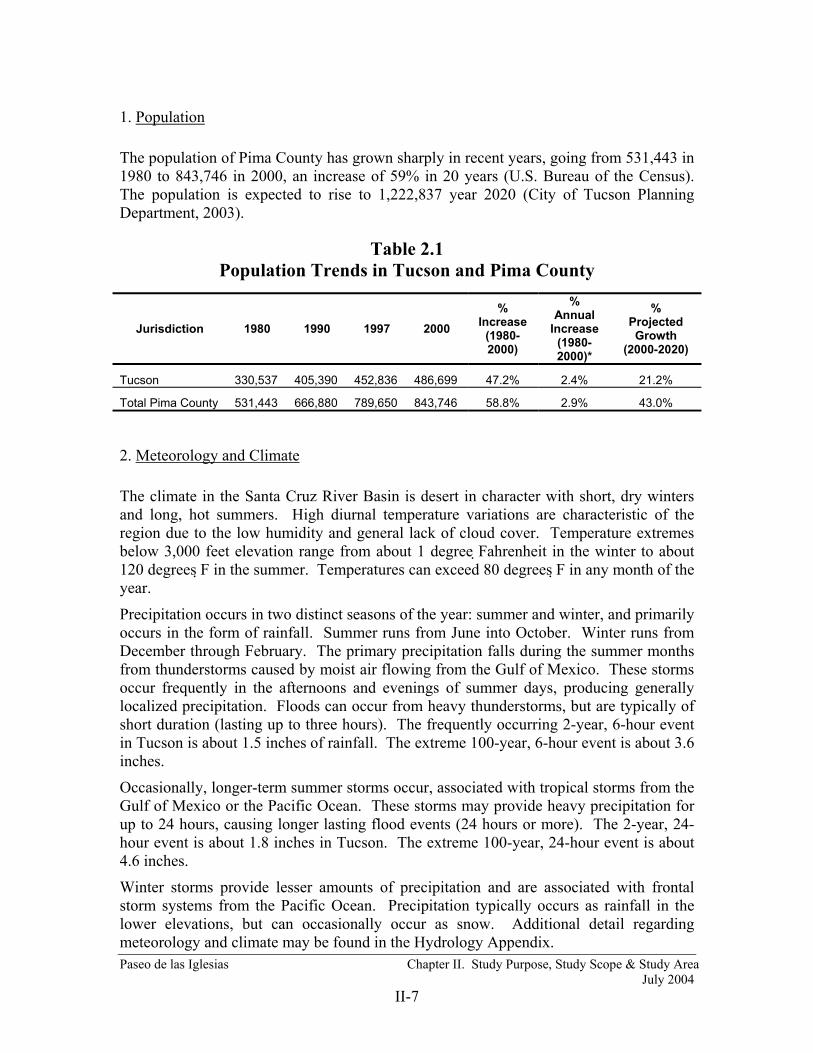
1. Population The population of Pima County has grown sharply in recent years, going from 531,443 in 1980 to 843,746 in 2000, an increase of 59% in 20 years (U.S. Bureau of the Census). The population is expected to rise to 1,222,837 year 2020 (City of Tucson Planning Department, 2003).
Table 2.1 Population Trends in Tucson and Pima County
2. Meteorology and Climate The climate in the Santa Cruz River Basin is desert in character with short, dry winters and long, hot summers. High diurnal temperature variations are characteristic of the region due to the low humidity and general lack of cloud cover. Temperature extremes below 3,000 feet elevation range from about 1 degree Fahrenheit in the winter to about 120 degrees F in the summer. Temperatures can exceed 80 degrees F in any month of the year.
Precipitation occurs in two distinct seasons of the year: summer and winter, and primarily occurs in the form of rainfall. Summer runs from June into October. Winter runs from December through February. The primary precipitation falls during the summer months from thunderstorms caused by moist air flowing from the Gulf of Mexico. These storms occur frequently in the afternoons and evenings of summer days, producing generally localized precipitation. Floods can occur from heavy thunderstorms, but are typically of short duration (lasting up to three hours). The frequently occurring 2-year, 6-hour event in Tucson is about 1.5 inches of rainfall. The extreme 100-year, 6-hour event is about 3.6 inches.
Occasionally, longer-term summer storms occur, associated with tropical storms from the Gulf of Mexico or the Pacific Ocean. These storms may provide heavy precipitation for up to 24 hours, causing longer lasting flood events (24 hours or more). The 2-year, 24-hour event is about 1.8 inches in Tucson. The extreme 100-year, 24-hour event is about 4.6 inches.
Winter storms provide lesser amounts of precipitation and are associated with frontal storm systems from the Pacific Ocean. Precipitation typically occurs as rainfall in the lower elevations, but can occasionally occur as snow. Additional detail regarding meteorology and climate may be found in the Hydrology Appendix.
Jurisdiction 1980 1990 1997 2000 %
Increase (1980-2000)
% Annual
Increase (1980-2000)*
% Projected Growth
(2000-2020)
Tucson 330,537 405,390 452,836 486,699 47.2% 2.4% 21.2%
Total Pima County 531,443 666,880 789,650 843,746 58.8% 2.9% 43.0%

Paseo de las Iglesias Chapter II. Study Purpose, Study Scope & Study Area July 2004
II-8
3. Existing Land Use Approximately 95% of the Paseo de Las Iglesias study area is located within the municipal limits of the City of Tucson. The remaining five percent is contained within unincorporated Pima County (Pima County Real Property Services, 2001). The reach of the river between San Xavier Mission and downtown Tucson is characterized as an arroyo with most high flows entirely contained within the main channel. Soil cement bank protection is discontinuous and is located on both banks at the Valencia Road bridge; on both banks from Ajo Way to Irvington Road; and from Silverlake Road to Grant Road. The corresponding unprotected areas include the reach between San Xavier Mission and Valencia Road; the reach north of Valencia Road to Irvington Road; and the reach from Ajo Way to Silverlake Road.
The 100-year floodplain of the Santa Cruz River is narrow as it passes through the study area due to the effects of earlier channelization and down cutting by the river. While the Paseo de las Iglesias study area is within the City of Tucson, significant amounts of the land adjoining the river are publicly owned. As a result, a significant percentage of the study area remains undeveloped.
The study area currently contains a variety of land uses. It consists of mainly residential areas, light industrial and commercial uses, as well as open space and public parks. Table 2.1 lists the corresponding acres by land use category in the study area. These were identified using the Pima County GIS Database. Figure 2.2 depicts the distribution of land uses within the study area.
Table 2.2 Land Use in the Paseo de las Iglesias Study Area
Land Use Acres Residential – Single Family 1,975 Residential- Multiple Family 87 Residential – Open Space 20 Commercial 483 Industrial 385 Public 1,456 Dedicated Rights-Of-Way 567 Intuitional (Schools, Churches) 32 TOTAL
5,005
Over one-quarter of the study area (1,456 acres) is publicly owned with the majority of public acreage being held by the City of Tucson. The areas adjoining the study area have surrounding land use that is predominantly residential and commercial with some manufacturing or light industrial use. Construction activities associated with a selected alternative would occur mostly within the river floodplain and its tributary floodplains. Within the entire City of Tucson, approximately 30 percent (or 79 square miles) of the land area is vacant.

Paseo de las Iglesias Chapter II. Study Purpose, Study Scope & Study Area July 2004
II-9
FIGURE 2.2 Land Use
Paseo de las Iglesias Chapter III. Prior Studies, Reports & Existing Projects July 2004
III-1
CHAPTER III PRIOR STUDIES, REPORTS & EXISTING PROJECTS
A. Prior Studies or Reports Many studies have been conducted pertaining to water and related land resources within the study area. These studies have examined themes including development trends, environmental resources, water supply, groundwater recharge, wastewater management, flooding and erosion, geology, cultural resources, history, and recreation. The following is not intended to be a comprehensive list of previous reports, but to provide a sample of the types of studies that have been completed in the study area.
Arizona Stream Navigability Study for the Santa Cruz River (Gila River Confluence to the Headwaters) Final Report, Prepared by SFC Engineering Company for the Arizona State Land Department
Sonoran Desert Conservation Plan: Relationships Between Land and People –The Cultural Landscapes Approach in Archaeology and History (May 2000) Pima County
Overview of Traditional Cultural Places in Pima County (May 2000), Pima County
Preserving Cultural and Historic Resources – A Conservation Objective of the Sonoran Desert Conservation Plan, (May 1999) Pima County
Sonoran Desert Conservation Plan: Pygmy Owl Update (November 1999) Pima County
Final Documentation October, 1993 Flood Damage Report, Pima County Department of Transportation and Flood Control District
Pima County Flood Control District Comprehensive Program (December 1990), Pima County Department of Transportation and Flood Control District, Planning and Development Division
Pima County Flood Control District Comprehensive Program Report FY1990-91-FY1995-96 (January 1997), Pima County Department of Transportation and Flood Control District, Planning and Development Division
Santa Cruz River Alignment Recharge Study - Final Report (July 1986), Prepared by Pima Association of Governments for City of Tucson
Existing Conditions Hydrologic Modeling for the Tucson Stormwater Management Study (TSMS), Phase II, Stormwater Master Plan, Task 7, Subtask 7A3. Prepared by Simons, LI & Associates, Inc. for the City of Tucson, November 1995.
Landfills and Waste Disposal Sites along the Lower Santa Cruz River - Final Report (February 1995) Prepared by Pima Association of Governments for Pima County Flood Control District
Landfills Along the Santa Cruz River in Tucson and Avra Valley – Final Report, Arizona (May 1995) Prepared by Pima Association of Governments for City of Tucson Office of Environmental Management

Paseo de las Iglesias Chapter III. Prior Studies, Reports & Existing Projects July 2004
III-2
Arizona Stream Navigability Study for the Santa Cruz River (Gila River Confluence to the Headwaters) Final Report, Prepared by SFC Engineering Company for the Arizona State Land Department
Sonoran Desert Conservation Plan: Mountain Parks (August 1999) Pima County
Pima County River Parks Master Plan (December 1996) Prepared by Planners Ink for Pima County Department of Transportation and Flood Control District
Sonoran Desert Conservation Plan Draft Report (October 1998), Pima County
Sonoran Desert Conservation Plan Update – Focus on Riparian Areas (July 1999), Pima County
Paseo de las Iglesias – Restoring Cultural and Natural Resources in the Context of the Sonoran Desert Conservation Plan (April 1999), Pima County
Paseo de las Iglesias, Pima County, Arizona - Reconnaissance Phase Study, 905B Analysis (1999) Pima County, Arizona
Reconnaissance Phase Study, 905B Analysis (September 2000) (Includes Tres Rio del Norte and Agua Caliente), U.S. Army Corps of Engineers Los Angeles District
Gila River, Santa Cruz River Watershed, Pima County Arizona – Final Feasibility Report (August 2001), U.S. Army Corps of Engineers Los Angeles District
B. Existing Projects There are no existing Federal water resource projects within the study area. Local improvements include:
• Soil cement bank stabilization on the Santa Cruz River between 29th Street and Congress Strret and between Irvington Road and Ajo Way.
• Repair and soil cement protection of the 22nd Street and Valencia bridges. • Construction of an energy dissipator on the New West Branch confluence with the
Santa Cruz River. • Establishment of the Santa Cruz River Park between 29th Street and Mission Lane
and between Irvington Road and Ajo Way.
The Corps of Engineers is in the initial stages of a Feasibility Study to evaluate the potential for environmental restoration immediately downstream of the Paseo de las Iglesias study area in an area identified as El Rio Medio (Congress St. to Prince Rd.). At the northern boundary of the El Rio Medio study area the Corps of Engineers is engaged in a Feasibility Study to evaluate the potential for environmental restoration along a seventeen mile reach of the Santa Cruz identified as Tres Rios del Norte. Another Corps environmental restoration study is concluding on the Rillito River upstream of it confluence with the Santa Cruz. There are other Federal projects and studies on tributaries to the Santa Cruz in or near the study area. They include the Rillito River, Tucson Diversion and Tanque Verde Wash flood control projects and the El Vado Wash study. Should some or all of these projects come to fruition, these projects would add environmental restoration or recreation measures. The addition of adjacent and possiblly contiguous restored areas would likely increase the benefits of a restoration project in the

Paseo de las Iglesias Chapter III. Prior Studies, Reports & Existing Projects July 2004
III-3
Paseo de las Iglesias study area due the creation of larger continuous or nearby areas of native habitat. The connection of recreational trails in adjacent projects would likely increase the recreation benefits. These potential projects are unlikely to produce cumulative effects on most other resources beyond their immediate effects.
C. Master Planning
1. Pima County Comprehensive Plan The most current information regarding the Pima County Comprehensive Plan can be found at the following web site: http://www.pimaxpress.com/Planning/ComprehensivePlan/ The purpose of the comprehensive plan is to conserve the natural resources of the county, to ensure efficient expenditure of public funds, and to promote health, safety, convenience, and general welfare of the public. The comprehensive plan includes the following guidelines related to aesthetic resources:
• Restore and preserve natural areas. This may include floodplain acquisition, purchase of development and water rights, and limitations on rezoning.
• Construct wetlands and riparian areas. This may include the use of reclaimed water or CAP water, and recharge projects.
• Preserve open space characteristics of development sensitive lands and promote development that blends with the natural landscape and protects wildlife habitat. Extend visually the public land boundaries.
• Provide natural open space.
2. Sonoran Desert Conservation Plan (SDCP) The most current information regarding the Sonoran Desert Conservation Plan can be found at the following web site: http://www.co.pima.az.us/cmo/sdcp/index.html The Sonoran Desert Conservation Plan is a comprehensive, local planning initiative to conserve the County’s most valued natural and cultural resources, while accommodating the inevitable population growth and economic expansion of the community.
In the most recent phase of this planning effort a Science Technical Advisory Team and staff of the County developed the concept for a differentiated biological reserve where Pima County biological resources are ranked in level of importance. That concept was applied to establish a framework for designing a Conservation Lands System for eastern Pima County. The Conservation Lands System is a first draft attempt to place value on conserving natural biological resources of the County. The intent of the master planning effort is to ultimately extend the system to the establishment of similar priorities for cultural and historic resources, ranching, riparian and mountain parks.

Paseo de las Iglesias Chapter III. Prior Studies, Reports & Existing Projects July 2004
III-4
3. Rio Nuevo Master Plan The Rio Nuevo Master Plan is a City of Tucson initiative that addresses redevelopment of urban Tucson, primarily along the Santa Cruz River immediately north and south of West Congress Street. The aim of the master plan is the creation of a network of unique experience areas, linked by shaded plazas that connect new cultural, civic, entertainment and business uses interwoven in a historically accurate and aesthetically pleasing manner throughout the Rio Nuevo District.
Following the completion of the Rio Nuevo master plan in early 2001, the City of Tucson began to evaluate the ability of a myriad of public, private and non-profit agencies to participate in new development, management and marketing activities. In an October memorandum to the City Council, city staff evidenced concern with “duplication of effort and lack of accountability” among the agencies involved. To advance downtown development, a strategic approach was recommended to clarify organizational responsibilities and develop stronger public/private collaboration. Subsequently, the City of Tucson Rio Nuevo Multipurpose Facilities District (RNMFD) contracted with an urban planning consultant to conduct a downtown Tucson stakeholder summit. That summit was held on January 16th and 17th 2002 and resulted in a series of recommendations to City government to advance the Rio Nuevo master plan. The plan includes a number of landscape concepts that could complement restoration efforts.

Paseo de las Iglesias Chapter IV. Problems and Opportunities July 2004
IV-1
CHAPTER IV PROBLEMS AND OPPORTUNITIES
A. Historical Conditions and Problem Development
1. History In order to have a complete understanding of historic conditions and the lost value of the study area ecosystem, it is necessary to consider the study area in the broader ecological context of the arid southwest. In the recent past, there were hundreds of locations across the southwest where waters flowed perennially or seasonally. These watercourses were often just the exposed tips of vast aquifers that rose upward to the earth's surface. The surface and subterranean waters created springs and riparian areas along rivers and streams scattered across the arid southwestern landscape. Some of these areas were relatively small, only a few acres or less in size, but others were thousands of acres of lush, nurturing habitat and travel corridors for local and migratory wildlife. Wildlife thrived in broad marshes and dense mesquite thickets, in galleries of cottonwoods and willows shading the watercourses, in expansive meadows of native grasses and shrubs, and in the water itself, which teemed with fish, frogs, turtles, insects, and aquatic plants.
When the first people arrived in the southwest a few thousand years ago, they used these riparian areas first as migratory corridors and then to establish permanent settlements. When the first Europeans arrived in the late 1600’s, they found the same riparian ecosystem embedded in an arid landscape. They used the riparian areas as others had before as highways and places to settle. One of the first places they settled was in the Santa Cruz River Valley. In the mid 19th century, wagon trains carrying American migrants to the gold fields of California passed through the region. As they had in the past, the riparian areas provided an essential place to rest, hunt, graze livestock, and fill water barrels in preparation for long, dry stretches westward. Without these sanctuaries of freely flowing water and the habitat it supported, it is doubtful that any sizable groups could have traversed the region. In the late 19th century, substantial riparian areas remained in many parts of the Tucson area (Betancourt & Turner 1985).
For many years, there were reliable year-round springs at San Xavier and at Sentinel Peak (“A” Mountain), though the river sometimes grew marshy in between. Cottonwood trees lined the river, and mesquite bosques hugged its banks. The shallow bed was nearly the same elevation as the surrounding floodplain. In some places water flowed on the surface for only a few months each year, while in others it flowed constantly except in the driest years. Early accounts describe dense mesquite growth in the usually dry reaches above and below that perennial stretch that surfaced at the base of Sentinel Peak. From the peak, upstream and downstream for miles, cottonwoods and willows marked the course of the river and irrigation ditches. A grassy marsh, or “cienega,” covered 1.5 square miles on each side of the Spring Branch of the river upstream from the church named San Xavier. An impressive mesquite forest, interspersed with small meadows, lay in the western floodplain of the river near the San Xavier Mission. Historical accounts of that mesquite forest describe tree specimens with trunks over four feet in diameter and heights exceeding 60 feet. The river continued northward to another Spanish church

Paseo de las Iglesias Chapter IV. Problems and Opportunities July 2004
IV-2
named San Agustín, that served a community in what is now downtown Tucson. The river was the passage (Paseo) between churches (Iglesias) and was the life stream of the communities.
In 1855 Julius Froebel, a visitor to the Tucson area, made the following observations (Froebel, 1859):
"...the banks of the river, and the valley itself, are covered with poplars and willows, ash-trees and plantains, oaks and walnut trees ... Some portions of the valley are of such grand, rich and simple beauty, as for instance Tumacacori and San Xavier del Bac, that they would be remarkable in any part of the world."
Another journal entry (U.S. Fish and Wildlife Service, 1999) made while camped on the Santa Cruz River near Tucson describes a:
"…rapid brook, clear as crystal, and full of aquatic plants, fish, and tortoises of various kinds, flowed through a small meadow covered with shrubs."
As the 19th century ended, more and more people settled in the well-watered areas of the southwest. Easterners responded to the promise of fertile valleys, abundant water and nearly endless sunshine by moving west in large numbers to places like Tucson.
The uses of water increased as entrepreneurs built dams to create lakes for boating and fishing as well as to power flourmills. Increasing numbers of wells were sunk to support burgeoning industry and farms. As more and more water was consumed, the natural springs and cienegas slowly diminished. Mesquite forests shrank under saw and ax while the flows nurturing cottonwood and willow reduced and trees began to wither. Slowly, the aquifers that sustained the riparian islands during the dry times began to recede.
Discontinuous arroyos existed 6 to 12 miles upstream of Tucson as early as 1849 but photos of the Santa Cruz River near Sentinel Peak from the early and late 20th Century provide an illustration of how historic habitat conditions have changed (Figure 4.1). As the end of the 19th century approached, a series of occurrences in Tucson dramatically accelerated the transition of the Santa Cruz River valley, particularly in the study area, into an arid landscape. In 1887, entrepreneur Sam Hughes excavated a ditch to tap near-surface flows in the vicinity of the St. Mary’s Road crossing of the Santa Cruz River to provide water for irrigation of cultivated lands north of St. Mary’s Road. Severe flooding occurred along the Santa Cruz River in July and August of 1890, following a period of severe drought. The flood breached the dams and eroded lakes. During one of the August floods, Sam Hughes’ new ditch served as the starting point for an upstream erosion (head cut) that retreated for a time at the rate of about 100 feet per hour toward Congress Street. Subsequent events extended the erosion. By 1910, the resulting arroyo had coalesced with a gully at Valencia Road that continued to Martinez Hill. During the 1914-1915 floods, the arroyo eroded to a point several kilometers south of Martinez Hill on the Indian Reservation (Betancourt and Turner 1985).
Groundwater pumping for agricultural and municipal uses caused the groundwater table to drop. At the time of statehood (1912), the Santa Cruz River was still perennial in some of the reaches that had shown historic surface flows, but flows were becoming increasingly intermittent in most areas. U.S. Geological Survey stream gage summaries (1907, 1912) indicate that all surface water flows were diverted at the Tucson gaging

Paseo de las Iglesias Chapter IV. Problems and Opportunities July 2004
IV-3
station by irrigation ditches. Agricultural uses in Tucson and San Xavier accounted for most of the area’s surface water with supplemental irrigation water coming from groundwater pumps. Diversions, and groundwater pumping, also diminished flows on major tributaries, especially the Rillito River. In 1935, the Works Progress Administration (renamed the Works Projects Administration in 1939) straightened the channel from San Xavier downstream to Congress Street. The current was deflected into the channel by revetments made of discarded automobile frames. Much of the remaining riparian vegetation was destroyed during the process of placing the revetments.
Throughout the 20th century, groundwater pumping increased at a rate far greater than natural recharge. By the 1950s, the perennial water was gone. A spectacular mesquite forest, four or five miles wide, survived into the 1940s on the now barren Tohono O’odham land in the San Xavier District. Ornithologist Herbert Brandt measured the trees in the 1930s, recording girths up to 13 feet and heights up to 72 feet. These centuries old forests were home to legions of birds, among them the now-endangered cactus ferruginous pygmy owl. “A woodland of giant mesquite trees…drew to itself such a fine list of unusual birds that I feel it merits designation as a separate type of desert area,” Brandt reported. The forest died off by the early 1950s.
In the 1950s and 1960, tons of garbage were dumped in landfills established in the channel or on the adjacent floodplain, resulting in a narrowing of the channel. Overburden from highway construction was also deposited on the east bank of the river to allow construction inside the meander. Riparian and floodplain fringe vegetation was progressively destroyed during the construction of Interstates 10 and 19.
Wildlife biologists, ecologists and naturalists have long recognized the importance of arid landscape riparian ecosystems. Over 100 state and federally listed species in New Mexico and Arizona are riparian dependent (Johnson, 1989). Riparian ecosystems are the richest bird habitat in North America, particularly in the arid West where an astounding array of species depend upon these thin ribbons of lush vegetation (Van Hylckama, 1980). The highest population densities of non-colonial nesting birds in North America, in fact, are in the cottonwood forests of central Arizona (Johnson, 1971; Carothers et al., 1974). Riparian corridors and their tributaries are important breeding areas, migratory pathways for a multitude of wildlife species and winter residents for migratory land birds, including species that over-winter in the Neotropics. A large proportion, 75-80% of vertebrate wildlife species depend on riparian areas for food, water, cover and migration routes (Gillis, 1991).
The loss of western riparian ecosystems can scarcely be overstated. The degradation of riparian ecosystems in the Southwest is extreme; losses in California and Arizona have been estimated to be in excess of 95% (Warner, 1979). The Arizona Nature Conservancy (1987) rates the cottonwood-willow community as North America’s most rare forest type. The National Center for Environmental Research and the Society for Ecological Restoration recognize the importance of restoring the hydrological and geomorphologic functions of riparian ecosystems (National Center for Environmental Research – Progress Report 2001, Society for Ecological Restoration, 2002).

Paseo de las Iglesias Chapter IV. Problems and Opportunities July 2004
IV-4
Confluence of the West Branch and the Santa Cruz River from Sentinel Peak, 1904
(Arizona Historical Society, Tucson)
The same area as it appears in a contemporary photograph
FIGURE 4.1 Comparison of Historic and Present Conditions

Paseo de las Iglesias Chapter IV. Problems and Opportunities July 2004
IV-5
Cottonwoods persisted at the base of Martinez Hill near San Xavier in the 1940s
(Arizona Historical Society, Tucson)
FIGURE 4.2 Historic Conditions
2. Historic Riparian Conditions and Development of a Restoration Concept The presence of water near the surface is the primary factor that controls the presence and persistence of plants and animals in an ecosystem. The position, frequency, duration and relative kinetic energy of water dictate what types of plants and animals occur and where in the landscape they tend to occur. Water forms the landscape as it carves resistant earth and re-deposits earth particles, the created form of which then controls the frequency and duration of subsequent exposure to water, which again re-shapes the surface over which it flows. This constant change is the essential, dynamic characteristic of the riparian ecosystem. The plants and animals using this ecosystem are fully attuned to the changes, taking advantage of the seasonal or multi-year cyclic alterations by the ways in which they use and populate the habitats.
Habitat complexity is a characteristic created by hydrogeomorphic processes. The land surface is shaped into a mixture of steep grades, gradual slopes, channel meanders and depressions which offer variable exposure to sun and shade, and provide variability water loss or retention in soils. Such high variability of earth forms supports species diversity and their relative distribution as recognizable groupings and distributions across the

Paseo de las Iglesias Chapter IV. Problems and Opportunities July 2004
IV-6
riparian landscape. The diversity of life forms and the interspersion of communities are the often-noted characteristics cited by many observers of riparian ecosystems.
A simplified, typical cross-section aids in describing characteristics of the riparian ecosystem and the relationships between geomorphic processes, water (hydrologic) presence and the occurrence of plant communities. Figure 4.3, entitled “Natural Sonoran Riparian System”, was created based on systematic discussions in The Sonoran Desert Conservation Plan (SDCP, July 1999) and observations of relatively undisturbed riparian sites, located both within the Santa Cruz system and in the region.
The linear flow of water across a landscape carves the recognizable flattened trapezoid-shaped, valley cross-section depicted in Figure 4.3. Rarely occurring, high energy, violent water flow creates a different cross-sectional form than more frequent normal flows. Since both types of flow occur due to variability in precipitation, the effects of both types of flow are properly represented in the typical cross-section. The higher energy flows associated with greater volumes of water create the floodplain, relatively abrupt slopes and the vertically separated, topographic steps identified as terraces or benches. Portions of the landscape generally above even the higher flows are here identified as the overbank area. Ordinary flow or frequent moderately higher flows create and maintain the active channel, relic channels and linear, low ridges of sediment identified as point bars.
The presence of groundwater near the active channel and the depth at which it discharges from the surrounding landscape relative to the elevation of the channel determines whether a given reach of stream flows continuously (perennial stream) or intermittently. An actively flowing, perennial channel may simultaneously represent the lowest point of the surface hydrologic system and the highest point of the groundwater hydrologic system as there is no distinction between the two. They are a continuum of water movement through the riparian ecosystem that provides it its essential nature. The condition of groundwater presence perennially near the topographic elevation of the active channel bottom is the characteristic that creates perennial channel flow and a higher frequency of wetter plant community types (cienegas) in relic channels and behind point bars, characterized in many accounts of the pre-development Santa Cruz River ecosystem within the study area reach.
The position of a landform in the channel cross-section; its absolute height above the active channel, groundwater influences and storm flow volumes create the riparian hydrogeomorphic regime. The hydrogeomorphic regime is described by the frequency, duration and depth of water present at a location. Water presence for all riparian hydrogeomorphic regimes is greater than for desert (which receives water only as direct precipitation), since water may be directed and concentrated by way of surface runoff during rainfall events, flooding, shallow groundwater migration and groundwater discharge. Three broadly interpretive terms are used to describe riparian hydrogeomorphic regimes: hydroriparian, mesoriparian and xeroriparian. Certain plant species, growth forms and species groupings (habitats) are typically found in each of these regimes. While these vegetation types are depicted on Figure 4.3 to establish linkages with landforms and hydrogeomorphic regimes, detailed discussions of vegetation and habitats are found later in this document.

Paseo de las Iglesias Chapter IV. Problems and Opportunities July 2004
IV-7
Hydroriparian regime. This is the portion of a channel that is exposed to water at, above or near the surface for all, or nearly all of the time. Spatially, this includes some or all of the active channel and the topographically lower portions of relic channels and braids. Sources of water include direct rainfall, local runoff from uplands, channel flow from an extended drainage basin, capillary migration (movement of water between soil particles) and groundwater discharge. Plants typically associated with this regime include submerged, floating and emergent species with succulent tissues and often grass-like growth forms. Trees and shrubs, particularly willow, may occur. Vegetation density is typically high. Diversity is moderate to high and inversely proportional to the duration of inundation. Soil evaporation is low due to shading from taller plants growing in this and the next zone, however evapotranspiration is high due to the combination of high desert temperatures and lavish water supplies.
Mesoriparian regime. This portion of the channel cross-section occurs on first benches and terraces located above ordinary channel flow levels, to as much as 1-4 feet above, depending on soil grain size and local drainage patterns. Water is provided by direct precipitation, local runoff and relatively frequent flooding. These areas are not exposed to normal channel flow waters but may be inundated or saturated several times each year to as much as every two years by flood events. Groundwater contributes to water presence in this zone by way of soil capillarity and deep roots. Dominant plants occurring include cottonwood-willow mixtures, mesquite, perennial bunchgrasses, such as sacaton, and medium shrubs adapted to floodway disruption, such as burrobrush. Overall, vegetation density is moderate to high. Species diversity is typically high due to the relatively steep gradient in available moisture across this zone. Soil evaporation is typically low due to relatively dense shading.
Xeroriparian regime. This zone is found on secondary terraces, generally above the elevation of the two-year recurrence interval storm, extending upward to the periphery of the ten-year storm floodway (and higher). Available moisture in this zone always exceeds surrounding desert and includes sources of direct precipitation, lateral overland flow from uplands and occasional flood inundation. Groundwater may be important to only the more deep-rooted trees and shrubs. Vegetation density may range from high to low depending on position relative to actual water concentration potential, but is lowest on average for all the riparian zones. Species diversity is moderate to high. Typical vegetation is the mesquite bosque habitat; although various brush or cactus-dominated communities may temporarily prevail due to flood or fire disruptions.

Paseo de las Iglesias Chapter IV. Problems and Opportunities July 2004
IV-8
FIGURE 4.3 Natural Sonoran Riparian System

Paseo de las Iglesias Chapter IV. Problems and Opportunities July 2004
IV-9
Natural riparian systems will display a high geomorphic complexity, relatively low absolute topographic relief (each rising zone being broader and flatter than the previous) and high soil stability due to higher maintained vegetation densities. In a relatively undisturbed landscape, riparian change occurs gradually, almost imperceptibly in human temporal references, and at a scale amenable to biological processes. A point bar will change its orientation, a bank will slough or a back channel will fill with sediment. These newly altered areas, exposed to a continual rain of propagules (seeds) from surrounding vigorous populations, will be quickly re-colonized by species adapted for the conditions. The catastrophic changes that have occurred in the riparian zone and particularly in the landscape surrounding the Paseo de las Iglesias reach of the Santa Cruz River have resulted in a very different riparian condition than that occurring under the natural circumstances.
3. Present Conditions The Santa Cruz channel is now a 10 to 40 foot deep, usually desiccated erosional scar, with frequently steep, near vertical and unstable banks through much of the Paseo de las Iglesias reach. Figure 4.4 entitled, “Degraded Santa Cruz River Riparian System”, is designed to both depict present typical conditions and contrast with Figure 4.3. Natural geomorphic complexity has been replaced by a simplified set of parallel flat terraces separated by steep banks. The highest flat, formerly the xeroriparian mesquite bosque that was topographically disconnected from the Santa Cruz flooding regime by progressive head-cutting events, is a highly disrupted, nearly barren plain with a desert hydrogeomorphic regime. First and second terraces, formed since the occurrence of the major channel erosion events, may support a xeroriparian regime in many places, with occasional stands of the alien buffelgrass, invasive salt-cedars and native burro-brush. The channel bottom may support a mesoriparian regime; however, occasional flood flows tend to sweep out all vegetation, leaving only a dry sand bed that is highly suitable for off-road vehicle traffic. Biological resources within the study area are severely degraded. Continuous groundwater mining has dramatically lowered the area’s groundwater table; the water table is over 100 feet below the riverbed. Surface water is rare, and occurs only following rainfall events or because of release of water by people.
Currently, the study area consists primarily of urban and disturbed land on both sides of a frequently disturbed, deeply entrenched ephemeral riverbed (Figure 4.5 & 4.6). It is almost entirely isolated from natural vegetative communities by urban development and barren lands. Continuing disruptions in the former floodplain include chronic channel and overbank erosion, ongoing development, relict agricultural operations and landfills, off-road vehicle use, construction of soil cement lined banks, illegal dumping, and transient camps. The aquatic and riparian communities have vanished, and the mesquite bosques are represented only in diminished, isolated pockets of stunted trees sprouting from cut or burned stumps. Exotic plant species, including salt cedar (Tamarix ramosissima) and Athel tamarisk (Tamarix aphylla), have replaced most of the native cottonwood and willow.

Paseo de las Iglesias Chapter IV. Problems and Opportunities July 2004
IV-10
FIGURE 4.4 Degraded Santa Cruz Riparian System

Paseo de las Iglesias Chapter IV. Problems and Opportunities July 2004
IV-11
Note the nearly vertical banks in this unprotected reach south of Drexel
Debris left in channel north of Irvington
FIGURE 4.5 Existing Conditions

Paseo de las Iglesias Chapter IV. Problems and Opportunities July 2004
IV-12
Bank and River Park trail south of Ajo Way
New housing and drainage structures on the Santa Cruz west bank south of Ajo Way
Condition of tributary wash upstream of its confluence with the Santa Cruz River
FIGURE 4.6 Existing Conditions

Paseo de las Iglesias Chapter IV. Problems and Opportunities July 2004
IV-13
4. Flooding History The most severe flooding events in recent history occurred in 1977, 1983, 1990 and 1993 (USACE 2001). However, little information exists regarding specific damages within the study area. The 1977 flood caused an estimated $8,607,000 in damages, of which approximately $6.8 million was in agricultural damages. Most urban flood damage was recorded to the south of the City of Tucson near Green Valley. Considerable damage, estimated at $230,000, was done to the Silverbell Golf Course, located north of the study area near Roger Road. Considerable damage was caused to both public and private property. The 1983 flood caused extensive damage throughout the region. Unfortunately, little information is available regarding specific dollar values associated with damages. Information on damage amounts from the 1990 flood is also limited but the Operations Division of the Pima County Department of Transportation and Flood Control District estimated damages at approximately $1.7 million. Damages from the 1993 flood caused occurred primarily in the north and northeast portions of the Tucson metropolitan area. In these and other past flood events damages did occur to the roadway bridge crossings, however all bridges and abutments are now protected by soil cement or the bridges were reconstructed.
Other potential flood risks during severe infrequent flood events exist along the remaining unprotected reaches of the Paseo de las Iglesias study area. Erosion protection has not been constructed south of Irvington Road, except for the Valencia Street Bridge or between Ajo Way and Silverlake Road. These areas are at risk of experiencing significant lateral channel migration during major infrequent flood events. Based on the historic rates of channel migration, the damage potential arising from such erosion is limited, however impacts to downstream areas resulting from aggradation of the channel invert from deposition of sediment could reduce the river’s ability to convey flood flows.
B. Base Year Conditions
1. Definition of Base Year Conditions Base Year conditions are defined as those conditions which are expected to exist within the study area in the earliest year that a project could begin to produce NER and/or NED benefits. A thorough assessment and evaluation was conducted for existing conditions in the study area and was brought forward in time based on expected future change in the study area. The year 2012 was chosen as the Base Year based on the assumption that this feasibility study would be completed on 2004. The Planning, Engineering and Design Phase (PED) was estimated to commence in 2006, with actual construction commencing in 2009. Construction is estimated to last approximately three year until 2012. However, it is conceivable that NER benefit could begin accrue incrementally earlier in the construction phasing.
2. Environmental Resources
Paseo de las Iglesias Chapter IV. Problems and Opportunities July 2004
IV-14
Cultural Resources A literature search and cultural resources overview of the proposed project area of potential effects (APE) has been performed through the Arizona State Museum (ASM). This search indicates that less than 50 percent of the APE has been surveyed by archeologists. These surveys have recorded 47 archeological sites within the project APE. Site AZ BB:13:15 (Valencia Site) was nominated and listed in the National Register of Historic Places (NRHP) in 1984 (along with AZ BB:13:74) by William Doelle with the Institute of American Research. At least four sites are eligible for the NRHP including AZ AA:16:3 (West Branch Site), AZ AA:16:49 (Dakota Wash Site), AZ BB: 13:6 (Clearwater Site, Mission San Agustín del Tucson, Tucson Pressed Brick Company), and AZ BB 13:17 (Julian Wash Site). The Corps determined the Julian Wash Site eligible for the NRHP in 1995 as part of the Tucson Diversion Channel Project. The remainder of recorded sites within the study area are undetermined as to NRHP eligibility, unless destroyed. Sites described as destroyed are subject to confirmation via a field check. Many of the sites in the study area can be considered potentially eligible.
In accordance with 36 CFR 800, regulations implementing Section 106 of the National Historic Preservation Act, identification and evaluation studies will be coordinated with Pima County and interested Native American Indian tribes. Given the study area’s association with the Santa Cruz River floodplain, the overall archeological sensitivity and potential are very high. The floodplain may contain buried resources. Therefore, complete avoidance of all cultural resources by project alternatives may be unsuccessful.
Water Resources
Groundwater: The most important groundwater resources in the Tucson basin occur in the sedimentary rocks and alluvium that form a single aquifer. The aquifer consists of the Pantano Formation, the Tinaja Beds, and the Fort Lowell Formation (from bottom to top). The Pantano Formation yields small to moderate amounts of water while the Tinaja beds yield small to large amounts of water, frequently in excess of 1000 gal/min. The elevation of this primary aquifer is within 350 ft. of the ground surface throughout most of the basin. Due to localized and/or perched water tables, the depth to groundwater ranges from less than 20 ft. to about 170 ft. below the ground surface along the Santa Cruz and Rillito Rivers. Current well information included in this report indicates that depths to groundwater in the wells generally ranges from about 100 to 200 feet below ground surface in the study area close to the Santa Cruz channel.
Large-scale pumping of groundwater in the Tucson basin began in about 1900 and increased dramatically in the 1940s. Most of the groundwater pumped in 1940 was used for irrigation. The centers of greatest water-level decline are along the Santa Cruz River near Sahuarita and in the City of Tucson. Declines exceeding 100 ft. have occurred in Tucson and in portions of the study area, while to the south along the river, the maximum decline has been about 150 ft. Detailed information on depth to groundwater, including mapping may be found in the Geotechnical Appendix (Appendix F).
Infiltration of storm runoff in the stream channels during the rainy seasons is the major source of recharge to the groundwater basin (Davidson 1973). Seepage of runoff along the mountain fronts constitutes the second largest source of recharge. This natural system recharges about 100,000 acre-ft/yr; but there is a demand for 300,000 to 400,000 acre-ft

Paseo de las Iglesias Chapter IV. Problems and Opportunities July 2004
IV-15
annually. The resulting deficit is causing the water table to decline at an approximate average annual rate of 2.7 ft (PCDOT 1986). For additional information regarding groundwater, see the Geotechnical Appendix.
Surface Water: No local permanent water resources exist along the Santa Cruz River in the study area. Surface water is rare and occurs only following rainfall events or after water is released by people. There are small areas of flooded inactive gravel pits in the southern portion of the study area. Conditions at these are rapidly changing as mining activity ceased in 2003.
Biological Resources Watersheds and associated riparian habitats within Pima County have been profoundly altered in the past one hundred years. Historically, many of the rivers flowed perennially supporting lush riparian vegetation and marsh habitat in the study area. Before 1890, dense stands of cottonwood, willow, ash and walnut trees lined the Santa Cruz and many of its tributaries. Mesquite bosques covered the floodplain terraces and beaver dams were common. It is estimated that eighty-five to ninety-five percent of high-quality riparian habitat in Pima County has been lost over the past century. Virtually all riparian habitat has been lost in the study area.
Riparian systems provide critical habitat for many plants and animals. Riparian habitat is especially important in the semi-arid Southwest. Migratory birds, for instance, depend upon riparian areas for foraging, refuge during migration, and breeding areas. These strings of habitat, while encompassing less than one percent of the Southwest landscape, support a disproportionate number of wildlife species. It is estimated that seventy-five to ninety percent of all wildlife in the arid southwest is riparian dependent during some part of its life cycle. Degradation or loss of riparian habitat within Pima County has had great impacts on most resident species.
Vegetation:
Riparian Forests Vegetation communities of the Paseo de las Iglesias study area include very small remnants of Sonoran Desert Scrub, Sonoran Deciduous Forest and Woodlands, Sonoran Deciduous Riparian Scrub and Sonoran interior strand habitat. Vegetation community naming is based on the Brown, Lowe and Pase (1980, 1994) vegetation classification system. The use of the term communities to describe the degraded, scattered fragments of formerly definable natural systems is an overstatement of the characteristics of the mostly barren, weed-dominated Santa Cruz vicinity. Most areas consist of developed and disturbed areas. Soil cement banks and paved trails occur on the east and west side of the river and traverse a variety of habitat types.
The largest percentage of the study area (60.8%) is Urban, a subset of Cultivated and Cultured Uplands, with the next largest (17.6%) being Sonoran Vacant or Fallow Lands, another subset from the same vegetative community (SWCA 2003). Less than 20 percent of the study area is occupied by uncultivated/uncultured habitat. The majority of these
Paseo de las Iglesias Chapter IV. Problems and Opportunities July 2004
IV-16
uncultivated habitat areas have been drastically disturbed by erosion, filling, mining and prior development.
Areas with ephemeral stream channels support struggling remnants of xeroriparian vegetation such as mesquite and acacia. Shallow groundwater and areas of intermittent surface flow support occasional mesoriparian plants such as a few larger stands of mesquite. Outside of inactive mining process ponds and a few storm water outlets, wetlands and perennial watercourses supporting hydroriparian vegetation such as cottonwood-willow forests do not exist in the Paseo de las Iglesias reach of the Santa Cruz River. These riparian communities had been extremely rich in species diversity, supporting several hundred species of plants and sustaining a rich food base for wildlife.
Riparian dependent plant communities are considered at risk vegetation communities in the Southwest, particularly in Pima County. Sensitive plant species that could potentially occur onsite and are known to occur in the vicinity are listed in the Draft Environmental Impact Statement (DEIS). No federal or state listed species were observed in the study area during field observations conducted for this study. Riparian communities in the study area have been lost due to diversion of and reduction in stream flow, depletion of groundwater tables, competition by exotic plant species, the effects of grazing and fire, loss of floodplain function by undercutting caused by flood control activities, and encroaching urban and agricultural uses.
One species of concern with potential to occur in the area is the Tumamoc globeberry, an Arizona Department of Agriculture Salvage Restricted species and a Sonoran Desert Conservation Plan (SDCP) Priority Vulnerable species. The range of this plant covers some 31,000 square miles of Sonoran Desert from Sonora, Mexico to Tucson, Arizona, west to Organ Pipe Cactus National Monument and north to Pinal County, Arizona. In Tucson, it is found on hot, dry, south-facing slopes of basalt and along desert washes. The largest population is found in creosote bush desert scrub on gravelly loams primarily derived from weathered granites; however there are no known populations in the study area. A complete discussion of plants in the study area may be found in Appendix 14.2 of the DEIS, Biological Assessment.
Wildlife: No federally listed threatened or endangered species were detected in the study area. The following seven species of primarily local interest were determined to occur or have a potential to occur within the Paseo de las Iglesias corridor: giant spotted whiptail, western yellow-billed cuckoo, burrowing owl, Abert’s towhee, Bell’s vireo, western red bat, and western yellow bat. Other wildlife species observed during the field investigations were also recorded.
The giant spotted whiptail is designated as a USFWS Species of Concern, a USFS Region 3 Forester Priority Sensitive Species, and a SDCP Priority Vulnerable Species (PVS). Currently, known populations of the giant spotted whiptail have been recorded from the Santa Catalina, Santa Rita, and Baboquivari Mountains. Once common along the Santa Cruz River, the known population has been reduced to a remnant along the West Branch (Rosen 2001). Giant spotted whiptails are found in lower Sonoran (chiefly riparian areas) and upper Sonoran life zones, in mountain canyons, arroyos, and mesas in arid and semi-arid regions, entering lowland desert along stream courses. The species is

Paseo de las Iglesias Chapter IV. Problems and Opportunities July 2004
IV-17
found in dense shrubby vegetation, often among rocks near permanent and intermittent streams, and in grassy areas within riparian habitats.
The western yellow-billed cuckoo is a candidate for listing as endangered by the USFWS, is a USFS Sensitive, is an AGFD Wildlife of Special Concern and a SDCP PVS. This subspecies of the yellow-billed cuckoo is believed to have been once widespread and locally common in California and Arizona. Its present distribution in Pima County is at Cienega Creek, Arivaca Creek, San Pedro River, Tanque Verde Wash, Rincon Creek, and the Green Valley pecan orchards. The western yellow-billed cuckoo inhabits mature Sonoran riparian deciduous forest, Cottonwood-Willow Series, and Sonoran riparian scrub in well-developed mesquite bosques
The western burrowing owl is a SDCP PVS. Burrowing owls are uncommon residents of grasslands, open areas in desert scrub, pastures, and the edges of agricultural lands, and areas of bare dirt subject to erosion. Burrowing owls are known to occur in the project area.
Abert’s towhee is a PVS under the SDCP. Abert’s towhee inhabits low-elevation riparian sites throughout Pima County. This species tends to occur most often in Sonoran riparian deciduous woodlands and riparian scrublands with dense understories. Most of these communities are now fragmented throughout much of Arizona. Abert’s towhees were regularly observed in a variety of habitats during field reconnaissance including mesquite series, urban drainage, Sonoran interior strand, salt cedar disclimax, and maintained park.
Bell’s vireo is an SDCP PVS. In Pima County, this species is a common summer resident in dense shrubs and trees of lower canyons, generally below the oak zone, and along desert streams and washes in dense riparian vegetation.
The western red bat is an AGFD Wildlife Species of Special Concern, a USFS Sensitive Species and is a SDCP PVS.
The western yellow bat is an AGFD Wildlife Species of Special Concern and a SDCP PVS.
A complete discussion of wildlife in the study area may be found in Appendix 14.2 of the DEIS, Biological Assessment.
3. Evaluation Methodology
Habitat Evaluation In the 1970’s and early 1980’s, the U.S. Fish and Wildlife Service (USFWS), in cooperation with other agencies, developed a non-monetary evaluation procedure for environmental project planning. That process has been used and modified since then for both impact assessment and planning habitat restoration and management projects. Ecological Services Manuals describe the procedure and process in detail (USFWS 1980a-c). The Habitat Evaluation Procedure (HEP) is an objective, reliable and well-documented process used nationwide to generate environmental outputs for all levels of proposed projects and monitoring operations in the natural resources arena. HEP guidebooks focus on individual species. No guidebooks exist for evaluation of species habitat within the Paseo de las Iglesias study area.

Paseo de las Iglesias Chapter IV. Problems and Opportunities July 2004
IV-18
To evaluate habitats for planning purposes without existing guidebooks, the Los Angeles District of the Corps of Engineers evaluated wildlife benefits using a technique referred to as modified Habitat Evaluation Procedure (mHEP).
The basic premise of this modified procedure focused on a field reconnaissance approach where biologists surveyed a study site to familiarize themselves with the current conditions of the study area. The conditions were characterized by experts in the field and assigned a Habitat Suitability Index (HSI) score between 0-1 based on expert opinion of healthy, pristine, natural conditions. Graphical illustrations of conditions ranging from the 0-1 HSI scale were provided to the experts, and they were asked to select the “best-fit” representation for each community per site. The HSI for each location of each community was assigned, and an average was calculated for at least five locations (where more than five were available). By multiplying the average value by the total measured area of each community type, a single number was to express Habitat Units (HU). The solution was often efficient; however, the results were subjective and were often not repeatable.
Another restoration assessment approach is the Hydrogeomorphic Method (HGM). HGM is a habitat evaluation tool that employs a functional assessment approach to predicting with and without project values for an array of features and structures associated with ostensible habitat performance. An HGM based functional assessment approach was used as a parallel comparative method for habitat evaluation of the study area because of its broader approach to analysis of processes and conditions necessary for support of riparian habitat and its prior use for other ecosystem restoration studies conducted in the southwest. The HGM method examines habitat based on physical and biological parameters. HGM emphasizes the functions associated with the range of physical and chemical attributes comprising habitat of wetland ecosystems. It also incorporates a structural index based on a set of species identified for the specific model application. Models used in a HEP methodology might be more appropriate in some riparian settings but their overall evaluation of potential changes to the ecosystem dynamic are limited when capturing wetland functionality as a whole. The HGM based approach has one important advantage over the HEP methodology (HSI models in particular) in that it is more inclusive of all ecosystem functions relevant to ecosystem services. Hydrologic and geomorphic conditions are the primary factors governing riverine ecosystem structure and function. HEP models are generally limited to the habitat function in support of species richness, and might overlook key hydrologic and geomorphic influences on the ecosystem. Use of a functional assessment tool includes assessment of both abiotic and biotic functions, if proper functions are selected for assessment.
HGM Results:
Arizona Riverine Model Development Since there is not a regional guidebook completed specifically for the arid riverine environment in Arizona, existing models were modified to develop a functional assessment tool for planning purposes. The riverine over bank subclass for low gradient

Paseo de las Iglesias Chapter IV. Problems and Opportunities July 2004
IV-19
streams is the most applicable to the environment. Draft Guidebooks for the Santa Margarita Watershed and San Luis Rey Watershed were also reviewed for information.
A workshop was held to bring together regional experts and seek their input on modifying the model to be applicable to Arizona riverine environments. Workshop participants included the Environmental Lab (EL) of the U.S. Army Corps Engineers Engineering Research and Development Center (ERDC), the Los Angeles District Corps staff, local sponsor representatives from the City of Phoenix, City of Tucson, Town of Marana, Pima County Flood Control District, and Salt River Pima Maricopa Community, Arizona Game and Fish Department, U.S. Fish and Wildlife Service, professional consultants, and representatives from the scientific and academic community. The methodology used in applying functional assessment valuation of the study area is explained in more detail in the Habitat Analysis Appendix D provided under separate cover.
Reference Sites Reference sites are riverine or riparian areas selected from a reference domain (a defined geographic area), selected to “represent” sites that exhibit a range of variation within a particular wetland type, including sites that have been degraded/disturbed as well as those sites with minimal disturbance. The use of reference sites to scale the capacity of riparian area or wetlands to perform a function is one of the unique features of the functional assessment approach. The reference sites provide the standard for comparison in the functional assessment approach. They function as the physical representation of riparian areas from the region that can be observed and measured repeatedly. A basic assumption of a functional assessment approach is that the highest, sustainable functional capacity is achieved in riparian ecosystems and landscapes that have not been subject to long-term anthropogenic disturbance.
It is further assumed that under these conditions the structural components and physical, chemical, and biological processes within the wetland and surrounding landscape reach a dynamic equilibrium necessary to achieve the highest, sustainable functional capacity.
Reference sites for model calibration included The Nature Conservancy’s Hassayampa River Preserve, the Verde River at the confluence with the Salt River, Santa Cruz River at Tumacocori, the San Pedro River at the San Pedro National Riparian Conservation Area, and Tanque Verde Wash upstream of the Rillito River confluence. These sites were recommended by the Model Development Workshop attendees based on the following criteria: 1) they were reasonable sites considering current conditions, 2) they were in a similar regional riverine subclass with the Santa Cruz River having similar elevation, topography, gradient, and stream order, 3) they represented important aspects of pre-historical conditions, and 4) they were uniform across political boundaries. Model attendees agreed that no truly ideal reference site exists and restoration to the ideal was not achievable due to inability to remove all stressors. The goal in choosing these sites was that the hydrologic, biogeochemical and habitat characteristics be as undisturbed as possible.
Wetland Functions

Paseo de las Iglesias Chapter IV. Problems and Opportunities July 2004
IV-20
Wetland functions represent the currency or units of the wetland system for assessment purposes, but the integrity of the system is not disconnected from each function, rather it represents the collective interaction of all wetland functions. Functional capacity is simply the ability of a wetland to perform a given function (e.g. the capability of a wetland to temporarily store (retain) surface water) compared at the level that it is performed in reference standard wetlands. It was decided to use the same type of currency for this functional model as is used in HGM. The HGM methodology assesses wetland function based on a series of predictive Functional Capacity Indices (FCIs). An FCI is an index of the capacity of wetland to perform a function relative to other wetlands from a regional wetland subclass in a reference domain. Functional capacity indices are scaled from 0.0 to 1.0. An index of 1.0 indicates that a wetland performs a function at the highest sustainable functional capacity, the level equivalent to a wetland under reference standard conditions. An index of 0.0 indicates the wetland does not perform the function at a measurable level and will not recover the capacity to perform the function through natural processes. In summary, FCI models rate the functional capacity of a wetland on a scale of 0.0 (not functional) to 1.0 (optimum functionality). HGM combines both the wetland functionality (FCIs measured with variables) and wetland quantity to generate a measure of change referred to as Functional Capacity Units (FCUs).
Subcategories of wetlands are identified to further increase the resolution of the model. Those subcategories or cover types are referred to as Partial Wetlands Assessment Areas or PWAA. Functions developed for the Arizona riverine HGM model are displayed in Table 4.1. Once the FCI and PWAA quantities have been determined, the FCU values can be mathematically derived with the following equation:
FCU = FCI x Area (measured in acres). Under the HGM methodology, each FCU is equivalent to one optimally functioning wetland acre. Like HEP, HGM can be used to evaluate future conditions and the long-term effects of proposed alternatives by generating FCUs for wetland functions over several Target Years, or years of interest during the project life. In such analyses, future wetland conditions are estimated for both Without-Project and With-Project Conditions. Projected long-term effects of the project are reported in terms of Average Annual Functional Capacity Units (AAFCUs). Based on the AAFCU outcomes, alternative designs can be formulated, and trade-off analyses can be conducted, to promote environmental optimization.
Cover Types Habitats evaluated within the study area were classified as one of four Partial Wetland Assessment Areas (PWAAs) or cover types for Arizona riverine systems. Cover types are primarily based on vegetation cover. These are Cottonwood-Willow, Mesquite, Scrubshrub (Sonoran Desert Wash Community), and Riverbottom (potential emergent wetlands or cienega). These are homogenous zones of similar vegetative species, geographic similarities, and physical conditions that make the PWAA unique. In general, cover types are defined based on species recognition and dependence, soils types and topography. Other areas such as a buffer zone, urban areas, and desert areas will be tracked but not evaluated.

Paseo de las Iglesias Chapter IV. Problems and Opportunities July 2004
IV-21
Cover types for this study were mapped within the study boundaries. Note that the mapping of these cover types adjacent to the channel was completed for planning purposes and in order to consider the effects of adjacent land use on the study area, not with the intent that actual project features will be planned to that extent. Figure 4.7 depicts cover types and land use found within the project area. Scattered remnants of natural vegetation remain. Those cover types include Mesquite, Scrubshrub and Riverbottom. Cotton-wood willow forests, natural cienegas and seasonal emergent wetlands have disappeared from the study area. Table 4.2 lists the acreage in each cover type.
Cottonwood-Willow Forests
Cottonwood-willow forest is a high-quality hydro riparian habitat in Arizona. Riparian habitats are defined as habitats or ecosystems that are associated with rivers or streams or are dependent on the existence of perennial or ephemeral surface or subsurface water. They are further characterized by having diverse assemblages of plant and animal species in comparison with adjacent upland areas. These plant species are also found in habitats that are narrow, linear strands of vegetation parallel to the main direction of water flow that may occur in riverine flood channels and along the banks of streams. In the Sonoran Desert, riparian areas nourish cottonwood-willow forests, one of the rarest and most threatened forest types in North America. An estimated 90% of these critical wet landscapes have been lost, damaged or degraded in the last century. This loss threatens at least 80% of Arizona wildlife, which depends upon riparian habitats for survival. The growth of Tucson and surrounding areas, past land uses such as farming, grazing, gravel mining, and pumping of groundwater have altered the Santa Cruz River. Where it was once perennial, it is now an ephemeral stream. This has contributed to the decline of cottonwood and willow habitat within the study area. While an occasional tree survives at scattered locations, the Cottonwood-Willow cover type cannot be found within the study area.
Mesquite Bosques
Mesquite woodlands or bosques historically thrived over large areas within the river floodplain and on higher terraces of the river and were common into the 1940s. These communities have been nearly eliminated from the river ecosystem by a combination of anthropogenic activities (e.g. cutting for firewood) and an ever lowering aquifer combined with an altered flood regime. Significant contiguous stands currently exist along the Old West Branch of the Santa Cruz River. Several smaller patches are scattered throughout the historic floodplain of the Santa Cruz. These small bosques generally consist of struggling trees that have been isolated from the river by soil cement banks and are threatened by urbanization. Together, these areas of mesquite-dominated woodlands total 160 acres.

Paseo de las Iglesias Chapter IV. Problems and Opportunities July 2004
IV-22
FIGURE 4.7 Distribution of Cover Types

Paseo de las Iglesias Chapter IV. Problems and Opportunities July 2004
IV-23
Table 4.1 Riverine Overbank Subclass Functions
Functions Related to the Hydrologic Processes Description
1. Maintenance of Characteristic Dynamics
The physical processes and structural attributes that maintain characteristic channel dynamics. These include flow characteristics, bedload, in-channel coarse woody debris, and potential coarse woody debris inputs, channel dimensions, and other physical features (e.g. bank vegetation, slope).
2. Dynamic Surface Water Storage and Energy Dissipation
The dynamic water storage and dissipation of energy at bank full and greater discharges. These are a function of channel width, depth, bedload, bank roughness (coarse woody debris, vegetation, etc.), presence and number of in-channel coarse woody debris jams, and connectivity to off channel pits, ponds, and secondary channels.
3. Long Term Surface Water Storage The capability of a wetland to temporarily store (retain) surface water for long durations; associated with standing water not moving over the surface. Water sources may be overbank flow, overland flow, and/or channelized flow from uplands, or direct precipitation.
4. Dynamic Subsurface Water Storage The availability of water storage beneath the wetland surface. Storage capacity becomes available due to periodic draw down of water table.
Functions Related to Biogeochemical Processes Description
5. Nutrient Cycling The abiotic and biotic processes that convert elements from one form to another; primarilyrecycling processes.
6. Detention of Imported Elements and Compounds
The detention of imported nutrients, contaminants, and other elements or compounds.
7. Detention of Particles The deposition and detention of inorganic and organic particulates (>0.45 um) from the
Water column, primarily through physical processes.
Functions Related to Habitat Description
8. Maintain Characteristic Plant Communities
The species composition and physical characteristics of living plant biomass. The emphasis is on the dynamics and structure of the plant community as revealed by the species of trees, shrubs, seedlings, saplings, and herbs and by the physical characteristics of the vegetation.
9. Maintain Spatial Structure of Habitat The capacity of a wetland to support animal populations and guilds by providing heterogeneous habitats.
10. Maintain Interspersion and Connectivity
The capacity of the wetland to permit aquatic organisms to enter and leave the wetland via permanent of ephemeral surface channels, overbank flow, or unconfined hyporheic gravel aquifers. The capacity of the wetland to permit access of terrestrial or aerial organisms to contiguous areas of food and cover.
Sonoran Desert Wash Communities (Scrubshrub) Scrubshrub is the name given to the desert wash plant community in the functional assessment model. This cover includes shrub-dominated communities common along the low flow channel of the river as well as those common to the floodplain fringe. A healthy Scrubshrub community supports a diverse plant and wildlife community. The existing Scrubshrub community occupies more acreage (256) than any other cover type in the study area. The majority of that acreage is on the low terraces elevated only slightly above the dry low flow channel of the Santa Cruz River. Compared to reference sites and

Paseo de las Iglesias Chapter IV. Problems and Opportunities July 2004
IV-24
the of model biodiversity for Scrubshrub, within the study area this cover type is severely lacking in diversity. Many of these areas have been highly disturbed in the past from the construction of bank protection, off road vehicle traffic, illegal dumping, and gravel mining activities.
Riverbottom (Cienega)
The Riverbottom includes the low flow channel, tributary channels, and the gravel and sand bars within the braided river channel totaling 173 acres. The Riverbottom should include emergent vegetation and the unique Southwestern cienega types of vegetation. The term cienega is applied in North American areas with Hispanic history to a broad spectrum of marshy and swampy areas. In the Southwest, and particularly in a seasonal cienega, low sedges and grasses dominate the plant community. This community type was once common, but no longer exists. Low flow channels and depressions within the river bottoms of the Santa Cruz River have been almost entirely eliminated. These features are barren when present so the acres listed reflect areas where the cover type would be expected to occur. Due to the composition and lack of diversity within the project area dry river bottom, low flow channel, and emergent wetlands are all combined into this one cover type. This combination is mostly non-vegetated and not sufficiently wet to support hydroriparian communities. The use of the combined acreage for Riverbottom in the HGM analysis thus results in an overestimation of the baseline ecological condition and a subsequent reduction in FCUs obtained from any alternative restoration plan.
The distribution of these Cover Types is illustrated in Figure 4.7 with acreages listed in Tables 4.2 and 4.3. The total study area includes 5,005 acres.
Table 4.2 Riparian Cover Type Acreages
COVER TYPE ACRES Cottonwood/Willow Forest 0 Mesquite Bosque 160 Riverbottom (includes low flow and grasses) 173 Scrubshrub (Sonoran Desert Wash Communities) 256 Total 589
Non-riparian cover designations within the study area are tabulated in Table 4.3 below:

Paseo de las Iglesias Chapter IV. Problems and Opportunities July 2004
IV-25
Table 4.3 Other Cover Types in the Study Area COVER TYPE ACRES AGCROP 416 DESERT 237 DITCHES 99 PARK 86 SOIL CEMENT 21 URBAN 3557 Total 4416
Baseline Functional Capacity Indices (Ecosystem Quality)
As noted above, functional capacity indices are scaled from 0.0 to 1.0. An index of 1.0 indicates that a PWAA performs a function at the highest sustainable functional capacity, the level equivalent to a wetland under optimum conditions. An index of 0.0 indicates the wetland does not perform the function at a measurable level and will not recover the capacity to perform the function through natural processes. Baseline (Existing) conditions measured within the Paseo de las Iglesias study area are shown in Table 4.4. Definitions of each function were provided in Table 4.1. FCIs were applied to study area cover types to calculate FCUs. Each of the existing Cover Types is in a degraded condition with severely limited acreages of riparian cover types and limited diversity. These results show that riparian and wetland habitats within the study area have low functional values and are therefore highly degraded.
Table 4.4 Hydrogeomorphic Functional Assessment Summary
Function Name
Weighted Functional Capacity
Index (FCI)
Applicable Acres
Baseline Functional Capacity
Units (TY0 FCUs)
Fxn 01: Maintenance of Characteristic Dynamics 0.200 589 118 Fxn 02: Dynamic Surface Water Storage/Energy Dissipation
0.692 589 408
Fxn 03: Long Term Surface Water Storage 0.188 589 111 Fxn 04: Dynamic Subsurface Water Storage 0.000 589 0 Fxn 05: Nutrient Cycling 0.339 589 200 Fxn 06: Detention of Imported Elements and Compounds
0.297 589 175
Fxn 07: Detention of Particles 0.329 589 194 Fxn 08: Maintain Characteristic Plant Communities 0.168 589 99 Fxn 09: Maintain Spatial Structure of Habitat 0.204 589 120 Fxn 10: Maintain Interspersion and Connectivity 0.197 589 116

Paseo de las Iglesias Chapter IV. Problems and Opportunities July 2004
IV-26
Functions 1 to 4 are hydro-geomorphic functions. The hydro-geomorphic characteristics of a riverine ecosystem are the primary ecosystem drivers; these include flow regime, geophysical setting, intermediate-scale geomorphic processes, and anthropogenic impacts that interact and vary in importance across spatial scales in controlling stream environments and shaping biotic communities. As shown below, all but one of the FCIs for these functions are extremely low for the study area:
• Function 1, Maintenance of Characteristic Dynamics, is 0.20 because of the effects of channelization, modification of the channel with soil cement, past farming practices and artificially accelerated input of sediment from upstream development.
• Function 2, Dynamic Surface Water Storage/Energy Dissipation, has a high value that is most likely a result of the relatively wide channel in the unprotected reaches.
• Function 3, Long Term Surface Water Storage scored low as a result of modification of the flood prone area, construction of soil cement, disappearance of perennial flow and lack of a restrictive soil layer to slow infiltration and lack of subsurface flow.
• Function 4, Dynamic Subsurface Water Storage, had the lowest score possible because of the depth to groundwater levels due to pumping of groundwater in the Tucson Basin.
Functions 5 to 7 reflect the biogeochemical processes or the availability of nutrients in the ecosystem.
Function 5, Nutrient Cycling, was very low with the study area due because of the lack of sources of organic material.
Function 6, Detention of Imported Elements and Compounds, was extremely low due to lack of perennial flow, lack of a restrictive soil layer, lack of organic sources and a disconnected floodplain due to soil cement banks.
Function 7, Detention of Particles, was very low due to modification of the flood prone area throughout the study area, culturally accelerated sediment sources upstream, and lack of organic input sources within the study area.
Functions 8 to 10 are related to the habitat within the ecosystem.
Function 8, Maintain Characteristic Plant Communities, scored low because of the percent of invasives measured, the low number of plant species, the lack of obligate wetland species present and the low percentages of tree, shrub and herb canopy.
Function 9, Maintain Spatial Structure of Habitat, scored low because of its low number of vegetation layers, and lack of organic debris and litter.
Function 10, Maintain Interspersion and Connectivity also scored low due to lack of perennial flow, low percentages of contiguous vegetation cover between the riverbed and uplands, and modifications to tributary connections to the Santa Cruz.
Figure 4.8 illustrates the functional level of the Paseo de las Iglesias study area and Figure 4.9 displays the resultant Functional Capacity Units. All indices show that the site

Paseo de las Iglesias Chapter IV. Problems and Opportunities July 2004
IV-27
is poorly functioning. The average FCI is 0.26 for Paseo de las Iglesias. The lowest rated reference site, the Salt River, was rated at 0.57.
To compare Functional Capacity Units between the reference site(s) and the study area, the FCI for each reference site was multiplied times the same acreage per PWAA that exists in the Paseo de las Iglesias study area. When the Paseo de las Iglesias site is compared to the Arizona reference sites, the area has a much lower functional capacity index for desirable cover types. This illustrates the inability of the habitat within this reach to sustain itself. The average across the ten functions for the existing conditions in the study area is 154 AAFCUs, compared to the results for the Salt River reference site (the least productive of the five reference sites), which was 333 AAFCUs.

Paseo de las Iglesias Chapter IV. Problems and Opportunities July 2004
IV-28
0.200 0.188
0.2970.329
0.204 0.197
0.000
0.339
0.168
0.692
0.000
0.200
0.400
0.600
0.800
1.000
Fxn 01: Maintenance ofCharacteristic Dynamics
Fxn 02: Dynamic SurfaceWater Storage/Energy
Dissipation
Fxn 03: Long TermSurface Water Storage
Fxn 04: DynamicSubsurface Water Storage
Fxn 05: Nutrient Cycling Fxn 06: Detention ofImported Elements and
Compounds
Fxn 07: Detention ofParticles
Fxn 08: MaintainCharacteristic Plant
Communities
Fxn 09: Maintain SpatialStructure of Habitat
Fxn 10: MaintainInterspersion and
Connectivity
Functional Models
Func
tiona
l Cap
acity
Inde
x
FIGURE 4.8 Baseline Functional Capacity Index Results

Paseo de las Iglesias Chapter IV. Problems and Opportunities July 2004
IV-29
118 111
175194
120 116
0
200
99
408
0
50
100
150
200
250
300
350
400
450
Fxn 01: Maintenance ofCharacteristic Dynamics
Fxn 02: Dynamic SurfaceWater Storage/Energy
Dissipation
Fxn 03: Long Term SurfaceWater Storage
Fxn 04: DynamicSubsurface Water Storage
Fxn 05: Nutrient Cycling Fxn 06: Detention ofImported Elements and
Compounds
Fxn 07: Detention ofParticles
Fxn 08: MaintainCharacteristic Plant
Communities
Fxn 09: Maintain SpatialStructure of Habitat
Fxn 10: MaintainInterspersion and
Connectivity
Functional Models
Func
tiona
l Cap
acity
Uni
ts
FIGURE 4.9 Baseline Functional Capacity Unit Results
Paseo de las Iglesias Chapter IV. Problems and Opportunities July 2004
IV-30
4. NEPA Compliance/Issues & Concerns
Documentation of the Base Year conditions has been coordinated with the USFWS, the Arizona Department of Game and Fish and local interest groups. There are no known occurrences of threatened or endangered species in the proposed project or study area. One USFWS Candidate Species for listing, the Yellow-billed Cuckoo (Coccyzus americanus) may possibly occur in the study area during migration and one USFWS Species of Concern, the Giant Spotted Whiptail (Cnemidophorus burti stictogrammus) is known to occur in the area.
Endangered Species Act of 1973, as amended
As required by Section 7 of this Act, the Corps requested a list of threatened, endangered, proposed, and candidate species know to occur within the proposed project areas. All pertinent species information is addressed and incorporated in the Draft Environmental Impact Statement.
Sensitive Areas
One particularly sensitive area is the Old West Branch of the Santa Cruz River. The Santa Cruz River once flowed through multiple channels. The Old West Branch was one the principal western channel however; entrenchment of the eastern river channel and a water control and irrigation project in 1915 isolated the western channel, cutting off its water supply. It became known as the West Branch of the Santa Cruz River and, following construction of a flood control diversion upstream in 1980, the Old West Branch. Ironically it has been able to maintain a distinctive biological community in part because it was subjected to less scouring and entrenchment than the east branch.
5. Recreation A survey of local parks shows substantial existing recreation in the area. Two of those parks, the Santa Cruz and the Rillito River Parks represent models for planned future park expansions of the Santa Cruz River along Paseo de las Iglesias and future development of a river park along the New West Branch of the Santa Cruz River. The Santa Cruz River Park is constructed within and adjacent to the 100-year floodplain. Along with the potential future development of River Parks within the Study Area, the City of Tucson master plan for the Rio Nuevo District includes creation of recreation areas and parks along the Santa Cruz River in the northern portion of the study area.
In addition to the planned park expansions noted above, future river parks are planned in other parts of the Tucson metropolitan area for Tanque Verde Creek and Pantano Wash. Together the Santa Cruz, Rillito, Tanque Verde Creek, and Pantano Wash river parks will function as one large unified regional trail system. In the 1997 Bond Election funding was approved for the Santa Cruz River Community Park (a sports field complex) along the east bank of the Santa Cruz River, north of Ajo Way.

Paseo de las Iglesias Chapter IV. Problems and Opportunities July 2004
IV-31
The future needs for these parks, trails and recreational areas can be supported through a discussion of recreational demand and the unit day value method. Details of the recreational analysis are incorporated in the Economic Appendix.
6. Geotechnical Topography
The study area is located near the central portion of the Tucson basin, a broad 1,000 sq. mi. valley in the Santa Cruz River drainage basin. The topography of this basin is typical of the Basin and Range Physiographic Province. Northwestward trending, steep, rugged fault block mountains border the broad, gently northwestward sloping alluvium-filled valley. The basin is about 50 miles long and is approximately 20 miles wide in the southern and central parts, narrowing to 4 miles wide at the northwest outlet. The basin is bounded on the north and east by the Tortolita, Santa Catalina, Tanque Verde, Rincon, Empire and Santa Rita Mountains, and on the west by the Tucson, Black and Sierrita Mountains. The mountains on the west side of the basin range from 3,000 to 6,000 ft. elevation, and those on the north and east side have elevations generally ranging from 6,000 to 8,000 ft., with peaks rising to elevations of 9,400 ft. The metropolitan City of Tucson resides at the approximate center of this basin at an elevation of about 2,400 ft.
Geology
The complex geological history of Arizona has resulted in the formation of three geologic physiographical provinces. The three provinces consist of the Colorado Plateau (in the northern area of the state), the Basin and Range Province (encompassing southern and western Arizona), and the Central Highlands or Transitional Zone (encompassing the central part of the state). The Santa Cruz River Watershed lies within the Sonoran Desert of the Basin and Range Physiographic Province. The north to northwest trending alluvial basin is characterized by a semi-arid to arid broad valley.
The present relief of the Santa Cruz River Basin is a direct result of a period of regional uplifting that took place during the late Tertiary (63 million to 2 million years ago) and early Quaternary (2 million years ago to present). The Basin and Range province in southwestern Arizona has been considered tectonically inactive since that period. Concurrent with the uplifting of the regional mountains, large amounts of alluvium from the surrounding mountains have been deposited within the basin (at the center of the Santa Cruz River basin, bedrock is buried by more than 11,000 feet of alluvial sediments).
Soils
The alluvial sediments deposited within the basin have been divided into four geologic units that are, in descending order of depth: surficial or recent alluvial deposits, the Fort Lowell Formation, the Tinaja Beds, and the Pantano Formation. The surficial deposits occupy the streambed channels and are generally less than 100 feet thick. The coarse surficial deposits allow the infiltration of surface water to recharge the underlying units (LMT 2002).

Paseo de las Iglesias Chapter IV. Problems and Opportunities July 2004
IV-32
Large-scale pumping of groundwater in the Tucson basin began in about 1900 and increased dramatically in the 1940s. Most of the groundwater pumped in 1940 was used for irrigation. Later, groundwater pumping volume was approximately equally divided among irrigation, municipal, and industrial uses. The centers of greatest water-level decline are along the Santa Cruz River near Sahuarita and in the City of Tucson. Declines exceeding 100 ft have occurred in Tucson and portions of the study area, while to the south along the river, the maximum decline has been about 150 ft. This difference has resulted in the formation of two distinct cones of depression in the groundwater table.
The alluvial deposits in the study area consist mainly of recent stream channel and floodplain deposits. These alluvial basin sediments are generally gravel and gravelly sand. Locally, the sediments in the study area are sand to sandy silt of fluvial origin. Lithified sediments do not crop out along the Santa Cruz River and generally, they should not be present within excavation depths of the channel for structure installation, though such formations do approach the riverbed elevation in the vicinity of 22nd Street.
The material generally encountered within the banks was typically fine sandy silt. This material is not layered and has little plasticity but is cemented. There are very few cobble-sized rocks within this sandy silt material. The stability of the existing native embankments is marginal due to the existence of two conditions. One, the natural cementation of the soils allows the banks to stand at a near vertical inclination at many locations along the reaches of the study area. The vertical banks, when impacted by stream flow, are susceptible to being undercut at the bottom and collapsing into the streambed. The undercutting occurs mainly by water breaking down the weak cementation present in the silty material. The second form of stream bank erosion is piping. The particle size of the slope embankment material is such that it is very susceptible to piping. Either surface or subsurface water flowing over or beneath the banks form large cavities or cave-like structures as the materials are removed by piping thru the embankment and out its face.
Any plan to construct features associated with ecosystem restoration or stabilize the slopes would have to be implemented during the dry season when the Santa Cruz River is not flowing. Wet seasonal times and, consequently, stream flow can be expected to occur during the monsoons of late July and August, the early fall time of late September and October, and during the December and January winter rains. During these times, the channel can fill up with flow extending from bank to bank. As the predominant material comprising the channel bed is a fine gravelly sand, bed infiltration during flows and quick drainage of the bed material occurs once the stream flow subsides. Deep borings for the bridges have shown the presence of clay layers on which perched water could and, in some cases, does reside. In addition, there are cemented soils and/or rock at relatively shallow depths near 22nd and 29th (Silverlake) Streets. The depth of such formations is typically more than 20 ft. below the streambed elevation and, thus, would not affect construction.
Subsidence
Groundwater depletion in the Tucson basin has caused the aquifer system to compact (LMT 2002). This compaction, in turn, has resulted in large areas of land subsidence, a problem that exists in other parts of the Basin and Range province of southern Arizona.

Paseo de las Iglesias Chapter IV. Problems and Opportunities July 2004
IV-33
The area of greatest potential land subsidence in the Tucson basin is from the Davis-Monthan Air Force Base area to south of Sahuarita, where water-level declines have been large. The U.S. Geological Survey (USGS) is currently using seven vertical extensometer installations (VEIs) to measure and monitor aquifer compaction and water-level changes in the Tucson Basin. The closest VEI to the study area is located about 2-1/4 miles south of the Rillito River at First Avenue and about 2-1/2 miles northeast of the north end of this study area. A total of about 0.04 ft of aquifer compaction was measured at this installation. This amount would correspond to a minimum subsidence rate of less than 0.01 ft/yr.
Land subsidence was also identified and measured by National Geodetic Survey re-leveling in the Tucson basin in 1980. Results indicated that from 1951-54 to 1979-80, land subsidence ranged from less than 0.1 ft to almost 0.5 ft. The largest amount occurred southeast of Tucson in an area south of Davis-Monthan Air Force Base, approximately 7 to 10 miles east of the Santa Cruz River channel. Subsidence generally was small in relation to water-level decline in the basin during this period. Long-term data indicate a ratio of subsidence to water-level decline of generally less than 0.003 foot per foot. More detailed information regarding land subsidence can be found in the Geotechnical Appendix.
Existing Landfills
Seven landfills have been documented within the study area boundaries. Specific information on each landfill can be found in Appendix G, Phase I Site Assessment. These landfills have the potential to affect local groundwater, surface water and soils quality, depending on landfill contents and the potential mobility of contaminants. Contents of these landfills include but are not limited to municipal solid waste, construction debris, inorganic and organic debris, and tires. Wildcat dumping in and near the river channel has also occurred over the years, however it does not appear that the river channel has been subject to prolonged commercial or industrial waste disposal activities.
Due to potential voids, decomposition of materials and lack of compaction during filling, these existing landfills can pose engineering and/or structural risks to restoration efforts on or near the landfills. Chemical hazards could be created during excavation of landfill materials for possible grading or installation of water distribution lines. Construction or excavation on or near the landfills should be prohibited, unless potential hazards are fully characterized and mitigated.
For any restoration efforts in the river channel or historic floodplain, trash and debris should be removed to preclude this deleterious material from contributing to surface or groundwater contamination or detracting from the environmental benefits of restoring riparian habitat.
Phase I Environmental Site Assessment
Seventy-two aerial photographs, taken in 1930, 1959, and 1963 through 2001, were reviewed. The aerial photograph review did not reveal evidence of Reportable Environmental Conditions (RECs). The most recent (1954, photo-revised 1992, text revised 1995) USGS topographic map of the site did not reveal evidence of any REC’s.
Paseo de las Iglesias Chapter IV. Problems and Opportunities July 2004
IV-34
As part of the Phase I Environmental Site Assessment, applicable federal and state environmental regulatory databases were reviewed. Twenty-three sites were identified in the database search that may cause contamination due to migration of contaminants if the sites are not monitored and maintained properly. During a site reconnaissance, debris was observed throughout the entire length of the subject area. Based on the wide distribution of the disposal sites and the contents of the debris piles (papers, boxes, food and beverage containers, scrap wood and metal, household trash, furniture, appliances), it does not appear that the river bottom has been the site of prolonged commercial or industrial waste disposal activities.
Davis-Monthan Air Force Base is located approximately 7 miles from the study area to the east and southeast. No evidence was found suggesting the presence of groundwater contamination from the base that would pose a problem in the study area.
The site reconnaissance did not reveal evidence of any REC’s. The study area could be affected by migration of contaminants from facilities observed nearby and/or identified in the environmental regulatory databases. In most instances, only catastrophic releases would result in impacts to the subject site from off-site facilities. On-site landfills have the potential to affect groundwater, surface water and soil quality, depending on landfill contents and potential mobility of contaminants. Further investigation should be made into the wealth of documents and research that are available.
Due to voids, decomposition of materials, and lack of compaction during filling, the landfills can pose engineering and structural risks with respect to structures built on or near the landfills. Chemical exposure hazards could be created during excavation of landfill materials for possible building or utility construction. Construction or excavation on or near landfills should be prohibited until potential hazards are fully characterized and mitigated. Additional details may be found in Appendix G Phase I Site Assessment.
7. Hydrology Climate
The climate in the Santa Cruz River Basin is typically desert in character with short, mild winters and long, hot summers. High diurnal temperature variations are characteristic of the region. Temperature extremes range from about 12o Fahrenheit in the winter to 122o Fahrenheit in the summer. The prevailing winds are from the east and are usually light, although severe windstorms occur at rare intervals. Mean annual precipitation ranges from 11 inches in the valleys to over 37 inches at elevations greater than 8000 feet NGVD. Studies conducted in the Tucson vicinity show an extremely low percentage (about 1%) of the rainfall appears as runoff, generally evaporating or returning to groundwater. Precipitation occurs in two distinct seasons of the year; summer (late June, July, August, September, and into October; and winter - December, January, February, and March.
Monsoon Season
Summer rains in the form of thunderstorms originating in moist air that flows into Arizona from the Gulf of Mexico generally occur in middle to late afternoon and are

Paseo de las Iglesias Chapter IV. Problems and Opportunities July 2004
IV-35
usually of local extent. Approximately 80% of the thunderstorms over the basin occur in the summer months. Floods associated with summer thunderstorms can be extremely flashy (up to 3 hours), and are of short duration.
Cyclonic Season
Some general summer storms do occur during the period July through September. They are associated with an influx of tropical maritime air originating over the Gulf of Mexico or the South Pacific Ocean and entering the area from a southeast or a southwest direction. Usually the influx of tropical air is caused by the circulation about a high-pressure area centered in the southeastern United States, but occasionally is caused by remnants of a tropical hurricane. There is often relatively heavy precipitation for periods of up to 24 hours and showers may continue intermittently for as long as 3 days. Flooding commonly covers a wide area with durations of about 24 hours.
Frontal Season
Winter precipitation is normally associated with the passage of cyclonic storm centers originating in the Pacific Ocean, which commonly are a result of interaction between polar Pacific and tropical Pacific air masses. Some snow falls at the higher elevations, but the effect on flood flows is negligible. Individual storms usually are of several days' duration and wide areal extent, with slow and steady intensity. Winter floods from these storms are of longer duration with lower flood crests.
Floods can occur from heavy thunderstorms, but are typically of short duration (lasting up to three hours). The frequently occurring 2-year, 6-hour event in Tucson is about 1.5 inches of rainfall. The extreme 100-year, 6-hour event is about 3.6 inches in Tucson. Occasionally, longer-term summer storms occur, associated with tropical storms from the Gulf of Mexico or the Pacific Ocean. These storms may provide heavy precipitation for up to 24 hours, causing longer lasting flood events (24 hours or more). The 2-year, 24-hour event is about 1.8 inches in Tucson. The extreme 100-year, 24-hour event is about 4.6 inches in Tucson. The mountainous areas may receive up to 5.5 inches during a 100-year event. Winter storms provide lesser amounts of precipitation and are associated with frontal storm systems from the Pacific Ocean.
Stormwater Runoff
While all surface flows in the study area are ephemeral in nature, storm flows can be of a high magnitude. The Santa Cruz River flood of 1983 was estimated at approximately 53,000 cfs at Tucson. This discharge is 1.8 times the previously estimated 100-year (regulatory) discharge of 30,000 cfs at Tucson. As a result of that flood, the validity of the 30,000 cfs estimate had been called into question by local regulatory agencies. Several new estimates had been prepared, ranging from 30,000 cfs to 100,000 cfs. Historically, the flood frequency estimates by the U.S. Army Corps of Engineers (USACE), the U.S. Geological Survey (USGS), the Federal Emergency Management Agency (FEMA) and some local jurisdictions were at odds with one another. This has the effect of resulting in a loss of opportunity for the various entities to work together on floodplain management and flood control projects toward common goals.
Investigations aimed at resolving these differences were conducted as part of the Corps’ Gila River, Santa Cruz River Watershed Study (August 2001). Throughout that analysis

Paseo de las Iglesias Chapter IV. Problems and Opportunities July 2004
IV-36
the Corps met regularly with the a Hydrologic Task Force whose members included representatives of the Arizona Department of Water Resources, the Arizona Department of Transportation, Pinal County, Natural Resources Conservation Service, Santa Cruz County, United States Geological Survey, the Flood Control District of Maricopa County the Pima County Department of Transportation and Flood Control District. The analysis conducted for that study separated annual peak flow data into three sub-populations: summer thunderstorms (generally occurring from June through August), dissipating tropical cyclones (generally occurring in September and October) and winter storms (generally occurring from November through March). That analysis incorporated comments from the task force and resulted in discharge frequency estimates which more closely approximated local estimates and were accepted by the task force. The estimated frequency discharges relationships for Tucson resulting from that analysis are presented in Table 4.5 below.
Table 4.5 Santa Cruz River: Mixed Population Frequency Analysis
Combined Results (cubic feet per second) Location
Drainage Area sq. mi.
500-yr
200-yr
100-yr
50-yr
20-yr
10-yr
5-yr
2-yr
Tucson 2,222 120,000 75,000 55,000 35,000 17,000 14,000 9,500 4,900
The City of Tucson Report “Existing Conditions Hydrologic Modeling for the Tucson Storm water Management Study (TSMS), Phase II, Storm water Master Plan, Task 7, Subtask 7A3” provided the hydrologic analysis for existing (baseline) storm water quantity conditions for tributaries along the Santa Cruz River within the City limits.
The results of that analysis are presented in Table 4.6.

Paseo de las Iglesias Chapter IV. Problems and Opportunities July 2004
IV-37
Table 4.6 Santa Cruz River Tributary Washes Frequency Analysis Data at the Confluence of Washes with the Santa Cruz River
(cubic feet per second) Tributary Names South to North
WS Acres
100-yr
50-yr
25-yr
10-yr
5-yr
2-yr
Hughes Wash 5336 2376 1875 1258 738 334 93 Santa Clara Wash 250 389 314 221 143 86 47 El Vado Wash 1468 1558 1327 1003 716 474 287 Valencia Wash 1047 1510 1292 1026 721 441 230 Airport Wash 14546 5164 3981 2691 1549 7740 346 Wyoming Wash 449 877 719 519 335 184 82 Irvington Wash 161 427 343 237 145 75 40 Rodeo Wash 5371 3453 2839 2448 1340 744 321 Julian Wash 27859 5962 4767 3202 1901 945 389 Mission View Wash 1039 1802 1538 1201 885 599 355 18th Street Wash 2345 3085 2503 1921 1363 886 523 Cushing Street Wash 323 1165 993 770 562 375 221 Ajo Wash 1224 3465 2817 2007 1286 689 242 Enchanted Hills Wash 1989 3968 3270 2386 1540 801 256 San Juan wash 731 1757 1470 1104 757 423 152 Cholla Wash 833 2273 1882 1379 920 529 224 Old West Branch at Confluence with SCR 9543 6621 5417 3818 2447 1352 397
New West Branch at Confluence with SCR 9908 7925 5250 3665 2020 595
Water Budget
At Tucson station located in Congress Street bridge, average daily stream flow rates are 17 cfs to 90 cfs in summer (July-October) and 11 cfs to 42 cfs in winter (December-February) and the annual average daily stream flow rate is 24.4 cfs. Maximum monthly stream flow rates are 312 cfs to 682 cfs in summer (July-October) and 202 cfs to 895 cfs in winter (December-February) and the annual maximum stream flow is 112 cfs. An average daily flow of 1 cfs was exceeded during 17% to 43% of the record during the summer season (July-August-September). Average daily flows of 10 cfs, have been exceeded from 12% to 30% of the record. In the winter months (December through March), average daily flows of 1 cfs were exceeded in 7% to 14% of record. Average daily flows of 10 cfs were exceeded in 5% to 8% of the record. During the remaining months (October-November, April-June), there are zero flows in upwards of 92% of the record.
Data concerning flows at tributary confluences is important since the flows at the end of flood events represent a portion of the potential quantities of storm water that might be harvested to support restoration efforts. There are nineteen notable tributaries joining the

Paseo de las Iglesias Chapter IV. Problems and Opportunities July 2004
IV-38
SCR in the study reach. Twelve tributaries – Hughes Wash, Santa Clara Wash, El Vado Wash, Valencia Wash, Airport Wash, Wyoming Wash, Irvington Wash, Rodeo Wash, Julian Wash, Mission View Wash, 18th Street Wash, Cushing Street– join the East bank, while seven tributaries – Ajo Wash, Enchanted Hills Wash, San Juan Wash, Cholla Wash, Old West Branch at Confluence with SCR, New West Branch at Confluence with SCR, Los Reales Road – join the West bank of the Santa Cruz River. Stream flow data are generally not available for tributaries.
Additional analysis for Groundwater and Water Budget Analysis was performed in support of this study. As shown in Table 4.7, eleven of the tributaries are urban tributaries and eight tributaries are rural or natural tributaries. Most of east bank tributaries are relatively urban while west bank tributaries are relatively rural or natural. Average annual tributary runoff is 9,020 AF, 3,535 AF from urban watersheds, and 5,485 AF from natural watersheds. To estimate average monthly runoff volume (Table 4.7), the percentage of annual runoff volumes from the available records of the gauged watersheds was used. Based on the results, the runoff from urban watersheds is more available in July, August, and September, while the runoff from rural or natural watersheds is more available in December, January, February, and March.
Minor ephemeral flows from several tributaries, in addition to ephemeral flows within the Santa Cruz River, provide a source of water that is sufficient to support only minor (less than 5% of the river corridor) patches of riparian habitat. There can be considerable variation in the timing of these flows from the various tributaries and the main river. The 100 feet or more to existing groundwater, in combination with insufficient flows to support habitat, result in an existing conditions water budget that is incapable of supporting larger amounts of habitat. More efficient capturing and retention of the existing flood flows within the study area may result in an incremental increase in the amount of habitat that is supportable.
In addition to runoff, both reclaimed water and treated effluent are potentially available to support restoration. Reclaimed water lines cross the northern portion of the study area just south of Congress Street and parallel the study area to the east as far south as Ajo Way. A spur line crosses the Santa Cruz River and the Old West Branch just south of their confluence. Extensions of existing lines are planned for the next five years. These new lines will extend the line paralleling the study area south from Ajo Way to Drexel with a spur running west along Ajo Way, south along the Santa Cruz River to Irvington and then west across the rest of the study area. While delivery systems are not in place, wastewater treatment plants within several miles of the study area represent potential sources of treated effluent that could be used to support restoration.

Paseo de las Iglesias Chapter IV. Problems and Opportunities July 2004
IV-39
Table 4.7 Average Annual Runoff for Tributaries
Tributary Names Drainage Area (mi2)
Drainage Area
(Acres) Impervious
Area (Acres)1Impervious
Area (%) Basin
Rainfall (inch)
Urban2 Natural or Rural3
Ave. Annual Runoff (AARu)
for Urban (Acre-ft)
Ave. Annual Runoff (AARn)
for Natural (Acre-ft)
Hughes Wash 8.3 5,337.5 320.3 6.0% 11.55 X 486.3
Santa Clara Wash 0.4 249.6 74.1 29.7% X 77.6
El Vado Wash 2.3 1,465.6 524.7 35.8% X 150.7
Valencia Wash 1.6 1,049.6 436.6 41.6% X 135.1
Airport Wash 22.7 14,547.0 1,265.6 8.7% 11.55 X 1,228.2
Wyoming Wash 0.7 448.0 109.3 24.4% X 82.7
Irvington Wash 0.3 160.0 38.9 24.3% X 72.7
Rodeo Wash 8.4 5,369.5 1,127.6 21.0% X 275.2
Julian Wash 43.5 27,858.9 5,627.5 20.2% X 2,174.8
Mission View Wash 1.6 1,036.8 500.8 48.3% X 146.4
18th Street Wash 3.7 2,342.4 958.0 40.9% X 237.1
Cushing Street Wash 0.5 320.0 183.4 57.3% X 93.8
Ajo Wash 1.9 1,222.4 55.0 4.5% 11.55 X 124.6
Enchanted Hills Wash 3.1 1,990.4 13.9 0.7% 11.55 X 195.5
San Juan wash 1.1 729.6 16.1 2.2% 11.55 X 77.3
Cholla Wash 1.3 832.0 151.4 18.2% X 89.0 Old West Branch at Confluence with SCR 10.2 6,540.7 529.8 8.1% 11.55 X 586.8 New West Branch at Confluence with SCR 33.2 21,247.8 2,124.8* 10.0% 11.55 X 1,743.0
Los Reales Road 19.1 12,198.3 731.9* 6.0% 11.55 X 1,043.8
Total 164.0 104,946.1 11,933.0 3,535.0 5,485.6 *-Assume based on Aerial Photo. Impervious Area (Acres)1- Source is HEC-1 Brief Summary provided by PIMA County. Urban2-Assume the urban if impervious area (%) is greater than 10%. Natural or Rural3-Assume the natural or rural if impervious area (%) is equal or less than 10%.

Paseo de las Iglesias Chapter IV. Problems and Opportunities July 2004
IV-40
8. Base Year (2012) Floodplain The results of the hydraulic analysis of the Santa Cruz River, Old West Branch, New West Branch and Los Reales Improvement District are presented below:
Santa Cruz River
The 2-, 5-, 10-, 20-, 50-, 100-, 200-, and 500-year frequency flood events were simulated for the Santa Cruz River. This study reach of the Santa Cruz River was determined to contain between a 50- and 100-year capacity. The bridges within the study reach would not be overtopped during the 100-year flood event. The 200-, and 500-year flood events would overtop the channel banks and bridges.
The floodplains may be found in the Hydraulics Appendix. In the narrower reaches, the channel is generally inundated bank to bank by the 2-year flow. In the wider reaches, it requires a 10 to 20-year flow to inundate the channel bank to bank. No structures would be inundated by the 100-yr flood event. However, the 200- and 500-year flood events would inundate 132 and 1,972 structures, respectively.
Old West Branch
Only the 100-year flood event was simulated for the Old West Branch. The capacity of the channel is approximately 1000 cfs before the banks are overtopped. The 100-year flood event would overtop the channel banks. The 100-yr floodplain may be found in the Hydraulics Appendix. Breakouts were found to between Stations 4.0 and 17.0. Silverlake Road Bridge at Station 4.1 would likely be overtopped. The backwater caused by the bridge would cause the breakout between Station 5.0. Low channel banks would cause the rest of the breakouts.
New West Branch
The 2 through 500-year frequency flood events were simulated for the New West Branch. The New West Branch channel was determined to have a flood conveyance capacity of between the 50 and 100-year flood events. The 100 through 500-year flood events will overtop the channel banks, primarily the left overbank, looking downstream. The breakout over the weir (left levee) extends approximately 760 feet where flood depths of approximately one (1) foot are experienced. The 100-, 200-, and 500-year floodplains may be found in the Hydraulics Appendix.
Los Reales Improvement District
The 2 through 500-year frequency flood events were modeled. The more frequent (2, 5, 10-year) flood events were contained within the existing channel. The 25, 50, 100, 200, and 500-year flood events resulted in shallow sheet flow flooding and may be found in the Hydraulics Appendix.

Paseo de las Iglesias Chapter IV. Problems and Opportunities July 2004
IV-41
9. Economics Four floodplains for analysis are described in detail below.
1. The Paseo de las Iglesias Segment of the Santa Cruz River-- Certain areas of Paseo de las Iglesias have been channelized and embanked with soil cement up and downstream of the Valencia Road Bridge, between Irvington Road to Ajo Way, and from Silverlake Road to Grant Road. The remaining stretches that lack channel stabilization are located between Los Reales Road and Irvington Road, and between Ajo Way and Silverlake Road. The Santa Cruz River channel contains the 100-year flood throughout most of the study area. However, some localized areas are still susceptible to lower frequency flood events. The first area is located on the west bank of the river from Congress Street but switches to the east bank toward 22nd Street. A second area is located on both banks of the river south of 22nd Street, but most of the flooding is on the west bank of the river near the Old West Branch of the Santa Cruz River. The third area is located on both banks of the river just south of Ajo Way. The fourth area is susceptible to 500-year flooding located on the west side of the river south of Drexel Road.
2. The Old West Branch of the Santa Cruz River—The Old West Branch, located west of the Santa Cruz River between Irvington Road and 22nd Street. This arroyo does not have any channel embankment and 100-year flows flood the area between the Old West Branch and the Santa Cruz River. The area where most of the 100-year flooding occurs is between Silverlake Road and Ajo Way. (Since discharge frequency values other than the 100-year were unobtainable, the US Army Corps of Engineers and the local sponsor have agreed to limit the analysis to 100-year flow data.)
3. The New West Branch of the Santa Cruz River--The New West Branch, located west of the Santa Cruz between Valencia Road and Irvington Road, has been channelized and embanked. At Irvington Road, the New West Branch channel joins the Santa Cruz River. Some damages result from overtopping by the 100 through 500-year flood events.
4. The Los Reales Area--A small area on the New West Branch between Valencia Road and Los Reales Road experiences shallow flooding.
Tables 4.8 & 4.9 provide a summary of reach delineations (each starts at the downstream end of each stream and moves upstream), including stream name, and beginning and ending cross-sections for each reach.

Paseo de las Iglesias Chapter IV. Problems and Opportunities July 2004
IV-42
Table 4.8 Reach Delineation for the Santa Cruz River
Reach Name
Cross Streets
Stream
Beginning Cross-Section
Ending Cross-Section
1 SC Congress St. 22nd Street
Santa Cruz River 32.61 33.38
2 SC 22nd Street Ajo Way
Santa Cruz River 33.38 35.77
3 SC Ajo Way Irvington Rd.
Santa Cruz River 35.77 36.630
4 SC1 Irvington Rd. Drexel Rd.
Santa Cruz River 36.630 37.87
5 SC Drexel Rd. Valencia Rd.
Santa Cruz River 37.87 38.96
14 SC will not be listed on tables following this one because this reach produced no damages
Table 4.9 Reach Delineation for the New West Branch and Los Reales Areas
Reach Name Cross Streets Stream
Beginning Cross-Section
Ending Cross-Section
OWB 22nd Street Ajo Way Old West Branch 0.50 29.00
1 NWB Irvington Rd. Drexel Rd
New West Branch 1.00 17.00
2 NWB Drexel Rd Valencia Rd
New West Branch 17.00 26.00
LR Valencia Rd. Los Reales Rd.
Los Reales 51.00 78.1
Without-project structure and content damages were computed utilizing the HEC-FDA Flood Damage Reduction Model. The model computes equivalent annual damages based upon the input parameters of structure data, category of structure (single family residence, multi-family residence, public, commercial, industrial, mobile home), stream location, ground elevation, first floor elevation, structure value and content value. These parameters are compared with hydrologic and hydraulic data including frequency-discharge and stage-discharge relationships. Data was input including the appropriate risk and uncertainty variables, for the base year (2012) and the future condition (2062).
Tax assessor data aided in further description of the floodplain by verifying structure inventory data obtained through field survey and providing square footage estimates. Because property delineations in the tax assessor’s data are by parcel and not by the number of structures, the individual parcel for residential and non-residential categories may include more than one structure. For example, a residential parcel may include more than one apartment building. Likewise, a non-residential parcel may include more than

Paseo de las Iglesias Chapter IV. Problems and Opportunities July 2004
IV-43
one office building. In these cases, aerial maps and information gathered during the visit to the study area were relied upon to obtain the number of structures by reach and structure type. Replacement values were computed using the method from Marshall and Swift with depreciation computed using standard techniques. The number of structures shown by frequency is shown in Table 4.10.
Table 4.10 Number of Structures by Frequency for Each Floodplain
Floodplain 50 yr 100 yr 200 yr 500 yr Santa Cruz 0 0 132 1972 Old West Branch NA1 583 NA NA New West Branch 0 222 503 1126 Los Reales 24 47 62 119
1NA means overflows were not available for the frequencies listed; therefore structures could not be counted and included in Table 4.11.
The results of the base year computations are presented in Tables 4.11 and Table 4.12 below, which display the expected annual damages for the base year condition using current (2003) price levels.
Table 4.11 Without Project Conditions Santa Cruz River Expected Annual
Damages Reach Residential Nonresidential Total
SFR MFR MH Commercial Public 1 SC $38,030 $29,390 $310 $2,140 $0 $69,870 2 SC $24,770 $39,730 $24,970 $19,770 $1,710 $110,950 3 SC $27,690 $97,960 $106,150 $15,600 $11,100 $258,480 5 SC $77,810 $4,140 $0 $0 $0 $81,940 Total $168,300 $171,210 $131.42 $37,510 $12,810 $521,250
Table 4.12 Without Project Conditions New West Branch River and
Los Reales Area Expected Annual Damages Reach Residential Nonresidential Total
SFR MFR MH Commercial Public OWB $48,075 $0 $357,820 $317 $0 $406,212
1 NWB $0 $0 $141,330 $0 $0 $141,330 2 NWB $51,000 $0 $0 $0 $13,260 $64,260
LR $99,320 $3,190 $3,100 $980 $1,150 $107,740 Total $198,395 $3,190 $622,910 $1,297 $14,410 $719,542
Paseo de las Iglesias Chapter IV. Problems and Opportunities July 2004
IV-44
10. Socioeconomics
Three primary areas of employment in Pima County are education, government, and the military. Sources of employment in the education sector include the University of Arizona, Pima County Community College, and the Tucson Unified School District. Government offices offer employment in the state, county and city level. Two military establishments provide further employment opportunities. They are Davis-Monthan Air Force Base and Raytheon Missile Systems Company. All three areas of employment generally require a higher percentage of professional and technical skills as well as some college education. This helps to explain why 24.70 percent of persons employed in Pima County fall within the professional and technical occupations.
This demand for higher paying jobs, combined with steady population growth, may explain why Pima County has enjoyed a low unemployment rate as much as 1.2 and 1.8 percentage points lower than Arizona and the United States. In 2002, local unemployment was 4.9 percent compared with 5.7 percent for Arizona and 6.0 percent for the United States (2003 Pima Association of Governments data).
Construction of housing units has been increasing over the last decade. 348,508 housing units were constructed in Pima County in 1999 to accommodate population expansion in the area. This figure is up from 298,207 in 1990. In fact, the 1999 American Community Survey Profile for Pima County, Arizona, indicated that about 21 percent of the housing stock has been constructed in the past ten years. Most of the newer homes in master planned communities are reasonably priced compared to other metropolitan areas. The average cost of a new single family home is about $211,000 (June 2003 Tucson Association of Realtors Newsletter), a primary factor making the overall cost of living in Pima County among the lowest of major U.S. metropolitan areas.
C. Future Without-Project Conditions
1. Definition of Future Without-Project Conditions The future without-project conditions for the 50-year planning horizon describe the most likely future conditions that are expected without a Federal project. It consists of the base year 2012 conditions projected to a future year 2062 utilizing reasonable assumptions of how the base year conditions may change in the absence of any Federal project. The base and future year without-project condition are used to compare and evaluate any proposed actions that are developed.
2. Basic Assumptions It is assumed that no new ecosystem restoration or flood control projects will be in place before construction of a Federal project. In the event that a new feature is constructed by local interests before such authorization, the feature may be considered as an integral and compatible part of the Federal plan if prior approval is obtained.

Paseo de las Iglesias Chapter IV. Problems and Opportunities July 2004
IV-45
South of Valencia Road, along both sides of the River, there are approximately 400 acres of land recently used for sand and gravel extraction. Industrial development continues adjacent to this area. Both public and private interests have prepared numerous development concepts for this area, primarily because of its marketable location along the Interstate 19 (I-19) corridor. The sand and gravel operation is expected to close as a commercial operation before 2012.
Along the east side of the River, between Valencia and Irvington Roads, the Desert Vista Campus of the Pima Community College (PCC) just south of Drexel Road, and east of the Santa Cruz River is projecting an increase in student enrollment in response to the area’s growing population and a subsequent expansion of facilities to meet this demand. Other emerging development in this area includes business park uses (Honeywell facility immediately north of the PCC campus), and “Big Box” home improvement and discount stores just south of Irvington. Although the City of Tucson and Pima County own land immediately adjacent to the east bank of the River in this area, land that is privately held in this area will come under increased pressure for commercial development and industrial park development, due to its proximity to I-19.
Given this location and the history of past development in the metropolitan area, the future without-project conditions suggest the following scenario. If river restoration does not occur, it is anticipated that private development will alter the existing ecosystem in this area. As privately held land develops for commercial and park industrial uses (highest and best use based on market demand), adjacent publicly owned areas, available for restoration of upland habitat, preservation of cultural resources, and associated recreational amenities, will come under increased development pressure. Real estate values will rise in response to market demand. In order to maximize development acreage in areas adjacent to the River, a conventional, engineered solution for bank protection and erosion control (i.e., soil cement) would likely be implemented, and there would be minimum development setbacks from the River (according to local land use codes, setbacks can be reduced following construction of structural bank protection measures, City of Tucson Planning Department, 1998).
Although the above development scenario would include trail and recreation amenities (e.g., River Park) as mitigation for bank protection, the River’s east corridor would have lost any remaining natural resource value.
The River segment that lies between Irvington Road and Congress Street has experienced minimal development in the past five years, as compared to areas in the southern portion of the study area. However, this may change since the City of Tucson is embarking on a major urban revitalization project (Rio Nuevo) for a large parcel immediately west of the River, between Congress and 22nd Streets. In addition, the larger Rio Nuevo district concept will promote residential, commercial, and public development in areas that are vacant and in close proximity to downtown and the River’s eastern bank.
As a result of development pressures and the availability of residentially-zoned land, population is likely to increase along this 7-mile reach of the Santa Cruz River, regardless of project status. Without-project, the unprotected river banks will most likely be soil cemented, thus greatly decreasing native vegetation growth and the floodplain area. In addition, the use of soil cement would increase the amount of developable land in the

Paseo de las Iglesias Chapter IV. Problems and Opportunities July 2004
IV-46
study area and result in increased residential and non-residential development adjacent to the River. This development would greatly reduce, if not preclude, the opportunity for ecological restoration and that would accrue from an integrated program of water resources and riparian restoration.
Increased development will reduce or eliminate restoration opportunities. Over the past century, a reduction in vegetation adjacent to the River has resulted in an exponential loss of wildlife habitat. Without-project, this trend is expected to continue at an accelerated rate, due to the pressures of urbanization and competing demands on water and other resources within the region. Although the characteristics of this environmental decline will vary within the study area, the overall effect will be the reduction of existing habitat value. This loss of value is reflected in the decrease of the HGM-generated average Functional Capacity Index for the study area from 0.26 in the base year to 0.18 in year 51 and the accompanying reduction in Function Capacity Units from 154 to 71.
3. Recreation Demand Many factors contribute to make the proposed riparian habitat areas in the study area attractive in terms of their potential to meet unmet demand for passive recreation. Those factors include:
1. Recreation Experience--Proposed general recreation activities for the study area include trails for hiking, biking, and jogging. Among the activities identified, most have unmet demand.
2. Availability of Opportunity--The proposed facilities along the Paseo de las Iglesias and New West Branch will provide opportunity for many urban individuals to recreate close to their homes, work, and downtown
3. Carrying Capacity--As previously discussed, Pima County has experienced rapid population growth. Pima County’s MSA population is 843,746 at year 2000 and is expected to reach 1,518,000 by year 2025—a difference of 674,254 over 25 years. With this increase in population comes an increased demand for recreational facilities.
4. Accessibility--According to 43% of the Arizona Trails 2000 survey respondents, loss of access to trails is the top three most important issues facing trails today.
5. Environmental--As demonstrated earlier, there are several recreation areas located in the study area. Of these parks, there are no thriving riparian areas.
Recreation demand in the study area is expected to grow steadily in the future due to regional population growth and increased tourism.
4. Geotechnical The following determinations have been made regarding the future without project geotechnical conditions:
• Subsurface conditions would not prevent the construction of engineered bank stabilization measures, if justified.

Paseo de las Iglesias Chapter IV. Problems and Opportunities July 2004
IV-47
• Seismicity is not a constraint on the implementation of a project in the Paseo de las Iglesias study area.
• Existing landfills are likely to be remediated and developed upon. Specific information regarding landfill contents, remediation plans, and expected condition of landfill areas following remediation can be found in the Phase I Site Assessment, Appendix G.
• Addition of soil cement bank protection will likely encounter known and unknown landfill material during excavations just as previous soil cement projects encountered.
5. Hydrology Consideration of increases or decreases in watershed runoff was made in order to predict study area discharge changes for the year future Without-Project condition. The magnitude of the peak discharges (see Table 4.5) on the Santa Cruz River through the study area are not expected to increase significantly. This is attributed to the large size of the contributing watershed (2,222 sq. mi) and the negligible impacts of future urbanization on the remaining developable lands within this watershed on infrequent storm events.
For the Santa Cruz River tributaries, the magnitude of anticipated future growth in Tucson area was also investigated based on the City’s development plans, storm water management regulations for new development, amount of available developable land, and existing or planned storm water infrastructure. Local storm water and floodplain management regulations, which place retention & detention requirements on new developments, require developers to maintain pre-development peak discharges (2- 5- 10- 25- 50- and 100- year) to avoid creating and/or compounding downstream flooding. It is likely that in the future without-project condition peak discharges on some of the tributary watercourses may increase, but the increases are anticipated to be insignificant compared to peak discharges and hydrograph timing on the Santa Cruz River mainstem.
6. Hydraulics The future without project condition includes continued bank erosion in unprotected reaches with degradation to the existing closed landfills. The channel degradation trend will likely continue in spite of being stable since the 1980’s. Depth to groundwater will likely continue to increase, however the goal of the Tucson Active Management Area is to balance the groundwater withdrawal and recharge rates and has a statutory goal of achieving a safe-yield basin-wide balance by 2025. Based on without project conditions hydrology, the 2 – 500-year floodplain limits will not change.
7. Economics Economic damages include damages to structures, content damages, emergency and clean-up costs, transportation damages, and future flood proofing expenditures. Structure and content damages are based on flood depths. Transportation damages are based on

Paseo de las Iglesias Chapter IV. Problems and Opportunities July 2004
IV-48
time and reroute distances. Physical damages to utilities (power lines, sewer systems and water supply systems) are included.
Damages to Structures and Contents
Without-project structure and content damages as well as risk and uncertainty analyses were computed for the year 2062 using current price levels. Results were presented above in Tables 4.11 and 4.12. Expected annual damages for the years between 2012 and 2062, inclusive, were converted to equivalent values using standard discounting procedures.
Emergency and Clean Up Costs
Due to the limited amount of information on emergency response costs along the Santa Cruz and West Branch Rivers, emergency response cost estimates were based on estimates derived in the January 1993 Flood Damage Summary Report written by the Pima County Department of Transportation and Flood Control District. In the report, Pima County provided information on the emergency response cost to residents as they evacuates, relocate and, reoccupy their residence during a flood event. Based on the experience of residents who were flooded in the 1993 flood, the temporary relocation cost was approximately $1,400 per resident. This number was applied to the number of residences in the 500-year floodplain and was used along with a non-damaging frequency of a 100-year event (Paseo de las Iglesias) and 25-year event (New West Branch including Los Reales) to perform equivalent annual damages. The equivalent annual damages (EAD) to residents due to flooding along the Paseo de las Iglesias portion of the Santa Cruz River is $11,043, along the Old West Branch of the Santa Cruz River is $77,539, and along the New West Branch including the Los Reales area of the Santa Cruz River is $33,117.
Transportation Costs
Typically, expected annual traffic damages are estimated based upon delineations of floodplain areas with inundation levels exceeding one foot and durations of flooding. However, Hydrology and Hydraulics used the steady state or peak flow method in computing overflows. This method does not allow for a means to estimate durations of flooding by flooding event; therefore, traditional methods of computing traffic damages will not be used. Instead, traffic damages are estimated as a single event assuming traffic flow will be disrupted for a day no matter what the duration. Even if the duration is of a 500-year flood lasts less than a day, traffic is expected to be affected and roads blocked for approximately one day.
According to this analysis, the Santa Cruz River could cause temporary closures of Drexel Road, Ajo Way, Silverlake Road, 22nd Street, and Congress Street. Calculations were based on a 500-year flood. At a detour speed limit of 55 miles per hour, the time involved is 265 hours along Drexel Road, 2,327 hours along Ajo Way, 1,527 hours along Silverlake Road, 3,116 hours along 22nd Street, and 3,127 hours along Congress Road. Total vehicle delay and operation damages equal $140,564 while average annual vehicle delay and operation damages equal $8,276.

Paseo de las Iglesias Chapter IV. Problems and Opportunities July 2004
IV-49
Summary of Damages in the Future Without-Project Condition
Table 4.13 summarizes the expected annual damages discussed above using the current (October 2003) price levels, and is further detailed in the Economic Appendix.
Table 4.13 Without-Project Conditions, Expected Annual Damage Summary
Damage Category Santa Cruz River
Old & New West Brach Rivers and Los Reales
Floodplains Total
Structure & Content $521,250 $719,542 $1,240,792Emergency $11043 $110,656 $121,699Transportation $8,276 0 $8,276Total $540,569 $830,198 $1,370,767
D. Problems and Opportunities Summary
1. Problems Problems within the study area, although interrelated, are principally related to ecosystem degradation, water supply and infrequent flood damage.
As noted earlier, fresh water marshes, riparian forests and adjacent floodplain fringe forests existed in the study area well into the late 19th century. The diversion of surface flows and increased pumping of groundwater combined with early flood control efforts and pressure from development led to loss of nearly all native riparian habitats in this area. The loss of those habitats also affects the populations of many native species.
Flooding problems exist at several locations in the study area. Threat of flood damage exists in the Los Reales Improvement District, along the Old West Branch of the Santa Cruz River and on the New West Branch.
2. Without-Project Summary (No Action Alternative) Under the Without-Project Condition, there will not be sufficient water to support expansion of existing areas of riparian and associated floodplain fringe habitats. As development continues throughout the Santa Cruz watershed, loss of riparian and floodplain fringe habitat is likely to continue. Many native species will be increasingly confined to continually shrinking and increasingly isolated pockets of suitable environments. The lack of native riparian and associated floodplain fringe habitat will mean the absence of many species of native wildlife from the area. In addition, risks resulting from unstable river geomorphology will remain in unprotected reaches of the study area.

Paseo de las Iglesias Chapter IV. Problems and Opportunities July 2004
IV-50
3. Opportunities
Environmental Restoration
Opportunities for large-scale ecosystem restoration exist within the study area. Restoration of riparian habitats could be accomplished either in or adjacent to the Santa Cruz River and its major tributary washes. Specific opportunities may include:
• Planting riparian species • Enhancing/widening stream courses • Supplying additional water to stream courses • Establishment of riparian woodlands adjacent to stream courses
Water Resource Management
Water resource management opportunities include:
• Storm water harvesting • Groundwater recharge • Provide areas for storage and infiltration of localized runoff • Alternative uses of treated effluent • Utilization of CAP and TARP water sources through future negotiated agreements
Recreation
The opportunity exists to provide recreational resources in conjunction with any Federal project implemented for ecosystem restoration purposes. In addition, limited passive recreational opportunities may be provided adjacent to restored habitat areas. Maintaining open space (recreation facilities) adjacent to restoration sites could help promote successful restoration in that it precludes the stress to habitat and wildlife associated with more intensive land use in adjacent areas. In general, facilities would likely consist of trails and interpretative signage.
Flood Damage Reduction
Flood damage reduction opportunities consist of structural and non-structural measures that could be implemented in association with environmental restoration features. Among those measures is the potential to purchase flood prone structures and remove them from the floodplain to reduce future flood damages. The opportunity exists to formulate a project that addresses multiple purposes by, for example, providing storage for local runoff in a manner, which facilitates groundwater recharge and helps to support habitat restoration.
Groundwater Recharge
Infiltration of storm runoff in the stream channels during the rainy seasons is the major source of recharge to the Tucson area groundwater basin (Davidson 1973). Long-term groundwater withdrawal has resulted in a general decline in water levels in the Tucson area since the 1900’s. Opportunities exist to improve storm water detention and increase localized groundwater recharge by reintroducing low flows into Santa Cruz River channel and water harvesting measures. With groundwater depths exceeding 150 feet in the study area, overall goals of the Tucson Active Management Area (AMA) are to balance the withdrawal and recharge and maintain existing depths to groundwater.

Paseo de las Iglesias Chapter V. Plan Formulation July 2004
V-1
CHAPTER V PLAN FORMULATION
A. Planning Objectives
1. Federal Planning Objectives Ecosystem restoration is one of the primary missions of the Corps of Engineers Civil Works Program. The Corps’ objective is to contribute to National Ecosystem Restoration (NER) through increasing the net quality and/or quantity of desired ecosystem resources. NER measurements are based upon changes in ecological resource quality as a function of improvement in habitat quality or quantity and expressed quantitatively in physical units or indexes (not monetary units).
The purpose of this Feasibility Study is to determine if environmental restoration in this reach of the Santa Cruz River in Pima County, Arizona meets the Federal objectives stated above. An associated purpose is to contribute to National Economic Development (NED) consistent with protecting the Nation's environment, pursuant to national environmental statutes, applicable executive orders and other Federal planning requirements by providing incidental flood damage reduction. Planning objectives and constraints provide a framework for the development of alternative plans. As planning objectives for this investigation, it is in the Federal interest to:
• Contribute to National Ecosystem Restoration (NER) through restoration of degraded ecosystem structure, function, and dynamic processes to a less degraded, more natural condition.
• Contribute to National Economic Development (NED) through the reduction of flood hazards.
2. Specific Planning Objectives Specific planning objectives were developed to guide formulation of a restoration plan. Those objectives are:
• Increase the acreage of functional riparian and floodplain habitat within the study area.
• Increase wildlife habitat diversity by providing a mix of riparian habitats within the river corridor, riparian fringe and historic floodplain.
• Provide passive recreation opportunities. • Provide reduced bank erosion and sedimentation, and improved surface water
quality consistent with ecosystem restoration. • Integrate desires of local stakeholders consistent with Federal policy and local
planning efforts.

Paseo de las Iglesias Chapter V. Plan Formulation July 2004
V-2
B. Planning Constraints In order to develop environmental restoration alternatives that will best meet the established objectives, consideration of the existing constraints must be made. The following planning constraints have been identified for consideration in developing alternatives.
1. Availability of Water A principal constraint on any ecosystem restoration project is the limited availability of water to support establishment and maintenance of healthy riparian habitats. Water availability was not constrained to a specific volume because there are various sources of water available for restoration projects. To avoid predetermining the outcome of the alternatives selection, full range reasonable water demands and alternatives were developed.
2. Maintenance of Floodway Capacity Restoration of riparian habitat cannot be done in such a way that it would substantially reduce the hydraulic capacity of the Santa Cruz River or its tributary washes to convey damaging flood flows.
3. Proximity of Recreation to Restoration Projects must be formulated in such a way as to avoid impacts from existing and planned recreational facilities in adjoining areas.
4. Endangered Species The study area is located in an urban area that is not known to contain endangered or threatened species. Any potential project would be required under the Endangered Species Act to not jeopardize the continued existence of threatened or endangered species or to destroy or adversely modify their habitat. Furthermore, ecosystem restoration projects may potentially attract endangered or threatened species. Projects should be sited so that their habitation by those species does not reduce the ability to preserve the flood control functions and maintenance of the channels.
5. Landfills and HTRW Sites Numerous landfills and/or Hazardous, Toxic or Radioactive Waste (HTRW) sites are known to exist within the study area. Throughout the plan formulation process, these sites have been avoided, to the greatest extent possible, in accordance with Corps guidelines. Landfills are likely to be encountered with bank excavation for creating new slopes. However, environmental assessment data (Appendix G) indicates that landfill contents are benign. A remediation and management plan will need to be developed for unknown HTRW and other deleterious material encountered during bank excavations.
Paseo de las Iglesias Chapter V. Plan Formulation July 2004
V-3
C. Alternative Development Rationale The alternatives are developed for the purposes related specifically to the requirements for a Corps of Engineers Feasibility Report. As such, the alternatives described in this feasibility report are not proposals for actual construction, nor are they of sufficient design detail to be constructed. Following the completion of the feasibility report, EIS, and project authorization by Congress, if such action occurs, detailed design analysis and preparation of plans and specifications would take place. Alternatives were formulated to address a comprehensive Federal project for ecosystem restoration to:
a. Comply with NEPA and other environmental laws and regulations; b. Restore a variety of riparian and associated floodplain fringe habitats to a
less degraded more natural state; c. Provide an acceptable means of detaining storm water and conveying it
into restored habitat areas; d. Maintain or enhance existing conveyance of peak discharges and ensure
that the system of storm water collection would not increase flood surface elevations or worsen flooding conditions upstream or downstream in the existing developed areas;
e. Provide flood damage reduction benefits where justified. f. Produce NER benefits while positively contributing to the National
Economic Development (NED) Account (if applicable), Regional (RED) Account, and the Other Social Effects (OSE) Account;
g. Provide decision makers with information that could be utilized to help determine the balance between construction costs, real estate costs, and social issues and concerns;
h. Provide a framework for responding to future urban development in the floodplain, consistent with Executive Order 11988; and
i. Match existing and proposed improvements where possible to take advantage of local improvements and to be consistent with the future master planning efforts of the local community.
D. Alternative Development and Evaluation Process The Paseo de las Iglesias feasibility study process involves successive iterations of alternative solutions to the defined ecosystem degradation problem. Those solutions are based upon the study objectives and designed to address the opportunities while remaining within the limitations imposed by the identified constraints. The general feasibility criteria that are required to be met are as follows:
Technical Feasibility: Solutions must be technically capable of performing the intended function, have the ability to address the problem, and conform to Corps of Engineers technical standards, regulations, and policies;
Environmental Feasibility: Solutions must comply with all applicable environmental laws, including the National Environmental Policy Act;

Paseo de las Iglesias Chapter V. Plan Formulation July 2004
V-4
Economic Feasibility: Solutions must be economically justifiable in that the economic benefits or, in the case of ecosystem restoration NER (non-monetary) benefits, must exceed the economic costs, in accordance with applicable regulations, policies, and procedures; and
Public Feasibility: Solutions must be publicly acceptable as evidenced by a cost sharing non-Federal sponsor and further documented through an open public involvement process that incorporates the public’s input into the formulation of the solutions.
Initially, specific measures were developed to satisfy the four feasibility criteria. Measures are specific stand-alone features to address the defined problems. Numerous specific measures can be utilized to restore habitats depending upon site location, technical considerations, environmental conditions, and a host of other factors. In determining the set of measures to be evaluated for this study, specific consideration was given to public input and suggestions, Corps experience with similar restoration opportunities, technical considerations based upon the specifics of the area, and flood control considerations for improving or maintaining the existing level of protection.
E. Ecosystem Restoration Measures A multitude of general and specific restoration measures have been articulated in a variety of public forums. More detailed lists are provided in the Public Involvement Appendix. These measures were evaluated for inclusion in the restoration alternatives to be developed as part of this study. Many of the measures reviewed were incorporated into this plan formulation effort. Those included:
• Utilize Natural Water Sources Through Water Harvesting • Establish Perennial Low Flow Channel • Lay Back Banks/Widen Channel • Terracing of Banks • Stabilizing and Planting Islands/Sand Bars/Oasis (place clay lenses) • Modify Confluence/Distribute Incoming Flows • In Channel, Bank and Floodplain Vegetation • Soil Cement Removal. • Palisades/Fence Jetties/Root wad revetments • Drop Structures/Weirs aligned with existing or new grade control
structures. • Elements Conducive to Wildlife/Fish measure
These measures were organized into grouped actions aligned with the following areas of the habitat that could be restored within the ecosystem:
1) Active Channel: bundles, clay liners, aquitards, grade control, seasonal pools, low flow channel, palisades/jetties, increase sinuosity, cottonwood/willow, and perennial flow.
2) Terraces and Banks: tributary deltas, distributary floodplains, soil cement removal, terracing, gallery forest, palisades/jetties, and aquitards upstream of confluences.
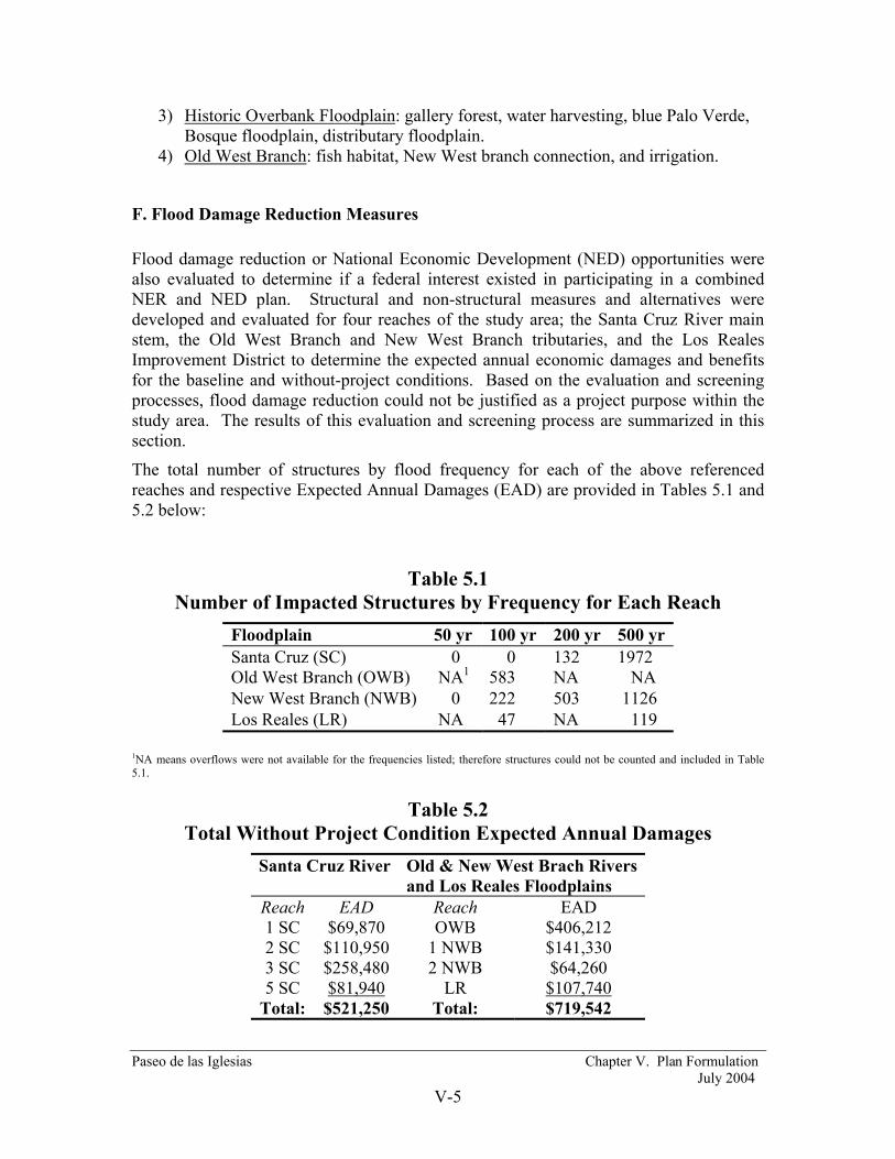
Paseo de las Iglesias Chapter V. Plan Formulation July 2004
V-5
3) Historic Overbank Floodplain: gallery forest, water harvesting, blue Palo Verde, Bosque floodplain, distributary floodplain.
4) Old West Branch: fish habitat, New West branch connection, and irrigation.
F. Flood Damage Reduction Measures Flood damage reduction or National Economic Development (NED) opportunities were also evaluated to determine if a federal interest existed in participating in a combined NER and NED plan. Structural and non-structural measures and alternatives were developed and evaluated for four reaches of the study area; the Santa Cruz River main stem, the Old West Branch and New West Branch tributaries, and the Los Reales Improvement District to determine the expected annual economic damages and benefits for the baseline and without-project conditions. Based on the evaluation and screening processes, flood damage reduction could not be justified as a project purpose within the study area. The results of this evaluation and screening process are summarized in this section.
The total number of structures by flood frequency for each of the above referenced reaches and respective Expected Annual Damages (EAD) are provided in Tables 5.1 and 5.2 below:
Table 5.1 Number of Impacted Structures by Frequency for Each Reach
Floodplain 50 yr 100 yr 200 yr 500 yr Santa Cruz (SC) 0 0 132 1972 Old West Branch (OWB) NA1 583 NA NA New West Branch (NWB) 0 222 503 1126 Los Reales (LR) NA 47 NA 119
1NA means overflows were not available for the frequencies listed; therefore structures could not be counted and included in Table 5.1.
Table 5.2 Total Without Project Condition Expected Annual Damages
Santa Cruz River Old & New West Brach Rivers and Los Reales Floodplains
Reach EAD Reach EAD 1 SC $69,870 OWB $406,212 2 SC $110,950 1 NWB $141,330 3 SC $258,480 2 NWB $64,260 5 SC $81,940 LR $107,740
Total: $521,250 Total: $719,542

Paseo de las Iglesias Chapter V. Plan Formulation July 2004
V-6
1. Non-Structural Flood Damage Reduction Measures: A variety of non-structural flood damage reduction measures were identified, which could be used to meet the planning objectives. The initial evaluation of these measures is discussed below.
Floodplain Management Regulations
The City of Tucson and Pima County participate in the National Flood Insurance Program (NFIP), which is administered through the Federal Emergency Management Agency (FEMA). FEMA has published Flood Insurance Rate Maps (FIRMs) for both jurisdictions that identify Special Flood Hazard Areas for the Santa Cruz River and tributaries. For local jurisdictions to maintain eligibility in the NFIP, minimum levels of floodplain management regulations must be adopted and enforced. Due to the existence of floodplain management regulations and enforcement, this measure was not carried forward for alternative evaluation.
Flood Warning Systems
A flood warning and preparedness system is often the most cost effective flood mitigation measure comprised of computer hardware, software, technical activities and/or organizational arrangements aimed at decreasing flood hazards. Advanced warning is not generally effective in reducing structural damages (outside of sandbagging efforts given early warning); the primary benefits of such a system are credited for providing early evacuation of residents and reduction in damages to vehicles and structure contents.
Pima County owns and operates an extensive flood-warning network. This network operates in the National Weather Service ALERT (Automated Local Evaluation in Real Time) format and is part of the Arizona Statewide Flood Warning System previously developed and constructed by the Corps under Section 205 of the Continuing Authorities Program.
Due to the existence the statewide and local flood warning systems, this measure was not carried forward for alternative evaluation.
Flood Proofing
Flood proofing offers the opportunity to provide flood protection on an individual structure-by-structure basis or a group of structures. Flood proofing techniques typically include buyouts, relocation, elevation, floodwalls or levees, and dry flood proofing. Elevation, buyout, and relocation are the most dependable of these flood proofing methods. Flood proofing costs can vary substantially depending on the type of flood proofing method being considered and the type, size, age, and location of the structure(s). Flood proofing techniques considered for alternative development are:
1) Relocation of Existing Structures: Relocation is perhaps the most dependable flood proofing technique since it totally eliminates flood damages, minimizes the need for flood insurance and allows for the restoration/reclamation of the floodplain. This technique requires the physical relocation of flood prone structures outside of the

Paseo de las Iglesias Chapter V. Plan Formulation July 2004
V-7
identified flood hazard area. This also requires purchase of the flood prone property; selecting and purchasing a new site; and lifting/moving the structure to the new site.
2) Buyout or Acquisition: This technique requires the purchase of the flood prone property and structure; demolition of the structure; relocation assistance; and applicable compensation required under Federal and State law. This alternative typically requires voluntary relocation by the property owners and/or eminent domain rights exercised by the non-federal sponsor.
3) Retrofitting or Dry Flood Proofing: Dry flood proofing of existing structures is a common flood proofing technique applicable for flood depths of three (3) feet or less on buildings that are structurally sound. Installation of temporary closures or flood shields is a commonly used flood proofing technique. A flood shield is a watertight barrier designed to prevent the passage of floodwater though doors, windows, ventilating shafts, and other openings of the structure exposed to flooding. Such shields are typically made of steel or aluminum and are installed on structures only prior to expected flooding. However, flood shields can only be used on structures with walls that are strong enough to resist the flood-induced forces and loadings. Exterior walls must be made watertight in addition to the use of flood shields. This technique is not applicable areas subject to flash flooding (less than one hour) or where flow velocities are greater than three (3) feet per second. It would also not be applicable to mobile homes, which comprise sixty-nine percent of the flood prone structures in the study area, due to the type of construction and typical lack of anchoring to a foundation.
Aside from the cost, dry flood proofed homes and businesses can still suffer flood damages due to the potentially incomplete nature of the solution. Enclosures for windows and doors require human intervention in order to fully implement the solution and, this action would have to occur in a relatively short time frame. Due to the incomplete nature and limited applicability of this flood proofing method, it was not carried forward for alternative evaluation.
4) Localized Levees or Floodwalls: Ring levees or floodwalls can be built around individual structures to protect single or small groups of structures. Ring levees are earthen embankments with stable or protected side slopes and a wide top. Floodwalls are generally constructed of masonry or concrete and are designed to withstand varying heights of floodwaters and hydrostatic pressure. Closures (e.g., for driveway access) are typically manually operated based on flood forecasting and prediction that would alert the operator.
Disadvantages of levees or berms are: 1) can impede or divert flow of water in a floodplain; 2) can block natural drainage; 3) susceptible to scour and erosion; 4) give a false sense of security; and 5) take up valuable property space.
Disadvantages of floodwalls are: 1) high cost; 2) closures for openings required, and 3) give a false sense of security.
5) Elevation of Structures: Existing structures can be elevated or raised above the potential flood elevation. Structures can be raided on concrete columns, metal posts, piles, compacted earth fill, or extended foundation walls. Elevated structures must be designed and constructed to withstand anticipated hydrostatic and hydrodynamic forces

Paseo de las Iglesias Chapter V. Plan Formulation July 2004
V-8
and debris impact resulting from flooding. The access and utility systems of the structures to be raised would need to be modified to ensure they are safe from flooding.
2. Structural Flood Damage Reduction Measures:
A variety of structural flood damage reduction measures were also identified, which could be used to meet the planning objectives. The initial evaluation of these measures is discussed below.
Detention
This measure would require construction of on-line (i.e., in-stream) or off-line regional detention facilities upstream of the study area designed to detain flood flows and release then at a lower rate. There are no lands identified for upstream detention that would provide adequate storage volume to detain the 100-500-year flood events. In addition, any such location would fall outside the study area and outside Pima County jurisdiction either on Tribal Lands or in Santa Cruz County. The location of a large-scale detention facility relative to the entire 22,222 square mile contributing watershed would have to be evaluated to determine what impacts, if any, there are on flood hydrographs through the study area. This measure was not carried forward for alternative evaluation.
Lined Channels & Covered Channels:
1) Rectangular Concrete Channels: Preliminary evaluation of this measure revealed no practical location along the large, entrenched Santa Cruz River channel where such a solution would be practical. Rectangular concrete channels are not carried forward for alternative evaluation.
2) Trapezoidal Rip-Rap/Soil Cement/Vegetation Lined Channels: A preliminary evaluation was performed for the potential for utilizing trapezoidal lined channels, due to the reduced construction costs and improved aesthetics of such channels. The Santa Cruz River contains the 100-year flood, and several reaches within the study area are currently protected from erosion with soil cement lined banks. This measure was carried forward for alternative evaluation.
3) Covered Channels: A preliminary evaluation indicated that there is no specific location where covered channels could be utilized and this measure is not carried forward for the alternative evaluation.
Levees and/or Floodwalls:
1) Levees: Levees can provide significant levels of protection in a cost effective manner, however, there are disadvantages such as increases of flood stages, real estate costs and access considerations, environmental impacts, and the potential for failure due to scour/erosion or overtopping. This measure was carried for alternative evaluation.
2) Floodwalls: Consideration was given to protective floodwalls in place of levees. Floodwalls may be provided at a lower cost than levees and provide significant levels of protection over and above the current channels, with or without widening and deepening. This measure was carried forward for alternative evaluation.

Paseo de las Iglesias Chapter V. Plan Formulation July 2004
V-9
G. Evaluation of Measures Each measure was evaluated in terms of the feasibility criteria. All criteria must be adequately met since any one criterion can serve to eliminate a measure from further consideration. Those measures satisfying all the criteria were carried forward for additional development and evaluation while those that were shown not to meet the criteria were eliminated from further consideration.
Measures that were carried forward were then combined in various configurations to form a preliminary set of alternatives, which was then subjected to a more rigorous evaluation against the criteria. Some measures became alternatives, while other measures were combined to form alternatives.
1. Restoration Measures Based upon feasibility criteria, all but one of the identified restoration measures were carried forward for Plan Formulation in development of the alternatives. Soil cement removal was the only restoration measure eliminated from further consideration.
2. Flood Damage Reduction Measures Measures were utilized to develop alternatives at the conceptual level. Alternatives were evaluated and screened using preliminary cost estimates based on costs developed for similar measures in other studies conducted in the region. Detailed cost estimates were not prepared because none of the alternatives were near enough to being justified to warrant more precise analysis.
Old West Branch (OWB):
The Old West Branch is an entrenched natural channel. The average base width is 20 ft and the average bank height is 10 ft. There is a significant amount of vegetation (e.g., mesquite) growing along the banks and some vegetation growing in the channel bed. There is a large concrete drop structure at the confluence of with the Santa Cruz River. Bridge crossings are located at Silverlake Road, Ajo Way, and Via Engresso.
Structural flood damage reduction alternatives along the OWB would result in the loss of the most highly valued riparian habitat and mesquite bosque within the study area, which is in direct conflict with the primary ecosystem restoration purpose. Previous proposals, by the non-federal sponsor, for structural flood control channel improvements along the OWB resulted in a high degree of public opposition. In addition, 73 acres of the OWB channel and floodplain must be maintained as a “natural floodplain” under the mitigation provisions of an existing USACE Section 404 Permit and structural modifications of the natural channel are prohibited. Based on aforementioned constraints, structural flood damage reduction alternatives for the OWB were not developed and evaluated.
In light of the above, only non-structural flood damage alternatives were evaluated for the OWB. Approximately 583 structures are potentially damaged in the 100-year flood event and the expected annual damages are $406,212. The non-structural alternatives evaluated are:
Paseo de las Iglesias Chapter V. Plan Formulation July 2004
V-10
OWB-1 Buyouts and/or Relocation OWB-2 Elevation of Structures OWB-3 Localized Floodwalls or Levees
Alternative OWB-1 (Buyouts/Relocation): Estimates for structure values (not including relocation assistance and demolition costs) in the OWB 100-year floodplain exceeded $23,000,000 (See Economic Appendix). Based on this estimate compared EAD level that might justify a $4.8 million project, Alternative OWB-1 is clearly not economically justified and was eliminated from further consideration.
Relocation would depend on whether alternative sites for 583 structures are available, the willingness of the residents to relocate, and other non-technical factors. There are no identified sites with equivalent zoning, existing infrastructure, and lot configuration that could accommodate relocating 583 structures. Assuming that such relocation sites were available, the cost to relocate these structures (1,000 sq. ft. each) was estimated at $10 per square foot to move the structures several miles. 10% contractor profit was also assumed per USACE National Flood Proofing Committee guidelines. Relocation and profit costs only are estimated at $6,400,000. The average annual cost is $384,949 for a B/C of 1.05 at a 5.625% interest rate. Required additional costs not incorporated would include cost of the new lot, new foundations, landscaping, and pertinent indirect costs. Based on this cost estimate and lack of relocation sites, relocation was eliminated from further consideration.
Alternative OWB-2 (Elevation): The economic benefits associated with elevating existing structures are measured by subtracting the value of the expected annual damages under improved conditions from the expected annuals damages under the Without-Project conditions.
Construction costs were estimated for raising structures with piers for manufactured/ mobile homes and stem walls for slab on grade homes. The mobile homes also require adequate tie-downs to prevent flotation. These costs considered the condition of the structure to be raised, the site preparations required, mobilization costs, and the approximate square footage of the structure. A constant cost of per square foot was used whether the structure is raised one foot or three feet. Commonly, the cost per square foot increases for each additional foot the structure is elevated. These costs (per NFPC data) are:
Wood Frame Building on Piles, Posts or Piers1 $26 per square foot Wood Frame Building on Foundation Walls1 $19 per square foot Brick Building1 $32 per square foot
1These costs include foundation, extending utilities, and miscellaneous items, such as sidewalks and driveways. They do not include the cost of fill or landscaping.
A profit of 10% also needed to be included, as well as fixed engineering design, mobilization, and relocation cost of $7,000 for the mobile homes and $14,000 for the each single family residential homes. All costs were based on a typical 1,000 square foot wood framed structure.

Paseo de las Iglesias Chapter V. Plan Formulation July 2004
V-11
The cost to elevate 52 SFR and 528 MH residential structures was estimated at $15,451,000. This figure was then converted to an annual average equivalent value for purposes of comparison on a common basis with the estimate of the average annual benefits. The analysis shows that the net benefits generated by the alternative are -$523,141, therefore the B/C ratio is .43. Thus, this alternative is not economically justified and was not carried forward.
Alternative OWB-3 (Floodwalls): Installation of individual or groups of floodwalls or levees was analyzed for the residential structures only. Based on the small lot sizes, configuration of the subdivision(s) and clustered nature of the residential structures, construction of individual floodwalls or ring levees are not physically possible. Floodwalls constructed around the perimeter of individual subdivisions would act as ineffective flow areas that increase water surface elevations and divert flood flows onto adjacent properties, thus inducing damages. Based on this evaluation, this alternative was eliminated from further consideration.
New West Branch:
The New West Branch (NWB) is an entrenched partially bank protected trapezoidal channel. The channel has a natural bottom with 3 on 1 concrete lined side slopes. The base width varies from 100 to 120 ft. The average bank height is 8 ft. There is a large concrete drop structure/energy dissipator at the confluence of with the Santa Cruz River; with another drop structure located approximately 1,925 feet upstream. Bridge crossings are located at Irvington, Drexel, and Valencia Roads.
222 structures are potentially damaged in the 100-year, 503 in the 200-year flood events and 1,126 structures are damaged in the 500-year event. The total expected annual damages are $205,590. Non-structural alternatives (i.e., dry flood proofing, elevation, and relocation) were eliminated from further consideration based on the non-structural alternatives analysis performed for the 583 structures on the Old West Branch.
Potential structural alternatives evaluated for the New West Branch were:
NWB-1: Channel Dredging, NWB-2: Reconstruction of Existing Levees, and NWB-3: Floodwalls.
Alternative NWB-1 (Channel Dredging): The without project hydraulic model was modified to determine the impacts of channel dredging. The following impacts or concerns were identified:
• Excavation can increase the conveyance of the New West Branch up to the 100-yr flood event only. Up to two (2) ft of excavation is necessary.
• Excavation alone would not contain the 200- and 500-yr flood events.
• The existing grade control structure at Station 6.0 would need to be modified (lowered) as well as the existing bank protection.

Paseo de las Iglesias Chapter V. Plan Formulation July 2004
V-12
• The existing footbridge upstream of Drexel Road would need to be removed or replaced.
• Excavation may result in undermining of the existing soil cement bank protection. The toe down depth(s) of the existing soil cement bank protection is unknown and cannot be verified. Additional field exploration will be required to determine structural integrity, toe-down depths, and subsurface conditions behind and under the soil cement.
For cost estimating purposes and alternatives analysis, the assumption was made that the existing soil cement would require structural measures to prevent undermining. At this time, a preliminary cost estimate cannot be developed without knowledge of toe-down depth. This alternative is unlikely to be justified even if excavation is the primary cost and structural modifications to the existing bank protection are not required. Cost for excavation alone is estimated at $2,838,486. Annualized over 50 years and a 5.625% interest is $170,730. This estimate does not include modification of the existing grade control structure, removal or replacement of existing pedestrian bridge or bridge improvements to Drexel and Irvington. Benefits were calculated using HEC-FDA without project output and an EAD spreadsheet. Benefits for the New West Branch floodplain are $85,781. If this preliminary analysis showed possible justification HEC-FDA would have been used for detailed analysis. However, the resulting benefit-to-cost ratio for excavation on Alternative NWB-1 is .50. Therefore, this alternative was not economically justified.
Alternative NWB-2 (Replace Levees): Levees (or berms) currently exist along both channel banks, however they do not contain the 100 to 500-year flows. An analysis was performed to determine effects of raising the existing levees to protect for the 100, 200, and 500-year flood events. As built drawings for the existing levee are not available therefore, for engineering design and cost estimating purposes, the existing levees were assumed to be structurally inadequate and completely new engineered levees were assumed. Due to the high velocities and possibility of run-up at the curve, rigid armoring (i.e., soil cement) would be required on the inside slopes of the levees. Costs for soil cement bank protection assumed a 14-foot bank height and 5-foot toe-down. Major elements include earthwork, borrow material, manufacturing of soil cement, cement materials, handrails, and utility relocations. Lesser items include traffic control, removal of obstructions, clearing/grubbing, and off-site drainage facilities. Typical unit costs for earthwork, manufacturing of soil cement, and cement materials were provided by Pima County.
The cost (excluding additional real estate requirements) for reconstruction of approximately 14,200 lineal feet of new levee system on both sides of channel was estimated at $11,809,801. Annualized cost equal $710,340. With benefits equaling $204,120 for 100 years of protection, $205,240 for 200 years of protection and $205,450 for 500 years of protection, the resulting B/C ratio for Alternative NWB-2 and NWB-3 (described below) is .29; therefore it is not economically justified.
Alternative NWB-3 (Floodwall): Based on the analysis for Alternative NWB-2, a floodwall determined to be impractical given the fact that the costs of floodwalls are typically in the range of five to seven (5-7) times the cost of the soil cement levee.

Paseo de las Iglesias Chapter V. Plan Formulation July 2004
V-13
Santa Cruz River:
The Santa Cruz River main stem is characterized by a partially bank protected ephemeral river with a narrow 100-year floodplain. There is soil cement bank protection on both banks between Congress Street and Silverlake Road, Irvington Road and Ajo Way, and near Valencia Road. The rest of the study reach is unprotected. The river is entrenched with widths varying from 200 to 1000 ft. Bridge crossings are located at Congress Street, 22nd Street, Silverlake Road, Ajo Way, Irvington Road, Drexel Road, and Valencia Road. The Old West Branch joins the Santa Cruz River between 22nd Street and Silverlake Road. The New West Branch joins the Santa Cruz River between Ajo Way and Irvington Road.
The Santa Cruz River incised channel contains the 2 through 100-year flood events for the majority of the study area and no structures are affected by these flood frequencies. 132 structures are affected in the 200-year flood frequency and 1,972 structures are affected in the 500-year flood frequency. The total expected annual damages are $521,250 (see Table 5.2) for the four sub-reaches on the Santa Cruz River.
Non-structural Alternatives: Dry flood proofing was not considered due to fact that 1,040 of the existing 1,972 structures are mobile homes, which are not conducive to this technique. Non-structural alternatives (i.e., dry flood proofing, elevation, and relocation) were eliminated from further consideration based on the costs determined by the non-structural alternatives analysis performed for the 583 structures on the Old West Branch.
Structural Alternatives: Structural alternatives considered for the Santa Cruz River are:
SCRiver-A Channel Improvements / Widening
SCRiver-B Levee or Floodwalls
Table 5.3 Reach Delineation Breakdown: The Santa Cruz Floodplain
Reach Name Cross Streets Stream Beginning Cross-Section
Ending Cross-Section
1 SC Congress St. 22nd Street
Santa Cruz River
32.61 33.38
2 SC 22nd Street Ajo Way
Santa Cruz River 33.38 35.77
3 SC Ajo Way Irvington Rd.
Santa Cruz River 35.77 36.630
4 SC1 Irvington Rd. Drexel Rd.
Santa Cruz River 36.630 37.87
5 SC Drexel Rd. Valencia Rd.
Santa Cruz River 37.87 38.96
__________________ 14 SC produced no damages.

Paseo de las Iglesias Chapter V. Plan Formulation July 2004
V-14
Alternative SCRiver-A (Channel Widening): Channel improvements along the Santa Cruz River main stem would entail widening of existing vertical eroded banks and then constructing soil cement bank protection at 1 (horizontal):1 (vertical). Referencing Table 5.3, both river banks for sub-reaches 1 SC and 3 SC are protected with soil cement and would require removal of the existing soil cement to accommodate channel widening and new soil cement protection would then have to be reconstructed. Sub-reach 2 SC is bank protected from 22nd Street to Silverlake Road.
A preliminary lump sum cost estimate for bank protection was previously developed for the Gila River, Santa Cruz River Watershed Pima County, Arizona Final Feasibility Report (dated August 2001) for the remaining unprotected channel banks. Costs for soil cement bank protection assumed a 20-foot bank height and 10-foot toe-down. Major elements include earthwork, borrow material, manufacturing of soil cement, cement materials, handrails, and utility relocations. Lesser items include traffic control, removal of obstructions, clearing/grubbing, and off-site drainage facilities. Typical unit costs for earthwork, manufacturing of soil cement, and cement materials were provided by the Pima County. The initial cost estimate, not including real estate and contingencies, was in excess of $14,960,000.
Channel widening alone will not provide a complete flood protection solution. The eight (8) existing roadway bridges would require improvements or replacement to convey design floods without overtopping.
Based on expected annual damage levels for the Santa Cruz River Sub-reaches, the initial cost estimate of $14,960,000, the impracticality of removing existing soil cement for channel widening, construction of new soil cement, and bridge replacements, Alternative SCRiver-A was not carried forward for detailed evaluation.
Alternative SCRiver-B (Levees or Floodwalls): Based on the cost estimates developed for the New West Branch Alternative NWB-2, construction of levees or floodwalls along both banks of the Santa Cruz River was deemed impractical. In addition, all bridge crossing would have to reconstructed and elevated to accommodate the top of any new levee or floodwall. This alternative was not carried forward.
Los Reales Alternatives:
The Pima County Department of Transportation and Flood Control District (FCD) formed the Los Reales Improvement District in 1987 in order to construct a flood-control levee and associated drainage ways. The purpose of this project was to divert flows around the development and dispose of these flood flows either into the Santa Cruz River or into the New West Branch channel. Along the south boundary of this Improvement District, there is a 4 ft high, 1400 ft long floodwall, which extends between the Tohono O’Odham Indian Reservation Boundary and Indian Agency Road. On the west end of this floodwall, there is a partially lined concrete channel that would divert a portion of the flood flows northward into the New West Branch channel. A partially lined concrete channel is aligned along the south edge of the development and diverts all remainder flood flows into the Santa Cruz River approximately opposite Hughes Wash.

Paseo de las Iglesias Chapter V. Plan Formulation July 2004
V-15
Forty-seven (47) structures are affected in the 100-yeat event and 119 structures are affected (primarily from shallow overland flows) in the 500-year event. Total expected annual damages are $107,740. Alternatives evaluated are:
LR-1 Flood Proofing LR-2 Elevation of Structures
Alternative LR-1 (Flood Proofing): Sixty-six (66) percent of the existing structures are classified as mobile homes. Dry flood proofing techniques such as flood shields and sealing of exterior walls would not be applicable for mobile homes due to the type of construction and lack of adequate anchoring to a foundation. Therefore, this alternative was not carried forward. Alternative LR-2 (Elevation): Costs to properly elevate and anchor the residential structures was estimated at $3,187,000. $191,693 is the annualized costs at a 5.625% interest rate. The resulting benefit-to-cost ration is .56 with benefits potentially equaling $107,740; therefore this alternative is not economically justified.
Erosion Hazard Damage Evaluation:
The bank erosion study was limited to the Santa Cruz River. The New West Branch was not studied since its banks are lined with concrete/soil cement. This was the same case for the Los Reales Improvement District area. The Old West Branch was not studied due to plan formulation constrains that preclude structural channel modifications.
Santa Cruz River Results:
Approximately 70 structures could be affected based on the historic annual erosion rates, in areas without soil cement bank protection. The total annualized expected annual damages for these 70 structures is estimated at $57,946 (see Table 5.4). At this level of economic damage, an estimated $963,000 project might be economically justified.
Table 5.4 Present Value and Annualized Damages for Affected Structures
Reach Present Value
AnnualizedDamages
SC 2 $695,678 $43,937 SC 4 $80,153 $5,375 SC 5 $129,522 $8,634 Total $905,354 $57,946
A preliminary lump sum cost estimate for bank protection was previously developed for the Gila River, Santa Cruz River Watershed Pima County, Arizona Final Feasibility Report, dated August 2001. This estimate for bank protection was made based on similar projects on the study area. Costs for soil cement bank protection assumed a 20-foot bank height and 10-foot toe-down. Major elements include earthwork, borrow material,

Paseo de las Iglesias Chapter V. Plan Formulation July 2004
V-16
manufacturing of soil cement, cement materials, handrails, and utility relocations. Lesser items include traffic control, removal of obstructions, clearing/grubbing, and off-site drainage facilities. Typical unit costs for earthwork, manufacturing of soil cement, and cement materials were provided by the Pima County. The initial cost estimate, not including real estate and contingencies, was in excess of $14,960,000. Based on the low EAD value of $57,946 and a resulting annualized cost of $899,820, a soil cement bank protection project would not be economically justified with a B/C ratio at .06.
H. Preliminary Ecosystem Restoration Alternatives Extensive work to identify and conceptually describe restoration opportunities had been accomplished by Pima County before initiation of this feasibility study. Detailed information regarding Pima County planning efforts may be found in “Paseo de las Iglesias: Restoring Cultural and Natural Resources in the Context of the Sonoran Desert Conservation Plan, April 1993.”
1. Alternative Formulation The principal limiting constraint for ecosystem restoration in an arid environment is the availability of water; however, this formulation process initially assumed that sufficient volumes of water to support a full range of riparian communities could be made available. The kinds of restoration techniques and measures to be implemented were also used to define alternatives. Land was presumed to be available within the study area, particularly near the larger stream channels within the study area. Alternatives were developed by varying the volumes of water that could be supplied, the area of land utilized and the restoration measures that might be constructed within a carefully selected area of land adjacent to the Santa Cruz River and its major tributaries. This approach allowed decision makers to weigh the relative cost of the markedly different biologic outputs resulting from the commitment of various volume of water within a fixed area of land.
The selection of the areas of land in the study area where riparian ecosystem restoration alternatives might reasonably and appropriately be constructed was accomplished through an iterative process by the project team composed of District personnel, the local sponsor and their respective technical specialists and consultants. Geographic Information System mapping resources (particularly the Pima County Land Information System PCLIS), recent aerial photographs, field inspections, the local knowledge base and professional opinion were employed to delineate a rational project area. The following selection criteria were employed to yield an area of approximately 1350 acres that alternatives were formulated to fit within.
• Publicly owned lands were favored over privately held lands. The majority (more than 90 percent) of the lands in and immediately adjacent to the Santa Cruz River and its major tributaries are owned by public entities. The City of Tucson is the major landowner, followed by Pima county lands, State and Federal lands.
• The majority of existing residential and commercial areas and all street and road rights-of-ways and utility corridors were eliminated. These would not be

Paseo de las Iglesias Chapter V. Plan Formulation July 2004
V-17
considered as part of a project unless there were unavoidable engineering requirements directing the need of a particular location.
• Areas presently platted for commercial or residential development were generally eliminated, unless reasonably needed for access or over-riding engineering considerations.
• Most overlaps with proposed Rio Nuevo redevelopment project were eliminated due to uncertainty regarding potential conflicts between redevelopment and restoration land uses.
• Known hazardous or toxic waste sites and landfills were avoided. • Most lands that did not need to be restored were eliminated. These included lands
currently supporting moderate to high quality examples of Sonoran Desert Cactus-scrub habitat.
• Existing, developed and manicured parks were eliminated. While not untrammeled native habitat, maintained parks support stands of vegetation that provide a suitable buffer between future restoration sites and urban uses.
Any lands that were clearly within limits of existing watercourses, as well as those immediately adjacent to areas of the associated historic floodplains were considered for the restoration alternatives. Parcels located within the historic floodplain and close to existing watercourses were evaluated on a case-by-case basis. Finally, the team agreed that the outer limit of the Project Area boundary should be adjusted to follow parcel boundaries in a manner that precluded taking unreasonably small portions of parcels or leaving parcels that were not large enough to be viable for other uses. The application of these criteria resulted in a potential Project Area of 1,341 acres.
This delineated area included the land most suitable for riparian corridor ecosystem restoration projects within the Paseo de las Iglesias study area. The area selected included distinct geomorphic areas within the active river channel, first and second terraces within the main erosion-defined channel, unstable banks above terraces (including the area required to lay them back) and an overbank area within the historic floodplain. Figure 5.1 shows the spatial relationship of this area to the study area. Table 5.5 provides a summary of land ownership of the project area. Table 5.6 summarizes lands by geomorphic classification.

Paseo de las Iglesias Chapter V. Plan Formulation July 2004
V-18
Table 5.5 Land Ownership in the Paseo de las Iglesias Restoration Area
Land Owner Type Acres Percent of Area
City of Tucson 565 42.1 Pima County Flood Control 138 10.3
State of Arizona 11 0.8 Other Public 4 0.3 Residential 75 5.6 Commercial/Industrial 497 37.1 Unclassified 51 3.8
Table 5.6 Geomorphic Conditions in the Paseo de las Iglesias Restoration Area
Geomorphic Condition Acres Percent of Area
Active Channel 173 12.9 Terraces 188 14.0 Unstable Slopes/Banks 146 10.9 Overbank/Historic Floodplain 785 58.5 Other (Soil Cement/Rio Nuevo) 49 3.7

Paseo de las Iglesias Chapter V. Plan Formulation July 2004
V-19
S 12TH AV
W VALENCIA RD
W IRVINGTON RD
E AJO WY
W AJO WY
E BROADWAY BL
E 22ND ST
E DREXEL RD
S LA CHO
LLA BL
S CALL E SANTA
CR UZN
S
W CONGRESS ST
E SILVERLAKE RDW SILVERLAKE RD
S STON
E AV
INTERSTATE 19
ProjectArea
#
#
#
#
StudyArea
City of Tucson
400 0 400 800 Feet
N
EW
S
FIGURE 5.1 Project Area

Paseo de las Iglesias Chapter V. Plan Formulation July 2004
V-20
Certain presumptions were established as the starting conditions for the development of restoration alternatives. These conditions included the following:
1. Restoration alternatives considered would utilize variable locations within the project area. Utilization would consist of all earth moving and grading practices, slope stabilization practices, water harvesting practices, planting, weed removal, irrigation, flooding features, ingress/egress routes, permanent and temporary storage areas and temporary infrastructure support features.
2. The most fundamental restoration plan for the area was presumed to be the application of minimal dry-land restoration practices. These include soil scarification, incorporation of nutrients and organic matter, mulching, ground patterning, water harvesting techniques for non-irrigated restoration, the placement of natural wind and sun-shading features and slope stabilization. Weed control and direct seeding of native species mixes would be applied for all lands included in the alternatives.
3. The presence and success of planted natural communities will be facilitated and maintained by the volume of water applied at a given location. Alternatives were formulated to have varying water requirements.
4. It was assumed that all of the area utilized by each alternative would be exposed to some level of restoration activity. While grading and excessive soil manipulation will be avoided in remnants of natural communities in the project area, most areas will require moderate to profound disturbance of the existing surface.
In addition to the Xeroriparian concept (number 2 immediately above), features were also placed into “Mesoriparian” and “Hydroriparian” groups. The project area was divided into three regions or geomorphic settings: 1) the active channel, 2) the adjoining terraces, and 3) the historic floodplain. The active channel refers to the area where water flows most frequently and where perennial flow would be found if it still existed. The terraces are the adjacent land features that are elevated only slightly above the active channel. Lower terraces might be flooded once or more in most years and the upper terraces would be flooded approximately every other year. The historic floodplain is the area adjacent to the entrenched channel of the Santa Cruz River. Although the historic floodplain has been cut off from the river due to down cutting resulting from human activities, in the past parts of this area would have been flooded by events greater than the 2-year event with most of the area being inundated in a 10-year event.
Using the concepts of riparian communities and geomorphic settings, a matrix of grouped measures was created. This matrix is included as Table 5.7. The matrix allowed initial consideration of potential combinations of feature groups, including “no action”, to create forty-seven potential alternatives.

Paseo de las Iglesias Chapter V. Plan Formulation July 2004
V-21
Table 5.7 Alternative Features Matrix
Active Channel Features Floodplain Terrace Features Historic Floodplain Features No Action* (Without Project) *Listed items are anticipated consequences rather than measures to be implemented as in the other rows.
1. Continued instability of channel due to erosion.
2. Continued refuse dumping. 3. Continued habitat degradation.
1. Continued erosion loss of lower terraces creating cliff-like banks.
2. Eventual application of soil cement on unprotected banks armoring entire reach.
1. With expanded soil cement bank protection, continued historic floodplain encroachment by development.
Xeroriparian (Establishment & Emergency Irrigation)
1. Construct aquitards upstream of existing and new grade control structures.
2. Divert low flow from New West Branch into remnant headwaters of Old West Branch.
3. Plantings of riparian grasses/shrubs
1. Water harvesting from local runoff. 2. Create tributary aquitard deltas with
two-tiered aquitards. 3. Plantings on terraces and aquitards.
1. Amend soil with nutrients, moisture trapping, contouring.
2. Water harvesting from local runoff. 3. Replace steep banks with stabilized
planted terraces
Mesoriparian (Irrigation)
1. Construct and provide supplemental irrigation to aquitards upstream of existing and new grade control structures.
2. Introduce periodic flow into the Old West Branch just upstream of its confluence with the Enchanted Hills Wash and on other tributaries downstream of that point.
3. Plantings of riparian grasses
1. Create tributary single-tiered aquitard deltas.
2. Irrigate and plant terraces with mesquite along upper terrace.
3. Stabilize active channel banks by establishing thickly rooted mesquite at the edge of the lower terraces.
1. Amend soil with nutrients, moisture trapping, contouring.
2. Plant and irrigate historic floodplain. 3. Replace steep banks with stabilized
planted terraces
Hydroriparian (Perennial Flow With Irrigation)
1. Restore perennial flow with multiple points of distribution into the main Santa Cruz and tributary channels.
2. Plant cottonwood-willow bundles at edges of perennial flow where erosion protection needed.
3. Construct perennial channel features (e.g., pools, runs, and riffles).
1. Create tributary aquitard deltas with hydraulic link to perennial flow.
2. Irrigate and plant low terraces with riparian grasses to maintain flood conveyance and discourage colonization by invasive species.
3. Irrigate and plant upper terraces with mesquite and cottonwood-willow at tributary aquitards.
Hydro Riparian plants do not occur in areas of the floodplain that are not subject to frequent inundation. Even so, measure 3 from the mesoriparian floodplain is carried forward to mitigate greater erosion risks associated with increased channel roughness in combinations where “No Action” is paired with Perennial Flow.

Paseo de las Iglesias Chapter V. Plan Formulation July 2004 V-22
2. Alternative Screening: Preliminary screening of these alternatives was accomplished by applying three factors that embodied the planning objectives and constraints identified in the early stages of the study. Based on these objectives, alternatives were discarded that:
• failed to provide sufficient area of diverse habitat (that is, they failed to maximize use of the delineated Project Area lands and lacked community interspersion),
• were inconsistent with the appropriate geomorphic setting of riparian communities or restoration practices, and
• were determined as likely to negatively alter flood conveyance. The number and interspersion of cover types restored and the total acreage restored were taken into consideration for assessing the application of the first criterion. The second criterion, “appropriateness with the geomorphic setting”, selected against alternatives, which misplaced riparian communities. Hydroriparian communities occur in the lowest positions in the channel cross-section, where water is usually is at or near the surface. Mesoriparian communities occur vertically above channel flow but experience frequent flooding or surface saturation from high water levels in the channel. Xeroriparian communities experience brief and infrequent flooding or saturation, being sustained by rainfall and local surface runoff. In geomorphic terms, hydroriparian plants are most often found adjacent to the active channel or in the adjoining lower terraces. Mesoriparian plants would be found in the lower or upper terraces and xeroriparian plants would be found in the upper terraces or the historic floodplain. While diminished flows might lead to drier communities occurring near the active channel, hydroriparian plants would not be found in the historic floodplain and drier communities would not be found near the channel with a wetter one upgradient at a greater distance from the channel (See Figure 4.3). With a few exceptions described later, alternatives that violated this “natural logic” were eliminated.
While the Santa Cruz River channel has substantial capacity to convey flood flows, restoration measures that encourage the growth of thick stands of vegetation throughout the channel would reduce that capacity and run a high risk of inducing flood damages as a result. Therefore, alternatives that would create extensive new woody vegetation and obstructions in both the terraces and the active channel were eliminated. Application of these screening criteria resulted in elimination of thirty-three of the forty-seven possible alternatives. The results of this screening are presented in Table 5.8 and those alternatives eliminated from further consideration are gray shaded.

Paseo de las Iglesias Chapter V. Plan Formulation July 2004 V-23
Table 5.8 Alternative Screening
Active Channel Terraces Floodplain Reason for Elimination
No Action Xeroriparian Xeroriparian Fails to provide sufficient habitat diversity No Action Xeroriparian Mesoriparian Not Consistent with Natural Pattern No Action Xeroriparian No Action Fails to provide sufficient habitat diversity No Action Mesoriparian Xeroriparian No Action Mesoriparian Mesoriparian No Action Mesoriparian No Action Fails to provide sufficient habitat diversity No Action Hydro Xeroriparian Not Consistent with Natural Pattern No Action Hydro Mesoriparian Not Consistent with Natural Pattern No Action Hydro No Action Not Consistent with Natural Pattern No Action No Action Xeroriparian Fails to provide sufficient habitat diversity No Action No Action Mesoriparian Fails to provide sufficient habitat diversity Xeroriparian No Action No Action Fails to provide sufficient habitat diversity Xeroriparian No Action Xeroriparian Fails to provide sufficient habitat diversity Xeroriparian No Action Mesoriparian Not Consistent with Natural Pattern Xeroriparian Xeroriparian No Action Fails to provide sufficient habitat diversity Xeroriparian Xeroriparian Xeroriparian Xeroriparian Xeroriparian Mesoriparian Not Consistent with Natural Pattern Xeroriparian Mesoriparian No Action Not Consistent with Natural Pattern Xeroriparian Mesoriparian Xeroriparian Not Consistent with Natural Pattern Xeroriparian Mesoriparian Mesoriparian Not Consistent with Natural Pattern Xeroriparian Hydro No Action Not Consistent with Natural Pattern Xeroriparian Hydro Xeroriparian Not Consistent with Natural Pattern Xeroriparian Hydro Mesoriparian Not Consistent with Natural Pattern Mesoriparian No Action No Action Fails to provide sufficient habitat diversity Mesoriparian No Action Xeroriparian Not Consistent with Natural Pattern Mesoriparian No Action Mesoriparian Not Consistent with Natural Pattern Mesoriparian Xeroriparian No Action Mesoriparian Xeroriparian Xeroriparian Mesoriparian Xeroriparian Mesoriparian Not Consistent with Natural Pattern Mesoriparian Mesoriparian No Action Mesoriparian Mesoriparian Xeroriparian Mesoriparian Mesoriparian Mesoriparian Mesoriparian Hydroriparian No Action Not Consistent with Natural Pattern Mesoriparian Hydroriparian Xeroriparian Not Consistent with Natural Pattern Mesoriparian Hydroriparian Mesoriparian Not Consistent with Natural Pattern Hydroriparian No Action No Action Hydroriparian No Action Xeroriparian Not Consistent with Natural Pattern Hydroriparian No Action Mesoriparian Not Consistent with Natural Pattern Hydroriparian Xeroriparian No Action Hydroriparian Xeroriparian Xeroriparian Hydroriparian Xeroriparian Mesoriparian Not Consistent with Natural Pattern Hydroriparian Mesoriparian No Action Too much reduction in conveyance Hydroriparian Mesoriparian Xeroriparian Too much reduction in conveyance Hydroriparian Mesoriparian Mesoriparian Too much reduction in conveyance Hydroriparian Hydroriparian No Action Hydroriparian Hydroriparian Xeroriparian Hydroriparian Hydroriparian Mesoriparian Note: “Natural Pattern” refers to maintaining the appropriate association of plan communities with geomorphic setting.
Paseo de las Iglesias Chapter V. Plan Formulation July 2004 V-24
Recreation components will be considered in the design of the recommended plan. Passive recreation associated with restored areas may include trails, viewing areas, and kiosks. The need to establish equestrian and off-road vehicle areas in neighboring sites to reduce the likelihood of impacts to restored areas from those activities will be evaluated.
Initially, alternatives were designated by combinations of four characters into groups of three. The letters used are N for no action, X for xeroriparian, M for mesoriparian and H for hydroriparian. Each letter represents a row from the Alternative Features Matrix with the order of letter aligned to the columns. Each habitat designation is assigned to the geomorphic aspect of the riparian corridor cross section moving from the center of the river channel to the highest ground furthest from the river’s centerline: active channel, terraced floodplain, and historic floodplain. For example, alternative HMN would be the result of combining hydroriparian active channel features and mesoriparian terrace features with no action in the historic floodplain. Results of the screening are discussed below.
Alternatives with No Measures in the Active Channel
Nine of the eleven alternative based on no action in the active channel were eliminated. Alternatives NXX, NXN, NMN, NNX and NNM were eliminated because they failed to produce sufficient area of diverse habitat. In addition, four of these include no action in two of the three geomorphic regions and as such, are inconsistent with natural patterns. Alternative NXM, NHX, NHM and NHN all have at least one wetter plant community located up gradient from a drier one and thus are inconsistent with natural patterns.
NMX and NMM were retained although they represent a departure from the screening criteria in that one would normally find a hydroriparian or mesoriparian plant community in the active channel if flow were frequent enough to support a mesoriparian community on the terraces. However, one of the other screening criteria was to avoid unacceptable reductions in flood conveyance. Leaving the active channel undisturbed represents the least possible impact to conveyance short of avoiding both the channel and the terraces.
Alternatives with Xeroriparian Measures in the Active Channel
Eleven of the twelve alternatives based on xeroriparian restoration in the active channel were eliminated. Alternatives XNM XXM, XMN, XMX, XMM, XHN, XHX, and XHM all have at least one wetter plant community located up gradient from a drier one and thus are inconsistent with natural patterns. Alternative XNX neither provides sufficient area of diverse habitat nor is consistent with natural patterns as the restored xeroriparian communities would be cut off from each other by an unrestored terrace region. Finally, alternatives XNN and XXN did not provide sufficient area of diverse habitat. Alternative XNN would consist of a total of six acres seasonally emergent marsh and 5 acres of riparian shrub for a total of 11 acres. Alternative XXN would add 174 acres of riparian shrub and 14 acres of mesquite for a total of 199 acres, 90 percent of which would be one cover type (riparian shrub. One alternative including xeroriparian features in the channel was carried forward. Alternative XXX (1125 acres with 77 percent riparian shrub) pairs xeroriparian channel features with xeroriparian restorations on the terraces and in the historic floodplain. The combination of a larger restoration area with the reduction of dominance by a single cover type leads to the retention of XXX.

Paseo de las Iglesias Chapter V. Plan Formulation July 2004 V-25
Alternatives with Mesoriparian Measures in the Active Channel
Seven of the twelve alternatives based on mesoriparian restoration in the active channel were not carried forward. Alternatives MNX, MNM, MXM, MHN, MHX and MHM all have at least one wetter plant community located up gradient from a drier one and thus are inconsistent with natural patterns. Alternative MNN did not provide sufficient area of diverse habitat. Five alternatives including mesoriparian features in the active channel were carried forward. Those alternatives carried forward were MXN, MXX, MMN, MMX and MMM.
Alternatives with Hydroriparian Measures in the Active Channel
Six of the twelve alternatives based on mesoriparian restoration in the active channel were not carried forward. Alternatives HNX, HNM and HXM all have at least one wetter plant community located up gradient from a drier one and thus are inconsistent with natural patterns. Alternatives HMN, HMX and HMM would all have excessive impacts on conveyance of flood flows due to pairing of mesquite planted lower and upper terraces with the hydroriparian channel. Six alternatives including hydroriparian features in the active channel were carried forward. Those alternatives carried forward were HNN, HXN, HXX, HHN, HHX and HHM.
In summary, twenty-one of the forty-seven theoretical alternatives identified in the initial plan formulation matrix were not carried forward because they were inconsistent with the appropriate geomorphic setting of riparian communities; an additional nine were eliminated because they failed to provide sufficient area of diverse habitat (that is, they failed to maximize use of the delineated Project Area lands and lacked community interspersion); and three others were eliminated based on the impacts they would have on conveyance of flood flows.
Alternative Names The adopted nomenclature (combinations of N, X, M and H into groups of three) worked well during the initial screening and was carried forward into the HGM based analysis of restoration outputs. However, in the alternatives that survived the screening process it became apparent that this nomenclature was somewhat misleading.
For example, as noted in Table 5.7, hydroriparian terrace features were modified to limit planting on the lower terraces to riparian grasses while upper terraces are planted with mesquite irrigated at hydroriparian levels. This action was taken to ameliorate potential conveyance impacts of the associated hydroriparian channel features. These were important distinctions to capture during the initial assembling and screening of alternatives. However, the resulting “hydroriparian terrace features”, due to the limitations imposed, result in a restored habitat more representative of mesoriparian plant communities.
Another example is the decision to include stabilized terraces in the historic floodplain with all alternatives having a perennial channel. As a result, N for no action really meant no action except for the terraces. Therefore, it was decided to refer to alternatives that passed screening in terms of the plant communities to be restored in order to eliminate
Paseo de las Iglesias Chapter V. Plan Formulation July 2004 V-26
any confusion regarding habitats to be restored. Each alternative is assigned a number (1-4) for the channel treatment and a letter sequenced within each number grouping (Table 5.9).
Table 5.9 Alternative Names
Screening Alternative Name
Screening Alternative Name
NMX 1A MMM 3E NMM 1B HNN 4A XXX 2A HXN 4B MXN 3A HXX 4C MXX 3B HHN 4D MMN 3C HHX 4E MMX 3D HHM 4F
I. First Array of Alternatives Fourteen of the forty-seven possible alternatives remained after the initial screening. A brief description of each alternative is provided below with summary data regarding the alternatives immediately following in Table 5.10. For ease of presentation, the alternatives have been grouped based on the riparian community in the active channel (e.g. No Action in the Channel, etc).
1. No Channel Features Two alternatives with no restoration measures in the active channel survived screening. Common features of both alternatives include construction and planting of subsurface water harvesting basins (aquitards) at the confluences of 11 tributaries, permanent irrigation systems for mesoriparian areas, temporary irrigation for xeroriparian areas and stabilized terraces in areas with steep unprotected banks. In addition, soil amendment would be common to both mesoriparian and xeroriparian areas with the latter having additional surface treatments to improve the soils ability to collect and retain rainfall.
The water harvesting features would involve excavating in the area where the tributaries enter the terraces. Excavation would be to a depth of approximately four feet, a liner membrane would be laid, and the excavated area would be filled with layers of appropriately sized gravel covered with granular fill. Permanent irrigation would combine construction of feeder pipelines to move water through the project area with use of gated pipe, flood or subsurface drip irrigation to distribute water at specific locations. In some cases, such as the tributary basins, a simple outflow would be sufficient.
Reaches of steep natural banks would be modified by cutting back into the historic floodplain to create gentler and more stable slopes. The method of stabilization would be a function of the amount of land available for the new terrace area. Where available land is not a constraint, banks will be graded at a 5 foot horizontal to 1 foot vertical slope and

Paseo de las Iglesias Chapter V. Plan Formulation July 2004 V-27
planted. Vegetated slopes of this grade are considered stable. A different treatment will be used in areas where there is not enough land to create a 5:1 slope but sufficient space exists to create slopes between 5:1 and 2:1. In those cases, the banks will be laid back to the minimum slope that can be fit into the available space. These slopes will also be vegetated, however a geotextile layer will be installed before planting to increase slope stability. In areas where insufficient space exists to accommodate 2:1 slopes placement of rip rap or soil cement may be necessary for bank protection. Such applications will be decided on a case-by-case basis.
There are several differences between alternatives with respect to the measures to be implemented in the historic floodplain. In the xeroriparian floodplain there is no permanent irrigation. Two features added to compensate for this are the additional efforts at surface treatment and the creation of a number of shallow depressions to concentrate local run-off.
Xeroriparian plantings will include smaller mesquite planted less densely, blue palo verde, wolfberry, graythorn, creosote bush, fourwing saltbush, sacaton and spiny hackberry. Mesoriparian plantings will have many of the same species planted with a higher density using larger specimens of mesquite and the addition of Fremont cottonwood, Goodding's Willow, and velvet ash at the tributary water harvesting basins.
Each of these alternatives results in the restoration or enhancement of 1,119 acres of habitat. Both are dominated by xeroriparian shrub (Scrubshrub) and mesquite with a few small pockets of cottonwood-willow.
Alternative 1A, Mesoriparian Terraces with Xeroriparian Floodplain, is comprised of 693 acres of xeroriparian shrub, 416 acres of mesquite and ten acres of cottonwood-willow. This alternative has an estimated construction cost of $73,054,463 that, when annualized over a 50-year project life yields an average annual cost of $4,394,110. Annual Operations, Maintenance Repair, Rehabilitation and Replacement (OMRR&R) costs are estimated at $893,863 so the total average annual cost of the alternative is $5,287,973. This alternative produces a net gain of 406 average annual Functional Capacity Units at a cost of $13,025 per unit.
In Alternative 1B, Mesoriparian Terraces and Floodplain, the addition of irrigation to the historic floodplain reverses the dominance xeroriparian plants producing 638 acres of mesquite, 471 acres of Scrubshrub and 10 acres of cottonwood-willow. This alternative has an estimated construction cost of $80,399,322 that, when annualized over a 50-year project life yields an average annual cost of $4,835,892. Annual OMRR&R costs are estimated at $888,749 so the total average annual cost of the alternative is $5,724,641. This alternative produces a net gain of 451 average annual Functional Capacity Units at a cost of $12,693 per unit.
2. Xeroriparian Channel Features The channel features for this alternative consist of two measures; construction of water harvesting basins on the upstream side of five existing grade structures and construction of a low flow diversion to direct water from the New West Branch back into the Old West Branch.

Paseo de las Iglesias Chapter V. Plan Formulation July 2004 V-28
The water harvesting basins would involve excavating upstream of each grade control structure to a depth of approximately four feet, placing a liner membrane, and filling the excavated area with layers of appropriately sized gravel covered with granular fill. The areas would be seeded with riparian grasses and would be maintained as emergent marsh with larger shrubs or medium sized trees periodically cut back to preclude significant impacts on flood flows.
The low flow diversion would be accomplished by placing a diversion structure in the New West Branch channel to pond low flows and placing a 24” diameter culvert through the bank to the newly excavated reach of channel between the NWB bank and remaining OWB channel. The tributary basins discussed above would still be constructed. However, they would be expanded in size since, without irrigation, the plants in those areas would be much more dependent water harvesting.
Soil amendment of terrace and floodplain areas would include finish grading to provide micro-topography suitable for concentration of rainfall along with placement of rocks and coarse woody debris to facilitate moisture retention and provide sun and wind shade. Also, the off channel areas to concentrate local runoff would be created in the floodplain.
Alternative 2A restores or enhances 1,125 acres of habitat. It is dominated by 867 acres of xeroriparian shrub (Scrubshrub) with 252 acres of mesquite and 6 acres of emergent marsh (Riverbottom). This alternative, Xeroriparian, has an estimated construction cost of $62,604,865 that, when annualized over a 50-year project life yields an average annual cost of $3,765,583. OMRR&R costs are estimated at $428,518 so the total average annual cost of the alternative is $4,194,101. This alternative produces a net gain of 402 average annual Functional Capacity Units at a cost of $10,433 per unit.
3. Mesoriparian Channel Features There are five alternatives sharing mesoriparian features in the active channel. The change in channel features associated with these alternatives consists of introduction of irrigation water into the lower reach of the Old West Branch and irrigation of the grade control harvesting basins. The irrigation would not be constant but would consist of adding water to extend the flow period following natural events. In this way, the volume and duration of flow in these areas would be increased to mimic mesoriparian conditions.
Two of the five mesoriparian channel alternatives have no restoration in the historic floodplain. Paired with the mesoriparian channel they produce only 199 acres of restored or enhanced habitat.
Alternative 3A, Mesoriparian Channel with Xeroriparian Terraces, restores or enhances 6 acres of emergent marsh, 174 acres of xeroriparian shrub and 19 acres of mesquite. 3A has an estimated construction cost of $18,179,435 that, when annualized over a 50-year project life yields an average annual cost of $1,093,464. OMRR&R costs are estimated at $232,910 so the total average annual cost of the alternative is $1,326,375. This alternative produces a net gain of 62 average annual Functional Capacity Units at a cost of $21,393 per unit.
Alternative 3C, Mesoriparian Channel and Terraces, restores the same 6 acres of emergent marsh with the remaining 193 acres consisting of mesquite. 3B has an
Paseo de las Iglesias Chapter V. Plan Formulation July 2004 V-29
estimated construction cost of $17,128,553 that, when annualized over a 50-year project life yields an average annual cost of $1,030,255. OMRR&R costs are estimated at $636,403 so the total average annual cost of the alternative is $1,666,659. This alternative produces a net gain of 115 average annual Functional Capacity Units at a cost of $14,493 per unit.
The other three alternatives with mesoriparian channel features each produce 1,125 acres of restored or enhanced habitat.
Alternative 3B, Mesoriparian Channel with Xeroriparian Terraces and Floodplain, is dominated by 862 acres of xeroriparian shrub with 257 acres of mesquite and 6 acres of emergent marsh. 3C has an estimated construction cost of $73,640,021 that, when annualized over a 50-year project life yields an average annual cost of $4,429,331. OMRR&R costs are estimated at $493,394 so the total average annual cost of the alternative is $4,922,724. This alternative produces a net gain of 375 average annual Functional Capacity Units at a cost of $13,127 per unit.
Alternative 3D, Mesoriparian Channel and Terraces with Xeroriparian Floodplain, is predominantly xeroriparian shrub at 688 acres with 421 acres of mesquite, 10 acres of cottonwood-willow and 6 acres of emergent marsh. 3D has an estimated construction cost of $71,605,491 that, when annualized over a 50-year project life yields an average annual cost of $4,306,957. OMRR&R costs are estimated at $896,887 so the total average annual cost of the alternative is $5,203,844. This alternative produces a net gain of 409 average annual Functional Capacity Units at a cost of $12,723 per unit.
Alternative 3E, Mesoriparian, continues the trend with mesquite becoming dominant at 643 acres, 466 acres of xeroriparian shrub, 10 acres of cottonwood-willow and 6 acres of emergent marsh. 3E has an estimated construction cost of $80,678,407 that, when annualized over a 50-year project life yields an average annual cost of $4,852,678. OMRR&R costs are estimated at $866,625 so the total average annual cost of the alternative is $5,719,304. This alternative produces a net gain of 454 average annual Functional Capacity Units at a cost of $12,598 per unit.
4. Hydroriparian Channel Features Implementation of these alternatives involves replacing the channel features discussed above with a perennial flow channel. It would require grading the active channel to create a low flow channel averaging six feet in width and one-half foot in depth. Grading would also create depressional areas on each side of the low flow channel about ten feet in width where soil saturation conditions resulting from infiltration would be conducive to emergent marsh. Finally, a band of cottonwood-willow varying in width from ten to twenty feet would be planted adjacent to the emergent marsh to further utilize infiltrating water from the perennial channel.
Because of the conveyance impacts that would result from such a feature terrace features are limited to either xeroriparian, discussed above, or hydroriparian. In the hydroriparian terrace features the upper level terraces are irrigated and planted with mesquite and pockets of cottonwood-willow. The lower terraces would be planted with riparian grasses and would be maintained as xeroriparian shrub with larger shrubs or medium
Paseo de las Iglesias Chapter V. Plan Formulation July 2004 V-30
sized trees periodically cut back to retain cross-sectional area for conveyance of larger flood flows.
Finally, the alternatives including No Action in the historic floodplain include the stabilized terraces described for the xeroriparian and mesoriparian floodplain. While this measure produces significant restoration benefits, it is carried forward here to mitigate greater erosion risks associated with increased channel roughness. Three of the six alternatives involve “no action” is the historic floodplain.
Alternative 4A, Hydroriparian Channel, produces 319 restored or enhanced acres with 122 acres of mesquite, 69 acres of cottonwood-willow, 69 acres of riparian shrub and 59 acres of emergent marsh. 4A has an estimated construction cost of $40,303,387 that, when annualized over a 50-year project life yields an average annual cost of $2,424,185. OMRR&R costs are estimated at $1,196,386 so the total average annual cost of the alternative is $3,620,570. This alternative produces a net gain of 155 average annual Functional Capacity Units at a cost of $23,359 per unit.
Alternative 4B, Hydroriparian Channel with Xeroriparian Terraces, produces 507 restored or enhanced acres with 243 acres of riparian shrub, 136 acres of mesquite, 69 acres of cottonwood-willow and 59 acres of emergent marsh. 4B has an estimated construction cost of $43,521,747 that, when annualized over a 50-year project life yields an average annual cost of $2,617,764. OMRR&R costs are estimated at $1,276,285 so the total average annual cost of the alternative is $3,894,049. This alternative produces a net gain of 188 average annual Functional Capacity Units at a cost of $20,713 per unit.
Alternative 4D, Hydroriparian Channel with Mesoriparian Terraces, produces 487 restored or enhanced acres with 181 acres of riparian shrub, 168 acres of mesquite, 79 acres of cottonwood-willow and 59 acres of emergent marsh. 4C has an estimated construction cost of $59,151,422 that, when annualized over a 50-year project life yields an average annual cost of $3,557,864. OMRR&R costs are estimated at $1,357,426 so the total average annual cost of the alternative is $4,915,291. This alternative produces a net gain of 194 average annual Functional Capacity Units at a cost of $25,337 per unit. The other three alternatives all include either xeroriparian or mesoriparian floodplain features.
Alternative 4C, Hydroriparian Channel with Xeroriparian Terraces and Floodplain, produces 1247 restored acres with 867 acres of riparian shrub, 253 acres of mesquite, 69 acres of cottonwood-willow and 59 acres of emergent marsh. 4D has an estimated construction cost of $81,125,713 that, when annualized over a 50-year project life yields an average annual cost of $4,879,583. OMRR&R costs are estimated at $1,376,997 so the total average annual cost of the alternative is $6,256,580. This alternative produces a net gain of 491 average annual Functional Capacity Units at a cost of $12,743 per unit.
Alternative 4E, Hydroriparian Channel with Mesoriparian Terrace and Xeroriparian Floodplain, produces 1227 restored or enhanced acres with 805 acres of riparian shrub, 284 acres of mesquite, 79 acres of cottonwood-willow and 59 acres of emergent marsh. 4E has an estimated construction cost of $88,180,602 that, when annualized over a 50-year project life yields an average annual cost of $5,303,923. OMRR&R costs are estimated at $1,430,254 so the total average annual cost of the alternative is $6,734,177.

Paseo de las Iglesias Chapter V. Plan Formulation July 2004 V-31
This alternative produces a net gain of 490 average annual Functional Capacity Units at a cost of $13,743 per unit.
Alternative 4F, Hydroriparian Channel with Mesoriparian Terraces and Floodplain, produces 1227 restored or enhanced acres with 577 acres of riparian shrub, 512 acres of mesquite, 79 acres of cottonwood-willow and 59 acres of emergent marsh. 4F has an estimated construction cost of $85,263,675 that, when annualized over a 50-year project life yields an average annual cost of $5,128,475. OMRR&R costs are estimated at $1,658,608 so the total average annual cost of the alternative is $6,787,083. This alternative produces a net gain of 519 average annual Functional Capacity Units at a cost of $13,077 per unit.

Paseo de las Iglesias Chapter V. Plan Formulation July 2004 V-32
Table 5.10 Alternative Summary for the First Array
Alternative Total Acres
Restored
Annual Water
Demand (Acre-
Ft)
Average Annual
Cost
Rank by Average Annual
Cost
Net AAFCUs
Rank by Net
AAFCUs
Cost Per
AAFCU
Rank by Average
Cost per
AAFCU
Ranking of Cost
Effective Plans (CEA)
Best Buys (ICA)
1A 1119 563 $5,287,973 9 406 7 $13,025 6 1B 1119 1889 $5,724,641 11 451 5 $12,693 3 2A 1125 253 $4,194,101 5 402 8 $10,433 1 1 1 3A 199 55 $1,326,375 1 62 14 $21,393 12 8 3B 1125 262 $4.922,724 7 375 13 $13,127 8 6 3C 199 475 $1,666,659 2 115 9 $14,493 10 3D 1125 681 $5,203,844 8 409 6 $12,723 4 3 3E 1125 1925 $5,719,304 10 454 4 $12,598 2 2 4A 319 7394 $3,620,570 3 155 12 $23,359 13 9 4B 507 7280 $3,894,049 4 188 11 $20,713 11 7 4C 1247 7296 $6,256,580 12 491 10 $12,743 5 4 4D 487 7843 $4,915,291 6 194 2 $25,337 14 4E 1227 7963 $6,734,177 13 490 3 $13,743 9 4F 1227 8978 $6,787,083 14 519 1 $13,033 7 5 2

Paseo de las Iglesias Chapter V. Plan Formulation July 2004 V-33
J. Analysis of First Array The evaluation of alternatives involves the consideration of the ability to meet planning objectives in the context of the identified constraints. The following discussions address the differences and similarities between the alternatives and the baseline conditions. Details of these topics are addressed in the Environmental, Cost Estimating and Economic Appendices. The four national objectives are also considered in the comparison and evaluation of alternative plans, as are the associated evaluation criteria.
1. Environmental Resources The reference sites considered most representative of what might be accomplished in the Paseo de las Iglesias area were San Pedro with an average FCI of .814 and Tumacacori with an average FCI of .824. Together the two sites have an average FCI of .819. The average Functional Capacity Indexes (FCI) for the alternatives range from .286 to .493. Thus the alternatives produce habitat that functions at 35% to 60% of the targeted level. Under with project conditions the average FCI would be improved over the future with-project condition for all alternatives. All but two of the alternatives (3A and 3C) achieve at least double the average without project FCI of .182 with values ranging from .370 to .493. Alternative 3A produces the lowest average FCI at .286.
The functional outputs for the alternatives range from 65 FCU to 519 FCU. Alternative 4D restores the highest number of acres and Alternatives 3A and 3B restore the least number of acres. The top three functional (for hydrogeomorphic, biogeochemical and biological function) alternatives are 4F, 4D and 4E. 4F results in restoration of 1227 acres of riparian habitat while 4D and 4E restore 1247 and 1227 acres respectively. These alternatives would produce net AAFCU gains of 519, 491 and 490 respectively.
The net increases in acreage of cover types produced by the alternatives ranges from 199 acres for 3A to 1247 for 4D. 3A produces 6 additional acres of emergent marsh, 19 additional acres of mesquite and 174 additional acres of xeroriparian shrub. 4D produces 867 acres of xeroriparian shrub, 252 acres of mesquite, 69 acres of cottonwood-willow forest and 59 acres of emergent marsh.
It is reasonable to expect that there may be both short and long-term changes to biological resources because of the implementation of alternatives. Possible short-term affects may include, but are not limited to, temporary disturbance to vegetation communities and species including the temporary displacement or inadvertent killing of wildlife during construction. Implementation of mitigation measures during construction will be designed to minimize these effects. No adverse impacts are expected to federally listed species, since none are known to occur in the area.
Beneficial outcomes go beyond the increase in the amount and quality of native riparian vegetation detailed above. While no federally listed species occur in the area there is one USFWS Species of Concern, two USFS Sensitive Species and five SDCP sensitive species that may directly benefit from the restoration of these habitats. These include two mammals, one reptile, four birds and one plant. In addition to benefiting locally resident

Paseo de las Iglesias Chapter V. Plan Formulation July 2004 V-34
species the restored areas will provide additional resting and forage habitat for the many migratory bird species that pass through the Santa Cruz Basin.
2. Hydraulics Effects The effects on water surface elevation were evaluated for Alternative 4F only since it included the greatest increase in vegetation and resultant roughness coefficients within the incised channel of the Santa Cruz River. For the 1% exceedance (100-year) event there was no induced flooding resulting from the channel modifications.
3. Water Budget The potential water sources including groundwater, Santa Cruz River and its tributaries water, and wastewater treatment plant effluents (both secondary effluent and reclaimed water) were evaluated based on the quality, quantity, and seasonality of flow. The analysis of water sources shows that the wastewater treatment plant effluent is a reliable water source to the project. The Santa Cruz River, its tributaries water, groundwater and local surface run-off can serve as supplemental water sources.
Water demand associated with the various alternatives ranges from a low of 55 acre-feet per year for alternative 3A up to 8978 acre-feet per year for Alternative 4F (which provides perennial flow). The water budgets for non-irrigated areas reflect small deficits after subtracting water supplied from precipitation. For example, Alternative 2A shows a need for 253 acre-feet per year more than would be supplied by on-site rainfall. These deficits will be offset by the effects of ground patterning and water harvesting features.
4. Costs Preliminary costs were developed for each alternative. Cost estimates utilized a contingency of twenty-five percent of the alternatives’ First Cost and allowed ten percent of the First Cost for engineering and design. One percent and six and one-half percent of first costs were used in estimating engineering and design during construction and construction management. The Gross Investment for an alternative includes the first cost added to the other costs defined above plus interest during construction calculated at the current 5.875 % interest rate, October 2003 price levels.
Gross Investment costs for the alternatives ranged from a low of $17,128,553 to a high of $88,263,575. Average Annual Costs, including Operation Maintenance Repair Rehabilitation and Replacement ranged from $1,326,375 to $6,787,083. Details of cost estimates for other alternatives can be found in the Cost Estimating Appendix.
5. Economics Traditional benefit-cost analysis is not possible for planning ecosystem restoration projects because the cost and benefits are expressed in different units. Corps of Engineers guidance (ER 1105-2-100, Planning Guidance Notebook) requires cost effectiveness and incremental cost analyses for recommended ecosystem plans to provide

Paseo de las Iglesias Chapter V. Plan Formulation July 2004 V-35
decision makers with relative benefit-cost relationships of the various alternatives. While these analyses are not intended to lead to a single best solution, they do improve the quality of decision making by ensuring that a rational, supportable, focused, and traceable approach is used for considering and selecting alternatives to produce ecosystem outputs.
The first step is to conduct a cost effectiveness analysis. This analysis is conducted to ensure that the least cost solution is identified for each possible level of ecosystem output. First, the alternative with the lowest level of biological output (FCUs) is selected. This is the first cost effective alternative identified. Then, the alternative with the next highest level of output is identified. If there are no alternatives that provide an equal or greater output for less cost it becomes the second cost effective alternative. The process is repeated until all alternatives have been considered and all cost effective alternatives have been identified. Cost effectiveness means that no plan can provide the same benefits for less cost or more benefits for the same cost.
Nine of the fourteen plans subjected to detailed analysis were identified as cost effective. Table 5.11 lists those plans along with their associated costs and outputs.
Table 5.11 Cost Effective Alternatives
Alternative Output Measured as FCUs
Average Annual Cost
3A 62 $1,326,375 3C 115 $1,666,659 4A 155 $3,620,570 4B 188 $3,894,049 2A 402 $4,194,101 3D 409 $5,203,844 3E 454 $5,719,304 4C 491 $6,256,580 4F 519 $6,787,083
After the cost effective alternatives have been identified, incremental analysis of the least cost solutions is conducted to reveal changes in cost for increasing level of outputs. In this case the cost per unit of output is calculated and the alternative that has the lowest unit cost is identified. The cost effective alternative with the next lowest cost per unit of output is then identified. Any alternatives that produce the same output, or a lower output, for a higher unit cost are discarded. This analysis identifies the cost effective alternative with the lowest cost per unit of output and those alternatives that provide the greatest increase in benefits for the least increase in unit cost. These alternatives are called “Best Buys” and constitute the final array of alternatives from which the recommended plan is selected.
In applying incremental cost analysis to the eight cost effective alternatives only two best buys were identified. This results from the fact that the alternative with the second

Paseo de las Iglesias Chapter V. Plan Formulation July 2004 V-36
cheapest unit cost is also the alternative with the highest total output. The alternative with the lowest cost per unit of output is Alternative 2A, which produces a net increase of 402 average annual FCU at a cost of $10,433 dollars per unit. The alternative with the next cheapest cost per unit of output is Alternative 4F, which produces an additional 117 average annual FCU at an incremental cost of $22,162 dollars per unit. Thus the final array of alternatives, from which the recommended plan is to be selected, consists of these two alternatives. The results of these analyses are represented in Figures 5.2 and 5.3.
FIGURE 5.2 All Plans Differentiated (CEA Plans and Best Buy Plans Labeled)
4E 4F 4D 1A 1B 3E 4C 3B 3D 2A 4B 4A 3C 3A
0
1000
2000
3000
4000
5000
6000
7000
0 50 100 150 200 250 300 350 400 450 500
All Plans Differentiated
Cost Effective Not-Cost Effective Best Buy

Paseo de las Iglesias Chapter V. Plan Formulation July 2004 V-37
HHM
XXX
0.0
2.5
5.0
7.5
10.0
12.5
15.0
17.5
20.0
22.5
0 50 100 150 200 250 300 350 400 450 500
Best Buy Plans Paseo de Las Iglesias
Incremental Cost
AAFCUs
FIGURE 5.3 Final Incremental Cost Results (Incremental Average Cost by Incremental Output)
Associated Evaluation Criteria
The selection of alternative plans for the final array required a combination of decision- making factors. For ecosystem restoration, the decision-making process attempts to incorporate human needs and values with our best understanding of the natural environment, recognizing a complex blend of social, economic, political and scientific information. Both quantitative and qualitative information is used including information about outputs, costs, significance, acceptability, completeness, effectiveness, partnership context, and reasonableness of costs. Policy and Guidance screening criteria are shown below.
Completeness: Completeness is the extent to which a given alternative plan provides and accounts for all necessary investments or other actions to ensure the realization of the planned effects.
1. Plans have been formulated to ensure that investments necessary to ensure realization of planned effects have been identified.
2. Costs of investments have been thoroughly detailed by management measure and include: first costs, real estate costs, contingency, PED, engineering during construction, construction management, adaptive management, interest during construction, and OMRRR.

Paseo de las Iglesias Chapter V. Plan Formulation July 2004 V-38
Therefore, the completeness of all plans in the final array is a result of detailing all expected costs to accurately assess each alternative measure and allowing for extraneous factors by including an appropriate contingency.
Effectiveness: Effectiveness is the extent to which an alternative plan alleviates the specified problems and achieves the specified opportunities. In other words, it details the ability of the project to attain the planning objectives.
Planning objectives are listed as follows:
1. Increase the acreage of functional riparian and floodplain habitat within the study area.
2. Increase wildlife habitat diversity by providing a mix of riparian habitats within the river corridor, riparian fringe and historic floodplain.
3. Provide passive recreation opportunities 4. Provide incidental benefits of flood damage reduction, reduced bank erosion and
sedimentation, and improved surface water quality consistent with ecosystem restoration
5. Integrate desires of local stakeholders consistent with Federal policy and local planning efforts.
Efficiency: Efficiency is the extent to which an alternative plan is the most cost effective means to alleviating the specified problems and realizing the specified opportunities, consistent with protecting the Nation’s environment.
IWR-Plan uses two techniques address the question: is the alternative worth it in the cost evaluation process? First, the results of the habitat assessment were compared using Cost Effectiveness Analysis (CEA). When comparing alternatives using CEA, those alternatives that produce increased levels of output (AAFCUs) for the same or lesser costs were considered “effective” solutions and were retained. These alternatives were, in turn, compared based on cost efficiency (i.e. those alternatives that produce similar levels of output (AAFCUs at a lesser expense). The “efficient” solutions were submitted to Incremental Cost Analysis (ICA) (i.e. determining changes in costs for increasing levels of outputs). Once evaluated, through a computer program called IWR-Plan, on the basis of cost effectiveness and incremental cost analysis, the “best buy” solutions or alternatives resulting in the most output for the least cost were revealed (those that are both cost effective and incrementally efficient).
All of the plans in the Cost Effective and Efficient Array met all the criteria for completeness. Of these cost effective, efficient and complete alternatives, two were shown to be “best buy” solutions.
Acceptability: Acceptability is the workability and viability of the alternative plan with respect to acceptance by State, local entities and the public. Acceptability should also be compatible with existing laws, regulations, and public policies. The plans in the final array have features consistent with those identified as desirable by public work groups. These plans are also expected to comply with existing laws, regulations, and public policies.

Paseo de las Iglesias Chapter V. Plan Formulation July 2004 V-39
6. Final Array of Alternatives Three alternatives were carried forward into the final array from which the tentatively recommended plan was selected. Two alternatives were carried forward based on the incremental analyses of the alternatives in the first array. These plans were the “Best Buy” plans as illustrated in Figure 5.1.
These alternatives were:
Alternative 2A: This alternative focuses on water harvesting including soil amendment, surface grading, a low flow diversion and construction of subsurface water harvesting basins. Implementation of these measures will allow creation of new PWAAS as well as enhancement of existing PWAAS with plantings in Mesquite, Scrubshrub, and Riverbottom. The alternative would require establishment irrigation and periodic irrigation during periods of prolonged drought (Figure 5.4).
Alternative 4F: This alternative focuses on establishment of a low flow channel with perennial flow; laid back vegetated banks, soil amendment, surface grading, and construction of subsurface water harvesting basins. Implementation of these measures will allow creation of new PWAAS as well as enhancement of existing PWAAS with plantings in Cottonwood-Willow, Mesquite, Scrubshrub, and Riverbottom. These planted areas will be irrigated (Figure 5.6).
The two alternatives identified by cost effectiveness and incremental cost analyses represent the extremes of the water requirements for the analyzed alternatives. The selection of a either a restoration alternative utilizing almost no water or one utilizing nearly 9,000 acre-feet per year would potentially pose problems with respect to public acceptability. The general public and residents within the study area have expressed a desire for restoration beyond what might be accomplished without irrigation however; there are a number of restoration sites under study and committing such a large volume to a single project would be opposed by local citizens. In addition to public acceptability, there would be a substantial fiscal burden and complex political agreements associated with committing 9,000 acre-feet per year to a single restoration project.
First, the perennial flow included in 4F was reevaluated and found to provide two functions. One was to supply water to adjacent emergent wetlands and cottonwood-willow habitat through infiltration losses from the flow and the other was essentially aesthetic. The biologic outputs of the alternative (FCUs) were found to be independent of the presence or absence of perennial flow while the cost of having perennial flow (over two thirds of the water budget) was very high. Analysis indicated that the irrigation function of the perennial flow could be accomplished equally well utilizing an intermittent flow that would result in a reduction of over fifty percent in the water budget to an annual requirement of approximately 3683 acre-feet. While this was substantially less than the nearly 9000 acre-feet per year estimated with a perennial flow it still represented an extremely large commitment of water to a single restoration project.
To fully address acceptability issues a third cost effective alternative, Alternative 3E, was added to the final array despite the fact that it was not a “Best Buy”. The primary reason
Paseo de las Iglesias Chapter V. Plan Formulation July 2004 V-40
for selecting Alternative 3E is that it comes closest to presenting a mid-point in water demand between Alternatives 2A and 4F. Alternative 3E restores mesoriparian habitat to the project area with pockets of hydroriparian plantings. Alternative 3E, with an annual water budget of just under 2,000 acre-feet, provides a substantial reduction from Alternative 4F while still committing enough water to sustain mesoriparian plant communities. In addition, although Alternative 3E is incrementally more expensive that Alternative 4F, it ranks second for cost effectiveness with a cost of $12,598 per average annual functional capacity unit.
Alternative 3E: This alternative builds on 2A by providing irrigation to the subsurface water harvesting basins in addition to water harvesting, soil amendment, surface grading, irrigation of the lower reaches of the Old West Branch. Implementation of these measures will allow creation of new PWAAS as well as enhancement of existing PWAAS with plantings in Cottonwood-Willow, Mesquite, Scrubshrub, and Riverbottom. These planted areas will be irrigated (Figure 5.5).

Paseo de las Iglesias Chapter V. Plan Formulation July 2004 V-41
FIGURE 5.4a Alternative 2A

Paseo de las Iglesias Chapter V. Plan Formulation July 2004 V-42
FIGURE 5.4b Alternative 2A

Paseo de las Iglesias Chapter V. Plan Formulation July 2004 V-43
FIGURE 5.5a Alternative 3E

Paseo de las Iglesias Chapter V. Plan Formulation July 2004 V-44
FIGURE 5.5b Alternative 3E

Paseo de las Iglesias Chapter V. Plan Formulation July 2004 V-45
FIGURE 5.6a Alternative 4F

Paseo de las Iglesias Chapter V. Plan Formulation July 2004 V-46
FIGURE 5.6b Alternative 4F

Paseo de las Iglesias Chapter V. Plan Formulation July 2004 V-47
K. Selection of a Recommended Plan
1. Comparison and Evaluation of Alternative Plans The comparison and evaluation of alternatives involves the consideration of the effects that the plans will have on planning objectives and constraints. The following discussions address the differences and similarities between the alternatives and the baseline conditions. The four national accounts are also considered in the comparison and evaluation of alternative plans, as are the associated evaluation criteria.
2. National Objectives In the 1970 Flood Control Act, Congress identified four equal national accounts for use in water resources development planning. They are national economic development (NED); regional economic development (RED); environmental quality (EQ); and social well being (OSE, other social effects). Policy in the 1970’s regarded making contributions to only two of these, NED and EQ, as national objectives. Now only contributing to NED remains a national objective. However, these four categories of plan effects remain important considerations of water resource projects. The four categories, known as the System of Accounts and suggested by the U.S. Water Resources Council, address long-term impacts, defined in such a manner that each proposed plan can be easily compared to the no action plan and other alternatives. The Federal objective is taken from the “Economic and Environmental Principles and Guidelines for Water and Related Land Resources Implementation Studies” also known as Principles and Guidelines or P&G, which state:
“The Federal objective of water and related land resources planning is to contribute to national economic development consistent with protecting the Nation’s environment, pursuant to national environmental statutes, applicable executive orders, and other Federal planning requirements.”
Contributions to NED are increases in the net value of the national output of goods and services, expressed in monetary units. Contributions to NED are the direct net benefits that accrue in the planning area and the rest of the nation. Recommended ecosystem restoration measures do not need to exhibit net NED benefits, but will be based on non-monetary outputs compatible with the P&G selection criteria. Although alternatives may produce incidental NED benefits, for this study, the NED account is replaced with the National Ecosystem Restoration (NER) account. Ecosystem restoration has become one of the primary missions of the Civil Works program. The NER plan is the option with the greatest net ecosystem restoration benefits. The NER objective is to contribute to the Nation’s ecosystems through restoration, with contributions measured by changes in the amounts and values of habitat. The four accounts used to compare the alternative plans have been modified to include the NER account, and the EQ, RED and OSE accounts.

Paseo de las Iglesias Chapter V. Plan Formulation July 2004 V-48
3. NER Benefit Analysis of the Final Array The NER account displays the monetary costs and the non-monetary benefits related to each alternative plan. The NER plan is identified by examining the net average annual functional capacity units (AAFCU’s) for each alternative versus the net average annual costs for the alternative. Determination of the NER plan is typically the primary decision-making factor for identification of the recommended plan. The incremental cost analysis indicates that alternatives listed in Table 5.11 are cost effective and efficient incrementally. Alternative 2A ranks fifth based on average annual cost ($4.2 million) and ranks eighth in biological productivity but, at a cost of $10,772 annually per AAFCU, it ranks first in cost. Alternative 3E ranks tenth based on average annual cost (5.7 million), ranks fourth in biological productivity and ranks second in cost at $12,598 annually per AAFCU. Alternative 4F ranks last in average annual cost (6.8 million), first in biological productivity and fifth in costs (13,077 per AAFCU). However, the incremental cost of selecting 4F compared to 2A is only $22,753 per extra AAFCU while the incremental cost of selecting 3E is $29,331.
4. Environmental Quality The alternatives are forecast to have positive long term impacts when compared to the no action alternative. They could have short term negative impacts due to construction activities however; these could be mitigated through implementation of Best Management Practices. Environmental analysis detected no notable differences between Alternatives 2A, 3E and 4F with respect to impacts on noise, cultural resources and aesthetics. However, the plans do differ with respect to water usage, the number of acres restored and the ecosystem function restored (AAFCUs).
All three alternatives would restore similarly large areas of habitat however; Alternative 4F would possess the greatest diversity of habitat and would restore larger areas of rarer Emergent Marsh and Cottonwood-willow vegetation. Alternative 4F would have the greatest potential benefits to the greatest number of wildlife species in the study area, especially to species that are regionally rare or declining. This alternative would result in the creation of Emergent Marsh and Cottonwood-willow vegetation that is potentially suitable habitat for several species that are federally-listed, candidates for listing, of concern to federal and state agencies, and regionally rare, endemic, or otherwise sensitive. Alternative 3E would restore small pockets of Emergent Marsh and Cottonwood-willow vegetation. More species of concern would benefit under Alternative 4F than under Alternative 3E or Alternative 2A however, Alternative 3E would benefit more species than Alternative 2A.
5. Regional Economic Development and Other Social Effects None of the alternatives is forecast to have any quantifiable long-term effects on employment, causing growth or public health and safety when compared to the no action alternative. The plans are differentiated with respect to their annual operating costs and so have different effects on Local Government Finance as well as on Relocations

Paseo de las Iglesias Chapter V. Plan Formulation July 2004 V-49
Required and Open Space. When compared to the no action alternative, implementation of any of the alternatives, in concert with other proposed restoration actions, may help to sustain tourism related to bird watching and enjoyment of the environment. Implementation of any of the alternatives is expected to have positive long-term impacts on recreation and traffic, as detailed in the economic analysis.
These accounts and rankings for achievement of making contributions to the four national accounts of the No Action Alternative, Alternative 2 and Alternative 4F are shown in Table 5.12 below. Although some of the variables are the same for each alternative, they have been included to preserve the distinction between the alternatives and the No Action Plan. Other “cost effective” plans that did not rate as “best buys” were not carried forward into the final array.
Table 5.12 Summary Ranking of Alternatives – System of Accounts
(Final Array: 1 is superior, 3 is average, 5 is poor)
FEATURES No Action
Alt 2A
Alt 3E
Alt 4F
Water Quality 4 3 2 1 Air Quality 3 2 2 1 Acres Restored 5 2 1 1 Balance of PWAAs Restored 5 3 2 1 Acres of Scarcer PWAAs 5 3 2 1 Overall Ecosystem Function Restored (AAFCUs) 5 2 2 1 NER Average Annual $/AAFCU 1 2 2 3 CEA ranking 1 2 2 3 Total Average Annual Costs 1 2 3 4 Local Government Finance for O&M 1 2 2 3 Public Acceptability 4 3 1 2 Relocations 1 2 3 3 Open Space 5 2 1 1 SUMMARY TOTAL (less is better) 41 30 25 25
6. Selection of a Tentatively Recommended Plan After consideration of the National Objectives and other associated evaluation criteria Alternative 3E is selected as the tentatively recommended plan. Alternative 3E was tentatively selected because:
1. It rated second for average cost among cost effective plans and fourth for biological output. It was effective, biologically productive and ranked highly on public acceptability.
Paseo de las Iglesias Chapter V. Plan Formulation July 2004 V-50
2. Commitments of water resources associated with Alternative 3E are more politically and fiscally acceptable
3. Alternative 3E appropriately addresses the balance between ecosystem restoration and the need to maintain the existing level of flood protection
Local Sponsor Views of the Tentatively Recommended Plan
From a partnership context and acceptability aspect, Alternative 3E best meets the objectives of the Local Sponsor, Pima County Department of Transportation and Flood Control District.
Paseo de las Iglesias Chapter VI. Description of the Selected Plan July 2004
VI-1
CHAPTER VI DESCRIPTION OF THE PLAN TENTATIVELY SELECTED FOR RECOMMENDATION
A. Plan Description The recommended plan, selected from those discussed in the previous chapter, is Alternative 3E. The plan is shown in Figure 6.1. Alternative 3E is expected to increase all ecosystem functions assessed to a moderate to good function. Alternative 3E is characterized by irrigated plantings of mesquite and riparian shrub on terraces above the low flow channel and in the historic floodplain with small areas of emergent marsh and cottonwood-willow habitat located at water harvesting features scattered throughout the project. Riparian shrub would be the dominant cover type on the banks and terraces while mesquite would be the dominant cover in the historic floodplain. Specific plan features include:
1. Water Harvesting Basins Implementation of this alternative involves construction and irrigation of subsurface water harvesting basins on the upstream side of five existing grade structures and of introduction of irrigation water into the lower reach of the Old West Branch. Most of the existing grade control structures are located in the downstream portion of the project area between Silverlake and Congress with one located immediately upstream of Ajo Way. In addition to the basins collocated with existing grade control structures basins would be constructed in the area where the tributaries enter the terraces at the confluences of eight tributaries of the Santa Cruz River. Those basins are located at the confluence of the unnamed wash along the east bank of the river immediately upstream of the Silverlake Bridge, at the confluence of Julian Wash, at the confluence of the New West Branch, near the confluence of Airport Wash, and at the confluences of four small washes providing local drainage in the vicinity of Drexel Road.
The water harvesting basins would involve excavating to a depth of approximately four feet, compacting the soil to reduce infiltration rates, and filling the excavated area with layers of appropriately sized gravel covered with granular fill. These areas would be seeded with riparian grasses and would be maintained as emergent marsh with larger shrubs or medium sized trees periodically cut back to preclude significant impacts on flood flows.
Two other water harvesting features will be included south of Valencia in the historic floodplain along the east bank of the Santa Cruz. These features will involve regrading to take advantage of existing surface depressions near the confluences of Santa Clara Wash and an unnamed drainage immediately north of Santa Clara Wash. Grading of the depressions and connection of the depressions to the adjacent washes will allow capture of additional local runoff facilitating denser riparian habitat.
2. Irrigation System Three methods of irrigation are planned for different areas of the project. Flood irrigation would be used for all restored areas in the historic floodplain. Furrows with a maximum length of 600 feet would be created on eight foot centers running roughly parallel to the south to north flow of

Paseo de las Iglesias Chapter VI. Description of the Selected Plan July 2004
VI-2
the Santa Cruz. The bottoms of the furrows would be compacted to promote lateral infiltration of irrigation water. Water would be released into the furrows for a period of time sufficient to allow each furrow to fill.
A second method of water delivery, irrigation leach field or subsurface drip irrigation, would be used to provide water to habitat on natural or created slopes and on upper terraces. This approach utilizes leach pipe placed in the shallow trenches (approximately 12 inches deep) on ten foot centers. Irrigation water is fed into the pipes and allowed to soak into the root zone of the plants. A layer low permeability geotextile would be placed under the pipes in sloped areas to promote infiltration parallel to the surface.
Finally, for the low terraces that experience the most frequent flooding, sprinklers would be mounted the higher adjacent banks. Irrigation would at night to limit evaporation losses. These irrigation measures would be supplied by three irrigation mains running parallel to the Santa Cruz on each bank and along the Old West Branch. In the northernmost reach of the project, where no restoration is planned outside of the channel, water would be drawn from existing reclaimed water lines paralleling the trails on each bank. The end points of irrigation furrows and leach pipes will be modified to drain into water harvesting basins in those areas where they both occur.
3. Stabilized Banks The reaches of steep eroded banks would be modified by cutting back into the historic floodplain to create gentler and more stable slopes. The method of stabilization would be a function of the amount of land available for the new terrace area. Where available land is not a constraint, banks will be graded at a 5 foot horizontal to 1 foot vertical slope and planted. Vegetated slopes of this grade are considered stable. This treatment is not intended to prevent lateral channel migration during catastrophic events. However, it will reestablish a hydrologic connection to the river, reduce the frequency of bank failure during intermediate events and should reduce the need to reestablish habitat due to washout.
The excess material generated by cutting back these banks will be trucked down the channel to southernmost reach of the project. The material will be placed into abandoned gravel pits located in the historic floodplain to the west of the Santa Cruz River. In addition to eliminating the need for off-site disposal of the cut material this placement will make the area more suitable for restoration by reducing extreme variation in elevation created by past mining.
There are five short reaches of eroded bank where insufficient space exists to accommodate 5:1 slopes. These areas, totaling approximately 4,700 linear feet of bank cannot be regarded however; in their current state they pose a threat of increased erosion and consequent destruction of plantings in adjacent areas. In order to preclude these risks the areas will be stabilized using soil cement.

Paseo de las Iglesias Chapter VI. Description of the Selected Plan July 2004
VI-3
FIGURE 6.1 Recommended Plan

Paseo de las Iglesias Chapter VI. Description of the Selected Plan July 2004
VI-4
4. Other Features Five tributaries have been identified where expected future erosion due to head cutting would represent a threat to adjacent restored habitat. In order to reduce the risk of future erosion pipe slope drains would be installed to intercept flows and convey them down the existing slope through while preventing additional erosion in the area.
5. Plant Communities Prior to planting soil amendment would include finish grading to provide micro-topography suitable for concentration of rainfall along with placement of rocks and coarse woody debris to facilitate moisture retention and provide sun and wind shade. Hydro-seeding would be used to spread a mix of native seed, mulch and fertilizer over all areas.
Plantings of mesquite and riparian shrubs will be interspersed throughout the project area however; one or the other will provide the dominant cover in each geomorphic area where they occur. In the terraces and on the vegetated banks riparian shrub will be the dominant cover type while mesquite will dominate in the historic floodplain. This distribution, together with plantings at the harvesting basins, will yield 718 acres of mesquite habitat, 356 acres of riparian shrub (scrub-shrub), 18 acres of cottonwood-willow and 6 acres of emergent marsh (new riverbottom).
Plantings will include mesquite planted with a high density using larger specimens of mesquite, blue palo verde, netleaf hackberry, wolfberry, graythorn, catclaw acacia, fourwing saltbush, and sacaton. Fremont cottonwood, Gooding's Willow, and velvet ash will be added to the plantings at the tributary water harvesting basins. Native herbaceous grasses will be planted in the water harvesting basins upstream of existing grade-control structures.
6. Additional Water Sources For as long as the project remains authorized, the non-Federal sponsor must provide sufficient water for construction, operation and maintenance of the project. Tertiary effluent accessed from reclaimed water mains will be distributed through an irrigation system in the restored areas. The annual water budget for the tentatively recommended plan is estimated at 1,925 acre-feet per year. The cost of providing such water is an associated non-Federal cost of the project and 100 percent of these costs will be paid by the non-Federal sponsor. These costs are currently estimated at $1,099,175 annually. These costs are not shared as part of the total project costs.
7. Real Estate Plan A Real Estate Plan has been developed and is included in Appendix I. A real estate cost estimate has been prepared for Alternative 3E and has been used in the MCACES cost analysis provided in the Cost Appendix. Throughout the project area the low-flow channel is surrounded by areas to be restored and so will be acquired as part of the restoration project. The total area to be acquired for the project is 1223 aces.

Paseo de las Iglesias Chapter VI. Description of the Selected Plan July 2004
VI-5
8. Costs of Recommended Plan The recommended plan has an estimated First Cost of $90,916,632. The First Cost is determined adding construction costs to real estate costs and then applying a contingency factor plus factors for design, engineering during construction, construction management and adaptive management to arrive at the First Cost. Details concerning costs of the recommended plan are presented in Table 6.1 below.
Table 6.1 Economic Cost Summary for the Recommended Plan
Cost Type Amount Construction & Real Estate $72,828,371 Contingency at 15% $6,987,940 PED at 10% $4,658,627 EDC at 1% $465,863
Construction Mgmt at 6.5% $3,482,323Adaptive Management $1,870,205Monitoring $623,304Total First Costs $90,916,632OMRRR $770,786Water $1,099,175
B. Project Outputs
1. National Ecosystem Restoration The tentatively selected plan produces 454 AAFCUs at a cost of $16,819 per unit. This output is indicative of medium size healthy arid region riparian ecosystem. As noted earlier in the report, such ecosystems are increasingly rare and are necessary to provide critical habitat for many native and migratory species.
2. National Economic Development NED benefits resulting from implementation of the tentatively selected plan are incidental and were not quantified. However, analysis of the with-project floodplain for the 1% exceedance event indicates a reduction in the extent and depth of overbank flooding.
C. Associated Costs As noted above, the cost of providing water is an associated non-Federal cost of the project and 100 percent of these costs will be paid by the non-Federal sponsor. These costs are estimated at $1,099,175 annually. These costs are not shared as part of the total project costs.

Paseo de las Iglesias Chapter VI. Description of the Selected Plan July 2004
VI-6
D. Maintenance Considerations The features of the Paseo de las Iglesias project are subject to damage by recurrent flood flows and periods of inundation. This will result in the need for periodic maintenance to insure successful habitat restoration. Operation and maintenance costs will include periodic channel clearance, control of invasive plant species, pumps and irrigation maintenance. Operation and maintenance also include periodic replanting of habitat areas damaged by flood.
In compliance with authorizing legislation and cost-sharing requirements, the non-Federal sponsor must assume responsibility for operation and maintenance of project features for as long as the project remains authorized. Maintenance and operation of the project will generate the following costs:
Table 6.2 Restoration Operation and Maintenance Costs
O&M Activities Annual Cost Invasives Control $64,782 Biological Survey $21,120 Vegetation Management $4,320 Irrigation System Maintenance $175,734 Replace Active Channel Features (YR 25/40) $3,687 Replace Terrace Features (YR 25/40) $501,143 Associated Water Costs $1,099,175 Total $1,869,961
E. Recreation Plan The Recreation Plan proposed in conjunction with the recommended restoration plan consists of decomposed granite (DG) multipurpose trails, parking, and trail links that serve a recreation purpose by connecting existing unlinked trail segments and providing opportunities to a variety of recreational users. Comfort stations will serve the basic safety needs of the recreational user. All road segments designated as maintenance provide access to areas in case of emergencies such as flooding and fire. Access will also provide a means to maintain vegetation in the newly restored area and park facilities. Warning signs are also added to direct pedestrians off the newly restored area and guide pedestrians away from any potential danger. These changes will provide a unique opportunity for resource-based recreation and environmental education. Trail alignments and parking locations are shown on Figure 6.2. Placement of comfort stations will be determined during detailed design.
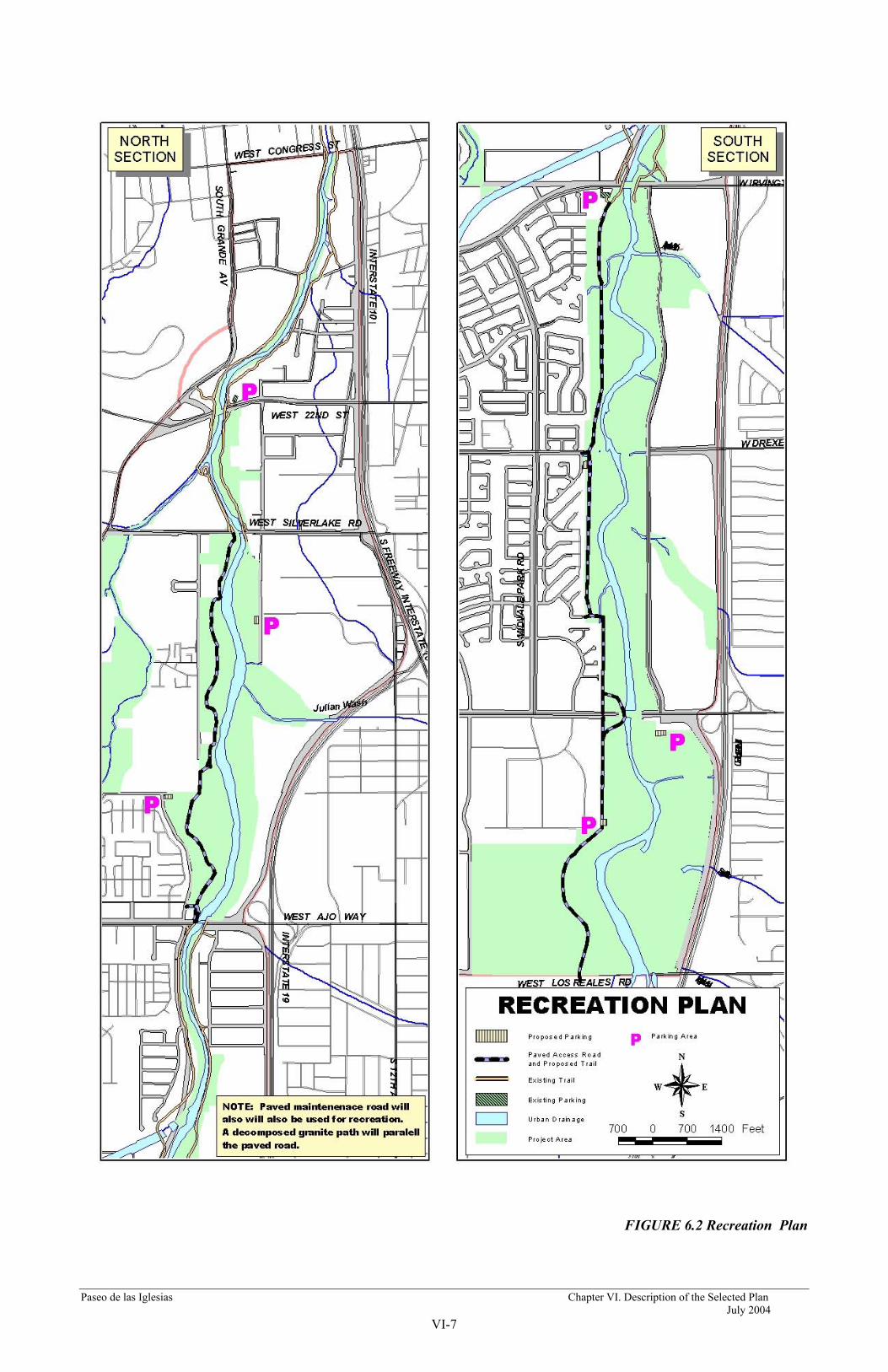
Paseo de las Iglesias Chapter VI. Description of the Selected Plan July 2004
VI-7
FIGURE 6.2 Recreation Plan
Paseo de las Iglesias Chapter VI. Description of the Selected Plan July 2004
VI-8
With the recreation improvements identified and described above, the unit day value (method described in the recreation component of this report under the Existing Condition) can be derived by selecting point values for recreation criteria and with the input of the US Army Corps of Engineers, LA District and local government agencies. These values are then applied to projected visitation. Because visitation figures have already been adjusted for double counting and projected over fifty years using a relationship to projected population growth, they will be used as a basis. However, further adjustments will be made to account for changes in visitation due to the construction of the project. These adjusted visitation figures will again be compared to capacity limits established by the National Recreation Parks Association.
The recreation criteria described in the Economic Appendix remain the same for the with project condition. The only changes will include impacts of the proposed recreation improvements to the Santa Cruz River Park and De Anza Historic Trail. They include:
1. Recreation Experience--Same as Without Project Condition 2. Availability of Opportunity--Same as Without Project Condition 3. Carrying Capacity--As previously discussed, Pima County will experience
rapid population growth. To accommodate this increase in population, additional parking lots, along with areas for five rest stops, three comfort stations and 20 benches are being proposed for the Santa Cruz River Park. DG multipurpose trail segments will also enhance carrying capacity along the Santa Cruz. These proposed facilities would allow for future population growth.
4. Accessibility--Same as Without Project Condition 5. Environmental--Since there is no significant thriving riparian areas located in
the study area, the restoration of the Santa Cruz River would prove to be a highly valued recreational area. Visitors could recreate near a thriving habitat for plants and animals. Restoration of this area could mean some of the significant unmet recreational demand for riparian areas could be met. Restoration features would also create more passive opportunities for wildlife viewing, aesthetic experience, and education. Recreational trails, signs, and access will be located so as to allow for recreation activities in such a way as to discourage interference and recreation in habitat areas.
The increase in the monetary value of the recreation experience derived from the Unit Day Value analysis of the changes in the recreation experience was applied to the projected visitation to calculate the economic benefits resulting from the recreation plan. That value was determined to be $135,484.
The US Army Corps of Engineers, Los Angeles District prepared the following cost estimates for the recreation project improvements. Estimated First Cost of the recreation plan is $1,141,914. Details regarding recreation costs may be found in the Cost Estimating Appendix. The average annual cost of the recreation plan was computed to be $69,474. Annual operations and maintenance costs for the recreation plan are estimated to be $36,260. Thus, the total average annual cost of the recreation plan is $105,734. Table 6.3 summarizes the economic analysis of the recreation plan. Details regarding the analysis of the recreation plan may be found in the Economic Appendix.

Paseo de las Iglesias Chapter VI. Description of the Selected Plan July 2004
VI-9
Table 6.3 Summary of Recreation Benefits and Costs
Benefits Recreation Value Without the Recreation Plan $210,682 Recreation Value With the Plan $314,648 Net Benefits of the Recreation Plan $135,484 Costs Average Annual Costs $69,474 OMRRR $36,260 Total Average Annual Costs $105,734 Benefit to Cost Ratio 1.29 Net Benefits $29,750
F. Monitoring and Adaptive Management Plan Uncertainty and variability are inherent in water resources planning therefore, the consideration of risk and uncertainty is important. Situations of risk are conventionally defined as those in which the potential outcomes can be described in reasonably well known probability distributions. In situations of uncertainty, potential outcomes cannot be described in objectively known probability distributions. Risk and uncertainty arise from measurement errors and from the underlying variability of complex natural, social, and economic situations. The degree of risk and uncertainty generally differs among various aspects of a project. It also differs over time, because benefits from a particular purpose or costs in a particular category may be relatively certain during one time period and uncertain during another.
Some risk and uncertainty are assumed in nearly every aspect of a water resources project. The variability of outcome associated with the recommended plan does not fit the definition of risk. That variability is better characterized as uncertainty in that the potential outcomes cannot be described in known probability distributions.
A higher than normal amount of uncertainty exists regarding landscape scale ecosystem restoration in the arid southwest. This is because very few such projects have been completed and those that have are of recent origin. Given the lack of precedent and scarcity of empirical data regarding restoration of Sonoran riparian systems there is a great degree of uncertainty regarding a number of aspects of the design, construction and operation of the recommended alternative. Uncertainty exists regarding:
• The volumes and frequency of application to be used for irrigation • The densities of initial plantings and the associated success rates • The frequency of flood events and their impacts on restored habitat • The design of the drainage features for water harvesting basins • The design of bank stabilization measures • Planned invasive plant management activities and schedules
Due to the number of project elements subject to uncertainty and the high degree of uncertainty associated with them a Monitoring and Adaptive Management Plan will be established to

Paseo de las Iglesias Chapter VI. Description of the Selected Plan July 2004
VI-10
evaluate the effectiveness of the restoration measures implemented in this project and make adaptive changes, if required, to obtain project objectives. The cost of monitoring included in the total project cost and cost shared with the non-Federal sponsor shall not exceed one percent of the total first cost of ecosystem restoration features. The cost of the adaptive management action will be limited to three percent of the total project cost excluding monitoring costs.
1. Purpose
The purpose of the Monitoring and Adaptive Management Plan is to provide a mechanism to evaluate the effectiveness of the restoration measures implemented in this project and implement adaptive changes, if required to obtain project objectives. As outlined in EC 1105-2-210 (para. 21.b.), the Monitoring Plan is intended to ascertain whether: the project is functioning as per project objectives; adjustments for unforeseen circumstances are needed; and changes to structures or their operation or management techniques are required.
The Monitoring and Adaptive Management Plan will provide a description of: the habitats to be restored, the density and composition of the plantings to restore habitat, surveys to monitor the expected, natural re-introduction of native wildlife into the restored habitats, the performance criteria and monitoring protocol to evaluate success of the restoration effort, adaptive management actions (or maintenance activities) that may be performed to ensure a successful restoration effort, and reporting requirements.
The Monitoring and Adaptive Management Plan covers monitoring and adaptive management actions during the first 5 years after initial construction. (After the first 5 years, monitoring and/or adaptive management becomes the responsibility of the Local Sponsor.) Note that during the preconstruction engineering and design [PED] phase, more specific monitoring details [e.g., exact monitoring transect locations, reference site locations, more specific performance/success criteria, more specific monitoring protocols, etc...] may be added to this Monitoring and Adaptive Management Plan.).
2. Goal
The goal of this effort is to restore riparian vegetation typical of the Sonoran desert to obtain habitat values consistent with those predicted in the Habitat Analysis Appendix. It is expected that the habitat value of the Constructed Wetlands will have good to above average quality. It is also expected that the restored habitat will be suitable for native wildlife. The quality of the habitats (i.e., average or high) is expected to dictate the abundance or density of wildlife.
3. Restored Habitats A description of: the habitats to be restored, the density and composition of the plantings to restore habitat along with a quantitative discussion of the surveys to monitor the restoration is provided earlier in this chapter. Since only the wetlands constructed on the overbank are located outside of the 100-year flood zone some restoration features have the potential to be impacted by long periods of flood inundation and are subject to being uprooted during significant high flows - as would any natural riparian ecosystem. Monitoring protocols defined below will assist in

Paseo de las Iglesias Chapter VI. Description of the Selected Plan July 2004
VI-11
determining whether replanting of the various habitats are needed following flood events. Prior to active restoration commencement, an assessment of the chosen restoration sites will be conducted to determine their suitability for the establishment and regeneration of native riparian plants.
The Corps intends to coordinate with and directly fund the Arizona Game and Fish Department (AZGFD) to perform baseline ecological assessments of existing biotic conditions within the area of potential affect (APE) for the Paseo de las Iglesias ecosystem restoration project. The Corps intends to retain the expertise of AZGFD as it pertains to the conservation and management of federally listed threatened and endangered species, wildlife species of concern to the State of Arizona, and their respective riparian habitats. The Corps also intends to retain and directly fund the AZGFD in the development and implementation of a Monitoring & Adaptive Management Plan for this riparian ecosystem restoration project along the Santa Cruz River.
Therefore, as AZGFD documents such baseline ecological conditions within the APE, their determinations will provide a scientific basis for strategically planning restoration measures, elements and features that will provide a framework for achieving a sustainable assemblage of native vegetation associations that will restore ecological processes and functions to degraded riparian habitats along this portion of the Santa Cruz River. Both the Corps and AZGFD have statutory guidelines regarding the conservation of diminishing native fish and wildlife habitats and it would be mutually beneficial to work together in restoring the State of Arizona’s native riparian ecosystems.
4. Habitat & Wildlife Monitoring - Frequency and Protocol
Habitat (Vegetation) Monitoring The monitoring protocols and frequencies described below will be reviewed and adjusted based upon the results of the baseline ecological assessments discussed above and the input of the Technical Committee.
Cottonwood/Willow Riparian Areas For the first 6 months after planting the site, it would be monitored monthly; thereafter, the site would be monitored every other month for a year. The site will remain free of all non-native shrubs throughout this 18 month period. Should the survival rate of plantings indicate that the species composition is less than prescribed, replanting will be undertaken to ensure that the species composition is maintained.
All plantings shall have a minimum of 80% survival the first year and 100% survival the second and third years and/or attain 40% cover after 5 years. Ninety percent cover is expected in the Riparian Areas after 10 years. There will be zero tolerance of exotic shrubs the first 5 years. If the survival and cover requirements are not met during the initial 5 years, the Corps is responsible for replacement planting to achieve these requirements. (Note that the replacement planting cost would be a cost-shared project cost for the first 5 years.)
After 5 years, the non-Federal Sponsor will be responsible for maintaining the restoration sites for the remaining life of the project. The species composition shall be maintained throughout the

Paseo de las Iglesias Chapter VI. Description of the Selected Plan July 2004
VI-12
life of the project. Site monitoring would be performed yearly throughout the life of the project (also see Section 5, below).
All of Cottonwood/Willow Habitat will be planted in the flood-prone tributary confluences. As such, it is expected to be regularly affected by flooding events (as typical of natural cottonwood/willow habitats). The Cottonwood/Willow sites will be evaluated after large storm events to determine the need for revegetation.
Mesquite Bosques The monitoring frequency and survival protocols outlined for the Cottonwood/Willow Riparian Area restoration sites would be followed for the Mesquite Bosque sites.
Riparian Shrub The monitoring frequency and percent survival outlined for the Cottonwood/Willow Riparian areas will be followed for the riparian shrub lands. Most of the riparian shrublands will be out of the more frequently inundated areas of the floodplain. The sites will be evaluated after large storm events to determine the need for revegetation.
Wildlife Monitoring
Restored habitats are expected to support native wildlife. The good quality riparian shrub lands, mesquite bosques and cottonwood/willow habitats are expected to support the diverse assemblage of wildlife that are associated with these habitat-types. Monitoring of wildlife abundance and diversity is proposed to assess whether habitats actually attract and support significant populations of a wide variety of native wildlife, as expected.
Bird surveys will be performed in the restored Cottonwood/Willow Riparian areas during each of the four seasons for the first 5 years following construction. The abundance/ diversity of bird species will be used as an indicator of whether wildlife habitat has developed as predicted and supporting a diverse assemblage of native avifauna. After the first five years, summer/spring bird surveys will be performed every other year to document the abundance and diversity trends. Small mammal trapping (live or snap) will be conducted during the summer for the first five years to document the diverse species expected to re-colonize restored habitats.
5. Success Criteria, Reporting & Adaptive Management
Success Criteria The success or failure of the restoration effort will be measured against three parameters which should indicate whether the goal of this restoration effort is being achieved; they are: 1) whether the plant species compositions and/or percent cover requirements outlined for the various habitat types are met, 2) whether native wildlife re-colonize the restored habitats, and 3) whether the restoration sites naturally regenerate. Monitoring will occur as identified above. Monitoring reports would be prepared jointly at the end of the year by the Corps and the Local Sponsor

Paseo de las Iglesias Chapter VI. Description of the Selected Plan July 2004
VI-13
during the first 5 years after initial construction. The need to make adjustments to the constructed project will be based on the results of the monitoring reports. If the restored habitats achieve the plant species composition identified and achieve a diverse native wildlife assemblage, no modifications will be made. After the first five years, the non-Federal Sponsor will prepare the Monitoring Reports.
Monitoring Reports and Adaptive Management
The Corps and/or the non-Federal Sponsor will be responsible for collecting monitoring data and preparing annual Monitoring Reports. A Technical Committee consisting of, at least, the U.S. Fish and Wildlife Service, USACE, the non-Federal Sponsor, and the Arizona Department of Game and Fish, will assist in collection of monitoring data, review monitoring data results, and providing recommendations of possible adaptive management measures.
The Technical Committee will recommend adaptive management measures to the existing project’s design should habitat not achieve the identified goal and objectives. The Committee will judge the restoration sites ability to revegetate naturally and recommend what conditions should trigger a need to replant restoration areas. If designed vegetation species composition are not achieved: replanting, additional irrigation, and/or removal of vegetation (especially exotics) may be necessary. (Note that the use of herbicides should only be used if more natural options are unsuccessful.)
Annual Monitoring Reports and any adaptive management measures recommended by the Technical Committee will be forwarded to an Executive Committee which will consist of, at least, a representative of the non-Federal Sponsor and the U.S. Army Corps of Engineers. The Executive Committee will decide whether to adopt adaptive management measures recommended by the Technical Committee.

Paseo de las Iglesias Chapter VII. Plan Implementation July 2004
VII-1
CHAPTER VII PLAN IMPLEMENTATION
This chapter summarizes the cost-sharing requirements and procedures necessary to implement the restoration features of the selected plan.
A. Study Recommendation
The Selected Plan is an ecosystem restoration project that also provides recreation benefits. Because of its positive environmental contribution selected plan is recommended.
B. Division of Plan Responsibilities The Water Resources Development Act (WRDA) of 1986 (P.L. 99-662) and various other administrative policies have established the basis for the division of Federal and non-Federal responsibilities in the construction, maintenance and operation of Federal water resource projects accomplished under the direction of the Corps of Engineers. This is discussed in detail below.
C. Cost Allocation Cost sharing for construction of this project would be in keeping within current Corps of Engineers policy whereby for environmental restoration projects, the non-Federal sponsor shall provide all lands, easements and rights-of-way and dredged material disposal areas, provide relocations of bridges and roadways; provide alteration of utilities which do not pass under or through the project’s structure; and maintain and operate the project after construction. All water rights and costs associated with providing water to the project shall be borne by the non-Federal sponsor. The value of this water has been estimated at $1,099,175 annually. Additional studies and analysis of the selected plan will be accomplished during Preconstruction Engineering and Design (PED). As a result of these studies, additional necessary project features may be identified that could be part of the Federal cost sharing for this project. In this event, Federal project cost sharing would be adjusted in accordance with the terms that will be included in the Project Cooperation Agreement.
Corps guidance (PGL No. 36 and 59) specifies that the level of financial participation in recreation development by the Corps at an otherwise justifiable project may not increase the Federal cost of the project by more than ten percent. This cost would be cost shared between the Corps and the non- Federal sponsor. Recreation costs are cost shared on a 50%/50% basis between the Corps and the non-Federal sponsor. Table 7.1 presents a summary of apportionment of project first costs between Federal and non-Federal interests for the Recommended Plan using current (2003) price levels

Paseo de las Iglesias Chapter VII. Plan Implementation July 2004
VII-2
Table 7.1 Cost Apportionment Table Paseo de las Iglesias, Pima County, Arizona
Ecosystem Restoration Project (Costs x $1000)
Allocation Item Federal Non-Federal Total
Construction* (Construction, S&A, PED/EDC, Contingency)
$59,096
$5,579 $64,675
Construction LEERDs* (Lands and credits, easements, rights-of-way, relocations and disposal sites
$26,242 $26,242
Total First Cost (Percentage of total cost)
$59,096 65
$31,821 35 $90,917
Recreation Costs $571 $571 $1,142 Total First Costs $59,667 $32,392 $92,059
* Does not include IDC nor annual O&M, the latter of which is fully a non-Federal Cost
D. Current and Future Work Eligible for Credit There is no current or future work planned or in construction which is part of the Corp’ Selected Plans, or which would be eligible for Section 104 credit.
E. Institutional Requirements Upon implementation of the cost-shared project, the non-Federal sponsor will prepare the following preliminary financial analysis:
(1) Assess project-related yearly cash flows (both expenditures and receipts where cost recovery is proposed), including provisions for major rehabilitation and operational contingencies and anticipated but uncertain repair costs resulting from damages from natural events;
(2) Demonstrate ability to finance their current and projected-future share of the project cost and to carry out project implementation operation, maintenance, and repair/rehabilitation responsibilities;
(3) Investigate the means for raising additional non-Federal financial resources including but not limited to special assessment districts; and
(4) Complete any other necessary steps to ensure that they are prepared to execute their project-related responsibilities at the time of project implementation.
In addition, as part of any Project Cooperation Agreement, the non-Federal sponsor would be required to undertake to hold and save the Federal Government free from damages due to

Paseo de las Iglesias Chapter VII. Plan Implementation July 2004
VII-3
construction, operation, and maintenance of the project, excluding damages due to the fault or negligence of the Federal Government or its contractors.
F. Environmental Requirements The Selected Plan could result in discharge of fill material into waters of the United States during the period of construction. It also may result in discharges associated with operation and maintenance activities. A Section 404(b)(l) evaluation has been prepared to address practicable alternatives. An NPDES permit will also be required for any water discharged to the river.
The FEIS will include a 404(b)(l) analysis as a part of the overall feasibility study. Based on this analysis, the feasibility report will recommend whether the project should receive a 404(r) exemption, when Congress authorizes the project. The 404(r) exemption would cover both the construction period and the operation and maintenance activities, for as long as the project remains authorized. It is anticipated that the Corps would receive a 404(r) exemption for the project, when Congress approves the project report and authorizes the project.
The report and EIS will both include a description of the required O&M activities, including timing, and any required mitigation that will be needed, for as long as the project remains authorized. These activities will be incorporated into an O&M manual that will be provided to the non-Federal sponsor at the end of construction.
The non-Federal sponsor will not need to obtain a Section 404 permit for future O&M activities if the non-Federal sponsor carries out the O&M activities as specified in the O&M manual, without deviation. Anytime during the life of the project should O&M requirements need to be modified or should there be a change in conditions not anticipated during this feasibility study, then an appropriate NEPA document will need to be prepared to modify the O&M manual and determine the need for any mitigation or 404 permit for O&M activities.
The Corps will coordinate with and provide funding to the Arizona Game and Fish Department (AZGFD) to conduct baseline ecological surveys and document the environmental assessment of existing biotic conditions within the area of potential affect (APE) immediately preceding initiation of construction of the Paseo de las Iglesias ecosystem restoration project through a Memorandum of Agreement (MOA), and a detailed scope of work (SOW).
The Corps will also coordinate with and provide funding to the AZGFD to develop and implement a Monitoring & Adaptive Management Plan for the Paseo de las Iglesias ecosystem restoration project through a MOA and detailed SOW.
Under direction from the Corps and Pima County, Statistical Research, Inc. performed a literature search and cultural resources overview of the proposed project area (area of potential effects [APE]) through the Arizona State Museum (ASM) (O'Mack et al. 2002). This search indicates that less than 50 percent of the area has been surveyed by archeologists.
Given the project's association with the Santa Cruz River floodplain, the overall archeological sensitivity and potential are very high. Therefore, complete avoidance of all cultural resources by project alternatives may not be possible. A determination of effect will not be made however, until more detailed plans are available and after testing and consideration of buried prehistoric resources along the bank of the river, in consultation with tribes and Pima County.

Paseo de las Iglesias Chapter VII. Plan Implementation July 2004
VII-4
The known resources are potentially avoidable by the project. The floodplain may contain buried resources, however. If additional sites cannot be avoided, they will be evaluated regarding eligibility for the National Register. All NRHP sites that will be impacted by project construction will be subjected to data recovery (i.e., mitigated). Environmental Commitments are:
1. Qualified archeologists will perform a survey of previously unsurveyed areas within the project's area of potential effects. Subsurface exploration to determine the presence/absence of buried cultural deposits may also be necessary.
2. If cultural resources cannot be avoided, they will be evaluated regarding eligibility for listing in the National Register of Historic Places.
3. Identification, evaluation, and data recovery (i.e., mitigation) efforts will be coordinated with Pima County and interested Native American Indian Tribes.
4. Archeologists from Pima County and the Corps will participate in the design of water conveyance features across the landform in an effort to minimize adverse effects.
5. Since it is likely that National Register listed or eligible properties will be adversely affected by the project, a Memorandum of Agreement, to include monitoring during construction, will be negotiated with the Arizona State Historic Preservation Officer (SHPO), Pima County, and interested Native American Indian tribes. An archeological site treatment plan will also be developed in consultation with the SHPO, Pima County and interested Native American Indian tribes.
Compliance with the National Historic Preservation Act of 1966 (36 CFR 800): As stated above, in accordance with 36 CFR 800, regulations implementing Section 106 of the National Historic Preservation Act, a records search has been performed. Corps identification and evaluation studies will be coordinated with Pima County and interested Native American Indian tribes. The Corps' determinations of eligibility and effect will be coordinated with the Arizona State Historic Preservation Officer (SHPO). It is expected that a Memorandum of Agreement (MOA) will be negotiated with the Arizona SHPO, Pima County, and interested Native American Indian tribes. An archeological site (historic properties) treatment plan will be developed in consultation with the SHPO, Pima County, and interested Native American Indian tribes as stipulated in the MOA. Until the field studies, consultation, and determinations of resource eligibility and project effect are completed, the project is not in compliance with the Act.
Coordination: Arizona State Historic Preservation Officer (SHPO) - A letter will be sent to the SHPO with our determination of eligibility and effect in accordance with 36 CFR 800.4(d). All supporting documentation required under 36 CFR 800.11(d) will be sent to the SHPO. This includes the draft EIS. The draft EIS will also be sent to the following for comment along with all identification, evaluation, and data recovery (i.e., mitigation) documentation:
Pima County - Ms. Linda Mayro/Mr. Roger Anyon, County Archeologists
Tohono O'odham Nation - Mr. Peter Steere, Program Manager, Cultural Affairs Department
Hopi Tribe - Mr. Leigh Kuwanwisiwma, Cultural Preservation Office
Paseo de las Iglesias Chapter VII. Plan Implementation July 2004
VII-5
Pascua Yaqui - Ms. Amalia A.M. Reyes, Language and Culture Preservation Specialist
Other requirements relating to the Arizona Game & Fish Department and the Arizona Department of Environmental Quality would need to be addressed by the non-Federal sponsor.
G. Non-Federal Requirements The presently estimated non-Federal share of the total first cost of the project is $32,392,000. which includes $26,242,000 in estimated LERRDs credits and $5,579,000 in non-Federal contribution.
In addition, maintenance and operation of the environmental restoration project is estimated to cost the non- Federal sponsor $1,906,221 annually.
Requirements of non-Federal cooperation are specified below:
a. Provide 35 percent of the separable project costs allocated to environmental restoration and 50 percent of the separate project costs allocated to recreation, as further specified below:
(1) Enter into an agreement which provides, prior to execution of a project cooperation agreement for the project, 25 percent of design costs;
(2) Provide, during construction, any additional funds needed to cover the non-federal share of design costs;
(3) Provide all lands, easements, and rights of way, including suitable borrow and dredged or excavated material disposal areas, and perform or assure the performance of all relocations determined by the Government to be necessary for the construction, operation, and maintenance of the project;
(4) Provide or pay to the Government the cost of providing all retaining dikes, wasteweirs, bulkheads, and embankments, including all monitoring features and stilling basins, that may be required at any dredged or excavated material disposal areas required for the construction, operation, and maintenance of the project; and
(5) Provide, during construction, any additional costs as necessary to make its total contribution equal to 35 percent of the separable project costs allocated to environmental restoration and 50 percent of the separable project costs allocated to recreation.
b. For so long as the project remains authorized, operate, maintain, repair, replace, and rehabilitate the completed project, or functional portion of the project, including mitigation features, at no cost to the Government, in a manner compatible with the project’s authorized purposes and in accordance with applicable Federal and State laws and any specific directions prescribed by the Government in the OMRR&R manual and any subsequent amendments thereto.
c. Give the Government a right to enter, at reasonable times and in a reasonable manner, upon land which the local sponsor owns or controls for access to the project for the purpose of

Paseo de las Iglesias Chapter VII. Plan Implementation July 2004
VII-6
inspection, and, if necessary, for the purpose of completing, operating, maintaining, repairing, replacing, or rehabilitating the project.
d. Comply with Section 221 of Public Law 91 611, Flood Control Act of 1970, as amended, and Section 103 of the Water Resources Development Act of 1986, Public Law 99 662, as amended, which provides that the Secretary of the Army shall not commence the construction of any water resources project or separable element thereof, until the non Federal sponsor has entered into a written agreement to furnish its required cooperation for the project or separable element.
e. Hold and save the Government free from all damages arising for the construction, operation, maintenance, repair, replacement, and rehabilitation of the project and any project related betterments, except for damages due to the fault or negligence of the Government or the Government's contractors.
f. Keep and maintain books, records, documents, and other evidence pertaining to costs and expenses incurred pursuant to the project to the extent and in such detail as will properly reflect total project costs.
g. Perform, or cause to be performed, any investigations for hazardous substances that are determined necessary to identify the existence and extent of any hazardous substances regulated under the Comprehensive Environmental Response, Compensation, and Liability Act (CERCLA), 42 USC 9601-9675, that may exist in, on, or under lands, easements or rights of way necessary for the construction, operation, and maintenance of the project; except that the non Federal sponsor shall not perform such investigations on lands, easements, or rights of way that the Government determines to be subject to the navigation servitude without prior specific written direction by the Government.
h. Assume complete financial responsibility for all necessary cleanup and response costs of any CERCLA regulated materials located in, on, or under lands, easements, or rights of way that the Government determines necessary for the construction, operation, or maintenance of the project.
i. To the maximum extent practicable, operate, maintain, repair, replace, and rehabilitate the project and otherwise perform its obligations in a manner that will not cause liability to arise under CERCLA.
j. Prevent future encroachments on project lands, easements, and rights of way which might interfere with the proper functioning of the project.
k. Comply with the applicable provisions of the Uniform Relocation Assistance and Real Property Acquisition Policies Act of 1970, Public law 91 646, as amended by title IV of the Surface Transportation and Uniform Relocation Assistance Act of 1987 (Public Law 100 17), and the Uniform Regulations contained in 49 CFR part 24, in acquiring lands, easements, and rights of way, and performing relocations for construction, operation, and maintenance of the project, and inform all affected persons of applicable benefits, policies, and procedures in connection with said act.
l. Comply with all applicable Federal and State laws and regulations, including Section 601 of the Civil Rights Act of 1964, Public Law 88 352, and Department of Defense Directive 5500.11 issued pursuant thereto, as well as Army Regulation 600 7, entitled "Nondiscrimination
Paseo de las Iglesias Chapter VII. Plan Implementation July 2004
VII-7
on the Basis of Handicap in Programs and Activities Assisted or Conducted by the Department of the Army".
m. Provide the non-Federal share of that portion of the costs of mitigation and data recovery activities associated with historic preservation, that are in excess of 1 percent of the total amount authorized to be appropriated for the project, in accordance with cost sharing provisions of the agreement;
n. Not use Federal funds to meet the non-Federal sponsor’s share of total project costs unless the Federal granting agency verifies in writing that the expenditure of such funds is authorized.
o. Provide and maintain necessary access roads, parking areas, and other public use facilities, open and available to all on equal terms.
H. Sponsorship Agreements
The Pima County Flood Control District has provided a Letter of Intent acknowledging sponsorship requirements for the Paseo de las Iglesias Project (included in Chapter XI, Letters of Support and Financial Capability). Prior to the start of construction, the non-Federal sponsor will be required to enter into an agreement with the Federal Government that it will comply with Section 221 of the Flood Control Act of 1970 (P.L. 9 1-61 1), and the Water Resources Development Act of 1986 (P.L. 99-662) as amended.
I. Procedures for Implementation Future actions necessary for authorization and construction of the selected plans are summarized as follows:
(1) This report will be reviewed by the Headquarters of the U.S. Army Corps of Engineers, Washington, D.C.
(2) The Chief of Engineers will seek formal review and comment by the Governor of the State of Arizona and interested Federal agencies.
(3) Following State and Agency review, the report will be sent to the Assistant Secretary of the Army for Civil Works.
(4) Upon approval of the Assistant Secretary, the report will be forwarded to the Office of Management and Budget (0MB) to obtain the relationship of the project to programs of the President.
(5) The final report of the Chief of Engineers will then be forwarded by the Assistant Secretary of the Army for Civil Works to Congress.
(6) Congressional review of the feasibility report and possible authorization of the project would follow.
(7) Pending project authorization for construction, the Chief of Engineers could include funds where appropriate, in his budget requests for preconstruction engineering

Paseo de las Iglesias Chapter VII. Plan Implementation July 2004
VII-8
and design of the project. The objective is to ready each project for a construction start established with the feasibility study.
(8) Following receipt of funds, preconstruction engineering and design would be initiated and surveys and detailed engineering designs would be accomplished.
(9) Following Congressional authorization of the project, plans and specifications would be accomplished by the District Engineer.
(10) Subsequent to appropriation of construction funds by Congress, but prior to construction, the local sponsor would enter into a binding agreement to furnish the required cooperation. This agreement is the Project Cooperation Agreement (PCA).
(11) Bids for construction would be initiated and contracts awarded.

Paseo de las Iglesias Chapter VIII. Public Views and Comments July 2004
VIII-1
CHAPTER VIII PUBLIC VIEWS AND COMMENTS
A. Non-Federal Views and Preferences
The non-Federal views and preferences regarding environmental restoration were in general obtained through coordination with the non-Federal sponsor and with various local and regional agencies and organizations, neighborhood associations, and the general public. These coordination efforts consisted of a series of public meetings held during the reconnaissance and feasibility study phases, through surveys, through the maintenance of a ‘point- of-contact’ with whom any interest could discuss matters, and a mailing list by which invitations to public meetings were distributed. Announcements for public meetings were made in local newspapers, including date, time, place, and subject matter.
B. Views of the Non-Federal Sponsor
The Pima County Flood Control District has expressed willingness in continuing to be the non-Federal sponsor for project implementation. The County has indicated its support for the project and a willingness to assume cost-shared financial obligations for its implementation.
The non-Federal sponsor fully supports the results of the feasibility study. The non-Federal sponsor’s interest in implementing environmental restoration solutions for the Paseo de las Iglesias area is reflected in the many previous studies and reports prepared by the County and by their willingness to enter into a cost-shared feasibility study to determine Federal interest.
There currently exists within the community, and with the non-Federal sponsor, significant interest for providing environmental restoration solutions for the Paseo de las Iglesias area. This is demonstrated by their desire to pursue environmental restoration options for the project, and their willingness to accommodate Federal guidance in the selected plan. The DEIS addresses existing resources and potential impacts to these resources from implementation of the desired environmental restoration alternative. It indicates that the selected plan would have temporary impacts to environmental resources associated with construction activities. These impacts are mitigable through adoption of Best Management Practices that reduce or eliminate the impacts. This is discussed in detail in the DEIS.
Locally-preferred options within the study area are consistent with the Selected Plan. The non-Federal sponsor has related its acceptance of the selected plan and is willing to accept the Corns of Engineers identified NER plan as the Locally Preferred Plan.
C. Financial Analysis
Further project engineering, design, and construction would be conducted in accordance with the cost-sharing principles provided by the Water Resources Development Act of 1986, as amended. The non-Federal sponsor has indicated its ability and willingness to participate in the planning, engineering and design of the selected plan, and to participate in construction of the project. The

Paseo de las Iglesias Chapter VIII. Public Views and Comments July 2004
VIII-2
statement of financial capability is provided in Chapter XI, Letters of Support and Financial Capability.
D. Summary of Study Management, Coordination, Public Views and Comments
The study team was a multi-disciplinary group that consisted of several functional elements of the Corps and the non-Federal sponsor. The study team included study and project managers, engineers, hydrologic and hydraulic engineers, groundwater specialists, environmental specialists, cost estimators, designers, appraisers, economists, materials, geotechnical specialists, real estate specialists, and landscape architects.
Formal and informal coordination occurred with a variety of Federal state and local agencies in addition to the public involvement efforts described above. Agencies contacted included the United States Fish and Wildlife Service (USFWS), the Arizona Department of Game and Fish (ADGF), the City of Tucson Parks, Tucson Water Department, City of Tucson Transportation, Pima County Department of Transportation, Pima County Cultural Resources, and Pima County Parks and Recreation. In addition to the above local stakeholders included local Homeowners Associations, Tucson Audobon Society, and Santa Cruz River Alliance.
Representatives from USFWS and ADGF participated in development of the functional assessment model and its application. USFWS also participated in development of alternatives and their design. USFWS has prepared a Planning Aid Letter and is currently preparing a Coordination Act Report for this study.
Throughout the planning process for this project, public input has been solicited utilizing a variety of avenues including local newspaper articles, public information mailings, and coordination with special-interest groups, public workshops and formal public hearings. The initial planning process began with a meeting March 31, 2001 to identify and review the primary issue areas involved in the Paseo de las Iglesias study area. As a result of that initial meeting, further meetings were scheduled to establish a process for development of public involvement in planning for restoration of the Paseo de las Iglesias study area. Issues addressed included habitat restoration, water budget, water quality, wildlife habitat, recreation, environmental education and tributary flood control. The principal participants in this public workshop planning process were representatives from Federal, state, and local agencies, citizens from the local area, and other stakeholders.

Paseo de las Iglesias Chapter IX. Conclusions July 2004
IX-1
CHAPTER IX CONCLUSIONS
The major conclusions of the Paseo de las Iglesias Ecosystem Restoration Feasibility Study to date are: a. Developmental pressures combined with increasing appropriation of groundwater and surface water flows have been the most significant contributors to increasing degradation and loss of riparian habitat along the Santa Cruz River in the last century. Future without project conditions will see the loss of the remaining pockets of habitat as adjacent vacant lands develop. The local species of concern, as well as birds migrating along the Pacific Flyway, will lose more of their forage base and will be much more vulnerable to terrestrial disturbances and predation.
b. Alternative measures developed to address the study objectives and constraints include construction of subsurface water harvesting basins including soil amendment; surface grading including regarding of unstable vertical banks; planting of native riparian species; and providing irrigation to restored areas including periodic flow along the lower reaches of the Old West Branch.
c. The recommended plan will result in a total increase of 454 average annual functional capacity units at a total average annual cost of $7,635,648 an average annual cost of $16,819 per average annual functional capacity unit.
d. The total first cost of implementing the plan is $92,059,000 ($90,917,000 environmental restoration and $1,142,000 recreation). The Federal share is currently estimated at $59,667,000 (59,096,000 environmental restoration and $571,000 recreation). Annual Operation and Maintenance costs are estimated to be about $1,906,000 and are a 100% non-Federal responsibility.
e. The County of Pima is the Sponsor for the feasibility study and fully supports the recommended plan as the locally preferred plan. The Sponsor is willing and able to cost-share in the PED phase and is willing to participate in the cost sharing for the construction of the project.
f. The resource agencies and local interests also support this project.

Paseo de las Iglesias Chapter X. Recommendations July 2004
X-1
CHAPTER X RECOMMENDATIONS
I recommend that the plan described herein for environmental restoration, flood control, and recreation, be authorized for implementation as a Federal project. The total first cost of the project is currently estimated at $92,059,000 under October 2004 prices. The Federal share is currently estimated at $59,667,000.
I recommend that the Corps of Engineers participate in cost-shared monitoring and minor modifications, as maybe required to ensure success of the project, as identified and described within the Monitoring and Adaptive Management Plan.
My recommendation is subject to cost sharing, financing, and other applicable requirements of Federal and State laws and policies, including Public Law 99-663, the Water Resources Development Act of 1986, as amended by Section 202 of Public Law 104-303, the Water Resources Development Act of 1996, and in accordance with the required items of local cooperation identified in Chapter VII which the non-Federal sponsor must agree to prior to project implementation.
The plans presented herein are recommended with such modifications thereof as in the discretion of the Commander, HQUSACE, may be advisable.
The recommendations contained herein reflect the information available at this time and current Departmental policies governing formulation of individual projects. They do not reflect program and budgeting priorities in the formulation of a national Civil Works construction program nor the perspective of higher review levels within the Executive Branch. Consequently, the recommendations may be modified before they are transmitted to the Congress as proposals for authorization and implementation funding. However, prior to transmittal to the Congress, the non- Federal sponsor, the State, interested Federal agencies, and other parties will be advised of any modifications and will be afforded an opportunity to comment further.

Paseo de las Iglesias Chapter XI. Letters of Support and Financial Capability July 2004
XI-1
CHAPTER XI LETTERS OF SUPPORT AND FINANCIAL CAPABILITY As required by Section 905 of the Water Resources Development Act, of 1986 a financial capability statement from Pima County will be included in the final report to show non-Federal cost sharing capability and intent.

Paseo de las Iglesias Chapter XI. Letters of Support and Financial Capability July 2004
XI-2

Paseo de las Iglesias Bibliography July 2004 B-1
BIBLIOGRAPHY
Arizona Fish and Game Department (AFGD). 2003. Letter from Sabra S. Schwartz, Heritage Data Management System Coordinator to Dr. Kenneth Kingsley, SWCA. Dated January 6, 2003.
Betancourt, J, Turner, R. 1985. Historic Arroyo-Cutting and Subsequent Channel Changes at the Congress Street Crossing, Santa Cruz River, Tucson Arizona. Tucson, Arizona.
Brandt, H. 1951. Arizona and its Bird Life. The Bird Research Foundation. Cleveland, Ohio.
Brown, D.E. 1980. A System for Classifying Cultivated and Cultured Lands Within a Systematic Classification of Natural Ecosystems. Journal of the Arizona-Nevada Academy of Science Vol. 15. No. 2. pp 48- 53.
Brown, D.E. 1994. Biotic Communities: Southwestern United States and Northwestern Mexico. University of Utah Press, Salt Lake City, Utah.
City of Tucson Planning Department. 1998. Standard Manual For Drainage Design and Floodplain Management In Tucson, Arizona, December 1989, Revised, July 1998.
Davidson, E. S., 1973. Geohydrology and water resources of the Tucson basin, Arizona: U.S. Geological Survey Water-Supply Paper 1939-E.
Gillis, A. M. 1991. Should cows chew cheatgrass on common lands? BioScience 41:668-675.
Froebel, Julius 1859. Seven Years’ Travel in Central America, Northern Mexico and the Far West of the United States, London, 1859.
LMT Engineering 2002. Paseo de las Iglesias, Tucson-Arizona. Appendix F to the Draft Feasibility Report.
Mabry, B. J. 1990. Archaeological Survey of City of Tucson TCE Extraction Well and Treatment Facility Sites. Letter Report No. 90-114. Desert Archaeology, Tucson.
Pima Association of Governments. 2003. Environmental Quality. In: Tucson Metropolitan Community Information Data Summary.
Pima County Department of Transportation, Technical Services Division, 2002. Pima County Land Information System.
Pima County Department of Transportation and Flood Control District, 1986. Rillito Creek – Alvernon to Craycroft flood storage/groundwater recharge/natural riverline preservation study.
Pima County Real Property Services. 2001. Santa Cruz River Paseo de las Iglesias, Arizona Feasibility Study, Real Estate Report.
Pima County, July 1999. Water Resources and the Sonoran Desert Conservation Plan. Report issued as part of the Sonoran Desert Conservation Plan.

Paseo de las Iglesias Bibliography July 2004 B-2
RECON. 2001b. Priority Vulnerable Species. Report issued as part of the Sonoran Desert Conservation Plan.
Rosen, P.C. 2001. Biological Values of the West Branch of the Santa Cruz River, With an Outline for a Potential Park or Reserve. Report issued as part of the Sonoran Desert Conservation Plan.
SWCA Environmental Consultants (SWCA). 2002. Phase 1 Environmental Site Assessment for Paseo de las Iglesias, Pima County, Arizona.
SWCA Environmental Consultants (SWCA). 2003. Biological Evaluation, Paseo de Las Iglesias, Santa Cruz River, Arizona. Prepared for the U.S. Army Corps of Engineers, Los Angeles District. February 21, 2003.
U.S. Army Corps of Engineers (USACE). 1997. The National Action Plan to Implement the Hydrogeomorphic Approach to Assessing Wetland Functions. Federal Register 62:33607-33620. June 20, 1997.
U. S. Army Corps of Engineers (USACE). 2001. Gila River, Santa Cruz River Watershed, Pima County, Arizona. Report prepared by Tetra Tech, Inc. for the U.S. Army Corps of Engineers, Los Angeles District.
U. S. Army Corps of Engineers Engineer Research and Development Center (ERDC). 2002. Arizona Streams Restoration Manual, USACE Environmental Research and Development Center. Distributed to workshop participants.
U.S. Bureau of the Census. 2000. Census 2000. On-line Resource at: www.census.gov
U.S. Department of Interior, Fish and Wildlife Service (USFWS). 2003. Planning Aid Letter from Steven L. Spangle, UFSWS Field Supervisor to Ruth Villalobos, USACE Planning Division Chief.
U.S. Department of Interior, Fish and Wildlife Service (USFWS). 1999. "Endangered and Threatened Wildlife and Plants; Designation of Critical Habitat for the Huachuca Water Umbel, a Plant." Federal Register. Volume 64, Number 132.
U.S. Federal Transit Administration (USFTA). 1995. Transit Noise and Vibration Impact Assessment. FTA Report DOT-T-95-16, April 1995.