santa clara valley urban runoff pollution prevention …€¦ · · 2017-11-10tm-task...
TRANSCRIPT

1410 Jackson Street Oakland, CA 94612 tel: (510) 832-2852 fax: (510) 832-2856 1021 South Wolfe Road, Suite 185 Sunnyvale, CA 94086 tel: (408) 720-8811 fax: (408) 720-8812
Campbell Cupertino Los Altos Los Altos Hills Los Gatos Milpitas Monte Sereno Mountain View Palo Alto San Jose Santa Clara Saratoga Sunnyvale Santa Clara County Santa Clara Valley Water District TO: Vincent Gin, Project Director, SCVWD CC: Brian Mendenhall, Grant Contact, SCVWD FROM: Jill Bicknell, P.E., Bonnie de Berry, and Jocelyn Walker, P.E., SCVURPPP Staff DATE: October 26, 2017 SUBJECT: Santa Clara Basin Storm Water Resource Plan – Watershed Identification;
Grant Agreement No. D1612605, Task 3.2
This memorandum identifies the watershed and sub-watersheds to be used in the Santa Clara Basin Storm Water Resource Plan (SWRP) being developed by the Santa Clara Valley Urban Runoff Pollution Prevention Program (SCVURPPP) and the Santa Clara Valley Water District (SCVWD or District).
This information fulfils the requirements of Task 3.2 of the SWRP Grant Agreement Scope of Work:
3.2 Review and Identify the SWRP watershed and sub-watersheds planning boundaries. The review shall include characterization of land use and natural or open space, public agency and water utility boundaries, surface and groundwater resources, and water quality priorities. Submit a watershed planning area description, map, and justification of planning area boundaries to the Grant Manager for review and approval.
The description below will be incorporated into the SWRP as part of Chapter 2.
Watershed Description
The Santa Clara Basin Watershed (Figure 1) is located within Santa Clara County and a small portion of San Mateo County at the southern end of the San Francisco Bay. This watershed generally follows the boundaries defined by the USGS HUC 8 digit “Coyote” watershed with some minor adjustments made by SCVURPPP to account for catchment areas that changed due to urbanization and modifications to the built environment. The watershed comprises 732 square miles.
The watershed includes one of the three major metropolitan areas in the San Francisco Bay Area Region -- the City of San Jose and the 12 surrounding cities and towns -- along with parts of unincorporated Santa Clara County. The portion of the watershed within San Mateo County is discussed in the San Mateo County Stormwater Resource Plan and therefore not discussed at length here.
MEMORANDUM
Santa Clara Valley Urban Runoff Pollution Prevention Program

TM-Task 3.2-Watershed Characterization_FINAL 10-26-17 2
For the purposes of storm water resource planning, the selected watershed is the largest practicable area that still allows for comprehensive and integrated storm water management across multiple jurisdictional boundaries.
FIGURE 1 – SANTA CLARA BASIN WATERSHED (Source: EOA, Inc., 2017)
There are two significant areas of Santa Clara County not addressed by this SWRP. The northeastern part of the county is in a watershed that drains to Alameda County. It is largely undeveloped and will not be a primary focus area for stormwater facility planning or implementation in Santa Clara County. The southern end of Santa Clara County (“South County”), including the cities of Morgan Hill and Gilroy, was excluded because it is in the Pajaro River watershed that does not drain to the San Francisco Bay. Thus, South County is not part of the Region 2 San Francisco Bay Regional Water Quality Control Board region or the Bay Area Integrated Regional Water Management Plan region, and it is not covered by the San Francisco Bay Region Municipal Regional Stormwater NPDES Permit (MRP). This area is part of Region 3, under the jurisdiction of the Central Coast Regional Water Quality Control Board.
TM-Task 3.2-Watershed Characterization_FINAL 10-26-17 3
Relationship of the Watershed with Other Regional Planning Efforts
Three primary planning documents reinforce the selection of this watershed as the planning area. These are the San Francisco Bay Area Integrated Regional Water Management Plan (BAIRWMP), the Santa Clara Valley Water District’s One Water Plan, and the Regional Water Quality Control Board’s Water Quality Control Plan for the San Francisco Bay Basin (Basin Plan).
BAIRWMP
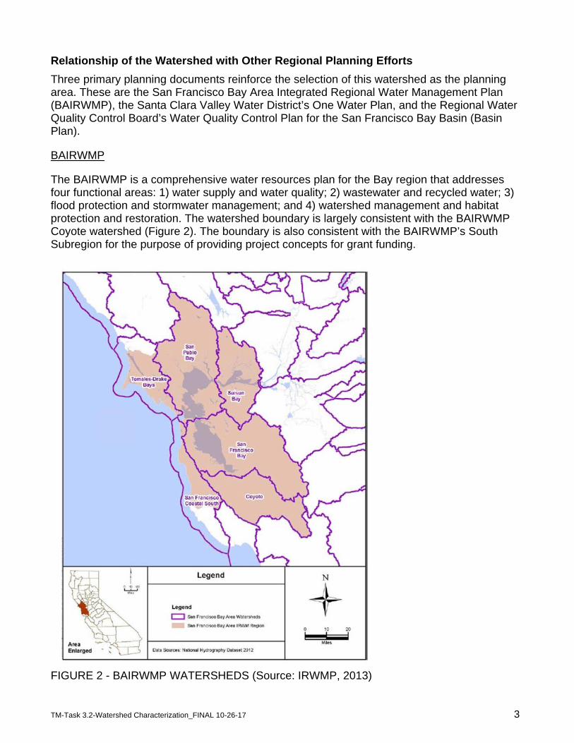
The BAIRWMP is a comprehensive water resources plan for the Bay region that addresses four functional areas: 1) water supply and water quality; 2) wastewater and recycled water; 3) flood protection and stormwater management; and 4) watershed management and habitat protection and restoration. The watershed boundary is largely consistent with the BAIRWMP Coyote watershed (Figure 2). The boundary is also consistent with the BAIRWMP’s South Subregion for the purpose of providing project concepts for grant funding.
FIGURE 2 - BAIRWMP WATERSHEDS (Source: IRWMP, 2013)
TM-Task 3.2-Watershed Characterization_FINAL 10-26-17 4
One Water Plan
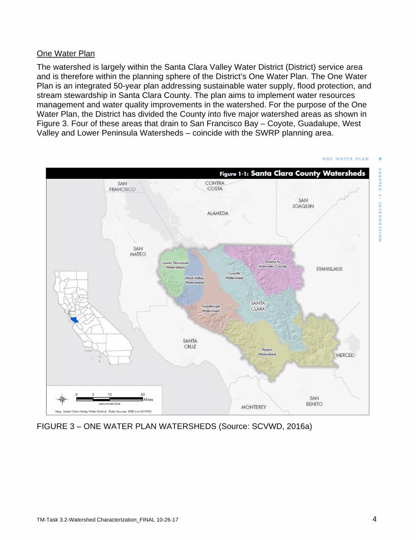
The watershed is largely within the Santa Clara Valley Water District (District) service area and is therefore within the planning sphere of the District’s One Water Plan. The One Water Plan is an integrated 50-year plan addressing sustainable water supply, flood protection, and stream stewardship in Santa Clara County. The plan aims to implement water resources management and water quality improvements in the watershed. For the purpose of the One Water Plan, the District has divided the County into five major watershed areas as shown in Figure 3. Four of these areas that drain to San Francisco Bay – Coyote, Guadalupe, West Valley and Lower Peninsula Watersheds – coincide with the SWRP planning area.
FIGURE 3 – ONE WATER PLAN WATERSHEDS (Source: SCVWD, 2016a)
TM-Task 3.2-Watershed Characterization_FINAL 10-26-17 5
Basin Plan
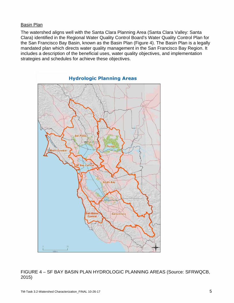
The watershed aligns well with the Santa Clara Planning Area (Santa Clara Valley: Santa Clara) identified in the Regional Water Quality Control Board’s Water Quality Control Plan for the San Francisco Bay Basin, known as the Basin Plan (Figure 4). The Basin Plan is a legally mandated plan which directs water quality management in the San Francisco Bay Region. It includes a description of the beneficial uses, water quality objectives, and implementation strategies and schedules for achieve these objectives.
FIGURE 4 – SF BAY BASIN PLAN HYDROLOGIC PLANNING AREAS (Source: SFRWQCB, 2015)
TM-Task 3.2-Watershed Characterization_FINAL 10-26-17 6
Summary
The Santa Clara Basin Watershed within Santa Clara County will be the regional planning area used throughout the Santa Clara Basin Storm Water Resource Plan. The watershed meets the requirements outlined in the State Water Quality Control Board’s Storm Water Resource Plan Guidelines (2015) and the requirements of the SWRP Planning Grant Agreement between the SCVWD and the State Water Quality Control Board. It allows for comprehensive planning across multi-jurisdictional boundaries and is supported by other regional watershed planning efforts.
Subwatershed Description
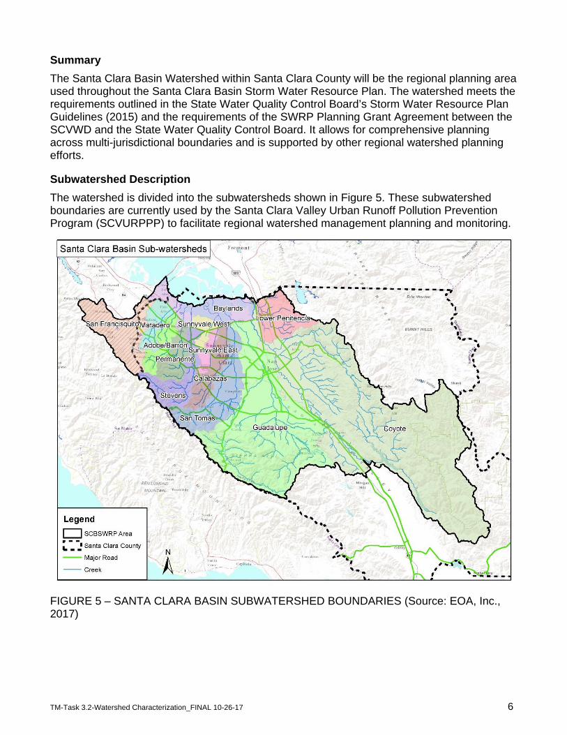
The watershed is divided into the subwatersheds shown in Figure 5. These subwatershed boundaries are currently used by the Santa Clara Valley Urban Runoff Pollution Prevention Program (SCVURPPP) to facilitate regional watershed management planning and monitoring.
FIGURE 5 – SANTA CLARA BASIN SUBWATERSHED BOUNDARIES (Source: EOA, Inc., 2017)

TM-Task 3.2-Watershed Characterization_FINAL 10-26-17 7
For the purpose of aligning the SWRP with the District's One Water Plan, the individual subwatersheds can be grouped into the four major watershed areas within the Basin (Lower Peninsula, West Valley, Guadalupe and Coyote) shown earlier in Figure 3.
Baylands
The “Baylands” area shown on Figure 5 is the wetland area connecting the Santa Clara Basin Watershed to its receiving waters (the Lower South San Francisco Bay) and is included in this SWRP to acknowledge this connection. This area is part of the USGS HUC 8 Digit “San Francisco Bay” watershed that includes the southern half of the San Francisco Bay.
San Francisquito Creek
The San Francisquito Creek subwatershed covers 47.5 square miles in northwestern Santa Clara County and southeastern San Mateo County. The subwatershed is bounded to the southwest by the Santa Cruz Mountains. San Francisquito Creek flows 12.5 miles from Searsville Dam to the Lower South San Francisco Bay. The creek defines the border between San Mateo and Santa Clara Counties. San Francisquito Creek traverses through unincorporated County, including Stanford University land, and the Towns of Portola Valley and Woodside, as well as the Cities of Menlo Park, Palo Alto, and East Palo Alto.
The upper subwatershed is comprised of undeveloped forest and grazing lands and low-density residential neighborhoods. On the valley floor, higher-density residential development exists along with commercial development focused on major surface streets. Stanford University occupies a large area of the valley portion of the subwatershed as does the downtown area of the City of Palo Alto.
The subwatershed is famous for its reproducing steelhead population. Besides steelhead, native fish found in the subwatershed are the California roach, Sacramento sucker, hitch, speckled dace, threespined stickleback, and prickly sculpin. Seven nonnative species also exist in the watershed. The threatened California red-legged frog lives along the Creek.
Matadero Creek
The Matadero Creek subwatershed covers an area of about 14 square miles, of which approximately 11 square miles are mountainous land, and 3 square miles are gently sloping
SCVWD Watershed Sub-Watersheds Lower Peninsula San Francisquito
Matadero Adobe/Barron Permanente Stevens
West Valley Sunnyvale West Sunnyvale East Calabazas San Tomas
Guadalupe Guadalupe Coyote Coyote
Lower Penitencia
TM-Task 3.2-Watershed Characterization_FINAL 10-26-17 8
valley floor. Matadero Creek originates in the foothills of the Santa Cruz Mountains and flows in a northeasterly direction for approximately eight miles until it discharges into the Palo Alto Flood Basin, which drains into the Lower South San Francisco Bay. Major tributaries to Matadero Creek are Arastradero and Deer Creeks and Stanford Channel.
Through the foothills, Matadero Creek traverses through low-density residential development in the Town of Los Altos Hills. As it nears the valley floor, it flows through the Stanford University Preserve and Campus, and then through residential, commercial, and industrial areas of Palo Alto. The portions of the watershed that fall in the northern part of City of Palo Alto are predominantly residential, commercial and public/institutional.
Five species of native fishes have been collected from and/or observed in Matadero Creek during the last 20 years: California roach, Sacramento blackfish, Sacramento sucker, threespine stickleback, and prickly sculpin.
Adobe/Barron Creeks
The Adobe Creek subwatershed covers an area of approximately 10 square miles in northwestern Santa Clara County, of which roughly 7.5 square miles are mountainous and 2.5 square miles are on the valley floor. Adobe Creek originates on the northeastern facing slopes of the Santa Cruz Mountains and flows northerly over steep forested terrain until it meets the Middle, West and North Adobe Forks. Other major tributaries in the upper watershed are Moody and Purissima Creeks.
The drainage area above the confluence of the Adobe Forks is undeveloped open space. The remainder of the watershed primarily consists of residential development. Along the valley floor, Adobe Creek flows through Los Altos Hills, Los Altos, Palo Alto, and Mountain View. Adobe Creek is joined by Barron Creek west of Highway 101 and continues to flow through estuarine area with tidal influence until it drains into the Palo Alto Flood Basin and then the Lower South San Francisco Bay.
Four species of native fishes have been collected from Adobe Creek: California roach, Sacramento sucker, threespine stickleback, and prickly sculpin.
The Barron Creek subwatershed covers an area of approximately three square miles of urban development between the Matadero and Adobe Creek watersheds. Barron Creek is approximately 5 miles long, originating in the low-density residential foothill region of the Town of Los Alto Hills and flowing in a northeasterly direction through residential, commercial, and industrial areas within the City of Palo Alto. The Creek joins neighboring Adobe Creek just upstream of Highway 101 and drains via a tide gate to the Lower South San Francisco Bay through the Palo Alto Flood Basin. It has no major tributaries.
Barron Creek has been greatly modified for flood control purposes; approximately 67 percent of the total length of creek bed has been hardened. Upstream of El Camino Real, the creek is piped for much of its length. Natural channel sections occur immediately adjacent to Arastradero Road and at the Barron Creek Debris Basin (SCVWD 2005a). Downstream of El Camino Real, Barron Creek is contained in a concrete trapezoidal channel. During wet storm events, high flows from Barron Creek may be diverted to Matadero Creek via the Barron Creek Bypass structure. No native fish communities have been identified upstream of the tidally influenced area of the creek.
TM-Task 3.2-Watershed Characterization_FINAL 10-26-17 9
Permanente Creek
The Permanente Creek subwatershed covers an area of approximately 17.5 square miles on the northeast-facing slopes of the Santa Cruz Mountains. The headwaters originate near Black Mountain along the Montebello Ridge. Permanente Creek flows east through unincorporated County land for about five miles, then turns to the north at the base of the foothills and continues another eight miles along the valley floor traversing through the cities of Los Altos and Mountain View, finally draining to the Lower South San Francisco Bay. The major tributaries are the West Branch Permanente Creek and Hale Creek.
Unlike most watersheds in the Santa Clara Basin, the headwaters of the Permanente Creek are not protected as open space, but are developed for light industry and mining. Only the headwaters of the West Branch Permanente Creek are protected as open space by the Mid Peninsula Open Space District. The majority of the watershed downstream of this tributary confluence is developed as high-density residential neighborhoods, with commercial development clustered along major surface streets such as El Camino Real. Some heavy industry is clustered adjacent to Highway 101 in the lower portion of the subwatershed by the Bay.
Four species of native fishes have been collected from and/or observed in Permanente Creek during the last 20 years: rainbow trout, California roach, Sacramento sucker, and threespine stickleback. The native fish assemblage primarily occurs in the reaches upstream of Interstate 280.
Stevens Creek
The Stevens Creek subwatershed covers an area of approximately 29 square miles. The headwaters originate in the Santa Cruz Mountains within the City of Palo Alto and Santa Clara County. Much of the headwater area is protected open space managed by the County and the Mid Peninsula Open Space District. In the upper subwatershed, the mainstem flows southeast for about five miles along the San Andreas Fault, and another three miles northeast to the Stevens Creek Reservoir. From the reservoir, the creek flows northward for a total of 12.5 miles through the foothills in the Cities of Cupertino and Los Altos, and across the alluvial plain through the Cities of Sunnyvale and Mountain View, finally draining into the Lower South San Francisco Bay. Below the reservoir, the subwatershed is largely developed as residential neighborhoods with commercial areas clustered along major surface streets such as El Camino Real. Tributaries above the reservoir include Montebello and Swiss Creeks. One tributary, Heney Creek, joins the mainstem 3.7 miles below the reservoir.
Stevens Creek supports both warm and cold water native fish. Five native fish species that have been found in the creek are California roach, Sacramento sucker, threespine stickleback, rainbow/steelhead trout and Pacific lamprey. Sunnyvale East Channel
Sunnyvale East Channel was constructed in 1967 to manage flooding that was becoming a problem due to subsidence of lands in the drainage area. The Sunnyvale East Channel subwatershed covers 7.1 square miles extending from central Cupertino northeastward through the City of Sunnyvale. The subwatershed draining to East Channel is located entirely on the alluvial plain of the Santa Clara Valley.
East Channel is approximately 6 miles in length and extends from Highway 280 in the south to Guadalupe Slough in the north. The channel is a man-made feature with no natural

TM-Task 3.2-Watershed Characterization_FINAL 10-26-17 10
antecedent. Roughly one quarter of it runs through underground culverts. It drains to the Lower South San Francisco Bay via and Guadalupe Slough.
The portion of the watershed south of Highway 280 drains to the Junipero Serra Channel, an engineered channel which runs eastward along the south side of Highway 280. Near its intersection with Blaney Avenue, a double-pipe diversion structure splits the channel flow such that equal portions flow north to the Sunnyvale East Channel and east to Calabazas Creek (Givler, et al, 2005).
Sunnyvale East Channel subwatershed is almost entirely urbanized with predominately residential development as well as some commercial and industrial development. The only contiguous open space area in the subwatershed is the Sunnyvale Baylands Park along the San Francisco Bay shoreline and smaller city-owned parks in Sunnyvale and Cupertino. No fish species are known to occur upstream of the tidally influenced area.
Sunnyvale West Channel
Similar to East Channel, Sunnyvale West Channel was constructed in 1964 to manage flooding due to subsidence of lands. The West Channel subwatershed drains 7.5 square miles and is entirely located on the alluvial plain of the Santa Clara Valley. The channel originates in the urbanized sections of Sunnyvale and Mountain View.
The channel is approximately 3 miles in length, extending from Guadalupe Slough to Maude Avenue. From the upper end of the channel at Maude Avenue to Almanor Avenue, the channel is a concrete pipe culvert. Downstream of Almanor Avenue to Mathilda Avenue, the channel is an earth-excavated channel. Sunnyvale West Channel drains to Lower South San Francisco Bay via Moffett Channel and then Guadalupe Slough.
The Sunnyvale West Channel subwatershed is almost entirely urbanized with mostly public/institutional development, as well as some industrial and residential areas. The only open space in the watershed is the Sunnyvale Baylands Park along the San Francisco Bay shoreline and several smaller city-owned parks in Sunnyvale. No fish species are known to occur upstream of the tidally influenced area.
Calabazas Creek
The Calabazas Creek subwatershed covers an area of approximately 20 square miles. This 13.3 mile-long creek originates from the northeast-facing slopes of the Santa Cruz Mountains and flow into the Lower South San Francisco Bay via Guadalupe Slough. Major tributaries to Calabazas Creek include Prospect, Rodeo, and Regnart Creeks. Additional sources of water to Calabazas Creek include the El Camino storm drain and the Junipero Serra Channel.
The creek traverses through a small portion of unincorporated County land, and flows through the Cities of Saratoga, Cupertino, Sunnyvale, San Jose, and Santa Clara. Land use in the upper Calabazas Creek watershed, where it passes through unincorporated County areas and into Saratoga, is rural and the upper reaches of the creek are relatively natural and undisturbed.
The lower Calabazas Creek watershed is highly urbanized, predominantly with high-density residential neighborhoods. Areas of heavy industry exist between the Highway 101 and Central Expressway corridors. Commercial development is focused along El Camino Real,

TM-Task 3.2-Watershed Characterization_FINAL 10-26-17 11
Wolfe Road, and Saratoga-Sunnyvale Road. Fish are extremely scarce in the Calabazas Creek upstream of Bollinger Road. Prickly sculpin is the one native species that has been collected and/or observed in Calabazas Creek within the last 20 years.
San Tomas Aquino/Saratoga Creeks
The San Tomas Aquino Creek subwatershed covers an area of approximately 45 square miles. San Tomas Aquino Creek originates in the forested foothills of the Santa Cruz Mountains flowing in a northern direction through the Cities of Campbell and Santa Clara, into the Guadalupe Slough, and finally into the Lower South San Francisco Bay. The major tributaries to San Tomas Aquino Creek include Saratoga, Wildcat, Smith and Vasona Creeks. Of these, Saratoga Creek drains the largest area (17 square miles) and joins San Tomas Aquino Creek 1.5 miles upstream of Highway 101. Due to its relatively large size, the Saratoga Creek subwatershed is often viewed as a distinct watershed even though it does not directly drain to the Lower South San Francisco Bay.
Most of the San Tomas Aquino subwatershed is developed as high-density residential neighborhoods, with additional areas developed for commercial and industrial uses. The majority of the San Tomas Aquino Creek channel has been modified and lined with concrete (from the Smith Creek confluence in the upper reaches downstream to Highway 101). Hitch is the only native fish found in San Tomas Aquino Creek.
Saratoga Creek originates on the northeastern slopes of the Santa Cruz Mountains along Castle Rock Ridge at 3,100 feet in elevation. Saratoga Creek flows for approximately 4.5 miles in an eastern direction through forested terrain, largely contained within Sanborn County Park. It continues for about 1.5 miles through the low-density residential foothill region of the Town of Saratoga and then for another 8 miles along the alluvial plain of the Santa Clara Valley, through the Cities of San Jose and Santa Clara characterized by high-density residential neighborhoods. Major tributaries include San Andres, Bonjetti, and Booker Creeks.
Saratoga Creek supports both warm and cold water native fish assemblages. Three native fish species that have been found in the creek are California roach, Sacramento sucker and rainbow trout.
Guadalupe River
The Guadalupe River subwatershed is the second largest in the Basin and drains approximately 171 square miles. The headwaters drain from the eastern Santa Cruz Mountains near the summit of Loma Prieta in heavily forested unincorporated county land with pockets of low-density residential developments. The Guadalupe River itself begins on the Valley floor at the confluence of Alamitos Creek and Guadalupe Creek, just downstream of Coleman Road in San Jose. From here it flows north for approximately 14 miles until it discharges to the Lower South San Francisco Bay via Alviso Slough. On its journey, it traverses through the Town of Los Gatos, and the Cities of San Jose, Campbell, and Santa Clara, and is joined by three other tributaries: Ross, Canoas, and Los Gatos Creek. The largest of these, Los Gatos Creek, joins the mainstem about 3 ½ miles downstream of its origination, and passes from unincorporated County land through the Town of Los Gatos, and the Cities of Monte Sereno, Campbell, and San Jose.
The upper subwatershed is characterized by heavily forested areas with pockets of scattered residential areas. The upper subwatershed contains the New Almaden Mining District, which

TM-Task 3.2-Watershed Characterization_FINAL 10-26-17 12
was the largest-producing mercury mine in North America. Mercury mining during the late 19th century and early 20th century is one of the primary causes of mercury pollution in the Guadalupe River subwatershed. Moving into the lower subwatershed, the residential density gradually increases to high density on the valley floor. Commercial development is focused along major surface streets. Industrial developments are located closer to the Bay, primarily downstream of the El Camino Real crossing.
Six major reservoirs exist in the subwatershed: Calero Reservoir on Calero Creek; Guadalupe Reservoir on Guadalupe Creek; Almaden Reservoir on Alamitos Creek; and Vasona Reservoir, Lexington Reservoir, and Lake Elsman on Los Gatos Creek. The Guadalupe River subwatershed supports both warm and cold water native fish. Although much of the river is dominated by nonnative fish species, nine native fish species have been collected and/or observed during the last 20 years, including: Pacific lamprey, rainbow/steelhead trout, Chinook salmon, hitch, California roach, Sacramento sucker, threespine stickleback, riffle sculpin, and prickly sculpin. The Guadalupe River supports a reproducing steelhead trout population, as well as a small run of Chinook salmon.
Lower Penitencia Creek
The Lower Penitencia Creek subwatershed covers an area of about 30 square miles, half of which is on the western slopes of the Diablo Mountain Range on the east side of the Santa Clara Basin, and the other half on the valley floor. The major tributaries joining Lower Penitencia Creek are East Penitencia Channel and Berryessa Creek.
Berryessa Creek is a tributary to Lower Penitencia Creek that drains approximately 22 square miles (Leidy, 2005). It flows from the western slopes of the Diablo Mountain Range to Lower Penitencia Creek on the west side of Highway 680.
Lower Penitencia Creek flows from the foothills of the Diablo Range, through undeveloped, unincorporated County land, and continues westerly through largely residential neighborhoods in the Cities of Milpitas and San Jose, transitioning to higher density residential neighborhoods and industrial areas west of Highway 680. The creek flows into Coyote Creek near Dixon Landing Road just west of Highway 880. No native fish communities have been identified in the Lower Penitencia Creek subwatershed.
Coyote Creek
The Coyote Creek subwatershed is the largest in the Santa Clara Basin, and covers approximately 320 square miles of area from the Diablo Range on the east side of the Basin to the valley floor The Creek originates in the mountains northeast of the City of Morgan Hill and flows northwest for approximately 42 miles before entering the Lower South San Francisco Bay. At the base of the Diablo Range, the Creek is impounded by two dams, which form Coyote and Anderson Reservoirs.
Nine major tributaries lie within the area that drains to these two reservoirs: Canada de los Osos, Hunting Hollow, Dexter Canyon, and Larios Canyon Creeks drain to Coyote Reservoir; Otis Canyon, Packwood, San Felipe, Las Animas, and Shingle Valley Creeks drain to Anderson Reservoir. Runoff upstream of Coyote Reservoir accounts for about 75 percent of the total runoff for the entire watershed. The boundary between the Diablo Range and the alluvial plain that forms the Santa Clara Valley floor is sharply defined. At least four major
TM-Task 3.2-Watershed Characterization_FINAL 10-26-17 13
tributaries flow from the mountains across this alluvial plain to Coyote Creek, including Upper Penitencia Creek, Upper Silver Creek, Lower Silver Creek, and Fisher Creek. Coyote Creek flows through unincorporated, predominately agricultural land between Morgan Hill and San Jose. It then flows through the urbanized areas of San Jose and the lower edge of Milpitas, to reach the Bay.
Upper Penitencia Creek is a major tributary to Coyote Creek. Upper Penitencia Creek drains approximately 24 square miles. It flows from the headwaters in the Diablo Range west across the Santa Clara Valley floor to meet Coyote Creek at Berryessa Road (SFEI, 2012). It no longer directly connects to Lower Penitencia Creek. Upper Penitencia Creek supports steelhead/rainbow trout (Leidy, 2005).
The urbanized area of Coyote Creek watershed has dramatically increased since the 1960's, and continues to expand. Since this time, population has increased greatly, and agricultural and grazing land have been converted to residential communities in the southern region of the Santa Clara Valley, and along the base of the Western Diablo range.
Coyote Creek has historically supported, and still does support, the most diverse fish fauna among the Basin watersheds. It supports 10 to 11 native fish species out of the original 18. Species known to occur currently include Pacific lamprey, steelhead/resident rainbow trout, chinook salmon, California roach, hitch, Sacramento blackfish, Sacramento pikeminnow, Sacramento sucker, threespine stickleback, prickly sculpin, riffle sculpin, staghorn sculpin, and tule perch.
References: CA DWR (California Department of Water Resources). 2003. Bulletin 118. State of California Department of Water Resources, Sacramento, CA. Givler, R. W., J. M. Sowers, and P. Vorster. 2005. Creek and Watershed Map of West Santa Clara Valley. Published by the Oakland Museum of California. Leidy, R. A., G. S. Becker, and B. N. Harvey. 2005. Historical distribution and current status of steelhead/rainbow trout (Oncorhynchus mykiss) in streams of the San Francisco Estuary, California. Center for Ecosystem Management and Restoration, Oakland, CA. SCVWD (Santa Clara Valley Water District). 2012. Santa Clara Valley Water District 2012 Water Supply and Infrastructure Master Plan (WSIMP). SCVWD, San Jose, CA. SCVWD (Santa Clara Valley Water District). 2016a. One Water Plan for Santa Clara County, An Integrated Approach to Water Resources Management, Preliminary Draft Report 2016. SCVWD, San Jose, CA. SCVWD (Santa Clara Valley Water District). 2016b. 2016 Groundwater Management Plan for the Santa Clara and Llagas Subbasins. SCVWD, San Jose, CA. San Francisco Bay Area Integrated Regional Water Management Plan (IRWMP). 2013. Prepared by Kennedy/Jenks Consultants, San Francisco, CA SFEI (San Francisco Estuary Institute). 2012. Upper Penitencia Creek Historical Ecology Assessment, SFEI, Richmond, CA.
TM-Task 3.2-Watershed Characterization_FINAL 10-26-17 14
SFRWQCB (San Francisco Regional Water Quality Control Board). 2015. NPDES Phase I MS4 Municipal Regional Stormwater Permit (MRP) for San Francisco Bay Region. Order No. R2-2015-0049. San Francisco, CA. SFRWQCB (San Francisco Bay Regional Water Quality Control Board). 2015. Water Quality Control Plan for the San Francisco Bay Basin (Basin Plan). SFRWQCB, San Francisco, CA.