santa clara county i-280 corridor studyvtaorgcontent.s3-us-west-1.amazonaws.com/site... ·...
TRANSCRIPT
1-1
SANTA CLARA COUNTYI-280 CORRIDOR STUDYAppendix CActive Traffic Management Strategies
SANTA CLARA VALLEY TRANSPORTATION AUTHORITY (VTA)

I-280 Corridor Study – ATMS and ITS
MEMORANDUM From: Kimley-Horn and Associates
To: Shanthi Chatradhi, David Kobayashi, Valley Transportation Authority
Date: February 27, 2017
Re: I-280 Corridor Study: Preliminary Assessment of Active Traffic Management Strategies
This technical memorandum summarizes the preliminary assessment of potential Active Traffic Management (ATM) strategies that could address the needs of the Interstate 280 (I-280) corridor in Santa Clara County. This is a high-level planning exercise that documents the needs and critical issues of the corridor, current conditions of operations and infrastructure, and a discussion of feasible ATM strategies that should receive further consideration.
INTRODUCTION The I-280 Corridor Study is a highway planning study led by the Santa Clara Valley Transportation Authority (VTA), in partnership with City of Cupertino to develop a strategic plan for the 22-mile I-280 Corridor from the US 101/I-680 interchange in San Jose to San Mateo County line. Through a collaborative effort with local, state and regional stakeholders, the goal of the study is to identify improvement projects along the corridor that relieve congestion, improve operations, and enhance safety.
I-280 is one of the most congested corridors in the Santa Clara Valley. A comprehensive study to identify improvements that address the congestion on the corridor has never been conducted for the entire length of corridor. The goal of this corridor study is to evaluate the I-280 corridor at a high level to identify strategic improvements that can help improve mobility for all modes of transportation. This memorandum focuses on providing a useful tool for proactively programming short, mid, and long term projects that include technology solutions to enhance mobility, safety, and connectivity for all modes of transportation.
Basic ITS infrastructure and technologies that support ATM strategies include:
Detection Systems: Traffic sensors play a primary role in detecting vehicles, monitoring real-time traffic conditions, and collecting data, as well as communicating with a central system. Video camera systems provide transportation system operators with a live visual image of traffic conditions and to some extent weather and incident conditions, enabling operators to proactively manage conditions.
Communication Medium: Traffic management systems rely heavily on communication networks to collect and share data and video between and among field elements and Traffic Management Centers (TMCs). Hard wire and/or wireless networks are necessary to deploy advance operational applications such as ATM strategies.
Traveler Information: Information dissemination systems inform users of travel conditions (average speeds, travel times, etc.) via mobile applications, in-vehicle applications, radio, internet, or 511.org.
Connection with TMC and Data Analysis Systems: Traffic data analysis systems analyze outputs from traffic data collection systems and use a central system software at a TMC to generate commands for advance operational applications in the field. Such data analysis systems analyze ramp and mainline detector input to locally or regionally control ramp metering rates, traffic signals, and specific message signs.

I-280 Corridor Study – ATMS and ITS
As part of the I-280 corridor study, technology as it relates to ATM strategies provides opportunities to move toward a network that operates at its maximum potential. This technical memorandum summarizes the assessment of potential ATM strategies that could provide benefits both to I-280 freeway corridor and to the connected roadway system. After an initial high-level discussion of possible strategies, feasible solutions are mapped to specific hot spots or deficiencies to identify opportunities for further evaluation.
ACTIVE TRAFFIC MANAGEMENT (ATM) ATM is defined as the ability to dynamically manage recurrent and nonrecurrent congestion based on prevailing and predicted traffic conditions. ATM strategies use technology to enable efficient operation of the existing system by enhancing system monitoring, traveler information and integrated system operations. The following ATM strategies were considered for potential deployment on the I-280 corridor.
1. Dynamic Routing – Provides users with viable route alternatives using predictive traveler information to help reduce the impact of non-recurrent congestion.
2. Adaptive Ramp Metering – Advanced ramp metering strategies to expand ability to manage traffic entering the freeway.
3. Queue Warning – Real-time display messages advising of downstream queuing. 4. Speed Harmonization/Variable Advisory Speed Signs (Limits) – Suggesting changes to speeds to
reduce downstream congestion. 5. Hard Shoulder Running – Use of shoulder for transit, HOV, or general purpose traffic during
certain periods of time to reduce congestion. 6. Dynamic Junction Control – Dynamically manage lanes to manage access based on traffic
demand. 7. Lane Use Signals/Dynamic Lane Management – Dynamic use of lanes to manage and advise
traffic based on downstream conditions. 8. Dynamic Lane Reversal- Reversal of lanes to temporarily increase the capacity of the road. 9. Dynamic Truck Restrictions- Requires all truck traffic to use designated lanes in a dynamic
manner during peak periods. 10. Mainline Metering – Controlling the flow of traffic entering a certain segment of roadway. 11. Dynamic Pricing/Express Lanes – Using lane pricing to manage the use of HOV lanes. 12. Predictive Traveler Information – Using real-time data to predict travel time information for drivers
for pre-trip and en-route decisions. 13. Improved Incident Response – Evaluation of accident response strategies for subsequent
improvement on similar response strategies. 14. Arterial ITS: ITS devices on arterials to be able to manage the naturally diverted traffic from
freeway during incidents. 15. Adaptive Traffic Signal Control – Allowing traffic signal timing to change based on actual
conditions. 16. Transit Signal Priority – Enabling traffic signals to grant priority treatment to transit vehicles.

I-280 Corridor Study – ATMS and ITS
ACTIVE TRAFFIC MANAGEMENT STRATEGIES
ATM strategies can be deployed singularly to address a specific need of a corridor but are more often combined to meet system-wide needs including congestion management, traveler information, integrated corridor operations, and safety. Several ATM projects in the U.S. and elsewhere have implemented complementary strategies into an integrated system to provide efficient operations across multiple modes and jurisdictions. Table 1 is a quick reference to complementary and supportive strategies that can be deployed together.
Table 1: ATM Complementary and/or Supporting Strategies
Complementary and/or supporting strategies
Dyn
amic
Rou
ting
Ada
ptiv
e R
amp
Met
erin
g
Que
ue W
arni
ng
Spe
ed H
arm
oniz
atio
n
Har
d S
houl
der R
unni
ng
Dyn
amic
Jun
ctio
n C
ontro
l
Dyn
amic
Lan
e M
anag
emen
t
Dyn
amic
Lan
e R
ever
sal
Dyn
amic
Tru
ck R
estri
ctio
ns
Mai
nlin
e M
eter
ing
Dyn
amic
Pric
ing/
Expr
ess
Lane
s P
redi
ctiv
e Tr
avel
er In
form
atio
n
Impr
oved
Inci
dent
Res
pons
e
Arte
rial I
TS
Ada
ptiv
e Tr
affic
Sig
nal C
ontro
l
Tran
sit S
igna
l Prio
rity
Stra
tegi
es
Dynamic Routing X X X X Adaptive Ramp Metering X X X X Queue Warning X X X X X
Speed Harmonization X X X X X Hard Shoulder Running X X X X X X X X Dynamic Junction Control X X X X X X
Dynamic Lane Management
X X X X X
Dynamic Lane Reversal X X X Dynamic Truck Restrictions
X X X
Mainline Metering X X Dynamic Pricing/Express Lanes
X
Predictive Traveler Information X X X X X X X X X X
Incident Response X X X X X X X X
Arterial ITS X X X Adaptive Traffic Signal Control X X X
Transit Signal Priority X X X
I-280 Corridor Study – ATMS and ITS
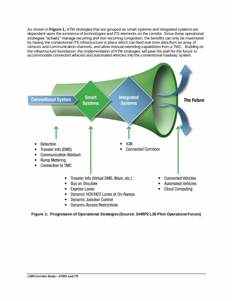
As shown in Figure 1, ATM strategies that are grouped as smart systems and integrated systems are dependent upon the existence of technologies and ITS elements on the corridor. Since these operational strategies “actively” manage recurring and non-recurring congestion, the benefits can only be maximized by having the conventional ITS infrastructure in place which can feed real-time data from an array of sensors and communication channels, and allow manual overriding capabilities from a TMC. Building on the infrastructure foundation, the implementation of ATM strategies will pave the path for the future to accommodate connected vehicles and automated vehicles into the conventional roadway system.
Figure 1: Progression of Operational Strategies (Source: SHRP2 L36 Pilot Operations Forum)

I-280 Corridor Study – ATMS and ITS
POTENTIAL BENEFITS OF ATM STRATEGIES
Table 2 summarizes potential benefits expected from implementation of various ATM strategies based on experience from other ATM implementations in the U.S. and Europe. The benefits of ATM strategies can be broadly categorized into Traffic, Safety, and Environmental benefits. The table below illustrates some of the more common benefits; other benefits such as improved level of service, increased speed, and enhanced data quality, can also be realized by these strategies. Table 4 at the end of this document includes implementation costs and benefits for each strategy, organized by most feasible location along the I-280 corridor.
Table 2: ATM Strategy Benefits
Strategies/Benefits
Traffic Safety Environmental
Incr
ease
d Th
roug
hput
1
Incr
ease
d C
apac
ity2
Dec
reas
e in
Prim
ary
Inci
dent
s
Dec
reas
e in
Sec
onda
ry In
cide
nts
Dec
reas
e in
Inci
dent
Sev
erity
Mor
e U
nifo
rm S
peed
s
Dec
reas
ed H
eadw
ays
Mor
e U
nifo
rm D
river
Beh
avio
r
Incr
ease
d Tr
ip R
elia
bilit
y
Del
ay O
nset
of F
reew
ay B
reak
dow
n
Red
uctio
n in
Tra
ffic
Noi
se
Red
uctio
n in
Em
issi
ons
Red
uctio
n in
Fue
l Con
sum
ptio
n
Dynamic Routing X X X X X X X Adaptive Ramp Metering X X X X X X X X Queue Warning X X X X X X X X X X Speed Harmonization X X X X X X X X X X X Hard Shoulder Running X X X X
Dynamic Junction Control X X X X X X X X X X Dynamic Lane Management X X X
Dynamic Lane Reversal X X X X Dynamic Truck Restrictions X X X X X X X Mainline Metering X X X X X X X X X Dynamic Pricing/Express Lanes X X X X X X X X Predictive Traveler Information X X X X X X X Improved Incident Response X X X X X
Arterial ITS X X X X X Adaptive Traffic Signal Control X X X X X X X Transit Signal Priority X
1 Increased throughput is considered as moving more vehicles through an existing roadway segment. 2 Increased capacity is considered as additional roadway is physically made available for appropriate traffic movements.
I-280 Corridor Study – ATMS and ITS
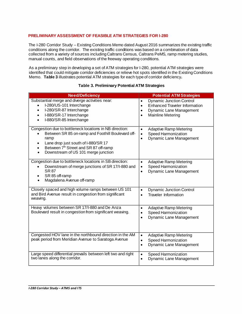
PRELIMINARY ASSESSMENT OF FEASIBLE ATM STRATEGIES FOR I-280 The I-280 Corridor Study – Existing Conditions Memo dated August 2016 summarizes the existing traffic conditions along the corridor. The existing traffic conditions was based on a combination of data collected from a variety of sources including Caltrans Census, Caltrans PeMS, ramp metering studies, manual counts, and field observations of the freeway operating conditions. As a preliminary step in developing a set of ATM strategies for I-280, potential ATM strategies were identified that could mitigate corridor deficiencies or relieve hot spots identified in the Existing Conditions Memo. Table 3 illustrates potential ATM strategies for each type of corridor deficiency.
Table 3. Preliminary Potential ATM Strategies
Need/Deficiency Potential ATM Strategies
Substantial merge and diverge activities near: I-280/US-101 Interchange I-280/SR-87 Interchange I-880/SR-17 Interchange I-880/SR-85 Interchange
Dynamic Junction Control Enhanced Traveler Information Dynamic Lane Management Mainline Metering
Congestion due to bottleneck locations in NB direction:
Between SR 85 on-ramp and Foothill Boulevard off-ramp
Lane drop just south of I-880/SR 17 Between 7th Street and SR 87 off-ramp Downstream of US 101 merge junction
Adaptive Ramp Metering Speed Harmonization Dynamic Lane Management
Congestion due to bottleneck locations in SB direction: Downstream of merge junctions of SR 17/I-880 and
SR 87 SR 85 off-ramp Magdalena Avenue off-ramp
Adaptive Ramp Metering Speed Harmonization Dynamic Lane Management
Closely spaced and high volume ramps between US 101 and Bird Avenue result in congestion from significant weaving.
Dynamic Junction Control Traveler Information
Heavy volumes between SR 17/I-880 and De Anza Boulevard result in congestion from significant weaving.
Adaptive Ramp Metering Speed Harmonization Dynamic Lane Management
Congested HOV lane in the northbound direction in the AM peak period from Meridian Avenue to Saratoga Avenue
Adaptive Ramp Metering Speed Harmonization Dynamic Lane Management
Large speed differential prevails between left two and right two lanes along the corridor.
Speed Harmonization Dynamic Lane Management

I-280 Corridor Study – ATMS and ITS
Need/Deficiency Potential ATM Strategies Lack of ITS infrastructure and incident management plans to manage heavy demand on arterials during incidents.
Adaptive Ramp Metering Improved Incident Response Arterial ITS
Local traffic responsive ramp metering between McLaughlin Avenue and De Anza Boulevard could be ineffective to combat oversaturated conditions.
Adaptive Ramp Metering
Limited transit routes – Four transit routes, 102, 103, 182, and Highway 17 Express travel on the corridor. VTA is planning to increase bus services on I-280; however, supporting operational strategies are deemed necessary.
Hard Shoulder Running Transit Signal Priority
High concentration of collisions near SR 87 and I-880. Dynamic Routing Adaptive Ramp Metering Queue Warning Improved Incident Response Arterial ITS
Using this preliminary list of possible strategies, we can envision an initial conceptual package of overall ATM strategies and assess the feasibility of these strategies operating along the I-280 corridor. The specific corridor concepts and operational functionality most feasible for the I-280 corridor are first discussed in more detail below; followed by a summary list of ATM strategies with corresponding potential deployment locations within the I-280 corridor.
Adaptive Ramp Metering (ARM): This operational strategy is one iteration beyond Local Traffic Responsive Ramp Metering currently operating in most locations throughout the Bay Area. Adaptive ramp metering uses a software algorithm to evaluate all on-ramps along a corridor to determine an optimal metering rate at each ramp that benefits the entire corridor. ARM can effectively manage recurring congestion and freeway incidents. Freeway incidents are typically managed using more restrictive metering upstream and less restrictive metering downstream of the incident. Caltrans can monitor operations of every on-ramp from the Regional Traffic Management Center, and can remotely override or reprogram metering rates and algorithm thresholds when necessary.
Corridor Characteristics and Benefits The following characteristics of the I-280 corridor make it suitable for the adaptive ramp metering:
Presence of multiple bottlenecks between US 101 and I-880 due to heavy volumes and weaving between local ramps and system interchanges. Enabling communication among local roadway ramps could optimize total flow onto the mainline to maximize passenger throughput.
Volume fluctuations not only during the day but also in the peak periods. Adaptive ramp meters allow automated as well as manual adjustment to metering rates based on real-time data.
Multiple system-to-system connections are present on the I-280 corridor. If these connectors are metered, greater flexibility can be provided in clearing queues at critical on-ramps while being more restrictive at less critical on-ramps.
Lack of an incident management plan. Adaptive ramp meters could restrict the flow rates upstream of the incident, while flushing out the vehicles downstream of the incident.
Need to address changing travel conditions and traffic growth over time. I-280 traffic volumes are expected to grow substantially.

I-280 Corridor Study – ATMS and ITS
Adaptive ramp metering could support other ATM strategies such as Bus on Shoulder by holding the red time longer to allow priority treatments for transit vehicles on shoulders.
Deployment Locations Based on existing operating conditions, the implementation of coordinated adaptive ramp metering can be considered along I-280 NB between SR 85 and King Road and I-280 SB between Page Mill Road and I-880.
Bus On Shoulder (BOS): This ATM strategy allows transit vehicles to utilize the designated shoulder, often with driving instructions and restrictions for bus drivers to ensure operational safety along the corridor. Buses are typically limited to use at a specific time of day, and are limited to a specific speed differential or maximum speed compared to the adjacent general purpose lanes. BOS application can be deployed as a pilot project at selected segments or used as a permanent lane.
Given the complexity of the I-280 corridor, this strategy would require development of plans, policies, and guidelines in partnership with private bus operators, transit agencies, Caltrans, local jurisdictions, and California Highway Patrol. Engaging cities and communities along the corridor is key in the decision-making process.
This strategy includes strengthening of shoulders, adding supplemental signs and striping treatments at on and off-ramps, and installing supporting ITS elements and technologies such as detection, Dedicated Short Range Communications from on-ramps to buses, communication system, overhead VMS and lane control signs. BOS should be implemented with complementary strategies such as dynamic lane use signs, variable message signs, colored/illuminated pavement, dynamic junction control, etc. Design exceptions will be required for this strategy, which should be done in consultation with Caltrans.
Corridor Characteristics and Benefits The I-280 is currently used by a limited number of buses, as discussed earlier. With the construction of BART and High Speed Rail stations, transit services to and from the San Jose Downtown are expected to increase. BOS could aid public and private bus services between education, shopping, and employment destinations in Cupertino and San Jose, and Diridon station. BOS has potential to make transit services more reliable and faster.
BOS can be implemented on right or left shoulders. I-280 provides a minimum of 10 feet wide shoulders at unconstrained locations. There is an opportunity to provide continuous BOS lane on the left or right shoulder between De Anza Boulevard and Winchester Boulevard. The pinch points from the system interchanges, overpass columns and bridge structures would need minor widening or lane realignments to accommodate BOS between Winchester Boulevard and Bird Avenue. The use of overhead dynamic lane control signs and supplement pavement striping would allow buses to merge safely and efficiently into existing managed or general purpose lane at the constrained locations.
Extension of the existing HOV lanes and converting HOV lanes to a managed lane and potential addition of a second managed lane in some segment of the corridor is being evaluated in the potential improvements section of the corridor study report. While such capacity improvement projects require environmental clearance, and thus could take a long time to build, interim operational strategies such as BOS could be considered on the left shoulder for longer segment and on the right shoulder for short segments of the corridor.
BOS application through the acute bottlenecks at system interchanges is critical. As such, opportunities to add extra pavement width should be explored while planning and designing the physical improvements described earlier. VTA’s Next Network project will redesign the transit network in late 2017. The route planning process would also inform BOS opportunities on the I-280 corridor.
I-280 Corridor Study – ATMS and ITS
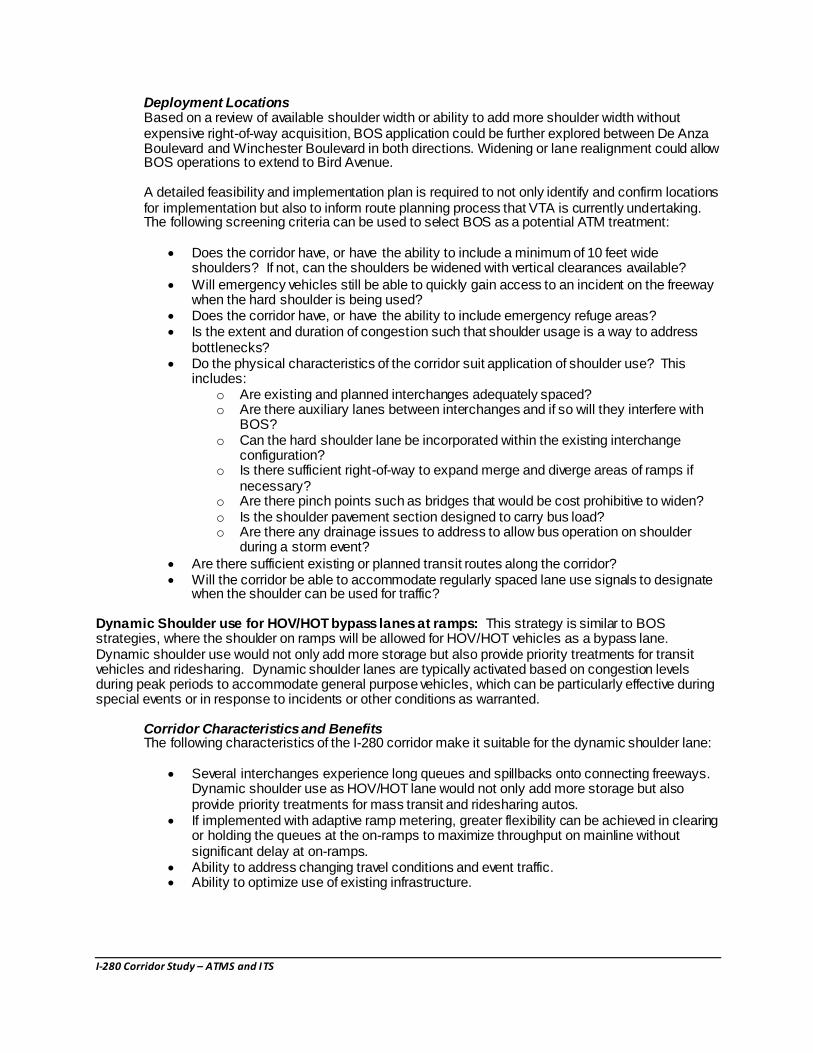
Deployment Locations Based on a review of available shoulder width or ability to add more shoulder width without expensive right-of-way acquisition, BOS application could be further explored between De Anza Boulevard and Winchester Boulevard in both directions. Widening or lane realignment could allow BOS operations to extend to Bird Avenue.
A detailed feasibility and implementation plan is required to not only identify and confirm locations for implementation but also to inform route planning process that VTA is currently undertaking. The following screening criteria can be used to select BOS as a potential ATM treatment:
Does the corridor have, or have the ability to include a minimum of 10 feet wide shoulders? If not, can the shoulders be widened with vertical clearances available?
Will emergency vehicles still be able to quickly gain access to an incident on the freeway when the hard shoulder is being used?
Does the corridor have, or have the ability to include emergency refuge areas? Is the extent and duration of congestion such that shoulder usage is a way to address
bottlenecks? Do the physical characteristics of the corridor suit application of shoulder use? This
includes: o Are existing and planned interchanges adequately spaced? o Are there auxiliary lanes between interchanges and if so will they interfere with
BOS? o Can the hard shoulder lane be incorporated within the existing interchange
configuration? o Is there sufficient right-of-way to expand merge and diverge areas of ramps if
necessary? o Are there pinch points such as bridges that would be cost prohibitive to widen? o Is the shoulder pavement section designed to carry bus load? o Are there any drainage issues to address to allow bus operation on shoulder
during a storm event? Are there sufficient existing or planned transit routes along the corridor? Will the corridor be able to accommodate regularly spaced lane use signals to designate
when the shoulder can be used for traffic?
Dynamic Shoulder use for HOV/HOT bypass lanes at ramps: This strategy is similar to BOS strategies, where the shoulder on ramps will be allowed for HOV/HOT vehicles as a bypass lane. Dynamic shoulder use would not only add more storage but also provide priority treatments for transit vehicles and ridesharing. Dynamic shoulder lanes are typically activated based on congestion levels during peak periods to accommodate general purpose vehicles, which can be particularly effective during special events or in response to incidents or other conditions as warranted.
Corridor Characteristics and Benefits The following characteristics of the I-280 corridor make it suitable for the dynamic shoulder lane:
Several interchanges experience long queues and spillbacks onto connecting freeways. Dynamic shoulder use as HOV/HOT lane would not only add more storage but also provide priority treatments for mass transit and ridesharing autos.
If implemented with adaptive ramp metering, greater flexibility can be achieved in clearing or holding the queues at the on-ramps to maximize throughput on mainline without significant delay at on-ramps.
Ability to address changing travel conditions and event traffic. Ability to optimize use of existing infrastructure.
I-280 Corridor Study – ATMS and ITS
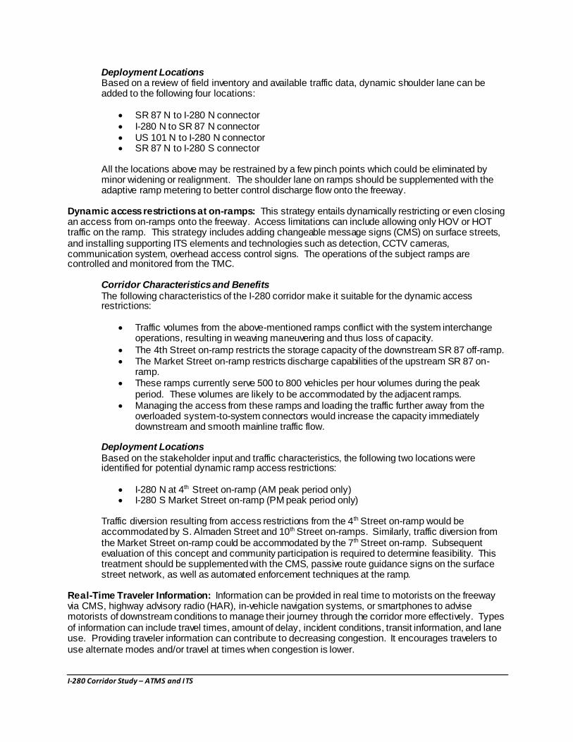
Deployment Locations Based on a review of field inventory and available traffic data, dynamic shoulder lane can be added to the following four locations:
SR 87 N to I-280 N connector I-280 N to SR 87 N connector US 101 N to I-280 N connector SR 87 N to I-280 S connector
All the locations above may be restrained by a few pinch points which could be eliminated by minor widening or realignment. The shoulder lane on ramps should be supplemented with the adaptive ramp metering to better control discharge flow onto the freeway.
Dynamic access restrictions at on-ramps: This strategy entails dynamically restricting or even closing an access from on-ramps onto the freeway. Access limitations can include allowing only HOV or HOT traffic on the ramp. This strategy includes adding changeable message signs (CMS) on surface streets, and installing supporting ITS elements and technologies such as detection, CCTV cameras, communication system, overhead access control signs. The operations of the subject ramps are controlled and monitored from the TMC.
Corridor Characteristics and Benefits The following characteristics of the I-280 corridor make it suitable for the dynamic access restrictions:
Traffic volumes from the above-mentioned ramps conflict with the system interchange operations, resulting in weaving maneuvering and thus loss of capacity.
The 4th Street on-ramp restricts the storage capacity of the downstream SR 87 off-ramp. The Market Street on-ramp restricts discharge capabilities of the upstream SR 87 on-
ramp. These ramps currently serve 500 to 800 vehicles per hour volumes during the peak
period. These volumes are likely to be accommodated by the adjacent ramps. Managing the access from these ramps and loading the traffic further away from the
overloaded system-to-system connectors would increase the capacity immediately downstream and smooth mainline traffic flow.
Deployment Locations Based on the stakeholder input and traffic characteristics, the following two locations were identified for potential dynamic ramp access restrictions:
I-280 N at 4th Street on-ramp (AM peak period only) I-280 S Market Street on-ramp (PM peak period only)
Traffic diversion resulting from access restrictions from the 4th Street on-ramp would be accommodated by S. Almaden Street and 10th Street on-ramps. Similarly, traffic diversion from the Market Street on-ramp could be accommodated by the 7th Street on-ramp. Subsequent evaluation of this concept and community participation is required to determine feasibility. This treatment should be supplemented with the CMS, passive route guidance signs on the surface street network, as well as automated enforcement techniques at the ramp.
Real-Time Traveler Information: Information can be provided in real time to motorists on the freeway via CMS, highway advisory radio (HAR), in-vehicle navigation systems, or smartphones to advise motorists of downstream conditions to manage their journey through the corridor more effectively. Types of information can include travel times, amount of delay, incident conditions, transit information, and lane use. Providing traveler information can contribute to decreasing congestion. It encourages travelers to use alternate modes and/or travel at times when congestion is lower.

I-280 Corridor Study – ATMS and ITS
Corridor Characteristics and Benefits The following characteristics of the I-280 corridor make it suitable for the real-time traveler information:
I-280 currently lacks a mechanism for advanced traveler information system along the corridor.
High accident rates support the need for advanced traveler information on downstream conditions.
Deployment Locations Based on a review of corridor characteristics and stakeholder coordination, the following locations were identified with potential for real-time traveler information in the form of electronic message signs or in-vehicle information points:
I-280 N upstream of: o McKee Avenue o SR 87 o I-880
I-280 S upstream of: o Page Mill Road o Stevens Creek Road o SR 87
These locations were based on availability of parallel roadways as alternate routes taken when incidents occur on the freeway. A mobile application or communications to in-vehicle applications could also be developed by VTA to provide real-time travel time information for major destinations and warn motorists of any incidents and unexpected congestion. This treatment should be supplemented with the ITS technologies, such as detectors, communication systems and a TMC.
Dynamic Junction Control: Dynamic junction control is dynamic allocation of lane access on mainline and ramp lanes in interchange areas where high traffic volumes are present and the relative demand on the mainline and ramps change throughout the day. This may prevent the formation of congestion in merge areas when there is sufficient or imbalanced capacity in the adjacent mainline lanes. This could easily incorporate existing ramp metering systems and could offer the potential of delaying the onset of mainline congestion and balancing demands between the upstream mainline and ramps. Dynamic junction control also can be used as an alternative to freeway to freeway control/metering.
Corridor Characteristics and Benefits For the I-280 corridor, three forms of dynamic junction control could potentially be implemented:
A lane reduction on the entrance and/or exit ramp to complement shoulder running operations on the mainline.
A lane reduction on the mainline upstream of a high-volume entrance ramp to provide an additional lane on the entrance ramp
Assigning a mainline lane for shared through-exit movements or exit-only movements at an off ramp.
Deployment Locations Based on a review of field inventory and available traffic data, dynamic junction control can be considered at the following locations:
I-280 Northbound o US 101 N on-ramp – lane reduction on the mainline o SR 87 N off-ramp – assigning a SR 87 S off-ramp lane as shared lane to support
dynamic shoulder lane

I-280 Corridor Study – ATMS and ITS
o Meridian Avenue on-ramp – supporting a shoulder lane on the right between Race Street off-ramp and Meridian Avenue on-ramp
o Foothill Express Way off-ramp – assigning an outside mainline lane for shared through-exit movement
Speed Harmonization and Dynamic Queue Warning: Speed harmonization is an ATM strategy used to proactively manage vehicle speeds to improve roadway safety and maximize freeway throughput. The primary purpose of speed harmonization is to minimize turbulent spatial and temporal variations in speed and is achieved by recommending an advisory speed upstream of areas of congestion or incidents. This strategy can be achieved with regularly spaced lane speed and lane control signs over each lane or on shoulder-mounted installations to dynamically reduce speed limits in areas of congestion, construction work zones, accidents, or special events to maintain traffic flow and reduce the risk of collisions due to speed differentials at the end of queue and throughout the congested area.
Dynamic queue warning strategy is real-time display of warning messages along a roadway to alert motorists that queues or significant slowdowns are ahead, reducing rear-end crashes. This strategy is appropriate for locations with high rates of secondary crashes, high rate of rear-end collisions, recurring congestion and queuing, and sight distance restrictions.
Speed harmonization and dynamic queue warning can result in a reduction in the number of crashes caused by sudden changes in speed (by reducing speeds before vehicles reach the back of a queue) and by abrupt lane changes (by reducing the speed differential between lanes and therefore eliminating the incentive to change lanes). It also alerts drivers that downstream conditions are changing.
Corridor Characteristics and Benefits With the complexity of the geometric configuration of the I-280 corridor and lack of basic ITS infrastructure in place, these strategies might be cost-prohibitive and might not be effective to be implemented as a first phase of improvements. The strategies need to be analyzed further to evaluate the full potential benefits once complementary strategies are in place.
Deployment Locations Speed harmonization and dynamic queue warning sign strategies could also be considered when the technology allows information to be shown inside the cars or on mobile phones as virtual Dynamic Message Signs (DMS).
Table 4 summarizes deployment locations discussed above as potential ITS/ATM projects.
NEXT STEPS
The assessment presented above should be construed as a very high-level feasibility evaluation of ATM strategies that could provide some benefit within the I-280 corridor. It is not a conclusive statement of the specific elements that should be carried to the next stage.
There are several steps that VTA should take to advance this assessment:
These ATM strategies and any other appropriate strategies should be furthered investigated and analyzed in a Systems Engineering process, including Concept of Operations, and other simulation analyses to document the purpose for these strategies, the complete deficiencies in the system, and how these strategies would operate under various scenarios.
Convene project stakeholders consisting of VTA, local agencies, Caltrans, and MTC. Establish a regular meeting schedule (including a Technical Advisory Committee) to devise the technical concepts and overall project approach. Document stakeholder roles and responsibilities for the lifecycle of this project.
Identify funding opportunities and constraints.

I-280 Corridor Study – ATMS and ITS
Reference Caltran’s Corridor Management Work Plan for guidance on initiating and developing ATM strategies for this corridor.
Currently, the I-280 corridor within the Santa Clara County has very limited ITS infrastructure. Through the I-280 Corridor Study, VTA needs to begin collaborating with Caltrans and local agencies to include implementation of this foundational infrastructure along I-280 to facilitate development and deployment of ATM strategies. That discussion should include a definition of needs, goals, and objectives that ATM strategies can help to mitigate. This will create a smarter corridor that also accommodates advancing technologies to support connected and autonomous vehicles, and to manage congestion and increase safety.
Identify performance metrics that are appropriate or important to achieve within this corridor.
Moving forward in this strategic fashion will avoid the trap of technology driving this project. It will help to focus the discussions on the deficiencies within the corridor, the needs or issues that must be mitigated, and will position this corridor and VTA to develop and deliver an innovative solution that enables advancement and accommodation of future technology.

I-280 Corridor Study – ATMS and ITS
Table 4: Potential ATM and ITS Projects
ID # LOCATION DESCRIPTION OF POTENTIAL IMPROVEMENTS COST
ITS and ATM STRATEGIES
IA01 Entire Corridor
ITS Elements and Technologies
Detection (in-pavement sensors, CCTV, etc.) with real-time traffic data collection and monitoring Communication networks and systems, including connection to Center Information dissemination systems (such as mobile applications, 511.org, etc.) Connection with Traffic Management Center (TMC) Data Analysis systems
To be added as part of
overall plan
IA02
I-280 N
between De
Anza
Boulevard and
I-880
Adaptive Ramp Metering
Upgrade existing ramp metering controllers Add detection upstream and downstream of ramps and adjacent mainline segment Enable wireless connection among ramps and between ramps and a central system Add HOV/HOT Bypass lane at on-ramps when feasible
IA03
I-280 N
between I-880
and SR 87
Adaptive Ramp Metering
Upgrade existing ramp metering controller Add detection upstream and downstream of ramps and adjacent mainline segment Enable wireless connection among ramps and between ramps and a central system Add HOV/HOT Bypass lane at on-ramps when feasible
IA04
I-280 N
between SR
87and King
Avenue
Adaptive Ramp Metering
Upgrade existing ramp metering controller Add detection upstream and downstream of ramps and adjacent mainline segment Enable wireless connection among ramps and between ramps and a central system Add HOV/HOT Bypass lane at on-ramps when feasible

I-280 Corridor Study – ATMS and ITS
ID # LOCATION DESCRIPTION OF POTENTIAL IMPROVEMENTS COST
IA05
I-280 N
between De
Anza
Boulevard and
SR 87
Bus on Shoulders
Determine feasible locations for local and/or continuous usage of shoulders Add signing and striping treatments at on and off-ramps Install CCTV cameras for traffic incident monitoring Add overhead VMS and lane use signals Construct emergency pull-out areas where feasible
IA06
SR 87 N to I-
280 N
Connector
Dynamic Shoulder Use as HOV/HOT Bypass Lane
Modify signing and striping Add detector and communication systems Install CCTV cameras for traffic monitoring Add overhead VMS and lane use signs
IA07 I-280 N to SR
87 N Connector
Dynamic Shoulder Use
Modify signing and striping Add detector and communication systems Install CCTV cameras for traffic monitoring Add overhead VMS and lane use signs
IA08
I-280 N 4th
Street On-
Ramp
Dynamic Ramp Access Restrictions
Add detector and communication systems Install automated enforcement technologies Add overhead VMS and access control signs
IA09
US 101 N to I-
280 N
Connector
Dynamic Shoulder Use as HOV/HOT Bypass Lane
Modify signing and striping Add detector and communication systems Install CCTV cameras for traffic monitoring Add overhead VMS and lane use signs
I-280 Corridor Study – ATMS and ITS
ID # LOCATION DESCRIPTION OF POTENTIAL IMPROVEMENTS COST
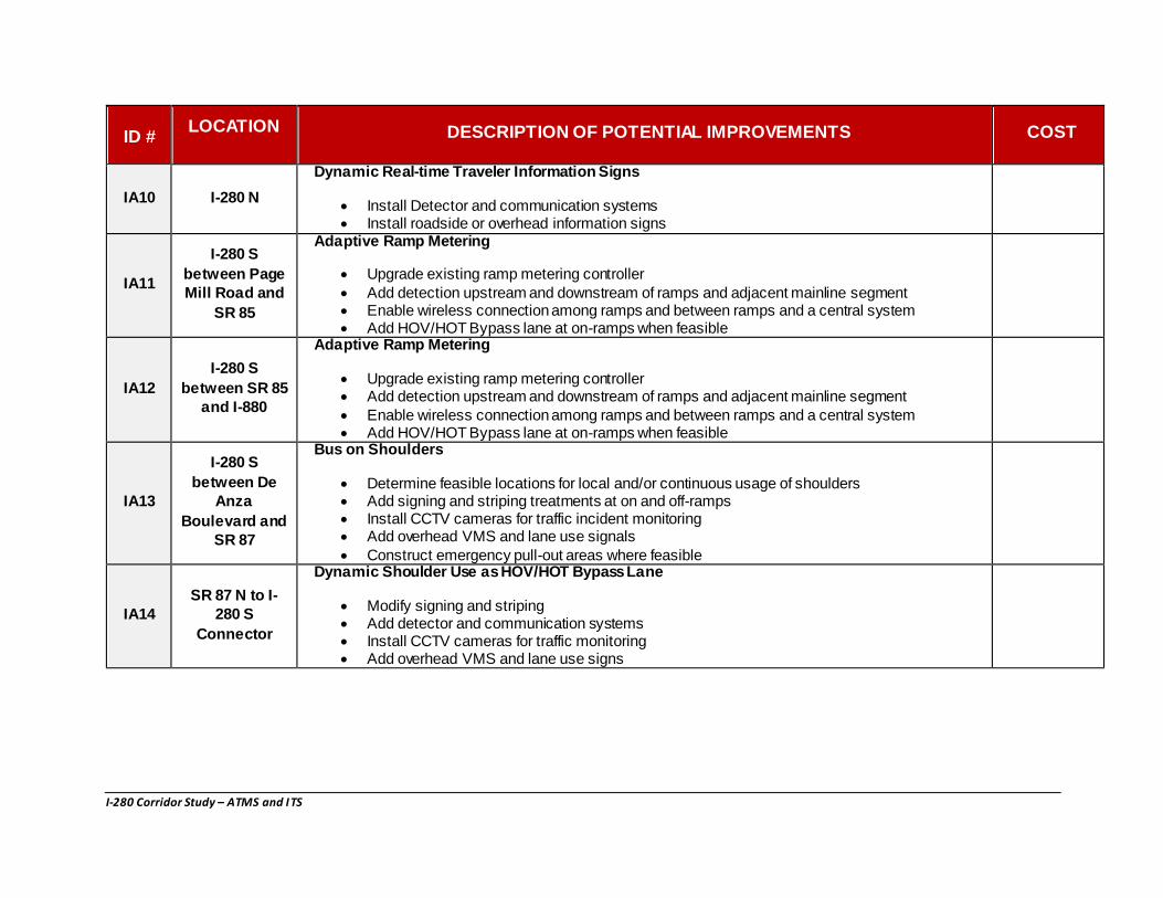
IA10 I-280 N
Dynamic Real-time Traveler Information Signs
Install Detector and communication systems Install roadside or overhead information signs
IA11
I-280 S
between Page
Mill Road and
SR 85
Adaptive Ramp Metering “Road Diet” to Add Class II Bike Lanes
Upgrade existing ramp metering controller Add detection upstream and downstream of ramps and adjacent mainline segment Enable wireless connection among ramps and between ramps and a central system Add HOV/HOT Bypass lane at on-ramps when feasible
Delineate Class II Bike Lanes with 2’ Buffer
IA12
I-280 S
between SR 85
and I-880
Adaptive Ramp Metering “Square-Up” On- and Off-Ramps and Add Class II Bike Lanes
Upgrade existing ramp metering controller Add detection upstream and downstream of ramps and adjacent mainline segment Enable wireless connection among ramps and between ramps and a central system Add HOV/HOT Bypass lane at on-ramps when feasible
Delineate Class II Bike Lanes
IA13
I-280 S
between De
Anza
Boulevard and
SR 87
Bus on Shoulders “Square-Up” NB On-and Off-Ramps and Add Class II Bike Lanes
Determine feasible locations for local and/or continuous usage of shoulders Add signing and striping treatments at on and off-ramps Install CCTV cameras for traffic incident monitoring Add overhead VMS and lane use signals Construct emergency pull-out areas where feasible
Delineate Class II Bike Lanes
IA14
SR 87 N to I-
280 S
Connector
Dynamic Shoulder Use as HOV/HOT Bypass Lane
Modify signing and striping Add detector and communication systems Install CCTV cameras for traffic monitoring Add overhead VMS and lane use signs
“Square-Up” NB On-and Off-Ramps and Add Class II Bike Lanes
I-280 Corridor Study – ATMS and ITS
ID # LOCATION DESCRIPTION OF POTENTIAL IMPROVEMENTS COST
IA15
I-280 S Market
Street On-
Ramp
Dynamic Ramp Access Restrictions
Add detector and communication systems Install automated enforcement technologies Add overhead VMS and access control signs
“Square-Up” NB On-and Off-Ramps and Add Class II Bike Lanes
IA16 I-280 S
Dynamic Real-time Traveler Information Signs
Install detector and communication systems Install roadside or overhead information signs
IA17
Stevens Creek
Boulevard and
W San Carlos
Street
Construct Class IV Cycle Tracks
Install detector and communication systems to provide real-time information to bicyclists Add wayfinding signs and CMS Construct protected intersections where required
IA18
I-280 N at US
101 N On-ramp,
SR 87 Off-
ramp, Meridian
On-ramp and
Foothill Off-
ramp
Dynamic Junction Control
Modify signing and striping Add detector and communication systems Install CCTV cameras for traffic monitoring Add overhead VMS and lane use signs

1
2
3
4 5 67
89
14 15
16 17 1819
13121110
22
2324
2120
I12
IA11
IA17
IA13
IA02
IA05IA04
IA10
IA16
IA18
IA09
I14I15 IA08
IA03
IA06 IA07
PALO ALTO
MOUNTAINVIEW
UNINCORPORATED SANTA CLARA COUNTY
SUNNYVALE
CUPERTINO
CAMBELL
SARATOGA
LOS GATOS
SANTACLARA
SANJOSE
MILPITAS
LOSALTOSHILLS
LOSALTOS
San M
ateo C
ounty
Santa
Clar
a Cou
nty
STUDY AREA
LEGEND
Interchanges/Ramps
HOV Lanes
Corridor Study Limits
Parallel Routes
Major Roads
County Line
ITS and ATMS Potential Improvement Locations
280
280
880680
680
101
101
101
CALIFORNIA
237
CALIFORNIA
237
CALIFORNIA
85
CALIFORNIA
85CALIFORNIA
17
CALIFORNIA
17CALIFORNIA
87
End: HOV I-280 NB
End: HOV I-280 SB
Begin: HOV I-280 SB
Begin: HOV I-280 NB
1
2
3
4
5
6
7
8
9
14
15
16
17
18
19
13
12
11
10
22
23
24
21
20
* Not Part of the Study
INTERCHANGESI-280/Page Mill RdI-280/El Monte RdI-280/Magdalena AveI-280/Foothill ExpyI-280/SR-85I-280/N De Anza BlvdI-280/Wolfe Rd*I-280/Stevens Creek Blvd
I-280/Lawrence ExpyI-280/Saratoga AveI-280/Winchester Blvd*I-880/SR-17I-280/Bascom AveI-280/Leigh AveI-280/Meridian AveI-280/Bird Ave
I-280/SR-87I-280/1st StI-280/4th StI-280/7th StI-280/10th StI-280/11th StI-280/McLaughlin AveI-280/US-101
SANTACLARA
Page
Mill
Rd
Arastradero Rd
El Mon
te Rd S Sp
ringe
r Rd
Gran
t RdFoothill Expy
N Fo
othi
ll Bl
vd
El Camino Real
El Camino RealFremont Ave
Homestead RdN De
Anz
a Bl
vd
Wol
fe R
d
Law
renc
e Ex
py
Stevents Creek Blvd
Bollinger RdWilliams Rd
Pruneridge Ave
E Santa Clara St
S 10th St
N 1st St
E Julian StE Taylor St
McLaughlin Ave
Senter Rd
Sarat
oga A
ve