sanddunes rajasthan
DESCRIPTION
aTRANSCRIPT
Geological Survey of India
Compiled by: Dr. A.K. GROVER Western Region
1
Types of Sand Dunes occurring in Thar Desert of India
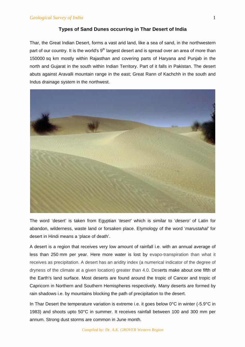
Thar, the Great Indian Desert, forms a vast arid land, like a sea of sand, in the northwestern
part of our country. It is the world's 9th largest desert and is spread over an area of more than
150000 sq km mostly within Rajasthan and covering parts of Haryana and Punjab in the
north and Gujarat in the south within Indian Territory. Part of it falls in Pakistan. The desert
abuts against Aravalli mountain range in the east; Great Rann of Kachchh in the south and
Indus drainage system in the northwest.
The word ‘desert’ is taken from Egyptian ‘tesert’ which is similar to ‘desero’ of Latin for
abandon, wilderness, waste land or forsaken place. Etymology of the word ‘marustahal’ for
desert in Hindi means a ‘place of death’.
A desert is a region that receives very low amount of rainfall i.e. with an annual average of
less than 250 mm per year. Here more water is lost by evapo-transpiration than what it
receives as precipitation. A desert has an aridity index (a numerical indicator of the degree of
dryness of the climate at a given location) greater than 4.0. Deserts make about one fifth of
the Earth's land surface. Most deserts are found around the tropic of Cancer and tropic of
Capricorn in Northern and Southern Hemispheres respectively. Many deserts are formed by
rain shadows i.e. by mountains blocking the path of precipitation to the desert.
In Thar Desert the temperature variation is extreme i.e. it goes below 0°C in winter (-5.9°C in
1983) and shoots upto 50°C in summer. It receives rainfall between 100 and 300 mm per
annum. Strong dust storms are common in June month.
Geological Survey of India
Compiled by: Dr. A.K. GROVER Western Region
2
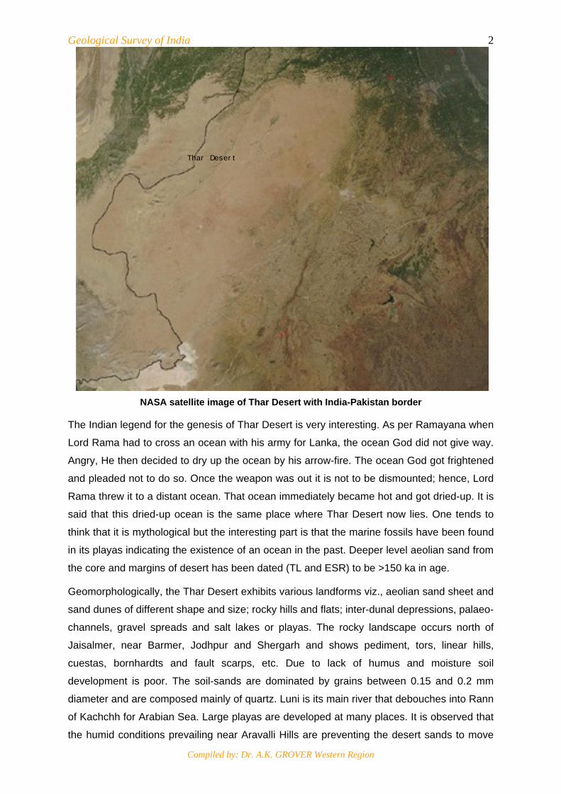
NASA satellite image of Thar Desert with India-Pakistan border
The Indian legend for the genesis of Thar Desert is very interesting. As per Ramayana when
Lord Rama had to cross an ocean with his army for Lanka, the ocean God did not give way.
Angry, He then decided to dry up the ocean by his arrow-fire. The ocean God got frightened
and pleaded not to do so. Once the weapon was out it is not to be dismounted; hence, Lord
Rama threw it to a distant ocean. That ocean immediately became hot and got dried-up. It is
said that this dried-up ocean is the same place where Thar Desert now lies. One tends to
think that it is mythological but the interesting part is that the marine fossils have been found
in its playas indicating the existence of an ocean in the past. Deeper level aeolian sand from
the core and margins of desert has been dated (TL and ESR) to be >150 ka in age.
Geomorphologically, the Thar Desert exhibits various landforms viz., aeolian sand sheet and
sand dunes of different shape and size; rocky hills and flats; inter-dunal depressions, palaeo-
channels, gravel spreads and salt lakes or playas. The rocky landscape occurs north of
Jaisalmer, near Barmer, Jodhpur and Shergarh and shows pediment, tors, linear hills,
cuestas, bornhardts and fault scarps, etc. Due to lack of humus and moisture soil
development is poor. The soil-sands are dominated by grains between 0.15 and 0.2 mm
diameter and are composed mainly of quartz. Luni is its main river that debouches into Rann
of Kachchh for Arabian Sea. Large playas are developed at many places. It is observed that
the humid conditions prevailing near Aravalli Hills are preventing the desert sands to move
Thar Desert
Geological Survey of India
Compiled by: Dr. A.K. GROVER Western Region
3towards east/ northeast. Major phases of aeolian accumulation during the late Pleistocene
were between 100 and 115 ka, 75 ka; 55 ka and between 30 and 25 ka.
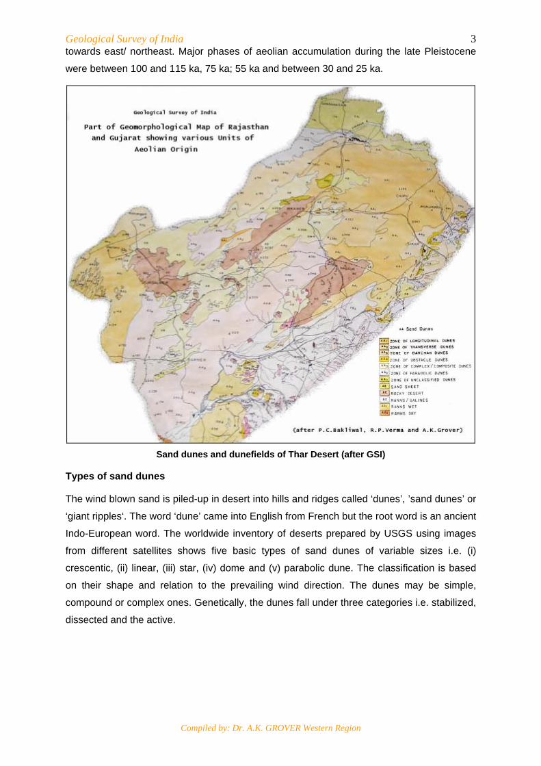
Sand dunes and dunefields of Thar Desert (after GSI)
Types of sand dunes
The wind blown sand is piled-up in desert into hills and ridges called ‘dunes’, ’sand dunes’ or
‘giant ripples‘. The word ‘dune’ came into English from French but the root word is an ancient
Indo-European word. The worldwide inventory of deserts prepared by USGS using images
from different satellites shows five basic types of sand dunes of variable sizes i.e. (i)
crescentic, (ii) linear, (iii) star, (iv) dome and (v) parabolic dune. The classification is based
on their shape and relation to the prevailing wind direction. The dunes may be simple,
compound or complex ones. Genetically, the dunes fall under three categories i.e. stabilized,
dissected and the active.
Geological Survey of India
Compiled by: Dr. A.K. GROVER Western Region
4
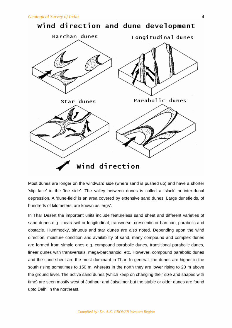
Most dunes are longer on the windward side (where sand is pushed up) and have a shorter
‘slip face’ in the ‘lee side’. The valley between dunes is called a ‘slack’ or inter-dunal
depression. A ‘dune-field’ is an area covered by extensive sand dunes. Large dunefields, of
hundreds of kilometers, are known as ‘ergs’.
In Thar Desert the important units include featureless sand sheet and different varieties of
sand dunes e.g. linear/ seif or longitudinal, transverse, crescentic or barchan, parabolic and
obstacle. Hummocky, sinuous and star dunes are also noted. Depending upon the wind
direction, moisture condition and availability of sand, many compound and complex dunes
are formed from simple ones e.g. compound parabolic dunes, transitional parabolic dunes,
linear dunes with transversals, mega-barchanoid, etc. However, compound parabolic dunes
and the sand sheet are the most dominant in Thar. In general, the dunes are higher in the
south rising sometimes to 150 m, whereas in the north they are lower rising to 20 m above
the ground level. The active sand dunes (which keep on changing their size and shapes with
time) are seen mostly west of Jodhpur and Jaisalmer but the stable or older dunes are found
upto Delhi in the northeast.
Geological Survey of India
Compiled by: Dr. A.K. GROVER Western Region
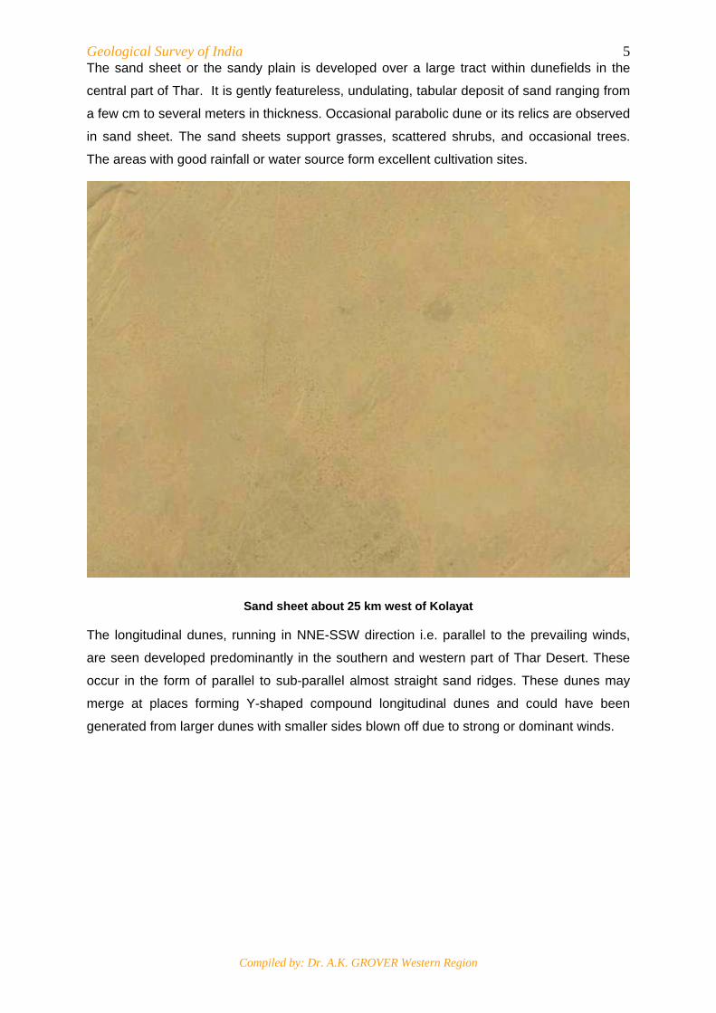
5The sand sheet or the sandy plain is developed over a large tract within dunefields in the
central part of Thar. It is gently featureless, undulating, tabular deposit of sand ranging from
a few cm to several meters in thickness. Occasional parabolic dune or its relics are observed
in sand sheet. The sand sheets support grasses, scattered shrubs, and occasional trees.
The areas with good rainfall or water source form excellent cultivation sites.
Sand sheet about 25 km west of Kolayat
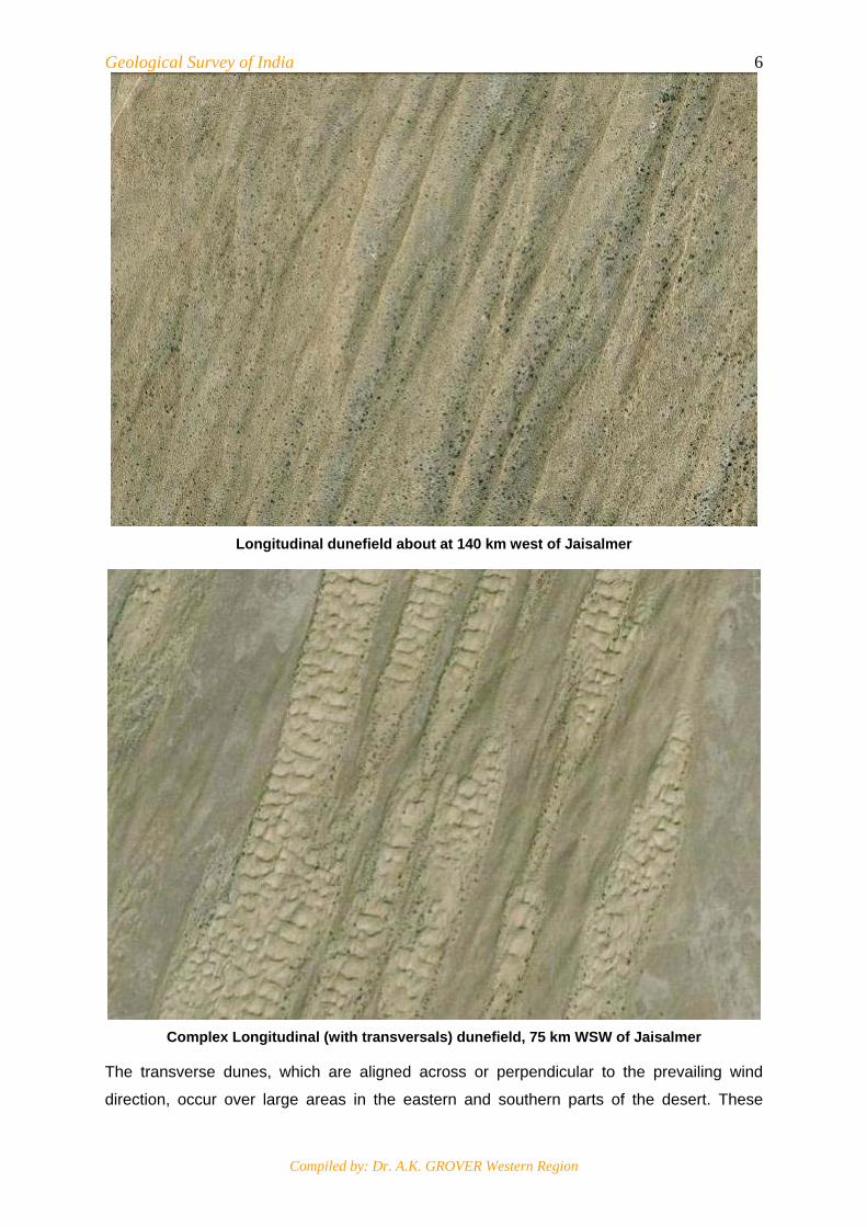
The longitudinal dunes, running in NNE-SSW direction i.e. parallel to the prevailing winds,
are seen developed predominantly in the southern and western part of Thar Desert. These
occur in the form of parallel to sub-parallel almost straight sand ridges. These dunes may
merge at places forming Y-shaped compound longitudinal dunes and could have been
generated from larger dunes with smaller sides blown off due to strong or dominant winds.
Geological Survey of India
Compiled by: Dr. A.K. GROVER Western Region
6
Longitudinal dunefield about at 140 km west of Jaisalmer
Complex Longitudinal (with transversals) dunefield, 75 km WSW of Jaisalmer
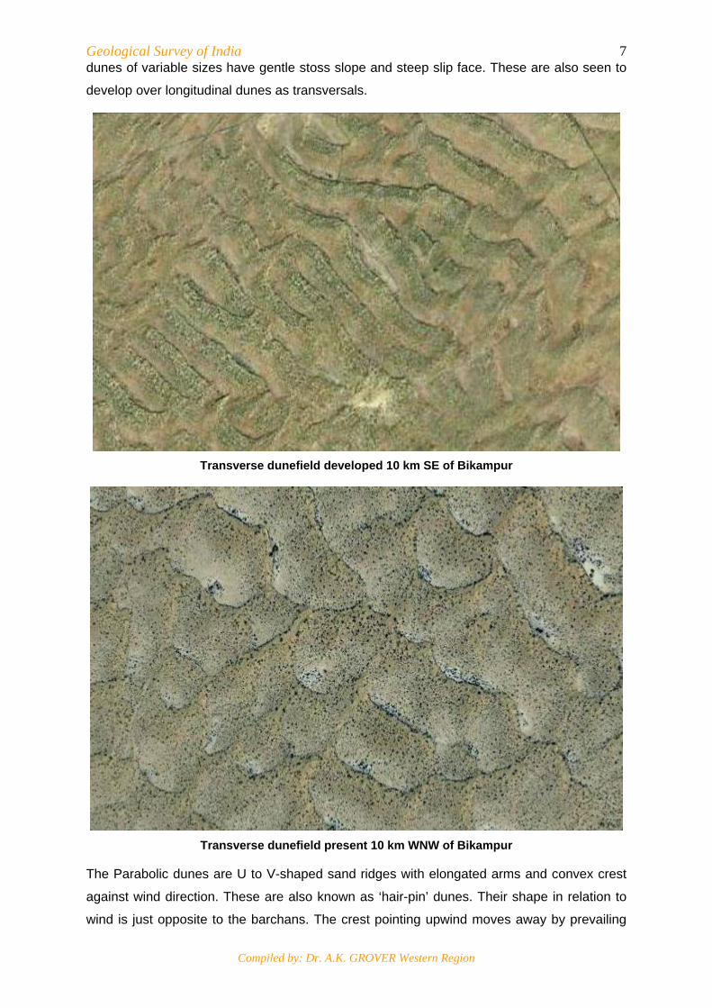
The transverse dunes, which are aligned across or perpendicular to the prevailing wind
direction, occur over large areas in the eastern and southern parts of the desert. These
Geological Survey of India
Compiled by: Dr. A.K. GROVER Western Region
7dunes of variable sizes have gentle stoss slope and steep slip face. These are also seen to
develop over longitudinal dunes as transversals.
Transverse dunefield developed 10 km SE of Bikampur
Transverse dunefield present 10 km WNW of Bikampur
The Parabolic dunes are U to V-shaped sand ridges with elongated arms and convex crest
against wind direction. These are also known as ‘hair-pin’ dunes. Their shape in relation to
wind is just opposite to the barchans. The crest pointing upwind moves away by prevailing

Geological Survey of India
Compiled by: Dr. A.K. GROVER Western Region
8wind and the elongated arms follow it as these are fixed or obstructed by moisture and
vegetation. These, therefore, are developed in sand sheet areas having some moisture and
vegetation. When more than one parabolic dune coalesces or merges with each other,
compound parabolic dunes are generated. These are widespread in Thar Desert.
Parabolic dunes occurring northeast of Osiyan
Compound parabolic dunes occurring 30 km SW of Nachna
Geological Survey of India
Compiled by: Dr. A.K. GROVER Western Region
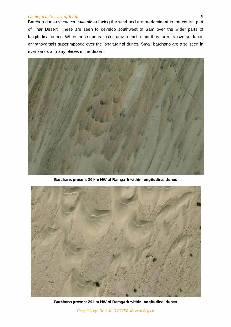
9Barchan dunes show concave sides facing the wind and are predominant in the central part
of Thar Desert. These are seen to develop southwest of Sam over the wider parts of
longitudinal dunes. When these dunes coalesce with each other they form transverse dunes
or transversals superimposed over the longitudinal dunes. Small barchans are also seen in
river sands at many places in the desert.
Barchans present 20 km NW of Ramgarh within longitudinal dunes
Barchans present 20 km NW of Ramgarh within longitudinal dunes
Geological Survey of India
Compiled by: Dr. A.K. GROVER Western Region
10
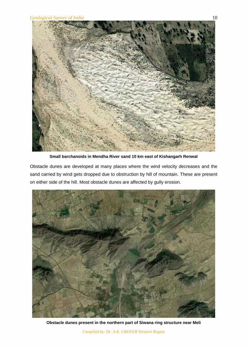
Small barchanoids in Mendha River sand 10 km east of Kishangarh Renwal
Obstacle dunes are developed at many places where the wind velocity decreases and the
sand carried by wind gets dropped due to obstruction by hill of mountain. These are present
on either side of the hill. Most obstacle dunes are affected by gully erosion.
Obstacle dunes present in the northern part of Siwana ring structure near Meli

Geological Survey of India
Compiled by: Dr. A.K. GROVER Western Region
11
Dissected obstacle dunefield present west of Khetri hills
East of Thar Desert, NE-SW trending almost straight, linear sand streaks or sandy zones are
developed across the Aravalli Mountain. These occur more or less in discrete fashion in
relation to hills and gaps. These are low-lying areas with confinement of drainage. These are
generated by low sand deposition by winds. The best sand streak zones are seen north and
northeast of Sambhar Lake.
Sand streaks north and NE of Sambhar Lake
Geological Survey of India
Compiled by: Dr. A.K. GROVER Western Region
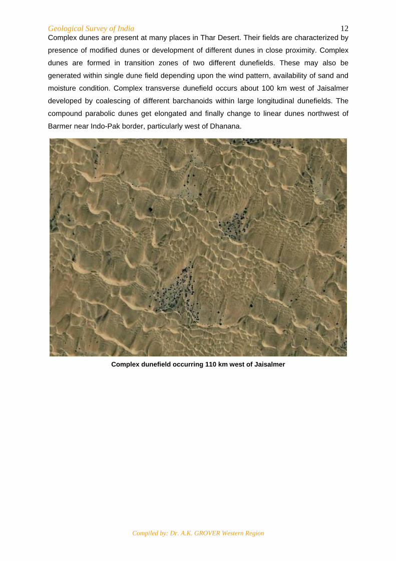
12Complex dunes are present at many places in Thar Desert. Their fields are characterized by
presence of modified dunes or development of different dunes in close proximity. Complex
dunes are formed in transition zones of two different dunefields. These may also be
generated within single dune field depending upon the wind pattern, availability of sand and
moisture condition. Complex transverse dunefield occurs about 100 km west of Jaisalmer
developed by coalescing of different barchanoids within large longitudinal dunefields. The
compound parabolic dunes get elongated and finally change to linear dunes northwest of
Barmer near Indo-Pak border, particularly west of Dhanana.
Complex dunefield occurring 110 km west of Jaisalmer
Geological Survey of India
Compiled by: Dr. A.K. GROVER Western Region
13
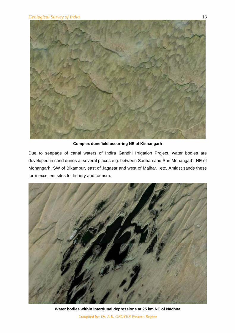
Complex dunefield occurring NE of Kishangarh
Due to seepage of canal waters of Indira Gandhi Irrigation Project, water bodies are
developed in sand dunes at several places e.g. between Sadhan and Shri Mohangarh, NE of
Mohangarh, SW of Bikampur, east of Jagasar and west of Malhar, etc. Amidst sands these
form excellent sites for fishery and tourism.
Water bodies within interdunal depressions at 25 km NE of Nachna
Geological Survey of India
Compiled by: Dr. A.K. GROVER Western Region
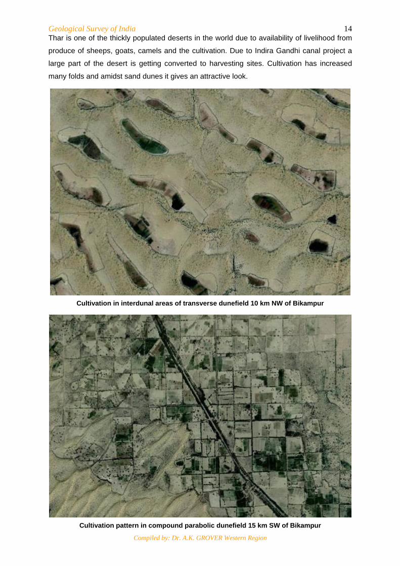
14Thar is one of the thickly populated deserts in the world due to availability of livelihood from
produce of sheeps, goats, camels and the cultivation. Due to Indira Gandhi canal project a
large part of the desert is getting converted to harvesting sites. Cultivation has increased
many folds and amidst sand dunes it gives an attractive look.
Cultivation in interdunal areas of transverse dunefield 10 km NW of Bikampur
Cultivation pattern in compound parabolic dunefield 15 km SW of Bikampur
Geological Survey of India
Compiled by: Dr. A.K. GROVER Western Region
15Selected References
Allchin, B., Goudie, A. and Hegde, K. (1978): The Pre-history and palaeo-geography of the Thar Desert. Academic Press, London.
Bakliwal, S.K. and Wadhawan, S.K. (2003): Geological evolution of Thar Desert in India - issues and prospects. Proc. Ind. Nat. Sci. Acad. 69 A, pp 151-165.
CAZRI (1984): Arid zone research (Indo-US workshop, Jodhpur; 9 to 14 January) Central Arid Zone Research Institute, Jodhpur-342003
Cooke, R., Warren, A. and Goudie, A. (1993): Desert Geomorphology. UCL Press, London.
ICAR (1977): Desertification and its control (UN conference, Nairobi), New Delhi
GSI (2001): Geomorphological map of India (scale 1: 5,00,000 scale), Hyderabad.
Google Earth (2000): Satellite images of various sand dunes/ dunefields used in text.
Joshi, V.K. (2007): Sands of Thar - Key to past climates.
John Macdonald (2010): Dune photo, ID 3228205 on Google Earth.
Kumar, M, Goossens, E. and Goossens, R. (1993): Assessment of sand dune change detection in Rajasthan (Thar) Desert, India. Int. Jour. Rem. Sens. V. 14.
Walker, A.S. (1996): Geomorphology from space, NASA publication.
Singhvi, A.K. and Kar, A. (2004): The aeolian sedimentation record of the Thar Desert. Proc. Indian Acad. Sci. (Earth Planet. Sci.), 113, No. 3, pp. 371-401
USGS (2008): Types of sand dunes.
Wadhawan, S.K. (1994): Dune dynamics and evolution of aeolian landforms in parts of Jaisalmer district, Rajasthan. Jour. Ind. Soc. Rem. Sens., V. 22, No. 2, pp 65-77.
Wikipedia (2010): the free encyclopedia on the Internet.