san antonio wrong way driving initiative...san antonio wrong way driving initiative brian g....
TRANSCRIPT

San Antonio Wrong Way DrivingInitiative
Brian G. Fariello, P.E.Traffic Management Engineer‐ TransGuideSan Antonio District‐ [email protected]

●
Monday, March 14, 2011 Early Evening – 12 Midnight Flying Saucer, De Zavala & Vance Jackson

●
●Tuesday, March 15, 2011 12 Midnight – 1:30 AM Oak Hills Tavern, Medical Dr. & Fred. Rd.

●
●
seen entering IH 35 wrong way @ 35 SB Martin St. Exit

●
●
●Tuesday, March 15, 2011‐ 2 AM On IH 35 @ McCullough Traveling Northbound in the Southbound Main lanes

IH 35 @ McCullough, 2 AM, March 15, 2011-2 fatalities, WWD & SAPD Officer Stephanie Brown
‐No reports of WWD prior to accident ‐Less than one minute of drive time from ramp to accident location (3500 ft.)

Lessons Learned from Accident Investigations:
• Drivers were impaired, with extremely high BAC
• Drivers were initially driving in correct direction on freeway
• Drivers either missed exit, or were driving away from their intended destination to begin with
• Driver eventually exited freeway; wrong way event resulted when impaired driver attempted to re‐enter freeway
• Conclusion: – The solution is not as simple as identifying the locations of drinking
establishments and the nearest exit ramps

The San Antonio Wrong Way Driver Task Force• The San Antonio Wrong Way Driver Task Force was organized in the
spring of 2011 specifically to examine the factors contributing to the wrong way driving problem in San Antonio, and to identify possible methods of addressing the wrong way driver problem
• Agencies Participating:– Texas Department of Transportation
• Headquarters– Traffic Engineering, Traffic Management, Traffic Safety
• San Antonio District– Traffic Engineering, Traffic Management, PIO
– The San Antonio Police Department– City of San Antonio Department of Public Works– The Bexar County Sheriff’s Department– The Federal Highway Administration– The Texas Transportation Institute

Task Force Goals And Challenges:
• Goals– Identify high risk locations– Investigate prior WWD related research– Investigate WWD Counter Measures implemented elsewhere– Identify potential WWD Counter Measures for San Antonio– Identify funding resources for implementation of WWD Counter
Measures
• Challenges– Determining points of entry for WWDs– How to get the attention of drivers that are severely impaired– Number of ramps‐
• More than 400 exit ramps in San Antonio metro area– Manual of Uniform Traffic Control Devices Compliance
• Spike Strips are not MUTCD compliant

Institutional Actions
• San Antonio Police Department– Aug 2010‐ Implemented E‐Tone WWD notification for its radio network– Nov 2010‐ Initiated use of portable spike strips– Jan 2011‐ Implemented code in CAD system identifying WWD events – Jul 2011‐ Traffic Investigations Section instructed to focus on
determining entry point/exit ramps used by WWDs
• TxDOT/TransGuide– Mar 2010‐ TransGuide Operations began documenting all WWD events
• Previously documented WWD accidents– May 2011‐ TransGuide system operators authorized to display WWD
warning message on DMS when SAPD issued E‐Tone for WWD alert• Previously operators verified the WWD, and then placed the messages

TransGuide DMS Wrong Way Driver Warning Message
‐No lane instruction directions given‐Displayed until WWD stopped, accident located, or until SAPD cancels Alert‐Message displayed first, then operator searches for vehicle using cameras

Role of the TransGuide Operations Center in the Apprehension of Wrong Way Drivers
• TxDOT and SAPD have been co‐located at TransGuide since 1996
• In 2011 there were 14 documented WWD events where:– A 911 caller alerted SAPD Dispatcher at TransGuide of a wrong way
driver– The wrong way driver was located by a TxDOT/TransGuide operator
with a CCTV camera prior to a crash– The SAPD dispatcher working at TransGuide was able to alert SAPD
officers on the highways of the location and direction of the wrong way driver
– The officers on the highway apprehended the wrong way driver prior to an accident
• 12 camera assisted apprehensions in 2012, 2 thus far in 2013

2011 WWD Statistics (TransGuide Operator Logs)
• 185‐ Total WWD Events logged by TransGuide Operators (Mar – Dec)
• 150‐WWD not apprehended, no accident
• 21‐ Total accidents documented4‐ Vehicle matching description of WWD found wrecked, abandoned4‐ Accidents involving fatality, Driver DWI (7 fatalities in 4 accidents)3‐ Accident with serious injuries, Driver DWI 10‐ Accident with no serious injuries, Driver DWI
• 10‐ No Accident, WWD apprehended, Driver DWI
• 4‐ No Accident, WWD Disoriented due to medical condition

Wrong Way Driver Reports analyzed by hour of day show:‐ 80% happen at night‐ 45% occurring between 2 AM and 4 AM

Bars Close at 2 AM
Wrong Way Driver Reports analyzed by hour of day show:‐ 80% happen at night‐ 45% occurring between 2 AM and 4 AM

Development of GIS Map of Wrong Way Driver Events
• WWD Event Data Sources Available:– TxDOT Crash Record Information System (CRIS) reports
• CRIS records filtered for “wrong way” events– TxDOT TransGuide Operator reports– San Antonio Police Department CAD data
• All reports of WWDs, not just accidents & apprehensions
• Developed by TTI– WWD reports typically referenced nearest cross street or major
interchange – To provide a comprehensive analysis of WWD activity across corridors
throughout the urbanized area, spatial analysis features in the GIS software were applied to create a density, or “heat,” map of WWD activity

San Antonio Area GIS Map/Density Map‐Wrong Way Driver Location Reports 2011

Identification of High Risk Locations Using GIS Map
• Considered an approach that identified individual high risk ramp locations: – identify nearby drinking establishments– target the exit ramp locations nearest those establishments
• Of 358 WWD reports to 911, only 5 identified the exit used by the WWD
• The available data provides a good indication of the high risk corridors, but does not indicate individual high risk ramps
• Conclusion‐ The installation of WWD countermeasures on an entire corridor section is needed so that the number of WWD reports before and after deployment can be compared to determine the effectiveness of the implemented countermeasures

San Antonio Area GIS Map/Density Map‐Wrong Way Driver Location Reports 2011
US 281 at Airport BoulevardHighest Number of Events

San Antonio Area GIS Map/Density Map‐Wrong Way Driver Location Reports 2011
1. US 281 From IH 35 to Stone OakMost Events on Any Corridor

San Antonio Area GIS Map/Density Map‐Wrong Way Driver Location Reports 2011
2. IH 35 DowntownHighest Number of Accidents

Countermeasures Identified
• Enhanced Static Signing & Pavement Markings
• On‐Site Driveway Channelization
• Detection Technologies (Radar Sensors)
• Active/Illuminated Signing

Enhanced Static Signing
• Prior research has shown that increased visibility of “WRONG WAY” and “DO NOT ENTER” signs can reduce the instances of wrong way driving
• San Antonio implemented countermeasures recommended in a prior study: “Countermeasures for Wrong‐Way Movement on Freeways: Overview of Project Activities and Findings”, TTI 2003/2004– Field Inspection of all ramps using 2004 TTI Study Checklist – Ensure all required signs, pavement markings and RPM’s are in place
and visible– Recommend additional (supplemental) measures:
• Add reflective tape on sign posts• Increased size of ONE WAY signs• Additional WRONG WAY & DO NOT ENTER signs at critical locations• Lowered sign heights*
* Note: San Antonio is not implementing lowered sign heights at this time

On‐Site Driveway Channelization
• Force traffic into correct direction using on-site driveway channelization (curb or striping with RPMs)
• Voluntary action on part of property owners

Detection Technologies (Radar Sensors)
• Selected radar detectors from two manufacturers for evaluation as WWD detection devices for San Antonio, one type of radar detector will be used for exit ramps, and the other will be used for mainlane WWD system locations– Radar unit selected for exit ramps is the standard unit used by TAPCO
in conjunction with its illuminated signing ($1,000/unit)– Radar unit selected for the mainlane systems is the Wavetronix HD
sensor ($7,000/unit)
• TxDOT & Southwest Research Institute worked with suppliers to integrate the wrong way data with Lonestar software– The date, time and location of the event is logged, an alarm is
generated at the TransGuide Operations Manager’s workstation, and email notifications are provided

Active/Illuminated Signing
• Over 80% of the wrong way driver events occur at night
LED Illuminated Wrong Way Signs
LED Blank Out Signs

LED ILLUMINATED WRONG WAY SIGN AS SEEN FROM A DISTANCE
LED ILLUMINATED WRONG WAY SIGN AS VEHICLE APPROACHES
LED Illuminated Wrong Way Signs
The flashing LED lights will be visible to the wrong driver from a distance
As the WWD gets closer to the sign, the vehicle headlights will illuminate the retroreflective WRONG WAY message (greater visibility than LEDs)
Fully MUTCD Compliant (size, shape, retroreflectivity)

Blank Out Sign is an LED DMS panel capable of displaying a single message when activated, otherwise message panel is “blank”
LED Blank Out Signs

WWD Active Countermeasures (Ramps)
• Exit Ramp Installations– Installing 2 TAPCO LED Illuminated Wrong Way Signs
• Photocell activated for night and low visibility operation– Installing 1 TAPCO Radar Detector
• Radar unit will provide notification of wrong way detection using TxDOT communication network connection to TMC
• Illuminated wrong way signs are installed as supplemental signs where possible, in some locations the existing wrong ways were replaced with the LED Illuminated Wrong Way Signs due to site conditions

WWD Countermeasures (Mainlanes)• Mainlanes Systems
– Installing 1 TAPCO LED Illuminated Wrong Way Sign & 1 SES Blank‐Out Sign on each shoulder
– Installing 1 Wavetronix HD Radar Detector in advance of sign location– MAINLANE SYSTEMS WILL BE RADAR DETECTOR ACTIVATED due to
visibility of illuminated signs to drivers on the other side of the median
– Radar unit will provide notification of wrong way detection using TxDOT communication network connection to TMC
• Set up test environment at test track on Southwest Research Institute Campus for mainlane system configuration, demonstration and testing

Overview of Testing at SwRI Test Track
• Set up interconnected system with Wavetronix radar unit activating both the TAPCO Illuminated Wrong Way sign and the SES Blank Out Sign
• Establish correct configuration settings for radar unit and signs– Radars must be installed at least 600 ft. in advance of the signs– Wireless connection used to activate the signs
• The test track is connected to TransGuide using a WER connection from the SwRI campus to TxDOT’s fiber network on LP 410
• Allows active testing of equipment from TxDOT operator workstations in TransGuide Operations Center
• Ensure that mainlane WWD systems work before installation


TxDOT Fiber
Wireless Link


Test Track Lane
Direction of Test Vehicle Travel
Traffic Cones
Cable Connecting Wavetronix Output to LED Adjacent to CCTV Camera
Wavetronix Unit
CCTV with View of LED Connected to Wavetronix Output and Test Area
Sensor Orientation
Test at Various Displacements from Lane Without Changing Sensor Orientation and
Repeat with Sensor Facing Opposite Direction

Test Track Lane
Wavetronix UnitSensor Orientation
Detection Zone
Max 11 Deg Beam
Distance TBD
Click! 512
Contact Closure Radio Contact Closure Radio
Tapco Illuminated Wrong Way Sign and SES Blank Out Sign

US 281 Pilot Project
Limits: From IH 35 (downtown)To Stone Oak Parkway
15 Miles
29 Exit Ramps‐ 2 LED IlluminatedWrong Way Signs
‐ 1 Radar Detection Unit
1 Mainlane Location‐ LED Illuminated Wrong Way &LED Blank Out Sign installedon both shoulders‐ 1 Radar Detection Unit
‐Installation began Jan 2012‐LED Illuminated Wrong Way Sign Installation Completed June 2012‐Radar Unit Installation is Ongoing‐Mainlane System Installation pending‐Budget $500,000

San Antonio Area GIS Map/Density Map‐Wrong Way Driver Location Reports 2011
US 281 at Airport BoulevardHighest Number of Events

CoSA Signalized Intersection
One Way Street
US 281 NB exit Airport Blvd.
Airport Parking, Car Rental Agencies, No Bars in Area

‐ Reflective RPM arrows were present‐Wrong Way and Do Not Enter Signs present, BUT:‐ Red/White Signs mounted on Red/White Columns

‐Wrong Way and Do Not Enter Signs not visible‐ No Wrong Way/Do Not Enter Signs between signal and ramp

‐Relocated Wrong Way & Do Not Enter Signs ‐Added reflective tape to sign mounts‐Wrong Way Signs are LED Illuminated‐Installed radar detector

‐Supplemental Wrong Way & Do Not Enter Signs addedbetween signalized intersection and ramp ‐Wrong Way Signs are LED Illuminated


Future Connected Vehicle Applications *Graphic from Ryan Lamm, SwRI

TxDOT Research Project 0‐6769 Wrong Way Driving Countermeasures
• Research project will evaluate the effectiveness of WWD countermeasures implemented on US 281 and IH 35 Corridors, elsewhere in Texas and around the country
• Will evaluate detection methods used to detect wrong way drivers in San Antonio, Dallas (NTTA), Houston (HCTRA) and elsewhere
• Will review MUTCD guidelines for Illuminated Signing applications for WWD countermeasures and make best practice recommendations
• The research project will commence in the fall of 2012, and is expected to be completed in two years

TxDOT Research Project 0‐6769 Wrong Way Driving Countermeasures
• Research Plan
– Task 1: Assess State‐of‐Knowledge in the US and Texas
– Task 2: Evaluate Countermeasures in a Closed‐Course Environment• Monitored, intoxicated test subjects on a closed course at night in an instrumented
vehicle
– Task 3: Evaluate countermeasures and detection systems in an operational environment
• Utilize data from San Antonio, Dallas and Houston WWD countermeasure deployments to assess their impacts
– Task 4: Develop and assess wrong‐way driver warning messages • Determine what message(s) to deliver to right‐way drivers
– Task 5: Develop recommendations and report

WWD Research Testing
• Example of eye‐tracking heat map to document driver looking behavior (signs, pavement lines, etc.)

2011 WWD Density Map

2012 WWD Density Map

Comparison of the new 2012 WWD density/heat map and the 2011 map(as a reference). Comparing the two maps shows that addressing WWDson US 281 has brought that corridor down from the highest WWD eventdensity (as show in the 2011 map) to make US 281’s WWD densitycomparable to other high-volume corridors in San Antonio (as shown inthe 2012 map). Locations that seem to have increased in their intensityinclude:
1. IH 35 N at Loop 410 (Fratt Interchange)2. Loop 1604 between Bandera and SH 151,3. US 90 between Loop 410 and Gen. McMullen4. Loop 1604/US 281 interchange5. Loop 410 S at Spur 422/Palo Alto Road6. I-37 between SW Military and Loop 410 S

San Antonio TransGuide Operator Logs, Wrong Way Driver Reports
2011 (Mar ‐ Dec)2012 (Jan ‐ Dec)Number of Reports 185 274No Accident/Not Apprehended 150 235Accident (Fatal) 4 5 ‐Number of Fatalities 7 7Accident (Non‐Fatal) 17 17Medical Conditon/Elderly Driver 4 2No Accident/WWD Apprehended 10 15WWD Observed with Camera 14 12WWD reports 10 PM to 6 AM 80% 72%WWD Repoprts 2 AM to 4 AM 45% 32%

• Benefit – Cost Ratio‐ 14.3 to 1• Cost Recovery Time‐ 1.4 Years
US 281 Corridor Wrong Way Driver Countermeasure Operational Test Project‐ Preliminary Findings
• Project Cost‐ $377,605• Annual Cost Savings‐ $270,656
Jul 2012 ‐ Dec 2012 (6 Months)
Jul 2012 ‐ Jan 2013
(7 Months)
Jul 2012 ‐ Feb 2013 (8 Months)
Jul 2012 ‐ Mar 2013 (9 Months)
Jul 2012 ‐ Apr 2013
(10 Months)Reduction in Average Rate of WWD Events/Month TransGuide Operator Logs US 281‐ IH 35 to LP 1604 ‐30.32% ‐28.11% ‐27.42% ‐31.18% ‐29.62%Reduction in Average Rate WWD Events/Month TransGuide Operator Logs IH 35 to Stone Oak Parkway ‐36.33% ‐35.71% ‐39.05% ‐37.66%Reduction in Average Rate WWD Events/Month SAPD 911 Call Logs US 281‐ IH 35 to LP 1604 ‐20.87% ‐30.43% ‐31.52% ‐32.37% ‐30.00%Reduction in Average Rate WWD Events/Month SAPD 911 Call Logs US 281‐ IH 35 to Stone Oak Parkway ‐20.00% ‐21.64% ‐20.81% ‐18.55%Calculated Annual Cost Savings (Average of SAPD and TransGuide Data) $218,015.69 $249,276.39 $251,022.56 $270,656.33 $253,919.00
Benefit ‐ Cost Ratio 11.5 to 1 13.2 to 1 13.3 to 1 14.3 to 1 13.4 to 1
Cost Recovery Time (Years) 1.7 1.5 1.5 1.4 1.5

Top 15 DWI Bars With WWD Density –Single and Multiple Locations

Top 15 DWI Bars With WWD Density –Single Location only
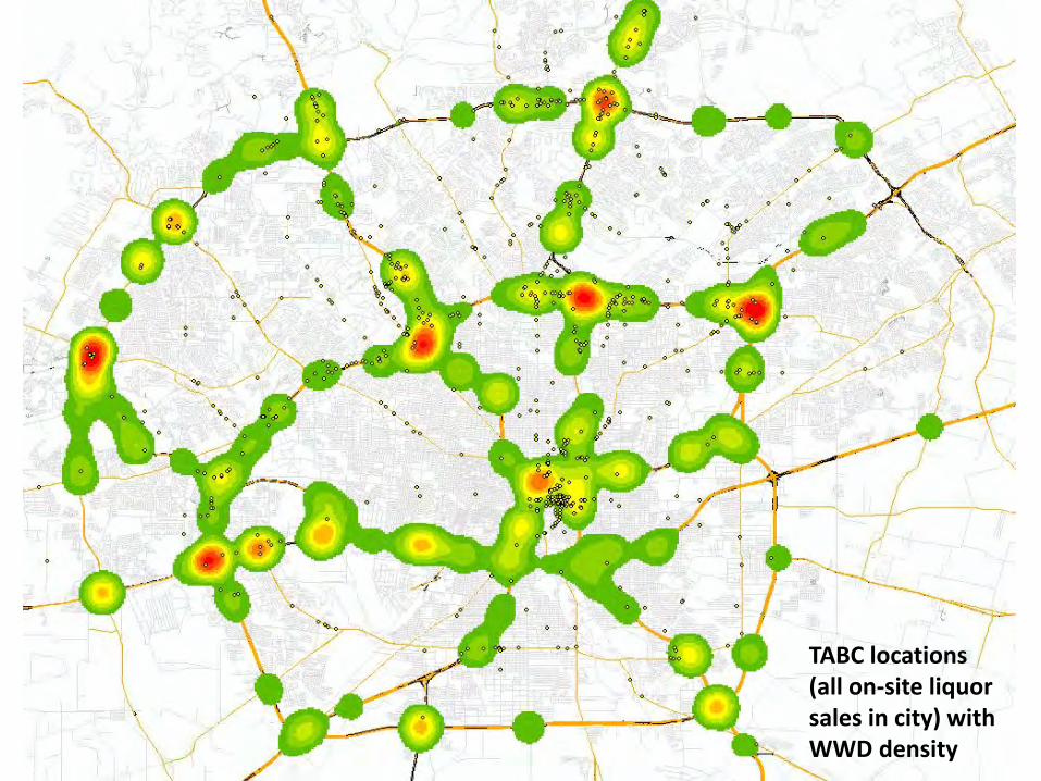
TABC locations (all on‐site liquor sales in city) with WWD density

Wrong Way Crash US 90 @ LP 1604 April 14, 2013
• 0001‐ SAPD dispatcher at TransGuide receives 911 call reporting WWD on US 90 WB in EB lanes
• 0001‐ TransGuide Operators place WWD warning message on DMS on US 90 in both EB and WB directions
• 0003‐ SAPD receives 911 calls reporting crash on US 90 @ LP 1604• WWD was actually traveling EB in WB lanes• WWD was 18 wheeler, cab & trailer, carrying a load of bottled
water• WWD struck Ford Expedition carrying family of 5• 4 family members were killed, 1 survivor (injured)• Secondary accident, single vehicle, resulted in minor injuries• 18 wheeler driver uninjured• 18 wheeler driver charged with 4 counts of intoxication
manslaughter, $1 million bond• Last westbound DMS is 4 miles from crash location, it is unlikely
that the WWD warning message was on the DMS when the Expedition passed it (accident report lists time of accident as 23:56 on 4/13/13)

5 MilesUS 90‐ Rural Divided Highway West of SH 211
‐First report of WWD reported location as SH 211‐WWD traveled at least 5 miles EB in WB lanes
Accident Location
First Reported WWD Location


Summary‐ SA WWD Task Force Lessons Learned
• Adopted lessons learned from prior research and countermeasure deployment projects– TTI Study 2003/2004– NTTA Project‐ Task Force Summary Report– HCTRA Detection Project
• Law enforcement (SAPD) took steps that aided in identifying problem areas:– E‐Tone Radio Network Alerts – Created specific code in CAD systems for wrong way driver reports– Critical data for developing GIS map
• Many opportunities for sharing lessons learned– Dallas, Houston and San Antonio all have active WWD efforts– WWD sessions have been included in many technical conferences (ITS Texas
November 2011, ITS America May 2012, Texas ITE August 2012)– TxDOT Research Project – NTSB special investigation of wrong way accidents (report to be released fall
2012)

QUESTIONS?