salp products specification – volume 10 : jason-2 user
TRANSCRIPT

Reference: SALP-ST-M-EA-15704-CN Version : 3.5 Date : January 13th , 2017 Page: 1/71
SALP Products Specification – Volume 10 : Jason-2 User Products
SALP
SALP Products Specification – Volume 10 : Jason-2 User Products
Prepared by : J.P. DUMONT CLS
S. URIEN CLS
O. LAURET CLS
P. SICARD CLS
E. BRONNER CNES
05/07/2016
p.o.
Accepted by :
Approved by : N. PICOT CNES
R. SCHARROO NOAA
J. FIGA EumetSat
S. DESAI NASA/JPL
05/07/2016
p.o.
Document ref : SALP-ST-M-EA-15704-CN Issue :3 Update :5
For DS2 DS4 DS5 DH2 TP ENVISAT JASON1 DCY LTA-SIRAL
Application to
For SMM SALP JASON2
Application to X
Configuration controlled Document YES by : CCM SALP Since : 28-06-2007

Reference: SALP-ST-M-EA-15704-CN Version : 3.5 Date : January 13th , 2017 Page: 2/71
SALP Products Specification – Volume 10 : Jason-2 User Products
SUMMARY
Confidentiality : no Type :
Key words : Jason-2 User Products
Summary : This document is aimed at defining the Jason-2 User Products
DOCUMENT CHANGE RECORD
Issue Update Date Modifications Visa
1 0 28-06-07 Creation
1 1 18-09-07 • Accounting for SMM-DM-BA3-GO-22928-CM (Evolution of global attrinutes - adding of MDT model (“mdt_model ») - and evolution of GDR data set - adding of an MDT interpolation flag (“interp_flag_mdt”))
• Corrections (Modification of “number_of_iterations _Ku” and “number_of_iterations_C”)
1 2 09-11-07 • Comments relative to brightness temperatures
• Accounting for a new DAD and for four new SAD for AMR data processing
• Adding of state flags (altimeter acquisition mode and radiometer operating)
Reference: SALP-ST-M-EA-15704-CN Version : 3.5 Date : January 13th , 2017 Page: 3/71
SALP Products Specification – Volume 10 : Jason-2 User Products
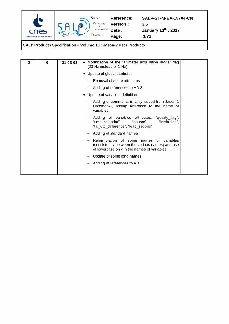
2 0 31-03-08 • Modification of the “altimeter acquisition mode” flag (20-Hz instead of 1-Hz)
• Update of global attributes:
− Removal of some attributes
− Adding of references to AD 3
• Update of variables definition:
− Adding of comments (mainly issued from Jason-1 Handbook), adding reference to the name of variables
− Adding of variables attributes: “quality_flag”, “time_calendar”, “source”, “institution”, “tai_utc_difference”, “leap_second”
− Adding of standard names
− Reformulation of some names of variables (consistency between the various names) and use of lowercase only in the names of variables
− Update of some long-names
− Adding of references to AD 3

Reference: SALP-ST-M-EA-15704-CN Version : 3.5 Date : January 13th , 2017 Page: 4/71
SALP Products Specification – Volume 10 : Jason-2 User Products
2 1 13-05-08 • Global attributes:
− Adding of first_meas_time and last_meas_time
− Renaming of the attributes corresponding to the referencement of dynamic input files (xref_...)
− Removal of the attributes corresponding to the referencement of static input files
− Adding of two attibutes to reference the ellipsoïd (semi-major axis and flattening coefficient)
• Data sets:
− Removal of quality_flag attibutes for SSHA parameters
− Modification of comment attributes for SSHA alt_quality_flag, rad_quality_flag and ecmwf_meteo_map_avail
− Update of standard names (range, dry and tropo. corrections, iono. correction, sea state bias, significant waveheight, backscatter coefficient, inverted barometer, HF fluctuations of the SSH, geocentric ocean tide, equilibrium ocean tide, non equilibrium ocean tide, solid earth tide, pole tide, altitude)
− Removal of standard names (bathymetry, ssha, mss, mean_topography, load_tide)
− Update of long names (mss, mean_topography)
• Minor corrections (typo)
2 2 19-Jun-08 • Minor corrections provided by EUMETSAT and NOAA, only on header part. (SALP-DM- M-522-CN)
N. Picot
2 3 27-Nov-08 • Evolutions to account for project, PIs and Eumetsat feedbacks.
(SALP-DM- M-549-CN)
N. Picot
Reference: SALP-ST-M-EA-15704-CN Version : 3.5 Date : January 13th , 2017 Page: 5/71
SALP Products Specification – Volume 10 : Jason-2 User Products
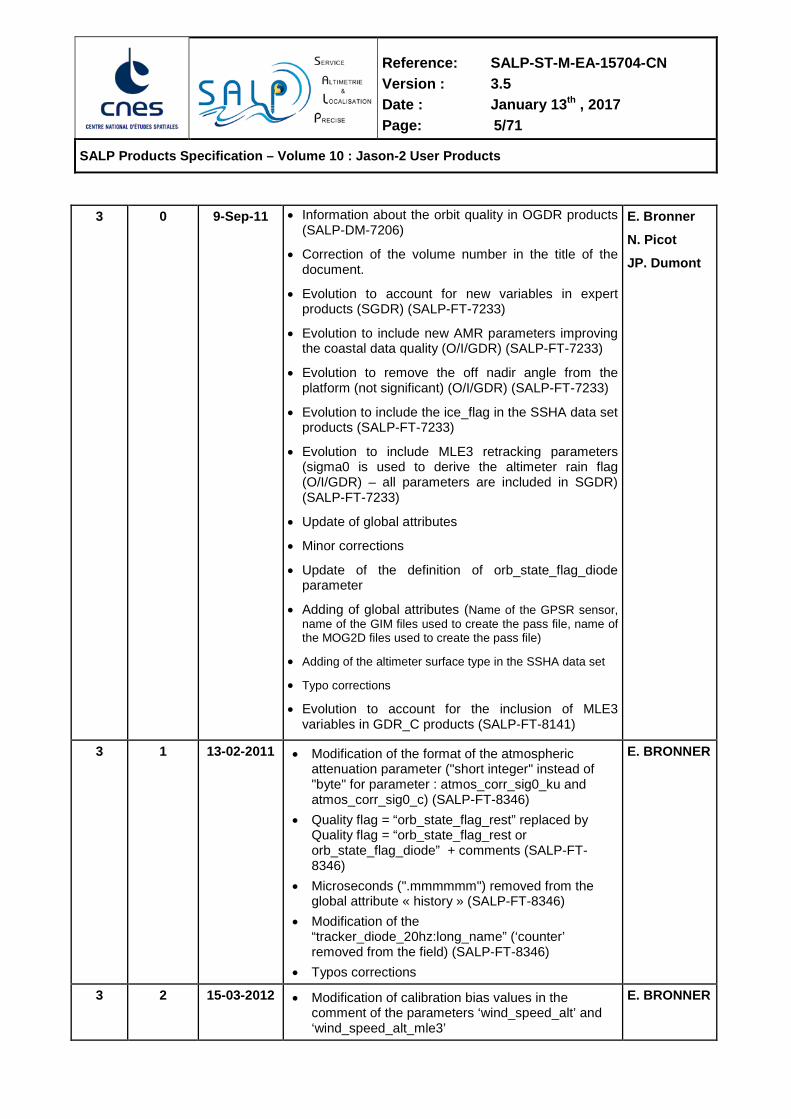
3 0 9-Sep-11
• Information about the orbit quality in OGDR products (SALP-DM-7206)
• Correction of the volume number in the title of the document.
• Evolution to account for new variables in expert products (SGDR) (SALP-FT-7233)
• Evolution to include new AMR parameters improving the coastal data quality (O/I/GDR) (SALP-FT-7233)
• Evolution to remove the off nadir angle from the platform (not significant) (O/I/GDR) (SALP-FT-7233)
• Evolution to include the ice_flag in the SSHA data set products (SALP-FT-7233)
• Evolution to include MLE3 retracking parameters (sigma0 is used to derive the altimeter rain flag (O/I/GDR) – all parameters are included in SGDR) (SALP-FT-7233)
• Update of global attributes
• Minor corrections
• Update of the definition of orb_state_flag_diode parameter
• Adding of global attributes (Name of the GPSR sensor, name of the GIM files used to create the pass file, name of the MOG2D files used to create the pass file)
• Adding of the altimeter surface type in the SSHA data set
• Typo corrections
• Evolution to account for the inclusion of MLE3 variables in GDR_C products (SALP-FT-8141)
E. Bronner
N. Picot
JP. Dumont
3 1 13-02-2011 • Modification of the format of the atmospheric attenuation parameter ("short integer" instead of "byte" for parameter : atmos_corr_sig0_ku and atmos_corr_sig0_c) (SALP-FT-8346)
• Quality flag = “orb_state_flag_rest” replaced by Quality flag = “orb_state_flag_rest or orb_state_flag_diode” + comments (SALP-FT-8346)
• Microseconds (".mmmmmm") removed from the global attribute « history » (SALP-FT-8346)
• Modification of the “tracker_diode_20hz:long_name” (‘counter’ removed from the field) (SALP-FT-8346)
• Typos corrections
E. BRONNER
3 2 15-03-2012 • Modification of calibration bias values in the comment of the parameters ‘wind_speed_alt’ and ‘wind_speed_alt_mle3’
E. BRONNER

Reference: SALP-ST-M-EA-15704-CN Version : 3.5 Date : January 13th , 2017 Page: 6/71
SALP Products Specification – Volume 10 : Jason-2 User Products
3 3 09/12/2013 • Modification of the ecmwf_meteo_map_avail flag meaning and comment (SALP-FT-8904).
E. BRONNER
3 4 05/07/2016 • Modification of the comments of parameters ‘ssha’ and ‘ssha_mle3’ (SALP-FT-10453rev2).
E. BRONNER
3 5 13/01/2017 Modification of GDR latency after OSTST 2016 recommendation. Latency extended from 60 to 90 days in order to allow cold sky calibration processing and use in radiometer calibrations.
T. GUINLE
Reference: SALP-ST-M-EA-15704-CN Version : 3.5 Date : January 13th , 2017 Page: 7/71
SALP Products Specification – Volume 10 : Jason-2 User Products
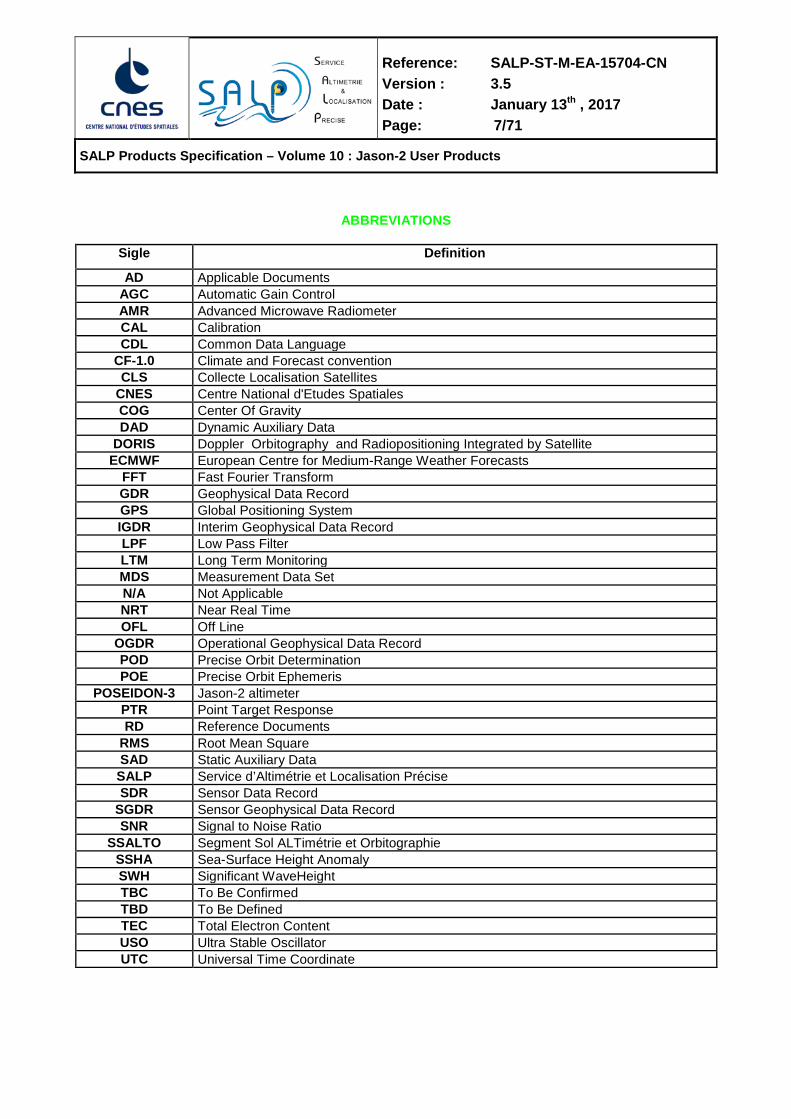
ABBREVIATIONS
Sigle Definition
AD Applicable Documents AGC Automatic Gain Control AMR Advanced Microwave Radiometer CAL Calibration CDL Common Data Language
CF-1.0 Climate and Forecast convention CLS Collecte Localisation Satellites
CNES Centre National d'Etudes Spatiales COG Center Of Gravity DAD Dynamic Auxiliary Data
DORIS Doppler Orbitography and Radiopositioning Integrated by Satellite ECMWF European Centre for Medium-Range Weather Forecasts
FFT Fast Fourier Transform GDR Geophysical Data Record GPS Global Positioning System IGDR Interim Geophysical Data Record LPF Low Pass Filter LTM Long Term Monitoring MDS Measurement Data Set N/A Not Applicable NRT Near Real Time OFL Off Line
OGDR Operational Geophysical Data Record POD Precise Orbit Determination POE Precise Orbit Ephemeris
POSEIDON-3 Jason-2 altimeter PTR Point Target Response RD Reference Documents
RMS Root Mean Square SAD Static Auxiliary Data SALP Service d’Altimétrie et Localisation Précise SDR Sensor Data Record
SGDR Sensor Geophysical Data Record SNR Signal to Noise Ratio
SSALTO Segment Sol ALTimétrie et Orbitographie SSHA Sea-Surface Height Anomaly SWH Significant WaveHeight TBC To Be Confirmed TBD To Be Defined TEC Total Electron Content USO Ultra Stable Oscillator UTC Universal Time Coordinate
Reference: SALP-ST-M-EA-15704-CN Version : 3.5 Date : January 13th , 2017 Page: 8/71
SALP Products Specification – Volume 10 : Jason-2 User Products
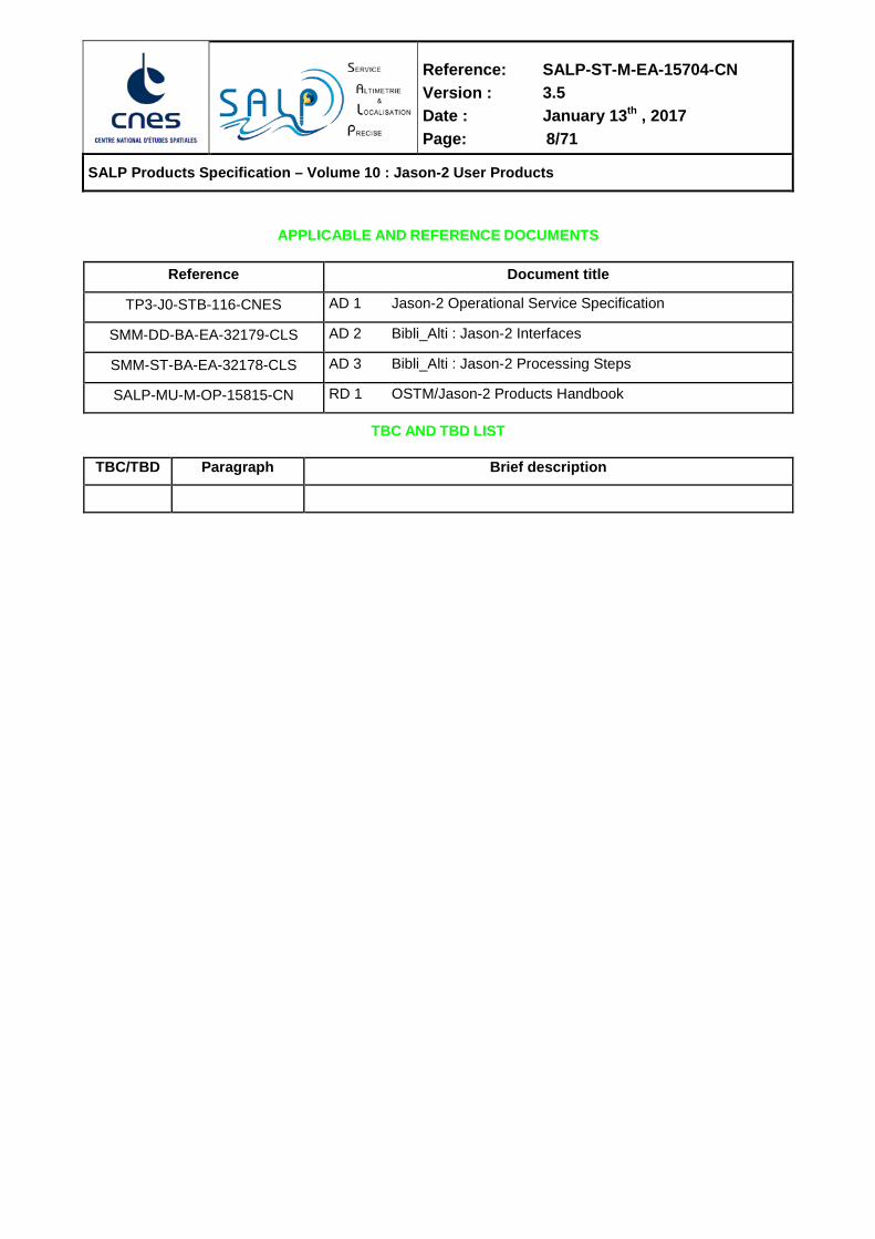
APPLICABLE AND REFERENCE DOCUMENTS
Reference Document title
TP3-J0-STB-116-CNES AD 1 Jason-2 Operational Service Specification
SMM-DD-BA-EA-32179-CLS AD 2 Bibli_Alti : Jason-2 Interfaces
SMM-ST-BA-EA-32178-CLS AD 3 Bibli_Alti : Jason-2 Processing Steps
SALP-MU-M-OP-15815-CN RD 1 OSTM/Jason-2 Products Handbook
TBC AND TBD LIST
TBC/TBD Paragraph Brief description

Reference: SALP-ST-M-EA-15704-CN Version : 3.5 Date : January 13th , 2017 Page: 9/71
SALP Products Specification – Volume 10 : Jason-2 User Products
CONTENTS
1. INTRODUCTION ...................................................................................................................................10 2. JASON-2 PRODUCTS OVERVIEW .....................................................................................................13
2.2. THE NETCDF DATA MODEL ........................................................................................................................................ 13 2.2.1. DIMENSIONS ...................................................................................................................................................... 13 2.2.2. VARIABLES ......................................................................................................................................................... 13 2.2.3. COORDINATE VARIABLES AND AUXILIARY COORDINATE VARIABLES ........................................................ 14 2.2.4. ATTRIBUTES ....................................................................................................................................................... 14
2.3. THE COMMON DATA LANGUAGE ............................................................................................................................... 15 3. GLOBAL ATTRIBUTES .......................................................................................................................17 4. SSHA DATA SET ..................................................................................................................................21 5. GDR DATA SET ....................................................................................................................................30 6. SGDR DATA SET .................................................................................................................................63

Reference: SALP-ST-M-EA-15704-CN Version : 3.5 Date : January 13th , 2017 Page: 10/71
SALP Products Specification – Volume 10 : Jason-2 User Products
1. INTRODUCTION The aim of this document is to define the Jason-2 level2 altimeter products specifications. It is applicable to the development of the processing module (SPA, TM_NRT) and of the other tools developed by 4 partners (BUFR convertor, NRTAVS, …). The document RD 1 (OSTM/Jason-2 Products Handbook) gives the required information to users.
This document has been named according to the Jason-1 mission (SSALTO Products Specifications – Volume 1 : JASON-1 User Products : SALP -ST-M-EA-10879-CN DA162). Other products specification documents are available to describe experts products and orbitography products. Those additional documents are maintain by CNES SALP project and are names :
• SALP-ST-M-EA-10882-CN : SSALTO Products Specifications – Volume 4 : Positioning and orbitography external products
• SALP-ST-M-EA-10883-CN : Spécifications des produits SSALTO – Volume 5 : Altimeter expertise products
• SALP-ST-M-EA-10884-CN : SSALTO Products Specifications – Volume 6 : Mission orbitography and positioning expertise products
• SALP-ST-M-EA-10885-CN : Spécifications des produits SSALTO – Volume 7 : Produits d'expertise – Réseau de balises
According to requirements from AD 1, three different data products shall be produced and distributed to the users:
1. Operational Geophysical Data Record (OGDR) produced in near real time
2. Interim Geophysical Data Record (IGDR) produced in 1 to 1.5 days
3. Geophysical Data Record (GDR) produced in 90 days
The first one is a NRT product. The other two are OFL products.
In addition to the native NetCdf format which are described in this document, a 1Hz BUFR-formatted dataset from the OGDR family (OGDR-BUFR) for distribution via the World Meteorological Organization (WMO) Global Tele-communication System (GTS) and EUMETCast is also generated. The BUFR format is described in RD 1.
Netcdf .OGDR/IGDR/GDR products have the same information and format. The only difference is related to auxiliary data (orbit, meteo files, calibrations, … ).
Taken into account Jason-1 heritage, products are splitted into several data sets :
1. One file close to current Jason-1 NRT-SSHA, limited to 1Hz sampling.
2. One file close to current Jason-1 I/GDR, containing 1Hz and 20Hz values.
3. One file close to current Jason-1 SGDR, containing 1Hz, 20hz and waveforms values. This file is not generated in NRT.
Reference: SALP-ST-M-EA-15704-CN Version : 3.5 Date : January 13th , 2017 Page: 11/71
SALP Products Specification – Volume 10 : Jason-2 User Products
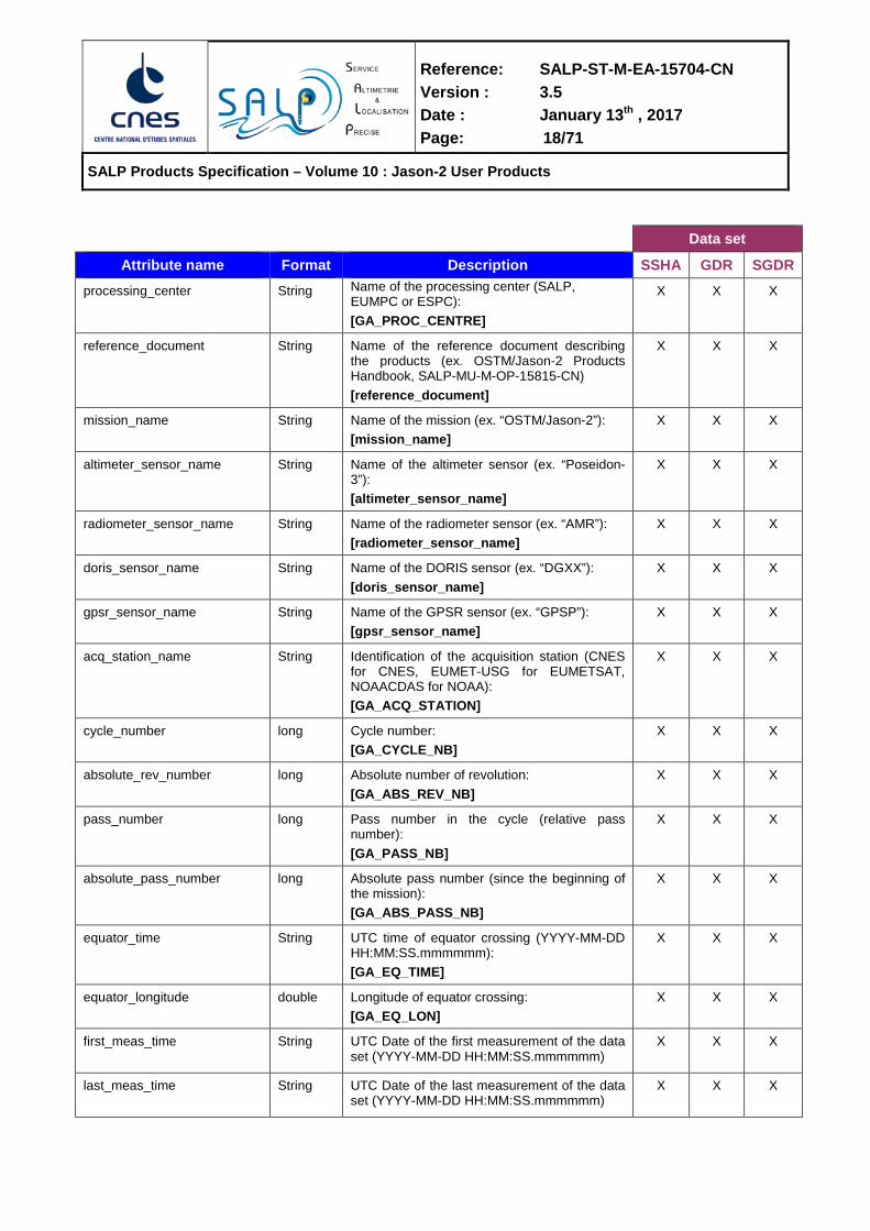
The following table shows the data sets available for each kind of product.
Data set
SSHA GDR SGDR
Products
OGDR X X
IGDR X X X
GDR X X X
Table 1 – Data set availability per product
An overview of the file format used for the data sets is given in section 2. Then the data sets are described from section 3 to section 6.
The four partner Measurement Systems Engineers and Project Scientists conducted an in-depth assessment of which MLE-3 retracker parameters to include in the GDR-C version of the Jason-2 products. The original reason to perform MLE-3 retracking was to provide a valid rain flag as the nominal MLE-4 retracker doesn't provide a useful rain flag - it is always set to zero by the algorithm used on Jason-1 & Jason-2.
Initially, the full suite of MLE-3 retracker variables (range/swh/sigma-0 etc.) were to be added only to the S-GDR and S-IGDR expertise products, but not to the O/I/GDR nor O/I/GDR-SSHA. The 'native' and 'reduced' products would only have included the MLE-3 based rain flag. After extensive discussions, it was decided that the majority of MLE-3 parameters should be included in ALL of the level-2 GDR-C products. The following design principles helped guide this decision:
1) retain consistency, where the O/I/GDR products have the same format, the O/I/GDR-SSHA have the same format, and the S-I/GDR have the same format;
2) retain the relationship between the product families, where the S-I/GDR contain the most complete information (and waveforms), the O/I/GDR contain all the important 1-Hz & 20-Hz variables, and the O/I/GDR-SSHA contain the essential reduced subset of 1-Hz variables;
3) when adding MLE-3 variables, include all variables in the product families which have an MLE-4 counterpart.
The desire was to make the MLE-3 information available to all users of nominal and reduced datasets, as well as those using the expert products, and to facilitate comparison of MLE-3 versus MLE-4 by providing the same set of variables within the GDR-C products.
The addition of MLE-3 variables results in some size increase to the products, but end user software should not be affected because no existing variables have been removed. A size savings was achieved when it was realized that the C-band MLE-4 retracker was to be constrained with attitude=0 in the GDR-C products, and that this is equivalent to MLE-3 retracking for C-band. Hence in the GDR-C products there will be MLE-4 and MLE-3 retracker outputs for Ku-band, while for C-band the MLE-3 retracker outputs (identical to the restrained C-band results) are provided.
The list of new Ku-band MLE-3 parameters in each product family are detailed in the product specification sections below.
Altimeter parameters (e.g. Range, swh, sigma0, etc) and related geophysical parameters (e.g. Ionosphere correction, sea state bias correction, wind speed, etc) named without the "mle3" extension are derived from MLE-4 retracking, while those with the "mle3" extension are derived from MLE-3 retracking.
Most users are advised to use the MLE-4 altimeter parameters for typical scientific applications. The MLE-3 Ku-band parameters are provided for the convenience of specialized studies on the calibration and validation of the mission and impact of altimeter retracking.

Reference: SALP-ST-M-EA-15704-CN Version : 3.5 Date : January 13th , 2017 Page: 12/71
SALP Products Specification – Volume 10 : Jason-2 User Products

Reference: SALP-ST-M-EA-15704-CN Version : 3.5 Date : January 13th , 2017 Page: 13/71
SALP Products Specification – Volume 10 : Jason-2 User Products
2. JASON-2 PRODUCTS OVERVIEW
NETCDF FORMAT AND CF CONVENTION
The netCDF data format has been chosen to store the different data sets (one file per data set). This format is extremely flexible, self describing and has been adopted as a de-facto standard for many operational oceanography systems. What’s more, the files will follow the Climate and Forecast NetCDF conventions CF-1.1 because these conventions provide a practical standard for storing.
THE NETCDF DATA MODEL A netCDF file contains dimensions, variables, and attributes, which all have both a name by which they are identified. These components can be used together to capture the meaning of data and relations among data fields in an array-oriented data set.
2.2.1. DIMENSIONS A dimension may be used to represent a real physical dimension, for example, time, latitude, longitude, or height. A dimension might also be used to index other quantities (waveforms index for example). The following dimensions are used in the Jason-2 product files:
Data set
Dimension name Value SSHA GDR SGDR
time Number of measurements in the file Yes Yes Yes
meas_ind 20 (number of elementary measurements) No Yes Yes
wvf_ind 104 (number of waveform samples) No No Yes
Table 2 - Dimensions used in the Jason-2 data sets
2.2.2. VARIABLES Variables are used to store the bulk of the data in a netCDF file. A variable represents an array of values of the same type. A scalar value is treated as a 0-dimensional array. A variable has a name, a data type, and a shape described by its list of dimensions specified when the variable is created. A variable may also have associated attributes, which may be added, deleted or changed after the variable is created.
A variable data type is one of a small set of netCDF types. In this document the variable types will be represented as follows:

Reference: SALP-ST-M-EA-15704-CN Version : 3.5 Date : January 13th , 2017 Page: 14/71
SALP Products Specification – Volume 10 : Jason-2 User Products
Variable type Description
char characters
byte 8-bit data signed
short 16-bit signed integer
int 32-bit signed integer
float IEEE single precision floating point (32 bits)
double IEEE double precision floating point (64 bits)
Table 3 - netCDF variable type
2.2.3. COORDINATE VARIABLES AND AUXILIARY COORDINATE VARIABLES A variable with the same name as a dimension is called a coordinate variable. It typically defines a physical coordinate corresponding to that dimension. In accordance with the Climate and Forecast conventions, we must declare a coordinate variable for each dimension. What’s more, missing values are not allowed in coordinate variables and they must be strictly monotonic.
An auxiliary coordinate variable is a netCDF variable that contains coordinates data but is not a coordinate variable as defined above. Unlike coordinate variables, there is no relationship between the name of an auxiliary coordinate variable and the name(s) of its dimension(s).
2.2.4. ATTRIBUTES NetCDF attributes are used to store data about the data (ancillary data or metadata), similar in many ways to the information stored in data dictionaries and schema in conventional database systems. Most attributes provide information about a specific variable. These are identified by the name of that variable, together with the name of the attribute.
Some attributes provide information about the data set as a whole. They are called global attributes (similar to the header of the Jason-1 products).
The following table shows the variable attributes used in the Jason-2 product. There are no mandatory attributes.
Attribute Description _FillValue A value used to represent missing or undefined data
add_offset If present, this number is to be added to the date after it is read by an application. If both scale_factor and add_offset attributes are present, the date are first scaled before the offset is added.
calendar Reference time calendar
comment Miscellaneous information about the data or the methods used to produce it
coordinates Identified auxiliary coordinates variables.
flag_meanings Use in conjunction with flag_values to provide descriptive words or phrase for each flag value.
flag_values Provide a list of the flag values. Use in conjunction with flag_meanings.
institution Institution which provides the data
leap_second UTC time at which a leap second occurs

Reference: SALP-ST-M-EA-15704-CN Version : 3.5 Date : January 13th , 2017 Page: 15/71
SALP Products Specification – Volume 10 : Jason-2 User Products
Attribute Description long_name A descriptive name that indicates a variable’s content. This name is not
standardized.
quality_flag Name of the variable(s) (quality flag) representing the quality of the current variable
scale_factor If present, the date are to be multiplied by this factor after the data are read by an application. See also add_offset attribute.
source Data source (model features, or observation)
standard_name A standard name that references a description of a variables content in the standard name table.
tai_utc_difference Difference between TAI and UTC reference time
units Unit of a variable’s content. The value of this attribute must be a string that can be recognized by the UNIDATA’s Udunits package.
valid_max Largest theoretical valid value of a variable (this is not the maximum of actual data).
valid_min Smallest theoretical valid value of a variable (this is not the minimum of actual data).
Table 4 - Variable’s attributes
THE COMMON DATA LANGUAGE The Common Data Language (CDL) will be used to describe the content of a data set.
The CDL is textual notation that described the netCDF object and it is human readable. The netCDF utility ncdump converts netCDF objects binary to CDL text. The netCDF utility ncgen creates netCDF binary file from CDL text file.
A CDL description of a netCDF data set takes the form:
netCDF name { dimension: … variables: … data: … }
where the name is used only as a default in constructing file names by the ncgen utility. The CDL description consists of three optional parts, introduced by the keywords dimensions variables and data. NetCDF dimension declarations appear after the dimensions keyword, netCDF variables and attributes are defined after the variables keyword and variable data assignments appears after the data keyword. CDL statement are terminated by a semicolon. Spaces, tabs and newlines can be used freely for readability. Comments in CDL follow the characters ‘//’ on any line.

Reference: SALP-ST-M-EA-15704-CN Version : 3.5 Date : January 13th , 2017 Page: 16/71
SALP Products Specification – Volume 10 : Jason-2 User Products
Example : netcdf example { dimensions: // dimensions name are declared first time = 2680;
variables: double time(time); // variable <type> <name>(<dimension>) time:long_name = "time"; // variable attributes time:units = "seconds since 2000-01-01 00:00:00.0"; int lon(time); lon:long_name = "longitude"; lon:standard_name = "longitude"; lon:units = "degrees_east"; lon:scale_factor = 1.0e-06; byte alt_echo_type(time); alt_echo_type:long_name = "altimeter echo type"; alt_echo_type:_FillValue = 127b; alt_echo_type:flag_values = 0b, 1b ; alt_echo_type:flag_meanings = "ocean_like non_ocean_like"; alt_echo_type:coordinates = "lon lat"; int alt(time); alt:long_name = "1 Hz altitude of satellite"; alt:_FillValue = 2147483647; alt:units = "m"; alt:add_offset = 1.30e+06; alt:scale_factor = 1.00e-04; alt:coordinates = "lon lat";
• time is a coordinate variable.
• alt_echo_type is a flag fully described by the flag_meanings and flag_values attributes:
alt_echo_type = 0 -> ocean like echo alt_echo_type = 1 -> non ocean like echo If alt_echo_type is not computed, it will take the value 127 (_FillValue attribute).
• alt is packed. The data are stored in 32-bit integers (long). The value of the altitude of the satellite can be recovered using:
alt = (altlong * scale_factor) + add_offset

Reference: SALP-ST-M-EA-15704-CN Version : 3.5 Date : January 13th , 2017 Page: 17/71
SALP Products Specification – Volume 10 : Jason-2 User Products
3. GLOBAL ATTRIBUTES Global attributes are defined in the table below.
[xxx] refers to the name of the parameter defined in AD 3 (in “Step G1 command file” or “Global attributes of production user products” sections) and AD 3 (“Global attributes to be computed” section in processing step G1).
Data set
Attribute name Format Description SSHA GDR SGDR Conventions String netCDF convention followed.
[conventions] This attribute should be set to “CF-1.1” to indicate that the file is compliant with the Climate and Forecast netCDF convention.
X X X
title String A descriptive title for the data set, built as follows: [PO_PROD] – [Title_x], leading to OGDR - Reduced dataset OGDR - Standard dataset IGDR - Reduced dataset IGDR - Standard dataset IGDR - Expertise dataset GDR - Reduced dataset GDR - Standard dataset GDR - Expertise dataset
X X X
institution String The name of the data producer (ex. CNES EUMETSAT or NOAA): [GA_INSTITUTION]
X X X
source String The method of production of original data (model vs observational): “radar altimeter”
X X X
history String Product creation date and time (YYYY-MM-DD HH:MM:SS: creation)
X X X
contact String A text giving the primary contact for information about the data set (ex. CNES [email protected], EUMETSAT [email protected], NOAA [email protected]): [contact]
X X X
references String The version of the altimetric library used to produce the data set (ex: L1 library=V3.1p1, L2 library=V3.0p1, Processing Pilot=V3-0p1p2p3): [GA_REF]
X X X
Reference: SALP-ST-M-EA-15704-CN Version : 3.5 Date : January 13th , 2017 Page: 18/71
SALP Products Specification – Volume 10 : Jason-2 User Products
Data set
Attribute name Format Description SSHA GDR SGDR processing_center String Name of the processing center (SALP,
EUMPC or ESPC): [GA_PROC_CENTRE]
X X X
reference_document String Name of the reference document describing the products (ex. OSTM/Jason-2 Products Handbook, SALP-MU-M-OP-15815-CN) [reference_document]
X X X
mission_name String Name of the mission (ex. “OSTM/Jason-2”): [mission_name]
X X X
altimeter_sensor_name String Name of the altimeter sensor (ex. “Poseidon-3”): [altimeter_sensor_name]
X X X
radiometer_sensor_name String Name of the radiometer sensor (ex. “AMR”): [radiometer_sensor_name]
X X X
doris_sensor_name String Name of the DORIS sensor (ex. “DGXX”): [doris_sensor_name]
X X X
gpsr_sensor_name String Name of the GPSR sensor (ex. “GPSP”): [gpsr_sensor_name]
X X X
acq_station_name String Identification of the acquisition station (CNES for CNES, EUMET-USG for EUMETSAT, NOAACDAS for NOAA): [GA_ACQ_STATION]
X X X
cycle_number long Cycle number: [GA_CYCLE_NB]
X X X
absolute_rev_number long Absolute number of revolution: [GA_ABS_REV_NB]
X X X
pass_number long Pass number in the cycle (relative pass number): [GA_PASS_NB]
X X X
absolute_pass_number long Absolute pass number (since the beginning of the mission): [GA_ABS_PASS_NB]
X X X
equator_time String
UTC time of equator crossing (YYYY-MM-DD HH:MM:SS.mmmmmm): [GA_EQ_TIME]
X X X
equator_longitude double Longitude of equator crossing: [GA_EQ_LON]
X X X
first_meas_time String
UTC Date of the first measurement of the data set (YYYY-MM-DD HH:MM:SS.mmmmmm)
X X X
last_meas_time String
UTC Date of the last measurement of the data set (YYYY-MM-DD HH:MM:SS.mmmmmm)
X X X
Reference: SALP-ST-M-EA-15704-CN Version : 3.5 Date : January 13th , 2017 Page: 19/71
SALP Products Specification – Volume 10 : Jason-2 User Products
Data set
Attribute name Format Description SSHA GDR SGDR xref_input_frame String Name of the input frame (only for OGDRs
products): [GA_FRAME]
X X
xref_altimeter_characterisation
String Name of the altimeter characterisation data file: [IF_CHAR_ALT]
X X X
xref_altimeter_ltm String Name of the altimeter Long Term Monitoring data file: [GA_LTM]
X X X
xref_radiometer_temp String Name of the file containing the antenna
temperature coefficients: [GA_TEMP]
X X X
xref_doris_uso String Name of the file containing the DORIS-derived
USO frequency: [GA_USO]
X X X
xref_orbit_data String Name of the file containing the orbit ephemeris
(not applicable to OGDRs products): [GA_ORB]
X X X
xref_pf_data String Name of the file containing the platform data
(mispointing, distance antenna-COG): [GA_PLA]
X X X
xref_pole_location String Name of the file containing the pole location
data: [GA_POL]
X X X
xref_orf_data String Name of the Orbit Revolution File used to
create the pass file: [GA_ORF]
X X X
xref_meteorological_files String Name of the meteorological files used to
create the pass file: [GA_METEO]
X X X
xref_utc_tai_data String Name of the TAI/UTC leap second offset file
used to manage the leap second: [GA_UTC_TAI]
X X X
xref_radiometer_calibration String Name of the file containing the radiometer
level-1 calibration: [GA_RAD_L1B]
X X X
xref_gim_data String Name of the GIM files used to create the pass
file: [GA_GIM]
X X X
xref_mog2d_data String Name of the MOG2D files used to create the
pass file: [GA_MOG2D]
X X X

Reference: SALP-ST-M-EA-15704-CN Version : 3.5 Date : January 13th , 2017 Page: 20/71
SALP Products Specification – Volume 10 : Jason-2 User Products
Data set
Attribute name Format Description SSHA GDR SGDR
ellipsoid_axis String Semi-major axis of the reference ellipsoid
[ellipsoid_sm_axis] X X X
ellipsoid_flattening String Flattening coeffcient of the reference ellipsoid
[ellipsoid _flattening] X X X
Reference: SALP-ST-M-EA-15704-CN Version : 3.5 Date : January 13th , 2017 Page: 21/71
SALP Products Specification – Volume 10 : Jason-2 User Products
4. SSHA DATA SET netcdf ssha { dimensions: time = < number of measurements >; variables:
// Time Tag
double time(time); time:long_name = "time (sec. since 2000-01-01)"; time:standard_name = "time"; time:units = "seconds since 2000-01-01 00:00:00.0";
time:calendar = "gregorian"; time:tai_utc_difference = [GA_TAI_UTC_DIF]; time:leap_second = [GA_LEAP_TIME]; time:comment = "[tai_utc_difference] is the difference between TAI and UTC
reference time (seconds) for the first measurement of the data set. [leap_second] is the UTC time at which a leap second occurs in the data set, if any. After this UTC time, the [tai_utc_difference] is increased by 1 second";
// Location and surface type
int lat(time); lat:long_name = "latitude"; lat:standard_name = "latitude"; lat:units = "degrees_north"; lat:scale_factor = 1.00e-06;
lat:comment = "Positive latitude is North latitude, negative latitude is South latitude. See Jason-2 User Handbook. Associated quality flag is orb_state_flag_diode for the OGDR products, orb_state_flag_rest for the IGDR and GDR products"; int lon(time); lon:long_name = "longitude"; lon:standard_name = "longitude"; lon:units = "degrees_east"; lon:scale_factor = 1.00e-06;
lon:comment = "East longitude relative to Greenwich meridian. See Jason-2 User Handbook. Associated quality flag is orb_state_flag_diode for the OGDR products, orb_state_flag_rest for the IGDR and GDR products"; byte surface_type(time); surface_type:long_name = "surface type"; surface_type:_FillValue = 127b; surface_type:flag_values = 0b, 1b, 2b, 3b ; surface_type:flag_meanings = "ocean lake_enclosed_sea ice land"; surface_type:coordinates = "lon lat"; surface_type:comment = "Computed using a DTM2000 file: 0 = open oceans or semi-enclosed seas; 1 = enclosed seas or lakes; 2 = continental ice; 3 = land. See Jason-2 User Handbook"; byte alt_echo_type(time); alt_echo_type:long_name = "altimeter echo type"; alt_echo_type:_FillValue = 127b; alt_echo_type:flag_values = 0b, 1b; alt_echo_type:flag_meanings = "ocean_like non_ocean_like";

Reference: SALP-ST-M-EA-15704-CN Version : 3.5 Date : January 13th , 2017 Page: 22/71
SALP Products Specification – Volume 10 : Jason-2 User Products
alt_echo_type:coordinates = "lon lat";
alt_echo_type:comment = "The altimeter echo type is determined by testing the rms of the high rate range measurements against a threshold as well as the number of valid high rate range measurements against a minimum value”; byte rad_surf_type(time); rad_surf_type:long_name = "radiometer surface type"; rad_surf_type:_FillValue = 127b; rad_surf_type:flag_values = 0b, 1b, 2b; rad_surf_type:flag_meanings = "open_ocean near_coast land"; rad_surf_type:coordinates = "lon lat";
rad_surf_type:comment = "The radiometer surface type flag is applicable to the radiometer wet troposphere path delays provided by rad_wet_tropo_corr. A value of 0 indicates that open ocean processing is used to compute the path delay, 1 indicates coastal processing is used, and 2 indicates the path delay is invalid due to land";
// Quality information byte alt_quality_flag(time); alt_quality_flag:long_name = "altimeter quality flag"; alt_quality_flag:_FillValue = 127b; alt_quality_flag:flag_values = 0b, 1b; alt_quality_flag:flag_meanings = "good bad"; alt_quality_flag:coordinates = "lon lat"; alt_quality_flag:comment = "Compilation of all altimeter flags except altimeter echo type : Set to default in the current issue"; byte rad_quality_flag(time); rad_quality_flag:long_name = "radiometer quality flag"; rad_quality_flag:_FillValue = 127b; rad_quality_flag:flag_values = 0b, 1b; rad_quality_flag:flag_meanings = "good bad"; rad_quality_flag:coordinates = "lon lat"; rad_quality_flag:comment = "Compilation of all radiometer flags except radiometer surface type : Set to default in the current issue"; byte geophysical_quality_flag(time); geophysical_quality_flag:long_name = "geophysical quality flag"; geophysical_quality_flag:_FillValue = 127b; geophysical_quality_flag:flag_values = 0b, 1b; geophysical_quality_flag:flag_meanings = "good bad"; geophysical_quality_flag:coordinates = "lon lat"; geophysical_quality_flag:comment = "Check on validity of all geophysical fields : Set to default in the current issue"; byte ecmwf_meteo_map_avail(time); ecmwf_meteo_map_avail:long_name = "ECMWF meteorological map availability"; ecmwf_meteo_map_avail:_FillValue = 127b; ecmwf_meteo_map_avail:flag_values = 0b, 1b, 2b, 3b ; ecmwf_meteo_map_avail:flag_meanings = "2_maps_nominal 2_maps_degraded 1_map_closest_used no_valid_map"; ecmwf_meteo_map_avail:coordinates = "lon lat"; ecmwf_meteo_map_avail:comment = ”Possible values are: 0 meaning ’2 maps, nominal’ (six hours apart), 1 meaning ’2 maps, degraded’ (more than six hours apart), 2 meaning ’1 map, closest map used’, 3 meaning 'no valid map'; byte rain_flag(time); rain_flag:long_name = "rain flag"; rain_flag:_FillValue = 127b;
Reference: SALP-ST-M-EA-15704-CN Version : 3.5 Date : January 13th , 2017 Page: 23/71
SALP Products Specification – Volume 10 : Jason-2 User Products
rain_flag:flag_values = 0b, 1b; rain_flag:flag_meanings = "no_rain rain"; rain_flag:coordinates = "lon lat"; rain_flag:comment = "See Jason-2 User Handbook"; byte rad_rain_flag(time); rad_rain_flag:long_name = "radiometer rain flag"; rad_rain_flag:_FillValue = 127b; rad_rain_flag:flag_values = 0b, 1b; rad_rain_flag:flag_meanings = "no_rain rain"; rad_rain_flag:coordinates = "lon lat"; rad_rain_flag:comment = "See Jason-2 User Handbook. The radiometer rain flag indicates where the radiometer wet troposphere path delay (rad_wet_tropo_corr) is invalid due to rain contamination";
byte ice_flag(time); ice_flag:long_name = "ice flag"; ice_flag:_FillValue = 127b; ice_flag:flag_values = 0b, 1b; ice_flag:flag_meanings = "no_ice ice"; ice_flag:coordinates = "lon lat"; ice_flag:comment = "See Jason-2 User Handbook";
byte rad_sea_ice_flag(time); rad_sea_ice_flag:long_name = "radiometer sea-ice flag"; rad_sea_ice_flag:_FillValue = 127b; rad_sea_ice_flag:flag_values = 0b, 1b; rad_sea_ice_flag:flag_meanings = "no_sea_ice sea_ice"; rad_sea_ice_flag:coordinates = "lon lat"; rad_sea_ice_flag:comment = "See Jason-2 User Handbook. The radiometer sea ice flag indicates where the radiometer wet troposphere path delay (rad_wet_tropo_corr) is invalid due to sea ice contamination";
// Orbit
int alt(time); alt:long_name = "1 Hz altitude of satellite"; alt: standard _name = "height_above_reference_ellipsoid"; alt:_FillValue = 2147483647; alt:units = "m"; alt:add_offset = 1.300000e+06; alt:scale_factor = 1.00e-04; alt:coordinates = "lon lat"; alt:comment = "Altitude of satellite above the reference ellipsoid. Associated quality flag is orb_state_flag_diode for the OGDR products, orb_state_flag_rest for the IGDR and GDR products";
// Altimeter range int range_ku(time); range_ku:long_name = "1 Hz Ku band corrected altimeter range"; range_ku:standard_name = "altimeter_range”; range_ku:_FillValue = 2147483647; range_ku:units = "m"; range_ku:add_offset = 1.300000e+06; range_ku:scale_factor = 1.00e-04; range_ku:coordinates = "lon lat";
Reference: SALP-ST-M-EA-15704-CN Version : 3.5 Date : January 13th , 2017 Page: 24/71
SALP Products Specification – Volume 10 : Jason-2 User Products
range_ku:comment = "All instrumental corrections included, i.e. distance antenna-
COG (cog_corr), USO drift correction (uso_corr), internal path correction (internal_path_delay_corr_ku), Doppler correction (doppler_corr_ku), modeled instrumental errors correction (modeled_instr_corr_range_ku) and system bias"; int range_ku_mle3(time); range_ku_mle3:long_name = "1 Hz Ku band corrected altimeter range (MLE3 retracking)"; range_ku_mle3:standard_name = "altimeter_range”;
range_ku_mle3:_FillValue = 2147483647; range_ku_mle3:units = "m"; range_ku_mle3:add_offset = 1.300000e+06; range_ku_mle3:scale_factor = 1.00e-04; range_ku_mle3:coordinates = "lon lat";
range_ku_mle3:comment = "All instrumental corrections included, i.e. distance antenna-COG (cog_corr), USO drift correction (uso_corr), internal path correction (internal_path_delay_corr_ku), Doppler correction (doppler_corr_ku), modeled instrumental errors correction (modeled_instr_corr_range_ku_mle3) and system bias";
// Altimeter range corrections short model_dry_tropo_corr(time); model_dry_tropo_corr:long_name = "model dry tropospheric correction"; model_dry_tropo_corr:standard_name = "altimeter_range_correction_due_to_dry_troposphere"; model_dry_tropo_corr:source = [mto_fields_source]; model_dry_tropo_corr:institution = [mto_fields_institution]; model_dry_tropo_corr:_FillValue = 32767s; model_dry_tropo_corr:units = "m"; model_dry_tropo_corr:scale_factor = 1.00e-04; model_dry_tropo_corr:coordinates = "lon lat";
model_dry_tropo_corr:comment = "Computed at the altimeter time-tag from the interpolation of 2 meteorological fields that surround the altimeter time-tag. A dry tropospheric correction must be added (negative value) to the instrument range to correct this range measurement for dry tropospheric range delays of the radar pulse. See Jason-2 User Handbook”; short rad_wet_tropo_corr(time); rad_wet_tropo_corr:long_name = "radiometer wet tropospheric correction"; rad_wet_tropo_corr:standard_name = "altimeter_range_correction_due_to_wet_troposphere"; rad_wet_tropo_corr:source = [radiometer_sensor_name]; rad_wet_tropo_corr:institution = [radiometer_sensor_institution]; rad_wet_tropo_corr:_FillValue = 32767s; rad_wet_tropo_corr:units = "m"; rad_wet_tropo_corr:scale_factor = 1.00e-04; rad_wet_tropo_corr:coordinates = "lon lat";
rad_wet_tropo_corr:comment = "A wet tropospheric correction must be added (negative value) to the instrument range to correct this range measurement for wet tropospheric range delays of the radar pulse”; short iono_corr_alt_ku(time); iono_corr_alt_ku:long_name = "altimeter ionospheric correction on Ku band"; iono_corr_alt_ku:standard_name = "altimeter_range_correction_due_to_ionosphere"; iono_corr_alt_ku:source = [altimeter_sensor_name]; iono_corr_alt_ku:institution = [altimeter_sensor_institution]; iono_corr_alt_ku:_FillValue = 32767s; iono_corr_alt_ku:units = "m"; iono_corr_alt_ku:scale_factor = 1.00e-04; iono_corr_alt_ku:coordinates = "lon lat";
Reference: SALP-ST-M-EA-15704-CN Version : 3.5 Date : January 13th , 2017 Page: 25/71
SALP Products Specification – Volume 10 : Jason-2 User Products
iono_corr_alt_ku:comment = "An ionospheric correction must be added (negative value) to the instrument range to correct this range measurement for ionospheric range delays of the radar pulse. See Jason-2 User Handbook”; short iono_corr_alt_ku_mle3(time); iono_corr_alt_ku_mle3:long_name = "altimeter ionospheric correction on Ku band (MLE3 retracking)"; iono_corr_alt_ku_mle3:standard_name = "altimeter_range_correction_due_to_ionosphere"; iono_corr_alt_ku_mle3:source = [altimeter_sensor_name]; iono_corr_alt_ku_mle3:institution = [altimeter_sensor_institution]; iono_corr_alt_ku_mle3:_FillValue = 32767s; iono_corr_alt_ku_mle3:units = "m"; iono_corr_alt_ku_mle3:scale_factor = 1.00e-04; iono_corr_alt_ku_mle3:coordinates = "lon lat"; iono_corr_alt_ku_mle3:comment = "An ionospheric correction must be added (negative value) to the instrument range to correct this range measurement for ionospheric range delays of the radar pulse. See Jason-2 User Handbook”; short sea_state_bias_ku(time); sea_state_bias_ku:long_name = "sea state bias correction in Ku band"; sea_state_bias_ku:standard_name = "sea_surface_height_bias_due_to_sea_surface_roughness"; sea_state_bias_ku:source = [altimeter_ssb_source]; sea_state_bias_ku:institution = [altimeter_ssb_institution]; sea_state_bias_ku:_FillValue = 32767s; sea_state_bias_ku:units = "m"; sea_state_bias_ku:scale_factor = 1.00e-04; sea_state_bias_ku:coordinates = "lon lat"; sea_state_bias_ku:comment = "A sea state bias correction must be added (negative value) to the instrument range to correct this range measurement for sea state delays of the radar pulse. This element should not be used over land. See Jason-2 User Handbook”; short sea_state_bias_ku_mle3(time); sea_state_bias_ku_mle3:long_name = "sea state bias correction in Ku band (MLE3 retracking)"; sea_state_bias_ku_mle3:standard_name = "sea_surface_height_bias_due_to_sea_surface_roughness"; sea_state_bias_ku_mle3:source = [altimeter_ssb_source]; sea_state_bias_ku_mle3:institution = [altimeter_ssb_institution]; sea_state_bias_ku_mle3:_FillValue = 32767s; sea_state_bias_ku_mle3:units = "m"; sea_state_bias_ku_mle3:scale_factor = 1.00e-04; sea_state_bias_ku_mle3:coordinates = "lon lat"; sea_state_bias_ku_mle3:comment = "A sea state bias correction must be added (negative value) to the instrument range to correct this range measurement for sea state delays of the radar pulse. This element should not be used over land. See Jason-2 User Handbook”;
// Significant waveheight
short swh_ku(time); swh_ku:long_name = "Ku band corrected significant waveheight";
swh_ku:standard_name = "sea_surface_wave_significant_height"; swh_ku:_FillValue = 32767s;
swh_ku:units = "m"; swh_ku:scale_factor = 1.00e-03; swh_ku:coordinates = "lon lat";
swh_ku:comment = "All instrumental corrections included, i.e. modeled instrumental errors correction (modeled_instr_corr_swh_ku) and system bias";

Reference: SALP-ST-M-EA-15704-CN Version : 3.5 Date : January 13th , 2017 Page: 26/71
SALP Products Specification – Volume 10 : Jason-2 User Products
short swh_ku_mle3(time); swh_ku_mle3:long_name = "Ku band corrected significant waveheight (MLE3 retracking)";
swh_ku_mle3:standard_name = "sea_surface_wave_significant_height"; swh_ku_mle3:_FillValue = 32767s; swh_ku_mle3:units = "m"; swh_ku_mle3:scale_factor = 1.00e-03; swh_ku_mle3:coordinates = "lon lat";
swh_ku_mle3:comment = "All instrumental corrections included, i.e. modeled instrumental errors correction (modeled_instr_corr_swh_ku_mle3) and system bias";
// Backscatter coefficient
short sig0_ku(time); sig0_ku:long_name = "Ku band corrected backscatter coefficient"; sig0_ku:standard_name = "surface_backwards_scattering_coefficient_of_radar_wave"; sig0_ku:_FillValue = 32767s; sig0_ku:units = "dB"; sig0_ku:scale_factor = 1.00e-02; sig0_ku:coordinates = "lon lat";
sig0_ku:comment = "All instrumental corrections included, excepted the system bias, i.e. AGC instrumental errors correction, internal calibration correction (internal_corr_sig0_ku), modeled instrumental errors correction (modeled_instr_corr_sig0_ku) and atmospheric attenuation (atmos_corr_sig0_ku)” short sig0_ku_mle3(time); sig0_ku_mle3:long_name = "Ku band corrected backscatter coefficient (MLE3 retracking)"; sig0_ku_mle3:standard_name = "surface_backwards_scattering_coefficient_of_radar_wave"; sig0_ku_mle3:_FillValue = 32767s; sig0_ku_mle3:units = "dB"; sig0_ku_mle3:scale_factor = 1.00e-02; sig0_ku_mle3:coordinates = "lon lat";
sig0_ku_mle3:comment = "All instrumental corrections included, excepted the system bias, i.e. AGC instrumental errors correction, internal calibration correction (internal_corr_sig0_ku), modeled instrumental errors correction (modeled_instr_corr_sig0_ku_mle3) and atmospheric attenuation (atmos_corr_sig0_ku)";
// Geophysical parameters
int mean_sea_surface(time); mean_sea_surface:long_name = "mean sea surface height above reference ellipsoid"; mean_sea_surface:source = [mean_sea_surface_source]; mean_sea_surface:institution = [mean_sea_surface_institution]; mean_sea_surface:_FillValue = 2147483647; mean_sea_surface:units = "m";
mean_sea_surface:scale_factor = 1.00e-04; mean_sea_surface:coordinates = "lon lat"; mean_sea_surface:comment = "See Jason-2 User Handbook";
int mean_topography(time); mean_topography:long_name = "mean dynamic topography above geoid"; mean_topography:source = [mdt_source]; mean_topography:institution = [mdt_institution]; mean_topography:_FillValue = 2147483647; mean_topography:units = "m"; mean_topography:scale_factor = 1.00e-04; mean_topography:coordinates = "lon lat"; mean_topography:comment = "See Jason-2 User Handbook";

Reference: SALP-ST-M-EA-15704-CN Version : 3.5 Date : January 13th , 2017 Page: 27/71
SALP Products Specification – Volume 10 : Jason-2 User Products
int bathymetry(time); bathymetry:long_name = "ocean depth/land elevation"; bathymetry:source = [bathy_topo_source]; bathymetry:institution = [bathy_topo_institution]; bathymetry:_FillValue = 2147483647; bathymetry:units = "m"; bathymetry:coordinates = "lon lat"; short inv_bar_corr(time); inv_bar_corr:long_name = "inverted barometer height correction"; inv_bar_corr:standard_name = "sea_surface_height_correction_due_to_air_pressure_at_low_frequency"; inv_bar_corr:source = [mto_fields_source]; inv_bar_corr:institution = [mto_fields_institution]; inv_bar_corr:_FillValue = 32767s; inv_bar_corr:units = "m"; inv_bar_corr:scale_factor = 1.00e-04; inv_bar_corr:coordinates = "lon lat"; inv_bar_corr:comment = "Computed at the altimeter time-tag from the interpolation of 2 meteorological fields that surround the altimeter time-tag. See Jason-2 User Handbook"; short hf_fluctuations_corr(time); hf_fluctuations_corr:long_name = "high frequency fluctuations of the sea surface topography"; hf_fluctuations_corr:standard_name = "sea_surface_height_correction_due_to_air_pressure_and_wind_at_high_frequency"; hf_fluctuations_corr:institution = [mog2d_institution]; hf_fluctuations_corr:_FillValue = 32767s; hf_fluctuations_corr:units = "m"; hf_fluctuations_corr:scale_factor = 1.00e-04; hf_fluctuations_corr:coordinates = "lon lat"; hf_fluctuations_corr:comment = "Provided as a correction to the inverted barometer correction (inv_bar_corr)"; int ocean_tide_sol1(time); ocean_tide_sol1:long_name = "geocentric ocean tide height (solution 1)"; ocean_tide_sol1:standard_name = "sea_surface_height_amplitude_due_to_geocentric_ocean_tide"; ocean_tide_sol1:source = [ocean_tide_sol1_source]; ocean_tide_sol1:institution = [ocean_tide_sol1_institution]; ocean_tide_sol1:_FillValue = 2147483647; ocean_tide_sol1:units = "m"; ocean_tide_sol1:scale_factor = 1.00e-04; ocean_tide_sol1:coordinates = "lon lat";
ocean_tide_sol1:comment = "Solution 1 corresponds to GOT4.8 model. Includes the corresponding loading tide (load_tide_sol1) and equilibrium long-period ocean tide height (ocean_tide_equil). The permanent tide (zero frequency) is not included in this parameter because it is included in the geoid and mean sea surface (geoid, mean_sea_surface). See Jason-2 User Handbook"; short solid_earth_tide(time); solid_earth_tide:long_name = "solid earth tide height"; solid_earth_tide:standard_name = "sea_surface_height_amplitude_due_to_earth_tide"; solid_earth_tide:source = [solid_earth_tide_source]; solid_earth_tide:_FillValue = 32767s; solid_earth_tide:units = "m"; solid_earth_tide:scale_factor = 1.00e-04; solid_earth_tide:coordinates = "lon lat";
Reference: SALP-ST-M-EA-15704-CN Version : 3.5 Date : January 13th , 2017 Page: 28/71
SALP Products Specification – Volume 10 : Jason-2 User Products
solid_earth_tide:comment = "Calculated using Cartwright and Tayler tables and consisting of the second and third degree constituents. The permanent tide (zero frequency) is not included. See Jason-2 User Handbook"; short pole_tide(time); pole_tide:long_name = "geocentric pole tide height"; pole_tide:standard_name = "sea_surface_height_amplitude_due_to_pole_tide"; pole_tide:source = [pole_tide_source]; pole_tide:_FillValue = 32767s; pole_tide:units = "m"; pole_tide:scale_factor = 1.00e-04; pole_tide:coordinates = "lon lat"; pole_tide:comment = "See Jason-2 User Handbook”;
// Environmental parameters
short wind_speed_alt(time); wind_speed_alt:long_name = "altimeter wind speed"; wind_speed_alt:standard_name = "wind_speed"; wind_speed_alt:_FillValue = 32767s; wind_speed_alt:units = "m/s"; wind_speed_alt:scale_factor = 1.00e-02; wind_speed_alt:coordinates = "lon lat"; wind_speed_alt:comment = "Should not be used over land. See Jason-2 User Handbook. A calibration bias of 0.32 dB has been added to the Ku-band backscatter coefficient (sig0_ku) before computing the wind speed"; short wind_speed_alt_mle3(time); wind_speed_alt_mle3:long_name = "altimeter wind speed (MLE3 retracking)"; wind_speed_alt_mle3:standard_name = "wind_speed"; wind_speed_alt_mle3:_FillValue = 32767s; wind_speed_alt_mle3:units = "m/s"; wind_speed_alt_mle3:scale_factor = 1.00e-02; wind_speed_alt_mle3:coordinates = "lon lat"; wind_speed_alt_mle3:comment = "Should not be used over land. See Jason-2 User Handbook. A calibration bias of 0.34 dB has been added to the Ku-band backscatter coefficient (sig0_ku_mle3) before computing the wind speed"; short rad_water_vapor(time); rad_water_vapor:long_name = "radiometer water vapor content"; rad_water_vapor:standard_name = "atmosphere_water_vapor_content"; rad_water_vapor:source = [radiometer_sensor_name]; rad_water_vapor:institution = [radiometer_sensor_institution]; rad_water_vapor:_FillValue = 32767s; rad_water_vapor:units = "kg/m^2"; rad_water_vapor:scale_factor = 1.00e-01; rad_water_vapor:coordinates = "lon lat";
rad_water_vapor:comment = "Should not be used over land"; short rad_liquid_water(time); rad_liquid_water:long_name = "radiometer liquid water content"; rad_liquid_water:standard_name = "atmosphere_cloud_liquid_water_content"; rad_liquid_water:source = [radiometer_sensor_name]; rad_liquid_water:institution = [radiometer_sensor_institution]; rad_liquid_water:_FillValue = 32767s; rad_liquid_water:units = "kg/m^2"; rad_liquid_water:scale_factor = 1.00e-02; rad_liquid_water:coordinates = "lon lat";
rad_liquid_water:comment = "Should not be used over land";

Reference: SALP-ST-M-EA-15704-CN Version : 3.5 Date : January 13th , 2017 Page: 29/71
SALP Products Specification – Volume 10 : Jason-2 User Products
// Sea Surface height
short ssha(time); ssha:long_name = "sea surface height anomaly"; ssha:standard_name = "sea_surface_height_above_sea_level"; ssha:source = [altimeter_sensor_name]; ssha:institution = [altimeter_sensor_institution]; ssha:_FillValue = 32767s; ssha:units = "m"; ssha:scale_factor = 1.00e-03; ssha:coordinates = "lon lat"; ssha:comment = "= altitude of satellite (alt) - Ku band corrected altimeter range (range_ku) - altimeter ionospheric correction on Ku band (iono_corr_alt_ku) - model dry tropospheric correction (model_dry_tropo_corr) - radiometer wet tropospheric correction (rad_wet_tropo_corr) - sea state bias correction in Ku band (sea_state_bias_ku) - solid earth tide height (solid_earth_tide) - geocentric ocean tide height solution 1 (ocean_tide_sol1) - geocentric pole tide height (pole_tide) - inverted barometer height correction (inv_bar_corr) - high frequency fluctuations of the sea surface topography (hf_fluctuations_corr for I/GDR off line products only) - mean sea surface (mean_sea_surface). Set to default if the altimeter echo type (alt_echo_type) is set to 1 = non ocean like, the radiometer surface type (rad_surf_type) set to 2 = land "; short ssha_mle3(time); ssha_mle3:long_name = "sea surface height anomaly (MLE3 retracking)"; ssha_mle3:standard_name = "sea_surface_height_above_sea_level"; ssha_mle3:source = [altimeter_sensor_name]; ssha_mle3:institution = [altimeter_sensor_institution]; ssha_mle3:_FillValue = 32767s; ssha_mle3:units = "m"; ssha_mle3:scale_factor = 1.00e-03; ssha_mle3:coordinates = "lon lat"; ssha_mle3:comment = "= altitude of satellite (alt) - Ku band corrected altimeter range (range_ku_mle3) - altimeter ionospheric correction on Ku band (iono_corr_alt_ku_mle3) - model dry tropospheric correction (model_dry_tropo_corr) - radiometer wet tropospheric correction (rad_wet_tropo_corr) - sea state bias correction in Ku band (sea_state_bias_ku_mle3) - solid earth tide height (solid_earth_tide) - geocentric ocean tide height solution 1 (ocean_tide_sol1) - geocentric pole tide height (pole_tide) - inverted barometer height correction (inv_bar_corr) - high frequency fluctuations of the sea surface topography (hf_fluctuations_corr for I/GDR off line products only) - mean sea surface (mean_sea_surface). Set to default if the altimeter echo type (alt_echo_type) is set to 1 = non ocean like, the radiometer surface type (rad_surf_type) set to 2 = land”; }
Reference: SALP-ST-M-EA-15704-CN Version : 3.5 Date : January 13th , 2017 Page: 30/71
SALP Products Specification – Volume 10 : Jason-2 User Products
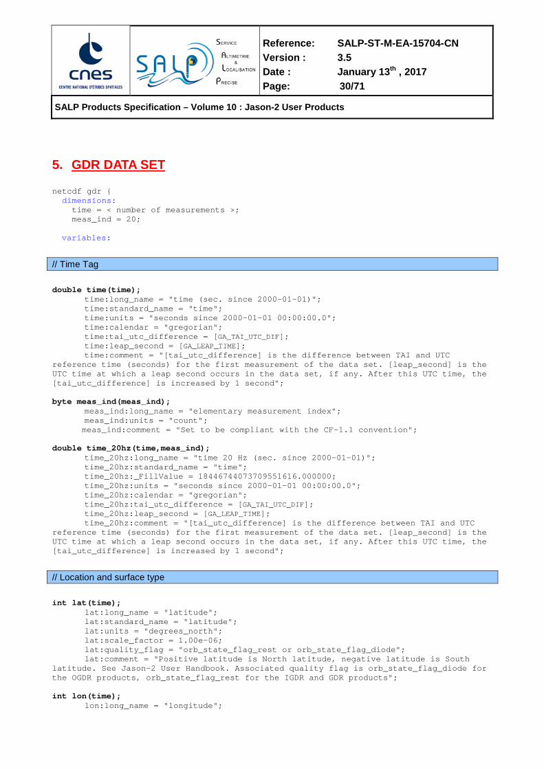
5. GDR DATA SET netcdf gdr { dimensions: time = < number of measurements >; meas_ind = 20; variables:
// Time Tag
double time(time); time:long_name = "time (sec. since 2000-01-01)"; time:standard_name = "time"; time:units = "seconds since 2000-01-01 00:00:00.0";
time:calendar = "gregorian"; time:tai_utc_difference = [GA_TAI_UTC_DIF]; time:leap_second = [GA_LEAP_TIME]; time:comment = "[tai_utc_difference] is the difference between TAI and UTC
reference time (seconds) for the first measurement of the data set. [leap_second] is the UTC time at which a leap second occurs in the data set, if any. After this UTC time, the [tai_utc_difference] is increased by 1 second"; byte meas_ind(meas_ind); meas_ind:long_name = "elementary measurement index"; meas_ind:units = "count"; meas_ind:comment = "Set to be compliant with the CF-1.1 convention"; double time_20hz(time,meas_ind); time_20hz:long_name = "time 20 Hz (sec. since 2000-01-01)"; time_20hz:standard_name = "time"; time_20hz:_FillValue = 18446744073709551616.000000; time_20hz:units = "seconds since 2000-01-01 00:00:00.0";
time_20hz:calendar = "gregorian"; time_20hz:tai_utc_difference = [GA_TAI_UTC_DIF]; time_20hz:leap_second = [GA_LEAP_TIME]; time_20hz:comment = "[tai_utc_difference] is the difference between TAI and UTC
reference time (seconds) for the first measurement of the data set. [leap_second] is the UTC time at which a leap second occurs in the data set, if any. After this UTC time, the [tai_utc_difference] is increased by 1 second";
// Location and surface type
int lat(time); lat:long_name = "latitude"; lat:standard_name = "latitude"; lat:units = "degrees_north"; lat:scale_factor = 1.00e-06; lat:quality_flag = "orb_state_flag_rest or orb_state_flag_diode";
lat:comment = "Positive latitude is North latitude, negative latitude is South latitude. See Jason-2 User Handbook. Associated quality flag is orb_state_flag_diode for the OGDR products, orb_state_flag_rest for the IGDR and GDR products"; int lon(time); lon:long_name = "longitude";

Reference: SALP-ST-M-EA-15704-CN Version : 3.5 Date : January 13th , 2017 Page: 31/71
SALP Products Specification – Volume 10 : Jason-2 User Products
lon:standard_name = "longitude"; lon:units = "degrees_east"; lon:scale_factor = 1.00e-06; lon:quality_flag = "orb_state_flag_rest or orb_state_flag_diode";
lon:comment = "East longitude relative to Greenwich meridian. See Jason-2 User Handbook. Associated quality flag is orb_state_flag_diode for the OGDR products, orb_state_flag_rest for the IGDR and GDR products"; int lon_20hz(time,meas_ind); lon_20hz:long_name = "20 Hz longitude"; lon_20hz:standard_name = "longitude"; lon_20hz:_FillValue = 2147483647; lon_20hz:units = "degrees_east"; lon_20hz:scale_factor = 1.00e-06;
lon_20hz:comment = "East longitude relative to Greenwich meridian. See Jason-2 User Handbook"; int lat_20hz(time,meas_ind); lat_20hz:long_name = "20 Hz latitude"; lat_20hz:standard_name = "latitude"; lat_20hz:_FillValue = 2147483647; lat_20hz:units = "degrees_north"; lat_20hz:scale_factor = 1.00e-06;
lat_20hz:comment = "Positive latitude is North latitude, negative latitude is South latitude. See Jason-2 User Handbook"; byte surface_type(time); surface_type:long_name = "surface type"; surface_type:_FillValue = 127b; surface_type:flag_values = 0b, 1b, 2b, 3b ; surface_type:flag_meanings = "ocean lake_enclosed_sea ice land"; surface_type:coordinates = "lon lat"; surface_type:comment = "Computed using a DTM2000 file: 0 = open oceans or semi-enclosed seas; 1 = enclosed seas or lakes; 2 = continental ice; 3 = land. See Jason-2 User Handbook"; byte alt_echo_type(time); alt_echo_type:long_name = "altimeter echo type"; alt_echo_type:_FillValue = 127b; alt_echo_type:flag_values = 0b, 1b; alt_echo_type:flag_meanings = "ocean_like non_ocean_like"; alt_echo_type:coordinates = "lon lat";
alt_echo_type:comment = "The altimeter echo type is determined by testing the rms of the high rate range measurements against a threshold as well as the number of valid high rate range measurements against a minimum value”; byte rad_surf_type(time); rad_surf_type:long_name = "radiometer surface type"; rad_surf_type:_FillValue = 127b; rad_surf_type:flag_values = 0b, 1b, 2b; rad_surf_type:flag_meanings = "open_ocean near_coast land"; rad_surf_type:coordinates = "lon lat";
rad_surf_type:comment = "The radiometer surface type flag is applicable to the radiometer wet troposphere path delays provided by rad_wet_tropo_corr. A value of 0 indicates that open ocean processing is used to compute the path delay, 1 indicates coastal processing is used, and 2 indicates the path delay is invalid due to land"; int rad_distance_to_land(time); rad_distance_to_land:long_name = "radiometer radial distance to land"; rad_distance_to_land:_FillValue = 2147483647; rad_distance_to_land:units = "m";

Reference: SALP-ST-M-EA-15704-CN Version : 3.5 Date : January 13th , 2017 Page: 32/71
SALP Products Specification – Volume 10 : Jason-2 User Products
rad_distance_to_land:coordinates = "lon lat";
rad_distance_to_land: comment = "Shortest distance between nadir sub-satellite point and land";
// Quality information and sensor status
// Quality flags for 1Hz altimeter data byte qual_alt_1hz_range_ku(time); qual_alt_1hz_range_ku:long_name = "quality flag for 1 Hz altimeter data: Ku band range"; qual_alt_1hz_range_ku:_FillValue = 127b; qual_alt_1hz_range_ku:flag_values = 0b, 1b; qual_alt_1hz_range_ku:flag_meanings = "good bad"; qual_alt_1hz_range_ku:coordinates = "lon lat"; byte qual_alt_1hz_range_ku_mle3(time); qual_alt_1hz_range_ku_mle3:long_name = "quality flag for 1 Hz altimeter data: Ku band range (MLE3 retracking)"; qual_alt_1hz_range_ku_mle3:_FillValue = 127b; qual_alt_1hz_range_ku_mle3:flag_values = 0b, 1b; qual_alt_1hz_range_ku_mle3:flag_meanings = "good bad"; qual_alt_1hz_range_ku_mle3:coordinates = "lon lat"; byte qual_alt_1hz_range_c(time); qual_alt_1hz_range_c:long_name = "quality flag for 1 Hz altimeter data: C band range"; qual_alt_1hz_range_c:_FillValue = 127b; qual_alt_1hz_range_c:flag_values = 0b, 1b; qual_alt_1hz_range_c:flag_meanings = "good bad"; qual_alt_1hz_range_c:coordinates = "lon lat"; byte qual_alt_1hz_swh_ku(time); qual_alt_1hz_swh_ku:long_name = "quality flag for 1 Hz altimeter data: Ku band SWH"; qual_alt_1hz_swh_ku:_FillValue = 127b; qual_alt_1hz_swh_ku:flag_values = 0b, 1b; qual_alt_1hz_swh_ku:flag_meanings = "good bad"; qual_alt_1hz_swh_ku:coordinates = "lon lat"; byte qual_alt_1hz_swh_ku_mle3(time); qual_alt_1hz_swh_ku_mle3:long_name = "quality flag for 1 Hz altimeter data: Ku band SWH (MLE3 retracking)"; qual_alt_1hz_swh_ku_mle3:_FillValue = 127b; qual_alt_1hz_swh_ku_mle3:flag_values = 0b, 1b; qual_alt_1hz_swh_ku_mle3:flag_meanings = "good bad"; qual_alt_1hz_swh_ku_mle3:coordinates = "lon lat"; byte qual_alt_1hz_swh_c(time); qual_alt_1hz_swh_c:long_name = "quality flag for 1 Hz altimeter data: C band SWH"; qual_alt_1hz_swh_c:_FillValue = 127b; qual_alt_1hz_swh_c:flag_values = 0b, 1b; qual_alt_1hz_swh_c:flag_meanings = "good bad"; qual_alt_1hz_swh_c:coordinates = "lon lat"; byte qual_alt_1hz_sig0_ku(time); qual_alt_1hz_sig0_ku:long_name = "quality flag for 1 Hz altimeter data: Ku band backscatter coefficient"; qual_alt_1hz_sig0_ku:_FillValue = 127b; qual_alt_1hz_sig0_ku:flag_values = 0b, 1b; qual_alt_1hz_sig0_ku:flag_meanings = "good bad";

Reference: SALP-ST-M-EA-15704-CN Version : 3.5 Date : January 13th , 2017 Page: 33/71
SALP Products Specification – Volume 10 : Jason-2 User Products
qual_alt_1hz_sig0_ku:coordinates = "lon lat"; byte qual_alt_1hz_sig0_ku_mle3(time); qual_alt_1hz_sig0_ku_mle3:long_name = "quality flag for 1 Hz altimeter data: Ku band backscatter coefficient (MLE3 retracking)"; qual_alt_1hz_sig0_ku_mle3:_FillValue = 127b; qual_alt_1hz_sig0_ku_mle3:flag_values = 0b, 1b; qual_alt_1hz_sig0_ku_mle3:flag_meanings = "good bad"; qual_alt_1hz_sig0_ku_mle3:coordinates = "lon lat"; byte qual_alt_1hz_sig0_c(time); qual_alt_1hz_sig0_c:long_name = "quality flag for 1 Hz altimeter data: C band backscatter coefficient"; qual_alt_1hz_sig0_c:_FillValue = 127b; qual_alt_1hz_sig0_c:flag_values = 0b, 1b; qual_alt_1hz_sig0_c:flag_meanings = "good bad"; qual_alt_1hz_sig0_c:coordinates = "lon lat"; byte qual_alt_1hz_off_nadir_angle_wf_ku(time);
qual_alt_1hz_off_nadir_angle_wf_ku:long_name = "quality flag for 1 Hz altimeter data: off nadir angle from Ku band"; qual_alt_1hz_off_nadir_angle_wf_ku:_FillValue = 127b;
qual_alt_1hz_off_nadir_angle_wf_ku:flag_values = 0b, 1b; qual_alt_1hz_off_nadir_angle_wf_ku:flag_meanings = "good bad"; qual_alt_1hz_off_nadir_angle_wf_ku:coordinates = "lon lat";
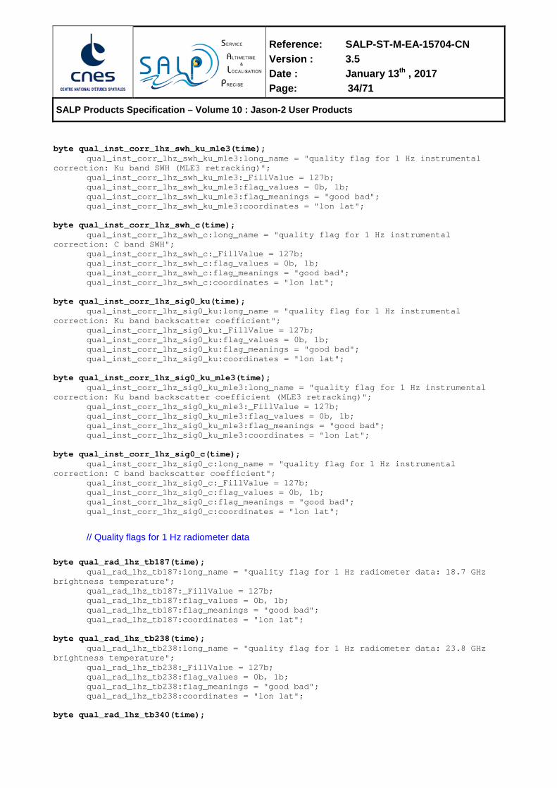
// Quality flags for 1 Hz altimeter instrumental corrections byte qual_inst_corr_1hz_range_ku(time); qual_inst_corr_1hz_range_ku:long_name = "quality flag for 1 Hz instrumental correction: Ku band range"; qual_inst_corr_1hz_range_ku:_FillValue = 127b; qual_inst_corr_1hz_range_ku:flag_values = 0b, 1b; qual_inst_corr_1hz_range_ku:flag_meanings = "good bad"; qual_inst_corr_1hz_range_ku:coordinates = "lon lat"; byte qual_inst_corr_1hz_range_ku_mle3(time); qual_inst_corr_1hz_range_ku_mle3:long_name = "quality flag for 1 Hz instrumental correction: Ku band range (MLE3 retracking)"; qual_inst_corr_1hz_range_ku_mle3:_FillValue = 127b; qual_inst_corr_1hz_range_ku_mle3:flag_values = 0b, 1b; qual_inst_corr_1hz_range_ku_mle3:flag_meanings = "good bad"; qual_inst_corr_1hz_range_ku_mle3:coordinates = "lon lat"; byte qual_inst_corr_1hz_range_c(time); qual_inst_corr_1hz_range_c:long_name = "quality flag for 1 Hz instrumental correction: C band range"; qual_inst_corr_1hz_range_c:_FillValue = 127b; qual_inst_corr_1hz_range_c:flag_values = 0b, 1b; qual_inst_corr_1hz_range_c:flag_meanings = "good bad"; qual_inst_corr_1hz_range_c:coordinates = "lon lat"; byte qual_inst_corr_1hz_swh_ku(time); qual_inst_corr_1hz_swh_ku:long_name = "quality flag for 1 Hz instrumental correction: Ku band SWH"; qual_inst_corr_1hz_swh_ku:_FillValue = 127b; qual_inst_corr_1hz_swh_ku:flag_values = 0b, 1b; qual_inst_corr_1hz_swh_ku:flag_meanings = "good bad"; qual_inst_corr_1hz_swh_ku:coordinates = "lon lat";
Reference: SALP-ST-M-EA-15704-CN Version : 3.5 Date : January 13th , 2017 Page: 34/71
SALP Products Specification – Volume 10 : Jason-2 User Products
byte qual_inst_corr_1hz_swh_ku_mle3(time); qual_inst_corr_1hz_swh_ku_mle3:long_name = "quality flag for 1 Hz instrumental correction: Ku band SWH (MLE3 retracking)"; qual_inst_corr_1hz_swh_ku_mle3:_FillValue = 127b; qual_inst_corr_1hz_swh_ku_mle3:flag_values = 0b, 1b; qual_inst_corr_1hz_swh_ku_mle3:flag_meanings = "good bad"; qual_inst_corr_1hz_swh_ku_mle3:coordinates = "lon lat"; byte qual_inst_corr_1hz_swh_c(time); qual_inst_corr_1hz_swh_c:long_name = "quality flag for 1 Hz instrumental correction: C band SWH"; qual_inst_corr_1hz_swh_c:_FillValue = 127b; qual_inst_corr_1hz_swh_c:flag_values = 0b, 1b; qual_inst_corr_1hz_swh_c:flag_meanings = "good bad"; qual_inst_corr_1hz_swh_c:coordinates = "lon lat"; byte qual_inst_corr_1hz_sig0_ku(time); qual_inst_corr_1hz_sig0_ku:long_name = "quality flag for 1 Hz instrumental correction: Ku band backscatter coefficient"; qual_inst_corr_1hz_sig0_ku:_FillValue = 127b; qual_inst_corr_1hz_sig0_ku:flag_values = 0b, 1b; qual_inst_corr_1hz_sig0_ku:flag_meanings = "good bad"; qual_inst_corr_1hz_sig0_ku:coordinates = "lon lat"; byte qual_inst_corr_1hz_sig0_ku_mle3(time); qual_inst_corr_1hz_sig0_ku_mle3:long_name = "quality flag for 1 Hz instrumental correction: Ku band backscatter coefficient (MLE3 retracking)"; qual_inst_corr_1hz_sig0_ku_mle3:_FillValue = 127b; qual_inst_corr_1hz_sig0_ku_mle3:flag_values = 0b, 1b; qual_inst_corr_1hz_sig0_ku_mle3:flag_meanings = "good bad"; qual_inst_corr_1hz_sig0_ku_mle3:coordinates = "lon lat"; byte qual_inst_corr_1hz_sig0_c(time); qual_inst_corr_1hz_sig0_c:long_name = "quality flag for 1 Hz instrumental correction: C band backscatter coefficient"; qual_inst_corr_1hz_sig0_c:_FillValue = 127b; qual_inst_corr_1hz_sig0_c:flag_values = 0b, 1b; qual_inst_corr_1hz_sig0_c:flag_meanings = "good bad"; qual_inst_corr_1hz_sig0_c:coordinates = "lon lat";
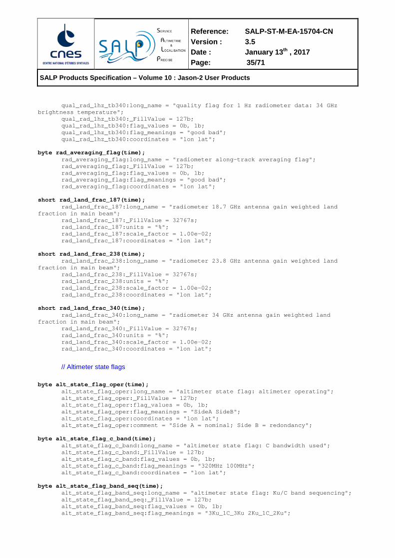
// Quality flags for 1 Hz radiometer data byte qual_rad_1hz_tb187(time); qual_rad_1hz_tb187:long_name = "quality flag for 1 Hz radiometer data: 18.7 GHz brightness temperature"; qual_rad_1hz_tb187:_FillValue = 127b; qual_rad_1hz_tb187:flag_values = 0b, 1b; qual_rad_1hz_tb187:flag_meanings = "good bad"; qual_rad_1hz_tb187:coordinates = "lon lat"; byte qual_rad_1hz_tb238(time); qual_rad_1hz_tb238:long_name = "quality flag for 1 Hz radiometer data: 23.8 GHz brightness temperature"; qual_rad_1hz_tb238:_FillValue = 127b; qual_rad_1hz_tb238:flag_values = 0b, 1b; qual_rad_1hz_tb238:flag_meanings = "good bad"; qual_rad_1hz_tb238:coordinates = "lon lat"; byte qual_rad_1hz_tb340(time);
Reference: SALP-ST-M-EA-15704-CN Version : 3.5 Date : January 13th , 2017 Page: 35/71
SALP Products Specification – Volume 10 : Jason-2 User Products
qual_rad_1hz_tb340:long_name = "quality flag for 1 Hz radiometer data: 34 GHz brightness temperature"; qual_rad_1hz_tb340:_FillValue = 127b; qual_rad_1hz_tb340:flag_values = 0b, 1b; qual_rad_1hz_tb340:flag_meanings = "good bad"; qual_rad_1hz_tb340:coordinates = "lon lat"; byte rad_averaging_flag(time); rad_averaging_flag:long_name = "radiometer along-track averaging flag"; rad_averaging_flag:_FillValue = 127b; rad_averaging_flag:flag_values = 0b, 1b; rad_averaging_flag:flag_meanings = "good bad"; rad_averaging_flag:coordinates = "lon lat"; short rad_land_frac_187(time); rad_land_frac_187:long_name = "radiometer 18.7 GHz antenna gain weighted land fraction in main beam"; rad_land_frac_187:_FillValue = 32767s; rad_land_frac_187:units = "%"; rad_land_frac_187:scale_factor = 1.00e-02; rad_land_frac_187:coordinates = "lon lat"; short rad_land_frac_238(time); rad_land_frac_238:long_name = "radiometer 23.8 GHz antenna gain weighted land fraction in main beam"; rad_land_frac_238:_FillValue = 32767s; rad_land_frac_238:units = "%"; rad_land_frac_238:scale_factor = 1.00e-02; rad_land_frac_238:coordinates = "lon lat"; short rad_land_frac_340(time); rad_land_frac_340:long_name = "radiometer 34 GHz antenna gain weighted land fraction in main beam"; rad_land_frac_340:_FillValue = 32767s; rad_land_frac_340:units = "%"; rad_land_frac_340:scale_factor = 1.00e-02; rad_land_frac_340:coordinates = "lon lat";
// Altimeter state flags byte alt_state_flag_oper(time); alt_state_flag_oper:long_name = "altimeter state flag: altimeter operating"; alt_state_flag_oper:_FillValue = 127b; alt_state_flag_oper:flag_values = 0b, 1b; alt_state_flag_oper:flag_meanings = "SideA SideB"; alt_state_flag_oper:coordinates = "lon lat"; alt_state_flag_oper:comment = "Side A = nominal; Side B = redondancy"; byte alt_state_flag_c_band(time); alt_state_flag_c_band:long_name = "altimeter state flag: C bandwidth used"; alt_state_flag_c_band:_FillValue = 127b; alt_state_flag_c_band:flag_values = 0b, 1b; alt_state_flag_c_band:flag_meanings = "320MHz 100MHz"; alt_state_flag_c_band:coordinates = "lon lat"; byte alt_state_flag_band_seq(time); alt_state_flag_band_seq:long_name = "altimeter state flag: Ku/C band sequencing"; alt_state_flag_band_seq:_FillValue = 127b; alt_state_flag_band_seq:flag_values = 0b, 1b; alt_state_flag_band_seq:flag_meanings = "3Ku_1C_3Ku 2Ku_1C_2Ku";
Reference: SALP-ST-M-EA-15704-CN Version : 3.5 Date : January 13th , 2017 Page: 36/71
SALP Products Specification – Volume 10 : Jason-2 User Products
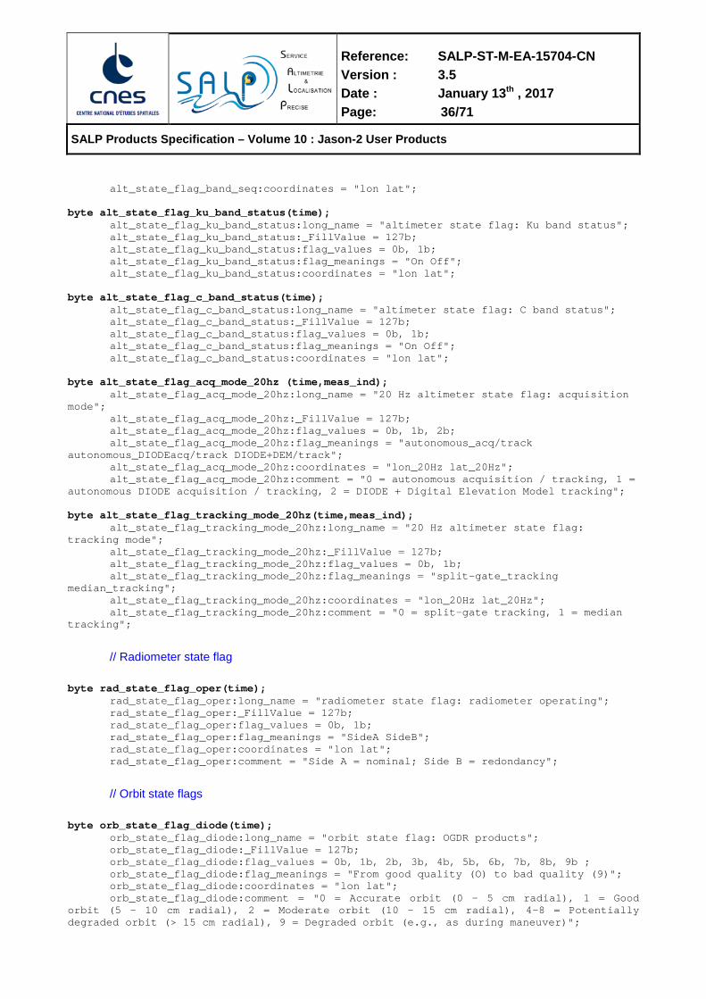
alt_state_flag_band_seq:coordinates = "lon lat"; byte alt_state_flag_ku_band_status(time); alt_state_flag_ku_band_status:long_name = "altimeter state flag: Ku band status"; alt_state_flag_ku_band_status:_FillValue = 127b; alt_state_flag_ku_band_status:flag_values = 0b, 1b; alt_state_flag_ku_band_status:flag_meanings = "On Off"; alt_state_flag_ku_band_status:coordinates = "lon lat"; byte alt_state_flag_c_band_status(time); alt_state_flag_c_band_status:long_name = "altimeter state flag: C band status"; alt_state_flag_c_band_status:_FillValue = 127b; alt_state_flag_c_band_status:flag_values = 0b, 1b; alt_state_flag_c_band_status:flag_meanings = "On Off"; alt_state_flag_c_band_status:coordinates = "lon lat"; byte alt_state_flag_acq_mode_20hz (time,meas_ind); alt_state_flag_acq_mode_20hz:long_name = "20 Hz altimeter state flag: acquisition mode"; alt_state_flag_acq_mode_20hz:_FillValue = 127b; alt_state_flag_acq_mode_20hz:flag_values = 0b, 1b, 2b; alt_state_flag_acq_mode_20hz:flag_meanings = "autonomous_acq/track autonomous_DIODEacq/track DIODE+DEM/track"; alt_state_flag_acq_mode_20hz:coordinates = "lon_20Hz lat_20Hz"; alt_state_flag_acq_mode_20hz:comment = "0 = autonomous acquisition / tracking, 1 = autonomous DIODE acquisition / tracking, 2 = DIODE + Digital Elevation Model tracking"; byte alt_state_flag_tracking_mode_20hz(time,meas_ind); alt_state_flag_tracking_mode_20hz:long_name = "20 Hz altimeter state flag: tracking mode"; alt_state_flag_tracking_mode_20hz:_FillValue = 127b; alt_state_flag_tracking_mode_20hz:flag_values = 0b, 1b; alt_state_flag_tracking_mode_20hz:flag_meanings = "split-gate_tracking median_tracking"; alt_state_flag_tracking_mode_20hz:coordinates = "lon_20Hz lat_20Hz"; alt_state_flag_tracking_mode_20hz:comment = "0 = split-gate tracking, 1 = median tracking";
// Radiometer state flag byte rad_state_flag_oper(time); rad_state_flag_oper:long_name = "radiometer state flag: radiometer operating"; rad_state_flag_oper:_FillValue = 127b; rad_state_flag_oper:flag_values = 0b, 1b; rad_state_flag_oper:flag_meanings = "SideA SideB"; rad_state_flag_oper:coordinates = "lon lat"; rad_state_flag_oper:comment = "Side A = nominal; Side B = redondancy";
// Orbit state flags byte orb_state_flag_diode(time); orb_state_flag_diode:long_name = "orbit state flag: OGDR products"; orb_state_flag_diode:_FillValue = 127b; orb_state_flag_diode:flag_values = 0b, 1b, 2b, 3b, 4b, 5b, 6b, 7b, 8b, 9b ; orb_state_flag_diode:flag_meanings = "From good quality (O) to bad quality (9)"; orb_state_flag_diode:coordinates = "lon lat";
orb_state_flag_diode:comment = "0 = Accurate orbit (0 - 5 cm radial), 1 = Good orbit (5 - 10 cm radial), 2 = Moderate orbit (10 - 15 cm radial), 4-8 = Potentially degraded orbit (> 15 cm radial), 9 = Degraded orbit (e.g., as during maneuver)";

Reference: SALP-ST-M-EA-15704-CN Version : 3.5 Date : January 13th , 2017 Page: 37/71
SALP Products Specification – Volume 10 : Jason-2 User Products
byte orb_state_flag_rest(time); orb_state_flag_rest:long_name = "orbit state flag: restituted orbit"; orb_state_flag_rest:_FillValue = 127b; orb_state_flag_rest:flag_values = 0b, 1b, 2b, 3b, 4b, 5b, 6b, 7b, 8b, 9b ; orb_state_flag_rest:flag_meanings = "op_maneuver op_adjusted op_extrapolated pre_adjusted pre_maneuver pre_interpolated_gap pre_extrapolated_L1 pre_extrapolated_L1S2 pre_extrapolated_S2 DIODE"; orb_state_flag_rest:coordinates = "lon lat"; orb_state_flag_rest:comment = "0 characterizes a mission operations orbit that is computed during a maneuver period, 1 stands for an adjusted mission operations orbit, 2 stands for an extrapolated mission operations orbit, 3 stands for an adjusted (preliminary/precise) orbit, 4 indicates that the (preliminary/precise) orbit is estimated during a maneuver period, 5 indicates that the (preliminary/precise) orbit is interpolated over a tracking data gap, 6 means that the (preliminary/precise) orbit is extrapolated for a duration less than 1 day, 7 means that the (preliminary/precise) orbit is extrapolated for a duration that ranges from 1 day to 2 days, 8 means that the (preliminary/precise) orbit is extrapolated for a duration larger than 2 days, or that the orbit is extrapolated just after a maneuver, 9 stands for the DORIS DIODE navigator orbit. The nominal value is 3”;
// Geophysical flags byte ecmwf_meteo_map_avail(time); ecmwf_meteo_map_avail:long_name = "ECMWF meteorological map availability"; ecmwf_meteo_map_avail:_FillValue = 127b; ecmwf_meteo_map_avail:flag_values = 0b, 1b, 2b, 3b ; ecmwf_meteo_map_avail:flag_meanings = "2_maps_nominal 2_maps_degraded 1_map_closest_used no_valid_map"; ecmwf_meteo_map_avail:coordinates = "lon lat"; ecmwf_meteo_map_avail:comment = ”Possible values are: 0 meaning ’2 maps, nominal’ (six hours apart), 1 meaning ’2 maps, degraded’ (more than six hours apart), 2 meaning ’1 map, closest map used’, 3 meaning 'no valid map'; byte rain_flag(time); rain_flag:long_name = "rain flag"; rain_flag:_FillValue = 127b; rain_flag:flag_values = 0b, 1b; rain_flag:flag_meanings = "no_rain rain"; rain_flag:coordinates = "lon lat"; rain_flag:comment = "See Jason-2 User Handbook"; byte rad_rain_flag(time); rad_rain_flag:long_name = "radiometer rain flag"; rad_rain_flag:_FillValue = 127b; rad_rain_flag:flag_values = 0b, 1b; rad_rain_flag:flag_meanings = "no_rain rain"; rad_rain_flag:coordinates = "lon lat"; rad_rain_flag:comment = "See Jason-2 User Handbook. The radiometer rain flag indicates where the radiometer wet troposphere path delay (rad_wet_tropo_corr) is invalid due to rain contamination"; byte ice_flag(time); ice_flag:long_name = "ice flag"; ice_flag:_FillValue = 127b; ice_flag:flag_values = 0b, 1b; ice_flag:flag_meanings = "no_ice ice"; ice_flag:coordinates = "lon lat"; ice_flag:comment = "See Jason-2 User Handbook";
Reference: SALP-ST-M-EA-15704-CN Version : 3.5 Date : January 13th , 2017 Page: 38/71
SALP Products Specification – Volume 10 : Jason-2 User Products
byte rad_sea_ice_flag(time); rad_sea_ice_flag:long_name = "radiometer sea-ice flag"; rad_sea_ice_flag:_FillValue = 127b; rad_sea_ice_flag:flag_values = 0b, 1b; rad_sea_ice_flag:flag_meanings = "no_sea_ice sea_ice"; rad_sea_ice_flag:coordinates = "lon lat"; rad_sea_ice_flag:comment = "See Jason-2 User Handbook. The radiometer sea ice flag indicates where the radiometer wet troposphere path delay (rad_wet_tropo_corr) is invalid due to sea ice contamination";
// Quality flags for interpolation byte interp_flag_tb(time); interp_flag_tb:long_name = "radiometer brightness temperatures interpolation flag"; interp_flag_tb:_FillValue = 127b; interp_flag_tb:flag_values = 0b, 1b, 2b, 3b; interp_flag_tb:flag_meanings = "good interpolation_with_gap extrapolation fail"; interp_flag_tb:coordinates = "lon lat";
interp_flag_tb:comment = "Possible values are: 0 = interpolation without gap between AMR data, 1 = interpolation with gap between AMR data, 2 = extrapolation of AMR data, 3 = failure of extrapolation and interpolation”; byte interp_flag_mean_sea_surface(time); interp_flag_mean_sea_surface:long_name = "mean_sea_surface interpolation flag"; interp_flag_mean_sea_surface:_FillValue = 127b; interp_flag_mean_sea_surface:flag_values = 0b, 1b; interp_flag_mean_sea_surface:flag_meanings = "good bad"; interp_flag_mean_sea_surface:coordinates = "lon lat"; byte interp_flag_mdt(time); interp_flag_mdt:long_name = "MDT interpolation flag"; interp_flag_mdt:_FillValue = 127b; interp_flag_mdt:flag_values = 0b, 1b; interp_flag_mdt:flag_meanings = "good bad"; interp_flag_mdt:coordinates = "lon lat"; byte interp_flag_ocean_tide_sol1(time);
interp_flag_ocean_tide_sol1:long_name = "ocean tide solution 1 interpolation flag";
interp_flag_ocean_tide_sol1:_FillValue = 127b; interp_flag_ocean_tide_sol1:flag_values = 0b, 1b; interp_flag_ocean_tide_sol1:flag_meanings = "good bad"; interp_flag_ocean_tide_sol1:coordinates = "lon lat";
interp_flag_ocean_tide_sol1:comment = "0 = 4 points over ocean; 1 = less than 4 points"; byte interp_flag_ocean_tide_sol2(time); interp_flag_ocean_tide_sol2:long_name = "ocean tide solution 2 interpolation flag"; interp_flag_ocean_tide_sol2:_FillValue = 127b; interp_flag_ocean_tide_sol2:flag_values = 0b, 1b; interp_flag_ocean_tide_sol2:flag_meanings = "good bad"; interp_flag_ocean_tide_sol2:coordinates = "lon lat"; interp_flag_ocean_tide_sol2:comment = "0 = 4 points over ocean; 1 = less than 4 points"; byte interp_flag_meteo(time); interp_flag_meteo:long_name = "meteorological data interpolation flag"; interp_flag_meteo:_FillValue = 127b;
Reference: SALP-ST-M-EA-15704-CN Version : 3.5 Date : January 13th , 2017 Page: 39/71
SALP Products Specification – Volume 10 : Jason-2 User Products
interp_flag_meteo:flag_values = 0b, 1b; interp_flag_meteo:flag_meanings = "good bad"; interp_flag_meteo:coordinates = "lon lat"; interp_flag_meteo:comment = "0 = interpolation from 4 points; 1 = interpolation from less than 4 points";
// Orbit
int alt(time); alt:long_name = "1 Hz altitude of satellite"; alt:standard_name = "height_above_reference_ellipsoid"; alt:_FillValue = 2147483647; alt:units = "m"; alt:add_offset = 1.300000e+06; alt:scale_factor = 1.00e-04; alt:coordinates = "lon lat"; alt:quality_flag = "orb_state_flag_rest or orb_state_flag_diode"; alt:comment = "Altitude of satellite above the reference ellipsoid. Associated quality flag is orb_state_flag_diode for the OGDR products, orb_state_flag_rest for the IGDR and GDR products"; int alt_20hz(time,meas_ind); alt_20hz:long_name = "20 Hz altitude of satellite"; alt_20hz:standard_name = "height_above_reference_ellipsoid"; alt_20hz:_FillValue = 2147483647; alt_20hz:units = "m"; alt_20hz:add_offset = 1.300000e+06; alt_20hz:scale_factor = 1.00e-04; alt_20hz:coordinates = "lon_20Hz lat_20Hz"; alt_20hz:comment = "Altitude of satellite above the reference ellipsoid"; short orb_alt_rate(time); orb_alt_rate:long_name = "1 Hz orbital altitude rate"; orb_alt_rate:_FillValue = 32767s; orb_alt_rate:units = "m/s"; orb_alt_rate:scale_factor = 1.00e-02; orb_alt_rate:coordinates = "lon lat"; orb_alt_rate:comment = "The reference surface for the orbital altitude rate is the combined mean_sea_surface/geoid surface. It is used to compute the Doppler correction on the altimeter range (doppler_corr_ku, doppler_corr_c)";
// Altimeter range
int range_ku(time); range_ku:long_name = "1 Hz Ku band corrected altimeter range"; range_ku:standard_name = "altimeter_range”; range_ku:_FillValue = 2147483647; range_ku:units = "m"; range_ku:add_offset = 1.300000e+06; range_ku:scale_factor = 1.00e-04; range_ku:coordinates = "lon lat";
range_ku:quality_flag = "qual_alt_1hz_range_ku"; range_ku:comment = "All instrumental corrections included, i.e. distance antenna-
COG (cog_corr), USO drift correction (uso_corr), internal path correction (internal_path_delay_corr_ku), Doppler correction (doppler_corr_ku), modeled instrumental errors correction (modeled_instr_corr_range_ku) and system bias"; int range_20hz_ku(time,meas_ind);
Reference: SALP-ST-M-EA-15704-CN Version : 3.5 Date : January 13th , 2017 Page: 40/71
SALP Products Specification – Volume 10 : Jason-2 User Products
range_20hz_ku:long_name = "20 Hz Ku band corrected altimeter range"; range_20hz_ku:standard_name = "altimeter_range”; range_20hz_ku:_FillValue = 2147483647; range_20hz_ku:units = "m"; range_20hz_ku:add_offset = 1.300000e+06; range_20hz_ku:scale_factor = 1.00e-04; range_20hz_ku:coordinates = "lon_20Hz lat_20Hz"; range_20hz_ku:comment = "All instrumental corrections included, i.e. distance antenna-COG (cog_corr), USO drift correction (uso_corr), internal path correction (internal_path_delay_corr_ku), Doppler correction (doppler_corr_ku), modeled instrumental errors correction (modeled_instr_corr_range_ku) and system bias"; int range_c(time); range_c:long_name = "1 Hz C band corrected altimeter range"; range_c:standard_name = "altimeter_range”; range_c:_FillValue = 2147483647; range_c:units = "m"; range_c:add_offset = 1.300000e+06; range_c:scale_factor = 1.00e-04; range_c:coordinates = "lon lat";
range_c:quality_flag = "qual_alt_1hz_range_c"; range_c:comment = "All instrumental corrections included, i.e. distance antenna-COG (cog_corr), USO drift correction (uso_corr), internal path correction (internal_path_delay_corr_c), Doppler correction (doppler_corr_c), modeled instrumental errors correction (modeled_instr_corr_range_c) and system bias";
int range_20hz_c(time,meas_ind); range_20hz_c:long_name = "20 Hz C band corrected altimeter range"; range_20hz_c:standard_name = "altimeter_range”; range_20hz_c:_FillValue = 2147483647; range_20hz_c:units = "m"; range_20hz_c:add_offset = 1.300000e+06; range_20hz_c:scale_factor = 1.00e-04; range_20hz_c:coordinates = "lon_20Hz lat_20Hz"; range_20hz_c:comment = "All instrumental corrections included, i.e. distance antenna-COG (cog_corr), USO drift correction (uso_corr), internal path correction (internal_path_delay_corr_c), Doppler correction (doppler_corr_c), modeled instrumental errors correction (modeled_instr_corr_range_c) and system bias"; byte range_used_20hz_ku(time,meas_ind); range_used_20hz_ku:long_name = "20 Hz flag for utilization in the computation of 1Hz Ku band range"; range_used_20hz_ku:_FillValue = 127b; range_used_20hz_ku:flag_values = 0b, 1b; range_used_20hz_ku:flag_meanings = "yes no"; range_used_20hz_ku:coordinates = "lon_20Hz lat_20Hz"; range_used_20hz_ku:comment = "Map of valid points used to compute the 1-Hz Ku-band altimeter range"; byte range_used_20hz_c(time,meas_ind); range_used_20hz_c:long_name = "20 Hz flag for utilization in the computation of 1Hz C band range"; range_used_20hz_c:_FillValue = 127b; range_used_20hz_c:flag_values = 0b, 1b; range_used_20hz_c:flag_meanings = "yes no"; range_used_20hz_c:coordinates = "lon_20Hz lat_20Hz"; range_used_20hz_c:comment = "Map of valid points used to compute the 1-Hz C-band altimeter range"; short range_rms_ku(time); range_rms_ku:long_name = "RMS of the Ku band range";
Reference: SALP-ST-M-EA-15704-CN Version : 3.5 Date : January 13th , 2017 Page: 41/71
SALP Products Specification – Volume 10 : Jason-2 User Products
range_rms_ku:_FillValue = 32767s; range_rms_ku:units = "m"; range_rms_ku:scale_factor = 1.00e-04; range_rms_ku:coordinates = "lon lat"; range_rms_ku:comment = "Compression of Ku-band high rate elements is preceded by a detection of outliers. Only valid high-rate values are used to compute this element"; short range_rms_c(time); range_rms_c:long_name = "RMS of the C band range"; range_rms_c:_FillValue = 32767s; range_rms_c:units = "m"; range_rms_c:scale_factor = 1.00e-04; range_rms_c:coordinates = "lon lat"; range_rms_c:comment = "Compression of C-band high rate elements is preceded by a detection of outliers. Only valid high-rate values are used to compute this element"; byte range_numval_ku(time); range_numval_ku:long_name = "number of valid points for Ku band range"; range_numval_ku:_FillValue = 127b; range_numval_ku:units = "count"; range_numval_ku:coordinates = "lon lat"; range_numval_ku:valid_min = 0b; range_numval_ku:valid_max = 20b; byte range_numval_c(time); range_numval_c:long_name = "number of valid points for C band range"; range_numval_c:_FillValue = 127b; range_numval_c:units = "count"; range_numval_c:coordinates = "lon lat"; range_numval_c:valid_min = 0b; range_numval_c:valid_max = 20b;
// Altimeter range – ocean-2 (MLE3)
int range_ku_mle3(time); range_ku_mle3:long_name = "1 Hz Ku band corrected altimeter range (MLE3 retracking)"; range_ku_mle3:standard_name = "altimeter_range”;
range_ku_mle3:_FillValue = 2147483647; range_ku_mle3:units = "m"; range_ku_mle3:add_offset = 1.300000e+06; range_ku_mle3:scale_factor = 1.00e-04; range_ku_mle3:coordinates = "lon lat";
range_ku_mle3:quality_flag = "qual_alt_1hz_range_ku_mle3"; range_ku_mle3:comment = "All instrumental corrections included, i.e. distance
antenna-COG (cog_corr), USO drift correction (uso_corr), internal path correction (internal_path_delay_corr_ku), Doppler correction (doppler_corr_ku), modeled instrumental errors correction (modeled_instr_corr_range_ku_mle3) and system bias"; int range_20hz_ku_mle3(time,meas_ind); range_20hz_ku_mle3:long_name = "20 Hz Ku band corrected altimeter range (MLE3 retracking)"; range_20hz_ku_mle3:standard_name = "altimeter_range”; range_20hz_ku_mle3:_FillValue = 2147483647; range_20hz_ku_mle3:units = "m"; range_20hz_ku_mle3:add_offset = 1.300000e+06; range_20hz_ku_mle3:scale_factor = 1.00e-04; range_20hz_ku_mle3:coordinates = "lon_20Hz lat_20Hz"; range_20hz_ku_mle3:comment = "All instrumental corrections included, i.e. distance antenna-COG (cog_corr), USO drift correction (uso_corr), internal path correction
Reference: SALP-ST-M-EA-15704-CN Version : 3.5 Date : January 13th , 2017 Page: 42/71
SALP Products Specification – Volume 10 : Jason-2 User Products
(internal_path_delay_corr_ku), Doppler correction (doppler_corr_ku), modeled instrumental errors correction (modeled_instr_corr_range_ku_mle3) and system bias"; byte range_used_20hz_ku_mle3(time,meas_ind); range_used_20hz_ku_mle3:long_name = "20 Hz flag for utilization in the computation of 1Hz Ku band range (MLE3 retracking)"; range_used_20hz_ku_mle3:_FillValue = 127b; range_used_20hz_ku_mle3:flag_values = 0b, 1b; range_used_20hz_ku_mle3:flag_meanings = "yes no"; range_used_20hz_ku_mle3:coordinates = "lon_20Hz lat_20Hz"; range_used_20hz_ku_mle3:comment = "Map of valid points used to compute the 1-Hz Ku-band altimeter range"; short range_rms_ku_mle3(time); range_rms_ku_mle3:long_name = "RMS of the Ku band range (MLE3 retracking)"; range_rms_ku_mle3:_FillValue = 32767s; range_rms_ku_mle3:units = "m"; range_rms_ku_mle3:scale_factor = 1.00e-04; range_rms_ku_mle3:coordinates = "lon lat"; range_rms_ku_mle3:comment = "Compression of Ku-band high rate elements is preceded by a detection of outliers. Only valid high-rate values are used to compute this element"; byte range_numval_ku_mle3(time); range_numval_ku_mle3:long_name = "number of valid points for Ku band range (MLE3 retracking)"; range_numval_ku_mle3:_FillValue = 127b; range_numval_ku_mle3:units = "count"; range_numval_ku_mle3:coordinates = "lon lat"; range_numval_ku_mle3:valid_min = 0b; range_numval_ku_mle3:valid_max = 20b;
// Ocean retracking outputs
byte number_of_iterations_ku(time,meas_ind); number_of_iterations_ku:long_name = "2O Hz number of iterations of the ocean retracking in Ku band"; number_of_iterations_ku:_FillValue = 127b; number_of_iterations_ku:units = "count"; number_of_iterations_ku:coordinates = "lon_20Hz lat_20Hz"; byte number_of_iterations_ku_mle3(time,meas_ind); number_of_iterations_ku_mle3:long_name = "2O Hz number of iterations of the ocean retracking in Ku band (MLE3 retracking)"; number_of_iterations_ku_mle3:_FillValue = 127b; number_of_iterations_ku_mle3:units = "count"; number_of_iterations_ku_mle3:coordinates = "lon_20Hz lat_20Hz"; byte number_of_iterations_c(time,meas_ind); number_of_iterations_c:long_name = "2O Hz number of iterations of the ocean retracking in C band"; number_of_iterations_c:_FillValue = 127b; number_of_iterations_c:units = "count"; number_of_iterations_c:coordinates = "lon_20Hz lat_20Hz";
// Altimeter range corrections
int net_instr_corr_range_ku(time);
Reference: SALP-ST-M-EA-15704-CN Version : 3.5 Date : January 13th , 2017 Page: 43/71
SALP Products Specification – Volume 10 : Jason-2 User Products
net_instr_corr_range_ku:long_name = "net instrumental correction on the Ku band range"; net_instr_corr_range_ku:_FillValue = 2147483647; net_instr_corr_range_ku:units = "m"; net_instr_corr_range_ku:scale_factor = 1.00e-04; net_instr_corr_range_ku:coordinates = "lon lat";
net_instr_corr_range_ku:quality_flag = "qual_inst_corr_1hz_range_ku"; net_instr_corr_range_ku:comment = "Sum of distance antenna-COG (cog_corr), USO drift correction (uso_corr), internal path correction (internal_path_delay_corr_ku), Doppler correction (doppler_corr_ku), modeled instrumental errors correction (modeled_instr_corr_range_ku) and system bias"; int net_instr_corr_range_ku_mle3(time); net_instr_corr_range_ku_mle3:long_name = "net instrumental correction on the Ku band range (MLE3 retracking)"; net_instr_corr_range_ku_mle3:_FillValue = 2147483647; net_instr_corr_range_ku_mle3:units = "m"; net_instr_corr_range_ku_mle3:scale_factor = 1.00e-04; net_instr_corr_range_ku_mle3:coordinates = "lon lat";
net_instr_corr_range_ku_mle3:quality_flag = "qual_inst_corr_1hz_range_ku_mle3"; net_instr_corr_range_ku_mle3:comment = "Sum of distance antenna-COG (cog_corr), USO drift correction (uso_corr), internal path correction (internal_path_delay_corr_ku), Doppler correction (doppler_corr_ku), modeled instrumental errors correction (modeled_instr_corr_range_ku_mle3) and system bias"; int net_instr_corr_range_c(time);
net_instr_corr_range_c:long_name = "net instrumental correction on the C band range";
net_instr_corr_range_c:_FillValue = 2147483647; net_instr_corr_range_c:units = "m"; net_instr_corr_range_c:scale_factor = 1.00e-04; net_instr_corr_range_c:coordinates = "lon lat";
net_instr_corr_range_c:quality_flag = "qual_inst_corr_1hz_range_c"; net_instr_corr_range_c:comment = "Sum of distance antenna-COG (cog_corr), USO
drift correction (uso_corr), internal path correction (internal_path_delay_corr_c), Doppler correction (doppler_corr_c), modeled instrumental errors correction (modeled_instr_corr_range_c) and system bias"; short model_dry_tropo_corr(time); model_dry_tropo_corr:long_name = "model dry tropospheric correction"; model_dry_tropo_corr:standard_name = "altimeter_range_correction_due_to_dry_troposphere"; model_dry_tropo_corr:source = [mto_fields_source]; model_dry_tropo_corr:institution = [mto_fields_institution]; model_dry_tropo_corr:_FillValue = 32767s; model_dry_tropo_corr:units = "m"; model_dry_tropo_corr:scale_factor = 1.00e-04; model_dry_tropo_corr:coordinates = "lon lat"; model_dry_tropo_corr:quality_flag = "interp_flag_meteo";
model_dry_tropo_corr:comment = "Computed at the altimeter time-tag from the interpolation of 2 meteorological fields that surround the altimeter time-tag. A dry tropospheric correction must be added (negative value) to the instrument range to correct this range measurement for dry tropospheric range delays of the radar pulse. See Jason-2 User Handbook”; short model_wet_tropo_corr(time);
model_wet_tropo_corr:long_name = "model wet tropospheric correction"; model_wet_tropo_corr:standard_name = "altimeter_range_correction_due_to_wet_troposphere"; model_wet_tropo_corr:source = [mto_fields_source]; model_wet_tropo_corr:institution = [mto_fields_institution];

Reference: SALP-ST-M-EA-15704-CN Version : 3.5 Date : January 13th , 2017 Page: 44/71
SALP Products Specification – Volume 10 : Jason-2 User Products
model_wet_tropo_corr:_FillValue = 32767s; model_wet_tropo_corr:units = "m"; model_wet_tropo_corr:scale_factor = 1.00e-04; model_wet_tropo_corr:coordinates = "lon lat"; model_wet_tropo_corr:quality_flag = "interp_flag_meteo"; model_wet_tropo_corr:comment = "Computed at the altimeter time-tag from the
interpolation of 2 meteorological fields that surround the altimeter time-tag. A wet tropospheric correction must be added (negative value) to the instrument range to correct this range measurement for wet tropospheric range delays of the radar pulse. See Jason-2 User Handbook"; short rad_wet_tropo_corr(time); rad_wet_tropo_corr:long_name = "radiometer wet tropospheric correction"; rad_wet_tropo_corr:standard_name = "altimeter_range_correction_due_to_wet_troposphere"; rad_wet_tropo_corr:source = [radiometer_sensor_name]; rad_wet_tropo_corr:institution = [radiometer_sensor_institution]; rad_wet_tropo_corr:_FillValue = 32767s; rad_wet_tropo_corr:units = "m"; rad_wet_tropo_corr:scale_factor = 1.00e-04; rad_wet_tropo_corr:coordinates = "lon lat";
rad_wet_tropo_corr:quality_flag = "qual_rad_1hz_tb187 and qual_rad_1hz_tb238 and qual_rad_1hz_tb340 and interp_flag_tb";
rad_wet_tropo_corr:comment = "A wet tropospheric correction must be added (negative value) to the instrument range to correct this range measurement for wet tropospheric range delays of the radar pulse”; short iono_corr_alt_ku(time); iono_corr_alt_ku:long_name = "altimeter ionospheric correction on Ku band"; iono_corr_alt_ku:standard_name = "altimeter_range_correction_due_to_ionosphere"; iono_corr_alt_ku:source = [altimeter_sensor_name]; iono_corr_alt_ku:institution = [altimeter_sensor_institution]; iono_corr_alt_ku:_FillValue = 32767s; iono_corr_alt_ku:units = "m"; iono_corr_alt_ku:scale_factor = 1.00e-04; iono_corr_alt_ku:coordinates = "lon lat"; iono_corr_alt_ku:comment = "An ionospheric correction must be added (negative value) to the instrument range to correct this range measurement for ionospheric range delays of the radar pulse. See Jason-2 User Handbook”; short iono_corr_alt_ku_mle3(time); iono_corr_alt_ku_mle3:long_name = "altimeter ionospheric correction on Ku band (MLE3 retracking)"; iono_corr_alt_ku_mle3:standard_name = "altimeter_range_correction_due_to_ionosphere"; iono_corr_alt_ku_mle3:source = [altimeter_sensor_name]; iono_corr_alt_ku_mle3:institution = [altimeter_sensor_institution]; iono_corr_alt_ku_mle3:_FillValue = 32767s; iono_corr_alt_ku_mle3:units = "m"; iono_corr_alt_ku_mle3:scale_factor = 1.00e-04; iono_corr_alt_ku_mle3:coordinates = "lon lat"; iono_corr_alt_ku_mle3:comment = "An ionospheric correction must be added (negative value) to the instrument range to correct this range measurement for ionospheric range delays of the radar pulse. See Jason-2 User Handbook”; short iono_corr_gim_ku(time); iono_corr_gim_ku:long_name = "GIM ionospheric correction on Ku band"; iono_corr_gim_ku:standard_name = "altimeter_range_correction_due_to_ionosphere"; iono_corr_gim_ku:institution = [GIM_institution]; iono_corr_gim_ku:_FillValue = 32767s; iono_corr_gim_ku:units = "m";

Reference: SALP-ST-M-EA-15704-CN Version : 3.5 Date : January 13th , 2017 Page: 45/71
SALP Products Specification – Volume 10 : Jason-2 User Products
iono_corr_gim_ku:scale_factor = 1.00e-04; iono_corr_gim_ku:coordinates = "lon lat"; iono_corr_gim_ku:comment = "An ionospheric correction must be added (negative value) to the instrument range to correct this range measurement for ionospheric range delays of the radar pulse. See Jason-2 User Handbook”; short sea_state_bias_ku(time); sea_state_bias_ku:long_name = "sea state bias correction in Ku band"; sea_state_bias_ku:standard_name = "sea_surface_height_bias_due_to_sea_surface_roughness"; sea_state_bias_ku:source = [altimeter_ssb_source]; sea_state_bias_ku:institution = [altimeter_ssb_institution]; sea_state_bias_ku:_FillValue = 32767s; sea_state_bias_ku:units = "m"; sea_state_bias_ku:scale_factor = 1.00e-04; sea_state_bias_ku:coordinates = "lon lat"; sea_state_bias_ku:comment = "A sea state bias correction must be added (negative value) to the instrument range to correct this range measurement for sea state delays of the radar pulse. This element should not be used over land. See Jason-2 User Handbook”; short sea_state_bias_ku_mle3(time); sea_state_bias_ku_mle3:long_name = "sea state bias correction in Ku band (MLE3 retracking)"; sea_state_bias_ku_mle3:standard_name = "sea_surface_height_bias_due_to_sea_surface_roughness"; sea_state_bias_ku_mle3:source = [altimeter_ssb_source]; sea_state_bias_ku_mle3:institution = [altimeter_ssb_institution]; sea_state_bias_ku_mle3:_FillValue = 32767s; sea_state_bias_ku_mle3:units = "m"; sea_state_bias_ku_mle3:scale_factor = 1.00e-04; sea_state_bias_ku_mle3:coordinates = "lon lat"; sea_state_bias_ku_mle3:comment = "A sea state bias correction must be added (negative value) to the instrument range to correct this range measurement for sea state delays of the radar pulse. This element should not be used over land. See Jason-2 User Handbook”; short sea_state_bias_c(time); sea_state_bias_c:long_name = "sea state bias correction in C band"; sea_state_bias_c:standard_name = "sea_surface_height_bias_due_to_sea_surface_roughness"; sea_state_bias_c:source = [altimeter_ssb_source]; sea_state_bias_c:institution = [altimeter_ssb_institution]; sea_state_bias_c:_FillValue = 32767s; sea_state_bias_c:units = "m"; sea_state_bias_c:scale_factor = 1.00e-04; sea_state_bias_c:coordinates = "lon lat"; sea_state_bias_c:comment = "A sea state bias correction must be added (negative value) to the instrument range to correct this range measurement for sea state delays of the radar pulse. This element should not be used over land. See Jason-2 User Handbook”; short sea_state_bias_c_mle3(time); sea_state_bias_c_mle3:long_name = "sea state bias correction in C band (MLE3 retracking)"; sea_state_bias_c_mle3:standard_name = "sea_surface_height_bias_due_to_sea_surface_roughness"; sea_state_bias_c_mle3:source = [altimeter_ssb_source]; sea_state_bias_c_mle3:institution = [altimeter_ssb_institution]; sea_state_bias_c_mle3:_FillValue = 32767s; sea_state_bias_c_mle3:units = "m"; sea_state_bias_c_mle3:scale_factor = 1.00e-04; sea_state_bias_c_mle3:coordinates = "lon lat";

Reference: SALP-ST-M-EA-15704-CN Version : 3.5 Date : January 13th , 2017 Page: 46/71
SALP Products Specification – Volume 10 : Jason-2 User Products
sea_state_bias_c_mle3:comment = "A sea state bias correction must be added (negative value) to the instrument range to correct this range measurement for sea state delays of the radar pulse. This element should not be used over land. See Jason-2 User Handbook”;
// Significant waveheight
short swh_ku(time); swh_ku:long_name = "Ku band corrected significant waveheight";
swh_ku:standard_name = "sea_surface_wave_significant_height"; swh_ku:_FillValue = 32767s; swh_ku:units = "m"; swh_ku:scale_factor = 1.00e-03; swh_ku:coordinates = "lon lat";
swh_ku:quality_flag = "qual_alt_1hz_swh_ku"; swh_ku:comment = "All instrumental corrections included, i.e. modeled instrumental
errors correction (modeled_instr_corr_swh_ku) and system bias"; short swh_20hz_ku(time,meas_ind); swh_20hz_ku:long_name = "20 Hz Ku band corrected significant waveheight";
swh_20hz_ku:standard_name = "sea_surface_wave_significant_height"; swh_20hz_ku:_FillValue = 32767s; swh_20hz_ku:units = "m"; swh_20hz_ku:scale_factor = 1.00e-03; swh_20hz_ku:coordinates = "lon_20Hz lat_20Hz"; swh_20hz_ku:comment = "All instrumental corrections included, i.e. modeled instrumental errors correction (modeled_instr_corr_swh_ku) and system bias"; short swh_c(time); swh_c:long_name = "C band corrected significant waveheight";
swh_c:standard_name = "sea_surface_wave_significant_height"; swh_c:_FillValue = 32767s; swh_c:units = "m"; swh_c:scale_factor = 1.00e-03; swh_c:coordinates = "lon lat";
swh_c:quality_flag = "qual_alt_1hz_swh_c"; swh_c:comment = "All instrumental corrections included, i.e. modeled instrumental
errors correction (modeled_instr_corr_swh_c) and system bias"; short swh_20hz_c(time,meas_ind); swh_20hz_c:long_name = "20 Hz C band corrected significant waveheight";
swh_20hz_c:standard_name = "sea_surface_wave_significant_height"; swh_20hz_c:_FillValue = 32767s; swh_20hz_c:units = "m"; swh_20hz_c:scale_factor = 1.00e-03; swh_20hz_c:coordinates = "lon_20Hz lat_20Hz"; swh_20hz_c:comment = "All instrumental corrections included, i.e. modeled instrumental errors correction (modeled_instr_corr_swh_c) and system bias"; byte swh_used_20hz_ku(time,meas_ind); swh_used_20hz_ku:long_name = "20 Hz flag for utilization in the computation of 1Hz Ku band significant waveheight"; swh_used_20hz_ku:_FillValue = 127b; swh_used_20hz_ku:flag_values = 0b, 1b; swh_used_20hz_ku:flag_meanings = "yes no"; swh_used_20hz_ku:coordinates = "lon_20Hz lat_20Hz"; swh_used_20hz_ku:comment = "Map of valid points used to compute the 1-Hz Ku-band significant waveheight"; byte swh_used_20hz_c(time,meas_ind);

Reference: SALP-ST-M-EA-15704-CN Version : 3.5 Date : January 13th , 2017 Page: 47/71
SALP Products Specification – Volume 10 : Jason-2 User Products
swh_used_20hz_c:long_name = "20 Hz flag for utilization in the computation of 1Hz C band significant waveheight"; swh_used_20hz_c:_FillValue = 127b; swh_used_20hz_c:flag_values = 0b, 1b; swh_used_20hz_c:flag_meanings = "yes no"; swh_used_20hz_c:coordinates = "lon_20Hz lat_20Hz"; swh_used_20hz_c:comment = "Map of valid points used to compute the 1-Hz C-band significant waveheight"; short swh_rms_ku(time); swh_rms_ku:long_name = "RMS of the Ku band significant waveheight"; swh_rms_ku:_FillValue = 32767s; swh_rms_ku:units = "m"; swh_rms_ku:scale_factor = 1.00e-03; swh_rms_ku:coordinates = "lon lat"; swh_rms_ku:comment = "Compression of Ku-band high rate elements is preceded by a detection of outliers. Only valid high-rate values are used to compute this element"; short swh_rms_c(time); swh_rms_c:long_name = "RMS of the C band significant waveheight"; swh_rms_c:_FillValue = 32767s; swh_rms_c:units = "m"; swh_rms_c:scale_factor = 1.00e-03; swh_rms_c:coordinates = "lon lat"; swh_rms_c:comment = "Compression of C-band high rate elements is preceded by a detection of outliers. Only valid high-rate values are used to compute this element"; byte swh_numval_ku(time); swh_numval_ku:long_name = "number of valid points used to compute Ku significant waveheight"; swh_numval_ku:_FillValue = 127b; swh_numval_ku:units = "count"; swh_numval_ku:coordinates = "lon lat"; swh_numval_ku:valid_min = 0b; swh_numval_ku:valid_max = 20b; byte swh_numval_c(time); swh_numval_c:long_name = "number of valid points used to compute C significant waveheight"; swh_numval_c:_FillValue = 127b; swh_numval_c:units = "count"; swh_numval_c:coordinates = "lon lat"; swh_numval_c:valid_min = 0b; swh_numval_c:valid_max = 20b;
// Significant waveheight – ocean-2 (MLE3)
short swh_ku_mle3(time); swh_ku_mle3:long_name = "Ku band corrected significant waveheight (MLE3 retracking)";
swh_ku_mle3:standard_name = "sea_surface_wave_significant_height"; swh_ku_mle3:_FillValue = 32767s; swh_ku_mle3:units = "m"; swh_ku_mle3:scale_factor = 1.00e-03; swh_ku_mle3:coordinates = "lon lat";
swh_ku_mle3:quality_flag = "qual_alt_1hz_swh_ku_mle3"; swh_ku_mle3:comment = "All instrumental corrections included, i.e. modeled
instrumental errors correction (modeled_instr_corr_swh_ku_mle3) and system bias"; short swh_20hz_ku_mle3(time,meas_ind);
Reference: SALP-ST-M-EA-15704-CN Version : 3.5 Date : January 13th , 2017 Page: 48/71
SALP Products Specification – Volume 10 : Jason-2 User Products
swh_20hz_ku_mle3:long_name = "20 Hz Ku band corrected significant waveheight (MLE3 retracking)";
swh_20hz_ku_mle3:standard_name = "sea_surface_wave_significant_height"; swh_20hz_ku_mle3:_FillValue = 32767s; swh_20hz_ku_mle3:units = "m"; swh_20hz_ku_mle3:scale_factor = 1.00e-03; swh_20hz_ku_mle3:coordinates = "lon_20Hz lat_20Hz"; swh_20hz_ku_mle3:comment = "All instrumental corrections included, i.e. modeled instrumental errors correction (modeled_instr_corr_swh_ku_mle3) and system bias"; byte swh_used_20hz_ku_mle3(time,meas_ind); swh_used_20hz_ku_mle3:long_name = "20 Hz flag for utilization in the computation of 1Hz Ku band significant waveheight (MLE3 retracking)"; swh_used_20hz_ku_mle3:_FillValue = 127b; swh_used_20hz_ku_mle3:flag_values = 0b, 1b; swh_used_20hz_ku_mle3:flag_meanings = "yes no"; swh_used_20hz_ku_mle3:coordinates = "lon_20Hz lat_20Hz"; swh_used_20hz_ku_mle3:comment = "Map of valid points used to compute the 1-Hz Ku-band significant waveheight"; short swh_rms_ku_mle3(time); swh_rms_ku_mle3:long_name = "RMS of the Ku band significant waveheight (MLE3 retracking)"; swh_rms_ku_mle3:_FillValue = 32767s; swh_rms_ku_mle3:units = "m"; swh_rms_ku_mle3:scale_factor = 1.00e-03; swh_rms_ku_mle3:coordinates = "lon lat"; swh_rms_ku_mle3:comment = "Compression of Ku-band high rate elements is preceded by a detection of outliers. Only valid high-rate values are used to compute this element"; byte swh_numval_ku_mle3(time); swh_numval_ku_mle3:long_name = "number of valid points used to compute Ku significant waveheight (MLE3 retracking)"; swh_numval_ku_mle3:_FillValue = 127b; swh_numval_ku_mle3:units = "count"; swh_numval_ku_mle3:coordinates = "lon lat"; swh_numval_ku_mle3:valid_min = 0b; swh_numval_ku_mle3:valid_max = 20b;
// Significant waveheight corrections
short net_instr_corr_swh_ku(time);
net_instr_corr_swh_ku:long_name = "net instrumental correction on Ku band significant waveheight";
net_instr_corr_swh_ku:_FillValue = 32767s; net_instr_corr_swh_ku:units = "m"; net_instr_corr_swh_ku:scale_factor = 1.00e-03; net_instr_corr_swh_ku:coordinates = "lon lat"; net_instr_corr_swh_ku:quality_flag = "qual_inst_corr_1hz_swh_ku"; net_instr_corr_swh_ku:comment = "Sum of modeled instrumental errors correction
(modeled_instr_corr_swh_ku) and system bias"; short net_instr_corr_swh_ku_mle3(time);
net_instr_corr_swh_ku_mle3:long_name = "net instrumental correction on Ku band significant waveheight (MLE3 retracking)";
net_instr_corr_swh_ku_mle3:_FillValue = 32767s; net_instr_corr_swh_ku_mle3:units = "m"; net_instr_corr_swh_ku_mle3:scale_factor = 1.00e-03; net_instr_corr_swh_ku_mle3:coordinates = "lon lat";

Reference: SALP-ST-M-EA-15704-CN Version : 3.5 Date : January 13th , 2017 Page: 49/71
SALP Products Specification – Volume 10 : Jason-2 User Products
net_instr_corr_swh_ku_mle3:quality_flag = "qual_inst_corr_1hz_swh_ku_mle3"; net_instr_corr_swh_ku_mle3:comment = "Sum of modeled instrumental errors
correction (modeled_instr_corr_swh_ku_mle3) and system bias"; short net_instr_corr_swh_c(time);
net_instr_corr_swh_c:long_name = "net instrumental correction on C band significant waveheight";
net_instr_corr_swh_c:_FillValue = 32767s; net_instr_corr_swh_c:units = "m"; net_instr_corr_swh_c:scale_factor = 1.00e-03; net_instr_corr_swh_c:coordinates = "lon lat";
net_instr_corr_swh_c:quality_flag = "qual_inst_corr_1hz_swh_c"; net_instr_corr_swh_c:comment = "Sum of modeled instrumental errors correction
(modeled_instr_corr_swh_c) and system bias";
// Backscatter coefficient
short sig0_ku(time); sig0_ku:long_name = "Ku band corrected backscatter coefficient"; sig0_ku:standard_name = "surface_backwards_scattering_coefficient_of_radar_wave"; sig0_ku:_FillValue = 32767s; sig0_ku:units = "dB"; sig0_ku:scale_factor = 1.00e-02; sig0_ku:coordinates = "lon lat";
sig0_ku:quality_flag = "qual_alt_1hz_sig0_ku"; sig0_ku:comment = "All instrumental corrections included, excepted the system
bias, i.e. AGC instrumental errors correction, internal calibration correction (internal_corr_sig0_ku), modeled instrumental errors correction (modeled_instr_corr_sig0_ku) and atmospheric attenuation (atmos_corr_sig0_ku)"; short sig0_20hz_ku(time,meas_ind); sig0_20hz_ku:long_name = "20 Hz Ku band corrected backscatter coefficient"; sig0_20hz_ku:standard_name = "surface_backwards_scattering_coefficient_of_radar_wave"; sig0_20hz_ku:_FillValue = 32767s; sig0_20hz_ku:units = "dB"; sig0_20hz_ku:scale_factor = 1.00e-02; sig0_20hz_ku:coordinates = "lon_20Hz lat_20Hz"; sig0_20hz_ku:comment = "All instrumental corrections included, excepted the system bias, i.e. AGC instrumental errors correction, internal calibration correction (internal_corr_sig0_ku), modeled instrumental errors correction (modeled_instr_corr_sig0_ku) and atmospheric attenuation (atmos_corr_sig0_ku)"; short sig0_c(time); sig0_c:long_name = "C band corrected backscatter coefficient"; sig0_c:standard_name = "surface_backwards_scattering_coefficient_of_radar_wave"; sig0_c:_FillValue = 32767s; sig0_c:units = "dB"; sig0_c:scale_factor = 1.00e-02; sig0_c:coordinates = "lon lat";
sig0_c:quality_flag = "qual_alt_1hz_sig0_c"; sig0_c:comment = "All instrumental corrections included, excepted the system bias,
i.e. AGC instrumental errors correction, internal calibration correction (internal_corr_sig0_c), modeled instrumental errors correction (modeled_instr_corr_sig0_c) and atmospheric attenuation (atmos_corr_sig0_c)"; short sig0_20hz_c(time,meas_ind); sig0_20hz_c:long_name = "20 Hz C band corrected backscatter coefficient"; sig0_20hz_c:standard_name = "surface_backwards_scattering_coefficient_of_radar_wave";
Reference: SALP-ST-M-EA-15704-CN Version : 3.5 Date : January 13th , 2017 Page: 50/71
SALP Products Specification – Volume 10 : Jason-2 User Products
sig0_20hz_c:_FillValue = 32767s; sig0_20hz_c:units = "dB"; sig0_20hz_c:scale_factor = 1.00e-02; sig0_20hz_c:coordinates = "lon_20Hz lat_20Hz"; sig0_20hz_c:comment = "All instrumental corrections included, excepted the system bias, i.e. AGC instrumental errors correction, internal calibration correction (internal_corr_sig0_c), modeled instrumental errors correction (modeled_instr_corr_sig0_c) and atmospheric attenuation (atmos_corr_sig0_c)"; byte sig0_used_20hz_ku(time,meas_ind); sig0_used_20hz_ku:long_name = "20 Hz flag for utilization in the computation of 1Hz Ku band backscatter coefficient"; sig0_used_20hz_ku:_FillValue = 127b; sig0_used_20hz_ku:flag_values = 0b, 1b; sig0_used_20hz_ku:flag_meanings = "yes no"; sig0_used_20hz_ku:coordinates = "lon_20Hz lat_20Hz"; sig0_used_20hz_ku:comment = "Map of valid points used to compute the 1-Hz Ku-band backscatter coefficient"; byte sig0_used_20hz_c(time,meas_ind); sig0_used_20hz_c:long_name = "20 Hz flag for utilization in the computation of 1Hz C band backscatter coefficient"; sig0_used_20hz_c:_FillValue = 127b; sig0_used_20hz_c:flag_values = 0b, 1b; sig0_used_20hz_c:flag_meanings = "yes no"; sig0_used_20hz_c:coordinates = "lon_20Hz lat_20Hz"; sig0_used_20hz_c:comment = "Map of valid points used to compute the 1-Hz C-band backscatter coefficient"; short sig0_rms_ku(time); sig0_rms_ku:long_name = "RMS of the Ku band backscatter coefficient"; sig0_rms_ku:_FillValue = 32767s; sig0_rms_ku:units = "dB"; sig0_rms_ku:scale_factor = 1.00e-02; sig0_rms_ku:coordinates = "lon lat"; sig0_rms_ku:comment = "Compression of Ku-band high rate elements is preceded by a detection of outliers. Only valid high-rate values are used to compute this element"; short sig0_rms_c(time); sig0_rms_c:long_name = "RMS of the C band backscatter coefficient"; sig0_rms_c:_FillValue = 32767s; sig0_rms_c:units = "dB"; sig0_rms_c:scale_factor = 1.00e-02; sig0_rms_c:coordinates = "lon lat"; sig0_rms_c:comment = "Compression of C-band high rate elements is preceded by a detection of outliers. Only valid high-rate values are used to compute this element"; byte sig0_numval_ku(time); sig0_numval_ku:long_name = "number of valid points used to compute Ku backscatter coefficient"; sig0_numval_ku:_FillValue = 127b; sig0_numval_ku:units = "count"; sig0_numval_ku:coordinates = "lon lat"; sig0_numval_ku:valid_min = 0b; sig0_numval_ku:valid_max = 20b; byte sig0_numval_c(time); sig0_numval_c:long_name = "number of valid points used to compute C backscatter coefficient"; sig0_numval_c:_FillValue = 127b; sig0_numval_c:units = "count";
Reference: SALP-ST-M-EA-15704-CN Version : 3.5 Date : January 13th , 2017 Page: 51/71
SALP Products Specification – Volume 10 : Jason-2 User Products
sig0_numval_c:coordinates = "lon lat"; sig0_numval_c:valid_min = 0b; sig0_numval_c:valid_max = 20b;
// Backscatter coefficient – ocean-2 (MLE3)
short sig0_ku_mle3(time); sig0_ku_mle3:long_name = "Ku band corrected backscatter coefficient (MLE3 retracking)"; sig0_ku_mle3:standard_name = "surface_backwards_scattering_coefficient_of_radar_wave"; sig0_ku_mle3:_FillValue = 32767s; sig0_ku_mle3:units = "dB"; sig0_ku_mle3:scale_factor = 1.00e-02; sig0_ku_mle3:coordinates = "lon lat";
sig0_ku_mle3:quality_flag = "qual_alt_1hz_sig0_ku_mle3"; sig0_ku_mle3:comment = "All instrumental corrections included, excepted the system
bias, i.e. AGC instrumental errors correction, internal calibration correction (internal_corr_sig0_ku), modeled instrumental errors correction (modeled_instr_corr_sig0_ku_mle3) and atmospheric attenuation (atmos_corr_sig0_ku)"; short sig0_20hz_ku_mle3(time,meas_ind); sig0_20hz_ku_mle3:long_name = "20 Hz Ku band corrected backscatter coefficient (MLE3 retracking)"; sig0_20hz_ku_mle3:standard_name = "surface_backwards_scattering_coefficient_of_radar_wave"; sig0_20hz_ku_mle3:_FillValue = 32767s; sig0_20hz_ku_mle3:units = "dB"; sig0_20hz_ku_mle3:scale_factor = 1.00e-02; sig0_20hz_ku_mle3:coordinates = "lon_20Hz lat_20Hz"; sig0_20hz_ku_mle3:comment = "All instrumental corrections included, excepted the system bias, i.e. AGC instrumental errors correction, internal calibration correction (internal_corr_sig0_ku), modeled instrumental errors correction (modeled_instr_corr_sig0_ku_mle3) and atmospheric attenuation (atmos_corr_sig0_ku)"; byte sig0_used_20hz_ku_mle3(time,meas_ind); sig0_used_20hz_ku_mle3:long_name = "20 Hz flag for utilization in the computation of 1Hz Ku band backscatter coefficient (MLE3 retracking)"; sig0_used_20hz_ku_mle3:_FillValue = 127b; sig0_used_20hz_ku_mle3:flag_values = 0b, 1b; sig0_used_20hz_ku_mle3:flag_meanings = "yes no"; sig0_used_20hz_ku_mle3:coordinates = "lon_20Hz lat_20Hz"; sig0_used_20hz_ku_mle3:comment = "Map of valid points used to compute the 1-Hz Ku-band backscatter coefficient"; short sig0_rms_ku_mle3(time); sig0_rms_ku_mle3:long_name = "RMS of the Ku band backscatter coefficient (MLE3 retracking)"; sig0_rms_ku_mle3:_FillValue = 32767s; sig0_rms_ku_mle3:units = "dB"; sig0_rms_ku_mle3:scale_factor = 1.00e-02; sig0_rms_ku_mle3:coordinates = "lon lat"; sig0_rms_ku_mle3:comment = "Compression of Ku-band high rate elements is preceded by a detection of outliers. Only valid high-rate values are used to compute this element"; byte sig0_numval_ku_mle3(time); sig0_numval_ku_mle3:long_name = "number of valid points used to compute Ku backscatter coefficient (MLE3 retracking)"; sig0_numval_ku_mle3:_FillValue = 127b;
Reference: SALP-ST-M-EA-15704-CN Version : 3.5 Date : January 13th , 2017 Page: 52/71
SALP Products Specification – Volume 10 : Jason-2 User Products
sig0_numval_ku_mle3:units = "count"; sig0_numval_ku_mle3:coordinates = "lon lat"; sig0_numval_ku_mle3:valid_min = 0b; sig0_numval_ku_mle3:valid_max = 20b;
// Tracker AGC
short agc_ku(time); agc_ku:long_name = "Ku band corrected AGC"; agc_ku:_FillValue = 32767s; agc_ku:units = "dB"; agc_ku:scale_factor = 1.00e-02; agc_ku:coordinates = "lon lat"; agc_ku:comment = "AGC is corrected for instrumental errors due to the imperfections of the on-board attenuators"; short agc_c(time); agc_c:long_name = "C band corrected AGC"; agc_c:_FillValue = 32767s; agc_c:units = "dB"; agc_c:scale_factor = 1.00e-02; agc_c:coordinates = "lon lat"; agc_c:comment = "AGC is corrected for instrumental errors due to the imperfections of the on-board attenuators"; short agc_rms_ku(time); agc_rms_ku:long_name = "RMS of the Ku band AGC"; agc_rms_ku:_FillValue = 32767s; agc_rms_ku:units = "dB"; agc_rms_ku:scale_factor = 1.00e-02; agc_rms_ku:coordinates = "lon lat"; agc_rms_ku:comment = "Compression of Ku-band high rate elements is preceded by a detection of outliers. Only valid high-rate values are used to compute this element"; short agc_rms_c(time); agc_rms_c:long_name = "RMS of the C band AGC"; agc_rms_c:_FillValue = 32767s; agc_rms_c:units = "dB"; agc_rms_c:scale_factor = 1.00e-02; agc_rms_c:coordinates = "lon lat"; agc_rms_c:comment = "Compression of C-band high rate elements is preceded by a detection of outliers. Only valid high-rate values are used to compute this element"; byte agc_numval_ku(time); agc_numval_ku:long_name = "number of valid points used to compute Ku band AGC"; agc_numval_ku:_FillValue = 127b; agc_numval_ku:units = "count"; agc_numval_ku:coordinates = "lon lat"; agc_numval_ku:valid_min = 0b; agc_numval_ku:valid_max = 20b; byte agc_numval_c(time); agc_numval_c:long_name = "number of valid points used to compute C band AGC"; agc_numval_c:_FillValue = 127b; agc_numval_c:units = "count"; agc_numval_c:coordinates = "lon lat"; agc_numval_c:valid_min = 0b; agc_numval_c:valid_max = 20b;

Reference: SALP-ST-M-EA-15704-CN Version : 3.5 Date : January 13th , 2017 Page: 53/71
SALP Products Specification – Volume 10 : Jason-2 User Products
// Backscatter coefficient corrections
short net_instr_corr_sig0_ku(time);
net_instr_corr_sig0_ku:long_name = "net instrumental correction on Ku backscatter coefficient";
net_instr_corr_sig0_ku:_FillValue = 32767s; net_instr_corr_sig0_ku:units = "dB"; net_instr_corr_sig0_ku:scale_factor = 1.00e-02; net_instr_corr_sig0_ku:coordinates = "lon lat"; net_instr_corr_sig0_ku:quality_flag = "qual_inst_corr_1hz_sig0_ku"; net_instr_corr_sig0_ku:comment = "Sum of AGC instrumental errors correction,
internal calibration correction (internal_corr_sig0_ku) and modeled instrumental errors correction (modeled_instr_corr_sig0_ku) - system bias not included"; short net_instr_corr_sig0_ku_mle3(time);
net_instr_corr_sig0_ku_mle3:long_name = "net instrumental correction on Ku backscatter coefficient (MLE3 retracking)";
net_instr_corr_sig0_ku_mle3:_FillValue = 32767s; net_instr_corr_sig0_ku_mle3:units = "dB"; net_instr_corr_sig0_ku_mle3:scale_factor = 1.00e-02; net_instr_corr_sig0_ku_mle3:coordinates = "lon lat"; net_instr_corr_sig0_ku_mle3:quality_flag = "qual_inst_corr_1hz_sig0_ku_mle3"; net_instr_corr_sig0_ku_mle3:comment = "Sum of AGC instrumental errors correction,
internal calibration correction (internal_corr_sig0_ku) and modeled instrumental errors correction (modeled_instr_corr_sig0_ku_mle3) - system bias not included"; short net_instr_corr_sig0_c(time);
net_instr_corr_sig0_c:long_name = "net instrumental correction on C backscatter coefficient";
net_instr_corr_sig0_c:_FillValue = 32767s; net_instr_corr_sig0_c:units = "dB"; net_instr_corr_sig0_c:scale_factor = 1.00e-02; net_instr_corr_sig0_c:coordinates = "lon lat"; net_instr_corr_sig0_c:quality_flag = "qual_inst_corr_1hz_sig0_c"; net_instr_corr_sig0_c:comment = "Sum of AGC instrumental errors correction,
internal calibration correction (internal_corr_sig0_c) and modeled instrumental errors correction (modeled_instr_corr_sig0_c) - system bias not included"; short atmos_corr_sig0_ku(time); atmos_corr_sig0_ku:long_name = "atmospheric attenuation correction on Ku band backscatter coefficient"; atmos_corr_sig0_ku:_FillValue = 32767s; atmos_corr_sig0_ku:units = "dB"; atmos_corr_sig0_ku:scale_factor = 1.00e-02; atmos_corr_sig0_ku:coordinates = "lon lat"; short atmos_corr_sig0_c(time); atmos_corr_sig0_c:long_name = "atmospheric attenuation correction on C band backscatter coefficient"; atmos_corr_sig0_c:_FillValue = 32767s; atmos_corr_sig0_c:units = "dB"; atmos_corr_sig0_c:scale_factor = 1.00e-02; atmos_corr_sig0_c:coordinates = "lon lat";
// Off nadir angle
short off_nadir_angle_wf_ku(time); off_nadir_angle_wf_ku:long_name = "square of the off nadir angle computed from Ku waveforms";

Reference: SALP-ST-M-EA-15704-CN Version : 3.5 Date : January 13th , 2017 Page: 54/71
SALP Products Specification – Volume 10 : Jason-2 User Products
off_nadir_angle_wf_ku:_FillValue = 32767s; off_nadir_angle_wf_ku:units = "degrees^2"; off_nadir_angle_wf_ku:scale_factor = 1.00e-04; off_nadir_angle_wf_ku:coordinates = "lon lat";
off_nadir_angle_wf_ku:quality_flag = "qual_alt_1hz_off_nadir_angle_wf_ku"; short off_nadir_angle_wf_20hz_ku(time,meas_ind); off_nadir_angle_wf_20hz_ku:long_name = "20 Hz square of the off nadir angle computed from Ku waveforms"; off_nadir_angle_wf_20hz_ku:_FillValue = 32767s; off_nadir_angle_wf_20hz_ku:units = "degrees^2"; off_nadir_angle_wf_20hz_ku:scale_factor = 1.00e-04; off_nadir_angle_wf_20hz_ku:coordinates = "lon_20Hz lat_20Hz";
// Brightness temperatures
short tb_187(time); tb_187:long_name = "18.7 GHz main beam brightness temperature"; tb_187:standard_name = "surface_brightness_temperature"; tb_187:_FillValue = 32767s; tb_187:units = "K"; tb_187:scale_factor = 1.00e-02; tb_187:coordinates = "lon lat";
tb_187:quality_flag = "qual_rad_1hz_tb187"; tb_187:comment = "Brightness temperatures are unsmoothed (along-track averaging
has not been performed on the brightness temperatures)"; short tb_238(time); tb_238:long_name = "23.8 GHz main beam brightness temperature"; tb_238:standard_name = "surface_brightness_temperature"; tb_238:_FillValue = 32767s; tb_238:units = "K"; tb_238:scale_factor = 1.00e-02; tb_238:coordinates = "lon lat";
tb_238:quality_flag = "qual_rad_1hz_tb238"; tb_238:comment = "Brightness temperatures are unsmoothed (along-track averaging
has not been performed on the brightness temperatures)"; short tb_340(time); tb_340:long_name = "34 GHz main beam brightness temperature"; tb_340:standard_name = "surface_brightness_temperature"; tb_340:_FillValue = 32767s; tb_340:units = "K"; tb_340:scale_factor = 1.00e-02; tb_340:coordinates = "lon lat";
tb_340:quality_flag = "qual_rad_1hz_tb340"; tb_340:comment = "Brightness temperatures are unsmoothed (along-track averaging
has not been performed on the brightness temperatures)"; short tb_187_smoothed(time); tb_187_smoothed:long_name = "18.7 GHz main beam smoothed brightness temperature"; tb_187_smoothed:standard_name = "surface_brightness_temperature"; tb_187_smoothed:_FillValue = 32767s; tb_187_smoothed:units = "K"; tb_187_smoothed:scale_factor = 1.00e-02; tb_187_smoothed:coordinates = "lon lat";
tb_187_smoothed:quality_flag = "qual_rad_1hz_tb187"; tb_187_smoothed:comment = "Brightness temperatures are along-track averaged";

Reference: SALP-ST-M-EA-15704-CN Version : 3.5 Date : January 13th , 2017 Page: 55/71
SALP Products Specification – Volume 10 : Jason-2 User Products
short tb_238_smoothed (time); tb_238_smoothed:long_name = "23.8 GHz main beam smoothed brightness temperature"; tb_238_smoothed:standard_name = "surface_brightness_temperature"; tb_238_smoothed:_FillValue = 32767s; tb_238_smoothed:units = "K"; tb_238_smoothed:scale_factor = 1.00e-02; tb_238_smoothed:coordinates = "lon lat";
tb_238_smoothed:quality_flag = "qual_rad_1hz_tb238"; tb_238_smoothed:comment = "Brightness temperatures are along-track averaged";
short tb_340_smoothed (time); tb_340_smoothed:long_name = "34 GHz main beam smoothed brightness temperature"; tb_340_smoothed:standard_name = "surface_brightness_temperature"; tb_340_smoothed:_FillValue = 32767s; tb_340_smoothed:units = "K"; tb_340_smoothed:scale_factor = 1.00e-02; tb_340_smoothed:coordinates = "lon lat";
tb_340_smoothed:quality_flag = "qual_rad_1hz_tb340"; tb_340_smoothed:comment = "Brightness temperatures are along-track averaged";
// Geophysical parameters
int mean_sea_surface(time);
mean_sea_surface:long_name = "mean sea surface height above reference ellipsoid"; mean_sea_surface:source = [mean_sea_surface_source]; mean_sea_surface:institution = [mean_sea_surface_institution];
mean_sea_surface:_FillValue = 2147483647; mean_sea_surface:units = "m"; mean_sea_surface:scale_factor = 1.00e-04; mean_sea_surface:coordinates = "lon lat"; mean_sea_surface:quality_flag = "interp_flag_mean_sea_surface"; mean_sea_surface:comment = "See Jason-2 User Handbook";
int mean_topography(time); mean_topography:long_name = "mean dynamic topography above geoid"; mean_topography:source = [mdt_source]; mean_topography:institution = [mdt_institution]; mean_topography:_FillValue = 2147483647; mean_topography:units = "m"; mean_topography:scale_factor = 1.00e-04; mean_topography:coordinates = "lon lat"; mean_topography:quality_flag = "interp_flag_mdt"; mean_topography:comment = "See Jason-2 User Handbook"; int geoid(time); geoid:long_name = "geoid height"; geoid:standard_name = "geoid_height_above_reference_ellipsoid"; geoid:source = [geoid_source]; geoid:institution = [geoid_institution]; geoid:_FillValue = 2147483647; geoid:units = "m"; geoid:scale_factor = 1.00e-04; geoid:coordinates = "lon lat"; geoid:comment = "Computed from the geoid model with a correction to refer the value to the mean tide system i.e. includes the permanent tide (zero frequency). See Jason-2 User Handbook"; int bathymetry(time); bathymetry:long_name = "ocean depth/land elevation"; bathymetry:source = [bathy_topo_source];

Reference: SALP-ST-M-EA-15704-CN Version : 3.5 Date : January 13th , 2017 Page: 56/71
SALP Products Specification – Volume 10 : Jason-2 User Products
bathymetry:institution = [bathy_topo_institution]; bathymetry:_FillValue = 2147483647; bathymetry:units = "m"; bathymetry:coordinates = "lon lat"; short inv_bar_corr(time); inv_bar_corr:long_name = "inverted barometer height correction"; inv_bar_corr:standard_name = "sea_surface_height_correction_due_to_air_pressure_at_low_frequency"; inv_bar_corr:source = [mto_fields_source]; inv_bar_corr:institution = [mto_fields_institution]; inv_bar_corr:_FillValue = 32767s; inv_bar_corr:units = "m"; inv_bar_corr:scale_factor = 1.00e-04; inv_bar_corr:coordinates = "lon lat"; inv_bar_corr:quality_flag = "interp_flag_meteo"; inv_bar_corr:comment = "Computed at the altimeter time-tag from the interpolation of 2 meteorological fields that surround the altimeter time-tag. See Jason-2 User Handbook"; short hf_fluctuations_corr(time); hf_fluctuations_corr:long_name = "high frequency fluctuations of the sea surface topography"; hf_fluctuations_corr:standard_name = "sea_surface_height_correction_due_to_air_pressure_and_wind_at_high_frequency"; hf_fluctuations_corr:institution = [mog2d_institution]; hf_fluctuations_corr:_FillValue = 32767s; hf_fluctuations_corr:units = "m"; hf_fluctuations_corr:scale_factor = 1.00e-04; hf_fluctuations_corr:coordinates = "lon lat"; hf_fluctuations_corr:comment = "Provided as a correction to the inverted barometer correction (inv_bar_corr)"; int ocean_tide_sol1(time); ocean_tide_sol1:long_name = "geocentric ocean tide height (solution 1)"; ocean_tide_sol1:standard_name = "sea_surface_height_amplitude_due_to_geocentric_ocean_tide"; ocean_tide_sol1:source = [ocean_tide_sol1_source]; ocean_tide_sol1:institution = [ocean_tide_sol1_institution]; ocean_tide_sol1:_FillValue = 2147483647; ocean_tide_sol1:units = "m"; ocean_tide_sol1:scale_factor = 1.00e-04; ocean_tide_sol1:coordinates = "lon lat";
ocean_tide_sol1:quality_flag = "interp_flag_ocean_tide_sol1"; ocean_tide_sol1:comment = "Solution 1 corresponds to GOT4.8 model. Includes the
corresponding loading tide (load_tide_sol1) and equilibrium long-period ocean tide height (ocean_tide_equil). The permanent tide (zero frequency) is not included in this parameter because it is included in the geoid and mean sea surface (geoid, mean_sea_surface). See Jason-2 User Handbook"; int ocean_tide_sol2(time);
ocean_tide_sol2:long_name = "geocentric ocean tide height (solution 2)"; ocean_tide_sol2:standard_name = "sea_surface_height_amplitude_due_to_geocentric_ocean_tide"; ocean_tide_sol2:source = [ocean_tide_sol2_source]; ocean_tide_sol2:institution = [ocean_tide_sol2_institution];
ocean_tide_sol2:_FillValue = 2147483647; ocean_tide_sol2:units = "m"; ocean_tide_sol2:scale_factor = 1.00e-04; ocean_tide_sol2:coordinates = "lon lat"; ocean_tide_sol2:quality_flag = "interp_flag_ocean_tide_sol2";
Reference: SALP-ST-M-EA-15704-CN Version : 3.5 Date : January 13th , 2017 Page: 57/71
SALP Products Specification – Volume 10 : Jason-2 User Products
ocean_tide_sol2:comment = "Solution 2 corresponds to FES2004 model. Includes the corresponding loading tide (load_tide_sol2) and equilibrium long-period ocean tide height (ocean_tide_equil). The permanent tide (zero frequency) is not included in this parameter because it is included in the geoid and mean sea surface (geoid, mean_sea_surface). See Jason-2 User Handbook"; short ocean_tide_equil(time); ocean_tide_equil:long_name = "equilibrium long-period ocean tide height"; ocean_tide_equil:standard_name = "sea_surface_height_amplitude_due_to_equilibrium_ocean_tide"; ocean_tide_equil:source = [ocean_tide_eq_source]; ocean_tide_equil:_FillValue = 32767s; ocean_tide_equil:units = "m"; ocean_tide_equil:scale_factor = 1.00e-04; ocean_tide_equil:coordinates = "lon lat"; ocean_tide_equil:comment = "This value has already been added to the two geocentric ocean tide height values recorded in the product (ocean_tide_sol1 and ocean_tide_sol2). The permanent tide (zero frequency) is not included in this parameter because it is included in the geoid and mean sea surface (geoid, mean_sea_surface). See Jason-2 User Handbook"; short ocean_tide_non_equil(time); ocean_tide_non_equil:long_name = "non-equilibrium long-period ocean tide height"; ocean_tide_non_equil:standard_name = "sea_surface_height_amplitude_due_to_non_equilibrium_ocean_tide"; ocean_tide_non_equil:source = [ocean_tide_neq_source]; ocean_tide_non_equil:institution = [ocean_tide_neq_institution]; ocean_tide_non_equil:_FillValue = 32767s; ocean_tide_non_equil:units = "m"; ocean_tide_non_equil:scale_factor = 1.00e-04; ocean_tide_non_equil:coordinates = "lon lat"; ocean_tide_non_equil:comment = "This parameter is computed as a correction to the parameter ocean_tide_equil. This value can be added to ocean_tide_equil (or ocean_tide_sol1, ocean_tide_sol2) so that the resulting value models the total non equilibrium ocean tide height. See Jason-2 User Handbook”; short load_tide_sol1(time); load_tide_sol1:long_name = "load tide height for geocentric ocean tide (solution 1)"; load_tide_sol1:source = [tidal_loading_sol1_source]; load_tide_sol1:institution = [tidal_loading_sol1_institution]; load_tide_sol1:_FillValue = 32767s; load_tide_sol1:units = "m"; load_tide_sol1:scale_factor = 1.00e-04; load_tide_sol1:coordinates = "lon lat"; load_tide_sol1:comment = "This value has already been added to the corresponding ocean tide height value recorded in the product (ocean_tide_sol1). See Jason-2 User Handbook”; short load_tide_sol2(time); load_tide_sol2:long_name = "load tide height for geocentric ocean tide (solution 2)"; load_tide_sol2:source = [tidal_loading_sol2_source]; load_tide_sol2:institution = [tidal_loading_sol2_institution]; load_tide_sol2:_FillValue = 32767s; load_tide_sol2:units = "m"; load_tide_sol2:scale_factor = 1.00e-04; load_tide_sol2:coordinates = "lon lat"; load_tide_sol2:comment = "This value has already been added to the corresponding ocean tide height value recorded in the product (ocean_tide_sol2). See Jason-2 User Handbook”;

Reference: SALP-ST-M-EA-15704-CN Version : 3.5 Date : January 13th , 2017 Page: 58/71
SALP Products Specification – Volume 10 : Jason-2 User Products
short solid_earth_tide(time); solid_earth_tide:long_name = "solid earth tide height"; solid_earth_tide::standard_name = "sea_surface_height_amplitude_due_to_earth_tide"; solid_earth_tide::source = [solid_earth_tide_source]; solid_earth_tide:_FillValue = 32767s; solid_earth_tide:units = "m"; solid_earth_tide:scale_factor = 1.00e-04; solid_earth_tide:coordinates = "lon lat"; solid_earth_tide:comment = "Calculated using Cartwright and Tayler tables and consisting of the second and third degree constituents. The permanent tide (zero frequency) is not included. See Jason-2 User Handbook"; short pole_tide(time); pole_tide:long_name = "geocentric pole tide height"; pole_tide:standard_name = "sea_surface_height_amplitude_due_to_pole_tide"; pole_tide:source = [pole_tide_source]; pole_tide:_FillValue = 32767s; pole_tide:units = "m"; pole_tide:scale_factor = 1.00e-04; pole_tide:coordinates = "lon lat"; pole_tide:comment = "See Jason-2 User Handbook”;
// Environmental parameters
short wind_speed_model_u(time); wind_speed_model_u:long_name = "U component of the model wind vector"; wind_speed_model_u:standard_name = "wind_speed"; wind_speed_model_u:source = [mto_fields_source]; wind_speed_model_u:institution = [mto_fields_institution]; wind_speed_model_u:_FillValue = 32767s; wind_speed_model_u:units = "m/s"; wind_speed_model_u:scale_factor = 1.00e-02; wind_speed_model_u:coordinates = "lon lat";
wind_speed_model_u:quality_flag = "interp_flag_meteo and ecmwf_meteo_map_avail"; wind_speed_model_u:comment = "Computed at the altimeter time-tag from the
interpolation of 2 meteorological fields that surround the altimeter time-tag. See Jason-2 User Handbook”; short wind_speed_model_v(time); wind_speed_model_v:long_name = "V component of the model wind vector"; wind_speed_model_v:standard_name = "wind_speed"; wind_speed_model_v:source = [mto_fields_source]; wind_speed_model_v:institution = [mto_fields_institution]; wind_speed_model_v:_FillValue = 32767s; wind_speed_model_v:units = "m/s"; wind_speed_model_v:scale_factor = 1.00e-02; wind_speed_model_v:coordinates = "lon lat";
wind_speed_model_v:quality_flag = "interp_flag_meteo and ecmwf_meteo_map_avail"; wind_speed_model_v:comment = "Computed at the altimeter time-tag from the
interpolation of 2 meteorological fields that surround the altimeter time-tag. See Jason-2 User Handbook”; short wind_speed_alt(time); wind_speed_alt:long_name = "altimeter wind speed"; wind_speed_alt:standard_name = "wind_speed"; wind_speed_alt:_FillValue = 32767s; wind_speed_alt:units = "m/s"; wind_speed_alt:scale_factor = 1.00e-02;
Reference: SALP-ST-M-EA-15704-CN Version : 3.5 Date : January 13th , 2017 Page: 59/71
SALP Products Specification – Volume 10 : Jason-2 User Products
wind_speed_alt:coordinates = "lon lat"; wind_speed_alt:comment = "Should not be used over land. See Jason-2 User Handbook. A calibration bias of 0.32 dB has been added to the Ku-band backscatter coefficient (sig0_ku) before computing the wind speed"; short wind_speed_alt_mle3(time); wind_speed_alt_mle3:long_name = "altimeter wind speed (MLE3 retracking)"; wind_speed_alt_mle3:standard_name = "wind_speed"; wind_speed_alt_mle3:_FillValue = 32767s; wind_speed_alt_mle3:units = "m/s"; wind_speed_alt_mle3:scale_factor = 1.00e-02; wind_speed_alt_mle3:coordinates = "lon lat"; wind_speed_alt_mle3:comment = "Should not be used over land. See Jason-2 User Handbook. A calibration bias of 0.34 dB has been added to the Ku-band backscatter coefficient (sig0_ku_mle3) before computing the wind speed"; short wind_speed_rad(time); wind_speed_rad:long_name = "radiometer wind speed"; wind_speed_rad:standard_name = "wind_speed"; wind_speed_rad:source = [radiometer_sensor_name]; wind_speed_rad:institution = [radiometer_sensor_institution]; wind_speed_rad:_FillValue = 32767s; wind_speed_rad:units = "m/s"; wind_speed_rad:scale_factor = 1.00e-02; wind_speed_rad:coordinates = "lon lat"; wind_speed_rad:comment = "Should not be used over land. See Jason-2 User Handbook”; short rad_water_vapor(time); rad_water_vapor:long_name = "radiometer water vapor content"; rad_water_vapor:standard_name = "atmosphere_water_vapor_content"; rad_water_vapor:source = [radiometer_sensor_name]; rad_water_vapor:institution = [radiometer_sensor_institution]; rad_water_vapor:_FillValue = 32767s; rad_water_vapor:units = "kg/m^2"; rad_water_vapor:scale_factor = 1.00e-01; rad_water_vapor:coordinates = "lon lat";
rad_water_vapor:quality_flag = "qual_rad_1hz_tb187 and qual_rad_1hz_tb238 and qual_rad_1hz_tb340 and interp_flag_tb";
rad_water_vapor:comment = "Should not be used over land"; short rad_liquid_water(time); rad_liquid_water:long_name = "radiometer liquid water content"; rad_liquid_water:standard_name = "atmosphere_cloud_liquid_water_content"; rad_liquid_water:source = [radiometer_sensor_name]; rad_liquid_water:institution = [radiometer_sensor_institution]; rad_liquid_water:_FillValue = 32767s; rad_liquid_water:units = "kg/m^2"; rad_liquid_water:scale_factor = 1.00e-02; rad_liquid_water:coordinates = "lon lat";
rad_liquid water:quality_flag = "qual_rad_1hz_tb187 and qual_rad_1hz_tb238 and qual_rad_1hz_tb340 and interp_flag_tb";
rad_liquid water:comment = "Should not be used over land";
// Ice retracking
int ice_range_20hz_ku(time,meas_ind); ice_range_20hz_ku:long_name = "20 Hz Ku band altimeter range (ice retracking)"; ice_range_20hz_ku:standard_name = "altimeter_range”; ice_range_20hz_ku:_FillValue = 2147483647;
Reference: SALP-ST-M-EA-15704-CN Version : 3.5 Date : January 13th , 2017 Page: 60/71
SALP Products Specification – Volume 10 : Jason-2 User Products
ice_range_20hz_ku:units = "m"; ice_range_20hz_ku:add_offset = 1.300000e+06; ice_range_20hz_ku:scale_factor = 1.00e-04; ice_range_20hz_ku:coordinates = "lon_20Hz lat_20Hz"; ice_range_20hz_ku:comment = "Distance antenna-COG (cog_corr), USO drift correction (uso_corr) and internal path correction (internal_path_delay_corr_ku) included"; int ice_range_20hz_c(time,meas_ind); ice_range_20hz_c:long_name = "20 Hz C band altimeter range (ice retracking)"; ice_range_20hz_c:standard_name = "altimeter_range”; ice_range_20hz_c:_FillValue = 2147483647; ice_range_20hz_c:units = "m"; ice_range_20hz_c:add_offset = 1.300000e+06; ice_range_20hz_c:scale_factor = 1.00e-04; ice_range_20hz_c:coordinates = "lon_20Hz lat_20Hz"; ice_range_20hz_c:comment = "Distance antenna-COG (cog_corr), USO drift correction (uso_corr) and internal path correction (internal_path_delay_corr_c) included"; short ice_sig0_20hz_ku(time,meas_ind); ice_sig0_20hz_ku:long_name = "20 Hz Ku band backscatter coefficient (ice retracking)"; ice_sig0_20hz_ku:standard_name = "surface_backwards_scattering_coefficient_of_radar_wave"; ice_sig0_20hz_ku:_FillValue = 32767s; ice_sig0_20hz_ku:units = "dB"; ice_sig0_20hz_ku:scale_factor = 1.00e-02; ice_sig0_20hz_ku:coordinates = "lon_20Hz lat_20Hz"; ice_sig0_20hz_ku:comment = "AGC instrumental errors correction and internal calibration correction (internal_corr_sig0_ku) included"; short ice_sig0_20hz_c(time,meas_ind); ice_sig0_20hz_c:long_name = "20 Hz C band backscatter coefficient (ice retracking)"; ice_sig0_20hz_c:standard_name = "surface_backwards_scattering_coefficient_of_radar_wave"; ice_sig0_20hz_c:_FillValue = 32767s; ice_sig0_20hz_c:units = "dB"; ice_sig0_20hz_c:scale_factor = 1.00e-02; ice_sig0_20hz_c:coordinates = "lon_20Hz lat_20Hz"; ice_sig0_20hz_c:comment = "AGC instrumental errors correction and internal calibration correction (internal_corr_sig0_c) included";
// Ice retracking outputs
byte ice_qual_flag_20hz_ku(time,meas_ind); ice_qual_flag_20hz_ku:long_name = "20 Hz Ku band ice retracking quality flag"; ice_qual_flag_20hz_ku:_FillValue = 127b; ice_qual_flag_20hz_ku:flag_values = 0b, 1b; ice_qual_flag_20hz_ku:flag_meanings = "good bad";
ice_qual_flag_20hz_ku:coordinates = "lon_20hz lat_20hz"; ice_qual_flag_20hz_ku:comment = "ice retracking quality flag";
// Waveforms characteristics
short mqe_20hz_ku(time,meas_ind); mqe_20hz_ku:long_name = "20 Hz Ku band MQE (ocean retracking)"; mqe_20hz_ku:_FillValue = 32767s; mqe_20hz_ku:units = "count";

Reference: SALP-ST-M-EA-15704-CN Version : 3.5 Date : January 13th , 2017 Page: 61/71
SALP Products Specification – Volume 10 : Jason-2 User Products
mqe_20hz_ku:scale_factor = 1.00e-04; mqe_20hz_ku:coordinates = "lon_20Hz lat_20Hz"; mqe_20hz_ku:comment = "Mean Quadratic Error between the waveforms samples and the corresponding model samples built from the ocean retracking outputs"; short mqe_20hz_ku_mle3(time,meas_ind); mqe_20hz_ku_mle3:long_name = "20 Hz Ku band MQE (MLE3 retracking)"; mqe_20hz_ku_mle3:_FillValue = 32767s; mqe_20hz_ku_mle3:units = "count"; mqe_20hz_ku_mle3:scale_factor = 1.00e-04; mqe_20hz_ku_mle3:coordinates = "lon_20Hz lat_20Hz"; mqe_20hz_ku_mle3:comment = "Mean Quadratic Error between the waveforms samples and the corresponding model samples built from the ocean retracking outputs"; short mqe_20hz_c(time,meas_ind); mqe_20hz_c:long_name = "20 Hz C band MQE (ocean retracking)"; mqe_20hz_c:_FillValue = 32767s; mqe_20hz_c:units = "count"; mqe_20hz_c:scale_factor = 1.00e-04; mqe_20hz_c:coordinates = "lon_20Hz lat_20Hz"; mqe_20hz_c:comment = "Mean Quadratic Error between the waveforms samples and the corresponding model samples built from the ocean retracking outputs"; short peakiness_20hz_ku(time,meas_ind); peakiness_20hz_ku:long_name = "20 Hz peakiness on Ku band waveforms"; peakiness_20hz_ku:_FillValue = 32767s; peakiness_20hz_ku:units = "count"; peakiness_20hz_ku:scale_factor = 1.00e-03; peakiness_20hz_ku:coordinates = "lon_20Hz lat_20Hz"; short peakiness_20hz_c(time,meas_ind); peakiness_20hz_c:long_name = "20 Hz peakiness on C band waveforms"; peakiness_20hz_c:_FillValue = 32767s; peakiness_20hz_c:units = "count"; peakiness_20hz_c:scale_factor = 1.00e-03; peakiness_20hz_c:coordinates = "lon_20Hz lat_20Hz";
// Sea Surface height
short ssha(time); ssha:long_name = "sea surface height anomaly"; ssha:standard_name = "sea_surface_height_above_sea_level"; ssha:source = [altimeter_sensor_name]; ssha:institution = [altimeter_sensor_institution]; ssha:_FillValue = 32767s; ssha:units = "m"; ssha:scale_factor = 1.00e-03; ssha:coordinates = "lon lat"; ssha:comment = "= altitude of satellite (alt) - Ku band corrected altimeter range (range_ku) - altimeter ionospheric correction on Ku band (iono_corr_alt_ku) - model dry tropospheric correction (model_dry_tropo_corr) - radiometer wet tropospheric correction (rad_wet_tropo_corr) - sea state bias correction in Ku band (sea_state_bias_ku) - solid earth tide height (solid_earth_tide) - geocentric ocean tide height solution 1 (ocean_tide_sol1) - geocentric pole tide height (pole_tide) - inverted barometer height correction (inv_bar_corr) - high frequency fluctuations of the sea surface topography (hf_fluctuations_corr for I/GDR off line products only) - mean sea surface (mean_sea_surface). Set to default if the altimeter echo type (alt_echo_type) is set to 1 = non ocean like, the radiometer surface type (rad_surf_type) set to 2 = land”; short ssha_mle3(time);

Reference: SALP-ST-M-EA-15704-CN Version : 3.5 Date : January 13th , 2017 Page: 62/71
SALP Products Specification – Volume 10 : Jason-2 User Products
ssha_mle3:long_name = "sea surface height anomaly (MLE3 retracking)"; ssha_mle3:standard_name = "sea_surface_height_above_sea_level"; ssha_mle3:source = [altimeter_sensor_name]; ssha_mle3:institution = [altimeter_sensor_institution]; ssha_mle3:_FillValue = 32767s; ssha_mle3:units = "m"; ssha_mle3:scale_factor = 1.00e-03; ssha_mle3:coordinates = "lon lat"; ssha_mle3:comment = "= altitude of satellite (alt) - Ku band corrected altimeter range (range_ku_mle3) - altimeter ionospheric correction on Ku band (iono_corr_alt_ku_mle3) - model dry tropospheric correction (model_dry_tropo_corr) - radiometer wet tropospheric correction (rad_wet_tropo_corr) - sea state bias correction in Ku band (sea_state_bias_ku_mle3) - solid earth tide height (solid_earth_tide) - geocentric ocean tide height solution 1 (ocean_tide_sol1) - geocentric pole tide height (pole_tide) - inverted barometer height correction (inv_bar_corr) - high frequency fluctuations of the sea surface topography (hf_fluctuations_corr for I/GDR off line products only) - mean sea surface (mean_sea_surface). Set to default if the altimeter echo type (alt_echo_type) is set to 1 = non ocean like, the radiometer surface type (rad_surf_type) set to 2 = land”; }

Reference: SALP-ST-M-EA-15704-CN Version : 3.5 Date : January 13th , 2017 Page: 63/71
SALP Products Specification – Volume 10 : Jason-2 User Products
6. SGDR DATA SET All the variables described for the GDR data set are available in SGDR. Below are given the data available only in the SGDR data set.
netcdf sgdr { dimensions: time = < number of measurements >; meas_ind = 20; wvf_ind = 104; variables:
// Time Tag
double time(time); time:long_name = "time (sec. since 2000-01-01)"; time:standard_name = "time"; time:units = "seconds since 2000-01-01 00:00:00.0";
time:calendar = "gregorian"; time:tai_utc_difference = [GA_TAI_UTC_DIF]; time:leap_second = [GA_LEAP_TIME]; time:comment = "[tai_utc_difference] is the difference between TAI and UTC
reference time (seconds) for the first measurement of the data set. [leap_second] is the UTC time at which a leap second occurs in the data set, if any. After this UTC time, the [tai_utc_difference] is increased by 1 second"; byte meas_ind(meas_ind); meas_ind:long_name = "elementary measurement index"; meas_ind:units = "count"; meas_ind:comment = "Set to be compliant with the CF-1.1 convention"; byte wvf_ind(wvf_ind); wvf_ind:long_name = "waveform index"; wvf_ind:units = "count"; wvf_ind:comment = "Set to be compliant with the CF-1.1 convention"; double time_20hz(time,meas_ind); time_20hz:long_name = "time 20 Hz (sec. since 2000-01-01)"; time_20hz:standard_name = "time"; time_20hz:_FillValue = 18446744073709551616.000000; time_20hz:units = "seconds since 2000-01-01 00:00:00.0";
time_20hz:calendar = "gregorian"; time_20hz:tai_utc_difference = [GA_TAI_UTC_DIF]; time_20hz:leap_second = [GA_LEAP_TIME]; time_20hz:comment = "[tai_utc_difference] is the difference between TAI and UTC
reference time (seconds) for the first measurement of the data set. [leap_second] is the UTC time at which a leap second occurs in the data set, if any. After this UTC time, the [tai_utc_difference] is increased by 1 second";
// Cf. GDR product
…/… [cf. section 5]
Reference: SALP-ST-M-EA-15704-CN Version : 3.5 Date : January 13th , 2017 Page: 64/71
SALP Products Specification – Volume 10 : Jason-2 User Products
// Tracker range
int tracker_20hz_ku(time,meas_ind); tracker_20hz_ku:long_name = "20 Hz Ku band corrected tracker range"; tracker_20hz_ku:standard_name = "altimeter_range”; tracker_20hz_ku:_FillValue = 2147483647; tracker_20hz_ku:units = "m"; tracker_20hz_ku:add_offset = 1.300000e+06; tracker_20hz_ku:scale_factor = 1.00e-04; tracker_20hz_ku:coordinates = "lon_20Hz lat_20Hz"; tracker_20hz_ku:comment = "Ku-band operating tracker (’Diode+DEM’ or ’Median’ or ’Split-Gate’ tracker). This includes the Distance antenna-COG (cog_corr), USO drift correction (uso_corr) and internal path correction (internal_path_delay_corr_ku). But not the Doppler correction (doppler_corr_ku), modeled instrumental errors correction (modeled_instr_corr_range_ku) and system bias”; int tracker_diode_20hz_ku(time,meas_ind);
tracker_diode_20hz_ku:long_name = "20 Hz tracker range from Diode+DEM"; tracker_diode_20hz_ku:standard_name = "altimeter_range”;
tracker_diode_20hz_ku:_FillValue = 2147483647; tracker_diode_20hz_ku:units = "m"; tracker_diode_20hz_ku:add_offset = 1.300000e+06; tracker_diode_20hz_ku:scale_factor = 1.00e-04; tracker_diode_20hz_ku:coordinates = "lon_20Hz lat_20Hz";
int tracker_20hz_c(time,meas_ind); tracker_20hz_c:long_name = "20 Hz C band corrected tracker range"; tracker_20hz_c:standard_name = "altimeter_range”; tracker_20hz_c:_FillValue = 2147483647; tracker_20hz_c:units = "m"; tracker_20hz_c:add_offset = 1.300000e+06; tracker_20hz_c:scale_factor = 1.00e-04; tracker_20hz_c:coordinates = "lon_20Hz lat_20Hz"; tracker_20hz_c:comment = "C-band operating tracker. This includes the Distance antenna-COG (cog_corr), USO drift correction (uso_corr) and internal path correction (internal_path_delay_corr_c). But not the Doppler correction (doppler_corr_c), modeled instrumental errors correction (modeled_instr_corr_range_c) and system bias”;
// Altimeter range corrections
int uso_corr(time); uso_corr:long_name = "USO frequency correction on altimeter range"; uso_corr:_FillValue = 2147483647; uso_corr:units = "m"; uso_corr:scale_factor = 1.00e-04; uso_corr:comment = "Correction of the USO frequency drift on the altimeter range"; int internal_path_delay_corr_ku(time); internal_path_delay_corr_ku:long_name = "Ku band internal path delay correction on altimeter range"; internal_path_delay_corr_ku:_FillValue = 2147483647; internal_path_delay_corr_ku:units = "m"; internal_path_delay_corr_ku:scale_factor = 1.00e-04; internal_path_delay_corr_ku:comment = "Internal calibration correction on the Ku-band altimeter range"; int internal_path_delay_corr_c(time); internal_path_delay_corr_c:long_name = "C band internal path delay correction on altimeter range";

Reference: SALP-ST-M-EA-15704-CN Version : 3.5 Date : January 13th , 2017 Page: 65/71
SALP Products Specification – Volume 10 : Jason-2 User Products
internal_path_delay_corr_c:_FillValue = 2147483647; internal_path_delay_corr_c:units = "m"; internal_path_delay_corr_c:scale_factor = 1.00e-04; internal_path_delay_corr_c:comment = "Internal calibration correction on the C-band altimeter range"; short modeled_instr_corr_range_ku(time); modeled_instr_corr_range_ku:long_name = "Ku band modeled instrumental correction on altimeter range"; modeled_instr_corr_range_ku:_FillValue = 32767s; modeled_instr_corr_range_ku:units = "m"; modeled_instr_corr_range_ku:scale_factor = 1.00e-04; short modeled_instr_corr_range_ku_mle3(time); modeled_instr_corr_range_ku_mle3:long_name = "Ku band modeled instrumental correction on altimeter range (MLE3 retracking)"; modeled_instr_corr_range_ku_mle3:_FillValue = 32767s; modeled_instr_corr_range_ku_mle3:units = "m"; modeled_instr_corr_range_ku_mle3:scale_factor = 1.00e-04; short modeled_instr_corr_range_c(time); modeled_instr_corr_range_c:long_name = "C band modeled instrumental correction on altimeter range"; modeled_instr_corr_range_c:_FillValue = 32767s; modeled_instr_corr_range_c:units = "m"; modeled_instr_corr_range_c:scale_factor = 1.00e-04; short doppler_corr_ku(time); doppler_corr_ku:long_name = "Ku band Doppler correction on altimeter range"; doppler_corr_ku:_FillValue = 32767s; doppler_corr_ku:units = "m"; doppler_corr_ku:scale_factor = 1.00e-04; short doppler_corr_c(time); doppler_corr_c:long_name = "C band Doppler correction on altimeter range"; doppler_corr_c:_FillValue = 32767s; doppler_corr_c:units = "m"; doppler_corr_c:scale_factor = 1.00e-04; short cog_corr(time); cog_corr:long_name = "Distance antenna-COG correction on altimeter range"; cog_corr:_FillValue = 32767s; cog_corr:units = "m"; cog_corr:scale_factor = 1.00e-04;
// Significant waveheight corrections
short modeled_instr_corr_swh_ku(time); modeled_instr_corr_swh_ku:long_name = "Ku band modeled instrumental correction on significant waveheight"; modeled_instr_corr_swh_ku:_FillValue = 32767s; modeled_instr_corr_swh_ku:units = "m"; modeled_instr_corr_swh_ku:scale_factor = 1.00e-03; short modeled_instr_corr_swh_ku_mle3(time); modeled_instr_corr_swh_ku_mle3:long_name = "Ku band modeled instrumental correction on significant waveheight (MLE3 retracking)"; modeled_instr_corr_swh_ku_mle3:_FillValue = 32767s; modeled_instr_corr_swh_ku_mle3:units = "m"; modeled_instr_corr_swh_ku_mle3:scale_factor = 1.00e-03;
Reference: SALP-ST-M-EA-15704-CN Version : 3.5 Date : January 13th , 2017 Page: 66/71
SALP Products Specification – Volume 10 : Jason-2 User Products
short modeled_instr_corr_swh_c(time); modeled_instr_corr_swh_c:long_name = "C band modeled instrumental correction on significant waveheight"; modeled_instr_corr_swh_c:_FillValue = 32767s; modeled_instr_corr_swh_c:units = "m"; modeled_instr_corr_swh_c:scale_factor = 1.00e-03;
// Backscatter coefficient corrections
short internal_corr_sig0_ku(time); internal_corr_sig0_ku:long_name = "Ku band internal calibration correction on backscatter coefficient"; internal_corr_sig0_ku:_FillValue = 32767s; internal_corr_sig0_ku:units = "dB"; internal_corr_sig0_ku:scale_factor = 1.00e-02; short internal_corr_sig0_c(time); internal_corr_sig0_c:long_name = "C band internal calibration correction on backscatter coefficient"; internal_corr_sig0_c:_FillValue = 32767s; internal_corr_sig0_c:units = "dB"; internal_corr_sig0_c:scale_factor = 1.00e-02; short modeled_instr_corr_sig0_ku(time); modeled_instr_corr_sig0_ku:long_name = "Ku band modeled instrumental correction on backscatter coefficient"; modeled_instr_corr_sig0_ku:_FillValue = 32767s; modeled_instr_corr_sig0_ku:units = "dB"; modeled_instr_corr_sig0_ku:scale_factor = 1.00e-02; short modeled_instr_corr_sig0_ku_mle3(time); modeled_instr_corr_sig0_ku_mle3:long_name = "Ku band modeled instrumental correction on backscatter coefficient (MLE3 retracking)"; modeled_instr_corr_sig0_ku_mle3:_FillValue = 32767s; modeled_instr_corr_sig0_ku_mle3:units = "dB"; modeled_instr_corr_sig0_ku_mle3:scale_factor = 1.00e-02; short modeled_instr_corr_sig0_c(time); modeled_instr_corr_sig0_c:long_name = "C band modeled instrumental on backscatter coefficient"; modeled_instr_corr_sig0_c:_FillValue = 32767s; modeled_instr_corr_sig0_c:units = "dB"; modeled_instr_corr_sig0_c:scale_factor = 1.00e-02;
// Tracker AGC
short agc_20hz_ku(time,meas_ind); agc_20hz_ku:long_name = "20 Hz Ku band corrected AGC"; agc_20hz_ku:_FillValue = 32767s; agc_20hz_ku:units = "dB"; agc_20hz_ku:scale_factor = 1.00e-02; agc_20hz_ku:coordinates = "lon_20Hz lat_20Hz"; agc_20hz_ku:comment = "AGC is corrected for instrumental errors due to the imperfections of the on-board attenuators"; short agc_20hz_c(time,meas_ind); agc_20hz_c:long_name = "20 Hz C band corrected AGC";

Reference: SALP-ST-M-EA-15704-CN Version : 3.5 Date : January 13th , 2017 Page: 67/71
SALP Products Specification – Volume 10 : Jason-2 User Products
agc_20hz_c:_FillValue = 32767s; agc_20hz_c:units = "dB"; agc_20hz_c:scale_factor = 1.00e-02; agc_20hz_c:coordinates = "lon_20Hz lat_20Hz"; agc_20hz_c:comment = "AGC is corrected for instrumental errors due to the imperfections of the on-board attenuators"; short agc_corr_20hz_ku(time,meas_ind); agc_corr_20hz_ku:long_name = "20 Hz Ku band AGC correction"; agc_corr_20hz_ku:_FillValue = 32767s; agc_corr_20hz_ku:units = "dB"; agc_corr_20hz_ku:scale_factor = 1.00e-02; agc_corr_20hz_ku:coordinates = "lon_20Hz lat_20Hz"; short agc_corr_20hz_c(time,meas_ind); agc_corr_20hz_c:long_name = "20 Hz C band AGC correction"; agc_corr_20hz_c:_FillValue = 32767s; agc_corr_20hz_c:units = "dB"; agc_corr_20hz_c:scale_factor = 1.00e-02; agc_corr_20hz_c:coordinates = "lon_20Hz lat_20Hz";
// Scaling factors for Sigma0 evaluation
int scaling_factor_20hz_ku(time,meas_ind); scaling_factor_20hz_ku:long_name = "Scaling factor for Ku band backscatter coefficient"; scaling_factor_20hz_ku:_FillValue = 2147483647; scaling_factor_20hz_ku:units = "dB"; scaling_factor_20hz_ku:scale_factor = 1.00e-02; scaling_factor_20hz_ku:coordinates = "lon_20Hz lat_20Hz"; scaling_factor_20hz_ku:comment = "This scaling factor represents the backscatter coefficient for a Ku-band waveform amplitude equal to 1. It is a raw value accounting for AGC 20Hz correction and internal calibration correction. All other correction are not applied (ie atmospheric attenuation, modeled instrumental errors correction and system bias)”; int scaling_factor_20hz_c(time,meas_ind); scaling_factor_20hz_c:long_name = "Scaling factor for C band backscatter coefficient"; scaling_factor_20hz_c:_FillValue = 2147483647; scaling_factor_20hz_c:units = "dB"; scaling_factor_20hz_c:scale_factor = 1.00e-02; scaling_factor_20hz_c:coordinates = "lon_20Hz lat_20Hz"; scaling_factor_20hz_c:comment = "This scaling factor represents the backscatter coefficient for a C-band waveform amplitude equal to 1. It is a raw value accounting for AGC 20Hz correction and internal calibration correction. All other correction are not applied (ie atmospheric attenuation, modeled instrumental errors correction and system bias)”;
// Ocean retracking outputs
// Ocean-3 (MLE4) outputs int epoch_20hz_ku(time,meas_ind); epoch_20hz_ku:long_name = "Ku band epoch (ocean retracking)"; epoch_20hz_ku:_FillValue = 2147483647; epoch_20hz_ku:units = "s"; epoch_20hz_ku:scale_factor = 1.00e-15; epoch_20hz_ku:coordinates = "lon_20Hz lat_20Hz";
Reference: SALP-ST-M-EA-15704-CN Version : 3.5 Date : January 13th , 2017 Page: 68/71
SALP Products Specification – Volume 10 : Jason-2 User Products
int width_leading_edge_20hz_ku(time,meas_ind); width_leading_edge_20hz_ku:long_name = "Ku band width of the leading edge (ocean retracking)"; width_leading_edge_20hz_ku:_FillValue = 2147483647; width_leading_edge_20hz_ku:units = "s"; width_leading_edge_20hz_ku:scale_factor = 1.00e-15; width_leading_edge_20hz_ku:coordinates = "lon_20Hz lat_20Hz"; width_leading_edge_20hz_ku:comment = "The width of the leading edge corresponds to the so-called composite sigma (SigmaC)"; int amplitude_20hz_ku(time,meas_ind); amplitude_20hz_ku:long_name = "Ku band amplitude (ocean retracking) [FFT power unit]"; amplitude_20hz_ku:_FillValue = 2147483647; amplitude_20hz_ku:units = "count"; amplitude_20hz_ku:scale_factor = 1.00e-06; amplitude_20hz_ku:coordinates = "lon_20Hz lat_20Hz"; int thermal_noise_20hz_ku(time,meas_ind); thermal_noise_20hz_ku:long_name = "Ku band thermal noise (ocean retracking) [FFT power unit]"; thermal_noise_20hz_ku:_FillValue = 2147483647; thermal_noise_20hz_ku:units = "count"; thermal_noise_20hz_ku:scale_factor = 1.00e-06; thermal_noise_20hz_ku:coordinates = "lon_20Hz lat_20Hz"; int epoch_20hz_c(time,meas_ind); epoch_20hz_c:long_name = "C band epoch (ocean retracking)"; epoch_20hz_c:_FillValue = 2147483647; epoch_20hz_c:units = "s"; epoch_20hz_c:scale_factor = 1.00e-15; epoch_20hz_c:coordinates = "lon_20Hz lat_20Hz"; int width_leading_edge_20hz_c(time,meas_ind); width_leading_edge_20hz_c:long_name = "C band width of the leading edge (ocean retracking)"; width_leading_edge_20hz_c:_FillValue = 2147483647; width_leading_edge_20hz_c:units = "s"; width_leading_edge_20hz_c:scale_factor = 1.00e-15; width_leading_edge_20hz_c:coordinates = "lon_20Hz lat_20Hz"; width_leading_edge_20hz_c:comment = "The width of the leading edge corresponds to the so-called composite sigma (SigmaC)"; int amplitude_20hz_c(time,meas_ind); amplitude_20hz_c:long_name = "C band amplitude (ocean retracking) [FFT power unit]"; amplitude_20hz_c:_FillValue = 2147483647; amplitude_20hz_c:units = "count"; amplitude_20hz_c:scale_factor = 1.00e-06; amplitude_20hz_c:coordinates = "lon_20Hz lat_20Hz"; int thermal_noise_20hz_c(time,meas_ind); thermal_noise_20hz_c:long_name = "C band thermal noise (ocean retracking) [FFT power unit]"; thermal_noise_20hz_c:_FillValue = 2147483647; thermal_noise_20hz_c:units = "count"; thermal_noise_20hz_c:scale_factor = 1.00e-06; thermal_noise_20hz_c:coordinates = "lon_20Hz lat_20Hz";
// Ocean-2 (MLE3) outputs

Reference: SALP-ST-M-EA-15704-CN Version : 3.5 Date : January 13th , 2017 Page: 69/71
SALP Products Specification – Volume 10 : Jason-2 User Products
int epoch_20hz_ku_mle3(time,meas_ind); epoch_20hz_ku_mle3:long_name = "Ku band epoch (MLE3 retracking)"; epoch_20hz_ku_mle3:_FillValue = 2147483647; epoch_20hz_ku_mle3:units = "s"; epoch_20hz_ku_mle3:scale_factor = 1.00e-15; epoch_20hz_ku_mle3:coordinates = "lon_20Hz lat_20Hz"; int width_leading_edge_20hz_ku_mle3(time,meas_ind); width_leading_edge_20hz_ku_mle3:long_name = "Ku band width of the leading edge (MLE3 retracking)"; width_leading_edge_20hz_ku_mle3:_FillValue = 2147483647; width_leading_edge_20hz_ku_mle3:units = "s"; width_leading_edge_20hz_ku_mle3:scale_factor = 1.00e-15; width_leading_edge_20hz_ku_mle3:coordinates = "lon_20Hz lat_20Hz"; width_leading_edge_20hz_ku_mle3:comment = "The width of the leading edge corresponds to the so-called composite sigma (SigmaC)"; int amplitude_20hz_ku_mle3(time,meas_ind); amplitude_20hz_ku_mle3:long_name = "Ku band amplitude (MLE3 retracking) [FFT power unit]"; amplitude_20hz_ku_mle3:_FillValue = 2147483647; amplitude_20hz_ku_mle3:units = "count"; amplitude_20hz_ku_mle3:scale_factor = 1.00e-06; amplitude_20hz_ku_mle3:coordinates = "lon_20Hz lat_20Hz";
// Waveforms
short waveforms_20hz_ku(time,meas_ind,wvf_ind); waveforms_20hz_ku:long_name = "Ku band waveform samples"; waveforms_20hz_ku:_FillValue = 32767s; waveforms_20hz_ku:units = "count"; waveforms_20hz_ku:comment = "Waveforms are not corrected for the Low Pass Filter effects"; short waveforms_20hz_c(time,meas_ind,wvf_ind); waveforms_20hz_c:long_name = "C band waveform samples"; waveforms_20hz_c:_FillValue = 32767s; waveforms_20hz_c:units = "count"; waveforms_20hz_c:comment = "Waveforms are not corrected for the Low Pass Filter effects";
// Radiometer parameters
short ta_187(time); ta_187:long_name = "18.7 GHz antenna temperature"; ta_187:_FillValue = 32767s; ta_187:units = "K"; ta_187:scale_factor = 1.00e-02; ta_187:coordinates = "lon lat"; short ta_238(time); ta_238:long_name = "23.8 GHz antenna temperature"; ta_238:_FillValue = 32767s; ta_238:units = "K"; ta_238:scale_factor = 1.00e-02; ta_238:coordinates = "lon lat";

Reference: SALP-ST-M-EA-15704-CN Version : 3.5 Date : January 13th , 2017 Page: 70/71
SALP Products Specification – Volume 10 : Jason-2 User Products
short ta_340(time); ta_340:long_name = "34 GHz antenna temperature"; ta_340:_FillValue = 32767s; ta_340:units = "K"; ta_340:scale_factor = 1.00e-02; ta_340:coordinates = "lon lat"; }

Reference: SALP-ST-M-EA-15704-CN Version : 3.5 Date : January 13th , 2017 Page: 71/71
SALP Products Specification – Volume 10 : Jason-2 User Products
DIFFUSION
INTERNAL: MENOT Frédéric DCT/PS/EA GARCIA Charlotte DCT/PS/EA WERY Florian DCT/PS/EA QUEYRUT Olivier DCT/PS/EA GUILLOT Amandine DCT/SI/TR GUINLE Thierry DCT/ME/OC BRONNER Emilie DCT/ME/OC PICOT Nicolas DCT/PO/AL EXTERNAL:
S. D’ALESSIO CLS/DT J.P. DUMONT CLS/DOS S. URIEN CLS/DOS G. DIBARBOURE CLS/DOS M. ABLAIN CLS/DOS J. LILLIBRIDGE NOAA ([email protected]) R. SCHARROO Altimetrics ([email protected]) H. BONEKAMP EumetSat ([email protected]) S. DESAI NASA/JPL