salinas pueblo missions nm: architectural history - national park
TRANSCRIPT

Salinas Pueblo Missions NM: Architectural History
SALINAS
"In the Midst of a Loneliness": The Architectural History of the Salinas Missions
"In the Midst of a Loneliness"
The Architectural History of the Salinas Missions
Salinas Pueblo Missions National Monument Historic Structures Report
James E. Ivey
1988
Southwest Cultural Resources Center Professional Papers No. 15 Southwest Regional Office
National Park Service Santa Fe, New Mexico
TABLE OF CONTENTS
sapu/hsr/hsr.htm Last Updated: 03-Sep-2001
file:///C|/Web/SAPU/hsr/hsr.htm [9/7/2007 2:07:46 PM]

Salinas Pueblo Missions NM: Architectural History (Table of Contents)
SALINAS
"In the Midst of a Loneliness": The Architectural History of the Salinas Missions
TABLE OF CONTENTS
Table of Figures
Executive Summary
Foreword
Acknowledgements
Chapter 1: Administrative Background
Chapter 2: The Setting of the Salinas Pueblos
Chapter 3: An Introduction to Spanish Colonial Construction Method
Chapter 4: Abó: The Construction of San Gregorio
Chapter 5: Quarai: The Construction of Purísima Concepción
Chapter 6: Las Humanas: San Isidro and San Buenaventura
Chapter 7: Daily Life in the Salinas Missions
Chapter 8: The Salinas Pueblos Abandoned and Reoccupied
Chapter 9: The Return to the Salinas Missions
file:///C|/Web/SAPU/hsr/hsrt.htm (1 of 6) [9/7/2007 2:07:47 PM]
Salinas Pueblo Missions NM: Architectural History (Table of Contents)
Chapter 10: Archeology at the Salinas Missions
Chapter 11: The Stabilization of the Salinas Missions
Chapter 12: Recommendations
Notes
Bibliography
Index (omitted from on-line edition)
APPENDICES
Appendix 1: Examination of Beam Sockets at Quarai
Appendix 2: Seventeenth Century Mission Church Roof Beams
Appendix 3: The Names of the Churches at Gran Quivira
Appendix 4: The Extent of Construction of San Buenaventura
Appendix 5: The Patio Kivas of Abó and Quarai
TABLE OF FIGURES
Figure 1 The Salinas Basin
Figure 2 Plan of the pueblo and mission of Abó in the period from 1622 to 1673
Figure 3 The plan of the mission of Abó about 1630, as it was originally built
Figure 4 The plan of the mission of Abó after its first reconstruction about 1652
Figure 5 The sanctuary area and altars of the church at Hawikuh, burned out in 1672
file:///C|/Web/SAPU/hsr/hsrt.htm (2 of 6) [9/7/2007 2:07:47 PM]

Salinas Pueblo Missions NM: Architectural History (Table of Contents)
Figure 6 The upper level of Abó about 1652
Figure 7 Hypothetical section down the nave of the church of San Gregorio de Abó as completed about 1652
Figure 8 Plan of the second reconstruction of Abó, about 1658
Figure 9 Elevation of the east side of the church of Abó about 1670
Figure 10 Elevation of the front, or south side of the church of Abó about 1670
Figure 11 Plan of the last changes to Abó about 1670
Figure 12 Plan of the pueblo and mission of Quarai about 1632
Figure 13 The mission of Nuestra Señora de Purísima Concepción de Quarai about 1632
Figure 14 Elevation of the facade or south side of the church and convento of Quarai about 1632
Figure 15 Section down the nave of the church of Quarai about 1632, just after completion
Figure 16 Section down the east side of the church of Quarai about 1660
Figure 17 Plan of the mission of Quarai about 1670
Figure 18 Plan of the pueblo and missions of Las Humanas
Figure 19 The first convento and churches of Las Humanas about 1635
Figure 20 Plan of San Buenaventura and its convento
Figure 21 Section across the nave of San Buenaventura at its maximum height
Figure 22 Section down the nave of San Buenaventura at its maximum height
Figure 23 The pueblo of Abó about 1882, at the time of Bandelier's visit
Figure 24 Abó as painted by Abert in 1846
file:///C|/Web/SAPU/hsr/hsrt.htm (3 of 6) [9/7/2007 2:07:47 PM]

Salinas Pueblo Missions NM: Architectural History (Table of Contents)
Figure 25 Abó in 1882 as photographed by Bandelier
Figure 26 Abó as seen by Charles Lummis in 1890
Figure 27 A second view of Abó in 1890
Figure 28 Abó from the northwest in 1916, by Jesse L. Nusbaum
Figure 29 Abó in about 1916
Figure 30 The pueblo of Quarai about 1830
Figure 31 Changes to the convento of Quarai after the reoccupation during the nineteenth and early twentieth centuries
Figure 32 Quarai as painted by Abert on Wednesday, November 4, 1846
Figure 33 Quarai on December 28, 1882, as photographed by Bandelier
Figure 34 Quarai as photographed by Charles Lummis in 1890
Figure 35 Quarai from the north in 1890
Figure 36 The interior of the church of Quarai in 1890
Figure 37 Quarai about 1900
Figure 38 San Buenaventura in 1877, as sketched by Morrison
Figure 39 San Buenaventura in 1883, as photographed by Bandelier
Figure 40 The interior of the church of San Buenaventura as Bandelier saw it in January, 1883
Figure 41 San Buenaventura from the south in 1890, as photographed by Charles Lummis
Figure 42 The interior of the church of San Buenaventura in 1890
Figure 43 The doorway into the sacristy of San Buenaventura in 1890
file:///C|/Web/SAPU/hsr/hsrt.htm (4 of 6) [9/7/2007 2:07:47 PM]

Salinas Pueblo Missions NM: Architectural History (Table of Contents)
Figure 44 The lintel over the entrance to the church of San Buenaventura in ca. 1890
Figure 45 A beam from San Buenaventura
Figure 46 The north portion of the convento of San Buenaventura about 1900
Figure 47 The Marcos Luna house at Abó
Figure 48 Stabilization and excavation of Abó by Joseph Toulouse, 1938
Figure 49 The first church of San Gregorio de Abó
Figure 50 Quarai on August 26, 1913
Figure 51 The area of the sacristy of Quarai in 1913
Figure 52 Excavations in the church of Quarai, first week of August, 1934
Figure 53 Removing the fill from the nave of Quarai, first week of August, 1934
Figure 54 The west transept and apse of the church of Quarai in the fall of 1937
Figure 55 The pueblo of Quarai west of the church in 1940
Figure 56 San Buenaventura about 1920, taken from almost the same spot as Bandelier's photograph in 1883
Figure 57 Excavation of the convento of San Buenaventura
Figure 58 Abó in 1939
Figure 59 Abó as it appears today
Figure 60 The nave of the church of Quarai in the fall of 1937
Figure 61 Quarai during the stabilization by Wesley Hurt, October, 1939
Figure 62 Quarai in 1956, and generally as it appears today
file:///C|/Web/SAPU/hsr/hsrt.htm (5 of 6) [9/7/2007 2:07:47 PM]

Salinas Pueblo Missions NM: Architectural History (Table of Contents)
Figure 63 San Buenaventura in the 1940s
sapu/hsr/hsr.htm Last Updated: 03-Sep-2001
file:///C|/Web/SAPU/hsr/hsrt.htm (6 of 6) [9/7/2007 2:07:47 PM]

Salinas Pueblo Missions NM: Architectural History (Executive Summary)
SALINAS
"In the Midst of a Loneliness": The Architectural History of the Salinas Missions
EXECUTIVE SUMMARY
"Of the various bits of evidence concerning the seventeenth-century friars, however, the most eloquent are the isolated ruins of such missions as Abó, Las Jumanas, and Pecos--massive monuments to the zeal of the friars, situated in the midst of a loneliness akin to what they knew."
Friar Hans Lentz, OFM, "Franciscan Missiology in Seventeenth-Century New Mexico," manuscript at Duns Scotus College, Southfield, Michigan, 1969.
"In the mystery that envelopes everything connected with these ruins--as to when, and why, and by whom they were erected; and how, and when, and why, abandoned--there is much food for very interesting speculation. Until that mystery is penetrated so that all these questions can be answered without leaving a doubt, Abó belongs to the region of romance and fancy; and it will be for the poet and the painter to restore to its original beauty this venerable temple, to rebuild its altars, and to exhibit again unto us its robed priests, its burning censers, its kneeling worshippers."
Major James Henry Carleton, United States Army, at Abó, December 17, 1853.
Congress established Salinas National Monument "to set apart and preserve for the benefit and enjoyment of the American people the ruins of prehistoric Indian pueblos and associated seventeenth century, Franciscan Spanish mission ruins." In order to preserve these ruins, an effective plan of stabilization and maintenance is needed. The trouble with the stabilization and maintenance of a ruin, however, is that it inevitably changes the nature of the ruin. The visible stonework gradually, through small steps of repointing, dismantling and rebuilding, and capping, becomes the product of a generalized National Park Service policy rather than the product of a particular people at a particular time in the past. To slow down this process of the loss of the original nature or cultural imprint of a ruin, a careful maintenance program that minimizes changes to the appearance of the building is necessary. The most important single document for planning such a program is the Historic Structure Report, that determines
file:///C|/Web/SAPU/hsr/hsrs.htm (1 of 2) [9/7/2007 2:07:47 PM]

Salinas Pueblo Missions NM: Architectural History (Executive Summary)
the original appearance of a building and the previous attempts at stabilizing it. After its preparation, interpreters frequently use the Historic Structure Reports as one of the sources of information in their effort to make a site more understandable to the park visitor.
This Historic Structure Report was written with the needs of both managers and interpreters in mind. The narratives of design, construction, and change over time attempt to present the life and the mind behind the structure, as well as the material of which it was made. This approach has led to some surprising insights. Most significant among these was the determination that the present church of Abó had been partially torn down and enlarged at one time, and that the church of San Buenaventura had never been completed. Equally important in the author's mind is the definition of the methods of construction, the human activity itself. The buildings did not simply grow like weeds; human hands placed each rock on top of the others, and lifted each beam into place.
The analysis generated a number of recommendations. In the area of further research, for example, this report recommends that the nineteenth century structures at Abó and Quarai receive their own Historic Structure Reports when acquisition of them is complete. These buildings and their associated archeological resources are unique properties within the National Park Service and should be as carefully managed as the mission churches themselves. Of equal importance is the recommendation that stabilization of the nineteenth-century structures be included in the cyclic maintenance program.
In general, this report found that the resources of the three units of Salinas National Monument are far more extensive and varied than originally thought. These units are of great value, both as records of Spanish colonial culture and of human life. They should be managed with great care and respect.
CONTENTS Foreword >>>
sapu/hsr/hsrs.htm Last Updated: 03-Sep-2001
file:///C|/Web/SAPU/hsr/hsrs.htm (2 of 2) [9/7/2007 2:07:47 PM]

Salinas Pueblo Missions NM: Architectural History (Foreword)
SALINAS
"In the Midst of a Loneliness": The Architectural History of the Salinas Missions
FOREWORD: SPANISH COLONIAL LIFE AND THE ARCHITECTURAL HISTORY OF A MISSION
A historical study usually has a guiding or unifying principle that serves to determine what information is included and how it is organized. The central principle or first premise for the present architectural history is simple: a building that was constructed and altered by the people who lived in it was like an oyster shell--it grew and changed according to the needs of the life within it, but had to accommodate the stresses of the environment outside. The Spanish colonial missions of the American southwest are an excellent demonstration of this principle. They were designed and built by those who would live in them and rebuilt by other occupants as their needs changed. The missions had to respond to the shifting stresses placed on them by the Spanish government and the Catholic church, as well as those of the local community. [1]
A mission, however, was not a "biofact," produced by the mindless operation of a biological system, as an oyster shell is, but an artifact, created by the mind and hand of a few people at a given point in time. It did not just grow, but was put together so that it recreated in stone and clay the image in the mind of its designer. At some specific time, before the first stake was driven or the first rock set in place, the designer created a mental image or idea of how this church and convento would look. Like that for any other artifact, the idea for a mission was the product of its time, place, and culture. Its designer and the supervisor of its construction (usually the same person) had certain assumptions about what a church and convento ought to be, but those assumptions changed with time and as the requirements of the Franciscan missionary effort changed. Eventually, the individuals using the convento realized that its structure no longer effectively met their needs, now somewhat different from those for which the building was designed, or they received orders from outside the mission requiring or allowing them to redesign the buildings. The alterations to the structures would reflect the new needs or requirements. The interaction between a culture and its social and natural environment has been called "cultural ecology." The mission was therefore molded by the cultural ecology within which it existed.
For the missions of seventeenth century New Mexico, the cultural ecology was the product of an
file:///C|/Web/SAPU/hsr/hsrf.htm (1 of 4) [9/7/2007 2:07:49 PM]

Salinas Pueblo Missions NM: Architectural History (Foreword)
interaction between the Franciscan culture of the northern frontier and the constraints of the natural and political environments of the frontier. Throughout the colonial period, Franciscan culture differed from the general Hispanic culture of the frontier in a number of ways. Franciscans were directly controlled by a higher authority in the form of Franciscan officials in Mexico City. They were supported by a stipend paid by the king of Spain and aided by a supply train at fixed intervals. Franciscans received training that prepared them for the conditions of the frontier, and followed a daily regimen distinctly different from that of the average Hispanic settler. They were granted a privileged relationship with a local labor pool and production resources, and protected from many of the legal constraints of the civil government. As a result, their material wealth, their capabilities, and their expectations differed from those of the general populace. In archeological research, for example, Franciscan establishments can usually be distinguished from a civil establishment by its plan, use patterns, material culture, and artifact distribution. Franciscan New Mexico was a small, close-knit community. The community had a distinct culture: a shared body of knowledge defining the usual or accepted way of doing things. A missionary would usually be transferred from one mission to another every few years, and all frequently travelled among the missions of the province.
Most of the missionaries had the same general expectations about how their churches and conventos should be designed, built, decorated, furnished, and used. Documents and archeology have demonstrated that they used specific methods, structures and items at one or another New Mexico mission. As a beginning premise, this architectural history assumes that, because the community of Franciscans in New Mexico was so close, any knowledge, skills, or items available to one mission were available to all missions in the province. The individual Franciscan chose what was used at his mission from among the available methods, structures and items. Variations in the level of sophistication of different missions seems to be the result of variations, not in their construction or furnishing, but in the sophistication of the archeological investigation of the mission in this century. Wherever the acheologist looked carefully, evidence for careful door framing, window framing, wall decoration, stairs, altars and platforms, and woodwork were found. Because of such evidence, the present architectural history assumes that the missions usually were built with a moderate degree of sophistication, rather than with the lowest level.
Therefore, if, for example, several seventeenth century missions had wall plaster painted in multi-colored, decorative patterns inside the church, the architectural history assumes that all of them did unless evidence to the contrary exists for a specific mission. If stone or wooden stairs were the usual method for climbing to the choir loft, then Quarai, for example, probably used stairs rather than a ladder for this purpose. Once the typical attributes of a mission have been determined, thereafter a historian must show that a given item of those attributes was probably not present, rather than have to prove all over again that it probably was. At Quarai, for example, the space that would have held the stairs to the choir loft would accommodate a ladder equally well, but the stairs should be chosen as the most likely structure in the space unless there is specific evidence that the missionary used a ladder. At San Isidro in Las Humanas, on the other hand, the missionary may have used a ladder to reach the choir loft since he did not construct a room that could have served as a stairwell, and the limited evidence implies that provisions for a ladder or ladder-like stairway were made.
This report has two other assumptions that directed the research. The first of these is that Franciscan
file:///C|/Web/SAPU/hsr/hsrf.htm (2 of 4) [9/7/2007 2:07:49 PM]

Salinas Pueblo Missions NM: Architectural History (Foreword)
culture on the New Mexico frontier in the seventeenth century was not primitive. The author has found that there is an unstated assumption that has been one of the foundation stones for the structure of colonial New Mexican history and culture, so painfully and painstakingly assembled over the last century. This assumption is simple: the Franciscan missions and the civil settlements of New Mexico were poor: they had nothing but the most primitive living conditions and goods. This assumption has colored virtually every narrative of life in colonial New Mexico. It is based to some extent on the claims of the people themselves in their letters back to the heartland of Mexico, but it is very likely untrue. When the claims of extreme poverty made by the citizens of New Mexico in official letters are ignored and other documents considered, documents that were prepared for other reasons than to make a case or secure patronage, a different picture seems to emerge. Look, for example, at the list of items to be found in one of the Salinas missions in 1662 in Chapter 7. These are not the possessions of poverty-stricken missions. The variations in the quality of excavations discussed as part of the first premise seem to be a product of the "primitive" assumption. Unless they are very careful, archeologists see what they expect to see, and most archeologists thought of missions as poverty-stricken places; their quick, rough excavations confirmed these expectations.
The second assumption was that the Franciscan missionaries of New Mexico were reasoning, capable human beings like their counterparts on other frontiers at other times. This assumption produced, not a minimalist viewpoint in the narrative, but an optimalist viewpoint. That is, the synthesis assumed that under any given circumstances the people involved would do the best they could. The research then reduced itself to finding out what their best might have been, based on what they did at other missions or at other times, and to seek confirmation of the presence of this optimum usage at the Salinas missions, either in the historical records, in the results of archeology, or on the surviving structures.
The Franciscan community did not live in isolation on the New Mexico frontier. It constantly received an influx of new ideas and attitudes with the arrival of new friars from Mexico. New regulations concerning the management of mission operations came from the executive levels of the Catholic church. New projects or renewed effort in already-existing programs would be funded by the secular government. Each of these external influences affected the missions and frequently left an imprint on them in the form of structural changes, improvements, or even abandonment. When several missions show evidence of similar modifications or additions at the same general time, this architectural history infers a frontier-wide change in the attitudes or policies governing the missions. For example, the available archeological evidence argues that missions built before 1640 in New Mexico had the baptistry under the choir loft in the nave of the church, rather than housed in a separate room to one side of the nave. After 1640, when a separate baptistry became the accepted method, the friars built baptistry rooms onto the already-completed pre-1640 churches. Because of the serious shortage of information about seventeenth-century missions, these inferences are tenuous at best. They can only be stated as hypotheses in hopes that future historical and archeological work might evaluate them. The author feels that it best helps advance the state of knowledge if these hypotheses are mentioned in print.
Published documentation on seventeenth century New Mexico has tended to give the general reader a comfortable sense of security, a feeling that the historian and the archeologist knew the important events and the culture of that time. Such an impression is false. The wide-ranging "over-view" approach
file:///C|/Web/SAPU/hsr/hsrf.htm (3 of 4) [9/7/2007 2:07:49 PM]

Salinas Pueblo Missions NM: Architectural History (Foreword)
followed by most published research cannot produce the evidence needed to reconstruct the culture of the seventeenth century Spanish frontier by itself. Such a reconstruction can occur only when the broad synthesis is combined with "particularistic" studies, looking at the life and times of one or a small group of places and people. Each needs the other, and each supplies the other with ideas and information that might never be found any other way. For example, the present architectural history calls into question several assumptions forming the basis of the general studies of the New Mexican colonial past. The "poverty-stricken frontier" assumption has been discussed under premise two. Another assumption questioned here is the "communal" nature of Pueblo Indian society. There are hints that the model of a "homogenous" society presently in use does not allow for enough variation. It appears that sometimes Pueblo society could be divisive, factionalized to the point that one kin or social group could watch another starve to death during a famine without offering aid; see Chapter 8.
Franciscans were not necessarily as they have been portrayed in general studies, either. Rather than pious priests sleeping on the floors of their cells and applying the Franciscan rules of poverty to all aspects of their lives, instead they were managers concerned with the price that goods would bring at the market; they ran huge farming and ranching establishments for profit; and they may have been tolerant enough of local religion in the early decades of the seventeenth century to build transitional churches that looked like kivas; see Chapter 2, Chapter 7, and Appendix 5.
This report discusses mission life and construction with an air of certainty that may be misleading, especially since the report questions such an air on the part of previous research. But because records of the seventeenth century are few and details sparse, the narrative has used reasonable deductions, inferences and assumptions as though they were fact. In each case, however, the notes review the reasoning behind the assumption or deduction so that the reader may hopefully see where the edge of the known lies, and where speculation begins.
The author hopes that this architectural history, in addition to meeting the needs of National Park Service managers, maintenance personnel, and interpreters, will also stimulate the curiosity or confirm some guesses of historians and archeologist in the Southwest. If this Historic Structure Report generates any further research at all, even in an attempt to disprove some offending statement, the author will be satisfied.
<<< Summary CONTENTS Acknowledgements >>>
sapu/hsr/hsrf.htm Last Updated: 03-Sep-2001
file:///C|/Web/SAPU/hsr/hsrf.htm (4 of 4) [9/7/2007 2:07:49 PM]

Salinas Pueblo Missions NM: Architectural History (Acknowledgements)
SALINAS
"In the Midst of a Loneliness": The Architectural History of the Salinas Missions
ACKNOWLEDGEMENTS
A research project of this length owes a debt of gratitude to everyone who put up with the author during the work. Some people, however, stand out in their contributions to the effort. At the top of the list is Sue Schofield, former Park Ranger and Interpreter at Salinas National Monument. Along with an intuitive grasp of how real people might handle real-life problems in the planning and use of buildings, she had the ability to take random observations of the architecture and descriptions in old documents and formulate inferences that could be tested by further observation or research. Many of the conclusions presented in this work could not have been reached without her.
Much of the archeological interpretation and field work that formed the basis for this report would not have been possible without the years of patient instruction that I received from Anne Fox of the Center for Archeological Research at the University of Texas at Austin. I cannot help but suspect she could have done the job better. I also owe a great debt to Mardith Schuetz. Without her excavations and continuing research, none of us who worked in Texas or who are working in the Southwest today could have done half as much. Her efforts form the starting point for almost all studies in mission archeology and structure in Texas during the last twenty-five years. Grateful thanks to both of you.
At least as important to the arguments presented here was the continuing effort of Tom Carroll, former Superintendent of Salinas National Monument. His unparalleled familiarity with the documents recording the history of the Salinas missions never failed to produce a reference when one was needed, and his unwavering enthusiasm and relentless drive kept the author going long past reasonable limits. There are still things I have not done that he wanted me to do.
Several others on the staff of Salinas National Monument should be mentioned. Glen Fulfer, Chief Ranger at the park, constantly supplied a level-headed counterbalance to many of the more bizarre ideas that Schofield and I entertained over the course of the work, although sometimes we convinced him, instead. Carol Chilton, Interpreter, and her ability to remember everything she ever read, served as the index to the documents. We all turned to her whenever we could not recall where that off-hand remark was in the thousands of pages of Inquisition records.
file:///C|/Web/SAPU/hsr/hsra.htm (1 of 3) [9/7/2007 2:07:49 PM]

Salinas Pueblo Missions NM: Architectural History (Acknowledgements)
Several people at the University of New Mexico deserve extravagant praise. First is Dr. John Kessell, who supplied several key references when I could not find them anywhere. More important, John's work in Kiva, Cross, and Crown showed me that it was possible, with patience, to bring back far more of the life of these forgotten times than I imagined. In the Special Collections of the Zimmerman Library, Rose Diaz located documents and gave calm advice and quick copying service when I was considering hysteria as a meaningful research method.
The Southwest Museum in Los Angeles provided prints of the Charles Lummis photographs used in this report. Daniela Moneta, Librarian, cheerfully handled my requests with a minimum of paperwork and complication. John Dewar of South Pasadena supplied his time and skills to evaluate the photographs and help in the selection.
Charles and Elizabeth Lange, who spent the last decade editing and publishing the journals of Adolph Bandelier, made available their slide collection of Bandelier's maps and photographs from the Vatican. These supplied several small but critical details that formed the basis of many conclusions in this report.
In the category of sharing their knowledge, I offer thanks to Donna Pierce, one of the best researchers working today on the Northern Borderlands of New Spain; to Robin Farwell, who is on her way to becoming another one of the best, and to Gloria Gifford, who is in a category by herself. Additional thanks to Dr. Joseph Sanchez of the National Park Service, the starting point for my research when all I knew was Texas missions. Special thanks to Jean Pike and Ted Connelly, the brilliant young architects who took my scratchy pencil sketches and prepared the beautiful plans and drawings in this report.
Heartfelt thanks to: Lynn Adkins Battle, who patiently photographed wall after wall at the missions and listened to me argue endlessly with myself about what that joint in the masonry meant, or when this section of wall was built; Diana Parker, who nearly froze to death while excavating for the first church at Abó and yet still talks about how much fun it was, and who went on to edit this monster with the same careful, patient attention to detail; Wes Hurt, who has another 40 years worth of research and work planned for the Salinas area; and especially Vincent Barrett Price, who recognized the poetry of structure and shared his vision with us.
Special thanks to Bunny Fontana of the Southwestern Mission Research Center for his willingness to read the manuscript over and over again, and to all those who attended Gran Quivira Conference XVII at Salinas National Monument in October, 1987. They had to listen as I attempted to present some of these conclusions verbally, and even acted interested while I did so. Among the SMRCers and others who read early drafts of the manuscript, several carried out critical reviews of great value. These were Jack Wilson, Alden Hayes, Dan Murphy, Al Schroeder, Bill Sundt, Bill Sawyer, and Gordon Page. Tom Carroll and the staff of Salinas National Monument read and reread the various drafts, and always had something useful to say, especially Carol Chilton, Sue Schofield, Gary and Audrey Swanson, and Glen Fulfer.
Thanks to Melody Webb, Chief of the Division of History for the Southwest Region of the National
file:///C|/Web/SAPU/hsr/hsra.htm (2 of 3) [9/7/2007 2:07:49 PM]

Salinas Pueblo Missions NM: Architectural History (Acknowledgements)
Park Service and my supervisor, who managed to keep me on track and sort of on schedule throughout the project, even when I decided it could never be finished.
Finally, this study is dedicated to Tom Carroll, the last Superintendent of Gran Quivira National Monument. He was instrumental in the creation of Salinas National Monument, and was the first Superintendent of the new Monument. Without him this architectural history would not have been possible. Thanks, Tom.
<<< Foreword CONTENTS Chapter 1 >>>
sapu/hsr/hsra.htm Last Updated: 03-Sep-2001
file:///C|/Web/SAPU/hsr/hsra.htm (3 of 3) [9/7/2007 2:07:49 PM]

Salinas Pueblo Missions NM: Architectural History (Chapter 1)
SALINAS
"In the Midst of a Loneliness": The Architectural History of the Salinas Missions
CHAPTER 1: ADMINISTRATIVE BACKGROUND
The reaction is always the same. When visitors approach the ruins of Concepción de Quarai, they stare up at the towering walls and say, "How did they build this?" When they walk into the ruins of San Gregorio de Abó, they look around at the broken church and ask, "What did this look like?" When they see San Buenaventura in the isolated ruins of Las Humanas, they wonder, "Why is this here?" As they leave the ruins of mission and pueblo, they look back and think, "What happened to these places?"
The striking and unexpected appearance of the Salinas missions has always been their strongest argument for inclusion in the National Park System. Their unique history and the archeological potential of the ruins of the pueblos and conventos are strong points, but largely of academic interest. Before anything was known about the archeology or the history, travellers visited the ruined churches and were astonished. Everyone recognized them as special and moving places.
The sense of awe felt by visitors created the movement to incorporate all three standing ruins into a single park under Federal administration. Their inclusion could not be justified, however, by simply saying, "They are awesome." They are striking and memorable for specific reasons. These reasons together make up their significance--all the principle factors that make the Salinas sites unique and important records of past human actions.
The Salinas missions and pueblos possess many attributes of significance. These can be divided into four general categories: 1) the Salinas villages were the sites of significant historic events; 2) they possess structural remains that preserve a significant record of seventeenth century architecture and workmanship, in settings virtually unchanged since their construction; 3) the sites and their structural remains record significant archeological and anthropological information about their occupants; and 4) the structural remains have integrity.
1) The Salinas villages were the sites of significant historic events:
file:///C|/Web/SAPU/hsr/hsr1.htm (1 of 5) [9/7/2007 2:07:51 PM]

Salinas Pueblo Missions NM: Architectural History (Chapter 1)
Major conflicts between Franciscan and civil authority in the seventeenth century occurred at the Salinas pueblos. Spanish authorities stored the documentation of these conflicts outside New Mexico, so that they survived the general destruction of the Pueblo Revolt in 1680. As a result, the Salinas pueblos are among the best-documented sites of the seventeenth century. They are three of the four best preserved sites of those that were devastated by famines and Indian uprising during the years of pre-Revolt New Mexico. [1] They are three of six major sites abandoned because of this devastation before the Pueblo Revolt and never reoccupied by Franciscan or Pueblo Indian. [2]
The Salinas pueblos were important contact points between the Pueblo Indians, the Plains Indians, and the Spaniards. Of the few seventeenth-century Plains Indian contact sites, only the Salinas pueblos remained abandoned through the eighteenth century. Pecos, the other contact site within the National Park System, survived the Pueblo Revolt and continued as a living pueblo, altered and disturbed by eighteenth and nineteenth century occupation.
2) The Salinas missions possess structural remains that preserve a significant record of seventeenth century architecture and workmanship, in settings virtually unchanged since their construction:
They preserve the best structural record of building methodology of seventeenth century Franciscans on the northern frontier. They possess four of the six substantially surviving seventeenth century mission churches in the United States. [3] San Isidro and San Buenaventura at the pueblo of Las Humanas are the remains of unaltered examples of a typical seventeenth-century Franciscan temporary church and a typical full-sized church and convento. [4] The church of San Buenaventura may be the only example of an unfinished full-sized seventeenth century Spanish colonial church on the northern frontier, and preserves unique information about the process of church construction because of that condition. The convento of San Isidro is one of only two known examples of priest's quarters adapted from local Indian houses, although such construction must have been common in the seventeenth century. [5]
The churches of Abó and Quarai constitute the finest surviving examples of wall-and-lintel technology--buildings constructed with vertical walls and beam-supported flat roofs. When complete, they approached the performance limits of that technology in their roof spans and wall heights. [6]
Abó and Quarai played an important role in the reoccupation of the Salinas area in the nineteenth century and preserve a record of nineteenth century reoccupation construction. The Salinas Basin was a "new frontier" during the first decades of the 1800s, and little is known of the history, social life, or architecture of these "new frontier" settlements. Abó and Quarai preserve a number of standing ruins that were built during the resettlement of the Salinas Basin and are valuable sources of information about the culture of that frontier.
3) The sites and their structural remains record significant archeological and anthropological information about their occupants:
file:///C|/Web/SAPU/hsr/hsr1.htm (2 of 5) [9/7/2007 2:07:51 PM]

Salinas Pueblo Missions NM: Architectural History (Chapter 1)
Because the three pueblos contained Indians of two and perhaps three distinct cultural groups, they preserve unique archeological records of Pueblo Indian cultural development, contact with the Spanish, and acculturation during the seventeenth century. [7] Very little is known about the material culture and change through time of Franciscan missionaries in seventeenth century New Mexico. Although several missions have been completely excavated, no useful record of these excavations or their artifacts survive. A major part of the cultural deposits of the mission of San Gregorio de Abó is intact beneath the later convento, preserving essential information about the lifeways of Franciscan New Mexico. Subsequent reoccupation of the sites by a small Hispanic population did not occur until the nineteenth century and caused only slight disturbance of the seventeenth century deposits. The sites of Abó and Quarai retain a unique archeological record of the culture and architecture of these reoccupation settlements.
4) The structural remains have integrity:
The surviving portions of the four churches have changed very little since their original construction. The church and convento of Quarai are about 90 percent original fabric. Approximately 80 percent of the church and 40 percent of the convento survive. The church and convento of Abó are about 70 percent original fabric. Approximately 30 percent of the church and convento survive. The church and convento of San Buenaventura are about 90 percent original fabric. Approximately 95 percent of the completed construction of the church survives. About 50 percent of the convento survives. The church and convento of San Isidro are about 70 percent original fabric. Approximately 20 percent of the church and convento survive. The excavated pueblo structures at Las Humanas are about 70 percent original fabric. At all three missions the University of New Mexico, the Museum of New Mexico, and the National Park Service have stabilized the ruins and carried out some reconstruction.
Most of the fabric altered or added by reconstruction is along wall tops. Only in a few places do additions and alterations obscure or change the appearance of the surviving structure. Most of the fabric is unchanged except by time and retains its integrity.
Because of these qualities of significance, Congress accepted the proposal for a National Monument incorporating the three publicly owned Salinas pueblos. Public Law 96-550 created Salinas National Monument on December 19, 1980, "in order to set apart and preserve for the benefit and enjoyment of the American people the ruins of prehistoric Indian pueblos and associated seventeenth century Franciscan Spanish mission ruins." The new National Monument combined Gran Quivira National Monument, Abó State Monument, and Quarai State Monument--three of the five principal pueblos that had once formed the Jurisdiction of Salinas in the seventeenth century. Because Tajique and Chililí, the two remaining principal pueblos, are modern communities with no above-ground structural remains of their seventeenth-century villages and missions, the legislation did not include them. [8]
The three sites followed different paths before becoming part of Salinas National Monument. The United States established Gran Quivira National Monument in 1909 and designated the present boundaries in 1919. Private owners transferred Quarai to the Museum of New Mexico in 1913, when a
file:///C|/Web/SAPU/hsr/hsr1.htm (3 of 5) [9/7/2007 2:07:51 PM]

Salinas Pueblo Missions NM: Architectural History (Chapter 1)
portion of the Indian pueblo was excavated, and it became a state monument in 1935. [9] The University of New Mexico acquired Abó in 1937, in order to excavate and preserve the ruins of the church and convento. In 1938 Abó also became a state monument under the administration of the Museum of New Mexico. [10] During the 1930s the Museum supervised extensive excavations at the pueblo of Quarai and the mission complexes of both Quarai and Abó. Additionally, it stabilized the extant and excavated church and convento ruins of both pueblos. Similar work began at Gran Quivira in 1923 under Federal supervision.
In 1941 Dr Erik K. Reed proposed the creation of a "Salinas Missions National Monument" including all three major mission ruins and the associated pueblos. The idea enjoyed varying levels of acceptance until Abó and Quarai became National Historic Landmarks in 1962. At that point the Director of the National Park Service requested a feasibility study of the proposed National Monument. As a result of the study, in 1963 the Advisory Board on National Parks, Historic Sites, Buildings, and Monuments recommended that Salinas National Monument be established. [11]
The creation of Salinas National Monument proceeded slowly. Abó and Quarai were placed in the National Register in 1966, but six years passed with no further action. Finally, in 1973 National Park Service planners stated that the Monument proposal was "still valid and holds the key resources to make a viable unit of the National Park System." [12] The State of New Mexico set up initial legislation in 1974 to transfer Abó and Quarai to the National Park Service, pending approval by state officials of a management plan for the National Monument. In 1977 the United States Senate passed Senate Bill 1864 to establish Salinas National Monument. The next year the National Park Service prepared an initial management plan for the National Monument, the Proposal/Assessment General Management Plan. [13]
In 1979 cultural resources management officials of the State of New Mexico objected to several provisions in the proposed General Management Plan and declined to accept it. Further planning was delayed until after the passage of Public Law 96-550 at the end of 1980. Finally, in early 1981 an initial management plan was worked out between the State of New Mexico and the National Park Service. The proposal was issued as a Summary Plan in February, 1981. [14]
The State of New Mexico accepted the Summary Plan, permitting the transfer of Abó and Quarai to the newly established National Monument in October, 1981. The National Park Service approved a Resources Management Plan (RMP) in 1982 (revised in 1987) and a Statement for Management in 1983. [15] Finally, the General Management Plan/ Development Concept Plan (GMP/DCP), the coordinating document for all other planning for the Monument, was approved in 1984. Representatives from the State of New Mexico were included on the planning team.
The Salinas RMP listed a number of projects essential to the Monument's proper management of its historic resources. Among these projects, the Monument specified the need for Historic Structure Reports for the major structures at each Unit, to allow effective maintenance and stabilization without further damage to these ancient and fragile buildings. [16] The present report has been prepared to meet
file:///C|/Web/SAPU/hsr/hsr1.htm (4 of 5) [9/7/2007 2:07:51 PM]

Salinas Pueblo Missions NM: Architectural History (Chapter 1)
part of that need. [17]
Continued >>>
sapu/hsr/hsr1.htm Last Updated: 03-Sep-2001
file:///C|/Web/SAPU/hsr/hsr1.htm (5 of 5) [9/7/2007 2:07:51 PM]

Salinas Pueblo Missions NM: Architectural History (Chapter 2)
SALINAS
"In the Midst of a Loneliness": The Architectural History of the Salinas Missions
CHAPTER 2: INDIAN, ENCOMENDERO, AND MISSIONARY: THE SETTING OF THE SALINAS PUEBLOS
In the 1580s, when the first Spanish explorers marched through the area, the Salinas pueblos were already large villages. They had grown up over the previous centuries, the inheritors of the cultures that for several thousand years had occupied the Salinas Basin and the surrounding mountains and deserts. The Spanish incorporated the Salinas area into their existing social and administrative structures: the Roman Catholic Church and the civil government.
The church established a series of outposts called missions along the west edge of the Salinas Basin. Using the missions as starting points, the church endeavored to convert all the Indians of the Salinas area to Christianity and a European life-style. The missions were the hands of the church, part of a hierarchy of authority and responsibility extending all the way to the pope in Rome. At the same time they were agents of the Spanish crown, part of the pacification mechanism used on new frontiers. They supplied moral teaching, pragmatic training in farming and ranching, new food plants and animals, and instruction in the ways of European culture. They demanded labor and obedience in return.
The civil government of the Province of New Mexico also extended its authority into the Salinas Basin. This authority ultimately derived from the king of Spain, who ruled by Divine Right. The governor, appointed by the king's viceroy, the political head of New Spain, established his headquarters in Santa Fe. He appointed prominent settlers as alcaldes mayores, the representatives of his authority in subdivisions of the province called jurisdicciones, or jurisdictions. The governor gave selected men of the province the right to collect tribute from the pueblos in the form of cloth and grain, in return for their promise to supply military service when it was needed. The privilege was called encomienda, and the men who received it encomenderos. The encomendero, and others, also acquired some control over land not legally used by the Indians. The Europeans settled in the Salinas area as they had in the Rio Grande Valley, establishing a subsistence economy dependent on sheep and cattle ranching and farming. [1]
The settlers brought ideas of right and wrong, good and bad, that differed from the teachings of the
file:///C|/Web/SAPU/hsr/hsr2.htm (1 of 2) [9/7/2007 2:07:51 PM]

Salinas Pueblo Missions NM: Architectural History (Chapter 2)
church. The encomenderos demanded their tributes, sometimes without regard for whether the Indians had enough to feed themselves. The alcalde mayor enforced the decrees of the governor, although sometimes they undermined the authority and image of the church. The result was conflict between the church and the civil government, the two authorities that claimed the right to rule the pueblos.
The daily life of the pueblos and missions, and the changes in that life resulting from the stresses between the church, the pueblos and the government, left their marks on the structures built by each group. In order for the origin, changes, and abandonment of the structures at the Salinas pueblos to be understood, the context within which these events occurred must be known.
Continued >>>
sapu/hsr/hsr2.htm Last Updated: 03-Sep-2001
file:///C|/Web/SAPU/hsr/hsr2.htm (2 of 2) [9/7/2007 2:07:51 PM]

Salinas Pueblo Missions NM: Architectural History (Chapter 3)
SALINAS
"In the Midst of a Loneliness": The Architectural History of the Salinas Missions
CHAPTER 3: AN INTRODUCTION TO SPANISH COLONIAL CONSTRUCTION METHODS
The methods of construction used by Hispanic builders in the New World remained the same from the conquest of Mexico in 1521 through the end of the Spanish colonial period in 1821. In fact, builders still use many of the same techniques, materials, and organization of work crews today and these derive from traditional building methods of the Mediterranean Basin of Medieval Europe, North Africa, and the Near East.
Construction of houses with clay or stone walls and flat, beam supported, earth-covered roofs, referred to as "wall and beam" construction in this report, began in Turkey and Israel as early as 10,000 BC. By 8,000 BC builders in Jericho, Israel, had invented the method of molding clay bricks in square wooden forms, sun-drying them, and using them for construction. About 7,000 BC the practice of coating walls with gypsum plaster began. About the same time, rectangular adobe buildings with shared walls formed much of the city of Catal Huyuck, Turkey. Horizontal beams supported a flat roof made up of a layer of smaller logs or sticks covered by grass and sealed with a layer of puddled clay. The inhabitants entered the buildings by means of square hatches through the roofs. The populations of the arid regions of the American southwest and Mexico arrived at almost identical construction methods several thousand years later, in the tenth and eleventh centuries AD, excluding adobe bricks molded in wooden forms. [1]
In the Old World, the wall and beam method of construction spread rapidly throughout the arid regions of the Mediterranean basin and the Middle East. The consolidation of most of the Mediterranean basin and adjoining areas under Islam from 632 to 738 AD eventually carried the construction method to places as far apart as Pakistan and Spain. The arid regions that once comprised the Islamic Empire still use this method. [2]
Spain, once a thriving colonial territory of the Roman Empire, already possessed a wide range of building traditions including wall and beam construction when, in the years from 711 to 715, it was overrun by Islam. The conquest began a long period of Islamic control and cultural influence, especially from the area of Morocco, North Africa, just across the Straits of Gibraltar. Spain was reconquered by
file:///C|/Web/SAPU/hsr/hsr3.htm (1 of 3) [9/7/2007 2:07:52 PM]

Salinas Pueblo Missions NM: Architectural History (Chapter 3)
its remaining Christian kings in a long series of campaigns from 1212 to 1492. [3]
As Spain began the exploration of the New World in 1492, colonists sent to the new territories brought with them the traditions of the Iberian peninsula. They usually built stone and adobe buildings with gabled tile roofs in places with moderate rain and snowfall. In the dryer areas from Peru to New Mexico, with wider temperature ranges and lower rain and snowfall, they built wall and beam houses.
In most of the arid regions of the Spanish New World, the more advanced Indian cultures had begun the use of wall-and-beam construction by 1000 AD. Throughout the New World Spanish settlers found the local Indian artisans already skilled in the methods of construction needed for building the houses, offices, and churches that befitted Spanish culture. The Indians of New Mexico had five hundred years of experience with "Spanish" construction methods and materials. [4]
The design and construction of the mission churches and conventos of New Mexico were a combination of the Spanish architectural tradition of wall and beam construction and the influence of local Indian cultures skilled in the same methods. The differences between the two architectures lay not in the method, but in the design. The Pueblo Indians constructed a house incorporating their own standards of room size and proportions, squareness, wall thickness, overall height, the relationship between rooms, and the size, shape, location, and design of doors and windows. All of these differed from the standards a Spaniard would have employed in building a house. Spanish and Pueblo Indian builders in New Mexico used the same methods to roof a room or make a beam over a doorway, but these methods had to serve different cultural needs, and, therefore, differed in many details. A completed structure usually had a clear imprint of the culture for which it was built.
The churches and conventos of seventeenth century New Mexico bore the clear imprint of Spanish construction. The Indians worked on the construction crews with considerable skill because they knew, in general, how the new buildings would go together, but the completed buildings were thoroughly Spanish.
The resident friar of a new mission probably designed and directed the building of his own church and convento. Each friar generally worked out the plans for his new church on his own, though the less experienced probably sought the assistance of other Franciscans in nearby missions. Higher authorities in the Franciscan administration of New Mexico undoubtedly examined the buildings at various stages in their construction and made their own suggestions for structural details and design changes.
The basic elements of the plan and elevation of the mission buildings would have been common knowledge to a Franciscan, who usually had spent much of his life in a mission. To this basic design the individual friar would have added details that were popular at the time, that were derived from other churches and conventos he had seen and admired, or that were innovations of his own. Friars varied in their creativity, sense of balance and proportion, and even in their understanding of the technical aspects of constructing a sound, attractive building.
file:///C|/Web/SAPU/hsr/hsr3.htm (2 of 3) [9/7/2007 2:07:52 PM]

Salinas Pueblo Missions NM: Architectural History (Chapter 3)
Few seventeenth century missions have been examined in any detail, so variations in personal taste among the Franciscans who constructed them cannot yet be determined. Enough information is available, however, to see some change in the popularity of various plan elements. These will be discussed in the chapters on the individual Salinas missions.
Continued >>>
sapu/hsr/hsr3.htm Last Updated: 03-Sep-2001
file:///C|/Web/SAPU/hsr/hsr3.htm (3 of 3) [9/7/2007 2:07:52 PM]

Salinas Pueblo Missions NM: Architectural History (Chapter 4)
SALINAS
"In the Midst of a Loneliness": The Architectural History of the Salinas Missions
CHAPTER 4: ABO: THE CONSTRUCTION OF SAN GREGORIO
Fray Francisco Fonte arrived in New Mexico in the autumn of 1621. It was probably at the chapter meeting in October of that year that the new custodian, Fray Miguel de Chavarria, assigned him to the pueblo of Abó. [1]
Fonte entered into the standard negotiations with the authorities in the pueblo. He arranged for several rooms at the east end of room block I as his first convento, and for the area just east of the room block as the site for the permanent church and convento. In 1622 and 1623 Fonte altered the rooms given to him by the pueblo and built several new rooms along their east side. [2] The people of Abó accepted his presence and some groups aided him in the construction of the new rooms of the temporary convento. This success with the people of Abó encouraged him to begin planning a permanent church and convento in 1623.
The Church
Fonte worked out a simple plan for a rather small church and convento, somewhat like those later built at Hawikuh and Halona. The room arrangements, however, resembled those of Pecos, being built by Fray Andres Suares about the same time. [3]
Because of the gentle slope of the site, Fonte based his plan on a low artificial platform somewhat like those later used at Quarai and Las Humanas. Fonte directed the mayordomo and construction crews as they marked out the lines of the retaining walls and began excavation on the foundation trenches (see figure 2 for a plan of the first church and convento of Abó). When the construction crews had completed the platform, the floors of the first patio convento rooms were only about three feet above the natural ground surface along the south and east edges of the building. The second courtyard rooms, stables, and sheds on the east side of the convento sat on the original ground level rather than being raised.
file:///C|/Web/SAPU/hsr/hsr4.htm (1 of 6) [9/7/2007 2:07:53 PM]

Salinas Pueblo Missions NM: Architectural History (Chapter 4)
Figure 2. Plan of the pueblo and mission of Abó in the period from 1622 to 1673. The church and convento are shown at their greatest extent, after 1660. At the north side of
mound I are the corrals and other structures of the Spanish compound built here between 1622 and 1645. The north wall of this compound lines up with the north wall of the apse of San Gregorio I. Some wall lines appear to have extended all the way to
the church. The Spanish compound may have been used for the storage of supplies and trade goods belonging to the civil government, and possibly similar goods belonging to
the mission. (click on map for an enlarged view in a new window)
At about this time, a kiva-like structure was built on the platform centered in the patio. It was a round structure about seventeen feet across and seven feet high on the inside, with the same interior arrangement and roofing as a kiva. Since it appears to have been built during the major construction effort on the church, Fonte must have approved of it. It may have served as the temporary church during the construction of the full-sized church, helping the Indians in the transition from their kivas to the above-ground churches typical of Catholicism. [4]
The construction crew began laying stone and building scaffolding for the above-grade walls of the church and convento. The church faced almost exactly south. It was twenty-five feet wide and 83 1/2 feet long on the interior, without transepts. The masons built the walls with an average thickness of
file:///C|/Web/SAPU/hsr/hsr4.htm (2 of 6) [9/7/2007 2:07:53 PM]
Salinas Pueblo Missions NM: Architectural History (Chapter 4)
about three feet along the sides of the nave, and 2.8 feet along the front and apse ends of the church. They stood about twenty-five feet high to the undersides of the roof vigas, and twenty-eight feet to the tops of the parapets along the nave. The roof was probably supported on square beams resting on corbels, with a spacing of about two feet between vigas, the usual method. Fonte built a doorway from the choir loft to the choir balcony at the front of the church, a window centered on each nave wall, eighteen feet north of the choir loft and about nine feet above the floor. Fonte probably built a clerestory window on the church, perhaps about sixty feet from the front of the church. If the clerestory was about four feet high, then the walls of the sanctuary and apse probably stood about ten feet higher than those of the nave, to about thirty-eight feet. [5]
The apse measured twelve feet across its mouth and twelve feet deep from south to north. It tapered only slightly, so that the width of the north end was 11.5 feet on the interior. To help support the apse walls, with a height of almost forty feet and a thickness of only 2.8 feet, Fonte had the masons build a large buttress five feet across and 2.8 feet thick centered against its north or exterior side.
On the interior, the carpenters built the customary arrangement of woodwork. They constructed a choir loft at the south end of the nave over the main entrance, extending twenty feet north from the front wall. The construction crews laid the floor vigas of the loft with their south ends set into the front wall of the church and their north ends resting on a main viga supported by two wooden columns. The bases of the columns rested on circular stone foundations set into the puddled adobe floor of the church. The choir loft was probably reached by a wooden or stone staircase within the church, like that used under the loft at Awatovi. In accord with the practice of the time, Fonte placed the baptismal font within the nave under the west side of the choir loft, rather than building a separate room for the baptistry. [6]
At the front of the church, Fonte designed a simple porch and choir balcony. A main cross viga extended across the front of the church, held up by four equally spaced columns. The main viga supported the floor vigas of the porch, which may have been the choir loft vigas extending through the front wall, as Fray Gutiérrez de la Chica did in constructing the porch at Quarai five years later.
At the head, or north end, of the church, Fonte designed a simple complex of altars. He built a platform in the apse supporting the main altar, with several steps along the front. The side altars also stood on low platforms. Painted patterns or a wooden structure formed retablos for the three altars. [7]
Fonte's plan included an awkward relationship between the church and its sacristy. When leaving the church for the sacristy, the priest walked through a door in the east wall of the nave near the northeast corner, into the west corridor of the ambulatorio. He then turned left and passed through a door into the sacristy. In transepted churches, the friar usually had direct access into the sacristy rather than having to pass through the ambulatory on the way. [8]
The Convento
Convento rooms ran along the north and east sides of the ambulatorio around the patio. Their floors
file:///C|/Web/SAPU/hsr/hsr4.htm (3 of 6) [9/7/2007 2:07:53 PM]

Salinas Pueblo Missions NM: Architectural History (Chapter 4)
were about three inches higher than the present floor surface of the convento. Only the walkway itself ran along most of the south side of the convento complex. Fonte probably had the carpenters built a covered porch, or portería, in the corner made by the east wall of the church and the south corridor of the ambulatorio. The portería had no enclosing walls, but only a roof supported by wooden pillars. [9]
A second row of rooms surrounded the first along the north and east sides of the patio. On the east side, the floors of this second row of rooms were fourteen inches lower than the floors of the first row along the ambulatorio. A stairway gave access from Room 8 eastward down into the second courtyard, to the east. It had five stone steps, each with a rise of eight inches and a tread of thirteen inches.
Two rooms along this side of the convento (Rooms 3 and 4) each had a doorway or window opening onto the second courtyard. Room 4, on the south, had a fire-baked area covered with ash and charcoal in its southwest corner. The area marked as Room 2 may have been a raised stone hearth along the south side of room 4.
Figure 3. The plan of the mission of Abó about 1630, as it was originally built. Construction on the building probably began about 1623, and was completed about
1628. The patio kiva had to have been built between 1622 and 1645 and later was only partially refilled. The front porch and portería are conjectural, but assume that the
file:///C|/Web/SAPU/hsr/hsr4.htm (4 of 6) [9/7/2007 2:07:53 PM]
Salinas Pueblo Missions NM: Architectural History (Chapter 4)
present plan derives from the first plan of these areas. The portería was changed at least twice, the final change resulting in the structure presently visible at the mission.
(click on map for an enlarged view in a new window)
Little is known about the plan of the second courtyard itself. A large formal gateway may have faced east, and a smaller gate or doorway opened to the north. Some of the adobe rooms along the north side of the later courtyard may have been in use during the period of the first convento. [10]
The Campo Santo and Front Platform
At the front of the church, along its south side, Fonte built the campo santo, or cemetery and a front porch platform with stairs to allow traffic from the pueblo into the church. The campo santo was about 110 feet across and ran south perhaps 100 feet. The platform in front of the church was about seventy-seven feet across, east to west, and extended south from the facade of the church about eighteen feet. It had a stairway with three steps centered on the church. To the east of the facade of the church, the platform gave access to the portería and another higher platform along the south wall of the convento. [11]
Fonte probably finished the church and convento of San Gregorio I about 1627. Its plan and small size very likely resembled the churches built earlier at Tajique and Chililí. The lower volume of stone and smaller roof area allowed Fonte to complete the construction a year sooner than would have been possible with larger churches such as those at Quarai or Pecos.
The Civil Compound West of the Church
A group of corrals and buildings grew up west of the church, which seems to have been associated with trade and the civil government more than with the Franciscans. It consisted of several large enclosures with stone walls built along the north side of mound I, with two rows of buildings forming an L-shaped block up the center and along the north side. The old convento rooms on the east end of mound I were probably converted to offices associated with the civil compound after Fonte moved into the new convento buildings east of the church. The row of buildings along the north side extended eastward and joined the west wall of the church, so that the north side of the compound and the north side of the apse of the church formed a straight, continuous wall. Apparently the road from Quarai ran between the civil compound and the church, perhaps through a large gateway at the northwest corner of the church. The road continued south between the campo santo wall and the east side of mound I. Then it passed along the east side of mound J and on south out of the pueblo area, heading for Abó Pass and the Rio Grande valley.
The civil compound probably contained stables, feed sheds, sheep pens, storerooms, and offices. Here would have been kept the salt hauled from the Salinas Lakes thirty miles to the east, [12] pinon nuts
file:///C|/Web/SAPU/hsr/hsr4.htm (5 of 6) [9/7/2007 2:07:53 PM]

Salinas Pueblo Missions NM: Architectural History (Chapter 4)
collected by the Indians, hides, and perhaps blankets and other woven goods made in the pueblo or the convento workshops. Some rooms may have been the casa real, the house maintained by the pueblo and the mission as a lodging for visitors and travellers. [13]
Continued >>>
sapu/hsr/hsr4.htm Last Updated: 03-Sep-2001
file:///C|/Web/SAPU/hsr/hsr4.htm (6 of 6) [9/7/2007 2:07:53 PM]

Salinas Pueblo Missions NM: Architectural History (Chapter 5)
SALINAS
"In the Midst of a Loneliness": The Architectural History of the Salinas Missions
CHAPTER 5: QUARAI: THE CONSTRUCTION OF PURISIMA CONCEPCION
In 1626, Fray Alonso de Benavides, the new custodian of the missionary effort in New Mexico, decided to send a mission to the pueblo called Quarai in the Salinas basin. The missions at Chililí and Abó were doing well, and it seemed a good time to add another of the major Salinas pueblos to the list of mission-occupied villages. Fray Benavides had been in New Mexico only a short time, having just arrived from Mexico City on the supply train that reached New Mexico in December 1625. For the job of establishing the new mission, he selected another newcomer to New Mexico, Fray Juan Gutiérrez de la Chica, one of the missionaries who had travelled north on the supply train with Benavides. [1]
Gutiérrez rode into Quarai a few months later with his wagon load of starting tools, equipment, and supplies. The leaders of the pueblo apparently approved of his intent to convert the Indians of Quarai, because he encountered few of the problems of opposition or harassment so common to the first effort of conversion in a new pueblo. He purchased several rooms at the east end of house block G in the pueblo, and added to them to make a residence for himself, as storage space for the supplies, and as a temporary church. [2]
After an examination of the pueblo and the surrounding land, he selected a mound of ruins left near the northeast corner of the pueblo as the site of his church and convento. During the remainder of 1626 Gutiérrez designed the new church and convento of La Purísima Concepción de Quarai. Construction began in 1627. [3]
RETAINING WALLS, LEVELLING AND FILLING
Because Quarai was built on a pueblo mound, Gutiérrez had to add several steps to the usual layout procedure described in Chapter 3. The presence of the mound prevented the layout, excavation, and construction of the entire ground plan of the church and convento as a single unit. The site had to be levelled first. Gutiérrez accomplished this by building retaining walls on the outline of the plan of the church and convento, and then levelling the area within the retaining walls.
file:///C|/Web/SAPU/hsr/hsr5.htm (1 of 2) [9/7/2007 2:07:54 PM]

Salinas Pueblo Missions NM: Architectural History (Chapter 5)
Gutiérrez de la Chica directed the Indian work crews as they marked out the massive retaining walls around the mound. The crew carefully pegged the outline of the north, east, and south exterior walls of the friary, or first courtyard, on the ground, aligned 4.5 degrees west of north. The orientation of these walls determined the orientation of the rest of the construction, including the axis of the church. Then they marked out the retaining walls forming terraces down the mound to the east that would form the upper levels of the second courtyard, and the main north and south walls of this courtyard. The crews excavated trenches along the inside of these lines, digging until compacted rubble, firm earth, or bedrock was reached. At this point they began building of the foundations of the retaining walls. Once grade was reached, they built up the retaining walls until the top of the highest section was level with the ground surface along the west side of the mound. The sections east of this stepped down the slope of the mound to the eastern wall of the second courtyard. The crews filled the spaces between the retaining wall and the mound surface with packed earth, rubble, and sand removed from the high points of the mound or hauled from elsewhere in the area. [4]
When the platforms were completed, Gutiérrez laid out the foundations for the friary and church on the highest platform. The outer faces of these buildings were built directly on the retaining walls. Interior walls required additional foundations built into trenches excavated into the new fill and old pueblo rubble of the platform. Once again, the construction crew excavated the foundation trenches and filled them with stone and clay mortar to the grade of the surface of the platform. Construction then began on the above-grade walls of the church and convento. During the several stages of the layout procedure, however, the crew made several slight adjustments in marking the location of the church walls on the ground. The errors resulted in the church having an orientation 2 degrees west of north, about 2.5 degrees east of the alignment of the convento. This divergence would have been virtually unnoticeable to the friar or construction crew without careful remeasuring of the plan on the ground. It made no significant difference during the construction, but significantly improved the orientation of the church toward due south.
Continued >>>
sapu/hsr/hsr5.htm Last Updated: 03-Sep-2001
file:///C|/Web/SAPU/hsr/hsr5.htm (2 of 2) [9/7/2007 2:07:54 PM]

Salinas Pueblo Missions NM: Architectural History (Chapter 6)
SALINAS
"In the Midst of a Loneliness": The Architectural History of the Salinas Missions
CHAPTER 6: LAS HUMANAS: SAN ISIDRO AND SAN BUENAVENTURA
THE MOUND 7 CONVENTO AND SAN ISIDRO
In the summer of 1629 Fray Francisco Letrado arrived at his new assignment, the large pueblo of Cueloce, called Las Humanas by the Spaniards. Fray Alonso de Benavides had begun the evangelical effort in the pueblo with a brief visit two years earlier in the first half of 1627, and had established the advocation of the mission as "San Isidro" because of the date of that visit. [1]
Letrado was a new arrival in New Mexico. He had come from Mexico with the supply train of 1629, in the group of Franciscans that included the returning custodian Fray Estévan de Perea and Fray Francisco de Acevedo. During the chapter meeting held soon after their arrival in June, Perea assigned Letrado to Las Humanas and Acevedo to Abó. The lay brother Fray Diego de San Lucas, who had arrived in the same group, was probably assigned to help Letrado with the establishment of the new conversión. [2] Acevedo was destined for many years of service in the Piro speaking areas of the Salinas and Rio Arriba. The unfortunate Letrado, however, was to become a martyr to the Franciscan effort in New Mexico within three years.
Letrado and San Lucas stayed only a few months at the pueblo during this first visit. The first few days would have been spent in negotiations with the leaders of the controlling groups of the pueblo for rooms to be used as a first convento, storeroom, and chapel, and for a tract on which to build a permanent church and convento. These negotiations resulted in the assignment of eight rooms for their use on the southwest corner of mound 7. [3] The two Franciscans probably began changes to the rooms immediately, adapting them to the needs of a convento. [4] By the time the work was completed, it was so late in the year that Letrado saw no reason to attempt to move their two wagon loads of supplies to the pueblo before the roads became passable. Instead, they returned to Santa Fe for the winter. [5]
file:///C|/Web/SAPU/hsr/hsr6.htm (1 of 6) [9/7/2007 2:07:56 PM]

Salinas Pueblo Missions NM: Architectural History (Chapter 6)
Figure 18. Plan of the pueblo and missions of Las Humanas. Mounds 1 and 2 form a plaza-like compound north of the second church and convento. They were apparently built after the beginning of construction on the second church in 1660. A Spanish road from the northwest apparently entered the pueblo through the gap between mounds 1
and 2. San Isidro, in use from its completion about 1635 until the mission was abandoned about 1671, stands south of its convento in mound 7. It was actually called
"San Buenaventura" through most or all of this period. The kiva just north of San Isidro is kiva D, in use until about 1662.
(click on map for an enlarged view in a new window)
Most of Letrado's changes to the pueblo rooms were concerned with access and light. He and San Lucas sealed two doorways into other pueblo rooms and then enlarged four of the doorways between the rooms granted to them. However, they left three other doorways at the original width of 1 1/2 feet. They probably added larger windows to the outside rooms.
The two friars arranged the rooms as best they could for such limited space. In one of the front rooms (208) they built a simple altar for services, and replastered the walls with brown plaster. This room was the first church at Las Humanas and probably was dedicated to San Isidro. [6] The adjoining room (220) was the entrance to the "convento," and probably served as the portería. Letrado and San Lucas decorated it with a simple dado of red, black, and white painted plaster. [7] Room 217, with a central
file:///C|/Web/SAPU/hsr/hsr6.htm (2 of 6) [9/7/2007 2:07:56 PM]

Salinas Pueblo Missions NM: Architectural History (Chapter 6)
slab-lined fireplace, and the adjoining room 219 very likely served as the kitchen. Food was probably prepared by an Indian. Room 210 was the refectory for the two Franciscans, with food passed from room 219 through a small opening. This opening was intentionally left when Letrado and San Lucas partially filled the Indian doorway between 219 and 210. Letrado probably used room 211 as storage space, room 218 as an office, and room 193 as the sleeping room for himself and the lay brother.
Letrado and San Lucas apparently did most of the construction themselves. For example, the doorway between rooms 193 and 210 was widened by knocking out most of the wall from floor to ceiling, and then dressing the ragged edges with jambs of adobe brick. The use of brick adobe was a trait introduced by the Spaniards. [8] Letrado was not going to find anyone in the pueblo who knew how to do it. The bricks were not made in the usual fashion of being molded in wooden forms, however. They were hand formed in the shape of a loaf of bread and allowed to dry on a flat surface, so that the top, sides and ends were rounded and only the bottom was flat. These bricks were probably made by Letrado and San Lucas themselves and indicate that the two were making do as best they could. Having no forms and no tools to make them, the two friars molded individual adobe bricks by hand.
Figure 19. The first convento and churches of Las Humanas about 1635. This is the probable arrangement of the interior of the large church of San Isidro, based on the
structural remains found by Gordon Vivian. The size and shape of the sanctuary area is almost identical to that of the first church at Abó and of the first church of San Miguel in Santa Fe. At San Miguel, enough of the stairs and platforms survived to demonstrate
file:///C|/Web/SAPU/hsr/hsr6.htm (3 of 6) [9/7/2007 2:07:56 PM]

Salinas Pueblo Missions NM: Architectural History (Chapter 6)
the purpose of the walls and floors uncovered by Vivian. Compare this figure with figure 3. Kiva D, just north of San Isidro, is located in precisely the right place to have been centered on a convento located north of the church. If kiva D was built with the permission and planning of the Franciscans, as the kivas at Abó and Quarai seem to have been, then its presence implies that Fray Francisco Letrado intended to build a
convento here. (click on map for an enlarged view in a new window)
Letrado and San Lucas went into Santa Fe for the winter, and returned in March of 1630 with two or three wagons loaded with the supplies and equipment allotted to them for the establishment of the new conversión. [9] They stored these in the existing "convento," probably in rooms 211 and 218, overcrowding an already too-small convento. With their tools now available, the two friars immediately began planning the construction of an additional eight rooms to enlarge the convento. [10]
Letrado negotiated with the pueblo groups most favorable toward a Spanish presence at Las Humanas to arrange for a construction crew. He arrived at an agreement with pro-Spanish factions of the pueblo, who provided people to help the Franciscans. [11] The workers removed the roofing from rooms 208 and 220 and stacked the beams. They then dismantled the south wall of room 208 and the south and west walls of 220, down to a little above grade. [12]
The workers laid out and excavated trenches for the walls of the rooms to be added to the convento. The collection crews gathered rock from local quarries and perhaps from mounds of ruined buildings, and the masons began constructing the new walls. First they built the walls of room 214 into the corner between the Indian rooms numbered 185 and 198. Then they built the cross wall on the south side of room 220, including a new doorway. After this the masons built the outside wall and four cross walls of the other seven rooms in one continuous operation. Finally they constructed the north wall of room 223, the partition between rooms 225 and 226, and the new wall between 215 and 208. All the walls were probably about seven feet high to the undersides of the roof beams.
During the construction, Letrado and San Lucas instructed some of the Indians in the use of the woodworking tools and made the door frames and doors for the new doorways. One of the doors, between rooms 221 and 220, was 2.35 feet wide and probably about 5.35 feet high. It was made from six pieces of wood carefully cut and fitted together. The door turned on wooden pintles set into sockets in the sill and lintel. The main door of the convento, in the south wall of room 221, was 4.25 feet wide and 5.35 feet high, made of eleven carefully shaped pieces of wood. Letrado and the Indians training to be carpenters cut a large tree in the nearest forest to supply some of the larger pieces. [13]
Working at the rate of about thirteen cubic feet of stone a day, the new construction would take one mason about 255 workdays to complete. With a standard crew of eight masons and thirty-seven other persons, the work of construction would take about thirty days, or 1 1/2 months at about twenty workdays a month. If Letrado began laying the stone in April using a construction crew of this size, the
file:///C|/Web/SAPU/hsr/hsr6.htm (4 of 6) [9/7/2007 2:07:56 PM]

Salinas Pueblo Missions NM: Architectural History (Chapter 6)
walls would have been completed about the middle of May. [14]
When the walls were completed, the construction crews began roofing the new and rebuilt rooms. The beams from rooms 220 and 208 were reused, as well as beams from other abandoned rooms nearby. No new vigas were used in the roofing. [15] The roofing took about a month.
Once the roof was finished, about the middle of June, 1630, Letrado and San Lucas established themselves in their new rooms. They unpacked the supplies and equipment and arranged them in the three rooms on the north (223, 225, and 226) that appear to have been designed as storerooms. These three long, narrow rooms probably had only very small windows, and were accessible only through one door from the residence area of the convento. Letrado seems to have designed room 224 to be the dispensary, where he would have given food, spices, small tools, and trinkets to the Indians. A small window-like opening communicated with the southernmost storeroom on the north. This window probably served as a pass-through for small items given to the Indians from the stores. Room 222 probably became the office, where most of the business between the Franciscans and the pueblo was conducted. It may also have been Letrado's residence. It was built with a vent-like opening through the wall near the northwest corner. This vent, 1 1/2 feet square with its base six inches above floor level, may have been associated with a small corner fireplace. Room 221 became the new portería, or entrance to the convento. Doors communicated with Letrado's office on the west, the temporary church on the east, and the residence area of the convento on the north.
Room 215 was built against room 208 so that the two could serve specifically as a church. Again, the new construction of rooms and interior arrangements was certainly dedicated to San Isidro. Letrado built several wooden constructions within room 215, but so little evidence was left that his arrangements and furnishings can only be guessed at. A symmetrical pattern of post holes at the south end of the room, directly inside the door, may have been some sort of communion railing or benches. A larger hole in the center of the room may have been the base of the baptismal font, a major item during the early years when emphasis was on conversion and baptism. The north wall had some arrangement for an altar. [16]
The altar apparently made use of the provisions in the next room on the north, room 208, which had been the first church in 1629. Letrado and San Lucas had rebuilt the wall between rooms 208 and 215, leaving a splayed window or niche through the wall, centered on the old altar in room 208. The splay opened inward, toward room 208. The base of this niche-like opening was 3.3 feet above the floor of room 215, just the right height to match the top of a table in the room. In room 208, which had a higher floor, the bottom of the opening was only 2.1 feet above the floor.
It appears that room 208 may have become the sacristy for room 215, but with an opening through the wall so that sacred vessels or a santo on the altar of the sacristy could also be used in the church in room 215. This arrangement seems to have had security in mind. The Franciscans may have been protecting the sacred items on the altar and in the sacristy from possible theft by members of anti-Spanish factions, or from any innocent mischief on the part of pro-Spanish Indians who were still unfamiliar with the proprieties of a church.
file:///C|/Web/SAPU/hsr/hsr6.htm (5 of 6) [9/7/2007 2:07:56 PM]

Salinas Pueblo Missions NM: Architectural History (Chapter 6)
The other seven of the original rooms saw little change in their uses. Rooms 217 and 219 remained the kitchen, 211 kitchen storage, and 210 the refectory. Rooms 193, 218, and 220 (the old portería) were principally passageway rooms, connecting other spaces together, but were probably also used for such things as an infirmary and a schoolroom. There seems to have been no provision for a privy in any of the rooms, old or new.
Letrado planned room 214 as a residence, probably for San Lucas. It had a large corner fireplace, and its door opened through the east wall of the church, room 215.
Continued >>>
sapu/hsr/hsr6.htm Last Updated: 03-Sep-2001
file:///C|/Web/SAPU/hsr/hsr6.htm (6 of 6) [9/7/2007 2:07:56 PM]

Salinas Pueblo Missions NM: Architectural History (Chapter 7)
SALINAS
"In the Midst of a Loneliness": The Architectural History of the Salinas Missions
CHAPTER 7: DAILY LIFE IN THE SALINAS MISSIONS
The Franciscan missionary adapted the plan of the mission church and convento from the monastic tradition of Europe to meet his needs in the New World. Each generation of mission buildings constructed as the mission effort moved north towards the American Southwest established other traditions to draw from. His experience in the activities that formed the cycle of days and years in the church he attended as a child, the mission where he was trained, and other missions he visited, molded the ideal plan in the mind of a friar into a particular shape, that influenced what he built at the site of his new mission. The complete structure and the activities that took place within it were interactive: each influenced the other and changed the other. To understand the plan of a mission, some familiarity with mission life is necessary.
Spanish Franciscan establishments formed a network that covered most of the Western Hemisphere from South America to the American Southeast and Southwest. The Salinas missions were a part of this network and received a great deal of support from it in the form of supplies and personnel. The support was, however, only enough for the minimum operation of the mission. The executives of the Franciscan network expected each mission to contribute to its own support as much as it could, and New Mexico missions purchased many necessities and luxury items with the income from the sale of their surplus corn, sheep, cattle, and woven goods, and the hides, nuts, and salt that the Indians collected under the direction of the missionaries.
MISSION TRADE
The trade to and from a mission was an important part of its life. It influenced the planning, construction, activities in, and changes to the church and convento throughout the existence of the mission. The trade relationship between each mission and the world around it was therefore a significant part of its structural history.
The Supply Trains
file:///C|/Web/SAPU/hsr/hsr7.htm (1 of 3) [9/7/2007 2:07:56 PM]

Salinas Pueblo Missions NM: Architectural History (Chapter 7)
The wagon train provided the vital link between the missions and civil settlements of New Mexico and the supply and trade centers of New Spain. The Franciscans established the train in order to supply the missions, but the regular, well-protected service attracted the interest of merchants and civil authorities, who soon began sending private wagons along on the trips to supplement their own wagon trains. Without this link, the mission system of New Mexico would have collapsed, probably bringing down the civil settlement with it.
The availability or lack of various items from the supply trains directly affected operations at the Salinas missions. Because the wagon trains were so necessary for the survival of the missions, the Franciscans operated them with great efficiency. During the active life of the Salinas missions, ca. 1622 to ca. 1677, the supply system was dependable, arriving on time at precise three-year intervals. [1]
In 1631, the Franciscans and the government of New Spain arranged a contract standardizing the arrangements for the supply trains to New Mexico. The contract clearly described the typical caravan and the usual procedure followed by the supply system. The assembly of a supply train began with an official letter brought by the wagons returning from New Mexico, outlining the needs of the missionaries for the upcoming triennium. To this the Franciscans in Mexico City added the requirements of any new missionaries to be sent with the next dispatch, including both the supplies for the journey and the initial goods needed to establish a mission. The necessary goods were then purchased from local suppliers in Mexico City. [2]
Prior to 1631, an agent of the Viceroy purchased the supplies at auction as they became available and turned these over to the Franciscans. The vagaries of this system resulted in delays and uncertainties, however, which contributed to occasional four-year intervals between dispatches. Worse, the supplies were frequently not of good quality and the cost was sometimes excessive.
The contract of 1631 changed this arrangement. The Viceregal Treasury transferred the total budget due the New Mexico missions to the Franciscan Procurador-General, who then arranged for the purchase of goods from merchants and suppliers, usually in Mexico City. This method allowed the goods to be purchased in a timely manner and at minimum cost. Additionally, the Treasury would purchase and outfit the necessary wagons, including all spare parts, hire the drivers, guards, and other necessary personnel, and cover the expenses of their upkeep during the journey to and from New Mexico. In return, the Franciscans agreed to pay for the upkeep of the wagons and personnel during the time they were in New Mexico, and to keep up the full complement of mules for each wagon. After the return of the supply train to Mexico City, the government agreed to maintain the wagons and mules during the year and a half until the next dispatch, but reserved the right to use them as needed during this period.
Continued >>>
sapu/hsr/hsr7.htm
file:///C|/Web/SAPU/hsr/hsr7.htm (2 of 3) [9/7/2007 2:07:56 PM]

Salinas Pueblo Missions NM: Architectural History (Chapter 7)
Last Updated: 03-Sep-2001
file:///C|/Web/SAPU/hsr/hsr7.htm (3 of 3) [9/7/2007 2:07:56 PM]

Salinas Pueblo Missions NM: Architectural History (Chapter 8)
SALINAS
"In the Midst of a Loneliness": The Architectural History of the Salinas Missions
CHAPTER 8: THE SALINAS BASIN ABANDONED AND REOCCUPIED
In 1669, Fray Juan Bernal remarked on the twin misfortunes that had caused so much difficulty in the Province of New Mexico for the last three years and that threatened to "put it out of existence." These were the war with the Apache Indians, which had escalated in severity since the mid-1660s, and crop failure, which had been causing problems in one part or another of the Province of New Mexico since 1667. [1]
Bernal was prophetic: he was observing the beginning of the process that put the Province of New Mexico "out of existence." The twin stresses of famine and Indian insurrection eventually caused the abandonment of the Salinas Jurisdiction in the late 1670s and contributed to the loss of the entire Province of New Mexico in 1680. The famine was not quite as catastrophic as he stated--Indians were not dying of hunger in wholesale fashion beside the roads of the entire province--but there were severe food shortages in the province and perhaps four hundred and fifty deaths from starvation and thirst at Las Humanas. In addition, some of the Indian uprisings were not just Apache attacks, but Pueblo Indian revolts on a small scale. [2]
The Decline and Abandonment of the Salinas Missions
As the situation in New Mexico deteriorated, civil and religious authorities in the province began to consider the possibility of pulling back from some of the more exposed or less self-supporting pueblos. The areas of greatest concern were those at some distance from the northern Rio Grande Valley. These were the jurisdictions of the Hopi, the Zuñi, Las Salinas, Galisteo and the Piro at the south end of the province. The closing of a mission at a pueblo during the famine years was the direct equivalent of abandoning the pueblo. When the missionary moved, he attempted to move the Christianized Indians with him to prevent their returning to their old pagan ways or being harmed by anti-Christian factions. The removal of Franciscan support and some number of Indians from a pueblo caused severe damage to the subsistence system of the pueblo, perhaps leading to abandonment by anti-Spanish factions, too. From the viewpoint of the Spanish government, however, the situation was even worse. Since the
file:///C|/Web/SAPU/hsr/hsr8.htm (1 of 3) [9/7/2007 2:07:57 PM]

Salinas Pueblo Missions NM: Architectural History (Chapter 8)
closing out of a mission under the circumstances of the late 1660s and early 1670s meant the probable abandonment of the place, or at least the end of effective Spanish control over the pueblo, the provincial government lost the tribute of that pueblo. This, in turn, theoretically meant the loss of the services of the encomendero who received that tribute. The closing of a pueblo could translate directly into a reduction of the military strength of the province. Closing a pueblo had serious implications and far-reaching consequences, and would not have been carried out without painful reassessments of strategy and the military situation by both the civil government and the Franciscans. The loss had to be outweighed by the gain in terms of the survival of the province. If the province had not gained by the closing of the Salinas pueblos, one by one, the combined capabilities of the civil and religious administrations would have found a way to keep them occupied.
Poor harvests caused the missions to institute food distribution in the Salinas pueblos and other areas of New Mexico in the winter of 1667-68. In 1668, Bernal stated, more than 450 Indians died of starvation at Las Humanas. At the same time, Apache raids increased. In 1670 the mission at Las Humanas was seriously damaged in an attack on September 30. The Apaches probably destroyed the church of San Isidro and several rooms of the old convento. [3] This was effectively the end for Las Humanas. The Franciscans probably closed the mission in 1671, and Fray Joseph de Paredes and the surviving population of five hundred families retreated to Abó and then on to the Piro-speaking missions of the Rio Grande valley to the west probably Isleta, where Paredes became guardian in August, 1672. [4] To facilitate the defense and the provisioning of the province of New Mexico, the final consolidation of the Salinas frontier had begun.
In November, 1671, if not earlier, Fray Francisco Gómez de la Cadena, the guardian of Tajique and its visita, Chililí, began feeding those two pueblos out of mission stores. [5] At the same time a detachment of soldiers was stationed at Chililí, from which they patrolled the area. They, too, were supplied out of the mission storehouses. [6]
The situation continued to deteriorate. A second, larger military detachment was assigned to Abó in May, 1672, again supplied out of mission stores. [7] Fray Alonso Gil de Avila, the resident minister, was also feeding the pueblo of Abó by this time. A similar military detachment was probably stationed at Quarai, where Fray Diego de Parraga would see to their supplies. [8]
The Crisis
These difficult years demonstrated that the claims made by the Franciscans about storing up for the bad days were true. Throughout the seventeenth century the civil government criticized the missions for their huge flocks of sheep and herds of cattle and their storehouses full of corn and wheat. The missionaries invariably replied that in times of famine "rations were distributed to their parishoners, whenever requested, on Sundays for the entire week . . . ." The mission storerooms and herds had supplied the pueblos of Tajique and Quarai during the famine of 1659-60, and did so again in 1667-72. [9]
file:///C|/Web/SAPU/hsr/hsr8.htm (2 of 3) [9/7/2007 2:07:57 PM]
Salinas Pueblo Missions NM: Architectural History (Chapter 8)
The accountings from Abó and Tajique clearly document the Franciscan effort in 1671 and 1672. From November 1671 to July 1672, Fray Francisco Gómez de la Cadena of Tajique gave 11,063 pounds of corn, 202 pounds of beans, 12 cows, 14 sheep, and 554 feet of cloth for clothing to needy families in the pueblo. He also gave 3,451 pounds of corn to the pueblo of Chililí and 609 pounds of corn and 16 sheep to the military detachment. [10]
From May to September, 1672, Fray Alonso Gil de Avila of Abó gave 4,466 pounds of corn, 12 cows, and 37 sheep for food, 605 pounds of corn for planting the fields in May, and the fleeces of 250 sheep to be made into clothing for his pueblo. During the same period he supported the military detachment at Abó with 990 pounds of wheat, 84 pounds of beans, and 21 sheep. [11]
Quarai may not have suffered from the same famine as the other missions, since its water supply, a series of springs, was more dependable than that of the other pueblos. A military detachment at Quarai the same size as that at Abó would consume perhaps four sheep and 198 pounds of wheat (or 159 pounds of corn) per month. [12] The detachments were probably about ten men and thirty or more horses at Chililí, and thirteen men and forty or more horses at Abó. [13]
During the emergency of 1667 to 1672, the resources of the entire Franciscan establishment in New Mexico were used to meet the needs of the pueblos. Fray Alonso Gil de Avila, at the end of his list of expenditures for 1672, stated that "all of which [supplies] I have sought after and obtained, for the love of God, aided only by the Religious of the Conventos and especially our most revered Father Custodian." At least seven other pueblos on the frontiers of the province were also being supplied by the Franciscans. This amounted to a staggering expenditure of food, and a convincing argument that the Franciscans were serious about their planning for the lean years. [14]
Continued >>>
sapu/hsr/hsr8.htm Last Updated: 03-Sep-2001
file:///C|/Web/SAPU/hsr/hsr8.htm (3 of 3) [9/7/2007 2:07:57 PM]

Salinas Pueblo Missions NM: Architectural History (Chapter 9)
SALINAS
"In the Midst of a Loneliness": The Architectural History of the Salinas Missions
CHAPTER 9: THE RETURN TO THE SALINAS MISSIONS
ABO: HOUSES AND SHEEP RANCHING
The reoccupation of Abó probably began as part of the resurgence of interest in the lands east of the Manzano Mountains from 1800 to 1815. The presence of the almost complete church of San Gregorio de Abó, the low walls of the burned-out convento, and the great mass of the ruins of the pueblo beside permanent springs just off the old road through the pass attracted many overnight visitors. Soon a permanent resident population settled by the springs and began to build houses from the remains of the ruined buildings. [1]
The new settlers built several houses southwest of the mission church, including a rectangular enclosure about 135 feet wide and 160 feet long at the south edge of the campo santo, apparently to be used as a corral or pen for livestock. [2] At the same time they built an enclosing wall that ran 140 feet north from the north end of the church and enclosed an area about 330 feet east to west and 550 feet north to south. It originally stood to a height of well over four feet. The settlers built a square bastion-like room at the northeast corner of the enclosure. [3]
The houses consisted of a two-room structure and a five-room structure built adjacent to each other, probably with a continuous wall connecting the two buildings and enclosing a small patio or yard. The settlers may have rebuilt portions of the civil compound on the west side of the church, and perhaps the first convento rooms at the east end of mound I. The reoccupation does not appear to have been extensive, and seems to have been oriented more toward sheepherding and catering to travellers than toward developing a permanent, easily-defended compound.
The settlers later built a plazuela, a small fortified building with a torreon at the southeast corner, on the south side of the corral. By comparison with similar torreon complexes at Manzano and Quarai, the Abó torreon can be roughly dated between 1820 and 1830, when Apache raiding reached its height.
file:///C|/Web/SAPU/hsr/hsr9.htm (1 of 4) [9/7/2007 2:07:58 PM]

Salinas Pueblo Missions NM: Architectural History (Chapter 9)
Abó appears to have been abandoned again about 1830. The settlers probably left because of the increased Apache raids during this time and the failure of the Manzano settlers to have the small Abó settlement included in the boundaries of the town grant. The church probably burned out about the same time. For the next thirty-five years the ruins apparently served only as an overnight camp for hunters and for travellers on their way through the pass to Manzano.
Abandonment and Visitors
Lieutenant James W. Abert visited the ruins in 1846. His careful watercolor of the church recorded a number of important details of the structure before major collapses had occurred. At that time Abó looked much like Quarai does today. Abert's measurements of the church closely match the actual size of the building. He briefly described the large window in the east side-chapel, but did not mention any other windows or doorways. [4]
J. W. Chatham visited Abó in July of 1849, and found no trace of anyone living in the area. He briefly described the extent of the church and convento, and of the enclosing wall built by the settlers in the period between 1815 and 1830. [5]
William W. Hunter, a forty-niner on his way to California, passed through about the same time, and also did not note any residents in the area. He described the crenelated wall tops and mentioned two windows in the church. Hunter noticed the charred ends of burned "rafters, joists, and beams" still set in the masonry. [6]
Major James H. Carleton visited Abó on his way to Las Humanas, in 1853. His detailed description of the church again recorded information of great importance to a history of the buildings. From his description, it appears that the apse still stood as of that year, as well as much of the front, or south, wall. Carleton also mentioned the crenelated wall tops and the charred beams still in place in the walls. He was able to find one beam set into the east wall of the church, about six feet above the ground, which retained a finished surface. This may have been one of the beams of the sacristy. Carleton also observed the remains of a protective wall enclosing the church and convento area, but considered it to have also surrounding the pueblo. He estimated that the enclosure was about 940 feet north to south and 450 feet east to west. [7]
The apse fell sometime after Carleton's visit but before Bandelier drew and photographed the ruins in 1882. Archeology in 1938 found that the area of the main altar had been destroyed by treasure hunters, as happened at Quarai and San Isidro. Apparently the looters undermined and cut through the back wall of the apse in the process of digging for phantom treasures. This caused the apse to cave in, taking the end walls of the sanctuary with it. [8]
In the mid-1850s Luciano Pino, accompanying a group of buffalo hunters from the Casa Colorado grant, stopped at the ruins and springs. Pino was impressed with the area and decided to attempt to resettle the
file:///C|/Web/SAPU/hsr/hsr9.htm (2 of 4) [9/7/2007 2:07:58 PM]

Salinas Pueblo Missions NM: Architectural History (Chapter 9)
ruins. In 1859 he and a group of prospective settlers, including Juan José Sisneros, revisited the area to plan such a resettlement. They were attacked by Apaches and Pino was killed. The survivors decided that the area was still too dangerous and gave up on the attempt at resettlement. [9]
Second Reoccupation
By 1865, the Manzano area had become more peaceful. Juan José Sisneros remembered the good qualities of the Abó valley. By 1869, he had moved his family to the ruins of Abó and had begun building houses and protective walls. [10] They apparently reoccupied and reconstructed the older buildings left by the settlers of 1800 to 1830, and then added to the complex. As each of the children came of age, they built another house within the protective walls of the little settlement. Eventually, with marriages and friends moving into the area, a small village grew up around the burned-out church. By the 1870s the new arrivals had built at least eight houses along the west and south sides of the pueblo ruins.
Several of these houses were plazuelas in their own right. For example, the house where Ramon Sisneros lived in 1882 was part of a U-shaped structure with six rooms. The mouth of the "U" opened toward the west, and was closed by a single wall to form a patio within the building. The main entrance was through a large gateway in the single room forming the south arm of the "U." Other buildings followed variations of the same pattern. [11]
file:///C|/Web/SAPU/hsr/hsr9.htm (3 of 4) [9/7/2007 2:07:58 PM]

Salinas Pueblo Missions NM: Architectural History (Chapter 9)
Figure 23. The pueblo of Abó about 1882, at the time of Bandelier's visit. At the east edge of the convento is the house of Marcos Luna. East of it is Ramon Cisneros's house.
The walled enclosure described by most visitors to the site through the nineteenth century can be seen extending north and east from the ruined church. South of the
church ruins are a series of structures built on or within mound J. These were constructed during the first occupation of Abó in the period from about 1810 to about
1830, and were ruins by 1882. Farther south, the group of large buildings are those where members of the Sisneros family live today. According to family tradition, some parts of these buildings were constructed in the late nineteenth century. However, the
buildings have not been closely inspected, so the details of their plan about 1880 is not known.
(click on map for an enlarged view in a new window)
Continued >>>
sapu/hsr/hsr9.htm Last Updated: 03-Sep-2001
file:///C|/Web/SAPU/hsr/hsr9.htm (4 of 4) [9/7/2007 2:07:58 PM]

Salinas Pueblo Missions NM: Architectural History (Chapter 10)
SALINAS
"In the Midst of a Loneliness": The Architectural History of the Salinas Missions
CHAPTER 10: ARCHEOLOGY AT THE SALINAS MISSIONS
EXCAVATIONS AT ABO
In June, 1937, Abundio Peralta sold the pueblo of Abó and the visible ruins of the church and convento to a group of University of New Mexico alumni headed by Pearce Rodey of Albuquerque. The group then donated the site to the University. The University then divided the ownership among itself, the Museum of New Mexico, and the School of American Research.
The three organizations immediately began planning excavation and stabilization work on the mission buildings. The work was of critical importance if the last of the high walls of the church were to be saved, preserving the full height of the side chapel wall to the top of the parapet. The loss of the majority of the side chapel walls during the previous three decades demonstrated that the last remaining section had little time left.
The three organizations had completed planning for the excavations and were awaiting final approval on funding by April, 1938. Joseph Toulouse, a young graduate of the University of New Mexico who had been working as part of a team of excavators on prehistoric sites in Texas, was selected as the field director for the excavations. Reginald Fisher of UNM was to supervise the work.
First Excavations at Abó: June-December, 1938
On June 1, the Soil Conservation Service signed a contract to supply labor to the excavations, and Toulouse moved into housing at the old Civilian Conservation Corps camp near Manzano. He and a crew of about twenty-five men began work at Abó on June 6.
The first priorities were to fence the site to protect it from vandals, and to build a storeroom to protect the tools and equipment left on the site overnight and on weekends. The fencing work proceeded slowly and was not completed until late in the year. Toulouse elected to rebuild several rooms of the ruins of
file:///C|/Web/SAPU/hsr/hsr10.htm (1 of 6) [9/7/2007 2:08:00 PM]

Salinas Pueblo Missions NM: Architectural History (Chapter 10)
the Marcos Luna house and use it as his toolroom. Work on the reconstruction of the rooms was completed by June 30. Later, in 1939, Toulouse demolished the toolroom and all other traces of the Luna house that he could recognize.
The crew began trenching into the rubble mounds of the convento along the south side and at the southeast corner on June 20. By June 24, the trenches outlined the south wall and southeast corner. The search for the north wall of the convento began. Toulouse began excavating inside the first three rooms at the southeast corner about the same time. [1]
Figure 47. The Marcos Luna house at Abó. It is being converted to a toolshed by workmen under the direction of Joseph Toulouse about June 28 or 29, 1938. The Luna house can be seen in earlier photographs taken at a distance from the church, but only the lower few feet of walls still stood at the time. In 1882 Adolph Bandelier drew its
outline on his map of the ruins of the pueblo of Abó, along the east edge of the mounds left by the collapse of the convento. Toulouse raised the walls by about 5 feet and added doors, windows, a roof, and a fireplace. The entire building was removed in late 1939 as
part of the final cleanup of the area. Courtesy Museum of New Mexico, # 45415.
The north, south, and east walls of the convento had been located and the first three rooms cleared by July 6. On the same date, Toulouse began construction on the scaffolding along the west wall of the church for use by the stabilization crew, employing a team of carpenters from the Soil Conservation
file:///C|/Web/SAPU/hsr/hsr10.htm (2 of 6) [9/7/2007 2:08:00 PM]

Salinas Pueblo Missions NM: Architectural History (Chapter 10)
Service.
The excavation crew excavated the church from July 6 through the end of the season in late December. Stabilization work on the west wall of the building continued during the same period. Toulouse's first priority was to locate the end walls of the church, since both had fallen so completely that only nondescript mounds of rubble marked the general location of these two areas. The north end of the church, Toulouse decided, extended across the property line onto Federico Sisneros's property. Until Sisneros agreed, on July 27, to donate the narrow strip of land to the University, Toulouse concentrated on the south side of the church. Because the access to the convento along the north side was so restricted within the land owned by UNM, work on the convento also concentrated on the south side during this period.
By the last week of July, the excavators were seeing the flagstones of the south terrace, and finding the first charred beams of the fallen choir balcony at the front of the church and the balustrade and roofing of the portería. Toulouse began to see the first indications of the walls that had supported the portal or choir balcony across the front of the church in late July and he began excavations along the walls inside the church. By August 16, the crew had located both sides of the main entrance doorway of the church at the south and seen the first indications of the charred sill beams. [2]
Toulouse's notes for the items, features, and artifacts found in 1938 are difficult to use because the coordinate system of 1938 differed from that used in 1939. The 1939 system is recorded on the plan of the mission published in Toulouse's final report and described in the report. The 1938 system, however, is mentioned only in passing in Toulouse's diary, when he states that he will use forty-foot squares and four-foot units. Fortunately, references to physical locations of items within rooms, and a detailed plan of the locations of a number of charred beams on the south porch at the front of the church and in the portería, allow a reconstruction of the 1938 coordinate system. The places of discovery of many of the artifacts found by Toulouse can be located on his plan to within two feet using the two grid systems. It is difficult to transfer these locations accurately to the most recent HABS plan of the buildings, however, because Toulouse's plan is distorted. A rectilinear grid cannot be drawn on the recent plan that replicates the 1938 and 1939 coordinate systems. Nonetheless, most artifact locations can be reconstructed with little loss of accuracy.
file:///C|/Web/SAPU/hsr/hsr10.htm (3 of 6) [9/7/2007 2:08:00 PM]

Salinas Pueblo Missions NM: Architectural History (Chapter 10)
Figure 48. Stabilization and excavation of Abó by Joseph Toulouse, 1938. The photograph was taken in the last week of July or the first week of August. In the
foreground, a crew is clearing rubble away from the north wall of the convento in the process of tracing the wall face outside rooms 13, 14, and 15. In the background, the
scaffolding for the masons stabilizing the west wall is visible on the inside and outside faces of the wall, but no work has started on the north end around the bell tower.
Courtesy Museum of New Mexico, # 6357.
After Sisneros agreed to donate the property along the north side, the crew began trenching for the apse end of the church. The excavations at the north end soon demonstrated that the surviving wall here was very low, and as of August 17 no clear indications of the rear wall had been found.
The following day excavators began to see the top of the west side-chapel altar as they trenched to trace the west wall north from the bell tower. Toulouse described this as an "adobe structure" at first, indicating that it was made predominantly of adobe brick. [3] Later he revised his description, saying the altar had a rubble stone core with adobe facing. On August 19, work began on rebuilding enough of the west side-chapel wall to form a buttress for the bell-tower.
The crew finished exposing the sill and fallen beams at the front of the church in the last week of August. From here the excavation began to uncover the rest of the south terrace, following it east and west across the front of the church. By September 13, they had located the south wall of the baptistry (room 4) and indications of the "east porch," the portería of the convento.
file:///C|/Web/SAPU/hsr/hsr10.htm (4 of 6) [9/7/2007 2:08:00 PM]

Salinas Pueblo Missions NM: Architectural History (Chapter 10)
During the week from September 15 to September 21, 1938, Toulouse uncovered the burned bench lying on the flagstone floor of the portería. This process was especially difficult because part of the roofing and the balustrade across the front of the portería had fallen across the bench as the building burned, and Toulouse had some trouble determining which pieces belonged to which construction. [4]
By September 28, Toulouse had cleared the portería, and was almost certain that the walls on the west side of the church were the baptistry. When he discovered the niche and altar on the north wall of the baptistry the next day, it confirmed the identity of the room.
During October, Toulouse began excavating within the nave northward from the main entrance of the church, and within the convento from the door opening off the portería. On October 13 he found the fireplace at the west end of the south corridor.
The stabilization crew finished work on the bell tower and its associated walls and buttresses on October 26. During the first few days of October the crew had lifted huge beam sections into place high on these walls, filling the spaces left when the originals burned out of the walls. On the last day of October Toulouse removed the scaffolding from the bell tower and began shifting it to the south end of the wall for reconstruction of the south buttress, baptistry, and front wall on the west.
At the end of the first week of November the crew found the first indications of the stairs to the choir loft. They had been tracing the walls of the south and west corridors, and in the process located the entrance to the choir stairwell. By November 14, the choir stairs had been uncovered to their surviving height.
Stabilization on the baptistry area proceeded rapidly. By November 21, the crew was placing the new piñon beams of the lintel for the baptistry doorway. Bad weather was beginning to hamper operations, however, and Toulouse began to plan for closing down for the winter. The last stabilization work for the year was the completion of the baptistry doorway and the walls above it. Perhaps one-third of the interior of the church had been emptied. Along the west wall, the crew had reached the floor from the front entrance almost to the side chapel. In the central and eastern areas of the nave, the fill had been removed to forty feet north of the front wall. Throughout the nave, the crew found large fragments of burned vigas in the rubble.
The crew did no stabilization work on the east wall of the church during 1938, nor did the excavation team find more than traces of the north wall or the altars in the sanctuary. These structures and the sacristy were not defined until the 1939 season.
In the convento, the excavation crew exposed the west half of the south corridor, enough for Toulouse to know that "a number of doorways" opened off of this hall. In the west corridor, work stopped with only the southern third of the hall excavated. In all, no more than perhaps a tenth of the convento had actually been excavated. However, the north, east, and south walls of the convento complex had been defined, so
file:///C|/Web/SAPU/hsr/hsr10.htm (5 of 6) [9/7/2007 2:08:00 PM]

Salinas Pueblo Missions NM: Architectural History (Chapter 10)
Toulouse knew the limits within which he would be working during the next season. The excavations closed down the 1938 season on December 22.
Continued >>>
sapu/hsr/hsr10.htm Last Updated: 03-Sep-2001
file:///C|/Web/SAPU/hsr/hsr10.htm (6 of 6) [9/7/2007 2:08:00 PM]

Salinas Pueblo Missions NM: Architectural History (Chapter 11)
SALINAS
"In the Midst of a Loneliness": The Architectural History of the Salinas Missions
CHAPTER 11: THE STABILIZATION OF THE SALINAS MISSIONS
STABILIZATION AT ABO
Only a general description of the stabilization of the ruins of Abó can be considered here. For most of the work up to National Park Service participation beginning in 1980, the level of recording was too low to plot changes precisely. After 1980, stabilization records are usually quite detailed, but only elevation drawings of individual wall surfaces could present the work at that level of detail. Instead, this chapter will describe the projects in terms of the kind of work done and the general area affected.
First Stabilization, 1938-1940
During 1938, Joseph Toulouse began stabilizing of the surviving ruins of Abó in conjunction with his archeology. The effort was necessary to prevent further collapse of the high-standing walls, and to preserve the lower walls uncovered during excavation. [1]
Toulouse started construction on scaffolding along the west side of the west wall of the nave on June 28. On July 6 his crew began work on the scaffolding against the east side of the west wall. On the same day, the work crews inserted new round lintel beams in the belltower passageway above the surviving floor beams.
The carpenters completed the scaffolding on July 18, and the stabilization crews began intensive masonry work. The masons used a mortar containing portland cement, but the actual mix is not known. They filled all the holes and reconstructed the veneer of the walls where stone had fallen out. On the east face of the west wall, Toulouse had the masons fill the lower of the two channels left by the burning out of the bond beams under the vigas, because he could not replace both beams securely enough that they would stay in place. The bond beam sockets on the west face were also filled, except for a short section of narrow beam placed in the opening below the viga socket visible from the west. On the wall top, the crew built up the wall adjacent to the northern buttress, recreating the south side and top of the viga
file:///C|/Web/SAPU/hsr/hsr11.htm (1 of 4) [9/7/2007 2:08:01 PM]
Salinas Pueblo Missions NM: Architectural History (Chapter 11)
socket against the east side of the buttress. Toulouse removed the wooden canal that formed a drain through the wall at the base of the notch between the two surviving crenels, and filled in most of the crenelations with new stone work, apparently under the impression that the notches were the result of stone collapse.
Toulouse's crew finished the west wall of the nave by the second week of August, and began moving the scaffolding to enclose the "tower," the surviving high section of wall at the west side of the clerestory. During this time they cut beams in the nearby National Forest to be used to refill the beam sockets on the north face of the side chapel wall.
The scaffolding was in place by August 19, and the masons began work on the north face of the wall. They rebuilt the west wall of the side chapel in a long rising curve to act as a buttress against the north side of the "tower," and repaired the edges and faces of the corner structures themselves.
On October 3 the crew began jacking the beams into place. Toulouse replaced the ends of the six beams and corbels of the lower clerestory vigas, but did not put in replacements for the pair of bond beams beneath the clerestory beams, or for the upper clerestory vigas and corbels. He replaced the facing of virtually the entire north side of the wall above the socket for the viga that supported the balcony, and in the process filled in the upper balustrade socket. Toulouse made the replacement clerestory beams thin enough that the facing of the side chapel wall continued across them, so that they were sealed within the facing stone as seen from the north rather than exposed as they are now. The last beams were placed on October 6. The masons finished the top of the side chapel wall, and capped the walls with cement on October 26. In the process of finishing and capping, they obscured the outlines of the crenels along the wall top in this area. The final height of the "tower" was 42 feet 10 inches to the thin concrete capping placed by Toulouse. This was within a few inches of the actual finished height of the wall as completed in ca. 1651--the estimated full height is about 43 feet to the tops of the crenels.
Meanwhile, in late September the excavation crew relocated the baptistry. Its walls survived to about the height of the sill of the south window around most of the room. When the masons finished the "tower" on October 26, they moved the scaffolding to the south end of the wall and began to rebuild the walls of the baptistry at the same time. By November 21 the walls of the baptistry were to the height of the lintel of the doorway. Toulouse replaced the sill and frame of the south window of the baptistry with new wood, and built a similar window into the west wall--this window was his own creation, since the wall itself did not survive to enough height to have preserved any trace of the opening. The masons left the west wall flat above the lintel of the baptistry doorway, and a raw edge of original stonework up the south face of the south buttress. Further work in this area would be carried out in 1939.
In the 1938 season, Toulouse carried out stabilization work only on the west wall. The masonry replacement extended from the southwest corner of the nave and baptistry to the northwest corner of the west side chapel. None of the walls of the front terrace, porteria, choir stairs, east or north sides of the church, or any part of the convento received any stabilization treatment.
file:///C|/Web/SAPU/hsr/hsr11.htm (2 of 4) [9/7/2007 2:08:01 PM]

Salinas Pueblo Missions NM: Architectural History (Chapter 11)
After returning to Abó in the second week of February, 1939, the work crews excavated and stabilized the rest of the mission. [2] The stabilization of the east wall of the church took priority over everything else. While the trenching of the convento was carried out in the last two weeks of February, 1939, masons quickly built up and capped the walls of the church. Most of the east wall stood only to a height of about 4 feet, including the walls of the convento rooms built against it. Only in the area of the southeast corner of the east side chapel did the wall survive above the mounds of rubble. Here, a portion of the corner and the east wall face at the south edge of the second-story entrance doorway to the balcony of the side chapel stood almost to the height of the top of the balcony entrance. The masons raised all the lower walls to a height of about 10 1/2 feet. In the process, they installed replacement beams as lintels for the two east doors of room 18, and as the stair edging for the choir stairs. Wall stabilization and replacement of the porteria beams and wall stabilization probably occurred at the same time.
In the area of the sacristy, the work crews cut and inserted new beams into the bond beam sockets beneath the corbel and viga sockets of the sacristy roof, and rebuilt much of the southeast corner of the side chapel above the height of about 4 feet. During the reconstruction of the corner, Toulouse erroneously restored the beam sockets of the corridor roof as rectangles of the same size as those in the sacristy. In reality they were round sockets about eight inches in diameter at the same height as the corbels under the sacristy beams. They had no bond beams beneath them. [3] The square beam sockets of the corridor, the bond beam beneath them, and the heights of the doorways into room 18 are guesses on Toulouse's part--no physical evidence for these details survived in 1938-39. [4]
The stabilization ended at the south edge of the doorway from the roof of the sacristy onto the balcony in the east side chapel. The masons restored the surviving lower south corner of this doorway incorrectly. The doorway originally had two masonry steps at the sill, so that the inner or west edge of the doorway was about two feet higher than the outer or east edge, just above the roof surface of the sacristy. Toulouse rebuilt the south portion of the sill as a peculiar series of surfaces that obscured the steps. Northward from this corner of the doorway, no stabilization was carried out in February.
The remainder of the church and all of the convento were stabilized during the period from the end of June to completion of the project in October, 1939. Toulouse conducted a final cleanup of scattered stone rubble from in front of the mission on
October 30 and 31, and turned over the keys to the first custodian of the park, Martin Campbell, on the afternoon of the 31st.
file:///C|/Web/SAPU/hsr/hsr11.htm (3 of 4) [9/7/2007 2:08:01 PM]

Salinas Pueblo Missions NM: Architectural History (Chapter 11)
Figure 58. Abó in 1939. The interior of the church in the final stages of cleanup and stabilization. Replacement beams have been cut and set into the floor along the edges of
the side chapel altar platforms and in front of the main altars. Stabilization of the side walls of the sanctuary near the side altars has not yet been carried out.
Courtesy Museum of New Mexico, # 6365.
Continued >>>
sapu/hsr/hsr11.htm Last Updated: 03-Sep-2001
file:///C|/Web/SAPU/hsr/hsr11.htm (4 of 4) [9/7/2007 2:08:01 PM]

Salinas Pueblo Missions NM: Architectural History (Chapter 12)
SALINAS
"In the Midst of a Loneliness": The Architectural History of the Salinas Missions
CHAPTER 12: RECOMMENDATIONS
This study of the structural history of the Salinas missions has generated a number of recommendations for further study and structural changes. The structural recommendations will be included in future architectural data studies. Most of the structural changes suggested will be intended to remove various elements of non-historical stonework that have been added in error and to reduce the amount of maintenance by getting rid of potential problems.
The recommendations presented in this report address areas needing further structural and historical study. Many of the suggestions concern the nineteenth century structures standing at the Abó and Quarai units of the National Monument that have not been included in any detailed planning.
QUARAI
Further Study
1. When they have been acquired by the National Park Service, Historic Structure Reports must be written on the two plazuelas, the Lucero House and the North House (the second surviving only as foundations at grade) on the Gonzales property. These structures are a previously unrecognized but important part of the story of Quarai's occupation and reoccupation. The Lucero House will require stabilization, and therefore must have a structural history to serve as a guide for the repair work. The North House should be cleared of brush and grass and its foundations traced in order to have a full plan of the building and its surrounding enclosure. It may need to be stabilized as a ruin.
2. Change the interpretation of the ruins, including signage and trail guides. The 1830 chapel foundations should be interpreted as part of the record of the reoccupation of the land east of the Manzanos and should be used as one illustration of the ties between Quarai and the Manzano settlement effort.
file:///C|/Web/SAPU/hsr/hsr12.htm (1 of 3) [9/7/2007 2:08:02 PM]

Salinas Pueblo Missions NM: Architectural History (Chapter 12)
3. A moderately technical guide booklet should be available for purchase at the visitor center. It should be written for those visitors who want to get a little more deeply into the history and uses of the buildings (including the plazuelas and the terraced fields), and the history of the immediate area. These details are beyond those that a simple trail guide, signage, or the limited time of an interpreter can supply and are presently unavailable.
4. The management documents for Quarai should be changed to incorporate the changed significance of the site. The new significance statement should emphasize: 1) the role played by Quarai in the reoccupation of the land east of the Manzanos in the nineteenth century, and 2) Quarai as the record of a fortified ranching and farming complex built in the early nineteenth century. The second point is of national significance, because Quarai preserves in an almost unaltered condition (except for deterioration and some changes by the Gonzales family after 1900) a plazuela or fortified ranch complex of the nineteenth century reconquest of the frontiers of New Mexico, a critical part of the nineteenth-century settlement of the Southwestern United States. Such a fortified complex is very rare: few survive in the United States and no other examples are in the hands of the National Park Service.
Structural Changes
1. Stabilize the two plazuelas. This should include the removal of recent additions to the Lucero House, a cleanup of the grounds and the removal of brush and grass. These actions are necessary to prevent the collapse of the surviving walls of the Lucero House, and to help preserve the foundations of both houses. The metal roof should be removed from the Lucero house, and any surviving woodwork of the original roofing, doorways, windows and other details preserved or replaced in kind. Samples of any roofing vigas or other wood should be dated by tree-ring analysis.
2. If a drainage system is installed at Quarai similar to that installed at Abó, great care should be taken in excavation and recording of the trenches. No excavations have gone below the floor levels seen by Ely except in the areas discussed in the chapter on archeology at Quarai. It is likely that the church and convento were built on a pueblo ruin, and any excavations below floor level in the church and convento could encounter these ruins.
ABO
Further Study
1. Historic Structure Reports must be prepared on the nineteenth century buildings at Abó in order to plan an effective stabilization program for these buildings.
2. Change the interpretation of the ruins to include the first church, the Spanish compound west of the church, and the nineteenth century buildings.
file:///C|/Web/SAPU/hsr/hsr12.htm (2 of 3) [9/7/2007 2:08:02 PM]

Salinas Pueblo Missions NM: Architectural History (Chapter 12)
3. A guide booklet should be prepared for the visitor who is interested in more detail on the history of the mission and the area.
4. Change the significance statement of the site to include the nineteenth century houses.
Structural Changes
1. After the preparation of a Historic Structure Report on the nineteenth-century buildings at Abó, remove recent additions and stabilize the buildings. They are an important part of the resources of Salinas National Monument.
2. Build up the outline of the apse of the first church within the nave of the second.
GRAN QUIVIRA
1. A guide booklet should be prepared for the visitor who is interested in more detail on the history of the mission and the area.
2. Excavation of the pueblo mounds north of San Buenaventura would be very informative. If for any reason there is to be disturbance of these mounds, any required excavations should include in its research design an examination of the possibility that they were built by the Spaniards or by Christian Indians.
3. Mound 21 has a plan strongly reminiscent of a Spanish structure with an enclosed patio. If any disturbance of this structure should take place, the research design for the archeology should investigate the possibility that the structure was built by Spaniards.
<<< Chapter 11 CONTENTS
sapu/hsr/hsr12.htm Last Updated: 03-Sep-2001
file:///C|/Web/SAPU/hsr/hsr12.htm (3 of 3) [9/7/2007 2:08:02 PM]

Salinas Pueblo Missions NM: Architectural History (Notes)
SALINAS
"In the Midst of a Loneliness": The Architectural History of the Salinas Missions
NOTES
Foreword
1 In this report, the word "mission" refers to the Franciscan establishment at a pueblo, including the church, the convento, or missionary residence, and all associated buildings, corrals, stables, and fields.
Chapter 1
1 The fourth is Tabirá, now called Pueblo Blanco, Laboratory of Anthropology site number 51 (LA 51).
2 The other three are Tajique, Chililí, and Tabirá. Tajique and Chililí are now modern towns, and Tabirá is owned by the National Forest Service.
3 The fifth is San Estéban at Acoma, and the sixth is San José de Giusewa at Jemez Springs.
4 Since 1941, the National Park Service has called the smaller church by the name "San Isidro," and the larger church by the name "San Buenaventura." See Appendix 2 for an explanation of the names for these churches used in this report.
5 The other example is a portion of the South Mound at Pecos. Similar room groups exist at Abó and Quarai, but no information is preserved from their excavation, so that their use as early conventos is conjectural. Other possible Spanish-constructed rooms have been seen at Hawikuh and Awatovi, and
file:///C|/Web/SAPU/hsr/hsrn.htm (1 of 97) [9/7/2007 2:08:27 PM]
Salinas Pueblo Missions NM: Architectural History (Notes)
perhaps Giusewa.
6 Somewhat larger spans were built at San José de Giusewa at Jemez Springs, San Isidro de Las Humanas; but the largest was Nuestra Señora de los Angeles de Porciúncula at Pecos, built in 1622-29; Alden C. Hayes, The Four Churches of Pecos (Albuquerque: University of New Mexico Press, 1974), p. 4. Los Angeles was 39 feet wide across the nave, 146 feet long to the back of the sanctuary, and stood 45 to 50 feet high with walls 9 to 14 feet thick. This building undoubtedly is beyond the optimum limits of wall-and-beam construction. Among many other difficulties, the simple problem of finding, transporting, carving and raising the massive beams capable of spanning a 39-foot nave must have been almost insurmountable; see Appendix 2.
7 These were the Tiwa Indians of Quarai, the Tompiro of Abó, and a group at Gran Quivira (called Las Humanas in this report) that was either a somewhat different variety of Tompiro or a composite group with some Plains Indian (probably Apache) characteristics.
8 General Management Plan/Development Concept Plan, Salinas National Monument, New Mexico (Santa Fe: United States Department of the Interior, National Park Service, Southwest Regional Office, 1984), p. 107.
9 Anonymous, "Ancient Quarai Ruins Taken Over by Museum," El Palacio 1 (November 1913): 1; Salinas National Monument (Abó, Quarai, and Gran Quivira), New Mexico: A Proposal (Santa Fe: United States Department of the Interior, National Park Service, Southwest Regional Office, 1964), p. 8.
10 Editor's note in Joseph H. Toulouse, Jr., "San Gregorio de Abó Mission," El Palacio 47 (March 1940): 49; Salinas Proposal, p. 8.
11 Salinas Proposal, p. 10-11.
12 Draft Master Plan, Gran Quivira National Monument (Santa Fe: United States Department of the Interior, National Park Service, Southwest Regional Office, 1973), p. 9.
13 Proposal/Assessment General Management Plan, Proposed Salinas National Monument, New Mexico (Santa Fe: United States Department of the Interior, National Park Service, Southwest Regional Office, 1978), pp. 2-6.
14 Summary Plan, Salinas National Monument, New Mexico (Santa Fe: United States Department of the Interior, National Park Service, Southwest Regional Office, 1981), pp. 1-2.
15 Resources Management Plan and Environmental Assessment for Salinas National Monument (Santa Fe: United States Department of the Interior, National Park Service, Southwest Regional Office, 1982), pp. 66, 99, 102; Salinas National Monument, New Mexico: Statement for Management (Santa Fe:
file:///C|/Web/SAPU/hsr/hsrn.htm (2 of 97) [9/7/2007 2:08:27 PM]

Salinas Pueblo Missions NM: Architectural History (Notes)
United States Department of the Interior, National Park Service, Southwest Regional Office, 1983), pp. 9-11.
16 Resources Management Plan, pp. 66, 99, 102.
17 The present report includes the administrative background and historical data sections of a historic structure report. Architectural data sections are planned.
18 Before 1630, conventos were small and seem to have been designed for only one friar. After 1630 conventos were built with three suites for friars.
19 The principal change was the moving of the baptistry area from beneath the choir loft to a separate room at the front of the church, built specifically for it. This change occurred about 1640.
Chapter 2
1 Six ranches are known to have been in the area between Tajique and Quarai alone; see notes 56 and 57 in this chapter.
2 Wesley R. Hurt, "The 1939-1940 Excavation Project at Quarai Pueblo and Mission Buildings," (manuscript at Salinas National Monument, National Park Service, 1985), p. 132; Joseph A. Tainter and Frances Levine, Cultural Resources Overview: Central New Mexico (Santa Fe: New Mexico State Office, Bureau of Land Management, 1987), pp. 20-68; and Alden C. Hayes, Jon Nathan Young, and A. H. Warren, Excavation of Mound 7, Gran Quivira National Monument, New Mexico, Publications in Archeology, No. 16 (Washington, D.C.: National Park Service, 1981), p. 5.
3 Tainter and Levine, Overview: Central New Mexico, pp. 37, 68-70.
4 Tainter and Levine, Overview: Central New Mexico, p. 42.
5 Kenneth Hale and David Harris, "Historical Linguistics and Archeology," Handbook of North American Indians, Vol. 9 (Washington, D.C.: Smithsonian Institution, 1979), p. 171; William L. Leap, "Who were the Piro?," Anthropological Linguistics, 13 (July, 1971): 329.
6 Hale and Harris, "Historical Linguistics," p. 177; and Hayes, et al., Mound 7, pp. 5, 12, 20.
7 The pueblo named Las Humanas by the Spanish is today called Gran Quivira. In this report the Spanish name will be used.
file:///C|/Web/SAPU/hsr/hsrn.htm (3 of 97) [9/7/2007 2:08:27 PM]
Salinas Pueblo Missions NM: Architectural History (Notes)
8 Joseph H. Toulouse and Robert L. Stephenson excavated a small section of Pueblo Pardo (LA 83) in 1941 and concluded that it had been abandoned about 1630, plus or minus ten years; see Excavations at Pueblo Pardo: Central New Mexico, Papers in Anthropology, No. 2 (Santa Fe: Museum of New Mexico, 1960), pp. 3, 38. Pueblo Colorado (LA 476) was abandoned at about the same time or earlier, according to notes in the Laboratory of Anthropology site files; see also H. P. Mera, Population Changes in the Rio Grande Glaze-Paint Area, Technical Series, Bulletin 11 (Santa Fe: Laboratory of Anthropology, 1940), p. 17, and the remarks by Alden Hayes in note 31 of this chapter.
9 The languages spoken at the six historical pueblos of Salinas during the seventeenth century are a topic of debate among anthropologists and historians. For example, Albert H. Schroeder argued in "Pueblos Abandoned in Historic Times," Handbook of North American Indians, Vol. 9: The Southwest (Washington D.C.: Smithsonian Institution, 1979), pp. 237-39, that all the Salinas pueblos were either Piro or Tompiro; see also Albert Schroeder, "The Language of the Salinas Pueblos: Piro or Tiwa?" El Palacio 39 (July 1964): 235-49. The Franciscans, having to learn the languages, had no doubt about the situation. In Charles Wilson Hackett, ed., Historical Documents Relating to New Mexico, Nueva Vizcaya, and Approaches Thereto, to 1773, Collected by Adolph F. A. Bandelier and Fanny R. Bandelier, English translations edited with introduction and annotations by Charles Wilson Hackett, Vol. 3 (Washington, D.C.: Carnegie Institute, 1937), p. 163, Fray Nicolás de Freitas, Guardian of Concepción de Quarai, stated that a Franciscan who could speak the Piro language of Socorro and Senecú could make himself understood in the pueblos of Las Humanas, Abó and Tabirá, whereas Tiwa was spoken in "the district of Las Salinas;" that is, in Tajique (perhaps including Quarai and Chililí). In Hackett, Documents, p. 178, the testimony of other people about the linguistic affiliations of the Salinas pueblos are recorded; see also Hayes, et al., Mound 7, pp. 6, 7.
10 See France Scholes, "Documentary Evidence Relating to the Jumano Indians," pp. 271-76, in Scholes and Mera, "Some Aspects of the Jumanos Problem," and Gordon Vivian, Excavations in a 17th-Century Jumano Pueblo: Gran Quivira, Archeological Research Series Number 8 (Washington, D. C.: National Park Service, 1979), pp. 9-10, for summaries of the evidence for this.
11 Hayes, et al., Mound 7, p. 1.
12 See Hayes, et al., Mound 7, pp. 6-7.
13 David M. Brugge, "Pueblo Factionalism and External Relations," Ethnohistory 16 (Spring 1969): 191-93.
14 See Chapter 8 for a discussion of this.
15 See figure 2, Chapter 4, for a plan of the pueblo of Abó. The pueblo has seen very little archeological work. West of Arroyo Espinoso, which flows from north to south through the middle of the group of
file:///C|/Web/SAPU/hsr/hsrn.htm (4 of 97) [9/7/2007 2:08:27 PM]

Salinas Pueblo Missions NM: Architectural History (Notes)
pueblo mounds making up the site of Abó, only three small areas have been examined. These excavations imply the sequence of construction given here, but the sequence should be considered as tentative. Bertha P. Dutton, "Excavation Tests at the Pueblo Ruins of Abó," Collected Papers in Honor of Erik Kellerman Reed, Papers of the Archaeological Society of New Mexico, No. 6 (Albuquerque: Albuquerque Archaeological Society Press, 1981), pp. 182-93; Bertha P. Dutton, "Excavation Tests at the Pueblo Ruins of Abó, Part II," Prehistory and History in the Southwest, Papers of the Archaeological Society of New Mexico, No. 11 (Santa Fe: Ancient City Press, 1985), pp. 100-02. See also Tainter and Levine, Overview: Central New Mexico, p. 63.
16 Dutton, "Excavation Tests," pp. 182-193; Dutton, "Excavation Tests, Part II," pp. 100-02; Stuart J. Baldwin, "Preliminary report on 1982 Excavations at the Pueblo of Abó," manuscript in the files of Salinas National Monument, pp. 4-17.
17 Hurt, "Excavation Project at Quarai," pp. 132-34.
18 Edgar L. Hewett, who conducted the first excavations at Quarai in 1913, was convinced that he had found a round structure under mound A. All later excavations have found a rectilinear pattern of rooms, but excavators may not have penetrated to the lowest levels of the mound. See Edgar L. Hewett, "Quarai, Excavation of Mound, August 29, 1913," Site LA95 (Quarai), file folder 4, map drawer 2, Laboratory of Anthropology, Santa Fe; Hayes, et al., Mound 7, p. 20; Paul A. F. Walter, "The Cities that Died of Fear," El Palacio, 3 (August 1916): 35.
19 See figure 12, Chapter 5, for a plan of the pueblo of Quarai. A kiva found under the Spanish-built retaining walls of Quarai by Ele Baker in 1936 may be considered virtual proof that a mound of pueblo ruins underlies the church and convento. Baker, directing the CCC excavations, found a round kiva in the eastern, or second, courtyard at Quarai. This kiva was apparently a buried ruin at the time the convento was built, with walls surviving in the ground to about one or two feet above the top of the ventilator opening in the east wall; see Museum of New Mexico photograph number (hereafter referred to as MNM #) 45438, 45439. The mound suggested by the round kiva is called mound X in this report. No other structural traces of the underlying pueblo have been seen. The excavations in the church and convento in the 1930s did not penetrate the Spanish colonial floors. The probable pueblo ruin is assumed by the author to be contemporaneous with mound A because of its similarity in siting and separation from the later buildings of the pueblo of Quarai. See Hurt, "Excavation Project at Quarai," pp. 134, 141-42; Anonymous, "Kivas Found in Quarai Monastery," El Palacio 40 (May-June 1936): 122; Ross Gordon Montgomery, Watson Smith, and John Otis Brew, Franciscan Awatovi: The Excavation and Conjectural Reconstruction of a 17th Century Spanish Mission Establishment at a Hopi Indian Town in Northeastern Arizona, Reports of the Awatovi Expedition, Report No. 3, Papers of the Peabody Museum of American Archaeology and Ethnology, Harvard University, Vol. 36, (Cambridge, Mass.: Peabody Museum, 1949), p. 135, n. 43. Because the presence of the kiva is considered sufficient to prove the presence of an associated house mound, the author did not believe it necessary to check on this hypothesis by excavations beneath the convento of Quarai. However, it is still a hypothesis, and should be confirmed when possible.
file:///C|/Web/SAPU/hsr/hsrn.htm (5 of 97) [9/7/2007 2:08:27 PM]

Salinas Pueblo Missions NM: Architectural History (Notes)
20 Archeology conducted at Quarai between 1913 and 1959 has been interpreted to indicate that the pueblo was abandoned from ca. 1425 to ca. 1600. This report assumes that such an interpretation is incorrect. The excavations have apparently sampled only the oldest mound and the most recent pueblo construction, resulting in a dearth of occupation debris from the 15th and 16th centuries and the conclusion that the pueblo was not occupied during those years. Hurt, "Excavation Project at Quarai," pp. 60-62, indicates that the hypothetical abandonment is not likely. Artifacts from this period are rare in the areas actually excavated on the north side of the pueblo, but not absent. Because the evidence presented by Hurt seems to show continuous occupation of Quarai, the author considered excavations to check on the dates of the central mounds to be unnecessary. However, the assumption that Quarai has been continuously occupied since 1300 should be tested when feasible. See also Tainter and Levine, Overview: Central New Mexico, p. 62.
21 The sequence of construction events for the pueblo of Quarai are conjectural, based on the ceramics discussion by Hurt, "Excavation Project at Quarai," pp. 60-62, who hints at these conclusions. Between 1913 and 1959, the few archeological investigations at Quarai found the greatest concentration of ceramics dating from the sixteenth century in Plaza C. John P. Wilson, "Quarai: A Turbulent History," Salinas, Exploration: the Annual Bulletin of the School of American Research (Santa Fe: School of American Research, 1982), p. 21, points out that there is additional evidence for the occupation of Quarai during the period from 1400 to 1600 in the tree-ring dates of wood samples collected from Quarai. For example, William J. Robinson, John W. Hannah, and Bruce G. Harrill, Tree-Ring Dates from New Mexico I, O, U: Central Rio Grande Area (Tucson: University of Arizona, Laboratory of Tree-Ring Research, 1972), p. 88, give one cutting date of about 1428, with others through the 1500s. That the pueblo was two or three stories high in places is implied by the records of the Fray Agustín Rodriguez-Francisco Sanchez Chamuscado expedition of 1581-82. They visited five pueblos in the area of the Salinas basin, one of which was probably Quarai, and explicitly stated that all had two to three stories of buildings. See Schroeder, "Pueblos Abandoned," pp. 237-39.
22 Schroeder, "Pueblos Abandoned," p. 249; Wilson, "Quarai: A Turbulent History," p. 20; Wilson, "Quarai, Living Mission to Monument," El Palacio 78 (January 1973): 15; John P. Wilson to David Brugge, June 12, 1985, in the personal files of David Brugge, Regional Curator, Southwest Regional Office, Santa Fe.
23 Alden C. Hayes, ed., Contributions to Gran Quivira Archeology, Publications in Archeology 17, (Washington, D.C.: National Park Service, 1981), pp. 1-2, 12. See figure 18, Chapter 6.
24 Scholes, "Documentary Evidence," p. 277.
25 Schroeder, "Pueblos Abandoned," p. 240, thinks the pueblos visited were Abó and an unidentified second pueblo; John P. Wilson, in "Quarai, Living Mission to Monument," p. 15, and "Quarai: A Turbulent History," p. 20, agrees with Schroeder; Joseph H. Toulouse, in The Mission of San Gregorio de Abó: A Report on the Excavation and Repair of a Seventeenth-Century New Mexico Mission,
file:///C|/Web/SAPU/hsr/hsrn.htm (6 of 97) [9/7/2007 2:08:27 PM]

Salinas Pueblo Missions NM: Architectural History (Notes)
Monographs of the School of American Research, No. 13 (Santa Fe: School of American Research, 1949), p. 2, thinks they were Las Humanas and a neighboring pueblo; Vivian, Excavations, pp. 11-12, says that Espejo could have visited either Abó or Las Humanas; and Alden Hayes, et al., Mound 7, p. 2, thinks that the two towns were the site labelled LA 200 in Abó Pass, and Abó.
26 In fact, the only published dates are in Mera, Population Changes, pp. 14-15. Alden Hayes has visited the site and found Glaze F and Tabirá Plain pottery. Some of the Tabirá Plain was in the form of soup plates, a Spanish-introduced design; Alden Hayes to James Ivey, February 8, 1987, manuscript in the files of the Southwest Regional Office.
27 Fray Agustín de Vetancurt, Teatro Mexicano: Descripcion Breve de Los Sucessos Exemplares de la Nueva-España en el Nuevo Mundo Occidental de las Indias, José Porrua Turanzas, ed., Coleccion Chimalistac de Libros y Documentos Acerca de la Nueva España, no. 10, Vol. 3 (Madrid: José Porrua Turanzas, 1961), p. 279; Ibid., no. 11, Vol. 4, p. 215.
28 France V. Scholes and Lansing B. Bloom, "Friar Personnel and Mission Chronology, 1598-1629, II," New Mexico Historical Review 20 (January 1945): 68.
29 Scholes, "Documentary Evidence," p. 276; see also Schroeder, "Piro or Tiwa?" p. 243. Schroeder has since argued that there was an additional day of travel between Las Humanas and "the second Abó," making the reference either to a second visit to Abó or to a second town of Abó in the immediate area of Abó itself, i.e., LA 200. Schroeder's argument fits the evidence, and could well be correct. Personal communication, Al Schroeder to James Ivey, June 8, 1988.
30 Lieutenant James W. Abert, Western America in 1846-1847, The Original Travel Diary of Lieutenant J. W. Abert, who mapped New Mexico for the United States Army, with Illustrations in Color from his Sketchbook, John Galvin, ed. (San Francisco: John Howell Books, 1966), p. 57 and n. 79.
31 Alden Hayes has stated, "I'm convinced that LA 200 is Ténabo. Pueblo Colorado couldn't possibly be, and Pardo would be a poor place for the custodio to plant a church--in a smaller plaza so close to Las Humanas." Of course, LA 200 is almost as close to Abó as Pueblo Pardo is to Las Humanas. Colorado could not be Ténabo, argues Hayes, because "from the surface collection of sherds, I believe that Pueblo Colorado was dead before the entradas [the arrival of the Spaniards]. There was no Tabirá whiteware there--a type made at the Jumano towns, including the nearby Pueblo Blanco [LA 51, the town called Tabirá by the Spaniards], after about 1545. No Glaze F which dates from 1625." However, Hayes adds, "it will take excavation" to be sure of this. Alden Hayes to James Ivey, February 8, 1987, manuscript on file at the Southwest Regional Office, National Park Service, Santa Fe.
32 Scholes, "Documentary Evidence," pp. 277-79.
33 Ele Baker, in excavations conducted in 1936, found evidence of what may be interpreted as a fire ca.
file:///C|/Web/SAPU/hsr/hsrn.htm (7 of 97) [9/7/2007 2:08:27 PM]
Salinas Pueblo Missions NM: Architectural History (Notes)
1600 that destroyed part of mounds F and G. See Toulouse, Abó, p. 3; Scholes, "Documentary Evidence," pp. 277-79; Wilson, "Quarai: A Turbulent History," p. 21; and Wilson, "Quarai, Living Mission to Monument," pp. 15-16. See also Vivian, Excavations, p. 15.
34 Ireneo L. Chavez, translator, "Instructions to Peralta by Vice-Roy," New Mexico Historical Review, 4 (April 1929): 178-87.
35 France V. Scholes and Lansing B. Bloom, "Friar Personnel and Mission Chronology, 1598-1629, I," New Mexico Historical Review 19 (October 1944): 327-32
36 Ibid.
37 Scholes and Bloom, "Friar Personnel, II," pp. 62, 68.
38 Scholes and Bloom, "Friar Personnel, I," p. 335; Scholes and Bloom, "Friar Personnel, II," pp. 64, 68, 74. In 1629 six priests were assigned to Las Humanas and other pueblos in the southern Rio Grande and Salinas areas, according to Fray Estévan de Perea in Lansing B. Bloom, "Fray Estévan de Perea's Relación," New Mexico Historical Review, 8 (July 1933): 225-26. These were Fray Antonio de Artiaga (Arteaga), Fray Francisco de la Concepción, Fray Tomas de San Diego, Fray Francisco Letrado, Fray Diego de la Fuente, and Fray Francisco de Azebedo (Acevedo). Although Perea does not indicate where each of the six were sent, other records shed some light on their assignments. At this time the missions at Chililí, Quarai and Abó had already been established. Arteaga founded the first mission at Senecú. Francisco de la Concepción was apparently assigned to begin the mission at Tajique, where he is posted when next mentioned in 1635. Letrado was sent to establish the mission at Las Humanas. Acevedo was sent to Abó as the second priest, probably assisting Fray Francisco Fonte by assuming responsibility for the visitas at Tabirá and Ténabo. Fray Tomas de San Diego and Fray Diego de la Fuente cannot be associated with any specific mission among the Piro and Salinas pueblos, but could have been assigned to Chililí, Socorro, or the short-lived mission at Sevilleta, all places where the names of the missionaries in the early 1630s are not known.
39 The origins of "ecclesiastical jurisdiction" are outlined in France V. Scholes, "Church and State In New Mexico, 1610-1650, I," New Mexico Historical Review, 11 (January 1936): 24.
40 France V. Scholes, "Civil Government and Society in New Mexico in the Seventeenth Century," New Mexico Historical Review, 10 (April 1935): 75. This article contains a brief introduction to the topic of the evolution and function of the administrative structure of New Mexico. Far more research is needed on this topic, a critical issue during the second half of the seventeenth century.
41 Scholes, "Civil Government and Society," p. 77.
42 The "district" appears to have been several miles across, and may have extended as far as two leagues
file:///C|/Web/SAPU/hsr/hsrn.htm (8 of 97) [9/7/2007 2:08:27 PM]

Salinas Pueblo Missions NM: Architectural History (Notes)
(about five miles) from the pueblo. It is possible that Pueblo Pardo and LA 200 are never mentioned as separate pueblos after 1622 because they were within the districts of Las Humanas and Abó, respectively. If LA 200 was Ténabo, for example, then by this reasoning it would have disappeared from the administrative map of the Salinas area with the creation of the district of Abó.
43 Scholes, "Civil Government and Society," p. 77.
44 See note 54 in this chapter.
45 A number of changes in the political structure of the province were instituted beginning in ca. 1650. No indication of the source or cause of these changes is available.
46 The question of whether a given pueblo had advanced from the status of misión to that of doctrina, the next level of mission administration, becomes critical in order to properly understand some parts of this conflict. If the missions of the Salinas jurisdiction were indeed doctrinas, then the governor had every right to establish Spanish alcaldes in each pueblo and the missionary had to surrender much of his civil authority. If, on the other hand, they were still misiones, the governor had no such right. However, for the pueblos to remain misiones for any length of time implied a lack of success on the part of the missionaries in converting the Indians, a criticism they did not want. For a more complete discussion, see pp. 30 and 32-33 in this chapter, and Scholes, "Church and State, I," p. 13.
47 France V. Scholes, "Church and State in New Mexico, 1610-1650, V," New Mexico Historical Review 12 (January 1937): 100; "Civil Government and Society," pp. 75-76 and n. 8, pp. 91-93 and n. 36. The first known Lieutenant Governor was Captain Juan Dominguez de Mendoza in 1659; Hackett, Documents, pp. 156, 197.
48 Hackett, Documents, pp. 136, 144, 145, 160; Hayes, et al., Mound 7, pp. 6-7. The people of the province of New Mexico associated the jurisdiction of Las Salinas with the pueblo of Tajique so strongly that by the 1670s Tajique alone was occasionally referred to as "Las Salinas." See, for example, Hackett, Documents, p. 297; and Chapter 8 in the present report, note 22.
49 France V. Scholes, "Troublous Times in New Mexico, 1659-1670, I," New Mexico Historical Review 12 (April 1937): 135; Hackett, Documents, pp. 161, 181, 327, 329-30. Juan Manso was the younger brother of Fray Thomas Manso, the Procurador General and conductor of the supply train to New Mexico for the previous 30 years. He was apparently on friendly terms with the Franciscans.
50 Hackett, Documents, p. 160.
51 Hackett, Documents, pp. 224, 273, 276. Nieto's house, abandoned in about 1677, remained unoccupied until about 1800, when Captain Bartólome Baca of Tomé established his ranch, El Torreon, or "the Tower," in the area. Baca may have rebuilt the ruins of Nieto's ranch complex into a fortified
file:///C|/Web/SAPU/hsr/hsrn.htm (9 of 97) [9/7/2007 2:08:27 PM]

Salinas Pueblo Missions NM: Architectural History (Notes)
compound and used it as the headquarters of El Torreon; similar reuse of seventeenth-century sites occurred at many places in the province of New Mexico. He received title to the grant in 1819, but because of Apache raids was forced to abandon it in about 1830. The land in the immediate area of Nieto's ranch house was regranted to the community of Torreon in 1841; see Chapter 8, pp. 240-41. The site of the Nieto ranch house in or near the town of Torreon is presently unknown
52 Casas reales were located in the pueblos for travellers; see Hackett, Documents, p. 153.
53 France V. Scholes, "Documents for the History of the New Mexican Missions in the Seventeenth Century," part I, New Mexico Historical Review, 4 (January, 1929): 46-50, 52-57; Hackett, Documents, p. 119.
54 Scholes, "Civil Government and Society," p. 96, n. 44, and p. 102.
55 Lansing B. Bloom, "The Royal Order To Custodian Perea," New Mexico Historical Review 5 (July 1930): 288; Lansing B. Bloom, "A Glimpse At New Mexico In 1620," New Mexico Historical Review 3 (October 1928): 357; see also Scholes, "Church and State, II," p. 155. There are a number of cases where known estancias were at about 2 1/2 miles from a pueblo, such as the Nieto ranch south of Tajique at present Torreon, the Serrano or Salazar ranch north of Quarai (probably at present Manzano), the ranch of Captain Francisco Valencia, one league from Isleta, or the ranch of Don Diego de Guadalajara, one league from Sevilleta on the Rio Grande; see Hackett, Documents, pp. 148, 178; and "Hacienda San Antonio de Sevilleta," in Michael P. Marshall and Henry J. Walt, Rio Abajo: Prehistory and History of a Rio Grande Province (Santa Fe: New Mexico Historic Preservation Program, Historic Preservation Division, 1984), p. 256.
56 Hackett, Documents, p. 131; France V. Scholes, "Troublous Times, II," p. 389.
57 Hackett, Documents, p. 131. The presence of at least one seventeenth-century ruin that was possibly Spanish, LA 383, at the northwest edge of the modern town of Manzano has been reported by Mera. A large apple orchard was located on the site at the time the town was founded in 1829. The settlers attributed the orchard to the missions of the 1600s, but it was probably in reality the property of Doña Zalazar. Archeology has yet to locate any ranch houses in the Salinas area. Little or nothing is known about the plan, construction, or material culture likely to be associated with such a house. The references to the ranch of Doña Catharina de Zalazar are in the Diligencias practicadas sobre la solicitud de el cuerpo del Venerable Padre Fray Gerónimo de la Llana, 1759, PC 29, Box 807, Catron Papers, Special Collections, Zimmerman Library, University of New Mexico, Albuquerque. See also the translation in Adolph F. Bandelier, The Southwestern Journals of Adolph F. Bandelier, 1885-1888, eds. Charles H. Lange, Carroll L. Riley and Elizabeth M. Lange, (Albuquerque: University of New Mexico Press, 1975), p. 524, n. 997. Fray Gerónimo de la Llana died on July 14 or 19, 1659; see Fray Angélico Chavez, "The Unique Tomb of Fathers Zarate and De La Llana in Santa Fe," New Mexico Historical Review, 40 (April 1965): 15, note 21. Doña Catharina de Zalazar was probably Doña Catalina de Salazar, the wife of Luis Martín Serrano. Fray Angélico Chavez, Origins of New Mexico Families in the Spanish Colonial
file:///C|/Web/SAPU/hsr/hsrn.htm (10 of 97) [9/7/2007 2:08:27 PM]

Salinas Pueblo Missions NM: Architectural History (Notes)
Period (Albuquerque: University of Albuquerque, 1973), pp. 71-72, 101. Catalina de Salazar was widowed before 1663. The Martín Serrano family was associated with the Martín Barba family, of whom Alonso Martín Barba lived at Chililí, and several other members lived in the Salinas area. The relationships between these families and the actual identity of Doña Catharina as presented by Chavez is very confused and needs further research.
58 Hackett, Documents, pp. 145, 151, 160-61, 224; Scholes, "Civil Government and Society," pp. 96, 102; Scholes, "Documents for the History of the New Mexico Missions," pp. 46-50, 52-57; this article includes two lists of missions and ranches, one from ca. 1641 and the second giving the condition of the province in the triennium from 1663 to 1669; see France V. Scholes, "Correction," New Mexico Historical Review, 19 (July 1944): 243-46. Stewart Baldwin has argued that the list of missions and ranches that Scholes considered to be from ca. 1641 was actually prepared in ca. 1659; see Stuart J. Baldwin, "A Reconsideration of the Dating of a Seventeenth-Century New Mexican Document," New Mexico Historical Review, 59 (October 1984): 411-13. However, an analysis of the Scholes document indicates that, although a date cannot be unequivocally assigned to it, it most likely dates from about 1640; see James E. Ivey "The Scholes Manuscript: Another Look at the Dating of An Important Seventeenth Century Document," manuscript on file at Southwest Regional Office, National Park Service, Santa Fe.
59 The actual structure of the encomienda system varied somewhat through time and from place to place in New Spain. See Lyle N. McAlister, Spain and Portugal in the New World, 1492-1700 (Minneapolis: University of Minnesota Press, 1984), pp. 157-66, especially pp. 163-66 for a discussion of the controversial aspects of the practice; also James Lockhart, "Encomienda and Hacienda: The Evolution of the Great Estate in the Spanish Indies," pp. 51-66, in Peter J. Bakewell, John J. Johnson, and Meredith D. Dodge, Readings in Latin American History, Volume I: The Formative Centuries (Durham: Duke University Press, 1985). The practices in New Mexico may not have been identical to those in other parts of the New World. See, for example, David H. Snow, "A Note on Encomienda Economics in Seventeenth-century New Mexico," in Marta Weigle, ed., Hispanic Arts and Ethnohistory in the Southwest (Santa Fe: Ancient City Press, 1983), pp. 347-48; H. Allen Anderson, "The Encomienda in New Mexico," New Mexico Historical Review 60 (October 1985): 355, 361, 364-65.
60 Vivian, Excavations, p. 21; Scholes, "Documentary Evidence," pp. 282-83.
61 Thomas C. Barnes, Thomas H. Naylor and Charles W. Polzer, Northern New Spain: A Research Guide (Tucson: The University of Arizona Press, 1981), p. 69.
62 Snow, "Encomienda Economics," pp. 347-49; Hackett, Documents, p. 110.
63 Snow, "Encomienda Economics," pp. 354-55; Hackett, Documents, pp. 252-53; Tainter and Levine, Overview: Central New Mexico, p. 84. Anaya Almazán was a notary public in Santa Fe in the late 1630s; see Hackett, Documents, p. 49; Lansing B. Bloom, "A Trade Invoice of 1638," New Mexico Historical Review, 10 (July 1935): 243.
file:///C|/Web/SAPU/hsr/hsrn.htm (11 of 97) [9/7/2007 2:08:27 PM]

Salinas Pueblo Missions NM: Architectural History (Notes)
64 France V. Scholes, "Documents for the History of the New Mexican Missions, II," p. 197, n. 2.
65 A typical chapter meeting is described in Lansing B. Bloom and Lynn B. Mitchell, "The Chapter Elections in 1762," New Mexico Historical Review 13 (January 1938): 85-119.
66 Fray Diego Miguel Bringas de Manzaneda y Encinas, Friar Bringas Reports to the King, Daniel S. Matson and Bernard L. Fontana, eds. and trans. (Tucson: The University of Arizona Press, 1977), pp. 13-15.
67 Scholes, "Documents for the History of the New Mexico Missions, I," pp. 51-58.
68 France V. Scholes, "Documentary Evidence Relating to the Jumanos Indians," in France V. Scholes and H. P. Mera, "Some Aspects of the Jumano Problem," Contributions to American Anthropology and History, Vol. 6, No. 34 (Washington: Carnegie Institution, 1940), p. 281. In contrast to the general trend, Abó was almost completely rebuilt in the late 1640s when most other missions were seeing a time of decline. Directed by Fray Francisco de Acevedo, a long-time resident of Abó, it probably resulted from a real need to refurbish the rather small and poorly constructed church and convento built in 1622.
69 Stanley A. Stubbs, "'New' Old Churches Found at Quarai and Tabira (Pueblo Blanco)," El Palacio 66 (October 1959): 165. A number of other building projects at New Mexico churches can be attributed to the new effort of the late 1650s. For example, major reconstructions of La Purísima Concepción de Háwikuh, Nuestra Señora de los Angeles de Porciúncula de Pecos, and San Miguel in Santa Fe date to the 1650s; see Watson Smith, Richard B. Woodbury, and Nathalie F. S. Woodbury, with Ross G. Montgomery, The Excavation of Hawikuh By Frederick Webb Hodge, Museum of the American Indian, Vol. 20 (New York: Heye Foundation, 1966), p. 100; Alden C. Hayes, The Four Churches of Pecos (Albuquerque: University of New Mexico Press, 1974), pp. 25-29; Stanley A. Stubbs and Bruce T. Ellis, Archeological Investigations at the Chapel of San Miguel and the site of La Castrense, Santa Fe, New Mexico, Laboratory of Anthropology, Monographs of the School of American Research, No. 20, (Santa Fe: Museum of New Mexico, 1955), p. 3. No study of the resurgence has been made by students of the Northern Borderlands.
70 A good discussion of the opinions of the church on this question, as recorded by participants in the hottest part of the controversy, can be found in Hackett, Documents, pp. 155, 186-93, and 199. The state's position can be found on pp. 200, 203, 204, and 212-15.
71 Hackett, Documents, p. 172.
72 Hackett, Documents, pp. 200, 215.
73 Bringas, Friar Bringas Reports to the King, p. 16.
file:///C|/Web/SAPU/hsr/hsrn.htm (12 of 97) [9/7/2007 2:08:27 PM]

Salinas Pueblo Missions NM: Architectural History (Notes)
74 Only European products could be tithed, such as wheat or sheep. Corn and beans or cotton were native products and therefore not subject to the tithe. See Hackett, Documents, p. 112-13.
75 Hackett, Documents, pp. 75-127.
Chapter 3
1 Seton Lloyd and Hans Wolfgang Muller, Ancient Architecture (New York: Rizzoli International Publications, 1986), pp. 9, 10, figs 3, 5. Bainbridge Bunting, Early Architecture in New Mexico (Albuquerque: University of New Mexico Press, 1976), pp. 9-10.
2 Enrico Guidoni, Primitive Architecture, trans. Robert Erich Wolf (New York: Harry N. Abrams, Inc., 1978), pp. 11, 12, figs. 1-9. Included is a remarkable set of photographs of villages in Nepal, Iran, Algeria, Morocco, Pakistan, and New Mexico, all of which look almost the same. Even more interesting is a series of photographs of the construction of a flat roof in Pakistan, where the steps and methods are indistinguishable from roof construction at a New Mexican pueblo.
3 Today, most Spanish villages have pitched roofs covered with baked clay tiles, the roofing method introduced by the Romans two thousand years ago. Only a few villages, such as Orjiva and Capileira in the mountains around Grenada, the last Islamic city to fall to the Reconquest, still use the Morrocan-style flat earthen roofs. See, for example, Norman F. Carver, Jr., Iberian Villages, Portugal and Spain (Kalamazoo, Michigan: Documan Press, Ltd., 1981), p. 176.
4 The construction methods and designs used in New Mexico are frequently characterized as the "Pueblo" style. Actually, both Indians and Spaniards shared the same architectural answers to the problems met when living in areas with low rates of rainfall and a wide variation in temperature.
5 The Franciscan would probably have ridden a mule to the new pueblo; however, lay brothers could ride horses and carry arms, and it is possible that ordained Franciscans would do likewise on occasion.
6 Lansing Bloom, "Fray Estévan de Perea's Relacion," New Mexico Historical Review, 13 (July 1933): 228; Frederick W. Hodge, History of Hawikuh, New Mexico (Los Angeles: The Southwest Museum, 1937), p. 87; France V. Scholes and Lansing B. Bloom, "Friar Personnel and Mission Chronology, 1598-1629, II," New Mexico Historical Review 20 (January 1945): 81-82. This is the method followed by Fray Roque de Figueredo when he began the mission to Hawikuh in 1629, and probably represents the standard procedure followed by the Franciscan order in New Mexico. Archeology has demonstrated that a similar process was followed at Las Humanas.
file:///C|/Web/SAPU/hsr/hsrn.htm (13 of 97) [9/7/2007 2:08:27 PM]

Salinas Pueblo Missions NM: Architectural History (Notes)
7 This history of the early construction of Hawikuh is conjectural, based on the scant knowledge available from historical studies and archeology. See Watson Smith, et al., The Excavation of Hawikuh by Frederick Webb Hodge: Report of the Hendricks-Hodge Expedition, 1917-1923, Contributions from the Museum of the American Indian, Vol. 20 (New York: Heye Foundation, 1966), pp. 95, 98-102; France V. Scholes, "Documents for the History of the New Mexican Missions in the Seventeenth Century, I," New Mexico Historical Review, 4 (January 1929): 50; France V. Scholes, "Correction," New Mexico Historical Review, 19 (July 1944): 243-46. It is possible that the return to Hawikuh did not occur until after 1650.
8 This sequence of events is conjectural, but seems the best order based on the very limited information available through archeology and historical research. The actual dates of construction of the first two churches at Pecos are unknown, except that the second, larger church was described as a finished structure in 1629. References to construction on a church at Pecos before 1629 probably refer to this building. See the discussions in Stanley A. Stubbs, et al., "'Lost' Pecos Church," El Palacio 64 (March, April, 1957): 67-85; Alden C. Hayes, The Four Churches of Pecos (Albuquerque: University of New Mexico Press, 1974), pp. 2-5; John L. Kessell, Kiva, Cross, and Crown: The Pecos Indians and New Mexico, 1540-1840 (Washington, D.C.: National Park Service, 1979), pp. 112-27.
9 Alden C. Hayes, et al., Excavation of Mound 7, Grand Quivira National Monument, New Mexico, Publications in Archeology No. 16 (Washington, D.C.: National Park Service, 1981), pp. 31-36; and Gordon Vivian, Excavations in a 17th-Century Jumano Pueblo: Gran Quivira, Archeological Research Series, No. 8 (Washington, D.C.: National Park Service, 1979), pp. 60-83. Hayes found that the convento rooms in house block 7 had two components. One of these was a set of rooms built by the Indians but with the doorways and other details converted to a Spanish plan. The second component was a series of rooms built in the Spanish style. Hayes felt that both were the work of Letrado from 1630 to 1631, and analysis of construction rates confirms this. Vivian excavated San Isidro and arrived at several conclusions about its design and rate of construction. This report disagrees with most of his conclusions. For a detailed discussion of the construction of the churches of Las Humanas, see Chapter 6 and Appendix 2.
10 The actual starting supplies given any specific friar varied; the list here, derived principally from the contract of 1631, was the standard assortment. France V. Scholes translated the contract of 1631 in "The Supply Service of the New Mexican Missions in the Seventeenth Century, I," New Mexico Historical Review, 5 (January 1930): 96-113. See also the accounts of the supply train of 1626 in Archivo General de Indias, Contaduría, legajo 726, Photostats, Special Collections, The Zimmerman Library, The University of New Mexico, and the translation of these accounts in Frederick W. Hodge, George P. Hammond, and Agapito Rey, Fray Alonso de Benavides' Revised Memorial of 1634 (Albuquerque: University of New Mexico Press, 1945), Appendix 4, pp. 109-24.
11 Kessell, Kiva, Cross, and Crown, pp. 132-33; Hodge, Hammond and Rey, Benavides' Revised Memorial, p. 67.
file:///C|/Web/SAPU/hsr/hsrn.htm (14 of 97) [9/7/2007 2:08:27 PM]

Salinas Pueblo Missions NM: Architectural History (Notes)
12 The Spanish phrases refer to weight or measure and determine the size of the nail. At present the sizing system is not known.
13 Scholes, "Supply Service, I," pp. 103-04.
14 Hayes, Mound 7, pp. 33-35, described the remains of two doors he found in the first convento at Las Humanas. The carpenters used no nails in the construction of these doors, nor was there any evidence of pegs. Apparently tight-fitting joints and glue held the doors together. Doors constructed for a permanent convento would probably have been more solidly joined, using pegs and nails.
15 The plans of the conventos of the Salinas missions are too neat and well-designed to have been worked out as the lines of the foundation excavations were marked on the ground. Quarai and Abó, for example, show intricacies of plan that must have required at least some thought and a number of sketches before the interrelationships of rooms and patios worked out correctly. The churches demonstrate careful planning, too, in their proportions as multiples or ratios of some specific measurement. For example, the friars constructed the church of Quarai so that the major divisions of the length, width and height of the nave are in multiples of nine varas and ratios of eighths. Width and height are nine eighths or nine varas; the total length of the church in the interior is four times nine varas; the nave is 2.5 times nine varas long, and five eighths of the total length of the church; the nave and transept are 3.5 times nine varas long and seven eighths of the total length of the church, and so on. The height and size of the transept window were apparently carefully constructed to maximize the effect of the changing sunlight through the cycle of the year. These and other details strongly argue that the churches and conventos were carefully planned in advance of construction.
16 George Kubler, The Religious Architecture of New Mexico in the Colonial Period and Since the American Occupation (Albuquerque: University of New Mexico Press, 1940), pp. 68-70.
17 Eleanor B. Adams and Fray Angelico Chavez, trans., The Missions of New Mexico, 1776: A Description by Fray Francisco Atanasio Dominguez, With Other Contemporary Documents (Albuquerque: University of New Mexico Press, 1956), p. 352.
18 See Ross Gordon Montgomery, Watson Smith, and John Otis Brew, Franciscan Awatovi: The Excavation and Conjectural Reconstruction of a 17th-Century Spanish Mission Establishment at a Hopi Indian Town in Northeastern Arizona, Reports of the Awatovi Expedition, No. 3, Papers of the Peabody Museum of American Archaeology and Ethnology, Vol. 36 (Cambridge: Peabody Museum of American Archaeology and Ethnology, 1949), pp. 55-56, n. 9 and Fig. 6; E. Boyd, Popular Arts of Spanish New Mexico (Santa Fe: Museum of New Mexico, 1974), pp. 266-69.
19 AGI, Contaduría, legajo 714, LBB # 59, pp. 129-30. Five more bells of the same size were included in the 1625 listings; see ibid., legajo 726, p. 331. The other items made by Sanchez were six communion-wafer molds of brass with a tin wash, nine brass mortars, six chrismeras, and twelve little bells for ringing the Sanctus. See also Manuel Toussaint, Colonial Art in Mexico, Elizabeth W. Weismann, trans.
file:///C|/Web/SAPU/hsr/hsrn.htm (15 of 97) [9/7/2007 2:08:27 PM]

Salinas Pueblo Missions NM: Architectural History (Notes)
(Austin: University of Texas Press, 1967), p. 268, for a brief discussion of Hernan Sanchez.
20 France V. Scholes, "Documents for the History of the New Mexican Missions in the Seventeenth Century, II," New Mexico Historical Review, 4 (April 1929): 199; Charles Wilson Hackett, ed., Historical Documents Relating to New Mexico, Nueva Vizcaya, and Approaches Thereto, to 1773, Collected by Adolph F. A. Bandelier and Fanny R. Bandelier, English translations edited with introduction and annotations by Charles Wilson Hackett, Vol. 3 (Washington, D.C.: Carnegie Institute, 1937), pp. 141, 143, 146, 213, 259. Because terminology for the parts of a convento are difficult, the usages in this report will be defined here. The word convento is used to mean the entire complex of structures built by the Franciscans for use by the mission outside the church, the baptistry and the sacristy. Note, however, that in Spanish convento can include the church and is occasionally used that way in the Colonial documents; see Secretaría del Patrimonio Nacional, Vocabulario Arquitectónico Ilustrado (México City: Secretaría del Patrimonio Nacional, 1975), p. 146; see also Scholes, "Documents for the History of the New Mexican Missions in the Seventeenth Century, I," New Mexico Historical Review 4 (January 1929): 51-58. The convento is divided into the "friary," the rooms around the patio used for mission business and living activities (although the Spanish term frequently used in Franciscan inventories of mission buildings is simply casa, house) and the "second courtyard," used principally for livestock and their food storage. The Vocabulario, p. 128, states that the covered gallery around the patio of a convento or monastery should be called the claustro, or cloister. By extension, it adds, the term "cloister" is applied to the entire monastery or convento, and to the monastic life. Because the Franciscans were not a cloistered order, the term seems both too restrictive and too non-specific. A more general term, ambulatorio, will be used in this report. In English, "ambulatory" is usually applied to the covered walk of a cloister, but in Spanish, ambulatorio means simply "a gallery, covered or uncovered; a place for walking." Privies within conventos were common in the eighteenth century; see for example the description of the patio of the friary of Acoma in Eleanor B. Adams and Fray Angélico Chavez, trans., The Missions of New Mexico, 1776: A Description by Fray Francisco Atanasio Dominguez, With Other Contemporary Documents (Albuquerque: University of New Mexico Press, 1956), p. 192, and in the friary rooms of Santa Ana, p. 168. In the seventeenth century they were sometimes in the friary. For example, Nicolás de Aguilar mentioned privies in the friary of Tajique in Hackett, Documents, p. 141.
21 In Hodge, Benavides' Revised Memorial, p. 100, Fray Benavides stated that as many as 20 Indians in the service of a mission might live in the friary.
22 Although tame cattle were probably kept in protective pens and barns at the convento, and sheep were herded from pen to pasture, the majority of the cattle were more or less feral. Most of the time they were allowed to wander the ranges around the mission on their own, harvested on a seasonal schedule as a natural resource; see Hackett, Documents, pp. 118, 131; France V. Scholes, "Church and State In New Mexico, 1610-1650, I," New Mexico Historical Review, 11 (January 1936): 37; France V. Scholes, "Church and State In New Mexico, 1610-1650, II," New Mexico Historical Review, 11 (April 1936): 155. This was the usual practice in northern Mexico in the sixteenth century, in Texas in the eighteenth century, and in New Mexico in the nineteenth century. López de Mendizábal mentioned the presence of
file:///C|/Web/SAPU/hsr/hsrn.htm (16 of 97) [9/7/2007 2:08:27 PM]

Salinas Pueblo Missions NM: Architectural History (Notes)
mission corrals full of cattle near the churches in Ibid., p. 214, and mission granaries full of seed in Ibid., p. 204.
23 The Indians had been weaving cotton cloth for centuries, using their own methods. However, remarks in various documents of the seventeenth century imply that the Franciscans established workshops of their own. See, for example, Hackett, Documents, p. 213. See also Chapter 7.
24 Scholes, "Documents for the History of the New Mexico Missions, II," pp. 51-58. See also Chapter 7.
25 Norman J. W. Thrower, "Edmond Halley and Thematic GeoCartography," The Terraqueous Globe: The History of Geography and Cartography (Los Angeles: University of California, 1969), pp. 18-27 and plate 3. Edmond Halley, the man who identified Halley's comet as a regularly recurrent visitor, recorded information about magnetic variation that can be used to determine magnetic north in New Mexico at the end of the seventeenth century. In 1701, Halley published a magnetic chart of the Atlantic Ocean, based on observations made during sea voyages in 1698 and 1699. Although Halley did not show lines of variation across the continental United States or in the Pacific, the lines in the Gulf of Mexico and across the North Atlantic can easily be extrapolated through New Mexico. Such an extrapolation indicates a variation of between 0 degrees and 1 degree east of north at the location of the Salinas Basin as of 1698-1700. Observations of variation in North America prior to 1700 are few. Gillespie gives only four, made in 1680 and 1690 at Williamsburg, Virginia and New York City. These, combined with contemporary records made in Europe, suggest that the variation pattern stayed about the same in the American Southwest during the entire seventeenth century, plus or minus about 5 degrees. See W. M. Gillespie, A Treatise on Land-Surveying: Comprising the Theory Developed from Five Elementary Principles; and the Practice with the Chain Alone, the Compass, the Transit, the Theodolite, the Plane Table, etc. (New York: D. Appleton and Company, 1883), Appendix D, p. 414. After 1700, the pattern slowly changed. In 1850, in central New Mexico, the variation was N 13_E, virtually the same as it has returned to today.
26 See Gillespie, A Treatise on Land-Surveying, pp. 191-193, for examples of obtaining true north by stellar observation.
27 Samuel Guye and Henri Michel, Time and Space: Measuring Instruments from the 15th to the 19th Century (New York: Praeger Publishers, 1971), p. 244-247.
28 Edwin P. Arneson, "The Early Art of Terrestrial Measurement and its Practice in Texas," The Southwestern Historical Quarterly, 29 (October 1925): 79-97. Alonso de Leon says in his diary that he was using ephemerides made by Andrea Argoli (1570-1657) of Bologna. Argoli published several widely used volumes of ephemerides, covering the period from 1621 to 1700 (Owen Gingerich and Barbara L. Welther, Planetary, Lunar, and Solar Positions, New and Full Moons, A.D. 1650-1805, Memoirs, Vol. 59S (Philadelphia: The American Philosophical Society, 1983), pp. xi, xxiii). De Leon quotes Argoli as stating that he had taken his ephemerides from the Arte de Navegar, written in 1545 by the noted engineer and scholar, Maestro Pedro Medina of Sevilla (c.1510-c.1570). Medina's tables were
file:///C|/Web/SAPU/hsr/hsrn.htm (17 of 97) [9/7/2007 2:08:27 PM]

Salinas Pueblo Missions NM: Architectural History (Notes)
prepared before the Gregorian correction to the calendar in 1582, so that Argoli's data giving the height of the sun at noon on a given date and latitude were wrong by several degrees. De Leon had to calculate a series of corrections to the ephemerides incorporating the changes resulting from the use of the Gregorian calendar and to allow for damage to the astrolabe. His latitudes are correct to within two minutes of arc, or 1/30th of a degree; see Arneson, "Measurement," p. 84. These details of Alonso de Leon's astronomical activities are given to illustrate the level of expertise to be expected among seventeenth century Spanish explorers of the northern borderlands.
29 In the seventeenth century the vara, or yard, of Mexico was approximately equal in length to the vara of Burgos, 32.9 inches or 2.74 feet; see Thomas C. Barnes, Thomas H. Naylor and Charles W. Polzer, Northern New Spain: A Research Guide (Tucson: University of Arizona Press, 1981), p. 68. However, the length differed by an inch or two in various regions of the Spanish Empire, and those from one or another region tended to use the length with which they were familiar.
30 Sidney D. Markman, in Colonial Architecture of Antigua Guatemala (Philadelphia: The American Philosophical Society, 1966), pp. 52 and 71, briefly describes the process of site layout in Guatemala in the sixteenth century. Other descriptions of construction work in Texas in the eighteenth century are quite similar. The available information indicates that there was little change in the methods throughout the New World from the 1500s to the 1800s.
31 The excavations at Awatovi showed that the builders of Brew's "church 1," (probably constructed after "church 2," instead of before as Brew stated) had entirely excavated its foundation trenches and constructed the foundations themselves to a level approximately at grade around most of the circumference of the church, before the work was stopped. Ross Gordon Montgomery, Watson Smith, and John Otis Brew, Franciscan Awatovi: The Excavation and Conjectural Reconstruction of a 17th-Century Spanish Mission Establishment at a Hopi Indian Town in Northeastern Arizona (Cambridge: Peabody Museum Press, Reports of the Awatovi Expedition, Peabody Museum, Harvard University, Report No. 3, Papers of the Peabody Museum of American Archaeology and Ethnology, Harvard University, Vol. 36, 1949), pp. 134-37, 265-72.
32 Mrs. Edward E. Ayer, trans., The Memorial of Fray Alonso de Benavides, 1630 (Chicago: Edward E. Ayer, 1916), p. 33; Kessell, Kiva, Cross, and Crown, p. 124. See also George P. Hammond and Agapito Rey, Don Juan de Oñate, Colonizer of New Mexico, 1595-1628, Coronado Historical Series, vol. 5 (Albuquerque: University of New Mexico Press, 1953), pp. 608-10.
33 For example, Benavides remarked about "the various workmen who came to build the churches;" see Ayer, Memorial, p. 102.
34 The inclusion of roofing nails in the beginning supplies of a mission suggests that some buildings may have had shingled roofs.
35 Personal communication, Thomas M. Mott, Timber Staff Officer, Santa Fe National Forest, National
file:///C|/Web/SAPU/hsr/hsrn.htm (18 of 97) [9/7/2007 2:08:27 PM]

Salinas Pueblo Missions NM: Architectural History (Notes)
Forest Service, July 15, 1988. See also Appendix 2.
36 See, for example, the varieties of wagon used by the Artillery in the nineteenth century in don Luis de Agar, Diccionario Ilustrado de los pertrechos de guerra y demas efectos pertenecientes al material de Artilleria (Madrid: 1853-66), pp. 133-137. As a comparison, the average beam used in prehistoric construction of the Great Pueblos of Chaco Canyon measured about nine inches in diameter, were about sixteen feet long, and weighed just over six hundred pounds each. In the upland forests of western New Mexico these trees were felled, trimmed, debarked, and cut to a predetermined size. The prepared trees were then carried, probably hanging from a yoke or in a sling between two rows of men, an average of over forty-five miles by a crew of perhaps ten to fourteen persons. See Julio L. Betancourt, Jeffrey S. Dean, and Herbert M. Hull, "Prehistoric Long-distance Transport of Construction Beams, Chaco Canyon, New Mexico," American Antiquity, 51 (April 1986): 370.
37 Colonial woodworking tools are well-described in Marc Simmons and Frank Turley, Southwestern Colonial Ironwork: The Spanish Blacksmithing Tradition from Texas to California (Santa Fe: Museum of New Mexico Press, 1980), pp. 68-81. See, for example, the turned posts found in the church and sacristy of Hawikuh, burned in 1672, in Smith, The Excavation of Hawikuh, plate 19. Some of these were massive pillars several feet long and one foot thick.
38 Bryant Bannister to Albert Schroeder, Tucson, Arizona, June 26, 1963, manuscript at Salinas National Monument, section H2215, "Beam File."
39 Markman, Colonial Architecture of Antigua Guatemala, p. 29, 34, 71; Agar, Diccionario Ilustrado, p. 316.
40 Put-holes were filled as part of the finishing of a structure, so that they would be difficult to identify at Abó and Quarai. Only at San Buenaventura is there hope of eventually recognizing put-holes in the older photographs made before stabilization crews filled all the holes in the twentieth century. Put-holes can be identified in other unfinished mission churches, such as San José de Tumacacori, sixty miles south of Tucson, Arizona, or in nineteenth-century drawings of San Antonio de Valero (the Alamo), in San Antonio, Texas.
41 The poles from which andamios, or scaffolding, was made were usually called morillos. This word is frequently mistranslated as "andiron," or "firedog," as for example in George Kubler, The Rebuilding of San Miguel at Santa Fe in 1710 (Colorado Springs: The Taylor Museum, 1939), p. 26, n. 27. A morillo was a log or beam intended to supply wood for any structural purpose from door jambs and andamios to latillas and vigas. The earliest documented use of scaffolding in New Mexico was for the reconstruction of San Miguel Chapel, Santa Fe, in 1710, ibid. However, it was used as a standard building procedure throughout the Middle Ages and from the first years of occupation of New Spain in the sixteenth century; see, for example, Markman, Colonial Architecture of Antigua Guatemala, pp. 29, 34.
42 Eighteen guindalisas, or hawsers, of Castillian hemp, each about 28 feet long, were shipped to the
file:///C|/Web/SAPU/hsr/hsrn.htm (19 of 97) [9/7/2007 2:08:27 PM]

Salinas Pueblo Missions NM: Architectural History (Notes)
missions in 1628; see AGI, Contaduría, legajo 728, p. 385. These were almost certainly used for heavy lifting--they would have had few other uses.
43 See, for example, an illustration of a lifting device used in construction in the eighteenth century in Mardith Schuetz, ed. and trans., Architectural Practice in Mexico City: A Manual for Journeyman Architects of the Eighteenth Century (Tucson: University of Arizona Press, 1987), p. 17.
44 Agar, Diccionario Ilustrado de Artilleria, pp. 105-08.
45 George Kubler, The Religious Architecture of New Mexico in the Colonial Period and Since the American Occupation (Albuquerque: University of New Mexico Press, 1940), p. 34.
46 See, for example, the drawing of the choir loft beams at San Buenaventura made by Lt. Charles C. Morrison in 1877 and published in Lieutenant George M. Wheeler, Annual Report upon the Geographical Surveys of the Territories of the United States West of the 100th Meridian, in the States and Territories of California, Colorado, Kansas, Nebraska, Nevada, Oregon, Texas, Arizona, Idaho, Montana, New Mexico, Utah, Washington, and Wyoming, Appendix NN of the Annual Report of the Chief of Engineers for 1878 (Washington, D. C.: Government Printing Office, 1878), Appendix F, Executive and Descriptive Report of Lieutenant Charles C. Morrison, Sixth Cavalry, on the Operations of Party No. 2, Colorado Section, Field Season of 1877, pp. 136-37; and the photographs of portions of the same beams taken in 1890 by Charles Lummis, SWM # 24825, 24836.
47 See Joseph H. Toulouse, The Mission of San Gregorio de Abó: A Report on the Excavation and Repair of a Seventeenth-Century New Mexico Mission, Monographs of the School of American Research, No. 13 (Albuquerque: University of New Mexico Press, 1949), p. 23, fig. 32, and plate 37
48 The one seventeenth-century mission about which definite information concerning construction time and the dedication ceremonies is available was Nuestra Señora de Guadalupe at El Paso del Norte. The cornerstone of this church was laid in 1662 and the completed church was dedicated in 1668, for a construction time of 6 years. See Scholes, "Documents for the History of the New Mexican Missions, II," p. 195.
49 This works out to about 103 cubic feet a day. At the rate of about thirteen cubic feet per person per day (a moderate rate of stonework), eight masons could have built the stonework of a typical mission in five years. Such a rate would require that each mason have a tender who supplied raw stone and mortar, and that each tender had a collection and preparation crew of perhaps three people gathering the stone and making the mortar, for a total of about forty people. This was the average crew size as indicated by the available records. It would have been possible for the crew to be increased in size, thereby increasing the speed of construction, but crews larger than about one hundred people are quite difficult to manage, and impractical to use unless they are highly trained. Unless there is a specific reason to assume otherwise, the standard crew of about forty people will be used for all construction rate calculations in
file:///C|/Web/SAPU/hsr/hsrn.htm (20 of 97) [9/7/2007 2:08:27 PM]

Salinas Pueblo Missions NM: Architectural History (Notes)
this report.
Chapter 4
1 In October of 1622, Fray Alonso de Peinado stated that Abó had recently been converted to the faith. The first missionary named as serving at Abó was Fray Francisco Fonte, mentioned in January, 1626; France V. Scholes and Lansing B. Bloom, "Friar Personnel and Mission Chronology, 1589-1629, II," New Mexico Historical Review 20 (January 1945): 62, 68. Fonte is not known to have served anywhere else during the years from 1621 to 1626, so it is reasonable to suppose that he was at Abó during these years. It was apparently common for a new friar to be assigned to begin a new mission: see, for example, Fray Diego de Santandér at Las Humanas in 1659, Fray Francisco Letrado at Las Humanas in 1629, and probably Fray Juan Gutiérrez de la Chica at Quarai in 1625. It is therefore assumed that the chapter meeting of 1621 posted Fonte at Abó.
2 Alden C. Hayes, The Four Churches of Pecos (Albuquerque: University of New Mexico Press, 1974), p. 2-5; Joseph H. Toulouse, Jr., The Mission of San Gregorio de Abó: A Report on the Excavation and Repair of a Seventeenth-Century New Mexico Mission, Monographs of the School of American Research, No. 13 (Albuquerque: University of New Mexico Press, 1949), p. 7 and n. 62; MNM # 6358 (Toulouse, August 1938), 45408 (Toulouse?, ca. 1940). In 1938-40, Joseph Toulouse removed the rubble from the ruins of the church and mission of Abó. During the work he excavated the area west of the church and found the outline of several Spanish-built rooms and corrals at the east end of mound I and along its north side. These have the same general relationship to the church as the first convento in mound 7 at Las Humanas has to the church called San Isidro. It is probable that the mound I rooms at Abó were the first convento, built by Fray Francisco Fonte in 1622-23.
3 The construction of the first church and convento of San Gregorio de Abó is discussed only in general detail because archeology has examined very little of it. The general plan of the convento and church is known, but many things such as the height of the floor levels of many rooms and the placing of fireplaces, doors and windows are still unknown. A conjectural plan of the terrace in front of the church and the location of the portería has been worked out, but is not yet proven by archeology.
4 For a complete discussion of the evidence concerning the construction and use of the kiva-like structures in the patios of Abó and Quarai, see Appendix 5. The construction of kiva-like churches by the Franciscans is hypothetical, but the simplest explanation of the evidence. A similar structure was built in the patio of Quarai in about 1625-26. These structures were built decades before the Franciscans began the campaign against the religious system of the pueblos that attempted to destroy all kivas. In the 1620s they were still called estufas, or sweat-rooms.
5 The measurements are taken from James Ivey and Judith Miles, "Field Notes of the Excavations in San
file:///C|/Web/SAPU/hsr/hsrn.htm (21 of 97) [9/7/2007 2:08:27 PM]

Salinas Pueblo Missions NM: Architectural History (Notes)
Gregorio de Abó, March 20-30, 1987," manuscript at the Southwestern Cultural Research Center, Southwest Regional Office, National Park Service, Santa Fe. The height of the walls of the first church is an estimate based on the height of the surviving wall incorporated into the walls of the second church, and the standard practices of the time. The height to the underside of the roof vigas would therefore have been very nearly the same as the width of the nave, or about twenty-five feet. The roofing and parapets would have added about three feet, making the total height about twenty-eight feet. The outline of a filled nave window can be seen on the west wall about thirty-five feet from the south end of the church and fifteen feet above the ground. There is no evidence in either the surviving structure or the archeological and historical information to indicate whether the first church had a clerestory window with a higher roof over the area of the sanctuary and apse. Acoma, built in the 1630s, is the only substantially surviving example of a seventeenth century New Mexican church without transepts. The nave of Acoma is about thirty-one feet wide, and the present distance from the earthen floor to the underside of the vigas averages about twenty-nine feet, after any number of reroofings since its construction. The structure has no significant change in thickness at any point along the nave and sanctuary walls. According to a statement by don Diego de Vargas, it had a clerestory: "[the walls] stand firm with the exception of the holes which were made in breaking the windows and the skylights," where "skylight" (claraboyo in the original Spanish) apparently means "clerestory;" see Eleanor B. Adams and Fray Angélico Chavez, tr., The Missions of New Mexico, 1776: A Description by Fray Francisco Atanasio Dominguez (Albuquerque: University of New Mexico Press, 1956), pp. 189-90, n. 1. The author reluctantly concludes that seventeenth-century churches without transepts can have clerestory windows with no change in the thickness of the walls or break in the wall lines to indicate the presence of a change in the roof height. However, the walls must be thick enough to support the necessary wall height required by a clerestory. The walls of San Gregorio I, 2.8 to three feet thick, are somewhat thin but could conceivably have supported the necessary thirty-five to forty foot high walls in the sanctuary. San Isidro at Las Humanas, with two-foot-thick walls, probably could not have supported a clerestory. Because of the differing attitudes of the eighteenth century, the presence of clerestory windows on churches without transepts built during this period should not be considered evidence of practices in the previous century.
6 The choir loft was mentioned in the description of Abó included in the ca. 1641 list of conventos published in France V. Scholes, "Documents for the History of the New Mexican Missions in the Seventeenth Century, I," New Mexico Historical Review, 4 (January 1929). On p. 50 Abó is listed as having a choir loft with an organ. When the church of San Gregorio de Abó was enlarged in the 1640s, the original loft was apparently retained with some alterations, and continued to be used in the renovated church. The reasoning behind the assumption that the stairway to the choir loft was inside San Gregorio I is simple. Had there been an exterior stair, it would have been located in a separate room just south of the southwest corner of the ambulatorio, and would have communicated with the loft through a doorway in the east wall of the nave at the southwest corner. Such a doorway and stair must not have been present at the time of the reconstruction, or Acevedo would probably have used them. Instead, he built a new stairway in the area that had been the southwest corner of the first ambulatorio and apparently cut a doorway through the nave wall to the choir loft. The interior stairs at Awatovi are illustrated in Ross Gordon Montgomery, Watson Smith, and John Otis Brew, Franciscan Awatovi: The Excavation and Conjectural Reconstruction of a 17th-Century Spanish Mission Establishment at a Hopi Indian Town in
file:///C|/Web/SAPU/hsr/hsrn.htm (22 of 97) [9/7/2007 2:08:27 PM]

Salinas Pueblo Missions NM: Architectural History (Notes)
Northeastern Arizona, Reports of the Awatovi Expedition, Peabody Museum, Report No. 3, Papers of the Peabody Museum of American Archaeology and Ethnology, Harvard University, Vol. 36 (Cambridge: Peabody Museum, 1949), p. 59 and figures 39, 40 and 41.
7 No evidence for the altars or retablos as found in the excavations of the first church. All above-ground evidence was removed during the demolition of the apse end of the first church, but footings for the altars and platforms probably still exist in the ground. The description here is based on standard practices and the similar church Acevedo built at Las Humanas a few years later, San Isidro. This church is almost identical to San Gregorio I in all measurements except the length and interior width. It is likely that Acevedo also duplicated the altar layout of Abó.
8 A similar arrangement of church, ambulatorio and sacristy was built at Acoma in the 1640s. See Adams and Chavez, Missions of New Mexico, 1776, p. 192, and Historic American Buildings Survey 36-NM-5 (April, 1934), sheet 27. Even at Hawikuh and Halona, with a straight nave design similar to the first construction of Abó, the sacristies were built so that they were entered directly from the church rather than through the ambulatory.
9 This is the location of the portería at the convento of Pecos, which has many similarities with Abó. The plan of the stairs after the first renovation of the convento of San Gregorio I indicates that there was a room in this location; the author assumes that it had existed before the renovation and was the portería. The portería was apparently not a walled enclosure adjoining the ambulatorio on the south, unless the foundations of these walls were robbed of stone to an unusual depth during the almost complete renovation of the convento in the 1650s. Archeology has shown that no foundations extend south from the south ambulatorio wall anywhere between the east wall of the church and the east wall of the campo santo. The only alternative is a structure consisting of a roof supported by pillars, with perhaps a wall along the south side.
10 This description assumes that at least the main outline of the rebuilt courtyard in use after 1660 was continued from its predecessor. Much of the plan of the early version of the second courtyard is probably still preserved in the ground at Abó. Careful archeological investigation may eventually recover this plan.
11 The platform now at the front of the church was apparently built for San Gregorio I. When the convento was almost completely rebuilt in the 1650s, the platform seems to have been changed only slightly in the area of the first portería in order to accommodate the new version of the portería. Further archeological work is needed to confirm these conjectures.
12 These may be the rooms mentioned in Charles Wilson Hackett, ed., Historical Documents Relating to New Mexico, Nueva Vizcaya, and Approaches Thereto, to 1773, Collected by Adolph F. A. Bandelier and Fanny R. Bandelier, Vol. 3 (Washington, D.C.: Carnegie Institution of Washington, 1937), p. 155.
13 Hackett, Documents, pp. 153, 155, 190, 214, 254. A casa real was maintained in many pueblos with a
file:///C|/Web/SAPU/hsr/hsrn.htm (23 of 97) [9/7/2007 2:08:27 PM]

Salinas Pueblo Missions NM: Architectural History (Notes)
mission, apparently at the expense of the Franciscans.
14 France V. Scholes and Lansing B. Bloom, "Friar Personnel and Mission Chronology, 1598-1629, II," New Mexico Historical Review, 20 (January 1945): 68, 70; Lansing B. Bloom, "Fray Estévan de Perea's Relacion," New Mexico Historical Review, 8 (July 1933): 225 and n. 3.
15 Wilson suggests that the advocation of the church at Tabirá was San Diego in John W. Wilson, "Tabirá--Outpost on the East," in Collected Papers in Honor of Charlie R. Steen, Jr., Papers of the Archeological Society of New Mexico, no. 8 (Albuquerque: Archeological Society of New Mexico, 1983), pp. 87-104. ; also Albert H. Schroeder, "Pueblos Abandoned in Historic Times," Handbook of North American Indians, Vol. 9, The Southwest (The Smithsonian Institution: Washington, D. C., 1979), p. 241.
16 About 1634 Fonte left and Fray Juan del Campo was made guardian in his place. Del Campo continued as guardian until about 1640, when Acevedo became guardian. See Toulouse, Abó, p. 4.
17 Ténabo or Pénabo was never mentioned after 1622, except in Vetancurt's description of Acevedo's life written in 1698. The list of missions prepared in ca. 1641 and published in Scholes, 1929, indicates that only Las Humanas and Tabirá were visitas of Abó by 1641; see France V. Scholes, "Documents for the History of the New Mexican Missions in the Seventeenth Century, I," New Mexico Historical Review 4 (January 1929): 48. However, if Ténabo was considered part of Abó, as Pueblo Pardo seemed to be considered part of Las Humanas, then the lack of reference would not be meaningful.
18 It would have been impossible for Acevedo to carry out the rebuilding of San Gregorio de Abó without an elevation drawing of both the first church of Abó and of the planned second church. For example, the plan of the addition to Abó included a bell-tower in the southwest corner of the new transept-like addition. The plan was specifically laid out with a thickened wall and a corner buttress here, unlike the equivalent corner on the opposite "transept," which was braced by a concealed corner buttress in the form of a wall segment seven feet thick and twelve feet wide. The additional thickness of wall planned for the west side of the nave required that a fifteen-foot segment of the west nave wall had to be removed, while on the east wall only the area of the north corner itself was removed. The buttress and wall-thickening on the west side had no other purpose but to support the bell tower. This demonstrates that the bell tower platform and the method by which it was supported was planned before the walls of the first church were ever dismantled.
19 Toulouse, Abó, p. 10 and n. 78.
20 Why Acevedo chose this method of reaching the bell tower, rather than an exterior stair on the west side or, more simply, a bell tower on the east side of the church reached from the convento as at Quarai, is known only to Acevedo. It may be that in this, as in so many of the changes, Acevedo chose the structurally intricate over the simple for no other reason than because he liked the idea. It is likely, however, that Acevedo designed this series of balconies and walkways to make use of the crossbeams
file:///C|/Web/SAPU/hsr/hsrn.htm (24 of 97) [9/7/2007 2:08:27 PM]

Salinas Pueblo Missions NM: Architectural History (Notes)
already required by the design.
21 The Franciscans frequently used the word "collateral" to refer to the main altar as well, but it originally meant only a side altar.
22 See Chapter 7 for a discussion of the change of sunlight through the clerestory window during the year.
23 The location of this temporary church is not known at present. Future archeological investigations may locate evidence of it.
24 This shift of the south patio and ambulatorio walls northward about two feet is peculiar. Its purpose seems to have been to change the relationship between the south wall of the convento and the front of the church, so that the stairs to the top of the wall would not overlap the entrance to the choir loft at the second floor level.
25 The doorway from the sacristy storeroom was built to open onto a lower surface than the first landing in the choir loft stairwell. This indicates that the stone stairway was a second version of stairs in this stairwell. The earlier version began at ground level within the stairwell.
26 Only the break in the facing at the foundation level on the east face of the nave wall, inside the sacristy storeroom, and a patch of facing stone in the style of the second church mark the presence of the filled doorway today.
27 The author expected to find indications in the construction to show that Acevedo arranged the sequence of demolitions and additions in such a way that the nave would have been usable for services as much of the time as possible. For example, the apse walls could have been built outside the north end of the first church to their full height before any demolition of the church was necessary. The nature of the joint between the old and new masonry shows that Acevedo did not do it this way. Again, if the nave was roofed first, then a temporary partition across the north end a few feet south of where the fifteen foot west section was removed would have allowed it to be used for services during the remaining work. The lack of seams or joints in the bearing plate beam sockets indicates that this was not done either. Acevedo apparently had a satisfactory arrangement for a temporary church, and did not feel the need for adding complications to the construction sequence in order to allow the use of part of the church during construction.
28 The length of the bearing beams cannot be determined from available evidence, but photographs of the sockets from which they had been burned out do not show the imprints of joints between beams in the thirty-six foot section surviving. Beams of the appropriate cross section and a little more than thirty-six feet long would not be unreasonable. In the future, when the present beams inserted during stabilization are replaced, the sockets should be examined closely in search of new information on such
file:///C|/Web/SAPU/hsr/hsrn.htm (25 of 97) [9/7/2007 2:08:27 PM]

Salinas Pueblo Missions NM: Architectural History (Notes)
details as beam length.
29 The description of the process of beam placement and stone infilling on levelled wall tops given here is based on the evidence of seams and fill episodes visible in the bearing plate sockets in a number of photographs; good examples are MNM # 12871, 14460, and 58308, taken around 1920.
30 Toulouse found one surviving canal in the west wall of the nave. This is enough evidence to indicate that the nave roof sloped down slightly to the west. See Toulouse, Abó, p. 9, figure 4, p. 24, and plate 8.
31 No recognizable corbels were seen among the charred beam fragments Toulouse found covering the floor of the church during the excavations of 1938-39. The corbel lengths given here are based on the estimated ratios of length to height deduced from beam imprints at Quarai; see James E. Ivey, "Trip Report, Salinas National Monument, June 5, 6, 7, 1986," in Appendix 1. This was about 3.5 inches of length per inch of height. Such a ratio gives a lower corbel extending 3 1/2 feet from the wall, and an upper corbel length of seven feet, 3 1/2 feet covered by the lower corbel and another 3 1/2 feet exposed. Total length of each, including the portion set into the walls, would therefore have been about six feet for the lower corbel and 9 1/2 feet for the upper.
32 Joseph Toulouse found the charred remains of this roof during his excavations in 1938; see Toulouse, Abó, p. 9 and n. 72. He did not give the dimensions of the boards. The sizes given here are taken from the sketch included in his report, p. 9, figure 4. A roof similar to this was built on Santa Cruz de la Canada in the 1730s and 1740s; see Adams and Chavez, Missions of New Mexico, 1776, p. 73. Two-handed saws appear to have been rare in New Mexico, but were certainly available. A saw 5.4 feet long with its file and holder is listed as being shipped on the wagon train in 1609, Archivo General de Indias (hereinafter AGI), Contaduría, legajo 711, LBB # 48, p. 100, in Special Collections, Zimmerman Library, University of New Mexico; two large two-handed saws with stirrups (estribos) were sent in 1612, AGI, Contaduría, legajo 714 (LBB 59), p. 136; and a large saw in 1624, AGI, Contaduría, legajo 726 (LBB 235), p. 340.
33 Toulouse, Abó, p. 9, fig.4, p. 24, and plate 8.
34 The crenelations can easily be seen in a number of photographs, especially SWM # 24831, 24832, and 24867 (Lummis, 1890). They were also mentioned by Major James H. Carleton in 1853: "The upper edge of these walls is cut into battlements;" see Carleton, "Diary of an excursion to the ruins of Abó, Quarra, and Gran Quivira, in New Mexico, under the command of Major James Henry Carleton, U.S.A.," in Ninth Annual Report of the Board of Regents of the Smithsonian Institution (Washington, D.C.: Beverley Tucker, Senate Printer, 1855), p. 300. For some reason, Toulouse filled most of the surviving crenelations, leaving only shallow indentations in place of the previous deep notches.
35 Toulouse, Abó, p. 10 and fig. 3.
file:///C|/Web/SAPU/hsr/hsrn.htm (26 of 97) [9/7/2007 2:08:27 PM]

Salinas Pueblo Missions NM: Architectural History (Notes)
36 These steps can be seen in two photographs taken by Charles Lummis in 1890, SWM # 24831 and 24867, and MNM # 28794 (ca. 1910). The transept and sanctuary windows can be seen in SWM # 24831 and 24832 (C. F. Lummis, 1890). The window on the east wall of the nave had fallen in by 1846, but the gap left by the collapse was recorded in the watercolor of the church made by Lieutenant J. W. Abert, made in November, 1846; see Abert, Western America in 1846-1847: The Original Travel Diary of Lieutenant J. W. Abert, ed. John Galvin (San Francisco: John Howell Books, 1966), facing p. 52. See figures 24, 26, and 27 in Chapter 9.
37 SWM # 24831, 24832, 24867 (Lummis, 1890); Toulouse, Abó, pp. 23-24 and plate 36. Toulouse found the charred remains of boards with spiral designs in the north corner of the west side chapel. They probably came from some part of the tribune or the catwalk. This catwalk is perhaps the most peculiar of all the peculiar constructions built by Acevedo at Abó. The author would not suggest such an odd arrangement if the evidence was not quite strong in its favor. The only access to the bell-platform was from the west tribune. The photographs make it quite clear that there was no opening through the walls of the west side chapel other than the stairway to the bell-platform. How, then, did the sacristan get to the west tribune to climb the stairs to the bell-platform? There were no traces of sockets to support a stairway within the west side chapel and no indications in the arrangement of the main support viga or the joists that there had ever been an opening through the floor of the tribune, even if there had been room for a staircase and the side chapel altar at the same time. Nor were there indications of a stairway along the west wall of the nave or sanctuary. These wall surfaces are smooth and clean even in the earliest photographs. However, on the north wall of the side chapel, traces of three major beams set into the wall surface above the sockets for the tribune railing, and three more at the same height about six to eight feet further north along the sanctuary walls, indicated that something crossed the width of the church here. The author reluctantly accepted this as the only possible explanation for the route by which the sacristan reached the bell-tower: he climbed the choir stairs to the second story, went left out the door onto the convento roof, walked back across the roof of the ambulatorio to its north end where he climbed one or two steps to the sacristy roof, then entered the doorway from the sacristy roof onto the east tribune. From the north end of the tribune, he went out onto a platform supported by the longer joists that held up the tribune floor. Then he climbed a short flight of six or seven stairs to the catwalk, crossed the sanctuary, climbed down a second flight of stairs to the west tribune, and then up the stairs through the southwest corner to the bell-platform. The catwalk was situated at the height of about twenty-two feet because if it had been any lower it would have blocked part of the sunlight coming through the clerestory. As it was, at noon on Christmas Day the top edge of the ray of sunlight coming through the clerestory just touched the bottom edge of the southern beam of the catwalk.
38 The beams for the bell landing were cut in 1649, indicating that the bell landing could not have been built until about 1650 at the earliest. See William J. Robinson, John W. Hannah, and Bruce G. Harrill, Tree-Ring Dates from New Mexico I, O, U: Central Rio Grande Area (Tucson: University of Arizona, Laboratory of Tree-Ring Research, 1972), p. 88.
39 The size, spacing, and arrangement of the high roof vigas are visible in photographs MNM # 12881 (1919), 14458 (C. B. Cosgrove, 1920); the imprints of the beams against the west walls of the side
file:///C|/Web/SAPU/hsr/hsrn.htm (27 of 97) [9/7/2007 2:08:27 PM]

Salinas Pueblo Missions NM: Architectural History (Notes)
chapels and sanctuary can be seen in SWM # 24,831 and 24,832 (C. F. Lummis, 1890). The five beam sockets in the northwest wall of the sanctuary can be seen in Lieutenant Abert's painting. The spacing and imprints indicate that either the vigas were continuous timbers from clerestory to apse mouth, or that they were butted end-to-end over the vigas at the north edge of the side chapels. Since continuous timbers are not significantly longer than others used in the church and would take some of the weight off the sanctuary mouth vigas, while divided beams with their ends resting only on one of the two vigas would make the force distribution worse, the author concludes that the beams were continuous. The length of forty-eight feet is quite long for roofing vigas, but not the longest on record in New Mexico. The nave of Pecos had an average width of about thirty-nine feet, requiring a viga of at least forty-nine feet in length, and possibly sixty-one feet if they ran to the outer faces of the buttresses. See Appendix 5.
40 That the high roof drained to the west is demonstrated by two Lummis photographs showing a water-erosion scar on the inner face of the west sanctuary wall. This mark is the sort left when a canal becomes blocked and water collecting at its mouth leaks through the roof, making a larger and larger hole. The scar could only be formed when the roof was still in place, and must have occurred in the period after church maintenance ended but before the roof burned. See MNM # 24831 and 24832 (Lummis, 1890), reproduced in figures 26 and 27.
41 The height and arrangement of the apse vigas can be seen in Lieutenant J. W. Abert's watercolor, figure 24. Abert depicted two of the viga and corbel sockets of the apse. This is fortunate, because the apse and the entire north wall of the church above the altars collapsed between November, 1846, and Bandelier's photograph taken in December, 1882. In 1846 Abó was in about the same condition as Quarai seventy years later, in the 1910s.
42 Toulouse does not mention the presence of clay plaster on the exterior of the church. Its existence is assumed by the author, based on the standard practices in use in seventeenth-century New Mexico. Such plaster was necessary to prevent erosion of the mortar of the walls, with subsequent loss of stone. The exterior may have been whitewashed.
43 Toulouse, Abó, p. 9-10, 13.
44 This description is based on Toulouse's findings at Abó in 1938-40; see Toulouse, Abó, pp. 10, 13. However, Toulouse interpreted the altar area differently. He considered the stone retaining wall, with its thickened central section, to be the main altar at the same level as the two side altars, and thought that the apse was empty except possibly for a retablo. The strong similarity, both in size and layout, between the sanctuary area at Abó and that at Hawikuh makes the author certain that Toulouse misinterpreted the altar plan at Abó; see Watson Smith et al., The Excavation of Hawikuh by Frederick Webb Hodge: Report of the Hendricks-Hodge Expedition, 1917-1923, Contribution from the Museum of the American Indian, Vol. 20 (New York: Heye Foundation, 1966), pp. 106-10; fig. 23, 24; plates 17, a, b; 19, d. Toulouse may have missed recognizing the traces of the high altar platform and the staircase up to it, but it is more likely that the entire area of the apse had been seriously disturbed by treasure-hunters, as happened at Quarai and San Isidro. In fact, the collapse of the apse, the strongest section of the church,
file:///C|/Web/SAPU/hsr/hsrn.htm (28 of 97) [9/7/2007 2:08:27 PM]

Salinas Pueblo Missions NM: Architectural History (Notes)
with its thick walls and supporting angles, probably occurred because the walls had been undermined by treasure-hunter's pits. This almost happened at Quarai, where a hole about five feet across was hacked entirely through the back wall of the apse. Stabilization work stopped the inevitable collapse at Quarai, but not at Abó.
45 Toulouse, Abó, p. 10, fig. 3 and plate 12. Other details can be seen in MNM # 45407 and 12877. What appears to be the charred remains of the northern post of the east side-chapel can be seen on the ground next to the edging beam in MNM # 45407, and the sockets for the rails supporting the screen in MNM # 12817.
46 The arrangement of altar and steps in the sacristy again probably resembled that found at Hawikuh; see Smith, Excavation of Hawikuh, pp. 111-15, 127-29; fig. 26; plates 18, b; 19, c. A typical sacristy of the time is described in France V. Scholes, "Documents for the History of the New Mexican Missions in the Seventeenth Century, II," New Mexico Historical Review 4 (April 1929): 198-99.
47 A careful comparison of the pattern of alterations at the several missions with surviving altars, and with structural episodes deduced from historical documents and other missions, could narrow the probable dates of these changes to within a few years.
48 Comparative data is available from Awatovi and Hawikuh, and possibly San Miguel, Pueblo Blanco (Tabirá), and San Isidro. In all cases the actual dates of construction events are unknown, but various lines of comparative and deductive reasoning can at least suggest dates during which the changes occurred. San Isidro, Pueblo Blanco, San Miguel and Hawikuh all show no additions to side altars (Pueblo Blanco does not even have side altars). Hawikuh shows changes to the main altar and to the sacristy altar. The plan of the side altars, stairs and everything else at San Miguel is very like that of San Isidro. Awatovi shows changes of its side and main altars, as well as the sacristy altar.
49 This is conjecture, since the walls did not survive to sufficient height to prove that the windows remained open at a higher level. Beneath the window opening, Toulouse found sills or steps against the east wall of the convento rooms. The purpose of these steps is unknown.
50 The easternmost cell and alcove were altered by excavations in 1938. Toulouse apparently excavated through any surviving floors down to the present ground level. During stabilization of this area he built up the walls to their present height without doorway openings. See Chapter 10 for a discussion of these events.
51 The doorway from the sacristy storeroom was built to open onto a lower surface than the first landing in the choir loft stairwell. This indicates that the stone stairway was a second version of stairs in this stairwell. The earlier version may have been wood, and began at ground level within the stairwell.
52 Toulouse found the bottom eight steps, including the two from the ambulatorio up to the first landing.
file:///C|/Web/SAPU/hsr/hsrn.htm (29 of 97) [9/7/2007 2:08:27 PM]

Salinas Pueblo Missions NM: Architectural History (Notes)
The total number of steps is conjectural, based on the tread and rise of the surviving steps, the probable height of the choir loft and the probable location of the doorway opening from the top landing of the stairs onto the loft.
53 The west door would have been necessary to permit residents of the convento to reach the tribune doorway above the sacristy. From here they gained access to the doorway opening onto the east balcony within the east side chapel of the church and the catwalk to the west balcony, from which they could reach the bell platform by the stairs through the southwest corner of the west side chapel.
54 No trace of a stone or wooden stairway was found outside this doorway, but the drop is about four feet. The author considers it likely that Toulouse did not recognize that part of the refuse fill along this wall was actually an intentionally-built ramp of earth.
55 The rebuilding of this area happened some time after the completion of the second reconstruction in about 1658, and before the abandonment in about 1673. The most likely time for the addition of a latrine would be soon after the arrival of a new, young friar with new ideas to replace the now aged Acevedo in 1659; this friar was Antonio Aguado.
56 See, for example, George Kubler, Mexican Architecture of the Sixteenth Century (New Haven: Yale University Press, 1948), vol. 2, p. 344, fig. 288, showing a Dominican latrine block at Yanhuitlan, Mexico.
57 See Toulouse, Abó, p. 12 and n. 81.
58 See also Florence C. and Robert H. Lister, "One Pot's Pedigree," in Collected Papers in Honor of Charlie R. Steen, Jr., Papers of the Archeological Society of New Mexico, No. 8 (Albuquerque: Albuquerque Archeological Society Press, 1983), pp. 167-187, for a description of the typical majolica vessel from which the Salinas Redware example at Quarai was derived.
59 Room 1 is difficult to interpret because it is ambiguous. Toulouse began the excavation of the convento with this room, and did not clearly understand that most of the building was constructed on a raised platform until beginning the excavation of the interior of the church and of room 4. At the same time, the ruins of the Marcos Luna house still obscured the east side of the convento and undoubtedly confused the archeology in this area. In fact, it is possible that room 1 was actually built as part of the Luna house in the 1800s, rather than as part of the convento in the mid-1600s. Without Toulouse's field notes, plans and section drawings, it is almost impossible to reach any firm conclusion about the relationship between room 1 and the rest of the convento. In the absence of any other data, Toulouse's attribution of this room to the seventeenth century is accepted.
Chapter 5
file:///C|/Web/SAPU/hsr/hsrn.htm (30 of 97) [9/7/2007 2:08:27 PM]

Salinas Pueblo Missions NM: Architectural History (Notes)
1 According to France Scholes and Lansing B. Bloom, "Friar Personnel and Mission Chronology, 1598-1629, II," New Mexico Historical Review, 20 (January, 1945): p. 68, Benavides held a chapter meeting held in late December, 1625, or early in 1626. Gutiérrez was very likely assigned to Quarai during this meeting. Gutiérrez is first mentioned at Quarai in 1628. Gutiérrez was only 22 in 1626, another young missionary sent to build a new church and convert a pueblo in the wilderness of New Mexico. "De la Chica" may have been a nickname to distinguish him from Fray Andres Gutiérrez, who arrived in the wagon train of 1629. Fray Juan Gutierrez "de la Chica" may be the same man as Fray Juan de la Chica who was at Pecos briefly in 1663; see Kessell, Kiva, Cross, and Crown, p. 531, n. 45.
2 House block G appears to have been the closest building to the site Gutierrez selected for his mission. The Franciscan use of rooms in this block is conjectural; for example, Gutierrez may have been offered rooms elsewhere in the pueblo instead.
3 The date of 1627 is chosen as the beginning of construction at Quarai based on a cutting date of 1631 for wood from the church collected in 1931 as reported in William J. Robinson, John W. Hannah, and Bruce G. Harrill, Tree-Ring Dates from New Mexico I, O, U: Central Rio Grande Area (Tucson: University of Arizona, Laboratory of Tree-Ring Research, 1972), p. 88. The source of this wood is unknown, but the stub of the lintel beam over the second-story antecoro window was cut in about 1931, according to photographic evidence, and may have supplied the wood. If so, this indicates that construction had reached the level of the church vigas about 1631, and implies a completion date about a year later, or 1632. The discussion of the construction of Quarai in this chapter draws heavily on the archeological evidence supplied by several sources. These are Donovan Senter, "The Work on the Old Quarai Mission, 1934," El Palacio, 34 (November-December 1934): 169-74; Donovan Senter, "Church Excavation," Laboratory of Anthropology Site Number (LA) 95 (Quarai), Site Record Files, Laboratory of Anthropology, Museum of New Mexico, Santa Fe; Albert G. Ely, "The Excavation and Repair of Quarai Mission," El Palacio, 39 (December 1935): 133-45; Albert G. Ely, "The Excavation and Repair of the Quarai Mission," thesis, University of New Mexico, 1935; Ely and Jewel Baker, map entitled "Quarai-Mission Excavated Mar. 20, '36," LA 95 (Quarai), File 4, Drawer 2, Map Files, Laboratory of Anthropology, Museum of New Mexico, Santa Fe; and Wesley R. Hurt, "The 1939-1940 Excavation Project at Quarai Pueblo and Mission Buildings," manuscript on file at Salinas National Monument, 1985. To distinguish Ely's El Palacio article from his thesis, the two will be referred to respectively as Ely, El Palacio, "Excavation and Repair of Quarai," and Ely, Thesis, "Excavation and Repair of the Quarai Mission."
4 The orientation and the sequence of the layout steps are recorded by the surviving structures. The friary and church plans are precise, with their lines straight and square. The eastern or second courtyard plan is not as precise. It was apparently roughly marked out from the east wall of the friary, rather than carefully measured and staked.
5 The second convento plan at Abó followed the same pattern, with most of its residences opening from
file:///C|/Web/SAPU/hsr/hsrn.htm (31 of 97) [9/7/2007 2:08:27 PM]

Salinas Pueblo Missions NM: Architectural History (Notes)
a hallway rather than from the ambulatorio. This design peculiarity, appearing only at the missions of Quarai and Abó, is one of a number of attributes shared by the two building complexes. Because of these attributes, this report assumes that the design of the second convento of Abó (built from about 1644 to about 1651) was derived from the plan of the convento of Quarai.
6 It is possible that the ambulatorio, and all other rooms with a packed sand floor, had floors of wood on joists above the sand. Unfortunately, the archeologists cleared the rooms with little or no care, and saw no traces of flooring other than the sand. See Ely, Thesis, "Excavation and Repair of the Quarai Mission," p. 36.
7 The posts and low wall were later enclosed in a stone ambulatorio wall about three feet thick. Ely noticed the change only in the northwest corner of the patio, described in Ely, Thesis, "Excavation and Repair of the Quarai Mission," pp. 40-41. See pp. 145-153 for a discussion of such changes to the mission. During excavations in 1934, seven of the sixteen post holes left by the decay of the posts within the walls were recorded on a map by Reginald Fisher published in Ely, El Palacio, "Excavation and Repair of Quarai," p. 142. One other post hole is visible at the south end of the west patio wall in photographs taken in 1937, Museum of New Mexico photograph numbers (MNM #) 14332, 45430, and 45440. Three of these holes have survived stabilization and are still visible today. Tim and Linda Valder found the charred base of another of the posts in place within the wall in 1962, just west of the south doorway; see Louise Valder, "Field Journal of the Stabilization of Quarai, 1972," and Tim Valder, "Field Records of the Stabilization of Quarai, 1972," in the files of the Museum of New Mexico; and Chapter 10.
8 The total number of ambulatorio vigas is an estimate, based on the size of the ambulatorio and the known spacing of the roof vigas. The size, shape, height, and interval between the ambulatorio beams are preserved at its northwest corner, where they were set into the wall of the church. The appearance of the viga sockets before restoration were recorded in a photograph probably taken by Donovan Senter in 1934, MNM # 6674.
9 The only door larger was the main door into the church, made of two leaves each four feet by 9 1/2 feet. The construction of wooden frames for doors, as well as windows, was a standard procedure in seventeenth-century New Mexican missions. Remains of such door frames, and sometimes even the doors that closed them, have been found in all such missions that were carefully excavated.
10 During the excavation of the portería Albert G. Ely found portions of the footrest and seat beams still in place on the stone bases. See Ely, Thesis, "Excavation and Repair of the Quarai Mission," pp. 34, 36. The presence of wooden posts along an open front can be inferred from the plan of the later stone additions, but no direct evidence in the form of post holes in the masonry have been observed. The Abó portería entrance, probably copied by Acevedo from the entrance at Quarai, has been used as the model for details of location and spacing of the posts and railing. See Joseph H. Toulouse, Jr., The Mission of San Gregorio de Abó: A Report on the Excavation and Repair of a Seventeenth-Century New Mexico Mission, Monographs of the School of American Research, No. 13 (Albuquerque: University of New
file:///C|/Web/SAPU/hsr/hsrn.htm (32 of 97) [9/7/2007 2:08:27 PM]

Salinas Pueblo Missions NM: Architectural History (Notes)
Mexico Press, 1949), p. 8, fig. 3.
11 Ely, Thesis, "Excavation and Repair of the Quarai Mission," pp. 30, 32, 34. There is no physical evidence for the doorway described in this report as being in the east wall of the room, but without it the space would have had no entrance. The east wall was covered with a patchy layer of dirt or plaster obscuring its stonework when photographed in 1937, soon after its excavation, as shown in photographs MNM # 45440, 45430, and 14332. The wall has been extensively altered since by stabilization. Because of these circumstances, no details of the original construction can be seen, making it impossible to prove or disprove the existence of a filled doorway in this wall.
12 In the missions of seventeenth-century New Mexico, corbelling was apparently used only in churches, sacristies, and sometimes the sacristy storeroom. The conventos used round beams without corbels.
13 Scholes, "Documents for the History of the New Mexican Missions, II," pp. 198-199. The description is of the sacristy of Nuestra Señora de Guadalupe del Paso del Rio Grande del Norte, completed in January, 1668. The Franciscans of New Mexico administered this mission and its room uses and furnishings are representative of the province. The beam sockets for the sacristy roof vigas and corbels can be seen in several photographs, especially Salinas National Monument photograph numbers (SNM #) 1, 2, (c.1900) and MNM # 6702 (c.1905), 14318 (c.1910), 6642 (c.1915), and 6640 (1916). They were covered by the massive buttress built in 1934 to brace up the northeast transept corner, but adjacent stonework visible in the pictures was relocated on the church and its height measured.
14 The height of 13 1/2 feet to the bottom of the roof vigas of the residence hallway and its associated rooms on the east and north sides is based on measurements of a section of wall visible in a Lummis photograph taken in 1890, Southwest Museum photograph number (SWM #) 24833. The wall belonged to one of the rooms on the east side of the residence hall and survived to its full height, with beam sockets still visible in the photograph. By relocating the place from which the photograph was taken, the line of sight was recreated and the height of the top of the wall above the convento floor determined.
15 In photographs taken immediately after excavation, no structural traces of a window can be found on the wall facing south onto the ambulatorio. The wall as excavated was high enough that the lower portion of a window opening would have been preserved had one been present. The lack of such an opening indicates that the room received natural light only through the doorway into the ambulatorio. The doorway into the ambulatorio was altered at some later date, probably after 1800, so that its present appearance is not the way it looked in the seventeenth century. The original doorway was somewhat wider than the present irregular opening. Its east edge, partially covered by later fill, can be seen in MNM # 45424 (1937).
16 The doorway from the refectory into the ambulatorio shows signs of having been modified on its east side since its construction. Because it would make little sense to have a room with one opening closed by a door and the other left open, it is assumed that the doorway into the ambulatorio was originally splayed and closed by a door. The splay would have opened into the room with the door pivoting on the
file:///C|/Web/SAPU/hsr/hsrn.htm (33 of 97) [9/7/2007 2:08:27 PM]

Salinas Pueblo Missions NM: Architectural History (Notes)
right, as was the case with the other doorways.
17 In 1661 or 1662, testimony mentions that four friars and the governor of New Mexico were all sitting together at the same table in Quarai, presumably in the refectory; see AGM, Inquisition, tomo 594, folio 57. This gives some idea of the appearance of the room. See Chapter 7 for further discussion of the interior of the convento. Later changes and insufficient information retrieval by archeology have obscured the original use of these rooms. Informed speculation is the only remaining avenue for interpreting them.
18 Ele Baker, "Quarai-Mission Excavated Mar. 20, '36. Ele and Jewel Baker." plan in the files of the Laboratory of Anthropology, LA 95, Drawer 2, File 4, the Museum of New Mexico, Santa Fe.
19 The unit of measurement used in the layout of the church and convento can be determined by a comparison of the sizes of the various spaces. The comparison is complicated by the loss of the thick layers of finishing plaster that would have given the rooms their final dimensions, but indicates that the Friar probably used a vara between 2.70 and 2.74 feet, or 32.4 to 32.9 inches, for laying out the plan of the mission. This is quite close to the vara of Burgos, Spain. The vara of Burgos was the standard unit of measurement in Mexico and was equal to about 32.91 inches. During the layout procedure, 1/2, 1/4, and 1/3 vara fractions were used. See Thomas C. Barnes, Thomas H. Naylor and Charles W. Polzer, Northern New Spain: A Research Guide (Tucson: The University of Arizona Press, 1981), p. 68.
20 The north wall of the entrance hall to the second courtyard appears to be the wall with beam sockets facing south at a height of about 13 1/2 feet, in Charles Lummis' photograph taken in 1890, SWM # 24833. In the remainder of the rooms, the thin partition walls between cells were inadequate to support roofs, while the massive east and west walls were obviously designed for this purpose. A light roof with short beams covered the entrance hall.
21 Hurt, "1939-1940 Excavation Project at Quarai," p. 50.
22 From the center of the doorway to the north face of the north wall of the convento was about 37.6 feet, and from the same point to the south edge of the first terrace wall was about 37.5 feet.
23 Abó has a similar design of thin walls with reinforcing buttresses. The walls average three feet in thickness, somewhat thinner than Quarai. The buttresses are largely hidden within other structural elements, as at Quarai. The Franciscans built a similar but larger church of adobe at Pecos in ca. 1622; see Alden C. Hayes, The Four Churches of Pecos (Albuquerque: University of New Mexico Press, 1974), pp. 4-5. The experience acquired by the construction crews while building the convento, with its lower, thinner walls and smaller roofing beams, would have prepared them well for the more demanding tasks to be met while building the church. The probability is high that this on-the-job training was a planned and anticipated part of the construction process, one aspect of the friar's use of the entire church construction experience as education in European culture.
file:///C|/Web/SAPU/hsr/hsrn.htm (34 of 97) [9/7/2007 2:08:27 PM]

Salinas Pueblo Missions NM: Architectural History (Notes)
24 No effective archeology has been done at the front of Concepción de Quarai. The description of the facade given here is based on the few pieces of evidence available: occasional references by the archeologists who excavated the church, some information visible in historical photographs, observations of some physical details today, and comparison with contemporaneous New Mexico churches.
25 The presently restored height of the main door is 8 feet. However, no evidence of any sockets at the 8 foot level can be seen in any photograph, nor is any reason given in the available documentation of Works Progress Administration (WPA) reconstruction work for the selection of this height for the main door beam. In Bandelier's photograph of the facade of Quarai, Biblioteca Apostólica Vaticana, Archivo Fotografico, (BAV) # 483-48, taken in December, 1882, and on Lummis' photograph SWM # 24833 taken in 1890, both prior to the removal of the surfacing stone of the facade by local scavengers, the socket for the lintel beam above the door is visible at 9 1/2 feet. The removal of the facing stone destroyed the evidence for the location of the beam. Apparently the WPA selected what they considered to be the proper height of the door based on inadequate evidence.
26 The presence of the front porch or choir balcony is conjectural, but is derived from the following evidence. The floor joists of the choir loft extended entirely through the facade wall. In several photographs taken prior to 1913, the stubs of two of them are visible sawed off flush with the exterior surface of the wall. See, for example, MNM # 6704 (c.1900), 14314 (c.1910), and SWM # 24833 (Lummis, 1890). These two stubs and the surviving sockets of the other joists indicate that they were the only beams in the entire church structure that actually extended through the wall surface. All other beams reached to within a few inches of the surface, but were sealed within a thin layer of stone.
The evidence strongly suggests that the joists of the choir loft once extended some distance beyond the facade, forming a porch roof across the front of the church. Here they survived the fire which destroyed most of the wood inside the church. At some time scavengers salvaged the wood, cutting the porch roof joist sections free from the facade by sawing through them flush with the stone surface.
In the absence of archeological information about post holes or other structural details at the front of the facade, only a conjectural reconstruction of the appearance of the porch can be made. Several bits of evidence guide the reconstruction. For example, the porch platform has visible divisions which divide the ground in front of the facade into a symmetrical pattern, where the baptistry entrance room on the west is balanced by a section of the porch on the east. The baptistry and the adjoining entrance room are both additions to the church at some time after the first construction, and were probably added so as to fit onto the porch. Their location and size, therefore, gives some information about the location and size of the porch. Furthermore, above the top of the window or door from the porch into the choir loft before stabilization, the facade retained socket-like traces 14 1/2 feet above the floor of the choir loft. These appear to have been for beams to support a porch roof above the window. All the structural hints together suggest a porch as shown in the conjectural drawings of the church as it looked ca. 1640, figures 14 and 15.
file:///C|/Web/SAPU/hsr/hsrn.htm (35 of 97) [9/7/2007 2:08:27 PM]

Salinas Pueblo Missions NM: Architectural History (Notes)
27 The best photographs of the multiple choir beam sockets are Lummis's of 1890, SWM # 24833 and 24844. Choir lofts of similar design are illustrated in George Kubler, The Religious Architecture of New Mexico in the Colonial Period and Since the American Occupation (Albuquerque: University of New Mexico Press, 1940), Figs. 89, 130.
28 Donovan Senter observed the remains of the choir loft floor during the excavation of the church. In his "Excavation Record - Mortuary, Skeleton #1, 1934," LA95 (Quarai) files, Laboratory of Anthropology, Museum of New Mexico, Santa Fe, Senter stated that the burned ruins of the choir loft lying on the floor of the nave had the remains of clay flooring. Senter's unqualified statement implies that he was seeing the burned remains of standard flooring consisting of latillas above the vigas, a layer of matting on the latillas, a clay layer, and probably a finished plaster surface on the clay.
29 The west nave window still exists today. The east nave window was almost entirely destroyed in the fire of ca. 1830. The last traces of the window could be seen at the edge of the deep notch in the east wall before the upper 15 feet fell in ca. 1912; see, for example, photographs SWM # 24844, MNM # 6704 (c.1900), 40606 (c.1910), and 14318 (c.1910). The edge of the north splay of the window and some indication of the beam socket can be seen in SWM # 24844. After the east wall fell, enough evidence of the window remained on the surviving north edge to be noticed by J. P. Adams in 1914. He included the window on his model of the church now on display at Quarai. Subsequent stabilization has obliterated the last traces of the window.
30 The sockets for the railings of the choir loft, visible in pre-stabilization photographs, indicate that the bannister stood 7 feet high above the choir loft floor with a middle rail at 3 1/2 feet above the floor. See, for example, Lummis's photograph SWM # 24844 (1890), and MNM # 14318 (c. 1910). Vertical posts, probably lathe-turned, would have been set along the width of the bannister and smaller slats, wood screens or lattice-work panels inserted between them. This would have formed a screen-like partition across the front of the choir loft.
31 One canal survived in the west wall of the nave at Abó, where it was recovered by Joseph Toulouse. This canal is probably typical in size and shape, and its general measurements are used here. See Toulouse, Abó, p. 24 and plate 8.
32 Donovan Senter, while clearing the rubble from the nave in 1934, found a number of charred fragments of the roof vigas, some of them fairly large. He says "one charred fragment some three feet long retains the carving incised there long ago. He who cut it must have had some knowledge of geometry." Senter made a drawing of the pattern that was to have been printed in El Palacio, but for some reason the figure was not included in his article and is not available. See Donovan Senter, "The Work on the Old Quarai Mission, 1934," El Palacio, 37(November, December 1934): 172-73. The charred section of carved beam is presently in the collection of the Museum of New Mexico, access no. 43181/11. A photograph of the beam fragment and its carved surface is in Lonn Taylor and Dessa Bokides, New Mexico Furniture, 1600-1940: The Origins, Survival, and Revival of Furniture Making in the Hispanic Southwest (Santa Fe: Museum of New Mexico Press, 1987), p. 11. The photograph shows
file:///C|/Web/SAPU/hsr/hsrn.htm (36 of 97) [9/7/2007 2:08:27 PM]

Salinas Pueblo Missions NM: Architectural History (Notes)
the same six-pointed floral star in a circle that Toulouse found at Abó, preserved by a cast in the mortar of the wall. This portion is almost identical to parts of the decorations visible on the beams of San Buenaventura in photographs and drawings. See Toulouse, Abó, pp. 11, 23, Fig. 32 and plate 37, the drawing of the choir loft beams at San Buenaventura made by Lt. Charles C. Morrison in 1877 and published in Lt. George M. Wheeler, Annual Report Upon the Geographic Surveys of the Territory of the United States West of the 100th Meridian, in the States and Territories of California, Colorado, Kansas, Nebraska, Nevada, Oregon, Texas, Arizona, Idaho, Montana, New Mexico, Utah, Washington, and Wyoming (Washington, D.C.: Government Printing Office, 1878), pp. 136-37; and the photographs taken in 1890 by Charles Lummis, SWM # 24825, 24836.
33 This series of steps by the masons is deduced from direct examination of the beam sockets surviving at Quarai, conducted by the author on June 5, 6, and 7, 1986. The original mortar placed against the beams is still present in many places, baked hard and impervious to the weather by the fire that destroyed Quarai's roof in about 1830 (see Chapter 8, n. 56). A fragment of this clay, preserving a cast of the upper surface of one of the vigas, was removed for analysis. The clay surface clearly shows the surface of the beam. Even the grain of the wood and the smooth, curved marks left by the cutting of the adze can be seen. On the upper side of the clay, the trowel-marks of the tool that laid the mortar in place are preserved. See James E. Ivey, "Trip Report, Salinas National Monument, June 5, 6, 7, 1986," Division of History, Southwest Cultural Resources Center, Southwest Regional Office, National Park Service, included in this report as Appendix 1. The parapet was 2 feet high above the tops of the vigas on the west side, and 1 foot high above the east side.
34 The outlines of both the upper and lower clerestory window beam sockets can be seen on the outside wall surface of the east side of the transept in photographs MNM # 6702 (c. 1905), 14318 (c. 1910), 14328, and especially 6674 (1934).
35 When the latillas were set diagonally, the ends of the diagonal latillas closest to the wall rested on a ledge or set-back in the masonry at the height of the top of the viga rather than on the next viga. Such a ledge can be seen on the stonework of the church.
36 See photographs MNM # 87725-29, for example. The stonework across the north end of the apse was built after the retablo support beam and the northernmost apse viga and corbels were in place. The stonework was laid directly against the beams. When the beams burned later, their imprints were left in the stonework.
37 There is no structural evidence for these posts. However, the upper clerestory vigas supported much more weight than standard roofing vigas, and were obviously intended to be supported by the lower vigas. Posts would have transferred the stresses while forming jambs for the window closures of the clerestory. Two posts spaced equidistant between the walls is suggested because this echoes the method used in the patio portales.
38 The construction crew probably set up the shear legs so that it lifted each viga from outside the west
file:///C|/Web/SAPU/hsr/hsrn.htm (37 of 97) [9/7/2007 2:08:27 PM]

Salinas Pueblo Missions NM: Architectural History (Notes)
wall of the transept, rather than from within the church where the nave beams had been lifted. The shear legs would raise the viga above the height of the west transept wall, left somewhat lower than 35 feet to make this lift easier. Then crew members would turn the viga so that it pointed east to west, and other crew would pull the shear legs over in an arc so that the viga would move between the legs and over the transept. When the viga was over its final destination, it would again be turned to point north to south, and lowered into position. The shear legs probably stood on the tops of the west transept buttress towers, or on the ground outside the west transept. If it stood on the ground, it would have to be at least fifty feet high.
39 The eastward slope of the roof is taken from Perry Borchers, "Ruins of the Mission Church of La Purísima Concepción de Cuarac," Historic American Building Survey, copies in the files of Salinas National Monument. However, this slope is within the range of possible errors in the drawing, and may not be correct. It would be more reasonable for the water to drain to the west, away from the convento.
40 Evidence for the upper roof over the apse can be seen in photographs MNM # 87725-29 (1937).
41 The remains of the canal slot can be seen in a number of photographs; for example MNM # 87728 and 87729 (1937). The outline is similar to the canal slots photographed at Abó on walls that survived until 1890-1920. The lower apse roof, over the sanctuary and main altar, was almost exactly level, and was enclosed in walls creating a well-like depression about seven feet deep below the general level of the roof. Had this well not been covered rainwater would have pooled and snow collected, making a leak onto the altar and retablo a virtual certainty. The second roof near the top of the apse well would have closed off the pooling area and made it unlikely that a leak would have formed here. Above the level of the viga sockets of the apse is a rectangular opening in the north apse wall that appears to be a viga socket. However, no use can be determined for a single viga in this location extending south over the apse roof. The opening may have been a small ventilator (perhaps covered with a wooden grill to keep out birds) to allow the circulation of fresh air into the space between the upper and lower apse ceilings.
42 The baptistry at the west side of the church facade was not part of the original plan. Before its construction, the functions of the baptistry must have been carried out beneath the choir loft in the southwest corner of the nave.
43 This is an estimate based on an assumed riser height of 10 inches. The usual height of risers was between seven and eleven inches. See Ross Montgomery in Watson Smith et al., The Excavation of Hawikuh by Frederick Webb Hodge, Contributions from the Museum of the American Indian, Vol. 20 (New York: Heye Foundation, 1966), p. 129. No trace of the stairs survives. It was apparently not recognized and removed during excavations in 1934-1935.
44 The evidence for the bell tower is in the form of wall joint, floor scar, and beam socket marks on the east face of the east tower and the east face of the east nave wall visible in early photographs (MNM # 14318 and 6702, for example). One lintel beam of the window looking south from the antecoro is still in place. The existence of this beam was pointed out to the author by Sue Schofield, National Park Service,
file:///C|/Web/SAPU/hsr/hsrn.htm (38 of 97) [9/7/2007 2:08:27 PM]

Salinas Pueblo Missions NM: Architectural History (Notes)
who also proved through photographic research that it was an original structural beam, not a recent addition.
45 Hayes, The Four Churches of Pecos, pp. 20-25
46 The sockets for the altar stair rails can be seen in several photographs, which also show the sockets for the lower supports of the retablo. See for example SWM # 24844 (Lummis, 1890).
47 Remains of the first three stairs were found by Albert Ely in 1935 and described in Thesis, "Excavation and Repair of the Quarai Mission," p. 21. The remainder of the sanctuary was destroyed by the excavations of Governor Marín del Valle and later treasure hunters.
48 Architects have usually attributed the splay of the apse walls to a desire to increase the apparent visual length of the church by creating a false perspective. A more likely reason for the splay was probably the desire on the part of the designer to show off all the panels of the expensive retablo filling the wall spaces.
49 The sanctuary and altar design described here is derived from descriptions of several seventeenth century sanctuaries found by archeology, brief descriptions of retablos at other Salinas missions, and what are probably the remains of the retablo of Abó, found in its convento. The specific details are conjectural, of course, but describes the method used in most other cases. The archeological descriptions are located in: Smith et al., Hawikuh, pp. 106-10, 111-15, Figs. 23, 24, 26, 33-35, and Plates 17, 19; Gordon Vivian, Excavations in a 17th Century Jumano Pueblo, Gran Quivira (Washington, D.C.: National Park Service, Archeological Research Series, No. 8, 1964), pp. 64, 74-79; Stanley A. Stubbs, "'New' Old Churches Found at Quarai and Tabirá," El Palacio 66 (October 1959): 165-68 and Figs. 2-4; Montgomery, Smith and Brew, Franciscan Awatovi, pp. 61-65 and Figs. 9 and 10; Stanley A. Stubbs and Bruce T. Ellis, Archaeological Investigations at the Chapel of San Miguel and the site of La Castrense, Santa Fe, New Mexico, Monographs of the School of American Research No. 20 (Santa Fe: Laboratory of Anthropology, Museum of New Mexico, 1955), pp. 2, 5-7. The documentary descriptions are in France V. Scholes and Eleanor B. Adams, "Inventories of Church Furnishings in some of the New Mexico Missions," Dargan Historical Essays, University of New Mexico Publications in History, No. 4 (Albuquerque: University of New Mexico, 1952), pp. 29-31. In the convento of Abó, Toulouse found several fragments of carved wood painted in white enamel with gilt and green trim, and a large number of cut pieces of mica cemented by means of plaster-of-paris to oddly-shaped pieces of gypsum. These are probably the broken and decayed remains of the retablo of Abó. See Toulouse, Abó, pp. 23-24.
50 Ely, Thesis, "Excavation and Repair of the Quarai Mission," pp. 19-21.
51 Ely, Thesis, "Excavation and Repair of the Quarai Mission," pp. 34-35. In the choir stairwell, a relatively secondary area less likely to be painted than the interior of the church or sacristy, Ely found orange and gray painted plaster still adhering to the wall. Franciscans did not randomly apply painted decoration. Therefore, the presence of decoration here makes it certain that painted designs had been
file:///C|/Web/SAPU/hsr/hsrn.htm (39 of 97) [9/7/2007 2:08:27 PM]
Salinas Pueblo Missions NM: Architectural History (Notes)
applied in the church and sacristy. For the colors, drawings of the designs, and usual locations of frescoes that have been found by archeologists on the walls of various seventeenth-century churches, see Smith et al., Hawikuh, pp. 113-14 and Fig. 27; Montgomery, Smith and Brew, Awatovi, pp. 291-313 and n. 44. Visitas tended to have simpler designs, but still were decorated. At San Isidro, the visita church of Las Humanas, Gordon Vivian found fragments of painted plaster that may have come from a retablo on the wall behind one side altar; see Gordon Vivian, Excavations in a 17th-Century Jumano Pueblo: Gran Quivira (Washington, D.C.: National Park Service, Archeological Research Series, No. 8, 1964), pp. 78-79; see also the description of decorative painting at Tabirá in Stubbs, "'New' Old Churches," p. 167.
52 The baptistry still stood to its full height in 1846 when sketched by Lt. J. W. Abert. His watercolor is reproduced in Western America in 1846-1847; The Original Travel Diary of Lieutenant J. W. Abert, who mapped New Mexico for the United States Army, with Illustrations in Color from his Sketchbook, John Galvin, ed. (San Francisco: John Howell Publishers, 1961), opposite p. 52; see figure 32. Most of the west face of the baptistry wall is visible in the watercolor and clearly has no window. The south wall is partly obscured by the ruins of a nineteenth century house, but the visible portion seems to show the notch of a collapsed window opening. A window is inferred in the south wall, based on the structural evidence in the Abert watercolor, on the presence of a similar window at Abó, and on the simple need for illumination inside the baptistry.
53 Ross Gordon Montgomery, Watson Smith, and John Otis Brew, Franciscan Awatovi: The Excavation and Conjectural Reconstruction of a 17th-Century Spanish Mission Establishment at a Hopi Indian Town in Northeastern Arizona, Reports of the Awatovi Expedition No. 3, Papers of the Peabody Museum of American Archaeology and Ethnology, Harvard University, Vol. 36 (Cambridge: Peabody Museum Press, 1949), p. 55-59, fig. 4. J. O. Brew, who conducted the excavations at Awatovi, came to the conclusion that work on the large church began before any construction on the smaller church. This conclusion was based on the observation that rooms associated with the sacristy of the smaller church overlaid the wall of the larger. However, these sacristy rooms were built as part of the fourth phase of development of the sacristy, in about the 1650s or 1660s. The relationship of the walls actually indicates only that work on the larger church had stopped before construction of phase 4 of the smaller church. Examining the development of the smaller church indicates that it probably began as a visita church much like San Isidro at Las Humanas, also built in the early 1630s. Construction on the convento and larger church probably began at about the same time. Because virtually nothing is known of the history of activities at Awatovi between 1630 and 1660, the dates of the major changes and the relationships between them must remain conjectural. The interpretation given here is based on a comparison of the structures with similar ones of known date in other parts of the province of New Mexico.
54 Sue Schofield, interpreter, Salinas National Monument, interview with author, Quarai Unit of Salinas National Monument, November 20, 1985. The filled outline of the window can be seen in Lummis, 1890, SWM # 24884. Later photographs show the sealing stonework in various stages of collapse. See MNM # 6415, (ca. 1900), and SWM # 24840 (Lummis, 1913), for example.
file:///C|/Web/SAPU/hsr/hsrn.htm (40 of 97) [9/7/2007 2:08:27 PM]

Salinas Pueblo Missions NM: Architectural History (Notes)
55 Construction probably did not begin until after the new policies were implemented about 1655 and were completed by the time Fray Nicolás de Freitas was guardian at Quarai from 1659 to 1660.
56 The high walls of the second story of room 6, as well as a surviving roof beam, can be seen in one of Charles Lummis's photographs taken in 1890, SWM # 24828. Historical references to a second story at Quarai are limited, but do exist. The guardian's cell was a second-story room by July 1660. In AGN, Inquisición, tomo 512, FVS typescripts, p. 109, Nicolás de Aguilar states that on July 14, 1660, "subio . . . a la Celda del Padre Guardian de dicho Pueblo de Quarac," he climbed up to the cell of the guardian of the said pueblo of Quarai; a few pages later, when Aguilar is questioned about his testimony, he again states (p. 120): "subio . . . a la celda de dicho Fray Nicolás [de Freitas] . . . se vajo," he climbed up to the cell of the said Fray Nicolás . . . [then] he went down. In another incident in about 1662, two men "escalaron el Convento del d.ho pueblo," climbed the convento of the said pueblo [of Quarai], AGM, Inquisición, tomo 507, p. 450v., July 3, 1665. There is only limited structural evidence for the room above the kitchen. Lummis's 1890 photograph SWM # 24828 and two ca. 1900 photographs (NPS # 1, 2) supply all the available structural information. This consists of four beam sockets visible at the second-story level on the east face of the transept and barely visible scars where the second story walls abutted the transept wall and the second story wall above room 6. These structural traces indicate that walls and a roof extended eastward from the transept over the sacristy. In order to have space equal to or greater than the largest cell on the ground floor, the room had to extend all the way to the east end of the kitchen. As evidence that the second story cell was not above the cells of the east hallway, see Lummis photograph SWM # 24833. This picture, showing the wall of one of these cells to its full height, demonstrates that the walls in this area were 13 1/2 feet high. Such a height is surprisingly great, but certainly not high enough for two stories. The known two-story section above room 6 is too small to be the residence of the guardian. At one point during Aguilar's visit, three people and a chair occupied Freitas's cell (p. 120). The space above room 6 had only about seventy-seven square feet of area, while the smallest cell along the east row of rooms had a total of about 236 square feet, including the cell and the alcove. An alcove alone usually had about eight-eight to ninety-five square feet. It is highly unlikely that Fray Freitas would have accepted living in a single closet-sized room on the second story when there were full-sized rooms available on the first floor. Therefore the cell had to be somewhere else than above room 6, and the second story of room 6 had to have some other use. A stairwell is needed to give access to the second-story cell; the seven-foot-by-eleven-foot space of room 6 and its second story would make a good stairwell. Taking all the physical evidence mentioned above into account, the most likely place for the second-story cell is next to the second story of room 6, above the sacristy and first kitchen.
57 There is no significant wall scar above the ground-floor portion of the wall between rooms 4 and 7, indicating that there was probably no wall at this point on the second-story level. However, the construction of the wall across the sacristy at this point indicates that de la Llana intended to support something at the second-story level, while the two-foot thickness indicates that the wall was not intended to support much weight. The mirador described is the structure that best fits the evidence, and is one known to have been used at several missions in the eighteenth century. Such an arrangement, for example, is somewhat similar to the convento at Acoma, which had a second story only over a portion of the north range of ground-floor convento rooms in the 1770s. Adjacent to these second-story rooms on
file:///C|/Web/SAPU/hsr/hsrn.htm (41 of 97) [9/7/2007 2:08:27 PM]
Salinas Pueblo Missions NM: Architectural History (Notes)
the east were a mirador and porch. See Eleanor B. Adams and Fray Angélico Chavez, trans., The Missions of New Mexico, 1776: A Description by Fray Francisco Atanasio Dominguez, With Other Contemporary Documents (Albuquerque: University of New Mexico Press, 1956), pp. 191, 192-93. A similar arrangement existed on the west side of the second floor of both the seventeenth and eighteenth century Pecos conventos, as described in Adams and Chavez, The Missions of New Mexico, 1776, pp. 211-12, and John Kessell, Kiva, Cross, and Crown: the Pecos Indians and New Mexico, 1540-1840 (Washington: National Park Service, 1979), pp. 126-27.
58 This door opens in the opposite direction from all the doors built into the first version of the convento. For it to follow the same pattern, the splay should open into the alcove, room 13. This indicates that the changes were planned by someone other than the first designer of Quarai.
59 Albert G. Ely, "The Excavation and Repair of the Quarai Mission" (MA thesis, University of New Mexico, 1935), pp. 40-41. Ely mentions traces of a window on the north side of the west patio wall and on the east section of the south wall in his thesis, p. 41. The outline of the splayed window on the southeast is visible in MNM # 45423, taken in the fall of 1937. The northwest window is visible in MNM # 14332, 45430, 45440, and 87719, also taken in the fall of 1937. These four photos also show the dips in the top of the patio wall between the posts on the west side, the last traces of the other two windows on this side. The remaining windows and their plan are inferred from these traces; no physical evidence of them were recorded on plans or visible in the photographs. The stonework of the rounded false pillar in the northwest corner collapsed at some time before the excavations of 1934, exposing the corner of the square pillar. Part of the stonework of the rounded pillar surface still survives, however, bonded to the masonry of the west wall enclosing the wooden posts.
60 Similar rooms were built at Las Humanas and at Abó, discussed in Chapters 4 and 6. At Abó, one of the rooms was at the end of the residence hallway, not adjacent to the kitchen. See also James Ivey, "Apaches and Famine: Indian Depredations and Food Shortages in the Province of New Mexico, 1667-1672," manuscript in the files of the Southwest Regional Office, National Park Service, Santa Fe.
61 John L. Kessell, Kiva, Cross, and Crown: the Pecos Indians and New Mexico, 1540-1840 (Washington, D. C.: National Park Service, 1979), p. 540, n. 16. Such community houses were built at many pueblos in the seventeenth century. The structure was rebuilt in the first decades of the nineteenth century and used as a small residence; see Chapter 9.
62 See, for example, the plan of Quarai drawn from notes and sketches made in late 1882 and early 1883 by Adolph Bandelier, Biblioteca Apostólica Vaticana, Archivo Fotografico #236-25; two photographs taken in 1890 by Charles Lummis, Southwest Museum Photograph Nos. 24828 and 24833, showing the road curving past the west side of the church; and a photograph taken early in the twentieth century showing a covered wagon heading south from the ruins of Quarai towards Abó, El Palacio, 23 (November 1927): 497.
file:///C|/Web/SAPU/hsr/hsrn.htm (42 of 97) [9/7/2007 2:08:27 PM]

Salinas Pueblo Missions NM: Architectural History (Notes)
Chapter 6
1 Mrs. Edward E. Ayer, The Memorial of Fray Alonso de Benavides, 1630 (Edward E. Ayer: Chicago, 1916), pp. 20-21; France V. Scholes, "Documentary Evidence Relating to the Jumano Indians," p. 280, in "Some Aspects of the Jumano Problem," Contributions to American Anthropology and History, Vol. 6, No. 34, (Washington D.C.: Carnegie Institution of Washington, 1940). The day of San Isidro de Sevilla that Benavides refers to cannot be assigned to a specific date. Today St. Isidore of Seville has his saint's day on April 4, but the saint's days were changed several times in past centuries and only recently returned to the original dates; see John J. Delaney, Dictionary of the Saints (Garden City, N. Y.: Doubleday and Company, Inc., 1980) pp. 303-04. See Appendix 2 for a discussion of Benavides's description of his visit to Las Humanas and subsequent events.
2 Fray Estévan de Perea described this chapter meeting in his report to the King; see Lansing B. Bloom, "Fray Estévan de Perea's Relacion," New Mexico Historical Review, 8 (July 1933): 225 and n. 3. Apparently more than one person was assigned to Las Humanas; on p. 235 Perea refers to "the Fathers" there, and how "they were received with general applause" when they returned to Santa Fe, where "they arranged to provide wagons." It is unlikely that more than one priest and one lay brother would have been assigned to Las Humanas, so one of the two newly-arrived lay brothers that were sent to the Salinas pueblos probably accompanied Letrado. Of the two lay brothers, one is known to have been sent to Senecú, leaving Fray Diego de San Lucas as the likely candidate for Las Humanas.
3 Hayes notes the possibility that Letrado had originally acquired rooms at the northeast corner of mound 7, but soon switched to the southwestern rooms. In rooms 117 and 118 on the northeast corner, at least one doorway appears to have been altered to European standards; see Alden C. Hayes et al., Excavation of Mound 7, Gran Quivira National Monument, New Mexico, Publications in Archeology no. 16 (Washington: National Park Service, U. S. Department of the Interior, 1981), p. 36.
4 These rooms were located by Alden Hayes during his excavations of mound 7; see Hayes, et al., Mound 7, pp. 31-36. Hayes gave the rooms the numbers 193, 208, 210, 211, and 217-220. The detailed description of these rooms and their use are based on Hayes's information.
5 The winter of the two Franciscans at Santa Fe in 1629-30 is mentioned briefly by Perea; see Bloom, "Perea's Relacion," p. 235 and note 24.
6 Hayes found post holes in room 208 that suggested the supports for an altar to him; Hayes, et al., Mound 7, p. 32. See Appendix 2 for a discussion of the names applied to the various churches at Las Humanas.
7 This room eventually built up five layers of red, black, and white plaster. Apparently Acevedo later
file:///C|/Web/SAPU/hsr/hsrn.htm (43 of 97) [9/7/2007 2:08:27 PM]

Salinas Pueblo Missions NM: Architectural History (Notes)
replastered the room in its original colors, even after it had gone out of use as the portería; see Hayes, et al., Mound 7, p. 32.
8 Hayes found some construction using sun dried balls of adobe, but adobe bricks are not found in pre-contact pueblo construction; see Hayes, et al., Mound 7, pp. 22-23.
9 The return of the two Franciscans to Las Humanas with wagons of supplies in March, 1630, is mentioned briefly by Perea; see Bloom, "Perea's Relacion," p. 235 and note 24.
10 Hayes gave these rooms numbers 214, 215, and 221-226; see Hayes, et al., Mound 7, p. 31, fig. 21.
11 The number of workers is assumed to be the same as at other missions in the Salinas area. Brugge's thesis that pro- and anti-Spanish factions had a strong influence on the history of the Spanish occupation of New Mexico is well-supported by events; see David M. Brugge, "Pueblo Factionalism and External Relations," Ethnohistory, 16 (Spring, 1969): 191-93.
12 That the added rooms were undoubtedly built using Indian labor is indicated by the method of constructing many of the corners of the new walls using overlapping abutted wall ends. Note especially the southeast corner of room 214, the northeast and northwest corners of room 215, and the northwest corner of room 221; see Hayes, et al., Mound 7, p. 31, fig. 21. This was the same method as had been used before in the Indian construction, rather than the solid, continuous corners the Spanish would have used in most cases. The roofing of these rooms reused old beams scavenged from the pueblo rooms; see Ibid., p. 36.
13 Some of the wood had to come from timbers cut and brought to Las Humanas for the purpose, because the panels of this door were single pieces of wood 1.6 feet wide, requiring a log somewhat larger than that in diameter. Such a log was not likely to have been available at Las Humanas.
14 The volume of stone wall built during this construction is estimated to be about 3,320 cubic feet. The rate of construction assumes the same crew system used in the estimates discussed in Chapter 3, n. 48.
15 Hayes, et al., Mound 7, p. 36.
16 Hayes found only two post holes here, one against the north wall near the northeast corner and the other centered on the window in the north wall and about two feet from the wall. Hayes saw no beam imprints or sockets in the walls of the room. The evidence suggests that two permanent items were set into the floor, such as perhaps a large candle holder and a cross, but the principal "altar" was not. It was therefore probably a portable altar table, the same as was used for services held in a tent during travel or upon first arriving in a new pueblo. Such a table is a standard item in the supplies sent to New Mexico.
17 The description of the construction and the interior of San Isidro as given here is based on the work of
file:///C|/Web/SAPU/hsr/hsrn.htm (44 of 97) [9/7/2007 2:08:27 PM]
Salinas Pueblo Missions NM: Architectural History (Notes)
Gordon Vivian, Excavations in a 17th-Century Jumano Pueblo: Gran Quivira, Archeological Research Series Number 8 (Washington, D. C.: National Park Service, 1979), pp. 60-83. However, the conclusion presented differ from those of Vivian in most details.
18 The crew probably removed stone at a considerably slower rate than they could lay it. Assuming three cubic feet per person per day and a crew of about ten persons actually removing stone, the rate per day would have been about thirty cubic feet. The crew removed a total of about 4,680 cubic feet of rock. At thirty cubic feet a day, they would have had to work 156 days. At twenty days a month this is about eight months. At nine working months a year, the preparation of the platform would have been completed by about May, 1631.
19 San Diego is the name on the "Peñalosa" map (ca 1680), and was probably the saint's name applied to the church at Tabirá. See Richard Howard, "Tabirá," El Palacio, 67 (April 1960): 71; John W. Wilson, "Tabirá--Outpost on the East," in Collected Papers in Honor of Charlie R. Steen, Jr., Papers of the Archeological Society of New Mexico, no. 8 (Albuquerque: Archeological Society of New Mexico, 1983), pp. 95, 101; Lansing B. Bloom, "The Peñalosa Map," New Mexico Historical Review 9 (April 1934): 113, 228. See also the "Coronelli" map, taken from the "Peñalosa" map and dating to the later 1680s, New Mexico Historical Review 11 (October 1936) facing page 297.
20 Stanley A. Stubbs, "'New' Old Churches found at Quarai and Tabirá (Pueblo Blanco)," El Palacio, 66 (October 1959): 164-69. Stubbs distinguished two periods of occupation at San Diego de Tabirá, with the second occupation divided into two episodes of construction. He felt that the first period of occupation corresponded to the efforts of Letrado at Las Humanas from 1629 to 1631, and the second to Santandér's activities from 1659 to 1661. Stubbs, however, thought that Letrado had completed the church, and that after Letrado left Las Humanas in 1631 the church at Tabirá fell into ruin, collapsing until the walls were only two to five feet high. At this point, Stubbs thought, Santandér rebuilt the church ca. 1660. The author considers it unlikely that Letrado could have completed a church at Tabirá in the short time he worked at Las Humanas, and thinks that Stubbs's first occupation was only Letrado's beginning on the church. The lack of any traces of an altar or baptismal font supports this view. Stubbs's second occupation, then, probably corresponds to the takeover of the missionary effort at Tabirá by Fray Francisco Acevedo of Abó. The author thinks that Acevedo finished the church of San Diego in the period from 1634 to 1641. This church would have been Stubbs's first episode of the second occupation. Acevedo probably renovated the church in the 1650s, at the same time as the other major renovations being carried out in the Salinas area. This corresponds to Stubbs's second episode of construction in the second occupation. Testimony given in the 1660s indicates that Acevedo apparently kept the visita of Tabirá in good repair until 1659. It is unlikely that Santandér or Paredes who followed him at Las Humanas would have had time for a major reconstruction at Tabirá, or that they would have felt the need to carry it out.
21 The walls of the church contained about 19,910 cubic feet of stone, assuming an average height of about twenty-eight feet (the same as at Abó) plus a bell wall ten feet higher above the front of the church. This volume of wall would have taken one mason about 1,530 workdays to construct, and an
file:///C|/Web/SAPU/hsr/hsrn.htm (45 of 97) [9/7/2007 2:08:27 PM]

Salinas Pueblo Missions NM: Architectural History (Notes)
eight-mason crew about 192 days. At twenty days per month, this would be about 9 1/2 months. In the four months from May to September, the walls would have risen to only about forty to forty-five percent of their total height, or eleven to thirteen feet high.
22 In fact, water was so precious at Las Humanas that the Indians saved their urine and used it to make mud mortar for construction. See Charles Wilson Hackett, trans. and ed., Historical Documents relating to New Mexico, Nueva Vizcaya, and Approaches Thereto, to 1773, collected by Adolph F. A. Bandelier and Fanny R. Bandelier, Vol. 3 (Washington, D. C., Carnegie Institution of Washington, 1937), p. 142.
23 Testimony of Miguel de Noriega, May, 1661, in Hackett, Documents, p. 184.
24 Hackett, Documents, p. 130. It is unlikely that the unnamed priest (probably San Lucas) would have been at Tabirá, because the establishment was a visita and the church and sacristy there were barely begun, while at Las Humanas a large and relatively comfortable convento had been finished, furnished and supplied. Perea was almost certainly referring to Las Humanas in this passage.
25 As of October, 1633, Las Humanas was apparently not yet a visita. In this month, Perea mentioned that the unnamed friar, apparently stationed at Las Humanas, was seeking aid from the governor to help the conversion; see Hackett, Documents, p. 130. The friar was probably the lay brother Fray Diego de San Lucas, and the aid he eventually secured was apparently the assistance of Fray Francisco de Acevedo. This could not have happened earlier than the beginning of 1634. Fray Diego de San Lucas apparently was ordained as a priest soon afterwards (perhaps going to Mexico City for this) and then assigned as guardian to San Diego de Jemez. Here he was killed in 1639; see France V. Scholes, "Notes on the Jemez Missions in the Seventeenth Century," El Palacio, 44 (October 1938): 94 and n. 16.
26 When Letrado left, there was still about five months of wall construction and several months of roofing and interior work left to do on the church. In 1660 Nicholas de Aguilar said that Acevedo built churches at Abó, Las Humanas, and Tabirá; see Scholes, "Jumano Indians," p. 281, and Scholes, "Documents for the History of the New Mexican Missions," p. 48. Vetancurt did not mention Acevedo in connection with Las Humanas, but instead said that he built churches at Ténabo and Tabirá.
27 See Appendix 3. Because of the uncertainty of the patron saint for the church at the time of its completion, the author has elected to continue the use of the name "San Isidro" for the building. This is the name used since 1940 and allows the structure to be distinguished from the later church, now called San Buenaventura. It is possible that "San Isidro" is the correct name for the building.
28 See Appendix 2 for an engineering analysis of mission roofing structures.
29 The use of an interior choir stair in San Isidro is suggested by the presence of two crossbeams, as indicated by the presence of two sets of supporting pillars, and the lack of any indication of an exterior room on the north side of the church near the front. There was no reason for two sets of beams other
file:///C|/Web/SAPU/hsr/hsrn.htm (46 of 97) [9/7/2007 2:08:27 PM]

Salinas Pueblo Missions NM: Architectural History (Notes)
than to provide support for a stairwell opening in the floor of the choir loft. The choir stairs could not have been on the south side, because the baptismal font was located there.
30 Garland J. Gordon, "Report on the Excavation of a Sacrarium in San Isidro Church, Gran Quivira National Monument, Gran Quivira, New Mexico," manuscript in the files of Salinas National Monument, March 12, 1962, p. 1. Stanley Stubbs found a similar base in the southeast corner of the visita church at Tabirá. Fragments of the adobe rim of the masonry base were found fallen inside the drain hole down the center of the pillar. The flat surface of the rim was curved down towards the center of the pillar, indicating that it had supported a large circular bowl or basin which had been removed. Since the bowl would have been several feet across, it is unlikely that it was made of ceramic. Copper is the only other likely material. See Stubbs, "'New' Old Churches," p. 167.
831 This description and the plan of the altars shown in figure 19 are derived from Gordon Vivian's excavations. However, Vivian's interpretation of what he found differs considerably from the conclusions given here. See Vivian, Excavations, pp. 74-77 and figure 21. The structures at Las Humanas are almost identical to the altars and platforms built into the chapel of San Miguel in Santa Fe; see Stanley A. Stubbs and Bruce T. Ellis, Archaeological Investigations at the Chapel of San Miguel and the site of La Castrense, Santa Fe, New Mexico. Monographs of the School of American Research No. 20 (Santa Fe: Laboratory of Anthropology, Museum of New Mexico, 1955), pp. 5-7, figs. 1-3. The San Miguel example allows a detailed reconstruction of the appearance of the Las Humanas visita church.
32 Again the interpretation given here differs from that by Vivian. For a detailed description of a sacristy complex, including several major changes and rebuildings, see J. O. Brew, "The Excavation of Franciscan Awatovi," in Franciscan Awatovi: The Excavation and Conjectural Reconstruction of a 17th-Century Spanish Mission Established at a Hopi Indian Town in Northeastern Arizona, Reports of the Awatovi Expedition, Report No. 3, Papers of the Peabody Museum of American Archaeology and Ethnology, Harvard University, Vol. 36 (Cambridge, Mass.: Peabody Museum, 1949), pp. 67-74.
33 Painted plaster on the baptismal fount is described in Gordon, Sacrarium, p. 1.
34 The painted decorations of the altars is described in Vivian, Excavations, pp. 78-79. Because of the similarities between the first church of Abó and the visita church at Las Humanas and the probability that the Las Humanas church was completed by Acevedo who lived at Abó, the author considers it likely that the side and main altars in the visita church at Las Humanas were approximate replicas of those at Abó. Since excavation has not yet revealed any details about the Abó altars, the Las Humanas altars are the best available approximation of their appearance.
35 Using the plan of San Diego de Tabirá as excavated by Stubbs and published in "'New' Old Churches," the total volume of stonework in the church and sacristy was about 13,820 cubic feet. For a crew of eight masons and another thirty-two persons collecting and preparing materials, this would have taken only about 6 1/2 months. Allowing several months for woodcutting, beam carving, and roof construction, the total time would have amounted to one long construction season, or two shorter
file:///C|/Web/SAPU/hsr/hsrn.htm (47 of 97) [9/7/2007 2:08:27 PM]

Salinas Pueblo Missions NM: Architectural History (Notes)
seasons over two years. In his Teatro Mexicano: Descripcion Breve de Los Sucessos Exemplares de la Nueva-España en el Nuevo Mundo Occidental de las Indias, José Porrua Turanzas, ed., Coleccion Chimalistac de Libros y Documentos Acerca de la Nueva España, no. 11, Vol. 4 (Madrid: José Porrua Turanzas, 1961), p. 215, Fray Agustín de Vetancurt says that Acevedo built the church of Abó and two smaller churches at Ténabo and Tabirá. He implies that Acevedo built these structures between 1634, when he took over from Letrado, and 1644, when Vetancurt believed he died.
36 Hackett, Documents, p. 135, 143, 146, 160, 185. In Scholes, "Documentary Evidence," p. 281, the word capilla is translated as "chapel." However, this appears to be an error; the word is used in the context of musicians and singers, and probably was intended to refer to the musicians from Abó rather than a "chapel of Abó;" see Mariano Velasquez de la Cadena and Edward Gray and Juan L. Iribas, New Revised Velasquez Spanish and English Dictionary (Chicago: Follett Publishing Company, 1961), p. 139, definition 6. Tom Carroll, former Superintendent of Salinas National Monument, pointed out this fine but critical distinction.
37 Hayes, et al., Mound 7, p. 35 and figure 21.
38 Stubbs, "'New' Old Churches," p. 165-67.
39 Hackett, Documents, pp. 133, 154, 157; France V. Scholes, "The Supply Service of the New Mexican Missions in the Seventeenth Century," New Mexico Historical Review, 5 (April 1930): 193-99. Santandér was to be the secretary and ecclesiastical notary for New Mexico. Although fourteen friars reached New Mexico, twenty-four had begun the journey from Mexico City. Ten friars deserted from the wagon train on the trip as a result of friction between Fray Ramirez and Governor López de Mendizábal.
40 Hackett, Documents, p. 146; also Archivo General y Publico, Mexico (AGM), Inquisicion, tomo 512, folio 175, FVS typescript, p. 301. Aguilar went to Las Humanas to assume the office of alcalde mayor in September or October, 1659, and met Santandér there in a cell of the convent, where they carried on a conversation by the window of the cell. This was probably the same window of the trascelda, or alcove of a cell, through which Santandér heard a speech by Aguilar in 1659; Hackett, Documents, p. 135 and AGM, Inquisicion, tomo 512, folio 29, FVS typescript, p. 54. These events both probably occurred in room 222. Mendizábal appointed Aguilar as alcalde mayor between July, when Mendizábal arrived in New Mexico, and the time when the above events occurred; see also Ibid., p. 154. Since Santandér had been at Las Humanas less than two months, he obviously could not have more than begun the planning on the full convento, and therefore was living in Letrado's convento. Hayes found evidence for several changes to the convento rooms that indicate a different approach to their uses. Since the rooms supplied more space than Acevedo needed for use as a visita residence, he had little need to change them. The changes are therefore probably the product of Santandér's reoccupation. These changes are discussed in Mound 7, p. 35 and figure 21.
41 Scholes, "Documentary Evidence," p. 281; Gordon, "Sacrarium," p. 1 and fig. 2. Even though the
file:///C|/Web/SAPU/hsr/hsrn.htm (48 of 97) [9/7/2007 2:08:27 PM]

Salinas Pueblo Missions NM: Architectural History (Notes)
church had been rededicated to San Buenaventura, this report will continue to call it "San Isidro" for the sake of clarity.
42 Hackett, Documents, p. 161. Freitas says at one point that Santandér was just "enlarging" the church at Las Humanas, but then adds that Santandér said that he was building it "from its foundations." This report assumes that Santandér meant that he was building the foundations, not starting a building on foundations completed by a previous friar. Certainly he was "enlarging the church" in the sense that he was constructing a larger building.
43 Ibid., pp. 164, 186-87, 191.
44 Ibid., pp. 135, 142, 159, 162-63. Scholes quoted a report made after Governor López de Mendizábal's arrest which indicates that the herds of Abó and Las Humanas were being maintained together; see France V. Scholes, "Troublous Times in New Mexico, 1659-1670, III," New Mexico Historical Review, 13 (January 1938): 67.
45 The water supply at Las Humanas has been the subject of a great deal of speculation in the nineteenth and twentieth centuries. Until recently, it has been assumed that the pueblo water supply depended on a network of aqueducts from mountains miles away, carrying water to holding tanks along the ridge on which the pueblo stands, although most researchers have acknowledged that there were problems with this idea. Recent highly detailed contour maps of the pueblo and the surrounding land have cleared up much of the mystery. Most of the supposed "irrigation ditches" through the pueblo were roads and trails. They follow the easiest routes without regard for the slope of the ground, while irrigation ditches must follow contour lines with only a very slight, continuous down-slope.
46 Hackett, Documents, p. 173; AGM, Inquisicion, tomo 512, FVS Transcript pp. 201, 235.
47 See AGM, Inquisicion, Primera Audiencia de Don Bernardo López de Mendizábal, tomo 594, FVS typescript, p. 78, Special Collections, Zimmerman Library, University of New Mexico; also Hackett, Documents, p. 162.
48 See AGM, Inquisicion, tomo 594, FVS typescripts, p. 202.
49 AGM, Inquisicion, tomo 594, FVS typescripts, p. 119; Hackett, Documents, p. 161.
50 Hackett, Documents, pp. 216, 220.
51 Santandér had been made secretary to the custodian before ever leaving Mexico City in 1659; see Hackett, Documents, p. 157. His activities as secretary are mentioned in Hackett on pp. 159, 167, 170, 258, and in AGM, Inquisicion, tomo 512, FVS typescripts, pp. 96-98.
file:///C|/Web/SAPU/hsr/hsrn.htm (49 of 97) [9/7/2007 2:08:27 PM]

Salinas Pueblo Missions NM: Architectural History (Notes)
52 It has been suggested that Acevedo may have begun San Buenaventura before 1659. This is unlikely, since Las Humanas was a visita at the time and had no need for a full-sized church and convento.
53 The estimated length of the vara used by Santandér is 2.8 feet. This is the same vara length used in the first church at Abó, but larger than the 2.74 foot length of the vara used at Quarai.
54 San Buenaventura is the only one of the standing seventeenth century churches to have a significant lack of parallelism in the walls of the nave. See Chapter 3.
55 About 5,550 cubic feet of stone and earth were removed from the area of the second courtyard during this excavation. If about seventy people were available, and each removed about three cubic feet of stone a day, then the crew removed a total of about two hundred and ten cubic feet a day. At this rate the courtyard area could have been excavated in about twenty-seven days. At about twenty days per month spent on construction, this would have taken a little more than a month. It would have been difficult to fit more than about seventy people into the second courtyard area and still leave room for each to swing a pick or haul away loose stone.
56 The descriptions of the steps in constructing and filling the platform are based on the results of the excavations by Charles B. Voll and Roland Richert, "Archeological Tests In San Buenaventura de los Jumanos, Gran Quivira National Monument, New Mexico, 1962" manuscript in the files of Salinas National Monument.
57 The first courtyard contains a wall area of 1,526 square feet, excluding the rooms along the church. Working on this area alone, the standard crew of eight masons, each laying about thirteen cubic feet of stone per day, could raise the walls a height of 1 1/3 feet a month. In 7 1/2 months this rate would raise the first courtyard walls to about ten feet, the height where the roof vigas would be added. This calculation excludes about 1085 cubic feet of volume for doors and windows. Roofing would add another two months or so. Based on these figures, Santandér would probably have finished the walls of some convento rooms only to roof beam height, and completed only those rooms needed as a residence and storage. The rooms finished, therefore, would most likely have been those along the east and south side of the friary. The other rooms would have remained unroofed at the end of the 1662 season.
58 This is reminiscent of the first and second churches at Awatovi.
59 It is unlikely that Santandér would have designed the church with a series of steps down from the level of the front porch to the interior floor, or that the interior would slope down from the front door to the altars. The appearance that this was the intent must be the result of the next priest beginning final construction on the church using Santandér's foundations as he found them, rather than raising them the last few feet. A description of the church in 1923 mentions steps in the entrance doorway; see Ida Belle Squires, "Field Work, Summer of 1923: Houses of Tabirá," in "Hewett Excavations, 1923-1925," bound volume in files of Salinas National Monument, New Mexico. However, photographs taken at the time show no visible steps, and an archeological test in the doorway in 1986 found only a foundation wall
file:///C|/Web/SAPU/hsr/hsrn.htm (50 of 97) [9/7/2007 2:08:27 PM]

Salinas Pueblo Missions NM: Architectural History (Notes)
here, with some indication of scaffolding post molds.
60 The foundation of the wall that would have divided room 3 into two rooms can be seen in the floor of the room. The decision to leave this cross wall unbuilt was made before the construction of the other walls, as is shown by the approximate centering of the doorway on the west and the two windows on the east side. Additionally, there are no scars on the main walls such as would have been left if the wall had been built and then removed. Room 12 was actually two rooms, entered by the doorway from the short corridor between the ambulatory and the doorway to the second courtyard. Although no trace of the cross wall can be seen today, the wall scar and some fragments of the wall are visible on the north wall in 1890; see SWM # 24836 (Lummis, 1890).
61 The sockets for corner fireplace lintels are still visible in room 4, even though these fireplaces were not recorded on Vivian's plan. Vivian did show a fireplace in the northwest corner of room 2. The fireplace in the northwest corner of room 3 was photographed after it was uncovered; see Vivian, Excavations, p. 86, fig. 24, and p. 93, fig. 27, for example. The lintel beam survived in place until 1978, when it was removed to prevent its further deterioration. The beam is presently stored at the Western Archeological Conservation Center in Tucson, Arizona; see Acting Regional Director Theodore R. Thompson to Robert R. Garvey, Executive Secretary of the Advisory Council on Historic Preservation, September 27, 1977, manuscript in the files of Salinas National Monument, section H22.
62 See Vivian, Excavations, p. 86, fig. 24.
63 See photograph MNM # 40667 and discussion in Chapter 10, figure 45.
64 Wall plaster was found in several rooms during excavation; see, for example, figure 27 in Vivian, Excavations, referred to in the previous note, and the description by Lieutenant Charles C. Morrison in the summer of 1877; see Appendix F, "Executive and Descriptive Report of Lieutenant Charles C. Morrison, Sixth Cavalry, on the Operations of Party No. 2, Colorado Section, Field Season of 1877," in Lieutenant George M. Wheeler Annual Report upon the Geographical Surveys of the Territories of the United States West of the 100th Meridian, in the States and Territories of California, Colorado, Kansas, Nebraska, Nevada, Oregon, Texas, Arizona, Idaho, Montana, New Mexico, Utah, Washington, and Wyoming, Appendix NN of the Annual Report of the Chief of Engineers for 1878 (Washington, D. C.: Government Printing Office, 1878), pp. 136-37. Morrison makes an apparent reference to painted plaster and woodwork in the convento. Much of the information about window and door locations on the convento is derived from the perspective view and plan of the ruins made by Morrison and included in his report.
65 Later, when the church walls were built up, a clear vertical joint was left at the south edge of the facade where the wall of room 1 met the church.
66 It might be expected that the flooring for the second level would extend the entire length of the
file:///C|/Web/SAPU/hsr/hsrn.htm (51 of 97) [9/7/2007 2:08:27 PM]

Salinas Pueblo Missions NM: Architectural History (Notes)
building. This could not have been the case, however, because the combined thickness of the floor vigas and the substantial lintels necessary to support them and another ten feet of wall over the doorway would have left a door opening only about 4 1/2 to 5 feet high. Since the doorway is 5 1/2 feet wide at its narrowest point and the broad splay indicates that it was designed to give maximum accessibility, such a low lintel is very unlikely.
67 Room 6 strongly resembles a storeroom built as part of the convento at Mission San Juan Capistrano in San Antonio, Texas, in about 1750. At San Juan, the room was about 31 feet long and 14 feet wide, with a loft at each end and a wide, double-splayed doorway in the center of one long wall. A major inventory made in 1772 described in great detail the interior arrangements of the room and all of the hundreds of items stored in it. This description would probably fit room 6 quite well, and serves to give a good general idea of how such a storeroom would have been used; see "Certificacion, e Imbentario de la Mission de San Juan Capistrano," December 17, 1772, microfilm roll 10, frames 4288-89, Old Spanish Missions Historical Research Library, Our Lady of the Lake University, San Antonio.
68 Hayes, et al., Mound 7, pp. 36, 174. Hayes found that two cremated bodies were buried through the floor of room 221. Hayes suggested that the burials occurred between 1632 and 1659 because of the lack of a permanent priest at Las Humanas during these years, but Acevedo's presence seems to have been strong. It seems unlikely that he would not have noticed the appearance of cremation burial pits in his convento and had them removed. Therefore, it is likely that they were buried after Santandér moved out and the rooms returned to Indian use in about 1662
69 Hackett, Documents, p. 258.
70 Santandér last acted as notary during a hearing on September 29, 1661. At the next hearing on October 24, 1661, the Inquisition records indicate that Fray Salvador de Guerra was acting as notary because a serious accident had befallen Fray Santandér. Since Fray Santandér probably returned to Las Humanas between the two hearings, the accident probably occurred on the road to Las Humanas or at that pueblo. The next hearing occurred on July 5, 1662, and Fray Santandér was briefly mentioned as being too sick to act as notary. Finally, on April 1, 1669, Fray Juan Bernal remarks that the testimony of Fray Santandér was not available because he had gone to Mexico City more than two years ago (therefore in late 1666 or early 1667), and died there; see Hackett, Documents, p. 270.
71 France V. Scholes and Lansing B. Bloom, "Friar Personnel and Mission Chronology, II," New Mexico Historical Review 20 (January 1945): 65, 81; Hackett, Documents, p. 270; Scholes, "Troublous Times in New Mexico, III," New Mexico Historical Review 16 (July 1941): 315-16.
72 The statement in the mission list of 1663-1666 in Scholes, "Documents for the History of the New Mexico Missions," pp. 51 and 54, "In the convento of San Buenaventura of the pueblo of the Jumanos there serves and will serve one friar-priest for the administration of the Blessed Sacrament in the pueblo and in a visita which is also in the mountain area," indicates that Las Humanas had a missionary during the three-year period from 1663-1666. The name of the missionary, however, is not known at present.
file:///C|/Web/SAPU/hsr/hsrn.htm (52 of 97) [9/7/2007 2:08:27 PM]

Salinas Pueblo Missions NM: Architectural History (Notes)
73 Voll and Richert, "Archeological Tests in San Buenaventura," p. 5, 6, 26. Except for its large size, this puddling pit resembles the mortar-mixing pits left by Indian masons elsewhere in the pueblo; see Hayes, Mound 7, p. 48 and fig. 68.
74 See the photograph by Lummis, SWM # 24836, figure 42.
75 The beam presently in place over the entrance to San Buenaventura was the second beam from the front of the church. When Lummis photographed the facade in 1890, the exterior beam had already been removed, exposing the second beam. The ends of the socket from which the facade beam had been removed are clearly visible in SWM # 24823 and 24845. The original length of the surviving beam was about twenty-four feet, as it appears in Lummis's photograph. At present it is about nineteen feet long. Several sections were cut off the ends over the years, including a chunk for tree-ring dating.
76 This beam was photographed while still in place in about 1890. The photograph may have been taken by Charles Lummis, but if so it is missing from the collection of his photographs and papers at the Southwestern Museum in Los Angeles. An engraving made from the photograph was used by John W. Virgin for his article, "The Ruins of Gran Quivira," in The American Archaeologist, 2 (January 1898): 1-6; see figure 44. It clearly shows the beam in place, the decorations carved into it, ageing cracks, the stubs of the choir loft floor vigas resting on the lintel, and the edges of the choir loft window still sharp and clear above the lintel and vigas. Soon after 1890 the beam was pulled from the wall of the church, and in 1896 it was photographed again resting on the ground near the house of E. A. Dow in the little village of Gran Quivira, about three miles northwest of the church, SNM # 448 (266.27891). The cracks and decorative carving visible in the engraving can readily be recognized in the photograph, figure 44. The same circular elements of decoration were used in San Gregorio II at Abó, and at Quarai.
77 The description of the sizes, plan, construction details and decoration of the choir loft is based on the information collected by Virgin, "Gran Quivira," p. 4 and fig. 2, Morrison in Wheeler, Annual Report, 1878, p. 136 and the detailed engraving of the choir loft cornice while it was still in place, and Major James Henry Carleton, "Diary," p. 307.
78 The first reference to Paredes puts him at Las Humanas in late December, 1667; see Hackett, Documents, p. 274. However, he had probably been there for some period of time before that date.
79 See Appendix 3 for a complete discussion of the evidence for and against the completion of the church. However, it can easily be demonstrated by volume calculations that the church was left incomplete. A comparison of photographs taken before the church was excavated in 1923 with those taken afterwards shows that fill in the church was about two feet deep along the walls, thinning to only a few inches deep in the center of the nave and transepts. Compare this to Quarai, where most of the height of the wall still stands and the entire interior of the church had a layer of wall fall, burned and decayed beams and roofing, wall plaster, and blow-in about five to six feet deep before a large section of the east nave wall fell into the nave. About 3,162 cubic feet of fill were removed from the church of San
file:///C|/Web/SAPU/hsr/hsrn.htm (53 of 97) [9/7/2007 2:08:27 PM]

Salinas Pueblo Missions NM: Architectural History (Notes)
Buenaventura, most of it stone fallen from the walls and dirt blown in by the wind. If the ratio of stone to blow-in was about equal (actually blowing dirt would fill the interior much faster than falling wall stone, as is shown at Quarai), then about half this material was from the walls of the church. If twice as much stone fell outside than inside, then the total volume of fallen stone was about 4,743 cubic feet. This volume added to the tops of the walls as they stood in 1923 could raise them only to the height of about twenty feet, about ten to twelve feet short of the height of a completed church with the dimensions of San Buenaventura, assuming that it had no clerestory. With a clerestory, the walls of the transept and apse would have been another six to ten feet higher. Since there were no residents in the area robbing stone from the church, and no other mechanism for the disappearance of a large volume of stone can be suggested, the church of San Buenaventura could not have been a completed structure.
80 James E. Ivey, "Apaches and Famine: Indian Depredations and Food Shortages in the Province of New Mexico, 1667-1672," 1987, manuscript at Southwest Regional Office, National Park Service, Santa Fe.
81 Voll and Richert, "Archeological Tests in San Buenaventura," p. 5-7.
82 Biblioteca Nacional de Mexico, legajo 1, no. 32, bound photostats in Special Collections, Zimmerman Library, University of New Mexico; see also Fray Juan Bernal, April 1, 1669, in Hackett, Documents, pp. 271-72; and Ivey, "Apaches and Famine.".
83 Hackett, Documents, p. 273.
84 Scholes, "Documentary Evidence," p. 283; Wilson, "Tabirá," p. 96-97. Wilson mentions a second raid on Las Humanas not long before June 5, 1670. However, the document from which Wilson deduced this raid was wrongly dated. The document was the certification that Captain don Juan Dominguez de Mendoza took part in the campaign of September 11, 1670, in response to the Apache raid of September 3, and should have been dated June 5, 1671 (or perhaps 1672). Therefore, there is no record of a raid in 1670 prior to the September 3 attack. See Biblioteca Nacional de Madrid, ms. 19285, FVS typescripts, Special Collections, Zimmerman Library, University of New Mexico, Albuquerque. Anti-Spanish factions frequently allied themselves with Apache groups, and got their support for a number of short-lived revolts. These factions were undoubtedly responsible for the loss of the Salinas Pueblos in the 1670s. John Wilson has also shown that there is good reason to believe that the Apaches were not operating alone during the series of revolts and raids in the period from 1650 to 1680; see John P. Wilson, "Before the Pueblo Revolt: Population Trends, Apache Relations and Pueblo Abandonments in Seventeenth Century New Mexico," Prehistory and History in the Southwest, Papers of the Archaeological Society of New Mexico, No. 11 (Santa Fe: Ancient City Press, 1985), pp. 114-18.
85 Scholes, "Documentary Evidence," p. 283. Because San Buenaventura was unfinished, it could not have been the church profaned and damaged by the raid. Instead, it was probably the smaller church, San Isidro (called San Buenaventura since sometime before 1659), still in use as the principal church of Las Humanas.
file:///C|/Web/SAPU/hsr/hsrn.htm (54 of 97) [9/7/2007 2:08:27 PM]

Salinas Pueblo Missions NM: Architectural History (Notes)
86 Hayes, et al., Mound 7, p. 36.
87 Lansing B. Bloom and Lynn B. Mitchell, "The Chapter Elections in 1672," New Mexico Historical Review, 13 (January 1938): 113; Adolf F. Bandelier, Final Report of Investigations Among the Indians of the Southwestern United States, Carried On Mainly in the Years From 1880 to 1885, Part II, Papers of the Archaeological Institute of America, American Series, Vol. 4 (Cambridge, Mass.: John Wilson and Sons, 1892), p. 273.
Chapter 7
1 The supply caravan reached New Mexico about every three years throughout the seventeenth century. During the period from 1600 to 1629 there were ten dispatches. They arrived at intervals of between two and four years, but were not as undependable as Fray Alonso de Benavides stated in The Memorial of Fray Alonso de Benavides, 1630, pp. 14-15, translated by Mrs. Edward E. Ayer (Chicago: Edward E. Ayer, 1916). From 1631 through the 1670s the dispatches arrived regularly every three years. Accounts for the supply trains up to 1631, including lists of most of the goods carried, are in the Royal Treasury records, Archivo General de Indias (hereafter referred to as the AGI), Contaduría, largely in legajos 695-931. These records are available in the Special Collections, Zimmerman Library, University of New Mexico as bound photostats, loose photostats, or transcripts. Frederick W. Hodge, George P. Hammond and Agapito Rey published a translation of the 1625 account in Fray Alonso de Benavides' Revised Memorial of 1634 (Albuquerque: The University of New Mexico Press, 1945), Appendix IV, pp. 109-24.
2 A complete translation of the contract of 1631 is in France V. Scholes, "The Supply Service of the New Mexican Missions in the Seventeenth Century, I," New Mexico Historical Review, 5 (January 1930): pp. 93-115. A copy of the manuscript is in Biblioteca Nacional de Mexico, legajo 1, part 1, no. 9, in the bound photostats of the Special Collections, Zimmerman Library, University of New Mexico, Albuquerque.
3 The economic and social interactions between the Santa Bárbara region and New Mexico were apparently important to both areas, although little study of this topic has been made. Some movement of citizens occurred, too. For example, Captain Nicolás de Aguilar, who figured so large in the conflicts between Governor Bernardo López de Mendizábal and Franciscan authority in New Mexico, moved to New Mexico from Parral, as stated in the Archivo General y Publico, Mexico (AGM), Inquisicion, El Señor Fiscal de este Santo Oficio contra El Capitan Nicolás de Aguilar por Proposiciones, tomo 512, folio 93r, France V. Scholes (FVS) typescripts, p. 161, Special Collections, Zimmerman Library, The University of New Mexico; see also Charles W. Hackett, ed., Historical Documents relating to New Mexico, Nueva Vizcaya, and Approaches Thereto, to 1773, Volume 3 (Washington: Carnegie Institution of Washington, 1937), p. 154. A brief outline of the history of the Parral area and the north road from
file:///C|/Web/SAPU/hsr/hsrn.htm (55 of 97) [9/7/2007 2:08:27 PM]

Salinas Pueblo Missions NM: Architectural History (Notes)
Mexico City to Santa Fe can be found in William B. Griffin, Indian Assimilation in the Franciscan Area of Nueva Vizcaya (Tucson: University of Arizona Press, Anthropological Papers of the University of Arizona, No. 33, 1979), pp. 1-2, and Lansing B. Bloom, "The Chihuahua Highway," New Mexico Historical Review, 12 (July 1937): p. 209. Senecú was near present San Antonio, New Mexico, and was abandoned in 1680. The site is presently unlocated.
4 Nick Eggenhofer, Wagons, Mules and Men: How the Frontier Moved West (New York: Hastings House Publishers, 1961), pp. 35-36, 38, 90. The question of the actual design of the supply wagons of the seventeenth century is still being debated by Southwestern historians. Much of the argument centers around the number of wheels on the standard freight wagon. The traditional view that all Mexican wagons were two-wheeled carts has so colored the imaginations of Americans that historians are reluctant to question it. In actuality, it would be a difficult technological achievement to build a two-wheeled cart capable of carrying three tons of cargo, and the problem of balancing the load over sixteen hundred miles of unimproved road would have been virtually impossible. For simplicity, this report assumes that the wagon structures implied by the equipment were, in fact, what was used. Four-wheeled wagons had long been common in Europe and were used in New Spain; there is no reason to suppose that they would be rejected for heavy freight haulage to New Mexico.
5 France V. Scholes, "Troublous Times in New Mexico, 1659-1670, I," New Mexico Historical Review, 12 (April 1937): 155.
6 Any extras beyond the amount allotted for each mission in the contract of 1631 had to be paid for by the individual mission. This was probably accomplished by a transfer of credit built up by sales of mission products at a major trade center, perhaps Parral or even Mexico City.
7 Scholes, in "Troublous Times, I," pp. 155, 163, for example, states that the supply train that arrived in New Mexico in 1659 reached Santo Domingo in July and left for the return trip to Mexico City in October. The wagons would have needed most of the time during these four months to distribute the supplies to the missions and bring trade goods from the missions back to Santo Domingo.
8 The missionaries supervised the production and collection of trade goods by the Indians of the Pueblo. Many of these activities are outlined by Fray Garcia de San Francisco in Hackett, Documents, pp. 191-192. Nicolás de Aguilar, the Alcalde of the Salinas Jurisdiction, stated that "the Indians of the entire Pueblo [were involved in] gathering piñon, weaving, painting, and making stockings," in AGM, Inquisición, tomo 512, FVS typescript p. 127; see also Hackett, Documents, p. 144. In AGM, Inquisición, Primera Audiencia de Don Bernardo López de Mendizábal, Año de 1663, tomo 594, FVS typescript pp. 227-28, and Hackett, Documents, p. 213, Governor López de Mendizábal also referred to the convento workshops and other factories operated by the friars.
9 It is unlikely that such an important resource as the supply wagons went unutilized. They certainly never returned empty. The conflict between the Governor and the Franciscans was probably over how much space the governor could legitimately claim in the wagons, rather than over whether he could use
file:///C|/Web/SAPU/hsr/hsrn.htm (56 of 97) [9/7/2007 2:08:27 PM]

Salinas Pueblo Missions NM: Architectural History (Notes)
them. The governor could justifiably argue that the contract of 1631 specified that the wagons were available for use by the government. The question, then, was when the period of government use began, and how much control of the wagons the government had.
10 See Scholes, "Troublous Times, I," p. 159; Scholes, "Supply Service, III," p. 395; Hackett, Documents, pp. 188, 191, 192; AGM, Inquisicion, tomo 594, FVS typescript pp. 39-42, 69-71. In Mexico City in 1630, piñon nuts sold at wholesale for between fourteen and fifteen pesos the bushel, and deer hides for between five and six pesos, see Ayer, Benavides, Memorial, pp. 36, 37. During one period in 1659 the missions exported between one thousand and three thousand head of sheep--see, for example, Scholes, "Troublous Times, I," p. 161 and AGM, Inquisicion, tomo 594, FVS typescript p. 190. A detailed listing of a typical shipment of goods sent to Parral by non-mission traders can be found in Lansing B. Bloom, "A Trade Invoice of 1638," New Mexico Historical Review, 10 (July 1935): pp. 242-48. The missions at one time or another probably traded in all these goods.
11 Hackett, Documents, pp. 188-192; AGM, Inquisicion, tomo 594, FVS typescript pp. 39-42, 69-71. Chocolate was one of the luxuries the Franciscans permitted themselves. For example, a priest at Concepción de Quarai, probably Fray Francisco Freitas, made chocolate for Nicolás de Aguilar while they were dining in the convento in around 1659; see Hackett, Documents, p. 173. See also John Kessell, Kiva, Cross,and Crown: the Pecos Indians and New Mexico, 1540-1840 (Washington: National Park Service, 1979), p. 199.
12 France V. Scholes and Eleanor B. Adams, "Inventories of Church Furnishings in Some of the New Mexico Missions, 1672," Dargan Historical Essays, University of New Mexico Publications in History, No. 4 (Albuquerque: University of New Mexico Press, 1952), pp. 29-31.
13 Charles W. Polzer, Rules and Precepts of the Jesuit Missions of Northwestern New Spain (Tucson: The University of Arizona Press, 1976), p. 55.
14 Robert Ricard, The Spiritual Conquest of Mexico: An Essay on the Apostolate and the Evangelizing Methods of the Mendicant Orders in New Spain: 1523-1572, Lesley Bird Simpson, tr., (Berkeley: University of California Press, 1966), pp. 142-54.
15 John Kessell, "Father Ramon and the Big Debt," New Mexico Historical Review 44 (January 1969): 53-72.
16 Fray Benedict Leutenegger, trans., The Zacatecan Missionaries in Texas, 1716-1834: Excerpts from the Libros de los Decretos of the Missionary College of Zacatecas, 1707-1828, Office of the State Archeologist, Reports, No. 23 (Austin: Texas Historical Commission, 1973), p. 41.
17 Scholes, "Supply Service, II," pp. 188-89.
file:///C|/Web/SAPU/hsr/hsrn.htm (57 of 97) [9/7/2007 2:08:27 PM]

Salinas Pueblo Missions NM: Architectural History (Notes)
18 Hackett, Documents, p. 71. This was undoubtedly an exaggerated position on the part of the non-Franciscans who filed this protest, but it contained a large percentage of truth.
19 France V. Scholes, "Church and State in New Mexico, 1610-1650, III," New Mexico Historical Review 11 (October 1936): 313.
20 Hackett, Documents, p. 203, 211.
21 Vivian, Excavations, p. 78-79.
22 The excavation of Hawikuh found the well-preserved, charred remains of the stairs, railings, and balustrades of the main altar and the sacristy altar, but no trace of a burned retablo behind the main altar, on or around the side altars, or in the sacristy. If a retablo had been in the church at the time it was burned, remains of it should have been found. The brief description of Hawikuh's altar, written only days before it was destroyed by fire, stated that the main altar had a statue of the Purísima Concepción, and that all the altars had many paintings. No traces of any of these were mentioned in the excavation report.
23 Biblioteca Nacional de Mexico, legajo 1, document 34, bound photostats in the Special Collections, Zimmerman Library, University of New Mexico, Albuquerque; France V. Scholes and Eleanor B. Adams, "Inventories of Church Furnishings in Some New Mexico Missions, 1672," Dargan Historical Essays: Historical Studies Presented to Marion Dargan by his Colleagues and Former Students, University of New Mexico, University of New Mexico Publications in History, No. 4 (Albuquerque: University of New Mexico Press, 1952), pp. 27-38.
24 AGI, Contaduría, legajo 726, p. 329-30.
25 See, for example, Manuel Toussaint, Colonial Art in Mexico, Elizabeth W. Weismann, trans. (Austin: University of Texas Press, 1967), figure 148. The descriptions never mention a retablo in the sacristy, even though some sacristies probably had them. For example, the presence of somewhat elaborate altars at Abó and Hawikuh, probably including retablos, are indicated by beam-edged platforms built in the sacristies of each mission.
26 See Joseph H. Toulouse, Jr., The Mission of San Gregorio de Abó: A Report on the Excavation and Repair of a Seventeenth-Century New Mexico Mission, Monographs of the School of American Research, No. 13 (Albuquerque: University of New Mexico Press, 1949), pp. 23-24.
27 Retablos were usually given by the king, and would have been listed in the treasury accounts; see Hackett, Documents, p. 72. The retablo listed here appears only in the form of the costs of the packing, and therefore was probably a donation by someone else at no cost to the crown.
28 A guardapolvo was a canopy or little roof-like projection at the top of the retablo.
file:///C|/Web/SAPU/hsr/hsrn.htm (58 of 97) [9/7/2007 2:08:27 PM]

Salinas Pueblo Missions NM: Architectural History (Notes)
29 The statement about the second cuerpo of the retablo "armado" is curious, and implies either that the box contains panels set in their mountings, or panels stacked in the box one above the other.
30 This was the statue in its niche (the caja) frequently seen in the center of a retablo, like the Virgin mentioned at Socorro, above. AGI, Contaduría, legajo 726, pp. 351-2. See Hodge, Hammond, and Rey, Benavides Revised Memorial of 1634, appendix IV, pp. 109-124, for a translation of this record. The items listed here are on p. 121.
31 That there were persons with enough skill to do this in New Mexico is indicated by the descriptions of the altar furnishings, where several carved picture frames were made in New Mexico. Further evidence for some woodworking skill in the province can be seen in the intricately joined and carved choir loft beams of San Buenaventura at Las Humanas, the railings at Hawikuh, and the bench found in the portería of Abó, all of which appear to have been made locally.
32 France Scholes, "Documents for the History of the New Mexican Missions in the Seventeenth Century, I," New Mexico Historical Review 4 (April 1929): 198-99.
33 The definitions of the vestments and accessories are from Eleanor B. Adams and Fray Angelico Chavez, trans., The Missions of New Mexico, 1776: A Description by Fray Francisco Atanasio Dominguez, With Other Contemporary Documents (Albuquerque: University of New Mexico Press, 1956), pp. 350-63.
34 AGI, Contaduría, legajo 714, p. 138.
35 These items and the following are taken from the listings in the supply contract of 1631; see France V. Scholes, "The Supply Service of the New Mexican Missions, I," New Mexico Historical Review 5 (January, 1930): 96-113; also a photostat of the manuscript of this document in BNM, legajo 1, part 1, no. 9, pp. 1-15.
36 In the records, some items are listed as for each two, three, or five missionaries and lay brothers. Apparently the intent was to have one of each item at each church.
37 Organs are listed as present in many of the missions of New Mexico by about 1640; see Scholes, "Some Documents for the History of the New Mexico Missions," p. 48. John Kessell has pointed out that the word "organó," used in this description, may refer to a choir trained in polyphonic chant, rather than a musical instrument; see John Kessell, Kiva, Cross, and Crown, p. 169-70. However, the documents make it quite clear that the musical instrument was meant in a statement that a new organ was purchased for San Gregorio de Abó just prior to 1659; see Kessell, Kiva, Cross, and Crown, p. 176, and Hackett, Documents, p. 192. A shipment of three sets of trumpets, three sets of oboes, and a bassoon was sent to the missions in 1628, at a total cost of 522 pesos; see AGI, Contaduría, legajo 728, p. 385.
file:///C|/Web/SAPU/hsr/hsrn.htm (59 of 97) [9/7/2007 2:08:27 PM]

Salinas Pueblo Missions NM: Architectural History (Notes)
Sets of these instruments were included as standard equipment in the 1631 contract; see Scholes, "Supply Service," p. 103.
38 France V. Scholes and Eleanor B. Adams, "Inventories of Church Furnishings in Some New Mexico Missions, 1672," pp. 27-38, Dargan Historical Essays: Historical Studies Presented to Marion Dargan by his Colleagues and Former Students, University of New Mexico (Albuquerque: University of New Mexico Publications in History, No. 4, University of New Mexico Press, Albuquerque, 1952).
39 Hackett, Documents, p. 254.
40 Ibid., p. 259.
41 Ibid., p. 213.
42 Without specific items included in supply lists for the caravans, however, the presence of mission weaving on imported looms cannot be proven.
43 In 1638, for example, the weaving industry of New Mexico produced just under a mile of cloth for a single shipment by Governor Luís de Rosas. Lansing B. Bloom, "A Trade-Invoice of 1638," The New Mexico Historical Review 10 (July 1935): 244.
44 Lansing B. Bloom, "Early Weaving in New Mexico," The New Mexico Historical Review 2 (July 1927): 229.
45 In their plan and activities, New Mexico missions resemble haciendas to a surprising extent. Haciendas were large, centralized establishments intended to produce one or several variations of goods for marketing--that is, a factory.
46 AGM, Inquisition, tomo 594, folio 57.
47 Hackett, Documents, p. 259.
48 Kessell, Kiva, Cross, and Crown, p. 199; Hackett, Documents, p. 173.
49 AGI, Contaduría, legajo 728, p. 381.
50 AGM, Inquisition, tomo 594, folio 57. See also Scholes, "Friar Personnel, II," p. 73.
51 Scholes, "Church and State, II," p. 324.
file:///C|/Web/SAPU/hsr/hsrn.htm (60 of 97) [9/7/2007 2:08:27 PM]
Salinas Pueblo Missions NM: Architectural History (Notes)
52 Scholes, "Troublous Times, I," pp. 145-146
53 Scholes, "Troublous Times, I," 158; Hodge, Hammond and Rey, Benavides' Revised Memorial, p. 100. In 1648 Governor Luis de Guzman y Figueroa issued orders exempting these members of the usual mission administration from tribute.
54 Hodge, Hammond and Rey, Benavides' Revised Memorial, p. 100.
55 Gomez de la Cadena in Scholes and Adams, "Church Furnishings," p. 28.
56 Hackett, Documents, p. 181.
57 Ibid., pp. 71, 132, 133, 143, 144, 145, 146, 151, 158, 173.
58 Mrs. Edward E. Ayer, The Memorial of Fray Alonso de Benavides, 1630, Horn and Wallace, Publishers, Albuquerque, 1965, p. 33.
59 Ricard, The Spiritual Conquest of Mexico, p. 159.
60 BNM, legajo 1, no. 9, p. 4.
61 Ivor No‘l Hume found the ceramic helm of such an alembic at the farmstead of Martin's Hundred in Virginia, in a context dating it to c. 1630. This helm and No‘l Hume's discussion of it gives a good idea of the appearance and use of such a device in the early seventeenth century; see Ivor No‘l Hume, Martin's Hundred: The Discovery of a Lost Colonial Virginia Settlement (New York: Dell Publishing Company, 1983), pp. 101-03 and Fig. 11.
62 Florence C. Lister and Robert H. Lister, A Descriptive Dictionary for 500 Years of Spanish-Tradition Ceramics, Special Publication Series, No. 1 (The Society for Historical Archeology, 1976), p. 57.
63 Charles Lummis excavated a fairly complete kitchen at Hawikuh. The somewhat more disturbed kitchen in the second convento at Abó resembled the Hawikuh example in many respects. Something similar may have been at Quarai, but later occupation and poor excavation technique appear to have obscured any traces. At San Buenaventura, no formal kitchen was found. The room most likely to have been the kitchen contained two corner fireplaces but no full-sized hearth. This may be another example of Santandér's lack of planning and building expertise. See Watson Smith, Richard B. Woodbury, and Nathalie F. S. Woodbury, The Excavation of Hawikuh by Frederick Webb Hodge: Report of the Hendricks-Hodge Expedition, 1917-1923, Contribution from the Museum of the American Indian, vol. 20 (New York: Heye Foundation, 1966), pp. 115-16 and fig. 28.
file:///C|/Web/SAPU/hsr/hsrn.htm (61 of 97) [9/7/2007 2:08:27 PM]

Salinas Pueblo Missions NM: Architectural History (Notes)
64 The charred remains of a wooden bench were found in the portería of Abó by Joseph Toulouse in 1938, demonstrating that such furniture was indeed used in the seventeenth century in the convento (Joseph H. Toulouse, Jr., The Mission of San Gregorio de Abó, Monographs of the School of American Research, No. 13 (Albuquerque: The University of New Mexico Press, 1949), p. 24, fig. 33, plates 38, 39).
65 A "reloj grande," or large clock, costing 450 pesos, was shipped to the missions in 1628; see AGI, Contaduría, legajo 728, p. 381. Francisco de Freitas made hot chocolate for Nicolás de Aguilar at Quarai in about 1661; see Hackett, Documents, p. 173.
66 Chairs were eventually included in the furnishings of the convento; see, for example, AGM, Inquisición, tomo 512, FVS typescript, p. 216: "Presente Fray Diego de Parraga que estava sentado en una silla ...," present was Fray Diego de Parraga who was sitting in a chair. This happened on July 14, 1660, during the time of an investigation into the behavior of Fray Diego de Parraga; the Custodian of New Mexico had deprived him of the doctrina of Tajique and placed him in the convento of Quarai.
67 Ayer, Memorial, p. 38.
68 AGI, Contaduría, legajo 714, p. 137; ibid., legajo 726, p. 344.
Chapter 8
1 Charles W. Hackett, ed., Historical Documents relating to New Mexico, Nueva Vizcaya, and Approaches Thereto, to 1773, Collected by Adolph F. A. Bandelier and Fanny R. Bandelier, English translations edited with introduction and annotations by Charles Wilson Hackett, Vol. 3 (Washington, D.C.: Carnegie Institution, 1937), pp. 272-73.
2 John P. Wilson has established that many of the Indian uprisings were arranged for or lead by Pueblo Indians, not the Apache. See John P. Wilson, "Before the Pueblo Revolt: Population Trends, Apache Relations and Pueblo Abandonments in Seventeenth Century New Mexico," Prehistory and History in the Southwest, Papers of the Archaeological Society of New Mexico, No. 11 (Albuquerque: Archeological Society of New Mexico, 1985). For a detailed discussion of the period of famine and increasing conflict between Indian and Spaniard, see James E. Ivey, "Apaches and Famine: Indian Depredations and Food Shortages in the Province of New Mexico, 1669-1672," manuscript in the files of the Southwest Regional Office, National Park Service, Santa Fe.
3 Gordon Vivian, Excavations in a Seventeenth Century Jumano Pueblo: Gran Quivira (National Park Service: Archeological Research Series, No. 8, 1979), p. 30; France V. Scholes, "Documentary Evidence
file:///C|/Web/SAPU/hsr/hsrn.htm (62 of 97) [9/7/2007 2:08:27 PM]

Salinas Pueblo Missions NM: Architectural History (Notes)
Relating to the Jumanos Indians," p. 283, in France V. Scholes and H. P. Mera, "Some Aspects of the Jumano Problem," Contributions to American Anthropology and History (Washington: Carnegie Institution, Vol. 6, No. 34, 1940). The church that received these attentions from the Apache is not specified, but was either San Isidro or San Buenaventura. Since San Buenaventura was never completed, then obviously San Isidro was the church destroyed in 1670.
4 Fray Francisco de Ayeta in Hackett, Documents, p. 297. Lansing B. Bloom and Lynn B. Mitchell, "The Chapter Elections in 1672," New Mexico Historical Review, 13 (January 1938): 113-114. In Fray Juan Bernal's letter concerning the prosecution of Bernard Gruber, Fray Joseph de Paredes is mentioned as the missionary at Jumanos as of April, 1669 (Hackett, Documents, p. 273). It is assumed here that he continued at Las Humanas until its abandonment in 1672. In the chapter elections held on August 13, 1672, neither Las Humanas nor Tabirá is mentioned as receiving a minister. The chapter continued Fray Alonso Gil de Avila at Abó; The report on the September, 1670, raid on Humanas is the last known reference to that Pueblo as a living village and operating mission.
5 Fray Francisco Gómez de la Cadena, "Memoria de lo que sea gastado en sustentar este Pueblo de S. Miguel de taxique desde el mes de nobiembre del año Passado de setenta y uno asta este mes de agosto desde año de mill seissientos y setenta y dos que seles a estado dando de comer a lo dos por que no tenian que comer, y de lo que sea gastado asi mesmo en sustentar el Pueblo de la natividad de chililí, y las escoltas que se abido," Biblioteca Nacional de Mexico, legajo 1, no. 34, August 16, 1672 (from photostats in Special Collections, Zimmerman Library, The University of New Mexico); Bloom and Mitchell, "Chapter Elections in 1672," pp. 113-14. Chililí had become a visita of Tajique by the time of the chapter elections held in August 1666 (France V. Scholes, "Documents for the History of the New Mexican Missions in the Seventeenth Century, I," New Mexico Historical Review 4 (January 1938): 51-58). The chapter elections on August 13, 1672 assigned Fray Sebastián de Aliri, a missionary just arrived in New Mexico, to Tajique in place of Fray Francisco Gómez de la Cadena, who was transferred to Isleta. The "Memoria . . . de S. Miguel de tajique" was apparently written as part of Cadena's final accounting just prior to his departure from Tajique to Isleta.
6 Fray Francisco Gómez de la Cadena, "Memoria." The escolta, or guard, was probably a cavalry patrol made up of militiamen supplied by Encomenderos as part of their military responsibilities. It is mentioned only at Chililí, and occurs in the accounts five out of the nine months that they cover.
7 Fray Alonso Gil de Avila, "Memoria de gasto q.e ha tenido este convento de S.n Gregorio de Abó en estos cinco mes q.e se sigue con los Soldados escolteros, y con los naturales," BNM, legajo 1, no. 34, September 15, 1672. Fray de Avila was continued at Abó by the chapter election of August 13, 1872; see Bloom and Mitchell, "Chapter Elections in 1672," p. 115.
8 Bloom and Mitchell, "Chapter Elections in 1672," pp. 113-14. Fray Diego de Parraga was continued as minister of the Indians of Quarai as of August 13, 1672. No records are available concerning the stationing of a patrol at Quarai.
file:///C|/Web/SAPU/hsr/hsrn.htm (63 of 97) [9/7/2007 2:08:27 PM]

Salinas Pueblo Missions NM: Architectural History (Notes)
9 Hackett, Documents, p. 191; Ivey, "Apaches and Famine."
10 Fray Francisco Gómez de la Cadena, "Memoria."
11 Fray Alonso Gil de Avila, "Memoria."
12 Hackett, Documents, p. 298. As of their abandonment, the population of Abó was 300 families, Tajique was three hundred families, Quarai was two hundred families, and Chililí was one hundred families. The ratios between these population figures match the ratios between amounts given to each pueblo well enough to add confidence to Ayeta's numbers. Given the figures supplied by the Memorias of Fray Gil de Avila and Fray Gómez de la Cadena, the estimates for Quarai follow from their population counts.
13 The basic detachment seems to have been ten men, as is indicated by the ten-man detachment placed at Galisteo in preparation for the reoccupation of the Salinas pueblos; Hackett, Documents, p. 292. When the fifty-man troop was sent to New Mexico in 1677, they were accompanied by one thousand horses, or twenty horses per man. Presumably some of these were reserve stock; Hackett, Documents, p. 291.
14 Ivey, "Apaches and Famine." France V. Scholes and Eleanor B. Adams, "Inventories of Church Furnishings in Some of the New Mexico Missions, 1672," Dargan Historical Essays (Albuquerque: University of New Mexico Press, University of New Mexico Publications in History, No. 4, 1952), p. 28. The other pueblos were Socorro, Senecú, Acoma, Halona, Hawikuh, Oraibi, and Shongopavi; all were at the edges of the province and were undoubtedly supported by supplies from the more centralized pueblos along the Rio Grande.
15 The last mention of Abó as inhabited is in the "Memoria" of Gil de Avila, September 15, 1672. Ayeta stated that the convento of Abó was burned, but confused Gil de Avila's name with that of Fray Pedro de Ayala, killed by Indian hostilities at Hawikuh in September 1672; see Hackett, Documents, p. 298; Bloom and Mitchell, "Chapter Elections in 1672," p. 87.
16 Bloom and Mitchell, "Chapter Elections in 1672," pp. 87-88; Hackett, Documents, p. 297. Ayeta describes the death of Fray Gil de Avila in such a way as to imply that it occurred at the same time as the loss of Senecú between March 1676, and November 1677. Gil de Avila, however, was apparently killed during a revolt of the Indians of Senecú in early 1675, not in an Apache raid, as Ayeta stated in a report mentioned by the Fiscal, Don Martín de Solís Miranda on September 5, 1676; see Wilson, "Before the Pueblo Revolt," p. 116; Adolph F. Bandelier, Final Report of Investigations Among the Indians of the Southwestern United States Carried On Mainly in the Years from 1880 to 1885: Part 2, Papers of the Archaeological Institute of America, American Series, No. 4 (Cambridge, Mass.: John Wilson and Son, University Press, 1892), p. 257, n. 1.
file:///C|/Web/SAPU/hsr/hsrn.htm (64 of 97) [9/7/2007 2:08:27 PM]

Salinas Pueblo Missions NM: Architectural History (Notes)
17 Hackett, Documents, p. 297.
18 Ibid., p. 298. Bandelier, Final Report, p. 258, n. 5. Fray Francisco de Ayeta stated that Quarai and Chililí were lost during the period from March 1676, to November 1677, while he was away from New Mexico assembling the military relief wagon train.
19 Bandelier, Final Report, p. 258, n. 5. None of the preserved testimony about the removal of the body gives the name of the friar. The later assumption that it was that of de la Llana has little support.
20 Hackett, Documents, p. 297; Wilson, Quarai, p. 12.
21 Fray Francisco de Ayeta, undated, in Archivo General de Indias, Guadalajara, 138, document 13 (photostats, Special Collection, Zimmerman Library, The University of New Mexico), pp. 198-204; Hackett, Documents, pp. 290-93.
22 Fray Francisco de Ayeta, May 10, 1679, AGI, Guadalajara 138, document 13 (photostats, Special Collections, Zimmerman Library, University of New Mexico), pp. 240-66; Hackett, Documents, pp. 296-305. In statements made in December 1677, Fray Ayeta indicated that Quarai was to be reoccupied (Hackett, Documents, p. 292). In May 1679, however, Ayeta stated that the pueblo of Las Salinas was taken and resettled with two hundred families, but that Quarai was still depopulated; see Hackett, Documents, p. 297; Hayes, et al., Mound 7, p. 8. Ayeta refers to Tajique as "Las Salinas," which appears to be nothing more than an alternate name for the pueblo. Wilson has considered this to be a reference to Tabirá, but this is unlikely. Tabirá had apparently been abandoned with Las Humanas ca. 1671. Tajique is known to have been occupied until after the abandonment of Quarai; Ayeta refers to the loss of Quarai as occurring along with Chililí, Senecú, and "Las Salinas," all in the period from March, 1676 to November, 1677. "Las Salinas" must therefore be Tajique, not Tabirá. Another consideration is that Tabirá was unlikely to have been the object of a reoccupation attempt because it was far too exposed and too distant from military support. A major center such as Abó, Quarai, or Tajique was closer and less exposed. Tajique was selected over Chililí apparently because it was larger, as indicated by Ayeta: when the two pueblos of Chililí and "Las Salinas" were abandoned, Chililí had "more than one hundred families," while "Las Salinas" had "more than three hundred," and Chililí had been a visita of Tajique since about 1662. The ratio of populations closely matches the ratios of amounts of supplies being given to the two missions, and the ratio of population to supplies given for Abó. Further, Ayeta stated explicitly that "Las Salinas" was the "veritable key" to the jurisdiction of Las Salinas, a description that fits Tajique far better than Tabirá. Tajique was the nearest major Salinas pueblo to the Galisteo basin, and therefore the key or portal through which the Spaniards would have to retake the jurisdiction. See Ivey, "Apaches and Famine."
23 Bandelier, Final Report, p. 259, n. 1. Tajique "was administered by a priest who escaped the rebellion with two other Spaniards." This may have been a reference to the abandonment of Tajique in 1677, but the use of the word "rebellion" makes it more likely that the Pueblo Revolt was meant. There is, however, no mention of Tajique in the documents of the Revolt. In fact, Twitchell quotes Escalante in
file:///C|/Web/SAPU/hsr/hsrn.htm (65 of 97) [9/7/2007 2:08:27 PM]

Salinas Pueblo Missions NM: Architectural History (Notes)
1778 as saying that Tajique was in ruins by the time of the revolt in 1680; Robert E. Twitchell, The Leading Facts of New Mexican History, vol. 1 (Albuquerque: Horn and Wallace, 1963), p. 350, n. 361.
24 Hackett, Documents, pp. 284-326. The King's response arrived in Mexico City too late to have any effect on the Pueblo Revolt, August 9, 1680; it was, however, used as Royal permission to give aid to the refugees.
25 France V. Scholes, "The Supply Service of the New Mexican Missions in the 17th Century, III," New Mexico Historical Review 5 (October 1930): 401-02.
26 Hackett, Documents, p. 63. These were the items taken by a friar when he abandoned a mission. By "personal belongings" is meant the items the church has given for his use, such as habits, shoes, books, some furniture, and the like.
27 See Chapter 9, n. 1.
28 See the present chapter, n. 56.
29 In the testimony concerning Governor Marín del Valle's search for the body of Fray Gerónimo de Llana, for example, there is a reference to an unnamed Indian from Cochiti visiting the ruins of the Salinas missions in 1753 while hunting; see Adolph F. Bandelier, The Southwestern Journals of Adolph F. Bandelier, 1885-1888, eds. Charles H. Lange, Carroll L. Riley, and Elizabeth M. Lange (Albuquerque: The University of New Mexico Press, 1975), n. 997, pp. 514-25.
30 Oakah L. Jones, Jr., Pueblo Warriors and Spanish Conquest (Norman: University of Oklahoma Press, 1966), pp. 128-29.
31 Governor Thomas Vélez Cachupín, August 12, 1754, in Alfred B. Thomas, The Plains Indians and New Mexico, 1751-1778: A Collection of Documents Illustrative of the History of the Eastern Frontier of New Mexico (Albuquerque: The University of New Mexico Press, 1940), p. 142. Oakah Jones interpreted Governor Vélez' remarks to mean that the patrol in the area of the Salinas included forty Keres Indians and two squads of soldiers, either presidial or militia. This patrol, however, operated in the Rio Grande Valley, covering the passes to Albuquerque, San Felipe and Santo Domingo. Governor Vélez is explicit about the troops in the Salinas area: ". . . the presidio has been able to operate in the spot of Coara [Quarai], or Tajique, of the old missions;" see Thomas, Plains Indians, p. 142. Thomas has Governor Vélez spelling Tajique as both "Tajique" and "Tafique."
32 This confusion between Quarai and Tajique apparently originated with Vetancurt, who in 1697 mistakenly placed Quarai between Chililí and Tajique, rather than south of Tajique; see, for example, George Kubler, The Religious Architecture of New Mexico in the Colonial Period and Since the American Occupation, fourth printing (University of New Mexico Press, 1972), pp. 88-89 and note 93.
file:///C|/Web/SAPU/hsr/hsrn.htm (66 of 97) [9/7/2007 2:08:27 PM]

Salinas Pueblo Missions NM: Architectural History (Notes)
Governor Vélez was probably caught in the conflict between a copy of Vetancurt and persons who remembered the actual names of the ruined pueblos of the Salinas. See for example the same conflict in the testimony concerning the retrieval of the body of Fray Gerónimo de la Llana in 1759 and the perpetuation of the problem on the Meir y Pacheco map made at the same time, Bandelier, Journals, 1885-1888, p. 524, n. 997; John Kessell, "A Tale of Two Pueblos," El Palacio 85 (Fall 1979): 4.
33 Fray Angélico Chavez, "The Unique Tombs of Fathers Zarate and De la Llana in Santa Fe," New Mexico Historical Review, 40 (April 1965): 102. After bringing the supposed body of De la Llana back to Santa Fe on April 7, 1759, from his excavations at Quarai and Tajique, Governor Marín went on to Pícuris, where on May 8, 1759 he located the body thought to be that of Fray Acencio Zarate. The two bodies were interred in a stone casket in the church of St. Francis on August 31, 1759.
34 Bandelier, Southwestern Journals, 1885-1888, n. 997, pp. 517, 519. The description of the condition of the church is conjectural, based on a careful reading of the Spanish as transcribed by Bandelier and comparing it to the condition of the church in later descriptions.
35 Adolph F. Bandelier, Diligencias practicadas sobre la solicitud de el cuerpo del Venerable Padre Fray Gerónimo de la Llana, Catron Papers, Special Collections, Zimmerman Library, University of New Mexico, PC 29, Box 807, folder #4, 1759, pp. 3-8. A translation is in Bandelier, Southwestern Journals, 1885-1888, n. 997, pp. 517-19. John Kessell suggests that the date of 1706 for Freitas' statement is a copyist's error, and that the date should read 1670; see Kessell, "Tale of Two Pueblos, p. 4.
36 Bandelier, Southwestern Journals, 1885-1888, pp. 517, 519-20. The tradition about the moving of the body of a priest from Quarai to Tajique when Quarai was abandoned did not give the name of the man, nor did it state where the body was buried. The body retrieved by Governor Marín from beside the main altar of Tajique was undoubtedly that of a Franciscan; there is, however, no real evidence that it was the body of Fray Gerónimo de la Llana.
37 Joseph A. Tainter and Frances Levine, Cultural Resources Overview: Central New Mexico (Santa Fe: New Mexico State Office, Bureau of Land Management, 1987), pp. 93-112.
38 Lansing B. Bloom, "Albuquerque and Galisteo, certificate of their founding, 1706," New Mexico Historical Review, 10 (January 1935): 48-50; Hackett, Documents, pp. 379-81.
39 Hackett, Documents, pp. 401-02; Eleanor B. Adams and Fray Angélico Chavez, The Missions of New Mexico, 1776: A Description by Fray Francisco Atanasio Domínguez (Albuquerque: The University of New Mexico Press, 1956), pp. 153-54, 208, 254.
40 Fray Miguel de Menchero, May 10, 1744, in Hackett, Documents, p. 402.
41 Adams and Chavez, Missions of New Mexico, 1776, p. 154.
file:///C|/Web/SAPU/hsr/hsrn.htm (67 of 97) [9/7/2007 2:08:27 PM]

Salinas Pueblo Missions NM: Architectural History (Notes)
42 Tainter and Levine, Overview: Central New Mexico, p. 98.
43 By 1853, at least, the road through Abó pass was one of the best in New Mexico. Carleton says "these passes are known, in the language of the country, as Los Puertos de Abó. The summit of the right hand pass is 19 miles and 63 yards from Casa Colorada, and lies east twenty degrees south from that town. The road for this whole distance is by far the finest we had seen in New Mexico, and is not surpassed, in any point of excellence, by the celebrated shell road at New Orleans;" Major James H. Carleton, "Diary of an excursion to the ruins of Abo, Quarra, and Gran Quivira, in New Mexico, under the Command of Major James Henry Carleton, U.S.A.," Ninth Annual Report of the Board of Regents of the Smithsonian Institution (Washington, D.C.: Beverley Tucker, Senate Printer, 1855), p. 299.
44 Tainter and Levine, Overview: Central New Mexico, p. 98.
45 Tainter and Levine, Overview: Central New Mexico, pp. 99-100. Local tradition states that Miguel and Juan Lucero were two of the five patrons who dominated Manzano in the mid-nineteenth century. Miguel Lucero was also justice of the peace and responsible for judging miscreant peons. The other patrons were Filimeno Sanchez, whose father Thomas was supposed to have built the Torreon at Manzano, Antonio Roble, and Juan Otero; see Wesley Robert Hurt, Jr., "Manzano: A Study of Community Disorganization," thesis, University of New Mexico, 1941, p. 50.
46 New Mexico State Records Center and Archives (hereafter referred to as NMSRC), Surveyor General Microfilms, Reel 24, Case 126, Frames 23-24.
47 NMSRC, Surveyor General, Reel 24, Case 126, Frames 42-44.
48 Apache raids became so severe in the late 1820s that Baca was forced to abandon the Torreon grant in ca. 1830. Afterwards he permitted the regranting of most of the land as town grants. See NMSRC, Surveyor General, Reel 24, Case 126, Frames 52-53, and Tainter and Levine, Overview: Central New Mexico, pp. 102-05.
49 See Chapter 9.
50 NMSRC, Surveyor General, Reel 29, Case 5, Frame 2. The Casa Colorado Grant, a tract on the west slope of the Manzanos around Abó pass, was requested by a group of people who referred to themselves as the pobladores, or founders, of the town of Manzano. The petition contains forty-two names, of which fourteen are on the 1829 request for the Manzano Grant. The occupation of Manzano can be pushed back even further by historical references: in testimony collected by the Surveyor General concerning the history of occupation of the Torreon Grant of Captain Bartolome Baca, Clemente Chaves states that his uncle, mayordomo of the Baca ranch; was a resident of Manzano in 1822; see NMSRC, Surveyor General, Reel 24, Case 126, Frame 52; and in the Spanish Archives of New Mexico 1: 1104, July 5 1815, the governor of New Mexico requested volunteers to resettle Socorro and "the ancient pueblo of
file:///C|/Web/SAPU/hsr/hsrn.htm (68 of 97) [9/7/2007 2:08:27 PM]

Salinas Pueblo Missions NM: Architectural History (Notes)
Manzano." Four Luceros were among the original petitioners for the Manzano Grant: Miguel and Domingo Lucero were in the list of original settlers, and Santiago and Juan Lucero were "new settlers." Further, Miguel and Domingo Lucero were among the "settlers of Manzano" who petitioned for the Casa Colorado Grant in 1823.
51 The term "plaza" was apparently used in the sense of "fortified village," rather than specifically referring to the town square. A typical "plaza" such as Abiquiu or Chimayo consisted of a square formed by continuous rows of buildings on all four sides, enclosing a central plaza area. The use of the term "Casa de Apodaca" as a synonym for "Plaza de Apodaca" in the Alcalde's decree implies that this part of Manzano was such a defensive compound, probably built and occupied largely by a family named Apodaca. If so, it was early in the life of Manzano, because no Apodacas are listed in the families of the Manzano area by 1823.
52 Loose Documents 1830, nos. 10, 11, Archdiocese Archives of Santa Fe, Special Collection Microfilm, Zimmerman Library, University of New Mexico (hereafter referred to as AASF). The origins of the orchards are conjectural, based on the available evidence. For some reason the orchards of Manzano have inspired a long-lived minor controversy. The orchards mentioned in the founding documents of the town and the petition for the church are certainly the same apple orchards which were the namesake of the village and mentioned by most traveller's journals. The smaller orchard is now occupied by a house and yard, although portions of the old wall still stand. A number of trees still survive in the larger enclosure, even though most of the wall has fallen.
The apple orchards of Manzano are one of the best-documented features of the Quarai area. After they were described in the church and land petition records in 1829, they were frequently mentioned again. See, for example, Lt. J. W. Abert, Abert's New Mexico Report, 1846-'47, ed. William A. Keleher (Albuquerque: Horn and Wallace, 1962), p. 107; Carleton, "Diary," p. 303; Bandelier, Final Report, p. 261; Adolph F. Bandelier, The Southwestern Journals of Adolph F. Bandelier, 1880-1882, eds. Charles H. Lang and Carroll L. Riley (Albuquerque: The University of New Mexico Press, 1966), p. 386; "The Oldest and Most Noted Orchard in Southwest Country," The Rio Grande Republican, Las Cruces, New Mexico, Vol. 32, no. 35, October 20, 1911, p. 1; "The Oldest Apple Orchard in the United States is in New Mexico," The Rio Grande Republican, Las Cruces, New Mexico, Vol. 32, no. 50, December 15, 1911, p. 1; Mary Orr, "Manzano--America's Oldest Apple Orchard," New Mexico, 8 (July 1935): 29, 47; Florence M. Hawley, "Yes, We Have No Old Apples," New Mexico, 14 (August 1936): 16; and Hurt, "Manzano," pp. 27, 30, map 1. Not until Florence Hawley's article in 1936, when the documented life of the orchards was over 116 years old, did doubt about the attribution of the orchard to the seventeenth century begin to creep in. Hawley had one tree dated by tree-ring analysis. The estimated date of planting of the tree was 1800. Based on this date, she attributes the inception date of the orchards to the same year. Since manzano was founded about 1815, it is difficult to explain an orchard being established before the town, unless it was established one hundred and fifty years earlier.
Because of the documentation of the orchards and the indications that the Zalazar ranch was located at the site of present Manzano, the author considers it likely that the orchards did originate in the
file:///C|/Web/SAPU/hsr/hsrn.htm (69 of 97) [9/7/2007 2:08:27 PM]

Salinas Pueblo Missions NM: Architectural History (Notes)
seventeenth century, and that Hawley did not have one of the original trees dated, assuming that any remained in 1936.
53 Adolph F. Bandelier, The Southwestern Journals of Adolph F. Bandelier, 1883-1884, ed. Charles H. Lang et al. (Albuquerque: The University of New Mexico Press, 1970), p. 10; Bandelier, Southwestern Journals, 1880-1882, pp. 386-87; Hurt, "Manzano," p. 28. Hurt assumed that Ojitos was the site of the original occupation that tradition says was attempted ca. 1800. This assumption was essentially correct.
54 NMSRC, Surveyor General, Reel 15, Case 23, Frames 1-6.
55 Loose Documents 1830, no. 11, AASF. "Bachiller" is the first degree taken in a discipline, approximately equivalent to the Bachelor's degree in the American educational system. It was frequently used by secular priests, and indicated the completion of a first degree in theological studies. See Adams and Chavez, Missions of New Mexico, 1776, p. 351.
56 Archeological evidence indicates that most of the roof and choir loft of Quarai were present at the time the church burned. The mass of charred beams and debris from the choir loft and roof, mixed with rubble knocked from the wall tops as the beams burned through and fell in, created a layer at least 2 feet thick on the floor of the nave. The excavation descriptions mention chunks of carved roof and choir loft beam up to three feet long; see Donovan Senter, "The Work on the Old Quarai Mission, 1934," El Palacio, 32 (November-December 1934): 172-73. The burned roof debris rested on a layer of earth composed of blow-in sand and clay washed through the roofing. This layer was at least one foot thick, and probably thicker in some areas. The sand and clay covered a half-inch thick layer of white wall plaster fragments resting on the flagstone floor. The layers of earth and plaster contained little stone rubble. The presence of these layers below the burned roof material indicates that the church had been abandoned for a long time before the roof burned, and that no major collapse of roof structure had occurred during that time. The bodies of 40 people were found buried in the layer of earth above the flagstone floor and beneath the burned roof debris. The archeologists excavating the church looked for evidence that the burials had been made through the burned debris. They were quite sure that the layers of burned roof and other fill showed no signs of having been disturbed by the digging of grave-pits for the bodies; see Donovan Senter, "The Work on the Old Quarai Mission," pp. 172-73; Donovan Senter, "Excavation Records, Mortuary, Quarai, 1934," Burials #1-#5, Museum of New Mexico, Laboratory of Anthropology, File LA95, Quarai. In some places the earth covering the skeletons had settled so that the burning beams fell directly on the bones, scorching them. All bodies for whom information is available were non-Indian. One was that of an aged, largely toothless individual, probably female; see Senter, "Excavation Records, Mortuary, Quarai, 1934," Burial #3.
The presence of the aged female makes it unlikely that these bodies were members of the military patrols stationed at Quarai on occasion in the mid-eighteenth century; therefore, they must be those of persons living in the area of Quarai after resettlement began in ca. 1815. The presence of the bodies indicates that the settlers considered the church to retain some, at least, of its religious attributes; an occasional Mass there is therefore likely. The condition of burial #3, that of the elderly female, indicated
file:///C|/Web/SAPU/hsr/hsrn.htm (70 of 97) [9/7/2007 2:08:27 PM]

Salinas Pueblo Missions NM: Architectural History (Notes)
that she had apparently been killed by a blow to the head just prior to the fire which destroyed the church roof. The body was not buried, but was lying on the surface of the fill. When the church burned, beams fell on and scorched the bones of the body and carbonized or mummified some portions of it; see Donovan Senter, "Excavation Records, Mortuary, Quarai, 1934," Burial #3.
The circumstances suggest a date for the destruction of Quarai. The presence of the bodies indicates that the destruction occurred after 1815. The fire, in association with at least one violent death, argues that the event occurred during an Apache raid, perhaps in the period of greatest conflict between the Apache and the Spanish in the Salinas area, the decade from 1820 to 1830. The strange sequence of events surrounding the attempt to build the chapel of Manzano at Quarai suggests that it was intended to replace the Quarai church, either because of its destruction or because it was becoming too old to use without a great deal of refurbishing. The decision in late 1829 or early 1830 to stop construction on the chapel at Quarai and, instead, to build it in the main settlement of Manzano implies that Quarai had suddenly lost its hold on the settlers. Apache raids, the destruction of the church and other buildings, and the probable abandonment of most of the site may have been the events that caused this change of heart. If so, then the church burned in the winter of 1829-1830.
57 The citizens of Manzano apparently filed a petition in early 1830 to build the chapel at Quarai rather than at Manzano. Permission must have been granted by Church authorities. The presumed petition of early 1830 and the official permission to build at Quarai, if they exist, are unlocated at present. The later reversal of this decision, moving the location of the new chapel from Quarai to Manzano, was probably a result of the shift of political power in the Manzano Grant as a result of the effective loss of Quarai by the Luceros, apparently as the result of an Apache raid and the influx of the "New Settlers" at Manzano. The raids may have been responsible for the temporary abandonment of most of the Quarai and Abó settlements in about 1830, an abandonment that lasted through the 1840s. This abandonment is suggested by a lack of artifacts from those years in the middens of the houses near the pueblos and churches. There seems to have been no abandonment of the houses within the convento of Quarai, however, indicating some continuing effort on the part of the Lucero family to maintain their holdings there.
58 The Lucero family owned the Pueblo of Quarai until November 7, 1872, when Miguel Lucero sold the property to Bernabe Salas (Abstract of Title no. X-17203, New Mexico Abstract Co.). The town of Punta de Agua, one mile east of Quarai, was not part of the original settlement of the area. It may have been settled in the late 1850s. Carleton did not mark it on the map of his route through the Salinas area in 1853 (Major James H. Carleton, Map of a Military Reconnaissance made by Brevet Major James Henry Carleton to the Ruins of Abó, Quarrá, and Gran Quivira, New Mexico, in December, 1853, National Archives, Record Group 77, Civil Works Map file, W25-2). Punta's church has a founding date of 1878.
59 Loose Documents 1830, nos. 8, 10-12, AASF. Because the original petition to build a church at Manzano had been voided in favor of building at Quarai, it was necessary for a new petition to be filed in July, requesting a second official permission to build at Manzano.
file:///C|/Web/SAPU/hsr/hsrn.htm (71 of 97) [9/7/2007 2:08:27 PM]

Salinas Pueblo Missions NM: Architectural History (Notes)
60 The first resettlement was detected by examination of the artifacts in the middens of several ruins at Abó. By mapping the various reoccupation ruins and associating them with known reoccupation events, the construction of each episode of resettlement became apparent. Gentry Keith, "The Woman Who Sells Water," New Mexico Magazine, 19 (February 1941): 26, 33-34. Bandelier, Southwestern Journals, 1880-1882, p. 389, says that in 1882 the Cisneros family told him that they had settled in the ruins in April, 1869. The family presently spells the name as "Sisneros."
61 Personal communication, Federico Sisneros to Thomas Carroll, former Superintendent of Salinas National Monument. Sheepherders or miners left a small shack near mound 7 during the excavations in 1967-68; see Hayes, et al., Mound 7, p. 61.
62 George T. McCullough, U.S. Deputy Surveyor, September 1872, in "Selected Nineteenth Century References," looseleaf notebook in the files of Salinas National Monument.
Chapter 9
1 The convento of Abó was burned during an Indian raid in about 1673, according to the rather confused statements of Fray Francisco de Ayeta. This was probably one of the causes of the abandonment of the pueblo and mission soon afterwards. When Lieutenant James Abert recorded the appearance of the church of San Gregorio in 1846, its condition was very much like that of Quarai; see J. W. Abert, Western America in 1846-1847; The Original Travel Diary of Lieutenant J. W. Abert, who mapped New Mexico for the United States Army, with Illustrations in Color from his Sketchbook, John Galvin, ed. (San Francisco: John Howell Publishers, 1961), opposite p. 52; and figure 24. At some time between the abandonment of the mission in about 1673 and Abert's drawing in 1846, the church burned. The author assumes that the similarity of condition of the two ruins of Abó and Quarai in 1846 implies a roughly similar date of burning: therefore, Abó probably burned during the height of the Apache raids in 1820 to 1830, at about the same time as Quarai; see Chapter 8, n. 56.
2 Little archeology has been conducted outside the church and convento. Only Toulouse's work might have told something about the reoccupation of Abó, but his plans and notes are missing. The few statements available to us made by Toulouse indicate that he considered the convento area to have been reoccupied in the 18th century; see Joseph H. Toulouse, Jr., "Discussion, Toulouse vs. Hurt and Dick," El Palacio, 54 (April 1947): 100-01. However, the evidence from Quarai indicates that the ceramic types forming the core of this dating have been misdated. Apparently many of the late locally made ceramics discussed by Hurt and Dick as well as by Toulouse originated in the Rio Grande valley in the late 18th century and spread to the Salinas area with resettlement after 1800. The first occupation of Abó is deduced from a surface survey of the mission and pueblo conducted by the author and Ranger Susan Schofield in the fall of 1986. The survey found pre-1830 European ceramics along the apparent roadway running north to south and passing just west of the church. Two areas of concentration were seen, one at
file:///C|/Web/SAPU/hsr/hsrn.htm (72 of 97) [9/7/2007 2:08:27 PM]

Salinas Pueblo Missions NM: Architectural History (Notes)
the south just west of the fortified structure, and the other somewhat further north, near a group of Spanish buildings southwest of the church ruins. Because of the lack of historical documents or archeological investigations, the actual buildings and walls constructed during each episode of reoccupation are uncertain. The sequence presented here is hypothetical, suggested by the available evidence.
3 This wall was briefly mentioned by William W. Hunter during his visit to Abó in 1849. He estimated that the area enclosed was about four acres. This is approximately the total area of the enclosures north, east, and south of the church; see William W. Hunter, "Journal," David Robrock transcripts, pp. 66-67, Special Collections, the University of Arizona Library. J. W. Chatham, who visited the ruins in the same year, also described the protective wall, estimating the enclosed area to be about 300 feet wide by 450 feet long; see J. W. Chatham, "Diary," February 27, 1849, copy in the files of Salinas National Monument. Portions of the wall are visible in Abert's painting of the church made in 1846. It is possible that this enclosure was built in the seventeenth century, but the author has chosen to date it to the nineteenth century because other than the massive church structure, these walls were the only construction standing. Such a condition strongly suggests that the walls were much more recent than the pueblo or convento buildings. Their plan and proximity to the convento and pueblo mounds suggest that the enclosures were a large corral and stables area set up when the convento and pueblo buildings were no longer inhabited.
4 Lt. J. W. Abert in Abert's New Mexico Report, 1846-'47, ed. William A. Keleher (Albuquerque: Horn and Wallace, 1962), p. 110.
5 J. W. Chatham, "Diary," February 27, 1849.
6 William W. Hunter, "Journal," August 12, 1849, David P. Robrock transcripts, Special Collections, University of Arizona Library.
7 Major James Henry Carleton, Diary of an excursion to the ruins of Abo, Quarra, and Gran Quivira, in New Mexico, under the command of Major James Henry Carleton, U. S. A., Ninth Annual Report of the Smithsonian Institution (Washington, D.C.: Beverley Tucker, Senate Printer, 1855), pp. 300-01.
8 Quarai followed the same decay pattern, but more slowly. Apparently Abó's exposed location on the main route into the Salinas basin encouraged treasure hunting to start earlier and continue longer there. As a result, Abó's apse fell between 1850 and 1880, while Quarai's still stood eighty years later in the 1930s, although it was seriously undermined. Once the apse was gone, the remaining walls of Abó quickly followed. Quarai would have gone the same way had it not been stabilized beginning in 1934.
9 Gentry Keith, "The Woman Who Sells Water," New Mexico Magazine, 19 (February 1941): 26, 33-34.
10 Bandelier, after talking with Ramon Sisneros in 1882, said that the family tradition at the time was
file:///C|/Web/SAPU/hsr/hsrn.htm (73 of 97) [9/7/2007 2:08:27 PM]

Salinas Pueblo Missions NM: Architectural History (Notes)
that the father and father-in-law of Manuel Sisneros had settled at Abó in April, 1869. The family had lived at the Saladas, six miles southwest near another pueblo ruin, before moving to Abó. See Adolph F. Bandelier, The Southwestern Journals of Adolph F. Bandelier, 1880-1882, eds. Charles H. Lang and Carroll L. Riley (Albuquerque: University of New Mexico Press, 1966), p. 389. See also Gentry Keith, "Woman Who Sells Water," pp. 33-34.
11 This group of buildings, an almost undisturbed settlement of the period from 1800 to 1890 entirely protected by the National Park Service, is a unique cultural resource preserving archeological and historical information of great importance for the study of the Spanish re-expansion out of the Rio Grande River valley in the nineteenth century. It should be treated with great care, and will require further detailed study, stabilization, and maintenance.
12 Bandelier, Southwestern Journals, 1880-1882, p. 389; see also Bandelier's watercolor map in the Biblioteca Apostólica Vaticana, Archivo Fotografico (BAV), #234-23.
13 BAV # 482-47 (Bandelier 1882).
14 SWM # 24830, 24831, 24832, 24867 (Lummis 1890).
15 Original Patent to Ramon Cisneros, HE # 1764, March 1, 1892.
16 The genealogy of the Sisneros family is complex. An oral history project is presently underway that hopefully will clear up some of the uncertainties of their settlement and descent.
17 Keith, "Woman Who Sells Water," p. 34.
18 MNM # 12872, 12878.
19 Tax sale, August 17, 1912, Torrance County Deed Records (TCDR) book 6, p. 50; also September 4, 1914, TCDR A1:186. Tax redemption, August 10, 1915, Torrance County Redemption #481, document #7549; also November 2, 1915, red. #98, doc. #7989. Ubaldo Sanchez to J. J. Brazil, June 28, 1919, TCDR 20:48, doc. #35660; J. J. Brazil to Joaquin Sisneros, July 21, 1920, TCDR 20:50, doc. #35659; J. J. Brazil to Abundio Peralta, February 14, 1920, TCDR 20:81, doc. #35837.
20 Adminstrators of the Joaquin Sisneros Estate, September 3, 1928, Torrance County, no. 348 PB. Esquipula and Federico Sisneros, Administrators for the estate of Joaquin Sisneros, to Federico Sisneros, January 8, 1934, TCDR 47:585, doc. #66632.
21 See for example MNM # 6362.
22 Abó, Quarai, and the future site of Manzano all seem to have been settled within a few years around
file:///C|/Web/SAPU/hsr/hsrn.htm (74 of 97) [9/7/2007 2:08:27 PM]

Salinas Pueblo Missions NM: Architectural History (Notes)
1800. No study of the resettlement of the east slope of the Manzanos has been made, so the question of sequence is unanswered. This report assumes that the settlement occurred in order of distance from the Rio Grande Valley: Abó, Quarai, and then Manzano. The reconstruction of events during the reoccupation of Quarai presented here is conjectural, based on limited information. These are: a few historical references to the Luceros, an inspection of surface artifact material at the house sites around Quarai, the reports on the excavation of the various convento rooms, and the sequence of construction events recorded by the surviving walls. Further research into archival collections and Spanish records in Valencia and Torrance Counties should add confidence to the outline presented here.
23 See Chapter 8, n. 56.
24 The pattern of roof survival is derived from the descriptions of Abert in New Mexico Report, pp. 109-110; Carleton, "Diary," p. 302; and Adolph F. Bandelier, Final Report of Investigations Among the Indians of the Southwestern United States, Carried On Mainly in the Years From 1880 to 1885, Part II, Papers of the Archaeological Institute of America, American Series, no. IV, (Cambridge: Cambridge University Press, 1892), p. 263.
On Bandelier's plan of Quarai in the BAV, #236-25, he showed only room 6 and two sections of the rooms east of the residence hall still standing. The rest of the convento had fallen to the extent that he considered the south row of rooms to have been the cemetery, and did not even see the north row, including the sacristy, storeroom and refectory; see also the transcription of the captions on the map in Bandelier, A History of the Southwest: A Study of the Civilization and Conversion of the Indians in Southwestern United States and Northwestern Mexico from the Earliest Times to 1700, Vol. I, A Catalogue of the Bandelier Collection in the Vatican Library, ed. Ernest J. Burrus, S. J. (Rome: Jesuit Historical Institute, 1969), p. 150. One oddity of the map is that Bandelier gave the two surviving eastern rooms the letter designations "a" and "b," but did not define these letters in the captions, although he did define captions "c" and "d."
Bandelier's plan, in fact, looks very much like the plan prepared in 1913 by Charles Lummis, "Quarai--Mission Church, August 28, 1913," in drawer 2, file 4, LA95 (Quarai) Map Files, Laboratory of Anthropology, Museum of New Mexico, Santa Fe. Both were drawing the same structures, including the surviving eastern rooms. Lummis's plan includes measurements, allowing a reconstruction of which rooms actually survived as standing walls during the later nineteenth and early twentieth centuries.
25 These figures are based on calculations of the total area of the convento west of the east hallway, and the total volume of wall available to fill that area if it collapsed evenly. Allowing for the outer half of the outside walls falling outside the convento rather than contributing to the fill inside, eleven foot walls would have filled the area of the convento to a height of just over two feet if they had fallen completely and evenly.
The average height of the surviving convento walls in the area west of the east hall was about eight feet at the time they were excavated in 1934 (in other words, there was enough fill to bury and protect an
file:///C|/Web/SAPU/hsr/hsrn.htm (75 of 97) [9/7/2007 2:08:27 PM]

Salinas Pueblo Missions NM: Architectural History (Notes)
average height of eight feet of convento wall). The three-foot portion of wall above the fill had fallen into the rooms during the process of fill accumulation; that is, only the top three feet of wall height contributed to the eight feet of fill. Three feet of wall height would produce only enough stone to fill the rooms to a depth of 0.7 feet.
The walls crumbled into the rooms during two separate periods, each producing a layer of fill about three feet deep. Dividing the 0.7 feet of fill supplied by the walls between the two periods of fall gives a depth of 0.35 feet of wall material in each of the two three-foot deposits. The remaining 2.65 feet of fill that accumulated during each episode was not from the walls, and must have been brought in from outside the building. The ratio of imported fill to collapsed wall material is therefore about 0.12. That is, only 12% of a given depth of fill within the rooms is actually fallen wall. Nine to twelve inches of the lower fill probably came from the layer of adobe on the roof, and the remaining 1.65 to 1.9 feet came from blow-in, trash deposits, and animal deposition.
The constituents and thicknesses of the layers of fill in the convento were described by Albert G. Ely, "The Excavation and Repair of Quarai Mission," El Palacio, 39 (December 1935): 137; and Albert G. Ely, "The Excavation and Repair of the Quarai Mission," thesis, University of New Mexico, 1935, p. 25.
To distinguish Ely's El Palacio article from his thesis, the two will be referred to respectively as Ely, El Palacio, "Excavation and Repair of Quarai," and Ely, Thesis, "Excavation and Repair of the Quarai Mission."
26 Wesley R. Hurt, Jr., "Manzano: A Study of Community Disorganization" thesis, University of New Mexico, 1941, p. 28. The Luceros lived at Quarai until November 7, 1872, when Bernabe Salas bought the property from Miguel Lucero (Abstract of Title no. X-17203, New Mexico Abstract Co.). Miguel was probably the son of José Lucero who lived at Quarai in 1846 when Lieutenant J. W. Abert visited the site; see Abert, New Mexico Report, pp. 109-10. The continuous presence of the Luceros at Quarai after 1845 and their participation in the movement to settle the Manzano area before 1845 argues that they were the group that settled there in 1800. José was probably a grandson of the first Miguel Lucero at Quarai. In the absence of any additional records, however, this must remain only a hypothesis.
27 Ely, thesis, "Excavation and Repair of the Quarai Mission," pp. 26-27. At the Rancho de las Cabras, near Floresville, Texas, the ranch headquarters building for Mission San Francisco de Espada of San Antonio, Texas, the ruins were used as sheep pens for no more than two decades, probably less. This use left ten to twelve inches of manure. Using the Las Cabras figure as a guide, it can be estimated that the convento of Quarai was used as animal pens for about ten years. James E. Ivey and Anne A. Fox, Archaeological Survey and Testing at Rancho de las Cabras, Wilson County, Texas (San Antonio: The University of Texas at San Antonio, Center for Archaeological Research, Archaeological Survey Report no. 104, 1981), pp. 19, 20, 24, 42; James E. Ivey, Archaeological Testing at Rancho de las Cabras, 41 WN 30, Wilson County, Texas: Second Season (San Antonio: The University of Texas at San Antonio, Center for Archaeological Research, Archaeological Survey Report no. 121, 1983), pp. 32-35.
file:///C|/Web/SAPU/hsr/hsrn.htm (76 of 97) [9/7/2007 2:08:27 PM]

Salinas Pueblo Missions NM: Architectural History (Notes)
28 More than 2300 feet of rough terrace walls are still visible today. They have not been investigated by archeology, but the peculiarities of the plan of the fields imply that they were built by Spanish farmers rather than by Indians under the direction of a Franciscan missionary.
29 Archeology has cleared the rubble from the ruins, but no artifact associations were recorded. See Abert's watercolor; Abert, Western America, opposite p. 52, included in this report as figure 31; SWM # 12947, 6641 (Nusbaum 1916).
30 The town of Punta de Agua probably began as a group of client farmer's houses at the mouth of the Quarai valley.
31 This description of the Lucero House is based on Charles Lummis photographs SWM # 24833 (1890) and SWM # 24824, 24837 (1913); Quarai Topographic Map, National Park Service, Koogle and Poole Engineering, July 6, 1982; and field measurements by the author.
32 This description of the North House is based on Charles Lummis photograph SWM # 24828 (1890), figure 34; Quarai Topographic Map, National Park Service, Koogle and Poole Engineering, July 6, 1982; and field measurements by the author.
33 Joseph A. Tainter and Frances Levine, Cultural Resources Overview: Central New Mexico (Santa Fe: New Mexico State Office, Bureau of Land Management, 1987), p. 101.
34 See Chapter 8, n. 56, for a detailed discussion of the evidence for the dating of the destruction of the church and other buildings at Quarai. Abert's watercolor of the ruins shows that not only the church but also the baptistry and Mound J House burned out; see figure 32.
35 The activities of the Lucero family are conjectural, based on the few references to them in the documents. Perhaps oral history studies of Lucero family tradition in the area of Manzano would reveal more detail about their involvement with Quarai.
36 The chapel foundations at Quarai, recorded by Bandelier on his plat of Quarai after his visits of December 1882 and January 1883 and relocated by Stubbs through archeological work in 1959, are undoubtedly the remains of the incomplete Manzano chapel. Stubbs erroneously states that Bandelier did not recognize the chapel outline: "The outline of this second church structure is visible, correctly placed, in this plan [the plan by Bandelier reproduced as Fig. 45 in George Kubler's The Religious Architecture of New Mexico, Colorado Springs, 1940], but there is no identifying reference by Bandelier . . . (Stanley A. Stubbs, "'New' Old Churches Found At Quarai and Tabirá (Pueblo Blanco)," El Palacio 66 (October 1959): 162, n. 3)." However, the chapel is outlined by blue dots on Bandelier's watercolor map, indicating that it was one of the "Ruines d'églises, couvents, cimetiéres, etc. [Ruins of churches, convents, cemeteries, etc.]" shown on the Explanation of Colors accompanying the maps, the same color used to indicate the ruins of the church and convent of Concepción de Quarai. The chapel
file:///C|/Web/SAPU/hsr/hsrn.htm (77 of 97) [9/7/2007 2:08:27 PM]

Salinas Pueblo Missions NM: Architectural History (Notes)
outline is further identified by the letter "B" on the plan. This is stated to be a "Chapelle" in the caption (Adolph F. Bandelier, A History of the Southwest, Vol. I, A Catalogue of the Bandelier Collection in the Vatican Library, ed. Ernest J. Burrus, S. J., p. 150; Bandelier Map #236-25 and Explanation of Colors #211, Biblioteca Apostólica Vaticana, Archivo Fotografico).
The map shows that as of 1882-83, Bandelier was in no doubt as to the purpose of the small church. The clear outline he delineated strongly implies that the foundations were relatively undeteriorated, and certainly not completely buried in rubble. Stubbs found no artifact associations that would require an early seventeenth century date, but made that chronological attribution based on the shape of the chapel plan and the primary assumption that all Pueblo missions must have a small early chapel predating the larger final church.
No characteristics of the plan of the are peculiar to the seventeenth century. Similar church plans can be seen, for example, in the Santuario at Chimayo, built in ca. 1816, and the chapel at Cordova, built in 1831 (Kubler, "Religious Architecture," p. 55, fig. 22, p.104, fig. 35). Many of the churches built in the eighteenth century were also simple, continuous nave structures. Being a small, simple, continuous nave structure does not mean that a church was built in the early 1600s.
The foundations at Quarai match the situation described in Archdiocese records so well that we must assume they belong to the chapel mentioned in the 1829-1830 controversy, unless clear evidence to the contrary is found.
Park Service historian Joseph Sanchez directed the author to some of the Archdiocese Archives documents dealing with the Manzano request for a chapel. He was the first to argue that these documents implied the Quarai church foundations might have been built in 1830 as a result of the Manzano petition.
37 Loose Documents 1830, nos. 8, 10-12, Archdiocese Archives of Santa Fe, Special Collection Microfilm, Zimmerman Library, University of New Mexico (hereafter referred to as AASF).
38 Ibid. In the petition for permission to build the new chapel at Manzano instead of Quarai, the petitioners referred to the chapel as empesado. In colloquial architectural usage this usually meant "foundations are laid but no significant aboveground construction has been done."
39 Stubbs, "'New' Old Churches," pp. 162-163.
40 Abert, New Mexico Report, 1846-'47, p. 109-10; Abert, Western America, p. 52.
41 Stone robbing in the 1870s was probably responsible for the almost complete destruction of the baptistry.
file:///C|/Web/SAPU/hsr/hsrn.htm (78 of 97) [9/7/2007 2:08:27 PM]

Salinas Pueblo Missions NM: Architectural History (Notes)
42 Wesley R. Hurt, "The 1939-1940 Excavation Project at Quarai Pueblo and Mission Buildings," 1985, pp. 21-22, manuscript in the files of Salinas National Monument.
43 J. W. Chatham, "Diary," February 27, 1849, copy in the files of Salinas National Monument.
44 William W. Hunter, "Journal," July 31, 1849, David P. Robrock transcripts, Special Collections, the University of Arizona Library.
45 Carleton, "Diary," p. 302. Carleton has a peculiarly abstract style of narrative. Even when talking about the town of Manzano as having five or six hundred inhabitants, he gives the impression that he never looked directly at any of them. The lack of a reference to persons living at Quarai should not, therefore, be considered proof that the place was abandoned.
46 Bandelier, Southwestern Journals, 1883-1884, p. 15.
47 Bandelier, Final Report, p. 263; Bandelier, A History of the Southwest, p. 150; Kubler, Religious Architecture, Fig. 45. Bandelier took two photographs of Quarai on December 28, 1882: one of the pueblo and church from the northwest and one of the church from the south. These photographs, long thought to be lost, were relocated by Burrus in the Vatican Library, BAV # 483-48, 466-31.
48 SWM # 24833, 24828, 24844.
49 Adolph Bandelier, Final Report of Investigations Among the Indians of the Southwestern United States, Carried On Mainly in the Years From 1880 to 1885, Part I, Papers of the Archeological Institute of America, American Series, no. 4 (Cambridge: John Wilson and Son, 1892), p. 131 and n. 2. See also Adolph Bandelier, The Southwestern Journals of Adolph F. Bandelier, 1883-1884, edited by Charles H. Lange, Carroll L. Riley, and Elizabeth M. Lange (Albuquerque: University of New Mexico Press, 1970), p. 160, 162; and George Kubler, The Religious Architecture of New Mexico in the Colonial Period and Since the American Occupation, fourth printing (Albuquerque: University of New Mexico Press, 1972), p. 91.
50 Benjamin David Wilson, "Benjamin David Wilson's Observations on Early Days in California and New Mexico," Annual (Los Angeles: Historical Society of Southern California, 1934), pp. 95-96.
51 Josiah Gregg, Commerce of the Prairies, edited by Max Moorhead (Norman: University of Oklahoma Press, 1954), pp. xix, 116-17.
52 Carleton, "Diary," pp. 307-15
53 Robert B. Willison, "Survey Report 1872, Base Line, General Description," April 19, 1872, in the files of Salinas National Monument.
file:///C|/Web/SAPU/hsr/hsrn.htm (79 of 97) [9/7/2007 2:08:27 PM]

Salinas Pueblo Missions NM: Architectural History (Notes)
54 Lieutenant Charles C. Morrison, Appendix F, "Executive and Descriptive Report of Lieutenant Charles C. Morrison, Sixth Cavalry, on the Operations of Party No. 2, Colorado Section, Field Season of 1877," in Lieutenant George M. Wheeler Annual Report upon the Geographical Surveys of the Territories of the United States West of the 100th Meridian, in the States and Territories of California, Colorado, Kansas, Nebraska, Nevada, Oregon, Texas, Arizona, Idaho, Montana, New Mexico, Utah, Washington, and Wyoming, Appendix NN of the Annual Report of the Chief of Engineers for 1878 (Washington, D. C.: Government Printing Office, 1878), pp. 136-37; see figure 38. Lieutenant Morrison's original journal and sketches may be in the National Archives. It is possible that his journal contains other information beyond what was included in his official report. He may well have drawn several other sketches besides those included in the report, and the original drawings could contain more information than the etchings made from them, as happened with Abert's watercolors. In the case of Abert's work, the etching contained considerably less information than did Abert's original. Morrison's journals should be looked for.
55 BAV # 484-49, 467-32, 485-50, 447-12, 373-62, and watercolor map 281-70, features H and W.
56 Hayes, Gran Quivira, p. 61.
57 Charles F. Lummis, "The Southwestern Wonderland. VIII. The Ghost of the Quivira," in The Land of Sunshine, 5 (November 1896): 222-26; Charles F. Lummis, The Land of Poco Tiempo (New York: Charles Scribner's Sons, 1893), pp. 301-06.
58 Virgin seems to have confused details of the three Salinas missions. For example, he describes Quarai as "more dilapidated than either of the others," a description that could only fit Abó, and described a flagstone floor in San Buenaventura that wasn't there, but could have been an erroneous memory of the floor in the church at Quarai, some part of which may have been visible. Virgin's statements should not be categorically accepted in all details. In letters written in the 1930s, Virgin recalls taking photographs at Quarai, although in earlier letters he states that he never visited Quarai or Abó. Virgin's photograph collection is presently unlocated. These quotes are from facsimiles of Virgin's letters at Salinas National Monument, "Beam File":
1908, Feb. 5-- "I have not been at Abó."
1930, Feb. 2-- "Abo (which I never saw)"; "isn't a picture of Quivira atoll but looks much as Quarrah ruins might look by now. In fact is little different from what Quarah was when I photographed it thirty odd years ago [therefore ca. 1900]. It was built of red sand stone & had been a much finer building as to proportions than Quivira tho not covering so much ground. It was quite a lot taller then than Quivira had ever been."
59 This is incorrect. Carleton in 1853 described two decaying pillars that had supported the main cross-beam, matching the practice at other seventeenth-century missions. Virgin may have seen the remains of
file:///C|/Web/SAPU/hsr/hsrn.htm (80 of 97) [9/7/2007 2:08:27 PM]

Salinas Pueblo Missions NM: Architectural History (Notes)
one of these pillars.
60 Virgin, Jan. 15, 1930. This could have been the beam photographed outside the Dow House in ca. 1896; see figure 45. That beam had one saw cut about 1/4 of its length from one end, carving on at least one face, and severe weathering on its upper surface.
61 None of the archeological work within the church has ever seen any indication of a flagstone floor in the building. It is virtually impossible for the entire interior to have had flagstone removed so thoroughly that no archeological evidence remained, and none of the photographs taken before the excavations of 1923 show any sign of the extensive excavations necessary for such a removal. In fact, other than a constant disturbance at the head of the church in the area where the main altar would have been, the interior of the church stayed almost unchanged throughout the period from the first available photographs in 1882 to the excavations of 1923. It is unlikely that such work would have been carried out, anyway, since good stone was readily available at the surface in the ruins of the church, convento, and pueblo.
62 According to long-time Mountainair resident H. M. Fulfer, at least one lintel beam was pulled from the church facade in about 1916, removed by one Henry Culbert using a team of horses; see Douglas Scofield, "Memorandum," July 25, 1963, Salinas National Monument files, section H2215. However, dated photographs show that all beams had been removed by 1905 (see, for example, the Santa Fe New Mexican, June 22, 1905, p. 1), while photographs by Harry C. Yontz, taken between 1898 and 1905, show the beams in place; see, for example, MNM # 40759. The outermost beam was brought back to the site in about 1924 and over the next few years moved from one location to another near San Buenaventura. It was eventually identified by the pattern of knots on one face as the outermost surviving beam visible in the Lummis photographs of 1890. After this identification it was returned to the lintel of the church door where it remains today.
63 SNM # 448 (266. 27891), ca. 1896.
Chapter 10
1 Toulouse numbered the convento rooms in the order in which he found them or recognized them as subdivisions of previously located rooms. The first three rooms on the southeast corner, therefore, were numbered 1, 2, and 3.
2 Toulouse does not specifically mention the choir balcony beams in his published report. See his discussion in Joseph H. Toulouse, Jr., The Mission of San Gregorio de Abó: A Report on the Excavation and Repair of a Seventeenth-Century New Mexico Mission, Monographs of the School of American
file:///C|/Web/SAPU/hsr/hsrn.htm (81 of 97) [9/7/2007 2:08:27 PM]

Salinas Pueblo Missions NM: Architectural History (Notes)
Research, No. 13 (Albuquerque: University of New Mexico Press, 1949), p. 9 and n. 69. A great deal more detail about these beams, their appearance and their location, can be found in Toulouse's field records in the files of the Laboratory of Anthropology, Museum of New Mexico, Santa Fe; see especially "Excavation Record: Wood," items Bb 32/1 through 32/32, July 22 through August 28, 1938.
3 Joseph H. Toulouse, Jr. "The Standard Daily Reminder, 1938," August 18, 1938, copy in the files of Salinas National Monument; Toulouse, Abó, pp. 10, 12.
4 In the published report, Toulouse mentions the balustrade only briefly, and says little to indicate where in the portería the bench was found. His journal implies that the bench was just inside and to the left or right of the entrance to the portería, close to the balustrade; see "Daily Reminder," August 17, September 15-21. It was apparently facing towards the south. The field records specifically locate the parts of the bench just inside and to the right of the entrance to the portería through the balustrade. See "Excavation Record: Wood," items Bb 32/36-38, September 21, 1938, location C-5/35 to 46.
5 In "Excavation Record: Sherds," Toulouse noted on record Bb 11/37 that the excavation had to penetrate 15 feet of rubble before seeing the walls of the apse.
6 Toulouse, Abó, pp. 13, 25; plate 42. Toulouse found no other burials within the church, probably because he did not go beneath the floor. The burials within the church occurred after abandonment but before the walls fell; however, Toulouse does not say whether they pre-dated or post-dated the burning of the roof.
7 An exception to this may have been rooms 1, 2, and 3. These were the first three rooms excavated, before Toulouse knew the floor level within the convento. On June 21, when the excavation of these rooms was well along, Toulouse wrote in his "Daily Reminder" that there was "something screwy somewhere -- walls not continuing down to where they should. Must check all of these." The author considers it likely that at least rooms 2 and 3 had floors at the same level as the other rooms along the south side of the convento and were entered by doors from the south corridor, and that Toulouse missed this evidence during the too-hasty excavation of the rooms. Room 1, added to the convento later in the seventeenth century along with its stairway, probably had a floor at outside ground level since it appears to have been a storeroom entered through a hatch from the second floor like the storerooms added to the conventos of Quarai and San Buenaventura. Since this was the first room excavated, Toulouse was probably mislead by its floor level into believing that the next two rooms west would have the same floor height.
8 Toulouse later recognized that room 15 had two floor levels, and excavated to the lower one in July. He was apparently trying to understand how the shallow stub of wall across the floor between room 15 and room 26 actually related to the plan. More recent archeology has shown that a number of the last convento rooms over lie floors and walls at lower levels dating from the first convento period. In most areas, however, Toulouse stopped at the upper floors.
file:///C|/Web/SAPU/hsr/hsrn.htm (82 of 97) [9/7/2007 2:08:27 PM]

Salinas Pueblo Missions NM: Architectural History (Notes)
9 Toulouse, "Excavation Record: Wood," Bb 32/47, February, 28, 1939, indicates that beam fragments were being removed from the southeast portion of the room by that date. Since the Excavation Records describing the individual rooms show that burned beams and other charred material were found only in the lower six to fifteen inches of room fill immediately above the floors in the church and convento, mixed with what Toulouse called "wind-blown material," the clearing of burned material indicates that the excavators were near the floor in this part of the sacristy. In general, when Toulouse's records state that burned material was removed from a particular area in a room, this is taken to mean that the room excavation has virtually reached the floor in that area.
10 In the northeast corner of room 17, opening off the sacristy, Toulouse found badly decayed fragments of carved wood, enameled white and trimmed with gold and green paint. The fragments, when found, were attached to a badly decayed board on which letters had been carved. Unfortunately, the letters could not be read. In the southeast corner he found a number of segments of shaped gypsum on which pieces of cut mica had been cemented. The presence of the cut mica, an item frequently mentioned as decoration on retablos, suggests that sections of the retablo from one of the altars of the church may have been dragged into this room and left at the time of abandonment of the mission. See Toulouse, Abó, p. 23, fig. 31 and plate 37.
11 Majolica is a tin-enamelled earthen ware ceramic made in Mexico and imported to Spanish sites in the Southwestern United States by the supply trains.
12 Toulouse apparently did not find these middens because they were all buried under the expanded portions of the convento, except for the material removed from some area, perhaps the original version of the east courtyard, and dumped into the kiva. San Gregorio de Abó is the type site for the majolica variety called Abó Polychrome. John Goggin, the formulator of the type, dated Abó Polychrome to 1650-1700, based on the appearance of the ceramic at various sites; see John M. Goggin, Spanish Majolica in the New World: Types of the Sixteenth to Eighteenth Centuries, Yale University Publications in Anthropology, No. 72 (New Haven: Department of Anthropology, Yale University, 1968), pp. 169-73. Most of the Abó Polychrome found at Abó came from the kiva, and therefore dated from 1622-1650, but other fragments were found on the floor of the kitchen, room 16. It would appear that Goggin should have dated Abó Polychrome to the period 1620-1700, instead. Some of the later appearances of Abó Polychrome may actually be types that are transitional between Abó and later orange-band polychromes such as those called Aranama Polychrome by Goggin.
13 See Toulouse, Abó, p. 7 and note 62; p. 21, fig. 27.
14 Unfortunately, Toulouse's field notes and plans of these areas have been lost. Only a general idea of the layout of the buildings around the church can be achieved through examination of the surviving wall traces today. Either Toulouse or some later project director removed all above grade walls foundations that approached the church within the State-constructed chain-link fence. Fortunately, the foundations of these walls appear to survive in the ground.
file:///C|/Web/SAPU/hsr/hsrn.htm (83 of 97) [9/7/2007 2:08:27 PM]

Salinas Pueblo Missions NM: Architectural History (Notes)
15 Toulouse, Abó, p. 23, 25.
16 Toulouse's excavation records indicate that burned beams were being found between the upper and lower floors as of July 17, 1939.
17 Bertha Dutton, "Excavation Tests at the Pueblo Ruins of Abó, Part I," in Collected Papers in Honor of Erik Kellerman Reed, Papers of the Archeological Society of New Mexico, no. 6 (Albuquerque: Archeological Society of New Mexico, 1981), pp. 177-195; Bertha Dutton, "Excavation Tests at the Pueblo Ruins of Abó, Part II," in Prehistory and History in the Southwest, Papers of the Archeological Society of New Mexico, no. 11 (Albuquerque: Archeological Society of New Mexico, 1985), pp. 91-104.
18 Dutton, "Excavation Tests, Part I," pp. 178-86.
19 Dutton, "Excavation Tests, Part II," pp. 95-97, 100-01.
20 Ray Ghent, "Report of Excavations at Abó, May 15th to 22 inc, Ray Ghent--Supervisor," May 22, 1958, in the files of the Laboratory of Anthropology, LA 97, Museum of New Mexico, Santa Fe.
21 Ghent does not say whether room 1 was north or south of room 2, but internal evidence implies that room 1 was on the north.
22 Stewart J. Baldwin, Preliminary Report on 1982 Excavations at the Pueblo of Abó," manuscript at Salinas National Monument; see also Jim Trott, "Comments on Baldwin's 'Preliminary Report,'" appended to the report.
23 Jim Trott, the archeologist at Salinas National Monument at the time, stated in the "Assessment of Effect" that he considered Toulouse to have found traces of an earlier convento, and that therefore "the possibility for encountering subsurface cultural material is high."
24 Susan Kreger, personal communication, August 27, 1984; Jim Trott, personal communication, October 15, 1986.
25 A complete report with detailed discussion of the information found during the investigations is forthcoming.
26 Anonymous, "Ancient Quarai Ruins Taken Over By Museum," El Palacio, 1 (December 1913): 1. Within a few years, a lawsuit would be filed against the Museum and the University claiming that the land had not been purchased from the legal owners. The University and Museum would lose the court case, and not have clear title to the ruins of Quarai until 1934.
file:///C|/Web/SAPU/hsr/hsrn.htm (84 of 97) [9/7/2007 2:08:27 PM]

Salinas Pueblo Missions NM: Architectural History (Notes)
27 Anonymous, "Field Work," El Palacio, 1 (December 1913): 5, 6; "Quarai - Mission Church, August 28, 1913" and "Quarai - Site Map, August 1913," Museum of New Mexico Laboratory of Anthropology Map Files, LA 95, Drawer 2, File 4; Lummis photographs, 1913, SWM # 24824, 24826, 24827, 24829, 24837-42, 24845, August 26-August 28.
28 The survey reversed the measurements of rooms 12 and 13, probably through an error in recording.
29 In fact, it was the only map of the system until the aerial mapping and archeological survey of the valley conducted by the National Park Service in September, 1982.
30 Anonymous, "Field Work," pp. 5, 6; "Quarai - Excavation of Mound, August 29, 1913 (two maps)," Museum of New Mexico Laboratory of Anthropology Map Files, LA95, Drawer 2, File 4.
31 Anonymous, "Both Field Expeditions Prove Very Successful," El Palacio, 2 (October 1914): 5; Adams's topographic map has disappeared.
32 Anonymous, "The Museum of New Mexico," El Palacio, 7 (August 1919): 75. After a long period of neglect, the model was restored in 1984 and is now on display at Salinas National Monument.
33 Lynn Adkins, Jesse L. Nusbaum: A Transitional Period Archeological Photographer in the Maya Region of Guatemala, Honduras, and Mexico thesis, University of New Mexico, 1985, pp. 9-10, 114; MNM # 6640, 6641, 12945-12947, 12950, 12951, and 28793 (1916). The North House wall can be seen at the left edge of the church in photograph 12950 and Mound J House in 6641, 12947.
34 Anonymous, "The Museum of New Mexico," p. 76; Roy A. Keech, "The Saline Pueblo Strongholds," El Palacio, 34 (January 1933): 8.
35 Donovan Senter, "The Work on the Old Quarai Mission, 1934," El Palacio, 37 (November-December 1934): 169; Donovan Senter, "Church Excavation," p. 1, LA 95, Site Record Files, Laboratory of Anthropology, Museum of New Mexico, Santa Fe.
36 Senter, "Church Excavation," p. 1.
37 This included some description by Al Ely in Albert G. Ely, "The Excavation and Repair of Quarai Mission," El Palacio, 39 (December 1935): 142; and Albert G. Ely, "The Excavation and Repair of the Quarai Mission," (MA thesis, University of New Mexico, 1935), Acknowledgements and p. 23. To distinguish Ely's El Palacio article from his thesis, the two will be referred to respectively as Ely, El Palacio, "Excavation and Repair of Quarai," and Ely, Thesis, "Excavation and Repair of the Quarai Mission."
38 Donovan Senter, "Excavation Records, Mortuary, Quarai, 1934," Burials #1-#5, Museum of New
file:///C|/Web/SAPU/hsr/hsrn.htm (85 of 97) [9/7/2007 2:08:27 PM]

Salinas Pueblo Missions NM: Architectural History (Notes)
Mexico, Laboratory of Anthropology, File LA95, Quarai.
39 The floor and the burial had both been somewhat disturbed, but Senter felt that the body was still approximately in its original position. The body was that of a thirty-five year old European male with a long narrow face, good teeth, and a pronounced nose. He was resting on his back with his head towards the south. Senter found a button and a buckle in the burial. He felt that the body was that of a priest. Senter, "Excavation Records, Mortuary, Quarai, 1934," Burial #1.
40 Senter, "Work on the Old Quarai Mission," p. 170. Senter made a drawing of the pattern or design on the beam, which he intended to be included in the El Palacio article. However, it was left out. No copy of the drawing can be found in the Laboratory of Anthropology files, but perhaps it survives in the files of El Palacio. The beam fragment itself is in the collections of the Laboratory of Anthropology, accession number 43181-11. See, for example, the photograph of it in Lonn Taylor and Dessa Bokides, New Mexico Furniture, 1600-1940: The Origins, Survival, and Revival of Furniture Making in the Hispanic Southwest (Santa Fe: Museum of New Mexico Press, 1987), p. 11.
41 See, for example, photograph MNM # 87726.
42 Reginald G. Fisher, map dated May, 1935 in Ely, El Palacio, "Excavation and Repair of Quarai," p. 142; Ely, Thesis, "Excavation and Repair of the Quarai Mission," Acknowledgements and p. 23. Ely used Fisher's map, but did not describe the square kiva in his thesis or mention its discovery. The first reference to the square kiva in print was in a newsnote in El Palacio in 1936, apparently communicated by Ele Baker; see Anonymous, "Kivas Found in Quarai Monastery," El Palacio 40 (May-June 1936): 122.
43 The square kiva was discussed by Ross Montgomery in 1949 in Ross Gordon Montgomery, Watson Smith, and John Otis Brew, Franciscan Awatovi: The Excavation and Conjectural Reconstruction of a 17th-Century Spanish Mission Establishment at a Hopi Indian Town in Northeastern Arizona, Reports of the Awatovi Expedition, No. 3, Papers of the Peabody Museum of American Archaeology and Ethnology, Vol. 36 (Cambridge: Peabody Museum of American Archaeology and Ethnology, 1949), p. 135. Baker's work was recorded on "Quarai-Mission Excavated Mar. 20, '36. Ele and Jewel Baker," plan in the files of the Laboratory of Anthropology, LA 95, Drawer 2, File 4, the Museum of New Mexico, Santa Fe.
44 Anonymous, "Kivas Found," p. 122. Both the round and square kivas found in the convento of Quarai were described in this report.
45 Some details of Baker's excavations are from John P. Wilson notes, telephone conversation with Ele Baker; Personal communication, Ele Baker to John P. Wilson, January 29, 1982.
46 George Boundey, "Southwestern Monuments Monthly Reports," April, 1976, p. 247.
file:///C|/Web/SAPU/hsr/hsrn.htm (86 of 97) [9/7/2007 2:08:27 PM]

Salinas Pueblo Missions NM: Architectural History (Notes)
47 Baker, "Quarai - Mission Excavated March 20, 1936."
48 Ele Baker, "Report of Stratification Tests, Quarai," 1936, manuscript in the files of LA95 (Quarai), Laboratory of Anthropology, Museum of New Mexico, Santa Fe.
49 Baker, "Stratification Tests," p. 8.
50 Wesley R. Hurt, "The 1939-1940 Excavation Project at Quarai Pueblo and Mission Buildings," 1985, p. 136, manuscript in the files of Salinas National Monument.
51 See MNM # 6680, summer, 1934, MNM # 6709, summer 1935, and MNM # 6690, fall 1937.
52 Hurt, "Excavation Project at Quarai," p. 11-28.
53 Excavations in the nave in 1972 saw evidence indicating that the floor had been raised about three inches. See Louise Valder, "Field Journal of the Stabilization of Quarai, 1972," and Tim Valder, "Field Records of the Stabilization of Quarai, 1972," in the files of the Laboratory of Anthropology, Museum of New Mexico, Santa Fe; see also n. 60 in this chapter.
54 Anonymous, "Test Excavations at Quarai," El Palacio 51 (October 1944): 221.
55 Hurt, "Excavation Project at Quarai," p. 8.
56 Stanley A. Stubbs, "'New' Old Churches Found at Quarai and Tabirá (Pueblo Blanco)," El Palacio, 66 (October 1959): 162-63.
57 Biblioteca Apostólica Vaticana, Archivo Fotographico, # 236-25 (Bandelier 1882).
58 See "Field journal, LA 95, Quarai Stabilization, 1972," by Linda Valder in the files of the Laboratory of Anthropology, Museum of New Mexico, Santa Fe. Linda Valder's field journal is a careful record of the work accomplished and the observations made on each day of the project, and delightful in its own right. The author's favorite entry is "4/20--The dog stole our lunch, so we all ate at Eloy's."
59 Valder, "Field Journal," entries for March 27, June 20, and July 10, 1972. This arrangement of beams resembles those of room 108 in mound 7 of Las Humanas; see Alden C. Hayes, Jon Nathan Young, and A. H. Warren, Excavation of Mound 7, Gran Quivira National Monument, New Mexico, Publications in Archeology no. 16 (Washington: National Park Service, U. S. Department of the Interior, 1981), p. 46. Hayes speculates that his room 108 was a turkey pen. It is more likely, however, that the beams in the friary of Quarai are the supports for a loft-like structure in the room, typical of storerooms.
file:///C|/Web/SAPU/hsr/hsrn.htm (87 of 97) [9/7/2007 2:08:27 PM]

Salinas Pueblo Missions NM: Architectural History (Notes)
60 The Valders were under the impression that Albert Ely had removed all the flagstone from the church, levelled the surface, and then reset the stone; see Valder, "Field Journal," May 15, 1972. Ely's thesis was apparently not available to them. In actuality, Ely had uncovered the floor, but had not moved any of the stones. Wes Hurt, in August, 1939, and June through July, 1940, had removed and reset some or all of the flagstone in the church. The extent of his work is unknown.
61 See Valder, "Field Journal," May 8 through 15, 1972, and Feature Form #7.
62 Mardith Schuetz, The History and Archeology of Mission San Juan Capistrano, San Antonio, Texas; Volume I: Historical Documentation and Description of the Structures, Archeological Program Report no. 10 (Austin: Texas State Building Commission, 1968), pp. 196-215; also Joan K. Koch, "Mortuary Behavior Patterning and Physical Anthropology in Colonial St. Augustine," pp. 187-218, in Kathleen Deagan, et al., Spanish St. Augustine: The Archeology of a Colonial Creole Community (New York: Academic Press, 1983). Churches with wooden floors usually arranged the flooring so that panels could be lifted in order to bury the dead; see, for example, the surviving floor in the colonial church at Trampas, New Mexico.
63 "Stabilization Notes, Quarai/LA 95, Volume I: Feature Notes 1-34, New Mexico State Monuments, Museum of New Mexico, 1978," p. 23; manuscript in the files of the Laboratory of Anthropology, Museum of New Mexico, Santa Fe.
64 Channing Howell, "History of Gran Quivira National Monument," manuscript on file at Salinas National Monument, 1956, p. 31.
65 See Presidential Proclamation no. 882 (36 Stat. 2503), November 1, 1909, and Presidential Proclamation no. 1545 (41 Stat. 1778), November 25, 1919.
66 Frank "Boss" Pinkley to Stephen Mather, August 1, 1923, copy in the files of Salinas National Monument. Each of the principle activities were described in a short report, and Shepard and Squires drew a final draft of the map of the pueblo, numbering the house blocks in the manner still used today; see Ida Belle Squires, "Field Work, Summer of 1923: Houses of Tabirá," in "Hewett Excavations, 1923-1925," bound volume in files of Salinas National Monument, New Mexico; Ida Belle Squires, "Plat of House Ruins, Gran Quivira National Monument, New Mexico," School of American Research, 1923, copies in the files of Salinas National Monument.
67 Toulouse, Abó, p. 1; Joseph H. Toulouse, Jr., "Southwestern Monuments Monthly Reports," January, 1940, p. 17.
68 The last use of the name "New Mission" was in the February, 1941, issue of "Southwestern Monuments Monthly Reports." Toulouse referred to San Isidro as "the small church" in the "Southwestern Monuments Monthly Reports," in May, 1941. Toulouse's hesitation to use "San
file:///C|/Web/SAPU/hsr/hsrn.htm (88 of 97) [9/7/2007 2:08:27 PM]

Salinas Pueblo Missions NM: Architectural History (Notes)
Buenaventura" in the September, 1941 report on the collapse of some walls suggests that he had only just arrived at the decision to apply the names to the two structures as of late 1941; see Appendix 3.
69 Toulouse, Abó, p. 10, n. 76; Joseph Toulouse, "Stabilization: Gran Quivira National Monument, 1942," manuscript at Salinas National Monument, bound volume, pp. 98-100; Gordon Vivian, Excavations in a 17th-Century Jumano Pueblo: Gran Quivira, Archeological Research Series, No. 8 (Washington, D. C.: National Park Service, 1979), p. 62.
70 Vivian, Excavations, pp. 61-83.
71 Vivian, Excavations, p. v. Vivian revised some of the ceramics assessments in 1959, but did not rewrite the other sections of the report.
72 Stanley A. Stubbs and Bruce T. Ellis, Archaeological Investigations at the Chapel of San Miguel and the site of La Castrense, Santa Fe, New Mexico, Monographs of the School of American Research No. 20 (Santa Fe: Laboratory of Anthropology, Museum of New Mexico, 1955).
73 Garland J. Gordon, "Report on the Excavation of a Sacrarium in San Isidro Church, Gran Quivira, New Mexico," March 12, 1962, manuscript in files of Salinas National Monument, New Mexico.
74 Gordon, "Sacrarium;" see also Father Victor R. Stoner, "Identification of rooms and features in San Isidro and San Buenaventura," floor plans and note on letter, December 2, 1952, Salinas National Monument, file H22, Research-Gran Quivira.
75 Vivian, Excavations, pp. 85-93.
76 Charles Voll and Roland Richert, "Archeological Tests in San Buenaventura de los Jumanos, Gran Quivira National Monument, New Mexico," manuscript at Salinas National Monument, bound volume.
77 Voll and Richert, "Archeological Tests," pp. 23-24.
78 Ibid., pp. 4-5.
79 Squires, "Field Work, Summer of 1923;" Squires, "Plat of House Ruins."
80 Joseph H. Toulouse, Jr., "Stabilization Report for 1923," bound volume in the files of Salinas National Monument.
81 Morgan Rieder, "San Buenaventura, 8/3/86 & 8/15/86," drawings in the files of Salinas National Monument.
file:///C|/Web/SAPU/hsr/hsrn.htm (89 of 97) [9/7/2007 2:08:27 PM]

Salinas Pueblo Missions NM: Architectural History (Notes)
82 Gordon Vivian summarized what is known of Hewett's work in Gran Quivira, p. 5.
83 Adolph Bandelier, Final Report of Investigations Among the Indians of the Southwestern United States, Carried On Mainly in the Years From 1880 to 1885, Part I, Papers of the Archeological Institute of America, American Series, no. 4 (Cambridge: John Wilson and Son, 1892), p. 131 and n. 2. See also Adolph Bandelier, The Southwestern Journals of Adolph F. Bandelier, 1883-1884, edited by Charles H. Lange, Carroll L. Riley, and Elizabeth M. Lange (Albuquerque: University of New Mexico Press, 1970), p. 160, 162; and George Kubler, The Religious Architecture of New Mexico in the Colonial Period and Since the American Occupation, fourth printing (Albuquerque: University of New Mexico Press, 1972), p. 91.
84 George Boundey, "Southwestern Monuments Monthly Reports," March, 1936, p. 169.
85 George Boundey, "Southwestern Monuments Monthly Reports," November, 1936, pp. 317, 318.
86 George Boundey, "Southwestern Monuments Monthly Reports," November, 1936, p. 317.
87 George Boundey, "Southwestern Monuments Monthly Report," March, 1938, p. 220. Although Boundey apparently never knew the name "Pueblo Blanco" in association with the pueblo where he found the church ruins, his later descriptions of the location of the site narrowed the possibilities to Pueblo Blanco and Pueblo Colorado. Information from a student who accompanied Boundey on a return to the site in June, 1938 (including a photograph of the ruins of the church) leaves no doubt that Pueblo Blanco was indeed the pueblo Boundey identified as Tabirá.
88 Frank Pinkley, "Southwestern Monuments Monthly Reports," March, 1938, p. 221.
89 George Boundey, "Monthly Report of Educational Activities in National Parks and Monuments," Gran Quivira National Monument, June, 1938, manuscript at Salinas National Monument, bound volume entitled "Gran Quivira and the Salinas Group: Various Authors." In his report, Boundey remarks with irritation that "this is the ruin much ridiculed in a previous report--nevertheless [the visitors] all seem to have had the same hallucination as the custodian." In the "Southwestern Monuments Monthly Reports," June, 1938, p. 498, Pinkley responded to these remarks by saying that he wouldn't "give up the name 'Gran Quivira'" to the new pueblo and church ruins until the remains of two churches were found there. "We continue to think you have the old and new 'Tabirá' churches right there on your monument, George," Pinkley added. Boundey's estimates of size, shape, and plan all proved to be accurate when the church was excavated in 1959.
90 Charles W. Hackett, ed., Historical Documents relating to New Mexico, Nueva Vizcaya, and Approaches Thereto, to 1773, Collected by Adolph F. A. Bandelier and Fanny R. Bandelier, English translations edited with introduction and annotations by Charles Wilson Hackett, Vol. 3 (Washington, D.C.: Carnegie Institution of Washington, 1937).
file:///C|/Web/SAPU/hsr/hsrn.htm (90 of 97) [9/7/2007 2:08:27 PM]

Salinas Pueblo Missions NM: Architectural History (Notes)
91 Joseph H. Toulouse, Jr., "Historical Notes on Gran Quivira," January 31, 1939, manuscript at Salinas National Monument, in bound volume entitled "Gran Quivira and Salinas Group: Various Authors."
92 Joseph H. Toulouse, Jr., "Recent Data Relating to Gran Quivira National Monument," "Southwestern Monuments Monthly Report," Supplement, November, 1940, pp. 326-31.
93 Toulouse, "Recent Data," p. 327, n. 11; H. P. Mera, Population Changes in the Rio Grande Glaze-Paint Area, Laboratory of Anthropology Technical Series, Bulletin no. 9 (Santa Fe: New Mexico Laboratory of Anthropology, 1940), pp. 16-17; H. P. Mera, "An Approach to the Identity of the Jumano Pueblos in the Saline-Medano District Through Archaeological Evidence," pp. 296, 298, in Scholes and Mera, "Jumanos Problem." Mera may have been in the group of students and professors from the University of New Mexico that George Boundey took to visit the ruins of "Tabirá" in June, 1938.
94 Channing T. Howell to George L. Boundey, March 5, 1958, manuscript at Salinas National Monument, "Gran Quivira and Salinas Group: Various Authors."
95 George Boundey to Channing T. Howell, April 14, 1958, in "Gran Quivira and the Salinas Group: Various Authors."
96 W. D. Crozier to Richard Howard, March 22, 1959, in "Gran Quivira and the Salinas Group: Various Authors."
97 Guided by Mack Wells of the village of Gran Quivira, Howard had visited Pueblo Blanco in about March, 1958, about the time Channing Howell had first noticed Boundey's remarks about a church ruin in a near-by pueblo. He noticed the ruins of the church during the visit, but thought they were nothing more than a "peculiar" pueblo ruin. See Richard Howard, Supervisory Park Ranger, Gran Quivira National Monument, to Regional Director, "Location of Spanish Mission Site of Tabirá," March 11, 1959, in "Gran Quivira and the Salinas Group: Various Authors;" Richard Howard, "Tabirá--Identification and Historical Sketch," El Palacio 67 (April 1960): 68, n. 1.
98 Howard, "Location of Spanish Mission Site of Tabirá."
99 Stubbs, "'New' Old Churches," pp. 162-69.
100 Howard, "Tabirá," pp. 68-71; see also John W. Wilson, "Tabirá--Outpost on the East," in Collected Papers in Honor of Charlie R. Steen, Jr., Papers of the Archeological Society of New Mexico, no. 8 (Albuquerque: Archeological Society of New Mexico, 1983), pp. 87-104.
Chapter 11
file:///C|/Web/SAPU/hsr/hsrn.htm (91 of 97) [9/7/2007 2:08:27 PM]

Salinas Pueblo Missions NM: Architectural History (Notes)
1 The details of the 1938 season are taken from Joseph H. Toulouse, Jr. "The Standard Daily Reminder, 1938," copy in the files of Salinas National Monument; Joseph H. Toulouse, Jr., The Mission of San Gregorio de Abó: A Report on the Excavation and Repair of a Seventeenth-Century New Mexico Mission, Monographs of the School of American Research, No. 13 (Albuquerque: University of New Mexico Press, 1949); and Joseph H. Toulouse, Jr., Field Records, in the files of the Laboratory of Anthropology, Museum of New Mexico, Santa Fe.
2 The details of the 1939 season are taken from Toulouse, Abó, and Toulouse, Field Records.
3 Photographs taken about 1919 clearly show the first beam socket of the corridor ceiling, as well as the line of the roof of room 18 on the south face of the east side chapel. No clear indication of a lintel socket for the filled doorway can be seen below these details.
4 All the wood presently in place at Abó appears to date from the stabilization of 1938-39, except the round beams making up the floor of the bell platform. The beams in the west wall and the beams making the edges of the choir stair have been specifically identified in photographs taken during Toulouse's work. Beams edging the side chapel platforms and the platform across the sanctuary, and the two beams across the north end of the sacristy floor were all put in by Toulouse, but cannot be examined closely enough in the photographs to confirm that they are those still in place. Considering their apparent age and method of cutting, the present beams are almost certainly the beams installed by Toulouse.
5 Why Vivian reached this conclusion is unknown. Photographs made during Toulouse's work and the remarks in his diary make it clear that the masons only repaired the veneer and capped the wall tops of the "tower." Most of it was original construction, as a comparison of stonework before and after the 1938-39 project shows.
6 Adelicio S. (Sam) Chavez, "1982 Stabilization Report, Abó," manuscript in the files of Salinas National Monument.
7 Ibid.
8 Adelicio Chavez, "1983 Stabilization Report, Abó," manuscript in the files of Salinas National Monument.
9 Adelicio Chavez, "1984 Stabilization Report, Abó;" Jim Trott, "The Annual Inspection of the Abó Unit of Salinas National Monument, March, 1984," p. 2, manuscript at Salinas National Monument, New Mexico.
file:///C|/Web/SAPU/hsr/hsrn.htm (92 of 97) [9/7/2007 2:08:27 PM]

Salinas Pueblo Missions NM: Architectural History (Notes)
10 Donovan Senter, "The Work on the Old Quarai Mission, 1934," El Palacio, 37 (November-December 1934): 169; Senter, "Church Excavation," p. 1, Laboratory of Anthropology Site Number (LA) 95 (Quarai), Site Record Files. Laboratory of Anthropology, Museum of New Mexico, Santa Fe.
11 Senter, "Church Excavation," p. 1.
12 The workmen found the first burial under the flagstones at the entrance to the church on July 31. By the end of 1934 the laborers would remove just under 3,000 cubic yards of earth and rock from the interior of the church.
13 The rebuilding of rooms 17 and 18 into a second residence probably occurred after Baker left in March, 1936, and the fall of 1937. Baker prepared a plan of the church and convento on March 20, 1936, and did not indicate that rooms 17 and 18 (rooms 12 and 13 in the numbering system used by all the projects at Quarai in the period from 1934 to 1940) had been converted to a residence. However, he did not show the baptistry as a residence, either, so it is possible that the rebuilding had occurred before March 20.
14 At the same time, the first residence built into the baptistry became the park office.
15 Wesley R. Hurt, "The 1939-1940 Excavation Project at Quarai Pueblo and Mission Buildings," 1985, manuscript in the files of Salinas National Monument; Wesley R. Hurt, "Monthly Reports," in the files of the Laboratory of Anthropology, Museum of New Mexico, Santa Fe.
16 The photographs do not reveal the presence of ruined steps in this area prior to the capping, and Hurt had difficulty deciding what the plan of the front terrace actually was. In a letter to his supervisor, Reginald Fisher, Hurt asked for any excavation notes on the terrace, because "there is so little of it left, that it is not possible to determine its original size." Wesley Hurt to Reginald Fisher, July 26, 1939, in the files of the Laboratory of Anthropology, Museum of New Mexico, Santa Fe.
17 Excavations in the nave in 1972 saw evidence indicating that the floor had been raised about three inches. See Louise Valder, "Field Journal of the Stabilization of Quarai, 1972," and Tim Valder, "Field Records of the Stabilization of Quarai, 1972," in the files of the Laboratory of Anthropology, Museum of New Mexico, Santa Fe.
18 Wayne L. Mauzy to Joseph A. Black, June 7, 1963, manuscript in the files of the Laboratory of Anthropology, Museum of New Mexico, Santa Fe.
19 Ronald L. Stewart, "Quarai State Monument Development Project, Phase I Completion Report," October 30, 1972, manuscript in the files of the Laboratory of Anthropology, Museum of New Mexico, Santa Fe.
file:///C|/Web/SAPU/hsr/hsrn.htm (93 of 97) [9/7/2007 2:08:27 PM]

Salinas Pueblo Missions NM: Architectural History (Notes)
20 Charles R. Steen, "Stabilization Plan," 1973, manuscript in the files of the Laboratory of Anthropology, Museum of New Mexico, Santa Fe.
21 Anonymous, "Stabilization Notes: Quarai/95," Volume 1, "Feature Notes 1-34," New Mexico State Monuments, Museum of New Mexico, 1978, manuscript in the files of the Laboratory of Anthropology, Museum of New Mexico, Santa Fe; see notes on Feature 1, the church.
22 Anonymous, "Stabilization Notes," Feature 22 and Feature 24.
23 Ibid., Feature 27. The fire pit was found to be square, measuring 28 inches north to south and 30 inches east to west, and full of charcoal.
24 Ibid., Features 52-54.
25 Jim Trott, "The Ruins Inspection of the Quarai Unit of Salinas National Monument, 1983," manuscript in the files of Salinas National Monument.
26 MNM # 6680, MNM # 6690.
27 Adelicio Chavez, "1983 Stabilization Report, Quarai" manuscript in the files of Salinas National Monument.
28 Adelicio Chavez, "1984 Stabilization Report Quarai," manuscript in the files of Salinas National Monument.
29 Ibid.
30 Adelicio Chavez, "1985 Stabilization Report, Quarai," manuscript in the files of Salinas National Monument.
31 Ibid.
32 Adelicio Chavez, "1986 Stabilization Report, Quarai," manuscript in the files of Salinas National Monument.
33 Adelicio Chavez, "1987 Stabilization Report, Quarai," manuscript in the files of Salinas National Monument.
34 Channing Howell, "History of Gran Quivira National Monument, " 1956, p. 19, manuscript in the files of Salinas National Monument.
file:///C|/Web/SAPU/hsr/hsrn.htm (94 of 97) [9/7/2007 2:08:27 PM]

Salinas Pueblo Missions NM: Architectural History (Notes)
35 Frank "Boss" Pinkley said that some stabilization was planned as of the time he left Gran Quivira in August, 1923; see Frank Pinkley to Stephen Mather, August 1, 1923, manuscript in the files of Salinas National Monument. The attempt by Joe Toulouse in 1941 to work out all stabilization work at Gran Quivira during the 1923-27 work identified a fair amount of veneer repair and hole filling; see Toulouse, "The Stabilization of 1923," manuscript in the files of Salinas National Monument.
36 Smith noticed the edges of the sill and jambs of the window over the room with its splay widening inward towards the nave; see Smith, "Southwestern Monuments Monthly Report," April, 1933, p. 7, and Ibid., May, 1933, p. 4. See also R. E. Fetter, "Gran Quivira National Monument, Plan, Elevations, & Cross Sections of Mission Ruins," NM/GQ-4940, September, 1933, Office of the Chief of Engineers, San Francisco, National Park Service, Department of the Interior, copy in the files of Salinas National Monument. Fetter did the field work for the plans in 1931.
37 Smith, "Southwestern Monuments Monthly Report," July, 1932, and Ibid., September, 1932. See also the map of the pueblo by R. E. Fetter, "Gran Quivira National Monument, Topographic Sheet, Headquarters Area," 1932, Office of the Chief of Engineers, San Francisco, National Park Service, Department of the Interior, copy in the files of Salinas National Monument. Fetter carried out the field survey in 1931, at the same time as the "Plan, Elevations, & Cross Section," but details were updated in 1932 before the final preparation of the map.
38 W. H. Smith, "Southwestern Monuments Monthly Report," February, 1935, p. 57, states that the museum was broken into on February 1. See also Howell, "History of Gran Quivira National Monument," p. 20.
39 Joseph H. Toulouse, Jr., "Stabilization: Gran Quivira National Monument, 1942," bound volume in the files of Salinas National Monument. See the map in the back pocket, "Headquarters Area Plan, Part of the Master Plan, Gran Quivira National Monument," January, 1942, NM-GQ-3003-E.
40 George Boundey, "Southwestern Monuments Monthly Report," June, 1938, p. 497.
41 Joseph H. Toulouse, Jr., "Southwestern Monuments Monthly Report," January, 1940, p. 17. George Boundey left Gran Quivira in July 1939; see Frank Pinkley, "Southwestern Monuments Monthly Report," p. 49. A series of temporary custodians filled in for the next five months.
42 Toulouse, "Southwestern Monuments Monthly Reports," April 1940, p. 215.
43 Toulouse, "Southwestern Monuments Monthly Reports," May, 1940, p. 284-85.
44 Joseph H. Toulouse, Jr., "Stabilization of Gran Quivira, Fiscal Year, 1940," manuscript in the files of Salinas National Monument.
file:///C|/Web/SAPU/hsr/hsrn.htm (95 of 97) [9/7/2007 2:08:27 PM]

Salinas Pueblo Missions NM: Architectural History (Notes)
45 Toulouse, "Southwestern Monuments Monthly Reports," August, 1940, p. 92.
46 Toulouse, "Southwestern Monuments Monthly Reports," October, 1940, p. 230. Toulouse completed the study in the winter of 1941-42, after the storm of September, 1941, in anticipation of the stabilization of 1942; see Joseph H. Toulouse, Jr., "Stabilization Report for 1923," manuscript in the files of Salinas National Monument.
47 Toulouse, "Southwestern Monuments Monthly Reports," December, 1940, p. 359.
48 Joseph H. Toulouse, Jr., "Storm Damage: September, 1941," in the bound reports, "Gran Quivira Stabilization Records, 1933-1964," in the files of Salinas National Monument.
49 Toulouse, "Stabilization, 1942," p. 5.
50 Gordon Vivian, "San Buenaventura Mission, Gran Quivira National Monument, Stabilization Records," November, 1948 and March, April, 1951, bound volume "Stabilization San Buenaventura Church & Convent," in the files of Salinas National Monument; see also Gordon Vivian, 1956, in "Gran Quivira Stabilization Record, 1933-1964," bound volume in the files of Salinas National Monument.
51 Voll and Richert, "Gran Quivira National Monument, Stabilization Records," April-July, 1962, bound volume in the files of Salinas National Monument.
52 Notes in the 1978-80 stabilization records volume state that the plastic wood peeled off within a few years. About 1966 the wood began to be treated with "penta" every year. After several years, the treatment with "penta" was reduced to every other year. After the plastic wood peeled off, the cracks in the upper surface were caulked with jute. Ravens were observed to pull out the jute. Beginning in 1980, the beam was painted with Cuprinol 20 (zinc naphthanate) with the intent to continue application of Cuprinol at intervals until the beam would absorb no more. Today the beam has a matte grey, weathered finish that looks much like its appearance in photographs taken before it was treated with any preservatives. In other words, so long as the beam is exposed to weather, it continues to weather. The only treatment that will preserve it is to put it inside a building, either on display or in storage.
53 W. H. Smith, "Southwestern Monuments Monthly Report," May, 1932; Toulouse, "Stabilization Report for 1923."
54 Smith, "Southwestern Monuments Monthly Report," June, 1933, p. 6; see also Gordon Vivian, Excavations in a 17th-Century Jumano Pueblo: Gran Quivira, Archeological Research Series, No. 8 (Washington, D.C.: National Park Service, 1979), p. 31-33.
55 Toulouse, Abó, p. 10, n. 76; see also Vivian, Excavations, p. 62 for further discussion of this.
file:///C|/Web/SAPU/hsr/hsrn.htm (96 of 97) [9/7/2007 2:08:27 PM]

Salinas Pueblo Missions NM: Architectural History (Notes)
56 Toulouse, "Stabilization: 1942;" Vivian, Excavations, p. 3.
57 Toulouse, "Stabilization: 1942."
58 Gordon Vivian, "House A, Gran Quivira National Monument, 1951," bound volume in the files of Salinas National Monument.
59 Roland Richert to Calvin Cummings, "1973-77 F. Y. Maintenance Stabilization Estimates," April 19, 1971, in "Management-Preservation-Maintenance of Gran Quivira Structures," folder in the files of Salinas National Monument.
60 Ibid.
61 Anonymous, "Stabilization Record 6-1-76 to 12-1-76," in "Early Stabilization Records," folder in the files of Salinas National Monument.
62 C. H. Fulfer, "Ruins Stabilization Report, 1978," manuscript in the files of Salinas National Monument.
63 Vernie L. Wells, "Stabilization Summary Report, Summer 1979," manuscript in the files of Salinas National Monument.
64 Adelicio S. Chavez, "1980: Stabilization Report," manuscript in the files of Salinas National Monument.
65 Adelicio S. Chavez, "1981: Stabilization Report," manuscript in the files of Salinas National Monument.
CONTENTS
sapu/hsr/hsrn.htm Last Updated: 03-Sep-2001
file:///C|/Web/SAPU/hsr/hsrn.htm (97 of 97) [9/7/2007 2:08:27 PM]

Salinas Pueblo Missions NM: Architectural History (Bibliography)
SALINAS
"In the Midst of a Loneliness": The Architectural History of the Salinas Missions
BIBLIOGRAPHY
ARCHIVAL COLLECTIONS
Archdiocese Archives of Santa Fe. Microfilms, Special Collections, Zimmerman Library, University of New Mexico, Albuquerque.
Archivo General de Indias. Contaduría. Photostats, Special Collections, Zimmerman Library, University of New Mexico, Albuquerque.
Archivo General de Indias. Guadalajara. Photostats, Special Collections, Zimmerman Library, University of New Mexico, Albuquerque.
Archivo General y Publico, Mexico. Inquisicion. France V. Scholes typescripts, Special Collection, Zimmerman Library, University of New Mexico, Albuquerque.
Biblioteca Nacional de Mexico. Photostats, Special Collections, Zimmerman Library, The University of New Mexico, Albuquerque.
Catron Papers. Special Collections, Zimmerman Library, University of New Mexico, Albuquerque.
Surveyor General Microfilms. New Mexico State Records Center and Archives, Santa Fe.
Microfilm Collections. Old Spanish Missions Historical Research Library, Our Lady of the Lake University, San Antonio.
Torrance County Records. Torrance County Courthous, Estancia, New Mexico.
file:///C|/Web/SAPU/hsr/hsrb.htm (1 of 21) [9/7/2007 2:08:31 PM]

Salinas Pueblo Missions NM: Architectural History (Bibliography)
MANUSCRIPTS
Adkins, Lynn. "Jesse L. Nusbaum: A Transitional Period Archeological Photographer in the Maya Region of Guatemala, Honduras, and Mexico," 1985. Thesis, University of New Mexico.
Anonymous. "Stabilization Notes: Quarai/95," Volume 1, "Feature Notes 1-34," New Mexico State Monuments, Museum of New Mexico, 1978. Manuscript in the files of the Laboratory of Anthropology, Museum of New Mexico, Santa Fe.
-----. "Stabilization Record 6-1-76 to 12-1-76." In "Early Stabilization Records," folder in the files of Salinas National Monument.
Baker, Ele, and Jewel Baker. "Quarai-Mission Excavated Mar. 20, '36. Ele and Jewel Baker." Map Files, Quarai, LA 95, File 4, Drawer 2. Laboratory of Anthropology, Museum of New Mexico, Santa Fe.
-----. "Report of Stratification Tests, Quarai," 1936. Quarai, LA 95. Manuscript in the files of the Laboratory of Anthropology, Museum of New Mexico, Santa Fe.
Baldwin, Stuart J. "Preliminary report on 1982 Excavations at the Pueblo of Abó." Manuscript in the files of Salinas National Monument.
Bannister, Bryant, to Albert Schroeder, Tucson, Arizona, June 26, 1963. In Section H2215, "Beam File," in the files of Salinas National Monument.
Boundey, George L. "Monthly Report of Educational Activities in National Parks and Monuments," Gran Quivira National Monument, June, 1938. Manuscript in bound volume, "Gran Quivira and the Salinas Group: Various Authors," Salinas National Monument.
----- to Channing T. Howell, April 14, 1958. In "Gran Quivira and the Salinas Group: Various Authors," bound volume in the files of Salinas National Monument.
Carleton, James H. "Map of a Military Reconnaissance made by Brevet Major James Henry Carleton to the Ruins of Abó, Quarrá, and Gran Quivira, New Mexico, in December, 1853." National Archives, Record Group 77, Civil Works Map file, W25-2).
Chatham, J. W. "Diary." Copy in the files of Salinas National Monument.
Crozier, W. D., to Richard Howard, March 22, 1959. In "Gran Quivira and the Salinas Group: Various Authors," bound volume in the files of Salinas National Monument.
file:///C|/Web/SAPU/hsr/hsrb.htm (2 of 21) [9/7/2007 2:08:31 PM]

Salinas Pueblo Missions NM: Architectural History (Bibliography)
Ely, Albert G. "The Excavation and Repair of the Quarai Mission," 1935. Thesis, University of New Mexico.
Fulfer, C. H. "Ruins Stabilization Report, 1978." Manuscript in the files of Salinas National Monument.
Ghent, Ray. "Report of Excavations at Abó, May 15th to 22 inc, Ray Ghent--Supervisor," May 22, 1958. Abó, LA 97. Manuscript in the files of the Laboratory of Anthropology, Museum of New Mexico, Santa Fe.
Chavez, Adelicio S. (Sam). "1982 Stabilization Report, Abó." Manuscript in the files of Salinas National Monument.
-----. "1983 Stabilization Report, Abó." Manuscript in the files of Salinas National Monument.
-----. "1984 Stabilization Report, Abó." Manuscript in the files of Salinas National Monument.
-----. "1983 Stabilization Report, Quarai." Manuscript in the files of Salinas National Monument.
-----. "1984 Stabilization Report Quarai." Manuscript in the files of Salinas National Monument.
-----. "1985 Stabilization Report, Quarai." Manuscript in the files of Salinas National Monument.
-----. "1986 Stabilization Report, Quarai." Manuscript in the files of Salinas National Monument.
-----. "1987 Stabilization Report, Quarai." Manuscript in the files of Salinas National Monument.
-----. "1980 Stabilization Report, Gran Quivira." Manuscript in the files of Salinas National Monument.
-----. "1981 Stabilization Report, Gran Quivira." Manuscript in the files of Salinas National Monument.
Fetter, R. E. "Gran Quivira National Monument, Plan, Elevations, & Cross Sections of Mission Ruins," NM/GQ-4940, September, 1933, Office of the Chief of Engineers, San Francisco, National Park Service, Department of the Interior. Copy in the files of Salinas National Monument.
-----. "Gran Quivira National Monument, Topographic Sheet, Headquarters Area," 1932, Office of the Chief of Engineers, San Francisco, National Park Service, Department of the Interior. Copy in the files of Salinas National Monument.
Gordon, Garland J. "Report on the Excavation of a Sacrarium in San Isidro Church, Gran Quivira National Monument, Gran Quivira, New Mexico, March 12, 1962." Manuscript in the files of Salinas National Monument.
file:///C|/Web/SAPU/hsr/hsrb.htm (3 of 21) [9/7/2007 2:08:31 PM]

Salinas Pueblo Missions NM: Architectural History (Bibliography)
Hayes, Alden C., to James Ivey, February 8, 1987. Manuscript in the files of the Southwest Regional Office, National Park Service, Santa Fe.
Hewett, Edgar L. "Quarai, Excavation of Mound, August 29, 1913." Map Files, Quarai, LA 95, File 4, Drawer 2. Laboratory of Anthropology, Museum of New Mexico, Santa Fe.
Howard, Richard, Gran Quivira National Monument, to Regional Director, "Location of Spanish Mission Site of Tabirá," March 11, 1959. In "Gran Quivira and the Salinas Group: Various Authors," bound volume in the files of Salinas National Monument.
Howell, Channing T. "History of Gran Quivira National Monument," 1956. Manuscript in the files of Salinas National Monument.
----- to George L. Boundey, March 5, 1958. Manuscript at Salinas National Monument, "Gran Quivira and the Salinas Group: Various Authors," bound volume in the files of Salinas National Monument.
Hunter, William W. "Journal." David Robrock transcripts, pp. 66-67, Special Collections, the University of Arizona Library, Tucson.
Hurt, Wesley R., Jr. "Monthly Reports." In the files of the Laboratory of Anthropology, Museum of New Mexico, Santa Fe.
-----. "Manzano: A Study of Community Disorganization," 1941. Thesis, University of New Mexico.
-----. "The 1939-1940 Excavation Project at Quarai Pueblo and Mission Buildings," 1985. Manuscript in the files of Salinas National Monument.
----- to Reginald Fisher, July 26, 1939. Quarai, LA 95. Manuscript in the files of the Laboratory of Anthropology, Museum of New Mexico, Santa Fe.
Ivey, James E. "The Scholes Manuscript: Another Look at the Dating of An Important 17th-Century Document," 1988. Manuscript in the files of the Southwest Regional Office, National Park Service, Santa Fe.
-----. "Apaches and Famine: Indian Depredations and Food Shortages in the Province of New Mexico, 1667-1672," 1987. Manuscript in the files of the Southwest Regional Office, National Park Service, Santa Fe.
-----. "The Plan of the Church was Radically Altered: An Hypothetical History of the Construction of San José de Tumacacori," 1988. Manuscript in the files of Tumacacori National Monument, Arizona.
file:///C|/Web/SAPU/hsr/hsrb.htm (4 of 21) [9/7/2007 2:08:31 PM]

Salinas Pueblo Missions NM: Architectural History (Bibliography)
Ivey, James E. and Judith Miles. "Field Notes of the Excavations in San Gregorio de Abo, March 20-30, 1987." Manuscript in the files of the Southwest Regional Office, National Park Service, Santa Fe.
Mauzy, Wayne L. to Joseph A. Black, June 7, 1963. In the files of the Laboratory of Anthropology, Museum of New Mexico, Santa Fe.
McCullough, George T., U.S. Deputy Surveyor, September 1872. In "Selected Nineteenth Century References," looseleaf notebook in the files of Salinas National Monument.
Pinkley, Frank, to Stephen Mather, August 1, 1923. Copy in the files of Salinas National Monument.
Richert, Roland, to Calvin Cummings, "1973-77 F. Y. Maintenance Stabilization Estimates," April 19, 1971. In "Management-Preservation-Maintenance of Gran Quivira Structures," folder in the files of Salinas National Monument.
Rieder, Morgan. "San Buenaventura, 8/3/86 & 8/15/86." Drawings in the files of Salinas National Monument.
Senter, Donovan. "Church Excavation." Quarai, LA 95. Files of the Laboratory of Anthropology, Museum of New Mexico, Santa Fe.
-----. "Excavation Record, Mortuary, Quarai, 1934," Burials #1-#5. Quarai, LA 95. Files of the Laboratory of Anthropology, Museum of New Mexico, Santa Fe.
Stewart, Ronald L. "Quarai State Monument Development Project, Phase I Completion Report," October 30, 1972. Manuscript in the files of the Laboratory of Anthropology, Museum of New Mexico, Santa Fe.
Steen, Charles R. "Stabilization Plan," 1973. Manuscript in the files of the Laboratory of Anthropology, Museum of New Mexico, Santa Fe.
Stoner, Victor R. "Identification of rooms and features in San Isidro and San Buenaventura," floor plans and note on letter, December 2, 1952. File H22, Research-Gran Quivira, Salinas National Monument.
Squires, Ida Belle. "Field Work, Summer of 1923: Houses of Tabirá," in "Hewitt Excavations, 1923-1925," bound volume in files of Salinas National Monument, New Mexico.
-----. "Plat of House Ruins, Gran Quivira National Monument, New Mexico," School of American Research, 1923. Copy in the files of Salinas National Monument.
Thompson, Theodore R., to Robert R. Garvey, Executive Secretary of the Advisory Council on Historic Preservation, September 27, 1977. Manuscript in section H22 of the files of Salinas National Monument.
file:///C|/Web/SAPU/hsr/hsrb.htm (5 of 21) [9/7/2007 2:08:31 PM]

Salinas Pueblo Missions NM: Architectural History (Bibliography)
Toulouse, Joseph H., Jr. "Excavation Records," 1938 and 1939 seasons, LA97 (Abó), Files of the Laboratory of Anthropology, Museum of New Mexico, Santa Fe.
-----. "The Standard Daily Reminder, 1938," personal daily journal kept by Toulouse during 1938. Copy of manuscript on file at Salinas National Monument, New Mexico.
-----. "Historical Notes on Gran Quivira," January 31, 1939. Manuscript in bound volume, "Gran Quivira and Salinas Group: Various Authors," in the files of Salinas National Monument.
-----. "Stabilization of Gran Quivira, Fiscal Year, 1940." Manuscript in the files of Salinas National Monument.
----- to Hugh Miller, Gran Quivira National Monument, December 6, 1940. In section H2223 of the files of Salinas National Monument.
-----. "Stabilization Report for 1923," report prepared in 1941. Bound volume in the files of Salinas National Monument.
-----. "Storm Damage: September, 1941." In bound volume, "Gran Quivira Stabilization Records, 1933-1964," in the files of Salinas National Monument.
-----. "Stabilization: Gran Quivira National Monument, 1942." Bound volume in the files of Salinas National Monument.
Trott, Jim. "The Ruins Inspection of the Quarai Unit of Salinas National Monument, 1983," manuscript in the files of Salinas National Monument.
-----. "The Annual Inspection of the Abo Unit of Salinas National Monument, March, 1984," (manuscript at Salinas National Monument), p. 2.
Valder, Tim. "Field Records of the Stabilization of Quarai, 1972." In the files of the Laboratory of Anthropology, Museum of New Mexico, Santa Fe.
Valder, Linda. "Field Journal, LA 95, Quarai Stabilization, 1972." In the files of the Laboratory of Anthropology, Museum of New Mexico, Santa Fe.
Vivian, Gordon. "House A, Gran Quivira National Monument, 1951." Bound volume in the files of Salinas National Monument.
-----. "San Buenaventura Mission, Gran Quivira National Monument, Stabilization Records," November, 1948 and March, April, 1951. Bound volume "Stabilization San Buenaventura Church & Convent," in
file:///C|/Web/SAPU/hsr/hsrb.htm (6 of 21) [9/7/2007 2:08:31 PM]

Salinas Pueblo Missions NM: Architectural History (Bibliography)
the files of Salinas National Monument.
-----. 1956. In "Gran Quivira Stabilization Record, 1933-1964," bound volume in the files of Salinas National Monument.
Voll, Charles B., and Roland Richert. "Archeological Tests In San Buenaventura de los Jumanos, Gran Quivira National Monument, New Mexico," 1962. Manuscript in the Southwest Regional Office, National Park Service, Santa Fe.
-----. "Gran Quivira National Monument, Stabilization Records," April-July, 1962, bound volume in the files of Salinas National Monument.
Wells, Vernie L. "Stabilization Summary Report, Summer 1979." Manuscript in the files of Salinas National Monument.
Wilson, John P. Letter to David Brugge, June 12, 1985. In the personal files of David Brugge, Regional Curator. Southwest Regional Office, National Park Service, Santa Fe.
PUBLIC DOCUMENTS
Historic American Buildings Survey 36-NM-5 (April, 1934), sheet 27.
National Park Service. Salinas National Monument: a Proposal. Santa Fe: United States Department of the Interior, National Park Service, Southwest Regional Office, 1964.
-----. Draft Master Plan, Gran Quivira National Monument. Santa Fe: United States Department of the Interior, National Park Service, Southwest Regional Office, 1973.
-----. Proposal/Assessment General Management Plan, Proposed Salinas National Monument, New Mexico. Santa Fe: United States Department of the Interior, National Park Service, Southwest Regional Office, 1978.
-----. Summary Plan, Salinas National Monument, New Mexico. Santa Fe: United States Department of the Interior, National Park Service, Southwest Regional Office, 1981.
-----. Resources Management Plan and Environmental Assessment for Salinas National Monument. Santa Fe: United States Department of the Interior, National Park Service, Southwest Regional Office, 1982.
-----. Salinas National Monument, New Mexico: Statement for Management. Santa Fe: United States
file:///C|/Web/SAPU/hsr/hsrb.htm (7 of 21) [9/7/2007 2:08:31 PM]

Salinas Pueblo Missions NM: Architectural History (Bibliography)
Department of the Interior, National Park Service, Southwest Regional Office, 1983.
-----. General Management Plan/Development Concept Plan, Salinas National Monument, New Mexico. Santa Fe: United States Department of the Interior, National Park Service, Southwest Regional Office, 1984.
PUBLISHED PRIMARY DOCUMENTS
Abert, James W. Western America in 1846-1847; The Original Travel Diary of Lieutenant J. W. Abert, who mapped New Mexico for the United States Army, with Illustrations in Color from his Sketchbook. John Galvin, ed. San Francisco: John Howell Books, 1961.
-----. Abert's New Mexico Report, 1846-'47. ed. William A. Keleher. Albuquerque: Horn and Wallace, 1962.
Adams, Eleanor B. and Fray Angelico Chavez, trans. The Missions of New Mexico, 1776: A Description by Fray Francisco Atanasio Dominguez, With Other Contemporary Documents. Albuquerque: University of New Mexico Press, 1956.
Ayer, Mrs. Edward E., trans. The Memorial of Fray Alonso de Benavides, 1630. Chicago: Edward E. Ayer, 1916.
Bandelier, Adolph F. The Southwestern Journals of Adolph F. Bandelier, 1880-1882. Eds. Charles H. Lang and Carroll L. Riley. Albuquerque: The University of New Mexico Press, 1966.
-----. The Southwestern Journals of Adolph F. Bandelier, 1883-1884. Ed. Charles H. Lang et al. Albuquerque: The University of New Mexico Press, 1970.
-----. The Southwestern Journals of Adolph F. Bandelier, 1885-1888. Ed. Charles H. Lange, Carroll L. Riley and Elizabeth M. Lange. Albuquerque: University of New Mexico Press, 1975.
Bringas de Manzaneda y Encinas, Diego Miguel. Friar Bringas Reports to the King. Daniel S. Matson and Bernard L. Fontana, ed. and trans. Tucson: The University of Arizona Press, 1977.
Carleton, James H. "Diary of an excursion to the ruins of Abo, Quarra, and Gran Quivira, in New Mexico, under the command of Major James Henry Carleton, U.S.A." In Ninth Annual Report of the Board of Regents of the Smithsonian Institution. Washington, D.C.: Beverley Tucker, Senate Printer, 1855.
Gregg, Josiah. Commerce of the Prairies. Max Moorhead, ed. Norman: University of Oklahoma Press,
file:///C|/Web/SAPU/hsr/hsrb.htm (8 of 21) [9/7/2007 2:08:31 PM]

Salinas Pueblo Missions NM: Architectural History (Bibliography)
1954.
Hackett, Charles W., ed. and trans. Historical Documents Relating to New Mexico, Nueva Vizcaya, and Approaches Thereto, to 1773. Collected by Adolph F. A. Bandelier and Fanny R. Bandelier. English translations edited with introduction and annotations by Charles Wilson Hackett. Vol. 3. Washington, D. C., Carnegie Institution of Washington, 1937.
Hammond, George P., and Agapito Rey. Don Juan de Oñate, Colonizer of New Mexico, 1595-1628. Coronado Historical Series, vol. 5. Albuquerque: University of New Mexico Press, 1953.
Hodge, Frederick W., George P. Hammond, and Agapito Rey, ed. Fray Alonso de Benavides' Revised Memorial of 1634. Albuquerque: The University of New Mexico Press, 1945.
Leutenegger, Benedict, trans. The Zacatecan Missionaries in Texas, 1716-1834: Excerpts from the Libros de los Decretos of the Missionary College of Zacatecas, 1707-1828. Office of the State Archeologist Reports, No. 23. Austin: Texas Historical Commission, 1973.
Morrison, Charles C. "Appendix F, Executive and Descriptive Report of Lieutenant Charles C. Morrison, Sixth Cavalry, on the Operations of Party No. 2, Colorado Section, Field Season of 1877." In Lieutenant George M. Wheeler, Annual Report upon the Geographical Surveys of the Territories of the United States West of the 100th Meridian, in the States and Territories of California, Colorado, Kansas, Nebraska, Nevada, Oregon, Texas, Arizona, Idaho, Montana, New Mexico, Utah, Washington, and Wyoming. Appendix NN of the Annual Report of the Chief of Engineers for 1878. Washington, D. C.: Government Printing Office, 1878.
Scholes, France V. and Eleanor B. Adams. "Inventories of Church Furnishings in Some of the New Mexico Missions, 1672." In Dargan Historical Essays. University of New Mexico Publications in History, No. 4. Albuquerque: University of New Mexico Press, 1952.
Schuetz, Mardith. The History and Archeology of Mission San Juan Capistrano, San Antonio, Texas; Volume I: Historical Documentation and Description of the Structures. Archeological Program Report no. 10. Austin: Texas State Building Commission, 1968.
Twitchell, Robert E. The Leading Facts of New Mexican History, Vol. 1. Albuquerque: Horn and Wallace, 1963.
Thomas, Alfred B. The Plains Indians and New Mexico, 1751-1778: A Collection of Documents Illustrative of the History of the Eastern Frontier of New Mexico. Albuquerque: The University of New Mexico Press, 1940.
file:///C|/Web/SAPU/hsr/hsrb.htm (9 of 21) [9/7/2007 2:08:31 PM]

Salinas Pueblo Missions NM: Architectural History (Bibliography)
SECONDARY SOURCES
Agar, Luis de. Diccionario Ilustrado de los pertrechos de guerra y demas efectos pertenecientes al material de Artilleria. Madrid: 1853-66.
Bandelier, Adolph F. Final Report of Investigations Among the Indians of the Southwestern United States, Carried On Mainly in the Years From 1880 to 1885, Part II. Papers of the Archaeological Institute of America, American Series, Vol. 4. Cambridge, Mass.: John Wilson and Sons, 1892.
-----. A History of the Southwest: A Study of the Civilization and Conversion of the Indians in Southwestern United States and Northwestern Mexico from the Earliest Times to 1700. Vol. I, A Catalogue of the Bandelier Collection in the Vatican Library, ed. Ernest J. Burrus, S. J. Rome: Jesuit Historical Institute, 1969.
Barnes, Thomas C., Thomas H. Naylor and Charles W. Polzer. Northern New Spain: A Research Guide. Tucson: The University of Arizona Press, 1981.
Boyd, E. Popular Arts of Spanish New Mexico. Santa Fe: Museum of New Mexico, 1974.
Brew, J. O. "The Excavation of Franciscan Awatovi." In Ross Gordon Montgomery, Watson Smith, and John Otis Brew, Franciscan Awatovi: The Excavation and Conjectural Reconstruction of a 17th-Century Spanish Mission Established at a Hopi Indian Town in Northeastern Arizona. Reports of the Awatovi Expedition, Report No. 3, Papers of the Peabody Museum of American Archaeology and Ethnology, Harvard University, Vol. 36. Cambridge, Mass.: Peabody Museum, 1949.
Bunting, Bainbridge. Early Architecture in New Mexico. Albuquerque: University of New Mexico Press, 1976.
Carver, Norman F., Jr. Iberian Villages, Portugal and Spain Kalamazoo, Michigan: Documan Press, Ltd., 1981.
Chavez, Fray Angélico. Origins of New Mexico Families in the Spanish Colonial Period. Albuquerque: University of Albuquerque, 1973.
Davis, Harmer E., George Earl Troxell, and Clement T. Wiskocil. The Testing and Inspection of Engineering Materials. Third edition. New York: McGraw-Hill Book Company, 1964.
Koch, Joan K. "Mortuary Behavior Patterning and Physical Anthropology in Colonial St. Augustine," pp. 187-218. In Kathleen Deagan, et al., Spanish St. Augustine: The Archeology of a Colonial Creole Community. New York: Academic Press, 1983.
file:///C|/Web/SAPU/hsr/hsrb.htm (10 of 21) [9/7/2007 2:08:31 PM]

Salinas Pueblo Missions NM: Architectural History (Bibliography)
Delaney, John J. Dictionary of the Saints. Garden City, N. Y.: Doubleday and Company, Inc., 1980.
Dutton, Bertha P. "Excavation Tests at the Pueblo Ruins of Abó." In Collected Papers in Honor of Erik Kellerman Reed. Papers of the Archaeological Society of New Mexico, No. 6. Albuquerque: Albuquerque Archaeological Society Press, 1981.
-----. "Excavation Tests at the Pueblo Ruins of Abó, Part II." In Prehistory and History in the Southwest. Papers of the Archaeological Society of New Mexico, No. 11. Santa Fe: Ancient City Press, 1985.
Eggenhofer, Nick. Wagons, Mules and Men: How the Frontier Moved West. New York: Hastings House Publishers, 1961.
Forbes, Jack D. Apache, Navaho and Spaniard. Norman: University of Oklahoma Press, 1960.
Gillespie, W. M. A Treatise on Land-Surveying: Comprising the Theory Developed from Five Elementary Principles; and the Practice with the Chain Alone, the Compass, the Transit, the Theodolite, the Plane Table, etc. New York: D. Appleton and Company, 1883.
Gingerich, Owen and Barbara L. Welther. Planetary, Lunar, and Solar Positions, New and Full Moons, A.D. 1650-1805. Memoirs, Vol. 59S. Philadelphia: The American Philosophical Society, 1983.
Goggin, John M. Spanish Majolica in the New World: Types of the Sixteenth to Eighteenth Centuries. Yale University Publications in Anthropology, No. 72. New Haven: Department of Anthropology, Yale University, 1968.
Griffin, William B. Indian Assimilation in the Franciscan Area of Nueva Vizcaya. Anthropological Papers of the University of Arizona, No. 33. Tucson: University of Arizona Press, 1979.
Guidoni, Enrico. Primitive Architecture. Robert Erich Wolf, trans. New York: Harry N. Abrams, Inc, 1978.
Guye, Samuel and Henri Michel. Time and Space: Measuring Instruments from the 15th to the 19th Century. New York: Praeger Publishers, 1971.
Hale, Kenneth and David Harris. "Historical Linguistics and Archeology." In Handbook of North American Indians, Vol. 9. Washington, D.C.: Smithsonian Institution, 1979.
Hayes, Alden C. The Four Churches of Pecos. Albuquerque: University of New Mexico Press, 1974.
Hayes, Alden C., ed. Contributions to Gran Quivira Archeology. Publications in Archeology 17. Washington, D.C.: National Park Service, 1981.
file:///C|/Web/SAPU/hsr/hsrb.htm (11 of 21) [9/7/2007 2:08:31 PM]

Salinas Pueblo Missions NM: Architectural History (Bibliography)
Hayes, Alden C., Jon Nathan Young, and A. H. Warren. Excavation of Mound 7, Gran Quivira National Mounument, New Mexico. Publications in Archeology no. 16. Washington, D.C.: National Park Service, 1981.
Hodge, Frederick W. History of Hawikuh, New Mexico. Los Angeles: The Southwest Museum, 1937.
Noël Hume, Ivor. Martin's Hundred: The Discovery of a Lost Colonial Virginia Settlement. New York: Dell Publishing Company, 1983.
Ivey, James E. Archaeological Testing at Rancho de las Cabras, 41 WN 30, Wilson County, Texas: Second Season. Archaeological Survey Report no. 121. San Antonio: The University of Texas at San Antonio, Center for Archaeological Research, 1983.
Ivey, James E. and Anne A. Fox. Archaeological Survey and Testing at Rancho de las Cabras, Wilson County, Texas. Archaeological Survey Report no. 104. San Antonio: The University of Texas at San Antonio, Center for Archaeological Research, 1981.
James, John. Chartres: The Masons Who Built a Legend. London: Routledge and Kegan Paul, 1982.
Jones, Oakah L., Jr. Pueblo Warriors and Spanish Conquest. Norman: University of Oklahoma Press, 1966.
Kessell, John L. Kiva, Cross and Crown: the Pecos Indians and New Mexico, 1540-1840. Washington, D.C.: National Park Service, 1979.
Kubler, George. The Rebuilding of San Miguel at Santa Fe in 1710. Colorado Springs: The Taylor Museum, 1939.
-----. The Religious Architecture of New Mexico in the Colonial Period and Since the American Occupation. Albuquerque: University of New Mexico Press, 1940.
-----. Mexican Architecture of the Sixteenth Century. New Haven: Yale University Press, 1948.
Lister, Florence C., and Robert H. Lister. A Descriptive Dictionary for 500 Years of Spanish-Tradition Ceramics. Special Publication Series, No. 1. The Society for Historical Archeology, 1976.
-----. "One Pot's Pedigree." In Collected Papers in Honor of Charlie R. Steen, Jr.. Papers of the Archeological Society of New Mexico, No. 8. Albuquerque: Albuquerque Archeological Society Press, 1983.
Lloyd, Seton and Hans Wolfgang Muller. Ancient Architecture. New York: Rizzoli International
file:///C|/Web/SAPU/hsr/hsrb.htm (12 of 21) [9/7/2007 2:08:31 PM]

Salinas Pueblo Missions NM: Architectural History (Bibliography)
Publications, 1986.
Lockhart, James. "Encomienda and Hacienda: The Evolution of the Great Estate in the Spanish Indies." In Peter J. Bakewell, John J. Johnson, and Meredith D. Dodge, Readings in Latin American History, Volume I: The Formative Centuries. Durham: Duke University Press, 1985.
Lummis, Charles. The Land Of Poco Tiempo. New York: Charles Scribner's Sons, 1893.
Markman, Sidney D. Colonial Architecture of Antigua Guatemala. Philadelphia: The American Philosophical Society, 1966.
Marshall, Michael P. and Henry J. Walt. Rio Abajo: Prehistory and History of a Rio Grande Province. Santa Fe: New Mexico Historic Preservation Program, Historic Preservation Division, 1984.
McAlister, Lyle N. Spain and Portugal in the New World, 1492-1700. Minneapolis: University of Minnesota Press, 1984.
Mera, H. P. Population Changes in the Rio Grande Glaze-Paint Area. Technical Series, Bulletin 11. Santa Fe: Laboratory of Anthropology, 1940.
Montgomery, Ross Gordon. "Functional Interpretations of the Church and Friary." In Watson Smith et al., The Excavation of Hawikuh by Frederick Webb Hodge. Contributions from the Museum of the American Indian, Vol. 20. New York: Heye Foundation, 1966.
Montgomery, Ross Gordon, Watson Smith, and John Otis Brew. Franciscan Awatovi: The Excavation and Conjectural Reconstruction of a 17th-Century Spanish Mission Establishment at a Hopi Indian Town in Northeastern Arizona. Reports of the Awatovi Expedition, No. 3, Papers of the Peabody Museum of American Archaeology and Ethnology, Vol. 36. Cambridge, Mass.: Peabody Museum of American Archaeology and Ethnology, 1949.
Polzer, Charles W. Rules and Precepts of the Jesuit Missions of Northwestern New Spain. Tucson: The University of Arizona Press, 1976.
Ricard, Robert. The Spiritual Conquest of Mexico: An Essay on the Apostolate and the Evangelizing Methods of the Mendicant Orders in New Spain: 1523-1572. Lesley Bird Simpson, tr. Berkeley: University of California Press, 1966.
Robinson, William J., John W. Hannah, and Bruce G. Harrill. Tree-Ring Dates from New Mexico I, O, U: Central Rio Grande Area. Tucson: University of Arizona, Laboratory of Tree-Ring Research, 1972.
Scholes, France V. "Documentary Evidence Relating to the Jumanos Indians." In France V. Scholes and H. P. Mera, "Some Aspects of the Jumano Problem." Contributions to American Anthropology and
file:///C|/Web/SAPU/hsr/hsrb.htm (13 of 21) [9/7/2007 2:08:31 PM]

Salinas Pueblo Missions NM: Architectural History (Bibliography)
History. Vol. 6, No. 34. Washington D.C.: Carnegie Institution of Washington, 1940.
Scholes, France V., and H. P. Mera, "Some Aspects of the Jumano Problem." Contributions to American Anthropology and History. Vol. 6, No. 34. Washington D.C.: Carnegie Institution of Washington, 1940.
Schroeder, Albert H. "Pueblos Abandoned in Historic Times." In Handbook of North American Indians. Vol. 9: The Southwest. Washington, D. C: The Smithsonian Institution, 1979.
Schuetz, Mardith K. The History and Archeology of Mission San Juan Capistrano, San Antonio, Texas; Volume I: Historical Documentation and Description of the Structures. Archeological Program Report no. 10. Austin: Texas State Building Commission, 1968.
Schuetz, Mardith K., ed. and trans. Architectural Practice in Mexico City: A Manual for Journeyman Architects of the Eighteenth Century. Tucson: University of Arizona Press, 1987.
Secretaría del Patrimonio Nacional. Vocabulario Arquitectónico Ilustrado. México City: Secretaría del Patrimonio Nacional, 1975.
Simmons, Marc. "Carros y Carretas: Vehicular Traffic on the Camino Real." In Hispanic Arts and Ethnohistory in the Southwest, Marta Weigle, ed. Santa Fe: Ancient City Press, 1983.
Simmons, Marc and Frank Turley. Southwestern Colonial Ironwork: The Spanish Blacksmithing Tradition from Texas to California. Santa Fe: Museum of New Mexico Press, 1980.
Smith, Watson, Richard B. Woodbury, and Nathalie F. S. Woodbury. The Excavation of Hawikuh by Frederick Webb Hodge: Report of the Hendricks-Hodge Expedition, 1917-1923. Contribution from the Museum of the American Indian, Vol. 20. New York: Heye Foundation, 1966.
Snow, David H. "A Note on Encomienda Economics in Seventeenth-century New Mexico." In Hispanic Arts and Ethnohistory in the Southwest, Marta Weigle, ed. Santa Fe: Ancient City Press, 1983.
Stubbs, Stanly A. and Bruce T. Ellis. Archaeological Investigations at the Chapel of San Miguel and the site of La Castrense, Santa Fe, New Mexico. Monographs of the School of American Research No. 20. Santa Fe: Laboratory of Anthropology, Museum of New Mexico, 1955.
Tainter, Joseph A. and Frances Levine. Cultural Resources Overview: Central New Mexico. Santa Fe: New Mexico State Office, Bureau of Land Management, 1987.
Taylor, Lonn, and Dessa Bokides. New Mexico Furniture, 1600-1940: The Origins, Survival, and Revival of Furniture Making in the Hispanic Southwest. Santa Fe: Museum of New Mexico Press, 1987.
file:///C|/Web/SAPU/hsr/hsrb.htm (14 of 21) [9/7/2007 2:08:31 PM]

Salinas Pueblo Missions NM: Architectural History (Bibliography)
Thrower, Norman J. W. "Edmond Halley and Thematic GeoCartography." In The Terraqueous Globe: The History of Geography and Cartography, Norman J. W. Thrower and Clarence J. Glacken, ed. Los Angeles: University of California, 1969.
Toulouse, Joseph H., Jr. The Mission of San Gregorio de Abo: A Report on the Excavation and Repair of a Seventeenth-Century New Mexico Mission. Monographs of the School of American Research, No. 13. Albuquerque: University of New Mexico Press, 1949.
Toulouse, Joseph H., Jr., and Robert L. Stephenson. Excavations at Pueblo Pardo: Central New Mexico. Papers in Anthropology, No. 2. Santa Fe: the Museum of New Mexico, 1960.
Toussaint, Manuel. Colonial Art in Mexico Elizabeth W. Weismann, trans. Austin: University of Texas Press, 1967.
Velasquez de la Cadena, Mariano, Edward Gray and Juan L. Iribas. New Revised Velasquez Spanish and English Dictionary. Chicago: Follett Publishing Company, 1961.
Vetancurt, Fray Agustin de. Teatro Mexicano: Descripcion Breve de Los Sucessos Exemplares de la Nueva-España en el Nuevo Mundo Occidental de las Indias. José Porrua Turanzas, ed. Coleccion Chimalistac de Libros y Documentos Acerca de la Nueva España, nos. 10 and 11, Vols. 3 and 4. Madrid: José Porrúa Turanzas, 1961.
Vivian, Gordon. Excavations in a 17th-Century Jumano Pueblo: Gran Quivira. Archeological Research Series, No. 8. Washington, D.C.: National Park Service, 1979.
Wilson, John P. "Quarai: A Turbulent History." In Salinas; Exploration: the Annual Bulletin of the School of American Research. Santa Fe: School of American Research, 1982.
-----. "Tabirá--Outpost on the East." In Collected Papers in Honor of Charlie R. Steen, Jr.. Papers of the Archeological Society of New Mexico, no. 8. Albuquerque: Archeological Society of New Mexico, 1983.
-----. "Before the Pueblo Revolt: Population Trends, Apache Relations and Pueblo Abandonments in Seventeenth Century New Mexico." In Prehistory and History in the Southwest. Papers of the Archaeological Society of New Mexico, No. 11. Albuquerque: Archeological Society of New Mexico, 1985.
ARTICLES
Anderson, H. Allen. "The Encomienda in New Mexico." New Mexico Historical Review 60 (October
file:///C|/Web/SAPU/hsr/hsrb.htm (15 of 21) [9/7/2007 2:08:31 PM]

Salinas Pueblo Missions NM: Architectural History (Bibliography)
1985): 353-77.
Anonymous. "Ancient Quarai Ruins Taken Over by Museum." El Palacio 1 (November 1913): 1.
-----. "Both Field Expeditions Prove Very Successful." El Palacio 2 (October 1914): 5
-----. "The Cities That Died of Fear." El Palacio 11(November 1921): 135.
-----. "Kivas Found in Quarai Monastery." El Palacio 40 (May-June 1936): 122.
-----. "A `Coronelli' Map." New Mexico Historical Review 11 (October 1936) facing page 297.
-----. "Test Excavations at Quarai." El Palacio 51 (October 1944): 221.
Arneson, Edwin P. "The Early Art of Terrestrial Measurement and its Practice in Texas." The Southwestern Historical Quarterly 29 (October 1925): 79-97.
Baldwin, Stuart J. "A Reconsideration of the Dating of a Seventeenth-Century New Mexican Document." New Mexico Historical Review 59 (October 1984): 411-13.
Betancourt, Julio L., Jeffrey S. Dean, and Herbert M. Hull. "Prehistoric Long-distance Transport of Construction Beams, Chaco Canyon, New Mexico." American Antiquity 51 (April 1986): 370-75.
Lansing B. Bloom, "Early Weaving in New Mexico," The New Mexico Historical Review 2 (July 1927): 228-38.
-----. "A Glimpse Of New Mexico In 1620," New Mexico Historical Review 3 (October 1928): 357-80.
-----. "The Royal Order To Custodian Perea," New Mexico Historical Review 5 (July 1930): 288-98.
-----. "Fray Estevan de Perea's Relacion." New Mexico Historical Review 8 (July 1933): 211-35.
-----. "The Peñalosa Map." New Mexico Historical Review 9 (April 1934): 113, 228.
-----. "Albuquerque and Galisteo: Certificate of their Founding, 1706." New Mexico Historical Review 10 (January 1935): 48-50.
-----. "A Trade Invoice of 1638." New Mexico Historical Review 10 (July 1935): 242-48.
-----. "The Chihuahua Highway." New Mexico Historical Review 12 (July 1937): 209-16.
file:///C|/Web/SAPU/hsr/hsrb.htm (16 of 21) [9/7/2007 2:08:31 PM]

Salinas Pueblo Missions NM: Architectural History (Bibliography)
Bloom, Lansing B. and Lynn B. Mitchell. "The Chapter Elections in 1672." New Mexico Historical Review 13 (January 1938): 85-119.
Boundey, George L. "Southwestern Monuments Monthly Reports," March, 1936.
-----. "Southwestern Monuments Monthly Reports," April, 1936.
-----. "Southwestern Monuments Monthly Reports," November, 1936.
-----. "Southwestern Monuments Monthly Report," March, 1938.
-----. "Southwestern Monuments Monthly Report," June, 1938.
Brugge, David M. "Pueblo Factionalism and External Relations." Ethnohistory 16 (Spring 1969): 191-200.
Chavez, Ireneo L., trans. "Instructions to Peralta by Vice-Roy." New Mexico Historical Review 4 (April 1929): 178-87.
Chavez, Angélico. "Santa Fe Church and Convent Sites in the Seventeenth and Eighteenth Centuries." New Mexico Historical Review 24 (April 1949): 85-93.
-----. "The Unique Tomb of Fathers Zarate and De La Llana in Santa Fe." New Mexico Historical Review 40 (April 1965): 101-15.
Ely, Albert G. "The Excavation and Repair of Quarai Mission." El Palacio 39 (December 1935): 133-148.
Hawley, Florence M. "Yes, We Have No Old Apples." New Mexico 14 (August 1936): 16-17, 43.
Hayes, Alden C. "The Missing Convento of San Isidro." El Palacio 75 (October 1967): 35-40.
Howard, Richard. "Tabirá--Identification and Historical Sketch." El Palacio 67 (April 1960): 68-71.
Keech, Roy A. "The Saline Pueblo Strongholds." El Palacio 34 (January 1933): 1-16
Keith, Gentry. "The Woman Who Sells Water." New Mexico Magazine 19 (February 1941): 26-34.
Kessel, John. "A Tale of Two Pueblos." El Palacio 85 (Fall 1979): 2-5.
-----. "Father Ramon and the Big Debt." New Mexico Historical Review 44 (January 1969): 53-72.
file:///C|/Web/SAPU/hsr/hsrb.htm (17 of 21) [9/7/2007 2:08:31 PM]

Salinas Pueblo Missions NM: Architectural History (Bibliography)
Kubler, George. "Gran Quivira-Humanas." New Mexico Historical Review 14 (October 1939): 418-21.
Leap, William L. "Who were the Piro?." Anthropological Linguistics 13 (July 1971): 329.
Lummis, Charles. "The Southwestern Wonderland. VIII. The Ghost of the Quivira." The Land of Sunshine 5 (November 1896): 222-76.
Orr, Mary. "Manzano--America's Oldest Apple Orchard." New Mexico 8 (July 1935): 29-47.
Pinkley, Frank. "Southwestern Monuments Monthly Reports," March, 1938.
-----. "Southwestern Monuments Monthly Reports," June, 1938.
Scholes, France V. "Documents for the History of the New Mexican Missions in the Seventeenth Century, I." New Mexico Historical Review 4 (January 1929): 45-58.
-----. "Documents for the History of the New Mexican Missions in the Seventeenth Century, II." New Mexico Historical Review 4 (April 1929): 195-201.
-----. "The Supply Service of the New Mexican Missions in the Seventeenth Century, I." New Mexico Historical Review 5 (January 1930): 93-115.
-----. "The Supply Service of the New Mexican Missions in the Seventeenth Century, II." New Mexico Historical Review 5 (April 1930): 186-210.
-----. "The Supply Service of the New Mexican Missions in the Seventeenth Century, III." New Mexico Historical Review 5 (October 1930): 386-404.
-----. "Civil Government and Society in New Mexico in the Seventeenth Century." New Mexico Historical Review 10 (April 1935): 71-111.
-----. "Church and State in New Mexico, 1610-1650, I." [Part four of a serial publication of five parts]. New Mexico Historical Review 11 (October 1936): 297-349.
-----. "Church and State in New Mexico, 1610-1650, II." [Part five of a serial publication of five parts]. New Mexico Historical Review 12 (January 1937): 78-106.
-----. "Troublous Times in New Mexico, 1659-1670, I." New Mexico Historical Review 12 (April 1937): 134-74.
file:///C|/Web/SAPU/hsr/hsrb.htm (18 of 21) [9/7/2007 2:08:31 PM]

Salinas Pueblo Missions NM: Architectural History (Bibliography)
-----. "Troublous Times in New Mexico, 1659-1670, II." New Mexico Historical Review 13 (October 1937): 380-452.
-----. "Troublous Times in New Mexico, 1659-1670, III." New Mexico Historical Review 13 (January 1938): 63-84.
-----. "Notes on the Jemez Missions in the Seventeenth Century." El Palacio 44 (October 1938): 61-102.
-----. "Troublous Times in New Mexico, 1659-1670, IV." New Mexico Historical Review 15 (July 1940): 249-68.
-----. "Troublous Times in New Mexico, 1659-1670, V." New Mexico Historical Review 15 (October 1940): 369-417.
-----. "Troublous Times in New Mexico, 1659-1670, VI." New Mexico Historical Review 16 (January 1941): 15-40.
-----. "Troublous Times in New Mexico, 1659-1670, VII." New Mexico Historical Review 16 (April 1941): 184-205.
-----. "Troublous Times in New Mexico, 1659-1670, VIII." New Mexico Historical Review 16 (July 1941): 315-316.
-----. "Correction." New Mexico Historical Review 19 (July 1944): 243-246.
Scholes, France V. and Lansing B. Bloom. "Friar Personnel and Mission Chronology, 1598-1629, I." New Mexico Historical Review 19 (October 1944): 319-36.
-----. "Friar Personnel and Mission Chronology, 1598-1629, II." New Mexico Historical Review 20 (January 1945): 51-82.
Schroeder, Albert H. "The Language of the Salinas Pueblos: Piro or Tiwa?" El Palacio 39 (July, 1964): 235-49.
Senter, Donovan. "The Work on the Old Quarai Mission, 1934." El Palacio 34 (November-December 1934): 169-174.
Smith, W. H. "Southwestern Monuments Monthly Report," May, 1932.
-----. "Southwestern Monuments Monthly Report," July, 1932.
file:///C|/Web/SAPU/hsr/hsrb.htm (19 of 21) [9/7/2007 2:08:31 PM]

Salinas Pueblo Missions NM: Architectural History (Bibliography)
-----. "Southwestern Monuments Monthly Report," September, 1932.
-----. "Southwestern Monuments Monthly Report," April, 1933.
-----. "Southwestern Monuments Monthly Report," May, 1933.
-----. "Southwestern Monuments Monthly Report," June, 1933.
-----. "Southwestern Monuments Monthly Report," February, 1935.
Stubbs, Stanley A. "`New' Old Churches found at Quarai and Tabira (Pueblo Blanco)." El Palacio 66 (October 1959): 162-169.
Stubbs, Stanley A., Bruce T. Ellis, and Alfred E. Dittert, Jr. "`Lost' Pecos Church." El Palacio 64 (March, April 1957): 67-92.
Toulouse, Joseph H., Jr. "The Mission of San Gregorio de Abó." El Palacio 45 (December 1938): 103-07.
-----. "Southwestern Monuments Monthly Reports," January, 1940.
-----. "San Gregorio de Abó Mission." El Palacio 47 (March 1940): 49-58.
-----. "Southwestern Monuments Monthly Reports," April 1940.
-----. "Southwestern Monuments Monthly Reports," May, 1940.
-----. "Southwestern Monuments Monthly Reports," August, 1940.
-----. "Southwestern Monuments Monthly Reports," October, 1940.
-----. "Recent Data Relating to Gran Quivira National Monument." In "Southwestern Monuments Monthly Reports, Supplement," November, 1940.
-----. "Southwestern Monuments Monthly Reports," December, 1940.
-----. "Southwestern Monuments Monthly Reports," February, 1941.
-----. "Southwestern Monuments Monthly Reports," May, 1941.
Toulouse, Joseph H., Jr., and Herbert Dick. "Discussion, Toulouse vs. Hurt and Dick." El Palacio 54
file:///C|/Web/SAPU/hsr/hsrb.htm (20 of 21) [9/7/2007 2:08:31 PM]

Salinas Pueblo Missions NM: Architectural History (Bibliography)
(April 1947): 99-102
Virgin, John W. "The Ruins of Gran Quivira." The American Archaeologist. 2 (Part I, January 1898): 1-6.
von Wuthenau, A. "The Spanish Military Chapels in Santa Fe and the Reredos of our Lady of Light." New Mexico Historical Review 10 (July 1935): 175-94.
Walter, Paul A. F. "The Cities that Died of Fear." El Palacio 3 (August 1916): 12-73.
Wilson, Benjamin David. "Benjamin David Wilson's Observations on Early Days in California and New Mexico." Annual of the Historical Society of Southern California (1934): 95-96.
Wilson, John P. "Quarai, Living Mission to Monument." El Palacio 78 (January 1973): 14-28.
NEWSPAPERS
Rio Grande Republican. "The Oldest and Most Noted Orchard in Southwest Country. Las Cruces, New Mexico." October 20, 1911. Vol. 32, no. 35, p. 1.
Rio Grande Republican. "The Oldest Apple Orchard in the United States is in New Mexico. Las Cruces, New Mexico." December 15, 1911. Vol. 32, no. 50, p. 1.
Santa Fe New Mexican. June 22, 1905, p. 1.
CONTENTS
sapu/hsr/hsrb.htm Last Updated: 03-Sep-2001
file:///C|/Web/SAPU/hsr/hsrb.htm (21 of 21) [9/7/2007 2:08:31 PM]

Salinas Pueblo Missions NM: Architectural History (Appendix 1)
SALINAS
"In the Midst of a Loneliness": The Architectural History of the Salinas Missions
APPENDIX 1: ABSTRACT FROM TRIP REPORT ON EXAMINATION OF BEAM SOCKETS AT QUARAI
Memorandum
To: Associate Regional Director, Planning and Cultural Resources, SWR
Through: Chief, Southwest Cultural Resources Center, SWR Chief, Division of History, SWR
From: Historian, Division of History, SWR
Subject:Trip Report, Salinas National Monument, June 5, 6, 7, 1986.
Purpose of Trip: . . . 2) to examine beam sockets of Quarai in search of evidence of the actual roof structure of the church . . .
. . . I examined a number of beam sockets on the walls of Quarai. Some of the examinations used the scaffolding erected by the stabilization crew, but most were made from the top of an extensible ladder.
The examinations resulted in several specific observations. I will discuss these observations in three groups: nave, transepts, and sanctuary. I am including a detailed summary for Tom Carroll, the superintendent of SALI, and as an official record of the observations that I may cite in the Salinas Historic Structures Report.
The Nave. I examined nine sockets on the west side of the nave and five sockets on the east side. The southernmost four sockets on the west and two sockets on the east were not examined. In this area the roof beam structure consisted of a viga resting on two corbels. The sockets left by each set of viga and corbels average 11 inches wide and 36 inches high. Weathering has made the sockets somewhat larger at
file:///C|/Web/SAPU/hsr/hsra1.htm (1 of 4) [9/7/2007 2:08:32 PM]

Salinas Pueblo Missions NM: Architectural History (Appendix 1)
the surface of the nave wall. Each socket is separated from the next by an average of 16 inches. The viga and corbels were carefully squared with an adze so that they were about 10 1/2 inches side to side and about 12 inches vertically. The imprint of the faces on the remaining clay mortar in the sockets were flat and smooth, except for the faceting left by the adze. The edges of the beams were straight, sharp and square. The ends were flat and square.
No decorative carving left its imprint on the clay mortar. Unfortunately, the areas most likely to retain such imprints were the first several inches of each socket closest to the nave wall surface--these areas had been covered with repointing mortar by stabilization crews in all the sockets examined.
Every socket examined in the nave showed clear evidence that fire destroyed the church of Quarai. The clay mortar was baked hard, and was a rich orange in color. Most of the clay surfaces of the sockets themselves were clean, the result of an oxidation environment in the fire. Heavy sooting and ash deposits were visible in cracks running away above the sockets, indicating a reduction environment with lower oxygen levels and a slightly cooler temperature. Apparently a chimney effect was created through the cracks above the beam end as the beams burned, allowing the beam bases to burn completely to the rear of the sockets. This tells us two things: a) the fire was quite hot, and b) every socket examined probably had a beam in it at the time of the fire. Without a beam, no chimney effect would have occurred in a given socket, and the temperature deep within the socket probably could not have risen high enough to bake the clay mortar in it.
The sockets varied considerably in depth. Most of the surviving sockets are in the faces of the tower buttresses of the church walls. In these areas the builders of the church had allowed the vigas to remain several feet longer than they were in the central areas of the nave. On the west side of the nave, the two measured depths of the viga inset were 7 feet 6 inches and 5 feet 8 inches for the first and third sockets south from the transept, respectively. On the east side, the first viga was inset 8 feet, while the second inset was 7 feet 4 inches. The third viga inset was only 4 feet 7 inches. The first viga, spanning a nave of 27 1/2 feet with an inset of 7 1/2 feet on the west and 8 feet on the east, was almost exactly 42 feet long, and just over 10 inches square for that entire length. The third viga was 37 3/4 feet long. These are surprising lengths for squared vigas. They indicate that large trees were available in the area of Quarai in ca. 1630, or that the carpenters responsible for collecting wood for the roofbeams were willing to go whatever distance was necessary to secure such beams. They also indicate that the Franciscans of the seventeenth century were not willing to accept the shortcut of using round beams (easier to find in a given length), but preferred to go to the extra trouble needed to locate and square up the larger trees necessary to give a uniform 10 inches thickness for a length of up to 42 feet.
Corbel insets in the buttress areas are more consistent than are the viga insets. They average 4 1/2 feet for the top corbel and 4 feet 1 inch for the bottom corbel.
The vigas from the central area of the nave had insets considerably less than the maximum of 8 feet seen at the north end. The wall thickness here is about 5 feet on the west side and 4 1/2 feet on the east. In this area the surviving sockets averaged 3 1/2 feet deep, with no appreciable difference between the inset
file:///C|/Web/SAPU/hsr/hsra1.htm (2 of 4) [9/7/2007 2:08:32 PM]

Salinas Pueblo Missions NM: Architectural History (Appendix 1)
of the viga and that of the corbels. This indicates viga lengths of about 35 1/2 feet for most of the nave.
The ceiling of the church (at the top of the viga) was at an average height of 28 1/2 feet above the present floor. The average height from the bottom of the lowest corbel to the floor was about 25 1/2 feet. Field measurements and measurements on Perry Borchers's HABS drawings of Quarai made in 1978 show that the roof had a slope of about 1 foot downward east to west and about 3 inches downward north to south. This indicates that the major drainage from the nave roof was in the southwest corner of the church, probably against the north side of the west facade tower.
In many places the masonry between the beam sockets had cracks and gaps. These blocks of masonry, averaging 16 inches wide, were apparently built up between the corbels and vigas after they were set in place. Most sockets have several flat stones 8 to 10 inches square that were placed vertically, directly against the beam surfaces. They were then mortared over, with standard horizontally-laid stones against their outside faces. On the top surfaces of the beams a layer of mortar perhaps one inch thick covered the wood.
One large chunk of baked clay was removed from the third socket south on the west side, in order for it to be analyzed for its components and to photograph the imprint of the viga on its surface. It had been applied as mortar to the top of the viga, 42 inches in from the face of the nave wall. It is baked hard and bears the clear imprint of the beam cast onto its lower surface. Adze marks and the woodgrain itself can be seen in the surface of the cast. The construction crew apparently used a tool similar to a trowel to apply the mortar, leaving toolmarks visible on the top surface of the clay, away from the wood imprints. Flat stones were laid into this coating of mortar, and then the stonework of the parapet continued upward.
The Transept. The viga and corbel arrangement in the transept was somewhat different from that in the nave. A viga and two corbels were used as in the nave, but were somewhat smaller. They were 9 inches side to side and 11 inches vertically. The sockets averaged 10 inches wide and 33 inches high, with an average of 11 inches between sockets. The amount of inset of the vigas and corbels varied from wall to wall of the transept. On the north face of the east transept, for example, the lower corbel was set in about 3 feet, the upper corbel about 2 1/2 feet, and the viga about 4 feet. On the south face of the same transept, the two corbels were set in about 3 feet, while the viga was inset 3 1/2 feet. In the south face of the west transept, the bottom corbel was inset 4 1/2 feet, the top corbel 3 1/2 feet, and the viga 3 feet. Vigas in the transept averaged 32 1/2 feet in overall length, with a clear span of 25 feet.
The height of the ceiling in the transept was 36 1/2 feet. The transept roof apparently sloped downward to the south about one foot, and downward to the east about three inches, indicating that the transept roof drainage ran off the southeast corner of the transept onto the roof of the convento.
The Sanctuary. The sockets in this area were 29 inches high, on the average, and 8 1/2 inches wide. They contained a viga and two corbels, each about 8 inches wide side to side, and 9 1/2 inches wide top to bottom. The beams and corbels of the sanctuary had a shallow inset of 20 inches, with no difference
file:///C|/Web/SAPU/hsr/hsra1.htm (3 of 4) [9/7/2007 2:08:32 PM]

Salinas Pueblo Missions NM: Architectural History (Appendix 1)
in depth between corbels and vigas. The beams are set into a wall varying between 4 and 10 feet in thickness. They could have been made at least two feet longer, adding strength to the structure. Apparently the builders felt that there was no need for added strength. This implies that the roof of the sanctuary did not have to support much weight, unlike the nave and transept.
The northernmost set of two corbels and a viga left a poorly defined imprint on the north wall of the sanctuary that gives some idea of the length of the corbels outside their sockets. The corbelling apparently almost touched at the center of the northernmost viga, with a span of 11 feet. Each pair of sanctuary corbels must therefore have extended from the wall about half this width, or 5 1/2 feet. The lower corbel was 2 3/4 feet long with decorative scrollwork the entire length of the underside. The upper corbel had no decorative scrollwork along the first 2 3/4 feet, where it rested on the lower corbel, but the remaining 2 3/4 feet extending beyond the lower corbel would have had identical decoration. The larger corbels of the nave and transept would have had longer lengths, about 3 1/2 feet for the lower corbel and 7 feet for the upper.
Recommendations. This brief examination of the beam sockets of Quarai was surprisingly rewarding. When time permits, the remaining sockets should be examined. It is always possible that casts of decorative carving were preserved in some sockets. In most cases the first six inches of the cast surface has been covered by new mud plaster during stabilization work, but perhaps some areas of casts of decorative carving extended further back than this into the socket. A similar examination of Abó and Gran Quivira will be conducted next year. Sam Chavez, leader of the Quarai stabilization crew this year, tells me that when he worked at Abó several years ago he found baked clay and charred wood still in place in the deeper holes. Photographs of the sockets and wood are on file at park headquarters and will be examined.
I strongly recommend that during future stabilization work at the Salinas missions the beam sockets be treated carefully. The crews should not cover any more of the interior of the sockets with mortar. If possible, none of the socket interiors should be repointed. Covering the already-pointed surfaces of the sockets with any additional mortar should be avoided. . .
PCR Reading File JIvey:ji:7/3/86 PCH1
1 Manuscript on file in Southwest Regional Office, National Park Service, Santa Fe.
CONTENTS
sapu/hsr/hsra1.htm Last Updated: 03-Sep-2001
file:///C|/Web/SAPU/hsr/hsra1.htm (4 of 4) [9/7/2007 2:08:32 PM]

Salinas Pueblo Missions NM: Architectural History (Appendix 2)
SALINAS
"In the Midst of a Loneliness": The Architectural History of the Salinas Missions
APPENDIX 2: SEVENTEENTH CENTURY MISSION CHURCH ROOF BEAMS: A Structural Analysis
William R. Gafford, Ph.D and
James E. Ivey
A preliminary analysis of the beams that supported the roof of the nave and transepts of the mission churches of Our Lady of the Immaculate Conception (Nuestra Señora de la Purísima Concepción) at the Quarai unit, and San Gregorio II at the Abó unit of Salinas National Monument, was performed using data supplied by Mr. James Ivey of the National Park Service office in Santa Fe, New Mexico, and by on-site measurements to supplement information supplied by Mr. Ivey. This activity was done during the months of March through June, 1988, for the main purpose of determining whether the members supporting the roofs of these churches were just adequately structurally designed, whether they were moderately overdesigned, heavily overdesigned, or dangerously underdesigned.
Since there were no trained structural engineers available for consultation during the planning of Spanish colonial mission churches of the seventeenth century, the franciscan friar in charge of such planning and construction was forced to rely on his own past experience perhaps coupled with that of older and more experienced builders. The results were astounding! Calculations have shown that the beams supporting the roofs of the mission churches at Quarai and Abó were very close to the sizes that would be required had the structures been built in accordance with current building codes!
These calculations were based on current procedures for the design (selection of size) of solid wood timbers for such applications. Certain assumptions were made, particularly regarding the material that was used for these major roof beams, by Mr. Ivey; an estimate of the probable maximum snow load that would occur in that region of the state; and the size of tree branches that were used for "latillas" (very small secondary beams) that span between the main beams.
file:///C|/Web/SAPU/hsr/hsra2.htm (1 of 11) [9/7/2007 2:08:34 PM]

Salinas Pueblo Missions NM: Architectural History (Appendix 2)
Input items used in the calculations below have been identified as "factual" or "assumed" as the case may be, with the "factual" items having been supplied by Mr. Ivey and by on-site measurements, and the "assumed" items having been supplied by the writer and verified by Mr. Ivey and others as being reasonable.
NUESTRA SENORA DE LA PURISIMA CONCEPCION DE QUARAI
Nave Roof Beams
The following are the input items used for the mathematical analysis of the roof beams of the nave of the mission church at Quarai:
Beam Size: 10.5" x 12" (factual)
Span (L) of Beams: 27 feet (factual)
Beam spacing: 24" on center (factual)
Corbels: 2, stacked at each end of beams (factual)
Corbel size: 10.5 x 12" (factual)
Material: Ponderosa (or lodgepole) pine (factual)
Roof live load: 25 pounds per square foot (assumed)
Weight of roofing: 56 pounds per square foot (assumed)
Weight of latillas 4 pounds per square foot (assumed)
Ultimate bending stress: 8000 lb. per sq. in. (assumed average)1
Following are abbreviations used:
E elastic modulus of the material
Fact actual bending stress
fb allowable bending stress
file:///C|/Web/SAPU/hsr/hsra2.htm (2 of 11) [9/7/2007 2:08:34 PM]

Salinas Pueblo Missions NM: Architectural History (Appendix 2)
Fb average ultimate bending stress
ft foot or feet
ft-lb moment, foot-pounds
I moment of inertia of the section
in inch or inches
in-lb moment, inch-pounds
L span, feet
lb pound or pounds
Mmax maximum bending moment
plf pounds per linear foot
psf pounds per square foot
psi pounds per square inch
Sact actual section modulus
Smin minimum section modulus
sq ft square foot or square feet
W total load per beam
w load per linear foot of beam
Calculations
The first condition investigated assumes the beam to be simply-supported at its ends with a span of 13.5 feet, which is the clear distance between ends of the longest corbels under each end of the beam. This condition was investigated initially because it provides the worst condition of bending and beam
file:///C|/Web/SAPU/hsr/hsra2.htm (3 of 11) [9/7/2007 2:08:34 PM]

Salinas Pueblo Missions NM: Architectural History (Appendix 2)
deflection, and a positive result would clearly indicate that the roof beams were not dangerously underdesigned.
Tributary area per beam = (span) (spacing) = (13.5) (2.0) = 27.0 sq ft
W = (Tributary area) (Total load psf) = (27.0) (85.0) = 2295 lb + dead weight
Dead weight = (weight per foot) (span) = (26.25) (13.5) = 354 lb
W = 2295 + 354 = 2650 lb
w = W/L = 2650/13.5 = 196.25 plf
Mmax = (w)(L)2/8 = (196.25)(13.5)2/8
= 4471 ft-lbs = 53,650 in-lb
Smin = Mmax/Fb = 53,650/8000 = 6.71 in3
Sact = (b)(d)2/6 = (10.5)(12)2/6 = 252 in3
Fact = Mmax/Sact = 53,650/252.0 = 212.9 psi
Safety factor = Fb/Fact = 8000/212.9 = 37.6
Current safety factor = Fb/fb = 8000/850
= 9.41
Deflection = (5)(W)(L)3/(384)(E)(I) = (5)(2650)(162)3/(384)(1,100,000)(1512) = 0.09 in
Deflection allowed = L/360 = 162/360 = 0.45 in
The second condition investigated assumes the beam to be partially fixed at its extreme ends, due to the combined action of the double corbels under each end and the mass of masonry placed on top of the beam. This condition is more realistic than the first investigated, inasmuch as the beams, in addition to
file:///C|/Web/SAPU/hsr/hsra2.htm (4 of 11) [9/7/2007 2:08:34 PM]

Salinas Pueblo Missions NM: Architectural History (Appendix 2)
the support conditions just described, were tightly packed into their sockets in the masonry walls with clay.
Tributary area per beam = (27.0)(2.0) = 54.0 sq ft
W = (54.0)(85.0) + dead weight
Dead weight = (26.25)(27.0) = 709 lb
W = 4590 + 709 = 5299 lb
w = 5299/27 = 196.25 plf
Mmax = (w)(L)2/10 = (196.25)(27)2/10
= 14,307 ft-lbs = 176,680 in-lb
Fact = Mmax/Sact = 176,680/252.0 = 681.3 psi
Safety factor = Fb/Fact = 8000/681.3 = 11.74
Current safety factor = Fb/fb = 8000/850
= 9.41
Deflection = (W)(L)3/(109)(E)(I) =(5299)(324)3/(109)(1,100,000)(1512) = 0.99 in
Deflection allowed = L/360 = 324/360 = 0.90 in
A close investigation of the results of calculations for the second assumed condition, which is considered to be more realistic than the first for the reasons stated above, shows that the apparent safety factor is slightly in excess of that expected by current building codes, indicating that the beams were approximately the correct size for bending. Scrutinizing the probable maximum deflection, which would occur at the center of the span, it would appear that the deflection is slightly in excess of that limited by current building codes. However, the value L/360 is somewhat arbitrary and is based on the probability that minimum damage to attached plaster ceilings would occur if the deflection were limited to this value. If no such ceiling existed, as was the case of the mission church at Quarai, a normal deflection of L/240 would be permitted by current building codes, because this magnitude of deflection would not be visually noticeable. However, since this mission church and others constructed at about the same time had adobe and plaster surfaces on top of the latillas and mating, a deflection value of about L/300 is not unrealistic.
file:///C|/Web/SAPU/hsr/hsra2.htm (5 of 11) [9/7/2007 2:08:34 PM]

Salinas Pueblo Missions NM: Architectural History (Appendix 2)
Under this condition:
Deflection allowed = L/300 = 324/300 = 1.08 in which is slightly in excess of the probable maximum value of 0.99 in.
It would appear, therefore, that deflection is the governing factor in the selection of beam sizes for the roof of the mission church at Quarai, and not bending, which is normally the initial assumption in the investigation or design of roof beams.
Transept Roof Beams
The beams supporting the roof of the transept portions of the mission church at Quarai were investigated in a manner similar to that used for the nave roof beams, assuming that the ends of the beams were partially restrained against rotation as in the second investigation of the roof beams. The following mathematical analysis was used:
Beam Size: 9" x 11" (factual)
Span (L) of beams: 25 feet (factual)
Spacing: 24 inches on center (factual)
Tributary area per beam = (25.0)(2.0) = 50.0 sq ft
W = (50.0)(85.0) = 4250 + dead weight
W = 4250 + (20.63)(25.0) = 4766 lb
w = W/L = 4766/25 = 190.63 plf
Mmax = (w)(L)2/10 = (190.63)(25)2/10
= 11,914 ft-lb = 142,973 in-lb
Fact = Mmax/Sact = 142,973/181.5 = 788 psi
Safety factor = Fb/Fact = 8000/788 = 10.16
Current safety factor = Fb/fb = 8000/850 = 9.41
file:///C|/Web/SAPU/hsr/hsra2.htm (6 of 11) [9/7/2007 2:08:34 PM]

Salinas Pueblo Missions NM: Architectural History (Appendix 2)
Deflection = (W)(L)3/(109)(E)(I) = (4766)(300)3/(109)(1,100,000)(998) = 1.08 in
Deflection allowed = L/300 = 300/300 = 1.0 in
The deflection expected of these beams, 1.08 inch, is slightly in excess of the value that would probably be allowed by current building codes; however, it would undoubtedly be acceptable. The results of this investigation clearly show that the beams used to support the roof of the transept of the mission church at Quarai were approximately the same size that would be required were the church built in conformance with current building codes.
SAN GREGORIO II, ABO
Nave Roof Beams
The following are the input items used for the mathematical analysis of the roof beams of the nave of the mission church at Abó:
Beam Size: 12" x 12" (factual)
Span (L) of Beams: 25 feet (factual)
Beam Spacing: 9 feet (factual)2
Corbels: 2, stacked at each end of beams (factual)
Corbel size: 12" x 12" (factual)
Material: Ponderosa (or lodgepole) pine (factual)
Roof live load: 25 pounds per square foot (assumed)
Weight of roofing: 60 pounds per square foot (assumed)
Weight of roof boards: 4 pounds per square foot (assumed)
Ultimate bending stress: 8000 lb. per sq. in. (assumed average)2
Abbreviations used are the same as those for calculations for beams for the mission church at Quarai.
file:///C|/Web/SAPU/hsr/hsra2.htm (7 of 11) [9/7/2007 2:08:34 PM]

Salinas Pueblo Missions NM: Architectural History (Appendix 2)
Calculations
The first condition investigated assumes the beams to be partially fixed-end with a span of 25.0 feet, which is the clear distance between walls of the nave. This condition was investigated initially because it provides the probable worst condition of bending and beam deflection due to the long span, and a positive result would clearly indicate that the roof beams were not dangerously underdesigned.
Tributary area per beam = (span) (spacing) = (25.0)(4.5) = 112.5 sq ft
W = (tributary area) (Total load psf) = (112.5) (89.0) = 10,013 lb + dead weight
Dead weight = (weight per foot) (span) = (30.0)(25.0) = 750 lb
W = 10,103 + 750 = 10,763 lb
w = W/L = 10,763/25 = 430.5 plf
Mmax = (w)(L)2/10 = (430.5)(25)2/10
= 26,906 ft-lbs = 322,875 in-lb
Smin = Mmax/Fb = 322,875/8000 = 40.36 in3
Sact = (b)(d)3/6 = (12) (12)3/6
= 288.0 in3
Fact = Mmax/Sact = 322,875/288.0 = 1121 psi
Safety factor = Fb/Fact = 8000/1121 = 7.14
Current safety factor = Fb/fb = 8000/850
Deflection = (W)(L)3/(109)(E)(I) = (10,763)(300)3/(109)(1,100,000)(1728) = 1.40 in
file:///C|/Web/SAPU/hsr/hsra2.htm (8 of 11) [9/7/2007 2:08:34 PM]

Salinas Pueblo Missions NM: Architectural History (Appendix 2)
Deflection allowed = L/360 = 300/360 = .83 in
The probable maximum deflection, 1.40 inches, is nearly two times the value that would be permitted by the current building codes, and would certainly not be permitted.3 A more realistic analysis of the beams would be to assume a somewhat shorter span in the calculations, perhaps the clear span between the ends of the bottom corbels, a total of eighteen feet, still considering the ends to be partially fixed against rotation due to the mass of masonry on top of the beams and the double corbel action supporting their ends.
Tributary area per beam = (18.0)(4.5) = 81.0 sq ft
W = (81.0)(89.0) + dead weight
Dead weight = (30.0)(18) = 540 lb
W = 7209 + 540 = 7749 lb
w = 7749/18 = 431.0 plf
Mmax = (w)(L)2/10 = (431.0)(18)2/10
= 13,948 ft-lbs = 167,378 in-lb
Fact = Mmax/Sact = 167,378/288 = 581.2 psi
Safety factor = Fb/Fact = 8000/581.2 = 13.77
Current safety factor = Fb/fb = 8000/850
= 9.41
Deflection = (W)(L)3/(109)(E)(I)
= (7749)(216)3/(109)(1,100,000)(1728) = 0.38 in
Deflection allowed = L/360 = 216/360 = 0.60 in
A study of the second assumed condition of span and end-support conditions of the nave beams indicates that they would undoubtedly be permitted because of the probable maximum deflection of 0.38 inch compared to the allowed value of 0.60 inch. However, as earlier noted (see the analysis of the roof
file:///C|/Web/SAPU/hsr/hsra2.htm (9 of 11) [9/7/2007 2:08:34 PM]

Salinas Pueblo Missions NM: Architectural History (Appendix 2)
and transept beams of the mission church at Quarai), a deflection of L/300 would not be unrealistic. Under this condition:
Deflection allowed = L/300 = 0.72 inch which is nearly two times the maximum deflection (0.38 inch) that would be expected for these roof beams.
It would appear again that deflection is the governing factor in the selection of beam sizes for roof of the mission church at Abó, and not bending. This investigation again shows that the beams used to support the roof of the nave of the mission church at Abó (San Gregorio II) were approximately the same size that would be required were the church built in conformance with the current building codes.
William R. Gafford Prof. Emeritus of Civil Engineering
The University of New Mexico
The deflections calculated by Dr. Gafford are under worst conditions. The roof has a live load of 25 pounds per square foot, the equivalent of about twenty inches of snow, the expected maximum for the area. Under dry conditions the weight would be about thirty percent less, and the deflection would decrease about the same amount.
Using Gafford's conclusions above, it is apparent that the corbels are not purely decorative, but an important part of the supporting structure of the roof. The more firmly fixed in the walls the corbels and beams were, and the more weight above their ends in the form of parapets, the better the structure worked.
Some interesting theoretical conclusions may be reached about other missions, using Gafford's calculations. For example, at San Isidro, beams set at two-foot centers, with a breadth of 10 1/2 inches and a depth of twelve inches, with no corbels and no massive parapets to fix their ends, would deflect about 1.6 inches over the twenty-eight foot free span of the nave under a full load of twenty inches of snow. At the same time, the beams add lateral support to the side walls. Such a roof would probably be acceptable to the Franciscans, even if the deflection is a little large by our standards. A slight increase in the beam cross-section would reduce the deflection to less than an inch.
A more interesting case is that of Pecos. Assuming pairs of beams set above the buttresses along the outside of the nave wall, the beam pairs would have been centered at about nine foot intervals, or a spacing of about 4.5 feet per beam, as at Abó. Using square beams of Ponderosa pine one foot on a side over the thirty-nine foot free span of the nave, a maximum live load produces a deflection of a little over eight inches. This is obviously excessive. Pecos must have had substantial corbels, massive parapets, and beams of spruce or fir with a cross-section somewhat larger than one foot. However, even using the one-foot beams, if the beam and corbel ends were well-fixed by massive parapets above the buttresses, then the effective span would have been about twenty-five feet and the deflection about 1 1/2 inches. Good corbelling makes a difficult roofing problem solvable.
file:///C|/Web/SAPU/hsr/hsra2.htm (10 of 11) [9/7/2007 2:08:34 PM]

Salinas Pueblo Missions NM: Architectural History (Appendix 2)
It appears that Abó and Quarai were designed and built with the intent to fix the ends of the beams and corbels supporting the roof, rather than for the corbels to be purely decorative.4 This would have achieved the most efficient use of the structural elements of the roof, as well as reducing the size of the necessary beams. The fanciful crenelations of Abó appear to be there to add mass above the ends of the vigas and corbels, thereby allowing them to have a spacing of 4 1/2 feet. How many of the engineering considerations explored by Gafford were known to the Spanish designers of the Salinas missions is unknown. It is quite apparent, however, that they had some rule of thumb that allowed them to estimate the size of the beam needed under various conditions of wood type, span, beam spacing, and corbel design, in such a manner that their results come very close to matching the choices modern builders would make. The designers of the Salinas missions appear to have been the friars stationed at each one. This indicates that the friars must have learned such a rule during their training to become missionaries, along with a large range of other skills. The training programs for friars in the seventeenth century is unknown, but based on the results recorded in the documents and structures of Franciscan New Mexico, it is clear that such training programs deserve research and study.
1 Harmer E. Davis, George Earl Troxell, and Clement T. Wiskocil. The Testing and Inspection of Engineering Materials, third edition (New York: McGraw-Hill Book Company, 1964).
2 Two beams were placed side by side at each center, so that the effective spacing of a beam was 4.5 feet.
3 The beam spacing at Abó is about twice that at Quarai, which doubles the total load per beam.
4 Ross Montomery, in his analysis of the roof structure of Awatovi, assumed that the corbels were effectively useless; see Ross Gordon Montgomery, Watson Smith, and John Otis Brew, Franciscan Awatovi: The Excavation and Conjectural Reconstruction of a 17th-Century Spanish Mission Established at a Hopi Indian Town in Northeastern Arizona, Reports of the Awatovi Expedition, Report No. 3, Papers of the Peabody Museum of American Archeology and Ethnology, Harvard Univesity, Vol. 36 (Cambridge: Peabody Museum, 1949) pp. 240-42. Awatovi was a small, simple church with a nave width of only nineteen feet, but it had adobe walls three feet thick. With well-set beams and a substantial parapet, the corbells would have definitely improved the support of the roof.
CONTENTS
sapu/hsr/hsra1.htm Last Updated: 03-Sep-2001
file:///C|/Web/SAPU/hsr/hsra2.htm (11 of 11) [9/7/2007 2:08:34 PM]

Salinas Pueblo Missions NM: Architectural History (Appendix 3)
SALINAS
"In the Midst of a Loneliness": The Architectural History of the Salinas Missions
APPENDIX 3: THE NAMES OF THE CHURCHES AT GRAN QUIVIRA, SALINAS NATIONAL MONUMENT
The pueblo that the Spanish called Las Humanas was popularly known as Gran Quivira from at least the 1830s and probably well back into the 1700s.1 However, in the 1890s, Adolf Bandelier argued that it was actually the place called Tabirá. Bandelier was not aware of the difference between the Indians the Spanish called "Jumanos" on the plains of eastern New Mexico and Texas and the Indians they called "Jumanos" at Las Humanas. The statements in the records that the Indians of the "pueblo of the Jumanos" were Piro confused him. He was convinced that "Las Humanas" was a settlement of plains Jumanos, rather than a village of Pueblo Indians.2 By his reasoning, this left only Tabirá as the possible name for the pueblo ruins called "Gran Quivira." This name was accepted among historians through 1939.3
Kubler, Scholes, Toulouse and the Renaming of Tabirá
In October, 1939, George Kubler published a short note in the New Mexico Historical Review briefly outlining an argument that Gran Quivira was Las Humanas, not Tabirá. Kubler's book on the religious architecture of New Mexico was published the next year, 1940, and was available for reading by about mid-year (L. L. Bloom reviewed it in the New Mexico Historical Review, for example, in October, 1940). The book contained further information on the identification of Gran Quivira as Las Humanas, and specifically discusses the churches. However, Kubler did not make the assumption that Benavides's "San Isidro" was the name that should be associated with the smaller church, called the "Old Church" by the National Park Service at the time, even though he used Benavides's description of his early missionary activities at the pueblo. Kubler thought the smaller building was the chapel for the pueblo of Tabirá, which he construes the documents to state was built at Las Humanas. He called the missionary establishment at Las Humanas "San Buenaventura," but did not associate the name with any specific building.
About the time Kubler's book became available, France Scholes and H. P. Mera published "Some
file:///C|/Web/SAPU/hsr/hsra3.htm (1 of 11) [9/7/2007 2:08:37 PM]

Salinas Pueblo Missions NM: Architectural History (Appendix 3)
Aspects of the Jumano Problem," released in June, 1940. In this document, Scholes presented a complete argument demonstrating that "Tabirá" was Las Humanas.4 Scholes then continued with an outline of the history of Las Humanas as reconstructed from documents available at the time.5 In his discussion of events and construction at the pueblo, Scholes accepted that the first church at Las Humanas was called "San Isidro," but further stated that sometime before 1660, the patron saint was changed to San Buenaventura.
Joseph Toulouse became custodian of Gran Quivira in January, 1940. He kept up with the work of Hackett, Kubler and Scholes, and in November, 1940, wrote a summary of the status of the research for the National Park Service.6 In this summary, Toulouse accepted Scholes's attribution of "San Isidro" to the "Old Church," and mentioned Scholes's conclusion that the name was changed before 1660. Toulouse, however, suggested that the larger church, the "New Church" in Park Service usage, "was intended to be the so-called San Buenaventura de Las Humanas."7 He continued the practice of calling the two churches the "Old Church" and the "New Church" through 1940 to at least May, 1941.8 Finally, in September, 1941, he referred to the Old Church as "San Isidro," even though he continued the use of "New Church" instead of "San Buenaventura." This name was first used in January, 1942. Although the actual decision to change the names of the buildings may have been made by Toulouse's superiors, by the end of 1941 the National Park Service had officially accepted the results of Scholes's and Kubler's work. The two churches have continued to be called by the present names of "San Isidro" for the Old Church and "San Buenaventura" for the New Church since that time.
Fray Alonso Benavides and the Origin of "San Isidro"
The writing of France Scholes formed the basis for the National Park Service to apply the present names to the church buildings at Gran Quivira, presumed to be the pueblo of Las Humanas. However, Scholes's conclusions in 1940 were a reevaluation of the evidence available at the time, and should not be considered the final word. Research since 1940, especially archeological work, has provided more information, and calls for a reappraisal of Scholes's conclusions.
It could be argued that neither Toulouse nor Scholes named the buildings, but only revived the original names, because Fray Alonso de Benavides and Fray Diego de Santandér had already named the churches in 1627 and 1660. However, this suggestion cannot be supported. Benavides did not name any church "San Isidro," nor did Santandér name any church "San Buenaventura." Benavides did not name the smaller church at Las Humanas, but dedicated a day of preaching in 1627 to Saint Isidore of Seville, because that was the day on which he preached to the Indians of the pueblo. Santandér named a convento San Buenaventura, but never completed the larger church associated with it.9 Further, there is a third church at Las Humanas with no name applied to it at all, discovered by Alden Hayes in 1965-68, during the excavations of mound 7. The problem, then, is to determine the names of these three churches, based on very limited historical evidence.
The situation is not as confused as it sounds. It is simplest to begin at the beginning, with Fray Benavides. In 1630 he wrote a report to the King of Spain describing his activities in New Mexico,
file:///C|/Web/SAPU/hsr/hsra3.htm (2 of 11) [9/7/2007 2:08:37 PM]

Salinas Pueblo Missions NM: Architectural History (Appendix 3)
which he had left in late September or early October, 1629. In that report, he described his visit to Las Humanas: "I began the conversion of the great pueblo of the Xumanas, the which I dedicated to the glorious San Isidoro, Archbishop of Sevilla, because of having made the conversion on his day."10 This statement immediately causes problems. Benavides used the word "conversion" twice in his statement, but did not make it clear whether he referred to the act of converting pagans to Christianity, or to the Franciscan administrative unit of missionary activity, the conversión. Because of his use of two different verbs, comencer for the first "conversion" and aver hecho for the second, it appears that he meant both. His statement then becomes: "I began the process of converting the Indians of the great pueblo of the Xumanas to Christianity, which process I dedicated to San Isidro, because of having created the conversión on his day." If this is what Benavides intended to say, then he apparently considered himself to have actually established the Franciscan administrative unit called the conversión at Las Humanas.11 Notice that Benavides does not give the year of his missionary effort at Las Humanas, or refer to Fray Letrado, to the establishment of a permanent missionary activity at the pueblo, or to the construction of any buildings there. The closest Benavides came to a statement that any construction had been carried out at Las Humanas was a general statement that six conventos and "very good" churches had been established in the Salinas area. 12
Just what such a statement could mean is open to a wide range of interpretation. When Benavides left the province in late September, Letrado had already been appointed to found a mission at Las Humanas, and had gone out to the pueblo, but had not yet returned to spend the winter in Santa Fe. As of September, Letrado had time to do no more than acquire the pueblo rooms at Las Humanas and make a few changes to doors and windows. Undoubtedly the first room he established was the one to serve as the church. Since he did not bring out his wagon of supplies until March of 1630, he could hardly have done much more. Benavides spent the next six months on the road to Mexico City, and then on to the coast where he boarded a ship to Spain. He reached Madrid in August, 1630. Therefore, unless he received messages by fast couriers travelling alone from New Mexico to Mexico City, who reached him before he took ship, Benavides had only what he knew of New Mexico as of late September, 1629, on which to base his reports. From this, it can be concluded either that the statement about six conventos and churches in the Salinas area did not include any structures at Las Humanas, or that it referred only to the pueblo rooms converted to missionary use and the first simple church established in one of these rooms. 13
In 1634, Benavides revised his report, incorporating new information he had received from New Mexico. In his description of the Tompiro, he left the statement about the six conventos and churches, but added the year 1627 to his description of his first preaching to the pueblo of Las Humanas. Benavides said that Las Humanas was left with the start he had made, "and later on there came to continue this conversion the blessed father, Fray Francisco Letrado, who converted and baptized the people and founded there a convent and a very fine church. We now have the information that in the year 1632 he was martyred in the Zuñi nation."14 Again, Benavides uses the word "conversion" in such a way that he is apparently speaking of the mission administration, rather than the activity. Benavides considered Letrado's activities at Las Humanas to be carrying on what he had begun, rather than beginning a new missionary effort at the place.
file:///C|/Web/SAPU/hsr/hsra3.htm (3 of 11) [9/7/2007 2:08:37 PM]

Salinas Pueblo Missions NM: Architectural History (Appendix 3)
Benavides, in Spain, had received information updating his knowledge of events in New Mexico to at least February, 1632. This probably would have come on the wagontrain that departed Mexico City sometime in the second half of 1631, arrived in New Mexico probably in early 1632, and left for Mexico City in perhaps mid-1632. With a boat-trip of about six months, the information would have arrived in Benavides's hands by the end of 1632 or early 1633. Again, unless a special messenger made the trip from New Mexico to Mexico City separate from the regular caravan, this was the only time Benavides could have gotten messages from contacts in New Mexico before 1634. This indicates that the 1634 report could not have incorporated information from New Mexico dating more recently than mid-1632. Benavides knew that Letrado had left Las Humanas, but not what further provisions had been made for the mission there.
Considering the circumstances under which Benavides received his information, and the precise phrasing of his reports emphasizing the continuity of the missionary effort, the most reasonable conclusion to reach is that Benavides established a conversión at Las Humanas that he called "San Isidro." However, the degree to which such a dedication was binding on future Franciscan work at the pueblo is unknown.15
Fray Letrado and "San Isidro"
When Fray Letrado purchased rooms in the pueblo of Las Humanas in 1629 and set up his residence there, he was duplicating the actions of the Franciscans at Hawikuh in the same year. Here, "a house was bought for lodging of the Religious, and at once was the first Church of the Province, where the next day was celebrated the first mass."16 The first order of business for a missionary was to establish a place to hold religious services, and this place was called "the church" because it was used for religious activities. Alden Hayes, who excavated mound 7 at Las Humanas in 1965-68, considered room 208, in the pueblo rooms converted to use as a convento by Letrado, to be where religious services were conducted.17 This is the equivalent of saying that room 208 was the first church at Las Humanas. It was the "church" to which Benavides referred in the 1634 report when he stated that Letrado had built a "fine church" at Las Humanas. However, Letrado never applied the name "San Isidro" to the room, because a saint's name cannot be assigned to a church until at least a "quasi-fixed" altar has been constructed and the portable altar stone installed in it.18 This is the ceremony called "dedication."19 Since the church rooms in the pueblo never had more than a portable altar table built into them, they could never have been dedicated, named churches.
Letrado began construction on the first "permanent" church of Las Humanas as soon as he was able, but because of more pressing needs this was probably not until 1631. He worked at the pueblo a total of about twenty-five or thirty months. Of these months, no major construction could have occurred before the arrival of the wagontrain of supplies in March, 1630, no construction could have been carried out during the freezing weather of the winter of 1630-31, and Letrado may have slacked off during the last half of 1631. This left Letrado with only about March through October of 1630, and March through September or October of 1631, or perhaps fifteen months, to have accomplished whatever construction he managed to carry out. Letrado had modified the purchased pueblo rooms during 1629, so that he was
file:///C|/Web/SAPU/hsr/hsra3.htm (4 of 11) [9/7/2007 2:08:37 PM]

Salinas Pueblo Missions NM: Architectural History (Appendix 3)
able to begin the new convento rooms added to the rooms of mound 7 in March, 1630.
The availability of labor determined the amount of work accomplished in a given time. However, even at pueblos with the best circumstances, it still took about six years to build a church and convento, because there was a limit to the amount of time a missionary could spend on construction out of the necessary activities of his day, a limit to the number of people who could be spared from the other work needed to keep a pueblo functioning, and a limit to the number of persons the missionary could actually supervise as they worked. In other words, a missionary might have been able to build a full-sized church and convento in three years by doubling the crew, but this would have required a crew of about eighty people, a difficult management problem.20 Unless there is good reason to assume otherwise, it is better to use the standard crew size for the calculation of construction times. Therefore, two years would not be enough time to build a complete church, even a visita church, even with the usual full crew.
Assuming that he was able to achieve the full level of support and rate of construction found at the missions at the other Salinas pueblos, not a high probability, Letrado would have been able to build only part of the Old Church. He would have completed the new convento rooms by about May or June, 1630, including the addition of room 215 to the church in room 208. If he started immediately on the Old Church, he could have finished the cut into the bedrock of the hillside into which it was to be built by about May, 1631. By the time he left, about October, 1631, the walls would have reached a height of perhaps eleven to thirteen feet. Even under the best working conditions, with full support and a full crew, Letrado would have had another twelve months of work before the church could be completed. With a working year of only nine months, he could not have finished the building until the end of 1632.
Why Letrado left is unknown. He may have run into opposition with some factions in the pueblo; or he may have realized that the shortage of water at the pueblo would prevent its ever becoming self-supporting, because it could not support extensive new fields, pasturage for large herds of animals, or the water requirements of a major building program; or he may have been removed from Las Humanas by the Franciscan administration of the province because of a greater need elsewhere, rather than because he requested to leave. For whatever reason, he left Las Humanas without a full-sized church.
Since Letrado could not have finished the church, Letrado could not have named it. The available evidence is ambiguous about the name he intended for the church. If he was continuing Benavides's dedication of the missionary activity at Las Humanas to San Isidro, this is the name he probably planned to use. However, the question is meaningless, since he did not finish the church. Instead, in 1634 Las Humanas was reduced to visita status, and Fray Francisco Acevedo of Abó became visitador.
Fray Acevedo and "San Buenaventura"
Acevedo completed the church buildings Letrado had begun at Las Humanas and Tabirá. Again assuming a full complement of workers, the construction could have been completed by about 1636.21 Agustín de Vetancurt, the Franciscan historian of missionary activities in New Mexico in the seventeenth century, attributes only the churches at Abó and Ténabo to Acevedo.22 Vetancurt may have
file:///C|/Web/SAPU/hsr/hsra3.htm (5 of 11) [9/7/2007 2:08:37 PM]

Salinas Pueblo Missions NM: Architectural History (Appendix 3)
made a simple error in leaving the church at Las Humanas off the list of Acevedo's accomplishments; he made many errors in the Menológio. For example, he gives Acevedo's year of death as 1644, when in reality Acevedo lived until at least 1660.
Nicolás de Aguilar, the alcalde mayor of the Jurisdiction of Salinas in 1659-60, stated during his trial before the Inquisition that "Fray Francisco de Acevedo, who has administered those pueblos thirty years or more, has always kept the feast of Señor San Buenaventura . . . and he built a church in the said pueblo of Abó and in Humanas and Tabirá."23 Gordon Vivian, who excavated the Old Church and formulated the first hypothetical construction sequence for it, discredits Aguilar's statement because it was hearsay.24 However, the statement was made in open court and made known to missionaries who had worked in the New Mexico missions for some time. Many of these missionaries criticized or contradicted most of Aguilar's opinions, but they rarely questioned his statements of event, and no one contradicted his attribution of a church at Las Humanas to Acevedo. Since Fray Acevedo was still working in New Mexico in 1659-60, his own narrative of his activities would have been known to most people in the province. Aguilar's statement could have been derived directly from Acevedo. Such circumstances indicate that there are no grounds to discount Aguilar's remarks. They are part of the historical record, and without any evidence to the contrary, either documentary or structural, they must be accepted.
Acevedo dedicated the buildings to titular saints of his choice when they were completed. In the case of the church at Las Humanas, he may have dedicated it, not to San Isidro, but to San Buenaventura. If he did not name it San Buenaventura at the time of its completion and dedication in about 1635, then he changed the name from San Isidro to San Buenaventura sometime soon after. San Buenaventura was the patron saint of the mission at Las Humanas in 1660, and the evidence indicates that it had been the patron for some time before that, perhaps the entire twenty-five years of Acevedo's ministry at the church at Las Humanas. The name was accepted by everyone, both Franciscan and civilian.25
The church in use during these years was, of course, the Old Church. Although it has long been thought that the Old church had been destroyed in an Apache raid in 1653,26 France Scholes and Jack Forbes have convincingly demonstrated that the document on which this assumption was based was a forgery.27 In fact, the raid occurred in September, 1670, and the church destroyed in this raid was the Old Church, still called San Buenaventura.
Therefore, there can be no doubt that the Old Church was called "San Buenaventura" during most or all of its life from 1635 to 1670. Charles Polzer has said that a missionary doing a series of preaching visits to pueblos will usually dedicate his "mission," his preaching activity (this is what the word actually means; it does not, for example, mean a church, as so many people still misuse it) at a specific village to a specific saint, usually the one who is patron of the day on which he conducts the mission. Benavides clearly did just that in 1627. As discussed above, however, Benavides seems to state that he also established a conversión, in the sense of a permanent mission for the purpose of continuing conversion of the Indians. The missionary, Fray Letrado, sent to Las Humanas two years later may have continued the use of "San Isidro," although there is no evidence to this effect in the documents. Letrado's
file:///C|/Web/SAPU/hsr/hsra3.htm (6 of 11) [9/7/2007 2:08:37 PM]

Salinas Pueblo Missions NM: Architectural History (Appendix 3)
missionary activities ended in late 1631. At this juncture, the Franciscans had the choice of continuing the conversión of San Isidro. Instead, there was a break of two years, at the end of which Las Humanas became a visita, not a conversión. Such a break, according to Polzer, can result in the assigning of a new patron to the missionary activity.28
In other missions, the building of a series of new church structures did not affect the name associated with the mission. For example, at Mission San Francisco de la Espada in San Antonio, the church was first in some temporary jacal, then in the sacristy of the intended permanent church, then in a rebuilt granary, and finally in the sacristy again, after it had been rebuilt specifically to be the church. It was called San Francisco de la Espada throughout. On the other hand, at Tumacacori in southern Arizona, the church was called San José de Tumacacori from its establishment by the Jesuits in 1753, through its changing hands to the Franciscans, and even through the partial construction and consecration for burial of a new church in 1822. Then, sometime between 1822 and the final inventories in 1841, the patronage of the new church was changed from San José to Nuestra Señora de Purísima Concepción.29 The circumstances that prompted the renaming are unknown. These examples show that the name associated with the last church at a mission may or may not be the name associated with that mission from the beginning.
Only Benavides's memorials of 1630 and 1634, both written before any church other than the small room in the pueblo convento were built, mention the name "San Isidro" in connection with Las Humanas. There is no other documentary reference to this saint's name at Las Humanas. Other than Benavides, everyone speaks of the church at Las Humanas as being San Buenaventura. Because of the lack of evidence and the ambiguous nature of Benavides's references to "San Isidro," the question of whether a mission dedicated to San Isidro ever existed at Las Humanas cannot be answered. The probable sequence of construction events and the long history of the use of the name "San Buenaventura" suggests that such a dedication is unlikely.
For the sake of clarity, however, and because the names have been used for so long, this report continues the use of the name "San Isidro" for the Old Church, even though it was known to have been called "San Buenaventura" for most of its working life. Historians and interpreters, however, must remember just how tenuous, or perhaps non-existent, is the case for the use of the name "San Isidro."
1 Adolph Bandelier, Final Report of Investigations Among the Indians of the Southwestern United States, Carried On Mainly in the Years From 1880 to 1885, Part I, Papers of the Archeological Institute of America, American Series no. 4 (Cambridge: John Wilson and Son, 1892), p. 131 and n. 2. See also Adolph Bandelier, The Southwestern Journals of Adolph F. Bandelier, 1883-1884, edited by Charles H. Lange, Carroll L. Riley, and Elizabeth M. Lange (Albuquerque: University of New Mexico Press, 1970), p. 160, 162; and George Kubler, The Religious Architecture of New Mexico in the Colonial Period and Since the American Occupation, foruth printing (Albuquerque: University of New Mexico Press, 1972), p. 91.
file:///C|/Web/SAPU/hsr/hsra3.htm (7 of 11) [9/7/2007 2:08:37 PM]

Salinas Pueblo Missions NM: Architectural History (Appendix 3)
2 Bandelier, Final Report, Part II, pp. 268-69.
3 The name was questioned earlier, but the first published statement proposing another name for the pueblo did not see print until 1939. As early as November 1936, Frances Scholes had begun to prepare a paper demonstrating that the place was actually Las Humans; see George Boundey, "Southestern Monuments Monthly Reports," Novemeber, 1936, pp. 317-18; France Scholes and H. P. Mera, "Some Aspects of the Jumanos Problem," Contributions to American Anthroplogy and History, volume 6, no. 34 (Washington, D.C.: Carnegie Institution of Washington, 1940), p. 270. In early 1939, Joseph Tolouse realized that the descriptions of Las Humans in Charles Wilson Hackett, ed. Historical Documents Relating to New Mexico, Nueva Vizcava, and Approaches Thereto, to 1773, Collected by Adolph F. A. Bandelier and Fanny R. Bandelier, Vol. 3 (Washington, D.C.: Carnegie Institution of Washington, 1937), p. 135, 142, 143, 273, and 298 fit Gran Quivira better than any references to Tabirá, and suggested in a short discussion that Gran Quivira was the pueblo of the Jumanos; see "Historical Notes on Gran Quivira," January 31, 1939, manuscript at Salinas National Monument, in bound volume entitled "Gran Quivira and Salinas Group: Various Authors."
4 Scholes's and Kubler's contentions have been accepted as proof beyond a reasonable doubt by all subsequent students. However, note that it is a proof based on inference from documents and architectural remains, and has not in actuality been proven beyond any question. In other words, the historian cannot be sure that "Gran Quivira" is Las Humanas, but only reasonably certain.
5 France Scholes, "Documentary Evidence Relating to the Jumano Indians," p. 281, in Scholes and Mera, "Jumanos Problem." The narrative presented by Scholes has since been reconsidered somewhat. For example, Scholes described the Apache raid on Las Humanas in 1653 in some detail and quoted from the document referring to it, but within a few years decided that the document was a forgery; see the discussion of this in Jack D. Forbes, Apache, Navaho and Spaniard (Norman: University of Oklahoma Press, 1960), pp. 146-48.
6 Joseph H. Toulouse, Jr., "Recent Data Relating to Gran Quivira National Monument," Southwestern Monuments Monthly Reports, Supplement, November, 1940, pp. 326-31.
7 Toulouse, "Recent Data," p. 327.
8 Joseph H. Toulouse, Jr., "Southwestern Monuments Monthly Reports," February, 1941. Toulouse, in fact, resisted a movement within the Park Service to rename "Gran Quivira National Monument" as "Las Humanas National Monument." See Joseph Toulouse to Hugh Miller, Gran Quivira National Monument, December 6, 1940, in the files of Salinas National Monument, Section H2223. The official decision to rename the two churches was probably made in mid-1941 and is undoubtedly on record in the files of the National Park Service, but has not yet been located.
9 It should be remembered that when the Franciscans built a convento at a pueblo, the church was considered part of it, not a separate structure. See, for example, France Scholes, "Documents for the
file:///C|/Web/SAPU/hsr/hsra3.htm (8 of 11) [9/7/2007 2:08:37 PM]

Salinas Pueblo Missions NM: Architectural History (Appendix 3)
History of the New Mexican Missions in the Seventeenth Century, I," New Mexico Historical Review, 4 (January 1929): 45-58, where the saint's name is consistently said to be the name of the convento, not just of the church.
10 The Memorial of Fray Alonso de Benavides, 1630, Mrs. Edward E. Ayer, trans. (Chicago: Edward E. Ayer, 1916), p. 20 and p. 101-02. Ayer inserted the word "begun" in brackets after the word "made" in her translation, suggesting that Benavides meant the Spanish comencé, which he used earlier in the sentence. He actually used the Spanish aver hecho in the second half of the sentence, implying that he meant specifically "to have made," or "having created."
11 See the discussion of the various administrative levels of missionary activity in Chapter 2.
12 Ayer, Memorial, p. 20.
13 Ibid., pp. 20, 188.
14 Benavides specifically mentioned the activities of Fray Francisco Letrado in the revised version of his report because this allowed him to discuss Letrado's martyrdom. He took every opportunity in the report to note the names and activities of those who died while engaged in work he had begun.
15 This conclusion, however, depends on a very fine distinction between the possible meanings of Benavides' words. It is quite possible to argue that he did not actually establish a conversión at Las Humanas, in which case Letrado's work would be a new misión to the pueblo, and presumably would have been dedicated to a different saint.
16 Lansing Bloom, "Fray Estevan de Perea's Relacion," New Mexico Historical Review 8 (July 1933): 228.
17 Alden Hayes, Excavation of Mound 7, Gran Quivira National Monument, New Mexico, Publications in Archeology, no. 16 (Washington, D.C.: National Park Service, United States Department of the Interior, 1981), p. 32. See also Alden Hayes, "The Missing Convento of San Isidro," El Palacio 75 (October 1967): 35-40.
18 This is the altar al modum fixi described in Ross Montgomery's discussion of the level of consecration of New Mexico churches and the implications of such a level for the interpretation of the altar structures; see Ross Gordon Montgomery, Watson Smith, and John Otis Brew, Franciscan Awatovi: The Excavation and Conjectural Reconstruction of a 17th-Century Spanish Mission Establishment at a Hopi Indian Town in Northeastern Arizona, Reports of the Awatovi Expedition, No. 3, Papers of the Peabody Museum of American Archaeology and Ethnology, vol. 36 (Cambridge: Peabody Museum of American Archaeology and Ethnology, 1949), p. 178.
file:///C|/Web/SAPU/hsr/hsra3.htm (9 of 11) [9/7/2007 2:08:37 PM]

Salinas Pueblo Missions NM: Architectural History (Appendix 3)
19 See a brief description of a dedication ceremony in a seventeenth century New Mexico mission in Scholes, "Documents for the History of the New Mexican Missions, II," p. 196.
20 The Franciscans may have built churches very quickly under some circumstances; see, for example, a church described in Lansing Bloom and Lynn Mitchell, "The Chapter Elections in 1672," New Mexico Historical Review 8 (January 1933): 90, n. 14, 103. Bloom assumes that this building was built "in the summer of 1694." The ruins are recognizable as a church, but there is no documentary reference to the building being finished, and the site was abandoned in 1696. The available information suggests that the church was begun in 1694 and may not have been complete when the work stopped in 1696. Any such quickly built churches were probably small, simple structures, not full-sized churches. The Old Church at Las Humanas was a typical first church on a site, and would have taken a substantial amount of time and labor. See for example John James, Chartres: The Masons Who Built a Legend (London: Routledge and Kegan Paul, 1982), pp. 133-35. James demonstrates that even for the great cathedrals of medieval Europe, the core team of skilled workers rarely numbered more than seventy or eighty persons. Today a major construction project rarely has more than one hundred and fifty persons on the job at one time, and managing this number requires a large staff besides the master mason himself. It is unlikely that a mission project had more than one or two people available for management, which would severely limit the crew size. Forty crewmembers are probably about the largest number of persons that can be carefully supervised by one foreman.
21 This assumes a beginning date of about March, 1634. Wall construction would have been completed by early 1635. Roofing and interior work would have taken most of the rest of the year.
22 Fray Agustín de Vetancurt, Menológio Franciscano de los Varones Mas Señalados que con sus Vidas Exemplares Ilustraron La Provincia de el Santo Evangelio de Mexico, volume 4 of the Teatro Mexicano: Descripcion Breve de Los Sucessos Exemplares de la Nueva-España en el Nuevo Mundo Occidental de las Indias, José Porrua Turanzas, ed., Coleccion Chimalistac de Libros y Documentos Acerca de la Nueva España, vol. 11 (Madrid: José Porrua Turanzas, 1961), p. 260.
23 See Hackett, Documents, p. 146, and Scholes, "Documentary Evidence," p. 281. Scholes shows that Hackett's transcription of Aguilar's statement was incomplete, leaving out the reference to Acevedo's construction of the churches of Abá, Humanas, and Tabirá.
24 Gordon Vivian, Excavations in a 17th-Century Jumano Pueblo: Gran Quivira, Archeological Research Series, no. 8 (Washington, D.C.: National Park Service, United States Department of the Interior, 1961), pp. 24, 26, 63.
25 See, for example, Hackett, Documents, pp. 135, 160, and 185.
26 France Scholes, "Documentary Evidence," p. 281. See references to this raid in, for example, Vivian, Excavations, p. 26, and Hayes, et al., Mound 7, p. 5.
file:///C|/Web/SAPU/hsr/hsra3.htm (10 of 11) [9/7/2007 2:08:37 PM]

Salinas Pueblo Missions NM: Architectural History (Appendix 3)
27 see Forbes, Apache, Navaho and Spaniard, pp. 146-48.
28 Personal communication, Charles Polzer, June 28, 1988.
29 James E. Ivey, "The Plan of the Church was Radically Altered: An Hypothetical History of the Construction of San José de Tumacacori," manuscript at Tumacacori National Monument, Arizona.
CONTENTS
sapu/hsr/hsra3.htm Last Updated: 03-Sep-2001
file:///C|/Web/SAPU/hsr/hsra3.htm (11 of 11) [9/7/2007 2:08:37 PM]

Salinas Pueblo Missions NM: Architectural History (Appendix 4)
SALINAS
"In the Midst of a Loneliness": The Architectural History of the Salinas Missions
APPENDIX 4: THE EXTENT OF CONSTRUCTION OF SAN BUENAVENTURA
The determination of whether a building had been completed can be a very difficult process, depending on the amount of structure left and the amount of early documentation available. Several kinds of evidence can be used, but each item of data must be evaluated carefully to be sure that it says what the researcher thinks it says.
In the case of San Buenaventura, physical evidence can demonstrate only that the building reached a height of about nineteen feet above its present floor surface. Only logical deduction from archeological, architectural, documentary, and pictorial evidence can raise the building any higher than that. The policy of the Park, in the case of the pueblo buildings, has been never to assume that a building was higher than necessary without clear evidence. Such an approach should be taken with the larger church: rather than trying to find some way to prove it was finished, the evaluation should just lay out the evidence and make the determination requiring the simplest assumptions. The author did not set out to prove that the church was never finished. Instead, he set out to find the best description of the construction of the building supported by the evidence.
The kinds of evidence that would demonstrate that the building had probably been finished are as follows:
1. Photographs or drawings showing roof beam sockets, or walls standing to a height equivalent to the bases of the roof viga sockets, and displaying the proper contours of completed walls, i.e., V-shaped gaps opening from the tops of the door and window openings.
2. Historical documents stating that the writer had seen the roof in place, or indicating that the building had actually seen use appropriate for a completed church.
3. Archeological or documentary evidence that the church had been completed, such as some indications of a full set of altars and painted wall plaster, or finished floors of adobe or flagstone, or indications of a
file:///C|/Web/SAPU/hsr/hsra4.htm (1 of 6) [9/7/2007 2:08:39 PM]

Salinas Pueblo Missions NM: Architectural History (Appendix 4)
wooden floor. A completed church that has seen some use would also have a number of burials beneath the floor. A church that had been consecrated for burial before completion (this happened fairly often) would have at least a few burials.
4. Architectural evidence that the walls had once stood to the full height of the standard church (where the distance to the underside of the vigas was equal to the width of the nave), or that the church had been roofed at a lower level.
If even one of these can be demonstrated without reasonable doubt, it would be justifiable to analyze the structural history of the building beginning with the assumption that the church was finished. Even then, if the analysis began to indicate problems with the beginning assumption, it should be subject to review and reevaluation. No assumption is sacred; all are open to reappraisal at any time. Absolute truths are very rare in research--only reasonable assumptions usually tie isolated events together.
Applying the above possible categories of evidence for completion to San Buenaventura:
1. The graphic evidence clearly records the decay of the walls of the church, and a careful examination of the photographs indicates that the walls did decrease in height. The measurements, however, indicate a decrease of less than 2 1/2 feet. The wall tops and window openings are fairly sharp and straight in the earliest photographs, those taken by Bandelier in 1882 and Lummis in 1890. The projected walls, however, based on the present profiles of the wall tops and the increase in structural detail as the profiles are examined at earlier and earlier dates, indicates that the walls were never more than perhaps one to two feet higher than they are today. Even in the earliest drawings made in 1877, the profiles never display the shapes associated with a collapsing church. The walls are almost square at the tops of the window openings, which are never more than about five feet deep. It is difficult to imagine a physical process that would remove the upper ten feet of wall so cleanly and evenly around the entire circumference of the church, other than the intentional demolition of the walls by human hands. In the location of Las Humanas, this is very unlikely, and such a proposition would have to be considered special pleading (i. e., if the church had been finished this had to have happened later; therefore, in order to prove that the church was finished, we must assume that it happened). The unbiased choice here is to avoid this whole series of assumptions and take the simplest explanation: the walls never went any higher than about twenty or twenty-one feet, partway up the side and front windows.
2. All known contemporary records refer to the church as being under construction. None indicate that it was finished. The closest thing to a reference to the church being completed, functioning building is the statement that in September, 1670, the Apaches attacked Las Humanas, profaned and laid waste to the church, smashed the santos, and destroyed the vestments.1 Since, however, some church was in operation at Las Humanas while San Buenaventura was being built, the interim church (probably "San Isidro") could just as well have been the one attacked. This is the assumption made in this Historic Structure Report.
Later visitors to Las Humanas refer to the completed choir loft still in place in San Buenaventura, but
file:///C|/Web/SAPU/hsr/hsra4.htm (2 of 6) [9/7/2007 2:08:39 PM]

Salinas Pueblo Missions NM: Architectural History (Appendix 4)
usually not to a roof. Only the surveyor Robert Willison refers to a roof. He visited the ruins while laying out baselines in the area in 1872. Among other details, he says "The carved timbers in the church are still in a good state of preservation. A portion of the roof still remains." Willison, however, does not mention the choir loft, which was still more or less in place. It must be assumed that he mistook the choir loft for a roof-section. Major James Carleton, in 1853, described the church and choir loft in detail, but never mentioned a roof on the building. Carleton, in fact, even referred to the smaller church as "apparently in a better state of preservation than the cathedral, but yet none of the former woodwork remains in it." Again, this implies that when the two buildings were in better states of preservation, it was obvious that the smaller appeared more finished, even without any surviving woodwork. There is, then, only one piece of documentary evidence that a roof ever covered the building, and that statement is apparently a mistake on the part of the recorder.2
3. There are no indications in the photographs, sketches, or historical documents of a completed interior. Various visitors did occasionally remark on something that could be construed as such indications, but in each case the remark can be shown to be an error or a misreading of the visitor's statement. In 1853 Major James Carleton visited the ruins. He stated that "the altar was in the western end." Later, in talking about the choir loft, he said "the remains of two of the pillars that stood along under the end of it which was nearest to the altar, are still here." The context indicates that Carleton recognized the apse, and knew that the altar would have been in the apse. His use of the past tense, however, and the reference to the pillars being "still here," indicates that he could not actually see the altar, but inferred that it had once been in the apse. His remarks, then, cannot be used as proof that altars stood in the apse in 1853; they could even be used as proof that altars did not stand in the apse at that time.
In 1878, Captain Charles C. Morrison visited the ruin and prepared a measured drawing, a perspective sketch, and a detail drawing of the beams of the choir loft. He stated that "the interior had formerly been plastered, the woodwork painted." But the interior of what? The statement is in the middle of a long paragraph and its context is important. "In the vicinity of the larger church, the buildings were better built, the rooms being much larger. The cathedral faced the east. The walls are of a limestone shale, the exterior edges chipped square, the interior being rubble. They vary from two feet in thickness for the interior walls to from four to six feet for exterior ones. The interior had formerly been plastered, the woodwork painted. Over the entrance had been a gallery." The statement is badly organized, and wanders back and forth between the church and "the buildings in the vicinity of the larger church," i.e., the convento. The remark, however, that the "interior walls" were two feet in thickness can refer only to the convento walls, because there are no interior walls in the church. Other statements by visitors and the photographs taken during the excavations of the 1920s show that rooms of the convento were plastered. It should be assumed, therefore, that the "interior walls" and the interior plaster Morrison refers to are probably both in the convento. They cannot be assigned to the church without reasonable doubt.
Bandelier was convinced that the church had never been finished when he visited the building, although later he apparently backed off from that position. He saw the church when the wall tops were much more sharp-edged than in later years. The impression conveyed was so strong that he even suggested that the convento, too, had never been completed. This assumption has been shown to be wrong by the finding of wall plaster and used fireplaces in the convento, and roof beams and beam sockets in the wall tops of
file:///C|/Web/SAPU/hsr/hsra4.htm (3 of 6) [9/7/2007 2:08:39 PM]

Salinas Pueblo Missions NM: Architectural History (Appendix 4)
several rooms. The impression of incompleteness must have been very strong for Bandelier, an astute observer, to have ignored the evidence of the beam sockets.
John Virgin visited the ruins in 1894, and later stated that the floor of the church "was laid in neatly-jointed limestone flags." However, several photographs of the interior of the church taken by Bandelier and Lummis before Virgin ever visited the church show the floor to be covered in rubble. Virgin's statement must be discounted. Virgin described Abó, for example, as having walls forty-two feet apart, twelve feet thick at the base, and sixty feet high, and then said that Quarai was "a still larger edifice." At San Buenaventura, he said the walls were six feet thick and still stood twenty-five feet high, that the church was thirty-five feet wide at the choir loft beam, 140 feet long, and had a single pillar holding up the choir loft beam and six windows, three on each side. Of these statements, only the length of the church, actually 138 feet, is approximately correct. Virgin's statements should be trusted only where they can be confirmed by other observations.
Archeological work inside the church, sacristy and baptistry have consistently failed to find any evidence, unequivocal or otherwise, for completed floors, plastered and painted walls, or altar structures.3 The excavations of Charlie Voll, in fact, found clear surfaces with the usual litter and structures to be expected during construction of a church. Only the ongoing controversy over whether the church was completed obscured this evidence. Had there been no controversy, Voll's research would have been taken for what it was: the uncovering of important information about Franciscan construction methods.
Compare San Buenaventura with San Isidro, Awatovi, or Hawikuh. In each of these cases, although only a few feet of wall height survive, there is no doubt that these were completed, and used structures. The evidence for this exists in the form of finished floors, painted wall plaster, and finished altars and their associated features. San Isidro is the best demonstration of this because it was in the worst condition. Its walls had collapsed to only a few feet high, so that no architectural evidence of its completion could be found. No visitor descriptions, sketches, or photographs gave any additional evidence. The colonial documents do not make it clear which church is being referred to when a functioning church is mentioned. Treasure hunters dug huge pits throughout the interior of the building, destroying most of the interior structures. However, in spite of all these adverse conditions, Gordon Vivian easily demonstrated that the church had been finished and used. He found clear, unquestionable evidence for finished floors, wall paintings, a choir loft, and a complete set of altars, platforms, steps, and associated features. Later archeology found the base of a baptismal font with red, black and white decorative paint still in place on the fount base and the surrounding floor. Bad as was the damage, perhaps comparatively worse than anything that was done to San Buenaventura, some portions of each of these features was left. The absence of any of these features in the big church must be taken to show that the features were never there. Only the creation of an event that carried out an impossibly thorough removal of everything within San Buenaventura could explain the total lack of any surviving evidence. Such an event, based only on the desire for it to have happened, is hardly a reasonable assumption. Essentially, the assumption would be: "The church was finished. Because no physical evidence that the church was finished survives within it, something must have destroyed all this evidence. This something must have been . . ." etc. This is the sort of argument that has been used for years. The fault is not in the argument, but in the initial
file:///C|/Web/SAPU/hsr/hsra4.htm (4 of 6) [9/7/2007 2:08:39 PM]

Salinas Pueblo Missions NM: Architectural History (Appendix 4)
assumption. When such an assumption is true, a great deal can then be deduced. If it is false, the researcher is creating fantasy.
Finally, there has never been any evidence of any sort demonstrating even the possibility of burials in the church. No trace of burial pits from which the bodies had been removed have been seen. Such a circumstance indicates that the building was never even consecrated for burial, although it could have been--consecration for burial could happen when the walls were only ten or twelve feet high. Burials apparently continued inside and in front of San Isidro during the seventeenth century.
4. Tom Carroll once suggested that perhaps the building never reached such a height that a clerestory was built or the vigas put in place about 30 feet above the floor. Instead, he proposed that the building was roofed at about the present height or perhaps a little higher. This is an ingenious idea, and would certainly have been a possible step for the Franciscan builder. Unfortunately, there is, again, no evidence for viga sockets at any level above the choir loft, nor evidence for the structures within an operating church. This suggestion, like the others, begins with the desire to see San Buenaventura as a working church, and assumes whatever necessary to reach that end. In reality, no such desperate move was necessary, since San Isidro was in full use until its destruction by Apaches in September, 1670. Besides, the Franciscans didn't know in advance that they were going to be forced out of the Salinas area. They would never have accepted a cutback in construction; it would have been an admission of uncertainty. They would always act as if they were going to complete the building.
Carleton remarked in his journal that the walls of San Buenaventura "are now about thirty feet in height. It was estimated, from the great quantity of stones which have fallen down, forming a sort of talus both within the walls and outside of them, that, originally, this building was all of fifty feet in height."4 However, an analysis of the surviving fabric of the church using volumetric calculations indicates that the walls of the building could never have reached much higher than about 20 feet. This analysis (summarized in Chapter 6, pages 192-98, especially note 79) assumes that half the volume of the fill inside the church was from the walls (probably doubling or tripling the actual stone in the fill) and then assumes that twice that much rock had fallen outside the church (resulting in an estimate probably six times the actual volume of stone in and around the church). Using this volume, the author worked out how high such a quantity of stone would have carried the walls. This wildly optimistic process only raised the walls to a height of about twenty feet. Even assuming all the fill inside the church was stone from the wall, with no blown dirt at all, and that twice that amount was outside (even though the usual distribution would be 50% in, 50% out), the walls only reach about twenty-three feet. To have had a complete church requires the assumption that people carried off perhaps twice the volume of stone actually found within the church and lying around outside of it, sometime before 1882. Considering the amount of stone available in the convento and the ruins of the pueblo (neither of which seem to have been stone-robbed) and the total absence of any other evidence to suggest this, such an assumption would be unjustified. Carleton must have estimated the wall heights while standing on the ground west of the apse. Here the wall is presently twenty feet high, and would have been about twenty-two feet high in 1853.
file:///C|/Web/SAPU/hsr/hsra4.htm (5 of 6) [9/7/2007 2:08:39 PM]

Salinas Pueblo Missions NM: Architectural History (Appendix 4)
In each of the varieties of evidence discussed above, it is possible that the structural or archeological traces have been destroyed by time or treasure hunters, or that the pertinent document, drawing, or photograph has been lost--but when in every case the evidence is either absent or, at best, ambiguous, then an unbiased evaluation must conclude that the preponderance of evidence indicates that the Franciscans never built San Buenaventura higher than about twenty feet, and never put it into use in any form.
1 France Scholes, "Documentary Evidence Relating to the Jumano Indians," in France Scholes and H. P. Mera, "Some Aspects of the Jumanos Problem," Contributions to American Anthropology and History, volume 6, no. 34 (Washington, D.C.: Carnegie Institution of Washington, 1940), p. 283.
2 George Kubler questioned Willison's statement about a roof and suggested he was referring to the choir loft. See George Kubler, The Religious Architecture of New Mexico in the Colonial Period and Since the American Occupation (Albuquerque: University of New Mexico Press, 1940), p. 91.
3 Even finding some of these indicators will not prove that a church was completed. Plastered and painted interiors have been found in churches that were not finished; see, for example, Mardith Schuetz, The History and Archeology of Mission San Juan Capistrano, San Antonio, Texas; Volume I: Historical Documentation and Description of the Structures, Archeological Program Report no. 10 (Austin: Texas State Building Commission, 1968), p. 215-17. Schuetz was convinced at the time that the church had been completed, but no indications were found of altars in the sanctuary, and all available documents refer to the building as incomplete throughout its history. The accepted position is that the building had never been finished and put into use as a church, even though it was consecrated for and used as a burial area.
4 Major James H. Carleton, "Diary of an excursion to the ruins of Abo, Quarra, and Gran Quivira, in New Mexico, under the command of Major James Henry Carleton, U.S.A.," Ninth Annual Report of the Regents of the Smithsonian Institution (Washington, D. C.: Beverley Tucker, Senate Printer, 1855), p. 308.
CONTENTS
sapu/hsr/hsra4.htm Last Updated: 03-Sep-2001
file:///C|/Web/SAPU/hsr/hsra4.htm (6 of 6) [9/7/2007 2:08:39 PM]

Salinas Pueblo Missions NM: Architectural History (Appendix 5)
*
SALINAS
"In the Midst of a Loneliness": The Architectural History of the Salinas Missions
APPENDIX 5: THE PATIO KIVAS OF ABO AND QUARAI
In the patios of the conventos of Abó and Quarai are two kivas. Historians have generally accepted that they were built before the conventos, and that the convento patios were centered on the kivas as a form of superposition: that is, a symbolic overbuilding to indicate the dominance of Christianity over the pagan religion of the Indians. There are, however, a number of problems with this interpretation. A few historians and anthropologists argue that a better explanation for the kivas is that the Indians built them after the conventos had been constructed, during one of the periods when there was no friar stationed at the mission. This position has problems, too. Some scholars have toyed with the idea that the kivas were built in the convento patios after the buildings were abandoned, but this never received much attention because all the Indians were supposed to have left the pueblos at the same time as the missionary.
All of these propositions suffer from basic problems. For example, the idea of superposition in the Province of New Mexico derives from a single example, that of Awatovi. There the church is built so that the main altar stands over a kiva that the Franciscans intentionally backfilled. John Otis Brew excavated beneath the altar because Ross Montgomery, the architect on the excavation crew, insisted that a kiva would be found there because of the "theory of Superposition." The care with which the structure was backfilled with clean sand instead of the usual midden earth, leaving the roof beams intact, was confirming evidence, in the mind of Montgomery, that the relationship between the kiva and the altar had symbolic significance. However, the kiva was somewhat offcentered, so that the wall between the apse and the sacristy passed over it. In fact, the central hatchway of the kiva was several feet north of the wall, under the sacristy. Only about the south third of the kiva was actually under any part of the sanctuary. Further, the location of a second kiva, backfilled like the first and also partly under the apse, but ignored by all the discussion in the Awatovi report other than a passing reference to its existence, suggests a second explanation.1
The second kiva makes it quite possible that there were several kivas in the area selected for the church and convento, and that all of them received the same careful backfilling. The most likely scenario would
file:///C|/Web/SAPU/hsr/hsra5.htm (1 of 8) [9/7/2007 2:08:41 PM]

Salinas Pueblo Missions NM: Architectural History (Appendix 5)
then go something like this: the Franciscans made arrangements with the pueblo authorities to use the area where the church was built. Several kivas already existed in this area. The pueblo authorities allowed the Franciscans to remove the roofing and fill the kivas in order to form a solid platform on which to build, on condition that the job be done carefully and with respect.2 Superposition, therefore, does not seem to have been the intent. If it had, it seems more likely that the main altar would have been centered precisely over one of the kivas.3
Considering the situation at a new pueblo, it is difficult to understand how the Franciscans could begin with such an arrogant move as to take over and destroy kivas without the approval of the local authorities. Fray Francisco Letrado, for example, was killed at Hawikuh for no more reason than that he called the people to Mass on one of their festival days. It would appear that when the soldiers left after the first few days, Franciscans had to be very careful how they conducted themselves.
At Abó and Quarai, the situation is even less indicative of superposition than at Awatovi. The kivas are carefully centered in the patios of the convento, so that no part of the structure of church or convento covers it. Rather than implying dominance, this plan almost suggests that the kivas were "centerpieces" of the conventos, as though a certain amount of respect for the structures had dictated the layout. More important, the kivas were built after the construction of the artificial platform on which the conventos were built, and therefore could not have been the object of an act of superposition.
At Las Humanas, Hayes remarked that Letrado probably picked the site he did for San Isidro in order to avoid kivas.4 Even more indicative of the situation, Letrado built his church next to kiva D, which continued in use concurrently with the church until perhaps 1661. Letrado had to pass the kiva almost every day while he was at Las Humanas, as did Acevedo for thirty years after him. In fact, none of the kivas of Las Humanas were destroyed until the anti-kachina campaigns by the Franciscans beginning in 1661. This demonstrates that a certain co-existence between the kivas and the churches was tolerated, at least at Las Humanas, by the Franciscans prior to 1660.5
The final objection to the "superposition" idea, however, is that the kivas at Abó and Quarai were built on the artificial platform that the Franciscans constructed for the missions, not the other way around. At Quarai, it is likely that the mission platform was constructed on the mound of a circular pueblo ruin; but quite unlikely that the ruin, which would have dated to about 1300 AD, would have had a square kiva high in its central rooms.6 At Abó, there is no evidence of ruins of any sort under the mission platform. The kiva had to have been built after the mission platform was constructed.
The idea that the Indians constructed the kivas when the priest was gone also has its problems. Extended absences of resident friars have long been accepted by historians as typical of the New Mexico missions. The argument has been that the number of friars was so limited that they constantly had to travel from one mission to the next in order to attend properly to all the Christianized Indians. However, this does not seem to be supported by the records. In reality, it appears that the core missions were continuously manned, and secondary or peripheral missions were placed in "visita" status when the number of available friars dropped too low. In the Salinas area, for example, Chililí was reduced to a visita of
file:///C|/Web/SAPU/hsr/hsra5.htm (2 of 8) [9/7/2007 2:08:41 PM]

Salinas Pueblo Missions NM: Architectural History (Appendix 5)
Tajique after about 1660, and Las Humanas moved in and out of visita status as the number of friars changed. Quarai and Abó, however, were core missions. It is unlikely that they would have been left unmanned for any extended period.7
The assumptions required for the "absence" idea include the "mission in the wilderness" concept. This idea is, for example, implicit in the title of this report, "In the Midst of a Loneliness."8 The assumption is that the friar was alone at his mission, with any other Spanish presence at some great distance. This does not appear to be valid, because the records indicate the probable presence of faithful Indian sacristans, a lay brother, or a second friar at those missions that needed one (those, for example, that had a visita and required that one friar be travelling frequently, such as at Abó in the 1630s). They also document several privately-owned estancias within only a few miles of Quarai. Such estancias were probably also within a short distance of Abó. In addition, architectural and archeological information demonstrates the probable presence of Spanish civil authorities in the pueblos; at Abó, for example, the Spaniards built a large compound against the north side of house block I just west of the church of San Gregorio I containing what appear to be stables and storage rooms. Documents support this: apparently all converted pueblos, or at least those given in encomienda, had Spanish alcaldes in permanent residence throughout most of the century.
Beyond the presence of all these persons, the existence of a completed mission building indicates the acceptance of the Franciscans by influential factions of the pueblo. An anti-Franciscan faction building a kiva in the convento would be acting against the interests of the powerful pro-Franciscan faction in full view of the entire pueblo. Since the pro-Franciscan factions of Abó and Quarai seem to have been stable and powerful, such an act would probably have been foolish on the part of the less powerful and less influential anti-Franciscan factions. It is highly likely, therefore, that the conventos of Abó and Quarai were always under the protection of someone associated or allied with Spanish authority.
The construction of the kivas after the abandonment of the conventos is more likely than previously thought. "Abandonment" meant only that the Franciscans withdrew their missionary from the pueblo, and, if possible, persuaded most of the Christianized Indians to go with them. This may also have signalled the loss of the tribute of the pueblo to its encomenderos. The anti-Spanish factions of the pueblos, undoubtedly involved in some sort of alliance with the local Apache, may not have left immediately. They, in fact, would be the people most likely to build such a kiva. However, two things argue against such a sequence of events: 1) the kivas are precisely centered in their patios, in a manner more suggestive of European planning methods than of the less compulsive Indian approach to building; and 2) the kiva at Abó was built centered on the first convento patio, which was changed to a different plan after about 1645--in fact, the evidence suggests that the kiva at Abó was filled in about that year.
At Abó, then, the kiva had to have been built between 1622 and 1645. The first church and convento were under construction from 1622 to about 1628 or 1629. From 1629 through about 1640 two friars were stationed at Abó in order to avoid periods of time when the convento was left empty. Acevedo became guardian of Abó in about 1640, and began work on the second church of San Gregorio soon afterwards. He appears to have been the only friar at the mission beginning in 1640. Therefore, the only
file:///C|/Web/SAPU/hsr/hsra5.htm (3 of 8) [9/7/2007 2:08:41 PM]

Salinas Pueblo Missions NM: Architectural History (Appendix 5)
time there is a reasonable chance that all friars were absent from the convento for longer than a few days is from about 1640 to about 1645. This was one of the most disrupted periods of New Mexico's history, as well as one of the least known.9 It is possible that during this period Acevedo was away from Abó long enough for anti-Franciscan factions to built a kiva in the center of the convento patio. However, such an interpretation does not explain the other oddities about the kivas at Abó and Quarai.
Consider the structural history of the kiva at Abó. It was laid out after 1622 with its center within one foot of the center of the first patio, and its roof apparently level with the artificial surface of the convento platform, giving an interior height of about seven feet, more like a Spanish roof height than that used by the Pueblo Indians.10 It was constructed with firepits, a deflector, a ventilator shaft, four large wooden pillars supporting the roof, and probably a central entranceway in the roof. It was used for a period of time, as demonstrated by the ash in the firepit. It was then unroofed and left an open hole for a period of time, as shown by the laminated layers of sand up to three feet deep against the walls in some areas of the floor. The unroofing may have occurred at the time of the rebuilding of the convento to its second plan in ca. 1645. Finally, earth from a midden near the convento was used to fill and level the interior at a depth of about 5 1/2 feet below the surface of the patio.11 The kiva was left open as a circular, stone-lined hole about 5 1/2 feet deep for the rest of the life of the convento. After abandonment, the side walls slowly collapsed into the pit along with blown sand, filling the hole until it was a barely detectable depression at the time Toulouse found it in 1940.
If the kiva had built by the Indians as a gesture of defiance against the Franciscans, then they would have excavated a hole in the patio without real regard for such niceties as carrying the backdirt away; therefore the backdirt would have been piled here and there around the patio at the edges of the kiva, or dumped in one of the convento rooms. The first act of the friar upon returning and discovering such an act of disrespect would be to rip off the roof of the kiva and shovel the dirt back into the hole. This would get the backdirt out of the way, and get rid of an embarassing episode in the history of the convento. Obviously this did not happen. What happened to the backdirt from the kiva?
At Quarai, the square kiva is precisely centered on its patio. Diagonal lines drawn through the outside corners of the patio pass exactly through the center of the kiva.12 The kiva is surprisingly precise: its north and east sides are 15.9 feet long, its south side is 16.1 feet long, about 2 1/2 inches longer, and its west side is 15.2 feet long, or about seven inches shorter. In addition, the kiva at Quarai is the only known square kiva in the Salinas pueblos. Quarai's kiva was carefully filled during the life of the convento, so that excavators did not recognize it until the final cleaning of the surface of the patio in 1934.
Few details about the kiva at Quarai were preserved. Its roof, again, was at the level of the patio floor, for an interior roof height of about seven feet. The kiva contained a fire pit containing ash, a ventilator shaft, and what the excavators interpreted as a sipapu, but which could have been the ladder pit. The fill contained at least one item manufactured for Europeans, and the lowest foot contained a large quantity of lime or gypsum plaster, apparently fallen from the walls. The kiva seems to have been unroofed and filled until it was level with the patio--the excavators saw no trace of it until the final cleaning of the
file:///C|/Web/SAPU/hsr/hsra5.htm (4 of 8) [9/7/2007 2:08:41 PM]
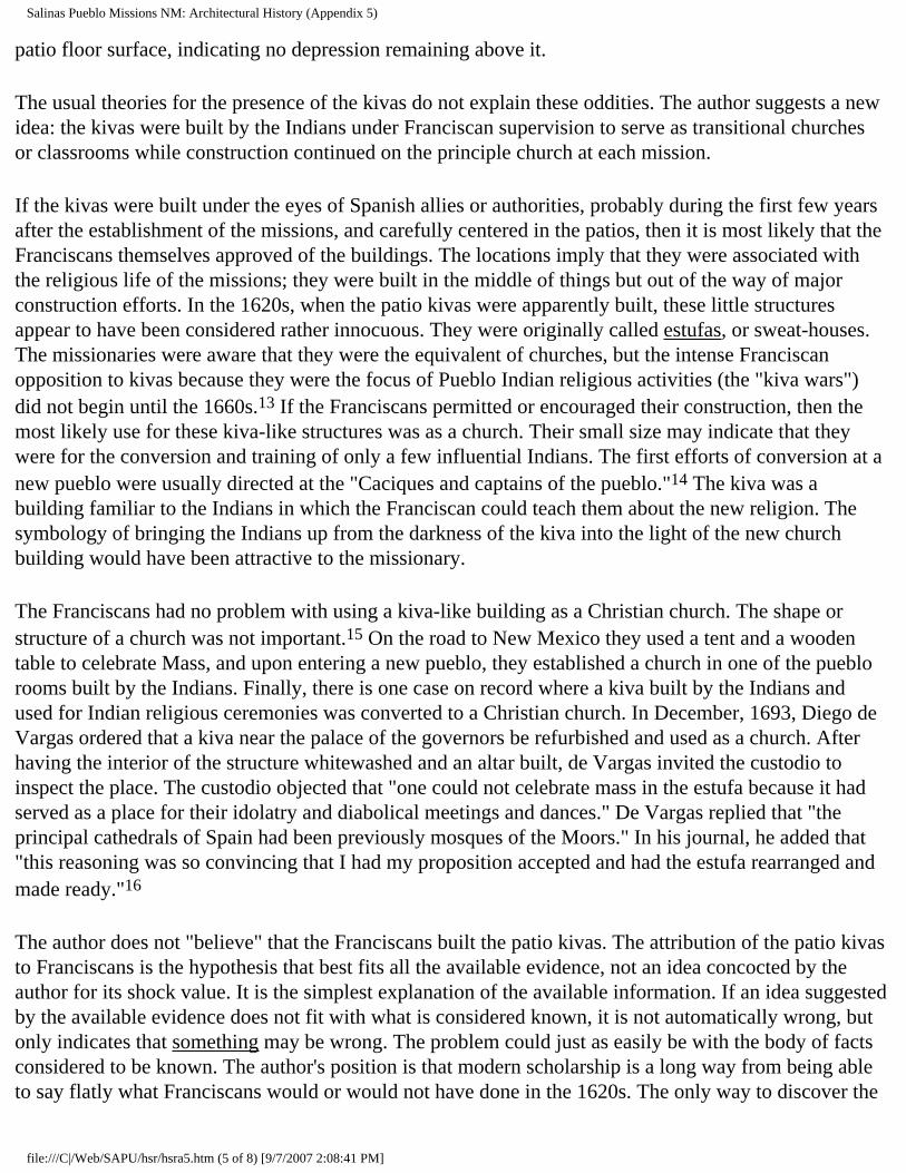
Salinas Pueblo Missions NM: Architectural History (Appendix 5)
patio floor surface, indicating no depression remaining above it.
The usual theories for the presence of the kivas do not explain these oddities. The author suggests a new idea: the kivas were built by the Indians under Franciscan supervision to serve as transitional churches or classrooms while construction continued on the principle church at each mission.
If the kivas were built under the eyes of Spanish allies or authorities, probably during the first few years after the establishment of the missions, and carefully centered in the patios, then it is most likely that the Franciscans themselves approved of the buildings. The locations imply that they were associated with the religious life of the missions; they were built in the middle of things but out of the way of major construction efforts. In the 1620s, when the patio kivas were apparently built, these little structures appear to have been considered rather innocuous. They were originally called estufas, or sweat-houses. The missionaries were aware that they were the equivalent of churches, but the intense Franciscan opposition to kivas because they were the focus of Pueblo Indian religious activities (the "kiva wars") did not begin until the 1660s.13 If the Franciscans permitted or encouraged their construction, then the most likely use for these kiva-like structures was as a church. Their small size may indicate that they were for the conversion and training of only a few influential Indians. The first efforts of conversion at a new pueblo were usually directed at the "Caciques and captains of the pueblo."14 The kiva was a building familiar to the Indians in which the Franciscan could teach them about the new religion. The symbology of bringing the Indians up from the darkness of the kiva into the light of the new church building would have been attractive to the missionary.
The Franciscans had no problem with using a kiva-like building as a Christian church. The shape or structure of a church was not important.15 On the road to New Mexico they used a tent and a wooden table to celebrate Mass, and upon entering a new pueblo, they established a church in one of the pueblo rooms built by the Indians. Finally, there is one case on record where a kiva built by the Indians and used for Indian religious ceremonies was converted to a Christian church. In December, 1693, Diego de Vargas ordered that a kiva near the palace of the governors be refurbished and used as a church. After having the interior of the structure whitewashed and an altar built, de Vargas invited the custodio to inspect the place. The custodio objected that "one could not celebrate mass in the estufa because it had served as a place for their idolatry and diabolical meetings and dances." De Vargas replied that "the principal cathedrals of Spain had been previously mosques of the Moors." In his journal, he added that "this reasoning was so convincing that I had my proposition accepted and had the estufa rearranged and made ready."16
The author does not "believe" that the Franciscans built the patio kivas. The attribution of the patio kivas to Franciscans is the hypothesis that best fits all the available evidence, not an idea concocted by the author for its shock value. It is the simplest explanation of the available information. If an idea suggested by the available evidence does not fit with what is considered known, it is not automatically wrong, but only indicates that something may be wrong. The problem could just as easily be with the body of facts considered to be known. The author's position is that modern scholarship is a long way from being able to say flatly what Franciscans would or would not have done in the 1620s. The only way to discover the
file:///C|/Web/SAPU/hsr/hsra5.htm (5 of 8) [9/7/2007 2:08:41 PM]

Salinas Pueblo Missions NM: Architectural History (Appendix 5)
rules within which they worked is by a willingness to hypothesize and then to test the hypothesis.
1 Ross Gordon Montgomery, Watson Smith, and John Otis Brew, Franciscan Awatovi: The Excavation and Conjectural Reconstruction of a 17th-Century Spanish Mission Establishment at a Hopi Indian Town in Northeastern Arizona, Reports of the Awatovi Expedition, No. 3, Papers of the Peabody Museum of American Archaeology and Ethnology, vol. 36 (Cambridge: Peabody Museum of American Archaeology and Ethnology, 1949), pp. 64-67, 77, and figure 22d.
2 Brew's description makes it clear that, although the beams that had supported the roof were left in place, the roofing itself had been removed. This made the job of filling the kiva much easier.
3 This is not to argue that acts of superposition did not happen during the conquest of Mexico. Such activities are well-documented; see, for example, Montgomery's discussion in Awatovi, pp. 134-36, 265-72. The evidence simply does not seem to justify the assumption that superposition was the determining factor in the location of the church of Awatovi.
4 Hayes, Mound 7, p. 36.
5 It is possible that, rather than being an example of tolerance, kiva D is another example of Franciscan construction like those suggested at Abó and Quarai, discussed in this appendix. Considering its location and the available information about it, the possibility exists that Letrado built kiva D with the intent for it to be centered in the patio of a convento planned to be built against the north side of the church of San Isidro. Kiva D was apparently built late in the life of Las Humanas, was filled in the late seventeenth century, and resembled the kiva in the convento of Abó; see Vivian, Excavations, pp. 44-45, 54, 57, and 110; also Hayes, Mound 7, p. 58, 61; and Hackett, Documents, p. 166. Because kivas are excavated into underlying fill by their builders, it is usually difficult to determine the date of their construction.
6 In fact, Quarai has a second kiva under the mission compound. This is a round kiva under the terraced section of the second courtyard, only a few feet east of the east wall of the friary. The upper retaining wall of the terraces passes over the center of the kiva. The limited archeological and photographic information indicates that the kiva was in ruins and had partly collapsed by the time the Franciscans built the second courtyard terraces across it.
7 During the 1660s, for example, several missions had more than one Franciscan. In fact, two missions had three friars, and another seven had two, out of a total of twenty-five missions, or about thirty-six percent. See Scholes, "Documents," pp. 52-56.
8 The title was used for this report because it so precisely captures the feeling of the ruins today. However, the original use of the phrase by Fray Hans Lentz in 1969 referred to the conditions in which the Franciscans lived. One of the conclusions of this report is that the "mission in the wilderness" idea is
file:///C|/Web/SAPU/hsr/hsra5.htm (6 of 8) [9/7/2007 2:08:41 PM]

Salinas Pueblo Missions NM: Architectural History (Appendix 5)
incorrect for most of the life of the Salinas missions.
9 See, for example, James Ivey, "The Scholes Manuscript: Another Look at the Dating of An Important Seventeenth Century Document," manuscript in the files of the Southwest Regional Office, National Park Service, Santa Fe.
10 At the time of its discovery, about six feet of wall height within the kiva survived. The stratigraphy implies that one or two feet of wall collapsed into the pit of the kiva after the abandonment of the mission, and that the roof had been about level with the patio courtyard. This indicates a distance from the floor to the underside of the ceiling of perhaps seven feet, significantly higher than the usual kiva height of about 5 1/2 feet. See Joseph H. Toulouse, Jr., The Mission of San Gregorio de Abó: A Report on the Excavation and Repair of a Seventeenth-Century New Mexico Mission, Monographs of the School of American Research, No. 13 (Albuquerque: University of New Mexico Press, 1949), p. 11 and figure 5.
11 Toulouse says that the kiva was used as a dump from the nearby kitchen, but also indicates that the filling was a single event with fragments of the same ceramic vessels appearing at all levels of the material. Therefore, the use of the kiva as a dump over any length of time is ruled out. The only way for a single-event filling to occur in this way would be for the fill to be removed from a pre-existing kitchen midden and hauled to the kiva.
12 The centering error is smaller than the limits of error in the plan. The difference between the two centers is therefore less than two inches. Available colonial Spanish surveyor's notes indicate that the usual method for the layout of a building or compound was to pick the center of the site and then plot diagonals from that point to locate the corners of the structure. If the Franciscans had laid out the kiva at Quarai before allowing the Indians to build it, they would have done so in a manner that resulted in the kiva being precisely centered in the patio.
13 There was a brief anti-kachina movement at Pecos in 1620; Kessell, Kiva, Cross, and Crown, p. 110-11; and a short reference to difficulties with the return of the Indians to their old ways in 1644; Scholes, "Church and State," p. 324; but the literature does not indicate any wholesale, province-wide suppression of kivas until the kachina wars of the 1660s. For example, both Alden Hayes and Gordon Vivian believe that anti-kiva efforts did not begin at Las Humanas until after 1660; Hayes, Mound 7, pp. 7, 58; Vivian, Excavations, p. 29; Hackett, Documents, p. 166.
14 Vivian, Excavations, p. 24; Bloom, "Perea's Relacion," pp. 228-34.
15 That is, so long as it was not a consecrated church. See the discussion of levels of blessing of a church and the restrictions accompanying each level in Montgomery, Awatovi, pp. 178-81, 190-91, 273-76; see also Appendix 2 in this report.
file:///C|/Web/SAPU/hsr/hsra5.htm (7 of 8) [9/7/2007 2:08:41 PM]

Salinas Pueblo Missions NM: Architectural History (Appendix 5)
16 A. von Wuthenau, "The Spanish Military Chapels in Santa Fe and the Reredos of our Lady of Light," New Mexico Historical Review, 10 (July 1935): 178-79. See also Fray Angélico Chavez, "Santa Fe Church and Convent Sites in the Seventeenth and Eighteenth Centuries," New Mexico Historical Review, 24 (April 1949): 90, where Chavez indicates that the structure in question may not have been the original tower chapel in the palace of the governors. Whether or not the building had originally been built for Christian services does not matter here--the main point is that the participants in the debate between de Vargas and the custodio considered the building a kiva.
CONTENTS
sapu/hsr/hsra5.htm Last Updated: 03-Sep-2001
file:///C|/Web/SAPU/hsr/hsra5.htm (8 of 8) [9/7/2007 2:08:41 PM]

file:///C|/Web/SAPU/hsr/fig1.jpg
file:///C|/Web/SAPU/hsr/fig1.jpg (1 of 2) [9/7/2007 2:08:42 PM]

file:///C|/Web/SAPU/hsr/fig1.jpg
file:///C|/Web/SAPU/hsr/fig1.jpg (2 of 2) [9/7/2007 2:08:42 PM]

file:///C|/Web/SAPU/hsr/fig2.jpg
file:///C|/Web/SAPU/hsr/fig2.jpg [9/7/2007 2:08:44 PM]

file:///C|/Web/SAPU/hsr/fig3.jpg
file:///C|/Web/SAPU/hsr/fig3.jpg (1 of 2) [9/7/2007 2:08:44 PM]

file:///C|/Web/SAPU/hsr/fig3.jpg
file:///C|/Web/SAPU/hsr/fig3.jpg (2 of 2) [9/7/2007 2:08:44 PM]

file:///C|/Web/SAPU/hsr/fig4.jpg
file:///C|/Web/SAPU/hsr/fig4.jpg (1 of 2) [9/7/2007 2:08:45 PM]

file:///C|/Web/SAPU/hsr/fig4.jpg
file:///C|/Web/SAPU/hsr/fig4.jpg (2 of 2) [9/7/2007 2:08:45 PM]

file:///C|/Web/SAPU/hsr/fig5.jpg
file:///C|/Web/SAPU/hsr/fig5.jpg [9/7/2007 2:08:46 PM]

file:///C|/Web/SAPU/hsr/fig6.jpg
file:///C|/Web/SAPU/hsr/fig6.jpg (1 of 2) [9/7/2007 2:08:46 PM]

file:///C|/Web/SAPU/hsr/fig6.jpg
file:///C|/Web/SAPU/hsr/fig6.jpg (2 of 2) [9/7/2007 2:08:46 PM]

file:///C|/Web/SAPU/hsr/fig7.jpg
file:///C|/Web/SAPU/hsr/fig7.jpg [9/7/2007 2:08:47 PM]

file:///C|/Web/SAPU/hsr/fig8.jpg
file:///C|/Web/SAPU/hsr/fig8.jpg (1 of 2) [9/7/2007 2:08:48 PM]
file:///C|/Web/SAPU/hsr/fig8.jpg
file:///C|/Web/SAPU/hsr/fig8.jpg (2 of 2) [9/7/2007 2:08:48 PM]

file:///C|/Web/SAPU/hsr/fig9.jpg
file:///C|/Web/SAPU/hsr/fig9.jpg [9/7/2007 2:08:49 PM]

file:///C|/Web/SAPU/hsr/fig10.jpg
file:///C|/Web/SAPU/hsr/fig10.jpg [9/7/2007 2:08:49 PM]

file:///C|/Web/SAPU/hsr/fig11.jpg
file:///C|/Web/SAPU/hsr/fig11.jpg (1 of 2) [9/7/2007 2:08:50 PM]

file:///C|/Web/SAPU/hsr/fig11.jpg
file:///C|/Web/SAPU/hsr/fig11.jpg (2 of 2) [9/7/2007 2:08:50 PM]

file:///C|/Web/SAPU/hsr/fig12.jpg
file:///C|/Web/SAPU/hsr/fig12.jpg [9/7/2007 2:08:52 PM]

file:///C|/Web/SAPU/hsr/fig13.jpg
file:///C|/Web/SAPU/hsr/fig13.jpg [9/7/2007 2:08:52 PM]

file:///C|/Web/SAPU/hsr/fig14.jpg
file:///C|/Web/SAPU/hsr/fig14.jpg [9/7/2007 2:08:53 PM]

file:///C|/Web/SAPU/hsr/fig15.jpg
file:///C|/Web/SAPU/hsr/fig15.jpg [9/7/2007 2:08:54 PM]

file:///C|/Web/SAPU/hsr/fig16.jpg
file:///C|/Web/SAPU/hsr/fig16.jpg [9/7/2007 2:08:54 PM]

file:///C|/Web/SAPU/hsr/fig17.jpg
file:///C|/Web/SAPU/hsr/fig17.jpg [9/7/2007 2:08:55 PM]

file:///C|/Web/SAPU/hsr/fig18.jpg
file:///C|/Web/SAPU/hsr/fig18.jpg [9/7/2007 2:08:56 PM]

file:///C|/Web/SAPU/hsr/fig19.jpg
file:///C|/Web/SAPU/hsr/fig19.jpg [9/7/2007 2:08:57 PM]

file:///C|/Web/SAPU/hsr/fig20.jpg
file:///C|/Web/SAPU/hsr/fig20.jpg (1 of 2) [9/7/2007 2:08:59 PM]

file:///C|/Web/SAPU/hsr/fig20.jpg
file:///C|/Web/SAPU/hsr/fig20.jpg (2 of 2) [9/7/2007 2:08:59 PM]

file:///C|/Web/SAPU/hsr/fig21.jpg
file:///C|/Web/SAPU/hsr/fig21.jpg [9/7/2007 2:08:59 PM]

file:///C|/Web/SAPU/hsr/fig22.jpg
file:///C|/Web/SAPU/hsr/fig22.jpg [9/7/2007 2:09:00 PM]

file:///C|/Web/SAPU/hsr/fig23.jpg
file:///C|/Web/SAPU/hsr/fig23.jpg [9/7/2007 2:09:01 PM]

file:///C|/Web/SAPU/hsr/fig24.jpg
file:///C|/Web/SAPU/hsr/fig24.jpg [9/7/2007 2:09:01 PM]

file:///C|/Web/SAPU/hsr/fig25.jpg
file:///C|/Web/SAPU/hsr/fig25.jpg [9/7/2007 2:09:02 PM]

file:///C|/Web/SAPU/hsr/fig26.jpg
file:///C|/Web/SAPU/hsr/fig26.jpg [9/7/2007 2:09:02 PM]

file:///C|/Web/SAPU/hsr/fig27.jpg
file:///C|/Web/SAPU/hsr/fig27.jpg [9/7/2007 2:09:02 PM]

file:///C|/Web/SAPU/hsr/fig28.jpg
file:///C|/Web/SAPU/hsr/fig28.jpg [9/7/2007 2:09:03 PM]

file:///C|/Web/SAPU/hsr/fig29.jpg
file:///C|/Web/SAPU/hsr/fig29.jpg [9/7/2007 2:09:03 PM]

file:///C|/Web/SAPU/hsr/fig30.jpg
file:///C|/Web/SAPU/hsr/fig30.jpg [9/7/2007 2:09:04 PM]

file:///C|/Web/SAPU/hsr/fig31.jpg
file:///C|/Web/SAPU/hsr/fig31.jpg [9/7/2007 2:09:05 PM]

file:///C|/Web/SAPU/hsr/fig32.jpg
file:///C|/Web/SAPU/hsr/fig32.jpg [9/7/2007 2:09:05 PM]

file:///C|/Web/SAPU/hsr/fig33.jpg
file:///C|/Web/SAPU/hsr/fig33.jpg [9/7/2007 2:09:06 PM]

file:///C|/Web/SAPU/hsr/fig34.jpg
file:///C|/Web/SAPU/hsr/fig34.jpg [9/7/2007 2:09:06 PM]

file:///C|/Web/SAPU/hsr/fig35.jpg
file:///C|/Web/SAPU/hsr/fig35.jpg [9/7/2007 2:09:06 PM]

file:///C|/Web/SAPU/hsr/fig36.jpg
file:///C|/Web/SAPU/hsr/fig36.jpg [9/7/2007 2:09:07 PM]

file:///C|/Web/SAPU/hsr/fig37.jpg
file:///C|/Web/SAPU/hsr/fig37.jpg [9/7/2007 2:09:07 PM]

file:///C|/Web/SAPU/hsr/fig38.jpg
file:///C|/Web/SAPU/hsr/fig38.jpg [9/7/2007 2:09:08 PM]

file:///C|/Web/SAPU/hsr/fig39.jpg
file:///C|/Web/SAPU/hsr/fig39.jpg [9/7/2007 2:09:08 PM]

file:///C|/Web/SAPU/hsr/fig40.jpg
file:///C|/Web/SAPU/hsr/fig40.jpg [9/7/2007 2:09:09 PM]

file:///C|/Web/SAPU/hsr/fig41.jpg
file:///C|/Web/SAPU/hsr/fig41.jpg [9/7/2007 2:09:09 PM]

file:///C|/Web/SAPU/hsr/fig42.jpg
file:///C|/Web/SAPU/hsr/fig42.jpg [9/7/2007 2:09:09 PM]

file:///C|/Web/SAPU/hsr/fig43.jpg
file:///C|/Web/SAPU/hsr/fig43.jpg [9/7/2007 2:09:10 PM]

file:///C|/Web/SAPU/hsr/fig44.jpg
file:///C|/Web/SAPU/hsr/fig44.jpg [9/7/2007 2:09:10 PM]

file:///C|/Web/SAPU/hsr/fig45.jpg
file:///C|/Web/SAPU/hsr/fig45.jpg [9/7/2007 2:09:11 PM]

file:///C|/Web/SAPU/hsr/fig46.jpg
file:///C|/Web/SAPU/hsr/fig46.jpg [9/7/2007 2:09:11 PM]

file:///C|/Web/SAPU/hsr/fig47.jpg
file:///C|/Web/SAPU/hsr/fig47.jpg [9/7/2007 2:09:11 PM]

file:///C|/Web/SAPU/hsr/fig48.jpg
file:///C|/Web/SAPU/hsr/fig48.jpg [9/7/2007 2:09:12 PM]

file:///C|/Web/SAPU/hsr/fig49.jpg
file:///C|/Web/SAPU/hsr/fig49.jpg [9/7/2007 2:09:12 PM]

file:///C|/Web/SAPU/hsr/fig50.jpg
file:///C|/Web/SAPU/hsr/fig50.jpg [9/7/2007 2:09:12 PM]

file:///C|/Web/SAPU/hsr/fig51.jpg
file:///C|/Web/SAPU/hsr/fig51.jpg [9/7/2007 2:09:13 PM]

file:///C|/Web/SAPU/hsr/fig52.jpg
file:///C|/Web/SAPU/hsr/fig52.jpg [9/7/2007 2:09:13 PM]

file:///C|/Web/SAPU/hsr/fig53.jpg
file:///C|/Web/SAPU/hsr/fig53.jpg [9/7/2007 2:09:14 PM]

file:///C|/Web/SAPU/hsr/fig54.jpg
file:///C|/Web/SAPU/hsr/fig54.jpg [9/7/2007 2:09:14 PM]

file:///C|/Web/SAPU/hsr/fig55.jpg
file:///C|/Web/SAPU/hsr/fig55.jpg [9/7/2007 2:09:14 PM]

file:///C|/Web/SAPU/hsr/fig56.jpg
file:///C|/Web/SAPU/hsr/fig56.jpg [9/7/2007 2:09:15 PM]

file:///C|/Web/SAPU/hsr/fig57.jpg
file:///C|/Web/SAPU/hsr/fig57.jpg [9/7/2007 2:09:15 PM]

file:///C|/Web/SAPU/hsr/fig58.jpg
file:///C|/Web/SAPU/hsr/fig58.jpg [9/7/2007 2:09:15 PM]

file:///C|/Web/SAPU/hsr/fig59.jpg
file:///C|/Web/SAPU/hsr/fig59.jpg [9/7/2007 2:09:16 PM]

file:///C|/Web/SAPU/hsr/fig60.jpg
file:///C|/Web/SAPU/hsr/fig60.jpg [9/7/2007 2:09:16 PM]
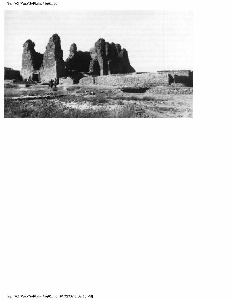
file:///C|/Web/SAPU/hsr/fig61.jpg
file:///C|/Web/SAPU/hsr/fig61.jpg [9/7/2007 2:09:16 PM]

file:///C|/Web/SAPU/hsr/fig62.jpg
file:///C|/Web/SAPU/hsr/fig62.jpg [9/7/2007 2:09:17 PM]

file:///C|/Web/SAPU/hsr/fig63.jpg
file:///C|/Web/SAPU/hsr/fig63.jpg [9/7/2007 2:09:17 PM]

Salinas Pueblo Missions NM: Architectural History (Chapter 1)
SALINAS
"In the Midst of a Loneliness": The Architectural History of the Salinas Missions
CHAPTER 1: ADMINISTRATIVE BACKGROUND (continued)
THE HISTORIC STRUCTURE REPORT
Every Historic Structure Report is unique. Each must meet both the requirements of the Cultural Resources Management Guideline (NPS-28) and the specific needs of the Park for which the document is written. At the same time, it should answer the questions of "How was this built, what did it look like, how did it come to be here, and what happened to it?" asked by visitors, interpreters, and resource managers alike.
The Federal government established general guidelines for Historic Structure Reports. The guidelines covered all possible situations involving actions that might affect the qualities that make a structure significant. Salinas National Monument planned actions largely concerned with preservation.
Because the Monument intended to stabilize and maintain most of the standing structures at the three sites at their present appearance, Salinas needed a Historic Structure Report that documented how the structures arrived at that appearance. In order to be effective as both a management and an interpretation document, the Historic Structure Report would have to emphasize two areas: the construction history, use, and decay of the buildings during the seventeenth, eighteenth, and nineteenth centuries, and the additions and alterations to the structures resulting from reconstruction and stabilization since 1900. To achieve this required a flexible methodology that synthesized the results of archeological, architectural, and historical research into a single narrative, rather than the more traditional division of the report into three separate narratives dealing with each of those fields. The more detailed structural appraisals needed for stabilization and maintenance planning would be prepared as needed by conservation professionals in separate documents.
Methodology
Information about the Salinas pueblos fell into three broad categories. These were historic records,
file:///C|/Web/SAPU/hsr/hsr1a.htm (1 of 4) [9/7/2007 2:09:18 PM]

Salinas Pueblo Missions NM: Architectural History (Chapter 1)
including Spanish colonial records of the seventeenth and eighteenth centuries, traveller's journals in the eighteenth and nineteenth centuries, and graphic records, including sketches, measured drawings and photographs; archeological records and artifacts, scattered among several university, state, and federal collections; and architectural information recorded by the structures themselves.
Historic Records
Spanish colonial records concerning the Salinas pueblos are few compared to other areas of the Spanish Empire, but important for their details about the construction and use of the buildings. Most collections of documents dealing with the seventeenth century in New Mexico were destroyed in the Pueblo Revolt of 1680. Fortunately for the historian, Salinas was deeply involved in a major controversy during the seventeenth century and descriptions of people, places, and activities in the area were deposited in Mexico City as a result. Here they survived the catastrophe of the Revolt and can be consulted today. Many other details of life in seventeenth century New Mexico were recorded in documents kept safe in collections in Spain. A great deal of this material has been published and much of the rest is available on microfilm or as photostats at the University of New Mexico. Undoubtedly there are many other records of life in seventeenth century New Mexico still to be discovered in the archival collections of Mexico and Spain. Unfortunately, few documents give any details about the appearance or arrangement of the missions. It would be impossible to reconstruct mission plans or much of the life within them from the documents alone, without the information from the few examples surviving as ruins or found by archeology.
The Salinas missions regularly attracted the attention of travellers after their abandonment. Numerous journals and diaries mention the ruins and frequently contain measurements and detailed descriptions. Some visitors made maps, sketches, or watercolors of the sites. Later, Salinas was among the earliest sites photographed when cameras became available. The attractiveness of the ruins resulted in the recording of a great amount of information about them that could not be deduced from the surviving ruins today. Much of this material has been stored in archival collections in the Southwest, where it was examined as part of the research for this report. More photographs, drawings, and descriptions are discovered every year. Each new item adds information about the history of the Salinas buildings.
Archeological Information
Most of the archeological information came from old reports, field notes, maps, sketches, and artifacts. Many of the archeologists who worked at the Salinas missions never published more than a brief account of their work. Whenever possible the original notes, descriptions, and artifacts were examined for more information. Several important collections of field notes and photographs have been lost (Joseph Toulouse's excavation notes, plans, section drawings, and photographs for his excavation of Abó, for example) and much of the artifact material is missing or no longer well-identified. Only when no other recourse was possible did further minimum excavation of a site become necessary. All known archeological information about the Salinas sites was collected; when possible, the archeologists who performed the work were interviewed.
file:///C|/Web/SAPU/hsr/hsr1a.htm (2 of 4) [9/7/2007 2:09:18 PM]

Salinas Pueblo Missions NM: Architectural History (Chapter 1)
The lack of well-recorded archeological investigations has been a serious handicap to the analysis. Certainly, a number of missions have been excavated, or at least cleared of debris, but little other than the plan of the buildings was recovered from these excavations. Even the best of these excavations, that of Awatovi in northeastern Arizona, supplied little information about the culture of the Franciscan missionary and its change through the seventeenth century. Even less is known about the non-Franciscan Spanish culture of seventeenth century New Mexico. So far as the author can determine, no report on the excavation of a secular Spanish site from this century has ever been published. The definition of seventeenth century Spanish culture, and the clearly-defined Franciscan culture within it, should be the top priority for any future mission excavation, with Franciscan-Indian interaction a lower priority. Too many missions have been poorly excavated with details of Franciscan life lost, or never recorded, to risk losing any more.
Architectural Information
Intensive examination of the evidence recorded by the surviving ruins added more details about how each building looked when new and how its occupants changed it while it was in use. The buildings were subjected to an almost stone-by-stone examination of every surface, wall-top, and opening. This examination recovered a great deal of information about Spanish colonial construction methods. Further, comparison of the Salinas evidence with that from other seventeenth century New Mexico missions confirmed that Franciscan building methods were generally the same throughout the province and from the earliest sites to the last built before the Revolt.
At the same time, the comparison showed that there were some trends or long-term changes in Franciscan building design in New Mexico through the century. For example, the basic plan of a mission convento seemed to have changed about 1630. [18] In the same way, the Franciscans revised their ideas about how a full-sized church should be arranged several times during the seventeenth century. [19]
Synthesis
All of the above evidence allowed a surprisingly detailed reconstruction of the physical appearance of the missions in the 1600s. Further, the documentation clearly showed the slow process of decay through the 1700s, the reoccupation of ca. 1800, the fires that destroyed two of the four churches, and the more rapid decay process at these churches after the fires. One interesting result of the research was the formulation of general rules that a building seemed to follow as it decayed and collapsed. Eventually the ruins became the mounds of rubble and fragments of standing wall acquired by State and Federal protection agencies who began the process of clearing the rubble, preventing further decay, and interpreting the Salinas story.
When stabilization and repair of the ruins began soon after 1900, each episode of repair work added changes to the surviving structural remains. Photographs and stabilization notes recorded these changes and provided the details needed to bring the history of the structures up to the present (the summer of 1987).
file:///C|/Web/SAPU/hsr/hsr1a.htm (3 of 4) [9/7/2007 2:09:18 PM]

Salinas Pueblo Missions NM: Architectural History (Chapter 1)
<<< Acknowledgements CONTENTS Chapter 2 >>>
sapu/hsr/hsr1a.htm Last Updated: 03-Sep-2001
file:///C|/Web/SAPU/hsr/hsr1a.htm (4 of 4) [9/7/2007 2:09:18 PM]

Salinas Pueblo Missions NM: Architectural History (Chapter 2)
SALINAS
"In the Midst of a Loneliness": The Architectural History of the Salinas Missions
CHAPTER 2: INDIAN, ENCOMENDERO, AND MISSIONARY: THE SETTING OF THE SALINAS PUEBLOS (continued)
THE ORIGINS OF THE SALINAS PUEBLOS
The springs and catch-basins around ancient Lake Estancia attracted visitors since human beings first moved through the Salinas Basin. Archeologists have found evidence of brief occupation as early as 6000 BC. Short-term visits continued until about 700 AD, when people settled permanently in the area and began to build pit-houses. Concentrations of population built up at the most favorable locations. [2]
In about the twelfth century, Early Puebloan cultures began to appear in the area. They may have developed from the earlier transient populations, settling permanently in the area. Early Puebloan cultures in the Salinas area show some indications of contact with the Anasazi of northern New Mexico, southern Colorado, and the Four Corners area. They built small "villages" of above-ground jacales, structures with cobblestone or masonry wall bases and superstructures of close-set vertical posts plastered with mud. Each village might also have a few pit-house-like structures. [3]
By the early fourteenth century, these groups had developed into Late Puebloan cultures. The Late Puebloan cultures built the large, integrated villages found by the Spaniards when they began to move into the area. [4] Late Puebloans, from whom modern Pueblo Indians developed, were composed of several major linguistic groups across the Southwest. The central group was the Anasazi, living in the San Juan Basin of northwestern New Mexico. They may have spoken Keresan, a language with no known relationship to other Native American languages. Along the northern Rio Grande lived a group of Puebloans that may have been related to the Anasazi. The eastern Puebloans spoke several closely related languages, all variants of the Tanoan language group. South of the Tanoan speaking Puebloans, along the Rio Grande, lived another group of Indians. They spoke a language called Piro that may have also been part of the Tanoan language group. The Piro speakers had some contact with the Anasazi, but probably were not part of their interacting cultural association of the Four Corners area and northern New Mexico.
file:///C|/Web/SAPU/hsr/hsr2a.htm (1 of 6) [9/7/2007 2:09:20 PM]

Salinas Pueblo Missions NM: Architectural History (Chapter 2)
Tanoan is related to Kiowa, a Plains Indian language. Linguistic analysis suggests that about three thousand years ago Indians speaking the ancestral Kiowa-Tanoan language separated into two groups. One group became the Tanoan speaking Indians of New Mexico and the other the Kiowa speakers of the Great Plains. Tanoan further separated into several closely related languages: Tiwa, Tewa, and Towa. Today Tiwa is spoken at Taos, Pícuris, Sandía, and Isleta, Tewa at Santa Clara, San Juan, San Ildefonso, Nambé, Tesuque, and Pojoaque; and Towa at Jemez. Tewa speakers once lived in the now-empty pueblos of the Galisteo Basin, and Towa speakers at Pecos. Piro, spoken in the abandoned pueblos of the southern Rio Grande such as Senecú and Socorro, and Tompiro, the dialect spoken in the southern Salinas pueblos, may be related to the Tanoan family of languages, but not enough examples of Piro and Tompiro survive to allow a detailed analysis. The modern distribution indicates that the Tanoan speakers who settled along the northern part of the Rio Grande and the eastern plains developed the Tiwa-Tewa-Towa groups, while another group along the southern Rio Grande developed the Piro language. [5]
In perhaps the twelfth century, Tiwa speaking Indians from the Rio Grande Valley to the northwest and Piro speaking Indians from the Rio Grande Valley to the west moved into the Salinas area and established the small Early Puebloan settlements. The Tiwa speakers settled along the west side of the Salinas Basin at about the same time that Piro speakers settled the area along the south side of the basin from Abó Pass east and southeastward. Construction on the first permanent buildings at Abó began in perhaps the late eleventh or early twelfth century, while construction of the other Salinas pueblo sites did not begin until later.
About 1300, Anasazi culture collapsed in the San Juan Basin. This may have been the cause of the migration of Keresan speaking Indians towards the south and east and may have been partly responsible for the development of Late Puebloan culture in the Rio Grande and Salinas basins. Keresans settled on the central Rio Grande, in the area presently occupied by the Keresan speaking pueblos of Zia, Santa Ana, San Felipe, Santo Domingo, and Cochiti. At roughly the same time, the occupants of the Salinas Basin built the first major structures on the sites of a number of Salinas pueblos, and expanded the construction at Abó. Nine of the pueblos eventually grew into the towns that played major parts in the history of the Salinas area during the seventeenth century. [6]
Tiwa speaking Indians established the northern three of the nine pueblos, later known as Chililí, Tajique, and Quarai, while Piro speaking Indians settled the other six, three of which were called Abó, Las Humanas, [7] and Tabirá by the Spanish. The remaining three are presently called LA 200, five miles west of Abó; Pueblo Pardo, three miles south of Las Humanas; and Pueblo Colorado, four miles southeast of Tabirá. These three were probably among the Piro speaking pueblos mentioned in the records from early Spanish exploration of the region east of the Manzanos. They undoubtedly figured in the exploration and first contacts of 1580-1598 but were abandoned in the early 1600s. They undoubtedly figured in the exploration and first contacts of 1580-1598 but were abandoned in the early 1600s. [8]
file:///C|/Web/SAPU/hsr/hsr2a.htm (2 of 6) [9/7/2007 2:09:20 PM]

Salinas Pueblo Missions NM: Architectural History (Chapter 2)
Figure 1. The Salinas Basin.
(click on map for an enlarged view in a new window)
file:///C|/Web/SAPU/hsr/hsr2a.htm (3 of 6) [9/7/2007 2:09:20 PM]

Salinas Pueblo Missions NM: Architectural History (Chapter 2)
The separation of the southern pueblo sites from the Piro speakers of the Rio Grande, and their association with the Plains Indians eventually caused the Piro language of these six pueblos to develop into a variant dialect called Tompiro. [9] By the late sixteenth century, association with the plains Indians had increased the differences among the Tompiro pueblos themselves. When the Spanish arrived after 1580, they divided the Tompiro speakers of Abó and its associated pueblos from those in the area of Las Humanas, whom they called Jumanos, or rayados (striped ones). [10] The name indicates that at least some of the Indians of the eastern Tompiro pueblos resembled Indians to the southeast that the Spanish called Jumanos, who had the trait of tattooing or painting stripes on their faces. However, the non-Tompiro Indians that frequented Las Humanas were probably Apache, rather than Jumanos.
Chililí, Tajique, Quarai and Abó formed a line from north to south about twenty-five miles east of the Rio Grande, in the foothills of the east slope of the Manzano Mountains. The country here is rolling hills rising to the west towards the mountains, covered with juniper, piñon, and Ponderosa pine on the higher hills and mountain slopes. Streams flow down to the east from the Manzanos into the Salinas Basin, where they sink into the soil. The ground-water eventually reaches the salt lagoons covering the lowest areas. [11] The Tiwas built Chililí on Chililí Creek in what is now the southwest corner of Bernalillo County. A modern town covers the site today. Tajique, also a modern town now, lies on the Arroyo de Tajique, eleven miles south in northwestern Torrance County, in the Tularosa Basin. Another eleven miles south stands the mounds of the pueblo of Quarai, beside a group of springs in the Cañon de Sapato. The ruins of Abó are twelve miles farther south on the Cañon de Espinosa in Abó Pass, the main route from the southern pueblos of the Rio Grande, such as Senecú and Socorro, to the salt deposits of the Salinas Basin, more than twenty miles farther east. The mounds of Las Humanas, now called Gran Quivira, top a hill twenty-one miles southeast of Abó, on the south edge of Torrance County. Three miles south of Las Humanas is its neighboring pueblo called Pueblo Pardo. Tabirá, also known as Pueblo Blanco, is an isolated ruin fifteen miles northeast of Las Humanas.
Their location east of the mountains separating the Rio Grande valley from the plains, exposed the pueblos to the southern Plains Indians, most of whom were Apache. All the pueblos developed relationships with the plains Indians that were at least seasonally cordial. At Las Humanas and Tabirá, the most exposed, however, the relationship went beyond cordiality to virtual coexistence. By the late sixteenth century Plains Indians formed some part of the daily social life of these pueblos. This probably included family ties such as developed at Pecos and Taos pueblos, also on the edge of the plains to the north. Because of the association, the Spaniards differentiated between the western Tompiros at Abó and the eastern Tompiros at Las Humanas and Tabirá. The linguistic difference between the Tompiros and the Tiwas caused another, administrative separation between the two groups within the Salinas area. [12]
Because the language and culture of the Indians of the Tompiro pueblos did not survive into the present, little is known of their social structure. They probably lived in ways similar to the Tanoan speaking pueblos of the Rio Grande valley. Here the village leader and his council exercised strong, centralized political control, allocated land, and determined who could and could not live in the pueblo. Much of the social life of the pueblos revolved around the division of the people into various paired groups, called moieties, with duties associated with summer or winter. Responsibility for the cycle of ceremonies
file:///C|/Web/SAPU/hsr/hsr2a.htm (4 of 6) [9/7/2007 2:09:20 PM]

Salinas Pueblo Missions NM: Architectural History (Chapter 2)
during the year moved back and forth between the two moieties according to the season. Moieties were usually established along the lines of kinship groups. [13] Although Puebloan society could appear remarkably homogenous, friction did occur within a given pueblo. The discord could result in the formation of opposing factions, probably also divided along the lines of kinship groups. The appearance of harmony or homogeneity could be deceiving. Faction differences apparently could cause the collapse of the social structure of a pueblo, resulting in the abandonment of the site. At a less disruptive level, factions or kinship groups may not have been as communal as is thought today. There is evidence, for example, that during a famine some families could do well while others in the same pueblo were starving. [14]
Abó
The first pueblo construction at Abó began about 1100 with work on what is now mound B, on the west side of Espinoso Creek. The inhabitants were attracted to the area by the springs that supplied them with water even during dry periods. One of these still flows on the east bank of the creek, southwest of the Eliseo Sisneros house. Abó probably had fields of maize and cotton on the nearby floodplain of Abó Arroyo and its side canyons, watered by the springs and occasional rainfall. [15]
Over the next several centuries, the Indians of Abó built additional blocks of houses. Most grew up to the north and south of block B from 1100 to the late 1500s. Around 1600 the residents began to build house block J, a long rectangular enclosure on the east side of the creek. By this time they had probably abandoned most of the earlier, western buildings, continuing to use only those along the banks of the creek. [16]
Quarai
The earliest known occupants at Quarai constructed several masonry pueblo buildings beginning around 1300. [17] One was the group of structures that later became mound A near the springs at the south side of the site of Quarai. [18] This may have been a round pueblo similar to the earliest structure under mound 7 at Gran Quivira. A second pueblo structure later became mound X, the site selected by the Spanish for the church and convento of Concepción de Quarai. [19]
The Indians abandoned mounds A and X about 1425. By this time they had already begun the buildings grouped around plaza D. These buildings became mounds B, C, D, E, and the south half of G. [20] About 1500 the Indians built the room blocks of mound F and the north half of mound G around plaza C. The buildings may have reached three stories in some parts of the pueblo. This was the pueblo of Quarai as seen by the first Spaniards to visit the area. [21] Quarai may have originally been named Acolocu or Agualacu, and was usually called Cuarac by the Spaniards. [22]
Quarai and the other two Tiwa pueblos, Tajique and Chililí, spoke the same language, shared social connections, occupied similar locations on spring-fed streams, and apparently had areas of farmland that
file:///C|/Web/SAPU/hsr/hsr2a.htm (5 of 6) [9/7/2007 2:09:20 PM]

Salinas Pueblo Missions NM: Architectural History (Chapter 2)
they worked in common, probably on the smooth flats east of the three pueblos where the mountain streams flowed out onto the floor of the Estancia Basin. The Franciscans saw these pueblos as a perfect missionary opportunity.
Las Humanas
About 1300, the Indians began the construction of a large circular pueblo on the present site of mound 7 at Gran Quivira. About the same time they built a second circular pueblo south of the first, under mounds 7 and 8. The mound 7 pueblo was similar to Tyuonyi on Frijoles Creek in Bandelier National Monument and to the circular structure perhaps underlying mound A at Quarai.
About 1400, the Indians had abandoned most of the rooms in the round structure and had built several rectangular room blocks adjacent to them. These rooms were occupied from 1400 to about 1515. From 1515 to 1545 no one lived in the rooms of mound 7, but probably continued to occupy other nearby room blocks.
Beginning about 1545, the residents of Las Humanas began to expand the house block of mound 7. As of 1598, they probably lived in houses composing mounds 7, 13, 14, 15, 16, and 18. [23]
Continued >>>
sapu/hsr/hsr2a.htm Last Updated: 03-Sep-2001
file:///C|/Web/SAPU/hsr/hsr2a.htm (6 of 6) [9/7/2007 2:09:20 PM]

Salinas Pueblo Missions NM: Architectural History (Chapter 3)
SALINAS
"In the Midst of a Loneliness": The Architectural History of the Salinas Missions
CHAPTER 3: AN INTRODUCTION TO SPANISH COLONIAL CONSTRUCTION METHODS (continued)
ESTABLISHMENT OF A MISSION
The founding of a new mission followed a standardized procedure. First, the custodio and his staff of difinitors made the decision to send a mission to a particular pueblo. They usually selected a missionary for the task during the annual chapter meeting. It was common for a new mission to be assigned to a friar who had just arrived from Mexico. The friar departed for his new pueblo accompanied by a squad of soldiers for his protection on the road and during the first days in his assigned pueblo. A wagon carried his allotment of basic supplies necessary to begin religious instruction and the construction of a church and convento. The equipment had been sent from Mexico City on the same supply train that brought him to New Mexico. [5]
Upon arriving in the pueblo, the friar purchased one or two houses from an Indian family, with the approval of the administrators responsible for such decisions. The houses served as his church, convento, and storerooms during the planning and construction of permanent buildings. [6]
The friar's next step was to secure permission to build a church. The leaders of the pueblo had to give permission to use a particular tract of land for this purpose. Depending on the success of the negotiations, the friar decided whether to build a temporary or a permanent church and convento.
There were several paths that events could follow over the next several years. For example, at Hawikuh Fray Roque de Figueredo and his successor, Fray Francisco Letrado, began construction on the permanent church and convento about 300 feet east of the pueblo, at the bottom of the hill on which the Indian buildings stood. The friars built the mission immediately adjacent to abandoned house block F, reoccupied by the Indians about the same time. Some of the rooms of this house block probably served as the temporary convento. The friars began on the mission in late 1629, but it was destroyed before completion during a revolt about a year and a half later, in February, 1632. The Franciscans did not
file:///C|/Web/SAPU/hsr/hsr3a.htm (1 of 8) [9/7/2007 2:09:22 PM]

Salinas Pueblo Missions NM: Architectural History (Chapter 3)
return to Hawikuh until the late 1640s, when they successfully completed the church and convento. [7]
At Pecos in 1617, the pueblo would not permit the construction of a church near Indian buildings. Fray Pedro Zambrano Ortiz began a small church about a thousand feet northeast of the pueblo and probably lived in a small shack near the site of construction. The small church may have been roofed but was unfinished inside when the Franciscans finally received permission to enter the pueblo about 1620. Fray Pedro de Ortega, who replaced Ortiz, moved into rooms at the south end of the South Pueblo and built several additional rooms to serve as a convento. He constructed a small temporary church, and in late 1620 began construction on the building that was to become the largest church ever built in colonial New Mexico. The small church northeast of the pueblo was dismantled and some of the adobes and wood were probably reused in the new construction. Fray Andres Suárez took over the work of construction in 1622 and completed the new church and its convento by early 1626. [8]
At Las Humanas a third variation on establishment occurred. In mid-1629 Fray Francisco Letrado occupied several rooms at the west end of house block 7 and in 1631 began construction on the church of San Isidro. It was located on the south slope of the hill crowned by the pueblo, and was intended as an interim structure. Letrado was transferred to Hawikuh in late 1631, and Las Humanas was reduced to a visita of Abó. Fray Francisco Acevedo completed construction on San Isidro. Fray Diego de Santandér began construction on a larger church in about 1660. [9]
Supplies and Equipment
Each friar was given a set of basic items when he was sent to New Mexico for the first time. As part of his founding equipment, the friar was furnished with:
10 axes for cutting trees for beams and other wooden items; 3 adzes for trimming beams, lintels, and other wooden items; 10 hoes for the preparation and maintenance of the convento garden and for digging foundation trenches; 1 medium-sized saw for cutting boards; 1 chisel with collar and handle for detailed shaping of beams, lintels, and boards; 2 augers for drilling holes for pegs, the usual way of fastening the components of doors; 1 box plane for planing board and beam surfaces flat. [10]
This was a basic set of tools for use in the mission on a day-to-day basis. For major work such as the trimming and carving of the decorated roof beams and corbels for the church and sacristy and the lathe-turning of bannister rails and posts, the friar usually hired skilled carpenters, such as the Indians of Pecos Pueblo. These experts would bring their own, more specialized tools and equipment to the site. [11]
In addition, the friar was supplied with the following materials for construction:
file:///C|/Web/SAPU/hsr/hsr3a.htm (2 of 8) [9/7/2007 2:09:22 PM]

Salinas Pueblo Missions NM: Architectural History (Chapter 3)
600 tinned nails for decorating the church door; 60 nails about 4 inches long; 60 nails about 7 inches long; 100 nails de a quinientos en suma; [12] 400 nails de a mil en suma; 1800 roofing nails; 1200 nails de medio almud; 800 tacks; 10 pounds of steel for making other needed items and tools; 1 large latch for the church door; 1 pair of braces for double doors, probably the church doors; 2 small locks; 12 hinges for doors and windows; 12 hook and eye latches. [13]
The carpenters used very few nails in the construction of flat earthen roofs, and they used wooden pegs in much of the other work, such as door construction and window framing. [14] Other than the tinned nails for the church door, the carpenters probably used the smaller nails listed above for furniture construction such as benches, chairs, tables, cabinets, and bed frames. The larger nails were probably for framing and supports for the retablo, or decorative screens, in the church. The roofing nails may have been used in the construction of stables and storerooms adjacent to the convento.
The friar had some tools or equipment made on-site, using the ten pounds of unworked steel in his supplies. A blacksmith must have been present during at least some of the cycle of mission construction and activity to do this work.
Site selection and siting considerations
As his first major task, the friar had to select an appropriate location for the mission compound. Several criteria influenced his decision. The friar wanted the church to have an imposing situation, close to the main plaza of the pueblo, but clearly separate from the mundane lives of the Indians, as dictated by the Laws of the Indies. The site should be fairly level, but the friar would plan on building a level platform for the mission if necessary. The church should face into one of the plazas of the pueblo, but still be oriented towards a cardinal direction if possible.
After he selecting a first choice and several second choices, the friar entered into negotiations with those in authority in the pueblo, in order to secure permission to build on one or another of the sites. If and when permission was granted, the friar could begin planning the actual construction.
Planning the Buildings
The friar worked out the plan of the church and convento buildings, probably in the form of a measured
file:///C|/Web/SAPU/hsr/hsr3a.htm (3 of 8) [9/7/2007 2:09:22 PM]

Salinas Pueblo Missions NM: Architectural History (Chapter 3)
sketch plan on paper or smooth board, in advance of actual layout of the site. He carefully determined the overall measurements, the use, sizes and relative location of the rooms of the convento, the plan of the church, and the design of facade. During planning, the friar's own ideas and experience necessarily influenced the design. Conventos and church plan and elevation, usually similar in their general attributes, tended to be different in detail throughout seventeenth century New Mexico because each was the creative product of only one or two people. [15]
The church could be planned with either a straight nave (the main body of the interior of a church) or with transepts. Transepts were extensions built onto the sides of a nave to give the plan of a church the shape of a cross. At the end of the church opposite the main entrance doors, the friars built the main altar. In the area immediately in front of the altar was the sanctuary, where much of the activity took place during the religious ceremony called Mass. The main altar was almost always raised above the level of the nave on a platform reached by broad stairs. To either side of the main alter, the Franciscans usually built secondary altars called collaterals, or simply side altars. At the front of the church, over the entrance, was usually a choir loft, a large balcony where the choir stood to sing. The choir loft was reached by a stairway built under the loft or in a room against the outside wall of the church. Before 1640, the friars built a baptismal area under the choir loft, but after 1640 the baptistry was a separate room reached by a doorway through the church wall. From the area of the sanctuary, a doorway opened into the sacristy, a room used for storing the vestments worn during the Mass. From the sacristy, the friar could go through another doorway into the main residence area of the mission, called the convento.
The Franciscans laid out the churches as precisely square as they could, with remarkable success. San Buenaventura is the only one of the surviving seventeenth-century churches to have a significant lack of parallelism in the walls of the nave. George Kubler has suggested that many seventeenth-century churches were designed to appear longer by the creation of a false perspective with non-parallel nave walls. [16] However, most of these churches have naves that diverge less than one foot over lengths of sixty to one hundred feet. These include Halona, Hawikuh, Abó, Quarai, Giusewa, Acoma, San Isidro, the "Lost Church" at Pecos, and the first plan of the Chapel of San Miguel in Santa Fe; most of these diverge less than six inches. Only San Diego de Tabirá and San Buenaventura have walls more than one foot out of parallel, with San Buenaventura having a three-foot divergence and San Diego two feet. Apparently the missionary responsible for each church wanted the walls parallel, but were not always able to achieve this.
Somewhere high on the church, sometimes above the choir loft stairs or the baptistry, the Franciscans built the bell room. Bells in seventeenth century mission churches were not sounded by swinging. Instead, the clapper was pulled against it by a thong, or the bell was struck from the outside. [17] It was necessary for the bell ringer to stand virtually beside the bell. This resulted in the distinctive arrangement of the bell tower seen in the missions of the seventeenth century. In each case, the design carefully allowed direct, easy access to the bell room, usually built high on one side or either end of the church. Each missionary received one standard issue, two-hundred pound bell in the founding supplies for his mission. Most of these were virtually identical bronze bells. The seventeenth century Pecos and Aguatobi bells were cast in the same mold as the bell at Acoma made in 1710; the bells at the Salinas
file:///C|/Web/SAPU/hsr/hsr3a.htm (4 of 8) [9/7/2007 2:09:22 PM]

Salinas Pueblo Missions NM: Architectural History (Chapter 3)
missions probably looked the same. [18] The bells were usually made in Mexico City. For example, in 1612, the Franciscans contracted with the maestro de campañero, the master bell-maker, Hernan Sanchez for a number of brass items, including six large bells, each weighing 200 pounds. Hernan Sanchez was a recognized maestro in Mexico City. Among other things, he made the bell called "Santa Maria de los Angeles" in the Cathedral there. [19]
The Convento
The friar planned the convento to include certain basic elements: 1) the central patio with its encircling covered walk, called the ambulatorio in this report; 2) the portería, or reception room, at the front of the convento near the church facade; 3) a refectorio, or dining room; 4) a cocina, or kitchen; 5) oficinas, or storerooms; 6) the despensa, or pantry; 7) the infirmario, or infirmary; and 8) several celdas, cells or residences. Some of the cells had alcobas (alcoves, also called trasceldas) or rear rooms for sleeping, and usually one cell, the celda principal, had an adjoining office space for the friar. Frequently the mission would have one or several privies inside the convento buildings, in the patio, or in the second courtyard. The missionaries usually used one room, probably an unused cell, for a schoolroom. [20]
The convento centered on the patio. Around it was the ambulatorio, a walkway that gave access to both the secular and sacred areas of the mission. It served to separate the activities which involved the public from the private residence of the Franciscans. However, the Franciscans were not a cloistered order, and lay persons had some access even to the private rooms of the friars. Doors were used, not to preserve the sanctity of the cloister, but as a security measure to prevent pilferage of goods, supplies, and valuable church fittings, and as a deterrent to cold drafts in the winter.
In the private area of the friary were the rooms for the necessities of life and the business of the mission. These included the cells where the friar and any other resident Franciscan or lay brother lived; the storerooms; the dining room; and the kitchen. The cells were usually two rooms each, a larger one for paperwork and study, and a smaller, the alcove, for sleeping. Some of the cells may have been used as residences by Indians on the permanent staff of the mission, such as the sacristan, who kept the sacristy and church clean and neat and cared for the vestments used in the ceremonies of the church. He sometimes assisted the priest in such ceremonies. [21] These and other room uses were highly variable depending on the wishes of the resident minister and the fortunes of the mission.
The friar designed all of the rooms for particular purposes at the time they were built. Some, such as the extra cells, anticipated future needs, while other rooms were put into use immediately. However, because of changes introduced by later friars and alterations by reoccupation after 1800, and lack of sufficient detail in the archeological records, the purposes of some rooms cannot be determined. The friars after the original builder changed the plan of some rooms, indicating that they also probably changed the uses of these rooms.
Adjacent to the main convento complex, the friar laid out a second courtyard resembling a barnyard. The second courtyard contained the animal pens; stables for the mules, horses, and dairy cows; and coops for
file:///C|/Web/SAPU/hsr/hsr3a.htm (5 of 8) [9/7/2007 2:09:22 PM]

Salinas Pueblo Missions NM: Architectural History (Chapter 3)
chickens and turkeys. Here stood the main food-storage buildings, usually a hay barn for the animals and a granary to store beans, wheat, and corn against time of need for the convento and the pueblo. Beyond this, but not far from the convento, would be pens and corrals for keeping sheep for shearing or fattening and tame cattle for milking and breeding. Larger pens in the area held stock waiting to be driven to markets in the San Bartólome-Parral area, several hundred miles to the south. [22]
The rooms and associated wooden buildings of the second courtyard served the secular life of the mission. Elsewhere, either in the second courtyard or in buildings added to the pueblo room blocks, the friar built the mission weaving rooms and other workshops. [23]
The mission maintained its ranching and farming activities in large estancias on the surrounding valley floor, using Indian labor. Some missions in the central Rio Grande Valley had a surprising number of these estancias. In the period from 1663 to 1666, for example, San Ildefonso had six, Sandía had thirty, Isleta had fourteen, and Socorro had two. [24]
The mission, with its residences, offices, storerooms, workshops, sheds, barns, pens, herds and fields, was almost a self-contained community. This was certainly the intent of the design, derived from over 800 years of monastic tradition and 400 years of Franciscan development. It had served well in Medieval Europe, in Renaissance Mexico, and would continue to serve in Colonial New Mexico.
Surveying
The friar usually laid out the church and convento with some concern for geographic orientation. He located geographic north by a magnetic compass, or by means of any one of several methods using the stars or sun. A compass, however, was not trustworthy in a new territory until its variation, or deviation from geographic north, had been determined. Each area had a different variation, and in some cases the difference could be very large. [25]
The friar could accurately obtain the bearing of geographic north by methods using either observation of the stars during the night or of the sun during the day. He could have determined the variation with an accuracy of less than half a degree by a simple nighttime observation of the direction of the North Star relative to the direction in which the compass needle pointed. Greater accuracy could have been obtained by several observations at different times during one or several nights. [26]
Most "frontiersmen" such as the Spanish explorers, missionaries, and colonists on the northern frontiers of New Spain probably used solar observations to find the cardinal directions. They would have known several techniques for this, and probably carried small, easily used instruments for the job.
The simplest method of determining the cardinal directions using the sun was the gnomon. The friar set a rod (the gnomon) vertically into the ground and drew a circle around it using the base of the rod as the center. He marked the shadow of the top of the rod as it crossed the circle in the morning and again in
file:///C|/Web/SAPU/hsr/hsr3a.htm (6 of 8) [9/7/2007 2:09:22 PM]

Salinas Pueblo Missions NM: Architectural History (Chapter 3)
the evening. He then found the midpoint of the line between the two marks and drew a line from that midpoint through the base of the rod. This line would run within a fraction of a degree of true north and south.
Several other instruments for finding true north using the sun, such as the magnetic sundial, the equinoctial sundial, and the equinoctial ring, were available to the missionaries in the early seventeenth century. All of these instruments were made in small, virtually pocket-sized versions. [27]
The magnetic sundial and equinoctial sundial used compasses as part of their orientation system, and therefore would not serve the purposes of the friar. The equinoctial ring was simpler, but required that the north latitude and the hour of the day be known. The friar could easily find his north latitude and the arrival of the noon hour by observing the altitude of the sun with standard instruments such as the quadrant or astrolabe and comparing this reading with printed tables of latitude. Such tables, called ephemerides, were commonly available. For example, Antonio Espejo used a set during his exploration of New Mexico in 1582, as did Captain Alonso de Leon while crossing Texas in 1689, and Father Eusebio Kino, a Jesuit, who explored and mapped southern California from 1685 to the early years of the 1700s. [28] The hour of the day could be obtained with some accuracy by using the astrolabe. In fact, a latitude observation required, as a routine procedure, that local noon be determined.
In the Salinas area, the missionaries would have found that the compass pointed almost due north, making it unnecessary for them to correct for variation on every sighting. After this determination, the friar could proceed with the layout of the mission buildings.
Laying Out the Plan of the Buildings
The church and convento buildings were laid out at the same time using stakes, a plumb bob, and a measuring cord, the cordel, probably fifty varas (140 feet) in length. [29] In general, the method consisted of a series of angle and distance determinations, with stakes placed at intended corners. First, the friar selected the location of the center of the complex. The Indians on the layout crew then ran a baseline through the center along the alignment selected by the friar for the building. They used the cordel to measure the length of the main wall along the baseline and drove stakes to mark the first two corners. The friar showed them how to turn a right angle here, using a simple geometric method such as intersecting circles or a 3-4-5 triangle, or an instrument such as the compass. The crew drove a third stake marking the new alignment and measured along that alignment to the next principal corner, perhaps using the plumb bob string as the sighting instrument. This procedure continued until the crew/workers had marked the outline of the entire building complex on the ground. They probably ran string between the stakes. [30]
Within the outline, the crew members delineated room walls, then excavated trenches for the building foundations along these lines. As a rule, the friar had all the foundations completed first to serve as the permanent plan for above-ground construction. [31]
file:///C|/Web/SAPU/hsr/hsr3a.htm (7 of 8) [9/7/2007 2:09:22 PM]

Salinas Pueblo Missions NM: Architectural History (Chapter 3)
Continued >>>
sapu/hsr/hsr3a.htm Last Updated: 03-Sep-2001
file:///C|/Web/SAPU/hsr/hsr3a.htm (8 of 8) [9/7/2007 2:09:22 PM]

Salinas Pueblo Missions NM: Architectural History (Chapter 4)
SALINAS
"In the Midst of a Loneliness": The Architectural History of the Salinas Missions
CHAPTER 4: ABO: THE CONSTRUCTION OF SAN GREGORIO (continued)
THE SECOND CHURCH AND CONVENTO
In 1629 Fray Francisco Acevedo arrived with the wagon train from Mexico in company with Fray Estévan de Perea, the new custodian, and Fray Francisco Letrado, soon to be assigned to begin the conversion of Las Humanas. In the chapter meeting held after the arrival of the train, Fray Perea assigned Fray Acevedo as the second missionary at Abó, joining Fonte. [14] He may have been assigned to manage the visita at LA 200 (probably the village called Ténabo), four miles to the west.
After Letrado's beginning at Las Humanas and departure for Hawikuh in 1631, Acevedo acquired Las Humanas and Tabirá as visitas. Acevedo embarked on a major building program, and over the next few years he completed the construction of the visita church of San Diego at Tabirá and built the visita church of San Buenaventura at Las Humanas. [15]
About 1640, Acevedo became guardian of Abó. [16] He soon began planning a renovation of the church and convento of San Gregorio. The reasons for the enlargement are unknown, but can be suggested. The church was almost 20 years old by 1640, and probably needed re-roofing. During the same period, Abó's place in the Franciscan effort in New Mexico had changed. Since 1634, Abó had administered of two visitas (or three if Ténabo was still a visita). [17] This made Abó the head of one of the largest chains of pueblos in New Mexico. Acevedo, with a decade of experience in construction in the Salinas basin, saw no reason to accept the small, simple church and convento of San Gregorio as the structure housing such a significant mission.
Acevedo carefully mapped the church and convento. He drew a scale plan of the buildings and a set of elevation drawings of the church. Using these, he began to work out the most economical reconstruction that would result in a fully-developed church and convento. He eventually arrived at a plan and elevation that would produce the desired results with the least amount of demolition and new construction. [18]
file:///C|/Web/SAPU/hsr/hsr4a.htm (1 of 4) [9/7/2007 2:09:23 PM]

Salinas Pueblo Missions NM: Architectural History (Chapter 4)
By 1645 Acevedo had worked out the necessary changes and additions and the required steps for the renovation.
Acevedo decided that the large, impressive church he wanted could be achieved by a simple process of addition to the present church, minimizing the amount of additional stonework. He worked out a plan that added transept-like side chapels and a larger, more intricate and imposing group of altars to the old church. The old sacristy would be eradicated by the expansion, so a new, larger sacristy would have to be built. This meant that several changes had to be made in the rooms at the northwest corner of the convento in order to make space for the new sacristy. Further changes were necessary in the convento along the west side of the patio to add the sacristy storeroom and the new choir stairwell (see figure 4 for the plan of the second church and convento of Abó).
Figure 4. The plan of the mission of Abó after its first reconstruction. The church was almost doubled in size, and a new, larger sacristy added. The patio was changed to
file:///C|/Web/SAPU/hsr/hsr4a.htm (2 of 4) [9/7/2007 2:09:23 PM]

Salinas Pueblo Missions NM: Architectural History (Chapter 4)
accomodate the new sacristy storeroom on the west. The kiva was probably filled to a depth of about 6 feet as part of this reconstruction. The portería and front platform are
again conjectural, based on their appearance after several reconstructions. (click on map for an enlarged view in a new window)
Within the church, Acevedo wanted a higher, more imposing roof and more space and light in the nave. He decided to follow the new practice being used at the newer missions in New Mexico, and moved the baptismal font and the choir stairs to separate rooms outside the church. This would leave much more space under the choir loft. A new window would have to be cut through the east wall of the church and the original two windows filled. Space for the choir stairway had to be arranged in the convento and a second hole cut through the east wall of the church for an entrance to the choir loft. Acevedo wanted the baptismal area to be located outside the west wall of the nave, rather than outside the front of the church as at Quarai. This would require the addition of a doorway through the west wall under the choir loft. The old roof would have to be removed and replaced. All these changes would necessitate a considerable dismantling of the front end of the church.
Acevedo's plan for his new sanctuary and altars was innovative, incorporating several unique features. The addition of transepts and a larger altar area would not have been surprising in itself. Acevedo, however, did not do just this. Instead, he designed the "transepts" to contain two altars. They were not transepts, in other words, but side chapels, partially closed off from the nave by wooden screens. [19] This made a total of five altars at the head of the church. Above the side chapel altars, Acevedo built two balconies, or tribunas. In order to connect the balconies, while at the same time providing support for the main roof vigas across the north edge of the side chapels, he created a daring catwalk across the nave of the church at a height of twenty-two feet. In addition, the balconies and catwalk allowed access from the roof of the convento to the bell tower. [20]
Beyond the side chapels the nave would widen into true transepts, although very shallow ones. The additional width was sufficient to allow for three full-sized altars: two collaterals and an imposing high altar in the center. [21] The location of the main altar and the height of the walls of the church required the clerestory to be located well south of the altar in order for the sunlight to illuminate the area during the Christmas feast-days. Juggling sizes and heights, Acevedo worked out the proper size and placement of the clerestory at the south edge of the new side chapels. Still, in order for the proportions to work out correctly, he had to accept that maximum sunlight through the clerestory, during the Christmas season, illuminated the high altar stairway and the floor immediately in front of it, rather than of the altar itself. [22]
Continued >>>
sapu/hsr/hsr4a.htm Last Updated: 03-Sep-2001
file:///C|/Web/SAPU/hsr/hsr4a.htm (3 of 4) [9/7/2007 2:09:23 PM]

Salinas Pueblo Missions NM: Architectural History (Chapter 4)
file:///C|/Web/SAPU/hsr/hsr4a.htm (4 of 4) [9/7/2007 2:09:23 PM]

Salinas Pueblo Missions NM: Architectural History (Chapter 5)
SALINAS
"In the Midst of a Loneliness": The Architectural History of the Salinas Missions
CHAPTER 5: QUARAI: THE CONSTRUCTION OF PURISIMA CONCEPCION (continued)
FRIARY DESIGN AND CONSTRUCTION
Gutierrez de la Chica laid out the plan of the friary so that it had characteristics distinct from others in New Mexico at the time. The friary of San Buenaventura at Las Humanas, designed by Fray Diego de Santandér in 1659, for example, followed the "traditional" plan much more closely, as did the first friary at Abó, designed by Fray Francisco Fonte in 1622. In the traditional layout, the ambulatorio was the central pathway to the surrounding rooms. Doors of all rooms used on a daily basis by the friars opened onto the ambulatorio, and traffic flowed around the walkway.
Quarai's design was distinctive among seventeenth century missions in New Mexico. The design of the Quarai friary, for example, minimized the role of the ambulatorio as the main avenue of access to the rooms of the convento. Instead, the residential area of the Franciscans formed a separate block of rooms along a north-south hallway adjacent to the ambulatorio. [5] From this hallway, doors opened into the ambulatorio, the cells and storerooms, and the second courtyard where the more mundane activities of the convento took place.
The arrangement of doors imply that it was common for the residence area to be open to lay persons but that casual traffic was discouraged. Doors secured individual rooms to prevent random pilferage and to help keep the residences warmer in winter.
Construction of the Patio and Ambulatorio
The plan of the friary centered on the patio. In the patio, a square kiva was built about this time. Around the patio, Guitiérrez de la Chica had laid out the ambulatorio as a series of four portales, or corridors with one side open to the patio. Within the ambulatorio foundations the crew made a floor of packed sand. Each of the four corridors were 7 1/4 feet in width. The east and west corridors measured 46 1/2 feet in length, while the north and south corridors were respectively 48 1/2 and 50 feet long. The
file:///C|/Web/SAPU/hsr/hsr5a.htm (1 of 6) [9/7/2007 2:09:24 PM]

Salinas Pueblo Missions NM: Architectural History (Chapter 5)
north, east, and south walls of the ambulatorio were 3 1/4 feet thick, while the west wall was only 2 1/2 feet thick. On this side it formed the east wall of a small room (room 24). At the corners of the patio, the construction crew built stone pillars averaging 3 1/2 feet square to be the main supports for the ambulatorio roof. [6]
Figure 12. Plan of the pueblo and mission of Quarai about 1640. The baptistry has been added to the west side of the portal at the front of the church, but the patio has not been altered to its more closed form. On the west side of the church, the outlines of the house blocks that formed mounds H, I, and J can be seen. These house blocks must have been built after perhaps 1630, because they line up precisely with the north and south edges of the church and convento. The Spanish structure on the east end of mound J stands just west of the baptistry. This was probably the casa real for Quarai, maintained for
visitors by the Franciscans. (click on map for an enlarged view in a new window)
Construction on the ambulatorio walls halted when the crew had raised them to a height of 10 1/2 feet, the height at which the roofs of the ambulatorio and several adjacent rooms were to be built. In the ambulatorio, the crew set up the posts, bolsters and lintels of the portales between the stone pillars. Each side of the patio received four posts, two against the face of each pillar and two more equally spaced between them. The posts were about twelve inches thick and rested on a stone sill or footing about 2 1/2
file:///C|/Web/SAPU/hsr/hsr5a.htm (2 of 6) [9/7/2007 2:09:24 PM]
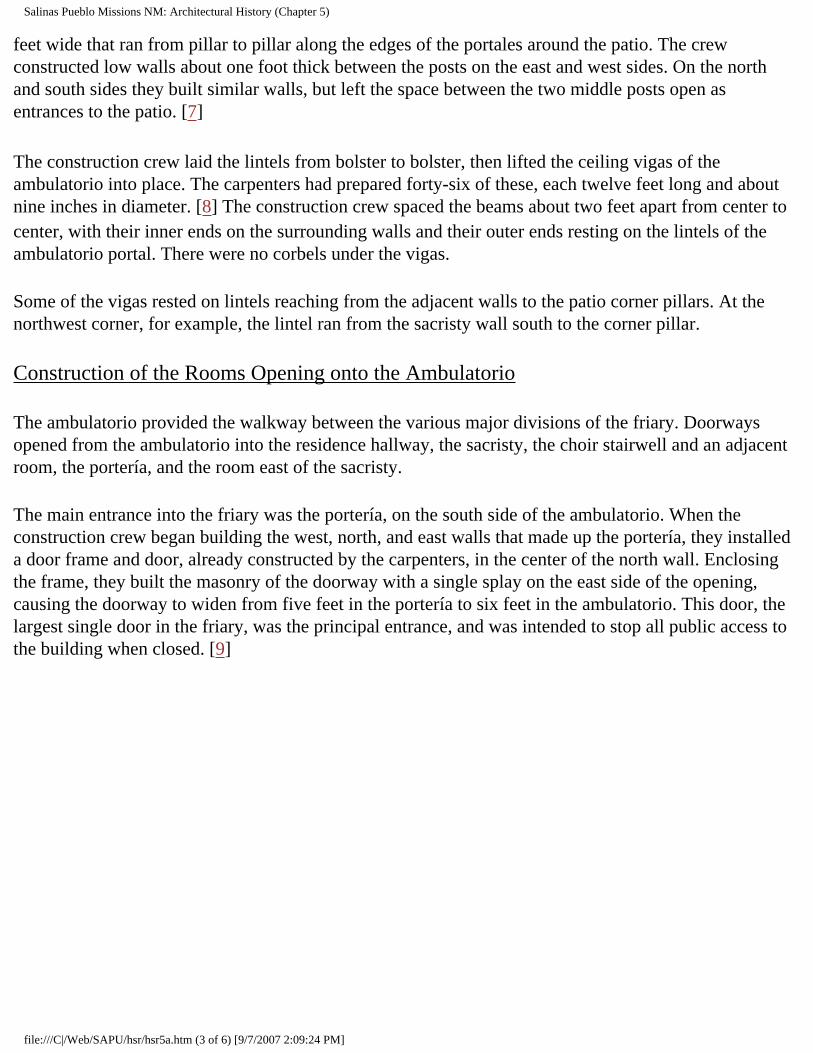
Salinas Pueblo Missions NM: Architectural History (Chapter 5)
feet wide that ran from pillar to pillar along the edges of the portales around the patio. The crew constructed low walls about one foot thick between the posts on the east and west sides. On the north and south sides they built similar walls, but left the space between the two middle posts open as entrances to the patio. [7]
The construction crew laid the lintels from bolster to bolster, then lifted the ceiling vigas of the ambulatorio into place. The carpenters had prepared forty-six of these, each twelve feet long and about nine inches in diameter. [8] The construction crew spaced the beams about two feet apart from center to center, with their inner ends on the surrounding walls and their outer ends resting on the lintels of the ambulatorio portal. There were no corbels under the vigas.
Some of the vigas rested on lintels reaching from the adjacent walls to the patio corner pillars. At the northwest corner, for example, the lintel ran from the sacristy wall south to the corner pillar.
Construction of the Rooms Opening onto the Ambulatorio
The ambulatorio provided the walkway between the various major divisions of the friary. Doorways opened from the ambulatorio into the residence hallway, the sacristy, the choir stairwell and an adjacent room, the portería, and the room east of the sacristy.
The main entrance into the friary was the portería, on the south side of the ambulatorio. When the construction crew began building the west, north, and east walls that made up the portería, they installed a door frame and door, already constructed by the carpenters, in the center of the north wall. Enclosing the frame, they built the masonry of the doorway with a single splay on the east side of the opening, causing the doorway to widen from five feet in the portería to six feet in the ambulatorio. This door, the largest single door in the friary, was the principal entrance, and was intended to stop all public access to the building when closed. [9]
file:///C|/Web/SAPU/hsr/hsr5a.htm (3 of 6) [9/7/2007 2:09:24 PM]

Salinas Pueblo Missions NM: Architectural History (Chapter 5)
Figure 13. The mission of Nuestra Señora de Purísima Concepción de Quarai. This plan shows the original plan of the church and main convento as completed about 1632. The patio portal is supported on masonry piers at the corners and wooden pillars between. The portería portal is the same. The baptistry has not yet been built, and the west nave
window is still open. (click on map for an enlarged view in a new window)
When the portería walls reached a height of about 10 1/2 feet, the construction crew began work on its interior. First they laid squared sandstone flags to form the floor. Along the open front, or south side, they set four posts to form a portal, with two posts against the side walls and the other two in the middle, dividing the opening into three equal sections. Then they built benches along all four sides of the room. Each bench had a stone core or base with a seat and foot rest of wood. The crew built the stone base about twenty-four inches high and about eighteen inches wide. The carpenters cut beams about twelve by eighteen inches for the footrests and seats. At the front, of the portería the bench was built against the base of the posts. These benches extended from the walls on each side to the middle posts, leaving an entranceway through the space between them. [10]
The front posts supported the lintels of the front portal on bolsters. The lintels held up the roof vigas, running north and south over the room at a height of 10 1/2 feet. The vigas supported the usual layers of latillas, matting, adobe and a plaster sealing layer.
file:///C|/Web/SAPU/hsr/hsr5a.htm (4 of 6) [9/7/2007 2:09:24 PM]

Salinas Pueblo Missions NM: Architectural History (Chapter 5)
On the west side of the ambulatorio the construction crew built a small room about 18 1/2 by eight feet. It had a small window-like opening measuring 2 1/3 feet wide by 2 3/4 feet high, facing south into the choir loft stairwell. A doorway opened east into the ambulatorio. This room had a roof 10 1/2 feet and a flagstone floor two feet above the floor level of the ambulatorio. The window-like opening had eight 2-inch beams forming its lintel and a round beam five inches in diameter making the sill. Its plan and location imply that the room was used as a storeroom for the sacristy and choir. [11]
Gutiérrez de la Chica designed the sacristy as a small chapel, 33 by 16 1/2 feet. The room had a flagstone floor, like the church, and a small altar at the north end. The roof was supported by vigas resting on corbels with a height of 13 1/2 feet to the underside of the vigas. [12] A window looking north probably opened over the altar, supplying natural light to the room. A large door opened into the east transept of the church, and a smaller door led into the ambulatorio. A doorway in the northwest corner provided access to a small room with a sand floor, probably used for storing the Host and the more valuable silver vessels and objects used in the Mass. The sacristan kept the vestments neatly stored in a large wooden closet or chest set into the east wall of the sacristy at the south corner. A similar closet in the sacristy of Nuestra Señora de Guadalupe, constructed near present El Paso in 1662 to 1668, had "a handsome chest of drawers of fourteen divisions, as elaborate as if it had been made in Mexico City." [13]
Construction of the Residence Hall and its Rooms
The rooms on the east side of the ambulatorio, reached by the residence hallway, had roofs about 13 1/2 feet high to the underside of the roof beams. Most of the rooms along this hallway had splayed doorways. [14]
The room on the north side of the ambulatorio, east of the sacristy, was probably the refectory. [15] The refectory had two doors, one opening into the residence hallway and one into the ambulatorio. [16] A third opening, about 20 inches wide, was used to pass prepared foods to the refectory from the kitchen on its north side. This may have been built as a window-like opening originally, and later altered to its present doorway size. A doorway from the ambulatorio into this room in addition to one from the residence hallway implies that access to it was needed by both friars and lay persons. The most likely rooms needing such access were the kitchen and the refectory. Because of its location, this room is more likely to have been the refectory. A second, smaller opening through its north wall may have been original, and would then have been the serving pass-through from the kitchen--the large room on the north. [17]
The kitchen, north of the refectory, had a doorway with a double splay. On the room side of the wall this doorway was five feet wide, (as were all the single-splay doorways), but on the outside, in the hall, it was only 3 1/2 feet wide. The storeroom on the west side of the south end of the residence hall had a single-splay doorway that was five feet wide on the interior and 4 1/2 feet wide on the hall side. The
file:///C|/Web/SAPU/hsr/hsr5a.htm (5 of 6) [9/7/2007 2:09:24 PM]

Salinas Pueblo Missions NM: Architectural History (Chapter 5)
doorway of the storeroom on the east side of the far north end of the hallway had no splay; its straight sides were three feet apart. The doorway from the ambulatorio into the hall was also straight-sided and a full four feet wide. [18]
The cells and two associated rooms formed a row along the east side of the residence hallway. All the rooms measured 13 1/2 feet east to west. The southernmost cell was the largest with a total width of 24 1/2 feet including its alcove. The next cell north was 22 1/2 feet wide with its alcove, and the third cell and alcove were 19 1/2 feet wide. Each alcove was seven feet across, north to south. The doorway from each cell to its alcove was three feet wide, and had no splay.
Between the second and third cells, Gutiérrez placed a small, almost square room 13 1/2 feet wide and 14 1/2 feet long, and the short exit hall, 4 1/2 feet wide leading into the second courtyard. Although no trace of it remains, this hall must have had a door at its east end to close the friary on this side. North of the third cell was a small rectangular room, 13 1/2 feet by 8 1/2 feet. [19] The roofing for all these rooms consisted of round vigas without corbels supporting the usual latillas, matting, clay and plaster. The vigas ran east to west over the rooms, except over the short entrance hall from the second courtyard and the storeroom on the east side of the far north end of the residence hallway. Here short vigas ran north to south. [20]
Probable uses of the rooms other than the celdas can only be suggested, but are limited by their sizes. The room at the far north end of the row could hardly be used for anything other than a small storeroom, and was probably used as the despensa or pantry for the kitchen just down the hall. The room south of the short hall to the second courtyard door may have been an office space or the infirmary. The room at the far south end of the hall on the west side was larger and was probably the main oficina or storeroom.
Continued >>>
sapu/hsr/hsr5a.htm Last Updated: 03-Sep-2001
file:///C|/Web/SAPU/hsr/hsr5a.htm (6 of 6) [9/7/2007 2:09:24 PM]

Salinas Pueblo Missions NM: Architectural History (Chapter 6)
SALINAS
"In the Midst of a Loneliness": The Architectural History of the Salinas Missions
CHAPTER 6: LAS HUMANAS: SAN ISIDRO AND SAN BUENAVENTURA
THE MOUND 7 CONVENTO AND SAN ISIDRO (continued)
The Construction of the Church of San Isidro
Letrado probably began work on the church immediately. The first step in the construction of the church was the selection and preparation of a building site. The obvious choice for the permanent church was the large clear area at the west end of the mesa, west of mound 7, but for some reason he was unable to acquire this area. Instead, the pueblo gave him permission to use the space on the hillside south of the convento below kiva D, which continued in use through most of the seventeenth century.
Letrado decided to build a church much like the first church at Abó. He increased the length by 25 1/2 feet to 108 feet, but left all the other dimensions about the same. Letrado located the sacristy inside the church near the altar, and the baptistry inside the front of the church under the choir loft. This was probably typical of the earliest plan of any new church. [17]
The slope of the hill created a major problem. Letrado and his construction crew had to cut a deep slot into the hill about eighty feet long and thirty-three feet wide in order to create a level platform on which they could build the new church. At the west end, this slot was eight to ten feet deep. Along the north and northwest sides, the crew had to cut into bedrock. Fortunately, this was composed of poor-quality limestone and a coarse sandstone, both rather soft, making the labor relatively easy. Before work began on the cut in the hillside, the masons excavated a footing trench into the refuse from the pueblo that covered the slope. Into this they built a retaining wall about five feet thick and five feet high along the line of the east end of the church, and a shallower foundation about two feet thick and one foot high along the eastern half of what would be the south wall. When work on the cut into the hillside began, most of the refuse and stone removed by the crew went into the space inside the retaining walls, raising the top of the fill until the surface was approximately level with the bottom of the slot cut into the hillside. When completed, the platform sloped slightly downward toward the east, dropping about three
file:///C|/Web/SAPU/hsr/hsr6a.htm (1 of 3) [9/7/2007 2:09:25 PM]

Salinas Pueblo Missions NM: Architectural History (Chapter 6)
feet over the 108-foot length of the church. Eventually the altars would be placed at the higher end. Cutting and filling for the creation of this platform probably took about a year. [18]
Construction work stopped during the winter months of 1630-31. In the spring of 1631, Letrado apparently continued on the church at Las Humanas and began construction on a visita church at Tabirá. Here he conducted the same negotiations for cooperation and a tract of land, with somewhat more success. He was soon able to begin construction on the church that would become San Diego de Tabirá. [19] Letrado worked out a plan and the pueblo provided workers to help him dig the foundation trenches for a church fifty-four feet long and twenty-six feet wide on the interior, with walls 2 1/2 feet thick. They began construction on the church probably in April or May of 1631, and soon the walls were two to five feet high. [20]
At Las Humanas, the platform for the interim church was ready in about May, 1631. The construction crews began work on the walls of the church and the campo santo at its east end. This was a cemetery area measuring about ninety feet by sixty feet, surrounded by a low wall. The construction crew did little to alter the natural surface of the ground inside the campo santo. By the end of September, 1631, the walls had reached a height of no more than thirteen feet. [21]
Letrado had succeeded in convincing some factions at Las Humanas to support his efforts there, making a work force available and allowing him to complete the temporary convento. However, by 1631 he apparently realized that the very limited resources of Las Humanas would not support a full mission operation at the pueblo. The critical resource was the water supply. The amount of water was limited, and the Indians lived in balance with the supply. The pueblo could not support large herds, additional large fields, or perhaps even a major new construction effort that would require large quantities of water for the plaster and adobe of the construction. [22] Letrado would not be able to put together the large, complex organization of buildings, fields, and herds needed to keep a Franciscan mission going. Faced with this inescapable conclusion, Letrado apparently recommended that Las Humanas be made a visita, and requested permission to move on to a more promising pueblo sometime in mid-1631. He was reassigned to Hawikuh, probably during the annual chapter meeting about August. If so, Letrado would have left Las Humanas in September, and arrived at Hawikuh in October of 1631. He was killed during a conflict there in February, 1632. Later testimony stated that the conflict arose because Letrado had called the Indians to mass on one of their festival days. [23]
San Lucas, however, probably stayed on at Las Humanas. In 1633 Fray Estévan de Perea, writing at Quarai, was probably speaking of him when he described the plight of "one poor religious who is in one of the most miserable and needy conversions describable . . . where there is not even water to drink, and whither food has to be taken to him from neighboring convents (one of which is this one)." [24]
Continued >>>
file:///C|/Web/SAPU/hsr/hsr6a.htm (2 of 3) [9/7/2007 2:09:25 PM]

Salinas Pueblo Missions NM: Architectural History (Chapter 6)
sapu/hsr/hsr6a.htm Last Updated: 03-Sep-2001
file:///C|/Web/SAPU/hsr/hsr6a.htm (3 of 3) [9/7/2007 2:09:25 PM]

Salinas Pueblo Missions NM: Architectural History (Chapter 7)
SALINAS
"In the Midst of a Loneliness": The Architectural History of the Salinas Missions
CHAPTER 7: DAILY LIFE IN THE SALINAS MISSIONS (continued)
MISSION TRADE (continued)
The Trip To New Mexico
As the Procurador-General purchased the supplies, they were stored in a warehouse in Mexico City. When the full stock had been collected, he would send orders for the mayordomos in charge of the wagons to bring them to the warehouse and load them.
Once loaded, the wagon train set out for Santa Fe, about sixteen hundred miles to the north. The trip took about six months, including a two or three week stopover at Zacatecas, four hundred miles from Mexico City. In 1631 this was the last town at the edge of the empty lands of the north, where the wagons would refit and resupply before setting out into the wilderness. At a distance of nine hundred miles from Mexico City the road passed through a small island of civilization in the form of the mining district of Santa Bárbara, established in 1567. By 1600 mining towns, ranch holdings, and farms extended for eighty miles up the valleys of the tributaries of the Río del Parral and the Río Florida, north of Santa Bárbara. The town of Parral was founded near Santa Bárbara in 1631 and quickly grew into a major new commercial center of the north. It became the principal point where merchants and Franciscans could sell goods from New Mexico. The Santa Bárbara area must have been considered an oasis in the unpopulated northlands. It provided a welcome rest stop before the next long, desolate leg of the journey. After Santa Bárbara, the road ran about 560 miles through flat arid country inhabited largely by nomadic Indians before it reached Senecú on the Rio Grande, about fifteen miles south of Socorro. There the caravan would stop and resupply again before continuing on to ecclesiastical headquarters at Santo Domingo, another 125 miles north. [3]
A supply train usually had thirty-two wagons. It was under the supervision of the Procurador-General, who made each round trip himself. The thirty-two wagons were divided into two cuadrillas or sections of sixteen wagons, each under the supervision of a mayordomo. The cuadrilla was divided into two
file:///C|/Web/SAPU/hsr/hsr7a.htm (1 of 3) [9/7/2007 2:09:26 PM]

Salinas Pueblo Missions NM: Architectural History (Chapter 7)
subsections of eight wagons, with the mayordomo probably driving the lead wagon of the leading subsection and the trailing subsection supervised by the driver of its lead wagon. Each wagon had a single chirrionero, or driver, assigned to it, so that there were thirty-two men under the direction of the Procurador-General. In addition, the mule train employed four Plains Indians to serve as scouts, drovers, and hunters, and sixteen Indian women as cooks and as needed, making a total wagon crew of fifty-two. Accompanying each wagon train was a military escort of unstated size. A second friar accompanied the Procurador-General as his companion and assistant on the road. Frequently other friars, merchants, and government personnel on their way to New Mexico would join the train.
A number of animals accompanied the train, some to pull the wagons and others to serve as food for the people making the journey. A team of eight mules hauled each wagon. A wagon had two teams and alternated between them, making sixteen mules per wagon. The entire caravan had an additional thirty-two mules to replace those that were lost or died on the trip, for a total of 544 mules on the usual train. As the meat supply for the trip, seventy-two head of cattle would be driven with the train. Additionally, each friar on his way to New Mexico for the first time received ten heifers, ten sheep, and forty-eight hens. The heifers and sheep were the beginning of the new friar's mission herds, while the chickens were to be eaten on the road as needed, with the survivors becoming part of the mission flock. In the dispatch of 1631, there were twenty new friars, meaning that the wagon train had two hundred heifers and two hundred sheep along with the seventy-two head of livestock that usually accompanied it. The usual train, therefore, had anywhere from about six hundred to about one thousand head of stock moving in company with the wagons.
Each wagon could carry a minimum of two tons of cargo. In the 1660s they were loaded far beyond that weight, probably hauling as much as three tons. The wagons were strong four-wheeled vehicles very similar in design to the wagons built a century later in the Conestoga Valley of Pennsylvania. This design derived from a general wainwright's tradition common to most of sixteenth century Europe. [4] They had iron-tired, spoked wheels and a canvas cover mounted on ribs above the wagon bed. Each wagon carried a supply of extra tires and axle parts. Other spare parts were carried by selected wagons in the cuadrillas. These included 16 axles, 150 spokes, harness parts, 144 prefabricated mule shoes, and tools enough to rebuild a wagon on the road.
The Procurador-General outfitted the wagons not only for utility, but with an eye toward appropriate ceremony. The lead wagon of each cuadrillas had four bells on a two bell-frame on each of the two lead mules. The entire team pulling the two lead wagons were outfitted with rebozos, blankets more decorative than the mantas worn as harness-blankets by the other teams. Finally, the four lead wagons of the four subsections of the cuadrillas each flew a banner with the royal coat of arms, notifying all who watched the train pass that this was a caravan of some importance.
These wagons averaged about ten miles per day along the unmaintained roads of northern Mexico. Compared with the twelve to fourteen miles per day that Conestoga freight wagons covered on the surfaced and maintained roads of the American Northeast in the early 1800s, this was an astonishing achievement. The amount of freight hauled was equally astonishing. Later versions of the Conestoga
file:///C|/Web/SAPU/hsr/hsr7a.htm (2 of 3) [9/7/2007 2:09:26 PM]

Salinas Pueblo Missions NM: Architectural History (Chapter 7)
used on the Santa Fe Trail from St. Louis to Santa Fe in the 1850s and 1860s were considered to be pushing their limits when they hauled three tons, while the freight wagons of the mission supply trains carried an average of over two tons. The usual train on the Santa Fe Trail in 1860 consisted of twenty-five wagons, carrying a total of about seventy to seventy-five tons. The mission supply train hauled over eighty tons.
From Senecú, the wagon train continued north to Santo Domingo, the ecclesiastical headquarters of the province during much of the seventeenth century. Missions along the route probably received their supplies as the train passed through. When the wagon train arrived at Santo Domingo, the Procurador divided the train into smaller caravans, each carrying the supplies for missions in other regions of the province. For example, one section headed west to Acoma, the Zuñi missions, and on to the Hopi establishments. A second went north to Santa Fe and the Rio Arriba missions. A third division headed east to the Galisteo missions and on south to the Salinas area. [5]
The caravan to Salinas might consist of from two to four wagons. The actual number depended on how many friars were stationed at the missions of Salinas at the time and what extra goods above the standard issue they had ordered. [6] Once they were unloaded, the wagons returned to Santo Domingo to await the return of all the other wagons and the assembly of the wagon train for the trip back to Mexico City that would begin within a few months. [7]
The returning wagons usually carried the products of manufacturing and collection carried out at each mission. [8] The missions carried on a strong trade with the Santa Bárbara-Parral area, orienting much of their daily and yearly activity to provide for this trade. Sometimes the governor of the province would press the wagons into service for shipping his own trade goods to the south. The legality of this comprised one of the main points of disagreement between civil and ecclesiastical authorities in New Mexico. [9]
Continued >>>
sapu/hsr/hsr7a.htm Last Updated: 03-Sep-2001
file:///C|/Web/SAPU/hsr/hsr7a.htm (3 of 3) [9/7/2007 2:09:26 PM]

Salinas Pueblo Missions NM: Architectural History (Chapter 8)
SALINAS
"In the Midst of a Loneliness": The Architectural History of the Salinas Missions
CHAPTER 8: THE SALINAS BASIN ABANDONED AND REOCCUPIED (continued)
The Last Days
Fray Alonso Gil de Avila was forced to abandon the pueblo and church of Abó in about 1673 after the Indians burned the convento. [15] Gil de Avila was transferred to Senecú, where he was killed in the convento by Indian arrows during an uprising in January, 1675. [16] Senecú survived only another year and a half and finally fell between March, 1676, and November, 1677. [17]
Between late 1676 and early 1677, Chililí and Quarai were given up, the Christian populations of both moving to Tajique. [18] The Indians of Quarai insisted on taking the body of one of their favorite missionaries (presumed in the 1750s to have been Fray Gerónimo de la Llana) with them on the move. The Franciscans reinterred the body at an unspecified location in the church of San Miguel de Tajique. [19]
The government of New Mexico made a desperate plea to the viceroy for aid in 1676. Reinforcements and weapons arrived in late November or early December 1677, but too late for Tajique. It was abandoned shortly before the arrival of the supply train. [20]
Fray Francisco de Ayeta, the procurador for the supply train from 1674 to 1680, made a heroic attempt to save the province. He made three round trips between Santa Fe and Mexico City in the period from late 1675 to mid-1680. During this time he carried mission supplies in the standard dispatch of 1675, arriving in Santa Fe in December, 1675. Upon arrival in New Mexico, he quickly realized that the situation was very precarious and he was determined to take action. He left Santa Fe in March, 1676, with the petitions for help from the government of New Mexico, and returned to Mexico City, arriving in late August or early September. He petitioned the viceroy to supply the province with soldiers, equipment, and food; the Franciscan order would cover the costs of food and transportation for fifty men and one thousand horses. The viceroy approved the plan. Ayeta helped gather the men and equipment
file:///C|/Web/SAPU/hsr/hsr8a.htm (1 of 4) [9/7/2007 2:09:27 PM]
Salinas Pueblo Missions NM: Architectural History (Chapter 8)
and left Mexico City with the special supply and reinforcement train on February 27, 1677. Because of delays by bad weather, the train did not arrive in Santa Fe until late November. [21]
In December, Governor don Antonio de Otermín established a garrison of ten soldiers at Galisteo to aid in the reoccupation of the Salinas pueblos. Ayeta supplied the soldiers and Salinas refugees there with grain and meat. From this staging point Tajique was reoccupied in January or February 1678, but the attempt to recover Quarai was unsuccessful, probably because too few soldiers were available. [22] Tajique was resettled with more than two hundred families of Christian Indians and a small garrison. It was held until at least mid-1679, and perhaps until the Pueblo Revolt in August, 1680. [23]
Ayeta distributed men and supplies through the province until March, 1678. During this time he realized that the aid he had brought was not enough and that the situation was worse than anyone had thought. He left again on March 28, 1678, and arrived in Mexico City in September. On May 10, 1679, after receiving word from New Mexico that the Apache were again on the move, he petitioned for a second dispatch of fifty armed men and for the establishment of a presidio in Santa Fe. The petition was denied by the viceroy. This decision, which probably was directly responsible for the loss of New Mexico, was actually made by don Martín de Solís Miranda, Fiscal for the Viceroy. He recommended that the petition for reinforcements and military aide be refused on the grounds that "since such a short time has intervened [since the dispatch of military aid in 1677], it might be feared that [the King] would consider it to be a useless and unnecessary expense." Instead, don Solís Miranda recommended that the petition be forwarded to the king. The Viceroy accepted don Martín's decision not to make a decision, and the papers were sent on the next ship to Spain, where it arrived in January, 1680. On June 25, 1680, the King issued orders to do whatever was necessary to give aid to New Mexico. [24]
Meanwhile, Ayeta assembled his next regular mission dispatch and set out again for New Mexico in mid-1680. He arrived at the Rio Grande near present El Paso in early August, where he met the first refugees from the province. He immediately made the entire shipment of mission supplies available to the governor and did all he could to aid in the establishment of a refugee center in the area. [25]
So the province of New Mexico was lost, to famine, Apache raids, dissatisfaction, greed, and uncertainty. The demonstration that he had been right and the viceroy wrong was only bitter consolation to Fray Francisco de Ayeta.
Abandonment
Fray Diego de Parraga locked the doors of the church of Concepción de Quarai for the last time in mid-1677, and climbed on the wagon carrying the bell, the sacred vessels and vestments from the sacristy, and his personal belongings. [26] He joined the column of two hundred refugee families moving out of Quarai on the road to Tajique, eleven miles to the north. As the last stragglers disappeared around the hill, the days of Quarai as a living community came to an end. It was the last of the southern Salinas pueblos to be given up; it joined Abó, abandoned by Gil de Avila four years before, and Las Humanas,
file:///C|/Web/SAPU/hsr/hsr8a.htm (2 of 4) [9/7/2007 2:09:27 PM]

Salinas Pueblo Missions NM: Architectural History (Chapter 8)
abandoned by Joseph de Paredes in 1671, in the slow process of decay that would eventually reduce it to mounds of scrub-covered rubble.
The churches and conventos, more substantially built, would resist the forces of time longer--except when those forces were aided by men. The convento of San Gregorio de Abó, burned by the Apache in 1673, was already well on its way to the ground, but the church would stand relatively unchanged for more than a century, until the Apache struck once again about 1830 and burned it, too. [27]
Concepción de Quarai was left whole, and time worked on it only very slowly. The roofs of some convento rooms rotted and fell in during the next century, but by 1800 most of the roofing remained on the church and much of the convento. The church of Concepción de Quarai, like San Gregorio de Abó, was burned out by Apache about 1830, after surviving earlier Apache raids and a century and a half of abandonment. [28]
At Las Humanas, San Isidro and the old convento rooms in mound 7, burned out in the Apache raid of September, 1670, probably collapsed. The new convento of San Buenaventura aged much more slowly, while the unfinished church changed little until beam robbers began pulling out its woodwork in the 1870s.
During the eighteenth century, Abó and Quarai were visited occasionally. Most of these visits were unrecorded, but others were official business. [29] During the period from 1751 to 1754, and probably from 1762 to 1767, Governor Thomas Vélez Cachupín stationed frontier patrols of cavalry from the Presidio of Santa Fe in the Salinas area. They formed an early warning network keeping watch on the southeastern approaches into the Rio Grande Valley and the main settlements of Pueblo and Spanish New Mexico. [30]
The patrol was of unstated size, but Governor Vélez implies that it was not small: "The troops which occupy this area are posted in the spot of Coara [Quarai], or Tafique [Tajique], and make the entry of the Apache impossible." [31] Unfortunately, his phrasing indicates that Governor Vélez was uncertain of the name of the old mission where the troops were stationed, and so gave both possible names. Because of this confusion, the actual location of the main post of the patrol is not known. [32]
Between Vélez's two terms as governor from 1754 to 1760, Don Francisco Antonio Marín del Valle served as governor. In 1759, Governor Marín decided, for reasons not entirely clear, to attempt the retrieval of the bodies of Fray Gerónimo de la Llana from the Salinas missions and Fray Acencio de Zarate from Pícuris. [33] By the time the expedition arrived at Quarai, on March 30, 1759, it consisted of the governor, two squadrons of soldiers, three officers, four Franciscans, fifty-five Indians, twenty citizens, and "all the equipment necessary for excavating."
They found the sanctuary partly filled with rubble and roofing debris. Apparently the double viga at the mouth of the apse, supporting the central vigas over the transept, had rotted and fallen. This would have
file:///C|/Web/SAPU/hsr/hsr8a.htm (3 of 4) [9/7/2007 2:09:27 PM]

Salinas Pueblo Missions NM: Architectural History (Chapter 8)
brought down part of the main apse roof and nine transept beams in the central area of the transept roof. The beams, stonework, latillas, matting, and adobe covering layer would have fallen into the sanctuary, partly burying the main altar and altar steps beneath a tangle of whole and broken woodwork, stone rubble, and dirt. The upper apse roof apparently survived the collapse, so that only a rectangular area in the center of the transept was open to the weather. [34]
The governor used the testimony of Fray Nicolás de Freitas as a guide for the attempt to relocate the bodies. Freitas stated in 1706 that he had placed Fray Gerónimo's body in a coffin of pine "en la mesa del altar mayor (in the table or platform of the main altar)" of Concepción de Quarai. [35] The Franciscans and the governor had the rubble removed from the sanctuary until the main altar was cleared. They opened the altar table but found no body.
Thinking that Freitas may have meant the altar platform rather than the altar table itself, they demolished the altar and excavated a hole fourteen feet deep into the sanctuary platform beneath it. The excavation destroyed most of the sanctuary platform and the altar steps. Still no body was found.
At this point, several people in the expedition came forward with information that could explain why Fray Gerónimo's body was not in the altar. According to several Hispanics, the next mission north was actually Quarai, and this mission was Tajique. According to several Indians, the people of Quarai removed a friar's body, possibly that of de la Llana, when they abandoned Quarai and fled to Tajique. These people considered Tajique to be the next mission to the north. [36] The expedition moved north to examine the ruins of Tajique.
Again, quiet settled over the abandoned pueblo. The rubble of the main altar and the dirt from the pit beneath it slowly washed back into the hole over the years. Finally, in the first years of the nineteenth century, settlers began moving back into the Salinas area and the pueblo of Quarai.
Continued >>>
sapu/hsr/hsr8a.htm Last Updated: 03-Sep-2001
file:///C|/Web/SAPU/hsr/hsr8a.htm (4 of 4) [9/7/2007 2:09:27 PM]

Salinas Pueblo Missions NM: Architectural History (Chapter 9)
SALINAS
"In the Midst of a Loneliness": The Architectural History of the Salinas Missions
CHAPTER 9: THE RETURN TO THE SALINAS MISSIONS (continued)
ABO: HOUSES AND SHEEP RANCHING (continued)
Photographs of the Ruins
By 1882 Juan José was dead, and his son Ramon was the head of the Sisneros family. His house stood on the east side of the compound near the northeast corner. At the same time, Marcos Luna lived in a house built on the east edge of the convento ruins. Adolph Bandelier stayed in Ramon's house when he visited Abó during Christmas of 1882 and drew a plan of the entire pueblo, mission compound, and most of the settlement. [12]
Bandelier succeeded in taking only one photograph of the ruins of San Gregorio. The picture is almost useless, because the intense cold affected the chemicals of the plate and prevented a clear image. Only vague details can be made out in the print. Enough can be seen, however, to identify the southeast buttress of the church facade still standing to the height of the walls of the nave. There is no clear indication of a tower extending above the wall line, adding support to the appearance of the church as recorded by James Abert in 1846. [13]
Charles Lummis visited the ruins in 1890 and took four photographs. He had better luck with the weather, and two of the four pictures are sharp, clear records of structural details. The other two are slightly out of focus but still of great importance. These pictures preserve evidence of the interior structure of the church that could never have been deduced from the plan of the building, and permit the detailed reconstruction of the roof, balconies, and catwalk described in this report. [14]
file:///C|/Web/SAPU/hsr/hsr9a.htm (1 of 9) [9/7/2007 2:09:28 PM]

Salinas Pueblo Missions NM: Architectural History (Chapter 9)
Figure 24. Abó as painted by Abert in 1846. The painting documents a number of critical details about the church and its surroundings. No traces of the front porch are
visible, and the lintels of the front entrance and choir loft window are both gone, probably destroyed in the fire that gutted the building in perhaps 1830. The deep notch on the east (right) side marks the location of the window at the mid-point of the nave,
while the choir loft doorway does not seem to be visible at all. The second-story doorway that once opened from the roof of the sacristy into the east side-chapel has
fallen out above the location of the lintel, but the collapse has not penetrated all the way up to the parapet. On the west (left) side of the nave, the high point marks the location
of the buttress outside the wall, while the drop-off to its left probably indicates the location of the notch where the masonry has fallen above the sacristy doorway. Beam sockets can be identified on the north wall of the church. In the original watercolor,
differences in shading indicate that Abert could see five sockets in the north wall of the sanctuary, and the first two sockets of the beams over the apse. These two sets of
sockets are at about the same height, indicating that the ceiling of the apse was almost as high as the ceiling of the sanctuary. To the right of the church, the walls of the
sacristy still stand to about their full height. The ruined wall in the foreground and a poorly-defined wall extending across the background to the right of the sacristy, below the trees, all appear to be ruins of the ca. 1810 to ca. 1830 reoccupation of the area. The interior of the church still clearly shows extensive traces of the white plaster that once
covered it.
file:///C|/Web/SAPU/hsr/hsr9a.htm (2 of 9) [9/7/2007 2:09:28 PM]

Salinas Pueblo Missions NM: Architectural History (Chapter 9)
Figure 25. Abó in 1882 as photographed by Bandelier. This picture was taken from almost the same angle as Abert painted his watercolor 36 years before. Since Abert's watercolor, large sections of the walls of the church have fallen. The southwest tower
and the south end of the west wall of the nave have fallen, as well as the east wall of the nave from the southeast tower to the east side chapel. The southeast tower itself still stands. At the north end of the church, the entire apse wall of the building has fallen.
The crenelations along the tops of the walls can easily be seen. Biblioteca Apostólica Vaticana, Archivo Fotographico, # 482-47, courtesy Charles
Lang.
In 1892, Ramon applied to the United States government for title to the quarter-section in which the ruins of Abó were located. After demonstrating the validity of his claim to the land, he was granted title. [15]
Ramon died about 1900, and his brother (or son) Joaquin became the head of family. [16] Joaquin contracted an agreement to sell water to the Eastern Railway of New Mexico at the Scholle watering point about 1909. [17] In the period from 1880 to about 1910 branches of the Sisneros family, and perhaps some other settlers, built a number of new houses among the ruins of the pueblo. These houses were largely empty and falling to ruin by 1920. [18]
In 1912, the Sisneros family lost title to the portion of the quarter-section containing Abó and in 1915, Ubaldo Sanchez and his wife Beatriz acquired title by tax redemption. They sold the quarter-section to
file:///C|/Web/SAPU/hsr/hsr9a.htm (3 of 9) [9/7/2007 2:09:28 PM]

Salinas Pueblo Missions NM: Architectural History (Chapter 9)
Joe J. Brazil in 1919. Brazil then sold a half interest in the land back to Joaquin Sisneros. The remaining half-interest was sold to Abundio Peralta. [19]
Joaquin died in 1926, and the family divided his estate in 1928. In 1934, Federico Sisneros bought all the family-owned interest in the site of the pueblo and church from the remaining heirs, and all interest in the tract along the north side of the church and convento. [20]
During the years from 1900 to 1930 photographers recorded the collapse of the walls of the church of San Gregorio. These photographs show that the side walls of the sanctuary and north walls of the side chapels fell by about 1900. The west side chapel wall collapsed before 1910, while the east side chapel wall split down the center of the east balcony doorway. The multiple buttresses of the bell tower kept the south wall of the west side chapel standing (until the top five feet of it were intentionally removed in 1972), but the top of the south wall of the east side chapel fell in about 1910, leaving only a small section of the east wall of the side chapel, along the south side of the balcony doorway, still standing. [21]
file:///C|/Web/SAPU/hsr/hsr9a.htm (4 of 9) [9/7/2007 2:09:28 PM]

Salinas Pueblo Missions NM: Architectural History (Chapter 9)
Figure 26. Abó as seen by Charles Lummis in 1890. This picture was made from almost the same angle as the Bandelier photograph 8 years earlier. In the interval the southeast tower had finally collapsed, but few other changes can be seen. In the foreground, walls
and structures constructed during the second reoccupation after 1860 are visible. Bandelier's photograph was taken somewhat closer to the church, so that these walls and
structures were behind him, out of the picture. Courtesy Southwest Museum, # 24832.
file:///C|/Web/SAPU/hsr/hsr9a.htm (5 of 9) [9/7/2007 2:09:28 PM]

Salinas Pueblo Missions NM: Architectural History (Chapter 9)
Figure 27. A second view of Abó in 1890. This picture is looking towards the southwest, and the north or sanctuary end of the church is in the foreground. In both this and the previous picture, the crenelations at the top of the building can be seen clearly.
These two Lummis photographs are critical to the analysis of the structure of Abó, because only they record several items of important information. The wall at the right in
this picture is the west wall of the sanctuary (or transept in the case of Abó, with its peculiar arrangement of space. At the top of the wall, below the crenelations, can be seen two horizontal bands in the stonework. The upper of these is the scar left by the roofing above the roof vigas themselves, which in this area ran lenghtwise down the church, or parallel with this wall. The lower horizontal band marks the sockets of the bond beams creating the box-like structure around the wall tops of the high walls of
Abó. The bare wall between the two bands was covered by the westernmost of the roof vigas in this area. The vertical, irregular scar down the face of the wall was produced by
a failed roof canal. Instead of draining roof water through the wall, the canal became blocked, the water pooled, the roof seal failed, and water began running down the inner face of the wall, cutting this channel. This indicates that the roof sloped down towards this wall. In this and the previous photograph, three sockets can be seen in the irregular scarring left by the leak. They line up with three sockets a few feet to the south at the
corner of the side chapel. The six sockets together are the last traces of the central support for the high roof of the church as well as the catwalk from balcony to balcony. The sockets for the floor of the west balcony are visible below and to the left. On the
left, or east, side of the church, the second window into the sanctuary can be seen above the remnants of the sacristy doorway. To the left of the sanctuary window is the large
file:///C|/Web/SAPU/hsr/hsr9a.htm (6 of 9) [9/7/2007 2:09:28 PM]

Salinas Pueblo Missions NM: Architectural History (Chapter 9)
doorway that once opened from the sacristy roof onto the east balcony inside the church. The beam sockets and bond beam sockets for the sacristy roof are visible below
this door and the sanctuary window. Courtesy Southwest Museum, # 24831.
Figure 28. Abó from the northwest in 1916, by Jesse L. Nusbaum. The walls of the sanctuary and side chapels have fallen, except for the buttressed area of the bell tower, and the tower buttress on the east side. The southernmost bottom corner of the balcony doorway is visible just to the right of the figure sitting on the sill of the doorway on the wall. Below the doorway can be seen the irregular traces of the sockets for the eastern balcony. On the shadowed north face of the east tower buttress, the dark patches of the
socket for the viga that supported the balcony can be seen, with the sockets of the balcony railing above it. The large depression in the wall above the railing sockets is the
socket for the east end of the lower clerestory vigas and corbels; the hole through the wall at this point marks the end of the vigas themselves where they penetrated to within inches of the outer surface of the wall. Several feet above this is the smaller indentation
of the upper clerestory viga socket, and in the irregular wall surface above this and below the crenelations are the sockets of the vigas and corbels for the high roof above the clerestory. A similar series of sockets can be seen in the bell tower section of the
west wall, closer to the camera.
file:///C|/Web/SAPU/hsr/hsr9a.htm (7 of 9) [9/7/2007 2:09:28 PM]

Salinas Pueblo Missions NM: Architectural History (Chapter 9)
Courtesy Museum of New Mexico, # 12876.
Figure 29. Abó in about 1916. This is a closeup of the southeast corner of the east side chapel and the east face of the west wall of the nave, taken by an unknown
photographer. Fine details such as the second level of inset of the crenelations and the imprints of both bond beams on the west wall can be seen. The scar of the east wall of the nave is visible on the east buttress tower, and the corbel sockets, viga sockets, and the scar of the small section of wall that had been at the edge of the doorway from the
sacristy to the corridor can all be seen in this view. To the left of the rectangular sockets of the sacristy roof, the smaller round sockets of two corridor roof-beams are visible,
and next to them on the south face of the tower, the irregular horizontal shadow line in the stonework marks the upper surface of the roof of room 18.
Courtesy Museum of New Mexico, # 58308.
By the time preservationists began to actively consider the possibility of excavating and stabilizing the church, most of it had fallen. Only an impressive section of the west nave wall and the bell tower stood to the height of the original wall top. This small piece of the original building, however, was enough to indicate the size and impressiveness of the whole.
file:///C|/Web/SAPU/hsr/hsr9a.htm (8 of 9) [9/7/2007 2:09:28 PM]

Salinas Pueblo Missions NM: Architectural History (Chapter 9)
Continued >>>
sapu/hsr/hsr9a.htm Last Updated: 03-Sep-2001
file:///C|/Web/SAPU/hsr/hsr9a.htm (9 of 9) [9/7/2007 2:09:28 PM]

Salinas Pueblo Missions NM: Architectural History (Chapter 10)
SALINAS
"In the Midst of a Loneliness": The Architectural History of the Salinas Missions
CHAPTER 10: ARCHEOLOGY AT THE SALINAS MISSIONS (continued)
EXCAVATIONS AT ABO (continued)
The Second Season: February-October, 1939
Toulouse returned to Abó on February 15 for the 1939 season, which was funded as a Works Projects Administration undertaking. Detailed records for this year are not available, but general details can be determined from Toulouse's final report and the excavation record and artifact record sheets prepared during the season.
Excavation continued where it had been left off in December. Within the church, clearing of the rubble filling the nave and sanctuary progressed, and the search for the north wall finally succeeded in late May. [5] Stabilization concentrated on the east wall of the nave for the first few months.
During the clearing of the nave and sanctuary, Toulouse stopped excavating when he reached what he considered the floor of the church. Only when he saw recognizable architectural or cultural features in the floor did he go deeper. The stone bases of the pillars supporting the choir loft were defined by cutting into the floor of the church, and several child burials in a single grave pit were investigated in the same way. [6] Toulouse's failure to recognize the foundations of the north wall of the first church across the sanctuary, or to see other burials that more recent archeology suggests are plentiful, confirms that he was careful about following floors.
He followed the same methods in the convento. Again, only when he thought he recognized deeper features did he cut through the final floors of the building. The kiva in the west courtyard and some walls of the earlier patio were traced by deeper excavation, as was the lower floor of room 15, but Toulouse did not see the many other wall foundations only inches below the floors of the rooms and corridors. [7]
file:///C|/Web/SAPU/hsr/hsr10a.htm (1 of 4) [9/7/2007 2:09:29 PM]

Salinas Pueblo Missions NM: Architectural History (Chapter 10)
Most of the convento rooms were located by trenching and given identifying numbers by the end of February. In the convento, the excavation crew began emptying the rooms along the south corridor and digging a rectangular network of exploratory trenches across the rest of the building. The short hall connecting the east corridor to the east courtyard and the room just north of it were the first rooms to be defined outside of the row of rooms and corridor along the south side of the convento.
Excavators working on clearing the sanctuary and the altars found the doorway to the sacristy. The general plan of the convento quickly became apparent after that. The sacristy and the three rooms east of it were defined, then the kitchen south of room 10, and so on.
After their outlines were determined, each room was cleared of rubble down to the floor level. Room 15 had been cleared down to its upper floor level by February 22. [8] Most of the sacristy (room 12) and the adjacent room 17 had been emptied to floor level by February 28, although some areas of the room were still being emptied in mid-June. [9] The clearing of the storage room (room 11) was nearing completion by March 3, and room 18, the sacristy storeroom, by March 21. Rooms 16 and 22 were still being cleared in late April, while work in room 20 continued to mid-May. The excavators finished most of room 14 in late May and emptied the privy itself (Toulouse's "turkey pen") during the first week of June. The East Court was emptied from March through June. As the excavation crews completed the emptying of each room, stabilization crews began work on repairing and rebuilding the walls.
The greater part of the burned wood came from a limited area. Most of the material was found in the church, sacristy, baptistry, portería, and on the South Terrace. Within the church and sacristy, the sections of burned beam were mixed into clean fill on the floors ranging from six to twelve inches deep. Toulouse considered the fill to have been blown in, but some of it could easily have been the earth from the roof itself, dumped in as the roofing collapsed. Blown fill would then have covered this irregular layer. On the South Terrace, beams were found in the "blown fill" at depths ranging from directly on the flagstone of the terrace to as much as two feet above it. In the remainder of the convento, significant amounts of charred wood were found only in the sacristy storeroom (room 18) and the kitchen storeroom (room 11). A layer of charcoal was found above the lower floor level in room 15. The rest of the convento apparently had very few charred beams. Whenever the fill of a room was mentioned, it usually consisted of a foot or so of blown fill covered by one to several feet of fallen wall debris.
While cleaning out room 17 in late February, Toulouse encountered fragments of intricately carved and painted wood and carved gypsum fragments with mica decorations. These may have been the remains of one of the altar retablos from the church. [10]
During the excavations within the west courtyard, or patio, Toulouse located the kiva and indications of an earlier version of the convento. The excavation crew cut two trenches across the patio, one north to south and the other east to west. These trenches located the sides of the final patio, and its ground surface. Toulouse's profile drawing of the kiva and photographs taken during the work indicate that the kiva was first seen as a depression in the patio surface. According to the excavation records, this was in about mid-March. When the reason for the depression was sought by further trenching, the excavators
file:///C|/Web/SAPU/hsr/hsr10a.htm (2 of 4) [9/7/2007 2:09:29 PM]

Salinas Pueblo Missions NM: Architectural History (Chapter 10)
found the kiva and the east and south walls associated with earlier versions of the patio.
The trenches were continued down into the kiva, leaving sections of the fill at the sides of the structure. By March 22, the trenches had been excavated four feet deep. By March 30, the excavations had reached a depth of six feet and had found the top of the layer of refuse shown in Toulouse's profile drawing.
In the first week of April, Toulouse began to see the structures on the floor of the kiva. The first detail seen was the top of the deflector of the fireplace. By April 24, the crew was excavating the firepit, and the emptying of the ventilator shaft took place in the last few days of April.
During May, Toulouse removed the remaining sections of fill in a more careful manner, attempting to detect any stratigraphic structuring. Apparently two blocks of fill were left. The top several feet of one were removed in the first two weeks of May. In the second half of May the rest of one block and all of the other block were removed at the same time. The final cleaning and stabilization of the structure was carried out throughout June.
Meanwhile, the clearing of the rest of the patio continued. The excavation crew began in the southwest corner during the last week of March, and were digging out the west side by mid-May. At the end of May, they were clearing the southwest corner.
Although in Toulouse's final report he implied that the walls of the earlier patio formed a somewhat raised walkway along the east and south sides of the later patio, the photographs taken during excavation indicate that the later patio floor was at the level of the tops of the earlier foundations. In its final form, the patio was a flat space level with the floor of the surrounding corridor, with no visible trace of the earlier foundations. The kiva apparently continued as a circular structure in the center of the patio about six feet deep.
Most of the majolica found by Toulouse came from the kiva in the west court and from around "annex 2," interpreted here as an entranceway or porch into the guardian's quarters. [11] Additionally, virtually all the Chinese porcelain came from the kiva. This is curious, because the refuse in the kiva was dumped in a single episode, with fragments of the same vessels mixed throughout the material. It is likely that the refuse was not from "the nearby kitchen," as Toulouse says, but was brought from a midden and dumped into the kiva as part of its backfilling, after the structure had been unroofed for a period of time long enough to build up an irregular layer of blown sand to three feet deep. The refuse would have built up somewhere around the convento between the construction of the building beginning in 1622 and the filling of the kiva in about 1650 as part of the first renovation of the west courtyard. The material from the kiva must therefore date from between 1622 and about 1650. [12]
At the same time that the convento rooms were being excavated, Toulouse began clearing around the outside of the church and convento to the colonial ground level and investigating the structures around the church complex. In early April the crews were working outside the west transept and they probably traced the out lines of the Spanish buildings west of the church in April and May. Toulouse determined
file:///C|/Web/SAPU/hsr/hsr10a.htm (3 of 4) [9/7/2007 2:09:29 PM]

Salinas Pueblo Missions NM: Architectural History (Chapter 10)
that the plaza areas to the west of the church had been used on occasion as corrals, based on the layers of animal dung found both here and in the east courtyard of the convento. [13]
The crews began clearing the area just north of the church in early June, and continued on across the walled enclosure to the north. [14] Room 29 at the northwest corner of the walled area was excavated in late June. Toulouse called this area the "mission gardens." [15] During this period he must have also excavated the ruins of an L-shaped building near room 29 within the "garden."
Beginning in late June, the crews cleared along the south and east sides of the convento. The ruins of Marcos Luna's house, converted to a toolshed by Toulouse in 1938, were probably removed about June 22 while the area north of room 1 was being cleared.
Toulouse completed all excavation by the end of June, 1939, except for a few detail excavations, such as the exploration of the lower floor in room 15. [16] Stabilization work continued until October. During this same period, the construction crew probably built the present visitor contact station and the old restrooms west of the church on the west fence line.
Continued >>>
sapu/hsr/hsr10a.htm Last Updated: 03-Sep-2001
file:///C|/Web/SAPU/hsr/hsr10a.htm (4 of 4) [9/7/2007 2:09:29 PM]

Salinas Pueblo Missions NM: Architectural History (Chapter 11)
SALINAS
"In the Midst of a Loneliness": The Architectural History of the Salinas Missions
CHAPTER 11: THE STABILIZATION OF THE SALINAS MISSIONS (continued)
STABILIZATION AT ABO (continued)
State Stabilization, 1940-1900
After the completion of Toulouse's initial stabilization in October, 1939, very little structural maintenance work was carried out over the next seventeen years. In the first half of 1956 the Museum of New Mexico became aware that the high side-chapel wall had developed serious structural problems since 1939, and was threatening a major collapse. On July 9, at the request of the Museum, Charles Steen of the National Park Service and Stewart Peckham of the New Mexico Highway Department Archaeological Salvage Division carried out an initial evaluation of the deterioration. In a written report dated July 10, Peckham reported that the restored veneer on the north face of the tower above the replacement beams installed by Toulouse was separating from the core of the masonry. The cause seemed to be the shifting of the northern of the two top beams. At the same time Peckham noted that the fireplace in the southwest corner of the convento ambulatory had been destroyed by vandals, the southwest area of the wall of the kiva had collapsed, partially filling the kiva, and the steps up from the campo santo to the front terrace of the church were deteriorated and unstable.
In August, Gordon Vivian of the Southwest Monuments Association conducted a second appraisal of the condition of Abó at the request of the Museum. His findings corroborated those of Peckham and Steen. Vivian decided that the upper portion of the "tower" above the bell platform had been rebuilt by Toulouse in 1938 or 1939, and should be removed to lower the stress on the original sections of the walls. [5] Based on the unanimous findings of the structural experts, the Museum decided that repairs must be carried out on the high walls.
A lack of funds delayed the project until 1958, but in that year the repair of the "tower" began under the supervision of Albert Ely. Ely removed the sagging replacement veneer and took out the top two beams of the six placed in the walls by Toulouse. He rebuilt the veneer a second time, resting on the second
file:///C|/Web/SAPU/hsr/hsr11a.htm (1 of 4) [9/7/2007 2:09:30 PM]

Salinas Pueblo Missions NM: Architectural History (Chapter 11)
pair of beams. While at the mission, Ely repaired a few other deteriorating areas. For example, he removed the remains of the fireplace in the south corridor, rebuilt the southwest wall of the kiva, and reconstructed the side chapel altars in masonry, replacing the altars found by Toulouse with new versions built of masonry. Ely seems to have changed the shape of several doorways along the south row of rooms during this work, apparently because their original plan could not be determined from the surviving deteriorated walls.
Another thirteen years of little structural maintenance ensued. In late 1971 the Museum again noticed the development of major cracks in the high walls above Toulouse's beams. Charles Steen stripped off the higher portions of the new veneer above the beams during an emergency project in March, 1972, leaving the lower three feet of the 1958 stonework in place. This stopped further sagging until a major reconstruction could be conducted.
The Museum began a complete re-stabilization of the high walls in July, 1973. David Kayser supervised the work under the direction of Thomas J. Caperton of the Museum of New Mexico. After an appraisal of the condition of the surviving walls, the Museum decided to remove the top five feet of the "tower," thereby reducing the weight on the lower sections of wall. All involved seemed to agree that the upper fifteen feet or so of the "tower" had been rebuilt by Toulouse, so original fabric would not be affected by the removal they believed. On July 24 the crew began disassembling the stonework, and by July 27 had reduced the height of the walls by five feet to a height of 37 feet 10 inches. On the shortened wall Kayser later roughly reconstructed the features that had been on the original wall top so that the profile of the wall as seen from the ground would look about the same as before the removal. This reconstruction raised the wall to the present height of 38 feet 10 inches above the floor of the nave.
Kayser and the crew filled the cracks in the "tower" with stone and a soil and cement mixture. Inside the cracks, Kayser used a mixture of 4 1/2 parts screened soil to two parts cement. As a grout between stones and for setting veneer into place on the exterior surfaces of the walls, he used a mixture of nine parts soil to one part cement. All repaired surfaces were coated with a concrete adhesive mixed with portland cement and clean soil. A similar coating painted the concrete capping on the top of the shortened "tower." In areas where the new stonework was poorly supported, the crew tied it to the older work with 3/8-inch iron reinforcing rods.
Major stabilization work on the high walls was completed by August 1, and Kayser began replacing the veneer on that day. After the new veneer had reached a height of about four feet, funding ran out and the work stopped. The remainder of the unveneered surface was finished with a soil-cement mixture and left as an irregular surface.
While carrying out the repair to the "tower," the main purpose of the stabilization, Kayser patched and repaired several other areas of the mission, using crewmembers with nothing else to do during slack workperiods. Most of the work consisted of the rebuilding of corners of doorways and replacing loose or fallen stone into holes in the walls. Kayser finished the stabilization project on August 22.
file:///C|/Web/SAPU/hsr/hsr11a.htm (2 of 4) [9/7/2007 2:09:30 PM]

Salinas Pueblo Missions NM: Architectural History (Chapter 11)
Although the emergency work saved the high walls of the "tower" in a sense, by preventing further collapse, the ruins of Abó were far from stabilized. The deterioration of lower walls continued, and the State was never able to acquire sufficient funding to conduct a thorough, complete stabilization and an ongoing maintenance program. As the stones loosened they began to fall, and posed an increasing threat to visitors. Finally, the State closed the National Monument in 1975, enclosing the ruins in a six-foot-high chain-link fence to keep visitors from entering the collapsing walls. The deterioration and the inability of the State to fund sufficient maintenance was a powerful factor in favor of putting the ruins of Abó under the management of the National Park Service as part of Salinas National Monument.
Figure 59. Abó as it appears today. The bell tower area is about 5 feet lower in this picture than in the previous photograhs, but its top has been reconstructed to have the
same general appearance as it had before the removal of the upper masonry. This demolition and remodelling occurred in 1972. The lower four viga stubs set in the north face of the tower by Toulouse are still in place, as are the viga sections in the east face
of the west wall and under the sacristy roofbeam sockets, but the upper pair of viga stubs in the tower are gone, removed in 1958. The wall for the first four feet above the
surviving viga stubs is refaced, the result of the work of 1972. Courtesy National Park Service.
Continued >>>
file:///C|/Web/SAPU/hsr/hsr11a.htm (3 of 4) [9/7/2007 2:09:30 PM]

Salinas Pueblo Missions NM: Architectural History (Chapter 11)
sapu/hsr/hsr11a.htm Last Updated: 03-Sep-2001
file:///C|/Web/SAPU/hsr/hsr11a.htm (4 of 4) [9/7/2007 2:09:30 PM]

Salinas Pueblo Missions NM: Architectural History (Chapter 2)
SALINAS
"In the Midst of a Loneliness": The Architectural History of the Salinas Missions
CHAPTER 2: INDIAN, ENCOMENDERO, AND MISSIONARY: THE SETTING OF THE SALINAS PUEBLOS (continued)
EXPLORATION AND COLONIZATION OF NEW MEXICO
As Francisco Vasquez de Coronado tried to deal with the upper Rio Grande pueblos in 1540 through 1542, he heard of the Salinas pueblos, but apparently none of his party had the opportunity to visit them. The first Spaniards to see the Salinas area were the Chamuscado-Rodriguez and Espejo expeditions of the early 1580s. In the winter of 1581-82 the expedition lead by Captain Francisco Sanchez Chamuscado and Fray Agustín Rodriguez entered the Salinas Basin from the north and visited five pueblos. In Abó, the southernmost of these, the explorers heard of the three pueblos of the Jumanos to the southeast, but were unable to visit them because of the deep snow. [24]
In 1583 Captain Antonio de Espejo's expedition visited two pueblos just across the Manzano Mountains from the Rio Grande. One of these may have been Abó and the other the site now called LA 200, but Espejo was too vague about his location for this to be certain. [25] There is some disagreement about the place presently called LA 200, about four miles west of Abó. It has attracted attention because it is one of the two large sites in the Salinas area that were occupied after 1600 and for which no other historical association can be suggested. The other site is LA 83, also called Pueblo Pardo, about three miles south of Las Humanas. The archeological evidence for occupation of LA 200 after 1600 is not well documented. Based on his visits to the site, however, Alden Hayes has no doubt that LA 200 was occupied until at least the mid-1600s. [26] H. P. Mera decided that parts of the site were in use until almost 1700, based on a surface collection of ceramics. No surveys or excavations more recent than Mera's have been published. The Site Survey files of the Laboratory of Anthropology add little information to Mera's statements, but do not contradict them. One structure excavated within LA 200 was described in these files as a "Spanish structure, probably a chapel," but this claim has since been abandoned.
Bandelier and others after him have assigned the name "Ténabo" to LA 200. "Ténabo" is an almost
file:///C|/Web/SAPU/hsr/hsr2b.htm (1 of 4) [9/7/2007 2:09:31 PM]

Salinas Pueblo Missions NM: Architectural History (Chapter 2)
mythical place whose existence derives entirely from two statements by Fray Agustín de Vetancurt in 1698. [27] Vetancurt described Ténabo and Tabirá as small pueblos that were visitas of Abó, and stated that Fray Francisco de Acevedo built churches at the two places. His phrasing implied that Ténabo was almost as far east as Tabirá.
Reference to a "Pénabo" (possibly the same village as the Ténabo mentioned by Vetancurt) associated with Abó appeared in a letter by Fray Alonso de Peinado dated October 4, 1622. [28] Peinado stated that Abó and Pénabo had recently been reduced to faith and obedience. The construction of the first church at Abó probably started in that year; it is possible that a similar start was made on a visita chapel at "Pénabo." It would be difficult to attribute such a chapel to Acevedo, who did not arrive at Abó until seven years later. Perhaps the first missionary visits to "Pénabo" began in 1622, but no visita chapel was built until Acevedo did so sometime after 1629. Pénabo is not mentioned again in contemporary records and Ténabo is never mentioned at all before 1698, unless Vetancurt miscopied Peinado's 1622 reference or saw other statements about Ténabo, presently unknown.
There are also two tantalizing mentions of a "second Abó" in the available records. These may be construed as references to "Ténabo." The first was a mention in 1598 of a "second Abó" one and a half leagues (between three and ten miles) from Las Humanas. [29] The second was 250 years later, when in 1846 Lieutenant James W. Abert mentioned his encounter with a tradition in the Manzano area that there was a second Abó much further off than the site now known as Abó, and that it was located in an area where there was "no water, no pasture, no sign of a road, [and] no people . . . ." [30] Such a description would fit a site located near Las Humanas better than one near Abó.
Where was the place called Ténabo? If the references to Ténabo, Pénabo, and "a second Abó" all refer to the same place, that place must have certain characteristics. It should be smaller than Abó, should be between three and ten miles from Las Humanas (perhaps in the general area of Tabirá), and should have been abandoned between 1629 and about 1641. There are two sites that fulfill these characteristics: LA 476, known as Pueblo Colorado, and LA 83, Pueblo Pardo. The artifact collections from these two pueblos contain very few sherds that date after 1600. It is generally accepted that Pardo was abandoned between 1600 and 1650 and Colorado perhaps before 1600. So far no chapel has been recognized at either Pueblo Colorado or Pueblo Pardo, but this may indicate only that the ruins still wait to be found. On the other hand, if Schroeder's arguments about the "second Abó" are correct, then the location would be near Abó, but all the other characteristics would be the same. The only certain identification of Ténabo would come by finding a visita chapel in the ruins of LA 83 or LA 200.
It is possible, therefore, that the pueblo of Ténabo has yet to be recognized, and that Pueblo Pardo is a strong candidates for that name. LA 200 is a more likely candidate, but archeologists and historians should remember that it is only thought to be Ténabo. Repetition of the name does not make it correct. [31]
The Establishment of the Colony of New Mexico
file:///C|/Web/SAPU/hsr/hsr2b.htm (2 of 4) [9/7/2007 2:09:31 PM]

Salinas Pueblo Missions NM: Architectural History (Chapter 2)
In 1598, Don Juan de Oñate established a permanent Spanish settlement in New Mexico. In September he located the capital of the new province at the pueblo of San Gabriel on the west side of the Rio Grande across from Pueblo San Juan, a few miles north of present Española. It remained there until late 1610. During the first year of the colonization, Oñate visited most of the pueblos of New Mexico to establish in their minds that they were a conquered people. As part of this political tour of conquest, he had each pueblo indicate their agreement to the "Act of Obedience and Vassalage," which in effect legalized the ownership of each pueblo by the king of Spain. It is, of course, unlikely that the Indians understood the import of their agreement. Oñate covered the Salinas area in late 1598. Ayquian and Aguim, the village leaders of the pueblo of Acolocu, probably later known as the pueblo of Cuarac or Quarai, signed the "Act of Obedience" on October 12, 1598. On October 17, the three "captains" of the villages of the Jumanos or Rayados, signed at Cueloce (probably Las Humanas). They were Yolha of Cueloce, Pocaetaqui of Genobey (perhaps Pueblo Pardo), and Haye of Pataoce (perhaps Tabirá). [32]
The status of the Salinas pueblos as "vassals" was not so easily assured, however. In late 1600, the Indians of Abó attacked a party of five Spanish soldiers, apparently deserters, who were on their way from provincial headquarters at San Gabriel to Mexico City. Two of the soldiers were killed in the attack. When word of the deaths reached San Gabriel, along with rumors of an Indian revolt against the authority of the Spaniards, the Franciscans and soldiers demanded that the rebellious Indians be punished to insure the security of the small colony. Oñate dispatched a troop of soldiers under the command of Captain Vicente de Záldivar from San Gabriel to punish Abó. The troop was attacked near Acolocu. In the course of the battle, the Indians retreated into the houses of the pueblo. During the siege that followed, Záldivar killed a number of Indians and burned a major section of Acolocu. The Indians soon rebelled again, but by the end of 1601 peace returned to the Salinas area. [33]
The Founding of the Mission System
The central missions of New Mexico were founded between 1598 and 1615. After a brief flurry of mission establishment from 1598 to 1600, the Franciscan effort slowed from 1601 to 1609. During these years only ten friars served in New Mexico. An increase in the number of missionaries and a reorganization of the provincial government around a new capitol town called Santa Fe allowed active development of the mission system outside the area of the upper Rio Grande in 1610. [34] A convento founded about 1600 at the pueblo of Santo Domingo, a few miles north of present Bernalillo, became ecclesiastical headquarters for the region in 1610, at the same time as the provincial capital was being established. [35]
The Salinas area was included in this developing mission system. In 1598, Fray Francisco de San Miguel was assigned to begin the conversion of Pecos and the Salinas pueblos, but apparently never visited the Salinas area during the first faltering years of the colonization effort. [36] Salinas was, however, an important part of the new effort that began in 1610. Fray Alonso de Peinado established the first mission in the Salinas area at Chililí in 1613 or 1614. Abó received a mission in 1622. It was probably administered by Fray Francisco Fonte, who arrived in New Mexico in late 1621, and was the missionary at Abó in January, 1626. [37] Fray Juan Gutiérrez de la Chica, who arrived in the province in
file:///C|/Web/SAPU/hsr/hsr2b.htm (3 of 4) [9/7/2007 2:09:31 PM]

Salinas Pueblo Missions NM: Architectural History (Chapter 2)
December, 1625, was probably assigned to convert Quarai beginning in early 1626. Tajique received a mission in 1629, administered by Fray Francisco de la Concepción. At the same time Fray Francisco Letrado was assigned to Las Humanas. Within five years the Las Humanas mission was changed to a visita of Abó and Letrado was transferred to Hawikuh. [38]
Continued >>>
sapu/hsr/hsr2b.htm Last Updated: 03-Sep-2001
file:///C|/Web/SAPU/hsr/hsr2b.htm (4 of 4) [9/7/2007 2:09:31 PM]

Salinas Pueblo Missions NM: Architectural History (Chapter 3)
SALINAS
"In the Midst of a Loneliness": The Architectural History of the Salinas Missions
CHAPTER 3: AN INTRODUCTION TO SPANISH COLONIAL CONSTRUCTION METHODS (continued)
WALLS AND ROOFS
Wall thickness was an important choice by the friar. The greater the weight of roofing a wall was to support, the thicker it was made. Primary walls in a friary, for example, measured 3 to 3 1/2 feet thick and carried the weight of the roof over the room. The larger the area of the roof, the greater the weight resting on the walls. Only two of the four walls of a given room actually carried the roof, because the roof was supported on beams running only across the shorter dimension of the room. When several rooms were built in a row, the wall thickness between any two rooms was determined by the area of roofing in both rooms. Secondary walls that still performed some structural function were about 2 1/2 feet thick. Simple partition walls, such as those between the celdas, had a thickness of about 1 1/2 feet. When the friar built a platform, he designed the retaining walls along the edge of the platform so that they also formed the foundations of the buildings constructed on the platform.
In "wall and beam" construction, the "beam" was the overhead piece of wood between two vertical supports. When the beam formed the overhead for an window or doorway, it was called a "lintel." When the beam was one of several supporting a flat roof it was called a "viga." Sometimes vigas received additional support in the form of a "corbel," a beam with one end set into the wall or resting on the lintel, and the other end unsupported. The viga rested on the upper surface, while the lower surface of the corbel was usually carved into a series of curves with intricate patterns cut into its surface and sides. Corbels could be either structural elements or decorative elements, depending on where they are used. A "bolster" was a short length of wood (usually with both ends carved in the same shape as the corbels) forming a platform at the top of the post to support the beam.
Wall Openings
The masons built the doorways so that they were wider on one side than on the other. This characteristic
file:///C|/Web/SAPU/hsr/hsr3b.htm (1 of 2) [9/7/2007 2:09:32 PM]

Salinas Pueblo Missions NM: Architectural History (Chapter 3)
is called splay. It made the doorways through thick walls easier to pass through and allowed more light from the hall into the room. Splay also provided space for the door when it was standing open, keeping it from blocking part of the doorway. Each doorway was usually wider on the inside of a room. Most doors opened toward the interior of the room. A door pivoted on one edge, usually on a wooden peg called a "pintle" set into a hole in the sill beam, and opened by a latch or latchkey on the opposite edge. When open, each door stood back against the splayed face of the doorway.
Continued >>>
sapu/hsr/hsr3b.htm Last Updated: 03-Sep-2001
file:///C|/Web/SAPU/hsr/hsr3b.htm (2 of 2) [9/7/2007 2:09:32 PM]

Salinas Pueblo Missions NM: Architectural History (Chapter 4)
SALINAS
"In the Midst of a Loneliness": The Architectural History of the Salinas Missions
CHAPTER 4: ABO: THE CONSTRUCTION OF SAN GREGORIO (continued)
THE SECOND CHURCH AND CONVENTO (continued)
First Steps in the Renovation
Acevedo probably began with the alterations to the convento and the construction of the foundations for the additions to the church. This allowed him to continue services in the first church until it was necessary for the work crews to begin dismantling the walls and roof. After the demolition began, services were transferred either to a room in the convento or to a temporary altar set up under a ramada outdoors near the church.
Within the convento, three sides of the patio were torn down. First the demolition crews removed the roofing from the ambulatorio along the north, west, and south sides. Then they dismantled the stone balustrades, pillars, and pilasters along these sides of the patio. The front or south wall of the convento was also removed, as well as the south wall of room 10. The patio "kiva," unroofed a few years before, was filled about this time, but only to within 6 feet of ground surface. It appears to have been left open at this depth for the rest of the life of San Gregorio.
file:///C|/Web/SAPU/hsr/hsr4b.htm (1 of 6) [9/7/2007 2:09:33 PM]

Salinas Pueblo Missions NM: Architectural History (Chapter 4)
Figure 5. The sanctuary area and altars of the church at Hawikuh, burned out in 1672. The altars of Abó and Quarai probably looked very much like this. At the left edge of
the stairs up to the main altar can be seen the large post that supported the bannister for the stairs. The predella platform under the main altar is visible, as are the platforms for
the side altars.
The surveyors laid out new foundations along the north and south sides of the ambulatorio, and another trench across the west side of the patio, reducing the area of the patio by about one-quarter. Along the north side of the patio they built the new wall on the foundations of the old patio wall while on the south the new wall was built slightly north of the old wall. On the west side they built the new patio wall on the new foundation, about six feet east of the old patio wall foundation.
Along the front of the convento, the construction crews laid out a new foundation just north of the old, and at a slight angle to it. This new wall kept the width of the ambulatorio the same as it had been, while moving the wall north far enough so that the new exterior stairs to the choir loft fit properly between the ambulatorio and the choir loft door. [24] In the space originally occupied by the west ambulatorio hall, adjoining the church, crews constructed the sacristy storeroom and the new choir loft stairwell, reusing the old patio wall foundations for part of the construction. They built a doorway opening from the storeroom into the ambulatorio, and a second through the south wall of the room into the new choir stairway. Crews also built a large doorway from the ambulatorio into the stairwell. [25]
The construction crews built a two-story room onto the southwest corner of the first ambulatorio, using the foundations of the east wall of the west corridor. Acevedo designed this room to be part of the new
file:///C|/Web/SAPU/hsr/hsr4b.htm (2 of 6) [9/7/2007 2:09:33 PM]

Salinas Pueblo Missions NM: Architectural History (Chapter 4)
portería at ground level and the preparation room for the choir (the antecoro) on the second story. The staircase was probably of wood, and contained about seventeen steps, each with a tread and riser of nine inches. It led to the top of the new south wall of the convento and out onto the roof of the portería, now the floor of the second story antecoro room at the same level as the choir loft inside the church.
When work within the church permitted it, the construction crews would cut a doorway from the new antecoro through the east wall of the church into the choir loft. Meanwhile, they built a doorway in the east wall of the stairwell to the roof of the convento.
After the construction crews completed the new walls in the convento, the ambulatorio was reroofed. Building the sacristy storeroom roof would have been difficult, because beam sockets had to be cut into the facing stones of the nave wall. Once the roof was completed, however, the storeroom could have doubled as the sacristy for the first church while the new sacristy was under construction.
At the northwest corner of the convento, demolition crews removed the old sacristy walls and some walls of the adjacent rooms and constructed the foundations for the new sacristy across them. The roofing of this room could not be completed, however, until the walls of the sanctuary being added to the church had been raised to the height of thirteen feet.
Finally, work on the church itself could begin. The first step in the renovation was the construction of two buttresses, each five feet square, against the outer face of the west wall of the church. Acevedo designed the buttresses to prevent the collapse of the west wall of the church during the period when it would be standing unsupported by cross walls or roof beams. Using the standard scaffolding, the crews built each buttress at full thickness to a height of nineteen feet. At this point the masons stepped the outer or west faces of the two buttresses in about two feet, making a new cross-section five feet north to south and three feet deep. They then continued construction on the reduced buttresses, raising them another four feet to a height of twenty-three feet. At this height work on the buttresses stopped. The flat surfaces of the top and first step were probably designed to act as scaffolding support during the later stages of the construction, when the roofing and parapets of the first church would be removed and those of the second church constructed.
As part of the construction of the buttresses, the crews built the walls of the new baptistry on the exterior of the southwest front corner. In order to make a smooth joint between the baptistry walls and the southwest facade tower of the church, they had to remove the facing stone from the corner itself to a height of about fifteen feet, and then to rebuild the facing with the baptistry walls tied in. At a height of four feet above the original ground surface, the masons inserted a window frame in the south wall and built a splay into the facing stone of the corner tower.
As they built the baptistry, the construction crews added the necessary features the room required. Against the north wall they built a square stone altar, three feet wide, 1 3/4 feet deep, and 1 3/4 feet high. Above the altar, in the stonework of the north wall of the baptistry and the buttress making up part of the north side of the room, the masons inserted boards in stonework to form a small niche for religious
file:///C|/Web/SAPU/hsr/hsr4b.htm (3 of 6) [9/7/2007 2:09:33 PM]

Salinas Pueblo Missions NM: Architectural History (Chapter 4)
statuary. At about this time, they cut a hole through the west nave wall, inserted a lintel about seven feet above floor level, and began the process of refacing the edges to make a doorway from the nave into the baptistry. When work on the baptistry doorway was finished, the construction crews cut sockets into the west wall of the church, set the vigas for the baptistry roof into these holes, and then finished the roof and parapets of the baptistry.
Once the construction crews had completed the buttresses and baptistry, the major task of demolition of the roof and sections of the walls of the first church began. The first step was the removal of the roof. Crews broke up and shovelled off the clay plaster and fiber matting in chunks, uncovering the latillas above the roofing vigas. At the same time, the demolition crew carefully dismantled the parapet above the beams and corbels, with the intention of reusing the stone. The construction crew then built scaffolding on the interior of the church, braced the corbels in place, set up a shear legs, and began the labor of lifting the vigas and lowering them to the ground. If the job were done carefully, many of the latillas, vigas, and corbels could be reused in the new roof, assuming that they remained unrotted. As the work crews removed the vigas and corbels, the masons continued to remove stone from the tops of the walls. After the lowest corbels were lifted off, the masons carefully leveled the wall tops in preparation for the addition of bearing beams. These beams would be set horizontally into the wall to help support the new roof structure.
Once the work crews had removed the roof, the dismantling of the walls at the north end of the church could begin. Working from the scaffolding, the masons pried the stones apart, loaded them into baskets or tubs, and lowered them to the ground for stockpiling. The walls of the apse and the shoulders of the church, between the apse and the side walls of the nave, were all taken down in this way. They were removed to a level slightly below the floor of the first church so that when a new floor was laid within the new sanctuary the old wall stubs would be covered. On the east side of the church, the stone of the northeast corner was also removed. On the west side, the work crews dismantled the northern fifteen feet of the nave wall.
At this point, the masons began a series of alterations inside the nave of the first church. They removed the facing stone from the inner corners of the two facade towers, which projected into the interior of the church, and began the process of refacing the area so that the inner corners of the nave were square. On the east side of the nave, the masons cut a second hole through the wall at a height of about twelve feet, inserted another lintel at about nineteen feet, and began refacing the edges of the opening to make a doorway from the choir loft to the stairwell just completed outside the east wall of the church.
At the same height, the masons cut an opening for a new, larger east nave window. It was located twenty-six feet north of the choir loft main viga, and was four feet wide and nine feet high on the interior. It was splayed toward the exterior, making its outside width 6 1/2 feet. The old nave windows on the east and west walls were filled at this time.
At ground level on the east side of the nave, the crews began the task of closing the old sacristy doorway into the ambulatorio from the church. They removed the jambs, sill and lintel, and then the facing stone
file:///C|/Web/SAPU/hsr/hsr4b.htm (4 of 6) [9/7/2007 2:09:33 PM]

Salinas Pueblo Missions NM: Architectural History (Chapter 4)
of the opening. They filled the hole with rubble and covered it with a smooth, seamless facing of stone, leaving only a small break in the facing above the foundation on the ambulatorio side of the wall. [26] This careful rebuilding of the nave wall was apparently done so as to minimize the chance of the wall cracking there under the greater weight of the new, higher stonework and roof.
When these alterations were completed, the first church was ready to receive its additions. At this point the church was roofless, with the side walls of the nave flat along the tops and ready for the installation of beams along their edges to support the corbels and vigas. These beams were to act as bearing beams, spreading the force of the weight of the corbels, vigas, and roofing along the wall tops. This scheme of weight distribution may have been prompted by a concern that the walls, originally designed for a lower, lighter roof, were a little too thin for the new, heavier roof, even with the new buttresses against the outside of the west wall.
The north end of the church had been removed down to floor level, and the foundations of the new walls completed outside the old apse to the north. At the south end of the church, the facade remained virtually unchanged, but the inside corners of the facade towers had been removed from floor level to the tops of the towers. The choir loft was left in place, but the flooring was removed so that the inside corners of the facade towers could be removed. Changes were made in the choir loft flooring vigas so that the old stairway opening through the floor could be filled. On the west side, the buttresses supporting the walls and the upper scaffolding remained in place. The baptistry was complete, and the doorway from the church into the baptistry had been finished. On the east side, the convento room added against the outside of the nave was complete, while the new sacristy was finished to its roof line but awaited its roofing. The choir loft stairwell was finished, as were the two doors, one opening onto the roof of the convento and the other into the choir loft. The doorway that had originally opened from the old sanctuary into the ambulatorio had been filled.
The masons began the construction of the side chapels, sanctuary and apse walls about 1647. [27] By 1649 the tops of the new additions were even with the tops of the existing nave walls. At this point the crews on shear legs lifted large bearing beams, about 40 feet long, 9 1/2 inches high, and 12 inches wide, to the tops of the nave walls. [28] The masons set these along the inner edge of the walls, then built up the tops of the walls around the beams until they were flush with upper surface of the beams. More beams were lifted and set along the inner and outer edges of the three-foot-wide walls, the outside edge of the fifteen-foot thickened section of the west nave wall, and along the face of the south wall of the east side-chapel. The masons built up the stonework between the beams until it was again flush with the tops of the beams. [29] The masons built the west wall bearing plate so that it was about a foot lower than the east wall. This ensured that the roof would slope down to the west so that rain and snow melt would drain properly. [30]
With the bearing beams in place, the shear-legs crew began raising the corbels. The masons set them in place in pairs along the wall tops, bracing them with supports against the scaffolding. They probably began the corbelling at the north end of the nave, because delays here would slow down and complicate the job of constructing the higher walls of the side chapels, sanctuary, and apse. The lowest corbels
file:///C|/Web/SAPU/hsr/hsr4b.htm (5 of 6) [9/7/2007 2:09:33 PM]

Salinas Pueblo Missions NM: Architectural History (Chapter 4)
rested on the bearing beams and on the upper surfaces of the stonework between the beams.
Acevedo's plan called for a massive roof structure (see the section drawing of the church in figure 7). The corbels and vigas were set in pairs, each pair consisting of two shorter lower corbels, two longer upper corbels, and two vigas, set side-by-side on the wall tops so that the pairs consisted of six units, two wide and three high. The pairs were set at intervals, center to center, of nine feet. The corbels and vigas were squared timbers, their surfaces decorated with carving and probably painting. Each timber was twelve inches square. The lower corbels averaged six feet in length, of which about 2 1/2 feet were inside the walls. The upper corbels averaged 9 1/2 feet in length with the same average inset, and the vigas were about thirty feet long. [31] As the corbels and vigas were set in place, the masons built up the stonework between them to lock them in position.
After the shear-legs crew lifted the vigas into place, the carpenter crews began laying the ceiling above them. The ceiling was formed of boards laid at right angles to the vigas. Each board was about 3.5 inches thick and eleven inches wide. These planks were probably saw cut from squared timbers, using a two-handed saw. The planks, each nine feet long, extended from viga to viga. The carpenter crews laid them edge to edge and end to end. Above the planks the roofing crew laid juniper and pinon boughs, and on this poured a layer of adobe about eight inches thick. At the southeast corner of the church, they also set the ceiling beams for the roof of the choir loft stairwell. [32]
Above the top of the roof the masons constructed a parapet. At intervals of about ten feet, the masons set canales into the parapet for drainage of the roof. The carpenters carved each canal from a single piece of wood. Each canal was 3.5 feet long, 7.5 inches wide, and 6.5 inches high, with a U-shaped trough cut into the upper side. [33]
The parapet extended above the roof about four feet. The parapet was crenelated with each notch about four feet wide at the top and about three feet wide at the bottom, and a step of about six inches in each side about halfway up the notch. [34] The width of each crenel varied from place to place on the wall top, but averaged perhaps four feet across. The crenelations gave the church an intricate Moorish appearance, unlike the typical straight-edged lines of Spanish buildings in New Mexico. The crenels are set at approximately the intervals of the vigas. In addition to their decorative function, they may have been intended to act as additional mass on the outer ends of the vigas to reduce deflection over the center of the nave.
Continued >>>
sapu/hsr/hsr4b.htm Last Updated: 03-Sep-2001
file:///C|/Web/SAPU/hsr/hsr4b.htm (6 of 6) [9/7/2007 2:09:33 PM]
Salinas Pueblo Missions NM: Architectural History (Chapter 5)
SALINAS
"In the Midst of a Loneliness": The Architectural History of the Salinas Missions
CHAPTER 5: QUARAI: THE CONSTRUCTION OF PURISIMA CONCEPCION (continued)
CONSTRUCTION OF THE SECOND COURTYARD
Archeology in this area was limited to uncovering the surviving walls of the structures. Little information was recovered about the sequence of construction or use of the rooms. Only some general observations can be made.
Gutiérrez concentrated the food storage, maintenance, transportation, and animal husbandry activities in the second courtyard on the east side of the friary. The construction crew built this as an extension of the lines of the friary retaining walls, approximately one hundred feet west to east and one hundred and ten feet north to south, divided into three levels by two terrace walls. The main body of the friary stood on its platform supported by a massive retaining wall between it and the second courtyard. The second courtyard sloped up to the base of the eastern friary retaining wall, but there was still a six-foot drop from the friary floor level to the upper area of the courtyard. The construction crew built the terraces within the courtyard to serve as steps from the entrance to the friary down to the main level of the second courtyard, sloping from six feet to eleven feet below the floor of the friary at the eastern half of the courtyard, along the stone sheds and barns.
The crews built the upper terrace of the second courtyard about 1 1/2 feet lower than the friary floor. The second terrace surface was another 2 1/2 feet lower. The upper slope of the lowest level of the eastern courtyard was two feet lower. The area around the buildings along the east side of the second courtyard was five feet lower than the second terrace and eleven feet below the friary floor.
Across the courtyard and along the west side of the second courtyard buildings, the crew built a drainage ditch of flagstone about one foot wide, one foot deep, and covered with flags. This diverted water runoff from the convento and church and the higher levels of the second courtyard, around the second courtyard buildings and out through the retaining wall along the east side of the second courtyard. East of this the ground dropped another three feet. [21]
file:///C|/Web/SAPU/hsr/hsr5b.htm (1 of 2) [9/7/2007 2:09:34 PM]

Salinas Pueblo Missions NM: Architectural History (Chapter 5)
Gutiérrez laid out the plan of the second courtyard so that the passageway from the friary to the second courtyard opened at the center of the west side of the first terrace. [22] The crew built a ramp or several steps down from the friary entrance to the terrace. A similar arrangement may have connected the first terrace with the second and the second terrace with the west side of the lowest courtyard level.
Reconstruction in the early nineteenth century altered and obscured the structures that once stood along the east side of the courtyard. By comparison with other missions, it is clear that these were storage sheds, hay-barns, stables and pens, but the remodelling of the early 1800s left few details of their plan unaltered. The excavations conducted here in the 1930s did not record enough information to allow the original structures to be recognized within the later remodeling. All that can be said is that a series of stone rooms about twenty feet wide and altogether perhaps eighty feet long stood along the east edge of the courtyard, against the easternmost retaining wall. Probably several wooden coops and sheds stood along the north and south walls of the courtyard.
In the area east of the campo santo extending south from the church, the crew built three other retaining walls. The westernmost extended south from the southeast corner of the friary, acting as the east edge of the campo santo. It was about four feet thick and extended south an undetermined distance. East of it two other walls, each 2 1/2 to three feet thick, stepped down the slope. At least one long building was built using these two walls as a foundation. It extended south from the second courtyard wall about sixty-five feet and was nineteen feet across on its exterior. This may have been the granary for the mission. Nineteenth century construction again obscured the original building, to the point that little more can be determined.
Continued >>>
sapu/hsr/hsr5b.htm Last Updated: 03-Sep-2001
file:///C|/Web/SAPU/hsr/hsr5b.htm (2 of 2) [9/7/2007 2:09:34 PM]

Salinas Pueblo Missions NM: Architectural History (Chapter 6)
SALINAS
"In the Midst of a Loneliness": The Architectural History of the Salinas Missions
CHAPTER 6: LAS HUMANAS: SAN ISIDRO AND SAN BUENAVENTURA (continued)
FRAY FRANCISCO DE ACEVEDO AND LAS HUMANAS
So Letrado left Las Humanas and San Lucas struggled on alone. In 1633 he petitioned the governor, don Francisco de la Mora, for assistance. The governor and Custodian Perea decided to reduce Las Humanas to a visita. About 1634, Letrado's companion on the trip from Mexico, Fray Francisco de Acevedo (stationed at Abó at the same time that Letrado was assigned to Las Humanas) became the visitador and inherited the problem of Las Humanas. With the status of Las Humanas changed to that of a visita, the Franciscan construction needs were considerably reduced, to a scale that the very restricted resources of the pueblo could support. Most of the starting supplies were probably transferred to storage at Abó when Letrado left Las Humanas in late 1631. [25]
The Completion of the Interim Church
Because Acevedo was also responsible for the construction of a visita church at Tabirá, as well as his other duties at Abó, he could not have been at Las Humanas continuously throughout the year required to finish the church. Either San Lucas (or some other lay brother) or an Indian mayordomo must have remained at Las Humanas during this time to oversee the work.
Acevedo would probably have had the same number of people working on the church as Letrado had. Using the standard procedures of crew organization and scaffolding, woodcutting and shear-legs lifting, he completed construction on the church in about a year. Acevedo apparently dedicated the finished church in late 1634 or early 1635. [36] Although Letrado probably intended that the church would be dedicated to San Isidro, Acevedo changed the advocation of the church to San Buenaventura either at the time of its formal dedication in 1634, or soon thereafter. Acevedo may have renamed the mission because of its change in status, since it had been made a visita after the absence of a minister for two years, or he may have had other, presently unknown reasons. [27]
file:///C|/Web/SAPU/hsr/hsr6b.htm (1 of 6) [9/7/2007 2:09:35 PM]

Salinas Pueblo Missions NM: Architectural History (Chapter 6)
Small though it was compared to, for example, the church of Nuestra Senora de Quarai, San Isidro de las Humanas loomed over the nearest of the low, huddled buildings of the pueblo of Las Humanas. Its adobe-plastered walls stood about twenty-eight feet high, so that the parapets were almost even with the tops of the highest buildings on mound 7. The plain facade would have been another ten feet higher, and would have looked much like that depicted by Gordon Vivian in his reconstruction drawing of the church, with no balcony over the main door, a window into the choir loft, and a bell wall at the top of the church with a single bell mounted in an opening through the wall.
The roofing of the church as proposed by Vivian does not match the practices in use in seventeenth-century New Mexico. Vivian's design was derived from his assumptions that the flat stones he found in the floor of the church were all pillar supports, that the pillars were to hold up roof vigas, and that the pillars were at the intervals of the roof vigas. If the fifth pillar support was nothing more than a random flat stone or the base of some other structure, then the four pillars near the east end of the church become nothing but standard choir loft supports. In this report, the roof is assumed to consist of the usual structure of vigas, latillas, matting and a clay surface, with the vigas at about two-foot intervals; see figure 20. The total length of these vigas would have been about 33 feet, shorter than those used in the other Salinas churches and certainly shorter than the thirty-eight-foot beams intended to be used in San Buenaventura, or even the thirty-five-foot beams that would have been necessary for the sacristy of San Buenaventura. Beams at closer intervals lessened the stresses on each one, making the supporting pillars proposed by Vivian unnecessary. The walls, averaging two feet thick and about thirty feet high, were thin but supported over part of their length by the slopes of the hill into which the church was cut, making the structure solid enough to stand for several decades. [28]
Inside the church, Acevedo constructed an interior very much like that of the recently completed first church at Abó. At the east end, over the principal entrance, he built a choir loft. It had two main crossbeams, each supported by two wooden pillars eight feet from the side walls of the nave. One of the two crossbeams was positioned to support the front edge of the choir loft, sixteen feet from the front wall, while the second crossbeam was eight feet from the front wall of the church. The two crossbeams were necessary in order to support several short flooring vigas at the north side of the choir loft, allowing Acevedo to insert a stairwell opening for the choir stairs. A wooden stairway against the north wall gave access to the choir loft. A second stairway or ladder allowed the sacristan to climb from the choir loft through a hatch in the ceiling to the roof where he rang the bell to announce activities in the church. [29]
file:///C|/Web/SAPU/hsr/hsr6b.htm (2 of 6) [9/7/2007 2:09:35 PM]

Salinas Pueblo Missions NM: Architectural History (Chapter 6)
Figure 20. Plan of San Buenaventura and its convento. This plan depicts the buildings after the final effort at construction ending about 1667. The convento had been roofed,
and the choir loft built into the church, but the roofing of the church, sacristy and baptistry were never put on the building.
(click on map for an enlarged view in a new window)
Under the choir loft on the south side of the church near the entrance, Acevedo placed the baptismal font. He built a circular stone pillar base about two feet in diameter, with a hole in the center about ten inches across. The base was probably about three feet high, and supported a large baptismal basin of copper. [30]
At the west end of the church he placed two side altars on low platforms in the north and south corners of the sanctuary area, and a main altar on a higher platform in the apse. Each side altar platform was about one foot high, with a masonry edge and an adobe floor over packed earth fill. The side altars were masonry boxes also filled with earth, and with a stone or wood top about four feet above the platform. The main altar platform was about two feet above the floor of the church, with four steps each about six
file:///C|/Web/SAPU/hsr/hsr6b.htm (3 of 6) [9/7/2007 2:09:35 PM]

Salinas Pueblo Missions NM: Architectural History (Chapter 6)
inches high leading up to it from the nave. Two of these steps had masonry risers, while the other two probably had wooden risers. The main altar itself probably followed the traditional arrangement. It would have been about four feet high, resting on a predella, or altar platform, about six inches high. Acevedo probably left a space behind it to allow the addition of a wooden retablo later. [31]
Against the edge of the platform of the southern side altar, Acevedo built a font and washbasin to carry out part of the activities usually conducted in a sacristy. The font was probably a copper basin, like the baptismal basin, placed on a similar masonry pillar. The priest would have used it to hold holy water to wash his hands before Mass. The masonry box next to it stood two or more feet high, and may have been used to dispose of the holy water in the approved manner. The robing room remained in the old convento farther up the hill. [32]
The interior of San Isidro was more colorful than the drab, adobe-tan exterior. The plastering crew coated the clay floor and stone walls with a layer of tan clay plaster, and then painted the walls with a thin white plaster coat. They also whitewashed the baptismal font, the altar platforms and altars, and probably the sacristy font and washbasin. Then the plasterers added a red dado along the walls, and a similar dado-like band around the base of the baptismal font, extending four inches out onto the floor around it. [33]
Behind the side altars, Acevedo designed retablos of white plaster on an armature or framework of small poles. It had a red dado along the base, topped by a black line and floral designs in black on the white plaster above the dado. The main altar probably had a similar retablo, although undoubtedly more elaborate, with perhaps a central niche for a statue of San Isidro or San Buenaventura. [34]
Tabirá
During the same period, Acevedo completed the church begun by Letrado at Tabirá. Letrado had begun the church, but abandoned the work while the walls were only two to five feet high and no interior structures had been built. Acevedo continued the construction. [35] The work crews, under the direction of a mayordomo, built the usual scaffolding and raised the walls to a height of about twenty-five feet. At this height they lifted roof beams, and finished the roof and parapets to a height of about twenty-eight feet. Acevedo had them build a room on the south side of the church, measuring fourteen feet by twenty-one feet, to use as the sacristy and his residence when he was visiting the pueblo. The sacristy had a door through the south nave wall in front of the altar through which the priest entered the church. The construction crew raised the floor of the church about two feet, making it slightly higher than the floor of the sacristy. As part of this construction, the workers built a flagged area at the main doorway through the east or front wall, with a flight of three stairs down to ground level in the campo santo on the east side of the church. After the floor fill was completed, the masons built a simple altar against the west wall of the apse. The altar, about four feet high, had no raised platform, unlike virtually every other known main altar in seventeenth century New Mexico. The visita church apparently had no choir loft. Total construction time was about two years. When it was completed, Acevedo dedicated the church to San Diego.
file:///C|/Web/SAPU/hsr/hsr6b.htm (4 of 6) [9/7/2007 2:09:35 PM]

Salinas Pueblo Missions NM: Architectural History (Chapter 6)
Administration of the Visita
During his visits to Las Humanas, Acevedo continued to use the convento rooms built by the late Letrado as his residence. When he was at Tabirá, he probably stayed in the sacristy of San Diego. He travelled, presumably by wagon, from Abó to Las Humanas as part of his rounds to the visitas of Abó, bringing the necessary vestments and vessels for the services, and perhaps a sacristan or cantor as an assistant. He would have stayed in the convento overnight during these visits. From Las Humanas he probably went on to Tabirá, then back to Abó. Acevedo would have spent about five days on the road or at a visita, and may have made the trip once a month perhaps or even more frequently. He followed this routine for almost thirty years.
He made the feast day of San Buenaventura a special celebration for the people of Las Humanas, and even brought Indians from Abó to help during the celebration. Usually Acevedo was accompanied by about twenty Indian cantors and sacristans, and brought along the appropriate vestments for the festival, which usually included a vesper service, a mass, and a procession. [36]
Changes to the Mission Buildings
Acevedo noticed that the north and west walls of the convento of San Isidro were settling and cracking. In order to assure that they did not collapse, he arranged for a construction crew to thicken the exterior wall along the entire west side of the convento, as well as along the west half of the north side. When completed, the lower portion of the wall was almost three feet thick. A gap was left for the vent in the west wall of room 222. [37]
During the 1650s Acevedo also extensively remodelled the visita church at Tabirá. He constructed an altar platform into the apse of the church by building a masonry wall across the mouth of the apse and filling the enclosed area with packed earth. He built up the altar until its top was about four feet above the surface of the platform, and added a flight of three masonry stairs for access. Both the edge of the platform and the edges of the stairs were formed by squared beams. The stairs, platform face, and lower five feet of the nave walls were painted red, while the rebuilt altar was painted white. [38]
In the late 1650s began a resurgence of the interest of the king and higher authorities in Mexico City in the northern frontier. This resulted in the decision in 1659 to expand the Franciscan effort in the frontier missions of New Mexico. The number of missionaries serving the province was returned to the maximum of sixty-six, and several missions which had been reduced to visitas were returned to full mission status. In this spirit of a new effort on the frontier, the custodian of New Mexico decided on a second attempt to make Las Humanas a permanent mission post.
Continued >>>
file:///C|/Web/SAPU/hsr/hsr6b.htm (5 of 6) [9/7/2007 2:09:35 PM]

Salinas Pueblo Missions NM: Architectural History (Chapter 6)
sapu/hsr/hsr6b.htm Last Updated: 03-Sep-2001
file:///C|/Web/SAPU/hsr/hsr6b.htm (6 of 6) [9/7/2007 2:09:35 PM]
Salinas Pueblo Missions NM: Architectural History (Chapter 7)
SALINAS
"In the Midst of a Loneliness": The Architectural History of the Salinas Missions
CHAPTER 7: DAILY LIFE IN THE SALINAS MISSIONS (continued)
MISSION TRADE (continued)
The Return To Mexico
After a period of four to six months in New Mexico, the wagon train and the Procurador-General began the trip back to Mexico City. The wagons were probably almost as heavily loaded on the return trip as they were when they arrived in New Mexico. Most of the trade goods on the wagons, however, were due to be unloaded and sold at Santa Bárbara.
Among the goods shipped by the missions to the Santa Bárbara area, or on to Mexico City, were piñon nuts, antelope hides, wheat, corn, sheep and wool, cattle, mantas, and wool stockings. Other items in which the friars probably traded were cowhides, buffalo hides, and salt, needed in quantity by the mining and refining operations of the Santa Bárbara-Parral area. [10]
With the income from trade, the missionaries bought luxury items that they could not afford using only their stipend from the Crown. These included horses, musical instruments, rich vestments for the Mass, decorations such as retablos and gold and silver implements for the interior of the church, clothing for the servants, tools for the workshops, an organ for the choir loft, and other luxuries such as chocolate and clothing for the friars. [11] For example, Tajique and Chililí each had three retablos made in Mexico, carved figures of various saints, several paintings of saints made in Mexico, and many silver and gold accessories for the Mass, all probably purchased and shipped using mission trade money. The other Salinas missions certainly had similar amenities, bought in the same way. [12]
For a mission to use its produce and other goods in order to purchase necessities and luxuries was not unusual; in fact, it was expected. The Jesuit missions of Sonora in the early eighteenth century, for example, aided in their own support and paid for the building and furnishing of new churches by means
file:///C|/Web/SAPU/hsr/hsr7b.htm (1 of 4) [9/7/2007 2:09:36 PM]
Salinas Pueblo Missions NM: Architectural History (Chapter 7)
of the sale of surplus produce from the fields and herds. [13] The effort to develop the farming and industries of an Indian village to the point that it became self-supporting and able to compete within Hispanic society was always one of the goals of the mission, as explained by Robert Ricard in The Spiritual Conquest of Mexico. [14]
For Franciscans the management of trade and purchasing conducted by the pueblo was a difficult and delicate process, because they were forbidden by the precepts of their order to deal with money. They avoided the contradiction that seemed to be inherent in the idea of a Franciscan missionary buying and selling goods by doing so as the guardians of the Indians. In other words, it was the Indians who were buying and selling, and the Franciscans were only acting as advisors. Such a legalism was absolutely necessary for a mission to have any hope of success in achieving its goal of acculturation of the Indian. A good example of Franciscan financing may be found in the efforts of missionaries stationed at Tumacacori, sixty miles south of Tucson, Arizona, to build their church. In 1821 they sold 4,000 of their 5,500 cattle to a prospective cattle baron for 12,000 pesos. The contract specified that the money would be used for the completion of the church of Tumacacori. Within six months the cattleman was behind in his payments. So began a long and painful collection process, characterized by the missionary at Tumacacori riding across the countryside and badgering his debtor, sending dunning letters and threatening lawsuits, and borrowing from moneylenders to continue the construction of the mission, using the potential income from the cattle sale as security. The mission finally received the last payments in 1823, a year late. [15]
The conflict between their vows of poverty and their responsibilities continuously plagued the Franciscans. In the records of the Franciscan Missionary College of Nuestra Señora de Guadalupe, in Zacatecas, Mexico, a curious example of this concern illustrates the point. On November 5, 1782,
"various matters were brought up by Fr. Guardian for a better observance of our Seraphic Poverty: first, concerning the destruction or damage done the furniture, bookshelves, and the beds in the cells [of the friars]; second, about the exorbitant expenses and the superfluous amount of chocolate [consumed by the friars]; third, about the cost of leaf tobacco and snuff [used by the friars]. As to the first point, it was decided that orders should be given the carpenter [of the convento] that in no wise should he do any work for any friar without the express permission of Fr. Guardian, and that also the brother who welcomes guests should see to it that all cells of the hospice are locked. On the second point: Fr. Guardian should make it clear to all the friars that it is against his will that they give, though it be only a small piece [of chocolate], to outsiders without his express permission, and, therefore, he commands that it not be given. As for the last point of tobacco--be it snuff or leaf tobacco--the same be determined, and that for greater convenience, cigars should be on hand so that no friar need order them to be made." [16]
Apparently friars smoking cigars, eating chocolate, or having guests in the convento were all acceptable activities that did not infringe on the vows of poverty. However, running up bills by giving cigars and chocolate to visiting friends, or by allowing these visitors to damage mission property, did infringe on
file:///C|/Web/SAPU/hsr/hsr7b.htm (2 of 4) [9/7/2007 2:09:36 PM]
Salinas Pueblo Missions NM: Architectural History (Chapter 7)
the vows. It may be that, beyond the additional cost, giving away chocolate or tobacco to outsiders tacitly indicated a forbidden level of ownership on the part of the Franciscan making the gift, while the simple consuming of the item did not. Ordering cigars to be made for their own use was a forbidden level of ownership, while smoking cigars already made by order of another was not. The humorous nature of these rulings makes them attractive illustrations, but the point was very serious to the Franciscan Order.
Disagreements Over Mission Trade
Mission trade eventually became one of the areas of conflict between the governor and the missionaries. Both the missionaries and the governor recognized that the wagons returning to Mexico were a source of great potential trade income. Through the seventeenth century both sides used the returning wagons to haul hides, salt, piñon nuts, wool, and woven goods to southern markets. Apparently the apportioning of the wagons between the two authorities depended on the relative strengths of the opposing factions at the time the train left. [17]
The governors, and much of the civil population of New Mexico, felt that the missionaries were becoming rich from trade using the resources of their pueblos and the support of the Franciscan supply system. While each friar had a herd of several thousand sheep and thirty or forty horses, numerous shields, swords, arquebuses and pistols, and thirty or forty Indian servants, most of the private citizens of New Mexico had only a few sheep, no horses, no arms, and no servants. [18] Several times in the seventeenth century, popular movements arose advocating that the mission herds be divided up among the poor of the province and the mission arms be placed in the hands of the governor. [19]
The governor constantly attempted to control mission exports. Governor López de Mendizábal aroused a storm of protest among the Franciscans when he imposed the requirement that no livestock could be exported from the province without a license from the governor. Mendizábal insisted that he had established this regulation because famine had severely reduced the herds of the civil populace of the province, and he was attempting to keep sufficient livestock in the province to feed everyone if necessary. The missionaries said that Mendizábal set up the laws out of hatred for the missionary effort and because he thought that the trade was for profit. [20]
The supply trains formed the principal artery for New Mexico. Along it flowed goods, personnel and information that kept not only the missions, but the province itself, alive. Almost every item or furnishing in the mission was brought to it along the roads from Mexico City. A few things, however, were made by artisans in New Mexico. Nothing like a complete discussion of the contents of mission buildings can presently be written, because of a lack of detailed information, but enough evidence is available in the documents and from archeology to gain a general idea.
Continued >>>
file:///C|/Web/SAPU/hsr/hsr7b.htm (3 of 4) [9/7/2007 2:09:36 PM]

Salinas Pueblo Missions NM: Architectural History (Chapter 7)
sapu/hsr/hsr7b.htm Last Updated: 03-Sep-2001
file:///C|/Web/SAPU/hsr/hsr7b.htm (4 of 4) [9/7/2007 2:09:36 PM]

Salinas Pueblo Missions NM: Architectural History (Chapter 8)
SALINAS
"In the Midst of a Loneliness": The Architectural History of the Salinas Missions
CHAPTER 8: THE SALINAS BASIN ABANDONED AND REOCCUPIED (continued)
THE RECONQUEST OF NEW MEXICO
New Mexico remained separated from the Spanish Empire for twelve years, until the campaign of Governor Diego de Vargas in 1692. Governor Antonio de Otermín made an unsuccessful attempt to recapture the lost province during the winter of 1681-82, and other expeditions made punitive strikes at the Pueblo Indians in 1688 and 1689, but during most of the twelve year period, the pueblos were left to themselves.
The Spanish presence was not forgotten, however. The Indians continued to use many of the tools, livestock, and farming methods that they had learned about from the Franciscans, and many people with some percentage of Spanish blood lived in the pueblos. Some pueblos were abandoned and reestablished in more defensible locations, probably in fear of the return of the Spanish as well as because of increased friction between pueblos and between the pueblos and nomadic Indians.
De Vargas began the reconquest in 1692, but not until 1696 did he have the province firmly in hand. He set up the machinery of government again, but many of the old ways were gone. De Vargas did not reestablish the encomienda system, and the broad powers of the Franciscans were severely cut back. The conflict between the governor, the encomenderos, and the church was over. Missions became doctrinas in fact, exercising little influence over the daily lives of their pueblos. In place of the encomienda, the Spanish Government maintained a permanent force of regular army troops in the province. The governor began the use of the land-grant to encourage the establishment of towns and settlements that would have some ability to defend themselves. Pueblos and towns would receive a formal title to a specific tract of land for their use. Individuals and groups had the same privileges. In spite of the danger and the efforts of the government, many small, undefended settlements grew up, only to be destroyed by nomadic Indian raids. [37]
Resettlement of the Rio Grande Valley
file:///C|/Web/SAPU/hsr/hsr8b.htm (1 of 3) [9/7/2007 2:09:37 PM]

Salinas Pueblo Missions NM: Architectural History (Chapter 8)
Through the eighteenth century, settlements slowly filled the northern Rio Grande valley and began to be established farther and farther south. In 1706, the governor founded the villa of Albuquerque in the middle of what had been the richest and most extensive farming area of the seventeenth century. [38] It served as the starting point for colonization farther south.
In 1739 Governor Gaspar Domingo de Mendoza created the town of Tomé, eleven miles south of Isleta Pueblo on the east side of the Rio Grande. The governor selected the ruins of the estancia of Tomé Domínguez de Mendoza for the site of the new town. Since the Domínguez de Mendoza family abandoned the ranch during the Pueblo Revolt in 1680 the site had been called the Cerro de Tomé, or "Tomé's hill." Tomé was effectively the southern limit of settlement on the east side of the Rio Grande in New Mexico for most of the eighteenth century. Across the river and five miles south, the town of Bethlén, now called Belén, was settled in 1740. Eleven miles south of Belén also on the west bank, was the fortified settlement of Sabinal, established in the mid-eighteenth century. Just across the river on the east bank the town of Las Nutrias had been established about the same time as Sabinal, but it was abandoned in 1772 because of Apache raids. [39]
Tomé had been colonized with genizaros, hispanicized Indians, who were to form the first line of defense against Plains Indian raids up the Rio Grande valley from the south. When the town was founded, the settlers were "under obligation to go out and explore the country in pursuit of the [Plains Indians], which they are doing with great bravery and zeal." [40] Tomé bore the brunt of many Plains Indian raids throughout the eighteenth century. For example, in 1777 twenty-one settlers of the Tomé area were killed by Comanches, and in 1778 another thirty persons died during a raid by unnamed Indians. The friction between the Spanish and the Plains Indians kept the area south of Tomé untenable for the next twenty years. [41]
The government of the Province of New Mexico began a new effort to colonize the southern Rio Grande in the last decade of the eighteenth century. Plans were made to reoccupy the pueblos of Sevilleta, Alamillo and Socorro, all within forty-five miles south of Belen. The new settlers had begun construction on the defenses of Alamillo and Sevilleta by 1800. The reconstruction of Socorro was delayed until about 1815. Colonists had built a new town in the ruins by 1817. [42]
As the interest in expansion down the Rio Grande strengthened in the period from 1800 to 1815, settlers began to trickle through the Bocas de Abó, the mouth of Abó canyon, toward the abandoned pueblos and estancias east of the Manzano Mountains. [43] Artifacts in the trash dumps of the towns established here indicate that the first reoccupation of Abó and Quarai occurred soon after 1800. In 1815, at the same time that it was encouraging the reoccupation of Socorro, the government began actively recruiting colonists to resettle "the ancient pueblo of Manzano", probably referring to the ruins of the Zalazar estancia and its surviving apple groves four miles northwest of Quarai. [44]
The Expansion of Settlement Into the Salinas Basin
file:///C|/Web/SAPU/hsr/hsr8b.htm (2 of 3) [9/7/2007 2:09:37 PM]

Salinas Pueblo Missions NM: Architectural History (Chapter 8)
The land in the Rio Grande valley was filling up, and ranchers and farmers began to look outside the valley for new territory. The Salinas basin, abandoned since the 1670s, held a large expanse of land unclaimed by Indian pueblos or private owners. Everyone knew of the good land on the east slope of the Manzano Mountains, and everyone had heard the stories of pueblos and missions that had once been there. The basin was more exposed to Apache and Navajo raiding than the Rio Grande valley, making settlement of the area a risky business, but there were always people willing to take risks for good land.
In 1800, small groups of settlers started moving through Abó Pass to the eastern slopes of the Manzanos, then called the Abó Mountains. Because of their strategic location near dependable springs on the main route east, small settlements immediately formed at the ruins of Abó and Quarai. From Quarai, the explorers and settlers moved north, establishing themselves at other water sources along the eastern slope of the Manzanos. By 1815, settlers were reclaiming the ruins of the Zalazar estancia where the village of Manzano is now located. By 1819, Joseph Nieto's estancia, where the town of Torreon now stands, was reoccupied. The more extensive remains of the pueblos of Tajique and Chililí were resettled before 1840. By 1850, Torreon, Tajique, and Chililí had become the dominant towns of the western Salinas basin.
In the sudden flurry of land speculation and colonization, Abó and Quarai had promising beginnings, but a combination of local political maneuvering and Navajo raiding prevented their development from equalling that of the towns farther north. Las Humanas, in an area that was more exposed to raids and with a less dependable water supply, never aroused much interest among the colonists. The success and failure of the settlements directly influenced the rate of disturbance and deterioration at the three missions. In fact, the survival of the churches and conventos of Abó, Quarai, and Las Humanas in relatively good condition can be attributed to the lack of long-term occupation at these three locations.
No documents directly recorded the reoccupation of Abó and Quarai. Events at the two pueblos can be reconstructed only in the most sketchy manner, from remarks in the records of the successful colonies, traveller's journals, and an examination of the structural changes. Rough dates for the stages of the rise and fall of the new settlements are indicated by the trash thrown onto the refuse heaps around the reoccupied buildings.
Continued >>>
sapu/hsr/hsr8b.htm Last Updated: 03-Sep-2001
file:///C|/Web/SAPU/hsr/hsr8b.htm (3 of 3) [9/7/2007 2:09:37 PM]

Salinas Pueblo Missions NM: Architectural History (Chapter 9)
SALINAS
"In the Midst of a Loneliness": The Architectural History of the Salinas Missions
CHAPTER 9: THE RETURN TO THE SALINAS MISSIONS (continued)
QUARAI: HACIENDAS AND FARMING
Settlers reoccupied Quarai in the first years of the nineteenth century. Abó, with substantial ruins beside the main route through Abó Pass and with a dependable spring, was the first community to be established west of the Manzano Mountains since 1680. The Quarai settlement formed the second, predating the establishment of Manzano itself. [22]
Quarai in 1800
When the settlers arrived at Quarai, they found that the roofs of the old mission church and convento survived relatively intact after 125 years of abandonment. The buildings were, however, well along the path of decay followed by all abandoned buildings. Falling leaves, bird's nests, and other debris had blocked canales, causing rain and snow melt to puddle and soak through the plaster and adobe layers of the roofs. Under some damp areas latillas and vigas had begun to rot. In places, a viga had rotted sufficiently to break under the weight of a heavy rain or snow, and the roof had fallen in along that viga line. The collapse had twisted the viga ends in the wall, causing shifts and cracks in the stonework. Rain and snow melt rapidly washed the clay from the roof in the area of the break, exposing more wood to weathering. This, too, was rotting and beginning to sag. The lintels over windows and doors were slowly giving way, and the walls cracked and exposed by the collapsing roof beams were beginning to crumble. Had the process of decay continued naturally, the abandoned church and convento would have eventually been reduced to rubble indistinguishable from the ruins of the pueblo. The arrival of the settlers altered the process considerably.
file:///C|/Web/SAPU/hsr/hsr9b.htm (1 of 7) [9/7/2007 2:09:39 PM]

Salinas Pueblo Missions NM: Architectural History (Chapter 9)
Figure 30. The pueblo of Quarai about 1830. The large structure northeast of the church is the Lucero House, a fortified ranch house or plazuela. The North House, a second plazuela, stands north of the church, and Mound J House is west of the church. The
church has not yet been burned and still has most of its roof, except for a section in the center of the transepts that has fallen in. The rooms built onto the old mission storeroom
at the southeast corner of the convento can be seen. (click on map for an enlarged view in a new window)
file:///C|/Web/SAPU/hsr/hsr9b.htm (2 of 7) [9/7/2007 2:09:39 PM]

Salinas Pueblo Missions NM: Architectural History (Chapter 9)
Figure 31. Changes to the convento of Quarai after the reoccupation during the nineteenth and early twentieth centuries. 1. About 1820, the first rooms added at the southeast corner of the convento had been completed. 2. About 1830, the church was burned out. This plan probably represents the structures in use when Abert, Chatham, Hunter, and Carleton visited the ruins. 3. In 1880 the rooms at the southeast corner of
the convento reached their greatest extent, and the convento rooms continued to collapse. 4. By 1910 no roofing survived, and about this time treasure hunters excavated
the fill from the interior of the sacristy, room 4.
file:///C|/Web/SAPU/hsr/hsr9b.htm (3 of 7) [9/7/2007 2:09:39 PM]

Salinas Pueblo Missions NM: Architectural History (Chapter 9)
The Church
The well-designed and built church roof survived in fair condition over the nave and most of the transept. Much of the adobe sealing layer of the roof had washed away, so that light showed through the roofing in many places. One or two beams had probably cracked and fallen in the nave. The worst damage was in the transept, where the main support beam across the mouth of the apse had apparently rotted and broken before 1759. This caused the beams of the central area of the transept roof in front of the sanctuary to fall in, dumping rubble in the transept and apse. Such a collapse would have opened a hole seventeen feet wide and twenty-five feet long in the transept roof. [23]
The church showed many other signs of its age. Virtually all the exterior adobe had washed off. Most of the decorative wall plaster on the interior had flaked off, revealing patches of bare adobe plaster and stone. A layer of dirt over a foot thick covered the flagstone floor, washed down from the roof through cracks and gaps, blown in through the doors and windows, or washed from the walls. The side altars were still recognizable. In the apse, the rubble from the fallen transept roof had been dug out, and a large pit excavated through the main altar and altar platform. The dirt from the excavation, the rubble of the altar, and the debris from the collapsed roof combined to form a low, wide mound in the transept and apse. The retablos, decorative woodwork and paintings were gone, taken by the priests or for mementos or firewood by occasional travellers.
The Convento
As a result of decay, only the sacristy (rooms 4 and 7) and the residence hall block (hall 10 and rooms 11-20) were still covered with roofs. [24] The rest of the convento was a tangle of ragged walls and rubble-filled spaces. The roofs of the rooms most exposed to weather had rotted quickly and collapsed. These included the portería, ambulatorio, storeroom (room 8), and refectory (room 9) on the ground floor and most of the second story rooms.
After the loss of the roofs, the walls of the entire central area of the convento had begun to crumble into the rooms. Clay from the roof and stones from the wall tops, along with dirt and sand blown in by the wind, had covered the floors. When the settlers arrived, a fill of about three feet of rubble and wind-blown dirt had built up, and the walls had been reduced by about 1 1/2 feet. Since the walls in this area averaged about eleven feet high originally, only about six feet of wall stood above the rubble in 1800. [25]
The surviving rooms were in fair condition. Both the first and second story of room 6 survived. The sacristy rooms (4 and 7) retained their original square-beamed and corbelled roof in good condition, but the roofing of the mirador over the north half of the sacristy (room 7) had fallen. The residence hallway and most of the cells along its east side retained solid roofs, even though most of the plaster had fallen off the walls, forming a layer of fallen plaster and blow-in dirt six or eight inches thick on the floors.
file:///C|/Web/SAPU/hsr/hsr9b.htm (4 of 7) [9/7/2007 2:09:39 PM]

Salinas Pueblo Missions NM: Architectural History (Chapter 9)
In spite of the obvious structural problems, to the settlers looking for a place to homestead, the ruins of the convento of Quarai were houses waiting for them to move in. The fields of the well-watered valley could still be recognized, even though they were badly overrun by 130 years growth of weeds and brush. This looked like the perfect place for a new ranch and farm for the land-hungry wanderers from the crowded Rio Grande valley.
The Settlers of Quarai
Miguel Lucero and his family were probably the founders of the new Quarai settlement. Two of the dominant men in the effort to resettle the Manzano area were Miguel and Juan Lucero. Miguel arrived on the east side of the Manzanos before 1823 with Domingo Lucero, perhaps his son. Juan came soon after 1823 with Santiago, who may have been his son. Both branches of the family were probably living at Quarai before 1830. [26]
Miguel set up housekeeping in the intact rooms of the convento of Concepción de Quarai. He chose the residence hallway and the rooms on its east side for the family house during the first few years. He repaired the roofs, cleaned out the debris of more than a century, built a fireplace in room 15, and moved in. The sacristy rooms and the adjoining two-story section became additional housing, perhaps for Santiago's family.
The Luceros converted the standing walls of the ruined portions of the convento to sheep and goat pens to protect the livestock, the potential wealth of the family. In room 7 they repaired the roof and added wall plaster and a new floor on top of three feet of debris. In the northeast corner of room 6 they built a fireplace. [27]
In the first few years the family prospered and the herds grew. Soon more space was needed for pens, corrals, stables, and houses for client workers attracted to the rapidly growing ranch. New buildings went up around the old granary, extending south from the second courtyard into the corral and garden area of the convento. Some of the new buildings were stables and pens, while others were small houses for the new workers. The Luceros added most of the rooms on the west side of the old granary building, against its wall. Miguel built two other houses from the ruins of the stable and barn buildings against the east wall of the second courtyard.
The Luceros built an irrigation system and terraces along the valley using the rubble of the fallen pueblo buildings. The terraces consisted of retaining walls of uncoursed rubble along the north, west, and south sides of the valley. [28] They built stock pens and fences, sheds, coops, stables, gardens, and small houses for the people who came to work for them on the rich land of the Quarai valley. They cleared out the church, perhaps even roughly patching the roof, and used it as a place to bury their dead and for occasional religious services when an itinerant priest visited the area.
The irrigation system was simple. The dam was about six feet thick, made of two rows of upright posts with rock and clay fill between. It formed a pond on Zapato Creek along the south side of the pueblo.
file:///C|/Web/SAPU/hsr/hsr9b.htm (5 of 7) [9/7/2007 2:09:39 PM]

Salinas Pueblo Missions NM: Architectural History (Chapter 9)
The pond formed by the dam overflowed at the south end of the dam against a series of huge boulders and sandstone ledges forming the hillside here. From the north edge of the pond the Luceros excavated a ditch across the old mission garden and along the top of the north and south terraces, carrying water to the fields behind the terraces, plowed for the first time in more than a century. The north ditch continued down the valley. Eventually it crossed the future site of Punta de Agua a mile away and emptied into the vast basin of ancient Lake Estancia, now almost dry.
Mound J House began as a small two-room house. The Luceros built it on the top of the east end of mound J, southwest of the church. It measured twenty-five feet square, with walls three feet thick and about ten feet high. It had a flat roof, a doorway opening onto a porch-like terrace on the east side, and a window on the south wall. [29]
As the fields began to produce and the sheep increased in number, the Luceros prospered. Client farmers, or peons, began to move into the valley. The Luceros gave each peon permission to live on and use small tracts of land in return for a portion of the produce of his herds and fields each year. [30] The Luceros, as patron, would protect the peons from the Indians in return for a certain amount of labor in the Lucero fields and herds. About 1820, Miguel decided the time had come to build a plazuela, a fortified home and ranch headquarters building, for their holdings.
Miguel selected a knoll just above the north terrace of the new fields and five hundred feet northeast of the church as the site for his new rancho. Construction proceeded quickly with all the peons lending a hand. Soon the fortified complex, now called the "Lucero House," was completed. It had a central block of rooms feet wide and seventy-five feet long, with stone walls two feet thick and fifteen feet high and a flat roof. Three rooms along the north side and several on the south all opened into a central patio area. The westernmost room on the north enclosed a large gateway opening into the central patio. A second gateway opened through the center of the south wall, with a small window on either side. A wall seven feet high and two feet thick formed a compound on the north side of the main block. The compound measured eighty-five feet north to south and seventy-feet east to west, with a square torreon on the northwest corner. Around the entire complex Miguel built a protective wall enclosing an area two hundred feet on a side. [31]
After the completion of the plazuela, the Luceros moved out of the convento rooms where they had been living. Lucero's mayordomo, or foreman, and his family probably moved into the convento.
A second major branch of the family, perhaps headed by Juan Lucero, arrived about 1825. This group immediately constructed a second plazuela, called the "North House" in this report, on the hillside about three hundred feet north of the old church, looking down the valley. The plazuela was much like Miguel's. Several rooms built of stone walls about two feet thick and fifteen feet high formed a central block fifty feet square. Around this Juan constructed a wall making a rectangular enclosure 115 feet east to west by seventy feet north to south. A square bastion stood in the southeast corner, and two other rooms projected from the northeast corner. Few windows or doors opened through the main enclosing wall. Around the main enclosure Juan built a secondary wall about 1 1/2 feet thick, two hundred feet
file:///C|/Web/SAPU/hsr/hsr9b.htm (6 of 7) [9/7/2007 2:09:39 PM]

Salinas Pueblo Missions NM: Architectural History (Chapter 9)
east to west and probably two hundred feet north to south. [32]
Continued >>>
sapu/hsr/hsr9b.htm Last Updated: 03-Sep-2001
file:///C|/Web/SAPU/hsr/hsr9b.htm (7 of 7) [9/7/2007 2:09:39 PM]

Salinas Pueblo Missions NM: Architectural History (Chapter 10)
SALINAS
"In the Midst of a Loneliness": The Architectural History of the Salinas Missions
CHAPTER 10: ARCHEOLOGY AT THE SALINAS MISSIONS (continued)
Excavations in the Pueblo
Bertha Dutton, 1944
In 1944, Bertha Dutton conducted a series of test excavations in some of the pueblo mounds of Abó. Of these, "Test I" sampled part of mound J in the historical pueblo. [17] Dutton's excavations examined three rooms (or two rooms and a porch on the west). The ceramics indicated that the rooms were abandoned in the late 1600s. [18]
Dutton tested three other areas west of the arroyo between the historical pueblo and the older house mounds. These excavations revealed the complexity of the structural history of the pueblo, and found evidence that the first houses may have been constructed as early as the mid-tenth century. [19]
Ray Ghent, 1958
In 1958 the Museum of New Mexico conducted further excavations at Abó. Ray Ghent, an archeologist with the Laboratory of Anthropology, excavated two rooms at the east end of mound I, just west of the baptistry of the church. He began work on May 15, and wrote a brief three-page report on May 22. [20] The two rooms were left open, and eventually capped and stabilized.
Ghent found that both rooms measured eight feet wide and nineteen feet long, with the long axis oriented east-west. The two rooms were adjoining, sharing one wall. [21] In room 1, Ghent found an adobe floor on which were ash and charcoal, including charred corn-cobs; animal bones; some worked stone items; a clay effigy figure of a bull; Indian ceramics; and some "Spanish potsherds," presumably majolica.
file:///C|/Web/SAPU/hsr/hsr10b.htm (1 of 2) [9/7/2007 2:09:39 PM]

Salinas Pueblo Missions NM: Architectural History (Chapter 10)
Room 2 contained many more items of Spanish manufacture. On its adobe floor, Ghent found four objects of iron: a hatchet, a chisel or wedge, a nail, and an undescribed "implement." Also on the floor was a copper rod six inches long and 1/8 inch in diameter, and a thick layer of ash and charcoal containing animal bones. In the southwest corner of the room, Ghent found a fire pit, but he did not describe it.
Ghent saw what at first he believed to be a stone "pavement" eighteen inches wide along the north wall of room 2. The "pavement" extended from the northwest corner along the wall to about four feet from the east wall of the room. Here it turned a right angle, ran across the room, and disappeared under the south wall. Ghent excavated two pits through the adobe floor of the room to examine this "pavement." He found a second floor fifty-eight inches below the first. The "pavement" along the north wall of room 2 turned out to be the top of the wall of another room on the remains of which room 2 had been built. Ghent did not describe the fill beneath the floor of room 2. The north wall of the buried room was distinctly odd: the first forty inches above the floor were made of "pressed adobe brick," as Ghent calls them. Above this, the remaining eighteen inches were of stone.
In the northwest quadrant of room 2, Ghent found a burial. He identified it as male, probably Indian, 35 to 40 years old at the time of death. The burial was about two feet deep beneath the floor of room 2, lying on its back, knees "doubled up," oriented with the head towards the west. On the chest of the burial were "parts of 2 pots." The cranium showed distinct flattening from a cradleboard, and rested on the decayed remains of a "board."
Stewart Baldwin, 1982
Stewart Baldwin excavated three rooms in mound J of the historic pueblo in 1982. During the excavations, Baldwin was under the impression that the three rooms had burned out at some point during the historical period and were then reoccupied and rebuilt. Examination of Baldwin's results has prompted Park Service archeologists to propose an alternate explanation. They suggest that the three rooms were originally two stories high. The collapsed roofing found by Baldwin was not the result of two occupations, but of two floors falling into the room fill. [22]
Continued >>>
sapu/hsr/hsr10b.htm Last Updated: 03-Sep-2001
file:///C|/Web/SAPU/hsr/hsr10b.htm (2 of 2) [9/7/2007 2:09:39 PM]

Salinas Pueblo Missions NM: Architectural History (Chapter 11)
SALINAS
"In the Midst of a Loneliness": The Architectural History of the Salinas Missions
CHAPTER 11: THE STABILIZATION OF THE SALINAS MISSIONS (continued)
NATIONAL PARK SERVICE STABILIZATION, 1980-1987
The 1982 Season at Abó
Salinas National Monument was created on December 19, 1980, but the National Park Service did not assume management of the sites of Abó and Quarai until October 2, 1981. Stabilization crews could not begin work at Abó until May, 1982.
The 1982 work was the first phase of a four-year stabilization project designed to pull the ruins into a safe, easily maintained condition for the first time since 1975. The first year was to cap walls and correct problems that could result in severe collapse or threaten visitor safety, with the goal of allowing visitation of the ruins beginning in 1983. The subsequent years would address lower priorities, but would find stabilization solutions to long standing problems of wall collapse and decay. One such solution was the installation of a drainage system to stop the pooling of water in some areas of the church and convento. The pooling was contributing to the decay of mortars and the sandstone itself in the lowest courses of masonry. [6]
Although Abó had not been stabilized since the work in July and August, 1972, a period of almost ten years, most of the damage that had occurred in the interval was mortar erosion and some loosening of stone in areas untreated since 1938-39. No major cracking or wall shifting had become apparent since the desperate measures undertaken on the "tower" in 1973. Apparently the repairs carried out by Kayser and Caperton had succeeded in stopping the separation of the various buttresses of the corner. The "Assessment of Effect" (XXX form) for the stabilization of Abó specified that the mortar would be a mixture of earth fill, natural clay, and calcium aluminate cement, mixed in the ratio of one part calcium aluminate, two parts screened earth, and two parts screened clay, with the earth and clay components selected so that the final dry color would match that of the original clay mortars used in the construction of the building. In the field, the stabilization crew experimented with various mixes and found that the
file:///C|/Web/SAPU/hsr/hsr11b.htm (1 of 2) [9/7/2007 2:09:40 PM]

Salinas Pueblo Missions NM: Architectural History (Chapter 11)
calcium aluminate made the mortars too grey or pale for the proposed mixing ratio to be useable. Finally, a good color match was achieved with a mixture of fourteen parts screened earth, one part sand, and one part calcium aluminate. This made a weaker mortar than intended, but still stronger than the natural clay mortars used in the original construction. [7]
Stabilization in 1983
The stabilization crew changed the mortar mix for work in 1983. The mixture of fourteen parts earth to one part calcium aluminate used in 1982 was found to erode too easily, and a stronger mixture of seven parts earth to two parts calcium aluminate (a ratio of 3.5:1, close to the mixture proposed in the 1982 "assessment of effect") was tried in 1983. Again, the earth component was carefully selected so as to closely approximate the color of the original mortar. [8]
Stabilization in 1984
In March, 1984, the National Park Service carried out an intensive inspection of the ruins of Abó. With the completion of the initial stabilization the previous year, the Park Service could begin planning for long-term maintenance of the ruins. The 1984 inspection had as its primary goal the identification of probable future trouble-spots. One clear indication was that basal erosion of both mortar and the stones themselves was a continuing problem. The method of construction used by the Franciscans was a principal cause of this problem. Because they levelled the site by constructing an earthen platform with vertical stone retaining walls, they created a situation where earth fill was higher on one side of many of the wall bases. After the loss of the roofing over the platform and the later excavation of the ruins, the earth fill began to hold water and allow it to percolate through the retaining wall. This has caused the faces of the retaining walls to remain damp far longer than the higher masonry, encouraging mortar and stone decay. As a result, the wall faces along these areas of higher interior soil have tended to deteriorate more quickly and collapse sooner than the walls with no fill on one side. [9]
Continued >>>
sapu/hsr/hsr11v.htm Last Updated: 03-Sep-2001
file:///C|/Web/SAPU/hsr/hsr11b.htm (2 of 2) [9/7/2007 2:09:40 PM]

Salinas Pueblo Missions NM: Architectural History (Chapter 2)
SALINAS
"In the Midst of a Loneliness": The Architectural History of the Salinas Missions
CHAPTER 2: INDIAN, ENCOMENDERO, AND MISSIONARY: THE SETTING OF THE SALINAS PUEBLOS (continued)
THE ADMINISTRATION OF THE COLONY
In the seventeenth century, New Mexico suffered from serious administrative problems. Many of these problems derived from conflicts between the two major powers in the colony: the governor and the custodian of the missions. Each of these men had extensive authority. Unfortunately, their areas of authority overlapped in several ways. This frequently led to direct conflict between the two offices.
One of the main reasons for the existence of the colony was to support the missionary effort of the Franciscans. Among his other duties, the governor of the province was intended to act as police force, judge and jury for the missions when needed. In many cases, however, the Franciscan establishment in a pueblo was isolated from the civil government by a considerable distance. To compensate for this, the viceroy gave the Franciscans wide judicial authority in the early years of the colony. They became accustomed to judging violations of civil law as well as church law, to punishing crimes as well as sins. Such authority inevitably brought them into conflict with the governors of New Mexico, who were technically the highest civil authority in the province. The governors attempted to restrict the judicial authority of the Franciscans to church matters alone, while the missionaries continued to punish Indians for any violation of the law, regardless of whether the law being broken was church law or civil law. The Franciscans fought back against the power of the governor with the weapons available to them, the powers of excommunication, of withholding the sacraments from the colonists, and of the Inquisition. [39]
The conflict continued through the seventeenth century and colored all other aspects of colonial life in New Mexico. The level of animosity between the governors and the Franciscans directly affected the fortunes of the missions.
Civil Administration
file:///C|/Web/SAPU/hsr/hsr2c.htm (1 of 5) [9/7/2007 2:09:41 PM]

Salinas Pueblo Missions NM: Architectural History (Chapter 2)
The governor of the province of New Mexico had specific duties and authority. The principal duties were to promote the general welfare of the province, to defend the province from internal revolt and outside attack, to foster and protect the missions, to protect the settled Pueblo Indians from abuse and exploitation, and to secure the administration of justice. [40]
In order for the governor to carry out these duties, the Spanish administrative system gave him a wide range of authority. This included, for example, the power to issue ordinances and decrees, to supervise the government of the Villa of Santa Fe, to select new sites for settlement, to supervise the assignment of land and water rights, and to maintain the roads of the province, especially the Camino Real, the principal route from Santa Fe to the supply centers of northern Mexico.
The governor was the commander of the military forces of the province and was responsible for ensuring that those forces were sufficient for the protection of the people. Since there was no formal military establishment, the army was made up of militia, or citizen-soldiers. Because the governor could not pay these men, he compensated them by granting them an "encomienda," the rights to the tribute taken from a conquered Indian pueblo.
An important part of the governor's authority was the right to divide the province into lesser administrative districts, to appoint officials to administer these districts, and to supervise their administration. It was this authorization that permitted the establishment of regional jurisdictions such as that of Las Salinas, each administered by an alcalde mayor, or chief judge.
The requirements that the governor aid the missionary program and that he protect the Indians from abuse sometimes conflicted with each other. Aid to the missionary effort usually came in the form of military escorts for the supply trains, protective detachments for missionaries entering potentially dangerous Indian pueblos, and displays of force at already converted pueblos when the demands of the mission led to opposition and protest by the populace. Frequently governors would donate goods and supplies to an individual mission for aid in its construction or for furnishings and vestments. However, many governors adopted an antagonistic role toward the missionary system in the area of Indian protection. The source of the antagonism lay in the overlapping areas of the judicial authority of the governor and the ecclesiastical jurisdiction of the missionaries.
As part of his duties, the governor had direct judicial authority over:
1) Cases of military discipline and privilege;
2) Cases of sedition;
3) Cases involving questions of encomienda and allocation of the revenues from pueblos;
4) Cases dealing with Indians in the Villa of Santa Fe; and
file:///C|/Web/SAPU/hsr/hsr2c.htm (2 of 5) [9/7/2007 2:09:41 PM]

Salinas Pueblo Missions NM: Architectural History (Chapter 2)
5) Appellate jurisdiction in cases appealed from the magistrates of the Villa of Santa Fe and in cases referred from the judges of the rural subdivisions of the provinces--the alcaldes mayores and Indian alcaldes mayores of the rural jurisdictions. [41]
The jurisdiction structure, a standard management system in New Spain, divided New Mexico into regions, each with a civil administrator, the alcalde mayor, who was appointed by and acted for the governor. Each Indian Pueblo within the jurisdiction had its own "district," or area controlled by the pueblo, wherein justice was administered by the Spanish alcalde of the town. Controversial decisions of the Spanish alcalde of a town would be brought to the alcalde mayor of the jurisdiction for an opinion. The decisions of the alcalde mayor could be appealed to the governor of the province. [42]
The Indian population of the jurisdiction had a similar judicial structure. Each pueblo had an Indian alcalde who administered justice to the Indians within the community's district. His decisions could be reviewed or reversed by the Indian alcalde mayor of the jurisdiction of Salinas. As in the Spanish legal system, decisions by the Indian alcalde mayor could be appealed to the governor. The Indian alcalde represented the continuing effort of the Spanish to include the Indians, however arbitrarily, in the governmental processes of the province. [43]
The governor probably did not establish the jurisdictions of New Mexico until several decades after the founding of the province, perhaps as late as the 1650s. Although the Royal instructions to the governors of New Mexico had always contained provisions for the establishment of jurisdictions, there had been no need for them during the early years because the province had few colonists, most of which were concentrated near Santa Fe. The church administered ecclesiastical justice everywhere else. By the late 1640s, however, settlements of Spanish citizens had grown up in various parts of the province, usually in direct association with a group of pueblos or in areas where farming and ranch land were available. [44] This shift in the distribution of the population away from Santa Fe, and the conflicts between the governor and prominent citizens of the province, apparently resulted in the establishment of rural jurisdictions about 1650. [45] The changes decentralized political authority somewhat, reducing the extreme concentration of power in the hands of the governor alone. At the same time it brought civil justice to the pueblos, until then presided over entirely by the local missionaries. The "intrusion" of civil authority into areas that the missionaries considered entirely ecclesiastical intensified the conflict between the Franciscans and the governor. [46] After 1659 the additional practice of appointing a lieutenant governor who was responsible for the southern half of the province became a standard procedure in New Mexico, further diluting the authority of the governor. [47]
The governor established the headquarters for the Jurisdiction of Las Salinas at Tajique before 1656. The jurisdiction included the three Tiwa pueblos of Chililí, Tajique, Quarai, the Tompiro pueblos of Abó, Las Humanas and Tabirá, and all Spanish estancias, or ranching and farming establishments, in the same area. As in other jurisdictions, each pueblo had a Spanish alcalde, or magistrate, who administered the law in the district of the pueblo. The alcalde mayor of Las Salinas seems also to have been the alcalde of the district of Tajique. The references to this arrangement imply that some land rights to
file:///C|/Web/SAPU/hsr/hsr2c.htm (3 of 5) [9/7/2007 2:09:41 PM]

Salinas Pueblo Missions NM: Architectural History (Chapter 2)
property near Tajique were included with the office. The Tompiro speaking pueblos were included in the jurisdiction of Las Salinas, but were frequently spoken of as though they were a division separate from the three Tiwa pueblos. [48]
Captain Pedro de Leiba is the earliest known alcalde mayor of the Salinas Jurisdiction. He was apparently appointed by governor Juan Manso de Contreras in 1656, but governor López de Mendizábal replaced him about 1660 because Leiba was "partial to the affairs of the Church." Pedro de Leiba apparently stayed on his estancia near Tajique until the abandonment of the jurisdiction of Salinas. He became field commander of New Mexico under Governor Don Antonio de Otermín, and distinguished himself during the Pueblo Revolt of 1680 and its aftermath. His wife and children were killed at Galisteo during the revolt. [49]
Nicolás de Aguilar became the new alcalde mayor of Las Salinas in late 1660 and moved from his estancia near Chililí to the district of the alcalde mayor at Tajique. [50] He was arrested by the Inquisition in 1662, along with governor Bernardo López de Mendizábal, and taken to Mexico City. He never returned to the province of New Mexico.
After Aguilar, Joseph Nieto served as alcalde mayor of Las Salinas from 1662 until at least April, 1668, and possibly until Tajique was abandoned in late 1677. Nieto lived one league (about 2 1/2 miles) south of Tajique on the road to Quarai, in the area of the present town of Torreon. His brother and family lived near the pueblo of Quarai at the same time. In late 1677, with the abandonment of the last pueblo of the Salinas jurisdiction, Joseph Nieto moved to Galisteo. He and his family were killed there during the Pueblo Revolt. [51]
Spanish Construction In The Pueblos
At the three major pueblos of Quarai, Abó, and Las Humanas, the direct structural influence of the Spanish presence was recorded in construction carried out during the active life of the Salinas missions. At Quarai the Indians constructed mounds H, I, and J, laid out so that they formed an enclosed plaza, plaza A, on the west side of the church, with the north and south rows of houses aligned with the north and south sides of the mission complex. The masons also constructed a large Spanish-style building at the east end of mound J, adjacent to the church. This structure was probably the casa real, the Spanish government's official offices and travelling official's dwelling in the pueblo. [52] At Abó, an almost identical complex was built on the west side of the church, with several courtyards enclosed by Indian dwellings and a Spanish structure at the east end of the south side, adjacent to the church. At Las Humanas a similar plaza has been identified on the north side of the church of San Buenaventura, but no excavations have been conducted to date the buildings. However, with the example of the other two major missions of Salinas to go on, it is probable that future work will confirm that the plaza buildings were built after 1660 as the beginnings of a Spanish enclosure.
These compounds, belonging more to the Spanish government and civil authority than to the church or the pueblo, appear to have been a common feature at the mission-controlled pueblos of the seventeenth
file:///C|/Web/SAPU/hsr/hsr2c.htm (4 of 5) [9/7/2007 2:09:41 PM]

Salinas Pueblo Missions NM: Architectural History (Chapter 2)
century. Similar structures have been found immediately north of the church at Pecos, at Hawikuh, and some indications at Awatovi. The available evidence suggests the hypothesis that all missions of seventeenth-century New Mexico had a civil compound near the church on the opposite side from the convento.
Continued >>>
sapu/hsr/hsr2c.htm Last Updated: 03-Sep-2001
file:///C|/Web/SAPU/hsr/hsr2c.htm (5 of 5) [9/7/2007 2:09:41 PM]

Salinas Pueblo Missions NM: Architectural History (Chapter 3)
SALINAS
"In the Midst of a Loneliness": The Architectural History of the Salinas Missions
CHAPTER 3: AN INTRODUCTION TO SPANISH COLONIAL CONSTRUCTION METHODS (continued)
THE ORGANIZATION OF CONSTRUCTION CREWS
According to Fray Alonso de Benavides, construction crews were made up of women, with children doing much of the lighter fetch-and-carry work. "Sumptuous and beautiful as they are, [the churches and conventos] were built solely by the women and by the boys and girls of the curacy. For among these nations it is the custom for the women to build the walls." [32] The men of the pueblo collected the materials needed. The organization of the work crews was probably hierarchical. The friar would have appointed the more experienced Indians or faster learners as crew leaders. Leaders directed workers in particular tasks according to detailed instructions from the friar. When possible, experienced colonists acted as crew leaders. It is likely that the friar had one man who acted as mayordomo, or foreman, overseeing the entire construction operation. This may have been a lay brother, a colonist or an experienced Indian. Such an arrangement allowed the construction work to continue while the friar attended to all the other myriad details of the daily life of a mission. [33]
Construction Crews and Collection Crews
For a building project as complex as the construction of a mission church and convento, the work had to be divided into several major tasks. Mayordomos directed all of these task groups under the supervision of the friar. One task group quarried stone and hauled it to the construction site, probably using a mule-drawn wagon to facilitate collection. Another mixed adobe mortar used to set the stones and cover the walls. A third group, under the close supervision of the friar, collected limestone or gypsum, built kilns, burned the stone, and slaked the lime for use in the final plaster coating of the walls.
Other groups performed the many other tasks necessary to construct a large building. One cut brush and small trees to cover those buildings that were not to receive roofs of carved beams and corbels, or shingles. [34] Another group wove matting to be used between the stick or board layer of the roof and its
file:///C|/Web/SAPU/hsr/hsr3c.htm (1 of 3) [9/7/2007 2:09:42 PM]

Salinas Pueblo Missions NM: Architectural History (Chapter 3)
final earth covering. Still others worked on the layout crew, shovelled dirt from foundation trenches, or hauled earth, stone, and sand to fill the foundation platform.
The Carpenters
The carpenters formed a separate group whose job included seeking out and cutting the appropriate trees for large roofing beams. They probably had to go only five or six miles away into the Manzano Mountains for Quarai and Abó. At Las Humanas, good forests were almost twenty miles distant in the Gallinas Mountains to the east. Supplying timbers for the construction of the churches of Las Humanas would have been more labor-intensive than for the other two pueblos.
In the Salinas missions, the principal material for the large roofing beams was probably Ponderosa pine. In other areas where it was available, spruce would have been used, because the wood was lighter for a given volume and stronger than Ponderosa. More important, the grain of Ponderosa usually twisted as it cured, while the grain of spruce stayed straight. This meant that Ponderosa had to be well-cured before it could be used, or a large beam could twist somewhat and shift and crack even thick walls. [35]
The woodcutters probably allowed the trees to season for perhaps a year where they were felled, perhaps stacked in ricks to prevent rot. After the seasoning period, before the trees were moved to the mission, carpenters probably trimmed the trees into beams, planks, and other members. To shape the larger beams, they used axes, adzes, and saws of various types including two-man pitsaws. This initial shaping reduced the weight having to be carried by the wagons when the crew hauled the wood back to the mission. An average finished roofing beam for the church was about 35 feet long, 10 1/2 inches across, and 12 inches high. When prepared for transportation, it was probably somewhat thicker, say 12 inches square. Such a beam weighed about 1,750 pounds and must have been a challenge to bring down the rough slopes of the Manzano Mountains or haul the twenty miles from the Gallinas forests to Las Humanas. Rather than having the beams dragged or carried by hand, the friar may have dismantled the wheels and suspension from wagons and attached them directly to each beam. This would have allowed the beams to be hauled by mule-team. Similar adaptations were common in Europe as part of fortification construction and the hauling of military equipment. [36]
The carpenters finished the trimmed beams and other members in a workshop at the mission, probably a ramada-covered area in the second courtyard or near the church. Here they had a wider variety of tools, including draw knives, chisels of many sizes and shapes, augers, planes, and lathes to turn stair and bannister posts and other such pieces. [37]
Judging from the scant information available in the structures of the Salinas missions, the carpenters followed a clear routine for preparing the woodwork of a mission. Large beams for the major door and window lintels, choir loft beams and roofing vigas would be cut and allowed to cure until the carpenters were certain that they had stabilized. Then they would be trimmed to the right length and squared. The surviving ponderosa pine lintel beam at San Buenaventura, Las Humanas, for example, was adzed square after it had cured and twisted.
file:///C|/Web/SAPU/hsr/hsr3c.htm (2 of 3) [9/7/2007 2:09:42 PM]

Salinas Pueblo Missions NM: Architectural History (Chapter 3)
At this point the carpenters would begin decorative carving. The large beams seem to have been cut and carved when the church was begun, perhaps five years before they would be needed. Smaller logs for the window and door lintels and roofing of the convento, needing less curing time because of their smaller volume, were probably cut just before being needed. This implies that the cutting dates of the smaller, unsquared logs used high in a building are about one year before they were actually placed in a building, while the cutting dates of large, squared beams are approximately the year the building was begun. For example, the logs used as the floor of the bell tower in San Gregorio II at Abó were cut in 1649, and probably placed in the walls in 1650, indicating that the main construction of the building was probably finished in about 1651. The small lintel beam of the second story window of the choir loft entrance room, the antecoro, at Quarai, is probably the beam used to produce the only tree-ring date from the mission. If so, it was cut in 1631, indicating that it was placed in the walls in about the same year, giving a completion date for the building of about 1632 or 1633. Finally, the choir loft and doorway vigas visible in drawings and photographs in the unfinished church of San Buenaventura at Las Humanas were probably cut in 1660, carved in 1661, and kept in storage until they were needed in the later 1660s. The cutting date of squared beams usually cannot be determined, because of the loss of the outer rings of the log. The one surviving beam from San Buenaventura, back in place over the main entrance to the church, is an example. Tree-ring dating indicates only that it was cut sometime after 1583. [38]
Continued >>>
sapu/hsr/hsr3c.htm Last Updated: 03-Sep-2001
file:///C|/Web/SAPU/hsr/hsr3c.htm (3 of 3) [9/7/2007 2:09:42 PM]

Salinas Pueblo Missions NM: Architectural History (Chapter 4)
SALINAS
"In the Midst of a Loneliness": The Architectural History of the Salinas Missions
CHAPTER 4: ABO: THE CONSTRUCTION OF SAN GREGORIO (continued)
THE SECOND CHURCH AND CONVENTO (continued)
The Northern Addition to the Church
At the north end of the church, construction on the walls of the side chapels, sanctuary, apse, and sacristy progressed steadily. Early in the construction of the apse, the construction crew had built the retaining wall forming the front of the high altar platform. At its east and west corners they set two large beams vertically into the stonework, forming the edges of the mouth of the apse. The two beams were about twelve inches square and thirty-two feet long, and would eventually extend up to the cross-viga that supported the roofing vigas above the mouth of the apse, when this was put in place later. [35]
When the masons had raised the walls to about nine feet, they built the roof of the sacristy. First they set bearing plate timbers on the inside edges of the east and west walls of the sacristy. Each of these beams was 0.8 feet by 0.6 feet in cross-section, with the short dimension set horizontally. On this they set corbels and vigas with the same dimensions. The vigas and corbels were spaced at 1 1/3 foot intervals, center to center. The corbels were set into the wall a distance of 2.0 feet, while the vigas were set in 2.6 feet. The carpenters decorated the vigas and corbels with carving similar to that used at Quarai and later in San Buenaventura at Las Humanas, circular designs enclosing six-pointed floral patterns. As at San Buenaventura, the circular design may have alternated with a diamond-shaped design enclosing four-pointed floral patterns.
When the construction crew finished the stonework at the thirteen foot level of the completed sacristy roof, they began work on two large windows on the east side of the church (see the east elevation of the church in figure 9). These were the same size as the window inserted into the east nave wall, measuring about 6 1/2 feet wide on the exterior, and nine feet high. Each was splayed so that the interior width was four feet. One window was placed in the center of the east wall of the side chapel, and the other in the center of the east wall of the sanctuary, or transept-like area. The window opening into the east side
file:///C|/Web/SAPU/hsr/hsr4c.htm (1 of 4) [9/7/2007 2:09:43 PM]

Salinas Pueblo Missions NM: Architectural History (Chapter 4)
chapel area also served as a doorway from the roof of the sacristy onto the tribune in the chapel. The masons built two steps into the sill of the window/door, each with a nine inch riser and seventeen inch tread, allowing the friars to climb from the thirteen foot level of the sacristy roof to the sixteen foot level of the tribunes inside the church. [36]
At fourteen feet the masons and carpenters began setting the corbels and vigas that acted as supports for the joists of the tribunes. They placed the corbels of the joists for the floor of the tribunes at 14 1/2 feet, and the joists themselves at fifteen feet. The flooring of the tribunes was set into place at 15 1/2 feet with its upper surface at sixteen feet. When the walls rose above 17 1/2 feet, the masons set in the lower rail of the tribune railing, and at twenty feet the carpenters assembled the vertical position of the railing, probably lathe-turned posts, and the upper rail. At the same height the masons set into place the first set of beams that spanned the width of the sanctuary.
These were two 12-inch-square beams, supported by corbels of the same size, extending across the mouth of the sanctuary north of the side chapels to support the catwalk from the east tribune to the west tribune. The first beam, about forty-seven feet long, extended from within a few inches of the outside west face of the west chapel to just inside the east face of the east side chapel, and was set into the north face of the side chapel walls. The two corbels supporting it, one on each end, were each almost thirteen feet long. At the same height and about seven feet north of the first transverse beam, a second set of beams and corbels were set into the walls, parallel to the first. The carpenters floored the catwalk with thick planks. Thus the catwalk was suspended about the sanctuary at a height of twenty-two feet. Carpenters added the short wooden stair or ladder at each side of the sanctuary which would allow access from the catwalk down to the tribunes, 5 1/2 feet below. Eventually, the masons and carpenters would set thick wooden railing into place above at a height of three and 6 1/2 feet above the catwalk. The boards forming the side of the stairway from the catwalk to the tribune apparently were decorated with a carved spiral design. [37]
file:///C|/Web/SAPU/hsr/hsr4c.htm (2 of 4) [9/7/2007 2:09:43 PM]

Salinas Pueblo Missions NM: Architectural History (Chapter 4)
Figure 6. The upper level of Abó about 1652. The tribunes and catwalk are shown on this plan, as well as the large windows in the east walls of the nave and the east transept.
The doorway and stairs from the roof of the sacristy to the east tribune opens through the east side chapel wall at this level.
(click on map for an enlarged view in a new window)
Meanwhile, at 16 1/2 feet in the west side chapel the construction crews began work on the stairway through the southwest corner. This was a flight of three steps up to a stone landing opening out onto a wooden platform built between the thickened section of the west wall of the nave and the corner buttress on the side chapel. The landing and platform were constructed at a height of 20 1/2 feet. [38] On this platform the sacristan would stand to ring the big bell that summoned the pueblo of Abó to mass. The bell hung from a beam set into the walls above the platform, at a height of about 27 1/2 feet. But before the bell-support beam could be set into the rising walls, some of the most critical structures would have
file:///C|/Web/SAPU/hsr/hsr4c.htm (3 of 4) [9/7/2007 2:09:43 PM]

Salinas Pueblo Missions NM: Architectural History (Chapter 4)
to be built.
Continued >>>
sapu/hsr/hsr4c.htm Last Updated: 03-Sep-2001
file:///C|/Web/SAPU/hsr/hsr4c.htm (4 of 4) [9/7/2007 2:09:43 PM]

Salinas Pueblo Missions NM: Architectural History (Chapter 5)
SALINAS
"In the Midst of a Loneliness": The Architectural History of the Salinas Missions
CHAPTER 5: QUARAI: THE CONSTRUCTION OF PURISIMA CONCEPCION (continued)
CONSTRUCTION OF THE CHURCH
The church rose along with the convento. Still, at the end of the third year of construction, the crews had completed the convento, but the church stood only to a height of about thirteen feet. At this height, the masons had laid a little more than 1/3 of the total volume of its stonework. Because of its height and complex structure, the church would require three more years of work to complete the masonry, roofing, interior woodwork, plastering, and decoration. If the crews worked at a normal rate of construction, the church was ready for dedication by 1632.
The crews constructed the walls of the nave, transept, and apse with a thickness of 4 1/2 feet, and the facade wall with a thickness of just under four feet. These were relatively thin walls for their height, but the design allowed for their thinness by including reinforcing tower buttresses ten feet square at principal corners. [23]
The construction of the church was a more complex task than the construction of the convento had been. The complexity of the construction resulted from the inclusion of structural wood elements such as door and window lintels and roof beams at several levels rather than at one level as in the convento. As they reached each element of wood construction, the crew carefully prepared the ledge or platform where the beams would rest. When several elements were involved, one supporting another, such as lintel beams supporting the floor joists of the choir loft, their sequence of construction became critical. Two wall height levels presented the most complex sequencing problems to Gutiérrez and his construction crew. Wall heights varied between 9 1/2 to 13 1/2 feet, where most of the door and window lintels and the choir loft, porch, and adjoining convento room roof beams all had to be installed, and twenty-eight to thirty-five feet, where the church roofing was constructed.
The First Level of Wood Construction
file:///C|/Web/SAPU/hsr/hsr5c.htm (1 of 3) [9/7/2007 2:09:44 PM]

Salinas Pueblo Missions NM: Architectural History (Chapter 5)
Along the east wall of the church, construction stopped at 10 1/2 feet on the south side of the sacristy wall and 13 1/2 feet north of it. The crew lifted the roof vigas for the adjoining sacristy, ambulatorio, and friary rooms into place, with corbels under the sacristy vigas. Then they continued the construction of the wall, encasing the ends of the vigas in stone.
At the south front and southeast corner, however, the job was more complex. The choir loft joists or floor support beams could not be laid until the main supporting viga for the choir loft, running across the width of the nave; the supporting posts and vigas of the front porch; and the lintel beams for the main doorway were all in place. [24]
The main choir loft viga was not a simple structure. The beam itself was about thirty-seven feet long and twelve inches square, and covered with decorative carving. Beneath it were one-foot-square corbels set into the walls at each end, and two vertical supporting posts with bolsters equally spaced between the walls. Above it, resting on top of the choir loft floor joists and also set into the side walls of the nave, was the bottom rail of the bannister of the choir loft.
Outside the church, the supporting beam of the porch was almost identical in construction. It had additional posts at the sides, holding up the ends of the beam, but between these was the same arrangement of two evenly-spaced posts topped by bolsters holding up the beam. Resting on the beam were the joists of the porch and choir loft, and above this was the bottom rail of the porch bannister.
The crews had to assemble three sets of supporting beams at the same time to construct this complex arrangement. They set up the front porch posts and bolsters and the interior posts and bolsters, then laid the corbels and beams in place, supported by the posts. At the same time they laid the lintels across the top of the main doorway, making an opening 9 1/2 feet high by 7 1/2 feet wide at the outer face of the wall. [25]
The thirteen joists supporting the floor of the choir loft were then lifted into place. Each joist was about ten inches square and thirty-five feet long, extending from the supporting beam of the porch outside the front wall, across the wall top and the lintel of the main door, down the nave to the main support beam of the choir loft. [26]
Once the joists were in place, the masons continued the stonework of the facade (the front wall of the church), and the side walls. The masons laid stone between the choir loft joists at the top of the facade. In the center of the facade, above the lintel of the main entrance doorway, the carpenters assembled the frame of the doorway opening from the choir loft out onto the porch roof or balcony, with the sill resting on the tops of the choir loft joists and the fill stone between them. At the same time they built a similar door frame at the east side of the choir loft, set into the nave wall. This doorway opened onto the landing of the stairway from the convento to the choir loft.
Across the top of the joists where they rested on the main, choir loft support viga, a woodwork crew laid the second beam securing it in position and forming the lower rail of the choir loft bannister. Where the
file:///C|/Web/SAPU/hsr/hsr5c.htm (2 of 3) [9/7/2007 2:09:44 PM]

Salinas Pueblo Missions NM: Architectural History (Chapter 5)
joists rested on the supporting beam of the porch, the crew laid a similar rail for the porch bannister. [27] Finally, the porch and the choir loft received a floor of latillas, matting, and plastered clay. [28]
The work on other parts of the church walls continued. When the walls reached thirteen feet, the carpenters set the frames for two windows into the walls at the midpoints of the nave, one on the east wall and one on the west. [29] At fourteen feet they assembled the lower posts and panels of the bannister of the choir loft, and put the middle bannister rail in place. [30] When the walls reached eighteen to nineteen feet, the carpenters pieced together the top posts and panels of the choir loft bannister, and then set the upper bannister rail in place. At the same time they put in the lintels over the east and west nave windows, over the doorway from the stairway to the choir loft, and over the doorway from the choir loft to the front porch.
Continued >>>
sapu/hsr/hsr5c.htm Last Updated: 03-Sep-2001
file:///C|/Web/SAPU/hsr/hsr5c.htm (3 of 3) [9/7/2007 2:09:44 PM]

Salinas Pueblo Missions NM: Architectural History (Chapter 6)
SALINAS
"In the Midst of a Loneliness": The Architectural History of the Salinas Missions
CHAPTER 6: LAS HUMANAS: SAN ISIDRO AND SAN BUENAVENTURA (continued)
THE CONSTRUCTION OF SAN BUENAVENTURA
At the end of July, 1659, Fray Diego de Santandér arrived at the headquarters of the Franciscan province of New Mexico at Santo Domingo, accompanying the new custodian, Fray Juan Ramirez. They and fourteen other new missionaries had travelled from Mexico City in the same wagon train that brought the new governor, Don Bernardo López de Mendizábal. [39] The new missionaries received their assignments at the chapter meeting held soon after their arrival, probably in August. Santandér was designated to return a permanent Franciscan establishment to the pueblo of Las Humanas. With this assignment the custodian raised Las Humanas once again from a visita to a doctrina, and Tabirá again became a visita of Las Humanas rather than of Abó.
Santandér arrived at Las Humanas in late August or September of 1659 with his wagon load of starting supplies. He moved into the convento built by Letrado and soon carried out a program of repairs and reconstruction on the buildings. In room 222, where Santandér lived, he built a large fireplace in the northwest corner. As part of the construction, the masons sealed off the vent through the west wall, leaving a niche in its place on the outside of the wall. At some time during Santandér's tenure at Las Humanas the small pass through opening between rooms 226 and 224 was also filled. [40]
Probably in this same period, the church of San Isidro (named San Buenaventura by Acevedo) was redecorated. During the redecoration, the floor, which had accumulated about 1 1/2 inches of dirt, was replastered and the baptismal font repainted in red and white. [41]
After completing the repair and remodelling of Letrado's church and convento, Santandér began work on the design of a full-sized mission compound. He wanted one appropriate for a doctrina with its own visita and preferably one somewhat more imposing than the other churches in the Jurisdiction of Salinas. Santandér and the surveying crew probably began to lay out the new design in the spring of 1660. Later testimony by Fray Nicolás de Freitas indicates that construction on the foundations had already begun by
file:///C|/Web/SAPU/hsr/hsr6c.htm (1 of 4) [9/7/2007 2:09:45 PM]

Salinas Pueblo Missions NM: Architectural History (Chapter 6)
late 1660. [42]
Santandér, however, soon ran into a number of problems, both political and economic. The economic problems were the same as those that had defeated Fray Francisco Letrado thirty years before, centering around the shortage of water at the pueblo. This was destined to be the major recurring difficulty throughout the next decade. Santandér had arrived in New Mexico during a period of famine. The Salinas missions had already found it necessary to feed some of the people in their pueblos earlier in 1659, and perhaps during the winter months of 1658. The shortages continued into 1660. In February, 1660, Vice-Custodian Fray Garcia de San Francisco ordered those missions that had not already done so to begin feeding their pueblos from the convento storerooms, if they had sufficient supplies. Santandér, in what amounted to a new conversión, had no stockpile of supplies to draw on, and Las Humanas had to depend on whatever could be spared from the other Salinas missions. [43]
Figure 21. Section across the nave of San Buenaventura at its maximum height. The choir loft structure in the drawing is not hypothetical, but is taken directly from
photographs, drawings, and the recorded measurements of visitors to the ruins. The opening above the choir loft was apparently intended to be only a window, since there is
no evidence suggesting a porch along the front of the building. (click on map for an enlarged view in a new window)
A mission usually used its herds of sheep and the excess grain not needed in the mission storerooms to finance the miscellaneous costs of constructing and furnishing a church. Like Letrado before him, Santandér found that he had very limited access to such income. Because the water supply was adequate only for the people and the fields of the pueblo, he could not maintain the usual herds of sheep, cattle, and horses at Las Humanas. Finally, in July, 1660, by order of Governor Mendizábal, his herds were
file:///C|/Web/SAPU/hsr/hsr6c.htm (2 of 4) [9/7/2007 2:09:45 PM]

Salinas Pueblo Missions NM: Architectural History (Chapter 6)
moved to Abó. [44] This allowed Santandér some hope of profitable increase to be used to furnish his new mission appropriately, but such increase would be at the discretion of Abó, not directly under Santandér's control as he would have liked.
Santandér was unable to plant the usual fields of wheat to be used to supplement the food supplies of the mission and to add to the trade goods, again because of the closely-controlled water supply, which was aggravated by the drought conditions prevailing in much of New Mexico. Any fields Santandér planted were that much more of a drain on the limited water in the basins. The catch-basins on the hillsides and the large fields in the valley bottoms were badly dried out, so that the crops were falling short of their usual quantity. [45] One solution Santandér attempted was to plant wheat in the large fields near Quarai, but this made problems in harvesting and transporting the grain. [46]
The Indians had established larger areas of farming in the big basins on the floors of the surrounding valleys. Millennia of runoff from the hills had deposited thick layers of rich soil on the floors of these shallow limestone bowls. During times of good rain and snowfall, these basins probably retained enough moisture for dry-farming throughout the year. The Indians found that the basins were also a dependable source of water for drinking if they excavated pozos, or wells, in their centers. Fray Freitas, stationed at Quarai, later stated that there were about 32 pozos within 1/4 mile of Las Humanas. Most were about 22 to 28 feet deep, although some were as deep as 56 feet. [47] The pozos could supply only a limited amount of water, an amount undoubtedly precisely known by the people living at Las Humanas. The actual population of Las Humanas was controlled by the amount of water available. Before the Franciscans came, in dry years, some people probably had to move elsewhere.
The hillside catch-basins were artificial structures called jagueyes formed by building low retaining dams across ravines on the slopes of the mesa. The retaining walls trapped soil being washed from the top of the mesa, and the soil trapped moisture. Governor López de Mendizábal claimed that he had suggested the construction of these to Santandér in 1659. [48] The Indians, and presumably Santandér, farmed in and around these small pockets of moist earth. Nine of these have been located. Most are about 30 to 50 feet across and almost flat, while the two largest are each 120 feet across and several feet deep.
From Santandér's viewpoint, a far worse problem was the political situation. Governor López had quickly taken the position that the Franciscans exercised far too much civil authority, and he embarked on a campaign to restrict their legal powers to those of simple doctrineros, rather than the broad powers they presently wielded. As part of the conflict, severe restrictions were put on the use of Indian labor, and strong punishment was meted out to those who violated the governor's edicts. Santandér found that legally he could not have the usual work-crews of Indians unless he paid them one real a day instead of employing them on a volunteer basis. This must have seemed an exorbitant rate, especially when he was facing the fact that he had no appreciable income from which to draw funds. Requesting the usual Indian masons experienced in Spanish construction methods to serve as his mayordomos would be relatively expensive and legally difficult. Santandér was faced with the necessity of building his church surreptitiously with Indians he persuaded to carry out the work with little or no hope of pay and a very
file:///C|/Web/SAPU/hsr/hsr6c.htm (3 of 4) [9/7/2007 2:09:45 PM]

Salinas Pueblo Missions NM: Architectural History (Chapter 6)
real chance of being whipped if caught by Aguilar. [49] The amazing thing is that Santandér got any work done at all.
Santandér managed to avoid the direct attacks Mendizábal made against priests like Fray Nicolás de Freitas and Fray Diego de Parraga, but still apparently aroused the enmity of both the conservative Franciscan clergy and the civil authorities. He brought some of his difficulties on himself. Governor López de Mendizábal remarked that he was very young and considered him to be a troublemaker and the cause of many of the problems in 1659 to 1660. [50]
Santandér had a heavy load of duties to carry out. In addition to conducting an occasional mass at Tabirá, twenty-five miles away to the northeast, he was also secretary to the custodian, all of which required that he travel frequently. He acted as the notary, officially recording many hearings and inquiries conducted by the Franciscans. Santandér is known to have made trips to Chililí and Senecú during 1660 and Isleta and Santa Fe during 1661 as part of these duties. [51] Because of Santandér's other activities, work on the church apparently went slowly and lacked the expert polish to be found in other churches built by more experienced friars. [52]
Continued >>>
sapu/hsr/hsr6c.htm Last Updated: 03-Sep-2001
file:///C|/Web/SAPU/hsr/hsr6c.htm (4 of 4) [9/7/2007 2:09:45 PM]

Salinas Pueblo Missions NM: Architectural History (Chapter 7)
SALINAS
"In the Midst of a Loneliness": The Architectural History of the Salinas Missions
CHAPTER 7: DAILY LIFE IN THE SALINAS MISSIONS (continued)
MISSION FURNISHINGS
Preceding chapters have narrated how each of the three missions of the Salinas pueblos were built. The descriptions ended with the completion of the principal construction of each mission complex. Each church and convento was left, in effect, with the walls plastered but before the furniture was moved into the buildings. From that point, little specific information is available about any of the missions. The decoration and furnishings of the churches and conventos may only be described in general, except for a few details associated with each mission.
The Church
Retablos
Seventeenth century New Mexico was a part of the life of Mexico. The design of the churches are more powerful, more optimistic than those of the eighteenth centuries. The evidence indicates that the retablos in New Mexico were typical of seventeenth century Mexico rather than of some local tradition. In fact, the retablos were made in Mexico and shipped to New Mexico.
Archeological work has shown that the missionary would have a retablo design painted onto the plastered walls above the altars, but this was undoubtedly a temporary measure. [21] The Franciscan designers of the churches seem to have had large, ornate wooden retablos in mind when they built the places, and arranged for them in the construction.
As an example, in the apse at Quarai there were beams set into the walls whose only apparent purpose was to be the mounting points for a retablo. The beams were twenty-seven feet above the present floor level of the nave, and perhaps 24 1/2 feet above the predella, the platform on which the main altar stood. At seven feet above the present floor, or about four feet above the predella, the construction crew set two
file:///C|/Web/SAPU/hsr/hsr7c.htm (1 of 5) [9/7/2007 2:09:46 PM]

Salinas Pueblo Missions NM: Architectural History (Chapter 7)
sections of wood into the north wall of the apse, probably as base supports for the retablo. If the Franciscan at Quarai ordered a retablo to be made for the church, it would appear that he would have asked for a retablo about twenty or twenty-one feet high. The altar platform probably had a sotobanco, a narrow, waist-high platform of adobe, stone, or wood behind the altar on which the retablo rested. The excavations of governor Marín in the 1750s, and later treasure-hunter work, would have destroyed the sotobancos along with the rest of the structural details of the altar. At Quarai, there were no mounting beams inset above the side altars, so any retablos here must have been somewhat lower.
Sotobancos have been found in some other seventeenth-century mission churches in New Mexico. Awatovi and Giusewa had sotobancos of adobe and stone, for example, but Hawikuh did not. [22] The smaller, temporary churches such as San Isidro at Las Humanas, San Miguel in Santa Fe, the Lost Church at Pecos, or San Diego at Tabirá, also lacked sotobancos. All of these churches, however, may have had sotobancos of wood. In the area of the main altar at Abó, treasure hunters may have destroyed any evidence of adobe sotobancos. No indication of the altar layout was found in San Gregorio I at Abó.
The plan of the head of the church may indicate the design of the retablo planned for. An apse with angled sides might have been designed for a three-part retablo covering the entire interior of the apse, while a parallel-sided apse may have been designed for a single-panel retablo only on the end wall of the apse. A church with a half-octagon head may have had only one retablo above the main altar, or three retablos, one over the main altar in the center panel of the apse and one over each side altar on the side panels of the apse. However, the designs only indicate what the missionary hoped for, not the retablo actually installed.
The peculiar little group of records in Biblioteca Nacional de Mexico, legajo 1, document 34, partially translated by France Scholes and Eleanor Adams, allows the reconstruction of a typical retablo. The descriptions demonstrate that the typical seventeenth-century retablo seen in churches in Mexico was also common in New Mexico. At Acoma, for example, there were three retablos, one behind the main altar and one behind each of the two side altars. The central retablo had three cuerpos, or levels. It was gilded and decorated with images in the form of statues and paintings "from the hand of the best artists of Mexico." The two side altars were similar. All three had statues of principal saints in the center of each. Equally common in New Mexico were retablos decorated only with paintings rather than statues. The retablo of Socorro was one of these. [23]
On the main altar itself, the major item of furnishing was the tabernacle, a veiled case that stood in the center of the altar table. This could be quite large: in 1624 one was shipped to New Mexico that measured 6 3/4 feet high by 4 3/4 feet wide. It was octagonal and made of elaborately carved and gilded wood and decorated with oil paintings. The paintings on the retablo and hanging elsewhere in the church could also be large. The shipping records, for example, list a set of five oil paintings sent to the missions in 1624, each of which was seven feet high and 5 1/2 feet wide, with a gilded and ornamented frame. Hanging over the main altar at Socorro in 1672 was a painting of Nuestra Señora del Socorro over eleven feet across. [24]
file:///C|/Web/SAPU/hsr/hsr7c.htm (2 of 5) [9/7/2007 2:09:46 PM]

Salinas Pueblo Missions NM: Architectural History (Chapter 7)
The retablos and other carved and painted items sent to New Mexico were made by artisans in New Spain, principally Mexico City. This is explicitly stated in the descriptions of some New Mexico altars in 1672, and substantiated by evidence in the shipping records. In 1612, for example, the shipment contained two tabernacles that cost 250 pesos each, made by the entallador y ensamblador, the woodcarver and joiner, Andres Pablo of Mexico City. The same shipment contained carved and gilded crosses, carved and painted figures of Christ, and twelve pairs of ciriales, or carved and gilded candle holders on long staffs, all made by the pintor Martín Borru, and eight oil paintings in gilded frames by Francisco Franco. In 1614 the missions were shipped a large oil painting in a gilded frame, painted by Manuel de Chaves on the order of the viceroy, featuring both San Antonio de Padua and San Diego. Taking all the information into account about the level of expertise that produced the woodwork and the individual items described, the retablos probably looked something like those at Cuautinchan, Puebla or Tezcoco, made in the early 1600s and still surviving. [25]
Although no seventeenth century retablos have survived in New Mexico, what appears to be fragments of on have been found by archeology. In the convento of Abó, Toulouse found several fragments of carved wood painted in white enamel with gilt and green trim, and a large number of cut pieces of mica cemented by means of plaster-of-paris to oddly-shaped pieces of gypsum. These are probably the broken and decayed remains of the retablo of Abó. [26]
Beyond the hints in the descriptions of some New Mexico churches and in the physical remains of the churches themselves, the shipping records offer more evidence about the size and construction of retablos, as well as the method used to get them to the province.
Shipping from Mexico City to New Mexico
The tabernacles, crosses, paintings, statues, silver items, vestments, and retablos were packed in Mexico City, loaded on the wagons, and hauled to New Mexico. For example, in 1626 the shipping records list the charges for the packing cases for a retablo being sent from Mexico City to some unnamed mission church in New Mexico. The retablo itself is not mentioned in the listings, implying that it may have been paid for by the mission receiving it (or by donation from private persons). [27]
The packing cases listed are:
1. A box for el banco del retablo, the base of the retablo, 6 feet by 5 1/2 feet by 1 3/4 feet (using a vara of about 2.8 feet). 2. Box for la cornixa, the cornice of the retablo, also about 6 feet by 5 1/2 feet by 1 3/4 feet. 3. Box for las pilastras y guardapolvo del retablo, the pilasters and canopy, 6 3/4 feet by 1 1/3 feet (depth unstated). [28] 4. Box for el segundo cuerpo del retablo armado, the second level of the retablo, stacked, 2 1/2 feet on a side. [29] 5. Box for las dos colunas redondas, the two lathe-turned columns, 5 1/2 feet by 1 3/4 feet
file:///C|/Web/SAPU/hsr/hsr7c.htm (3 of 5) [9/7/2007 2:09:46 PM]

Salinas Pueblo Missions NM: Architectural History (Chapter 7)
(depth unstated).
In addition to the retablo itself, there was the following:
6. Box for an image of the Virgin, 3 1/3 feet long, 2 feet wide, and 1 3/4 feet deep. 7. Box for the caja in which the Virgin is kept, 6 feet long, 3 1/2 feet wide, and 2 feet deep. 8. Box for the pedestal for the Virgin, 2 feet on a side. [30]
The information about the boxing of this retablo does not allow a reconstruction of the actual size of the retablo itself. However, it implies that the retablo was composed of sections of about 4 feet by 5 feet, that it had at least 2 cuerpos, or levels, that the recuadros, or painted panels, were about 2 feet square, and that it had a large caja, or niche, about 5 feet by just under 3 feet by about 1 1/2 feet deep for an image of the Virgin. The caja rested on a pedestal about 1 1/2 feet across and 1 1/2 feet high. Obviously this was a "prefabricated" retablo, probably made to fit a particular space, with the pieces pre-assembled into components, packed, and sent to New Mexico where a local artisan or the missionary himself carried out the final assembly. [31]
Once the missionary had his retablos set up behind the altars, the church was complete. From that time on, the activities within the church settled into a familiar routine of masses and celebrations that repeated from year to year.
The Cycle of the Year and Light in the Church
Because of the careful orientation and construction of the clerestory windows of Abó and Quarai, sunlight shining through these windows followed an interesting cycle through a year. At both missions, the maximum amount of sunlight entered the church through the clerestory at noon on the winter solstice, December 22.
At Abó on this day and time, the sunlight entered the clerestory window at an angle of 32 degrees, and illuminated an area about 25 1/2 feet across and 9 feet wide on the predella in front of the altar. On Christmas Day, December 25, the angle of sunlight would have been almost the same, making Mass at noon on Christmas Day the most brightly lit of all the major celebrations. As the yearly cycle continued and the angle of the noon sun rose, the sunlight entering the clerestory at noon decreased. At noon on the spring equinox on March 22, very near Easter, the angle was 55_30'. It illuminated an area of the nave floor 25 1/2 feet across and 3 feet wide at the north edge of the side chapels.
As the date approached Mid-summer's Day, June 22, the sunlit area became smaller and smaller, and the time during which the light entered the church shorter and shorter. On about June 1 a very thin line of light would appear briefly at local noon, extending from side to side of the nave about 6 1/2 feet north of the south edge of the side chapels. For the next six weeks no direct light would enter the clerestory window.
file:///C|/Web/SAPU/hsr/hsr7c.htm (4 of 5) [9/7/2007 2:09:46 PM]

Salinas Pueblo Missions NM: Architectural History (Chapter 7)
On about July 13 the first brief line of sunlight would appear at the point where it was last seen, 6 1/2 feet north of the south edge of the side chapels. Each day at noon the band of light would be a little wider, appearing further north up the nave, until in the Christmas season it again reached its maximum.
Because of the different shape of its clerestory window, the cycle at Quarai would have been different. The light through the clerestory first appeared at noon on about September 19 as a thin line 27 1/2 feet across and 2 3/4 feet south of the lowest step of the main altar stairs near the edge of the stair platform. At noon on the equinox, September 22, the sunlight made a line about 2 inches wide at the edge of the lowest step. The band of sunlight grew higher each day until the Christmas season, when at noon on Christmas Day it was about 2 feet wide, 27 1/2 feet across, and lit the area directly above the main altar table surface, approximately where the Tabernacle would be placed. During noon Mass on this day, the raising of the Host in its monstrance above the priest's head would have thrust the brightly gilded container directly into a brilliant beam of sunlight.
Continued >>>
sapu/hsr/hsr7c.htm Last Updated: 03-Sep-2001
file:///C|/Web/SAPU/hsr/hsr7c.htm (5 of 5) [9/7/2007 2:09:46 PM]
Salinas Pueblo Missions NM: Architectural History (Chapter 8)
SALINAS
"In the Midst of a Loneliness": The Architectural History of the Salinas Missions
CHAPTER 8: THE SALINAS BASIN ABANDONED AND REOCCUPIED (continued)
LAND GRANTS IN THE SALINAS BASIN
Petitions for land and for the right to establish churches, kept in the Spanish Archives of New Mexico and the Archdiocese Archives of Santa Fe, record most of the sparse historical information concerning the settlements east of the Manzano Mountains. An examination of these records indicates that already established landowners in the Rio Grande valley frequently sponsored the resettlement efforts and became the official owners of the reclaimed land. Among these sponsors, or patrons, as they were called, were Bartolome Baca of Tomé and the Lucero family with lands in the same area. [45]
Captain Bartolome Baca requested a grant of land in the Salinas Basin in 1819. This land, known as the Torreon Grant (not to be confused with the Torreon Community Grant made in 1841), was the first official permanent Spanish presence east of the Manzanos since the abandonment of the Jurisdiction in 1673. Baca established a ranch on the land and pastured sheep, cattle, and horses there. [46] While Baca himself lived in Tomé, the ranch was run and protected by resident herders. Ranch headquarters was at Torreon Springs, where Joseph Nieto's estancia stood from 1650 to 1680 and near the present town of Torreon. The name "Torreon," meaning "fortified building" or "tower," was already associated with the area when Baca petitioned for title to the tract, and may indicate that recognizable traces of Nieto's buildings still stood. [47]
Baca's ranch served to encourage and support other efforts at colonization nearby. Baca was governor of the Province of New Mexico from 1823 to 1825 and an influential landowner for most of the first three decades of the nineteenth century. The development of the nearby settlement of Manzano depended on Baca's support both directly and indirectly. He actively encouraged the other colonization efforts around his Torreon Grant. At the same time, he employed a number of the people who were settling in the area of the ruins of the Zalazar estancia, soon to become the town of Manzano.
Manzano, because of its greater population and strong defenses, survived the Indian raids that came with
file:///C|/Web/SAPU/hsr/hsr8c.htm (1 of 4) [9/7/2007 2:09:47 PM]

Salinas Pueblo Missions NM: Architectural History (Chapter 8)
increasing severity from 1822 to 1833 and caused the abandonment of virtually all other new settlements east of the Manzano Mountains. [48] Much of the reoccupation and construction at Quarai was directly influenced by developments in Manzano, and the raids of ca. 1830 apparently caused many of the people of Quarai to move to the better-defended town. The settlers at Abó, abandoned at the same time, apparently returned to Tomé and the other towns of the Rio Grande valley. [49]
The Manzano Grant
Governor Alberto Maynez had begun the effort to establish the town of Manzano in 1815. Several landowners in the Tomé area were interested in developing the eastern slope of the Manzanos. Among these was the Lucero family, led by Miguel and Juan Lucero. Their efforts met with success; Manzano was an established settlement by 1823, when the petition for the creation of the Casa Colorado grant, supported by the Luceros and other Manzano settlers, specifically mentioned the town. [50]
By 1829, the Manzano settlers were obviously prospering in spite of the increasing Apache raids. Because the colonists depended on sheep ranching and subsistence farming, they did not settle in a simple nuclear town pattern, with the village in the center and fields and pastures surrounding it. Instead, the central fortified compounds of Manzano (called plazas), with their dependable spring-fed irrigation systems, attracted a number of families who depended largely on farming for subsistence, while the families whose principal interest was sheepherding formed loose settlements centered around other fortified compounds in outlying areas. The ruins of Abó and Quarai each attracted a group of these families. Both sites had enough water that the families could practice limited subsistence farming, but most activities centered around sheep. For the sheep-dependant families, Manzano was one of the market towns to which they carried their wool, woven goods, and mutton for sale or trade. All the settlers, however, thought of themselves as part of the Manzano colonization effort, whether they lived in town or at Quarai or Abó.
The town of Manzano was as spread out as the surrounding settlements. It consisted of at least two parts. One was called the Plaza de Apodaca, and was apparently the present main plaza of the town. [51] This part of town clustered around the springs, reservoir, and headwaters of the irrigation system that watered the fields. Associated with the Plaza de Apodaca were two apple orchard enclosures owned by the Catholic Church.
The orchards were apparently present when the first settlers arrived to establish the town of Manzano. The available evidence implies that they were planted by the occupants of the Zalazar ranch, the ruins of which were incorporated into the new town. Local tradition, however, had forgotten the Zalazars and considered the ruins and the orchards to be the work of Franciscan missionaries, somehow associated with Quarai. Because of this tradition, the Catholic Church claimed the orchards. [52]
The second part of the town was the Plaza de Ojitos, where, remarks the petition, most of the citizens of the town reside. Ojitos was approximately one mile southeast down the Arroyo de Manzano, and according to local tradition was on the site of an Indian pueblo. Adolph Bandelier visited Ojitos in 1882-
file:///C|/Web/SAPU/hsr/hsr8c.htm (2 of 4) [9/7/2007 2:09:47 PM]

Salinas Pueblo Missions NM: Architectural History (Chapter 8)
83, looking for the supposed pueblo. He could find no traces of any large occupation. Wesley Hurt apparently saw the surviving traces of the Plaza de Ojitos "at the spring about a mile east of the present village of Manzano" in 1938-40, and was told that it was a very early settlement of the people of Manzano. [53]
On September 22, 1829, the residents of the Manzano area petitioned the Territorial Deputation of Tomé for a community grant. The settlers requested a tract of land that included all the areas of their scattered settlement, from the mission of Abó on the southwest to the general area of present Torreon on the north, and from Jumanos Mesa on the east to the Manzano Mountains on the west, an area about twenty miles on a side. This was only a little larger than the community grant established for Tomé and indicated that the people of Manzano were ambitious and thought their settlement to be, potentially at least, the equivalent of Tomé. The Deputation considered the requested area to be too large, and instead granted a four square league tract out of the land originally requested on November 28, 1829. Jacinto Sanchez, in compliance with the order of the Deputation, surveyed and officially granted the four-league tract to the citizens of Manzano on December 24, 1829. [54]
The tract formed a square centered on the town of Manzano, with sides 5.2 miles long. The ruins of Quarai fell just inside the boundary. A great deal of territory that the Manzano settlers were used to thinking of as theirs was left out, including the small settlement at Abó. This reduction of Manzano territory undoubtedly had an effect on the settlement of outlying areas such as Abó and Quarai, and may have induced some of the settlers to move closer to Manzano. The pressure of Indian raids encouraged such centralization of the settlement, with the result that during the 1830s Abó was abandoned and Quarai was greatly reduced in population.
On August 25, 1829, a month before they petitioned for their community grant, residents of the extended Manzano area filed a petition for the right to build a chapel with the advocation of Maria Santísima de los Dolores. Curate Don Francisco Ygnacio de Madariaga, the parish priest in Tomé, approved the petition on August 29, and on September 4 Bachiller Don Juan Rafael Rascon, the Ecclesiastical Governor of the territory of New Mexico, granted official permission for a church to be built in Manzano. [55]
In the petition for the town grant, the citizens of the Manzano area indicated that they would construct their chapel in the main plaza of the settlement. At some time soon after September 22, 1829, a majority of the citizens changed their minds, electing instead to build the new chapel in a plaza of the pueblo of Quarai a short distance southwest of the old mission church.
The mission church still had its choir loft and most of its roof in the late 1820s, and was used for the burial of those among the local settlers who died or were killed by occasional Apache attack. By this time the building was probably so dilapidated that it was dangerous to use for any purpose, for fear of the roof collapsing onto visitors. In late 1829 or early 1830, an Apache raid struck at the settlement of Quarai, killing at least one person and burning out the surviving roofing, choir loft, and lintels of the church. Several other buildings were probably destroyed in the attack. [56]
file:///C|/Web/SAPU/hsr/hsr8c.htm (3 of 4) [9/7/2007 2:09:47 PM]

Salinas Pueblo Missions NM: Architectural History (Chapter 8)
The decision to build the new chapel of Manzano at Quarai was probably intended to replace the old mission church. Whether this move was prompted by the deterioration of the building, or by its destruction, cannot be determined. The decision, however, caused a conflict between the residents of the town of Manzano and the other settlers on the Manzano grant. [57] The Lucero family, influential members of the Manzano Grant citizenry, apparently lived at Quarai. The Luceros were undoubtedly responsible, at least in part, for the decision to build the new chapel at Quarai, rather than in Manzano proper. [58]
In spite of the disagreement among the settlers, construction began on the chapel at its new site in the pueblo of Quarai. Opposition, however, continued to grow until on July 6, 1830, the citizens of Manzano petitioned the parish priest Don Francisco Madariaga for the privilege of moving the site of the chapel from Quarai to the town of Manzano. It was only just begun, they stated, and they were suffering "difficulties and inconveniences . . . because of having to build [it] in the Pueblo of Quarai . . . ." They insisted that it would be better to build the church in the Plaza de Apodaca at Manzano. The controversy was resolved when the alcalde of Tomé, José Manuel Apodaca, officially ordered on July 10 that the chapel be built "at the Casa de Apodaca" in Manzano. Bachillor Don Francisco Madariaga followed suit by giving his approval for the change on July 11. The parish priest assigned the income from one of the apple orchards near Apodaca Plaza to defray the expenses of services in the new chapel. [59]
The settlement at Abó remained small. The failure of the attempt to include Abó and its adjacent settlement in the Manzano Land Grant, and the increase in Indian raids through the decade of the 1820s, appears to have led finally to the abandonment of the settlement about 1830. By the time the Cisneros family settled at Abó about 1865, the first settlers were forgotten. Little was left but the ruins of a few houses on top of the earlier Pueblo ruins, and scattered trash in the kitchen middens. [60]
No one resettled at Las Humanas until the twentieth century. It was too distant from the occupied areas of New Mexico, had too little water, and was too exposed to the Plains Indians. Some families in Manzano and later settlers at Abó herded sheep in the area of the ruins, sometimes camping in the convento or building a small shack near the pueblo buildings. [61] By 1872, José Ramon Espinosa had established a ranch about six miles north of Gran Quivira, and in the early years of the twentieth century the little town of Gran Quivira grew up at the foot of the hill northwest of the mission ruins. [62]
<<< Chapter 7 CONTENTS Chapter 9 >>>
sapu/hsr/hsr8c.htm Last Updated: 03-Sep-2001
file:///C|/Web/SAPU/hsr/hsr8c.htm (4 of 4) [9/7/2007 2:09:47 PM]

Salinas Pueblo Missions NM: Architectural History (Chapter 9)
SALINAS
"In the Midst of a Loneliness": The Architectural History of the Salinas Missions
CHAPTER 9: THE RETURN TO THE SALINAS MISSIONS (continued)
QUARAI: HACIENDAS AND FARMING (continued)
The Destruction of 1830
During the 1820s Apache raids on the Manzano settlements increased. Captain Bartólome Baca's ranch north of Manzano, called "El Torreon," had to be abandoned, as was Valverde, Pedro Armendaris's ranch about twenty miles south of Socorro on the Rio Grande. Abó was deserted in the same period. As part of the widespread raiding, Quarai was attacked in late 1829 or early 1830. [33]
The raiders effectively destroyed the Lucero rancho. They killed several people, badly damaged the North and Lucero Houses, and burned the church, Mound J House, several of the buildings in the southeast area next to the old granary, and perhaps some of the convento buildings. [34]
The fire severely damaged the church. The clerestory, east nave, and east transept windows acted as chimneys. Air was pulled in through the main door and choir loft facade window; superheated air and flame jetted out of the higher openings. The intense heat burned out the lintels above the doors and windows, including the sealed west window. It damaged the stonework above these openings and on the inner faces of the buttress towers, making the stone softer and much more susceptible to water damage.
As the vigas of the roof burned through, the great weight of the roofing forced the viga ends to pivot in their wall sockets, levering the wall above each socket upward and inward, dumping large chunks of roof parapet into the interior along with the charred vigas, latillas, matting, and remaining adobe layer above. The parapets broke away in almost continuous strips in the areas where long stretches of vigas were set close to the top of the parapet, as in the nave. In the transepts and sanctuary the buttress towers stood above the vigas. Here the beams, unable to move the greater mass of stone, caused much less damage as they fell. Over the mouth of the apse, already damaged by the breaking of the apse mouth beam in the eighteenth century, much more collapse of the masonry occurred.
file:///C|/Web/SAPU/hsr/hsr9c.htm (1 of 11) [9/7/2007 2:09:49 PM]

Salinas Pueblo Missions NM: Architectural History (Chapter 9)
The heat damage and loss of lintels hastened the rate of collapse of the walls above the windows and doors. The unsupported stone began to fall out, causing the openings to grow upwards and outward from their top edges. Soon the entire wall above the higher openings, undermined by this decay, began to fall in. Over the next sixteen years, tall V-shaped gaps formed in the walls, marking the locations where doors and windows had been. The gaps above the choir loft entrance door and the east nave window left the east nave wall unsupported. Within a century it would fall into the nave.
The destructive raid broke the Lucero family. The damage to the fields, flocks, and buildings and the wholesale abandonment of the area by the peons left them effectively penniless. Most of the family left over the next year, moving to Manzano or back to the Rio Grande valley. [35]
The Manzano Church at Quarai
Meanwhile, the Manzano Community Grant had been approved and the town of Manzano had been officially created. In late 1829, the citizens of Manzano decided to build their new community church next to the decaying mission church at Quarai. The partly ruined church of Quarai had been the only real church in the area for as long as the settlements had existed. This and the influence of the Lucero family at Quarai, even though it was fading, were strong factors in their decision to select Quarai as the site for the Manzano chapel. The selection was apparently an attempt to replace the old church, an important part of the life of the new settlement.
Construction began on the chapel in the plaza about 150 feet southwest of Concepción de Quarai. [36] Public protest against the Quarai location of the chapel must have begun at the same time. Opposition grew rapidly, until on July 10, 1830, the Alcalde of Tomé gave permission to stop work at Quarai and build the chapel at Manzano. [37] The burning of the old mission church probably occurred during the construction of the new church, and may have influenced the decision to stop work at Quarai.
The few months of work on the chapel accomplished very little. The masons had marked the church outline onto the selected spot and excavated foundation trenches about four inches deep and thirty inches wide. They had begun construction on the walls and had poured an adobe floor onto the sloping ground surface. The walls had reached no more than a few feet in height when work was stopped, and the masons packed up their tools and left. [38] Later the foundations were apparently used for some other purpose; a juniper post one foot in diameter and perhaps nine feet long was set two feet into the ground in the approximate center of the walls. The purpose of this post is unknown. [39]
The leading members of the Lucero family apparently left Quarai ca. 1830, probably as a result of the Apache raids. They left José Lucero, probably a younger brother or cousin, in charge of the Quarai valley holdings. José and his family apparently lived in the convento buildings. The Lucero House and the North House, damaged by the raiders, were left uninhabited.
file:///C|/Web/SAPU/hsr/hsr9c.htm (2 of 11) [9/7/2007 2:09:49 PM]

Salinas Pueblo Missions NM: Architectural History (Chapter 9)
Lieutenant James W. Abert, travelling the main road through Quarai in November, 1846, met José Lucero and visited his house. Abert described the house as "an old ruin fitted up with such modern addition as was necessary to render it habitable." His watercolor of the church and convento is the earliest known pictorial representation of Quarai. [40]
The painting supplies several important details about the buildings and gives an indication of their condition in 1846. The filled west nave window was barely visible. The wall above it, supported by the stone fill of the window and not as damaged by the fire as the wall above other windows that remained open, had not yet begun to collapse. The facade above the choir window and main entrance had already fallen. The thin layer of stone covering the nave roof beam sockets had weathered out, leaving the sockets visible like tall, narrow crenelations along the top of the nave wall. The parapet had broken off in a ragged line above the beam sockets. The heat-damaged tower tops were already irregular and partially fallen; they looked much as they did just prior to reconstruction in the 1930s. Little or no stone robbing had yet occurred on the lower walls of the church.
Part of the antecoro survived against the east tower. Abert's painting clearly shows the antecoro window. The bell room above, however, had already fallen. The painting depicts the portería as fallen, but the east end of the south wall and the east rooms of the convento standing, with the window at the south end of the residence hall visible. The southeast rooms are apparently out of the painting at the right side.
On the southwest, the walls of the baptistry stood to a height of about twelve feet in most places. Mound J House, burned out with the church in 1830, was roofless and above its doors and windows showed the same V-shaped decay pattern as the church. [41]
During the 1840s and 1850s the remaining Luceros made an attempt at reconstruction. They rebuilt a number of rooms in the southeast area beside the old granary, including several new corrals and sheds. They built a torreon just west of the granary, but separate from the other structures. [42]
J. W. Chatham visited Quarai in February, 1849, and noticed the Lucero family. In the ruins of the mission, he said, lived "some poor Spaniards principally pastores as they have some spindle farms the walls of the old building show some skill as the plastering in some places is yet remaining . . . ." [43]
file:///C|/Web/SAPU/hsr/hsr9c.htm (3 of 11) [9/7/2007 2:09:49 PM]

Salinas Pueblo Missions NM: Architectural History (Chapter 9)
Figure 32. Quarai as painted by James Abert on Wednesday, November 4, 1846. In the foreground is the ruin of Mound J House, with the notch of a collapsed window on the right, or south side. Immediately behind it is the baptistry of the church. Abert indicates
that he could see the sockets for the roof vigas of the nave from the outside of the building, meaning that the stonework between the sockets still stood to the height of the
tops of the beams in 1846. To the right of the facade of the church, the choir loft stairwell and belltower still stand to the height of the top of the second story window. Just to the right of the belltower rooms is the gap where the portería has fallen in, and
then the facade of the convento with a window opening, probably into the east hall. The rooms added on the southeast by the Luceros are out of sight to the right.
A few months later, in July, William W. Hunter passed through Quarai. He described the houses: "Attached to the church were other ruins, partly demolished which some of the villagers had metamorphosed into modern habitations on their own rude and uncouth plan. There were several acres of land into cultivation at this place, the crops on which looked well." [44]
file:///C|/Web/SAPU/hsr/hsr9c.htm (4 of 11) [9/7/2007 2:09:49 PM]

Salinas Pueblo Missions NM: Architectural History (Chapter 9)
Four years later, in December, 1853, Major James H. Carleton passed through Quarai. He mentioned no people at Quarai, but did describe in detail one of the rooms of the convento. "We found one room here," he says,
probably one of the cloisters attached to the church, which was in a good state of preservation. The beams that supported the roof were blackened by age. They were square and smooth, and supported under each end by shorter pieces of wood carved into regularly curved lines and scrolls, like similar supports which we had seen at the ends of beams in houses of the better class in Old Mexico. The earth upon the roof was sustained by small straight poles, well finished and laid in herring bone fashion upon these beams. In this room there is also a fire-place precisely like those found in the Mexican houses at the present day. [45]
The level of expertise shown in the construction of the roof is far above that to be expected in a small house rebuilt from the ruins of the convento of Quarai. It is very likely that Carleton visited the sacristy of Concepción de Quarai, with its original roof having survived the fire that destroyed the church.
Settlers began returning to Quarai just before the Civil War. Punta de Agua was established between 1850 and 1860, probably in the ruins of client farmer houses built in 1820 to 1830 and soon became the new center of development for the valley. After the war, in 1872, Miguel Lucero sold the pueblo and mission of Quarai to Bernabe Salas of Punta.
Salas repaired and reoccupied the Lucero House and made some repairs to the convento. He rebuilt the northern room of the sacristy and plastered it with adobe, including a new floor almost four feet above the original flagstone floor. The old refectory and original kitchen were just ruined walls, and the patio, ambulatorio, southwest storeroom, and portería were nothing but low mounds of rubble. The eastern rooms, having survived so much, continued as residences for a time. In the southeastern area next to the old granary, Salas converted several of the sheds into a large stable, and other rooms continued to be used as small houses. The occupation was, however, short-lived. By 1882 Bernabe had apparently moved back to Punta, abandoned the convento rooms altogether, and turned the Lucero House into a barn and stable.
Adolph Bandelier visited Quarai twice in a period of two weeks in the winter of 1882-83 and was shown around the area by Bernabe Salas. Bandelier remarked that there were two or three new "ranchos," or houses, around the mission church, and "a large rancho of stone, now abandoned, on the south side of the pueblo." This may have been the building on the Romero family picnic area about 860 feet south of the mission church, built about this time, or it could be an undiscovered building somewhere between the Romero house and the south side of the pueblo mounds. More likely, though, Bandelier was describing the North House and got his directions reversed in his notes.
Bandelier found rooms of the convento still roofed: "We examined also the ruins of the convent . . . Several rooms, on the east side, are still entire, with white plaster on the wall, wooden lintels and
file:///C|/Web/SAPU/hsr/hsr9c.htm (5 of 11) [9/7/2007 2:09:49 PM]

Salinas Pueblo Missions NM: Architectural History (Chapter 9)
ceilings." [46]
When Bandelier wrote up his notes in 1892 as his Final Report of Investigations Among the Indians of the Southwestern United States, Carried On Mainly in the Years from 1880 to 1885, his appraisal of Quarai was somewhat different. "The convent," he says, "is reduced to indistinct foundation lines measuring 15 by 17 m. (49 by 58 feet)." He had decided that the standing, roofed rooms along the east side of the convento patio were not original convento buildings, and that the southern half of the convento, so completely ruined by time and the use of the area as animal pens, was the cemetery for the church. [47]
The new residents of Punta de Agua began removing stone for building material from the buildings surrounding the church in the 1850s. By Bandelier's visit in 1882 they had removed the baptistry and Mound J House but had not yet done much damage to the church.
Seven years after Bandelier's visit to Quarai, Charles Lummis made three photographs of the ruins. His pictures illustrate most of the details seen by Bandelier. The second story of room 6 stood, but only one roof beam remained in place against the transept wall. The surviving cells on the east side of the convento had been unroofed at some time since 1882, but their outlines were recognizable. The Lucero House was in use and in good repair, visible in the background in one of Lummis's photographs. The North House, although obviously abandoned and beginning to decay, was standing in good condition. The palisado fence north of the church and the stone fence running south from the southwest corner of the church were standing, but in bad shape. Stonerobbing had removed most of the facing stone on the west side of the church. [48]
In spite of how solid it looked, Quarai was very close to final collapse. Within a few years settlers had removed the facing stone from the church facade, seriously weakening the thin front wall. Treasure hunters had chopped a large hole through the apse wall. The east transept wall began to sag outward, and a large crack formed on the north wall of the east transept where the sag pulled the walls apart. In 1908 the east wall, standing unsupported since 1830, finally toppled into the nave. About the same time treasure hunters excavated the south room of the sacristy. They left the hole open, exposing the walls to further weathering and probable collapse. Unless the church was given immediate, serious attention, it would soon follow Abó into ruin.
file:///C|/Web/SAPU/hsr/hsr9c.htm (6 of 11) [9/7/2007 2:09:49 PM]

Salinas Pueblo Missions NM: Architectural History (Chapter 9)
Figure 33. Quarai on December 28, 1882, as photographed by Bandelier. The edge of the window on the second story of the choir stairwell and belltower can be seen at the right edge of the facade of the church. Near its top corner, the stub of one of the lintel
beams still survives. This beam has since been sawed off flush with the stonework, but is still in place. The wall beneath it originally extended to the left, or west, edge of the
portería, but most of it had collapsed by the time of this photograph. The empty sockets of three vigas for the floor of the choir loft and front balcony are visible to the right of the collapsed entrance doorway. The sockets to the left of the doorway are not visible because the ends of the vigas are still in the sockets. At the left side of the church, the baptistry has fallen to a low mound, and a rubble stone wall extends across the mound
to the corner of the church. Biblioteca Apostólica Vaticana, Archivo Fotographico, # 483-48, courtesy Charles
Lang.
file:///C|/Web/SAPU/hsr/hsr9c.htm (7 of 11) [9/7/2007 2:09:49 PM]

Salinas Pueblo Missions NM: Architectural History (Chapter 9)
Figure 34. Quarai as photographed by Charles Lummis in 1890. To the right of the church in the distance can be seen the Lucero House, with a covered wagon parked next to it. Below the Lucero house, the ruins of the walls of the south end of the east hall and of room 20 are visible. To the left of the Lucero House, the south wall of room 13 still stands to almost its full height, and three beam sockets can be made out along its top
edge. These beams, running north to south, covered the hallway (room 14 from the east hall to the east courtyard. By reconstructing the lines of sight of this scene at Quarai
today, it was possible to determine that the top of the wall of room 14 was about 13 feet above the present floor level.
file:///C|/Web/SAPU/hsr/hsr9c.htm (8 of 11) [9/7/2007 2:09:49 PM]

Salinas Pueblo Missions NM: Architectural History (Chapter 9)
Figure 35. Quarai from the north in 1890. Lummis was the first photographer to record the details of this side of the church. At the right edge of the picture, the North House still stands to its full height. On the left corner of the church the walls of room 6 still
stand to the top of the second story, and one roof viga remains in place against the north wall of the east transept. The notch of a window at the second floor level can be seen in the north wall of the room. At the top of the apse, the ventilation opening can clearly be
seen, as well as the notch in the top of the wall where the canal that drained the apse roof had penetrated. The road to Abó from Punta de Agua curves around the church
with a jacal fence along its east side. The road and fence were both recorded by Bandelier on his plan of the pueblo and mission made from the notes and sketches of his
1882 visit. Courtesy Southwest Museum, # 24828.
file:///C|/Web/SAPU/hsr/hsr9c.htm (9 of 11) [9/7/2007 2:09:49 PM]

Salinas Pueblo Missions NM: Architectural History (Chapter 9)
Figure 36. The interior of the church of Quarai in 1890. This is the earliest detailed view of the interior wall surfaces of the church. A number of important details can be made
out. In the north wall of the apse, the hole chopped through the wall by treasure hunters is easily visible. To the left and right of this hole on the apse wall are the sockets for the lower supports for the retablo. At the left and right corners at the mouth of the apse can be seen the sockets for the bannisters of the stairs of the main altar. On the left wall of the nave, the collapsed stonework above the lintel of the west window can be seen, as
well as the neat masonry that sealed the window in colonial times. The stonework fell in above the window because the lintel woodwork burned out all the way through the wall
during the fire in ca. 1830. Closer to the camera on the left can be seen the multiple sockets of the choir loft. The lowest socket is a three-part outline for the cobel beneath
the main viga, the viga itself, and the lower railing of the choir loft bannister above. Above this triple socket, and a few inches north, are the middle and upper sockets of the choir loft bannister. On the right, or east wall, of the nave, an identical set of sockets can
be made out. Closer to the transept, the notch of the east window of the nave can be seen. The sill of the window has collapsed almost to the level of the fill within the church. The fill at this time is only about three feet deep. Photograph by Charles
Lummis, 1890. Courtesy Southwest Museum, # 24844.
file:///C|/Web/SAPU/hsr/hsr9c.htm (10 of 11) [9/7/2007 2:09:49 PM]

Salinas Pueblo Missions NM: Architectural History (Chapter 9)
Figure 37. Quarai about 1900 from a photograph found in the files of the National Park Service. This is a print made from a negative made from a slide made of a print of the original negative. With so many generations of duplication, many of the details in the
original have been lost, and the source of the photograph is unknown. Careful inspection and comparison with other pictures, however, recovers much useful
information from the print. At the right background of the view, the walls of parts of the North House still stand, even though the main east wall visible in the Lummis
photograph made in 1890 has fallen. Closer, just above the trees across the center of the photograph, the walls of several rooms of the east courtyard are visible, and just above
them the walls in the area of rooms 11, 12, 13, and 29 can be seen. The imprints of most of the walls that adjoined the east wall of the church can be made out by comparison
with other photographs. Courtesy National Park Service.
Continued >>>
sapu/hsr/hsr9c.htm Last Updated: 03-Sep-2001
file:///C|/Web/SAPU/hsr/hsr9c.htm (11 of 11) [9/7/2007 2:09:49 PM]

Salinas Pueblo Missions NM: Architectural History (Chapter 10)
SALINAS
"In the Midst of a Loneliness": The Architectural History of the Salinas Missions
CHAPTER 10: ARCHEOLOGY AT THE SALINAS MISSIONS (continued)
EXCAVATIONS AT ABO (continued)
Park Service Excavations
The Drainage Project of 1984
No known archeological work was conducted in the church and convento of Abó during the forty-five year period between October, 1939, and the summer of 1984. For several years prior to 1984 the Park Service had been noticing drainage problems within the stabilized ruins of the church and convento, causing deterioration of the stabilized walls. In early 1984 the Park Service developed a plan for the installation of a drainage system in the mission that would relieve most of the problems.
The plan called for a two-sided approach to the problem. Where appropriate, Salinas National Monument would add fill within the church and portions of the convento to create sloping surfaces eliminating low areas and encouraging drainage. Where the walls themselves formed catch basins, perforated polyvinyl pipe would be installed in trenches, in association with impermeable plastic sheet below sterile fill. The sheet would catch surface water and lead it down to the pipes, which would channel the water to dry-barrel sumps.
The system would require trenching in the convento for the installation of the pipes. Because Toulouse had encountered some below-floor walls in the patio, the Park Service anticipated that further foundations could be present below other parts of the building, and assigned an archeologist to monitor the excavation of the trenches and record any significant findings with photographs, notes, and drawings. [23]
Jim Trott began excavations in the south row of rooms in late May, 1984. The pressure of other work pulled him away by the end of June, and archeologist Susan Kreger took over the work. She excavated
file:///C|/Web/SAPU/hsr/hsr10c.htm (1 of 4) [9/7/2007 2:09:50 PM]

Salinas Pueblo Missions NM: Architectural History (Chapter 10)
and recorded the remaining trenches from late June through mid-August. During the excavations, Trott and Kreger found a number of wall foundations beneath the present floors of the convento. No plaster was found on any of the wall surfaces, nor were floors seen in association with the walls. Trott and Kreger were convinced that the walls were those of an earlier version of the convento, but were unable to find conclusive evidence of this hypothesis within the limits of the excavations. [24]
Park Service Excavations in 1987
Rediscovery of the First Church and Convento of Abó
In 1986, when the detailed, large-scale HABS drawings of Abó became available, the author conducted an intensive analysis of the Trott-Kreger excavations and the Toulouse excavations. He plotted all of the known sub-floor foundations onto the plan of Abó as precisely as possible, and noted any other oddities or peculiar features found during the two excavations.
This analysis supported the idea that an earlier convento had stood on the site of the present convento of Abó. Its floor surface had apparently been at the same height as the present floor. The author was able to work out a tentative plan of the earlier building and found hints that some of the walls of the first convento may have been reused in the later building. A careful examination of the surviving colonial walls confirmed this supposition. When the conjectural plan of the first convento was drawn out, it became obvious that it was too small and too simple to have been built in association with the present church. An inspection of the standing church walls suggested that the present church may have been constructed by rebuilding a smaller, simpler church, reusing some portions of the earlier building in the same way that some parts of the first convento had been reused.
file:///C|/Web/SAPU/hsr/hsr10c.htm (2 of 4) [9/7/2007 2:09:50 PM]

Salinas Pueblo Missions NM: Architectural History (Chapter 10)
Figure 49. The first church of San Gregorio de Abó. This photograph, taken during excavations in March, 1987, shows the walls outlining the apse of the church.
The results of the analysis of the plan of the church and convento strongly indicated the presence of an earlier church and convento beneath the standing ruins of Abó. Proof that such a church and convento had existed and had been altered to create the present structures would have a strong impact on the Historic Structure Report for Abó. The author decided that before the final description of the construction of Abó could be written for this report, archeology had to be conducted to prove or disprove the theory that the present buildings were remodeled versions of earlier structures.
In October, 1986, the author prepared a research proposal for archeological investigations at Abó. It described the evidence and reasoning behind the hypothesis that an earlier church and convento had existed and the archeological steps necessary to prove or disprove the hypothesis. The staff of the Cultural Research Center of the Southwest Regional Office of the National Park Service, responsible for approving such a proposal, reviewed the document and approved it.
Because of early snows, the excavations had to be delayed until the spring of 1987. Fieldwork began on March 21 and continued for ten days, ending on March 31. The excavations were designed to prove the existence of an earlier convento and show its general plan by digging at selected places where walls should intersect if the hypothetical plan worked out during the analysis was correct. At the same time, a series of units within the church would test the idea that the building was a reconstructed version of a
file:///C|/Web/SAPU/hsr/hsr10c.htm (3 of 4) [9/7/2007 2:09:50 PM]

Salinas Pueblo Missions NM: Architectural History (Chapter 10)
smaller structure and would determine its plan.
The excavations succeeded in locating the walls of the earlier church and in proving the existence of an earlier convento. In fact, the evidence from the convento excavations showed that the convento had been constructed originally with one plan and then extensively rebuilt twice, modifying various sections of the building. [25]
The evidence showed that Abó had a very complex structural history, much more so than either of the other two missions covered in this HSR. The findings will require considerable changes to the interpretation of the site and will pose a number of problems for maintenance and stabilization. One result of the work is the National Monument's proposal to cap the foundations of the north wall of the first church, raising it to grade so that it will be visible to visitors. This will help the interpreter convey the idea of the change from first to second church much better than sketch plans and narrative alone. Other developments to the interpretation of the building will occur as usable approaches to its complexity are found.
Continued >>>
sapu/hsr/hsr10c.htm Last Updated: 03-Sep-2001
file:///C|/Web/SAPU/hsr/hsr10c.htm (4 of 4) [9/7/2007 2:09:50 PM]

Salinas Pueblo Missions NM: Architectural History (Chapter 11)
SALINAS
"In the Midst of a Loneliness": The Architectural History of the Salinas Missions
CHAPTER 11: THE STABILIZATION OF THE SALINAS MISSIONS (continued)
STABILIZATION OF QUARAI
First Stabilization, 1934 to 1935
On June 1, 1934, the Museum of New Mexico and the Civilian Conservation Corps (CCC) began the stabilization of Quarai as part of the excavation of the ruins. Edgar L. Hewett directed the stabilization, with graduate student Donovan Senter as field director of the archeology and Sam F. Hudelson as the field supervisor for the labor. A month later, on July 8, Paul Hudelson became the field supervisor. Frank Woodall served as foreman throughout the stabilization, heading a crew averaging twenty men. The men worked six hours a day, five days a week. [10]
The CCC began excavating along the north, west, and south outside wall surfaces of the church, where the facing stone had been removed. After they relocated the remaining solid structure below the grade of the fallen rubble, they began repairing the facing. By the end of July the veneer on the entire west and probably the north face had been repaired to a height of ten feet. Restoration of the window through the west wall of the nave began in the last week of July, and the lintel beams were replaced in early August.
Before any major excavation on the interior of the church, the workmen built a massive buttress against the east wall of the east transept. A major crack had developed in the north wall of the east transept, and the east transept wall threatened collapse. On July 9 the workmen began the excavation of a pit in the area selected for the buttress at the northeast corner of the transept. They found the crosswall dividing the sacristy into two smaller rooms, and at ten feet below the surface of the rubble mound they reached the flagstone floor. Using this as a foundation, they constructed a buttress 7 1/2 feet wide east to west, 10 feet long north to south, and 15 feet high. The upper 5 feet sloped steeply down away from the wall to encourage drainage. The crew completed the buttress on July 17, 1934. [11]
On July 18 the workmen began clearing out the western half of the sacristy in order to stabilize the
file:///C|/Web/SAPU/hsr/hsr11c.htm (1 of 6) [9/7/2007 2:09:51 PM]

Salinas Pueblo Missions NM: Architectural History (Chapter 11)
doorway into the east transept. A few days later the CCC inserted new lintel beams over the transept doorway and rebuilt the section of wall that had fallen out above it.
Preparation for stabilizing the remains of the east nave wall began on July 20. However, the surviving stub of wall had weathered severely and the excavators had to dig into the rubble, searching for solid masonry. They soon found that the east wall had fallen into the church, and realized that the entire church had to be emptied of rubble before the surviving lower portion of the east wall could be uncovered and stabilized.
On July 23 the workmen began clearing the loose rock along the facade, looking for the edges of the main entrance. They needed the doorway open and stabilized in order to have an opening at the floor level of the church through which to haul the rubble filling the nave. As the crew cleared away the rubble, they found the rooms of the baptistry at the southwest corner of the church. Hudelson immediately decided to rebuild the western room of the baptistry and make it into an office and tool storage area. It could later be used as a visitor center for Quarai.
By July 31 the baptistry room had been built up and roofed, and the facade and main entrance of the church stabilized. The baptistry walls had been raised to a height of about 10 feet, and a roof built supported by 8 round vigas running north to south across the room. Hudelson put windows in the south and west walls of the church, and built a doorframe into the east doorway. On the interior, the south half of the room received a flagstone floor, while in the north half the carpenters built a floor of pine boards. The masons built a fireplace in the southeast corner of the room with a round chimney penetrating the roof.
The masons rebuilt the entrance doorway of the church. They reconstructed the sides of the door, building up the walls from the surviving stubs about 2 feet high. At 9 feet they place new lintel beams on the walls, but this was an estimated door height because no recognizable beam sockets survived. The masons added about one foot of stonework above the lintels, curving this masonry up at the sides to help support the overhanging broken edges of the front wall to either side. At the same time, they repaired the lower ten feet of the veneer on the east face of the southeast tower. This repair covered the scars where the choir loft stairwell room and bell tower had attached to the tower, and made a false opening through the wall from the southeast corner of the tower to the southwest corner of the convento.
At the end of July the workcrew began the removal of rubble from within the church. [12] By August 15 they had cleared the southern 40 feet of the nave to the flagstone floor. They were removing the last of the huge mass of rubble left by the fallen east wall of the nave. Once past this, the work of removing the debris speeded up considerably, because the fill dropped to a thickness of only about 6 feet with a much lower percentage of rock in the volume.
During the first half of August stabilization on the church walls continued slowly. The east wall face was cleaned off as it was uncovered, but the mound of rubble outside the wall prevented the beginning of stabilization of the wall top until most of the church was emptied and crewmen could be shifted to
file:///C|/Web/SAPU/hsr/hsr11c.htm (2 of 6) [9/7/2007 2:09:51 PM]

Salinas Pueblo Missions NM: Architectural History (Chapter 11)
remove it. On the west wall, the workmen set the lintel of the window in place and built up the wall above it to within a few feet of the height of the surviving wall to either side, leaving a lower section of wall over the window.
Archeologist Donovan Senter left Quarai in the last week of August. Replacing him as field director of the excavations was Albert Ely, also a graduate student at the University of New Mexico. From mid-August, 1934, to May, 1935, the progress of the stabilization work cannot be given specific dates. However, Ely's photographs and excavation report allow a general narrative.
On the church, the lower half of the walls had been repaired. The crew rebuilt the veneer where necessary on the east side of the building, capped the east wall with concrete at a height of eight feet, and then rebuilt it with a concrete core to a height of twelve feet. They added a little more of the wall over the new lintel of the main entrance to fill the last overhang. The floor of the church was cleaned so that the flagstones, the surviving fragments of the stairway, and the side altars were all visible. The 5-foot-wide hole through the back wall of the apse had been filled, and at the same time the crew filled the beam sockets in the apse wall and at the mouth of the apse.
In the convento, the crew did very little stabilization as they emptied the rooms. On the west side, they inserted new lintels into the small window-like opening through the south wall of room 24, and rebuilt the veneer of the upper two feet of its west wall. In the patio, they rebuilt a portion of the north wall at the northeast corner. The badly deteriorated north and south walls of the convento were capped and built up to a level top four feet above ground level at the midpoints of the walls. At the southeast corner of the convento, the south wall reached a height of eight feet as a result of this capping, because of the sloping ground level down the hill to the east.
file:///C|/Web/SAPU/hsr/hsr11c.htm (3 of 6) [9/7/2007 2:09:51 PM]

Salinas Pueblo Missions NM: Architectural History (Chapter 11)
Figure 60. The nave of the church of Quarai in the fall of 1937. The photograph was taken after the completion of the first excavation and stabilization of the building. All
of the surviving flagstones of the church floor remain undisturbed. Courtesy Museum of New Mexico, # 87730.
The rest of the convento was left as it was found, with no rebuilding, remortaring, or capping. When Ely left in late April or early May, rooms 11, 19, 20, and the northern 20 feet of the east hallway remained unexcavated in the main area of the convento, and the kiva in the patio had not been found. The eastern and southeastern groups of ruins remained buried.
file:///C|/Web/SAPU/hsr/hsr11c.htm (4 of 6) [9/7/2007 2:09:51 PM]

Salinas Pueblo Missions NM: Architectural History (Chapter 11)
In May, the CCC crew found the kiva in the middle of the patio, and began removing the fill. This work may have been under the direction of Reginald Fisher, who mapped the church and convento during this month.
Ele Baker arrived at Quarai in August, 1935, and directed the excavations through the end of March, 1936. No photographs from Baker's excavations are available, but a series made in the fall of 1937 show the stabilization changes made during the eight months he worked in the mission.
Baker took up where Albert Ely and Reginald Fisher had left off. He directed the excavation of the last foot of fill from the kiva, uncovering the features on the floor and the ventilator shaft. He then turned the crew to the finishing of the main convento, emptying rooms 11, 19, 20, and the north end of the eastern corridor.
Baker and the crew excavated all the terrace steps and rooms of the east courtyard, "rooms" 28-40 and 69. In the process they found a circular kiva, room 31, over which the Franciscans had built one of the retaining walls for the first terrace. Baker excavated the west half of the kiva to its floor level, and then built a wall across the center of the structure to hold the fill of the east half of the room in place, while supporting the remains of the Franciscan terrace wall above. He began the excavation of the east half of the kiva, but stopped at a depth of about 3 feet. At this level he built a square drain hole through the dividing wall so that the eastern half of the kiva could drain rain and snowmelt into the west half.
Baker traced the south wall of the east courtyard and the east wall of the campo santo. In the process he found the group of rooms south of the east courtyard, and began excavating them. He cleared rooms 41-42, 44-51, 56, 58-59, and 68. In the small courtyard west of these rooms, designated room 43, he emptied all but the northwest quarter. Like his predecessors, Baker did little stabilization of the church or convento. In fact, no reconstruction or stabilization can be attributed to him.
Other Changes in 1934 to 1937
Several major changes to the ruins and the surrounding area occurred during the first series of excavations, but cannot be attributed to any one person. One of these changes was the construction of a second modern dwelling in the ruins. This may have been built by Baker or by a crew under the direction of someone else between early 1935 and the fall of 1937. [13] The workmen converted rooms 17 and 18 to a residence for the caretaker assigned to Quarai. [14] They raised the walls to a height of about 8 feet, cut a hole through the east wall of the convento, and installed doors and windows. The workmen set vigas running east to west across the walls, and constructed a roof on the rooms. In the northern room (17), they built a fireplace into the southeast corner.
During the same period work was done west and north of the mission complex. Between the summer of 1934 and fall, 1937, Mound J was excavated, revealing the Spanish structure on top of the pueblo foundations. Meanwhile, workmen built the main entrance road from the north, with the earliest construction taking place during the work by Senter and Ely, 1934-35. The road required a raised
file:///C|/Web/SAPU/hsr/hsr11c.htm (5 of 6) [9/7/2007 2:09:51 PM]

Salinas Pueblo Missions NM: Architectural History (Chapter 11)
causeway about 3 feet high and 20 feet wide extending from the north gate to the northwest corner of the mission, to carry cars over the lower areas north of the church where bogs formed every time it rained. The road was improved several times between 1935 and 1940.
By the fall of 1937 the entire mission had been excavated to its original floor levels, and rubble cleared from around the walls. Some stabilization of the walls of the church had been carried out. However, most of the wall surfaces of the church and convento had not been repointed, nor had any walls been capped except the north and south exterior walls of the convento, the top of room 24, and rooms 3, 17, and 18, capped in the process of converting them to residences. The freshly exposed convento walls quickly began to deteriorate, and the high walls of the church continued the slow decay that had characterized them for almost three centuries. By 1939 it became obvious that the ruins needed a full job of stabilization to remain standing.
Continued >>>
sapu/hsr/hsr11c.htm Last Updated: 03-Sep-2001
file:///C|/Web/SAPU/hsr/hsr11c.htm (6 of 6) [9/7/2007 2:09:51 PM]

Salinas Pueblo Missions NM: Architectural History (Chapter 2)
SALINAS
"In the Midst of a Loneliness": The Architectural History of the Salinas Missions
CHAPTER 2: INDIAN, ENCOMENDERO, AND MISSIONARY: THE SETTING OF THE SALINAS PUEBLOS (continued)
THE ADMINISTRATION OF THE COLONY (continued)
The Private Sector: Estancias and Encomiendas
Estancias
As part of the advancement of the province of New Mexico, the governor encouraged the controlled development of empty land by the colonists. The number of privately-owned estancias increased rapidly during the mid-1600s. Most were in the valleys of the Rio Grande and its tributaries between San Juan Pueblo on the north and Socorro Pueblo on the south. By 1640 about eleven privately-owned estancias and twenty-five mission-owned estancias had been established along this part of the river. By the 1660s there were nearly sixty mission-owned estancias. Of these, forty-six stood between Sandía and Isleta Pueblos, where only fourteen had been in 1640. [53] The number of private estancias in this area in the 1660s is presently unknown, but could have increased by the same proportion. In 1665 the European population of New Mexico numbered more than two thousand people. A little more than a hundred of these lived in Santa Fe--most lived on estancias and in smaller settlements near major pueblos. [54]
Privately owned ranches or estancias made use of the land and water, and could legally use Indian labor only on a daily-wage basis, an arrangement called repartimiento. They had no direct claim on the products of nearby pueblos except by purchase, and technically could not encroach within 3 leagues (about 9 miles) of them. [55] This regulation was frequently ignored, and it may be that the governor of New Mexico had established a regulation allowing civil settlement as close as one league (about 2.6 miles) from a pueblo. One of the earliest references to an estancia in the Salinas area illustrates this situation. In 1633, while serving as the missionary at Quarai, Fray Estévan de Perea wrote that the governor allowed colonists to set up farms and ranches on the fields of the Indians. In some cases he
file:///C|/Web/SAPU/hsr/hsr2d.htm (1 of 3) [9/7/2007 2:09:52 PM]

Salinas Pueblo Missions NM: Architectural History (Chapter 2)
even permitted encroachment on land used by the conventos. For example, a colonist had established a ranch near Quarai. He built corrals and his residence on the cotton fields shared jointly by the "three neighboring pueblos," and ran his cattle and sheep in the area. [56] The "three neighboring pueblos" were probably Quarai, Tajique, and Chililí. Perea's letter may refer to the founding of the ranch of don Luis Martín Serrano or his wife, Doña Catharina de Zalazar, perhaps where the town of Manzano is now located. [56]
Most historical studies have left the reader with the impression that, other than the pueblos with their missions, the Salinas area was empty. This is not the case. Mission records mention at least six estancias between Quarai and Chililí, those of Captain Leiba, Nicolás de Aguilar, Alonso Barba, two branches of the Nieto family, and Doña Zalazar. There were undoubtedly other families making use of the rich farmland and dependable water of the streams and springs along the eastern slopes of the Manzano Mountains. As yet, no ranchers are known in the areas around Abó and Las Humanas. It is likely that some Spanish settlers homesteaded in the district of Abó, but the lack of water in the territory around Las Humanas probably prevented their settling there. [58]
The Encomienda
The rights to the tribute collected from the "conquered" pueblos were assigned by the governor, as the agent of the king, to those persons who had entered into an agreement with the provincial government to provide military service in return for those rights. The system of paying for military service with the goods produced by a specific pueblo was called "encomienda."
Encomienda was derived from earlier service arrangements common in Spain during the Reconquest. The government of New Spain established the practice soon after the conquest of Mexico in 1521. In the early days of the encomienda in Mexico, labor could be substituted for tribute by the encomendero, but eventually the abuses of the system became so great that king Carlos I ruled against tribute by labor. His "New Laws" of 1542 caused a tumult of opposition from most authorities, including the missionaries, in New Spain, leading the king to moderate the laws. The end result was a set of ambivalent regulations controlling Indian tribute labor. These regulations fixed the relationship between the Spanish and the pueblos of New Mexico. [59]
In New Mexico, the letter of the law permitted encomenderos to take tribute only in the form of goods such as blankets, hides, and corn. Requiring tribute in the form of labor was illegal. A separate legal provision called repartimiento, however, allowed the governor, the missionaries, and the encomenderos to force the Indians to work for them, so long as the Indians were compensated for their time. Frequently, however, such compensation never occurred. Repartimiento became a point of contention between the governor and the missionaries during the severe church-state conflicts of the 1660s. The governor claimed that the Franciscans should compensate the Indians for the work they did for the missions, while the missionaries insisted that the work was part of the process of conversion, so that the Indians required no pay.
file:///C|/Web/SAPU/hsr/hsr2d.htm (2 of 3) [9/7/2007 2:09:52 PM]

Salinas Pueblo Missions NM: Architectural History (Chapter 2)
Encomenderos were persons of influence in the economic structure of New Mexico, because they had some control over one of the major sources of wealth in the province: the Indian pueblos. Because the Franciscans also had some control of this resource, the opportunities for conflict between encomenderos and Franciscans were numerous. However, both groups were dependent on the pueblos for their economic well-being and generally tended toward a wary co-existence.
The encomienda system had stabilized in New Mexico by the 1630s. The governor had established a limit of thirty-five on the number of encomiendas. Because the privilege could be handed down to heirs for three generations, the tributes of a given pueblo were apparently soon divided among two or more persons. [60] Tribute was usually figured as one manta, or blanket, about fifty inches square, and one fanega of corn, or about 1.6 bushels, [61] per household of the Pueblo. This was calculated to have a value of ten reales. Fray Juan de Prada remarked in 1638 that the practice of assessing tribute by house rather than by family led to a reduced income for encomenderos because three or four families lived in each house. [62]
Encomenderos, because of their relative wealth, frequently owned ranches and farms in the area of their encomienda. Undoubtedly there were several estancias operated by encomenderos in the Salinas jurisdiction. The majority of estancias, however, were owned by ordinary settlers with no other source of subsistence. These settlers formed a reservoir from which encomenderos could draw manpower to create the military forces they had agreed to supply. A dependency system was created, where the average settler augmented his living from his own estancia with support from an encomendero. In return for this the estanciero was available for military service under the encomendero as needed.
Only a few of the encomenderos of the Salinas pueblos are known. These date from the period from 1660 to 1665, when the majority of the available documents dealing with Salinas were written. Francisco and Cristobal de Anaya Almazán owned the encomienda of Quarai in 1662. Hernando and Miguel de Hinojos, possibly father and son, owned Las Humanas. After them, the encomienda from Las Humanas divided among Alonso Rodriguez Cisneros, Sebastian Gonzales Bernal and his son Juan Gonzales Bernal. In 1662, Francisco Gomez Robledo held one-half of the encomienda of Abó. [63]
Continued >>>
sapu/hsr/hsr2d.htm Last Updated: 03-Sep-2001
file:///C|/Web/SAPU/hsr/hsr2d.htm (3 of 3) [9/7/2007 2:09:52 PM]

Salinas Pueblo Missions NM: Architectural History (Chapter 3)
SALINAS
"In the Midst of a Loneliness": The Architectural History of the Salinas Missions
CHAPTER 3: AN INTRODUCTION TO SPANISH COLONIAL CONSTRUCTION METHODS (continued)
CONSTRUCTION METHODS
The crews built the mission church and convento using simple equipment. In most cases, the use of these tools could be taught quickly, and the results of their use could be consistent and dependable.
Tools
The most important tools used during wall construction were the plumb bob and the stretched string. These permitted straight, square corners and flat wall surfaces that could not be obtained in any other simple way. The stretched string served as a guide for the construction crew, insuring that the above-grade walls began with straight lines and faces. The plumb bob, held above the corner locations, kept the edge of intersection straight.
Almost as important as the plumb bob and string was the nivel de albañil, or mason's level. The simplest version of the level was an A-shaped frame with a small plumb bob hanging from the crotch of the A. On the crossbar was a mark indicating vertical. When the frame was held so that the plumb cord ran across the vertical mark, the crossbar was precisely horizontal. Sights on the crossbar allowed a skilled workman to determine, for example, when wall tops were level. The use of the level also allowed the friar to accurately set up such exacting details as the slope of the roof beams to insure the proper drainage of the roof. [39]
Masonry
The work crews laid up the stone walls using a rubble core and veneer construction. They kept the veneered surfaces as flat as possible to reduce the work necessary to make the final plastered surface
file:///C|/Web/SAPU/hsr/hsr3d.htm (1 of 3) [9/7/2007 2:09:53 PM]

Salinas Pueblo Missions NM: Architectural History (Chapter 3)
smooth. Larger and more irregular stones went into the wall interiors. These cores were also carefully laid in order to prevent voids or large masses of adobe mortar that could wash out later. Great care usually went into the construction and the flat surfaces, sharp edges, and long, straight vertical lines to be seen at Concepción de Quarai and Abó demonstrate this precision. Sometimes the friar was not so skillful, as at San Buenaventura. Here irregularities in plan, vertical edges that are not vertical and straight walls that are not straight indicate that young Fray Diego de Santandér and his successors were not accomplished builders, did not effectively use a levelling device and may not have used plumb bobs or stretched strings in the construction.
Scaffolding
Once the walls passed the height of about four feet, the construction crew built scaffolding along the wall faces. The scaffolds gave the workers a place to stand as they built the walls higher and to stockpile small heaps of building stone and tubs of clay mortar waiting to be used. The scaffolding was made of vertical poles set into the ground with horizontal poles lashed to them by rope or rawhide thongs. Planks were laid from horizontal pole to horizontal pole, to form walkways and platforms. The scaffolding was braced by horizontal poles set into the face of the masonry at intervals. These poles were called "put-logs," and the holes into which they were placed, "put-holes." Although no clearly identified examples of put-holes have been identified in the walls of the Salinas missions, this was such a common construction method for walls higher than perhaps four feet that it can be assumed to have been used. [40] Eventually the scaffolding would have reached the height of the finished walls and towers, about 45 feet at the churches of Concepción de Quarai or San Gregorio II at Abó. [41]
Lifting Systems
The crews working on the ground raised construction materials, water, and tools to the platforms in buckets or tubs by rope and pulley. In the eighteenth and nineteenth centuries these containers were frequently made of wood, but could also be of basketry, fabric or leather. Larger and heavier materials, such as roofing vigas, were lifted by block and tackle, probably using shear legs. This was a simple lifting device made by two spars fastened together at the top, from which a pulley system was hung. The angle of tilt of the spars was controlled by guy ropes pulled by ground crews. [42] The shear legs were used much as a crane would be today. A seventy-foot pair of shear legs with its ends resting on the ground could have easily lifted roof vigas into place from inside the nave of a church. [43]
It is frequently forgotten that such equipment was known to virtually every Spaniard in the New World, since all had arrived there on board ships with innumerable pulleys, winches, and other lifting devices in constant use. Somewhat smaller, tripod-like lifting systems called cabrias were in common use both on shipboard and on land by artillery engineers, for example, to lift massive cannon into position. [44] The average European resident of New Spain, therefore, knew some basics of the construction and use of lifting gear. Friars responsible for building probably knew a good deal more.
file:///C|/Web/SAPU/hsr/hsr3d.htm (2 of 3) [9/7/2007 2:09:53 PM]

Salinas Pueblo Missions NM: Architectural History (Chapter 3)
Shear legs or some similar system of lifting had to have been used in the construction of the Salinas missions, contrary to the statements of George Kubler. [45] The surviving sockets and casts of roofing vigas and corbels in the churches and sacristies of Abó and Quarai, a surviving beam at San Buenaventura, and drawings and photographs of other San Buenaventura beams demonstrate beyond doubt that they were square and most had intricate decorative carving and painting. [46] The beams were finished before being put into place on the walls, as was shown by the cast of the end of a beam in a surviving socket over the sacristy at Abó. The cast preserved the imprint of decorative carving on a portion of the beam inside the socket. [47] If finished beams had been rolled to a wall top and then dragged into position, as depicted by Kubler, they would have been extensively damaged on the finished surfaces and edges. Instead, they had to be lifted clear of the walls and lowered into position.
Rate of Construction
Using a period of six years as the standard for the construction of a mission, it is possible to estimate the typical rate of construction by the work crews. [48] Allowing about three months for site layout and foundation trenching, and nine months for roof construction, plastering, woodwork, painting and other finishing, the masons spent five years of the total laying stone. A church and convento typically contain about 92,000 cubic feet of masonry. The masons were able to lay about 18,400 cubic feet of stone per year during the five-year period dominated by masonry work. Such a rate could easily be managed by a masonry crew of about forty people, including eight masons on the scaffolds, eight tenders who supplied them with raw stone and mortar, and twenty-four collection and preparation workers, working twenty days a month, nine months a year. [49] The remainder of the time would be lost to below-freezing weather, when good mortar work was impossible, or to other high-priority work such as the harvest of the fields and the daily affairs of the Indians. Religious holidays must have affected the work schedule, too, but when and how much is unknown.
The friar and his Indian crews spent about six years constructing the church and convento, from the planning of the buildings through the final dedication of the completed structures. The entire process of construction--with its prior planning, careful measurement, and concern for detail--would have served as an excellent opportunity for the friar to teach lessons about authority, the "superiority" of Spanish culture, and what was to be gained by becoming Hispanicized and Christianized. Construction was, in all probability, an integral part of the acculturization process conducted by the mission.
<<< Chapter 2 CONTENTS Chapter 4 >>>
sapu/hsr/hsr3d.htm Last Updated: 03-Sep-2001
file:///C|/Web/SAPU/hsr/hsr3d.htm (3 of 3) [9/7/2007 2:09:53 PM]

Salinas Pueblo Missions NM: Architectural History (Chapter 4)
SALINAS
"In the Midst of a Loneliness": The Architectural History of the Salinas Missions
CHAPTER 4: ABO: THE CONSTRUCTION OF SAN GREGORIO (continued)
THE SECOND CHURCH AND CONVENTO (continued)
The Clerestory Window
Constructing a clerestory window always taxed the skills of masons and carpenters, as well as the shear-legs crew. The beams forming the upper and lower edges of this window were among the largest in any church, and the upper beams were among the highest. The task of lifting these beams to heights of twenty-six to thirty-five feet was probably always a time of great tension, and to set them into place without accident or injury to workers or to the fabric of the church was cause for relief and rejoicing.
Figure 7. Hypothetical section down the nave of the church of San Gregorio de Abó as completed about 1652. The details shown in heavy outline are not conjectural. They are
taken from standing walls, photographs, and drawings. The probable section of the church as it looked at the time of its completion is shown by fine lines. The tribunes and
file:///C|/Web/SAPU/hsr/hsr4d.htm (1 of 3) [9/7/2007 2:09:54 PM]

Salinas Pueblo Missions NM: Architectural History (Chapter 4)
catwalk can be seen in the side chapel and transept areas, as well as the lower and upper clerestory beams, the beams supporting the roof in the transept, and the beams
supporting the roof in the sanctuary and apse. The probable structure of the main altar, altar platform, and stairs are shown. Compare this section to the photograph of the altars
at Hawikuh, shown in figure 5. (click on map for an enlarged view in a new window)
In San Gregorio II, the four main vigas were each about forty-six feet long and twelve inches square. Each of them weighed about 1,700 pounds. Sixteen corbels of the same size as those beneath the vigas of the nave supported them, two at each end of each viga. The shear-legs crew lifted the lower vigas and the construction crews guided them as they were lowered into place. Then the masons built up the towers at the south corners of the side chapels, adding supporting beams to form the ceiling of the staircase through the southwest tower to the bell-platform. At the same time they built up the other walls of the side chapels, sanctuary, and apse.
When they had raised the walls to a height of thirty-four feet, the construction crews carefully levelled the wall tops. Using the nivel de albañil, the mason's level, Acevedo and the mayordomo checked to insure that the west walls were about twelve inches lower than the east walls, so that when the vigas were set into place the roof would slope down to the west for proper drainage.
Next, the shear-legs crew began lifting the timbers for the supporting structure of the high roof. The largest of these were the upper clerestory vigas and the other crossbeams that reached from the east to the west walls. The construction crews set the upper clerestory corbels in place and braced them against the scaffolding, placed the corbels for the crossbeams at the mouth of the sanctuary and the mouth of the apse in the same way, and then began laying beams along the wall tops.
Acevedo's plan for the high, relatively thin walls of his addition to San Gregorio demonstrated that he wanted to be sure the structure had more strength than stone walls alone would give him. He worked out a method that would tie together all the walls at their upper edges, giving them resistance to wind pressures and the strains introduced by foundation shifts and settlement. He used the same system as in the nave, with two 12-inch-square beams laid along the inner edges of the wall tops. Here in the side chapels and sanctuary, however, he did not use them as bearing plates, but as bond beams. The ends of the corbels and crossbeams interlocked with these bond beams in the upper corners of the side chapels and transepts, so that when the entire set of beams was in place it formed a series of box frames around the tops of the walls, bracing them against the effects of side pressures and shifting foundations. All the beams were either enclosed within stonework and plaster or beneath the roof of the church, protecting them from the decaying effects of the weather.
Once the lower network of corbels and bond-beams was in place, the shear-legs crew began lifting the upper layer of timbers. They lifted the upper clerestory viga and the construction crews guided it into place, while at the same time setting two upright posts between the upper and lower vigas, dividing the
file:///C|/Web/SAPU/hsr/hsr4d.htm (2 of 3) [9/7/2007 2:09:54 PM]

Salinas Pueblo Missions NM: Architectural History (Chapter 4)
window opening into three equal sections. The clerestory window was not only a means of illuminating the sanctuary, but was also a critical part of the support structure for the transept roof. The beams over a transept ran lengthwise down a church, resting on the upper clerestory beams at one end. Therefore clerestory beams were required to support the weight of a number of corbels and vigas, as well as the latillas, matting, puddled adobe covering, and plastered surface of the transept roof. In order to support such a weight, the friars doubled the clerestory vigas, so that the lower set absorbed about half of the forces applied to the upper set. Without such an arrangement, it would have been impossible to construct a transept roof. The clerestory window itself was nothing more than a space between the upper and lower transept crossbeams, and may have been a later development after the invention of the transept crossbeams themselves. When and where this invention occurred is unknown.
The shear-legs crew began lifting the two vigas for the north end of the side-chapel crossing. These were the same size as the clerestory window vigas, but had to support almost twice as much weight. The vigas supporting the roof of both the side chapels and the sanctuary would rest on them. Acevedo, however, had thought of this. The massive pair of beams and corbels, acting as the south support of the catwalk at a height of twenty-two feet, also served as the lower set of supports for the sanctuary mouth beams. A series of square posts, 11 1/2 feet long, set vertically on the catwalk beams, probably transferred some of the forces from the upper beams to the lower set. Functionally, the arrangement was almost identical to that of a standard clerestory window. Acevedo's creative imagination took this common structure and modified it to produce both a unique combination of spaces within a seventeenth century New Mexico church, and the unheard-of catwalk at the same level to allowing movement from one side of the church to the other high above the floor.
Finally, the shear-legs lifted the last of the large vigas into place at the north end of the sanctuary across the mouth of the apse. These vigas were shorter than the large, forty-six foot beams that spanned the entire width of the side chapels. They were only about thirty-six feet long, and each weighed about 1,300 pounds. These three sets of upper beams, the top clerestory, the sanctuary mouth, and the apse mouth beams, were the main supports for the high roof of the church. Once they were in place, the lifting crews raised the upper set of bond beams and the construction crews set them onto the ends of the vigas along the tops of the walls, locking the crossbeams into position. The final roofing could now begin.
Continued >>>
sapu/hsr/hsr4d.htm Last Updated: 03-Sep-2001
file:///C|/Web/SAPU/hsr/hsr4d.htm (3 of 3) [9/7/2007 2:09:54 PM]

Salinas Pueblo Missions NM: Architectural History (Chapter 5)
SALINAS
"In the Midst of a Loneliness": The Architectural History of the Salinas Missions
CHAPTER 5: QUARAI: THE CONSTRUCTION OF PURISIMA CONCEPCION (continued)
CONSTRUCTION OF THE CHURCH (continued)
The Second Level of Wood Construction
The Nave Roof
The most difficult part of the construction of Concepción de Quarai began at twenty-six feet above the ground. At this height, construction began on the platform along the west wall of the nave where the corbels and vigas of the nave roof would rest. At the same time, the roof beam platform on the east wall of the nave was built at a height of twenty-seven feet. The difference in height provided a one-foot slope across the 27 1/2-foot width of the church for drainage of the runoff of rain and snow melt. The masons built the roof with an additional slope of about three inches from north to south. This prevented pooling at the clerestory window and channelled the runoff to canales, or drainspouts, through the parapet that allowed the water to fall to the ground. The carpenters carved the canales from solid pieces of wood, making each canal in the form of an open-topped wooden channel about 4 feet long, 8 inches across and 7 inches high, with a U-shaped cross-section. [31]
At the same wall height several other wood elements went into the walls. On the facade, the carpenters set the beams which would support the roof of the porch, above the doorway from the choir loft to the front porch. In the east transept, they laid the sill of the high window opening eastward over the convento.
While masonry work continued in the area of the transept and apse, in the nave the masons and carpenters together began the construction of the roof. The carpenters had cut, trimmed, and carved twenty-nine vigas. The decorative carved patterns covered the sides and bottom of each viga and consisted of repeating geometric patterns down the center of each beam, framed with lines and smaller patterns along the edges of the wood. The carpenters probably painted the patterns in the same colors
file:///C|/Web/SAPU/hsr/hsr5d.htm (1 of 6) [9/7/2007 2:09:55 PM]

Salinas Pueblo Missions NM: Architectural History (Chapter 5)
used on the church walls and the altars, predominantly white, blue, red, green, and black. They made no real attempt to cut the vigas exactly the same length, but most of the vigas were about thirty-five feet long. Each viga was 10 1/2 inches wide, and twelve inches high. The vigas extending across the nave at the buttressing towers were somewhat longer, ranging between thirty-seven and forty-two feet long. Even longer were the pair of vigas for the bottom of the clerestory window, fifty-six feet in length. [32]
Four corbels supported every viga in the nave, two corbels beneath each end of the viga. The visible end of each corbel was carved into an identical scroll-like curve on its underside, and covered with decorative patterns on the side faces. The 116 corbels were made in two lengths, about 7 1/2 feet for the lower corbels and 11 1/2 feet for the upper corbels. The lower corbels were set about four feet into the walls of the nave, while the upper corbels were set in about 4 1/2 feet. This left an exposed length of 3 1/2 feet for the lower corbels and seven feet for the uppers. Only the exposed surfaces received decorative carving.
The corbels were set on the spot selected for each viga and braced in place against the interior scaffolding. Then the stone wall was built up between the corbels. The masons laid large flat stones, eight to ten inches square, against the sides of the corbels, securing the stones in place with mortar. Then they built up the stonework between the corbels with normal, horizontally-laid stone, until the wall was flush with the top of the upper corbel. At this point the viga was carefully lifted from inside the church, turned, and lowered onto the corbels. The masons built the stonework up around the viga. They trowelled a layer of mortar about two inches thick on top of the viga, and then continued the construction of the wall. They added another one to two feet of stone as a parapet, so that the final height of the nave walls was thirty-one feet. [33]
At the north end of the nave the pair of clerestory vigas were set in place along the edge of the transept. The carpenters set the two beams side by side, each with their corbels, to make a double-width viga. The ends of all six beams (the two vigas and the four corbels on each side) extended along the south face of the transept, flush with the surface of the stonework, and then on through the transept wall to within three to four inches of the outer face. [34]
When the carpenters had set the lower clerestory beams in place, the roofing crews began work on the nave. The carpenters laid smaller peeled logs called latillas diagonally from viga to viga. [35] On top of the latillas they placed a layer of fiber matting to close the small gaps between the logs, and then began shovelling a layer of adobe about six inches thick onto the prepared surface. This was trowelled flat, shaped around the ends of the canales to insure proper drainage, and probably sealed with a layer of plaster.
The Apse and Transept Roof
The masons continued with the construction of the apse and transept upper walls and roofing. In the apse, the carpenters and masons placed three fifteen-inch-square beams at a height of 23 feet. These beams were intended to be the mounting points for the retablo above the main altar when it was
file:///C|/Web/SAPU/hsr/hsr5d.htm (2 of 6) [9/7/2007 2:09:55 PM]

Salinas Pueblo Missions NM: Architectural History (Chapter 5)
installed. Two of the beams were set flush into the side walls. The third beam ran across the apse with its ends set into the side walls at the same height as the side stringers but was not set into the stonework. [36]
At a height of thirty feet, the construction crew began work on the roof of the apse. First they set the roof beams of the apse in place. Each was eight inches wide and 9 1/2 inches high, with a double set of corbels and vigas at the front, or south, side of the apse. The carpenters and masons put the apse corbels and beams in place in the same manner as those of the nave, except that the ends of the beams were set into the side walls only about twenty inches, with the ends of the corbels almost flush with the ends of the beams. Structurally, the beams and corbels had little strength with such a shallow inset, but they supported little more than their own weight. The carpenters laid only a plank floor on top of the vigas to close off the spaces between them. No layers of latillas, matting, and adobe were placed above the planks, because this was not the actual roof of the apse, but something like a false roof to give the apse the proper visual height. The true roof of the apse would be built later, seven feet higher.
The masons built the walls of the transept and apse to 32 1/2 feet, where they lifted the upper clerestory window beams into place. This was also a double viga. Each beam was 10 1/2 inches wide, 12 inches high, and about fifty-six feet long, supported on corbels of the same description as those under the nave vigas. The carpenters set thick vertical posts between the lower and upper clerestory vigas, a pair against each wall and two pair equally spaced along the vigas. [37] With the posts in place the upper and lower clerestory vigas became a single system strong enough to support the seventeen transept beams that would rest on them, the stone parapet above, and the latillas, clay and plaster layers sealing the roof.
The construction crew laid a second set of long beams on top of the vigas at the mouth of the apse. These were a double set of vigas, each 56 feet long, with two sets of corbels on solid beams beneath. These formed the supports across the mouth of the apse on which the transept roof beams rested. When these vigas were in place, the transept was ready to receive the high roof. The crew lifted the one hundred and sixteen corbels and twenty-nine vigas into place, building the wall up around each corbel as it was braced in position. The carpenters had cut the corbels and vigas with a width of nine inches and a height of eleven inches, slightly smaller than those in the nave. Over the clerestory window, the transept corbels and vigas rested directly on the clerestory viga, but stonework was placed between the corbels and vigas to secure them in place. [38]
file:///C|/Web/SAPU/hsr/hsr5d.htm (3 of 6) [9/7/2007 2:09:55 PM]

Salinas Pueblo Missions NM: Architectural History (Chapter 5)
Figure 14. Elevation of the facade or south side of the church and convento of Quarai about 1632. As in previous elevation drawings, the structural information from existing
walls, photographs, and drawings is shown in heavy lines, while the conjectural appearance of the completed church and convento are shown in fine line.
(click on map for an enlarged view in a new window)
The transept sloped downward toward the south about twelve inches and toward the east about three inches. [39] These slopes permitted rainwater and snow melt to flow to a canal set near the south edge of the east face of the transept. From the canal the water fell onto the roof of the ambulatorio, where it may have been caught in a storage barrel or allowed to run off to the ground. After the transept vigas and latillas were in place, the masons built up the stone parapets to a height of forty feet. This resulted in a parapet two feet high across the top of the clerestory window, and about 1 1/4 feet above the north edge of the transepts.
Over the apse they constructed a light roof on eight inch thick beams at the level of the transept roof. The north end of each beam rested on a transverse beam eight inches in diameter set into the side walls of the apse against the back or north wall. The south ends rested on the stonework between the transept vigas so that the upper surface of the roof over the transept matched the roof surface over the apse. Latillas were laid from beam to beam, running east-west. [40] This upper roof sloped down about six inches from the north edge of the transept roof to the north parapet of the apse. Here the rainwater and snow melt ran off through a canal set through the north wall parapet slightly off center to the east. [41]
The roofing crews finished the roof of the transept and apse as they had the nave. They rapidly laid coarse matting or onto the transept and apse latillas. These mats held the latillas in place and filled any cracks and gaps left between them. The crew then hauled bucket after bucket of adobe to the top of the church. This was spread over the matting, until a layer six to eight inches thick was built up. In the area
file:///C|/Web/SAPU/hsr/hsr5d.htm (4 of 6) [9/7/2007 2:09:55 PM]

Salinas Pueblo Missions NM: Architectural History (Chapter 5)
of a canal the roofing crew formed the top surface of the adobe into smooth slopes down to the intake of the canal so that no ponds would form. Finally they may have spread a layer of lime plaster over the roof surfaces to reduce runoff erosion and to waterproof the adobe as much as possible. Because the process allowed some drainage of mud and plaster through the matting and down the interior wall surfaces, these final steps of roofing were completed before the final plastering and painting of the interior of the church.
Figure 15. Section down the nave of the church of Quarai about 1632, just after completion. The placement of the main altar and its platform, the stairs, and the sockets
of the stair bannister and lower retablo supports can be seen at the north end of the church. At the south end the choir loft structure, including the two levels of bannisters,
are visible. (click on map for an enlarged view in a new window)
In the meantime the masons continued work on the six tower buttresses. They built the facade towers to thirty-nine feet, the nave towers to forty-three feet, and the apse towers to forty-five feet. As a final touch they formed the top surfaces of the towers into flattened four-sided pyramids, to insure drainage and reduce runoff and frost damage. This completed the major construction work on the church of Nuestra Señora de Purísima Concepción de Quarai. [42]
Continued >>>
sapu/hsr/hsr5d.htm
file:///C|/Web/SAPU/hsr/hsr5d.htm (5 of 6) [9/7/2007 2:09:55 PM]

Salinas Pueblo Missions NM: Architectural History (Chapter 5)
Last Updated: 03-Sep-2001
file:///C|/Web/SAPU/hsr/hsr5d.htm (6 of 6) [9/7/2007 2:09:55 PM]

Salinas Pueblo Missions NM: Architectural History (Chapter 6)
SALINAS
"In the Midst of a Loneliness": The Architectural History of the Salinas Missions
CHAPTER 6: LAS HUMANAS: SAN ISIDRO AND SAN BUENAVENTURA (continued)
THE CONSTRUCTION OF SAN BUENAVENTURA (continued)
The Second Church of San Buenaventura
In the winter of 1659-60, Santandér evaluated the site he had selected for the church and convento. The only good location, on the west end of the small mesa of Las Humanas, sloped rather steeply down to the west and south. Santandér developed a ground plan and worked out a construction method that suited the location. He apparently had some training in surveying and construction, but only a theoretical knowledge of the structural needs of a mission. The church he designed was a little large, but not unusually so. The sacristy, on the other hand, was huge. When it came time to roof this room, beams about thirty-five feet long would be necessary for the vigas. This was only a foot shorter than the vigas that would be needed for the nave roof.
Santandér's lack of design experience showed most clearly in the plan of the friary. He laid out all the rooms the same size, about fourteen feet square, with no provision for different room sizes for different uses. Among other things, he left off any provision for a porteria. He did not allow for the thickness of partition walls in the layout. As a result, these walls were built approximately on the line between units. Sometimes they were centered, sometimes offset so that one face or the other was on the line. The partition wall locations would not cause any real problems during the construction, but the lack of room size variation according to the intended use of the room eventually required correction.
About March of 1660, Santandér was ready to begin the layout of the plan on the ground. The crews cleared the brush and cactus from the entire hillside and began to mark out the lines of the walls and courtyards. The slope created a difficult surveying problem for Santandér, because with the simple procedures for layout available to him, the slope tended to distort his plan as he marked it out. In most areas Santandér was able to keep the errors small, so that they showed up only as minor irregularities in wall alignments. In the church Santandér apparently intended to set the nave width at exactly ten varas
file:///C|/Web/SAPU/hsr/hsr6d.htm (1 of 6) [9/7/2007 2:09:57 PM]

Salinas Pueblo Missions NM: Architectural History (Chapter 6)
or twenty-eight feet. [53] However, he did not get the long walls exactly parallel, so that at the mouth of the transept the nave was twenty-six feet, ten inches wide, while at the front it was twenty-nine feet, ten inches. [54] Santandér probably used a method involving a measuring cord and vertical poles, so that the measurements could be made in a series of increments down the hillside. Under the circumstances, the layout of the plan was carried out in an effective, fairly accurate manner.
Santandér realized that the somewhat steep slope would require the construction of a higher platform than usual. The platform would need retaining walls almost eight feet high along the west side and part of the north side, and six feet high along the south. Such a high platform would require much more foundation stonework than was used on Quarai or the two versions of Abó, and would add almost two years to the time needed to construct the buildings.
Once the wall and courtyard outlines were marked out, the work crews began the labor of digging through the shallow soil on the hillside until they hit bedrock or fairly solid limestone rubble. On the south side of the building site, crew members continued to dig into the hillside, cutting into the rock itself in the area of the northeast half of the second courtyard area. Fortunately, the second courtyard did not need to be as level as the first; in fact, a slope to the courtyard area aided in drainage, helping to keep this stable and barnyard area reasonably clean. This courtyard excavation had to be completed before the masons could begin construction on the retaining wall along the south side of the first courtyard area to the north, because that wall was to cover the north face of the cut. Probably, in order to save time, the masons began construction on other parts of the retaining walls and foundations while excavation crews dug out the second courtyard area, beginning with the area where the wall between the first and second courtyards would be built. Rubble from the excavations was probably piled in the middle of the first courtyard area to be spread out later as part of the levelling fill. Depending on how many people were available to remove the dirt and stone, the excavation could have taken anywhere from one to two months. [55]
When the foundation trenching were ready, the masons constructed the outside walls of the first courtyard of the convento and the church. When they had raised these to the point where the west and south sides had reached a height of about four feet, they stopped construction and began the first episode of filling and levelling. Crew members probably spread the dirt and rubble removed from the second courtyard excavation and hauled additional fill to the first courtyard and church in baskets. Several people would have been assigned to spreading the fill evenly and packing it down. When the fill reached a depth of about three feet along the retaining walls, filling stopped and the masons returned. With the fill surface to stand on, the masons did not need scaffolding during the construction of the platform and foundations. [56]
The masons laid out the interior walls of the convento on the approximately levelled surface of the first layer of fill. They then built these walls up along with the main outside walls. When all the walls had built up another three or four feet, the masonry work stopped and everyone hauled dirt again for the second episode of fill. In the area of the friary, this fill episode brought the platform surface up to within a few inches of the intended final floor level. The fill was continued up to the tops of all the retaining
file:///C|/Web/SAPU/hsr/hsr6d.htm (2 of 6) [9/7/2007 2:09:57 PM]

Salinas Pueblo Missions NM: Architectural History (Chapter 6)
walls and foundations. With the completion of the second levelling fill, the platform was ready for the construction of the new convento and church buildings. Assuming that Santandér was able to keep the work moving at the same rate as Fray Gutiérrez de la Chica had at Quarai or as Acevedo at Abó and Las Humanas, he would have completed the platform in the fall of 1661.
During the building season of 1662, Santandér appears to have had the construction crews concentrate almost entirely on the convento. Probably the old convento in the pueblo was deteriorating and much too small, and San Isidro was still in acceptable condition. The builders were able to complete the walls of the main convento rooms by the fall of 1662, including the rooms along the east, west, and south sides of the patio. Of these, the refectory, kitchen, and principal cell were probably roofed. [57]
Little work would have been done on the church during this effort. The church would have remained a church-shaped outline of walls level with the top of the fill within it, but eight feet high on the outside at the west end. [58] The surface of the fill and the tops of the foundations were probably three to four feet lower than Santandér's intended final floor level. He apparently intended to have several steps up from the convento to the sacristy, and perhaps another step or two from the sacristy to the church. [59]
Changes to Santandér's Plan
Santandér built the retaining walls and foundations as they appeared on his original plan, but when he began work on the above-grade walls he did not follow the original layout. By the time construction could begin on the rooms in the spring of 1662, Santandér had realized that he needed some rooms larger than others. He revised the plan so that one cross wall did not get built, doubling the size of room 3, and he changed the location of the door to allow for the new room arrangement. He may have rearranged the entrances to other rooms so that some communicated with an adjacent room rather than with the ambulatorio. Finally, he built a porteria on the east side of the convento at the doorway of the entrance wall, with its walls butted against the already-completed friary walls.
Even after the adjustments, however, Santandér's odd approach to construction, apparently the result of inexperience, still showed. For example, he apparently built a window in every outside wall of every room, even those that would not face outside when the church was completed. He built a window in the south wall of room 4, even though it would eventually face into the second level of the storeroom in the second courtyard. In room 15, he built a window opening onto the area that would become the sacristy when work on the church resumed. Either Santandér's planning was faulty in some details, or he was expecting a long time to pass before the sacristy and storeroom would be completed. [60]
The changes allow functions to be deduced for each room. Rooms 3 and 4 were a single suite, within which room 4 was the kitchen and room 3 was the refectory. Santandér built a fireplace in the northwest corner of the refectory to warm it, and two fireplaces in the northwest and southeast corners of the kitchen. [61] He set up two suites as cells: rooms 10 and 11, and rooms 12a and 12b. Rooms 14 and 15 may have been a third cell suite, but were more likely schoolrooms or the infirmary. Room 2 may have been the residence for an Indian sacristan or porter and had a fire place in its north west corner. [62]
file:///C|/Web/SAPU/hsr/hsr6d.htm (3 of 6) [9/7/2007 2:09:57 PM]

Salinas Pueblo Missions NM: Architectural History (Chapter 6)
Room 13 was probably a storeroom.
When completed, these rooms looked very much like those at Abó or Quarai. The undersides of the roof beams of these rooms were at a height of ten feet above the floor of the convento and the tops of the parapets at about 12 1/2 feet, except in rooms 1 and 16, where the roof vigas were set at 12 1/2 feet and the tops of the parapets at fifteen feet. None of the roofing vigas had corbels. The vigas over rooms 1 and 16 were carved square, but the roofing over the rest of the convento used round beams. [63] The room walls were coated with mortar and finished with a white plaster. Some of the more important rooms, such as the principal cell, may have had dados and other decorations painted on the walls. Every room had a splayed window opening inward, closed by a wooden grill probably glazed with selenite. [64]
Rooms 1 and 16 along the south wall of the church may have reached a height of eight to ten feet during the construction of 1662. Room 1 was to be a two-story structure containing the wooden choir loft stairs, and room 16 was the same sort of ambiguous room next to the church as found at the other two Salinas missions. Its probable use was to be sacristy storage. These rooms could not be finished because their roofs were supported in part by the wall of the church, still at about floor level at this time. [65]
In the second courtyard, room 6 was probably finished. Santandér built it as the principal storeroom for the mission. When completed, it stood about nineteen feet high to the tops of the parapets. It had a large doorway approximately centered in the west wall, with a double splay opening inward. This doorway was 5 1/2 feet wide on the outside and 9 1/4 feet wide on the inside. The doorway probably had a height of seven feet. Such a doorway was designed for a double door with each leaf about 2 3/4 feet wide and seven feet high. At the north and south ends of the storeroom, Santandér built lofts supported by large vigas fifteen inches square and twenty feet long, running east to west across the room. There were probably six vigas at each end of the room set approximately three feet apart, center to center, with the first viga at each end set against the end wall. This made two loft platforms about sixteen feet wide. [66] The undersides of the vigas were about six feet above the floor, with the floors of the lofts about 7 1/2 feet above the floor of the storeroom. Each loft was probably reached by a steep, solid wooden staircase. The underside of the roof vigas were about 10 1/2 feet above the loft floor, or 18 feet above the storeroom floor. The room was designed to be a secure storage area and granary, with some supplies stacked on the lofts and others piled on the floor beneath. The doorway was probably wide enough for a wagon to be backed into the room and tall enough for its high-stacked cargo to clear the lintel implying a height of perhaps eight to nine feet high. Through the east wall Santandér had two narrow, ventilator-like windows built which were 1 1/2 to two feet wide with a single splay opening toward the outside. The windows were low enough that on the east exterior of the building, where the ground sloped up, their bases were only a little above ground level. They were probably closed by thick wooden gratings. [67]
South of the storeroom, three other rooms (7, 8, and 8a) ran along the south side of the second courtyard. These were probably stables and workshops, where blacksmithing and wagon and harness repair took place. These rooms were probably left uncompleted in 1662.
file:///C|/Web/SAPU/hsr/hsr6d.htm (4 of 6) [9/7/2007 2:09:57 PM]

Salinas Pueblo Missions NM: Architectural History (Chapter 6)
When the main rooms of the convento were finished, Santandér moved his residence from Letrado's old convento in mound 7 into the new building. Most of the old convento was turned over to the Indians for their own use. Soon after, Santandér's old residence in mound 7 (room 222) was dismantled and apparently converted to a porch. The roofing was removed and probably some of the wall stone reused elsewhere in the pueblo. The large doors in the south wall of rooms 221 and 220 were removed from their frames and apparently left leaning against the wall. [68]
The sacristy and robing room remained in the old structure, however, just as the first church of San Buenaventura (San Isidro) continued to serve the pueblo for services. The doorway between room 221, now a pueblo room, and the sacristy (room 215) was filled, making the sacristy and the robing room (room 214) a separate suite within the rooms returned to Indian use.
Other Events in 1661 and 1662
Meanwhile during 1661, a new custodian, Fray Alonso de Posadas, arrived in New Mexico to take the place of Fray Juan Ramirez, who had returned to Mexico City with the supply train in the fall of 1659. Posadas acquired a dislike for Santandér and several other of the young activist Franciscans such as Nicolás de Freitas and Diego de Parraga, who were deeply involved in the conflict with Governor Mendizábal. In the second half of 1661 he began a campaign of ridicule and opposition later described as the "persecution" of these men. [69]
In early October, Santandér was seriously injured while travelling or at Las Humanas in an undescribed accident. He never fully recovered his health after the injuries. Because of his illness, he was unable to act as notary during official enquiries of the custody in October, and, in fact, he never served as notary again. In spite of Santandér's illness, or perhaps because of it and Posadas's ill will, the young priest was transferred three times in the next four years. [70]
Santandér probably left Las Humanas in 1662, perhaps after the Chapter meeting about August. He was transferred to San Marcos in the Galisteo Basin. In 1665, probably also in August, he was transferred again, this time to Senecú in the southern Rio Grande valley. In late 1665 or early 1666 he was moved a third time, to Acoma where he was the second missionary under the guardian Fray Nicolás de Freitas. By this time he was so ill that he had to be carried up and down the difficult climb to the top of the mesa on which Acoma stands. Finally his illness forced him to leave New Mexico, probably on the supply train that departed in the autumn of 1666. He returned to Mexico City, where he died in 1667. [71]
Santandér had been at Las Humanas for about three full years, although he was seriously ill during the last year. During this time he was able to complete the foundations of the new complex of San Buenaventura, as well as most of the convento. On Santandér's departure in 1662, Las Humanas was assigned a new missionary. His name is unknown. [72]
Continued >>>
file:///C|/Web/SAPU/hsr/hsr6d.htm (5 of 6) [9/7/2007 2:09:57 PM]

Salinas Pueblo Missions NM: Architectural History (Chapter 6)
sapu/hsr/hsr6d.htm Last Updated: 03-Sep-2001
file:///C|/Web/SAPU/hsr/hsr6d.htm (6 of 6) [9/7/2007 2:09:57 PM]

Salinas Pueblo Missions NM: Architectural History (Chapter 7)
SALINAS
"In the Midst of a Loneliness": The Architectural History of the Salinas Missions
CHAPTER 7: DAILY LIFE IN THE SALINAS MISSIONS (continued)
SACRISTY
The sacristan was the person in charge of keeping the sacristy, and usually the entire church, clean and tidy. He was responsible for the cleanliness, repair, and storage of the vestments, furnishings, and other valuables of the sacristy. He also assisted the priest during mass, and at this time wore a decorated cassock, or robe somewhat like a habit. The sacristan kept the ornamentos y alajas, the vestments and accessories, stored in a large cabinet in the sacristy. The cabinet built into the sacristy of Nuestra Señora de Guadalupe of El Paso del Norte, dedicated in January, 1668, was "a handsome chest of drawers of fourteen divisions, as elaborate as if it had been made in Mexico City." [32] The last phrase indicated that the cabinet had been made in New Mexico. A typical set of vestments included: [33]
The Amice, a linen cloth placed on the head and tied by two ribbons crossing over the chest and tied around the waist under the Alb.
The Alb, a loose-fitting white linen gown worn over the priest's cassock, or habit and tied at the waist with the Cincture, or cord.
The Stole, a scarf of the same material as the Chasuble, worn over the shoulders and secured in front by the Cincture.
The Dalmatic, a wide-sleeved overgarment with slit sides, usually worn over the Alb.
The Chasuble, the outer vestment of the minister at Mass. The color of the Chasuble depends on the feast or season, so that several of different colors are needed. Sometimes made reversible so that one garment could have two of the appropriate colors.
file:///C|/Web/SAPU/hsr/hsr7d.htm (1 of 5) [9/7/2007 2:09:58 PM]

Salinas Pueblo Missions NM: Architectural History (Chapter 7)
The Choir Cope, a hooded cape worn by members of the choir.
The Sacristan's Cassock, a decorated habit-like robe worn by the Sacristan when he assists the minister during Mass.
The Maniple, a long strip of cloth worn over the left arm during Mass.
The Surplice, a loose white outer vestment, knee length, with wide sleeves.
Accessories were any items used during the various services through the year. They included a number of articles made of fabric:
The Altar Cloths, three long linen cloths for the table of the main altar on which Mass is celebrated. Other Altar Cloths were undoubtedly needed for the side altars.
The Frontal, the cloth used as the front facing or decorative curtain of an altar table, usually of the same color and material as the Chasuble worn on a given occasion.
The Canopy, a portable cloth covering, carried on four poles, one at each corner, used to protect special items during processions.
The Cross Sheath, a sleeve-like cylinder of fine cloth tied onto a processional cross, hanging from the base of the cross and covering the shaft of the staff. The Spanish sheath had a cylindrical frame so that it was held out round.
The Pall, a cloth used to cover the Chalice during Mass.
The Purificator, a linen cloth folded to form a small narrow towel, used to clean and dry the chalice after the Communion.
The Corporal, a square piece of cloth used with the Chalice during Mass.
The Banner, a flag or pennant, usually hanging down vertically from a crosspiece on a staff, carried during processions.
Towels, sometimes decorated, used by the Minister after washing his hands in preparation for Mass.
These items of cloth were made of a variety of materials and decorated in several ways. The chasuble and other vestments could be of Rouen, brocatel, damask, or lamé. Rouen was a kind of linen, usually made in Rouen, France. The name became generic, however, so that any linen cloth made in the same
file:///C|/Web/SAPU/hsr/hsr7d.htm (2 of 5) [9/7/2007 2:09:58 PM]

Salinas Pueblo Missions NM: Architectural History (Chapter 7)
way was called by that name. Brocatel was a heavy fabric with a very pronounced raised design woven into its surface. It was usually made of silk with wool or cotton. Damask was a rich fabric with a wavy decorative pattern resembling the marks on Damascus steel, and could be made of cotton, silk, linen or wool. Lamé was a fabric worked with metallic threads, either gold or silver. Watered lamé had a wavy or watermarked pattern, like damask, in addition to the metallic threads.
Decoration could be by embroidery, galloon, point lace, or drawn work. Embroidery was the addition of decorative figures or patterns by needlework. Galloon was a narrow band or braid added to the edge of fabric, and made of lace, embroidery, or metallic thread. Point lace was lace made by needlepoint, following a pattern. Drawn work was fabric worked into patterns by pulling up individual threads of the weave, or by drawing selected threads out of the fabric altogether, leaving a lace-like pattern.
The accessories included a number of silver vessels:
The Chalice, the communion cup, covered with the Corporal and Pall.
The Paten, a silver dish, gold-plated on top, used to carry the bread used at Mass.
The Dish, a silver plate on which the Cruets were carried during Mass.
The Cruets, two small vessels, one for the wine and one for the water used at Mass.
The Thurible, or censer, a metal receptacle with a perforated lid, suspended from a ring by chains, for burning incense in church ceremonies.
The Monstrance, a highly decorated silver receptacle in the Tabernacle, in which the consecrated bread, the Holy Eucharist or Host, was displayed during Mass.
The Ciborium, a goblet-shaped vessel for holding the Eucharist.
In 1612, for example, the silversmith Miguel de Torres of Mexico City made seven chalices with their patens for the missions of New Mexico. Each chalice and its paten weighed a total of 31.1 onzas, or 28.8 troy ounces. Torres charged 31.6 pesos for the silver in each chalice and paten, plus an additional 24 pesos for making and gilding each one, for a total of 55.6 pesos for a chalice and paten. [34]
Starting Supplies for the Sacristy
As part of the materials given to a friar for founding a new mission, the king supplied an initial set of vestments and accessories:
One complete set of vestments including Chasuble, Stole, Maniple, Frontal, and bundle of
file:///C|/Web/SAPU/hsr/hsr7d.htm (3 of 5) [9/7/2007 2:09:58 PM]

Salinas Pueblo Missions NM: Architectural History (Chapter 7)
Corporals. One Alb of Rouen cloth. One Surplice. One pair of Palls for the altar, made of Rouen, each 36 feet long. One embroidered Pall for the altar. One damask Pall for the altar. Some coarse Corporals. Two Cassocks of "Chinese stuff." One rug for the altar steps. Three yards of Rouen to make Amices. [35]
Each mission received additional items:
Two choir robes of chinese damask. Two sets of Dalmaticas of chinese damask. One Pall for the Holy Sacrament. Three Cross Sheaths of velvet with gold edgings. [36]
Accessories usually received as starting supplies by each friar were:
One enameled silver chalice, with gilded paten. One cupboard for the chalice. One small bell to sound the Sanctus. One pair of gilded wooden processional candle-holders. One pair of brass candlesticks. One pair of snuffing scissors. One small chest with chrismeras, vials of baptismal oil. One copper vessel for the Holy Water. One tin plate with Cruets. One crucifix with gilded brass handle, probably a processional cross. One wafer box for the unconsecrated host.
Each mission also received:
One Ciborium. One communion wafer iron or mold. One brass oil lamp for the altar.
Other supplies needed by the friar to prepare for Mass were:
Two and a half pounds of incense. Two and a half pounds of copal, a transparent resin used as incense.
file:///C|/Web/SAPU/hsr/hsr7d.htm (4 of 5) [9/7/2007 2:09:58 PM]

Salinas Pueblo Missions NM: Architectural History (Chapter 7)
Three ounces of silk wicking to make candles. Three pesos' worth of soap for washing the vestments. One missal and three books of chants.
Every three years the friar received:
45 gallons of sacramental wine. 85 1/2 pounds of prepared candle wax. 26 gallons of lamp oil for illuminating the altar.
"In addition, things to replace vestments and things for the sacristy, and other necessities." This would have included more incense, copal, wicking, and soap as needed.
Over time the friars purchased additional items for the church and sacristy. This would have included musical instruments for the choir, such as an organ, trumpets, oboes and bassoons, [37] and new vestments of improved appearance.
For example, in 1672, at Tajique, the mission eleven miles north of Quarai, the sacristy contained four complete sets of vestments, including the chasuble, alb, amice, and stole. One set was of red watered lamé and two were of Chinese damask with gold trimming; one of these was black. The fourth set was of white cloth with no other description. In addition to the full sets of vestments, there were another 12 chasubles of damask in different colors. Each had a matching frontal for the altar table. There were four albs decorated with drawn work from the waist down, and with an eight-inch wide section of point lace; another six albs without decoration; twelve amices decorated with drawn work; twelve altar cloths, four with drawn work and point lace; twenty palls, "all very rich and splendid;" twelve towels with drawn work and point lace; and two choir copes, one of pearl-colored Italian damask trimmed with silver galloon. Accessories included two silver chalices with patens, one silver thurible and incense boat, one silver-gilt tabernacle 1 1/2 feet high with monstrance with rays, and a silver dish with cruets. [38] All these items were somewhat more luxurious than the basic issue sent to each new mission, and must have been bought with the proceeds from sales of livestock and produce from the mission fields or Indians. [39]
All of these items had to be stored safely in the sacristy, and yet be available for use as needed. In about 1662, for example, two persons climbed into the convento of Quarai, rifled the despensa, or pantry, and other storerooms, and took several vestments from the chests of the sacristy. [40]
Continued >>>
sapu/hsr/hsr7d.htm Last Updated: 03-Sep-2001
file:///C|/Web/SAPU/hsr/hsr7d.htm (5 of 5) [9/7/2007 2:09:58 PM]

Salinas Pueblo Missions NM: Architectural History (Chapter 9)
SALINAS
"In the Midst of a Loneliness": The Architectural History of the Salinas Missions
CHAPTER 9: THE RETURN TO THE SALINAS MISSIONS (continued)
LAS HUMANAS
Traveller's Tales
Las Humanas was not reoccupied in the same way as the other missions. The revival of interest in the land on the east slope of the Manzanos did not extend to the exposed, waterless country around that ruined mission and pueblo. Not until the danger of Apache raids began to fade after 1830 did even sheepherders and treasure hunters begin to visit the ruins. Because of this low level of human contact, the masonry and woodwork of San Buenaventura and its convento fared much better than that at the other Salinas missions.
By the 1830s, the stories associating Las Humanas with the tales and treasures of "Gran Quivira," as told to Coronado in the 1540s, were already old. [49] At first, treasure-hunting visits to the ruins were risky, and not many made the attempt. As the Apache hazard eased in the country east of the Manzanos, incidents of excavation increased. By the 1850s, treasure-hunting had left very noticeable marks on the hill of Las Humanas.
Some travellers who visited Las Humanas wrote descriptions of what they saw on the hilltop, and some made sketches or took photographs. These descriptions, sketches and photographs document the condition of the ruins in the mid-nineteenth century, and its final steps of decay before and after the National Park Service acquired the site.
David Wilson, 1835-36
In the winter of 1835-36, David Wilson and a group of six companions came across Las Humanas while looking for water between the Rio Grande and the Pecos. Wilson's description is brief. "We saw to the
file:///C|/Web/SAPU/hsr/hsr9d.htm (1 of 5) [9/7/2007 2:09:59 PM]

Salinas Pueblo Missions NM: Architectural History (Chapter 9)
north of us . . . a large building; we went to the building and found it to be a large Church . . . the Church itself was built of stone, and stood almost in a perfect state of preservation, while all the other buildings had decayed." Later, in Santa Fe, when Wilson described the church, he was told that it was the "Grand Quivira." This is the earliest record of the use of the name in association with Las Humanas. [50]
Josiah Gregg, ca. 1839
Josiah Gregg travelled the Santa Fe Trail from 1831 to 1839, and in 1844 published Commerce of the Prairies, based on his observations. In this book, Gregg briefly described Las Humanas, under the name of "La Gran Quivira." He mentioned the walls of ruined stone buildings, including churches, still standing. He discussed cisterns for water collection, and described the "aqueducts" seen by a number of other visitors to the site. In his description, Gregg made a rather obscure reference to "the Spanish coat of arms" sculpted and painted on the facades of the buildings that appeared to be churches. Because of this remark, later visitors to the site, seeing no trace of such sculpture or painting, came to the conclusion that Gregg had not visited Gran Quivira himself, but had heard it described by others who had been there. Gregg narrated a brief version of the treasure-hunter's story in which all but one of the occupants of the town were killed during the Pueblo revolt, and the survivor later told the tale of "immense treasures" buried in the ruins. Gregg remarked that "credulous adventurers have lately visited the spot," searching for the treasure. Considering the dates of his travels and the preparation of his manuscript, Gregg probably talked to these "credulous adventurers" about 1839. [51]
Major James Henry Carleton, 1853
Major Carleton visited the ruins of Las Humanas 180 years after its abandonment. He noted the measurements of the church of San Buenaventura and said that the walls stood about thirty feet high. He also described the condition of the choir loft. The main viga and the two pillars that supported it were still up, although the pillars were badly decayed. Several of the secondary vigas were still in place, as were "entablatures" in the side walls. Carleton removed one of the secondary vigas by cutting it into three pieces. Carleton stated that the entablatures were about twenty-four feet long and 1/2 or two feet in width. The entablatures were carved "very beautifully, indeed, and exhibits not only great skill in the use of various kinds of tools, but exquisite taste on the part of the workmen in the construction of the figures." The secondary vigas had decorative carving on the bottom and sides, but not on the top.
The convento of San Buenaventura received little mention in Carleton's report. It was referred to only as a "monastery, or system of cloisters, which are attached to the cathedral."
Carleton briefly described San Isidro, which he called "the chapel." He gave its principal measurements, including a wall thickness of three feet eight inches, and remarked with puzzlement that the building was "apparently in a better state of preservation than the cathedral, but yet none of the former wood-work remains in it."
Carleton remarked that he had met men in the Manzano area who had herded sheep in the area of Las
file:///C|/Web/SAPU/hsr/hsr9d.htm (2 of 5) [9/7/2007 2:09:59 PM]

Salinas Pueblo Missions NM: Architectural History (Chapter 9)
Humanas "in their youth," and discussed the legends of buried treasure associated with "Gran Quivira," as the ruins had come to be known. He mentioned treasure-hunters' pits in San Isidro and San Buenaventura, "every room" in the convento, the ruins of the pueblo, and here and there around the ruins. He also referred to Gregg's description of the "Spanish coat of arms" on the buildings, and concluded that Gregg had not, in fact, visited the ruins. [52]
Robert B. Willison, 1872
Deputy Surveyor Robert B. Willison of the United States Surveyor General's Office surveyed the base line for New Mexico public surveys across Las Humanas in early 1872. In his field notes, prepared in April, Willison wrote a lengthy description of the structures he saw. He gave the measurements of the church, and said that "the carved timbers in the church are still in a good state of preservation; a portion of the roof [the choir loft] still remains." In the convento, he saw window frames in place, on which "the mark of the carpenter's scribe is still plainly visible." Willison saw a number of excavations made by treasure hunters in the ruins of the village, but did not specifically mention digging in the church. He did not describe San Isidro at all. [53]
Lieutenant Charles C. Morrison, 1878
Lieutenant Charles C. Morrison of the United States Army visited Las Humanas in mid-1878. He wrote a detailed description of the ruins and drew several sketches, reproduced by lithograph in the published report. [54] Morrison's work is of great value because he supplied the earliest visual records of the church and convento, as well as the only drawing of the choir loft woodwork. He also provided the earliest detailed description of the convento. Morrison said that the convento walls were two feet thick, and that he could see the remains of a plastered surface on them. He had the impression that the woodwork in the convento had been painted. "Many of the window-frames were intact," he says, "one door-frame, showing that the door turned on wooden pivots for hinges, was well preserved." His plans of the church and convento are quite accurate and were not improved upon until the 1930s. The sketch of the ruins as seen from the southeast shows that the three windows along the front of the convento had their lintels intact, while the lintels of the windows and doors of the south side, the sacristy storeroom (room 16), the choir loft stairwell (room 1) and the patio walls had collapsed. With the collapse of the lintel above the doorway from the kitchen (room 4) into the second-story storeroom (room 5), the entire southeast corner of the building had fallen outward, as well as the entire east wall of the storage building (rooms 5 and 6). No frames survived in most of the windows and doors of the second level of the church. Morrison showed the ruins of the second courtyard as far lower than they actually were, apparently to get them out of the way of his view of the main convento rooms.
In his description and sketch of the choir loft, Morrison supplied more details than had previous observers. The central section of the main beam and the western ends of most of the secondary vigas had fallen, but enough remained for Morrison to work out the appearance of the structure. The secondary vigas were "squared beams, eleven by thirteen inches, placed about three feet apart, the sides exposed to view being finished with the squares and diagonals marking the type of the best of the ornamental
file:///C|/Web/SAPU/hsr/hsr9d.htm (3 of 5) [9/7/2007 2:09:59 PM]

Salinas Pueblo Missions NM: Architectural History (Chapter 9)
work." The floor of the choir loft "consisted of small split poles laid in juxtaposition diagonally" from one secondary viga to the next. "On these diagonals was a heavy, rudely woven matting or thatching of straw." Apparently none of the earth covering above the matting survived. His sketch shows the intricacy of the carving on the entablatures described by Carleton, although his depiction of the shape of the corbel beneath the main viga is not entirely accurate. He showed the length of the corbel about twice what it actually was, as seen in later photographs.
Figure 38. San Buenaventura in 1877, as sketched by Morrison. Morrison's plan of the church and convento are quite accurate, much more so than Bandelier's plan made six
years later. Morrison's plan of the pueblo and churches is distorted, but not much worse than Bandelier's map. Morrison's major contribution, however, is the perspective drawing of the church ruins and the detailed sketch of the choir loft woodwork.
Although a comparison with surviving fragments of the choir beams in later photographs shows that Morrison did not depict the shape of the corbel with complete accuracy, he still was able to capture the intricacy of the entablature carving and the
complex interconnections of the various pieces of woodwork.
Continued >>>
file:///C|/Web/SAPU/hsr/hsr9d.htm (4 of 5) [9/7/2007 2:09:59 PM]

Salinas Pueblo Missions NM: Architectural History (Chapter 9)
sapu/hsr/hsr9d.htm Last Updated: 03-Sep-2001
file:///C|/Web/SAPU/hsr/hsr9d.htm (5 of 5) [9/7/2007 2:09:59 PM]

Salinas Pueblo Missions NM: Architectural History (Chapter 10)
SALINAS
"In the Midst of a Loneliness": The Architectural History of the Salinas Missions
CHAPTER 10: ARCHEOLOGY AT THE SALINAS MISSIONS (continued)
ARCHEOLOGY AT QUARAI
Scientific archeology arrived at the Pueblo of Quarai in August, 1913, with the beginning of the Summer School of American Archeology on the site. This was an archeological field school conducted jointly by the School of American Archeology, the Museum of New Mexico, and the University of New Mexico. On August 21, the first day of the field school, the Museum acquired the site in a ceremony at Quarai. The apparent owners, Senator William M. McCoy and J. P. Dunlavy and John W. Corbett of Mountainair, transferred the title of the forty-acre tract to the Museum of New Mexico. [26]
file:///C|/Web/SAPU/hsr/hsr10d.htm (1 of 10) [9/7/2007 2:10:01 PM]

Salinas Pueblo Missions NM: Architectural History (Chapter 10)
Figure 50. Quarai on August 26, 1913. In the foreground is Mound A, with the School of American Research excavations in progress. Just above the mound is the Lucero
House, showing signs of deterioration on the enclosing wall. The house appears to be just behind the mound, but this is an effect produced by Lummis's camera lens. The
walls of the convento have all fallen to within a foot or two of the tops of their rubble mounds, and the east wall of the nave has fallen into the church.
Courtesy Southwest Museum, # 24837.
The Field School conducted an initial survey of the pueblo, church and convento, and surrounding area. From August 26 to August 28, Charles F. Lummis rephotographed the area. The students prepared a detailed map of the church and convento complex and a sketch map of the upper Quarai valley. [27]
The Field School accurately measured the church and convento. The sizes they found for the components of the church are within inches of more recent measurements. Outside the east wall of the church, the sacristy (room 4) had recently been excavated, apparently by treasure hunters. Lummis photographed its walls, which descended into the rubble mound covering most of the rest of the convento, and the plan showed the outline of the room with its measurements and the note, "room below level." The walls of the two-story room at the northeast corner of the church (room 6) stood to a height of about ten feet above the rubble.
file:///C|/Web/SAPU/hsr/hsr10d.htm (2 of 10) [9/7/2007 2:10:01 PM]

Salinas Pueblo Missions NM: Architectural History (Chapter 10)
To the east, the top two or three feet of the walls of the best-preserved rooms along the hall showed above the rubble mound. They appear in the background of several of Lummis's photographs. The Field School plotted the outlines and measurements of rooms 11, 12, 13, and room 10A in the south end of the corridor, as well as about forty-three feet of the west wall of the hallway. In addition, they marked in the north wall of room 15, the east wall of rooms 15 through 18, and the south wall of room 18. [28] They did not recognize any of the rooms of the east courtyard, but plotted the east terrace wall and rooms 48, 49, and 58. They construed the terrace wall and the east wall of the old granary (rooms 47, 50, and 51) to be the outline of two other rooms.
The map of the valley accentuates the Lucero acequia system and the terraces. The acequia was dry by 1913, but the dam and ditch were visible. Lummis photographed the visible remains of the dam, and the map showed both its location and the first several hundred feet of the acequia. The Field School paced out the major components of the terraces. Their rough plan was the first map of the terrace system in the Quarai Valley. [29]
Figure 51. The area of the sacristy of Quarai in 1913. Lummis stood on top of the stub of the wall of room 6 to take this photograph. Just past the corner of the transept, the hole excavated into the sacristy can be seen. In the middle ground the walls of rooms
11, 12, and 13 have all fallen to heights of about one or two feet on the side toward the camera. On the east side, the walls stand four or five feet above the sloping rubble.
Courtesy Southwest Museum, # 24838.
The Field School worked out a plan of the pueblo mounds. It did not correspond closely to more recent
file:///C|/Web/SAPU/hsr/hsr10d.htm (3 of 10) [9/7/2007 2:10:01 PM]

Salinas Pueblo Missions NM: Architectural History (Chapter 10)
maps because the surveyors made an extremely subjective division of the pueblo into room blocks. The principal mounds can, however, be recognized. The Field School designated the present mound A as mound E on their plan, for example. They indicated the North House as a large unlabelled rectangle north of the church and convento. They apparently considered the Lucero House to be out of the area of the plan.
Probably the most striking detail on the plan is the depiction of a protective wall enclosing the pueblo of Quarai. No other visitors to the site mentioned such a wall, nor did the detailed model of the pueblo made the next year by J. P. Adams show it. It was probably the product of the perceptions of that particular Field School, based on random alignments of rubble. [30]
The Field School returned to Quarai in 1914. Along with the regular field work, J. P. Adams surveyed the site and prepared a topographic map of the mounds and ruins. During the last part of 1914, commissioned by the Museum of New Mexico, Adams built a model of Quarai as it might have looked in the seventeenth century. [31] The Museum displayed the model at the Panama-California Exposition that opened at San Diego, California, in January, 1915. After the closing of the Exposition, the model resided in the Governor's Palace. [32]
Jesse L. Nusbaum, Superintendent of Construction for the School of American Archaeology and Museum of New Mexico, inspected the condition of the Salinas missions in July, 1916. His photographs of Quarai show no significant changes to the structures. In one picture, a section of a wall of the North House can be seen behind the church standing to a height of seven or eight feet. [33]
The Museum of New Mexico lost title to Quarai in 1916. For the next sixteen years the mission property remained in private hands. During this time, the town of Punta de Agua built a new acequia system down the Quarai Valley. The construction took place between 1916 and 1919, and the acequia was in operation by April 4, 1919, when it was surveyed by E. M. Fenton. The new acequia began at a spring about 750 feet up Zapato Creek from the old dam, and followed a different course down the edge of the arroyo. It supplied water to twenty-two tracts and flowed along the south side of the town of Punta. [34]
In 1932, after a long legal battle, the Museum of New Mexico managed to repurchase the land, making it possible to continue with the plans for excavation and stabilization of the ruins. The Museum began large-scale excavations in 1934. Under the general supervision of Edgar L. Hewett, Sam F. Hudelson began work on the church of Concepción de Quarai on June 1. Paul Hudelson became the director of reconstruction and excavation on July 8. Donovan Senter, a student archeologist, was Hudelson's assistant. [35]
On July 9, the workmen began excavations in the area of the sacristy, where they were to build a buttress to support the northeast corner of the transept. They found the crosswall dividing the sacristy into two smaller rooms, and about ten feet below the surface they reached the flagstone floor. [36] The workmen began excavation on the western half of the sacristy and the area of the doorway through the wall into the east transept on July 18. They followed the flagstone floor of the sacristy through the doorway into
file:///C|/Web/SAPU/hsr/hsr10d.htm (4 of 10) [9/7/2007 2:10:01 PM]

Salinas Pueblo Missions NM: Architectural History (Chapter 10)
the church.
The excavators began work on the east wall of the church on July 20. They found that the wall had fallen into the church in a single mass. It covered the nave in a layer about four feet deep, with most of the stones in their original relationships. On July 23, the workmen began clearing the loose rock along the facade, in preparation for removing debris from the interior of the church. They soon revealed the rooms of the baptistry at the southwest corner of the church. The tops of the walls of these rooms were about two feet below the surface of the rubble.
As workers with the Civilian Conservation Corps removed the thick mass of material left by the fallen east nave wall within the church, burned wood began to be found in the older fill beneath. Donovan Senter described the stratigraphy. He found the fill to be ten feet deep where the east wall had fallen, and six feet deep in the transepts and apse. Most of the fill was wind-blown deposits. A half-inch thick layer of white gypsum wall plaster covered the flagstone floor. Above this was a layer of dirt, some of which was probably washed from the interior surfaces of the church walls, the roof, and the choir loft, mixed with blown sand and some rock from the walls. [37]
Figure 52. Excavations in the church of Quarai, first week of August, 1934. This photograph was probably made by Donovan Senter. The fill has been emptied from the
church for about the first thirty feet on the east side, except for a block left in the
file:///C|/Web/SAPU/hsr/hsr10d.htm (5 of 10) [9/7/2007 2:10:01 PM]

Salinas Pueblo Missions NM: Architectural History (Chapter 10)
southeast corner. On the west side the fill remains to within about ten feet of the front wall. Floor level can be seen at the front door, where the lintel has already been installed about one foot too low. The lintel of the west window of the nave has been reinstalled,
and the wall rebuilt above it. Courtesy Museum of New Mexico, # 6676.
Figure 53. Removing the fill from the nave of Quarai, first week of August, 1934. The fallen east wall of the nave can be seen behind the workmen, with the stones still in
approximately their original relationship to each other. The workmen are standing about on the original floor of the church.
Courtesy Museum of New Mexico, # 6675.
A distinct layer of burned material from the roof had fallen onto the dirt layer, covering most of the interior. In the south end of the nave Senter could see a second layer of burned material from the choir loft beneath the roof material. The dirt, scattered rock, and layers of burned material added up to a fill thickness of about three feet.
Above the layer of burned material the excavators found a stratigraphic record of the continuing decay
file:///C|/Web/SAPU/hsr/hsr10d.htm (6 of 10) [9/7/2007 2:10:01 PM]

Salinas Pueblo Missions NM: Architectural History (Chapter 10)
of the building after the roof was lost. In the nave this consisted of another layer of dirt and blown sand, then the fallen east wall, and a final layer of blown sand and some dirt. In the transepts the sequence was the same, without the four-foot-thick layer of fallen nave wall.
Between July 31 and August 15, the CCC cleared the southern forty feet of the sixty-foot nave. Senter found five burials in this southern two-thirds of the nave. Four of these had been interred above the flagstone floor in the clay and scattered stones fallen from the wall, but before the roof burned. [38] The burning beams had scorched several of the skeletons when they fell. The excavators found the fifth burial just inside the entranceway of the church, below the flagstone floor. [39]
The excavations found "a number of vegas [sic] in very fragmentary condition," all charred. One three-foot long piece, apparently from the choir loft, preserved its carved surface. Of these carvings Senter says, "he who cut it must have had some knowledge of geometry." He found it against the east wall of the nave, about six feet from the southeast inner corner of the church, and less than a foot above the flagstone floor in the layer of burned material attributed to the choir loft. A second large beam fragment came from the same layer, against the east wall eleven feet from the southeast corner. [40]
Senter returned to the University of New Mexico in late August, and Albert G. Ely took his place as archeologist. The CCC continued clearing the church with Ely supervising. They found thirty-six burials in the fill above the flagstone floor, most of them in the transept.
Only fragments of the altar bases in the transepts remained. Traces of white plaster still adhered to the surfaces. Ely described the results of Governor Marín del Valle's efforts in the sanctuary: "The high altar had been completely destroyed, and also the greater portion of the three steps which lead from the transept to the apse." The western three feet of the steps remained, with traces of a wooden tread on the "first" step, probably the southernmost. Treasure hunters had hacked a large tunnel, five feet wide and four feet high, through the north wall of the apse. Although never mentioned by Ely or recorded on any plan, the excavations located the platforms in front of the side altars and the stairs to the main altar. These are visible as rectangles of packed earth outlined by the flat slabs of the flagstone floor of the church. The platforms probably had wooden beams forming their edges, but no traces of these can be seen in the photographs. [41]
file:///C|/Web/SAPU/hsr/hsr10d.htm (7 of 10) [9/7/2007 2:10:01 PM]

Salinas Pueblo Missions NM: Architectural History (Chapter 10)
Figure 54. The west transept and apse of the church of Quarai in the fall of 1937. In the northeast corner of the transept the west side altar base still stands, and closer the last traces of the main altar stairs remain at the west side of the apse. The socket for the
stair bannister on the corner of the apse has been filled. In the foreground at the lower right corner of the picture, the top of the east side altar base is just visible. The
surviving flagstone of the transept can be seen, and the rectangular areas of bare dirt in front of each of the altars. High on the west wall of the transept, patches of white wall
plaster can be seen. Some of this patch still survives today. High in the apse the horizontal socket of the retablo support beam runs beneath the sockets of the apse roof vigas. Above these, the severe collapse around the sockets of the transept roof beams is
visible. This collapse was caused by the burning out of the main viga that ran across the north face of the transept just under the corbels of the transept vigas. It supported
file:///C|/Web/SAPU/hsr/hsr10d.htm (8 of 10) [9/7/2007 2:10:01 PM]

Salinas Pueblo Missions NM: Architectural History (Chapter 10)
the transept vigas over the mouth of the apse. One description of the same area on the east side of the apse stated that about four feet of the thickness of the masonry had
fallen away from around the beam sockets. Courtesy Museum of New Mexico, # 87726.
Albert Ely left Quarai in late April or early May to write his thesis, using the excavations as his topic. CCC excavations continued in his absence, probably under the direction of Reginald G. Fisher, who mapped the church and convento in May. The work located the square kiva in the friary patio. [42] Ele Baker arrived about August, 1935, in time to supervise the removal of the last foot or so of fill and clean the floor features. Baker resumed the excavations of the convento where Ely left off. [43]
In the last of the fill in the square kiva, Baker noticed a large percentage of white "gypsum" plaster. On the floor, he found a "fire pit, altar, and 'sip-o-phe' [sipapu]," [44] but observed no artifacts. [45] However, at some point the excavation recovered most of a large Salinas Redware chamber pot from the kiva, presently on display in the museum of Quarai. The hand-written label "K-1" (kiva 1) can be seen on the side of the pot.
Baker worked at Quarai from August, 1935, to the end of April, 1936. [46] During this period he excavated rooms 19 and 20 in the main part of the convento, and finished emptying the residence hall. Then he cleared all of the second courtyard to the east, and the northern portion of the rooms on the southeast. Other than the map made by Ele and Jewel Baker on March 20, no field records or notes survive from this period of work. [47]
While excavating the convento, Baker tested mound A and plaza C, in order to have a better idea of the stratification and prehistory of the pueblo. [48] His test in plaza C found only five sherds of Glaze C and none of Glaze D. [49] Based on his findings in this stratification test, Baker suggested that Quarai had been abandoned during Glaze C times and not reoccupied until Glaze F times. Baker's conclusions were accepted into the "known" facts about Quarai. Hurt's reanalysis of Baker's work indicated that the frequency curve of ceramics found would argue for an abandonment from Glaze B times to Glaze E times, or about 1450 to 1600. Hurt, however, noted that some sherds of all three "missing" glaze wares have been found at Quarai. "These types seem to have had centers of manufacture by Pueblo Indians in other areas, and at Quarai their low frequency suggests that they were trade items." [50] Hurt pointed out that similar low frequencies of Glazes B, C, and D have been found at Gran Quivira and Pueblo Pardo, and suggested that Agua Fria Glaze-on-Red may have been manufactured at Quarai and in use during Glaze B, C, and D times, in place of these glaze-wares. Since Hurt has conducted the most extensive excavation and most intensive analysis of pueblo structures at Quarai, his evaluation should be considered definitive.
During his work in the convento and pueblo of Quarai, Baker seems to have excavated Mound J House. Photographs taken in the summer of 1935 seem to show it unexcavated, while pictures taken in the fall
file:///C|/Web/SAPU/hsr/hsr10d.htm (9 of 10) [9/7/2007 2:10:01 PM]

Salinas Pueblo Missions NM: Architectural History (Chapter 10)
of 1937 show the walls visible. Since archeology stopped in April, 1936, this indicates that Baker must have excavated the ruins in 1935-36. [51]
Continued >>>
sapu/hsr/hsr10d.htm Last Updated: 03-Sep-2001
file:///C|/Web/SAPU/hsr/hsr10d.htm (10 of 10) [9/7/2007 2:10:01 PM]

Salinas Pueblo Missions NM: Architectural History (Chapter 11)
SALINAS
"In the Midst of a Loneliness": The Architectural History of the Salinas Missions
CHAPTER 11: THE STABILIZATION OF THE SALINAS MISSIONS (continued)
STABILIZATION OF QUARAI (continued)
Second Stabilization, 1939 to 1940
After a pause of almost three years, Wesley Hurt arrived at Quarai to continue the excavations and to stabilize the ruins of the church and convento. He had trained under Joseph Toulouse during the first year of excavation and stabilization at Abó. On January 25, 1939, he and a crew of Works Progress Administration workmen began the excavation of the pueblo of Quarai. [15] For the next five months they cleared the plaza west of the church while delineating the exterior walls of the pueblo buildings. In May, 1939, Hurt and the crew turned to the mission buildings.
file:///C|/Web/SAPU/hsr/hsr11d.htm (1 of 5) [9/7/2007 2:10:02 PM]

Salinas Pueblo Missions NM: Architectural History (Chapter 11)
Figure 61. Quarai during the stabilization by Wesley Hurt, October, 1939. At this date the terrace in front of the church had been restored and the north wall of the west
transept stabilized and built up to the height of the adjoining tower. The scaffolding has been moved into the apse. One strut of the scaffold is visible at the left edge of the
tower at the south side of the east transept. Courtesy Museum of New Mexico, # 6666.
During the second week of May, the crew stabilized the Spanish ruins west of the baptistry and began work on the convento. During the third week the crew repaired the porteria and the kiva. As part of the stabilization of the kiva, Hurt rebuilt the adobe-lined ventilator shaft in stone.
At the end of May, Hurt and the crew began excavating the remaining rooms extending south from the southeast corner of the east courtyard. They started where Baker had left off, at the south side of rooms 58 and 59, and the midpoint of room 51. Over the next seven months, Hurt carried the excavations to the south end of room 53 and two-thirds of the way across room 54. South of this point an irrigation ditch prevented further work in 1939. As the walls were exposed, the crew began capping and stabilization of the ruins.
In late May, while work continued on the southeastern rooms, Hurt had some of the crew begin work on the east courtyard. The crew built up the retaining walls and hauled dirt to fill behind the raised walls, levelling the terraces. They cleaned out the remaining fill and the crosswall from the round kiva, room 31, and cleaned up and stabilized the rooms along the east side of the courtyard.
By the end of July, most of the eastern area of the mission had been finished. The eastern courtyard and
file:///C|/Web/SAPU/hsr/hsr11d.htm (2 of 5) [9/7/2007 2:10:02 PM]

Salinas Pueblo Missions NM: Architectural History (Chapter 11)
its associated rooms had been cleaned and stabilized, and most of the rooms in the southeastern area had been emptied of fill. In the southeast, the crew was still tracing some of the single walls enclosing what Hurt called "Patio 3," the open area between the east campo santo wall and the west side of the southeastern buildings. Hurt moved most of the workmen up to the church to begin final stabilization of its walls.
In the last week of July, the crew began with landscaping at the front of the church. They removed the irregular earth fill in the area of the front entrance, and capped the stone steps marking the edges of the platforms here. [16] From September, 1939 through the end of March, 1940, the workmen patched and stabilized the western convento and various portions of the church that had deteriorated since 1935, and then began capping all walls in the western convento, the eastern courtyard, and the southeastern rooms. They levelled the wall tops and built a capping of stone on top. The capping tapered to a narrow edge, making a stone crest or ridge along the walls to encourage drainage and keep people from climbing on the structures.
In September, 1939, the workmen built a scaffolding in the church and began capping and stabilizing the upper walls of the building. They began at the northwest corner of the interior. Here they capped the north wall of the west transept, the northwest tower, and the west and north walls of the apse. Hurt believed that the walls in these areas stood to the height of the tops of the towers, and raised the walls on either side of the tower to that height. Apparently the effort in this area indicated that to raise the rest of the transept and apse walls to the same height would take up too much time, so the "reconstruction" of these non-existent wall tops was discontinued and the walls capped at their surviving height around the remainder of the west side of the transept and north side of the apse. The masons then repaired and refaced the areas around the west beam sockets in the apse and the north sockets of the west transept. They filled the socket for the transverse viga above the mouth of the apse, and reinserted a beam into the lowest socket of the beams for supporting the retablo.
Moving the scaffolding, they capped the tower at the south side of the west transept in December, and again repaired and refaced the wall around the south beam sockets of the west transept and the sockets at the northwest corner of the nave. In this area they restored two beam sockets and part of a third at the south face of the tower, and filled most of the sockets of the upper and lower clerestory beams. They reinserted a beam in the lowest clerestory socket, as Toulouse had done at Abó. Above the restored sockets south of the face of the tower, the masons built the wall up to within 1 1/2 feet of the original height.
Moving the scaffolding again, the workmen began capping the top of the west wall of the nave. They built up the stonework above the west window to the height of the surviving wall, and then raised the wall south of the window to about half the height of the beam sockets. At the south end of the nave wall, the masons stabilized the tower and repaired and refaced the surfaces, both exterior and in the nave around the first two beam sockets. North of the tower along the nave wall, they raised the wall to its original height, rebuilding the upper half of the next two beam sockets. The fifth and sixth sockets were stabilized at half their original height. North of the sixth socket, only the lower two or three inches of the
file:///C|/Web/SAPU/hsr/hsr11d.htm (3 of 5) [9/7/2007 2:10:02 PM]

Salinas Pueblo Missions NM: Architectural History (Chapter 11)
sockets survived--these were stabilized out of existence when the walls were capped.
By the first week of February, 1940, the crew had completed the stabilization of all walls of the convento and the entire west side of the church, and were working on the front of the building. They set up the scaffolding at the center of the facade and prepared to rebuild the doorway from the choir loft through the facade. About February 9, a storm blew the scaffolding over, damaging it enough to halt work on the high walls of the church for a few weeks while it was repaired.
While the carpenters repaired the scaffolding, Hurt built the visitor contact station, although he referred to it as the "headquarters building." Hurt had this structure built of the same red sandstone as that used in the church. It was a rectangular building about 24 feet long and perhaps 12 feet wide, with a roof at a height of about 7 1/2 feet supported on vigas extending six inches beyond the exterior faces of the walls. It had two large doorways, one on each of the two long sides. The doorways were approximately four feet wide and seven feet high. The masons built a fireplace with a rectangular chimney in the south end of the building. Finally, they constructed a retaining wall along the east side with two steps down to grade, and filled behind the wall to create an artificial platform around the kiosk, level with the parking area a few feet to the west.
The scaffolding was ready by the end of March, and work began again on stabilizing the church walls. During mid-April the crew rebuilt the facade above the entrance door, recreating an approximation of the original choir loft door opening onto the choir balcony. Then they lifted new lintels for the choir doorway and set them into place in the traces of the surviving sockets. Above the lintel they rebuilt a portion of the facade wall. This wall was left with a shallow V-shaped top profile. At the sides it reached to within 2 feet of the original height of the facade parapet, but in the center, above the choir doorway, it was only about two feet high.
At the end of April Hurt moved the scaffolding to the southeast corner and began work on the east wall. By mid-May the crew had rebuilt the choir loft doorway, replacing wooden lintel beams in the last traces of the beam sockets above the doorway. The masons capped the south wall of the nave and the southeast tower, and repaired the facing around the choir loft door and up the tower.
By the end of June, crewmen began work on the interior of the church. They removed and relaid much of the flagstone in the nave and transepts, probably because the original flagstones had shifted, making the flooring irregular. [17] This relaying of the floor destroyed the arrangement of flagstone outlining the altar platforms in front of the two side altars, and the platform for the stairs to the main altar. At the same time, the workmen removed the decayed traces of the main altar steps and built replacement steps inside the mouth of the apse. These replacement steps were located about 1 1/2 feet north of the originals and were of the wrong riser and tread sizes. With the completion of this construction in late June, Hurt reached the end of the time available for capping and stabilization of the church. He apparently assumed that the east walls of the church and many of the details would be finished in a later season's work.
Meanwhile, the first week of February the crew finished excavating the known rooms of the
file:///C|/Web/SAPU/hsr/hsr11d.htm (4 of 5) [9/7/2007 2:10:02 PM]

Salinas Pueblo Missions NM: Architectural History (Chapter 11)
southeastern area of the ruins. They removed the fill from the last few feet of room 54 and stabilized the walls. At the same time they apparently moved the irrigation ditch a few feet to the south so that it passed just south of the ruins.
In the last week of May, Hurt and the crew began a few final details to clean up the site. This involved the removal of rubble and brush from various parts of the site, and the removal of the residence built into the baptistry a few years before. Hurt removed the roof, doors, and windows, and took down the walls to about half the height of the windows. In mid-June the crew removed the roof, doors, windows and upper wall of the residence built into rooms 17 and 18. He left the outlines of the two windows on top of the east wall, as well as the doorway cut through the wall. Finally, on August 9, Hurt and the crew packed up the equipment and left Quarai.
With Hurt's departure, Quarai entered a period of 32 years during which it received no further stabilization work. Most of the convento walls and the structural remains on the southeast side of the convento had been stabilized well enough to survive this period of neglect reasonably well. The high walls of the church along the east side of the apse, the entire east transept, and the east central tower never received any stabilization during the effort from 1934-1940, and in fact remained unmaintained until 1978. They stayed virtually unchanged during these years, apparently because they had reached a point of equilibrium some time before. In other words, although the building had been acquired by a public agency in 1932, much of it survived until 1978 only because of its sound original construction, rather than through modern preservation techniques.
Continued >>>
sapu/hsr/hsr11d.htm Last Updated: 03-Sep-2001
file:///C|/Web/SAPU/hsr/hsr11d.htm (5 of 5) [9/7/2007 2:10:02 PM]

Salinas Pueblo Missions NM: Architectural History (Chapter 2)
SALINAS
"In the Midst of a Loneliness": The Architectural History of the Salinas Missions
CHAPTER 2: INDIAN, ENCOMENDERO, AND MISSIONARY: THE SETTING OF THE SALINAS PUEBLOS (continued)
THE ADMINISTRATION OF THE COLONY (continued)
Ecclesiastical Administration
The establishment of ecclesiastical headquarters at Santo Domingo, where it remained for most of the rest of the seventeenth century, allowed the organization of the Franciscan administrative structure to operate virtually unchanged throughout the life of colonial New Mexico. The areas that are now New Mexico and northern Arizona were then the Santa Custodia de la Conversión de San Pablo de Nuevo Mexico, the "Holy Custodia of the Conversion of Saint Paul of New Mexico," under the authority of the provincial, or chief administrator, and the directing council of the Provincia de Santo Evangelio de Tampico y Nuevo Mexico, the "Province of the Holy Gospel of Tampico and New Mexico," in Mexico City. The provincial and council selected the custodio, the supervisor or custodian of the custodia of San Pablo. Under the custodio was the difinitorio, a governing committee that aided him in managing the affairs of the custodia. There were usually four members, called the difinitors, on the committee. They were elected every year at the annual meeting of the custodial chapter, at the same time that many other business matters of the custodia were attended to. [64]
The chapter meetings, held usually in August or September at Santo Domingo, or at San José de Giusewa near present Jemez Springs after about 1660, were attended by as many of the Franciscans of the custodia as could make the trip. Frequently no more than the custodio and the difinitors attended. Among other things, the chapter meetings determined at which mission a friar would serve. The first chapter meeting after the arrival of a group of new friars with the triennial supply train usually saw a great deal of activity. New missions were established then, or new friars assigned to already-established missions, while veterans were either continued at their present locations or moved to other missions. [65]
In the field, the general unit of administration was called a misión. The misión was, in this context, an
file:///C|/Web/SAPU/hsr/hsr2e.htm (1 of 4) [9/7/2007 2:10:03 PM]

Salinas Pueblo Missions NM: Architectural History (Chapter 2)
established missionary activity in a given pueblo. Misión activities were of several types. They usually began as conversiones or reducciones, depending on whether the Indians to which the misión was sent were all of a single pueblo (the conversión), or were being gathered, or "reduced," into one pueblo by the missionary (the reducción). [66]
The pueblo apparently became a conversión when one or several major factions in the pueblo agreed to allow the friar a site on which to build a church, and to help with church construction. Usually, the conventos, or mission establishments, in major pueblos became cabeceras, or "head missions," with a resident friar. Church establishments in lesser pueblos in the area normally became visitas, having a small church visited at intervals by the friar from the nearby cabecera. The word "convento" also referred to the friar's residence, built next to the church in the main pueblo. Visitas usually had no convento. This situation was not static, however. Depending on the fortunes of the custodia, some missions became visitas and some visitas became missions. Usually, though, the primary pueblos stayed missions with resident friars, while the status of smaller or more distant pueblos fluctuated. For example, Abó, Quarai, and Tajique became missions and remained so, while Las Humanas began as a mission, but was soon demoted to a visita of Abó. It eventually became a mission again, with a resident friar and a visita of its own at Tabirá. Chililí, on the other hand, began as a mission and was eventually made into a visita of Tajique.
The number of friars in a given convento varied according to the total number available in the custodia and the relative importance of the convento. For example, in the triennium from 1663 to 1666, the convento of La Concepción in the provincial capital of Santa Fe and the headquarters convento at Santo Domingo each had three friars. Seven other conventos had two friars, and sixteen had only a single friar. At missions with more than one friar, at least one was an ordained priest and one was usually a lay brother (a brother who had not taken final vows). The more distant conventos, such as those in the Salinas area, rarely had more than one friar in residence, but even there the situation varied according to the number of friars available and the political climate. On several occasions more than one friar was in residence at one or another of the Salinas missions. [67]
The Revival of the 1650s in Las Salinas
After a vigorous beginning in the late 1620s, the missionary effort in New Mexico fell on difficult times during the 1630s and 1640s. From 1645 to 1655 political disruptions and Indian dissention marked the decade. During the period from 1632 to the early 1650s, the number of friars in the province fell from the authorized level of 66 to a low of about 45. [68]
Beginning in the mid-1650s, however, a new interest in repair and improvement began to appear in the missions of New Mexico. France V. Scholes called this "a general resurgence of missionary activity and zeal that characterized the late 1650's and the 1660's." Viceregal support for Franciscan activities on the New Mexican frontier increased. An immediate effect of the support was to return of the number of friars assigned to New Mexico to 66, the number established by the contract of 1631. This number allowed the reopening of several conventos that had been closed because their missions had been
file:///C|/Web/SAPU/hsr/hsr2e.htm (2 of 4) [9/7/2007 2:10:03 PM]

Salinas Pueblo Missions NM: Architectural History (Chapter 2)
reduced to visitas. One of these was Las Humanas. The vigor of 21 new friars in the province had a number of repercussions, both politically and in terms of construction. One product of the influx of new blood was a renewed interest in building programs in the newly created Salinas Jurisdiction. These included the beginning of construction on a major new church and convento at Las Humanas in 1660, the reconstruction of the visita chapel at Tabirá, and an extensive modification of the convento at Quarai. [69]
Conflicts Between Church and Civil Authority
The structure of the administrative organization of New Mexico and the history of its formation left many opportunities for misunderstanding and even direct conflict between the church and the governor of the province. The transcripts of the trials of Governor López de Mendizábal and Alcalde Mayor Nicolás Aguilar before the Inquisition in Mexico City made it clear that Mendizábal was convinced that he was justified in his actions toward the Franciscans from 1659 to 1662. The controversy turned on a central issue: the limits of "ecclesiastical jurisdiction," the authority of the missionaries to force the Indians to comply with the strictures of Catholicism. [70]
In New Mexico, the Franciscans interpreted their rights to ecclesiastical jurisdiction over the Indians in physical terms. They could demand physical labor from the Indians for farming, ranching, construction, and the needs of the convento without paying them. Furthermore, the friars could mete physical punishment for violations of the laws of behavior they had imposed on the Indians. For example, on one occasion the missionary at Quarai ordered that a woman of that pueblo be given four lashes for adultery. [71]
The governor, on the other hand, saw the Indians as subject to civil law, not ecclesiastical. At one point in his trial, for example, López de Mendizábal was accused of saying that "the religious who administered [the Indians] could not beat them or punish them for their faults; and that he had no other function than to say mass for them and administer to them the holy sacraments; and that they, as mere parishoners, had no obligation to obey the religious in anything . . . ." In an attempt to define the limits of the ecclesiastical jurisdiction of the missions, Mendizábal had initiated an inquiry to determine under what authority the custodio "exercised jurisdiction against seculars." [72]
In Mendizábal's view, the Indians were seculars or parishoners, and the church had no physical authority over them. This meant that the church should pay the Indians for labor required of them, and if the friar found that an Indian was violating a law of behavior, he could not himself have the Indian punished, but could only turn him over to civil authority for judgement and possible punishment. Since the church wished to punish many violations that the state did not consider subject to punishment by law, such as missing mass or confession, the church refused to accept the governor's position. The Franciscans insisted that the Indians were still as children under their control as parents, and therefore they had the right of any parent to punish and to command.
The views of the two parties depended ultimately on their views of the legal status of the Indian pueblos.
file:///C|/Web/SAPU/hsr/hsr2e.htm (3 of 4) [9/7/2007 2:10:03 PM]

Salinas Pueblo Missions NM: Architectural History (Chapter 2)
The church occupied an ambiguous position. By 1640, all pueblos with missions or visitas had legally become doctrinas, apparently on the decision of the government of New Spain and in spite of the opposition of the church. The term "doctrina" usually indicated that the pueblo was capable of handling its own internal affairs; that is, it had an Indian alcalde who was the direct equivalent of the Spanish alcalde of the area. It meant that the friar was responsible only for the spiritual welfare and training of the Indians, not every aspect of their lives, as was the case when the pueblo was still only a conversión. During this earlier phase of conversion, the missionary "wanted his Indian charges in a wholly segregated community, one free of the taint of worldly civilians or Spanish troops." [73] In reality, of course, both were always present in the form of encomenderos. When advanced to the status of doctrina, a pueblo theoretically would come under the authority of the bishop responsible for the area, would begin to pay taxes to the crown and tithes to the bishop, and would be subject to civil law like any other village. However, in the late 1630s the viceroy determined that: 1) the pueblos were indeed doctrinas because of their advancement as self-administered, Christian villages; but 2) the pueblos could not be required to pay taxes because they already paid tribute to the encomendero; 3) no bishop should be placed in authority over New Mexico because it was too far from the nearest center of episcopal authority and because spiritual guidance was already present in the form of the Franciscan missionary system; and 4) the pueblos could not be required to pay tithes because they did not actually control the products of the fields on which tithes would be levied, [74] and further, they paid tribute to the encomenderos, who then paid tithes on that tribute to the Franciscans, who supervised much of the planting and herding of the pueblo in the first place. [75] Needless to say, this hopelessly complicated situation had no simple legal resolution satisfactory to both the Franciscans and the governor.
The church attempted to retain the authority and benefits they possessed over the pueblos as conversiones, while the state attempted to exercise some of the responsibilities and rights it customarily held for doctrinas. The trouble was that New Mexico came into existence at the end of the sixteenth century, while the laws allowing encomienda were still in force. Later, during the seventeenth century, the laws governing encomienda and the status of conquered Indians were being reevaluated. The very base of the conflict rested on the ambiguity of the laws themselves. In other words, both factions were equally right, or wrong, and neither made much effort to compromise or conciliate. Consequently, the Indians were treated to the spectacle of their two dominating authorities fighting each other with no sign of "Christian" charity or respect. It was the Indians themselves, the only major natural resource in New Mexico, who paid the costs for both sides of the conflict. Eventually, the Indians demanded repayment, in the form of the Pueblo Revolt of 1680.
<<< Chapter 1 CONTENTS Chapter 3 >>>
sapu/hsr/hsr2c.htm Last Updated: 03-Sep-2001
file:///C|/Web/SAPU/hsr/hsr2e.htm (4 of 4) [9/7/2007 2:10:03 PM]

Salinas Pueblo Missions NM: Architectural History (Chapter 4)
SALINAS
"In the Midst of a Loneliness": The Architectural History of the Salinas Missions
CHAPTER 4: ABO: THE CONSTRUCTION OF SAN GREGORIO (continued)
THE SECOND CHURCH AND CONVENTO (continued)
The High Roof
The construction crews installed the massive crossbeams for the specific purpose of supporting the vigas of the high roof over the empty spaces of the church. Most of the roofing vigas were smaller in cross section and weighed less than the nave vigas. Because they were thinner, the crews had to space them closer together to support the weight of the roof.
The roofing vigas ran lengthwise down the church, at right angles to the crossbeams. Over the side chapels and crossing the crew set twenty-four vigas, each measuring about ten inches high and eight inches wide, at intervals of slightly more than twelve inches. Six of the vigas over the side chapels were twenty-four feet long and set into the north and south walls. The other eighteen vigas were about forty-eight feet long, the longest beams in the church. They extended from the upper clerestory vigas on the south, across the sanctuary mouth vigas at about twenty-four feet, all the way to the wall above the side altars and the apse mouth viga on the north. Beneath each viga the crews placed a corbel of the same cross-section. [39] Between the vigas and the crossbeams over the sanctuary mouth, the construction crews placed two-ended corbels. These supported the centers of the long vigas. In order to place these corbels, as well as the catwalk across the mouth of the sanctuary and the vertical posts supporting the crossbeam, the carpenters had to construct scaffolding across the church at this point. The high roof sloped downward to the west like the nave roof. [40]
Over the apse, the vigas and corbels ran east-west. They were approximately the same cross-section as the vigas over the side chapels and sanctuary, and set at the same height. These vigas had the same slope downward to the west as the rest of the high roof. [41]
file:///C|/Web/SAPU/hsr/hsr4e.htm (1 of 4) [9/7/2007 2:10:05 PM]

Salinas Pueblo Missions NM: Architectural History (Chapter 4)
When the construction crews had built up the stonework above the bond beams on the east and west walls and the ends of the vigas and corbels on the north and south walls, the carpenters began laying roof latillas and matting of juniper and pinon branches. Once these materials were in place, the construction crews hauled buckets of clay mortar to the roof and spread them over the surface. The masons continued work on the parapets, setting the canales in place along the west edge of the roof and then building crenelations over them as on the nave walls. When the crenelations were built, the major construction on the new church was complete. All that remained were the plastering of the exterior and the finishing of the interior.
Finishing the Church
The finishing crews went to work, covering the outside of the church and sacristy with a coating of clay mortar. [42] On the inside they poured a smooth clay floor over the old floor in the south half of the church and over the packed dirt fill inside the new foundations in the north section. They covered the interior walls with white plaster and painted dados and other decorative patterns along the lower portions in colors of red, blue, and black. [43]
The masons and carpenters built five altars in the sanctuary and side chapels at the north end of the church (see the plan of the second church in figure 4). The main altar stood within the apse on a packed clay platform edged by a stone retaining wall across the mouth of the apse. The top of the main altar platform was about 3 1/2 feet above the floor of the church. On the main platform the carpenters probably built one or two wooden steps, forming another platform seven or eight inches high on which the alter itself stood. On the wall behind the altar, Acevedo probably laid out a retablo design on the plaster, and the painters added the necessary details and colors. Eventually this flat retablo-like design would be covered by a large wooden retablo from Mexico City, but for the present a simple painted retablo would suffice. The construction crew built a staircase, probably of adobe bricks with wooden beams forming the nose of each step, running from the front of the altar platform down to the edge of the platform extending across the width of the sanctuary at the mouth of the apse. The staircase had about five steps. It probably had a railing along each side, running up to a short section of railing attached to the vertical beam forming the two edges of the apse opening. The colaterales, or side altars, stood against the north wall on either side of the apse. Each extended out from the wall about two feet and had a board inset in the top against the wall. A painted retablo design probably covered the wall above each side altar. The sanctuary platform on which the side altars stood was about 7 1/2 feet across. It was covered with flagstone, and a large beam running from the east wall to the west wall of the sanctuary formed a step of about five inches from the floor of the church to the platform. [44]
The side chapels received similar arrangements. Each had a low platform about five inches high edged with wooden beams. The surface of each platform was covered with flagstone and supported an altar with a rubble stone core faced with adobe bricks. The carpenters set vertical posts into sockets cut into the edging beam along the front of the altar platform to support a partition screen. The screen, about eight feet high, ran across the mouth of each side chapel on the line of the nave walls, turning at the north corners back to the side walls of the sanctuary area, 2 1/2 feet wider at each side. It consisted of
file:///C|/Web/SAPU/hsr/hsr4e.htm (2 of 4) [9/7/2007 2:10:05 PM]

Salinas Pueblo Missions NM: Architectural History (Chapter 4)
two rails, one about 3 1/2 feet above the ground and the second about eight feet high. The supporting posts were about 6 1/2 and thirteen feet from the south wall, with a third post at the north corners. At the south edge of the side chapels the rails were set into the corner of the wall, and into the side wall of the sanctuary on the north. The rails probably supported a decorative latticework or turned poles that might have extended all the way up to the edge of the tribune overhead. The screen apparently had an opening between the two middle posts, about 6 1/2 feet wide. Above the altars the finishing crew painted decorative designs in black and possibly other colors, creating a retablo-like design here as over the other altars. [45]
When they were completed, the side altar screens continued the walls of the nave across the mouth of the side chapels. Not until the north edge of the side chapels did the nave widen out to form a transept-like space in front of the side altars at the head of the church. The clerestory window, instead of being situated at the south edge of the transept, was at the south edge of the side chapels, about twenty-one feet farther south. This arrangement of space appears to have been unique to Abó among the missions of New Mexico.
Finishing the Sacristy
The finishing crews then turned to the sacristy. The carpenters laid two beams onto the packed earth fill along the north side of the sacristy, and then poured a clay floor. They plastered the walls of the sacristy and probably added painted decoration in the form of a dado. Using the beams set into the floor on the north side, they built a low platform supporting an altar. Along the east wall the carpenters probably installed a large cabinet to hold the vestments and vessels for the mass. [46]
When the crews completed work on the sacristy about 1651, the remodeling of San Gregorio de Abó was complete. In a period of about six years, Fray Francisco Acevedo had changed San Gregorio from a small, commonplace church to one of the most striking and unusual buildings on the northern frontier. Within a few years, however, he would again fill the air around the church with dust and the sound of hammering. In the last few years of the 1650s Acevedo would decide that the convento was too small for such a large, handsome church, and would again embark on a planned program of demolition and reconstruction. For a few years, though, peace and quiet returned to Abó.
file:///C|/Web/SAPU/hsr/hsr4e.htm (3 of 4) [9/7/2007 2:10:05 PM]

Salinas Pueblo Missions NM: Architectural History (Chapter 4)
Figure 8. Plan of the second reconstruction of Abó, about 1658. During this construction, most of the remainder of the convento was changed to its present form. The residence hall and row of suites, each consisting of a cell and alcove, were added
along the south side of the convento, and the front porch and portería reached their final plan. However, the convento would be changed once more before it was abandoned.
(click on map for an enlarged view in a new window)
Continued >>>
sapu/hsr/hsr4e.htm Last Updated: 03-Sep-2001
file:///C|/Web/SAPU/hsr/hsr4e.htm (4 of 4) [9/7/2007 2:10:05 PM]

Salinas Pueblo Missions NM: Architectural History (Chapter 5)
SALINAS
"In the Midst of a Loneliness": The Architectural History of the Salinas Missions
CHAPTER 5: QUARAI: THE CONSTRUCTION OF PURISIMA CONCEPCION (continued)
CONSTRUCTION OF THE CHURCH (continued)
Antecoro and Bell Tower
As work on the church proceeded, in the southwest corner of the convento between the friary and the church the construction crew built a three-story room providing access to the choir loft and forming the bell tower. The first level, opening onto the ambulatorio, contained the stairs to the choir loft. The masons filled this space with earth and stone. On top of the fill they built a flight of stairs the full width of the room. The stairs had perhaps thirteen steps from the floor level of the ambulatorio up to the antecoro, the room leading to the choir loft itself. Two of these stairs were probably at the entrance from the ambulatorio and led up to a landing at the foot of the main flight to the antecoro. A window opened through the south wall of the room next to the east facade tower. [43]
From the antecoro, the crew probably built a ladder against one wall giving access through a hatch to the third level, a mirador or porch-like arrangement that served as the bell tower on the roof of the antecoro. The floor of this level was twenty feet above the ground. The stairs permitted the sacristan to reach the bells, hanging in a room built against the east face of the church east tower, at the south end of the mirador. The small bellroom had a parapet four feet high on the south side, and roof vigas ten feet above its floor, leaving a window-like opening toward the south six feet high and about six feet wide. The parapet around the roof reached to thirty-two feet, its top edge flush with the parapet of the nave. A doorway opened north onto the antecoro roof. The bell hung from a beam running east-west, with one end set into the side wall of the east tower of the church and the other in the east side wall of the bellroom. [44]
file:///C|/Web/SAPU/hsr/hsr5e.htm (1 of 4) [9/7/2007 2:10:06 PM]

Salinas Pueblo Missions NM: Architectural History (Chapter 5)
Figure 16. Section down the east side of the church of Quarai about 1660. The second story rooms above the sacristy have been added. The stairs to the antecoro and the bell
tower on the third level can be seen at the south end of the church. The baptistry is visible beyond the front porch at the front of the church.
(click on map for an enlarged view in a new window)
Finishing of the Church
The crew plastered the exterior surfaces of the church and friary with adobe. Gutiérrez may have had the exterior walls of the church and friary whitewashed as at Pecos. [45] On the interior a scratch coat of adobe plaster was laid on the walls to smooth the surfaces. Then the crew continued with the construction of the interior details.
Sanctuary and Side Altars
The masons built the sanctuary so that it was above the level of the transept floor, reached by stone steps with wooden treads. Each step had a rise of about six inches, a tread of twelve inches, and a width of about seventeen feet across the mouth of the apse. The steps began two feet south of the transept north wall, on a platform of packed earth about five inches high, edged with beams of wood. The platform was about eighteen feet across and four feet wide. The crews built four steps, giving a total rise of about 2 1/2 feet from the transept floor to the sanctuary floor. Along the sides of the stairs, the carpenters assembled balustrades or rails, with a large post at each end of the bottom step supporting the lower end of the railing, and the upper end set into the wall at the mouth of the apse about 6 1/2 feet above the nave floor. [46]
About two feet from the edge of the stairs they built another step up to the sanctuary platform. Two feet
file:///C|/Web/SAPU/hsr/hsr5e.htm (2 of 4) [9/7/2007 2:10:06 PM]

Salinas Pueblo Missions NM: Architectural History (Chapter 5)
beyond they constructed the predella, the altar platform, a rectangular platform about eight feet wide and nine feet long with its surface about three feet above the level of the nave floor. Centered on the back edge of the predella, near the north wall, they built the altar itself. [47]
The altar consisted of several parts. The most substantial component was the altar table, a solid block of masonry about three feet high, two to three feet thick, and eight to ten feet wide. The table stood forward from the back wall of the apse, so that a space of about 2 1/2 feet remained behind it. Gutiérrez left the space between the altar table and the wall in hopes that it would eventually contain the base of the retablo. At seven feet above the nave floor, or about four feet above the predella surface, he set two blocks of wood into the walls. These would support the lower end of the retablo when it was installed. Gutiérrez hoped for a custom-made retablo of carved, painted, and gilded wood that would extend about twenty-six feet up the apse walls, and perhaps cover all three wall surfaces. The friar had laid out the plan of the apse walls so that they splayed outward, which would show the retablos to best advantage. [48] On top of the altar table the masons placed a smooth slab of carefully carved stone. Eventually various shelves and platforms would be placed here to hold the paraphernalia for the celebration of Mass. [49]
Along the north side of the transepts the masons built two collaterals, or side altars. They stood on platforms of packed earth about five inches high, edged with wooden beams, and measured about ten feet across and seven feet long. The altar tables were of stone, about seven feet wide and two feet thick, set 2 1/2 feet out from the north wall of the transept. Again, Gutiérrez planned that eventually the mission would be able to buy custom-made retablos to fit onto the transept walls behind the side altars. [50]
As a final touch, Gutiérrez gathered members of the crew with some artistic talent and put them to work painting decorations on the white wall plaster. When complete, these consisted of dados along the walls of the church, sacristy, and the choir loft stairwell and probably painted retablo designs behind the main altar, the two side altars, and the sacristy altar. The paintings were executed in red, black, gray, yellow, orange, and probably blue, white, and green. The retablo designs would serve until the new mission could afford to order carved and painted wooden retablos custom-made to fit into the spaces left behind the altars. [51]
With the completion of the wall painting, and after six years of effort, work on the church and convento of Concepción de Quarai came to an end. Gutiérrez began to stock the rooms of the convento with stores, equipment, supplies, and furniture that had either been stored in the purchased rooms of the pueblo or made to his order. Hay, corn, and wheat began to flow into the lofts and granaries. The Indian herdsmen moved the livestock into their places in the permanent pens and corrals. Gutiérrez placed the standard issue vestments and implements of the mass in the cabinets of the sacristy with a promise to himself to begin soon the process of replacing them with finer garments and vessels as the fortunes of the new mission allowed. He furnished the altars and hung the few pictures he had in appropriate places, imagining the splendor of the new church when the real retablos were in place. Concepción de Quarai was ready to face the future.
file:///C|/Web/SAPU/hsr/hsr5e.htm (3 of 4) [9/7/2007 2:10:06 PM]

Salinas Pueblo Missions NM: Architectural History (Chapter 5)
Continued >>>
sapu/hsr/hsr5e.htm Last Updated: 03-Sep-2001
file:///C|/Web/SAPU/hsr/hsr5e.htm (4 of 4) [9/7/2007 2:10:06 PM]

Salinas Pueblo Missions NM: Architectural History (Chapter 6)
SALINAS
"In the Midst of a Loneliness": The Architectural History of the Salinas Missions
CHAPTER 6: LAS HUMANAS: SAN ISIDRO AND SAN BUENAVENTURA (continued)
THE CONSTRUCTION OF SAN BUENAVENTURA (continued)
The Final Attempt to Finish the Church of San Buenaventura
During the administration of the unnamed friar, work continued on the unfinished convento rooms and on the church and sacristy. He constructed the roofs of the unfinished rooms along the south and west sides of the first courtyard and built the walls of the church, sacristy, and baptistry to a height of about eight feet by the fall of 1664. During the construction, the sacristy was used to stockpile some of the building stone and mortar materials. The collection and preparation crews built one of their puddling pits for mixing mortar in the middle of the sacristy. It was ten feet across and almost a foot deep. [73] Santandér's successor accepted Santandér's construction surfaces in the church and sacristy as the finished surfaces, and began final construction while leaving the sills and floor levels with a distinct downward slope of 4 feet towards the west. The church, sacristy, and baptistry masonry looks somewhat different from the stonework in the convento. It uses more large stones, and both the levels and vertical edges are somewhat off. This may be a sign of haste: the friar may have felt (quite accurately) that if San Buenaventura was going to be finished, it was going to have to hurry. Even cutting almost four feet off the final height of the foundations and platform, however, did not allow the church to be completed.
At the end of the season the construction crew raised and set in place the lintel beams over the large sacristy window, the doorway from the church to the sacristy, and the doorway from the church to the baptistry. Each lintel consisted of five beams, twelve inches square. The beam at the face of the interior wall of the church above the doorway to the sacristy was covered with decorative carving consisting of a series of diamonds and circles. The diamonds enclosed four-leafed floral elements, and the circles enclosed six-leafed elements. Semicircles with fleur-de-lis were carved along the edges of the beam. [74] A similar beam faced into the church over the baptistry doorway, and may also have been decorated. The baptistry walls were left at eight feet in height, awaiting the installation of roofing vigas.
file:///C|/Web/SAPU/hsr/hsr6e.htm (1 of 6) [9/7/2007 2:10:07 PM]

Salinas Pueblo Missions NM: Architectural History (Chapter 6)
During the first few months of the building season of 1665 the masons and carpenters raised the walls to eleven feet. At this height they began assembling the front entrance lintels and choir loft. The entrance lintel consisted of five beams, thirteen inches wide and fifteen inches high. The beams varied in length, with the outermost being about 27 1/2 feet long and the next somewhat shorter. [75] The interior beam of the entrance lintel was about thirty-two feet long, with decorative carving on the interior face. [76] The carving covered only the middle eighteen feet or so, centered over the doorway. On the tops of the side walls at the same height, the carpenters and lifting crews assembled the pieces of an intricately-carved cornice, and, extending across the church at twenty feet from the front, they placed the corbels and main crossbeam of the choir loft. [77] The main viga was sixteen inches wide and about ten inches high. It was supported by two square columns, each sixteen inches on a side about ten feet from the side walls.
The cornices, one on each side of the nave beneath the choir loft, were complex pieces of woodwork. Each appears to have consisted of two parts. The main section was a beam about twenty feet long and sixteen inches square, set about eight inches into the nave wall. Attached to the lower edge of this beam was a second section sixteen inches high and about four inches thick, placed against the surface of the nave wall. A portion of the west end of the lower section extended beneath the corbel of the cross beam. The exterior surfaces of both sections were covered with carved decoration, with the pattern on the main beam of the cornice very much like that on the entrance lintel beam and the sacristy lintel beam. The carpenters had carved the lower section of the cornice into a complex molding with a variety of floral and geometric details.
One of the best examples of the shoddy construction taking place during these last years of work on the church is the choir loft. Although it was a complex, carefully made, intricately carved structure, it was built with a slope of about seven inches down from the facade to the main cross beam, twenty feet to the west. This is approximately the same slope followed by the surface of Santandér's fill in the church. The same slope can also be seen in the coursing of the stonework on the walls of the nave. Apparently the friar or the mayordomo was not levelling the work, and errors were creeping into the construction. This is further evidence that the friar who replaced Santandér did not know the full details of Santandér's plan for the church. It is likely that all the beams for the lintels and the choir loft had been cut during Santandér's tenure at Las Humanas, and were kept in storage until the unnamed friar was ready to place them on the walls.
file:///C|/Web/SAPU/hsr/hsr6e.htm (2 of 6) [9/7/2007 2:10:07 PM]

Salinas Pueblo Missions NM: Architectural History (Chapter 6)
Figure 22. Section down the nave of San Buenaventura. The dashed line shows the probable intended height of the walls. Many of the edges and corners of the building as
it stands today have been restored distinctly out of plumb, distorting the shape of the walls and doorways. Note that the ground surface inside the church, the tops of the
walls, and the choir loft all slope downward at the same rate. This slope is echoed by the coursing of the stonework in the walls of the building. It is probably the result of the incomplete construction and filling of the church foundation before the above-grade
walls were begun, and the failure to use a levelling device in the last stages of the attempt to finish the church. As designed, the church was probably intended to have a
floor level with the sill of the main entrance. (click on map for an enlarged view in a new window)
The lifting crews raised the eleven choir floor beams and the construction crew set them in place with one end on the main cross beam and the other on the entrance lintel beams. Each beam was about 8 1/2 inches wide and 10 1/2 inches high, set at intervals of about three feet. At the same time, the construction crews placed the roofing vigas for the convento rooms along the south side of the church. The masons then built up the stonework of the nave and facade to lock the beams, cornice, and lintels into place.
During 1666, the construction crews completed the choir loft floor and the roofs of the convento rooms. They built wooden stairs in room 1 to give access to the second floor and the choir entrance doorway, and they set the frames for the choir entrance door, the choir facade window, and the two large windows in the south wall of the nave. No doorway was made from the choir loft to the baptistry roof. Each of the windows was to be about eight feet square on the exterior, with an inward splay to a width of 12 1/2 feet. The choir doorway was to have been eight feet square with no splay. Once the frames were in place, the masons continued laying stone on the tops of the walls of the church and sacristy. Work stopped when they had raised the walls of the church and sacristy to a height of fifteen feet. The masons expected to
file:///C|/Web/SAPU/hsr/hsr6e.htm (3 of 6) [9/7/2007 2:10:07 PM]

Salinas Pueblo Missions NM: Architectural History (Chapter 6)
set the roofing vigas of the sacristy and the baptistry in place during the next season of construction in 1667.
It was probably in late 1666, however, that the chapter elections assigned a new friar, Fray Joseph de Paredes, to Las Humanas and transferred the unnamed friar elsewhere. [78] Paredes would have examined the condition and plans for the new church of San Buenaventura as part of his familiarization during the winter of 1666-67. He was undoubtedly dismayed at the obvious difficulties left to him by the unnamed friar.
In 1667, Paredes made an attempt to continue the construction of the church, but agricultural problems took priority. Snowfall and the spring rains had been short, and the fields were dryer than they should have been. If rain continued short, food was going to be a problem for the pueblo by harvest time. Worse, many of the other pueblos in the province of New Mexico were having similar problems.
Construction on the church went slowly, perhaps because fewer people could be spared from trying to work the drying fields or hunting and gathering activities. On some sections of the walls the height reached about eighteen to twenty feet, but most areas rose only a few inches during this time. The transepts, apse and sacristy remained around fourteen to fifteen feet in height. At this point the work stopped and was never resumed. [79]
No crops were harvested in the fall of 1667. Stored supplies ran out quickly. It became obvious in 1668 that the famine was going to be severe, and Las Humanas had no time for anything other than the search for food. [80] During the year, 450 Indians died of hunger and thirst. No significant work on the church was carried out. Neat stacks of building stone and caliche mortar were left stockpiled in the sacristy, and the last batch of puddled adobe being mixed in the pit in the sacristy floor dried with the workers' footprints still impressed in its surface. [81] The maze of scaffolding obscuring much of the church and sacristy was left in place in hopes that when the emergency passed work could begin again, but these hopes were in vain. The emergency never passed, and the permanent church of San Buenaventura, with its beautifully carved beams and corbels and its intricate choir loft, was never to be completed.
Fray Joseph de Paredes and the Last Years of Las Humanas
Fray Joseph de Paredes served at Las Humanas for the triennium of August, 1666, to August, 1669. During the first of these years it became obvious that the drought was going to be severe. The production of the fields had fallen off badly, and the catch basins and bottom lands were drying out. Ten years earlier, similar conditions had occurred, and the missions had taken up the slack by supplying food to the Indians. The military situation worsened, and the entire province went to what amounted to martial law. In 1667, some missions began to distribute food to their pueblos and also began to feed military patrols stationed in the pueblos. As happened before, the convento at Las Humanas had no surpluses to distribute. Probably Abó helped Paredes out. [82]
The difficult situation demanded special measures. Hunger was becoming a common affliction among
file:///C|/Web/SAPU/hsr/hsr6e.htm (4 of 6) [9/7/2007 2:10:07 PM]

Salinas Pueblo Missions NM: Architectural History (Chapter 6)
most of the inhabitants of the province, whether Indian or Spanish. The friars were concerned about the possibility of someone stealing the meager supplies of food being distributed among the missions to help feed the Indians and the military patrols. Any such loss could have been disastrous. To protect the supplies, about 1669 Paredes built a more secure storage area at Las Humanas, similar to the arrangements being made at Quarai and Abó.
As at the other two Salinas missions, the secure storeroom was built next to the kitchen of the convento. Inside the main storeroom in the second courtyard, Paredes constructed a partition wall from floor to ceiling, enclosing the southernmost beam of the northern loft and separating the north end of the room from the rest. Within the first-floor room created by this partition, he built a cross wall pierced by a narrow doorway. This wall supported the loft vigas, allowing Paredes to cut out a section of one of them in order to make a hatchway through the loft floor. A strong ladder-like stair was built beneath the hatch, providing access from the first level to the second. At the same time, Paredes had the masons build a flight of two stones steps under the useless south window in the kitchen (room 4) that opened into the storeroom. This allowed the friars to use the window to go from the kitchen to the second floor of the secure storage area.
The windows through the east side wall of the storeroom were filled or considerably reduced in size to prevent anyone from crawling through them. This insured that no person could enter the secure storeroom without permission and the keys of the guardian of the mission.
The famine and the presence of military patrols in the jurisdiction of Las Salinas continued for several years, from 1669 to at least 1672. Paredes was last mentioned at Las Humanas in testimony taken in April, 1669, but the chapter meeting held about August, 1669, probably continued him at the pueblo for the triennium to August, 1672. However, by August 1672 the pueblo of Las Humanas no longer existed. [83]
Time for the pueblo and the church was running out. The food supply was growing rapidly smaller at the same time that unrest among the Apache and anti-Spanish factions among the Pueblo Indians was growing stronger. On September 3, 1670, an Apache raid hit the pueblo, perhaps carried out at the prompting of an increasingly powerful anti-Spanish groups in the pueblo. [84] During the raid, Acevedo's visita church of San Isidro "was profaned and laid waste," statues and paintings on the altar destroyed, and vestments torn to pieces. During this raid the Apache killed eleven people and captured thirty others. [85] It is likely that the church and rooms 208, 214, 215, 220, and 221 in mound 7 were burned during the raid. The new convento rooms in San Buenaventura were apparently not damaged. [86]
The description of this raid was the last reference to Las Humanas as a living pueblo. Paredes and the pro-Spanish factions of the population abandoned the town and convento soon afterwards, perhaps in 1671. They probably moved to Abó first, and then on to one of the Piro settlements of the Rio Grande Valley. Most of them seem to have settled at Senecú, and the chapter meeting of August, 1672, made Paredes the guardian of Senecú. [87]
file:///C|/Web/SAPU/hsr/hsr6e.htm (5 of 6) [9/7/2007 2:10:07 PM]

Salinas Pueblo Missions NM: Architectural History (Chapter 6)
The buildings of the pueblo and convento of Las Humanas were left to collapse slowly into mounds of rubble. The unroofed permanent church slowly filled with sand and dirt blown in by the wind, and the scaffolding rotted and fell apart. Eventually the roofs of the convento collapsed, room by room, and wall rubble began to add itself to the growing fill in the rooms and church. The old convento rooms in mound 7 fell in much faster, helped by the destruction caused by the fire. Acevedo's visita church with its thin walls quickly became a mound of rubble. Within a century Las Humanas looked much like any other abandoned pueblo to the occasional brave explorer passing through the area.
<<< Chapter 5 CONTENTS Chapter 7 >>>
sapu/hsr/hsr6e.htm Last Updated: 03-Sep-2001
file:///C|/Web/SAPU/hsr/hsr6e.htm (6 of 6) [9/7/2007 2:10:07 PM]

Salinas Pueblo Missions NM: Architectural History (Chapter 7)
SALINAS
"In the Midst of a Loneliness": The Architectural History of the Salinas Missions
CHAPTER 7: DAILY LIFE IN THE SALINAS MISSIONS (continued)
LIFE AND TIMES IN THE CONVENTO
In the eighteenth century, missions had shops for carpentry, blacksmithing, weaving, and sometimes stoneworking. However, other than weaving, craft activities were not incorporated into the buildings at the New Mexico missions in the seventeenth century. These activities were apparently conducted by specialists located elsewhere in the province, or in the Pueblo where the mission was located. For example, carpentry was carried out by Indians from the pueblo of Pecos. Their finished goods or their expertise was transported all over the province. It is likely that Pecos Indian carpenters cut and carved virtually all the wooden items at the Salinas missions. Details of the decorated woodwork at all three Salinas missions are known, and show a strong resemblance.
Blacksmithing may have been relatively rare in the pueblos and at the missions, although it must have been practiced in the civil settlements and military establishments. Most necessary iron items such as hinges, nails, and tools were probably shipped from Mexico. Zuñi maintained a large smithy in the 19th century; whether this reflects earlier skills at this pueblo is not known. The mission wagon trains, however, must have needed smiths as part of their travelling staff, to take care of the almost certain breakdowns during the long months of travel to New Mexico. This expertise would surely have been made available to individual missions as needed. Bulk iron and steel was occasionally shipped to the missions to be made into necessary items needed sooner than the next round trip of the wagon train, six years later.
Some missionaries included a weaving workshop, using imported looms and other equipment, in the convento. [41] The workshop could, however, just as easily have been maintained in the pueblo, although a convento workroom is more likely since the equipment was costly and replacement time would be three or six years. The missionary probably supplied the Indian workers with the necessary equipment and supplies through the mission supply system. No such equipment is listed as part of the founding stock sent to a new mission, but it may have been usual to start this industry later, after the new
file:///C|/Web/SAPU/hsr/hsr7e.htm (1 of 3) [9/7/2007 2:10:08 PM]
Salinas Pueblo Missions NM: Architectural History (Chapter 7)
mission operation was stabilized. [42]
Undoubtedly a weaving industry existed in New Mexico during the 17th century. [43] The missions were strongly involved in this industry, as is shown by an order of governor Peñalosa Brizeño in 1664 in which he prohibited the missionaries from employing "Indian women in spinning, weaving mantas, stockings, or any other things" without permission from the governor. [44] The prohibition, part of the ongoing competition between the Franciscan establishment and civil enterprises in New Mexico in the later 17th century, indicates that such activities must have been relatively common in the missions. [45]
Staff and Daily Activity in the Convento
Life for the Franciscan on the New Mexican frontier was not always harsh or difficult. It was common, for example, for several friars to get together in one or another convento to exchange news and discuss politics. [46] Occasionally the convento saw a more formal dinner with a visiting governor, as at Quarai in 1661, when four Franciscans, including the guardian, Fray Francisco de Salazar, and the governor all eating at the same table. [47]
Luxuries were not forbidden to the Franciscans. For example, on social occasions, chocolate was served as coffee would be in the United States today. [48] Some items were very expensive, such as a large clock purchased in 1628. It cost 450 pesos, more than the full three-year stipend for a missionary. [49] It is difficult to imagine that the friars could afford such an expenditure unless the income from the sales of mission products was quite good.
Sometimes the rooms of a convento could acquire individual names or specialized uses. For example, the principal cell at Quarai was called "of the Custodians," probably because it had been used by custodian Estevan de Perea in the 1630s. [50] One room of the convento was used as the office of the Inquisition for a time in the 1640s. In about 1641 it was broken into by unknown persons and the Inquisition records disturbed. [51] One unusual use of the convento was the confinement of Fray Salvador de Guerra in the convento of Concepción de Quarai in July, 1655, to be held there until taken back to Mexico City by the returning supply train in the winter of 1656. [52]
Fray Alonso de Benavides described a standard convento in the late 1620s as having only one Franciscan. Later the Franciscans anticipated two or three friars at a convento, although usually this did not happen. Two friars in a convento became relatively common by 1666, and two missions had three, but the Franciscans were still requesting additional friars.
In addition to the friars, each mission had a number of persons as semipermanent staff. In the 1620s, more than twenty Indians with the friar in the convento. They worked as gardeners, waiters, an interpreter, a sacristan, a choir leader, a bell ringer, an organist, a herdsman, a cook, a porter, and a horse-tender. [53] Benavides says that they "perform their duties with as much attention and care as if they were friars." [54] The sacristans, at least, wore cassocks when assisting at mass. [55] As the mission
file:///C|/Web/SAPU/hsr/hsr7e.htm (2 of 3) [9/7/2007 2:10:08 PM]

Salinas Pueblo Missions NM: Architectural History (Chapter 7)
establishment developed, however, the number of people on staff seems to have increased. In 1660, for example, Captain Nicolás de Aguilar testified that more than 70 Indians worked for the conventos of Salinas "as acolytes, sacristans, singers, aides, horsemen, cooks, shepherds, and farm hands, and in other things, and besides this, every day all the [families of these] Indians, women as well as children, were kept busy . . . ." During a normal day, the Indians attended the teaching of doctrine, and rang the mission bells to mark the hours of the day, specifically the Ave Maria and the sunset bell. At some time during the day they attended choir. [56]
The Franciscans were said to have as many as twenty Indians as cantors and sacristans. The mission schools could have up to seventy students, some of them adult. More than forty Indians might be used as porters, wood cutters, or millers. At Tajique, and apparently in all the missions, women entered the convento to do the cooking and bread-making. On the farms, the Indians planted and guarded "very large fields of wheat and corn for the religious," as well as vegetable gardens and orchards. As well as planting it, the Indians reaped the wheat for the Franciscans. On the ranches, the Indians herded and protected the cattle and horses. [57]
Continued >>>
sapu/hsr/hsr7e.htm Last Updated: 03-Sep-2001
file:///C|/Web/SAPU/hsr/hsr7e.htm (3 of 3) [9/7/2007 2:10:08 PM]

Salinas Pueblo Missions NM: Architectural History (Chapter 9)
SALINAS
"In the Midst of a Loneliness": The Architectural History of the Salinas Missions
CHAPTER 9: THE RETURN TO THE SALINAS MISSIONS (continued)
LAS HUMANAS (continued)
Adolph Bandelier, 1883
Adolph Bandelier spent two days at Las Humanas in early January, 1883. While there he took seven photographs of the church, convento, and pueblo, and prepared rough sketches of their plans. He noted the dimensions of San Isidro and prepared a sketch plan of San Buenaventura with dimensions. The sketch of the convento was inaccurate in many details of the plan. He said very little about the structural details of the buildings in his journal, and added little more in his final report. It is his photographs that are of the greatest interest.
Figure 39. San Buenaventura in 1883, as photographed by Bandelier. The door and
file:///C|/Web/SAPU/hsr/hsr9e.htm (1 of 6) [9/7/2007 2:10:09 PM]

Salinas Pueblo Missions NM: Architectural History (Chapter 9)
window openings high on the wall of the church are still sharp-edged and the tops of the walls flat, straight lines.
Biblioteca Apostólica Vaticana, Archivo Fotographico, #14116-49, courtesy Charles Lang.
Figure 40. The interior of the church of San Buenaventura as Bandelier saw it in January, 1883. The right stub of the viga that formed the main support for the choir loft, and its corbel, are both still set into the north wall. These are the same corbel and viga sketched by Morrison in 1877. The entablature running from the viga to the front wall of the church, however, has been removed. The rubble fill against the walls in the nave
of the church is only 1-1/2 to two feet higher than the present floor surface. Biblioteca Apostólica Vaticana, Archivo Fotographico, # 485-50, courtesy Charles
Lang.
Only three views of San Buenaventura are available. They show the buildings from the southeast and the far northwest, and one view of the interior of the nave. In the nave, the rotted remains of about five feet of the primary beam of the choir loft, with its corbel in place, can be seen.
The distant view from the northwest shows that the wall above the doorway into the baptistry was in place, indicating that the lintel beams survive here. The tops of the walls of the church were very level, with irregularities of less than one or two feet. The nave wall up to the transept is higher than the transept walls, which in turn are higher than the apse walls. The apse and sacristy wall tops are almost
file:///C|/Web/SAPU/hsr/hsr9e.htm (2 of 6) [9/7/2007 2:10:09 PM]

Salinas Pueblo Missions NM: Architectural History (Chapter 9)
perfectly straight.
The view from the southeast, almost exactly the same view as that drawn by Morrison ten years before, shows the changes that had occurred in that time. The lintels of the three eastward-facing windows along the front of the convento had failed or been removed, allowing the walls above to collapse. This resulted in the loss of almost the entire front wall. The southwest corner of the stairwell to the choir loft (room 1), next to the portería entrance doorway, had partially collapsed. The outermost beam over the church entrance doorway had been pulled out, although it is difficult to be sure that it was surviving in 1877 using Morrison's drawing. The wall tops along the south side of the church were more level than those along the north side. Again, the transept walls are distinctly lower by perhaps two feet than those of the nave. The doorway into the choir loft at the second level of room 1 is sharply defined, with a square upper corner to the stonework at its east side and traces of the splay visible. The top of the north wall of the nave can be seen through the opening. West of the choir doorway, the first nave window is equally sharp and clear, along with its splay. The second, westernmost window is more irregular, with extensive collapse of its upper corners. The sockets for the vigas of rooms 1 and 16 are visible at the level of the bottom edges of the windows and doorway through the nave wall. The splay surfaces of the front doorway and the choir window above can be seen, as well as the lintel beam above the doorway.
On his plan of the pueblo, Bandelier showed the walls of a hut and a "dry well" built between kiva J and mound 7. [55] Hayes located the foundations of this hut, and described it as feature 9 in his report on excavations at Gran Quivira. Hayes found Bandelier's "dry well" to be a trial mine shaft. Hayes considered the hut to have been a line shack for herdsmen, or a prospector's hut. [56]
Charles Lummis, 1890
Charles Lummis visited Las Humanas in 1890 and made a number of photographs of the ruins. Only five of these have been located so far, although at least three more are known to have existed.
Lummis later described some of what he had seen at the ruins. He thought that the structure was "little shorn of its first stature." He remarked that the lintels over the main doorway of the church held up "fifteen feet of massive masonry." In the convento,
in one of the apartments of the honeycomb is still a perfect fireplace; and here and there over the vacant doorways are carved-wood lintels, their arabesques softened but not lost in the weathering of centuries. Some of the rafters must have weighed a ton and a half to two tons. [57]
file:///C|/Web/SAPU/hsr/hsr9e.htm (3 of 6) [9/7/2007 2:10:09 PM]

Salinas Pueblo Missions NM: Architectural History (Chapter 9)
Figure 41. San Buenaventura from the south in 1890, as photographed by Charles Lummis.
Courtesy Southwest Museum, # 24834.
Figure 42. The interior of the church of San Buenaventura in 1890. Lummis
file:///C|/Web/SAPU/hsr/hsr9e.htm (4 of 6) [9/7/2007 2:10:09 PM]

Salinas Pueblo Missions NM: Architectural History (Chapter 9)
photographed the south end of the main viga that supported the choir loft, with its corbel, and the outside of the lintel over the front door of the church. It was this
photograph that allowed the identification of the beam presently over the door as the beam closest to the camera in the lintel, by the distinctive pattern of knots and cracks.
Courtesy Southwest Museum, # 24825.
file:///C|/Web/SAPU/hsr/hsr9e.htm (5 of 6) [9/7/2007 2:10:09 PM]

Salinas Pueblo Missions NM: Architectural History (Chapter 9)
Figure 43. The doorway from the church of San Buenaventura into the sacristy in 1890. This photograph by Lummis shows the decorative carving on the beam over the
doorway, and the appearance of the sacristy window. Courtesy Southwest Museum, # 24836.
Continued >>>
sapu/hsr/hsr9e.htm Last Updated: 03-Sep-2001
file:///C|/Web/SAPU/hsr/hsr9e.htm (6 of 6) [9/7/2007 2:10:09 PM]

Salinas Pueblo Missions NM: Architectural History (Chapter 10)
SALINAS
"In the Midst of a Loneliness": The Architectural History of the Salinas Missions
CHAPTER 10: ARCHEOLOGY AT THE SALINAS MISSIONS (continued)
ARCHEOLOGY AT QUARAI (continued)
Excavations in the Pueblo of Quarai
Wes Hurt, 1939
After a pause of almost three years, Wesley Hurt arrived at Quarai to continue the excavations and to stabilize the ruins of the church and convento. He had trained under Joseph Toulouse during the first year of excavation and stabilization at Abó. On January 25, 1939, he and a crew of Works Progress Administration workmen began the excavation of the pueblo of Quarai. For the next five months they cleared the plaza west of the church while delineating the exterior walls of the pueblo buildings. In May, 1939, Hurt and the crew turned to the mission buildings.
During the second week of May, the crew cleared rubble from the Spanish ruins west of the baptistry and began work on the convento. During the third week the crew repaired the portería and the kiva. As part of the stabilization of the kiva, Hurt rebuilt the adobe-lined ventilator shaft in stone. [52]
file:///C|/Web/SAPU/hsr/hsr10e.htm (1 of 5) [9/7/2007 2:10:10 PM]

Salinas Pueblo Missions NM: Architectural History (Chapter 10)
Figure 55. The pueblo of Quarai west of the church. This is the appearance of mounds H, I, and J after Hurt completed the clearing of the rubble from the outlines of the
mounds in 1939. Courtesy Wesley Hurt.
Excavations in the "Southeast Convento"
Wes Hurt, 1939-40
At the end of May, Hurt and the crew began excavating the remaining rooms extending south from the southeast corner of the east courtyard. They started where Baker had left off, at the south side of rooms 58 and 59, and the midpoint of room 51. Over the next seven months, Hurt carried the excavations to the south end of room 53 and two-thirds of the way across room 54. South of this point an irrigation ditch prevented further work in 1939.
By the end of July, 1939, most of the eastern area of the mission had been finished. The eastern courtyard and its associated rooms had been cleared, and most of the rooms in the southeastern area had been emptied of fill. In the southeast, the crew was still tracing some of the single walls enclosing what Hurt called "Patio 3," the open area between the east campo santo wall and the west side of the southeastern buildings.
In June, 1940, crewmen began work on the interior of the church. They removed and relayed much of the flagstone in the nave and transepts, probably because the original flagstones had shifted, making the flooring irregular and uncertain. [53] This relaying of the floor destroyed the arrangement of flagstone outlining the altar platforms in front of the two side altars, and the platform for the stairs to the main altar. At the same time, the workmen removed the decayed traces of the main altar steps, and built replacement steps across the mouth of the apse. These replacement steps were located about 3 feet north of the originals and were of the wrong riser and tread sizes.
In the first week of February, 1940, the crew finished excavating the known rooms of the southeastern
file:///C|/Web/SAPU/hsr/hsr10e.htm (2 of 5) [9/7/2007 2:10:10 PM]

Salinas Pueblo Missions NM: Architectural History (Chapter 10)
area of the ruins. They removed the fill from the last few feet of room 54 and stabilized the walls. At the same time they apparently moved the irrigation ditch a few feet to the south so that it passed just south of the ruins. Finally, on August 9, Hurt and the crew packed up the equipment and left Quarai.
Albert Ely, 1944 and 1958
In October, 1944, Al Ely conducted stratigraphic tests at an unknown location in the pueblo of Quarai. He was teaching a class in archeology in Santa Fe, and gave the students field experience through two days of excavation during October 20-22. No known records of this excavation are available. [54]
Albert Ely returned to Quarai in 1958 to repair and re-stabilize the buildings. In order "to obtain clay for making mortar he uncovered six rooms" of the pueblo in mound J, as Wes Hurt puts it. Only a set of plan drawings of the rooms uncovered have been found. [55]
The "Chapel of 1629": Stubbs Excavations in 1959
In 1959 Stanley Stubbs excavated the "chapel" in the plaza just south of mound J. Stubbs found no artifacts in or around the church that allowed him to date it. He assumed that it had been built before the large church of Quarai, in about 1615-20. [56] Stubbs stated that the church outline had been "unrecognized for years by archaeologists and visitors at Quarai, and also not mentioned in any known Spanish record." However, the outline had been quite clear to Bandelier, who marked it on his plan of Quarai with the note "Chapelle," or chapel. [57] The archives of the Archdiocese of Santa Fe records the construction of a church at Quarai in 1829, stopped soon after it was begun. These two pieces of evidence show that Stubbs was wrong in his estimation of the age of the building. The date of its construction was probably 1829, and its walls never got much higher than about one foot.
Excavations in the Church and Convento
Valder, 1972
In 1972, the Museum of New Mexico carried out a major stabilization of Quarai. Assigned as field foreman was Timothy S. Valder, an archeologist. His wife, Linda Valder (also an archeologist), worked as photographer, records-keeper, and excavator, as well as working on the stabilization crew. In the process of room clearing and stabilization, the crew uncovered a number of previously unnoticed details about the structure and construction of the mission and convento. [58]
The Valders and their crew found several surviving pieces of wooden beams in the convento. While stabilizing and capping the south wall of the patio, one of the stabilization crew accidentally removed the charred remains of an upright beam from the wall west of the south doorway. The beam was apparently one of the original pillars that supported the open side of the ambulatorio before it was walled up. The beam was sent to "the lab," presumably the Laboratory of Anthropology. In the northeast room
file:///C|/Web/SAPU/hsr/hsr10e.htm (3 of 5) [9/7/2007 2:10:10 PM]

Salinas Pueblo Missions NM: Architectural History (Chapter 10)
of the convento, while clearing out fill from the lower portion of the room, the crew found beam sockets on the north and south sides of the room. The socket on the south side was 9 1/2 inches across, horizontally, and 4 1/2 inches high. It originally contained two beams side by side; the badly decayed base of one of these still remained in place. The surviving chunk was only 2 3/4 inches in diameter. The Valders observed that the beams extended almost through the wall between room 11 and room 12 on the south, and that the ends of the beams had been covered with a thin layer of mortared stone from the south side of the wall. During stabilization, the holes on the north side of the room collapsed and were filled as solid wall. The west edge of the south socket pair was four feet four inches from the inner face of the southwest corner, and twenty-eight inches above the floor surface of the room as it existed in July, 1972. [59]
The Valders removed the flagstone from the platform in front of the church and from the interior of the building. [60] When they began on the platform, Linda recorded that the platform extended the width of the church facade from the front room of the baptistry on the west to the east edge of the facade, thirty-eight feet and two inches. The platform extended thirteen feet and nine inches from the front of the church. Traces of a second level or step just south of the south edge of the upper platform were visible in some places. Inside the church, as the flagstones came out the Valders noticed several post holes against the walls, previously covered by the stones. There were four of these, each about eleven inches in diameter and seven inches deep, with a rounded bottom. Two of the holes were in the southeast and southwest corners of the church interior, the third was sixteen feet six inches from the southeast corner against the east wall of the nave, and the fourth was sixteen feet from the southwest corner against the west wall. The Valders thought the posts that had stood here were to support the choir loft, but they were more likely main vertical supports for the scaffolding set up for the construction of the church in the seventeenth century. [61]
Beneath the flagstone floor of the church, the Valders found information about both the construction of the floor and the burial practices of the Franciscans who tended the mission. The Valders set up a seven-foot by nine-foot unit in the middle of the south half of the nave, and excavated to eighteen inches in six-inch levels. In this unit they found that the flagstones had rested on about three inches of brown loam, beneath which was a hard-packed, smooth surface. The hard-packed surface had been penetrated in a number of places, and scattered concentrations of re-deposited human bones were found everywhere in the test unit. The Valders hypothesized that the hard-packed floor had been the original surface inside the church, before the flagstones were installed. In actuality, it was probably the last "construction floor" within the church. When the construction crew finished the building, they then shoveled a thin layer of bedding clay onto the surface, and set the flagstones in place onto this clay. When it was necessary to bury someone, the missionary probably lifted two or three stones to uncover a patch of earth big enough for a grave, and then excavated a pit to contain the body. After the body was covered, the flagstones were lowered back into place. As the floor area filled with bodies, new graves reexcavated the old burials; the bones of the earlier burials were tossed back into the fill of the new graves. This is the typical sequence of events in a church that is used long enough to fill the favorite areas of the nave floor with graves. [62]
file:///C|/Web/SAPU/hsr/hsr10e.htm (4 of 5) [9/7/2007 2:10:10 PM]

Salinas Pueblo Missions NM: Architectural History (Chapter 10)
As bodies decayed, the flagstones would have settled unevenly over the graves, making the floor irregular. Whether the Franciscans ever felt the situation had gotten pronounced enough that they relevelled the floor cannot be determined.
1978 Stabilization Excavations
During the State stabilization of 1978, the Museum of New Mexico excavated a pit to examine the construction of the foundations of the church. The test pit was five feet long, and extended from the north face of the southwest tower, north along the west face of the west nave wall. The test found that the foundations of the church extended about seven feet below the present surface. The lowest 1 1/2 feet of foundation were built of cobbles, or water-smoothed stones. The next four feet of foundation were built with the same smooth veneer found on the above-grade walls. At about 1 1/2 feet below the present surface, the surface of the wall stepped back several inches, forming what the stabilization report called "a narrow footing." Above this footing, the veneer continued upward onto the above-grade wall surface. [63]
The veneered surface followed by this excavation must at some point become the surface stabilized into existence during the work by Senter in 1934. Senter's reports and field notes indicate that the stabilization had reveneered all of the wall surface below ten feet above grade. At least some part of the series of steps or setbacks built as part of the stabilization were a creation of the 1934 construction work. It is likely that the original surface had no setback, but dropped straight to the top of the footing, 1 1/2 feet below the ground surface. If so, then this footing would have originally been about 1 1/2 feet wide along the west side of the church.
Continued >>>
sapu/hsr/hsr10e.htm Last Updated: 03-Sep-2001
file:///C|/Web/SAPU/hsr/hsr10e.htm (5 of 5) [9/7/2007 2:10:10 PM]

Salinas Pueblo Missions NM: Architectural History (Chapter 11)
SALINAS
"In the Midst of a Loneliness": The Architectural History of the Salinas Missions
CHAPTER 11: THE STABILIZATION OF THE SALINAS MISSIONS (continued)
STABILIZATION OF QUARAI (continued)
Stabilization as a State Monument, 1940 to 1972
The State conducted occasional inspections of the ruins through the years from 1940 to 1972, but performed no further stabilization. In 1956, when sudden concern for the condition of Abó triggered a flurry of stabilization activity, Quarai was inspected and found to need only patching and a little maintenance. It was showing no major areas of deterioration.
Because of the part-time arrangement for a local custodian, Quarai went unprotected for days at a time during these 32 years. As a result, in May, 1963, treasure hunters again cut a hole into the north wall of the apse. The hole, 2 1/2 feet deep, 5 feet wide and 3 feet high, removed a portion of new masonry rebuilt by Ely in 1934-35, filling a similar hole that had been present since at least 1890. [18] The hole remained open, and in fact was cut deeper into the wall over the next few years, until by 1972 it had been punched entirely through the north wall of the apse.
The Stabilization of 1972
Finally, in 1972 the State was able to put together funding for a major stabilization effort at Quarai. The field work began on March 17, 1972, and continued to September 7 of the same year under the direction of Tim Valder, with his wife Linda making notes and keeping the records of the archeological work carried out in association with the stabilization. The work was stopped on September 7 more or less in the middle of the project, leaving a number of tasks unfinished. [19]
During this stabilization the workmen used "pencapsula" as the stabilizing agent mixed with local soil for most of the work. In some areas a mixture of soil and soil cement was used. Pencapsula was a
file:///C|/Web/SAPU/hsr/hsr11e.htm (1 of 4) [9/7/2007 2:10:11 PM]

Salinas Pueblo Missions NM: Architectural History (Chapter 11)
"polyresin combined with mineral spirits." Within two years most of the pencapsula pointing washed out of the newly stabilized areas.
During the stabilization, the crew removed all the flagstone from the floor of the church, the porteria, and the front terrace. The project stopped before the flagging could be reset on the levelled floors. A planned drainage system for the church was not built.
Figure 62. Quarai in 1956, and generally as it appears today. Courtesy Museum of New Mexico, # 6669.
In the church, local sandstone and pencapsula-stabilized mortar were used to cap about fifty percent of the church walls. Only the west nave, west transept, and east nave walls were capped. The wooden lintel beams of the west window, front door and choir window, choir door and sacristy door were coated with pencapsula, as was the surviving white wall plaster high on the inner face of the west transept wall. The treasure-hunter's pit through the apse wall was not repaired.
The small chapel excavated by Stubbs in 1959, southwest of the church, was cleared of blown fill. About sixty percent of the wall top was capped, using local sandstone and pencapsula mortar.
In the convento, about half of the walls were capped and repaired. Four rooms were stabilized using soil
file:///C|/Web/SAPU/hsr/hsr11e.htm (2 of 4) [9/7/2007 2:10:11 PM]

Salinas Pueblo Missions NM: Architectural History (Chapter 11)
cement, and the rest with pencapsula mortar. Most walls were not grouted, nor was the planned drainage installed in the square kiva.
Three rooms of the "east ruin," along the east side of the second courtyard, were capped with local sandstone and pencapsula mortar. Blown fill was removed from two rooms, and one undercut wall was repaired, but most rooms were left uncleaned, uncapped and ungrouted. In the "southeast convento," about one quarter of the rooms were capped and grouted, and emptied of fill. The drainage systems intended for these areas were not constructed.
In 1973 Charlie Steen reported that all the stabilization work of 1972 using pencapsula had completely failed and the work using soil cement was in bad shape. He attributed the failure to the severe winter. Worse, sections of four walls in the "southeast convento," completely stabilized with pencapsula, had collapsed. Steen stated that the entire stabilization project would have to be redone, using a better stabilization agent. [20]
The Stabilization of 1978
In 1978 the office of New Mexico State Monuments of the Museum of New Mexico carried out a complete stabilization of the ruins of Quarai. All wall surfaces of the church, convento, and associated ruins were pointed and capped. Within the church, the flagstone floor was rest with a slight slope to encourage drainage. The stabilization crew found only enough flagstone to cover the nave of the church, and left the transept as bare dirt. [21]
In the convento, the flagstone floor of the porteria (room 22) was not replaced. However, the crew removed blown fill that had accumulated, and found a few stones remained in place. In the sacristy storeroom, room 24, the original flagstone floor was found still in place after accumulated blown fill was removed. [22]
The crew removed accumulated dirt from the square kiva (room 27) and relocated its original floor surface, marked by a charcoal stain on an earthen floor. In the process the crew found the last traces of the fire pit in the floor, with a few small slabs of sandstone edging still in place. They replaced the sandstone slabs and rebuilt the tops of the walls back to the level of the grade in the patio. This made the walls a little more than seven feet high. [23]
In the southeastern rooms, room 52 was pointed and capped. Rooms 53 and 54 were backfilled to the same level as the surrounding grade, but their walls were not stabilized in any way. Four mixes of mortar were used for all the stabilization work at the mission, but its components were never specified in the stabilization notes. [24] However, the mortar had largely washed out by the time the National Park Service made its first inspection in 1983. The mortar may have been strengthened with soil cement, or it may have been unfortified adobe mortar.
file:///C|/Web/SAPU/hsr/hsr11e.htm (3 of 4) [9/7/2007 2:10:11 PM]

Salinas Pueblo Missions NM: Architectural History (Chapter 11)
Continued >>>
sapu/hsr/hsr11e.htm Last Updated: 03-Sep-2001
file:///C|/Web/SAPU/hsr/hsr11e.htm (4 of 4) [9/7/2007 2:10:11 PM]

Salinas Pueblo Missions NM: Architectural History (Chapter 4)
SALINAS
"In the Midst of a Loneliness": The Architectural History of the Salinas Missions
CHAPTER 4: ABO: THE CONSTRUCTION OF SAN GREGORIO (continued)
THE THIRD CONVENTO AND LATER CHANGES
Between the completion of the church about 1651 and the abandonment of the mission about 1673, the Franciscans carried out several additional construction projects within the mission. In the church, Joseph Toulouse found indications of several remodelings. These largely involved additions and changes to the altars. The alterations resemble those carried out at other missions during the seventeenth century. [47]
The remodeling of the side altars added masonry along their fronts to extend them about 1 foot south. This was similar to changes seen at Awatovi and to the high altars at Awatovi and Hawikuh. The Abó high altar may have been added to several times over the years from 1651 to the 1670s, if the pattern followed at other missions happened here, but the destruction of the altar wiped out any record of change. [48]
In the convento, the projects included another major reconstruction and two episodes of remodeling. The care and planning of the reconstruction suggests that Fray Francisco de Acevedo was responsible for this work, in which case it occurred between 1651 and 1659. The characteristics of the remodelling jobs indicate that they were probably done later. For example, the addition of a latrine on the north side of the convento and the alterations of adjoining rooms used adobe bricks to construct three major walls. The design and the areas selected to receive the adobe indicate that the bricks were used because they were quick and easy, and the walls were not going to be exposed to weathering or structural stress. However, Acevedo probably would not have used adobe brick as the major material in wall construction. His planning and construction demonstrate that he was not interested in short cuts or easy answers, but in workmanship. Therefore, these changes probably happened after Acevedo left Abó in 1659, perhaps during the tenure of his successor, Fray Antonio Aguado. Alterations in the storage rooms echo similar changes in the other Salinas missions, and therefore probably occurred about the same time, during the famine that lasted from 1667 to sometime after 1672.
file:///C|/Web/SAPU/hsr/hsr4f.htm (1 of 5) [9/7/2007 2:10:12 PM]

Salinas Pueblo Missions NM: Architectural History (Chapter 4)
The Second Reconstruction of the Convento
After he had completed the construction of the new, larger church of San Gregorio de Abó, Acevedo again turned his attention to the convento. Against the great mass of the church, the convento looked shrunken and shabby. The rooms were small and the plan was awkward. After some thought, Acevedo worked out a new plan that incorporated some of the innovations made by Fray Juan Gutiérrez de la Chica in the convento of Quarai. This plan called for the removal of the rather random distribution of cell rooms and the addition of a residence hallway with a row of cells along it, the rooms numbered 2, 3, 5-9, and 19.
Figure 9. Elevation of the east side of the church of Abó about 1670. As in the section drawing, figure 7, the details from surviving structure, photographs, and drawings are
shown in heavy outline, while the conjectural original appearance is shown in fine line. Also shown in section are the portería, patio, and sacristy.
(click on map for an enlarged view in a new window)
As the first step in the reconstruction, Acevedo had the eastern two rows of rooms demolished down to somewhat below the level of the upper floor within the convento. The work crews removed the roofing, doors, and any reusable hardware, and began dismantling the walls, but left the east wall of the eastern row standing to the height of the bases of the vigas. They filled the floor of the easternmost row of rooms with dirt and rubble to bring it up to the level of the rest of the convento. The masons filled the lower portions of the eastern windows in order to raise the sills to the appropriate height for the new floor level. [49] At the southeast corner of the eastern row, the masons removed the corners of the alcove of the stairway leading down to the second courtyard, and sealed the alcove with stone. The stairwell itself was filled with dirt and stone rubble.
In the patio, the work crews prepared the area for a new arrangement of walls. They dismantled the roofs
file:///C|/Web/SAPU/hsr/hsr4f.htm (2 of 5) [9/7/2007 2:10:12 PM]

Salinas Pueblo Missions NM: Architectural History (Chapter 4)
of the ambulatorio on the north, east, and south sides. At the same time they removed the roofs of the stairwell going to the choir loft and the portería. Then they dismantled the north, east, and south walls of the patio, the south wall of the convento, and the walls of the portería down to a level somewhat below the floor of the convento.
While the dismantling of the old convento walls was progressing, other work crews were excavating foundation trenches along the lines of the new walls. The north wall of the residence hallway would be formed from the original corral wall, but the south side of the hall and the new south front of the convento all required new foundations.
Since the residence hallway would block the drainage of the second courtyard, the construction crew built a covered drain across the line of the new construction, using flat stone slabs for the base, sides, and top. The masons raised the foundation walls to the level of the floor of the convento. At this height, other crews began hauling fill dirt to pack within the walls in order to create floors at the appropriate level within the new rooms. The carpenters assembled scaffolding and the masons continued to build the walls of the new convento rooms.
The rooms under construction along the new south hallway were a series of four cells, each about 11 1/2 feet across. The first cell, at the west end next to the portería, was a suite of two large rooms for the guardian of Abó. It consisted of a main entrance room about twenty feet long and an alcove about twelve feet long. East of the guardian's cell were three standard cells, each consisting of a main room and an alcove. The friars who occupied these rooms on occasion probably used the larger room for an office and the smaller room as a bedroom. These three cells were almost the same size, with the larger room measuring about seventeen feet long and the alcove about eight feet long. [50] Later, the first two cells were converted to a single suite, with a new doorway between them. The construction crew added a doorway through the south wall of the second cell, and a formal porch against the exterior of the wall. This appears to have been a friar's entrance into the convento, separate from the portería designed to handle business with the pueblo.
file:///C|/Web/SAPU/hsr/hsr4f.htm (3 of 5) [9/7/2007 2:10:12 PM]

Salinas Pueblo Missions NM: Architectural History (Chapter 4)
Figure 10. Elevation of the front, or south side of the church of Abó about 1670. The same line weights as seen in the previous elevation and sections drawings are used here. The evidence suggests that San Gregorio II had no towers at the front of the church, and
no roof over the choir porch. (click on map for an enlarged view in a new window)
At the east end of the residence hall, extending north into the corral area, the construction crew built a room about 12 1/2 feet by 17 1/2 feet. It probably served as the storeroom or despensa.
At the west end of the new residence hall, the crews constructed the new portería on the old front platform of the church. The carpenters assembled two posts and a railing along the front or south side of the portería, and the masons built stone benches against the side and back walls. The carpenters set wooden beams along the outside edges of the benches.
Into the old stairwell, now enlarged from fourteen feet to 24 1/2 feet in length, the masons built a new stairway of a somewhat different design. They closed the old doorway from the sacristy storeroom into the stairwell and then built up the stairway as a massive stone construction. [51] The entire area from the new south wall of the convento to the south wall of the sacristy storeroom within the southwest corner of the old ambulatorio was filled with rock. On this mass, the construction crews built a stone stairway with squared wooden beams forming the nose of each step. The staircase contained a total of twelve steps, each with a tread of about thirteen inches and a rise of eight inches. The masons built two of the steps in the wide entranceway from the ambulatorio to the stairwell. These led up to a landing next to the sacristy storeroom. From here, ten more steps climbed to a second landing at the level of the choir loft inside the church. [52] The masons enclosed the entire stairwell and two landings in a two-story room, roofed at a height of about twenty-five feet. In the west wall of the room they probably built a doorway opening onto the roof of the convento, and probably a window through the south wall to light the stairwell. [53]
file:///C|/Web/SAPU/hsr/hsr4f.htm (4 of 5) [9/7/2007 2:10:12 PM]

Salinas Pueblo Missions NM: Architectural History (Chapter 4)
On the platform left by the east row of rooms, the masons built the walls of the new kitchen and kitchen storeroom. In the kitchen, on the south, they constructed a stone workbench along the south wall above the filled stairwell of the first convento. This bench may have had a wooden slab top or a smooth clay surface. On the north side of the room they constructed a stone hearth for the cooking, resembling the hearth in the convento of Hawikuh. From the kitchen, the cooks would carry the prepared food to the refectory, probably room 26 at the north end of the east ambulatorio. This room was created by taking out the old cross wall between two rooms of the first convento. North of the kitchen the construction crews built a short hallway running east and west, connecting the east ambulatorio to the second courtyard by a door and earthen ramp. [54] On the north side of the small hallway was the kitchen storeroom, reached by a doorway into the short hall rather than into the ambulatorio. Here, among other things, the friars kept the delicacies and spices brought from Mexico by the supply trains.
On the north row, the reconstruction left rooms 13, 14, 15, 17, and 26 largely unchanged. The construction crew removed the wall between rooms 15 and 26, combining the two into a room about twenty-two feet long and thirteen feet wide. At the same time, the north wall of room 13 was taken down and a new wall built farther north, enlarging the room by three feet. For the most part, though, the north row of rooms remained unchanged from the first convento. Other than room 26, they probably continued to serve as rooms associated with the sacristy. The rebuilding of the convento was completed about 1657 or 1658.
Continued >>>
sapu/hsr/hsr4f.htm Last Updated: 03-Sep-2001
file:///C|/Web/SAPU/hsr/hsr4f.htm (5 of 5) [9/7/2007 2:10:12 PM]

Salinas Pueblo Missions NM: Architectural History (Chapter 5)
SALINAS
"In the Midst of a Loneliness": The Architectural History of the Salinas Missions
CHAPTER 5: QUARAI: THE CONSTRUCTION OF PURISIMA CONCEPCION (continued)
ADDITIONS AND ALTERATIONS
Modifications to the Church
Within a few years of completion of the church, the friars became aware of two things. First, they found the baptistry under the choir loft to be an awkward arrangement. Second, the west nave window allowed too strong a breeze to blow through the church.
The friars decided to construct a new baptistry against the west tower of the facade next to the front porch, rather than outside the west wall of the nave. [52] Placing the baptistry so that it was entered from the porch saved the difficulty of cutting a hole through the wall of the church under the choir. The masons built the baptistry as a simple flat-roofed room, almost square, with the opening for the door flush with the facade of the church and a window in the south wall for light.
The construction showed a number of peculiarities. At the point where it met the facade tower, the wall was neither butted nor tied into the fabric of the church. Instead, the full 3 1/2-foot thickness of the baptistry wall continued across the west face of the tower. An entrance room or foyer of somewhat irregular plan extended from the east wall of the baptistry to the edge of the porch. The thickness of the foyer's south wall varied from two feet ten inches where it abutted the baptistry to three feet ten inches inside the southeast corner. The east front wall of the foyer was two feet two inches in thickness under the edge of the porch roof. Within the context of earlier church and convento construction at Quarai, this irregular work was poor masonry and demonstrated a lower level of planning and expertise. The masons raised the walls to the height of the porch roof, so that the baptistry roof became an extension of the choir loft balcony.
When the baptistry complex was completed, it resembled the baptistry plan at San Bernardo de Awatovi. This was a contemporary mission church on Antelope Mesa near the modern settlements of Jeddito and
file:///C|/Web/SAPU/hsr/hsr5f.htm (1 of 6) [9/7/2007 2:10:14 PM]

Salinas Pueblo Missions NM: Architectural History (Chapter 5)
Keams Canyon in northeastern Arizona, on the western frontier of New Mexico. The Franciscans built this church ca. 1630 as a temporary or visita church with a plain facade and no separate room for a baptistry. About 1640, after giving up on the construction of a larger, permanent church with a plan and dimensions almost identical to Quarai (including the lack of a specific room for the baptistry), the friars improved the smaller church by adding two massive facade towers and a front porch, with a baptistry against one of the towers and a matching room against the other. As at Quarai, the baptistry opened under the roof of a facade porch. [53]
The resemblance between the Awatovi churches and Quarai, and an examination of other churches constructed before 1640, suggests the hypothesis that most churches built in New Mexico before 1640 had no baptistry room, and that the baptismal function was performed in an area under the choir loft. Not until after 1640 did the construction of baptistries as separate rooms become popular for new churches, and the earlier churches added baptistries to their structures during the same period.
About the same time as the construction of the baptistry at Quarai, the friars sealed the west nave window with careful stonework closely resembling that of the interior surface of the nave wall. The masonry formed a stone plug about one foot thick filling the entire window opening. This sealed off drafts and any rain leakage caused by the constant west wind, still a distinct characteristic of Quarai today. [54]
Changes to the Convento
In the late 1650s Fray Jerónimo de la Llana, the guardian of Quarai at the time, undertook a series of alterations to produce additional space within the convento. The most significant additions affected the sacristy, kitchen, and refectory. [55]
De la Llana decided that the convento of Quarai needed a roomier principal cell, and that it should take advantage of the cooler breezes available at the second-story level. He and the masons worked out a design that allowed the construction of a cell on the second story, above the refectory.
The design required several changes at the ground-floor level. The masons built a partition wall two feet thick across the middle of the sacristy, with a doorway at the west end of the wall. This wall was intended to support portions of the structures to be added on the second-floor level, and divided the original sacristy into two rooms (rooms 7 and 4). The masons converted the storeroom (room 6) to a stairwell by constructing a wooden staircase in the small space. They narrowed the doorway from 4 1/2 to 2 1/2 feet by adding stonework to the north edge of the opening and then replastering the area. This allowed the base of the stairway to extend farther south from the north wall without awkwardly blocking part of the doorway.
In the south room (room 4), the masons reorganized the space. They moved the sacristy cabinet from the alcove in the east end of the room, and probably placed it against the south wall. The masons enclosed the alcove itself by constructing a two-foot-thick stone wall across the opening, leaving a doorway at the
file:///C|/Web/SAPU/hsr/hsr5f.htm (2 of 6) [9/7/2007 2:10:14 PM]

Salinas Pueblo Missions NM: Architectural History (Chapter 5)
north end. This converted the alcove to a small closet or storeroom.
The rearrangement of space must have required that the various activities originally carried out in the sacristy chapel had to be divided between the two smaller rooms. Unfortunately, the excavation of these rooms in 1934-35 was not sensitive enough to recognize the details of furnishings and built-in features recording such a reorganization. What evidence is available suggests that the north room (room 7) remained a friar's chapel, while the south room (room 4) became the vestry, or robing room.
Figure 17. Plan of the mission of Quarai about 1670. The portals of the ambulatorio and of the portería have been walled in and the changes to the rooms along the residence
hall completed. The kitchen is now on the east side of the hall, and the secure storeroom (room 29) has been built next to it in the second courtyard.
(click on map for an enlarged view in a new window)
East of the sacristy, the work crews converted the kitchen into a storeroom. They moved the cooking equipment out of the kitchen, removed the ovens and chimney, and built a partition wall about two feet thick, extending north to south across the at the west edge of the small doorway or window in the south wall. The small doorway or window was probably filled at the same time. Like the partition wall added in the sacristy, the masons built this wall to support structures on the second-floor level. In the east end of the room they built two large, rather asymmetrical stone storage bins, one against the north wall and
file:///C|/Web/SAPU/hsr/hsr5f.htm (3 of 6) [9/7/2007 2:10:14 PM]

Salinas Pueblo Missions NM: Architectural History (Chapter 5)
one against the south wall. The south splay of the double-splay doorway was filled, effectively narrowing the opening. The carpenters removed the narrow double doors and installed a single door pivoted at its north edge, a stronger and more secure arrangement apparently intended to protect the contents of the room. The changes converted the former kitchen to two smaller storerooms.
Above the kitchen roof the masons began construction on the second-story walls of the new cell. They raised the walls of the refectory another eleven feet, installing door and window frames in their assigned places as they went. Where they had built the partition wall across the refectory at ground level, they constructed a second-story partition to separate the cell from the alcove. This resulted in a cell eighteen feet long and 16 1/2 feet wide, and an alcove 8 1/2 feet across and 16 1/2 feet wide, a considerable increase over the largest cell and alcove on the first floor. The second-story cell probably had windows facing north and east and two doorways, one opening south onto the roof of the refectory and the other opening into the alcove. [56]
Above room 7 of the sacristy, between the second-story cell and the stairwell in room 6, the masons built a mirador, a porch-like space with a good roof but open on the south. A bench and stone balustrade probably enclosed the north side, while two posts supported the second-story roof and parapet along the south side. A second bench and balustrade may have enclosed this side between the posts and the side walls. The mirador opened out onto the roof of the south half of the sacristy and the refectory. These two roof surfaces formed an open porch along the south side of the cell. [57]
De la Llana moved the kitchen function from room 8 to room 13, the third or smallest cell. He converted the alcove (room 12) to a small pantry, narrowed the doorway between the two rooms by the addition of a splay opening toward room 13, and built a door into the doorway in order to allow the contents of the room to be secured. [58] He filled the main doorway from the cell into the hall, leaving a small pass-through window at shoulder height, and cut a new doorway through the south wall of the room into the passageway leading from the residence hallway to the second courtyard.
Down the residence hallway, the masons altered room 16, which had been an office or the infirmary. They removed the hallway wall south of the doorway and filled the doorway itself. They built a large square stone pillar in the center of the room, then built a cross wall joining the square pillar to the west wall. The alterations and additions to this room strongly suggest that it was converted to a stairwell. If so, the stairs gave additional access to the roof of the one-story sections of the convento and the second-story celda principal.
At the south end of the hallway, de la Llana changed room 21 from a storeroom to some other use. Adding stonework to the south side of the doorway, the masons narrowed it by one foot so that it was identical to the other doorways along the hall. The infirmary or office use of room 16 probably shifted to room 21. The storage activity of room 21 may have been moved to the old kitchen, room 8. This placed all the storerooms at the north end of the hall, in rooms 8 and 11.
In the patio, de la Llana converted the post-and-lintel portal along the sides of the ambulatorio to a
file:///C|/Web/SAPU/hsr/hsr5f.htm (4 of 6) [9/7/2007 2:10:14 PM]
Salinas Pueblo Missions NM: Architectural History (Chapter 5)
continuous solid wall pierced by windows and doors. The masons added an eleven-inch-thick layer of stone against the inside and outside surfaces of the balustrade and posts, covering the old portal structure. The wall averaged two feet nine inches in thickness. They enclosed the original posts in stonework, and installed wooden window frames in the spaces between the posts. There were a total of ten windows, three on the east and west sides, and two on the north and south, flanking the two entrances into the patio. The windows on the north and south were splayed, with the narrower side toward the patio, while the windows on the east and west were straight-sided. To make the patio visually more pleasing, the masons covered the edges of the corner pillars with a rounded stonework surface, making false round stone pillars. Because the masonry work reduced the size of the windows opening from the patio into the ambulatorio, the ambulatorio became somewhat darker and more enclosed, but less exposed to the weather. [59]
De la Llana also directed changes to the entranceway into the portería. The masons built massive square stone pillars at the east and west corners of the open south side, then enclosed this side with a thin wall, one foot nine inches thick. The wall extended from the corner pillars past the south side of the posts supporting the lintel beam of the south wall, leaving a doorway 3 1/2 feet wide in the center of the wall. The masons probably constructed windows on either side of the central door.
The utility buildings along the east side of the second courtyard undoubtedly changed during this time also, but rebuilding in the nineteenth century obscured these changes. Archeological work, rather than separating the events of the nineteenth century from those of the seventeenth, instead destroyed much of the evidence, and archeologists never became aware that were examining two major construction events. Architectural investigations have been unable to supply significant information about the structures. The seventeenth century as-built plan of the second courtyard buildings, and the changes to that plan, will remain unknown until further excavations are carried out in the second courtyard.
The Famine of 1667 to 1672
In 1667 a severe famine began in New Mexico. The southern pueblos were hard hit by the food shortage. In order to feed the starving Indians of the pueblos, the Franciscans began shipping food by wagon from conventos with surpluses to those with shortages. In order to protect the food supplies, the Salinas missions built secure storerooms for their protection. At Quarai, de la Llana had the masons build a new, two-story kitchen storeroom (room 29) on the first platform of the courtyard abutting the friary wall outside the new kitchen. The interior of the room was fourteen feet wide and extended westward nineteen feet from the convento wall to the first terrace retaining wall, with a floor level about a foot lower than the terrace on which the building stood. The masons built the new walls three feet thick. The interior floor was three feet lower than the floor of the convento, so that the walls of the new room would be sixteen to seventeen feet high if they were raised to the height of the adjacent convento rooms.
The masons cut a new doorway through the east wall of room 13, the new kitchen, into the new storeroom. They built stairs from the kitchen up through the doorway to the second floor level of the
file:///C|/Web/SAPU/hsr/hsr5f.htm (5 of 6) [9/7/2007 2:10:14 PM]

Salinas Pueblo Missions NM: Architectural History (Chapter 5)
storeroom. The cooks probably used the first floor level as the main storage area for the kitchen. They reached this room from the kitchen by a wooden stairway or ladder through the floor from the upper level. A doorway opened onto the second courtyard through the north wall of the storeroom. A massive door closed this doorway, protecting the valuable supplies stored within the room. [60]
Construction in the Pueblo
During the years from the establishment of the mission of Purísima Concepción de Quarai, probably in 1626, to the abandonment of the pueblo and mission in about 1677, the Spanish presence had a strong influence on the pueblo. Although excavation information is limited, the work of Wesley Hurt in 1939-40 demonstrated that most of the pueblo structures around plaza A were built after the arrival of the Spanish. This includes virtually all of the structures forming mounds I and J, and much of mound H.
The alignments of the walls of the structures forming these mounds are striking. The eastern fifty-five feet of the north exterior wall of mound H are almost exactly aligned with the north side of the church and convento, while the north exterior wall of mound J is parallel to the south facade of the church and convento, and aligns with the edge of the platform along the south side of the mission. These alignments suggest that the eastern half of mound H and all of mounds I and J were not only built after the arrival of the Spanish, but were intentionally laid out, probably under the supervision of the Franciscans, to form an enclosed plaza on the west side of the mission.
On the east end of house block J, adjacent to the church, the Spanish built a structure for their own use. This building may have been the casa real or casa de communidad of Quarai, built and maintained by the Franciscans or the governor as the residence for visiting government officials or merchants. [61] The general slope of the ground and the roads used in the nineteenth century imply that the main road from Abó to Quarai and on to Tajique passed from south to north through plaza A, between the casa real and the church. [62]
<<< Chapter 4 CONTENTS Chapter 6 >>>
sapu/hsr/hsr5f.htm Last Updated: 03-Sep-2001
file:///C|/Web/SAPU/hsr/hsr5f.htm (6 of 6) [9/7/2007 2:10:14 PM]

Salinas Pueblo Missions NM: Architectural History (Chapter 7)
SALINAS
"In the Midst of a Loneliness": The Architectural History of the Salinas Missions
CHAPTER 7: DAILY LIFE IN THE SALINAS MISSIONS (continued)
LIFE AND TIMES IN THE CONVENTO (continued)
The Oficinas
The oficinas, or storage rooms of the convento, were not a minor part of the mission operation. They contained the produce of the friars' fields, other staples collected by the Indians and given to the convento, the cotton and wool to be made into cloth for the convento in the Pueblo, and the supplies shipped to the mission by the triennial wagon trains. The goods brought in each shipment had to last until the next arrival three years later, and therefore had to be well protected.
During the active life of the Salinas missions, ca. 1622 to ca. 1677, the supply system was very dependable, arriving on time every three years. The normal procedure was for the procurador, or buyer and distributor, to bring the wagons to each mission and deliver the supplies to the friar in charge. The triennial shipment for a given mission would take up about half of one of the wagons.
Each shipment contained a basic allotment that was sent every three years. Beyond this basic allotment, the terms of the contract of 1631 indicated that other goods and supplies could be ordered as needed. Unfortunately no supply train accounts listing typical additional supplies are presently available.
The Infirmary and its Storeroom
Fray Alonso de Benavides briefly mentions one of the principle functions of the convento: "Scarcely does one [of the Indians] begin to be sick before he comes quickly to see the Religious . . . . This is the continuous occupation of the Religious, treating them in their sicknesses and supplying all their necessities. [58] Ricard, while describing the hospitals established in major Indian towns in Mexico in the Sixteenth century, said that they were not only intended "to shelter and care for sick natives, but also to receive and entertain travelers and passers-by . . . . The hospitals were, moreover, free provisioning
file:///C|/Web/SAPU/hsr/hsr7f.htm (1 of 5) [9/7/2007 2:10:15 PM]

Salinas Pueblo Missions NM: Architectural History (Chapter 7)
centers, where the natives found everything they could want: meat, oil, wine, lard, and sugar . . . ." [59]
This importance is demonstrated by the basic allotment of triennial supplies sent to the missions. Nearly half of the items listed in these goods are for the infirmary. The supplies would have been stored in the infirmary or the oficina and used as needed. Clothes, bedding, and bandages are part of the list:
One shirt. One sheet of Rouen. One pillow. One blanket. Six and a half yards of coarse linen.
Instruments formed part of the stock renewed every three years:
A copper cupping instrument. A syringe. A lancet.
These were basic tools of the healing arts of the time.
In the seventeenth century, the surgeon was usually also the barber, and the combination of these two activities in the Infirmary is reflected in the supplies for the room:
One pair of barber's scissors. One razor. Four pairs of razor hones. One large brass basin, both for barbering and general use.
Medicine and medicinal items made up a large part of the supplies, and would have required careful storage:
Thirty-five pesos' worth of medicines. Six and a half pounds of sweetmeats. Twenty-five pounds of sugar. Three ounces of saffron. One pound of pepper. Six ounces of cinnamon. Ten and a half pounds of raisins. Six pounds of almonds. Two jugs of Campeche honey "for the entire infirmary." Five boxes of conserves. Five pounds of conserves in syrup.
file:///C|/Web/SAPU/hsr/hsr7f.htm (2 of 5) [9/7/2007 2:10:15 PM]

Salinas Pueblo Missions NM: Architectural History (Chapter 7)
This list seems to include items that should be in the kitchen, such as the sugar, pepper, cinnamon, and saffron. The attitude of seventeenth-century Franciscan Spaniards towards the difference between spices and medicines is difficult to determine; conceivably the spices sent for the infirmary could also be used as medicinally effective cooking spices.
Finally, three items of general equipment were sent every three years:
One grindstone. Two stills, for distilling water. One box of loza de Puebla.
The stills were alquitaras, or alembics. [60] An alembic was a large two-piece apparatus used to distill liquids or brew medicinal curatives and essences, and could be made of copper or ceramic. The base of the alembic was a squat cylindrical pot called a cucurbit. It was placed on a stove or oven serving as a heat-source. Into the cucurbit was placed the mixture from which the distillate was to be extracted. On top of the cucurbit and fitting onto it tightly sat the helm, a conical vessel with a channel or trough inside the rim communicating with a spout extending from the side like a hollow handle. The evaporated distillate would rise from the cucurbit, condense on the inner surface of the helm, run down into the channel, and out the spout into a catch container such as a pot or jar. [61]
The last item was a box of plates, bowls, and cups made in the city of Puebla. This item on the triennial shipment list is the source of virtually all the majolica found in small amounts in seventeenth century New Mexico. [62]
The Kitchen and its Storeroom
The "standard" kitchen in the missions appears to have been a rectangular room with a bench along one wall, probably for food preparation, and a large rectangular fireplace or hearth along another wall for cooking. Over the hearth the friar built a large hood to collect the smoke and exhaust it through a chimney. The hearth was lined with stone slabs, and had several upright slabs partitioning it into sections. Some of these partitions would serve to support comales, or griddles, of iron, copper, ceramic, or even sandstone. [63]
The equipment to be found in the convento kitchen was issued to the friar as part of his basic allotment on his departure from Mexico City. These items were for general use during the trip to New Mexico, but would have continued in use at the convento to which the friar was assigned.
6 wooden bowls. 12 small bowls or cups, possibly made of gourd. 6 pewter plates. 2 pewter bowls.
file:///C|/Web/SAPU/hsr/hsr7f.htm (3 of 5) [9/7/2007 2:10:15 PM]

Salinas Pueblo Missions NM: Architectural History (Chapter 7)
2 barrels for water. 2 metates for grinding corn and wheat. 2 table cloths. 24 napkins. 2 iron spoons. 1 tin grater. 3 spits, one of them large. 2 sieves. 1 frying pan. 1 comal, or griddle of copper, iron or ceramic. 1 grinding bowl, or mortar and pestle.
In addition, each mission received:
1 bronze olla. 1 bronze saucepan or kettle.
Food and Supplies
As part of his supplies for the trip to New Mexico, each friar received a stock of foodstuff to last during the journey, which lasted six to eight months. Some of these supplies would have lasted beyond the trip and been used in the convento. More importantly, the list shows what was considered to be staples in the colonial Franciscan's diet. A six to eight month food supply for one man included:
52 pounds of bacon. 41 pounds of cheese. 25 pounds of dried shrimp. 54 pounds of dried haddock. 12 1/2 pounds of dried tollo (dog-fish). 6 pounds of dried oysters. 600 pounds of flour. 300 pounds of biscuits. 13 bushels of corn. 1 1/2 bushels of beans. 1/6 bushel of garbanzo beans. 1/6 bushel of lentils. 1/3 bushel of chiles. 1/2 box of onions and garlic. 2 gallons of wine. 2 gallons of cooking oil. 5 pints of vinegar. 12 1/2 pounds of lard.
file:///C|/Web/SAPU/hsr/hsr7f.htm (4 of 5) [9/7/2007 2:10:15 PM]

Salinas Pueblo Missions NM: Architectural History (Chapter 7)
1 bushel of salt. 8 pounds of sugar. 6 pounds of raisins. 4 pounds of almonds. 4 pounds of conserves.
The last items are of interest because the restocking supplies automatically sent on every triennial shipment included a large quantity of sugar, raisins, almonds, and conserves for the infirmary, as well as four gallons of vinegar. The infirmary may have served as the pantry for the convento kitchen, and its stock as part of the convento food supply.
Once at his new mission, the friar would depend as much as possible on local food supplies, because the cost of shipping most foodstuffs except spices and special items such as raisins and almonds would have been prohibitive. The mission was to be self-supporting as much as possible.
Continued >>>
sapu/hsr/hsr7f.htm Last Updated: 03-Sep-2001
file:///C|/Web/SAPU/hsr/hsr7f.htm (5 of 5) [9/7/2007 2:10:15 PM]

Salinas Pueblo Missions NM: Architectural History (Chapter 9)
SALINAS
"In the Midst of a Loneliness": The Architectural History of the Salinas Missions
CHAPTER 9: THE RETURN TO THE SALINAS MISSIONS (continued)
LAS HUMANAS (continued)
John W. Virgin, 1894
In February, 1894, John W. Virgin visited the ruins. He later wrote his own description of San Buenaventura. [58] The church walls stood twenty-five feet high, he said. The choir loft had been supported by a large beam measuring ten inches by sixteen inches, resting on a vertical pillar sixteen inches square. [59] On the large beam rested smaller beams, each with one end set into the front wall of the church. The smaller beams measured 8 1/2 inches by 10 1/2 inches (Morrison earlier had given the measurement of these beams as eleven inches by thirteen inches). All the beams were carved with elaborate decoration. In a letter written thirty-six years later, Virgin added more details to his description of the church, without the picturesque style that confuses what he saw with what he suspected or had heard. "When I was there the only timbers in place [in the church] were the square timbers over the front door, with a little of the wall they had supported still there." He added that the ends of the main beam were in the wall at the time of his visit.
In later correspondence, Virgin described finding a section of one of the carved beams in a large pit about a mile from San Buenaventura, probably during this visit. He gives its measurements as ten inches by twelve inches and perhaps twenty-five to thirty feet long, and said that it was weathered gray and had sever pitting and decay on the upper surface. The other three surfaces were covered with carved decoration. He had to cut it into two sections to lift it out of the pit. He considered it to have been the middle section of the main beam, and thought it had been cut out by a vandal to be used as a ladder to reach the bottom of the pit. Note that the measurements Virgin gave for this beam do not match the measurements stated for any of the beams in his article. [60]
Virgin said that there were three windows on each side of the nave, and the floor of the church was "laid in neatly-jointed limestone flags." Both these statements were incorrect. He could see the lower portions
file:///C|/Web/SAPU/hsr/hsr9f.htm (1 of 4) [9/7/2007 2:10:15 PM]

Salinas Pueblo Missions NM: Architectural History (Chapter 9)
of three openings in the south wall, and presumably interpreted the slight irregularities of the top of the north wall as the last traces of similar window openings. He could probably see the flagging in front of the portería and the entrance to the church (that at the front of the church is covered with a thin layer of soil and grass today), and assumed that the stones continued throughout the interior of the church. Photographs taken before and after his visit all show that the interior ground surface of the church was covered with from several inches to two feet of rubble, so that he could not have seen a floor surface. [61]
San Isidro, said Virgin, presented "such a confusion of fallen walls and dirt-covered debris as to defy any attempt to trace its form or determine its dimensions with much accuracy." This should be taken to mean only that Virgin did not measure the building. Several people before and after his visit had no difficulty measuring the structure and drawing an accurate plan of it, including Willison in 1872, Bandelier in 1882, and Ida Squires and Anna Shepard in 1923.
Virgin illustrated his article with etchings made from two photographs. One of these can be identified as one of the missing Lummis photographs from his 1890 visit. The other, showing the inner face of the front of the church, looks so much like the Lummis photograph showing the outside of the same wall that it, too, is probably a missing Lummis photograph.
Figure 44. The inside face of the lintel over the entrance to the church of San Buenaventura in ca. 1890, looking east. This is the engraving published in 1898, but
suspected to be made from a lost Lummis photograph made in 1890.
file:///C|/Web/SAPU/hsr/hsr9f.htm (2 of 4) [9/7/2007 2:10:15 PM]

Salinas Pueblo Missions NM: Architectural History (Chapter 9)
Figure 45. A beam from San Buenaventura. It was photographed in 1896 in front of a shed of the Dow House next to the post office of Gran Quivira. This beam has
decorative carving on the middle section of the face towards the camera. The carving, cracks, and weathering all match the details of the beam in the engraving in the previous illustration, making it very likely that this beam had been removed from the inner face
of the facade of San Buenaventura between 1890 and 1896. Courtesy National Park Service, #GQ-448.
Figure 46. The north portion of the convento of San Buenaventura about 1900. The room at the right is room 16, and the north corridor runs diagonally across the center of
file:///C|/Web/SAPU/hsr/hsr9f.htm (3 of 4) [9/7/2007 2:10:15 PM]

Salinas Pueblo Missions NM: Architectural History (Chapter 9)
the picture to the sacristy in the background. This photograph is of great importance, because it records the last surviving traces of the roof of the convento. Six beam sockets can be seen in the top of the wall between the sacristy and room 15. The second socket
from the left still has the stub of a beam set in it. The sockets and beam stub survive here because the thickness and height of the sacristy wall kept it from collapsing to a
level below the beam sockets of the convento, as happened everywhere else in the convento except along the south side of the church. The sockets in room 15 were about 10 feet above the present floor level, three feet lower than the sockets in the south wall
of the church in rooms 1 and 16. Courtesy New Mexico State Monuments, # 40667.
Visitors Between 1894 and 1923
A number of photographs taken between about 1890 and 1923 are available, although undated at present. These show the process of collapse of the buildings, and can be roughly divided into two periods by the presence or absence of the beams over the church entrance, which were removed between 1896 and 1905. [62] The innermost beam with its carved decorations had been pulled out by 1896 and lay next to the Dow house in the village of Gran Quivira at the foot of the hill for several years. [63]
Between 1890 and 1905, the lintel beams over the sacristy window disappeared, probably pulled out by souvenir hunters. The carved beams over the doorway from the church to the sacristy probably disappeared about the same time. The lintels over the window facing west and most of the other walls of room 14 collapsed, leaving a splintered stub of wood from one of the beams in place until about 1905. The doorway opening north into the corridor from room 10, the window facing south from room 7, and the doorway from room 7 to room 8 all fell during the same period.
After 1905, lintel beams remained in room 10 over the window facing south onto the second courtyard and over the doorway to room 11, and in room 15 over the doorway south to room 14 and the small window facing west into the sacristy. In 1919 the United States Government placed the care and protection of Gran Quivira in the hands of the newly created National Park Service. The doorway between rooms 15 and 14 fell soon after National Park Service maintenance of the ruins began about 1920, and then the doorway from room 10 to 11. The last lintels to collapse were those for the window south from room 10 and those for the window west from room 15 into the sacristy, not long before excavation and a full stabilization program began in 1923.
<<< Chapter 8 CONTENTS Chapter 10 >>>
sapu/hsr/hsr9f.htm Last Updated: 03-Sep-2001
file:///C|/Web/SAPU/hsr/hsr9f.htm (4 of 4) [9/7/2007 2:10:15 PM]

Salinas Pueblo Missions NM: Architectural History (Chapter 10)
SALINAS
"In the Midst of a Loneliness": The Architectural History of the Salinas Missions
CHAPTER 10: ARCHEOLOGY AT THE SALINAS MISSIONS (continued)
ARCHEOLOGY AT LAS HUMANAS
Creation of the National Monument
Most of the pueblo of Las Humanas, including the two churches, was on federally-owned National Forest land. The interest in making these ruins into a National Monument grew throughout the 1890s, until the passage of the Antiquities Act of 1906. Among other things, the act authorized the President to establish National Monuments on lands belonging to the Federal Government. In 1908 the President was petitioned to make Gran Quivira a National Monument. [64] The proposal was accepted, and in 1909 the Federal government created Gran Quivira National Monument. In 1919, the boundaries of the park were enlarged to include the remainder of the pueblo ruins and management of the Monument entrusted to the National Park Service, created three years before. [65]
Excavations
In order to excavate and stabilize the ruins, the National Park Service made an agreement with the University of New Mexico, the School of American Research, and the Museum of New Mexico. Edgar L. Hewett was given supervision of the project. He put together a team of workmen and students, and set up camp at Gran Quivira in June, 1923. On Monday, June 25, the team began a detailed examination and mapping of the National Monument. Anna Shepard and Ida Squires completed the map of the pueblo and churches by July 6. Sam Hudelson and Frank "Boss" Pinkley (then superintendent of Casa Grande National Monument) began excavation in the church and convento of San Buenaventura in the third week of July. They worked on removing rubble from the sacristy, the baptistry and the front doorway, along the front of the church, and from around the mission walls in general. They also began the repair of some walls which were in particularly bad condition. By July 22, Hewett remarked that the church contained "considerably more debris than expected." The first season of work was completed by July 25. Pinkley, in a letter dated a few days later, indicated that they had not completed clearing rubble from
file:///C|/Web/SAPU/hsr/hsr10f.htm (1 of 4) [9/7/2007 2:10:16 PM]

Salinas Pueblo Missions NM: Architectural History (Chapter 10)
within the church, and had not even begun on the convento rooms. [66] The excavations within the church used "as many men and teams as could work without interference," and no screening of fill or collecting of artifacts was conducted.
Figure 56. San Buenaventura about 1920, taken from almost the same spot as Bandelier's photograph in 1883. The tremendous loss of wall fabric through the theft or,
in a few cases, the decay of lintels, is obvious. Courtesy National Park Service.
During 1924, Sam Hudelson and Dr. Wesley Bradfield spent most of the season working in the pueblo. Only the removal of debris along the east wall of the convento was carried out this year.
In 1925, work concentrated on the mission. Sam Hudelson and Frank "Boss" Pinkley worked on the convento from May 27 to June 10. During this time they cleared the rubble from rooms 4, 6, 8, 10, 12, and 14. A portion of the second courtyard was also emptied. On September 7, Hudelson returned with Hewett to continue working on the mission buildings. They cleared away rubble from the west and north exterior walls of the complex. Within the convento, they cleared out the patio, the south corridor, the
file:///C|/Web/SAPU/hsr/hsr10f.htm (2 of 4) [9/7/2007 2:10:16 PM]

Salinas Pueblo Missions NM: Architectural History (Chapter 10)
"dining room," room 11, and part of room 2. They finished clearing the second courtyard. Work stopped on September 16.
1926 saw little work on the mission buildings. The clearing of room 2 was completed during September, and plans were made to convert room 1 to a museum.
The "excavation" of Gran Quivira was effectively completed in 1927 with the clearing of rubble from room 1 and the adjacent hall to the front entrance of the convento. No other archeologist investigated the convento or church until Charles Voll's work in the late 1960s.
Joseph Toulouse, the archeologist who excavated and stabilized San Gregorio de Abó, was appointed the third custodian of Gran Quivira on January 8, 1940, only a few months after completing his work at Abó in October 1939. [67] Toulouse took a dislike to the lack of proper names for the two mission structures on the hilltop and embarked on a program to get rid of the practice of referring to the buildings as "the Old Mission" and "the New Mission." Toulouse continued using these names through 1940 and most of 1941, but in a report prepared in September of 1941 he referred to the "Old Mission" as "San Ysidro." The "New Mission" was called simply "the Mission" in this report. Not until January of 1942 was "San Buenaventura" used in the records to indicate the "New Mission." It would appear that Toulouse found the references to the names of the missions in the writings of Charles Hackett and France Scholes sometime in 1940 or 1941, and decided to give the names to the two missions about September. [68]
file:///C|/Web/SAPU/hsr/hsr10f.htm (3 of 4) [9/7/2007 2:10:16 PM]

Salinas Pueblo Missions NM: Architectural History (Chapter 10)
Figure 57. Excavation of the convento of San Buenaventura. This is room 16, probably in the summer of 1927.
Courtesy National Park Service.
Continued >>>
sapu/hsr/hsr10f.htm Last Updated: 03-Sep-2001
file:///C|/Web/SAPU/hsr/hsr10f.htm (4 of 4) [9/7/2007 2:10:16 PM]

Salinas Pueblo Missions NM: Architectural History (Chapter 11)
SALINAS
"In the Midst of a Loneliness": The Architectural History of the Salinas Missions
CHAPTER 11: THE STABILIZATION OF THE SALINAS MISSIONS (continued)
STABILIZATION OF QUARAI (continued)
Stabilization by the National Park Service
After the Federal government acquired Quarai in December, 1980, it was another eleven months before the National Park Service took over the upkeep of the site in October, 1981. Since cold weather was possible at any time, no stabilization could be attempted in the new units of the National Monument until spring of the next year. The 1982 season was devoted to critically-needed work at Abó, closed entirely because of unsafe conditions until the repairs of highest priority could be carried out. Quarai, in somewhat better condition, had to wait until 1983.
The Stabilization of 1983
The first inspection of Quarai for stabilization planning purposes took place on May 10 and 12 and June 7, 1983. It determined the areas of deterioration and allowed the park staff to set up a schedule for future repair work. [25]
The inspection checked for mortar erosion, basal erosion, voids and wall bulges, and salt deposits. It examined the walls for architectural defects such as cracks, leaning wall faces, veneer separation, and loose capping. The inspection found that Quarai showed signs of serious deterioration. These signs included mortar erosion and salt deposition along the bases of the walls, and mortar erosion and loose or missing capping along the wall tops. These were the same problems that previous inspections had found as far back as the 1930s.
One cause of the basal erosion and salt deposits was the poor drainage in the convento and church. It was obvious that a drainage project was needed at Quarai almost as much as at Abó. However, the construction of a drainage system was considered a lower priority than the critical repairs needed on the
file:///C|/Web/SAPU/hsr/hsr11f.htm (1 of 4) [9/7/2007 2:10:17 PM]

Salinas Pueblo Missions NM: Architectural History (Chapter 11)
walls of Quarai and the drainage project required for Abó. Eventually, when the maintenance of all the sites catches up with the deterioration, a drainage system will probably be installed at Quarai.
During the inspection of 1983, several wall sections were considered to be in danger of collapse or were a safety hazard. The most severe conditions were seen in the patio area of the friary. The square kiva and the walls of the patio and corridor were all badly eroded and sagging. Lesser problems were seen in rooms 15 and 16, the doorway to room 11, and most of the southeast rooms, 44 through 47, 50 and 51, and 58 through 65. In the church, the east wall of the nave was in the poorest condition.
Rooms 33 through 40 of the east courtyard had also lost most of their mortar, but were of lower priority. The entire east courtyard was closed to visitors, except for a path from the east doorway of the friary south to the campo santo and then west across the front of the church to the main trail to the visitor center.
Mound J, with the pueblo rooms excavated in 1959 and the outline of Mound J House excavated sometime between the summer of 1935 and the fall of 1937, probably in mid 1935 to early 1936 by Ele Baker, was also in bad shape. These ruins had been left almost untouched since they were uncovered, and were rapidly crumbling away. [26]
Under the supervision of Adelicio S. (Sam) Chavez, the stabilization began in June and continued for eight weeks. During the two-month period, the maintenance crew stabilized mound J and several of the convento rooms. These included most of the west half of the friary. The square kiva, patio walls, corridor walls, the porteria and sacristy, and rooms 9 and 21 were stabilized, but not capped except for portions of the patio. Rom 11 along the eastern row of friary rooms was stabilized, as was the upper terrace outside the east door of the friary. The two large courtyards in the southeastern area (rooms 43 and 55) were stabilized but not capped. During this year the mortar used for stabilization was a mixture of fourteen parts dirt, one part plaster sand, and two parts calcium aluminate. [27]
The Stabilization of 1984
In 1984, the plaster sand was left out of the mortar mixture. This produced a stronger mortar and a better color match with the original mortar. During this year the stabilization of the convento continued. In the friary, the porteria and room 21, only partially stabilized in 1983, were finished. The residence hall (room 10) and rooms 13, 14, 15, 16 and 19 were capped, but not pointed. In the southeastern rooms, a portion of the west wall of room 47 was repaired and pointed because it was about to collapse. [28]
In the church, the lowest few feet of wall were pointed. Part of the east wall was repaired and capped where runoff down the sloping top of the remaining wall caused a higher rate of mortar wash-out. During the stabilization work inside the church, the altar steps were incorrectly capped, producing a crosswall rather than steps. However, the three steps that had been here were the product of a previously incorrect stabilization by Wes Hurt in 1940. Hurt's work removed the almost totally eroded above-grade traces of the original steps found by Al Ely in front of the apse. Hurt built a new set of steps across the
file:///C|/Web/SAPU/hsr/hsr11f.htm (2 of 4) [9/7/2007 2:10:17 PM]

Salinas Pueblo Missions NM: Architectural History (Chapter 11)
inner edge of the mouth of the apse, about 1 1/2 feet too far north. [29]
The Stabilization of 1985
The 1985 stabilization changed the mortar mix again. This time the mixture was sixteen parts red dirt, two parts "cliche" dirt and one part calcium aluminate for pointing. For capping, an additional part of calcium aluminate was included in the mix. [30]
Archeologist Jim Trott and Sam Chavez inspected the ruins in March, 1985. They determined that the rooms of the eastern and southeastern areas were in the greatest need of stabilization. Work began on April 29 and continued through July 1, when the stabilization crew was removed to Gran Quivira for emergency work. [31]
During the 1985 season, most of the rooms of the southeastern and eastern areas of the convento were stabilized and capped. Rooms 41, 52, 53, 54, 66, and 67, however, were not stabilized. Rooms 41 and 52 through 54 had fallen into such disrepair that they could not be salvaged without archeological work to determine their outlines. Rooms 66 and 67 had entirely disappeared since they were found by Wes Hurt in 1939 and 1940; apparently they had never been repaired since their first stabilization by Hurt.
The Stabilization of 1986
The 1986 stabilization work lasted from May 12 to September 27. During this season the mortar mixture and its color became a major point of discussion. At the beginning of the year, Anthony Crosby of the Denver Service Center, who was responsible for the creation of Preservation guides for the historical buildings of Salinas National Monument, suggested a new combination of components. The mix consisted of six parts dirt, two parts "caliche" clay, two parts plaster sand, and one part portland cement. [32]
Within a few days of beginning, Chavez realized that the mortar was too pale in color when it dried, so that it contrasted strongly with the masonry of the mission walls. He contacted Tony Crosby, who advised the Division of Conservation (PCC) of the Southwest Regional Office in Santa Fe. Doug Hicks of PCC came to inspect the project and evaluate the mortar problem. He was accompanied by Jim Trott, now with PCC. Crosby, Hicks and Trott all agreed that the 6-2-2-1 mortar mix should continue to be used as the pointing material until they had found a better material.
The stabilization crew finished rooms 35 and 36 in the eastern courtyard, and began on the north and west exterior walls of the church, while some crewpersons worked on repairing the severe basal erosion of the friary walls. In the church, the southwest buttress of the west transept was capped and pointed from the top down. Capping used a 6-2-2-2 mortar mix, with two parts portland cement rather than one part for added strength. The rest of the west and north sides of the church were pointed up to nine feet from the ground. The pointing on the church and the filling of the areas of basal erosion in the friary used a 6-2-2-1 mixture.
file:///C|/Web/SAPU/hsr/hsr11f.htm (3 of 4) [9/7/2007 2:10:17 PM]

Salinas Pueblo Missions NM: Architectural History (Chapter 11)
After some research, Doug Hicks of PCC advised Chavez to experiment with various mixtures of dirt and brown stucco. Chavez found that mortar using five parts dirt and three parts El Rey #116 Adobe Brown Stucco gave the best color match with the original colonial mortar. Terry Morgart of PCC examined the experimental areas pointed by Chavez and his crew, collected samples, and requested that Chavez continue using the 6-2-2-1 and 6-2-2-2 mixtures until a final decision could be made by the Regional Office and Tony Crosby.
When the north and west walls of the church had been pointed up to nine feet, the stabilization crew moved to the convento. They began capping the walls of the friary, using the usual 6-2-2-2 mortar. Included in the capping was room 29 of the eastern courtyard and the baptistry rooms. Before the capping had progressed very far, PCC gave Chavez approval to use his mortar of dirt and El Rey stucco mixed at a 5-3 ratio for the remaining work.
Using the new mortar, the stabilization crew pointed rooms 5-8, 17, 18, and 20 of the friary that had not yet been stabilized by the National Park Service. Rooms 9, 21, and 22 were repointed with the new mixture. Room 4, the sacristy, was partially repointed. During the season, the foundations of the 1829 church were also completely stabilized and capped with the 5-3 mixture.
The Stabilization of 1987
In 1987 the remainder of the interior and exterior of the church was pointed with the 5-3 mixture. The walls and buttresses were capped, the baptistry (rooms 2 and 3) pointed, and rooms 20 through 16, 23, 25 and 27 of the convento repointed. Room 30 was pointed with an experimental mixture of dirt and the stabilizing agent Rhoplex, and the southeastern rooms 42 through 49, 51, and 56 pointed with the dirt and stucco mixture. [33]
The monument and the Regional Office decided to experiment with a number of different mixtures of mortar to determine which had the best characteristics of resistance and color. Rooms 28 and 29 were pointed with various mixtures of dirt, sand, caliche clay, stucco, portland cement, and two new additives, Rhoplex and polyvinyl acetate (PVA). The mixtures were applied in test areas each about two feet across, and left to the mercies of time and the conditions at Salinas National Monument. This and similar tests at other parks should eventually result in an effective stabilizing material for ruins like those at Salinas.
Continued >>>
sapu/hsr/hsr11f.htm Last Updated: 03-Sep-2001
file:///C|/Web/SAPU/hsr/hsr11f.htm (4 of 4) [9/7/2007 2:10:17 PM]

Salinas Pueblo Missions NM: Architectural History (Chapter 4)
SALINAS
"In the Midst of a Loneliness": The Architectural History of the Salinas Missions
CHAPTER 4: ABO: THE CONSTRUCTION OF SAN GREGORIO (continued)
THE THIRD CONVENTO AND LATER CHANGES (continued)
The Third Reconstruction of the Convento
Soon after his arrival in 1659, Fray Antonio Aguado decided that the convento needed a little modernization. He began the alteration of rooms 13, 14, and 15 along the north side of the convento to make space for a latrine for the friars. [55]
The alterations had the general intent of separating the latrine from the other surrounding rooms, while communicating with the ambulatorio. The design removed the stone wall between rooms 14 and 15, and replaced it with an adobe wall about two feet farther east. The construction crew cut new doorways through the wall between rooms 14 and 17 and the wall between the ambulatorio and room 17 (two of the walls surviving from the first convento plan), and removed the wall between rooms 17 and 26. They then built in two adobe walls to create room 27, a short corridor from the ambulatorio to the latrine. The construction may have added a window through the north wall of the convento, if one had not been here before. Ventilation is important in a privy.
The design of the latrine strongly resembles the lower portions of latrines used at missions in Mexico in the sixteenth century. [56] Each of the five square openings was probably covered by a wooden cover and seat, and thin stone partition walls on the crossbeams divided the privy into five stalls. Measurements indicate that the southern wall may have been a lower step, with the seats about twenty inches higher. There was probably some method for periodically cleaning out the pit. It is possible that a stone-lined drain ran to and from the pit, to channel a stream of water for periodic clean-out. Such a setup seems to have been built at Mission San José in San Antonio, Texas, and a suspicious-looking arrangement of slab-lined channel and small rooms or cubicles suggests a latrine set-up at Pecos.
The latrine was called a "turkey pen" by Toulouse, based on the presence of eggshells, the fragments of
file:///C|/Web/SAPU/hsr/hsr4g.htm (1 of 4) [9/7/2007 2:10:18 PM]

Salinas Pueblo Missions NM: Architectural History (Chapter 4)
shallow pottery "watering pans," and what he considered to be "bird droppings." [57] Toulouse indicates that the materials from the pit of the latrine had been analyzed by Volney H. Jones and the "droppings" positively identified as bird dung. However, in Appendix 2 of Toulouse's report, Volney Jones states that the "material from the turkey corrals consisted of lumps of light grey more or less porous material chiefly of organic origin. There seems to be little question that it was primarily turkey dung." This is hardly a positive identification. In fact it sounds like circular reasoning: Toulouse told Jones that the material was from a probable turkey pen, so Jones stated that the material was probably turkey dung, thereby proving to Toulouse that the pit was a turkey pen. There seems to have been no definitive test applied to the dung that proved it to have been the product of turkeys or any other bird. Field experience has shown that turkey dung tends to be a distinctive yellow-gray, while that of omnivorous mammals, including human beings, is usually a friable gray material in archeological contexts.
Materials found in the pit are typical of those found in any privy pit, and the appearance of the dung is consistent with what would be expected in a privy. The author therefore suggests that the "turkey pens" of Abó were in reality what they appear to be: the latrine for the friars of the convento. Similar privies are lacking at the other conventos in the Salinas area, and in fact at virtually every other mission on the Northern Frontier. This seems to be predominantly the result of chance. For example, privies are mentioned in the inventories of three eighteenth-century missions in San Antonio, Texas. One of the privy rooms was later converted to the kitchen of the rectory of the church, and is not available for excavation. No excavations have been conducted in the likely location of the second, and insufficient investigations at the third. A privy is mentioned in the convento at Acoma by Dominguez in 1776, but no investigations have been made here, either. Similar circumstances of a failure to recognize these simple structures or too limited investigation probably explain their lack in most cases. At Quarai, however, another alternative is suggested by the evidence. Here, the trusty chamberpot seems to have been the preferred method of handling this common necessity: see, for example, the largely complete chamberpot found in the debris filling the patio kiva and now on display in the small museum at the visitor's center. It is not identified to visitors as a chamberpot. [58]
file:///C|/Web/SAPU/hsr/hsr4g.htm (2 of 4) [9/7/2007 2:10:18 PM]

Salinas Pueblo Missions NM: Architectural History (Chapter 4)
Figure 11. Plan of the last changes to Abó about 1670. The addition of the latrine in room 14 occurred about 1660 to 1665, while rooms 1, 11a and A-3 were probably built during the famine of 1667-72. The changes to the rooms in the second courtyard were
made after the completion of the main walls of these rooms, but the date cannot be estimated.
(click on map for an enlarged view in a new window)
The Construction of 1667 to 1672
Late in the life of the convento, the Franciscans partitioned off a portion of the storeroom (room 11a), and at the same time built a small, massively-walled room next to the kitchen storeroom and extending into the second courtyard on the east (room A-3). This room probably communicated with the kitchen storeroom by way of a converted window. It could have been two stories high, with a stairway up through the converted window to the second story of A-3. Unfortunately, too little of the wall survived
file:///C|/Web/SAPU/hsr/hsr4g.htm (3 of 4) [9/7/2007 2:10:18 PM]

Salinas Pueblo Missions NM: Architectural History (Chapter 4)
to confirm this, and insufficient archeology has been carried out in the area to determine if the traces of a wooden stairway might remain.
At the same time, the missionaries probably built room 1 at the end of the residence hallway. [59] Room 1 appears to have been built with its floor at ground level, and with a stairway up from the end of the hall to its roof level. It was apparently entered by a hatchway through the ceiling of the first floor. This sort of secure room was also built at the other two missions. The rooms usually had a second story and a hatchway entrance to the lower floor, and were usually built near the kitchen. They were probably constructed during the severe famine of 1667 to 1672, when food supplies were being shipped from missions with surplus food to the southern missions. The rooms seem to have been used to protect critical food and seed supplies from theft by the Pueblo Indians and raids by the Apache.
<<< Chapter 3 CONTENTS Chapter 5 >>>
sapu/hsr/hsr4g.htm Last Updated: 03-Sep-2001
file:///C|/Web/SAPU/hsr/hsr4g.htm (4 of 4) [9/7/2007 2:10:18 PM]

Salinas Pueblo Missions NM: Architectural History (Chapter 7)
SALINAS
"In the Midst of a Loneliness": The Architectural History of the Salinas Missions
CHAPTER 7: DAILY LIFE IN THE SALINAS MISSIONS (continued)
LIFE AND TIMES IN THE CONVENTO (continued)
The Cell
For the trip to New Mexico, each friar received an issue of supplies which was to feed and clothe him for the duration of the trip. Most of these materials were apparently intended to last beyond the trip itself, and formed a basic stock of personal equipment and supplies. Clothing issued was:
2 pairs of shoes. 2 pairs of stockings. 2 pairs of leggings. 6 yards of Rouen. 15 yards of burlap. 1 hat and hat-box.
Bedding:
2 blankets. 9 yards of canvas for making mattresses. 1 travelling bag of leather or canvas for the mattress.
Other personal items included:
1 wine-bottle. 1 drinking jug. 1 chest with a lock and key. 1 large brass basin.
file:///C|/Web/SAPU/hsr/hsr7g.htm (1 of 3) [9/7/2007 2:10:19 PM]

Salinas Pueblo Missions NM: Architectural History (Chapter 7)
1 hundred-weight of tallow candles. 2 brush-axes for cutting firewood. 2 tin-plated lanterns. 1 table and benches.
The tin-plated lanterns were provided for saying mass on the road, but again would have been available for use in the convento after more permanent provisions were made. The table and benches were to be used to make a temporary altar on the road and while in the Pueblo before a permanent altar was completed, but would have thereafter been available for use in the convento. [64]
Over the years, the missionaries ordered the shipment of additional furnishings and luxury items for the convento, such as a large clock or chocolate for the friars. [65] Other items would have been made either by the friar himself or on his request by local craftsmen. These would probably have included chairs, a desk, a bed frame, and extra tables as needed. [66]
Every three years the friar received additional supplies for use in the convento:
8 gallons of lamp oil. 1 ream of paper. 2 blankets. 3 pairs of sandals. 2 pairs of woolen stockings. 1 friar's hat. 1 pound of domestic yarn. 1 hundred yards of sack-cloth. 12 yards of Rouen. 12 yards of linen. 2 pairs of scissors. 12 awls with handles. 12 square needles. 12 coarse needles. 24 regular needles. 20 large knives. 6 common rosaries.
The last two items may have been intended for use as trade goods or gifts. Knives, rosaries and rings were commonly ordered gift items in the Texas missions of the Eighteenth century. The provision of cloth and sewing equipment rather than finished clothing indicates that the friar was expected to make or have made his own garments.
Continued >>>
file:///C|/Web/SAPU/hsr/hsr7g.htm (2 of 3) [9/7/2007 2:10:19 PM]

Salinas Pueblo Missions NM: Architectural History (Chapter 7)
sapu/hsr/hsr7g.htm Last Updated: 03-Sep-2001
file:///C|/Web/SAPU/hsr/hsr7g.htm (3 of 3) [9/7/2007 2:10:19 PM]

Salinas Pueblo Missions NM: Architectural History (Chapter 10)
SALINAS
"In the Midst of a Loneliness": The Architectural History of the Salinas Missions
CHAPTER 10: ARCHEOLOGY AT THE SALINAS MISSIONS (continued)
ARCHEOLOGY AT LAS HUMANAS (continued)
Excavations in San Isidro
San Isidro remained an almost unrecognizable ruin through most of the first two decades of Park Service management. During the stabilization work conducted in 1942, Joe Toulouse excavated some of the sanctuary area of San Isidro while refilling a treasure-hunter's pit in the area where the main altar had been. He saw enough of the side altars to recognize them. [69] Not until 1951, however, was San Isidro excavated in its entirety. Along with his work in mound A, Gordon Vivian emptied the church of rubble and carefully exposed the surviving structural traces of the sanctuary area. [70] Vivian worked out a probable reconstruction of the sanctuary structures, a probable roofing method, and a probable construction history. The present report has reevaluated his conclusions, and disagreed with most of them. This does not lessen the importance or the quality of Vivian's work at San Isidro, but indicates that the general knowledge available to draw on has increased considerably since Vivian made his final revisions to the manuscript of Gran Quivira in 1953. [71] Since that time, the excavations of several seventeenth-century church sanctuaries has gathered a great deal of information on how these structures looked. Probably the most important single excavation was that of the Chapel of San Miguel in Santa Fe, published by Stanley Stubbs and Bruce T. Ellis in 1955. [72] The plan of the sanctuary area of the church as it was built in the early 1600s is almost identical to the plan of the sanctuary of San Isidro, built about the same time, with the exception that San Isidro is thirty percent larger in all dimensions. In the case of San Miguel, however, enough of the sanctuary was left to make it clear what the various structures were that stood there. This allowed a revision of Vivian's work, with the results presented in Chapter 7 of the present report.
Garland Gordon, 1962
file:///C|/Web/SAPU/hsr/hsr10g.htm (1 of 6) [9/7/2007 2:10:20 PM]

Salinas Pueblo Missions NM: Architectural History (Chapter 10)
During February of 1962, Garland Gordon excavated in the southeast corner of San Isidro, examining a circular arrangement of stone noticed by Caretaker Jack Kite. The excavation revealed that the stones were the top of a circular structure about two feet in diameter with a central hole about ten inches in diameter. The central hole widened to about fifteen inches in diameter and was excavated to a depth of about two feet. At this depth Gordon found a layer of ash. The fill of the hole was compacted clay with plaster fragments. [73]
Gordon called this structure a sacrarium, or holy water drain. The outside of the stone structure had been plastered at least twice, each time in three layers. The lowest layer was brown, the second white, and the third red. The same plaster layers were found on a finished floor surface to a distance of at least four inches from the sacrarium base. The hole had no plaster or detectable stonework.
Gordon excavated around the sacrarium for a distance of 1 1/2 feet to the west and north, and to the wall on the south and east. He found a finished floor throughout the area, with two surfaces. The lower was associated with the first layer of plaster on the sacrarium and was about seven inches below the present surface and the top of the sacrarium. The second floor surface, associated with the second plastering episode, was about 1 1/2 inches above the lower floor surface. Both plaster surfaces curved up to the sides of the sacrarium. Gordon speculated that the Franciscans had painted the entire sacrarium white, and then painted a red dado on the lower portion.
As part of the floor examination, Gordon cleared the floor toward the northeast to the edge of the main doorway. In the center of the south side of the doorway, Gordon found a rectangular stone feature perhaps one foot square which he thought might have been the masonry support for the pivot of the door. He did not examine the same point on the north side of the doorway.
Gordon said that the four stones on the floor at the east end were not bases for pillars, but covered post holes left by such pillars. He cited the observations of Jack Kite, who cleaned out the four holes himself during Vivian's excavation of San Isidro. [74]
On the recommendation of Regional Archeologist Charlie Steen, the floor was reburied and a replica of the sacrarium stonework was built above the original.
National Park Service Excavations in San Buenaventura
In 1951, Gordon Vivian summarized previous work within the church and convento of San Buenaventura. [75] The present report refined Vivian's summary somewhat, but still virtually no information about what was found in San Buenaventura from 1923 to 1930 can be recovered. No further effective excavations in the church and convento took place until the work of Charles Voll and Roland Richert in 1962. [76]
The work of Voll and Richert clearly revealed that the church, sacristy and baptistry of Las Humanas had never been finished. Their investigations defined the episodes of fill dumping within the retaining
file:///C|/Web/SAPU/hsr/hsr10g.htm (2 of 6) [9/7/2007 2:10:20 PM]

Salinas Pueblo Missions NM: Architectural History (Chapter 10)
wall foundations outlining the complex. They showed how the foundations of individual rooms had been built in trenches excavated into the fill. Most important, they found the traces left by construction workers. The construction crew had abandoned a ten-foot-wide adobe puddling pit, piles of caliche and other materials in the sacristy, and left hard-packed "construction floors" throughout the church, sacristy, and baptistry. [77]
Voll and Richert followed the compacted "construction floor" from the sacristy doorway northward across the transept in one trench, and from the east side of the transept down the center of the church to the wall of the apse in a second trench at right angles to the first. The trenches found no indication of any structures in the sanctuary area, even though the packed "construction floor" was intact except for random treasure-hunter's holes. [78] The sum of the evidence collected by Voll and Richert shows beyond a reasonable doubt that San Buenaventura was not completed.
In 1986, the Park Service conducted additional excavations in the church. This was a single unit by Kate Spielman of the University of Iowa, Morgan Rieder working with the Historic American Buildings Survey, and the author. The unit was placed in the main entranceway of the church, and was intended to check statements made in 1923 by Anna O. Shepard and Ida Squires that there were steps here going down towards the interior. [79] Photographs taken at the time Shepard and Squires were at Las Humanas, or "Tabirá," as they called it, showed nothing that could be interpreted as steps, but the possibility required checking. [80]
The excavation revealed the irregular top of the foundation wall running beneath the entrance, a construction surface similar to that seen by Voll and Richert, and a postmold that appears to have been left by a scaffolding pole. The excavation found no indication of steps. [81]
Excavations in the Pueblo of Las Humanas
Several of the house mounds of Las Humanas have been sampled by archeology. The least productive of these tests were those conducted by Edgar L. Hewett and his students in the 1920s. Virtually no results of this work are on record, either published or as notes on file in the central collections at the University of New Mexico or the Museum of New Mexico. [82]
In 1951, Gordon Vivian excavated the house mound designated mound A. During March, April and May of 1951, he carefully emptied the rooms of the west half of the mound. This excavation was the first scientifically recorded work at Las Humanas, and the data gathered by Vivian was critical for the evaluation of Tompiro culture and the planning of later excavations. Vivian published his detailed report on these excavations in 1961. The report was reprinted in 1979.
Building on Vivian's work, Alden Hayes excavated all of mound 7 from 1965 to 1968. This excavation, published in two volumes of reports and analysis, forms the core block of data about Tompiro culture, architecture and archeology. In addition, Hayes's discovery of the Franciscan rooms at the west end of
file:///C|/Web/SAPU/hsr/hsr10g.htm (3 of 6) [9/7/2007 2:10:20 PM]

Salinas Pueblo Missions NM: Architectural History (Chapter 10)
mound 7 produced the only detailed archeological information about the Franciscan method of establishing a mission at a pueblo. Without Hayes's work, much of the detailed deductions presented in the present report about the sequence of structural and historical events at Las Humanas could not have been possible.
The Identification and Excavation of Tabirá (Pueblo Blanco, LA 51)
Bandelier first attempted to identify the pueblo of Tabirá, based on references to it in the records available to him in the 1880s. He concluded that the pueblo of Las Humanas was Tabirá, a misidentification that persisted for almost fifty years. [83] In the mid-1930s, France Scholes, the foremost historian working on the colonial history of New Mexico, began to suspect that Bandelier's name for Gran Quivira was wrong and that the pueblo called Tabirá was still unidentified, somewhere in the general vicinity of Gran Quivira.
Scholes visited Gran Quivira in November, 1936, while examining pueblo ruins in the area. He appears to have been searching for the ruins of a church, attempting to find the true Tabirá. Scholes discussed his suspicions with George Boundey, who had become custodian of Gran Quivira in March. [84] Boundey agreed to examine some ruins that Scholes had not been able to locate, and to send Scholes a report on them. [85]
When he discussed his conversation with Scholes in his monthly report, Boundey outlined his impression of Scholes's position. Boundey stated that the documentary evidence implied that Gran Quivira was not Tabirá, but the "Mother Mission," with Tabirá a "smaller pueblo, a Visita of the Mother Mission." [86]
Boundey searched for physical evidence to support this idea for the next year and a half. Finally, in March, 1938, he found the place. In the Southwestern Monuments Monthly Report for that month he announced that, accompanied by one "Reverend Hillard," he had located the pueblo, and stated that the easily-recognizable church ruins were "the true church of Tiberia [Tabirá]." [87] Frank Pinkley, Regional Director at the time, disagreed with Boundey's identification, on the grounds that Tabirá should have two churches, one built in about 1630 and the other in about 1650. [88]
Boundey took a group of 21 people to his "church" site in June, 1938. The group was made up of professors and graduate students from the University of New Mexico. Boundey's report on this outing contained more details about the church (including estimates of its length, width and orientation), sacristy, and campo santo. [89] In spite of the doubts of Pinkley (and apparently everybody else who read his statement), Boundey turned out to be right: he had indeed located "the true church" of Tabirá.
In January, 1939, Joseph Toulouse wrote a brief summary of historical evidence pertaining to Gran Quivira, based on the recently published third volume of Historical Documents relating to New Mexico, Nueva Vizcaya, and Approaches Thereto, to 1773, translated and edited by Charles Wilson Hackett. [90]
file:///C|/Web/SAPU/hsr/hsr10g.htm (4 of 6) [9/7/2007 2:10:20 PM]

Salinas Pueblo Missions NM: Architectural History (Chapter 10)
Here, Toulouse suggested that Gran Quivira National Monument was the place called "Las Humanas" in the documents, and that Tabirá and Las Humanas were the same place. Toulouse assumed this because both pueblos were said to have had churches in the records, and Toulouse knew of no other church in the area. [91] Toulouse then outlined the construction of the churches and the history of the pueblo in the Spanish colonial period along the same lines followed by France Scholes a year later. In November, 1940, after becoming the new custodian of Gran Quivira, Toulouse again summarized the current picture of the history of Las Humanas and Tabirá, incorporating the work of Kubler and Scholes firmly identifying Gran Quivira as Las Humanas. [92] In this summary, Toulouse proposed that "an Indian village east of Gran Quivira, not previously reported, yielding late sherds and majolica ware of the Spanish period," and containing "a small structure in one of the plazas which might be attributable [sic] to a small chapel," could be Tabirá. Toulouse had gotten this information, not from George Boundey, but from H. P. Mera. Mera had just completed his survey of the "Rio Grande Glaze Paint" area, and had noticed the ruins at the site he designated no. 51 (now LA 51, Pueblo Blanco), even though he did not mention them in the two papers he published in 1940, both briefly describing the site. [93]
The identification of Gran Quivira as Las Humanas by Kubler and Scholes in 1939 and 1940 cleared up many historical questions, but the question of the identity of Tabirá dropped from discussion until eighteen years later, in 1958. Channing Howell, then Superintendent of Gran Quivira, noticed George Boundey's remarks in the Gran Quivira files of Monthly Reports about a pueblo with a church ruin in the area of Las Humanas. He wrote to Boundey asking him for the name of the pueblo if he could remember it, its general location if he couldn't, and any other details he might recall about the place. [94] Boundey replied with his best recollection of the location of the pueblo, and promised to visit Gran Quivira in the fall to supply any further information he could. [95]
In September, 1958, Boundey stopped at Gran Quivira. Although he could not improve on his estimated location of the pueblo, he did apparently recall the name of one of the students who had accompanied him in his June, 1938, visit, a W. D. Crozier. Richard Howard, the archeologist at Gran Quivira at the time, took over the search for Tabirá. He wrote to Crozier, then at the New Mexico Institute of Mining and Technology, asking him for any further information about the pueblo. Crozier responded in late March, 1959, saying that he thought the name of the pueblo had been "Pueblo Blanco," and including a photograph of the church ruins taken in 1938. [96] In the meantime, Howard had visited Pueblo Blanco on March 9, feeling that it was one of the most likely candidates to be the pueblo described by Boundey. He returned from the visit convinced that the ruin in the plaza of the pueblo was that of a church. [97]
During Howard's visit in March, 1959, he found that treasure hunters had uncovered a portion of the west end of the "peculiar" pueblo ruin. Howard scraped rubble from adjoining wall tops and found that the place was almost certainly a Spanish-built structure, probably a church. He was able to sketch the outlines of the church, sacristy, and campo santo, and even to recognize a structure at the west end of the church, in the area he identified as the apse, that later turned out to be the altar. [98]
Howard requested that the Park Service plan to excavate the church. In response, Stanley Stubbs of the Laboratory of Anthropology of the Museum of New Mexico visited the site. He decided that Boundey
file:///C|/Web/SAPU/hsr/hsr10g.htm (5 of 6) [9/7/2007 2:10:20 PM]

Salinas Pueblo Missions NM: Architectural History (Chapter 10)
and Howard had been correct: there was indeed a church in the plaza of Pueblo Blanco. Stubbs arranged a permit with the Department of Agriculture for excavation in Cibola National Forest, where the site was located, and began digging on June 8, 1959, with Howard assisting. The field work was completed on June 14, and Stubbs published the results in El Palacio. [99] In April, 1960, Howard published a historical assessment of the site, offering documentary evidence that the church must logically be that of San Diego de Tabirá. This has since been accepted, and the ruins of Pueblo Blanco are now also called "Tabirá." [100]
The results of Stubb's excavations have been reevaluated in the present report, in light of the revised sequence of construction events at Las Humanas in 1629-32, 1634-36, and 1659-61, presented in chapters 6 and 10. The structural events imply that the three episodes of construction Stubbs identified at San Diego de Tabirá should be: 1) the construction of the foundations and the first two or three feet of wall by Fray Francisco Letrado in 1630-31, during which Letrado built no internal structures such as altars; 2) completion of the church in 1634-36 by Fray Francisco de Acevedo, including the first altar; and 3) the renovation of the building in 1660-61 or later by Fray Diego de Santandér or his successors. This is hypothetical, of course, and may be revised as more archeological or documentary information becomes available. For example, it is quite possible that Acevedo could have carried out the construction of both versions of the complete church, first in 1634-36 and then during the "resurgence" of the 1650s.
<<< Chapter 9 CONTENTS Chapter 11 >>>
sapu/hsr/hsr10g.htm Last Updated: 03-Sep-2001
file:///C|/Web/SAPU/hsr/hsr10g.htm (6 of 6) [9/7/2007 2:10:20 PM]

Salinas Pueblo Missions NM: Architectural History (Chapter 11)
SALINAS
"In the Midst of a Loneliness": The Architectural History of the Salinas Missions
CHAPTER 11: THE STABILIZATION OF THE SALINAS MISSIONS (continued)
STABILIZATION OF GRAN QUIVIRA
The United States Government made Gran Quivira a National Monument in 1909. It has been the responsibility of the National Park Service since 1919. Because of this, it has been stabilized and maintained under a more consistent policy than have Abó and Quarai.
However, National Park Service maintenance did not begin soon enough after it was given the site. In San Buenaventura, the doorway between rooms 15 and 14 fell in about 1920, and then the doorway from room 10 to 11. The last lintels to collapse were those for the window south from room 10 and those for the window west from room 15 into the sacristy, not long before excavation and a full stabilization program began in 1923. The National Monument was opened to the public in a dedication ceremony held on April 25, 1925. [34]
It is particularly painful to realize that so many lintel beams remained in place when the site was named a National Monument in 1909, but were then lost to theft or rot through neglect. A few limited areas of stabilization and repair in the convento can be detected in some photographs after 1919 when the National Park Service was entrusted with care for the site. At this date several window and door lintels survived, and still lintels were allowed to rot and collapse, taking sections of wall with them, instead of being removed and replaced with new wood. The Service could have a number of the windows of Las Humanas still in existence, and window lintel beams in curation, if the proper steps had been taken.
Initial Stabilization, 1927 to 1932
Hewett and his crew did little stabilization on the church and convento of San Buenaventura during the excavations of 1923 to 1926. Not until 1927, while W. H. Smith, the first superintendent of Gran Quivira, was directing the season's work, is there any mention of stabilization work in the limited documentation. This stabilization repaired only the most blatant areas of collapse or weakness, and used
file:///C|/Web/SAPU/hsr/hsr11g.htm (1 of 2) [9/7/2007 2:10:21 PM]

Salinas Pueblo Missions NM: Architectural History (Chapter 11)
a mud mortar mixed from the local topsoil with no binding agents included, so far as is known. [35]
During the same year, the National Park Service, needing a museum and office at Gran Quivira, decided to rebuild room 1 in the convento. In March, 35 beams for the museum roof were cut in the Gallinas Mountains and hauled to Gran Quivira. They were cut to the correct length in May. During June and July, the room and the adjacent corridor were cleaned of rubble, the walls of room 1 built up to the original roof height, and roof vigas placed on the wall tops. These apparently reused the beam sockets left in the wall of the church. The roof was completed by the end of July.
Repairs to the walls of the mission buildings occupied the 1929 season, under the direction of Frank "Boss" Pinkley. In mid-May the crew worked on the walls at the northeast corner of the corral, the partition wall between rooms 7 and 8, the north door facing of room 10, and the northeast corner of room 12. Later in the season the crew worked on the west wall of room 3 south of the door, the northwest corner of room 2 and the northeast corner of the patio, the northeast corner of room 2, and the walls of room 15. They probably built the buttress against the south side of the south wall of room 6 during this year's work.
Stabilization work in unspecified locations continued through 1930 and 1931. The mission buildings were considered to be in acceptable condition by the end of 1932. The crew made further minor repairs in the sacristy storeroom (room 16) in April through June, 1933. Work in this area was mostly on the north wall, capping the church wall and repairing the viga sockets. At the same time the sacristy and on the main entrance of the church received some repairs. [36]
During this period the National Park Service built an employee's residence on the National Monument to improve the protection of the ruins and the museum. Before this employees apparently lived in houses at the village of Gran Quivira, just north of the Monument boundary. The construction lasted from July through September, 1932. [37] However, the improved surveillance did no good. Vandals broke into the museum room in 1935 and took most of the artifacts on display. [38] The room saw little use afterwards, until its removal in 1942. An additional employee's house was built in the early 1940s, and was in use by January, 1942. [39] This building was eventually remodeled and became the present visitor center after the construction of other residences at the west end of the Monument.
Continued >>>
sapu/hsr/hsr11g.htm Last Updated: 03-Sep-2001
file:///C|/Web/SAPU/hsr/hsr11g.htm (2 of 2) [9/7/2007 2:10:21 PM]

Salinas Pueblo Missions NM: Architectural History (Chapter 7)
SALINAS
"In the Midst of a Loneliness": The Architectural History of the Salinas Missions
CHAPTER 7: DAILY LIFE IN THE SALINAS MISSIONS (continued)
LIFE AND TIMES IN THE CONVENTO (continued)
The Second Courtyard:
The second courtyard contained the pens, sheds, corrals, feed barns and lofts, stables. Here the shearing of sheep and the fattening of cattle took place. Milk cows were kept in their sheds and pastured nearby. The first issue of farm animals to a friar consisted of:
10 heifers. 10 sheep. Unspecified number of chickens.
With time and patience, these few animals could be built up into the huge herds described as held by the missions of New Mexico. Benavides remarks that European domestic animals did very well in New Mexico. The ewes bore three lambs at a birth, for example. He added pigs, horses, and mules to the list of animals probably held by the missions. [67]
The friars usual rode mules, but this rule may not have been followed in New Mexico. At any rate, the first issue to a friar was:
1 mule. 1 saddle. 1 bridle. 1 pair of saddlebags.
Twenty, thirty or forty horses for each missionary, stables where they keep three or four saddle horses,
file:///C|/Web/SAPU/hsr/hsr7h.htm (1 of 2) [9/7/2007 2:10:21 PM]

Salinas Pueblo Missions NM: Architectural History (Chapter 7)
p. 71. Twenty or thirty horses at Las Humanas in 1660, p. 142. Armor for horses, leather jackets, swords, arquebuses and pistols for the Franciscans, p. 71. Lay brothers rode horses and carried arquebuses, p. 152.
Every three years, the friar received:
12 horseshoes 1 pair of spurs. 1 Jérez bridle.
The shipping of horseshoes to the convento rather than iron stock from which they and other tools could be made indicates that it was difficult for a convento to get the services of a blacksmith on a regular basis. However, sometimes bulk iron and steel were sent to the missions, indicating that a blacksmith was available, at least on occasion. For example, one hundred pounds of steel were shipped in 1612, and 609 pounds of iron in 1624. [68]
The picture presented by these goods and furnishings in the church and convento is not one of poverty. Instead, the missions appear to have been healthy, prosperous establishments with huge fields and herds--the equivalent of great wealth--and hopes of continuing prosperity. It is unfortunate that a similar picture of life in the civil settlements is not available. However, in spite of the lack of information at present, it is likely that some, at least, of the families of New Mexico lived at the same level of comfort as the missions.
<<< Chapter 6 CONTENTS Chapter 8 >>>
sapu/hsr/hsr7h.htm Last Updated: 03-Sep-2001
file:///C|/Web/SAPU/hsr/hsr7h.htm (2 of 2) [9/7/2007 2:10:21 PM]

Salinas Pueblo Missions NM: Architectural History (Chapter 11)
SALINAS
"In the Midst of a Loneliness": The Architectural History of the Salinas Missions
CHAPTER 11: THE STABILIZATION OF THE SALINAS MISSIONS (continued)
STABILIZATION OF GRAN QUIVIRA (continued)
Maintenance of San Buenaventura
After the work ending in 1932, the National Park Service did no further stabilization of the ruins until 1938, when George Boundey, the custodian, did some repair work on "the walls." [40]
Joseph Toulouse became custodian of Gran Quivira in January, 1940, only two months after he completed the stabilization of Abó in October, 1939. [41] In April, Toulouse began planning on a major new stabilization when the weather improved, and took a series of "Before" photographs. [42] Stabilization began April 24. Started with the porteria, and rebuilding the wall between room 12 and the second courtyard, the "corral," and the steps up from the corral to the friary. [43] Toulouse also stabilized the west wall of the corral, and the south and west walls of room 8. [44] Work stopped in late May or early June, and Toulouse took "After" photographs in August, 1940. [45]
In October, 1940, Toulouse went over the ruins of the mission with "Doc" Smith, working out the areas of stabilization carried out by Pinkley and Smith in 1927 through 1933. This formed the basis of Toulouse's later detailed photographic analysis of the early stabilization of the ruins. [46] In December, Toulouse began planning for a continuation of WPA stabilization work on the ruins, hopefully in 1941. [47] As it happened, however, the project did not begin until early 1942.
The storm of September, 1941, demonstrated that the ruins of the church and convento of San Buenaventura were not as well stabilized as the Park Service had thought in 1932. The Park Service began a Works Progress Administration project in January, 1942, to repair the visible damage caused by the storm. Using portland cement mortar, the collapsed areas were rebuilt. Toulouse worked on rooms 2, 3, 8, 10, 11, 12, 13, 14, 15, the sacristy, and the short corridor at the top of the stairs to the second
file:///C|/Web/SAPU/hsr/hsr11h.htm (1 of 4) [9/7/2007 2:10:22 PM]

Salinas Pueblo Missions NM: Architectural History (Chapter 11)
courtyard. Some repair work was done in the patio, the porteria, and the outside east wall of the convento. [48] The final major change to the structure was the removal of the museum from room 1, whose walls had partially collapsed in the storm. [49]
Toulouse carried out some other stabilization work during the repairs. He graded the floors and rebuilt some parts of the walls of rooms 12, 13, and 14 in the convento of San Buenaventura and installed drainage. Work continued through April, 1942. The 1942 stabilization of the convento was primarily emergency work to repair the obvious damage caused by the 1941 storm. The structures obviously needed a complete rehabilitation to fill voids and repoint where mortar had washed out. Large sections of wall were merely waiting for the proper stimulus from rain or frost to collapse. With the successful stabilization of the major problems in the church completed, the Park Service turned its attention to the convento, and to smaller details in the church.
The 1942 work, however, did not conduct a comprehensive program of capping, repointing, patching, or drainage, nor did it repair any part of the church itself. In November, 1948, Gordon Vivian directed a project to stabilize the church. Using cement mortar with soil pointing, repair and capping of the north wall of the nave of the church began. The inexperience of the crew, hired from locally-available labor, and bad weather allowed little progress during 1948. Vivian returned in 1951 to resume the project using Navajo labor, and successfully stabilized the entire church, interior and exterior, during March and April. Again, cement mortar and soil pointing was used for areas of major stress, such as wall capping. The remaining wall surfaces were pointed with a mortar made of caliche with a pink cast, similar to the mortar used by the masons who built the church in the 1660s. [50]
file:///C|/Web/SAPU/hsr/hsr11h.htm (2 of 4) [9/7/2007 2:10:22 PM]

Salinas Pueblo Missions NM: Architectural History (Chapter 11)
Figure 63. San Buenaventura in the 1940s. The lintle beam has been returned to the site, and is on the ground behind the flagstaff with two people sitting on it.
Courtesy National Park Service.
In 1962 Roland Richert and Charles Voll conducted a thorough stabilization of the convento and did some additional work in the church. In April and May, 1962, Richert and a crew of Navajo laborers capped the baptistry and south nave walls, and pointed all the wall surfaces of the church with tinted cement. The walls were then overpointed with soil cement. During the pointing, Richert restabilized several areas pointed by Vivian's crew in 1948 and 1951. Much of the caliche mortar used by Vivian had washed out in the eleven years since the previous job. [51]
As part of the stabilization of the church, Richert replaced the surviving lintel beam. This beam, removed in ca. 1905 and recovered in 1924, was finally identified as the outermost lintel beam in the Lummis photograph of the facade of the church. The knot and crack pattern on the beam is recognizable in the Lummis photo. The National Park Service decided to return the beam to its original location, and Richert was given the job. Richert's crew poured square concrete pads at the tops of the two door jambs, lifted the beam into place, and then built up stonework around the concrete pads. The beam had been treated and sealed beforehand.
The treatment of the beam consisted of several steps. The crew first filled the upper, heavily eroded surface with two gallons of plastic wood, then treated the entire beam with a material referred to as
file:///C|/Web/SAPU/hsr/hsr11h.htm (3 of 4) [9/7/2007 2:10:22 PM]

Salinas Pueblo Missions NM: Architectural History (Chapter 11)
"Wood Life," with no other identification. Finally the upper surface of the beam was "treated and stained with linseed oil." [52]
In June and July, 1962, Voll and the Navajo crew stabilized the convento, except for rooms 1 and 16 already completed by Richert. The crew repointed all the wall surfaces, reset several doorsills, rebuilt the walls of room 9, and capped several other walls in the second or southern courtyard. The crew installed dry-barrel drainage systems in rooms 12, 13, and 14. Voll also did some stabilization of the porteria, rebuilding the bases of the splayed entranceway from the plaza. All the work in the convento used tinted portland cement with no soil cement over-pointing.
San Isidro
"Doc" Smith did a little stabilization work in San Isidro in April and May, 1932. His remarks indicate that he did enough work to remove a few obvious safety hazards, but little more. Joseph Toulouse later examined the ruins of San Isidro with Smith and was able to work out the extent of the stabilizations from 1923 through 1932. [53]
Jacobo Yrissari excavated through the area of the main altar in 1932 and 1933 as part of his treasure-hunting activities. In June, 1933, heavy rains caused a collapse of the area around the mouth of the shaft in the church. The collapse threatened the north wall of the apse. Toulouse backfilled the shaft in 1940. [54]
Toulouse did more work in 1942. He stated in 1949 that "the altars in the smaller mission [San Isidro] have not been completely excavated. They were partially excavated, however, during repairs in 1942, and each was in the corner of the nave at the sanctuary end." [55] Toulouse stabilized around the entrance and along the north walls and the apse of the church.
During March and April, 1951, Vivian cleared San Isidro of rubble and stabilized the walls and exposed features. No record of the actual stabilization of the ruins is available at present.
Continued >>>
sapu/hsr/hsr11h.htm Last Updated: 03-Sep-2001
file:///C|/Web/SAPU/hsr/hsr11h.htm (4 of 4) [9/7/2007 2:10:22 PM]

Salinas Pueblo Missions NM: Architectural History (Chapter 11)
SALINAS
"In the Midst of a Loneliness": The Architectural History of the Salinas Missions
CHAPTER 11: THE STABILIZATION OF THE SALINAS MISSIONS (continued)
STABILIZATION OF GRAN QUIVIRA (continued)
House A
House A is Mound 10 in the original numbering system. In 1923 through 1931, rooms 1 through 9 in mounds 10 and 11, using Toulouse's numbering system, were excavated. [56] Toulouse stabilized rooms 1 and 3 through 8 in 1942. [57] Gordon Vivian excavated most of mound 10 in March and April, 1951. Rooms 1 and 2 of Toulouse's system became rooms 31 and 23, respectively, in Vivian's new numbering system. In May, after the rooms were emptied of fill, Vivian capped the walls by removing the upper three courses of stone and resetting them in concrete. The original mortar was a mud made from the local highly organic topsoil, and had washed out wherever the walls had been exposed to the weather. The wall faces were repointed in soil mortar. Vivian predicted that in 10-15 years the walls of House A would need major stabilization work. [58]
The Stabilization of Mound 7
In 1965 Alden Hayes began the excavation of mound 7. He and his crew completed the work in 1968. The excavations left exposed all of the sixteenth and seventeenth-century walls of the pueblo, as well as some earlier structures beneath these walls for interpretive purposes. The opening up of mound 7 doubled the maintenance load for Gran Quivira. The Park Service realized that all the exposed walls had to be maintained, including 30 to 40 porch rooms fronting the plaza east of mound 7, and several kivas. [59]
The Stabilization of Gran Quivira After 1970
In 1971 the National Park service prepared for the stabilization of all the ruins of Gran Quivira. These
file:///C|/Web/SAPU/hsr/hsr11i.htm (1 of 3) [9/7/2007 2:10:23 PM]

Salinas Pueblo Missions NM: Architectural History (Chapter 11)
estimates covered the period from fiscal year 1973 to FY 1977. [60] Richert stated that the church and convento had not been stabilized since 1962.
The Stabilization of 1976
The first stabilization of the ruins since 1962 began in June, 1976, and continued through December. [61] The stabilization crew decided to use caliche clay mortar rather than portland cement mortar. At first they used pure caliche, but found that it would crack as it dried and flake out of the joints. The next attempt tried five parts caliche and one part sand, but the mixture had the same problems. Finally, a mixture of five parts caliche and two parts ashy soil from pueblo middens was found to work. The stabilization crew pointed and capped the convento rooms, church, sacristy and baptistry of San Buenaventura. They pointed the walls of the pueblo rooms of mound 7; graded the floors; repaired kivas E, F, and K; and pointed and reset the walls of mound 15. The supervisor remarked in his report that because of the weakness of the mortar, repointing might be needed as often as every year.
The Stabilization of 1978
C. H. Fulfer directed the stabilization in 1978. [62] Using a mortar mix of three parts caliche clay, one part ashy dirt, and one part calcium aluminate, making a 3-1-1 mortar, he trained his crew by pointing the western rooms of mound 15, excavated by Hewett in 1923-27. Once the crew was proficient, they stabilized the northeastern area of mound 7. Most of the repair work was not extensive--the crew filled cracks and loose joints, replaced fallen stone, and recapped the walls where needed. Around mound 7 they pointed six kivas. In San Buenaventura, they repointed the base of the walls in the nave. The south interior wall of the nave was repointed to a height of about five feet. South of the church, the crew repointed the sacristy, hall, rooms 1, 7, 8, 16, the outside of the west wall of the patio and the north wall of the second courtyard east of the steps.
The Stabilization of 1979
This stabilization used the same mix of 3-1-1. The crew pointed the walls on the east side of mound 7, facing the plaza, and the fourteen rooms on the west side of mound 15. Kivas J and K were repaired. In addition to repointing, they repaired the capping and regraded the floors. As part of the stabilization, the supervisor inspected the northeastern area of mound 7, stabilized in 1978 year, and found that no work was needed in this area. The crew did some pointing and a fair amount of capping in San Buenaventura, but most of the walls were in acceptable condition. House A was inspected and rooms 1, 3, 6, and the north wall of the northeast porch repaired and pointed. [63]
The Stabilization of 1980
Using the same 3-1-1 mortar mixture, the 1980 stabilization crew spent most of their time on repointing. In mound 7 only six rooms needed extensive work. Five others received some stone replacement and repointing. In San Buenaventura, the east wall of the nave and baptistry, the lower south wall of the
file:///C|/Web/SAPU/hsr/hsr11i.htm (2 of 3) [9/7/2007 2:10:23 PM]

Salinas Pueblo Missions NM: Architectural History (Chapter 11)
nave, the south transept, and the sacristy were repointed. In the convento, rooms 7 and 8 in the corral and 5 and 6 in the friary were repointed. The upper walls of room 15 and the south end of the sacristy were capped. [64]
The Stabilization of 1981
The 1981 season continued the use of the 3-1-1 mortar mixture. Most of the work of the season was concerned with San Buenaventura. In front of the porteria, the crew covered the flagstone area with dirt. The crew pointed the entire east exterior of the mission, from the baptistry on the north to the end of the second courtyard on the south. On the interior, they pointed rooms 12, 11, 10, 13, 14, 15, 16, 1, and the sacristy. The interior of the church was in good shape and no work was needed. In the rest of the pueblo, some repointing work was done in the rooms of mounds 13, 14, 15, 16, and 18. House A needed little work, but the kivas received some pointing. San Isidro received capping on its walls and some pointing. [65]
<<< Chapter 10 CONTENTS Chapter 12 >>>
sapu/hsr/hsr11i.htm Last Updated: 03-Sep-2001
file:///C|/Web/SAPU/hsr/hsr11i.htm (3 of 3) [9/7/2007 2:10:23 PM]