sale flyer vertical
TRANSCRIPT
Tom Flanagan+1 336 358 [email protected]
348 N. Elm StreetGreensboro, NC 27401www.naipt.com
No Warranty Or Representation, Express Or Implied, Is Made As To TheAccuracy Of The Information Contained Herein, And The Same IsSubmitted Subject To Errors, Omissions, Change Of Price, Rental OrOther Conditions, Prior Sale, Lease Or Financing, Or Withdrawal WithoutNotice, And Of Any Special Listing Conditions Imposed By Our PrincipalsNo Warranties Or Rep- resentations Are Made As To The Condition OfThe Property Or Any Hazards Contained Therein Are Any To Be Implied.
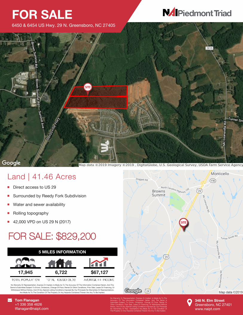
Land | 41.46 AcresDirect access to US 29
Surrounded by Reedy Fork Subdivision
Water and sewer availability
Rolling topography
42,000 VPD on US 29 N (2017)
5 MILES INFORMATION
17,945 6,722 $67,127
No Warranty Or Representation, Express Or Implied, Is Made As To The Accuracy Of The Information Contained Herein, And TheSame Is Submitted Subject To Errors, Omissions, Change Of Price, Rental Or Other Conditions, Prior Sale, Lease Or Financing, OrWithdrawal Without Notice, And Of Any Special Listing Conditions Imposed By Our Principals No Warranties Or Representations
Are Made As To The Condition Of The Property Or Any Hazards Contained Therein Are Any To Be Implied.
FOR SALE6450 & 6454 US Hwy. 29 N. Greensboro, NC 27405
FOR SALE: $829,200

q
q
q
qqq
q
qqq
q
q
q
q
q
q
q
q q
q
q
q
q
q qqq
q
q
q
q
q
q qq
q
q
q
q
q
q
q
q
q
q
q q q
q
q
q
q
qqq
q
q
q
q
q
q
q
q
q
q
q
q qq
q
q qq
q
q qq
q
!
!
!
US 29 N
TIER VIEW TR
RED
POLL
DR
TURNER SMITH RD
OAKGATE DR
BRAHMAN TR
BAVERHOF DR
ADEN PL
SPRINGER DR
SHOR
THOR
N WA
Y
LOWLINE DR
SUMMIT AV
WISENT DR
NELLORE ST
HOLSTEIN LN
HARDIE FARM DR
BODEN WAY
RANGELAND PLSHORTHORN CT
BANDANA CT
US 29 N
6462
5001
4700
64546450
6462
6000
5610
4900
5955
5147
4590
4571
7025
6018
103
5500
5500
5515
6021
6020
5126
7005
100
11
4899
4906
2
6019
8 46
1
111
7 5 3
159
4901
1214
5001
5124
5005
102
5119 5122
100
101103
10
200
111
5505
5117
110
208
116
105
5529
115
109
202102204
113
206 104
112114
4902
110
107
60177126
5121
106108
5601
4901
2075507
5119
5040
5004
4905
5003
5109
5120
5030
5011
5117
5007
4903
5028
4911
5006
5032
5015
5110
5013
5017
5004
5115
50095007
5112
500550035001
49094907
5102
510851065104
5008
50195021
5010
5026
5100
5024
5014
5023
5012
7011
5022
50095016
5020
5024
5000
5025
5100
5018
5040
5109
5011
50225029
5020
5027
5112
5006
5110
5010
5016
50125014
5008
5018
5002
4908
5029
5111
5108
5031
5106
5027
51025104
5110
5033
5102
50435101510351055107 5104
51085106
51095107510551035101
4801
4901
5119
6027
5006
55245522
5003
5502
5801
5042
5000
5008
111
5712
201
5520
107
106
5004
103
6468
5525
109
5710 209
104
5716
5600
5714
5516
105
6910
5528
108
202
5518
5514
4904
204
5516
5002
205
4900
203
5718
5007
5005
206
5504
2085701
5123
6912
5115
5720
6900
55075501
6908
5607
5603
5518 550355115509
5722
5011
6902
5520
5523
5526
6906
551555195521
55175524
55225513
6904
5526
5009
5506
5153
5010
5127
5514
5131
5145
5125
5129
5002
51495143
5600
5137
5715
5141
5723
51505135
5139
5114
5133
5116
6901
5512
5151 5111
5521
5510
5513551555195523
6900
5721
5602
6903
5517
5707 57035705
5506
5118
5148
7008
6904
5713 5518
5134
7006
5509
55105508
5505
5800
5113
5511
5700
6910
57045702
55145508
5118
5124
69066912
5120
5709
6905
7009
5122
5146
5706
5132
5608
69076905
5503
5711
5140
7007
6902
5725
5130
5501
5126
6908
6911
51285138
55255527
56015603
5527
5719
560256045606
56055708
5512
6903
5116
6916
5500
5507
7000
5502
513651445134
5132
5142
6909
6907
51165114
5120 5130
6911
5118
5717
5114
6909
51175124
5516
501350155017
6915
5019
69137002
7005
5021
5018
70037001
51285122
7004
5126
5023
6901
5012
5143
5113
5025
5030
5038
50345036
5032
50245022
5028
5112
5119
5020
5026
5115
50165014
51255133
51235129 51355127
51215131 51415137
5139
5996 59905992
5033
7116 5988
5042
5500
F
1 inch = 450 feet
LEGEND! Proposed Manholes
q Proposed Sewer MainsPropsed Water MainsProjectAreas
Pressurized MainsPrivatePublic
Sewer ManholesPublic
! PrivateGravity Mains
q Private
q PublicRailroadsCityLimit
Growth Tiers1: 2013-2019 2: 2019-20253: 2025+
Date: 5/30/2019
Data included in this map is used for internal purposes by the City and is subjectto constant change therefore its accuracy cannot be guaranteed. Errors or omissions are possible and the user is hereby advised of that possibility. Thisdata should not be used for navigational, engineering, legal, or other site-specific uses.
8"
Water
and S
ewer
Feas
ibility
6450
6454
US 2
9 N
8"
8"
8"
8"
Cattleman Trl