sabo/flood control non-structural measuresopen_jicareport.jica.go.jp/pdf/11734589_40.pdf · i the...
TRANSCRIPT

The Study on Sabo and Flood Control for Western River Basins of Mount Pinatubo in the Republic of the Philippines
Final Report Supporting Report
APPENDIX-VIII
Sabo/Flood Control Non-Structural Measures

i
THE STUDY ON SABO AND FLOOD CONTROL FOR WESTERN RIVER BASINS OF MOUNT PINATUBO
IN THE REPUBLIC OF THE PHILIPPINES
FINAL REPORT
SUPPORTING REPORT APPENDIX VIII SABO/FLOOD CONTROL NON-STRUCTURAL MEASURES
Table of Contents
Page
CHAPTER 1 GENERAL..............................................................................................VIII-1 CHAPTER 2 FLOOD/MUDFLOW MONITORING AND WARNING SYSTEM.....VIII-2
2.1 Present Condition and Problems....................................................................VIII-2 2.2 Recommendations for Monitoring and Warning System...............................VIII-3 2.3 Alternatives of Warning System ....................................................................VIII-4 2.4 Selection of Recommendable System............................................................VIII-6 2.5 Outline of Recommended System .................................................................VIII-7 2.6 Implementation Schedule and Cost Estimation for Recommended
System..........................................................................................................VIII-10 2.7 Operation and Maintenance.........................................................................VIII-10 2.8 Recommended Stage-wise Implementation Plan ........................................VIII-11
CHAPTER 3 EVACUATION SYSTEM ....................................................................VIII-13
3.1 Present Condition.........................................................................................VIII-13 3.2 Improvement of Evacuation System............................................................VIII-14 3.3 Cost Estimation for the Improvement of Evacuation System......................VIII-17 3.4 Operation and Maintenance.........................................................................VIII-20 3.5 Recommended Implementation Plan...........................................................VIII-20
CHAPTER 4 WATERSHED MANAGEMENT.........................................................VIII-22
4.1 Legal Basis of Watershed Management.......................................................VIII-22 4.2 Watershed Management in the Study Area..................................................VIII-23 4.3 Forest Management......................................................................................VIII-24 4.4 Indigenous Peoples’ Rights Act and the Aeta People (Foothill
Management) ...............................................................................................VIII-25 4.5 Sediment Control .........................................................................................VIII-25 4.6 Particular Issues ...........................................................................................VIII-26
4.6.1 Crater Lake Management (Maraunot Notch).................................VIII-26

ii
4.6.2 Dizon Mine Tailings Dam and Mapanuepe Lake ..........................VIII-26 4.7 Recommended Approach for Watershed Management................................VIII-28
List of Tables
Page
Table 2.6.1 Installation Costs for Flood/Mudflow Monitoring & Warning System.................................................................................................VIII-T1
Table 2.7.1 Estimated Cost for Operation and Maintenance by Private Company .............................................................................................VIII-T2
Table 3.1.1 List of Evacuation Center during Calamities (1/3) .............................VIII-T3 Table 3.1.1 List of Evacuation Center during Calamities (2/3) .............................VIII-T4 Table 3.1.1 List of Evacuation Center during Calamities (3/3) .............................VIII-T5 Table 3.2.1 Capacity and Condition of Evacuation Center....................................VIII-T6 Table 3.2.2 Estimation Process of Number of Evacuees and Inundation Area......VIII-T7 Table 3.3.1 Construction Cost for Elementary School by Number of Students ....VIII-T8

iii
List of Figures
Page
Figure 2.1.1 Location of Installed Observatories ....................................................VIII-F1 Figure 2.5.1 General Idea of Data Dissemination System by Cellular Phone.........VIII-F2 Figure 2.5.2 Dissemination System for Flood/ Mudflow Warning .........................VIII-F3 Figure 2.5.3 Probable Propagation Area of Radio Wave for Cellular Phone ..........VIII-F4 Figure 2.5.4 Data Transmission System ..................................................................VIII-F5 Figure 2.6.1 Implementation Schedule of Flood Warning System..........................VIII-F6 Figure 2.7.1 Step-wise Development on Flood Warning System............................VIII-F7 Figure 3.1.1 Location of Existing Evacuation Centers............................................VIII-F8 Figure 3.2.1 Out of Coverage Area of Existing Evacuation Centers.......................VIII-F9 Figure 3.2.2 Minimum Requirement of Distribution of Evacuation Center .........VIII-F10 Figure 3.2.3 Location of Evacuation Centers for All Evacuees ............................VIII-F11 Figure 3.2.4 Hazard Map (Bucao River Basin) (1/5) ............................................VIII-F12 Figure 3.2.4 Hazard Map (Maloma River Basin) (2/5) .........................................VIII-F13 Figure 3.2.4 Hazard Map (Sto. Tomas River Basin: Right Side) (3/5)..................VIII-F14 Figure 3.2.4 Hazard Map (Sto. Tomas River Basin: Left Side I, II) (4/5).............VIII-F15 Figure 3.2.4 Hazard Map (Sto. Tomas River Basin: Left Side III)) (5/5) .............VIII-F16 Figure 3.3.1 Proportion of Capacity of Evacuation Centers to Number of
Evacuees............................................................................................VIII-F17 Figure 3.3.2 Implementation Schedule for Evacuation System ............................VIII-F18 Figure 3.3.3 Division of Inundation Area..............................................................VIII-F19 Figure 3.3.4 Procedure for Construction of Evacuation Centers...........................VIII-F20 Figure 3.5.1 Area for Nomination of Evacuation Center (Bucao River Basin
No.1) (1/10).......................................................................................VIII-F21 Figure 3.5.1 Area for Nomination of Evacuation Center (Bucao River Basin
No.2) (2/10).......................................................................................VIII-F22 Figure 3.5.1 Area for Nomination of Evacuation Center (Maloma River Basin
No.3) (3/10).......................................................................................VIII-F23 Figure 3.5.1 Area for Nomination of Evacuation Center (Sto. Tomas River
Basin No.4) (4/10).............................................................................VIII-F24 Figure 3.5.1 Area for Nomination of Evacuation Center (Sto. Tomas River
Basin No.5) (5/10).............................................................................VIII-F25 Figure 3.5.1 Area for Nomination of Evacuation Center (Sto. Tomas River
Basin No.6) (6/10).............................................................................VIII-F26 Figure 3.5.1 Area for Nomination of Evacuation Center (Sto. Tomas River
Basin No.7) (7/10).............................................................................VIII-F27 Figure 3.5.1 Area for Nomination of Evacuation Center (Sto. Tomas River
Basin No.8) (8/10).............................................................................VIII-F28

iv
Figure 3.5.1 Area for Nomination of Evacuation Center (Sto. Tomas River Basin No.9) (9/10).............................................................................VIII-F29
Figure 3.5.1 Area for Nomination of Evacuation Center (Sto. Tomas River Basin No.10) (10/10).........................................................................VIII-F30
Figure 3.5.2 Area for Nomination of Evacuation Center (Bucao River Basin) (1/5)...................................................................................................VIII-F31
Figure 3.5.2 Area for Nomination of Evacuation Center (Maloma River Basin) (2/5)...................................................................................................VIII-F32
Figure 3.5.2 Area for Nomination of Evacuation Center (Right Side of Sto. Tomas River Basin) (3/5) ..................................................................VIII-F33
Figure 3.5.2 Area for Nomination of Evacuation Center (Left Side of Sto. Tomas River Basin 1/2) (4/5)............................................................VIII-F34
Figure 3.5.2 Area for Nomination of Evacuation Center (Left Side of Sto. Tomas River Basin 2/2) (5/5)............................................................VIII-F35
Figure 4.3.1 CBFM Implementation Framework ..................................................VIII-F36 Figure 4.3.2 Territorial Jurisdiction of Proposed Ancestral Domain Clamp .........VIII-F37 Figure 4.6.1 Progress of Collapse at Spillway Portion of Dizon Mines Tailing
Dam...................................................................................................VIII-F38 Figure 4.6.2 Before and After Formation of Mapanuepe Lake .............................VIII-F39

VIII-1
CHAPTER 1 GENERAL
In the Philippines, the legal basis, policies, principles and guidelines for the country’s emergency management system are embodied in Presidential Decree (PD) 1566 issued on June 11, 1978. Section 1 of this decree, Declaration of Policies, states: “Self-reliance shall be developed by promoting and encouraging the spirit of self-help and mutual assistance among the local officials and their constituents”.
Self-reliance could be attained through the establishment of nonstructural measures. In this study, nonstructural measures against flood and mudflow are among the important elements for the formulation of master plan and the conduct of feasibility study from the following viewpoints: 1) As immediate measures to mitigate flood and mudflow damage; 2) As measures to mitigate damage by exceeding the design flood of the structural measures; and 3) As measures to reduce potential damage to the flood/mudflow prone areas. This Appendix VIII pertains to the existing Flood/Mudflow Monitoring and Warning System, the Evacuation System and Watershed Management, with the following contents:
1) Flood/Mudflow Monitoring and Warning System - Present condition and history of previously installed systems - Recommended systems, required cost - Operation and maintenance method
2) Evacuation System - Present conditions - Improvement of evacuation system
3) Watershed Management - Legal definition of watershed management - Recommendations for watershed management in the project site Resettlement activities and Community Based Forest Management (CBFM) are taken into account as components of non-structural measures. Their concepts are explained briefly in this appendix, but the details are described in other relevant appendices.

VIII-2
CHAPTER 2 FLOOD/MUDFLOW MONITORING AND WARNING SYSTEM
2.1 Present Condition and Problems
PHIVOLCS, OCD, PAGASA and the AFP/PNP are the agencies that had installed and been maintaining equipment to obtain basic information for flood and mudflow monitoring and warning in the study area. Aside from these agencies, the DPWH-BRS and NIA have their own observatories, but these are for the monitoring of bridge security and irrigation water, not for flood and mudflow forecasting and warning purposes.
Basically, the information collected through these agencies are gathered and summarized by the OCD (particularly, RDCC-III, the interagency disaster coordinating body in the study area) and disseminates the information/warning to its subordinate agencies and the broadcasting media. However, in case of emergency, the PDCC, MDCC and BDCC in each province also issue warning based on their own judgment.
Figure 2.1.1 shows the locations of observatories under OCD/JICA (the lahar monitoring system of the OCD donated by JICA in 1991), PAGASA, AFP/PNP and the study team. Locations of equipment installed and dismantled by PHIVOLCS are not shown in this figure, because the locations of original installation could not be pinpointed during the survey.
The followings give the present conditions of the systems/stations under the above stated four agencies on the area of western side of Mount Pinatubo, the study area.
(1) PHIVOLCS
With assistance from the USGS, PHIVOLCS installed six telemeterized rain gauges and seven telemeterized experimental acoustic flow monitors (AFMs) around Mount Pinatubo immediately after the eruption on June 15, 1991.
The combined network of flow sensors and rain gauges served three roles, as follows: - To provide immediate warning on lahar hazards; - To collect data for the studies on hydraulic aftermath of the eruption; and, - To test technical aspects of the system itself. The rain gauges were installed at high elevations in the lahar source region but far enough from populated sites so as to maximize the lead-time for warning.
Precautions notwithstanding, the monitoring system was damaged by heavy rainfall, lightning, wind, volcanic ash and thieves that aimed at the solar panel and battery. As of 2000, all equipment was malfunctioning, and PHIVOLCS decided to dismantle all equipment from the sites to avoid further damage.
In view of the foregoing, real time forecasting and warning from PHIVOLCS is not available at present. Currently, PHIVOLCS dispatches a task force to the presumed hazard area when further heavy rainfall is forecasted by PAGASA, and issue advisories to agencies concerned on the basis of the findings of the task force.
(2) OCD
The lahar monitoring system of the OCD donated by JICA in 1991 consists of eight each units of telemeterized rain gauges and trap-wire type mudflow sensors and two units of repeater and monitoring devices. Among the equipment, three units of rainfall gauges, trap-wire type mud flow sensors and one unit of repeater and monitoring devices were planned to be installed in the western

VIII-3
side of Mount Pinatubo area within the Japanese Fiscal Year 1991. Operation and maintenance as well as the dissemination of obtained data had been placed under the responsibility of PDCC in Iba through OCD and RDCC-III.
During the survey, only two units of rainfall gauges, one unit of repeater device and one unit of monitoring device were found in the field. According to PDCC in Iba, the units had been maintained and operated until 1997; however, these were also vandalized by thieves. Solar panels and battery were stolen. All the devices in the field have been vandalized except the monitoring station in Iba.
The stations have been collecting data until 1997, but accumulated data were lost because the office was flooded.
(3) PAGASA
PAGASA had installed/established the telemeterized flood forecasting and warning systems for the Agno, Bicol, Cagayan and Pampanga river basins. All of these basins have relatively large catchment areas and receive higher priority in the country.
In the study area, four rain gauges have been installed mainly at the flat land near the coast and in the lower reaches of the river. Data is collected manually.
Although weather information based on data obtained through the observatories nationwide are important to flood and mudflow monitoring and warning in the study area in general, the information is not directly applicable to the particular and specific hazard in the study area with respect to lead-time.
(4) AFP/PNP
Two watch points in the study area are being maintained and operated by AFP/PNP. Especially in the rainy season, the staffs observe flow conditions for 24 hours, and whenever they judge that the flood and mud flow will cause damage in the lower reaches, they transmit the information to PDCC which will take the appropriate action, disseminate the information and give warning to subordinate agencies, the MDCC and Barangays.
However, it is pointed out that: - The judgment itself is being done on the basis of personal experience without objective standards
for items such as accumulated rainfall volume, intensity of rainfall, or water level of the river; and, - There is concern over the reliability and judgment for warning during nighttime. 2.2 Recommendations for Monitoring and Warning System
Based on the above, it is concluded that no effective warning system currently exists. The ongoing PHIVOLCS procedure seems to be giving a rather general warning to the people, and warnings transmitted by the watch point personnel are strongly dependent upon the persons transmitting the warning.
The following items should be taken into consideration when real time flood and mudflow monitoring and warning system is to be planned and implemented in the study area.
(1) Establishment of Real Time Data Transmission System
For the flood and mudflow monitoring and warning, real time observation data shall be obtained in every way possible to enable comprehensive judgment and to be able to issue accurate information. The importance of a consolidated information system in the East Pinatubo area was noted under the Study on Flood and Mudflow Control for Sacobia-Bamban/Abacan River Drainage from Mount

VIII-4
Pinatubo; however, in the West Pinatubo area, which is under the same organization as the East Pinatubo area, RDCC-III, the level of information integration is judged to be lower than that of the East Pinatubo area.
(2) Solution of Problems brought out by PDCC
Under the present condition of the study area, PDCC had informed that there are many inadequacies with respect to:
- The integration/unification of information;
- The common and effective utilization of information; and
- The periodical compilation and aggregation/analysis of the obtained information.
These problems should be solved through the monitoring and warning system proposed in this study.
(3) Countermeasures to Prevent the Vandalism of Observatories
When the flood and mudflow monitoring and warning system has been established in the study area, measures shall be taken to prevent the commonly arising vandalism of installed equipment and devices.
(4) Possible Use of Rain Gauges Installed by the study team
The study team had installed four units of rain gauges and three units of staff gauges for water level in the study area and is maintaining them periodically to obtain additional hydrological information. It expected that data collection and appropriate maintenance will be continued by the agency concerned even after the demobilization of the team.
2.3 Alternatives of Warning System
There is a high possibility that flood and mudflow will occur in adverse weather conditions; however, there is no real-time monitoring and warning system in the study area at present.
As part of the non-structural measures, it is recommended to establish the real-time flood and mudflow monitoring and warning system featuring the observatories of rainfall and water level for the safety of inhabitants. Through the data collected by this system and the data accumulated up to the present, it is expected that the correlation between rainfall and flood as well as mudflow outset mechanism becomes clearer, and it may assist in the design of long-term structural measures.
The following measures are described as possible devices for the flood and mudflow monitoring and warning system in the study area:
(1) Rehabilitation of Installed Facilities by OCD/JICA
The telemeterized rainfall and water level data transmission system for flood and mudflow monitoring and warning has been applied widely all over the world because of immediacy and certainty of data collection and transmission. PAGASA also has applied this system as its raw data collection measure.
In the study area, a telemeterized rainfall and water level data (hereinafter called hydrological data) transmission system was installed in 1991 for flood and mudflow forecasting and warning as described earlier.
The survey conducted by this study on two rainfall gauging stations, one repeater station and one monitoring station, has confirmed that the foundation of antennas and the antenna poles are available for reuse. The location of these stations has also been confirmed suitable in view of hydrological

VIII-5
positions and propagation of waves. Therefore, the rehabilitation/renewal of electrical devices will make these stations available for further use. Besides, the total cost of rehabilitation will be lower than that of installation of new facilities. If the system is installed at the same location as in 1991, the rehabilitation cost is estimated to be around JPY 60 million.
For the implementation of this plan, the following items shall be taken into account:
- For the system stated above, only PDCC Zambales may obtain the collected data. For the purpose of consolidated control and monitoring, collected data shall be disseminated to RDCC-III in San Fernando City, Pampanga, and other related agencies in Metro Manila. Such enhancement of the equipment will increase installation cost, because of installation of new repeater station(s) and data receiving devices for each agency.
- The previous system has been damaged mainly because of theft. To prevent vandalism, it will be necessary to assign somebody from neighboring areas concerned through the subordinate organization of PDCC.
- Among the four stations stated above, there are no residential houses nearby the rainfall gauging station and the repeater station. At these remote stations, guardhouse with watchman needs to be stationed.
- For further development of the system, additional cost may be necessary aside from the installation cost of stations, such as the cost for installation of new repeater stations, modification of software, etc.
- In case the collected data needs to be disseminated to the Manila area for the integration of collected information, PAGASA is considered as the main receiving agency of information, because PAGASA has longer and richer experiences in the fields of monitoring and warning system in comparison with the other agencies such as OCD/RDCC-III.
However, the western part of Mount Pinatubo is not specified as target area in accordance with the Six-Year Modernization Program.
(2) Installation of New Radar Rain Gauge System
If an adequate high land is selected as a radar site, one radar rain gauge can cover all of the study area and the dissemination of data will also be possible through a simple transmission system.
Since the site will be limited to one site, maintenance and operation can be carried out by stationed personnel, avoiding the difficulty of access to locations scattered in remote areas. A single site will also be beneficial in view of the integration of data and prevention of theft.
If this system will be operated and maintained by appropriate experts, the apparatus could be the key to the flood and mudflow monitoring and warning system for the western side of Mount Pinatubo.
The cost of installation of a radar rain gauge system is estimated to be JPY 300 million to JPY 400 million, but the cost will vary depending on the location.
For the implementation of this plan, the following items shall be taken into account:
- For almost the same reasons as those of the telemeterized rainfall and water level data transmission system, PAGASA is nominated as the main receiving agency of data. However, the western side of Mount Pinatubo is not included in the development program of PAGASA.
- For the effective use of the radar rain gauge system, the station shall be located at a high elevation with full coverage of the study area. The location of the radar rain gauge station is presumed to be

VIII-6
in the mountainous region in this study area. Some additional costs will be necessary to facilitate the power supply system and other supplementary facilities.
- Once the radar rain gauge station has commenced operation, a calibration period of around one year will be necessary for adjusting the various coefficients of the software. On-the-job training by expatriates will be needed throughout this period.
(3) Installation of New Rain and Water Level Gauge with Cellular-Phone for Data Dissemination
This is a combined unit containing rain and water level gauges and cellular phone. A dedicated circuit system (telemeter) will not be required. As far as the field station is located within the coverage area of cellular phone, this system can disseminate the collected data to any monitoring station and has the flexibility to allow proliferation and easy relocation of the station. At the monitoring stations, the data will be conveyed by modem to the computers. The installation cost per station is commonly much lower than that of the system featuring the dedicated circuit system (telemeter).
For the implementation of this plan, the followings shall be taken into account:
- Compared with the dedicated circuit system (telemeter), cross talk and/or difficulties in the contact line tend to take place. It may be concluded that this system is rather unstable from the information dissemination point of view.
- The cellular coverage area in the western side of Mount Pinatubo was surveyed, and in some area(s), communication through cellular phone is not available. In non-communicable area(s), other measures for data dissemination shall be taken by using: a) Ordinary radio waves to the nearest monitoring station, or b) Installation of a new transponder in conjunction with the telecommunication company.
- If the equipment is imported from Japan, the communication system needs to be transferred to GSM (Global System for Mobile Communications).
- Utilization of a solar panel and battery as the power source at the stations seems essential. Therefore, the same countermeasures described in Item (1) above will be needed to deal with potential thefts.
2.4 Selection of Recommendable System
Judging from the priority of nationwide balance concerning the provision of flood and mudflow monitoring and warning systems and other economic and property conditions, the application of a telemeterized warning system and the radar rain gauge system seems out of balance for the western side of Mount Pinatubo.
For the present situation, the lowest cost system, namely the installation of a new rain and water level gauge with cellular phones for data dissemination is recommended for the flood and mudflow monitoring and warning system in the study area, although this system has some weaknesses in access and reliability.
The reasons for selecting this system for the flood and mudflow monitoring and warning system in this area are as follows:
(1) This system could be considered as an urgent/remedial facility or a transitional system until the implementation of permanent facilities such as telemeterized rainfall and water level data

VIII-7
transmission system for monitoring and warning system and/or a radar rain gauge system under the organizations of PAGASA/NDCC (RDCCs).
(2) This appears to be the first application of such system in the Philippines. The state of the commercial telecommunication system and other related factors must be examined by a telecommunications expert. However, it is expected that any major technical problem in the transmission system can be solved. Even though the development of such measure will involve an increase in cost, this is minor in comparison with the installation cost of the other two systems.
(3) If the existing cellular phone system is available in major portions of the study area, many gauging stations can be established in small quantities at a time. Even if communication troubles occur at any of the stations, other station(s) nearby can tentatively supplement the expected functions.
(4) This system remains flexible in the proliferation and relocation of stations on demand, as long as the device can be located within the communicable area. If the location of the following stations becomes communicable, it is proposed to provide rainfall and water level observatories at: a) Col at the outer rim of the Mount Pinatubo volcanic crater where there is the potential for further erosion of the outlet; and b) Dizon Mines dam reservoir that has been constructed by a private company but its spillway is in dangerous status at present due to erosion, as well as Mapanuepe Lake located just downstream of the said spillway.
(5) As described above, the replacement of devices with sub-facilities is easy in case serious mechanical problems occur.
(6) The local level disaster information system has recently been developed and applied in various cities/towns all over the world together with the recent development of the GSM network.
2.5 Outline of Recommended System
The recommended system will consist of four monitoring stations, seven rain gauges, and six water level gauges. The outline of this system and other related matters are described below.
(1) Location of Hydrological Observation Stations
New hydrological observation stations will be installed under the recommended system; namely, six water level gauging stations and seven rainfall gauging stations. Their locations are as shown in Figure 2.5.1, taking into account the following:
(a) Accessibility of the gauging stations is one of the most important factors for maintenance work.
(b) A water level gauge shall be placed just downstream of the bridge where discharge measurement can be conducted easily.
(c) The overflow from the Dizon Mine Tailings Dam and the crater lake of Mount Pinatubo may involve disastrous calamities; hence, a water level gauging station is necessary at these sites.
(d) The rainfall gauging stations are to be distributed uniformly in the whole three river basins (Bucao, Maloma, Sto. Tomas).
(e) The rainfall intensity around Mount Pinatubo seems to be higher than in other areas according to the hydrological analysis (referred to Appendix V); hence, one rainfall gauging station is necessary around the summit of Mount Pinatubo.
(f) The adequate number of stations is assumed using the WMO guideline for flood forecasting and warning as reference. The density of rain gauge stations is 130 km2 per station in the study area,

VIII-8
which is enough in comparison with the required minimum rain gauge station density (250 km2 per station) in terms of area for mountainous zones in accordance with the WMO guideline
The hydrological observation stations to be installed are listed in the table below.
Hydrological Observation Stations Name of Observatory
(Temporary) Measuring Devices to be
Installed Remarks
Baquilan Station Rainfall Gauge Burgos Station Rainfall Gauge Mount Pinatubo Station Water Level Gauge; Rainfall
Gauge The Col at the outer rim of Mount Pinatubo crater
Maloma River Bridge Station Water Level Gauge Belbel Station Rainfall Gauge Apostol Station Rainfall Gauge Sto. Tomas River Bridge Station
Water Level Gauge
Mapanuepe Lake Station Water Level Gauge; Rainfall Gauge
Dizon Mines Dam Station Water Level Gauge San Marcelino Station Rainfall Gauge Bucao Bridge Station Water Level Gauge
(2) Monitoring Sites and Dissemination of Information
The establishment of monitoring site has two purposes: (1) to transfer information related to flood/mudflow quickly to the inhabitants in order to contribute to the efficiency of evacuation system; and (2) to share information with the related organizations (refer to table below), so that measures to prevent flood/mudflow are reinforced at the Barangay level.
To achieve these purposes, a dissemination system for flood/mudflow warning can be as illustrated in Figure 2.5.2. As can be seen the figure, it is recommended to set up the website for PDCC in Iba Station as the key station for data/information dissemination to enable access of warning information by anybody. On the other hand, the warning information to each Barangay needs to be disseminated by media through the radio company for ordinary residents who do not posses their own computers.
Monitoring Sites Monitoring Site Monitoring Sites Remarks
PDCC in Iba All data from above-stated stations Iba Central Station PAGASA (Manila) All data from above-stated stations
except data from Mt. Pinatubo Station
PHIVOLCS (Manila) The data from Mt. Pinatubo Station only
Operation and maintenance of this station will be shouldered by this agency.
RDCC (Region III) All data from above-stated stations
Additionally, it is proposed to install sirens at appropriate locations in consideration of range of signal access and the safety of equipment. The siren shall be sounded whenever warning is issued through the Iba Central Station (see Figure 2.5.1 for the location of Iba monitoring site). The range of signal access is presumed at 1.5 km and the equipment will be set at the public office (Barangay Office).

VIII-9
Incidentally, there is an idea to integrate the observatory stations at Mt. Pinatubo Crater Lake into the seismic monitoring system under PHIVOLCS since this agency is continuously monitoring various scientific aspects regarding the activities of Mount Pinatubo even before its eruption. In fact, PHIVOLCS is also interested to integrate rainfall and lake water level observatories into the seismic monitoring system.
(3) Field Investigation
Two major cellular phone carriers have been selected for investigation; namely, the GLOBE and SMART communication companies, which are widely accepted in the Philippines. Through this investigation, it was found out that the GLOBE system is preferable for the area where the system will be installed.
The GLOBE GSM system is available for almost all of the proposed observation stations, that is, except the stations at Dizon Mine Tailings Dam in Sto. Tomas river basin and Mt. Pinatubo Crater Lake.
Figure 2.5.3 shows the availability of the existing GLOBE Cellular Phone system for the proposed sites of rain and water level gauges.
(4) Data Transmission System
The central station of the system (data processing site) is proposed to be located at the provincial office in Iba, which is responsible for the activities of monitoring and warning. The transmission system of observed data through the existing cellular phone network is also proposed instead of the exclusive nationwide network for warning system applied by PAGASA.
Through the field investigation, it was found out that the existing cellular phone network is not available at the Mt. Pinatubo and Dizon Mine Tailings Dam stations. Therefore, the ordinary radio wave system for data transmission to the nearest monitoring station (Burgos and Mapanuepe sites as repeater stations) needs to be adopted for these stations.
Figure 2.5.4 shows the general idea of data transmission system by cellular phone.
(5) Data Processing System
The data processing system will serve: (1) to collect raw data, (2) to foresee the possibility of flood on an as-needed basis using the information, (3) to create a visual image for display, and (4) to transfer it into the website managed by Iba Central Station. This data processing system is roughly divided into three subsystems function-wise.
To implement the data processing system, the following points should be taken into account:
(a) The computers to be introduced must be PCs in view of maintenance services at site and familiarization with the staff.
(b) Flood/mudflow phenomena are very fast; thus, to monitor flash floods and mudflow, a quick response of the system is necessary. The processing should be done automatically with reduced manual intervention.
(c) A backup system will be implemented to cope with system breakdown and failure, which could be caused by power failure because of a typhoon, heavy rain, earthquake, etc., and by miss-operation.

VIII-10
(d) The processing data and information will be displayed in Web form, thus the PDCC staffs should be accustomed with the Internet. The system must be on the defensive about computer virus prevailing in the Philippines nowadays.
(e) As for the data processing, the introduction of Geographic Information System (GIS) database is recommended because this system can accommodate all related information concerning the monitoring and warning activities.
2.6 Implementation Schedule and Cost Estimation for Recommended System
The implementation schedule and cost estimation of the above system has been carried out under the assumption that these works will be implemented under foreign technical/financial assistance, as shown in Figure 2.6.1 and Table2.6.1.
The installation of equipment will require 12 months, but the engineering services for the training and calibration of the data processing procedure will continue for another 12 months.
The total cost for installation is estimated at 79 million pesos, including the engineering services cost.
2.7 Operation and Maintenance
Although the application of an advanced system is efficient for obtaining information on time, the equipment applied is usually sensitive in nature and vulnerable to physical shocks. Care shall be taken to maintain all equipment in good condition and the operation and maintenance activities (O&M) may need financial support. The cost for operation is a major item in considering the application of an advanced system.
For practical reasons, the following system for operation and maintenance is recommended especially in the financial point of view:
(1) Operation and Maintenance at Monitoring Site
In general, the cost for operation and maintenance is presumed to be minor, since the staffs of agencies concerned have rich experiences in the maintenance of this kind of system. It is therefore expected that operation and maintenance will be carried out by one of the present staffs who will be trained by the tutor to be dispatched as a part of the engineering services.
However, in the case of PDCC in Iba which will function as the central station of recommended system, a budget for operation and maintenance need to be prepared to cover remunerations of systems engineer, computer operators, telecommunications, and others. The required budget for O&M is roughly estimated to be PHP600,000 to PHP700,000 pesos a year.
(2) Operation and Maintenance for Observatories
Among the observatories listed before, the cost for operation and maintenance of Mount Pinatubo Station will be shouldered by PHIVOLCS as generally agreed upon during a meeting between the study team and the representative of PHIVOLCS.
Although further discussions will be necessary, it is considered naturally that the cost for operation and maintenance of Mapanuepe Lake Station and Dizon Mine Dam Station are to be shouldered by the owner–company, Dizon Mines, in accordance with the concept of product liability.

VIII-11
On the other hand, the cost for operation and maintenance of the remaining eight (8) observatories will be shouldered by the PDCC in Iba, the agency responsible for flood/mudflow monitoring and warning covering the major beneficiaries.
The cost for operation and maintenance of observatories will include costs for watchmen who will watch equipment installed nearby residences, fuel supply and others vehicles, engineer who will make periodical patrols in the coverage area, communication with agencies concerned, and so on. The cost for operation and maintenance for observatories under the PDCC in Iba is estimated to be around PHP300,000 to PHP400,000 pesos a year.
(3) Operation and Maintenance of Warning Posts
The structure and system of warning post is simple and roughly judged as almost maintenance free except the supply of power. Therefore, it is expected that warning posts are to be maintained by the Barangay where they exist.
Table 2.7.1 shows the estimated cost for operation and maintenance of warning post in case the works are to be carried out by a private company.
As described above, the preparation of budget for operation and maintenance cost is a major consideration for the implementation of the recommended system for flood/mudflow monitoring. If such budget will not be prepared, system installation will not be realized.
2.8 Recommended Stage-wise Implementation Plan
(1) Warning System as Present Issue
Although it is primitive and no accurate value is obtained, people can be warned against flood and mudflow if some personnel capable of transmitting the prevailing flow conditions at a particular site through radio communication are designated by responsible authorities.
By this method, the maximum utilization of measures presently available against calamities can be taken until the advanced/accurate measures are provided.
Available sources of information for this purpose are:
(a) The watch points maintained by the AFP/PNP (Armed Forces of the Philippines/Philippine National Police)
(b) The watch point for the condition of Dizon Mine Dam Site.
(c) The rainfall measuring point set by the present study team. (2) Upgrading Manners of the Present Available System
It is expected that personnel assigned at the watch points maintained by the AFP/PNP are to carry out their duties at regular intervals everyday. For watch points (b) and (c), the following considerations and improvement measures may be needed:
(a) Personnel assigned to watch the conditions of Dizon Mines Dam are workers of the private company (Dizon) so that an understanding with the company may be additionally required. Besides, the location is out of the dissemination area of the cellular phone company. Therefore, the required information has to be transmitted first to the private company’s main office by radio as presently being done and the main office will transmit the information to the PDCC.
(b) In case of the rainfall gauging station set by the study team at the hilly area in the Mapanuepe river basin, the rainfall gauges are maintained by a watchman residing nearby the station and cellular

VIII-12
phone service is available in the area. Therefore, PDCC can obtain accumulated data on rainfall from the watchman directly by cellular phone.
(3) Recommendation of Stage-wise Development on Warning System
The operation and maintenance for the warning system by GSM is not easy to be carried out continuously from the point view of technical level and financial difficulties in Zambales. First of all, thus, the improvement of existing system should be improved to aim at warning the civic level of flood/mudflow and the staffs in charge of the warning should gain experience so as to get used to the operation/activities concerning the flood/mudflow warning. After the improved existing system work well and secure the reasonable dissemination path, the GSM system should be introduced so that the system is utilized as the effective flood/mudflow warning system more than enough.
The Calamity Fund, which normally goes on the budget in case of calamity (18 mil. pesos per year), should be made good use for the cost of the operation and maintenance.
Figure 2.7.1 shows the general concept of the above method in comparison with the presently available warning system as well as the system proposed by the study team.

VIII-13
CHAPTER 3 EVACUATION SYSTEM
3.1 Present Condition
The exact number of evacuees is hard to determine because it is envisioned that some people will evacuate to the homes of their relatives and some of the population is not counted in the records. Based on the result of interviews conducted at manifested locations of evacuation centers, the following information has been are derived.
(1) Evacuation Status Since 1992
Table 3.1.1 shows the interview/observation results from 63 evacuation centers in the study area. The distribution of evacuation centers is illustrated in Figure 3.1.1.
Based on the results of the interview survey conducted at 42 elementary schools designated as evacuation centers by the Department of Education, Culture and Sports, and at other 19 official evacuation centers, it was concluded that all of them served as evacuation centers in 1992, 1993, 1994, 1995, July, August and September in 2001, and July 2002.
Of the facility utilization determined, the extensive evacuation in September 2001 was different in nature from the other evacuations made. Approximately 35,000 people were evacuated for two days mainly to Iba, transported by eight (8) commercial buses and 14 military trucks. This evacuation was planned before releasing the water in the caldera’s lake and its schedule was informed officially in advance to the excavation works for coal at the outer rim of the Mount Pinatubo volcanic crater, where there was apprehension on the further erosion of outlet.
It is clear that evacuation centers are still frequently used as emergency shelters against flood and mudflow disasters. However, judging from the small number of evacuated families and utilized number of evacuation centers at the same time, it is presumed that evacuations are practiced through the decision of a rather small unit, independently or on the Barangay level.
(2) Evacuation Procedures
Judging from the results of interview with the municipalities concerned, the procedures at times of calamities are well established under the MDCC/BDCC level; however, these procedures seem to be activated only after the occurrence of a disaster.
At present, the evacuations are carried out through the following steps, based on the information provided by PHIVOLCS and PAGASA:
1) Individuals: Detection of the possibility of disaster by residents
2) Individuals: Transmission of Alert to the Barangay Office
3) Barangay Office: Transmission of Alert to MDCC and PDCC by radio or telephone
4) MDCC and PDCC: Transmission of Alert to other related Barangays and MDCC, as well as RDCC-III, by radio or telephone
5) RDCC-III: Reports to OCD
Some municipalities have established their own evacuation procedures and take actions based on disaster information obtained through the Barangays. The concept of evacuation procedure at the municipal level is as follows:
“A Barangay by Barangay simultaneous evacuation will be undertaken from pick-up points to the identified evacuation centers by the overall Marshall (Mayor). The farthest Barangay will be

VIII-14
evacuated first, followed by Barangays according to the degree of threat. Residents will be organized into ages with priorities for evacuation. Some available vehicles of one family per vehicle or otherwise maybe hauled from designated pick-up points to the evacuation site.”
(3) Condition of Evacuation Centers and their Problems
Before 1997, when the flood and mudflow forecasting and warning system (donated by JICA to OCD and transferred to PDCC through RDCC-III) was still inactivate in the study area, PDCC has been taking the position as issuance organization of flood and mudflow warnings based on available information. Any action for evacuation was then under the judgment of the particular Barangay or individual concerned.
Ordinary people were not notified of information from the latest hazard map; accordingly, they are not familiar with the latest information on not only the presumed hazard area but also the nearest location of evacuation center where they could take shelter when a flood and mudflow with short lead-time comes. Although some municipalities have fixed the location of evacuation site for each Barangay, it seems that the location of some of the sites are not appropriate.
In coastal areas, it is presumed that there are many other private or public facilities to be utilized at times of calamity, such as churches, community centers, other public facilities and private houses. In consideration of previous evacuation patterns, especially during the evacuation in September 2001, it is judged that the capacity of evacuation centers is almost sufficient. However, the quality of some evacuation centers may not be satisfactory, because it was reported that some of them were inundated during the flood, some are in dilapidated condition, some need repair, and some do not have water and electric facilities.
A few kilometers from the coastline to the hilly/mountainous areas, evacuation centers are very sparse. Although population density is low in these areas, residents may not have any safety zone except the hills/mountains located north and south of the rivers. With regard to evacuation speed and lead-time at times of calamity, some people residing along the river course might not reach the safety zone within the limited time.
3.2 Improvement of Evacuation System
To prevent/mitigate damage to human lives, the improvement of the evacuation system, as well as the establishment of a hydrological monitoring system, is necessary.
In this subsection, the improvement of the evacuation system is described from the following viewpoints:
- Construction of new evacuation centers;
- Renovation of evacuation centers;
- Enlightenment campaign on disasters;
- Cooperation with NGOs; and,
- Application of Hazard Map.
(1) Construction of New Evacuation Centers
In consideration of previous evacuation patterns, especially the evacuation in September 2001, it is judged that the capacity of evacuation centers is almost sufficient.
However, based on the above-said event, evacuees do not have enough lead time to move to safety in

VIII-15
case of a natural disaster, that is, under the present inundation conditions the number of evacuation centers (churches, relatives’ houses and other public facilities) at the proper locations is limited from the viewpoint of relationship between lead time and distance.
Therefore, the construction of new evacuation centers at proper locations is necessary for evacuees’ safety from flood. The location and number of evacuation centers can be determined as follows:
(a) Basic Condition to Decide the Location of Evacuation Center
Generally, the location of an evacuation center is selected under the following conditions:
- Flood/mudflow is presumed to dissipate at the lower river basin where roads are generally maintained better than those in the upper river basin; therefore, it is assumed that inhabitants will seek evacuation centers that are around 2 kilometers away from their houses. (According to the results of interview survey, the escaping speed in these areas is 2 to 4 km/hr).
- Based on the above, if an evacuation center exists in the lower reaches, the facility may accommodate the people residing within 2 km away from the said facility.
- The evacuation facilities in this subsection consider the population at present; however, if the installation of new evacuation centers is carried out in the future, the increase of population is to be taken into account.
- The number of new evacuation centers is determined in consideration of the difference between evacuees and capacity of the center.
- The distribution of new evacuation centers shall coincide with the population density.
- According to the results of interview/observation survey, there are 63 evacuation centers around the study Area (cf. Figure 3.1.1).
(b) Target Area of the Evacuation System
Generally, an evacuation system as well as the flood warning system is established as a countermeasure for floods of high probability. Therefore, although the structural measure in this study was set at the scale of 20 years, the inundation area in case of a 100-year return period flood (refer to Appendix V) was identified as the target area for improvement of the evacuation system for the Bucao, Maloma and Sto. Tomas flood plains. The inundation area and the number of evacuees in the area were estimated for each basin, as shown in the table below.
Probable Maximum Inundation Area and Number of Evacuees River Basin Inundation Area (km2) Number of Evacuees Remarks Bucao 14.4 8,118 16 Barangays Maloma 5.8 1,108 5 Barangays Sto. Tomas 71.1 24,269 40 Barangays, Part of
San Antonio Municipality Total 91.3 33,495
The number of evacuees was estimated taking the total population of barangays and the number of houses in the inundation area into account. (c) Minimum Requirement of Distribution of Evacuation Centers
Inundation areas out of the coverage area of each existing evacuation center (cf. Figure3.2.1) have the highest priority for the construction of additional evacuation centers to be

VIII-16
constructed at the initial stage, as shown Figure3.2.2. The additional number of evacuation centers to meet the minimum requirement is 10. (d) Capacity of Evacuation Centers
The capacity of existing evacuation compares low with the number of evacuee, even if taking the number of centers for minimum requirement, as shown in table below.
Comparison between Number of Evacuees and Capacity of Evacuation Center Capacity
River Basin Number of Evacuees Existing Evacuation
Center To be Absorbed by the
Additional Centers Bucao 8,118 1,800 700 Maloma 1,108 50 200 Sto. Tomas 24,269 10,300 1,600 Total 33,495 12,150 2,500
The capacity of each evacuation center located within a radius of 2 km (referred to item (a) for the reason 2 km is set up) from the inundation area has been estimated, as given in Table 3.2.1. The number of evacuees from each barangay and inundation area has also been estimated, as shown in Table3.2.2. (e) Location of Evacuation Center for All Evacuees
The location of evacuation centers for all evacuees from an inundation area has been determined as the difference between the number of evacuees and the capacity of evacuation centers. As a result, some 50 additional evacuation centers need to be constructed to accommodate evacuees from inundation areas already having the minimum distribution of evacuation centers, as shown in Figure3.2.3. The capacity of each center is limited to 1,000 people, which is the maximum capacity of the existing evacuation centers (except for Vega Hill in San Marcelino, which has the capacity of 7,500 people).
(2) Renovation of Existing Evacuation Centers
At present, many of the existing officially nominated evacuation centers are dilapidated and require renovation. Some facilities also do not have tap water and/or electricity supply systems. In some instances, the survey on inundation areas and locations of evacuation centers has found that evacuation centers themselves are under the menace of floods (refer to Table 3.2.1).
Renovation of Existing Evacuation Centers
River Basin Total Number of Evacuation Centers
Number of Center Probably Inundated
Bucao 8 7 Maloma 1 1 Sto. Tomas 27 24 Total 36 32
(3) Enlightenment Campaign
Many administrative and individual sessions in different fields are being executed centering on the Barangay as the basic unit of the administrative system. Hence, the campaign activities concerning flood and mudflow monitoring and warning, as well as route and timing, etc., should be activated

VIII-17
through these units.
The campaign on “how to avoid becoming a victim of a mudflow” offered suggestions for what residents should do before and when they are warned of flood and mudflows through illustrated flyers, posters and leaflets prepared and distributed by RDCC-III.
Additionally, the relatively large-scale hazard map [see Item (5) below] will enable officials and residents to judge whether their Barangay, town streets and secondary roads are in relatively high or relatively low danger levels.
(4) Cooperation with NGOs
The activities done by many NGOs in various fields related to the eruption of Mt. Pinatubo are highly appreciated. The government agencies concerned should keep closer relationships with them as other disaster prevention organizations that will supplement the official activities.
Although not all NGOs are founded for the purpose of flood and mudflow disaster mitigation, as many as 92 organizations are listed as officially accredited NGOs and 38 other organizations are applying for accreditation. NGO activities to supplement difficult official activities are highly expected, and if these organizations could be appointed to discuss their appropriate fields of expertise and try to bring out their utmost efficiencies, remarkable activities in relevant fields may be attained.
It is necessary for government agencies, especially the NDCC and OCD through RDCC-III and PDCC in Zambales, to coordinate with such network of NGOs for efficient relief operations and evacuation activities.
(5) Application of Hazard Map
Based on the basic data, the Hazard Map has to be elaborated is elaborated under the present condition of each inundation area, as shown in Figure 3.2.4. It is recommended to apply the Hazard Map for the campaign mentioned Item (3) above to familiarize people on the evacuation route, location of evacuation center and so on.
The hazard map should be updated by each barangay, taking into account the definite conditions of infrastructure, lead time, vulnerability to disasters, past flood records, impassable areas during flood, and allocation of evacuees to the evacuation area.
An example of Hazard Map describing the allocation of a group of evacuees to each evacuation center is given in Appendix XIV.
3.3 Cost Estimation for the Improvement of Evacuation System
For improvement of the Evacuation System, the estimation of construction and renovation cost of evacuation centers is discussed below.
(1) Sequence for the Construction of Evacuation Centers
Based on the results of study on the construction of new evacuation centers described in Section 3.2, the following sequence of construction of new centers is applied:
(a) Inundation areas outside of the coverage area of the evacuation center have the highest priority for the construction of new evacuation centers. Therefore, the evacuation centers selected in Section 3.2(1)(c), Minimum Requirement of Distribution of Evacuation Centers, should be constructed at the initial stage of the construction work.
(b) The percentage rates obtained by dividing the available capacities of evacuation centers by the

VIII-18
total number of evacuees in each area as described below vary to a large extent, as shown in Figure 3.3.1. Therefore, the construction of new evacuations centers is recommended to start in the area where the above rate is low to attain fairness among the inhabitants.
(c) After the percentage rate between the areas becomes almost even, the construction work for all remaining evacuation centers may be executed simultaneously.
(2) Sequence for the Renovation of Evacuation Centers
The renovation schedule and cost for existing evacuation centers are greatly dependent on the level of present conditions; therefore, the implementation schedule and required budget are estimated under the following assumptions:
(a) Renovation works required are categorized into 3 levels of present condition; namely, minor, medium and serious condition.
(b) Depending upon the above categorized level of conditions, the required cost for renovation is set at 10%, 25% and 50% of new construction cost respectively.
(c) Required renovation periods are also presumed by applying the same percentages.
(3) Cost Estimate (a) Unit Cost
Public facilities are usually designated as evacuation centers in the study area. Therefore, unit cost has been estimated on the assumption that the evacuation center is an elementary school.
The construction cost of an evacuation center has been estimated according to capacity (number of students), as given in Table 3.3.1. (b) Cost in the Initial Stage of Construction
As described before, both construction and renovation works of evacuation centers are indispensable and need to be carried out sequentially. The implementation schedule of evacuation centers to be constructed in the initial stage of construction is shown in Figure 3.3.2. Construction costs of evacuation centers in the initial stage are summarized in the table below.
Construction Cost in the Initial Stage (Unit: Million Pesos)
River Basin First Year Second Year Third Year Total Bucao 18.5 18.5 0.0 37.0 Maloma 6.0 6.0 0.0 12.0 Sto. Tomas (Right Side)
5.2 15.5 2.6 23.2
Sto. Tomas (Left Side)
0.0 39.4 32.0 71.5
Total 29.7 79.4 34.6 143.7
The implementation schedule for the renovation of evacuation centers is also shown in Figure3.3.2. Renovation cost has been estimated in accordance with the sequence decided in Item (1) above, as shown in the table below.

VIII-19
Renovation Cost in the Initial Stage (Unit: Million Pesos)
River Basin First Year Second Year Third Year Total Bucao 32.2 19.8 0.6 52.6 Maloma 0.0 0.2 0.2 0.4 Sto. Tomas (Right Side) 0.0 0.3 2.6 2.9 Sto. Tomas (Left Side) 49.1 46.6 27.2 122.8 Total 81.3 66.8 30.6 178.7
(c) Middle Term and Long Term Stage
The target area has been divided into seven (7) almost equal areas for comparison of sufficiency rate, as shown in Figure 3.3.3.
Based on the implementation sequence explained in Item (1), the number of evacuation centers to be constructed has been estimated for the seven (7) areas.
Number of Evacuation Centers to be Constructed
River Basin Middle Term Long Term Total Bucao 6 5 11 Maloma 3 1 4 Sto. Tomas (R) 5 3 8 Sto. Tomas (L-I) 0 3 3 Sto. Tomas (L-II) 5 4 9 Sto. Tomas (L -III) 0 9 9 Sto. Tomas (L-IV) 3 3 6 Total 22 27 50
The procedure for the estimation is presented in Figure 3.3.4. The costs of construction for the middle term and long term stages are summarized in the table below.
Cost in Middle and Long Term Stages (Unit: Million Pesos)
River Basin Middle Term Long Term Total Bucao 162.8 150.1 312.9 Maloma 33.5 17.6 51.2 Sto. Tomas (R ) 70.6 46.7 117.2 Sto. Tomas (I) 0.0 34.2 34.2 Sto. Tomas (II) 75.7 64.2 139.9 Sto. Tomas (III) 0.0 202.8 202.8 Sto. Tomas (IV) 99.9 85.8 185.7 Total 442.6 601.3 1043.9
(d) Total Cost of Evacuation System
The total cost for the construction and renovation of evacuation centers is shown in the following table.

VIII-20
Construction and Renovation Costs (Unit: Million Pesos)
Construction Cost River Basin Renovation
Cost Initial Middle Term
Long Term Total
Grand Total
Bucao 52.6 37 162.8 150.1 349.9 402.5 Maloma 0.4 12 33.5 17.6 63.1 63.5 Sto. Tomas (R) 2.9 23.2 70.6 46.7 140.5 143.4 Sto. Tomas (L) 122.8 71.5 175.6 387 634.1 756.9 Total 178.7 143.7 442.5 601.4 1187.6 1366.3
3.4 Operation and Maintenance
Most of the many existing evacuation centers are schools, so that elementary schools are proposed as evacuation centers in this study (refer to Subsection 3.5). In this case, it is expected that the evacuation centers are to be maintained by the Department of Education, Culture and Sports. On the other hand, evacuation centers aside from schools are usually public facilities utilized as community halls and so on. These are therefore expected to be maintained by each entity concerned as they should.
Under the above circumstances, no special fund is therefore needed for the operation and maintenance (O&M) of proposed evacuation centers. However, the following matters are recommended:
1) To stock some emergency goods such as food and blankets as immediately necessary goods before hazards occur.
2) To prepare simple temporary shelters (tents) that could be carried into the safe locations outside of the inundation area. Temporary shelters may accommodate the evacuees until the permanent evacuation centers are provided.
3.5 Recommended Implementation Plan
(1) Nomination and Renovation for Evacuation Center
In this Chapter 3, the necessary number and distribution of evacuation centers to be constructed is determined in consideration of the balance between the existing officially nominated evacuation centers and total number of evacuees from inundation area. However, according to the aerial photograph taken in the study area, churches, schools and other buildings that have the possibility to be utilized as evacuation centers during flood can still be nominated.
In view of the above considerations, concretely, the implementation plan and activities to improve existing evacuation system are proposed as follows:
1) To nominate 10 evacuation centers through the PDCC around the delineated area (Cf. Figure 3.5.1 and Figure 3.5.2), which accomplish the minimum requirement distribution of evacuation centers as described in subsection 3.2 (1) (c) of this chapter 8.
2) To establish a renovation plan of both newly and existing elementary schools nominated as evacuation center (for both new and existing schools nominated), and propose to DECS through Zambales Province.
3) To make and distribute the Hazard Map at each probable inundation area through the PDCC.
(2) Consideration on the Selection of Kind of Facility for Construction
From the viewpoint of improvement of social conditions, it is proposed to construct more elementary

VIII-21
schools that could be utilized as evacuation centers at times of calamity. The main reason for this is that elementary schools are presently insufficient for the education of local children, as pointed out in the report entitled “Accessibility Database 2001” of the study conducted under a Grant from the Netherlands. Needless to say, elementary schools will promote the educational level and contribute to the decreasing disparity between rich and poor in this country. (According to statistical data in the Philippines, elementary school graduates earn higher incomes than the undergraduates.)
After the construction of more elementary schools as evacuation centers in Iba, Zambales, other public facilities and buildings may be constructed as required taking the social conditions into account.

VIII-22
CHAPTER 4 WATERSHED MANAGEMENT
4.1 Legal Basis of Watershed Management
(1) Definition of Watershed and Watershed Management
Presidential Decree (PD) 705 defines Watershed as “land drained by a stream or fixed body of water and its tributaries having a common outlet for surface run-off” and DENR Administrative Order (DAO) 99-01 defines Watershed as “an area of landform which rainwater can drain, as surface run-off, via a specific stream or river system to a common outlet point that may be a dam, irrigation system or municipal/urban water supply take off point or where the stream or river discharges into larger river, lake or sea.”
As for the term Watershed Management, it is defined under the Guidelines for Watershed Management and Development in the Philippines as follows: (a) The process of guiding and organizing the use of land and other resources found inside the
watershed to provide desired goods and services without adversely affecting soil and water resources;
(b) The application of business methods and technical principles to the manipulation and control of watershed resources to achieve desired results such as maximum supply of usable water, minimization of soil erosion and siltation, and the reduction of occurrence of floods and droughts.
(2) Jurisdiction of Watershed Management through Legislation 1) National Integrated Protected Areas System (NIPAS) Act
NIPAS is under the administration and control of the DENR and the policy of the NIPAS is to secure all native plants and animals, and to conserve soil and water in critical watersheds through the establishment of a system of integrated protected areas (Protected Area).
Protected Area is defined in the NIPAS Act as “identified portions of land and water set aside by reason of their unique physical and biological significance, managed to enhance biological diversity and protected against destructive human exploitation.” 2) Indigenous Peoples’ Rights Act (Republic Act 8371, 1997)
Indigenous Peoples’ Rights Act (Republic Act 8371, 1997) recognizes the rights of indigenous people to own, manage, develop and conserve their ancestral domains and all natural resources found therein. This vests the management of ancestral domains on the indigenous cultural communities/indigenous people. These people have the right of self-governance and self-determination over the use, management and conservation of their domains. Certificate of Ancestral Domain Claim covers the jurisdiction over the management of watersheds and protected areas. 3) Philippine Mining Act (Republic Act 7942, 1995)
Philippine Mining Act (Republic Act 7942, 1995) provides that subject to existing rights, reservations and prior agreements, all mineral resources in public and private lands, including timber and forestlands may be opened to mineral agreements and financial and technical assistance agreements. It also defines areas excluded from mining agreements such as military and government reservations, areas covered by small mining claims, old growth or virgin forests, all areas prohibited under the NIPAS Act and areas under Republic Act 8371.

VIII-23
(3) Land Uses and Occupancy in Watershed Areas
As stated above, specified land uses are allowed in watershed areas. The NIPAS Act allows the establishment of protected areas. Similarly, the Philippine Mining Act provides for the granting of mineral agreements in certain areas. The Indigenous Peoples’ Rights Act recognizes the establishment of ancestral domains.
DENR has issued administrative orders that allow various land uses and occupancy in watershed areas. It also grants tenure rights over these areas. Department Administrative Order 96-29, which implements Executive Order 263, grants tenure to qualified communities through the Community Based Forest Management (CBFM) Agreement. It aims also to consolidate all the previous tenure instruments under the CBFM Agreement.
Department Administrative Order 98-41 allows the establishment of CBFM projects within watershed reservations and Department Administrative Order 2000-44 provides specific guidelines for the establishment and management of community-based projects within the Protected Area.
Other land uses that are allowed within watersheds include Integrated Forestland Management for corporate forest plantation development, Socialized Industrial Forest Management for small-scale commercial plantation development, and the Forestland Grazing Management Agreement promoting the development, improvement and sustainable use of grazing land within watershed areas.
The duration of tenure in all of these agreements is 25 years renewable for another 25 years except those with specific agreements that prescribe other periods of tenure such as those covered by a Memorandum of Agreement.
(4) Jurisdiction over Forest Products
Presidential Decree 705 states that no person may utilize, exploit, occupy, possess or conduct any activity within any forest and grazing land or install wood processing plants unless authorized to do so under a license agreement, lease, or permit issued by the Bureau of Forest Development.
The authority over the collection and disposition of forest products is not relinquished by DENR even in forest areas managed by other agencies and organizations.
One product of watersheds is water. However, this is often not under the purview of DENR’s authority to supervise and control its use because other government agencies such as the National Water Resources Board (NWRB) have been given authority to distribute and tax its use.
4.2 Watershed Management in the Study Area
As described above, watershed management covers a wide range and the items to be applied to watershed management could be selected depending on the characteristics of the area.
Through the studies carried out for the master plan, Forest Management, Foothill Management (Indigenous Peoples’ Rights Act and Aeta people) and Sediment Control are recommended for consideration in the study area.
In addition to the above, particular issues together with the brief comments forwarded in previous studies, namely, findings for Maraunot Notch, and Dizon Mines Tailings Dam and Mapanuepe Lake, are also presented from the nonstructural measures point of view.
Respective issue is described in section 4.3 to 4.6 hereunder.

VIII-24
4.3 Forest Management
Forest management is a national issue in the Philippines, especially in the study area where the establishment of a reforestation program is important. Given below is a general idea of the reforestation scheme for the study area.
(1) Present Condition of the Study Area
Based on the present land use map, the study area can be roughly divided into three categories; namely, (1) the steep slope area surrounding the summit of Mt. Pinatubo; (2) the foothill area (the outskirts of Mt. Pinatubo); and (3) the cultivated land along the coastline.
In the steep slope area, a number of gullies have developed. At present, most of this area is judged to be generally stable compared with the situation in 1991, because some natural vegetation can be observed on relatively flat areas in the mountain. However, there may be a high risk on the implementation of a reforestation program on the mountain slope. Furthermore, the erosion of gullies on the slope may occur in the event of heavy rain.
In the foothill area, forest areas have developed or are developing in some portions where the effects of pyroclastic flow are not significant. However, almost all of the remaining portions are still in bare condition or grassland.
On the other hand, land along the coastline has been recovered as cultivated land in general, although the level of cultivation is still lower than that of before the eruption.
Therefore, it is recommended to promote the reforestation program on the foothill areas with the application of Community Based Forestry Management (CBFM) as the practical method of reforestation.
(2) History and Concept of Community Based Forest Management
Based on foreign aid programs of the USA, Japan and other countries, the Philippines has taken the initiative in implementing many kinds of forest development projects since the 1980’s. However, the protection of forests has not been given much consideration against the slash-and-burn farming, the destructive tendency of residents opposed to project implementation, and the continuous intrusion of people to gather firewood.
Therefore, the Philippine Government has adopted the Community Based Forest Management (CBFM) program as a national strategy in accordance with Presidential Decree 263 issued on July 19, 1995 to accomplish the sustainable management of forest resources under the slogan of “people first and sustainable forestry will follow.”
The decree stipulates that residential communities are given the autonomy to preserve and manage the national forest in their localities, since forests contain various resources for their livelihood.
The CBFM program is intended for areas where the introduction of participatory reforestation is easy, for example, in areas with gentle slopes and properly used for agriculture and in areas afforested in the past. CBFM implementation Framework is shown in Figure 4.3.1.
Through the program, it is expected that a part of the increasing population be absorbed in a sustainable mountain village, resulting in the improvement of living conditions in the gentle slope area near the mountain village together with the increase of farm production and public utility functions.
Aside from the above, reforestation projects funded with national and/or ODA funds will:
(a) Create employment opportunities for local residents or organizations. (Residents/organizations

VIII-25
may avail themselves of the funds for their initial operating expenses.)
(b) Promote knowledge and awareness on the importance of forest management. (Preservation of the ecosystem is necessary for the sustainable development of mountain villages.)
A detailed evaluation of existing CBFM programs and identification of potential CBFM sites including location of community and recommended activities are given in Appendix X, Community Disaster Prevention System.
4.4 Indigenous Peoples’ Rights Act and the Aeta People (Foothill Management)
Areas where foothill management could be applied are: (a) Areas where pyroclastic deposits are in a stable condition; (b) Areas where communities are judged to be relatively safe in terms of hazard assessment; and (c) Areas where the participation of local people is highly expected. In accordance with the Indigenous Peoples’ Rights Act, the Aetas are recognized as indigenous people who may own, manage, develop and conserve their ancestral domain and all natural resources found therein. The Aetas have been residing in certain communities even before the eruption of Mount Pinatubo and they were the ones most severely affected by the eruption of Mount Pinatubo, because they lost not only their homes, farmlands, family members and friends, but also their culture and identity. Therefore, they have the right of self-governance and self-determination over the use, management and conservation of their domains. The Certificate of Ancestral Domain Claim covers jurisdiction over the management of watersheds and protected areas.
Foothill management in the study area involves, more or less, the resettlement of Aeta people in the locality. Figure 4.3.2 shows the territorial boundary of ancestral domain claimed by the Aeta people. Appendices IX and XI describe in detail the methodology of promoting foothill management through the assistance of Aeta people.
4.5 Sediment Control
The sediment control measures mentioned in Section 4.2 may be divided into two categories: (1) Structural Measures, and (2) Non-structural Measures (Sediment control in mountainous areas and foothills).
Structural sediment control measures identified through the studies made concerning the sediment source zone are described in detail in Appendix VI, Sabo/Flood Control Structural Measures. The structural measures from the sediment control viewpoint have been divided into three categories depending upon location, as follows:
(a) Structural countermeasure in sediment source zone to reduce the sediment volume at source;
(b) Structural countermeasure in sediment deposition/secondary erosion zone to stabilize unstable sediment; and
(c) Structural countermeasure in sediment transport zone to attain the smooth transport of sediment to the river mouth/sea.
Through economic analysis, heightening of the existing dike has been selected as the most feasible structural countermeasure for the rivers Bucao and Sto. Tomas
As for sediment control by non-structural measures, they are described in the preceding Sections 4.3, Forest Management, and 4.4, Foothill Management.

VIII-26
4.6 Particular Issues
4.6.1 Crater Lake Management (Maraunot Notch)
The present condition of topography and geology in and around Crater Lake and Maraunot Notch is described in detail in Appendix II, Topography and Geology.
Based on of the stated conditions, rain gauge and water level gauge have been provided to monitor the water level of Crater Lake as well as the amount of rain as stated in Chapter 2 of this Appendix VIII.
4.6.2 Dizon Mine Tailings Dam and Mapanuepe Lake
(1) Present Condition of Dizon Mine Tailings Dam
The Dizon Copper Mines is located at the upstream portion of Mapanuepe River, which is called Sto. Tomas River after it interflows with Marella River. Mining activities started in 1989 but closed in 1997 due to scarcity of copper mine. For treating the tailings, the copper mine tailings dam with a height of approximately 120 m and a reservoir area of approximately 1 km2 has been provided.
In May 2002, however, it was observed that the lower portion of the spillway had collapsed and the spillway foundation had severely eroded. In August 2002 or three months after the first inspection, the collapsed portion had developed up to the half section of that spillway portion. The cause of collapse was believed to be the flood on 7-8 July 2002, which was estimated to have a 10-year return period.
By September 2002, no structure of the spillway has remained and all portions of the spillway foundation were severely eroded by the continuous overflow from the reservoir. Figure 4.6.1 shows the progress of collapse at the spillway portion.
Since the progress of collapse was quite fast and there was apprehension that it may reach the dam body, the study team recommended that DPWH should take the following actions immediately:
(a) To dispatch watchmen to the dam site and conduct continuous monitoring activities;
(b) To facilitate radio communication between the dam site and each of the four municipalities downstream for real time information regarding the condition of dam; and
(c) To advise the evacuation of communities located around the Mapanuepe Lake.
(2) Present Condition of Mapanuepe Lake
Mapanuepe Lake was remarkably created at the confluence of the Marella and Mapanuepe rivers in 1991 due to lahar deposits from the Marella (Cf. Figure 4.6.2). The lake had no outlet, and the water level continued to rise up.
In 1992, the stored lake water overflowed and breached the natural dam. Severe flood damage was inflicted to the downstream residential area along Sto. Tomas River.
In 1993, the DPWH excavated the downstream mountain to provide a new outlet from the lake. Subsequently, the lake water level was kept at El. 123 m during the non-flooding periods and no natural dam break was experienced after then. The difference between the top elevation of natural dam (existing elevation of lahar fan area developed by the Marella lahar deposits) and the normal lake water level is approximately 10 m, which can be considered as the regulating storage for flood from the Mapanuepe lake basin.
The reservoir capacity of the Mapanuepe Lake is estimated to be 30 million m3. On the other hand,

VIII-27
the sediment yield in 2002 from the Marella basin was 16 million m3.
Presently, Mapanuepe Lake is functioning as the retarding basin for the copper mine tailings dam.
(3) Presumed Problems
The above-stated unexpected phenomena could not be treated as a part of the present study, and imprudent judgment should not be done by the study team. It is presumed, however, that people residing in the lakeshore and along the downstream portion of Sto. Tomas River from the confluence will encounter two different but complicated problems should the undesirable events mentioned below will occur.
1) Collapse of Dam Body
If the dam body will collapse, water will rush into the Mapanuepe Lake and inflict heavy damage to the lakeshore residents and even to the residents residing downstream. There is apprehension that even a hydraulic bore will occur.
As to the issue on safety of the dam against dam break, the DENR commented that countermeasures should be taken by the owner of the dam. In this regard, implementation of those countermeasures at the earliest possible time is highly recommended. 2) Proliferation of Heavy Metals
Due to lack of purification for process water from the mine, the Dizon Mine Tailings Dam may be contaminated by heavy metals, and the water from the dam may also contaminate the water in Mapanuepe Lake, as stated in another Appendix.
Therefore, if the dam body collapses, contaminated water and contaminated slime in the lakebed will spill out to the lake. Further, these contaminated matters from the lake may contaminate the water in the mainstream of Sto. Tomas River.
Regardless of the number of serious experiences on this kind of problem, treatment or countermeasure for any specific issue is also highly recommended.
(4) Recommendations for Present Urgent Issues
Stated below are the recommendations for the present urgent issues only. 1) Hydrological/Hydraulic Data
As described in Appendix II and Appendix III, the spillway was damaged seriously during the rainy season in 2002, and deposited heavy metals have been flowing down to the Mapanuepe Lake located downstream adjacent to the Dizon Mine Tailings Dam.
To obtain hydrological/hydraulic data for warning purposes at these locations, recommended are water level gauges and rainfall gauges, as stated in Chapter 2, Flood/Mudflow Warning and Monitoring System. 2) Water Contamination by Heavy Metals
Based on the results of water quality survey conducted at the Dizon Mine Tailings reservoir, the contamination level of mercury, lead, manganese, fluoride and copper exceeds the Philippine water quality standards. As for Mapanuepe Lake, the contamination level of mercury, lead, iron, manganese, phenol and copper is over the standards, while the organic contents as indicated by BOD and COD are fairly low so that organic pollution of the Mapanuepe Lake is judged to be not a problem at present.
Based on the above situations, the following actions are recommended:

VIII-28
a) Additional sampling and laboratory analysis should be conducted to confirm the values obtained in this study that will be used as supplementary baseline values, because the samples were taken only once in the survey.
b) To conduct sampling in short regular intervals, monthly or even bi-weekly, in order to detect any variation of contamination level.
c) To commission a laboratory that has a more precise limit detection device for mercury than that used during the survey.
In addition, the following actions are recommended:
a) Regular health check up for people residing around Mapanuepe Lake.
b) Regular monitoring and analysis of fishes and crops in and around the Lake, because there is apprehension that heavy metals contained in the water might accumulate in the human body through intake of food and water that may have been polluted.
After verification of the survey results, and if it is still desired to use the water for irrigation, fish hatchery or recreation, treatment prior to usage would be required. In such cases, chemical treatment such as flocculation or precipitation removal would be required. Such treatment processes are generally expensive and would not be economically justified. Under the present financial conditions, it may be preferable to let the concentration values decrease over time.
4.7 Recommended Approach for Watershed Management
As described above, the measures for watershed management in the study area are closely related to each other. The figure below shows the relationship among the measures.
This relationship among the measures and the important notices concerning watershed management in this study area are summarized as follows:

VIII-29
Summary for Watershed Management in the Study Area
Item Existing Management System
Problems Action in the Future
Forest Management
- Participatory management through CBFM
- Since the system are regarded as the mean for land acquisition, the activities of plantation does not work well
- Establishment and implementation of the long-term action plan to enhance CBFM’s effectiveness in technology and fund.
Foothill Management
- CADC’s assurance for proprietary rights of Indigenous People
- Since the system are regarded as the mean for land acquisition, the conservation and development at foothill has no progress.
- Strengthening of supporting for Aeta people in technology and fund.
- Exchange slash and burn farming for SALT
Sediment Control
- Prevention of diffusion of sediment flow to lower river basin (Dike Construction
- The management of sediment yield is not established.
- Continuous monitoring of sediment balance
- Management for upper river basin through CBFM and CADC.
Management of Mine
- Management on developer’s own responsibility under the guidance of DENR
- The inadequate management for structure and water quality risks lower river basin.
- Reinforcement of observation and guidance for monitoring
- Free Access to Information (information Dissemination) to inhabitants on lower river basin
- Proposing and implementation of safety plan under the guidance of Government
All the items above table are closely related to sabo and flood control programs for the river basin, that is, both implementation of the structural measure in the lower river basin and improvement of comprehensive management in the upper river basin simultaneously lead the river basin to the stability in the sediment and runoff conveyance and finally realize the development of whole river basin.
Thus, on sabo and flood control programs, the comprehensive approach from the viewpoint of whole river basin is proposed to mitigate or prevent the flood/mudflow and problem concerning sedimentation with the structural measures in the lower basin.

The Study on Sabo and Flood Control for Western River Basins of Mount Pinatubo in the Republic of the Philippines
Final Report Supporting Report
Tables

unit : Yen
Baquilan Station
Bucao Bridge Station
Burgos Station Mt. Pinatubo Station
Maloma River Bridge Station
Belbel Station Apostol Station Sto. Thomas River Bridge
Station
Mapanuepe Lake Station
Dizon Mining Dam Station
San Marcelino Station
Remarks
Equipment Cost Rainfall Gauge 800,000 800,000 800,000 800,000 800,000 800,000 800,000 Including softwareWater Level Gauge 1,000,000 1,000,000 1,000,000 1,000,000 1,000,000 1,000,000 Including softwareCellerphone System 100,000 100,000 100,000 100,000 100,000 100,000 100,000 100,000 100,000 100,000 100,000 Including modification Solar Panel 200,000 200,000 200,000 200,000 200,000 200,000 200,000 200,000 200,000 200,000 200,000 Battery 50,000 50,000 50,000 50,000 50,000 50,000 50,000 50,000 50,000 50,000 50,000 Cubicle Box 100,000 100,000 100,000 100,000 100,000 100,000 100,000 100,000 100,000 100,000 100,000 Accessories (5% of above) 62,500 72,500 62,500 112,500 72,500 62,500 62,500 72,500 112,500 72,500 62,500 Standby Equipment (15 % of Above)
196,875 228,375 196,875 354,375 228,375 196,875 196,875 228,375 354,375 228,375 196,875
Others (10% of above) 131,250 152,250 131,250 236,250 152,250 131,250 131,250 152,250 236,250 152,250 131,250 Installation Cost 15 % of Equipment cost 246,094 285,469 246,094 442,969 285,469 246,094 246,094 285,469 442,969 285,469 246,094 including Fence, Antenna
(if nesesary), etc 1,886,719 2,188,594 1,886,719 3,396,094 2,188,594 1,886,719 1,886,719 2,188,594 3,396,094 2,188,594 1,886,719
188,672 218,859 188,672 339,609 218,859 188,672 188,672 218,859 339,609 218,859 188,672
PDCC in Iba RDCC (Region III)
PAGASA (Manila)
PHIVOLCS (Manila)
Remarks
Equipent Cost Computer 2,000,000 500,000 500,000 500,000 Software 5,000,000 1,000,000 1,000,000 1,000,000 Cellerphone System 200,000 100,000 100,000 100,000 UPS 500,000 200,000 200,000 200,000 Accessories (5% of above) 385,000 90,000 90,000 90,000 Others (10% of above) 808,500 189,000 189,000 189,000
Installation Cost 10 % of Equipment cost 889,350 207,900 207,900 207,900 Maintenance One Pick-Up Truck 4,000,000 Subtotal 13,782,850 2,286,900 2,286,900 2,286,900
1,378,285 228,690 228,690 228,690
Equipent Cost Panza Mast 200,000 Siren 300,000 Power Supply 100,000 Accessories (5% of above) 30,000 Others (10% of above) 63,000
Installation Cost 10 % of Equipment cost 69,300 762,300 76,230
838,530 35
29,348,550
Engineering Remuneration 85,000,000 Others (20% of above) 17,000,000
102,000,000
GRAND TOTAL (in Yen)(in US$)
Table 2.6.1 Installation Costs for Flood/Mudflow Monitoring & Warning System
Engineering Services Cost
Observatory
Including software
Subtotal
VATTotal
Warning Post (per Set)
VAT(10 % of above)Total
Items
Number of Warning Post
27,478,172
22,707,905
Monitoring Site
Item
1,578,562 181,534,627
Total
VATTotal
2500000*34M/Mincluding Seminar
Subtotal
Total Construction Cost
VIII-T
1
ent Cost Panza Mast 200
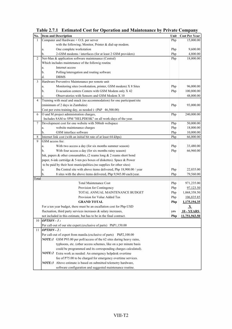
No. Unit Cost Per Year 1 Php 15,000.00
a. Php 9,600.00b. Php 4,800.00
2 Php 18,000.00
a. Internet access b.d. DBMS
3a. Php 96,000.00b. Php 100,800.00c. 48,000.00
4 Php 93,000.00
6 Php 240,000.00
7 Php 50,000.00a. Php 18,000.00b. Php 10,000.00
8 Php 66,000.009
a. Php 33,480.00b. Php 66,960.00
a. Php 22,035.00b. Php 79,560.00
Php 971,235.00 Php 97,123.50 Php 1,068,358.50 Php 106,835.85 Php 1,175,194.35
X yrs 10 - YEARS Php 11,751,943.50
10
11
NOTE:1
NOTE:2
NOTE:3
Total
Table 2.7.1 Estimated Cost for Operation and Maintenance by Private Company
software configuration and suggested maintenance routine.
could be programmed and its corresponding charges calculated).Extra work as needed: An emergency helpdesk overtime fee of P75.00 to be charged for emergency overtime services.Above estimate is based on submitted telemetry hardware,
OPTION - 2 :Per call-out of expert from manila.(exclusive of parts) PhP2,100.00
GSM P93.00 per poll/access of the 62 sites during heavy rains,typhoons, etc. (other access schemes, like on a per minute basis
fluctuation, third party services increases & salary increases,not included in this estimate, but has to be in the final contract.OPTION - 1 :Per call-out of our site expert.(exclusive of parts) PhP1,150.00
TOTAL ANNUAL MAINTENANCE BUDGETProvision for Value Added TaxGRAND TOTAL
For a ten year budget, there must be an escallation cost for Php-USD
Iba Central site with above items delivered, Php 18,900.00 / year 8 sites with the above items delivered, Php 9,945.00 each/year.
Total Maintenance Cost Provision for Contingency
With four access a day (for six months rainy season) Ink, papers & other consumables, (2 reams long & 2 reams short bondpaper, 6-ink cartridge & 5-ten pcs boxes of diskettes). Space & Power to be paid by their host municipalities.(no supplies for other sites)
GSM interface software Internet link cost (with an initial bit rate of at least 64-kbps) GSM access fee:
With two access a day (for six months summer season)
O and M project administration charges, Includes 8AM to 5PM "HELPDESK" on all work-days of the year.Development cost for one website with 500mb webspace
website maintenance charges
Training with meal and snack (no accommodation) for one participant/site(minimum of 2 days in Zambales) Cost per extra training day, as needed is (PhP 46,500.00)
Hardware Preventive Maintenance per remote unitMonitoring sites (workstation, printer, GSM modem) X 8 Sites Evacuation centers Centers with GSM Modem only X 42 Observatories with Sensors and GSM Modem X 10
2-GSM modems / interfaces (for at least 2 GSM providers) Net-Man & application software maintenance (Central) Which includes maintenance of the followig routine
Polling/interogation and routing software
Computer and Hardware + O.S. per server with the following; Monitor, Printer & dial-up modem.One complete workstation
Item and Description
VIII-T2

Table 3.1.1 List of Evacuation Center during Calamities (1/3)(Department of Education, Region III Division of Zambales, Iba)
1 Botolan Bucao Bancal Elementary School Bancal N 15 0 18' 28.0' E 120 0 00' 08.6' Along National Hi-way, Brgy. Bancal, Botolan, Zambales
14 Class Rooms 500 Persons 17 W: NO、EL:OK、CR: 4units CR is not enough. No
water pump is avaiable. No potable water in School.1991 All rooms are used from Brgy Nacolcol and Poonbato
To provide potable water CR to increase
2 Botolan Bucao Batonlapok Elementary School Batonlapok N 15 0 17' 16.8' E 120 0 01' 58.0' Along National Hi-way, Botolan,Zambales
10 Class Rooms 300 Persons 24 W:OK, EL:Partial, CR: 8 unit * 4 rooms are not
electrified.CR is not enough.
4 times after 1991 July/2002 : 15 fam.from Carael School area is often flooding
To provide electricity To increase CR To elevate school area and to provide drainage.
3 Botolan Bucao Beneg Elementary School Beneg N 15 0 16' 52.2' E 120 0 00' 27.7' Along Rural Road, Brgy. Beneg, Botolan, Zambales
6 Class rooms 180 persons 21 W:NO, EL:OK, CR: 6 unit * Required to repair
water sytemNot used as evacuation center Every year flooded in school area
To elevate school area To provide drainage To repair water system
4 Botolan Bucao Binoclutan Elementary School Binoclutan N 15 0 14' 13.4' E 120 0 00' 46.5'Along Rural Rd.Coastal Area, Brgy. Binoclutan, Botolan, Zambales
6 Class rooms 180 Persons 16 W:NO, EL:OK, CR: 2 unit * CR is not enough Sep.2001: 100fam. From Carael
High tide occurred in 1985. Every high tide season affects to the area. Not suitable as Evacuation Center.
5 Botolan Bucao Botolan North Central Elementary School Tampo N 15 0 17' 25.5' E 120 0 01' 26.0' Along National Hi-way, Center
of Botolan, Zambales19 Class room 1 big hall 670 Persons 6 W: OK、EL:OK、CR:19units 1991 All rooms are used Jul/2001: 1fam.
From brgy.Carael
Building is rahter old. Some renovation will be needed. School area is about 5ha.
6 Botolan Bucao Botolan South Central School Paco N 15 0 17' 17.6' E 120 0 01' 22.5' South Central Brgy. Paco, Botolan, Zambales
16 Class room 1 Big hall580 persons 13 W:OK, EL:OK, CR: 16 unit 1991 All rooms are used
Building is rahter old. Some renovation will be needed. School area is about 3ha.
7 Botolan Bucao New Taugtog Elementary School and High School New Taugtog N 15 0 18' 28.0' E 120 0 02' 42.5' Purok 3 New Taugtog, Botolan,
Zambales10 rooms in HS 5 rooms in EMS 800 Persons 17 W: OK、EL:OK、CR:7units CR is not enough in HS
Class Room for Grade 5&6 is not enough
Newly established in 2000 for Elementary School, and 2001 for High school
More class rooms needed to accommodate students. School are is about 5 ha. Hostpital is located in adjacent.
8 Botolan Bucao Panan Elementary School Panan N 15 0 12' 59.2' E 120 0 01' 30.4' Along National Hi-way, Brgy. Panan, Botolan, Zambales
13 Class romms 390 Persons 23 W:NO, EL:OK, CR: 13 unit Two times in 1991 All rooms are used.
Sep.2001: 1fam.from Carael
Leakage of rainwater from roof are to be repaired School area is about 5 ha.
9 Botolan Bucao Ramon Magsaisai Technical University. Porac N 15 0 14' 51.4' E 120 0 01' 08.5' Along National Hi-way, Brgy.
Porac, Botolan, Zambales
23 Class Rooms Several Halls 16 Domitiries More than 1000
52 W:OK, EL:OK, CR: Many1991 : 2 times 1995 : due to flush flood Aug/2001 : from San Felipe Sep/2001 : Many from Carael
Best places. Enough capacity. Enough food in experimental farms.
10 Botolan Bucao San Isidro Elementary School San Isidro N 15 0 18' 49.3' E 120 0 00' 58.5' Rural Road, Brgy. San Isidro, Botolan, Zambales
6 Cross Room 150 persons 22 W: NO、EL:OK、CR:2units CR is not enough.No
water pump is avaiable. No potable water in School.1991 All rooms are used from Brgy Maguisguis, Poonbato and Villar.
To provide potable water CR and Class Room to increase No flood affected
11 Iba Bucao Amungan Elementary School Amungan N 15 0 21' 44.7' E 119 0 57' 31.9' Along National Hi-way, Brgy. Amungan, Iba, Zambales
30 classrooms 2-3 thousand persons Area: 2000 sq.m.
16 W= NO EL. NO CR= OK 1991 all classroom used Sept. 2001-all CR used
better water system Repair of classroom more toilets
12 Iba Bucao Bangan Talinga Elementary School Bangan Talinga N 15 0 20' 57.3' E 119 0 57' 59.8' Along National Hi-way, Brgy. Bangan Talinga, Iba, Zambales
12 classrooms 180 Families A= almost 2 ha.
17 W=NO EL: OK CR: all with CR 1991-all rooms 2001-all rooms occupied water for drinking CR to be repaired
13 Iba Bucao Dampay Elementary School Amungan N 15 0 22' 18.0' E 119 0 57' 28.7'Along National Hi-way, Dampay, Brgy. Amungan, Iba, Zambales
9 classrooms 7/8 families/C/R Area: 2 hectares
25 W= OK EL. OK CR= OK 1991-all Classroom occupied 2001-(Sept.)all classroom occupied repair of all classrooms
14 Iba Bucao Dirita- Balugan Elementary School Dirita-Balugan N 15 0 19' 56.2' E 119 0 58' 45.5'Along National Rd.near Iba Market, Brgy. Dirita, Balugan, Iba, Zambales
14 Classrooms 4-5 Families/c/r Area: 11,924 sq. m
26 W= YES EL: OK CR:6 1991-almost all classrooms are used repair of classroom
15 Iba Bucao Iba Central School Poblacion N 15 0 19' 26.7' E 119 0 58' 56.1' Along National Road, Brgy. Poblacion, Iba, Zambales
20 classrooms 500 families Area: 20,400 sq.m
24 W= OK EL. NO CR= OK 1991-all Classroom occupied Sept. 2001-all class room repair of electrical wiring
16 Iba Bucao Lawak Elementary School Amungan N 15 0 21' 24.2' E 119 0 57' 43.9' Along National Hi-way, Brgy. Amungan, Iba, Zambales
14 classrooms 2-3 thousand persons Area: 2000 sq.m.
26 W=OK EL. OK CR= 5 1991-14 classrooms occupied 2001- all classroom repair of classroom roofing
17 Iba Bucao Palanginan Elem. Sch. Palanginan N 15 0 19' 07.9' E 119 0 59' 24.5' Along National Road, Brgy. Palanginan, Iba, Zambales
100 families 30 classrooms 28 EL.:OK ,W: OK,CR - 12 units only 1991-for less than 1 month 2001-
anticipated flooding needs repair/replacement upgrade water system needs more toilets
18 Cabangan Maloma Anonang Elementary School Anonang N 15 0 07' 34.7' E 120 0 03' 25.5' Brgy. Anonang, Cabangan, Zambales 10 families 6 classrooms 20 W: water system:OK, El. OK CR: not enough (2)
units only needs repair 1991: once only 3 rooms were occupied 3 classrooms need repair H.E. Building deteriorated
19 Cabangan Maloma Cabangan Central Elementary School Poblacion N 15 0 09' 39.2' E 120 0 03' 17.9' Along National Hi-way,
Cabangan, Zambales
17 ClassRooms 1 multi-purpose building More than 1000
25 W: not enough,El: Ok CR: not enough 1991: once only all rooms, buildings occupied
Water not sufficient some classrooms need repair (termites infected)
Longitude
Location Comments
(Budget, etc.)River Basin Storing against Emergency
(Food, Water, etc. if any, quantities)
Utilized in (month, year and No. of
Evacuees)Latitude
CoodinationBarangay Elevation
(El. m)No.
Detail CapacityMunicipal/
City Name of School
Conditions
VIII-T
3

Table 3.1.1 List of Evacuation Center during Calamities (2/3)(Department of Education, Region III Division of Zambales, Iba)
Longitude
Location Comments
(Budget, etc.)River Basin Storing against Emergency
(Food, Water, etc. if any, quantities)
Utilized in (month, year and No. of
Evacuees)Latitude
CoodinationBarangay Elevation
(El. m)No.
Detail CapacityMunicipal/
City Name of School
Conditions
20 Cabangan Maloma Mt. Cabangaan A Private Lot at the foot of the mountain S Antonio N 15 0 09' 46.9' E 120 0 03' 02.9'
San Antonio & San Isidro Boundaries, Cabangan, Zambales
100 families from San Antonio Temporary Shelter
22 W:none, El: none, CR:temporary 1991 was used for 1 week only Evacueesreturned to San Antonio Temporary shelter is delapidated
21 Cabangan Maloma Pavillion Evacuation Center Sto. Niño N 15 0 08' 48.4' E 120 0 03' 10.6' Along National Hi-way, Brgy. Sto. Niño, Cabangan, Zambales 23 1991
abandoned building was used as temporary shelter for several days only
22 Cabangan Maloma San Isidro Plaza Temporary Shelter Sn. Isidro N 15 0 09' 57.8' E 120 0 02' 52.3' Brgy. San Isidro, Cabangan, Zambales 20 families 200 sq. m. W:OK, El: None, CR: temporary 1991 used for 1 month only.
Temporary shelter was const. at the plaza since school bldgs. of the brgy. was constructed only in 1994.
23 Cabangan Maloma San Juan Elem. Sch. San Juan N 15 0 09' 21.6' E 120 0 03' 38.5' Brgy. San Juan, Cabangan, Zambales
100 families 15 classrooms 1 adm. Building
20 W: OK, El.:OK, CR: not adequate '3 units only 1991 Flashflood 1994 Flooded during heavy rain Needs more sch. buildings and toilets
24 Cabangan Maloma San Juan Plaza Concrete 4 Door Row House San Juan N 15 0 09' 21.3' E 120 0 03' 40.5' Brgy. San Juan, Cabangan,
Zambales 20 families 2 hectares 21 W.:OK, El: OK, CR: 2 units only needs repair 1991 several months after eruption and construction of the building
Evacuees transferred from Mt. Mabiga
25 Cabangan Maloma Santa Rita Elementary School Santa Rita N 15 0 10' 43.7' E 120 0 02' 50.1' Along National Hi-way, Brgy. Sta. Rita, Cabangan, Zambales
20 families 14 rooms 1 Admin. Bldg. A=5,314 sq.m.
49 W: OK , El: OK CR: 3 units only 1991 for 3 weeks just stay overight daytime return to their brgys.
all classrooms need repair needs more toilets
26 Cabangan Maloma Tangos Evacuation Center Tangos Dolores N 15 0 09' 41.7' E 120 0 07' 02.7' Sitio Tangos Dolores, Cabangan, Zambales
27 San Felipe St. Tomas Bantay Carmen Maloma N 15 0 05' 56.0' E 120 0 03' 56.5' Along National Hi-way, Maloma, San Felipe, Zambales
60 families fr. Maloma, Bunawen Muraza 45 W: Ok, El:Ok, CR: individually built 1991 to present 28 families became permanent
settlers houses individually built
28 San Felipe St. Tomas San Rafael Elem. Sch. San Rafael N 15 0 03' 28.1' E 120 0 03' 59.7' Brgy. San Rafael, San Felipe, Zambales
100 persons 3 rms used existing 9 rms. 5,466 sq. m.
39 W: Ok, El:Ok, CR:OK, 1 unit/rm for evacuatuon: CR not available to the 3 rooms
1991 every flash flood almost yearly except this year
3 room building needs basic facilities and repair
29 San Felipe St. Tomas Sindol Elem. Sch. Sindol N 15 0 04' 36.2' E 120 0 04' 00.4' Along National Hi-way, Brgy. Sindol, San Felipe, Zambales
12 families 9 cl rms. 1 adm. Bldg. 3 hectares 47 W: Ok, El: Ok,CR: not adequate 1991 for 3 weeks only Need repair wide playground needs
more toilets
30 San Felipe St. Tomas Sitio Sagpat Maloma N 15 0 06' 05.1' E 120 0 05' 56.7' Sitio Sagpat Maloma, San Felipe, Zambales
31 San Felipe St. Tomas Tektek Resettlement Area Sindol N 15 0 05' 45.5' E 120 0 03' 45.3' Sitio Tek-Tek, San Felipe, Zambales 47 families 41 W: not adequate E: none CR: 2 units only (public)
per house
1995 when declared as an evacuation center house and lots were donated became permanent settlers
needs basic facilities needs livelihood for indigenous people
32 San Marcelino St. Tomas Laoag Elem. Sch. Laoag N 14 0 58' 32.8' E 120 0 10' 03.6' 50
33 San Marcelino St. Tomas Linasin Elem. Sch. Linasin N 14 0 58' 23.6' E 120 0 08' 58.7' 4 buildings 37
34 San Marcelino St. Tomas Linusungan Elem. Sch. Linusungan N 14 0 57' 05.4' E 120 0 09' 45.7' 3 Bldgs. 7 Cls. Rooms App 1 hec. 43 existing water supply is not enough Electricity - ok
toilet needs repair 1991 used for 2 mos. 50 families
35 San Marcelino St. Tomas San Marcelino Elem. Sch. Poblacion N 14 0 58' 42.6' E 120 0 09' 19.0' Brgy. Burgos, San Marcelino, Zambales
>100 families A=3 hec. 23 existing clsrms 3 adm. Buildings
W: Ok, El:Ok,CR:Ok 1991 all classrooms were used but vacated after June 15 all bldgs collapsed Needs repair Termite infested
36 San Marcelino St. Tomas Sn Guillermo N. H Sch. Burgos N 14 0 58' 23.6' E 120 0 08' 58.7' 6 buildings 37
37 San Marcelino St. Tomas St. William's Sch. Central N 14 0 58' 28.2' E 120 0 09' 25.8' 3- two storey buildings 42
38 San Marcelino St. Tomas Vega Hill Consuelo Norte N 14 0 59' 06.3' E 120 0 09' 11.7' Brgy. Consuelo Norte, San Marcelino, Zambales 1,500 families 64 W: Ok nat. spring potable El: none CR: temporary 1991 for almost 1 year tent were put up Permenent Settlers built houses
39 San Narciso St. Tomas Alusiis elem. Sch. Alusiis N 15 0 01' 33.1' E 120 0 04' 39.2' 36
40 San Narciso St. Tomas Beddeng Elem. Sch. Beddeng N 14 0 59' 14.4' E 120 0 05' 00.5' Along National Hi-way, Brgy. Beddeng, San Narciso, Zambales
50 persons 3 rooms used 12 classrms existin 36 W: not sufficient El: Ok CR: not adequate
1991for several days only heavy ashfall one building was left others collapsed Needs water supply
Reconst. 1993 only Needs repair/ replacement
41 San Narciso St. Tomas Consuelo Elem. Sch. Consuselo N 14 0 59' 13.9' E 120 0 08' 24.4' 3 sch buildings 6 classrms 38 electricity - none toilet - ok water - deepwell but
defective 1991 for 20 families used for storage
42 San Narciso St. Tomas Doce Martirez El. Sch. Grullo N 15 0 00' 48.3' E 120 0 05' 39.1' 5 buildings 39
43 San Narciso St. Tomas La Paz Elem. Sch. La Paz N 15 0 00' 50.5' E 120 0 04' 06.1' 3 sch buildings 11 classrms. 31
VIII-T
4

Table 3.1.1 List of Evacuation Center during Calamities (3/3)(Department of Education, Region III Division of Zambales, Iba)
Longitude
Location Comments
(Budget, etc.)River Basin Storing against Emergency
(Food, Water, etc. if any, quantities)
Utilized in (month, year and No. of
Evacuees)Latitude
CoodinationBarangay Elevation
(El. m)No.
Detail CapacityMunicipal/
City Name of School
Conditions
44 San Narciso St. Tomas La Paz High Sch. La Paz N 15 0 00' 57.1' E 120 0 04' 19.3' 4 buildings 35
45 San Narciso St. Tomas Lalek Sindol N 15 0 05' 23.1' E 120 0 04' 19.8' 100 families W: not sufficient El: none CR: individual1991 tent were put up, was used for more than 1 year 98 families became perma- nent settlers
Not declared as Evacuation Center
46 San Narciso St. Tomas Magsaysay Mem. Col Libertad N 15 0 00' 58.7' E 120 0 04' 47.5'3 buildings 10 elem. classrms 10 HS classrms.
34 electricity - ok water - ok toilet - ok not used as an evacuation center
47 San Narciso St. Tomas Namatacan Elem. Sch. Namatacan N 15 0 00' 24.0' E 120 0 08' 03.2' 53
48 San Narciso St. Tomas Phil Merchant Mar. Ac. Aldea N 14 0 59' 59.3' E 120 0 04' 21.8'15 buildings 20 clsrms. 1 dormitory 1 gymnasium app 1.5 hec.
18 electricity - ok water - ok toilet - ok not used as an evacuation center constructed only in 1998
49 San Narciso St. Tomas San Jose-Patrocinio Elem. Sch. Poblacion East N 15 0 00' 41.9' E 120 0 04' 55.0' Brgy. Patrocinio, San Narciso, Zambales
100 to 150 persons 15 class rooms 2 adm. Building Area= 1.4 hec.
44 W:not adequate E: needs to be upgraded CR: not adequate
1991 for 3 days only all buildings collapsed except for one
Almost all buildings need repair concrete fence for demolition
50 San Narciso St. Tomas San Juan-Candelaria Elem. Sch. Candelaria N 15 0 00' 49.0' E 120 0 05' 05.6' Brgy. Candelaria, San Narciso, Zambales
100 to 150 persons 11 class rooms 1 adm. Building
42 W: Ok, El.:Ok CR: not adequate 1991 for 2 weeks only Buildings recons- tructed 1992 needs repair
51 San Narciso St. Tomas San Narciso Central Elementary School Sn Rafael N 15 0 01' 03.2' E 120 0 04' 44.2'
Along National Hi-way, Brgy. San Rafael, San Narciso, Zambales
100 to 150 persons existing 17 cl rms 1 adm. bldg.
48 W: Ok, El: Ok,CR: not adequate/non-functional 1991 for 3 days 1992 flash flood Need repair frequently flooded
52 San Narciso St. Tomas San Rafael-Natividad Elem. Sch. Sn Rafael N 15 0 00' 55.1' E 120 0 04' 28.8' Brgy. San Rafael, San Narciso, Zambales
10 families Area=1.2 hec. 44 W:Ok, El:Ok, CR: 2 units 1991 for one week only evacuees were
transferred to other evacuation center Classrooms need repair Termite infested Needs more toilets
53 San Narciso St. Tomas Simminublan Elem. Sch. Simminublan N 14 0 59' 20.5' E 120 0 07' 06.1'4 sch. Bldgs 1 adm. 1 H.E./Ind. Arts bldgs. 850 sq. m.
26 electricity - ok water - water system needs repair toilet - ok
1991 10 families used for 1 month 1993 and 1994 during flood flooded during rainy season
54 San Narciso St. Tomas Umaya Elem .Sch. Umaya N 15 0 00' 01.3' E 120 0 09' 38.9' 59
55 San Narciso St. Tomas Zambales Academy Alusiis N 15 0 01' 14.1' E 120 0 04' 41.5' 4 sch. buildgs 1 adm. 16 class rms. 33 electricity - ok water - ok toilet - ok 1991 1 bldg. used for 1 month 30
families
56 Castillejos Balaybay Resettlement Elementary School Balaybay N 14 0 53' 35.9' E 120 0 12' 06.4' Brgy. Balaybay Resettlement
Area Castillejos, Zambales1,600 families 20 classrooms 147 W: if deepwell be repaired water supply will be
sufficient El: Ok, CR: OkMay 1993 when the place was declared as Resettlement Area
Tents were put up within the school area. Sch buildings were const. in 1994 only
57 Castillejos Ramon Magsayasay Elementary School Brgy. Pob. N 14 0 55' 57.2' E 120 0 12' 02.5' Along National Hi-way,
Poblacion, Castillejos, Zambales
18 families 12 classrooms 2 multi purpose bldg.
64 W: jetmaticpump: not adequate El: Ok, CR: Ok 1991 for almost 1 month 1993 flashflood Needs more sch.buildings 3 classrooms need repair
58 Castillejos Santa Maria Elementary School Sta. Maria N 14 0 56' 12.2' E 120 0 11' 52.3' Along National Hi-way, Brgy. Sta. Maria, Castillejos, Zambales
40 families 28 class rooms 1 adm. Building 63 W:Ok, El.:OK, CR: 10 units only 2 units need
repair1991 once only for 1 month Evacuees from diff barangays near Mt. Pinatubo Needs more toilets and class rooms
59 Castillejos Villaflor Elementary School Sn Roque N 14 0 55' 44.4' E 120 0 12' 20.1'Along National Hi-way, Brgy. San Roque, Castillejos, Zambales
8 families 14 classrooms 61 W: waterpump not adequate El.: Ok, CR: not adequate
1991, was used only once evacuees from Brgy. Nagbunga near the river
all rooms were occupied some classroooms need repair affected by termites
60 Palauig Tent City or Palauig Evac. Center N 15 0 24' 39.7' E 119 0 57' 06.9' 100 houses 76 families Area: 20,400 sq.m 59 W= NO EL. Ok CR= Needs repair 1991-all buildings occupied Sept. 2001-
all buildings were occ. better water system repair of CR
61 Sn Antonio Angeles elem. Sch. Angeles N 14 0 56' 13.7' E 120 0 08' 50.6' 3 sch. Buildings 12 classrms. 21
62 Sn Antonio San Esteban Elem. Sch. Sn Esteban N 14 0 56' 52.6' E 120 0 09' 23.5'
5 sch. Buildings 8 classrms. 1 ind arts bldg 1- H.E. bldg. app. 750 sq. m.
43 electricity - ok water - ok toilet - ok 1992 - 15 families sch. Buildings need repair
63 Sn Antonio West Dirita Elem. Sch. Dirita N 14 0 57' 40.2' E 120 0 04' 29.4' 3 sch. buildings 1 adm. Bldg. 12 classrms. 14 electricity - ok water - ok toilet - ok 1991 - 30 families flooded when Dinumagat River
overflows but easily subside
VIII-T
5

Table 3.2.1 Capacity and Condition of Evacuation Center
1 Bucao Botolan 14 Class Rooms 500 Persons 500 W: NO、EL:OK、CR: 4units CR is not enough. No water pump is avaiable. No potable water in School. No Midium 25
2 Bucao Botolan 10 Class Rooms 300 Persons 300 W:OK, EL:Partial, CR: 8 unit * 4 rooms are not electrified.CR is not enough. Yes Serious 50
3 Bucao Botolan 6 Class rooms 180 persons 180 W:NO, EL:OK, CR: 6 unit * Required to repair water sytem No Midium 25
5 Bucao Botolan 19 Class room 1 big hall 670 Persons 670 W: OK、EL:OK、CR:19units Yes Serious 50
6 Bucao Botolan 16 Class room 1 Big hall 580 persons 580 W:OK, EL:OK, CR: 16 unit No - 0
7 Bucao Botolan 10 rooms in HS 5 rooms in EMS 800 Persons 800 W: OK、EL:OK、CR:7units CR is not enough in HS Class Room for Grade 5&6 is not enough No Minor 10
10 Bucao Botolan 6 Cross Room 150 persons 150 W: NO、EL:OK、CR:2units CR is not enough.No water pump is avaiable. No potable water in School. Yes Serious 50
17 Bucao Iba 100 families 30 classrooms 500 EL.:OK ,W: OK,CR - 12 units only No Minor 10
18 Maloma Cabangan 10 families 6 classrooms 50 W: water system:OK, El. OK CR: not enough (2) units only needs repair No Minor 10
39 St.Tomas (L) San Narciso N.A. 450 N.A No Midium 25
43 St.Tomas (L) San Narciso 3 sch buildings 11 classrms. 220 N.A Yes Serious 50
44 St.Tomas (L) San Narciso 4 buildings 280 N.A No Midium 25
46 St.Tomas (L) San Narciso 3 buildings 10 elem. classrms 10 HS classrms. 200 electricity - ok water - ok toilet - ok No - 0
48 St.Tomas (L) San Narciso 15 buildings 20 clsrms. 1 dormitory 1 gymnasium app 1.5 hec. 400 electricity - ok water - ok toilet - ok No - 0
49 St.Tomas (L) San Narciso 100 to 150 persons 15 class rooms 2 adm. Building Area= 1.4 hec. 125 W:not adequate E: needs to be upgraded CR: not adequate No Midium 25
50 St.Tomas (L) San Narciso 100 to 150 persons 11 class rooms 1 adm. Building 150 W: Ok, El.:Ok CR: not adequate No Minor 10
51 St.Tomas (L) San Narciso 100 to 150 persons existing 17 cl rms 1 adm. bldg. 150 W: Ok, El: Ok,CR: not adequate/non-functional No Minor 10
52 St.Tomas (L) San Narciso 10 families Area=1.2 hec. 50 W:Ok, El:Ok, CR: 2 units No Minor 10
55 St.Tomas (L) San Narciso 4 sch. buildgs 1 adm. 16 class rms. 320 electricity - ok water - ok toilet - ok No - 0
40 St.Tomas (L) San Narciso 50 persons 3 rooms used 12 classrms existin 50 W: not sufficient El: Ok CR: not adequate Yes Serious 50
42 St.Tomas (L) San Narciso 5 buildings 350 N.A No Midium 25
47 St.Tomas (L) San Narciso N.A. 450 N.A No Midium 25
53 St.Tomas (L) San Narciso 4 sch. Bldgs 1 adm. 1 H.E./Ind. Arts bldgs. 850 sq. m. 280 electricity - ok water - water system needs repair toilet - ok No Minor 10
54 St.Tomas (L) San Narciso N.A. 450 N.A No Midium 25
32 St.Tomas (L) San Marcelino N.A. 450 N.A Yes Serious 50
33 St.Tomas (L) San Marcelino 4 buildings 280 N.A Yes Serious 50
34 St.Tomas (L) San Marcelino 3 Bldgs. 7 Cls. Rooms App 1 hec. 140 existing water supply is not enough Electricity - ok toilet needs repair No Midium 25
35 St.Tomas (L) San Marcelino >100 families A=3 hec. 23 existing clsrms 3 adm. Buildings 500 W: Ok, El:Ok,CR:Ok Yes Serious 50
36 St.Tomas (L) San Marcelino 6 buildings 420 N.A Yes Serious 50
38 St.Tomas (L) San Marcelino 1,500 families 7,500 W: Ok nat. spring potable El: none CR: temporary Yes Serious 50
41 St.Tomas (L) San Narciso 3 sch buildings 6 classrms 120 electricity - none toilet - ok water - deepwell but defective Yes Serious 50
60 St.Tomas (L) Palauig 100 houses 76 families Area: 20,400 sq.m 380 W= NO EL. Ok CR= Needs repair No Midium 25
61 St.Tomas (L) Sn Antonio 3 sch. Buildings 12 classrms. 240 N.A Yes Serious 50
62 St.Tomas (L) Sn Antonio 5 sch. Buildings 8 classrms. 1 ind arts bldg 1- H.E. bldg. app. 750 sq. m. 160 electricity - ok water - ok toilet - ok Yes Serious 50
28 St.Tomas (R) San Felipe 100 persons 3 rms used existing 9 rms. 5,466 sq. m. 100 W: Ok, El:Ok, CR:OK, 1 unit/rm for evacuatuon: CR not available to the 3 rooms No Midium 25
29 St. Tomas (R) San Felipe 12 families 9 cl rms. 1 adm. Bldg. 3 hectares 60 W: Ok, El: Ok,CR: not adequate No Midium 25
Survey Result
Capacity Storing against Emergency (Food, Water, etc. if any, quantities)
LocationNo.
RiverBasin
Possibility of InundationAssumption
(Person)
Municipal/City
Rate (%)
Condition of Damage
VIII-T
6

Bancal 1.21 910 752 0.02 0.02 17Bangan 1.70 1,586 934 0.73 0.43 685Batonlapoc 2.38 1,170 491 1.84 0.77 904Beneg 0.87 1,414 1,630 0.54 0.62 874Capayawan 0.70 820 1,173 0.69 0.98 804Carael 5.60 1,723 308 2.95 0.53 906Danacbunga 3.87 2,306 595 0.98 0.25 581Malomboy 31.09 3,598 116 2.60 0.08 301Paco 0.74 2,298 3,124 0.47 0.64 1,469Parel 1.27 816 643 0.44 0.34 280Paudpod 3.97 558 141 1.33 0.34 187San Juan 46.60 2,530 54 0.46 0.01 25San Miguel 1.10 997 905 0.83 0.75 748Santiago 3.08 1,666 541 0.24 0.08 129Tampo 1.28 1,173 918 0.17 0.13 154
Iba Palanginan 12.81 4,651 363 0.15 0.01 54118.27 28,216 - 14.42 0.12 8,118
Anonang 2.32 747 323 0.45 0.19 144Casabaan 0.28 635 2,276 0.00 0.00 0Laoag 1.66 891 537 0.99 0.59 200Tondo 0.53 1,022 1,922 0.14 0.26 50
San Felipe Maloma 23.45 3,977 170 4.21 0.18 71428.24 7,272 - 5.78 0.20 1,108
San Marcelino La Paz 1.06 1,019 964 1.03 0.97 990San Narciso Grullo 4.92 1,609 327 0.50 0.10 162San Narciso Natividad 2.10 1,375 654 1.17 0.56 764San Narciso Patro cinio 2.44 2,114 866 1.01 0.42 878San Narciso San Juan 1.40 1,237 882 0.52 0.37 458San Narciso San Rafael 0.63 1,387 2,213 0.00 0.00 5San Narciso Beddeng 10.69 2,477 232 6.78 0.63 1,572San Narciso Dallipawen 3.28 733 224 1.95 0.60 437San Narciso Namatacan 5.53 1,448 262 0.70 0.13 184San Narciso Simminublan 7.81 1,412 181 6.25 0.80 1,130San Marcelino Burgos 2.01 1,903 945 0.76 0.38 717San Marcelino Central(pob.) 0.23 681 2,950 0.17 0.73 497San Marcelino Consuelo Norte 2.10 1,292 615 1.12 0.53 690San Marcelino Consuelo Sur 0.60 1,247 2,067 0.36 0.60 750San Marcelino Laoag 3.24 1,820 561 0.93 0.29 523San Marcelino Linasin 1.92 2,011 1,047 0.70 0.36 730San Marcelino Linusungan 3.69 1,247 338 3.10 0.84 1,047San Marcelino Lucero 1.27 1,387 1,095 0.81 0.64 887San Marcelino Rizal 1.83 807 441 1.75 0.95 771San Marcelino San Guillermo 1.92 786 410 1.89 0.99 777San Marcelino San Isidro 2.63 1,416 538 2.34 0.89 1,259San Marcelino Sta.Fe 50.74 1,969 39 0.71 0.01 27San Narciso La Paz 3.60 3,764 1,047 1.65 0.46 1,729Castellejos Buenayista 3.76 615 163 0.74 0.20 121Castellejos Nagbayan 7.65 1,689 221 0.35 0.05 77San Marcelino Nagbunga 4.32 1,036 240 0.50 0.12 120San Marcelino Rabanes 5.79 707 122 1.81 0.31 221
- San Antonio - - - 18.24 - 4232*1)
San Felipe Amagna 2.20 1,285 584 0.62 0.28 365San Felipe Apostol 8.68 1,594 184 4.73 0.54 250*2)
San Felipe Balincaguing 1.89 720 381 1.15 0.61 440San Felipe Faranal 3.14 1,690 537 0.36 0.11 192San Felipe Feria 4.33 1,126 260 0.74 0.17 192San Felipe Maloma (Aeta) 57.34 0 0 0.86 0.01 0San Felipe Manglicmot 8.14 1,219 150 0.97 0.12 145San Felipe Rosete 4.64 1,173 253 0.40 0.09 102San Felipe San Rafael 1.66 935 563 0.50 0.30 281San Felipe Sindol 7.81 1,507 193 0.00 0.00 0San Felipe Sto.Nino 1.36 3,641 2,674 0.52 0.38 400*2)
San Narciso Omaya 16.72 757 45 1.26 0.08 57San Narciso Paite 4.59 367 80 1.13 0.25 90
259.69 55,202 - 71.09 0.27 24,269406 90,690 - 91.29 0 33,495
St. Tomas Area Total
St. Tomas River
Total
Table 3.2.2 Estimation Process of Number of Evacuees and Inundation Area
Bucao Area Total
Botolan
(3) InundationArea
(km2)
(5) Evacuee(5)=(4)*(2)
(4) Rate(4)=(1)/(3)
Bucao River Basin
Maloma River Basin
(1) Area (km2)
Cabangan
Maloma Area Total
Density(Pop/km2)
Barangay Basic Data
(2) PopulationMunicipality BarangayArea
VIII-T7

Number of Students
Number of Classrooms
Area of School
Building
Unit Construction
cost of School Building
Construction Cost
Accessories and Others
Unit Cost for Land Acquisition
Area of School Yard
Cost for School Yard
VAT Administrative Cost for Project Implementation
Project Cost
(30 Students /Class Room)
(7 m2 /Students)
(20% of Construction Cost)
inclusive building Area, 3000 m2 in minimum
10 % of Land Acuisition and Construction Costs
5 % of Total Cost
Students Classroom m2 m2/Peso Peso Peso Peso/m2 m2 Peso Peso Peso Peso100 4 700 4,550,000 910,000 3,000 600,000 606,000 333,300 6,999,300 200 7 1,260 8,190,000 1,638,000 4,000 800,000 1,062,800 584,540 12,275,340 300 10 1,820 11,830,000 2,366,000 5,000 1,000,000 1,519,600 835,780 17,551,380 400 14 2,380 15,470,000 3,094,000 6,000 1,200,000 1,976,400 1,087,020 22,827,420 500 17 2,940 19,110,000 3,822,000 7,000 1,400,000 2,433,200 1,338,260 28,103,460
1,000 34 5,740 37,310,000 7,462,000 12,000 2,400,000 4,717,200 2,594,460 54,483,660
(With Land Reclamation of 1 m High)Number of Students
Number of Classrooms
Area of School
Building
Construction cost of School
Building
Construction Cost
Accessories and Others
Unit Cost for Land Acquisition
including Land Acquisition Cost
Area of School Yard
Cost for School Yard
VAT Administrative cost for
constuction
Project Cost
(30 Students /Class Room)
(7 m2 /Students)
(20% of Construction Cost)
inclusive building Area, 3000 m2 in minimum
10 % of Land Acquisition and Construction Costs
5 % of Construction Cost
Students Classroom m2 m2/Peso Peso Peso Peso/m2 m2 Peso Peso Peso Peso100 4 700 4,550,000 910,000 3,000 1,950,000 741,000 407,550 8,558,550 200 7 1,260 8,190,000 1,638,000 4,000 2,600,000 1,242,800 683,540 14,354,340 300 10 1,820 11,830,000 2,366,000 5,000 3,250,000 1,744,600 959,530 20,150,130 400 14 2,380 15,470,000 3,094,000 6,000 3,900,000 2,246,400 1,235,520 25,945,920 500 17 2,940 19,110,000 3,822,000 7,000 4,550,000 2,748,200 1,511,510 31,741,710
1,000 34 5,740 37,310,000 7,462,000 12,000 7,800,000 5,257,200 2,891,460 60,720,660
Table 3.3.1 Costruction Cost for Elementary School by Number of Students
200
6,500 650
6,500
(Without Land Recramation)
VIII-T
8

The Study on Sabo and Flood Control for Western River Basins of Mount Pinatubo in the Republic of the Philippines
Final Report Supporting Report
Figures

THE GOVERNMENT OF THE PHILIPPINES
THE DEPARTMENT OF PUBLIC WORKS AND HIGHWAYS
The Study on Sabo and Flood Control for Western River Basins of Mount Pinatubo in
the Republic of the Philippines JAPAN INTERNATIONAL COOPERATION AGENCY
Figure 2.1.1 Location of Installed Observatories
VIII-F1