sö por munt wanderkarte hiking map - · pdf filesegnavie e tempi per gite e passeggiate /...
TRANSCRIPT
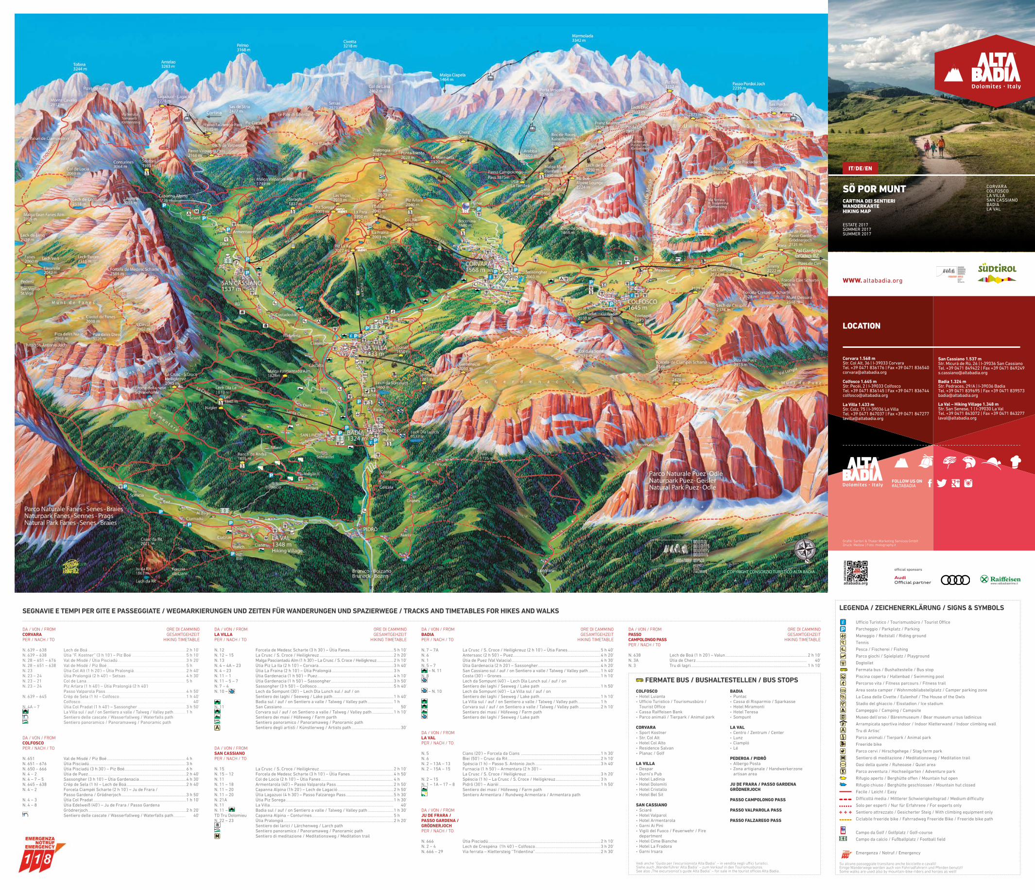
SEGNAVIE E TEMPI PER GITE E PASSEGGIATE / WEGMARKIERUNGEN UND ZEITEN FÜR WANDERUNGEN UND SPAZIERWEGE / TRACKS AND TIMETABLES FOR HIKES AND WALKS
DA / VON / FROM ORE DI CAMMINO CORVARA GESAMTGEHZEITPER / NACH / TO HIKING TIMETABLE
N. 639 – 638 Lech de Boá .................................................................................................................................2 h 10'N. 639 – 638 Ütia “F. Kostner” (3 h 10') – Piz Boé .......................................................................5 h 10'N. 28 – 651 – 676 Val de Misdé / Ütia Pisciadú ..........................................................................................3 h 20'N. 28 – 651 – 638 Val de Misdé / Piz Boé ....................................................................................................... 5 h N. 23 Ütia Col Alt (1 h 20') – Ütia Pralongiá .....................................................................2 h 40'N. 23 – 24 Ütia Pralongiá (2 h 40') – Setsas ...............................................................................4 h 30'N. 23 – 21 Col de Lana .................................................................................................................................. 5 hN. 23 – 24 Piz Arlara (1 h 40') – Ütia Pralongiá (2 h 40') Passo Valparola Pass ..........................................................................................................4 h 50'N. 639 – 645 Crëp de Sela (1 h) – Colfosco ........................................................................................1 h 40' Colfosco .......................................................................................................................................... 40'N. 4A – 7 Ütia Col Pradat (1 h 40') – Sassongher ................................................................3 h 50'
La Villa sul / auf / on Sentiero a valle / Talweg / Valley path ................ 1 h Sentiero delle cascate / Wasserfallweg / Waterfalls path Sentiero panoramico / Panoramaweg / Panoramic path
DA / VON / FROMCOLFOSCO PER / NACH / TO
N. 651 Val de Misdé / Piz Boé ....................................................................................................... 4 hN. 651 – 676 Ütia Pisciadú .............................................................................................................................. 3 hN. 650 – 666 Ütia Pisciadú (3 h 30') – Piz Boé ................................................................................ 6 hN. 4 – 2 Ütia de Puez .................................................................................................................................2 h 40'N. 4 – 7 – 5 Sassongher (3 h 10') – Ütia Gardenacia ..............................................................4 h 30'N. 645 – 638 Crëp de Sela (1 h) – Lech de Boá...............................................................................2 h 40'N. 4 – 2 Forcela Ciampëi Scharte (2 h 10') – Ju de Frara / Passo Gardena / Grödnerjoch .....................................................................................3 h 50'N. 4 – 3 Ütia Col Pradat ..........................................................................................................................1 h 10'N. 4 – 8 Ütia Edelweiß (40') – Ju de Frara / Passo Gardena Grödnerjoch .................................................................................................................................2 h 20'
Sentiero delle cascate / Wasserfallweg / Waterfalls path ................ 40'
DA / VON / FROM ORE DI CAMMINOBADIA GESAMTGEHZEITPER / NACH / TO HIKING TIMETABLE
N. 7 – 7A La Crusc / S. Croce / Heiligkreuz (2 h 10') – Ütia Fanes ...........................................5 h 40'N. 6 Antersasc (2 h 50') – Puez...................................................................................................................4 h 20'N. 1 Ütia de Puez (Val Valacia) .....................................................................................................................4 h 30'N. 5 – 7 Ütia Gardenacia (2 h 20') – Sassongher ..................................................................................4 h 20'
– N. 11 San Cassiano sul / auf / on Sentiero a valle / Talweg / Valley path ................1 h 40'N. 8 Costa (30') – Grones ..................................................................................................................................1 h 10'
Lech da Sompunt (40') – Lech Dla Lunch sul / auf / on Sentiero dei laghi / Seeweg / Lake path ..............................................................................1 h 50'
– N. 10 Lech da Sompunt (40') – La Villa sul / auf / on Sentiero dei laghi / Seeweg / Lake path ................................................................................1 h 10'
La Villa sul / auf / on Sentiero a valle / Talweg / Valley path ............................. 1 h Corvara sul / auf / on Sentiero a valle / Talweg / Valley path ............................2 h 10' Sentiero dei masi / Höfeweg / Farm path Sentiero dei laghi / Seeweg / Lake path
DA / VON / FROMLA VAL PER / NACH / TO
N. 5 Cians (20') – Forcela da Cians ........................................................................................................1 h 30'N. 6 Biei (50') – Crusc da Rit ..........................................................................................................................2 h 10'N. 2 – 13A – 13 Spëscia (1 h) – Passo S. Antonio Joch ......................................................................................3 h 40'N. 2 – 15A – 15 Furnacia (1 h 50') – Armentara (2 h 30') – La Crusc / S. Croce / Heiligkreuz .................................................................................................3 h 20'N. 2 – 15 Spëscia (1 h) – La Crusc / S. Croce / Heiligkreuz .......................................................... 3 hN. 1 – 1A – 17 – 8 Pidrô (30') – Aiarëi .....................................................................................................................................1 h 50'
Sentiero dei masi / Höfeweg / Farm path Sentiero Armentara / Rundweg Armentara / Armentara path
DA / VON / FROM JU DE FRARA / PASSO GARDENA / GRÖDNERJOCH PER / NACH / TO
N. 666 Ütia Pisciadú ...................................................................................................................................................2 h 10'N. 2 – 4 Lech de Crespëna (1h 40') – Colfosco......................................................................................3 h 20'N. 666 – 29 Via ferrata – Klettersteig “Tridentina” ......................................................................................2 h 30'
DA / VON / FROM ORE DI CAMMINO PASSO GESAMTGEHZEITCAMPOLONGO PASS HIKING TIMETABLEPER / NACH / TO
N. 638 Lech de Boá (1 h 20') – Valun ............................................................................................................2 h 10'N. 3A Ütia de Cherz ................................................................................................................................................. 40'N. 3 Tru di Iagri .........................................................................................................................................................1 h 10'
DA / VON / FROM ORE DI CAMMINOLA VILLA GESAMTGEHZEITPER / NACH / TO HIKING TIMETABLE
N. 12 Forcela de Medesc Scharte (3 h 30') – Ütia Fanes .........................................................5 h 10'N. 12 – 15 La Crusc / S. Croce / Heiligkreuz .................................................................................................2 h 20'N. 13 Malga Pasciantadú Alm (1 h 30') – La Crusc / S. Croce / Heiligkreuz ......................2 h 10'N. 4 – 4A – 23 Ütia Piz La Ila (2 h 10') – Corvara ..................................................................................................3 h 40'N. 4 – 23 Ütia La Fraina (2 h 10') – Ütia Pralongiá ................................................................................ 3 hN. 11 – 1 Ütia Gardenacia (1 h 50') – Puez ....................................................................................................4 h 10'N. 11 – 5 – 7 Ütia Gardenacia (1 h 50') – Sassongher ..................................................................................3 h 50'N. 7 – 4 Sassongher (3 h 50') – Colfosco .....................................................................................................5 h 40'N. 10 – Lech da Sompunt (30') – Lech Dla Lunch sul / auf / on Sentiero dei laghi / Seeweg / Lake path ................................................................................1 h 40'
Badia sul / auf / on Sentiero a valle / Talweg / Valley path ................................. 1 hN. 11 San Cassiano ................................................................................................................................................. 50'
Corvara sul / auf / on Sentiero a valle / Talweg / Valley path ............................1 h 10' Sentiero dei masi / Höfeweg / Farm parth Sentiero panoramico / Panoramaweg / Panoramic path Sentiero degli artisti / Künstlerweg / Artists path ................................................................ 30'
DA / VON / FROMSAN CASSIANO PER / NACH / TO
N. 15 La Crusc / S. Croce / Heiligkreuz .................................................................................................2 h 10'N. 15 – 12 Forcela de Medesc Scharte (3 h 10') – Ütia Fanes .........................................................4 h 50'N. 11 Col de Locia (2 h 10') – Ütia Fanes .............................................................................................. 4 hN. 11 – 18 Armentarola (40') – Passo Valparola Pass ...........................................................................2 h 50'N. 11 – 20 Capanna Alpina (1h 20') – Lech de Lagació .........................................................................2 h 50'N. 11 – 20 Ütia Lagazuoi (4 h 30') – Passo Falzarego Pass ..............................................................5 h 30'N. 21A Ütia Piz Sorega .............................................................................................................................................1 h 30'N. 11 La Villa .................................................................................................................................................................. 40'N. 11 – Badia sul / auf / on Sentiero a valle / Talweg / Valley path ..................................1 h 30'TD Tru Dolomieu Capanna Alpina – Conturines .......................................................................................................... 5 hN. 22 – 23 Ütia Pralongiá ................................................................................................................................................2 h 20'
Sentiero dei larici / Lärchenweg / Larch path Sentiero panoramico / Panoramaweg / Panoramic path
M Sentiero di meditazione / Meditationsweg / Meditation trail
LEGENDA / ZEICHENERKLÄRUNG / SIGNS & SYMBOLS
UfficioTuristico/Tourismusbüro/TouristOffice
Parcheggio / Parkplatz / Parking
Maneggio / Reitstall / Riding ground
Tennis
Pesca / Fischerei / Fishing
Parco giochi / Spielplatz / Playground
Dogtoilet
Fermatabus/Bushaltestelle/Busstop
Piscinacoperta/Hallenbad/Swimmingpool
Percorso vita / Fitness parcours / Fitness trail
Areasostacamper/Wohnmobilabstellplatz/Camperparkingzone
LaCasadelleCivette/Eulenhof/TheHouseoftheOwls
Stadio del ghiaccio / Eisstadion / Ice stadium
Campeggio / Camping / Campsite
Museo dell’orso / Bärenmuseum / Bear museum ursus ladinicus
Arrampicatasportivaindoor/IndoorKletterwand/Indoorclimbingwall
Tru di Artisc’
Parco animali / Tierpark / Animal park
Freeridebike
Parco cervi / Hirschgehege / Stag farm park
M Sentiero di meditazione / Meditationsweg / Meditation trail
Oasidellaquiete/Ruheoase/Quietarea
Parco avventura / Hochseilgarten / Adventure park
Rifugioaperto/Berghütteoffen/Mountainhutopen
Rifugio chiuso / Berghütte geschlossen / Mountain hut closed
Facile / Leicht / Easy
Difficoltámedia/MittlererSchwierigkeitsgrad/Mediumdifficulty
Solo per esperti / Nur für Erfahrene / For experts only
Sentieroattrezzato/GesicherterSteig/Withclimbingequipmentonly
Ciclabilefreeridebike/FahrradwegFreerideBike/Freeridebikepath
Campo da Golf / Golfplatz / Golf-course
Campodacalcio/Fußballplatz/Footballfield
Emergenza / Notruf / Emergency
Su alcune passeggiate transitano anche biciclette e cavalli!Einige Wanderwege werden auch von Fahrradfahrern und Pferden benutzt!Some walks are used also by mountain-bike-riders and horses as well!
FERMATE BUS / BUSHALTESTELLEN / BUS STOPS
COLFOSCO• Hotel Luianta• UfficioTuristico/Tourismusbüro/TouristOffice
• CassaRaiffeisenBank• Parco animali / Tierpark / Animal park
CORVARA• Sport Kostner• Str. Col Alt• Hotel Col Alto• Residence Salvan• Planac / Golf
LA VILLA• Despar• Durni’sPub• Hotel Ladinia• Hotel Dolomiti• Hotel Cristallo• Hotel Bel Sit
SAN CASSIANO• Sciaré• Hotel Valparol • Hotel Armentarola• Garni Ai Pini• Vigili del Fuoco / Feuerwehr / Fire
department• Hotel Cime Bianche• Hotel La Fradora• Garni Irsara
BADIA • Puntac• Cassa di Risparmio / Sparkasse• Hotel Miramonti• Hotel Teresa• Sompunt
LA VAL• Centro / Zentrum / Center• Lunz • Ciampló• Lé
PEDEROA / PIDRÔ•AlbergoPosta• Zona artigianale / Handwerkerzone artisan area
JU DE FRARA / PASSO GARDENAGRÖDNERJOCH
PASSO CAMPOLONGO PASS
PASSO VALPAROLA PASS
PASSO FALZAREGO PASS
Vedi anche “Guida per l’escursionista Alta Badia“ – in vendita negli uffici turistici.Siehe auch „Wanderführer Alta Badia” – zum Verkauf in den Tourismusbüros. See also „The excursionist’s guide Alta Badia” – for sale in the tourist offices Alta Badia.
LOCATION
Corvara 1.568 m Str. Col Alt, 36 | I-39033 Corvara Tel. +39 0471 836176 | Fax +39 0471 836540 [email protected]
Colfosco 1.645 m Str. Pecëi, 2 | I-39033 ColfoscoTel. +39 0471 836145 | Fax +39 0471 836744 [email protected]
La Villa 1.433 m Str. Colz, 75 | I-39036 La VillaTel. +39 0471 847037 | Fax +39 0471 847277 [email protected]
FOLLOW US ON #ALTABADIA
Grafik: Sartori & Thaler Marketing Services GmbHDruck: Mellow | Foto: molography.it
San Cassiano 1.537 m Str. Micurá de Rü, 26 | I-39036 San CassianoTel. +39 0471 849422 | Fax +39 0471 849249 [email protected]
Badia 1.324 m Str. Pedraces, 29/A | I-39036 BadiaTel. +39 0471 839695 | Fax +39 0471 839573 [email protected]
La Val – Hiking Village 1.348 m Str. San Senese, 1 | I-39030 La ValTel. +39 0471 843072 | Fax +39 0471 843277 [email protected]
WWW. altabadia.org
CORVARACOLFOSCOLA VILLASANCASSIANOBADIALA VAL
IT/DE/EN
SÖ POR MUNTCARTINA DEI SENTIERIWANDERKARTEHIKING MAP
ESTATE 2017SOMMER2017SUMMER 2017
officialsponsors

DOLOMITI SUPERSUMMERDALL’ALBA AL TRAMONTO,
LE DOLOMITI A MILLE COLORI!ALTA BADIA è Dolomiti SuperSummer.
Goditi la libertà di passare un’estatedi avventura, sport e relax,
scegliendo fra ben 92 impianti,con una sola card.
#DolomitiSuperSummerDOLOMITISUPERSUMMER.com
OFFERTE EMOZIONANTI!L’ESTATE È TUTTA DA VIVERE IN ALTA QUOTA!Vi aspettano infatti più di 100 attrazioni turistiche e sportive tutte in alta quota in 12 valli nel comprensorio unico e spettacolare delle Dolomiti. L’off erta unica di SuperSummer signifi ca disporre di oltre 92 impianti di risalita con un’unica Card disponibile nelle versioni “SUPER SUMMER CARD” e “POINTS VALUE CARD”.
BEGEISTERNDE ANGEBOTE!ERLEBEN SIE DEN SOMMER IN LUFTIGER HÖHE!Über 100 Tourismus und Sportangebote warten in höheren Bergregionen auf Sie – in zwölf Tälern des unvergleichlichen, spektakulären Verbundgebiets der Dolomiten. Mit dem einzigartigen SuperSummer-Angebot können Sie mit einem einzigen Pass mehr als 92 Bergbahnen benützen – wahlweise in den Versionen “SUPER SUMMER CARD” und “POINTS VALUE CARD”.
AMAZING OFFERS!SUMMER WILL SIMPLY TAKE YOUR BREATH AWAY!Come and enjoy more than 100 tourist attractions and sports opportunities set amongst dizzy heights in 12 valleys of the unique and spectacular Dolomite area. “SUPER SUMMER CARD” and “POINTS VALUE CARD” are part of the SuperSummer package: access more than 92 lift facilities with one Card.
Goditi la libertà di passare un’estatedi avventura, sport e relax,
scegliendo fra ben 92 impianti,con una sola card.
RELAX AREA SANTA CROCETroverete sedie panoramiche giganti da scalare, romantiche panche e sedie sdraio in legno piazzate nel verde della natura. Il tutto circondato da un panorama mozzafiato ai piedi del maestoso massiccio del Sas dla Crusc. Da non perdere il sentiero tematico “Sulle orme degli animali selvatici”.
Sie werden Riesen-Panorama-Stühle zum Besteigen für die Mutigsten, romantische Bänke und Holz-Liegestühle mitten im Grünen der Natur vorfinden. Das atemberaubende Panorama am Fuße des majestätischen Sas dla Crusc wird Sie bezaubern. Sehenswert der Lehrpfad „Auf den Spuren der Wildtiere“.
You will find panoramic giant chairs to climb, romantic benches and loungers placed middle in the green of the nature. Don’t miss the nature trail “Tracking Wild Animals”.
CLIMBING BOÈArrampicata sportiva, vie ferrate, vie in arrampicata libera – in un solo luogo! Nelle vicinanze del lago Boè partono nove vie di arrampicata sportiva per un primo assaggio di quello che vi aspetterà. Alla stazione a monte della seggio-via Vallon vi troverete immersi in un vero e proprio paradiso dell’arrampicata.
Sportklettern, Klettersteige, alpine Routen – alles an einem Ort! Nahe am Boè-See starten neun Sportkletter-Routen für einen ersten Vorgeschmack. An der Bergstation des Vallon Sesselliftes eröffnet sich ein wahres Kletterparadies.
Sport climbing, via ferratas, alpine routes – all in one place! Near the lake Boè there are nine sport climbing routes starting for a first taste. At the top station of the Vallon chairlift opens a real climber’s paradise.
MOVIMËNT RECREATION AREA PIZ LA ILAE-BIKE SHARING, KNEIPP, SLACKLINE COURSE
Esplorare il favoloso mondo delle Dolomiti su due ruote. Al Piz La Ila è possibile noleggiare le E-Bike per indimenti-cabili itinerari sull’altipiano. E per la tua salute: un percorso rivitalizzante nell’acqua fredda con effetti benefici alla circolazione. Inoltre potrai mettere alla prova le tue capacità equilibristiche su slackline di diverso grado di diffcoltà.
Die sagenhafte Welt der Dolomiten auf zwei Rädern erkunden. Am Piz La Ila können E-Bikes für einmalige Touren über das Hochplateau gemietet werden. Und für deine Gesundheit: durch eiskaltes Wasser stelzen. Das Wassertre-ten in freier Natur hat positive Auswirkungen auf den Kreislauf und wirkt belebend. Darüber hinaus kannst du auf sechs Slacklines deine Künste vorzeigen.
Exploring the fabulous world of the Dolomites on two wheels. E-Bikes can be rented on Piz La Ila for unforgettable rides on the high plateau. Good for health: brave stilts through icy water. Treading water in nature has a very positive effect on the circulation and has an invigorating effect. Furthermore you can show your skills on six slacklines.
SELLARONDA MTB TOURGrazie a sette Impianti di risalita, ora è possibile effettuare il giro in mountain bike del massiccio del Sella con solo 730 metri di dislivello in salita anziché quasi 3.000. Così un’impresa inaccessibile ad un normale ciclista, diventa un tour straordinario!
Mit Hilfe von sieben Bergbahnen kann man die Sellaronda auf dem Mountainbike jetzt mit nur 730 statt 3.000 m Höhenunterschied im Anstieg bewältigen. Damit wird die für Freizeitbiker zuvor kaum machbare Strecke zu einer großartigen Tour.
Thanks to seven lift facilities, you can now circle the Sella Mountain with a mountain bike and endure only 730 metres of altitude di erence instead of 3,000. A normally impossible feat for an average biker turns into an extraordinary tour.
MOVIMËNT RECREATION AREA PIZ SOREGACHILDREN’S ACTIVITY COURSE AND BEAR HOLE PARK
Percorso avventuroso per bambini che amano giocare con l’acqua. Movimento all’aria fresca immersi nella natura, costruire ponti e dighe, raccogliere oggetti e scovare l’orso nella propria grotta... qualcosa da fare per tutti.
Abenteuerparcours für Kids, die Spaß an Wasserspielen haben. Sich in der Natur bewegen, Brücken und Staudämme bauen, Dinge sammeln und sogar einem Bären in seiner Höhle begegnen... da ist für alle etwas dabei.
For kids who have fun with water games. Moving in the nature, building bridges and dams, collecting things and meet the bear in his cave... there’s something for everyone.
MOVIMËNT RECREATION AREA COL ALTOSPEED HIKING
Con velocità in salita. Con partenza da San Cassiano un percorso relativamente lungo ma semplice e non troppo ripido, alla stazione a monte della cabinovia Col Alto.
Rasant bergauf. In San Cassiano startet ein relativ langer, aber einfacher und nicht besonders steiler Anstieg zur Bergstation der Kabinenbahn Col Alto.
Rapidly uphill. In San Cassiano starts a quite long, but simple and not very steep increase to the top station of the cable car Col Alto.
NATURAL PARK PUEZ-ODLEIl fascino di camminare tra le “pagine” del libro di storia geologica nella distesa del Parco Naturale Puez-Odle. Raggiungibile con la cabinovia Plans-Frara e Col Pradat.
Die Faszination durch die “Seiten” des geologischen Geschichtsbuches im Naturpark Puez-Geisler zu wandern. Erreichbar mit der Kabinenbahn Plans-Frara und Col Pradat.
The fascination of walking through the „pages“ of the geological history book in the Natural Park Puez-Odle. Accessible by the Plans-Frara and Col Pradat cable cars.
FREERIDE BIKE GARDENACCIAA monte della seggiovia Gardenaccia a 1.750 m s.l.m. due tracciati. Il primo dedicato ai bikers alle “prime armi” ed il secondo adatto ai più esperti.
An der Bergstation des Gardenaccia-Sessellifts in 1.750m starten zwei Strecken, eine für MTB- Anfänger und eine für Biker mit Erfahrung.
From the Gardenaccia chairlift mountain station (1,750 metres) there are two routes. The first one is for beginner bikers, while the second one is for more expert bikers.
MOVIMËNT RECREATION AREA PRALONGIÀFUN WITH SPAGHETTINO
Imparare a conoscere il mondo degli animali con l’aiuto di “Spaghettino”, un piccolo vermiciattolo che invita i suoi amici a partecipare ad una festa e ad immergersi in un racconto fiabesco immerso nei prati del Pralongià.
Spielerisch die Tierwelt kennenlernen mit Regenwurm “Spaghettino”, der seine kleinen Freunde zum Wiesenfest und Wiesenmärchen auf der Pralongià einlädt.
Get to know the animal kingdom with earthworm “Spaghettino” who invites his little friends to meadow celebra-tions and fairytales on the Pralongià.
ARMENTARA MEADOWSI prati dell’Armentara: un angolo di natura intatto con una straordinaria e unica ricchezza reale. Raggiungibile con la seggiovia Santa Croce e La Crusc.
Die Armentara Wiesen: eine Ecke intakter Natur mit einem einmaligen und außergewöhnlichen Blumen-reichtum. Erreichbar mit den Sesselliften Santa Croce und La Crusc.
The Armentara meadows: a spot of unspoilt nature with a unique and extraordinary oral wealth. Accessible by the chairlifts Santa Croce and La Crusc.
È possibile acquistare ad un prezzo agevolato la Mobilcard per viaggiare con autobus e treni in tutto l’Alto Adige.
Sie erhalten die Mobilcard zum Vorzugspreis, mit der Sie sich in ganz Südtirol mit Bussen und Bahnen fortbewegen können.
You can get the Mobilcard to a special price and move around Southtyrol by train and bus.
MOBILCARD LEISURE ACTIVITIES
LIFTS
Con l’Alta Badia Summer Card si può accedere a prezzi ridotti sulle strutture per il tempo liberoin valle.
Sie sparen mit der Alta Badia Summer Card bei den zahlreichen Freizeitangeboten.
Save thanks to the Alta Badia Summer Card on various leisure activities.
Piz Sorega
Col Alto
Pralongià
Plans-Frara / Col Alto
Plans-Frara / Col Pradat
Piz La Ila
Boé
Braia Fraida
Gardenaccia
Santa Croce / La Crusc
Vallon
Santa Croce / La Crusc
IT
IT
IT
IT
IT
IT
IT
IT
IT
IT
DE
DE
DE
DE
DE
DE
DE
DE
DE
DE
GB
GB
GB
GB
GB
GB
GB
GB
GB
GB
PLACE LIFT TIMES DATES
Plans-Frara 8:30 – 17:30
8:30 – 17:30
8:30 – 17:30
8:30 – 17:30
8:30 – 17:30
8:45 – 17:15
8:30 – 17:30
8:30 – 17:30
8:30 – 17:30
8:30 – 17:30
8:45 – 17:15
8:45 – 17:15
9:00 – 17:00
9:00 – 17:15
17.06.2017 – 24.09.2017
17.06.2017 – 24.09.2017
17.06.2017 – 24.09.2017
17.06.2017 – 24.09.2017
17.06.2017 – 01.10.2017
17.06.2017 – 01.10.2017
17.06.2017 – 24.09.2017
18.06.2017 – 24.09.2017
02.07.2017 – 03.09.2017
17.06.2017 – 24.09.2017
17.06.2017 – 24.09.2017
17.06.2017 – 24.09.2017
17.06.2017 – 24.09.2017
17.06.2017 – 24.09.2017
Col Pradat
Boè
Vallon
Braia Fraida
Col Alto
Pralongiá
Campolongo - Bec de Roces
Cherz
Piz La Ila
Gardenaccia
Piz Sorega
Santa Croce
La Crusc
Colfosco
Corvara
La Villa
San Cassiano
Badia
PassoCampolongo
Con l’Alta Badia Summer Card è possibile l’uso illimitato di 14 impianti di risalita.
Mit der Alta Badia Summer Card können Sie 14 Liftanlagen unbegrenzt benutzen.
The Alta Badia Summer Card allows unlimited use of 14 lifts in the area of Alta Badia.
HIGHLIGHTSOPEN LIFTS IN ALTA BADIA