rws noord nederland march 2007 - vliz · march 2007 working document 9s1158 . document title...
TRANSCRIPT

HARBASINS WP1 Document analysis: comparison of WFD Article 5 implementation
in estuaries and coastal zones in Belgium, Denmark, Germany, the Netherlands and United Kingdom
RWS NOORD NEDERLAND
March 2007 Working document 9S1158

������������
Document title HARBASINS WP1
Document analysis: comparison of WFD Article 5 implementation in estuaries and coastal zones in Belgium, Denmark, Germany, the Netherlands and United Kingdom
Status Working document
Date March 2007
Project number 9S1158
Client RWS NOORD NEDERLAND
Reference 9S1158/R05/LHEU/Gron
Chopinlaan 12
P.O. Box 8064
Groningen 9702 KB The Netherlands
+31 (0)50 521 42 14 Telephone +31 (0)50 526 14 53 Fax
[email protected] E-mail www.royalhaskoning.com Internet
Arnhem 09122561 CoC
����� ������������������
���� ���������������
Drafted by ing. G. Enserink, ir. A. Dommering, ir. R. Knoben, dr. Lies van Nieuwerburgh, C. Coumans MSc
Checked and approved by ir. L.A. Heuer
Date/initials approval 08-03-2007

HARBASINS WP1 - i - 9S1158/R05/LHEU/Gron Working document March 2007
CONTENTS Page
1 INTRODUCTION 1 1.1 HARBASINS Work package 1 1 1.2 Objectives and focus 1 1.3 Scope and limitations 2 1.4 Activities 2 1.5 Status of this document 3
2 CONTENTS OF THE RIVER BASIN CHARACTERISATION REPORTS 4 2.1 Introduction 4 2.2 Identification of water bodies: setting the borders 4 2.3 Typology 4 2.4 Assignment of status 4 2.5 Reference conditions 5 2.6 Risk assessment 6
3 BELGIUM 7 3.1 Transitional Waters 7 3.1.1 Identification of water bodies 7 3.1.2 Typology 7 3.1.3 Reference conditions 8 3.1.4 Risk assessment 8 3.1.5 Assignment of status 9 3.2 Coastal waters 9 3.2.1 Identification and status of water bodies 9 3.2.2 Typology 9 3.2.3 Reference conditions 9 3.2.4 Risk assessment 10
4 DENMARK 11 4.1 Transitional waters 11 4.2 Coastal waters 13 4.2.1 Identification of the waterbodies 13 4.2.2 Typology 13 4.2.3 Reference conditions 14 4.2.4 Risk assessment 14 4.2.5 Assignment of status 15
5 GERMANY 16 5.1 Transitional Waters 16 5.1.1 Identification of water bodies 16 5.1.2 Typology 16 5.1.3 Reference conditions 16 5.1.4 Risk assessment 17 5.1.5 Assignment of status 17 5.2 Coastal waters 17 5.2.1 Identification of water bodies 17

HARBASINS WP1 - ii - 9S1158/R05/LHEU/Gron Working document March 2007
5.2.2 Typology 17 5.2.3 Reference conditions 18 5.2.4 Risk assessment 18 5.2.5 Assignment of status 18
6 THE NETHERLANDS 20 6.1 Transitional Waters 20 6.1.1 Identification of water bodies 20 6.1.2 Typology 20 6.1.3 Assignment of status 20 6.1.4 Reference conditions 20 6.1.5 Risk assessment 21 6.1.6 Assignment of status 22 6.2 Coastal waters 22 6.2.1 Identification and delimitation of water bodies 22 6.2.2 Typology 23 6.2.3 Reference conditions 23 6.2.4 Risk assessment 23 6.2.5 Assignment of status 24
7 UNITED KINGDOM 25 7.1 Transitional Waters 25 7.1.1 Identification of water bodies 25 7.1.2 Typology 25 7.1.3 Reference conditions 25 7.1.4 Risk assessment 25 7.1.5 Assignment of status 27 7.2 Coastal waters 27 7.2.1 Identification of water bodies 27 7.2.2 Typology 27 7.2.3 Reference conditions 28 7.2.4 Risk assessment 28 7.2.5 Assignment of status 28
8 ANALYSIS OF DIFFERENCES AND SIMILARITIES 29 8.1 General observations 29 8.2 Identification of water bodies 29 8.3 Typology 31 8.4 Reference conditions 31 8.5 Risk assessment 32
9 RELATION OF WFD WITH BIRDS AND HABITATS DIRECTIVE AND ICZM 33 9.1 Birds and Habitats Directive (Natura 2000) 33 9.2 Integrated Coastal Zone Management 34 9.3 Implementation 35 9.3.1 Belgium 35 9.3.2 Denmark 36 9.3.3 Germany 36 9.3.4 The Netherlands 36 9.3.5 United Kingdom 36

HARBASINS WP1 - iii - 9S1158/R05/LHEU/Gron Working document March 2007
10 CONCLUSIONS AND RECOMMENDATIONS 37 10.1 General conclusions on WFD Article 5 report document analysis 37 10.2 Conclusions on specific topics 38 10.3 Conclusions on the relation with BHD (Natura 2000) 39 10.4 Conclusions on the relation of WFD and ICZM 40 10.5 Recommendations for WP1 next project phases 40
ANNEX 1. Literature 2. Overview used descriptors for transitional waters 3. Overview used descriptors for coastal waters 4. Type and status of the water bodies 5. Methods reference conditions 6. National legislation

HARBASINS WP1 9S1158/R05/LHEU/Gron Working document - 1 - March 2007
1 INTRODUCTION
1.1 HARBASINS Work package 1
In 2005 the international project HARBASINS was initiated under EU Interreg IIIB funding. The main focus of HARBASINS concerns the harmonisation of management strategies in implementing the EU Water Framework Directive (2000/60/EC, referred to as WFD) with respect to other EU Directives and international agreements, such as: • The Birds and Habitats directives (BHD). • Integrated Coastal Zone Management (ICZM). • The forthcoming European Marine Strategy Directive (EMS). • OSPAR agreements. • The Trilateral Wadden Sea Cooperation, in connection with the activities on the
management of the coastal area in the Wadden Sea. EU member states are currently working hard to meet WFD requirements and objectives but there is a concern that obligations and agreements in relation to harmonisation may be forgotten. HARBASINS aims to identify opportunities for harmonisation of national approaches and of the WFD-implementation in coastal areas in relation to the Birds and Habitats directive (BHD) and integrated coastal zone management (ICZM). This report is part of Work package 1 (WP 1), which is dedicated to harmonisation of management strategies. The other work packages of HARBASINS deal with ecological restoration of estuaries (WP 2), sediment transport (WP 3) and hydromorphological pressures and impacts (WP 4).
1.2 Objectives and focus
HARBASINS WP 1 starts with phase 1: Administrative embedding and legislation. The first phase is subdivided in three project phases: Phase 1.1: Study of the status of WFD implementation by means of an inventory of
available information and document analysis. Phase 1.2: Analysing the WFD implementation in more detail by executing interviews
and organising workshops. Phase 1.3: Report and recommendations for WP1. This working document contains the results of phase 1.1. This phase is dedicated to the implementation of WFD requirements in the so called Article 5 reports and how this implementation has considered other EU Directives and international agreements. In order of decreasing attention the relation with other policy fields like Birds and Habitats Directive (Natura 2000) and ICZM are studied. Attention was focused to: Similarities and differences in WFD implementation that might reveal best-practices and
might be beneficial for other member states. Current practices of member states in accounting for BHD and ICZM aspects during
WFD implementation. Identifying issues that are potentially suitable for harmonisation.

HARBASINS WP1 9S1158/R05/LHEU/Gron Working document - 2 - March 2007
1.3 Scope and limitations
The study area concerns the estuaries and coastal waters in member states which are involved in HARBASINS in the ecoregion North Sea, namely: the Netherlands, Germany, Denmark, Belgium and the United Kingdom. Fresh waters were not considered. Primarily, this study focuses on the WFD implementation. The BHD directive and the
ICZM strategy are only discussed briefly. The EMS directive which is in preparation could not been taken into account yet. National legislation is not considered. Status is described in the report on administrational embedding. Annex 6 gives an overview of the National legislation regarding the WFD.
This document analysis is based on published Article 5 reports only. It provides a snap shot in time and does not reflect of today’s current state.
The economic analyses in the Article 5 reports were not considered, because of the early stage in the process.
1.4 Activities
Three activities were conducted in this study: a) short list of available information The first step in the process was to determine what information is available for the member states considered. This was documented in a checklist which enabled countries to be compared easily. b) document analysis All available WFD Article 5 reports from the relevant river basins (bordering the North Sea) in Netherlands, Germany, Belgium, United Kingdom and Denmark were collected and studied. For each country a description as been made of the Article 5 reports: typology, delimitation of water bodies, assignment of status and risk assessment. The Article 5 reports were screened by means of a checklist in order to identity differences and similarities between the countries. This was useful in providing an overview of the approaches. Deviations from WFD requirements and international guidances were noted. The member states reports for the implementation of ICZM were then screened for the sustainability indicators and progress indicators. The indicators were examined in their relation with WFD and Natura 2000 (BHD). Results from the document analysis were reported according to an agreed format for every country. All relevant documents that have been screened are listed in appendix 1. c) Conclusions and recommendations The last activity concerned the analysis of similarities and differences between member states. This is important in understanding why countries have taken different approaches and it might reveal issues for harmonisation for the implementation of the WFD in relation to Natura 2000 and ICZM. Aspects that are potentially useful in considering harmonisation were noted.

HARBASINS WP1 9S1158/R05/LHEU/Gron Working document - 3 - March 2007
1.5 Status of this document
This report is to be considered a working document for the Harbasins Work Package 1. It is aimed to the group of members of the HARBASINS project team. The results provide input for the next phases: the interviews with key persons and workshops.

HARBASINS WP1 9S1158/R05/LHEU/Gron Working document - 4 - March 2007
2 CONTENTS OF THE RIVER BASIN CHARACTERISATION REPORTS
2.1 Introduction
According to Article 5 of the WFD member states should characterise all waters within their territory. WDF annex 2 provides requirements and details how to do this. Further more this activity is supported by a number of international CIS guidance’s (Common Implementation Strategy), like the Guidance on reference conditions and the Guidance Document in identification and designation of heavily modified and artificial water bodies [lit. 30]. The so-called article 5 reports are based on the WFD requirements for the initial characterisation of river basins. This study focuses on five elements: Delimitation of surface water bodies (identification of location and boundaries). Typology of transitional and coastal waters. Assignment of status of water bodies. Reference conditions of natural water types. Risk assessment.
2.2 Identification of water bodies: setting the borders
Member states have to identify surface water bodies and define the boundaries geographically. There are four categories of natural surface water bodies to choose from: rivers, lakes, transitional waters or coastal waters. This report only considers transitional and coastal water bodies. The surface water bodies can be designated as natural waters, artificial waters or heavily modified water bodies.
2.3 Typology
Within each category of water bodies member states can identify water body types that vary in ecological relevant features or environmental conditions. In establishing a typology member states may choose between systems A or B. System A is a method for developing a typology based on a set of fixed criteria or descriptors. System B offers more possibilities for differentiation because optional criteria are allowed next to a set of obligatory descriptors. Combinations of these descriptors can also be used.
2.4 Assignment of status
In the Article 5 reports member states have to provide a provisional assignment of the status of all water bodies. If a water body is ‘at risk’ in failing to achieve Good Ecological Status in 2015 and this is due to significant hydromorphological human pressures, the status heavily modified water body can be assigned [lit. 31]. A water body created by human activity is an artificial water body. For artificial and heavily modified surface water bodies, the assignment implies different ecological objectives. The objective then is Good Ecological Potential rather than Good Ecological Status, to be achieved in 2015. Water bodies that are not artificial or heavily modified are referred to as natural.

HARBASINS WP1 9S1158/R05/LHEU/Gron Working document - 5 - March 2007
This reports looks into differences and similarities in the assignment of status between member states in order to investigate possibilities for harmonisation.
2.5 Reference conditions
Reference conditions (equivalent to High Ecological) will be set in relation to the ecology expected to be found in each water type and represent undisturbed or nearly undisturbed conditions. These provide the reference point for the quality status assessment and classification scheme. Following characterisation of surface water bodies into different water body types, type-specific biological, hydromorphological and physicochemical conditions have to be defined and described. These descriptors represent the values of the biological, hydromorphological and physicochemical quality elements specified in Annex V of the WFD for that surface water body type that describe High Ecological Status as defined in point 1.2 in Annex V of the WFD. In this report these quality elements used by the different countries are compared. Table 2.1 Descriptors required in the WFD to describe the conditions of transitional waters (annex 5,
1.1.3 of the WFD) and the coastal waters (annex 5, 1.1.4 of the WFD)
Quality elements Descriptors WFD Transi-
tional
waters
Coastal
waters
Biological Composition, abundance and biomass of phytoplankton
Composition and abundance of other aquatic flora
Composition and abundance of benthic invertebrate fauna
Composition and abundance of fish fauna
X
X
X
X
X
X
X
Hydromorphological Morphological
Depth variation
Quantity structure and substrate
Structure and substrate of the coastal bed
Structure of the intertidal zone
Tidal regime
Fresh water flow
Wave exposure
Direction of dominant currents
X
X
X
X
X
X
X
X
X
X
X

HARBASINS WP1 9S1158/R05/LHEU/Gron Working document - 6 - March 2007
Quality elements Descriptors WFD Transi-
tional
waters
Coastal
waters
Physico-Chemical General
Transparency
Thermal conditions
Oxygenation conditions
Salinity
Nutrient conditions
Specific Pollutants
Pollution by all priority substances emitted into the water
body
Pollution by all substances emitted in significant amounts
into the water body
X
X
X
X
X
X
X
X
X
X
X
X
X
X
X
X
2.6 Risk assessment
One of the main objectives of WFD is to achieve the Good Ecological and Good Chemical Status for all water bodies in river basins by 2015. In the article 5 report a first assessment has to be made of the risk of failing to achieve this objective. In the first river basin management plan, which has to be completed in 2009, a more definitive assessment has to be delivered. Member states have to collect and maintain information on the type and magnitude of the significant anthropogenic pressures in the surface water bodies in each river basin district. In this report the main pressures and basic information for the risk assessment in rivers basins described in the Article 5 reports and the method of how this was done are compared for the different participating countries.

HARBASINS WP1 9S1158/R05/LHEU/Gron Working document - 7 - March 2007
3 BELGIUM
The characterisation report for Flanders [lit. 4] is a comprehensive report, including all details of the reference conditions and typology. In a separate document, a coordinating report for the international Scheldt river basin on the characterisation was published, including the Dutch and French parts of the basin. The French parts are not part of the North Sea ecoregion. The Dutch part is discussed in chapter 6. This international approach contributes to the harmonisation between the Dutch and Belgian methods. Coastal waters are within the competence of federal authority of Belgium and thus not reported in the Flanders report. From the interviews later on it was learned that a separate Article 5 report was drafted for North Sae coast.
3.1 Transitional Waters
The only Belgian river basin with a large estuary in the North Sea is the Scheldt.
3.1.1 Identification of water bodies
In the Scheldt river basin district, seven transitional waters have the status heavily modified waterbodies because of the high morphological changes (due to f.e. deepening for shipping) which have taken place in all transitional water bodies. The three ports (Oostende, Blankenberge and Brugge) and the surrounding shipping routes have the status artificial waterbodies. The IJzer is a separate waterbody and has the status heavily modified. An overview of the Belgium waterbodies, the type and their status can be found in annex 2 and 4. Salinity gradient and tidal influence are used as descriptors for identifying boundaries of the transitional waters towards the coast in Flanders. Harbours and shipping routes In the Scheldt river basin district three harbours (Oostende, Blankenberge and Zeebrugge) including the shipping routes to the harbours are separately identified as artificial water bodies.
3.1.2 Typology
In Belgium system B is used to distinguish types for transitional waters. The typology of the Belgium water bodies is described in the river basins district Scheldt art. 5 report [lit. 4]. The Belgian typology uses all obligatory descriptors (latitude, longitude, tidal range, and salinity). Optional factors like residence time, mixing characteristics and intertidal surface are also applied. There are two types of transitional waters in the river basin district of the Scheldt. The first is type O1: a macrotidal lowland estuary and the second type O2: a mesotidal lowland estuary. The Sea Scheldt has type O1; the IJzer and three harbours have type O2. A further explanation on the typology can be found in the SDG Scheldt art. 5 report [lit. 4].

HARBASINS WP1 9S1158/R05/LHEU/Gron Working document - 8 - March 2007
3.1.3 Reference conditions
In Belgium, the EU guidelines [lit. 6 en lit. 7] are followed to describe the reference conditions for the different types of transitional waters. Biological, hydromorphological, physico-chemical and chemical descriptors are used. The descriptors used comply with the required WFD descriptors for reference conditions with one exception. For hydromorphological descriptors the meandering pattern and bank structure are used. All transitional waters in Belgium have been identified as heavily modified water bodies, therefore are the maximal and good ecological potential (MEP/GEP) used as reference conditions and environmental objective respectively. The MEP and GEP are described in Brys et al., 2005). [lit 9] The setup for a biological reference condition for the Flemish part of Belgium’s transitional waters is based on phytoplankton, chlorophyll-a, nutrients and light conditions. Because of the mortality zone in brackish waters, there is no metric for phytoplankton for the brackish parts of the transitional waters [lit. 4]. This is due to the complexity of the areas. The setup of a historical reference and an environmental reference was difficult due to high morphological changes caused by human interference. Therefore the maximum score for each variable or metric has been used as reference condition. An overview of the used descriptors for the reference conditions and the used data to measure these descriptors are given in annex 4 and 5 respectively. At the time the characterisation report was written the hydromorphological quality elements for linear watercourses were not yet selected. For the benthic structure the presence of marshes and mudflats were selected as a metric. .Another problem has occurred in determining the physicochemical reference condition. At this moment there are no data available to appoint the optimal nutrient composition for transitional waters.
3.1.4 Risk assessment
The risk assessment in Belgium for 2015 is based on the PEGASE model, with the exception for the water body the IJzer. This is done using the SIMCAT model. These models give an indication of the status of all water bodies in Belgium, based on present water quality data and future policy measures. The policy measures are combined in the Business As Usual scenario (BAU-scenario). This is based on all the future measures of policies. In the BAU-scenario the status ‘at risk’ or ‘not at risk’ is determined by the following descriptors: physicochemical, organic substances, nitrogen, nitrate and phosphorous. For Belgium (Flanders) there is no overview map to show where all descriptors are combined to show the risk status. A general conclusion is that most of the transitional waters are at risk because these fail to meet the WFD objectives for one of the descriptors used by the BAU-scenario [lit. 4]. Main pressures transitional waters The main pressures in the transitional and coastal waters are: households, industry and agriculture. In general the status of the water quality in Flanders for 2000 is poor. Households, agriculture (nitrate) and hydromorphological changes are thought to have the greatest impact on the water quality, however for nitrate; agriculture is expected to

HARBASINS WP1 9S1158/R05/LHEU/Gron Working document - 9 - March 2007
be the main contributing factor. Industry is thought to be responsible for the problems associated with chemical oxygen demand.
3.1.5 Assignment of status
The status of the waterbodies is already described in 3.1.1.
3.2 Coastal waters
3.2.1 Identification and status of water bodies
In total Belgium has two coastal waterbodies. In the Scheldt river basin district there is one water body assigned as coastal water: ‘Het Zwin’. The boundary on the sea side corresponds with the tidal inlet in the dune line at the coastal side. The boundary towards the main land is formed by the high water level line, which is the same as the border of the national park ‘Het Zwin’. The coastal waters in Belgium are within authority of the federal government. A separate Article 5 report was written for these coastal waters. The whole of the coastal zone has been assigned as one coastal water body by the federal government.
3.2.2 Typology
In Belgium system B is used to divide transitional and coastal waters into types. The typology of the Belgium water bodies is described in SDG Scheldt art. 5 report [lit. 4]. The obligatory factors and optional factors used to describe the typology are consistent with those in the EU guidelines. For coastal waters in Belgium all obligatory factors are used and eight optional descriptors: wave exposure, current velocity, average temperature, mixing characteristics, turbidity, residence time, composition of the substrate and temperature reach, are used. These results in one coastal water body type K1: a mesotidal tidal inlet or sea arm. A further explanation on the typology can be found in the SDG Scheldt art. 5 report [lit. 4]. The typology of the coastal water body is not known yet.
3.2.3 Reference conditions
In Belgium the CIS guidelines [lit. 32] are followed to describe the reference conditions for the different types of coastal waters. Biological, hydromorphological and chemical/physiochemical parameters are used to describe the reference conditions for coastal waters according to the WFD. The same descriptors are use for the reference conditions for Belgium coastal waters as for the transitional waters and those described in the SDG Scheldt Article 5 report for typology [lit. 4]. The Article 5 report about the North Sea coastal water from the federal government the reference conditions are not yet described. From the required physiochemical descriptors for coastal waters only salinity is used. From the required biological descriptors for coastal waters angiosperms is used instead of other aquatic flora and benthic invertebrate fauna. The coastal waters are compared to similar standards as those applied to the transitional waters to determine the chemical and ecological status of water bodies.

HARBASINS WP1 9S1158/R05/LHEU/Gron Working document - 10 - March 2007
An overview of these descriptors and their parameters can be found in annex 4 and 5 respectively.
3.2.4 Risk assessment
The risk assessment of ‘Het Zwin’ revealed that the water body is at risk. The method used can be found in 6.1.5. For the other coastal water body a risk assessment has not yet been executed. Main pressures coastal waters The main pressures in coastal waters of the Scheldt river basin district are: households, industry and agriculture.

HARBASINS WP1 9S1158/R05/LHEU/Gron Working document - 11 - March 2007
4 DENMARK
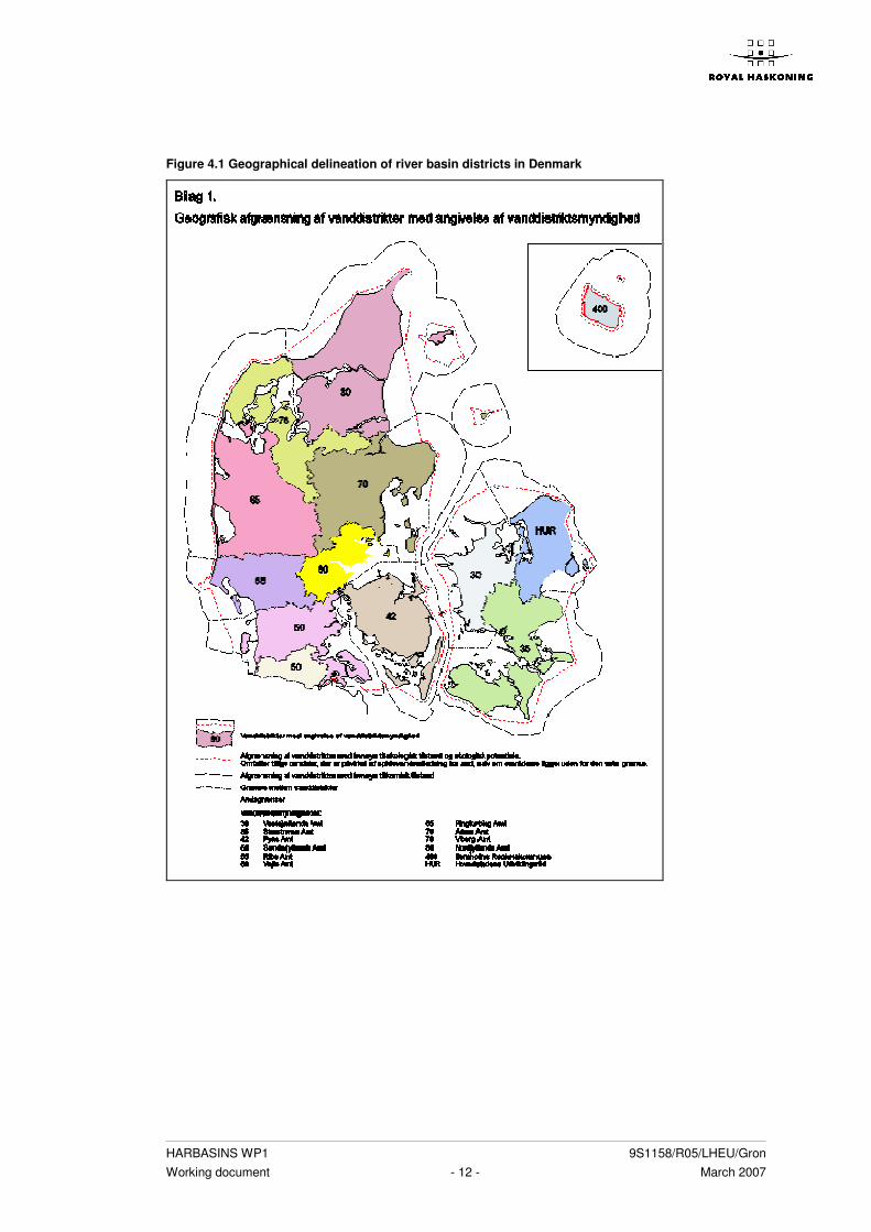
The Report of the Article 5 of the WFD is not available in English. Therefore we made a short summary of the available information. Denmark is divided into 13 water districts and administrated by their own ‘Amt’ (see fig. 1.1). In the Final Report to the Commission (Lit. 24 a) these districts are mentioned, but the results are published in two separate reports per water district. In the first report a general description of the water district, a characterization of the water and the impact of the human activity is described. In the second report a risk assessment per water district is published. The water districts use a different approach and not all PDF files could be downloaded from the internet. Therefore we contacted Mr. Jensen at the Danish Environmental Protection Agency and received further information. Denmark exists of a great number of islands and the amount of coastline, estuaries and fjords is numerous. Denmark did not identify transitional waters, but focused on coastal areas (‘kystvand’). The marine parts concern 1 mile from the coast and for the chemical status until 12 mile. There has been a lot of co-operation between the different water districts and one amt has had the responsibility for a river basin that runs through several amt : Arhus, Vejle and Viborg have worked together and the 4 water districts along the Limfjorden have made an own Article 5 analysis (water districts 65, 70, 76, 80, see fig. 1.1). From the 1st of January 2007 reorganization has taken place and there will be only 4 river basin districts.
4.1 Transitional waters
Transitional waters were not considered in Denmark since the coastline exists mainly of fjords. These fjords were subdivided in different parts during characterization (see coastal waters).
HARBASINS WP1 9S1158/R05/LHEU/Gron Working document - 12 - March 2007
Figure 4.1 Geographical delineation of river basin districts in Denmark

HARBASINS WP1 9S1158/R05/LHEU/Gron Working document - 13 - March 2007
4.2 Coastal waters
4.2.1 Identification of the waterbodies
Each water district has identified waterbodies based on salinity, wave exposure and mean tidal range. For example, the water district of Fyn has 37 waterbodies and the water district Nordjylland has five waterbodies. The harbours are included in the waterbodies. The large shipping routes are situated outside the borders from the Water Framework Directive and therefore not treated separately.
4.2.2 Typology
In Denmark the system B (physical and chemical factors) is used to divide coastal waters into different types (lit. 24b). The obligatory factors were used: latitude, longitude, tidal range and salinity. The coastal waters are divided into two types: fjords and open coastal stretches that are areas which are not fjords. The open coastal are similar to the common typology agreed by member states. The fjords are on their turn differentiated further into different types according to salinity, stratification and an index associated with water retention time and fresh water run off (10 types). In total 15 types were identified (see table 1.2.1 and 1.2.2 and fig. 2) Table 4.2.1 Different types of open coastal stretches
Surrounding Type
West coast Jylland OW4
Wadden Sea (Vadehavet) OW5
Deeper parts of Kattegat north of Sjaelland OW1
Kattegat and northern Belt Sea, Little Belt bridge and north of Drogden OW2
Southern part of Belt sea and Western Baltic Sea, Little Belt bridge and south of
Drogden
OW3a
Western Baltic Sea, Coast of Åbne, Bornholm OW3b
Table 4.2.2 Different types of fjords
Surrounding Type
Inner Randers fjord O3
Augustenborg fjord, Helnæs bugt, Nakskov fjord, Inner Åbenrå fjord, Inner Mariager
fjord
M1
Roskilde fjord, Dybsø fjord, Præstø fjord, Holsteinsborg nor, Lunkebugten M2
Karrebæk fjord, Central Randers fjord, Holckenhavn fjord M3
Indre Odense fjord M4
Flensborg fjord, Gamborg fjord, Outer Åbenrå fjord, Outer Mariager fjord P1
Isefjord P2
Århus bugt, Horsens fjord, Vejle fjord, Kalundborg fjord, Kolding fjord, Skive fjord,
Lovns bredning, Risgårde bredning, Outer Randers fjord
P3
Nissum bredning
Thisted bredning, Kås bredning, Løgstør bredning, Nibe bredning,
P4
Ringkjøbing fjord, Nissum Fjord Slusefjorde

HARBASINS WP1 9S1158/R05/LHEU/Gron Working document - 14 - March 2007
4.2.3 Reference conditions
The reference conditions are not yet fixed and the description is still in process. Once the intercalibration process is finished there will be a good definition of the reference conditions. Until then the reference conditions of an existing planning system is used (Miljømålsloven).
4.2.4 Risk assessment
The risk assessment is carried out by a projection loads and pressures till 2015. Several counties were able to make detailed calculations for specific coastal waters, in particular for fjords, and some counties the assessment was possible based on operational criteria for environmental objectives. The risk assessment shows that more than 90% of Danish coastal waters are at risk of not achieving good status in 2015. The most widespread reason is nutrient pressure mainly due to run off from agricultural areas. In over half of the coastal waters the risk is further more combined with pressure from dangerous substances to a large extent due to pressure with TBT from shipping. Finally nearly half of the coastal waters are in risk of not achieving good status due to direct pressure on biological conditions eg. from bottom trawling fishing gear. In summary the Danish Ministry of the Environment finds the risk assessments are prepared on a conservative basis that has led to an overestimation of water bodies at risk as regards eutrophication, in particular, for coastal areas bordering open marine waters The risk assessment is divided in two categories: I. Waterbodies where the objectives for water quality can be reached by 22
December 2015. II. Waterbodies where there is a risk that the objectives for water quality can not be
reached by 22 December 2015. These categories are in their turn divided in two categories: Ia It is certain that the regional targets will be reached. Ib The current data indicate that there is no risk to not reach the targets, but the
quality and the use of data can be prepared. IIa It is possible that the targets are not reached, but more data is needed to be
certain about it. IIb It is very probable that the targets are not reached and more characterization
and consideration is needed. IIc It is sure that without further characterization and consideration the targets
will not be reached.

HARBASINS WP1 9S1158/R05/LHEU/Gron Working document - 15 - March 2007
Table 4.2.4 Surface areas of pressures in river basins in different risk categories
Total areal ha: 2.610.436 B FM KH MFS N U
Kategori I Ia 548.191 37.761 100.460 355 82.613 0
Ib 16.260 800 0 16.260 0 0
Total 564.451 38.561 100.460 16.615 82.613 0
Kategori II IIa 194.286 675 38.166 826.883 510.429 0
IIb 1.234.430 80.481 9.899 813.583 1.754.327 0
IIc 111.490 97.650 1.721 63.592 263.067 0
Total 1.540.206 178.806 49.786 1.704.058 2.527.823 0
Symbols of the influence types:
B: Biological conditions – direct influence on flora an fauna
FM: Hydromorphological conditions – physical (morphological) changes
KH: Quantitative hydrological changes
MFS: Dangerous substances – physical and chemical conditions
N: Nutrients
U: Without influence of human activities
For example, in almost areas of the water district Fyn the coastal water bodies are at risk to achieve the WFD objectives by 2015 because of the high quantities of environmentally dangerous substances (TBT, Cu, CD, Hg, PAH) and nutrients. None of the coastal areas are natural. In Øresund and Køge bight there are expectations to reach the WFD obligations concerning nutrients. In Vestsjaellands district are all, but one part is at risk to achieve the WFD obligations by 2015 Nutrients and environmentally dangerous substances. In Nordjylland the targets can partly be reached until 2015. In Århus are all parts at risk.
4.2.5 Assignment of status
The majority of the coastal waters are assigned the natural status, but they are affected by eutrophication so they can not reach the good biological status. In the fjords where the main harbours are situated the status is heavily modified (Slusefjords). In cases like dredged canals the influence is limited to the surrounding areas and therefore the status is not heavily modified. Harbours are included in the coastal areas and they are only a small area compared to the total coastal area. The major shipping routes are situated outside the WFD area and not considered here.

HARBASINS WP1 9S1158/R05/LHEU/Gron Working document - 16 - March 2007
5 GERMANY
5.1 Transitional Waters
In Germany the rivers Ems, Weser, Elbe and Eider have large estuaries in the Wadden Sea. The Ems River basin district covers: 1. The Ems estuary; this part of the district will be described in chapter 6. 2. The coastal waters of the East Frisian coast (from Borkum to Spiekeroog) Untere
Ems’; this part of the district will be described in this chapter.
5.1.1 Identification of water bodies
All transitional water bodies in the river basins of the Weser, Eider, Ems and Elbe are situated in the ecoregion ’North Sea’. The following criteria were used to identify water bodies: • change of water type; • change of status (natural, artificial or heavily modified); • clear change of pressures or risk assessment. In the document ‘Water Framework Directive Weser’ harbours are classified as artificial surface water bodies. Because of their small size, they are added to the nearest water body as artificial water element. In the documents ‘Water Framework Directive Eider, Ems and Elbe’ harbours are not separately mentioned, but part of the transitional water bodies [lit. 15,16, 17 en 18]. An overview of the water bodies can be found in annex 4.
5.1.2 Typology
Germany has chosen system B to establish the typology. The ‘Flussgebiets-gemeinschaften’ Ems, Weser, Elbe and Eider have applied the same methodology. All obligatory factors are used. Depth (Weser and Ems), mean substratum composition (Ems, Weser and Elbe) and current velocity, mixing, residence time, wave exposure and tidal reach (Ems) are the optional factors used. Germany has only one type of transitional water. In the river basin Eider, only the part of the river has been marked as transitional water body where a tidal effect can be measured. In the river basin Elbe and the river basin part ‘Untere Ems’ the border between the transitional water body and the river water body, is the ‘line’ between salt and fresh water. The difference in approach of the different estuaries is due to the political boundaries of the different German ‘Bundesländer’ that are in charge.
5.1.3 Reference conditions
The description for the reference for transitional waters is still under development (2005). In Germany, the description of reference conditions is compliant with WFD requirements: biological, hydromorphological and chemical parameters are used [lit. 6]. For every surface water body type, an undisturbed water body condition has been identified. The Highest Ecological Potential for heavily modified water bodies are also described for each individual water body. Parameters for undisturbed water bodies are

HARBASINS WP1 9S1158/R05/LHEU/Gron Working document - 17 - March 2007
for example: ‘zero’ background concentrations of pollutants, no major morphological (anthropogenic) changes and nutrient, organic and acid conditions and salinity. If undisturbed water bodies are not available for a certain typology, historical information, expert judgement or models are used to determine the reference condition. From the in the WFD required biological descriptors for transitional waters only phytoplankton is not used. All the other required descriptors are used. An overview of these descriptors and parameters and the can be found in annex 2 and 5 respectively.
5.1.4 Risk assessment
In the transitional waters of the ‘Flussgebietsgemeinschaften Weser, Eider and Elbe’ the main pressures that prevent the water bodies reaching the environmental objectives are: point and diffuse sources of pollutants, permanent morphological changes, cooling water discharges, harbours, shipping and polluted sediment. For all the transitional water bodies objectives are expected not be achieved by 2015 and so these are all at risk. The described reasons are: the chemical situation for the Weser; high content of suspended solids the morphological changes for Eider and Elbe are not reversible.
5.1.5 Assignment of status
All transitional water bodies are assigned the status of heavily modified. Fixed morphological conditions due to maintenance dredging measures for shipping (among other things) are the main reason. In the ‘Flussgebietsgemeinschaft Weser’ surface water bodies near the harbours are assigned artificial water elements.
5.2 Coastal waters
5.2.1 Identification of water bodies
The Eider has ten coastal water bodies, the Weser four, the ‘Untere Ems’ has three coastal water bodies and the Elbe also four water bodies. A change of water body is based on differences in type (physico-chemical differences as salinity, amount of openness).
5.2.2 Typology
Germany has chosen system B for typology. The ‘Flussgebietsgemeinschaften’ Weser, Eider, Ems and Elbe applied the same methodology. All obligatory factors are used. Depth (Weser and Ems), mean substratum composition (Weser, Ems, Eider and Elbe) and wave exposure (Eider, Ems and Elbe) are the used optional factors. There are therefore differences between optional factors used for the typology of Eider and Elbe and the Weser river basin districts. Germany has five types of coastal water (N1-N5). N1 and N2 are euhaline coastal waters, N3 is a polyhaline open coastal water, N4 is a polyhaline coastal water and N5 is euhaline with rock character (specific for Helgoland).

HARBASINS WP1 9S1158/R05/LHEU/Gron Working document - 18 - March 2007
The water body ‘Lister Tief’ crosses the borders of Germany (typology N2) and Denmark (Typology OW5). Both typologies describe an euhaline coastal water.
5.2.3 Reference conditions
In Germany the description of reference conditions for coastal waters is performed in the same way as that for transitional waters (see paragraph 6.3.1). The reference conditions for German coastal waters are based on expert judgement due to the lack of historical data. All the in the WFD required descriptors for coastal waters are used. An overview of these descriptors and the used parameters can be found in annex 4 and 5 respectively.
5.2.4 Risk assessment
In the coastal waters of the ‘Flussgebietsgemeinschaften Weser, Ems, Eider and Elbe’ the main pressures that prevent from reaching the Directive’s environmental objectives are: point and diffuse sources of pollutants, permanent morphological changes, cooling water discharges, harbours, shipping and polluted sediment. For all coastal water bodies it is expected to be difficult to reach the objectives: these are at risk. The described reasons are: Weser: the main pressures are 1) change in settlement of fauna and flora, 2) load of
pollutants (for example heavy metals and nitrate and phosphate). Eider: Without additional measures it is not possible for the coastal water bodies to
reach the objectives. These measures will have to reduce the pollution of nutrients (point and diffuse sources).
Elbe: For all water bodies it is impossible to reach the objectives. The main reasons are the load of pollutants (for example heavy metals and nitrate and phosphate) from Elbe and adjacent coastal water bodies.
Ems: the main problem is eutrophication, which leads to algal blooms and loss of transparency.
5.2.5 Assignment of status
All the coastal water bodies have the status of natural water bodies. For the status assignment of harbours and shipping routes the following conclusions can be drawn based on the Article 5 reports produced by Germany [lit. 14, 15 en 16]: Harbours: Weser: harbours are heavily modified: The morphological conditions along the shipping
routes are fixed due to the maintenance dredging measures required for shipping. However, although the natural processes of sedimentation and erosion dominate the coast around shipping routes they are small compared to the whole surface of the coastal water body. Therefore the anthropogenic changes have no significant effect on the ecological conditions of the coastal water bodies. At the moment (2005) a study is being undertaken to distinguish the shipping routes as separate water bodies. Water surfaces in the neighbourhood of harbours are assigned artificial water elements.
Eider and Elbe: natural: The coastal water bodies are not hydromorphologically and structurally changed in such a way that they can be assigned as heavily modified.

HARBASINS WP1 9S1158/R05/LHEU/Gron Working document - 19 - March 2007
For example: the shipping routes have no significant effect on the living communities in the water body.
Ems: the data are not sufficient at the moment to signify if a harbour is heavily modified or artificial.
Shipping routes Weser: An exact definition of the borders of the shipping routes is not possible according
to the available information (2005). At the moment (2005) a study is being undertaken to distinguish the shipping routes as independent water bodies.
Eider and Elbe: Shipping routes are not mentioned in the document. Ems; the data are not sufficient at the moment to distinguish the shipping routes as
either heavily modified or artificial.

HARBASINS WP1 9S1158/R05/LHEU/Gron Working document - 20 - March 2007
6 THE NETHERLANDS
The information used in this chapter in addition to the four characterisation reports [lit. 9, 10, 11 en 12] includes several back-ground reports [lit. 1, 2, 3 en 5].
6.1 Transitional Waters
In the Netherlands the river basins of Ems-Dollard, Rhine Delta, Meuse and Scheldt have estuaries in the Wadden Sea and North Sea. The river basin of Ems-Dollard is described in combination with the German part of the basin. There are three transitional waters in the Netherlands.
6.1.1 Identification of water bodies
The three transitional waters are located in the Ems-Dollard, the Scheldt and the Rhine Delta river basin districts. The Ems-Dollard estuary is identified as transitional waterbody. This is the Ems-Dollard estuary which is separated from the mouth of Ems into the Dollard until the geographical line of Ems harbour. Further information on the assignment is described in paragraph 6.1.5. In the Scheldt river basin district the Wester-Scheldt is identified as transitional water. In the Rhine Delta river basin district de Nieuwe Waterweg is identified as a transitional water body. [lit. 5].
6.1.2 Typology
In the Netherlands system B is used to divide transitional and coastal waters into types. The typology of the Dutch water bodies is described in the report ‘Typology of Dutch surface waters [lit. 1]. In the Dutch typology all obligatory factors are used for the typology [lit. 1], i.e. salinity and tidal difference. No optional factors were used. This method results in two transitional water types (O1 and O2) for the Netherlands. O2 is an estuary with moderate tidal range. Since O1 did not occur in the Netherlands it was not further developed. A further explanation on the typology can be found in [lit. 2]. In the Ems Dollard report the Dutch and the German typology is combined (e.g. the names are the same but have different codes). The German type is coded T1 and the Dutch type is coded O2.
6.1.3 Assignment of status
The transitional waters in the Ems-Dollard and the Scheldt have been identified as heavily modified waters. The transitional water from the Rhine district has been identified as artificial water, because it is man made.
6.1.4 Reference conditions
In the Netherlands, the CIS guidelines [lit. 6 en lit. 7] are followed, to describe the reference conditions for the different types of transitional waters. This is described in

HARBASINS WP1 9S1158/R05/LHEU/Gron Working document - 21 - March 2007
paragraph 6.1.2. [lit. 2]. In case of the common German-Dutch Ems-Dollard report, the Dutch reference conditions for the transitional type are described, whereas the German reference conditions are still under development. The reference conditions are not mentioned in the combined Article 5 report for the Ems-Dollard. The Netherlands have not yet defined standards for determining Good Ecological Status or Good Ecological Potential. In the concept report of Evers, 2006 [lit. 3] proposals are included for setting the physicochemical quality standards. In the Netherlands, biological, hydromorphological and chemical/physiochemical parameters are used to describe the reference conditions for transitional waters [lit. 6]. Reference conditions for Dutch transitional and coastal waters are described in the STOWA report for all natural water types [lit. 2]. From the required hydromorphological descriptors for transitional waters mean tidal difference and wave height are used in stead of depth variation, structural intertidal zone and wave exposure. An overview of the used descriptors and parameters can be found in annex 4 and 5 respectively.
6.1.5 Risk assessment
Main pressures transitional waters The main pressures in the Netherlands are described according to the WFD Guidelines [lit. 6]. In the transitional waters of the Netherlands the main pressures for failing to achieve the environmental objectives for 2015 are: point and diffuse sources of pollutants, abstraction and flow regulation pressures, hydromorphological pressures, other human pressures and land use patterns. In the reports the pressures are not always described separately for transitional waters. In that case a general description is given. Main pressures in the Ems-Dollard estuary are point sources (sewage discharges for a few substances), diffuse sources (pressure via canals, rivers and locks, pressures from outside of the area), water abstraction, fisheries, and harbours. There are two main harbours in the Ems-Dollard transitional water body: Ems harbour and Delfzijl. Due to frequent dredging, some substances pose a significant pressure on surface water quality status. For example, in the main shipping routes, high concentrations of tributyl tin (TBT) are present. In the Wester-Scheldt main pressures are point sources (sewage discharges), diffuse sources (nutrients, heavy metals and Polycyclic Aromatic Hydrocarbons (PAHs) caused by atmospheric deposition and shipping) and hydromorphological pressures. The Wester-Scheldt is heavily modified as a result of flood protection measures and shipping lane mainenance. Furthermore, fisheries, shipping, recreation and the supply of polluted water from water bodies upstream causes significant pressure. There are two main harbours in the Wester-Scheldt: Vlissingen and Terneuzen. Shipping causes pollution of the Wester-Scheldt with nutrients, heavy metals, PAHs, polychlorinated biphenyls (PCBs), pesticides and TBT. In the Wester-Scheldt, for some substances up to 90% of the pollution load originates from Flanders, Belgium. In the Nieuwe Waterweg (Rhine river basin district) major pressures are: diffuse sources (agriculture, nutrient leaching from natural grounds, traffic and atmospheric deposition)

HARBASINS WP1 9S1158/R05/LHEU/Gron Working document - 22 - March 2007
and hydromorphological pressures (surface water level control, intensive maintenance, normalisation and intensive draining of the area). For the entire Rhine Delta the intensive pressure on land used by urbanisation and agriculture (surface water level control and discharge of substances) are responsible for the transitional water bodies being at risk. There is also the problem of deposition of pollutions from the coastal waters outside of the Rhine caused by the sea current of the Canal (English Channel). About 80-100% of the pollution pressure in coastal water bodies is due to deposition. Risk assessment The chemical risk assessment for transitional waters was done using the provisional current European standards (proposed by the Fraunhofer Institute FHI) to determine the chemical status of a water body. These include standards for both priority substances and 76/464/EG-substances. For the ecological status of natural water bodies physiochemical and biological standards are used. A final assessment method for biological status of heavily modified transitional water bodies was not yet available. An existing national ecological assessment method was used for the risk assessment. In the Scheldt basin the OSPAR methodology was used in addition. The risk assessment resulted revealed that all Dutch transitional water bodies (the Ems-Dollard estuary, the Wester-scheldt and de Nieuwe Waterweg are at risk for failing to achieve the WFD objectives by 2015.
6.1.6 Assignment of status
In the river basin districts of the Rhine-Delta and Ems-Dollard all transitional waters have been identified as heavily modified water bodies. De Nieuwe Waterweg (Rhine river basin district) recently has the status of artificial water body [lit. 5] because it was man made. In the Ems-Dollard and Rhine Delta the assignment of status is based on human activities (e.g. canalising, dikes) [lit. 31]. The Ems-Dollard estuary and the Wester-scheldt have the status of heavily modified waterbody, because of the significant hydromorphological changes for shipping.
6.2 Coastal waters
6.2.1 Identification and delimitation of water bodies
All Dutch coastal water bodies of the river basins districts of Ems, Meuse, Rhine Delta and Scheldt are situated in the ecoregion North Sea. In the river basin district of the Scheldt two water bodies were identified as coastal waters: the Easter-Scheldt and the Zeeuwse coast. The typology is explained in paragraph 6.2.2. The outside coastal zone of the Scheldt is not included in the bordering. In the Ems-Dollard river basin two water bodies are identified as coastal water. The first is delineated from the geographical line Ems-harbour- Pilsum until the east-west line south of Rottumeroog and Borkum. The second is delineated from the east-west line south of Rottumeroog and Borkum until the baseline +1 sea mile of the Wadden Sea. The area outside the 12 nautical miles is not delineated under the WFD.

HARBASINS WP1 9S1158/R05/LHEU/Gron Working document - 23 - March 2007
In the Meuse River basin district there is one water body assigned as coastal waters. This is delineated from the end of the Haringvliet till the North Sea. In the Rhine Delta River basin district there are three water bodies assigned as coastal waters. The first two are stretched out along the whole North Sea coastline of the Netherlands. They are split by a horizontal line from Den Helder. The second is the Wadden Sea.
6.2.2 Typology
In The Netherlands system B is used to divide transitional and coastal waters into types. Beside the optional factors the mean substratum composition is used because of its importance in determining the biological composition of coastal waters [lit. 1]. The Dutch typology had originally three distinct coastal water types: K1 (polyhaline coastal waters), K2 (protected polyhaline coastal water) or K3 (euhaline coastal water). In 2006 K3 was merged into type (K1).
6.2.3 Reference conditions
In the Netherlands EU guidelines [lit. 6 en lit. 7] were followed to describe the reference conditions for the different types of coastal waters (par 6.2.2 and lit. 2]. Biological, hydromorphological and chemical/physiochemical parameters were used to describe the reference conditions for coastal waters according to WFD guidelines [lit. 2]. These are reported in national STOWA documents for all natural water types [lit. 2]. From the required hydromorphological descriptors for coastal waters mean tidal difference and wave height are used in stead of depth variation, structural intertidal zone and wave exposure. An overview of the used descriptors and parameters can be found in annex 4 and 5 respectively. The assessment of chemical and ecological status of coastal waters was done with the same of standards as the transitional waters to (paragraph 6.1.3).
6.2.4 Risk assessment
Main pressures coastal waters The main pressures in the Netherlands are described according to the WFD Guidelines [lit. 6]. For coastal waters of the Ems-Dollard river basin district an important pressure is the loading of nutrients from diffuse sources from the southern part of the North Sea and the German hinterland. Another (significant) pressure of the coastal waters is originated from atmospheric deposition of nitrogen. Significant hydromorphological pressures are from dredging in shipping routes, building of the Ems harbour and the harbour sea canal and morphological changes to protect the mainland and the island Borkum against flooding. To facilitate intensive shipping in the area civil constructions and harbour areas have been built and the area is frequently dredged. Shipping is also responsible for a significant emission of TBT. Another significant pressure is fisheries. In the Scheldt river basin an important pressure for coastal waters is supply of polluted water from other rivers basin districts. There are also significant hydromorphological changes due to shipping and protection against flooding. Other pressures in these

HARBASINS WP1 9S1158/R05/LHEU/Gron Working document - 24 - March 2007
coastal waters are fishing, recreation and shipping. Discharge of ballast water is also a problem. In addition, the introduction of the Japanese oyster is a problem in the Easter-Scheldt. In the Rhine Delta River basin district there are three water bodies assigned as coastal waters: the northern part and southern part of North Sea coastline of the Netherlands and the Wadden Sea. A lot of pollution in the coastal waters originates from the Canal (English Channel). This contributes between 80 and a 100% of the total amount of pollution in the coastal zone. There are also significant hydromorphological changes due to shipping and protection against flooding. In the Meuse River basin the main pressure for coastal water bodies are diffuse sources (atmospheric deposition) and hydromorphological pressures. Risk assessment All Dutch coastal waters are considered to be at risk for achieving WFD objectives by 2015.
6.2.5 Assignment of status
The two coastal water bodies in the Ems-Dollard district have been identified as Natural waters. The two coastal water bodies in the Meuse district have both been identified as heavily modified waters. Two of the three coastal water bodies (Oosterschelde, Zeeuwse coast) from the Scheldt district have been identified as heavily modified and the coastal territorial water has been identified as natural water. One of the water bodies (zuidelijke Noordzee) from the Rhine district has been identified as heavily modified. The other two water bodies (noordelijke Noordzee and Waddenzee) have been identified as natural waters. Harbours and shipping routes Six harbours in the coastal waters of the Rhine delta (Den Helder, Harlingen, Den Oever, Lauwersoog, Oude Schild and West Terschelling and a zone of 500m around them) are assigned as heavily modified water bodies [lit. 5] Ems harbour and Delfzijl are situated in a water body with the status of heavily modified. There is still discussion going on amongst stakeholders in the Wadden Sea region on the status of the harbours.

HARBASINS WP1 9S1158/R05/LHEU/Gron Working document - 25 - March 2007
7 UNITED KINGDOM
7.1 Transitional Waters
On the eastern coast of the United Kingdom the main estuaries into North Sea are the river basins of Northumbria, Anglia, Humber, Solway Tweed, South East, Thames and Scotland. Three of them (South East, Northumbria and Scotland) only partly discharge into the North Sea.
7.1.1 Identification of water bodies
For the transitional waters in the UK two sizes of water bodies are distinguished: smaller than 30 km2 and larger than 30 km2. The smaller ones refer to small river basins, discharging directly into the North Sea or into larger transitional water. This results in many small transitional water bodies. The harbours are classified as artificial surface water bodies according to the United Kingdom Technical Advisory Group Guidance (UKTAG-guidance) for artificial water bodies, but these are not specifically mentioned in the WFD Article 5 reports [lit. 8].
7.1.2 Typology
System B is used by the UK to divide transitional and coastal waters into types. In this system the obligatory factors are latitude, longitude, tidal range and salinity. Optional factors of mixing characteristics, mean substratum composition and wave exposure are also used, as these are important in determining the ecology of transitional and coastal waters. This approach results in five transitional water types for England, Wales and Scotland.
7.1.3 Reference conditions
The UK has used biological, hydromorphological and chemical/physiochemical parameters to describe the reference conditions for transitional waters. Criteria were set by the United Kingdom Technical Advisory Group (UKTAG) and used in the assessments. In some districts alternative methods for assessments were used as well.
7.1.4 Risk assessment
The principal objective of the WFD is to achieve good status and to comply with standards by 2015. Because of the difficulty to predict the changes in pressures between now and 2015 the UK has made a general assumption: if a water body is at risk in 2004 it will be at risk in 2015. Although the WFD requires water bodies to be reported as either at risk or not at risk of failing their objectives by 2015, the results are reported using 4 categories agreed by UKTAG. The results of the risk assessment for transitional and costal waters are described below. The UK distinguished four different degrees of a water body being at risk as determined by the UKTAG to help prioritise future action, including monitoring efforts to focus on the most significant risks and to fill any data or knowledge gaps to increase certainty in the risk assessment results. These four categories are listed below. ‘at significant risk’ of not meeting the environmental objectives of the WFD by 2015 (1a);

HARBASINS WP1 9S1158/R05/LHEU/Gron Working document - 26 - March 2007
‘probably at significant risk’ (1b); ‘probably not at significant risk’ (2a); ‘not at significant risk’ (2b). Main pressures transitional waters Main pressures for the transitional and coastal waterbodies in the UK: point and diffuse sources of pollutants, abstraction and flow regulation pressures, morphological pressures and other human pressures (introduction of non-native species). All transitional and coastal waters in the UK are at risk, except for the coastal waters of Solway Tweed and Scotland. The main pressures for transitional waters and costal waters that cause the transitional and coastal water to be at risk are described below. Table 7.1 gives a summary on the risk percentage for the transitional waters and costal waters for the different river basins districts. Table 7.1 Risk percentages for transitional and coastal waters in the UK
Cat. Northumb
ria*
Anglian Humber Solway
Tweed
South*
East
Thames Scotland*
Transition
al waters
100% (at
risk)
100% 100% 84% 100% 100% 84%
Coastal
waters
100% (at
risk)
98.6% 100% 9% 100% 100% 17%
* discharge only partly in the North Sea
Summary of water bodies at risk Northumbria Morphological pressures are significant for transitional and coastal water bodies, accounting for around 90% of water bodies at risk in each water category. Point and diffuse source pollution pressures are also significant in transitional waters Summary of water bodies at risk Anglian Morphological pressures are a key cause of risk to transitional and coastal water bodies. Point source pollution pressures account for nearly 60% of transitional water bodies reported at risk of not achieving good status. Summary of water bodies at risk Humber There is only one coastal water body, which is at risk from morphological pressures and from the presence of non-native species. All five transitional water bodies are at risk from morphological pressures. Summary of water bodies at risk Solway Tweed As can be seen from the table many of the transitional waters are at risk of failing the environmental objectives (about 84% of the total surface area). This is because the Solway Estuary is the largest transitional water body in the district. This is not surprising given the heavy anthropogenic use that occurs there. The larger population centres in the district are situated close to large estuaries and human activity brings with it pressures on the water environment.

HARBASINS WP1 9S1158/R05/LHEU/Gron Working document - 27 - March 2007
Coastal areas have the lowest proportion of water bodies at risk of failing the environmental objectives (about 9% of the surface area). The relatively long coastline on the west of the Solway Tweed is generally not at risk from human activity. Summary of water bodies at risk South East The predominant pressures for transitional and coastal water bodies are morphological, accounting for around 90% of water bodies in each category being at risk. The presence of non-native species is also a significant pressure for these water categories. Diffuse pollution pressures account for around a quarter of transitional water bodies and nearly a half of all coastal water bodies being at risk of not achieving good status. Summary of water bodies at risk Thames Morphological pressures cause all three coastal waters and all seven transitional waters to be at risk of not achieving good status. Point source pollution pressures are also significant in transitional waters (greater than 40% at risk), and diffuse source pollution pressures account for around a third of coastal waters being at risk. Summary of water bodies at risk Scotland Scotland’s estuaries are subject to the highest levels of risk of failing the environmental objectives (about 84% of the total surface area). This is not surprising as the largest population centres are close to large estuaries and include some of Scotland’s most important industrial sites. Coastal water bodies have the lowest proportion of areas at risk of failing the environmental objectives (about 17% of the surface area). The Scotland river basin district has a long coastline and the majority of the coastal waters are not considered to be at risk.
7.1.5 Assignment of status
The canals and other 'linear' waters (open water transfers) have been identified as provisionally artificial, but not split into specific water bodies yet. The harbours are classified as artificial surface water bodies according to the TAG-guidance for artificial water bodies, but not specifically mentioned in the WFD Article 5 reports.
7.2 Coastal waters
7.2.1 Identification of water bodies
All coastal water bodies in the river basins of Northumbria, Anglian, Humber, Solway Tweed, South East, Thames and Scotland are located in the ecoregion ‘North Sea’. See transitional waters for further information.
7.2.2 Typology
In the UK system B is used to divide transitional and coastal waters into types. The same obligatory factors and optional factors are used as those chosen for transitional waters. This results in eight different types of coastal waters. See transitional waters for further information.

HARBASINS WP1 9S1158/R05/LHEU/Gron Working document - 28 - March 2007
7.2.3 Reference conditions
See transitional waters for further information.
7.2.4 Risk assessment
See transitional waters for further information.
7.2.5 Assignment of status
See transitional waters for further information.
HARBASINS WP1 9S1158/R05/LHEU/Gron Working document - 29 - March 2007
8 ANALYSIS OF DIFFERENCES AND SIMILARITIES
The previous chapters have given a brief description of five important aspects of the river basin characterisation reports for each country separately. This chapter will try to make a cross-section through each aspect in order to identify differences and similarities in approach and list the pros and cons. The differences in particular might reveal issues that might call for harmonisation and thus be of importance for HARBASINS project.
8.1 General observations
In general the Article 5 reports provide no more or less than the information required by the WFD and listed in the WFD annexes. The reports show the results rather than the methods applied and criteria used. Political arguments and discussions behind the choices which might have influenced the identification and boundary setting of the water bodies are not presented. This makes it difficult to compare the motives and methods used by the different countries by analysing the reports only. The WFD does not describe an approach, but prescribes the obligatory elements of the reports. Although all the countries implemented these obligatory elements the contents vary (considerably) between the countries. Table 8.1 gives an overview of all the administrative bodies of the member states. Table 8.1: overview of the administrative bodies for the member states.
Country Administrative body
Belgium Federale regering van België (FOD Volksgezondheid, Veiligheid van de
voedselketen en Leefmilieu).
Commissie Integraal Waterbeleid
Denmark Miljøministeriet
Germany Ministerium für Umwelt, Naturschutz und Reaktorsicherheit
The Netherlands Ministerie van Verkeer en Waterstaat
United Kingdom Environmental Agency : Water framework directive team
Scottish Environment Protection agency.
It is possible and even likely that the information we were looking for is published in other background documents or informal working reports. This is a task for the next phase of Harbasins workpackage 1. Furthermore, it can be assumed that the Article 5 reports do not fully corresponds to the current state-of-affairs and that increasing insight has already led to changes. In designing the monitoring network (due December 2006) member states may have changed views on water body identification, as was the case in the Netherlands.
8.2 Identification of water bodies
Motives for identifying and separating water bodies are often not implicitly described in the reports. It is clear that member states use differences in ecological types for separating water bodies. But in cases with two adjacent water bodies of the same type, it is often not explained what the reason behind this division is. The reason may be found in territorial borders from national or regional water management authorities. Also State borders are used as a border of water body, indicating the border of a river basin district.

HARBASINS WP1 9S1158/R05/LHEU/Gron Working document - 30 - March 2007
The reports show relatively little attention for coastal and transitional waters compared to inland waters. The number of fresh water bodies in a river basin (rivers and lakes) is often very high compared to the number of coastal and transitional waters. Also the attention in the texts is fairly limited. It can be concluded that the size of the water bodies in coastal and transitional waters can vary considerably between countries. This might be the result of both real existing and homogeneous water systems of different size but might also be the result of practical reasons regarding the requirements that have to be met for each water body, like the size of the monitoring programme. We found different approaches in the way the crossing borderline between transitional waters and coastal waters were drawn. For example in the Netherlands and in the Ems estuary the estuary is identified as partly transitional water and the outer parts as coastal water. However, the Weser and the Elbe estuaries are both identified as transitional waters. The identification at this point is not applied equal in all estuaries. This might be the result of different approaches and political choices in the respective areas. A same kind of conclusion can be drawn for the level crossing lines between transitional waters and fresh waters. In the German Eider the borderline is at the tidal effect boundary. For the Elbe the fresh water – salt water borderline is used. The identification at this point is not applied equal in all estuaries. Harbours and shipping routes The WFD has no specific requirements and guidance for the identification of harbours and shipping routes. However, as a result of the discussions in the Netherlands special attention was given to the question how harbours and shipping routes in other countries were treated in the Article 5 reports. This comparison study shows that in some countries harbours and shipping routes have not been identified separately and are within the borders of a larger water body. Often these larger water bodies are associated with significant hydromorphological pressures and changes. In the Netherlands, Belgium and Germany, most harbours are specially delineated and classified as artificial water bodies. In the Netherlands, harbours and a zone of 500m around each harbour are classified as separate water bodies for example. Because harbours are man made and are subjected to high morphological changes, these water bodies are assigned heavily modified water body status in the Netherlands. But there is still discussion on this issue with stakeholders in the region. Shipping routes in The Netherlands are separate waterbodies. Semi-aquatic areas An important feature of coastal waters like the Wadden Sea is the occurrence of semi-aquatic areas or salt marshes. In the Netherlands there was a serious debate whether these areas should be part of the water body or not. This debate/choice is not mentioned in Article 5 and it was not clear from the maps in the reports if these marshes are included if present. Also in reports from other countries this aspect was not mentioned.
HARBASINS WP1 9S1158/R05/LHEU/Gron Working document - 31 - March 2007
8.3 Typology
The definition of the water body types vary along the North Sea coast. Relevant questions for comparison of typology are: Was system A or B used to design the typology? Are there similarities in optional descriptors? Is it possible to design a common typology for the North Sea region? Table 8.3. Overview of the amount of types and the amount of waterbodies in the different countries.
Transitional waters Coastal waters
Country Amount types Amount distinct
waterbodies
Amount types Amount distinct
waterbodies
Belgium O1 and O2 11 K1 and K3 2
Netherlands O1 and O2 3 K1 and K3 9
Germany T1(=O1) 5 N1, N2, N3, N4, N5 25
Denmark - - 15 211
United Kingdom 5 (different system) 32 3 (different system) 17
System A of B All countries have chosen system B with all obligatory and a varying number of optional descriptors. Optional descriptors were often mixing characteristics and mean substratum composition. There are however, some differences in the naming and coding of the descriptors. This is especially important for water bodies next to country borders. It should be investigated if different types in neighbouring countries, which are reported to be based on the same descriptors, are actually the same. The consequence of this would be that the reference conditions and ecological assessment method could and maybe should be harmonised. In all cases where water bodies align with national borders the types were already coordinated by the countries. In this case a part of the typology was made jointly. This was for instance the case in the international Ems-Dollard river basin between Netherlands and Germany and in the Scheldt river basin between Netherlands and Belgium. The United Kingdom coasts clearly differ in type from the continental coastal areas. Therefore harmonisation in typology between United Kingdom and the main land seems to be not possible.
8.4 Reference conditions
Reference conditions are to be described for all natural water types. The description should cover biological, physicochemical and hydromorphological quality elements. Relevant questions for comparison of typology are: Are all quality elements covered? What is the level of detail of the description? Is it qualitative of quantified in numbers of
species or abundances? What were reasons not to cover all?

HARBASINS WP1 9S1158/R05/LHEU/Gron Working document - 32 - March 2007
Although in all documents the quality elements are mentioned, only the Belgian and Dutch documents explicitly show in which way this was done. England refers to the EUNIS classification and Germany does not mention the details how they set up their reference conditions. This makes it difficult to compare the methods. In all documents, difficulties in describing reference conditions are mentioned, due to the long history of human activity and lack of historical data. The lack of historical data made Germany and the United Kingdom decide not to describe these conditions yet. Coastal and transitional waters were often described in less detail than in case of fresh water types. For example, in the UK modelling was used for fresh waters, but not available for transitional and coastal waters.
8.5 Risk assessment
Relevant questions for comparison of typology are: What is in general the result of the risk assessment? What are the common pressures? Was the result of the risk assessment determined by chemical, biological or both quality
elements? Pressures and result of risk assessment The pressures causing water bodies to be at risk vary between the countries. The main pressures mentioned almost in all Article 5 Reports are: • Emissions from agriculture in the catchment. • supply from other river basins. • hydromorphological changes for flood protection and shipping. Most coastal and transitional water bodies in the river basins studied are considered to be at risk. Exceptions are the coastal waters of Scotland, and Solway Tweed, which are only partly assigned to the North Sea ecoregion. In the United Kingdom the risk assessment is expressed as a percentage of the surface of the water body being at risk. Furthermore, four categories of risk are distinguished. This differentiates the results of the risk assessment and offers more information than just at risk or ‘not at risk’. The WFD risk assessment follows the ‘one-out all-out’ principle: if a single priority substance exceeds the environmental standard or a single biological quality element is not classified as good, the overall status is not sufficient and thus at risk. As a result of this method almost all transitional and coastal waters in all countries studied are considered to be at risk. It would be relevant to study what the strategy of the member states will be to cope with water bodies at risk and what hydromorphological pressures are considered to be irreversible. Are they bound to be assigned as heavily modified water bodies or is lowering the objectives or delaying deadlines (exemption) considered? This will be a task for the next activity of the Harbasins project. There are connections to other Harbasins work-packages: • Heavily modified water bodies: modelling and criteria. • Transitional waters – habitat gain and loss. • How to deal with transboundary pollution (RBD).

HARBASINS WP1 9S1158/R05/LHEU/Gron Working document - 33 - March 2007
9 RELATION OF WFD WITH BIRDS AND HABITATS DIRECTIVE AND ICZM
HARBASINS is aiming to enhance compatibility of management strategies and international cooperation for the North Sea’s coastal waters and estuaries. This implies harmonisation of the implementation of EU Water Framework Directive and coordination with other European legislation and international agreements. This document analysis focuses on the Birds and Habitats Directive and ICZM recommendations as most relevant at this moment. It was studied if and to what extent the Article 5 reports consider or reflect to or consider both regulations, while realising that this is not a obligatory WFD requirement. The essentials of both regulations are introduced in paragraphs 9.1 and 9.2.
9.1 Birds and Habitats Directive (Natura 2000)
Birds Directive (‘Council Directive 79/409/EEC on the conservation of wild birds’) The Birds Directives main goal is regulate the protection and management of all wild (European) birds and their habitats on European soil. The Member States are required to take measures to protect the habitats of protected bird species. Measures for migratory birds are included. The focus is on protecting wetlands that are of international importance (Council Directive 79/409/EEC, 1979). The Birds Directive identified 193 endangered species and sub-species for which the Member States are required to designate Special Protection Areas (SPAs). Over 4.000 SPAs have been designated to date, covering 8% of EU territory. As a result of this action, some severely threatened species are now beginning to recover. There is still a lot of work to do before we have the necessary SPA network in place to ensure the conservation of Europe's most vulnerable birds (EC, 2006) [lit.32]. Habitats Directive (‘Council Directive 92/43/EEC on the Conservation of natural habitats and of wild fauna and flora’) The Habitats Directive aims to protect other wildlife species and habitats. Each Member State is required to identify sites of European importance and to put in place a special management plan to protect them, combining long-term conservation with economic and social activities, as part of a sustainable development strategy (EC, 2006). Member States are required to take measures for the protection of natural habitats and the habitats of specific species. Specific species refers to species listed on Annex II of the Directive and habitat types listed on Annex I. In addition, the Directive imposes strict protection for all species important for the EU as a whole. These species are listed on Annex IV. These sites, together with those of the Birds Directive, make up the Natura 2000 network - the cornerstone of EU nature protection policy. The Natura 2000 network already comprises more than 18 000 sites, covering over 17% of EU territory, and is due to be completed in 2005 for EU 15. It is co-financed through the Commission's LIFE programme (set up in 1992 to develop EU environmental policy) and other Community finance instruments (EC, 2006) [lit.32].

HARBASINS WP1 9S1158/R05/LHEU/Gron Working document - 34 - March 2007
Natura 2000 To preserve the natural values available in the European Union (EU), the EU has initiated Natura 2000. This is a connected network of protected areas stretching across the borders of European Member States (LNV, 2006) [lit.33]. In 2001, when EU heads of state and government launched the EU Sustainable Development Strategy in Gothenburg, they declared that the decline in biodiversity must be halted by 2010. A '2010 target' also exists at the international level: during the 2002 World Summit on Sustainable Development in Johannesburg, world leaders committed themselves to significantly reducing global biodiversity loss by 2010 (EC, 2006). This network represents the cornerstone of the EU policies for halting the loss of biodiversity on European soil by 2010. The network comprises all areas that are protected through the Birds Directive and the Habitats Directive. The network has not yet been completed. Several Member States are still in the process of designating the necessary protected areas (LNV, 2006). Relation between BHD and WFD The BHD (or Natura 2000) differs in focus and set-up from the WFD: BHD concerns the protection of habitats and species whereas the WFD relates to
overall water ecosystem quality, both the biological and the environmental aspect; BHD concerns certain specifically designated areas whereas WFD applies to entire
catchments and its water systems; Identification of WFD water bodies and Natura 2000 areas was done independently
because their time frames are not synchronized; The Directives are sectorial (water, birds, etc.) and therefore sectorial interest may rise
difficulties in implementation. At local levels small conflicts can occur, but they are of minor importance compare to the major pressures like anthropogenic pollution from agriculture.
9.2 Integrated Coastal Zone Management
Many of Europe's coastal zones face problems of deterioration of their environmental, socio-economic and cultural resources. Since 1996, the European Commission has been working to identify and promote measures to remedy this deterioration and to improve the overall situation in our coastal zones. From 1996 to 1999, the Commission operated a Demonstration Programme on Integrated Coastal Zone Management (ICZM) designed around a series of 35 demonstration projects and six thematic studies. This programme was aimed to: • Provide technical information about sustainable coastal zone management, and • Stimulate a broad debate among the various actors involved in the planning,
management or use of European coastal zones. The programme was intended to lead to a consensus regarding the measures necessary in order to stimulate ICZM in Europe In 2000, based on the experiences and outputs of the Demonstration Programme (all of which are available online at europa.europa.eu/environment/iczm/demopgm.htm), the Commission adopted two documents:

HARBASINS WP1 9S1158/R05/LHEU/Gron Working document - 35 - March 2007
• A Communication from the Commission to the Council and the European Commission on ‘Integrated Coastal Zone Management: A Strategy for Europe’ (COM/00/547 of 17 Sept. 2000).
• A proposal for a European Parliament and Council Recommendation concerning the implementation of Integrated Coastal Zone Management in Europe (COM/00/545 of 8 Sept. 2000). This Recommendation was adopted by Council and Parliament on 30 May 2002.
The Communication explains how the Commission will be working to promote ICZM through the use of Community instruments and programmes. The Recommendation outlines steps which the member states should take to develop national strategies for ICZM. The national strategies are due for Spring 2006 and should involve all the coastal stakeholders. The working group on indicators and data established two set of indicators, one aimed to measure progress in ICZM, the other one measuring sustainability on the coast. The indicators which relate to WFD aspects are listed in the following table: Table 9.1: ICZM indicators that relate to WDF aspects
7 Area of semi-natural habitat – Area of semi-natural habitat
8 Area of land and sea protected by statutory designations – Area protected for nature conservation,
landscape and heritage
10 Change to significant coastal and marine habitats and species
Status and trend of specified habitats and species
Number of species per habitat type
Number of Red List coastal area species
16 Quality of bathing water (Percentage of bathing waters compliant with the guide value of the European
Bathing Water Directive)
18 Concentration of nutrients in coastal waters (Riverine and direct inputs of nitrogen and phosphorous to
inshore waters)
19 Amount of oil production
• Volume of accidental oil spills
• Number of observed oil slicks from aerial surveillance
23 Fish stocks and fish landings
• State of the main fish stocks by species and sea area
• Recruitment and spawning stock biomass by species
• Landings and fish mortality by species
• Value of landings by port and species
9.3 Implementation
9.3.1 Belgium
The Article 5 reports of the Scheldt river basins and the North Sea (which was drafted later on) and the ICZM report do not refer to each other. Also there is no reference to the Birds and Habitats directive in the Article 5 reports. The reports result from separate goals, circuits and independent timeframe.

HARBASINS WP1 9S1158/R05/LHEU/Gron Working document - 36 - March 2007
9.3.2 Denmark
The ICZM report of Denmark is not referring to the Water Framework Directive or to the Birds and Habitats directive.
9.3.3 Germany
In Germany the ICZM report examines the interactions between the coastal sea and the transitional waters in accordance with the Water Framework Directive. The WFD guidelines are an important component for implementation process of ICZM. Therefore it’s important to expand the use of the WFD. The federal government has improved the set of legal instruments by transposing European legislation under which the Water Framework Directive as well as the Natura 2000 directive. In the evaluation of the implementation and application of the legal provisions and policies of the Community special attention is given to the contributions of the NATURA 2000 directive and the WFD to development of an integrative set of legal instruments and a high level of protection.
9.3.4 The Netherlands
The Dutch ICZM report begins by describing the current status of the Dutch coastal zone itself, using the ‘sustainability indicators’ formulated by an EU group of experts working together with representatives of all the member states. Secondly, it compiles of the organisational arrangements for coastal zone policymaking and management, and analyses the extent to which they promote integrated management. Finally, the report examines the influence of EU legislation on the current practice of coastal zone management in the Netherlands [lit.25]. The WFD is not mentioned in the ICZM report. The subjects discussed in the ICZM report concern i.e. spatial development, tourism, land use and social factors. In the Article 5 reports of The Netherlands, the relation with ICZM and the Birds and Habitats Directive is not mentioned.
9.3.5 United Kingdom
In December 2005 Defra and the Welsh Assembly Government jointly published a consultation on River Basin Planning Guidance, which set out the principles and key steps for the river basin planning process. Structures to ensure proper public participation under the WFD have been introduced across the UK in order to help develop draft River Basin management plans (RBMPs) by 2008. These will need to link with existing coastal groups already established and promoting an ICZM approach. In the Article 5 reports of the UK no reference is made to ICZM or the Birds and Habitats directive.

HARBASINS WP1 9S1158/R05/LHEU/Gron Working document - 37 - March 2007
10 CONCLUSIONS AND RECOMMENDATIONS
This document analysis is part of the Interreg IIIB Harbasins project (Workpackage 1). The main aim of the study was to examine the status of the implementation of the Water Framework Directive in member states along the North Sea and to study the relation with Birds and Habitats Directives and Integrated Coastal Zone Management. This is the first time that such a comparative analysis is made to identify and select issues that can benefit from harmonisation between river basins or countries. More than 20 river basin reports from Belgium, Denmark, Germany, United Kingdom and the Netherlands were studied.
10.1 General conclusions on WFD Article 5 report document analysis
This report presents a unique document analysis. It is the first time a comparison is made of the Article 5 reports from five different countries that have coastal areas at the North Sea. This document analysis is a snap shot in time, only based on the Article 5 reports that were delivered by the end of 2004 to the European Commission. This document elucidates the differences in methods used in these countries according to Article 5 of the WFD. We have to emphasize that the data reported in the Article 5 report may currently be outdated (pers. comm. and more recent documents) due to new insights. The reasons for these updates are of particular interest for exchange in order to achieve a common level playing field in the WFD implementation. Differences between the reports appear in the way reference conditions, delimitation of water bodies, typology and risk assessment (see 10.2). These factors are essential and in big need of harmonization. Transitional and coastal waters get relatively little attention in the reports compared to inland waters (categories rivers and lakes). Also there is little or no attention for the relation with the North Sea outside the 12 mile zone, because this is not a requirement. The river basin characterisation reports are published and delivered to the European Commission by the member states. The WFD requirements are very strict and followed thoroughly in all reports. As a consequence, the reports present only the results of a process of identification, typification and description rather than the motives, arguments and scientific discussions behind the screens during the process. It appeared to be hard to find information on the political process in the reports. This implies that the document analysis can only partially contribute to identification of topics for harmonisation. Member states are not able to learn about practices, motives and applied methodologies in neighbouring countries only from the Article 5 report. An efficient way to find out about the political motives and discussions is to interview people in the different countries who are directly connected to the WFD. One step further, workshops will be organised to improve interaction, discussion and harmonisation. => It is recommended to use interviews with key persons in the WFD implementation process to get more detailed and the most actual information on the applied methods and practical or theoretical motives.

HARBASINS WP1 9S1158/R05/LHEU/Gron Working document - 38 - March 2007
=> It is recommended to focus more on exchange of practices and methodologies between member states in the areas where international guidances provide freedom of interpretation. This can be done by organising workshops.
10.2 Conclusions on specific topics
Some issues were selected to look into more detail. This was done from experiences of public discussion in the Netherlands and might be recommended to study in the next phase of Harbasins. Identification of water bodies: harbours and shipping routes There appears to be no common approach for identification of harbours. In some river basins they are identified as (small) separate water bodies and in others they are part of a larger water body. => it is recommended to study the motives and learn from the benefits from the approach in other basins and possibly to identify a ‘best practice’ in coping with harbours. Also for shipping lanes a common approach is lacking. Identification of water bodies: semi-aquatic areas or salt marshes Salt marshes often represent important natural or semi-natural values that might be different from the coastal or transitional water body. The consequences of including or excluding these areas from the water body are interesting to compare. However, the attention and level of detail in the Article 5 reports on coastal and transitional waters is low compared to inland waters and as a consequence there is no information on salt marshes. There might be a strong relation with the Birds and Habitats Directives, but this is not reported. => It is recommended to discuss the approaches to salt marshes in other countries in the workshops and develop a common approach, also coordinated with BHD. Typology It is clear that typological differences do exist along the North Sea coast and estuaries, but there might be similar types occurring in different member states. Often the same descriptors are used. Some effort for harmonisation of typology for coastal and transitional waters was made for the intercalibration exercise. This however concerns only a few types. Furthermore there is still discussion on the types. If the optional factors used are the same in several member states, further harmonisation might be possible. => It is recommended to discuss the need for a common typology of North Sea water bodies. This may help member states to define reference conditions by geographical comparison in case of lacking historical data. Reference conditions The WFD and the CIS-guidances provide general guidelines for the description of the reference conditions for water types by means of biological, chemical and hydromorphological quality elements. Especially in the case a member state has no actual reference situations available; it would be very good to learn from the neighbours how they dealt with that problem. Also the problem of expressing the reference conditions in (quantified) numbers is of scientific interest and would urge for

HARBASINS WP1 9S1158/R05/LHEU/Gron Working document - 39 - March 2007
harmonisation. In addition a satisfactory description of good ecological status is still a point of discussion. => It is recommended to examine and discuss the need for a common typology for the North Sea countries and consequently the need to harmonise the descriptions of the reference conditions and to determine a comparable method for defining good ecological status in coastal and transitional waters. Risk assessment The WFD prescribed two options for the water bodies: being ‘at risk’ or ‘not at risk’. A water body is at risk if just one of the priority substances exceeds the standard or one of the biological quality elements is not classified as good status. As a result, most of the water bodies in every country are at risk. Therefore the risk maps do not show any distinction in severeness. In applying four categories, the UK however has come up with a different approach which provides more resolution. Assignment of status In the Article 5 reports the status assignment of heavily modified water body is provisional. The consequences of this assignment are important because member states have to show that the environmental objectives of GES (as for natural waters) can not be achieved due to irreversible hydromorphological impacts, or disproportional costs are at stake, environmental damage will occur or other sectors are impacted. For heavily modified water bodies specific objectives (GEP) and ‘reference’ conditions (MEP) have to be defined. In this area a great number of aspects are important that justify thorough discussion and exchange of approaches between member states. => It is recommended to point out the assignment of the heavily modified water body status as an important opportunity for exchanging information on practices and potentially harmonisation. One of the goals of Harbasins is to develop the criteria of the heavily modified water body status.
10.3 Conclusions on the relation with BHD (Natura 2000)
The requirements for the Article 5 reports do not consider the relation with Birds and Habitats Directives. As a consequence, the reports show little reference to the BHD. The BHD differs in set-up from the WFD and concerns the protection of species and habitats, while the WFD strongly relates to water quality. Often it is not (yet) clear what the water quality requirements are for the Natura 2000 areas. The identification of WFD water bodies and Natura 2000 areas was often done independently and by different administrative bodies. The WFD and the BHD are sectorial and here some differences can occur, but their main objectives coincide. At local levels small conflicts can occur, but they are of minor importance compare to the major pressures. => It is therefore recommended to study the linkage of the WFD and the BHD and synergies in more detail in the next phase of Harbasins especially for the objectives, monitoring and assessment.

HARBASINS WP1 9S1158/R05/LHEU/Gron Working document - 40 - March 2007
10.4 Conclusions on the relation of WFD and ICZM
The requirements for the Article 5 reports do not consider the relation with Integrated Coastal Zone Management regulations. As a consequence, there is little or no attention for this relation found in the reports during document analysis. However, there are some overlapping objectives and indicators. In general it can be concluded that IZCM report is focusing on human uses while WFD is dedicated to water ecosystem quality. It is found from personal communication that some member states are in favor of turning the ICZM recommendations into a real EU Directive and other states are against. The latter is likely to give little attention to the recommendations and provide only a basic report without much reference and cross links to other sectors and regulations.
10.5 Recommendations for WP1 next project phases
In this document differences between countries who have coastal areas around the North Sea could be identified and some of the differences are in high need of harmonisation. This document analysis could fulfil only partially the objective to identify issues and opportunities for harmonisation. This is due to the fact that the Article 5 reports are strictly restricted to the requirements and describe a status in 2005 reflecting the official opinion rather than the political discussions. One should consider that these Article 5 reports are a snap shot in time and reflect the situation at the time of reporting. New evaluations have been made and changes have occurred. The analysis shows that there are several opportunities in the next steps of the WFD implementation for harmonisation and a chance of improving the comparability of instruments and methods. There is a need for transboundary harmonisation especially for the BHD and the WFD with regards to monitoring assessment and management. Based on the Article 5 reports analysis, the next phase of WP1 with interviews and workshops will provide details and insight into the political discussions and changes in the implementation since the Article 5 was delivered. It is likely that the next steps in the WFD implementation are even more important for harmonisation between member states and of importance for coastal waters: development of the (transboundary) monitoring network; approaches and motives for the final assignment of status to water bodies; developing the environmental objectives for non-natural water types. It is recommended for the next WP1 project phases to shift focus from ICZM to the European Marine Strategy and the future Marine Water Framework Directive and the BHD because this has to be coordinated carefully with the Water Framework directive.

HARBASINS WP1 9S1158/R05/LHEU/Gron Working document March 2007
������������
Annex 1 Literature

HARBASINS WP1 9S1158/R05/LHEU/Gron Working document - 2 - March 2007
LITERATURE Lit 1. Elbersen, J.W.H., Verdonschot, P.F.M., Roels, B., Hartholt, J.G., 2003. Definitiestudie Kaderrichtlijn Water (WFD); I. Typologie Nederlandse oppervlaktewateren. Alterra, RIKZ, Wageningen 2003. Lit 2. Van der Molen, D.T., Pot, R., 2006. Referenties en conceptmaatlatten voor overgangs- en kustwateren voor de KRW, update april 2006, rapportnr 2004-44, stowa 2004. Lit 3. Evers, 2006: Getalswaarden GET voor de algemene fysisch-chemische Kwaliteitselementen in natuurlijke wateren: temperatuur, zuurgraad, doorzicht, zoutgehalte, zuurstof, RIZA, Royal haskoning project 9r9513 2006. Lit 4. CIW Schelde, 2005: Karakterisering van het Vlaams deel van het internationale stroomgebiedsdistrict van de Schelde, coördinatiecommissie integraal waterbeleid, december, 2006. Lit 5. Ministerie van Verkeer en Waterstaat, 2005.: Brief status van de Waddenzee, DGW 2005/662, 2005 Lit 6. EU Directive 2000/60/EC: Establishing a framework for Community action in the field of water policy, Appendix II number 1.3, EU, 2000) Lit 7. EU Directive 2000/60/EC: Overall Approach to the Classification of Ecological Status and Ecological Potential, 2005) Lit 8. UKTAG, 2004: Type Specific Reference Condition Descriptions for Transitional and Coastal Waters for the UK. UK Technical Advisory Group, 2004. Lit 9. Brys, R., Ysebaert. T., Escaravage, V., van Damme, S., van Breackel, A., van de Voorde, B., van den Bergh, E., 2005. Afstemmen van referentiecondities en evaluatiesystemen in functie van de KRW: afleiden en beschrijven van typespecifieke referentieomstandigheden en/of MEP in elk Vlaams overgangswatertype vanuit de –overeenkomstig de KRW- ontwikkelde beoordelingssystemen voor biologische kwaliteitselementen. Eindrapport, VMM AMO KRW REFCOND OW. Instituut voor natuurbehoud IN. O. 2005.7

HARBASINS WP1 9S1158/R05/LHEU/Gron Working document - 3 - March 2007
WFD Article 5 Reports The Netherlands Lit 10. Ministerie van Verkeer en Waterstaat, 2005. Karakterisering werkgebied Rijndelta. Rapportage volgens artikel 5 van de Kaderrichtlijn water (2000/60/EG). Maart 2005. C-rapportage. Lit 11. Ministerie van Verkeer en Waterstaat, 2005. Karakterisering Nederlands Maasstroomgebied. Rapportage volgens artikel 5 van de Kaderrichtlijn water (2000/60/EG). Maart 2005. B-rapportage Lit 12. Ministerie van verkeer en waterstaat 2005. Karakterisering deelstroomgebied Ems-Dollard. Rapportage volgens artikel 5 van de Kaderrichtlijn water (2000/60/EG). Maart 2005. C-rapportage Belgium Lit 13a. CIW, 2005. Artikel 60 rapport (artikel 5 KRLW) SDG Schelde, Coördinatiecommissie integraal waterbeleid. maart 2005. B-Rapportage http://www.ciwvlaanderen.be/uploads/b671.pdf Lit 13b. FOD Volksgezondheid, Veiligheid van de voedselketen en Leefmilieu, 2006. Rapport Richtlijn 2000/60/EC- artikel 5 voor de Belgische kustwateren. Germany Lit 14. FGG Weser, 2005. Bewirtschaftungsplan Flussgebietseinheit Weser. EG wasserrahmenrichtlinie. Flussgebiedsgemeinschaft Weser, 2005. B-Bericht Lit 15. Ministerium für Umwelt, Naturschutz und Landwirtschaft des Landes Schleswig-Holstein. 2004. Flussgebietseinheit Eider, Bericht über die Analysen nach Artikel 5 der Richtlinie 2000/60/EG. Dezember 2004. B-bericht Lit 16. IKSE, 2005. Merkmale der Flussgebietseinheit, Uberprufumg der umweltauswirkungen menschlicher tatigkeiten und wirtschaftliche analyse der wassernutzung. Internationale Kommission zum Schutz der Elbe. Maart 2005. A-bericht Lit 17. NLWKN, 2005. B-Bericht Untere Ems 2005, Niedersächsicher Landesbetrieb für Wasserwirtschaft, Küsten- und Naturschutz. B-bericht Lit 18. Niedersachen, 2004. EG-WRRL bericht. Bestandsaufname zur Umsetzung der EG-Wasserrahmenrichtlinie. Oberflächengewässer-Bearbeitungsgebiet Untere Ems. Dezember 2004. B-bericht

HARBASINS WP1 9S1158/R05/LHEU/Gron Working document - 4 - March 2007
United Kingdom Lit 19. Water Framework directive team, 2005. Water framework directive, summary report of the characterization, impacts and economics analyses required by Article 5, Anglian river basin district. March 2005. B-report Lit 20. Water Framework directive team, 2005. Water framework directive, summary report of the characterization, impacts and economics analyses required by Article 5, South east river basin district. March 2005. B-report Lit 21. Water Framework directive team, 2005. Water framework directive, summary report of the characterization, impacts and economics analyses required by Article 5, Thames river basin district. March 2005. B-report Lit 22. Water Framework directive team, 2005. Water framework directive, summary report of the characterization, impacts and economics analyses required by Article 5, Humber river basin district. March 2005. B-report Lit 23. Sepa, 2005. Scotland river Basin District, characterization and impact analyses required by article 5 of the Water Framework Directive, Summary report. Scottish Environment Protection agency. B-report Lit 24. Water Framework directive team, 2005. Water framework directive, summary report of the characterization, impacts and economics analyses required by Article 5, Northumbria river basin district. March 2005. B-report Lit 25. Sepa, 2005. Solway Tweed River Basin District, characterization and impact analyses required by article 5 of the Water Framework Directive, Summary report. Scottish Environment Protection agency. B-report Denmark Lit 24a. Rapport om karakterisering og analyse af vanddistrikter mv. i henhold til artikel 5 i vandrammedirektivet (direktiv 2000/60/EF) Lit 24b. Redegørelse for amternes vurdering af vandforekomsternes tilstand (Miljøstyrelsen 5. juli 2006) Lit 24c. Lov om miljømål m.v. for vandforekomster og internationale naturbeskyttelsesområder (miljømålsloven). LOV nr. 1150 af 17/12/2003

HARBASINS WP1 9S1158/R05/LHEU/Gron Working document - 5 - March 2007
ICZM Reports The Netherlands Lit 25. Ministerie van VenW, VROM, LNV en EZ, 2005. De Europese aanbeveling voor geïntegreerd beheer van kustgebieden. Rapportage over de implementatie in Nederland. December 2005. Lit 26. Stuurgroep Noordzee en oceanen, 2006. Nationaal rapport van Belgie inzake de implementatie van Aanbeveling 2002/413/EC. Februari 2006. Lit 27. Bundesministerium für Umwelt, Naturschutz und Reaktorsicherheit, 2006. Nationale Strategie für ein integriertes Küstenzonemanagement, nach der EU-Empfehlung 2002/413/EG vom 30 mai 2002. Lit 28. Defra, 2006. Report from the United Kingdom, Implementation of (2002/413/EC) Recommendation of the European parliament and of the Council, of 3 may 2002, concerning the implementation of Integrated Coastal Zone Management in Europe. March 2006. Denmark Lit 29. ICZM report of Denmark (Not examined, because of language) Lit 30: CIS working group 2.2, 2003. Richtsnoer voor de identificatie en aanwijzing van kunstmatige en sterk veranderde waterlichamen. Januari 2003. Lit. 31. CIS working group 2.2 on heavily modified water bodies, 2003. Toolbox on identification and designation of artificial and heavily modified water bodies. Januari 2003. Lit. 21. REFCOND Guidance, 2003; Guidance on Ecological Classification, 2003 Cis working group 2.4 (coast), 2002. Guidance on typology, reference conditions and classification systems for transitional and coastal waters. November 2002. Lit. 32. EC, 2006; http://ec.europa.eu/environment/nature/mission_statement/index_en.htm; 25-01-2007 Lit 33. LNV, 2006; http://www.minlnv.nl; 24-01-2006

HARBASINS WP1 9S1158/R05/LHEU/Gron Working document March 2007
������������
Annex 2 Overview used descriptors for transitional waters

HA
RB
AS
INS
WP
1
9S11
58/R
05/L
HE
U/G
ron
Wor
king
doc
umen
t -
2 -
Mar
ch 2
007
������������
Qua
lity
elem
ents
D
escr
ipto
rs W
FD
Tran
sitio
nal w
ater
s
Sch
eldt
W
eser
, Eid
er a
nd E
lbe
Net
herl
ands
U
K
Bio
logi
cal
Phy
topl
ankt
on
Oth
er a
quat
ic fl
ora
bent
hic
inve
rtebr
ate
faun
a
fish
faun
a
Phy
topl
ankt
on
Oth
er a
quat
ic fl
ora
(mac
roal
gae
and
angi
ospe
rms)
bent
hic
inve
rtebr
ate
faun
a
fish
faun
a
Phy
topl
ankt
on is
not
use
d,
rest
as
requ
ired
in th
e W
FD
Sam
e as
WFD
in
add
ition
to ty
pes,
mor
e
spec
ific
desc
riptio
n of
refe
renc
e co
nditi
on a
re
deve
lope
d
Hyd
rom
orph
olog
ical
Fr
esh
wat
er fl
ow
Qua
ntity
stru
ctur
e an
d
subs
trate
as re
quire
d in
the
WFD
as
requ
ired
in th
e W
FD
as re
quire
d in
the
WFD
A
s re
quire
d?
Phy
sioc
hem
ical
D
epth
var
iatio
n
Stru
ctur
e In
terti
dal z
one
Wav
e ex
posu
re
trans
pare
ncy
ther
mal
con
ditio
ns
oxyg
enat
ion
cond
ition
s
salin
ity
Nut
rient
con
ditio
ns
as re
quire
d in
the
WFD
as
requ
ired
in th
e W
FD
mea
n tid
al d
iffer
ence
wav
e he
ight
In a
dditi
on to
obl
igat
ory
fact
ors,
mix
ing
char
acte
ristic
s,
mea
n su
bstra
tum
com
posi
tion
and
wav
e ex
posu
re w
ere
used
Info
rmat
ion
used
Bas
ed o
n ty
pe s
peci
fic
ecol
ogic
al a
sses
smen
t
met
hods
and
exp
ert
judg
emen
t
His
toric
al d
ata
and
expe
rt
judg
emen
t
Bas
ed o
n ty
pe s
peci
fic
ecol
ogic
al a
sses
smen
t
met
hods
, his
toric
al d
ata
and
expe
rt ju
dgem
ent
Bas
ed o
n ty
pe s
peci
fic
ecol
ogic
al a
sses
smen
t
met
hods
and
exp
ert
judg
emen
t

HARBASINS WP1 9S1158/R05/LHEU/Gron Working document March 2007
Annex 3 Overview used descriptors for coastal waters

HA
RB
AS
INS
WP
1
9S11
58/R
05/L
HE
U/G
ron
Wor
king
doc
umen
t -
2 -
Mar
ch 2
007
������������
Qua
lity
elem
ents
D
escr
ipto
rs W
FD
Coa
stal
wat
ers
Sch
eldt
W
eser
, Eid
er a
nd E
lbe
N
ethe
rlan
ds
UK
Bio
logi
cal
Phy
topl
ankt
on,
Oth
er a
quat
ic fl
ora
bent
hic
inve
rtebr
ate
faun
a
Ang
iosp
erm
s (=
othe
r aqu
atic
flora
) and
ben
thic
inve
rtebr
ate
faun
a
Sam
e as
requ
ired
in W
FD
Sam
e as
requ
ired
in W
FD
Hyd
rom
orph
olog
ical
Q
uant
ity, s
truct
ure,
and
subs
trate
Dire
ctio
n of
dom
inan
t cur
rent
s
Sam
e as
requ
ired
in W
FD
Sam
e as
requ
ired
in W
FD
Sam
e as
requ
ired
in W
FD
Phy
sioc
hem
ical
D
epth
var
iatio
n
Stru
ctur
e In
terti
dal z
one
Wav
e ex
posu
re
Sam
e as
requ
ired
in W
FD
Sam
e as
requ
ired
in W
FD
Mea
n tid
al d
iffer
ence
,
wav
e he
ight
,
wat
er d
epth
coa
stal
wat
ers

HARBASINS WP1 9S1158/R05/LHEU/Gron Working document March 2007
Annex 4 Type and status of the water bodies

HARBASINS WP1 9S1158/R05/LHEU/Gron Working document - 2 - March 2007
Belgium Schelde
O1= macrotidaal laaglandestuarium O2= Mesotidaal laadlandestuarium K1= Mesotidaal zeegat of zeearm K3= Mesotidaal, euhalien, onbeschut en zandig Literature CIW, 2005. Artikel 60 rapport (artikel 5 KRLW) SDG Schelde, Coördinatiecommissie integraal waterbeleid. maart 2005. Rapportage http://www.ciwvlaanderen.be/uploads/b671.pdf FOD Volksgezondheid, Veiligheid van de voedselketen en Leefmilieu, 2006. Rapport Richtlijn 2000/60/EC- artikel 5 voor de Belgische kustwateren. Missing data No map with water bodies available. There is a map with the surface water bodies. This maps however only shows the rivers and the coastal water bodies, the transitional water bodies are not on the map.
Name water body Type Status
Durme (198) Transitional water O1 Heavily modified
Schelde 1 (193) Transitional water O1 Heavily modified
Schelde + rupel (194) Transitional water O1 Heavily modified
Schelde 3 (195) Transitional water O1 Heavily modified
Schelde 4 (192) Transitional water O1 Heavily modified
Dijle en Zenne Transitional water O1 Heavily modified
Nete-Grote Nete- Kleine Nete (191) Transitional water O1 Heavily modified
IJzerestuarium Transitional water O2 Heavily modified
Haven Oostende Transitional water O2 Artificial
Haven van Blankenberge Transitional water O2 Artificial
Haven Brugge Transitional water O2 Artificial
Het Zwin Coastal water K1 Natural
Noordzee Coastal water K3 Natural

HARBASINS WP1 9S1158/R05/LHEU/Gron Working document - 3 - March 2007
Denmark Map of the different types of coastal waterbodies in Denmark
Different types of open coastal stretches
Name water body Type
West coast Jylland OW4
Wadden Sea (Vadehavet) OW5
Deeper parts of Kattegat north of Sjaelland OW1
Kattegat and northern Belt Sea, Little Belt bridge and north of Drogden OW2
Southern part of Belt sea and Western Baltic Sea, Little Belt bridge and south
of Drogden
OW3a
Western Baltic Sea, Coast of Åbne, Bornholm OW3b
Different types of fjords
Name water body Type
Indre Randers fjord O3
Augustenborg fjord, Helnæs bugt, Nakskov fjord, Indre Åbenrå fjord, Indre
Mariager fjord
M1
Roskilde fjord, Dybsø fjord, Præstø fjord, Holsteinsborg nor, Lunkebugten M2

HARBASINS WP1 9S1158/R05/LHEU/Gron Working document - 4 - March 2007
Name water body Type
Karrebæk fjord, Centrale Randers fjord, Holckenhavn fjord M3
Indre Odense fjord M4
Flensborg fjord, Gamborg fjord, Ydre Åbenrå fjord, Ydre Mariager fjord P1
Isefjord P2
Århus bugt, Horsens fjord, Vejle fjord, Kalundborg fjord, Kolding fjord, Skive
fjord, Lovns bredning, Risgårde bredning, Ydre Randers fjord
P3
Nissum bredning
Thisted bredning, Kås bredning, Løgstør bredning, Nibe bredning,
P4
Ringkjøbing fjord, Nissum Fjord Slusefjorde
Activities that have a direct effect on the environmental status (Danish)
Aktivitet Direkte påvirkning af miljøtilstand
Påvirkningstype
Bio
logi
ske
forh
old
Hyd
rom
orfo
logi
ske
forh
old
Fysi
sk-k
emis
ke fo
rhol
d
Spildevandsudledning, inkl udsivning fra depoter o.lign. X X
Kølevand X X
Regulering/rørlægning/kystbeskyttelse X X X
Dræning X X
Klapning X X X
Vedligeholdelse af vandløb og sejlrender X X X
Dambrug X X X
Havbrug X X
Råstofindvinding X X X
Søtransport X X
Erhvervsfiskeri X X
Energiproduktion (incl. vandkraft og havvindmøller) X X X
Indvinding af overfladevand X
Landbrugsdrift X
Vandindvinding i opland X -
Badning X
Anden rekreativ anvendelse X X Literature Basisanalyse del 1. Karakterisering af vandforekomster og opgørelse af Påvirkninger. Miljøministeriet, Miljøstyrelsen. Basisanalys del II Rapportering. Redegørelse for amternes vurdering af vandforekomsternes tilstand (Miljøstyrelsen 5. juli 2006)
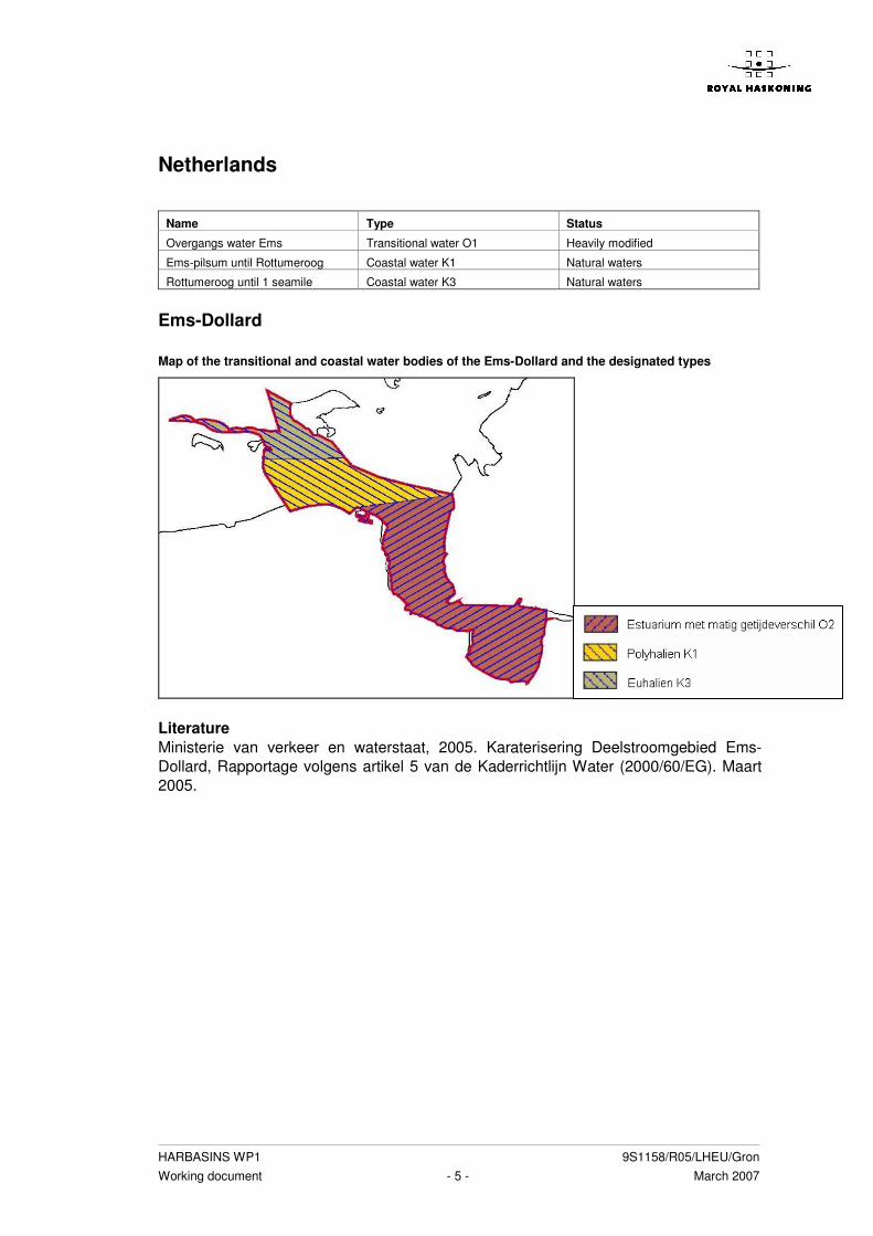
HARBASINS WP1 9S1158/R05/LHEU/Gron Working document - 5 - March 2007
Netherlands
Ems-Dollard Map of the transitional and coastal water bodies of the Ems-Dollard and the designated types
Literature Ministerie van verkeer en waterstaat, 2005. Karaterisering Deelstroomgebied Ems-Dollard, Rapportage volgens artikel 5 van de Kaderrichtlijn Water (2000/60/EG). Maart 2005.
Name Type Status
Overgangs water Ems Transitional water O1 Heavily modified
Ems-pilsum until Rottumeroog Coastal water K1 Natural waters
Rottumeroog until 1 seamile Coastal water K3 Natural waters

HARBASINS WP1 9S1158/R05/LHEU/Gron Working document - 6 - March 2007
Meuse
Name water body Type Status
Haringvliet tot Noordzee Coastal water K3 Heavily modified
Noordzee Coastal water K3 Heavily modified
Map of the transitional and coastal water bodies of the river district Meuse and the designated types
Literature Internationale maascommissie, 2005. Internationaal stroomgebiedsdistrict Maas-Analyse, overkoepelend rapport (Kaderrichtlijn Water). Maart 2005

HARBASINS WP1 9S1158/R05/LHEU/Gron Working document - 7 - March 2007
Scheldt
Map of the transitional and coastal water bodies of the river Scheldt and the designated types
Literature Ministerie van verkeer en waterstaat, 2004. Karakterisering stroomgebied Schelde, rapportage van Nederland over de invulling van de Kaderrichtlijn Water in het Stroomgebied Schelde conform artikel 5. November 2004. Missing data The report does not mention the status of the North sea.
Name water body Type Status
Oosterschelde (1) Coastal water K2 Heavily modified
Westerschelde (2) Transitional water O2 Heavily modified
Zeeuwse kust (3) Coastal water K3 Heavily modified
Noordzee (4) Kustwater territoriaal

HARBASINS WP1 9S1158/R05/LHEU/Gron Working document - 8 - March 2007
Rhine Delta
Name water body Type Status
De Nieuwe waterweg Transitional water O2 Artificial water body
Zuidelijke Noordzee Coastal water K3 Heavily modified
Noordelijke Noordzee Coastal water K3 Natural waters
Waddenzee Coastal water K2 Natural waters
Map of the transitional and coastal water bodies of the river district Rhine delta and the designated types
Literature Ministerie van verkeer en waterstaat, 2004. Karakterisering werkgebied Rijndelta, rapportage volgens artikel 5 van de Kaderrichtlijn water (2000/60/EG). December 2004.

HARBASINS WP1 9S1158/R05/LHEU/Gron Working document - 9 - March 2007
Germany Ems-Dollard
Name water body Type Status
Overgangs water Ems Transitional water T1 Heavily modified
Ems-pilsum until Rottumeroog Coastal water N3 Natural waters
Rottumeroog until 1 seamile Coastal water N1 Natural waters
Map of the transitional and coastal water bodies of the Ems-Dollard and the designated types
Literature Ministerie van verkeer en waterstaat, 2005. Karaterisering Deelstroomgebied Ems-Dollard, Rapportage volgens artikel 5 van de Kaderrichtlijn Water (2000/60/EG). Maart 2005. Remarks The status of the coastal waters is nit mentioned in the text. In the maps the legends says data of these water bodies in lacking. Missing data Status of the coastal water bodies .

HARBASINS WP1 9S1158/R05/LHEU/Gron Working document - 10 - March 2007
Untere Ems
Name water body Type Status
Ems (Leer until The Dollard) Übergangsgewässer der Ems (T1) Heavily modified
Nordsee Euhalin offense Küstengewässer
der Ems (N1)
Wattenmeer im osten (Baltrum bis
wangerooge)
Euhalines Wattenmeer der Ems
(N2)
Wattenmeer im westen (Borkum
bis Baltrum)
Polyhalines Wattenmeer der Ems
(N3)
Map of the transitional and coastal water bodies of the UNtere Ems and the designated types
Literature NLWKN, 2005. B-Bericht Untere Ems 2005, Niedersächsicher Landesbetrieb für Wasserwirtschaft, Küsten- und Naturschutz.

HARBASINS WP1 9S1158/R05/LHEU/Gron Working document - 11 - March 2007
Weser
Name water body Type Status
Übergangswasser Weser Transitional water T1 Heavily modified
W1 Coastal water N1 Natural water
W2 Coastal water N3 Natural water
W3 Coastal water N3 Natural water
W4 Coastal water N4 Natural water
W5 Coastal water N2 Natural water
W6 Coastal water Natural water
Map of the transitional and coastal water bodies of the river district Weser and the designated types
Literature FGG Weser, 2005. Bewirtschaftungsplan Flussgebietseinheit Weser. EG wasserrahmenrichtlinie. Flussgebiedsgemeinschaft Weser, 2005.

HARBASINS WP1 9S1158/R05/LHEU/Gron Working document - 12 - March 2007
Elbe
Name water body Type Status
Ubergangswasser Elbe Transitional water T1 Heavily modified
1 Coastal water N3 Natural
2 Coastal water N4 Natural
3 Coastal water N4 Natural
4 Coastal water N5 Natural
Map of the transitional and coastal water bodies of the river district Elbe and the designated types
Literature IKSE, 2005. Merkmale der Flussgebietseinheit, Uberprufumg der umweltauswirkungen menschlicher tatigkeiten und wirtschaftliche analyse der wassernutzung. Internationale Kommission zum Schutz der Elbe. Maart 2005 Remarks It is known that there have been addressed 4 coastal water bodies in the Elbe district. The names of the 4 coastal water bodies are not mentioned in the document, therefore they have been numbered 1 to 4 in the table. On the map these coastal water bodies are visible either. Missing data Names of the coastal water bodies. Map with the borders of the coastal water bodies.

HARBASINS WP1 9S1158/R05/LHEU/Gron Working document - 13 - March 2007
Eider
Name water body Type Status
Tide Eider Transitional water T1 Heavily modified water body
1, 2 Coastal water N1 Natural water
3, 4, 5, 6 Coastal water N2 Natural water
7, 8 Coastal water N3 Natural water
9, 10 Coastal water N4 Natural water
Map of the transitional and coastal water bodies of the river district Eider and the designated types

HARBASINS WP1 9S1158/R05/LHEU/Gron Working document - 14 - March 2007
Literature Ministerium für Umwelt, Naturschutz und Landwirtschaft des Landes Schleswig-Holstein. 2004. Flussgebietseinheit Eider, Bericht über die Analysen nach Artikel 5 der Richtlinie 2000/60/EG. Dezember 2004. Remarks It is known that there have been addressed 10 coastal water bodies in the Eider district. The names of the 10 coastal water bodies are not mentioned in the document, therefore they have been numbered 1 to 10 in the table. On the map these coastal water bodies are visible either. Missing data Names of the coastal water bodies. Map with the borders of the coastal water bodies.

HARBASINS WP1 9S1158/R05/LHEU/Gron Working document - 15 - March 2007
United Kingdom Anglian
Name type Status
1, 2, 3, 4, 7 Mixed macrotidal, Extensive intertidal (<30km2) Provisionally Heavily modified
5 Transitional lagoon Provisionally Heavily modified
8, 11, 12 Partly mixed, Macrotidal (<30km2) Provisionally Heavily modified
9, 13, 14, 16, 17, 18, 20 Partly mixed, Mesotidal (<30km2) Provisionally Heavily modified
6, 10 Mixed macrotidal, Extensive intertidal (>30km2) Provisionally Heavily modified
A, b, c Moderately exposed, Macrotidal Provisionally Heavily modified
D, e, f, g, h, I, j Moderately exposed, Mesotidal Provisionally Heavily modified
Map of the transitional and coastal water bodies of the river district Anglian and the designated types

HARBASINS WP1 9S1158/R05/LHEU/Gron Working document - 16 - March 2007
Literature Water Framework directive team, 2005. Water framework directive, summary report of the characterization, impacts and economics analyses required by artikel 5, Anglian river basin district. March 2005. Remarks In the text it is mentioned that 19 transitional waters and 13 coastal waters have been addressed. On the map however, 20 transitional waters and ten coastal waters are visible. The names of these water bodies are not mentioned in the document, therefore the water bodies have been numbered in the map. Missing data Names of the coastal water bodies.

HARBASINS WP1 9S1158/R05/LHEU/Gron Working document - 17 - March 2007
Humber
Name Type Status
1, 2, 3 Transitional lagoon (<30km2) Provisionally Heavily modified
4 Mixed, macrotidal, extensive intertidal (>30km2) Provisionally Heavily modified
5 Partly mixed, macrotidal (<30km2) Provisionally Heavily modified
A Moderately exposed, Macrotidal Provisionally Heavily modified
B Moderately exposed, mesotidal Provisionally Heavily modified
Map of the transitional and coastal water bodies of the river district Humber and the designated types
Literature Water Framework directive team, 2005. Water framework directive, summary report of the characterization, impacts and economics analyses required by the Article 5 report, Humber river basin district. March 2005. Remarks In the text it is mentioned that 5 transitional waters and 1 coastal water have been addressed. On the map however, 5 transitional waters and 2 coastal water are visible. The names of these water bodies are not mentioned in the document, therefore the water bodies have been numbered in the map. Missing data Names of the coastal water bodies. .

HARBASINS WP1 9S1158/R05/LHEU/Gron Working document - 18 - March 2007
Northumbria
Name Type Status
1, 4, 5, 6, 7, 8 Partly mixed, macrotidal (<30km2) Provisionally Heavily modified
3 Natural
A, B Sheltered mesotidal Provisionally Heavily modified
C, E, G, F Moderately exposed Provisionally Heavily modified
D Exposed mesotidal Provisionally Heavily modified
Map of the transitional and coastal water bodies of the river district Northumbria and the designated types

HARBASINS WP1 9S1158/R05/LHEU/Gron Working document - 19 - March 2007
Literature Water Framework directive team, 2005. Water framework directive, summary report of the characterization, impacts and economics analyses required by the article 5 report, Northumbria river basin district. March 2005. Remarks In the text it is mentioned that 10 transitional waters and 7 coastal waters have been addressed. On the map however, 8 transitional waters are visible. The names of these water bodies are not mentioned in the document, therefore the water bodies have been numbered in the map. Missing data Names of the coastal water bodies.

HARBASINS WP1 9S1158/R05/LHEU/Gron Working document - 20 - March 2007
Scotland Water bodies 40 transitional waters bodies. 449 coastal water bodies. Types 4 transitional water types: • Partly mixed/stratified, mesohaline/polyhaline. Strongly mesotidal, sheltered.
Intertidal/shallow sub-tidal, sand and mud. • Transitional lagoons (Partly mixed/stratified, Oligohaline + polyhailne, sheltered,
shallow, mud • Transitional sea lochs (Polyhaline, mesotidal, sheltered) • Fully mixed, polyhaline, Macrotidal, sheltered, extensive intertidal, sand or mud. 9 coastal water types: • Shallow sea loch. • Deep sea loch. • Euhaline, moderately exposed, macrotidal. • Euhaline, moderately exposed mesotidal. • Euhaline, moderately exposed, microtidal. • Lagoon (Euhaline sheltered). • Euhaline, exposed, mesotidal. • Euhaline, exposed, microtidal. • Euhaline, sheltered, mesotidal. Status 23 transitional water bodies: heavily modified. 17 transitional water bodies: natural. 128 coastal water bodies: heavily modified. 321 coastal water bodies: natural. Literature Sepa, 2005. Scotland river Basin District, characterization and impact analyses required by article 5 of the Water Framework Directive, Summary report. Scottish Environment Protection agency. Remarks The names of the water bodies are not mentioned in the text. The maps in the annexes of the document are very vague and the different water bodies are not visible. Therefore it is not possible to make a connection between the waterbodies, the types and the status. Missing data Names of the water bodies. Clear maps of the water bodies.

HARBASINS WP1 9S1158/R05/LHEU/Gron Working document - 21 - March 2007
Solway Tweed
Name Type Status
1 Fully mixed polyhaline, macrotidal sheltered, extensive
intertidal sand or mud
Heavily modified
2 - 7 Partly mixed/stratified, mesohaline/polyhaline. Strongly
mesotidal, sheltered. Intertidal/shallow sub-tidal, sand and
mud.
Natural
8 - 11 Partly mixed/stratified, mesohaline/polyhaline. Strongly
mesotidal, sheltered. Intertidal/shallow sub-tidal, sand and
mud.
Heavily modified
A Shallow sea loch (Euhaline, Sheltered, Mesotidal) Heavily modified
B, C, D, E Euhaline, moderately exposed, Macrotidal Natural
F, G Euhaline, moderately exposed, Mesotidal Natural
H Euhaline, moderately exposed, Mesotidal Heavily modified
Map of the transitional and coastal water bodies of the river district Solway tweed and the designated types
Literature Sepa, 2005. Solway Tweed River Basin District, characterization and impact analyses required by article 5 of the Water Framework Directive, Summary report. Scottish Environment Protection agency.

HARBASINS WP1 9S1158/R05/LHEU/Gron Working document - 22 - March 2007
Remarks In the text it is mentioned that 11 transitional waters and 8 coastal water have been addressed. The maps however are of pore quality and the borders of the transitional are not visible. The names of these water bodies are not mentioned in the document, therefore the water bodies have been numbered in the map (as good as possible). Missing data Names of the coastal water bodies. Clear maps.

HARBASINS WP1 9S1158/R05/LHEU/Gron Working document - 23 - March 2007
South east
Name Type Status
1, 8, 9, 10, 11, 12, 13,
14, 15, 17
Partly mixed mesotidal <30 km2 Provisionally heavily modified
18 Partly mixed mesotidal >30 km2 Provisionally heavily modified
2, 3, 4, 5, 6 Mixed macrotidal, extensive intertidal <30 km2 Provisionally heavily modified
7, 16 Transitional lagoon <30 km2 Provisionally heavily modified
a Exposed mesotidal Natural
B, c, g Moderately exposed, mesotidal Provisionally heavily modified
D, e, f Moderately exposed, macrotidal Provisionally heavily modified
h Sheltered macrotidal Provisionally heavily modified
I, j, k Sheltered mesotidal Provisionally heavily modified
Map of the transitional and coastal water bodies of the river district South East and the designated types
Literature Water Framework directive team, 2005. Water framework directive, summary report of the characterization, impacts and economics analyses required by the Article 5 report, South east river basin district. March 2005

HARBASINS WP1 9S1158/R05/LHEU/Gron Working document - 24 - March 2007
Remarks In the text it is mentioned that 20 transitional waters and 15 coastal waters have been addressed. On the map however only 18 transitional waters and 11 coastal waters are visible. The names of these water bodies are not mentioned in the document, therefore the water bodies have been numbered in the map. Missing data Names of the coastal water bodies. Clear maps.

HARBASINS WP1 9S1158/R05/LHEU/Gron Working document - 25 - March 2007
Thames
Name Type Status
1 Mixed macrotidal, extensive intertidal > 30km2 Provisionally heavily modified
2 Mixed macrotidal, extensive intertidal > 30km2 Provisionally heavily modified
3, 5, 6, 7 Transitional lagoon < 30km2 Provisionally heavily modified
4 Mixed macrotidal, extensive intertidal < 30km2 Provisionally heavily modified
A, b, c Moderately exposed, macrotidal Provisionally heavily modified
Map of the transitional and coastal water bodies of the river district Thames and the designated types
Literature Water Framework directive team, 2005. Water framework directive, summary report of the characterization, impacts and economics analyses required by the Artikel 5 report, Thames river basin district. March 2005 Remarks The names of these water bodies are not mentioned in the document, therefore the water bodies have been numbered in the map. Missing data Names of the coastal water bodies. Clear maps.

HARBASINS WP1 9S1158/R05/LHEU/Gron Working document March 2007
Annex 5 Methods reference conditions

HARBASINS WP1 9S1158/R05/LHEU/Gron Working document - 2 - March 2007
Belgium The arrangement of a historical reference as well as a special reference for transitional waters is not possible anymore. Human activities go to far back in time and are too widespread. The reference conditions are therefore defined from an analyses of existing knowledge from the functioning of the system. As a reference for the coastal area ‘het Zwin’ the definition for coastal waters will be used: ‘An area where sandy, dynamic coast dunes and sheltered-intertidal (and therefore silt rich) each other meet. This means that a natural reference situation an area is which is rich in contact habitats between natural landscape elements, through which ecological gradients can exist. An important difference with transitional waters is that the supply of fresh water is only provided by seepage from the nearby infiltration areas, the coastal dunes and the sea dikes.
Indicator Parameter Referentie
Trophy grade (incl. Silicium)
Light climat
Phytoplankton
Danger of flushing out
For the Flemish transitional waters an
ecological reference situation can be
described as a description of the
maximum scores for each variable or
metric which is important for the
defining of the EQR of that type.
For the Scheldt, the presence of fresh and
brackish water mud flat vegetation.
Angiosperms
For the IJzer estuary, the presence of fresh
water mud flat vegetation.
List of al possible communities of salt
marsh and mud flat vegetation in
transitional and coastal waters.
Benthos Presence of sensitive filterfeeders:
Salt water: de Kokkel en het Nonnetje
Brackish water: Pisidium casertanum
Freh water: Pisidium amnicum, Pisidium
supinumum
List of all possible species which
could be present in transitional and
coastal waters.
Number of species
Indicator
%bot & spiering
Tolerance value
Simpson diversity index D (1- �)
Number of estuarine residence species.
Number of diadrome species
% marine juvenile migrating species
Fishfauna
Number of benthic species
Fishindex for the Scheldt
Average high water
Average low water
Tidal regime
Average tidal reach
Measurement data of the last 100 tot
120 year.
Meandering patroon (sinuosity) Historical sinuosity Morphological
circumstances
Shore structure The formula for the assessment of
the structure of tidal rivers by
Hoffmann et al. (1997).

HARBASINS WP1 9S1158/R05/LHEU/Gron Working document - 3 - March 2007
Indicator Parameter Referentie
Guidelines for high ecological potential (Loose
et al., 1995).
N
P
Oxigen balans
Temperature
Physical-Chemical
circumstances
Tranparancy
Guideline for high ecological quality
(De Loose et al., 1995)
The values from 'Inventarisatie en
typologie van ecologisch waardevolle
waterlopen in het Vlaamse gewest'
The values from the CUWVO-rapport
(CUWVO, 1988).
Specific synthetic
hazardous
substances.
Concentrations of all specific hazardous
substances from the annexes of the WFD.
List of priority substances and the
most important hazardous
substances from the WFD,
Specific non-
synthetic hazardous
substances.
The Dutch national background values. (for the
present).
Background values from the WFD.
Literature Artikel 60 rapport (Artikel 5 KRLW) SDG Schelde � Maart 2005

HARBASINS WP1 9S1158/R05/LHEU/Gron Working document - 4 - March 2007
Netherlands The quantifying of the reference condition has been based on a combination of historical data, descriptions of undisturbed situations in the Netherlands and other countries, model results and expert knowledge. The method is in consensus with the REFCOND Guidance, 2003 and the Guidance on Ecological Classification, 2003). No significant date has been chosen, when historical data was used. Because the reference has not been fixed temporarily is extra attention given to the tuning between the biological quality elements and between biology, hydromorphology and chemistry. For the description of the global references a link has been made with the description of the Natuurdoeltypen (Bal et al., 2001).
Parameter Parameter Reference
Chlorofyl a Historical data and model results Phytoplankton
Phaeocystis Historical data and model results
Mud flats and salt marshes
(quantity).
Situation 1000 na Chr. (voor de Ems-Dollard zijn
geen gegevens beschikbaar)
Mud flats and salt marshes
(quality).
Expert judgement
Seagrass (quantity) Expert judgement
Seagrass (quality) Present situation and expert judgement
Angiosperms
Seaweed soft substrate Available historical data
Macrobenthos species List of species for macrofauna. Composed with
international data and expert judgement.
Biomass on watersystem level Biomass (gram Ash free dry weight per m²) = -
1,5 + 0,105 * Primary production (gram C per m²
per year).
Macrofauna
Species composition per ecotype Biotische coëfficiënt per ecotype (Borja et al.,
2000)
Number of diadrome species
Number of estuarine residence
species
Number of nursery species
Number of species seasonal gasts
Fish
Fint
Reference list of species composed with
historical description for Ems-Dollard and
Wester-Scheldt.
Termal circumstances
Oxigen balance
Salt concentration
Nutrients
Physical chemical
circumstances
Transparancy
Values from Bal et al. (2001) completed with
other sources and expert-judgement.
Discharge fresh water
Average tidal difference
Wave height
Water depth transitional waters
Mineral slib
Hydromorphology
Mineral sand
Several sources and expert judgement

HARBASINS WP1 9S1158/R05/LHEU/Gron Working document - 5 - March 2007
Literature Van der Molen, D. T., Pot, R., 2006. Referenties en maatlatten voor kust- en overgangwateren voor de Kaderrichtlijn Water, Rijkswaterstaat. April 2006 www.stowa.nl

HARBASINS WP1 9S1158/R05/LHEU/Gron Working document - 6 - March 2007
Germany Because a lot of the water bodies have been identified as heavily modified it is hard to define reference areas. Therefore Germany will use models, historical data and expert judgement to describe the reference conditions 3 methods: • The use of reference areas. • Historische data. • Modellen en overlegging. 3 thema’s: • Hydromorphological. • Biological. • Physical – chemical. The reference areas have been selected on their water morphology, water quality, water transport and aquatic communities. The reference areas must have a high natural level.

HARBASINS WP1 9S1158/R05/LHEU/Gron Working document - 7 - March 2007
United Kingdom The reference conditions are based on the Eunis classification and should therefore be read in conjunction with TAG WP2a(02) Marine Typology Final (P2 v12 14-4-04). General descriptions are provided for 6 transitional and 11 coastal types covering the UK and contain: • Type Overview description • Reference Condition Quality Elements description/s.
Reference conditions have been developed by the MTT’s working groups for the biological quality elements. The descriptions are necessarily qualitative at this TAG Work Programme 8a (03).
Parameter Parameter Referentie
Fytoplankton Pelagic water colomn
Seagrass beds on littoral and
sublitoral sediments
Angiospermen
Salt marsh
Littoral rock, sub-littoral rock and
other hard substrate.
Macroalgea
Littoral sediment, sub-littoral
sediment
Sand shores
Sub-littoral fine sands
Littoral rock very exposed to wave
action
Animal communities in fully marine
shallow-water muddy sands
Benthic macro-
invertebrates
Moderately exposed circa littoral rock
Temperature
Dissolved oxigen
Nutrients
Fysico chemical
characteristics
Transparency
Discharge fresh water
Average tidal difference
Wave height
Water depth transitional water
Mineral slib
Hydromorphology
Mineral sand
Eunis classification
MTT, 2004. TAG 2004 WP8a(03) reference conditions for transitional and coastal waters. http://www.wfduk.org/tag_guidance/Article_05/Type%20specific%20reference%20conditions/TAGWorkProgramme8a%2803%29Reference%20conditions%20for%20TRAC

HARBASINS WP1 9S1158/R05/LHEU/Gron Working document - 8 - March 2007
Denmark The reference conditions are not defined yet, but an existing system is used until the intercalibration process is finished and the reference conditions are fixed.

HARBASINS WP1 9S1158/R05/LHEU/Gron Working document March 2007
Annex 6 National legislation

HARBASINS WP1 9S1158/R05/LHEU/Gron Working document - 2 - March 2007
Overview of the national legislation or policy regarding the WFD for the member states.
Country Legislation/policy
Belgium Het decreet betreffende het integraal waterbeleid (decreet IWB) van 18 juli 2003 (BS 14
november 2003)
Germany Wasserhaushaltsgesetz (WHG)
Landeswassergesetzen
The Netherlands Wet op de Waterhuishouding
Wet milieubeheer
United Kingdom The Water Environment (Water Framework Directive) (England and Wales) Regulations
2003
The Water Environment (Water Framework Directive) (Northumbria River Basin District)
Regulations 2003
The Water Environment and Water Services (Scotland) Act. 2003
Denmark Lov om miljømål m.v. for vandforekomster og internationale naturbeskyttelsesområder
(miljømålsloven). LOV nr 1150 af 17/12/2003
Rådets direktiv, af 18 . juli 1978. Om kvaliteten af ferskvand , der kraever beskyttelse eller
forbedring for at vaere egnet til , at fisk kan leve deri (78/659/EOEF )
Bekendtgørelse om kvalitetskrav for vandområder og krav til udledning af visse farlige
stoffer til vandløb, søer eller havet (* 1). BEK nr 921 af 08/10/1996
Europa- parlementets og rådets direktiv 2006/11/EF af 15. februar 2006