rural transitions - ndsu libraries
TRANSCRIPT
blai
nmikkonen
rural transitionstransforming a lifestyle
rural transitionsthe supplemental community

Project Signature . . . . . . . . . . . . . . . . . . . . . . . . . . . . . 2Table of Contents . . . . . . . . . . . . . . . . . . . . . . . . . . . . . . 3Tables and Figures . . . . . . . . . . . . . . . . . . . . . . . . . . . . 4Abstract . . . . . . . . . . . . . . . . . . . . . . . . . . . . . . . . . . . . . . 5Statement of Intent . . . . . . . . . . . . . . . . . . . . . . . . . . . . 6Thesis Proposal . . . . . . . . . . . . . . . . . . . . . . . . . . . . . . . 26Program Document . . . . . . . . . . . . . . . . . . . . . . . . . . . 36 Case Studies . . . . . . . . . . . . . . . . . . . . . . . . . . . . . . . . 38 Research . . . . . . . . . . . . . . . . . . . . . . . . . . . . . . . . . . . 54 Historical Context . . . . . . . . . . . . . . . . . . . . . . . . . . . 66 Site Analysis . . . . . . . . . . . . . . . . . . . . . . . . . . . . . . . . 74 Programming . . . . . . . . . . . . . . . . . . . . . . . . . . . . . . . 100Process . . . . . . . . . . . . . . . . . . . . . . . . . . . . . . . . . . . . . . 106Final Design . . . . . . . . . . . . . . . . . . . . . . . . . . . . . . . . . . 116Models . . . . . . . . . . . . . . . . . . . . . . . . . . . . . . . . . . . . . . . 142Installation . . . . . . . . . . . . . . . . . . . . . . . . . . . . . . . . . . . . 150References . . . . . . . . . . . . . . . . . . . . . . . . . . . . . . . . . . . 160Personal Identification . . . . . . . . . . . . . . . . . . . . . . . . . 162
RURAL TRANSITIONS
A Design Thesis Submitted to the Department of Architecture and Landscape Architecture
of North Dakota State University
By
Blain Mikkonen
In Partial Fulfillment of the Requirements for the Degree of
Master of Architecture
May 2013Fargo, North Dakota
Primary Thesis Advisor
Thesis Committee Chair
table of contentsrura
l tra
nsit
ions
project signature rura
l tra
nsit
ions

keywords:rural lifestylecommunityvaluesquality of lifesustainabilitymixed usesimplifyagricultureintegrate
The thesis, Rural Transitions, investigates the problem that has become a growing trend as more people move from rural, agricultural areas into suburban or city life. Many of the existing country dwellers are no longer exercising the agricultural practices of their ancestors and have opted to seek convenience in populated areas instead. This has left small communities struggling to survive taking many necessities from the communities. Rural Transitions responds to this issue; the project will instill the rural and agricultural lifestyle into a rural mixed use, live, work play environment. This opportunity also provides a supplemental facility to surrounding communities as well as a unique style of living that maintains a rural quality of life and provides a more sustainable lifestyle.
figure 1.1 - photoshop graphics with maps from worldatlas.comfigure 1.2 - photoshop graphics with map underlay courtesy of https://maps.google.com/mapsfigure 1.3 - photoshop/illustrator graphic with map underlay courtesy of: http://www.bing.com/mapsfigure 1.4 - personal site photo with photoshop graphicsfigure 2.1 - schedule using Microsoft Project softwarefigure 2.2 - timeline using Microsfot Project softwarefigure 3.1 - illustrator graphics created referencing drawings courtesy of: http://www.archdaily.com/64519/siloettenthe-silohou ette-c-f-m%C3%B8ller-architects-in-collaboration-with-christian-carlsen-arkitektfirma/figure 3.2 - illustrator graphics created referencing drawings courtesy of: http://www.archdaily.com/64519/siloettenthe-silohou ette-c-f-m%C3%B8ller-architects-in-collaboration-with-christian-carlsen-arkitektfirma/figure 4.1 - illustrator graphics created referencing drawings courtesy of: http://www.archdaily.com/29323/newlands-community- centre-ccm-architects/figure 4.2 - illustrator graphics created referencing drawings courtesy of: http://www.archdaily.com/29323/newlands-communi ty-centre-ccm-architects/figure 5.1 - illustrator graphics created referencing drawings courtesy of: http://www.archdaily.com/251558/architectural-and- urban-redevelopment-site-in-nantes-saupin-philippe-gazeau/figure 5.2 - illustrator graphics created referencing drawings courtesy of: http://www.archdaily.com/251558/architectural-and-urban-redevelopment-site-in-nantes-saupin-philippe-gazeau/figure 6.1 - timeline using inDesign software with information from http://www.rootsweb.ancestry.com/~ndrichla/figure 7.1 - personal site photo with photoshop graphicsfigure 7.2 - photoshop graphics with map underlay courtesy of https://maps.google.com/mapsfigure 7.3 - photoshop and indesign graphics with map underlay courtesy of https://maps.google.com/mapsfigure 7.4 - photoshop graphics with map underlay courtesy of https://maps.google.com/mapsfigure 7.5 - photoshop graphics with map underlay courtesy of https://maps.google.com/mapsfigure 7.6 - photoshop and indesign graphics with map information and underlay from http://www.topoquest.com/figure 7.7 - photoshop graphics with map underlay courtesy of https://maps.google.com/mapsfigure 8.1 - photoshop graphics created referencing measurements courtesy of: https://maps.google.com/mapsfigure 8.2 - photoshop graphics with map underlay courtesy of: https://maps.google.com/mapsfigure 8.3 - photoshop graphic using personal photofigure 8.4 - photoshop graphic using personal photofigure 9.1-10.1- illustrator graphics using data from: http://www.city-data.com/city/Wahpeton-North-Dakota.html
abstractrura
l tra
nsit
ions
WDEOHV�DQG�¿JXUHV rura
l tra
nsit
ions
5
rura
l tra
nsit
ions
rura
l transitions
statement of intent
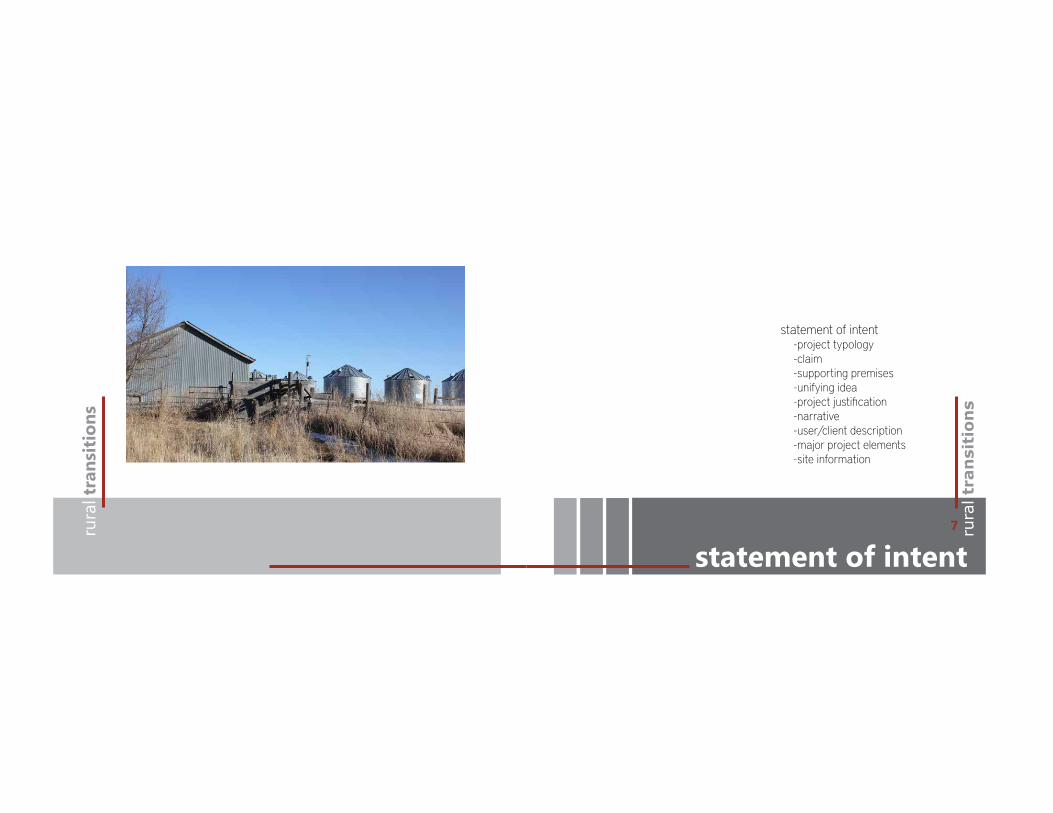
statement of intent -project typology -claim -supporting premises -unifying idea -project justification -narrative -user/client description -major project elements -site information
7
claimrura
l tra
nsit
ions
project typology rura
l tra
nsit
ions
- s
tate
men
t of i
nten
t
A design that understand and responds to the values of rural dwellers will o!er a unique opportunity for rural dwellers to simplify their lifestyle with the conveniences of an urban setting. The project will provide a location for surrounding communities to benefit as well as the residents bringing mutliple amenities to one place.
The typology chosen for this thesis project is a self sustaining, mixed use facility that will supplement struggling rural communities and provide the missing resources for people to live, work, shop, and dine.
9

unifying idearura
l tra
nsit
ions
supporting premises
As architects we have the ability to improve the quality of life for others by designing more sustainable living environments.
By understanding the quality of life valued by rural dwellers, we can begin to draw parallels between urban and rural lifestyles and which makes each beneficial to the dwellers and the environment.
In order to create appealing environments that integrate the primary benefits of rural individuals must be reflected into a new environment, but the solution can answer the problems that true rural living doesn’t provide. Those seeking a simpler, more sustainable way of life will seek the benefits.
This thesis will embrace the values of a rural agricultural people and instill these same values into a more integrated, sustainable lifestyle that can expand on the benefits of living in a city without sacrificing a rural life experience. The result will be a development where a new quality of life can be established my simplifying the aspects of a one’s everyday life and providing a supplemental facility to surrounding communities.
rura
l tra
nsit
ions
- s
tate
men
t of i
nten
t
11

narrativerura
l tra
nsit
ions
SURMHFW�MXVWL¿FDWLRQ
Current trends indicate more people are moving into areas of greater density from rural areas. The e"cient and convenient access to amenities and necessities in the rural setting is dwindling, moving people to cities and causing small communities to su!er. This creates an opportunity for a new mixed-use facility to be the transitional space to help sustain rural communities and create a new living environment where people can live a more sustainable centralized lifestyle. The solution is to integrate the values and living patterns of rural life into a live, work, shop typology while retaining a rural location quickly accessible to the full benefits of city living. The solution begins to bring the conveniences of the city back to the rural communities but avoids the chaos often associated with the city.
Transitions is an idea that has developed from my experiences living with in both an urban and rural environment. The city has become a desirable place to live because of the close proximity to so many accommodations. However, there is always a sense of place that is missing which was always fulfilled growing up in rural South Dakota. Furthermore, the trend of shrinking rural populations demands a challenging solution. The solution is to create architecture that can maintain a rural feel while still providing the accommodations necessary to live.
As people continue to move towards areas of greater population density, the rural areas are left dwindling
rura
l tra
nsit
ions
- s
tate
men
t of i
nten
t
13

narrativerura
l tra
nsit
ions
narrative rura
l tra
nsit
ions
with populations. This isn’t such an issue as much of the rural land is better utilized for agriculture and those serving the agricultural industry. The rural demographic is getting older, and the younger generations growing up in the rural areas are slowly moving towards the urban setting. However, agriculture will always exist as will the individuals that serve the industry and a solution to alleviate the growing trends and keep rural communities alive is vital.
By taking elements that are characterized as valued lifestyle benefits from rural dwellers and creating an environment that thrives on the sustainable benefits
of city life a transitional space will be created that builds on the most significant areas of both lifestyles. The solution will avoid the hustle and bustle associated with many city lifestyles yet all the essential amenities will be more centralized creating an environment that is more sustainable yet has a strong sense of community.
A sustainable solution creates economic benefits by centralizing all the essential necessities into one area for surrounding communities. The agricultural lifestyle will still be the unifying value in the design, but convenience and sustainability will be the driving force.
rura
l tra
nsit
ions
- s
tate
men
t of i
nten
t
15
user/client descriptionrura
l tra
nsit
ions
user/client description
a. The project will be designed for individuals or families who are interested in the rural lifestyle and the benefits that it provides, who also seek a more sustainable and economically beneficial lifestyle that the city can o!er. The primary users will be the residents of surrounding communities that lack essential conveniences. Another common user would be older generations seeking to move away from their retired farm life as well as younger generations seeking a centrally located living conveninces. Secondary occupants may include individuals living in the city looking for a more laid back lifestyle. Other users include those who work at or assist in the operations of the development. Visiting family or tourists are other likely temporary occupants.
b. The development will be funded by private investors and local communities who are excited about maintiaing their rural infrastructure. Restrictions on population and residents wouldn’t be limited until a rate of growth has exceeded a point that may sacrifice the rural lifestyle that is being sought after. The development will accommodate up to 25 families interested in rental housing in addition to a community center for surrounding communities to share as well as the amenities needed on a daily basis. Parking will accommodate the residents as well as additional parking for visitors and secondary building users.
rura
l tra
nsit
ions
- s
tate
men
t of i
nten
t
17
major project elementsrura
l tra
nsit
ions
major project elements
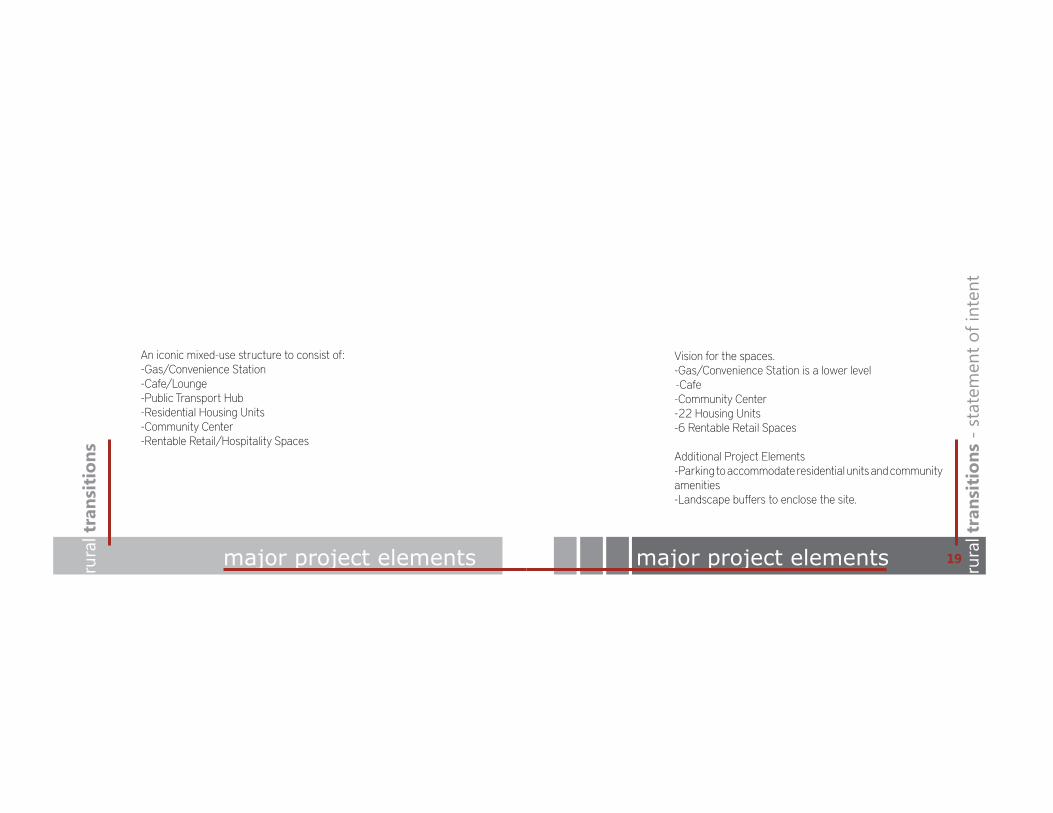
An iconic mixed-use structure to consist of:-Gas/Convenience Station-Cafe/Lounge-Public Transport Hub-Residential Housing Units-Community Center-Rentable Retail/Hospitality Spaces
Vision for the spaces.-Gas/Convenience Station is a lower level -Cafe-Community Center-22 Housing Units-6 Rentable Retail Spaces
Additional Project Elements-Parking to accommodate residential units and community amenities-Landscape bu!ers to enclose the site.
rura
l tra
nsit
ions
- s
tate
men
t of i
nten
t
19
site regionrura
l tra
nsit
ions
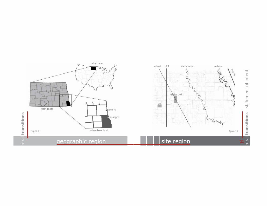
geographic region
fargo, nd
richland county, nd
site region
north dakota
united statesred river
hwy 75
wild rice riveri-29railroad
galchutt, nd
site
rura
l tra
nsit
ions
- s
tate
men
t of i
nten
t
figure 1.1 figure 1.2
21

site detailsrura
l tra
nsit
ions
site details
The site was chosen because of its proximity to a large city center, its access to a main transportation byway, and most importantly it’s rural setting. This particular site o!ers views near the river and a private location o! the vital roadway, yet it can be accessed and seen easily from the traveling arteries. There aren’t any immediate site limitations because the land is currently tillable farmland. The selected parcel is relatively small but there aren’t limitations that would keep the development from future expansion.
Site Details-County-Richland-Nearest intersection-171st AVE SE and 71st ST SE-Nearest town-Galchutt, ND (1.6 miles)-Nearest city-Fargo, ND (22 miles south)-1 mile west of Interstate 29-Surrounding Communities - Colfax, Dwight, Mooreton, Walcott
This site o!ers a unique opportunity because the completed design will share similar attributes to a tiny one street town. Galchutt is the tiny community in need of revitalization with a great location. No exisiting structures would be harmed yet added infrastructure to the area while help stablize the smaller communites.
rura
l tra
nsit
ions
- s
tate
men
t of i
nten
t
23

site perspectiverura
l tra
nsit
ions
site map
interstate 29
171st ave se
to fargo
170th ave se
county road 8
72nd st se
73rd st se
site
panorama view from 171st ave se
rura
l tra
nsit
ions
- s
tate
men
t of i
nten
t
figure 1.3 figure 1.4
25

rura
l tra
nsit
ions
rura
l transitions
thesis proposal
thesis proposal -project empahsis -research direction -design methodology -documentation plan -schedule -timeline -studio experience
27
research directionrura
l tra
nsit
ions
project emphasis rura
l tra
nsit
ions
- th
esis
pro
posa
l
This thesis will provide a solution that creates a more centralized and sustainable environment thriving from the benefits of urban life and integrating them into a development built on the lifestyle valued by rural dwellers into a transitional community.
Research will be conducted throughout the investigation and execution of five main areas:
-The Theoretical Premise/Unifying Idea -Project Typology -Historical Context -Site Analysis -Programmatic Requirements
29

My design methodology will follow a mixed use method that includes a quantitative and qualitative approach. Quantitative and qualitative data will both be gathered concurrently. Quantitative data may include statistical data or scientific data where as qualititative data will be data gathered from observation, local survey, through archival search, or direct interviews.
The research method will follow a concurrent transformative strategy which will be guided by the thesis’ premise/unifying idea.
documentation planrura
l tra
nsit
ions
design methodology
Research and information that can be utilized or is valuable to the outcome of the project will be documented and preserved digitally. Findings in electronic and hard copy format will be compiled into a list with proper citations to make them easily accessible. Process, Sketches and Drawings will be scanned and documented similarly in a digital format as well as filed into a hard copy folder. These tasks will be done as needed but will be checked and done in their entireity the first and third monday of each month during thesis. All things documented will be made available at the time of submission.
rura
l tra
nsit
ions
- th
esis
pro
posa
l
31

timelinerura
l tra
nsit
ions
schedule rura
l tra
nsit
ions
- th
esis
pro
posa
l
figure 2.1 figure 2.2
33

rura
l tra
nsit
ions
studio experience
Fall 2009 - Steven WischerTea House Boat House
Spring 2009 - Phil StahlMontessori SchoolHemmah ResidenceSteel Chair
Fall 2010 - Milt YergensMasons Guild LodgeCultural Center
Spring 2010 - Regin SchwaenHomeless ShelterConcrete Cafe
Fall 2011 - Frank KratkyHigh RiseKKE Competition
Spring 2011 - Ronald RamseyModern Residence for Agincourt, IA
Fall 2012 - Regin SchwaenMuseum Addition
rura
l tra
nsit
ions
- th
esis
pro
posa
l
35
rura
l tra
nsit
ions
rura
l transitions
program
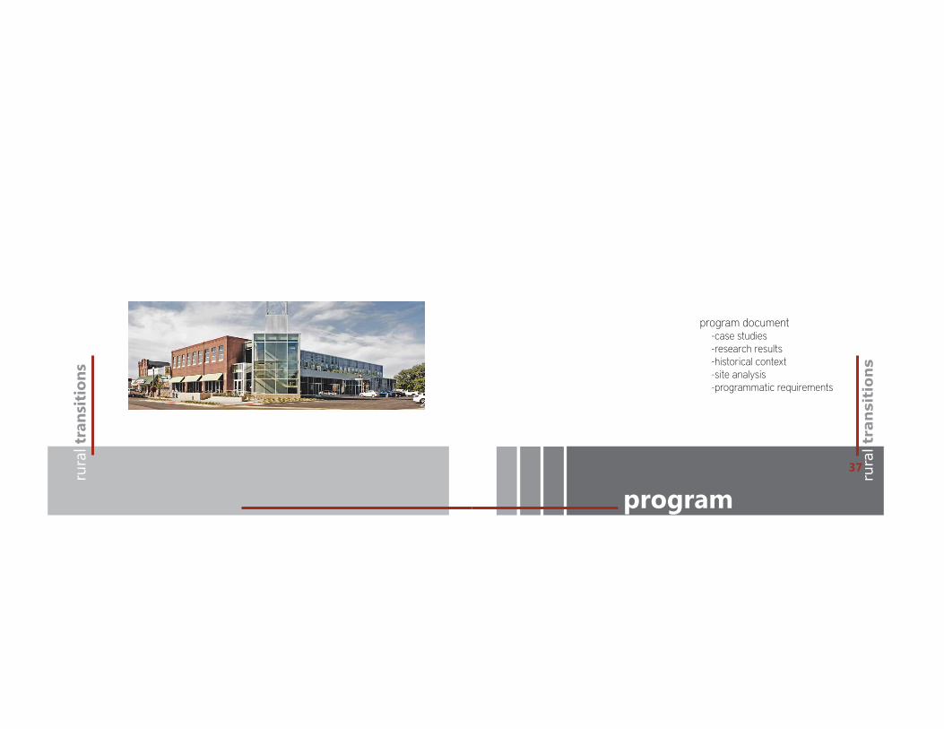
program document -case studies -research results -historical context -site analysis -programmatic requirements
37

rura
l tra
nsit
ions
case studies
rura
l tra
nsit
ions
case studies: -siloetten -newlands -nantes development
39
rura
l tra
nsit
ions
siloetten rura
l tra
nsit
ions
- c
ase
stud
ies
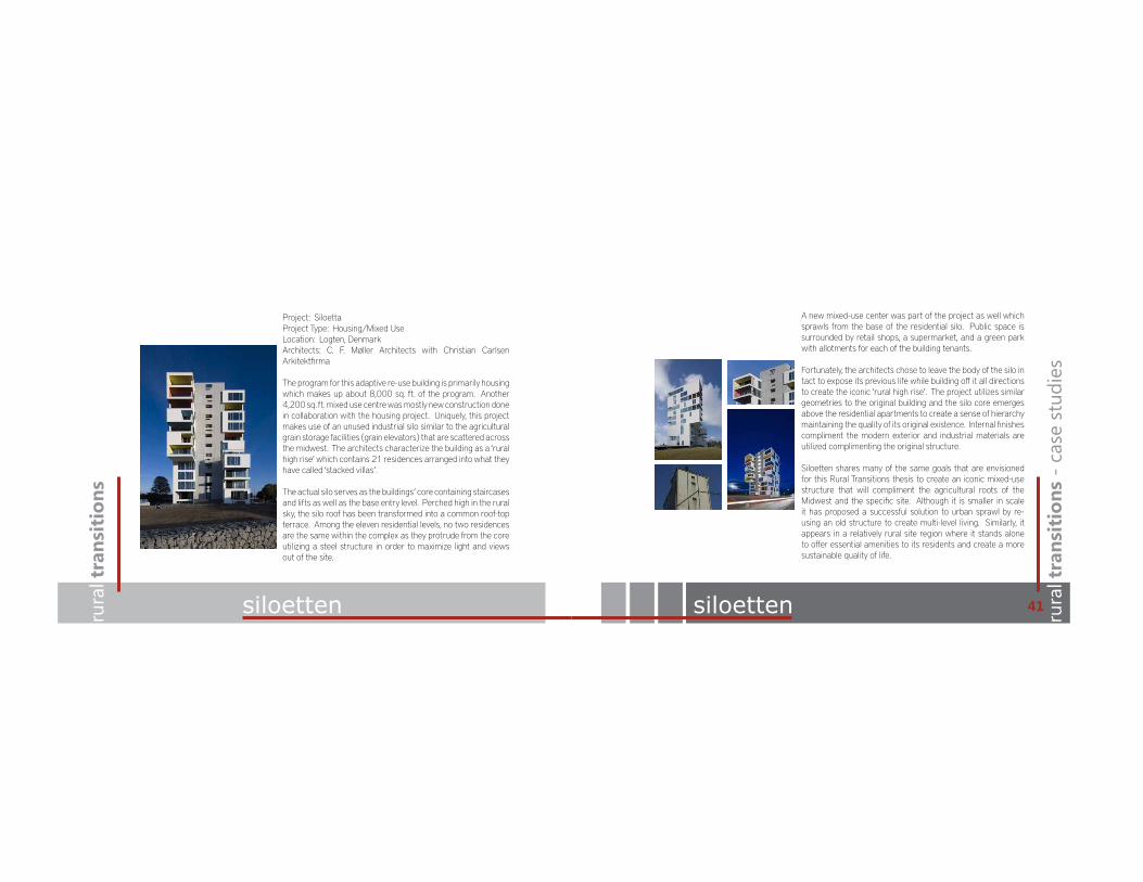
Project: SiloettaProject Type: Housing/Mixed UseLocation: Logten, DenmarkArchitects: C. F. Møller Architects with Christian Carlsen Arkitektfirma
The program for this adaptive re-use building is primarily housing which makes up about 8,000 sq. ft. of the program. Another 4,200 sq. ft. mixed use centre was mostly new construction done in collaboration with the housing project. Uniquely, this project makes use of an unused industrial silo similar to the agricultural grain storage facilities (grain elevators) that are scattered across the midwest. The architects characterize the building as a ‘rural high rise’ which contains 21 residences arranged into what they have called ‘stacked villas’.
The actual silo serves as the buildings’ core containing staircases and lifts as well as the base entry level. Perched high in the rural sky, the silo roof has been transformed into a common roof-top terrace. Among the eleven residential levels, no two residences are the same within the complex as they protrude from the core utilizing a steel structure in order to maximize light and views out of the site.
siloetten
A new mixed-use center was part of the project as well which sprawls from the base of the residential silo. Public space is surrounded by retail shops, a supermarket, and a green park with allotments for each of the building tenants.
Fortunately, the architects chose to leave the body of the silo in tact to expose its previous life while building o! it all directions to create the iconic ‘rural high rise’. The project utilizes similar geometries to the original building and the silo core emerges above the residential apartments to create a sense of hierarchy maintaining the quality of its original existence. Internal finishes compliment the modern exterior and industrial materials are utilized complimenting the original structure.
Siloetten shares many of the same goals that are envisioned for this Rural Transitions thesis to create an iconic mixed-use structure that will compliment the agricultural roots of the Midwest and the specific site. Although it is smaller in scale it has proposed a successful solution to urban sprawl by re-using an old structure to create multi-level living. Similarly, it appears in a relatively rural site region where it stands alone to o!er essential amenities to its residents and create a more sustainable quality of life.
41
rura
l tra
nsit
ions
rura
l tra
nsit
ions
- c
ase
stud
ies
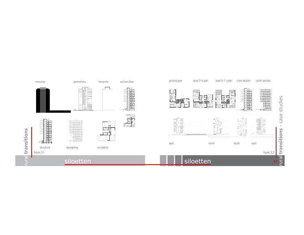
siloetten
east north south west
ground plan level 2-4 plan level 5-11 plan core section north section
siloetten
structure daylighting circulation
massing heirarchy section/plangeometries
figure 3.1 figure 3.2
43

rura
l tra
nsit
ions
newlands newlands rura
l tra
nsit
ions
- c
ase
stud
ies
Project: Newlands Community CentreProject Type: Mixed UseLocation: Newlands, Wellington NZArchitects: CCM Architects
Newlands is a di!erent type of project that responds to the needs of a community in an outer residential suburb of Newlands, Wellington that is located in New Zealand. The program is a mixed-use community center, which is a growing popularity in small communities. Since it is ine"cient and a struggle for smaller communities to build and support multiple community services, combining the services into one mixed-use facility is the solution.
Although this case study doesn’t contain a residential development within the immediate project, the community is already established and has adequate residential housing. This project revitalizes a struggling community and combines the needs of the community into one expansive project. Amenities include a cyber library, library, food bank, youth area, performance space, meeting
areas, o"ces, and an outdoor half court gymnasium. The building design has a very strong street, and community presence as the upstairs youth area cantilevers beyond the building confines to the street interface. This creates a light filled, fun, and interactive space for the youth development. Light quality is significant throughout the building as much of the exterior facades are glazing. Modern and industrial materials are used throughout the structure. The cantilever has been designed to also mark the primary entrance while awnings wrap around the building to shade light and create an inviting presence to the building. Upper level clerestory glazing provides natural day-lighting to the libraries and common areas.
Similar to the previous case study this project creates an iconic structure housing multiple essential needs of a community. It also creates a common community gathering area for all ages, a destination, and a sense of place with the community. Since Galchutt, ND and surrounding communities are struggling with little economy this type of project will be beneficial to the town and surrounding communities. The simple yet powerful design of a muti-use community space such as this can be a destination for not only a rural community but common gathering areas with-in a larger mixed-use housing facility will also bring community members together.
45

rura
l tra
nsit
ions
newlands rura
l tra
nsit
ions
- c
ase
stud
ies
structure daylighting circulation
massing heirarchy section/plangeometries ground plan upper level plan transverse section longitudinal section
east north south west
newlands
figure 4.1 figure 4.2
47

rura
l tra
nsit
ions
nantes development nantes development rura
l tra
nsit
ions
- c
ase
stud
ies
Project: Nantes Urban DevelopmentProject Type: Housing/O"cesLocation: Nantes, FranceArchitects: FGP
The Nantes Urban Development program is substantially larger than the previous two case studies. This project is about 213,000 sq. ft. with o"ces, housing, a library, a restaurant, a large research facility, sta! residence and hotel, as well as a big parking area. The massive site covers over a city block and strives to be landmark for the city of Nantes. Interior areas of the site remain open to accommodate a large sporting facility. This area could be envisioned an internal public green space in the application of the Rural Transition thesis. It protects the area from wind and minimizes outside safety, and noise concerns from tra"c in the area.
Spatial layout of the buildings remains narrow in order to keep site lines open along the building facades and out of the site. This also ensures that all residential spaces get a similar view and quality
of light within each space. Similar to the site in which the thesis is envisioned the site is enclosed on three sides and left open to the air on one side. Most of the structure is built along the south end of the site and multiple variations in height stretch across the facade.
These design elements create a very strong sense of hierarchy and provide unique day lighting opportunities. Although, the materials are very commercial, they respond to the modern design and were chosen to maximize light into the spaces. This particular project and site are also in an urban setting but the location on the bay side of town and the expansive open space make it feel very open which also could be applied in a rural setting.
FGP (French Global Project), the project architect also states that this type of construction can also integrate other programmatic facilities such as shopping centers, areas for leisure, and more parks and gardens such as the case in the Rural Transitions thesis.
49
rura
l tra
nsit
ions
nantes development nantes development
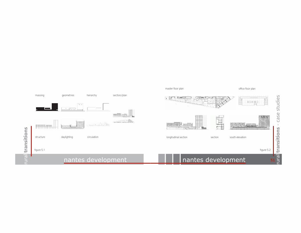
structure daylighting circulation
massing heirarchy section/plangeometries
master floor plan o"ce floor plan
south elevationlongitudinal section section
rura
l tra
nsit
ions
- c
ase
stud
ies
figure 5.1 figure 5.2
51

rura
l tra
nsit
ions
case study summary case study summary rura
l tra
nsit
ions
- c
ase
stud
ies
53
Good case studies are real life applications that have successfully been executed to fulfill the needs of a program. The case studies highlighted in the preceding pages were chosen because of their relevance and similarities to the Rural Transitions thesis project. Each of the case studies are part of the mixed-use typology and in have been executed in di!erent areas of the world. The scales range from 4,500 sq. ft. to 215,000 sq. ft. Rural Transitions seeks to fulfill a large program but maintains a small area. However, each program is also unique to the community or region and have a variety of uses with-in each facility.
Similarities between them are that each have an iconic design that strives to be a symbol or icon for the city, community, or rural landscape in which they were built. The thesis project being envisioned also seeks to make
an iconic statement with references to the rural economy and culture. All three designs have a great sense of hierarchy, utilize basic geometries, and are modern designs using modern and industrial materials.
Di!erences are extensive because of the wide range in size. The Nantes Development is very urban yet has a rural feel because of its location, while the Siloetten project is built into a rural landscape much like the thesis being proposed. Siloetten seems to be the most applicable as it fulfills similar programmatic requirement to this thesis. Housing is the primary focus with supporting amenities and uses throughout the development. The other two have a more scattered program, however, many of the same uses will be integrated into the Rural Transitions vision.

rura
l tra
nsit
ions
rura
l transitions
research results
results from the theoretical premise and unifying idea research: -rural lifestyle investigation -mixed-use developments -agricultural economy
55

rura
l tra
nsit
ions
rural research rural research rura
l tra
nsit
ions
- p
rogr
am
to urban and suburban areas (Hillyard 13). The significance of these facts is to identify these concerns as the primary problems in rural America and o!er a solution that responds to and solves the issues in a long-term solution for rural communities.
Hilliard’s book identifies three aspects of community that have dominated studies of rural communities. First is the relationship between modern industrial society and society itself and how it these this relationship impacts personal relationships as well the structure of relationships. The second analysis is more specific and related to the localized social relations within a community. Last is based on Howard Newby’s concept which focuses on the occupational community that exists with in a rural setting including factors such as long-term residence, shared employment patterns, and proximity. This is significant because it suggests the importance of relationships that must exist in order to make rural lifestyles operable. Additionally, many of these aspects of community can help draw parallels between rural and urban settings. In this thesis my development strives to identify which makes urban living appealing and how the urban lifestyle, which is more centralized, sustainable and convenient, can be integrated into a rural setting. As Hillard states this analysis of community, lifestyle, and relationships, “could relate to the redevelopment of many inner-city areas” (34) as well as the redevelopment of rural communities. (Hillyard)
Investigation of the Rural LifestyleInvestigation of the Rural Lifestyle
Research has indicated that the rural fabric of America is changing. Over the past couple of decades rural society has seen big changes in diversity, economics, centralized growth, and new opportunities as well as fluctuations in population, labor opportunities, and age demographics. Unlike urban areas, the source of rural economics is widespread through agriculture and is scattered into small communities that are vital to the existence of a rural lifestyle. (Hillyard)
Agriculture remains the backbone of many rural communities and the trend continues to grow as other rural economies have seen declines in areas such as manufacturing. (Hillyard) This trend is making the significance of agriculture as a tool for rural survival a necessity. On the contrary, it is causing communities to be more reliant on service industries that are often outsourced to areas of more dense population. This is scattering the rural population closer to cities in search of better paying jobs and also is linked to a growing diversity in the population. Sam Hillyard’s book, The Sociology of Rural Life, identifies a couple very important points, “rural communities, especially those within commuting distance of larger areas, are experiencing high physical growth, which must be balanced with protecting the natural environment, and while new opportunities are being created in rural communities, poverty persists at alarming levels relative
57

rura
l tra
nsit
ions
rural research rura
l tra
nsit
ions
- p
rogr
am
mixed use research
The redevelopment of rural communities must get creative in their plans to create new developments or redevelop areas of the city. With a limited and dwindling population to work with, the development must have very specific intentions for the people. For this to work e"ciently it must include this demographic of people in order for the building to serve as many people of the rural area as possible. The limited population and involvement also raises concerns about finances. As people seek to move away from the small communities, the sources of feedback and funding also leave with the people. The centralization of people and conveniences is what makes cities work and rural communities less appealing. Government programs also tend to favor the populated areas for funding and grants as opposed to o!ering assistance to the areas in need. Across the Midwest, it is clearly the rural communities that are struggling, poverty-stricken and in need and cities continue to extend past their boundaries onto once rural land.
The significance of location is obvious. Since rural areas can’t compete with the amenities cities have to o!er convenience and the geographic location of communities is vital to their existence as well. In a growing urban society, close proximity to an urban setting is a necessity. The significance of location also must be rural enough for a community to be independent. The book Sociology of Rural Life identifies ‘community spirit’ as the overall sense of a community, which
encompasses all the relationships, and factors that make a community successful. (Hillyard)One solution to this problem is to make rural developments that give the people a reason to stay, and in order to do this e"ciently on a small scale multiple uses must be integrated into one area and fulfill multiple needs. This idea is known as a mixed-use development.
Mixed-Use Developments
The idea of a ‘live, work, play’ community environment is the ideal living situation in terms of convenience, e"ciency, and sustainability. It is also a great way to integrate multiple functions into one program, which also saves time, money, and is more sustainable. This mixed-use building typology has been a growing trend and there is no question why. A mixed-use development is ideal for all types of applications, whether that be inner city, suburban, or rural. Rural Transistions takes this idea into the rural landscape to create a new self sustained community and to help revive small agricultural communities in the area. The project strives to integrate the living essentials into one environment. According to “Mixed-Use Development: A Call for Research”, there is little theoretical research indicating
59
rura
l tra
nsit
ions
mixed-use research mixed-use research rura
l tra
nsit
ions
- p
rogr
am
the success or failures of mixed-use development. The typology has also been practiced in di!erent forms such as one single building to house multiple uses or multiple buildings with in a site to have mixed uses.
The definition of mixed use from the National Institute of Building Sciences is “A development in one or several buildings that combines several revenue producing uses that are integrated into a comprehensive plan—such as a project with a elements of housing, retail, and o"ce space” (National Institute of Building Sciences). Mixed Use Development-A Call for Research talks about mixed-use buildings in terms of smart growth. The text outlines key elements for smart growth which include limiting outward expansion of new development, increasing residential densities, providing more mixed and pedestrian friendly development, emphasizing public transit, shifting development cost to those who benefit via impacts fees, and revitalizing older neighborhoods. (Rabianski, Gibler and Tidwell) Although all these elements aren’t included in all mixed-use developments, they can be applied to all design problems and mixed-use developments often respond to most of these elements. A rural mixed-use development o!ers most of these benefits as well as added factors of added convenience and sustainability that many rural communities su!er from. The document states that mixed-use developments are a planned development with a cluster of three or more compatible uses, not an organic concentration of uses. These developments
create a sense of place for cities and communities
The application has di!erent thoughtful standards in di!erent areas of the world:“Crowded Asian cities are home to large-scale organized mixed-use developments. In Europe, mixed-use developments are associated with urban revitalization and compact cites. In the U.S., they are associated with smart growth and postmodern design of neotraditional neighborhoods, such as pedestrian pockets and New Urbanism”. (Rabianski, Gibler and Tidwell)
This quote suggests the application is utilized throughout the world and they all suggest a more e"cient and sustainable quality of life through organization, revitalization, compaction, and smart growth.
Developments seeking to provide multiple uses in separate buildings such as the case in modern cities are ine"cient and inconvenient. A mixed-use development can integrate these same uses into a more concentrated area, which brings people together into a more e"cient layout that fulfills the same needs as the larger development. Grouping buildings or uses in this way also creates opportunities to design buildings with more visual interest that makes these same areas more attractive places to live. It also reduces the need for travel, which promotes e"ciency
61

rura
l tra
nsit
ions
agricultural research agricultural research rura
l tra
nsit
ions
- p
rogr
am
63
by the intensive use of space. This idea of centralized development reduces urban sprawl and gives smaller communities the opportunity for revitalization. (Rabianski, Gibler and Tidwell) Finally, this building type is also a great housing solution as well since so many of the living essentials are centralized in one area. Taking this program outside its usual boundaries has to be done well in order to be successful. In the application of a rural farming region, the most significant factor to consider is how to help the people. Thus it is vital to understand the economy of rural agriculture.
Agricultural Economies
As of 2007, North Dakota had 31,970 farms managing over 39,670,000 of the 44 million total acres in North Dakota. These farms are managed by 18,525 full-time operators and another 13,445 operators, which don’t include the on-farm employment. A meer 54% of the operators are over the age of 55 which leaves a pretty substantial portion to young farmers and the potential for aging operators to pass their farms to younger generations. (Farmland Information Center)
Just as the research has indicated that people have been moving away from farms
in recent years, data also suggests that agriculture has also seen drops in the total share of the North Dakota economy. However, more land is farmed in North Dakota now than in previous decades, which suggests North Dakota successfully diversifying their economy. Agriculture directly employs over 15% of the state’s workers generating more than $6 billion dollars in annual business. Nationally, North Dakota’s ranks second in the percentage of gross state product sustained from agriculture. This data solidifies that agriculture plays a very significant role in North Dakota’s economy and workforce, but more importantly North Dakota’s agriculture plays a vital role in the global agricultural economy. Agriculture also remains the largest export of goods and services for North Dakota signifying agriculture as the cornerstone of its diversifying economy. (Farmland Information Center) (F. Larry Leistritz)
Although significant changes have been in North Dakota’s economic infrastructure since the late 1800s, the agricultural industry still employs a significant amount of the workforce and accounts for a considerable portion of the state’s income.

rura
l tra
nsit
ions
research summary research summary rura
l tra
nsit
ions
- p
rogr
am
65
A research-based investigation indicates many of the assumptions I had made before about the viability of the project are supported by research. The project is based in rural setting, with a strong agriculture economy, and utilizes a program that can work. Agriculture remains to be the backbone of North Dakota’s economy. Although the research indicates that the economy has become much more diverse in the latest century; agriculture still utilizes almost 90% of the land area in North Dakota. These facts suggest that the significance of agriculture make the project viable especially in a rural setting where agriculture is the prominent industry. Small communities are latching to the economy that remain in their town, most of which are agriculture related including ag services, ag supply, and ag marketing or distribution. Other businesses are small operations that o!er conveniences to the residents. The lack of economic diversity is the cause of a shrinking rural population. Towns nears cities continue to grow into suburban America as rural communities shrink.
The obvious question is to ask what’s missing. Clearly an economic diversity, as well as modern conveniences o!ered by the city that rural communities lack. With these problems and lack of population, the “community spirit” leaves with its past residents. Community spirit is also strong among the agriculture community and can be lost in the midst of city life. A solution is to keep the rural communities strong.
Mixed-use buildings are the wave of the future in terms of e"ciency and practicality especially in rural areas where funding for necessities is minimal. Integrating multiple uses into one facility can cut costs and save space. It brings the missing resources of an area into a centralized location. This mixed-use typology that brings many uses to one area also beneficially brings multiple people to one area. Multiple buildings in a community can fulfill the needs, at a large cost, and the use is fairly small. However, if you integrate these same needs into one larger facility that houses multiple uses, the same number of people can be serviced in a much more e"cient manner while still fulfilling the needs of a community. Mixed-use developments also create an attractive living environment because of the convenience of centralized amenities.
This innovative idea of integrating multiple resources into one area, brings people into one area which can revitalize a community and help regain the treasured “community spirit”. In the unique application of the Rural Transitions thesis, all of these ideas are utilized to serve a broader agricultural region where multiple communities can reap the benefits therefore serving even more uses, and more people. This also brings the necessary agricultural and community resources to a centralized location that becomes a regional ‘hub’ built from the cultural, agricultural, and community values that have been investigated in the research process.

rura
l tra
nsit
ions
historical context historical context rura
l tra
nsit
ions
- p
rogr
am
The thesis, Rural Transitions, takes the idea of a mixed-use facility into an unfamiliar setting. Although mixed-use facilities have been popular in past decades, in recent years the popularity has grown and the idea has been a key area of urban regeneration, infill, compact cities, new urbanism, and sustainable development. (Rabianski, Gibler and Tidwell) Very few projects have been published about this project type being adapted into a totally rural environment as a new type of community development; however, there are endless case studies that utilize the mixed-use development in small communities. Towns all across the Midwest that are implementing new construction are choosing to include multiple programs into one building typology. Although, the trend has grown significantly in recent years it actually isn’t a totally new idea.
Ancient Greek agora and medieval market squares are early examples of what may be considered mixed-use as these center-city plazas were the central location of many community amenities. This was during a time when automobiles and other types of transportation didn’t exist so walking was the only form of transportation. Naturally, the city designs responded to this restriction and areas were designed in which people could live, work, play all within the same confined area. Following the invention of the automobile and advanced transportation methods, cities began to sprawl and people scattered to areas that were undeveloped and didn’t have this type of e"cient development layout. (Rabianski, Gibler and Tidwell)
As small communities have su!ered, people have fled to cities to find convenience and these same smaller communities are now trying to build mixed-use facilities in order to o!er the same conveniences. This is the issue that is apparent across struggling agricultural communities in the area of the Rural Transitions thesis site. Many of the towns are dwindling and hanging onto only the agricultural roots that still exist. The application hasn’t been proven extensively in small rural towns, however Howard, SD has made great use of a similar facility. Destroyed by a tornado a few years ago the town started by rebuilding a large mixed-use facility for the town’s essentials. It also has a hotel and restaurant to serve the community and help sustain itself. Similar to Galchutt, ND, Howard was a struggling agricultural community near a larger city center that has seen the benefits of such a development.
Other mixed-use developments are much more frequent in the urban setting, even as near to the site as Fargo, ND. Most the new retail developments built in the Fargo city and suburban area integrate mixed-use design considerations rather than single business or single purpose buildings. Fargo’s city center has also seen recent developments that integrate housing, retail, and other mixed-use functions into one structure. This growth trend indicates that the project typology must be working the in area. The limited rural applications have shown signs of success as well. The historical mixed-use applications have been around since the first city developments. While there was a hiatus in the typology
67
rura
l tra
nsit
ions
historical context historical context
19001910
19201930
19401950
19601970
19801990
20002010
17,387
20,51919,659 20,887
21,008
19,86518,824
18,08919,167
18,123 17,998
16,321
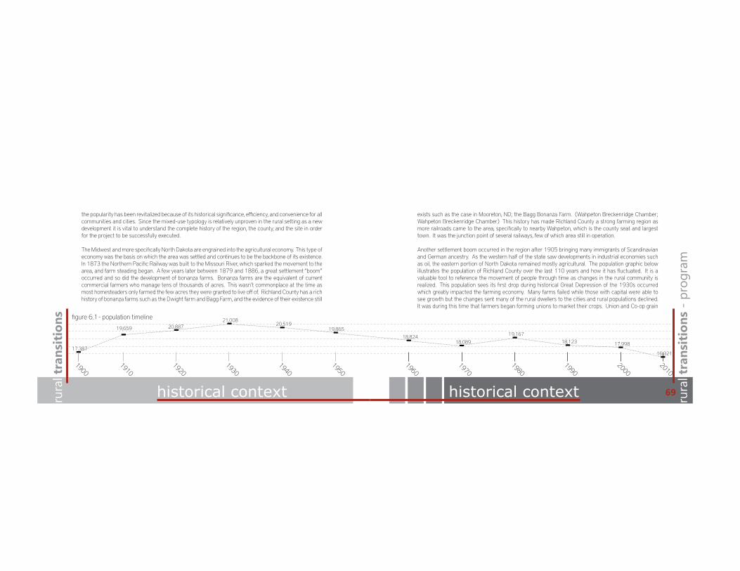
figure 6.1 - population timeline
rura
l tra
nsit
ions
- p
rogr
am
the popularity has been revitalized because of its historical significance, e"ciency, and convenience for all communities and cities. Since the mixed-use typology is relatively unproven in the rural setting as a new development it is vital to understand the complete history of the region, the county, and the site in order for the project to be successfully executed.
The Midwest and more specifically North Dakota are engrained into the agricultural economy. This type of economy was the basis on which the area was settled and continues to be the backbone of its existence. In 1873 the Northern Pacific Railway was built to the Missouri River, which sparked the movement to the area, and farm steading began. A few years later between 1879 and 1886, a great settlement “boom” occurred and so did the development of bonanza farms. Bonanza farms are the equivalent of current commercial farmers who manage tens of thousands of acres. This wasn’t commonplace at the time as most homesteaders only farmed the few acres they were granted to live o! of. Richland County has a rich history of bonanza farms such as the Dwight farm and Bagg Farm, and the evidence of their existence still
69
exists such as the case in Mooreton, ND; the Bagg Bonanza Farm. (Wahpeton Breckenridge Chamber; Wahpeton Breckenridge Chamber) This history has made Richland County a strong farming region as more railroads came to the area, specifically to nearby Wahpeton, which is the county seat and largest town. It was the junction point of several railways, few of which area still in operation.
Another settlement boom occurred in the region after 1905 bringing many immigrants of Scandinavian and German ancestry. As the western half of the state saw developments in industrial economies such as oil, the eastern portion of North Dakota remained mostly agricultural. The population graphic below illustrates the population of Richland County over the last 110 years and how it has fluctuated. It is a valuable tool to reference the movement of people through time as changes in the rural community is realized. This population sees its first drop during historical Great Depression of the 1930s occurred which greatly impacted the farming economy. Many farms failed while those with capital were able to see growth but the changes sent many of the rural dwellers to the cities and rural populations declined. It was during this time that farmers began forming unions to market their crops. Union and Co-op grain

rura
l tra
nsit
ions
historical context historical context rura
l tra
nsit
ions
- p
rogr
am
71
elevators began to be built across the area to help stabilize the agricultural economy. These developments made use of the railroads that had grown in the area and the ability to transport grain outside of the area was realized. It is these iconic elevator structures that will become inspiration for the design, as they are the historical artifact of the region and the regional agriculture. In 1908, there were 75 elevators in the county. Although, many have been abandoned and left to rot, many remain in good standing operation as well. (State Historical Society of North Dakota) (Claud H. Baker)
Nearly each community in Richland County has the agricultural icon towering above the town. This is also the case in Galchutt, ND near the Rural Transitions thesis site where the elevator and railway are the primary remaining signs of the past. As the complexity of government, advancements in technology, and time progressed so did the local economies and many industries began to operate with in regional cities. According to State Historical Society of North Dakota:
“Perhaps the most striking change, however, is reflected by a 1987 census figure. According to census estimates, more North Dakotans now live in cities and towns than in rural areas, an alteration with dramatic implications for the structure of the state’s economy and the composition of its government.” (State Historical Society of North Dakota)
This trend has continued in recent years and is the reason behind the thesis to help revitalize the rural struggle and bring the people of North Dakota and Richland County back to their agricultural ties.
The ongoing discussion of agriculture in the area also requests some further history on the regional farming practices. Richland County covers an area of 1,453 square miles in the southeastern corner of the state. According to a Soil Survey of Richland County published in 1997, the area of Richland County is 927, 424 acres. At the time of the survey 93% of the land was in farms. The study also indicates that trends are showing fewer are larger farms ranging in size from less than 100 acres to more than 6,000 acres in size. (United States Department of Agriculture and Soil Conservations Service) A statistic from 1970 showed 1,627 farms were operated in Richland County, which was a decrease of nearly 700 farms in the last 15 years (Claud H. Baker). These two statistics alone support the changing rural demographics as cities continue to sprawl.
Primary farming practices in the area are cash-grain, livestock and general crop types. A variety of crops are common in the area such as corn, soybean, spring wheat, sugar beets, and oats, barley, and alfalfa are also grown but less commonly in recent years. The principal trade and marketing centers serving the area remain to be Wahpeton, ND and Fargo, ND. Yet another opportunity arises to bring the economy back to its roots where the Rural Transitions thesis can thrive.

goals for the project goals for the project rura
l tra
nsit
ions
- p
rogr
am
73
Executing a thesis demands extensive research and understanding of a variety of subjects, topics, and historical context. This labor-intensive investigation and self-exploration is a grueling process that requires qualities and discipline that has been established over the past 16 years of education. In order to complete a project of this size, specific guidelines must be maintained and goals for the project itself as well as the execution of the project are vital. The Rural Transitions thesis is based around a few specific goals: -Improving a quality of life -Maintaining regional history -Making sustainability and convenience accessible to everyone -Creating a rural icon with agricultural roots -Fulfill the needs of Galchutt, ND, surrounding communities, and area residents -Create a destination with a strong sense of place -Embrace the rural landscape -Maintain a rural lifestyle while providing urban conveniences -Simplify the lifestyle of rural dwellers -Maintain the character of the surroundings and regional history
These goals provide the groundwork for not only designing a thesis project but also are values that I embrace because of my rural upbringing. Although I too appreciate the urban conveniences, the rural lifestyle is where the region was founded and where future generations should get to experience and embrace the same quality of life. This thesis also has goals specific to my
rura
l tra
nsit
ions
development in academic professional, and personal areas alike.
Academically, this thesis will bring all of the tools and talents that I have learned and acquired over my educational history into one compiled project/document. The quality of the project will be produced to my highest ability and showcase my strengths while improve on my weaknesses that I have developed over time. The final outcome is less significant to me in terms of a grade as long as I know that I have produced a quality project, with a quality design, and given my best quality work throughout the thesis’ entirety.
Professionally, this exercise is an opportunity to create an identity for myself. The project typology, location, and history has been derived from my personal experiences and the interests and passions I have acquired throughout my short life-time. Furthermore, it will be a final product that I can show to future employers with the confidence that it will give them adequate information to know that I have the abilities to fulfill the needs necessary to practice in the field.
Personally, this is a time to grow.; as I mentioned before improving my weaknesses and showcasing my strengths. The thesis has taught self-discipline, time-management, quality refinement, and focus, and my hope is that this will continue throughout the project. Finally, it is an opportunity to utilize all the tools necessary to reach a common goal which can be applied to all facets of life; academically, professionally, and personally.

rura
l tra
nsit
ions
rura
l transitions
site analysis
rura
l tra
nsit
ions
rura
l transitions
site analysis
figure 7.1
75

project signature table of contentsregional map regional grid rura
l tra
nsit
ions
- s
ite a
naly
sis
red river
hwy 75
wild rice riverrailroad
galchutt, nd
site
The graphic on the left illustrates the geographical layout of the greater site area. Two rivers are nearby; the Wild Rice is located about 4 miles east of the site, while the larger Red River which creates the North Dakota, Minnesota border is farther east. Main tra"c arteries are labeled as well. Galchutt, ND is the closest community just a mear 2 miles to the east on the opposite side of Interstate 29. A lightly utilized railway is also in close proximity to the site which runs through Galchutt. The grid layout on the map shows the common quarter/section layout of the area farmground seperated by roadways.
i29
red river
hwy 75
wild rice riveri-29railroad
galchutt, nd
site
figure 7.2 figure 7.3
77rura
l tra
nsit
ions

project signature table of contentssite analysis site conditions rura
l tra
nsit
ions
- s
ite a
naly
sis
site
local farmsteadsexternal views
internal views
greater site area
seasonal grain storage area
Similar to the previous graphic, this map illustrates potential views for the site as well as local farmsteads with-in the greater site area. The local farmsteads were denoted as potential noise concerns while the seasonal grain storage area was indicated as an area of greater noise interuptions. Views within the site area created by the trees that enclose the site and create privacy. Views out of the site are lmited to the easterly directions.
site
winter winds
noisewind
tra"c
greater site area
summer winds
The site is nestled on a piece of tillable land which is bordered to the south and west with trees. It is protected from the winter winds, and the site is open to the east and north where the site is accessed. This also will allow cooling summer breezes into the site. Circles on the map denote areas of potential noise from local farmsteads. Tra"c is light in the immediate area of the site but picks up significantly during the farming seasons. The seasonal tra"c will need to be considered in the site design to prevent noise, safety hazards, and site interuptions. Other areas of concern are the heavy tra"c, and noise from Interstate 29 one mile to the east. The larger circles indicate areas of heavier or more concentrated noise.
figure 7.4 figure 7.5
79rura
l tra
nsit
ions

project signature table of contentsrura
l tra
nsit
ions
typography/slope soils and drainage rura
l tra
nsit
ions
- s
ite a
naly
sis
According to the U.S. Department of Agriculture Soil Conservation Service the site is part of the Galchutt-Fargo-Aberdeen soil association. Richland county overall is poorly drained and the site region is nearly level and somewhat poorly drained as well. Most of the area has a claypan subsoil with a topsoil comprised of medium textured to moderately fine texture soils. The soil conditions were formed in silty and clay-like lacustrine sediments. The main soil types in the eastern part of the county which were derived from the Sheyenne Delta include: Fargo fine sandy loam, Fargo fine sand, and Fargo fine loam. Other common soils in the poorly drained area of the region towards the Red River include Fargo clay loam, Fargo loam, and Fargo clay. This particular site shows little signs of gravel and rock deposits with a medium textured soil.
typography
site
A soil survey from the National Resources Conservation Service indicates that there are three distinct topographic areas in Richland County. One is in the form of moraines formed by the glacial till deposits, another is made of up lacustrine deposits of Lake Agassiz, and the last is comprised of delta deposits from the Sheyenne River. The site region is on the border of the Sheyenne Delta area and the Lake Agassiz region. Drainage is towards the Red River and Richland county is part of the Red River basin. As the map indicates, elevation changes are very gradual ranging from 950 ft to 940 ft sloping eastward. The lake plain has little natural drainage and a large portion of the drainage is through man-made drains. Much of the agricultural land in the area utilizes drain tile to help with drainage. The site itself is very flat and shows minimal signs of natural drainage or water sloughs.
figure 7.6
81

project signature table of contentsrura
l tra
nsit
ions
site documentation site documentation rura
l tra
nsit
ions
- s
ite a
naly
sis
north
south
eastwest
panorama
west east
south northfigure 7.7
83

project signature table of contentsrura
l tra
nsit
ions
site sections shading conditions rura
l tra
nsit
ions
- s
ite a
naly
sis
west/east section
north/south section
west/east section
1600’
2500’
The internal site measurements are 2500’ by 1,600’. This is the buildable area of the land inside the area of the sheltering trees. This leaves a 4,000000 sq ft. footprint of useable space. The land area is approximately 92 acres of farmable land which a minimal amount will be utilized for the project. Trees bordering the site range from 40-60’ in height.
10amsummer solstice
10amequinox
10amwinter solstice
The light conditions on the site are only influenced by the season, time of day, and the tree boundaries which are are the only site obstruction. The graphics on the right show three shading studies in plan of the site. The top graphic is June 21st. The middle graphic is the equinox shading conditions which is March and October 21st. Finally the bottom graphic shows the winter solstice on December 21st. All times are approximately 10 am when the sun is still rising in the east. As the shading graphics illustrate the trees have little influence in the summer when the sun is higher in the sky, where as during the winter the sun is much lower towards the southern horizon. As a result the site shade by the trees is more significant however, it still won’t have a substantial impact on the shading conditions. Light conditions will be changing during all seasons on site only because of the sun’s position in the sky.
figure 8.1 figure 8.2
85

project signature table of contentsrura
l tra
nsit
ions
site conditions site conditions rura
l tra
nsit
ions
- s
ite a
naly
sis
1-decay
2-ground condition
3-vegetation
4-textures
1-decay
2-ground conditions
3-vegetation
4-textures
1 - Decay on the site is relatively minimal. The parcel of land is actively farmed and has considerable human tra"c and interaction during the farming season. Tree claims are showing signs of age and dead plant overgrowth, however the site remains in healthy, usable, and active condition.
2 - Similar to reasons for little decay, the ground conditions are all the result of being actively farmed. Signs of fall tillage are obvious, crop stalk remains, the ground is now turned and dried.
3 - Vegation in the area is the biggest influence on the existing site. Trees that border the site remain healthy and numerous. Grass that lines the tree claims and roadways shows all signs of perennial life while the crop remains in the site and surrounding fields indicate a healthy growing environment for the vegetation (crops) chosen by the caretaker.
4 - Textures of the area are primarily agricultural as well. Black dirt, dried and chopped cha!, leaves, and gravel roads are prominent. Orientation of tree claims are the most obvious texture existing year round while other views and textures change during the growing season. Fall conditions are shown in the image. Surrouding textures are very similar to the immediate site as the area is all agricultural ground as well.
figure 8.3
87

project signature table of contentsrura
l tra
nsit
ions
site conditions site conditions rura
l tra
nsit
ions
- s
ite a
naly
sis
1-light quality
2-human interaction
3-utilities
1-light quality
2-human interaction
3-utilities
1 - Due to the limited site influences, the light quality on the site is very good. There are no interfering structures and plenty of exposure in all directions. The bordering trees are the only light quality influences, however they won’t have a significant impact on the built site because the site is so large. In fact, the trees will compliment the design and help to shade the site in the evenings, yet allow ample sunlight in the mornings.
2 - Human interaction on site is minimal as well. The majority of interaction takes place using farm equipment; tractors, implements, combines, grain hauling equipment, etc. This was apparent during all of the site visits as the ground conditions had changed each time during the growing season, mid-harvest, and following fall tillage.
3 - There are no immediate utilities visible on or near the site however powerlines are just north of the site on County Road 8 as well as larger transmission lines farther west. Although no utilities visibly existed there are multiple farmsteads in the area that are inhabited and likely have access to all utilities such as water, sewer, electricity, and gas as well. It is likely that some utilities run near the site or just north of the site however no concrete information was found at this point.
figure 8.4
89
project signature table of contentsrura
l tra
nsit
ions
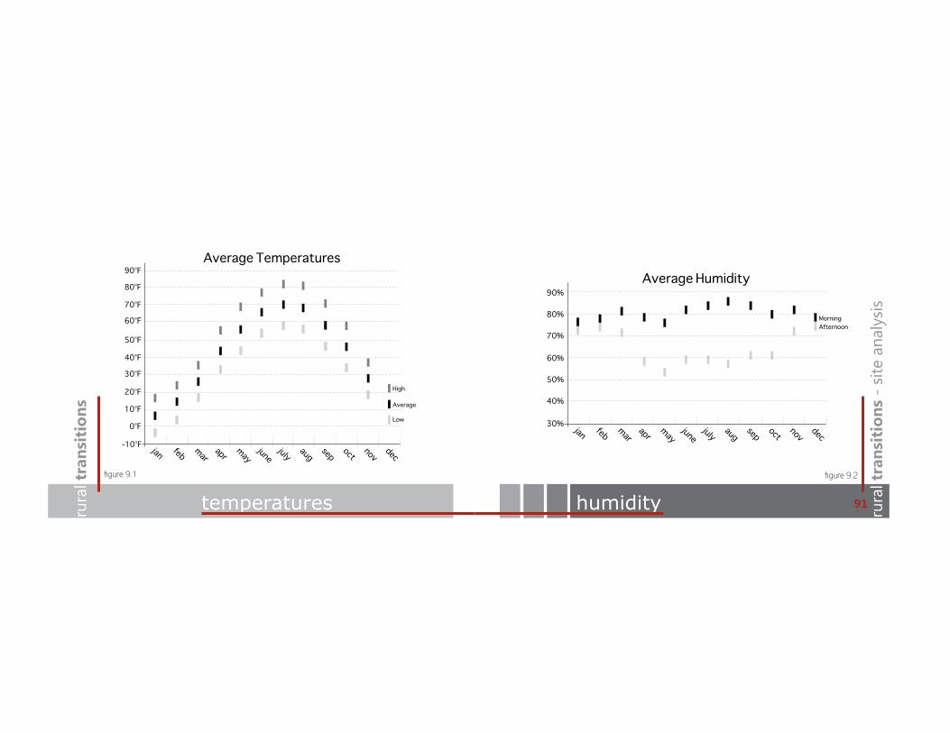
temperatures humidity rura
l tra
nsit
ions
- s
ite a
naly
sis
jan feb marapr
mayjune
july augsep oct
novdec
-10°F
0°F
10°F
20°F
30°F
40°F
50°F
60°F
70°F
80°F
90°FAverage Temperatures
High
Average
Lowjan feb mar
aprmay
junejuly aug
sep octnov
dec30%
40%
50%
60%
Average Humidity
70%
80%
90%
MorningAfternoon
figure 9.1 figure 9.2
91

project signature table of contentsrura
l tra
nsit
ions
wind wind rura
l tra
nsit
ions
- s
ite a
naly
sis
N
EW
S
3-9 mph10-15 mph >15 mph
Wind Rose
jan feb marapr
mayjune
july augsep oct
novdec
5 mph
6 mph
Average Wind Speed
7 mph
8 mph
9 mph
10 mph
11 mph
12 mph
13 mph
14 mph
figure 9.3 figure 9.4
93
project signature table of contentsrura
l tra
nsit
ions
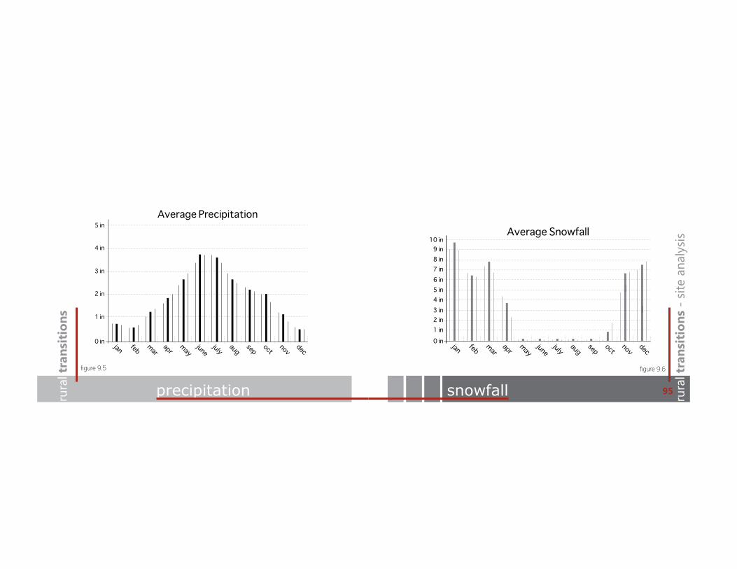
precipitation snowfall rura
l tra
nsit
ions
- s
ite a
naly
sis
jan feb marapr
mayjune
july augsep oct
novdec
0 in
1 in
2 in
4 in
3 in
5 inAverage Precipitation
jan feb marapr
mayjune
july augsep oct
novdec
0 in1 in
Average Snowfall
3 in2 in
4 in
6 in5 in
7 in
9 in8 in
10 in
figure 9.5 figure 9.6
95

project signature table of contentsrura
l tra
nsit
ions
sun sun rura
l tra
nsit
ions
- s
ite a
naly
sis
jan feb marapr
mayjune
july augsep oct
novdec
30%
40%
50%
60%
Average Sunshine
70%
80%
N
EW
S
Equinox
Summer Solstice
Winter Solstice
Sun Path Diagram
figure 9.7 figure 9.8
97
project signature table of contentsrura
l tra
nsit
ions
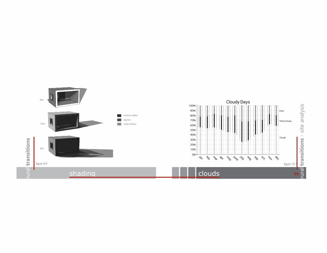
shading clouds rura
l tra
nsit
ions
- s
ite a
naly
sis
9am
12pm
3pm
-summer solstice
-equinox
-winter solstice
jan feb marapr
mayjune
july augsep oct
novdec
0%
10%
20%
30%
40%50%
100%Cloudy Days
Clear
Partly Cloudy
Cloudy
60%
70%80%
90%
figure 9.9 figure 10.1
99

rura
l tra
nsit
ions
rura
l transitions
site analysis
rura
l tra
nsit
ions
rura
l transitions
programming101
project signature table of contentsrura
l tra
nsit
ions
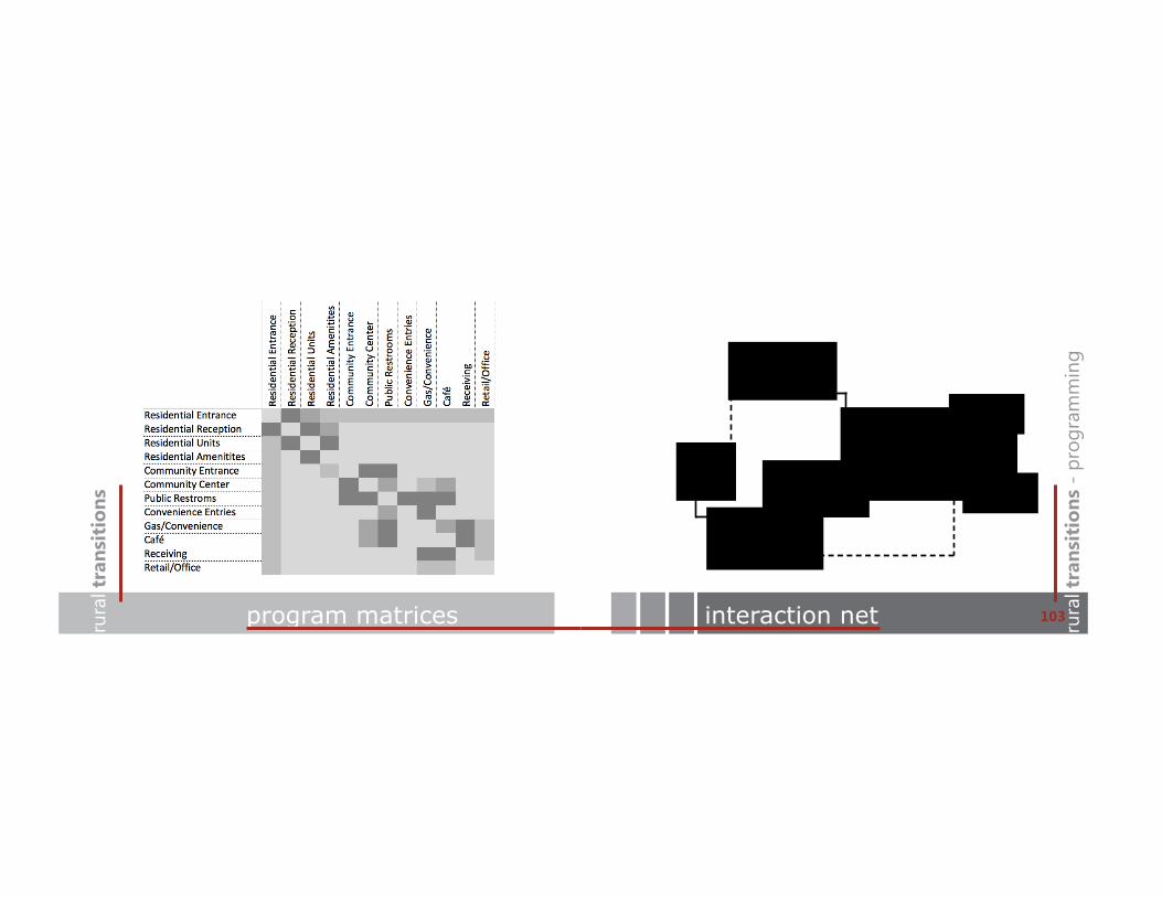
program matrices interaction net rura
l tra
nsit
ions
- p
rogr
amm
ing
residential units
public
amenities
o"ces
convenience/retail
cafe
private entry
103

project signature table of contentsrura
l tra
nsit
ions
program rura
l tra
nsit
ions
- p
rogr
amm
ing
105
residential units .....................................................................25,000 sq ft 22 units .................................................................................(avg 1,140 sq ft)residential amenitiesoutdoor terrace .....................................................................6,000 sq ftresidential amenities ...........................................................1,350 sq ft
o"ces .........................................................................................4,420 sq ft 6 units ....................................................................................(avg 740 sq ft)
community center ................................................................5,800 sq ft recreation .............................................................................(2,200 sq ft) meeting/conference ........................................................(3,600 sq ft)
gas/convenience...................................................................3,400 sq ft lounge .....................................................................................890 sq ft
cafe .............................................................................................1,500 sq ft
storage/loading .....................................................................1,100 sq ft
mechanical ..............................................................................3,520 sq ft
circulation .................................................................................9,510 sq ft
project total ............................................................................60,600 sq ft
*parking to accommodate 22 residential units, community center, gas station and cafe.

rura
l tra
nsit
ions
rura
l transitions
site analysis
rura
l tra
nsit
ions
rura
l transitions
process107
project signature table of contentsrura
l tra
nsit
ions
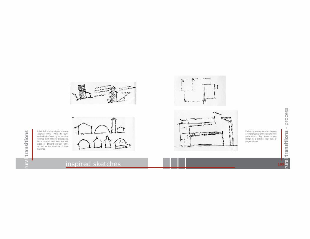
inspired sketches rura
l tra
nsit
ions
- p
roce
ss
109
Initial sketches investigated common agrarian forms. While the iconic grain elevator/towering silo structure seemed most fitting for the projects. More research and sketching took place of di!erent elevator forms as well as the structure of these buildings.
Early programming sketches showing a rough sketch of a large elevator with grain transport leg. Accompanying sketch is a generic floor plan or program layout.
project signature table of contentsrura
l tra
nsit
ions
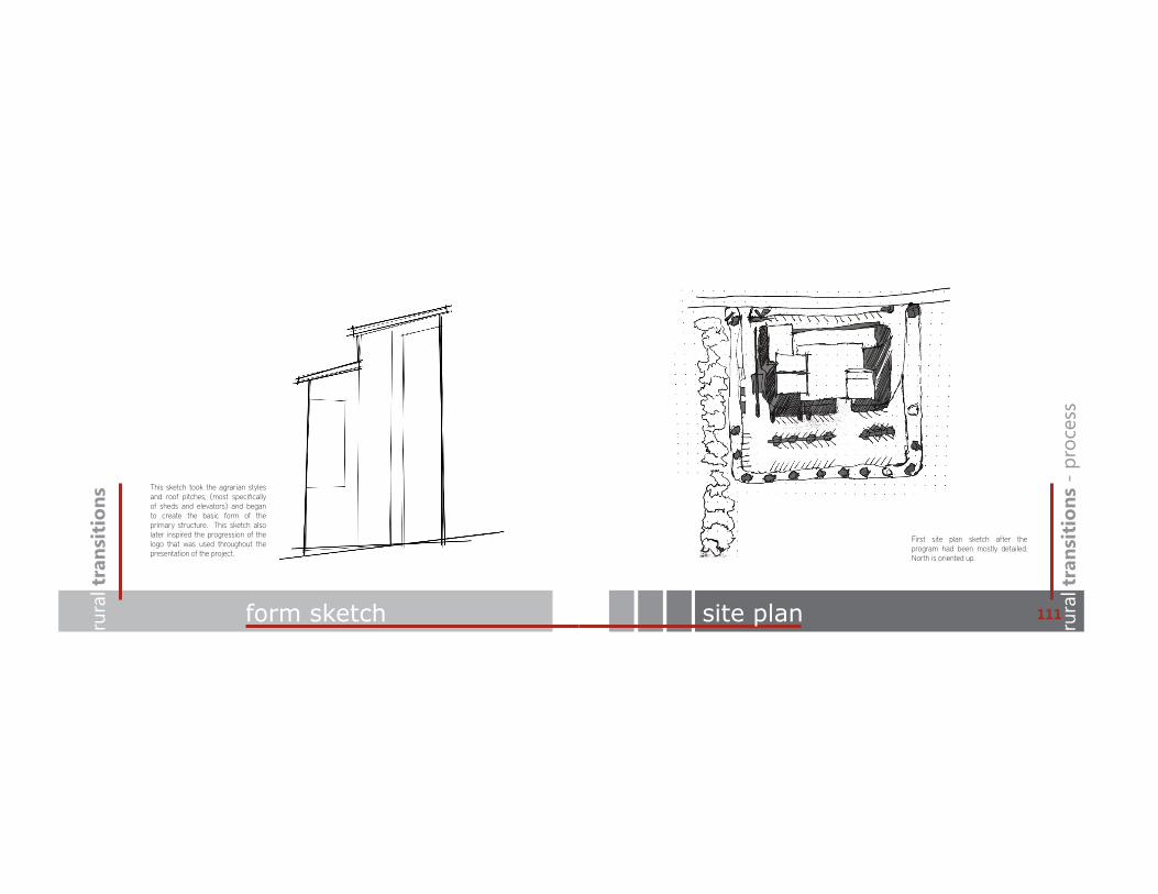
form sketch rura
l tra
nsit
ions
- p
roce
ss
111
This sketch took the agrarian styles and roof pitches, (most specifically of sheds and elevators) and began to create the basic form of the primary structure. This sketch also later inspired the progression of the logo that was used throughout the presentation of the project.
site plan
First site plan sketch after the program had been mostly detailed. North is oriented up.

project signature table of contentsrura
l tra
nsit
ions
ÀRRU�SODQ�SURFHVV rura
l tra
nsit
ions
- p
roce
ss
113
The two floor plans are the first draft of the final design. Left is the lower level while the one on the right is third and fourth level plans.
perspective sketches
This “sketch” is a perspective before the building was fully detailed. It was produced in Trimble Sketch-Up and Photoshop.

housinggas/conveniencecafe
residential amenitieshousingcommunityretail/o"ce
residential amenitieshousing
project signature table of contentsrura
l tra
nsit
ions
program rura
l tra
nsit
ions
- p
roce
ss
115program
housing
residential amenitieshousingcommunityretail/o"ce
residential amenitieshousing
retail/o"ce

rura
l transitions
site analysis
rura
l transitions
final design117ru
ral t
rans
itio
nsru
ral t
rans
itio
ns

project signature table of contentsrura
l tra
nsit
ions
basic structure rura
l tra
nsit
ions
- fi
nal d
esig
n
119structure with egress
project signature table of contentsrura
l tra
nsit
ions
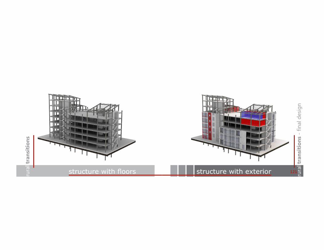
VWUXFWXUH�ZLWK�ÀRRUV rura
l tra
nsit
ions
- fi
nal d
esig
n
121structure with exterior

project signature table of contentsrura
l tra
nsit
ions
site plan rura
l tra
nsit
ions
- fi
nal d
esig
n
123ground level plan
Ground Level Plan-11,360 sq. ft. lobbies residential lounge gas/convenience
o"ces
project signature table of contentsrura
l tra
nsit
ions
second level plan rura
l tra
nsit
ions
- fi
nal d
esig
n
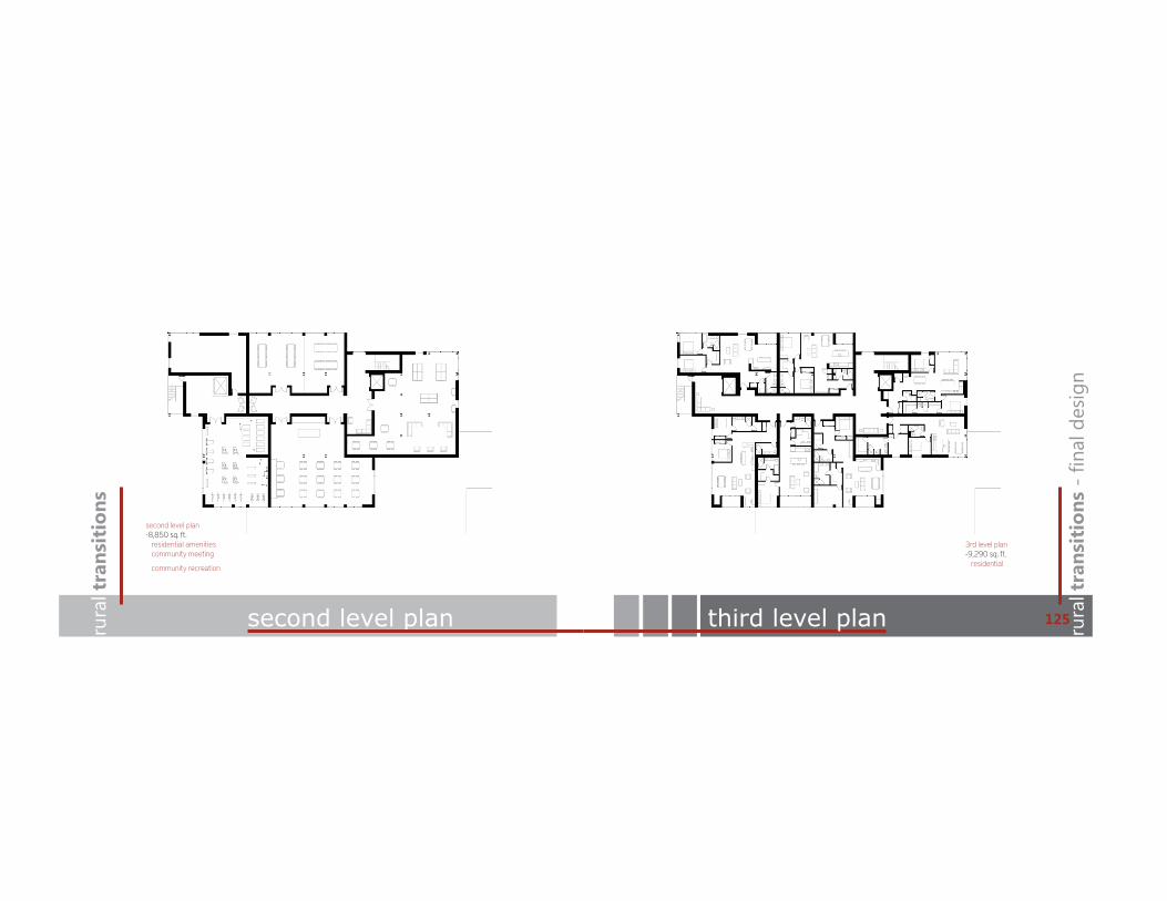
125third level plan
second level plan-8,850 sq. ft. residential amenities community meeting
community recreation
3rd level plan-9,290 sq. ft. residential

project signature table of contentsrura
l tra
nsit
ions
fourth level plan rura
l tra
nsit
ions
- fi
nal d
esig
n
127¿IWK�OHYHO�SODQ
fifth level plan-9,290 sq. ft. residential mechanical
4th level plan-9,290 sq. ft. residential
project signature table of contentsrura
l tra
nsit
ions
sixth level plan rura
l tra
nsit
ions
- fi
nal d
esig
n
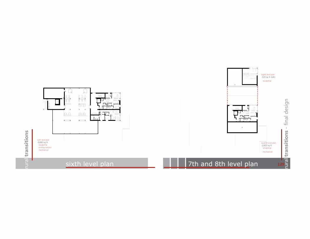
1297th and 8th level plan
seventh level plan-2,800 sq. ft. residential
mechanical
eighth level plan-320 sq. ft. (loft)
residential
sixth level plan-9,880 sq. ft. residential rooftop terrace mechanical
project signature table of contentsrura
l tra
nsit
ions
elevations rura
l tra
nsit
ions
- fi
nal d
esig
n
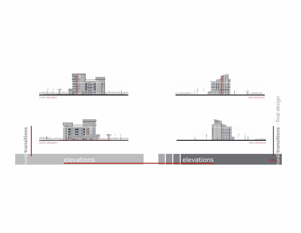
131elevations
north elevation
south elevation
east elevation
west elevation

project signature table of contentsrura
l tra
nsit
ions
residential unit rura
l tra
nsit
ions
- fi
nal d
esig
n
133community recreation
residential
7th level lofted suite-1,400 sq. ft.
4
recreation
2nd level-2,200 sq. ft.
3
The residential rendering is a section perspective view of the 7th and 8th level penthouse suite. It is the largest unit in the complex in the northeast corner of the structure.
The community recreation room is on the second level of the primary “elevator” structure. Meeting rooms and other community functions are nearby.

project signature table of contentsrura
l tra
nsit
ions
restaurant rura
l tra
nsit
ions
- fi
nal d
esig
n
135gas station/convenience
restaurant
lower level-1,520 sq. ft.
2
The Forecast Cafe is on the lower level with easy access to the north community parking lot. It utilizes the community entrance which gives it easy access to the second level community functions.
convenience
lower level-3,400 sq. ft.
1
The gas station/convenience store is located on the lower level as well. To the east is the gas pumps with entrances to the north and east. There is also a small co!ee area on the south side. A large storage area is shared with the cafe which is also equipped with a loading dock to the north.

Mechanical Rooms
elevator core elevator coreservice coreservice core
12’
2’10’
project signature table of contentsrura
l tra
nsit
ions
building details rura
l tra
nsit
ions
- fi
nal d
esig
n
137HVAC section
details
steel connection detail
floor detail
window/floor detail
corrugated steel red steel panels
floor to floor 12’
wood siding
building height96’
galvanized steel
building length170’
mechanical rooms
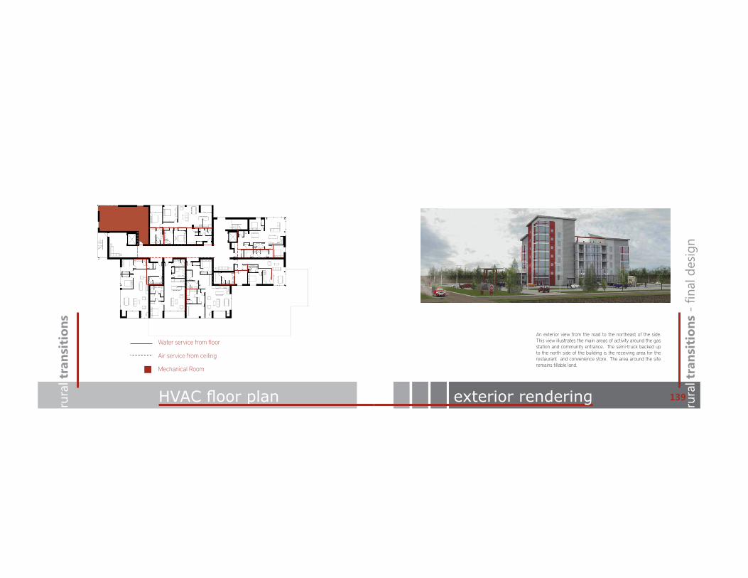
Mechanical Room
Air service from ceiling
Water service from floor
project signature table of contentsrura
l tra
nsit
ions
+9$&�ÀRRU�SODQ rura
l tra
nsit
ions
- fi
nal d
esig
n
139 exterior rendering
An exterior view from the road to the northeast of the side. This view illustrates the main areas of activity around the gas station and community entrance. The semi-truck backed up to the north side of the building is the receiving area for the restaurant and convenience store. The area around the site remains tillable land.

project signature table of contentsrura
l tra
nsit
ions
night rendering rura
l tra
nsit
ions
- fi
nal d
esig
n
141the rural commons
Throughout the design process of The Rural Transitions Thesis, the project began to form an identity. By the end of the process, I thought it had become so much part of the design that it was important to include a “branding e!ort” for the project. The Rural Commons is the structure that serves Richland County and with the iconic rural image the building provides, a brand that supports this image would provide users a memorable experience of a specific place. The brand was also carried through to develop logos for each of the functions that happen within the building. A graphic abstraction of the building was utilized through out the logos to make a reference to the iconic structure, while bold graphics tell about the function of each entity. Business names were chosen to relate to the rural landscape especially agriculture which was the driving force behind the entire thesis project.

rura
l transitions
site analysis
rura
l transitions
models143ru
ral t
rans
itio
nsru
ral t
rans
itio
ns
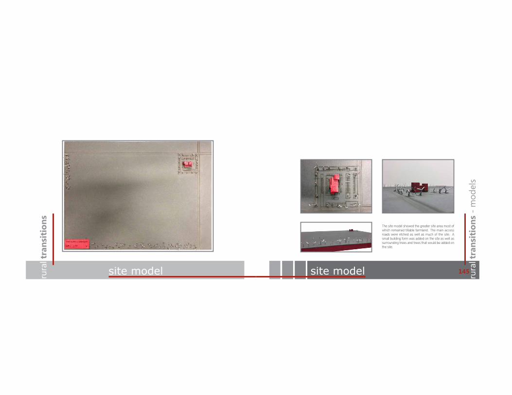
project signature table of contentsrura
l tra
nsit
ions
site model rura
l tra
nsit
ions
- m
odel
s
145site model
The site model showed the greater site area most of which remained tillable farmland. The main access roads were etched as well as much of the site. A small building form was added on the site as well as surrounding trees and trees that would be added on the site.
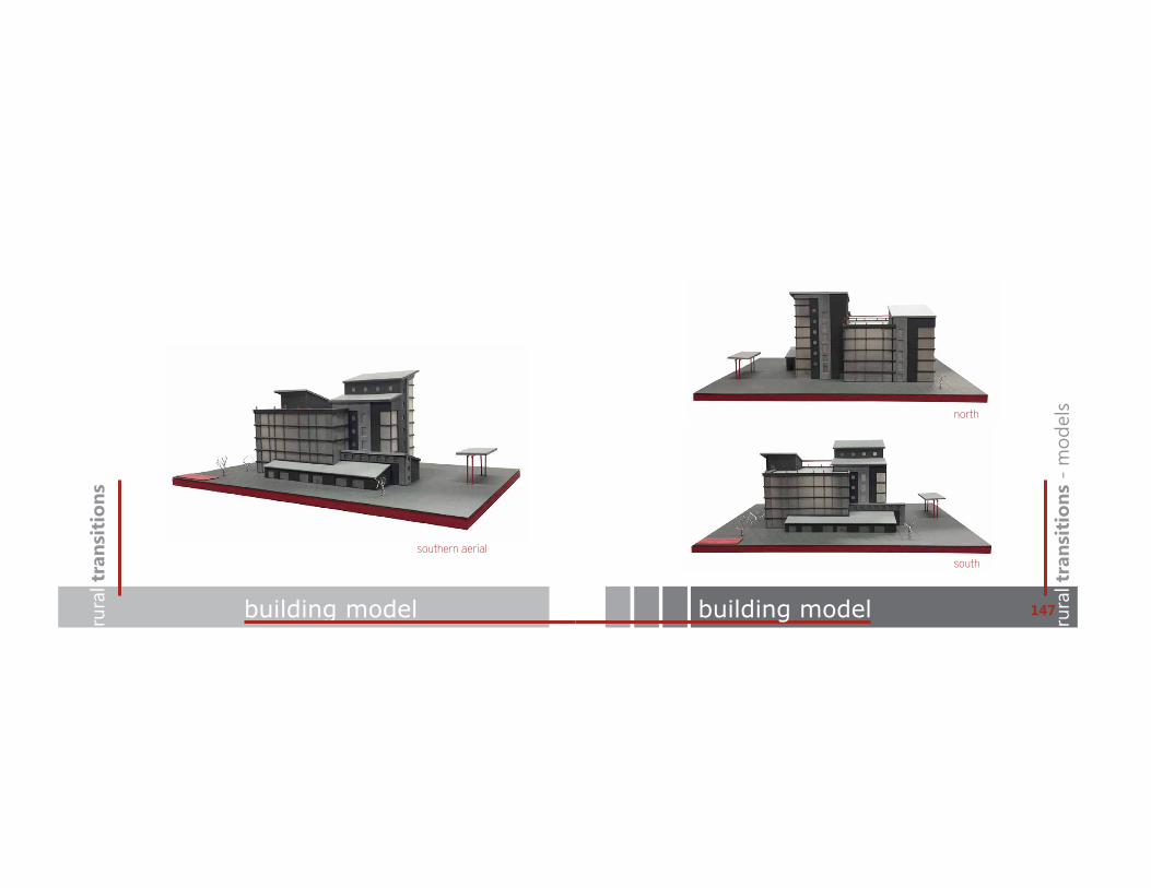
project signature table of contentsrura
l tra
nsit
ions
building model rura
l tra
nsit
ions
- m
odel
s
147building model
north
south southern aerial

project signature table of contentsrura
l tra
nsit
ions
building model rura
l tra
nsit
ions
- m
odel
s
149building model
east
west southeast perspective

rura
l transitions
site analysis
rura
l transitions
installation151ru
ral t
rans
itio
nsru
ral t
rans
itio
ns

project signature table of contentsrura
l tra
nsit
ions
installation rura
l tra
nsit
ions
- in
stal
latio
n
153installation

project signature table of contentsrura
l tra
nsit
ions
drawings rura
l tra
nsit
ions
- in
stal
latio
n
155drawings
region area towns
fargo, nd
richland county
north dakota
site
i29 to fargo
wild rice river
red river
hwy 75railroad
abercrombie
colfax
galchutt
site
dwight
wahpetonmooreton
elevations0 10’ 90’30’
Department of Architecture and Landscape Architecture, NDSUARCH 772, Design Thesis, Spring 2013Rural Transitions | The Rural CommonsMixed-Use 60,600 square feetStudent: Blain Mikkonen | Advisor : Ron RamseyMedia: Trimble Sketch-Up, Podium, Autocad, Adobe Suite
site015’ 135’45’
north
west
east
south
The Rural Commons site is located south of Fargo, ND near Galchutt. It is conveniently located near Intersate 29 and is easily accessible by many small communities that would benefit from the mixed-use facility. The graphic above illustrates the greater site region. Main traffic arteries are labeled as well as nearby rivers, and a lightly used railroad. The community primarily being served, Galchutt, is denoted as well as supplemental communities.
The detailed site plan illustrates site access from the north and east. Parking is arranged for different functions. Residential to the west, community and cafe parking to the north, office parking to the south, and gas station/overflow parking to the east. Trees would border the site, and all the surrounding area remains tillable farmland. Vegetation would also create seasonal buffers.
n
project description
structure
steel framing circulation cores floor plates
details
steel connection detail
floor detail
The Rural Transitions Thesis is a mixed-use supplemental facility near Galchutt, ND. It was designed as a rural hub to supplement not only Galchutt, but surrounding communities as well that suffer from dwindling populations, and the lack of necessities and conveniences that make rural living possible. Rather than trying to revitalize struggling rural towns by building costly, and underutilized facilities in each town, The Rural Commons serves as a central point to fulfill the needs of multiple communities in one location.
Since the population base is not present in each of these communities to sustain their own building, bringing multiple populations to one rural facility is a more cost effective and efficient solution. The structure was designed to reflect the iconic elevator structure scattered across the agricultural plains. Economics in the area are primarily agriculture based which make the rural setting appealing. The close proximity to major traffic also make the structure a stopping destination for travelers.
As traffic and activity in rural areas is largely seasonal based on the agriculture season incorporating housing into the facility gives the building a constant income so it can sustain itself when traffic is less heavy. Richland Commons is a community center intended to bring the communities and rural dwellers together. The office space is flexible and would most likely be utilized by agriculture related business that would benefit from the central location. Other inclusions are The Forecast Cafe, and Acres Station, a gas station/convenience store.
window/floor detail
corrugated steel red steel panels
floor to floor 12’
wood siding
building height96’
galvanized steel
building length170’
mechanical rooms
floor plans0 5’ 45’15’ n
7th level plan-2800 sq. ft residential mechanical
6th level plan-9,880 sq. ft. residential rooftop terrace mechanical
5th level plan-9,130 sq. ft. residential mechanical
3rd and 4th level plan-9,290 sq. ft. residential
2nd level plan-8,850 sq. ft. residential amenities community meeting community recreation
Ground level plan-11,360 sq. ft. lobbys residential lounge gas/convenience office
8th level plan-320 sq. ft. residential loft
4
3
2
1

project signature table of contentsrura
l tra
nsit
ions
drawings rura
l tra
nsit
ions
- in
stal
latio
n
157drawings
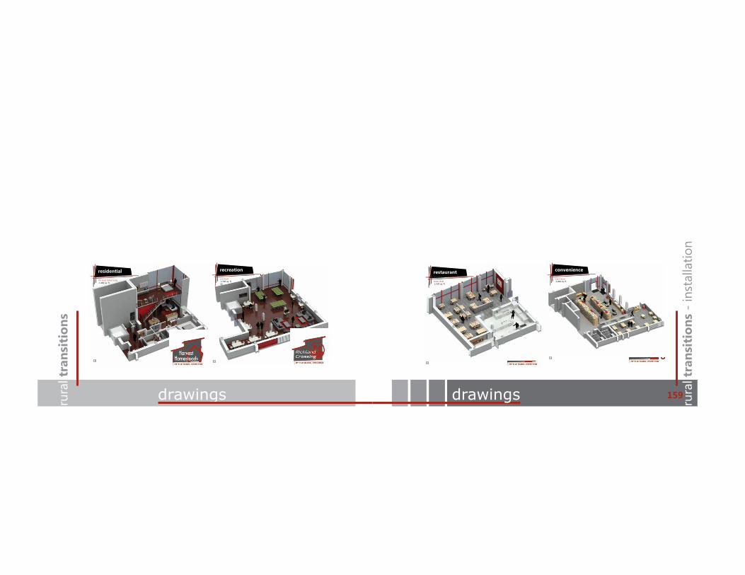
project signature table of contentsrura
l tra
nsit
ions
drawings rura
l tra
nsit
ions
- in
stal
latio
n
159drawings
residential
7th level lofted suite-1,400 sq. ft.
4
recreation
2nd level-2,200 sq. ft.
3
restaurant
lower level-1,520 sq. ft.
2
convenience
lower level-3,400 sq. ft.
1

project signature table of contentsrura
l tra
nsit
ions
references rura
l tra
nsit
ions
- re
fere
nces
161references
Advameg, Inc. City-Data: Wahpeton. 2012. 1 Dec 2012 <http://www.city-data.com/city/Wahpeton-North-Dakota.html>.
ArchDaily. Architectural and Urban Redevelopment Site in Nantes Saupin. 10 July 2012. 22 Oct 2012 <http://www.archdaily.com/251558/architectural-and-urban-redevelopment-site-in-nantes-saupin-philippe-gazeau/>.
—. Newlands Community Centre / CCM Architects. 19 July 2009. 16 Oct 2012 <http://www.archdaily.com/29323/newlands-community-centre-ccm-architects/>.
—. Siloetten/The Sil(o)houette. 17 June 2010. 12 Oct 2012 <http://www.archdaily.com/64519/siloettenthe-silohouette-c-f-m%C3%B8ller-architects-in-collaboration-with-christian-carlsen-arkitektfirma/>.
Claud H. Baker, Jr. “Geology and Ground Water Resources of Richland County.” Geological Survery. 1967.
F. Larry Leistritz, David K. Lambert, and Randal C. Coon. The Role of Agriculture in the North Dakota Economy. Agribusiness & Applied Economics Statistical Series Report. Fargo, ND, 2002.
Farmland Information Center. Farmland Info. 2012. 6 Dec 2012 <http://www.farmlandinfo.org/agricultural_statistics/index.cfm?function=statistics_view&stateID=ND>.
Google, Inc. Google Maps. 2012. 16 Oct 2012 <https://maps.google.com/maps?q=galchutt,+nd&ie=UTF-8&ei=MtHBUOCNH7PlyAHC-4G4Bw&ved=0CAgQ_AUoAA>.
Hillyard, Sam. The Sociology of Rural Life. New York: Oxford: Berg Publisher, 2008.
Historic Map Works, LLC. Richland County Soil Map. 2011. 5 Dec 2012 <http://www.historicmapworks.com/Map/US/119277/Richland+County+Soil+Map/>.
Maroney Commons. Maroney Commons. 2012. 16 Oct 2012 <http://www.maroneycommons.com/the-place/>.
Microsoft Corporation. Bing Maps. 2012. 1 Dec 2012 <http://www.bing.com/maps/?FORM=Z9LH2#>.
National Institute of Building Sciences. National Institute of Building Sciences. 2012. 5 November 2012 <http://www.nibs.org/sbic/glossary-sustainable-building-terms>.
Neimi, Ryan. TopoQuest. 2012. 1 Dec 2012 <http://www.topoquest.com/map.php?lat=46.47099&lon=-96.83878&datum=nad27&zoom=8&map=auto&coord=d&mode=zoomin&size=m>.
Rabianski, Joseph S., et al. n.d.State Historical Society of North Dakota. North Dakota State Historical Society. 2012. 7 Dec 2012 <http://history.nd.gov/ndhistory/conclusion.html>.
Stowell, Tim. Richland County History. 2011. 3 Dec 2012 <http://www.rootsweb.ancestry.com/~ndrichla/>.
United States Department of Agriculture and Soil Conservations Service. “Soil Survey of Richland County, and Sheyenne National Grassland Area of Ransom County, North Dakota.” 1997. 5 Dec 2012.
Wahpeton Breckenridge Chamber. Whapeton Breckenridge - Bagg Bonanza Farm. 2011. 5 Dec 2012 <http://www.wahpetonbreckenridgechamber.com/visitor_bagg.htm>.
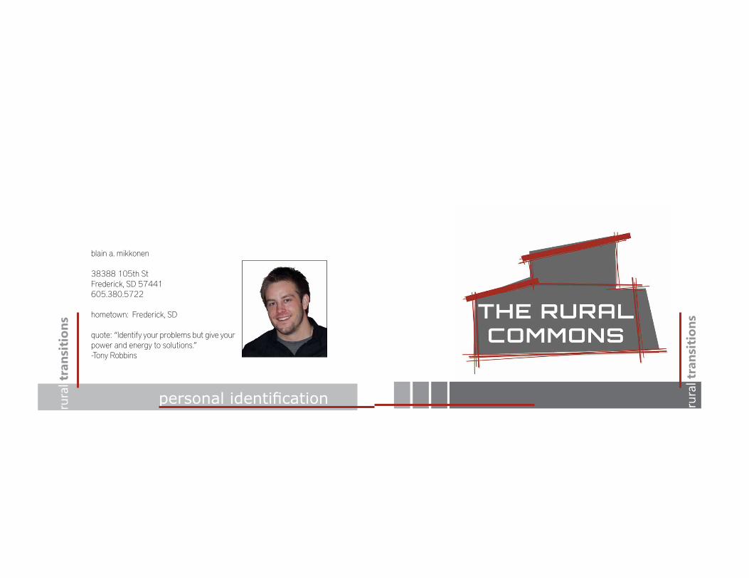
blain a. mikkonen
38388 105th StFrederick, SD 57441605.380.5722
hometown: Frederick, SD
quote: “Identify your problems but give your power and energy to solutions.” -Tony Robbins
rura
l tra
nsit
ions
SHUVRQDO�LGHQWL¿FDWLRQ table of contents rura
l tra
nsit
ions