rules inner city zone - nelson city council · contents of inner city zone rule tables rule table -...
TRANSCRIPT
Nelson Resource Management Plan (01/09/04) 8-17
rules inner city zone
8-18 (01/09/04) Nelson Resource Management Plan
ICr Rules ICr.1 Rule table - rules
This section and the Rule Tables that follow contain rules applicable in this Zone.
Note also that there may be relevant District-wide rules that appear in the Appendices. These rules will be linked to the Zone rules either by direct reference from within the Zone rules, through definitions, or through overlays or other notations on the maps. These rules must also be complied with.
ICr.2 Prohibited activities
The following activities are prohibited activities for which no resource consent shall be granted:
Use, storage, or disposal of radioactive material with an activity exceeding 1000 terabecquerels.
ICr.3 Permitted activities
A permitted activity is one that is allowed without a resource consent if it complies with the conditions specified in the “permitted” column of the Rule Table. In this Zone, permitted activities also include all land uses that are not specifically mentioned in the rules.
Certain permitted activities are subject to a condition for the payment of financial contributions of the amounts, and for the purposes, set out in Chapter 6. This condition is additional to any conditions mentioned in the rules, and may be the only condition in the case of activities not otherwise mentioned in the rules. The permitted activities subject to a condition for financial contributions are:
a) Building work
b) Connection to the Council’s water supply system
c) Connection to the Council’s sewerage system for the purpose of disposing of trade waste
d) As provided in rules
ICr.4 Controlled activities
A resource consent is required for a controlled activity. (See Chapter 3 for a fuller description of controlled activities.) Controlled activities must comply with the standards and terms set out in the “controlled” column of the Rule Table. Consent will usually be granted for a controlled activity. Conditions may be imposed on the matters stated in the column as matters that control is reserved over. These matters are also relevant to the assessment of effects to be supplied by the applicant for a resource consent. (See rule ICr.8 below regarding further matters of control.)
ICr.5 Discretionary activities/restricted discretionary activities
A resource consent is required for a discretionary activity. (See Chapter 3 for a fuller description of discretionary activities.) Discretionary activities must comply with the standards and terms set out in the “discretionary” column of the Rule Table. The Council has discretion to grant or refuse consent. The matters stated in the “assessment criteria” column of the Rule Table will guide assessment of effects and conditions, but do not restrict the Council’s discretion. Conditions of any type authorised by the Act (including financial contributions under Chapter 6) may be imposed on discretionary activities.
Nelson Resource Management Plan (01/09/04) 8-19
Some discretionary activity rules state that discretion is restricted. In these cases, the Council may refuse consent, or impose conditions only in respect of the matters stated in the discretionary column as matters that discretion control is restricted to. These matters are also relevant to the assessment of effects to be supplied by the applicant for a resource consent. (See rule ICr.8 below regarding further matters of restricted discretion.)
Note that some non-complying activities may also be listed within the “Discretionary” column. Where this occurs the column has been headed “Discretionary/Non-complying”.
ICr.6 Non-complying activities
A resource consent is required for a non-complying activity. (See Chapter 3 for a fuller description of non-complying activities.) Non-complying activities mostly arise where activities do not comply with the standards and terms set out in the “discretionary” column of the Rule Table. A direct statement of non-complying activities may also appear in the rules. The Council has discretion to grant or refuse consent and is required to refuse in certain circumstances (see Chapter 3). Conditions of any type authorised by the Act (including financial contributions under Chapter 6) may be imposed on non-complying activities.
ICr.7 Scheduled sites
Any activity listed in a Schedule following the Rule Table shall comply with the rules set out in that Schedule.
ICr.8 Controlled activities and restricted discretionary activities
In the Rule Tables every controlled activity, and every discretionary activity where discretion is restricted, contains a list of matters over which control is reserved, or discretion is restricted. The matters listed below are additional matters applicable to every controlled activity and restricted discretionary activity. They are stated here, rather than repeated in Rule Tables, in order to save space.
Matters over which control is reserved or discretion restricted:
ICr.8.a Financial contributions in the form of money, land, works or services, or a combination of these (See Chapter 6), and
ICr.8.b bonds or covenants or both, to ensure performance or compliance with any conditions imposed, and
ICr.8.c administrative charges to be paid to the Council in respect of processing applications, administration, monitoring and supervision of resource consents, and for the carrying out of the Council’s functions under section 35 of the Act, and
ICr.8.d the duration of a resource consent, under section 123 of the Act, and
ICr.8.e lapsing of a resource consent, under section 125 of the Act, and
ICr.8.f change and cancellation of a consent, under sections 126 and 127 of the Act, and
ICr.8.g notice that some or all conditions may be reviewed at some time in the future, under section 128 of the Act, and
ICr.8.h whether any land use or subdivision consent should attach to the land to which it relates, and be enjoyed by the owners and occupiers for the time being, under section 134 of the Act.
ICr.9 Regional rules, and regional and district rules
In the Rule Tables, a number of rules are indicated as being Regional rules, or Regional and District Rules. These are rules that derive in total or in part from the regional functions of the Council. Regional rules have a different impact on matters such as designations (which

8-20 (01/09/04) Nelson Resource Management Plan
must comply with regional rules) and existing use rights, which are much more limited in respect of regional matters. See sections 176 (Effect of a designation), 10 (Certain existing uses in relation to land protected), 10A, 10B, and 20 (Certain existing lawful activities allowed) of the Resource Management Act 1991.
ICr.10 Reading the rule table
Each row of the Rule Table presents rules that regulate or allow one activity, or type of activity, or effect. Read along the row from left to right to determine whether a proposed activity is permitted, controlled, discretionary or non-complying. This progression across the Rule Table is called a “cascade.” (See flow chart below.)
If an activity satisfies the conditions stated in the permitted activity column, then it is permitted. If not, look to the next column (controlled). If it satisfies the standards and terms in the controlled column, it is a controlled activity. If not, then look at the next column (discretionary) to see if it fits the standards and terms stated there. If the activity satisfies the standards and terms in the discretionary column it is discretionary. Otherwise it is a non-complying activity.
Further explanation of the Rule Table and cascade is contained in Chapter 3.
The following flow chart illustrates the cascade across the Rule Table.
ICr.10.1 Note that there are some rules, generally relating to post-development conditions, which do not trigger the activity into requiring a discretionary resource consent. Where relevant, this is indicated in the explanation to those rules.
Start Comply with permitted conditions
(a), (b), ..?
Comply with controlled standards
(a), (b), ..?
Comply with discretionary standards
(a), (b), ..?
Resource consent required for non-complying activity
No resource consent required
Resource consent required for controlled
activity
Resource consent required for
discretionary activity
Assessment Criteria will guide,
but not limit, assessment of
effects, conditions
Assessment of effects and conditions limited
to matters control reserved over: (1), (2),
etc
yes yes yes
no no no

Nelson Resource Management Plan (30/04/12) 8-21
Contents of inner city zone rule tables
Rule table - city centre area only ICr.20 Location of buildings - Road frontage ICr.21 Buildings over road reserve ICr.22 Continuity ICr.23 Minimum facade height ICr.24 Maximum building height ICr.25 Daylight admission -Trafalgar, Hardy or Bridge Streets (within the ring road) ICr.26 Daylight admission - Parking squares ICr.27 Buildings in Montgomery, Buxton and Wakatu Squares ICr.28 External design and appearance - Trafalgar, Hardy and Bridge Streets ICr.29 Display windows ICr.30 Security doors and screens ICr.31 Parking and loading ICr.31A Private car parking areas ICr.32 Access ICr.33 Residential activity ground floor
Rule table - city centre and city fringe areas ICr.34 Building setback - Corner sites ICr.35 Daylight admission - Boundary with Residential Zone or Open Space and Recreation Zone ICr.36 Verandahs - Trafalgar, Hardy and Bridge Street and Parking Squares ICr.37 Verandahs - Other roads ICr.38 Activities near the coast ICr.39 Building over or alongside drains and water mains ICr.40 Outdoor living court - residential activity ICr.41 Signs ICr.42 Noise ICr.43 Noise – at residential boundary ICr.44 Vibration ICr.45 Light Spill ICr.46 Closing times - services to the public ICr.47 Hazardous substances - use and storage ICr.48 Radioactive material ICr.49 Aerials ICr.50 Radiofrequency exposure levels ICr.51 Network utility - above ground and underground utilities ICr.52 Structures on the road reserve ICr.53 Network utility - roads ICr.54 Building on low lying sites ICr.55 Earthworks ICr.55A Landfill Rules relating to Overlays on Planning Maps ICr.56 View Shaft Overlay ICr.57 Riparian Overlay - Activities on land identified with riparian values ICr.58 Flood Path Overlays ICr.59
Inundation Overlays - Low lying ground susceptible to localised stormwater ponding or tidal inundation
ICr.60 Heritage Buildings, Places and Objects - Alterations to Group A and B Items ICr.61 Heritage Buildings, Places and Objects - New buildings on the site of a Heritage Item ICr.62 Heritage Buildings, Places and Objects - Demolition or removal of Group A or B Items ICr.63 Heritage Buildings, Places and Objects - Demolition or removal of Group C Items ICr.64 Heritage Precincts - Group A or B Heritage Buildings, Places and Objects ICr.65 Heritage Precincts – Buildings other than Group A or B Heritage Buildings ICr.66 Heritage Trees ICr.67 Landscape Trees ICr.68 Heritage and Landscape Trees – Activities within the root protection zone of a Heritage or
Landscape Tree identified in Appendix 2 ICr.69 Heritage and Landscape Trees - Removing or destroying a Heritage or Landscape Tree
identified in Appendix 2 ICr.70 Local Trees – Removing a Local Tree identified in Appendix 2 ICr.71 Archaeological Sites
8-22 (12/11/12) Nelson Resource Management Plan
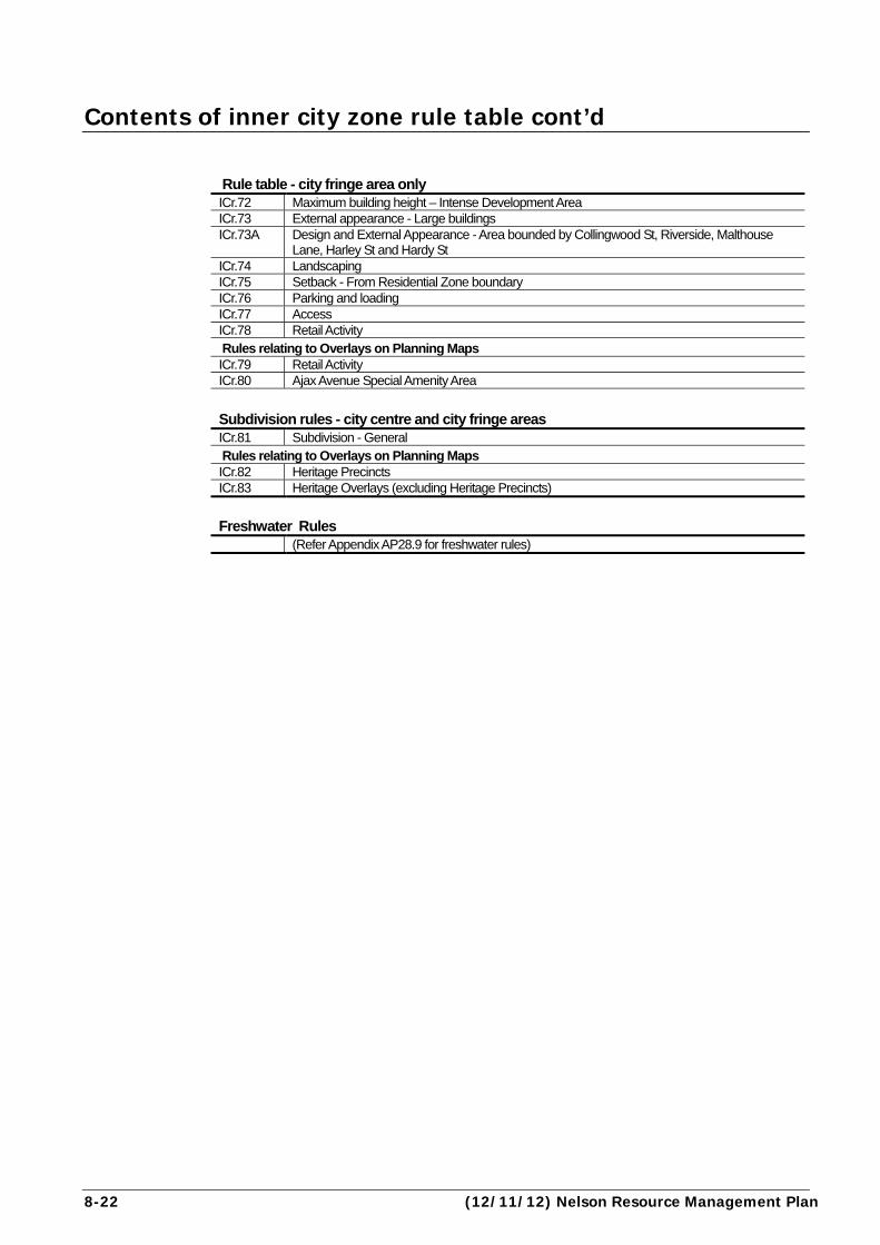
Contents of inner city zone rule table cont’d
Rule table - city fringe area only ICr.72 Maximum building height – Intense Development Area ICr.73 External appearance - Large buildings ICr.73A Design and External Appearance - Area bounded by Collingwood St, Riverside, Malthouse
Lane, Harley St and Hardy St ICr.74 Landscaping ICr.75 Setback - From Residential Zone boundary ICr.76 Parking and loading ICr.77 Access ICr.78 Retail Activity Rules relating to Overlays on Planning Maps ICr.79 Retail Activity ICr.80 Ajax Avenue Special Amenity Area
Subdivision rules - city centre and city fringe areas ICr.81 Subdivision - General Rules relating to Overlays on Planning Maps ICr.82 Heritage Precincts ICr.83 Heritage Overlays (excluding Heritage Precincts)
Freshwater Rules (Refer Appendix AP28.9 for freshwater rules)

Nelson Resource Management Plan (01/09/04) 8-23
8-24 (01/09/04) Nelson Resource Management Plan
Rule table
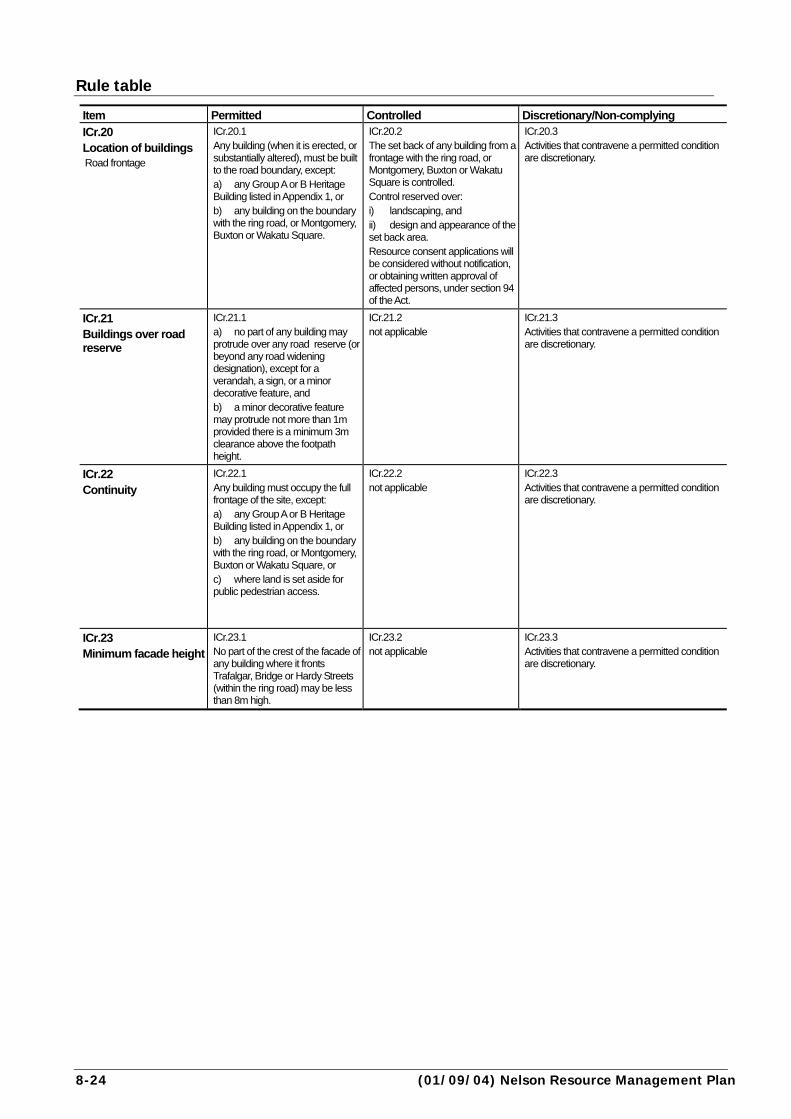
Item Permitted Controlled Discretionary/Non-complying
ICr.20 Location of buildings Road frontage
ICr.20.1 Any building (when it is erected, or substantially altered), must be built to the road boundary, except: a) any Group A or B Heritage Building listed in Appendix 1, or b) any building on the boundary with the ring road, or Montgomery, Buxton or Wakatu Square.
ICr.20.2 The set back of any building from a frontage with the ring road, or Montgomery, Buxton or Wakatu Square is controlled. Control reserved over: i) landscaping, and ii) design and appearance of the set back area. Resource consent applications will be considered without notification, or obtaining written approval of affected persons, under section 94 of the Act.
ICr.20.3 Activities that contravene a permitted condition are discretionary.
ICr.21 Buildings over road reserve
ICr.21.1 a) no part of any building may protrude over any road reserve (or beyond any road widening designation), except for a verandah, a sign, or a minor decorative feature, and b) a minor decorative feature may protrude not more than 1m provided there is a minimum 3m clearance above the footpath height.
ICr.21.2 not applicable
ICr.21.3 Activities that contravene a permitted condition are discretionary.
ICr.22 Continuity
ICr.22.1 Any building must occupy the full frontage of the site, except: a) any Group A or B Heritage Building listed in Appendix 1, or b) any building on the boundary with the ring road, or Montgomery, Buxton or Wakatu Square, or c) where land is set aside for public pedestrian access.
ICr.22.2 not applicable
ICr.22.3 Activities that contravene a permitted condition are discretionary.
ICr.23 Minimum facade height
ICr.23.1 No part of the crest of the facade of any building where it fronts Trafalgar, Bridge or Hardy Streets (within the ring road) may be less than 8m high.
ICr.23.2 not applicable
ICr.23.3 Activities that contravene a permitted condition are discretionary.

Nelson Resource Management Plan (26/01/08) 8-25
city centre area only
Assessment Criteria Explanation ICr.20.4 to ICr.23.4 a) the effects of any setback, building protrusion, change in continuity, or reduced facade height upon the visual impression of the streetscape, the sense of containment of the road, and the continuity and appearance of building facades. b) any proposed public amenity or building design features (including provision of street furniture), to compensate for changes in the setback. c) the effects of any setback or reduced continuity on the flow of pedestrians along the road or to other areas. d) any likely public benefits in terms of use of the setback or other area, including any contribution to the vitality of the locality. e) the relationship of the building with the scale and facade heights of adjoining buildings. f) In the case of an addition or alteration to the street façade of an existing building, the façade height of the existing and adjoining buildings. g) the effects of any building protrusion on views along the road, having regard in particular to Appendix 9 (landscape components and views). h) the significance of any loss of sunlight or daylight to the road, resulting from any protrusion into the road space, taking account of the use of the area. i) any particular impacts on the amenity of any heritage buildings or public open spaces.
ICr.20.5 Provision for building up to the road edge reflects the historical pattern of development along roads in the City Centre. A continuance of this pattern provides a strong and regular edge to these areas, which is a value the Plan seeks to reinforce. It also helps enhance the setting of the existing buildings, a number of which have significant heritage value. The ability to set back buildings is provided along the ring road, and on the side of the parking squares, where the building line is less important. Note: Where a road widening designation is shown on the Planning Maps and defined in Appendix 24 (designations), this is considered the road boundary. See Rule ICr.60 (heritage buildings: alterations to Group A or B items).
ICr.21.5 The rule prevents buildings encroaching into the road i.e. public space. However, provision is made for verandahs (which provide public amenity), signs and architectural features. See also Rule ICr.36 and ICr.37 (verandahs) See also Rule ICr.56 (view shaft overlay) See also Rule ICr.41 (signs)
ICr.22.5 Occupation by buildings of the full frontage is required for reasons of streetscape appearance, and continuity of buildings to maintain pedestrian interest and flows. An exception is provided on the ring road and the parking squares recognising that maintaining a street wall on these roads is less important than on the main streets within the City Centre. It also recognises that ICr.20 (road frontage) provides for setbacks from the road boundary and that this will affect the street wall in any event. Under ICr.20.2 (location of buildings), the setback is a controlled activity, providing the opportunity to manage the visual impacts on the streetscape. Heritage buildings are also exempted to help preserve their original character.
ICr.23.5 Minimum facade heights are required to provide a strong edge to the roads, and a more uniform pattern of building height. Eight metres is the equivalent of two storeys, at least on that part of a building fronting the road. See also Rule ICr.25 (daylight admission)

8-26 (28/09/09) Nelson Resource Management Plan
Item Permitted Controlled Discretionary/Non-
complying
ICr.24 Maximum building height
ICr.24.1 The maximum height of a building must not exceed 15m (see Chapter 2 Meaning of Words for definitions of ‘Height’ [including chimneys] and ‘Height measurement’).
ICr.24.2 not applicable
ICr.24.3 Activities that contravene a permitted condition are discretionary, if: the height does not exceed 21m.
ICr.25 Daylight admission Trafalgar, Hardy or Bridge Streets (within the ring road)
ICr.25.1 Except for an aerial, no part of a building may penetrate any recession plane specified below and shown in Appendix 17 (daylight admission): a) a recession plane originating from the road boundary at ground level on the south side of Bridge Street inclined at 24º towards the north, and b) a recession plane originating from the road boundary at ground level on the south side of Hardy Street inclined at 24º towards the north, and c) a recession plane originating from the road boundary at ground level on the east side of Trafalgar Street inclined at 24º towards the west, and d) a recession plane originating from the road boundary at ground level on the west side of Trafalgar Street inclined at 24º towards the east
ICr.25.2 not applicable
ICr.25.3 Activities that contravene a permitted condition are discretionary.
ICr.26 Daylight admission Parking squares
ICr.26.1 Except for an aerial, no part of any building may cast a shadow on the ground in Montgomery, Buxton or Wakatu Square between the hours of 10.10 am and 2.50 pm beyond the lines AB, BC and CD as shown in Appendix 17 (daylight admission). (Note: the angle of recession is 29 degrees in the east/west planes, and 21º in the north/south plane.)
ICr.26.2 not applicable
ICr.26.3 Activities that contravene a permitted condition are discretionary.
Nelson Resource Management Plan (26/01/08) 8-27
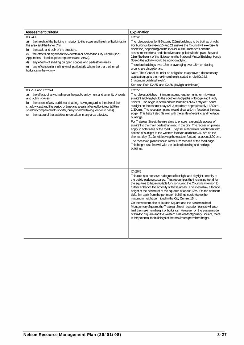
Assessment Criteria Explanation ICr.24.4 a) the height of the building in relation to the scale and height of buildings in the area and the Inner City. b) the scale and bulk of the structure. c) the effects on significant views within or across the City Centre (see Appendix 9 – landscape components and views). d) any effects of shading on open spaces and pedestrian areas. e) any effects on funnelling wind, particularly where there are other tall buildings in the vicinity.
ICr.24.5 The rule provides for 5-6 storey (15m) buildings to be built as of right. For buildings between 15 and 21 metres the Council will exercise its discretion, depending on the individual circumstances and the assessment criteria and objectives and policies in the plan. Beyond 21m (the height of the lift tower on the National Mutual Building, Hardy Street) the activity would be non-complying. Therefore buildings over 15m or averaging over 15m on sloping ground are discretionary. Note: The Council is under no obligation to approve a discretionary application up to the maximum height stated in rule ICr.24.3 (maximum building height). See also Rule ICr.25 and ICr.26 (daylight admission)
ICr.25.4 and ICr.26.4 a) the effects of any shading on the public enjoyment and amenity of roads and public spaces. b) the extent of any additional shading, having regard to the size of the shadow cast and the period of time any area is affected by it (eg. tall thin shadow compared with shorter, bulky shadow taking longer to pass). c) the nature of the activities undertaken in any area affected.
ICr.25.5 The rule establishes minimum access requirements for midwinter sunlight and daylight to the southern footpaths of Bridge and Hardy Streets. The angle is set to ensure buildings allow entry of 2 hours sunlight on the shortest day (21 June) (from approximately 11.30am - 1.30pm). The recession plane would allow a 9.4m facade at the road edge. This height also fits well with the scale of existing and heritage buildings. For Trafalgar Street, the rule aims to ensure reasonable access of sunlight to the main pedestrian road in the city. The recession planes apply to both sides of the road. They set a midwinter benchmark with access of sunlight to the western footpath at about 9.50 am on the shortest day (21 June), leaving the eastern footpath at about 3.20 pm.The recession planes would allow 11m facades at the road edge. This height also fits well with the scale of existing and heritage buildings.
ICr.26.5 This rule is to preserve a degree of sunlight and daylight amenity to the public parking squares. This recognises the increasing trend for the squares to have multiple functions, and the Council’s intention to further enhance the amenity of these areas. The lines allow a facade height at the perimeter of the squares of about 12m. On the northern side, 8m back from the perimeter, buildings could rise to the maximum height permitted in the City Centre, 15m. On the western side of Buxton Square and the eastern side of Montgomery Square, the Trafalgar Street recession planes will also limit the maximum height of buildings. However, on the eastern side of Buxton Square and the western side of Montgomery Square, there is the potential for buildings of the maximum permitted height.
8-28 (26/01/08) Nelson Resource Management Plan
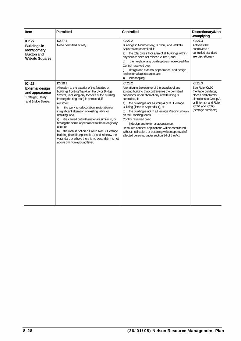
Item Permitted Controlled Discretionary/Non
-complying
ICr.27 Buildings in Montgomery, Buxton and Wakatu Squares
ICr.27.1 Not a permitted activity
ICr.27.2 Buildings in Montgomery, Buxton, and Wakatu Squares are controlled if: a) the total gross floor area of all buildings within any square does not exceed 200m2, and b) the height of any building does not exceed 4m. Control reserved over: i) design and external appearance, and design and external appearance, and ii) landscaping
ICr.27.3 Activities that contravene a controlled standard are discretionary.
ICr.28 External design and appearance Trafalgar, Hardy and Bridge Streets
ICr.28.1 Alteration to the exterior of the facades of buildings fronting Trafalgar, Hardy or Bridge Streets, (including any facades of the building fronting the ring road) is permitted, if: a) Either: i) the work is redecoration, restoration or insignificant alteration of existing fabric or detailing, and ii) it is carried out with materials similar to, or having the same appearance to those originally used or b) the work is not on a Group A or B Heritage Building (listed in Appendix 1), and is below the verandah, or where there is no verandah it is not above 3m from ground level.
ICr.28.2 Alteration to the exterior of the facades of any existing building that contravenes the permitted conditions, or erection of any new building is controlled, if: a) the building is not a Group A or B Heritage Building (listed in Appendix 1), or b) the building is not in a Heritage Precinct shown on the Planning Maps. Control reserved over: i) design and external appearance. Resource consent applications will be considered without notification, or obtaining written approval of affected persons, under section 94 of the Act.
ICr.28.3 See Rule ICr.60 (heritage buildings, places and objects: alterations to Group A or B items), and Rule ICr.64 and ICr.65 (heritage precincts)

Nelson Resource Management Plan (01/09/04) 8-29
Assessment Criteria Explanation ICr.27.4 a) the size, design and location of the building in the square. b) whether the building would enhance or detract from the amenity of the square. c) the effects on open space in the City Centre, and any uses of the square, including any proposals to compensate or mitigate these adverse effects. d) the effects on parking in the City Centre, and traffic and pedestrian movements in the square. e) the effects on access of sunlight and daylight to the square, and therefore amenity.
ICr.27.5 The rule allows toilets and other amenity blocks within the squares as controlled activities. Control is exercised to maintain and enhance the amenity of the squares. Larger scale developments however require a discretionary resource consent, so that their merits or otherwise can be considered on a case by case basis.
ICr.28.4 a) compliance with the Nelson City Centre Design Guide.
ICr.28.5 The City Centre is the heart of the city. Buildings fronting the main pedestrian roads, although mostly in private ownership, present a very public face and have a major influence on the appearance of the city. The rule aims to promote quality building design and appearance, by assessing the external appearance of buildings against a design guide for the City Centre. The activity will be controlled, meaning the application must be granted, but that conditions can be put on with respect to design and appearance. Redecoration and minor alteration are provided for, as is work below verandah level on other than heritage buildings. This enables businesses to adapt building frontages to their changing needs without having to get a resource consent. Such changes have little effect on the overall streetscape. The City Centre Design Guide seeks to control the height, scale, and modulation of buildings overall, and the appearance above verandah level. Different rules apply to alterations to Group A or B Heritage Buildings, or to alterations to any building within a Heritage Precinct (as shown on the Planning Maps). This is to take additional account of the heritage implications. See Rules ICr.60 (heritage buildings: alterations to Group A and B items), ICr.64 (heritage precincts: Group A or B heritage buildings), and ICr.65 (heritage precincts – buildings other than Group A or B heritage buildings) listed in Appendix 1). Appendix 1 should be checked to see whether a particular building is protected below verandah level. Many City Centre heritage buildings can be altered below verandah level without a resource consent. NOTE: THE CITY CENTRE DESIGN GUIDE APPLIES TO THIS RULE. Copies of the guide can be obtained from the City Council.

8-30 (30/04/12) Nelson Resource Management Plan
Item Permitted Controlled Discretionary/ Non-
complying
ICr.29 Display windows
ICr.29.1 On buildings fronting Trafalgar, Hardy or Bridge Streets (within the ring road): a) the ground floor frontages must contain glazing for the display of goods and services, which gives a clear view into the premises for a depth of at least 0.8m, and which is not obscured during normal business hours by curtains, blinds, screens, paint or other means, and b) the clear glazed area must occupy at least 60% of the frontage area between 0.6 and 2.1m above footpath level.
ICr.29.2 not applicable
ICr.29.3 Activities that contravene a permitted condition are discretionary.
ICr.30 Security doors and screens
ICr.30.1 On buildings fronting Trafalgar, Hardy or Bridge Streets (within the ring road): a) display windows, or glazed pedestrian entrances must not be blocked from view from the road by the use of obscure doors, screens, shutters or similar structures (including roller doors). b) transparent or semi-transparent security grills are permitted
ICr.30.2 not applicable
ICr.30.3 Activities that contravene a permitted condition are discretionary.
ICr.31 Parking and loading (including scheduled frontages)
ICr.31.1 a) parking spaces are not required in the City Centre, but:
i) any provided on a site must meet the design and layout standards in Appendix 10 (standards and terms for parking and loading) including for manoeuvring, queuing, set down areas, and surfacing, and ii) must not exceed as a maximum the number calculated for the activity or activities on the site in accordance with AP10.3 in Appendix 10, and
b) except on sites with a boundary on any scheduled frontage shown on Planning Maps 1 and 10, loading must be provided and maintained on each site in accordance with the standards set out in Appendix 10, and c) for sites with a boundary on a scheduled frontage, any loading spaces voluntarily provided must meet the design and layout standards in Appendix 10 including manoeuvring and queuing areas, and d) no reverse manoeuvring is permitted onto the ring road from any site.
ICr.31.2 not applicable
ICr.31.3 Activities that contravene a permitted condition are discretionary. Where the parking proposed is more than 15 spaces, and exceeds the maximum in ICr.31.1a) ii) by more than 20%, the application must be accompanied by a Travel Management Plan that addresses the matters in Assessment Criterion ICr.31.4 h).

Nelson Resource Management Plan (30/04/12) 8-31
Assessment Criteria Explanation ICr.29.4 a) The appearance of the building.
ICr.29.5 The rule aims to ensure that the majority of building frontage on the key pedestrian roads is glazed to provide pedestrian interest. This rule replaces the “retail frontage” concept of previous District Schemes, and avoids the need to name particular activities that can locate on these roads. Rather, the approach focuses on maintaining an interesting pedestrian environment, irrespective of the activities within the buildings.
ICr.30.4 a) the extent to which pedestrian circulation flows along the road are likely to be affected. b) the appearance of the building, and the impacts on the streetscape, including cumulative impacts. c) the adequacy of transparent devices in protecting the premises.
ICr.30.5 Security devices which block the view of glazed areas of buildings in the main pedestrian areas defeat the purpose of having these windows. They can also detract from the streetscape and atmosphere of the City Centre, conveying a siege appearance. The rule therefore provides for transparent screens, doors or similar structures, as of right. Devices that do not allow a through view will be assessed as a discretionary activity.
ICr.31.4 a) refer to Appendix 10. b) the effects of parking or loading areas in pedestrian safety, having regard to the level of foot traffic in the area. c) the extent to which alternative methods of access for goods may be available, such as providing a goods loading zone adjacent to the site and/or restricting the times of delivery or dispatch of goods.
In terms of exceeding the parking maximum: d) the effects of any additional parking on Council’s objectives to enhance the appearance and the pleasantness of the City Centre, and to encourage use of public transport, cycling and walking. e) the timing of any planned public transport improvements serving the City Centre. f) evidence from similar developments in comparable circumstances with a similar quality of access by non-car modes, justifying a higher parking provision than permitted by the maximum rate. This should clearly distinguish between long stay/employee parking (if any) and visitor parking. g) the cumulative impacts from a number of activities providing additional parking. h) Where the parking proposed for an activity is more than 15 spaces, and exceeds the maximum by more than 20%, consideration of a Travel Management Plan is required. This Plan shall include the following, taking into account the increase in parking spaces being sought:
i. The nature and scale of the activity and associated parking demands from employees and visitors/customers;
ii. Proposed means of managing parking demands, such as; • Managing the number of motor vehicle trips to and from the activity by
encouraging higher vehicle occupancies • Sharing parking spaces between complementary uses and spreading
peak loads • Encouraging more use of public transport, walking and cycling
iii. Proposed means of monitoring outcomes.
ICr.31.5 Refer to Appendix 10. Parking is provided collectively in the City Centre, therefore provision of parking on individual sites is not mandatory. However, if parking is provided it must meet the normal standards for layout and design. Parking must not exceed the maximum level determined from Appendix 10. This is to discourage congestion within the City Centre and on the roads to it, and to enhance the amenity within the City Centre. Note that vehicle crossings are restricted across certain scheduled frontages (generally the inside of the parking squares, and the main pedestrian streets. See Planning Map 1 and Rule ICr.32 (access). Loading is not mandatory on scheduled frontages shown on Maps 1 and 10. This is because frontage continuity, and pedestrian circulation, is more important in this area and because the Parking Squares provide a level of collective loading. However, Appendix 10 (Ap10.6) limits the time period when loading can be made from certain streets, in order to avoid traffic congestion. Reversing onto the ring road is not allowed for safety and efficiency reasons. These are busy roads with higher traffic volumes and vehicle speeds. See also Policies IC1.6, DO10.1.6 and DO10.1.6A.
8-32 (12/11/12) Nelson Resource Management Plan
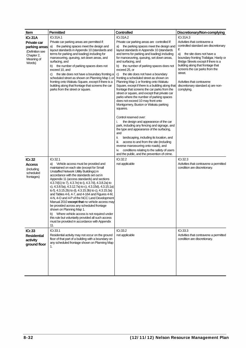
Item Permitted Controlled Discretionary/Non-complying
ICr.31A Private car parking areas (Definition see Chapter 2, Meaning of Words)
ICr.31A.1 Private car parking areas are permitted if: a) the parking spaces meet the design and layout standards in Appendix 10 (standards and terms for parking and loading) including for manoeuvring, queuing, set down areas, and surfacing, and b) the number of parking spaces does not exceed 10, and c) the site does not have a boundary fronting a scheduled street as shown on Planning Map 1 or fronting onto Wakatu Square, except if there is a building along that frontage that screens the car parks from the street or square.
ICr.31A.2 Private car parking areas are controlled if: a) the parking spaces meet the design and layout standards in Appendix 10 (standards and terms for parking and loading) including for manoeuvring, queuing, set down areas, and surfacing, and b) the number of parking spaces does not exceed 25, or c) the site does not have a boundary fronting a scheduled street as shown on Planning Map 1 or fronting onto Wakatu Square, except if there is a building along that frontage that screens the car parks from the street or square, and except that private car parks where the number of parking spaces does not exceed 10 may front onto Montgomery, Buxton or Wakatu parking squares. Control reserved over: i. the design and appearance of the car park, including any fencing and signage, and the type and appearance of the surfacing, and ii. landscaping, including its location, and iii. access to and from the site (including reverse manoeuvring onto roads), and iv. conditions relating to the safety of users and the public, and the prevention of crime.
ICr.31A.3 Activities that contravene a controlled standard are discretionary if: a) the site does not have a boundary fronting Trafalgar, Hardy or Bridge Streets except if there is a building along that frontage that screens the car parks from the street. Activities that contravene discretionary standard a) are non-complying.
ICr.32 Access (including scheduled frontages)
ICr.32.1 a) Vehicle access must be provided and maintained on each site (except for Small Unstaffed Network Utility Buildings) in accordance with the standards set out in Appendix 11 (access standards) and sections 4.3.7d)1) to 7), 4.3.7e) to i), 4.3.7d), 4.3.8.2a) to c), 4.3.8.5a), 4.3.12.7a) to c), 4.3.15d), 4.3.15.1a) to f), 4.3.15.2b) to d), 4.3.15.3b) to c), 4.3.15.3a) and Tables 4-6, 4-7, and 4-164 and Figures 4-M, 4-N, 4-O and 4-P of the NCC Land Development Manual 2010 except that no vehicle access may be provided across any scheduled frontage shown on Planning Map 1. b) Where vehicle access is not required under this rule but voluntarily provided all such access must be provided in accordance with Appendix 11.
ICr.32.2 not applicable
ICr.32.3 Activities that contravene a permitted condition are discretionary.
ICr.33 Residential activity ground floor
ICr.33.1 Residential activity may not occur on the ground floor of that part of a building with a boundary on any scheduled frontage shown on Planning Map 1.
ICr.33.2 not applicable
ICr.33.3 Activities that contravene a permitted condition are discretionary.
Nelson Resource Management Plan (30/04/12) 8-33
Assessment Criteria Explanation ICr.31A.4 a) how visually prominent the site is, and the impact of the parking area on the built environment, having regard to the character and desired character of the area. b) opportunities to enhance the appearance of the site through landscaping, surface texture, control of signage, fencing and other infrastructure. c) the location and the width of vehicle access to and from the site, having regard to pedestrian safety and the appearance of the site. d) the safety of the users of the car park and of members of the public, particularly after dark, and ways to manage this such as lighting, avoidance of entrapment spots, locking the area or other means, while having regard to any potential adverse effects of these methods on the appearance and amenity of the City Centre. e) the effects of the parking area on pedestrian safety, having regard to the level of foot traffic in the area. f) the effects on pedestrian circulation patterns and/or continuity of weather protection for pedestrians. g) the assessment criteria in Appendix 10. h) in terms of parking of more than 25 spaces within any building or a dedicated parking building, the appearance of that building and how it contributes to the amenity objectives and policies for the Inner City Zone, and good urban design principles. i) the effects of additional car parking on vehicle congestion in the Inner City and on roads to and from the Inner City. j) the effects of additional car parking on Council’s strategies and objectives to encourage public transport use, cycling and walking. k) the cumulative impacts of additional parking on the City Centre.
ICr.31A.5 Private car parking areas within the City Centre provide an important service for businesses and for people working in the City Centre. However, some parking areas can be unsightly and detract from the objectives to make the City Centre more attractive and vibrant. Some locations are potentially more sensitive than others, and this is recognised in the rules e.g. in the main retail streets (Bridge, Hardy and Trafalgar Streets), and those accessed off the public parking squares (Montgomery, Buxton and Wakatu). There can be adverse effects on visual amenity, pedestrian safety and amenity, and the continuity of the ‘street edge’ and verandah protection. The supply of car parking can influence the growth of private vehicle traffic. Limiting car parking can encourage use of other sustainable modes of transport, reduce congestion on the transport network and may also improve the environment of the City Centre. Very large private car parks, or many smaller ones, can have significant visual impacts, break up the continuity of streets, and impact on the pedestrian-friendly objectives that are sought for the City Centre.
ICr.32.4 a) refer to Appendix 11. b) the extent to which alternative methods of access for goods may be available, such as providing a goods loading zone adjacent to the site and/or restricting the times of delivery or dispatch of goods. c) the effects on traffic and pedestrian movement and safety.
ICr.32.5 Refer to Appendix 11. Vehicle crossings are not allowed as of right within the City Centre on the main pedestrian roads, and on the inside of the parking squares, in order to promote a better and safer pedestrian environment. A crossing in these situations may be granted by resource consent, having regard to the impacts on pedestrian traffic, and the appropriateness of the crossings in relation to the operational effects of the activity on the safe and efficient movement of traffic on and off the site and along the roadway.
ICr.33.4 a) the extent to which residential activity can occur on the ground floor without affecting the pedestrian circulation and interest along the main roads in the City Centre. b) the nature of any neighbouring activity, including in the case of any activity involving hazardous substances, any risk to human health posed by that substance
ICr.33.5 This rule, again, is to maintain pedestrian interest on the ground floor frontage of buildings in the City Centre. The assessment criteria anticipate that ground floor living may be appropriate if pedestrian circulation is unaffected.
8-34 (01/09/04) Nelson Resource Management Plan
rule table
Item Permitted Controlled Discretionary/Non-complying
ICr.34 Building setback Corner sites
ICr.34.1 The ground floor of any building must be set back at the corner to a diagonal line joining points on each road boundary 3m from the corner of the site (or the point where the road boundaries would meet if extended).
ICr.34.2 not applicable
ICr.34.3 Activities that contravene the conditions for permitted activities are discretionary
ICr.35 Daylight admission Boundary with Residential Zone or Open Space and Recreation Zone
ICr.35.1 Any building on a site adjoining a Residential Zone or an Open Space and Recreation Zone must comply with the daylight angles in Appendix 15 (daylight admission – residential).
ICr.35.2 not applicable
ICr.35.3 Activities that contravene a permitted condition are discretionary
ICr.36 Verandahs Trafalgar, Hardy and Bridge Streets and Parking Squares (scheduled frontages)
ICr.36.1 Any building (except any Group A or B Heritage Building listed in Appendix 1), when it is erected, or substantially altered in any way that substantially changes its external appearance: a) must be provided with a verandah along any scheduled frontage shown on Planning Map 1 or 10, and b) the verandah must comply with the specifications in Appendix 18 (verandahs).
ICr.36.2 not applicable
ICr.36.3 Activities that contravene a permitted condition are discretionary.
ICr.37 Verandahs Other roads
ICr.37.1 Any building may be provided with a verandah, if: a) the building is not a Heritage building listed in Appendix 1, and b) the verandah complies with the specifications in Appendix 18 (verandahs).
ICr.37.2 not applicable
ICr.37.3 Activities that contravene a permitted condition are discretionary.
Nelson Resource Management Plan (26/01/08) 8-35
city centre and city fringe areas
Assessment Criteria Explanation ICr.34.4 a) the effects on driver visibility and therefore road safety.
ICr.34.5 The rule improves driver sight lines at intersections and safer pedestrian movements.
ICr.35.4 a) the effects of any shading on the public enjoyment and amenity of roads and public spaces. b) the extent of any additional shading, having regard to the size of the shadow cast and the period of time any area is affected by it (eg. tall thin shadow compared with shorter, bulky shadow taking longer to pass). c) the nature of the activities undertaken in any area affected
ICr.35.5 The rule ensures that a residential level of daylight amenity is maintained on properties in residential zones, and public open space, even from adjoining zones. The rationale for the daylight angles is explained in Appendix 15.
ICr.36.4 a) the extent the footpath may be exposed to adverse weather conditions if a verandah is not provided. b) whether suitable alternative provision for pedestrian cover can be made. c) the volume of pedestrian movement in the vicinity. d) the effect of not providing a verandah on appearance of the building, and the road in the vicinity. e) the effect of departing from the specifications in Appendix 18 in terms of the relationship with adjoining verandahs (eg. appearance, continuity of weather protection), the appearance of the building and the road, and such things as ensuring adequate head clearance above footpaths. f) the extent to which a verandah added to a heritage building would detract from the architectural or historic merits of the building. g) the provisions of the Nelson City Centre Design Guide (where relevant)
ICr.36.5 The rule is to enhance the attractiveness and convenience of the City Centre as a shopping environment and as a place for visitors. In locations with high pedestrian movements verandahs are compulsory. Certain design specifications must be met. These ensure there is general consistency of design and continuity of protection for pedestrians. Having a verandah on a listed heritage building is not mandatory. Addition of such a structure may detract from the appearance of the building, and for this reason addition of a verandah to a listed building requires a resource consent. See also Rule ICr.60 (heritage buildings, places and objects: alterations).
ICr.37.4 a) the effect of departing from the specifications in Appendix 18 in terms of the relationship with adjoining verandahs (eg. appearance, continuity of weather protection), the appearance of the building and the road. b) the extent to which a verandah added to a heritage building would detract from the architectural or historic merits of the building. c) the provisions of the City Centre Design Guide.
ICr.37.5 Verandahs are optional on other than the scheduled frontages. However, certain design specifications must be met. These ensure there is general consistency of design and continuity of protection for pedestrians. See also Rule ICr.60 (heritage buildings, places and objects: alterations).

8-36 (07/01/13) Nelson Resource Management Plan
Item Permitted Controlled Discretionary/Non-complying
ICr.38 Activities near the coast
ICr.38.1 Activities within 5m of mean high water springs are permitted if: a) they do not involve erection or extension of structures (excluding fences), and b) they do not impede the legal right of foot access along a waterbody where this exists. Earthworks near coastal water or water bodies are regulated under other rules.
ICr.38.2 Extension of a utility service line or structure is controlled. Control reserved over: i) damage to indigenous vegetation, and damage to indigenous vegetation, and ii) discharge of contaminants and iii) discharge of contaminants, and iv) maintenance of access, and maintenance of access, and v) remedial measures.
ICr.38.3 Activities that contravene a permitted condition are discretionary.
ICr.39 Building over or alongside drains and water mains
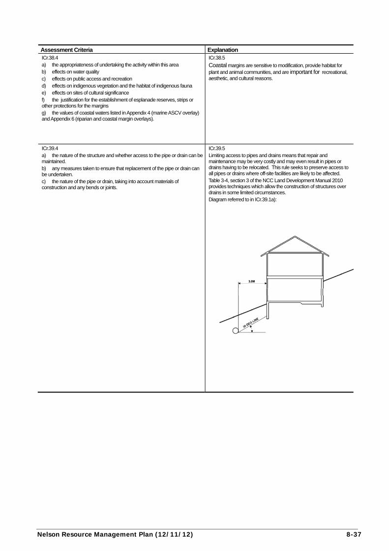
ICr.39.1 a) Structures: i) must be located no closer than 1m measured horizontally from the near side of any public water main or common private or public sewer or stormwater drain, where the required pipe or drain is less than or equal to 300mm in diameter or width, and ii) must be located no closer than 1.5m measured horizontally from the near side of any public water main, or common private or public sewer or stormwater drain, where the required pipe or drain is greater than 300mm in diameter or width, and iii) may overhang the line of the pipe or drain, provided the structure is cantilevered or is an eave and the height to the underside of the structure above ground level is not less than 1.8m, and iv) which are located within 3m, measured horizontally, from the near side of the pipe or drain must have the base of the foundations deeper than a line drawn at 30º from the horizontal from the invert (bottom) of the pipe or drain (see diagram). As an alternative to a), structures may be located over common private or public wastewater or stormwater drains, if they comply with “ Acceptable Techniques for Building over Drains or Pipelines”. Table 3-4 in section 3 of the NCC Land Development Manual.
ICr.39.2 not applicable
ICr.39.3 Restricted Discretionary Activity Activities that contravene a permitted standard are a restricted discretionary activity. Discretion restricted to: i) the design and location of the structure, and ii) access to pipework or drain for maintenance, and iii) the nature and location of the pipework or drain. Resource consent applications for restricted discretionary activities will be considered without notification, or service of notice, provided it can be shown that the building can be located in such a way as to ensure that access to the drain or pipe for maintenance or replacement purposes, can be achieved without causing adverse financial or physical effect on neighbouring properties or persons who are served by the same pipe or drain.
Nelson Resource Management Plan (12/11/12) 8-37
Assessment Criteria Explanation ICr.38.4 a) the appropriateness of undertaking the activity within this area b) effects on water quality c) effects on public access and recreation d) effects on indigenous vegetation and the habitat of indigenous fauna e) effects on sites of cultural significance f) the justification for the establishment of esplanade reserves, strips or other protections for the margins g) the values of coastal waters listed in Appendix 4 (marine ASCV overlay) and Appendix 6 (riparian and coastal margin overlays).
ICr.38.5
Coastal margins are sensitive to modification, provide habitat for plant and animal communities, and are important for recreational, aesthetic, and cultural reasons.
ICr.39.4 a) the nature of the structure and whether access to the pipe or drain can be maintained. b) any measures taken to ensure that replacement of the pipe or drain can be undertaken. c) the nature of the pipe or drain, taking into account materials of construction and any bends or joints.
ICr.39.5 Limiting access to pipes and drains means that repair and maintenance may be very costly and may even result in pipes or drains having to be relocated. This rule seeks to preserve access to all pipes or drains where off-site facilities are likely to be affected. Table 3-4, section 3 of the NCC Land Development Manual 2010 provides techniques which allow the construction of structures over drains in some limited circumstances. Diagram referred to in ICr.39.1a):
8-38 (30/04/12) Nelson Resource Management Plan
Item Permitted Controlled Discretionary/Non-complying
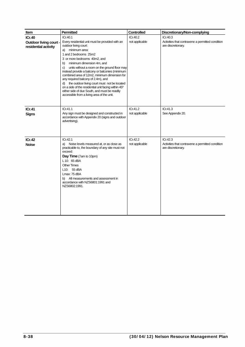
ICr.40 Outdoor living court - residential activity
ICr.40.1 Every residential unit must be provided with an outdoor living court: a) minimum area: 1 and 2 bedrooms 25m2 3 or more bedrooms 40m2, and b) minimum dimension 4m, and c) units without a room on the ground floor may instead provide a balcony or balconies (minimum combined area of 12m2, minimum dimension for any required balcony of 2.4m), and d) the outdoor living court must not be located on a side of the residential unit facing within 45º either side of due South, and must be readily accessible from a living area of the unit.
ICr.40.2 not applicable
ICr.40.3 Activities that contravene a permitted condition are discretionary.
ICr.41 Signs
ICr.41.1 Any sign must be designed and constructed in accordance with Appendix 20 (signs and outdoor advertising).
ICr.41.2 not applicable
ICr.41.3 See Appendix 20.
ICr.42 Noise
ICr.42.1 a) Noise levels measured at, or as close as practicable to, the boundary of any site must not exceed:
Day Time (7am to 10pm) L 10: 65 dBA Other Times L10: 55 dBA Lmax: 75 dBA b) All measurements and assessment in accordance with NZS6801:1991 and NZS6802:1991.
ICr.42.2 not applicable
ICr.42.3 Activities that contravene a permitted condition are discretionary.
Nelson Resource Management Plan (30/04/12) 8-39
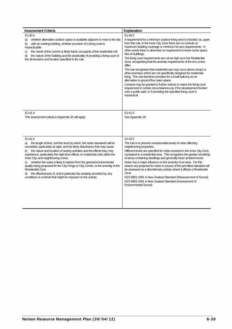
Assessment Criteria Explanation ICr.40.4 a) whether alternative outdoor space is available adjacent or near to the site.b) with an existing building, whether provision of a living court is impracticable. c) the needs of the current or likely future occupants of the residential unit. d) the nature of the building and the practicality of providing a living court of the dimensions and location specified in the rule.
ICr.40.5 A requirement for a minimum outdoor living area is included, as, apart from this rule, in the Inner City Zone there are no controls on maximum building coverage or minimum lot size requirements. In other words there is otherwise no requirement to leave some space free of buildings. The living court requirements are not as high as in the Residential Zone, recognising that the amenity requirements of the two zones differ. The rule recognises that residential use may occur above shops or other premises which are not specifically designed for residential living. The rule therefore provides for a small balcony as an alternative to ground floor open space. Consent may be granted to further reduce or waive the living court requirement in certain circumstances eg. if the development fronted onto a public park, or if providing the specified living court is impractical.
ICr.41.4 The assessment criteria in Appendix 20 will apply.
ICr.41.5 See Appendix 20.
ICr.42.4 a) the length of time, and the level by which, the noise standards will be exceeded, particularly at night, and the likely disturbance that may cause. b) the nature and location of nearby activities and the effects they may experience, particularly the night time effects on residential units within the Inner City, and neighbouring zones. c) whether the noise is likely to detract from the general environmental quality being proposed for the City Fringe or City Centre, or the amenity of the Residential Zone. d) the effectiveness of, and in particular the certainty provided by, any conditions or controls that might be imposed on the activity.
ICr.42.5 The rule is to prevent unreasonable levels of noise affecting neighbouring properties. Different levels are specified for noise received in the Inner City Zone, compared to a residential area. This recognises the greater sensitivity of areas containing dwellings and generally lower ambient levels. Noise has a major influence on the amenity of an area. For this reason any proposal for noise in excess of the permitted standard will be assessed as a discretionary activity where it affects a Residential Zone. NZS 6801:1991 is New Zealand Standard (Measurement of Sound). NZS 6802:1991 is New Zealand Standard (Assessment of Environmental Sound).

8-40 (01/09/04) Nelson Resource Management Plan
Item Permitted Controlled Discretionary/Non-complying
ICr.43 Noise At residential boundary
ICr.43.1 a) Noise levels measured at, any site within a Residential Zone must not exceed:
Day Time L 10: 55 dBA
Other Times L10: 45 dBA Lmax: 75 dBA (Day Time means 7am to 10pm Monday to Friday, and 9am to 10pm Saturdays, Sundays and Public Holidays). b) All measurements and assessment in accordance with NZS6801:1991 and NZS6802:1991. c) Parts a) and b) of this rule do not apply to building and demolition activities, which, when assessed at, or within, any site within the Residential Zone, must comply with the provisions of NZS6803P:1984 “The Measurement and Assessment of Noise from Construction, Maintenance and Demolition”.
ICr.43.2 not applicable
ICr.43.3 Activities that contravene a permitted condition are non-complying.
ICr.44 Vibration
ICr.44.1 No vibration created on a site may be discernible at any other site.
ICr.44.2 not applicable
ICr.44.3 Activities that contravene a permitted condition are discretionary.
Nelson Resource Management Plan (01/09/04) 8-41
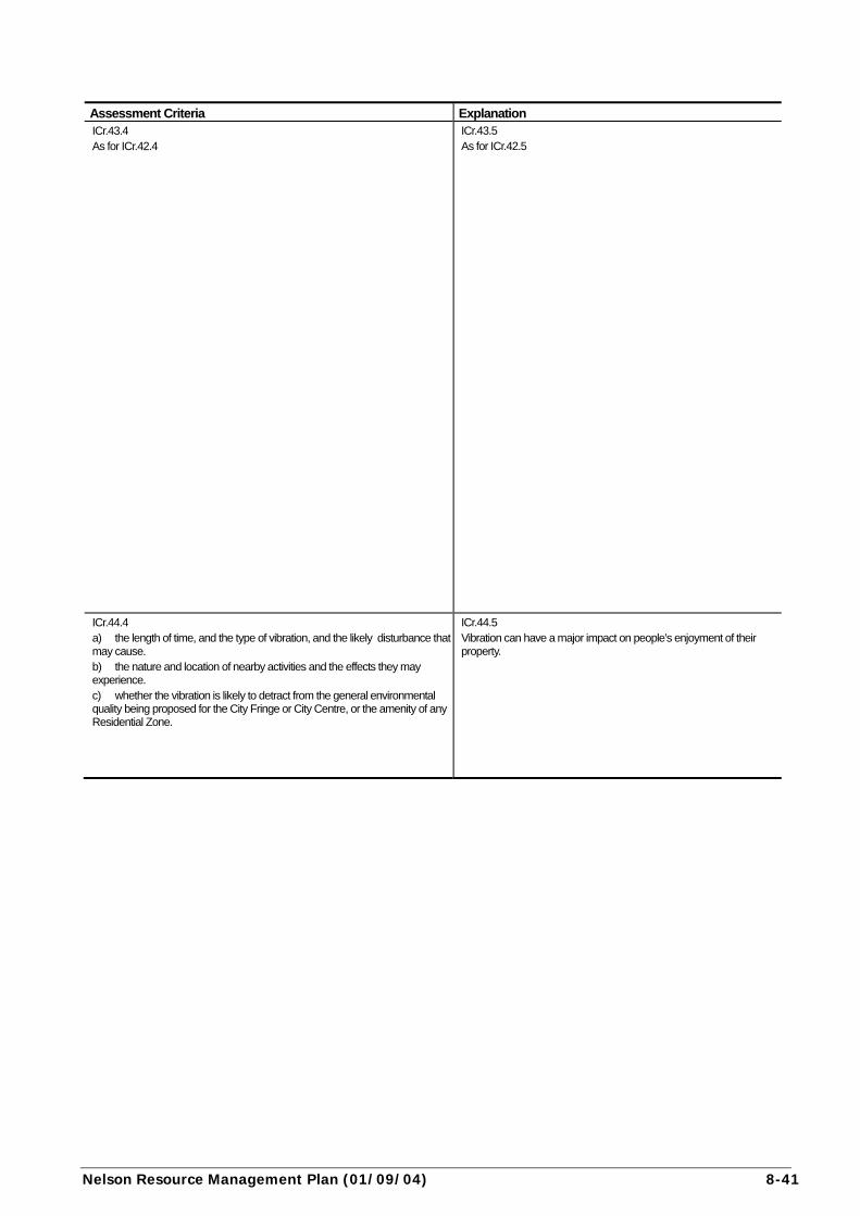
Assessment Criteria Explanation ICr.43.4 As for ICr.42.4
ICr.43.5 As for ICr.42.5
ICr.44.4 a) the length of time, and the type of vibration, and the likely disturbance that may cause. b) the nature and location of nearby activities and the effects they may experience. c) whether the vibration is likely to detract from the general environmental quality being proposed for the City Fringe or City Centre, or the amenity of any Residential Zone.
ICr.44.5 Vibration can have a major impact on people’s enjoyment of their property.
8-42 (01/09/04) Nelson Resource Management Plan
Item Permitted Controlled Discretionary/Non-complying
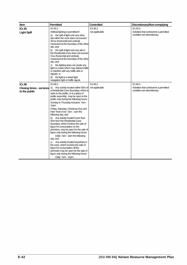
ICr.45 Light Spill
ICr.45.1 Artificial lighting is permitted if: a) the spill of light onto any other site within the zone does not exceed 30 lux (horizontal and vertical) measured at the boundary of the other site, and b) the spill of light onto any site in the Residential Zone does not exceed 3 lux (horizontal and vertical), measured at the boundary of the other site, and c) the lighting does not create any light on roads which may distract trafficor interfere with any traffic aids or signals, or d) the light is a street light, navigation light or traffic signal.
ICr.45.2 not applicable
ICr.45.3 Activities that contravene a permitted condition are discretionary.
ICr.46 Closing times - services to the public
ICr.46.1 a) Any activity located within 50m of a Residential Zone Boundary, which is open to the public, or is a place of public assembly, may be open to the public only during the following hours:Sunday to Thursday inclusive: 7am - 11pm Friday, Saturday, Christmas Eve and New Year's Eve: 7am - 1am the following day, and b) Any activity located more than 50m from the Residential Zone boundary, which involves the sale of liquor for consumption on the premises, may be open for the sale of liquor only during the following hours: Daily: 7am - 3am the following day, and c) Any activity located anywhere in the zone, which involves the sale of liquor for consumption off the premises may be open for the sale of liquor only during the following hours: Daily: 7am - 11pm.
ICr.46.2 not applicable
ICr.46.3 Activities that contravene a permitted condition are discretionary.

Nelson Resource Management Plan (01/09/04) 8-43
Assessment Criteria Explanation ICr.45.4 a) effects on adjacent and adjoining uses b) the extent to which additional light may adversely affect occupation of residential properties. c) the effect on traffic safety. d) the positive effects of improved pedestrian safety and security. e) the type of light, including its strength, and hours of operation.
ICr.45.5 The rule is to prevent unreasonable levels of light spilling onto neighbouring properties. Different levels are specified for light received on sites within the zone, compared to sites within the Residential Zone. This recognises the greater sensitivity of areas containing dwellings.
ICr.46.4 a) the nature and scale of the activity in relation to nearby residential activity, having regard to the nature of the existing and permitted future uses on nearby sites. b) the effect on the existing and likely foreseeable amenity of nearby residential areas, particularly in relation to noise and traffic generation. c) the ability to remedy or mitigate any adverse effects of the activity by the layout or design of the site or buildings, or by the provision of landscaping or similar measures. d) the topography of the site and the neighbouring areas. e) the adequacy of car parking on the site, and its location in relation to the neighbouring residential activities. f) the effectiveness, and in particular the certainty, provided by any conditions or controls that might be imposed on the activity. g) whether the activity is temporary, and the frequency of such events (where applicable).
ICr.46.5 Activities which are close to residential areas and which are open to the public late at night, have the potential to create adverse effects which conflict with the residential nature of the neighbouring areas. Particular problems are traffic arriving and leaving the premises, noise from patrons, and sometimes music. Therefore restrictions have been placed on the hours of opening of such activities. Away from the boundary with residentially-zoned land, there are no restrictions on hours of opening, except for activities which involve the sale of alcohol. This recognises the adverse environmental effects which often accompany licensed premises and the patrons using them. There are set hours for off-licence premises throughout the zone. The hours for licensed premises were developed after extensive public consultation under the Sale of Liquor Act and only apply to the sale of liquor aspects of activities.
8-44 (01/05/06) Nelson Resource Management Plan
Item Permitted Controlled Discretionary/Non-complying
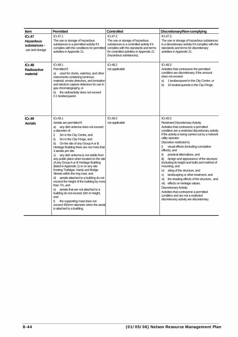
ICr.47 Hazardous substances - use and storage
ICr.47.1 The use or storage of hazardous substances is a permitted activity if it complies with the conditions for permitted activities in Appendix 21.
ICr.47.2 The use or storage of hazardous substances is a controlled activity if it complies with the standards and terms for controlled activities in Appendix 21 (hazardous substances).
ICr.47.3 The use or storage of hazardous substances is a discretionary activity if it complies with the standards and terms for discretionary activities in Appendix 21.
ICr.48 Radioactive material
ICr.48.1 Permitted if: a) used for clocks, watches, and other instruments containing luminous material, smoke detectors, and ionisation and electron capture detectors for use in gas chromatography, or b) the radioactivity does not exceed 0.1 terabecquerel.
ICr.48.2 not applicable
ICr.48.3 Activities that contravene the permitted condition are discretionary, if the amount does not exceed: a) 1 terabecquerel in the City Centre, or b) 10 terabecquerels in the City Fringe.
ICr.49 Aerials
ICr.49.1 Aerials are permitted if: a) any dish antenna does not exceed a diameter of: i) 3m in the City Centre, and ii) 5m in the City Fringe, and b) On the site of any Group A or B Heritage Building there are not more that 3 aerials per site. c) any dish antenna is not visible from any public place when located on the site of any Group A or B Heritage Building (listed in Appendix 1) or on any site fronting Trafalgar, Hardy and Bridge Streets within the ring road, and d) aerials attached to a building do not exceed the height of the building by more than 7m, and e) aerials that are not attached to a building do not exceed 18m in height, and f) the supporting mast does not exceed 450mm diameter when the aerial is attached to a building.
ICr.49.2 not applicable
ICr.49.3 Restricted Discretionary Activity Activities that contravene a permitted condition are a restricted discretionary activity if the activity is being carried out by a network utility operator. Discretion restricted to: i) visual effects (including cumulative effects), and ii) practical alternatives, and iii) design and appearance of the structure (including its height and bulk) and method of mounting, and iv) siting of the structure, and v) landscaping or other treatment, and vi) the shading effects of the structure., andvii) effects on heritage values. Discretionary Activity Activities that contravene a permitted condition and are not a restricted discretionary activity are discretionary.
Nelson Resource Management Plan (01/09/04) 8-45
Assessment Criteria Explanation ICr.47.4 Assessment criteria in Appendix 21.
ICr.47.5 See Appendix 21 .
ICr.48.4 a) the type of radioactive source proposed and its relative activity. b) compliance with the relevant National Radiation Laboratory code of practice. c) the methods of storage and disposal proposed, particularly in relation to natural hazards which may affect the site. d) transportation routes, particularly through residential areas, and methods.
ICr.48.5 The permitted standard provides for such things containing minor amounts of radioactive materials such as smoke detectors, and luminous watches and clocks. The discretionary activity category would provide for facilities such as medical laboratories or dentists in the City Centre, and X ray centres or hospitals in the City Fringe. The prohibited category excludes large scale facilities such as irradiation plants and nuclear power plants. Activities involving radioactive substances are controlled by the Radiation Protection Act 1965 and the Radiation Protection Regulations 1982. The rules seek to impose additional control only on the higher potential emission activities to enable wider community consultation. Note: activities are prohibited if emissions are in excess of 1000 terabecquerels of radioactivity (see ICr.2).
ICr.49.4 a) the visual impacts of the structure on the streetscape and the general public. b) any shading posed by the structure. c) how prominent the site is, taking account of any significant public or private views or any significant landscapes. d) the extent to which any heritage or cultural values of the site or adjoining sites might be compromised by the structure. e) the height and bulk of the structure. f) the extent to which design, colour scheme or screening (eg. locating it below the parapet) might mitigate the adverse effects of the structure. g) the cumulative effects of additional aerials and structures, taking account of the impacts of existing aerials on the site and on adjacent sites.
ICr.49.5 The height controls for the Inner City are generous and there should be little reason to breach these standards. Dish antennas tend to be bulkier than traditional aerials, and potentially more visually intrusive. Hence special controls relate to their location on heritage buildings and main shopping streets to ensure they do not affect the public enjoyment of these buildings and areas. Dish antennas are also subject to Rule ICr.56 which relates to protection of views from the Church Steps. Heritage buildings are also protected from multiple aerial installations because aerials can detract from the values of these special buildings. Note the definition of aerial in Chapter 2: Meaning of Words which allows for a support mast with several antenna mounted on it. Within the Inner City Zone therefore, Rule ICr.49 provides for a maximum of 3 support masts with multiple antenna/aerials.
8-46 (01/05/06) Nelson Resource Management Plan
Item Permitted Controlled Discretionary/Non-complying
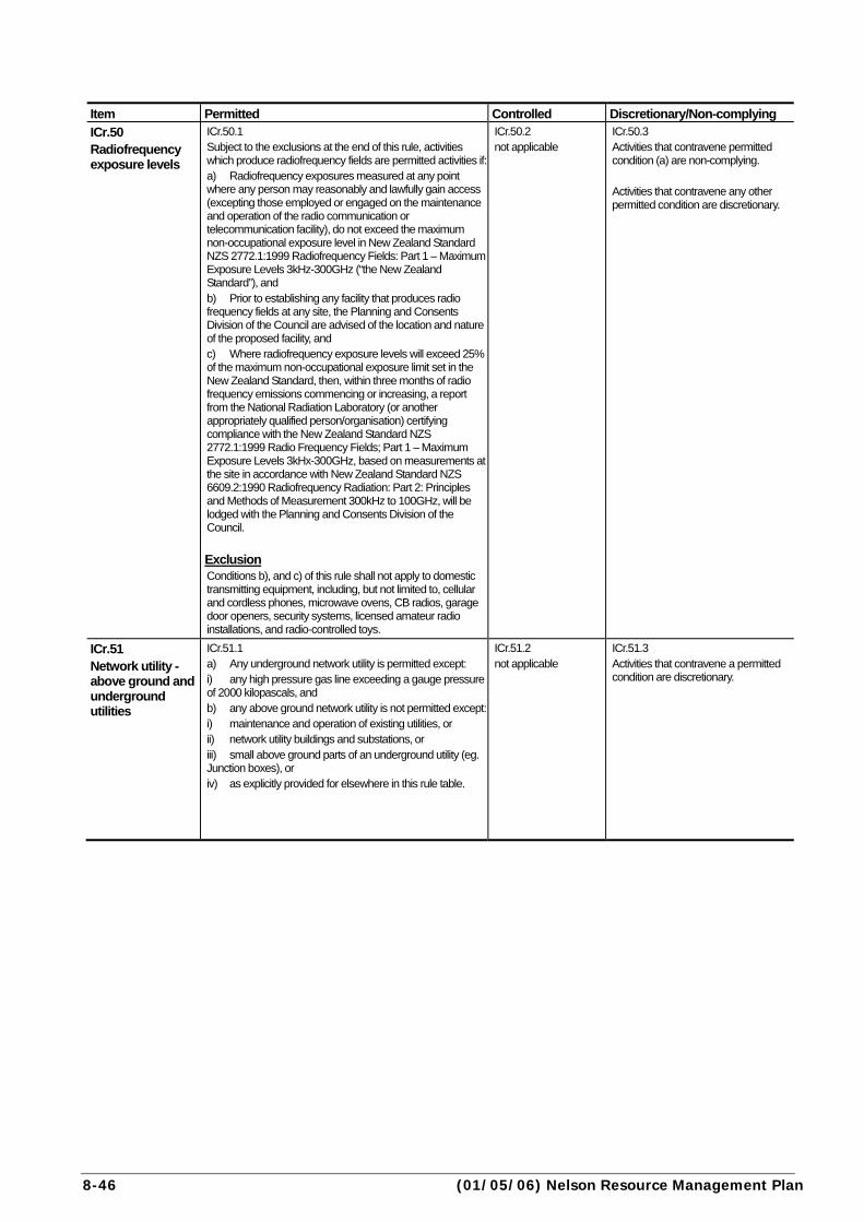
ICr.50 Radiofrequency exposure levels
ICr.50.1 Subject to the exclusions at the end of this rule, activities which produce radiofrequency fields are permitted activities if:a) Radiofrequency exposures measured at any point where any person may reasonably and lawfully gain access (excepting those employed or engaged on the maintenance and operation of the radio communication or telecommunication facility), do not exceed the maximum non-occupational exposure level in New Zealand Standard NZS 2772.1:1999 Radiofrequency Fields: Part 1 – Maximum Exposure Levels 3kHz-300GHz (“the New Zealand Standard”), and b) Prior to establishing any facility that produces radio frequency fields at any site, the Planning and Consents Division of the Council are advised of the location and nature of the proposed facility, and c) Where radiofrequency exposure levels will exceed 25% of the maximum non-occupational exposure limit set in the New Zealand Standard, then, within three months of radio frequency emissions commencing or increasing, a report from the National Radiation Laboratory (or another appropriately qualified person/organisation) certifying compliance with the New Zealand Standard NZS 2772.1:1999 Radio Frequency Fields; Part 1 – Maximum Exposure Levels 3kHx-300GHz, based on measurements at the site in accordance with New Zealand Standard NZS 6609.2:1990 Radiofrequency Radiation: Part 2: Principles and Methods of Measurement 300kHz to 100GHz, will be lodged with the Planning and Consents Division of the Council.
Exclusion Conditions b), and c) of this rule shall not apply to domestic transmitting equipment, including, but not limited to, cellular and cordless phones, microwave ovens, CB radios, garage door openers, security systems, licensed amateur radio installations, and radio-controlled toys.
ICr.50.2 not applicable
ICr.50.3 Activities that contravene permitted condition (a) are non-complying. Activities that contravene any other permitted condition are discretionary.
ICr.51 Network utility - above ground and underground utilities
ICr.51.1 a) Any underground network utility is permitted except: i) any high pressure gas line exceeding a gauge pressure of 2000 kilopascals, and b) any above ground network utility is not permitted except: i) maintenance and operation of existing utilities, or ii) network utility buildings and substations, or iii) small above ground parts of an underground utility (eg. Junction boxes), or iv) as explicitly provided for elsewhere in this rule table.
ICr.51.2 not applicable
ICr.51.3 Activities that contravene a permitted condition are discretionary.
Nelson Resource Management Plan (26/01/08) 8-47
Assessment Criteria Explanation ICr.50.4 a) the potential effects of any increase of radiofrequency exposure on the health of persons near the facility. b) the nature of any activities near the proposed site, having regard to their susceptibility to any exposures. c) the location of the site, and any potential for shielding from exposures. d) any cumulative effects, particularly with regard to exposure to electro magnetic radiation from existing facilities in the area.
ICr.50.5 Certain utilities and other activities emit electromagnetic radiation. These activities are perceived to be a health concern to some people living near them. In developing the rules on radiofrequency exposures, Council has based its approach on that recommended in the “National Guidelines for Managing the Effects of Radiofrequency Transmitters” produced by the Ministry of Health and the Ministry for the Environment in December 2000. The key findings of the guidelines was that there are no established health effects from exposure to radiofrequency fields as long as they comply with the New Zealand Standard NZS 2772.1:1999 Radiofrequency Fields: Part 1 – Maximum Exposure Levels 3kHz-300GHz. The Council is to be notified of location and nature of any proposed facility. Should this predictive report anticipate and should exposure levels be greater than 25 percent of the New Zealand Standard level, monitoring to determine the actual exposure levels from the transmitting installation will be required. The rule contains an exception for domestic radiofrequency transmitting equipment. This is to ensure that these domestic transmitting devices can be used without the rules applying to their radiofrequency emissions. Radiofrequency emissions that exceed the exposure levels set within the New Zealand Standard are to be considered as non-complying activities.
ICr.51.4 a) any hazard presented by the utility. b) the environmental setting of the structure, having regard to the general locality, topography, geographical features and adjacent land uses. c) the visual impacts of the structure on residential or recreational use of land in the vicinity, and on significant ridge lines and view planes from public places, including roads. d) the scale, bulk and height of the facility. e) screening or landscaping of the utility and any modifications to its colour and design to reduce the visual effect of the utility on the surrounding environment. f) any constraints on placing the utility underground.
ICr.51.5 Provision is made for lower pressure gas lines as permitted activities, but high pressure lines which present a higher risk need to be assessed as discretionary activities. The electricity and telephone network is an important part of the city’s infrastructure. They, and similar facilities, are permitted if located under ground. However, overhead lines have the potential to detract from the residential streetscape, and have to be dealt with as discretionary activities. Maintenance and operation of existing utilities is permitted in accordance with the definition of "maintenance" in Chapter 2 (meanings of words).

8-48 (12/11/12) Nelson Resource Management Plan
Item Permitted Controlled Discretionary/Non-
complying
ICr.52 Structures on the road reserve
ICr.52.1 Structures on the road reserve are permitted if: a) they are part of the road infrastructure (eg. bridges, culverts, street lighting, traffic signals, masts), or relate to the safe use of the road or walkway, or b) structures (including equipment shelters and bus shelters) do not exceed 6m2 .
ICr.52.2 not applicable
ICr.52.3 Activities that contravene a permitted condition are discretionary.
ICr.53 Network utility - roads
ICr.53.1 The construction of any new road is permitted if: a) the road is not a State Highway, Arterial Road or Principal Road as defined on the Planning Maps, and b) the minimum standards (as defined in Section 1.1.1 General) in Section 4 of the NCC Land Development Manual 2010 are complied with.
ICr.53.2 not applicable
ICr.53.3 Activities that contravene a permitted condition are discretionary.
ICr.54 Building on low lying sites
ICr.54.1 Building is permitted if: a) the ground level (excluding water bodies) is 15.35m NCC Datum or above; or ground level is raised and compacted to at least those levels: i) in accordance with NZS4431:1989 (Code of Practice for Earthfill for Residential Development) and ii) such that stormwater runoff from the site is not directed onto other sites or into any river or stream, and that stormwater runoff from other sites is not obstructed, and iii) the finished ground level is not less than 400mm above the design hydraulic grade level of the storm water system serving the site, and b) the minimum finished floor level of the building is: i) concrete floor: 15.50m ii) timber floor: 15.65m
ICr.54.2 not applicable
ICr.54.3 Buildings that contravene a permitted condition are restricted discretionary activities. Discretion is restricted to measures required for the avoidance or mitigation of inundation hazards on the subject and surrounding properties.

Nelson Resource Management Plan (12/11/12) 8-49
Assessment Criteria Explanation ICr.52.4 a) the size and scale of the structures. b) any visual impacts, taking account of the character of the area. c) safety considerations including any effects on line of sight for motorists and other road users, having regard to the usage of the road.
ICr.52.5 This rule allows for the usual basic infrastructure in the road reserve at a scale that is generally accepted by the public. This infrastructure includes street lights and other traffic equipment, as well as electricity distribution boxes and telephone booths. The rule is not restricted to network utility operators in order to regulate bus shelters, street vendors, and the use of the road reserve for pavement cafes. The Council (and the NZ Transport Agency in the case of State Highways) has an additional control as the owner of the land, in respect of who goes there and under what circumstances. Telecommunications and electricity operators have certain rights to put works on roads (under the Telecommunications Act 1987, section 15, and Electricity Act 1992, section 24). The Council will be guided when it prescribes conditions under those Acts, by the matters contemplated in these rules.
ICr.53.4 a) the minimum standards (as defined in Section 1.1.1 General) in section 4 of the NCC Land Development Manual 2010. b) the noise and air emissions from the road, taking account of the nature of nearby activities. c) any implications for traffic and pedestrian safety, both positive and adverse. d) any proposals to mitigate the adverse effects of the road, particularly by screening for noise and visual impacts. e) any impacts on communities eg. whether the road would divide a neighbourhood. f) any opportunities to provide views and vistas from the road.
ICr.53.5 New roads and realignments and upgrading work on existing roads are generally dealt with by way of designations in the Plan. The designation procedure provides an opportunity for the public or affected persons to have a say on the proposals and for the environmental effects to be scrutinised. Where new roads have not been dealt with by designation, this rule provides the opportunity for public input via the resource consent process if the road is to be a major traffic carrier, or the usual design standards are not being followed.
ICr.54.4 a) the ground level required to avoid the effects of anticipated flooding. b) the type of inundation likely to be experienced, whether it be stormwater ponding, tidal inundation, or some other combination of circumstances which could lead to surface flooding. c) the effects on neighbouring properties, especially with respect to stormwater runoff. d) section 5.6.5b) and Table 5-6 and 5-7 in section 5 of the NCC Land Development Manual 2010.
ICr.54.5 The minimum ground levels set are based on the best estimates from the Ministry for the Environment for likely sea level rise caused by global climate change. This takes account of predicted spring tides and expected tidal surges, and their consequent effects on stormwater ponding. Sites below the minimum levels stated for permitted activities will be assessed individually to ensure that ground or floor heights are sufficient to protect the building from inundation. See Rule ICr.55 (earthworks) where a site is to be filled. Note: This low lying site rule does not apply within the Inundation Overlay - see ICr.59 (inundation overlays) .
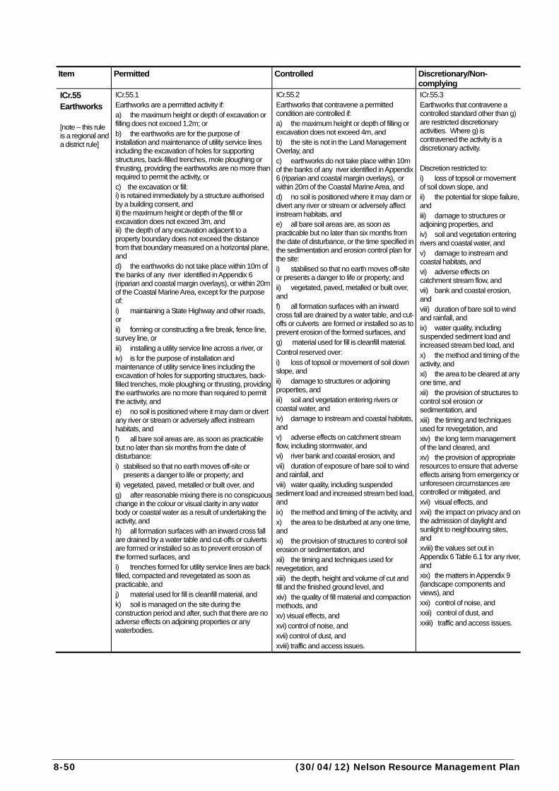
8-50 (30/04/12) Nelson Resource Management Plan
Item Permitted Controlled Discretionary/Non-
complying
ICr.55 Earthworks [note – this rule is a regional and a district rule]
ICr.55.1 Earthworks are a permitted activity if: a) the maximum height or depth of excavation or filling does not exceed 1.2m; or b) the earthworks are for the purpose of installation and maintenance of utility service lines including the excavation of holes for supporting structures, back-filled trenches, mole ploughing or thrusting, providing the earthworks are no more than required to permit the activity, or c) the excavation or fill: i) is retained immediately by a structure authorised by a building consent, and ii) the maximum height or depth of the fill or excavation does not exceed 3m, and iii) the depth of any excavation adjacent to a property boundary does not exceed the distance from that boundary measured on a horizontal plane, and d) the earthworks do not take place within 10m of the banks of any river identified in Appendix 6 (riparian and coastal margin overlays), or within 20m of the Coastal Marine Area, except for the purpose of: i) maintaining a State Highway and other roads, or ii) forming or constructing a fire break, fence line, survey line, or iii) installing a utility service line across a river, or iv) is for the purpose of installation and maintenance of utility service lines including the excavation of holes for supporting structures, back-filled trenches, mole ploughing or thrusting, providing the earthworks are no more than required to permit the activity, and e) no soil is positioned where it may dam or divert any river or stream or adversely affect instream habitats, and f) all bare soil areas are, as soon as practicable but no later than six months from the date of disturbance: i) stabilised so that no earth moves off-site or
presents a danger to life or property; and ii) vegetated, paved, metalled or built over, and g) after reasonable mixing there is no conspicuous change in the colour or visual clarity in any water body or coastal water as a result of undertaking the activity, and h) all formation surfaces with an inward cross fall are drained by a water table and cut-offs or culverts are formed or installed so as to prevent erosion of the formed surfaces, and i) trenches formed for utility service lines are back filled, compacted and revegetated as soon as practicable, and j) material used for fill is cleanfill material, and k) soil is managed on the site during the construction period and after, such that there are no adverse effects on adjoining properties or any waterbodies.
ICr.55.2 Earthworks that contravene a permitted condition are controlled if: a) the maximum height or depth of filling or excavation does not exceed 4m, and b) the site is not in the Land Management Overlay, and c) earthworks do not take place within 10m of the banks of any river identified in Appendix 6 (riparian and coastal margin overlays), or within 20m of the Coastal Marine Area, and d) no soil is positioned where it may dam or divert any river or stream or adversely affect instream habitats, and e) all bare soil areas are, as soon as practicable but no later than six months from the date of disturbance, or the time specified in the sedimentation and erosion control plan for the site: i) stabilised so that no earth moves off-site or presents a danger to life or property; and ii) vegetated, paved, metalled or built over, and f) all formation surfaces with an inward cross fall are drained by a water table, and cut-offs or culverts are formed or installed so as to prevent erosion of the formed surfaces, and g) material used for fill is cleanfill material. Control reserved over: i) loss of topsoil or movement of soil down slope, and ii) damage to structures or adjoining properties, and iii) soil and vegetation entering rivers or coastal water, and iv) damage to instream and coastal habitats, and v) adverse effects on catchment stream flow, including stormwater, and vi) river bank and coastal erosion, and vii) duration of exposure of bare soil to wind and rainfall, and viii) water quality, including suspended sediment load and increased stream bed load, and ix) the method and timing of the activity, and x) the area to be disturbed at any one time, and xi) the provision of structures to control soil erosion or sedimentation, and xii) the timing and techniques used for revegetation, and xiii) the depth, height and volume of cut and fill and the finished ground level, and xiv) the quality of fill material and compaction methods, and xv) visual effects, and xvi) control of noise, and xvii) control of dust, and xviii) traffic and access issues.
ICr.55.3 Earthworks that contravene a controlled standard other than g) are restricted discretionary activities. Where g) is contravened the activity is a discretionary activity. Discretion restricted to: i) loss of topsoil or movement of soil down slope, and ii) the potential for slope failure, and iii) damage to structures or adjoining properties, and iv) soil and vegetation entering rivers and coastal water, and v) damage to instream and coastal habitats, and vi) adverse effects on catchment stream flow, and vii) bank and coastal erosion, and viii) duration of bare soil to wind and rainfall, and ix) water quality, including suspended sediment load and increased stream bed load, and x) the method and timing of the activity, and xi) the area to be cleared at any one time, and xii) the provision of structures to control soil erosion or sedimentation, and xiii) the timing and techniques used for revegetation, and xiv) the long term management of the land cleared, and xv) the provision of appropriate resources to ensure that adverse effects arising from emergency or unforeseen circumstances are controlled or mitigated, and xvi) visual effects, and xvii) the impact on privacy and on the admission of daylight and sunlight to neighbouring sites, and xviii) the values set out in Appendix 6 Table 6.1 for any river, and xix) the matters in Appendix 9 (landscape components and views), and xxi) control of noise, and xxii) control of dust, and xxiii) traffic and access issues.
Nelson Resource Management Plan (26/01/08) 8-51
Assessment Criteria Explanation ICr.55.4 In considering applications for controlled and discretionary activities, Council will exercise control over the matters listed in ICr.55.2, and restrict its discretion to the matters listed in ICr.55.3.
ICr.55.5 This rule generally follows the pattern of the NCC Land Disturbance Regional Plan notified in 1993. That Plan will cease to have effect when this Plan becomes operative. The Land Management Overlay covers the land in Land Management Zone C in the Regional Plan, that is, land that has higher risks of erosion and sedimentation. Earthworks on flatter land are less likely to cause adverse soil erosion and sedimentation effects, except where the activity is close to a water body, and are therefore generally permitted. On steeper land, minor activities such as roads and utilities are permitted, but other activities are more closely regulated. Earthworks in the Land Management Overlay, apart from the minor work mentioned, may have more serious effects, and require assessment to ensure adverse soil erosion and sedimentation effects are avoided or minimised. Earthworks adjacent to rivers and the Coastal Marine Area have, because of their location, a high potential to cause soil erosion (river bank and coastal erosion), or sedimentation effects. Most rivers are included in Appendix 6. Fill can be used to improve sites for use and in particular to mitigate effects of natural hazards and servicing constraints. Clean fill is required because fill that contains contaminants can have adverse effects on the environment, while excessive amounts of vegetation can cause settling when it decomposes. Fill height and quality are controlled to ensure sufficient information to determine ground height in any particular area is available and considered on a case by case basis. However, where the height of the cut or fill exceeds 4m a discretionary activity resource consent is required. This is because such earthworks can have significant visual impacts. Also, in urban areas, significant filling of a site, relative to a neighbour, can affect privacy, and access to daylight and sunlight. Some confusion may arise as to whether an activity constitutes earthworks, landfill, or a combination of the two. The essential distinction is that while earthworks may involve some degree of landfill, it is not the primary purpose of the activity, whereas with landfill activities the primary purpose is the disposal of solid waste. Note: Section 14 of the Resource Management Act prohibits any activity that dams or diverts water, unless a resource consent is granted. This applies to earthworks that might dam or divert water (eg a spring), even if they are permitted or controlled activities under this rule. Note that Earthworks are regulated in other rules, particularly in Overlays, which may impose additional regulation on particular activities.
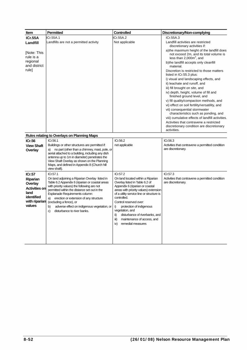
8-52 (26/01/08) Nelson Resource Management Plan
Item Permitted Controlled Discretionary/Non-complying
ICr.55A Landfill [Note: This rule is a regional and district rule]
ICr.55A.1 Landfills are not a permitted activity
ICr.55A.2 Not applicable
ICr.55A.3 Landfill activities are restricted
discretionary activities if: a) the maximum height of the landfill does
not exceed 2m, and its total volume is less than 2,000m3, and
b) the landfill accepts only cleanfill material.
Discretion is restricted to those matters listed in ICr.55.3 plus: i) visual and landscaping effects, and ii) leachate and runoff, and iii) fill brought on site, and iv) depth, height, volume of fill and
finished ground level, and v) fill quality/compaction methods, and vi) effect on soil fertility/versatility, and vii) consequential stormwater
characteristics such as ponding, and viii) cumulative effects of landfill activities.Activities that contravene a restricted discretionary condition are discretionary activities.
Rules relating to Overlays on Planning Maps
ICr.56 View Shaft Overlay
ICr.56.1 Buildings or other structures are permitted if: a) no part (other than a chimney, mast, pole, or aerial attached to a building, including any dish antenna up to 1m in diameter) penetrates the View Shaft Overlay as shown on the Planning Maps, and defined in Appendix 8 (Church hill view shaft).
ICr.56.2 not applicable
ICr.56.3 Activities that contravene a permitted condition are discretionary.
ICr.57 Riparian Overlay Activities on land identified with riparian values
ICr.57.1 On land adjoining a Riparian Overlay listed in Table 6.2 Appendix 6 (riparian or coastal areas with priority values) the following are not permitted within the distance set out in the Esplanade Requirements column: a) erection or extension of any structure (excluding a fence), or b) adverse effect on indigenous vegetation, orc) disturbance to river banks.
ICr.57.2 On land located within a Riparian Overlay listed in Table 6.2 of Appendix 6 (riparian or coastal areas with priority values) extension of a utility service line or structure is controlled. Control reserved over: i) protection of indigenous vegetation, and ii) disturbance of riverbanks, andiii) maintenance of access, and iv) remedial measures
ICr.57.3 Activities that contravene a permitted condition are discretionary.
Nelson Resource Management Plan (26/01/08) 8-53
Assessment Criteria Explanation ICr.55A.4 In considering applications for landfills, Council will restrict its discretion to the matters identified in ICr.55A.3 provided that the application does not contravene a restricted discretionary condition.
ICr.55A.5 Landfill development and operation are restricted discretionary activities, provided conditions in ICr.55A.3 are met. While landfills generally involve earthworks and modify the shape of the land, their primary purpose is the disposal of solid waste. The concentration of solid waste, often containing contaminants, within landfill sites, increases the potential for adverse effects on the environment beyond that associated with normal earthworks. Additional adverse effects may include generation of leachate, discharge of gas, geotechnical issues such as poor bearing strength and settlement, and contamination of the land itself making it unsuitable for other uses. Some landfills operate as cleanfill sites, accepting only material that does not undergo any physical, chemical, or biological transformations likely to cause adverse environmental effects, or health effects, once it is placed in the ground. Cleanfill operations are clearly preferable to activities accepting hazardous or potentially hazardous materials, and are more likely to be granted resource consent. Discharges to water and air from material within landfill sites also require separate regional resource consents.
ICr.56.4 a) whether the building frames the view horizontally or vertically from the edges of the view shaft. This may be acceptable in some circumstances. b) the extent of intrusion into the view shaft, and the elements of the view affected. c) the extent to which the core of the view is impinged upon. d) whether the building removes existing intrusions or increases the quality of the view.
ICr.56.5 The rule relates to views from the Church Steps looking north, towards the Haven. These views are important for visitors and residents alike, and provide an important link between the City Centre and the sea beyond. Any proposed building or structure that would impinge on the defined view shaft, will need to be assessed as a discretionary activity in terms of its potential impact on the view shaft. The view up Trafalgar Street is an important part of the view shaft. Rule ICr.21 (Buildings over road reserve) controls the intrusion of structures that might block this view eg. walkways connecting buildings, enclosed verandahs.
ICr.57.4 a) the values for esplanade purposes stated in Appendix 6, Table 6.2, including any additional information regarding the values of the reserve or strip sought for the purposes outlined in section 229 of the Act. b) the nature of the proposed activity, its likely effects on the values for esplanade purposes, and methods of avoiding, remedying or mitigating the adverse effect. c) any circumstances making the future setting aside of an esplanade reserve or esplanade strip inappropriate including the nature of existing development, security needs, public safety, minor boundary adjustment. d) whether a lesser distance than specified might adequately protect the esplanade values. e) any existing protection of the area including existing esplanade reserves or strips or protective covenants.
ICr.57.5 This rule ensures that activities within areas identified for possible acquisition of esplanade reserves or strips do not compromise their riparian values, or value for future acquisition. In the case of Riparian Overlays listed in Table 6.2 of Appendix 6, esplanade reserves or strips will be acquired whenever subdivision occurs, or may be required as a condition of a resource consent, eg. when there is a change of land use activity on the site. The width of the desired esplanade reserve or strip is set out in Appendix 6, Table 6.2.
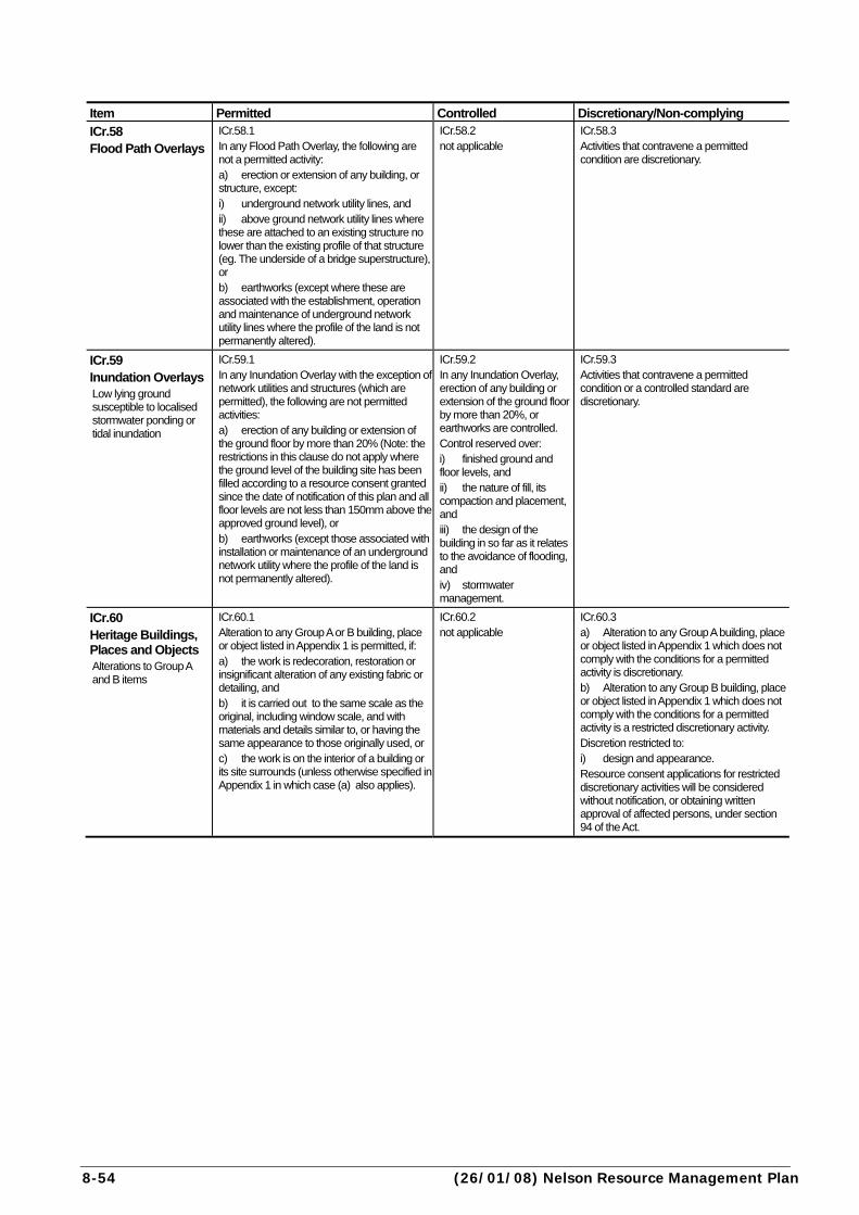
8-54 (26/01/08) Nelson Resource Management Plan
Item Permitted Controlled Discretionary/Non-complying
ICr.58 Flood Path Overlays
ICr.58.1 In any Flood Path Overlay, the following are not a permitted activity: a) erection or extension of any building, or structure, except: i) underground network utility lines, and ii) above ground network utility lines where these are attached to an existing structure no lower than the existing profile of that structure (eg. The underside of a bridge superstructure), or b) earthworks (except where these are associated with the establishment, operation and maintenance of underground network utility lines where the profile of the land is not permanently altered).
ICr.58.2 not applicable
ICr.58.3 Activities that contravene a permitted condition are discretionary.
ICr.59 Inundation Overlays Low lying ground susceptible to localised stormwater ponding or tidal inundation
ICr.59.1 In any Inundation Overlay with the exception of network utilities and structures (which are permitted), the following are not permitted activities: a) erection of any building or extension of the ground floor by more than 20% (Note: the restrictions in this clause do not apply where the ground level of the building site has been filled according to a resource consent granted since the date of notification of this plan and all floor levels are not less than 150mm above the approved ground level), or b) earthworks (except those associated with installation or maintenance of an underground network utility where the profile of the land is not permanently altered).
ICr.59.2 In any Inundation Overlay, erection of any building or extension of the ground floor by more than 20%, or earthworks are controlled. Control reserved over: i) finished ground and floor levels, and ii) the nature of fill, its compaction and placement, and iii) the design of the building in so far as it relates to the avoidance of flooding, and iv) stormwater management.
ICr.59.3 Activities that contravene a permitted condition or a controlled standard are discretionary.
ICr.60 Heritage Buildings, Places and Objects Alterations to Group A and B items
ICr.60.1 Alteration to any Group A or B building, place or object listed in Appendix 1 is permitted, if: a) the work is redecoration, restoration or insignificant alteration of any existing fabric or detailing, and b) it is carried out to the same scale as the original, including window scale, and with materials and details similar to, or having the same appearance to those originally used, or c) the work is on the interior of a building or its site surrounds (unless otherwise specified in Appendix 1 in which case (a) also applies).
ICr.60.2 not applicable
ICr.60.3 a) Alteration to any Group A building, place or object listed in Appendix 1 which does not comply with the conditions for a permitted activity is discretionary. b) Alteration to any Group B building, place or object listed in Appendix 1 which does not comply with the conditions for a permitted activity is a restricted discretionary activity. Discretion restricted to: i) design and appearance. Resource consent applications for restricted discretionary activities will be considered without notification, or obtaining written approval of affected persons, under section 94 of the Act.
Nelson Resource Management Plan (01/09/04) 8-55
Assessment Criteria Explanation ICr.58.4 a) any effects of the development on floodpaths. b) any likelihood of flooding being aggravated on adjacent sites, or of additional water being directed onto adjacent sites. c) the ground level or floor level height required to give protection from a 1 in 50 year return period event. d) the nature of any activity proposed, particularly if lower standards are sought and whether the activity will involve the use and storage of hazardous substances or some other sensitive use.
ICr.58.5 All buildings and any above ground structures and any earthworks (other than temporary earthworks for laying underground utilities) in flood paths have been made discretionary activities so the degree of risk to life and property can be evaluated in each case.
ICr.59.4 a) the ground level required to avoid the effects of anticipated flooding. b) the type of inundation likely to be experienced, whether it be stormwater ponding, tidal inundation, or some other combination of circumstances which could lead to surface flooding. c) the effects on neighbouring properties, especially with respect to stormwater runoff. d) the provision of an adequate secondary flow path for surface flooding. e) the possibility of an overloaded public storm water system overflowing onto private property.
ICr.59.5 The Inundation Overlays do not show floodpaths but areas which may be subject to localised ponding from stormwater etc during heavy rain events and/or high tides particularly if affected by sea level rise. The primary risk is to property, hence lesser controls apply than to flood paths. The activity is controlled so that floor levels and fill heights can be determined relative to the degree of risk and to co-ordinate filling to provide necessary fall for stormwater disposal and to avoid ponding. Extensions which increase the ground floor area by not more than 20% are provided for as a permitted activity to avoid the need to obtain a resource consent for a minor alteration.
ICr.60.4 a) the historic, cultural or architectural significance of the item, having regard to the site on which the item is located. b) the extent to which the item has particular value because of the scarcity of heritage buildings, places or objects in the area, or because it forms part of a precinct of heritage buildings. c) the effect of the alterations or additions proposed on the integrity of the original heritage building or object, taking account of how visible the change will be. For the City Centre area, the degree of compliance with the Nelson City Centre Design Guide. d) the degree to which the addition or alteration is compatible with the heritage building, place or object, and whether the alteration or addition is clearly distinguishable from the original as new work. e) the ability of the applicant to develop or use the site without the alteration, and the economic effects of this. f) whether the heritage value of the building, place or object has altered since the item was listed in the Plan. g) any immediate or cumulative effects of the alteration on the quality of heritage features in the vicinity and the city as a whole. h) the effect of the alterations or additions on any feature of heritage significance listed in Appendix 1.
ICr.60.5 The rules provide three levels of protection depending on the categorisation of the heritage building, place or object. Minor maintenance is allowed for Group A and B items. More major work requires a resource consent to ensure the work is compatible with the heritage feature being protected. Features of particular heritage significance for Group A buildings are listed in Appendix 1. Protection is not confined to these features, but it is anticipated that where additions or alterations will not affect these features, a consent application will be considered favourably. For Group B items discretion is restricted to the design and appearance of the alteration. See separate rules for Heritage Precincts. Note: Buildings must comply with the general rules on bulk and location. See also Ap20r.4 in relation to signs on heritage buildings and trees.
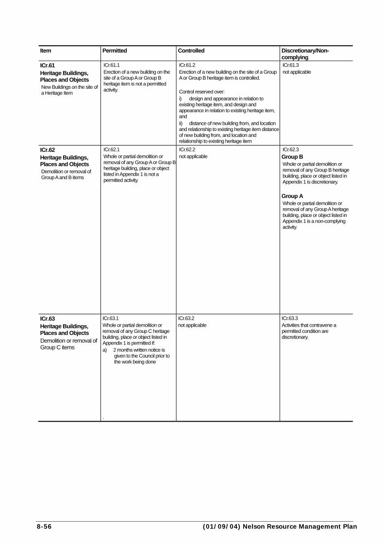
8-56 (01/09/04) Nelson Resource Management Plan
Item Permitted Controlled Discretionary/Non-
complying
ICr.61 Heritage Buildings, Places and Objects New Buildings on the site of a Heritage Item
ICr.61.1 Erection of a new building on the site of a Group A or Group B heritage item is not a permitted activity.
ICr.61.2 Erection of a new building on the site of a Group A or Group B heritage item is controlled. Control reserved over: i) design and appearance in relation to existing heritage item, and design and appearance in relation to existing heritage item, and ii) distance of new building from, and location and relationship to existing heritage item distance of new building from, and location and relationship to existing heritage item
ICr.61.3 not applicable
ICr.62 Heritage Buildings, Places and Objects Demolition or removal of Group A and B items
ICr.62.1 Whole or partial demolition or removal of any Group A or Group B heritage building, place or object listed in Appendix 1 is not a permitted activity.
ICr.62.2 not applicable
ICr.62.3
Group B Whole or partial demolition or removal of any Group B heritage building, place or object listed in Appendix 1 is discretionary.
Group A Whole or partial demolition or removal of any Group A heritage building, place or object listed in Appendix 1 is a non-complying activity.
ICr.63 Heritage Buildings, Places and Objects Demolition or removal of Group C items
ICr.63.1 Whole or partial demolition or removal of any Group C heritage building, place or object listed in Appendix 1 is permitted if: a) 2 months written notice is
given to the Council prior to the work being done
.
ICr.63.2 not applicable
ICr.63.3 Activities that contravene a permitted condition are discretionary.
Nelson Resource Management Plan (01/09/04) 8-57
Assessment Criteria Explanation ICr.61.4 a) the effect of the proposed new building on the integrity of the original heritage building or object, taking account of how visible the change will be. b) the degree to which the new building is compatible with the heritage building or object, including size, scale and materials used. c) the location of the new building in relation to the heritage building or object and whether it dominates or detracts from the heritage building or object.
ICr.61.5 This rule ensures that new buildings on the site of an existing heritage building, place or object are compatible with the existing heritage item. Distance from the heritage item is an important consideration, particularly where the proposed new building is in very close proximity to the heritage item. See separate rules for Heritage Precincts.
ICr.62.4 a) the historic, cultural or architectural significance of the item, having regard to the site on which the item is located. b) the extent to which the building has particular value because of the scarcity of heritage buildings in the area, or because it forms part of a precinct of heritage buildings. c) for removal, the degree of heritage loss due to the association of the building or object with the present site and the physical extent of relocation. d) the location a building or object is to be moved to, having regard to whether this yields a net environmental gain (eg. the new site is more accessible or visible), and whether the item is to be protected or covenanted on its new site. e) whether part of the building, place or object can be kept, while still maintaining to a reasonable degree, the features for which the item was listed. f) the ability of the applicant to economically develop or use the site without demolition, alteration or removal. g) the nature of any activity that is proposed to occur on the site, including the design and appearance of any replacement building or object (for the City Centre area, the degree of compliance with the Nelson City Centre Design Guide). h) whether the heritage value of the building, place or object has altered since the item was listed in the Plan. i) any immediate or cumulative effects of the loss or removal of the listed building, place or object on the range, number, and quality of heritage features in the vicinity and the city as a whole.
ICr.62.5 Group A buildings, places and objects are the premier heritage items in the District. Their removal or demolition therefore is a non-complying activity under the Plan. A lower threshold can be applied to Group B items, while recognising that their retention is still important. Buildings and objects may have different strengths of association with their site and location. Relocation on the same site or to an adjoining site may have limited adverse effects, while relocation to a site further away will have a greater adverse effect.
ICr.63.4 a) whether reducing the notification time would disadvantage any party, or would preclude effort to negotiate retention of the item.
ICr.63.5 The requirement for 2 months notice for Group C items allows time for photographic or other records to be made of the heritage building or item prior to it being demolished. (The Council will maintain such records and archival material). It also provides the opportunity for interested parties to negotiate voluntary protection of the heritage item. This might include purchase or some other arrangement to the satisfaction of the property owner.

8-58 (01/09/04) Nelson Resource Management Plan
Item Permitted Controlled Discretionary/Non-complying
ICr.64 Heritage Precincts Group A or B Heritage Buildings, Places and Objects
ICr.64.1 a) Alteration to any Group A or B building, place or object listed in Appendix 1 - see Rule ICr.60 (alterations to Group A and B items). b) Demolition or removal of Group A and B items - see Rule ICr.62 (demolition or removal of Group A and B items).
ICr.64.2 not applicable
ICr.64.3 See Rule ICr.60 (alterations to Group A and B items) and Rule ICr.62 (demolition or removal of Group A and B items).
ICr.65 Heritage Precincts Buildings other than Group A or B Heritage Buildings
ICr.65.1 a) Alteration to the external appearance of any building (other than a Group A or B Heritage Building) within a heritage precinct as defined on the Planning Maps is permitted, if: i) the work is redecoration, restoration or insignificant alteration of any existing fabric or detailing, and ii) it is carried out to the same scale as the original, including window scale, and with materials and details similar to, or having the same appearance to those originally used, or iii) the work is on a building within the City Centre, and is below the verandah, or where there is no verandah it is not above 3m from ground level. Erection of new buildings is not a permitted activity.
ICr.65.2 not applicable
ICr.65.3 a) The design and external appearance of any new building, or b) any alteration to the external appearance of any existing building which does not comply with the permitted conditions, is a restricted discretionary activity. Discretion restricted to: i) design and external appearance. Resource consent applications will be considered without notification, or obtaining written approval of affected persons, under section 94 of the Act.
Nelson Resource Management Plan (01/09/04) 8-59
Assessment Criteria Explanation ICr.64.4 The Assessment Criteria in Rules ICr.60 and ICr.62 (Heritage Buildings, Places and Objects) will apply. In addition, particular regard will be had to: a) for the City Centre precincts, the degree of compliance with the Nelson City Centre Design Guide. b) the degree of compliance with the South Street Design Guide. c) any effects (positive and negative) on the heritage values of the entire heritage precinct. d) any cumulative or precedent effects on the heritage values of the precinct.
ICr.64.5 The Heritage Precincts recognise the whole is often greater than the sum of the parts. That is, that a collection of heritage buildings in context, has a greater impact to the observer and the resident, and has greater heritage value, than the same number of buildings scattered throughout the City. The loss or the unsympathetic alteration to even a single building can have major impacts on the entire precinct - rather like a missing tooth from a smile. The controls therefore focus on retaining Group A and B listed heritage buildings, and ensuring that any significant alterations are in keeping with the heritage values of the precinct. NOTE: THE CITY CENTRE DESIGN GUIDE, AND THE SOUTH ST DESIGN GUIDE APPLY – Copies are available from the City Council.See also Ap20r.4 (signs on heritage items or listed trees) in relation to signs on heritage buildings and trees.
ICr.65.4 a) for the City Centre precincts, the degree of compliance with the Nelson City Centre Design Guide. b) the degree of compliance with the South Street Design Guide. c) any effects (positive and adverse) on the heritage values of the entire heritage precinct. d) any cumulative effects on the heritage values of the precinct or any effects which may establish a precedence within the precinct.
ICr.65.5 The rules aim to get a gradual enhancement in the heritage precincts by ensuring that if any building is replaced - be it a listed heritage or any other building in the precincts - the design and appearance is compatible with the values of the precinct. This does not mean that new buildings have to be replicas of heritage buildings, but rather that they have design features which fit with the character of the precinct. Similarly, there are design controls on significant alterations to existing non-listed buildings within the heritage precinct. The purpose of this is to promote a gradual improvement in the compatibility of these buildings with the heritage buildings, where this is practicable. As with rule ICr.28 (external design and appearance), work below verandah level is permitted on buildings in the City Centre heritage precincts (i.e. the main commercial streets). This enables businesses to adapt building frontages to their changing needs without having to get a resource consent. Such changes have little effect on the overall streetscape. The City Centre Design Guide seeks to control the height, scale, and modulation of buildings overall, and the appearance at and above verandah level. See also Rule ICr.63 (Heritage Buildings, Places and Objects demolition or removal of Group C items). NOTE: THE CITY CENTRE DESIGN GUIDE, AND THE SOUTH ST DESIGN GUIDE APPLY – Copies are available from the City Council
8-60 (01/09/04) Nelson Resource Management Plan
Item Permitted Controlled Discretionary/Non-complying
ICr.66 Heritage Trees Trimming of a Heritage Tree identified in Appendix 2
ICr.66.1 Trimming of a heritage tree is permitted if:a) either i) it is crown cleaning, being the removal of dead, dying, diseased, crowded, weakly attached, low-vigour branches and watersprouts from a tree crown, or ii) it is canopy lifting, being the balanced removal of lower branches of a tree on road reserve, and b) the work is done in accordance with accepted arboricultural practice.
ICr.66.2 not applicable
ICr.66.3 Activities that contravene a permitted condition are discretionary.
ICr.67 Landscape Trees Trimming of a Landscape Tree identified in Appendix 2
ICr.67.1 Trimming of a Landscape tree is permitted if: a) it is crown thinning (as defined in Chapter 2), and b) the work is done in accordance with accepted arboricultural practice.
ICr.67.2 Activities that contravene a permitted condition are controlled. Control is reserved over: i) amount, timing and manner in which the trimming is carried out. Resource consent applications will be considered without notification, or obtaining written approval of affected persons, under section 94 of the Act.
ICr.67.3 not applicable

Nelson Resource Management Plan (30/04/12) 8-61
Assessment Criteria Explanation ICr.66.4 - ICr.70.4 a) the condition of the tree, including any significant potential hazard to people or property. b) the extent to which the tree or trees contribute to the amenity of the neighbourhood. c) whether the work can be done without adversely affecting the health of the tree, or compromising the appearance and setting of the tree, including the visibility of the tree from a road or public place. d) whether the tree is currently causing, or is likely to cause significant damage to buildings, services or property. e) the extent to which the tree would seriously restrict the development potential of the site. f) any hardship or significant nuisance the tree causes to any person. g) any substitute or compensating tree planting or landscaping proposed. h) when the activity is within the root protection zone of a Heritage or Landscape Tree, how the tree trunk and roots are to be protected while works proceed (eg erection of a physical barrier). i) In the case of a tree in the road reserve, in addition to the above: ii) whether the tree places an unreasonable restriction on the development or widening of a road, or is a hazard to traffic. iii) whether alternatives to removing or damaging the tree have been adequately explored. j) in the case of a tree in an esplanade reserve or strip, for which the purpose of the reserve or strip includes hazard mitigation, in addition to the above: i) whether the tree places an unreasonable restriction on the development of river control works, or impedes the flow of the river ii) whether alternatives to removing or damaging the tree have been adequately explored.
ICr.66.5 Very limited trimming of Heritage Trees is allowed without a resource consent. Tighter controls are placed on Heritage Trees recognising that they are of greater significance to the community than the Landscape Trees. Trimming that is for the benefit of the landowner or neighbours (due to shading, debris or other effects) is required to go through the resource consent process.
ICr.67.5 Normal trimming is permitted for Landscape Trees. The controls on Landscape Trees recognises that these are of less significance to the community than the Heritage Trees, but still important. Increased light and air maintain and stimulate interior foliage, which in turn improves branch taper and strength. Thinning reduces the wind-sail effect of the crown and the weight of limbs. Thinning the crown can emphasise the structural beauty of trunk and branches as well as improve the growth of plants beneath the tree by increasing light penetration. Trees and branches thinned as per the definition will have stress evenly distributed throughout the tree and along the branches.

8-62 (30/04/12) Nelson Resource Management Plan
Item Permitted Controlled Discretionary/Non-complying
ICr.68 Heritage and Landscape Trees Activities within the root protection zone of a Heritage or Landscape Tree identified in Appendix 2
ICr.68.1 Activities within the root protection zone (defined in Chapter 2 Meanings of Words) of a Landscape Tree or a Heritage Tree identified in Appendix 2 are permitted if: a) parking or storage of materials, vehicles, or machinery is on an existing sealed, formed surface, and b) it does not involve compaction, sealing, removal or addition of soil, and c) there is no discharge of a toxic substance, and d) there is no excavation or construction of structures. except where the tree is on Road Reserve, where activities are permitted if:e) excavation is no deeper than 200mm and no less than 2m from the tree trunk, and f) sealing is within the existing formed carriageway or footpath.
ICr.68.2 Activities within the root protection zone of Landscape or Heritage Trees on Road Reserve that contravene a permitted condition are controlled. Control is reserved over: i) location, proximity to tree trunk, timing and manner in which the activity is carried out, and ii) remedial measures. Resource consent applications will be considered without notification, or obtaining written approval of affected persons, under section 94 of the Act.
ICr.68.3 Activities within the root protection zone of Landscape or Heritage Trees (not on Road Reserve) that contravene a permitted condition are discretionary.
ICr.69 Heritage and Landscape Trees Removing or destroying a Heritage or Landscape Tree identified in Appendix 2
ICr.69.1 Removing or destroying a Heritage or Landscape Tree is not a permitted activity.
ICr.69.2 not applicable
ICr.69.3
Landscape Trees Removing or destroying a Landscape Tree is a discretionary activity.
Heritage Trees Removing or destroying a Heritage Tree is a non-complying activity.
ICr.70 Local Trees Removing a Local Tree identified in Appendix 2
ICr.70.1 Removing a Local Tree is permitted if written notice is given to Council at least 1 week prior to work being done.
ICr.70.2 not applicable
ICr.70.3 Activities that contravene a permitted condition are discretionary.

Nelson Resource Management Plan (01/09/04) 8-63
Assessment Criteria Explanation See assessment criteria ICr.66 ICr.68.5
Activities in the area of the roots or trunk can damage or kill the tree. Resource consents are required for these activities so that the potential impacts can be assessed. Where the area beneath the tree is already sealed the impact is likely to be less significant. See also Ap20r.4 in relation to signs on heritage buildings and trees.
ICr.69.5 Heritage Trees are trees for which retention is considered essential. Landscape Trees are trees for which retention is considered important. Tighter controls are placed on Heritage Trees recognising that they are of greater significance to the community than the Landscape Trees. (Note: section 330 of the Act provides for emergency works, such as the removal of trees threatening life or property, but in strictly defined circumstance and by certain persons or agencies. Consent for such works can be applied for retrospectively (section 330A)). Some latitude is provided for the removal of trees in the road reserve if it can be shown it places an unreasonable restriction on the roading network, recognising that the primary purpose of the road reserve is transportation.
ICr.70.5 Local Trees are of noteworthy interest, and are not as significant as either Heritage or Landscape Trees. Retention and protection is encouraged. A week’s notice prior to removal of a Local Tree allows the Council the opportunity to negotiate with the owner if it desires. Written notice also allows the Council to update its list of Local Trees.
8-64 (01/09/04) Nelson Resource Management Plan
Item Permitted Controlled Discretionary/Non-complying
ICr.71 Archaeological Sites
ICr.71.1 On any site containing an Archaeological Site listed in Appendix 3 (archaeological sites) and identified on the Planning Maps, erection or extension of any building or other structure, any soil disturbance, or any earthworks is permitted if: a) written advice that the proposed activity will not adversely affect the values of the archaeological site is obtained from: i) in the case of a Maori archaeological site, the relevant iwi, or ii) in the case of other sites, a suitably qualified and experienced archaeologist .
ICr.71.2 not applicable
ICr.71.3 Activities that contravene a permitted condition are discretionary. (In situations where the extent of the archaeological site is unclear, the application may be required to be accompanied by an archaeological survey of the area surrounding the site, carried out by a person suitably qualified and experienced in archaeological survey).

Nelson Resource Management Plan (26/01/08) 8-65
Assessment Criteria Explanation ICr.71.4 a) the nature, form and extent of the proposed activity and its effects on the site. b) the impacts on the integrity or heritage value of the site. c) the findings of an archaeological survey of the area surrounding the site commissioned by the applicant, and carried out by a person suitably competent in archaeological survey. d) where the application relates to a Maori archaeological site, the response of the tangata whenua. e) if the site is to be modified, whether there is sufficient time and expertise to record the site. f) the ability to avoid, remedy or mitigate any adverse effects of the activity on the site.
ICr.71.5 Archaeological sites are sites of human activity before 1900. In this Plan the majority are Maori sites, with most non-Maori sites being on the Heritage Buildings, Places and Objects list (Appendix 1). The archaeological sites identified on the Planning Maps are from the registers of the Historic Places Trust and the NZ Archaeological Association. A resource consent is required where written advice is not available that the site will be unaffected. This allows examination of the extent of the site, and how the proposed activity could affect the values associated with the site. Applicants are reminded that authority is needed from the Historic Places Trust before any archaeological site is destroyed, damaged or modified. This applies to archaeological sites uncovered accidentally. Under section 10 of the Historic Places Act 1993 it is an offence to damage an archaeological site without authority. In the case of accidental discovery, the relevant iwi should be contacted immediately so that they can decide what action should be taken. In addition, the Historic Places Trust should be notified.
8-66 (30/04/12) Nelson Resource Management Plan
rule table Item Permitted Controlled Discretionary/Non-
complying
ICr.72 Maximum building height Intense Development Area
ICr.72.1 a) 20m - Intense Development Area (as shown on Planning Maps) , or b) 12m - rest of City Fringe. (see Chapter 2 Meanings of Words for definitions of ‘Height’ [including chimneys] and ‘Height measurement’).
ICr.72.2 not applicable
ICr.72.3 Activities that contravene a permitted condition are discretionary.
ICr.73 External appearance Large buildings
ICr.73.1 The erection or substantial alteration of a building is a permitted activity if: a) the gross ground floor area of the building does not exceed 2500m2.
ICr.73.2 The erection or substantial alteration of a building where the proposed gross floor area of the building is in excess of 2,500m2, is controlled. Control reserved over: i) the visual appearance of the site and buildings (including advertising and landscaping), and ii) the layout of the site. Resource consent applications will be considered without notification, or obtaining written approval of affected persons, under section 94 of the Act.
ICr.73.3 not applicable
ICr.73A Design and External Appearance Area bounded by Collingwood St, Riverside, Malthouse Lane, Harley St and Hardy St
ICr.73A.1 The erection or substantial exterior alteration of a building in the area bounded by Collingwood St, Riverside, Malthouse Lane, Harley St and Hardy St is not a permitted activity.
ICr.73A.2 The erection or substantial exterior alteration of a building in the area bounded by Collingwood St, Riverside, Malthouse Lane, Harley St and Hardy St is a controlled activity if: a) the building is, or when altered will be, setback
no more than 3m from the road boundary, and b) no car parking or loading is located between
the road boundary and building frontage (or a line extended from the building frontage to the side boundaries of the site).
Control reserved over: i) the design and external appearance of the building, and ii) the width and location of access to and from the site, and the direction of traffic flow (including the control of reverse manoeuvring onto roads), and iii) landscaping and maintenance of the site.
ICr.73A.3 Activities that contravene a controlled standard are discretionary.
ICr.74 Landscaping
ICr.74.1 Except where the building is built to the road boundary, a minimum of 5% of any site must be set aside as a landscaped area or areas, and a) The landscaped area must be located along the road frontage (except for any rear site), and b) The landscaped area must be maintained in good condition.
ICr.74.2 not applicable
ICr.74.3 Activities that contravene a permitted condition (excluding condition b) are discretionary.

Nelson Resource Management Plan (30/04/12) 8-67
city fringe area only Assessment Criteria Explanation ICr.72.4 a) the height of the building in relation to the scale and height of buildings in the area and the Inner City Zone as a whole. b) the scale and bulk of the structure. c) the effects on significant views within or across the Inner City Zone (see Appendix 9 – landscape components and views). d) any effects of shading on open spaces, pedestrian areas, and residential zones. e) the extent to which the building is likely to have an overbearing effect on properties in adjoining residential zones.
ICr.72.5 Building height over the majority of the area provides for 4 storey buildings. This meets most needs, and is slightly less than the maximum height in the City Centre, reinforcing the importance of the Centre as the focal point for the city. Buildings over the height limits in ICr.72.1 a) and b), or buildings averaging over those height limits on sloping ground, are discretionary. An exception is provided for in the block housing the Polytechnic, where taller buildings are allowed. The preference is to allow the Polytech to build up, rather than to intrude further into residential areas. Refer also to rules for daylight angles.
ICr.73.4 a) the extent to which expansive walls can be softened through the use of architectural features including form or surface treatment and landscaping. b) the degree to which building appearance and site layout including advertising is harmonious with other development in the surrounding area. c) the extent to which the site layout will minimise potential effects on the neighbouring area including noise, appearance and glare. d) the efficient use of the site.
ICr.73.5 Large buildings can detract from amenity values. The rule allows control over the visual aspects of the site where the ‘footprint’ of the building exceeds 2500m2.
ICr.73A.4 a) the extent to which the building relates positively to the street. b) the maintenance of an existing pattern of setback from the street, or the need to establish a new pattern which is more consistent with good urban design principles. c) the ability through planting or other landscaping to enhance the appearance of the site as seen from the street, having regard to the effectiveness of this in the longer term with respect to enforcement, maintenance, durability, and potential vandalism. d) the safety of vehicles entering or leaving the site, and potential impacts on pedestrian and other road users. e) the width of the vehicle access and potential impacts on the continuity of building facades and on the streetscape. f) whether the configuration of the site, existing buildings, or other significant factors limit the ability to develop the site in a way that makes the greatest contribution to the streetscape. g) the extent to which the building design and site layout promotes public safety by avoiding entrapment spots or areas with the potential to be used for anti-social behaviour (i.e. Crime Prevention Through Environmental Design).
ICr.73A.5 The area bounded by Collingwood St, Riverside, Malthouse Lane, Harley St and Hardy St is signalled in the Heart of Nelson Strategy to become part of the City Centre. As an interim measure ahead of a more comprehensive review of the zoning to apply to the area, and the design rules and controls that are to apply to the City Centre, some design control has been reserved over the external appearance of new or significantly altered buildings, and layout of the site. In the past rules required significant levels of parking to be provided in this area (see ICr.76.5). This, coupled with a lack of control over building location and design, was resulting in buildings that often did not contribute positively to the streetscape, and that would affect this area long term. Sometimes buildings were setback a long way from the street with parking dominating the frontage, and in other cases the required parking was accommodated under the building. This can provide a poor, and sometimes unsafe, frontage to the street. Resource consent applications, where considered necessary, will be referred to the Council’s Urban Design Panel for consideration and advice.
ICr.74.4 a) the visibility of the site and any building from any adjoining site, particularly in a Residential Zone. b) the visibility of the site and any building from any road, having regard to the nature and volume of traffic carried. c) the contribution of the landscaping to noise reduction, maintenance of privacy, or other aspects of amenity on any site. d) the nature and appearance of the activity and any building, and desirability of providing screening or softening. e) where landscaping is to be reduced, the effect on the amenity of adjoining sites, or the visibility from the road.
ICr.74.5 Sites in the City Fringe can be rather utilitarian in appearance. The landscaping requirement is to screen the public view of such sites. It is not intended that non-compliance with condition b) will result in requiring a resource consent, because a judgement is involved in condition b). Condition b) is to be used for enforcement purposes, ie. when the condition is not complied with, enforcement of the condition may be actioned.

8-68 (30/04/12) Nelson Resource Management Plan
Item Permitted Controlled Discretionary/Non-complying
ICr.75 Setback From Residential Zone boundary
ICr.75.1 a) Buildings must be set back at least 3 metres from a Residential Zone boundary, and b) Provision must be made for landscaping, fences, walls, or for a combination, to at least 1.8m in height along the length of the zone boundary, and c) Where landscaping is provided it must have an average depth of 1.5m along the boundary.
ICr.75.2 not applicable
ICr.75.3 Activities that contravene a permitted condition are discretionary.
ICr.76 Parking and loading
ICr.76.1 Parking, loading, manoeuvring, and queuing areas must be provided and maintained on each site in accordance with the standards set out in Appendix 10 (standards and terms for parking and loading), except: a) for sites in the area bounded by Collingwood St, Riverside, Malthouse Lane, Harley St and Hardy St where rules ICr.31 and ICr.31A apply as if the area were City Centre, and b) no reverse manoeuvring is permitted onto the ring road from any site.
ICr.76.2 Parking for Short Term Living Accommodation units (excluding any loading zones for coaches and parking for managers units) and which complies in all other respects with the relevant standards in Appendix 10, is a controlled activity if: a) a minimum of 0.8 spaces per unit is provided, except where the unit can accommodate more than 6 guests, in which case a minimum of 1.5 spaces must be provided per unit. Control reserved over: i) number of vehicle parks, and ii) type and size of vehicle parks, and iii) location of vehicle parking, and iv) manoeuvring to and from vehicle parking.
ICr.76.3 Activities that contravene a permitted condition or a controlled standard are discretionary, except that an application to reduce the parking requirements in Appendix 10 is a restricted discretionary activity if: (a) for short term living accommodation a minimum of 0.6 spaces per unit is provided, except where the unit can accommodate more than 6 guests, in which case a minimum of 1 space must be provided per unit, or (b) for other activities :
i. the proposed reduction in parking spaces is not more than 20% of the number required in Appendix 10, and
ii. where the reduction in parking spaces exceeds five spaces, the application is accompanied by a Travel Management Plan that addresses the matters in Assessment Criterion ICr.76.4 c).
Discretion restricted to: i) number of parking spaces (and any loading spaces) provided, and ii) the surfacing of the area, and iii) the location, dimensions and layout of parking, loading, manoeuvring and queuing areas, and iv) conditions relating to any parking off-site or any other methods or arrangements that are to be put in place to facilitate the reduction in parking. Resource consent applications for restricted discretionary activities under this rule will be considered without notification and without service of notice.
ICr.77 Access
ICr.77.1 Vehicle access must be provided and maintained on each site in accordance with the standards set out in Appendix 11 (access standards).
ICr.77.2 not applicable
ICr.77.3 Activities that contravene a permitted condition are discretionary.

Nelson Resource Management Plan (30/04/12) 8-69
Assessment Criteria Explanation ICr.75.4 a) the effects on the amenity of the neighbouring property(ies). b) any provision for compensating landscaping or screening. c) the scale and height of the buildings within the reduced setback. d) the ability to better use the site and provide better environmental quality
elsewhere on the site. e) any aspects of the proposal which may compensate for reduced
landscaping or screening, such as the nature of planting or materials used, the location of parking, manoeuvring or storage areas, and offices.
ICr.75.5 This provision ensures a degree of outlook is maintained from residential properties, and provides opportunity to “soften” that outlook by planting or other site treatments. Landscaping along the boundary can be to an average depth, to provide for variability in depth, thus increasing the visual interest.
ICr.76.4 a) refer to Appendix 10. b) for sites in the area bounded by Collingwood St, Riverside, Malthouse
Lane, Harley St and Hardy St the assessment criteria for rules ICr.31and ICr.31A apply.
c) where a Travel Management Plan is required under ICr.76.3, it shall include the following, taking into account the reduction in parking spaces being sought: i. The nature and scale of the activity and associated parking demands from employees and visitors/customers; ii. Proposed means of reducing parking demands, such as;
• Managing the number of motor vehicle trips to and from the activity by encouraging higher vehicle occupancies
• Sharing parking spaces between complementary uses and spreading peak loads
• Encouraging more use of public transport, walking and cycling iii. Proposed means of monitoring outcomes.
ICr.76.5 Refer to Appendix 10.
ICr.77.4 Refer to Appendix 11.
ICr.77.5 Refer to Appendix 11.
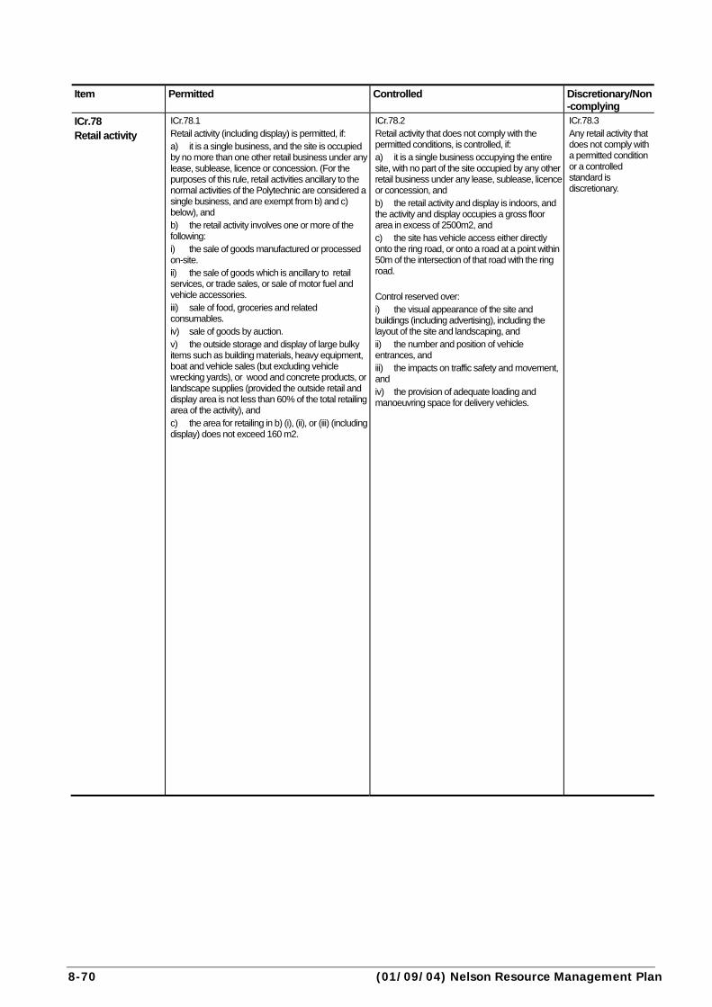
8-70 (01/09/04) Nelson Resource Management Plan
Item Permitted Controlled Discretionary/Non
-complying
ICr.78 Retail activity
ICr.78.1 Retail activity (including display) is permitted, if: a) it is a single business, and the site is occupied by no more than one other retail business under any lease, sublease, licence or concession. (For the purposes of this rule, retail activities ancillary to the normal activities of the Polytechnic are considered a single business, and are exempt from b) and c) below), and b) the retail activity involves one or more of the following: i) the sale of goods manufactured or processed on-site. ii) the sale of goods which is ancillary to retail services, or trade sales, or sale of motor fuel and vehicle accessories. iii) sale of food, groceries and related consumables. iv) sale of goods by auction. v) the outside storage and display of large bulky items such as building materials, heavy equipment, boat and vehicle sales (but excluding vehicle wrecking yards), or wood and concrete products, or landscape supplies (provided the outside retail and display area is not less than 60% of the total retailing area of the activity), and c) the area for retailing in b) (i), (ii), or (iii) (including display) does not exceed 160 m2.
ICr.78.2 Retail activity that does not comply with the permitted conditions, is controlled, if: a) it is a single business occupying the entire site, with no part of the site occupied by any other retail business under any lease, sublease, licence or concession, and b) the retail activity and display is indoors, and the activity and display occupies a gross floor area in excess of 2500m2, and c) the site has vehicle access either directly onto the ring road, or onto a road at a point within 50m of the intersection of that road with the ring road. Control reserved over: i) the visual appearance of the site and buildings (including advertising), including the layout of the site and landscaping, and ii) the number and position of vehicle entrances, and iii) the impacts on traffic safety and movement, and iv) the provision of adequate loading and manoeuvring space for delivery vehicles.
ICr.78.3 Any retail activity that does not comply with a permitted condition or a controlled standard is discretionary.
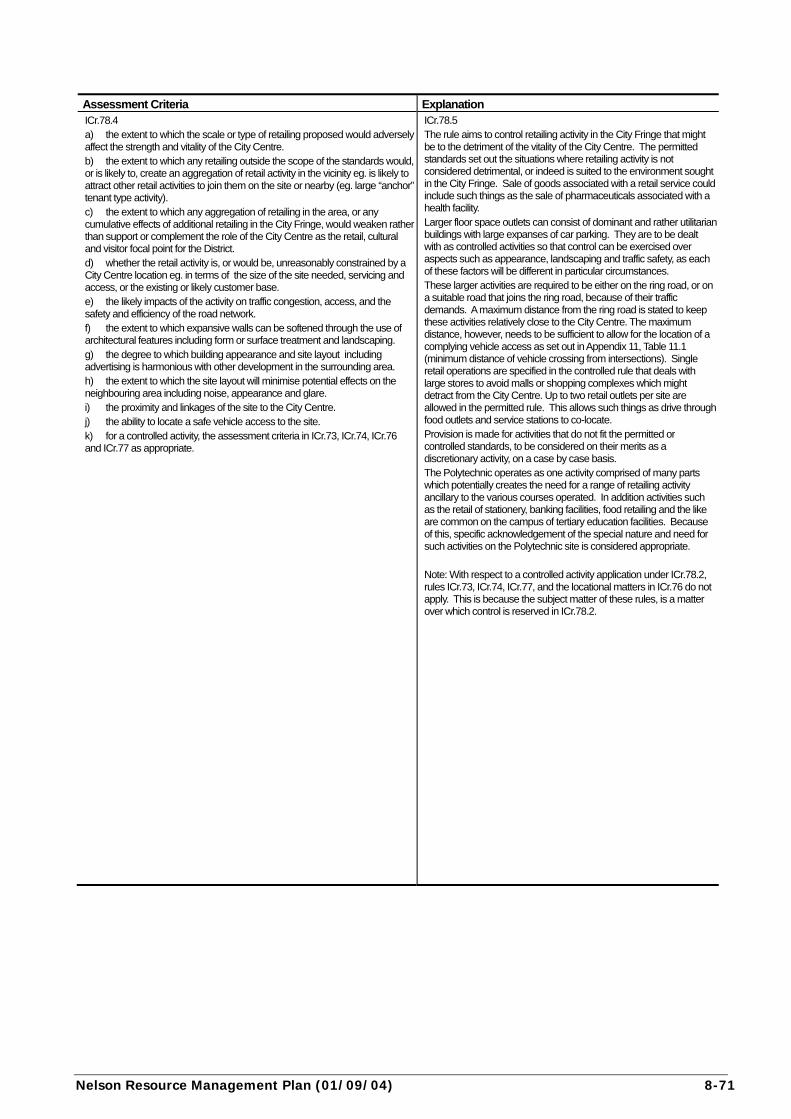
Nelson Resource Management Plan (01/09/04) 8-71
Assessment Criteria Explanation ICr.78.4 a) the extent to which the scale or type of retailing proposed would adversely affect the strength and vitality of the City Centre. b) the extent to which any retailing outside the scope of the standards would, or is likely to, create an aggregation of retail activity in the vicinity eg. is likely to attract other retail activities to join them on the site or nearby (eg. large “anchor” tenant type activity). c) the extent to which any aggregation of retailing in the area, or any cumulative effects of additional retailing in the City Fringe, would weaken rather than support or complement the role of the City Centre as the retail, cultural and visitor focal point for the District. d) whether the retail activity is, or would be, unreasonably constrained by a City Centre location eg. in terms of the size of the site needed, servicing and access, or the existing or likely customer base. e) the likely impacts of the activity on traffic congestion, access, and the safety and efficiency of the road network. f) the extent to which expansive walls can be softened through the use of architectural features including form or surface treatment and landscaping. g) the degree to which building appearance and site layout including advertising is harmonious with other development in the surrounding area. h) the extent to which the site layout will minimise potential effects on the neighbouring area including noise, appearance and glare. i) the proximity and linkages of the site to the City Centre. j) the ability to locate a safe vehicle access to the site. k) for a controlled activity, the assessment criteria in ICr.73, ICr.74, ICr.76 and ICr.77 as appropriate.
ICr.78.5 The rule aims to control retailing activity in the City Fringe that might be to the detriment of the vitality of the City Centre. The permitted standards set out the situations where retailing activity is not considered detrimental, or indeed is suited to the environment sought in the City Fringe. Sale of goods associated with a retail service could include such things as the sale of pharmaceuticals associated with a health facility. Larger floor space outlets can consist of dominant and rather utilitarian buildings with large expanses of car parking. They are to be dealt with as controlled activities so that control can be exercised over aspects such as appearance, landscaping and traffic safety, as each of these factors will be different in particular circumstances. These larger activities are required to be either on the ring road, or on a suitable road that joins the ring road, because of their traffic demands. A maximum distance from the ring road is stated to keep these activities relatively close to the City Centre. The maximum distance, however, needs to be sufficient to allow for the location of a complying vehicle access as set out in Appendix 11, Table 11.1 (minimum distance of vehicle crossing from intersections). Single retail operations are specified in the controlled rule that deals with large stores to avoid malls or shopping complexes which might detract from the City Centre. Up to two retail outlets per site are allowed in the permitted rule. This allows such things as drive through food outlets and service stations to co-locate. Provision is made for activities that do not fit the permitted or controlled standards, to be considered on their merits as a discretionary activity, on a case by case basis. The Polytechnic operates as one activity comprised of many parts which potentially creates the need for a range of retailing activity ancillary to the various courses operated. In addition activities such as the retail of stationery, banking facilities, food retailing and the like are common on the campus of tertiary education facilities. Because of this, specific acknowledgement of the special nature and need for such activities on the Polytechnic site is considered appropriate. Note: With respect to a controlled activity application under ICr.78.2, rules ICr.73, ICr.74, ICr.77, and the locational matters in ICr.76 do not apply. This is because the subject matter of these rules, is a matter over which control is reserved in ICr.78.2.
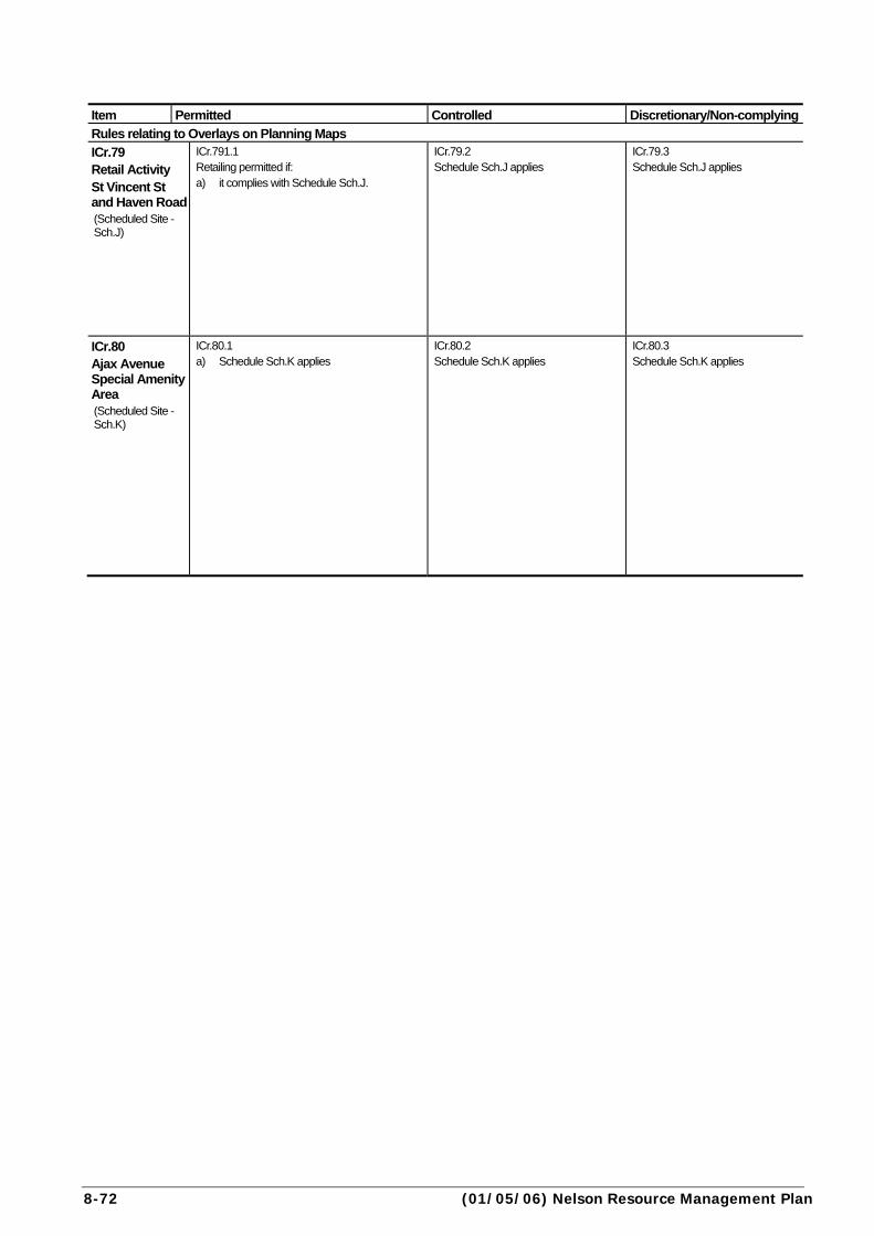
8-72 (01/05/06) Nelson Resource Management Plan
Item Permitted Controlled Discretionary/Non-complying
Rules relating to Overlays on Planning Maps
ICr.79 Retail Activity St Vincent St and Haven Road (Scheduled Site - Sch.J)
ICr.791.1 Retailing permitted if: a) it complies with Schedule Sch.J.
ICr.79.2 Schedule Sch.J applies
ICr.79.3 Schedule Sch.J applies
ICr.80 Ajax Avenue Special Amenity Area (Scheduled Site - Sch.K)
ICr.80.1 a) Schedule Sch.K applies
ICr.80.2 Schedule Sch.K applies
ICr.80.3 Schedule Sch.K applies
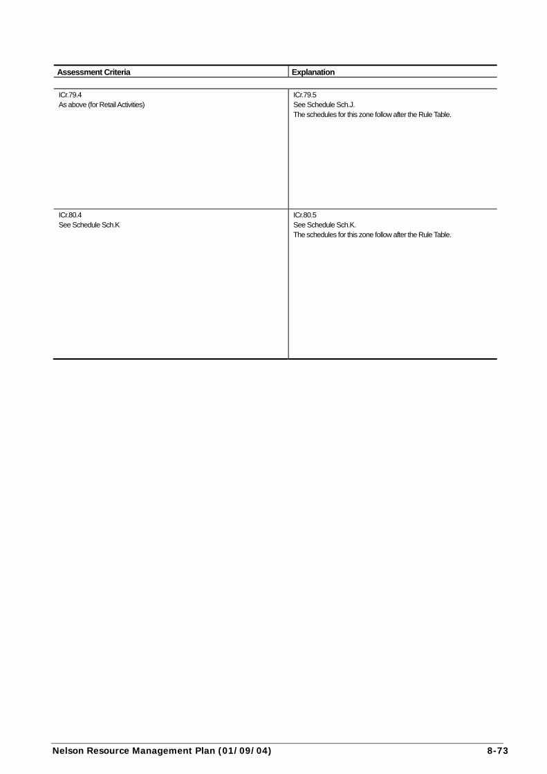
Nelson Resource Management Plan (01/09/04) 8-73
Assessment Criteria Explanation
ICr.79.4 As above (for Retail Activities)
ICr.79.5 See Schedule Sch.J. The schedules for this zone follow after the Rule Table.
ICr.80.4 See Schedule Sch.K
ICr.80.5 See Schedule Sch.K. The schedules for this zone follow after the Rule Table.

8-74 (07/01/13) Nelson Resource Management Plan
subdivision rules Item Permitted Controlled Discretionary/Non-complying
ICr.81 Subdivision General (except for subdivision located in the Heritage Overlay or Heritage Precinct)
ICr.81.1 Not a permitted activity.
ICr.81.2 Any subdivision not located in the Heritage Overlay or Heritage Precinct is controlled, if: a) it complies in all respects with all the relevant standards in
Appendices 10 to 12, and b) it complies with the minimum standards as defined in
Section 1.1.1 General in the NCC Land Development Manual 2010, and
c) esplanade reserves or strips as indicated in the Riparian Overlay of the dimensions set out in Appendix 6, Table 6.2 (riparian or coastal areas with priority values), are created and vested in the Council, and
d) the minimum finished ground level for any land allotment (excluding water bodies) is 15.35m NCC Datum, except in the Inundation Overlay, and
e) the minimum finished ground level is greater than the crown level of the road to which the piped stormwater from the allotment is drained, except in the Inundation Overlay, and
f) every allotment is of a regular shape that will maximise the range and efficiency of potential uses of the land, and
g) any existing buildings comply with the conditions for permitted activities, or a resource consent.
Control reserved over: i) the matters contained in the NCC Land Development
Manual 2010, and ii) the effects of natural and other hazards, and iii) design and layout of the subdivision, and iv) protection of natural features, landscapes, heritage items
and trees and Maori values, and v) riparian management, and. vi) public access, and vii) adverse effects likely to arise from the subdivision,
associated development or subsequent use of the land, and
viii) development of the subdivision and sites having regard to:a) appropriate vehicle access, and b) the intensity of buildings to be erected on each lot and
the siting of such buildings, and c) provision of services, and
ix) stormwater management, and x) the effects of vegetation clearance, land disturbance and
earthworks, including on visual amenity, soil erosion and sedimentation, and
xi) financial contributions in accordance with Chapter 6, and xii) the future of land subdivided for the purposes of public
utilities and no longer required for the purpose, and xiii) in the Inundation Overlay, in addition to the matters listed
above, control is reserved over: a) finished ground level, and b) the nature of infill, its compaction and placement.
ICr.81.3 Any subdivision not located in the Heritage Overlay or Heritage Precinct that contravenes a controlled standard is discretionary if it is for the purposes of a network utility. Any other subdivision that contravenes a controlled standard is discretionary if: a) every allotment (other than an access lot) complies with the standards as defined in Section 1.1.1 General relating to storm water and sewerage in Sections 5 & 6 of the NCC Land Development Manual 2010, and b) every allotment (other than an access lot) is connected through gravity fed pipes to the Council water supply system.
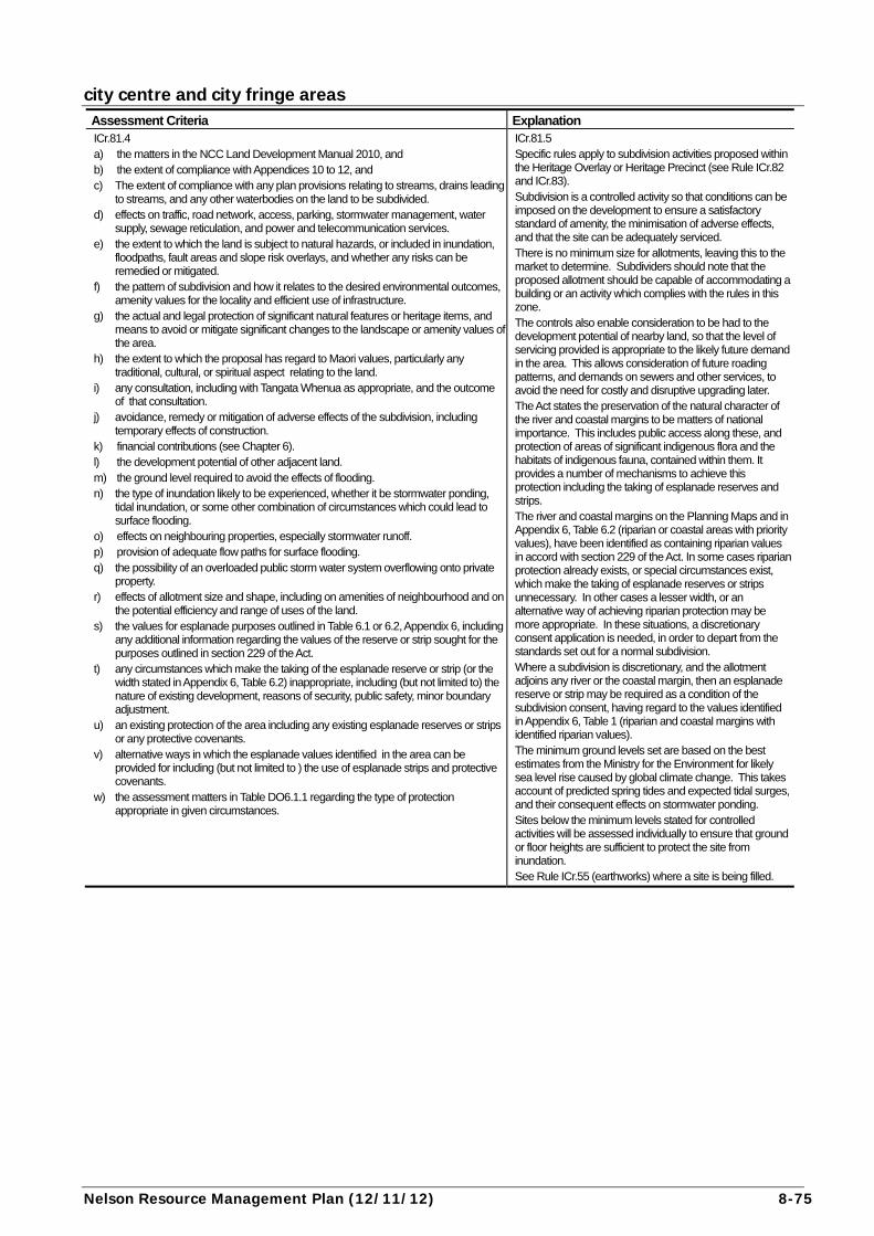
Nelson Resource Management Plan (12/11/12) 8-75
city centre and city fringe areas Assessment Criteria Explanation ICr.81.4 a) the matters in the NCC Land Development Manual 2010, and b) the extent of compliance with Appendices 10 to 12, and c) The extent of compliance with any plan provisions relating to streams, drains leading
to streams, and any other waterbodies on the land to be subdivided. d) effects on traffic, road network, access, parking, stormwater management, water
supply, sewage reticulation, and power and telecommunication services. e) the extent to which the land is subject to natural hazards, or included in inundation,
floodpaths, fault areas and slope risk overlays, and whether any risks can be remedied or mitigated.
f) the pattern of subdivision and how it relates to the desired environmental outcomes, amenity values for the locality and efficient use of infrastructure.
g) the actual and legal protection of significant natural features or heritage items, and means to avoid or mitigate significant changes to the landscape or amenity values of the area.
h) the extent to which the proposal has regard to Maori values, particularly any traditional, cultural, or spiritual aspect relating to the land.
i) any consultation, including with Tangata Whenua as appropriate, and the outcome of that consultation.
j) avoidance, remedy or mitigation of adverse effects of the subdivision, including temporary effects of construction.
k) financial contributions (see Chapter 6). l) the development potential of other adjacent land. m) the ground level required to avoid the effects of flooding. n) the type of inundation likely to be experienced, whether it be stormwater ponding,
tidal inundation, or some other combination of circumstances which could lead to surface flooding.
o) effects on neighbouring properties, especially stormwater runoff. p) provision of adequate flow paths for surface flooding. q) the possibility of an overloaded public storm water system overflowing onto private
property. r) effects of allotment size and shape, including on amenities of neighbourhood and on
the potential efficiency and range of uses of the land. s) the values for esplanade purposes outlined in Table 6.1 or 6.2, Appendix 6, including
any additional information regarding the values of the reserve or strip sought for the purposes outlined in section 229 of the Act.
t) any circumstances which make the taking of the esplanade reserve or strip (or the width stated in Appendix 6, Table 6.2) inappropriate, including (but not limited to) the nature of existing development, reasons of security, public safety, minor boundary adjustment.
u) an existing protection of the area including any existing esplanade reserves or strips or any protective covenants.
v) alternative ways in which the esplanade values identified in the area can be provided for including (but not limited to ) the use of esplanade strips and protective covenants.
w) the assessment matters in Table DO6.1.1 regarding the type of protection appropriate in given circumstances.
ICr.81.5 Specific rules apply to subdivision activities proposed within the Heritage Overlay or Heritage Precinct (see Rule ICr.82 and ICr.83). Subdivision is a controlled activity so that conditions can be imposed on the development to ensure a satisfactory standard of amenity, the minimisation of adverse effects, and that the site can be adequately serviced. There is no minimum size for allotments, leaving this to the market to determine. Subdividers should note that the proposed allotment should be capable of accommodating a building or an activity which complies with the rules in this zone. The controls also enable consideration to be had to the development potential of nearby land, so that the level of servicing provided is appropriate to the likely future demand in the area. This allows consideration of future roading patterns, and demands on sewers and other services, to avoid the need for costly and disruptive upgrading later. The Act states the preservation of the natural character of the river and coastal margins to be matters of national importance. This includes public access along these, and protection of areas of significant indigenous flora and the habitats of indigenous fauna, contained within them. It provides a number of mechanisms to achieve this protection including the taking of esplanade reserves and strips. The river and coastal margins on the Planning Maps and in Appendix 6, Table 6.2 (riparian or coastal areas with priority values), have been identified as containing riparian values in accord with section 229 of the Act. In some cases riparian protection already exists, or special circumstances exist, which make the taking of esplanade reserves or strips unnecessary. In other cases a lesser width, or an alternative way of achieving riparian protection may be more appropriate. In these situations, a discretionary consent application is needed, in order to depart from the standards set out for a normal subdivision. Where a subdivision is discretionary, and the allotment adjoins any river or the coastal margin, then an esplanade reserve or strip may be required as a condition of the subdivision consent, having regard to the values identified in Appendix 6, Table 1 (riparian and coastal margins with identified riparian values). The minimum ground levels set are based on the best estimates from the Ministry for the Environment for likely sea level rise caused by global climate change. This takes account of predicted spring tides and expected tidal surges, and their consequent effects on stormwater ponding. Sites below the minimum levels stated for controlled activities will be assessed individually to ensure that ground or floor heights are sufficient to protect the site from inundation. See Rule ICr.55 (earthworks) where a site is being filled.
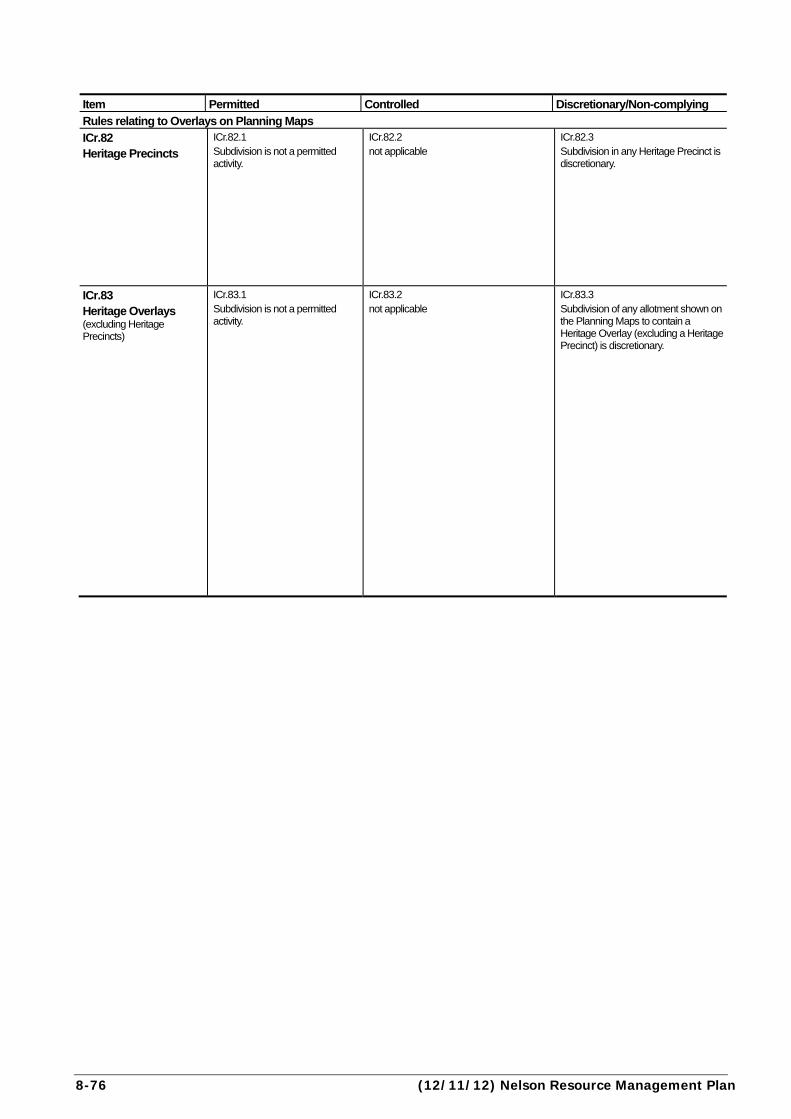
8-76 (12/11/12) Nelson Resource Management Plan
Item Permitted Controlled Discretionary/Non-complying
Rules relating to Overlays on Planning Maps
ICr.82 Heritage Precincts
ICr.82.1 Subdivision is not a permitted activity.
ICr.82.2 not applicable
ICr.82.3 Subdivision in any Heritage Precinct is discretionary.
ICr.83 Heritage Overlays (excluding Heritage Precincts)
ICr.83.1 Subdivision is not a permitted activity.
ICr.83.2 not applicable
ICr.83.3 Subdivision of any allotment shown on the Planning Maps to contain a Heritage Overlay (excluding a Heritage Precinct) is discretionary.
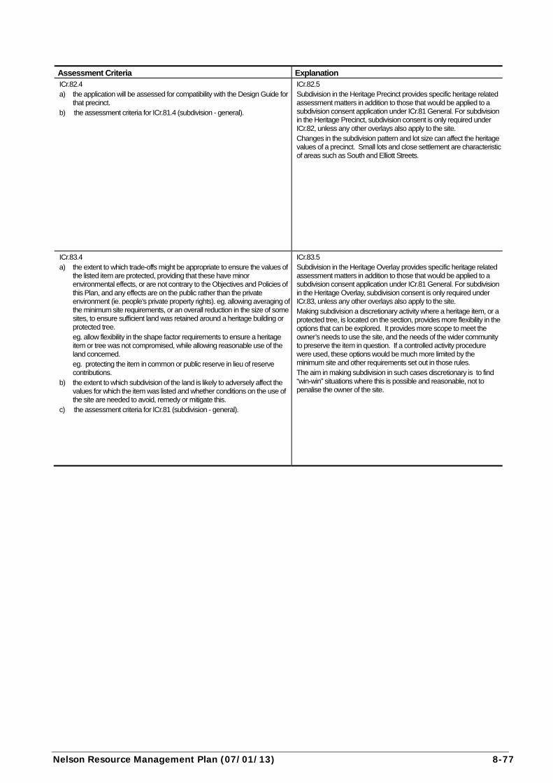
Nelson Resource Management Plan (07/01/13) 8-77
Assessment Criteria Explanation ICr.82.4 a) the application will be assessed for compatibility with the Design Guide for
that precinct. b) the assessment criteria for ICr.81.4 (subdivision - general).
ICr.82.5 Subdivision in the Heritage Precinct provides specific heritage related assessment matters in addition to those that would be applied to a subdivision consent application under ICr.81 General. For subdivision in the Heritage Precinct, subdivision consent is only required under ICr.82, unless any other overlays also apply to the site. Changes in the subdivision pattern and lot size can affect the heritage values of a precinct. Small lots and close settlement are characteristic of areas such as South and Elliott Streets.
ICr.83.4 a) the extent to which trade-offs might be appropriate to ensure the values of
the listed item are protected, providing that these have minor environmental effects, or are not contrary to the Objectives and Policies of this Plan, and any effects are on the public rather than the private environment (ie. people’s private property rights). eg. allowing averaging of the minimum site requirements, or an overall reduction in the size of some sites, to ensure sufficient land was retained around a heritage building or protected tree. eg. allow flexibility in the shape factor requirements to ensure a heritage item or tree was not compromised, while allowing reasonable use of the land concerned. eg. protecting the item in common or public reserve in lieu of reserve contributions.
b) the extent to which subdivision of the land is likely to adversely affect the values for which the item was listed and whether conditions on the use of the site are needed to avoid, remedy or mitigate this.
c) the assessment criteria for ICr.81 (subdivision - general).
ICr.83.5 Subdivision in the Heritage Overlay provides specific heritage related assessment matters in addition to those that would be applied to a subdivision consent application under ICr.81 General. For subdivision in the Heritage Overlay, subdivision consent is only required under ICr.83, unless any other overlays also apply to the site. Making subdivision a discretionary activity where a heritage item, or a protected tree, is located on the section, provides more flexibility in the options that can be explored. It provides more scope to meet the owner’s needs to use the site, and the needs of the wider community to preserve the item in question. If a controlled activity procedure were used, these options would be much more limited by the minimum site and other requirements set out in those rules. The aim in making subdivision in such cases discretionary is to find “win-win” situations where this is possible and reasonable, not to penalise the owner of the site.

8-78 (30/04/12) Nelson Resource Management Plan
freshwater rules Refer Appendix AP28.9 for freshwater rules.
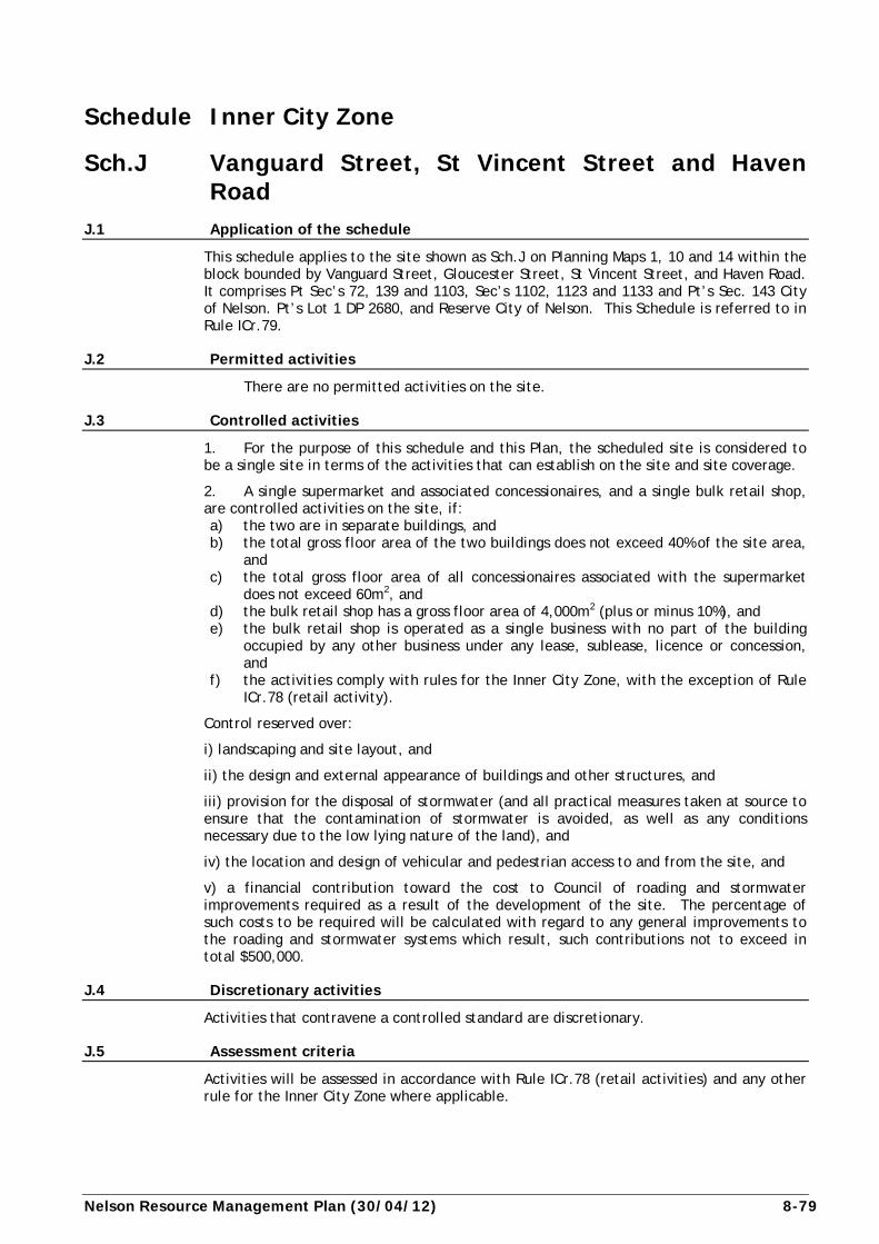
Nelson Resource Management Plan (30/04/12) 8-79
Schedule Inner City Zone
Sch.J Vanguard Street, St Vincent Street and Haven Road
J.1 Application of the schedule
This schedule applies to the site shown as Sch.J on Planning Maps 1, 10 and 14 within the block bounded by Vanguard Street, Gloucester Street, St Vincent Street, and Haven Road. It comprises Pt Sec’s 72, 139 and 1103, Sec’s 1102, 1123 and 1133 and Pt’s Sec. 143 City of Nelson. Pt’s Lot 1 DP 2680, and Reserve City of Nelson. This Schedule is referred to in Rule ICr.79.
J.2 Permitted activities
There are no permitted activities on the site.
J.3 Controlled activities
1. For the purpose of this schedule and this Plan, the scheduled site is considered to be a single site in terms of the activities that can establish on the site and site coverage.
2. A single supermarket and associated concessionaires, and a single bulk retail shop, are controlled activities on the site, if: a) the two are in separate buildings, and b) the total gross floor area of the two buildings does not exceed 40% of the site area,
and c) the total gross floor area of all concessionaires associated with the supermarket
does not exceed 60m2, and d) the bulk retail shop has a gross floor area of 4,000m2 (plus or minus 10%), and e) the bulk retail shop is operated as a single business with no part of the building
occupied by any other business under any lease, sublease, licence or concession, and
f) the activities comply with rules for the Inner City Zone, with the exception of Rule ICr.78 (retail activity).
Control reserved over:
i) landscaping and site layout, and
ii) the design and external appearance of buildings and other structures, and
iii) provision for the disposal of stormwater (and all practical measures taken at source to ensure that the contamination of stormwater is avoided, as well as any conditions necessary due to the low lying nature of the land), and
iv) the location and design of vehicular and pedestrian access to and from the site, and
v) a financial contribution toward the cost to Council of roading and stormwater improvements required as a result of the development of the site. The percentage of such costs to be required will be calculated with regard to any general improvements to the roading and stormwater systems which result, such contributions not to exceed in total $500,000.
J.4 Discretionary activities
Activities that contravene a controlled standard are discretionary.
J.5 Assessment criteria
Activities will be assessed in accordance with Rule ICr.78 (retail activities) and any other rule for the Inner City Zone where applicable.
8-80 (30/04/12) Nelson Resource Management Plan
J.6 Explanation
The schedule provides for a single supermarket and associated concessionaires, and a single bulk retail shop of 4,000m2 (plus or minus 10%) gross floor area, as controlled uses on the scheduled land. The scheduled land was the subject of Plan Change 95/2 to the Transitional District Plan (Third Review, 1982 Nelson Section), to provide for these specific developments on this specific site. The Plan Change was approved just before this Plan was notified. The essence of the Change has been carried over in this schedule, as it does not quite fit within the provisions of Rule ICr.78 (retail activity), not being located close to the ring road.
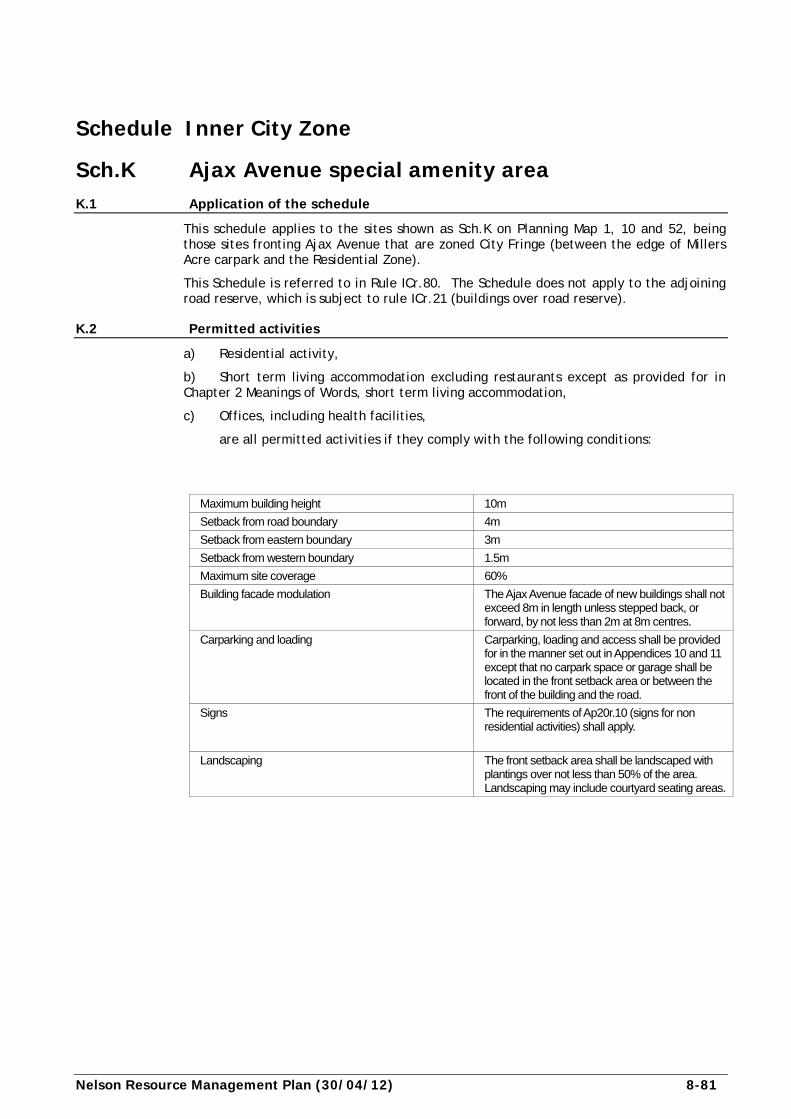
Nelson Resource Management Plan (30/04/12) 8-81
Schedule Inner City Zone
Sch.K Ajax Avenue special amenity area K.1 Application of the schedule
This schedule applies to the sites shown as Sch.K on Planning Map 1, 10 and 52, being those sites fronting Ajax Avenue that are zoned City Fringe (between the edge of Millers Acre carpark and the Residential Zone).
This Schedule is referred to in Rule ICr.80. The Schedule does not apply to the adjoining road reserve, which is subject to rule ICr.21 (buildings over road reserve).
K.2 Permitted activities
a) Residential activity,
b) Short term living accommodation excluding restaurants except as provided for in Chapter 2 Meanings of Words, short term living accommodation,
c) Offices, including health facilities,
are all permitted activities if they comply with the following conditions:
Maximum building height 10m
Setback from road boundary 4m
Setback from eastern boundary 3m
Setback from western boundary 1.5m
Maximum site coverage 60%
Building facade modulation The Ajax Avenue facade of new buildings shall not exceed 8m in length unless stepped back, or forward, by not less than 2m at 8m centres.
Carparking and loading Carparking, loading and access shall be provided for in the manner set out in Appendices 10 and 11 except that no carpark space or garage shall be located in the front setback area or between the front of the building and the road.
Signs The requirements of Ap20r.10 (signs for non residential activities) shall apply.
Landscaping The front setback area shall be landscaped with plantings over not less than 50% of the area. Landscaping may include courtyard seating areas.
8-82 (30/04/12) Nelson Resource Management Plan
Other rules
The following rules in the Residential Zone rule table must also be complied with: building over or alongside drains; aerials; noise; helicopter landing pads; vibration; light spill; hazardous substances; radioactive material; earthworks; inundation overlay; flood path overlay; network utility (REr.52), and microwave or ultra high frequency emissions. In addition, rule ICr.40 (outdoor living court for residential activity), rule ICr.35 (daylight admission on boundary with Residential Zone) and all the freshwater rules shall apply.
K.3 Controlled activities a) Subdivision. The rules of ICr.81 (subdivision – general) shall apply. b) Any rule under ‘Other Rules’ that has a controlled activity component.
K.4 Discretionary activities
Activities that contravene a permitted condition or a controlled standard are discretionary.
K.5 Assessment criteria a) the likely adverse effects of the activity, particularly on sites which contain
residential accommodation, and on the special amenity of the area. b) whether the activity would detract from the public use or appreciation of the
riverside amenity. c) the appearance of the site from any public space or residential site. d) the extent to which building design, landscaping or other methods could mitigate
any adverse effects of the activity. e) the volume of any traffic generated and the effects of such traffic volumes on the
amenities of the area and on traffic congestion on Ajax Avenue. f) the likely hours of operation of the activity and the effects that this may have on
those residents in the zone and in adjoining residential areas.
In addition, where an activity contravenes one of the residential rules or the Inner City rule listed under permitted activities, the assessment criteria for that rule will apply. The same applies for controlled activities.
K.6 Explanation
The Ajax Avenue Special Amenity Area is identified as an area of special character owing to its riverside location and proximity to the city centre. It is an area with high public amenity value which Council has recognised in its proposals to redevelop and beautify the Millers Acre carpark area. The amenity potential of this locality could easily be diminished by intensification of commercial or industrial activities. Ajax Avenue itself is narrow and ill-suited to accommodating high volumes of traffic without widening of the carriageway. Doing this would encroach on the open space values of the river bank.
Activities such as residential accommodation, offices and tourist accommodation are represented in the locality already and appear to be suited to the character and amenity values of the area. In order that these values can be sustained or enhanced only these activities are permitted. New buildings to accommodate such activities are subject to rules which limit scale and also encourage development of a ‘soft edge’ along the interface between the river bank and the fringe of the city centre.