rsa projection & coordinate system proposal: …...vy: difference between geodetic longitude...
TRANSCRIPT

RSA Projection & Coordinate System Proposal: February 2019 1

OVERVIEW
➢ Why review the projection?
➢ Coordinate system comparisons
➢ Projection characteristics
➢ Projection distortions
➢ Projection distortion summary
➢ Why review the coordinate system?
➢ Proposed coordinate system
➢ Area implications
➢ Other issues to consider?
RSA Projection & Coordinate System Proposal: February 2019 2

South Africa’s : Extent
RSA Projection & Coordinate System Proposal: February 2019 3
16½°
12¾°

WHY REVIEW THE PROJECTION?
➢ The current projection used in South Africa is the Gauss
Conform Projection (Transverse Mercator limited to 2°
longitude zones);
➢ Geo-spatial information used on a wide range of
applications covering large geographical extents, from
provincial coverage to national coverage. For these
applications the 2° zones may be a limitation;
➢ Do other projections, which provide for greater
geographical coverage, meet the requirements to be
adopted as an alternative to the Gauss Conform
Projection?
RSA Projection & Coordinate System Proposal: February 2019 4

COORDINATE SYSTEM COMPARISONS
Conformality is a requirement.
The following projections are compared:
➢ Gauss Conform (current projection);
➢ UTM (widely used);
➢ Lambert’s Conformal Conic Projection (suits areas with
greater east-west extent);
▪ Lambert’s Conformal Conic Projection with Two
Standard Parallels (4° zones);
▪ Lambert’s Conformal Conic Projection with Two
Standard Parallels (3° zones).
RSA Projection & Coordinate System Proposal: February 2019 5
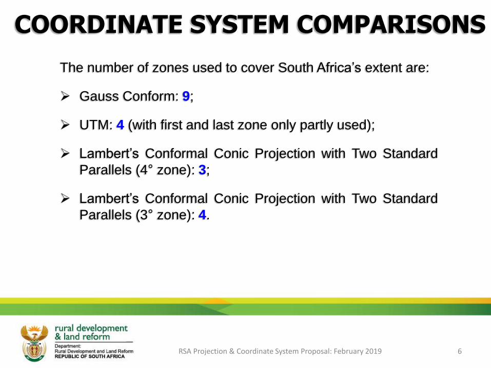
The number of zones used to cover South Africa’s extent are:
➢ Gauss Conform: 9;
➢ UTM: 4 (with first and last zone only partly used);
➢ Lambert’s Conformal Conic Projection with Two Standard
Parallels (4° zone): 3;
➢ Lambert’s Conformal Conic Projection with Two Standard
Parallels (3° zone): 4.
RSA Projection & Coordinate System Proposal: February 2019 6
COORDINATE SYSTEM COMPARISONS
RSA Projection & Coordinate System Proposal: February 2019 7
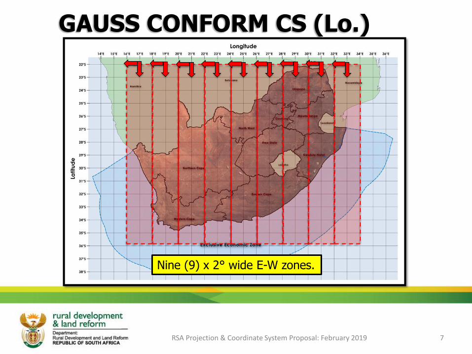
GAUSS CONFORM CS (Lo.)
Nine (9) x 2° wide E-W zones.
RSA Projection & Coordinate System Proposal: February 2019 8
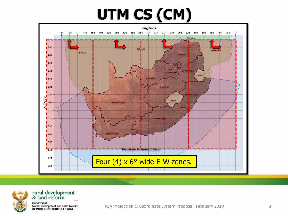
UTM CS (CM)
Four (4) x 6° wide E-W zones.
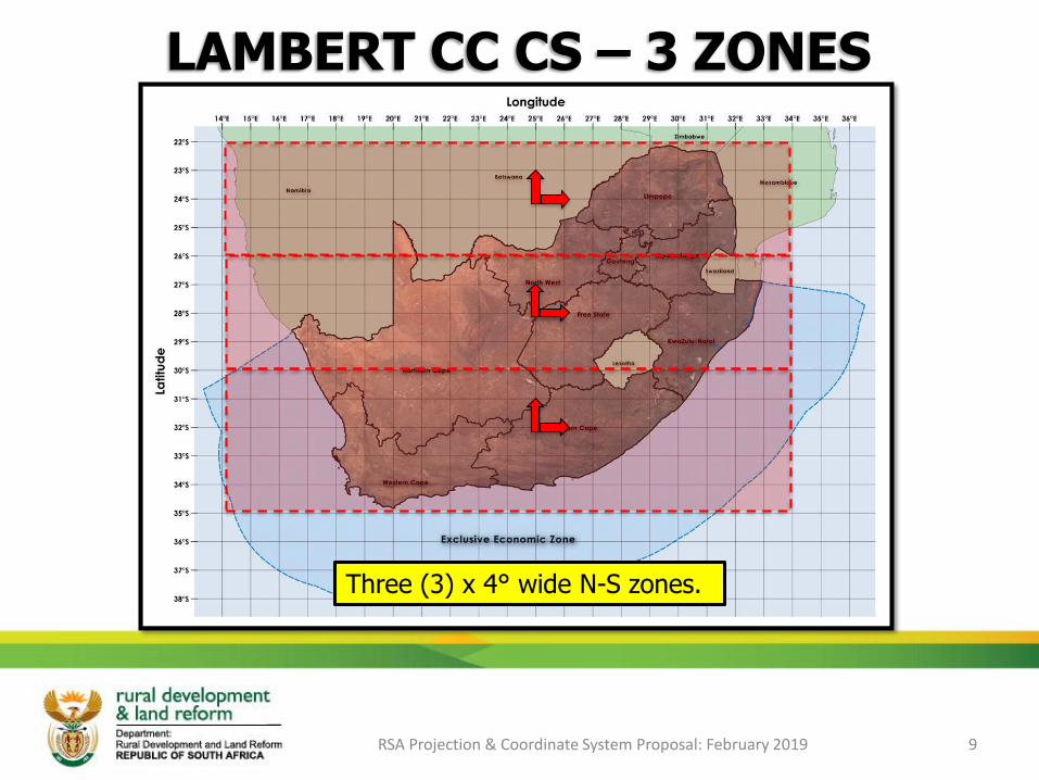
LAMBERT CC CS – 3 ZONES
RSA Projection & Coordinate System Proposal: February 2019 9
Three (3) x 4° wide N-S zones.
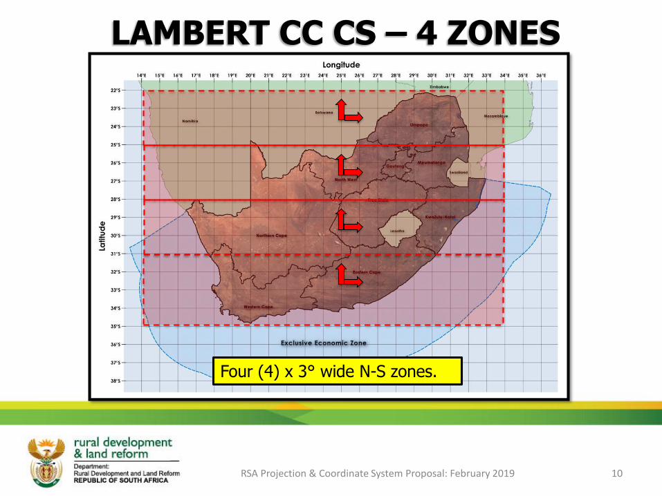
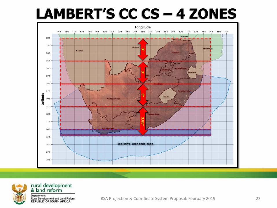
LAMBERT CC CS – 4 ZONES
RSA Projection & Coordinate System Proposal: February 2019 10
Four (4) x 3° wide N-S zones.

GAUSS CONFORM PROJECTION:CHARACTERISTICS
RSA Projection & Coordinate System Proposal: February 2019 11
Longitude of origin )Lo.)or Central meridian (CM) where scale =1
Click on the
icon to open…
Click on the
icon to open…
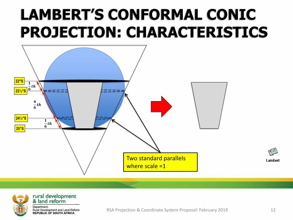
LAMBERT’S CONFORMAL CONICPROJECTION: CHARACTERISTICS
RSA Projection & Coordinate System Proposal: February 2019 12
Two standard parallels where scale =1
𝟏
𝟔𝒕𝒉
𝟏
𝟔𝒕𝒉
𝟒
𝟔𝒕𝒉
22°S
22½°S
24½°S
25°S
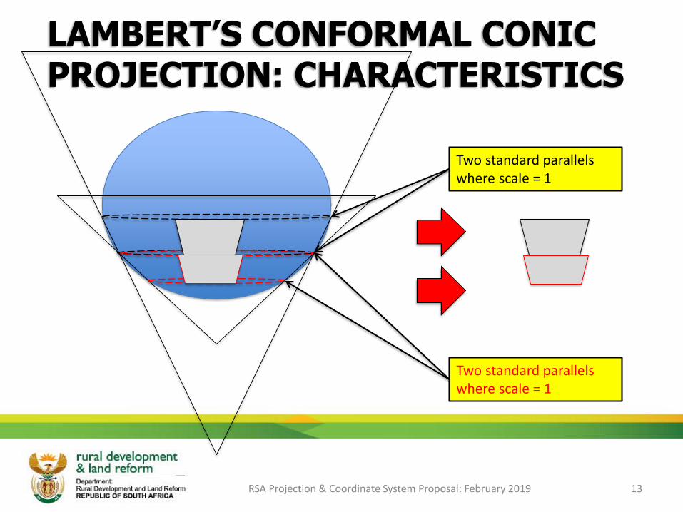
LAMBERT’S CONFORMAL CONICPROJECTION: CHARACTERISTICS
RSA Projection & Coordinate System Proposal: February 2019 13
Two standard parallels where scale = 1
Two standard parallels where scale = 1

GAUSS CONFORM PROJECTION
RSA Projection & Coordinate System Proposal: February 2019 14
Tissot’s Indicatrix: Represents relative scale increase. Circular due to conformality.
Scale equal in all directions around a point, preserving angles and shape.
Gauss Conform: Scale and shapes increase from the Central Meridian (Lo.)
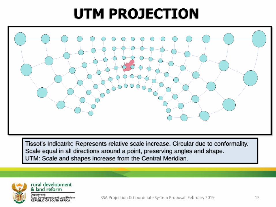
UTM PROJECTION
RSA Projection & Coordinate System Proposal: February 2019 15
Tissot’s Indicatrix: Represents relative scale increase. Circular due to conformality.
Scale equal in all directions around a point, preserving angles and shape.
UTM: Scale and shapes increase from the Central Meridian.

LAMBERT’S – 2 PAR: 3 ZONES (4°)
RSA Projection & Coordinate System Proposal: February 2019 16
Tissot’s Indicatrix: Represents relative scale increase. Circular due to conformality.
Scale equal in all directions around a point, preserving angles and shape.
Lambert’s: Scale and shapes increase from the Standard parallels outwards.
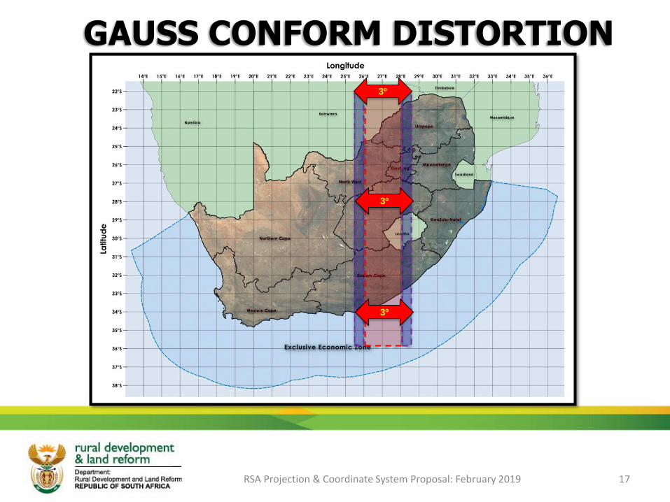
RSA Projection & Coordinate System Proposal: February 2019 17
3º
3º
3º
GAUSS CONFORM DISTORTION

GAUSS CONFORM DISTORTION
RSA Projection & Coordinate System Proposal: February 2019 18
22°S 25½°EvY: 13.44m
vX: 759.71m
Sc: 1.000296
(296 ppm)
22°S 26°EvY: 3.98m
vX: 337.61m
Sc: 1.000132
(132 ppm)
22°S 27°EvY: 0.00m
vX: 0.00m
Sc: 1.000000
(0 ppm)
22°S 28°EvY: 3.98m
vX: 337.61m
Sc: 1.000132
(132 ppm)
22°S 28½°EvY: 13.44m
vX: 759.71m
Sc: 1.000296
(296 ppm)
28°S 25½°EvY: 10.42m
vX: 906.90m
Sc: 1.000269
(269 ppm)
28°S 26°EvY: 3.09m
vX: 403.02m
Sc: 1.000119
(119 ppm)
28°S 27°EvY: 0.00m
vX: 0.00m
Sc: 1.000000
(0 ppm)
28°S 28°EvY: 3.09m
vX: 403.02m
Sc: 1.000119
(119 ppm)
28°S 28½°EvY: 10.42m
vX: 906.90m
Sc: 1.000269
(269 ppm)
34°S 25½°EvY: 7.22m
vX: 1014.54m
Sc: 1.000237
(237 ppm)
34°S 26°EvY: 2.14m
vX: 450.86m
Sc: 1.000105
(105 ppm)
34°S 27°EvY: 0.00m
vX: 0.00m
Sc: 1.000000
(0 ppm)
34°S 28°EvY: 2.14m
vX: 450.86m
Sc: 1.000105
(105 ppm)
34°S 28½°EvY: 7.22m
vX: 1014.54m
Sc: 1.000237
(237 ppm)
+6°
-1.5° -1° +1° +1.5°
+6° +6°
+6° +6° +6°
+6° +6°
-1.5° -1° +1° +1.5°
vY: Difference between geodetic longitude distance and projected distance from Lo.27 at that latitude at that point.
vX: Difference between geodetic latitude distance and projected distance from the equator at that point.
Sc: Scale at that point (in parts per million).
RSA Projection & Coordinate System Proposal: February 2019 19
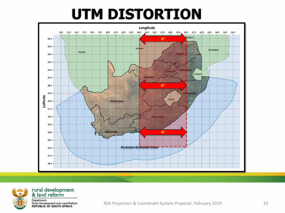
UTM DISTORTION
6º
6º
6º
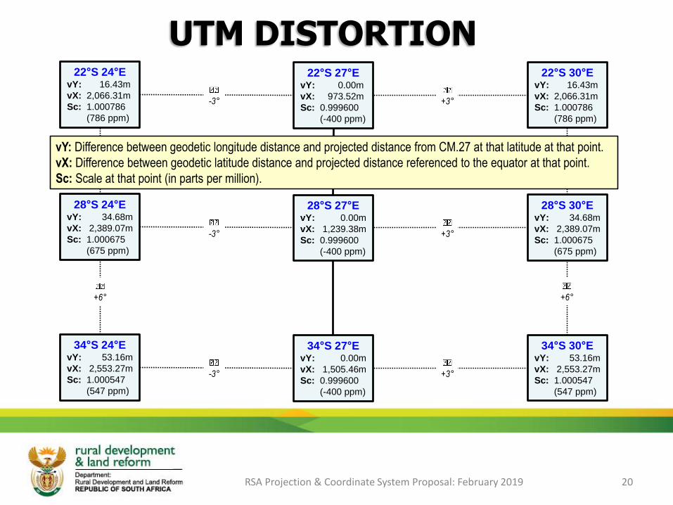
UTM DISTORTION
RSA Projection & Coordinate System Proposal: February 2019 20
22°S 24°EvY: 16.43m
vX: 2,066.31m
Sc: 1.000786
(786 ppm)
22°S 27°EvY: 0.00m
vX: 973.52m
Sc: 0.999600
(-400 ppm)
22°S 30°EvY: 16.43m
vX: 2,066.31m
Sc: 1.000786
(786 ppm)
28°S 24°EvY: 34.68m
vX: 2,389.07m
Sc: 1.000675
(675 ppm)
28°S 27°EvY: 0.00m
vX: 1,239.38m
Sc: 0.999600
(-400 ppm)
28°S 30°EvY: 34.68m
vX: 2,389.07m
Sc: 1.000675
(675 ppm)
34°S 24°EvY: 53.16m
vX: 2,553.27m
Sc: 1.000547
(547 ppm)
34°S 27°EvY: 0.00m
vX: 1,505.46m
Sc: 0.999600
(-400 ppm)
34°S 30°EvY: 53.16m
vX: 2,553.27m
Sc: 1.000547
(547 ppm)
-3°
-3°
-3°
+3°
+3°
+3°
+6° +6°
+6° +6°
vY: Difference between geodetic longitude distance and projected distance from CM.27 at that latitude at that point.
vX: Difference between geodetic latitude distance and projected distance referenced to the equator at that point.
Sc: Scale at that point (in parts per million).
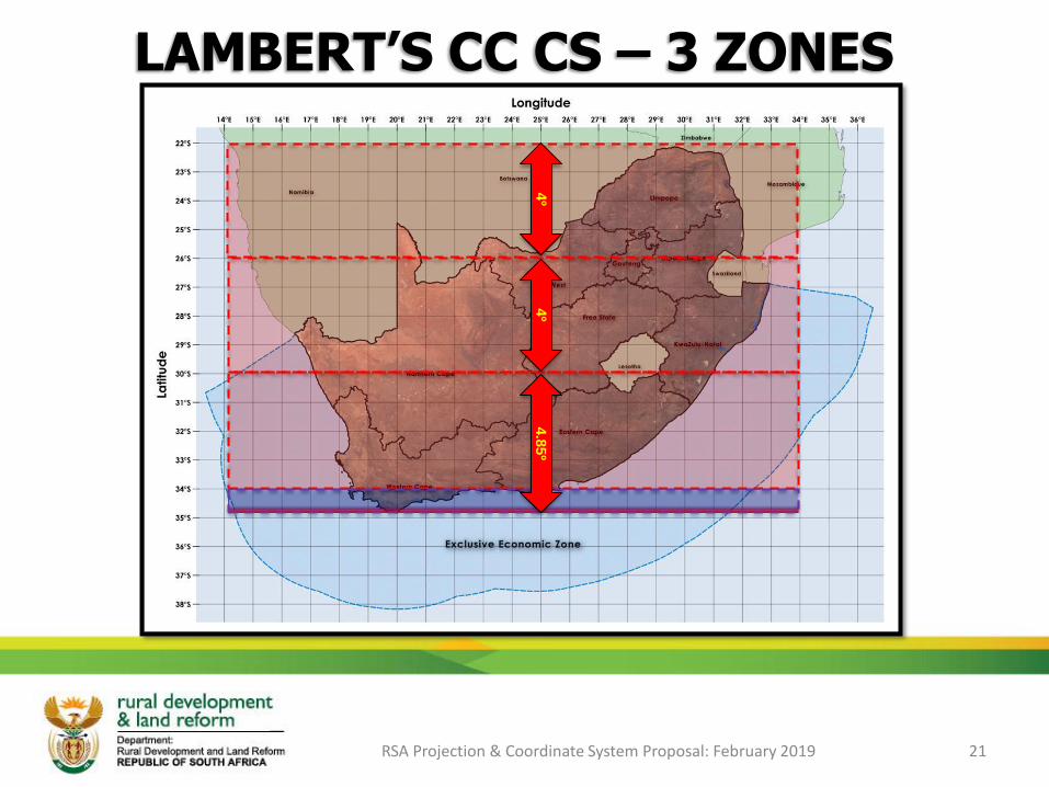
LAMBERT’S CC CS – 3 ZONES
RSA Projection & Coordinate System Proposal: February 2019 21
4º
4º
4.8
5º

LAMBERT’S DISTORTION (3 ZONES)
RSA Projection & Coordinate System Proposal: February 2019 22
22°S 27°EvY: 0.00m
vX: 15.57m
Sc: 1.000335
(335 ppm)
26°S 27°EvY: 0.00m
vX: 15.76m
Sc: 1.000335
(335 ppm)
30°S 27°EvY: 0.00m
vX: 15.93m
Sc: 1.000335
(335 ppm)
24°S 27°EvY: 0.00m
vX: 0.00m
Sc: 0.999731
(-269 ppm)
28°S 27°EvY: 0.00m
vX: 0.00m
Sc: 0.999731
(-269 ppm)
32°S 27°EvY: 0.00m
vX: 0.00m
Sc: 0.999731
(-269 ppm)
26°S 27°EvY: 0.00m
vX: 15.62m
Sc: 1.000339
(339 ppm)
30°S 27°EvY: 0.00m
vX: 15.79m
Sc: 1.000339
(339 ppm)
34°S 27°EvY: 0.00m
vX: 15.95m
Sc: 1.000340
(340 ppm)
+2°
+2°
+2°
+2°
+2°
+2°
Zone North Zone Central Zone South
vY: Difference between geodetic longitude distance and projected distance from ref long (27°E) at that latitude at that point.
vX: Difference between geodetic latitude distance and projected distance from the ref lats (24°S, 28°S & 32°S) at that point.
Sc: Scale at that point (in parts per million).
LAMBERT’S CC CS – 4 ZONES
RSA Projection & Coordinate System Proposal: February 2019 23
3º
3º
3.8
5º
3º
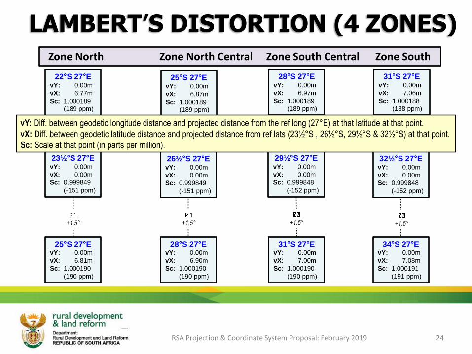
LAMBERT’S DISTORTION (4 ZONES)
RSA Projection & Coordinate System Proposal: February 2019 24
Zone North Zone North Central Zone South Central Zone South
22°S 27°EvY: 0.00m
vX: 6.77m
Sc: 1.000189
(189 ppm)
25°S 27°EvY: 0.00m
vX: 6.87m
Sc: 1.000189
(189 ppm)
31°S 27°EvY: 0.00m
vX: 7.06m
Sc: 1.000188
(188 ppm)
23½°S 27°EvY: 0.00m
vX: 0.00m
Sc: 0.999849
(-151 ppm)
26½°S 27°EvY: 0.00m
vX: 0.00m
Sc: 0.999849
(-151 ppm)
32½°S 27°EvY: 0.00m
vX: 0.00m
Sc: 0.999848
(-152 ppm)
25°S 27°EvY: 0.00m
vX: 6.81m
Sc: 1.000190
(190 ppm)
28°S 27°EvY: 0.00m
vX: 6.90m
Sc: 1.000190
(190 ppm)
34°S 27°EvY: 0.00m
vX: 7.08m
Sc: 1.000191
(191 ppm)
28°S 27°EvY: 0.00m
vX: 6.97m
Sc: 1.000189
(189 ppm)
29½°S 27°EvY: 0.00m
vX: 0.00m
Sc: 0.999848
(-152 ppm)
31°S 27°EvY: 0.00m
vX: 7.00m
Sc: 1.000190
(190 ppm)
+1.5°
+1.5°
+1.5°
+1.5°
+1.5°
+1.5°
+1.5°
+1.5°
vY: Diff. between geodetic longitude distance and projected distance from the ref long (27°E) at that latitude at that point.
vX: Diff. between geodetic latitude distance and projected distance from ref lats (23½°S , 26½°S, 29½°S & 32½°S) at that point.
Sc: Scale at that point (in parts per million).
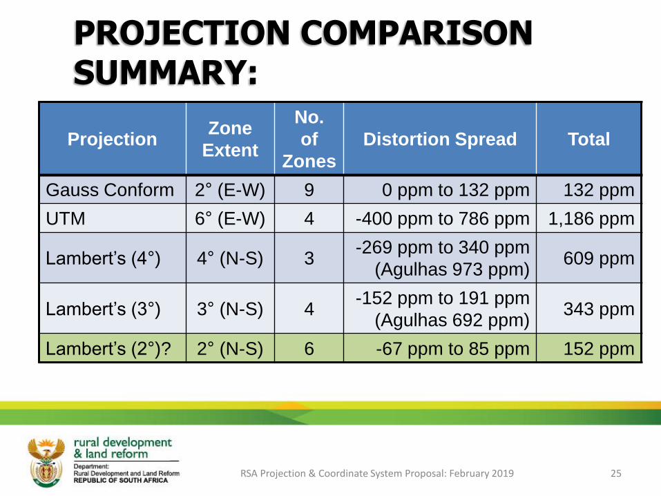
PROJECTION COMPARISON SUMMARY:
RSA Projection & Coordinate System Proposal: February 2019 25
ProjectionZone
Extent
No.
of
Zones
Distortion Spread Total
Gauss Conform 2° (E-W) 9 0 ppm to 132 ppm 132 ppm
UTM 6° (E-W) 4 -400 ppm to 786 ppm 1,186 ppm
Lambert’s (4°) 4° (N-S) 3-269 ppm to 340 ppm
(Agulhas 973 ppm)609 ppm
Lambert’s (3°) 3° (N-S) 4-152 ppm to 191 ppm
(Agulhas 692 ppm)343 ppm
Lambert’s (2°)? 2° (N-S) 6 -67 ppm to 85 ppm 152 ppm
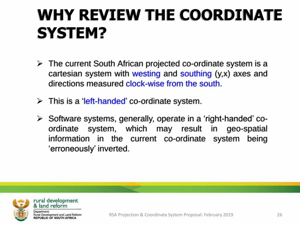
WHY REVIEW THE COORDINATE SYSTEM?
➢ The current South African projected co-ordinate system is a
cartesian system with westing and southing (y,x) axes and
directions measured clock-wise from the south.
➢ This is a ‘left-handed’ co-ordinate system.
➢ Software systems, generally, operate in a ‘right-handed’ co-
ordinate system, which may result in geo-spatial
information in the current co-ordinate system being
‘erroneously’ inverted.
RSA Projection & Coordinate System Proposal: February 2019 26
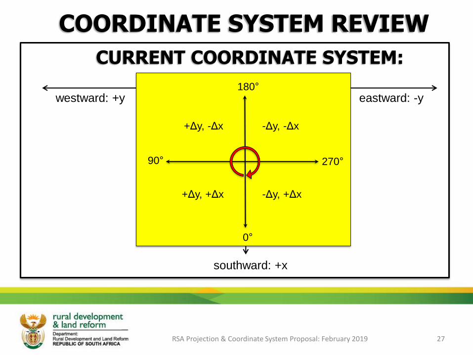
COORDINATE SYSTEM REVIEW
RSA Projection & Coordinate System Proposal: February 2019 27
eastward: -y
Equator: x = 0m
westward: +y
CURRENT COORDINATE SYSTEM:
southward: +x
Centra
l Merid
ian: y
= 0
m
0°
+Δy, -Δx -Δy, -Δx
+Δy, +Δx -Δy, +Δx
270°90°
180°

COORDINATE SYSTEM REVIEW
RSA Projection & Coordinate System Proposal: February 2019 28
eastward: +x
Equator: y = 4,000,000m
westward: -x
PROPOSED COORDINATE SYSTEM:
southward: -y
Centra
l Merid
ian: x
= 0
m
180°
-Δx, +Δy +Δx, +Δy
-Δx, -Δy +Δx, -Δy
90°270°
0°
RSA Projection & Coordinate System Proposal: February 2019 29
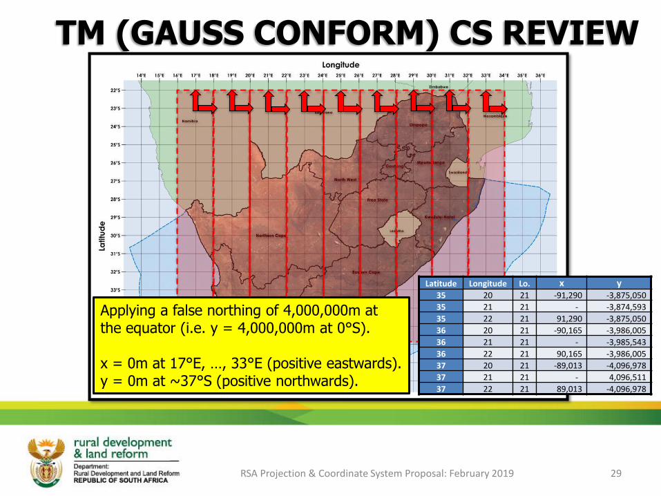
Latitude Longitude Lo. x y35 20 21 -91,290 -3,875,050
35 21 21 - -3,874,593
35 22 21 91,290 -3,875,050
36 20 21 -90,165 -3,986,005
36 21 21 - -3,985,543
36 22 21 90,165 -3,986,005
37 20 21 -89,013 -4,096,978
37 21 21 - 4,096,511
37 22 21 89,013 -4,096,978
Applying a false northing of 4,000,000m at the equator (i.e. y = 4,000,000m at 0°S).
x = 0m at 17°E, …, 33°E (positive eastwards).y = 0m at ~37°S (positive northwards).
TM (GAUSS CONFORM) CS REVIEW

COORDINATE SYSTEM REVIEW
RSA Projection & Coordinate System Proposal: February 2019 30
eastward: +xwestward: -x
PROPOSED COORDINATE SYSTEM:
southward: -y
Refe
rence L
ongitu
de: x
= 0
m
Standard parallel: scale = 1
Standard parallel: scale = 1
northward: +y
Reference Latitude: y = 0m
180°
-Δx, +Δy +Δx, +Δy
-Δx, -Δy +Δx, -Δy
90°270°
0°
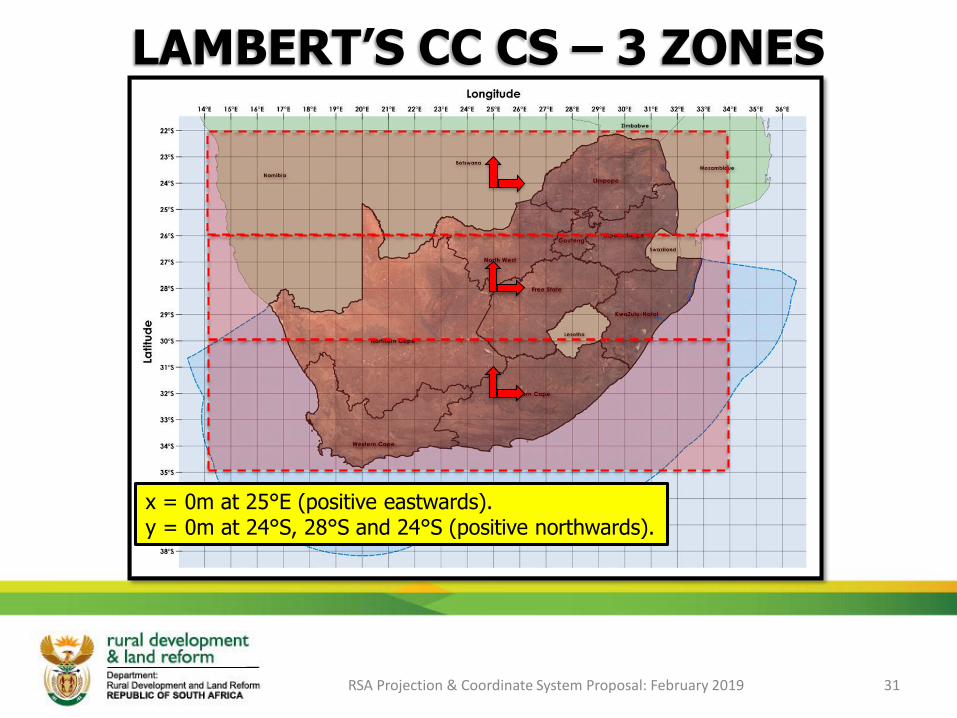
LAMBERT’S CC CS – 3 ZONES
RSA Projection & Coordinate System Proposal: February 2019 31
x = 0m at 25°E (positive eastwards).y = 0m at 24°S, 28°S and 24°S (positive northwards).
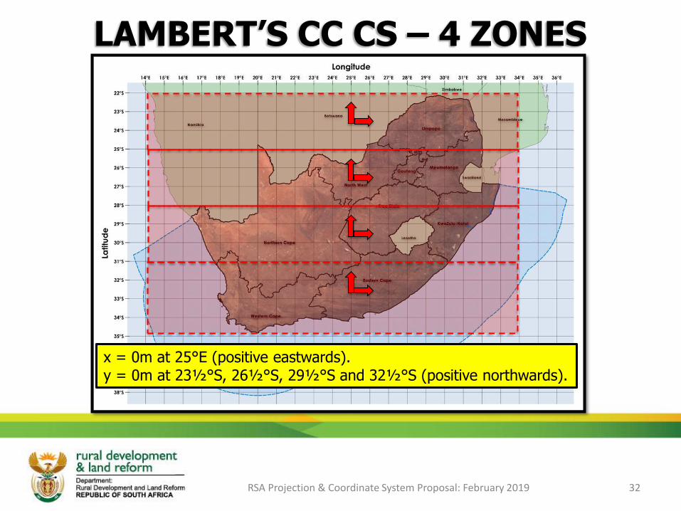
LAMBERT’S CC CS – 4 ZONES
RSA Projection & Coordinate System Proposal: February 2019 32
x = 0m at 25°E (positive eastwards).y = 0m at 23½°S, 26½°S, 29½°S and 32½°S (positive northwards).
AREA IMPLICATIONS
RSA Projection & Coordinate System Proposal: February 2019 33
➢ Area’s of fixed property are an important component of
ownership (Deeds & SG records) and taxation (Local
authorities);
➢ The areas used in these records are computed using the
current projected coordinate reference system, which is the
Gauss Conform (Transverse Mercator) projection system;
➢ How will a change in projection system affect area
calculations?
Click on the icon
to open…

OTHER ISSUES TO CONSIDER
➢ Legal matters (Deeds, SG and other records)?
➢ Geospatial datasets locked into the projection system?
➢ Discipline specific software (i.e. Cadastral, Engineering)?
➢ Geocoding based on current projection system?
➢ Mapping and map series?
➢ Raster geo-referencing (documents, imagery)?
➢ Who may and who must comply?
RSA Projection & Coordinate System Proposal: February 2019 34

THAT’S IT FOLKS!!
THANK YOU!!
RSA Projection & Coordinate System Proposal: February 2019 35