royce, bruno - paper 67 - road safety study - candia road crash · road safety study – candia...
TRANSCRIPT
Road Safety Study – Candia Road Bruno Royce Page 1
IPENZ Transportation Group Conference, Hamilton, 29 – 31 March 2017
ROAD SAFETY STUDY – CANDIA ROAD CRASH EVALUATION - ‘BEFORE’ AND ‘AFTER’
Author/Presenter:
Bruno Royce – BScEng (Civil) (Hons), MBA, CPEng, IntPE(NZ), MIPENZ, MIPENZ TG, APEC Engineer Director / Principal Traffic Engineer, Traffic Engineering Solutions Ltd (TES)
Email: [email protected]
17 February 2017
ABSTRACT
During a crash reduction study in 2009 it was established that a substantial rural road loss-of-control crash problem existed along Candia Road (Henderson, Auckland). The reported crashes appeared particularly adverse on the section from Henderson Valley Road to Sturges Road; this route becoming the focus of the investigation. As a result of the study, crash remedial works were recommended, designed and installed along the study cordon route (early 2010). The crash remedial works were mainly focussed at two bends within the study cordon, and the works were consistent with the Safe System principles of achieving ‘Safe Roads and Roadsides’, ‘Safe Speeds’, and ‘Safe Road Use’. In order to determine the effectiveness of the works in terms of reducing crashes, reported crash statistics have now been studied for a seven-year period before the works were implemented, and a seven-year period after the works were installed. The crash monitoring study has indicated that the combined package of constructed works achieved substantial lifetime crash savings of $24 million (including a downward crash trend). Also, a very high Benefit Cost Ratio (19) was achieved, and an average of 1.4 death/serious injury crashes were saved per year.
Road Safety Study – Candia Road Bruno Royce Page 2
IPENZ Transportation Group Conference, Hamilton, 29 – 31 March 2017
INTRODUCTION A crash reduction study in 2009 of Candia Road (Henderson, Auckland) established that a substantial rural road loss-of-control crash problem existed between Henderson Valley Road and Sturges Road. The outcome of the study was a package of crash remedial works which were constructed in early 2010. The majority of the works were implemented at two bends within the study cordon. In order to determine the effectiveness of the works, a ‘before’ and ‘after’ study was undertaken in 2017. Reported crashes were compared for a seven-year period ‘before’ the works were implemented (2003 – 2009, inclusive), and a seven-year period ‘after’ the improvements were installed (2010 – 2016, inclusive).
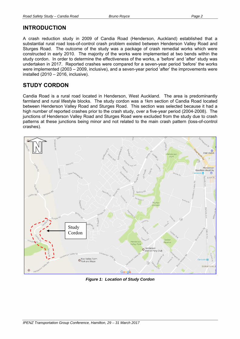
STUDY CORDON Candia Road is a rural road located in Henderson, West Auckland. The area is predominantly farmland and rural lifestyle blocks. The study cordon was a 1km section of Candia Road located between Henderson Valley Road and Sturges Road. This section was selected because it had a high number of reported crashes prior to the crash study, over a five-year period (2004-2008). The junctions of Henderson Valley Road and Sturges Road were excluded from the study due to crash patterns at these junctions being minor and not related to the main crash pattern (loss-of-control crashes).
Figure 1: Location of Study Cordon
Study Cordon
Road Safety Study – Candia Road Bruno Royce Page 3
IPENZ Transportation Group Conference, Hamilton, 29 – 31 March 2017
METHODOLOGY During the initial crash study, CAS crash plots (NZ Transport Agency) indicated that reported crashes were predominantly loss-of-control, and these were distributed along the entire study cordon route. However, a detailed review of individual Traffic Crash Reports revealed that most of the loss-of-control crashes on the CAS plots directly related to two major, sharper bends (to the north and south of Vineyard Road), with a relatively minor number of crashes related to a third more moderate bend (at Vineyard Road). Many of the crashes were not plotted correctly at the actual location of the bends, and there are two main reasons considered likely to explain this: Rural road crashes may be plotted in accordance with the final resting place of the errant
vehicle, rather than at the location where the loss-of-control problem begins. In the case of loss-of-control crashes the difference can be significant, as vehicles gradually losing control can traverse a sizeable distance before coming to rest. It is important to track loss-of-control crashes back to the original location of the problem; and
Rural roads often have few indicators to help identify an exact geographic location, and the
approximate location of a crash may be estimated based on a rough distance from the nearest side road. Detailed examination of Traffic Crash Reports can provide clues to help identify the causal factor and its precise location.
Crashes are often a result of a combination of contributory factors acting simultaneously. Along the subject route the loss-of-control crash problem was considered to be aggravated by a combination of the following key factors: Excessive vehicle speeds for the road environment, with two relatively sharp bends and
one moderate bend on a road with a posted speed of 70km/h; Lack of conspicuity of curve warning signage, with the existing curve warning signage being
technically correct but limited in terms of visibility (number, location, size, and obstructed by vegetation);
Narrow and unforgiving road shoulders, reducing the space available for motorists to
correct an errant vehicle; Ineffective road-marking delineation (faded edgeline and centreline); Irregular road surface condition (patch seal repairs and evidence of seal failure);
Inconsistent super-elevation (undulating road surface); Insufficient road surface skid resistance (visual evidence of longitudinal cracking and
flushing of seal surface).
The crash severity was considered to be exacerbated by the road’s narrow width, increasing the likelihood of head-on collisions. Also, a steep embankment existed on the outside of two bends, with no guardrails, increasing the risk of ‘R&R’ (Run-off and Roll-over) crashes. Figures 2 and 3 are photographs taken before any works were implemented, illustrating typical issues that existed along the route.

Road Safety Study – Candia Road Bruno Royce Page 4
IPENZ Transportation Group Conference, Hamilton, 29 – 31 March 2017
Figure 2: Visibility of Advance Warning signs obstructed by vegetation (facing Vineyard Road)
Figure 3: Signage and Road surface issues at the bend north of Vineyard Road
Large chevron with speed advisory needed
Narrow road shoulders
Road Safety Study – Candia Road Bruno Royce Page 5
IPENZ Transportation Group Conference, Hamilton, 29 – 31 March 2017
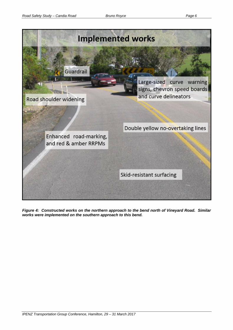
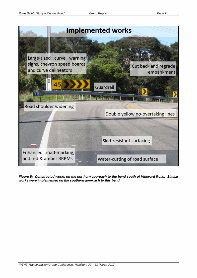
A package of crash remedial measures was proposed (TES 2009), with reference to general recommendations in technical guidelines (Austroads, 2009a; Austroads, 2009b; Transit New Zealand, 2009). The works were focussed mainly at the two sharper bends, and included the following (illustrated in Figures 4 and 5): Curve warning signage and chevrons: Upgrade quantity, size, visibility and double-gate; Embankment: Cut-back embankment to improve forward visibility on the inside of bend; Road shoulders: Widen and seal road shoulders, to provide a more forgiving roadside
and more opportunities for errant motorists to correct their vehicle if starting to lose control; Shape correction: To provide a smooth road surface and consistent super-elevation
around the bends; Skid resistant surface: A highly skid-resistant road surface (Polished Stone Value > 70) at
two bends, reducing likelihood of loss-of-control at the bends; Water-cutting: Water-cut the road surface on the approaches to the bends, to reduce the
likelihood of loss-of-control crashes on the approaches to the bends, but with reduced expenditure (as opposed to skid resistant surfacing);
Guardrail: Install guardrail, to prevent errant vehicles from R&R down an embankment on
the outside of two bends; No Overtaking: Install thermoplastic double yellow ‘No-Overtaking’ lines, to discourage
overtaking and speeding, and to reduce the visual appearance of the road’s width; Thermoplastic road-marking: Install thermoplastic road-marking for durability;
Raised pavement markers: Upgrade RRPM’s, with red and amber reflective faces for
edgeline and double yellow ‘No-Overtaking’, respectively;
Edge marker posts: Maintain posts and install additional posts, for improved delineation, particularly at night;
Vegetation trimming: To improve forward visibility of existing and proposed signage;
Street-lighting: Being a rural road, only flag-lighting of junctions was required. The junction at Vineyard Road had no crash problem and adequate flag-lighting;
Raised profile road-marking: This was recommended for edgelines and centrelines, for enhanced visibility and audible warning should a motorist start to deviate. However, it is understood that this recommendation was deleted from the final plans due to concerns about the possible effect of associated noise on local residents.
The proposed crash remedial works did not include special provisions for pedestrians and cyclists, since vulnerable road users weren’t significant in the reported crash statistics, and pedestrian / cyclist volumes were observed to be low. Figures 4 and 5 illustrate the proposed works as photographed after implementation.
Road Safety Study – Candia Road Bruno Royce Page 6
IPENZ Transportation Group Conference, Hamilton, 29 – 31 March 2017
Figure 4: Constructed works on the northern approach to the bend north of Vineyard Road. Similar works were implemented on the southern approach to this bend.
Road Safety Study – Candia Road Bruno Royce Page 7
IPENZ Transportation Group Conference, Hamilton, 29 – 31 March 2017
Figure 5: Constructed works on the northern approach to the bend south of Vineyard Road. Similar works were implemented on the southern approach to this bend.
Road Safety Study – Candia Road Bruno Royce Page 8
IPENZ Transportation Group Conference, Hamilton, 29 – 31 March 2017
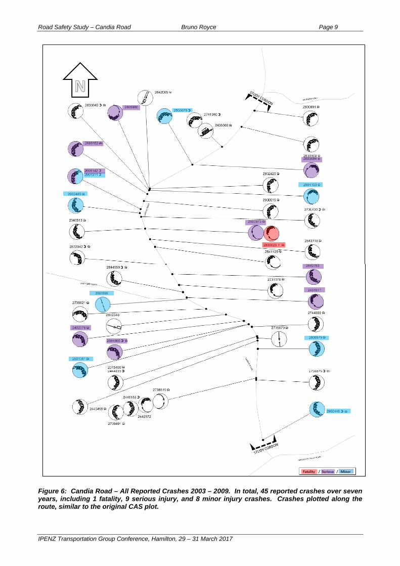
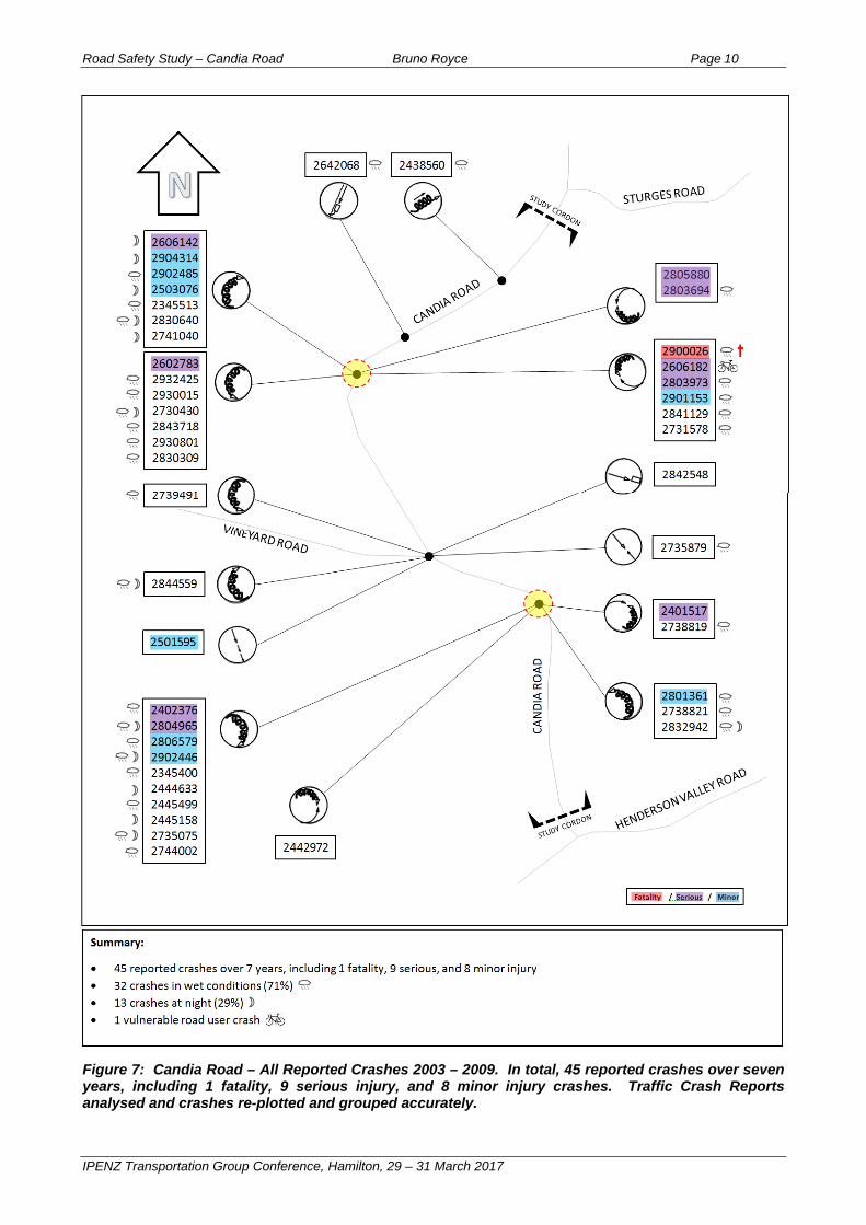
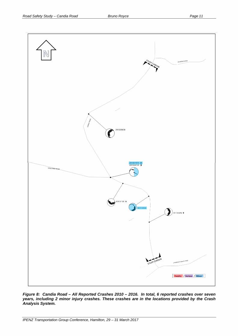
RESULTS Figure 6 illustrates a CAS plot of reported crash statistics ‘before’ the crash remedial measures were installed. The position of most crashes has not been edited, and the crashes appear to be distributed along the entire route. Figure 7 illustrates the same crashes as Figure 6, but Traffic Crash Reports have been analysed in detail and the exact nature, position and direction of each crash re-plotted. Correct interpretation of Traffic Crash Reports can require significant experience and technical expertise. This further analysis results in crash patterns being much stronger and more evident. This enables the causal factors to be identified more accurately, and any proposed remedial works to be focussed on the main issues. Figure 8 illustrates a CAS plot of reported crash statistics ‘after’ the crash remedial measures were installed. In this case the Traffic Crash Reports were not analysed for accuracy of the crashes’ positions and directions, as it is evident that there have been significant crash savings achieved, and the exact nature of the crash patterns are less relevant at this stage of the analysis. The works were installed in early 2010. Hence, for the crash monitoring, the ‘before’ analysis encompassed a seven-year period from 2003 to 2009 (inclusive), and the ‘after’ analysis encompassed a seven-year period from 2010 to 2016 (inclusive).
Road Safety Study – Candia Road Bruno Royce Page 9
IPENZ Transportation Group Conference, Hamilton, 29 – 31 March 2017
Figure 6: Candia Road – All Reported Crashes 2003 – 2009. In total, 45 reported crashes over seven years, including 1 fatality, 9 serious injury, and 8 minor injury crashes. Crashes plotted along the route, similar to the original CAS plot.
Road Safety Study – Candia Road Bruno Royce Page 10
IPENZ Transportation Group Conference, Hamilton, 29 – 31 March 2017
Figure 7: Candia Road – All Reported Crashes 2003 – 2009. In total, 45 reported crashes over seven years, including 1 fatality, 9 serious injury, and 8 minor injury crashes. Traffic Crash Reports analysed and crashes re-plotted and grouped accurately.
Road Safety Study – Candia Road Bruno Royce Page 11
IPENZ Transportation Group Conference, Hamilton, 29 – 31 March 2017
Figure 8: Candia Road – All Reported Crashes 2010 – 2016. In total, 6 reported crashes over seven years, including 2 minor injury crashes. These crashes are in the locations provided by the Crash Analysis System.
Road Safety Study – Candia Road Bruno Royce Page 12
IPENZ Transportation Group Conference, Hamilton, 29 – 31 March 2017
Overall, the crash savings achieved along the route for the combined package of constructed works were substantial, and far exceeded expectations and crash reduction savings typically expected and generated. The results are summarized as follows: From 2003 to 2009, 45 crashes were reported within the study cordon. Only 6 crashes
were reported from 2010 to 2016. Thus, reported crashes along the route have reduced 87%, a result with a statistical chi-squared significance greater than 99.9%;
Analysis of all reported loss-of-control crashes on roads in the Auckland area over the
same time periods shows a 22% reduction in loss-of-control crashes. Thus, over the same time periods, the reduction in reported crashes within the study cordon has far exceeded the control group crash trend. The percentage crashes saved taking into account the crash trend is 83%;
The 45 reported crashes before works included 1 fatality, 9 serious injury and 8 minor injury
crashes. The 6 crashes after works included only 2 minor injury crashes. The average number of death/serious injury crashes saved per year is 1.4; and
The estimated cost of construction of all the works was around $1 million, and reverse
discounted to present value would be around $1.3 million. Based on economic analysis (NZTA, 2016), Present value life-time crash cost savings were around $24 million (including the 22% downward crash trend), resulting in a Benefit Cost Ratio (BCR) of approximately 19.
The crash remedial works were innovative for the following reasons: The key causal factors relating to the crash patterns (excessive speed and loss of control at
the two main bends) were precisely identified by reading all the available Traffic Crash Reports, with most of the reported crashes re-positioned and re-plotted (Figure 7). The initial crash plot (Figure 6) indicated crashes distributed relatively evenly along the route, which was misleading, and necessitated preparation of Figure 7. Also, non-injury crashes were considered important to help identify crash patterns/locations;
A large number of complementary crash remedial measures were implemented
simultaneously at specific sites, focusing on the key issues, yet achieving a route-long Safe System crash saving;
The package of works that were implemented exceeded crash remedial works generally
recommended in technical guidelines to address similar issues, but were justified by the results, showing that significantly better outcomes can be achieved by doing more than the required minimum improvements.
The package of remedial works was cost effective, as evidenced by the substantial benefit-cost ratio achieved by the crash savings. The package of remedial works stands out beyond traditional activities in terms of the extremely high percentage of crash savings (87%), proven to have been achieved over a long period of time (seven years).
Road Safety Study – Candia Road Bruno Royce Page 13
IPENZ Transportation Group Conference, Hamilton, 29 – 31 March 2017
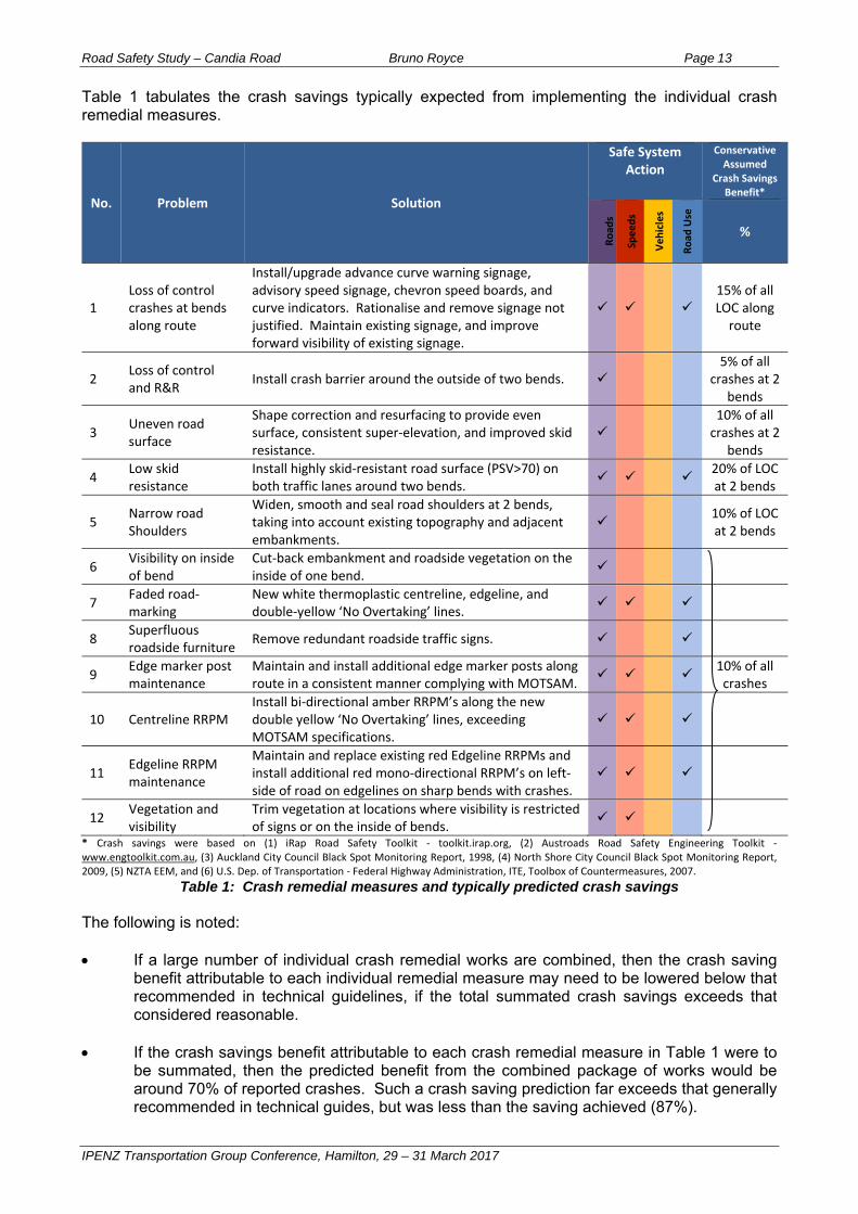
Table 1 tabulates the crash savings typically expected from implementing the individual crash remedial measures.
No. Problem Solution
Safe System Action
ConservativeAssumed
Crash Savings Benefit*
Road
s
Speeds
Vehicles
Road
Use
%
1 Loss of control crashes at bends along route
Install/upgrade advance curve warning signage, advisory speed signage, chevron speed boards, and curve indicators. Rationalise and remove signage not justified. Maintain existing signage, and improve forward visibility of existing signage.
15% of all LOC along route
2 Loss of control and R&R
Install crash barrier around the outside of two bends. 5% of all
crashes at 2 bends
3 Uneven road surface
Shape correction and resurfacing to provide even surface, consistent super‐elevation, and improved skid resistance.
10% of all crashes at 2
bends
4 Low skid resistance
Install highly skid‐resistant road surface (PSV>70) on both traffic lanes around two bends.
20% of LOC at 2 bends
5 Narrow road Shoulders
Widen, smooth and seal road shoulders at 2 bends, taking into account existing topography and adjacent embankments.
10% of LOC at 2 bends
6 Visibility on inside of bend
Cut‐back embankment and roadside vegetation on the inside of one bend.
7 Faded road‐marking
New white thermoplastic centreline, edgeline, and double‐yellow ‘No Overtaking’ lines.
8 Superfluous roadside furniture
Remove redundant roadside traffic signs.
9 Edge marker post maintenance
Maintain and install additional edge marker posts along route in a consistent manner complying with MOTSAM.
10% of all crashes
10 Centreline RRPM Install bi‐directional amber RRPM’s along the new double yellow ‘No Overtaking’ lines, exceeding MOTSAM specifications.
11 Edgeline RRPM maintenance
Maintain and replace existing red Edgeline RRPMs and install additional red mono‐directional RRPM’s on left‐side of road on edgelines on sharp bends with crashes.
12 Vegetation and visibility
Trim vegetation at locations where visibility is restricted of signs or on the inside of bends.
* Crash savings were based on (1) iRap Road Safety Toolkit ‐ toolkit.irap.org, (2) Austroads Road Safety Engineering Toolkit ‐ www.engtoolkit.com.au, (3) Auckland City Council Black Spot Monitoring Report, 1998, (4) North Shore City Council Black Spot Monitoring Report, 2009, (5) NZTA EEM, and (6) U.S. Dep. of Transportation ‐ Federal Highway Administration, ITE, Toolbox of Countermeasures, 2007.
Table 1: Crash remedial measures and typically predicted crash savings The following is noted: If a large number of individual crash remedial works are combined, then the crash saving
benefit attributable to each individual remedial measure may need to be lowered below that recommended in technical guidelines, if the total summated crash savings exceeds that considered reasonable.
If the crash savings benefit attributable to each crash remedial measure in Table 1 were to be summated, then the predicted benefit from the combined package of works would be around 70% of reported crashes. Such a crash saving prediction far exceeds that generally recommended in technical guides, but was less than the saving achieved (87%).
Road Safety Study – Candia Road Bruno Royce Page 14
IPENZ Transportation Group Conference, Hamilton, 29 – 31 March 2017
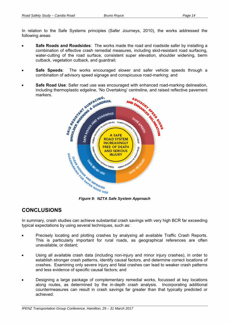
In relation to the Safe Systems principles (Safer Journeys, 2010), the works addressed the following areas: Safe Roads and Roadsides: The works made the road and roadside safer by installing a
combination of effective crash remedial measures, including skid-resistant road surfacing, water-cutting of the road surface, consistent super elevation, shoulder widening, berm cutback, vegetation cutback, and guardrail;
Safe Speeds: The works encouraged slower and safer vehicle speeds through a
combination of advisory speed signage and conspicuous road-marking; and Safe Road Use: Safer road use was encouraged with enhanced road-marking delineation,
including thermoplastic edgeline, ‘No Overtaking’ centreline, and raised reflective pavement markers.
Figure 9: NZTA Safe System Approach CONCLUSIONS In summary, crash studies can achieve substantial crash savings with very high BCR far exceeding typical expectations by using several techniques, such as: Precisely locating and plotting crashes by analysing all available Traffic Crash Reports.
This is particularly important for rural roads, as geographical references are often unavailable, or distant;
Using all available crash data (including non-injury and minor injury crashes), in order to establish stronger crash patterns, identify causal factors, and determine correct locations of crashes. Examining only severe injury and fatal crashes can lead to weaker crash patterns and less evidence of specific causal factors; and
Designing a large package of complementary remedial works, focussed at key locations along routes, as determined by the in-depth crash analysis. Incorporating additional countermeasures can result in crash savings far greater than that typically predicted or achieved.
Road Safety Study – Candia Road Bruno Royce Page 15
IPENZ Transportation Group Conference, Hamilton, 29 – 31 March 2017
REFERENCES Austroads (2009a). Guide to Road Safety Part 8: Treatment of Crash Locations. Sydney, Australia. Austroads (2009b). Guide to Road Design – Part 6: Roadside Design, Safety and Barriers. Sydney, Australia. NZTA (New Zealand Transport Agency) (formerly Transit New Zealand) (2009). Manual of Traffic Signs and Markings. Available at <https://www.nzta.govt.nz/resources/motsam/part-1/motsam-1.html> and <https://www.nzta.govt.nz/resources/motsam/part-2/motsam-2.html> NZTA (2011). High-risk rural roads guide, viewed 19 January 2017, <https://www.nzta.govt.nz/assets/resources/high-risk-rural-roads-guide/docs/high-risk-rural-roads-guide.pdf> NZTA (2016). Economic evaluation manual. Available at <https://www.nzta.govt.nz/resources/economic-evaluation-manual> NZTA. CAS Database, referenced January 2017, <https://securecas.nzta.govt.nz/Citrix/AccessPlatform/auth/login.aspx> Safer Journeys (2010), The Safe System approach, viewed January 2017, <http://www.saferjourneys.govt.nz/about-safer-journeys/the-safe-system-approach/> Traffic Engineering Solutions Ltd (2009). Scheme Plan Safety Improvements – Candia Road.
ACKNOWLEDGEMENTS I would like to thank David Yu (Senior Transportation Engineer – TES) for technical assistance, and Ivan Jurisich (Principal Traffic Engineer – TES) for technical advice, during the processes of undertaking both the crash investigation and crash monitoring. Also, I would like to thank Hussam Abdul-Rassol for having confidence in our analysis and approving construction of substantial crash remedial works on behalf of the (former) Waitakere City Council.