row power stripping maisonville twp
TRANSCRIPT

Ministry ofNorthern Developmentand Mines
Ontario.
DOCUMENT NO.
010.. w. w IWI
- Refer to Sections T6 and 77, the Mining Act tor i requirements and the reverse side o( this form tor table of Information.
Mining Act Report of WorkName and Address of Recorded Holder
i+JC,Prospector'* Licence No,
70 tfvf. L.AKC O*JT. /*X*/ 7. J" fTelephone No.•705--
Summary of Distribution of Credits and Work PerformanceMining Division
i-AAfoEA. UAKETownship or Area
/ //lATO/VW^tf T t0.Total Assessment Credits Claimed
X f o A*ysType of Work Performed (Check one only)
D Manual Work
[ , Shaft Sinking Drifting or other LJ Lateral Work
O Mechanical equipment
rn Power Stripping other than Manual WO (maximum credit allowed - 100 days
per claim) O Diamond or other Core drilling
Q Core Specimens
Mining Claim
Prefix
L
L,
L,
LL
L
Number
.Q6/2./7
SOT.?**-8cso 3 V^6*00 3^880/Z22.802.3* l
Work Days Cr.
ft
6Q31
3 1
312.1
Mining Claim
Prefix NumberWork
Days Cr.Mining Claim
Prefix NumberWork
DaysCr.
Dates when work was performed
From: S E^n 2 V /?O l To: O C T. 6. /9O
Total No. of Days Performed
/9o jG*ysTotal No. of Days Claimed
/fo A *ysTotal No. of Days to be Claimed at a Future Date
AJ/t-.
All the work was performed on Mining Claim(s): Indicate no. of days performed on each claim. * (See note No. 1 on reverse side)
Mining Claim No. of Days Mining Claim No o( Days
Mining Claim
(l-8oo3V6Mining Claim
No. of Days
32.3No. of Days
Mining Claim
L- Bo/ ill.Mining Claim
No. ol Days
&6-ZNo. of Days
Mining Claim
z.-#oo3vaMining Claim
No. of Days
9/-SNo. of Days
Mining Claim
i-778379
No. of Days
50Mining Claim No. of Days
Required Information eg. type of equipment, Names, Addresses, etc. (See Table on j-everse side) If space below Is insufficient, attach schedules with required information and location sketches"
3. f H.p, /y
/9 S /y*v. s ef*T.Tt46S.SCPT.^fO. SEPT. l 4/f Or/vvnj. j f fr. 2 7/90/foA/. o c.r. l /fo
- totfts.- /O.S HAS.- / O HAS.- 9 .S HAS.
oc/: f - /o HAS.
TOTAL - JT2.S-.ct> ///ov/? ^
Certification of Beneficial Interest * (See Note No. 2 on reverse side)1 hereby certify that, at the time the work was performed, the claims covered in this report of work were recorded in the current recorded holder's name or held under a beneficial interest by the current recorded holder.
Date
/V*j a. s /9o
Recorded Holder or Agent (Signature)
Certification Verifying Report of Work
l hereby certify that l have a personal and intimate knowledge of the facts set forth in the Report of Work annexed hereto, having performed the work or witnessed same during and/or after its completion and the annexed report is true.Name and Address of Person Certifying
Telephone No. Date
A/0V, f /jo
Certified By (Signature)
For Office Use OnlyWork AssignmentsL
1-) "S 3-~7 9 ^ 3^^.7SJ-o 3
y 2. o NOISIAIQ ON1NIW
768(89/06)

42A01NE54e5 W90e8-ee6S5 MAISONVILLE 900
JIM FORBES17 FOSS LANE
KIRKLAND LAKE, ONTARIOPHONE: 568-8361
Invoice to Carl P. Forbes - October 15. 1990
For hydraulic stripping 1n Maisonville Township using a 3.5 horsepower high pressure Honda supply pump with hoses and accessories; the dates are as follows:
Monday September 24/90 - 8 hours
Tuesday September 25/90 - 10 hours
Wednesday September 26/90 -10.5 hours
Thursday September 27/90 - 10 hours
Monday October 1/90 - 9.5 hours
Tuesday October 2/90 - 8 hours
Friday October 5/90 - 10 hours
Saturday October 6/90 - 10 hours
TOTAL - 76 Hours 9 125.00/per hour* $1900.00
For helping to sample and map stripped areas as follows:
Saturday October 13/90 - 8 hours
Sunday October 14/90 - 8 hours
TOTAL - 16 Hours 9 SlS.OO/per hour- S240.00
TOTAL INVOICE
Respectfully,
mes H. Forbes
S2140.00
PROSPECTING REPORT
ON THE
S E S E K I N I K A LAKE PROPERTY
MAISONVILLE TOWNSHIP
LARDER LAKE MINING DIVISION
BY: CARL P. FORBES
November 4, 1990 Kirkland Lake, Ontario

INDEX
INTRODUCTION
LOCATION AND ACCESS
HISTORY
Page Number
GEOLOGY 2,3
WORK PROGRAM 3,4,5
CONCLUSIONS 5,6
APPENDED
FOUR ASSAY SHEETS
2 ASSAY INVOICES
STRIPPING MAPS "A" TO "E" (5)
BULLDOZER INVOICES (5)
HYDRAULIC STRIPPING INVOICE

^INTRODUCTION- This report describes a surface exploration program
conducted on the Sesek1n1ka Lake gold property of
Premier Explorations Inc. located 1n Maisonville
Township, Larder Lake Mining Division, Ontario. This
program was funded by the Ontario Prospectors
Assistance Program and was designated as OP 90-077.
Surface stripping of previously known and new showings
was highly successful 1n furthering knowledge of the
character of gold mineralization on the property.
Several new veins were opened up and a number of
good assays were obtained. This program has
determined that more exploration work on the property
is fully warranted.
LOCATION AND ACCESS- The property consists of 76 unpatented mining
claims located in south central Maisonville Township
and encompasses most of what 1s historically known as
the Sesekinika Lake gold camp. Highway 11 passes just
west of the property about 17 miles north and west of
the Town of Kirkland Lake 1n northern Ontario.
Secondary Highway 570 branches southeasterly from
Highway 11 and leads to Seseklnika village which is
the southwest corner of the property. Forest access
roads for lumber operations afford easy access to the
central and eastern parts of the property which has
recently been clear cut.
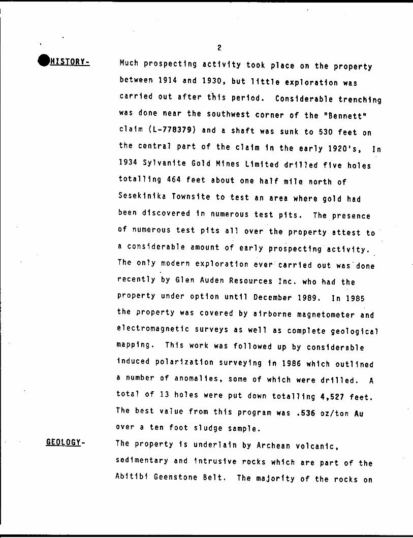
tolSTORY-
GEOLOGY-
Much prospecting activity took place on the property between 1914 and 1930, but little exploration was carried out after this period. Considerable trenching was done near the southwest corner of the "Bennett" claim (L-778379) and a shaft was sunk to 530 feet on the central part of the claim 1n the early 1920's, In 1934 Sylvanite Gold Mines Limited drilled five holes totalling 464 feet about one half mile north of Sesek1n1ka Townslte to test an area where gold had been discovered 1n numerous test pits. The presence of numerous test pits all over the property attest to a considerable amount of early prospecting activity. The only modern exploration ever carried out was done recently by Glen Auden Resources Inc. who had the property under option until December 1989. In 1985 the property was covered by airborne magnetometer and electromagnetic surveys as well as complete geological mapping. This work was followed up by considerable Induced polarization surveying 1n 1986 which outlined a number of anomalies, some of which were drilled. A total of 13 holes were put down totalling 4,527 feet. The best value from this program was .536 oz/ton Au over a ten foot sludge sample.
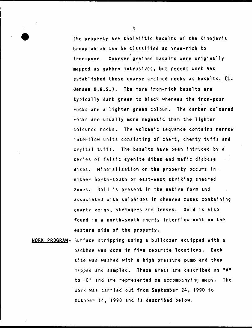
The property 1s underlain by Archean volcanic, sedimentary and intrusive rocks which are part of the Abitibi Geenstone Belt. The majority of the rocks on
3
the property are tholeiitic basalts of the K1nojev1s
Group which can be classified as Iron-rich tov
Iron-poor. Coarser grained basalts were originally
mapped as gabbro 1ntrus1ves, but recent work has
established these coarse grained rocks as basalts. (L.
Jensen O.G.S.). The more Iron-rich basalts are
typically dark green to black whereas the Iron-poor
rocks are a lighter green colour. The darker coloured
rocks are usually more magnetic than the lighter
coloured rocks. The volcanic sequence contains narrow
Interflow units consisting of chert, cherty tuffs and
crystal tuffs. The basalts have been Intruded by a
series of felsic syenite dikes and mafic diabase
dikes. Mineralization on the property occurs In
either north-south or east-west striking sheared
zones. Gold 1s present 1n the native form and
associated with sulphides 1n sheared zones containing
quartz veins, stringers and lenses. Gold 1s also
found 1n a north-south cherty Interflow unit on the
eastern side of the property.
WORK PROGRAM- Surface stripping using a bulldozer equipped with a
backhoe was done 1n five separate locations. Each
site was washed with a high pressure pump and then
mapped and sampled. These areas are described as "A"
to "E" and are represented on accompanying maps. The
work was carried out from September 24, 1990 to
October 14, 1990 and 1s described below.

"A" STRIPPING 1s 1n the northeast part of claim L-800346
and shows a quartz-sulphide vein zone 1n coarse grainedv
basalt. Seventeen samples were taken here and some
good gold assays were obtained. These are shown on a
sketch map scaled one Inch to fifteen feet.
"B" STRIPPING 1s about 100 feet north of the "A"
stripping on claim L-800346. Seven samples were taken
from a sheared zone with quartz veins 1n coarse
grained basalt. An encouraging assay was obtained at
the eastern extremity of this stripping. The results
are shown on a sketch map scaled at one Inch to ten
feet.
"C" STRIPPING 1s 1n the northeast part of claim
L-801222. Eight samples were taken from a sheared
zone with quartz veins, but returned only very low
values. These are represented on a map scaled at one
Inch to ten feet.
"D* STRIPPING was done 1n the northwest part of claim
L-800348 and the quartz filled shear zone 1s probably
the extension of the zone exposed 1n "C" stripping.
Most of the 21 samples taken here returned only low
values, but one section assayed .354 oz/ton Au over
five feet. A parallel zone about 40 feet to the north
was exposed and four samples taken there yielded very
low values. These samples are represented on a map
scaled at one Inch to fifteen feet.
5
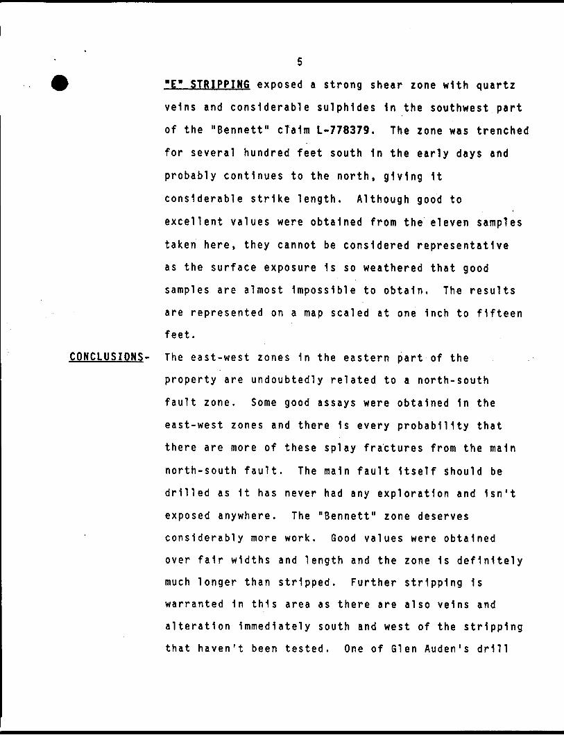
"E* STRIPPING exposed a strong shear zone with quartz
veins and considerable sulphides 1n the southwest part
of the "Bennett" cTalm L-778379. The zone was trenched
for several hundred feet south 1n the early days and
probably continues to the north, giving 1t
considerable strike length. Although good to
excellent values were obtained from the eleven samples
taken here, they cannot be considered representative
as the surface exposure 1s so weathered that good
samples are almost Impossible to obtain. The results
are represented on a map scaled at one Inch to fifteen
feet.
CONCLUSIONS- The east-west zones 1n the eastern part of the
property are undoubtedly related to a north-south
fault zone. Some good assays were obtained 1n the
east-west zones and there 1s every probability that
there are more of these splay fractures from the main
north-south fault. The main fault Itself Should be
drilled as 1t has never had any exploration and Isn't
exposed anywhere. The "Bennett" zone deserves
considerably more work. Good values were obtained
over fair widths and length and the zone 1s definitely
much longer than stripped. Further stripping 1s
warranted 1n this area as there are also veins and
alteration Immediately south and west of the stripping
that haven't been tested. One of Glen Auden's drill

holes tested the zone on the south boundary of the
claim and returned ,'l07 oz/ton Au over 5 feet. A
series of short holes 1n this locality might prove to
be the best way to sample this zone.
Respectfully Submitted by,
Carl P. Forbes
Licence K18293
November 4, 1990.

SKETCH M rt/0 O P XV9" C.LAIH- L-QO03*J6 -
EA LAKE M 1*1 td G
SCALE: l //JC H s JS FZGT
c. P.OCT. V /
853 -,6\ '.17 2.
865- . 003
+K-85Z. NIU
H 1865
^-H-M8fcO-.ool
86130
recA
•Oo3L
s
s
0•q
•862.-MIL
-STAAT iiiasi

l1H m I rn 1 * * i OD
^
(to
NOT
TO s
e/ae
3oo
0
m Q i Z.
V
'AM
Tft
*\
/
l* OD
liD
*
--
*6*
D !:
h,
* h
•o
C? '
D O
O
S ^
q *
* *
- h
"* r
J" S l rx. |l
NO
T
TO

f;Q iUl
-Jos ? rsi
Ut fM
V
-J g
U
m v.Q fi-
vi *
VJ -Ji;oo-HVJCI
0l**'-r'c
\
*"** A
^V
st\s
A^
0
tf3^r ? ,
o l
X
f f T (^v^^~
-i-^^v-v~-'-*---*-'—
~Q
^'r^ri SM
*-^^7
^A
lCtf\
l**l"
8 A
/ox/r/5
f
7 I
7i
; '
t o
1 ;
^i
o i
1 V(
's'
1X
J1V
i'"^/Q
o'e
Asr
yT-o^/i/fej
w.1viM^Ut5̂a m5
N4< r*u,*^j ^
5^t KM
t* .
ViK5
.ss0
*-3s*'ir-t-fli

o.?
s 1Q••xyj
* ;
Q^
S vb
k
coJ-
^?Uj
f Ul
w d̂
5^ ^
i
^UJ
^vi
U
If
U
Q
00Ul
al


GRENFELL TWP - M.35! l NOTICg OF FORESTRY ACTIV