route guidance section 3 - priuschat guidance 79 the voice guidance provides various mes-sages as...
TRANSCRIPT

SECTION 3
ROUTE GUIDANCE
75
ROUTE GUIDANCE
� Route guidance screen 76
� Typical voice guidance prompts 79
� Distance and time to destination 81
� Setting and deleting destinations 82
Adding destinations 82. . . . . . . . . . . . . . . . . . . . . . . . . . . . . . . . . . . Reordering destinations 82. . . . . . . . . . . . . . . . . . . . . . . . . . . . . . . Deleting destinations 83. . . . . . . . . . . . . . . . . . . . . . . . . . . . . . . . .
� Setting route 84
Detour setting 84. . . . . . . . . . . . . . . . . . . . . . . . . . . . . . . . . . . . . . . . Route overview 85. . . . . . . . . . . . . . . . . . . . . . . . . . . . . . . . . . . . . . Route preference 87. . . . . . . . . . . . . . . . . . . . . . . . . . . . . . . . . . . . Pausing and resuming guidance 89. . . . . . . . . . . . . . . . . . . . . . .
� Show on map 90
Display POI icons 90. . . . . . . . . . . . . . . . . . . . . . . . . . . . . . . . . . . . Route trace 94. . . . . . . . . . . . . . . . . . . . . . . . . . . . . . . . . . . . . . . . . .
� XM NavTraffic 96
∗: Point of Interest

ROUTE GUIDANCE
76
During route guidance, various types ofguidance screens can be displayed de-pending on conditions.
� Screen layout
1 Distance to the next turn and thearrow indicating turning direction
2 Current street name3 Distance and travel/arrival time to
the destination4 Current position5 Guidance route
INFORMATION� If the vehicle goes off the guidance
route, the route is searched again.
� For some areas, the roads have notbeen completely digitized in ourdatabase. For this reason, theroute guidance may select roadthat should not be traveled on.
� When you arrive at your destina-tion, the destination name will bedisplayed on the top of the screen.Touching “��Off” clears the dis-play.
� During freeway drivingDuring freeway driving, the freeway exit in-formation screen will be displayed.
This screen displays the distance to thenext junction and exit, or POIs in the vicin-ity of the freeway exit.
1 Current position2 Points of Interest that are close to
a freeway exit3 Exit number and junction name4 Distance from the current position
to the exit or junction5 Current street name
“Map”: To display the selected map of theexit vicinity.
: To scroll for farther junctions or exits.
: To scroll for closer junctions or exits.
: To scroll for the closest 3 junctions or
exits.
Route guidance screen

ROUTE GUIDANCE
77
� When approaching a freeway exit orjunction
When the vehicle approaches an exit orjunction, the guidance screen for the free-way will be displayed.
1 Next street name2 Distance from the current position
to the exit or junction3 Current position
“Off”: The guidance screen on freewaydisappears and the map screen appears.
When touching or push-ing the “MAP/VOICE” button, the guid-ance screen on freeway reappears.
� When approaching an intersectionWhen the vehicle approaches an intersec-tion, the intersection guidance screen willbe displayed.
1 Next street name2 Distance to the intersection3 Current position
“Off”: The intersection guidance screendisappears and the map screen appears.
When touching or push-ing the “MAP/VOICE” button, the inter-section guidance screen reappears.

ROUTE GUIDANCE
78
� Other screensTURN LIST SCREENOn this screen, the list of turns on the guid-ance route can be viewed.
Touching during guid-
ance displays the turn list.
1 Next street name or destinationname
2 Turn direction3 Distance between turns4 Current street name
ARROW SCREENOn this screen, information about nextturns on the guidance route can be viewed.
Touching during guid-ance displays the arrow screen.
1 Exit number, street name contain-ing number or next street name
2 Turn direction3 Distance to the next turn4 Current street name

ROUTE GUIDANCE
79
The voice guidance provides various mes-sages as you approach an intersection, orother point where you need to maneuverthe vehicle.
4.7 miles
0.5 miles
1 “Proceed about 5 miles to Mainstreet.”
2 “In half of a mile, right turn ontoMain street.”
3 “Right turn.”
4 (Beep sound only)
INFORMATION� The street names may not be pro-
nounced correctly or clearly due totext−to−speech function.
� On freeways, interstates or otherhighways with higher speed limits,the voice guidance will be made atearlier points than on city streets inorder to allow time to maneuver.
4.2 miles
0.5 miles
1 “Proceed about 4 miles to thetraffic circle.”
2 “In half of a mile, traffic circleahead, and then 3rd exit aheadonto Main street.”
3 “The 3rd exit ahead.”
4 “The exit ahead.”
5 (Beep sound only)
Typical voice guidanceprompts

ROUTE GUIDANCE
80
One−way road
One−way road
∗: The system indicates a U−turn if the dis-tance between two one−way roads (of op-posite directions) is less than 50 feet (15m) in residential areas or 164 feet (50 m)in non−residential areas.
1 “In half of a mile, make a legalU−turn.”
2 “Make a legal U−turn ahead.”
3 (Beep sound only)
The system announces the approach tothe final destination.
1 “Your destination is ahead.”
2 “You have arrived at your des-tination. The route guidance isnow finished.”
INFORMATION� If the system cannot determine the
current vehicle position correctly(in cases of poor GPS signal recep-tion), the voice guidance may bemade early or delayed.
� If you did not hear the voice guid-ance command, push the “MAP/VOICE” button to hear it again.
� To adjust the voice guidance vol-ume, see “� Voice volume” onpage 243.

ROUTE GUIDANCE
81
When the vehicle is on the guidance route,the distance and the estimated travel/arriv-al time to the destination are displayed.When the vehicle is not on the guidanceroute, the distance and the direction of thedestination are displayed.
When driving on the guidance route andmore than one destination is set, the dis-tance and the estimated travel/arrival timefrom the current position to each destina-tion are displayed.
1. Touch this button to display the fol-lowing screen.
2. Touch the number button to displaythe desired destination.
The distance, the estimated travel timeand the estimated arrival time from the cur-rent position to the selected destinationare displayed.
Estimated travel time is dis-played.
Estimated arrival time is dis-played.
To switch to estimated arrivaltime.
To switch to estimated traveltime.
Displayed while driving off theguidance route. The destina-tion direction is indicated byan arrow.
INFORMATIONWhen the vehicle is on the guidanceroute, the distance measured alongthe route is displayed. Travel timeand arrival time is calculated basedon the set vehicle speed information.(See page 247.) However, when thevehicle is not on the guidance route,the distance is the linear distance be-tween the current position and thedestination.
Distance and time todestination
ROUTE GUIDANCE
82
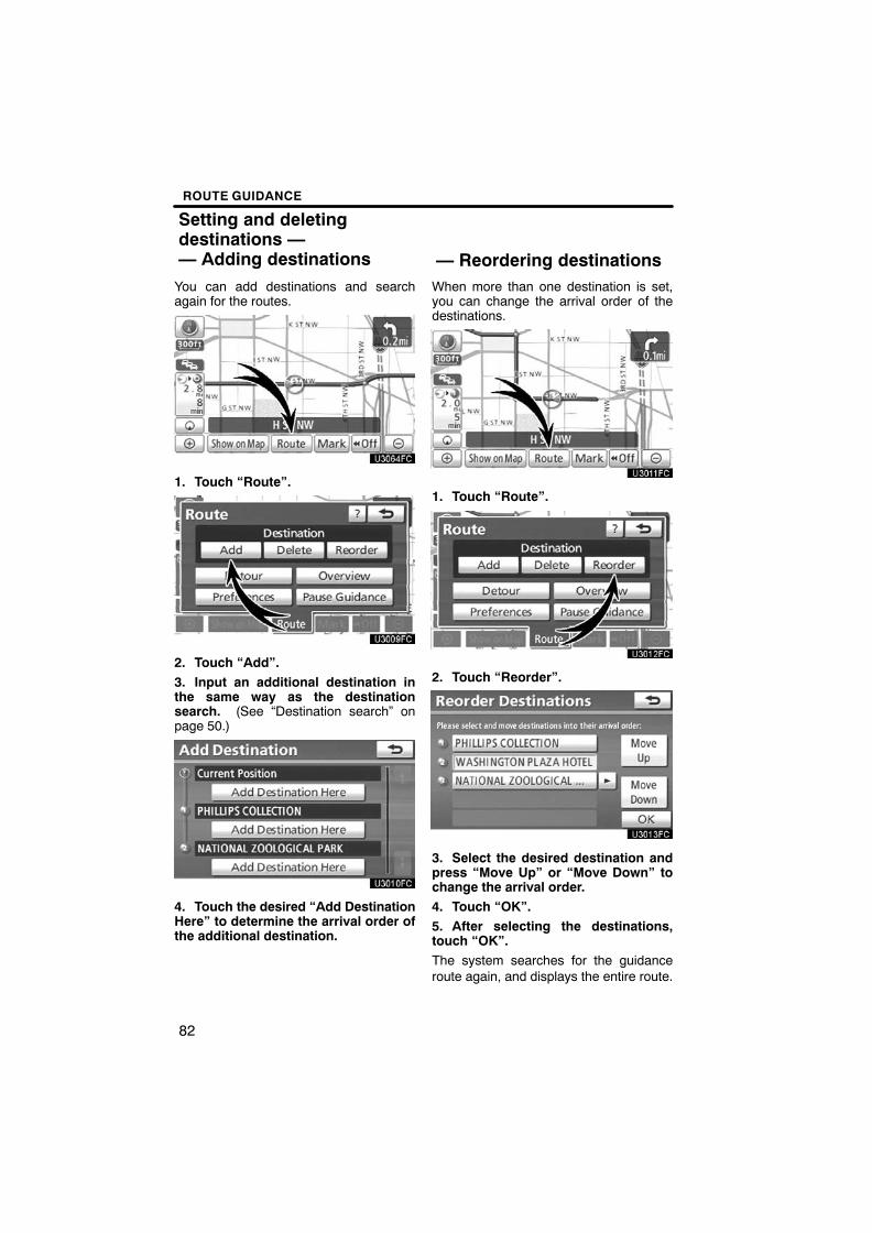
You can add destinations and searchagain for the routes.
1. Touch “Route”.
2. Touch “Add”.3. Input an additional destination inthe same way as the destinationsearch. (See “Destination search” onpage 50.)
4. Touch the desired “Add DestinationHere” to determine the arrival order ofthe additional destination.
When more than one destination is set,you can change the arrival order of thedestinations.
1. Touch “Route”.
2. Touch “Reorder”.
3. Select the desired destination andpress “Move Up” or “Move Down” tochange the arrival order.4. Touch “OK”.5. After selecting the destinations,touch “OK”.The system searches for the guidanceroute again, and displays the entire route.
Setting and deletingdestinations —— Adding destinations — Reordering destinations

ROUTE GUIDANCE
83
A set destination can be deleted.
1. Touch “Route”.
2. Touch “Delete”.When more than one destination is set, alist will be displayed on the screen.
3. Touch the destination for deletion.“Select All”: To select all destinations onthe list.
“Unselect All”: To unselect all of the se-lected destinations.
A message appears to confirm the requestto delete.
4. To delete the destination(s), touch“Yes”.If “Yes” is touched, the data cannot be re-covered.
If “No” is touched, the previous screen willreturn.
The system searches for the guidanceroute again, and displays the entire route.
— Deleting destinations

ROUTE GUIDANCE
84
While the route guidance is operating, youcan change the route to detour around asection of the route where a delay iscaused by road repairs, or an accident,etc.
1. Touch “Route”.
2. Touch “Detour”.
3. Select the button below to select thedesired detour distance.“1 mile (km)”, “3 miles (km)” or “5 miles(km)”: Touch one of these buttons to startthe detour process. After detouring, thesystem returns to the original guidanceroute.
“Whole Route”: By touching this button,the system will calculate an entire newroute to the destination.
“Around Traffic”: If you touch this button,the system will search for the route basedon the traffic congestion information re-ceived from XM� NavTraffic. For details,see “XM� NavTraffic” on page 96.
Setting route —— Detour setting

ROUTE GUIDANCE
85
This picture shows an example of how thesystem would guide around a delaycaused by a traffic jam.1 This position indicates the location of
a traffic jam caused by road repairs oran accident.
2 This route indicates the detour sug-gested by the system.
INFORMATION� When your vehicle is on a freeway,
the detour distance selections are5, 15, and 25 miles (km).
� The system may not be able to cal-culate a detour route depending onthe selected distance and sur-rounding road conditions.
1. Touch “Route”.
2. Touch “Overview”.
The entire route from the current positionto the destination is displayed.
“OK”: To start guidance.
“Turn List”: The following screen displaysthe list of the roads up to the destination.
“Preview”: To preview the route.
— Route overview

ROUTE GUIDANCE
86
You can scroll through the list of roads by
touching or . However, not all
road names in the route may appear on thelist. If a road changes its name without re-quiring a turn (such as on a street that runsthrough two or more cities), the namechange will not appear on the list. Thestreet names will be displayed in orderfrom the starting point, along with the dis-tance to the next turn.
These marks indicate thedirection in which you shouldturn at an intersection.
Touch “Map” on the “Turn List” screen.The point which you choose is displayedon the map screen.
� Route preview
1. Touch “Route”.
2. Touch “Overview”.
3. Touch “Preview”.
ROUTE GUIDANCE
87
: To indicate the next destination.
: To preview the route to the nextdestination.
: To preview the route to the nextdestination in fast−forward mode.
: To stop the preview.
: To review the route to the previousdestination or starting point.
: To review the route to the previousdestination or starting point infast−forward mode.
: To indicate the previous destina-tion or starting point.
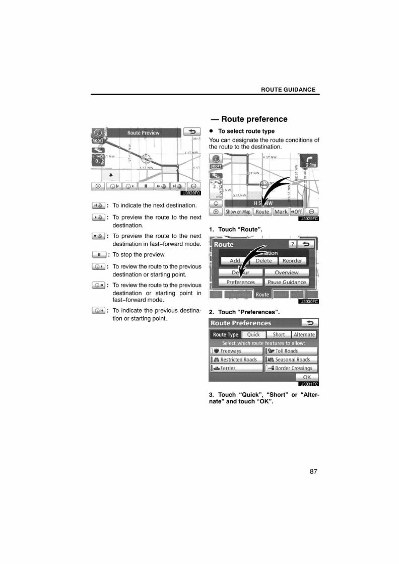
� To select route typeYou can designate the route conditions ofthe route to the destination.
1. Touch “Route”.
2. Touch “Preferences”.
3. Touch “Quick”, “Short” or “Alter-nate” and touch “OK”.
— Route preference

ROUTE GUIDANCE
88
The entire route from the starting point tothe destination is displayed.
“OK”: To start guidance.
“Edit Route”: To change a route. (Seepage 73.)
� To select route featuresA number of choices are provided on theconditions which the system uses to deter-mine the route to the destination.
1. Touch “Route”.
2. Touch “Preferences” to change theconditions that determine the route tothe destination.
3. Select the desired route preferenceby touching the button.When searching for a route, the system willavoid routes when the indicator is off.
4. After choosing the desired routepreference, touch “OK”.
ROUTE GUIDANCE
89
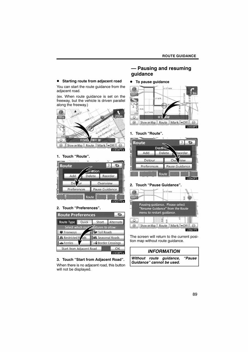
� Starting route from adjacent roadYou can start the route guidance from theadjacent road.
(ex. When route guidance is set on thefreeway, but the vehicle is driven parallelalong the freeway.)
1. Touch “Route”.
2. Touch “Preferences”.
3. Touch “Start from Adjacent Road”.When there is no adjacent road, this buttonwill not be displayed.
� To pause guidance
1. Touch “Route”.
2. Touch “Pause Guidance”.
The screen will return to the current posi-tion map without route guidance.
INFORMATIONWithout route guidance, “PauseGuidance” cannot be used.
— Pausing and resumingguidance

ROUTE GUIDANCE
90
� To resume guidance
1. Touch “Route”.
2. Touch “Resume Guidance”.
The screen will change to the current posi-tion map with route guidance.
Points of Interest such as gas stations andrestaurants can be displayed on the mapscreen. You can also set their location asa destination and use them for route guid-ance.
1. Touch “Show on Map”.
2. Touch “Select POI” to display a par-ticular type of Point of Interest on thescreen.When the Points of Interest to be displayedon the map screen have already been set,“Change POI” is displayed.
A screen with a limited choice of Points ofInterest will be displayed. (To change thedisplayed POI, see page 249.)
Show on map —— Display POI icons

ROUTE GUIDANCE
91
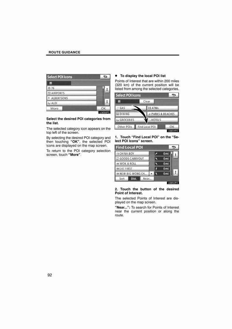
� Selecting POIs to be displayedUp to 5 categories of icons can be dis-played on the screen.
Touch the desired Point of Interestcategory to display POI location sym-bols on the map screen.By selecting the desired POI category andthen touching “OK”, the selected POIicons are displayed on the map screen.
To turn off the Points of Interest icons onthe map screen, touch “Clear”.
“Other POIs”: If the desired Point of Inter-est can not be found on the limited choicescreen, touch this button.
“Find Local POI”: When searching for thenearest Point of Interest, touch this button.Then choose one of the categories. Thesystem will list the points within 200 miles(320 km). (See page 92.)
Touch “Other POIs” on the “Select POIIcons” screen.When a Point of Interest category is se-lected from either the limited list or thecomplete list, the screen will display sym-bols of those locations on the map screen.
Select the desired POI categories.
The selected category icon appears on thetop left of the screen.
By selecting the desired POI category andthen touching “OK”, the selected POIicons are displayed on the map screen.
If the desired POI category is not on thescreen, touch “List All Categories” to listall POI categories.
ROUTE GUIDANCE
92
Select the desired POI categories fromthe list.
The selected category icon appears on thetop left of the screen.
By selecting the desired POI category andthen touching “OK”, the selected POIicons are displayed on the map screen.
To return to the POI category selectionscreen, touch “More”.
� To display the local POI listPoints of Interest that are within 200 miles(320 km) of the current position will belisted from among the selected categories.
1. Touch “Find Local POI” on the “Se-lect POI Icons” screen.
2. Touch the button of the desiredPoint of Interest.The selected Points of Interest are dis-played on the map screen.
“Near...”: To search for Points of Interestnear the current position or along theroute.

ROUTE GUIDANCE
93
“Near Here” : When “Near Here” istouched, the list of Points of Interest nearthe current position will be displayed.
“Along My Route” : When “Along MyRoute” is touched, the list of Points of In-terest along the route will be displayed.
� To set a POI as a destinationYou can select one of the Points of Interesticons on the map screen as a destinationand use it for route guidance.
1. Directly touch the Point of Interesticon that you want to set as a destina-tion.The map will shift so that the icon is cen-tered on the screen and overlaps with thecursor . At this time, the distance fromthe current position is displayed on thescreen. The distance shown is measuredas a straight line from the current vehicleposition to the POI.
2. When the desired Point of Interestoverlaps with the cursor, touch “Enter
”.The screen changes and displays the maplocation of the selected destination androute preference. (See “Starting routeguidance” on page 70.)

ROUTE GUIDANCE
94
� To hide POI icons
1. Touch “Show on Map”.
2. Touch “POI Icons”.The “POI Icons” indicator is dimmed.
The map screen will be displayed with thePOI icons hidden.
To display the POI icons again, touch “POIIcons” on the “Show on Map” screen.
It is possible to store the traveled route upto 124 miles (200 km) and retrace the routeon the display.
INFORMATIONThis feature is available on the mapwith more detailed map scale than 30mile (50 km).
— Route trace

ROUTE GUIDANCE
95
� To start recording the route trace
1. Touch “Show on Map”.
2. Touch “Route Trace”. “Route Trace” indicator is highlighted.
� To stop recording the route trace
1. Touch “Show on Map”.
2. Touch “Route Trace”. The followingscreen will be displayed.
Touching “Yes” stops recording and theroute trace remains displayed on thescreen.
Touching “No” stops recording and theroute trace is erased.

ROUTE GUIDANCE
96
The XM� NavTraffic service that allows thenavigation system to display traffic infor-mation on the map is available if your satel-lite radio tuner can receive traffic informa-tion.
To receive the XM� NavTraffic service, asubscription to the XM� Satellite Radiowith NavTraffic is necessary.
The XM� NavTraffic is available in the con-tiguous 48 U.S. states and some Canadiancities. For details about the XM� NavTraf-fic service coverage area, refer towww.xmradio.com (U.S.A.) or www.xmra-dio.ca (CANADA).
� How to activate the XM� NavTrafficservice
To receive the XM� NavTraffic service,it is necessary to activate the service.To activate the service, an extra fee isrequired in addition to subscriptionfees for the XM� Satellite Radio. Fordetails about service and activation,call XM� Listener Care Center at1−800−967−2346 (U.S.A.) or1−877−438−9677 (CANADA).
Customers should have their radio IDready; the radio ID can be found by select-ing “channel 000” on the radio. For details,see “(b) Displaying the radio ID” on page155.
XM� Satellite Radio has the responsibilityfor all fees and service, they are subject tochange.
The following operations can be per-formed.
� Show XM� NavTraffic InformationTraffic information is displayed on the map.(See page 97.)
� Auto Avoid TrafficIf any heavy congestion or moderate traffichas been detected on the guidance route,it may be possible for you to select anotherroute offered by the system. (See page248.)
� Traffic Voice GuidanceTraffic information is provided using voiceguidance. (See page 244.)
� Show Free Flowing TrafficFreely flowing traffic is shown by the arrowon the map. (See page 249.)
INFORMATION� Traffic voice guidance is available
only in English. To select English,see “� Selecting a language” onpage 237.
� When the “Traffic Information” in-dicator is dimmed, “Auto AvoidTraffic”, “Traffic Voice Guidance”and “Show Free Flowing Traffic”will not operate.
XM� NavTraffic

ROUTE GUIDANCE
97
� Show XM� NavTraffic information
1. Touch “Show on Map”.
2. Touch “Traffic Information”. “Traffic Information” indicator is high-lighted.
XM� NavTraffic information is displayedon the map.
� On Map screen
� On Freeway information screen

ROUTE GUIDANCE
98
1 XM� NavTraffic iconWhen any traffic information has beenreceived, the XM� NavTraffic icon willappear on the map screen. Touching theXM� NavTraffic icon on the screen willstart voice guidance for the traffic informa-tion. (See page 38.)
INFORMATIONWhen the XM� NavTraffic icon istouched, voice guidance for the traf-fic information will start even if “Off”for “Traffic Voice Guidance” is se-lected.
2 XM� NavTraffic information arrowWhen any XM� NavTraffic information hasbeen received, the XM� NavTraffic infor-mation arrow will appear on the mapscreen. The color of the arrow changesdepending on the traffic information re-ceived.
“Orange”: Heavy congestion
“Yellow”: Moderate traffic
“Green”: Freely flowing traffic
3 XM� NavTraffic indicatorWhen any XM� NavTraffic information hasbeen received, the XM� NavTraffic indica-tor will appear on the screen. The color ofthe indicator changes depending on thetraffic information received.
“White”: Traffic information has been re-ceived.
“Yellow”: Traffic restriction information onthe guidance route has been received(touch switch*).
“Orange”: Congestion information on theguidance route has been received (touchswitch*).
*: Touching the XM� NavTraffic indicatorwill start voice guidance.