route details - drive 4 corners bmw meet
TRANSCRIPT
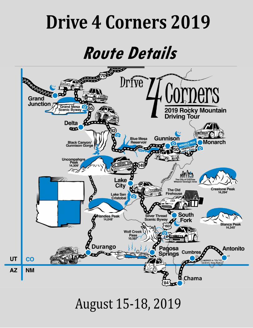
Route Details
Welcome! The Drive 4 Corners Event Team is excited that you are able to join us for the 2019 driving tour. We have organized a scenic driving route that is a path less traveled through the Rocky Mountains of Colorado. Knowing the driving route, schedule, and having meal plans is your responsibility. Be sure you know where you are going— we have provided address’ for this purpose.
We will have a few checkpoints and recommended stops, but sections of the route may not have
cell service. Due to the nature of the event home base changing nightly, it is important that you have a
good idea of where we are going in case you are separated from the group. Attend any activities at
your leisure, but we recommend joining for the driving groups and the social gatherings!
Safety Information
All participants should be aware of the safety concerns of high altitudes which are along the route! To avoid altitude sick-
ness, be sure to stay hydrated. Drinking lots of water will be the best way to prevent altitude sickness or dehydration.
Bring at least 1 liter of water per person in your vehicle. Snacks are recommended as well. Some of the route and stops
are at high altitude where he sunburn risk increases dramatically. Always wear sunscreen SPF 30+ sunblock!. This is espe-
cially important at higher elevations!
Drive 4 Corners does not condone unsafe or erratic driving. Please follow all local driving laws and be courteous and safe
in all situations when driving between D4C 2019 stops. All participants of Drive 4 Corners must read and sign the waiver of
liability to assume all risks involved in the weekend. Obeying all traffic laws and driving in a safe manner is the best way
to ensure your trip driving tour is enjoyable and safe!
Drive 4 Corners 2019
Rocky Mountain Driving Tour
-Drive 4 Corners Event Team
Event Sponsors
A big thank you to all of our event sponsors. Without their gracious support, Drive 4 Corners would not be possible. Please
take a moment to recognize our sponsors and thank their representatives if you meet them during the weekend!
2019 Event Sponsors
Description Name Number
General Questions Tom Schultz 303-249-4632
Go-carting in Grand Junction Tim Schultz 303-513-6638
Ristorante Pantuso Ristorante Pantuso 970-255-0000
Exxon Palisade Group Drive Leaders Marc Belz
Aaron Blair
719-351-4248
303-918-3709
Crawford, CO Regroup Greg Frank 719-352-9988
Gunnison County Fairgrounds Ice Cream Social Tom Schultz 303-249-4632
Monarch Extended Drive Aubrey Wright 214-500-9600
Blue Mesa Reservoir Meetup (Iola Boat Ramp) Marc Belz 719-351-4248
Lake San Cristobal Group Photo Aubrey Wright 214-500-9600
Freemon’s General Store [CASH ONLY] Freemon’s General 719-658-2954
The Old Firehouse—Awards & Group Photo Ted Schultz 303-249-4586
Wolf Creek Pass Meetup Tom Schultz 303-249-4632
Blue Mesa Reservoir
Blue Mesa Reservoir — part of Curecanti National Recreation Area — is the state's largest body of water, which means abundant recreation and boating opportunity. As US Hwy. 50 winds through the pinyon-dotted, high-mountain desert between the rural community of Montrose and the mountain college town of Gunnison, it opens up into a broad landscape of sparkling blue water and talus-sloped hills. Boaters love the 29-mile-long reservoir, which has several arms that lead into secluded canyons. The fishing is legendary, as it’s stocked with millions of fish each year, and it is home to the largest cokanee salmon fishery in the US.
Grand Mesa Scenic Byway
Before settlers came west, the Native American people populated Colorado, Utah and the surrounding areas. The Ute Indian tribe lived in the
Grand Mesa Area and called the Grand Mesa "Thunder Mountain" because of how the mesa towers over the valley 6,000' below. In 1776, the
Utes guided Europeans through the area. Later, buggy trips would bring touring travelers to area. Stage lines and freight wagons soon replaced
the buggy trips. In 1911, road improvements were made from convict labor provided easier travel. In 1933, the Civilian Conservation Corps
built "Veteran Road" (now Land's End road) that twists its way to the top of the mesa. The area is blessed with over 300 stream fed lakes.
West Elk Loop Scenic Byway & Gunnison Gorge
The late 1800s brought prospectors and miners from all over the country. When the hills had given up their gold, many of the miners stayed to
help build and maintain towns by ranching. The West Elk Loop starts at Carbondale and travels through Paonia, Hotchkiss, Crawford, Gun-
nison, and Crested Butte. This byway circles dazzling scenery. The mountain ranges and alpine wildflowers bring nature to you, and the farms
and cattle ranches commemorate those who began here. The Black Canyon of Gunnison is the only canyon with such a narrow opening, steep
walls, and gigantic depth.
Notable places along the Route
Silver Thread Scenic Byway
Between silver and cannibalism, the region of the Silver Thread Scenic and Historic Byway is rich in history. Creede boomed in 1890, but was abandoned when the silver prices dropped in 1893. Beauty surrounds the region. The San Juan Mountains are visible from the byway, and the Wheeler Geologic National Area provides views of exquisite land formations (4 wheel drive vehicle plus a hike where the road ends). Also in the area is Coller State Wildlife Area. Here, 700-1,000 Elk have been spotted gathering before migrating. Don't miss the North Clear Creek Waterfalls, known for being the most photographed site, or Spring Creek Pass, home of the great Continental Divide. The Ute Indians used the area long ago for what they called "Little Medicine," or hot mineral waters. Today, these hot springs are resorts and privately owned.
Lake City & Slumgullion Earthflow
Lake City got its start as a supply camp for the area mines. In September 1873, American officials met with Chief Ouray of the Ute tribe and
finalized the Brunot Treaty. The treaty placed the Ute on a reservation in Utah and opened up the San Juan Mountains to white settlement
and a gold and silver boom in the late 1800’s. During Lake City’s heydays, the city was often described as one of the most attractive in the San
Juan Mountains due to the scenic location. The city was made a National Historic District in 1978 and features over 200 historic buildings. Just
up the road a few miles south east of Lake City is the Slumgullion Earthflow. It is a slow moving active landslide, that crawled down the valley
about 700 years ago and is approximately 4 miles long and 2,000 feet wide. Lake San Cristobal , which inspired the name of the town, was
dammed by the earthflow. It has been a National Natural Landmark since 1983 and is also an Area of Critical Environmental Concern.
Cumbres Railroad & Los Caminos Antiguos Scenic Byway
Wolf Creek Pass sees some of the most snow in the state of Colorado and is a great stop along a spirited drive. Following the route south
brings participants through Chama New Mexico and their encounter with the Cumbres & Toltec Railroad. The railroad was originally construct-
ed in 1880 as part of the Rio Grande’s narrow gauge San Juan Extension, which served the silver mining district of the San Juan mountains in
southwestern Colorado. Stalled by the Silver Mining Bust, the tracks were mostly dismantled until through the combined efforts of a group of
railway preservationists and local civic interests, the most scenic portion of the line was saved. The Byway goes from Chama , NM following
the trails of the Spanish Conquerors through to the oldest town in Colorado (San Luis) as well as Fort Garland, Antonito, and Alamosa. As
you're traveling the byway, consider visiting the oldest church in Colorado, Our Lady of Guadelupe Parish church in Antonito, built 1858.
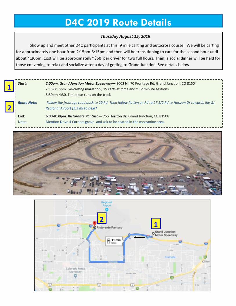
Thursday August 15, 2019
Show up and meet other D4C participants at this .9 mile carting and autocross course. We will be carting
for approximately one hour from 2:15pm-3:15pm and then will be transitioning to cars for the second hour until
about 4:30pm. Cost will be approximately ~$50 per driver for two full hours. Then, a social dinner will be held for
those convening to relax and socialize after a day of getting to Grand Junction. See details below.
D4C 2019 Route Details
Start: 2:00pm. Grand Junction Motor Speedway— 3002 N I 70 Frontage Rd, Grand Junction, CO 81504
2:15-3:15pm. Go-carting marathon , 15 carts at time and ~ 12 minute sessions
3:30pm-4:30. Timed car runs on the track
Route Note: Follow the frontage road back to 29 Rd. Then follow Patterson Rd to 27 1/2 Rd to Horizon Dr towards the GJ
Regional Airport [5.5 mi to next]
End: 6:00-8:30pm. Ristorante Pantuso— 755 Horizon Dr, Grand Junction, CO 81506
Note: Mention Drive 4 Corners group and ask to be seated in the mezzanine area.
1
2
1 2
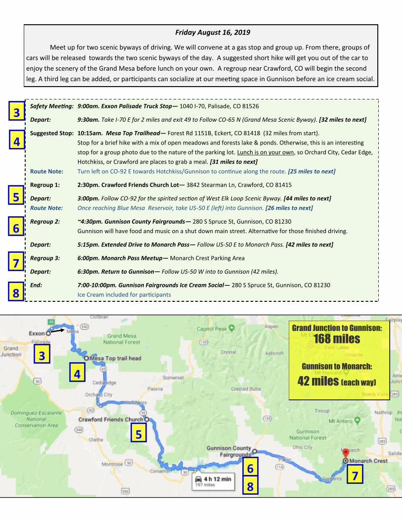
Friday August 16, 2019
Meet up for two scenic byways of driving. We will convene at a gas stop and group up. From there, groups of
cars will be released towards the two scenic byways of the day. A suggested short hike will get you out of the car to
enjoy the scenery of the Grand Mesa before lunch on your own. A regroup near Crawford, CO will begin the second
leg. A third leg can be added, or participants can socialize at our meeting space in Gunnison before an ice cream social.
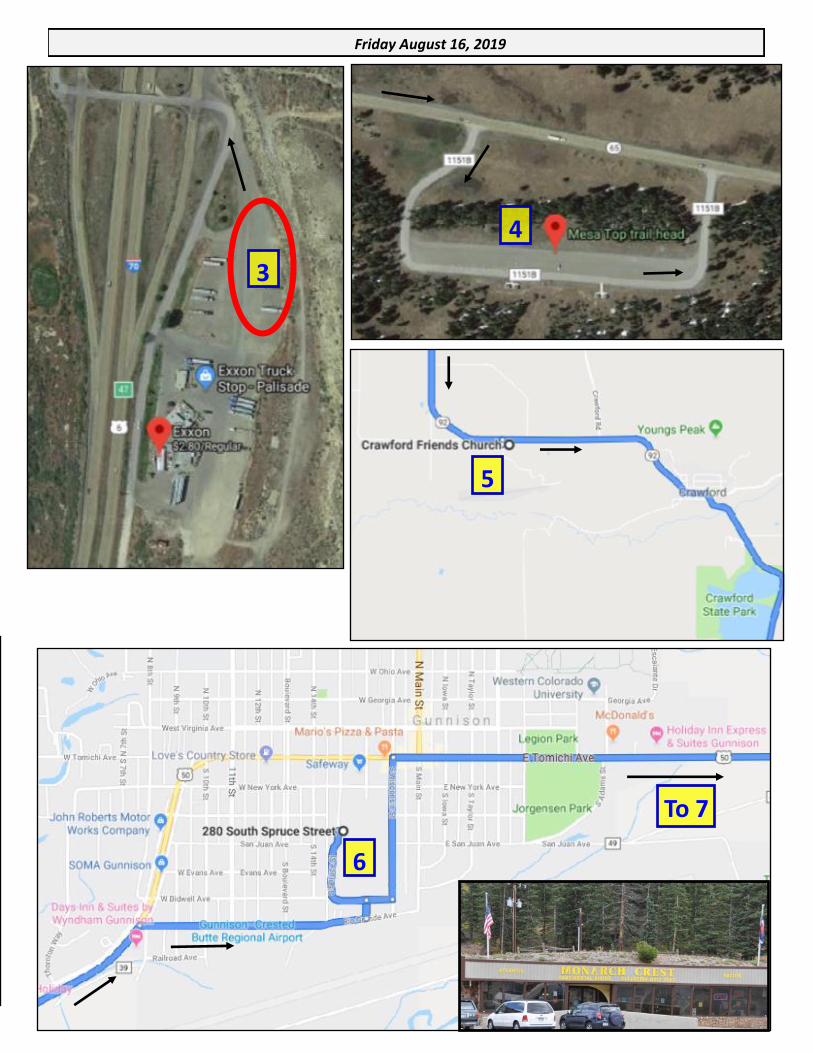
Safety Meeting: 9:00am. Exxon Palisade Truck Stop— 1040 I-70, Palisade, CO 81526
Depart: 9:30am. Take I-70 E for 2 miles and exit 49 to Follow CO-65 N (Grand Mesa Scenic Byway). [32 miles to next]
Suggested Stop: 10:15am. Mesa Top Trailhead— Forest Rd 1151B, Eckert, CO 81418 (32 miles from start).
Stop for a brief hike with a mix of open meadows and forests lake & ponds. Otherwise, this is an interesting
stop for a group photo due to the nature of the parking lot. Lunch is on your own, so Orchard City, Cedar Edge,
Hotchkiss, or Crawford are places to grab a meal. [31 miles to next]
Route Note: Turn left on CO-92 E towards Hotchkiss/Gunnison to continue along the route. [25 miles to next]
Regroup 1: 2:30pm. Crawford Friends Church Lot— 3842 Stearman Ln, Crawford, CO 81415
Depart: 3:00pm. Follow CO-92 for the spirited section of West Elk Loop Scenic Byway. [44 miles to next]
Route Note: Once reaching Blue Mesa Reservoir, take US-50 E (left) into Gunnison. [26 miles to next]
Regroup 2: ~4:30pm. Gunnison County Fairgrounds— 280 S Spruce St, Gunnison, CO 81230
Gunnison will have food and music on a shut down main street. Alternative for those finished driving.
Depart: 5:15pm. Extended Drive to Monarch Pass— Follow US-50 E to Monarch Pass. [42 miles to next]
Regroup 3: 6:00pm. Monarch Pass Meetup— Monarch Crest Parking Area
Depart: 6:30pm. Return to Gunnison— Follow US-50 W into to Gunnison (42 miles).
End: 7:00-10:00pm. Gunnison Fairgrounds Ice Cream Social— 280 S Spruce St, Gunnison, CO 81230
Ice Cream included for participants
Grand Junction to Gunnison:
168 miles
Gunnison to Monarch:
42 miles (each way)
3
4
5
6 7
3
4
5
6
7
8
8
3
Friday August 16, 2019
4
5
6
To 7
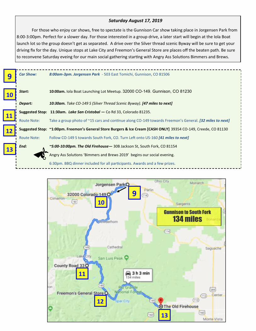
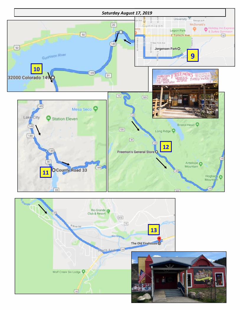
Car Show: 8:00am-3pm. Jorgensen Park - 503 East Tomichi, Gunnison, CO 81506
Start: 10:00am. Iola Boat Launching Lot Meetup. 32000 CO-149. Gunnison, CO 81230
Depart: 10:30am. Take CO-149 S (Silver Thread Scenic Byway). [47 miles to next]
Suggested Stop: 11:30am. Lake San Cristobal — Co Rd 33, Colorado 81235.
Route Note: Take a group photo of ~15 cars and continue along CO-149 towards Freemon’s General. [32 miles to next]
Suggested Stop: ~1:00pm. Freemon’s General Store Burgers & Ice Cream [CASH ONLY] 39354 CO-149, Creede, CO 81130
Route Note: Follow CO-149 S towards South Fork, CO. Turn Left onto US-160 [41 miles to next]
End: ~5:00-10:00pm. The Old Firehouse— 30B Jackson St, South Fork, CO 81154
Angry Ass Solutions ‘Bimmers and Brews 2019’ begins our social evening.
6:30pm. BBQ dinner included for all participants. Awards and a few prizes.
Gunnison to South Fork
134 miles
Saturday August 17, 2019
For those who enjoy car shows, free to spectate is the Gunnison Car show taking place in Jorgensen Park from
8:00-3:00pm. Perfect for a slower day. For those interested in a group drive, a later start will begin at the Iola Boat
launch lot so the group doesn’t get as separated. A drive over the Silver thread scenic Byway will be sure to get your
driving fix for the day. Unique stops at Lake City and Freemon’s General Store are places off the beaten path. Be sure
to reconvene Saturday eveing for our main social gathering starting with Angry Ass Solutions Bimmers and Brews.
9
10
11
9 10
11
12
12
13
13
9
Saturday August 17, 2019
10
11
12
13
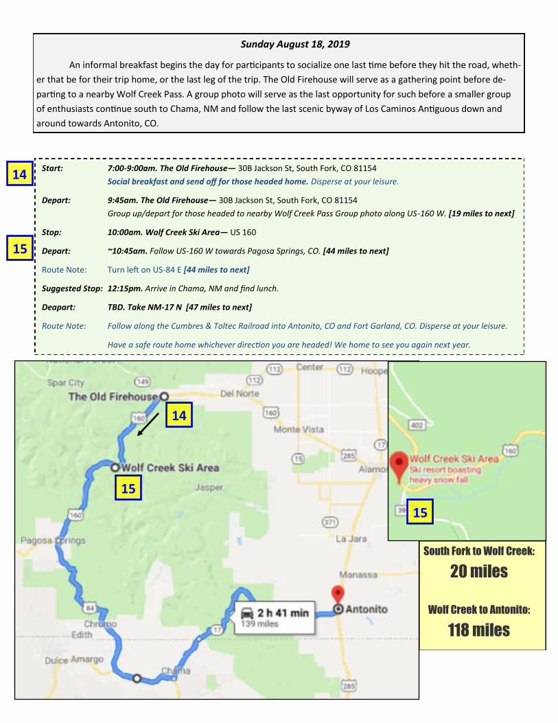
Start: 7:00-9:00am. The Old Firehouse— 30B Jackson St, South Fork, CO 81154
Social breakfast and send off for those headed home. Disperse at your leisure.
Depart: 9:45am. The Old Firehouse— 30B Jackson St, South Fork, CO 81154
Group up/depart for those headed to nearby Wolf Creek Pass Group photo along US-160 W. [19 miles to next]
Stop: 10:00am. Wolf Creek Ski Area— US 160
Depart: ~10:45am. Follow US-160 W towards Pagosa Springs, CO. [44 miles to next]
Route Note: Turn left on US-84 E [44 miles to next]
Suggested Stop: 12:15pm. Arrive in Chama, NM and find lunch.
Deapart: TBD. Take NM-17 N [47 miles to next]
Route Note: Follow along the Cumbres & Toltec Railroad into Antonito, CO and Fort Garland, CO. Disperse at your leisure.
Have a safe route home whichever direction you are headed! We home to see you again next year.
South Fork to Wolf Creek:
20 miles
Wolf Creek to Antonito:
118 miles
Sunday August 18, 2019
An informal breakfast begins the day for participants to socialize one last time before they hit the road, wheth-
er that be for their trip home, or the last leg of the trip. The Old Firehouse will serve as a gathering point before de-
parting to a nearby Wolf Creek Pass. A group photo will serve as the last opportunity for such before a smaller group
of enthusiasts continue south to Chama, NM and follow the last scenic byway of Los Caminos Antiguous down and
around towards Antonito, CO.
14
15
14
15
15