rogers kolachi khan & associates - world monuments fund · 2015-08-24 · rogers kolachi khan...
TRANSCRIPT


Rogers Kolachi Khan & Associates
Training Workshop Report January 2011
1
The Chilas Rock Carvings Cultural Landscape Project
Report on Training Workshop
03.12 – 06.12.10 Chilas, Gilgit-Baltistan, Pakistan
Project Background More than 50,000 rock carvings, 5000 inscriptions and many other heritage resources ranging from the Neolithic period, 8 to
9000 years ago, to the present lie in the area between Shatial
and Raikot. Documentation has been carried out primarily by the Heidelberg Academy of Sciences and Humanities during a joint
German-Pakistani project begun in 1980,
These carvings are a unique and rich archaeological record of the history of the area through the ages, as a trade and
pilgrimage route. Many of them will be inundated by the reservoir of the Diamer Basha Dam. The Chilas Rock Carving cultural Landscape Project was begun by the Water and Power
Development Authority of Pakistan (WAPDA) with the contracting of Rogers Kolachi Khan & Associates (RKK) to carry out a
Cultural Heritage Impact Assessment (CHIA) for the Diamer
Basha Dam to assess potential impacts of dam construction and inundation of the reservoir on these and other important
heritage resources.
In order to plan more effectively for the preservation, study and
economic future of the archaeology of the Chilas area, it was decided to seek international support. The world Monuments
Fund based in New York and the Prince Claus Fund for Culture and Development of the Netherlands are providing support to
WAPDA, RKK and the Heidelberg Academy to carry out this project.
Emergency Action: Aims and Objectives
The need for supplementary documentation was identified by the CHIA. It recommended further documentation of other
archaeological and intangible heritage in the study area and
consolidation of the rock carving data base and finalization of mitigation measures, particularly for heritage identified as
particularly significant.
Engineering for road and dam construction was inaugurated in the summer of 2010; construction work will last for 9 years with commissioning of the reservoir planned for 2019. This defines a
short window of opportunity to carry out final studies and to ensure that monitoring systems are in place as works progress.
Sun symbol carving

Rogers Kolachi Khan & Associates
Training Workshop Report January 2011
2
Construction of a Peripheral Road along the right bank of the Indus, relocation of a 100 km segment of the Karakorum
Highway (KKH) and other works associated with dam construction will potentially impact on areas where field
documentation of archaeological and ethnographic heritage is needed.
The Emergency Action Phase is designed to achieve several goals which will enable preparation of a long term Management
Plan. Most importantly, it aims to get a better understanding of the area as a cultural landscape as reflected in the impacts on
the environment made by human activity over time. To do this
we need to fill gaps in the data base regarding heritage resources and to assess impacts on these additional resources,
following the format of the CHIA; this will ensure that, to the best of our ability, impacts on heritage can be mitigated.
The Heritage Documentation Team In order to carry out additional field documentation it was
decided to train and equip a team of local young men to investigate the study area. A group of 12 team members was
formed comprising a local Project Liaison, two team leaders and 8 team members and a field guide with experience with the
Heidelberg Academy research.
A Field and Training Manual was prepared for the team; it was
designed for use in the field and to be used for a training workshop. It contains all the information needed to carry out the
tasks efficiently and is designed as an educational tool for non-professionals.
The goals of the training workshop were: • To familiarize trainees with the Manual
• To equip the teams with the skills and techniques to
locate, document and assess heritage in the study area
• To explain procedures for data collection, storage and retrieval
• To ensure that all the information needed to plan
mitigation measures for individual resources is collected
in the field • To train a core team which will be able to participate in
other aspects of the project over the long term adding to
the sustainability of the processes.
View of the study area from
the KKH
Landscape of the study area
Rogers Kolachi Khan & Associates
Training Workshop Report January 2011
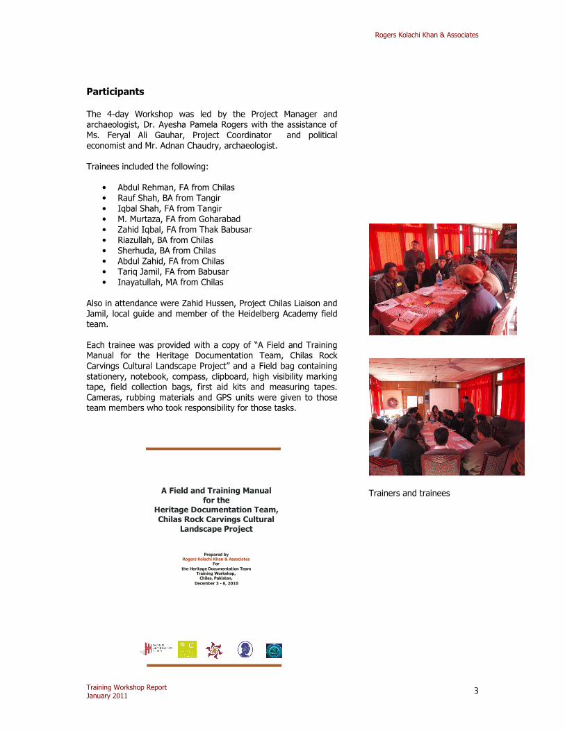
3
Participants The 4-day Workshop was led by the Project Manager and archaeologist, Dr. Ayesha Pamela Rogers with the assistance of
Ms. Feryal Ali Gauhar, Project Coordinator and political
economist and Mr. Adnan Chaudry, archaeologist.
Trainees included the following:
• Abdul Rehman, FA from Chilas
• Rauf Shah, BA from Tangir
• Iqbal Shah, FA from Tangir
• M. Murtaza, FA from Goharabad
• Zahid Iqbal, FA from Thak Babusar
• Riazullah, BA from Chilas
• Sherhuda, BA from Chilas
• Abdul Zahid, FA from Chilas
• Tariq Jamil, FA from Babusar
• Inayatullah, MA from Chilas
Also in attendance were Zahid Hussen, Project Chilas Liaison and Jamil, local guide and member of the Heidelberg Academy field team.
Each trainee was provided with a copy of “A Field and Training Manual for the Heritage Documentation Team, Chilas Rock
Carvings Cultural Landscape Project” and a Field bag containing
stationery, notebook, compass, clipboard, high visibility marking tape, field collection bags, first aid kits and measuring tapes.
Cameras, rubbing materials and GPS units were given to those team members who took responsibility for those tasks.
A Field and Training Manual
for the Heritage Documentation Team,
Chilas Rock Carvings Cultural
Landscape Project
Prepared by
For
the Heritage Documentation Team Training Workshop, Chilas, Pakistan,
December 3 - 6, 2010
Rogers Kolachi Khan & Associates
Trainers and trainees

Rogers Kolachi Khan & Associates
Training Workshop Report January 2011
4
Contents of the Workshop Day 1 of the workshop was devoted to introducing the trainers and the trainees and forming two teams to carry out the
documentation. Through exercises using the flip chart we found
out the background and interests of each of the trainees and allowed them to match themselves to the various skills we
agreed would be required in the field.
One of the first tasks of Day 1 was to identify two field
documentation team leaders and to form the trainees into two teams. The group discussed what should be the duties of the Team Leaders:
• To contact all members and arrange meeting to go into
the field
• To make sure all team members had the required
equipment, forms, manuals and first aid • To liaise with Zahid, Project Liaison
• To ensure that all data was filed properly in the project
office
• To answer community enquiries and explain the purpose
of the documentation
After a short discussion among themselves, the group proposed that Inayatullah and Murtaza should be leaders of Teams A and
B respectively. The trainees then divided themselves into the two
teams:
Team A: Inayahtullah Team Leader, reporting
Abdul Zahid Photographer
Riaz Sketching Abdur Rehman Rubbings, measuring
Sherhuda Interviews, intangible heritage, land use
Team B:
Murtaza Team Leader, reporting Tariq Jamil Photographer, measuring
Iqbal Shah Sketching Rauf Shah Rubbings, interviews
Zahid Iqbal Intangible heritage, land use
The group discussed how the information collected by the teams
would be used to plan for the preservation of local cultural heritage. It was stressed that hopefully this will be a long term
project and that there would be opportunities for the trainees to be involved in many ways.
Day 1 finished with a brief overview of the documentation process to be discussed in more detail on Day 2.
Introducing the project
Special interests and
knowledge of trainees

Rogers Kolachi Khan & Associates
Training Workshop Report January 2011
5
Day 2 was devoted to the process of heritage documentation as described in the Manual. Trainers and trainees generated a list
of sites /areas to be investigated by the Heritage Documentation Team. Areas were assigned to teams A and B on the basis of
member affiliations and local knowledge. Discussions highlighted points of special interest at sites which should be the focus of team attention. A schedule was created for each of the teams
taking local logistics and seasonal factors into account.
Site /Area Team(s) Notes Approx.
no. of days
Shing Nala A Landscape features
B Cultural
resources
Oral histories, terracing and
irrigation
5
Budogah A Remains and
oral history
3
Chilas (upper): Farooqabad and
Harpin Das
B Intangible, focus on
women
3
Chilas (lower) A 2
Thak and Nyath B Mosque 2
Ges and Goharabad
B 5
Raikot and Tatia
Pani
A 4
Thalpan A Left side B Right side
Soniwal communities
2 5
Thor Valley A 3
Hodur B 5
Tangir B 5
Darel A with Zahid 4
Shatial B with Jamil Route remains,
graveyard
2
It quickly became clear to the trainers that the team members
have a keen awareness of their local culture and innately
understood exactly what comprises their heritage. Less time than scheduled was needed therefore on the issue of what to
document.
They were very interested in documenting intangible heritage, particularly crafts, folklore and traditional agricultural practices,
in addition to archaeological remains and carvings. It was
therefore decided to add a specific recording form for intangible resources.
All of the tasks to be performed in the field were reviewed and
explained in preparation for a practical lesson in the field on Day
3. All of the recording forms and logs were explained in detail; trainees took the opportunity to make any translations needed
directly into their copies of the Manual.
Working out the site
documentation schedule
Inayatullah – leader of
Team A
Murtaza – leader of Team B

Rogers Kolachi Khan & Associates
Training Workshop Report January 2011
6
Day 3 was spent on site at Thalpan going through all of the steps of field documentation. However, before going to site the
team was given a brief introduction to the idea of oral history documentation by Zahir Shah. Shah Sb. is a local scholar and
academic who has been conducting oral history research in the area on his own initiative. He agreed to assist the teams in collecting further data and we hope to formalize his project by
linking it to an international oral history program. Each team was guided through the documentation process at
Thalpan, an important rock carving site near Chilas town.
Taking compass
readings
Making sketches of
the setting of the site and marking heritage resources
An explanation of stone patination
process and dating of carvings
Carrying out site scan
Practicing photography of
heritage resources
Taking GPS readings and
filling out the form

Rogers Kolachi Khan & Associates
Training Workshop Report January 2011
7
Trying out various rubbing materials to find the most
effective method
The barren rocky landscape of
Thalpan
Day 4
The last day of the Training workshop was spent setting up and
organizing the project office in a local hotel, making shopping lists of materials needed, going over the “chain of command” one more time and answering any last minute questions before
the trainers set off on the two day journey back to Lahore. The last event was the group photo.
Referring to the Manual for clarification
The Documentation Team
began work in the field in mid December 2010 and is
due to complete their work in early February 2011.

Rogers Kolachi Khan & Associates
Training Workshop Report January 2011
8
DAY 1 No. Time Task Manual Ref. Power Point Slides Equipment/Materials Location
Introductions of Facilitators and Team members
1. Project title, Partners, names of the
RKK team
Manuals, Field Kits, name stickers, flip
chart, markers
Conference Room,
Shangrila
Hotel
Introduction to The Chilas Cultural Landscape Project
Part I: pages 3 - 4
Conference
Room, Shangrila Hotel
1 9:00 – 11:00
What is Cultural Heritage? Reading 1: What is Cultural
Heritage and why is it
important?
2. Terms in Reading 1
and examples of
Cultural Heritage
Conference Room,
Shangrila
Hotel
2 11:00
– 11:15
Tea
3 11:15 – 1:30
Heritage Documentation Team: its tasks and role of the Manual
Team Skills
How team members will gain
from the experience
Part II: pages 6 - 9
Worksheet 1: Checklist of Heritage Documentation
Team Skills
3. Team diagram 4. Training outcomes
Manuals, flip chart, markers
Conference Room, Shangrila
Hotel
4 1:30 – 2:15
Lunch
5 2:15 –
4:00
How the Data will be used?
Review and Summary
Reading 2: How is the data
you collect going to be used?
5. How GIS will use the
data and to what ends
Manuals, flip chart,
markers
Conference
Room, Shangrila
Hotel
6 Forming Heritage Documentation Teams:
Space alone around the fire, cigarettes
Conference Room,

Rogers Kolachi Khan & Associates
Training Workshop Report January 2011
9
(a) Group leader selection: team members chose among
themselves who will be the
two leaders
Shangrila Hotel
7 (b)Teams and tasks:
members divided themselves
into two teams and offered to take on specific tasks such as
sketching, photography etc.
Conference
Room,
Shangrila Hotel
8 Documentation: 10 Steps
Intro to documentation process
Part III: Flow Chart pg. 13
6. Documentation
Process diagram
Conference
Room, Shangrila Hotel
Training in process

Rogers Kolachi Khan & Associates
Training Workshop Report January 2011
10
DAY 2
No. Time Task Manual Ref. Power Point Slide Equipment/Material Location
1 9:00 –
11:00
Step 1 -- Where to
Document?
Areas of Archaeological Potential (AAP)
Team and trainers drew
up a list of sites/areas of
archaeological potential and created a Fieldwork
Timetable for both teams
Part III: pages 14 - 15
Worksheet 2: What are the
Areas of Archaeological Potential?
7. How overlays of data
will reveal AAP
Data Maps, Tracing
paper, markers, flip
chart
Conference
Room,
Shangrila Hotel
2 11:00 –
11:15
Tea
Step 2 --What to
Document? Illustrated
Guide to Heritage
Pages 17 - 21
Reading 3: What is a Cultural
Landscape? Case Study 1 : Plain of Jars, Lao
PDR
8. Examples of
Cultural Landscapes
9. Plain of Jars documentation
Conference
Room,
Shangrila Hotel
3 11:15 –
1:30
How to Document? A brief introduction to:
Step 3 Surface Scan
Step 4 Using GPS
Step 5 Sketching
Step 6 Photography
Pages 24 - 25 case Study 2: Sphakia Survey,
Greece
Pages 27 - 29 Worksheet 3: Learning how to use the GPS
Unit Pages 31 - 32
Pages 33 - 34
10. Surface Scan illustrations
11. GPS basics
12. Sketch maps done in the field
13. Types of heritage
GPS units and logs
Sketching materials
Cameras, Photo Logs
Conference
Room, Shangrila
Hotel

Rogers Kolachi Khan & Associates
Training Workshop Report January 2011
11
Step 7 Rubbings Page 35
photos
14. Rubbing process Rubbing materials
4 1:30 –
2:15
Lunch
5 2:15 – 4:00
Filling in the Field Recording Forms:
Step 8 Rock Carvings Step 9 Archaeological
Features
Step 10 Intangible Heritage
Pages 36 - 49 Worksheet 4: Documenting Rock Carvings
Pages 51 - 54
Worksheet 5: Scanning an Area and Documenting Archaeological
Features
15. Main features of rock Carvings
Manuals, flip chart, markers Recording
Forms; Master Lists and
Logs
Conference Room,
Shangrila
Hotel
Heritage resources of Chilas

Rogers Kolachi Khan & Associates
Training Workshop Report January 2011
12
DAY 3
No.
Time Task Manual Ref. Power Point Slide Equipment/Material Location
1 9:00 –
9:30
Oral history
introduction By local scholar Zahir
Shah
Thalpan site
On-site training:
Site scan
Marking heritage features
Sketching site setting
Taking photos of the site
and its setting
Field packs, GPS units, maps, forms and logs,
cameras
Thalpan site
Regrouping: Team Leader
accounts of findings
Thalpan site
2 10:00 –
2:30
Documentation of
heritage resources:
Practical use of the recording forms and
equipment (GPS practice) Testing options for
rubbing methods
Forms and clipboards,
GPS units, rubbing
materials
Thalpan site

Rogers Kolachi Khan & Associates
Training Workshop Report January 2011
13
2:30 – 3:00
Regrouping: discussion of findings, problems and
questions
Thalpan site
DAY 4
No. Time Task Manual Ref. Equipment/Materials Location
1 9:00 –
11:00
Step 11 -- What to do
with the data after returning from the field?
Flowchart page 56
Worksheet 6: Organizing filing and storage systems for the data
Documentation, equipment
and stationery materials. Manuals, paper and markers
In Project
Office, Chilas Inn
2 11:00 –
11:15
Tea
3 11:15 –
1:30
Team organization of
the office space
In Project
Office, Chilas Inn
4 Group Photo
View of Thor Valley Village along a nalah Local Soniwal river folk