rock cut cave at village khodari, madhya pradesh: an ethno
TRANSCRIPT
Rock Cut Cave at Village Khodari, Madhya Pradesh: An Ethno Archaeological Study
Vinay Kumar1 and Vishi Upadhyay2 1. Department of Ancient Indian History, Culture and Archaeology, Indira Gandhi
National Tribal University, Amarkantak – 484 886, Madhya Pradesh, India (Email: [email protected])
2. Bihar Museum, Patna, Bihar and Palash 45, Rajkishor Nagar, Bilaspur – 495 006, Chhattisgarh, India (Email: [email protected])
Received: 27July 2014; Accepted: 21 August 2014; Revised: 05 October 2014 Heritage: Journal of Multidisciplinary Studies in Archaeology 2 (2014): 694‐704
Abstract: The region of Madhya Pradesh is famous for its tribal culture. This is the only part of India having the consistently tradition of tribal domination from the ancient period to the modern era. Various rock ‐ cut caves are known from the different parts of Madhya Pradesh and Chhattisgarh. In Madhya Pradesh the rock shelters in the Vidisha District are partially natural and partially manmade. In the Sarguja District of Chhattisgarh, there is rock ‐ cut cave, named as Sitabengara probably related to the Gupta period. Another cave in Jashpur District was made by Korava tribe of this region under the supervision of Gaharaguru and now being used by tribal community of this area. The present paper attempts to document on the basis of exploration by the first author the rock cut cave, locally called as Sitamarhi Cave at Khodari village in Madhya Pradesh. The architecture of the cave and other relevant findings in surrounding area have shown the relationship of this cave from medieval period to modern tribal culture. But mostly data are too susceptible and a deeper study is required for understanding the actual use and periodization of this cave.
Keywords: Khodari, Architecture, Rock‐cut Cave, Exploration, Tribe, Sanctum, Documentation
Introduction The region of Madhya Pradesh is situated in central part of India. State is famous for its tribal culture. A vast number of tribes have been reported from this region. This is the only part of India having the consistently tradition of tribal domination from the ancient period to modern era.
The present paper attempts to document a rock cut cave, locally called as Sitamarhi in the Khodari region of Madhya Pradesh. It was first discovered and documented by first author. The architecture of the cave and other relevant finding in the surrounding area, are shown the in relation of this cave from the medieval period to local modern tribal culture. But mostly data are too susceptible and a deeper study is required for
Kumar and Upadhyay 2014: 694‐704
695
understanding the actual use and period of this cave. These kinds of rock cut caves are available in different parts of Madhya Pradesh and Chhattisgarh region. In Madhya Pradesh the rock shelters in Vidisha district are good example of manmade activities. This rock shelters are partially natural and partially manmade. Mostly shelters consist of the sculptures of Gupta Period (Sharma 1998: 65). In Sarguja dist of Chhattisgarh region, there is rock cut cave, named as Sitabengara (see website of Raipur Circle, ASI), probably related to Gupta period. The utilization of this cave is not very clear. Another cave is available in Jashpur dist. the story of this cave is different. It was excavated by Korava tribe of this region under the supervision of Gaharaguru and now using by tribal community of this area. This is a good ethno archaeological instance for studying the technique of excavation of rock cut cave (see the website of Chhattisgarh tourism board).
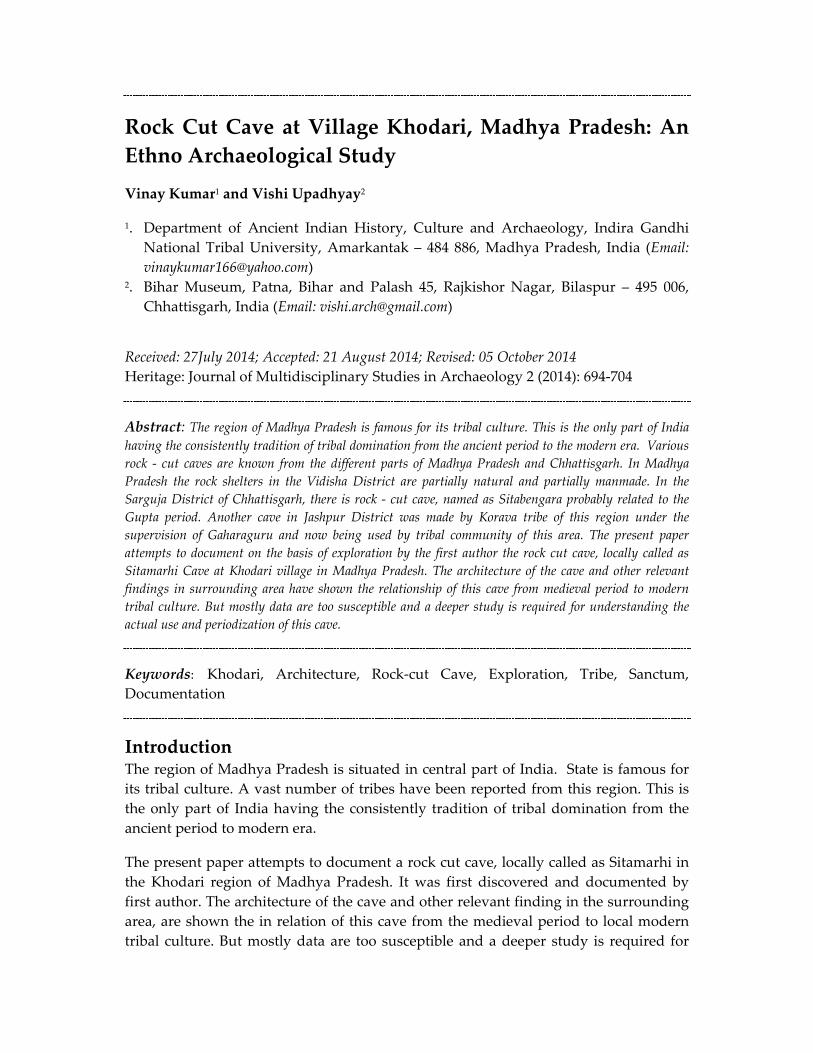
Geographical Delimitations The region (23ᵒ 04’ 00.35” N and 81ᵒ 46’ 38.70” E, elevation 1641 ft.) covers the area of 3701 km.2 (Fig. 1) and population of 667, 155 (2001 census). Geographically, it is counted in Vidhyacha Satpura region and dominated by tribal culture from long era (Singh 1971: 662).
In particular discussion on, district Anuppur is predominantly hilly district. It is consisted the belt of sal and mixed forests. The River Narmada originates from Amarkantak situated on the Maikal hills in this District. River Son and Johilla also originate from the Maikal Hills. District Anuppur is very rich in its mineral resources. Minerals found in district are coal, Bauxite and fire clay. Most of the coal mines are located in Kotma Sub Division. Amarkantak is known for its Bauxite deposits. Sal Alma, Teak, Sarai and Shisham are the main trees found in the present study area. The main rivulet flowing in this area is Barne River which is a tributary of Kewai River which is 8 km. away in South East direction of Kotma west colliery.
Local Tribes at a Glance The total population as per the data provided by one of the old villagers is around 2500. The village is inhabited mainly by the tribal like Agaria, Baiga, Gond, Ahir, Pao, Kewat etc. besides that the people of other community also dwell in the village. Gond is a most dominating tribe of this region.
The history of tribal occupation of this region is length. The tribals were the owners of land and property and were the rulers in most of the parts of the region (NCAER 1963: 8). This was the controlled and ruled earlier by some of the important tribal dynasties (Singh 1971: 623).
In this region, the Dravidian‐ speaking Gonds, around the fourteenth and fifteenth centuries, developed kingdom of large extent and gave the name Gondawana (Singh 1971: 624). According to Russel and Hiralal (Russel and Hiralal 1916: 44‐47), there rose more or less simultaneously four Gond kingdoms with their capitals at Garha, Deogarh,
ISSN 2347 – 5463 Heritage: Journal of Multidisciplinary Studies in Archaeology 2: 2014
696
Figure 1: Geographical Setting of the Study Area

Kumar and Upadhyay 2014: 694‐704
697
Khera and Chanda. The area of Anuppur came under the Garha mandal. They ruled till 16th Century, when they were vanquished by the Moghuls though their suzerainty was only nominal. The Gond kings adopted the Hindu customs and strived for Rajputizing themselves (Wills 1919: 197‐262) through Sanskritization, marriages among the Rajput families etc (Majumdar 1939:, 99‐173). So, this region shall have been influencing by the tribes from the ancient to modern era.
The Site Khodri is a village in Kotma tehsil in Anuppur District of Madhya Pradesh State. It belongs to Shahdol Division. It is located 67 kms. towards East from District head quarter Anuppur. Regarding the previous work in this region Shri Nisar Ahmad of the Deccan College Post‐Graduate and Research Institute, Poona, surveyed stretches of the river Hiruna‐nadi, Mahan‐nadi and Son with its tributaries in Districts Jabalpur, Shahdol and Sidhi and discovered many sites of Early, Middle and Late Stone Ages. In District Jabalpur, two good sections were recorded very near Katni town, along the river of the same name. Both of these showed the sequence (from bottom upwards) of cemented gravel and silt. In District Shahdol, tools variously of the Middle and the Early Stone Ages were obtained from Annuppur, Harha, Markandeya, Ruhania and Singrali. On the left bank of the Umrar‐nadi near Umaria town, a section showing (from bottom upwards) bed‐rock, gravel and silt was noticed. In District Sidhi, tools of Early and Middle Stone Ages were found at Akaori, Baboari, Bardi, Bargama, Barhai, Beeche, Chandreha, Dhabaoli, Ghitora, Hinoti, Khaira, Khootali, Khairpur, Laowar, Nakjhur, Rajghat, Ramanagar, Rampur and Sihawal, the last‐mentioned being the most notable (IAR 1962‐63:11). But no any archaeological exploration work has been done by any individual or agency in the present study area. The present site which is locally known as Sitamarhi caves was explored by the first author with the help of one of his student Shri Aman Tiwari.
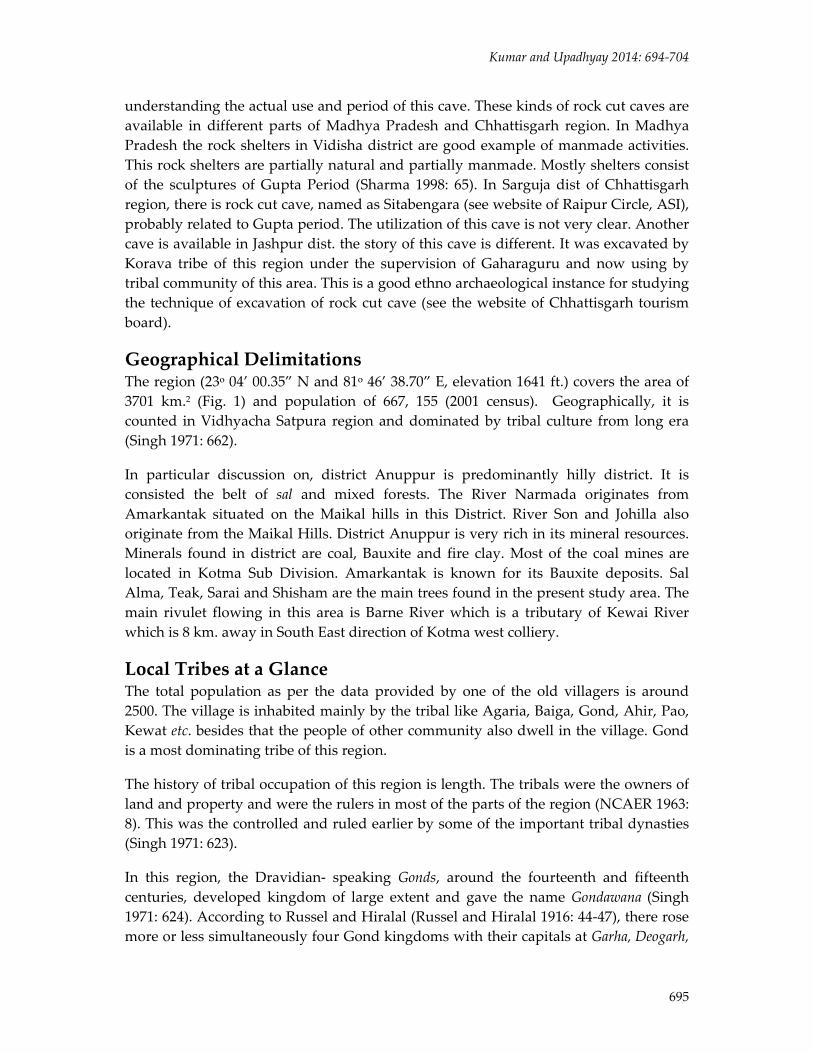
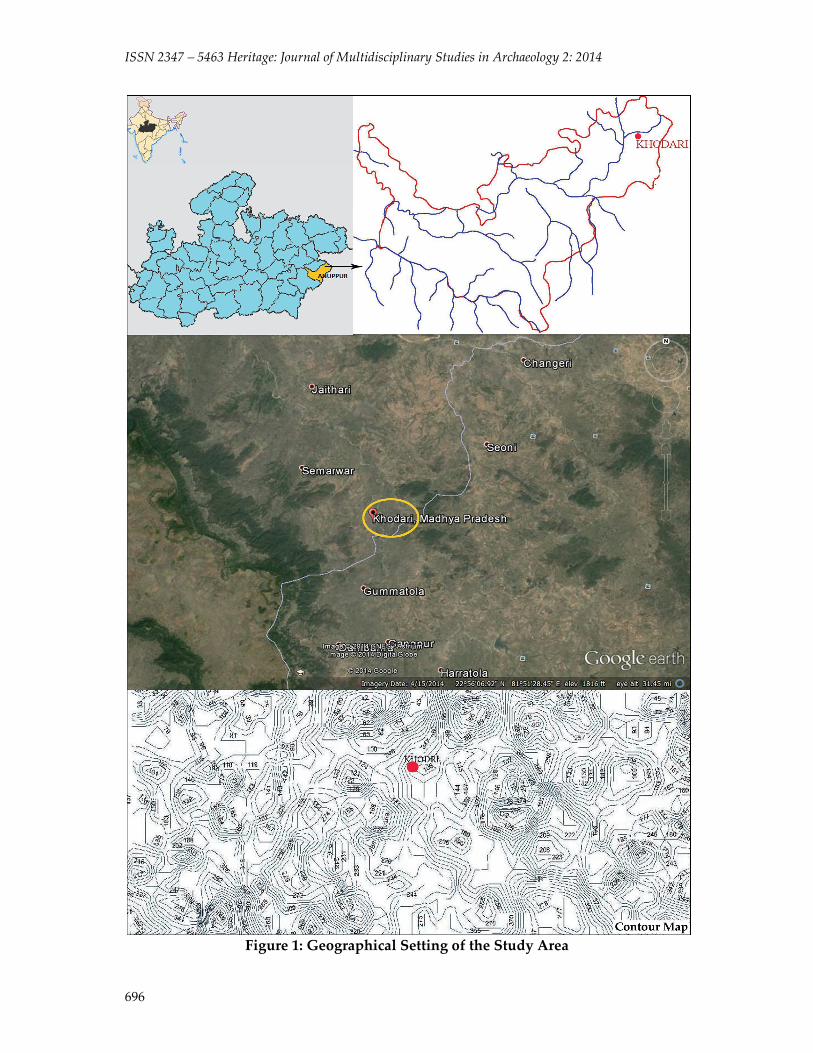
The Architecture of Cave The cave is partially rock cut and partially constructed. It has the coating of white wash which is made by local people. This is very interesting fact here that a very limited part of this cave has used. It might be carved out for any temporary residential purpose or for religious purpose because presently it is being existed as temple.
Exterior Part: External view (back elevation) of this cave (Figs. 2 and 3) seems very natural, this is unfinished and in irregular pattern. But the front elevation is very unique. It has arranged in sloping way for discharging the rain water easily. The small and huge niches are carved on outer wall for sculptures. Few sculptures are rock cut and part of this cave. Three entrances and single ventilation are arranged in longitudinal way with steps. In extreme right corner of this cave, there are staircases can see, running towards the roof of cave. The chisel marks on walls are clearly visible here.
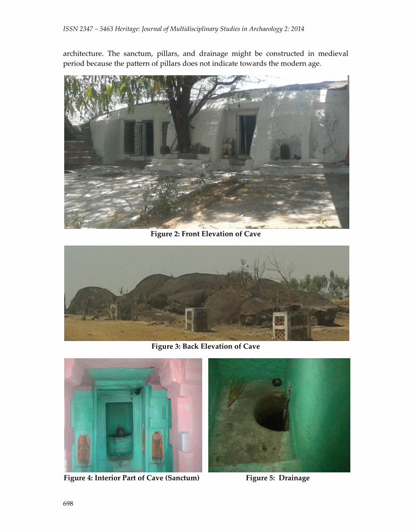
Interior Part: Interior part (Fig. 4) of this cave consist many alteration in original
ISSN 2347 – 5463 Heritage: Journal of Multidisciplinary Studies in Archaeology 2: 2014
698
architecture. The sanctum, pillars, and drainage might be constructed in medieval period because the pattern of pillars does not indicate towards the modern age.
Figure 2: Front Elevation of Cave
Figure 3: Back Elevation of Cave
Figure 4: Interior Part of Cave (Sanctum) Figure 5: Drainage

Kumar and Upadhyay 2014: 694‐704
699
Pillars: Pillars consist the all four parts e.g. Pillar base, shaft, abacus and pillar capital. Pillar base is square in shape while shaft is constructed in octagonal pattern. Abacus is square in shape and pillar capital is supported by four carved heavy stone pieces. This is interesting thing that a rock cut chamber does not has the requirement of pillars but these have added for giving the look of temple to this cave.
Sanctum (garbhagriha): Sanctum is in square in shape and a shivalinga with pranala has installed inside it. Features of shivalinga do not indicate towards the ancient significance. The front elevation of sanctum is carved and contained the sculpture of dwarpala and Surya in carved niches.
Drainage: A North oriented drainage (Fig. 5) is available inside the cave. It is connected with the sanctum and entire water which is discharged from the sivalinga, drained out through this channel. There is arrangement of crescent shaped pit connecting to the mouth of drainage; the water drains out from the cave through this pit. This is a beautiful instance of underground water management system.
After studying the entire structure of this cave, it seems that, originally the cave might only have consisted of a simple hall (rectangular in shape). In the space of time, it has been divided in compartments and altered into the temple which is featured by the pillars, religious sculptures, sanctum, and sivalinga. Along with it the chisel marks on the walls indicate towards the original parts of this cave, these are appeared on entire exterior portion and inside the cave these are located on the roof and floor and on walls (detached part from the walls of sanctum). So it seems that initially this cave might be consisted of only a rectangular hall. Pillars and sanctum are later additions.
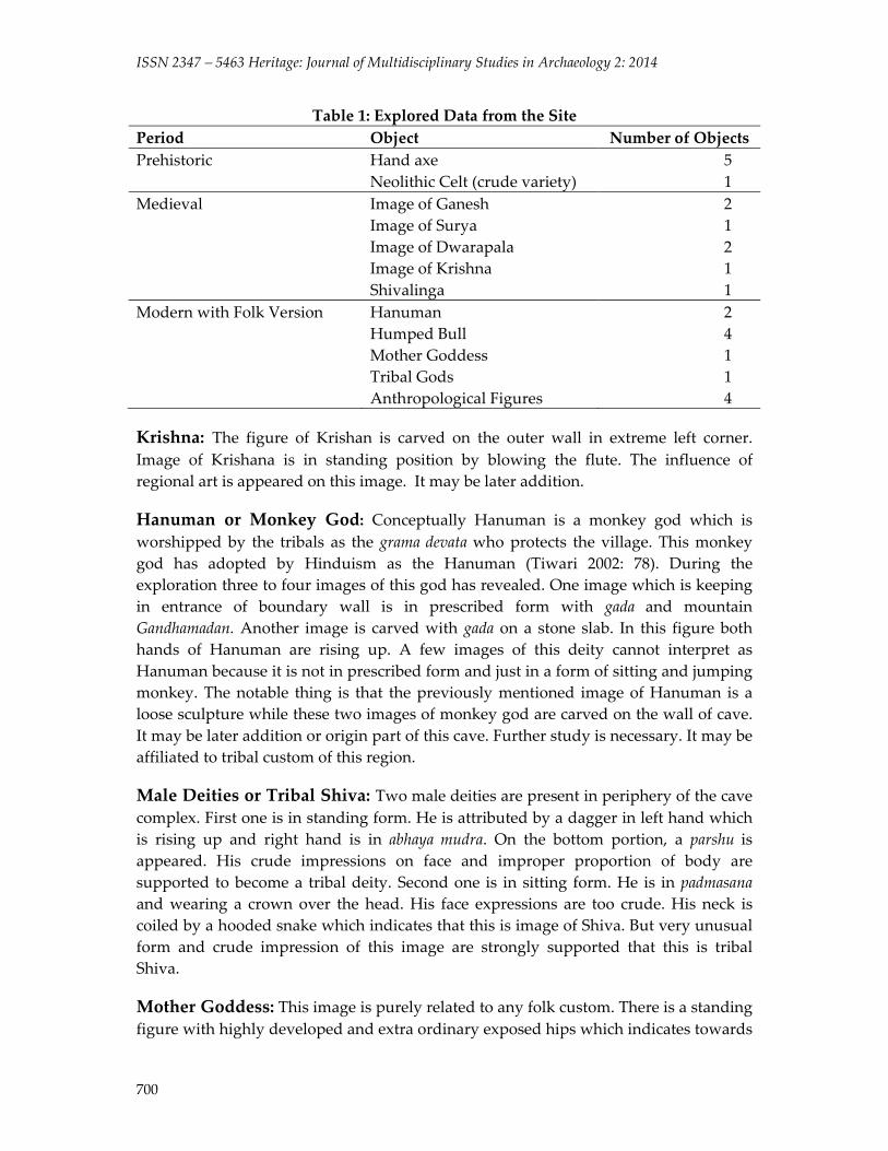
Sculptures Explorations in the site yielded Prehistoric hand axes, Neolithic celt and medieval sculptures of Ganesh, Surya, Dwarapala, Krishna and a Shivalinga. Modern sculptures of Hanuman, humped bull, Mother goddess and tribal gods were also reported (Table 1, Figs. 6 and 7).
Surya: The standing image of Surya is installed in entrance wall of sanctum. His two hands are rising up with two half bloomed lotuses as well as he is adorned by the kirita mukuta and clad with the dhoti. The period of this image seems to be 9th‐10th Century AD.
Ganesh: Ganesh is sitting in lalitasana under one of the niche inside the cave. He is four handed and attribute by his prominent weapons. The period of this image can be assume in 9th‐10th Century AD.
Shaiva Dwarapala: The shaiva dwarapala have fixed in the niches of entrance of sanctum. They are attributed by the trishula. The date of these images indicates the period of 9th ‐10th Century AD.
ISSN 2347 – 5463 Heritage: Journal of Multidisciplinary Studies in Archaeology 2: 2014
700
Table 1: Explored Data from the Site Period Object Number of ObjectsPrehistoric Hand axe
Neolithic Celt (crude variety) 5 1
Medieval Image of Ganesh Image of Surya Image of Dwarapala Image of Krishna Shivalinga
2 1 2 1 1
Modern with Folk Version Hanuman Humped Bull Mother Goddess Tribal Gods Anthropological Figures
2 4 1 1 4
Krishna: The figure of Krishan is carved on the outer wall in extreme left corner. Image of Krishana is in standing position by blowing the flute. The influence of regional art is appeared on this image. It may be later addition.
Hanuman or Monkey God: Conceptually Hanuman is a monkey god which is worshipped by the tribals as the grama devata who protects the village. This monkey god has adopted by Hinduism as the Hanuman (Tiwari 2002: 78). During the exploration three to four images of this god has revealed. One image which is keeping in entrance of boundary wall is in prescribed form with gada and mountain Gandhamadan. Another image is carved with gada on a stone slab. In this figure both hands of Hanuman are rising up. A few images of this deity cannot interpret as Hanuman because it is not in prescribed form and just in a form of sitting and jumping monkey. The notable thing is that the previously mentioned image of Hanuman is a loose sculpture while these two images of monkey god are carved on the wall of cave. It may be later addition or origin part of this cave. Further study is necessary. It may be affiliated to tribal custom of this region.
Male Deities or Tribal Shiva: Two male deities are present in periphery of the cave complex. First one is in standing form. He is attributed by a dagger in left hand which is rising up and right hand is in abhaya mudra. On the bottom portion, a parshu is appeared. His crude impressions on face and improper proportion of body are supported to become a tribal deity. Second one is in sitting form. He is in padmasana and wearing a crown over the head. His face expressions are too crude. His neck is coiled by a hooded snake which indicates that this is image of Shiva. But very unusual form and crude impression of this image are strongly supported that this is tribal Shiva.
Mother Goddess: This image is purely related to any folk custom. There is a standing figure with highly developed and extra ordinary exposed hips which indicates towards

Kumar and Upadhyay 2014: 694‐704
701
the fertility worship of this image. She is wearing a crown over the head and two rounded boll shaped ear rings. Her both hands are rested on her chest. Features of her face are too unusual. Her mouth is being opened.
Anthropomorphic Figures: The anthropomorphic figures are yielded in numbers of this area. They are worshiped by local people. The simple rock slabs consist of the human figure in standing and sitting position. Whole anatomy is very similar to human figure but the face is totally blank (without carving of human features). They must be related to local custom of this area.
Ganesh Hanuman Hanuman
Surya Celt Shaiva Dwarapala
Figure 6: Celt and Sculptures Recovered from the Site
Bull: Four figures of bulls are found from this periphery. All are keeping out from the cave. The carving of these figures, is indicates its relation with local art. Finding of bull figures must be related to the totum concept of the tribe of this region. A Totum concept of tribes is very similar to the gotra system of Brahmanism. Each tribe should have a

ISSN 2347 – 5463 Heritage: Journal of Multidisciplinary Studies in Archaeology 2: 2014
702
totum and these are in the form of animal (Tiwari 2002: 21). The finding of the bull figure in large number may indicate towards this custom. But further and detail study is too required to understand the relation of this cave with the tribal culture of this area.
Anthropomorphic Figure Mother Goddess Tribal Shiva
Monkey God Monkey God Tribal Shiva
Anthropomorphic Figure Humped Bull Figure 7: Sculptures Recovered from the Site
Kumar and Upadhyay 2014: 694‐704
703
Discussion and Conclusion In the Indian subcontinent the caves were inhabited and used by people over many periods. In India, the caves of prehistoric and early societies sometimes coexist with the extensively painted caves that were cut into the rock by Buddhist monks during the historical period. Akin to the lithic tool making industries of prehistoric groups, through the passage of time, rock art also underwent gradual refinement with the accumulation of evolved skill with experiences and changes in its implications. Refinement of rock art therefore is an integral part of its historical and evolutionary process. In India, evolution of rock art has taken two different courses. While one stream continued through tribal and folk forms, the other closely adhered to the classical idiom and was patronized by the royalty and nobility. We can find some examples where it is found how elements of the prehistoric rock art have survived in certain motifs and objects as tribal and folk art idioms. But the changes in imaginative conception, in style and form also took place because of contemporary society. The evidence of inscriptions and rock edicts of later periods discovered in some rock art sites suggest the occupation and use of the same locale in successive cultural periods. It is possible to perceive the growth and development of such multifunctional aspects of rock art in India through different chrono‐cultural stages.
To obtain a more meaningful result, rock cut caves and the art associated with them must be viewed, compared and integrated with other archaeological evidence in a distinctive cultural matrix of a region. The uniqueness of primeval rock art in India is that a continuum of the art tradition is evident among indigenous ethnic entities. Therefore close comparisons between the rock art and material culture, social organization, religious belief and practices among the indigenous egalitarian societies (adivasi) may render suitable clues for explaining the ethnic identity of art practicing groups in the past.
A carefully constructed research design, selection of an appropriate community, an extended time in the field, knowledge of the language, keen skills of observation and experience with ancient material culture is essential to conduct ethno‐archaeological research in the present study area as no previous investigations have been carried out in this area.
Acknowledgement We pay our thanks and acknowledge the help of Architect Shivi Joshi and Architect and Urban Planner Praveen Upadhyay for their valuable technical contribution in this article and for making the contour plan of site and arranging the plates in proper manner.
References Indian Archaeology‐ A review. 1962‐63. Archaeological Survey of India. Delhi. p. 11. Majumdar, D. N. 1939. Triabal Cultures and Acculturation. Man in India. 19: 99‐173.

ISSN 2347 – 5463 Heritage: Journal of Multidisciplinary Studies in Archaeology 2: 2014
704
NCAER. 1963. Scio‐ Economic Conditions of Primitive Tribes in Madhya Pradesh. New Delhi. p. 8.
Russel, R. V. and H. Lal. 1916. The Caste and Tribes of the Central Provinces of India 3. London. pp. 44‐47.
Sharma, R. K. 1998. Encyclopedia of Art. Archaeology and Literature in Central India. Vol. 1. New Delhi: Aryan Books International. p. 65.
Singh, R. L. 1971. Regional Geography of India. Varanasi: National Geographical Society of India. p. 622.
Tiwari, S. K. 2002. Tribal roots to Hinduism. New Delhi: Sarup and Sons. p. 78. Wills, C. U. 1919. Territorial system of the Rajput Kingdoms of Medieval Chhattisgarh.
Journal of the Royal Asiatic Society of Bengal. 15. pp. 197‐262. www.asiraipurcircle.in www.chhattisgarhtourism.net