roads to nowhere at big bend ranch state park
TRANSCRIPT

A guide tounmaintained4X4 high-clearance roads inBig Bend Ranch State Parks
T E X A S P A R K S A N D W I L D L I F E
roadstonowhere
By David RiskindandDan Sholly
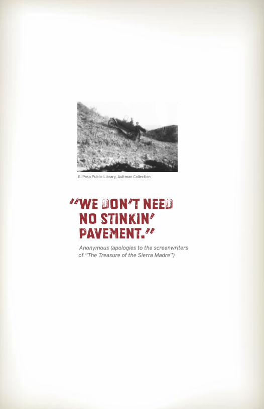
“We don’t needno stinkin’pavement.”Anonymous (apologies to the screenwritersof “The Treasure of the Sierra Madre”)
El Paso Public Library, Aultman Collection

CONTENTS2 History
3 Basic equipment recommendations
4 For a great outback road trip
6 Additional safety admonitions
7 Roads to nowhere, and back
8 Cienega
11 Solitario
13 Los Alamos
15 Camino del Rio
15 BocefillosMountains
www.tpwd.state.tx.us/bigbendranch
2
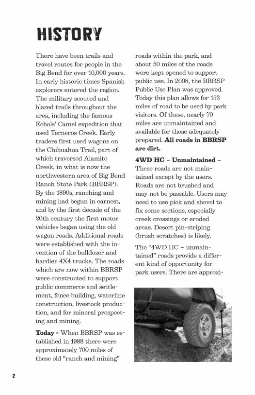
There have been trails andtravel routes for people in theBig Bend for over 10,000 years.In early historic times Spanishexplorers entered the region.The military scouted andblazed trails throughout thearea, including the famousEchols’ Camel expedition thatused Terneros Creek. Earlytraders first used wagons onthe Chihuahua Trail, part ofwhich traversed AlamitoCreek, in what is now thenorthwestern area of Big BendRanch State Park (BBRSP).By the 1890s, ranching andmining had begun in earnest,and by the first decade of the20th century the first motorvehicles began using the oldwagon roads. Additional roadswere established with the in-vention of the bulldozer andhardier 4X4 trucks. The roadswhich are now within BBRSPwere constructed to supportpublic commerce and settle-ment, fence building, waterlineconstruction, livestock produc-tion, and for mineral prospect-ing and mining.
Today -When BBRSP was es-tablished in 1988 there wereapproximately 700 miles ofthese old “ranch and mining”
roads within the park, andabout 50 miles of the roadswere kept opened to supportpublic use. In 2008, the BBRSPPublic Use Plan was approved.Today this plan allows for 153miles of road to be used by parkvisitors. Of these, nearly 70miles are unmaintained andavailable for those adequatelyprepared. All roads in BBRSPare dirt.
4WD HC – Unmaintained –These roads are not main-tained except by the users.Roads are not brushed andmay not be passable. Users mayneed to use pick and shovel tofix some sections, especiallycreek crossings or erodedareas. Desert pin-striping(brush scratches) is likely.
The “4WD HC – unmain-tained” roads provide a differ-ent kind of opportunity forpark users. There are approxi-
HISTORY

www.tpwd.state.tx.us/bigbendranch | 3
mately 70 miles of park roadsthat are not maintained, butwhich are available for visitorsto travel at their own risk.These roads will lead visitors toless-traveled, and in most cases,very remote and beautiful desertlandscapes. Unmaintained roadsin BBRSP are not considered“extreme 4X4.” There is no rockcrawling or rating system, andnot every mile requires 4X4.These roads simply are notmaintained, which means theyare rougher and more difficultand challenging to travel.
Unmaintained roads ofBBRSP should only be at-tempted by experienced 4X4drivers, with a capable vehicleand adequate “self-rescue”equipment. These roads are notpatrolled on a regular basis. Youare pretty much “on your own”should you have a problem.
•Two well-maintained 4X4 high-clearance vehicles. It is alwayssafer to travel in pairs.
• 6-ply tires - absolute minimum
• Two inflated spare tires
• Plenty of fuel (there is NO fuel forsale in BBRSP)
• Shovel and pick
• Rock bar
• High-lift jack - at least 48 inches
• Heavy-duty nylon recovery strap(3”wide x 20’ long - no hooks)
• 10’ chain with hooks
• Tool kit
• Abundant drinking water(at least 5 gallons extra)
• Food for at least two days
• Work gloves
• Good maps of the area
• GPS with extra batteries
• First aid kit
• 4-way lug wrench
• Air pump
! Road guides availableupon request.
Basic equipment recommendationsSpecial preparation highly recommended!

4
For a great “outback” road-trip: Roads may be overgrownwith the ubiquitous white-thornacacia or other desert shrubs,and your vehicle will be exposedto desert pin-striping. Yourtrusty steed will get scratchedand very dirty. Those whochoose to drive unmaintainedBBRSP roads (Special Use Per-mit required) may have to fillthe washout, rut or track toprogress. If your four-wheeldrive goes out, you may getstuck. You must use these roadsever-mindful of the conse-quences of your driving skill andbe prepared for self-extraction.
These roads are old ranch roadsfor the most part. They were in-stalled with economy of effort.They are short wheel-base roads
where a high angle of attack isrequired. If you have a big honk-ing front bumper or runningboards, or a receiver hitch witha removable three-ball setup, beprepared to either modify yourrig or get stuck in a steep, shortdip. If your vehicle’s exhausttailpipe hangs low and is not upand out of the way, it is going toget rearranged! If your towingwiring harness is not stowed andsecured, you’ll lose it.
LOAD RANGE E TIRES arestrongly recommended. If youhave standard 4-ply tread/2-plypolyester sidewalls, stay home.Six-ply tires are recommendedas an absolute minimum.
Bring two spares! Leave thejack that came with your vehicleat home. You’ll need a high-liftjack with a bottle-jack added forgood measure. Make sure youhave something on your vehicleto affix your jack to. Lots of fac-tory or even after-market acces-sory bumpers are NOTSUITABLE for the applicationyou will need for BBRSP roads.Best to practice at home beforeyou get backcountry. Flats doNOT HAPPEN at convenient
“Show me a 4X4 driver who has never been stuck, andI will show you a 4X4 driver who has not been downmany bad roads.” Anonymous
FOR A GREAT OUTBACKROAD TRIP

5
spots, and you can be sure thatat BBRSP they will not happenon level ground. To change a tireyou may have to jack AND digand level your vehicle for safety.
Bring abundant drinking waterin sturdy containers in additionto personal canteens.Have agallon with you at all times.Even if you do not plan tocamp out, bring high-energy,nutritious snack foods—at leasta two-day supply for everyone.
BEFORE you come to BBRSP,make sure your vehicle is ingood shape mechanically. Makesure all your tires are airedfully. Stow your gear so that itdoes not bounce around. Strapdown everything that has asharp point.
THERE IS NO GAS ORDIESEL AVAILABLE INTHE PARK INTERIOR. Gasup and top off before you driveinto BBRSP. Fuel is availableat Presidio, Lajitas and StudyButte only.
Unmaintained roads availablefor adventure travel on BBRSPare shown on the facility mapsin El Solitario and elsewhere atpark visitor centers or informa-tion kiosks. Access to unmain-tained roads will be by permit
only. Check in at Warnock, Ft.Leaton or Sauceda Ranger Sta-tion to obtain a permit.
There are some ranch roadsthat are NOT AVAILABLE forpublic vehicular access. Parkroads open to 4WD HC vehiclesare not designed for H1 or H2Hummers — if you have one ofthese that you are itching touse, it is likely that it WON’TFIT the tread width of ourranch roads. Consequently, youmay experience more roadsidebrush and greater exposure toroad hazards.
Generally speaking, cell phonecoverage in most areas atBBRSP is almost nonexistent.However, in the Cienega area—the northwest portion of thepark—there is good coverage.For extra safety, a satellitephone is recommended. Theonly local extraction and me-chanic service is in Presidio:Rio Grande Wrecker Service.(432) 229-3312 or, after hours(432) 229-3740.
TPWD staff will do their best toassist park visitors, but it is pos-sible that the services of a pro-fessional tow truck or mechanicmay be required. That can bequite expensive.
Note this number works only during businesshours daily. For park notification after businesshours call (432) 229-4913 or (432) 358-4451.911 is the emergency number where cell coverageis available. REMEMBER: response is usuallyhours away, if not a day or two.
For parkemergencies callSauceda Ranger
Station at(432) 358-4444.

6
Additional safety admonitions• WEAR YOUR SEATBELT, especially if you are in the back seat.
• When jacking your vehicle always chock your wheels.
• When making vehicle repairs on sloping terrain be especially mindful ofhelpers/watchers that may be down slope.
• The high-lift jack can hurt or maim you. Be careful; wear gloves. WHENLOWERING JACK, consider using hammer or rock to release action.
• If your repair or extraction takes a while, and the weather is hot andsunny, consider setting a shade tarp. Mistakes are made when you over-heat or are tired.
• Always, always grip your steering wheel firmly with two hands. This isespecially important where there are steep drop-offs. A large rock or otherroad hazard can jerk your wheels suddenly with dire consequences.
• Bad shocks, especially in front, can make your vehicle bounce, slip andslide sideways on slopes.
• Use a spotter.
• Try very hard to avoid spinning your tires–sharp rocks cut through tires.
•Without fail, bring a map: ideally, a USGS 7.5 minute topo quad sheets.They can save your life. Limited copies are available for sale at SaucedaRanger Station Trading Post.
• Be especially mindful of the potential for flash-flooding. Be weather wise.Intense storms can materialize very quickly.

www.tpwd.state.tx.us/bigbendranch | 7
Roads toNowhere, andBackUnmaintained 4WD HC Park Roads
Casa Piedra Trailhead to Casa Ramon
(7.5 USGS Map Quads: Alamo Spring, Cienega Mountains and Casa Piedra)
Beginning at the East Casa Piedra Trailhead on the county road, thissegment travels in a northerly direction for about 1 mile. At a lockedgate it turns ENE along a fenceline, thence NNW and intersects anhistoric roadway heading E. After .25 miles a large arroyo cuts theroad. Continue over rolling terrain and gravelly pediments for 2.25miles to an arroyo and follow the road as it descends to the soft ford(vado) of Alamito Creek. The road crosses near the historic Chi-huahua Trail and is likely to be in looser sand that may require re-duced tire pressure or winching for a successful crossing. If Alamito isflowing or has just recently subsided, the crossing may be impassable.You may want to wait for another day. At Alamito Creek head ENEto N bank--about 2000 feet to intersect the connecting road. Scoutahead before you commit to this crossing. Continue .3 miles and takethe left (N) road fork. After negotiating some severely eroded land,you’ll come to the railroad tracks. Now the South Orient RR, there istraffic about once a week. Just across the tracks is Casa Ramon, anadobe line camp of the former Big Bend Ranch. Here, there are threeunmaintained road choices:
Papalote de la Sierra Loop
This is the most challenging of the unmaintained BBRSP road seg-ments. One choice ascends N of Casa Ramon from the cattle pens, andfor the lower portion (.6 miles) lies nearly entirely in an arroyo filledwith boulders and, is by now, a brushy roadway. It is uphill, and gravitywill be working against you. You’ll need a full-time spotter. The going isslow but deliberate with lots of maneuvering. Continue upslope NNWto Papalote de la Sierra, about 2.4 miles.
A little-used jeep trail leaves Casa Ramon to the E and steadily climbsthe flanks of Cienega Mountain. Both arrive at the highest windmill onBBRSP--Papalote de la Sierra. It no longer pumps. From the papalote,one can return to Casa Ramon from one of the routes previously tra-versed, or proceed 2.5 miles WSW on a very rough road and downslope to the intersection with the road described below.
Cienega

8
Papalote de la Sierra
Casa Ramon
Lower Alamito
East Casa Piedra Trailhead
West Casa Piedra Trailhead
Cas
aPi
edra
Roa
d
Botella Residence
Cienega Camp
Cienega Peak5223
Ci
en
eg
aC
re
ek
169
d
CasaPiedra
c
k Hi l l s C r e e k
169
Bl a
c kH
i ll s
C i e n e g aM o u n t a i n s
Cienega
Legend
Trailheads
Backcountry RangerResidence
Campground
River Access
Campsite
Group Campsite
Equestrian StagingCampsite
2WD High Clearance
County
Graded
Highway
Locked Gate
4-Wheel Drive
4-Wheel Drive - Unmaintained
Closed Road
Trails
Private Property
Route or Road

www.tpwd.state.tx.us/bigbendranch | 10
Casa Ramon to Cat and Chupadero Springs and Beyond
Leave Casa Ramon to the W and cross an arroyo that may takesome work. After paralleling the railroad tracks, the road then as-cends steadily, passing gravel cliffs (pretty in good light) up throughthe gravelly and rocky flanks of Cienega Mountain to a T intersec-tion--about 2.9 miles. Take the E turn to Papalote de la Sierra orback to Casa Ramon the way you came, OR left (W) to CatSprings--about .8 miles. Cat Springs, whose traditional name is Ojodel Alamo Caido, is a great wildlife observation spot, but unless it isa very wet year, there will be little surface water. The road is rockyand gravelly and pretty eroded near the spring. Just beyond to theW (nearly a mile) is the intersection that will take you back toAlamito Creek and the West Casa Piedra Trailhead. West .3 mi. be-yond this intersection lies Chupadero de Tomas Hernandez (Chu-padero Springs).
Chupadero is the site of extensive cattle pens--a remnant of thedays as late as the 1970s when there was abundant stock in thesepastures and an active cattle operation. The adobe is the ruins of a“getaway” house built around 1936 by the S.S. (Ted) Harper’s. Thespring was surrounded by great cottonwoods and the still spectacu-lar velvet ash. We think that a severe storm hit the site and torehalf of the ash away, and lightning likely struck and set fire to thecottonwood whose charred skeletons remain.
West Casa Piedra Trailhead to Chupadero de TomasHernandez (Chupadero Spring)
This segment to Alamito Creek is straightforward. Travel north-westerly for 1.5 miles and take the right fork. Then proceed .75 milesto a right angle intersection. Take the right (E) road and proceed toAlamito Creek. The road drops following a steep hill; at the bottomhead upstream through the trees and drop into the drainage at anangle. Head upstream about 1,000 feet, sticking to firm ground. Aimfor the white rocks on the opposite bank and then turn W towardsome long-abandoned, crude, cattle working pens and corrals. Acampsite is on this vega.
From the pens/campsite, the road trends N and climbs the gravellypediment steadily. Ahead are the Cienega Mountains; behind are thescenic Alamito lowlands with the Bofecillos in the distance. After 4.3miles there is a T intersection. To the east less than a mile is CatSprings; beyond the return to Casa Ramon or continuing E is thePapalote de la Sierra Loop. To the west are Chupadero de TomasHernandez and Cienega Creek.

10
Cienega Creek Loop
West of Chupadero the unmaintained park road flanks CienegaMountain, called F Mountain long ago to honor Milton Favor, one ofthe earliest cattle ranchers of the area. Locked gates mark the lim-its of BBRSP. Cienega Creek and the limestone Sierra Blanca arethe outstanding features. Cienega Creek is an example of one themost intact desert riparian ecosystems in the region. Take the timeto walk slowly upstream and observe its riches, including rare desertfishes and aquatic life. Birdlife is abundant.
An historic loop roadway will take you on uplands above thecreek and Cienega Gorge, where you can experience the scenicCienega terrain. Explore the side canyons and arroyos that joinCienega Creek. The loop joins the main ranch road and affordsthe return S and E to Chupadero Springs.
Campsites in CienegaTo facilitate exploration there are three
designated campsites in the Cienega area.
The easternmost is around the old cattle
working pens just NNW of Casa Ramon; the
highest elevation at the Papalote de la Sierra
at the site of the old mill--still standing but
non-working; and the third is on the N bank of
the Alamito Creek crossing of the W Casa
Piedra Trailhead on the vega (river terrace) at
the makeshift-looking pens (see map).

www.tpwd.state.tx.us/bigbendranch | 11
The Road to Nowhere(Map Quads: Solitario and Bandera Mesa South)
Experience a narrow, one-way dead-endprospect road that leads into the heart of the Solitario. This jeeproad climbs the eastern flank of the ridge observable from Tres Pa-palotes and angles toward a scenic pass. This saddle has room for acouple of vehicles and a turn-around. Here, on an isolated outcropof tuff, there are a series of bedrock mortars used by ancient peoplethousands of years ago. “Nowhere” offers good day-hike access tointerior ridges of the Solitario and forks several times but ulti-mately goes nowhere. You may have to practice your backing skillsor your nerve if you meet someone. Flip a coin for the inside lane ifyou do! This road can be dangerous, with steep 400 foot slopes off tothe side of the mountain. Keep a firm grip on your steeringwheel, and pay attention.
Molybdenum Prospect (N fork) and UraniumMine(S fork)
These two short prospect tracks are accessed from the first southfork SSW of Tres Papalotes. The uranium prospect shaft is to begated for safety. It is at the very peak of an interior ridge and offersa 360-degree panorama. The moly prospect is a simple, short hori-zontal shaft. Both date from pre-park days, and are remnants of theCold War demand for domestic sources of strategic metals. Neitherwas ever developed further. Each has a turn around at or near theroad terminus.
McGuirk’s Loop and Dos Pilas Spur
Accessible from the road to McGuirk’s Tank Campsite or from asouth trending cut-off just as the main road passes a markedrideline N and W of Tres Papalotes, this historic waterline serv-ice road includes a spur (.3m) which climbs to a set of doublepilas in a saddle looking eastward above Tres Paplotes. Fromhere, ridge-running on foot is easy. The jeep road descends steeplyfrom the tanks and runs WNW and connects to what remains ofan old pumping station and thence to McGuirk's campground orBurnt Camp Tralhead beyond. It is the perfect short 4WD HCadventure in the Solitario and can easily be combined with any ofthe aforementioned 4WD HC Solitario segments for a full day.
SOLITARIO

12
Rincon 2
Rincon 1
Posta
Fresno Canyon
Paso al Solitario
Los Alamos
Fresno Vista
Chorro Vista
Tres Papalotes
Pila Montoya 3
Pila Montoya 2
Pila Montoya 1ncino
Losermanos
apalote Nuevo
o
Jackson Pens
Vista de losPortales
McGuirk's Tanks
Crawford - Smith Ranch
Lower Shutup Trailhead
Road to Nowhereerta ChilicoteTrailhead
Burnt Camp Trailhead
Mexicano Falls Trailhead
Pila MontoyaTrailhead
La Posta Trailhead
PrimeroTrailhead
Los AlamosLoop
Los Alamos Residence
Fresno Peak5131
Needle Peak4608
Solitario Peak4786
Wax Factory Laccolith3139
Rincon Mountain
Eagle Mountain4819
La Posta Mountain4630
Fr
es
no
T h e S o l i t a r i o
Portal del Norte
MadridFalls
MexicanoFalls
oy
o Pr
i
m e r o
Right Hand Shutu
p
LeftHand S
hutu
p
Lo
we
rS
hutu
p
M e x i c a n o s
Masada RidgeWilderness Un(BBR State Par
SolitarioLOS ALAMOS
Legend
Trailheads
Backcountry RangerResidence
Campground
River Access
Campsite
Group Campsite
Equestrian StagingCampsite
2WD High Clearance
County
Graded
Highway
Locked Gate
4-Wheel Drive
4-Wheel Drive - Unmaintained
Closed Road
Trails
Private Property
Route or Road
www.tpwd.state.tx.us/bigbendranch | 13
Los Alamos Loop(Map Quads: Solitario and Bandera Mesa South)
Leaving the main access road near the campsite Paso al Solitario,this road segment makes a 5.5-mile loop through the very northernportion of the outer Solitario. It passes through varied terrain ofboth limestone and igneous rocks eroded and carved by the Alamode Cessaria drainage. The mostly rolling terrain does not seem topresent any hazards, but the jeep road crosses many arroyos andhas several segments requiring careful spotting and good driving ex-ecution. At 3.8 miles from Paso al Solitario and 1.5 mile from LosAlamos residence a 1.5-mile spur departs from this road and endsjust about where the spectacular badlands begin. This loop primarilyprovided access to remote pasturage when Los Alamos was a keyranching nexus.
Los Alamos Campsite Spur
Similar to the more ambitious Paso al Solitario loop, this shortersegment also has Los Alamos residence as a destination. Short,steep gullies and eroded roadways are the main hazards for this seg-ment. Today, Los Alamos is a park residence but formerly a stand-alone ranch that was one of the later additions to Big Bend Ranchin the late 1950s well before acquisition by TPWD.
LOS ALAMOS

14
Yedra 2
Yedra 1
Guale 2
Guale 1
Mexicano 2
La Posta
Tascate 1
La Mota 2
Escondido
Rancherias
Los Ojitos
Los Cuates
South LeyvaCampground
Arenosa
Colorado Canyon
Madera Canyon
Las Burras 3
Las Burras 1
Papalote Llano
Escondido Pens
Papalote Encino
Agua Adentro Pens
Papalotito Colorado
La Cuesta
LosHerman
Javelin PensJavelin
La Monilla
Vista del Bofecillos
PapaloteLlano Nuevo
Papalote Rancho Viejo
Las Burras 2
Papalote
Mexicano 1
Vista del Chisos
Ojo Escondido
Tascate 2
La Mota 1
Guale Trailhead
Leyva Trailhead
Nopalera Trailhead
Las Burras Trailhead
Cinco Tinajas Trailhead
W
Rancherias East Trailhead
Rancherias West Trailhead
Puerta CTrailh
Yedra Trailhead
Rancho Viejo Trailhead
Ojito Adentro Trailhead
Closed Canyon Trailhead
Javelin Trailhead
PrimeTrailhe
West Casa Piedra Trailhead
Botella Residence
La Mota Mountain5046
Agua Adentro Mountain4938
Oso Mountain(Highest Point in Park)
5135
Bofecillos Peak5002
Panther Mountain4922
Cerro de las Burras4345
n
d
e
Sauceda
l os
C a n y o n
ra
s
Ca
n
yo n
La
s
Bu
rr a s
Ca
n
yo
n
Os
o
Ca
ny
on
Ra
nc
he
ri
as
Ca
ny
on
Le
yv
a
Ca
ny
on
T e r n e r o s C r e e k
Pa
nt
he
rC
an
yo
n
M
on
il
l
aC
an
yo
n
3TE3
Ta
pa
do
Cy
n.
C o l o r a d oC a n y o n
ePresidio
S a n t a n aM e s a
Gu
al e
Me
sa
i ll s
Cl o
se
dC
an
yo
n
MexicF
OjitoAdentro
Ar
ro
yo
T a s co
ta
l
Me
sa
Ar r o y o
de
l o s M e
10
camino del rioBOFECILLOSMOUNTAINS
Legend
Trailheads
Backcountry RangerResidence
Campground
River Access
Campsite
Group Campsite
Equestrian StagingCampsite
2WD High Clearance
County
Graded
Highway
Locked Gate
4-Wheel Drive
4-Wheel Drive - Unmaintained
Closed Road
Trails
Private Property
Route or Road

www.tpwd.state.tx.us/bigbendranch | 15
Cerro de las Burras Loop
(Map Quad: Agua Adentro Mountain)
From FM 170 between Las Burras and Oso/Tapado Canyons, thisloop offers one of the premier vistas of BBRSP. As one graduallyclimbs the road, more and more of the Redford Bolson is revealed.At the top of the roadway loop and as you descend, the Rio GrandeValley, its irrigable lands and the small agricultural settlements ofboth the U.S. and Mexico are all visible against the surroundingmountains. The loop is bounded by the massive cliffs of welded tuffwhich form the Cerro de las Burras. The eastern loop segmentpasses scenic Three-dike Hill with its starkly contrasting geology.Loose sandy soil at the lower, east end is the primary road hazard.The prime time to experience this loop is in the late afternoon,when shadows are long and color is best.
Rancherias Loop
(Map Quads: Agua Adentro Mountain and Sauceda Ranch)
From the W, this multi-use trailway is accessed from the Oso Loopand splits from the road to Guale Mesa and proceeds beyondRancherias Campsite. From the E it is accessed S of Javelin PensCampground .3 miles beyond the trailhead. The unmaintained 4WDHC road portion of the Rancherias Loop is approximately 3.5 miles.The road and trail overprint an old wagon road that ended atRancherias Spring. In modern times this track was a waterline serv-ice and pasture access road. The unmaintained road has a few shortspurs that go to water troughs and earth tanks (tanques) that are nolonger used, but it is easy to discern the main track. The segmentlies entirely within the Rancherias drainage, has numerous arroyocrossings and is on erosive clayey soils, for the most part. It will bevery difficult during wet conditions and is subject to flash-flooding.Keep a careful weather eye before you attempt this segment.
Taking this loop fromW to E is more challenging, so more novicedrivers may elect to go from E to W. Trail-only segments are clearlymarked. Just for reference, Rancherias Loop lies about 6 air milesfrom the Rio Grande over very rugged terrain marked by deepcanyons and arroyos.
CAMINO DEL RIO
BOFECILLOSMOUNTAINS
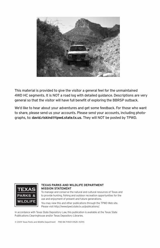
This material is provided to give the visitor a general feel for the unmaintained4WDHC segments. It is NOT a road log with detailed guidance. Descriptions are verygeneral so that the visitor will have full benefit of exploring the BBRSP outback.
We’d like to hear about your adventures and get some feedback. For those who wantto share, please send us your accounts. Please send your accounts, including photo-graphs, to: [email protected]. They will NOT be posted by TPWD.
TEXAS PARKS ANDWILDLIFE DEPARTMENTMISSION STATEMENTTomanage and conserve the natural and cultural resources of Texas andto provide hunting, fishing and outdoor recreation opportunities for theuse and enjoyment of present and future generations.
Youmay view this and other publications through the TPWDWeb site.Please visit http://www.tpwd.state.tx.us/publications/.
In accordance with Texas State Depository Law, this publication is available at the Texas StatePublications Clearinghouse and/or Texas Depository Libraries.
© 2009 Texas Parks andWildlife Department PWD BK P4501-0152K (11/09)

Yedra 2
Yedra 1
Guale 2
Guale 1
Rincon 2
Rincon 1
Mexicano 2
La Posta
Fresno Canyon
Tascate 1
La Mota 2
Escondido
Rancherias
Los Ojitos
Los Cuates
Paso al Solitario
Los Alamos
South LeyvaCampground
Arenosa
Colorado Canyon
Madera Canyon
Las Burras 3
Las Burras 1
Fresno Vista
Chorro Vista
Tres Papalotes
Pila Montoya 3
Pila Montoya 2
Pila Montoya 1
Papalote Llano
Escondido Pens
Papalote Encino
Agua Adentro Pens
Papalotito Colorado
Grassy Banks
ContrabandoMovie Set
La Cuesta
LosHermanos
Javelin PensJavelin
La Monilla
Vista del Bofecillos
PapaloteLlano Nuevo
Papalote Rancho Viejo
Las Burras 2
Papalote Nuevo
Mexicano 1
Vista del Chisos
Ojo Escondido
Jackson Pens
Vista de losPortales
McGuirk's Tanks
Tascate 2
La Mota 1
Crawford - Smith Ranch
Papalote de la Sierra
Casa Ramon
Lower Alamito
Guale Trailhead
Leyva Trailhead
Nopalera Trailhead
Las Burras Trailhead
Cinco Tinajas Trailhead
West Contrabando Trailhead
Lower Shutup Trailhead
Rancherias East Trailhead
East Contrabando Trailhead
Rancherias West Trailhead
Puerta ChilicoteTrailhead
Yedra Trailhead
Burnt Camp Trailhead
Rancho Viejo Trailhead
Ojito Adentro Trailhead
Closed Canyon Trailhead
Mexicano Falls TrailheadJavelin Trailhead
Pila MontoyaTrailhead
La Posta Trailhead
PrimeroTrailhead
East Casa Piedra Trailhead
West Casa Piedra Trailhead
Botella Residence
Cienega Camp
Los Alamos Residence
La Viuda4080
Fresno Peak5131
Cerro Tren4286
Needle Peak4608
Cerro Boludo4740
Solitario Peak4786
La Mota Mountain5046
Tres Cuevas Mountain
Amarilla Mountain3013
San Jacinto Mountain4965
Contrabando Mountain3214
Wax Factory Laccolith3139
Agua Adentro Mountain4938
Oso Mountain(Highest Point in Park)
5135
Rincon Mountain
Eagle Mountain4819
Bofecillos Peak5002
Panther Mountain4922
La Posta Mountain4630
Cerro de las Burras4345
Cienega Peak5223
Fr
es
no
R
i
o
G
r
a
n
d
e
Lajitas
Sauceda
Ci
en
eg
aC
re
ek
170
169
Cas
a
P ied raRoad
B
a
n
d
e
r
a
M
e
s
a
B o f e c i l l os
C a n y o n
Au
ra
s
Ca
ny
o n
La
s
Bu
rr a s
Ca
n
yo
n
Os
o
Ca
ny
on
Ra
nc
he
ri
as
Ca
ny
on
T h e S o l i t a r i o
Le
yv
a
Ca
ny
on
Al
am
it
o
Cr
ee
k
T e r n e r o s C r e e k
Pa
nt
he
rC
an
yo
n
M
on
il
l
aC
an
yo
n
Pu
bl
ic
Ac
ce
ss
Pe
nd
in
g
3TE3
Ta
pa
do
Cy
n.
C o l o r a d oC a n y o n
Redford
CasaPiedra
Bl
ac
k Hi l l s C r e e k
T e r n e r o s C r e e k
Bo
fec
il l os
Ro
ad
Portal del Norte
Park Entrance— Portal de Presidio
Ft. Leaton4 miles
S a n t a n aM e s a
Gu
al e
Me
sa
ContrabandoWaterhole
Disclaimer:
Property boundaries are for representation only.
Not all private property is shown on map. Map does
not depict all trails and roads. Additional trails and
roads depicted for informational and wayfinding
purposes only.
Bl a
c kH
i ll s
Cl o
se
dC
an
yo
n
C i e n e g aM o u n t a i n s
MadridFalls
MexicanoFalls
OjitoAdentro
Ar
ro
yo P
ri
m e r o
R
ight Hand Shutup
LeftHand S
hu
tup
Lo
we
rS
hu
tup
T a s co
ta
l
Me
sa
Ar r o y o
de
l o s M e x i c a n o s
Masada RidgeWilderness Unit(BBR State Park)
Barton Warnock Enviro Ed Center
0 5 101 2 3 4
Legend
Trailheads
Backcountry Ranger Residence
Campground
River Access
Campsite
Group Campsite
Equestrian Staging Campsite
2WD High Clearance
County
Graded
Highway
Locked Gate
4-Wheel Drive
4-Wheel Drive - Unmaintained
Closed Road
Private Property
Route or Road
Trails
Route or Road
Big Bend ranchState Park