rixton clay pits csac - connecting repositoriesrixton clay pits csac no. identified at stage 1 no....
TRANSCRIPT
HABITATS DIRECTIVE Review of Consents Stage 1 and 2
Rixton Clay Pits cSAC
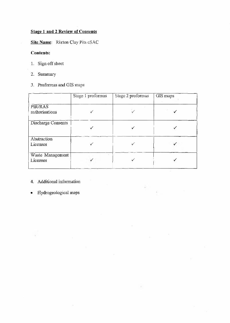
Stage 1 and 2 Review of Consents
Site Name: Rixton Clay Pits cSAC
Contents:
1. Sign off sheet
2. Summary
3. Proformas and GIS maps
Stage 1 proformas Stage 2 proformas GIS maps
PIR/RASauthorisations / V /
Discharge ConsentsV v ✓
AbstractionLicenses S s
Waste Management Licenses s s
4. Additional information
• Hydrogeological maps

SUMMARY - RIXTON CLAY PITS cS AC
Rixton Clay Pits cSACNo. identified at Stage 1 No. assessed at stage 2 as
potential ‘likely significant effect’Water QualityDischargeConsents
37 0
WasteManagementLicences
16 0
AbstractionLicences
15 2
IPC/IPPC Permits 29 10RAS 0 0TOTAL 97 12
Search Criteria
Criteria used in screening for stage 1 of the Review of Consents is in accordance with the Environment Agency ‘Habitats and Regulations Guidance, VI, 3/10/01’. Distances have been measured from the boundary of the European site. The following table outlines the criteria used for each type of consent:
Screening criteria for review of consents.Consent Type Buffer ZoneWater Quality Consents Within 3kmWater Resources abstractions Within 3 kmWaste Management Licenses Landfills within 5km
Licensed waste management facilities within 2kmPIR Authorisations IPPC permissions within 10km
Power stations within 15kmRAS - nuclear sites within 5km others licensed for disposal e.g. hospitals within 1km
Methodology
GIS Arcview has been used to identify consents within the specified distances of South Pennine Moors, data held within GIS Arcview comes directly from public register databases (this information is updated routinely as new consents are issued). The GIS maps have been attached to the corresponding pro-forma to assist in determining significant effect for stage 2 of the review.

Points to note
The ponds in the area are probably groundwater controlled. The groundwater occurs in sand/gravel horizons (max. 2m depth), between the boulder clay and underlying mudstones. Surface water courses do not discharge into or run out of the ponds.
A closed landfill exists to the north of Moss Side Lane. Leachate from this site runs down Moat Lane in a culvert, crosses under the lane and then travels east in an open ditch. It is understood that there have been seepages from this site into the fishing ponds to the south. Warrington BC and Transco are presently installing a liner to the ditch and bank works to prevent this. The site will fall under the Contaminated Land Regulations, Warrington Borough Council are pursuing this site as a whole rather than consideration of an individual discharge.
Septic tank discharge should also be directed to sewer. United Utilities have been requested to put this to sewer.
A closed non-permitted landfill known as Rixton I on the comer of Moat Lane and A57 has a french drain running around the north and east parts of the site which collects surface water runoff. The poor condition of the capping allows some leachate to also enter this drain. This is culverted under Moat Lane and discharges into the clay pits directly onto soil, there appears to be no direct connection with the pond. The discharge has an elevated ammonia level. Should an effect on the pond become apparent and a connection established the Agency would consider taking action.
A Planning Permission exists for an Industrial waste landfill immediately to the west of Moat Lane. Potentially any development of a deep liner in this area could affect groundwater flow, which in turn could affect pond levels. To operate the landfill site a permit will be required from the Agency, this issue will be addressed at the permitting stage.
Due to the complexity of modelling impacts of multiple sources of emissions to air, it has been decided that the in-combination effects of IPC/IPPC authorisations will be assessed at Stage 3 as part of the appropriate assessment.
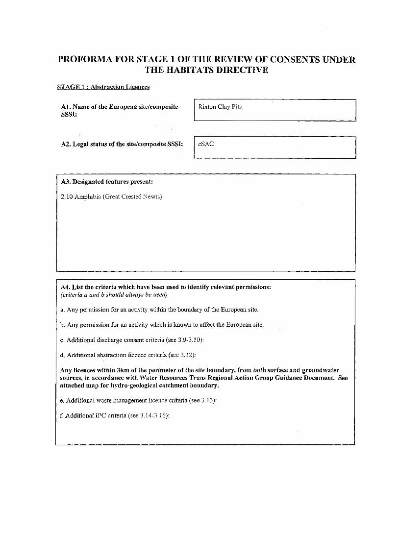
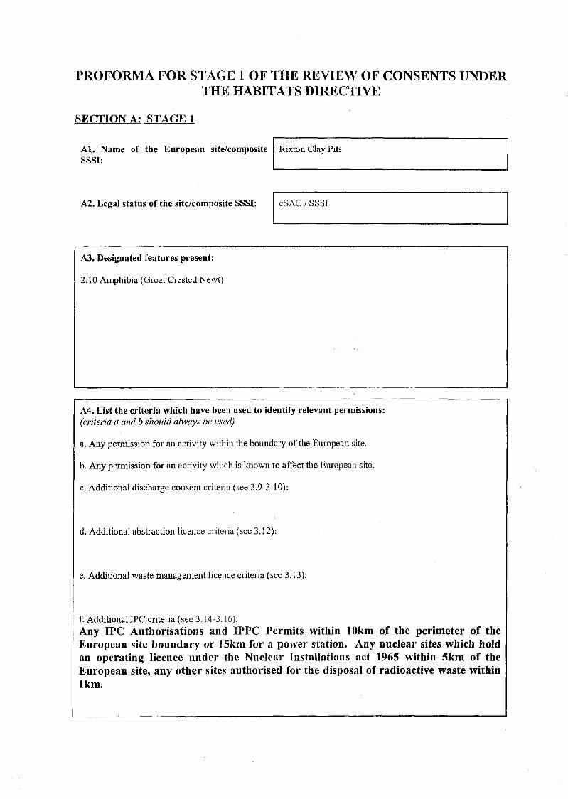
PROFORMA FOR STAGE 1 OF THE REVIEW OF CONSENTS UNDER THE HABITATS DIRECTIVE
STAGE 1 : Abstraction Licences
A l. Name of the European site/composite SSSI:
Rixton Clay P its,
A2. Legal status of the site/composite SSSI: cSAC
A3. Designated features present:
2.10 Amphibia (Great Crested Newts)
A4. List the criteria which have been used to identify relevant permissions:(criteria a and b should always be used)
a. Any permission for an activity within the boundary of the European site.
b. Any permission for an activity which is known to affect the European site.
c. Additional discharge consent criteria (see 3.9-3.10):
d. Additional abstraction licence criteria (see 3.12):
Any licences within 3km of the perim eter of the site boundary, from both surface and groundwater sources, in accordance with W ater Resources Trans Regional Action Group Guidance Document. See attached m ap for hydro-geological catchment boundary.
e. Additional waste management licence criteria (see 3.13):
f. Additional IPC criteria (see 3.14-3.16):
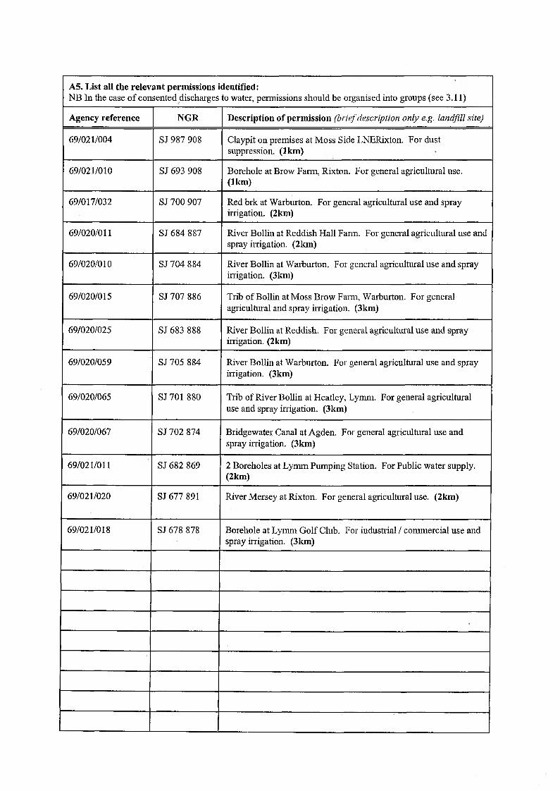
A5. List all the relevant permissions identified:NB In the case o f consented discharges to water, permissions should be organised into groups (see 3.11)
Agency reference NGR Description of permission (brief description only e.g. landfill site)
69/021/004 SJ 987 908 Claypit on premises at Moss Side LNERixton. For dust suppression. (1km)
69/021/010 SJ 693 908 Borehole at Brow Farm, Rixton. For general agricultural use. (1km)
69/017/032 SJ 700 907 Red brk at Warburton. For general agricultural use and spray irrigation. (2km)
69/020/011 SJ 684 887 River Bollin at Reddish Hall Farm. For general agricultural use and spray irrigation. (2km)
69/020/010 SJ 704 884 River Bollin at Warburton. For general agricultural use and spray irrigation. (3km)
69/020/015 SJ 707 886 Trib of Bollin at Moss Brow Farm, Warburton. For general agricultural and spray irrigation. (3km)
69/020/025 SJ 683 888 River Bollin at Reddish. For general agricultural use and spray irrigation. (2km)
69/020/059 SJ 705 884 River Bollin at Warburton. For general agricultural use and spray irrigation. (3km)
69/020/065 SJ 701 880 Trib of River Bollin at Heatley, Lymm. For general agricultural use and spray irrigation. (3 km)
69/020/067 SJ 702 874 Bridgewater Canal at Agden. For general agricultural use and spray irrigation. (3km)
69/021/011 SJ 682 869 2 Boreholes at Lymm Pumping Station. For Public water supply. (2km)
69/021/020 SJ 677 891 River Mersey at Rixton. For general agricultural use. (2km)
69/021/018 SJ 678 878 Borehole at Lymm Golf Club. For industrial / commercial use and spray irrigation. (3km)
STAGE 2 - ABSTRACTION LICENCESThese permissions will be reviewed under the general power contained in Habitat Regulation 3(4). See Chapter 3 of generic guidance for further details on these permissions.
E l. Are any of the features present identified as vulnerable to impacts from abstraction in Appendix 4? If so, list them: (See Appendix 4)
Amphibia: Great Crested Newt (GCN) Triturus cristatus
E2. Are there any known abstraction problems on the site? If so briefly describe them: (See Appendix 4) '
No
E3. W hat is the initial judgement of significance for the abstraction licences identified under SECTION A? (See Appendix 4)
Agency reference NGR
Likely to have a significant effect? - yes or no Initial judgem ent made
under element I or II or III? - specify
(See Fig. 7 in generic guidance)
Alone InCombination
25/69/021/004 SJ687908 YES YESI I — there is a probability that the potential m echanism w ill affect the interest feature o f the site
25/69/021/010 SJ693908 YES YES I I — there is a probability that the potential hazard w ill affect the interest feature o f the site
25/69/021/018 SJ678878 NO NO No Hydraulic Continuity
25/69/020/059 SJ705884 NO NO No Hydraulic Continuity
25/69/020/015 S.T707886 NO NO No Hydraulic Continuity
25/69/017/032 SJ700907 NO NO No Hydraulic Continuity
25/69/020/011 SJ684 887 NO NO No Hydraulic Continuity
25/69/020/010 SJ704884 NO NO No Hydraulic Continuity
25/69/020/015 SJ707886 NO NO No Hydraulic Continuity
25/69/020/025 SJ683888 NO NO No Hydraulic Continuity
25/69/020/059 SJ705884 NO NO No Hydraulic Continuity
25/69/021/020 SJ677891 NO NO No Hydraulic Continuity
E4. Describe the supporting case for the judgements given in E3:(This should be set out in terms o f the criteria fo r significance given in the procedure e.g. what is the mechanism o f impact, which features are sensitive, what is their condition etc. Reference should be made to the conservation agency’s view, the joint review and any problems identified under E2. Expand beyond a page i f necessary)
Criteria for significance
1.1 Mechanism of impact
Reduced water level due to licensed abstraction
1.2 Sensitive features
Great Crested Newt Triturus cristatus
1.2.1 GCN prefer submerged aquatic plants to lay eggs and a water depth of 1-1.5m is tolerated. It is essential that there is a stable level of water after egg laying and that this level is maintained during the breeding and tadpole development season (Feb-mid A ug)(I).
1.3 Condition
Favourable
2. Justification
There are 13 licensed abstractions and 14 abstraction points within a 3km radius of the sight boundary, o f these; ten are surface water (SW) abstractions and four are groundwater (GW) abstractions. The ponds at Rixton Clay Pits appear to be groundwater and / or rainfall fed, based on this premise, the ten SW abstractions identified in Stagel are not required to go any further than Stage 2. This also applies to the two remaining groundwater abstractions, as they too are not in hydraulic continuity with the site.
In adopting the precautionary principle, water resources are proposing to take two licensed GW abstractions forward to Stage 3 for appropriate assessment. The justification surrounding this decision is based upon the following issues:
❖ The proximity of both abstraction points to the designated site❖ It is uncertain whether the ponds are groundwater or surface water fed, or a
combination❖ It is uncertain whether there is any direct hydraulic connection between the ponds and
the two sources
25/69/020/065 SJ701880 NO NO No Hydraulic Continuity
25/69/021/011 SJ682869 NO NO No Hydraulic Continuity
25/60/020/067 SJ702874 NO NO No Hydraulic Continuity
(Note:- At this stage it is apparent that the scale of the abstractions are small and are not likely to have a significant impact, even assuming ‘worst case’ conditions. This will be explored further in Stage 3)
Licence Details:
Agency Reference25/69/021/004
NGRSJ687 908
Licence HolderThomas Mosedale (potential succession)
UseDust Suppression
Year: 2.25 Ml Day: 0.04 Ml Hour: 0.0045 Ml
Agency Reference25/69/021/010
NGRSJ693 908
Licence HolderBrow Farm (Ernest Mason)
UseAgriculture
Year: 16 Ml Day: 0.040 Ml Hour: 0.0045 Ml
References:(l) 2001 Great Crested Newt: Conservation Handbook. Froglife
E5. Does internal consultation support this initial assessment? (yes or no)Yes
E6. If not what is the new assessment? (See Appendix 4)
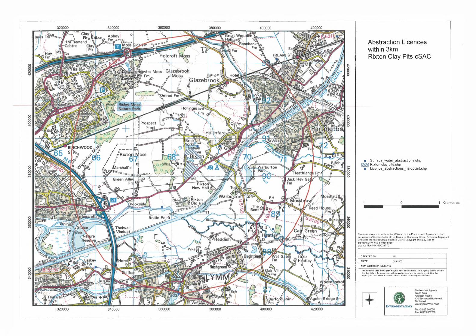
A b s t r a c t i o n L i c e n c e s
w i t h i n 3 k m
R i x t o n C l a y P i t s c S A C
• Surface_water_abstractions.shp Rixton clay pits.shp
• Licence_abstractions_naldpoint.shp
This map is reproduced from the OS map by the Environment Agency with the permission of the Controller of Her Majesty's Stationery Office, (c) Crown Copyright. Unauthorised reproduction infringes Crown Copyright and may lead to prosecution or civil proceedings:Licence Number: GD03177G.
CREATED BY NLDATE 08/01/02North West Region, South AreaThe datasets used in this plan may not have been audited. The Agency cannot ensure that the Data in its possession will always be accurate, up to date or valid but the Agency will use reasonable care to ensure an acarate copy of the Data.
PROFORMA FOR STAGE 1 OF THE REVIEW OF CONSENTS UNDER THE HABITATS DIRECTIVE
SECTION A: STAGE 1
A l. Name of the European site/composite SSSI:
Rixton Clay Pits
A2. Legal status of the site/composite SSSI: cSAC / SSSI
A3. Designated features present:
2.10 Amphibia (Great Crested Newt)
A4. L ist the criteria which have been used to identify relevant permissions:(criteria a and b should always he used)
a. Any permission for an activity within the boundary of the European site.
b. Any permission for an activity which is known to affect the European site.
c. Additional discharge consent criteria (see 3.9-3.10):Any discharge consent within 3km of the perimeter of the site boundary, to both surface and groundwater.
d. Additional abstraction licence criteria (see 3.12):
e. Additional waste management licence criteria (see 3.13):
f. Additional IPC criteria (see 3.14-3.16):

A5. List all the relevant permissions identified:NB In the case of consented discharges to water, permissions should be organised into groups (see 3.11)
Agency reference NGR Description of permission (brief description only e.g. landfill site)
0174/1 SJ675926 HOYLES MOSS, HOYLESS MOSS FARM, DAM LANE, RIXTON
016982896 SJ696874 OUGHTRIGHT, OUGHTRIGHT LANE CSO, WARRINGTON
016920281 SJ682873 SLITTEN VALLEY, SLITTEN VALLEY SEWER, LYMM
016992435 SJ684916 64 MOSS SIDE LANE, RIXTON, WARRINGTON
01M/733 SJ657890 11 BATTERY LANE, MARTINS CROFT, WARRINGTON
0174/3 SJ684894 9, 11, 13 MARSLAND GREEN LANE, ASTLEY, MANCHESTER
016992454 SJ701914 HOLLY BANK, MYTHOLME AVENUE, CADISHEAD
0174/2354 SJ691885 REDDISH HALL FARM SWO, REDDISH LANE, LYMM
0167/607 SJ690906 THE ROOKERY, 10 CHAPEL LANE, RIXTON, WARRINGTON
01M/557 SJ670896 ROSEGARTH, HOLLY BUSH LANE, RIXTON, WARRINGTON
016992432 SJ663887 WOOLSTON NO 2 DEPOSIT GROUND (OUTLETS 13, 14, 15) WOOLSTON, WARRINGTON
016993372 SJ667893 STP SERVING THE MASCRAT MANOR, JUNIPER LANE, WARRINGTON
01SAL0015 SJ711918 LORDS STREET, SALFORD, GREATER MANCHESTER
01TRA0035 SJ708915 LOCK LANE, PARTINGTON, GREATER MANCHESTER
01TRA0047 SJ708915 BIRCH ROAD, PARTINGTON, TRAFFORD, GREATER MANCHESTER
01TRA0046 SJ708915 BIRCH ROAD, PARTINGTON, TRAFFORD, GREATER MANCHESTER
016940148 SJ705908 PARTINGTON STW, LOCK LANE, PARTINGTON, GREATER MANCHESTER
01WAR0067 SJ702887 BIRCHBROOK ROAD, HEATLEY, WARRINGTON
01WAR0040 SJ701919 GLAZEBROOIC LANE, WARRINGTON
016940133 SJ701920 IRLAM STW, CUMBERLAND AVENUE, CADISHEAD, GREATER MANCHESTER
01WAR0047 SJ701913 OPP BLACK SWAN PUB HSE, WARRINGTON
01WAR0037 SJ699923 GLAZEBROOIC PS (BANK ST), WARRINGTON
01SAL0049 SJ699925 LORDS ST/FIR ST JCT, SALFORD, GREATER MANCHESTER
01TRA0050 SJ698898 WARBURTON, TRAFFORD, GREATER MANCHESTER
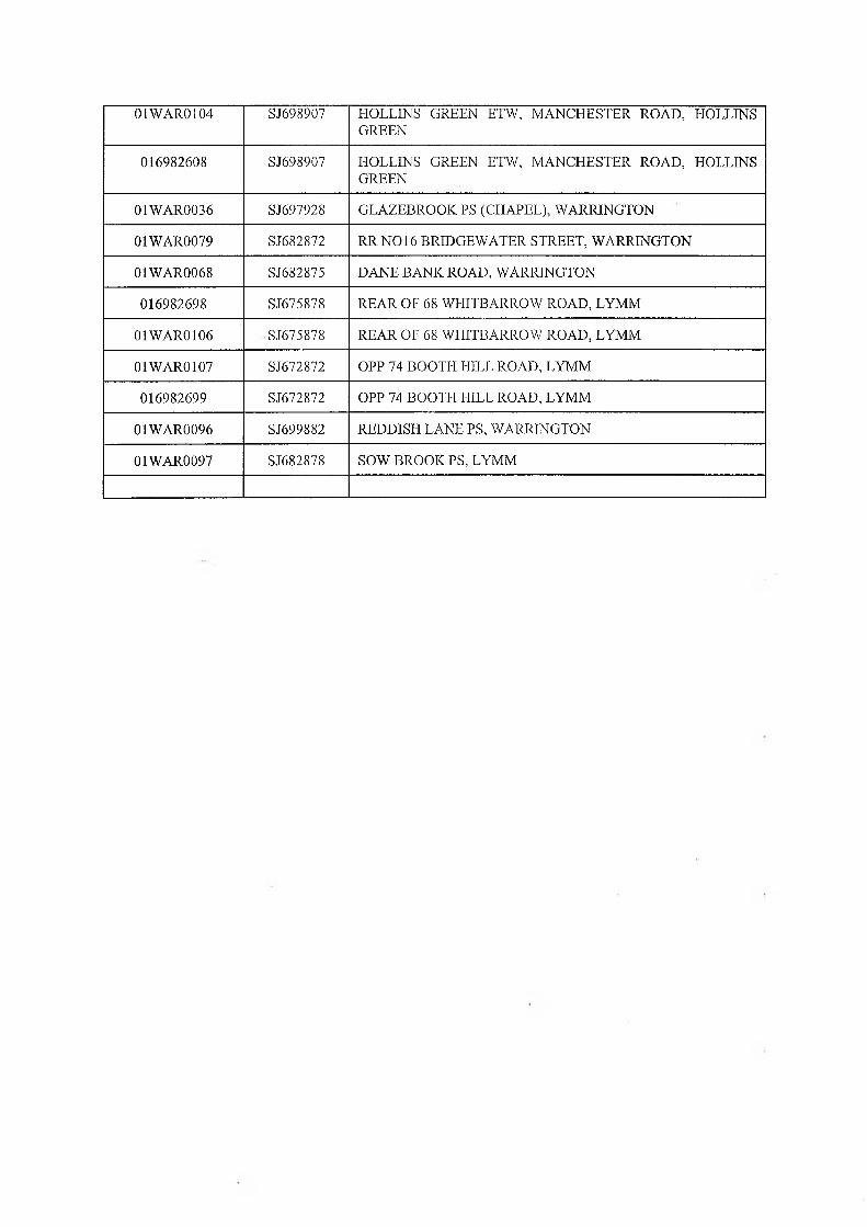
01WAR0104 S.T698907 HOLLINS GREEN ETW, MANCHESTER ROAD, HOLLINS GREEN
016982608 SJ698907 HOLLINS GREEN ETW, MANCHESTER ROAD, HOLLINS GREEN
01WAR0036 SJ697928 GLAZEBROOK PS (CHAPEL), WARRINGTON
01WAR0079 SJ682872 R RN 016 BRIDGEWATER STREET, WARRINGTON
01WAR0068 SJ682875 DANE BANK ROAD, WARRINGTON
016982698 SJ675878 REAR OF 68 WHITBARROW ROAD, LYMM
01WAR0106 SJ675878 REAR OF 68 WHITBARROW ROAD, LYMM
01WAR0107 SJ672872 OPP 74 BOOTH HILL ROAD, LYMM
016982699 SJ672872 OPP 74 BOOTH HILL ROAD, LYMM
01WAR0096 SJ699882 REDDISH LANE PS, WARRINGTON
01WAR0097 SJ682878 SOW BROOK PS, LYMM
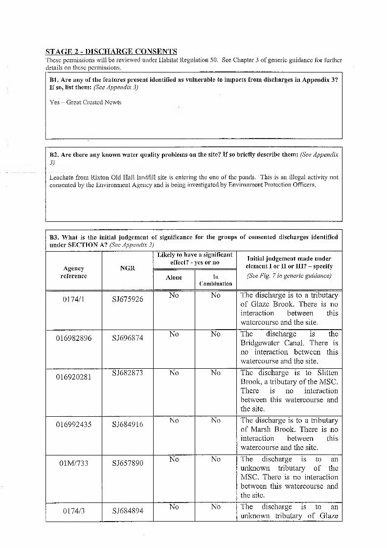
STAGE 2 - DISCHARGE CONSENTSThese permissions will be reviewed under Habitat Regulation 50. See Chapter 3 of generic guidance for further details on these permissions.
B l. Are any of the features present identified as vulnerable to impacts from discharges in Appendix 3? If so, list them: (See Appendix 3)
Yes - Great Crested Newts
B2. Are there any known water quality problems on the site? If so briefly describe them: (See Appendix3)
Leachate from Rixton Old Hall landfill site is entering the one of the ponds. This is an illegal activity not consented by the Environment Agency and is being investigated by Environment Protection Officers.
B3. W hat is the initial judgement of significance for the groups of consented discharges identified under SECTION A? (See Appendix 3)
Agencyreference
NGR
Likely to have a significant effect? - yes or no Initial judgement made under
element I or II or III? - specify(See Fig. 7 in generic guidance)Alone in
Combination
0174/1 SJ675926 No No The discharge is to a tributary of Glaze Brook. There is no interaction between this watercourse and the site.
016982896 S.T696874 No No The discharge is the Bridgewater Canal. There is no interaction between this watercourse and the site.
016920281 S.T682873 No No The discharge is to Slitten Brook, a tributary of the MSC. There is no interaction between this watercourse and the site.
016992435 SJ684916 No No The discharge is to a tributary of Marsh Brook. There is no interaction between this watercourse and the site.
01M/733 SJ657890 No No The discharge is to an unknown tributary of the MSC. There is no interaction between this watercourse and the site.
0174/3 SJ684894 No No The discharge is to an unknown tributary of Glaze
Brook. There is no interaction between this watercourse and the site.
016992454 SJ701914 No No The discharge is to Glaze Brook. There is no interaction between this watercourse and the site.
0174/2354 SJ691885 No No The discharge is to the River Bollin. There is no interaction between this watercourse and the site.
0167/607 SJ690906 No No The discharge is to an unknown tributary of the MSC. There is no interaction between this watercourse and the site.
01M/557 SJ670896 No No The discharge is to the River Mersey. There is no interaction between this watercourse and the site.
016992432 SJ663887 No No The discharge is to the River Mersey. There is no interaction between this watercourse and the site.
016993372 SJ667893 No No The discharge is to Fishington Brook a tributary of the River Mersey. There is no interaction between this watercourse and the site.
01SAL0015 SJ711918 No No The discharge is to the MSC. There is no interaction between this watercourse and the site.
01TRA0035 SJ708915 No No The discharge is to the MSC. There is no interaction between this watercourse and the site.
01TRA0047 SJ708915 No No The discharge is to Longford Brook a tributary of the MSC. There is no interaction between this watercourse and the site.
01TRA0046 SJ708915 No No The discharge is to the MSC. There is no interaction between this watercourse and the site.
016940148 SJ705908 No No The discharge is to Red Brook, a tributary of Sinderland Brook which is itself a trib. of the MSC. There
is no interaction between this watercourse and the site.
01WAR0067 SJ702887 No No The discharge is to the River Bollin. There is no interaction between this watercourse and the site.
01WAR0040 SJ701919 No No The discharge is to the River Glaze. There is no interaction between this watercourse and the site.
016940133 SJ701920 No No The discharge is to the River Glaze. There is no interaction between this watercourse and the site.
01WAR0047 SJ701913 No ' No The discharge is to the River Glaze. There is no interaction between this watercourse and the site.
01WAR0037 SJ699923 No No The discharge is to the River Glaze. There is no interaction between this watercourse and the site.
01SAL0049 SJ699925 No No The discharge is to the River Glaze. There is no interaction between this watercourse and the site.
01TRA0050 SJ698898 No No The discharge is to an unknown tributary of the MSC. There is no interaction between this watercourse and the site.
01WAR0104SJ698907 No No The discharge is to the MSC.
There is no interaction between this watercourse and the site.
016982608 SJ698907 No The discharge is to the MSC. There is no interaction between this watercourse and the site.
01WAR0036 SJ697928 No No The discharge is to Glaze Brook. There is no interaction between this watercourse and the site.
01WAR0079 SJ682872 No No The discharge is to Slitten Brook, a tributary of the MSC. There is no interaction between this watercourse and the site.
01WAR0068 SJ682875 No No The discharge is to Slitten

Brook, a tributary of the MSC. There is no interaction between this watercourse and the site.
016982698 SJ675878 No No The discharge is to an unknown tributary of the MSC. There is no interaction between this watercourse and the site.
01WAR0106 SJ675878 No No The discharge is to the MSC. There is no interaction between this watercourse and the site.
01WAR0107 SJ672872 No No The discharge is the Bridgewater Canal. There is no interaction between this watercourse and the site.
016982699 SJ672872 No No The discharge is the Bridgewater Canal. There is no interaction between this watercourse and the site.
01WAR0096 SJ699882 No No The discharge is to the River Bollin. There is no interaction between this watercourse and the site.
01WAR0097 SJ682878 No No The discharge is to Sow Brook, a tributary of the MSC. There is no interaction between this watercourse and the site.
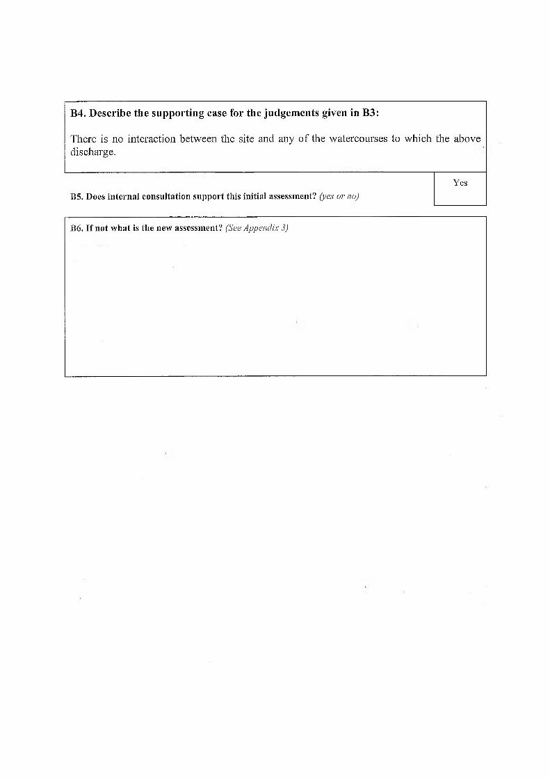
B4. Describe the supporting case for the judgements given in B3:
There is no interaction between the site and any of the watercourses to which the abovedischarge.
YesB5. Does internal consultation support this initial assessment? (yes or no)
B6. If not what is the new assessment? (See Appendix 3)
320000 340000 360000 380000 400000 420000
320000 340000 360000 380000 400000 420000
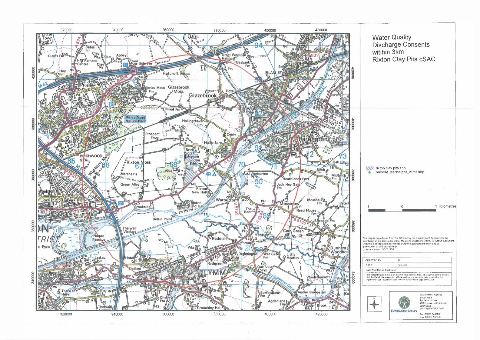
W a t e r Q u a l i t y
D i s c h a r g e C o n s e n t s
w i t i h i n 3 k m
R i x t o n C l a y P i t s c S A C
Rixton clay pits.shp Consent_discharges_wims.shp
This map is reproduced from the OS map by the Environment Agency with the permission of the Controller of Her Majesty’s Stationery Office, (c) Crown Copyright. Unauthorised reproduction infringes Crown Copyright and may lead to prosecution or civil proceedings:Licence Number: GD03177G.
CREATED BY NLDATE 08/01/02North West Region, South AreaThe datasets used in this plan may not have been audited. The Agency cannot ensure that the Data in its possession will always be accurate, up to date or valid but the Agency will use reasonable care to ensire an accurate copy of the Data.
Environment AgencySouth AreaAppleton House430 Birchwood BoulevardBirchwoodWarrington WA3 7WDTel: 01925 840000 Fax: 01925 852260
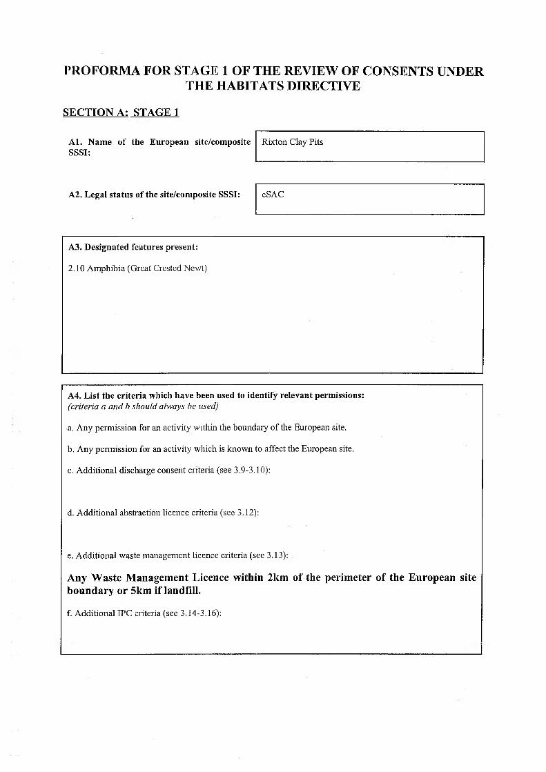
PROFORMA FOR STAGE 1 OF THE REVIEW OF CONSENTS UNDER THE HABITATS DIRECTIVE
SECTION A: STAGE 1
A l. Name of the European site/composite SSSI:
A2. Legal status of the site/composite SSSI:
Rixton Clay Pits
cSAC
A3. Designated features present:
2.10 Amphibia (Great Crested Newt)
A4. List the criteria which have been used to identify relevant permissions:(criteria a and b should always be used)
a. Any permission for an activity within the boundary of the European site.
b. Any permission for an activity which is known to affect the European site.
c. Additional discharge consent criteria (see 3.9-3.10):
d. Additional abstraction licence criteria (see 3.12):
e. Additional waste management licence criteria (see 3.13):
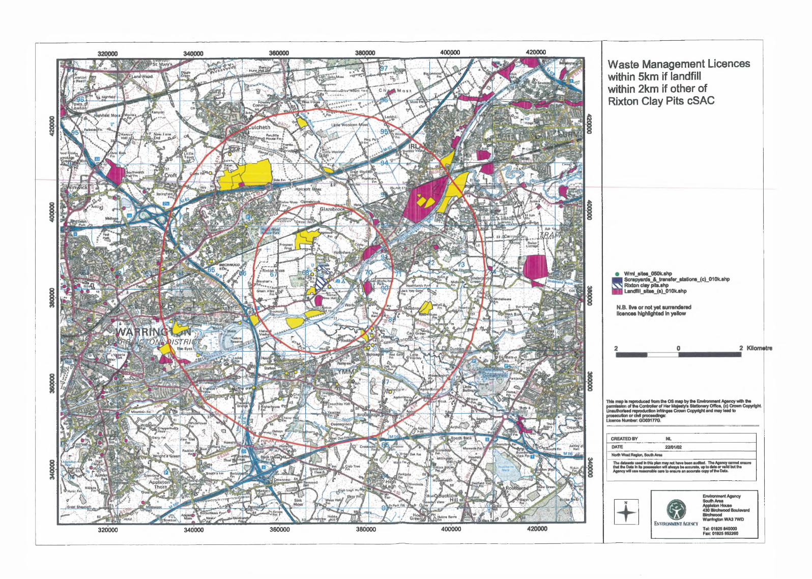
Any Waste Management Licence within 2km of the perimeter of the European site boundary or 5km if landfill.
f. Additional IPC criteria (see 3.14-3.16):
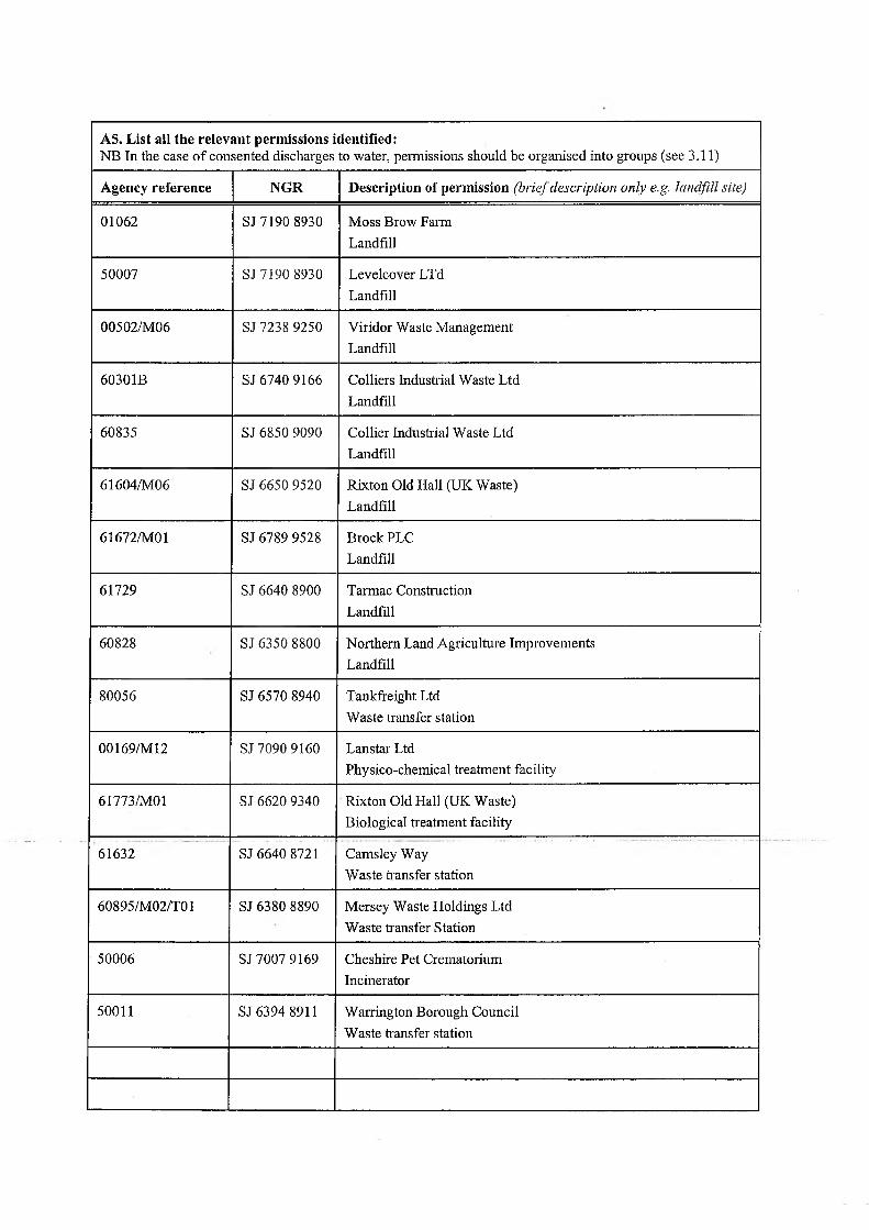
A5. List all the relevant permissions identified:NB In the case of consented discharges to water, permissions should be organised into groups (see 3.11)
Agency reference NGR Description of permission (brief description only e.g. landfill sitej
01062 SJ 7190 8930 Moss Brow Farm Landfill
50007 SJ 7190 8930 Levelcover LTd Landfill
00502/M06 SJ 7238 9250 Viridor Waste Management Landfill
60301B SJ 6740 9166 Colliers Industrial Waste Ltd Landfill
60835 SJ 6850 9090 Collier Industrial Waste Ltd Landfill
61604/M06 SJ 6650 9520 Rixton Old Hall (UK Waste) Landfill
61672/MO 1 SJ 6789 9528 Brock PLC Landfill
61729 SJ 6640 8900 Tarmac Construction Landfill
60828 SJ 6350 8800 Northern Land Agriculture Improvements Landfill
80056 SJ 6570 8940 Tankfreight Ltd Waste transfer station
00169/M 12 SJ 7090 9160 Lanstar LtdPhysico-chemical treatment facility
61773/MO 1 SJ 6620 9340 Rixton Old Hall (UK Waste) Biological treatment facility
61632 SJ 6640 8721 Camsley Way Waste transfer station
60895/M02/T01 SJ 6380 8890 Mersey Waste Holdings Ltd Waste transfer Station
50006 SJ 7007 9169 Cheshire Pet Crematorium Incinerator
50011 SJ 6394 8911 Warrington Borough Council Waste transfer station
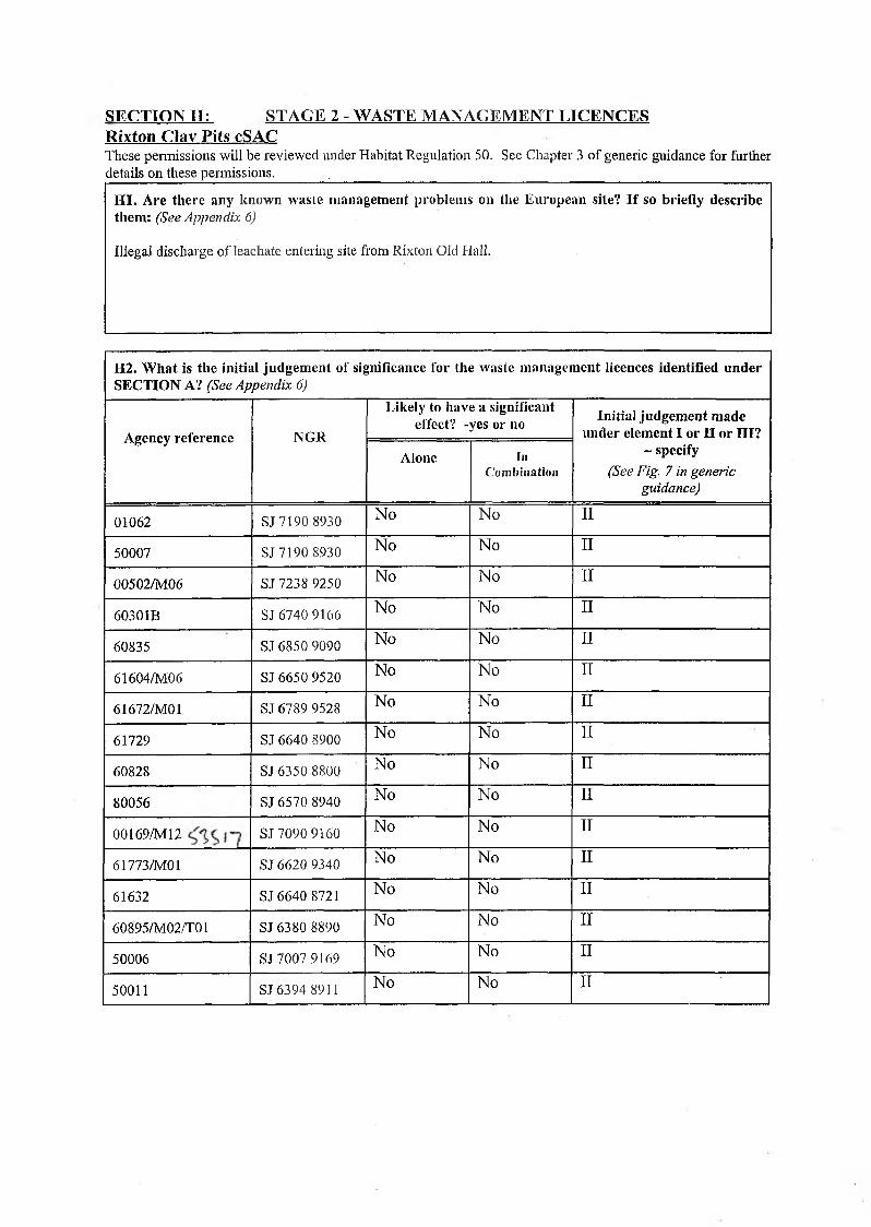
SECTION H: STAGE 2 - WASTE MANAGEMENT LICENCESRixton Clav Pits cSACThese permissions will be reviewed under Habitat Regulation 50. See Chapter 3 of generic guidance for further details on these permissions._______ . ____________________________________________________________
H I. Are there any known waste management problems on the European site? I f so briefly describe them: (See Appendix 6)
Illegal discharge of leachate entering site from Rixton Old Hall.
H2. W hat is the initial judgem ent of significance for the waste management licences identified under SECTION A? (See Appendix 6)
Agency reference NGR
Likely to have a significant effect? -yes or no Initial judgem ent made
under element I or II or III? - specify
(See Fig. 7 in generic guidance)
Alone InCombination
01062 SJ 7190 8930 No No II
50007 SJ 7190 8930 No No II
00502/M06 SJ 7238 9250 No No II
60301B SJ 6740 9166 No No II
60835 SJ 6850 9090 No No II
61604/M06 SJ 6650 9520 No No II
61672/MO 1 SJ 6789 9528 No No II
61729 SJ 6640 8900 No No
60828 SJ 6350 8800 No No II
80056 SJ 6570 8940 No No II
00169/M 12 SJ 7090 9160 No No II
61773/MO 1 SJ 6620 9340 No No II
61632 SJ 6640 8721 No No II
60895/M02/T01 SJ 6380 8890 No No II
50006 SJ 7007 9169 No No II
50011 SJ 6394 8911 No No
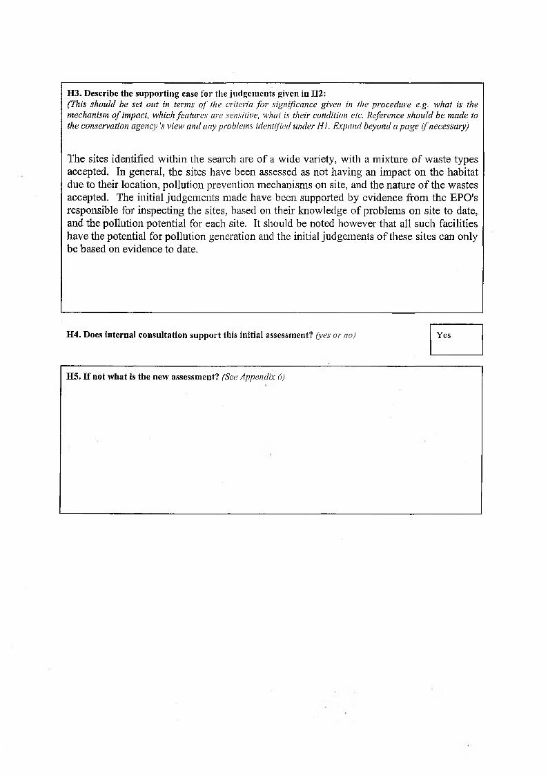
H3. Describe the supporting case for the judgements given in H2:(This should be set out in terms o f the criteria fo r significance given in the procedure e.g. what is the mechanism o f impact, which features are sensitive, what is their condition etc. Reference should be made to the conservation agency's view and any problems identified under HI. Expand beyond a page i f necessary)
The sites identified within the search are of a wide variety, with a mixture of waste types accepted. In general, the sites have been assessed as not having an impact on the habitat due to their location, pollution prevention mechanisms on site, and the nature o f the wastes accepted. The initial judgements made have been supported by evidence from the EPO's responsible for inspecting the sites, based on their knowledge of problems on site to date, and the pollution potential for each site. It should be noted however that all such facilities have the potential for pollution generation and the initial judgements o f these sites can only be based on evidence to date.
H4. Does internal consultation support this initial assessment? (yes or no) Yes
H5. If not what is the new assessment? (See Appendix 6)
400000 420000
320000 340000 360000 380000 400000
W a s t e M a n a g e m e n t L i c e n c e s
w i t h i n 5 k m if l a n d f i l l
w i t h i n 2 k m if o t h e r o f
R i x t o n C l a y P i t s c S A C
PROFORMA FOR STAGE 1 OF THE REVIEW OF CONSENTS UNDER THE HABITATS DIRECTIVE
SECTION A: STAGE 1
A l. Name of the European site/composite SSSI:
A2. Legal status of the site/composite SSSI: cSAC / SSSI
Rixton Clay Pits
A3. Designated features present:
2.10 Amphibia (Great Crested Newt)
A4. List the criteria which have been used to identify relevant permissions:(criteria a and b should always he used)
a. Any permission for an activity within the boundary of the European site.
b. Any permission for an activity which is known to affect the European site.
c. Additional discharge consent criteria (see 3.9-3.10):
d. Additional abstraction licence criteria (see 3.12):
e. Additional waste management licence criteria (see 3.13):
f. Additional IPC criteria (see 3.14-3.16):Any IPC Authorisations and IPPC Permits within 10km of the perimeter of the European site boundary or 15km for a power station. Any nuclear sites which hold an operating licence under the Nuclear Installations act 1965 within 5km of the European site, any other sites authorised for the disposal of radioactive waste within lkm.
A5. List all the relevant permissions identified:NB In the case of consented discharges to water, permissions should be organised into groups (see 3.11)
Agency reference NGR Description of permission (brief description only e.g. landfill site)
AA3301 SJ543865 COMBUSTION PROCESSES,FIDDLERS FERRY POWER STATION, WARRINGTON 14.5km
AY8549 SJ728935 COMBUSTION PROCESSES,AES PARTINGTON LTD, MANCHESTER RD,CARRINGTON, MANCHESTER 5km
AA3026 SJ597880 COMBUSTION PROCESSES,INEOS SILICAS LTD, SOUTH BANK WORKS,PO BOX 26 .LIVERPOOL ROAD, WARRINGTON 9km
AA7099 . SJ601862 COMBUSTION PROCESSES,SOLVAY INTEROX LTD, BARONET ROAD, WARRINGTON 9km
AF7827 SJ681903 COMBUSTION PROCESSES,TRANSCO PLC, WARRINGTON COMPRESSOR STATION, MOAT LANE, RIXTON 0.3km
AV6779 SJ727913 GASIFICATION AND ASSOCIATED PROCESSES,BRITISH GAS PLC, PARTINGTON LNG FACILITY, HEATH FARM LANE, PARTINGTON 4km
A01276 SJ597880 INORGANIC CHEMICAL PROCESSES,INEOS SILICAS LTD, BANK QUAY, WARRINGTON 9km
AU0180 SJ715923 INORGANIC CHEMICAL PROCESSES,LIBRA CHEMICALS LTD, MARTENS ROAD, NORTHBANK INDUSTRIAL ESTATE, IRLAM 31cm
AK3030 SJ710926 MANUFACTURE AND USE OF ORGANIC CHEMICALS, CLARIANT LIFE SCIENCE MOLECULES (UK), HAYES ROAD, CADISHEAD, MANCHESTER 3km
AK5636 SJ710926 MANUFACTURE AND USE OF ORGANIC CHEMICALS, CLARIANT LIFE SCIENCE MOLECULES (UK), HAYES ROAD, CADISHEAD, MANCHESTER 3km
AV5209 SJ710926 MANUFACTURE AND USE OF ORGANIC CHEMICALS, CLARIANT LIFE SCIENCE MOLECULES (UK), HAYES ROAD, CADISHEAD, MANCHESTER 31cm
AK1070 SJ710926 MANUFACTURE AND USE OF ORGANIC CHEMICALS, CLARIANT LIFE SCIENCE MOLECULES (UK), HAYES ROAD, CADISHEAD, MANCHESTER 2.7km
AK9801 SJ597880 MANUFACTURE AND USE OF ORGANIC CHEMICALS, INEOS SILICAS LTD, BANK QUAY, WARRINGTON 9km
AK6616 SJ702998 MANUFACTURE AND USE OF ORGANIC CHEMICALS, LAKELAND LABOURATORIES LTD, PEEL LANE, ASTLEY, TYLDESLEY, MANCHESTER 9km
AU0201 SJ715 923 MANUFACTURE AND USE OF ORGANIC CHEMICALS, LIBRA CHEMICALS LTD, MARTENS ROAD, NORTHBANK INDUSTRIAL ESTATE, IRLAM 3km
AK4036 SJ737927 MANUFACTURE AND USE OF ORGANIC CHEMICALS, NOVA CHEMICALS EUROPE LTD, CARRINGTON WORKS URMSTON 5.5km
AK6489 SJ736922MANUFACTURE AND USE OF ORGANIC CHEMICALS, NOVA CHEMICALS EUROPE LTD, ISHERWOOD ROAD, CARRINGTON, URMSTON 5.5km
AK6551 SJ658895 MANUFACTURE AND USE OF ORGANIC CHEMICALS, SHIPLEY EUROPE LTD, CHESFORD GRANGE, WOOLSTON2.5km
AK7809 SJ596860 MANUFACTURE AND USE OF ORGANIC CHEMICALS, SOLVAY INTEROX LTD, PO BOX 7, WARRINGTON 9.5km
AK7817 SJ596860 MANUFACTURE AND USE OF ORGANIC CHEMICALS, SOLVAY INTEROX LTD, PO BOX 7, WARRINGTON 9.5km
AK3960 SJ595876 MANUFACTURE AND USE OF ORGANIC CHEMICALS, VINAMUL LTD, EASTFORD ROAD, WARRINGTON 9km
AK3978 SJ595876 MANUFACTURE AND USE OF ORGANIC CHEMICALS, VINAMUL LTD, EASTFORD ROAD, WARRINGTON 9km
AK2386 SJ710926 MANUFACTURE AND USE OF ORGANIC CHEMICALS, ZZZZ CLARIANT LIFE SCIENCE MOLECULES, HAYES ROAD, CADISHEAD, MANCHESTER 3km
AS6918 SJ639875 NON-FERROUS METALS,ALCANALUMINIUM UIC LTD, ALCAN RECYCLING, LATCHFORD LOCKS WORKS, LATCHFORD 5km
AK4028 SJ737927 PETROCHEMICAL PROCESSES,BASELL POLYOLEFINS LTD, CARRINGTON SITE, URMSTON, MANCHESTER 5.5km
AK4001 SJ737927 PETROCHEMICAL PROCESSES,BASELL POLYOLEFINS LTD, CARRINGTON SITE, URMSTON, MANCHESTER 5.5km
AK4010 SJ737927 PETROCHEMICAL PROCESSES,BASELL POLYOLEFINS LTD, CARRINGTON SITE, URMSTON, MANCHESTER 5.5km
AJ8524 SJ707916 RECOVERY PROCESSES,LANSTAR WASTE TREATMENT, LIVERPOOL ROAD, CADISHEAD, MANCHESTER 2km
AK1231
'
SJ707916 RECOVERY PROCESSES,LANSTAR WASTE TREATMENT, LIVERPOOL ROAD, CADISHEAD, MANCHESTER 2km
No RAS Authorisations.
SECTION J: STAGE 2 - IPC (Integrated Pollution Control) AUTHORISATIONSRixton Clay Pits cSACThese permissions will be reviewed under Habitat Regulation 50. This will include IPC authorisations and variations, and IPC authorised discharges to sewer. See Chapter 3 of generic guidance for further details on these permissions. _______________________________________________________________________________
J l . Do any emissions from the relevant authorised processes exceed an action level at p art or all of the European site? (See Appendix 7)
Authorisation Emission NGR 1% ofEA L exceeded
1 % of CL exceeded
AA3301 NOx, SOx SJ543865
AY8549 Authorisation revoked SJ728935 -
AA3026 NOx, SOx SJ597880 N
AA7099 NOx, SOx SJ601862 N
AF7827 NOx, SOx SJ681903 N
AV6779 Ethylene, methane, S02 NOx
SJ727913 N N
A01276 Ammonia SJ597880 N N
AU0180 HCFC SJ715923 N N
AK9801 VOCs SJ597880 N N
AK6616 CO, C02, NOx, S02, VOCs, Diethyl Sulphate
SJ702998 N N
AU0201 amines SJ715 923 N N
AK4036 AK6489 NOx, styrene, S02, xylene, pentane
SJ737927 N N
AK6551 VOCs SJ658895 N N
AK7809 Acetic acid SJ596860 N N
AK7817 VOCs, Trimethyl- benzene, Arsenic
SJ596860 N N
AK3960 VOC’s, Ethylene, Acet- aldehyde, vinyl-chloride, vinyl-acetate
SJ595876 N N
AK3978 VOCs, Acet-aldehyde, Styrene
SJ595876 N N
AK2386 AK3030 AK5636 AK1070
AV5209
Hydrogen chloride, S02, nickel, methylene chloride, benzene, butene, NOx
SJ710926 N N
AS6918 NOx, SOx SJ639875 N
AK4028 AK4001 AK4010
Ammonia, ethylene oxide, HCFCs, N Ox acetone, ethylene, methanol, propene, hydrogen chloride
SJ737927N N
AJ8524AK1231
VOCs, Hydrogen chloride, hydrogen bromide, NOx, S02, antimony, arsenic
SJ707916 N N
J2. What is the initial judgement of significance for the emissions identified in J l? (See Appendix 7)
Authorisation Emission
Likely to have a significant effect? -yes or no
Alone In Combination
AA3301As above Y Y
AY8549tt -
AA3026N Y
AA7099N Y
AF7827N Y
AV6779N Y
A01276N N
AU0180N N
AK2386 AK3030 AK5636 AK1070
AV5209
N Y
AK9801N N
AK6616N Y
AU0201N N
AK4036 AK6489N Y
AK6551 N N
AK7809N N
AK7817N N
AK3960N N
AK3978N N
AS6918N Y
AK4028AK4001AK4010
N Y
AJ8524 AK1231N Y
J3. Describe the supporting case for the judgements given in J2:(This should be set out in terms o f the criteria fo r significance given in the procedure e.g. what is the mechanism o f impact, which features are sensitive, what is their condition etc. Reference should be made to the conservation agencies view. Expand beyond a page i f necessary)
Designated features:2.10 Amphibia - Great crested newts
Sensitive to toxic contamination, nutrient enrichment, acidification, habitat loss, physical damage, smothering, turbidity, siltation
There is no mechanism for releases to controlled waters/sewer to affect the habitat.Releases to air have been considered as set out in attached additional informationNo individual site exceeded the 1% threshold for significant effect for any substanceOxides o f nitrogen in combination exceeded the threshold (1.1% of the critical level) and therefore it isproposed to progress all sites with NOx and SOx emissions to Stage 3 assessment.
Sulphur dioxide releases also exceeded the 1% threshold - however releases have been overestimated as it has been assumed that every relevant site released 10 tonnes per annum (reportable threshold on ISR).It is proposed that S02 emissions will be considered in detail prior to Stage 3 assessment to determine more precisely the likely effect.
AA3301 - Fiddlers Ferry Power Station is automatically being progressed to Stage 3 for appropriate assessment. Modelling of in-combination effects o f power stations is being done at a national level.
Note on assessments -EAL’s were obtained from the following sources:Agency document E l (Best Practicable Environmental Option Assessments for IPC) and HI (IPPC Environmental Assessment and Appraisal of BAT).
If an EAL for a particular substance was not listed in the above then either a suitable surrogate was used or an EAL was inferred by reference to HSE Document EH40 which lists Operator Exposure Limits for a range of substances (see table attached).
Specifically for NOx and SOx i.e. those which were considered to be significant enough to take forward to Stage 3 then a CL o f 30 and 20 ug/m3 respectively were used.
As for multiple emissions, the cumulative contribution for each substance was estimated taking into account distance/direction from habitat and typical meteorological conditions and this cumulative total was compared to the respective EALs/CLs.
J4. Does internal consultation support this initial assessment? (yes or no) Yes
J5. I f not what is the new assessment? ( See Appendix 7)

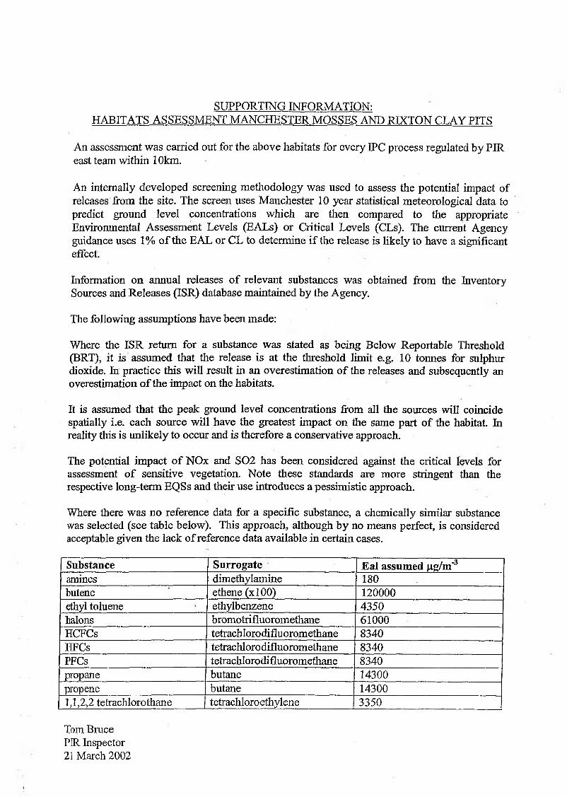
SUPPORTING INFORMATION:HABITATS ASSESSMENT MANCHESTER MOSSES AND RIXTON CLAY PITS
An assessment was carried out for the above habitats for every IPC process regulated by PIR east team within 10km.
An internally developed screening methodology was used to assess the potential impact of releases from the site. The screen uses Manchester 10 year statistical meteorological data to predict ground level concentrations which are then compared to the appropriate Environmental Assessment Levels (EALs) or Critical Levels (CLs). The current Agency guidance uses 1% o f the EAL or CL to determine if the release is likely to have a significant effect.
Information on annual releases o f relevant substances was obtained from the Inventory Sources and Releases (ISR) database maintained by the Agency.
The following assumptions have been made:
Where the ISR return for a substance was stated as being Below Reportable Threshold (BRT), it is assumed that the release is at the threshold limit e.g. 10 tonnes for sulphur dioxide. In practice this will result in an overestimation o f the releases and subsequently an overestimation o f the impact on the habitats.
It is assumed that the peak ground level concentrations from all the sources will coincide spatially i.e. each source will have the greatest impact on the same part o f the habitat. In reality this is unlikely to occur and is therefore a conservative approach.
The potential impact o f NOx and S02 has been considered against the critical levels for assessment o f sensitive vegetation. Note these standards are more stringent than the respective long-term EQSs and their use introduces a pessimistic approach.
Where there was no reference data for a specific substance, a chemically similar substance was selected (see table below). This approach, although by no means perfect, is considered acceptable given the lack of reference data available in certain cases.
Substance Surrogate Eal assumed |_ig/m"3amines dimethylamine 180butene ethene(xl00) 120000ethyl toluene ethylbenzene 4350halons bromotrifluoromethane 61000HCFCs tetrachlorodifluoromethane 8340HFCs tetrachlorodifluoromethane 8340PFCs tetrachlorodifluoromethane 8340propane butane 14300propene butane 143001,1,2,2 tetrachlorothane tetrachloroethylene 3350
Tom Bruce PIR Inspector 21 March 2002
320000 340000 380000 400000 420000
320000 340000 360000 380000 400000 420000
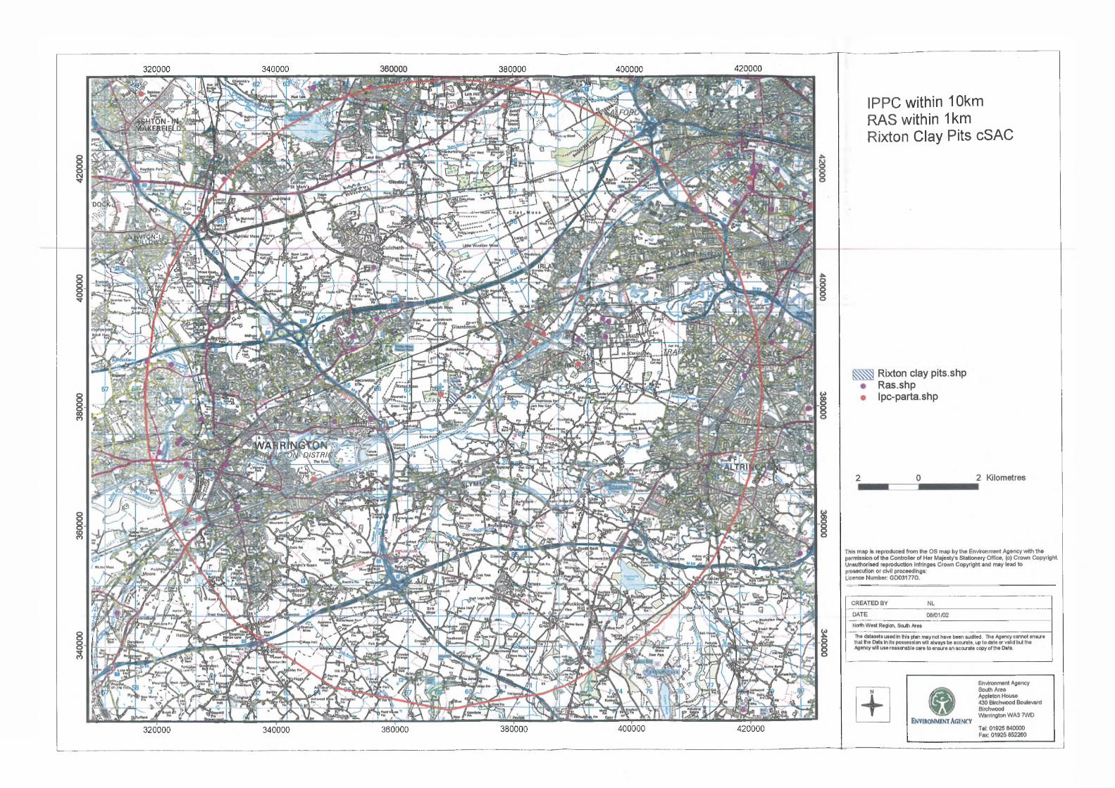
I P P C w i t h i n 1 0 k m
R A S w i t h i n 1 k m
R i x t o n C l a y P i t s c S A C
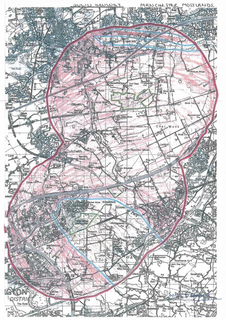
Key to hand-drawn map - Solid Geology
Lines:Red - 3km buffer around SACs Blue - geological boundary Green - boundaries of SAC
Shading:Brown area to south - Mercia Mudstone (non aquifer)Brown areas to north - Manchester Marls (non aquifer) and Coal measures (minor aquifer) Red area - Sherwood Sandstone (major aquifer)
Other information:• The site catchment areas are most likely to be only the peat areas.
• Risley moss is underlain by Mercia Mudstone and so NOT fed by groundwater.
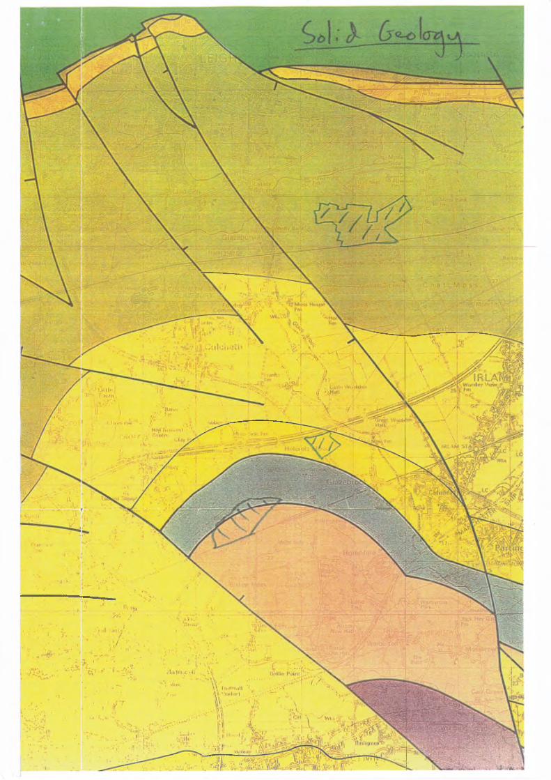
L E G E N D ( S O L I D G E O L O G Y )
( MERCIA MUDSTONE GROUP
N orthw ich H alite . F o rm a tio n
M u d s to n e U nit
TRIAS SIC T a rp o rle y S i l t s to n e F o rm a tio n
SH ERW OO D SANDSTONE. GROUP
H e lsb y S a n d s to n e F o rm a tio n
W ilm slo w S a n d s to n e F o rm a tio n
C h e s t e r P e b b le B e d s F o rm a tio n w ith lo w er m o tt le d s a n d s t o n e ’
M a n c h e s t e r M arl F o rm a t ion /
B o ld F o rm a tio n
C o l l y h u r s t S a n d s to n e F o rm a tio n
C A R B O N IFE R O U S W e s t p h a l i a n S t r a t a
LINE O F FAULT WITH DOW NTHROWN SIDE INDICATED

L E G E N D (D R I F T G E O L O G Y )
Al l u v i u m
P e a t F L A N D R I A N
T e r r a c e D e p o s i t s
S h i r d l e y H i l l S a n d F o r m a t i o n
L a m i n a t e d C l a y
S a n d
T i II
S t o c k p o r t
F o r m a t io n
LA T E
D E V E N S IA N
M e r c i a M u d s t o n e G r o u p
P e r m o - T r i a s s i c S u c c e s s i o n e x c l u d i n g
M e r c i a M u d s t o n e G r o u p
C a r b o n i f e r o u s S u c c e s s i o n
B e d r o c k Om O .D . C o n t o u r
SITE ISSUES BRIEFING v2.4
1. Site name and designation: Rixton Clay Pits pSAC
2. Features (list)
2.10 Great Crested Newt
3. Site condition Degree of confidence[favourable/unfavourable] (high/medium/low)
3a. If unfavourable, list features contributing to this judgement:
4. Level of complexityi. Number of Agency consents: <100: 100-1,000; 1,000-10,000; >10,000)ii. Number of SSSIs: 1iii. Total area of site: 13.99 Haiv. Estimated level of site knowledge: (high/Medium/Low)
5. Current Status of Review of Consents Process
Not started
6. Date of entry: 30/01/01 Version No: 1.1
7. Site priority:
1

8 Issues matrix (best judgement at present)
Issue/factor Impact/Risk* Responsibility Features at risk
Information source and comments3 2 1 0 Agency Others
Contamination (From air pathway)
Contamination (From water & land)
Toxic v/ Intermittent leaching of discharge from old landfills in surrounding area, phenols present in discharge.
Non-toxic V/ V* Septic tank effluent discharging into pond from ditch running to North of site.
Problematichydrology
Flow ✓Lowered water table V V ✓ Low number of abstractions in vicinity of site.Water level management ✓
Land drainage ✓Land use (catchment/off-site land use) V V VSite management ✓Fisheries management v» ✓ Introduction offish illegally/legally an issue.Flood & Coastal defence V*
Non-physical disturbance (eg.noise / recreation) V* Recreational pressure increasing. Sections have been fenced off.
Physical damage (eg. dredging/trampling) V* Recreational pressure.Biological Disturbance (eg.non-natives, extraction) v» V/ Introduced and aggressive species.Habitat fragmentation/barriers to migration ? V V/ Development pressure.
* 3, Impact on feature; 2, High risk; 1, likely low risk/uncertain risk; 0, No exposure/irrelevant
2