rivers estuaries deltas and beaches abstract book, 6-7 november 2008
TRANSCRIPT
7/26/2019 Rivers Estuaries Deltas and Beaches Abstract Book, 6-7 November 2008
http://slidepdf.com/reader/full/rivers-estuaries-deltas-and-beaches-abstract-book-6-7-november-2008 1/51
Rivers, Estuaries, Deltas & Beaches: Traps for Fossil Fuels
Rivers, Estuaries, Deltas &
Beaches: Traps for Fossil Fuels
6-7 November 2008
The Petroleum Group would like to thank BP,
ConocoPhillips, and ExxonMobil for theirsupport of this event:
November 2008 Page 1
7/26/2019 Rivers Estuaries Deltas and Beaches Abstract Book, 6-7 November 2008
http://slidepdf.com/reader/full/rivers-estuaries-deltas-and-beaches-abstract-book-6-7-november-2008 2/51
Rivers, Estuaries, Deltas & Beaches: Traps for Fossil Fuels
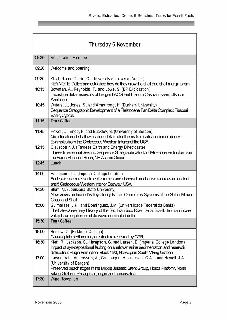
Thursday 6 November
08:30 Registration + coffee
09:20 Welcome and opening
09:30 Steel, R. and Olariu, C. (Universit y of Texas at Austin )KEYNOTE: Deltas and estuaries: how do they grow the shelf and shelf-margin prism
10:15 Bowman, A., Reynolds , T., and Lowe, S. (BP Exploration)Lacustrine delta reservoirs of the giant ACG Field, South Caspian Basin, offshore Azerbaijan
10:45 Waters, J., Jones, S., and Armstrong, H. (Durham Universi ty)
Sequence Stratigraphic Development of a Pleistocene Fan Delta Complex: PissouriBasin, Cyprus
11:15 Tea / Coffee
11:45 Howell, J., Enge, H. and Buck ley, S. (Universit y of Bergen)Quantification of shallow marine, deltaic clinothems from virtual outcrop models:Examples from the Cretaceous Western Interior of the USA
12:15 Olavsdott ir, J. (Faroese Earth and Energy Directorate)Three-dimensional Seismic Sequence Stratigraphic study of Mid-Eocene clinoforms inthe Faroe-Shetland Basin, NE Atlantic Ocean
12:45 Lunch
14:00 Hampson, G.J. (Imperial College London)Facies architecture, sediment volumes and dispersal mechanisms across an ancientshelf: Cretaceous Western Interior Seaway, USA
14:30 Blum, M. (Louisiana State University)New Views on Incised Valleys: Insights from Quaternary Systems of the Gulf of MexicoCoast and Shelf
15:00 Guimarães, J.K., and Dominguez, J.M. (Univers idade Federal da Bahia)The Late-Quaternary History of the Sao Francisco River Delta, Brazil: from an incisedvalley to an equilibrium-state wave dominated delta
15:30 Tea / Coffee
16:00 Bristow, C. (Birkbeck College)Coastal plain sedimentary architecture revealed by GPR
16:30 Kieft, R., Jackson, C., Hampson, G. and Larsen, E. (Imperial College London)Impact of syn-depositional faulting on shallow-marine sedimentation and reservoirdistribution: Hugin Formation, Block 15/3, Norwegian South Viking Graben
17:00 Larsen, A.L., Andersson, A., Grunhagen, H., Jackson, C.A.L. and Howell, J.A.(University of Bergen)Preserved beach ridges in the Middle Jurassic Brent Group, Horda Platform, NorthViking Graben: Recognition, origin and preservation
17:30 Wine Reception
November 2008 Page 2
7/26/2019 Rivers Estuaries Deltas and Beaches Abstract Book, 6-7 November 2008
http://slidepdf.com/reader/full/rivers-estuaries-deltas-and-beaches-abstract-book-6-7-november-2008 3/51
Rivers, Estuaries, Deltas & Beaches: Traps for Fossil Fuels
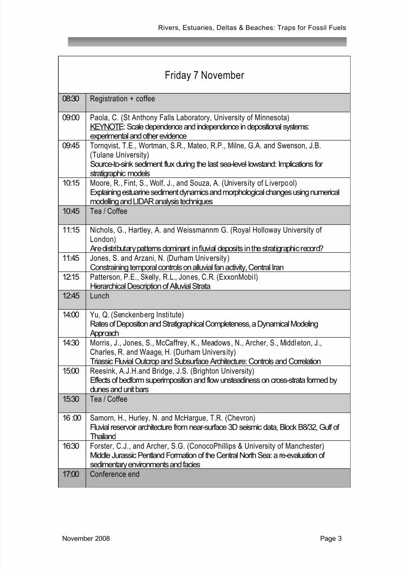
Friday 7 November
08:30 Registration + coffee
09:00 Paola, C. (St Anthony Falls Laboratory, University of Minnesota)KEYNOTE: Scale dependence and independence in depositional systems:experimental and other evidence
09:45 Tornqvist, T.E., Wortman, S.R., Mateo, R.P., Milne, G.A. and Swenson, J.B.(Tulane University)Source-to-sink sediment flux during the last sea-level lowstand: Implications forstratigraphic models
10:15 Moore, R., Fint, S., Wolf, J., and Souza, A. (Univers ity of L iverpool)Explaining estuarine sediment dynamics and morphological changes using numerical
modelling and LIDAR analysis techniques
10:45 Tea / Coffee
11:15 Nichols, G., Hartley, A. and Weissmannm G. (Royal Holloway University ofLondon) Are distributary patterns dominant in fluvial deposits in the stratigraphic record?
11:45 Jones, S. and Arzani, N. (Durham University )Constraining temporal controls on alluvial fan activity, Central Iran
12:15 Patterson, P.E., Skelly, R.L., Jones, C.R. (ExxonMobi l)Hierarchical Description of Alluvial Strata
12:45
Lunch
14:00 Yu, Q. (Senckenberg Insti tute)Rates of Deposition and Stratigraphical Completeness, a Dynamical Modeling Approach
14:30 Morris , J., Jones, S., McCaffrey, K., Meadows, N., Archer, S., Middleton, J.,Charles, R. and Waage, H. (Durham Univers ity)Triassic Fluvial Outcrop and Subsurface Architecture: Controls and Correlation
15:00 Reesink, A.J.H.and Bridge, J.S. (Brighton University)Effects of bedform superimposition and flow unsteadiness on cross-strata formed bydunes and unit bars
15:30 Tea / Coffee
16 :00 Samorn, H., Hurley, N. and McHargue, T.R. (Chevron)Fluvial reservoir architecture from near-surface 3D seismic data, Block B8/32, Gulf ofThailand
16:30 Forster, C.J., and Archer, S.G. (ConocoPhillips & University of Manchester)Middle Jurassic Pentland Formation of the Central North Sea: a re-evaluation ofsedimentary environments and facies
17:00 Conference end
November 2008 Page 3

7/26/2019 Rivers Estuaries Deltas and Beaches Abstract Book, 6-7 November 2008
http://slidepdf.com/reader/full/rivers-estuaries-deltas-and-beaches-abstract-book-6-7-november-2008 4/51
Rivers, Estuaries, Deltas & Beaches: Traps for Fossil Fuels
Thursday 6 November
November 2008 Page 4
7/26/2019 Rivers Estuaries Deltas and Beaches Abstract Book, 6-7 November 2008
http://slidepdf.com/reader/full/rivers-estuaries-deltas-and-beaches-abstract-book-6-7-november-2008 5/51
Rivers, Estuaries, Deltas & Beaches: Traps for Fossil Fuels
KEYNOTE:
Deltas & estuaries: how do they grow the shelf and shelf-margin prism
Ron Steel and Cornel Olariu, Jackson School of Geosciences, University of Texas at Austin
Deltas and estuaries are the key depositional systems that deliver and partition sand and mudonto the shelf during their regressive and transgressive transits. Deltas and estuaries arevariably affected by waves, tides and currents, and process dominance can vary with locationon the shelf platform, through time within the development of a stratigraphic sequence, and withbathymetry change across the basin. Process dominance can also be critical if sand is to bedelivered from a shelf-edge into the adjacent deep water area; for example storm swell andwaves, common at shelf margins, appear to be inefficient at delivering large volumes of sanddown onto deepwater slopes. The impact of this process variation on delta sandbody geometryis illustrated from the Pliocene Orinoco system and from the Campanian Western InteriorSeaway.
Deltas and estuaries have cross-shelf transits (extensive in Icehouse times, less so in
Greenhouse settings) that are driven mainly by accommodation or by sediment supply. Thesetransits, even on the widest shelves, happen on a time scale of 100ky or less, creating thetram-line stratigraphy seen on seismic data. Shorter time-scale, autogenic shifting (shiftswithout rate changes of the main forcing variables) of channels, mouth bars, and delta lobes isrampant, but probably tends to occur within the more extensive boundaries of 4th-order, shelf-transit units. The effect of autogenic shifting of channels and delta lobes is to spread andbroaden the area of shelf infill in front of the main river system, usually with a lateral spread thatis about twice the width of the pre-existing shelf. This configuration of shelf growth, plus atendency for waves to move sediment alongshore, ensures a relatively even accretion of theshelf margin. Very widely spaced coastal rivers, however, will cause some starved shelfsegments to have slower aggradation, less accentuated shelf-margin clinoforms and thereforeless even basinward accretion. Measurement of rates of aggradation and progradation ofancient shelf-margin prisms (clastic wedges) can indicate how highly supplied a margin has
been, and help predict the likelihood of large volumes of bypassed deepwater sand.
November 2008 Page 5

7/26/2019 Rivers Estuaries Deltas and Beaches Abstract Book, 6-7 November 2008
http://slidepdf.com/reader/full/rivers-estuaries-deltas-and-beaches-abstract-book-6-7-november-2008 6/51
Rivers, Estuaries, Deltas & Beaches: Traps for Fossil Fuels
NOTES
November 2008 Page 6
7/26/2019 Rivers Estuaries Deltas and Beaches Abstract Book, 6-7 November 2008
http://slidepdf.com/reader/full/rivers-estuaries-deltas-and-beaches-abstract-book-6-7-november-2008 7/51
Rivers, Estuaries, Deltas & Beaches: Traps for Fossil Fuels
Lacustrine delta reservoirs of the giant ACG Field, South Caspian Basin, offshore Azerbai jan
Andrew Bowman, Tony Reynolds & Stephen LoweBP Exploration, Chertsey Road, Sunbury upon Thames, Middlesex, UK
The giant ACG oil field in the South Caspian Basin comprises stacked Pliocene age deltaicsandstones and mudstones of the Middle Productive Series Pereriv and Balakhany reservoirs. Analysis of subsurface data and analogue data from nearby exposures onshore in Azerbaijanhas led to a detailed understanding of the depositional system and reservoir architectureswithin the field enabling efficient development of the hydrocarbon resource.
Deposition of the Middle Productive Series occurred on a broad, low gradient ramp. Sedimentwas sourced from the Russian platform and delivered to the South Caspian Basin by thePalaeo-Volga River which cut a large canyon system through the North and Central CaspianBasins when large scale (>2 km) base level fall isolated the South Caspian from the globaloceans at the end of the Miocene forming a large under filled lake.
A large core data base (> 2 km) has allowed the recognition of seven lithofacies within thePereriv and Balakhany Suites; five sandstone, a siltstone and a mudstone, each of which canbe further subdivided. These lithofacies are arranged into facies associations that recorddeposition in a range of deltaic environments from sandstone prone distributary channels tooffshore lake mudstones. The study of equivalent age Middle Productive Series exposuresonshore in Azerbaijan and the use of analogues, such as the modern Volga Delta, haveenabled an improved understanding of the depositional elements associated with each faciesassociation. Palynology has been a key tool in differentiating between depositionalenvironments and understanding the stratigraphic framework of the field.
The Pereriv Suite comprises 5 Units; Pereriv E (oldest) through to Pereriv A (youngest). ThePereriv B and D are the most productive reservoirs, comprising laterally extensive high net-to-gross (>0.85) stacked channel sandstones with mudstone barriers and baffles. Average
properties are ~20% porosity and 200-300 mD permeability. Despite the excellent reservoircontinuity and petrophysical properties ten years of production from the Pereriv B and D hasrevealed previously unrecognised complexity.
The Balakhany is subdivided into six Suites from the oldest Balakhany X, which overlies thePereriv A, through to the youngest, the Balakhany V. All are hydrocarbon bearing but theprinciple reservoirs in ACG are the Balakhany X and Balakhany VIII. Compared to the PererivB and D the Balakhany reservoirs are lower net-to-gross (0.35 to 0.55), have slightly lowerporosities (~18-20%) and permeabilities (~70 to150 mD) and contain laterally and verticallydiscontinuous sand bodies. The complex reservoir architecture of the Balakhany Reservoirshas led to them being developed differently to the Pereriv reservoirs.
November 2008 Page 7

7/26/2019 Rivers Estuaries Deltas and Beaches Abstract Book, 6-7 November 2008
http://slidepdf.com/reader/full/rivers-estuaries-deltas-and-beaches-abstract-book-6-7-november-2008 8/51
Rivers, Estuaries, Deltas & Beaches: Traps for Fossil Fuels
NOTES
November 2008 Page 8
7/26/2019 Rivers Estuaries Deltas and Beaches Abstract Book, 6-7 November 2008
http://slidepdf.com/reader/full/rivers-estuaries-deltas-and-beaches-abstract-book-6-7-november-2008 9/51
Rivers, Estuaries, Deltas & Beaches: Traps for Fossil Fuels
Sequence Stratigraphic Development of a Pleistocene Fan Delta Complex: PissouriBasin, Cyprus
Jen Waters, Stuart Jones and Howard Armstrong, Department of Earth Sciences, DurhamUniversity, South Road, Durham, DH1 3LE, UK
The Pissouri Basin in southern Cyprus exhibits a shallowing upwards succession in thehangingwall of the Cyprus subduction zone. The stratigraphic succession of shallow marinesilts, to fan delta clastic wedges, culminating in raised beach and alluvial fan deposits weredeposited during a tectonically active period of the Cyprus subduction zone and coeval with aphase of major climatic change. Structural updoming associated with the locking of the Cyprussubduction zone by the Eratosthenes Seamount and the emplacement of a large serpentinitediapir centred on Mount Olympus has been suggested as the main tectonic driver for upliftsince the Pliocene (Maximum 29cm/Ka). The whole of southern Cyprus has been tectonicallyactive for the last 5 Myrs but was particularly active during the late Pliocene to earlyPleistocene. The effects of high rates of subsidence and sediment supply, associated with upliftand loading of Cyprus of the Pleistocene fan delta clastic wedges of sediment will be explored.The influence of climate on alluvial successions is still largely neglected in the literature.
Climatically induced events can produce sedimentary structures, which would typify those of atectonically induced derivation, and this paper will delineate between the climatic and tectonicevents.
Two key aspects will be explored investigating the tectonic and climatic interactions in thePissouri Fan delta complex, using multiproxy dating techniques (e.g. U-Th; Foraminiferalbiozonation; palaeomagnetics):
i) Sequence stratigraphic analysis has been undertaken of the fan delta, taking into accountsediment flux, subsidence rates and dating of subaerial unconformable surfaces such aspalaeosols. By placing age constraints on the key stratal surfaces a better linkage can be madewith key tectonic events during the uplift of Cyprus. The intercalated palaeosol horizonssuggest periods of reduced accommodation space and potential abandonment of the fan delta.
Moving up through the succession a reduction in accommodation space is evident in the formof successively thinner beds and a series of primarily aggradational stacked channels,suggesting gradual infilling of the basin in addition to tectonic quiescence and stable eustaticsea level. By taking into account the relative sea level curve and field observations a sequencestratigraphic framework has been derived with a strong preservation of the TST and LST, andHST and FSST deposits less well developed.ii) The dating of key correlatable stratal surfaces has played an important role in this researchallowing correlation of dated fan surfaces to offshore sapropels dated as part of ODP (Leg-160) in the Levantine Basin. Linkage between these dated surfaces has identified precessionalcyclicity as a dominant control on the sedimentation history of the Pissouri fan delta complex.
This research demonstrates that through dating key surfaces and correlation with well-datedsapropel horizons a linkage can be made with climatic events, even in a tectonically active
area. Through the use of sequence stratigraphy and the linkage with sapropels improvedtemporally and spatially contrained facies models can be created, with important implicationsfor hydrocarbon exploration of non-marine and paralic environments.
November 2008 Page 9
7/26/2019 Rivers Estuaries Deltas and Beaches Abstract Book, 6-7 November 2008
http://slidepdf.com/reader/full/rivers-estuaries-deltas-and-beaches-abstract-book-6-7-november-2008 10/51
Rivers, Estuaries, Deltas & Beaches: Traps for Fossil Fuels
NOTES
November 2008 Page 10
7/26/2019 Rivers Estuaries Deltas and Beaches Abstract Book, 6-7 November 2008
http://slidepdf.com/reader/full/rivers-estuaries-deltas-and-beaches-abstract-book-6-7-november-2008 11/51
Rivers, Estuaries, Deltas & Beaches: Traps for Fossil Fuels
Quantification of shallow marine, deltaic clinothems from vi rtual outcrop models:Examples from the Cretaceous Western Interior of the USA
John Howell, Håvard Enge and Simon Buckley, Centre for Intergrated Petroleum Research,University of Bergen, Allegaten 41, Bergen, Norway. [email protected]
The presence of clinoforms and clinothems within a shallow marine, deltaic sandstone depositmay significantly impact reservoir performance. However, their geometry and distribution in 3Dis poorly understood and they are rarely included in reservoir models. In addition clinothemarchitecture may yield important information on the shoreline trajectory and evolution throughtime. A detailed study, based upon high resolution virtual outcrop models of two deltaicsystems, one highstand and one forced-regressive, has been undertaken to address clinothemgeometry and architecture. The studied systems are from the Ferron Formation and PantherTongue Member and, both of which lie within the Mesaverde Group outcrops of central Utah,USA.
A series of quantitative parameters are introduced to describe clinothems. The bedparametrisation and data analysis are based heaviliy on 3D virtual outcrop models generated
by ground-based laser scanning (lidar). These models have allowed the accurate, spatialconstrained measurement of over 5000 individual bed thickness measurements along morethan 100 individual clinothems from the two systems.
Results illustrate that the Panther Tongue clinothem beds are longer and lie at a lower anglethan their Ferron counterparts. They are however not significantly thicker. Beds in the PantherTongue have a mean thickness:length relationship of 1:525 with a range from 1:350 to 1:700 mfor the majority of the beds. The mean dip for almost 80 percent of the beds in Panther is1.25°. The Ferron clinothems have a mean dip of 2.6° and mean thickness:length relationshipof 1:415, with a range from 1:230 to 1:600.
A new parameter (α), which described bed thickness decay down depositional dip is described.In both cases values for this parameter show subtle cyclic depositional patterns in successive
beds. Combined with systematic changes in the dip angle, these cycles define bedsets whichare interpreted to have an autogenic origin related to the evolution and abandonment of mouthbar complexes within the lower delta front.
The data also have important implications for the correlation and computer based modelling ofsubsurface hydrocarbon reservoirs, where dipping mudstones associated with clinoformsgenerate important barriers and baffles to fluid flow.
November 2008 Page 11

7/26/2019 Rivers Estuaries Deltas and Beaches Abstract Book, 6-7 November 2008
http://slidepdf.com/reader/full/rivers-estuaries-deltas-and-beaches-abstract-book-6-7-november-2008 12/51
Rivers, Estuaries, Deltas & Beaches: Traps for Fossil Fuels
NOTES
November 2008 Page 12
7/26/2019 Rivers Estuaries Deltas and Beaches Abstract Book, 6-7 November 2008
http://slidepdf.com/reader/full/rivers-estuaries-deltas-and-beaches-abstract-book-6-7-november-2008 13/51
Rivers, Estuaries, Deltas & Beaches: Traps for Fossil Fuels
Three-dimensional Seismic Sequence Stratigraphic study of Mid-Eocene clinoforms inthe Faroe-Shetland Basin, NE Atlantic Ocean
Jana Ólavsdóttir, Jarðfeingi (Faroese Earth and Energy Directorate), Brekkutún 1, Postbox3059, FO-110 Tórshavn, Faroe Islands - E-mail: [email protected]; Tel: +298
357031; Fax +298 357001
During the last decade several 3-D seismic datasets have been obtained for the Faroe-Shetland Basin. These 3-D seismic datasets allow for the detailed interpretation and mappingof parts of the area. This study is based on seismic sequence stratigraphicinterpretation/mapping of a 3500 km2 mid-Eocene delta in the Faroe-Shetland Basin. The deltais building out from the Munkagrunnar Ridge which was uplifted and eroded during mid-Eocenetime. Some of the eroded material from the Munkagrunnar Ridge was transported via a channelin a NE direction and deposited in the analysed delta of this study. Munkagrunnar Ridge is builtup of volcanic material and therefore, the composition of the sediments in the delta, areinterpreted to be volcaniclastic in character.
The internal structures of the delta are examined through seismic sequence stratigraphy
analysis. This method, based on reflector termination in the delta, divides the delta into seismicfacies. The interpretation of the seismic facies, are put in to the sequence stratigraphicframework according to systems tracts, sequence boundaries and sequences.
The delta is divided into 4 sequences separated by Type-1 sequence boundaries. The foursequences consist of eight systems tracts. Isochore maps of the systems tracts are producedshowing that the thickest part of the systems tracts is lying on the slope and appear as lensesor slope front fill structures with a NW-SE orientation. The systems tracts are parallel with eachother where the lowermost and uppermost systems tracts are lying farthest to SW and NE,respectively.
The type of depositional system and environmental setting of the sedimentary unit is easier toinfer from 3-D data. Out from the geometry of the depositional unit, together with the angular
dip of the clinoforms and comparison with present-day depositional units would suggest that thesedimentary unit of this study is a wave/input dominated shelf edge delta. The slope gradient ofthe delta is approximately 3.0°, which is a moderate to high dip that gives indications about asandy delta.
From the offlap break point trajectories the delta is exhibiting an aggradational depositionalarchitecture where relative sea level, sediment supply rate and subsidence of the area havebeen moderate during the formation of the wave/input dominated shelf edge delta.
November 2008 Page 13

7/26/2019 Rivers Estuaries Deltas and Beaches Abstract Book, 6-7 November 2008
http://slidepdf.com/reader/full/rivers-estuaries-deltas-and-beaches-abstract-book-6-7-november-2008 14/51
Rivers, Estuaries, Deltas & Beaches: Traps for Fossil Fuels
NOTES
November 2008 Page 14
7/26/2019 Rivers Estuaries Deltas and Beaches Abstract Book, 6-7 November 2008
http://slidepdf.com/reader/full/rivers-estuaries-deltas-and-beaches-abstract-book-6-7-november-2008 15/51
Rivers, Estuaries, Deltas & Beaches: Traps for Fossil Fuels
Facies Architecture, Sediment Volumes and Dispersal Mechanisms across an AncientShelf: Cretaceous Western Interior Seaway, USA
Gary J. Hampson, Department of Earth Science and Engineering, Imperial College London, UK
Extensive outcrop exposure and abundant subsurface well-log data in northern Utah andColorado allow reconstruction of high-resolution stratigraphy and facies architecture across alarge area (c. 60,000 km
2) of the Campanian (Late Cretaceous) shelf along the western margin
of the Western Interior Seaway, USA. The range of sedimentological processes that dispersedsediment across the shelf is established via analysis of outcrop exposures, while outcrop-to-subsurface mapping allows the resulting sediment volumes to be quantitatively analysed in anappropriate stratigraphic and palaeogeographic context.
In the lower part of the studied strata, shorelines comprise wave-dominated deltas andstrandplains, but associated offshore mudstones contain evidence of river- and storm-derivedmaterial. Geomorphological reconstructions suggest that at least some intervals contain“compound clinoforms” similar to many modern deltas. In this case, an inner, sand-richshoreface clinofom is separated by a shelfal mud belt from an outer, sand-poor clinofom that
contains turbidites and hyperpycnites.
The upper part of the studied strata also contains wave-dominated shorelines, but shelfalmudstones contain an abundance of “isolated” shelfal sandstones with abundant tidalindicators. These shelfal sandstones are interpreted as the topsets of large tide-influenceddeltas or as related offshore bars that were deflected sub-parallel to the regional paleoshorelineby Coriolis- and/or wave-driven currents.
The pronounced change in shelfal facies architecture from “compound clinoform” delta systemto deflected, tide-influenced deposits is interpreted to reflect an increased interaction betweenshoreline depositional systems and basinal hydrodynamic circulation. The change in shelfalfacies architecture is not accompanied by a similar change in the wave-dominated shorelinedeposits, despite the fact that comparable volumes of sand are partitioned between these two
components. These results suggest that shelfal mudstones contain a wide range of sandbodytypes, whose character and distribution is poorly predicted by coeval shoreline deposits.
November 2008 Page 15

7/26/2019 Rivers Estuaries Deltas and Beaches Abstract Book, 6-7 November 2008
http://slidepdf.com/reader/full/rivers-estuaries-deltas-and-beaches-abstract-book-6-7-november-2008 16/51
Rivers, Estuaries, Deltas & Beaches: Traps for Fossil Fuels
NOTES
November 2008 Page 16
7/26/2019 Rivers Estuaries Deltas and Beaches Abstract Book, 6-7 November 2008
http://slidepdf.com/reader/full/rivers-estuaries-deltas-and-beaches-abstract-book-6-7-november-2008 17/51
Rivers, Estuaries, Deltas & Beaches: Traps for Fossil Fuels
New Views on Incised Valleys: Insights f rom Quaternary Systems of the Gulf of MexicoCoast and Shelf
Mike Blum, Department of Geology and Geophysics, Louisiana State University, Baton Rouge,Louisiana, USA
This paper reviews recent developments in incised-valley concepts as seen from the LateQuaternary record of the passive margin Gulf of Mexico coastal plain and shelf.
One key issue featured in early models was the concept of incision and sediment bypass of thecoastal plain and shelf during relative sea-level fall, and production of an unconformity.However, studies of Quaternary systems, where deposits can be mapped and datedindependent of sea-level change, make it clear that valleys are incised in a step-wise manner,with valley widening and channel-belt deposition common during sea-level fall and lowstand.Step-wise incision, with lateral channel migration is the process that creates the basal valley-fillsurface and the overall dimensions of the incised valley, and the basal surface and overlyingdeposits are genetically-related and the same age. Moreover, sea-level fall and lowstand is anecessary condition for extension of river systems across the shelf and partitioning of incised
valleys, but the timing of incision and channel-belt deposition on the evolving valley-fill surfacevaries between river systems due to upstream controls on discharge and sediment supply.
A second issue concerns links between incised valleys and sediment supply to the shelf marginand beyond: some interpretive models implied that valley incision and sediment bypass werenecessary to provide the mass of sediments for lowstand fans. Although additional export ofsediment does in fact occur from development of incised valleys, it is a very small fraction(<<10%) of the fluvial sediment that is always transported from the hinterland drainage basin tothe shoreline, wherever that may be. Moreover, merging of drainages as channels extendacross the shelf may result in increases in drainage area contributing to single point sources atthe shelf margin. Signals of increased or decreased flux of sediment to the shelf margin andbeyond may reflect geomorphic response to sea-level change, the merging of drainages asthey transit a broad shelf, rather than incision and sediment bypass.
Finally, two types of high-frequency cyclical isostatic adjustments should be considered inincised-valley models. First, the magnitude of sediment removed and replaced in large incised-valley systems over the course of a glacio-eustatic cycle produces a corresponding cycle offlexural uplift and subsidence that enhances depths of incision during the lowstand, and theoverall thickness of transgressive to highstand strata. Rates of uplift or subsidence due tosediment unloading and loading may exceed long-term rates of accommodation change by anorder of magnitude, and affect stratal geometries for distances of 10’s to 100’s of kilometersfrom the depocenter. Second, sea-level fall and removal of water from a broad shelf shouldresult in hydroisostatic uplift, with the reverse process during transgression and highstand.River systems are obliged to extend across the shelf during sea-level fall, but they need not cutvalleys that are any deeper than a single channel belt: hydroisostatic uplift may be the drivingforce behind the deeper incised valleys that are commonly observed in the Quaternary record.
November 2008 Page 17

7/26/2019 Rivers Estuaries Deltas and Beaches Abstract Book, 6-7 November 2008
http://slidepdf.com/reader/full/rivers-estuaries-deltas-and-beaches-abstract-book-6-7-november-2008 18/51
Rivers, Estuaries, Deltas & Beaches: Traps for Fossil Fuels
NOTES
November 2008 Page 18
7/26/2019 Rivers Estuaries Deltas and Beaches Abstract Book, 6-7 November 2008
http://slidepdf.com/reader/full/rivers-estuaries-deltas-and-beaches-abstract-book-6-7-november-2008 19/51
Rivers, Estuaries, Deltas & Beaches: Traps for Fossil Fuels
The Late-Quaternary History of the São Francisco River Delta, Brazil: From an IncisedValley to an Equi libr ium-State Wave-Dominated Delta
Junia Kacenelenbogen Guimarães and José Maria Landim Dominguez, 1 Universidade Federalda Bahia, Curso de Pós-graduação em Geologia, 40170-280, Salvador, Bahia, Brazil
email address: [email protected]
The São Francisco river delta is usually considered as a paradigm of a wave-dominated delta.Nevertheless most of the data available are limited to the distribution of surficial late Holocenesedimentary deposits. Information concerning the depositional architecture of the delta is non-existent. This work represents the first effort to characterize the 3D architecture of the delta andits Holocene evolution. 15 SPT (Standard Penetration Test) drills were acquired at the deltaicplain, with a maximum penetration of 40m. 12 samples were radiocarbon dated (AMS datings).Data integration shows the presence of a narrow and deep incised valley underneath theQuaternary plain. An incision depth of 80 m is estimated during the Last Glacial Maximum. Afterwards the valley was flooded by the rising sea-level and infilled mostly with estuarinemuds. Deltaic progadation began around 8 cal. kyr BP, probably as a result of decreasing ratesof sea-level rise by that time. Regressive sand sheets flanking the river mouth present an
average thickness of 14m, which correspond to the present day wave base.
Shoreline progradation rates averaged 5m/yr between 8 and 5 cal. kyr BP, decreasingafterwards to 1m/yr. This decrease is probably a result of a combination of factors. Initiallydelta construction took place in an embayed shoreline. This situation favored a convergence ofthe longshore drift of marine sediments and helped in trapping the fluvial sediments as well,causing rapid progradation of the shoreline. At this time the delta exhibited an estuarine-likebehaviour importing marine sediments. As soon as the embayment was infilled around 5 cal.kyr BP a delta cuspid was formed, which generated a divergence of longshore drift resulting ina more efficient longitudinal dispersion of fluvial sediments, thus decelerating shorelineprogadation. Moreover the delta began prograding in progressively deeper water on the narrowshelf that characterizes the region. Today the delta front is directly connected with a submarinecanyon which enhances sediment transfer to the deeper basin.
The present day low progradation rates suggests that the deltaic plain has reached anequilibrium configuration in which a significant amount of sediments are either transportedlongshore or bypassed to deeper basinal areas.
November 2008 Page 19
7/26/2019 Rivers Estuaries Deltas and Beaches Abstract Book, 6-7 November 2008
http://slidepdf.com/reader/full/rivers-estuaries-deltas-and-beaches-abstract-book-6-7-november-2008 20/51
Rivers, Estuaries, Deltas & Beaches: Traps for Fossil Fuels
NOTES
November 2008 Page 20
7/26/2019 Rivers Estuaries Deltas and Beaches Abstract Book, 6-7 November 2008
http://slidepdf.com/reader/full/rivers-estuaries-deltas-and-beaches-abstract-book-6-7-november-2008 21/51
Rivers, Estuaries, Deltas & Beaches: Traps for Fossil Fuels
Coastal plain sedimentary architecture revealed by GPR
Dr Charlie Bristow, School of Earth Sciences, Birkbeck College, Malet Street, London WC1E7HX
In comparison with deltas coastal plains have received relatively little attention fromsedimentologists and sedimentary geologists. While deltas are focal points for sedimentdeposition the intervening coastal plains are equally important sites of sediment deposition butthey appear to be underrepresented in the sedimentary literature. This may in part be due to alack of modern analogues, itself a consequence of the late Pleistocene and Holocenetransgression. However, in those areas where sediment supply from offshore, alongshore oronshore can keep pace with, or exceed, the rate of sea-level rise coastal plains have beenformed behind prograding coastlines.
In this paper GPR profiles across Holocene coastal plains are used to investigate thesedimentary architecture of the shallow marine, upper shoreface, foreshore and backshoresediments preserved within coastal plains. The examples include a prograding coastal plainwith a microtidal regime in South Australia. A barrier beach coast in New Zealand, and recurved
spits on a macrotidal coast in the UK. Despite concerns that GPR might be attenuated byconductive saline groundwater in coastal environments the results show that this is not the casein the examples presented in this paper.
The GPR profile across the microtidal coastal plain shows inclined tangential reflectionsinterpreted as beach progrades. The height of the beach progrades and the angle of dipincrease offshore as the beach progrades into deeper water. Beach progrades are truncated bybounding surfaces that are interpreted to have formed during storm events. GPR profilesacross the barrier beach coast shows washovers downlapping onto lagoonal and drainedalluvial backshore sediments. The washovers are truncated by beach erosion surfaces andoverlain by beach progrades. The GPR profiles across spits show inclinded reflections fromforeshore sediments (beach progrades) with local truncation and onlap. Truncation surfaces areinterpreted as the product of storm events eroding into the foreshore and backshore sediments.
Onlap occurs where the spits change orientation.
November 2008 Page 21

7/26/2019 Rivers Estuaries Deltas and Beaches Abstract Book, 6-7 November 2008
http://slidepdf.com/reader/full/rivers-estuaries-deltas-and-beaches-abstract-book-6-7-november-2008 22/51
Rivers, Estuaries, Deltas & Beaches: Traps for Fossil Fuels
NOTES
November 2008 Page 22
7/26/2019 Rivers Estuaries Deltas and Beaches Abstract Book, 6-7 November 2008
http://slidepdf.com/reader/full/rivers-estuaries-deltas-and-beaches-abstract-book-6-7-november-2008 23/51
Rivers, Estuaries, Deltas & Beaches: Traps for Fossil Fuels
Impact o f syn-depositional faulting on shallow-marine sedimentation and reservoirdistribution: Hugin Formation, Block 15/3, Norwegian South Viking Graben
Rachel Kieft1, Chris Jackson1, Gary Hampson1 and Eirik Larsen2,3
1
Dept. of Earth Sciences & Engineering, Imperial College, Prince Consort Rd, London, SW72BP2Statoil Bergen, Sandslihaugen 30, Sandsli, 5020 Bergen3Present address: Rocksource ASA, Box 994 Sentrum, Olav Kyrres gate 22, N-5808 Bergen.
Syn-depositional faulting can have a marked influence on facies and reservoir distribution withinshallow-marine settings. In settings of low sediment supply, sea-floor topography may developacross active faults, leading to localisation of depocentres and restriction of certain facies tothese topographic lows. Where sediment supply matches the rate of accommodationgeneration, topography does not develop and the same spatial restriction of certain facies maynot occur. An understanding of the relationship between sediment supply and structuraldevelopment is therefore important to predict reservoir distribution in shallow-marine settings.
The Hugin Formation (Middle Jurassic) consists of shallow-marine and marginal-marinesediments deposited during an overall transgression that marked the southerly migration of theBrent Delta system. This transgression coincided with the earliest phase of extension andnormal faulting in the South Viking Graben related to the Upper Jurassic rift event.
This study focuses on the prospective Hugin Formation in Norwegian exploration block 15/3, inthe hanging-wall of the western boundary fault of the South Viking Graben. Core logging showsthat the formation comprises five stacked parasequences separated by flooding surfaces.These parasequence typically consist of bioclastic claystones grading upwards into muddy andsandy bay-fill deposits, which are locally truncated by sand-rich tidal channels, thought to beconnected to the fluvial feeder system to the basin. In the more basinward wells, the bay-filldeposits are missing, and much thicker (up to 40m) sands are seen sharply overlying therestricted marine claystone. These are interpreted to be tidal inlets associated with a barrier
system that developed to the west and led to the restricted marine conditions. Remnant sandsof this barrier system are preserved in the most distal wells. Stacking of these coarsening-upward parasequences is interpreted to reflect periodic infilling of the restricted marineembayment.
Seismic mapping and well correlations both show the Hugin Formation thickening from east towest across the study area, interpreted to be the result of initiation of movement on the graben-bounding fault to the west. Relatively minor thickness changes are superimposed on thiswestward-thickening trend, highlighting the subtle influence of smaller, antithetic faults andhalokinesis during deposition. Well correlations demonstrate that such thickness changes arenot necessarily accompanied by facies shifts, and that fault-parallel facies variability also occursover comparatively short distances (2-4 km). Correlation of the Hugin Formationparasequences is possible within Block 15/3, indicating that sediment supply and structurally
controlled subsidence were approximately in balance. However, sand-rich reservoir facies (e.g.tidal channels and inlets) appear to be focussed within some syn-depositional depocentres,indicating that evolving structures may have influenced facies architecture at intra-parasequence scales, although proximity to sediment transport pathways into the basin is alsoimportant. In this area, a robust sedimentological model integrated with structural mappingprovides the best basis for reservoir prediction.
November 2008 Page 23

7/26/2019 Rivers Estuaries Deltas and Beaches Abstract Book, 6-7 November 2008
http://slidepdf.com/reader/full/rivers-estuaries-deltas-and-beaches-abstract-book-6-7-november-2008 24/51
Rivers, Estuaries, Deltas & Beaches: Traps for Fossil Fuels
NOTES
November 2008 Page 24
7/26/2019 Rivers Estuaries Deltas and Beaches Abstract Book, 6-7 November 2008
http://slidepdf.com/reader/full/rivers-estuaries-deltas-and-beaches-abstract-book-6-7-november-2008 25/51
Rivers, Estuaries, Deltas & Beaches: Traps for Fossil Fuels
Preserved beach ridges in the middle jurassic Brent Group, horda platform, Northviking graben: Recognition, origin and preservation
A.L. Larsen1, A. Andersson1, H. Grunhagen2, C.A.L. Jackson3, J.A. Howell1 1CIPR, University of Bergen, Allegaten 41, 5005 Bergen, Norway.2
StatoilHydro, Sandsliveien 90, 5020 Bergen, Norway3Department of Earth Science & Engineering, Imperial College, Prince Consort Road, London,SW7 2BP, UK
The Middle Jurassic Brent Group of the North Sea rift comprises a succession of marginal toshallow marine units deposited in a large wave-influenced delta. The regional geologicalunderstanding of depositional systems in the Brent Group has mainly come from closely-spaced well data, which indicate that the delta prograded northwards and had a roughly E-W-trending coastline. A recent study by Grunhagen et al. (2003) in the Oseberg Øst area of theHorda Platform, North Sea rift, recognized the presence of a series of straight to slightlycurved, E-W-orientated amplitude anomalies at the stratigraphic level of the Etive Fm. Theseanomalies are up to 15 km in length, are 50-100 m wide and have a spacing of 150-200 m.The anomalies are arranged into ‘sets’, with low-angle (<10°) intersections between sets of
differing orientations. The authors suggested that these amplitude anomalies are the seismicexpression of preserved beach ridges that represent the presence of a significant topographyat the boundary between the Etive and Ness formations. From an applied perspective, it wasalso demonstrated that these depositional features strongly influenced oil production.
Further seismic mapping over a greater area of the Horda Platform, in addition to studies ofwell data and comparisons to modern systems on the coast of Florida, supports and expandsupon this beach ridge interpretation. Ridges are interpreted to have initiated as cheniersduring progradation, and to have become modified by subsequent aeolian activity.Preservation of the beach ridges occurs during base-level rise as the inter-ridge topographyfloods, and becomes filled with peat and fine-grained sediment. Understanding the origin ofthese ridges has important implications for understanding, correlating and modelling thereservoirs of the lower Brent Group.
November 2008 Page 25

7/26/2019 Rivers Estuaries Deltas and Beaches Abstract Book, 6-7 November 2008
http://slidepdf.com/reader/full/rivers-estuaries-deltas-and-beaches-abstract-book-6-7-november-2008 26/51
Rivers, Estuaries, Deltas & Beaches: Traps for Fossil Fuels
NOTES
November 2008 Page 26

7/26/2019 Rivers Estuaries Deltas and Beaches Abstract Book, 6-7 November 2008
http://slidepdf.com/reader/full/rivers-estuaries-deltas-and-beaches-abstract-book-6-7-november-2008 27/51
Rivers, Estuaries, Deltas & Beaches: Traps for Fossil Fuels
Friday 7 November
November 2008 Page 27
7/26/2019 Rivers Estuaries Deltas and Beaches Abstract Book, 6-7 November 2008
http://slidepdf.com/reader/full/rivers-estuaries-deltas-and-beaches-abstract-book-6-7-november-2008 28/51
Rivers, Estuaries, Deltas & Beaches: Traps for Fossil Fuels
KEYNOTE:
Scale dependence and independence in depositional systems: experimental and otherevidence
Chris Paola, Department of Geology & Geophysics and St Anthony Falls Laboratory,University of Minnesota, Minneapolis MN 55414 USA, [email protected]
Because most morphodynamic experiments cannot be fully scaled, their utility forstratigraphic analysis and prediction depends critically on the extent to which the mainprocesses are scale independent. Moreover, the general association of scale independenceof depositional processes with self-similar (fractal) geometry of stratigraphic products impliesthat a better understanding of scale dependence and independence in stratigraphy would beextremely useful in stratigraphic prediction – for example, interpreting information atunresolved scales from seismic data, and making stratigraphic analogues more quantitativeand precise.
We review the origins, implications, and limits of scale independence in stratigraphy, primarily
using experimental and field observations. Overall, the case for scale independence instratigraphy, first articulated more than a decade ago, is quite strong. One major contributor toscale independence is that overall morphodynamic evolution appears to depend on fluid flowpatterns only in a relatively generic sense. On the whole, however, with a few exceptions wehave done little to formalize and quantify our understanding of scale independence inmorphodynamics, and the subject has great unexploited potential.
November 2008 Page 28

7/26/2019 Rivers Estuaries Deltas and Beaches Abstract Book, 6-7 November 2008
http://slidepdf.com/reader/full/rivers-estuaries-deltas-and-beaches-abstract-book-6-7-november-2008 29/51
Rivers, Estuaries, Deltas & Beaches: Traps for Fossil Fuels
NOTES
November 2008 Page 29
7/26/2019 Rivers Estuaries Deltas and Beaches Abstract Book, 6-7 November 2008
http://slidepdf.com/reader/full/rivers-estuaries-deltas-and-beaches-abstract-book-6-7-november-2008 30/51
Rivers, Estuaries, Deltas & Beaches: Traps for Fossil Fuels
Source-to-sink sediment flux during the last sea-level lowstand: Implications forstratigraphic models
Torbjörn E. Törnqvist1, Santina R. Wortman2, Zenon Richard P. Mateo2, Glenn A. Milne3 andJohn B. Swenson4
1Department of Earth and Environmental Sciences, Tulane University, 6823 St. Charles Avenue, New Orleans, Louisiana 70118-5698, USA, [email protected] of Earth and Environmental Sciences, University of Illinois at Chicago, 845 WestTaylor Street, Chicago, Illinois 60607-7059, USA3Department of Earth Sciences, University of Ottawa, Ontario K1N 6N5, Canada4Department of Geological Sciences, University of Minnesota Duluth, 1114 Kirby Drive,Duluth, Minnesota 55812, USA
It is commonly believed that the efficiency of sediment flux from continents to oceans ismaximized during relative sea-level (RSL) lowstands, by means of cross-shelf valleys that aredirectly connected to the continental slope and deep-marine environment. While suchconditions have been documented for the last RSL lowstand along several passive margins,
there is increasing evidence that radically different conditions persisted during the Last GlacialMaximum (LGM) elsewhere, with lowstand shorelines that remained on the continental shelf.Here, we analyze the relationship between the LGM (21 ka) shoreline and the shelf edge forthe Gulf of Mexico off the United States and the Bay of Biscay off France. A geophysicalmodel is used to compute shoreline positions corrected for glacio-hydro-isostatic movements,and the shelf-edge position is quantified by means of curvature. The conditions in the twostudy areas differed markedly: throughout the northern Gulf of Mexico LGM sea level droppedto a point commonly ~40 m below the shelf edge, consistent with conventional sequence-stratigraphic models, while in the Bay of Biscay the LGM shoreline remained well landward ofthe shelf edge, in places separated by hundreds of kilometers. Preliminary data from thesouthern African margin show that similar conditions prevailed there. Such contrastingresponses of continental margins to sea-level forcing challenge conventional views on (1) thesource-to-sink sediment flux from continents to oceans and its variation in time and space; (2)
sequence-stratigraphic models that predict deep-marine sedimentation as being particularlyprominent during RSL lowstands; and (3) the nature and timing of paleovalley formation onthe continental shelf.
November 2008 Page 30

7/26/2019 Rivers Estuaries Deltas and Beaches Abstract Book, 6-7 November 2008
http://slidepdf.com/reader/full/rivers-estuaries-deltas-and-beaches-abstract-book-6-7-november-2008 31/51
Rivers, Estuaries, Deltas & Beaches: Traps for Fossil Fuels
NOTES
November 2008 Page 31
7/26/2019 Rivers Estuaries Deltas and Beaches Abstract Book, 6-7 November 2008
http://slidepdf.com/reader/full/rivers-estuaries-deltas-and-beaches-abstract-book-6-7-november-2008 32/51
Rivers, Estuaries, Deltas & Beaches: Traps for Fossil Fuels
Explaining estuarine sediment dynamics and morphological changes using numericalmodelling and LIDAR analysis techniques
Rowena Moore1,2, Stephen Flint1, Judith Wolf 2 & Alejandro Souza2
1Stratigraphy Group, Department of Earth & Ocean Sciences, University of Liverpool, 4
Brownlow Street, Liverpool, L69 3GP, UK.2Proudman Oceanographic Laboratory, Joseph Proudman Building, 6 Brownlow Street,Liverpool, L3 5DA, UK
The macrotidal Dee estuary (tidal range in excess of 9 m), situated in Liverpool Bay, NWEngland, has undergone significant sediment infilling in the last 2 millennia, since Romantimes and particularly in the last 200 years. Asymmetry in the tidal propagation is known tobe a major cause of morphological changes in estuaries. Non-linear tidal distortion caused bycombinations of friction, convergence and continuity in estuaries, can cause a shorter, fasterrising tide (flood dominant) or a shorter, faster falling tide (ebb dominant). This can result innet sediment import to or export from the estuary respectively. This study has used 3-dimensional numerical modelling techniques to simulate tidal propagation in order toinvestigate spatially the tidal distortion and flood/ebb dominance in the Dee estuary and
Liverpool Bay. Inferences can then be made to explain the past morphological changes,present status and possible future development of the Dee. These results are independentlybacked-up by recent high resolution time-lapse LIDAR surveys, which provide detailedinformation on areas of erosion and accretion. A hypsometric analysis (area-elevationrelationship) was also carried out using the LIDAR data.
The results show that the shallow, intertidal regions were the most tidally distorted andasymmetric, showing flood dominance. The main conveyance channels of the estuary werefound to be ebb dominant, but only weakly so (the tides here were relatively undistorted). Theoverall flood dominance of the Dee and thus net sediment import explains the infilling over thelast century and is in agreement with the LIDAR surveys which show predominantly netaccretion between 2003 and 2006. The hypsometrical analysis suggests that Dee is quite a‘mature’ (infilled) estuary and may be approaching morphological equilibrium (where no net
sediment flux exists) and that the rate of accretion may therefore decrease in the future.Theory suggests that equilibrium can be reached in a flood dominant, infilling estuary largelydue to the formation and growth of tidal flats which act to reduce the flood dominance, andcan even cause a switch to ebb dominance. Indeed, a further investigation carried out onidealised estuary modelling (using a highly simplified bathymetric grid) has shown thatincreasing the elevation and extent of the intertidal area does seem to decrease the level offlood dominance. It is suggested, however, that in an estuary with high tidal amplitude tohydraulic depth ratio (such as the Dee) that the tidal flats would have to be very extensive fora switch to ebb dominance to occur. This does, however, question the consistency of long-term estuarine infilling (estuaries are regarded as geologically ephemeral entities whicheventually infill entirely). Rather than continued filling of estuarine incised valleys duringlong-term sea level rise, it may be that over shorter time-scales many estuaries may switch ina cyclic manner between ebb and flood dominance, creating periodic sediment flushing onto
the shelf. Therefore the estuary may alternate its role as a sediment source or sink, withpossible effects on sediment supply to the continental shelf.
November 2008 Page 32
7/26/2019 Rivers Estuaries Deltas and Beaches Abstract Book, 6-7 November 2008
http://slidepdf.com/reader/full/rivers-estuaries-deltas-and-beaches-abstract-book-6-7-november-2008 33/51
Rivers, Estuaries, Deltas & Beaches: Traps for Fossil Fuels
NOTES
November 2008 Page 33
7/26/2019 Rivers Estuaries Deltas and Beaches Abstract Book, 6-7 November 2008
http://slidepdf.com/reader/full/rivers-estuaries-deltas-and-beaches-abstract-book-6-7-november-2008 34/51
Rivers, Estuaries, Deltas & Beaches: Traps for Fossil Fuels
Are distributary patterns dominant in f luvial deposi ts in the strat igraph ic record?
Gary Nichols1, Adrian Hartley2, Gary Weissmann3
1Department of Earth Sciences, Royal Holloway University of London, Egham, Surrey, TW20
0EX, UK.2 Adrian Hartley, Department of Geology & Petroleum Geology, School of Geosciences,University of Aberdeen, Aberdeen, AB24 3UE, UK.3Gary Weissmann, Department of Earth and Planetary Sciences, University of New Mexico, Albuquerque, NM 87131, USA.
Most of the rivers we are familiar with have a tributary pattern of channels and they flow intothe sea or a lake. Studies on these modern rivers have provided a lot of information abouttransport and depositional processes and a number of facies models for fluvial sedimentationhave been established. We use these facies models to help us interpret the stratigraphicrecord and they inform subsurface reservoir models of fluvial deposits. But are the rivers thatwe study in the modern day the best analogues for ancient fluvial successions?
A review of modern rivers shows that many of the ones that are occurring in areas wherethere is net aggradation of sediment show a distributary pattern. These are variously referredto as ‘megafans’, ‘humid alluvial fans’ or ‘fluvial fans’ and form fan-shaped bodies of sedimenta hundred kilometres or more in radius. They consist of both braided and meandering riversand show repeated avulsion creating a radial pattern of abandoned channels. In manymodern examples the toe of the fan feeds into an axial river channel that ultimately leads to alake or the sea, but in arid regions where the evaporation rate is high much of the water is lostand there is a reduction in discharge downstream.
Interpretation of some ancient fluvial successions indicates that a downstream decrease indischarge and a radial pattern of channels may be widespread features. These distributaryfluvial systems have been documented in some detail in the Ebro Basin, Spain, where fluvialdeposition occurred in an Oligo-Miocene endorheic (internal) basin. Other examples from the
stratigraphic record also show a distributary pattern of palaeochannels and a decrease inchannel dimensions down-flow in both endorheic and externally-draining basins.
A distributary pattern of channels would result in a very different three-dimensionalarrangement of channel and overbank facies in the ‘architecture’ of the fluvial succession,with clear implications for the prediction of facies distributions and reservoir connectivity in thesubsurface. Furthermore, the frequent avulsion that appears to be a feature of distributaryfluvial systems will have implications for the character of the in-channel facies. Models offluvial sedimentation based on non-distributary rivers in settings where there is no long-termaggradation may not provide good analogues and revised models for fluvial facies aretherefore required.
November 2008 Page 34

7/26/2019 Rivers Estuaries Deltas and Beaches Abstract Book, 6-7 November 2008
http://slidepdf.com/reader/full/rivers-estuaries-deltas-and-beaches-abstract-book-6-7-november-2008 35/51
Rivers, Estuaries, Deltas & Beaches: Traps for Fossil Fuels
NOTES
November 2008 Page 35
7/26/2019 Rivers Estuaries Deltas and Beaches Abstract Book, 6-7 November 2008
http://slidepdf.com/reader/full/rivers-estuaries-deltas-and-beaches-abstract-book-6-7-november-2008 36/51
Rivers, Estuaries, Deltas & Beaches: Traps for Fossil Fuels
Constraining Temporal Controls on Al luvial Fan Activit y, Central Iran
Stuart J Jones1, and Nasser Arzani2
1 Department of Earth Sciences, South Road, Durham University, Durham, DH1 3LE, UK2
Department of Geology, University of Payme Nour, Kohandej Road, Iran
Alluvial fans are an obvious setting to understand how sediment flux controls the developmentof sedimentary geometries and sequences at mountain fronts. In many cases the catchment-fan is a closed system, that will have a well defined tectonic and climatic setting. Theprogradation distance of fans is a length control readily identifiable in the stratigraphic recordthat can be directly attributed to fault activity, subsidence rates and climate forcing ofsediment supply.
The Plio-Pleistocene to Recent alluvial fans of the Khrud Mountain belt of Central Iran wereaffected by interactions between tectonic activity, climatic changes and climatically induced
base-level through fluctuations in playa lake levels. A series of 35 alluvial fans were studieddraining the Khrud Mountain belt into the Ghavkhoni playa lake. All of the fans were affectedby climatically controlled variations in sediment supply and corresponding playa lake levels.
The tectonic activity of central Iran is characterised by large magnitude shallow earthquakes(>5 Mb) along several of the main Khrud Mountain bordering faults (e.g. Qom-Zefreh fault, Abbas Abad fault, Deh Shir fault). The fault activity is important in controlling the grossgeometry of the fans and outlet spacing from the mountain front. However, in the proximalparts of the fans and throughout their stratigraphy, intercalated travertine deposits can befound. Through age dating of the travertine sediments (e.g. Ur series analysis) an accuratetemporal framework of climate change has been achieved and how the alluvial fans respondto such variability. In comparison, at the distal portion of the fans, intercalated playa lakesediments from the Ghavkhoni lake record the rise and fall of the lake level that has had an
important impact on both the erosional modification and progradation of the alluvial fans. TheGhavkhoni lake level has fluctuated considerably over the last 4 Myrs and was at least c. 220m higher than at the present day. Through the use of detailed C
14age dating of playa
sediments a further climatic signal is recognised.
This paper will present a detailed temporal and spatial framework for alluvial fans along amountain front and identify the key response times within fan sediments to climatic forcing.This has important implications for understanding the timing and controls on deposition andsedimentation histories at basin margins.
November 2008 Page 36

7/26/2019 Rivers Estuaries Deltas and Beaches Abstract Book, 6-7 November 2008
http://slidepdf.com/reader/full/rivers-estuaries-deltas-and-beaches-abstract-book-6-7-november-2008 37/51
Rivers, Estuaries, Deltas & Beaches: Traps for Fossil Fuels
NOTES
November 2008 Page 37
7/26/2019 Rivers Estuaries Deltas and Beaches Abstract Book, 6-7 November 2008
http://slidepdf.com/reader/full/rivers-estuaries-deltas-and-beaches-abstract-book-6-7-november-2008 38/51
Rivers, Estuaries, Deltas & Beaches: Traps for Fossil Fuels
Hierarchical Descript ion of Alluvial Strata
Patterson, P.E.1, Skelly, R.L.2, Jones, C.R.3
1ExxonMobil Production Company, Houston, TX, U.S.A.2
ExxonMobil Canada, St. John's, Canada3Imperial Oil Resources, Calgary, Canada
A hierarchical approach for the description of alluvial strata is proposed based on the physicalcharacteristics of the depositional elements and their stratal bounding surfaces. Thisapproach provides a systematic method for the description of alluvial strata and theinterpretation of continental sequence-stratigraphic architecture. It also facilitates the spatialand temporal comparison of alluvial systems and enables delineation of the intrinsic andextrinsic controls on alluvial deposition.
The alluvial hierarchy is based on the physical description of the strata and their boundingsurfaces and the recognition of genetically-related depositional elements. It is independent ofthe style of deposition, channel planform, channel sinuosity, fill-type, etc., and is applicable at
all scales of the alluvial system. The alluvial hierarchy spans from the smallest depositionalelements of the lamina and laminaset, which may form locally over relatively short timeperiods; to intermediate-scale elements of bar sets, channel fills, and channel complexes thatdevelop over larger areas and are deposited over longer time periods; to the large-scaleelements of sequence sets and composite sequences that span the depositional basin andaccumulate over millions of years.
Stratal stacking patterns of the hierarchical elements and their chronostratigraphicallysignificant bounding surfaces provide a means of delineating the fundamental sequence-stratigraphic architecture. Within this context, a chronostratigraphic framework for an alluvialsetting is based on the recognition of key conformable and unconformable surfaces and thespatial and temporal relation of the alluvial hierarchical elements within this framework.Regional conformable and isochronous surfaces across which occurs a change in the stratal
stacking pattern of the hierarchical elements and there exhibits evidence of avulsion orabandonment of the fluvial system are referred to as abandonment surfaces. These surfacesform in association with channel-complex, channel-complex-set and sequence-set elementsand develop in response to increased accommodation along the alluvial surface with respectto sedimentation rates. Although abandonment surfaces also occur in association withhigher-order elements, such as channel-fill elements, their development at this scale is moredirectly linked to local autogenic processes rather than more regionally influenced allogenicprocesses. Unconformable surfaces that develop in response to regional controls aresequence boundaries, which are associated with lower-order elements including sequences,sequence sets, and composite sequences. Sequence boundaries in alluvial systems aregenerally composite surfaces that form as a result of repeated erosion and depositionalevents. Regional sequence boundaries develop in response to decreased rates ofaccommodation along the alluvial equilibrium profile relative to sedimentation rates.
Thus, the hierarchical description of alluvial strata provides a means for comparison of keydepositional characteristics of the alluvial system and is applicable in outcrop and subsurfacereservoir studies. Application of the alluvial hierarchy to subsurface reservoirs enablesprediction of variations in reservoir and seal lithofacies at the local scale; characterization ofreservoir continuity, connectivity, and producibility properties at the field scale; and evaluationof the relative influence of allogenic controls in the basin-scale depositional history foridentification of untested areas for future exploration.
November 2008 Page 38

7/26/2019 Rivers Estuaries Deltas and Beaches Abstract Book, 6-7 November 2008
http://slidepdf.com/reader/full/rivers-estuaries-deltas-and-beaches-abstract-book-6-7-november-2008 39/51
Rivers, Estuaries, Deltas & Beaches: Traps for Fossil Fuels
NOTES
November 2008 Page 39
7/26/2019 Rivers Estuaries Deltas and Beaches Abstract Book, 6-7 November 2008
http://slidepdf.com/reader/full/rivers-estuaries-deltas-and-beaches-abstract-book-6-7-november-2008 40/51
Rivers, Estuaries, Deltas & Beaches: Traps for Fossil Fuels
Rates of Deposition and Stratigraphical Completeness, a Dynamical Modeling Approach
Qian Yu, Senckenberg Institute, D-26382 Wilhelmshaven, GermanyEmail: [email protected]
A large number of empirical measurements show that there is a negative log-linearrelationship between deposition rates and the time span over which they are measured; i.e.,measured deposition rates are rapid when measured over short time spans and slow overlong time spans. In the present contribution, I attempt to establish a dynamical modelingapproach, to model the sedimentary processes and stratigraphical formation, to studydeposition rates and stratigraphical completeness. With steady subsidence and sedimentsupply, the model accounts for sediment deposition and re-suspension by wind waves inshallow coastal environment. Model has been run 1000 times using different time series ofwind speed, which is generated by Monte Carlo method. It is found that the averagedeposition rates linearly decreases with the time span by a slope of -0.28 in log-logcoordinates at the modeling timescale of 10
1~10
5 day. Model results also reveal that the main
reason of this negative log-linear relationship is the way to measure the deposition thickness
in sedimentology. Based on sedimentary record, deposition thickness is not the change ofelevation between the start and the end time of the time span, but the difference between thedeepest erosion surface in the span and the elevation in the end time.
November 2008 Page 40

7/26/2019 Rivers Estuaries Deltas and Beaches Abstract Book, 6-7 November 2008
http://slidepdf.com/reader/full/rivers-estuaries-deltas-and-beaches-abstract-book-6-7-november-2008 41/51
Rivers, Estuaries, Deltas & Beaches: Traps for Fossil Fuels
NOTES
November 2008 Page 41
7/26/2019 Rivers Estuaries Deltas and Beaches Abstract Book, 6-7 November 2008
http://slidepdf.com/reader/full/rivers-estuaries-deltas-and-beaches-abstract-book-6-7-november-2008 42/51
Rivers, Estuaries, Deltas & Beaches: Traps for Fossil Fuels
Triassic Fluvial Outcrop and Subsurface Architecture: Controls and Correlation
Jo Morris1, Stuart Jones1, Ken McCaffrey1, Neil Meadows (RedRock International Ltd), Stuart Archer (ConocoPhillips), Jamie Middleton (ConocoPhillips), Ricki Charles (BG) and HenrickWaage (Talisman Energy)
1 Department of Earth Sciences, South Road, Durham University, Durham, DH1 3LE, UK
The use of major unconformities, or sequence boundaries, in fluvial successions areassociated with a dramatic change in fluvial style from isolated single story, meanderingstreams in the transgressive and highstand systems tract to amalgamated braided-streamsystems in the lowstand systems tract. However, there has been a significant challenge tothis bipartite classification of ancient fluvial systems into ‘meandering’ versus ‘braided’ endmembers, in large part because these are not mutually exclusive categories. In modernsystems, water discharge, gradient, sediment flux and grain size determine channel patterns.Gradational differences within and among these variables result in a continuum of channelpatterns. Furthermore the interaction of climate and tectonism has long been recognised asan important control on fluvial sedimentation, but in recent years the recognition that steady-
state processes are more fundamental for shaping fluvial systems than catastrophic has ledto a reappraisal of fluvial sediments in line with climatic controls. The understanding of thesecontrols has important implications when modelling fluvial reservoirs for correlation purposesand imputing the correct parameters especially in low-net-to-gross reservoirs.
This research focuses on the Central Iberian Basin (CIB), an intracratonic rift basin in central-eastern Spain developed in Early Permian times. Syn-rift Upper Permian to Middle Triassiccontinental fluvial red beds have been studied in two key locations - Riba de Santiuste andMolina de Aragon, where outstanding quality of outcrops allows a three-dimensional study ofthe fluvial systems to be undertaken. The red beds were deposited in once tectonically activehalf-grabens with episodically changing rates of basin floor subsidence and many growthfaults controlling sedimentation. Fluvial sedimentation during this time took place in coexistingbraided and meandering channels together with ephemeral episodes. The considerable
vertical (~1 km) and lateral (10’s kms) extent provides the closest available analogue to manyof the main Triassic producing sequences in the Skagerrak Formation of the East CentralGraben, North Sea, in terms of both sandbody scale and gross architecture. The interbeddingof fluvial channel sandstones and floodplain facies compares favourably with logged sectionsin the Skagerrak sandstone members and therefore provides the opportunity to extendinterpretations away from the one dimensional aspect of the borehole in order to gain anappreciation of three dimensional reservoir heterogeneity.
This research is at an early stage of evolution but will demonstrate the importance ofunderstanding the architecture of low net to gross fluvial systems during a syn-rift phase ofbasin development. More specifically it shall identify i) key climate proxies to establishsequence stratigraphic models for the Triassic fluvial successions of the CIB and applicationto the Skagerrak and; ii) Recognition of how fluvial systems can change from low-net-to-gross
to high-net-to-gross along strike of a basin margin. These results have a direct application tothe Skagerrak Formation of the Central Graben, North Sea and other rift basins with complexfluvial successions.
November 2008 Page 42

7/26/2019 Rivers Estuaries Deltas and Beaches Abstract Book, 6-7 November 2008
http://slidepdf.com/reader/full/rivers-estuaries-deltas-and-beaches-abstract-book-6-7-november-2008 43/51
Rivers, Estuaries, Deltas & Beaches: Traps for Fossil Fuels
NOTES
November 2008 Page 43

7/26/2019 Rivers Estuaries Deltas and Beaches Abstract Book, 6-7 November 2008
http://slidepdf.com/reader/full/rivers-estuaries-deltas-and-beaches-abstract-book-6-7-november-2008 44/51
Rivers, Estuaries, Deltas & Beaches: Traps for Fossil Fuels
Effects of bedform superimposit ion and flow unsteadiness on cross-strata formed bydunes and unit bars
Reesink, A.J.H.1,2 and Bridge, J.S.3
1
School of Environment and Technology, Brighton University, Brighton, UK2School of Geography, Earth and Environmental Sciences, Birmingham University,Birmingham, UK3Department of Geological Sciences, Binghamton University, Binghamton, USA
Recent experimental and field work on the formation of different types of cross strata in fluvialdunes and unit bars shows that the geometry and grain-size sorting of fluvial cross strata canbe used to interpret bedform superimposition and flow unsteadiness, and hence formativeflow and sediment transport conditions (e.g. Reesink and Bridge, 2007).
Superimposition of bedforms (e.g., small dunes on large dunes, or dunes on unit bars) isubiquitous, and the arrival of a superimposed bedform at a host-bedform crest results in atemporary change in flow dynamics, sediment transport, bedform migration, and grain-size
sorting of the sediment that is deposited on the lee slope. The arrival of a superimposedbedform with height exceeding 25% of the host bedform height causes reduction of the hostlee-slope angle. The passage of multiple superimposed bedforms (e.g., dunes) with heightsexceeding 25% of the host bedform height therefore results in the formation of sets of down-climbing, angle-of-repose cross strata. A superimposed bedform with height smaller than 25%of the height of the host bedform does not reduce the host lee slope and forms angle-of-repose cross strata. The geometry and grain-size sorting of cross strata formed bysuperimposed bedforms can be used to reconstruct the geometry and grain-size sorting of thehost and superimposed bedforms, hence flow and sediment-transport conditions on the backof the host bedform.
Longer-term flow unsteadiness (i.e., floods) also causes changes in the transport rate andgrain size of the sediment supplied to the host-bedform lee slope, but is primarily expressed
as a change in superimposed bedform type. Cross sets formed by relatively small dunes formin less time than is involved in an individual flood. Flow unsteadiness is therefore not reflectedin changes in cross strata within an individual cross set. Dune-formed co-sets can be used forthe interpretation of flow unsteadiness if it can be assumed that the co-sets were formedduring a single flow event (e.g., a flood). Single cross-sets formed by unit bars and relativelylarge dunes that exist for timescales much longer than individual floods do provide records offlow unsteadiness because such cross sets are in fact internally composed of cross stratawith a range of geometry and grain-size sorting patterns.
November 2008 Page 44

7/26/2019 Rivers Estuaries Deltas and Beaches Abstract Book, 6-7 November 2008
http://slidepdf.com/reader/full/rivers-estuaries-deltas-and-beaches-abstract-book-6-7-november-2008 45/51
Rivers, Estuaries, Deltas & Beaches: Traps for Fossil Fuels
NOTES
November 2008 Page 45
7/26/2019 Rivers Estuaries Deltas and Beaches Abstract Book, 6-7 November 2008
http://slidepdf.com/reader/full/rivers-estuaries-deltas-and-beaches-abstract-book-6-7-november-2008 46/51
Rivers, Estuaries, Deltas & Beaches: Traps for Fossil Fuels
Topic “ Fluvial Reservoir Architecture from Near-Surface 3D Seismic Data, Block B8/32,Gulf of Thailand”
Hathaiporn (Goi) Samorn, Chevron Thailand Exploration and Production, Ltd, Tower III, SCBPark Plaza, 19 Ratchadapisek Road, Chatuchak, Bangkok 10900, Thailand Tel. 66-2-545-
6579E-mail addresses: [email protected] CoauthorNeil Hurley ([email protected])Timothy R. McHargue ([email protected])
This study aims to document the distribution and internal architecture of fluvial sand bodiesusing 3D seismic data from the Gulf of Thailand. Results were acquired from seismic timeslices at a spacing of 4 msec in a shallow interval from 104-272 msec. High-resolution timeslices and cross sections through the seismic data clearly image the architecture of valleysystems within the Pleistocene to Holocene section. There is nearly complete preservation ofalluvial depositional elements, including incised valleys, alluvial terraces, channels, neck
cutoffs, and point bars with meander scrolls.
Multiple channel systems are imaged. Compiled measurements from each channel includechannel width, channel-belt width, cumulative length along each channel, channel length,half-meander wavelength, amplitude, asymmetry, azimuth, sinuosity, point-bar sizes andvolumes, channel gradient, thickness of each channel, width/thickness aspect ratio, andpaleocurrent direction.
The most clearly defined evidence for incised valleys is the presence of small tributaries. Also, incised valleys tend to be deep and wide systems that cut across older seismicreflectors. Six sequence boundaries are interpreted in this study interval, based on thepresence of six levels of incised valleys. Channels that are not tributaries to incised valleys orincised valleys, are classified as unincised fluvial channels. These channels do not have
tributaries. They are also smaller in size, and it is hard to see point bars and other internalarchitecture within the seismic data. They are imaged in only a few successive slices, as theirthicknesses are significantly less than the incised-valley systems.
November 2008 Page 46

7/26/2019 Rivers Estuaries Deltas and Beaches Abstract Book, 6-7 November 2008
http://slidepdf.com/reader/full/rivers-estuaries-deltas-and-beaches-abstract-book-6-7-november-2008 47/51
Rivers, Estuaries, Deltas & Beaches: Traps for Fossil Fuels
NOTES
November 2008 Page 47
7/26/2019 Rivers Estuaries Deltas and Beaches Abstract Book, 6-7 November 2008
http://slidepdf.com/reader/full/rivers-estuaries-deltas-and-beaches-abstract-book-6-7-november-2008 48/51
Rivers, Estuaries, Deltas & Beaches: Traps for Fossil Fuels
The Middle Jurassic Pentland Formation of the Central North Sea: A re-evaluation ofsedimentary environments and facies
C.J. Forster and S.G. Archer, The University of Manchester and ConocoPhillips (UK) Ltd
The Middle Jurassic Pentland Formation in the Central North Sea has typically beenencountered during exploration for deeper reservoirs such as the Triassic SkagerrakFormation. Hydrocarbons have often been discovered serendipitously in the PentlandFormation however, recent work has identified potential for the Pentland Formation tobecome a more significant reservoir target. This study has attempted to identify higher qualityreservoir intervals within the Pentland Formation through an increased understanding ofintraformational facies changes. This information has been used to revaluate the prospectivityof the Pentland Formation in the J-Block Area, particularly in prospects that lie due west of theJudy Horst in UKCS Quadrant 30.
Core data from Central Graben wells has been integrated with wireline log data from acrossthe study area to construct a more detailed subdivision of the Pentland Formation.Stratigraphic correlation panels have yielded an increased understanding of the regional
architecture of Pentland reservoirs. Sedimentary facies in the Pentland Formation arepredominantly interbedded sandstone, shale and coal, which accumulated in a paralic coastalplain environment. Fluvial Pentland sandstones in the area of interest have reasonablereservoir properties with porosity averaging 10-15% and permeability averaging 10’s-100’smD. The sand bodies present tend to be thin and of limited lateral extent, earning thePentland Formation the reputation as a “ratty” reservoir. This, in combination with poorvertical stacking, indicates the presence of isolated sand body geometries, which most likelyreflect the deposition of ribbon sands within distributary fluvial channel networks. Theseaspects combine to suggest poor 3-dimensional connectivity and low production potentialfrom hydrocarbon-bearing intervals.
Wireline log analysis in this study shows that above upward fining sands of the low net-to-gross coastal plain strata there are often upward coarsening sands and coals. It is believed
that within the Pentland Formation there is a facies change from a lower coastal plain faciesto an overlying Upper Pentland lacustrine facies. There is often a significant shale unitassociated with this change in facies, informally termed the intra-Pentland shale, which is akey seismic marker. The upper lacustrine facies comprise better quality, cleaner reservoirunits, with more laterally extensive vertically stacked sands. These progradational lake-fillsands may have higher 3D connectivity and have greater potential for economic flow ratesand improved recovery factors. This work represents a step towards the identification of“sweet-spots” for exploration within the Pentland play.
November 2008 Page 48

7/26/2019 Rivers Estuaries Deltas and Beaches Abstract Book, 6-7 November 2008
http://slidepdf.com/reader/full/rivers-estuaries-deltas-and-beaches-abstract-book-6-7-november-2008 49/51
Rivers, Estuaries, Deltas & Beaches: Traps for Fossil Fuels
NOTES
November 2008 Page 49
7/26/2019 Rivers Estuaries Deltas and Beaches Abstract Book, 6-7 November 2008
http://slidepdf.com/reader/full/rivers-estuaries-deltas-and-beaches-abstract-book-6-7-november-2008 50/51
Rivers, Estuaries, Deltas & Beaches: Traps for Fossil Fuels
Burlington HouseFire Safety Information
If you hear the Alarm
Alarm Bells are situated throughout the building and will ring continuously for anevacuation. Do not stop to collect your personal belongings.Leave the building via the nearest and safest exit or the exit that you are advised toby the Fire Marshall on that floor.
Fire Exits from the Geological Society Conference Rooms
Lower Library:Exit via Piccadilly entrance or main reception entrance.
Lecture Theatre Exit at front of theatre (by screen) onto Courtyard or via side door out toPiccadilly entrance or via the doors that link to the Lower Library and to themain reception entrance.
Piccadilly Entrance Straight out door and walk around to the Courtyard or via the mainreception entrance.
Close the doors when leaving a room. DO NOT SWITCH OFF THE LIGHTS.
Assemble in the Courtyard in front of the Royal Academy, outside the Royal Astronomical Society.
Please do not re-enter the building except when you are advised that it is safe to doso by the Fire Brigade.
First Aid
All accidents should be reported to Reception and First Aid assistance will beprovided if necessary.
Facilities
The ladies toilets are situated in the basement at the bottom of the staircase outsidethe Lecture Theatre.
The Gents toilets are situated on the ground floor in the corridor leading to the ArthurHolmes Room.
The cloakroom is located along the corridor to the Arthur Holmes Room.
November 2008 Page 50
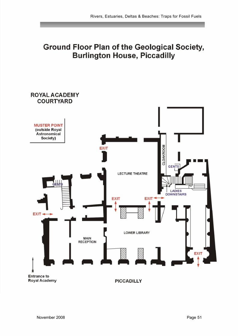
7/26/2019 Rivers Estuaries Deltas and Beaches Abstract Book, 6-7 November 2008
http://slidepdf.com/reader/full/rivers-estuaries-deltas-and-beaches-abstract-book-6-7-november-2008 51/51
Rivers, Estuaries, Deltas & Beaches: Traps for Fossil Fuels