rhondda cynon taf local development plan up to 2021 adopted … · 2016-05-09 · preserving our...
TRANSCRIPT

Preserving Our Heritage, Building Our Future
Rhondda Cynon Taf
Local Development Plan
up to 2021
Adopted March 2011
Jane Cook
Director of Regeneration & Planning
Simon Gale
Service Director Planning
1
35580-52 LDP plan 2011_Layout 1 30/06/2011 11:16 Page 1

22 Preserving Our Heritage, Building Our Future
Foreword
This Local Development Plan is an extremely important document for RhonddaCynon Taf and provides the framework for decisions to be made up until 2021on how land is used in the County Borough, for example what type ofdevelopment is appropriate or desirable and how best to protect ourenvironment. It is the culmination of a major piece of work that has includedengaging with the community, stakeholders, and councillors over a number ofyears and its completion and adoption by the Council is a big milestone forRhondda Cynon Taf.
We believe the LDP provides a focus for sustainable regeneration and highquality development that will make Rhondda Cynon Taf a better place to live,work and play. Having the right planning policy in place is a key part of howwe are trying to move our County Borough forward. It means that everyone canhave a sense of confidence and reliability in terms of what it will look like inthe future and will enable this policy and framework to be applied consistently
to planning decisions that can affect any of us or all ofus, depending on the development in question.
The next ten years promise to be a very exciting periodfor Rhondda Cynon Taf and I am sure the LDP willcontribute to achieving further progress and benefitsfor our residents and County Borough.
Councillor Russell Roberts Leader, Rhondda Cynon Taf County Borough Council
35580-52 LDP plan 2011_Layout 1 30/06/2011 11:17 Page 2

Preserving Our Heritage, Building Our Future 3
Contents
Chapter 1 Introduction and Context ......................................5Introduction...................................................................5Structure of Document..................................................6Key facts about Rhondda Cynon Taf .............................7Links to other Strategies ................................................7National Planning Policy and Technical Advice .........13How to use the document...........................................13
Chapter 2 Key Issues in Rhondda Cynon Taf .........................15
Chapter 3 Vision and Objectives ..........................................21
Chapter 4 Core Strategy and Policies....................................25Key Diagram ................................................................28Core Policies.................................................................30
Chapter 5 Area Wide Policies ...............................................45
Chapter 6 Strategy Area Policies ..........................................67Northern Strategy Area................................................67Southern Strategy Area................................................97
Chapter 7 Monitoring and Review Framework……………..123
Appendix 1 Detailed Allocations ..........................................145a) Housing Allocations......................................................................145b) Employment Allocations ..............................................................152c) Retail Allocation............................................................................153d) Major Highway Schemes ..............................................................155e) Sites of Important Nature Conservation,
Regionally Important Geological Sites and Local Nature Reserves ...........................................................157
f) List of Settlements withoutSettlement Boundaries .................................................................161
Appendix 2 Statutory Designations.......................................163
Appendix 3 Local Development Plan Evidence Base..............165
Appendix 4 Glossary of Terms ..............................................181
Appendix 5 List of Supplementary Planning Guidance ..........187
Appendix 6 Primary Shopping Area......................................189
Appendix 7 Infrastructure Requirements..............................191
35580-52 LDP plan 2011_Layout 1 30/06/2011 11:17 Page 3

Preserving Our Heritage, Building Our Future4
35580-52 LDP plan 2011_Layout 1 30/06/2011 11:17 Page 4

Preserving Our Heritage, Building Our Future 5
Introduction
1.1 The Planning and Compulsory Purchase Act 2004 requires Rhondda
Cynon Taf County Borough Council to prepare a Local Development
Plan (LDP) for the County Borough outside the Brecon Beacon
National Park. The LDP will provide the development strategy and
spatial policy framework for the LDP area over a fifteen-year period
to 2021. The Plan will be used by the Council to guide and control
development, providing a basis for consistent and appropriate
decision-making. The northernmost part of the County Borough lies
within the Brecon Beacons National Park. This area is subject to a
separate development plan that is the responsibility of the National
Park Authority.
1.2 For convenience, in this document the LDP area is usually referred
to as either “Rhondda Cynon Taf” or “the County Borough” which
should be taken to mean the County Borough excluding the National
Park.
1.3 The LDP will provide a policy framework that integrates and
balances the social, economic and environmental issues in order to
meet the needs of those people living, working and visiting Rhondda
Cynon Taf. The fundamental principles of achieving sustainable
development will underpin all land use decisions. The LDP will seek
to build a policy framework that protects important elements of the
built, natural and cultural environment, improves town centres,
provides new sustainable housing, employment and community
facilities in appropriate locations, promotes integrated transport and
encourage opportunities for sustainable regeneration.
Introduction and Context
Chapter One
35580-52 LDP plan 2011_Layout 1 30/06/2011 11:17 Page 5

Preserving Our Heritage, Building Our Future6
The Structure of the Document
1.4 This chapter sets out the context for the Deposit Draft LDP and describes
how it takes into account relevant strategies, policies and programmes.
These include the European Union Programmes, People, Places, Futures –
The Wales Spatial Plan, Planning Policy Wales and the Council’s Community
Plan.
1.5 Chapter Two provides the social, economic and environmental context for
the LDP. Based on consultation and the LDP evidence base, the chapter
outlines the issues that impact on the future development of the County
Borough.
1.6 Chapter Three contains the Council’s Vision and Objectives for the LDP. It
outlines the Council’s vision for the development of Rhondda Cynon Taf
over the plan period and a detailed framework of land use objectives. The
objectives of the plan were developed in partnership with the Council’s
LDP Forum and reflect the inter-relationship between people, activity and
land use at the local level.
1.7 Chapter Four sets out the Core Strategy for Rhondda Cynon Taf. The chapter
outlines the spatial strategy for guiding all future development and land
use in the County Borough during the plan period. The chapter also
identifies the eight Strategic Sites which are crucial to the implementation
of the strategy. Detailed guidance is given in respect of the nature and
form of development to take place on each site.
1.8 Chapter Five sets out detailed Rhondda Cynon Taf distinct area wide
policies. This chapter includes area wide topic based and non-site specific
policies, which provide a framework against which all future planning
applications will be considered. The policies are intended to ensure that all
development within the County Borough contributes towards achievement
of the Vision and Core Strategy.
1.9 Chapter Six sets out ‘locally distinct’ policies for the Northern and Southern
Strategy Areas respectively. The policy objectives for the Northern and
Southern Strategy Areas are different and reflect the individual
characteristics of the areas. The chapter provides detailed policies on issues
of identified importance within individual strategy areas.
1.10 Chapter Seven outlines the detailed monitoring framework for the Plan.
The chapter provides indicators for each of the core policies and will
provide a framework for monitoring the effectiveness of the Plan.
1.11 The Appendices include details of all allocations, evidence base, glossary
of terms, a list of sites of importance for nature conservation, statutory
designations and details of primary shopping areas.
1.12 Detailed allocation and areas of protection are illustrated on the
accompanying proposals and constraints maps.
35580-52 LDP plan 2011_Layout 1 30/06/2011 11:17 Page 6

Key Facts About Rhondda Cynon Taf
1.13 Rhondda Cynon Taf covers an area of the South Wales Valleys stretching
from the Brecon Beacons in the north, to the outskirts of Cardiff in the
south. It comprises a mixture of urban, semi-suburban and rural
communities, situated in mountains and lowland farmland.
1.14 Rhondda Cynon Taf is the second largest Local Authority in Wales, formed
in 1996 from the former Boroughs of Rhondda, Cynon Valley and Taff Ely
(part). The County Borough covers an area of 424 square kilometres with
a population of 231,946 (2001). The area has 75 electoral wards, of which
22 are Communities First Areas. Strategic highway links with the wider
region are provided by the M4, A470 and A465. A range of bus and rail
services provides public transportation links across the region.
Links to Strategies
1.15 Local Development Plans are intended to streamline the plan making
process and promote a proactive, positive approach to managing change
and development. Key aims of the new system are to speed up the
preparation of the development plan, contribute towards the achievement
of sustainable development, ensure plans are monitored and effectively
reviewed, achieve more effective community involvement and develop
plans that are more appropriate and responsive to changing local needs.
1.16 A key objective of the new planning system is “joining up” with plans and
strategies of other organisations and agencies,
especially where they relate to the
development of land. In developing the
Local Development Plan the Council has
had regard to relevant Welsh
Government, Regional and local
strategies and programmes.
7
35580-52 LDP plan 2011_Layout 1 30/06/2011 11:17 Page 7

Preserving Our Heritage, Building Our Future8
1.17. The Welsh Government publishes strategies, legislation, planning policy
and technical advice notes, circulars and statements that the Council takes
into account in its preparing Local Development Plan. Key Welsh
Government strategies include:
Environment Strategy for Wales (2006)
1.18 The Environment Strategy for Wales outlines the Welsh Government’s long-
term strategy for the environment of Wales, setting out the strategic
direction for the next 20 years.
1.19 The purpose of the Strategy is to provide a framework within which to
achieve an environment that is clean, healthy, biologically diverse and
valued by the people of Wales. The Welsh Government wish to see the
Welsh environment thriving and contributing to the economic and social
well-being and health of all of the people of Wales.
People, Places, Futures – The Wales Spatial Plan (2008)
1.20 The Wales Spatial Plan Update 2008: People, Places, Futures sets out a
vision for how each part of Wales should develop economically, socially
and environmentally over the next 20 years. The document further
develops the concept of a Capital Region and provides a more detailed
context for the development of the Rhondda Cynon Taf LDP. The Wales
Spatial Plan proposes distinct approaches for the three areas that make
up the Capital Region. The three areas are:
• City/Coast;
• Heads of the Valleys Plus, and
• Connections Corridor.
1.21 Rhondda Cynon Taf is within the Heads of the Valleys Plus and the
Connections Corridor.
1.22 The Spatial Plan Update identifies 14 hub settlements which it sees as vital
to the success of the city-region. Included are the Rhondda Cynon Taf
settlements of Aberdare, Pontypridd and Llantrisant.
1.23 In addition to the strategy areas and hub settlements the document also
identifies three Strategic Opportunity Areas (SOA). The SOAs are centred
around:
• The Heads of the Valleys Road (A465);
• Llantrisant and North West Cardiff, and
• St. Athan in the Vale of Glamorgan.
1.24 SOAs offer the potential for development to take place in a sustainable
way, which will benefit the region as a whole. The strategic location of
Rhondda Cynon Taf means that the County Borough has a crucial role to
play in the development of all of the SOAs.
Welsh Government Strategies
35580-52 LDP plan 2011_Layout 1 30/06/2011 11:17 Page 8

Economic Renewal: A New Direction (July 2010)
1.25 Economic Renewal: A new direction is the Welsh Governments Strategic
Framework to economic development. It sets out a vision of making Wales
‘one of the best places in the world to live and to work’. The strategy
outlines the Welsh Governments five priority areas, which are Investing in
high quality and sustainable infrastructure; making Wales a more attractive
place to do business; broadening and deepening the skills base;
Encouraging innovation and targeting support for businesses.
Preserving Our Heritage, Building Our Future 9
35580-52 LDP plan 2011_Layout 1 30/06/2011 11:17 Page 9

Preserving Our Heritage, Building Our Future
Turning Heads – A Strategy for the Heads of theValleys ( June 2006)
1.26 Turning Heads – A Strategy for the Heads of the Valleys 2020 outlines a
strategy for regenerating the northern valley areas of South East Wales. In
Rhondda Cynon Taf the strategy area includes Treorchy, Treherbert,
Ferndale, Hirwaun, Mountain Ash and Aberdare. The objectives of the
programme reflect those of the Wales Spatial Plan in seeking to ensure:
• An attractive and well used natural, historic and built environment;
• A vibrant economic landscape offering new opportunities;
• A well educated, skilled and healthier population;
• An appealing and coherent tourism and leisure experience, and
• Public confidence in a shared bright future.
1.27 Funding under these priority themes has and will continue to result in
significant investment in Rhondda Cynon Taf. During 2006 the Gateways
and Greenways project resulted in environmental enhancement work
being undertaken along the Cynon Valley River Park. In 2007 work began
on the implementation of the Ferndale Regeneration Strategy. Once
complete the strategy will result in townscape and public realm
improvements. In 2008, investment in Dare Valley Country Park focussed
on improved visitor facilities.
1.28 The focus in the Heads of the Valley area will provide an excellent
opportunity for the development of the northern valley area of Rhondda
Cynon Taf and the initiative is fully supported by the Council. The dualling
of the A465 in particular will significantly improve communication links
from Rhondda Cynon Taf to West Wales and England.
Regional Waste Plan (2008) - 1st Review
1.29 The Regional Waste Plan (RWP) provides a long-term strategic waste
management strategy and land-use planning framework for the
sustainable management of waste and recovery of resources in South East
Wales.
1.30 The aims of the RWP 1st Review are:
• To minimise adverse impacts on the environment and human
health.
• To minimise adverse social and economic impacts and maximise
social and economic opportunities.
• To meet the needs of communities and businesses.
• To accord with the legislative requirements, targets, principles and
policies set by the European and national legislation and policy
framework.
1.31 The RWP 1st Review comprises two main elements:s
• The RWP Technology Strategy which provides strategic information
on the types of waste management / resource recovery facilities
required in South-East Wales; and
• The RWP Spatial Strategy, which provides strategic information on
the types of locations likely to be acceptable.
1.32 These two elements have been developed through different processes;
they tackle different issues and have been presented separately. The RWP
1st Review does not bring the two elements together in order to identify
which technologies should be located at which site or in which Area of
Search. The process of combining the two elements is a policy making
exercise which can only be undertaken at the local level though the Local
Development Plan preparation process.
10
Regional Strategies
35580-52 LDP plan 2011_Layout 1 30/06/2011 11:17 Page 10

11
Regional Technical Statement for Aggregates (2007)
1.33 The Regional Technical Statement (RTS) has been produced by the South
Wales Regional Aggregates Working Party (SWRAWP). Minerals TAN1 sets an
overarching objective which seeks to ensure a sustainably managed supply
of aggregates (which are essential for construction), striking the balance
between environmental, economic and social costs. The RTS has been
formulated to help guide individual Local Authorities in South Wales on
how to implement these mineral planning policies in the formulation of
their individual Local Development Plan (LDP) policies and allocations.
Regional Transport Plan (2010)
1.34 The South-East Wales Transport Alliance (Sewta) is an alliance of 10 South-
East Wales local authorities working with others to deliver better transport
in the South-East Wales region. It is constituted as a joint local government
committee.
1.35 The Transport Act (Wales) 2006 requires the consortia to produce a regional
plan for transport for all modes of travel. Sewta produced an outline of the
Regional Transport Plan (RTP) in January 2007. The draft RTP was
published for consultation in the summer of 2008 and the final draft RTP
was issued in March 2010 following release of the Welsh Government's
Wales National Transport Plan (NTP). The NTP and RTPs set out how the
Wales Transport Strategy (WTS) will be delivered.
1.36 Sewta’s vision for the RTP is to provide a modern, integrated and
sustainable transport system for South- East Wales that increases
opportunity, promotes prosperity and protects the environment, where
public transport, walking, cycling and sustainable freight provides real
travel alternatives.
1.37 The priorities of the RTP will be to:-
• Improve access to services, facilities and employment, particularly by
public transport, walking and cycling;
• Provide a transport system that increases the use of sustainable modes
of travel;
• Reduce the demand for travel;
• Develop an efficient and reliable transport system with reduced levels
of congestion and improved transport links within the Sewta region
and to the rest of Wales, the UK and Europe;
• Provide a transport system that encourages healthy and active life
styles, is safer and supports local communities;
• Reduces significantly the emission of greenhouse gases and air
pollution from transportation;
• Ensure that land use development in South-East Wales is supported by
sustainable transport measures; and
• Make better use of the transport system.
Preserving Our Heritage, Building Our Future
35580-52 LDP plan 2011_Layout 1 30/06/2011 11:17 Page 11

Preserving Our Heritage, Building Our Future
Children and Young Peoples Plan (2008)
1.38 The Children and Young Peoples Plan for Rhondda Cynon Taf was issued
in 2008. The plan is designed to meet the needs of children and young
people living in our communities through collaboration with local agencies
and services for children. By working in partnership with local bodies the
plan will endeavour to achieve the Welsh Governments 7 core aims to
ensure all children and young people:
• Have a flying start in life;
• Have a comprehensive range of education and learning
opportunities;
• Enjoy the best possible health and freedom from abuse, victimisation
and exploitation;
• Have access to play, leisure, sporting and cultural activities;
• Are listened to, treated with respect, and have their race and cultural
identity recognised;
• Have a safe home and a community that supports physical and
emotional well-being;
• Are not disadvantaged by poverty.
‘Live. Grow. Aspire. Achieve’, Rhondda Cynon TafCommunity Strategy (2010 – 2020)
1.39 The Community Strategy sets out the vision for Rhondda Cynon Taf in 2020,
with clear priorities that need to be focussed on to make that vision a
reality. The Community Strategy was developed by all the partners who
make up the Partnership Congress, which include the Council, other public
sector agencies and the voluntary and community sectors, local businesses
and residents groups.
1.40 The Rhondda Cynon Taf Congress of Partners, Local Service Board and
Strategic Partnerships will work to deliver the vision for a sustainable
Rhondda Cynon Taf by focusing on five core improvement themes:
• Safer Communities;
• Children and Young People;
• Healthier Adults and Communities;
• Economic Regeneration and Transport; and
• Environment and Housing.
1.41 For the Council and other public services, the Community Strategy will set
the direction for our work over the next five years, with the Strategy being
reviewed after five years. The vision will provide the context for all our
other strategic strategies and plans, including important partnership plans
(such as Rhondda Cynon Taf’s Single Children’s Plan) and individual
organisations’ plans (such as the Council’s Corporate Improvement Plan).
12
Local Strategies
35580-52 LDP plan 2011_Layout 1 30/06/2011 11:17 Page 12

13
National Planning Policy and Technical Advice
1.42 National policy and advice in respect of spatial planning is contained in a
range of policy documents, statements, and advice notes. Of particular
significance are Planning Policy Wales and the Technical Advice Note series
of documents. An up to date list of guidance can be found on the Welsh
Government’s website at www.wales.gov.uk
How to use this Document1.43 The LDP contains a Core Strategy, Core Policies, Area Wide Policies,
Northern Strategy Area Policies and Southern Strategy Area Policies.
1.44 The LDP includes a Proposals Map that is presented as 2 individual 1:15000
scale maps. The Proposals Map illustrates those areas of land, which have
been specifically allocated for development or are subject to protection
through the plan process. Accompanying the Proposals Map is a separate
plan that illustrates constraints to development within Rhondda Cynon
Taf.
1.45 It should be noted that the Plan does not cover those parts of Rhondda
Cynon Taf which fall within the Brecon Beacons National Park.
1.46 The LDP should be read as a whole, many of the Plans objectives, strategies
and policies are cross-cutting and inter-related. Decisions on development
proposals will have regard to the relevant policies in the Plan and the
requirements of National Planning Policy.
Preserving Our Heritage, Building Our Future
35580-52 LDP plan 2011_Layout 1 30/06/2011 11:17 Page 13

14 Preserving Our Heritage, Building Our Future
35580-52 LDP plan 2011_Layout 1 30/06/2011 11:17 Page 14
Preserving Our Heritage, Building Our Future 15
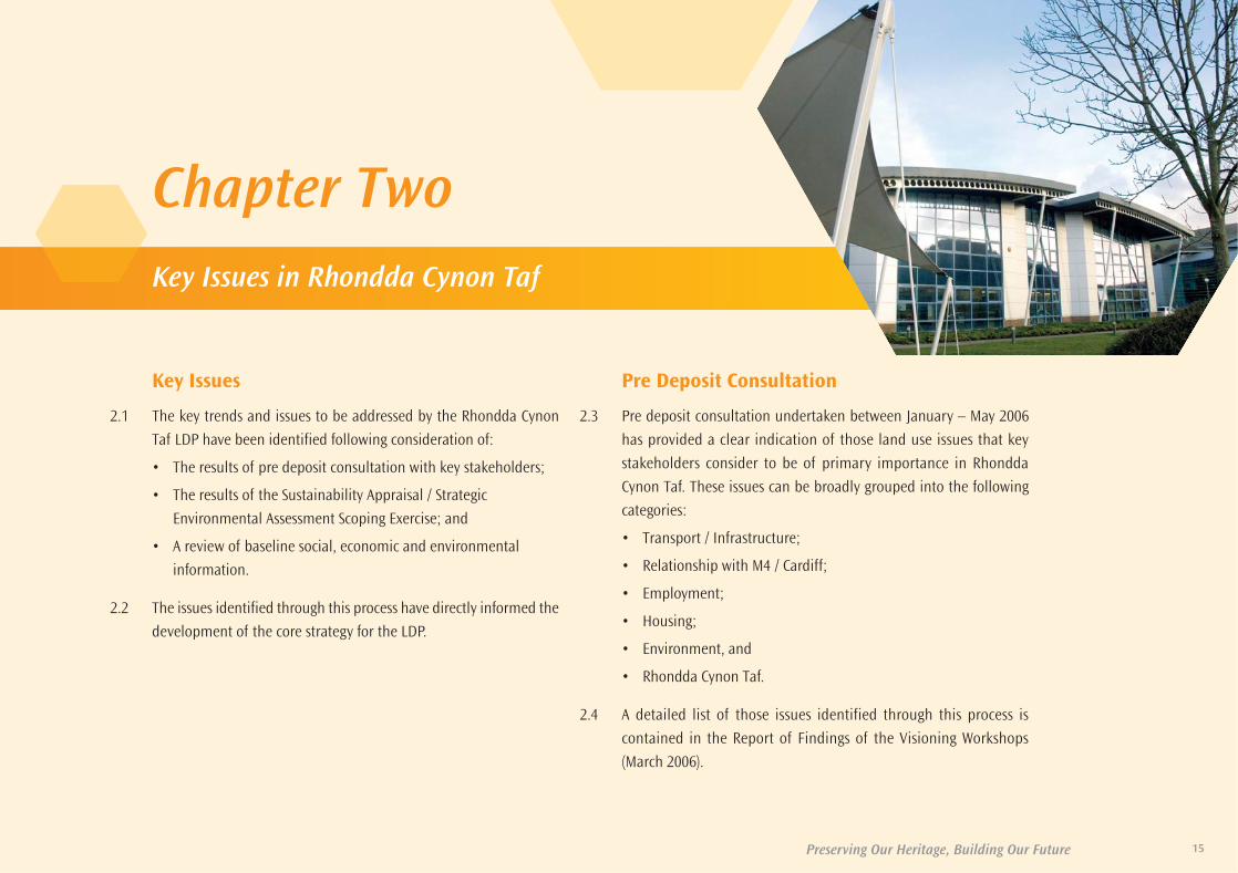
Chapter Two
Key Issues
2.1 The key trends and issues to be addressed by the Rhondda Cynon
Taf LDP have been identified following consideration of:
• The results of pre deposit consultation with key stakeholders;
• The results of the Sustainability Appraisal / Strategic
Environmental Assessment Scoping Exercise; and
• A review of baseline social, economic and environmental
information.
2.2 The issues identified through this process have directly informed the
development of the core strategy for the LDP.
Pre Deposit Consultation
2.3 Pre deposit consultation undertaken between January – May 2006
has provided a clear indication of those land use issues that key
stakeholders consider to be of primary importance in Rhondda
Cynon Taf. These issues can be broadly grouped into the following
categories:
• Transport / Infrastructure;
• Relationship with M4 / Cardiff;
• Employment;
• Housing;
• Environment, and
• Rhondda Cynon Taf.
2.4 A detailed list of those issues identified through this process is
contained in the Report of Findings of the Visioning Workshops
(March 2006).
Key Issues in Rhondda Cynon Taf
35580-52 LDP plan 2011_Layout 1 30/06/2011 11:17 Page 15

Preserving Our Heritage, Building Our Future16
Sustainability Appraisal / Strategic EnvironmentalAssessment Scoping Exercise
2.5. The Sustainability Appraisal / Strategic Environmental Assessment (SA / SEA)
scoping exercise was undertaken between January – April 2006. The
process identified key strategic problems, objectives and issues for
sustainability. The broad issues identified were as follows:
• Climate change;
• Economic development / housing provision;
• Transport;
• Protection of the landscape and biodiversity;
• Town centre vitality, and
• Cultural change.
2.6 A detailed discussion of each of the broad issues identified is contained in
the Sustainability Appraisal / Strategic Environmental Assessment Scoping
Report (March 2006).
Social, Economic and Environmental Baseline
2.7 In order to ensure that a robust basis was established on which to develop
a spatial strategy for the LDP, a review was undertaken of key social,
economic and environmental data. The review of the available data
supports the issues identified through the pre deposit consultation process
and the SA / SEA Scoping exercise. The analysis provides a clear picture of
the social, economic and environmental issues which need to be addressed
through the LDP process. The key trends identified are as follows:
Key Social Trends
• The resident population of Rhondda Cynon Taf mid-2007 is 233,734
persons. This population is projected to increase by 20,900 or 9% by
mid-2030 (Office for National Statistics).
• The population projections for South East Wales forecast an overall
increase in population of 14.7% between 2006 and 2031 to 1,631,000
persons (Welsh Government – Population Projections, 2006).
• The population of Rhondda Cynon Taf has remained largely
unchanged between 1991 and 2001. However this masks significant
local variation, between 1991 – 2001 the population of the central
and northern valleys declined by 5% whilst the population of the
south increased by 10% (Office for National Statistics).
• 72% of household completions between 1991 and 2006 in Rhondda
Cynon Taf occurred in the south of the County Borough (JHLA, 2008).
• Of the 95,400 households in Rhondda Cynon Taf 52.9% are in
terraced houses / bungalows, 26.2% are in semi-detached houses
/bungalows and 12.3% are in detached houses / bungalows (Housing
Needs Assessment, 2006).
• The most expensive housing sub-market in Rhondda Cynon Taf is in
the south with the average sale of a 4-bedroom property 60% higher
than a similar property in the north of the County Borough (Housing
Needs Assessment, 2006).
• The County Borough has around 4000 empty properties, the majority
of which are in the north of Rhondda Cynon Taf (Housing Matters – A
Local Housing Strategy for Rhondda Cynon Taf, 2002-2012).
• There is a shortfall of 870 affordable housing units per annum in
Rhondda Cynon Taf. (Housing Matters – A Local Housing Strategy for
Rhondda Cynon Taf, 2002-2012).
35580-52 LDP plan 2011_Layout 1 30/06/2011 11:17 Page 16

Preserving Our Heritage, Building Our Future
Key Social Trends (cont)
• 28 of the 152 lower super output areas in Rhondda Cynon Taf are in
the top 10% of most deprived areas in Wales (Welsh Index of Multiple
Deprivation, 2008).
• The highest overall concentration of deprivation in Rhondda Cynon
Taf is located in the central and northern valleys (Welsh Index of
Multiple Deprivation 2008).
• The highest levels of housing deprivation in Rhondda Cynon Taf are
in the central and northern valleys (Welsh Index of Multiple
Deprivation, 2008).
• Rhondda Cynon Taf has more super output areas in the most
deprived 10% in Wales for health deprivation than any other local
authority in Wales (Welsh Index of Multiple Deprivation, 2008).
• 27% of residents in Rhondda Cynon Taf suffer with a limiting long-
term illness compared with a Welsh average of just 23% (Office of
National Statistics).
• The highest levels of health deprivation in Rhondda Cynon Taf are in
the central and northern valleys (Welsh Index of Multiple
Deprivation, 2008).
• 41% of residents in Rhondda Cynon Taf have no academic
qualifications compared with a Welsh average of 33% (Office of
National Statistics).
Key Economic Trends
• 73% of residents in Rhondda Cynon Taf are economically active
compared with a Welsh average of 75% (Employment Land Review,
2008).
• The central and northern valleys have above average levels of people
claiming Job Seekers Allowance (JSA) in Wales and the highest level of
claimants in Rhondda Cynon Taf at 3.1% (Employment Land Review,
2008).
• The south of the County Borough has an above average level of
economic activity and the highest number of economically active
individuals in Rhondda Cynon Taf at 73% (Employment Land Review,
2008).
• In 2001 31,000 people residing in Rhondda Cynon Taf worked outside
the local authority. This figure increased to 38,400 in 2004 with 19,000
of these commuting to Cardiff (Economic Development Prospects and
Employment Land Implications, 2008).
• The employment structure of Rhondda Cynon Taf is dominated by
three sectors ‘public administration’, ‘manufacturing’ and ‘distribution,
hotels and restaurants’. Together, these three account for 74% of all
available jobs in Rhondda Cynon Taf (Employment Land Review, 2008).
• Between 2000 and 2006 33 hectares of employment land was
developed in Rhondda Cynon Taf at an average rate of 5.5ha per
annum (Employment Land Review, 2008).
• Convenience (food) sales floor space in Tesco Talbot Green, Asda
Aberdare and Tesco Upper Boat are trading 26% above the
companies average benchmark turnover (Retail Capacity Assessment,
2007).
17
35580-52 LDP plan 2011_Layout 1 30/06/2011 11:17 Page 17

Preserving Our Heritage, Building Our Future18
Key Environmental Trends
• 45% of Rhondda Cynon Taf passes the Fields in Trust standard of 1
kilometre to the nearest sports area of over 1,000 m² (Open space
Assessment, 2007).
• The highest levels of ‘physical environment’ deprivation (for poor air
quality, flood risk and waste disposal sites) occur in the central and
northern valleys (Welsh Index of Multiple Deprivation 2008).
• Municipal waste arisings in Rhondda Cynon Taf for 2004 / 05 stood at
131,777 tonnes. There was an average annual growth in arisings of
2.18% over the previous 6 year period compared with the SE Wales
average of 2.92% (Regional Waste Plan Annual Monitoring Report 2006).
• Average household waste arisings per household for 2004 / 05 stood at
1.332 kilograms compared with the SE Wales average of 1.284kg
(Regional Waste Plan Annual Monitoring Report 2006).
• Only 15.6% of municipal waste was recycled and composted in
Rhondda Cynon Taf in 2004 / 05 compared with 20.7% in SE Wales as a
whole (Regional Waste Plan Annual Monitoring Report 2006).
• Rhondda Cynon Taf is important for nature conservation with
significant areas of semi natural habitat and high levels of habitat
diversity. There are 3 Special Areas of Conservation (SAC) at Coedydd
Nedd a Mellte (part), Blaen Cynon (part) and Cardiff Beechwoods (part)
and 14 Sites of Special Scientific Interest.
• Rhondda Cynon Taf has 16 conservation areas and 366 listed buildings
(at the time of the preparation of the LDP).
• There are eight sites in Rhondda Cynon Taf which have potential sand
and gravel resources.
• Large parts of the County Borough are located on the coal resource,
with a substantial mining legacy being present.
Summary of Key Trends2.8 The trends identified in this section provide a clear indication of the deep-
seated social, economic and environmental factors that need to be
addressed, in order to achieve balanced development across the County
Borough. The factors identified provide a clear picture of the two parts of
Rhondda Cynon Taf.
2.9 The central and northern valleys of the County Borough are experiencing:
• High levels of deprivation;
• Dereliction compounded by a declining population;
• Low levels of house building, and
• Below average levels of economic activity.
2.10 The south of the County Borough in contrast, has experienced:
• A significant growth in population supported by high levels of house
building;
• Above average economic activity;
• Increased access to high-level services, facilities and jobs, and
• Development pressure because of its accessibility from the M4 and the
wider region.
2.11 When these factors are considered across the County Borough as a whole
they reveal the difficulties in managing cross-boundary relations with the
M4/Cardiff and the relationship between the north and south of the
County Borough. The key issues are:
• Internal and cross-boundary migration patterns;
• The provision of services in the north and development pressure in the
south;
• Dependence on the wider region for employment and road congestion,
and
• High levels of out commuting for employment.
35580-52 LDP plan 2011_Layout 1 30/06/2011 11:17 Page 18

Preserving Our Heritage, Building Our Future 19
Aims of the LDP Strategy
2.12 If the trends portrayed are allowed to continue, those areas of Rhondda
Cynon Taf with the least signs of socio economic deprivation are likely to
prosper, whilst those areas of the County Borough showing signs of the
most significant socio economic deprivation are likely to decline further.
2.13 In the central and northern valleys, the LDP strategy will seek to:
• Halt the process of decline by stimulating growth in the housing and
employment markets;
• Removing dereliction, and
• Supporting services in important urban centres.
2.14 In the south, the strategy will seek to:
• Manage growth by balancing housing and commercial development
with social and environmental considerations.
2.15 In accordance with the above, the LDP will provide a policy framework
which:
• Seeks to address the socio-economic balance between the north and
the south of the County Borough;
• Meets the housing and employment needs of a growing population;
• Provides a range of quality, affordable housing;
• Brings empty properties back into beneficial use;
• Provides a range of employment sites to meet local need, attract
inward investment and assist in diversifying the employment market;
• Reduces out-commuting by providing a range of employment and
commercial opportunities in accessible locations across Rhondda
Cynon Taf;
• Manages waste and provide recycling opportunities within the
boundaries of the County Borough;
• Protects the rich biodiversity and landscape of Rhondda Cynon Taf, and
• Protects the cultural and built environment.
35580-52 LDP plan 2011_Layout 1 30/06/2011 11:17 Page 19

35580-52 LDP plan 2011_Layout 1 30/06/2011 11:17 Page 20

Chapter Three
Vision And Objectives
Vision
3.1 The overall vision of the Rhondda Cynon Taf LDP is derived from the
vision for Rhondda Cynon Taf outlined in ‘Live. Grow. Aspire.
Achieve’, Rhondda Cynon Taf Community Strategy (2010 – 2020),
which states that:
“Rhondda Cynon Taf will be a County Borough of Opportunity. That
means working together to enable individuals and communities to
achieve their full potential, in terms of both their work and
social life.”
3.2 The LDP will present an opportunity for the spatial planning system
to deliver the aims and objectives of the Community Strategy.
3.3 The Community Strategy recognises that the successful delivery of
its vision relies on a range of physical, social, economic, health,
educational and related initiatives. It also recognises that the spatial
planning system has a fundamental role to play in the delivery of
this vision.
21
35580-52 LDP plan 2011_Layout 1 30/06/2011 11:17 Page 21

22 Preserving Our Heritage, Building Our Future
3.4 In order to directly support the implementation of the Community
Strategy, the LDP will provide a land use framework that seeks to: -
• Build sustainable communities that ensure everyone has access to
housing, jobs and essential services and that all new development is
supported by necessary social and physical infrastructure. This will be
achieved by focussing new growth in principal towns and key
settlements;
• Ensure that Rhondda Cynon Taf achieves its potential by maximizing
the advantages of its strategic location, both in terms of the Capital
Region and global economy. It will also maximise opportunities for
inward investment in Hirwaun and Llantrisant / Talbot Green;
• Deliver a better quality of life by ensuring our communities are vibrant,
healthy and safe, provide access to a range of cultural, commercial and
leisure activities and protect our natural heritage and built
environment;
• Develop and protect the County Borough for future generations so that
physical and natural resources are protected, the challenges of climate
change are met and new development is in sustainable locations and
of the highest environmental standards.
LDP Objectives3.5 In order to ensure the delivery of the Community Strategy Vision, spatial
planning objectives have been developed. These objectives are at the
centre of the LDP and form the basis for its policy development.
3.6 The objectives of the Rhondda Cynon Taf LDP are to:
Sustainable Communities
1. Provide for the County Borough’s overall housing requirement through
a mix of dwelling types catering for all needs to promote integrated
and thriving communities and reinforce the roles of the Principal
Towns and Key Settlements in the north and south of the County
Borough.
2. Promote integrated communities within the Principal Towns, Key
Settlements and other sustainable settlements by ensuring the
development of a high quality built environment that provides
opportunities for living, working and socialising for all.
Achieving Potential
3. Develop a sustainable economy in Rhondda Cynon Taf that provides a
diverse range of job opportunities in locations that reinforce the roles
of Principal Towns and Key Settlements in the north and south of the
County Borough.
Better Quality of Life
4. Promote and protect the rich culture and heritage of the County
Borough by protecting and enhancing the historic landscape of the
Rhondda, the historic parks and gardens in the south and the built
heritage of the County Borough as a whole.
35580-52 LDP plan 2011_Layout 1 30/06/2011 11:17 Page 22

23Preserving Our Heritage, Building Our Future
5. Provide an environment in Rhondda Cynon Taf that encourages a
healthy and safe lifestyle and promotes well-being through
improvement in access to green space in the north, provision of open
space in the south, and the protection of recreational space throughout
the County Borough.
6. Reduce the need to travel by car within Rhondda Cynon Taf by
promoting residential and commercial development in the Principal
Towns and Key Settlements in the north and south of the County
Borough where there is a choice of sustainable modes of transport.
Develop and Protect the County Borough for Future Generations
7. Protect and enhance the glacial landscapes of the north, undulating
countryside of south, important geological sites and the diverse and
abundant wildlife habitats and native species that exist throughout
Rhondda Cynon Taf.
8. Manage the effects of climate change by protecting biodiversity,
focussing development away from areas in the north and south which
are vulnerable to flooding, increase the supply of renewable energy
from a range of sources including onshore wind energy available
throughout the County Borough, by reducing energy consumption
through improved design and by promoting development in the
Principal Towns and Key Settlements in the north and south of the
County Borough.
9. Minimise waste, especially waste to landfill, by making adequate
provision for waste and community recycling facilities in Principal
Towns, Key Settlements and Smaller Settlements in the County Borough
in a way that meets the needs of Rhondda Cynon Taf and in accordance
with the requirements of the Regional Waste Plan.
10. Promote the efficient and appropriate
use of land, soil and minerals
throughout the County Borough by
maximising the use of land,
promoting the re-use and
restoration of derelict land
and buildings, reuse of
materials and the
safeguarding of
resources of local,
regional and national
importance where they
occur in Rhondda Cynon Taf.
3.7 The objectives have been translated
into the spatial framework provided by
the LDP and have informed the
development of the core, area wide and
strategy area policies of the plan. A detailed
monitoring framework for the LDP is contained in
Chapter Seven of the Plan. The framework will allow
the Council to assess the delivery of the LDP objectives
over the plan period.
35580-52 LDP plan 2011_Layout 1 30/06/2011 11:17 Page 23

24 Preserving Our Heritage, Building Our Future
35580-52 LDP plan 2011_Layout 1 30/06/2011 11:17 Page 24

25
Core Strategy
4.1 The Rhondda Cynon Taf LDP strategy is a hybrid strategy which
provides development in locations that meet local needs whilst
promoting sustainable growth. The strategy has been derived having
regard to the national, regional and local policy context, social,
economic and environmental factors, the availability of land suitable
for development and the unique characteristics of the County
Borough. The LDP strategy will provide a land use framework, which
seeks to marry the delivery of new homes and services at local level
with an ambitious strategy for growth intended to promote
sustainable regeneration.
4.2 An examination of the social, economic and environmental trends
within the County Borough clearly indicate that for the successful
implementation of the strategy, a different policy approach needs
to be taken in those areas of Rhondda Cynon Taf that are in decline
and those which are experiencing growth.
4.3 The core strategy for Rhondda Cynon Taf will therefore advocate a
different approach for development in the north and in the south of
the County Borough.
4.4 For the purpose of the LDP the Northern Strategy Area includes
Tonypandy, Porth, Treorchy, Treherbert, Ferndale, Tylorstown,
Mountain Ash, Aberdare and Hirwaun. The emphasis in this area is
on building sustainable communities and halting the process of
depopulation and decline. Development proposals in the Northern
Strategy Area will provide appropriate growth to address the
problems of deprivation and high levels of social and economic
need.
4.5 Strategic road and rail links mean that the Northern Strategy Area
benefits from good communication links with Cardiff, the Brecon
Beacons, Neath Port Talbot and communities in the Heads of the
Valleys region such as Merthyr Tydfil and Caerphilly. The location of
the Strategy Area in respect of the A465 means that excellent
communication links also exist with Swansea and the West Midlands.
4.6 The position of the Northern Strategy Area in the Capital Region
means that it benefits from being part of the Heads of the Valleys
Programme and within the Heads of the Valleys Road (A465)
Strategic Opportunity Area (SOA).
Chapter Four
Preserving Our Heritage, Building Our Future
Core Strategy and Policies
35580-52 LDP plan 2011_Layout 1 30/06/2011 11:17 Page 25

Preserving Our Heritage, Building Our Future26
4.7 The Southern Strategy Area includes Pontypridd, Llantrisant (including
Talbot Green), Tonyrefail and Llanharan. In the south of the County
Borough the emphasis is on sustainable growth that benefits Rhondda
Cynon Taf as a whole. Development proposals in the Southern Strategy
Area will promote sustainable development by providing a managed form
of growth which will consolidate existing settlement patterns; have regard
to the social and economic function and identity of settlements and the
surrounding countryside; address existing or potential capacity needs to
provide necessary infrastructure and reduce the need to travel.
4.8 Strategic road and rail links within the Southern Strategy Area provide good
communication links with Cardiff, the Vale of Glamorgan and Bridgend.
The position of the Strategy Area in relation to the M4 means that there are
also excellent communication links with West Wales, South West England
and London.
4.9 As in the north, the Southern Strategy Area is part of the Capital Region and
benefits from being within the Llantrisant and North West Cardiff SOA. The
area also has close links with RAF St Athan in the Vale of Glamorgan.
4.10 Within these two strategy areas the LDP strategy will recognise the
important role settlements in Rhondda Cynon Taf play in providing homes
and services of both local and county importance. In order to focus growth
in areas where the maximum social and economic benefits can be
achieved a distinction will be made between Principal Towns, Key
Settlements and Smaller Settlements. New development opportunities will
be focused in the Principal Towns and Key Settlements of the County
Borough in order to support and reinforce the important role these centres
play as places for social and economic activity.
4.11 For the purposes of the LDP strategy, Principal Towns are defined as
Pontypridd, Aberdare and Llantrisant (including Talbot Green). These towns
are important hubs for social and economic activity by acting as gateways
for new investment, innovation and sustainable development.
4.12 The position of each of the towns in respect of the strategic transportation
network means that these settlements are important to the promotion of
regeneration in Rhondda Cynon Taf and economic growth in the wider
region. Each of the Principal Towns has been identified as a ‘Hub
Settlement’ in the Wales Spatial Plan.
4.13 The Principal Towns of Aberdare and Llantrisant (including Talbot Green)
are areas in which significant new housing, employment and retail
development will be accommodated. Topographical constraints mean that
significant growth will be difficult to accommodate within the Principal
Town of Pontypridd. The emphasis in this area will be on consolidation
and redevelopment. Land for residential development to accommodate
the needs of the growing population of Pontypridd will be provided in the
nearby settlements of Church Village, Llantwit Fardre, Treforest and
Beddau.
4.14 Key Settlements are geographically smaller and less strategically significant
than the Principal Towns. Nevertheless these settlements provide
important services and act as centres for commercial and community
activity. For the purpose of the LDP Key Settlements are defined as
Tonypandy, Tonyrefail, Treorchy, Mountain Ash, Porth, Ferndale, Llanharan
and Hirwaun. These key settlements will act as focal points for growth in
Rhondda Cynon Taf over the plan period.
35580-52 LDP plan 2011_Layout 1 30/06/2011 11:17 Page 26

27Preserving Our Heritage, Building Our Future
4.15 Whilst Llanharan and Hirwaun currently play a different role in their local
areas from that of other Key Settlements, both settlements are in excellent
strategic locations and are capable of assimilating significant additional
residential and commercial development. Both settlements will have a
major role to play in the successful delivery of the LDP Strategy.
4.16 In addition to the identification of Principal Towns and Key Settlements,
the strategy recognises the importance of Smaller Settlements in providing
a limited range of services to meet local needs. For the purposes of the
LDP the smaller settlements are identified as Rhigos, Penywaun, Cwmbach,
Aberaman South, Penrhiwceiber, Abercynon, Ynysybwl, Treherbert, Pentre,
Maerdy, Ystrad, Tylorstown, Ynyshir and Cymmer in the Northern Strategy
Area, and Glyncoch, Church Village, Efail Isaf, Beddau, Llanharry, Gilfach
Goch, Cilfynydd, Hawthorn, Ton-Teg, Llantwit Fardre, Rhydyfelin, Treforest,
Taffs Well and Pontyclun in the South. The exact geographical definition of
the smaller settlements is shown on the proposals map.
4.17 A range of sites are allocated for the development of new housing,
employment and retail facilities throughout Rhondda Cynon Taf. Sites have
been allocated specifically to meet local needs and to promote socio-
economic growth. Smaller non-strategic sites intended to meet local needs
have been allocated in sustainable locations that reinforce the role of
Principal Towns and Key Settlements. Non-strategic sites are allocated for
development by policies in the Northern and Southern strategy areas.
Large-scale Strategic Sites, which are capable of accommodating significant
development, have been identified in locations that maximise the
opportunities for sustainable regeneration and ensure a step change in
the economy of the County Borough. Strategic Sites are allocated for
development by Policy CS 3. All sites have been assessed in accordance
with the Council’s Candidate Site Assessment Methodology.
4.18 The infrastructure needs of each allocated site have been considered in
discussion with service providers. The requirements for each site are
detailed in Appendix 7 and the LDP Infrastructure Topic Paper. Key areas
for investment have been identified in Supplementary Planning Guidance
(SPG) on Planning Obligations.
4.19 In allocating land for development the strategy also recognises the
importance of balancing the need for development with the need to
protect the global and local environment. The strategy seeks to mitigate
and adapt to the impacts of climate change by ensuring the efficient use
of resources supporting renewable energy resources, protecting
biodiversity, managing waste effectively, promoting development in
accessible locations, focusing new housing away from areas of flood risk
and improving energy efficiency in the design of new buildings. Equally
important is the need to protect the countryside and unique landscape of
Rhondda Cynon Taf from urbanisation and incremental loss.
4.20 A core component of the core strategy is a set of Core Policies. These
policies will provide a framework for determining where existing and
future residents of Rhondda Cynon Taf live, work, shop, recreate and how
they travel in between. The Core Policies include only those elements
essential for the delivery of the strategy.
4.21 The Key Diagram shown in figure 1 illustrates the core strategy and shows
the extent of Rhondda Cynon Taf County Borough and the LDP area.
35580-52 LDP plan 2011_Layout 1 30/06/2011 11:17 Page 27

Figure 1: Local Development Plan Key Diagram
28 Preserving Our Heritage, Building Our Future
35580-52 LDP plan 2011_Layout 1 30/06/2011 11:17 Page 28

Risk Assessment
4.22 The LDP strategy will provide a land use framework, which seeks to marry
the delivery of new homes and services at local level with an ambitious
strategy for growth intended to promote sustainable regeneration. The
delivery of the strategy depends on a number of factors including the
availability of genuinely developable land, national and European policy,
the operations of the global and national economy and the availability of
private and public sector funding.
4.23 Clearly, many of these factors cannot be controlled or influenced by the
LDP. Where it has been possible to do so, the Plan has sought to mitigate
risk by developing a balanced strategy that will allow the development of
a range of sites in a number of different locations. This approach is
married to a policy framework that is flexible and able to recognise and
respond to change.
4.24 In addition the Council will seek to maximise the opportunities to deliver
the LDP by securing public sector funding through mechanisms such as
single regeneration fund, transport grant and the convergence
programme.
4.25 In order to further manage the risks associated with the plan the Council
will keep under continual review those elements of the plan essential to
the delivery of the core strategy. This will include the development of the
Strategic Sites, the provision of land for new housing and employment,
the delivery of affordable housing and improvements in the strategic
transportation network. A detailed monitoring framework for the LDP is
contained in Chapter Seven of the Plan. Where it is clear that the delivery
of a key element of the strategy is not being achieved, the Council will
review the policy context and make appropriate amendments to the LDP.
29
35580-52 LDP plan 2011_Layout 1 30/06/2011 11:17 Page 29
Preserving Our Heritage, Building Our Future
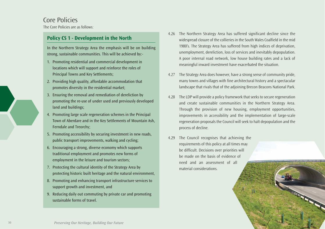
4.26 The Northern Strategy Area has suffered significant decline since the
widespread closure of the collieries in the South Wales Coalfield in the mid
1980’s. The Strategy Area has suffered from high indices of deprivation,
unemployment, dereliction, loss of services and inevitably depopulation.
A poor internal road network, low house building rates and a lack of
meaningful inward investment have exacerbated the situation.
4.27 The Strategy Area does however, have a strong sense of community pride,
many towns and villages with fine architectural history and a spectacular
landscape that rivals that of the adjoining Brecon Beacons National Park.
4.28 The LDP will provide a policy framework that seeks to secure regeneration
and create sustainable communities in the Northern Strategy Area.
Through the provision of new housing, employment opportunities,
improvements in accessibility and the implementation of large-scale
regeneration proposals the Council will seek to halt depopulation and the
process of decline.
4.29 The Council recognises that achieving the
requirements of this policy at all times may
be difficult. Decisions over priorities will
be made on the basis of evidence of
need and an assessment of all
material considerations.
30
Core PoliciesThe Core Policies are as follows:
Policy CS 1 - Development in the North
In the Northern Strategy Area the emphasis will be on building
strong, sustainable communities. This will be achieved by:-
1. Promoting residential and commercial development in
locations which will support and reinforce the roles of
Principal Towns and Key Settlements;
2. Providing high quality, affordable accommodation that
promotes diversity in the residential market;
3. Ensuring the removal and remediation of dereliction by
promoting the re-use of under used and previously developed
land and buildings;
4. Promoting large scale regeneration schemes in the Principal
Town of Aberdare and in the Key Settlements of Mountain Ash,
Ferndale and Treorchy;
5. Promoting accessibility by securing investment in new roads,
public transport improvements, walking and cycling;
6. Encouraging a strong, diverse economy which supports
traditional employment and promotes new forms of
employment in the leisure and tourism sectors;
7. Protecting the cultural identity of the Strategy Area by
protecting historic built heritage and the natural environment,
8. Promoting and enhancing transport infrastructure services to
support growth and investment, and
9. Reducing daily out commuting by private car and promoting
sustainable forms of travel.
35580-52 LDP plan 2011_Layout 1 30/06/2011 11:17 Page 30

Preserving Our Heritage, Building Our Future
Policy CS 2 - Development In The South
In the Southern Strategy Area the emphasis will be on sustainable
growth that benefits Rhondda Cynon Taf as a whole. This will be
achieved by:
1. Promoting residential development with a sense of place
which respects the character and context of the Principal
Towns and Key Settlements of the Southern Strategy Area;
2. Protecting the culture and identity of communities by focusing
development within defined settlement boundaries and
promoting the reuse of under used and previously developed
land and buildings;
3. Promoting large scale regeneration schemes in the Principal
Town of Pontypridd and Key Settlement of Tonyrefail;
4. Realising the importance of the Principal Town of Llantrisant /
Talbot Green as an area of social and economic growth;
5. Providing opportunities for significant inward investment, in
sustainable locations, that will benefit the economy of
Rhondda Cynon Taf and the Capital Region;
6. Reducing daily out commuting by private car and promoting
sustainable forms of transport;
7. Protecting the cultural identity of the Strategy Area by
protecting historic built heritage and the natural environment,
and
8. Promoting and enhancing transport infrastructure services to
support growth and investment.
4.30 The Southern Strategy Area has experienced considerable growth in recent
years. The Strategy Area has seen significant new house building and
inward investment that has transformed the economy of the area. The
ability of the Southern Strategy Area to absorb further growth at existing
rates, without social and environmental degradation, is being tested.
4.31 The key location of the Southern Strategy area means that it has a vital
role to play in ensuring the future economic prosperity of Rhondda Cynon
Taf. Economic growth however, must be carefully managed in order to
ensure that the social and environmental needs of the Strategy Area are
fully addressed.
4.32 The LDP will seek to manage residential and commercial growth in the
Southern Strategy Area in a manner that seeks to balance the economic
potential of the area with environmental capacity.
4.33 As with Policy CS 1, the Council recognises that it may not be possible to
achieve the requirements of this policy at all times. Decisions over
priorities will be made on the basis of evidence of need and an assessment
of all material considerations.
31
35580-52 LDP plan 2011_Layout 1 30/06/2011 11:17 Page 31

Preserving Our Heritage, Building Our Future
4.34. Strategic Sites are defined as being sites of 20 hectares or more, located inclose proximity to the regional transportation network and which have thepotential to deliver significant benefits to the County Borough.
4.35 Each of the Strategic Sites identified are located in a strategic positionwithin Rhondda Cynon Taf. Three of the sites, the former Cwm Colliery andCoking Works, Mwyndy / Talbot Green and former OCC site, Llanilid, arelocated within the Southern Strategy Area close to the M4 and within easyaccess of Cardiff and the wider region. The remaining five sites are in theNorthern Strategy Area, the former Phurnacite Plant, land at Robertstown/ Abernant and land South of Hirwaun are located along the A470 / A4059corridor in the Cynon Valley with the former Fernhill Colliery and Maerdy
Colliery sites, occupying strategic positions at the heads of the RhonddaFawr and Rhondda Fach.
4.36. The development proposed for each of these sites by the LDP is as follows:
4.37 The location and scale of these sites presents an opportunity for significantnew development to take place across the County Borough. Over the planperiod the combination of development on these sites will result in thedevelopment of between 5,000 – 5,450 new dwellings, 63 hectares ofemployment land, 23,400m2 net of new retail floor space and the provisionof a significant amount of new open / green space.
4.38 Details of the proposed development at each of the Strategic Sites arecontained in the Northern and Southern Strategy Areas of the LDP.
32
Site Proposed use1 Former Maerdy Colliery Site,
Rhondda FachEmployment (1 hectare)Informal Recreation Space
2 Former Fernhill Colliery Site,Blaenrhondda
350 – 400 Dwellings
3 Phurnacite Plant Site,Abercwmboi
500 Dwellings Employment (5.9hectares) Informal Recreation Space
4 Land at Robertstown /Abernant
500 - 600 DwellingsEmployment / Leisure (3.7 hectares)
5 Land South of Hirwaun 400 DwellingsEmployment (36 hectares)
6 Former Cwm Colliery andCoking Works, Tyn-y-Nant
800-950 DwellingsEmployment (1.9 hectares)
7 Mwyndy / Talbot Green Area
500 DwellingsEmployment (15 hectares) Retail (23,400 m2 net) Leisure (10,000 m2 net)
8 Former OCC Site Llanilid,Llanharan
1950-2100 Dwellings
Policy CS 3 - Strategic Sites
In order to promote sustainable growth within Rhondda Cynon Tafthe following sites are allocated for the development of a mixture oflarge-scale residential, employment, retail and recreational purposes:
1. Former Maerdy Colliery Site, Rhondda Fach (Policy NSA4);
2. Former Fernhill Colliery Site, Blaenrhondda (Policy NSA5);
3. Former Phurnacite Plant, Abercwmboi (Policy NSA6);
4. Land at Robertstown / Abernant, Aberdare (Policy NSA7);
5. Land South of Hirwaun (Policy NSA8);
6. Cwm Colliery and Coking Works / Tyn-y-Nant (Policy SSA7);
7. Mwyndy / Talbot Green Area (Policy SSA8), and
8. Former OCC Site Llanilid, Llanharan (Policy SSA9).
Proposals for the development of the Strategic Sites must haveregard to the indicative concept plans identified on the proposals map.
35580-52 LDP plan 2011_Layout 1 30/06/2011 11:17 Page 32
33Preserving Our Heritage, Building Our Future
4.39 The LDP provides a framework for the development of 14,385 new
dwellings in Rhondda Cynon Taf over the plan period. The figure of 14,385
is based on the application of the Welsh Government’s National and Sub
National Household Projections for Wales (2006) at local level and will
provide for population and household growth in Rhondda Cynon Taf. The
allocation will allow for the construction of 959 dwellings per annum, this
is an increase of 50% over previous build rates.
4.40 Uplift necessary to increase house-building rates in the County Borough
will be achieved through the allocation of 5,000 – 5,450 new dwellings on
the Strategic Sites allocated in Policy CS 3.
4.41 The construction and distribution of this number of dwellings will assist in
halting the process of depopulation and ensure a stable growth in the
future population. Statistical analysis and background to the dwelling
requirement figure is contained in the Population and Household
Projections Study (2006) and the Assessment of Housing Requirement and
Delivery (2009).
4.42 In accordance with the guidance contained in Planning Policy Wales, the
Council in partnership with the other 10 authorities in South East Wales has
been involved in the process of apportioning housing land requirement for
the region. The allocation identified in Policy CS 4 accords with the agreed
housing apportionment for South East Wales.
4.43 In delivering the housing requirement identified, the strategy focuses
opportunities for additional housing in sustainable locations as defined
by Policy AW 2. The scale of proposals has been based on an appraisal of
locations to determine their suitability to accommodate growth having
regard to existing social and physical capacity, the presence of
environmental constraints, and the extent to which development can
provide, or compensate for necessary additional social or physical
infrastructure. The strategy recognises the important role that the use of
previously developed land can play in regenerating communities in
Rhondda Cynon Taf. Where possible the development of brownfield land
will take preference over the use of greenfield land. There are however, a
number of factors that guide against the use of previously developed land
in all instances; these include locational considerations, biodiversity, and
Policy CS 4 - Housing Requirements
In order to meet housing requirements land will be made availablefor the construction of 14,385 new dwellings in sustainable locationsduring the plan period. Provision will be met in accordance withPolicy AW 1 – Supply of New Housing.
Land for the construction of between 5,000 – 5,450 new dwellingsis allocated on the following Strategic Sites:-
Land for 4025 new dwellings to meet local need is allocated inaccordance with policies NSA 9 and SSA 10.
Site Dwellings1. Former Fernhill Colliery Site,
Blaenrhondda350 – 400
2. Former Phurnacite Plant Site,Abercwmboi
500
3. Land at Robertstown Strategic Site,Aberdare
500 – 600
4. Land South of Hirwaun 400
5. Former Cwm Colliery and Coking Works,Tyn-y-Nant Pontypridd
800 – 950
6. Mwyndy / Talbot Green Area 500
7. Former OCC Site Llanilid, Llanharan 1950 - 2100
35580-52 LDP plan 2011_Layout 1 30/06/2011 11:17 Page 33

34
flooding. The availability of ‘developable’ brownfield land in Rhondda
Cynon Taf is a finite resource and it is clear that it cannot accommodate
the growth requirements of the County Borough. The development of
brownfield and greenfield land will therefore be necessary to the strategy
of the Plan.
4.44 An important element of the strategy is the use of settlement boundaries
to establish a settlement hierarchy. Settlement boundaries provide
certainty for members of the public and developers about the
development limits of urban areas, they maintain the integrity and
character of towns and villages and protect the countryside from
incremental urbanisation. The LDP however, takes a different approach to
the operation of settlement boundaries in the Northern and Southern
Strategy Areas. In the Northern Strategy Area, except the Principal Town of
Aberdare, Policy NSA 12 provides for development both within and subject
to site-specific considerations, adjacent to the defined settlement
boundaries. In the Southern Strategy Area Policy SSA 13 states that
development will only be permitted within defined boundaries. This
approach recognises the important role that the development of small
sites has played in ensuring the provision of new housing in the Northern
Strategy Area. Development will not be permitted in either the Northern
or Southern Strategy Areas in small settlements that do not have defined
settlement boundaries.
4.45 Proposals for the development of the Strategic Sites are contained in Policy
CS 3. Details of the non-Strategic Sites are contained in Appendix 1.
4.46. Of major importance to the strategy is the delivery of affordable housing.
The Local Housing Market Assessment (2006) shows that a significant
proportion of the County Borough’s population are unable to meet their
housing needs through the private housing market. The Assessment
indicates that 870 affordable units per annum need to be provided in
Rhondda Cynon Taf over the period 2007-12 to meet this requirement.
The LHMA comments that ‘the figure of 870 represents the scale of the
affordable housing problem in Rhondda Cynon Taf and not the scale of the
solution. It is clear that at least in the short-term need is unlikely to be
met and therefore the Council should consider a range of options to
increase the supply of affordable housing.
4.47 Whilst the planning system will not make up this shortfall in total it will
play an important role in meeting this need. Through the LDP the Council
will expand opportunities to maximise the provision of affordable housing
in respect of both social rented and low cost housing for sale. This will be
achieved by establishing appropriate arrangements for sites, promoting
the re-use / rehabilitation of existing older housing stock and allowing
the development of sites solely for affordable housing in the countryside.
Preserving Our Heritage, Building Our Future
Policy CS 5 - Affordable Housing
The housing requirements identified in Policy CS 4 will be expected
to contribute to established community housing need by providing
1770 affordable units over the plan period.
35580-52 LDP plan 2011_Layout 1 30/06/2011 11:17 Page 34

4.48 Whilst the Council recognises the importance of securing affordable
housing, this must be achieved in a manner which balances the social,
economic and environmental needs of the communities in Rhondda
Cynon Taf. The findings of the Rhondda Cynon Taf Affordable Housing
Viability Study (2009) make clear that such an approach would impact
significantly upon the operations of the housing market and therefore the
process of regeneration in the County Borough. The planning system will
seek to deliver approximately 1770 affordable units over a 15 year plan
period. This approach will deliver approximately 415 new affordable
dwellings in the Northern Strategy Area and 1355 in the Southern Strategy
Area. The delivery of affordable housing is dependent upon a number of
on site and off site factors and for this reason the figure of 1700 is an
indicative target.
4.49 The provision of affordable housing, by means outside the planning
process, through the application of social housing grant is expected to
continue over the plan period. Over the period 2004–2009 the Council has
provided an average of 40 affordable
dwellings per annum. Projected
forward over the plan period this
could generate an additional
600 affordable dwellings.
4.50 Further information in respect of this issue is contained in the Affordable
Housing Target Background Paper (2010). Guidance in relation to the
provision of affordable housing is contained in the Supplementary
Planning Guidance on Affordable Housing.
4.51 The Council in partnership with Registered Social Landlords will seek to
provide the remainder of the deficit by bringing existing under used stock
back into beneficial use and through operation of social housing grant.
4.52 The Council recognises that securing affordable housing must be carefully
balanced against other policy requirements contained in the Plan.
35
Policy CS 6 - Employment Requirements
In order to maximise the opportunities presented by the Capital Regionand to ensure that Rhondda Cynon Taf achieves its economic potential,land will be allocated to meet strategic and local employment needs.Land for the provision of 51 hectares of new B1, B2 and B8 strategicemployment development is allocated at the following locations:--
Land for the provision of 47 hectares of new B1, B2 and B8 localemployment development is allocated in accordance with policies NSA 4,NSA 6, NSA 7, NSA 14, SSA 7 and SSA 14.
Proposals relating to policy CS 6.1 will require an assessment of LikelySignificant Effect on the Blaen Cynon SAC and the features for which the siteis of European importance. Proposals at CS 6.1 will be required toincorporate landscape and habitat improvements and enhancements andbuild on the strong public right of way network within the site.
Site Use Size (hect)1. Strategic Site 5:
Land South of Hirwaun, and
B1, B2
& B8
36
2. Strategic Site 7:
Land at Mwyndy / Talbot Green
B1 15
Preserving Our Heritage, Building Our Future
35580-52 LDP plan 2011_Layout 1 30/06/2011 11:17 Page 35

Preserving Our Heritage, Building Our Future
4.53 The strategy recognises that in order to address some of the serious socio-economic problems in Rhondda Cynon Taf a progressive approach must betaken in the development of land for economic purposes. The LDPtherefore allocates 51 hectares of land on two Strategic Sites to meetregional need and 47 hectares of land on a range of small / medium sitesto meet local employment need. The approach is intended to maximisethe opportunity for large-scale inward investment whilst ensuring growthin the local employment sector.
4.54 Through the LDP the Council will seek the development of a businessenvironment that delivers a strong and diverse economy; quality, well paidjobs, and addresses problems of economic inactivity. The key sectors foremployment growth in Rhondda Cynon Taf are:-
• Built Environment;
• Social Enterprise;
• High Tech Manufacturing;
• Knowledge Based Industries.
4.55 There have been recent changes in the economy of Rhondda Cynon Tafthat are likely to have an impact upon employment land sites. Theseinclude decreasing employment in manufacturing sectors; increasinglevels of employment in construction; distribution, hotels & restaurants;transport & communications; banking, finance & insurance; and publicadministration, education & health. Forecasts predict a continued fall inmanufacturing employment and continued increase in employment in theservice sector. A key issue is to ensure that the changing needs ofbusinesses in Rhondda Cynon Taf are reflected in the supply ofemployment sites throughout the County Borough.
4.56 Recent studies have established that the overall supply of employmentland is healthy. The current supply does not however, meet future needs,in terms of:
• Type of employment sites and units available;
• Meeting the demand from micro-businesses;
• The quality of office space, including town centre provision.
4.57 Concerns also exist regarding the redundant nature of industrial space –the ‘large box syndrome’ of provision built during the 1980s; the perceivedpoor environment of some employment sites including difficultaccessibility in many areas and a mismatch of supply around the M4 area.Where appropriate, proposals to modernise redundant sites, including thesubdivision of large premises to create smaller units, will be supported.The LDP recognises the role of existing employment sites in meetingemployment needs. The redevelopment and modernisation of existingemployment sites to help them meet the changing employment needs ofthe market is fully supported.
4.58 In identifying different types of employment sites, the Council will ensure
that a range of enterprises and employment uses can be accommodated
within the County Borough over the life of the plan. It will ensure that
sites are well related in relation to existing settlements and infrastructure,
in order to utilise existing physical and social infrastructure, reduce the
need to travel and provide job opportunities for all.additional floor space
is proposed to be in the Strategic Site 7: Mwyndy / Talbot Green, where a
specific need to decongest existing convenience (food) provision in the
principal town centre has been identified. The remainder comprises modest
proposals considered essential to strengthen the retail status of three of the
key settlements, thereby minimising the need for local residents to travel
for convenience (food) shopping.
4.59 The LDP recognises the role of Rhondda Cynon Taf in the Capital Region
and that the provision of appropriate land for employment, housing and
transport development is integral to the success of the wider region.
36
35580-52 LDP plan 2011_Layout 1 30/06/2011 11:17 Page 36

Preserving Our Heritage, Building Our Future
Developments such as the Dragon Film Studios in Llanharan, the proposed
International Business Park near Junction 33 of the M4 and the Training
Centre for the Combined Armed Forces at RAF St Athan, will have regional
economic benefits. The LDP will look to support these developments and
ensure that the County Borough benefits from the opportunities they will
deliver. The Strategic Sites at Mwyndy and Hirwaun have the potential to
make a significant contribution to the economic development of the wider
region and employment allocations on these sites have been identified to
support regional economic initiatives. In considering major planning
applications at strategic sites which raise cross-boundary issues, the Council
will consult with affected adjoining Local Planning Authorities to ensure
that potential cross boundary issues are identified and addressed.
4.60 A range of sites have been identified throughout the County Borough to
provide employment opportunities for those who do not require major
employment sites. These sites will accommodate smaller-scale uses and
users that require traditional industrial estate locations. Local sites will
encourage new and start up-business growth and could accommodate
new waste facilities.
4.61 There are no Simplified Planning Zones (SPZs) identified or proposed
within the LDP. The Council will keep under review the desirability of
introducing such a scheme for part or parts of the County Borough.
4.62 Details of the Strategic Sites are contained in policies NSA 4 to NSA 8 and
policies SSA 7 to SSA 9. Details of each of the non-strategic sites are
contained in Appendix 1.
4.63 The objective of the LDP core strategy are three fold:-
• To reduce the leakage of retail expenditure from
Rhondda Cynon Taf to the wider region;
• To strengthen the role of retail centres in the
Principal Towns and Key Settlements, and
• To provide retail development intended to
meet local need in sustainable locations.
Policy CS 7 – Retail Development
Land will be allocated for the development of between 34,400 and
36,400 m2 net of new retail floorspace. Provision will be a
combination of convenience goods floorspace (between 7,550 and
10,050 m2 net) and comparison goods floorspace (between 24,350
and 28,850 m2 net) on sites intended to meet strategic and local
retail need.
Land for retail development is allocated on the following
Strategic Sites:-
Land for the provision of local retail development is allocated by
policies NSA 17 and SSA 15.
Site Floorspace (m2 net)1. Strategic Site 7:
Land at Mwyndy / Talbot Green23,400
37
35580-52 LDP plan 2011_Layout 1 30/06/2011 11:17 Page 37

4.64 The Retail Capacity Assessment (2007) indicates that there is a quantitative
need for 2,507m2 net convenience and 21,770m2 net comparison goods
retail floor space in Rhondda Cynon Taf over the plan period in addition
to those that are committed.
4.65 The proposed total additional net convenience (food) floorspace is between
7,550 and 10,050 m2 net. The different figures reflect the options available
under policy SSA 15.1. This is greater than the (tentative) quantitative need
assessment of 2,507 m2 net by 2021, but the absolute difference is not
considered to be excessive and is considered to be justified in qualitative
terms. Approximately half of the additional net floor space is proposed to
be in the Strategic Site 7: Mwyndy / Talbot Green, where a specific need to
decongest existing convenience (food) provision in the Principal Town
centre has been identified. The remainder comprises modest proposals
considered essential to strengthen the retail status of three of the Key
Settlements, thereby minimising the need for local residents to travel
for convenience (food) shopping.
4.66 The proposed total additional comparison (non-food)floorspace is between 24,350 and 28,850 m2 net. The
different figures reflect the options available underpolicy SSA 15.1. The largest proportion of the
proposed additional floor space is in Strategic Site7: Mwyndy / Talbot Green, in a development tobe designed with the characteristics of a town
centre, and limited in size to preventunacceptable impacts on other Principal Town
centres. A significant proportion of the additionalcomparison (non-food) floor space is in Pontypridd,
either in the in-centre Riverside scheme or at the edge of
centre Brown Lenox site. Either site would enhance the retail status of theprincipal town centre. Another significant proportion comprises modestproposals that are considered essential to strengthen the retail status ofthree Key Settlements. These would meet a qualitative need to minimisetravel for convenience (food) shopping.
4.67 The quantitative needs identified are in addition to the those retaildevelopments which already have planning permission but have yet to befully implemented. These schemes include:
• Land at Riverside Retail Park, Aberdare - The site has planningpermission for approximately 13,000m2 net comparison (non-food)retail floorspace, and
• Land at Taff Street (Precinct Site), Pontypridd - Planning permission hasbeen granted for 2,893m2 net sales floorspace (Riverside scheme).
4.68 Proposals for edge of centre / out of town retail developments will beassessed in accordance with guidance contained in Planning Policy Wales(2010).
4.69 It must be noted that should planning permission for a site lapse beforethe consent is implemented, applications to renew that planning approvalwill be assessed against the policies in the LDP.
4.70 Proposals for the development of the Strategic Sites are contained inpolicies NSA 4 to NSA 8 and policies SSA 7 to SSA 8. Details of the non-Strategic Sites are contained in Appendix 1.
Preserving Our Heritage, Building Our Future38
35580-52 LDP plan 2011_Layout 1 30/06/2011 11:17 Page 38

39
4.71 The distinctive geography of Rhondda Cynon Taf has created a linearcommunications network. Transportation links tend to follow the valleys,with access across the plateau being more difficult. The major roads,particularly the M4, A470 and A4119 provide access to Cardiff and SouthEast Wales. Access to Swansea and West Wales is provided by the A465Heads of the Valleys Road. Internal linkages in Rhondda Cynon Tafhowever, can be more problematic with congested residential streets andtown centres, which are unsuitable for heavy traffic.
4.72 During the plan period the following committed Transportation schemewill be completed: -
• A465 Abergavenny / Hirwaun Dualling.
4.73 In many parts of Rhondda Cynon Taf major routes continue to run throughresidential areas resulting in environmental and safety problems as well asleading to traffic congestion. As long as there are economic, environmentaland safety problems resulting from the existing road network, a roadconstruction programme will continue to be an essential element of theoverall transportation strategy. The Council will seek to ensure that theconstruction of new roads is undertaken in a manner which balances thesocio economic benefits with the environmental impact of construction.
4.74 The South East Wales Transport Alliance Regional Transport Plan identifiesfour major road schemes in Rhondda Cynon Taf as priority schemes forimplementation during the period 2008 – 23. These schemes are asfollows:
• Church Village Bypass (Completed);
• Gelli / Treorchy Relief Road;
• A4119 Ynysmaerdy to Talbot Green Relief Road, and
• A4059 Aberdare Bypass Extension.
4.75 Development throughout the County Borough will be directed to locationsthat offer a choice of modes of transportation. Particular importance willbe placed on ensuring that development both supports and, wherenecessary, contributes towards the development of a modern integratedtransport system. As a result, development proposals on sites capable ofaccommodating five dwellings or more / 1,000 m2 net commercial floorspace within the A4119 / A473, A470 / A4059 and A4059 / A465 Corridorswill be required to contribute to the development of a strategic corridormanagement system, improvements to the highway network and key
Policy CS 8 - Transportation
Improvements to the strategic transportation network in RhonddaCynon Taf will be secured through a combination of thefollowing:-
a) The safeguarding and provision of land for the improvement ofthe strategic highway network, including development of:-
1. The Gelli / Treorchy Relief Road;2. The Ynysmaerdy to Talbot Green Relief Road;3. The A4059 Aberdare Bypass Extension, and4. A465 Abergavenny / Hirwaun Dualling.
b) The implementation of a strategic transport corridormanagement system in the following strategic corridor areas;
1. A4119 / A473 Corridor;2. A470 / A4059 Corridor, and3. A4059 / A465 Corridor.
Provision of additional improvements in the highway network,public transport improvements and walking and cycling provisionwill be sought in accordance with policies NSA 20 to NSA 23 andSSA 18 to SSA 21.
Preserving Our Heritage, Building Our Future
35580-52 LDP plan 2011_Layout 1 30/06/2011 11:17 Page 39
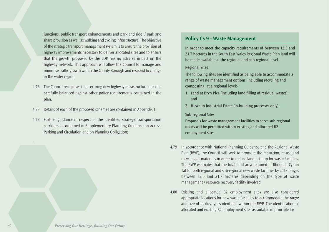
Preserving Our Heritage, Building Our Future40
junctions, public transport enhancements and park and ride / park andshare provision as well as walking and cycling infrastructure. The objectiveof the strategic transport management system is to ensure the provision ofhighway improvements necessary to deliver allocated sites and to ensurethat the growth proposed by the LDP has no adverse impact on thehighway network. This approach will allow the Council to manage andminimise traffic growth within the County Borough and respond to changein the wider region.
4.76 The Council recognises that securing new highway infrastructure must be
carefully balanced against other policy requirements contained in the
plan.
4.77 Details of each of the proposed schemes are contained in Appendix 1.
4.78 Further guidance in respect of the identified strategic transportation
corridors is contained in Supplementary Planning Guidance on Access,
Parking and Circulation and on Planning Obligations.
.4.79 In accordance with National Planning Guidance and the Regional Waste
Plan (RWP), the Council will seek to promote the reduction, re-use andrecycling of materials in order to reduce land take-up for waste facilities.The RWP estimates that the total land area required in Rhondda CynonTaf for both regional and sub-regional new waste facilities by 2013 rangesbetween 12.5 and 21.7 hectares depending on the type of wastemanagement / resource recovery facility involved.
4.80 Existing and allocated B2 employment sites are also consideredappropriate locations for new waste facilities to accommodate the rangeand size of facility types identified within the RWP. The identification ofallocated and existing B2 employment sites as suitable in principle for
Policy CS 9 - Waste Management
In order to meet the capacity requirements of between 12.5 and21.7 hectares in the South East Wales Regional Waste Plan land willbe made available at the regional and sub-regional level.-
Regional Sites
The following sites are identified as being able to accommodate arange of waste management options, including recycling andcomposting, at a regional level:-
1. Land at Bryn Pica (including land filling of residual wastes);and
2. Hirwaun Industrial Estate (in-building processes only).
Sub-regional Sites
Proposals for waste management facilities to serve sub-regionalneeds will be permitted within existing and allocated B2employment sites.
35580-52 LDP plan 2011_Layout 1 30/06/2011 11:17 Page 40
41Preserving Our Heritage, Building Our Future
waste management facilities, represents a substantial choice of sitescompared with the maximum estimated need of 21.7 hectares of landwhich the RWP calculates will be required for such facilities.
4.81 With regard to accommodating a range of facility types of different sizes,the Employment Land Review has identified 80 existing employment siteswith a B2 use. Taken together with the allocations within the LDP, it isconsidered that there is a sufficient range of sites available to contributeto an overall network of facilities. (Details of employment siteallocations are provided in Appendix1, part b) The location of suchemployment sites throughout the plan wrea is therefore consideredsufficient to meet identified needs at a sub-regional level and will permitthe provision of both open-air and in-building facilities.
4.82 Advances in technology and the introduction of new legislation, policies
and practices mean that many in-building modern waste management /
resource recovery facilities on the outside look no different to any other
industrial building. On the inside, they contain industrial de-
manufacturing processes or energy generation activities that are no
different to many other modern industrial processes in terms of their
operation and impact.
4.83 In line with the Regional Waste Plan (RWP) that provision should be made
for regional waste management facilities to serve more than one local
authority area, 2 sites have been identified for such provision: Hirwaun
Industrial Estate and land at the existing Bryn Pica Landfill Site. Both sites
are well located in relation to the strategic highway network and are
accessible within the plan area and to the wider region.
4.84 It is important that new development delivered through this LDP,
recognises the issues raised by former mining uses and how they can be
positively addressed through new development. Land instability and
mining legacy is not a complete constraint on the new development,
rather because mining legacy matters have been addressed, the new
development is safe, stable and sustainable. The aim of the LDP is on
tackling such issues for the benefit of local communities.
4.85 In relation to CS 9.2 it is essential that all proposals for development at the
site are fully informed by the constraints imposed by the nearby Special
Area of Conservation (SAC) and areas of high biodiversity significance. The
detailed environmental implications of any specific proposals will need to
be individually assessed and, where appropriate, proposals will need to
be accompanied by an Environmental Statement and Habitats Regulations
Assessment. Proposals for development will be carefully assessed for their
effect on the SAC and SINC.
4.86 The proximity of the National Park and the relationship of any new
development with it will be important considerations in assessing
proposals for wasterelated uses under policy CS 9.2.
4.87 Proposals for development will be carefully assessed for their effect on the
interests the National Park is designated to protect.
4.88 Waste management development in Hirwaun Industrial Estate will be
limited to in-building facilities to minimise visual and ecological impact.
Open-air waste management facilities can be accommodated at the Bryn
Pica site in view of its existing use as an operating waste facility.
4.89 It should be noted that in identifying Hirwaun Industrial Estate as a
suitable site for waste management facilities, it is not the intention that the
employment uses at the site should cease. The Council will continue to
support the employment use of the site and any proposals for alternative
uses will be considered in accordance with AW 11.
35580-52 LDP plan 2011_Layout 1 30/06/2011 11:17 Page 41

Preserving Our Heritage, Building Our Future42
4.90 The extraction of mineral resources raises issues of wide ranging
importance. Minerals impact upon all aspects of our lives, providing
resources for construction, roads, energy and our household and
commercial needs.
4.91 Quarrying and mining extraction can have major impacts upon the
environment and landscape and yet are crucial to the nation’s economy.
4.92 The LDP minerals policies will balance the need for the safeguarding of
nationally, regionally and locally important mineral resources whilst
considering their appropriate extraction against the potential impact of
such development on residential and sensitive occupiers, the landscape
and on sites of nature conservation interest.
4.93 It is important that new development delivered through the LDP,
recognizes the issues raised by former mining uses and how these issues
can be positively addressed. Land stability and mining legacy are not
necessarily constraints to redevelopment. Once mining legacy matters
have been addressed, the new development will therefore be safe, stable
and sustainable.
4.94 National Planning Policy and advice relating to the supply, safeguarding
and extraction of minerals are specifically outlined in Minerals Planning
Policy Wales, Minerals Technical Advice Note 1: Aggregates and Technical
Advice Note 2: Coal.
4.95 National guidance identifies the need to consider the effect of extraction
proposals in areas of high nature conservation value, as well as within
landscapes of recognised importance.
4.96 Further consideration is given as to where extraction is deemed
inappropriate with regards to its effect on residential areas and other
sensitive development uses. National policy in respect of aggregates,
describes distances from mineral operations where residential and other
sensitive use developments may not take place. These principles also apply
to the restriction of aggregate extraction within these prescribed distances
from settlements i.e. no Sandstone or Limestone extraction within 200
Policy CS 10 - Minerals
The Council will seek to protect resources and to contribute to thelocal, regional and national demand for a continuous supply ofminerals, without compromising environmental and social issues,by;
1. Maintaining a minimum 10 year landbank of permitted rockaggregate reserves throughout the plan period (to 2021),together with an extended landbank in the form of a PreferredArea of Known Mineral Resource;
2. Defining safeguarding areas for mineral resources, includingcoal, high quality hard rock, limestone and sand and gravel,taking into account the range, quality and extent of resourcesand environmental, planning and transportationconsiderations;
3. Where proven resources are under threat from sterilisation bynecessary development, the pre-working of the mineralresource will be encouraged;
4. Ensuring that appropriate restoration and aftercare measuresare incorporated;
5. Promoting efficient usage, minimising production of waste,and promoting alternatives to primary won aggregates;
6. Ensuring that impacts upon residential areas and sensitiveland uses from mineral operations and the transportation ofminerals are limited to an acceptable proven safe limit.
35580-52 LDP plan 2011_Layout 1 30/06/2011 11:17 Page 42
43Preserving Our Heritage, Building Our Future
metres of settlements and no Sand and Gravel extraction within 100 metres
of settlements. With regards to Coal, national policy prevents its extraction
within 500 metres of settlements.
4.97 There is, however, some scope identified within national guidance where
exceptional circumstances of a particular proposal may allow for the
reduction in the above standard distances.
4.98 Any minerals planning applications would also be subject to a range of
area wide policies and their objectives throughout the LDP. These policies
include AW 4, AW 5, AW 8 and AW 10. Applications would also be
considered against any site specific land allocations in the LDP.
4.99 ‘Settlements’ are recognised by the LDP as those areas with identified
Settlement Boundaries and other established settlements of 10 units or
more (A list of these settlements without Settlement Boundaries is
contained in Appendix 1. part F). Smaller settlements, other sensitive land
uses and individual buildings will also be subject to national and local
policy considerations.
4.100 A Minerals Background Paper has been prepared for the LDP to outline
current and future minerals circumstances in Rhondda Cynon Taf. Further
detail on the landbank process, safeguarding intentions and buffer zones,
amongst other minerals issues, are set out in this Paper.
35580-52 LDP plan 2011_Layout 1 30/06/2011 11:17 Page 43

Preserving Our Heritage, Building Our Future44
35580-52 LDP plan 2011_Layout 1 30/06/2011 11:17 Page 44

Preserving Our Heritage, Building Our Future
Area Wide Policies
Chapter Five
5.1 This chapter sets out the detailed Area Wide Policies, which in
conjunction with the LDP Core Policies, the LDP strategy specific
policies and national planning policies are the basis for the
determination of planning applications for the development and use
of land and buildings. These policies are an essential element of the
Council’s spatial strategy and are intended to ensure that development
accords with the visual and spatial objectives of the plan.
5.2 Each policy is shown in bold followed by justification and expansion of
the preferred policy approach. A more detailed assessment of the
impact of various policy approaches is contained in the SA / SEA
Environmental Report.
45
1. The allocations of this plan;
2. The development of sites in Rhondda Cynon Taf whereplanning permission for housing has been granted since 1stJune 2006;
3. The development of unallocated land within the definedsettlement boundaries of the Principal Towns, KeySettlements and Smaller Settlements;
4. The provision of affordable housing;
5. The conversion of suitable structures to provide housing; and
6. The development of land at density levels which accord withthe requirements of Policies NSA 10 and SSA 11.
Residential development proposals will be expected tocontribute to meeting local housing needs. Where a communityhousing need has been established, the local planning authoritywill seek the provision of affordable housing in accordance withpolicies NSA 11 and SSA 12.
Policy AW 1 - Supply of New Housing
In order to meet the housing land requirement of 14,385 provision
will be made for the development of between 14,936-15,386 new
dwellings in Rhondda Cynon Taf during the period up to 2021. This
will be met by:-
35580-52 LDP plan 2011_Layout 1 30/06/2011 11:17 Page 45

Preserving Our Heritage, Building Our Future
5.3 Population projections indicate that the number of households in South
East Wales will increase by 108,900 between 2003 and 2023. In order to
accommodate this growth, the LDP will allocate land for between 14,936-
15,386 new dwellings to be constructed throughout Rhondda Cynon Taf.
In doing so policy AW1 will provide for a supply of a higher number of
dwellings than required by policy CS4 in case some of the committed,
allocated or other sites do not deliver the anticipated number of dwellings
within the plan period. This is a high rate of growth and will result in an
increase in the house building rate from 660 to 959 per annum. The
construction and distribution of this number of dwellings will assist in
halting the process of depopulation and ensure a stable growth in the
future population. Statistical analysis and background to the dwelling
requirement figure is contained in the Population and Household
Projections Study (2006), the Housing Topic Paper (2007) and the housing
Delivery Background Paper (2009).
5.4 The Council in partnership with the other 10 authorities in South East
Wales has been involved in the process of apportioning housing land
requirement for the region. The housing requirement figure in Policy CS 4
accords with the agreed housing apportionment for South East Wales.
5.5 The Joint Housing Land Availability Study (April 2007) indicates that
Rhondda Cynon Taf had a residential land supply of 2,668 dwellings on
large sites (10 dwellings and over) at April 2007, excluding constrained
sites. In addition, 391 dwellings had been built on large sites between the
LDP base date (June 2006 and April 2007). For small sites, the April 2007
study shows that 74 dwellings were built on small sites between June 2006
and April 2007. This study assumes that dwellings on small sites will be
built at a rate of 660 per five years, which equates to a potential
contribution of 1,848 dwellings in the 14 years from 2007 to 2021. An
estimate has been made of the potential contribution of dwellings from
windfall sites, i.e. sites for 10 or more dwellings not identified at April 2007.
Based on experience of the 10 years from June 1997 to April 2007, it is
assumed that an average of 70 dwellings per annum will be completed on
windfall sites, totalling 980 dwellings between 2007 and 2021. Conversion
of existing permanent buildings within settlements such as religious, retail
and community buildings and permanent buildings in the countryside
such as vacant agricultural or industrial buildings are also likely to make
a small contribution to overall housing during the plan period.
5.6 It must be noted that should planning permission for a site lapse,
applications to renew that planning approval will be assessed against the
policies in the LDP.
5.7 In order to provide sufficient land to accommodate the projected growth,
the LDP will therefore provide a policy framework for the construction of
new dwellings.
Capacity of large sites available 2007 2,668
Dwellings built on large sites 2006-07 391
Dwellings built on small sites 2006-07 74
Potential from small sites 2007-21 1,848
Potential from windfall sites 2007-21 980
LDP provision for new housing sites 9,025 - 9,475
Total Dwelling supply 2006-21 14,936 - 15,386
46
35580-52 LDP plan 2011_Layout 1 30/06/2011 11:17 Page 46

47Preserving Our Heritage, Building Our Future
5.8 The need to ensure more sustainable forms of development, are central tothe objectives of the Plan, the Preferred Strategy and the allocated sites.
5.9 All development sites must contribute to delivering the objectives of thePlan. Where sites are proposed for development on unallocated sites, it isessential that they meet the same sustainability criteria that were used toassess the allocated sites in the Plan. Development proposals with thepotential to affect the Borough’s natural heritage will be consideredagainst AW 8. Proposals affecting green wedges will be considered againstNSA 24 and SSA 22 and proposals affecting Special Landscape Areas againstNSA 25 and SSA 23 as appropriate.
5.10 This policy will ensure that where unallocated sites come forward fordevelopment, those considered to be unsustainable locations for newdevelopment will be resisted. This policy will also provide flexibility toidentify new sites for development, should they be required over the lifeof the Plan. Applications for Rural Enterprise Dwellings away fromestablished settlements will be considered in accordance with PlanningPolicy Wales and Technical Advice Note 6: Planning for Sustainable RuralCommunities (July 2010).
5.11 Key services and facilities include schools, local shops and services, GPs,dentists and community facilities.
Policy AW 2 - Sustainable Locations
In order to ensure that development proposals on non-allocated sitessupport the objectives of the plan, development proposals will onlybe supported in sustainable locations. Sustainable locations aredefined as sites that:–
1. Are within the defined settlement boundary or in the NorthernStrategy Area, accord with Policy NSA 12;
2. Would not unacceptably conflict with surrounding uses;
3. Have good accessibility by a range of sustainable transportoptions;
4. Have good access to key services and facilities;
5. Do not permit highly vulnerable development and EmergencyServices within Zone C2 floodplain. Within Zone C developmentwill be permitted where it can be justified that: -
a) It is necessary to assist the regeneration of a PrincipalTown or Key Settlement including the key employmentobjectives, or where development involves a largebrownfield site.
b) he potential consequences of a flooding event have beenconsidered and found to be acceptable in accordance withnational guidance and meet the definition of previouslydeveloped land.
6. Support the roles and functions of the Principal Towns, KeySettlements and Small Settlements;
7. Support the development of the 8 Strategic Sites;
8. Are well related to existing water, sewerage, waste, electrical,gas and telecommunications infrastructure and improvementsto such services will be provided where necessary.
9. Where proposals relate to existing buildings in the countryside,accord with AW 9.
35580-52 LDP plan 2011_Layout 1 30/06/2011 11:17 Page 47

Preserving Our Heritage, Building Our Future48
5.12 The aim of this policy is to allow Registered Social Landlords to provideaffordable housing in areas where there is an identified local need. TheCouncil’s preference will always be for development to take place withindefined settlement boundaries. However, it is recognised that factors suchas the availability of land and high land values, may mean that it may notbe possible to deliver affordable housing within the defined settlementboundaries.
5.13 In permitting the development of affordable housing in these locations,the Council will require Registered Social Landlords to demonstrate whydevelopment cannot take place within the defined settlement boundariesand that appropriate mechanisms are in place to ensure the units aresecured in perpetuity.
5.14 Locally designated nature conservation sites include Sites of Importance forNature Conservation, Local Nature Reserves and Wildlife Trust NatureReserves.
5.15 Planning obligations will be sought only where they meet the tests setout in Welsh Office Circular 13/97 and Planning Policy Wales.
Policy AW 3 – Exception Sites For AffordableHousing in the Countryside
Development proposals for the provision of affordable housingoutside and adjoining the identified settlement boundaries will bepermitted where it can be demonstrated that:
1. The proposed development cannot be accommodated withinthe defined settlement boundaries;
2. The site does not exceed 30 dwellings or 1 hectare;
3. The proposed development is solely for the provision ofaffordable housing to meet an identified local need;
4. The proposed development is not within a Green Wedge, SpecialLandscape Area or within, near or adjacent to aninternationally, nationally or locally designated natureconservation site.
Policy AW 4 – Community Infrastructure &Planning ObligationsPlanning obligations may be sought where development proposalsrequire the provision of new, improved or rely on existing services,facilities, infrastructure and related works, to make the proposalacceptable in land use planning terms. Contributions may be soughtin respect of:
1. Affordable housing;
2. Physical infrastructure works;
3. Open space, sport / play space and access to naturalgreen space;
4. Educational facilities;
5. Recreational and leisure facilities;
6. Management of Strategic Transport Corridors;
7. Public transport facilities and services;
8. Travel plan initiatives;
9. Highway infrastructure works;
10.Walking and cycling schemes;
11.Waste management and recycling;
12.Renewable energy and energy efficiency initiatives.
13.Environmental and landscape improvements;
14.Nature conservation;
15.Public Art;
16.Culture and community facilities; and
17.Any other contribution the Council considers appropriate to thedevelopment.
35580-52 LDP plan 2011_Layout 1 30/06/2011 11:17 Page 48

49Preserving Our Heritage, Building Our Future
5.16 New development will often require new or rely on existing infrastructure,
services and facilities to make proposals acceptable in land use planning
terms. By ensuring that the needs of existing and future communities are
fully considered, the Council will ensure that sustainable, well-designed
places are created that support the needs of the community and promote
well-being.
5.17 It is an established principle of the planning system that development
should fund or contribute to the provision of infrastructure, services and
facilities that new development will rely on. Planning obligations are a
means by which contributions can be secured to enhance the quality of a
development and help limit the negative impact development may have
on local facilities, services and features. A planning obligation is a legally
binding agreement entered into between a local authority and a
developer. It provides a requirement for the developer to provide outlined
works or services and to help mitigate any negative impacts that may arise
as a consequence of the development.
5.18 In April 2010, Central Government introduced the Community
Infrastructure Levy (CIL). The CIL introduces a tariff-based approach to the
delivery of infrastructure. Following the adoption of the LDP the Council
will give detailed consideration to the appropriateness of preparing a CIL
plan.
5.19 Details of the types of obligation that may be sought by the Council are
detailed in the SPG on Planning Obligations. The SPG sets out the types of
contribution that will be sought, the types of development to which they
will apply and the trigger points where contributions will be required.
5.20 The provision of the key infrastructure identified in Policy CS 8 and the
social, economic and environmental infrastructure that will support the
development of the 8 Strategic Sites outlined in Policy CS 3 are integral to
the implementation of the Core Strategy for the LDP. Planning obligations
will be sought to deliver this key infrastructure and support the delivery of
the Strategy.
5.21 The Council will consider, where appropriate, development areas that may
be larger than the application site. This will ensure that where sites are
developed on a piecemeal basis, a fair and reasonable level of contribution
is secured.
5.22 The Council recognises that contributions for the provision of social,
economic and environmental infrastructure are essential to the delivery of
the LDP core strategy. There will be a presumption that development will
not be permitted unless appropriate planning obligations are secured.
Requests for contributions will however, be carefully balanced and will
only be requested where they are reasonable, realistic and necessary.
5.23 Proposals will be considered on a site-by-site basis. Where it is submitted
that a requirement to deliver appropriate planning obligations would
result in a site being economically unviable, the Council will require
verifiable objective evidence of the adverse financial appraisal, taking into
account any grant availability. Whilst the planning obligations sought
would enhance the quality of development, if the evidence demonstrates
conclusively that requiring them would result in a proposal being unviable,
the Council may conclude that the benefits of the development outweigh
the benefits of seeking to secure a higher quality scheme, in preference to
refusing planning permission.
35580-52 LDP plan 2011_Layout 1 30/06/2011 11:17 Page 49

Preserving Our Heritage, Building Our Future
5.24 In respect of affordable housing the Council appreciates that in exceptional
circumstances where there are significant abnormal costs associated with
a development, the provision of affordable housing may make a site
unviable for development, particularly if it would reduce the site’s land
value to below its value either in its existing use or in an alternative use
that could be realistically carried on without a requirement for planning
permission. Where site viability is considered to be an issue, developers
will be required to provide to the Council details of:
• The acquisition price of the site and the date of that acquisition or date
of an option to acquire the site;
• The current existing use value and any alternative use value;
• Projected construction costs;
• Other costs;
• The date when the housing is expected to be delivered;
• Forecast final sales value per unit; and
• The developer’s reasonable profit requirement.
5.25 The Council will then use a Development Appraisal Toolkit to examine the
economics of the development and determine the viability of affordable
housing provision. Where the developer can demonstrate that the
provision of the full affordable housing required would not be viable,
consideration should be given first to equivalent off-site provision and only
then to the negotiation of reduced provision on- or off-site. However,
developers must recognise that the requirement is to provide affordable
housing on private market sites. Whilst historic land acquisition costs may
influence the owner’s assessment of viability, consideration is also required
to current and future land and development values to ensure that the
appropriate level of affordable housing is secured at the time that the
housing is to be delivered.
50
Policy AW 5 - New Development
Development proposals will be supported where:-
1) Amenity
a) The scale, form and design of the development would have
no unacceptable effect on the character and appearance of
the site and the surrounding area;
b) Where appropriate, existing site features of built and natural
environment value would be retained;
c) There would be no significant impact upon the amenities of
neighbouring occupiers;
d) The development would be compatible with other uses in
the locality;
e) The development would include the use of multi-functional
buildings where appropriate;
f) The development designs out the opportunity for crime and
anti social behaviour.
2) Accessibility
a) The development would be accessible to the local and wider
community by a range of sustainable modes of transport;
b) The site layout and mix of uses maximises opportunities to
reduce dependence on cars;
c) The development would have safe access to the highway
network and would not cause traffic congestion or
exacerbate existing traffic congestion;
d) Car parking would be provided in accordance with the
Council’s Supplementary Planning Guidance on Delivering
Design and Placemaking: Access, Circulation and Parking
Requirements.
35580-52 LDP plan 2011_Layout 1 30/06/2011 11:17 Page 50

51Preserving Our Heritage, Building Our Future
5.26 In order to assess access and transport issues fully, transport assessments
will be required for development proposals on all allocated sites and where
the Council considers that proposals are likely to have significant transport
implications. Guidance on transport assessments is contained in the SPG
on Access, Circulation and Parking.
5.27 The LDP will deliver major new development over the life of the plan. In
addition to the eight Strategic Sites, the LDP includes proposals for
significant new areas of housing, employment and commercial
development. It is essential that these new developments create high
quality environments, if both our and future generations are to live in
communities that are attractive, liveable, inclusive, safe and enjoyable
places to live.
5.28 In addition to larger areas of planned change, the Council recognises that
smaller-scale developments cumulatively and over time, can have a
significant impact upon the appearance and quality of our communities.
Rhondda Cynon Taf registers approximately 2,200 planning applications
per annum. By ensuring that each proposal appropriately and reasonably
contributes to creating a high quality environment, the Council will ensure
that all proposals contribute to creating quality places.
5.29 All new development should be highly accessible. Walking and cycling have
an important role to play in the management of movement across the
County Borough, particularly reducing the number of short trips taken by
car. Developers will be required to ensure that new developments
encourage walking and cycling by giving careful consideration to location,
design, access arrangements, travel ‘desire lines’ through a development,
and integration with existing and potential off-site links. Providing safe
and convenient walking and cycling environments will help tackle health
problems associated with physical inactivity, and social exclusion factors
arising from car dependency, poor access to services and public transport
facilities.
5.30 Encouraging the multiple uses of buildings will further reduce the need to
travel and maximise the locational advantages of existing buildings, which
are often at the heart of communities.
5.31 The provision for car parking is a major influence on the choice of means
of transport and the pattern of development. The Council will seek to
restrict developments that generate a high level of trips (e.g. offices, shops
and leisure uses) to locations well served by public transport. Moreover,
provision for parking will be reduced in line with improvements in public
transport accessibility. Further guidance in respect of car parking is
contained in Supplementary Planning Guidance on Access, Circulation and
Parking.
5.32 The Welsh Government promotes the widespread adoption of Travel Plans
by businesses, schools, hospitals, tourist attractions, major residential
developments and other significant travel-generating uses to help ensure
efficient management of the highway network and promote alternative
modes of transport. The need for a travel plan will be identified early on as
part of the pre-application or scoping discussions with the Local Planning
Authority. Detailed guidance in respect of scope and contents of Travel
Plans is contained in Supplementary Planning Guidance on Access,
Circulation and Parking.
5.33 Key national policy and guidance in relation to climate change, flooding
and sustainable buildings is contained in Planning Policy Wales, TAN 15:
Development and Flood Risk (2004) and TAN 22: Sustainable Buildings
(2010).
35580-52 LDP plan 2011_Layout 1 30/06/2011 11:17 Page 51
Preserving Our Heritage, Building Our Future52
Policy AW 6 - Design and Placemaking
Development Proposals will be supported where:-
1. They are of a high standard of design, which reinforces attractive
qualities and local distinctiveness and improves areas of poor
design and layout;
2. They are appropriate to the local context in terms of siting,
appearance, scale, height, massing, elevational treatment,
materials and detailing;
3. In the case of extensions to buildings, they reflect, complement or
enhance the form, siting, materials, details and character of the
original building, its curtilage and the wider area;
4. In the case of proposals for new and replacement shop fronts and
signage, they make a positive contribution to the streetscene;
5. In the public realm and key locations such as town centres, major
routes, junctions and public spaces, the character and quality of
the built form is to a high standard of design;
6. They include public art;
7. Landscaping and planting are integral to the scheme and enhance
the site and the wider context;
8. They include an integrated mixture of uses appropriate to the
scale of the development;
9. They include the efficient use of land, especially higher-density
residential development on sites in proximity to local amenities
and public transport;
10. Open space is provided in accordance with the Fields in Trust
Standards;
11. A high level of connectivity and accessibility to existing centres,
by a wide range of modes of sustainable transport;
12. Schemes incorporate a flexibility in design to allow changes in
use of buildings and spaces as requirements and circumstances
change;
13. The development reflects and enhances the cultural heritage of
Rhondda Cynon Taf;
14. The design protects and enhances the landscape and
biodiversity;
15. The development promotes energy efficiency and the use of
renewable energy; and
16. The design promotes good water management, including
rainwater storage, sustainable urban drainage, porous paving etc.
Developers will be required to submit comprehensive masterplans
for residential proposals of 50 dwellings and over; for commercial
developments of 10,000m2 net and over; and for schemes where the
Council considers the issue of place making can only be fully
considered through the submission of a masterplan. Masterplans
must have regard to the need to create high quality, sustainable and
locally distinct places.
35580-52 LDP plan 2011_Layout 1 30/06/2011 11:17 Page 52

53Preserving Our Heritage, Building Our Future
5.34 The Council is committed to raising the standard of design on all new
developments across the County Borough. The erosion of local
distinctiveness is a widespread concern. Whilst very different traditional
characteristics exist between the northern and southern parts of the
County Borough, recent developments have often been uniform and lack
any acknowledgement of these characteristics. Rhondda Cynon Taf has a
strong culture and heritage and it is important that the traditional
character of the County Borough is respected and enhanced through
design.
5.35 ‘Placemaking’ is a key element of achieving sustainable development
through the creation of well-designed places, which are able to stand the
test of time. These areas will have reduced dependence on cars, quality
streets and spaces and the right mix of uses to help build strong
communities. Rhondda Cynon Taf has an opportunity to ensure that new
development achieves social, economic and environmental sustainability
and to create places that are socially inclusive.
5.36 The creation of walkable neighbourhoods and the nature of the spaces
between buildings will be primary considerations. However small, they
should be useful, connected, safe and landscape designed. Well-designed
site planning forms the foundation for good architecture. The Design and
Placemaking policy will complement the positive approach to energy
efficiency and conservation measures in both the location and design of
new developments.
5.37 Open spaces, whether formal sports areas, informal public open spaces ornatural green spaces, have been acknowledged as playing a significant rolein improving and maintaining peoples physical and mental health andwell-being. This is of particular importance in Rhondda Cynon Taf, giventhe identified health problems across the County. New or improved openspaces and more accessible natural green spaces will serve as valuablerecreational assets to local communities and may encourage people fromoutside the community to visit the area. With regard the provision offormal play space, the Council will require new developments to meet theFields in Trust standards.
35580-52 LDP plan 2011_Layout 1 30/06/2011 11:17 Page 53

Preserving Our Heritage, Building Our Future
5.38 The identified Strategic Sites are a key element of the LDP Strategy andtheir delivery will have significant benefits to all communities in RhonddaCynon Taf. To ensure that best use is made of these sites and high qualitysustainable development is delivered; the Council has prepared a ConceptStatement for each, setting out the key elements of spatial form, requiredmix of uses and design principles. These Concept Statements will form thestarting point for developers in the preparation of the requiredMasterplans for the sites. Where appropriate development should addressthe legacy of any former uses including in relation to ground stability.
5.39 Residential sites of 50 dwellings and over and commercial proposals of10,000m2 net and over will have the potential for considerable impact atCounty Borough level. The Council is keen to ensure that best use is madeof these sites and a high quality development is achieved. Accordingly, amasterplan led approach to new development will be required fordevelopments of this size.
5.40 Detailed guidance in respect of place making, site planning, design andmaster planning is contained in Supplementary Planning Guide (SPG) onDesign and Place Making.
5.41 The impact of smaller scale development and its effect on the characterand appearance of an area is equally important. Rhondda Cynon Tafregisters an average of 1000 householder planning applications every year.In many parts of the area, both the impact of individual alterations todwellings and the cumulative impact of developments within an area havehad a considerable impact upon the character and appearance ofcommunities. This impact is further compounded in parts of the area,where the distinct topography results in even small-scale householderdevelopment being highly visible over considerable distances.
5.42 The Council recognises the desire of occupants to stay within communitiesby adapting and upgrading their dwellings as their life style and personalneeds change. However the changes must be balanced against the mannerin which works to existing properties both individually and collectively,have an effect on the character of an area. It is important in the interestsof good design and to safeguard the character of an area, that suchextensions are well designed, in relation to the main building and thegeneral street scene. Extensions should be subservient to the originalbuilding and where possible significant alterations and extensions shouldbe confined to the rear and side elevations.
5.43 Detailed guidance in respect of householder applications is contained inthe Design Guide for Householder Development SPG.
5.44 The success of Rhondda Cynon Taf’s commercial centres, including thosewithin the Principal towns and Key Settlements, is crucial to the deliveryof the objectives of the LDP. Shop fronts and commercial frontages are anessential element of the commercial activity of Rhondda Cynon Taf’s townand local centres and there is constant pressure to update and modifythem. If the visual quality of the area’s shopping streets is to be enhanced,well-designed shop fronts built with good quality materials are essential.Design, proportion and scale of the shop front relates to both the buildingitself and to adjoining buildings. In sensitive locations such as ConservationAreas corporate styles may be unacceptable.
5.45 Rhondda Cynon Taf has a strong cultural heritage and the Council is keento ensure that new developments continue to add to the cultural fabric ofthe area. In considering proposals for public art as part of developmentschemes, the Council will seek artist commissions that add cultural valueto the architecture, landscape design and sense of place. Public art may beintegrated with the built or natural environment of the site. Where the
54
35580-52 LDP plan 2011_Layout 1 30/06/2011 11:17 Page 54

Council has an adopted strategy incorporating public art, it may negotiatecontributions to or the provision of, off-site installation of public art inpublic spaces to support these wider initiatives.
5.46 Further guidance in respect of shop fronts and public art is contained inthe SPG on Design and Place Making.
5.47 The Welsh language is integral to the identity, culture and history of Wales.Whilst Rhondda Cynon Taf does not have a large Welsh speakingpopulation as found in other parts of the Country, the Council is keen toensure that the spatial planning system protects and enhances Welshculture and language where possible.
5.48 It is considered that there is currently no need for a specific LDP policy forthe Welsh language. The aims of protecting and enhancing the culture andheritage of the area can be secured through design and placemaking andother policies in the LDP, such as the Protection and Enhancement of theBuilt Environment and Community Infrastructure. The Council will alsorequire that development proposals for the 8 Strategic Sites demonstratehow the interests of Welsh culture and where appropriate language hasbeen integrated into proposed schemes.
5.49 The historic built environment and the man made features ofarchaeological, historic or architectural interests are integral to the qualityof the County Borough’s environment. They are unique to Rhondda CynonTaf and trace the development of the area over time. Areas of recognisedarchitectural and / or historical merit or sites of archaeological importanceinclude listed buildings and conservation areas and their settings,registered historic landscapes and historic parks and gardens and theirsettings; and archaeological remains. The Plan area has 86 scheduledancient monuments, 366 listed buildings buildings (at the time of thepreparation of the LDP), 16 conservation areas, 1 registered historiclandscape and 5 registered historic parks and gardens, all of whichcontribute to the rich and diverse nature of the area. Over the plan period,the Council will, where appropriate, seek to implement enhancement andmanagement schemes to improve the character, quality and appearanceof these recognised heritage features.
Preserving Our Heritage, Building Our Future 55
Policy AW 7 - Protection and Enhancement of theBuilt Environment
Development proposals which impact upon sites of architectural and
/ or historical merit and sites of archaeological importance will only
be permitted where it can be demonstrated that the proposal would
preserve or enhance the character and appearance of the site.
Development proposals which affect areas of public open space,
allotments, public rights of way, bridleways and cycle tracks will only
be permitted where it can be demonstrated that :-
1. There is a surplus of such facilities in the locality, or;
2. The loss can be replaced with an equivalent or greater provision
in the immediate locality; or
3. The development enhances the existing facility.
35580-52 LDP plan 2011_Layout 1 30/06/2011 11:17 Page 55
Preserving Our Heritage, Building Our Future
5.50 In addition to these formally recognised buildings and areas, there are
individual buildings, groups of buildings and features, which whilst not
subject to formal recognition, make an important contribution to the
character and appearance of local communities. This policy will be used
to ensure that these important features are protected and enhanced.
5.51 Public open space includes all land that is available for use by the public
for informal and formal recreational and leisure use. Public open space
provision in Rhondda Cynon Taf includes a range of urban and country
parks, common land, community sport and recreation grounds and
facilities and children’s play areas. It is recognised that all these spaces
play a key role in Rhondda Cynon Taf, given its largely urban population,
providing important facilities, which offer the opportunity to improve the
health and well-being of residents. Public open space in Rhondda Cynon
Taf lies both within and outside of the settlement boundaries and as such
has the potential to come under significant pressure for development. This
policy will protect important public open space from unacceptable
development and retain it for use by the communities they serve.
5.52 The County Borough has approximately 2,000 individual paths with a total
length of 743km, of which, 646km are footpaths, 82km are bridleways and
15km are by-ways open to all traffic. There are also 50 km of off-road cycle
tracks. The built form of the County Borough means that most people have
good access to the rights of way and bridleways network and subsequent
open countryside. This ready access helps promote health and well-being
in the community, by providing an opportunity for all sectors of the
population to access the countryside for recreational purposes. In order
to ensure that the good standard of access to the countryside is
maintained, the Council will seek improvements to existing public rights
of way and cycle tracks where appropriate. These improvements will
include the provision of additional routes, improvements for users with
disabilities, restoration and maintenance.
5.53 The provision of allotment gardens within or adjacent to urban areas is
part of the traditional make up of Rhondda Cynon Taf. The Council
currently owns and manages 60 allotment sites, with many more sites in
private ownership. Allotment space provides many members of the
community with an opportunity to take beneficial exercise, in the open
air and produce a supply of healthy food. This is particularly important in
deprived communities. The location of these sites, within or adjacent to
settlement boundaries, means that land is inevitably under pressure for
alternative uses. The Council will resist the redevelopment of these sites for
alternative uses unless the requirements of the policy are met. Where it is
proposed to develop land used as statutory allotments for purposes other
than as allotments, the consent of the National Assembly for Wales is
required under Section 8 of the Allotments Act 1925.
56
35580-52 LDP plan 2011_Layout 1 30/06/2011 11:18 Page 56

57Preserving Our Heritage, Building Our Future
5.54 Rhondda Cynon Taf is an area with a rich and diverse natural environment.
There are three Special Areas of Conservation at Blaen Cynon, (part), Cardiff
Beechwoods (part) and Coedydd Nedd a Mellte (part) and 14 Sites of Special
Scientific Interest (see Appendix 2). In a Wales context, the County Borough
is of particular importance with over 20% of the area being classified as
Priority Habitat and the extent and diversity of semi-natural habitat, is
very high. The Welsh Government is committed to halting biodiversity loss
by 2010. The policy aims to protect and enhance the diversity and
abundance of these wildlife habitats and the native species that depend
on them. Planning proposals that affect internationally and nationally
designated sites will be assessed in accordance with National Planning
Policy.
5.55 For the purpose of the policy, locally designated sites comprise of Sites of
Importance for Nature Conservation (SINC), Local Nature Reserves and
Wildlife Trust Nature Reserves and Regionally Important Geological Sites
(RIGS).
5.56 Where development is permitted, planning conditions and / or obligations
will be used to protect or enhance the natural heritage. Where the benefits
of development outweigh the conservation interest, mitigation will be
required to offset adverse effects (including negative effects on adjacent
land). To ensure that there is no reduction in the overall nature
conservation value of the area or feature, compensation measures
designed to conserve, enhance, manage and, where appropriate, restore
locally distinctive natural habitats and species should be provided. Further
information on planning obligations and nature conservation is contained
in TAN 5: Nature Conservation and Planning (2009) and the SPG on Nature
Conservation.
Policy AW 8 - Protection And Enhancement Of TheNatural Environment
Rhondda Cynon Taf’s distinctive natural heritage will be preserved andenhanced by protecting it from inappropriate development.Development proposals will only be permitted where:-
1. They would not cause harm to the features of a Site of Importancefor Nature Conservation (SINC) or Regionally Important GeologicalSite (RIGS) or other locally designated sites, unless it can bedemonstrated that:-
a)The proposal is directly necessary for the positive managementof the site; or
b)The proposal would not unacceptably impact on the features ofthe site for which it has been designated; or
c) The development could not reasonably be located elsewhere andthe benefits of the proposed development clearly outweigh thenature conservation value of the site.
2. There would be no unacceptable impact upon features ofimportance to landscape or nature conservation, includingecological networks, the quality of natural resources such as air,water and soil, and the natural drainage of surface water.
All development proposals, including those in built up areas, that mayaffect protected and priority species will be required to demonstratewhat measures are proposed for the protection and management ofthe species and the mitigation and compensation of potential impacts.Development proposals must be accompanied by appropriateecological surveys and appraisals, as requested by the Council.
Development proposals that contribute to the management ordevelopment of Ecological Networks will be supported.
35580-52 LDP plan 2011_Layout 1 30/06/2011 11:18 Page 57

Preserving Our Heritage, Building Our Future
5.57 Locally distinctive landscape features, including trees, woodland,
hedgerows, river corridors, ponds, wetlands, stone walls, ffridd and species
rich grassland, green lanes, peat bogs, heathland and common land are
also important for biodiversity. The Welsh Government has produced a list
of habitats and species of principal importance for the conservation of
biodiversity in Wales. 24 priority habitats and a large number of priority
species (>114) on this list are known to occur in Rhondda Cynon Taf. These
will also be protected in line with this policy.
5.58 It is important to maintain and enhance ecological networks of natural and
semi-natural habitats that have a high degree of connectivity. Small,
isolated populations of species are more vulnerable to extinction than
populations that can disperse and interbreed with other populations. The
effects of climate change are likely to increase local extinctions among small
isolated populations. The Habitat Regulations require planning policies
which conserve features of the landscape that are of major importance for
wild flora and fauna, including those linear features that are essential for
the migration, dispersal and genetic exchange of wild species.
Interpretation of this policy should have regard to relevant studies that
identify important areas for ecological connectivity. At a regional level (SE
Wales), there are two ecological network studies currently underway (2008).
Locally, the Cynon Valley River Park strategy has identified important
ecological networks as part of a broader study (see NSA 26). The presence
of protected species is a material planning consideration and development
proposals must be informed by appropriate survey and appraisal.
5.59 The Council has prepared Supplementary Planning Guidance on Nature
Conservation which includes further information in support of the policy,
detailed criteria for site designation and the procedure to be followed in
considering planning applications.
5.60 Buildings in the countryside are important to the overall landscapecharacter and quality of the County Borough. The Council will support there-use of buildings where they are structurally sound and the worksrequired to accommodate the new uses, including the effect of any accessworks on hedges and walls, are in scale with the building and widerlandscape. Where the conversion of a building to residential use isproposed, the Council will consider carefully the architectural and / orhistoric merits of the building. Not all buildings make a positivecontribution to the character and quality of the countryside and are notnecessarily worthy of retention. All planning applications for the alteration,renovation or conversion of buildings in the countryside must beaccompanied by an appropriate ecological survey.
58
Policy AW 9 - Buildings in the Countryside
In the case of the alteration, renovation or conversion of existing
buildings outside the defined settlement boundaries for residential,
employment, community or tourism uses, development proposals
will be supported where:-
1. The existing building is structurally sound or is capable of being
made so without substantial major external alteration or
reconstruction;
2. In the case of residential use, it can be demonstrated that there
are no viable alternative uses to secure the retention of the
building and that the building is of architectural and / or
historical merit.
35580-52 LDP plan 2011_Layout 1 30/06/2011 11:18 Page 58

59Preserving Our Heritage, Building Our Future
5.61 Where significant alteration in the character of the existing building isproposed, or where the buildings are so derelict that substantial orcomplete rebuilding is required, this will be treated as a new developmentin the countryside.
5.62 The character of new works could be traditional or contemporary providedthey are rural in character and compatible with the existing character ofthe building. When converting rural buildings the presence of bats andowls may be an issue and must be thoroughly investigated. Designrevisions may be required as a result of relevant investigations. Appropriate“community uses” include village halls, religious uses and communitycentres. Retail uses would not be permitted under AW 9.
5.63. Pollution may cause significant damage to human health, quality of lifeand residential amenity, as well as impact upon both the natural and builtenvironment. This policy will ensure that developments that would resultin unacceptably high levels of noise, light, water and / or air pollution arelocated away from residential areas and other sensitive uses. The policywill also ensure that new development is not located in close proximity toexisting sources of pollution. Amenity is defined as the pleasant orsatisfactory aspects of a location, or features which contribute to its overallcharacter and the enjoyment of residents or visitors.
5.64 In November 2007, the Council declared eight Air Quality ManagementAreas (AQMA), two in the Northern and six in the Southern Strategy Area.The 8 AQMAs are shown on the constraints map and are subject to regularreview. Where the Council considers a development may impact upon anexisting AQMA or may exacerbate an existing problem, the submission ofan assessment setting out the impacts of the development on air qualityand outlining appropriate mitigation measures may be required.
5.65 The environment includes the water environment. Climate change,increases in population and changes in lifestyle have all had an impactupon the water environment and the pressures upon it. Climate changewill affect the amount of rain that falls, it will impact upon river flows,replenishing of groundwater, the quality of water available and incidentsof flooding, particularly localised flash flooding. The demands andpressures on water resources will also change. The approach to theprotection of the water environment will need to take into account thequality and quantity of the local water resource and how both will impactupon the wider environment. Such impacts are to prevent furtherdeterioration of aquatic ecosystems, associated habitats, fisheries,promoting the sustainable use of water and controlling water abstractions.
Policy AW 10 - Environmental Protection and Public Health
Development proposals will not be permitted where they wouldcause or result in a risk of unacceptable harm to health and / orlocal amenity because of:-
1. Air pollution; 2. Noise pollution;
3. Light pollution; 4. Contamination;
5. Landfill gas; 6. Land instability;
7. Water pollution; 8. Flooding;
9. Or any other identified risk to the environment, local amenityand public health or safety
unless it can be demonstrated that measures can be taken toovercome any significant adverse risk to public health, theenvironment and / or impact upon local amenity.
35580-52 LDP plan 2011_Layout 1 30/06/2011 11:18 Page 59
5.66 Whilst recognising that employment sites can be a scarce and valuableresource, it is acknowledged that some existing sites are no longer suitedto the needs of the modern economy and may become redundant over thelife of the plan. The policy aims to provide flexibility for the appropriate re-use of sites that are no longer required for employment purposes byproviding a basis for assessing proposals for other uses on existing land inindustrial / business use.
5.67 The Council will closely scrutinise the evidence put forward to demonstratethat sites are no longer required for employment purposes and willconsider short and medium scale demand. In most cases a 12 monthmarketing period will satisfy the Council. Where the loss of an employmentsite is considered to have significant implications for the Council’s landbank, through for example the loss of a major employment site, a longerperiod of marketing of up to 2 years may be required. Such instances willbe limited and developers are advised to contact the Council to discussthe likelihood of an extended marketing period, which will be requiredfor individual sites.
Preserving Our Heritage, Building Our Future60
Policy AW 11 - Existing Employment and Retail Uses
Development proposals promoting alternative uses for existing
employment sites and retail units identified within the defined
retail centres, will be permitted where:-
Employment Sites and Retail Units
1. The site is not identified by policies NSA 7, NSA 14, NSA 17,
SSA 7, SSA 8, SSA 9, SSA 14 and SSA 15 of this plan;
(Allocating policies);
2. The retention of employment sites for employment purposes
and retail sites for retail purposes has been fully explored
without success by way of marketing for appropriate
employment / retail purposes at reasonable market rates for a
minimum of 12 months.
or
3. The redevelopment of derelict, unsightly, underused and
vacant land / premises for alternative uses will have significant
regeneration benefits;
Retail Units
4. Within the identified primary retail frontages, the proposal
accords with policies NSA 19 and SSA 17 of this plan;
Employment Sites
5. In the case of employment sites:
a) A land bank of employment sites suitable to
accommodate a range of employment uses across the
plan area is maintained; AND
b) The proposed alternative use would not prejudice
adjoining employment land; OR
c) The proposed use is for a sui generis use, which exhibits the
characteristics of B1, B2, and B8 uses and which could
appropriately be accommodated on an employment site; or
d) The proposed use is a small, ancillary use which falls outside
the B-Class uses but which supports the wider function of an
employment site without affecting the integrity of the sites.
35580-52 LDP plan 2011_Layout 1 30/06/2011 11:18 Page 60

Preserving Our Heritage, Building Our Future61
5.68 In exceptional circumstances; where the Council considers the
regeneration and / or amenity benefits of an alternative use significantly
outweigh the retention of the site for employment or retail use, a 12
month marketing exercise may not be required.
5.69 The maintenance of a land bank of sites, particularly where growth sectors
can be accommodated, is vital to the success of the County Borough’s
economic development. In considering alternative uses on employment
sites, the Council will ensure that an adequate range of sites – in terms of
location, size and potential use – is maintained within the plan area. Small,
ancillary uses which fall outside the B-Class uses, which support the wider
function of employment sites and do not affect the integrity of these sites,
may be permitted. Examples include cafés and crèches. Subject to the
waste policies of this plan, employment sites are considered suitable to
accommodate waste facilities. Sui generis uses likely to be considered
acceptable on appropriate employment sites include such uses as car show
rooms, builder’s merchants, haulage yards and cash and carry warehouses.
5.70 The Retail Centres and the shops located within them are vital to the
communities they serve. They provide convenience shopping in accessible
locations and within walking distance of large sections of the community.
Without them, people would be required to travel longer distances to buy
basic provisions. Those less mobile, due to age, health or lack of access to
transport would be significantly disadvantaged. It is therefore vital that
these retail centres are protected, their improvement encouraged and the
provision of new shops in appropriate locations supported.
5.71 It is acknowledged that over the life of the plan, that some retail units
within the retail centres will become redundant. Vacant units can have
significant impacts on the appearance and amenity of an area and can
harm wider regeneration objectives. This policy will ensure that there is
flexibility to consider the appropriate re-use of these units, but only after
close examination of the evidence put forward to demonstrate that these
units are no longer required for retail purposes.
35580-52 LDP plan 2011_Layout 1 30/06/2011 11:18 Page 61

5.72 The provision of electricity from renewable sources, coupled with energy
efficiency and conservation measures, are key elements of the UK energy
policy and have the potential to make an important contribution to
meeting the challenges of climate change. Proposals that encourage the
harnessing of renewable energy from a range of sources including
biomass, anaerobic digestion, wind farms and small hydro schemes, will
be supported. In considering proposals, the need to harness energy from
renewable sources will be carefully balanced with the impact on local
communities, the landscape and ecological interest.
5.73 In determining proposals for the generation of hydro-electricity, the issue
of flooding will be an important consideration. With regard to anaerobic
digestion, in order to protect residential amenity proposals will only be
permitted on industrial estates where the predominant use falls into class
B2 of the Town and Country Planning Use Classes Order (1987) or on
existing waste disposal sites. Small scale digestors, for example on farms
utilising their own waste, may be exempt from this requirement.
5.74 In considering small / medium sized wind turbine proposals, it will be
necessary to demonstrate that the scheme would not constrain the
generating capacity of the refined strategic search area for large scale wind
farm developments.
5.75 For the purpose of this policy, small wind turbine developments are
classed as:-
• Very small low voltage DC wind generators;
• Small wind turbines (under 20 kW), and
• Small clusters (no more than 3) of larger wind turbines (up to 1.5 MW).
• Community based schemes of no more than 5 MW capacity. Proposals
for community based wind farms will need to be accompanied by clear
evidence of community ownership or community benefit from the
scheme.
5.76 Medium wind turbines are classed as those with a generating capacity of
between 5 and up to 25MW. These developments are often associated with
urban / industrial brownfield sites.
5.77 In all cases of renewable energy related development, applicants may be
required to enter into and implement appropriate land management
agreements.
5.78 Further advice on renewable energy related development is contained in
Supplementary Planning Guidance on Renewable Energy.
5.79 Opportunities for extracting Coal Bed Methane exist across Rhondda Cynon
Taf. In view of their special characteristics, they will be treated on merits
of individual cases and therefore not safeguarded. Unlike other minerals,
surface development should not sterilise their future extraction. National
Planning Policy in relation to coal bed methane extraction is set out in
Minerals Planning Policy Wales.
Preserving Our Heritage, Building Our Future62
Policy AW 12 - Renewable & Non-Renewable Energy
Development proposals which promote the provision of renewable
and non-renewable energy such as schemes for energy from biomass,
hydro-electricity, anaerobic digestion, on-shore oil and gas and small
/ medium sized wind turbines, will be permitted where it can be
demonstrated that there is no unacceptable effect upon the interests
of soil conservation, agriculture, nature conservation, wildlife,
natural and cultural heritage, landscape importance, public health
and residential amenity.
Development proposals should be designed to minimise resource
use during construction, operation and maintenance.
35580-52 LDP plan 2011_Layout 1 30/06/2011 11:18 Page 62

Preserving Our Heritage, Building Our Future 63
5.80 Technical Advice Note (TAN) 8: Renewable Energy (2005) identifies 7
Strategic Search Areas (SSA) in Wales, capable of accommodating large
(>25MW) wind power developments. SSA F “Coed Morgannwg” is
located within the administrative boundaries of Neath Port Talbot,
Bridgend and Rhondda Cynon Taf. TAN 8 identifies an indicative
generating capacity for this area of 290MW.
5.81 The area of SSA F within Rhondda Cynon Taf is located predominantly
in the Northern Strategy Area. SSA F includes large upland areas of the
Rhondda Fawr, Rhondda Fach and Cynon Valley.
5.82 In accordance with the requirements of TAN 8 the Council, in
partnership with the two adjoining authorities in SSA F, undertook a
strategic study intended to refine the SSA and to identify the best areas
for wind farm development sufficient to meet the TAN 8 target, having
regard to landscape, environmental and technical factors. The Council
intends to refine the TAN 8 area at a future stage through further
technical work.
5.83 Land management agreements should include details of access
arrangements. They should also include details of the management of
land for nature conservation, water and carbon storage.
5.84 Although much of the SSA F area is within forestry plantation, the
underlying soil frequently contains areas of deep peat. These areas,
which are important for nature conservation and water storage, are
significant ‘carbon sinks’. The design of windfarms and their associated
infrastructure will need to take this into account to ensure that overall
the development contributes to reducing and not increasing carbon
emissions.
Policy AW 13 - Large Wind Farm Development
Proposals for wind farm developments of 25MW and over or capable
of accommodating 25MW or over will be permitted where it can be
demonstrated that the proposal:
1. Is within the boundary of the strategic search area;
2. Is sited on a predominantly flat, extensive area of upland;
3. Is located a minimum of 500 metres away from the nearest
residential property unless it can be demonstrated that locating
turbines closer to residential properties will have no
unacceptable impact on human health;
4. Will not because of its siting, scale or design have an
unacceptable effect on the visual quality of the wider landscape;
5. Will minimise any loss of, and where possible enhance public
accessibility to the countryside.
6. Will not cause unacceptable impact on, and where appropriate
will enhance, sites designated for their international, national
or local nature conservation value.
7. Will protect the natural beauty and special qualities of the
Brecon Beacons National Park.
Where development proposals are acceptable applicants will be
required to enter into and implement appropriate land
management agreements.
35580-52 LDP plan 2011_Layout 1 30/06/2011 11:18 Page 63

64
5.85 The unrefined SSA F boundaries and further guidance on wind farm
developments is contained in Supplementary Planning Guidance on
Renewable Energy.
5.86 The Council will assess issues of noise from windfarms in accordance
with "The Assessment and Rating of Noise from Wind Farms" (ETSU-R-
97) report.
5.87 The identification of safeguarding areas for the above minerals in
Rhondda Cynon Taf does not carry any presumption that planning
permission would be granted for their extraction. Prior-extraction is
not always feasible, but with better pre-planning, it should be more
generally possible than in the past. Where it can be achieved, it can
represent a truly sustainable approach to development, good
application of the proximity principle and husbanding of resources.
5.88 There are also significant constraints to the extraction of the minerals
from within these identified safeguarding areas. These constraints are
raised in Policy CS 10 through reference to National and other LDP
policy. These include firstly the proximity to residential areas and
designated sites of landscape and nature conservation. These
designations are identified in the LDP Proposals and Constraints Maps,
with other policies within the LDP affecting their extraction.
4. The resources of Coal, as shown on the proposals map, will besafeguarded from development. This safeguarding area willexclude internationally and nationally designated natureconservation sites and established settlements of 10 units or more(as identified in Appendix 1F).
5. The Limestone and Sandstone quarries at Forest Wood, Hendy andCraig yr Hesg, will be further safeguarded from development thatwould adversely affect their operations by 200 metre buffer zonesas shown on the proposals maps.
The above safeguarding areas will safeguard the mineral resourcesup to identified settlement boundaries.
Policy AW 14 - Safeguarding of Minerals
The following mineral resources shall be safeguarded from anydevelopment which would unnecessarily sterilise them or hinder theirextraction.
1. The resources of Sand and Gravel, as listed below and shown onthe proposals map, will be safeguarded from development.
a) Llanilid, East of Felindre Road
b) Brynsadler, North of Llanharry Road
c) South of Tylegarw, Pontyclun
d) Ceulan Farm, Miskin
e) Pant Marsh, Talbot Green
f) Llantrisant and Pontyclun golf course
g) Rhiwsaeson Road, Cross Inn
h) Heol y Creigiau, Rhiwsaeson
2. The resources of Sandstone, as shown on the proposals map, willbe safeguarded from development.
3. The resources of Limestone, as shown on the proposals map, will besafeguarded from development.
35580-52 LDP plan 2011_Layout 1 30/06/2011 11:18 Page 64

65Preserving Our Heritage, Building Our Future
There are also areas within the safeguarding zones that have been
previously worked, where the quality and extent of the remaining
mineral may not require their safeguarding. Further investigation in
these locations would be required.
5.89 Strategic work is currently being undertaken to identify the quality of
resources of minerals throughout Wales, and in particular Rhondda
Cynon Taf, where the current safeguarding zones are considerably
widespread. This is in order to consolidate the resources that have the
greatest importance for future safeguarding.
5.90 Permanent development and land uses that would be considered
unsuitable within the safeguarding area would include residential
development, hospitals and schools, or where an acceptable standard
of amenity should be expected.
5.91 The Council recognises the need to consider alternative sources of sand
and gravel rather than continuing to rely on marine dredged sources
to support future economic development in Wales. These resources are
generally located in small pockets across the southern edge of the
County Borough.
5.92 Pennant sandstone covers approximately 70% of the surface area of
Rhondda Cynon Taf. The deposits are generally centrally located
running north to south. Previous studies to establish the quality of the
deposits and refine the potential safeguarding areas to the most
important deposits, have determined that their quality was in the main
remarkably uniform.
5.93 Deposits of the high purity limestone in Rhondda Cynon Taf are
confined to small areas close to the M4, with the slightly broader
outcrop of carboniferous limestone cutting through and adjoining it to
the south.
5.94 The proposals map shows the primary and secondary coal resource
areas (as identified by the British Geographical Survey) as one
safeguarding zone, as they both benefit from the same safeguarding
considerations. The primary resource includes the thicker, closely
spaced coals, with the secondary resource area having thinner, more
widely spaced coals. These areas are mainly located on the edges of the
South Wales Coal Field, in the southern and northern areas of Rhondda
Cynon Taf.
5.95 A Minerals Background Paper has been prepared for the LDP to outline
current and future minerals circumstances in Rhondda Cynon Taf.
Further detail on the landbank process, safeguarding intentions and
buffer zones, amongst other minerals issues, are set out in this Paper.
35580-52 LDP plan 2011_Layout 1 30/06/2011 11:18 Page 65

Preserving Our Heritage, Building Our Future66
5.96 The Draft Gypsy and Travellers Study (2007) indicates that much of the
need for additional accommodation is located in the Southern Strategy
Area. In order to meet this need Policy SSA 27 of the plan allocates land
at Beddau Caravan Park for the development of an 8-pitch Gypsy and
Travellers site.
5.97 The Council considers that the Beddau Caravan Park site would meet
the needs identified in the Draft Gypsies and Travellers Study. However,
the Council intends to keep the requirement for the provision of
Gypsies and Traveller sites in Rhondda Cynon Taf under review. An
assessment of the needs of this group will be looked at in more detail
as part of review of the Housing Market Assessment. This criteria-based
policy will allow for the provision of needs which cannot reasonably be
accommodated at the Beddau Caravan Park site.
5.98 The aim of this policy is to allow the development of land for sitting
of caravans for Gypsies, Travellers and Travelling Show People in
appropriate locations. In order to safeguard the character and
appearance of the area development proposals will need to
demonstrate that do not adversely affect the amenity of existing
residential areas, the safe operations of the highway network, the
provision of car parking and visual amenities.
Policy AW 15 – Gypsy and Travellers
Proposals for the use of land for the stationing of caravans occupied
by Gypsies, Travellers and Travelling Show People will be permitted
where it can be demonstrated that the proposed development:
1. Cannot be accommodated on the site allocated by policy SSA 26;
2. Is reasonably related to local services;
3. Where possible is located on previously developed land;
4. Includes sufficient space for parking and manoeuvring of all
vehicles associated with of all vehicles associated with the
occupiers within the site curtilage;
5. Is provided with adequate on-site services for water supply;
power; drainage; sewage disposal; and waste disposal facilities;
6. Does not adversely affect surface or ground water resources.
35580-52 LDP plan 2011_Layout 1 30/06/2011 11:18 Page 66

Strategy Area Policies
Chapter Six
6.1 This chapter sets out the policies specific to the two Strategy Areas.
The policies should be read in conjunction with the Core and Area
Wide policies of the Plan. Collectively these policies will form the
basis for the determination of planning applications relating to the
development and use of land and buildings. These policies are an
essential element of the Council’s land use strategy and are intended
to ensure that development accords with the spatial objectives of
the Plan.
Northern Strategy Area:Building Sustainable Communities
6.2 The Northern Strategy Area comprises the upland and valley areas of
Rhondda Cynon Taf. The area covers the Rhondda Fawr and Fach
and the Cynon Valley and includes the Principal Towns of Aberdare,
the Key Settlements of Tonypandy, Porth, Treorchy, Ferndale,
Mountain Ash and Hirwaun and the Small Settlements of Rhigos,
Penywaun, Cwmbach, Aberaman, Penrhiwceiber, Abercynon,
Ynysybwl, Treherbert, Pentre, Maerdy, Ystrad, Tylorstown, Ynyshir
and Cymmer.
6.3 The main strategic road links within the
Strategy Area are provided by the A4119, A470, A4058, A4233, A4059
and A465. A well-established network of bus and rail routes provides
public transport provision. Bus provision is provided by a network,
which serves the Key Settlements of Hirwaun, Mountain Ash,
Treorchy, Tonypandy, Ferndale, Porth and the Principal Town of
Aberdare. Main bus stations are located at Tonypandy and Aberdare.
The passenger rail service connects the Rhondda Fawr and the Cynon
Valley with Pontypridd and Cardiff. Stations are located at Trehafod,
Porth, Dinas Rhondda, Tonypandy, Llwynypia, Ystrad, Ton Pentre,
Treorchy, Ynyswen, Treherbert, Abercynon, Penrhiwceiber, Mountain
Ash, Fernhill, Cwmbach and Aberdare.
6.4 The problems of deprivation, unemployment, dereliction and
depopulation in the Northern Strategy Area, identified in the LDP
Preferred Strategy, have been further examined in the Core Strategy
Chapter of the Plan.
Preserving Our Heritage, Building Our Future 67Preserving Our Heritage, Building Our Future
35580-52 LDP plan 2011_Layout 1 30/06/2011 11:18 Page 67

Preserving Our Heritage, Building Our Future68
35580-52 LDP plan 2011_Layout 1 30/06/2011 11:18 Page 68

Preserving Our Heritage, Building Our Future 69
6.5 Aberdare is the only Principal Town identified within the Northern Strategy
Area. Nicknamed the ‘Queen of the Valleys’, Aberdare is located on the
cusp of the Brecon Beacons National Park. Aberdare is steeped in history
with many historic building and architecture. The town provides many
important services including commercial, leisure and cultural facilities.
Opportunities exist for the enhancement of the services already provided
in Aberdare, through improvements to the range and quality of retail, cafés
/ restaurants and accommodation facilities.
6.6 Through the Heritage Lottery Fund and European Funding, the Council
will seek to deliver a programme of improvements in Aberdare aimed at
the regeneration of the settlement. These improvements will include:
• A Townscape Heritage Initiative to improve and manage the historic
environment;
• Public realm improvements including the creation of new public
spaces, and
• Enhancement of the transport infrastructure.
6.7 The vision for Aberdare will be realised when the performance of the town
centre is above the UK average with low vacancy rates and increased
business turnover. To achieve this, the town will need a diverse retail offer,
including high street retailers, niche and local stores.
6.8 Residential and employment development within the defined town centre
will be permitted where the role of the town centre is supported. Proposals
which would result in the loss of key services and facilities, retail and
commercial units or other uses important to the role of these town centres,
will not be supported by this policy.
Policy NSA 1 - Development in the Principal Town of Aberdare
Proposals for residential and commercial development within the
defined town centre of Aberdare will be permitted where the
development:-
1. Reinforces the role of Aberdare as a Principal Town;
2. Respects the culture and heritage of Aberdare;
3. Is of a high standard of design and makes a positive contribution
to the townscape in the defined town centre;
4. Integrates positively with existing development;
5. Promotes opportunities for new retail, tourism and leisure
development; and
6. Promotes accessibility to services by a range of sustainable
modes of transport.
Northern Strategy Area PoliciesThe Northern Strategy Area Policies are as follows:
35580-52 LDP plan 2011_Layout 1 30/06/2011 11:18 Page 69

70 Preserving Our Heritage, Building Our Future
6.9 Although less strategically significant than the Principal Towns, Key
Settlements nevertheless provide important services and act as centres for
commercial and community activity. Major regeneration schemes are
proposed in Treorchy, Ferndale and Mountain Ash during the Plan period.
These improvements will result in:
• Improvements to the public realm;
• Provision of new employment, retail and community facilities;
• Enhancement of existing open space provision;
• Improved accessibility by a range of modes of transport;
• Provision of additional car and cycle parking.
6.10 Opportunities exist within these settlements for new residential and
commercial development that can support the process of regeneration in
these communities. The Council will support proposals that promote the
re-use of vacant and under used floor space, new retail development
which is of a scale that meets the needs of the community without
compromising the future viability of the town centres and small scale
employment and residential developments that are in sustainable
locations.
6.11 Residential and employment development within the defined town
centres will be permitted where the role of the town centre is supported.
Proposals which would result in the loss of key services and facilities, retail
and commercial units or other uses important to the role of these town
centres, will not be supported by this policy.
Policy NSA 2 - Development in the Key Settlements
Proposals for residential and commercial development within Key
Settlements of Tonypandy, Mountain Ash, Porth, Ferndale and
Treorchy will be permitted where the development:
1. Supports and reinforces the role of the centres as Key Settlements;
2. Is of a high standard of design and integrates positively with
existing development;
3. Promotes the beneficial re-use of vacant and under used floor
space;
4. Supports the provision of local services; and
5. Promotes accessibility to services by a range of sustainable modes
of transport.
35580-52 LDP plan 2011_Layout 1 30/06/2011 11:18 Page 70

6.12 Hirwaun is located in the Cynon Valley close to the Principal town ofAberdare. A modest sized settlement, Hirwaun has seen a relatively largeamount of development in recent years. This growth has not beensupported by an increased provision of local services and facilities.
6.13 Through the identified Strategic Site at Hirwaun, which includes large-scaleresidential and commercial proposals, Hirwaun will continue to experiencesignificant new development. The Council recognises that new
development must be supported by appropriate local services andinfrastructure in order to meet the needs of the existing and futurecommunity.
6.14 The Hirwaun Village Study made an assessment of the current provision inthe settlement and makes recommendations on the sustainableenhancements of this key settlement. The study identifies the supply,nature and quality of local facilities and the extent to which they arepresently serving the needs of the local community.
6.15 The report made recommendations on the need for improvements anddevelopment of key sectors. The report highlights the need forimprovements in the retail, leisure, education and health sectors includingsupporting the current offer and encouraging further provision. The needfor new facilities was identified in the tourism sector to promote the offerand strategic location of Hirwaun. The community facilities in the areawere identified as needing enhancement and should be used moreefficiently, for example as multi- functional shared spaces. The report alsoidentified the need to create sustainable access to employmentopportunities and to encourage the sustainable use andimprovement of the transportation network.
6.16 Policy NSA 3 provides a framework for futuredevelopment in Hirwaun that meets the needs ofcurrent and future populations.
Policy NSA 3 - Development in the Key Settlement of Hirwaun
Proposals for residential, commercial and community development
within Hirwaun will be permitted where the development:
1. Is of a high standard of design and integrates positively with
existing development;
2. Makes a positive contribution to the provision and improvement
of community and educational facilities;
3. Promotes opportunities for new retail and tourism development;
4. Promotes accessibility to services by a range of sustainable
modes of transport;
5. Does not adversely effect sites of international, national or local
nature conservation importance;
6. Does not result in the loss of local retail or community facilities;
and
7. Does not result in the loss of important open space within the
settlement.
71
35580-52 LDP plan 2011_Layout 1 30/06/2011 11:18 Page 71

Preserving Our Heritage, Building Our Future72
6.17 The Strategic Site lies at the head of the Rhondda Fach in the Northern
Strategy area, where otherwise, opportunities for large-scale development
are limited. In conjunction with further land reclamation, access and
environmental enhancement works, the potential exists for employment,
tourism and leisure uses.
6.18 The Council’s vision for the Strategic Site is the provision of employment
opportunities and tourism facilities in a restored dramatic landscape.
6.19 The site is subject to a number of constraints most notably:
• Steep slopes;
• Sites of importance for nature conservation;
• The need for large-scale land reclamation; and
• Low land values.
6.20 The Council has assessed the development potential of the Former Maerdy
Colliery site in detail and would wish to see proposals for development
that addresses the following elements:
a) Employment – a linear plateau of 1 hectare for small business and
industrial units;
b) Tourism – visitor centre and car park near Castell Nos and Lower
Reservoir;
c) Access – spine road on route of existing; riverside path and cycle
way;
d) Environment – retention and management of sites of importance for
nature conservation; establishment of community woodland;
restoration of valley side to natural appearance through land
reclamation.
6.21 The phasing of the development will be dependent upon the timing of
the land reclamation scheme. Logically the environmental and access
works must precede employment and tourism development.
Policy NSA 4 - Former Maerdy Colliery Site, Rhondda Fach
In accordance with Policy CS 3 land is allocated at the Former
Maerdy Colliery Site for the construction of 1 hectare of employment
land (B1 and / or B2), visitor centre and an area of informal
recreation contained in a historic landscape. Development on the
Strategic Site will be subject to a large-scale land reclamation
scheme.
35580-52 LDP plan 2011_Layout 1 30/06/2011 11:18 Page 72

73Preserving Our Heritage, Building Our Future
Policy NSA 4 - Former Maerdy Colliery Site, Rhondda Fach
Indicative Concept Plan
35580-52 LDP plan 2011_Layout 1 30/06/2011 11:18 Page 73
74 Preserving Our Heritage, Building Our Future
6.22 The Strategic Site lies at the head of the Rhondda Fawr in the NorthernStrategy Area. The land is comprised of un-restored spoil tips, which havebeen partially re-worked, and former housing land that was cleared severaldecades ago when the colliery closed.
6.23 The Council’s vision for the Strategic Site is one of a high quality residentialdevelopment on a restored valley floor set in a dramatic landscape.
6.24 The site is subject to a number of constraints most notably:
• Access;
• Sites of importance for nature conservation;
• Need for land reclamation; and
• Low land values.
6.25 The Council has assessed the development potential of the Former FernhillColliery site in detail and would wish to see proposals for developmentthat addresses the following elements:
a) Residential development of between 350 and 400 units;
b) Local retail centre – site for local convenience store. Community
facilities, such as a GP surgery, are also acceptable in this location
(subject to need and viability).
c) Education – extension of Penpych Primary School is required;
d) Access – primary access road from A4061 Rhigos Road across eastern
valley slope into centre of site; secondary access for pedestrians and
public transport from Brook Street; spine paths and cycle ways
linking the plateau with the village;
e) Environment – restoration of channels and green corridors for the
Rhondda Fawr and its tributaries; retention and management of
SINC and mitigation of impact of primary access road; restoration of
the land north of the site for amenity open space.
6.26 The phasing of the development will be dependent on the landreclamation scheme. No more than 75% of the residential developmentshall be completed before the local retail centre is completed.
Policy NSA 5 - Former Fernhill Colliery Site, Blaenrhondda
In accordance with Policy CS 3 land is allocated at the Former Fernhill
Colliery Site, Blaenrhondda for the construction of between 350 and
400 dwellings, a local retail centre and informal recreation contained
in a countryside setting. Development on the Strategic Site will be
subject to a large-scale reclamation scheme.
35580-52 LDP plan 2011_Layout 1 30/06/2011 11:18 Page 74

Preserving Our Heritage, Building Our Future 75
Policy NSA 5 - Former Fernhill Colliery Site, Blaenrhondda
Indicative Concept Plan
35580-52 LDP plan 2011_Layout 1 30/06/2011 11:18 Page 75
Preserving Our Heritage, Building Our Future76
6.27 The former Phurnacite Plant is a key brownfield site in a central position
in the Cynon Valley and lies within the Cynon Valley River Park. The site
represents a significant opportunity for major development to take place
in the Northern Strategy Area. Development of the site is significantly
constrained by flood risk.
6.28 The Council’s vision for the Strategic Site is high quality residential and
employment development with informal recreation, set in the lush
landscape of a restored valley floor.
6.29 The site is subject to a number of constraints most notably:
• Significant Flood risk;
• Ground contamination; and
• Sites of importance for nature conservation.
6.30 The Council has assessed the development potential of the Former
Phurnacite Plant in detail and would wish to see a proposal that addresses
the following elements:
a) Employment development – on the existing plateau to complete
Aberaman Industrial Park;
b) Access – the employment access will be via Aberaman Industrial Park;
the recreation access will be from John Street via the existing football
ground access;
c) Cynon Valley River Park – informal open space on both sides of the
River Cynon between the railway and the A4059.
d) Residential development of 500 units including a primary school
following removal of contamination and flood prevention works –
fronting the retained lakes and centred on the proposed school;
e) Access – the residential access will be from the B4275 Bronallt Terrace
between Abercwmboi and Glenboi;
f) Formal recreation provision consisting of a replacement football
ground – northwest of the retained lakes;
g) Development proposals must have regard to the position of the site
within the Cynon Valley River Park.
6.31 The phasing of the development will be dependent on the land
reclamation scheme and a timely resolution to the significant flood risk
issues.
Policy NSA 6 - Former Phurnacite Plant, Abercwmboi
In accordance with Policy CS 3 land is allocated at the Former
Phurnacite Plant, Abercwmboi for 500 dwellings, the construction of
5.9 hectares of employment, a new primary school and an informal
area of informal recreation within the Cynon Valley River Park.
Development on the Strategic Site will be subject to a large-scale
reclamation scheme.
35580-52 LDP plan 2011_Layout 1 30/06/2011 11:18 Page 76

77Preserving Our Heritage, Building Our Future
Policy NSA 6 - Former Phurnacite Plant, AbercwmboiIndicative Concept Plan
35580-52 LDP plan 2011_Layout 1 30/06/2011 11:18 Page 77

Preserving Our Heritage, Building Our Future78
6.32 The site includes land proposed for mixed uses at Robertstown and the
Aberdare General Hospital site. The hospital will be replaced by a new
facility at Mountain Ash. Regarded as a whole, the site affords
opportunities for regeneration as it is close to Aberdare town centre, the
leisure centre and railway station. Potential exists for the site to offer
significant mixed-use development comprising residential, employment
and commercial uses.
6.33 The Council’s vision for the Strategic Site is the enhancement of Aberdare
through commercial, residential and community development in a central
location, with new links and retention of trees and open spaces.
6.34 The site is subject to a number of constraints most notably:
• Access;
• Flood risk;
• Trees and open spaces;
• Ecology;
• Availability of Aberdare Hospital land.
6.35 The Council has assessed the development potential of the Robertstown /
Abernant site in detail and would wish to see a proposal that addresses
the following elements:
Robertstown:
a) Access – will be provided by improvements to the A4059 and the
existing highway network at Robertstown;
b) Flood Risk – the exact area of development plateau and evacuation
routes are to be determined at the detailed design stage.
c) Commercial – B1 light industrial and office development on vacant
land flanking Wellington Street;
d) Commercial – hotel, cinema or similar commercial leisure use on the
vacant land opposite the park and ride station;
e) Community – medical centre adjoining the park and ride car park.
Aberdare Hospital
f) Access – will be provided by improvements to the A4059 and the
existing highway network at Abernant;
g) Residential Development of 500 – 600 units on the vacated hospital
buildings at higher density, on the field rear of Abernant Road and
bordering the retained parkland at medium density; and on the field
south of Moss Row at lower density;
h) Community – a new community primary school off Abernant Road;
i) Trees and open space – the parkland northwest of the hospital
buildings is largely designated a site of importance for nature
conservation, along with the wooded slope down to the River Cynon
and Cynon Valley Trail. The mature trees in this area and throughout
the rest of the site are protected. The parkland is to be retained for the
enjoyment of residents.
6.36 Development of the strategic site will depend upon highway infrastructure
improvements provided as part of the Planning Obligations process, as set
out in the Planning Obligations SPG.
Policy NSA 7 - Land at Robertstown / Abernant, Aberdare
In accordance with Policy CS 3 land is allocated at Robertstown /
Abernant, Aberdare for the construction of 500-600 dwellings, 3.7
hectares of employment / leisure, a new primary school, medical
centre and associated informal amenity space in a parkland setting.
35580-52 LDP plan 2011_Layout 1 30/06/2011 11:18 Page 78

79Preserving Our Heritage, Building Our Future
Policy NSA 7 - Land at Robertstown / Abernant, Aberdare
Indicative Concept Plan
35580-52 LDP plan 2011_Layout 1 30/06/2011 11:18 Page 79

Preserving Our Heritage, Building Our Future80
6.37 A strategic corridor of land south of the A465 will be considered inconjunction with emerging Heads of the Valleys initiatives and discussionswith Tower Colliery on future uses of land after coal related operationshave ceased. Potential exists for large-scale employment, and someresidential uses.
6.38 The proposals are linked to the proposed dualling of the A465 trunk roadfrom Hirwaun to Abergavenny, involving a 1.4km length of new roadthrough part of the Strategic Site.
6.39 The Council’s vision for the Strategic Site is the enhancement of Hirwaunas a key settlement in Rhondda Cynon Taf, through residential,employment and community development, and restoration andenhancement of the landscape and habitats.
6.40 The site is subject to a number of constraints most notably:
• Recent coal mining activity;
• Coal reserves;
• High-pressure gas main and safety zone;
• Sites of Importance for Nature Conservation and Site of SpecialScientific Interest;
• Welsh Government scheme for dualling the A465 Heads Of The Valleystrunk road.
6.41 In order to ensure that these constraints can be appropriately addressedat the masterplanning stage by leaving some areas undeveloped, the areasindicated for development on the indicative concept plan are significantlylarger than the land area needed for the developments which areidentified in the policy.
6.42 In accordance with the requirements of Technical Advice Note 5 - NatureConservation and Planning (2009), proposals for the development of thestrategic site should be accompanied by a Habitats RegulationsAssessment.
6.43 The Council has assessed the development potential of the Land South ofHirwaun in detail and would wish to see a proposal that addresses thefollowing elements:
a) New Hirwaun Centre – on land fronting the existing southern bypass,adjoining the recreation ground, to include retail, commercial andcommunity facilities;
b) Residential development of 400 dwellings will be constructed duringthe plan period in two new neighbourhoods south of the existingHirwaun bypass, with links through the proposed new trunk road. Asset out in the Hirwaun Strategic Site Phasing Report (August 2010) it isanticipated that all the residential units can come forward prior to thecompletion of the dualling of the A465;
c) Employment development including 36 hectares on land south andeast of the A4061 west of Hirwaun, with ecological mitigation;
d) A new primary school at the east end of proposed residentialneighbourhood;
e) Extensions to secondary and Welsh-medium schools in Aberdare;
f) Landscape, habitat restoration and protection and ecologicalmitigation including the protection and management of the areas ofmarsh fritillary butterfly habitat identified within the Strategic Site.
6.44 Phasing – No more than 75% of the residential development shall becompleted before the completion of the local centre.
Policy NSA 8 - Land South of Hirwaun
In accordance with Policy CS 3 land is allocated South of Hirwaun for
the construction of 400 dwellings, 36 hectares of employment, a
new primary school, a retail store of 2000m2 net floor space,
medical /community centre and informal recreation contained in a
landscape setting. Development on the Strategic Site will be subject
to a large-scale reclamation scheme.
35580-52 LDP plan 2011_Layout 1 30/06/2011 11:18 Page 80

81Preserving Our Heritage, Building Our Future
Policy NSA 8 - Land South of Hirwaun
Indicative Concept Plan
35580-52 LDP plan 2011_Layout 1 30/06/2011 11:18 Page 81

Preserving Our Heritage, Building Our Future82
6.45 Between 2001 and 2006, only 287 dwellings were constructed in the
Rhondda Valleys and 605 dwellings in the Cynon Valley. Much of this
development, 452 units, is a result of the construction of dwellings on
small sites. In order to stimulate growth in the residential market, the LDP
has allocated land for the construction of 1,365 dwellings on 21 sites
throughout the Northern Strategy Area. The sites allocated have been
selected in accordance with the criteria contained in Policy AW 2 and will
seek to reinforce the roles of the Principal Towns and Key Settlements
6.46 Details of each of the proposed allocations are contained in Appendix 1.
Policy NSA 9 - Housing Allocations
In accordance with Policy CS 4 land is allocated in the Northern
Strategy Area for residential development on non-Strategic Sites in
the following locations:
Site Name Dwellings
1. Land South of Rhigos Road, Hirwaun 15
2. Land East of Trenant, Penywaun 100
3. Land South East of Llwydcoed Community Centre 15
4. Site including the old brick works, old dairy and
tipped land rear of Birchwood, Llwydcoed175
5. Tegfan Farm, Potters Field, Trecynon 140
6. Land at Nant y Wenallt, Abernant Road, Abernant 150
7. Land bordered by Cefnpennar Road and Phillip Row,
Cwmbach40
8. Dyffryn Row, Cwmbach 25
9. Remainder of Ynyscynon Farm, Cwmbach 100
10. Land to the end of Godreaman Street, Godreaman 40
11. Gwernifor Grounds, Mountain Ash 15
12. Land Rear of Maerdy Road, Maerdy. 50
13. Land at Gwernllwyn Terrace, Tylorstown 30
14. Site off Fenwick Street, Pontygwaith 40
15. Old Hospital Site and School Playground, Treherbert. 50
Site Name Dwellings
16. Site at the end of Mace Lane, Treorchy 40
17. Site off Cemetery Road, Treorchy 80
18. Hospital Site, Llwynypia 190
19. Land at Park Street, Clydach Vale 30
20. Land at Dinas Road / Graig Ddu Road, Dinas 25
21. Land at Catherine Crescent, Cymmer. 15
35580-52 LDP plan 2011_Layout 1 30/06/2011 11:18 Page 82

83Preserving Our Heritage, Building Our Future
6.47 The Northern Strategy Area is characterised by high density, Victorianterraced housing, constructed to accommodate a rapidly expandingpopulation. Average density levels for terraced housing in the NorthernStrategy Area are 70 dwellings per hectare. Although some modern lowerdensity properties exist in the area, the supply is limited.
6.48 In order to halt the process of depopulation it is essential to ensure asupply of new accommodation that is built to a high standard of designand provides diversity in the type of residential properties available. Thispolicy will require all new development in the Northern Strategy Area tobe built at a minimum density level of 30 dwellings per hectare. Althoughstill comparatively high, the imposition of a density level of 30 dwellingsper hectare will allow for diversity in the housing market whilst stillensuring the efficient use of land.
6.49 Developments that propose lower or higher density levels will only bepermitted where it can be demonstrated that the proposed density levelmakes the most effective use of the land and does not adversely affect thecharacter of the site or surrounding area.
6.50 In order to ensure the provision of affordable housing in the NorthernStrategy Area, the Council will seek the provision of at least 10% affordablehousing on sites of 10 units or more. Contributions for affordable housingwill take the form of on site provision and commuted sums for off siteprovision. The provision of affordable housing off site will be take the formof commuted sums, to be used to fulfil the aims of the Council’s LocalHousing Strategy.
These include:
• On-site provision;
• Off-site provision, and
• Financial contributions.
6.51 The Council’s preference is for the on-site provision of affordable housingin order to encourage mixed, balanced and inclusive communities. Off-site provision will only be considered in lieu of on-site provision inexceptional circumstances. Where the Council considers that off siteprovision is acceptable the affordable housing provided should be of thesame quantity, type and quality as that which would have been providedon-site.
Policy NSA 10 - Housing Density
Proposals for residential development will be permitted where thenet residential density is a minimum of 30 dwellings per hectare.Lower density levels may be permitted where it can bedemonstrated that:
1. They are necessary to protect the character of the site or thesurrounding area; or
2. They are necessary to protect the amenity of existing or futureresidents; and
3. They still make adequately efficient use of the site.
Policy NSA 11 - Affordable Housing
The provision of at least 10% affordable housing will be sought onsites of 10 units or more.
35580-52 LDP plan 2011_Layout 1 30/06/2011 11:18 Page 83

84 Preserving Our Heritage, Building Our Future
6.52 The percentage target for the Northern Strategy Area recognises that siteviability in the Northern Strategy Area is a major consideration. Thenumber of units sought may be reduced where it is clearly demonstratedthat a site’s location, the presence of abnormal development costs or otherindividual circumstances of the development, would result in thedevelopment not being economically viable with the above contributionthreshold. The Council will require evidence to support any proposedreduction in the provision of affordable housing.
6.53 Research undertaken for the Council indicated that there were 2,500 emptyproperties within the County Borough. These vacant properties provide asignificant opportunity to add to the supply of affordable housing. Themajority of these properties are located in the Northern Strategy Area. Thepresence of such a high number of empty properties can have a significantimpact on the character and appearance of a settlement. In order toameliorate this situation the Council will seek financial contributions fromdevelopers to bring empty properties back into beneficial occupation.
6.54 When calculating the required level of provision and / or contribution tothe reuse / rehabilitation of older housing stock, the Council will considerthe gross development area, including where appropriate land shownoutside the development site, rather than solely relying on the number ofunits proposed in a planning application. This will ensure that where sitesare developed on a piecemeal basis, the appropriate level of contributionis secured based on the size of the overall developable area.
6.55 Further advice is contained in Supplementary Planning Guidance onAffordable Housing.
6.56 In addition to allocated sites, the construction of dwellings on unallocatedsites is a key element of the strategy for the provision of new housing inthe Northern Strategy Area.
Policy NSA 12 - Housing Development Within andAdjacent To Settlement Boundaries
Development in the Northern Strategy Area will be permitted withinthe defined settlement boundaries where it can be demonstratedthat:
1. The proposed development does not adversely effect theprovision of open space;
2. The proposed development does not adversely affect thehighway network and is accessible to local services by a range ofmodes of transport, on foot or by cycle;
3. The proposed development does not adversely affect theprovision of car parking in the surrounding area; and
4. Where sites are contaminated or subject to land instability,adequate remediation can be achieved;
In addition, proposals for residential development outside butadjoining the defined settlement boundary will be permitted whereit can be demonstrated that:
5. The proposal does not result in the construction of more than 10dwellings;
6. The site is bounded on at least one side by the definedsettlement boundary and the scale, form and design of theproposed development does not adversely affect the amenity orcharacter of the site, surrounding or wider area;
7. The proposed development is not within a green wedge or a sitedesignated for international, national or local importance.
35580-52 LDP plan 2011_Layout 1 30/06/2011 11:18 Page 84

6.57 In order to ensure the continued provision of new housing in the Northern
Strategy Area, the LDP will seek to maximise the opportunities for small-
scale development on unallocated sites.
6.58 The aim of the policy is to provide a framework for the development of
unallocated land within the Principal Towns, Key Settlements and Smaller
Settlements of Rhigos, Penywaun, Cwmbach, Aberaman, Penrhiwceiber,
Abercynon, Ynysybwl, Treherbert, Pentre, Maerdy, Ystrad, Tylorstown,
Ynyshir and Cymmer for residential purposes. Past completion rates have
demonstrated that the development of unallocated or ‘windfall’ sites
within existing settlements can make an important contribution towards
the housing land bank.
6.59 In the Northern Strategy Area, the development of small sites has made an
important contribution to the housing land bank. For this reason the
policy will, where appropriate, allow for the construction of housing
outside the defined residential settlement boundaries on sites of 0.3
hectares or less which are bounded on at least one side by defined
residential settlement boundaries.
6.60 Unlike many of the other settlements in the Northern Strategy Area, the
Principal Town of Aberdare has seen considerable growth over the last
decade. The allocations contained in Policy NSA 9 will ensure that the
settlement continues to grow at an appropriate and sustainable rate.
Whilst further growth within the defined settlement boundary is
encouraged, development outside the boundary will undermine the
historic character of the area, result in the urbanisation of the countryside
and potentially see additional growth in Aberdare without the necessary
infrastructure and services to support a sustainable form of development.
Outside the defined settlement boundary of Aberdare development will
only be permitted where it accords with the requirements of Policies AW
3 and AW 9.
Preserving Our Heritage, Building Our Future 85
Development proposals in the identified area of Aberdare will onlybe permitted within the defined settlement boundary. Developmentproposals outside and adjoining the defined settlement boundary ofAberdare will not be permitted.
Development proposals within and / or adjoining the definedsettlement boundaries around the Strategic Sites defined by PolicyCS 3 will only be permitted where they will not prejudice thedevelopment of the Strategic Sites.
35580-52 LDP plan 2011_Layout 1 30/06/2011 11:18 Page 85

86
6.61 In 2005 the Council commissioned an urban capacity study for the upper
and central Rhondda Fach and Fawr. The study examined the potential
for new house building to take place on vacant land and in disused large
buildings. The findings of the study indicated that there were 57 disused
or under used buildings which presented opportunities for redevelopment
/ re-use. These buildings have a mixture of former uses including churches,
chapels, retail units, clubhouses and community buildings. Whilst the
study looked specifically at the Rhondda Valleys, opportunities also exist
for the redevelopment of large buildings in other parts of the Northern
Strategy Area.
6.62 The Northern Strategy area has many important and prominent buildings
that are an essential element of the character of the area and provide
variety and relief in the townscape. The aim of this policy is to bring
disused and under used buildings back into beneficial use. Whilst the
redevelopment or re-use of these buildings for commercial and
community use is desirable, the Council recognises that the redevelopment
of these buildings for residential purposes can also make an important
contribution to the process of regeneration. For this reason particular
encouragement is given to the re-use of the buildings for a mixture of uses
including commercial, community, educational and residential uses.
Where buildings are well related to local services such as shops, public
transport and open space, consideration will be given to the relaxation of
car parking and amenity space standards. When converting large buildings,
the presence of bats and owls may be an issue and must be thoroughly
investigated. Design revisions may be required as a result of these
investigations.
Policy NSA 13 - Rehabilitation / Conversion of Large Buildings
The rehabilitation and conversion of large buildings for residential
purposes within the Northern Strategy Area will be permitted where
it can be demonstrated that:
1. The building is located within the settlement boundary
identified in Policy NSA 12;
2. The building is of historic or architectural importance or is
prominent and makes a valuable contribution the townscape of
the settlement;
3. There is no economically viable alternative use for the building.
Preserving Our Heritage, Building Our Future
35580-52 LDP plan 2011_Layout 1 30/06/2011 11:18 Page 86

6.63 Policy NSA 14 allocates a total of 19.03 hectares for employment use withinthe Northern Strategy Area. The sites have been selected specifically tosupport the Principal Towns and Key Settlements of the Northern StrategyArea and to promote growth in the local economy. The sites allocated areall former or under used industrial estates which are able to accommodatefurther B1, B2 or B8 development. NSA 14.2 is in close proximity to theBlaen Cynon SAC. Any proposals will be subject to assessment underRegulation 48 of the Habitats Regulations.
6.64 Proposals for the development of the Strategic Sites are contained inpolicies NSA 4 to NSA 8. Details of the non-Strategic Sites are contained inAppendix 1.
6.65 The Northern Strategy Area, and in particular the Rhondda Valleys, has adensely developed built up area with limited opportunities for introducingnew industrial and business premises. Existing small industrial sites andbusiness sites, which operate as vehicle repair garages and builder’s yardsserve an important role in the local economy, providing both employmentand services that may not be provided if such sites were lost.
6.66 Whilst recognising that such sites can potentially cause disturbance forlocal residents, the Council is keen to ensure that these sites are protectedunless it has been clearly demonstrated that the existing use iseconomically unviable, that suitable alternative premises are availablenearby or that the improvements to local residential amenity outweighthe retention of the industrial or business use.
6.67 For the purposes of this policy, a small employment site is defined as oneup to 0.5 hectare, though in many cases sites will be considerably smaller.
Preserving Our Heritage, Building Our Future 87
Policy NSA 15 - Small Industrial and Business Sites
Proposals for the development of small industrial and business sites
(Use Classes B1, B2 and B8) for alternative uses will be assessed in
accordance with Policy AW 11.
Where the Council considers that the continued use of the premises
for business purposes would cause undue disturbance to residential
neighbours; or where access to the site does not meet an acceptable
safety standard and cannot reasonably be improved, Policy AW 11
will not be applied.
Policy NSA 14 - Employment Allocations
In accordance with Policy CS 6 land is allocated in the Northern
Strategy Area for employment development on non-Strategic Sites in
the following locations:-
Proposals for employment-led mixed-use development will be
considered in accordance with NSA 16.
Site Use Size (hect)
1. Ferndale & Highfield Industrial Estate,
MaerdyB1, B2
& B88.38
2. North of Fifth Avenue,
Hirwaun Industrial Estate, Hirwaun.B2, B8 4.17
3. Land at Former Mayhew Chicken Factory,
Trecynon.B1, B2
& B82.88
4. Cae Mawr Industrial Estate, Treorchy B1, B2 3.6
35580-52 LDP plan 2011_Layout 1 30/06/2011 11:18 Page 87

Preserving Our Heritage, Building Our Future88
6.68 The Council wishes to support the re-use of vacant / redundant industrial
sites in the Northern Strategy Area. On sites not allocated under NSA 14, the
Council will consider the principle of alternative uses under AW 11. In
principle the alternative use of vacant / redundant sites for residential,
leisure, retail or other uses will be acceptable and proposals will be
considered against policies in the wider plan and relevant national
guidance. Sites allocated under NSA 14 are considered to be important
employment sites. On these sites the Council will support alternative uses,
but only where they support employment led mixed-use schemes.
6.69 Employment-led mixed-use re-development proposals will be considered
on vacant / redundant employment sites allocated in Policy NSA 14.
6.70 It is recognised that many of the older and redundant industrial sites in the
Northern Strategy Area are unsuitable to the needs of modern industry
and that the land take required by today’s employment uses can be
significantly less than previous business users. Where it is demonstrated
that such sites are no longer required or suitable for modern employment
purposes, proposals to re-develop them will be supported.
6.71 Sites such as the Former Chubb Factory in the Rhondda Fach and the Cae
Mawr site in Rhondda Fawr are examples of sites where established large
scale users have ceased operating, leaving older industrial sites in need of
re-development to return them to beneficial use. The Council recognises
however the important role these industrial sites have played in the local
and regional economy and wishes to see such sites continue to provide
employment opportunities over the plan period. They are therefore
allocated as Employment Sites under Policy NSA 14.
6.72 In order to support the re-development of these allocated sites, the Council
will consider proposals for employment-led mixed-use schemes, where it
can be demonstrated that other uses will help bring forward employment
opportunities and contribute to the wider objectives of the LDP.
6.73 In considering employment-led mixed-use proposals on the allocated
employment sites, the Council will expect to see well designed schemes
which include a mixture of uses in addition to employment such as
housing, amenity space, community facilities and commercial
development amongst other uses, as appropriate to the site. The Council
will consider carefully whether proposals constitute employment-led
mixed-use development in the context of this policy. Proposals should
clearly demonstrate how the mixture of uses has been developed and how
they will contribute to the wider regeneration of the area.
Policy NSA 16 - Re-development of Vacant /Redundant Industrial SitesProposals for the conversion or re-development of redundantand/or vacant industrial sites will be supported where:-
1. All sites
(a) The development is compatible with other uses in the
locality and there are no significant adverse impacts on the
amenities enjoyed by local residents; and
(b) The re-development of the derelict, unsightly, underused
and vacant land will have a positive effect in regeneration
terms.
2. Non-allocated employment sites
(a) The requirements of AW 11 are met.
3. Sites allocated under NSA 14
(a) The proposal is for an employment led mixed-use scheme.
This policy will not apply to sites allocated as Strategic Sites.
35580-52 LDP plan 2011_Layout 1 30/06/2011 11:18 Page 88

89Preserving Our Heritage, Building Our Future
6.74 Policy NSA 17 proposes the construction of 2,950m2 net of new retail floor
space within the Northern Strategy Area over the plan period. The
provision will comprise a combination of convenience (food) and
comparison (non-food) provision. The sites have been selected specifically
to support the Principal Towns and Key Settlements and to ensure the
provision of modern and accessible retail facilities in the Northern Strategy
Area.
6.75 Proposals for the development of the Strategic Sites are contained in
policies NSA 4 to NSA 8. Details of the non-Strategic Sites are contained in
Appendix 1.
6.76 Planning Policy Wales requires development plans to establish the strategicrole to be performed by the main centres in the retail hierarchy. The centreat the head of the hierarchy for Rhondda Cynon Taf is the regional centreof Cardiff city centre. This has good road and rail access from most partsof the Plan area, and is the main destination for occasional comparison(non-food) shopping.
6.77 The Principal Town of Aberdare is expected to perform a sub-regional retailrole, principally serving the residents of the Cynon Valley. The emphasiswill be on a good balance between comparison (non-food) andconvenience (food) shopping.
6.78 The Key Settlement centres of Ferndale, Hirwaun, Mountain Ash, Porth,Treorchy and Tonypandy are expected to act as district centres, where theemphasis will be on convenience (food) shopping with an element of day-to-day comparison (non-food) shopping.
Policy NSA 17 - Retail Allocations
In accordance with Policy CS 7 land is allocated in the Northern
Strategy Area for retail development at the following locations:
Site Floorspace
1. Land at Oxford Street, Mountain Ash 950m2 net
2 . Strategic Site 5:
Land South of Hirwaun2,000m2 net
Policy NSA 18 - The Retail Hierarchy
The hierarchy of retail centres in the Northern Strategy Area isdefined as follows:-
1. Principal Town Centre: Aberdare;
2. Key Settlements: Ferndale, Hirwaun, Mountain Ash, Porth,Treorchy and Tonypandy;
3. Local And Neighbourhood Centres: Gelli, Maerdy, Pentre(Queens), Penygraig, Ton Pentre, Trebanog, Treherbert,Tynewydd, Williamstown, Ynyshir, Ystrad (Star), Aberaman,Abercynon, Gadlys, Penrhiwceiber, Trecynon and Ynysybwl.
Proposals for retail development or changes of use to Class A retailuses inside the defined boundaries of retail centres, which wouldmaintain or enhance a centre’s position in the retail hierarchy willbe permitted.
89
35580-52 LDP plan 2011_Layout 1 30/06/2011 11:18 Page 89

90
6.79 Primary shopping frontages have been redefined to cover the parts of the
centre of Aberdare where Class A1 uses predominate. They relate to only
the street level of premises. The clustering of A1 uses is considered
beneficial for the vitality, viability and attractiveness of Aberdare retail
centre. Therefore, in the primary shopping frontages, the policy gives
priority firstly to A1 uses and secondly to A2 and A3 uses. The test of non-
viability is included for flexibility to avoid long-term vacancies that would
have a detrimental effect on the character and appearance of the primary
retail frontage. Planning applications would need to be supported by
evidence of a protracted history of vacancy or a lack of response to
genuine efforts to market the premises for the preferred use over a
significant period.
6.80 Within the Key Settlements of Ferndale, Hirwaun, Mountain Ash, Porth,
Treorchy and Tonypandy this policy recognises that A2 and A3 uses add to
the vitality of a centre by attracting customers and increasing “footfall”. It
also recognises that other uses can have the same effect – amusement
centres, clinics, health centres, laundrettes, opticians, public service offices,
surgeries, for example, but applications will need to be supported by
evidence, for example footfall estimates, that the proposed use would
comply with this policy.
6.81 The policy seeks daytime opening hours for A3 uses to encourage cafés
and restaurants that complement the retail uses. Hot food takeaway
premises that are closed during the day make a limited contribution to
the vitality of retail centres, therefore in the larger centres further growth
of these is discouraged.
6.82 Proposals for the change of use of retail units to residential within district
and local centres will be assessed in accordance with Policy AW 11.
Preserving Our Heritage, Building Our Future
Policy NSA 19 - Retail Development in PrincipalTowns and Key Settlements
New and improved retail (Class A) facilities and other uses that are
appropriate within the town centre will be permitted within the
retail centre of Aberdare where:-
1. The proportion of other Class A2 or A3 units does not rise above
25% of frontage length of the defined primary shopping area;
2. The number, frontage lengths and distribution of other Class A2
or A3 uses in the frontage do not create an over-concentration of
uses detracting from its established retail character;
3. The proposed use will provide a direct service to visiting
members of the general public and generate sufficient daytime
and evening pedestrian activity to avoid creating an area of
relative inactivity in the shopping frontage;
4. The proposal does not prejudice the effective use of upper floors,
retaining any existing separate access to upper floors; and
5. The proposal will retain or provide a shop front with a display
function and entrances which relate well to the design of the
host building and to the streetscene and it’s setting, in terms of
its materials, form and proportion.
Within the defined retail centres of Ferndale, Hirwaun, Mountain
Ash, Porth, Treorchy and Tonypandy development proposals for
Class A1, A2, A3 and other uses that will add vitality and viability to
the retail centre by attracting footfall that benefits the daytime and
evening economy will be permitted.
35580-52 LDP plan 2011_Layout 1 30/06/2011 11:18 Page 90

6.83 In addition to the strategic schemes identified in Policy CS 8 the Council
will promote the development of three further road schemes in the
Northern Strategy Area. The schemes proposed in the Cynon Valley and
Rhondda Fach are essential to improve accessibility for local residents to
services and employment opportunities, improve the environment by
removing vehicles from congested areas and importantly attract
investment into the area.
6.84 Details of each of the proposed allocations are contained in Appendix 1.
6.85 Park and ride / park and share facilities provide an opportunity for work
colleagues and business associates to meet and continue in one car or by
bus for the remainder of their journey, thus reducing pollution and
congestion.
6.86 An element of park and ride / park and share provision will be made within
the car park of the proposed retail development at the Strategic Site 5:
Hirwaun.
6.87 The position of the strategic site will assist in promoting shared journeys
along the A465 / A4059 and A470 / A4059 Strategic Transport Corridors.
Preserving Our Heritage, Building Our Future 91
Policy NSA 20 - Major Road Schemes
In addition to those schemes identified in Policy CS 8 land will be
safeguarded and provision made for the development of the strategic
highway network in the Northern Strategy Area, including:-
1. Mountain Ash Southern Cross Valley Link;
2. Upper Rhondda Fach Relief Road; and
3. Mountain Ash Northern Cross Valley Link.
Policy NSA 21 - Park and Ride / Park and Share Provision
Provision for park and ride / park and share facilities will be
provided within the following developments:-
1. Strategic Site 5: Land South of Hirwaun;
2. Land south of Ty Trevithick, adjacent to A470, Abercynon; and
3. Expansion of existing park and ride facilities, Robertstown.
35580-52 LDP plan 2011_Layout 1 30/06/2011 11:18 Page 91

92
6.88 With the closure of Tower Colliery in 2008 the freight line between
Aberdare and Hirwaun is effectively redundant. The redevelopment of the
former Tower Colliery site towards the end of the plan period for major
residential, commercial and employment purposes presents an
opportunity for the freight line to be reused and passenger rail services to
be extended to Hirwaun.
6.89 The implementation of these services would provide an important new
rail link between Rhondda Cynon Taf and Cardiff and assist in reducing
congestion and promoting accessibility. The development will need to take
into account the likely impacts on the Blaen Cynon Special Area of
Conservation.
6.90 Cycling has potential to act as a substitute for shorter car journeys in urban
or rural areas, or form part of a longer journey when combined with public
transport. Within the County Borough there are two of the network’s
National routes. Lon Las Cymru runs north – south through Wales and links
Holyhead with Cardiff utilising the Taff Trail within Rhondda Cynon Taf.
The Celtic Trail – Lon Geltaidd, the National Route that links Chepstow and
Fishguard, also uses the Taff Trail from Nantgarw and Abercynon to meet
Pontypridd. From here the route heads west to Tonyrefail and the County
Borough boundary.
6.91 The schemes allocated in Policy NSA 23 provide an opportunity to further
develop and extend the cycle network throughout the Northern Strategy
Area. It should be noted however, that definitive route alignments have
not yet been prepared for all the proposals. In addition to the schemes
listed, it is anticipated that further route proposals will be developed and
implemented during the lifetime of the Plan.
Preserving Our Heritage, Building Our Future
Policy NSA 22 - Rail Network And Station Improvements
Land will be safeguarded for rail network improvements along the
route of; -
1. The former rail freight line between Aberdare and the former
Tower Colliery, Hirwaun; and
For the provision of station improvements at:
2. The former Railway Site, Hirwaun;
3. The former Freight Head, Hirwaun.
Policy NSA 23 - Cycle Network Improvements
The existing network of cycle paths and community routes will be
extended, improved and enhanced to include schemes at:-
1. The Rhondda Community Route Network;
2. The Cynon Valley Cycle Route;
3. The Heads of the Valley Cycleway & links to Hirwaun
Industrial Estate;
4. Pontygwaith to Maerdy;
5. Cwmaman to Aberaman;
6. Lady Windsor to Llanwonno.
35580-52 LDP plan 2011_Layout 1 30/06/2011 11:18 Page 92

6.92 Land on the urban fringe of many of the settlements in Rhondda CynonTaf is vulnerable to speculative development proposals. The spread ofdevelopment into the countryside can result in urbanisation of rural areas,incremental loss of important green space, coalescence of settlements andhave a detrimental effect upon agriculture, the landscape and amenityvalue of land and the individual identity of settlements.
6.93 Although other policies in the plan are aimed at restricting developmentin the countryside, it is considered necessary to provide additionalprotection to areas of important and vulnerable open land by restrictingdevelopment on the urban fringe and between settlements. Each of theGreen Wedges has been identified following consideration of factors suchas development pressure, urban form and the potential for eventualcoalescence of settlements.
6.94 In the Northern Strategy Area Green Wedges have been designatedspecifically to prevent coalescence between and within settlements andto protect vulnerable land and urban form.
6.95 Details of each of the designations are contained inthe Green Wedge Topic Paper.
Policy NSA 24 - Green Wedges
Green Wedges have been identified in order to prevent coalescencebetween and within settlements at the following locations:-
1. Land north of Tonyrefail (Trane Farm, Cae’r-lan Farm) andPenrhiwfer (Mynydd y Gilfach) (part);
2. Land between Penrhys (including Penrhys Cemetery) andTylorstown;
3. Land between Penrhys and Llwynypia;
4. Land between Abernant (including Abernant Golf Course) andCwmbach;
5. Land between Fernhill and Mountain Ash, including VictoriaPleasure Park;
6. Land north-east of Coed y Cwm and Grover’s Field (Abercynon);
7. Land between Penywaun and Cwmdare / Trecynon.
Within these areas development that prejudices the open nature ofthe land will not be permitted.
Preserving Our Heritage, Building Our Future 93
35580-52 LDP plan 2011_Layout 1 30/06/2011 11:18 Page 93

Preserving Our Heritage, Building Our Future
6.96 Special Landscape Areas (SLAs) have been designated to protect areas of
fine landscape quality within Rhondda Cynon Taf. The designation of these
landscape areas has been undertaken at local level using a regionally
agreed methodology. The methodology used to identify the SLA’s in
Rhondda Cynon Taf builds on the Countryside Council for Wales LANDMAP
methodology and considers factors such as:
• Prominence;
• Spectacle – dramatic topography and views;
• Unspoilt areas - Pre-industrial patterns of land use;
• Remoteness and Tranquillity;
• Vulnerability and sensitivity to change;
• Locally rare landscape;
• Setting for special landscapes.
6.97 In order to protect the visual qualities of each SLA, development proposals
within these areas will be required to conform to the highest possible
design standards.
6.98 In the Northern Strategy Area, SLAs have been identified to protect the
distinctive upland / valley landscape of the area. Particular consideration
has been given to the protection of the unspoilt valley slopes and ridges
which form a visual backdrop to the settlements of the area.
6.99 Details of the SLAs are contained in the Rhondda Cynon Taf Special
Landscape Area Study (2007).
Policy NSA 25 - Special Landscape Areas
Special Landscape Areas are identified at the following locations:
1. Mynydd y Cymmer;
2. Mynydd Troed y Rhiw Slopes;
3. Llwyncelyn Slopes;
4. Cwm Clydach;
5. Cynon Valley Northern Slopes;
6. Cwm Orci;
7. Rhondda Fawr Northern Cwm & Slopes;
8. Hirwaun Common, Cwm Dare & Cwm Aman; and,
9. Brecon Beacons Edge at Llwydcoed.
Development within the defined Special Landscape Areas will beexpected to conform to the highest standards of design, siting, layoutand materials appropriate to the character of the area.
94
35580-52 LDP plan 2011_Layout 1 30/06/2011 11:18 Page 94
95Preserving Our Heritage, Building Our Future
6.100 The Cynon Valley River Park has been identified locally as an important
landscape feature. The flood plain provides a natural space for the River
Cynon to move across the valley floor and to flood. Undeveloped flood
plain is recognised as an important asset for accommodating floodwater,
for wildlife habitat and for public open space. The Draft Cynon Valley River
Park Strategy, 2007, updates previous policy, taking into account new
development proposals and community aspirations, the adopted Local
Biodiversity Action Plan and the Heads of the Valleys environmental
programme. Protecting the River Cynon floodplain does not mean that the
land is abandoned or that built development is banned. Instead the River
Park aims to encourage positive use and management of the floodplain to
provide space for natural processes, for wildlife and for people. The
Strategy includes actions relating to climate change, biodiversity, the Cynon
Trail, health and well-being and heritage and tourism.
6.101 The industrial history of Rhondda Cynon Taf means that there are sites
requiring treatment and where land reclamation schemes are necessary to
either ensure the long-term stability of the land or to prepare the land for
future development. It should be noted that not all derelict land requires
reclamation: some has reverted to nature and presents no significant safety
issues, so that the balance of advantage to the public interest lies with
leaving such sites undisturbed. The issue of eyesore removal refers to
derelict land reclamation, which is closely related to the treatment of
contaminated and unstable land. Some eyesores such as mineral workings
or waste sites are created with planning permission subject to conditions
devised to ensure restoration of the sites.
6.102 The schemes identified in Policy NSA 27 will form the basis for land
reclamation schemes to be implemented in the Northern Strategy Area
over the plan period.
Policy NSA 26 - Cynon Valley River Park
Development that will contribute to the achievement of the Cynon
Valley River Park Strategy will be supported. This includes:
1. Proposals for the protection, enhancement, enlargement,
connectivity and management of important wildlife sites, species
and features of nature conservation value and water quality.
2. Proposals to promote public access on foot and by cycle, mitigate
and adapt to climate change, encourage health and well-being
and support heritage and tourism.
Policy NSA 27 - Land Reclamation Schemes
Land reclamation schemes are proposed at the following locations;
1. Aberaman Colliery land reclamation scheme;
2. Tylorstown and Llanwonno land reclamation scheme;
3. Lewis Merthyr land reclamation scheme, Trehafod;
4. Gelli land reclamation scheme;
5. Craig-y-Dyffryn Tip land reclamation scheme, Cwmpennar /
Cefnpennar, Mountain Ash;
6. Cefnpennar land reclamation scheme, Mountain Ash; and
7. Maerdy land reclamation scheme, Maerdy.
35580-52 LDP plan 2011_Layout 1 30/06/2011 11:18 Page 95

96
6.103 A review of further education provision in Aberdare carried out jointly
between the Education Authority and Coleg Morgannwg has identified a
need to rationalise and upgrade education provision for this sector in
Aberdare. The Coleg Morgannwg Estates Strategy rewritten in 2008
identifies this site as the principal location for new development in the
Cynon Valley. The allocated site is in an accessible location in the Principal
Town of Aberdare. As it adjoins the existing college campus, it could be
developed as an expansion of that site, although independent access from
the B4275 is feasible.
Policy NSA 28 - Coleg Morgannwg, Aberdare
Land adjoining Coleg Morgannwg, Trecynon, Aberdare is allocated
for education development.
Preserving Our Heritage, Building Our Future
35580-52 LDP plan 2011_Layout 1 30/06/2011 11:18 Page 96

Southern Strategy Area: Sustainable Growth
6.104 The Southern Strategy Area comprises the Principal Towns of Pontypridd
and Llantrisant (including Talbot Green), Key Settlements of Tonyrefail and
Llanharan and Small Settlements of Church Village, Efail Isaf, Beddau,
Llanharry, Gilfach Goch, Glyncoch, Cilfynydd, Hawthorn, Tonteg, Llantwit
Fardre, Rhydyfelin, Treforest, Taffs Well and Pontyclun.
6.105 In contrast to the North, the Southern Strategy Area has seen significant
growth over the last 10 years. The key location of the Southern Strategy
Area means that it has a vital role to play in ensuring the future economic
prosperity of Rhondda Cynon Taf. The ability of the Southern Strategy Area
to absorb further growth at existing rates, without social and
environmental degradation, is however, being tested. Economic growth
must be carefully managed in order to ensure that the social and
environmental needs of the Strategy Area are fully addressed.
Southern Strategy Area PoliciesThe Strategy Area Policies are as follows:--
6.106 Pontypridd is the County Town of Rhondda Cynon Taf. ‘A town for all
tastes’- Pontypridd is a bustling traditional market town, which grew
significantly as a result of the industrial revolution in the 18th Century.
The impact of this industrial heritage is evident in the physical
environment of the town. The town centre of Pontypridd accommodates
a range of civic and community uses, a retail offer that includes a mixture
of well known high street retailers and a number of smaller independent
traders and an historic urban park. The town is served by excellent public
transportation links which provide access to all parts of the County
Borough and the wider region.
Preserving Our Heritage, Building Our Future 97
Policy SSA 1 - Development in the Principal Town of PontypriddProposals for residential and commercial development within thedefined town centre of Pontypridd will be permitted where thedevelopment:-1. Reinforces the role of Pontypridd as a Principal Town;2. Respects the culture and heritage of Pontypridd;3. Is of a high standard of design and makes a positive contribution
to the townscape in the defined town centre;4. Contributes to the enhancement of Ynysangharad Park;5. Integrates positively with the existing built form;6. Promotes opportunities for new retail, tourism and leisure
development;7. Promotes walking and cycling;8. Promotes accessibility to services by a range of sustainable
modes of transport.
35580-52 LDP plan 2011_Layout 1 30/06/2011 11:18 Page 97

Preserving Our Heritage, Building Our Future
6.107 The LDP will support the regeneration of Pontypridd by providing a policy
context that encourages new residential and commercial development
within the town centre. The Council will support proposals that promote
the re-use of vacant and under used floor space, new retail development
including the provision of cafés and restaurants, the provision of new
employment and residential accommodation, developments that are in
sustainable locations and improvements to the public realm.
6.108 Residential and employment development within the defined town centre
will be permitted where the role of the town centre is supported. Proposals
that would result in the loss of key services and facilities, retail and
commercial units or other uses important to the role of the town centre
will not be supported by this policy.
6.109 The Pontypridd Town Centre Regeneration Strategy (2005) is currently
under review. Once the revised strategy is complete, the document will be
issued as Supplementary Planning Guidance.
6.110 Key elements in the regeneration of Pontypridd are proposals to
pedestrianise the town centre.
6.111 This scheme will involve the pedestrianisation of Taff Street southwards
from its junction with Crossbrook Street, High Street up to its junction with
Broadway, Mill Street and Penuel Lane by means of a prohibition of
driving. This will exclude traffic for much of the shopping day which will
benefit the environment and ensure the safety of shoppers and visitors to
the town centre. The streetscape of the area will be improved by a
programme of works in which the street will be resurfaced and new street
furniture and landscaping features provided. It is anticipated that these
proposals will form an important and integral element of the regeneration
strategy for the town centre.
98
Policy SSA 2 - Pontypridd Town Centre Enhancement
In order to improve the streetscape and retail environment in
Pontypridd Town Centre, parts of Taff Street, Mill Street and High
Street will be pedestrianised.
35580-52 LDP plan 2011_Layout 1 30/06/2011 11:18 Page 98

Preserving Our Heritage, Building Our Future
6.112 The Principal Town of Llantrisant / Talbot Green combines the cultural andhistoric town of Llantrisant with the commercial and residential centre ofTalbot Green. The area provides a rich mix of a historic town that acts as acentre for culture and the arts with a vibrant commercial and retail centre.Llantrisant / Talbot Green is a key a part of the Capital Region benefitingfrom excellent links with both Cardiff and the M4 motorway. The area isidentified by the Wales Spatial Plan as a Strategic Opportunity Area.
6.113 Since local government reorganisation in 1996 the Llantrisant / Talbot Greenarea has seen significant expansion. This is a trend set to continue withproposals for a large-scale residential, retail and employment developmentat Strategic Site 7: Mwyndy / Talbot Green and additional residentialallocations within the vicinity.
6.114 The continued success of Llantrisant / Talbot Green as a centre forresidential and commercial development is essential for the long-termeconomy of Rhondda Cynon Taf and the Capital Region. Large scale andmajor proposals will be required to demonstrate how they will support thewider capital region including the North West of Cardiff.
6.115 The Council will support opportunities for development in Llantrisant /Talbot Green for new residential and commercial development that respectthe culture, heritage and natural environment of the areaand makes a positive contribution to the provision oflocal services and reducing congestion.
6.116 Residential and employment development withinthe defined town centre will be permitted wherethe role of the town centre is supported.Proposals, which would result in the loss ofkey services and facilities, retail andcommercial units or other uses importantto the role of the town centre, will notbe supported by this policy.
Policy SSA 3 - Development in the Principal Townof Llantrisant / Talbot Green
Proposals for residential and commercial development at Llantrisant /Talbot Green will be permitted where the development:-
1. Reinforces the role of Llantrisant / Talbot Green as a Principal Town;
2. Respects the culture and heritage of Llantrisant / Talbot Green;
3. Is of a high standard of design and makes a positive contributionto the townscape in the defined town centre;
4. Integrates positively with existing development;
5. Promotes opportunities for new retail, tourism and leisuredevelopment;
6. Manage sites of importance for nature conservation;
7. Makes a positive contribution to the reduction of congestion bypromoting accessibility to services by a range of sustainable modesof transport including public transport links with the North Westof Cardiff; and
8. Improves the provision of car parking.
99
35580-52 LDP plan 2011_Layout 1 30/06/2011 11:18 Page 99

100
6.117 Tonyrefail is situated in the Ely Valley close to the Principal Town ofLlantrisant / Talbot Green. The town over recent years has experiencedsignificant new residential development. The trend is likely to continuewith additional land allocated for residential development in the LDP. Thesettlement also has a small retail centre, business / industrial units andcommunity facilities.
6.118 Whilst the settlement has experienced significant residential growth, thishas not been matched by the provision of new community or commercialfacilities.
6.119 The Tonyrefail Town Centre Regeneration Strategy identifies a number of
opportunities for redevelopment within the town centre. These include:-
• Improvements to the public realm;
• Provision of new employment, retail and community facilities;
• Improvements of accessibility and provision of car parking in the towncentre.
6.120 Opportunities exist within the settlement of Tonyrefail for new residentialand commercial development that can support the process ofregeneration. The Council will support proposals that promote the re-useof vacant and under used floor space and buildings, new retaildevelopment that is of a scale that meets the needs of the communitywithout compromising the future viability of the town centre and small-scale employment developments that are in sustainable locations.
6.121 Residential and employment development within the defined towncentres will be permitted where the role of the town centre is supported.Proposals, which would result in the loss of key services and facilities, retailand commercial units or other uses important to the role of the towncentre, will not be supported by this policy.
6.122 For the purpose of this policy educational facilities include the provision
of new and / or improved primary and secondary schools and new or
improved library facilities.
6.123 The LDP allocates land for the construction of 1,280 new dwellings in
Tonyrefail during the period 2006 – 2021. The development at Trane Farm
proposes the construction of 700 new dwellings; this site in particular will
place additional demands on the existing educational provision in the Key
Preserving Our Heritage, Building Our Future
Policy SSA 5 - New Educational Facilities
Land will be made available within the proposed residential
development at Trane Farm, Tonyrefail and land south of The
Ridings, Tonteg and east of Station Road, Church Village as defined by
Policy SSA 10 for the provision of new educational facilities.
Policy SSA 4 - Development in the Key Settlement of TonyrefailProposals for residential and commercial development within the KeySettlement of Tonyrefail will be permitted where the development:-
1. Supports and reinforces the role of the centre as a Key Settlement;
2. Is of a high standard of design and integrates positively with existingdevelopment;
3. Promotes the beneficial re-use of vacant and underused floor space;
4. Supports the provision of local services; and
5. Promotes accessibility to services by a range of sustainable modes oftransport.
35580-52 LDP plan 2011_Layout 1 30/06/2011 11:18 Page 100

Settlement. In order to accommodate the need for additional education
facilities, land for them will be made available within the residential
development at Trane Farm. Equally the development of 500 dwellings
on land south of the Ridings, Tonteg will necessitate the provision of a
new primary school. The Trane Farm primary school will be funded by
contributions from the developers of all schemes of 10 or more dwellings
in the Tonyrefail area. Each contribution is to be calculated in proportion
to the size of the scheme, in accordance with the Planning Obligations
Supplementary Planning Guidance.
6.124 Llanharan is located in the Ewenny Valley and is situated close to the
municipal boundary with Bridgend. Llanharan is a modest sized
settlement that has seen a relatively large amount of development in
recent years. This growth has not been supported by the increased
provision of local services and facilities.
6.125 Through the identified Strategic Site at Llanilid, which includes large-scale
residential and commercial proposals, Llanharan will continue to
experience significant new development. The Council recognises that new
development must be supported by appropriate local services and
infrastructure in order to meet the needs of the existing and future
community.
6.126 The Llanharan Village Study made an assessment of the current provision
in the settlement and makes recommendations on the sustainable
enhancements of this key settlement. The study identifies the supply,
nature and quality of local facilities and the extent to which they are
presently serving the needs of the local community.
6.127 The report made recommendations on the need for improvements and
development of key sectors. In particular the need for improvements in the
retail, leisure and education sectors including supporting the current offer
and encouraging further provision. The need for new facilities was
identified in relation to libraries, tourism and health to meet current
demand. The report indicated that many of the community centres were
sub-standard and that opportunities exist in the creation of
multifunctional buildings. The report also identified the need to create
sustainable access to employment opportunities and to encourage the
sustainable use and improvement of the transportation network.
6.128 Policy SSA 6 provides a framework for future development in Llanharan
that meets the needs of the current and future populations.
Preserving Our Heritage, Building Our Future 101
Policy SSA 6 - Development in the Key Settlement of LlanharanProposals for residential, commercial and community developmentwithin Llanharan will be permitted where the development:-
1. Is of a high standard of design and integrates positively withexisting development;
2. Makes a positive contribution to the provision and improvementof community and educational facilities;
3. Promotes opportunities for new retail and tourism development;
4. Promotes accessibility to services by a range of sustainable modesof transport:
5. Does not result in the loss of local retail or community facilities;and
6. Does not result in the loss of important open space within thesettlement.
35580-52 LDP plan 2011_Layout 1 30/06/2011 11:18 Page 101
102
6.129 The former Cwm Colliery and Coking Works site adjoins the settlement of
Tyn-y-nant and Beddau, in the Southern Strategy Area. The restored
colliery site, together with the former Coking Works complex and adjacent
Council owned spoil tips needs to be considered as a comprehensive
scheme involving land reclamation works to address factors such as
contamination, flood risk and land stability.
6.130 The Council’s vision for the Strategic Site is as an attractive residential
development with employment uses, community uses and open space in
a restored landscape setting.
6.131 The site is subject to a number of constraints most notably:
• Existing disused coking works;
• Listed buildings;
• Ground contamination;
• Colliery tips;
• Sites of importance for nature conservation;
• Flood risk.
6.132 The Council has assessed the development potential of the Former Cwm
Colliery and Coking Works site in detail and would wish to see a proposal
that addresses the following elements:
a) Residential development consisting between 800 - 950 dwellings in
three areas:
• higher density adjoining Tyn-y-nant;
• medium density in the centre of the site; and
• lower density on the colliery plateau.
b) Employment development – potentially around listed towers, although
subject to suitable masterplanning, also suitable elsewhere on site.
c) Primary school, near Croescade Road;
d) Restoration of the colliery tips and habitat enhancement to form
accessible open space;
e) Protection of the site of importance for nature conservation in
Croescade Road;
f) Corridors of green space through the site, along the restored and
enhanced channels of the Nant Myddlyn and the Croescade tributary;
g) Access – a new north-south spine road from Parish Road to replace the
existing industrial access road, with a subsidiary east-west link from
north of Windsor Gardens to Croescade Road.
6.133 Phasing – No more than 25% of the residential development shall be
completed before the new access from Parish Road is opened.
Preserving Our Heritage, Building Our Future
Policy SSA 7 - Former Cwm Colliery and CokingWorks, Tyn-y-nant, Pontypridd
In accordance with Policy CS 3 land is allocated at the Former Cwm
Colliery and Coking Works, Tyn-y-nant for the construction of between
800 and 950 dwellings, 1.9 hectares of employment land, a new
primary school and associated informal amenity space in a landscape
setting. Development on the strategic site will be subject to a large-
scale reclamation scheme.
35580-52 LDP plan 2011_Layout 1 30/06/2011 11:18 Page 102

Preserving Our Heritage, Building Our Future 103
Policy SSA 7 - Former Cwm Colliery and Coking Works, Tyn-y-nant, Pontypridd
Indicative Concept Plan
35580-52 LDP plan 2011_Layout 1 30/06/2011 11:18 Page 103
Preserving Our Heritage, Building Our Future
6.134 The site comprises land for retail, commercial, educational, civic,employment and residential uses. Development of these sites will requiresignificant improvements to the transportation network in the area.
6.135 Development of this large-scale site would consolidate the urban form ofLlantrisant / Talbot Green and give it enhanced status as a principalsettlement. Phased and managed development of the site would providefor long term growth with the creation of a new town centre to retain retailexpenditure which would otherwise be lost to other areas.
6.136 The Council’s vision for the Strategic Site is the strengthening of theLlantrisant / Talbot Green Principal Town through the provision of a newtown centre, residential development with a local centre, employmentdevelopment, major green spaces and a new road link.
6.137 The site is subject to a number of constraints most notably:-
• Access;
• Flood risk;
• Sites of importance for nature conservation;
• Sand and gravel reserves;
• Llantrisant Depot safety distance zones.
6.138 The Council has assessed the development potential of the Mwyndy /Talbot Green site in detail and would wish to see a proposal that addressesthe following elements:-
Cowbridge Road:
The area of land cross hatched on the indicative concept plan willaccommodate a retail development of approximately 0.5 hectares andlink road connecting the new town centre with the A473. The balance ofthe land will remain undeveloped.a) New Town Centre on the Leekes / Staedtler / Purolite site,
comprising:
• 3,700 m2 net convenience retail floor space
• 19,500 m2 net comparison retail floor space
• Pub / café
• 10,000 m2 net leisure floor space
• Library
• Focal public space plus sensitively integrated car parking
• Public transport hub
• Pedestrian and cycle links over the A473 at Cowbridge Road and
Glamorgan Vale retail park
• Main road connections at Cowbridge Road and Glamorgan Vale
roundabout
• The new town centre will be laid out in a manner that reflects the
characteristics of a town centre, with a range in the size of new
retail units to be provided.
b) Residential development of 100 apartments and town houses;
Clun Corridor
c) The corridor of the River Clun, including Coed-yr-hendy, Pant Marshand Cefn-yr-parc Cemetery, is to be retained and managed as a greencorridor;
104
Policy SSA 8 - Mwyndy / Talbot Green Area
In accordance with Policy CS 3 land is allocated at Mwyndy / TalbotGreen Area for the construction of 500 dwellings, 15 hectares ofemployment land, 23,400m2 net new retail floor space, 10,000m2 netof leisure floor space, a primary school, library / community facilityand informal amenity space in a landscape setting.
35580-52 LDP plan 2011_Layout 1 30/06/2011 11:18 Page 104

Mwyndy Cross
d) A major business park is proposed for B1 office development fronting
the A4119 at Mwyndy Cross with a grade-separated junction. An
extensive landscape buffer zone will be provided in the northern part
of the site to screen the Business Park from the cemetery.
e) Land to the east is to remain in agricultural use: Llantrisant Depot is
also to remain for storage use.
Cefn-yr-Hendy
f) Residential development of 400 dwellings adjoining the existing
residential area, served from the existing spine road roundabouts, new
primary school and local centre. The residential development will be
built at a range of densities, with higher density development to be
constructed between the existing housing development and the A4119
and lower density to be constructed on land adjacent to existing
housing development on the northern boundary of the site.
Consideration will be given to locating the proposed primary school in
the central section of the site close to Cefn-parc Farm. In order to
protect wider visual amenities a landscape buffer will be placed along
the northern boundary of the site. The proposed local centre will
comprise a maximum of 200m² net sales floorspace, designed to cater
for local residents. Typically, this would include a mixture of
convenience and comparison floorspace.
6.139 Phasing – To reduce the risk of an over-supply of comparison goods
floorspace significantly in advance of the identified need for that
floorspace, the retail development of the Cowbridge Road area shall be
carried out in two phases. Until 1 June 2016 the construction of new retail
floorspace will be limited to a new convenience goods floorspace of
3,700 m2 net, new comparison goods floorspace of 2000m2 net and the
replacement of the existing Leekes floorspace with an equivalent amount
of new comparison goods floorspace to that existing on those premises at
the date of the adoption of the LDP. In the Mwyndy Cross and Cefn-yr-
Hendy areas, no more 25% of dwellings and 25% of gross employment
buildings floorspace shall be completed before the proposed A4119 grade-
separated junction is open. In the Cefn-yr-Hendy area, no more than 75%
of dwellings shall be completed before the proposed local centre is
completed.
Preserving Our Heritage, Building Our Future 105
35580-52 LDP plan 2011_Layout 1 30/06/2011 11:18 Page 105

Preserving Our Heritage, Building Our Future106
Policy SSA 8 - Mwyndy / Talbot Green Area
Indicative Concept Plan
35580-52 LDP plan 2011_Layout 1 30/06/2011 11:18 Page 106

107Preserving Our Heritage, Building Our Future
6.140 The Strategic Site includes part of the former open cast coal (OCC) site in
Llanilid. The large-scale residential allocation is intended to build upon
and support the regionally important Film Studio Development for which
planning permission has previously been granted on the adjacent
southern part of the OCC site.
6.141 The planning permission for the southern part of the OCC site comprises:
• A film studios complex including production and post production
facilities, administration, core services, celebrity residences, parking, a
film back lot, a golf course and clubhouse and film academy;
• Leisure complex including leisure attractions, themed retail outlets,
restaurants / fast food counters, a multiplex cinema and parking;
• Associated developments comprising hotel and conference centre with
health spa, offices, business parks, warehousing and light industrial,
hospital, budget hotel and petrol station;
• A motorway junction, new roundabout on the A473 and pedestrian
and cycle routes throughout site.
6.142 The permission for the southern part of the site has been partially
implemented and therefore the site is regarded as a planning
commitment. It is therefore not necessary to include any elements of the
Film Studio development in the allocation made in policy SSA 9. The
implementation of the of the film studio development to date comprises
the construction of:
• 4 silent stages, and
• A new access road from the A473.
6.143 The Council’s vision for the OCC site as a whole is the enhancement of
Llanharan (with Brynna and Bryncae) as a Key Settlement in Rhondda
Cynon Taf, through residential, employment, leisure and community
development, and restoration and enhancement of the landscape and
habitats.
6.144 The allocation site is subject to a number of constraints most notably:
• Ground conditions
• Sites of Importance for Nature Conservation.
6.145 The Council has assessed the development potential of the former OCC
Site Llanilid in detail and would wish to see a proposal for the northern
part that comprises the following elements:
a) Residential development of between 1,950-2,100 dwellings in three
areas:
• Higher density south of New Road adjoining the proposed New
Llanharan Centre;
• Medium density south of New Road adjoining the proposed
bypass; and
• Lower density north of New Road, with medium density near the
New Llanharan Centre.
Policy SSA 9 - Former OCC Site Llanilid, Llanharan
In accordance with Policy CS 3 land is allocated at the Former OCC Site
Llanilid, Llanharan for the construction of between 1950 – 2100
dwellings, 2500m2 net retail floor space, a medical centre, library /
community facility, a new primary school and associated public open
space. Development on the strategic site will be subject to a large-
scale reclamation scheme. Access to the site will be provided by the
construction of the A473 Llanharan bypass as defined Policy SSA 18 or
appropriate alternative access.
35580-52 LDP plan 2011_Layout 1 30/06/2011 11:18 Page 107

b) New Llanharan Centre – south of New Road, comprising:
• New primary school;
• Medical centre providing between 600 – 800m2 net floorspace;
• Library / Community Centre;
• Foodstore of 2,000m2 net and other retail units up
to a maximum 500m2 net ;
• Pub / café;
• Apartments on upper floors;
• Small offices;
• Focal public space with car parking sensitively integrated.
c) Landmark feature;
d) Sports pitches – on land off Llanharry Road;
e) Accessible open space in three areas:
• Woods and ponds south of New Road between the proposed New
Llanharan Centre and Dolau Primary School;
• Woods, fields and pond north of the Silent Stages roundabout;
• Wedge between Bryncae and the railway line.
f) Ecological mitigation and enhancement including:
• The retention of existing trees and hedgerows, and
• Provision and enhancement of green corridors to ensure
connectivity between habitats.
g) Access – Improvements to the A473 including the provision of the
Llanharan Bypass or appropriate alternative access.
6.146 Phasing – no more than 25% of the proposed residential development
north of the Llanharan bypass route excluding existing commitments
(2008) shall be completed before the whole Llanharan bypass is opened,
unless it can be demonstrated through an agreed transport assessment
that appropriate alternative access can be achieved. No more than 75% of
the proposed residential development north of the Llanharan bypass route
excluding existing commitments (2008) shall be completed before the local
centre is completed.
6.147 The provision of land for the construction of between 1700 – 1850
dwellings is in addition to the land for the construction of 248 dwellings
which was granted planning permission in 2008. The upper limit of
2100 set out in the policy text is inclusive of the extant permission for
248 dwellings.
108 Preserving Our Heritage, Building Our Future
35580-52 LDP plan 2011_Layout 1 30/06/2011 11:18 Page 108

109Preserving Our Heritage, Building Our Future
Policy SSA 9 - Former OCC Site Llanilid, Llanharan
Indicative Concept Plan
35580-52 LDP plan 2011_Layout 1 30/06/2011 11:18 Page 109

Preserving Our Heritage, Building Our Future
6.148 During the period 1991 to 2001 the population of the Southern Strategy
area grew by 10%. House building rates for 2001 – 2006 indicate that this
trend is set to continue with 2,954 new dwellings being constructed during
the period. In order to manage the growth of the residential market in the
Southern Strategy Area the LDP has allocated land for the construction of
2,660 dwellings on 18 sites throughout the Southern Strategy Area. The
sites allocated have been selected in accordance with the criteria contained
in Policy AW 2 and will seek to reinforce the roles of the Principal Towns
and Key Settlements.
6.149 Proposals for the development of the Strategic Sites are contained in Policy
CS 3. Details of the non-Strategic Sites are contained in Appendix 1.
110
Policy SSA 10 - Housing Allocations
In accordance with Policy CS 4 land is allocated in the Southern
Strategy Area for residential development on non-Strategic Sites in
the following locations:-
Site Name Dwellings
1. Cefn Lane, Glyncoch 30
2. Trane Farm, Tonyrefail 700
3. Collenna Farm, Tonyrefail 25
4. Bryngolau, Tonyrefail 50
5. Site of the former Hillside Club, Capel Hill,
Tonyrefail
40
6. Land east of Mill Street, Tonyrefail 100
7. Land at Gwern Heulog, Coed Ely. 150
8. Land rear of Tylcha Wen Terrace, Tonyrefail. 30
9. Land Part of Tylcha Ganol Farm,
south of Mill Street, Tonyrefail.
85
10. Land East of Hafod Wen and North of Concorde
Drive, Tonyrefail.
100
11. Land south of Brynna Road, Brynna 200
12. Land east of Dolau County Primary School,
Bridgend Road, Bryncae
130
13. West of Llechau, Llanharry 90
14. Penygawsi, Llantrisant 40
Site Name Dwellings
15. Land south of Brynteg Court, Beddau 150
16. The Link Site, Pen-yr-eglwys, Church Village 160
17. Glyntaff Farm, Rhydyfelin 80
18. Land south of The Ridings, Tonteg and east of
Station Road, Church Village.
500
35580-52 LDP plan 2011_Layout 1 30/06/2011 11:18 Page 110

111Preserving Our Heritage, Building Our Future
6.150 The Southern Strategy Area is an area of extensively low lying, undulating
land, which has allowed for the creation of nucleated settlement patterns.
Whilst many settlements retain areas of high-density Victorian housing,
the fundamental character of these areas has been altered significantly by
the construction of a number of large, low density, mono use housing
developments. Many of the new estates have been constructed at density
levels as low as 20 dwellings per hectare.
6.151 In order to ensure that land is used efficiently and results in the creation
of mixed use sustainable communities a minimum density level of 35
dwellings per hectare will be required. Development that proposes lower
density levels will only be permitted where it can be demonstrated that the
proposed density level makes the most effective use of the land and does
not adversely affect the character of the site or surrounding area. Equally,
developments that propose higher densities will be given favourable
consideration where it can be demonstrated that the proposal will not
have an adverse impact on the character of the site or surrounding area.
6.152 In order to ensure the supply of affordable housing in the Southern
Strategy Area, the Council will seek the provision of at least 20% affordable
housing on sites of 5 units. Contributions for affordable housing will take
the form of on site provision and commuted sums for off site provision.
The provision of affordable housing off site will take the form of
commuted sums, to be used to fulfil the aims of the Council’s Local
Housing Strategy. These include:
• On-site provision;
• Off-site provision, and
• Financial contributions.
6.153 The Council’s preference is for the on-site provision of affordable housing
in order to encourage mixed, balanced and inclusive communities. Off-
site provision will only be considered in lieu of on-site provision in
exceptional circumstances. Where the Council considers that off site
provision is acceptable the affordable housing provided should be of the
same quantity, type and quality as that which would have been provided
on-site.
6.154 The percentage target for the Southern Strategy Area recognises the
comparative strength of the housing market. The number of units sought
may be reduced where it is clearly demonstrated that a site’s location, the
presence of abnormal development costs or other individual
circumstances of the development, would result in the development not
Policy SSA 11 - Housing Density
Proposals for residential development will be permitted where thenet residential density is a minimum of 35 dwellings per hectare.Lower density levels may be permitted where it can be demonstratedthat:
1. They are necessary to protect the character of the site or thesurrounding area; or
2. They are necessary to protect the amenity of existing or futureresidents; and
3. They still make adequately efficient use of the site.
Policy SSA 12 - Affordable Housing
The provision of 20% affordable housing will sought on sites of 5 unitsor more.
35580-52 LDP plan 2011_Layout 1 30/06/2011 11:18 Page 111

being economically viable with the above contribution threshold. The
Council will require evidence to support any proposed reduction in the
provision of affordable housing.
6.155 When calculating the required level of provision and / or contribution to
the re-use / rehabilitation of older housing stock, the Council will consider
the gross development area, including where appropriate land shown
outside the development site, rather than solely relying on the number of
units proposed in a planning application. This will ensure that where sites
are developed on a piecemeal basis, the appropriate level of contribution
is secured based on the size of the overall developable
area.
6.156 Further advice is contained in
Supplementary Planning Guidance on
Affordable Housing.
6.157 The aim of this policy is to provide a framework for the development ofunallocated land within the principal towns, key settlements and smallersettlements of Church Village, Efail Isaf, Beddau, Llanharry, Gilfach Goch,Brynsadler, Glyncoch, Cilfynydd, Hawthorn, Tonteg, Llantwit Fardre,Rhydyfelin and Taffs Well for residential purposes. Past completion rates havedemonstrated that the development of unallocated or ‘windfall’ sites withinexisting settlements can make an important contribution towards housingland supply.
6.158 The settlements in the Southern Strategy Area have absorbed a significantamount of new development during the last decade. In order to protect theidentity of these settlements, ensure the efficient use of land and protect thecountryside from urbanisation and incremental loss, development will not bepermitted outside the defined settlement boundaries.
Policy SSA 13 - Housing Development WithinSettlement Boundaries
Development will be permitted within the defined settlementboundaries where it can be demonstrated that:-
1. The proposed development does not adversely effect theprovision of open space;
2. The proposed development is accessible to local services by arange of modes of sustainable transport, on foot or by cycle;
3. The proposed development does not adversely effect theprovision of car parking in the surrounding area;
4. The site is not contaminated or subject to land instability or iscapable of being appropriately remediated.
Development proposals within the defined settlement boundarieswill only be permitted where they will not prejudice the developmentof the Strategic Sites.
Preserving Our Heritage, Building Our Future112
35580-52 LDP plan 2011_Layout 1 30/06/2011 11:18 Page 112

113Preserving Our Heritage, Building Our Future
6.159 Policy SSA 14 allocates a total of 15.79 hectares for employment use within
the Southern Strategy Area. The sites have been selected specifically to
support the Principal Town and Key Settlements of the Southern Strategy
Area and to promote growth in the local economy.
6.160 Proposals for the development of the Strategic Sites are contained in
policies NSA 4 to NSA 8 and SSA 7 to SSA 9. Details of the non-Strategic Sites
are contained in Appendix 1.
6.161 Policy SSA 15 proposes the construction of 7,500m2 net or 10,050m2 net of
new retail floor space within the Southern Strategy Area over the plan
period. The provision will comprise a combination of convenience (food)
and comparison (non-food) provision. The sites have been selected
specifically to support the Principal Towns and Key Settlements and to
ensure the provision of modern and accessible retail facilities in the
Southern Strategy Area. The alternative capacities specified for site 1 reflect
the differing car parking requirements of the alternative retail formats.
6.162 Details of each of the proposed allocations are contained in Appendix 1.
Policy SSA 14 - Employment Allocations
In accordance with Policy CS 6 land is allocated in the Southern
Strategy Area for employment development on non-Strategic Sites in
the following locations:-
Site Use Size (hect)
1. Coed Ely, Tonyrefail B1, B2 14.32
3. Land South of Gellihirion Industrial
Estate, Pontypridd
B2, B8 1.47
Policy SSA 15 - Retail Allocations
In accordance with Policy CS 7 land is allocated in the Southern
Strategy Area for retail development at the following locations:
Site Floorspace
1. Land adjacent to Pontypridd Retail Park
Either for comparison goods sale
Or for convenience goods sales
5,500m2 net
3,500m2net
2 . Strategic Site 8:
Former OCC Site, Llanilid, Llanharan2,000m2 net
3. Land East of Mill Street, Tonyrefail 2,000m2net
35580-52 LDP plan 2011_Layout 1 30/06/2011 11:18 Page 113
114
6.163 The centre at the head of the hierarchy for Rhondda Cynon Taf is theregional centre of Cardiff City centre. This has good road and rail accessfrom most parts of the Plan area, and is the main destination foroccasional comparison (non-food) shopping.
6.164 The principal town centres of Pontypridd and Llantrisant (including TalbotGreen) are expected to perform a sub-regional retail role, principallyserving the residents of the Ely and Rhondda Fawr valleys in the case ofLlantrisant / Talbot Green, and the Taff and Rhondda Fach valleys in thecase of Pontypridd (although there are no rigid divisions). The emphasis inthe Principal Town centres will be on a good balance between comparison(non-food) and convenience (food) shopping.
6.165 The Key Settlement centres of Llanharan and Tonyrefail are expected to actas district centres, where the emphasis will be on convenience (food)shopping with an element of day-to-day comparison (non-food) shopping.
Preserving Our Heritage, Building Our Future
Policy SSA 16 - The Retail Hierarchy
The hierarchy of retail centres in the Southern Strategy Area isdefined as follows:
1. Principal Town Centres: Pontypridd and Llantrisant (IncludingTalbot Green);
2. Key Settlements: Llanharan and Tonyrefail;
3. Local and Neighbourhood Centres: Church Village (Centre);Llantrisant Old Town, Pontyclun, Rhydyfelin, Taffs Well, Tonteg(Precinct), Treforest and Tyn-y-Nant.
Proposals for retail development or changes of use to retail usesinside the defined boundaries, which would maintain or enhance acentre’s position in the retail hierarchy will be permitted.
Policy SSA 17 - Retail Development in the RetailCentres of Principal Towns and Key Settlements
New and improved retail (Class A) facilities and other uses that are
appropriate within the town centres will be permitted within the
retail centres of Pontypridd and Llantrisant/Talbot Green where:-
1. The proportion of other Class A2 or A3 units does not rise above
25% of frontage length of the defined primary shopping area;
2. The number of frontage lengths and distribution of other Class
A2 or A3 uses in the frontages do not create an over-
concentration of uses detracting from its established retail
character;
3. The proposed use will provide a direct service to visiting
members of the general public and generate sufficient day time
and evening pedestrian activity to avoid creating an area of
relative inactivity in the shopping frontage;
4. The proposal does not prejudice the effective use of upper
floors, retaining any existing separate access to upper floors;
and
5. The proposal will retain or provide a shop front with a display
function and entrances which relate well to the design of the
host building and to the streetscene and its setting, in terms of
its materials, form and proportion.
Within the defined retail centres of Llanharan and Tonyrefail
development proposals for Class A1, A2, A3 and other uses that will
add vitality and viability to the retail centre by attracting foot fall that
benefits the daytime and evening economy will be permitted.
35580-52 LDP plan 2011_Layout 1 30/06/2011 11:18 Page 114

6.166 Primary shopping frontages have been redefined to cover the parts of the
centre of Pontypridd where Class A1 uses predominate. They relate to only
the street level of premises. The clustering of A1 uses is considered
beneficial for the vitality, viability and attractiveness of Pontypridd retail
centre. Therefore, in the primary shopping frontages, the policy gives
priority firstly to A1 uses and secondly to A2 and A3 uses. The test of non-
viability is included for flexibility to avoid long-term vacancies that would
have a detrimental effect on the character and appearance of the primary
retail frontage. Planning applications would need to be supported by
evidence of a protracted history of vacancy or a lack of response to
genuine efforts to market the premises for the preferred use over a
significant period. No primary shopping frontages have been identified in
Llantrisant/Talbot Green.
6.167 Within the Key Settlements of Llanharan and Tonyrefail this policy
recognises that A2 and A3 uses add to the vitality of a centre by attracting
customers and increasing “footfall”. It also recognises that other uses can
have the same effect – amusement centres, clinics, health centres,
laundrettes, opticians, public service offices, surgeries, for example, but
applications will need to be supported by evidence, for example footfall
estimates, that the proposed use would comply with this policy. The policy
seeks daytime opening hours for A3 uses to encourage cafés and
restaurants that complement the retail uses. Hot food takeaway premises
that are closed during the day make a limited contribution to the vitality
of retail centres, therefore in the larger centres further growth of these is
discouraged.
6.168 In addition to the strategic schemes identified in Policy CS 8 the Council
will promote the development of two further road schemes in the
Southern Strategy Area. The schemes
proposed are essential to improve
accessibility for local residents to
services, and improve the
environment by removing
vehicles from congested
routes.
6.169 Details of each of the
proposed allocations
are contained in
Appendix 1.
Preserving Our Heritage, Building Our Future
Policy SSA 18 - Major Road Schemes
In addition to those schemes identified in Policy CS 8 land will besafeguarded and provision made for the development of the strategichighway network in the Southern Strategy Area, including:
1. A473 Llanharan Bypass, and
2. A473 Talbot Green Bypass Dualling.
115
35580-52 LDP plan 2011_Layout 1 30/06/2011 11:18 Page 115

Preserving Our Heritage, Building Our Future
6.170 The provision of a new passenger rail service between Pontyclun and
Beddau is a key part of the South East Wales Transport Alliance’s Rail
Strategy. The scheme involves the introduction of passenger services on a
former freight line between Pontyclun and Beddau and the development
of new railway stations at Talbot Green, Llantrisant, Gwaun Miskin and
Beddau (Tyn-y-Nant).
6.171 The implementation of this service would provide an important new rail
link between Rhondda Cynon Taf and Cardiff and assist in reducing
congestion and promoting accessibility.
6.172 Park and ride / park and share facilities provide an opportunity for work
colleagues and business associates to meet and continue in one car or by
bus for the remainder of their journey, thus reducing pollution and
congestion. Public transport improvements such as bus priority measures
on key road corridors will be required to ensure the effectiveness of the
park and ride facilities. Developer contributions will be sought towards
these measures.
116
Policy SSA 20 - Park and Ride / Park and ShareProvision
Provision for park and ride / park and share facilities will be provided
within the following developments:
1. Land south of Makro, Parc Nantgarw;
2. Land adjacent to A4119 and B4264 School Road, Miskin;
3. Land adjacent to Penrhos roundabout, Penrhos;
4. Treforest Train Station;
5. Pontyclun Train Station; and
6. Taffs Well Station.
Policy SSA 19 - Rail Network And Station Improvements
Land will be safeguarded for rail network improvements along theroute of:-
1. The former rail freight line between Pontyclun and Beddau;
And for the provision of new stations at:
2. Cowbridge Road, Talbot Green;
3. Cardiff Road, Llantrisant;
4. Llantrisant Road, Gwaun Miskin; and
5. Parish Road, Tyn-y-Nant.
35580-52 LDP plan 2011_Layout 1 30/06/2011 11:18 Page 116

117Preserving Our Heritage, Building Our Future
6.173 Cycling has potential to act as a substitute for shorter car journeys in urban
or rural areas, or form part of a longer journey when combined with public
transport. Definitive route alignments have not yet been prepared for all
of the above proposals. In addition to the schemes listed above, it is
anticipated that further route proposals will be developed and
implemented during the lifetime of the Plan.
6.174 Land on the urban fringe of many of the settlements in Rhondda Cynon
Taf is vulnerable to speculative development proposals. The spread of
development into the countryside can result in urbanisation of rural areas,
incremental loss of important green space, coalescence of settlements and
have a detrimental effect upon agriculture, the landscape and amenity
value of land and the individual identity of settlements.
Policy SSA 21 - Cycle Network Improvements
The existing network of cycle paths and community routes will be
extended, improved and enhanced to include schemes at:
1. Treforest Connect 2;
2. Extension of Connect 2 scheme to Pontypridd;
3. Maesycoed to Porth;
4. Glyntaff to Nantgarw;
5. Trallwn to Cilfynydd;
6. Pontypridd to Tonyrefail via Llantrisant, and
7. Gyfeillion to Llanwonno route.
Policy SSA 22 - Green Wedges
Green Wedges have been identified in order to prevent coalescence
between and within settlements at the following locations:
1. Land north of Tonyrefail (Trane Farm, Cae’r-lan Farm) and
Penrhiwfer (Mynydd y Gilfach) (part);
2. Land between Gilfach Goch / Hendreforgan and Parc Eirin
(Tonyrefail);
3. Land between Parc Eirin (Tonyrefail) and Ty’n y Bryn / Gelli
Seren (Tonyrefail);
4. Land between Llanharan, Llanharry and Pontyclun;
5. Land between Llantrisant and Beddau (Brynteg);
6. Land between Beddau / Tyn-y-Nant and Llantwit Fardre (Crown
Hill) / Church Village;
7. Land between Efail Isaf and Llantwit Fardre;
8. Land between Glyncoch and Ynysybwl.
Within these areas development that would prejudice the open
nature of the land, will not be permitted.
35580-52 LDP plan 2011_Layout 1 30/06/2011 11:18 Page 117

118
6.175 Although other policies in the Plan are aimed at restricting development inthe countryside, it is considered necessary to provide additional protectionto areas of important and vulnerable open land by restricting developmenton the urban fringe and between settlements. Each of the Green Wedgeshas been identified following consideration of factors such as developmentpressure, urban form and the potential for coalescence of settlements.
6.176 In the Southern Strategy Area Green Wedges have been designatedspecifically to prevent coalescence between and within settlements, protectvulnerable and undeveloped land and urban form.
6.177 Details of each of the designations are contained in the Green Wedge TopicPaper.
6.178 Special Landscape Areas (SLAs) have been designated to protect areas offine landscape quality within Rhondda Cynon Taf. The designation of theselandscape areas has been undertaken at local level using a regionallyagreed methodology. The methodology used to identify the SLAs inRhondda Cynon Taf builds on the Countryside Council for Wales LANDMAPmethodology and considers factors such as:-
• Prominence;
• Spectacle – dramatic topography and views;
• Unspoilt areas - Pre-industrial patterns of land use;
• Remoteness and tranquillity;
• Vulnerability and sensitivity to change;
• Locally rare landscape;
• Setting for special landscapes.
6.179 In order to protect the visual qualities of each SLA, development proposalswithin these areas will be required to conform to the highest possibledesign standards.
6.180 In the Southern Strategy Area SLAs have been identified to protect thedistinctive landscape of the area. Particular consideration has been givento the protection of the unspoilt low lying farmland, common land andgentle valley slopes which form a visual backdrop to the settlements ofthe area.
6.181 Details of the SLAs are contained in the Rhondda Cynon Taf SpecialLandscape Area Study (2007).
Preserving Our Heritage, Building Our Future
Policy SSA 23 - Special Landscape Areas
Special Landscape Areas are identified at the following locations:
1. Llanharry Surrounds;
2. Talygarn Surrounds;
3. Ely Valley at Miskin;
4. Coed-yr-Hendy and Mwyndy;
5. Llantrisant Surrounds;
6. Mynydd y Glyn and Nant Muchudd Basin;
7. Mynydd Hugh and Llantrisant Forest;
8. Efail Isaf, Garth and Nantgarw Western Slopes;
9. Craig yr Allt;
10.Taff Vale Eastern Slopes, and
11.Treforest Western Slopes.
Development within the defined Special Landscape Areas will beexpected to conform to the highest standards of design, siting, layoutand materials appropriate to the character of the area.
35580-52 LDP plan 2011_Layout 1 30/06/2011 11:18 Page 118

6.182 The industrial history of Rhondda Cynon Taf means that there are sites
requiring treatment and where land reclamation schemes are necessary to
either ensure the long-term stability of the land or to prepare the land for
future development. It should be noted that not all derelict land requires
reclamation; some has reverted to nature and presents no significant safety
issues, so that the balance of advantage to the public interest lies with
leaving such sites undisturbed. The issue of eyesore removal refers to
derelict land reclamation, which is closely related to the treatment of
contaminated and unstable land. Some eyesores such as mineral workings
or waste sites are created with planning permission subject to conditions
devised to ensure restoration of the sites.
6.183 The schemes identified in Policy SSA 24 will form the basis for land
reclamation schemes to be implemented in the Southern Strategy Area
over the plan period.
.
6.184 Craig yr Hesg is the only operating sandstone quarry in Rhondda Cynon
Taf. The identified Preferred Area is an area of known mineral resource
with commercial potential. The existing, adjacent quarry currently
produces high specification polished stone value (PSV) or ‘skid resistance’
pennant sandstone. The resource is in high demand and is recognised as
being an important high specifications aggregate (HSA), i.e. a material
suitable for the highly demanding use of road surfacing materials.
6.185 The Regional Technical Statement identifies the need to allocate additional
rock reserves in Rhondda Cynon Taf, to ensure a supply of general
hardstone resources over the period of the LDP and given the requirement
to take a share of the production presently derived from the Brecon
Beacons National Park.
6.186 This Preferred Area of Known Mineral Resources, as well as the existing
quarry benefit from the sandstone safeguarding policy.
6.187 A Minerals Background Paper has been prepared for the LDP to outline
current and future minerals circumstances in Rhondda Cynon Taf.
Further detail on the landbank process, safeguarding intentions and
buffer zones, amongst other minerals issues, are set out in this Paper.
Preserving Our Heritage, Building Our Future 119
Policy SSA 24 - Land Reclamation Schemes
Land reclamation schemes are proposed at the following locations;
1. Coed Ely land reclamation aftercare scheme, Tonyrefail;
2. Albion Lower Tips land reclamation scheme, Cilfynydd
3. Hetty land reclamation scheme, Hopkinstown;
4. Cefn-yr-Hendy land reclamation scheme, Miskin; and
5. Former Cwm Colliery and Coking works land reclamation
scheme, Tyn-y-Nant.
Policy SSA 25 - Preferred Area of Known Mineral Resources
Land adjacent to Craig yr Hesg Quarry, Pontypridd is identified as a
Preferred Area of Known Mineral Resource.
35580-52 LDP plan 2011_Layout 1 30/06/2011 11:18 Page 119

6.188 The Draft Gypsy and Travellers Study (2007) indicates that Rhondda Cynon
Taf has a small number of Gypsy and Traveller families. The findings of
the study indicate that much of the need for additional accommodation
is located in the Southern Strategy Area. In order to meet the identified
need the site at Beddau Caravan Park will be redeveloped to provide 8
pitches. The Council will seek to secure appropriate funding for the
proposal from the Welsh Government. Subject to funding development
of the site will commence during 2010 .
6.189 The redevelopment of unused parts of the Beddau Caravan Park site for
Gypsy and Traveller accommodation represents an excellent opportunity
for the Council to meet an important need in the Southern Strategy Area.
In order to safeguard the character and appearance of the area
development proposals will need to demonstrate that they do not
adversely affect the amenity of existing residential areas, the safe
operation of the highway network, the provision of vehicle parking and
visual amenities.
6.190 Treforest Industrial Estate is a well established employment area which
has traditionally accommodated business and industrial uses within Class
B1 and B2 of the Use Classes Order. Changes in the structure of the
economy and the decline in traditional manufacturing have resulted in a
change in demand for the type and location of employment premises.
6.191 The Council is keen to ensure that Treforest Industrial Estate continues to
play a major role in the local economy and the refurbishment and
redevelopment of the site through proposals for B-Class uses on the Estate
will be supported.
Preserving Our Heritage, Building Our Future
Policy SSA 26 - Land at Beddau Caravan Park
Land is allocated at Beddau Caravan Park for the provision of Gypsies
and Travellers accommodation.
Policy SSA 27 - Treforest Industrial Estate / ParcNantgarw
Within the defined boundary of Treforest Industrial Estate / Parc
Nantgarw, development, redevelopment and changes of use will be
permitted for offices, research & development, light and general
industry, storage and distribution (Use Classes B1, B2 and B8) and
other sui generis employment generating uses which display the
characteristics of B-Class Uses. Other uses including retail (A1),
financial & professional services (A2), food and drink (A3), hotels (C1),
non-residential institutions (D1) and assembly and leisure (D2) will
only be permitted where they are complimentary and ancillary to
the main B class uses.
120
35580-52 LDP plan 2011_Layout 1 30/06/2011 11:18 Page 120

Preserving Our Heritage, Building Our Future
6.192 Where a use is classed as sui generis but is considered by the Council to
have essentially the same characteristics as a B-Class use, it will be
permitted by the above policy. In addition to considering proposals for
non B-Class uses against AW 11, the Council will also consider whether
proposals are complementary and ancillary to the Industrial Estate both
in their own right and collectively. The Council wishes to ensure that the
integrity of the Industrial Estate as an employment site is not undermined
by either individual uses or the cumulative impact of smaller, non B-Class
uses. Where proposals are not considered to be ancillary or
complementary, they will be determined in accordance with the other
policies in the Plan.
6.193 To further support the redevelopment of the industrial estate, the Council
will prepare Supplementary Planning Guidance for Treforest Industrial
Estate. The SPG will set out the context for the future redevelopment of
the site, the acceptable uses and detailed development management
issues in relation to for example access, landscaping and building design.
Treforest Industrial Estate lies in an area of identified flood risk.
Development proposals will be required to demonstrate that flooding
issues have been fully considered and that the consequences of flooding
can be managed to an acceptable level in line with Technical Advice Note
(TAN) 15: Development and Flood Risk (2004).
121
35580-52 LDP plan 2011_Layout 1 30/06/2011 11:18 Page 121

Preserving Our Heritage, Building Our Future122
35580-52 LDP plan 2011_Layout 1 30/06/2011 11:18 Page 122

Preserving Our Heritage, Building Our Future
Monitoring And Review Framework
Chapter Seven
7.1 The statutory Development Plan provides a framework for rationaland consistent decision-making. Public consultation on the LDPenables the whole community, businesses, other organisations andthe general public to be fully involved in the shaping of planningpolicies for their area. Above all, it provides confidence that theDevelopment Plan will be the key document in determiningdevelopment and land use changes in the County Borough in theperiod up to 2021.
7.2 Review and monitoring are key elements of the WelshGovernment’s approach to the planning system. In order to assessthe effectiveness of the Core Strategy and policies, there is a needfor continuous monitoring of changes occurring in the CountyBorough. Monitoring will allow the Council and others, to assesshow effective the Core Strategy and its policies are in encouragingor restricting various types of land use and delivering development.
7.3 This chapter outlines a monitoring framework, complete with aseries of indicators and targets, which will allow the Council toreview the effectiveness of the Core Strategy and policies of thePlan. The Council will also monitor the sustainable credentials ofthe LDP over the plan period.
7.4 As part of the monitoring framework the Council will prepare anAnnual Monitoring Report (AMR). The AMR will provide amechanism for reporting the data collected as part of themonitoring exercise and assessing the effectiveness of the LDP.
123
35580-52 LDP plan 2011_Layout 1 30/06/2011 11:18 Page 123

Preserving Our Heritage, Building Our Future124
Core Indicators
7.5 The LDP Manual (2006) sets out a number of core output indicators,
which are considered by the Welsh Government to be essential for
assessing implementation of national policy.
CI 1The housing land supply taken from the current HousingLand Availability Study per annum
CI 2Number of net additional affordable and general marketdwellings built in the Plan area per annum
CI 3 Net employment land supply/development per annum
CI 4
Amount of development, including housing, permitted onallocated sites in the development plan as a % ofdevelopment plan allocations and as % of totaldevelopment permitted (ha and units)
CI 5Average density of housing development permitted onallocated development plan sites
CI 6Amount of new develo\ land expressed as a % of alldevelopment permitted per annum
CI 7Amount of major retail, office and leisure development (sqm) permitted in town centres expressed as a % of all majordevelopment permitted
CI 8Amount of development (by TAN 15 paragraph 5.1development category) permitted in CI and C2 floodplainareas not meeting all Tan 15 tests (paragraph 6.2 i-v
CI 9Amount of greenfield and open space lost to development(ha) which is not allocated in the development plan
CI 10Amount of waste management capacity permitted expressed as apercentage of the total capacity required, as identified in theRegional Waste Plan (TAN 21) per annum
CI 11
The extent of primary land-won aggregates permitted inaccordance with the Regional Technical Statement for Aggregatesexpressed as a % of the total capacity required as identified in theRegional Technical Statement (MTAN)
CI 12The capacity of Renewable Energy developments (MW) installedinside Strategic Search Areas by type per annum
35580-52 LDP plan 2011_Layout 1 30/06/2011 11:18 Page 124
125Preserving Our Heritage, Building Our Future
Local Indicators
7.6 In addition to the Core Indicators, the Council has identified Local
Indicators to further help demonstrate the direction of travel of the
LDP towards the delivery of the LDP Objectives.
Ecology:
LI 11The amount of SINC lost to development and the numberof mitigation schemes secured annually
Transport:
LI 9Number of highway, roads, public transport and walkingand cycling schemes implemented per annum
LI 10Proportion of new housing, employment and retaildevelopment accessible by a range of transport modes perannum
Employment:
LI 5 % of employment land lost to alternative uses per annum
Retail:
LI 6Total convenience/comparison retail floorspace developedper annum
LI 7Annual vacancy rates for each Principal Town and KeySettlement
LI 8Number of applications approved per annum for non-retailuse in primary and secondary shopping frontages
Residential:
LI 1Number of net additional affordable and general marketdwellings built in the Plan area per annum
LI 2 Net employment land supply/development per annum
LI 3
Amount of development, including housing, permitted onallocated sites in the development plan as a % ofdevelopment plan allocations and as % of totaldevelopment permitted (ha and units)
LI 4Average density of housing development permitted onallocated development plan sites
Waste:
LI 12 Annual recycling / recovery / composting rates
Minerals::
LI 13Amount of mineral deposits sterilised by new developmentannually
Strategic sites:
CI 14Pre-application discussions and masterplanning exercisesundertaken with developers in relation to the developmentof strategic sites
CI 15 Planning permission granted for strategic sites
CI 16Annual rate of residential and/or commercial developmenton strategic sites
CI 17Annual provision of local centres, primary schools,openspace and biodiversity management schemes onstrategic sites
CI 18Annual provision of highway and utility infrastructure onstrategic sites
Regeneration:
CI 15Implementation of Regeneration Strategies during 2010-2021
35580-52 LDP plan 2011_Layout 1 30/06/2011 11:18 Page 125

Preserving Our Heritage, Building Our Future126
Annual Monitoring Report (AMR)
7.7 The AMR is intended to improve the transparency of the planning
process and help keep councillors, the community and business groups
informed of development plan issues facing the area. Each authority
is required to prepare an AMR covering the preceding financial year
and submit it to the Welsh Government by 31 October each year
following adoption.
7.8 The AMR will assess the extent to which LDP strategies and policies are
being achieved. The first report will establish data on the range of
indicators on which it is proposed to monitor policies including
indicators identified nationally (the Core Indicators). The AMR is the
main mechanism for reviewing the relevance and success of the LDP
and identifying any changes necessary. In order to fulfil this function,
the AMR will be focused on measuring the effectiveness of policies in
a meaningful sense and not a statistical compendium.
7.9 Welsh Government guidance recognises that it is not realistic for all
policies to be monitored as this would lead to an unnecessarily large
and complicated document. The AMR for the LDP will therefore focus
on key areas of policy which will need to be included consistently each
year, whereas other policy areas may be included less frequently.
7.10 Key questions for the AMR to consider will include:-
• What new issues have occurred in the area or in local/national
policy (key recent changes, future prospects)?
• What are the underlying causal factors of these new issues (for
instance new structural social, economic and demographic forces
that will impinge on the area)?
• How relevant, appropriate and up-to-date is the LDP strategy and
its policies and targets?
• What sites have been developed in relation to the plan’s
expectations on location and timing?
• What has been the effectiveness of policies (and associated SPG), in
dealing with applications, and where appropriate leading to
applications for better schemes, and in discouraging inappropriate
applications?
• What has been the effectiveness of policies (and associated SPG), in
dealing with appeals?
Plan Review
7.11 The results of the monitoring processes will feed into the ongoing
review and adjustment of the LDP and SPG. A major review of the LDP
must be undertaken 4 years following first and subsequent adoption
dates.
A review could take the form of:
• A replacement of the LDP, i.e. a complete new plan where the
existing plan is found to be substantially out of date and the scale
of necessary alterations is fundamental; or
• Alterations in the form of a partial rolling forward of the LDP, where
some forecasts and assumptions have changed, where some policy
needs to be changed or where some additional policies needs to
be added to deal with areas of significant change or conservation
or with some unforeseen events.
35580-52 LDP plan 2011_Layout 1 30/06/2011 11:18 Page 126

127Preserving Our Heritage, Building Our Future
Role of Triggers
7.12 A review of the LDP in advance of the formal 4-year review will only
take place in exceptional circumstances. The Monitoring Framework
for the LDP will not identify specific triggers for each of the Core
Policies. The Council will make a judgment on the need for a full or
partial review based on the consideration of the following factors:
• A significant change in external conditions;
• A significant change in national policy or legislation;
• A significant change in local context e.g. closure of a significantemployment site that undermines the local economy or the cumulativeeffect of a series of closures;
• A significant change in development pressures or needs and investmentstrategies of major public and private investors; and
• Significant concerns from the findings of the AMR in terms of policyeffectiveness, site delivery, progress rates, and any problems withimplementation.
7.13 It is the consideration of the AMR’s and the wider factors set out earlier
where the Council will use to identify the need to trigger a review. The
assessment of the Plan’s success or otherwise as a strategic plan is wide
ranging and circumstances will change over the Plan period. As such,
it is considered inappropriate to use the performance against
individual targets and the results of individual Core and Local
Indicators to automatically trigger a Plan review.
7.14 The LDP Monitoring Background Paper sets out the relationship in
practice between the Core and Local Indicators, the Annual Monitoring
Review and the triggering of a Plan review.
Data Sources
7.15 The data sources that will be used to monitor the LDP are included in
the LDP Evidence Base. The AMR will identify the specific sources of
data that support each indicator. The LDP Monitoring Background
Paper contains further information on the Evidence Base and data
sources.
35580-52 LDP plan 2011_Layout 1 30/06/2011 11:18 Page 127

Policy Objective Related Policies
CS 1 - Development in the North 1, 2, 4, 5, 6 & 8 NSA 1 to NSA 27
Target: Monitoring Target:
• To build strong and sustainablecommunities in the Northern StrategyArea over the Plan period
Adoption None
2015 40% of allocations
2021 100% of allocations
Monitoring of Objectives and Strategic Policies: Targets and Indicators
128 Preserving Our Heritage, Building Our Future
Core Output Indicators: Local Output Indicators:
CI 2 - Number of net additional affordable and general marketdwellings built in the Plan area per annum
CI 4 - Amount of development, including housing, permitted onallocated sites in the development plan as a % of development planallocations and as % of total development permitted (ha and units)
CI 5 - Average density of housing development permitted on allocateddevelopment plan sites
CI 6 - Amount of new development (ha) permitted on previouslydeveloped land expressed as a % of all development permitted perannum
CI 8 - Amount of development (by TAN 15 paragraph 5.1 developmentcategory) permitted in CI and C2 floodplain areas not meeting all Tan15 tests (paragraph 6.2 i-v)
CI 9 - Amount of greenfield and open space lost todevelopment (ha)which is not allocated in the development plan
CI 12 - The capacity of Renewable Energy developments (MW)installed inside Strategic Search Areas by type per annum
LI 9 - Number of highway, roads, public transport and walking andcycling schemes implemented per annum
LI 11 - The amount of SINC lost to development and the number ofmitigation schemes secured annually
LI 19 - Implementation of Regeneration Strategies during 2010-2021
35580-52 LDP plan 2011_Layout 1 30/06/2011 11:18 Page 128
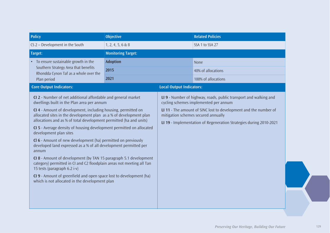
Preserving Our Heritage, Building Our Future 129
Policy Objective Related Policies
CS 2 – Development in the South 1, 2, 4, 5, 6 & 8 SSA 1 to SSA 27
Target: Monitoring Target:
• To ensure sustainable growth in theSouthern Strategy Area that benefitsRhondda Cynon Taf as a whole over thePlan period
Adoption None
2015 40% of allocations
2021 100% of allocations
Core Output Indicators: Local Output Indicators:
CI 2 - Number of net additional affordable and general marketdwellings built in the Plan area per annum
CI 4 - Amount of development, including housing, permitted onallocated sites in the development plan as a % of development planallocations and as % of total development permitted (ha and units)
CI 5 - Average density of housing development permitted on allocateddevelopment plan sites
Cl 6 - Amount of new development (ha) permitted on previouslydeveloped land expressed as a % of all development permitted perannum
CI 8 - Amount of development (by TAN 15 paragraph 5.1 developmentcategory) permitted in CI and C2 floodplain areas not meeting all Tan15 tests (paragraph 6.2 i-v)
CI 9 - Amount of greenfield and open space lost to development (ha)which is not allocated in the development plan
LI 9 - Number of highway, roads, public transport and walking andcycling schemes implemented per annum
LI 11 - The amount of SINC lost to development and the number ofmitigation schemes secured annually
LI 19 - Implementation of Regeneration Strategies during 2010-2021
35580-52 LDP plan 2011_Layout 1 30/06/2011 11:18 Page 129

Preserving Our Heritage, Building Our Future130
Policy Objective Related Policies
CS 3.1 – Former Maerdy Colliery 1, 2, 3, 5, 7 & 10 NSA 4
Target: Monitoring Target:
• The construction of 1ha of B1 and/or B2of employment land, visitors centre andarea of informal recreation
Adoption None
2015 Submission of planning application
2021 Development completed
Core Output Indicators: Local Output Indicators:
N/A LI 14 - Pre-application discussions and masterplanning exercisesundertaken with developers in relation to the development ofstrategic sites
LI 15 - Planning permission granted for strategic sites
LI 16 - Annual rate of residential and/or commercial development onstrategic sites
LI 17 - Annual provision of local centres, primary schools, openspaceand biodiversity management schemes on strategic sites
LI 18 - Annual provision of highway and utility infrastructure onstrategic sites
35580-52 LDP plan 2011_Layout 1 30/06/2011 11:18 Page 130

131Preserving Our Heritage, Building Our Future
Policy Objective Related Policies
CS 3.2 – Former Fernhill Colliery 1, 2, 3, 5, 7 & 10 NSA 5
Target: Monitoring Target:
• The construction of between 350-400dwellings, a local retail centre and areaof informal recreation
Adoption None
2015 Submission of planning application
2021 Development completed
Core Output Indicators: Local Output Indicators:
N/A LI 14 - Pre-application discussions and masterplanning exercisesundertaken with developers in relation to the development ofstrategic sites
LI 15 - Planning permission granted for strategic sites
LI 16 - Annual rate of residential and/or commercial development onstrategic sites
LI 17 - Annual provision of local centres, primary schools, openspaceand biodiversity management schemes on strategic sites
LI 18 - Annual provision of highway and utility infrastructure onstrategic sites
35580-52 LDP plan 2011_Layout 1 30/06/2011 11:18 Page 131

Preserving Our Heritage, Building Our Future132
Policy Objective Related Policies
CS 3.3 – Former Phurnacite Plant 1, 2, 3, 5, 7 & 10 NSA 6
Target: Monitoring Target:
• The construction of 500 dwellings, 5.9hectares of employment, a new primaryschool and area of formal/informalrecreation
Adoption None
2015 Submission of planning application
2021 Development completed
Core Output Indicators: Local Output Indicators:
N/A LI 14 - Pre-application discussions and masterplanning exercisesundertaken with developers in relation to the development ofstrategic sites
LI 15 - Planning permission granted for strategic sites
LI 16 - Annual rate of residential and/or commercial development onstrategic sites
LI 17 - Annual provision of local centres, primary schools, openspaceand biodiversity management schemes on strategic sites
LI 18 - Annual provision of highway and utility infrastructure onstrategic sites
35580-52 LDP plan 2011_Layout 1 30/06/2011 11:19 Page 132

133Preserving Our Heritage, Building Our Future
Policy Objective Related Policies
CS 3.4 – Land at Robertstown/Abernant 1, 2, 3, 5, 7 & 10 NSA 7
Target: Monitoring Target:
• The construction of between 500-600dwellings, 3.7 hectares of employment/leisure, a new primary school, medicalcentre and area of informal recreation
Adoption None
2015 Planning permission granted and implementation of development
2021 Development completed
Core Output Indicators: Local Output Indicators:
N/A LI 14 - Pre-application discussions and masterplanning exercisesundertaken with developers in relation to the development ofstrategic sites
LI 15 - Planning permission granted for strategic sites
LI 16 - Annual rate of residential and/or commercial development onstrategic sites
LI 17 - Annual provision of local centres, primary schools, openspaceand biodiversity management schemes on strategic sites
LI 18 - Annual provision of highway and utility infrastructure onstrategic sites
35580-52 LDP plan 2011_Layout 1 30/06/2011 11:19 Page 133

Preserving Our Heritage, Building Our Future134
Policy Objective Related Policies
CS 3.5 – Land south of Hirwaun 1, 2, 3, 5, 7 & 10 NSA 7
Target: Monitoring Target:
• The construction of 400 dwellings, 36 hectares ofemployment, a new primary school, 2000m²retail floorspace store, medical/communitycentre and area of informal recreation
Adoption None
2015 Planning permission granted and implementation of development
2021 Development completed
Core Output Indicators: Local Output Indicators:
N/A LI 14 - Pre-application discussions and masterplanning exercisesundertaken with developers in relation to the development ofstrategic sites
LI 15 - Planning permission granted for strategic sites
LI 16 - Annual rate of residential and/or commercial development onstrategic sites
LI 17 - Annual provision of local centres, primary schools, openspaceand biodiversity management schemes on strategic sites
LI 18 - Annual provision of highway and utility infrastructure onstrategic sites
35580-52 LDP plan 2011_Layout 1 30/06/2011 11:19 Page 134

135Preserving Our Heritage, Building Our Future
Policy Objective Related Policies
CS 3.6 – Cwm Colliery and Coking Works 1, 2, 3, 5, 7 & 10 SSA 7
Target: Monitoring Target:
• The construction of between 800-950dwellings, 1.9 hectares of employment, anew primary school and area of informalrecreation
Adoption None
2015 Submission of planning application
2021 Development completed
Core Output Indicators: Local Output Indicators:
N/A LI 14 - Pre-application discussions and masterplanning exercisesundertaken with developers in relation to the development ofstrategic sites
LI 15 - Planning permission granted for strategic sites
LI 16 - Annual rate of residential and/or commercial development onstrategic sites
LI 17 - Annual provision of local centres, primary schools, openspaceand biodiversity management schemes on strategic sites
LI 18 - Annual provision of highway and utility infrastructure onstrategic sites
35580-52 LDP plan 2011_Layout 1 30/06/2011 11:19 Page 135

Preserving Our Heritage, Building Our Future136
Policy Objective Related Policies
CS 3.7 – Mwyndy/Talbot Green Area 1, 2, 3, 5, 7 & 10 SSA 8
Target: Monitoring Target:
• The construction of 500 dwellings, 15hectares of employment, 23,400m² newretail floorspace, 10,000m² of leisurefloorspace, a primary school, library/community facility and area of informalrecreation
AdoptionPlanning permission for 19.1ha mixed use developmentcomprising B1 business development and residential units at landeast and west of the A4119
2015 Submission of planning application
2021 Development completed
Core Output Indicators: Local Output Indicators:
N/A LI 14 - Pre-application discussions and masterplanning exercisesundertaken with developers in relation to the development ofstrategic sites
LI 15 - Planning permission granted for strategic sites
LI 16 - Annual rate of residential and/or commercial development onstrategic sites
LI 17 - Annual provision of local centres, primary schools, openspaceand biodiversity management schemes on strategic sites
LI 18 - Annual provision of highway and utility infrastructure onstrategic sites
35580-52 LDP plan 2011_Layout 1 30/06/2011 11:19 Page 136

137Preserving Our Heritage, Building Our Future
Policy Objective Related Policies
CS 3.8 – Former OCC Site Llanilid 1, 2, 3, 5, 7 & 10 SSA 9
Target: Monitoring Target:
• The construction of 1950-2100 dwellings,2,500m² retail floorspace, a medical centre,library/community facility, a new primaryschool and associated public open space
Adoption None
2015 Planning permission granted and implementation of development
2021 Development completed
Core Output Indicators: Local Output Indicators:
N/A LI 14 - Pre-application discussions and masterplanning exercisesundertaken with developers in relation to the development ofstrategic sites
LI 15 - Planning permission granted for strategic sites
LI 16 - Annual rate of residential and/or commercial development onstrategic sites
LI 17 - Annual provision of local centres, primary schools, openspaceand biodiversity management schemes on strategic sites
LI 18 - Annual provision of highway and utility infrastructure onstrategic sites
35580-52 LDP plan 2011_Layout 1 30/06/2011 11:19 Page 137

Preserving Our Heritage, Building Our Future138
Policy Objective Related Policies
CS 4 – Housing Requirements 1 & 9 CS 3, AW 1, NSA 5, NSA 7 to NSA 9 & SSA 7 to SSA 10
Target: Monitoring Target:
• Land will be made available for theconstruction of 14,385 new dwellings overthe Plan period
Adoption 1605
2015 8,631
2021 14,385
Core Output Indicators: Local Output Indicators:
CI 1 - The housing land supply taken from the current Housing LandAvailability Study per annum
CI 2 - Number of net additional affordable and general marketdwellings built in the Plan area per annum
CI 4 - Amount of development, including housing, permitted onallocated sites in the development plan as a % of development planallocations and as % of total development permitted (ha and units)
CI 6 - Amount of new development (ha) permitted on previouslydeveloped land expressed as a % of all development permitted perannum
LI 1 - Number of dwellings permitted annually outside the definedsettlement boundaries
35580-52 LDP plan 2011_Layout 1 30/06/2011 11:19 Page 138

139Preserving Our Heritage, Building Our Future
Policy Objective Related Policies
CS 5 – Affordable Housing 1, 6 & 10 AW 3, NSA 11 & SSA 12
Target: Monitoring Target:
• To provide 1770 affordable homes inRhondda Cynon Taf over the Plan period.
Adoption 237 units
2015 1062 units
2021 1770 units
Core Output Indicators: Local Output Indicators:
CI 2 - Number of net additional affordable and general marketdwellings built in the Plan area per annum
CI 4 - Amount of development, including housing, permitted onallocated sites in the development plan as a % of development planallocations and as % of total development permitted (ha and units)
LI 1 - Number of affordable dwellings provided annually on ruralexception sites throughout Rhondda Cynon Taf
LI 3 - Average house price in Rhondda Cynon Taf per annum
LI 4 - Amount of affordable housing provided by Social Housing Grantper annum
35580-52 LDP plan 2011_Layout 1 30/06/2011 11:19 Page 139

Preserving Our Heritage, Building Our Future140
Policy Objective Related Policies
CS 6 – Employment Requirements 3 AW 11, NSA 14, NSA 15, NSA 16 & SSA 14
Target: Monitoring Target:
• Development of 51 hectares for ‘strategic’employment and 47 hectares for ‘local’employment opportunities
Adoption None
2015 25ha for ‘strategic’ employment and 23 ha for ‘local’ employment
2021 51ha for ‘strategic employment’ and 47 ha for ‘local’ employment
Core Output Indicators: Local Output Indicators:
CI 3 - Net employment land supply/development per annum
CI 4 - Amount of development, including housing, permitted onallocated sites in the development plan as a % of development planallocations and as % of total development permitted (ha and units)
CI 6 - Amount of new development (ha) permitted on previouslydeveloped land expressed as a % of all development permitted perannum
LI 5 - % of employment land lost to alternative uses per annum
35580-52 LDP plan 2011_Layout 1 30/06/2011 11:19 Page 140

141Preserving Our Heritage, Building Our Future
Policy Objective Related Policies
CS 7 – Retail Development 2 & 6 NSA 17 & SSA 15
Target: Monitoring Target:
• Improve viability and vitality of 8 KeySettlements and 3 Principal Towns inRhondda Cynon Taf over the Plan period
• Development of between 34,400m²-36,400m² new retail floorspace throughoutthe County Borough over the Plan period
Adoption None
2015 40%
2021 100%
Core Output Indicators: Local Output Indicators:
CI 4 - Amount of development, including housing, permitted onallocated sites in the development plan as a % of development planallocations and as % of total development permitted (ha and units)
CI 6 - Amount of new development (ha) permitted on previouslydeveloped land expressed as a % of all development permitted perannum
CI 7 - Amount of major retail, office and leisure development (sq m)permitted in town centres expressed as a % of all major developmentpermitted
LI 6 - Total convenience/comparison retail floorspace developed perannum
LI 7 - Annual vacancy rates for each Principal Town and KeySettlement
LI 8 - Number of applications approved per annum for non-retail usein primary and secondary shopping frontages
35580-52 LDP plan 2011_Layout 1 30/06/2011 11:19 Page 141

Preserving Our Heritage, Building Our Future142
Policy Objective Related Policies
CS 8 - Transportation 6 & 8 NSA 20 to NSA 23 & SSA 18 to SSA 21
Target: Monitoring Target:
• Promote more sustainable forms oftransport throughout Rhondda Cynon Taf
• Reduce need to travel through thedevelopment of new services in accessiblelocations throughout the plan period
Adoption None
2015 40%
2021 100%
Core Output Indicators: Local Output Indicators:
NA LI 9 - Number of highway, roads, public transport and walking andcycling schemes implemented per annum
LI 10 - Proportion of new housing, employment and retaildevelopment accessible by a range of transport modes per annum
35580-52 LDP plan 2011_Layout 1 30/06/2011 11:19 Page 142
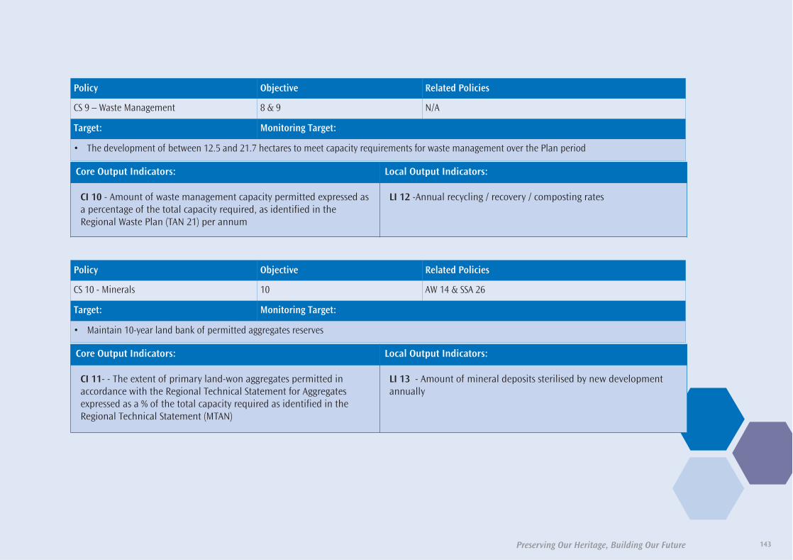
143Preserving Our Heritage, Building Our Future
Policy Objective Related Policies
CS 9 – Waste Management 8 & 9 N/A
Target: Monitoring Target:
• The development of between 12.5 and 21.7 hectares to meet capacity requirements for waste management over the Plan period
Core Output Indicators: Local Output Indicators:
CI 10 - Amount of waste management capacity permitted expressed asa percentage of the total capacity required, as identified in theRegional Waste Plan (TAN 21) per annum
LI 12 -Annual recycling / recovery / composting rates
Policy Objective Related Policies
CS 10 - Minerals 10 AW 14 & SSA 26
Target: Monitoring Target:
• Maintain 10-year land bank of permitted aggregates reserves
Core Output Indicators: Local Output Indicators:
CI 11- - The extent of primary land-won aggregates permitted inaccordance with the Regional Technical Statement for Aggregatesexpressed as a % of the total capacity required as identified in theRegional Technical Statement (MTAN)
LI 13 - Amount of mineral deposits sterilised by new developmentannually
35580-52 LDP plan 2011_Layout 1 30/06/2011 11:19 Page 143

144 Preserving Our Heritage, Building Our Future
35580-52 LDP plan 2011_Layout 1 30/06/2011 11:19 Page 144

Preserving Our Heritage, Building Our Future 145
A) Housing AllocationsNorthern Strategy Area Housing Allocations
1. Land South of Rhigos Road, HirwaunThe site is a 0.57 hectare flat field situated on the edge of the settlementof Hirwaun, located behind a low density residential street. Bordered toits rear by the A465 Hirwaun bypass, the site would be accessed fromRhigos Road or Meadow Lane.
2. Land east of Trenant, PenywaunThe site is situated between the villages of Hirwaun and Penywaun andconsists of previously tipped land. The majority of the 3.36 hectare site islevel land, although raised considerably above the adjacent Trenantresidential estate. To the site’s north and rear, the tip drops down steeply toa lower area of marshy land. In order to develop the whole site,considerable levelling and landscaping works would have to be undertaken.There is direct access onto the A4059, although improved visibility wouldhave to be incorporated into its design.
3. Land South East of Llwydcoed Community CentreThe site is located on the edge of the residential area of Llwydcoed,situated between the community centre and football field to the northand Corner House Street to the south. The small, gently rising site of 0.54hectares is heavily overgrown with trees and Japanese Knotweed whichwould need to be addressed in developing the site. There are severalpotential access points to the site, including Corner House Street and fromthe adjacent car park currently serving the community centre and footballground.
4. Site including the old brickworks, old dairy and tipped land rear ofBirchwood, LlwydcoedThe site for the most part is derelict, brownfield land, situated between therailway line and the residential area in Llwydcoed. The majority of the landis generally flat, although with various levels remaining from previous andexisting structures. Much of this area is within a flood risk zone B, whichwould require a flood consequences assessment. To the north and east ofthe site, where it adjoins the village, the land rises steeply, considerably soin places. There are some individual and group tree preservation orders inthis part of the site also. The 6 hectare site may be accessed from variouspoints along Llwydcoed Road that served the previous developments here,although improvements will be required.
5. Tegfan Farm, Potters Field, TrecynonA 4.3 hectare greenfield site on the edge of the village of Trecynon, slopingdown from the adjacent Aberdare cemetery. The field is currently usedfor grazing horses with hedgerow boundaries which should be maintainedto consider the privacy of the cemetery. Access is achieved through themodern, adjoining ‘Potters Field’ housing estate. There are no knownconstraints on the site.
Details Of Allocations
Appendix One
35580-52 LDP plan 2011_Layout 1 30/06/2011 11:19 Page 145

Preserving Our Heritage, Building Our Future
6. Land at Nant y Wenallt, Abernant Road, Abernant
Historically, the site and surrounding area included coal and iron workings
and associated tips. The majority of the site has long since been well
reclaimed and improved, with an open grazing paddock sloping down
from the sites highest point in the northwest corner. At the foot of the
paddock is a flatter area around an old feeder pond used as a builders /
timber yard. Below this is a very steep wooded embankment dropping to
the Nant y Wenallt stream, rising up equally steeply to the access road off
Abernant Road. The site is bordered across its northern edge by a raised
former railway line now used as a footpath. To the south is a site
benefiting from planning permission for housing, to which this site should
be linked. The 6.1 hectare site is allocated for residential use, although
the wooded area around the stream is a designated SINC, which is
unsuitable for development.
7. Land Bordered by Cefnpennar Road and Phillip Row, Cwmbach
This residential allocation is an agricultural field of 1.36 hectares on the
edge of the village of Cwmbach, although close to the main facilities in the
settlement. The land is generally flat although slopes down gently to
Cefnpennar Road, where access may be achieved. Access is also available
from Morgan Row. There are no known constraints on the site.
8. Dyffryn Row, Cwmbach
The site is a brownfield area of land which was previously developed for
housing. The land has since regenerated itself naturally and is wooded.
The site is accessible directly from the main road and is 0.88 hectares in
size. The front of the site adjacent to the road is level, rising up to the
rear to meet the new development at Rose Row, on the southern edge of
Cwmbach..
9. Remainder of Ynyscynon Farm, Cwmbach
The site is situated to the north of the village of Cwmbach on sloping
ground, rising above and around a recently built housing estate, with
woodland beyond. The layout of the adjacent new development allows
for very good access directly onto this site. The majority of the 3.85 hectare
site is located within a designated SINC, however the land has been
cleared and the majority of the SINC is lost. Consideration of the impact
of the development on the surrounding SINC, however, would still be
required through a management plan.
10. Land to the end of Godreaman Street, Godreaman
A 1.32 hectare sloping site rising from Foundry View to Brynmair Road.
The site is an open grazing field for the most part, although parts are
overgrown and there are some small temporary structures and informal
uses to the top of the site. There is also a line of pylons and associated
cables running along the south western boundary. There are several
possible access points to the site, via Godreaman Street, Foundry View
and from Dyffryn Villas.
11. Gwernifor Grounds, Mountain Ash
This site, within the urban area of Mountain Ash, is under construction.
12. Rear of Maerdy Road, Maerdy
This site occupies an elevated position above Maerdy Road, consisting of
3.32 hectares of steep moorland situated between the Maerdy Junior
School and Pentre Road. There is an area of the site designated as a SINC,
which would require a management plan to be completed as part of a
development scheme. There are various highways abutting the urban
edge of the site which could be utilised and developed to access the site.
146
35580-52 LDP plan 2011_Layout 1 30/06/2011 11:19 Page 146

147Preserving Our Heritage, Building Our Future
13. Land at Gwernllwyn Terrace, Tylorstown
The 1.11 hectare site is a linear area of brownfield land on the edge of the
village of Tylorstown. The site is very steep in places, although the design
of the development could replicate the terraced form of the street below
and the terraced housing that once stood here. The access road remains
in place from this previous development.
14. Site off Fenwick Street, Pontygwaith
Previously developed land to the south of the village of Pontygwaith, with
part of the site developed with detached dwellings. The remainder of the
site is steep in places, although the design of the site could continue the
terraced form of Fenwick Street. A very small section on the edge of the
1.31 hectares site is a designated SINC, which would need consideration
as part of the development scheme.
15. Old Hospital Site and School Playground, Treherbert
This 1.73 hectare site consists of a cleared hospital site and a former
school playground on the edge of Treherbert, adjacent to the Rhigos
mountain road. This allocated land has two level areas for development,
with firstly the former playground area then stepping up to the part of the
site where the hospital stood. Elsewhere around the site, particularly
against the Rhigos Road and in the northern corner, are steep, wooded
slopes that may not be wholly developable. There are some Tree
Preservation Orders on the residential edge of the site, which would need
to be considered within the development scheme. There are two existing
accesses, from the rear of Dumfries Street and directly off the Rhigos Road,
although both would require improvements to meet modern standards of
residential development.
16. Site at the end of Mace Lane, Treorchy
This residential allocation of 1.45 hectares is situated on the valley side,
above the village of Ynyswen. To the west of the site is a bus garage and
area of associated hard standing on generally level ground. To the south
the land is mainly greenfield, partly wooded and sloping. Access to the site
is possible from Crown Terrace.
17. Site off Cemetery Road, Treorchy
This reclaimed tip site on the edge of the village of Treorchy, comprises of
a plateau of land situated on the valley side, above a recently built
residential development. Although a major part of the site is level, there
is a steep embankment around its eastern and northern edge which leads
up to the adjacent Cemetery Road. Access to the 2.74 hectare site could
be achieved either through the Woodland Vale estate or from Cemetery
Road. There are very small areas of SINC designation and C2 Flood risk
zones on the western boundary of the site that would require further
consideration in any development scheme. Ground investigations for
stability and contamination are needed before development takes place.
18. Hospital Site, Llwynypia
The 6.39 hectare site is currently occupied as a hospital, with a range of
buildings situated on various levels on the valley side. The site benefits
from outline planning permission, with future development of the site
dependent on the completion of the replacement hospital in Llwynypia.
It is expected that development of the site would replicate the layout of
the existing development plateau. The site is adjacent to a large SINC
designation, which would require consideration as part of a development
scheme.
35580-52 LDP plan 2011_Layout 1 30/06/2011 11:19 Page 147

Preserving Our Heritage, Building Our Future
19. Land at Park Street, Clydach Vale
This site is a brownfield area of land that has been reclaimed to create a
level area of ground adjacent to the residential edge of Clydach Vale. The
1.12 hectare site has no known constraints and is accessible from Park Street.
20. Land at Dinas Road / Graig Ddu Road, Dinas
This 0.88 hectare brownfield site has been cleared of its previous
development which consisted of blocks of flats. The site occupies a
plateau on a steep hillside, elevated above Dinas. There are no known
constraints on the site and it benefits from existing access.
21. Land at Catherine Crescent, Cymmer
This 0.55 hectare site comprises an area of flat, rough ground, which is
used as a car park for the adjacent football field. The western part of the
site is wooded and on a rising slope. Development of the site would
require a smaller car park and changing rooms for the football field to be
provided.
Southern Strategy Area Housing Allocations
1. Cefn Lane, Glyncoch
This site of 1.2 hectares is an area of open, cleared land on the edge of
Glyncoch, on a north-facing slope. The land is adjacent to a woodland
that is a designated SINC. Access may be achieved from the adjacent Cefn
Close.
2. Trane Farm, Tonyrefail
This greenfield site comprises for the most part, agricultural fields with
mature hedgerows and trees. The site lies on a generally south-facing
slope with extensive views over western Tonyrefail. In the centre by Trane
Farm buildings, the land forms a large hollow with a stream running
through it with mature trees. Near Bryngolau there are signs of
unauthorised leisure use. To the west of Trane Cemetery the site includes
an area of 1.0 hectares designated as an SSSI, whilst further to the west of
the site is a larger area of SSSI of 2.74 hectares. The layout and design of
development will be required to protect these areas for their scientific
value and to retain and manage suitable wildlife corridors both between
the areas notified as SSSI and from the SSSI areas into the countryside to
the north (the details of which should be agreed between The Countryside
Council for Wales (CCW) and the LPA). The far south western part of the site
consists of more rough pasture and bracken. The principal access to the
site should be from the A4093 roundabout on Gilfach Road. Trane Lane
diverted to join Bryngolau should be a secondary access. Pedestrian links
to Tonyrefail town centre should be established. There are existing public
rights of way traversing the site north-south and east-west. The 0.74
hectare Bryngolau residential land allocation adjoins the southern
boundary of the site. The total area of the site (excluding the SSSI) is 33.3
hectares.
3. Collenna Farm, Tonyrefail
This brownfield site is a long-abandoned residential building site that has
reverted to nature and is overgrown. The site is flat and has access both
from Maes-y-bryn and from Heol Capel. The site adjoins an extensive SSSI
to the north, which would have to be protected in the layout of any
development. The site measures 0.71 hectares and is allocated for
residential development.
148
35580-52 LDP plan 2011_Layout 1 30/06/2011 11:19 Page 148

149Preserving Our Heritage, Building Our Future
4. Bryngolau, Tonyrefail
This greenfield site comprises vacant and overgrown flat land, and
includes an abandoned multi-use games area. Access would be from the
turning areas by 101 and 120 Bryngolau in the adjoining residential area.
Alternatively the site could be linked to the Trane Farm development
adjoining to the north. The site measure 1.74 hectares and is allocated
for residential development.
5. Site of the former Hillside Club, Capel Hill, Tonyrefail
This part brownfield, part greenfield sloping site lies prominently on the
north side of Tonyrefail with extensive views over Tonyrefail. The Hillside
Club formerly stood on the lower, south western part of the site and has
been cleared. The upper, north eastern part of the site by the entrance was
a lawn. Currently the site is subject to fly-tipping and presents a very poor
appearance. An extensive SSSI adjoins the northern boundary of the site,
which would have to be protected in the layout of any development. The
site fronts and gains access from Capel Hill, and there is potential for a
westwards connection to Collenna Farm. The area of the site is 1.14
hectares and it is allocated for residential development.
6. Land east of Mill Street, Tonyrefail
This mainly greenfield site lies close to the town centre of Tonyrefail on
its south-eastern edge. It is low-lying with limited views in and out of the
site. The land is a mixture of poor and unused, overgrown agricultural
land with trees and hedgerows. On the west side of the site is an area
formerly used for allotments but now cleared. There are residential
dwellings to the west, actively cultivated allotments to the north, playing
fields to the east and there is open countryside to the south. A clubhouse
occupies 0.3 hectares of the 5.4 hectare site, with access from Mill Street
via a small bridge over the unnamed stream that flows westwards along
the northern boundary. The proposal is for residential and retail
development incorporating a replacement clubhouse, all accessed from
a new link road connecting Mill Street to the west and High Street to the
north, via the unnamed road leading to Llys Tylcha Fawr. The retail
development will front the proposed link road.
7. Land at Gwern Heulog, Coed ElyThe site consists of three agricultural grazing fields situated to the rear ofthe recently built residential development at Gwern Heulog. The fieldsrise moderately steeply up behind the development, as far as the ridgelineof the hill, into open farmland beyond, although this is at a lower levelthan surrounding hills. The fields are bordered on most sides byhedgerows. The site and neighbouring development will form anextension to the established settlement of Coed Ely to the south ofTonyrefail. Access to the 4.63 hectare residential allocation will also beachieved from the Gwern Heulog development.
8. Land rear of Tylcha Wen Terrace, TonyrefailThe land is used for grazing purposes, although not of high quality. Theaccess point from the main road would be adjacent to the northern edgeof Tylcha Wen Terrace where the slope levels off to road level. The sitemeasures 0.83 hectares and is allocated for residential development.
9. Land Part of Tylcha Ganol Farm, South of Mill Street, TonyrefailThe site is located on the edge of the town centre of Tonyrefail, andconsists of an open, improved agricultural field that slopes moderatelyup the hillside to the south east, into more open countryside. There isexisting access from the end of Mill Street to the edge of the site, althoughthere would have to be a significant improvement. There is a televisionmast and substation on the edge of the site. The 2.4 hectare site isallocated for residential development.
35580-52 LDP plan 2011_Layout 1 30/06/2011 11:19 Page 149

Preserving Our Heritage, Building Our Future
10. Land East of Hafod Wen and North of Concorde Drive, Tonyrefail
The site is located on the northern edge of Tonyrefail, overlooking the
town and Ely Valley. The site has a moderate slope up northwards. It
comprises an improved grassland meadow, which is divided from the land
to the east by a stream with small trees either side of the channel. The
land adjoining to the east has been designated as an SSSI and therefore
the design of any development must provide for its protection for its
scientific value. Access could be achieved from Hafod Wen, or possibly
from Concorde Drive, which would require crossing a raised farm track.
The area is 2.7 hectares and it is allocated for residential development.
11. Land south of Brynna Road, Brynna
This elongated greenfield site comprises agricultural land with mature
hedgerows on a south-facing slope down from Brynna Road. The site can
be accessed from the Brynna Road frontage, and has extensive views over
Brynna Woods and Bryncae. Brynna Woods is separated from the site by
a former railway line; both the woods and old railway line form an
extensive SINC that would have to be protected in the design of any
development. The site measures 5.74 hectares and is allocated for
residential development.
12. Land east of Dolau County Primary School, Bridgend Road, Bryncae
This greenfield site comprises agricultural land on a gentle slope behind
bungalows and commercial premises fronting Bridgend Road, up to a
prominent tree line to the south. The site measures 3.62 hectares and is
allocated for residential development.
13. Land West of Llechau, LlanharryThis elongated, greenfield site comprises mainly agricultural fields withhedgerows, but includes a copse. The site slopes gently down towards the
north. There is a long frontage to the Llanharry-Brynsadler Road, whichwill afford access. The site has been defined to avoid land to the northaffected by past iron ore mining and therefore should not have groundstability issues. There are pole-mounted power cables on a route throughthe site parallel to the road. The site measures 4.5 hectares and isallocated for residential development.
14. Penygawsi, LlantrisantThis elongated, greenfield site comprises vacant and overgrown landfronting Burgesse Crescent. The site slopes gently down towards the Cwmmineral railway line, which is screened by mature trees. An area of 0.79hectares within the 1.14 hectare site is in flood risk zone B, therefore aflood consequences assessment will be required before any grant ofplanning permission for development. The site is allocated for residentialdevelopment.
15. Land south of Brynteg Court, BeddauThis greenfield site comprises agricultural land with hedgerows and trees.It slopes gently down to the south from Brynteg Lane and Brynteg Courttowards the A473 Llantrisant Road. The northwest corner of the site isincluded in an extensive SINC, which requires protection in the layout anddesign of any development. The A473 has been realigned following theconstruction of the Church Village bypass, which has improved access tothe site. The site extends to 5.23 hectares (excluding the 0.18 hectares ofSINC) and is allocated for residential development.
150
35580-52 LDP plan 2011_Layout 1 30/06/2011 11:19 Page 150

151Preserving Our Heritage, Building Our Future
16. The Link Site, Pen-yr-eglwys, Church VillageThis greenfield site comprises agricultural land in poor condition, togetherwith oak woods and a wooded twmp (an old spoil tip) that should beretained in any development. The site slopes moderately from thenorthwest to the southeast. Although the site has frontage to CroescadeRoad, access would only be from Pen-yr-Eglwys. Existing residentialdevelopment adjoins to the northeast, and a green wedge will be retainedto the southwest. The site extends to 4.65 hectares (4.31 excluding thewooded areas).
17. Glyntaff Farm, Rhydyfelin
This greenfield site comprises vacant formerly agricultural land adjoining
existing residential development. The site occupies a moderate slope and
affords extensive views to the south. There are signs of unauthorised
leisure use. Two streams cross the site and there are mature trees in the
northeast part. Pylon-mounted power lines cross the site. Access will be
from Poets Close. The site measures 2.16 hectares including the trees, and
is allocated for residential development. Development on part of the site
commenced in 2008.
18. Land south of The Ridings, Tonteg and East of Station Road,
Church Village
This roughly triangular greenfield site lies south of Tonteg and east of
Station Road, Church Village. The site slopes gently down from Tonteg
towards Efail Isaf and the Church Village bypass. The upper parts of the
site are agricultural with mature hedgerows and trees, affording extensive
views to the south. The lower parts are marshy grasslands and woodlands.
Pylon-mounted power lines cross the site northeast to southwest. Two
public rights of way run south from Tonteg across the site. The lower parts
of the site are affected by a combination of SINC, flood risk zone B and
flood risk zone C2 and therefore will be protected in any development
and provision made for their management. Access will be from the Church
Village bypass (Nant Celyn roundabout). Although the whole 32.36 hectare
site is allocated for residential development, 17.84 hectares is considered
undevelopable, leaving a net area for development of 14.52 hectares.
35580-52 LDP plan 2011_Layout 1 30/06/2011 11:19 Page 151

Preserving Our Heritage, Building Our Future152
B) Employment AllocationsNorthern Strategy Area Employment Allocations
1. Ferndale and Highfields Industrial Estate, Maerdy
The allocation comprises of a series of adjoining areas totalling 8.38
hectares of cleared, brownfield land located within the existing
industrial area between Ferndale and Maerdy. There are no known
constraints on this flat site, which may be accessed from both Ferndale
and Highfields Industrial Estates.
2. North of Fifth Avenue, Hirwaun Industrial Estate, Hirwaun
The site is an area of prepared level land on the edge of the Industrial
Estate in Hirwaun, which already benefits from an access point to the
estate distributor road and subsequent access to the A465 Heads of the
Valley Road. This 4.17 hectare site consists of over half of the overall
area of level land, with the remainder being within the Brecon Beacons
National Park Authority area. The land is situated below a raised
reservoir to the north and the majority of the site is located within the
identified flood risk zone B and would require a flood consequences
assessment. The site is also located close to the Blaen Cynon SAC which
would need to be considered as part of a development scheme.
3. Land at Former Mayhew Chicken Factory, Trecynon
The linear site is situated on the valley floor between the Aberdare
bypass and River Cynon at Trecynon. The site benefits from an existing
access on to the bypass, approximately 3.5 kilometres from the A465
Heads of the Valleys road. The majority of the 2.88 hectare brownfield
site still has the level concrete hard standing from the previous
industrial use. The northern quarter of the site is flat grassland which
is covered by a SINC designation, which would require a management
plan as part of a development proposal. The site is also wholly within
a C2 flood risk zone and would require a flood consequences
assessment.
4. Cae Mawr Industrial Estate, Treorchy
This 3.6 hectare site is located within the urban area of Treorchy, being
part of an existing, larger industrial estate. The flat site has been partly
cleared, although there remain some large, derelict units on it, as well
as a small working unit in the far northern corner. The site falls within
the identified C2 flood risk zone and would require a flood
consequences assessment as part of a development scheme.
Southern Strategy Area Employment Allocations
1. Coed Ely, Tonyrefail
This reclaimed brownfield site of a colliery and coking works comprises
3 vacant development plateaus and a spine road connecting to a
roundabout on the A4119 Ely Valley Road.
2. Gellihirion Industrial Estate, Pontypridd
This greenfield site gently slopes up from the Gellihirion Industrial
Estate spine road towards a backdrop of mature trees along the line of
the Taff Trail. The site is unused and overgrown. The Harp
International plant adjoins to the west. Overhead power lines and
drainage ditches cross the site. Measuring 1.47 hectares, the site is
allocated for employment development.
35580-52 LDP plan 2011_Layout 1 30/06/2011 11:19 Page 152

153Preserving Our Heritage, Building Our Future
C) Retail Allocations
Policy Allocation Description of Development
Policy CS 7 /
SSA 15 (1)
Land Adjacent ToPontypridd RetailPark, Pontypridd
Land adjoining Pontypridd Retail Park (Brown Lenox) is allocated for either 3,500m2 net or 5,500m2 net floor-space,either comparison (non-food) or convenience (food) or a mixture, subject to no detriment to the redevelopment of thein-centre Taff Street, Pontypridd site. The alternative floorspace figures specified in Policy SSA 15 represent the capacityof the site either for a foodstore (3,500m2 net sales) or for a comparison goods scheme (5,500m2 net sales). Land adjoiningPontypridd Retail Park (Brown Lenox) is considered to be an accessible location for the wider town, and therefore asequentially preferable site for retail development that cannot be located in the defined retail core. Outline proposalsfor about 5,500m2 net comparison retail floorspace were approved on 01/07/09 [07/1554]. Detailed proposals for about3,000m2 net convenience and 1,000m2 net comparison floorspace in one store were approved on 11/02/11 (10/0370). Itis vital that development here does not frustrate the retail development of the town centre site.
Policy CS 7 /
SSA 15 (3)
Land East Of MillStreet, Tonyrefail
Tonyrefail has a smaller centre than its status as a key settlement deserves. Therefore, since substantial new allocationsare being made for residential development, a retail centre or store of about 2,000m2 net sales area to provide amixture of convenience (food) and comparison (non-food) shopping is proposed on a site in walking distance of theexisting retail centre. Access would be from a new road linking High Street and Mill Street.
Policy CS 7 /
SSA 15 (2)
Llanharan Llanharan has a smaller centre than its status as a key settlement deserves. Therefore, as a substantial new allocationis being made for residential development, a retail centre comprising unit shops should be incorporated to providea mixture of convenience (food) and comparison (non-food) shopping.
Policy CS 7 /
NSA 17 (1)
Land at OxfordStreet, Mountain Ash
Land is allocated for shopping development of about 950m2 net floor-space. The new floor-space will provide acombination of convenience and comparison goods. Of the eight key settlements, Mountain Ash has the only centrewith a site potentially available for redevelopment. Development of the Oxford Street site for unit shops should benefitthe town and its centre environmentally, as well as socially and economically, by making appropriate use of vacantpreviously developed urban land.
Policy CS 7 /
NSA 17 (2)
Hirwaun Hirwaun has a smaller centre than its status as a key settlement deserves. Therefore, as a substantial new allocationis being made for residential development in Strategic Site 5, a retail food store should be incorporated into thedevelopment.
35580-52 LDP plan 2011_Layout 1 30/06/2011 11:19 Page 153
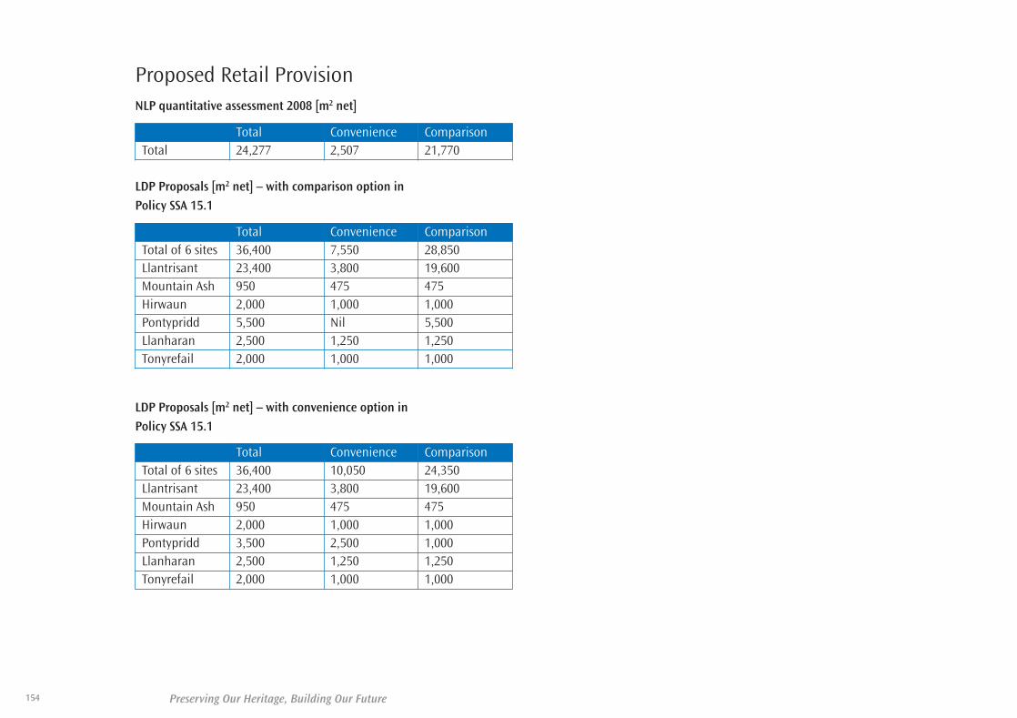
Preserving Our Heritage, Building Our Future154
Proposed Retail ProvisionNLP quantitative assessment 2008 [m2 net]
Total Convenience ComparisonTotal 24,277 2,507 21,770
LDP Proposals [m2 net] – with comparison option in
Policy SSA 15.1
Total Convenience ComparisonTotal of 6 sites 36,400 7,550 28,850 Llantrisant 23,400 3,800 19,600 Mountain Ash 950 475 475Hirwaun 2,000 1,000 1,000Pontypridd 5,500 Nil 5,500Llanharan 2,500 1,250 1,250 Tonyrefail 2,000 1,000 1,000
LDP Proposals [m2 net] – with convenience option in
Policy SSA 15.1
Total Convenience ComparisonTotal of 6 sites 36,400 10,050 24,350Llantrisant 23,400 3,800 19,600 Mountain Ash 950 475 475Hirwaun 2,000 1,000 1,000Pontypridd 3,500 2,500 1,000Llanharan 2,500 1,250 1,250 Tonyrefail 2,000 1,000 1,000
35580-52 LDP plan 2011_Layout 1 30/06/2011 11:19 Page 154

155Preserving Our Heritage, Building Our Future
CS 8(a) (1) - The Gelli / Treorchy Relief Road
The single carriageway relief road will provide a high quality link between the
middle and upper Rhondda Fawr. The proposed road scheme will provide
improved access to the Fernhill Colliery Strategic Site at the head of the
Rhondda Fawr Valley and significantly reduce traffic from immediately outside
the residential and commercial properties that front the route.
The route shown in the Proposals Map is supported by the Council and has
been subjected to a feasibility study. Therefore, this is seen as a viable route
and the one which the Council wishes to see protected from future
development. It is accepted that variations in the route may be preferable
when detailed design is undertaken. Also, the issues surrounding a previously
rejected possible alternative route (adjacent to the railway for its full length)
may have changed in the interim in favour of that route. Other opportunities
may also have arisen which could allow other routes to be feasible. As such,
the Council, whilst continuing to seek to protect the feasible route as indicated
on the Proposals Map, fully intends to investigate alternative alignments
before it finally adopts a route to take forward to detailed design.
CS 8(a) (2) - The Ynysmaerdy to Talbot Green Relief Road
The proposed relief road to provide an alternative route from the Upper Ely
Valley to the west of Talbot Green. The scheme is largely dependent on the
scale of new development in the area, and as such will require developers to
assist with cost.
The alignment shown on the Proposals Map is supported by the Council and
is the only route to benefit from a feasibility study. The Council acknowledges
that it may be possible to deliver the proposed new road via an alternative
alignment. This is particularly the case at the northern end of the scheme
where it may be possible to distance the route from the settlement of
Ynysmaerdy. Without prejudice to any future planning application, should
redevelopment proposals at the former Fire Service Headquarters at Lanelay
Hall be supported, alternative routes may be viable at the southern end,
including the possibility of agreeing a variation of the route in conjunction
with any redevelopment scheme. As such, the Council, whilst continuing to
seek to protect the feasible route as indicated on the Proposals Map, fully
intends to investigate alternative alignments before it finally adopts a route to
take forward to detailed design.
D) Major Highway Schemes
35580-52 LDP plan 2011_Layout 1 30/06/2011 11:19 Page 155

Preserving Our Heritage, Building Our Future
CS 8(a) (3) - The A4059 Aberdare Bypass Extension
The proposed extension to the existing A4059 Aberdare bypass will assist with
the development of the Strategic Sites in Hirwaun and Aberdare. The scheme
is largely dependent on the dualling of the A465 Heads of the Valleys Road by
the Welsh Government. The scheme would need to be constructed at the same
time as the A465 dualling, as the Aberdare bypass extension would need to be
designed to tie in with the revised alignment of the A465.
CS 8(a) (4) - Dualling of the A465
The Welsh Government Trunk Road Forward Programme 2004 has identified
a scheme for dualling the A465 between Abergavenny and Hirwaun. It will
take the form of an on line dualling of the existing road between the County
Borough boundary in the east and the eastern side of Hirwaun. As it passes
Hirwaun it will take a new alignment to the south of the village before
rejoining the existing A465 dual carriageway in the west. The number of
junctions in the area will be rationalised to reduce delays and improve safety.
The improvement of this road will upgrade the quality of service on this
strategic route and thereby improve the safety of the road, ease traffic
congestion and assist in the economic regeneration of the area. Of particular
importance to the Rhondda Cynon Taf area are the benefits to the economic
regeneration of the upper Cynon and Rhondda Valleys and its beneficial
effects on the strategic development sites in the Hirwaun and Aberdare areas.
The section of the scheme in Rhondda Cynon Taf between the B4276 junction
and Hirwaun is unlikely to take place before April 2010.
NSA 20 (1) - Mountain Ash Southern Cross Valley Link
A cross valley link approximately 1km south of Mountain Ash town centre to
divert traffic away from the built up B4275 to the A4059 bringing
environmental relief to Mountain Ash town centre, the Miskin and
Penrhiwceiber area.
NSA 20 (2) - Upper Rhondda Fach Relief Road
The scheme will extend the Porth Relief Road northwards from Pontygwaith
to Maerdy. The proposed road will provide good communications between
the population of the Upper Rhondda Fach and the A470 and M4. It will open
up access to employment opportunities and significantly reduce the traffic
from immediately outside the residential and commercial properties that front
the route.
NSA 20 (3) - Mountain Ash Northern Cross Valley Link
The proposed cross-river link will bring environmental relief to residential and
commercial properties within the town centre and the Miskin and
Penrhiwceiber area. The scheme will facilitate regeneration of the area, and
will provide improved safety and environmental conditions in the town centre.
The scheme will provide an improved link to the new Mountain Ash Hospital.
SSA 18 (1) - A473 Llanharan Bypass
This scheme will reduce congestion and loss of amenity being experienced
along this corridor and would assist with the implementation of the Llanilid
Strategic Site; unless an appropriate alternative access can be provided. The
scheme is largely dependent on the scale of new development in the area,
and as such will require developers to assist with cost.
SSA 18 (2) - A473 Talbot Green Bypass Dualling
The proposal involves both upgrading the A473 to dual carriageway standard
and junction improvements. The scheme is largely dependent on the scale of
new development in the area, and as such will require developers to assist
with cost.
156
35580-52 LDP plan 2011_Layout 1 30/06/2011 11:19 Page 156

157Preserving Our Heritage, Building Our Future
E) Sites of Important Nature Conservation, Regionally Important Geological Sitesand Local Nature ReservesSites of Important Nature Conservation
AW 8.1. Coed Wernhir
AW 8.2. Werfa Farm
AW 8.3. Nant Fforch
AW 8.4. Brickyard Mire
AW 8.5. Rhigos Tramway
AW 8.6. Cwm Gwrelych
AW 8.7. Hirwaun Industrial
Estate
AW 8.8. Clydach Vale
AW 8.9. Hirwaun Ponds
AW 8.10. Hirwaun Common
AW 8.11. Gelli-ben-uchel
AW 8.12. Hirwaun Ponds (North)
AW 8.13. Hirwaun Iron Works
AW 8.14. Glyncornel
AW 8.15. Upper Cynon Floodplain
AW 8.16. Nant Hir Valley and
Reservoir
AW 8.17. Nant Hir Gwyddel
AW 8.18. Llwydcoed Slopes
AW 8.19. Bryn-defaid Heath
AW 8.20. East Llwydcoed
AW 8.21. Mynydd Bwlffa
/Mynydd-y-gyngon
AW 8.22. Cwm Dare North
AW 8.23. Cwm Dare South
AW 8.24. Dare Valley
AW 8.25. Aberdare South
AW 8.26. Mynydd Ystradffernol
AW 8.27. Garn Wen and Panwen
Garreg-wen
AW 8.28. Rhos Gwawr
AW 8.29. Aberdare Mountain
AW 8.30. Nant y Wenallt
AW 8.31. Cwm y Felin Newydd
AW 8.32. Aberdare Canal
AW 8.33. Mid Cynon Floodplain
AW 8.34. Cwmbach Slopes
AW 8.35. Gelli Slopes
AW 8.36. Coed Tir Estyll
AW 8.37. Cefnpennar
AW 8.38. St.Gwynno Forest
AW 8.39. Mynydd Merthyr
AW 8.40. Mynydd Brith-weunydd
/ Llwynypia hillside
AW 8.41. Twyn Tyllaudefaid Valley
Mire
AW 8.42. Pont-y-gwaith Hillside
AW 8.43. Mynydd Troed-y-rhiw
Slopes
AW 8.44. Penrhiw Fushes
AW 8.45. Birch Grove Slopes
AW 8.46. Y Ffrywd
AW 8.47. Mynydd Dinas / Mynydd
y Cymmer
AW 8.48. Bronwydd Park
AW 8.49. Trebanog Slopes
AW 8.50. Cilely Farm Rhos Pasture
AW 8.51. Cwm Hafod Woodland
AW 8.52. Coed-yr-Hafod
Woodland Complex
AW 8.53. Llys Nant and Graig
Twyn-y-glog Woodlands
AW 8.54. Mynydd Blaenrhondda
and Mynydd Ty-Isaf
AW 8.55. Craig Pwllfa
AW 8.56. Abercwmboi Lake
AW 8.57. Lower Cynon
AW 8.58. Treherbert Slopes
AW 8.59. Mynydd y Ffaldau
AW 8.60. Mountain Ash Slopes
AW 8.61. Blaenllechau Woodland
AW 8.62. Penrhiw Cradoc Fields
AW 8.63. Cwm Clydach
AW 8.64. Mynydd Ty’n-tyle Slopes
AW 8.65. Old Smokey Slopes
AW 8.66. Coed Fforest Isaf-Uchaf
AW 8.67. Perthcelyn Slopes
AW 8.68. Pen-twyn-isaf
AW 8.69. Tyntetown Slopes
AW 8.70. Darren y Celyn
AW 8.71. Coed Pen-y-parc
AW 8.72. Heol-y-Mynach Pastures
AW 8.73. Buarth-y-Capel wetland
AW 8.74. Dan y Cribyn
AW 8.75. Lower Clydach
Woodlands
AW 8.76. Maerdy Colliery
AW 8.77. Craig-yr-Hesg / Lan
Wood
AW 8.78. Craig-Evan Leyshon
Common
AW 8.79. Mynydd Eglwysilian
AW 8.80. Pont Sion Norton
Woodland and Ffridd
AW 8.81. Pontypridd Golf Course
AW 8.82. Coed-Pen-Maen
Common
AW 8.83. Mynydd Meiros / Upper
Ewenny Fach
AW 8.84. Meiros
AW 8.85. Llantrisant Forestry and
Craig Melyn
AW 8.86. Cynllan Wood
35580-52 LDP plan 2011_Layout 1 30/06/2011 11:19 Page 157

Preserving Our Heritage, Building Our Future158
AW 8.87. Hendre Owen /
Trecastell Tip
AW 8.88. Coed Trecastell
AW 8.89. Gwaun Llanhari Wood
AW 8.90. Ty’n Y Waun
AW 8.91. Coedcae Marsh
AW 8.92. River Ely
AW 8.93. Ty-Du
AW 8.94. Ty-Draw (Pontyclun
floodmeadows)
AW 8.95. Llanharry Quarry
AW 8.96. Cowbridge Road Playing
Field
AW 8.97. Ceulan Farm
AW 8.98. Heol Miskin Woodland
AW 8.99. Talygarn Woodland and
Lake
AW 8.100. East Miskin
AW 8.101. Cefn Hendy Community
Woodlands
AW 8.102. Coed-yr-Hendy
AW 8.103. Pant Marsh
AW 8.104. Y Graig
AW 8.105. Llantrisant Common
AW 8.106. Cefn Craig Amos
AW 8.107. Tonyrefail Mountains
AW 8.108. Llanilid Valley
AW 8.109. Garth-Grabban Slopes
AW 8.110. Rhiwfelin Fawr
AW 8.111. Nant Muchudd
AW 8.112. Coedcae-mawr
AW 8.113. Pant-y-ddraenen
AW 8.114. Crofft -yr-haidd Marshy
Grassland
AW 8.115. Nant Gelliwion / Waun
Castellau
AW 8.116. Darran Park
AW 8.117. Tonyrefail East
AW 8.118. Cae’r-ysgol Woodland
AW 8.119. The Glyn
AW 8.120. Mynydd y Glyn
AW 8.121. Penrhiw-fer Road
Woodland
AW 8.122. Penrhiw-fer Road West
AW 8.123. Ystrad Slopes
AW 8.124. Mynydd Gelli-wion and
Gellwion Slopes
AW 8.125. Coed Craig-Fach
AW 8.126. Treforest Slopes
AW 8.127. Coed Castellau
AW 8.128. Pen-y-coedcae Grassland
AW 8.129. Coedcae-du
AW 8.130. Rhyd-y-llech
AW 8.131. Cwm Colliery Grasslands
AW 8.132. Cwm Colliery Spoil and
Lake
AW 8.133. Maendy Quarry
AW 8.134. Croesged Grassland
AW 8.135. Beddau East
AW 8.136. Duffryn Dowlais
AW 8.137. Llantwit Fardre Marsh
AW 8.138. Tonteg Marsh
AW 8.139. Heol-y-Cawl
AW 8.140. Brynhill Chapel
Grassland
AW 8.141. Coed y Fardre
AW 8.142. Taff and Rhondda Rivers
AW 8.143. Llantwit Fardre West
AW 8.144. Caeau’r-llan Slopes
AW 8.145. Diswylfa Woodland
AW 8.146. Efail Isaf South
AW 8.147. Afon Clun Valley and
Rhiwsaeson Hill
AW 8.148. Nant Myddlyn / Afon
Clun / Tor-y-Coed
Woodland
AW 8.149. Ty Newydd Woods and
Grassland
AW 8.150. Mwyndy Lake
AW 8.151. Cefn Parc Cemetery
AW 8.152. A4119 Road Verge
AW 8.153. Hendy Quarry and
Miskin Manor Slopes
AW 8.154. Fforest Wood Quarry
AW 8.155. Rhydhalog
AW 8.156. Coed y Gedrys and
Garth-fawr
AW 8.157. Fforest Fawr
AW 8.158. Ty-Rhiw Woodlands and
Penrhos Cutting
AW 8.159. Craig Yr Allt Slopes
AW 8.160. Coed Caedyrys / Tir
Thomas Jones Tip
AW 8.161. The Willowford
AW 8.162. Taff Trail Cycletrack
AW 8.163. Fforestnewydd
AW 8.164. Graig Cottages
AW 8.165. Mynydd yr Eglwys
AW 8.166. Parc Eirin
AW 8.167. Gilfach Road Wetlands
AW 8.168. Mynydd y Gilfach
AW 8.169. Gilfach Goch Slopes
AW 8.170. Nant Ciwc
AW 8.171. Llanbad-fawr Marsh
35580-52 LDP plan 2011_Layout 1 30/06/2011 11:19 Page 158
AW 8.172. Cwm Llanbad
AW 8.173. Fernbank East
AW 8.174. Llanharan Marsh /
Brynna Woods / Jubilee
Marsh
AW 8.175. Ewenny Fach and
associated woodlands
AW 8.176. Llanilid
AW 8.177. Dolau Slopes
AW 8.178. Cwmparc
AW 8.179. Mynydd Tyle-coch
AW 8.180. Nant Pentre Forestry
AW 8.181. Treorchy Slopes
AW 8.182. Treorchy Cemetery
AW 8.183. Ton Pentre Slopes
Preserving Our Heritage, Building Our Future 159
35580-52 LDP plan 2011_Layout 1 30/06/2011 11:19 Page 159

Preserving Our Heritage, Building Our Future
AW 8.228 Glyncornel (Llwynypia)
AW 8.229 Craig Yr Hesg (Pontypridd)
Local Nature Reserves (LNR) are owned or managed by Rhondda Cynon
Taf County Borough Council for nature conservation. There are currently
two LNR in Rhondda Cynon Taf, at Glyncornel (Llwynypia) and at Craig yr
Hesg (Pontypridd).
Wildlife Trusts for South and West Wales Nature Reserves are owned or
leased by the Trust and managed for nature conservation. At present
there are two Trust reserves in Rhondda Cynon Taf; Pwll Waun Cynon
(Mountain Ash) and Y Gweira (Llantrisant).
160
AW 8.184 Graig Fawr
AW 8.185 Craig-y-Llyn
AW 8.186 Graig Fach
AW 8.187 Tarren Saerbren cirque
AW 8.188 Brofiscin Quarry
AW 8.189 Mwyndy Mine tips
AW 8.190 Blaenrhondda road
cutting (A4061)
AW 8.191 Bwa Maen
AW 8.192 Mynydy Cross,
Llantrisant road cutting
AW 8.193 Cefn Park Mine
AW 8.194 Rhiwsaeson tips
AW 8.195 Cwm Lluest
AW 8.196 Navigation Quarry
AW 8.197 Tarren Felen Uchaf
track cutting
AW 8.198 Craig y Bwlch
AW 8.199 Llech Syrchyd waterfall
AW 8.200 Pen Pych and west
Blaenrhondda crags
AW 8.201 Craig Blaenrhondda
AW 8.202 Craig Selsig and Craig y
Ddelw
AW 8.203 Blaencwm landslide
AW 8.204 Forest Wood Quarry
AW 8.205 The Gap quarry
AW 8.206 Lower Craig
Blaenrhondda crags
and tip
AW 8.207 Nant y Gwair stream
gulley and Cwar y
Offeiriad
AW 8.208 Tarren y Bwllfa
AW 8.209 River Rhondda
Waterfall
AW 8.210 Coed-y-wiw tips
AW 8.211 Nant yr Ychen stream
gulley and crags
AW 8.212 South Ty Rhos crags
AW 8.213 Glyncoch Quarry
AW 8.214 Hendy/Miskin Quarry
AW 8.215 Craig yr Eos South Dinas
Quarry
AW 8.216 West Navigation quarry
AW 8.217 Daren y Celyn Quarry
AW 8.218 Bwllfa Road tips
AW 8.219 Mynydd yr Eglwys
landslide
AW 8.220 Gelynog colliery spoil
tips, Beddau
AW 8.221 Craig-yr-ysgol
AW 8.222 Taffs Well hematite
workings
AW 8.223 Old Dinas quarry, Pen-
cae drain
AW 8.224 Small crags west of
Gadir Wen House
AW 8.225 Lower section of River
Sychryd
AW 8.226 Tarren Maen-du quarry
and landslide
AW 8.227 River Taff terrace
deposits
Regionally Important Geological Sites
Local Nature Reserves
LDP Policy: Local Nature Reserve:
35580-52 LDP plan 2011_Layout 1 30/06/2011 11:19 Page 160
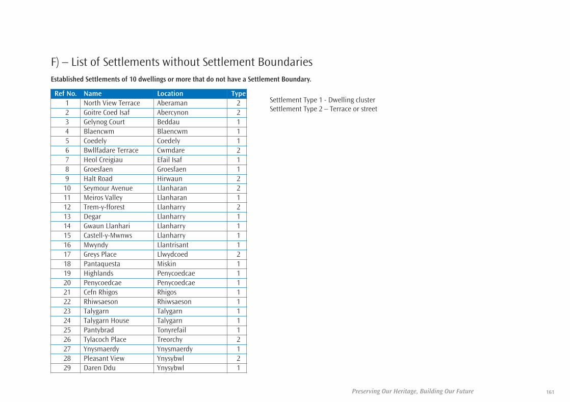
161Preserving Our Heritage, Building Our Future
F) – List of Settlements without Settlement BoundariesEstablished Settlements of 10 dwellings or more that do not have a Settlement Boundary.
Ref No. Name Location Type1 North View Terrace Aberaman 22 Goitre Coed Isaf Abercynon 23 Gelynog Court Beddau 14 Blaencwm Blaencwm 15 Coedely Coedely 16 Bwllfadare Terrace Cwmdare 27 Heol Creigiau Efail Isaf 18 Groesfaen Groesfaen 19 Halt Road Hirwaun 210 Seymour Avenue Llanharan 211 Meiros Valley Llanharan 112 Trem-y-fforest Llanharry 213 Degar Llanharry 114 Gwaun Llanhari Llanharry 115 Castell-y-Mwnws Llanharry 116 Mwyndy Llantrisant 117 Greys Place Llwydcoed 218 Pantaquesta Miskin 119 Highlands Penycoedcae 120 Penycoedcae Penycoedcae 121 Cefn Rhigos Rhigos 122 Rhiwsaeson Rhiwsaeson 123 Talygarn Talygarn 124 Talygarn House Talygarn 125 Pantybrad Tonyrefail 126 Tylacoch Place Treorchy 227 Ynysmaerdy Ynysmaerdy 128 Pleasant View Ynysybwl 229 Daren Ddu Ynysybwl 1
Settlement Type 1 - Dwelling clusterSettlement Type 2 – Terrace or street
35580-52 LDP plan 2011_Layout 1 30/06/2011 11:19 Page 161

Preserving Our Heritage, Building Our Future162
35580-52 LDP plan 2011_Layout 1 30/06/2011 11:19 Page 162

Preserving Our Heritage, Building Our Future 163
Special Areas ofConservationNorthern Strategy Area:• Coedydd Nedd a Mellte (part);• Blaen Cynon (part)
Southern Strategy Area:• Cardiff Beechwood (part)
Sites of Special Scientific InterestNorthern Strategy Area:• Blaenrhondda Road Cutting• Bryncarnau Grasslands,
Llwydcoed• Cors Bryn-y-Gaer, Hirwaun• Craig Pont Rhondda • Craig-y-Llyn, Rhigos (part)• Dyffrynoedd Nedd a Mellte &
Moel, Penderyn, (part)• Mynydd Ty-Isaf, Rhondda
Southern Strategy Area:• Brofiscin Quarry, Groesfaen• Brynna a Wern Tarw (part)• Castell Coch Woodlands, Taffs
Well (part)• Ely Valley, Miskin (part)• Llantrisant Common Pastures• Nant Gelliwion Woodland,
Pontypridd• Rhos Tonyrefail
Conservation AreasNorthern Strategy Area:• Aberdare Town Centre• Blaenrhondda• Llanwonno
Southern Strategy Area:• Glan-y-Llyn• Graigwen• Llanharan• Llanharry• Llantrisant• Miskin, Pontyclun• Pontypridd (Taff)• Pontypridd (Town Centre)• Talygarn• Treforest (Broadway)• Treforest (Old Park
Terrace)• Treforest (Riverside)• Troedrhiwtrwyn
Historic LandscapesNorthern Strategy Area:• Rhondda Historic Landscape
(former Rhondda Borough area)
Southern Strategy Area:• None
Historic Parksand GardensNorthern Strategy Area:• Aberdare Park
Southern Strategy Area:• Talygarn, Pontyclun• Llanharan House• Miskin Manor, Pontyclun• Ynysangharad War Memorial
Park, Pontypridd
Distribution of ScheduledAncient MonumentsNorthern Strategy Area:Aberaman ..................................2Aberaman & Ferndale................1Aberdare/Llwydcoed ................10Cwmbach ....................................2Ferndale......................................2Hirwaun......................................3Maerdy ........................................2Mountain Ash ............................2Pentre ........................................1Pentre & Treorchy ......................1Porth ..........................................1Rhigos ........................................1Rhigos & Treherbert ..................1Treherbert ..................................4Treorchy ......................................4Ynyshir ........................................1Ystrad..........................................1
Southern Strategy Area:Llanharan ..................................5Llanharry ....................................1Llantrisant ..................................3Llantwit Fardre ..........................1Pontyclun....................................3Pontypridd..................................8Taffs Well ....................................1Tonyrefail....................................1
Statutory Designations
Appendix Two
35580-52 LDP plan 2011_Layout 1 30/06/2011 11:19 Page 163

Preserving Our Heritage, Building Our Future164
Distribution of Listed Buildings
Northern Strategy Area: Grade II Grade II* Grade I
Aberaman 6Abercynon 5Aberdare 57 2Cymmer 2Ferndale 3Hirwaun 16Llwydcoed 3 1Llwyn-y-pia 3Mountain Ash 6 1Pen-y-graig 1Penrhiwceiber 4Pentre 3 2Porth 14 1Rhigos 2Tonypandy 2 2Trealaw 4Trehafod 4 5Treherbert 4 1Treorchy 4 1Tylorstown 1Ynyshir 2Ynysybwl 4Ystrad 2Total* 152 16 0
Southern Strategy Area: Grade II Grade II* Grade I
Llanharan 19 1Llanharry 2Llantrisant 17 2Llantwit Fardre 2 2Pontyclun 25 1Pontypridd 84 13 3Taffs Well 16Tonyrefail 11Total* 176 19 3
*5 listed buildings are double counted lying across ward boundaries. The total at the time of the preparation of the LDP is therefore 361 not 366.
*5 listed buildings are double counted lying across ward boundaries. The total at the time of the preparation of the LDP is therefore 361 not 366.
35580-52 LDP plan 2011_Layout 1 30/06/2011 11:19 Page 164
Preserving Our Heritage, Building Our Future
To enable the preparation of a sound plan, Rhondda Cynon Taf County Borough
Council has collated a range of up-to-date information that will underpin and
strengthen the Local Development Plan. This evidence base will contain the
latest information on the economic, social and environmental characteristics
of Rhondda Cynon Taf.
EB1. Strategic Environmental Assessment Screening Opinion, 2005
In accordance with the requirements of the SEA regulations the Council
prepared a detailed Screening Opinion for the LDP.
EB2. SA/SEA Scoping Report, 2006
The Scoping Report for the Sustainability Appraisal (SA) of the Rhondda
Cynon Taf Local Development Plan (LDP) 2006 – 2021. It sets out the key
sustainability issues and objectives for the County Borough, and is
intended, through consultation to make the plan more sustainable.
EB3. Rhondda Cynon Taf LDP Preferred Strategy, 2007
The Local Development Plan, Preferred Strategy sets out for consultation,
the preferred option for the Local Development Plan Spatial Strategy. It
represents a strategy for Rhondda Cynon Taf, which sets out the guiding
principles for future planning decisions with a spatial vision and spatial
objectives for the area, consistent with national and regional planning
policy.
EB4. Preferred Strategy Sustainability Appraisal, 2007
This document is the summary of the Sustainability Appraisal (SA) Report for
Rhondda Cynon Taf’s Local Development Plan (2006 – 2021) Preferred
Strategy. It describes how the Sustainability Appraisal (SA) process was used
to assist in planning for the development and use of land within the County
Borough, as required by legislation and government guidance.
EB5. Appropriate Assessment (AA) of the Rhondda Cynon Taf County
Borough Council’s Local Development Plan: Preferred Strategy
Screening Report, 2007
The report contains the findings of a ‘screening’ process to determine if
the Local Development Plan will have a significant adverse effect on Natura
2000 sites or European Sites in and adjacent to the County Borough.
EB6. Rhondda Cynon Taf Local Development Plan: Preferred Strategy
Regulation 15 Statement of Consultation, 2008
The statement provides a record of the consultation undertaken as part of
the Preferred Strategy Process and a summary of the representations
received.
EB7. Rhondda Cynon Taf Deposit Draft Local Development Plan
2006 – 2021, 2009
The Local Development Plan (LDP) will provide the development strategy
and spatial policy framework for the LDP area over a fifteen-year period to
2021. The Plan will be used by the Council to guide and control
development, providing a basis for consistent and appropriate decision-
making.
165
Development Plan Evidence Base
Appendix Three
35580-52 LDP plan 2011_Layout 1 30/06/2011 11:19 Page 165

Preserving Our Heritage, Building Our Future
EB8. SA/SEA Deposit Draft Plan Sustainability Appraisal Report, 2009
The SA of Rhondda Cynon Taff’s Deposit Draft Plan has appraised the
effects of individual policies, as well as the overall effect of the plan,
including cumulative and incremental effects.
EB9. SA/SEA Deposit Draft Plan Non Technical Summary, 2009
This is the summary of the Sustainability Appraisal Report for Rhondda
Cynon Taf County Borough Council’s Deposit Draft Plan. It describes how
the Sustainability Appraisal (SA) process was used to assist in planning for
the development and the use of land, as required by planning legislation
and Welsh Government guidance.
EB10. Habitat Regulations Assessment (Appropriate Assessment) Report
Draft Deposit LDP, 2009
This report details the HRA (Appropriate Assessment) stage for Rhondda
Cynon Taf County Borough Council’s Draft Local Development Plan (LDP).
It sets out the methods, findings and conclusions of the Appropriate
Assessment.
EB11. Preferred Strategy Statement of Consultation Report, 2009
The purpose of this statement is to provide a record of the consultation
undertaken on the Local Development Plan (LDP) Preferred Strategy in
January/February 2007. The statement provides a summary of all
representations received and a response to the main issues raised.
EB12. Deposit Draft Representations Register, 2009
The register contains full details of the representations received during
February/March 2009, in respect of the policies and proposals contained
in the Deposit Draft LDP.
EB13. Alternative Site Representations Register, 2009
The register contains full details of the representations received during
June/July 2009, in respect of sites contained in the Alternative Sites
Consultation Register.
EB14. Representations Responses Register, 2009
The register contains the Council’s response and recommendations to all
representations received to the Deposit Draft LDP and Alternative Sites
Consultation Register. A response has also been provided to
representations received on the SA/SEA.
EB15. Sustainability appraisal / strategic environmental assessment of
Focussed Proposed Changes, 2009
The Council has prepared Focussed Changes to its Deposit Draft LDP
(January 2010). These changes have been reviewed by Enfusion as part of
the ongoing Sustainability Appraisal (SA) process to determine whether
there are likely to be any significant sustainability effects arising from the
changes to the plan
EB16. Delivery Agreement revised, 2010
The purpose of the Delivery Agreement is to provide details of the
timetable for the production of the Local Development Plan and establish
a full and continuous approach to community engagement and
involvement in the preparation of the Local Development Plan.
EB17. Statement of Focussed Changes, 2010
This document sets out Focussed Changes, and consequential
amendments, that the Council considers appropriate to make to the LDP
following consideration of the representations received during the Deposit
and Alternative Site consultations and changes in circumstances since the
publication of the Deposit LDP.
166
35580-52 LDP plan 2011_Layout 1 30/06/2011 11:19 Page 166
167Preserving Our Heritage, Building Our Future
EB18. Habitats Regulations Assessment
(Appropriate Assessment) Report, 2010
This report, prepared by consultants ‘Enfusion’, details the HRA
Appropriate Assessment stage for Rhondda Cynon Taf County Borough
Council’s (RCT) Local Development Plan (LDP). It sets out the methods and
findings and the conclusions of the Appropriate Assessment. Further to
the HRA Appropriate Assessment as listed above as EB10, this report
undertakes further screening and assessment subsequent to the Deposit
stage consultation representations.
EB19. Urban Capacity Study Upper and Central Rhondda, 2005
The study outlines the findings of the Urban Capacity Study undertaken
to review the availability of developable land in the central and upper
Rhondda Valleys.
EB20. Candidate Site Assessment Methodology, 2006
The Candidate Site Assessment Methodology has been developed by
Rhondda Cynon Taf County Borough Council to reflect guidance from the
Welsh Government. The Candidate Site Assessment Methodology
document sets out the preferred methodology for the consideration of
land for development in the emerging Local Development Plan. In doing
so, it identifies the guiding principles for establishing potential new site
allocations, consistent with national and regional planning policy and
Sustainability Appraisal / Strategic Environment Assessment objectives.
EB21. Candidate Sites Register, 2007
The Candidate Sites Register provides details of all the sites submitted to
the Council for inclusion in the LDP process.
EB22. Findings of the Candidate Site Assessment Process, 2009
The document contains the detailed findings of each stage of the
Candidate Site Process. The document provides a detailed assessment of
each site including a constraints sustainability appraisal and the results of
consultation with special consultation bodies.
EB23. Alternative Site Consultation Register, 2009The Alternative Site Register sets out the site allocation representations thatwere received during the consultation on the Deposit Draft LocalDevelopment Plan. The register is in four parts; a site index, new sites forinclusion in the LDP, proposed amendments to the settlement boundaryand sites proposed for deletion from the LDP.
EB24. Delivery Agreement Consultation Record, 2005This document is a record of the engagement and consultation exercisesthat the Council undertook in the development of its Delivery Agreementbetween June and November 2005.
EB25. Report on the findings of visioning workshop, 2006The purpose of this report is to record and analyse the information andopinions gathered at two visioning workshops; one with elected membersand the second with key stakeholders, which included representativesfrom a wide range of organisations. The report provided the Council witha clear indication of the views and wishes of those attending theworkshops and a basis on which to undertake further consultation withthe wider community.
35580-52 LDP plan 2011_Layout 1 30/06/2011 11:19 Page 167

Preserving Our Heritage, Building Our Future
EB26. LDP Forum Event Record, 2006The Local Development Plan Forum Event Record is a summary of keypoints from three Local Development Plan Visioning Workshops withCouncil Members, Community Representatives and key stakeholders. Thepurpose of the workshops was threefold; to identify the main issues thatthe Local Development Plan would need to address, to begin consideringhow these issues would be addressed through various future developmentstrategies and finally to discuss the three main aspects of the draftPreferred Strategy.
EB27. Placemaking Event Record, 2007This document is a record of the Placemaking workshops that the Councilundertook during August and September 2007. The record outlines theCouncils discussions and preparations of the concept plans for thestrategic sites, which are a key part of the Councils Preferred Strategy.
EB28. Event record of pre-deposit consultation with key infrastructureproviders, 2008In order for key infrastructure providers to make representations toallocations in the Draft Deposit Draft LDP the Council has undertook apre-deposit public consultation. This is a record of the process ofconsultation with key infrastructure providers and the representationsreceived.
EB29. Sustainability Appraisal Targets & Indicators Consultation, 2008In order for a Monitoring Strategy to be prepared that will observe thesustainability effects of the Local Development Plan (LDP), the Councildeveloped and consulted on an up-to-date set of targets and indicators,to meet monitoring requirements for both the LDP and the SustainabilityAppraisal (SA) process. The consultation sought the views of neighbouringlocal authorities in Southeast Wales, consultees, members of the public
and internal Council departments on the 21 Sustainability AppraisalTargets and Indicators.
EB30. LDP Forum Event Record, 2008
This document is a record of a meeting of the LDP Forum that was heldon the 17th November 2008 at the Valleys Innovation Centre, Abercynonto discuss policy refinement in the Deposit Draft Local Development Plan(LDP).
EB31. Minutes of the Housing delivery workshop, 2009The housing deliverability workshop sought the views of house builders anddevelopers with regards to the deliverability of the allocated housing sitesand the timescale for the delivery within the plan period.
EB32. Rhondda Cynon Taf Progress Report on Population and DwellingProjection, 2006The population and household projections provides the detailed statisticalbasis from which the dwelling requirement figure for the LDP is derived.The projections use the ‘Chelmer’ model and forecast population,household and dwelling requirement rates for Rhondda Cynon Taf.
EB33. Rhondda Cynon Taf 2006 Housing Needs Assessment, 2006Fordham Research were commissioned by Rhondda Cynon Taf CountyBorough Council to undertake a Housing Needs Assessment Study toassess the future requirements for both affordable and market housingacross all tenures, areas and client groups in the local community.
168
35580-52 LDP plan 2011_Layout 1 30/06/2011 11:19 Page 168

169Preserving Our Heritage, Building Our Future
EB34. South East Wales Regional Housing Apportionment Seminar, 2007In accordance with the guidance contained in Planning Policy Wales, theCouncil as part of the South East Wales Planning Group (SEWPG) has beeninvolved in the process of apportioning housing land requirement for theSouth East Wales region. The process requires SEWPG to work with a rangeof stakeholders to agree population and household projections and theapportionment of these projections for each Local Authority area in theregion. The process was completed in summer 2007. The results of theprocess informed the development of the housing land requirements ofthe emerging Rhondda Cynon Taf LDP.
EB35. Joint Housing Land Availability Study, 2007This study, prepared by Welsh Government under TAN 1 and published inJuly 2008, assesses the availability of land for housing development in theplan area at 01/04/07 against the requirement for a 5-year land supply.
EB36. Housing Matters - Local Housing Strategy for Rhondda Cynon Taf2007 – 2012 (2007)Rhondda Cynon Taf’s Local Housing Strategy aims to provide a strategicframework that ensures all citizens in Rhondda Cynon Taf have access todecent, affordable housing and safe living environments.
EB37. Rhondda Cynon Taf Affordable Housing viability Study FinalReport, 2009This guidance was prepared for the Council by Three Dragons, using theirviability testing method (EB115). The LDP area is divided into 4 housingsub market areas, and the broad effects on viability of land values, densityof development and grant availability are considered.
EB38. Rhondda Cynon Taf Local Development Plan 2006 - 2021Assessment of Housing Requirements and delivery (NLP), 2009This report for the Council by Nathaniel Lichfield & Partners tests the LDPproposed housing land supply against the 2006-based population andhousehold forecasts. The deliverability of the proposed housing landallocations is considered.
EB39. Rhondda Cynon Taf Economic Development Prospects andEmployment Land Implications, 2006The study analysed the demand for employment land within the CountyBorough, as well as reviewing the current employment land offer andsupply that may be available in the future. Critically, the study builds uponthe Review of the Economic Regeneration Strategy of Rhondda Cynon Taf(2006) and incorporates the future needs of key growth sectors within theCounty Borough..
EB40. Review of the Rhondda Cynon Taf Economic RegenerationStrategy, 2006
This report seeks to provide an up-to-date review and detailed
information relating to the progress of the Rhondda Cynon Taf Economic
Regeneration Strategy.
EB41. Employment Land Review (NLP), 2008
Nathaniel Lichfield and Partners have been appointed by the Council to
undertake an employment land study to the Local Development Plan.
The study is intended to assist the Council in its consideration of the
existing economic position within the area; in making decisions on the
amount of land that is required to deliver its economic aspirations; and
in assessing the need to allocate new land or release existing land to
achieve a balanced portfolio of sites.
35580-52 LDP plan 2011_Layout 1 30/06/2011 11:19 Page 169

Preserving Our Heritage, Building Our Future
EB42. Rhondda Cynon Taf Employment Land Availability Schedule, 2008
This document sets out the situation regarding the availability of land for
employment related development in Rhondda Cynon Taf County Borough
Council up to the 1st January 2008.
EB43. Employment Land Review - Availability Schedule, 2009
This document sets out the situation regarding the availability of land for
employment related development in the Rhondda Cynon Taff County
Borough Council area up to the 1st April 2009.
EB44. Sites of Importance for Nature Conservation in RCT – Site
Descriptions, 2008
Prepared by the Council’s Countryside section, the report gives full detail
of the updated designation of Sites of Importance for Nature
Conservation. It outlines the flora and fauna that exist on the land, the
scale and location of the designation along with the specific features of
the site that qualify it for designation, as identified by regionally agreed
criteria (see EB46).
EB45. Rhondda Cynon Taff Earth Science Audit, 2003 – 2004 (2004)
This document outlines the audit of 565 Earth Science sites throughout
Rhondda Cynon Taf and considers locations / outcrop areas with current
and / or potential for geoconservation. The study identifies the sites
recommended for Regionally Important Geological Site status as shown on
the Proposals Map.
EB46. Criteria for the Selection of Sites of Importance for Nature
Conservation in the County Boroughs of Blaenau Gwent, Caerphilly,
Merthyr Tydfil and Rhondda Cynon Taff (the ‘Mid-Valleys Area’), 2008
This document has been produced to identify consistent criteria to identify
Sites of Importance for Nature Conservation (SINC’s) for the above Local
Authorities. It was used in the re-assessment of the SINC’s in Rhondda
Cynon Taf in 2008, the results of which are shown on the Constraints map
and listed in Appendix 1 E.
EB47. A Local Biodiversity Action Plan for Rhondda Cynon Taf, 2000
The Local Biodiversity Action Plan will aim to conserve and enhance the
biodiversity of the County Borough and will report to a wider biodiversity
partnership.
EB48. Development of Criteria for Special Landscape Area Designation
for South East Wales Local Authorities, 2007
The strategy commissioned by a consortium of South East Wales Planning
Authorities outlines a methodology for analysing and designating Special
Landscape Areas.
EB49. Proposals for Designation of Special Landscape Areas in Rhondda
Cynon Taf, 2008
The study provides a detailed analysis of the landscape characteristics of
Rhondda Cynon Taf and makes recommendations about areas to be
designated as Special Landscape Areas in the LDP.
EB50. Greenspace Provision Report, 2007
The study undertaken in 2007 assessed the provision of green space within
Rhondda Cynon Taf.
170
35580-52 LDP plan 2011_Layout 1 30/06/2011 11:19 Page 170

Preserving Our Heritage, Building Our Future 171
EB51. Open Space and Play/Sport Area Provision Report, 2007
The study undertaken in 2007 assessed the provision of open space and
play / sport area provision in Rhondda Cynon Taf.
EB52. SEWBREC Biodiversity Information Search Results, 2009
This comprehensive survey report, prepared by the South East Wales
Biodiversity Records Centre, includes an inventory of all species of flora,
fauna and nature conservation designations that exist within, and within
500 metres of, all LDP development allocation sites.
EB53. Tourism Opportunities Study for the Heads of the Valleys Area of
Rhondda Cynon Taf Final Report, 2007
The study identified and evaluated the potential tourism opportunities
within the defined Heads of the Valleys area of Rhondda Cynon Taf (the
Study Area).
EB54. Rhondda Cynon Taf Tourism Strategy: Reaching Destination
Rhondda Cynon Taf 2007 – 2013 (2007)
The Tourism Unit of Rhondda Cynon Taf County Borough Council
generated the tourism strategy with a vision to improve the profile and
“tourism offer” of Rhondda Cynon Taf so that prospective visitors would
believe the County Borough to be one of the UK’s short break destinations
by 2013.
EB55. Out and About, The Rights of Way Improvement Plan
for Rhondda Cynon Taf, 2007
The Out and About Plan is the final stage in the Rights of Way
Improvement Plan process. The Assessment quantifies the extent of the
countryside access network available for public recreation and enjoyment.
EB56. Cynon Valley River Park Draft Strategy, 2007
The Cynon Valley River Park is a floodplain environment on the valley
floor that stretches from Rhigos and Penderyn in the north to Abercynon
in the south. The Cynon Valley River Park Strategy updates the original
concept, taking into account changes in the planning context, new
development proposals and community aspirations, the adopted Local
Biodiversity Action Plan and the Heads of the Valleys environmental
programme.
EB57. Rhondda Cynon Taf Leisure Study, 2008
Nathaniel Lichfield and Partners have been appointed by Rhondda Cynon
Taf County Borough Council to undertake an assessment of indoor leisure
provision within the Borough.
EB58. Rhondda Cynon Taf Household Leisure Patterns Report (NLP), 2008
This report for the Council by Nathaniel Lichfield & Partners examines the
pattern of use of leisure facilities based on a household survey and
identifies future needs.
EB59. Rhondda Cynon Taf Strategic Flood Consequences Assessment,
2008
Scott Wilson were commissioned by Rhondda Cynon Taf County Borough
Council with assistance from the Environment Agency (Wales) in 2008 to
prepare a Strategic Flood Consequences Assessment, principally of the 8
LDP strategic sites and Treforest Industrial Estate.
EB60. Robertstown Broad Level Flood Consequences Assessment, 2010
Scott Wilson prepared this report for the Council to meet the TAN 15:
Development and Flood Risk (2004) requirement for assessment of the
flood consequences of the employment and leisure allocation in the
Robertstown / Abernant Strategic Site.
35580-52 LDP plan 2011_Layout 1 30/06/2011 11:19 Page 171

Preserving Our Heritage, Building Our Future
EB61. Rhondda Cynon Taf LDP Surface Water Analysis, 2010
The aim of this report is to provide the Council with an outline analysis of
draft LDP land allocations, including Strategic Sites that are potentially
constrained by surface water flood risk.
EB62. Porth Town Centre Regeneration Strategy, 2003
The Council commissioned Camlin Lonsdale to produce a strategy that
provided a focused plan, achieved consensus within the town centre
community, defines agreed actions, identifies implementation costs and
potential programmes and accommodates all existing proposals for the
Porth-Lower Rhondda Fach Relief Road.
EB63. Treorchy Town Centre Regeneration Strategy, 2003
Produced by Wyn Thomas, Gordon Lewis, the Regeneration Strategy for
Treorchy Town Centre sets a vision for Treorchy that addresses the three
main issues of new development opportunities within and around the
town centre; the enhancement of the retail centre of the town through
physical works and recommendations on management and promotion
activities; and, the full range of transportation issues affecting the town.
EB64. Pontypridd Regeneration Strategy Final Report, 2005
The Regeneration Strategy for Pontypridd Town Centre was prepared by
Atkins in order to place current activity and future opportunities into the
context of a single ‘Framework document’, and to create a comprehensive
and co-ordinated long term (10 year) strategy for the development of the
town.
EB65. Llantrisant Old Town Regeneration Strategy, 2005
The Council commissioned Hyder Consulting (UK) Ltd in partnership with
Davies Sutton Architects and Geoff Broom Associates to produce a
Regeneration Strategy for Llantrisant Old Town. The purpose of the
strategy is to show the way forward for the regeneration of Llantrisant’s
Old Town, so that it can maximise its potential as the principal “gateway”
settlement into the Taff Ely Vale and positively utilise the Old Town’s
unique historic attributes to act as a catalyst for the regeneration of the
Rhondda Cynon Taff area.
EB66. Tonyrefail Town Centre Regeneration Strategy, 2006
The Council commissioned Hyder Consulting (UK) Ltd in June 2005 to
produce a Regeneration Strategy for Tonyrefail Town Centre. The brief set
the task of formulating a fully costed strategy for the regeneration of
Tonyrefail, setting the context for new development opportunities and
creating a thriving and vibrant town centre which meets the needs of the
expanding population in the area.
EB67. Ferndale Regeneration Strategy, 2006
Prepared by consultants RPS, the aim of the strategy is to provide a
framework for Rhondda Cynon Taff and local representative community
led groups to co-ordinate regeneration activity and to promote events in
Ferndale. This would include new development opportunities within and
around the town centre. Enhancing the retail centre of the town through
physical works and recommendations on management and promotion
activities. Addressing the range of transportation issues affecting the town
and developing the tourism potential of the area.
EB68. Mountain Ash Town Centre Regeneration Strategy, 2002
Atkins were commissioned by the Council on behalf of the Mountain Ash
Town Forum to prepare a regeneration strategy for Mountain Ash town
centre. Funded by the Welsh Development Agency, the aim of the study
was to formulate a strategy for the regeneration of the town, thus setting
the context for new development opportunities and creating a thriving
and vibrant town centre.
172
35580-52 LDP plan 2011_Layout 1 30/06/2011 11:19 Page 172

173Preserving Our Heritage, Building Our Future
EB70. Rhondda Cynon Taf County Borough Council Retail Capacity
Assessment Quantitative Update, 2008
The study commissioned on behalf of Rhondda Cynon Taf County
Borough Council to prepare this quantitative retail study update. The
study assesses the quantitative scope for new retail floorspace in RCT in
the period 2007 – 2021. The report sets out the methodology adopted for
this analysis and provides a quantitative capacity analysis in terms of
levels of spending for convenience and comparison-shopping.
EB71. Rhondda Cynon Taf Retail Study: Supplementary Report on
Proposed Town Centre Llantrisant, 2008
The study commissioned on behalf of Rhondda Cynon Taf County
Borough Council to produce a supplementary report to the 2007
Quantitative Update of the RCT Retail Study. In the process of producing
the Local Development Plan, Rhondda Cynon Taf County Borough Council
has considered a new retail centre in Mwyndy / Talbot Green, and
consideration has therefore been given to what, if any would be an
appropriate size, function and format of the new centre.
EB72. Explanatory Memorandum on LDP Retail Evidence following
changes to Pontypridd Commitments, 2009
Nathaniel Lichfield & Partners provided the Council with advice on the
implications for the LDP of the approval of the smaller Riverside scheme
in place of the Angharad Walk scheme in central Pontypridd.
EEB73. Hanson’s Aggregates Background Documents
A) Assessment of Environmental Effects of blasting at Craig yr Hesg
quarry, 2004
This report was prepared by consultants ‘Vibroc Ltd’ on behalf of Hansons
Aggregates, as supporting information for the Candidate Site at Craig yr
Hesg quarry. It details the blasting process undertaken in hard-rock
quarries in general terms and specifically how such operations take place
at the existing quarry.
B) Extension to Craig Yr Hesg Quarry Briefing Note 2008
This Briefing note was prepared by consultants ‘White young Green’ on
behalf of Hansons Aggregates. It outlines the current operational
processes at the quarry including details of production. It sets out the
requirements of national and regional minerals policies in relation to
ensuring future production and the suitability of Craig yr Hesg to achieve
this.
C) Craig Yr Hesg Quarry landscape and visual appraisal of proposed
extension site 2006
Produced by consultants ‘White Young Green’ on behalf of Hansons
Aggregates’, the report gives details of the physical landform changes that
would result from the proposed quarry extension site.
EB74. Regional Waste Plan 1st Review, 2008
The Regional Waste Plan 1st Review is a non-statutory plan prepared
through a voluntary joint arrangement of 11 Local Planning Authorities
with the assistance of other key stakeholders. Once endorsed by each of
the Local Planning Authorities and agreed by the Welsh Government, the
RWP 1st Review will become a strategic framework for the preparation of
Local Development Plans and a material consideration in the
development control process.
35580-52 LDP plan 2011_Layout 1 30/06/2011 11:19 Page 173

Preserving Our Heritage, Building Our Future
EB75. Regional Technical Statement for the area covered by the South
Wales Aggregates Working Party, 2008
The main purpose of the statement is to set out the strategy for the
provision of aggregates in the South Wales region for the period until
2021. It sets out on a Minerals Planning Authority basis, where allocations
for future aggregate provision is required to ensure a 10 year landbank of
aggregates throughout the LDP plan period.
EB76. Minerals Background Paper, 2009
This background paper has been prepared to give detailed clarification
of, and outline the evidence behind, the formulation of the Deposit Plan’s
minerals policies.
EB77. Rhondda Cynon Taf Local Development Plan 2006 – 2021:
Renewable Energy Study, 2005
The aim of the Renewable Energy Study is to briefly examine the
opportunities and constraints to the development of renewable energy
and energy efficiency within the County Borough of Rhondda Cynon Taf,
to inform decision-making in the formation of policies on renewable
energy for the Local Development Plan 2006 – 2021.
EB78. TAN 8 Annex D Study of Strategic Search Areas E and F: South
Wales Valleys Final Report, 2006
The study commissioned by a consortium of South Wales Authorities seeks
to analyse and retrieve the strategic search area for the harnessing of
energy and wind power contained in TAN 8: Planning for Renewable
Energy (2005)
.
EB79. Access, Circulation and Parking Study, 2007
The study was commissioned by Rhondda Cynon Taf County Borough
Council to establish an evidence base from which modern highway
standards in relation to access, parking and circulation will assist in
meeting wider regeneration objectives in the County Borough.
EB80. Strategic Transport Assessment, 2007
Hyder Consulting were commissioned by the Council to assess eight
strategic sites in terms of their associated traffic impact upon the strategic
highway network. This report has addressed the transport implications of
forecast development on the eight strategic sites.
EB81. Strategic Transport Corridors Infrastructure Needs Studies, 2009
In March 2008 Hyder was commissioned by the Council to develop a traffic
model to establish the baseline traffic situation along the A4119 and A473
corridors. It was also a requirement to assess the degree of highway
improvements to the strategic highway network that would be needed to
accommodate the likely traffic volumes that will result from the
development of strategic and candidate sites put forward for
consideration in the emerging Local Development Plan.
EB82. LDP Cabinet, Council and Development Control
Committee Reports
This document provides a list of references to LDP documents at various
stages of the LDP process in the Council’s Cabinet, Council and
Development Control Committee reports dating back to when work began
on the preparation of the LDP.
174
35580-52 LDP plan 2011_Layout 1 30/06/2011 11:19 Page 174

175Preserving Our Heritage, Building Our Future
EB83. Housing Land Topic Paper, 2007
The LDP: Housing Land Topic Paper (January 2007) provides the statistical
analysis and background to the dwelling requirement figures contained
in the LDP: Preferred Strategy. In doing so the topic paper examines
population and house building trends in Rhondda Cynon Taf and outlines
population and dwelling requirements for the plan period.
EB84. Employment Land Topic Paper, 2007
This Topic Paper sets out the statistical background analysis and
justification for the scale of land allocations identified in the Rhondda
Cynon Taf Local Development Plan 2006-2021: Preferred Strategy
document.
EB85. Climate Change Topic Paper, 2008
This topic paper sets out the national and regional planning policy context
relating to climate change. It then guides the formulation of draft LDP
policies for the topic, giving consideration to local circumstances and
characteristics.
EB86. Design Topic Paper, 2008
This topic paper sets out the national and regional planning policy context
relating to Design. It then guides the formulation of draft LDP policies for
the topic, giving consideration to local circumstances and characteristics.
EB87. Transportation Topic Paper, 2008
This topic paper sets out the national and regional planning policy context
relating to Transportation. It then guides the formulation of draft LDP
policies for the topic, giving consideration to local circumstances and
characteristics.
EB88. Employment Topic Paper, 2008
The topic paper will develop draft LDP policies, which will set out the
policy framework for the delivery of employment sites. The paper should
be read in conjunction with the Employment Land Requirement Topic
Paper (Jan 2007).
EB89. Green Wedge Topic Paper, 2008
The purpose of this topic paper is to determine green wedge designations
and associated draft policies in the Local Development Plan (LDP) 2006-
2021.
EB90. Town Centre Topic Paper, 2008
The purpose of this topic paper is to set out the background and suggested
draft town centre policies to form part of the Local Development Plan
(LDP) 2006-2021.
EB91. Waste Management Topic Paper, 2008
The purpose of this Topic Paper is to develop the draft LDP policies which
will set out the policy framework for land use aspects of waste disposal
and make provision for facilities for waste management in Rhondda
Cynon Taff.
EB92. Tourism Topic Paper, 2008
The purpose of this Topic Paper is to set out the background and
suggested Draft Tourism Policies to form part of the Local Development
Plan (LDP) 2006-2021.
35580-52 LDP plan 2011_Layout 1 30/06/2011 11:19 Page 175

Preserving Our Heritage, Building Our Future
EB93. Leisure & Recreation Topic Paper, 2008
This topic paper sets out the national and regional planning policy context
relating to leisure and recreation. It then guides the formulation of draft
LDP policies for the topic, giving consideration to local circumstances and
characteristics.
EB94. Housing Topic Paper, 2008
This topic paper reviews the issues relating to provision of housing land,
and proposes policies for the Draft LDP.
EB95. Infrastructure Topic Paper, 2008
This topic paper sets out the national and regional planning policy context
relating to infrastructure. It then guides the formulation of draft LDP
policies for the topic, giving consideration to local circumstances and
characteristics.
EB96. Retail Topic Paper, 2008
This draft topic paper, originally prepared in 2007, proposes retail policies
for the Draft LDP. Retail planning commitments are summarised and retail
centre boundaries are reviewed.
EB97. Renewable Energy Topic Paper, 2008
This topic paper sets out the national and regional planning policy context
relating to Renewable Energy. It then guides the formulation of draft LDP
policies for the topic, giving consideration to local circumstances and
characteristics.
EB98. Natural Environment Topic Paper, 2008
This topic paper sets out the national and regional planning policy context
for the natural environment and nature conservation. It then guides the
formulation of draft LDP policies for the topic, giving consideration to
local circumstances and characteristics.
EB99. Minerals Topic Paper, 2008
This topic paper sets out the national and regional policy context relating
to minerals planning issues. It then guides the formulation of draft LDP
policies for the topic, giving consideration to local circumstances and
characteristics.
EB100. Design and Placemaking (SPG), 2010
The SPG sets out placemaking and design guidance aimed at raising the
standards of development to help deliver new sustainable communities
and to ensure that new development makes a positive contribution to
regenerating existing communities in Rhondda Cynon Taf.
EB101. The Historic Built Environment (SPG) 2010
This Supplementary Planning Guidance (SPG) gives detailed guidance to
owners and occupiers of land and buildings within the historic built
environment, and anyone wishing to develop within it or make alterations
to it, and is a material consideration in the determination of relevant
planning applications.
EB102. Design in Town Centres (SPG), 2010
This SPG provides guidance is for owners/occupiers of town centreheritage
properties within Rhondda Cynon Taf who are considering alterations and
repairs to their buildings. The SPG will also provide the Council with
assistance when in discussion with owners/occupiers and when
considering planning applications.
EB103. A Design Guide for Householder Development (SPG), 2010
This document sets out design guidance for householders and aims to
raise the standard of householder development to ensure that new
development makes a positive contribution to regenerating communities
in Rhondda Cynon Taf.
176
35580-52 LDP plan 2011_Layout 1 30/06/2011 11:19 Page 176

177Preserving Our Heritage, Building Our Future
EB104. Affordable Housing (SPG), 2010
This SPG provides greater detail on the affordable housing requirements
in the policies of the LDP.
EB105. Nature Conservation (SPG), 2010
This Supplementary Planning Guidance (SPG) for Nature Conservation has
been produced in conjunction with the Rhondda Cynon Taf Local
Development Plan and provides additional guidance to support the
policies, allocations and constraints identified in the Plan relating to
biodiversity, soil and earth science features.
EB106. Planning Obligations (SPG), 2010
The aim of this Supplementary Planning Guidance (SPG) is to provide a
clear picture of what types of obligations developers may be expected to
contribute towards, the likely amounts of these obligations and the trigger
points at which different obligations will be sought by the Council. It will
form the basis of negotiations between all parties.
EB107. Delivering Design and Placemaking (SPG), 2010
This SPG provides details of requirements under the LDP for transport
tariff payments, transport assessments, travel plans, parking
requirements, the design of roads and paths and commuted sums
payments.
EB108. Roles & Functions of Settlements Paper, 2008
This background paper demonstrates why specific towns and villages have
been identified as principal towns and key settlements and sets out the
methodology used to develop the settlement hierarchy. To do this, the
paper outlines what are ‘sustainable’ settlements, the settlement
hierarchy of Rhondda Cynon Taf, the methodology used to record the
services/facilities/uses that identify principal towns, key settlements, and
local and neighbourhood centres, a record of the services/facilities/uses
that define the settlements in the hierarchy and their role in the Wider
Region.
EB109. Preferred Strategy Background Paper, 2008
The topic paper outlines the current and emerging policy context for the
Core Strategy, responses to the Representations received to the strategy
outlined in the LDP: Preferred Strategy, and draft LDP Policy, which
outlines a core strategy amended in light of the changes to the policy
context and the representations.
EB110. Settlement Strategy Background Paper, 2009
This paper provides explanations of how the settlement strategy for the
Local Development Plan (LDP) was developed; the role different
settlements in the hierarchy will play in delivering the Preferred Strategy
and the development and role of the settlement boundaries in the
strategy.
EB111. Strategic Sites Background Paper – Final, 2010
This paper describes the background to the definition of the 8 strategic
sites listed in the LDP Preferred Strategy. A list of relevant evidence, details
of consideration of alternatives, a summary of the infrastructure issues
and a sensitivity test to changes in the proposals are provided.
EB112. Targets & Indicators Background Paper, 2010
The purpose of this background paper is to explain how the LDP has been
prepared to provide both certainty and flexibility in its application and
explain the framework that will be used to monitor the implementation
of the LDP.
35580-52 LDP plan 2011_Layout 1 30/06/2011 11:19 Page 177
Preserving Our Heritage, Building Our Future
EB113. SEWSPG Habit Regulations Assessment - A Toolkit to support HRA
Screening & Appropriate Assessment of Plans, 2008
This Toolkit has been produced by Enfusion Ltd to provide the members
of the South East Wales Strategic Planning Group (SEWSPG) with a simple,
clear, systematic method to support planners in the completion of robust
and compliant Habitats Regulations Assessment (HRA) Screening and full
Appropriate Assessment if necessary.
EB114. Record of Development of Preferred Strategy, 2007
The purpose of this paper is to outline the policy context and stages
undertaken to prepare the Rhondda Cynon Taf Local Development Plan
(LDP) Preferred Strategy. The paper details the factors and discussions that
have both informed and shaped the Preferred Strategy between January–
November 2006.
EB115. SEWSPG - Guidance on Preparing Affordable Housing Viability
Studies, 2009
This guidance was prepared by Three Dragons for the South East Wales
Strategic Planning Group. It provides a method for testing the viability of
housing proposals.
EB116. A Better Life Our Community Plan 2004 – 2014, 2004
“A Better Life” is the Community Plan for Rhondda Cynon Taf and sets out
a framework for creating a brighter future for everyone who lives and
works in Rhondda Cynon Taf. A range of local partners, through the
Rhondda Cynon Taf Better Life Consortium, developed the Community
Plan.
EB117. Rhondda Cynon Taf County Borough Council Contaminated Land
Strategy, 2004
Outlines the Council’s Strategy for dealing with land contamination within
the Borough.
EB118. Children and Young People’s Plan for Rhondda Cynon Taf, 2008 –
2011 (2008)
Fframwaith, the Children and Young People’s Partnership, with the help
of local children and their families, have produced the first Children and
Young People’s Plan for Rhondda Cynon Taf. The Plan is designed to meet
the needs of children and young people living in our communities,
through collaboration with local agencies and services for children.
EB119. Hirwaun Village Study, 2008 (NLP)
The study provides a detailed analysis of the socio-economic
characteristics of Hirwaun and makes recommendations about the
potential growth of the settlement.
EB120. Llanharan Village Study, 2008 (NLP)
The study provides a detailed analysis of the socio-economic
characteristics of Llanharan and makes recommendations about the
potential growth of the settlement.
EB121. Health Social Care and Well-Being Strategy, 2008-2011 (2008)
The Health Social Care and Well-Being Strategy, 2008 - 2011 is the second
strategy to be developed by the Health, Social Care and Well-Being
Partnership Board to tackle the underlying causes of ill health and health
inequality in deprived areas. The strategy reviews what has been achieved
to date and prioritises the next stages to improve access to healthcare and
quality of life for local residents.
178
35580-52 LDP plan 2011_Layout 1 30/06/2011 11:19 Page 178

179Preserving Our Heritage, Building Our Future
EB122. Rhondda Cynon Taf Planning Obligations Review
Final Report, 2005
The study provides detailed research and analysis of the form and
application of planning obligations. The document provides the basis for
the development of LDP policy.
EB123. Draft Retail & Leisure Development: Approach to
Site Selection, 2008
This paper provides the background details of the process of selection of
sites allocated in the LDP for retail and leisure development.
EB124. Retail Study – Rhondda Cynon Taf Household Survey, 2006
This data on household shopping patterns was compiled by NEMS Market
Research for Nathaniel Lichfield & Partners, to inform the Rhondda Cynon
Taf Retail Capacity Assessment Quantitative Update (EB70).
EB125. Draft Gypsy and Traveller Accommodation Assessment, 2007
The Council commissioned an analysis of existing data sources in
November 2006 in relation to Gypsy and Traveller accommodation and
this report sets out the results. The report identifies the existing data
sources and presents findings from these sources and a short
questionnaire. It sets the findings within a context for Rhondda Cynon
Taf.
EB126. ‘Live. Grow. Aspire. Achieve’, Rhondda Cynon Taf Community
Strategy (2010 – 2020), 2010
The strategy sets out the vision for Rhondda Cynon Taf and describes some
of the things partners in the County Borough will do to make Rhondda
Cynon Taf one of the best places to live, work and visit in South Wales.
35580-52 LDP plan 2011_Layout 1 30/06/2011 11:19 Page 179

Preserving Our Heritage, Building Our Future180
35580-52 LDP plan 2011_Layout 1 30/06/2011 11:19 Page 180

181Preserving Our Heritage, Building Our Future
Adaptation – Involves adjustments to natural or human systems in response
to actual or expected climatic stimuli or their effects, which moderates, harms
or exploits beneficial opportunities.
Adventure Tourism - Adventure tourism is a type of niche tourism involving
exploration or travel to remote areas, where the traveller should expect the
unexpected. Adventure tourism is rapidly growing in popularity as tourists seek
unusual holidays, different from the typical beach holiday.
Affordable Housing - Housing, whether for rent, shared ownership or outright
purchase, provided at a cost considered affordable in relation to incomes that are
average or below average, or in relation to the price of general market housing.
Biomass - Biomass refers to living and recently dead biological material that
can be used as fuel or for industrial production. Most commonly, biomass refers
to plant matter grown for use as bio fuel, but it also includes plant or animal
matter used for production of fibres, chemicals or heat. Biomass may also
include biodegradable wastes that can be burnt as fuel. It excludes organic
material which has been transformed by geological processes into substances
such as coal or petroleum.
Candidate Site Process - As part of the preparation towards preparing the Local
Development Plan (LDP), developers, service providers, landowners and others
with an interest in land are invited by their Local Planning Authority to submit
sites they wish to be considered for development or other uses through the LDP.
The sites identified are referred to as Candidate Sites. Candidate Sites may be
submitted for potential uses such as: housing, employment, retail, leisure, waste,
transport (e.g. park and ride sites), open space, health and community uses.
Capital Region - Cardiff, Newport and the Valleys make up the Capital Region
identified in the Wales Spatial Plan (2008 Update) occasionally also called the
‘Capital Network’. The area has major contrasts between prosperity and
deprivation, and a ribbon pattern of urban development reflects the historical
development of the coal and steel industries. Carbon Dioxide (CO2) Emissions
- Results from the burning of fossil fuels and is claimed to be a major
component of global warming.
Carbon Sinks – Forests, soils, oceans and the atmosphere all store carbon,
which moves among those different carbon pools over time; these four
different carbon stores form the active carbon pool. If one of these pools
absorbs more carbon than it gives off, it is called a 'sink'. Class A – Use Class A1:
Shops – for example: retail warehouses, hairdressers, undertakers, travel and
ticket agencies, post offices, dry cleaners, sandwich shops etc. Use Class A2:
Financial and professional services - banks, building societies, estate and
employment agencies, betting offices. Use Class A3: Food and drink -
restaurants, public houses, snack bars, cafés, wine bars, shops for the sale of
hot food..
Climate Change – Long-term changes in temperature, precipitation, wind and
all other aspects of the Earth's climate. Often regarded as a result of human
activity and fossil fuel consumption.
Committed sites - All sites with current planning permission or allocated in
adopted development plans for development (particularly residential
development).
Glossary Of Terms
Appendix Four
35580-52 LDP plan 2011_Layout 1 30/06/2011 11:19 Page 181

Preserving Our Heritage, Building Our Future
Communal / District Heating Networks – Communal / District heating is a
system for distributing heat generated in a centralised location for residential
and commercial heating requirements. The heat is often obtained from a
cogeneration plant, although dedicated facilities called heat-only boiler
stations are also used. A district heating plant can provide higher efficiencies
and better pollution control than localised boilers.
Comparison Floor Space: Floor space made available for the purchase of
retail items on an infrequent basis for which the customer generally expects
to invest time and effort into visiting a range of shops before making a choice.
For example, clothes, footwear, household goods, recreational goods and
white goods (fridges, dishwashers etc).
Consultation Report - A consultation report explains how and with whom
consultation on the Deposit Plan took place, and how it affected the drafting
of the Deposit Plan. Consultation reports have been made available for public
viewing for a period of six weeks along with the Deposit Plan to allow further
representations to be made.
Convenience Floor Space: Floor space made available to meet shopping
needs carried out on a day-to-day, basis e.g. food, drinks, newspapers
/magazines, cigarettes, and confectionery.
Decentralised Heating / Cooling Power Networks – A clean and efficient
energy system that provides heating, cooling, and electricity supplied by local
renewable and local low-carbon sources (i.e. on-site and near-site, but not
remote off-site) usually on a relatively small scale.
Deposit - A term describing the statutory consultation period for plans being
progressed under transitional arrangements.
Examination in Public - A term given to the examination of Structure Plans
under transitional arrangements.
Greenfield Land - Land (or a defined site) usually farmland, that has not
previously been developed.
Greenhouse Gas Emissions – Emissions into the atmosphere of gases thataffect the temperature and climate of the Earth's surface. The maingreenhouse gases emitted are carbon dioxide (CO2), methane (CH4) andnitrous oxide (N2O). Some human activities increase these gases, includingfossil fuel combustion within motor vehicles and some power stations.
Grey Water Recycling – Grey Water recycling involves collecting the water usedin hand basins, showers and baths, processing the water in order to ensure areasonable level of cleanliness and re-circulating the water for use in flushingtoilets. The water can often also be used to fill the washing machine, for re-use in toilets and for outside taps where it is not necessary to use drinkingquality water.
Gross Density - For the purpose of calculating the gross density of housingdevelopment, the gross developable area includes the whole of the allocatedsite.
Heads of the Valley Programme - The Heads of the Valleys Programme is awide-ranging regeneration partnership launched by the Welsh Governmenton the 22nd November 2004. It brings together the Welsh Government withfive Local Authorities (Rhondda Cynon Taf, Merthyr Tydfil, Caerphilly, Blaenau-Gwent and Torfaen) with other organisations from across the public, privateand voluntary sectors.
182
35580-52 LDP plan 2011_Layout 1 30/06/2011 11:19 Page 182
183Preserving Our Heritage, Building Our Future
Hub Settlement - These settlements function as service hubs for surroundingsettlements. They provide the central framework around which high capacitysustainable transport links. A wider range of services should be deliveredlocally within them to reduce the overall need to travel.
Hydroelectricity - Small Hydro Turbines placed within the flow of water
produce mechanical energy that causes the turbines to rotate at high speed.
The turbines drive a generator that converts the mechanical energy into
electrical energy. The amount of hydroelectric power that can be generated is
related to the water flow and the vertical distance (known as head) through
which the water has fallen. In the smallest hydroelectricity schemes, the head
of water can be a few metres; in the larger schemes the power station, which
houses the turbines, is often hundreds of metres below the reservoir. Useful
power may be produced from even a small stream. The key issue relating to
hydroelectric is to maintain the watercourse’s ecology by restricting the
proportion of the total flow diverted through the turbine.
Indicative Concept Plan - The concept plan is indicative and although
developers must have regard to it, it is flexible enough to allow for
masterplans to take place on the site. It does set out the Council’s aspirations
for the sites including the mix of uses that will be required. Detailed
discussions regarding masterplanning will be dealt with at a later stage.
Key Employment Sites - Sites have been identified to play a major long-term
role in the economy, where employment generating activities will be
encouraged and where coordinated activity and investment programmes are
required to realise their full potential.
Local Employment Sites - Local Employment Sites are employment sites
designed to accommodate the needs of a wide range of types and sizes of
employment and warehousing units. They are expected to be more than one
hectare in size, and located in or adjacent to the edge of towns. Local
employment sites should be located in areas where the community has access
to it in order to reduce distances travelled to work.
Locally Distinct - Local distinctiveness is about a sense of place and our
relationship with it. It makes one place unique from another. Local
distinctiveness might be shaped by the architecture, skylines and the social
and economic life derived from industries. The products of these industries,
such as the local yellow and red bricks, may define the detail and uses of the
buildings and the landscape around them. Identifying, understanding and
responding to local distinctiveness is more likely to lead to proposals that are
positive in respect of the pattern of the built and natural environments and
the social and physical characteristics of the locality.
Microgeneration Equipment – Microgeneration is the production of heat or
power on a very small scale, when compared to the outputs of a typical fossil-
fuelled power station. Microgeneration equipment can harness the power of
the sun, the wind and natural river flow.
Heat generating equipment includes:
• Solar thermal • Ground source heat pumps
• Air source heat pumps • Biomass
Electricity generating equipment includes:
• Solar PV (photovoltaics) • Wind turbines
• Small hydro
Mitigation – Involves taking action to reduce the impact of human activity
on the climate system, primarily through reducing greenhouse emissions.
Microgeneration systems use the power where it is made, which means they
are much more efficient as transmission and distribution losses are virtually
eliminated.
35580-52 LDP plan 2011_Layout 1 30/06/2011 11:19 Page 183

Preserving Our Heritage, Building Our Future
Net Density – For the purpose of calculating the net density of housingdevelopment, the net developable area of a site includes:
• Dwellings and their curtilages (but not ancillary land such as shops andcommunity facilities);
• Access roads, private shared drives, private shared parking areas andprivate shared amenity areas (but not spine roads and distributor roads);
• Incidental amenity open space and play areas (but not playing fields orsignificant landscape and ecological features); and
• Land free from permanent development constraints, such as easements forutility services, ground instability, contamination, archaeological remainsand flood risk.
Open Space - All space of public value, including public landscaped areas,playing fields, parks and play areas, and also including not just land, but alsoareas of water such as rivers, canals, lakes and reservoirs, which can offeropportunities for sport and recreation or can also act as a visual amenity anda haven for wildlife.
Preferred Area of Known Mineral Resource - Preferred Areas of Known
Mineral Resource are classified by Minerals Planning Policy Wales. They are
designated in locations where known mineral resources exist, which would
also have some commercial potential, and where planning permission might
reasonably be anticipated.
Previously Developed Land - Previously developed land is that which is or
was occupied by a permanent structure (excluding agricultural or forestry
buildings) and associated fixed surface infrastructure.
Renewable and Low-Carbon Energy - Includes energy for heating and coolingas well as generating electricity. Renewable energy covers those energy flowsthat occur naturally and repeatedly in the environment – from the wind, thefall of water, the movement of the oceans, from the sun and also frombiomass. Low-carbon technologies are those that can help reduce carbonemissions. Renewable and / or low-carbon energy supplies include, but notexclusively, those from biomass and energy crops; CHP / CCHP (and micro-CHP); waste heat that would otherwise be generate directly or indirectly fromfossil fuel; energy-from-waste; ground source heating and cooling; hydro; solarthermal and photovoltaic generation and wind generation
Simplified Planning Zone - An area in which a Local Planning Authoritywishes to stimulate development and encourage investment. It operates bygranting a specified planning permission for specific development in the zone,to obviate the need for applications for planning permission and the paymentof planning fees.
Site of Special Scientific Interest (SSSI) - A site identified under the Wildlifeand Countryside Act 1981 (as amended by the Countryside and Rights of WayAct 2000) as an area of special interest by reason of any of its flora, fauna,geological or physiographical features (basically, plants, animals, and naturalfeatures relating to the Earth's structure).
Soil carbon - A major component of the terrestrial biosphere pool in thecarbon cycle. The amount of carbon in the soil is a function of the historicalvegetative cover and productivity, which in turn is dependent in part uponclimatic variables.
Special Area of Conservation (SAC) - The most important sites for wildlife inthe country designated under the European Community’s Council Directiveof May 1992 covering animals, plants and habitats and providing them withincreased protection and management. All SACs are also SSSIs.
184
35580-52 LDP plan 2011_Layout 1 30/06/2011 11:19 Page 184
Preserving Our Heritage, Building Our Future 185
Strategic Opportunity Area - Strategic Opportunity Areas (SOA) offers potentialregional benefits from its sustainable development. SOA’s are intended tobring greater coherence to their development, and enable public transportlinks to be strengthened.
Sustainable Development - Development that meets the needs of the presentwithout compromising the ability of future generations to meet their ownneeds..
Sustainable Drainage Systems - Alternatives to the traditional ways ofmanaging runoff from buildings and hard standings. They are designed toimprove the rate and manner of absorption by water of hard and soft surfaces,in order to reduce the total amount, flow and rate of surface water that runsdirectly to rivers through storm water systems.
Sustainable Transport - Often meaning walking, cycling and public use oftransport (and in some circumstances "car sharing"), which is considered to beless damaging to the environment and which contributes less to trafficcongestion than one-person car journeys.
Waste Hierarchy - Framework for securing a sustainable approach to wastemanagement. Waste should be minimised wherever possible. If waste cannotbe avoided, then it should be re-used; after this value recovered by recyclingor composting, or waste to energy and finally landfill disposal.
Welsh Index of Multiple Deprivation - The Welsh Index of MultipleDeprivation is the official measure of deprivation for small areas in Wales. TheIndex looks at issues such as income, housing, employment, access to services,health, environment, education and community safety.
Windfall site - Housing sites not previously identified by the Council that are
suitable for development and arise through planning applications.
35580-52 LDP plan 2011_Layout 1 30/06/2011 11:19 Page 185

Preserving Our Heritage, Building Our Future186
35580-52 LDP plan 2011_Layout 1 30/06/2011 11:19 Page 186

187Preserving Our Heritage, Building Our Future
Supplementary Planning Guidance on the following topics will be issued to
accompany the LDP;
1. Design and Placemaking
2. Design in Town Centres
3. The Historic Built Environment
4. A Design Guide for Householder Development
5. Affordable Housing
6. Nature Conservation
7. Planning Obligations
8. Delivering Design and Placemaking:
Access, Circulation & Parking Requirements
List Of Supplementary Planning Guidance
Appendix Five
35580-52 LDP plan 2011_Layout 1 30/06/2011 11:19 Page 187

Preserving Our Heritage, Building Our Future188
35580-52 LDP plan 2011_Layout 1 30/06/2011 11:19 Page 188

Preserving Our Heritage, Building Our Future
Primary Shopping Areas
Appendix Six
189
Aberdare Primary Retail Frontage
35580-52 LDP plan 2011_Layout 1 30/06/2011 11:19 Page 189
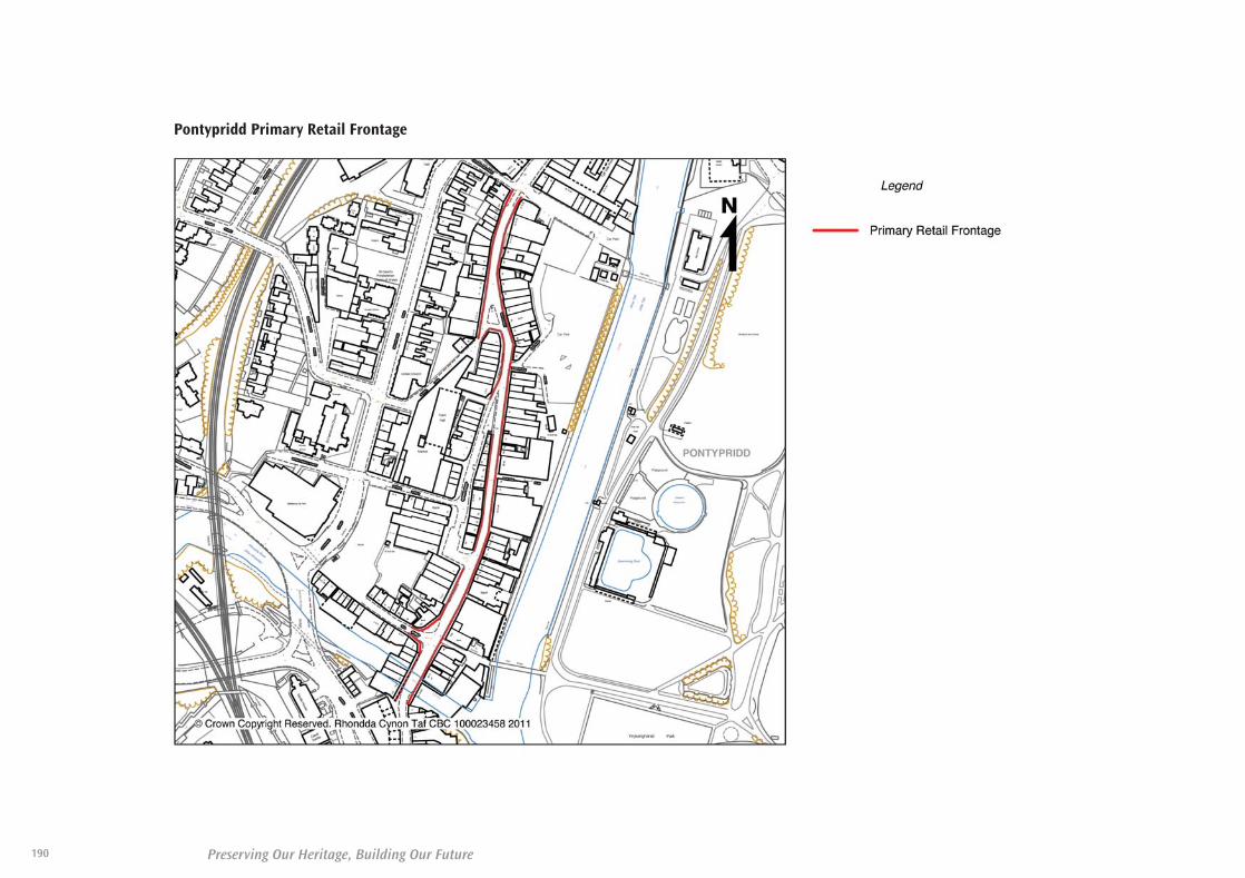
Pontypridd Primary Retail Frontage
190 Preserving Our Heritage, Building Our Future
35580-52 LDP plan 2011_Layout 1 30/06/2011 11:19 Page 190

191Preserving Our Heritage, Building Our Future
The following tables set out the infrastructure necessary to deliver the sites
allocated within the LDP. In addition to these tables, the Council will consider
the preparation of SPG to provide further guidance on additional infrastructure
matters.
Infrastructure Requirement
Appendix Seven
35580-52 LDP plan 2011_Layout 1 30/06/2011 11:19 Page 191

Preserving Our Heritage, Building Our Future192
Part A - Strategic Sites
Physical Infrastructure Social Infrastructure
Transport Utilities (Water /Drainage / Gas /
Electricity /Telecommunications
Flooding LandReclamation /Remediation
Education AffordableHousing
Community /Leisure
Delivery Period – 2010 - 2013
NSA 7 Land atRobertstown /Abernant,Aberdare
Taking intoconsiderationthe existingtrafficgeneration ofthe site,highways andtransportationprovision will besought fromdevelopers inaccordance withthe PlanningObligations SPGand theDeliveringDesign andPlacemakingSPG.
- Developer to fundsewerage networkimprovementsahead of regulatoryimprovements. - A public sewer andwater mains crossthe site, this mayrestrict the densityof development.- Area suffers fromlow water pressure,off-site main layingrequired to developsite.
Roberstown The StrategicFloodConsequencesAssessmentidentifies thewhole of thisarea as at riskfrom flooding.
Scheme toaddress floodingrisk to beimplemented aspart of sitedevelopment.
AbernantThe StrategicFloodConsequencesAssessmentidentifies thewhole of thisarea as notbeing at riskfrom flooding.
Possible/knownshallow mineworkings, otherundergroundworkings andrecorded mineentries.
Developer toprovide/contribute towards newPrimary School.
Appropriatecontributionswill be soughtbased onidentified needand inaccordance withthe Council'sPlanningObligations SPG.
10% affordablehousing will besecured inaccordance withpolicy NSA 11.
Appropriatecontributionswill be soughtbased onidentified needand inaccordance withthe Council’sPlanningObligations SPG.
35580-52 LDP plan 2011_Layout 1 30/06/2011 11:19 Page 192

193Preserving Our Heritage, Building Our Future
Part A - Strategic Sites
Physical Infrastructure Social Infrastructure
Transport Utilities (Water /Drainage / Gas /
Electricity /Telecommunications
Flooding LandReclamation /Remediation
Education AffordableHousing
Community /Leisure
Delivery Period – 2010 - 2013
SSA 9 FormerOCC SiteLlanilid,Llanharan
The A473LlanharanBypass or anappropriatealternativeaccess isessential to theimplementationof this site.Developers willbe required toassist with thecost.
Highways andtransportationprovision will besought fromdevelopers inaccordance withthe PlanningObligations SPGand theDeliveringDesign andPlacemakingSPG.
- A public sewer andwater mains crossesthe site so this mayrestrict the densityof development.- Area suffers fromlow water pressure,off-site main layingrequired to developsite.
Identified risk offloodingnegligible andwill not affectsite delivery.
Reclamation offormer opencast required aspart of sitedevelopment.
Possible/knownshallow mineworkings, otherundergroundworkings,recorded pastsurface miningand mineentries.
Depending onthe finalnumber ofhousing units, aminimum ofone large or twosmaller primaryschools may berequired to beprovided bydevelopers.
Appropriatecontributionswill be soughtbased onidentified needand inaccordance withthe Council'sPlanningObligations SPG.
20% affordablehousing will besecured inaccordance withpolicy SSA 12.
Appropriatecontributionswill be soughtbased onidentified needand inaccordance withthe Council’sPlanningObligations SPG.
35580-52 LDP plan 2011_Layout 1 30/06/2011 11:19 Page 193

Preserving Our Heritage, Building Our Future194
Part A - Strategic Sites
Physical Infrastructure Social Infrastructure
Transport Utilities (Water /Drainage / Gas /
Electricity /Telecommunications
Flooding LandReclamation /Remediation
Education AffordableHousing
Community /Leisure
Delivery Period – 2014 - 2017
NSA 5 FormerFernhill CollierySite,Blaenrhondda
Developer tofund a primaryaccess road fromA4061 RhigosRoad.
Highways andtransportationprovision will besought fromdevelopers inaccordance withthe PlanningObligations SPGand theDeliveringDesign andPlacemakingSPG.
- Developer to fundsewerage networkimprovementsahead of regulatoryimprovements.- A public sewer andwater mains crossthe site, this mayrestrict the densityof development.
The StrategicFloodConsequencesAssessmentstates that thereis flood riskfrom ordinarywatercoursesand surfacewater ditches.
Scheme toaddress floodingrisk to beimplemented aspart of sitedevelopment.
Reclamation offormer tipsrequired as partof sitedevelopment.
Phasing ofdevelopmentwill bedependent on alandreclamationscheme.
Possible/knownshallow mineworkings, otherundergroundworkings andrecorded mineentries.
Depending onthe finalnumber ofhousing unitsdevelopers maybe required tofund anextension toPenpychPrimary School.
Appropriatecontributionswill be soughtbased onidentified needand inaccordance withthe Council'sPlanningObligations SPG.
10% affordablehousing will besecured inaccordance withpolicy NSA 11.
Appropriatecontributionswill be soughtbased onidentified needand inaccordance withthe Council’sPlanningObligations SPG.
35580-52 LDP plan 2011_Layout 1 30/06/2011 11:19 Page 194

195Preserving Our Heritage, Building Our Future
Part A - Strategic Sites
Physical Infrastructure Social Infrastructure
Transport Utilities (Water /Drainage / Gas /
Electricity /Telecommunications
Flooding LandReclamation /Remediation
Education AffordableHousing
Community /Leisure
Delivery Period – 2014 - 2017
NSA 6 FormerPhurnacitePlant,Abercwmboi
Highways andtransportationprovision will besought fromdevelopers inaccordance withthe PlanningObligations SPGand theDeliveringDesign andPlacemakingSPG.
- A public sewercrosses the site sothis may restrict thedensity ofdevelopment.- Developer to fundsewerage networkimprovementsahead of regulatoryimprovements.- Area suffers fromlow water pressure,off-site main layingrequired to developsite.
The StrategicFloodConsequencesAssessmentstates that therisk of floodingon areas of thesite ismanageable.
Scheme toaddress floodingrisk to beimplemented aspart of sitedevelopment.
Remediation ofthe formerindustrial area isrequired as partof sitedevelopment.
The phasing ofdevelopmentwill bedependent on alandreclamationscheme.
Possible /known shallowmine workingsand otherundergroundworkings.
New primaryschool may berequireddepending onthe proposednumber ofhousing units.
Appropriatecontributionswill be soughtbased onidentified needand inaccordance withthe Council'sPlanningObligations SPG.
10% affordablehousing will besecured inaccordance withpolicy NSA 11.
Developer toprovide formalrecreationprovisionconsisting of areplacementfootball ground.
Appropriatecontributionswill be soughtbased onidentified needand inaccordance withthe Council’sPlanningObligations SPG.
35580-52 LDP plan 2011_Layout 1 30/06/2011 11:19 Page 195

Preserving Our Heritage, Building Our Future196
Part A - Strategic Sites
Physical Infrastructure Social Infrastructure
Transport Utilities (Water /Drainage / Gas /
Electricity /Telecommunications
Flooding LandReclamation /Remediation
Education AffordableHousing
Community /Leisure
Delivery Period – 2014 - 2017
SSA 7 FormerCwm Collieryand CokingWorks, Tyn-Y-Nant,Pontypridd
Developer toprovide newprimary andsecondaryaccess roadsbefore this sitecan be fullydeveloped.
Highways andtransportationprovision will besought fromdevelopers inaccordance withthe PlanningObligations SPGand theDeliveringDesign andPlacemakingSPG.
- Developer to fundsewerage networkimprovementsahead of regulatoryimprovements.- A public sewer andwater mains crossesthe site so this mayrestrict the densityof development.- Area suffers fromlow water pressure,off-site main layingrequired to developsite.
The StrategicFloodConsequencesAssessmentstates that theformer cokingworks area issubstantially atrisk fromflooding. Theremaining areaof the site is atlow risk offlooding.
Scheme toaddress floodingrisk to beimplemented aspart of sitedevelopment.
Reclamation offormer tipsrequired as partof sitedevelopment.
Phasing ofdevelopmentwill bedependent on alandreclamationscheme.
Possible/knownshallow mineworkings, otherundergroundworkings andrecorded mineentries.
Developer toprovide/contribute towards newPrimary School.
Appropriatecontributionswill be soughtbased onidentified needand inaccordance withthe Council'sPlanningObligations SPG.
20% affordablehousing will besecured inaccordance withpolicy SSA 12.
Appropriatecontributionswill be soughtbased onidentified needand inaccordance withthe Council’sPlanningObligations SPG.
35580-52 LDP plan 2011_Layout 1 30/06/2011 11:19 Page 196

197Preserving Our Heritage, Building Our Future
Part A - Strategic Sites
Physical Infrastructure Social Infrastructure
Transport Utilities (Water /Drainage / Gas /
Electricity /Telecommunications
Flooding LandReclamation /Remediation
Education AffordableHousing
Community /Leisure
Delivery Period – 2014 - 2017
SSA 8 Mwyndy /Talbot GreenArea
Highways andtransportationprovision will besought fromdevelopers inaccordance withthe PlanningObligations SPGand theDeliveringDesign andPlacemakingSPG.
- Developer to fundsewerage networkimprovementsahead of regulatoryimprovements.- A public sewer andwater mains crossesthe site so this mayrestrict the densityof development.- Area suffers fromlow water pressure,off-site main layingrequired to developsite.
Identified risk offloodingnegligible andwill not affectsite delivery.
Remediation ofa formerindustrial area isrequired as partof sitedevelopment.
Possible/knownshallow mineworkings andrecorded mineentries.
Preciseeducationrequirementscan only beprovided whenthe number ofhousing units isknown.
Developercontributionssought forexpansion ofexistingsecondaryschool.
Appropriatecontributionswill be soughtbased onidentified needand inaccordance withthe Council'sPlanningObligations SPG.
20% affordablehousing will besecured inaccordance withpolicy SSA 12.
Appropriatecontributionswill be soughtbased onidentified needand inaccordance withthe Council’sPlanningObligations SPG.
35580-52 LDP plan 2011_Layout 1 30/06/2011 11:19 Page 197

Preserving Our Heritage, Building Our Future198
Part A - Strategic Sites
Physical Infrastructure Social Infrastructure
Transport Utilities (Water /Drainage / Gas /
Electricity /Telecommunications
Flooding LandReclamation /Remediation
Education AffordableHousing
Community /Leisure
Delivery Period – 2018 - 2021
NSA 8 LandSouth ofHirwaun
The developmentof this site, whilstnot dependenton, is closelyrelated to theproposeddualling of theA465 Heads ofthe Valley Road.
Highways andtransportationprovision will besought fromdevelopers inaccordance withthe PlanningObligations SPGand theDelivering Designand PlacemakingSPG.
- Developer to fundsewerage networkimprovementsahead of regulatoryimprovements. - A public sewer andwater mains crossesthe site so this mayrestrict the densityof development.- Area suffers fromlow water pressure,off-site main layingrequired to developsite.
Identified floodrisk is negligibleand will notaffect sitedelivery.
Reclamation offormer tipsrequired as partof sitedevelopment.
Possible/knownshallow mineworkings, otherundergroundworkings andrecorded mineentries.
Developer toprovide a newprimary schooland contributeto existingschools inaccordance withthe Council’sPlanningObligations SPG.
Appropriatecontributionswill be soughtbased onidentified needand inaccordance withthe Council'sPlanningObligations SPG.
10% affordablehousing will besecured inaccordance withpolicy NSA 11.
Appropriatecontributionswill be soughtbased onidentified needand inaccordance withthe Council’sPlanningObligations SPG.
35580-52 LDP plan 2011_Layout 1 30/06/2011 11:19 Page 198

199Preserving Our Heritage, Building Our Future
Part A - Strategic Sites
Physical Infrastructure Social Infrastructure
Transport Utilities (Water /Drainage / Gas /
Electricity /Telecommunications
Flooding LandReclamation /Remediation
Education AffordableHousing
Community /Leisure
Delivery Period – 2018 - 2021
NSA 4 FormerMaerdy CollierySite, RhonddaFach
The developmentof this site islinked to theprovision of anew spine roadto access the site,to be provided bydevelopers.
Highways andtransportationprovision will besought fromdevelopers inaccordance withthe PlanningObligations SPGand theDelivering Designand PlacemakingSPG.
- Developer to fundsewerage networkimprovementsahead of regulatoryimprovements. - Area suffers fromlow water pressure,off-site main layingrequired to developsite. - A water maincrosses the site sothis may restrict thedensity ofdevelopment.
Identified risk offloodingnegligible andwill not affectsite delivery.
Reclamation offormer tipsrequired as partof sitedevelopment.
Possible/knownshallow mineworkings, otherundergroundworkings andrecorded mineentries.
No additionaleducationalfacilitiesrequired.
Not applicable. Appropriatecontributionswill be soughtbased onidentified needand inaccordance withthe Council’sPlanningObligations SPG.
35580-52 LDP plan 2011_Layout 1 30/06/2011 11:19 Page 199

Preserving Our Heritage, Building Our Future200
Part B - Northern Strategy Area Residential Allocations
Physical Infrastructure Social Infrastructure
Transport Utilities (Water /Drainage / Gas /
Electricity /Telecommunications
Flooding Education AffordableHousing
Community /Leisure
Delivery Period – 2010 - 2013
NSA 9.3 LandSouth East ofLlwydcoedCommunityCentre, Llwydcoed
Highways andtransportationprovision will besought fromdevelopers inaccordance with thePlanningObligations SPG andthe DeliveringDesign andPlacemaking SPG.
Developer to fundsewerage networkimprovementsahead of regulatoryimprovements.
No flooding issues. Appropriatecontributions willbe sought basedon identified needand in accordancewith the Council’sPlanningObligations SPG.
10% affordablehousing will besecured inaccordance withpolicy NSA 11.
Appropriatecontributions willbe sought basedon identified needand in accordancewith the Council’sPlanningObligations SPG.
NSA 9.4 Siteincluding the oldBrickworks, olddairy and tippedland rear ofBirchwood,Llwydcoed
Highways andtransportationprovision will besought fromdevelopers inaccordance with thePlanningObligations SPG andthe DeliveringDesign andPlacemaking SPG.
- A public sewer andwater mains crossthe site, this mayrestrict the densityof development. - Developer to fundnecessary upgradesto Cynon WwTW*,possibly throughSection 106agreement. - Area suffers fromlow water pressure,off-site main layingrequired to developsite.
Much of this site iswithin a flood riskzone B, whichwould require afloodconsequencesassessment.
Scheme to addressflooding risk to beimplemented aspart of sitedevelopment.
Appropriatecontributions willbe sought basedon identified needand in accordancewith the Council’sPlanningObligations SPG.
10% affordablehousing will besecured inaccordance withpolicy NSA 11.
Appropriatecontributions willbe sought basedon identified needand in accordancewith the Council’sPlanningObligations SPG.
* Waste Water Treatment Works
35580-52 LDP plan 2011_Layout 1 30/06/2011 11:19 Page 200

201Preserving Our Heritage, Building Our Future
Part B - Northern Strategy Area Residential Allocations
Physical Infrastructure Social Infrastructure
Transport Utilities (Water /Drainage / Gas /
Electricity /Telecommunications
Flooding Education AffordableHousing
Community /Leisure
Delivery Period – 2010 - 2013
NSA 9.6 Land atNant y Wenallt,Abernant Road,Abernant
Highways andtransportationprovision will besought fromdevelopers inaccordance with thePlanningObligations SPG andthe DeliveringDesign andPlacemaking SPG.
- Developer to fundsewerage networkimprovementsahead of regulatoryimprovements. -Developer to fundnecessary upgradesto Cynon WwTW*,possibly throughSection 106agreement.
No flooding issues. Appropriatecontributions willbe sought basedon identified needand in accordancewith the Council’sPlanningObligations SPG.
0% affordablehousing will besecured inaccordance withpolicy NSA 11.
Appropriatecontributions willbe sought basedon identified needand in accordancewith the Council’sPlanningObligations SPG.
NSA 9.10 Land tothe end ofGodreaman Street,Godreaman
Highways andtransportationprovision will besought fromdevelopers inaccordance with thePlanningObligations SPG andthe DeliveringDesign andPlacemaking SPG.
A public sewer andwater mains crossthe site, this mayrestrict the densityof development.
No flooding issues. Appropriatecontributions willbe sought basedon identified needand in accordancewith the Council’sPlanningObligations SPG.
10% affordablehousing will besecured inaccordance withpolicy NSA 11.
Appropriatecontributions willbe sought basedon identified needand in accordancewith the Council’sPlanningObligations SPG.
* Waste Water Treatment Works
35580-52 LDP plan 2011_Layout 1 30/06/2011 11:19 Page 201

Preserving Our Heritage, Building Our Future202
Part B - Northern Strategy Area Residential Allocations
Physical Infrastructure Social Infrastructure
Transport Utilities (Water /Drainage / Gas /
Electricity /Telecommunications
Flooding Education AffordableHousing
Community /Leisure
Delivery Period – 2018 - 2021
NSA 9.2 Land Eastof Trenant,Penywaun
Highways andtransportationprovision will besought fromdevelopers inaccordance with thePlanningObligations SPG andthe DeliveringDesign andPlacemaking SPG.
- Developer to fundsewerage networkimprovementsahead of regulatoryimprovements. - Developer to fundnecessary upgradesto Cynon WwTW*,possibly throughSection 106agreement.
No flooding issues. Appropriatecontributions willbe sought basedon identified needand in accordancewith the Council’sPlanningObligations SPG.
10% affordablehousing will besecured inaccordance withpolicy NSA 11.
Appropriatecontributions willbe sought basedon identified needand in accordancewith the Council’sPlanningObligations SPG.
NSA 9.9 Remainderof YnyscynonFarm, Cwmbach
Highways andtransportationprovision will besought fromdevelopers inaccordance with thePlanningObligations SPG andthe DeliveringDesign andPlacemaking SPG.
- Developer to fundsewerage networkimprovementsahead of regulatoryimprovements. - A public sewer andwater mains crossthe site, this mayrestrict the densityof development.
No flooding issues. Appropriatecontributions willbe sought basedon identified needand in accordancewith the Council’sPlanningObligations SPG.
10% affordablehousing will besecured inaccordance withpolicy NSA 11.
Appropriatecontributions willbe sought basedon identified needand in accordancewith the Council’sPlanningObligations SPG.
* Waste Water Treatment Works
35580-52 LDP plan 2011_Layout 1 30/06/2011 11:19 Page 202

203Preserving Our Heritage, Building Our Future
Part B - Northern Strategy Area Residential Allocations
Physical Infrastructure Social Infrastructure
Transport Utilities (Water /Drainage / Gas /
Electricity /Telecommunications
Flooding Education AffordableHousing
Community /Leisure
Delivery Period – 2018 - 2021
NSA 9.12 Land rearof Maerdy Road,Maerdy
Highways andtransportationprovision will besought fromdevelopers inaccordance with thePlanningObligations SPG andthe DeliveringDesign andPlacemaking SPG.
No record ofsewerage issues.
No flooding issues. Appropriatecontributions willbe sought basedon identified needand in accordancewith the Council’sPlanningObligations SPG.
10% affordablehousing will besecured inaccordance withpolicy NSA 11.
Appropriatecontributions willbe sought basedon identified needand in accordancewith the Council’sPlanningObligations SPG.
NSA 9.13 Land atGwernllwynTerrace,Tylorstown
Highways andtransportationprovision will besought fromdevelopers inaccordance with thePlanningObligations SPG andthe DeliveringDesign andPlacemaking SPG.
- A public sewercrosses the site, thismay restrict thedensity ofdevelopment.- Area suffers fromlow water pressure,off-site main layingrequired to developsite.
No flooding issues. Appropriatecontributions willbe sought basedon identified needand in accordancewith the Council’sPlanningObligations SPG.
10% affordablehousing will besecured inaccordance withpolicy NSA 11.
Appropriatecontributions willbe sought basedon identified needand in accordancewith the Council’sPlanningObligations SPG.
35580-52 LDP plan 2011_Layout 1 30/06/2011 11:19 Page 203

Preserving Our Heritage, Building Our Future204
Part B - Northern Strategy Area Residential Allocations
Physical Infrastructure Social Infrastructure
Transport Utilities (Water /Drainage / Gas /
Electricity /Telecommunications
Flooding Education AffordableHousing
Community /Leisure
Delivery Period – 2018 - 2021
NSA 9.14 Site offFenwick Street,Pontygwaith
Highways andtransportationprovision will besought fromdevelopers inaccordance with thePlanningObligations SPG andthe DeliveringDesign andPlacemaking SPG.
Area suffers fromlow water pressure,off-site main layingrequired to developsite.
No flooding issues. Appropriatecontributions willbe sought basedon identified needand in accordancewith the Council’sPlanningObligations SPG.
10% affordablehousing will besecured inaccordance withpolicy NSA 11.
Appropriatecontributions willbe sought basedon identified needand in accordancewith the Council’sPlanningObligations SPG.
NSA 9.15 OldHospital Site andSchool Playground,Treherbert
Highways andtransportationprovision will besought fromdevelopers inaccordance with thePlanningObligations SPG andthe DeliveringDesign andPlacemaking SPG.
- Developer to fundsewerage networkimprovementsahead of regulatoryimprovements. - A public sewer andwater mains crossthe site, this mayrestrict the densityof development.
No flooding issues. Appropriatecontributions willbe sought basedon identified needand in accordancewith the Council’sPlanningObligations SPG.
10% affordablehousing will besecured inaccordance withpolicy NSA 11.
Appropriatecontributions willbe sought basedon identified needand in accordancewith the Council’sPlanningObligations SPG.
35580-52 LDP plan 2011_Layout 1 30/06/2011 11:19 Page 204

205Preserving Our Heritage, Building Our Future
Part B - Northern Strategy Area Residential Allocations
Physical Infrastructure Social Infrastructure
Transport Utilities (Water /Drainage / Gas /
Electricity /Telecommunications
Flooding Education AffordableHousing
Community /Leisure
Delivery Period – 2018 - 2021
NSA 9.16 Site atthe end of MaceLane, Treorchy
NSA 9.16 Site at theend of Mace Lane,Treorchy
No Sewerageproblems.
No flooding issues. Appropriatecontributions willbe sought basedon identified needand in accordancewith the Council’sPlanningObligations SPG.
10% affordablehousing will besecured inaccordance withpolicy NSA 11.
Appropriatecontributions willbe sought basedon identified needand in accordancewith the Council’sPlanningObligations SPG.
NSA 9.17 Site offCemetery Road,Treorchy
Highways andtransportationprovision will besought fromdevelopers inaccordance with thePlanningObligations SPG andthe DeliveringDesign andPlacemaking SPG.
Area suffers fromlow water pressure,off-site main layingrequired to developsite.
No flooding issues. Appropriatecontributions willbe sought basedon identified needand in accordancewith the Council’sPlanningObligations SPG.
10% affordablehousing will besecured inaccordance withpolicy NSA 11.
Appropriatecontributions willbe sought basedon identified needand in accordancewith the Council’sPlanningObligations SPG.
35580-52 LDP plan 2011_Layout 1 30/06/2011 11:19 Page 205

Preserving Our Heritage, Building Our Future206
Part B - Northern Strategy Area Residential Allocations
Physical Infrastructure Social Infrastructure
Transport Utilities (Water /Drainage / Gas /
Electricity /Telecommunications
Flooding Education AffordableHousing
Community /Leisure
Delivery Period – 2018 - 2021
NSA 9.19 Land atPark Street,Clydach Vale
Highways andtransportationprovision will besought fromdevelopers inaccordance with thePlanningObligations SPG andthe DeliveringDesign andPlacemaking SPG.
- Developer to fundsewerage networkimprovementsahead of regulatoryimprovements. - A public sewercrosses the site, thismay restrict thedensity ofdevelopment.
No flooding issues. Appropriatecontributions willbe sought basedon identified needand in accordancewith the Council’sPlanningObligations SPG.
10% affordablehousing will besecured inaccordance withpolicy NSA 11.
Appropriatecontributions willbe sought basedon identified needand in accordancewith the Council’sPlanningObligations SPG.
NSA 9.20 Land atDinas Road / GraigDdu Road, Dinas
Highways andtransportationprovision will besought fromdevelopers inaccordance with thePlanningObligations SPG andthe DeliveringDesign andPlacemaking SPG.
- Developer to fundsewerage networkimprovementsahead of regulatoryimprovements. - A public sewer andwater mains crossthe site, this mayrestrict the densityof development.
No flooding issues. Appropriatecontributions willbe sought basedon identified needand in accordancewith the Council’sPlanningObligations SPG.
10% affordablehousing will besecured inaccordance withpolicy NSA 11.
Appropriatecontributions willbe sought basedon identified needand in accordancewith the Council’sPlanningObligations SPG.
35580-52 LDP plan 2011_Layout 1 30/06/2011 11:19 Page 206

207Preserving Our Heritage, Building Our Future
Part B - Northern Strategy Area Residential Allocations
Physical Infrastructure Social Infrastructure
Transport Utilities (Water /Drainage / Gas /
Electricity /Telecommunications
Flooding Education AffordableHousing
Community /Leisure
Delivery Period – 2018 - 2021
NSA 9.21 Land atCatherine Crescent,Cymmer
Highways andtransportationprovision will besought fromdevelopers inaccordance with thePlanningObligations SPG andthe DeliveringDesign andPlacemaking SPG.
No sewerage issuesidentified.
No flooding issues. Appropriatecontributions willbe sought basedon identified needand in accordancewith the Council’sPlanningObligations SPG.
10% affordablehousing will besecured inaccordance withpolicy NSA 11.
Appropriatecontributions willbe sought basedon identified needand in accordancewith the Council’sPlanningObligations SPG.
35580-52 LDP plan 2011_Layout 1 30/06/2011 11:19 Page 207

Preserving Our Heritage, Building Our Future208
Part B - Southern Strategy Area Residential Allocations
Physical Infrastructure Social Infrastructure
Transport Utilities (Water /Drainage / Gas /
Electricity /Telecommunications
Flooding Education AffordableHousing
Community /Leisure
Delivery Period – 2010 - 2013
SSA 10.2 TraneFarm, Tonyrefail
Highways andtransportationprovision will besought fromdevelopers inaccordance with thePlanningObligations SPG andthe DeliveringDesign andPlacemaking SPG.
- Area suffers fromlow water pressure,off-site main layingrequired to developsite.- Developer to fundsewerage networkimprovementsahead of regulatoryimprovements.
No flooding issues. Developer toprovide newPrimary School.Appropriatecontributions willbe sought basedon identified needand in accordancewith the Council'sPlanningObligations SPG.
20% affordablehousing will besecured inaccordance withpolicy SSA 12.
Appropriatecontributions willbe sought basedon identified needand in accordancewith the Council’sPlanningObligations SPG.
SSA 10.7 Land atGwern Heulog,Tonyrefail
Highways andtransportationprovision will besought fromdevelopers inaccordance with thePlanningObligations SPG andthe DeliveringDesign andPlacemaking SPG.
- Area suffers fromlow water pressure,off-site main layingrequired to developsite.- Developer to fundsewerage networkimprovementsahead of regulatoryimprovements.
No flooding issues. Appropriatecontributions willbe sought basedon identified needand in accordancewith the Council’sPlanningObligations SPG.
20% affordablehousing will besecured inaccordance withpolicy SSA 12.
Appropriatecontributions willbe sought basedon identified needand in accordancewith the Council’sPlanningObligations SPG.
35580-52 LDP plan 2011_Layout 1 30/06/2011 11:19 Page 208

209Preserving Our Heritage, Building Our Future
Part B - Southern Strategy Area Residential Allocations
Physical Infrastructure Social Infrastructure
Transport Utilities (Water /Drainage / Gas /
Electricity /Telecommunications
Flooding Education AffordableHousing
Community /Leisure
Delivery Period – 2010 - 2013
SSA 10.11 LandSouth of BrynnaRoad, Brynna
Highways andtransportationprovision will besought fromdevelopers inaccordance with thePlanningObligations SPG andthe DeliveringDesign andPlacemaking SPG.
- A public sewer andwater mains crossthe site, this mayrestrict the densityof development.- Developer to fundsewerage networkimprovementsahead of regulatoryimprovements.
No flooding issues. Appropriatecontributions willbe sought basedon identified needand in accordancewith the Council’sPlanningObligations SPG.
20% affordablehousing will besecured inaccordance withpolicy SSA 12.
Appropriatecontributions willbe sought basedon identified needand in accordancewith the Council’sPlanningObligations SPG.
SSA 10.12 Landeast of DolauCounty PrimarySchool, BridgendRoad, Bryncae
Highways andtransportationprovision will besought fromdevelopers inaccordance with thePlanningObligations SPG andthe DeliveringDesign andPlacemaking SPG.
Developer to fundsewerage networkimprovementsahead of regulatoryimprovements.
No flooding issues. Appropriatecontributions willbe sought basedon identified needand in accordancewith the Council’sPlanningObligations SPG.
20% affordablehousing will besecured inaccordance withpolicy SSA 12.
Appropriatecontributions willbe sought basedon identified needand in accordancewith the Council’sPlanningObligations SPG.
35580-52 LDP plan 2011_Layout 1 30/06/2011 11:19 Page 209

Preserving Our Heritage, Building Our Future210
Part B - Southern Strategy Area Residential Allocations
Physical Infrastructure Social Infrastructure
Transport Utilities (Water /Drainage / Gas /
Electricity /Telecommunications
Flooding Education AffordableHousing
Community /Leisure
Delivery Period – 2010 - 2013
SSA 10.14Penygawsi,Llantrisant
Highways andtransportationprovision will besought fromdevelopers inaccordance with thePlanningObligations SPG andthe DeliveringDesign andPlacemaking SPG.
- A public sewer andwater mains crossthe site, this mayrestrict the densityof development.- Developer to fundsewerage networkimprovementsahead of regulatoryimprovements.
Much of this site iswithin a flood riskzone B, whichwould require afloodconsequencesassessment.Scheme to addressflooding risk to beimplemented aspart of sitedevelopment.
Appropriatecontributions willbe sought basedon identified needand in accordancewith the Council’sPlanningObligations SPG.
20% affordablehousing will besecured inaccordance withpolicy SSA 12.
Appropriatecontributions willbe sought basedon identified needand in accordancewith the Council’sPlanningObligations SPG.
SSA 10.15 Landsouth of BryntegCourt, Beddau
Highways andtransportationprovision will besought fromdevelopers inaccordance with thePlanningObligations SPG andthe DeliveringDesign andPlacemaking SPG.
Developer to fundsewerage networkimprovementsahead of regulatoryimprovements.
No flooding issues. Appropriatecontributions willbe sought basedon identified needand in accordancewith the Council’sPlanningObligations SPG.
20% affordablehousing will besecured inaccordance withpolicy SSA 12.
Appropriatecontributions willbe sought basedon identified needand in accordancewith the Council’sPlanningObligations SPG.
35580-52 LDP plan 2011_Layout 1 30/06/2011 11:19 Page 210

211Preserving Our Heritage, Building Our Future
Part B - Southern Strategy Area Residential Allocations
Physical Infrastructure Social Infrastructure
Transport Utilities (Water /Drainage / Gas /
Electricity /Telecommunications
Flooding Education AffordableHousing
Community /Leisure
Delivery Period – 2010 - 2013
SSA 10.16 The LinkSite, Pen-yr-eglwys,Church Village
Highways andtransportationprovision will besought fromdevelopers inaccordance with thePlanningObligations SPG andthe DeliveringDesign andPlacemaking SPG.
- Developer to fundsewerage networkimprovementsahead of regulatoryimprovements. - A public sewer andwater mains crossesthe site so this mayrestrict the densityof development.
No flooding issues. Appropriatecontributions willbe sought basedon identified needand in accordancewith the Council’sPlanningObligations SPG.
20% affordablehousing will besecured inaccordance withpolicy SSA 12.
Appropriatecontributions willbe sought basedon identified needand in accordancewith the Council’sPlanningObligations SPG.
SSA 10.18 Landsouth of TheRidings, Tontegand east of StationRoad, ChurchVillage
Highways andtransportationprovision will besought fromdevelopers inaccordance with thePlanningObligations SPG andthe DeliveringDesign andPlacemaking SPG.
- Developer to fundsewerage networkimprovementsahead of regulatoryimprovements. - A public sewercrosses the site, mayrestrict the densityof development. - Area suffers fromlow water pressure,off-site main layingrequired to developsite.
Part of the site iswithin flood riskzone B and floodrisk zone C2.
Scheme to addressflooding risk to beimplemented aspart of sitedevelopment.
Appropriatecontributions willbe sought basedon identified needand in accordancewith the Council’sPlanningObligations SPG.
20% affordablehousing will besecured inaccordance withpolicy SSA 12.
Appropriatecontributions willbe sought basedon identified needand in accordancewith the Council’sPlanningObligations SPG.
35580-52 LDP plan 2011_Layout 1 30/06/2011 11:19 Page 211

Preserving Our Heritage, Building Our Future212
Part B - Southern Strategy Area Residential Allocations
Physical Infrastructure Social Infrastructure
Transport Utilities (Water /Drainage / Gas /
Electricity /Telecommunications
Flooding Education AffordableHousing
Community /Leisure
Delivery Period – 2014 - 2017
SSA 10.1 Cefn Lane,Glyncoch
Highways andtransportationprovision will besought fromdevelopers inaccordance with thePlanningObligations SPG andthe DeliveringDesign andPlacemaking SPG.
No sewerage issuesidentified.
No flooding issues. Appropriatecontributions willbe sought basedon identified needand in accordancewith the Council’sPlanningObligations SPG.
20% affordablehousing will besecured inaccordance withpolicy SSA 12.
Appropriatecontributions willbe sought basedon identified needand in accordancewith the Council’sPlanningObligations SPG.
SSA 10.3 CollennaFarm, Tonyrefail
Highways andtransportationprovision will besought fromdevelopers inaccordance with thePlanningObligations SPG andthe DeliveringDesign andPlacemaking SPG.
- No publicsewerage system inthe area, any newdevelopment wouldrequire facilities forsewage disposal. - Developer to fundsewerage networkimprovementsahead of regulatoryimprovements.
Part of the site iswithin flood riskzone B and floodrisk zone C2.
Scheme to addressflooding risk to beimplemented aspart of sitedevelopment.
Appropriatecontributions willbe sought basedon identified needand in accordancewith the Council’sPlanningObligations SPG.
20% affordablehousing will besecured inaccordance withpolicy SSA 12.
Appropriatecontributions willbe sought basedon identified needand in accordancewith the Council’sPlanningObligations SPG.
35580-52 LDP plan 2011_Layout 1 30/06/2011 11:19 Page 212

213Preserving Our Heritage, Building Our Future
Part B - Southern Strategy Area Residential Allocations
Physical Infrastructure Social Infrastructure
Transport Utilities (Water /Drainage / Gas /
Electricity /Telecommunications
Flooding Education AffordableHousing
Community /Leisure
Delivery Period – 2014 - 2017
SSA 10.4Bryngolau,Tonyrefail
Highways andtransportationprovision will besought fromdevelopers inaccordance with thePlanningObligations SPG andthe DeliveringDesign andPlacemaking SPG.
- No publicsewerage system inthe area, any newdevelopment wouldrequire facilities forsewage disposal. - Developer to fundsewerage networkimprovementsahead of regulatoryimprovements.
No flooding issues. Appropriatecontributions willbe sought basedon identified needand in accordancewith the Council’sPlanningObligations SPG.
20% affordablehousing will besecured inaccordance withpolicy SSA 12.
Appropriatecontributions willbe sought basedon identified needand in accordancewith the Council’sPlanningObligations SPG.
SSA 10.5 Site of theformer HillsideClub, Capel Hill,Tonyrefail
Highways andtransportationprovision will besought fromdevelopers inaccordance with thePlanningObligations SPG andthe DeliveringDesign andPlacemaking SPG.
- Area suffers fromlow water pressure,off-site main layingrequired to developsite.- No publicsewerage system inthe area, any newdevelopment wouldrequire facilities forsewage disposal. - Developer to fundsewerage networkimprovementsahead of regulatoryimprovements.
Part of the site iswithin flood riskzone B and floodrisk zone C2.
Scheme to addressflooding risk to beimplemented aspart of sitedevelopment.
Appropriatecontributions willbe sought basedon identified needand in accordancewith the Council’sPlanningObligations SPG.
20% affordablehousing will besecured inaccordance withpolicy SSA 12.
Appropriatecontributions willbe sought basedon identified needand in accordancewith the Council’sPlanningObligations SPG.
35580-52 LDP plan 2011_Layout 1 30/06/2011 11:19 Page 213

Preserving Our Heritage, Building Our Future214
Part B - Southern Strategy Area Residential Allocations
Physical Infrastructure Social Infrastructure
Transport Utilities (Water /Drainage / Gas /
Electricity /Telecommunications
Flooding Education AffordableHousing
Community /Leisure
Delivery Period – 2014 - 2017
SSA 10.6 Land eastof Mill Street,Tonyrefail
Highways andtransportationprovision will besought fromdevelopers inaccordance with thePlanningObligations SPG andthe DeliveringDesign andPlacemaking SPG.
A public sewercrosses the site, mayrestrict the densityof development.
No flooding issues. Appropriatecontributions willbe sought basedon identified needand in accordancewith the Council’sPlanningObligations SPG.
20% affordablehousing will besecured inaccordance withpolicy SSA 12.
Appropriatecontributions willbe sought basedon identified needand in accordancewith the Council’sPlanningObligations SPG.
SSA 10.10 Landeast of Hafod Wenand North ofConcorde Drive,Tonyrefail
Highways andtransportationprovision will besought fromdevelopers inaccordance with thePlanningObligations SPG andthe DeliveringDesign andPlacemaking SPG.
- Area suffers fromlow water pressure,off-site main layingrequired to developsite.- Developer to fundsewerage networkimprovementsahead of regulatoryimprovements.
No flooding issues. Appropriatecontributions willbe sought basedon identified needand in accordancewith the Council’sPlanningObligations SPG.
20% affordablehousing will besecured inaccordance withpolicy SSA 12.
Appropriatecontributions willbe sought basedon identified needand in accordancewith the Council’sPlanningObligations SPG.
35580-52 LDP plan 2011_Layout 1 30/06/2011 11:19 Page 214

215Preserving Our Heritage, Building Our Future
Part B - Southern Strategy Area Residential Allocations
Physical Infrastructure Social Infrastructure
Transport Utilities (Water /Drainage / Gas /
Electricity /Telecommunications
Flooding Education AffordableHousing
Community /Leisure
Delivery Period – 2014 - 2017
SSA 10.13 West ofLlechau, Llanharry
Highways andtransportationprovision will besought fromdevelopers inaccordance with thePlanningObligations SPG andthe DeliveringDesign andPlacemaking SPG.
- Developer to fundsewerage networkimprovementsahead of regulatoryimprovements. - Area suffers fromlow water pressure,off-site main layingrequired to developsite.
No flooding issues. Appropriatecontributions willbe sought basedon identified needand in accordancewith the Council’sPlanningObligations SPG.
20% affordablehousing will besecured inaccordance withpolicy SSA 12.
Appropriatecontributions willbe sought basedon identified needand in accordancewith the Council’sPlanningObligations SPG.
SSA 10.17 GlyntaffFarm, Rhydyfelin
Highways andtransportationprovision will besought fromdevelopers inaccordance with thePlanningObligations SPG andthe DeliveringDesign andPlacemaking SPG.
- Area suffers fromlow water pressure,off-site main layingrequired to developsite.- No publicsewerage system inthe area, any newdevelopment wouldrequire facilities forsewage disposal. - Developer to fundsewerage networkimprovementsahead of regulatoryimprovements.
No flooding issues. Appropriatecontributions willbe sought basedon identified needand in accordancewith the Council’sPlanningObligations SPG.
20% affordablehousing will besecured inaccordance withpolicy SSA 12.
Appropriatecontributions willbe sought basedon identified needand in accordancewith the Council’sPlanningObligations SPG.
35580-52 LDP plan 2011_Layout 1 30/06/2011 11:19 Page 215

Preserving Our Heritage, Building Our Future216
Part B - Southern Strategy Area Residential Allocations
Physical Infrastructure Social Infrastructure
Transport Utilities (Water /Drainage / Gas /
Electricity /Telecommunications
Flooding Education AffordableHousing
Community /Leisure
Delivery Period – 2018 - 2021
SSA 10.8 Land rearof Tylcha WenTerrace, Tonyrefail
Highways andtransportationprovision will besought fromdevelopers inaccordance with thePlanningObligations SPG andthe DeliveringDesign andPlacemaking SPG.
- Area suffers fromlow water pressure,off-site main layingrequired to developsite.- Developer to fundsewerage networkimprovementsahead of regulatoryimprovements.
No flooding issues. Appropriatecontributions willbe sought basedon identified needand in accordancewith the Council’sPlanningObligations SPG.
20% affordablehousing will besecured inaccordance withpolicy SSA 12.
Appropriatecontributions willbe sought basedon identified needand in accordancewith the Council’sPlanningObligations SPG.
SSA 10.9 Land Partof Tylcha GanolFarm, south of MillStreet, Tonyrefail
Highways andtransportationprovision will besought fromdevelopers inaccordance with thePlanningObligations SPG andthe DeliveringDesign andPlacemaking SPG.
Area suffers fromlow water pressure,off-site main layingrequired to developsite.
No flooding issues. Appropriatecontributions willbe sought basedon identified needand in accordancewith the Council’sPlanningObligations SPG.
20% affordablehousing will besecured inaccordance withpolicy SSA 12.
Appropriatecontributions willbe sought basedon identified needand in accordancewith the Council’sPlanningObligations SPG.
35580-52 LDP plan 2011_Layout 1 30/06/2011 11:19 Page 216

217Preserving Our Heritage, Building Our Future
Part C - Northern and Southern Strategy Area Retail Allocations
Physical Infrastructure
Transport Utilities (Water / Drainage / Gas /Electricity / Telecommunications
Flooding
Delivery period – 2018 - 2021
CS 7 Strategic Site 7: Land atMwyndy / Talbot Green
Highways and transportationprovision will be sought fromdevelopers in accordance with thePlanning Obligations SPG and theDelivering Design and PlacemakingSPG.
- Developer to fund seweragenetwork improvements ahead ofregulatory improvements. - A public sewer and water mainscrosses the site so this may restrictthe density of development. - Area suffers from low waterpressure, off-site main layingrequired to develop site.
No flooding issues.
NSA 17.1 Land at Oxford Street,Mountain Ash
Highways and transportationprovision will be sought fromdevelopers in accordance with thePlanning Obligations SPG and theDelivering Design and PlacemakingSPG.
A public sewer and water mainscross the site, this may restrict thedensity of development.
No flooding issues.
NSA 17.2 Strategic Site 5: LandSouth of Hirwaun
Highways and transportationprovision will be sought fromdevelopers in accordance with thePlanning Obligations SPG and theDelivering Design and PlacemakingSPG.
- Developer to fund seweragenetwork improvements ahead ofregulatory improvements. - A public sewer and water mainscrosses the site so this may restrictthe density of development. - Area suffers from low waterpressure, off-site main layingrequired to develop site.
No flooding issues.
35580-52 LDP plan 2011_Layout 1 30/06/2011 11:19 Page 217

Preserving Our Heritage, Building Our Future218
Part C - Northern and Southern Strategy Area Retail Allocations
Physical Infrastructure
Transport Utilities (Water / Drainage / Gas /Electricity / Telecommunications
Flooding
Delivery period – 2018 - 2021
SSA 15.1 Land adjacent toPontypridd Retail Park, Pontypridd
Highways and transportationprovision will be sought fromdevelopers in accordance with thePlanning Obligations SPG and theDelivering Design and PlacemakingSPG.
- Developer to fund seweragenetwork improvements ahead ofregulatory improvements. - Water mains cross the site, thismay restrict the density ofdevelopment.
Identified flood risk is negligibleand will not affect site delivery.
SSA 15.2 Strategic Site 8: FormerOCC, Llanilid, Llanharan
Highways and transportationprovision will be sought fromdevelopers in accordance with thePlanning Obligations SPG and theDelivering Design and PlacemakingSPG.
- A public sewer and water mainscrosses the site so this may restrictthe density of development. - Area suffers from low waterpressure, off-site main layingrequired to develop site.
No flooding issues.
SSA 15.3 Land East of Mill Street,Tonyrefail
Highways and transportationprovision will be sought fromdevelopers in accordance with thePlanning Obligations SPG and theDelivering Design and PlacemakingSPG.
- A public sewer crosses the site, mayrestrict the density of development.- Development of this site wouldrequire off-site main laying.
No flooding issues.
35580-52 LDP plan 2011_Layout 1 30/06/2011 11:19 Page 218
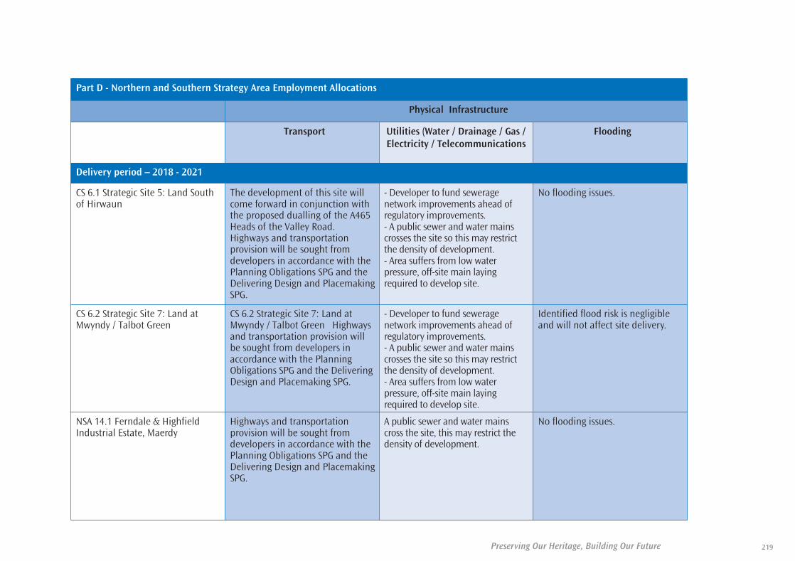
219Preserving Our Heritage, Building Our Future
Part D - Northern and Southern Strategy Area Employment Allocations
Physical Infrastructure
Transport Utilities (Water / Drainage / Gas /Electricity / Telecommunications
Flooding
Delivery period – 2018 - 2021
CS 6.1 Strategic Site 5: Land Southof Hirwaun
The development of this site willcome forward in conjunction withthe proposed dualling of the A465Heads of the Valley Road.Highways and transportationprovision will be sought fromdevelopers in accordance with thePlanning Obligations SPG and theDelivering Design and PlacemakingSPG.
- Developer to fund seweragenetwork improvements ahead ofregulatory improvements. - A public sewer and water mainscrosses the site so this may restrictthe density of development. - Area suffers from low waterpressure, off-site main layingrequired to develop site.
No flooding issues.
CS 6.2 Strategic Site 7: Land atMwyndy / Talbot Green
CS 6.2 Strategic Site 7: Land atMwyndy / Talbot Green Highwaysand transportation provision willbe sought from developers inaccordance with the PlanningObligations SPG and the DeliveringDesign and Placemaking SPG.
- Developer to fund seweragenetwork improvements ahead ofregulatory improvements. - A public sewer and water mainscrosses the site so this may restrictthe density of development. - Area suffers from low waterpressure, off-site main layingrequired to develop site.
Identified flood risk is negligibleand will not affect site delivery.
NSA 14.1 Ferndale & HighfieldIndustrial Estate, Maerdy
Highways and transportationprovision will be sought fromdevelopers in accordance with thePlanning Obligations SPG and theDelivering Design and PlacemakingSPG.
A public sewer and water mainscross the site, this may restrict thedensity of development.
No flooding issues.
35580-52 LDP plan 2011_Layout 1 30/06/2011 11:19 Page 219

Preserving Our Heritage, Building Our Future220
Part D - Northern and Southern Strategy Area Employment Allocations
Physical Infrastructure
Transport Utilities (Water / Drainage / Gas /Electricity / Telecommunications
Flooding
Delivery period – 2018 - 2021
NSA 14.2 North of Fifth Avenue,Hirwaun Industrial Estate, Hirwaun
Highways and transportationprovision will be sought fromdevelopers in accordance with thePlanning Obligations SPG and theDelivering Design and PlacemakingSPG.
A public sewer and water mainscross the site, this may restrict thedensity of development.
No flooding issues.
NSA 14.3 Land at Former MayhewChicken Factory, Trecynon
Highways and transportationprovision will be sought fromdevelopers in accordance with thePlanning Obligations SPG and theDelivering Design and PlacemakingSPG.
- Developer to fund seweragenetwork improvements ahead ofregulatory improvements. - A public sewer and water mainscross the site, this may restrict thedensity of development.
Scheme to address flooding risk tobe implemented as part of sitedevelopment.
NSA 14.4 Cae Mawr IndustrialEstate, Treorchy
Highways and transportationprovision will be sought fromdevelopers in accordance with thePlanning Obligations SPG and theDelivering Design and PlacemakingSPG.
- A water mains crosses the site, thismay restrict the density ofdevelopment.
Scheme to address flooding risk tobe implemented as part of sitedevelopment.
SSA 14.1 Coed Ely, Tonyrefail Highways and transportationprovision will be sought fromdevelopers in accordance with thePlanning Obligations SPG and theDelivering Design and PlacemakingSPG.
- No public sewerage system in thearea, any new development wouldrequire facilities for sewage disposal. - A public sewer crosses the site, mayrestrict the density of development. - Developer to fund seweragenetwork improvements ahead ofregulatory improvements.
No flooding issues.
35580-52 LDP plan 2011_Layout 1 30/06/2011 11:19 Page 220
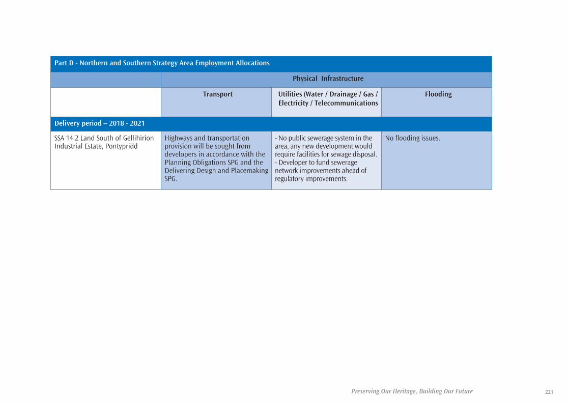
221Preserving Our Heritage, Building Our Future
Part D - Northern and Southern Strategy Area Employment Allocations
Physical Infrastructure
Transport Utilities (Water / Drainage / Gas /Electricity / Telecommunications
Flooding
Delivery period – 2018 - 2021
SSA 14.2 Land South of GellihirionIndustrial Estate, Pontypridd
Highways and transportationprovision will be sought fromdevelopers in accordance with thePlanning Obligations SPG and theDelivering Design and PlacemakingSPG.
- No public sewerage system in thearea, any new development wouldrequire facilities for sewage disposal. - Developer to fund seweragenetwork improvements ahead ofregulatory improvements.
No flooding issues.
35580-52 LDP plan 2011_Layout 1 30/06/2011 11:19 Page 221

Preserving Our Heritage, Building Our Future222
35580-52 LDP plan 2011_Layout 1 30/06/2011 11:19 Page 222

223Preserving Our Heritage, Building Our Future
35580-52 LDP plan 2011_Layout 1 30/06/2011 11:19 Page 223

Preserving Our Heritage, Building Our Future224
35580-52 LDP plan 2011_Layout 1 30/06/2011 11:19 Page 224