revitalising the gulf
TRANSCRIPT
Revitalising the Gulf
Government action on the Sea Change Plan
Māori Bay Coast Walk. Photo credit Brendan Bombaci.
Government Strategy in response to the Sea Change – Tai Timu Tai Pari – Hauraki Gulf Marine Spatial Plan
June 2021
Pakiri Beach. The shellfish shuffle. Photo credit @New Zealand Story.
1
ContentsMinisters’ foreword 3
Executive summary 4
1. Roadmap to deliver a healthier Hauraki Gulf 7
2. A call to action for the Gulf 10
2.1 Why the Gulf is important 10
2.2 A taonga in trouble 12
2.3 Protecting mana whenua rights and interests 13
3. The Sea Change – Tai Timu Tai Pari – Hauraki Gulf Marine Spatial Plan 14
3.1 Development of the Sea Change Plan 14
3.2 Sea Change Plan at a glance 15
4. Taking action: Government Response Strategy to the Sea Change Plan 16
4.1 What we want to achieve 16
4.2 Guiding principles 17
4.3 What we have considered 17
4.4 Connecting our actions with others – ki uta ki tai 18
4.5 What mana whenua and key stakeholders have told us 19
4.6 An ecosystem-based management approach 21
5. Elements of this Strategy 24
5.1 Fisheries management 24
5.2 Active habitat restoration 38
5.3 Aquaculture 46
5.4 Marine biosecurity 53
5.5 Marine protection 57
5.6 Protected species 68
5.7 Ahu Moana 76
5.8 Governance 84
6. Research, monitoring and reporting 91
7. Immediate actions to enhance the mauri of the Gulf 98
References 99
Glossary 102
Appendix 1: Sea Change – Tai Timu Tai Pari Ministerial Advisory Committee 106
Appendix 2: Draft Hauraki Gulf Fisheries Plan 107
Appendix 3: Sea Change Plan’s outcomes for marine biosecurity and agency implementation activities 121
Appendix 4: Our marine protection proposals 122
Revitalising the Gulf – Government action on the Sea Change Plan2
Figures
Figure 1: The Hauraki Gulf Marine Park Act 2000 recognises the national significance of the Gulf and establishes its boundaries (marine boundaries light blue) 11
Figure 2: We seek to reverse the decline and restore the balance of life-supporting ecosystems 12
Figure 3: Fisheries Management Area 1 (FMA 1) 26
Figure 4: Significant existing commercial fisheries restrictions in the Gulf 29
Figure 5: Quota management area for snapper off the east coast of the North Island (SNA 1) and boundaries for the three sub-stocks within SNA 1: East Northland, Hauraki Gulf and Bay of Plenty 33
Figure 6: Ecosystem services provided by shellfish 40
Figure 7: Aquaculture in the Coromandel – the contribution of marine farming to the Thames–Coromandel District in 2017 48
Figure 8: Locations of the protected area proposals that we will engage and consult on. 63
Figure 9: Proposed structure for identifying and progressing Ahu Moana initiatives 79
Figure 10: Implementation of all actions will inform the Monitoring and Reporting Framework 90
Figure 11: Adaptive management approach 94
Tables
Table 1: Our roadmap for delivering a healthier Hauraki Gulf 7
Table 2: Proposed new areas for marine protection in the Gulf 62
Table 3: Assessing the achievement of Ahu Moana outcomes 81
3
The protection of Aotearoa New Zealand’s unique natural environment is a deeply held value of New Zealanders. Sadly, one of the country’s most valued and intensively used coastal spaces, the Hauraki Gulf Marine Park / Tīkapa Moana / Te Moananui-ā-Toi (the Gulf), is in environmental decline. Action is needed now to revive this precious taonga.
Published in 2017, the Sea Change – Tai Timu Tai Pari – Hauraki Gulf Marine Spatial Plan (the Sea Change Plan) set a transformational path for the future of the Gulf. We are committed to working with mana whenua,1 communities and local government to achieve its vision.
A Government Strategy has been prepared in response to the marine proposals in the Sea Change Plan, with actions to drive change and deliver a healthier Gulf.
To support the recovery of species and habitats, we propose new marine protected areas in some of the most biodiverse regions in the Gulf, and complementary sustainable fisheries management measures, including harvesting controls and restrictions on trawling.
We will also promote targeted habitat restoration, a sustainable aquaculture industry, biosecurity programmes and protected species management. These measures will complement other government initiatives, including to reduce land-based sources of sediment and other contaminants currently polluting the Gulf. This integrated response will mirror the interconnected ecosystem of the Gulf.
Treaty partnership is critical to the restoration of the Gulf. Ongoing Treaty settlement processes and customary practices will be respected in implementing the Strategy’s actions. We will also work with mana
whenua and local communities to trial localised management approaches to fisheries and conservation through Ahu Moana pilots.
We thank the Stakeholder Working Group for developing the Sea Change Plan. We thank the independent Sea Change – Tai Timu Tai Pari Ministerial Advisory Committee for the advice that was instrumental in shaping the Strategy. We also thank mana whenua, stakeholders and interest groups for their feedback on the Strategy.
We acknowledge the contributions of other Ministers in progressing Sea Change over many years and across governments – including Conservation Ministers Hon Kiritapu Allan and Hon Eugenie Sage, Fisheries Minister Hon Stuart Nash, and their predecessors. We also acknowledge the work of officials from the Department of Conservation and the Ministry for Primary Industries/Fisheries New Zealand in preparing the Strategy.
The Government is committed to turning the tide on the declining health of the Gulf. We believe this Strategy sets out the necessary actions to restore the waiora and mauri (health and life force) of this precious taonga (treasure), and to ensure New Zealanders can enjoy one of the world’s most beautiful marine environments for generations to come.
Hon David Parker
Minister for Oceans and Fisheries
Hon Dr Ayesha Verrall
Acting Minister of Conservation
Ministers’ foreword
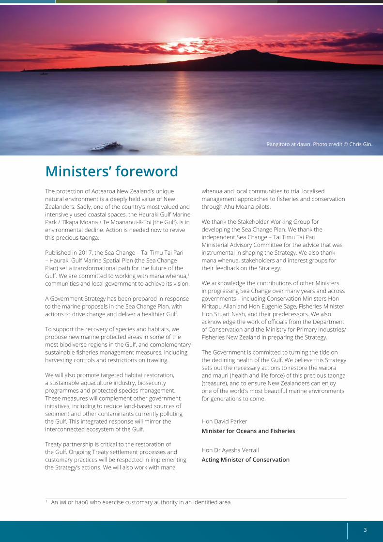
Rangitoto at dawn. Photo credit © Chris Gin.
1 An iwi or hapū who exercise customary authority in an identified area.
Revitalising the Gulf – Government action on the Sea Change Plan4
Executive summary
Mai te rangi ki te papaNgā maunga ki te MoanaTīkapa Moana – Te Moananui ā ToiNgā poitō o te kupengaNei rā te mihi ka tikaHei whakaruruhau taongaTaitimu, TaipariWai ora, Mauri oraKi uta, ki taiKi te whai ao, ki te ao mārama
From the Skyfather to the EarthmotherFrom the mountains to the seaThe sea of Tīkapa – The great ocean of ToiThe floats of the netWe greet youA shelter for our treasuresThe ebbing tide, the high tideHealthy waters, life forceTo the shores, to the seaTo the world, to the world of understanding
The Hauraki Gulf Marine Park / Tīkapa Moana / Te Moananui-ā-Toi (the Gulf) is one of Aotearoa New Zealand’s most valued and intensively used coastal spaces. Its mana (prestige) is embodied in its blue waters, forested islands, fertile catchments and extraordinary diversity of life, including its people.
The Gulf is badly degraded from human activities. Some fish and seabird populations are declining, and nature’s delicate balance is being upset. This has severe knock-on effects for other species and habitats. Extractive activities at sea, and activities on land that introduce sediment and pollutants, are also damaging marine and coastal environments.
In response to this decline, the Sea Change Stakeholder Working Group developed the 2017 Sea Change – Tai Timu Tai Pari – Hauraki Gulf Marine Spatial Plan (the Sea Change Plan). This includes over 180 recommendations to improve the waiora (health) and mauri (life force) of the Gulf from the land to its freshwater systems and down to the sea.
This Strategy is the Government’s response to the Sea Change Plan’s marine proposals, including fisheries management, marine protection, habitat restoration and localised management.
To develop an enduring set of actions, we:
• analysed the Sea Change Plan’s proposals, pragmatically identifying what could be taken forward and what could be further improved;
• listened to advice from the Sea Change Tai Timu Tai Pari Ministerial Advisory Committee;
• listened to feedback from mana whenua;2 and
• listened to feedback from stakeholders of the Gulf.
An integrated package of actions capable of addressing multiple pressures on the Gulf is critical to ensure successful restoration and protection. The Government, regional councils and community groups are undertaking significant work programmes to progress the Sea Change Plan’s broader aspirations for the Hauraki Gulf across land and freshwater. These include:
• the Essential Freshwater3 and the Productive and Sustainable Land Use4 packages that will reduce land-based sources of sediment and other contaminants;
• reform of the Resource Management Act 1991, to strengthen the sustainable management of natural resources and deliver better outcomes for the environment;
• Auckland Council and Waikato Regional Council actions in response to various land and freshwater proposals in the Sea Change Plan, including habitat restoration, managing sedimentation, improving water quality and managing marine debris; and
• projects led by mana whenua and community groups, such as the Ngāti Whātua Ōrākei restoration project in Okahu Bay and the Taramaire Stream restoration project.
2 Customary authority exercised by iwi or hapū who exercise customary authority over an identified area.3 A package of policies and regulations that the Government brought into force in 2020 to restore and protect the
health of New Zealand’s waterways.4 A package to promote land-use practices that deliver more value and improved environmental outcomes.
5
The Strategy complements these work programmes by addressing the direct threats to the marine environment in the Gulf. The Strategy’s actions span eight important elements:
1. Fisheries management: developing an area-based fisheries plan for customary, commercial and recreational fisheries,5 to progress over 50 integrated actions. This will be completed by June 2022. The actions recognise that, although most fish stocks are in a better state than 30 years ago, sustainability issues remain for some stocks, particularly at a local scale. The Fisheries Plan proposes management measures that include:
• removal of trawl fishing for a significant portion of the Gulf (except within limited areas or “trawl corridors”)
• freezing the footprint of commercial scallop dredging to existing areas and excluding recreational scallop dredging
• restoring fisheries abundance at the stock level and within the Gulf through management strategies to address localised depletion
• enabling more intertidal harvesting controls, such as blanket seasonal closures
• supporting greater mana whenua and regional participation in fisheries management.
The Fisheries Plan will enable a more ecosystem-based approach to fisheries management and be supported by the development of a fisheries indicator and monitoring framework, and a multi-stakeholder Hauraki Gulf Fisheries Plan Advisory Group.
2. Active habitat restoration: establishing a habitat restoration framework to guide new investment and restoration initiatives, to be completed in 2021.
3. Aquaculture: identifying government actions to remove impediments to aquaculture initiatives by 2023.
4. Marine biosecurity: continuing agency support for the Top of the North Marine Biosecurity Partnership.6
5. Marine protection: establishing 11 new High Protection Areas7 to protect and restore marine ecosystems, and recognise the role of mana whenua as rangatira and kaitiaki through provision for customary practices, consistent with biodiversity objectives.
Establishing 5 Seafloor Protection Areas8 and 2 areas of marine protection adjacent to existing marine reserves.9
These 18 measures will increase the area under marine protection in the Gulf from 6.6 percent (including the existing cable protection zone) to 17.6 percent. These protection areas will be progressed through new legislation passed in 2024.
6. Protected species: expanding the existing work by the Department of Conservation (DOC) and Ministry for Primary Industries (MPI)/Fisheries New Zealand (FNZ) for protected marine species in the Gulf over the next three years, including mitigating terrestrial biosecurity threats to burrow-nesting seabirds on island refuges, improving by-catch measures, and prioritising research and monitoring of protected species.
7. Ahu Moana (local marine management by mana whenua and local communities): initiating pilot projects with mana whenua and local communities in 2021 to explore how to improve fisheries and conservation in local areas.
The 2017 Sea Change Plan proposed empowering mana whenua and local communities to manage their marine environments more directly, but this concept has mixed support and requires more work to understand its practical application. The pilots will therefore explore mana whenua and local community ambitions, and how best DOC and MPI/FNZ can support them.
Existing fisheries regulatory tools will support the pilots. Lessons from the pilots will inform the development of an Ahu Moana framework by 2023.
5 A Fisheries Plan approved under s11A of the Fisheries Act 1996 can be used to set fisheries management objectives for one or more stocks, fishing years, areas, or any combination of these.
6 Auckland Council, Bay of Plenty, Northland and Waikato Regional Councils and MPI are working together to stop the spread of invasive marine pests in northern New Zealand.
7 High Protection Areas (HPAs) will protect, enhance and restore the full range of marine communities and ecosystems and outstanding, rare, distinctive or nationally important marine habitats.
8 Seafloor Protection Areas (SPAs) will protect seafloor marine habitats while allowing for compatible uses.9 The 2017 Sea Change Plan proposed that the boundaries of the existing marine reserves in the Gulf be extended
under the Marine Reserves Act 1971 with the same no-take restrictions – that is the Whanganui-a-Hei (Cathedral Cove) Marine Reserve and Cape Rodney-Okakari Point (Leigh) Marine Reserve. In recent engagement, some iwi reiterated that their support for protection at these sites is contingent upon the provision for customary practices. Further discussions with mana whenua will inform which option is pursued for these two sites.
Revitalising the Gulf – Government action on the Sea Change Plan6
8. Governance: establishing a cross-agency implementation group comprising DOC and MPI/FNZ (the agencies) to oversee the implementation of the Strategy. Determining a wider new governance arrangement in the Gulf is out of scope of the Strategy10 because future Treaty negotiations relating to the Gulf will focus on governance arrangements (including the Hauraki Gulf Forum).
The marine protection proposals will protect some of the most biodiverse areas in the Gulf. The Hauraki Gulf Fisheries Plan will provide complementary protection by managing the impacts of fisheries on seabed habitats and species. Our protection efforts will be bolstered by more active habitat restoration initiatives, which will become more targeted and effective through the development of a habitat restoration guidance framework.
Mana whenua and stakeholders will have input into local decision-making. The Hauraki Gulf Fisheries Plan will enable mana whenua and local communities to be more involved in the management of their nearshore
10 Strategy engagement identified governance options for the Hauraki Gulf that have been noted in section 5.8. This may inform future Treaty settlement negotiations.
coastal areas, and “Ahu Moana” projects will further enhance nearshore areas through local communities and mana whenua working together to support recovery of habitats and fisheries resources.
Implementation of the Strategy’s actions will begin immediately. Some actions will be accomplished within a few months, while others will be completed over the next three years because they require formal processes, such as public consultation on the proposed protected areas and Hauraki Gulf Fisheries Plan.
We will undertake research and ongoing monitoring to track progress and adapt our approach over time, to ensure it remains effective in delivering these actions.
7
Immediate(0-1 year)
1-2 years 3-plus yearsOngoing (from
implementation)
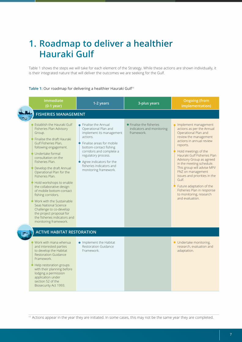
FISHERIES MANAGEMENT
Establish the Hauraki Gulf Fisheries Plan Advisory Group.
Finalise the draft Hauraki Gulf Fisheries Plan, following engagement.
Undertake formal consultation on the Fisheries Plan.
Develop the draft Annual Operational Plan for the Fisheries Plan.
Hold workshops to enable the collaborative design of mobile bottom-contact fishing corridors.
Work with the Sustainable Seas National Science Challenge to co-develop the project proposal for the fisheries indicators and monitoring framework.
Finalise the Annual Operational Plan and implement its management actions.
Finalise areas for mobile bottom-contact fishing corridors and complete a regulatory process.
Agree indicators for the fisheries indicators and monitoring framework.
Finalise the fisheries indicators and monitoring framework.
Implement management actions as per the Annual Operational Plan and review the management actions in annual review reports.
Hold meetings of the Hauraki Gulf Fisheries Plan Advisory Group as agreed in the meeting schedule. This group will advise MPI/FNZ on management issues and priorities in the Gulf.
Future adaptation of the Fisheries Plan in response to monitoring, research and evaluation.
ACTIVE HABITAT RESTORATION
Work with mana whenua and interested parties to develop the Habitat Restoration Guidance Framework.
Help restoration groups with their planning before lodging a permission application under section 52 of the Biosecurity Act 1993.
Implement the Habitat Restoration Guidance Framework.
Undertake monitoring, research, evaluation and adaptation.
1. Roadmap to deliver a healthier Hauraki Gulf
Table 1 shows the steps we will take for each element of the Strategy. While these actions are shown individually, it is their integrated nature that will deliver the outcomes we are seeking for the Gulf.
Table 1: Our roadmap for delivering a healthier Hauraki Gulf11
11 Actions appear in the year they are initiated. In some cases, this may not be the same year they are completed.
Revitalising the Gulf – Government action on the Sea Change Plan8
Immediate(0-1 year)
1-2 years 3-plus yearsOngoing (from
implementation)
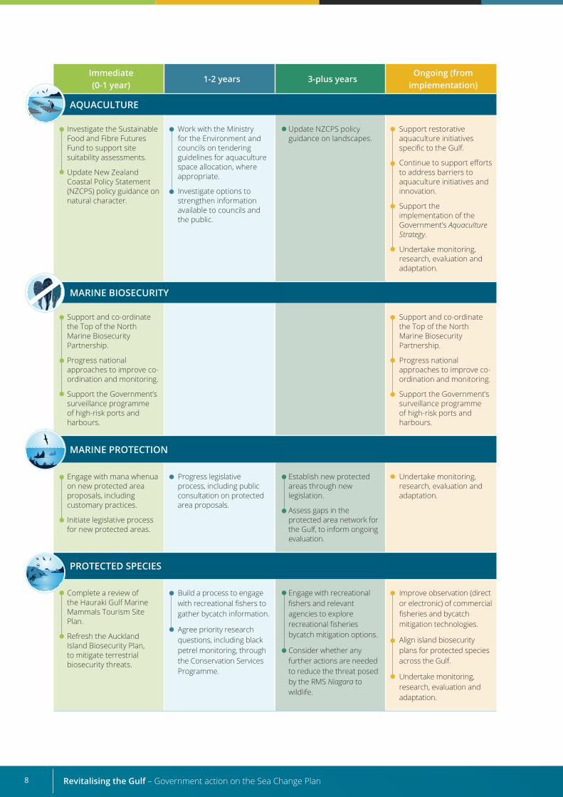
AQUACULTURE
Investigate the Sustainable Food and Fibre Futures Fund to support site suitability assessments.
Update New Zealand Coastal Policy Statement (NZCPS) policy guidance on natural character.
Work with the Ministry for the Environment and councils on tendering guidelines for aquaculture space allocation, where appropriate.
Investigate options to strengthen information available to councils and the public.
Update NZCPS policy guidance on landscapes.
Support restorative aquaculture initiatives specific to the Gulf.
Continue to support efforts to address barriers to aquaculture initiatives and innovation.
Support the implementation of the Government’s Aquaculture Strategy.
Undertake monitoring, research, evaluation and adaptation.
MARINE BIOSECURITY
Support and co-ordinate the Top of the North Marine Biosecurity Partnership.
Progress national approaches to improve co-ordination and monitoring.
Support the Government’s surveillance programme of high-risk ports and harbours.
Support and co-ordinate the Top of the North Marine Biosecurity Partnership.
Progress national approaches to improve co-ordination and monitoring.
Support the Government’s surveillance programme of high-risk ports and harbours.
MARINE PROTECTION
Engage with mana whenua on new protected area proposals, including customary practices.
Initiate legislative process for new protected areas.
Progress legislative process, including public consultation on protected area proposals.
Establish new protected areas through new legislation.
Assess gaps in the protected area network for the Gulf, to inform ongoing evaluation.
Undertake monitoring, research, evaluation and adaptation.
PROTECTED SPECIES
Complete a review of the Hauraki Gulf Marine Mammals Tourism Site Plan.
Refresh the Auckland Island Biosecurity Plan, to mitigate terrestrial biosecurity threats.
Build a process to engage with recreational fishers to gather bycatch information.
Agree priority research questions, including black petrel monitoring, through the Conservation Services Programme.
Engage with recreational fishers and relevant agencies to explore recreational fisheries bycatch mitigation options.
Consider whether any further actions are needed to reduce the threat posed by the RMS Niagara to wildlife.
Improve observation (direct or electronic) of commercial fisheries and bycatch mitigation technologies.
Align island biosecurity plans for protected species across the Gulf.
Undertake monitoring, research, evaluation and adaptation.
9
Immediate(0-1 year)
1-2 years 3-plus yearsOngoing (from
implementation)
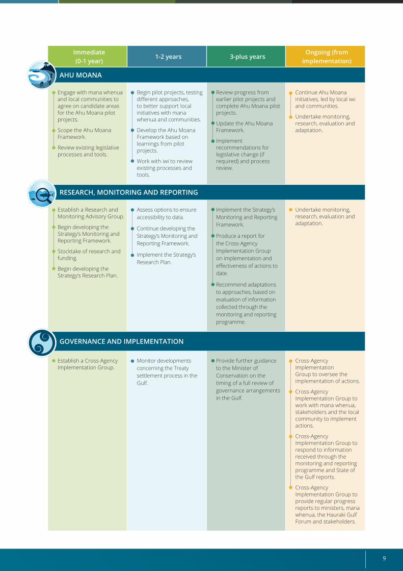
AHU MOANA
Engage with mana whenua and local communities to agree on candidate areas for the Ahu Moana pilot projects.
Scope the Ahu Moana Framework.
Review existing legislative processes and tools.
Begin pilot projects, testing different approaches, to better support local initiatives with mana whenua and communities.
Develop the Ahu Moana Framework based on learnings from pilot projects.
Work with iwi to review existing processes and tools.
Review progress from earlier pilot projects and complete Ahu Moana pilot projects.
Update the Ahu Moana Framework.
Implement recommendations for legislative change (if required) and process review.
Continue Ahu Moana initiatives, led by local iwi and communities.
Undertake monitoring, research, evaluation and adaptation.
RESEARCH, MONITORING AND REPORTING
Establish a Research and Monitoring Advisory Group.
Begin developing the Strategy’s Monitoring and Reporting Framework.
Stocktake of research and funding.
Begin developing the Strategy’s Research Plan.
Assess options to ensure accessibility to data.
Continue developing the Strategy’s Monitoring and Reporting Framework.
Implement the Strategy’s Research Plan.
Implement the Strategy’s Monitoring and Reporting Framework.
Produce a report for the Cross-Agency Implementation Group on implementation and effectiveness of actions to date.
Recommend adaptations to approaches, based on evaluation of information collected through the monitoring and reporting programme.
Undertake monitoring, research, evaluation and adaptation.
GOVERNANCE AND IMPLEMENTATION
Establish a Cross-Agency Implementation Group.
Monitor developments concerning the Treaty settlement process in the Gulf.
Provide further guidance to the Minister of Conservation on the timing of a full review of governance arrangements in the Gulf.
Cross-Agency Implementation Group to oversee the implementation of actions.
Cross-Agency Implementation Group to work with mana whenua, stakeholders and the local community to implement actions.
Cross-Agency Implementation Group to respond to information received through the monitoring and reporting programme and State of the Gulf reports.
Cross-Agency Implementation Group to provide regular progress reports to ministers, mana whenua, the Hauraki Gulf Forum and stakeholders.
Revitalising the Gulf – Government action on the Sea Change Plan10 10
2. A call to action for the Gulf2.1. Why the Gulf is important The Hauraki Gulf Marine Park / Tīkapa Moana / Te Moananui-ā-Toi (the Gulf) has a rich history of human settlement and is one of Aotearoa New Zealand’s most valued and intensively used coastal spaces. It supports people on its doorstep and beyond, contributing to their livelihoods, sustenance, recreation and wellbeing, and its kaimoana (seafood) has fed generations of New Zealand families.
The islands of the Gulf are also known as Ngā Poitō o te Kupenga o Taramainuku or “the float of the net of Taramainuku”, who was a contemporary of the ancestor Māui. This is used as a metaphor to mean a net that gathers everybody in to represent one whole. While we refer to “the Gulf” throughout this Strategy, we consider this metaphor in our approach, our thinking and our aspirations for ecosystem-based management in this special place.
The Gulf is intrinsic to whakapapa (genealogy), identity and mana (prestige), with mana whenua (customary authority exercised by an iwi or hapū in an identified area) having maintained a connection to it over many centuries. It includes the earliest places settled by Māori. Mana whenua are rangatira (chiefs) and kaitiaki (guardians) of these ancestral lands, a responsibility of the highest order that has been handed down through the generations.
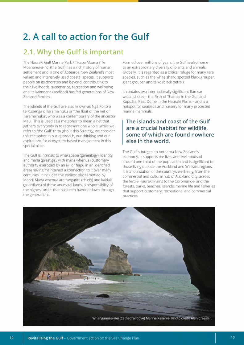
Whanganui-a-Hei (Cathedral Cove) Marine Reserve. Photo credit Alan Cressler.
Formed over millions of years, the Gulf is also home to an extraordinary diversity of plants and animals. Globally, it is regarded as a critical refuge for many rare species, such as the white shark, spotted black grouper, giant grouper and tāiko (black petrel).
It contains two internationally significant Ramsar wetland sites – the Firth of Thames in the Gulf and Kopuātai Peat Dome in the Hauraki Plains – and is a hotspot for seabirds and nursery for many protected marine mammals.
The islands and coast of the Gulf are a crucial habitat for wildlife, some of which are found nowhere else in the world.
The Gulf is integral to Aotearoa New Zealand’s economy. It supports the lives and livelihoods of around one-third of the population and is significant to those living outside the Auckland and Waikato regions. It is a foundation of the country’s wellbeing, from the commercial and cultural hub of Auckland City, across the fertile Hauraki Plains to the Coromandel and the forests, parks, beaches, islands, marine life and fisheries that support customary, recreational and commercial practices.
1110
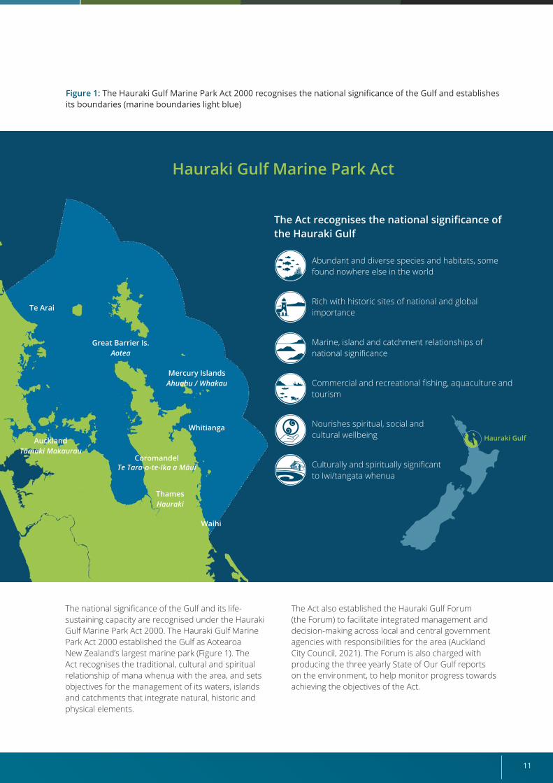
The national significance of the Gulf and its life-sustaining capacity are recognised under the Hauraki Gulf Marine Park Act 2000. The Hauraki Gulf Marine Park Act 2000 established the Gulf as Aotearoa New Zealand’s largest marine park (Figure 1). The Act recognises the traditional, cultural and spiritual relationship of mana whenua with the area, and sets objectives for the management of its waters, islands and catchments that integrate natural, historic and physical elements.
Abundant and diverse species and habitats, some found nowhere else in the world
Rich with historic sites of national and global importance
Marine, island and catchment relationships of national significance
Commercial and recreational fishing, aquaculture and tourism
Nourishes spiritual, social and cultural wellbeing
Culturally and spiritually significant to Iwi/tangata whenua
Hauraki Gulf Marine Park Act
The Act recognises the national significance of the Hauraki Gulf
Hauraki GulfWhitianga
Te Arai
Mercury IslandsAhuahu / Whakau
Great Barrier Is.Aotea
AucklandTāmaki Makaurau
Waihi
CoromandelTe Tara-o-te-Ika a Māui
ThamesHauraki
Figure 1: The Hauraki Gulf Marine Park Act 2000 recognises the national significance of the Gulf and establishes its boundaries (marine boundaries light blue)
The Act also established the Hauraki Gulf Forum (the Forum) to facilitate integrated management and decision-making across local and central government agencies with responsibilities for the area (Auckland City Council, 2021). The Forum is also charged with producing the three yearly State of Our Gulf reports on the environment, to help monitor progress towards achieving the objectives of the Act.
Revitalising the Gulf – Government action on the Sea Change Plan12
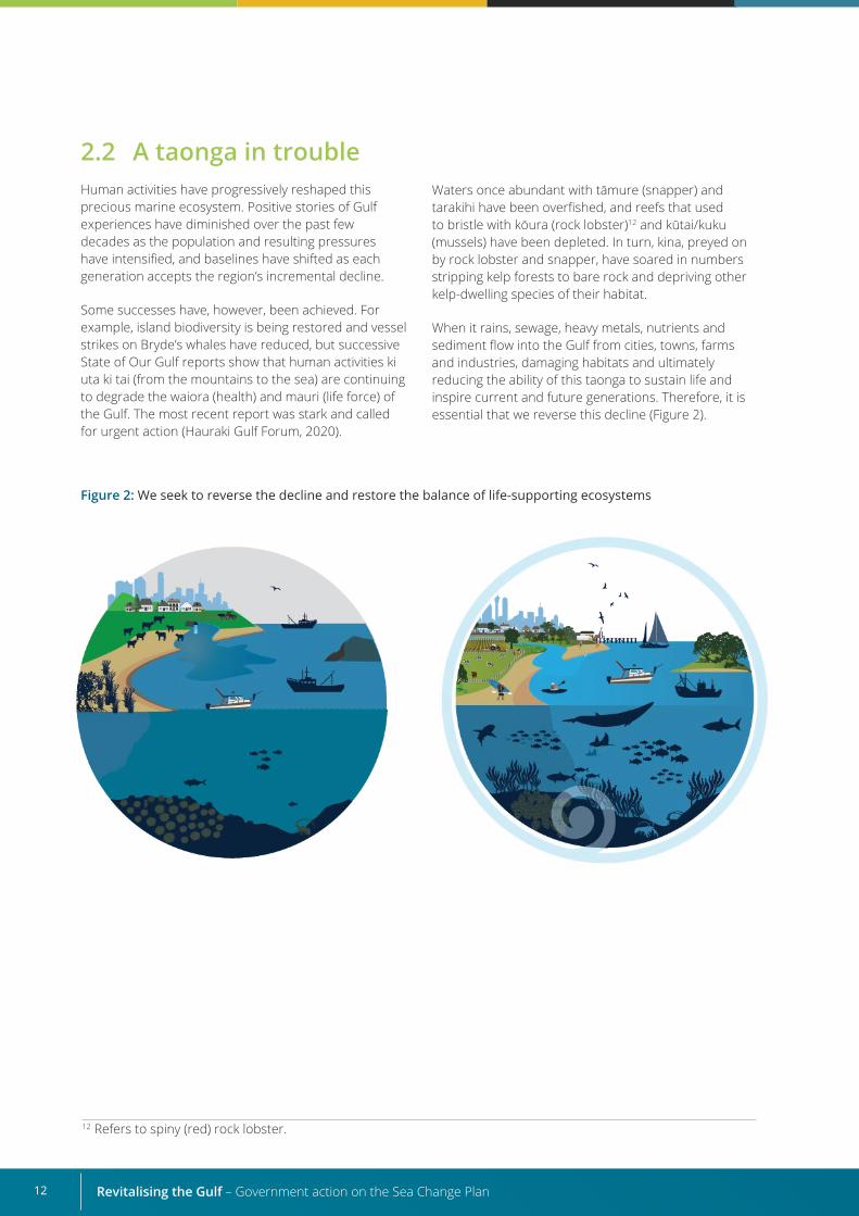
Figure 2: We seek to reverse the decline and restore the balance of life-supporting ecosystems
12 Refers to spiny (red) rock lobster.
2.2 A taonga in troubleHuman activities have progressively reshaped this precious marine ecosystem. Positive stories of Gulf experiences have diminished over the past few decades as the population and resulting pressures have intensified, and baselines have shifted as each generation accepts the region’s incremental decline.
Some successes have, however, been achieved. For example, island biodiversity is being restored and vessel strikes on Bryde’s whales have reduced, but successive State of Our Gulf reports show that human activities ki uta ki tai (from the mountains to the sea) are continuing to degrade the waiora (health) and mauri (life force) of the Gulf. The most recent report was stark and called for urgent action (Hauraki Gulf Forum, 2020).
Waters once abundant with tāmure (snapper) and tarakihi have been overfished, and reefs that used to bristle with kōura (rock lobster)12 and kūtai/kuku (mussels) have been depleted. In turn, kina, preyed on by rock lobster and snapper, have soared in numbers stripping kelp forests to bare rock and depriving other kelp-dwelling species of their habitat.
When it rains, sewage, heavy metals, nutrients and sediment flow into the Gulf from cities, towns, farms and industries, damaging habitats and ultimately reducing the ability of this taonga to sustain life and inspire current and future generations. Therefore, it is essential that we reverse this decline (Figure 2).
13
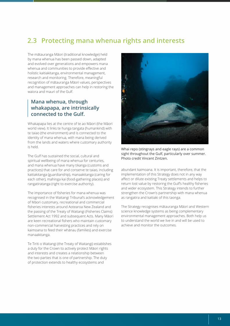
Whai repo (stingrays and eagle rays) are a common sight throughout the Gulf, particularly over summer. Photo credit Vincent Zintzen.
The mātauranga Māori (traditional knowledge) held by mana whenua has been passed down, adapted and evolved over generations and empowers mana whenua and communities to provide effective and holistic kaitiakitanga, environmental management, research and monitoring. Therefore, meaningful recognition of mātauranga Māori values, perspectives and management approaches can help in restoring the waiora and mauri of the Gulf.
Mana whenua, through whakapapa, are intrinsically connected to the Gulf.
Whakapapa lies at the centre of te ao Māori (the Māori world view). It links te hunga tangata (humankind) with te taiao (the environment) and is connected to the identity of mana whenua, with mana being derived from the lands and waters where customary authority is held.
The Gulf has sustained the social, cultural and spiritual wellbeing of mana whenua for centuries, and mana whenua have many tikanga (customs and practices) that care for and conserve te taiao, including kaitiakitanga (guardianship), manaakitanga (caring for each other), mahinga kai (food-gathering places) and rangatiratanga (right to exercise authority).
The importance of fisheries for mana whenua was recognised in the Waitangi Tribunal’s acknowledgement of Māori customary, recreational and commercial fisheries interests around Aotearoa New Zealand and the passing of the Treaty of Waitangi (Fisheries Claims) Settlement Act 1992 and subsequent Acts. Many Māori are keen recreational fishers who maintain customary non-commercial harvesting practices and rely on kaimoana to feed their whānau (families) and exercise manaakitanga.
Te Tiriti o Waitangi (the Treaty of Waitangi) establishes a duty for the Crown to actively protect Māori rights and interests and creates a relationship between the two parties that is one of partnership. The duty of protection extends to healthy ecosystems and
abundant kaimoana. It is important, therefore, that the implementation of this Strategy does not in any way affect or dilute existing Treaty settlements and helps to return lost value by restoring the Gulf’s healthy fisheries and wider ecosystem. This Strategy intends to further strengthen the Crown’s partnership with mana whenua as rangatira and kaitiaki of this taonga.
The Strategy recognises mātauranga Māori and Western science knowledge systems as being complementary environmental management approaches. Both help us to understand the world we live in and will be used to achieve and monitor the outcomes.
2.3 Protecting mana whenua rights and interests
Revitalising the Gulf – Government action on the Sea Change Plan14
3.1 Development of the Sea Change Plan
3. Sea Change Plan at a glance
In 2013, mana whenua, environmental groups, and infrastructure, fishing, aquaculture and agriculture sectors came together to form the Sea Change Stakeholder Working Group, which was tasked with developing an integrated plan for the Gulf in a bid to reverse the decline in its health. This project was overseen by a co-governance project steering group and guided by the following vision:
“He taonga tuku iho – treasures handed down from the ancestors Tīkapa Moana / Te Moananui-ā-Toi – the Hauraki Gulf is vibrant with life, its mauri strong, productive, and supporting healthy and prosperous communities.” (Stakeholder Working Group, 2017)
The resulting Sea Change Plan was developed over four years by the 14-member Stakeholder Working Group through engagement with mana whenua, local communities and stakeholder groups and the collection of mātauranga and scientific information from many sources. It was released in 2016 and published in 2017.
Mana whenua were involved in the development of the Sea Change Plan through representation on the Project Steering Group, Stakeholder Working Group, the Mātauranga Māori Round Table and the Mana Whenua Reference Group.
Although not involved in drafting the Sea Change Plan, the Department of Conservation (DOC), Ministry for Primary Industries (MPI), Auckland Council and Waikato Regional Council provided project governance and scientific, technical, financial and administrative support to the Stakeholder Working Group.
While the Sea Change Plan was welcomed by many with an interest in the Gulf, some groups and organisations, particularly those most affected by the proposals, felt they had not had sufficient opportunity to provide input into its development. Concerns were also raised that some of the proposals within the Sea Change Plan were not ready for immediate implementation.
15
3.2 Sea Change Plan at a glanceAlthough the Sea Change Plan is non-statutory and non-binding, it is designed to catalyse action by agencies with statutory environmental and economic functions in the Gulf. It lays the foundations for integrated management by recognising the diverse interests, users and interactions across the Gulf, its islands and catchments (Sea Change Stakeholder Working Group, 2017). It aims to navigate the different aspirations people have for the Gulf and sets out integrated actions for mana whenua, communities and central and local government agencies to implement together, to secure the Gulf’s healthy, productive and sustainable future.
These actions aim to improve the waiora and mauri of the Gulf by:
• restoring depleted fish stocks and benthic habitats;
• reducing the impacts of land-based activities;
• recognising and protecting cultural values;
• protecting representative marine habitats; and
• promoting economic development opportunities while ensuring marine environments are restored.
The Sea Change Plan contains proposals for:
• marine protection;
• fisheries management;
• aquaculture;
• habitat restoration;
• protected species;
• catchment management;
• localised co-management (Ahu Moana); and
• opportunities for economic development.
It recommends more than 180 interrelated actions spread across four overarching concepts:
1. kaitiakitanga and guardianship;
2. mahinga kai – replenishing the food basket (fish stocks and aquaculture);
3. ki uta ki tai – ridge to reef or mountains to sea (biodiversity and water quality); and
4. kotahitanga – prosperous communities (inspiring the community, providing access, developing coastal infrastructure and implementing the actions).
Although responsibility for progressing these proposals falls to a variety of organisations, it primarily lies with central government, Auckland Council, Waikato Regional Council and local iwi (tribes) and community organisations. Programmes to implement the Sea Change Plan are being progressed by Auckland Council and Waikato Regional Council.
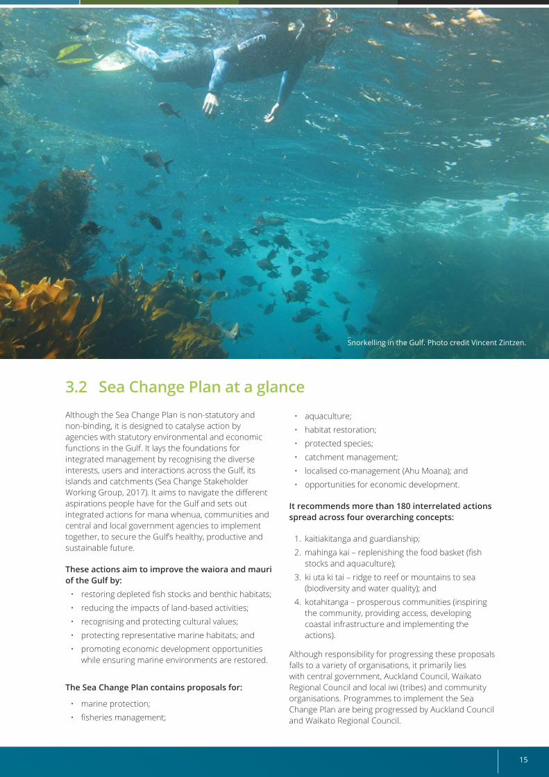
Snorkelling in the Gulf. Photo credit Vincent Zintzen.
Revitalising the Gulf – Government action on the Sea Change Plan16
4. Taking action: Government Response Strategy to the Sea Change Plan
The Government is committed to achieving the Sea Change Plan’s vision. This is a big task, but the Sea Change Plan has laid a solid foundation for determining the actions needed.
DOC and MPI/Fisheries New Zealand (FNZ)13 led the development of the Government Response Strategy on behalf of the Government, with advice from the Ministry for the Environment (MfE) and Te Arawhiti (Office for Māori Crown Relations). The Strategy directly builds on, and responds to, the proposals set out in the Sea Change Plan. The Strategy outlines actions within the Conservation and Oceans and Fisheries ministerial portfolios and the work of DOC and MPI/FNZ.
Targeted engagement helped develop the Strategy. This approach drew on the collaborative process used to develop the Sea Change Plan, which provided the building blocks for us to respond to and progress marine conservation and fisheries management actions in the Gulf.
Further detail on the targeted engagement programme is provided in Section 4.5 “What mana whenua and key stakeholders have told us”.
4.1 What we want to achieve Our goal is to achieve step-change improvements for the Gulf. To do this, we have set two overarching outcomes for this Strategy that will be delivered through a series of interconnected actions.
Overarching outcomesThe two overarching outcomes for this Strategy are:
• effective kaitiakitanga and guardianship in the Gulf; and
• healthy functioning ecosystems that:
- underpin the wellbeing and prosperity of people who live, work and play in the Gulf;
- sustain healthy fisheries that replenish and enhance the pātaka kai (food basket) for customary, recreational and commercial uses;
- regulate, support and sustain the Gulf; and
- support resilient and diverse habitats and marine life.
These outcomes reinforce the four concepts embedded in the Sea Change Plan: kaitiakitanga, mahinga kia pātaka kai, ki uta ki tai and kotahitanga.
In delivering these outcomes, we will ensure we respect the integrity and value of current and future Treaty settlements.
ActionsThis Strategy proposes actions across eight elements drawn from the Sea Change Plan that fall within the remits of the Minister for Oceans and Fisheries and the Minister of Conservation. These are:
• fisheries management
• habitat restoration
• aquaculture
• marine biosecurity
• marine protection
• protected species
• Ahu Moana (local marine management by mana whenua and local communities)
• governance.
Along with the above actions, research, ongoing monitoring and evaluation will be carried out to ensure that what we do remains effective through adaptive management. These actions all link back to our two overarching outcomes.
13 Fisheries New Zealand is a business unit within the Ministry for Primary Industries.
17
4.2. Guiding principlesThe following principles guided the development of this Strategy.
• Te Tiriti o Waitangi commitments: We will deliver on the Government’s Treaty commitments by recognising mana whenua as rangatira and kaitiaki, their Treaty rights and ongoing Treaty settlement processes. In this Strategy, we recognise both mātauranga Māori and Western science knowledge systems by prioritising:
- rangatiratanga and kaitiakitanga – the intergenerational role undertaken by mana whenua;
- stewardship practices that give effect to sustaining and enhancing the Gulf now and for future generations;
- manaakitanga and care and respect in providing for the waiora of the Gulf.
• Evidence based: We will make the best use of mātauranga Māori and current scientific understanding to prioritise actions and evaluate outcomes.
• Acting now: We will be pragmatic and focus on what central government can do now and in the future rather than waiting for all available information to be perfect.
4.3. What we have considered
• Agile: We will move forward in an iterative and adaptive way recognising that things are unlikely to remain static, given the influences of climate change, patterns of use, economic and social change, improved scientific understanding, and changes arising as a result of our actions and those of others.
• Integrated and interconnected: We will link in with the contributions of our implementation partners, including councils, and recognise the contributions of non-governmental organisations (NGOs), businesses, landowners and others.
• Testing alignment and practicality: We will test the proposed actions against the Sea Change Plan and broader governmental outcomes. We will also consider resourcing implications for central and local government, potential impacts on stakeholders and interactions with wider government priorities and programmes.
In developing this Strategy, we have considered the environmental, cultural, economic and social issues facing the Gulf and the potential benefits an ecosystem-based management approach will bring.
Building on the Sea Change Plan proposals, we have identified conservation and fisheries management actions that will effectively and equitably achieve the Strategy’s outcomes. This process involved discussions with the Sea Change – Tai Timu Tai Pari Ministerial Advisory Committee (MAC), key stakeholders, mana whenua, subject matter experts, implementation partners and policy makers. We also engaged with mana whenua to identify how mātauranga Māori can inform actions to restore the waiora and mauri of the Gulf and ensure alignment with existing Treaty obligations and iwi rights and interests (see Section 4.5 for more detail on the engagement process).
We have drawn on learnings presented in the Auditor-General’s 2018 report Sea Change – Tai Timu Tai Pari: Creating a marine spatial plan for the Hauraki Gulf (Office of the Auditor-General, 2018).
We have identified where some of the Sea Change Plan proposals could be adapted, or alternative approaches taken, to make greater progress towards achieving the Sea Change Plan’s vision.
To ensure we are integrating our actions with those of others, we have also considered work already under way by our implementation partners, to help us understand where additional government actions could more fully deliver on the Sea Change Plan’s vision. We identified that some existing and future government work programmes will deliver elements of the Sea
Ecosystem-based management is a holistic approach to management that considers all elements within an ecosystem and how they interact with each other, including human activities (See Section 4.6 for more information.)
Revitalising the Gulf – Government action on the Sea Change Plan18
The Sea Change – Tai Timu Tai Pari Ministerial Advisory Committee (MAC)The Sea Change – Tai Timu Tai Pari Ministerial Advisory Committee (MAC) was appointed by the Minister of Fisheries and Minister of Conservation in July 2019 to help shape this Strategy. It provided us with independent expert feedback and advice as we developed the Strategy, including reviewing and testing the proposals against the outcomes. The MAC also provided independent advice to the Minister of Conservation and Minister for Oceans and Fisheries.
Committee membership changed during the MAC’s term (see Appendix 1). Throughout the process, membership comprised 50 percent mana whenua and expertise in areas such as tikanga Māori, science, environmental issues, law, economics and fisheries management. Four members were also involved in the development of the Sea Change Plan. The mana of the MAC members, their standing within the Gulf community and experience in key sectors and interest areas brought together diverse viewpoints and expertise to inform the development of this Strategy.
Broadly, MAC members see the Strategy as a logical, durable response to addressing the problems identified in the Sea Change Plan. They believe quick action is needed to repair damage to the Gulf, stop its further degradation and support ecosystem-based management. Members also see local area management as important to a healthy Gulf in the future.
4.4 Connecting our actions with others – ki uta ki tai
This Strategy outlines actions to address some of the most difficult challenges facing the Gulf. Although the actions do not tackle all the issues that need to be addressed to restore the waiora and mauri of the Gulf, they do not operate in isolation: land and freshwater activities14 also influence the marine environment, ki uta ki tai. We want to use these actions to ignite a fuller discussion with mana whenua, local government, stakeholders and communities on how we can collectively do more.
Significant steps are being made nationally and locally to prioritise the waiora and mauri of waterways and recognise the connections between land, fresh water and the sea. The Essential Freshwater package being led by MfE and MPI will help tackle the upstream land and
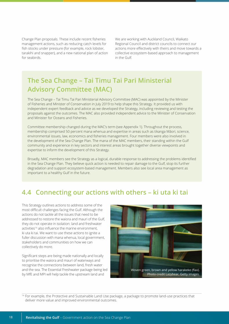
Woven green, brown and yellow harakeke (flax). Photo credit Lazybear, Getty images.
Change Plan proposals. These include recent fisheries management actions, such as reducing catch levels for fish stocks under pressure (for example, rock lobster, tarakihi and snapper), and a new national plan of action for seabirds.
We are working with Auckland Council, Waikato Regional Council and district councils to connect our actions more effectively with theirs and move towards a collective ecosystem-based approach to management in the Gulf.
14 For example, the Protective and Sustainable Land Use package, a package to promote land-use practices that deliver more value and improved environmental outcomes.
19
freshwater issues affecting the Gulf (MfE and MPI, 2018) by working towards the following objectives:
• stopping further degradation of Aotearoa New Zealand’s freshwater resources and starting to make immediate improvements so water quality improves within five years;
• reversing past damage to bring Aotearoa New Zealand’s freshwater resources, waterways and ecosystems to a healthy state within a generation; and
• addressing water allocation issues by working to achieve efficient and fair allocation of freshwater resources, having regard to all interests, including Māori and existing and potential new users.
This package has already delivered the new National Environmental Standards for Freshwater (MfE, 2020a) and National Policy Statement for Freshwater Management (MfE, 2020c), as well as controls on activities that are a high risk to water quality and freshwater ecosystems, to help support its objectives.
This Strategy focuses specifically on the work of DOC and MPI/FNZ in the marine environment, and identifies council activities where a direct connection occurs. It recognises that work by Auckland Council, Waikato Regional Council and local councils to incorporate the Sea Change Plan principles and actions into their work programmes for land, water and marine management will also help deliver the Sea Change Plan’s outcomes. Some actions have already been considered through statutory planning processes under the Resource Management Act 1991 and through non-statutory plans for harbours and catchments, including actions to improve water quality and support aquaculture and infrastructure development.
The Strategy’s actions will work alongside these significant national and local steps, because it is the connection between actions across all these spaces that will deliver the aspirations of the Sea Change Plan and this Strategy’s outcomes to revitalise the Gulf.
4.5 What mana whenua and key stakeholders have told us
Targeted engagement with mana whenua and key stakeholders in the Gulf was a critical component of testing the Sea Change Plan’s proposals and developing this Strategy.
The aim of the targeted engagement programme was to help us:
• strengthen our relationships with mana whenua, stakeholders and implementation partners;
• hear suggestions from those most affected by the Sea Change Plan about how we could progress its aspirations;
• share progress on development of the Strategy with mana whenua, affected stakeholders, Treaty partners and implementation partners; and
• use the feedback obtained from these discussions and written submissions to inform the Strategy.
The network of stakeholders, iwi and iwi organisations involved in the process was identified with input from DOC, MPI/FNZ and the MAC. All iwi identified as holding interests in the Gulf were contacted and provided with material on the Strategy. DOC and MPI/FNZ sought either face-to-face or virtual hui (due to COVID-19 restrictions) to discuss the Strategy further and met with all iwi who expressed an interest in meeting. Information packs were distributed to a further 138 stakeholders. Six local and regional
councils, 28 stakeholder groups (representing commercial and recreational fishers), the aquaculture industry and environmental organisations were actively engaged with (either face-to-face or in virtual meetings). Former members of the Sea Change Plan Stakeholder Working Group were provided progress reports and invited to give feedback.
The support we have heard for the Strategy, and the number of people keen to get involved and play an active part in its implementation, is encouraging.
We have learnt that stakeholders and mana whenua want us to recognise the importance of connection and different world views. They have asked us to ensure mātauranga Māori and Western science knowledge systems complement and work alongside each other as we move forward and that our actions uphold the principles of Te Tiriti o Waitangi. Support was also expressed for including mātauranga Māori indicators to assess the effectiveness of our actions and for taking an adaptive approach to future management.

Revitalising the Gulf – Government action on the Sea Change Plan20
“Bringing Māori and Western science knowledge together offers unique insights and opportunities to do things differently in how we look after our whenua and moana (land and sea).” Engagement feedback
Mana whenua also reinforced the importance of recognising rangatiratanga for an area, and ensuring the interests and views of iwi, hapū (sub-tribes) and whānau with rangatiratanga for the area are considered in management decisions. In particular, we must recognise and engage with those who have applications for recognition of customary rights under the Marine and Coastal Area (Takutai Moana) Act 2011 when progressing actions that may affect these interests, for example, through the implementation of High Protection Areas.
From the engagement, we learnt it is important that the Strategy’s actions are implemented quickly because mana whenua and localised community stakeholders are concerned about the environmental decline they are seeing in their backyards.
“New Zealanders remain concerned about the way their fisheries are being managed, and that the cumulative effects of mismanagement of our coastal and marine environment will impact on them and future generations.” Engagement feedback
Communities need to be empowered so they can give effect to the changes needed. We heard that, to do this well, government needs to show commitment to the Strategy’s outcome for kaitiakitanga and guardianship in the Gulf by making sure appropriate resourcing is available for the Strategy's implementation.
Mana whenua and stakeholders welcomed the opportunity for greater involvement in decision-making. In particular, support was expressed for the establishment of a fisheries advisory group and for the Ahu Moana initiative because both are seen as recognising place-based objectives for management.
We heard concerns that some changes may affect some users of the Gulf, particularly those in the recreational and commercial fishing sectors. The main message, however, was that change is needed if we are all genuine in our commitment to improve the waiora of the Gulf.
The engagement also highlighted the interconnections across the Strategy’s actions and the importance of connecting with actions on land and in fresh water, to take a ki uta ki tai approach to management in the Gulf, because the effectiveness of the actions will depend on the effective implementation of other actions.
“We are supportive of this approach because to me it is integrated throughout instead of just being a tick box centred around one area, it shows these outcomes are all integrated; cultural health indicators and social and environmental indicators for each of these things have mātauranga Māori.” Engagement feedback
We will continue to engage with mana whenua, stakeholders and the New Zealand public as we progress with the formal processes and consultation required for our fisheries management and marine protection actions.
Healthy functioning ecosystems
Ef ective kaitiakitanga and guardianship
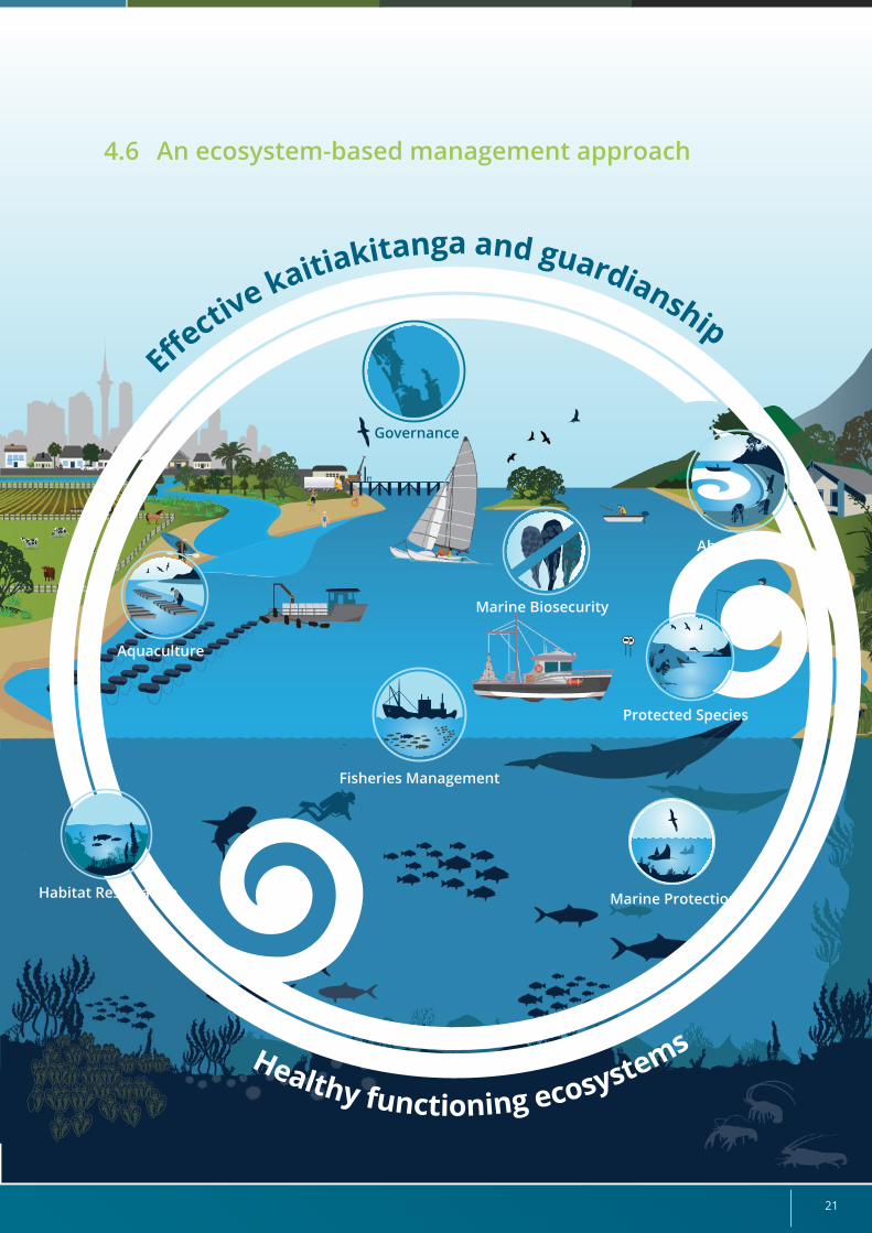
21
Healthy functioning ecosystems
Marine Protection
Aquaculture
Marine Biosecurity
Ahu Moana
Ef ective kaitiakitanga and guardianship
Habitat Restoration
Governance
4.6 An ecosystem-based management approach
Protected Species
Fisheries Management
Revitalising the Gulf – Government action on the Sea Change Plan22
The Gulf has a dynamic ecosystem of which people are an integral part. The outcomes of this Strategy, therefore, reflect the connection people have to the Gulf, the vested interest they have in being a part of how it is managed and, ultimately, the fact that a healthy functioning ecosystem underpins the wellbeing of its people, the health of its kaimoana, its natural processes and its diversity of life.
The Strategy’s actions will take an ecosystem-based approach to management and will work together to enhance the ecosystem function of the Gulf.
We have identified various actions to enhance the function of the Gulf’s habitats by removing key stressors. We will do this by establishing 11 High Protection Areas and five Seafloor Protection Areas, protecting marine areas adjacent to two existing marine reserves, and undertaking a range of management actions to protect rare and threatened habitats and species in the Gulf (see Section 5.5 “Marine Protection” and Section 5.6 “Protected Species”).
These protection areas will be nested in a broader expanse of the Gulf where mobile bottom-contact fishing methods will be excluded from all but carefully selected “corridors” (see Section 5.1 “Fisheries management”).
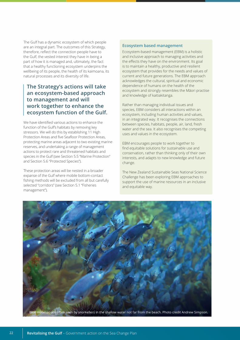
Blue maomao are often seen by snorkellers in the shallow water not far from the beach. Photo credit Andrew Simpson.
Ecosystem based managementEcosystem-based management (EBM) is a holistic and inclusive approach to managing activities and the effects they have on the environment. Its goal is to maintain a healthy, productive and resilient ecosystem that provides for the needs and values of current and future generations. The EBM approach acknowledges the cultural, spiritual and economic dependence of humans on the health of the ecosystem and strongly resembles the Māori practise and knowledge of kaitiakitanga.
Rather than managing individual issues and species, EBM considers all interactions within an ecosystem, including human activities and values, in an integrated way. It recognises the connections between species, habitats, people, air, land, fresh water and the sea. It also recognises the competing uses and values in the ecosystem.
EBM encourages people to work together to find equitable solutions for sustainable use and conservation, rather than thinking only of their own interests, and adapts to new knowledge and future change.
The New Zealand Sustainable Seas National Science Challenge has been exploring EBM approaches to support the use of marine resources in an inclusive and equitable way.
23
We recognise some habitats will not recover by simply removing stressors, and that people will need to actively do more to improve them to a healthy, functioning state. We have identified actions to strengthen habitat restoration activities and help these areas successfully contribute to the wider ecosystem health of the Gulf (see Section 5.2 “Active habitat restoration” and Section 5.6 “Protected species”).
People are integral to the Strategy’s success, because they depend on a healthy ecosystem for spiritual, cultural and economic wellbeing but also have wide ranging, and sometimes conflicting, values and uses for the ecosystem. Some of the Strategy’s actions, therefore, focus on managing the impact of human activities on habitats, species and the values people have for their local areas while recognising the need to provide for ongoing enhancement of, and access to, kaimoana for customary, commercial and recreational use. We also recognise that mana whenua and local communities are kaitiaki and guardians of the Gulf and want to be involved in how their local areas are managed. We will therefore support them and other stakeholders in working with us to maintain and enhance the special values and sustainable uses of this place.
While this Strategy focuses on fisheries and conservation actions, we will also need to work closely with others who have a role in managing the impacts of other activities, particularly those on land. The Strategy Cross-Agency Implementation Group (see Section 5.8 “Governance”) has been established to ensure the connections between the Strategy’s actions are built into implementation decisions and to strengthen the connection between ourselves and others who are undertaking actions to improve the waiora and mauri of the Gulf.
Taking the plunge: Photo credit Vincent Zintzen.
Revitalising the Gulf – Government action on the Sea Change Plan24
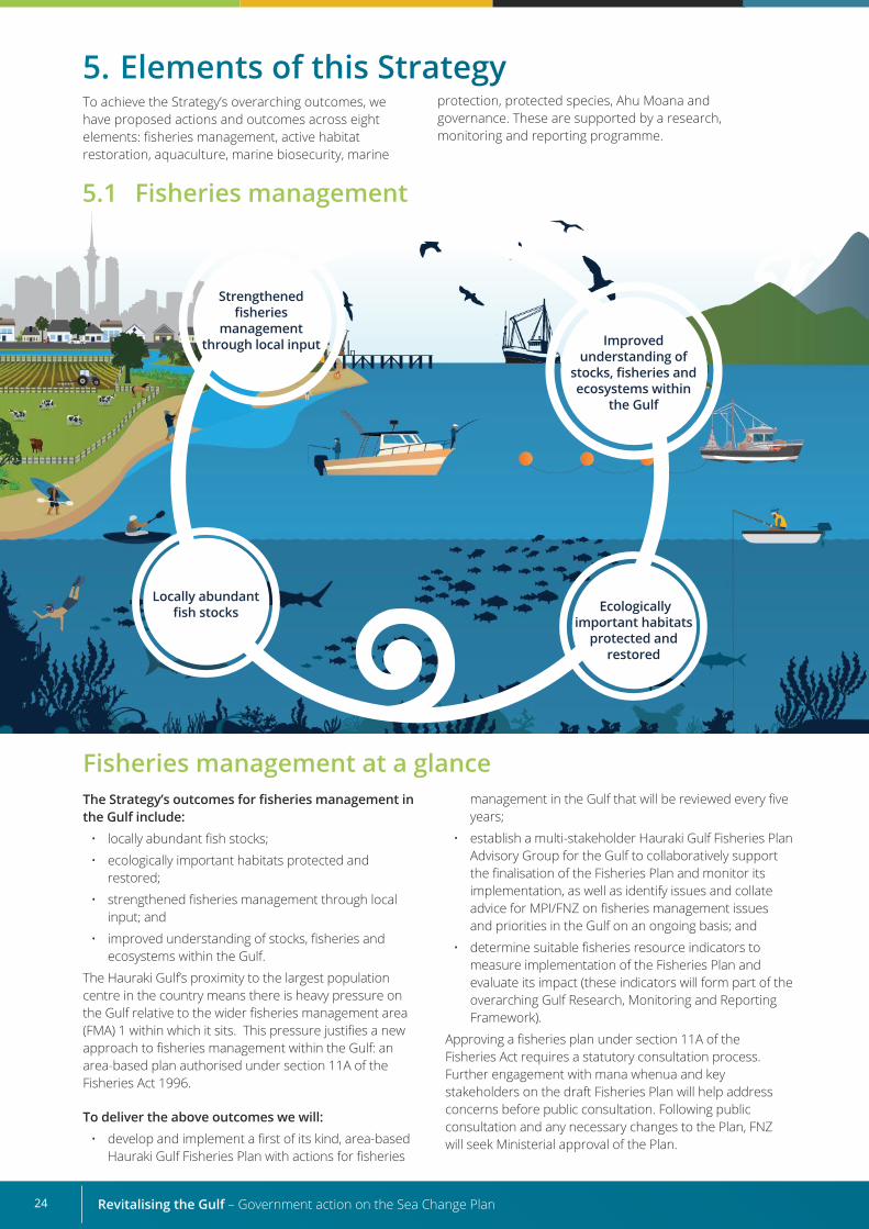
Strengthened fisheries
management through local input
Ecologically important habitats
protected and restored
Locally abundant fish stocks
Improved understanding of
stocks, fisheries and ecosystems within
the Gulf
5. Elements of this Strategy
Fisheries management at a glanceThe Strategy’s outcomes for fisheries management in the Gulf include:
• locally abundant fish stocks;
• ecologically important habitats protected and restored;
• strengthened fisheries management through local input; and
• improved understanding of stocks, fisheries and ecosystems within the Gulf.
The Hauraki Gulf’s proximity to the largest population centre in the country means there is heavy pressure on the Gulf relative to the wider fisheries management area (FMA) 1 within which it sits. This pressure justifies a new approach to fisheries management within the Gulf: an area-based plan authorised under section 11A of the Fisheries Act 1996.
To deliver the above outcomes we will:• develop and implement a first of its kind, area-based
Hauraki Gulf Fisheries Plan with actions for fisheries
management in the Gulf that will be reviewed every five years;
• establish a multi-stakeholder Hauraki Gulf Fisheries Plan Advisory Group for the Gulf to collaboratively support the finalisation of the Fisheries Plan and monitor its implementation, as well as identify issues and collate advice for MPI/FNZ on fisheries management issues and priorities in the Gulf on an ongoing basis; and
• determine suitable fisheries resource indicators to measure implementation of the Fisheries Plan and evaluate its impact (these indicators will form part of the overarching Gulf Research, Monitoring and Reporting Framework).
Approving a fisheries plan under section 11A of the Fisheries Act requires a statutory consultation process. Further engagement with mana whenua and key stakeholders on the draft Fisheries Plan will help address concerns before public consultation. Following public consultation and any necessary changes to the Plan, FNZ will seek Ministerial approval of the Plan.
5.1 Fisheries management
To achieve the Strategy’s overarching outcomes, we have proposed actions and outcomes across eight elements: fisheries management, active habitat restoration, aquaculture, marine biosecurity, marine
protection, protected species, Ahu Moana and governance. These are supported by a research, monitoring and reporting programme.
25
What the Sea Change Plan sought for fisheries management
The issues highlighted by the Sea Change Plan relating to the state of fisheries resources in the Hauraki Gulf include:
• Mobile bottom-contact fishing methods like bottom trawling, Danish seining and dredging have changed benthic (seafloor) habitats in the Gulf, reducing benthic biodiversity and modifying species’ interactions. The continued operation of these fishing methods is potentially causing damage and preventing recovery of habitats;
• Stocks of several important species found in the Gulf, including rock lobster and snapper, are below fisheries management targets for the quota management areas that include the Gulf;
• Anecdotal evidence indicates some stocks are locally depleted, despite management targets being met at the larger quota management area scale;
• Significant recreational fishing pressure is placed on fisheries resources in the Gulf relative to the wider fisheries management area in which it sits;
• Monitoring data are limited for fisheries resources at the scale of the Marine Park;
• A formal mechanism is lacking for stakeholder participation in fisheries governance; and
• Integration and co-ordination is poor between councils and central government agencies on issues affecting fisheries resources, such as catchment management.
The Sea Change Plan makes numerous proposals to address fisheries management issues and improve the state of fisheries resources in the Gulf. These proposals seek to improve the marine environment, enabling the enhanced use of fisheries, and to incorporate stakeholder participation in the governance of the Gulf’s fisheries resources. Some proposals focus on addressing specific issues, such as reviewing rock lobster catch limits to rebuild the stock, while others seek to change fundamental aspects of fisheries management in the Gulf, such as establishing a separate fisheries management area and quota management area, and phasing out bottom-contact fishing methods.
Fisheries management in the GulfThe Hauraki Gulf has supported commercial and non-commercial fishing for more than 170 years and that of Māori for a millennium. Human exploitation of the Gulf’s fisheries resources increased substantially during the nineteenth and twentieth centuries as New Zealand’s population grew and new fishing technologies emerged. This had noticeable effects on the marine ecosystem and its users, prompting the creation of a more intensive management regime beginning in the twentieth century. Over time, fisheries management in the Hauraki Gulf has incorporated iterations of catch limits, area closures, seasonal and gear restrictions to manage growing pressures (see Figure 4).
Today, the way New Zealand fisheries are managed continues to evolve in response to new technologies, changing values and increased understanding of marine ecosystems. The Quota Management System has been successful in reducing overcapacity in inshore fisheries across New Zealand, and many fish stocks are in a better state than 30 years ago. The introduction of digital technologies in 2019 to improve the tracking, reporting and monitoring of commercial fishing has further enhanced the system.
Yet work still needs to be done to better manage fisheries in the Hauraki Gulf, a space that experiences more concentrated pressure on its fisheries than anywhere else in New Zealand.
Localised depletion of some species, the lingering effects of mobile bottom-contact fishing methods on benthic habitats and a lack of stakeholder engagement and participation in fisheries management, still need to be addressed.
Through the Strategy, we have an exciting opportunity to progress an ecosystem-based approach to fisheries management in the Gulf. This approach recognises the complex interactions among species and their physical environment and, importantly, considers people, their activities and values as integral parts of the ecosystem (see Section 4.6 “An ecosystem-based management approach”). This is a significant shift from the existing fisheries management system that has traditionally focused on single issues or individual species.
Revitalising the Gulf – Government action on the Sea Change Plan26
An area-based Fisheries Plan for the Gulf
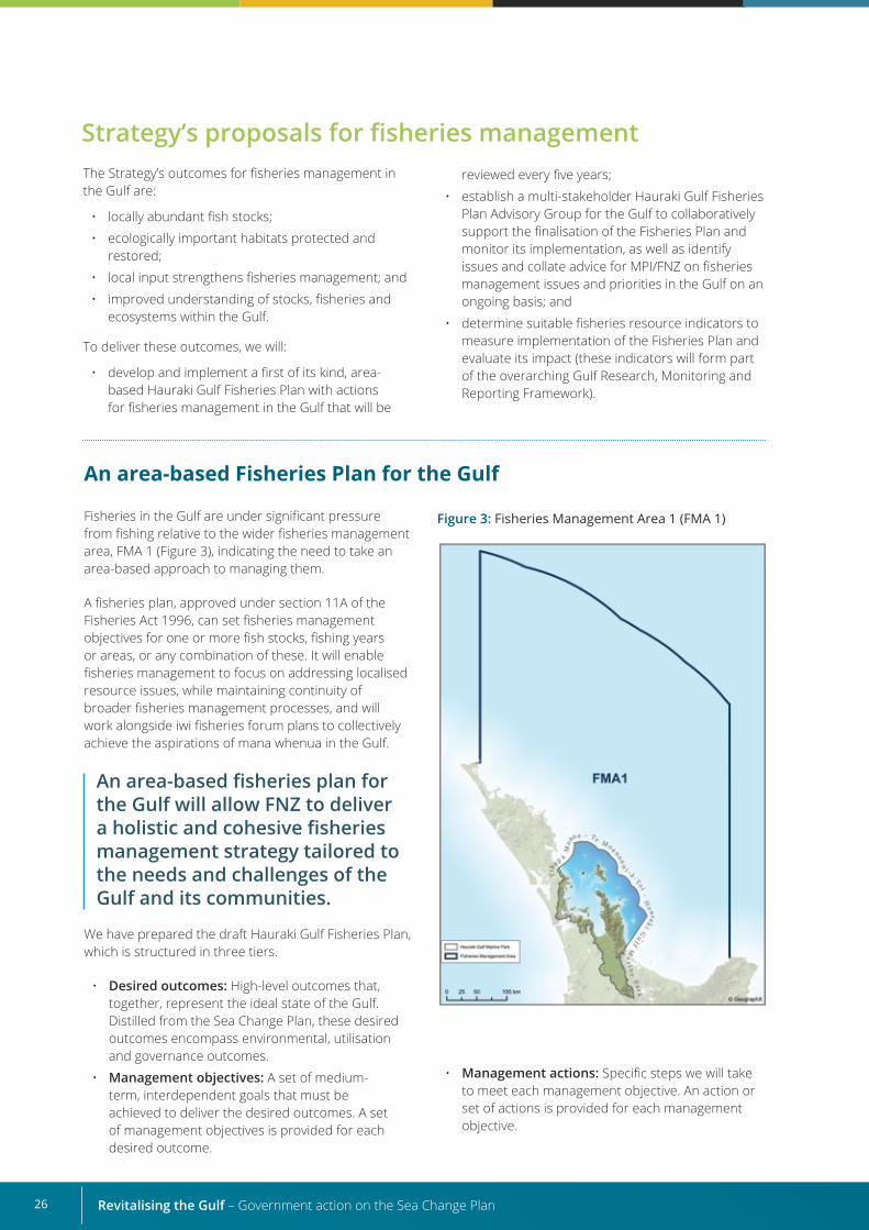
Figure 3: Fisheries Management Area 1 (FMA 1)Fisheries in the Gulf are under significant pressure from fishing relative to the wider fisheries management area, FMA 1 (Figure 3), indicating the need to take an area-based approach to managing them.
A fisheries plan, approved under section 11A of the Fisheries Act 1996, can set fisheries management objectives for one or more fish stocks, fishing years or areas, or any combination of these. It will enable fisheries management to focus on addressing localised resource issues, while maintaining continuity of broader fisheries management processes, and will work alongside iwi fisheries forum plans to collectively achieve the aspirations of mana whenua in the Gulf.
An area-based fisheries plan for the Gulf will allow FNZ to deliver a holistic and cohesive fisheries management strategy tailored to the needs and challenges of the Gulf and its communities.
We have prepared the draft Hauraki Gulf Fisheries Plan, which is structured in three tiers.
• Desired outcomes: High-level outcomes that, together, represent the ideal state of the Gulf. Distilled from the Sea Change Plan, these desired outcomes encompass environmental, utilisation and governance outcomes.
• Management objectives: A set of medium-term, interdependent goals that must be achieved to deliver the desired outcomes. A set of management objectives is provided for each desired outcome.
Strategy’s proposals for fisheries management The Strategy’s outcomes for fisheries management in the Gulf are:
• locally abundant fish stocks;
• ecologically important habitats protected and restored;
• local input strengthens fisheries management; and
• improved understanding of stocks, fisheries and ecosystems within the Gulf.
To deliver these outcomes, we will:
• develop and implement a first of its kind, area-based Hauraki Gulf Fisheries Plan with actions for fisheries management in the Gulf that will be
reviewed every five years;
• establish a multi-stakeholder Hauraki Gulf Fisheries Plan Advisory Group for the Gulf to collaboratively support the finalisation of the Fisheries Plan and monitor its implementation, as well as identify issues and collate advice for MPI/FNZ on fisheries management issues and priorities in the Gulf on an ongoing basis; and
• determine suitable fisheries resource indicators to measure implementation of the Fisheries Plan and evaluate its impact (these indicators will form part of the overarching Gulf Research, Monitoring and Reporting Framework).
• Management actions: Specific steps we will take to meet each management objective. An action or set of actions is provided for each management objective.

27
Development of the draft Hauraki Gulf Fisheries Plan
Rock lobster. Photo credit Malcom Francis.
When developing the draft Fisheries Plan, we considered existing and proposed work programmes relevant to the Sea Change Plan’s fisheries management proposals to identify any gaps.
Existing work programmesThe following fisheries initiatives have been progressed since the release of the Sea Change Plan.
• Rock lobster and snapper stocks off the east coast of the upper North Island (CRA 2 and SNA 1, respectively) and the tarakihi stock off the east and west coasts of the North Island (TAR 1) are currently under formal rebuilding frameworks.
• In April 2018, the Minister of Fisheries revised the total allowable catch for CRA 2 from 416.5 tonnes to 173 tonnes and commercial and recreational allowances were both reduced. A formalised plan is in place to rebuild the CRA 2 rock lobster fishery from the current low levels of abundance.
• On 1 July 2020, the Minister also introduced recreational measures for the CRA 2 rock lobster fishery to help rebuild this shared fishery, reducing the recreational daily bag limit from six to three rock lobsters (to manage recreational harvest to the new recreational allowance) and using telson clipping (to help discourage illegal catch).
• The National Rock Lobster Management Group was reviewed in 2019, resulting in the re establishment of environmental representation, broadening of recreational representation and formalisation of the compliance presence.
• A five-year research programme has been initiated to improve understanding of the recreational harvest of rock lobsters in the CRA 2 fishery.
• Kina stocks off the east coast of the upper North Island (SUR 1A and 1B) were reviewed in the October 2019 sustainability round, and information gathering was initiated to support future decision-making and develop a kina management plan.
• New Amateur Charter Vessel reporting requirements were implemented in 2020, requiring Amateur Charter Vessel operators to report catches of blue cod, scallops, snapper and tarakihi along with species they were already required to report (bass, bluenose, kingfish, rock lobster, southern bluefin tuna, Pacific bluefin tuna and blue cod in FMAs 2–8).
• All commercial fishing vessels are now required to report electronically and carry global positioning system tracking devices.
• The National Plan of Action – Seabirds (reducing the incidental mortality of seabirds in fisheries) was updated in 2020.
The draft Fisheries Plan aims to deliver three outcomes:
1. healthy, functioning aquatic ecosystems that support sustainable fisheries;
2. fisheries resources at levels that meet the needs of Māori and stakeholders; and
3. inclusive and integrated regional governance of fisheries.
Improving our understanding of fisheries resources in the Gulf is crucial to delivering these outcomes, and we will take an ecosystem-based fisheries management approach to do this. Additional research is highlighted in the Research Plan explored in Chapter 6.
Revitalising the Gulf – Government action on the Sea Change Plan28
Mobile bottom-contact fishing methods, such as trawling, Danish seining and dredging, can have adverse effects on benthic environments and biological communities and occur in areas of the Gulf.
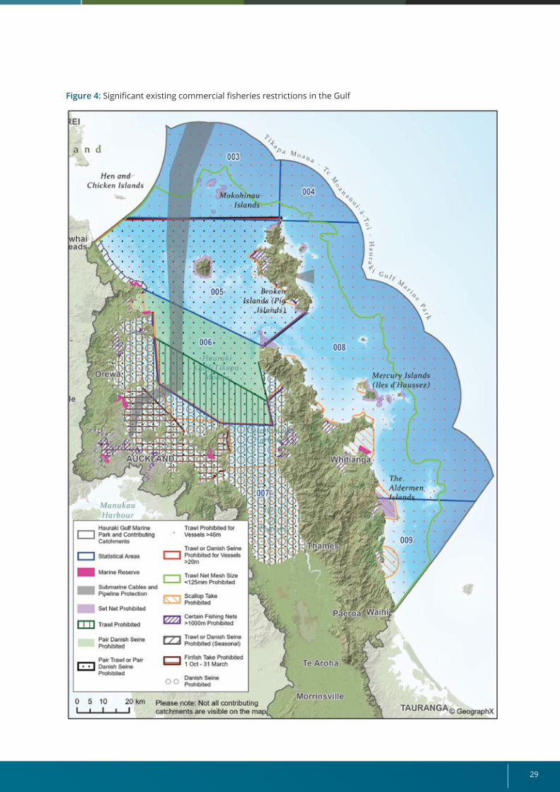
• Trawlers in the Gulf most commonly target snapper, tarakihi, trevally and John Dory but also species such as scampi and hoki in a small area that encompasses deep-water environments. Trawling has numerous spatial restrictions within the Gulf under current fisheries regulations. Trawling from any size vessel is prohibited in the inner Gulf (statistical area 007 and part of 006) and from vessels over 20 metres in length in statistical areas 005 and 006 (Figure 4).
• Danish seiners in the Gulf most commonly target snapper, John Dory and red gurnard. Danish seining is prohibited in the inner Gulf, although
this does not include the use of Danish seine by a single vessel for a portion of statistical area 006 (see Figure 5, green shaded area).
• Dredge fisheries in the Gulf target scallops, which are a sedentary species found in various coastal habitats that are managed within the Coromandel Scallop (SCA CS) quota management area.16 Commercial scallop dredging is conducted by a small fleet of around seven vessels that operate within discrete beds in the Gulf and is prohibited in the inner Gulf (Figure 5).
Since 2018, a noticeable shift has occurred in trawl effort, with fewer trawl vessels operating inside the Gulf.
Managing the impacts of mobile bottom-contact fishing methods on seafloor habitats
15 The proposed fisheries research services projects for 2020–21, along with previous years’ research project lists, can be accessed through MPI’s fisheries research processes webpage: www.mpi.govt.nz/news-and-resources/science-and-research/fisheries-research/fisheries-research-processes. The 2021–22 research services projects list is not yet available online.
16 The Coromandel scallop fishery is the only major scallop fishery currently operating in Aotearoa New Zealand, following closure of the Southern Scallop (SCA 7) and Port Underwood fisheries and the reduction in the total allowable commercial catch of scallops in the Northland fishery (SCA 1) in April 2020.
• A feasibility study for developing fishery independent longline surveys to monitor trends in the abundance of snapper, hāpuku, bass and bluenose was completed in 2019 (Hartill et al, 2020). The results of that study indicated limited feasibility for such an approach. However, a project to design a bottom longline survey to determine the age structure of New Zealand hāpuku is included in the 2021–22 research plan (see below).
• Short and longer-term management options to address sustainability concerns for hāpuku and bass are being explored, informed by iwi input and stakeholder engagement.
Existing research programmesSeveral fisheries research services projects for 2020–21 and 2021–2215 cover topics that support the Sea Change Plan’s aspirations, including:
• snapper (SNA 1) pre-recruit trawl survey programme;
• estimation of total seabird captures in amateur fisheries using the Spatially Explicit Fisheries Risk Assessment spatial overlap approach;
• assessment of mortality rates of fish released by recreational fishers;
• recovery of biogenic habitats: assessing the recovery potential offered by spatial planning scenarios proposed in the Sea Change Plan;
• assessment of the role of low- and mid-trophic level fishes in the Gulf ecosystem;
• review of land-based effects on coastal fisheries and kaimoana and their habitats;
• designing a longline survey to estimate the age structure of New Zealand hāpuku;
• exploring options for balancing habitat protection and fishing in the Gulf;
• northern intertidal shellfish survey; and
• establishing a framework for community shellfish monitoring.
Focus of the draft Fisheries PlanSeveral important Sea Change Plan proposals are not covered by the existing programmes listed above or require further examination. The following sections analyse these proposals and describe our actions for delivering the outcomes sought by the Sea Change Plan proposals.
29
Figure 4: Significant existing commercial fisheries restrictions in the Gulf
Revitalising the Gulf – Government action on the Sea Change Plan30
The Fisheries Act 1996 obliges the Minister for Oceans and Fisheries to provide for the utilisation of fisheries resources while ensuring sustainability. This includes avoiding, remedying or mitigating any adverse effects of fishing on the aquatic environment.
The Sea Change Plan proposes phasing out use of these fishing methods from the Gulf to allow benthic habitats to naturally recover (passive restoration). It is acknowledged not all benthic habitats are affected equally by bottom-contact fishing methods. Our understanding of their relative impact is limited, and FNZ has started a project to assess the effects of mobile bottom-contact fishing on inshore benthic communities, but the results will not be available for several years. Even though this is the case, action can still be taken in the interim to mitigate the effects of mobile bottom-contact fishing. This would align with the Fisheries Act, which states that absence of, or any uncertainty in, information should not be a reason for postponing or failing to take action to achieve sustainable use.
Ecological and economic considerationsWhile some fisheries resources can be harvested by a variety of fishing methods or across a large geographical range, others are more constrained. Scallops, for example, can only be harvested from the discrete beds in which they occur, and dredging is currently the only commercially viable harvest method for these species due to the depth of the beds, although the feasibility and use of other harvesting methods are being assessed. Excluding these methods from the Gulf could also affect consumers who access and rely on lower cost fish, because both bottom trawl and Danish seine fisheries provide a lower cost product due to their efficiency. Transitioning bottom-contact fisheries to other methods or areas could, therefore, have economic consequences that must be carefully considered.
As we explore whether a transition to alternative fishing methods is appropriate, we will need to consider the possible impacts on sensitive receiving environments. The effects that displacing these fisheries could have on areas outside the Gulf also need to be taken into account, because this could shift the pressure to new benthic environments or increase the fishing intensity on other fishing grounds.
Strategy’s approach to mitigating benthic impactsWe want to address the impacts of bottom trawling in the Gulf in a way that sustains and supports the ecosystem. FNZ will use an evidence-based approach
for working with mana whenua and stakeholders to collaboratively design, select and designate areas – “corridors” – within the Gulf where bottom trawling and Danish seining can continue to occur but with less impact on biodiversity. This will be supported by the research project to explore options for balancing habitat protection and fishing in the Gulf.
Monitoring the closed areas will provide crucial data to understand if and how the benthic habitats change. This will help us move towards more ecosystem-based management.
We are proposing to set corridors aside for bottom trawling and Danish seining, to provide for continued use within the Gulf while allowing the recovery of benthic habitats in most areas.
Commercial scallop dredging is a more spatially targeted method than trawling and Danish seining. Because it focuses on discrete scallop beds, we consider it will have a smaller footprint and be more easily monitored. We propose managing dredging separately by limiting it to currently harvested areas and establishing a process for reviewing the footprint in the event new beds are discovered. We will also increase monitoring of the fishery at a finer spatial scale and adjust the current management strategy, should monitoring indicate sustainability concerns.
Recreational dredging is also not subject to spatial restrictions in the Gulf, but most recreational harvesting of scallops is done by diving. We propose excluding recreational scallop dredging from the Gulf, on the basis that diving is a seabed-friendly and viable harvesting method.
We will continue to fund research into alternative methods for scallop harvesting and, once these become commercially viable, help facilitate transitions to these. The ban on the commercial use of underwater breathing apparatus to harvest scallops will be reviewed in 2021.
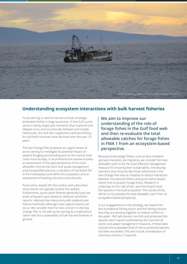
31
Inshore fishing trawler: Photo credit Hannah Hendricks.
Purse seining is used to harvest schools of pelagic (midwater) fishes in large quantities. In the Gulf, purse seiners mainly target jack mackerel, blue mackerel and skipjack tuna, and occasionally kahawai and trevally. Historically, the Gulf also supported a pilchard fishery, but pilchard removals have declined over the past 10 years.
The Sea Change Plan proposes an urgent review of purse seining to investigate its potential impact on seabird foraging and breeding and on the marine food chain more broadly. It recommends the review includes an assessment of the appropriateness of the total allowable commercial catch and quota management area (unspecified species), a valuation of harvested fish in the marketplace and within the ecosystem, and an assessment of existing voluntary area closures.
Purse seine vessels fish the surface and subsurface zone and do not typically contact the seabed. Furthermore, purse seine fisheries generally have low levels of bycatch and, based on observer and fisher reports, relatively few interactions with seabirds and marine mammals, although mass capture events can occur. We consider that the main concern in the Sea Change Plan is not with purse seining as a method but rather with the sustainability of bulk harvest fisheries in general.
We aim to improve our understanding of the role of forage fishes in the Gulf food web and then re-evaluate the total allowable catches for forage fishes in FMA 1 from an ecosystem-based perspective.
Because small pelagic fishes, such as blue mackerel and jack mackerel, are migratory, we consider the total allowable catch to be the most effective management measure for ensuring their sustainability. Introducing voluntary area closures like those referenced in the Sea Change Plan was an initiative to reduce interaction between recreational fishers and purse seine vessels rather than to protect forage fishes. Research is underway on the role of low- and mid-trophic level fish species in the Gulf ecosystem. The results of this will let us re-evaluate the total allowable catch from an ecosystem-based perspective.
In our engagement on this Strategy, we heard from the recreational fishing sector and the fishing industry that they are working together to reduce conflict on the water. FNZ will monitor non-fish and protected fish species catch reports submitted by the commercial sector and adapt management measures, if these data indicate the acceptable level of risk to protected species has been exceeded. This will include consideration of voluntary closures, if required.
Understanding ecosystem interactions with bulk harvest fisheries
Revitalising the Gulf – Government action on the Sea Change Plan32
Under section 25(2) of the Fisheries Act 1996, two mechanisms are in place for changing quota management areas:
1) quota holders representing 75 percent or more of the quota can reach agreement and request that a quota management area change be made with a plan for how individual transferable quotas will be reallocated; and
2) where the Minister for Oceans and Fisheries considers it necessary to ensure sustainability and a plan is in place to provide for the reallocation of individual transferable quota.
In the second situation, a reallocation of quota shares would be required between pre-existing and new Gulf quota management areas per species, which could impinge on Treaty settlements.
We believe the Sea Change Plan’s proposal to establish a separate fisheries management area and quota management area for the Gulf was intended to tailor fisheries management and research decisions to address fisheries resource issues specific to the Gulf.
We note that recreational fishing regulations have already been implemented within the Gulf, so a Gulf fisheries management area would not be needed to implement further Gulf-specific recreational fishing regulations if required.
Because the quota management area is the spatial scale at which stocks are managed under the Quota Management System, a separate quota management area would enable stock management at the scale of the Gulf. The best available information indicates, however, that a Gulf-scale quota management area
would not align with the biological characteristics of any fish populations in the area and so may not have the desired effect. This is because populations will likely move beyond the area’s boundaries into waters of other quota management areas with different regulations, although a possible exception is the Gulf sub-population of snapper, which is discussed further below.
For these reasons, we consider a new quota management area for all stocks in the Gulf would not deliver the outcomes the Sea Change Plan is seeking.
Locally depleted speciesThe Sea Change Plan raises concerns around the localised depletion of fisheries resources.
To address this, we first need to define the term “localised depletion”, because it does not feature in the Fisheries Act 1996 and no consensus has been reached on what it means. For a resource user, the definition depends on the scale of the area in which they operate, whereas from an ecosystem perspective, it depends on the biological characteristics and population dynamics of the species, as well as the carrying capacity of its habitat(s).
As outlined in the draft Fisheries Plan, the first step will be to identify which species are at risk of localised depletion in the Gulf and to define this term on a per species or species-group basis. We will then develop criteria for evaluating the status of these species throughout the Gulf. As part of this process, we will seek stakeholders’ perspectives on what localised depletion means to them and where they see it happening.
Managing fisheries at smaller spatial scalesThe Sea Change Plan proposes establishing a separate fisheries management area and quota management area for the Gulf.
Quota Management SystemBefore the Quota Management System was introduced, the management of Aotearoa New Zealand fisheries was divided into 10 standard and defined fisheries management areas. The Quota Management System required that the quota be issued by quota area, resulting in 10 standard quota management areas being established for quota species that matched the fisheries management areas. As more species were introduced to the Quota Management System, fisheries managers implemented species-specific quota management areas to better align the management scale with the biological characteristics of the species (that is, the number of distinct populations and their geographical distributions) and the operational characteristics of the fisheries that developed around them.
Today, FNZ designates and manages stocks using a combination of the original fisheries management areas, standard quota management areas and species-specific quota management areas.
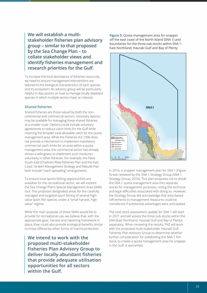
33
Figure 5: Quota management area for snapper off the east coast of the North Island (SNA 1) and boundaries for the three sub-stocks within SNA 1: East Northland, Hauraki Gulf and Bay of Plenty
We will establish a multi-stakeholder fisheries plan advisory group – similar to that proposed by the Sea Change Plan – to collate stakeholder views and identify fisheries management and research priorities for the Gulf.
To increase the local abundance of fisheries resources, we need to ensure management interventions are tailored to the biological characteristics of each species and its ecosystem. An advisory group will be particularly helpful in discussions on how to manage locally depleted species in which multiple sectors have an interest.
Shared fisheriesShared fisheries are those valued by both the non-commercial and commercial sectors. Voluntary options may be available for managing these shared fisheries at a smaller scale. Options could include voluntary agreements to reduce catch limits for the Gulf while retaining the broader total allowable catch for the quota management area. While the Fisheries Act 1996 does not provide a mechanism to implement mandatory commercial catch limits for an area within a quota management area, the commercial sector has already shown a willingness to implement such measures voluntarily in other fisheries. For example, the Pāua South-East (Chatham Rise) Fisheries Plan and the East Coast Tarakihi Management Strategy and Rebuild Plan both include “catch spreading” arrangements.
To ensure local sports fishing opportunities are available for the recreational sector, we will explore the Sea Change Plan’s Special Management Area (SMA) tool. This proposes designated areas for the carefully managed and targeted sport fishing of several high-value sport fish species under a “small harvest, high value” regime.
While the main purpose of these SMAs would be to provide for recreational use, we believe that, with the appropriate gear, harvest and reporting framework in place, they could also provide ecological benefits similar to those offered by other forms of marine protection.
We intend to work with the proposed multi-stakeholder Fisheries Plan Advisory Group to deliver locally abundant fisheries that provide adequate utilisation opportunities for all sectors within the Gulf.
In 2016, a snapper management plan for SNA 1 (Figure 5) was released by the SNA 1 Strategy Group (SNA 1 Strategy Group, 2016). This plan proposes not to divide the SNA 1 quota management area into separate stocks for management purposes, noting the technical and legal difficulties associated with doing so. However, the Strategy Group did acknowledge that area-based refinements to management measures could be considered, if substantial advantages were anticipated.
The next stock assessment update for SNA 1 will start in 2021 and will assess the three sub-stocks within the SNA (East Northland, Hauraki Gulf and Bay of Plenty) separately. When reviewing the results, FNZ will work with the proposed multi-stakeholder Hauraki Gulf Fisheries Plan Advisory Group to determine whether further consideration for subdividing the SNA 1 fish stock, to create a quota management area for snapper in the Gulf, is warranted.
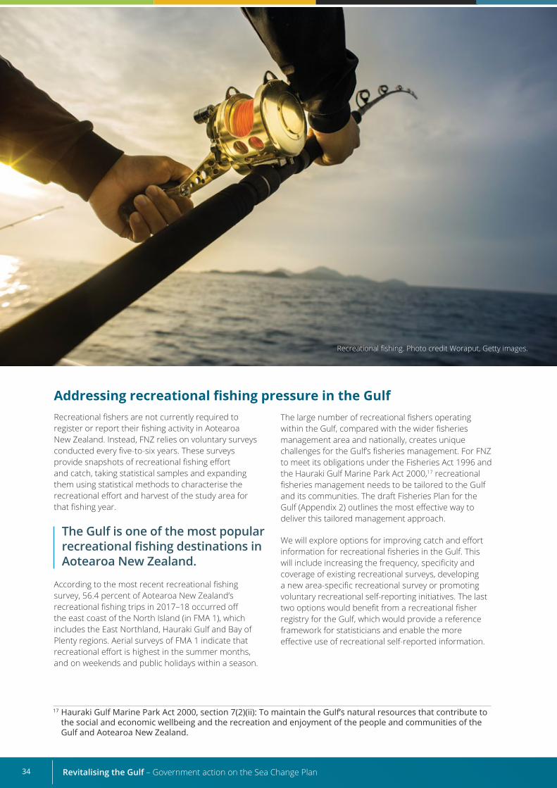
Revitalising the Gulf – Government action on the Sea Change Plan34
Addressing recreational fishing pressure in the Gulf Recreational fishers are not currently required to register or report their fishing activity in Aotearoa New Zealand. Instead, FNZ relies on voluntary surveys conducted every five-to-six years. These surveys provide snapshots of recreational fishing effort and catch, taking statistical samples and expanding them using statistical methods to characterise the recreational effort and harvest of the study area for that fishing year.
The Gulf is one of the most popular recreational fishing destinations in Aotearoa New Zealand.
According to the most recent recreational fishing survey, 56.4 percent of Aotearoa New Zealand’s recreational fishing trips in 2017–18 occurred off the east coast of the North Island (in FMA 1), which includes the East Northland, Hauraki Gulf and Bay of Plenty regions. Aerial surveys of FMA 1 indicate that recreational effort is highest in the summer months, and on weekends and public holidays within a season.
Recreational fishing. Photo credit Woraput, Getty images.
The large number of recreational fishers operating within the Gulf, compared with the wider fisheries management area and nationally, creates unique challenges for the Gulf’s fisheries management. For FNZ to meet its obligations under the Fisheries Act 1996 and the Hauraki Gulf Marine Park Act 2000,17 recreational fisheries management needs to be tailored to the Gulf and its communities. The draft Fisheries Plan for the Gulf (Appendix 2) outlines the most effective way to deliver this tailored management approach.
We will explore options for improving catch and effort information for recreational fisheries in the Gulf. This will include increasing the frequency, specificity and coverage of existing recreational surveys, developing a new area-specific recreational survey or promoting voluntary recreational self-reporting initiatives. The last two options would benefit from a recreational fisher registry for the Gulf, which would provide a reference framework for statisticians and enable the more effective use of recreational self-reported information.
17 Hauraki Gulf Marine Park Act 2000, section 7(2)(ii): To maintain the Gulf’s natural resources that contribute to the social and economic wellbeing and the recreation and enjoyment of the people and communities of the Gulf and Aotearoa New Zealand.
35
The extent and impact of recreational seabird bycatch is also an important consideration when managing recreational fishing. The draft Fisheries Plan contains management actions to address this. Actions include scaling up existing outreach and education programmes for recreational fishers, to reduce seabird bycatch, and implementing a programme to better estimate seabird bycatch in the recreational fishing sector. This will complement actions taken by commercial fishers to reduce seabird bycatch (see Section 5.6 “Protected species” and Appendix 2). This
Development of Hauraki Gulf fisheries indicators and monitoring framework
work will also be supported by the findings of the fisheries research services project that intends to use a spatially explicit fisheries risk assessment approach to estimate total seabird captures in amateur fisheries, as noted earlier in the section.
The proposed Hauraki Gulf Fisheries Plan Advisory Group (see below) could also have a role in helping to develop specific strategies for the effective management of recreational fisheries.
Creation of a Hauraki Gulf fisheries plan advisory groupWe will establish a Hauraki Gulf fisheries plan advisory group, similar to that proposed by the Sea Change Plan. It will be a mana whenua and multi-stakeholder group that represents all those with an interest in Gulf fisheries resources, including mana whenua, representatives from the commercial and recreational fishing sectors, non-take users and environmental NGOs. Regional councils will also have representation on the group.
This will allow cross-sectoral identification and discussion of fisheries management issues and research priorities in the Gulf to inform and advise on our decisions. It will also support finalisation and implementation of the draft Fisheries Plan and evaluation of its success.
We will develop a set of fisheries indicators and a monitoring framework to track the implementation of the Fisheries Plan and evaluate its impact on the Gulf. This will form a subset of the work described in Chapter 6 “Research, monitoring and reporting”.
Fisheries indicators for the Gulf should be based on ecosystem-based fisheries management principles and extend beyond the traditional stock status indicators. In particular, indicators should gauge the status of the marine ecosystem, such as trophic linkages and species interactions. The interplay between nursery habitat condition and recruitment should also be explored.
The monitoring framework will need to be designed so any causal links between management interventions and outcomes can be inferred, because this is crucial for supporting adaptive management and replicating management interventions elsewhere. It will also consider a broader set of indicators and monitoring plans, such as those for marine reserves and catchment management, to provide a more complete picture of the state of the Gulf. This will let us identify any interconnections among the living parts of the ecosystem, including flora and fauna and other drivers of change, such as climate change, and note any trends in the state of its resources.
Revitalising the Gulf – Government action on the Sea Change Plan36
Next stepsInput and participation in developing the draft Hauraki Gulf Fisheries PlanThe draft Fisheries Plan (Appendix 2) signals our intentions to improve fisheries management in the Gulf and has been developed with input from the MAC. However, the support of mana whenua, affected stakeholders, the wider community and environmental NGOs will be critical to its success, so opportunities for further partner and stakeholder input and participation are essential.
“The Hauraki Gulf Marine Park is big enough to provide a good snapshot to engage with and manage, even with moving species.” Engagement feedback
Approving a fisheries plan under section 11A of the Fisheries Act 1996 requires a statutory consultation process. This work will be led by FNZ. Further engagement with mana whenua and key stakeholders on the draft Fisheries Plan will help FNZ refine its detailed management objectives and actions before putting it out for public consultation.
The fisheries management actions outlined above have important connections with initiatives across other elements of this Strategy.
• Active habitat restoration (Section 5.2): Active habitat restoration activities could be nested within areas where “passive habitat recovery” may occur through the removal of adverse fishing method impacts. Strategy actions to protect or restore habitats may improve the condition of areas of ecological importance to fish stocks.
• Marine protection (Section 5.5): The draft Fisheries Plan’s environmental outcome includes management objectives and actions to protect ecologically important marine habitats from the adverse effects of fishing, and marine benthic habitats from the adverse effects of bottom-contact fishing methods. Fisheries management actions to manage the adverse effects of fishing will complement the proposals for highly protected habitats and ecosystems in the Gulf.
• Protected species (Section 5.6): Sustainable fisheries practices progressed through
implementation of the Fisheries Plan will reduce the impact of fishing on protected species and support their recovery.
• Ahu Moana (Section 5.7): Management actions in the draft Fisheries Plan include working with partners, to support the co-design and piloting of Ahu Moana projects, and providing high-value support to collaborative groups wanting to exercise kaitiakitanga in their local area.
• Governance (Section 5.8): The proposed mana whenua and multi-stakeholder Hauraki Gulf Fisheries Plan Advisory Group will provide input into decisions relating to fisheries management and research. The draft Fisheries Plan is also supported by management objectives to use customary tools to enable local governance and facilitate co-management of intertidal ecosystems.
• Research, monitoring and evaluation (Chapter 6): We will develop Hauraki Gulf fisheries indicators and a monitoring framework to track the implementation of the Fisheries Plan and evaluate its impact on the Gulf.
Establishment of the Hauraki Gulf Fisheries Plan Advisory GroupFNZ will issue a request to all Gulf stakeholders for member nominations to the Hauraki Gulf Fisheries Plan Advisory Group and initiate the search for an independent chairperson to lead the Group. We aim for it to be established soon after this Strategy has been released.
The Advisory Group’s first task will be to review and discuss the draft Fisheries Plan and advise us on its contents. FNZ will use this advice, and input from mana whenua, to refine the draft before putting it out for public consultation.
Hauraki Gulf Fisheries Plan implementationFollowing public consultation, FNZ will make any necessary amendments to the draft Fisheries Plan before providing it to the Minister for Oceans and Fisheries for approval. The Minister’s approval will initiate the Plan’s first five-year lifecycle.
FNZ will use the same implementation framework for the Fisheries Plan’s management actions as is used for other fisheries plans. This framework consists of an annual operational plan and annual review report.
Connections with other elements of this Strategy
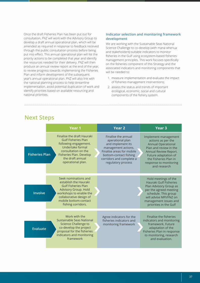
37
Once the draft Fisheries Plan has been put out for consultation, FNZ will work with the Advisory Group to develop a draft annual operational plan, which will be amended as required in response to feedback received through the public consultation process before being put into effect. This annual operational plan will list the priority actions to be completed that year and identify the resources needed for their delivery. FNZ will then produce an annual review report at the end of the year, to review progress towards implementing the Fisheries Plan and inform development of the subsequent year’s annual operational plan. FNZ will also link with the national planning process to help streamline implementation, avoid potential duplication of work and identify priorities based on available resourcing and national priorities.
Indicator selection and monitoring framework developmentWe are working with the Sustainable Seas National Science Challenge to co-develop (with mana whenua and stakeholders) suitable indicators to monitor fisheries in the Gulf using ecosystem-based fisheries management principles. This work focuses specifically on the fisheries component of this Strategy and the associated indicators and monitoring components that will be needed to:
1. measure implementation and evaluate the impact of fisheries management interventions;
2. assess the status and trends of important ecological, economic, social and cultural components of the fishery system.
Year 1 Year 2 Year 3
Fisheries Plan
Finalise the draft Hauraki Gulf Fisheries Plan
following engagement. Undertake formal
consultation on the Fisheries Plan. Develop
the draft annual operational plan.
Seek nominations and establish the Hauraki
Gulf Fisheries Plan Advisory Group. Hold
workshops to enable the collaborative design of mobile bottom-contact
fishing corridors.
Work with the Sustainable Seas National
Science Challenge to co-develop the project
proposal for the fisheries indicators and monitoring
framework
Finalise the annual aperational plan
and implement its management actions.
Finalise areas for mobile bottom-contact fishing
corridors and complete a regulatory process
Agree indicators for the fisheries indicators and monitoring framework
Finalise the fisheries indicators and monitoring
framework. Future adaptation of the
Fisheries Plan in response to monitoring, research
and evaluation.
Implement management actions as per the
Annual Operational Plan and review in the Annual Review Report. Future adaptation of the Fisheries Plan in
response to monitoring and research
Hold meetings of the Hauraki Gulf Fisheries
Plan Advisory Group as per the agreed meeting
schedule. This group will advise MPI/FNZ on
management issues and priorities in the Gulf
Next Steps
Involve
Evaluate
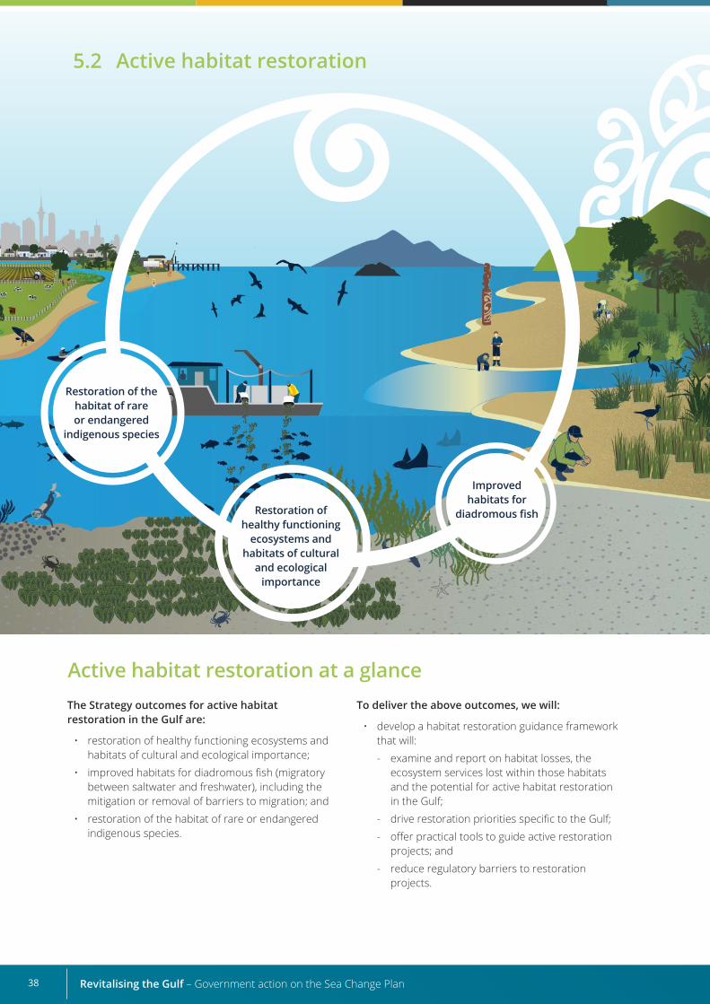
Revitalising the Gulf – Government action on the Sea Change Plan38
Active habitat restoration at a glanceThe Strategy outcomes for active habitat restoration in the Gulf are:
• restoration of healthy functioning ecosystems and habitats of cultural and ecological importance;
• improved habitats for diadromous fish (migratory between saltwater and freshwater), including the mitigation or removal of barriers to migration; and
• restoration of the habitat of rare or endangered indigenous species.
To deliver the above outcomes, we will:
• develop a habitat restoration guidance framework that will:
- examine and report on habitat losses, the ecosystem services lost within those habitats and the potential for active habitat restoration in the Gulf;
- drive restoration priorities specific to the Gulf;
- offer practical tools to guide active restoration projects; and
- reduce regulatory barriers to restoration projects.
Restoration of healthy functioning
ecosystems and habitats of cultural
and ecological importance
Restoration of the habitat of rare or endangered
indigenous species
Improved habitats for
diadromous fish
5.2 Active habitat restoration
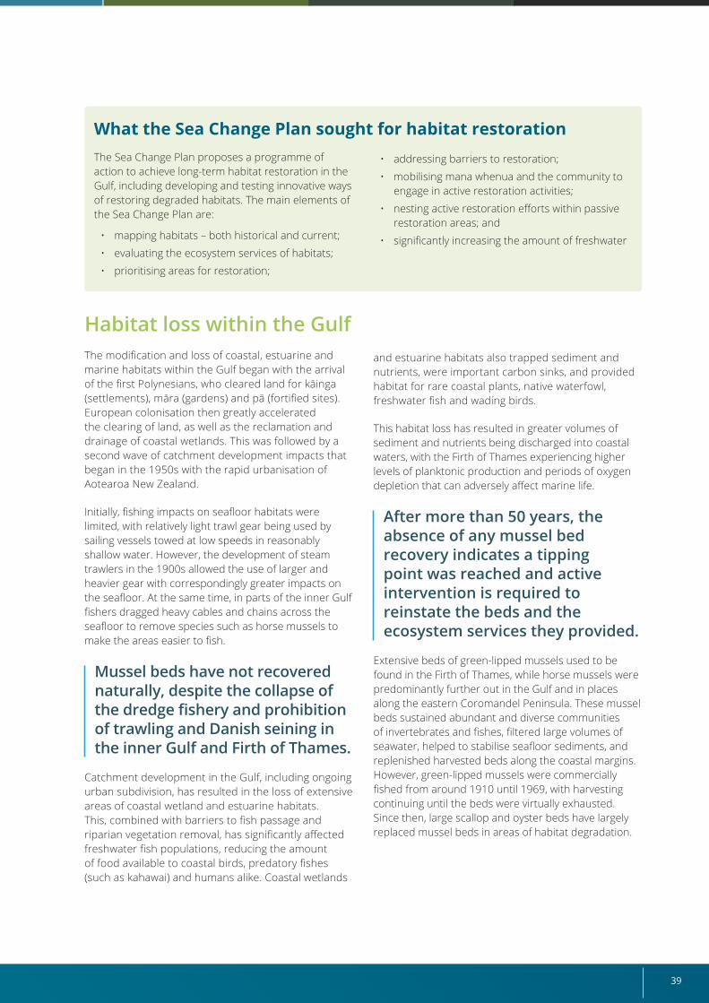
39
Habitat loss within the GulfThe modification and loss of coastal, estuarine and marine habitats within the Gulf began with the arrival of the first Polynesians, who cleared land for kāinga (settlements), māra (gardens) and pā (fortified sites). European colonisation then greatly accelerated the clearing of land, as well as the reclamation and drainage of coastal wetlands. This was followed by a second wave of catchment development impacts that began in the 1950s with the rapid urbanisation of Aotearoa New Zealand.
Initially, fishing impacts on seafloor habitats were limited, with relatively light trawl gear being used by sailing vessels towed at low speeds in reasonably shallow water. However, the development of steam trawlers in the 1900s allowed the use of larger and heavier gear with correspondingly greater impacts on the seafloor. At the same time, in parts of the inner Gulf fishers dragged heavy cables and chains across the seafloor to remove species such as horse mussels to make the areas easier to fish.
Mussel beds have not recovered naturally, despite the collapse of the dredge fishery and prohibition of trawling and Danish seining in the inner Gulf and Firth of Thames.
Catchment development in the Gulf, including ongoing urban subdivision, has resulted in the loss of extensive areas of coastal wetland and estuarine habitats. This, combined with barriers to fish passage and riparian vegetation removal, has significantly affected freshwater fish populations, reducing the amount of food available to coastal birds, predatory fishes (such as kahawai) and humans alike. Coastal wetlands
and estuarine habitats also trapped sediment and nutrients, were important carbon sinks, and provided habitat for rare coastal plants, native waterfowl, freshwater fish and wading birds.
This habitat loss has resulted in greater volumes of sediment and nutrients being discharged into coastal waters, with the Firth of Thames experiencing higher levels of planktonic production and periods of oxygen depletion that can adversely affect marine life.
After more than 50 years, the absence of any mussel bed recovery indicates a tipping point was reached and active intervention is required to reinstate the beds and the ecosystem services they provided.
Extensive beds of green-lipped mussels used to be found in the Firth of Thames, while horse mussels were predominantly further out in the Gulf and in places along the eastern Coromandel Peninsula. These mussel beds sustained abundant and diverse communities of invertebrates and fishes, filtered large volumes of seawater, helped to stabilise seafloor sediments, and replenished harvested beds along the coastal margins. However, green-lipped mussels were commercially fished from around 1910 until 1969, with harvesting continuing until the beds were virtually exhausted. Since then, large scallop and oyster beds have largely replaced mussel beds in areas of habitat degradation.
What the Sea Change Plan sought for habitat restorationThe Sea Change Plan proposes a programme of action to achieve long-term habitat restoration in the Gulf, including developing and testing innovative ways of restoring degraded habitats. The main elements of the Sea Change Plan are:
• mapping habitats – both historical and current;
• evaluating the ecosystem services of habitats;
• prioritising areas for restoration;
• addressing barriers to restoration;
• mobilising mana whenua and the community to engage in active restoration activities;
• nesting active restoration efforts within passive restoration areas; and
• significantly increasing the amount of freshwater
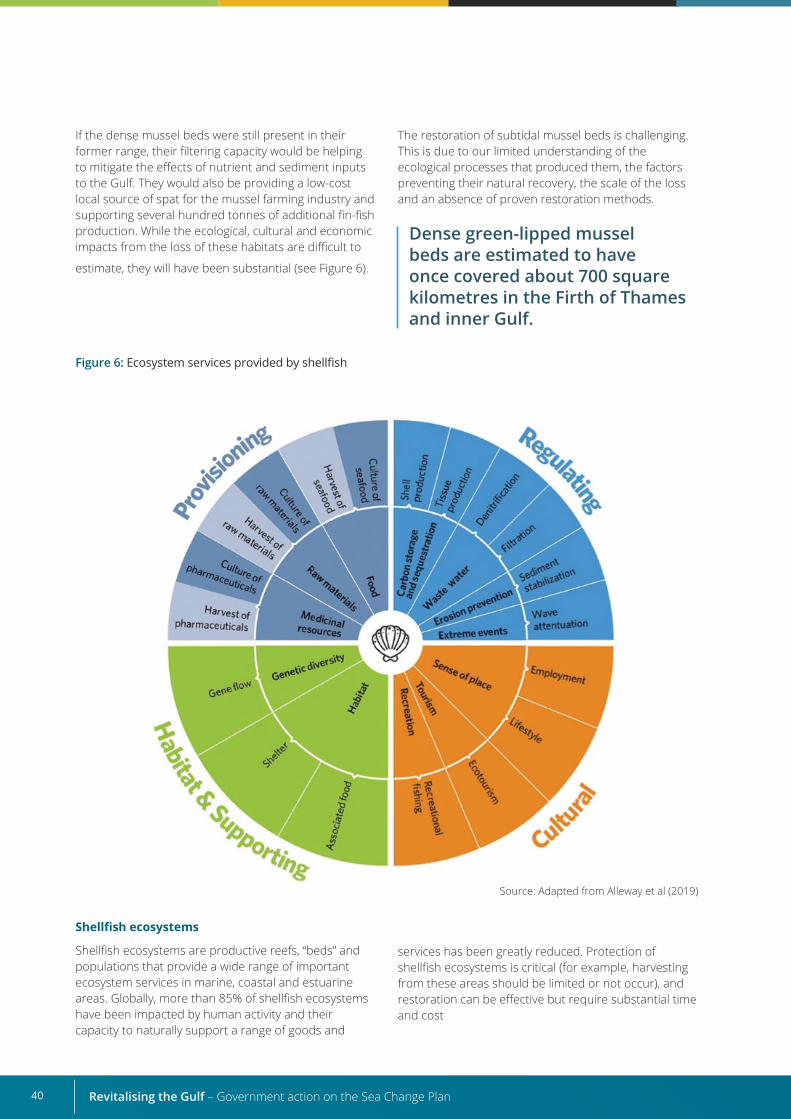
Revitalising the Gulf – Government action on the Sea Change Plan40
If the dense mussel beds were still present in their former range, their filtering capacity would be helping to mitigate the effects of nutrient and sediment inputs to the Gulf. They would also be providing a low-cost local source of spat for the mussel farming industry and supporting several hundred tonnes of additional fin-fish production. While the ecological, cultural and economic impacts from the loss of these habitats are difficult to
estimate, they will have been substantial (see Figure 6).
The restoration of subtidal mussel beds is challenging. This is due to our limited understanding of the ecological processes that produced them, the factors preventing their natural recovery, the scale of the loss and an absence of proven restoration methods.
Dense green-lipped mussel beds are estimated to have once covered about 700 square kilometres in the Firth of Thames and inner Gulf.
Figure 6: Ecosystem services provided by shellfish
Shellfish ecosystems
Shellfish ecosystems are productive reefs, “beds” and populations that provide a wide range of important ecosystem services in marine, coastal and estuarine areas. Globally, more than 85% of shellfish ecosystems have been impacted by human activity and their capacity to naturally support a range of goods and
Source: Adapted from Alleway et al (2019)
services has been greatly reduced. Protection of shellfish ecosystems is critical (for example, harvesting from these areas should be limited or not occur), and restoration can be effective but require substantial time and cost

41
Strategy’s proposals for active habitat restoration The Strategy’s outcomes for active habitat restoration in the Gulf are:
• restoration of healthy functioning ecosystems and habitats of cultural and ecological importance;
• improved habitats for diadromous freshwater fishes (those that spend some of their lifecycle in fresh water and some in salt water), including the mitigation or removal of barriers to migration; and
• restoration of habitats of rare or endangered indigenous species.
To deliver these outcomes, we will:
• develop a habitat restoration guidance framework that will:
- examine and report on habitat losses, the ecosystem services lost within those habitats and the potential for active habitat restoration in the Gulf;
- drive restoration priorities specific to the Gulf;
- offer practical tools to guide active restoration projects; and
- reduce regulatory barriers to restoration projects.
This guidance framework will drive a strategic and coordinated approach to habitat restoration that facilitates mana whenua and community participation and involves both passive and active restoration.
Passive habitat restorationPassive habitat restoration involves the reduction or removal of “stressors” that are preventing the natural recovery of habitats, such as destructive fishing methods or discharges of contaminants. It is most frequently used to halt declines in species or habitats that are occurring at large spatial scales.
Passive restoration will be driven through this Strategy’s fisheries management (Section 5.1) and marine protection (Section 5.5) actions, as well as catchment management plans prepared by councils to reduce erosion, the infilling of estuaries and the export of fine sediment to inshore and offshore environments.
Active habitat restorationActive habitat restoration involves direct intervention at a site, including physical alterations, plantings, transplants, predator control, and reintroductions to recreate or rehabilitate lost or degraded habitats.
A “fully restored” ecosystem is one that is self-sustaining and has the capacity for recovery after natural disturbance or stress. (Adapted from the Society for Ecological Restoration International Science and Policy Working Group, 2004.)
Despite their ecological importance, coastal wetlands, estuaries, mussel beds and other assemblages of soft-sediment-dwelling invertebrates (for example, sponges) have experienced the greatest declines in the Gulf. Such habitats should be prioritised for restoration.
The active restoration of subtidal mussel beds should focus on their re-establishment within documented historical distribution areas. This is where the ecosystem services mussel beds provide will have the greatest effect.
Examples of current restoration workDOC is currently supporting and leading several estuarine and freshwater restoration projects that will benefit the Gulf, including the Pūkorokoro-Miranda Living Water partnership and the Ngā Awa river restoration programme. These projects take a whole-of-catchment approach to freshwater and estuarine restoration and are developing guidance on catchment-scale restoration for partners, stakeholders and community groups interested in helping.
This work complements similar projects being undertaken by local authorities, mana whenua, local communities and industry groups. For example, the Ngā Motu ō Waikōpua Restoration Plan developed by Ngāi Tai ki Tāmaki for the Ngā Motu ō Waikōpua and Te Awakarihi catchment. This plan describes a set of social, cultural, environmental and economic tools intended to restore the living systems of the islands, support customary cultural practices, and drive economic benefits to mana whenua and the local community.
In addition, local and central government agencies, Crown research institutes and other research providers have produced research and technical advice relevant to the restoration of estuarine and subtidal habitats within the Gulf, including the following examples.
• National fish passage management guidelines for structures under 4 metres high were developed to improve habitat for diadromous fishes (National Institute of Water and Atmospheric Research, 2018). The National Institute of Water and
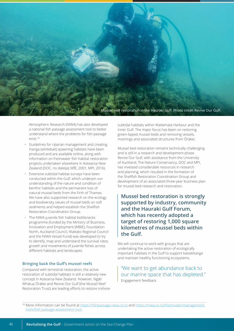
Revitalising the Gulf – Government action on the Sea Change Plan42
18 More information can be found at https://fishpassage.niwa.co.nz and https://niwa.co.nz/freshwater/management-tools/fish-passage-assessment-tool.
Atmospheric Research (NIWA) has also developed a national fish passage assessment tool to better understand where the problems for fish passage exist.18
• Guidelines for riparian management and creating īnanga (whitebait) spawning habitats have been produced and are available online, along with information on freshwater fish habitat restoration projects undertaken elsewhere in Aotearoa New Zealand (DOC, no date(a); MfE, 2001; MPI, 2016).
• Extensive subtidal habitat surveys have been conducted within the Gulf, which underpin our understanding of the nature and condition of benthic habitats and the permanent loss of natural mussel beds from the Firth of Thames. We have also supported research on the ecology and biodiversity values of mussel beds on soft sediments and helped establish the Shellfish Restoration Coordination Group.
• The NIWA juvenile fish habitat bottlenecks programme (funded by the Ministry of Business, Innovation and Employment (MBIE), Foundation North, Auckland Council, Waikato Regional Council and the NIWA Vessel Fund) was developed to try to identify, map and understand the survival rates, growth and movements of juvenile fishes across different habitats and landscapes.
Bringing back the Gulf’s mussel reefsCompared with terrestrial restoration, the active restoration of subtidal habitats is still a relatively new concept in Aotearoa New Zealand. However, Ngāti Whātua Ōrākei and Revive Our Gulf (the Mussel Reef Restoration Trust) are leading efforts to restore inshore
subtidal habitats within Waitematā Harbour and the inner Gulf. The major focus has been on restoring green-lipped mussel beds and removing vessels, moorings and associated structures from Ōrākei.
Mussel bed restoration remains technically challenging and is still in a research and development phase. Revive Our Gulf, with assistance from the University of Auckland, The Nature Conservancy, DOC and MPI, has invested considerable resources in research and planning, which resulted in the formation of the Shellfish Restoration Coordination Group and development of an associated three-year business plan for mussel bed research and restoration.
Mussel bed restoration is strongly supported by industry, community and the Hauraki Gulf Forum, which has recently adopted a target of restoring 1,000 square kilometres of mussel beds within the Gulf.
We will continue to work with groups that are undertaking the active restoration of ecologically important habitats in the Gulf to support kaitiakitanga and maintain healthy functioning ecosystems.
“We want to get abundance back to our marine space that has depleted.” Engagement feedback
Mussel reef restoration in the Hauraki Gulf. Photo credit Revive Our Gulf.
43
Marine biosecurity and restoration in the Gulf When planning restoration activities, it is important to strike a balance between minimising biosecurity risks to the existing native biodiversity in the area and maximising the potential for restoration.
The mussels used in mussel reef restoration efforts are currently sourced from marine farms in areas known to host unwanted organisms, particularly Mediterranean fanworm (Sabella spallanzanii), clubbed tunicate (Styela clava) and Japanese wakame (Undaria pinnatifida). Under section 52 of the Biosecurity Act 1993, permission is required for the movement and deployment of mussels that may have unwanted organisms attached as fouling.
During our engagement with restoration groups, we heard that more could be done to allow for deployments of mussels in areas where biosecurity risks are considered low. In response to that
feedback, Biosecurity New Zealand has produced a risk assessment framework to help assess section 52 applications for mussel reef restoration activities. This framework identifies low biosecurity risk options that may be used. An explanation of the section 52 application and decision process will be developed alongside the framework, to inform the public.
Biosecurity New Zealand also intends to collaborate with agencies (including regional councils with biosecurity interests) and conservation groups on risk mitigation. An important part of this will be helping restoration groups with their planning, before they lodge section 52 permission applications. This will identify the best and most appropriate areas for future restoration and suitable options for mitigating biosecurity risks relative to the activity.
Understanding where to focus our eforts
The Gulf has changed rapidly over the course of human occupation, presenting a significant challenge in understanding how habitats have changed, what restoration is possible and where restoration efforts should be focused. To inform this, we will develop a habitat restoration guidance framework to provide local and central government agencies, mana whenua, community groups and stakeholders with a clear understanding of:
• what constitutes restoration;
• the extent of habitat loss in the Gulf;
• the values and ecosystem services these habitats provide; and
• the ecological requirements for the re-establishment and ongoing health of these lost habitats.
Because marine restoration is relatively new and knowledge is always improving, the Framework will continuously evolve and incorporate mātauranga Māori and scientific research findings as they become available.
Revitalising the Gulf – Government action on the Sea Change Plan44
Overview of the Habitat Restoration Guidance Framework
Marine restoration is a relatively new and untried process, compared with habitat restoration on land. As well as determining which habitats and ecosystem services require restoration, we need to understand which restoration strategies and methods are likely to be most appropriate for a particular habitat or site.
The Habitat Restoration Guidance Framework will provide user-friendly information and guidance to agencies, stakeholders, mana whenua and communities on restoration priorities and tools for existing and new projects. It will focus on proposals in the Sea Change Plan and outline the potential for, and relative priority of, active restoration options (areas, species and methods). It will also be used to assess other factors (for example, current environmental conditions, community support and regulatory requirements) to ensure projects have the best chance of success.
In this way, the Framework will provide certainty for restoration groups, supporters and funding partners that they are pursuing restoration activities with the potential for a return on investment.
Scope of the Habitat Restoration Guidance Framework• Identify areas of habitat loss and the
ecosystem services they provided. Habitat restoration should occur in areas of the Gulf
where habitat has been lost and should focus on areas where environmental conditions conducive to survival and reproduction still exist or can be recreated.
• Identify the potential for, and relative priority of, active restoration options.
This will include:
- habitat types, areas, restoration methods (including novel approaches) and how to employ the principle underlying ki uta ki tai; and
- theuseofmātaurangainrestoration.
• Provide guidance for current and future restoration activities in the Gulf.
This will provide processes and tools to draw on when starting restoration initiatives and ongoing monitoring. It will include advice on obtaining any necessary consents and permits, identify funding opportunities and highlight opportunities to build knowledge bases around habitat restoration activities.
• Identify partnership opportunities for mana whenua and communities.
This will provide information on alignment opportunities with other initiatives, creating the opportunitytobenefitfromconnectedrestorationprojects and to share resources, logistics and expertise.
We will also explore opportunities to support priority habitat restoration initiatives identified by the Framework, with a focus on making space for mana whenua to exercise kaitiakitanga and use mātauranga.
Ki uta ki tai Ki uta ki tai represents a holistic approach to strategic decisions involving future restoration in the Gulf, recognising that the marine environment is intrinsically linked to the estuarine and freshwater environments it connects to. The Framework will reflect ki uta ki tai, acknowledging these interdependencies in how restoration projects are prioritised and delivered.
The efforts made by our implementation partners, such as mana whenua and councils, to improve freshwater quality, are fundamental to estuarine and marine restoration work. These efforts include catchment management plans, effective stormwater and wastewater management, and habitat restoration activities in the area.
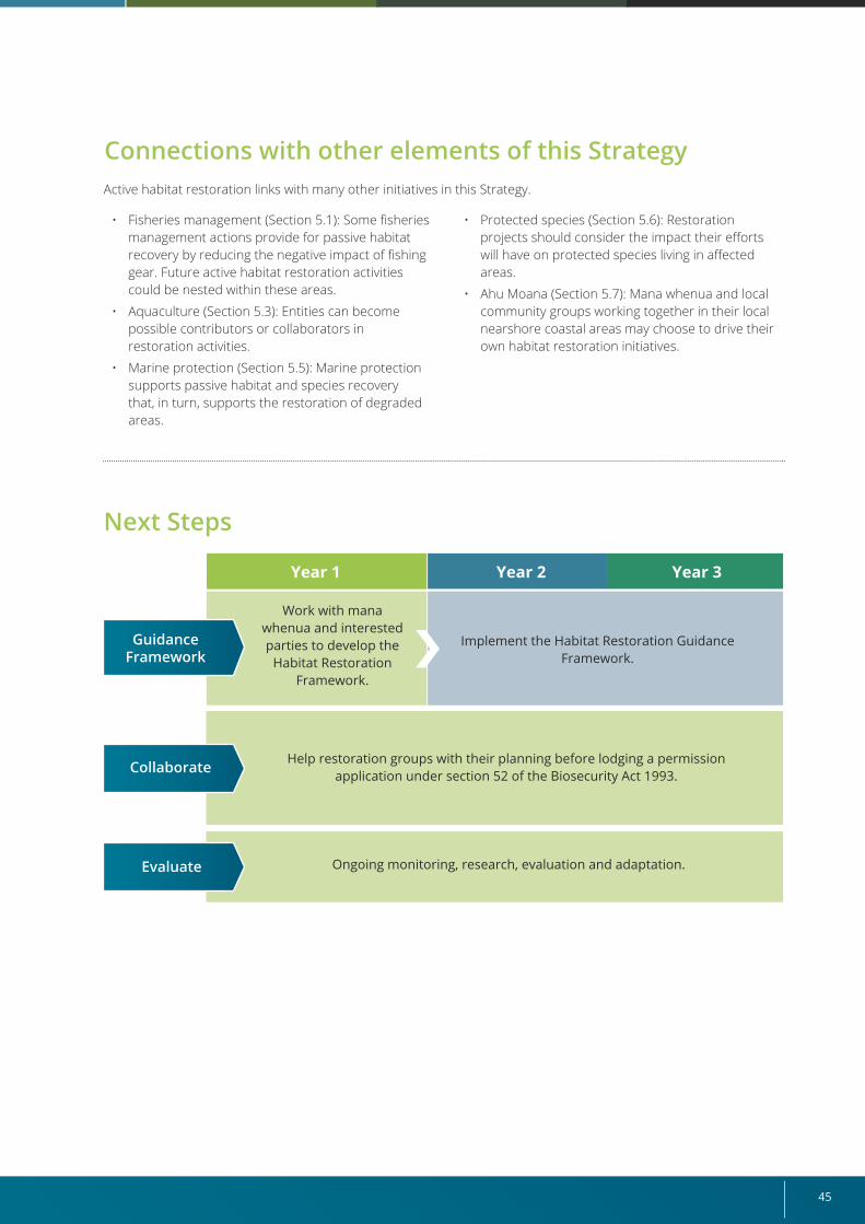
45
Next Steps
Year 1 Year 2 Year 3
Work with mana whenua and interested parties to develop the
Habitat Restoration Framework.
Implement the Habitat Restoration Guidance Framework.
Help restoration groups with their planning before lodging a permission application under section 52 of the Biosecurity Act 1993.
Ongoing monitoring, research, evaluation and adaptation.
Collaborate
Evaluate
Active habitat restoration links with many other initiatives in this Strategy.
• Fisheries management (Section 5.1): Some fisheries management actions provide for passive habitat recovery by reducing the negative impact of fishing gear. Future active habitat restoration activities could be nested within these areas.
• Aquaculture (Section 5.3): Entities can become possible contributors or collaborators in restoration activities.
• Marine protection (Section 5.5): Marine protection supports passive habitat and species recovery that, in turn, supports the restoration of degraded areas.
• Protected species (Section 5.6): Restoration projects should consider the impact their efforts will have on protected species living in affected areas.
• Ahu Moana (Section 5.7): Mana whenua and local community groups working together in their local nearshore coastal areas may choose to drive their own habitat restoration initiatives.
Connections with other elements of this Strategy
Guidance Framework
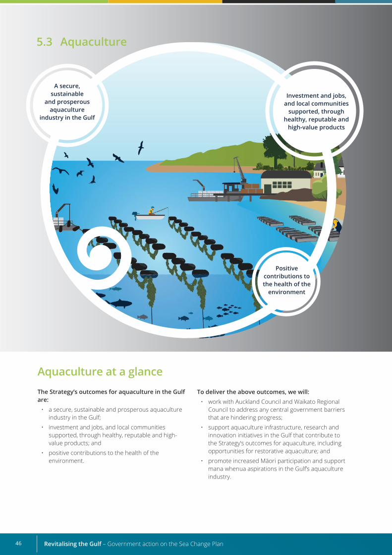
Revitalising the Gulf – Government action on the Sea Change Plan46
Investment and jobs, and local communities
supported, through healthy, reputable and
high-value products
Positive contributions to the health of the
environment
A secure, sustainable
and prosperous aquaculture
industry in the Gulf
5.3 Aquaculture
Aquaculture at a glanceThe Strategy’s outcomes for aquaculture in the Gulf are:
• a secure, sustainable and prosperous aquaculture industry in the Gulf;
• investment and jobs, and local communities supported, through healthy, reputable and high-value products; and
• positive contributions to the health of the environment.
To deliver the above outcomes, we will:• work with Auckland Council and Waikato Regional
Council to address any central government barriers that are hindering progress;
• support aquaculture infrastructure, research and innovation initiatives in the Gulf that contribute to the Strategy’s outcomes for aquaculture, including opportunities for restorative aquaculture; and
• promote increased Māori participation and support mana whenua aspirations in the Gulf’s aquaculture industry.
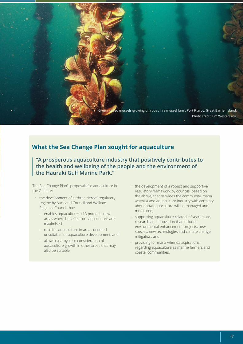
47
The Sea Change Plan’s proposals for aquaculture in the Gulf are:
• the development of a “three-tiered” regulatory regime by Auckland Council and Waikato Regional Council that:
- enables aquaculture in 13 potential new areas where benefits from aquaculture are maximised;
- restricts aquaculture in areas deemed unsuitable for aquaculture development; and
- allows case-by-case consideration of aquaculture growth in other areas that may also be suitable;
What the Sea Change Plan sought for aquaculture
• the development of a robust and supportive regulatory framework by councils (based on the above) that provides the community, mana whenua and aquaculture industry with certainty about how aquaculture will be managed and monitored;
• supporting aquaculture-related infrastructure, research and innovation that includes environmental enhancement projects, new species, new technologies and climate change mitigation; and
• providing for mana whenua aspirations regarding aquaculture as marine farmers and coastal communities.
“A prosperous aquaculture industry that positively contributes to the health and wellbeing of the people and the environment of the Hauraki Gulf Marine Park.”
Green-lipped mussels growing on ropes in a mussel farm, Port Fitzroy, Great Barrier Island.
Photo credit Kim Westerskov.
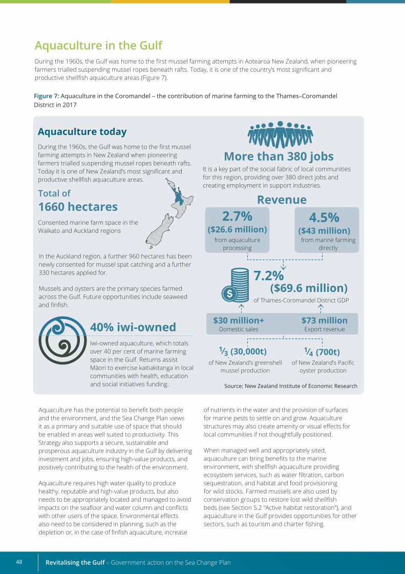
Revitalising the Gulf – Government action on the Sea Change Plan48
Aquaculture today During the 1960s, the Gulf was home to the first mussel farming attempts in New Zealand when pioneering farmers trialled suspending mussel ropes beneath rafts. Today it is one of New Zealand’s most significant and productive shellfish aquaculture areas.
Total of 1660 hectares Consented marine farm space in the Waikato and Auckland regions
Revenue
Iwi-owned aquaculture, which totals over 40 per cent of marine farming space in the Gulf. Returns assist Māori to exercise kaitiakitanga in local communities with health, education and social initiatives funding.
from aquaculture processing
of Thames-Coromandel District GDP
from marine farming directly
In the Auckland region, a further 960 hectares has been newly consented for mussel spat catching and a further 330 hectares applied for.
Mussels and oysters are the primary species farmed across the Gulf. Future opportunities include seaweed and finfish.
40% iwi-owned
2.7% ($26.6 million)
$30 million+Domestic sales
(30,000t)of New Zealand’s greenshell
mussel productionof New Zealand’s Pacific
oyster production
(700t)
$73 millionExport revenue
7.2% ($69.6 million)
4.5% ($43 million)
Figure 7: Aquaculture in the Coromandel – the contribution of marine farming to the Thames–Coromandel District in 2017
Source: New Zealand Institute of Economic Research
More than 380 jobsIt is a key part of the social fabric of local communities for this region, providing over 380 direct jobs and creating employment in support industries.
Aquaculture has the potential to benefit both people and the environment, and the Sea Change Plan views it as a primary and suitable use of space that should be enabled in areas well suited to productivity. This Strategy also supports a secure, sustainable and prosperous aquaculture industry in the Gulf by delivering investment and jobs, ensuring high-value products, and positively contributing to the health of the environment.
Aquaculture requires high water quality to produce healthy, reputable and high-value products, but also needs to be appropriately located and managed to avoid impacts on the seafloor and water column and conflicts with other users of the space. Environmental effects also need to be considered in planning, such as the depletion or, in the case of finfish aquaculture, increase
of nutrients in the water and the provision of surfaces for marine pests to settle on and grow. Aquaculture structures may also create amenity or visual effects for local communities if not thoughtfully positioned.
When managed well and appropriately sited, aquaculture can bring benefits to the marine environment, with shellfish aquaculture providing ecosystem services, such as water filtration, carbon sequestration, and habitat and food provisioning for wild stocks. Farmed mussels are also used by conservation groups to restore lost wild shellfish beds (see Section 5.2 “Active habitat restoration”), and aquaculture in the Gulf provides opportunities for other sectors, such as tourism and charter fishing.
Aquaculture in the GulfDuring the 1960s, the Gulf was home to the first mussel farming attempts in Aotearoa New Zealand, when pioneering farmers trialled suspending mussel ropes beneath rafts. Today, it is one of the country’s most significant and productive shellfish aquaculture areas (Figure 7).
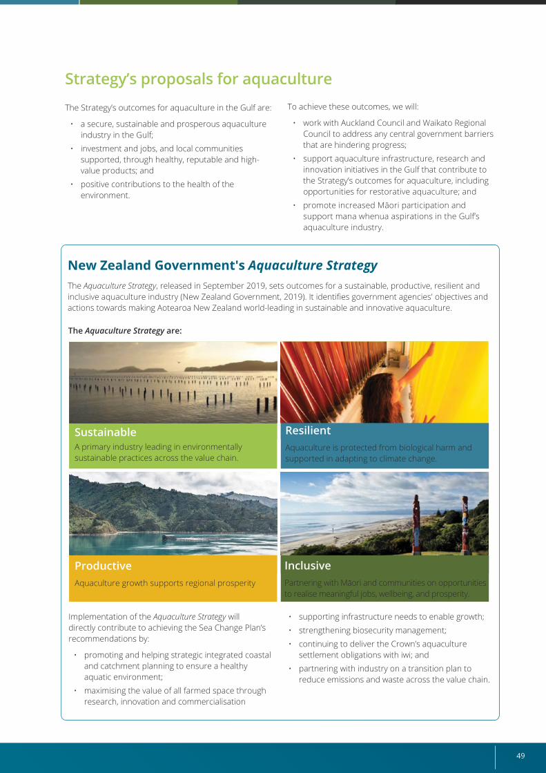
49
New Zealand Government's Aquaculture StrategyThe Aquaculture Strategy, released in September 2019, sets outcomes for a sustainable, productive, resilient and inclusive aquaculture industry (New Zealand Government, 2019). It identifies government agencies' objectives and actions towards making Aotearoa New Zealand world-leading in sustainable and innovative aquaculture.
InclusivePartnering with Māori and communities on opportunities to realise meaningful jobs, wellbeing, and prosperity.
ProductiveAquaculture growth supports regional prosperity
ResilientAquaculture is protected from biological harm and supported in adapting to climate change.
SustainableA primary industry leading in environmentally sustainable practices across the value chain.
Strategy’s proposals for aquaculture
The Strategy’s outcomes for aquaculture in the Gulf are:
• a secure, sustainable and prosperous aquaculture industry in the Gulf;
• investment and jobs, and local communities supported, through healthy, reputable and high-value products; and
• positive contributions to the health of the environment.
To achieve these outcomes, we will:
• work with Auckland Council and Waikato Regional Council to address any central government barriers that are hindering progress;
• support aquaculture infrastructure, research and innovation initiatives in the Gulf that contribute to the Strategy’s outcomes for aquaculture, including opportunities for restorative aquaculture; and
• promote increased Māori participation and support mana whenua aspirations in the Gulf’s aquaculture industry.
Implementation of the Aquaculture Strategy will directly contribute to achieving the Sea Change Plan’s recommendations by:
• promoting and helping strategic integrated coastal and catchment planning to ensure a healthy aquatic environment;
• maximising the value of all farmed space through research, innovation and commercialisation
• supporting infrastructure needs to enable growth;
• strengthening biosecurity management;
• continuing to deliver the Crown’s aquaculture settlement obligations with iwi; and
• partnering with industry on a transition plan to reduce emissions and waste across the value chain.
The Aquaculture Strategy are:
Revitalising the Gulf – Government action on the Sea Change Plan50
Regulatory frameworks for aquaculture in the Gulf Aquaculture development in the Gulf is mainly managed under the Resource Management Act 1991 through Waikato Regional Council’s Regional Coastal Plan and Auckland Council’s Unitary Plan, which help the councils identify areas where applications for aquaculture development are appropriate. Formal tools to guide aquaculture planning and management include the New Zealand Coastal Policy Statement (NZCPS) (New Zealand Government, 2010), the National Environmental Standards for Marine Aquaculture (MfE, 2020b) and the Māori Commercial Aquaculture Claims Settlement Act 2004.
The Sea Change Plan’s proposals closely align with the Government’s overarching Aquaculture Strategy (New Zealand Government, 2019) and the National Environmental Standards for Marine Aquaculture (MfE, 2020b). We have a strong role, therefore, in continuing to work with councils, mana whenua and industry to support a secure, sustainable and prosperous aquaculture industry in the Gulf.
The Sea Change Plan recommends councils consider areas to be prioritised for future aquaculture development and areas unsuitable for future development, to allow for a “three-tiered” regulatory regime. The 13 potential new areas identified in the Sea Change Plan were considered the best sites for aquaculture, balancing the need for a high-quality water space with factors such as avoiding impacts on outstanding landscapes and having minimal negative interactions with other users.
The Waikato Regional Coastal Plan allows aquaculture development only in designated zones and includes policies and rules on what species can be grown, what farming gear can be used and monitoring requirements. The industry sees this approach as being too restrictive to future development and opportunities, and the Coastal Plan is currently under review, enabling the Sea Change Plan’s proposals to be considered.
As part of our engagement process, staff from Waikato Regional Council identified barriers that need to be addressed in the response to the Sea Change Plan’s aquaculture proposals. These included the need for:
• help with the costs of undertaking site suitability assessment work on the proposed new aquaculture areas;
• further guidance on tendering when allocating new space;
• clarity in the NZCPS regarding the impacts of aquaculture on natural character, landscapes and biodiversity matters; and
• updated guidance for council ecologists through key MPI documents.
The Auckland Unitary Plan (2016 operative in part) was completed before the release of the Sea Change Plan, but certain elements deliver to the Sea Change Plan proposals. Feedback from Auckland Council staff suggests that appropriate aquaculture development in the Auckland region is currently occurring through the Unitary Plan’s provisions, as shown through recent approvals for aquaculture space allocation.
We have engaged with the councils, mana whenua and stakeholders to develop this chapter. Based on their feedback, we propose the following aquaculture actions to respond to the Sea Change Plan’s proposals:
• support the implementation actions from the Aquaculture Strategy and the National Environmental Standards for Marine Aquaculture;
• investigate MPI’s Sustainable Food and Fibre Futures Fund to support site suitability investigations of the 13 potential new aquaculture areas proposed in the Sea Change Plan;
• update NZCPS guidance on natural character and landscapes, to help councils implement all policies in the NZCPS. Councils will be able to draw on this policy guidance to identify values and areas requiring special recognition and management and to provide guidance for activities, such as aquaculture, within these areas;
• work with councils on tendering guidelines to allocate new aquaculture space;
• investigate options to strengthen information available to councils and the public on the ecological and environmental effects and benefits of aquaculture;
• support restorative aquaculture initiatives specific to the Gulf; and
• continue supporting work to address barriers to innovation in aquaculture, including improving access to broodstock from wild populations.
51
Supporting aquaculture infrastructure, research and innovation in the Gulf
Marine biosecurity and aquaculture
InfrastructureAn objective of the Government’s 2019 Aquaculture Strategy is to support infrastructure needs to enable growth of the aquaculture industry (New Zealand Government, 2019). Industry feedback during engagement on the Strategy highlighted the need for more infrastructure development to cater for growth within existing spaces and in new locations.
The Government is acting on that feedback and, in June 2020, announced $20 million of funding through the Provincial Growth Fund to extend the Te Ariki Tahi Sugarloaf Wharf and increase mussel farming capacity in the region (Thames–Coromandel District Council, no date). This expansion will allow the wharf to meet increased demand from recently granted consents around the Gulf and future-proof its resilience to climate change impacts.
Research and innovationThe Aquaculture Strategy’s vision involves sustainable and innovative aquaculture management. We will help deliver that vision by facilitating co-investment in priority research and innovation in the Gulf by industry, iwi and the Government.
Exciting projects are already under way, such as the $6 million Endeavour Fund project by the Auckland University of Technology, which is investigating the conversion of seaweeds to high-value animal feeds and organic plant fertiliser. Another example is Project Whakatiputipu by Wakame Fresh, which is funded by the Sustainable Food and Fibre Futures Fund and aims to turn invasive seaweed into a premium edible export for the Japanese market.
During our Strategy engagement, stakeholders talked about the potential for both restorative aquaculture in the Gulf and the commercialisation of additional species. The restorative aquaculture initiatives, and work to address barriers to innovation in aquaculture outlined in this Strategy, respond to that feedback.
Industry also called for a more flexible planning and consenting framework to reflect a changing environment due to climate change impacts. While that primarily rests with regional or unitary councils, the rollout of the National Environmental Standards for Marine Aquaculture will allow for more efficient re-consenting processes, species diversification and realignments to existing farms.
Some marine species can pose a serious threat to marine ecosystems. While aquaculture is unlikely to be the cause of a new pest incursion into Aotearoa New Zealand, marine farm structures can provide surfaces for pest organisms to colonise, which become a reservoir for further spread.
Diseases, pathogens, parasites and other biological threats also pose risks for aquaculture and could have an enormous impact on the industry.
The Government’s Aquaculture Strategy (New Zealand Government, 2019) identifies the need to protect
Restorative aquaculture and agricultural seaweed products Seaweeds could be farmed in the Gulf to capture carbon emissions and help mitigate climate change effects. This activity could also provide localised benefits, such as improving the quality of polluted waters by extracting nutrients, such as nitrogen and phosphorus. And the seaweed itself could be used in farming systems (for example, as pasture stimulants or feeds to reduce bovine methane), reducing land-based sources of marine pollution and synthetic fertiliser use in the Gulf’s catchments and providing a circular economy response.
aquaculture and surrounding environments from biological harm. It will be delivered through:
• progressing a Government–Industry Agreement for Biosecurity Readiness and Response in partnership with Aquaculture New Zealand;
• reforming the Biosecurity Act 1993 to identify improvement options for broader marine pathway management across coastal users; and
• continuing the investigation and application of the best tools to strengthen biosecurity measures around marine farms and other aquaculture activities nationally.
Revitalising the Gulf – Government action on the Sea Change Plan52
Promoting Māori and community participation in the Gulf aquaculture industryThe Crown has an aquaculture settlement obligation with Māori under the Māori Commercial Aquaculture Claims Settlement Act 2004. Along with this, part of the Aquaculture Strategy involves the Government proactively engaging with Māori to maximise opportunities from Treaty settlements and to provide for Māori values and aspirations across the aquaculture work programme.
This approach will be reflected in our work with mana whenua, which will support their aspirations in aquaculture as marine farmers and coastal communities within the Gulf.
We will engage with councils, mana whenua and communities to understand local priorities, help enable community-led initiatives and identify regional growth opportunities. This will include helping to build a social licence that supports aquaculture growth in the Gulf.
We will also continue to settle additional obligations arising from new marine farm consents under the Auckland and Waikato East new space aquaculture regional agreements.19
These aquaculture proposals have connections with other initiatives in this Strategy.
19 Treaty settlements are made under regional agreements between the iwi aquaculture organisations that represent a region, the Crown and Te Ohu Kaimoana Trustee Ltd. Regional agreements deliver a mix of settlement assets equivalent in value to 20 percent of all space created for aquaculture development.
Next steps
Connections with other elements of this Strategy
• Active habitat restoration (Section 5.2): Organisations can become possible contributors to or collaborators in restoration activities.
• Ahu Moana (Section 5.7): The aquaculture sector may work with mana whenua and local communities to protect their marine environment.
Year 1 Year 2 Year 3
Investigate the Sustainable Food and Fibre Futures Fund to support
site suitability assessmentsUpdate New Zealand Coastal
Policy Statement (NZCPS) policy guidance on natural character
Support implementation of actions from the Government’s Aquaculture StrategyContinue to support work to address barriers to aquaculture
initiatives and innovation Support restorative aquaculture initiatives specific to the Gulf
Support implementation of actions from the Government’s Aquaculture Strategy
Work with Ministry for the Environment and councils on
tendering guidelines for aquaculture space allocation where appropriateInvestigate options to strengthen
information available to councils and the public
Update NZCPS policy guidance on landscapes
Working with councils
Supporting aquaculture
Promoting greater Māori participation
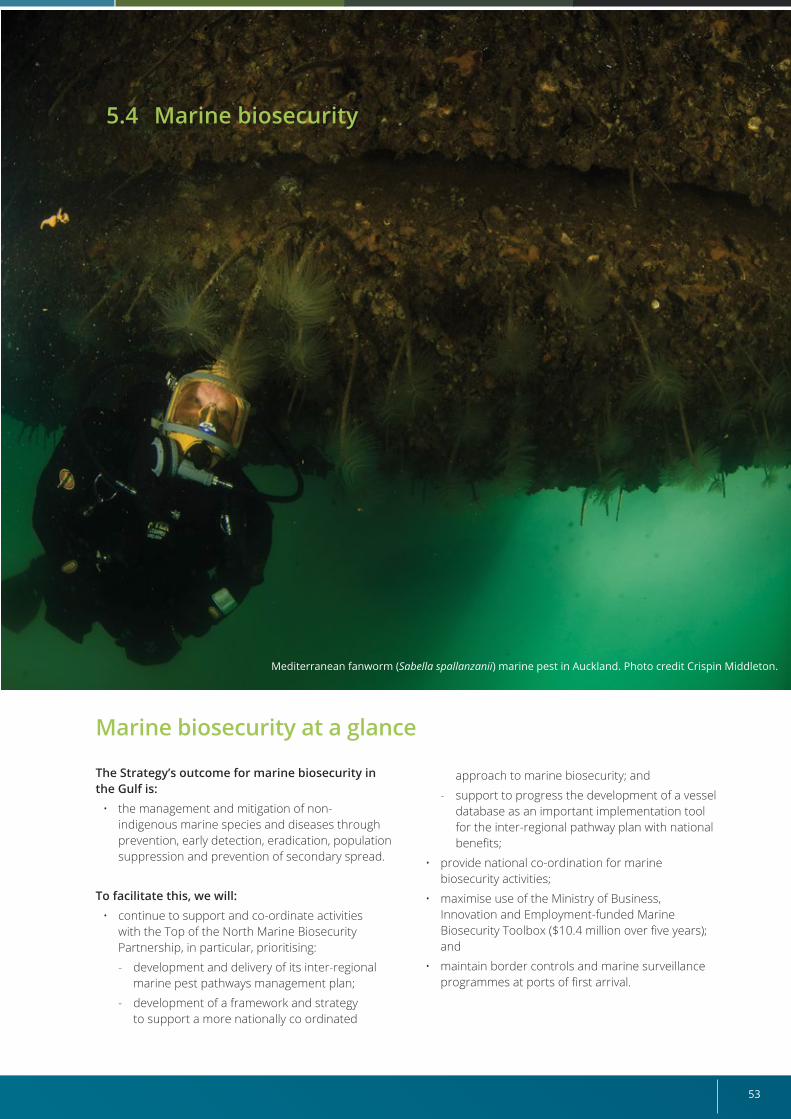
53
Mediterranean fanworm (Sabella spallanzanii) marine pest in Auckland. Photo credit Crispin Middleton.
Marine biosecurity at a glance
The Strategy’s outcome for marine biosecurity in the Gulf is:
• the management and mitigation of non-indigenous marine species and diseases through prevention, early detection, eradication, population suppression and prevention of secondary spread.
To facilitate this, we will:• continue to support and co-ordinate activities
with the Top of the North Marine Biosecurity Partnership, in particular, prioritising:
- development and delivery of its inter-regional marine pest pathways management plan;
- development of a framework and strategy to support a more nationally co ordinated
5.4 Marine biosecurity
approach to marine biosecurity; and
- support to progress the development of a vessel database as an important implementation tool for the inter-regional pathway plan with national benefits;
• provide national co-ordination for marine biosecurity activities;
• maximise use of the Ministry of Business, Innovation and Employment-funded Marine Biosecurity Toolbox ($10.4 million over five years); and
• maintain border controls and marine surveillance programmes at ports of first arrival.
Revitalising the Gulf – Government action on the Sea Change Plan54
Marine biosecurity pressures in the Gulf The Gulf is a major entry and departure point for international vessels and a central hub for recreational vessels, maritime transport and aquaculture activities.
Non-indigenous marine species have the potential to become ecological and economic pests and are identified in Our Marine Environment (MfE and Stats NZ, 2019) as one of the main pressures on coastal environments and ecosystems.
At least six non-indigenous marine species with the potential to cause serious harm to the marine environment have already become established in the Gulf, five of which arrived in the past 20 years.
The impact of non-indigenous marine species on the Gulf’s ecosystem can be reduced by preventing their entry into Aotearoa New Zealand and controlling the spread and abundance of established species. However, prevention is much easier than control, so a strong focus is on preventing their arrival through mandatory border requirements.
Most non-indigenous marine species arrive in the Gulf via international shipping, either as fouling organisms
on vessel hulls, as inhabitants of niche spaces (for example, sea chests, water intakes, box coolers) or in ballast water.20 Until recently, the Port of Auckland was one of the main entry points for invasive species, and the large number of boating and other marine-based activities centred in Auckland served as vectors for the spread of non-indigenous marine species throughout the Gulf and to other regions. However, the introduction of the Craft Risk Management Standard (CRMS) (MPI, 2018a) has significantly reduced the risk of non-indigenous marine species being introduced to Auckland and other ports from elsewhere in the world. The CRMS has also significantly slowed the rate of increase in new marine pest species being detected through government and council surveillance efforts, with only one new species being discovered in the Gulf in the past two years (Hauraki Gulf Forum, 2020).
Early detection, to improve the likelihood of successful management (that is, eradication or population suppression), is also an important focus. This is achieved through regular surveys of high-risk ports in Aotearoa New Zealand and a response process on detection of high-risk non-indigenous marine species.21
The ongoing challenge is to slow the spread of established marine pests to iconic areas of the Gulf and actively manage them to reduce their impact on native marine biodiversity, both in the Gulf and further afield.
What the Sea Change Plan sought for marine biosecurity
The Sea Change Plan includes a sub-section on marine biosecurity and sets an overall goal of identifying, managing and mitigating threats to the Gulf from pests and diseases through prevention, early warning and detection, eradication, and control measures.
The Sea Change Plan’s marine biosecurity objectives include:
• developing pathway management plans and pest management plans to prevent the arrival and further spread of new and existing species and diseases, especially to high-value areas;
• increasing regional monitoring and surveillance efforts, to enable the detection of, and rapid
response to, new introduced species;
• where feasible, eradicating or controlling present species using available and evolving tools and methods; and
• increasing stewardship through an informed and engaged industry and public.
The Sea Change Plan also refers to sections within the Biosecurity Act 1993 that manage the risk of further spread of unwanted organisms present in Aotearoa New Zealand. The requirements for management constrain the relocation of mussels (shell waste and live) within the Gulf in association with mussel reef restoration projects (see Section 5.2 “Active habitat restoration”).
20 The Australian droplet tunicate (Eudistoma elongatum) was only recently detected in the intertidal zone at Waiheke Island after being found a couple of years earlier at Sandspit. It is most likely to have spread from Northland, where it is common on oyster farm structures and some intertidal mudflats.
21 Biosecurity New Zealand co-ordinates the Marine High Risk Site Surveillance (MHRSS) programme, which involves twice-yearly surveys at key ports, including the Port of Auckland. This programme has been operational since 2002 and is an important tool, providing an early warning system for the presence of non-indigenous marine species.
55
Strategy’s proposals for marine biosecurity Our engagement with stakeholders revealed that, despite the substantive work in marine biosecurity over the past 20 years, the management of marine biosecurity risks is an ongoing concern. This presents challenges for councils and marine users of the Gulf, particularly the aquaculture industry. The Strategy’s outcome for marine biosecurity in the Gulf, therefore, is:
• management and mitigation of non-indigenous marine species and diseases through prevention, early detection, eradication, population suppression and prevention of secondary spread.
To facilitate this, we will:
• continue to support and co-ordinate activities with the Top of the North Marine Biosecurity Partnership (TON), in particular, prioritising:
- development and delivery of its inter-regional marine pest pathways management plan;
- development of a framework and strategy to support a more nationally co-ordinated approach to marine biosecurity; and
- support to progress the development of a vessel database as an important implementation tool for the inter-regional pathway plan with national benefits;
• provide national co-ordination for marine biosecurity activities;
• maximise use of the MBIE-funded Marine Biosecurity Toolbox ($10.4 million over five years); and
• maintain border controls and marine surveillance programmes at ports of first arrival.
Progress with marine biosecurity in the Gulf
Since publication of the Sea Change Plan in 2017, significant progress has been made by the Government, unitary authorities and regional councils that aligns with delivering the Sea Change Plan’s marine biosecurity outcomes (see Appendix 3).
In 2018, the New Zealand Craft Risk Management Standard for Biofouling (CRMS-BIOFOUL) came into force, setting mandatory requirements for the management of biofouling on vessels arriving in Aotearoa New Zealand (MPI, 2018b). The CRMS-BIOFOUL requires proactive management of biofouling before arrival, either by cleaning at the port of departure or through continual management. Vessels that arrive without evidence of this may be directed to have a dive inspection on arrival and/or to leave Aotearoa New Zealand waters.
Another significant action is the current development of an inter-regional marine pest pathways management plan through TON. This management plan will establish a consistent approach to managing and controlling the spread of non-indigenous marine species across the four northernmost regions of the North Island (Northland, Auckland, Waikato and Bay of Plenty).
Auckland Council’s Regional Pest Management Plan lists several marine pest species and identifies actions it will take to manage them. In addition, the Council has identified rules in its Unitary Plan for the management of vessel biofouling associated with in-water hull cleaning. Both the Council and Biosecurity New Zealand are jointly responding to localised incursions of Mediterranean fanworm at Port Fitzroy and Tryphena on Great Barrier Island (Aotea Island).
Along with the actions detailed in Appendix 3, other government activities that support delivery of the Sea Change Plan’s objectives include:
• implementing the Government’s 2019 Aquaculture Strategy;
• working with the aquaculture industry, under the Government–Industry Agreements Framework, to improve readiness to respond to biosecurity events; and
• overhauling the Biosecurity Act 1993, as announced in July 2019 by the Minister for Biosecurity, which will identify improved options for broader marine pathway management across coastal users.
Revitalising the Gulf – Government action on the Sea Change Plan56
The Sea Change Plan calls for a consistent approach to biosecurity across regions and for greater overall action to address and control the spread of marine pests in the Gulf. TON was established in 2016 to increase collaboration and consistency between the upper North Island regional councils, the Department of Conservation and Biosecurity New Zealand in relation to the management of marine pests.
Top of the North Marine Biosecurity Partnership (TON)TON is developing a proposed inter-regional marine pest pathways management plan that will cover the marine area in the upper North Island, including the Gulf. A focus of this plan is the application of a consistent rule for hull biofouling, because this has been identified as the main vector for spreading non-indigenous marine species.
Next steps
Connections with other elements of this StrategyThese marine biosecurity proposals have connections with other initiatives in this Strategy.
• Active habitat restoration (Section 5.2): It is important to mitigate the risk of introducing unwanted organisms to new areas when undertaking active habitat restoration.
Ongoing
Support and co-ordinate the Top of the North Marine Biosecurity Partnership to finalise and progress its inter-regional marine pest pathway management plan
Government’s surveillance programme of high-risk ports and harbours provides an early warning system for the arrival of new species, and records the spread of
non-indigenous species
Progress national approaches to improve co-ordination and monitoring, with an initial focus on developing a national strategy and framework to guide
future action
Surveillance
Co-ordination and monitoring
Partnership
• Aquaculture (Section 5.3): The Aquaculture Strategy (New Zealand Government, 2019) identifies the need to protect aquaculture and surrounding environments from biosecurity risks.
• Ahu Moana (Section 5.7): Mana whenua and local communities may be interested in undertaking projects to manage unwanted species in their local coastal areas.
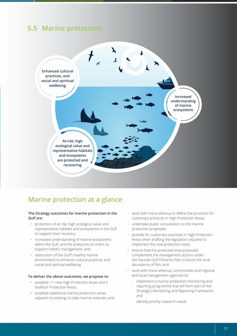
57
Marine protection at a glance
The Strategy outcomes for marine protection in the Gulf are:
• protection of at-risk, high ecological value and representative habitats and ecosystems in the Gulf to support their recovery;
• increased understanding of marine ecosystems within the Gulf, and the pressures on them, to support holistic management; and
• restoration of the Gulf’s healthy marine environment to enhance cultural practices and social and spiritual wellbeing.
To deliver the above outcomes, we propose to:• establish 11 new High Protection Areas and 5
Seafloor Protection Areas;
• establish additional marine protection areas adjacent to existing no-take marine reserves; and
• work with mana whenua to define the provision for customary practices in High Protection Areas;
• undertake public consultation on the marine protection proposals;
• provide for customary practices in High Protection Areas when drafting the legislation required to implement the new protection tools;
• ensure that the protected area proposals complement the management actions under the Hauraki Gulf Fisheries Plan to boost the local abundance of fish; and
• work with mana whenua, communities and regional and local management agencies to:
- implement a marine protection monitoring and reporting programme that will form part of the Strategy’s Monitoring and Reporting Framework; and
- identify priority research needs.
Increased understanding
of marine ecosystems
At-risk, high ecological value and
representative habitats and ecosystems
are protected and recovering
Enhanced cultural practices, and
social and spiritual wellbeing
5.5 Marine protection
Revitalising the Gulf – Government action on the Sea Change Plan58
What the Sea Change Plan sought for marine protection The Sea Change Plan proposes three overarching objectives for Marine Protected Areas (MPAs):
• establish a network of MPAs to help protect and passively restore at-risk, high-value and representative ecosystems in the Gulf and to boost the abundance of fish stocks;
• create a nested approach to MPA establishment that recognises some areas should be heavily restricted in the uses allowed, to best enable ecosystems to recover (that is, no take other than for customary harvesting purposes by special permit on a case-by-case basis). These no-take areas should generally be nested within larger areas that allow greater levels of recreational and commercial activity while
protecting benthic habitats from damaging human activities; and
• establish continuous inshore co-management areas (termed “Ahu Moana”) for the Gulf. These would generally extend from Mean High Water Springs (the high-tide mark) out to 1 kilometre. In some places, they would extend further to take in significant fisheries or places or to edge-protect MPAs.
We discuss fish stocks and the actions we will take to boost them in Section 5.1 “Fisheries management” and discuss co-management areas in Section 5.7 “Ahu Moana”.
Sea Change Plan’s MPA network The Sea Change Plan proposes the establishment of MPAs at 15 sites in the Gulf, using one or a combination of the three types of protection summarised below. For some sites, two alternative scenarios are proposed for their protection.
• Type One MPAs: These are described as “no-take marine reserves other than for customary purposes”. Their purpose is to protect, enhance and restore the full range of marine communities and ecosystems and outstanding, rare, distinctive or nationally important marine habitats to protect the mauri of the Gulf. The Sea Change Plan has two perspectives on how to approach the management of customary take: permits issued by kaitiaki or on a case-by-case basis
by special permit as reflected in the current legislation.
• Type Two MPAs: These are described as “benthic protection” and are intended to maintain, restore and protect key habitats, such as biogenic habitats, and increase productivity of the Gulf. They exclude activities that directly impact on the seafloor while allowing for compatible uses.
• Special Management Areas (SMAs): These are described as having the dual purpose of protecting the integrity and healthy functioning of the system, while allowing for a high-value economic activity (sports fishing) to create economic returns.
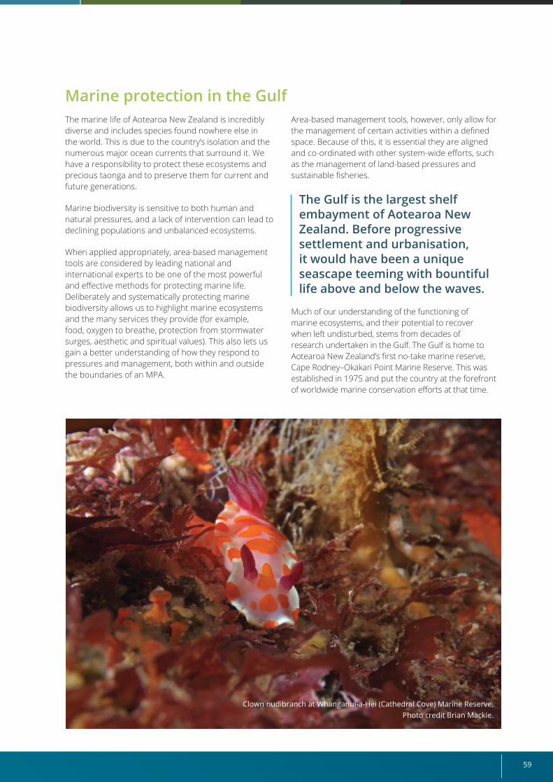
59
Marine protection in the GulfThe marine life of Aotearoa New Zealand is incredibly diverse and includes species found nowhere else in the world. This is due to the country’s isolation and the numerous major ocean currents that surround it. We have a responsibility to protect these ecosystems and precious taonga and to preserve them for current and future generations.
Marine biodiversity is sensitive to both human and natural pressures, and a lack of intervention can lead to declining populations and unbalanced ecosystems.
When applied appropriately, area-based management tools are considered by leading national and international experts to be one of the most powerful and effective methods for protecting marine life. Deliberately and systematically protecting marine biodiversity allows us to highlight marine ecosystems and the many services they provide (for example, food, oxygen to breathe, protection from stormwater surges, aesthetic and spiritual values). This also lets us gain a better understanding of how they respond to pressures and management, both within and outside the boundaries of an MPA.
Area-based management tools, however, only allow for the management of certain activities within a defined space. Because of this, it is essential they are aligned and co-ordinated with other system-wide efforts, such as the management of land-based pressures and sustainable fisheries.
The Gulf is the largest shelf embayment of Aotearoa New Zealand. Before progressive settlement and urbanisation, it would have been a unique seascape teeming with bountiful life above and below the waves.
Much of our understanding of the functioning of marine ecosystems, and their potential to recover when left undisturbed, stems from decades of research undertaken in the Gulf. The Gulf is home to Aotearoa New Zealand’s first no-take marine reserve, Cape Rodney–Okakari Point Marine Reserve. This was established in 1975 and put the country at the forefront of worldwide marine conservation efforts at that time.
Clown nudibranch at Whanganui-a-Hei (Cathedral Cove) Marine Reserve. Photo credit Brian Mackie.
Revitalising the Gulf – Government action on the Sea Change Plan60
Strategy proposals for increasing marine protection
The Strategy outcomes for marine protection in the Gulf are:
• protection of at-risk, high ecological value and representative habitats and ecosystems in the Gulf to support their recovery;
• increased understanding of marine ecosystems within the Gulf, and the pressures on them, to support holistic management; and
• restoration of the Gulf’s healthy marine environment to enhance cultural practices and social and spiritual wellbeing.
To deliver the above outcomes, we propose to:
• establish 11 new High Protection Areas and 5 Seafloor Protection Areas;
• establish additional marine protection areas adjacent to existing no-take marine reserves; and
• work with mana whenua to define the provision for customary practices in High Protection Areas;
• undertake public consultation on the marine protection proposals;
• provide for customary practices in High Protection Areas when drafting the legislation required to implement the new protection tools;
• ensure that the protected area proposals complement the management actions under the Hauraki Gulf Fisheries Plan to boost the local abundance of fish; and
• work with mana whenua, communities and regional and local management agencies to:
- implement a marine protection monitoring and reporting programme that will form part of the Strategy’s Monitoring and Reporting Framework; and
- identify priority research needs.
Marine protection areasWe will establish protected areas that achieve the biodiversity and cultural objectives.22 These proposals will be based on the special values at each site and what we are trying to achieve through protection.
High Protection Areas Purpose: To protect, enhance and restore the full range of marine communities and ecosystems and outstanding, rare, distinctive or nationally important marine habitats to protect the mauri of the Gulf.23
High Protection Areas offer the highest level of protection among the marine protection tools proposed in this Strategy. Site-specific management objectives will be based on the biological values requiring protection in each High Protection Area.
Customary practices, which will be defined during engagement with mana whenua, will be expressly provided for in High Protection Areas. To progress
this, DOC will engage further with mana whenua on the management of these sites and work closely with them to deliver the site biodiversity objectives following establishment.
Our proposals recognise Treaty settlements, customary rights, as recognised under the Marine and Coastal Area (Takutai Moana) Act 2011, and other statutory obligations. The establishment of new protected areas does not derogate from those settlements and rights.
High Protection Areas can be used to collect information on marine life through environmental monitoring and the application of mātauranga Māori. Monitoring also provides status, trend and threat information that helps us to assess the effectiveness of the protection against the outcomes sought. Supporting passive restoration of ecosystems at these sites to a more natural state will let us better understand how marine ecosystems work and respond to different threats.
22 The Sea Change Plan proposes the formation of new types of protection areas that are slightly different from those that are designated as MPAs under the national MPA Policy and Implementation Plan (see DOC & MFish 2005). In recognition of this, the protection areas referred to as Type One MPAs in the Sea Change Plan are termed High Protection Areas in this Strategy (which may meet the MPA Policy and Implementation standard), and those referred to as Type Two MPAs in the Sea Change Plan are termed Seafloor Protection Areas in this Strategy (which do not meet the MPA Policy and Implementation standard but do contribute some level of protection to seafloor habitats).
23 Taken from the purpose of the Type One MPAs proposed in the Sea Change Plan (Sea Change Stakeholder Working Group 2017).
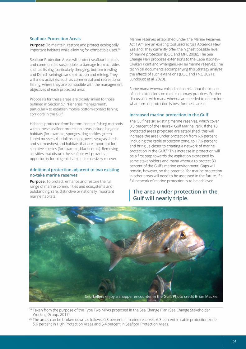
61
24 Taken from the purpose of the Type Two MPAs proposed in the Sea Change Plan (Sea Change Stakeholder Working Group, 2017).
25 The areas can be broken down as follows: 0.3 percent in marine reserves, 6.3 percent in cable protection zone, 5.6 percent in High Protection Areas and 5.4 percent in Seafloor Protection Areas.
Seafloor Protection Areas Purpose: To maintain, restore and protect ecologically important habitats while allowing for compatible uses.24
Seafloor Protection Areas will protect seafloor habitats and communities susceptible to damage from activities such as fishing (particularly dredging, bottom trawling and Danish seining), sand extraction and mining. They will allow activities, such as commercial and recreational fishing, where they are compatible with the management objectives of each protected area.
Proposals for these areas are closely linked to those outlined in Section 5.1 “Fisheries management”, particularly to establish mobile bottom-contact fishing corridors in the Gulf.
Habitats protected from bottom-contact fishing methods within these seafloor protection areas include biogenic habitats (for example, sponges, dog cockles, green-lipped mussels, rhodoliths, mangroves, seagrass beds and saltmarshes) and habitats that are important for sensitive species (for example, black corals). Removing activities that disturb the seafloor will provide an opportunity for biogenic habitats to passively recover.
Additional protection adjacent to two existing no-take marine reservesPurpose: To protect, enhance and restore the full range of marine communities and ecosystems and outstanding, rare, distinctive or nationally important marine habitats.
Marine reserves established under the Marine Reserves Act 1971 are an existing tool used across Aotearoa New Zealand. They currently offer the highest possible level of marine protection (DOC and MPI, 2008). The Sea Change Plan proposes extensions to the Cape Rodney–Okakari Point and Whanganui-a-Hei marine reserves. The technical documents accompanying this Strategy analyse the effects of such extensions (DOC and FNZ, 2021a; Lundquist et al, 2020).
Some mana whenua voiced concerns about the impact of such extensions on their customary practices. Further discussions with mana whenua are needed to determine what form of protection is best for these areas.
Increased marine protection in the GulfThe Gulf has six existing marine reserves, which cover 0.3 percent of the Hauraki Gulf Marine Park. If the 18 protected areas proposed are established, this will increase the area under protection from 6.6 percent (including the cable protection zone) to 17.6 percent and bring us closer to creating a network of marine protection in the Gulf.25 This increase in protection will be a first step towards the aspiration expressed by some stakeholders and mana whenua to protect 30 percent of the Gulf’s marine environment. Gaps will remain, however, so the potential for marine protection in other areas will need to be assessed in the future, if a full network of marine protection is to be achieved.
The area under protection in the Gulf will nearly triple.
Snorkellers enjoy a snapper encounter in the Gulf. Photo credit Brian Mackie.
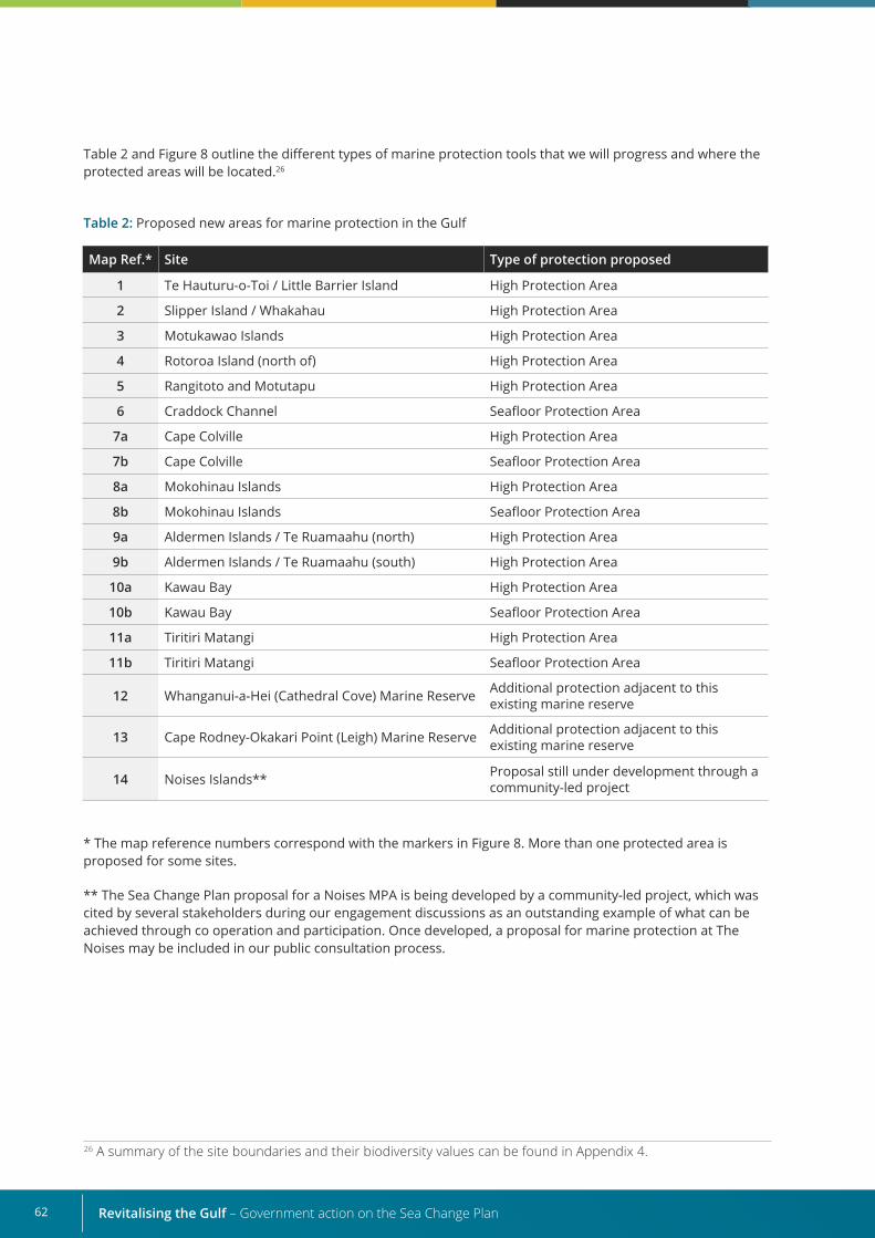
Revitalising the Gulf – Government action on the Sea Change Plan62
Table 2: Proposed new areas for marine protection in the Gulf
Table 2 and Figure 8 outline the different types of marine protection tools that we will progress and where the protected areas will be located.26
* The map reference numbers correspond with the markers in Figure 8. More than one protected area is proposed for some sites.
** The Sea Change Plan proposal for a Noises MPA is being developed by a community-led project, which was cited by several stakeholders during our engagement discussions as an outstanding example of what can be achieved through co operation and participation. Once developed, a proposal for marine protection at The Noises may be included in our public consultation process.
Map Ref.* Site Type of protection proposed
1 Te Hauturu-o-Toi / Little Barrier Island High Protection Area
2 Slipper Island / Whakahau High Protection Area
3 Motukawao Islands High Protection Area
4 Rotoroa Island (north of) High Protection Area
5 Rangitoto and Motutapu High Protection Area
6 Craddock Channel Seafloor Protection Area
7a Cape Colville High Protection Area
7b Cape Colville Seafloor Protection Area
8a Mokohinau Islands High Protection Area
8b Mokohinau Islands Seafloor Protection Area
9a Aldermen Islands / Te Ruamaahu (north) High Protection Area
9b Aldermen Islands / Te Ruamaahu (south) High Protection Area
10a Kawau Bay High Protection Area
10b Kawau Bay Seafloor Protection Area
11a Tiritiri Matangi High Protection Area
11b Tiritiri Matangi Seafloor Protection Area
12 Whanganui-a-Hei (Cathedral Cove) Marine Reserve Additional protection adjacent to this existing marine reserve
13 Cape Rodney-Okakari Point (Leigh) Marine Reserve Additional protection adjacent to this existing marine reserve
14 Noises Islands** Proposal still under development through a community-led project
26 A summary of the site boundaries and their biodiversity values can be found in Appendix 4.
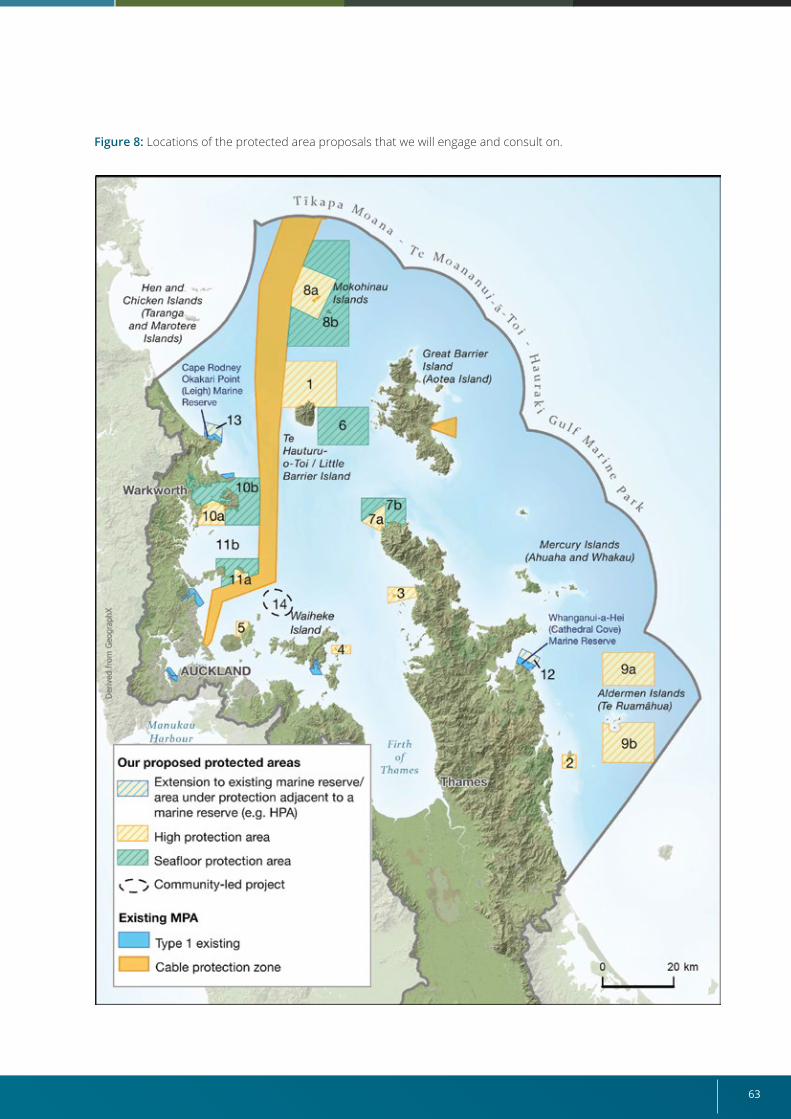
63
Figure 8: Locations of the protected area proposals that we will engage and consult on.
Revitalising the Gulf – Government action on the Sea Change Plan64
While development of the Sea Change Plan involved substantial effort to identify areas for increased protection, we acknowledge the existence of other community-driven initiatives that are seeking greater
marine protection in the Gulf. These include projects at Waiheke Island, Great Barrier Island (Aotea Island) and The Noises.
Analysis of the Sea Change Plan’s proposals
We undertook an evidence-based assessment of the Sea Change Plan’s proposals to align the protected areas with the three marine protection outcomes being sought (DOC and FNZ, 2021a, 2021b; Lundquist et al, 2020). This assessment involved:
• the use of best-available information on the distribution and state of marine biodiversity;
• an evaluation of the Sea Change Plan’s proposals against best-practice guidance for the design of marine protection sites and networks (DOC and MFish, 2008);27
• an evaluation of the efficiency of the proposals towards maximising biodiversity protection and limiting the displacement of fishing activities through the spatial management planning tool ‘Zonation’;
• a site-based analysis of proposals against the objectives set out in the Sea Change Plan;
• an assessment of the best tools available to achieve the desired site objectives; and
• an assessment of the potential impacts on users.
This assessment allowed us to identify which of the Sea Change Plan’s proposals most effectively delivered on the marine protection outcomes sought. We then made changes to the MPA boundaries proposed in the Sea Change Plan, where the assessment indicated such changes enhanced biodiversity outcomes and/or reduced the potential impact on users. While the assessment looked at provisional economic impacts, it was not intended to capture the customary aspirations of mana whenua. We will use the findings to inform and progress discussions with mana whenua around customary practices.
“We are impressed with the extent of the level 1 and 2 marine protected areas identified in the Sea Change Plan, which in our opinion will help balance the spatial allocation between nearshore and deeper water space in the Gulf.” Engagement feedback
Potential economic impacts on usersWhile various benefits from these changes exist, it is acknowledged that establishing new protected areas will affect a variety of users. We have analysed the potential economic impact on commercial fishing, based on an approach that estimates foregone annual revenue. The forgone revenue was estimated by multiplying landed catch estimates for the proposed protected areas by the price28 for each species. The assessment approach and results are described in more detail in the technical report that supports this Strategy (DOC and FNZ, 2021a).
We recognise this approach has limitations and is likely to be cautious, representing the upper end of potential financial impacts. It does not account for wider flow-on effects within the economy, such as direct impacts on harvesting and processing. Further, for fisheries where fine-scale reporting data are not available, catch has been proportionally applied across all areas to allow an estimate to be made. For those fisheries, the risk is that concentrated fishing activity is not accounted for. As part of the formal consultation process to implement the marine protection proposals, we will look at what further options and approaches are available to better estimate economic impacts.
27 Best practice as currently outlined in the Government’s MPA Protection Standard (DOC and MFish, 2008). 28 The price for each species is based on port price adjusted to reflect, among other considerations, the influence
of export price.
65
Marine protection monitoring and reporting programme We will implement a marine protection monitoring and reporting programme involving mana whenua, management agencies and wider stakeholders. This was highlighted as a priority in our engagement, to ensure the protection provided for each site is achieving its management objectives.
This initiative falls within the Monitoring and Reporting Framework discussed in Chapter 6 and will support adaptive management by testing the effectiveness of our interventions and identifying areas where further assessment or action is needed.
Our protected area proposals would most affect the snapper and rock lobster commercial fisheries. We determined this by looking at the percentage of commercial snapper and rock lobster catch potentially displaced from all protected area proposals, out of the total commercial catch taken from the wider quota management area. New protected areas have the potential to displace 4 percent and 6 percent of catch for these species, respectively, across the proposed protected areas (DOC and FNZ, 2021a).
The proposed High Protection Area at Te Hauturu-o-Toi / Little Barrier Island (Figure 8, Site 1) would have the greatest impact on the snapper commercial fishery, displacing 38 tonnes of catch with an estimated foregone annual revenue value of NZ$359,551. The proposed High Protection Areas at the Aldermen Islands (Figure 8, Sites 9a, 9b) would have the greatest impact on the rock lobster fishery, displacing over 4 tonnes of commercial catch with an estimated foregone annual revenue value of NZ$347,143.
Estimating potential economic impacts on recreational and customary users has not been done explicitly. Information on recreational fishing effort and catch of the top two species caught in the Gulf (snapper and kahawai) was, however, used in the assessment (DOC and FNZ, 2021a).
Areas we chose not to progressThe Sea Change Plan includes three proposals we will not be progressing.
1. Great Mercury Island (Ahuahu) and Red Mercury Island (Whakau): The Sea Change Plan’s proposal for the Mercury Islands does not provide
sufficient protection for the biodiversity in this area. Therefore, the Cross-Agency Implementation Group (see Section 5.8 “Governance”) will review this gap and consider how to address it as part of the ongoing monitoring and evaluation process.
2. Firth of Thames: The Sea Change Plan’s proposal for the Firth of Thames will not provide any meaningful protection to the site at this stage, because the major source of degradation to the Firth of Thames is land-based. Sedimentation is the major threat affecting the Firth of Thames ecosystem, but recovery may be possible if land-based use issues are addressed. A catchment-based approach to management is needed to address these pressures. Councils are progressing this work through the Government’s Essential Freshwater package (released in October 2018).
3. Whangateau Harbour: The Sea Change Plan’s proposal for additional protection in the Whangateau Harbour will not significantly increase biodiversity beyond what is offered by existing fishing restrictions. Instead, this area would benefit from a catchment-based approach to management.
We will not progress any marine protection areas that base their design on the Special Management Area tool proposed in the Sea Change Plan because it focuses on the management of use. This tool would be more appropriately deployed as a fisheries management tool. Some stakeholders wanted to see a pilot for Special Management Areas progressed. In response to this feedback, the use of Special Management Areas as a fisheries management tool is explored further in Section 5.1 “Fisheries management”.
The Research Plan (see Chapter 6) will direct research to help us understand:
• the current state of marine ecosystems in the Gulf;
• pressures on these marine ecosystems;
• overall trends in these marine ecosystems (for example, whether their overall health is generally improving, declining or staying the same); and
• interventions that might be needed to further protect them.
As protection initiatives are implemented, DOC will work with mana whenua to explore ways of monitoring protected areas that allow mātauranga Māori and Western science to work alongside each other.
Revitalising the Gulf – Government action on the Sea Change Plan66
Connections with other elements of this Strategy Marine protection is closely linked to other activities in the marine space, so we need to ensure protected areas can work alongside these, to deliver the Strategy’s outcomes across the Gulf.
We have identified the following initiatives that align with our work.
• Fisheries management (Section 5.1): Given the dynamic nature of the marine environment, areas under marine protection are not isolated from the effects of fisheries in surrounding areas and, in turn, fisheries are influenced by the populations of targeted fish species within protected areas. The draft Hauraki Gulf Fisheries Plan acknowledges that a healthy, functioning aquatic environment supports sustainable fisheries, and includes proposals to remove trawl fishing from all but discrete “corridors” to achieve both fisheries sustainability and biodiversity protection goals within an adaptive management framework.
• Active habitat restoration (Section 5.2): Protected areas in the marine environment support the passive restoration of habitats and their species. The Habitat Restoration Guidance Framework will support active restoration by driving restoration priorities specific to the Gulf and identifying practical tools to guide active restoration projects.
• Protected species (Section 5.6): Protected areas play a particularly important role for protected species, especially those that are sessile and
Working with mana whenua and communities
We will work with mana whenua to strengthen their connection with the Gulf’s ecosystems and marine life, because their identity and mana are connected to the lands and waters of which they are rangatira and kaitiaki.
We will provide for customary practices in the proposed High Protection Areas. We will work with mana whenua to understand how customary practices are
expressed, and we will work with them to deliver the site conservation objectives and ensure this regime is compliant with Te Tiriti o Waitangi.
The proposals will also provide places for New Zealanders and visitors to experience and learn about healthy marine ecosystems, to help connect people with nature and improve physical, mental and spiritual wellbeing (DOC, 2015).
sedentary. For example, marine protection will provide additional security to coral species around Te Hauturu-o-Toi / Little Barrier Island and the Mokohinau and Aldermen islands.
• Ahu Moana (Section 5.7): Ahu Moana explores how mana whenua and local communities can collaborate to manage their nearshore coastal areas in ways that work for them. This may involve establishing a system that incorporates mātauranga Māori alongside Western science to protect and monitor the marine environment. It may also involve developing new methods that incorporate customary management approaches in protected area management.
• Monitoring and reporting (Chapter 6): Monitoring the Strategy’s actions using both mātauranga and Western science approaches, and undertaking regular progress reviews, will drive the adaptive management approach, allowing us to identify possible gaps in marine protection and any actions required to remediate them.
• Essential freshwater: Sedimentation is the major threat affecting the Firth of Thames ecosystem, but recovery may be possible if land-based use issues are addressed. The Government’s Essential Freshwater package (released in October 2018) supports councils in addressing the land-based challenges in the Gulf.
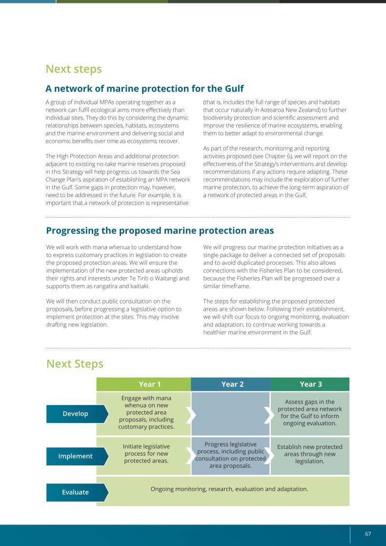
67
Next steps
A network of marine protection for the Gulf A group of individual MPAs operating together as a network can fulfil ecological aims more effectively than individual sites. They do this by considering the dynamic relationships between species, habitats, ecosystems and the marine environment and delivering social and economic benefits over time as ecosystems recover.
The High Protection Areas and additional protection adjacent to existing no-take marine reserves proposed in this Strategy will help progress us towards the Sea Change Plan’s aspiration of establishing an MPA network in the Gulf. Some gaps in protection may, however, need to be addressed in the future. For example, it is important that a network of protection is representative
Progressing the proposed marine protection areasWe will work with mana whenua to understand how to express customary practices in legislation to create the proposed protection areas. We will ensure the implementation of the new protected areas upholds their rights and interests under Te Tiriti o Waitangi and supports them as rangatira and kaitiaki.
We will then conduct public consultation on the proposals, before progressing a legislative option to implement protection at the sites. This may involve drafting new legislation.
We will progress our marine protection initiatives as a single package to deliver a connected set of proposals and to avoid duplicated processes. This also allows connections with the Fisheries Plan to be considered, because the Fisheries Plan will be progressed over a similar timeframe.
The steps for establishing the proposed protected areas are shown below. Following their establishment, we will shift our focus to ongoing monitoring, evaluation and adaptation, to continue working towards a healthier marine environment in the Gulf.
(that is, includes the full range of species and habitats that occur naturally in Aotearoa New Zealand) to further biodiversity protection and scientific assessment and improve the resilience of marine ecosystems, enabling them to better adapt to environmental change.
As part of the research, monitoring and reporting activities proposed (see Chapter 6), we will report on the effectiveness of the Strategy’s interventions and develop recommendations if any actions require adapting. These recommendations may include the exploration of further marine protection, to achieve the long-term aspiration of a network of protected areas in the Gulf.
Next Steps
Year 1 Year 2 Year 3
Engage with mana whenua on new protected area
proposals, including customary practices.
Initiate legislative process for new protected areas.
Ongoing monitoring, research, evaluation and adaptation.
Assess gaps in the protected area network for the Gulf to inform ongoing evaluation.
Establish new protected areas through new
legislation.
Progress legislative process, including public
consultation on protected area proposals.
Develop
Implement
Evaluate
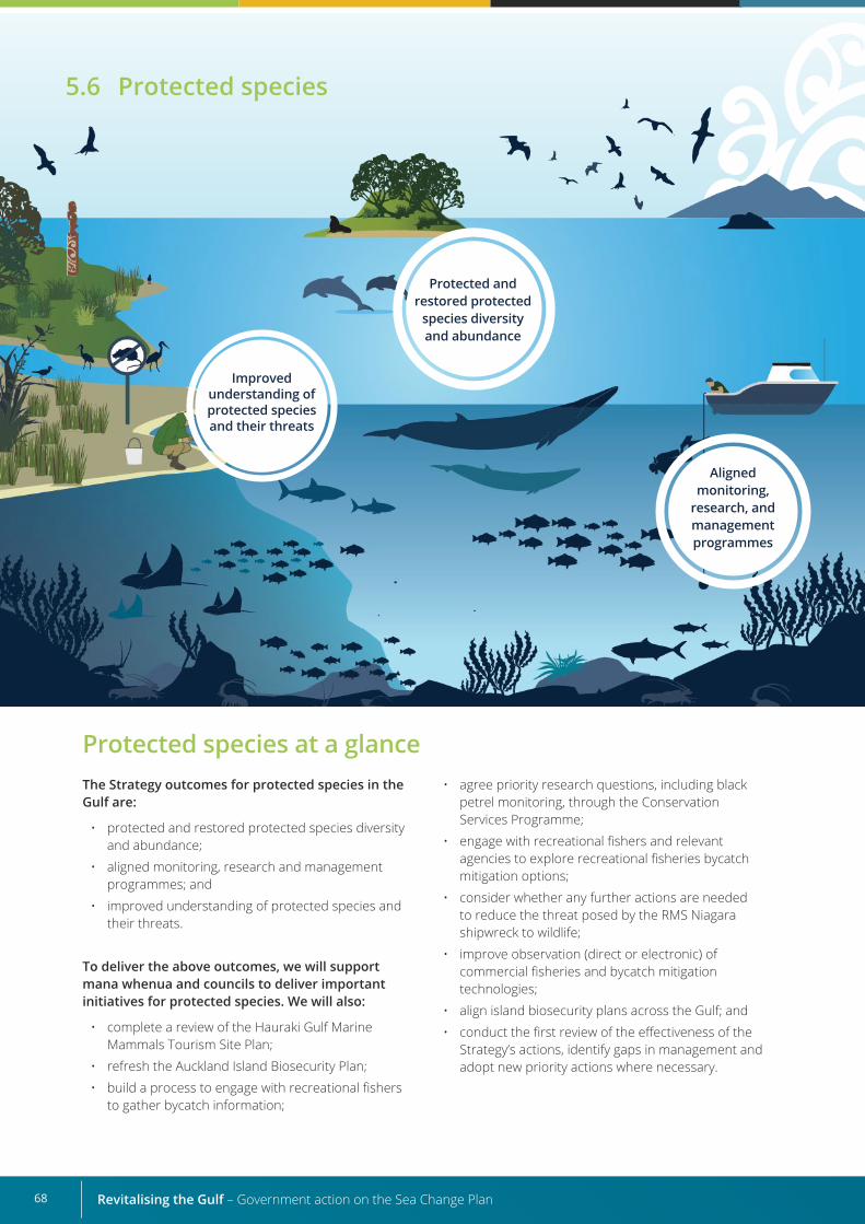
Revitalising the Gulf – Government action on the Sea Change Plan68
Protected species at a glanceThe Strategy outcomes for protected species in the Gulf are:
• protected and restored protected species diversity and abundance;
• aligned monitoring, research and management programmes; and
• improved understanding of protected species and their threats.
To deliver the above outcomes, we will support mana whenua and councils to deliver important initiatives for protected species. We will also:
• complete a review of the Hauraki Gulf Marine Mammals Tourism Site Plan;
• refresh the Auckland Island Biosecurity Plan;
• build a process to engage with recreational fishers to gather bycatch information;
• agree priority research questions, including black petrel monitoring, through the Conservation Services Programme;
• engage with recreational fishers and relevant agencies to explore recreational fisheries bycatch mitigation options;
• consider whether any further actions are needed to reduce the threat posed by the RMS Niagara shipwreck to wildlife;
• improve observation (direct or electronic) of commercial fisheries and bycatch mitigation technologies;
• align island biosecurity plans across the Gulf; and
• conduct the first review of the effectiveness of the Strategy’s actions, identify gaps in management and adopt new priority actions where necessary.
5.6 Protected species
Protected and restored protected
species diversity and abundance
Aligned monitoring,
research, and management programmes
Improved understanding of protected species and their threats
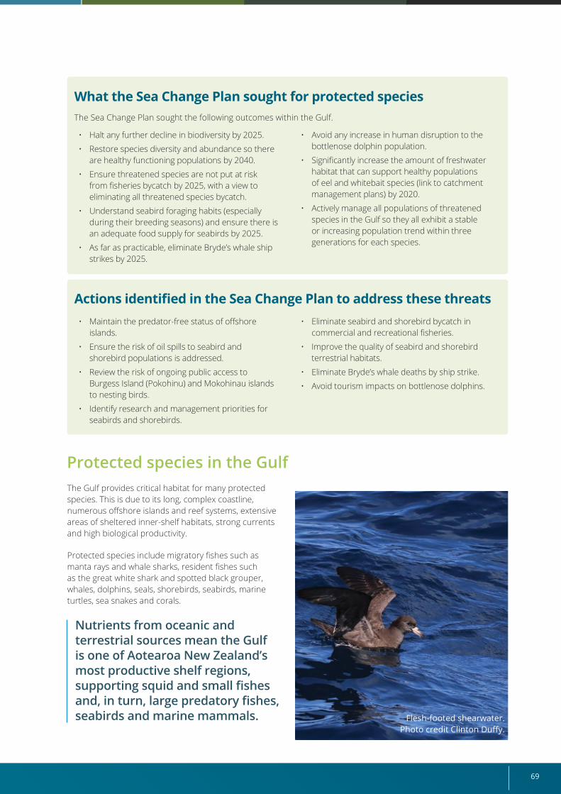
69
What the Sea Change Plan sought for protected speciesThe Sea Change Plan sought the following outcomes within the Gulf.
Actions identified in the Sea Change Plan to address these threats
Protected species in the Gulf The Gulf provides critical habitat for many protected species. This is due to its long, complex coastline, numerous offshore islands and reef systems, extensive areas of sheltered inner-shelf habitats, strong currents and high biological productivity.
Protected species include migratory fishes such as manta rays and whale sharks, resident fishes such as the great white shark and spotted black grouper, whales, dolphins, seals, shorebirds, seabirds, marine turtles, sea snakes and corals.
Nutrients from oceanic and terrestrial sources mean the Gulf is one of Aotearoa New Zealand’s most productive shelf regions, supporting squid and small fishes and, in turn, large predatory fishes, seabirds and marine mammals. Flesh-footed shearwater.
Photo credit Clinton Duffy.
• Halt any further decline in biodiversity by 2025.
• Restore species diversity and abundance so there are healthy functioning populations by 2040.
• Ensure threatened species are not put at risk from fisheries bycatch by 2025, with a view to eliminating all threatened species bycatch.
• Understand seabird foraging habits (especially during their breeding seasons) and ensure there is an adequate food supply for seabirds by 2025.
• As far as practicable, eliminate Bryde’s whale ship strikes by 2025.
• Maintain the predator-free status of offshore islands.
• Ensure the risk of oil spills to seabird and shorebird populations is addressed.
• Review the risk of ongoing public access to Burgess Island (Pokohinu) and Mokohinau islands to nesting birds.
• Identify research and management priorities for seabirds and shorebirds.
• Avoid any increase in human disruption to the bottlenose dolphin population.
• Significantly increase the amount of freshwater habitat that can support healthy populations of eel and whitebait species (link to catchment management plans) by 2020.
• Actively manage all populations of threatened species in the Gulf so they all exhibit a stable or increasing population trend within three generations for each species.
• Eliminate seabird and shorebird bycatch in commercial and recreational fisheries.
• Improve the quality of seabird and shorebird terrestrial habitats.
• Eliminate Bryde’s whale deaths by ship strike.
• Avoid tourism impacts on bottlenose dolphins.
Revitalising the Gulf – Government action on the Sea Change Plan70
Strategy’s proposals for protected species The Strategy’s outcomes for protected species in the Gulf are:
• protected and restored protected species diversity and abundance;
• aligned monitoring, research and management programmes; and
• improved understanding of protected species and their threats.
To achieve these outcomes, we will:
• complete a review of the Hauraki Gulf Marine Mammals Tourism Site Plan;
• refresh the Auckland Island Biosecurity Plan;
• build a process to engage with recreational fishers to gather bycatch information;
• agree priority research questions, including black petrel monitoring, through the Conservation Services Programme;
• engage with recreational fishers and relevant agencies to explore recreational fisheries bycatch mitigation options;
• consider whether any further actions are needed to reduce the threat posed by the RMS Niagara to wildlife;
• improve observation (direct or electronic) of commercial fisheries and bycatch mitigation technologies;
• align island biosecurity plans across the Gulf; and
• conduct the first review of the effectiveness of this Strategy’s actions, identify gaps in management and adopt new priority actions where necessary.
We cannot do this alone. Protected species programmes span mana whenua, local and central government, NGOs, industry and local communities.
We assessed the important work being carried out by others to restore protected species, to understand which protected species proposals in the Sea Change Plan need prioritising. Where gaps were evident, we have identified actions that can be progressed through this Strategy.
A high-level summary of our assessment and resulting recommendations is provided below, and related actions can be found in Section 5.1 “Fisheries management”, Section 5.5 “Marine protection” and Chapter 6 “Research, monitoring and reporting”. Further detail is available in the technical report Management and research of marine protected species in the Hauraki Gulf Marine park: An overview and gaps analysis (DOC and FNZ, 2021c).
Mana whenua and their connection to wildlifeMana whenua have a deep connection with the indigenous wildlife of the Gulf. Ongoing access to these taonga connects mana whenua to whakapapa, places and historical events and is necessary to maintain mana, culture and mātauranga.
Access to these taonga is guaranteed by Te Tiriti o Waitangi and is provided for in protected species
legislation, the Conservation Act 1987 and DOC’s Conservation General Policy.
To ensure this continues, DOC and MPI/FNZ will engage with mana whenua to support cultural connections to place, whakapapa, tikanga and mātauranga as it implements actions for protected species.
Threats to most of these species are well documented. They include terrestrial run-off, habitat loss, disease, disruptions to food webs caused by fishing and other human activities, chronic disturbance, incidental
mortality in commercial and recreational fisheries, and global climate change. Seabirds and shorebirds are also threatened by introduced mammalian predators and light pollution.
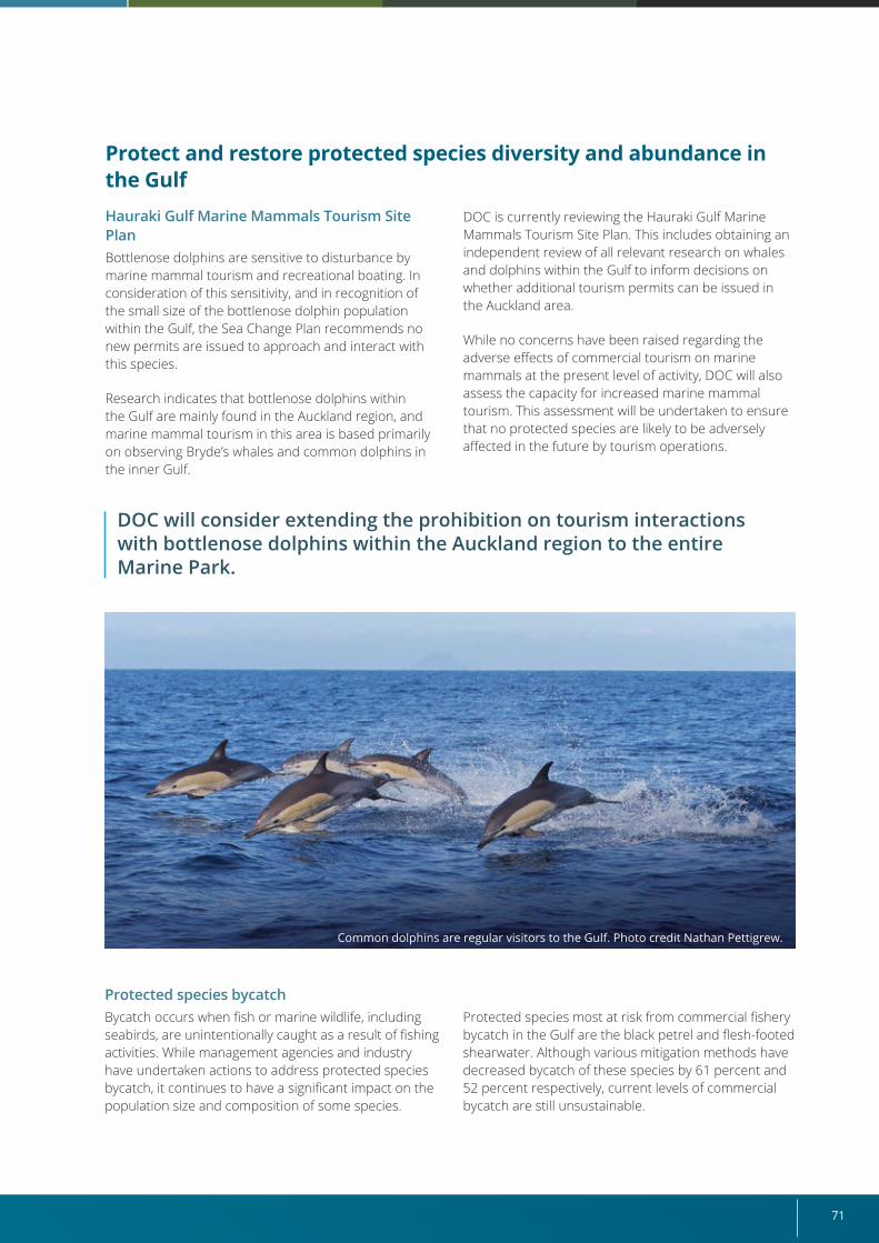
71
Protect and restore protected species diversity and abundance in the GulfHauraki Gulf Marine Mammals Tourism Site PlanBottlenose dolphins are sensitive to disturbance by marine mammal tourism and recreational boating. In consideration of this sensitivity, and in recognition of the small size of the bottlenose dolphin population within the Gulf, the Sea Change Plan recommends no new permits are issued to approach and interact with this species.
Research indicates that bottlenose dolphins within the Gulf are mainly found in the Auckland region, and marine mammal tourism in this area is based primarily on observing Bryde’s whales and common dolphins in the inner Gulf.
DOC is currently reviewing the Hauraki Gulf Marine Mammals Tourism Site Plan. This includes obtaining an independent review of all relevant research on whales and dolphins within the Gulf to inform decisions on whether additional tourism permits can be issued in the Auckland area.
While no concerns have been raised regarding the adverse effects of commercial tourism on marine mammals at the present level of activity, DOC will also assess the capacity for increased marine mammal tourism. This assessment will be undertaken to ensure that no protected species are likely to be adversely affected in the future by tourism operations.
Common dolphins are regular visitors to the Gulf. Photo credit Nathan Pettigrew.
DOC will consider extending the prohibition on tourism interactions with bottlenose dolphins within the Auckland region to the entire Marine Park.
Protected species bycatchBycatch occurs when fish or marine wildlife, including seabirds, are unintentionally caught as a result of fishing activities. While management agencies and industry have undertaken actions to address protected species bycatch, it continues to have a significant impact on the population size and composition of some species.
Protected species most at risk from commercial fishery bycatch in the Gulf are the black petrel and flesh-footed shearwater. Although various mitigation methods have decreased bycatch of these species by 61 percent and 52 percent respectively, current levels of commercial bycatch are still unsustainable.
Revitalising the Gulf – Government action on the Sea Change Plan72
To address the effects of seabird bycatch from fishing, the draft Hauraki Gulf Fisheries Plan (Appendix 2) proposes management actions that build on measures currently being implemented by the fishing sector. These actions include:
• improving the observation (either direct or electronic) of commercial fisheries to further estimate and track trends in protected species bycatch;
• strengthening our responses to reports of protected species captures;
• supporting the improvement and uptake of seabird mitigation measures; and
• implementing a programme to better estimate seabird bycatch in the recreational fishing sector.
The proposed High Protection Areas outlined in Section 5.5 “Marine protection” will also provide sites for important shorebirds and seabirds to feed without the risk of bycatch.
The National Plan of Action for Seabirds (NPOA) was reviewed and updated in May 2020 (FNZ, 2020). The NPOA works to limit or reduce the impacts of commercial fishing on seabirds at a national scale and is supported by an action-based seabird implementation plan to deliver important initiatives between 2020 and 2025.
Improved understanding of protected species and their threats
Large whale mortality and necropsy
Bryde’s whales are a regular and much-loved sight in the Gulf. However, research by the University of Auckland concluded that the mortality rate of Bryde’s whales was unsustainable (Constantine et al, 2015).
Up until recently, several Bryde’s whales were killed by ship strike every year.
In response, the Hauraki Gulf Transit Protocol was implemented in 2015 to reduce vessel speeds in the approaches to Auckland Harbour and, since this time, no Bryde’s whale deaths have been confirmed due to ship strike. To monitor the effectiveness of this protocol, pathologists need to perform internal examinations (necropsies) of all whales found dead in the Gulf, because the cause of death in whales is not always evident externally (even when resulting from traumatic injury). This allows clear identification of those animals that died due to ship strike as opposed to other causes, such as disease or ingestion of plastics.
We will continue to support and facilitate research by permitted researchers on marine mammals found dead within the Gulf, particularly any large whales exhibiting evidence of potential ship strike.
Highlighting priority research on protected species in the Gulf
We have identified various research and monitoring needs to improve our understanding of protected marine species in the Gulf, their threats and the effectiveness of our interventions. These will be captured in the Strategy’s Monitoring and Reporting Framework (Chapter 6).
Any new research and monitoring initiatives also need to consider the ecosystem effects of changes in the distribution, behaviour and abundance of a protected species, as well as changes in the food webs of which they are a component. This will enhance our understanding of the waiora of the Gulf ecosystem as a whole.
We will also explore options to reduce the effects of recreational fishing on seabird bycatch through the Hauraki Gulf Fisheries Plan and the NPOA. We will do this by supporting research into these impacts and promoting responsible fishing practices, including the refinement, improvement and uptake of bycatch mitigation measures.
We will develop a process to engage with recreational fishers to build bycatch information-gathering channels, and through this process, work with recreational fishers and relevant agencies to explore recreational fisheries bycatch mitigation options.
We will continue the Government’s bycatch programme, including the Conservation Services Programme that investigates ways to limit bycatch, and invests in new bycatch mitigation technologies and fishing practices.
Restoration of seabird and shorebird terrestrial habitatOpportunities for marine restoration in the Gulf are explored in Section 5.2 “Active habitat restoration”, where we propose developing a habitat restoration guidance framework that will identify priority habitats for restoration and the practical tools available to do so.
73
Through the Conservation Services Programme, we will review research conducted to date on the influence of surface-feeding fishes on seabird foraging. We will also progress work with mana whenua, researchers and councils to develop the protected species elements of the Strategy’s Research Plan. This will highlight priority research across corals, marine fishes, seabirds and shorebirds (including improved data on bycatch), and marine mammals (Chapter 6). Priority research for protected species may include:
• the influence of long-term trends in pelagic primary and secondary productivity on the behaviour, distribution and reproductive success of seabirds and cetaceans inhabiting the Gulf;
• the biology and ecology of bait fishes (particularly anchovy, pilchard, sprats and mullet);
• the terrestrial habitats of shorebirds and seabirds (for example, burrow-nesting seabirds, such as
petrels, shearwaters and little penguins) and improving our understanding of these habitats, including whether changes in vegetation at breeding sites are adversely affecting shorebird species;
• the effects of suspended sediments on foraging behaviour;
• the species of corals that occur within the Gulf;
• the distribution, movement and abundance of protected fishes within the Gulf; and
• the establishment of population trends of seabirds and shorebirds, and sustainable levels of harvest.
Further details on the assessment of research under way, and opportunities identified, can be found in the technical report that supports this Strategy (DOC and FNZ, 2021b).
Aligned monitoring, research and management programmes
The northeast of the North Island, including the Gulf, is a nationally and internationally significant hotspot for seabird biodiversity.
Around 20 percent of the world’s seabird species have been recorded in the wider Gulf, and almost a third of Aotearoa New Zealand’s seabirds breed there.
Many of the Gulf’s smaller estuaries, harbours and beaches provide critical habitat for endemic species, such as the New Zealand fairy tern, northern New Zealand dotterel and New Zealand shore plover. The Firth of Thames Ramsar site is particularly special because it provides critical foraging and roosting habitat for up to 25,000 wading birds at any time, many of which migrate there each year from the northern hemisphere (DOC, no date(b)).
Several agencies have statutory responsibilities in the Gulf, so it is important for protected species programmes to align with and support strategic interventions. We will work with Auckland Council, Waikato Regional Council and other agencies to align our management, monitoring and research work.
Aligned biosecurity plans
Pest control and island biosecurity within the Gulf are major focal areas for DOC, Auckland Council and Waikato Regional Council, to preserve the connectivity of island refuges and in recognition of the global significance of these refuges to seabirds.
The Strategy action to draft an Auckland Island Biosecurity Plan to mitigate terrestrial biosecurity threats on these islands will support protection of a number of burrow nesting seabirds.
The Auckland Unitary Plan and the Waikato Regional Coastal Plan provide high levels of protection to important large areas for wading and wetland birds, including the Firth of Thames Ramsar site.
Pest control on mainland sites within the Gulf includes supporting predator control around nesting areas of the most threatened species of shorebirds, such as the New Zealand fairy tern, through the recovery programme at Mangawhai Estuary, Waipu Cove and Pakiri.
The Predator Free 2050 strategy (DOC, 2020) to eliminate mammalian pests across the country, and DOC’s regional conservation management strategies and councils’ pest management strategies also include goals and actions to achieve this. We will align existing plans across agencies and groups to ensure our actions are most effective.
Revitalising the Gulf – Government action on the Sea Change Plan74
Connections with other elements of this StrategyWe have identified the following initiatives that align with our work to protect and restore protected species.
• Fisheries management (Section 5.1): Protected species likely to benefit from a reduction of bottom trawling in the Gulf include great white sharks and turtles, which are occasionally taken as bycatch, and several species of seabirds, which are occasionally killed by warp strike. All protected species are expected to benefit either directly or indirectly from the restoration of fish stocks. The management actions to reduce bycatch and fishing-related deaths of non-fish and protected species in the draft Fisheries Plan will directly contribute to the protection of protected species.
Adaptive management – regular review of actions for protected species
We have prioritised the actions we will progress in the next three years. As part of our monitoring and reporting programme, we will review the effectiveness of actions under way and identify any further actions required.
Possible future research and actions for protected species could include:
• prioritising work in areas that provide critical nesting habitats for regionally endemic or culturally significant seabird species, including assessing the risks posed to seabirds by ongoing public access to Burgess Island (Pokohinu) and Mokohinau Islands;
• completing site-based assessments of the risk posed by sea level rise to significant shorebird habitats on public conservation land within the Gulf, particularly the Firth of Thames Ramsar site, including identifying risks posed by adjacent land use and assessing possible mitigation measures (Tait, 2019);
• engaging with mana whenua to discuss aspirations they may have for a co-management programme aimed at re-establishing the sustainable customary harvest of ōi (grey-faced petrel); and
• reviewing the actions needed to manage the risks posed by oil spills to seabirds and shorebirds (see below).
Managing risks posed by oil spills to seabirds and shorebirds
Aotearoa New Zealand’s oil spill response is managed by Maritime New Zealand through a tiered system
(based on international agreements and standards) of contingency planning, risk assessment, training and response capabilities. Oil spill risk assessments include modelling oil spill trajectories and identifying natural resources, including protected wildlife, that may be affected by them (Maritime New Zealand, no date).
The wreck of the 13,415-ton RMS Niagara poses a potential oil spill risk with consequences that could adversely affect the marine life of the Gulf. The vessel was sunk by two German mines on 19 June 1940 and lies at 110–120 metres depth inside the cable protection zone between the Mokohinau and Hen and Chicken islands. Large oil spills were reported at the time of the sinking and shortly after during operations to salvage gold carried as cargo. More recent reports indicate that the vessel frequently leaks very small quantities of oil with no apparent environmental impacts. The current state of the vessel is poor, and it is not known what quantity of oil may remain in the vessel or where that oil is now located. In response to advice that the wreck is deteriorating, the Sea Change Plan recommends an urgent assessment of the risk to seabird and shorebird populations. Since then, a costing for undertaking such an assessment (detailed underwater survey, expert risk assessment of the wreck condition and environmental impact assessment), and an associated budget bid, has been completed. However, fiscal constraints arising from the COVID-19 pandemic deferred progress on this. During the first major review and adaptation of the Strategy’s actions, the Cross-Agency Implementation Group will consider what further actions are needed to reduce the threat posed by the RMS Niagara shipwreck to wildlife.
• Active habitat restoration (Section 5.2): Restored habitats may be used by protected species. Actions relating to the Sea Change Plan’s objective to increase the amount of habitat for diadromous freshwater fishes are discussed in Section 5.2, because these are not protected species.
• Aquaculture (Section 5.3): Entities can use best practice to reduce impacts on protected species.
• Marine protection (Section 5.5): The protection of ecologically important habitats is likely to directly benefit protected corals, particularly fragile species such as black corals (antipatharians) and sea fans (gorgonians). The proposed protected areas around Te Hauturu-o-Toi / Little Barrier Island and the Mokohinau and Aldermen islands are known or likely to contain populations of these species.
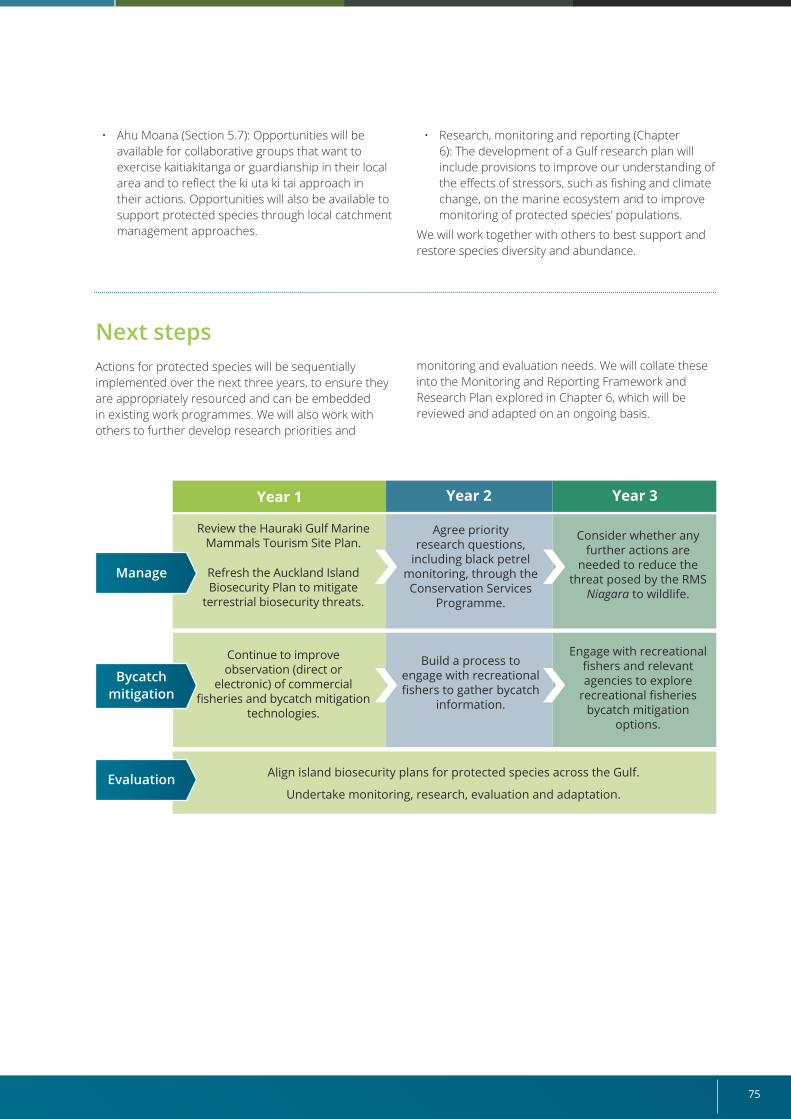
75
• Ahu Moana (Section 5.7): Opportunities will be available for collaborative groups that want to exercise kaitiakitanga or guardianship in their local area and to reflect the ki uta ki tai approach in their actions. Opportunities will also be available to support protected species through local catchment management approaches.
• Research, monitoring and reporting (Chapter 6): The development of a Gulf research plan will include provisions to improve our understanding of the effects of stressors, such as fishing and climate change, on the marine ecosystem and to improve monitoring of protected species’ populations.
We will work together with others to best support and restore species diversity and abundance.
Next stepsActions for protected species will be sequentially implemented over the next three years, to ensure they are appropriately resourced and can be embedded in existing work programmes. We will also work with others to further develop research priorities and
Year 1 Year 2 Year 3
Review the Hauraki Gulf Marine Mammals Tourism Site Plan.
Refresh the Auckland Island Biosecurity Plan to mitigate
terrestrial biosecurity threats.
Align island biosecurity plans for protected species across the Gulf.
Undertake monitoring, research, evaluation and adaptation.
Continue to improve observation (direct or
electronic) of commercial fisheries and bycatch mitigation
technologies.
Agree priority research questions,
including black petrel monitoring, through the Conservation Services
Programme.
Build a process to engage with recreational fishers to gather bycatch
information.
Consider whether any further actions are
needed to reduce the threat posed by the RMS
Niagara to wildlife.
Engage with recreational fishers and relevant agencies to explore
recreational fisheries bycatch mitigation
options.
Manage
Evaluation
Bycatch mitigation
monitoring and evaluation needs. We will collate these into the Monitoring and Reporting Framework and Research Plan explored in Chapter 6, which will be reviewed and adapted on an ongoing basis.
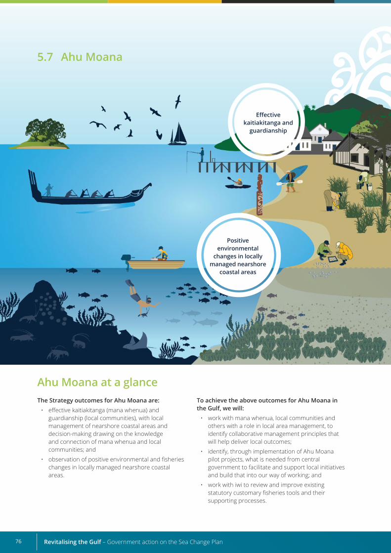
Revitalising the Gulf – Government action on the Sea Change Plan76
Ahu Moana at a glanceThe Strategy outcomes for Ahu Moana are:
• effective kaitiakitanga (mana whenua) and guardianship (local communities), with local management of nearshore coastal areas and decision-making drawing on the knowledge and connection of mana whenua and local communities; and
• observation of positive environmental and fisheries changes in locally managed nearshore coastal areas.
To achieve the above outcomes for Ahu Moana in the Gulf, we will:
• work with mana whenua, local communities and others with a role in local area management, to identify collaborative management principles that will help deliver local outcomes;
• identify, through implementation of Ahu Moana pilot projects, what is needed from central government to facilitate and support local initiatives and build that into our way of working; and
• work with iwi to review and improve existing statutory customary fisheries tools and their supporting processes.
Positive environmental
changes in locally managed nearshore
coastal areas
Effective kaitiakitanga and
guardianship
5.7 Ahu Moana
77
What the Sea Change Plan sought for Ahu Moana
Ahu Moana in the Gulf
Strategy’s proposals for Ahu Moana
Ahu Moana is based on four main pillars: people, place, knowledge and action. It brings together mana whenua and the local community and uses their combined knowledge and skills to deliver shared goals in their local fisheries and environments.
For Ahu Moana initiatives to have enduring strength, they need to be formed independently of the Government and based on joint mana whenua and local community goals for the local area.
The formation of Ahu Moana projects in coastal areas in the Gulf would allow local communities to be involved in coastal management, help mana whenua fulfil their ancestral kaitiaki obligations, and recognise their historical, traditional, cultural and spiritual relationship to the area.
We want to support collaborative management approaches between mana whenua and local communities to restore and improve coastal fisheries and environments in their local nearshore areas.
The Strategy’s social and environmental outcomes for Ahu Moana are:
• effective kaitiakitanga (mana whenua) and guardianship (local communities), with local management of nearshore coastal areas and decision-making drawing on the knowledge and connection of mana whenua and local communities; and
• observation of positive environmental and fisheries changes in locally managed nearshore coastal areas.
The bringing together of mātauranga Māori and local knowledge, including that of recreational and small commercial fishers, alongside scientific data, would provide responsive and adaptive management and strengthen iwi and hapū relationships with local communities in their shared spaces.
"Ahu Moana could be a concept to enable sustainable delivery of community aspirations – identifying how you can help with gaps.” Engagement feedback
To achieve these outcomes, we will:
• work with mana whenua, local communities and others with a role in local area management, to identify collaborative management principles that will help deliver local outcomes;
• identify, through implementation of Ahu Moana pilot projects, what is needed from central government to facilitate and support local initiatives and build that into our way of working; and
• work with iwi to review and improve existing statutory customary fisheries tools and their supporting processes.
The Sea Change Plan proposes that Ahu Moana coastal areas are identified for co-management by mana whenua and local communities, with the intention they will extend along the length of the Gulf
and its islands. It identifies principles to apply to Ahu Moana and recognises it will take time to find the best ways to implement this approach.
Revitalising the Gulf – Government action on the Sea Change Plan78
Ahu Moana framework
Through our targeted engagement on this Strategy, we heard that mana whenua and local communities want to take responsibility for and be part of strategic projects that lead to positive environmental change.
“The importance of iwi and community partnership is critical. Locals need to take responsibility.” Engagement feedback
Feedback to date indicates that many examples exist of mana whenua and local communities working together, and several opportunities are available where an Ahu Moana approach could be progressed. These initiatives need to be locally driven from the bottom up. They will help identify how and where central and local government can provide valuable support for local initiatives.
We will provide DOC and MPI/FNZ with support to facilitate the implementation of Ahu Moana pilot projects. These projects will follow mana whenua and local communities as they work together to deliver their shared fisheries and/or conservation objectives in their nearshore coastal areas. Mana whenua and local community groups leading the pilot projects will consider what governance arrangements (if any) and what actions are needed to deliver their shared goals. Because areas of interest overlap for many iwi in the Gulf, ensuring those with mana moana (customary authority over the sea and lakes) and mana whenua support the Ahu Moana projects will also be critical.
The pilot projects will test collaborative approaches and identify ways of working that will inform the development of an Ahu Moana framework to streamline future Ahu Moana initiatives. This framework will be developed using an adaptive management approach. It will focus on learning and adapting as initiatives move through the planning, doing, evaluating and learning, and adjusting cycle.
“... this could give us an ability to go to the right place and people to deal with and expedite action.” Engagement feedback
The Ahu Moana pilot projects will be undertaken with mana whenua and local community collaborations that have already defined the outcomes they want for their local nearshore coastal areas and for whom Ahu Moana is an appropriate approach.
Engagement with mana whenua and local communities has helped identify candidate areas for the first two pilot projects: Te Māta and Waipatukahu and Great Barrier Island (Aotea Island). We will continue discussions with mana whenua and local communities and, with their support, progress these projects. We will also continue to engage with mana whenua and local communities to define what Ahu Moana means for them and what action would look like (or they would like to take) in their area.
We expect these preliminary pilot projects to focus on nearshore coastal areas, for example, the restoration of a locally accessed shellfish bed in an area of importance to both parties. Their scale, however, will ultimately depend on the mana whenua and local community.
Existing regulatory tools and frameworks will support implementation of the pilots, retaining the Minister for Oceans and Fisheries responsibilities for providing for the utilisation of fisheries resources while ensuring sustainability.
In addition to pilot projects, case studies can also be used to test ideas, assess what works and identify opportunities to improve how things are done. Several examples of local, place-based collaborations that would be suitable for this have already been identified.
In the future, we will identify and progress initiatives based on the readiness of mana whenua and local communities, DOC and MPI/FNZ resourcing requirements, and connections to work under way through other initiatives, including those already being delivered with councils. The proposed structure for identifying and progressing Ahu Moana initiatives is described in Figure 9.
Initiatives within the mandates of the Minister of Conservation and Minister for Oceans and Fisheries will be prioritised for DOC and MPI/FNZ support, for example, those seeking to improve local area fisheries or conserve local marine biodiversity. We also recognise that mana whenua and the local community may want to address broader issues that cross over with the responsibilities of other agencies. An example is the management of sedimentation of shellfish beds through improved catchment management, an issue that sits within the remit of councils. We will continue to work with councils, to make connections to progress an ecosystem-based approach to management in the Gulf.
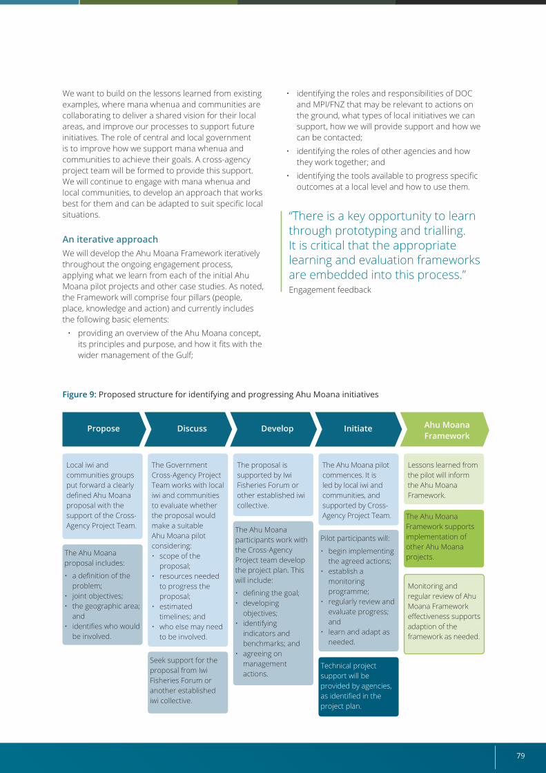
79
Figure 9: Proposed structure for identifying and progressing Ahu Moana initiatives
The Ahu Moana proposal includes:
• a definition of the problem;
• joint objectives;• the geographic area;
and • identifies who would
be involved.
The Ahu Moana participants work with the Cross-Agency Project team develop the project plan. This will include:
• defining the goal;• developing
objectives;• identifying
indicators and benchmarks; and
• agreeing on management actions.
Pilot participants will:
• begin implementing the agreed actions;
• establish a monitoring programme;
• regularly review and evaluate progress; and
• learn and adapt as needed.
Technical project support will be provided by agencies, as identified in the project plan.
The Ahu Moana Framework supports implementation of other Ahu Moana projects.
Seek support for the proposal from Iwi Fisheries Forum or another established iwi collective.
Local iwi and communities groups put forward a clearly defined Ahu Moana proposal with the support of the Cross-Agency Project Team.
The proposal is supported by Iwi Fisheries Forum or other established iwi collective.
The Ahu Moana pilot commences. It is led by local iwi and communities, and supported by Cross-Agency Project Team.
Lessons learned from the pilot will inform the Ahu Moana Framework.
Monitoring and regular review of Ahu Moana Framework effectiveness supports adaption of the framework as needed.
The Government Cross-Agency Project Team works with local iwi and communities to evaluate whether the proposal would make a suitable Ahu Moana pilot considering:• scope of the
proposal;• resources needed
to progress the proposal;
• estimated timelines; and
• who else may need to be involved.
We want to build on the lessons learned from existing examples, where mana whenua and communities are collaborating to deliver a shared vision for their local areas, and improve our processes to support future initiatives. The role of central and local government is to improve how we support mana whenua and communities to achieve their goals. A cross-agency project team will be formed to provide this support. We will continue to engage with mana whenua and local communities, to develop an approach that works best for them and can be adapted to suit specific local situations.
An iterative approach We will develop the Ahu Moana Framework iteratively throughout the ongoing engagement process, applying what we learn from each of the initial Ahu Moana pilot projects and other case studies. As noted, the Framework will comprise four pillars (people, place, knowledge and action) and currently includes the following basic elements:
• providing an overview of the Ahu Moana concept, its principles and purpose, and how it fits with the wider management of the Gulf;
• identifying the roles and responsibilities of DOC and MPI/FNZ that may be relevant to actions on the ground, what types of local initiatives we can support, how we will provide support and how we can be contacted;
• identifying the roles of other agencies and how they work together; and
• identifying the tools available to progress specific outcomes at a local level and how to use them.
“There is a key opportunity to learn through prototyping and trialling. It is critical that the appropriate learning and evaluation frameworks are embedded into this process.” Engagement feedback
Propose DevelopDiscuss Initiate Ahu Moana Framework
Revitalising the Gulf – Government action on the Sea Change Plan80
29 Refer to the Glossary for explanations of mātaitai and taiāpure reserves.
Improving existing processesExisting planning, statutory and legislative tools and processes may be used to achieve mana whenua and local community goals, such as those under the Fisheries Act 1996 (for example, mātaitai reserves, taiāpure reserves and temporary closures)29 and the Marine Reserves Act 1971.
During our Strategy engagement, we repeatedly heard that efforts must focus on improving the implementation of existing tools, recognising that both iwi and the Government have limited capacity and resources, and consultation processes can be lengthy. Our aim is to make these tools work more effectively in delivering the outcomes mana whenua and communities are seeking in their local areas.
The main challenge with using existing customary fisheries approaches to address local issues is the timelines and processes required by legislation, which can result in implementation taking months or even years. We will work with mana whenua and stakeholders to build on our existing understanding of where these and other processes need to be improved so we can consider options for improvement, including legislative review, where necessary. Tailoring legal provisions, potentially through existing statutes, to recognise Ahu Moana groups may also be considered.
We expect any agreed improvements to deliver a readily accessible toolkit for collaborative management projects, so future Ahu Moana initiatives no longer experience the frustrations associated with use of the existing tools.
Identifying further actionsWe will use the Ahu Moana pilot projects to explore whether any further actions are necessary and feasible to implement mana whenua and local community goals, in addition to reforming existing tools. The nature of any further actions will depend on the issue that needs to be addressed.
ResourcesWe will allocate resources from DOC and MPI/FNZ to support the delivery of the Ahu Moana pilot projects, develop the Framework and review existing processes. The Ahu Moana initiative also aligns and is compatible with work being undertaken by Auckland Council and Waikato Regional Council, both of which recognise the value of the initiative.
Resources will include a dedicated project team to support the Ahu Moana pilot projects, relevant subject matter experts (for example, in science, research, education, communications and compliance) and policy staff to review legislative processes and tools.
Financial support will be considered during the planning and defining periods of the initial Ahu Moana initiatives with mana whenua and local communities.
Evaluating the Framework Following completion of the Ahu Moana pilot projects, we will evaluate the Ahu Moana Framework’s effectiveness in supporting mana whenua and local communities to achieve their shared goals for their nearshore coastal areas. We will consider whether provisions for such local area management need to be strengthened and will assess the most appropriate and workable options to achieve this.
The way we evaluate the success of the actions for the initial Ahu Moana initiatives will be defined at the inception of the projects. Measures of success will be evidence based, use mātauranga and accommodate the values of the mana whenua and local community (Table 3). In addition, the Ahu Moana initiatives should encourage mana whenua and local community participation in the collection, storage and transfer of local knowledge.
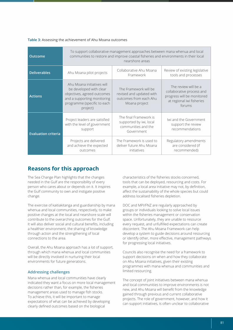
81
OutcomeTo support collaborative management approaches between mana whenua and local communities to restore and improve coastal fisheries and environments in their local
nearshore areas
Deliverables Ahu Moana pilot projects Collaborative Ahu Moana
FrameworkReview of existing legislative
tools and processes
Actions
Ahu Moana initiatives will be developed with clear
objectives, agreed outcomes and a supporting monitoring programme (specific to each
project)
The Framework will be revised and updated with outcomes from each Ahu
Moana project
The review will be a collaborative process and
progress will be monitored at regional iwi fisheries
forums
Evaluation criteria
Project leaders are satisfied with the level of government
support
The final Framework is supported by iwi, local communities and the
Government
Iwi and the Government support the review recommendations
Projects are delivered and achieve the expected
outcomes
The Framework is used to deliver future Ahu Moana
initiatives
Regulatory amendments are considered (if recommended)
Table 3: Assessing the achievement of Ahu Moana outcomes
Reasons for this approachThe Sea Change Plan highlights that the changes needed in the Gulf are the responsibility of every person who cares about or depends on it. It inspires the Gulf community to own and instigate positive change.
The exercise of kaitiakitanga and guardianship by mana whenua and local communities, respectively, to make positive changes at the local and nearshore scale will contribute to the overarching outcomes for the Gulf. It will also deliver social and cultural benefits, including a healthier environment, the sharing of knowledge through action and the strengthening of local connections to the area.
Overall, the Ahu Moana approach has a lot of support, through which mana whenua and local communities will be directly involved in nurturing their local environments for future generations.
Addressing challengesMana whenua and local communities have clearly indicated they want a focus on more local management decisions rather than, for example, the fisheries management areas used to manage fish stocks. To achieve this, it will be important to manage expectations of what can be achieved by developing clearly defined outcomes based on the biological
characteristics of the fisheries stocks concerned, tools that can be deployed, resourcing and costs. For example, a local area initiative may not, by definition, affect the sustainability of the whole species but could address localised fisheries depletion.
DOC and MPI/FNZ are regularly approached by groups or individuals looking to solve local issues within the fisheries management or conservation space. Unfortunately, they are unable to resource every request, and unfulfilled expectations can create discontent. The Ahu Moana Framework can help develop a system to guide decisions around resourcing or identify other, more effective, management pathways for progressing local initiatives.
Councils also recognise the need for a framework to support decisions on when and how they collaborate on Ahu Moana initiatives, given their existing programmes with mana whenua and communities and limited resourcing.
The concept of joint initiatives between mana whenua and local communities to improve environments is not new, and Ahu Moana will benefit from the knowledge gained through previous and current collaborative projects. The role of government, however, and how it can support initiatives, is often unclear to collaborative
Revitalising the Gulf – Government action on the Sea Change Plan82
Connections with other elements of this StrategyMana whenua and local communities are looking for a holistic approach to managing precious environmental resources. The Ahu Moana initiative will work alongside other aspects of this Strategy to support this aspiration while also contributing to the broader outcomes.
We have identified the following initiatives that align with our work to progress Ahu Moana in the Gulf.
• Fisheries management (Section 5.1): The Hauraki Gulf Fisheries Plan has the ability to reflect local fisheries management outcomes being sought by mana whenua and local communities.
• Active habitat restoration (Section 5.2): Ahu Moana initiatives may include objectives that align with the active habitat restoration initiatives and guidance proposed in this Strategy.
• Marine protection (Section 5.5): Ahu Moana groups may wish to contribute to what should
groups and the government agencies themselves. This Strategy proposes piloting the Ahu Moana approach to understand how the Government can better support mana whenua and communities to deliver on social and environmental aspirations for their local areas. This would build on the Ahu Moana initiative described in the Sea Change Plan while also ensuring government outcomes are delivered.
Several longstanding priority issues for mana whenua and relevant communities will be addressed by actions identified in other parts of this Strategy (for example, marine protection and fisheries management). Ahu Moana initiatives could be applied in areas where they would complement or enhance other established methods, to make effective use of limited mana whenua, community and DOC and MPI/FNZ resources.
Effective kaitiakitangaPreliminary engagement with iwi highlighted the connection they have with particular areas and their desire for effective kaitiakitanga. However, some of the existing planning, statutory and legislative arrangements, and their supporting processes, are not working effectively for some iwi. Implementing the Ahu Moana initiative will provide an opportunity to work with iwi to identify where existing legislation and processes require review to streamline the delivery of local-scale objectives, where this aligns with the purpose of the legislation.
Recognising Te Tiriti o Waitangi rights and obligationsIt is important that implementation of the Ahu Moana initiative does not undermine Treaty settlements and existing rights, including Crown commitments to the negotiation of historical claims regarding the area that includes the Gulf.
Regional iwi fisheries forums are a platform for iwi to engage directly with FNZ on issues that affect their fisheries interests. The role of iwi in iwi fisheries forums is a feature in many Treaty settlement protocols and, as a general principle, deeds of settlement provide for protocols to be legally enforceable.
The Sea Change Plan seeks to create new legislation that will devolve the joint management of Ahu Moana areas to mana whenua and local communities. This concept represents a significant aspirational opportunity so, as a next step, its practical applicability should be more fully explored with mana whenua and local communities. Development of the Ahu Moana Framework will support implementation of mana whenua and local community initiatives by improving existing processes and exploring possible further actions that are suitable and practical. Where required and appropriate, existing legal frameworks, such as those for customary fisheries that have been negotiated with mana whenua, will be used to ensure the integrity and value flowing from Treaty settlements are preserved and to recognise the Government’s obligations to Māori established through those settlements.
be monitored within High Protection Areas and Seafloor Protection Areas in the Gulf, how mātauranga Māori is incorporated into monitoring, and how customary management approaches are integrated into their management.
• Protected species (Section 5.6): Mana whenua and local communities may wish to enhance the protection of species in their local areas.
• Governance (Section 5.8): Ahu Moana pilot projects will help provide insights that will inform future governance in the Gulf.
Ahu Moana has implications that reach beyond the mandates of the Minister for Oceans and Fisheries and the Minister of Conservation. In the longer term, relationships built with other agencies (for example, councils) and bodies (for example, the Hauraki Collective) will support the holistic approach to local area management that mana whenua and local communities desire.
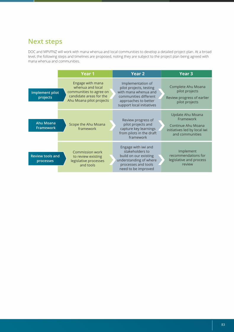
83
Next stepsDOC and MPI/FNZ will work with mana whenua and local communities to develop a detailed project plan. At a broad level, the following steps and timelines are proposed, noting they are subject to the project plan being agreed with mana whenua and communities.
Year 1 Year 2 Year 3
Engage with mana whenua and local
communities to agree on candidate areas for the
Ahu Moana pilot projects
Commission work to review existing
legislative processes and tools
Implementation of pilot projects, testing
with mana whenua and communities different approaches to better
support local initiatives
Engage with iwi and stakeholders to
build on our existing understanding of where
processes and tools need to be improved
Implement recommendations for legislative and process
review
Review progress of pilot projects and
capture key learnings from pilots in the draft
framework
Scope the Ahu Moana framework
Complete Ahu Moana pilot projects
Review progress of earlier pilot projects
Update Ahu Moana Framework
Continue Ahu Moana initiatives led by local iwi
and communities
Implement pilot projects
Ahu Moana Framework
Review tools and processes
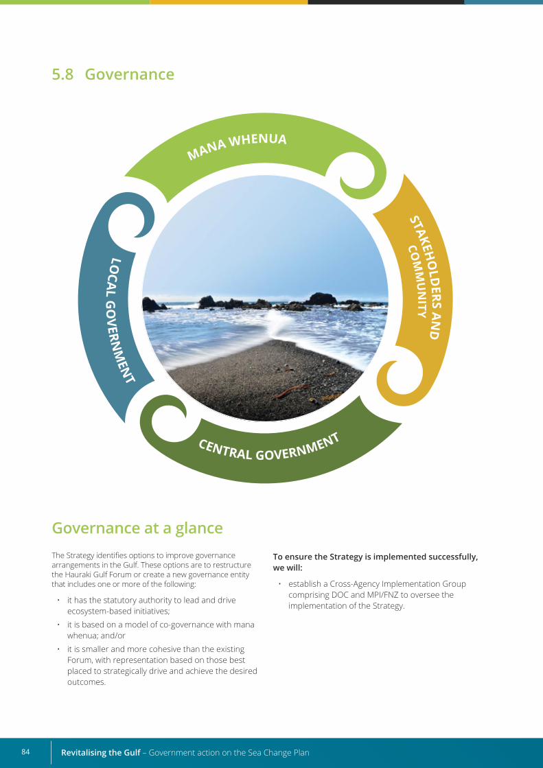
Revitalising the Gulf – Government action on the Sea Change Plan84
Governance at a glanceThe Strategy identifies options to improve governance arrangements in the Gulf. These options are to restructure the Hauraki Gulf Forum or create a new governance entity that includes one or more of the following:
• it has the statutory authority to lead and drive ecosystem-based initiatives;
• it is based on a model of co-governance with mana whenua; and/or
• it is smaller and more cohesive than the existing Forum, with representation based on those best placed to strategically drive and achieve the desired outcomes.
To ensure the Strategy is implemented successfully, we will:
• establish a Cross-Agency Implementation Group comprising DOC and MPI/FNZ to oversee the implementation of the Strategy.
5.8 Governance
85
What the Sea Change Plan sought for governance
”Strong, effective co-governance is the key element that will influence the success and implementation of the Plan.” The Sea Change Plan
The Sea Change Plan acknowledges that governance is already in place in the Gulf through statutory agencies, many of which will play a critical role in the implementation of this Strategy. It also indicates that the Hauraki Gulf Forum could become the co-ordinating co-governance entity that will be essential for the implementation of its objectives.
While it does not attempt to design an explicit future governance structure or funding model for the Gulf, the Sea Change Plan does identify the following attributes of governance that will be essential to its long-term implementation:
• the make-up of the governance entity should reflect co-governance principles, with membership from mana whenua and the community at large;
• all members should bring the ability to make decisions and to influence people;
• the size of the governance entity should be manageable but large enough to allow for appropriate representation of the various groups and the range of skills required;
• central and local government agency staff should act as advisors to the governance entity;
• the governance entity should be sufficiently mandated to be able to contribute meaningfully to the outcomes sought in the Sea Change Plan; and
• the entity may initiate “action committees”, with wider membership, to oversee and report on the various initiatives undertaken.
The Sea Change Plan proposes that the main functions of the governance entity should include:
• leading initiatives that are not the responsibility of statutory agencies;
• overseeing and co-ordinating research, information gathering and reporting for the Gulf;
• establishing public awareness and education campaigns;
• providing advice to the Minister of Fisheries (now the Minister of Oceans and Fisheries) and Minister of Conservation on fisheries, sustainability measures and the establishment of MPA networks;
• ensuring all government agencies and stakeholders consider impacts on Gulf ecosystems;
• developing guidance material on how ecosystem management and mātauranga Māori management should be applied;
• providing a five-yearly State of Hauraki Gulf Marine Park report; and
• reviewing draft statutory documents for the Gulf prepared by agencies before public notification.
Scope of governance for this Strategy For the purposes of this Strategy, we have considered “governance” within the context of:
• identifying options for improving the integrated management of natural, historical, cultural and physical resources in the Gulf, its catchments and islands; and
• determining what arrangements will be in place to oversee the implementation and management of this Strategy.
It is not within this Strategy’s scope to undertake a full review of existing governance arrangements in the Gulf or to progress options to improve these arrangements. Given the importance of the region to mana whenua, the timing of such a review will be influenced by developments in the Treaty settlement process.
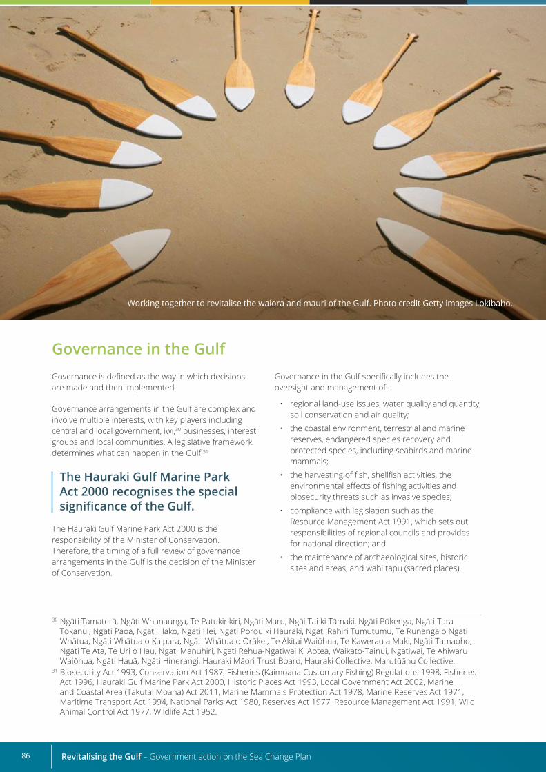
Revitalising the Gulf – Government action on the Sea Change Plan86
Governance in the Gulf Governance is defined as the way in which decisions are made and then implemented.
Governance arrangements in the Gulf are complex and involve multiple interests, with key players including central and local government, iwi,30 businesses, interest groups and local communities. A legislative framework determines what can happen in the Gulf.31
The Hauraki Gulf Marine Park Act 2000 recognises the special significance of the Gulf.
The Hauraki Gulf Marine Park Act 2000 is the responsibility of the Minister of Conservation. Therefore, the timing of a full review of governance arrangements in the Gulf is the decision of the Minister of Conservation.
Governance in the Gulf specifically includes the oversight and management of:
• regional land-use issues, water quality and quantity, soil conservation and air quality;
• the coastal environment, terrestrial and marine reserves, endangered species recovery and protected species, including seabirds and marine mammals;
• the harvesting of fish, shellfish activities, the environmental effects of fishing activities and biosecurity threats such as invasive species;
• compliance with legislation such as the Resource Management Act 1991, which sets out responsibilities of regional councils and provides for national direction; and
• the maintenance of archaeological sites, historic sites and areas, and wāhi tapu (sacred places).
Working together to revitalise the waiora and mauri of the Gulf. Photo credit Getty images Lokibaho.
30 Ngāti Tamaterā, Ngāti Whanaunga, Te Patukirikiri, Ngāti Maru, Ngāi Tai ki Tāmaki, Ngāti Pūkenga, Ngāti Tara Tokanui, Ngāti Paoa, Ngāti Hako, Ngāti Hei, Ngāti Porou ki Hauraki, Ngāti Rāhiri Tumutumu, Te Rūnanga o Ngāti Whātua, Ngāti Whātua o Kaipara, Ngāti Whātua o Ōrākei, Te Ākitai Waiōhua, Te Kawerau a Maki, Ngāti Tamaoho, Ngāti Te Ata, Te Uri o Hau, Ngāti Manuhiri, Ngāti Rehua-Ngātiwai Ki Aotea, Waikato-Tainui, Ngātiwai, Te Ahiwaru Waiōhua, Ngāti Hauā, Ngāti Hinerangi, Hauraki Māori Trust Board, Hauraki Collective, Marutūāhu Collective.
31 Biosecurity Act 1993, Conservation Act 1987, Fisheries (Kaimoana Customary Fishing) Regulations 1998, Fisheries Act 1996, Hauraki Gulf Marine Park Act 2000, Historic Places Act 1993, Local Government Act 2002, Marine and Coastal Area (Takutai Moana) Act 2011, Marine Mammals Protection Act 1978, Marine Reserves Act 1971, Maritime Transport Act 1994, National Parks Act 1980, Reserves Act 1977, Resource Management Act 1991, Wild Animal Control Act 1977, Wildlife Act 1952.
87
Current governance arrangements in the Gulf
Governance in the Gulf is currently overseen by the Hauraki Gulf Forum, which is a statutory body established under the Hauraki Gulf Marine Park Act 2000, with administrative support from Auckland Council. The Forum promotes and facilitates integrated management and the protection and enhancement of the Gulf. It has representatives from:
• the Minister of Conservation, Minister for Oceans and Fisheries and Minister for Māori Development;
• Auckland Council, Waikato Regional Council, Thames–Coromandel, Hauraki, Waikato and Matamata–Piako district councils; and
• mana whenua of the Hauraki Gulf and its islands, appointed by the Minister of Conservation.
The Forum’s purpose, as stated in section 15 of the Hauraki Gulf Marine Park Act 2000, is to:
• integrate the management and, where appropriate, promote the conservation and management in
a sustainable manner of the natural, historic and physical resources of the Gulf, its islands and catchments for the benefit and enjoyment of the people and communities of the Gulf and Aotearoa New Zealand;
• facilitate communication, co-operation and co-ordination on matters relating to the statutory functions of the constituent parties in relation to the Gulf, its islands and catchments and the Forum; and
• recognise the historic, traditional, cultural and spiritual relationship of tangata whenua with the Gulf, its islands and, where appropriate, its catchments.
The Forum contributed to the development of the Sea Change Plan.
Strategy’s proposals for governance
This Strategy identifies options to improve governance arrangements in the Gulf. These options are to restructure the Hauraki Gulf Forum or create a new governance entity that includes one or more of the following:
• it has the statutory authority to lead and drive ecosystem-based initiatives;
• it is based on a model of co-governance with mana whenua; and/or
• it is smaller and more cohesive than the existing Forum, with representation based on those best placed to strategically drive and achieve the desired outcomes.
Progression of these options is not within the scope of this Strategy.
To ensure the Strategy is implemented successfully and able to deliver on outcomes, we will:
• establish a cross-agency implementation group to oversee the implementation and management of this Strategy.
Assessment of current governance arrangements The Forum has been independently assessed several times in recent years (Beverley et al, 2016; Bradly, 2015; Peart and Cox, 2019; Schollum, 2017). This resulted in recommendations that the Hauraki Gulf Marine Park Act 2000 should be updated, especially in terms of governance, and the Forum should:
• act more collectively as a peer group to provide strategic leadership in the Gulf;
• prepare and approve an “integrated management plan” for the Gulf that other planning documents must apply;
• place a stronger emphasis on co-governance and greater representation of mana whenua;
• be reduced in size and include representation by those best placed to drive and achieve the purpose of the Hauraki Gulf Marine Park Act 2000;
• promote a clearer understanding of the purpose of the Hauraki Gulf Marine Park Act 2000 as well as the Forum itself; and
• have more statutory authority over the Gulf.
Revitalising the Gulf – Government action on the Sea Change Plan88
Options for improving governance arrangements A full review of governance is not within the scope of this Strategy.
At present, the Forum is not sufficiently empowered or resourced to lead and facilitate implementation of the initiatives specified in this Strategy or more widely across the Sea Change Plan. Furthermore, since the creation of the Forum 20 years ago, much of the Gulf’s ecological environment has substantially deteriorated.
It is clear the Forum in its current form is unlikely to provide what is needed to holistically address current environmental challenges in the Gulf and to resolve issues raised in recent assessments of governance arrangements and the concerns of mana whenua and key stakeholders.
Having considered these factors and the assessment above, we suggest that qualities for an effective and revised or new governance entity could include:
• having statutory authority to lead and drive holistic ecosystem-based initiatives;
• being based on a model of co-governance with mana whenua; and/or
• being smaller than the existing Forum, with representation coming from those best placed to strategically drive and achieve the desired outcomes.
These elements are outlined in more detail below and could be considered further within the context of a future review of governance arrangements in the Gulf.
Greater statutory authority
A restructured Forum, or the creation of a new governance entity, presents an opportunity to empower governance arrangements in the Gulf.
This Strategy is underpinned by ecosystem-based management initiatives implemented in the Gulf. While the Forum is a “statutory body”, and some of its members (for example, government agencies) have statutory authority, it lacks “statutory authority” under its legislation to lead, drive and implement these initiatives. Instead, its functions are based more on encouraging co operation, advocacy and intelligence gathering. This is reflected in section 17 of the Hauraki Gulf Marine Park Act 2000, which states that one of the Forum’s core functions is “to promote and advocate the integrated management and, where appropriate, the sustainable management of the Hauraki Gulf, its islands, and catchments”.
Several of these recommendations match those outlined in the Sea Change Plan, as well as feedback received from mana whenua and stakeholders we engaged with while developing this Strategy.
Some mana whenua and stakeholders suggested a review of governance arrangements in the Gulf would provide an opportunity to work with mana whenua to identify principles and components of good governance. Others suggested that, in the short-to-medium term, it would be best to use the existing governance arrangements and statutory instruments more effectively to progress interventions to improve Gulf outcomes. Further suggestions include that a governance structure for the Gulf should:
• be transparent and avoid the overlap and duplication of effort;
• review ecological challenges in the Gulf holistically and be agile in its response to them;
• facilitate or co-ordinate initiatives for the Gulf that are not the role of any statutory agency;
• have a legal mandate to deliver the desired outcomes of this Strategy;
• have effective internal management, particularly in relation to minimising conflicts of interest;
• represent the interests of all stakeholders, including local communities;
• develop initiatives that promote a sense of people’s ownership and relationships with the Gulf, and ensure their values are influencing management approaches; and
• develop effective public–private partnerships.
“The Hauraki Gulf Forum has all of the people, organisations, iwi representation and connections to start making things happen in the Hauraki Gulf.” Engagement feedback
89
Providing the Forum with greater statutory authority would improve its ability to drive and direct ecosystem-based management initiatives in the Gulf. However, the impacts of potentially shifting certain authority from existing agencies and bodies would need to be fully considered by ministers, iwi, central and local government agencies and key stakeholders.
Increased emphasis on co-governanceAdopting and implementing co-governance entities around Aotearoa New Zealand has been an important development in natural resource governance over the past decade. Critics of the co governance model argue it could limit public influence in decision-making, but entities established through Treaty settlements generally include local authority representation and, therefore, public input.
Co-governance improves decision-making because it brings a broad range of knowledge, values, traditions and experiences to the governance table. It places an emphasis on kaitiakitanga and uses intergenerational timeframes for decision-making, encouraging longer-term thinking and potentially better environmental outcomes (Peart and Cox, 2019). It also gives practical effect to the relationship between the Crown and Māori.
While the Sea Change Plan makes it clear that co-governance is essential for effective implementation, the Forum’s current structure is not based on equal representation from iwi.
At present, the Hauraki Gulf Marine Park Act 2000 provides for six mana whenua representatives out of a total of 21 on the Forum, despite there being approximately 30 iwi and collectives in the Hauraki Gulf region.
A smaller governance entity
The Hauraki Gulf Forum has 21 representatives, making it comparatively large for a co governance entity.
In its recent report Governance of the Hauraki Gulf – A review of options, the Environmental Defence Society noted that all of the contemporary co-governance models it studied in Aotearoa New Zealand ranged in size from eight to 12 members (Peart and Cox, 2019). While the basis for this small size was not evident, the Society presumed the entities were configured so they could best adhere to good governance principles.
The report also outlines the following pros and cons of small and large governance entities.
• Smaller groups (fewer than eight members) can make decisions more easily and are less resource intensive than larger groups, and their members can engage more fully with the group and more easily represent their own ideas. However, smaller groups will have less diversity, may have an issue with attendance, often have a greater workload and may have less analysis of key issues.
• Larger groups (more than 12 members) allow for genuine diversity, a greater skill set, workload sharing, and enhanced analysis and deliberation on key issues. However, their management is both resource and time intensive, and their larger size can impede consensus reaching and does not necessarily result in better decision-making.
Ultimately, the size of a governance body should correspond to its powers. Several reviews have made it clear that the size of the current Forum is too large for effective decision-making. The Forum’s statutory authority will have implications for the frequency of its meetings, its workload and the necessary range of expertise and representation needed to ensure effective decision-making. Striking the right size balance between effectiveness and efficiency should, therefore, be considered once the final statutory authority for a reconstituted forum is agreed on.
Legislative considerationsSections 15 to 18 of the Hauraki Gulf Marine Park Act 2000 specify the purpose, representation, functions and powers of the Forum. Legislative amendments would be required if structural and other changes to the Forum (or the creation of a new governance entity) are agreed on.
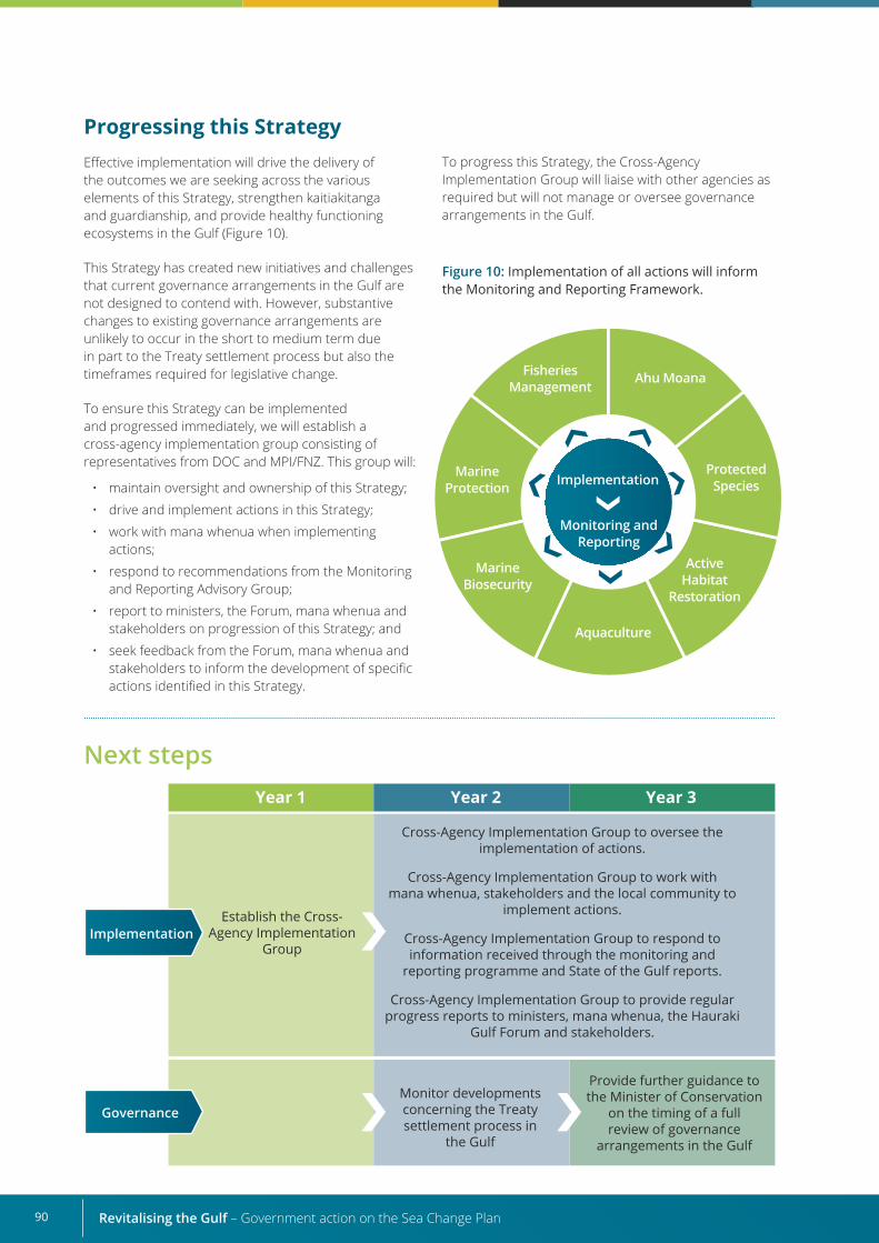
Revitalising the Gulf – Government action on the Sea Change Plan90
Year 1 Year 2 Year 3
Establish the Cross-Agency Implementation
Group
Monitor developments concerning the Treaty settlement process in
the Gulf
Provide further guidance to the Minister of Conservation
on the timing of a full review of governance
arrangements in the Gulf
Next steps
Governance
Implementation
Progressing this Strategy Effective implementation will drive the delivery of the outcomes we are seeking across the various elements of this Strategy, strengthen kaitiakitanga and guardianship, and provide healthy functioning ecosystems in the Gulf (Figure 10).
This Strategy has created new initiatives and challenges that current governance arrangements in the Gulf are not designed to contend with. However, substantive changes to existing governance arrangements are unlikely to occur in the short to medium term due in part to the Treaty settlement process but also the timeframes required for legislative change.
To ensure this Strategy can be implemented and progressed immediately, we will establish a cross-agency implementation group consisting of representatives from DOC and MPI/FNZ. This group will:
• maintain oversight and ownership of this Strategy;
• drive and implement actions in this Strategy;
• work with mana whenua when implementing actions;
• respond to recommendations from the Monitoring and Reporting Advisory Group;
• report to ministers, the Forum, mana whenua and stakeholders on progression of this Strategy; and
• seek feedback from the Forum, mana whenua and stakeholders to inform the development of specific actions identified in this Strategy.
Figure 10: Implementation of all actions will inform the Monitoring and Reporting Framework.
Fisheries Management
Marine Biosecurity
Aquaculture
Marine Protection Implementation
Monitoring and Reporting
Protected Species
Active Habitat
Restoration
Ahu Moana
To progress this Strategy, the Cross-Agency Implementation Group will liaise with other agencies as required but will not manage or oversee governance arrangements in the Gulf.
Cross-Agency Implementation Group to oversee the implementation of actions.
Cross-Agency Implementation Group to work with mana whenua, stakeholders and the local community to
implement actions.
Cross-Agency Implementation Group to respond to information received through the monitoring and
reporting programme and State of the Gulf reports.
Cross-Agency Implementation Group to provide regular progress reports to ministers, mana whenua, the Hauraki
Gulf Forum and stakeholders.
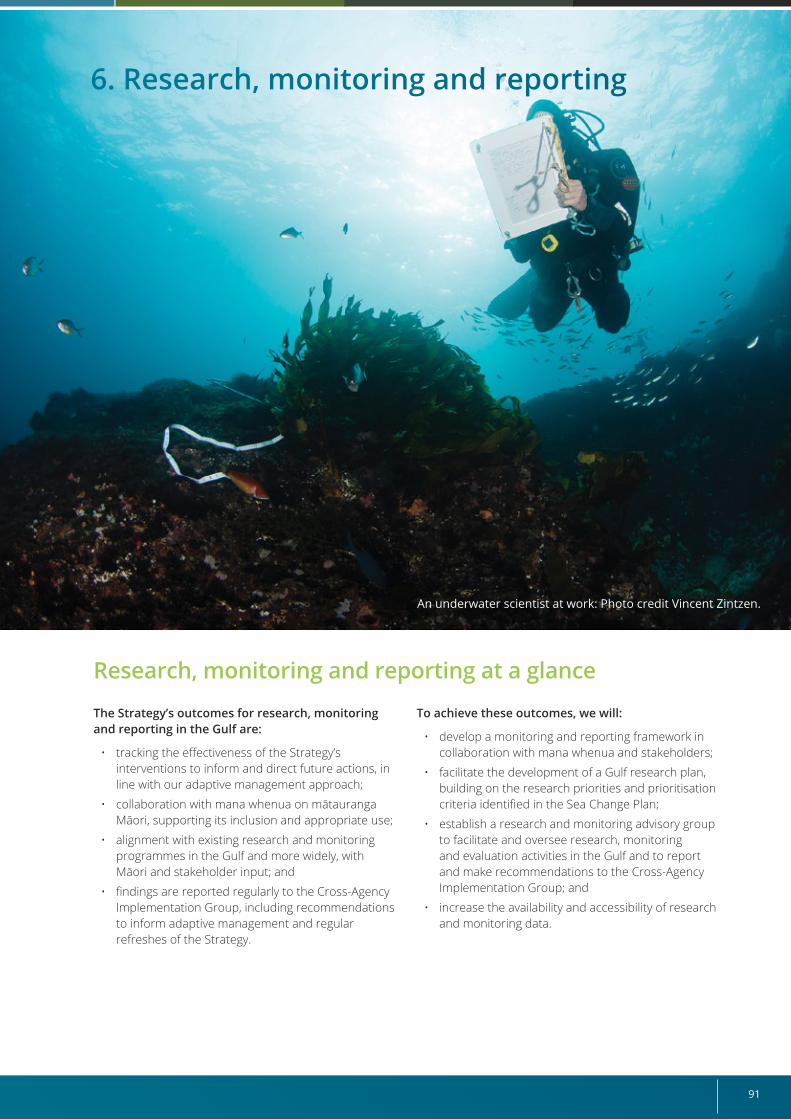
91
Research, monitoring and reporting at a glance
The Strategy’s outcomes for research, monitoring and reporting in the Gulf are:
• tracking the effectiveness of the Strategy’s interventions to inform and direct future actions, in line with our adaptive management approach;
• collaboration with mana whenua on mātauranga Māori, supporting its inclusion and appropriate use;
• alignment with existing research and monitoring programmes in the Gulf and more widely, with Māori and stakeholder input; and
• findings are reported regularly to the Cross-Agency Implementation Group, including recommendations to inform adaptive management and regular refreshes of the Strategy.
To achieve these outcomes, we will:
• develop a monitoring and reporting framework in collaboration with mana whenua and stakeholders;
• facilitate the development of a Gulf research plan, building on the research priorities and prioritisation criteria identified in the Sea Change Plan;
• establish a research and monitoring advisory group to facilitate and oversee research, monitoring and evaluation activities in the Gulf and to report and make recommendations to the Cross-Agency Implementation Group; and
• increase the availability and accessibility of research and monitoring data.
6. Research, monitoring and reporting
An underwater scientist at work: Photo credit Vincent Zintzen.
Revitalising the Gulf – Government action on the Sea Change Plan92
“Monitoring for monitoring’s sake is discouraged, and a poor use of resources. Monitoring should be undertaken with a clear understanding of how it will help inform management over time.”Engagement feedback
Research, monitoring and reporting in the GulfWhile efforts have been made to better co-ordinate marine monitoring in Aotearoa New Zealand (Hewitt et al, 2014), gaps remain in our understanding of the scale of change or loss in habitats and ecosystem quality (MfE and Stats NZ, 2019). We need to better co-ordinate and implement marine monitoring in several areas, including the effectiveness of management measures and the effects of climate change (MPI, 2019; PCE, 2019).
Te ao Māori perspectives are also a critical gap in marine monitoring. This particularly relates to the impact of fishing and seafood harvesting through mātauranga Māori and tikanga Māori, and impacts on kaitiakitanga, customary use and mahinga kai (MfE and Stats NZ, 2019).
The two overarching outcomes of this Strategy are effectivekaitiakitangaandguardianship and healthy functioning ecosystems. An opportunity exists for the Gulf to lead the way for Aotearoa New Zealand by having an integrated, innovative, co-ordinated approach to research, monitoring and reporting. This could improve our collective knowledge of the area, monitor the effectiveness of management and inform decisions on any changes needed to the management measures.
An opportunity also exists to provide vital information about the waiora and mauri of the Gulf and to co ordinate with wider research, monitoring and reporting initiatives in Aotearoa New Zealand, such as environmental monitoring.
What the Sea Change Plan sought for research, monitoring and reporting
The Sea Change Plan clearly identifies that monitoring and evaluation must be co ordinated and carried out with a view to informing management of the Gulf over time.
A framework should be as future proofed as possible to avoid any changes in approach that could undermine the value of data already collected, for example, when comparing results over time and space.
Management also needs to be iterative and adaptive, allowing for lessons to be applied as it becomes clear what works and what does not.
To support mana whenua in management and decision-making, Ngā Tohu Oranga (cultural health indicators) should be determined with mana whenua. This will encourage participation in monitoring, support holistic management practices, and recognise the perspectives and mātauranga of mana whenua in monitoring.
The Sea Change Plan also recommends the establishment of a research and monitoring committee to act as a broker and hub for all research activities in the Gulf. Representatives would be from different research organisations, government agencies, iwi, industry and sector groups, and the wider community.
93
Strategy’s proposals for research, monitoring and reporting
The Strategy’s outcomes for research, monitoring and reporting in the Gulf are:
• tracking the effectiveness of the Strategy’s interventions to inform and direct future actions, in line with our adaptive management approach;
• collaboration with mana whenua on mātauranga Māori, supporting its inclusion and appropriate use;
• alignment with existing research and monitoring programmes in the Gulf and more widely, with Māori and stakeholder input;
• findings are reported regularly to the Cross-Agency Implementation Group, including recommendations to inform adaptive management and regular refreshes of the Strategy.
To deliver these outcomes, we will:
• develop a monitoring and reporting framework in collaboration with mana whenua and stakeholders;
• facilitate the development of a Gulf research plan, building on the research priorities and prioritisation criteria identified in the Sea Change Plan;
• establish a research and monitoring advisory group to facilitate and oversee research, monitoring and evaluation activities in the Gulf and to report and make recommendations to the Cross-Agency Implementation Group; and
• increase the availability and accessibility of research and monitoring data.
This Strategy is an opportunity for the Gulf to lead the way for a new integrated, innovative, co ordinated approach to marine monitoring and research in Aotearoa New Zealand.
Monitoring and Reporting FrameworkMarine systems are complex and have interacting ecological, economic, social and cultural components. Monitoring and evaluation are important to identify if interventions are having intended – or possibly unintended – effects.
We will work with others to develop a monitoring and reporting framework to guide monitoring, evaluation and reporting, co-ordinate with existing initiatives, track the Strategy’s implementation progress and evaluate the effectiveness of its interventions.
The development of this framework will be facilitated by a research and monitoring advisory group, which will also have ongoing responsibilities for overseeing and reporting on relevant activities in the Gulf, including connecting with State of Our Gulf reporting.
“There is a need to monitor achievement of outcomes against cross-agency land, freshwater and marine indicators.” Engagement feedback
The Research and Monitoring Advisory Group will report to the Cross-Agency Implementation Group and make recommendations to inform the adaptive management process. Combined, the Research and Monitoring Advisory Group and Monitoring and Reporting Framework will support enhanced collaboration across mana whenua, communities, stakeholders and management agencies. They will also facilitate the use of mātauranga Māori and Western science knowledge systems alongside each other.
The Framework will:
• provide for integrated monitoring and evaluation across this Strategy’s elements;
• identify knowledge gaps, which will inform the development of a research plan;
• provide guidance on aspects such as monitoring and evaluation frequency, methodology (including monitoring progress towards restoring mauri and outcomes relating to kaitiakitanga and guardianship), analytical techniques and reporting requirements;
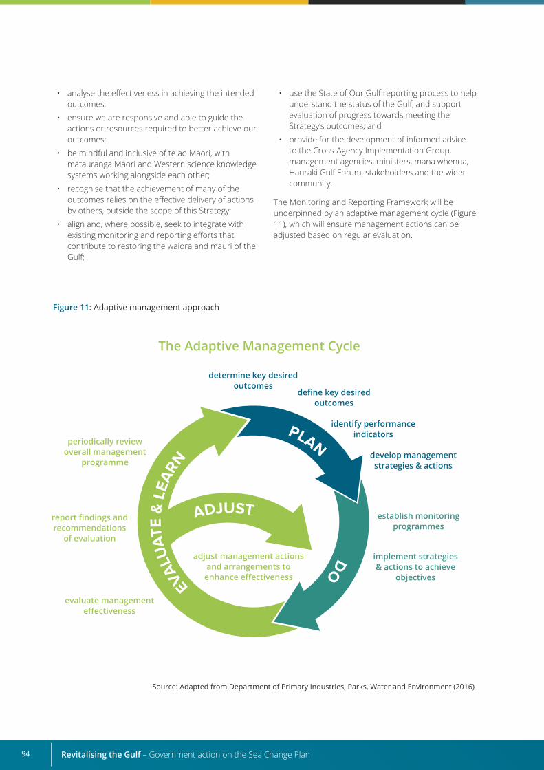
Revitalising the Gulf – Government action on the Sea Change Plan94
Figure 11: Adaptive management approach
periodically review overall management
programme
adjust management actions and arrangements to
enhance effectiveness
determine key desired outcomes
define key desired outcomes
identify performance indicators
develop management strategies & actions
implement strategies & actions to achieve
objectives
establish monitoring programmes
report findings and recommendations
of evaluation
evaluate management effectiveness
The Adaptive Management Cycle
• analyse the effectiveness in achieving the intended outcomes;
• ensure we are responsive and able to guide the actions or resources required to better achieve our outcomes;
• be mindful and inclusive of te ao Māori, with mātauranga Māori and Western science knowledge systems working alongside each other;
• recognise that the achievement of many of the outcomes relies on the effective delivery of actions by others, outside the scope of this Strategy;
• align and, where possible, seek to integrate with existing monitoring and reporting efforts that contribute to restoring the waiora and mauri of the Gulf;
• use the State of Our Gulf reporting process to help understand the status of the Gulf, and support evaluation of progress towards meeting the Strategy’s outcomes; and
• provide for the development of informed advice to the Cross-Agency Implementation Group, management agencies, ministers, mana whenua, Hauraki Gulf Forum, stakeholders and the wider community.
The Monitoring and Reporting Framework will be underpinned by an adaptive management cycle (Figure 11), which will ensure management actions can be adjusted based on regular evaluation.
Source: Adapted from Department of Primary Industries, Parks, Water and Environment (2016)
95
We expect the Framework will include the following components:
• a stocktake of existing monitoring and evaluation processes in the Gulf, identifying possible alignment opportunities and efficiencies;
• the identification or development of indicators to monitor the Strategy’s actions. This will likely involve an assessment of the causal linkages between pressures and drivers and the intended impact of each element’s management interventions. It may also include identifying the type and sources of data needed for monitoring. Ideally, the indicators will collectively capture the status and trends of
important ecological, economic, social and cultural components of the system being monitored;
• the development of targets for each indicator, in consultation with others;
• the development of a reporting and review schedule, including guidelines for analysis of the collected data and how mana whenua and stakeholders are involved in the process; and
• reporting and adaptive management processes that clearly detail how the findings should be incorporated into future management actions, including the Strategy’s actions, and how data will be made accessible to stakeholders.
Including mana whenua and stakeholder views
Resourcing the monitoring and reporting programme
Research plan
Mātauranga Māori An important part of the Sea Change Plan is supporting mana whenua to bring their mātauranga alongside Western scientific knowledge to improve the waiora and mauri of the Gulf through all components of the adaptive management cycle.
We will work with mana whenua to use mātauranga Māori to inform indicator development, monitoring and evaluation activities. Mana whenua and mātauranga experts will also be included in the Research and Monitoring Advisory Group.
Councils, communities and other agencies We will work to align and integrate our monitoring approaches with those of others, to support more cohesive monitoring and evaluation of the waiora and mauri of the Gulf. We will also identify opportunities to support ongoing efforts to undertake wider environmental monitoring and reporting in Aotearoa New Zealand.
When developing the Monitoring and Reporting Framework, the Research and Monitoring Advisory Group will also plan for its implementation, including
Other chapters in this Strategy have identified research that is under way and future research needs, and the Sea Change Plan also lists research needs relating to biodiversity and biosecurity, water quality, fish stocks and aquaculture.
Since the release of the Sea Change Plan, progress has been made on addressing these research needs, including:
• research on the ecology and biodiversity values of mussel beds on soft sediments to inform restoration efforts;
identifying cost implications, delivery milestones and resourcing requirements. These requirements will be considered by the Cross-Agency Implementation Group.
• extensive subtidal habitat surveys within the Gulf to inform restoration and protection actions; and
• Auckland University of Technology’s investigations into the conversion of seaweeds to high-value animal feeds and organic plant fertiliser.
Many mechanisms are available for funding and undertaking research in the Gulf. An opportunity is also available to develop a research plan that brings research needs and potential funding avenues together to enhance the co-ordination and delivery of research.
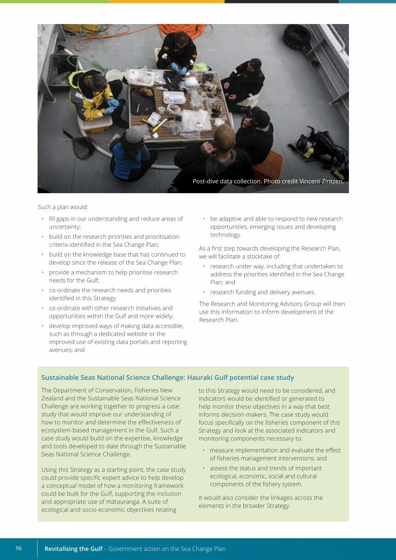
Revitalising the Gulf – Government action on the Sea Change Plan96
Sustainable Seas National Science Challenge: Hauraki Gulf potential case study
The Department of Conservation, Fisheries New Zealand and the Sustainable Seas National Science Challenge are working together to progress a case study that would improve our understanding of how to monitor and determine the effectiveness of ecosystem-based management in the Gulf. Such a case study would build on the expertise, knowledge and tools developed to date through the Sustainable Seas National Science Challenge.
Using this Strategy as a starting point, the case study could provide specific expert advice to help develop a conceptual model of how a monitoring framework could be built for the Gulf, supporting the inclusion and appropriate use of mātauranga. A suite of ecological and socio-economic objectives relating
to this Strategy would need to be considered, and indicators would be identified or generated to help monitor these objectives in a way that best informs decision-makers. The case study would focus specifically on the fisheries component of this Strategy and look at the associated indicators and monitoring components necessary to:
• measure implementation and evaluate the effect of fisheries management interventions; and
• assess the status and trends of important ecological, economic, social and cultural components of the fishery system.
It would also consider the linkages across the elements in the broader Strategy.
Post-dive data collection. Photo credit Vincent Zintzen.
Such a plan would:
• fill gaps in our understanding and reduce areas of uncertainty;
• build on the research priorities and prioritisation criteria identified in the Sea Change Plan;
• build on the knowledge base that has continued to develop since the release of the Sea Change Plan;
• provide a mechanism to help prioritise research needs for the Gulf;
• co-ordinate the research needs and priorities identified in this Strategy;
• co-ordinate with other research initiatives and opportunities within the Gulf and more widely;
• develop improved ways of making data accessible, such as through a dedicated website or the improved use of existing data portals and reporting avenues; and
• be adaptive and able to respond to new research opportunities, emerging issues and developing technology.
As a first step towards developing the Research Plan, we will facilitate a stocktake of:
• research under way, including that undertaken to address the priorities identified in the Sea Change Plan; and
• research funding and delivery avenues.
The Research and Monitoring Advisory Group will then use this information to inform development of the Research Plan.
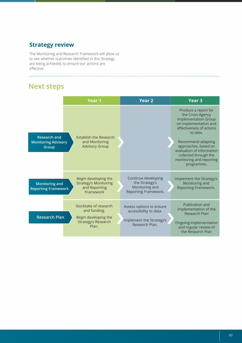
97
Strategy reviewThe Monitoring and Research Framework will allow us to see whether outcomes identified in this Strategy are being achieved, to ensure our actions are effective.
Next steps
Year 1 Year 2 Year 3
Establish the Research and Monitoring Advisory Group
Stocktake of research and funding.
Begin developing the Strategy’s Research
Plan.
Assess options to ensure accessibility to data.
Implement the Strategy’s Research Plan.
Publication and implementation of the
Research Plan
Ongoing implementation and regular review of
the Research Plan
Produce a report for the Cross-Agency
Implementation Group on implementation and effectiveness of actions
to date.
Recommend adapting approaches, based on
evaluation of information collected through the
monitoring and reporting programme.
Continue developing the Strategy’s
Monitoring and Reporting Framework.
Begin developing the Strategy’s Monitoring
and Reporting Framework
Implement the Strategy’s Monitoring and
Reporting Framework.
Research Plan
Monitoring and Reporting Framework
Research and Monitoring Advisory
Group
Revitalising the Gulf – Government action on the Sea Change Plan98
7. Immediate actions to enhance the mauri of the Gulf
Our first task is to establish the Cross-Agency Implementation Group, to start delivering an integrated package of actions for the Gulf. This group will oversee implementation of the actions, allocate resources and address any recommendations provided by the Research and Monitoring Advisory Group. The roadmap presented in Chapter 1 (Table 1) outlines our implementation timeframes. Our immediate actions are also summarised below.
Fisheries management• Finalise the draft Fisheries Plan and undertake
formal consultation.
• Establish the Hauraki Gulf Fisheries Plan Advisory Group.
• Work with the Sustainable Seas National Science Challenge to co-develop the project proposal for the fisheries indicators and monitoring framework.
• Develop the draft Annual Operational Plan for the Fisheries Plan.
• Hold workshops to enable the collaborative design of mobile bottom-contact fishing corridors.
Active habitat restoration• Work with mana whenua and interested parties
to develop the Habitat Restoration Guidance Framework.
• Help restoration groups with their planning before lodging a permission application under section 52 of the Biosecurity Act 1993.
Aquaculture• Investigate the Sustainable Food and Fibre Futures
Fund to support site suitability assessments.
• Update New Zealand Coastal Policy Statement (NZCPS) policy guidance on natural character.
Marine biosecurity• Support and co-ordinate the Top of the North
Marine Biosecurity Partnership.
• Progress national approaches to improve co-ordination and monitoring.
• Maintain the Government’s surveillance programme of high-risk ports and harbours.
Marine protection• Engage with mana whenua on new protected area
proposals, including customary practices.
• Initiate legislative process for new protected areas.
Protected species• Complete a review of the Hauraki Gulf Marine
Mammals Tourism Site Plan.
• Refresh the Auckland Island Biosecurity Plan to mitigate terrestrial biosecurity threats.
Ahu Moana• Engage with mana whenua and local communities
to agree on candidate areas for the Ahu Moana pilot projects.
• Scope the Ahu Moana Framework.
• Commission work to review existing legislative processes and tools.
Research, monitoring and reporting• Establish the Research and Monitoring Advisory
Group.
• Begin developing the Strategy’s Monitoring and Reporting Framework.
• Stocktake of research and funding.
• Begin developing the Strategy’s Research Plan.
99
ReferencesAlleway, H.K.; Gillies, C.L.; Bishop, M.J.; Gentry, R.R.; Theuerauf, S.J.; Jones, R. 2019: The ecosystem services of marine aquaculture: valuing benefits to people and nature. BioScience 69: 59–68.
Auckland City Council 2021: TeWānangaoTīkapaMoana–HaurakiGulfForum. www.aucklandcouncil.govt.nz/about-auckland-council/how-auckland-council-works/harbour-forums/Pages/hauraki-gulf-forum.aspx (accessed 20 March 2021).
Beverley, P.; Payne, V.; Maloney, M. 2016: Hauraki Gulf Forum governance review and recommendations. Report to the Hauraki Gulf Forum.
Bradly, N. 2015: Review of the Hauraki Gulf Forum. Report to the Hauraki Gulf Forum by Envirostat Limited, Auckland.
Constantine, R.; Johnson, M.; Riekkola, L.; Jervis, S.; Kozmian-Ledward, L.; Dennis, T.; Torres, L.; Aguilar de Soto, N. 2015: Mitigation of vessel-strike mortality of endangered Bryde’s whales in the Hauraki Gulf, New Zealand. Biological Conservation 186: 149–157.
Department of Primary Industries, Parks, Water and Environment 2016: Tasmanian Wilderness World Heritage Area (TWWHA) Management Plan 2016. Department of Primary Industries, Parks, Water and Environment, Hobart.
DOC (Department of Conservation) no date (a): Find, protect and create inanga spawning habitat. www.doc.govt.nz/nature/native-animals/freshwater-fish/whitebait-migratory-galaxiids/inanga/find-protect-and-create-inanga-spawning-habitat/#:~:text=New%20inanga%20spawning%20sites%20can,more%20inanga%20can%20spawn%20there (accessed 23 April 2021).
DOC (Department of Conservation) no date (b): Firth of Thames. www.doc.govt.nz/nature/habitats/wetlands/wetlands-by-region/waikato/firth-of-thames (accessed 23 March 2021).
DOC (Department of Conservation) 2020: Towards a predator free New Zealand 2050 Strategy. www.doc.govt.nz/globalassets/documents/conservation/threats-and-impacts/pf2050/pf2050-towards-predator-freedom-strategy.pdf (accessed 5 May 2021)
DOC (Department of Conservation) 2015: DOC and Mental Health Foundation partnership. Available from www.doc.govt.nz/about-us/our-partners/our-supporting-partners/mental-health-foundation (accessed 23 March 2021).
DOC (Department of Conservation); FNZ (Fisheries New Zealand) 2021a: Agency analysis and advice on selection of MPAs towards development of the Hauraki Gulf Marine Park MPA network. www.doc.govt.nz/.
DOC (Department of Conservation); FNZ (Fisheries New Zealand) 2021b: Habitat gaps analysis of the Sea Change MPA proposals. Available from www.doc.govt.nz/
DOC (Department of Conservation); FNZ (Fisheries New Zealand) 2021c: Management and research of marine protected species in the Hauraki Gulf Marine park: an overview and gaps analysis. Available from www.doc.govt.nz/.
DOC (Department of Conservation); MFish (Ministry of Fisheries) 2008: MarineProtectedAreasClassification,ProtectionStandard and Implementation Guidelines. Department of Conservation and Ministry of Fisheries, Wellington. www.doc.govt.nz/Documents/conservation/marine-and-coastal/marine-protected-areas/mpa-classification-protection-standard.pdf (accessed 23 March 2021).
DOC (Department of Conservation); MFish (Ministry of Fisheries) 2005: Marine Protected Areas Policy and Implementation Plan. Department of Conservation and Ministry of Fisheries, Wellington.
FNZ (Fisheries New Zealand) 2020: National Plan of Action – Seabirds 2020: Reducing the incidental mortality of seabirds infisheries. Fisheries New Zealand, Wellington. www.mpi.govt.nz/dmsdocument/40652-National-Plan-Of-Action-Seabirds-2020-Report (accessed 23 March 2021).
Hartill, B.; McGregor, V.; Doonan, I.; Bian, R.; Baird, S.J.; Walsh, C. 2020: New Zealand Fisheries Assessment Report 2020/25: Feasibilityoffisheryindependentlonglinesurveysforsnapper,hāpuku,bass,andbluenose. Fisheries New Zealand, Wellington.
Revitalising the Gulf – Government action on the Sea Change Plan100
Hauraki Gulf Forum 2020: StateofourGulf2020:HaurakiGulf/TīkapaMoana/TeMoananui-ā-ToiStateoftheEnvironment Report 2020. Hauraki Gulf Forum, Auckland. www.aucklandcouncil.govt.nz/about-auckland-council/how-auckland-council-works/harbour-forums/docsstateofgulf/state-gulf-full-report.pdf (accessed 23 March 2021).
Hewitt, J.E.; Bell, R.; Costello, M.; Cummings, V.; Currie, K.; Ellis, J.; Francis, M.; Froude, V.; Gorman, R.; Hall, J.; Inglis, G.; MacDiarmid, A.; Mills, G.; Pinkerton, M.; Schiel, D.; Swales, A.; Law, C.; McBride, G.; Nodder, S.; Rowden, A.; Smith, M.; Thompson, D.; Torres, L.; Tuck, I.; Wing, S. 2014: Development of a National Marine Environment Monitoring Programme (MEMP) for New Zealand. New Zealand Aquatic Environment and Biodiversity Report: No 141. Ministry for Primary Industries, Wellington.
Lundquist, C.; Tablada, J.; Watson, S. 2020: Evaluation of Biodiversity Protected by Sea Change Tai Timu Tai Pari – Hauraki Gulf Marine Spatial Plan Proposals. National Institute of Water and Atmospheric Research, Wellington.
Maritime New Zealand n.d.: New Zealand Marine Oil Spill Readiness and Response Strategy 2018–2022. Maritime New Zealand, Wellington. www.maritimenz.govt.nz/public/environment/responding-to-spills/documents/Oil-spill-response-strategy.pdf (accessed 23 March 2021).
MfE (Ministry for the Environment) 2020a: National Environmental Standards for Freshwater. www.mfe.govt.nz/fresh-water/freshwater-acts-and-regulations/national-environmental-standards-freshwater (accessed 21 March 2021).
MfE (Ministry for the Environment) 2020b: National Environmental Standards for Marine Aquaculture. www.mfe.govt.nz/marine/marine-and-government/national-environmental-standard-marine-aquaculture (accessed 21 March 2021).
MfE (Ministry for the Environment) 2020c: National Policy Statement for Freshwater Management. www.mfe.govt.nz/fresh-water/national-policy-statement/about-nps (accessed 21 March 2021).
MfE (Ministry for the Environment) 2001: Managing Waterways on Farms: A guide to sustainable water and riparian management in rural New Zealand. Ministry for the Environment: Wellington. https://environment.govt.nz/publications/managing-waterways-on-farms-a-guide-to-sustainable-water-and-riparian-management-in-rural-new-zealand/ (accessed 23 April 2021).
MfE (Ministry for the Environment); MPI (Ministry for Primary Industries) 2018: Essential Freshwater: Healthy Water, Fairly Allocated. Ministry for the Environment and Ministry for Primary Industries, Wellington. https://environment.govt.nz/publications/our-marine-environment-2019/ (accessed 21 March 2021).
MfE (Ministry for the Environment); Stats NZ (Statistics New Zealand) 2019: New Zealand’s Environmental Reporting Series: Our marine environment 2019. https://environment.govt.nz/publications/our-marine-environment-2019/ (accessed 21 March 2021).
MPI (Ministry for Primary Industries) 2019: Aquatic Environment and Biodiversity Annual Review 2018. Ministry for Primary Industries, Wellington. www.mpi.govt.nz/dmsdocument/13293-Aquaculture-Biosecurity-Handbook-Assisting-New-Zealands-commercial-and-non-commercial-aquaculture-to-minimise-on-farm-biosecurity-risk (accessed 21 March 2021).
MPI (Ministry for Primary Industries) 2018a: Craft Risk Management Standard: Vessels. Ministry for Primary Industries; Wellington. www.mpi.govt.nz/dmsdocument/19757/direct (accessed 26 April 2021).
MPI (Ministry for Primary Industries) 2018b: Biofouling on Vessels Arriving to New Zealand. Ministry for Primary Industries, Wellington. www.mpi.govt.nz/dmsdocument/11668-Biofouling-on-Vessels-Arriving-to-New-Zealand-Craft-Risk-Management-Standard (accessed 23 March 2021).
MPI (Ministry for Primary Industries) 2016: Land care and farm management. https://www.mpi.govt.nz/agriculture/land-care-farm-management/farm-management-healthy-waterways/ (accessed 23 April 2021).
MPI (Ministry for Primary Industries); Aquaculture New Zealand 2016: Aquaculture biosecurity handbook: Assisting New Zealand’s commercial and non-commercial aquaculture to minimise on-farm biosecurity risk. Ministry for Primary Industries, Wellington.
New Zealand Government 2019: Aquaculture Strategy. www.mpi.govt.nz/dmsdocument/15895-The-Governments-Aquaculture-Strategy-to-2025 (accessed 21 March 2021).
101
New Zealand Government 2010: New Zealand Coastal Policy Statement 2010. Department of Conservation, Wellington. www.doc.govt.nz/globalassets/documents/conservation/marine-and-coastal/coastal-management/nz-coastal-policy-statement-2010.pdf (accessed 21 March 2021).
National Institute of Water and Atmospheric Research 2018. New Zealand Fish Passage Guidelines for structures up to 4 metres. https://niwa.co.nz/static/web/freshwater-and-estuaries/NZ-FishPassageGuidelines-upto4m-NIWA-DOC-NZFPAG.pdf (accessed 16 April 2021).
Office of the Auditor-General 2018: Sea Change – Tai Timu Tai Pari: Creating a marine spatial plan for the Hauraki Gulf. Office of the Auditor General, Wellington. https://oag.parliament.nz/2018/hauraki (accessed 20 March 2021).
PCE (Parliamentary Commissioner for the Environment) 2019: Focusing Aotearoa New Zealand’s environmental reporting system. Parliamentary Commissioner for the Environment, Wellington. www.pce.parliament.nz/publications/focusing-aotearoa-new-zealand-s-environmental-reporting-system (accessed 21 March 2021).
Peart, R.; Cox, B. 2019: Governance in the Hauraki Gulf – A Review of Options. Environmental Defence Society Inc., Auckland.
Schollum, A. 2017: Implications of the Sea Change Tai Timu Tai Pari Marine Spatial Plan. Report to the Hauraki Gulf Forum by Martin Jenkins, Wellington.
Sea Change Stakeholder Working Group 2017: Sea Change – Tai Timu Tai Pari Hauraki Gulf Marine Spatial Plan. www.seachange.org.nz/assets/Sea-Change/5086-SCTTTP-Marine-Spatial-Plan-WR.pdf (accessed 21 March 2021).
SNA 1 Strategy Group 2016: Snapper (SNA 1) Management Plan. www.mpi.govt.nz/dmsdocument/13801-Snapper-SNA1-Management-Plan (accessed 27 April 2021).
Society for Ecological Restoration International Science & Policy Working Group 2004: The SER International Primer on Ecological Restoration. Society for Ecological Restoration International. www.ser.org/resource/resmgr/custompages/publications/ser_publications/ser_primer.pdf (accessed 21 March 2021).
Tait, A. 2019: Risk-exposure assessment of Department of Conservation (DOC) coastal locations to flooding from the sea: A national assessment of DOC assets, archaeological sites, recreation functional locations, destinations and ecosystem and species management units vulnerable to coastal inundation and sea-level rise. Science for Conservation 332. Department of Conservation, Wellington.
Thames–Coromandel District Council n.d.: Coromandel Harbour Facilities Project. www.tcdc.govt.nz/Your-Council/Council-Projects/Current-Projects/Coromandel-Harbour-Facilities-Project (accessed 21 March 2021).
Revitalising the Gulf – Government action on the Sea Change Plan102
GlossaryActive restoration – Projects and management techniques that actively restore and rehabilitate habitats and ecosystems, such as erosion control, and the removal and control of invasive species.
Agencies – Organisations in local or central government.
Ahu Moana – Localised collaborative management; mana whenua and local community management of local areas.
Area-based management – A clearly defined geographic space managed for long-term protection.
Benthic zone – The lowest level of a marine or freshwater system; includes the sediment surface, the water just above it and some subsurface layers.
Biogenic habitat – Habitat created by plants and animals. This may be the organism itself or may arise from an organism’s activities. Mussel beds are an example of a biogenic habitat in the Gulf.
CRA 2 – Fish stock for spiny rock lobster in the Hauraki Gulf and Bay of Plenty region, which stretches from Te Arai Point north of Auckland to the East Cape.
(see www.mpi.govt.nz/dmsdocument/21455-cra2-fishery-map).
CRMS – Craft Risk Management Standard.
CRMS-BIOFOUL – New Zealand Craft Risk Management Standard for Biofouling.
Demersal fish – Fish that live and feed on or near the sea or lake bottom.
Diadromous fish – A general category describing migratory fish that spend their lifecycles partly in fresh water and partly in salt water.
DOC – Department of Conservation.
Ecosystem – A dynamic complex of plant, animal and microorganism communities and their non-living environment interacting as a functional unit.
Ecosystem services – The direct and indirect benefits humans obtain from functioning ecosystems. The services fall into four main areas: supporting (eg, nutrient cycling, soil formation and primary production); provisioning (eg, food, fresh water, wood, fibre, genetic and medicinal resources); regulating (eg, climate regulation, flood and disease regulation, water purification, biological control); and cultural and amenity (aesthetic, spiritual, recreational, tourism, educational).
Ecosystem-based management (EBM) – An environmental management approach that recognises all interactions within an ecosystem, including those of humans, rather than considering single issues, species or ecosystem services in isolation.
Endemic species – Those species found only in Aotearoa New Zealand.
FMA – Fisheries management area.
FNZ – Fisheries New Zealand.
Forage fish – Small pelagic fish that are preyed on by larger predators, including larger fishes, seabirds and marine mammals; sometimes called bait fish.
Gulf, the – The Hauraki Gulf Marine Park.
Hapū – Sub-tribe.
Hauraki Gulf / Tīkapa Moana / Te Moananui-ā-Toi – The Hauraki Gulf Marine Park.
Iwi – Tribe.
Kaimoana – Seafood.
Kāinga – Settlements.
Kaitiaki – Guardian; may be a person, group or entity.
103
Kaitiakitanga – Guardianship, including stewardship; the processes and practices of looking after the environment. Guardianship is rooted in tikanga.
Ki uta ki tai – Kaitiakitanga (guardianship) from the mountains and lakes, down the rivers to hāpua (lagoons), wahapū (estuaries) and to the sea. Ki uta ki tai encapsulates the need to recognise and manage the interconnectedness of the whole environment.
Kotahitanga – Sharing, unity, solidarity, giving and receiving as prosperous communities.
Kōura – Rock lobster.
Kupenga – Fishing net.
Kūtai/kuku – Mussels.
MAC – Ministerial Advisory Committee.
Mahinga kai, pātaka kai – A natural resource that has traditionally been used as food, tools or other resources. Pātaka kai is the storehouse or pantry where food is left for people to take for free. Mahinga kai, pātaka kai is a term for replenishing the food basket.
Mana – Status or prestige.
Manaakitanga – Caring for each other.
Mana moana – Customary authority over the sea and lakes.
Mana whenua – Customary authority exercised by an iwi or hapū in an identified area. Māori who have power over the land and/or an ancestral connection to the land.
Marine protected area (MPA) – An area of the marine environment especially dedicated to, or achieving, through adequate protection the maintenance and/or recovery of biological diversity at the habitat and ecosystem level in a healthy functioning state (DOC and MFish, 2005). Adequate protection in this sense means that the management tools applied to the area meet the protection standard outlined in the MPA Policy.
Marine protection – A clearly defined geographic marine space managed for long-term protection.
Marine spatial planning – A holistic planning framework that informs use of the ocean space for human activities (eg, fisheries, aquaculture, shipping, tourism) between users and the marine environment to support ecological, cultural, economic and social outcomes. Sea Change – Tai Timu Tai Pari is Aotearoa New Zealand’s first marine spatial plan.
Mātaitai reserves – Areas that recognise and provide for traditional fishing through local management. They allow customary and recreational fishing but usually not commercial fishing.
Mātauranga Māori – A deep and evolving knowledge generated by whānau, hapū and iwi about place and practices over multiple generations. Mātauranga is shared through lived experience, stories, songs, place names, rituals, teachings and original instructions and is learnt through observation and copying of other community members.
Mauri – Life force, vital essence.
MBIE – Ministry of Business, Innovation and Employment.
MfE – Ministry for the Environment.
MHRSS – Marine High Risk Site Surveillance.
Mokopuna – Grandchildren.
MPA – Marine protected area.
MPI – Ministry for Primary Industries.
National Rock Lobster Management Group – This is a national-level, multi-stakeholder group comprising representatives of customary, recreational and commercial fishing sectors and FNZ. It is the primary adviser to the Minister for Oceans and Fisheries on catch limits, regulations and other management actions that apply specifically to spiny rock lobster fisheries.
Ngā Tohu Oranga – Cultural health indicators.
Revitalising the Gulf – Government action on the Sea Change Plan104
NIWA – National Institute of Water and Atmospheric Research.
NGO – Non-governmental organisation.
Non-fish species or protected fish species – If a seabird, marine mammal, reptile or protected fish species is caught, a non-fish or protected fish species report must give the number of animals caught and state of life status (ie, uninjured, injured or dead) each was in when released or returned to sea. If corals, sponges or bryozoans are caught, the weight of each species must be recorded.
NPOA – National Plan of Action for Seabirds.
NZCPS – New Zealand Coastal Policy Statement.
Passive restoration – Strategies that remove environmental stressors and allow for natural recovery and improved ecological functioning, such as the creation of MPAs.
Pātaka kai – Pantry or food basket.
Pelagic – The open sea or ocean comprising the water column, other than the area near the coast or seafloor. It can be further divided into regions by depth.
Pelagic fish – Fish that live and feed near the surface of the water column (not near the bottom or the shore) of coasts, open oceans and lakes. This contrasts with demersal fish, which do live on or near the bottom, and reef fish, which are associated with coral reefs.
Protected species – Most species of native and introduced wildlife (including mammals, birds, reptiles and amphibians) are protected under the Wildlife Act 1953. No one may kill or have in their possession any such bird or animal, unless they have a permit.
QMA – Quota management area.
Quota Management System – Under this system, a yearly catch limit (the total allowable catch) is set for every fish stock (a species of fish, shellfish or seaweed) from a particular area. By controlling the amount of fish taken from each stock, the Quota Management System helps keep Aotearoa New Zealand’s fisheries sustainable.
Ramsar wetland – A wetland that is identified in the List of Wetlands of International Importance (Ramsar sites) on account of its international significance in terms of ecology, botany, zoology, limnology or hydrology. To be identified as a Ramsar site, the wetland must meet specified criteria outlined in the Ramsar Convention on Wetlands.
Rangatira – High-ranking, chiefly, noble and/or esteemed.
Rangatiratanga – The right to exercise authority over a specific area or group.
Rock lobster – refers to spiny (red) rock lobster. Also known as kōura or crayfish.
Sea Change Ministerial Advisory Committee (MAC) – A committee established in July 2019 to provide independent advice to agencies to support the development of the Government Response Strategy to the Sea Change Plan. It has 11 members with expertise in subject areas relevant to the Gulf, such as science and mātauranga Māori, environmental issues, law, economics, and commercial and recreational fisheries management.
SCA CS – Coromandel Scallop QMA Fishery; extends from Cape Rodney to Town Point, Bay of Plenty.
Sessile – An organism that is fixed in one place or immobile (eg, a barnacle).
Shelf habitat – An underwater extension of the land that is relatively shallow compared with other areas of the ocean.
SNA 1 – Snapper 1 QMA Fishery; extends from the top of the North Island to Cape Runaway in the east (see www.mpi.govt.nz/dmsdocument/13804-snapper-sna1-map-6-june-2013).
Spatial scale – Extent or size of a geographical area.
Special Management Area (SMA) – One of a small number of areas managed only for their threatened species. SMAs are generally part of wider ecosystem management units and are places identified as important for management because of the types and condition of the ecosystems and species located there. They are usually quite large and often include groups of related ecosystems, which are managed together.
SUR 1A and 1B – Fish stocks for kina (sea urchin) located off the northeast coast of the North Island (see page 1 at www.fisheries.govt.nz/dmsdocument/35178/direct).
105
Taiao – The natural environment including land, sky, air and water that contains and surrounds us, encompassing all of the environment and its offspring and reflecting the interdependency between all things.
Taiāpure reserve – An estuarine or coastal area that is significant for food, spiritual or cultural reasons. These reserves allow all types of fishing and are managed by local communities.
Tāmure – Snapper.
Tangata whenua – In relation to a particular area, means the iwi, or hapū, that hold mana whenua over that area.
Taonga – Treasure.
TAR 1 – Fish stock for tarakihi located on the east and west coast of the upper North Island (see map at www.mpi.govt.nz/protection-and-response/sustainable-fisheries/east-coast-tarakihi-fishery-rebuild).
Te ao Māori – Interconnectedness and inter-relationship of all living and non-living things; the Māori world view.
Te hunga tangata – Humankind.
Te taiao – The environment.
Telson clipping – Telson clipping is a way of marking rock lobster to make it clear they have been recreationally caught. One-third of the telson is cut off so it is noticeably shorter than the other sections of the tail fan.
Threatened species – Native plants and animals that are under threat of extinction.
Tikanga – Customary lore and practices, Māori protocols.
TON – Top of the North Marine Biosecurity Partnership.
Wāhi tapu – Sacred place.
Waiora – Health.
Warp strike – Occurs when seabirds collide with cables, predominantly those used to tow the net of a fishing vessel but also with net monitoring equipment.
Whakapapa – Genealogy.
Whānau – Family.
Revitalising the Gulf – Government action on the Sea Change Plan106
Appendix 1: Sea Change – Tai Timu Tai Pari Ministerial Advisory Committee The Sea Change Ministerial Advisory Committee (MAC) was established in July 2019 to support the development of the Government Response Strategy to the Sea Change Plan. It had expertise in subject areas relevant to the Gulf, such as mātauranga Māori and science, environmental issues, law, economics, and commercial and recreational fisheries management.
Members of the committee were:
• Catherine Harland (Co-Chair);
• Paul Majurey (mana whenua Co-Chair);
• Volker Kuntzsch;
• Dr Jeremy Helson;
• Raewyn Peart;
• Dr John Montgomery;
• Tame Te Rangi;
• Dr Valmaine Toki;
• Dirk Sieling (appointed 16 December 2019);
• Moana Tamaariki-Pohe (appointed 16 December 2019);
• Wati Ngamane (appointed 8 June 2020); and
• Liane Ngamane (resigned 17 January 2020).
The MAC first met on 30 July 2019 and then regularly thereafter to provide feedback and advice on this Strategy as it was developed.
107
Appendix 2 – Draft Hauraki Gulf Fisheries Plan
Hauraki Gulf Fisheries Plan
Revitalising the Gulf – Government action on the Sea Change Plan108
Note to the reader:We will be seeking further input from iwi and key stakeholders on this draft Fisheries Plan.
Foreword (Minister)
109
Contents1. Overview
1.1. Purpose and rationale
1.2. Scope
1.3. Legal status
1.4. Operating context
1.5. Ecosystem-based fisheries management
2. Desired outcomes, management objectives and management actions
2.1. Desired outcomes
2.2. Management Objectives
2.3. Management actions
3. Implementing the plan
3.1. Annual operational plan
3.2. Annual review report
3.3. Annual planning with tangata whenua
3.4. Hauraki Gulf Fisheries Plan Advisory Group
3.5. Monitoring and evaluation
Revitalising the Gulf – Government action on the Sea Change Plan110
1. Overview 1.1. Purpose and rationaleThe Hauraki Gulf is an area of special significance recognised by its designation as a marine park under the Hauraki Gulf Marine Park Act 2000. The park’s proximity to the largest population centre in the country (Auckland) means significant pressure is placed on the park relative to the wider fisheries management area (FMA) 1 in which it sits. These uniquely heavy pressures justify a new approach to fisheries management within the Hauraki Gulf Marine Park (HGMP): an area-based plan authorised under section 11A of the Fisheries Act 1996 (the Act).
1.2. Scope This Hauraki Gulf Fisheries Plan (the Plan) sets outcomes and objectives for the management of fisheries in the HGMP and, using the tools and associated regulations under the Act, proposes management actions to achieve them.
While it is a standalone document, the Plan will be nested within the overarching framework that the Inshore Finfish Fisheries Plan will provide for the management of inshore finfish fisheries, once finalised. This plan also includes objectives and actions related to shellfish management in the HGMP despite the absence of an updated Inshore Shellfish Fisheries Plan. It is intended to work alongside iwi forum fisheries plans developed through the iwi fisheries forum(s).
1.3. Legal statusThis plan will have legal effect once approved by the Minister for Oceans and Fisheries (the Minister). It then becomes a matter that the Minister must take into account before deciding to set or vary a sustainability measure or make any decision or recommendation under the Act to regulate or control fishing. Nothing in this plan diminishes the legal requirement to ensure the purpose and principles of the Act are met. If conflicts exist between any part of this plan and the legislative obligations set out in the Act, then the legislative requirements unequivocally take priority.
1.4. Operating context [to be added prior to the finalisation of the plan for public consultation – it will include a characterisation of commercial, recreational, and customary fishing catch and effort and an overview of the current fisheries management regime]
1.5. Ecosystem-based fisheries management Ecosystem-based fisheries management (EBFM) is an integrated approach to managing the competing values and uses of fisheries resources while maintaining the ecosystems that support them. At a high level, EBFM considers a whole-of-ecosystem approach to managing fisheries and marine resources, taking into account the interactions among species, the physical environmental and human activities. Importantly, it also considers humans as an integral part of the ecosystem and aims to consider and integrate all stakeholder values.
This plan reflects Fisheries New Zealand’s intention to use EBFM within the HGMP. Important focus areas contributing to EBFM include:
• increasing our understanding of aquatic ecosystem functioning, including the trophic32 interactions among species;
• improving the environmental performance of fishing, with a focus on protecting benthic habitats from the adverse impacts of bottom-contact fishing, reducing bycatch and waste, and supporting the long-term viability of protected species;
• facilitating tangata whenua and stakeholder participation in regional and local fisheries management, to ensure their perspectives are heard and considered;
• considering the interdependencies between specific outcomes for fisheries management and broader environmental, social and economic outcomes.
Framing fisheries management within this context will lead to more inclusive engagement and governance processes and a more holistic focus on maintaining ecosystem integrity. Such an approach is intended to deliver better outcomes for our Treaty partners and New Zealanders. It also steps our management approach towards wider ecosystems based management, recognising the full range of interactions within an ecosystem.
32 relating to feeding and nutrition
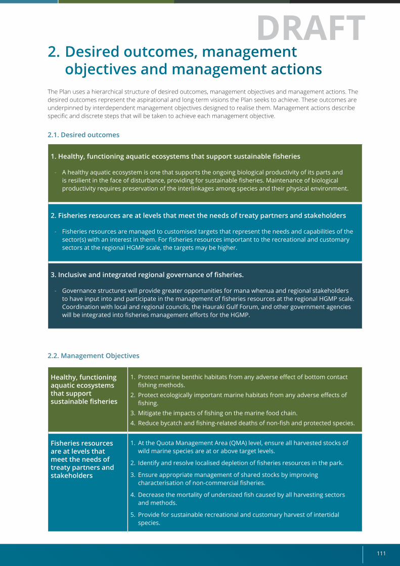
111
2. Desired outcomes, management objectives and management actions
The Plan uses a hierarchical structure of desired outcomes, management objectives and management actions. The desired outcomes represent the aspirational and long-term visions the Plan seeks to achieve. These outcomes are underpinned by interdependent management objectives designed to realise them. Management actions describe specific and discrete steps that will be taken to achieve each management objective.
2.1. Desired outcomes
1. Healthy, functioning aquatic ecosystems that support sustainable fisheries
- A healthy aquatic ecosystem is one that supports the ongoing biological productivity of its parts and is resilient in the face of disturbance, providing for sustainable fisheries. Maintenance of biological productivity requires preservation of the interlinkages among species and their physical environment.
2. Fisheries resources are at levels that meet the needs of treaty partners and stakeholders
- Fisheries resources are managed to customised targets that represent the needs and capabilities of the sector(s) with an interest in them. For fisheries resources important to the recreational and customary sectors at the regional HGMP scale, the targets may be higher.
3. Inclusive and integrated regional governance of fisheries.
- Governance structures will provide greater opportunities for mana whenua and regional stakeholders to have input into and participate in the management of fisheries resources at the regional HGMP scale. Coordination with local and regional councils, the Hauraki Gulf Forum, and other government agencies will be integrated into fisheries management efforts for the HGMP.
2.2. Management Objectives
Healthy, functioning aquatic ecosystems that support sustainable fisheries
1. Protect marine benthic habitats from any adverse effect of bottom contact fishing methods.
2. Protect ecologically important marine habitats from any adverse effects of fishing.
3. Mitigate the impacts of fishing on the marine food chain. 4. Reduce bycatch and fishing-related deaths of non-fish and protected species.
Fisheries resources are at levels that meet the needs of treaty partners and stakeholders
1. At the Quota Management Area (QMA) level, ensure all harvested stocks of wild marine species are at or above target levels.
2. Identify and resolve localised depletion of fisheries resources in the park.
3. Ensure appropriate management of shared stocks by improving characterisation of non-commercial fisheries.
4. Decrease the mortality of undersized fish caused by all harvesting sectors and methods.
5. Provide for sustainable recreational and customary harvest of intertidal species.
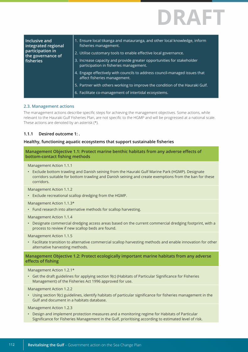
Revitalising the Gulf – Government action on the Sea Change Plan112
Inclusive and integrated regional participation in the governance of fisheries
1. Ensure local tikanga and matauranga, and other local knowledge, inform fisheries management.
2. Utilise customary tools to enable effective local governance.
3. Increase capacity and provide greater opportunities for stakeholder participation in fisheries management.
4. Engage effectively with councils to address council-managed issues that affect fisheries management.
5. Partner with others working to improve the condition of the Hauraki Gulf.
6. Facilitate co-management of intertidal ecosystems.
2.3. Management actionsThe management actions describe specific steps for achieving the management objectives. Some actions, while relevant to the Hauraki Gulf Fisheries Plan, are not specific to the HGMP and will be progressed at a national scale. These actions are denoted by an asterisk (*).
1.1.1 Desired outcome 1: .
Healthy, functioning aquatic ecosystems that support sustainable fisheries
Management Objective 1.1: Protect marine benthic habitats from any adverse effects of bottom-contact fishing methods
Management Action 1.1.1 • Exclude bottom trawling and Danish seining from the Hauraki Gulf Marine Park (HGMP). Designate
corridors suitable for bottom trawling and Danish seining and create exemptions from the ban for these corridors.
Management Action 1.1.2• Exclude recreational scallop dredging from the HGMP.
Management Action 1.1.3*• Fund research into alternative methods for scallop harvesting.
Management Action 1.1.4• Designate commercial dredging access areas based on the current commercial dredging footprint, with a
process to review if new scallop beds are found.
Management Action 1.1.5• Facilitate transition to alternative commercial scallop harvesting methods and enable innovation for other
alternative harvesting methods.
Management Objective 1.2: Protect ecologically important marine habitats from any adverse effects of fishing
Management Action 1.2.1* • Get the draft guidelines for applying section 9(c) (Habitats of Particular Significance for Fisheries
Management) of the Fisheries Act 1996 approved for use.
Management Action 1.2.2• Using section 9(c) guidelines, identify habitats of particular significance for fisheries management in the
Gulf and document in a habitats database.
Management Action 1.2.3• Design and implement protection measures and a monitoring regime for Habitats of Particular
Significance for Fisheries Management in the Gulf, prioritising according to estimated level of risk.
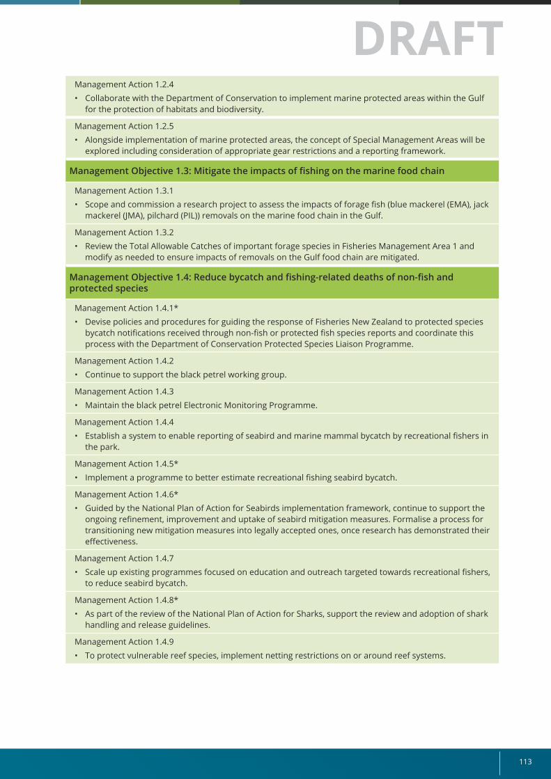
113
Management Action 1.2.4• Collaborate with the Department of Conservation to implement marine protected areas within the Gulf
for the protection of habitats and biodiversity.
Management Action 1.2.5• Alongside implementation of marine protected areas, the concept of Special Management Areas will be
explored including consideration of appropriate gear restrictions and a reporting framework.
Management Objective 1.3: Mitigate the impacts of fishing on the marine food chain
Management Action 1.3.1• Scope and commission a research project to assess the impacts of forage fish (blue mackerel (EMA), jack
mackerel (JMA), pilchard (PIL)) removals on the marine food chain in the Gulf.
Management Action 1.3.2• Review the Total Allowable Catches of important forage species in Fisheries Management Area 1 and
modify as needed to ensure impacts of removals on the Gulf food chain are mitigated.
Management Objective 1.4: Reduce bycatch and fishing-related deaths of non-fish and protected species
Management Action 1.4.1* • Devise policies and procedures for guiding the response of Fisheries New Zealand to protected species
bycatch notifications received through non-fish or protected fish species reports and coordinate this process with the Department of Conservation Protected Species Liaison Programme.
Management Action 1.4.2• Continue to support the black petrel working group.
Management Action 1.4.3• Maintain the black petrel Electronic Monitoring Programme.
Management Action 1.4.4• Establish a system to enable reporting of seabird and marine mammal bycatch by recreational fishers in
the park.
Management Action 1.4.5*• Implement a programme to better estimate recreational fishing seabird bycatch.
Management Action 1.4.6*• Guided by the National Plan of Action for Seabirds implementation framework, continue to support the
ongoing refinement, improvement and uptake of seabird mitigation measures. Formalise a process for transitioning new mitigation measures into legally accepted ones, once research has demonstrated their effectiveness.
Management Action 1.4.7• Scale up existing programmes focused on education and outreach targeted towards recreational fishers,
to reduce seabird bycatch.
Management Action 1.4.8*• As part of the review of the National Plan of Action for Sharks, support the review and adoption of shark
handling and release guidelines.
Management Action 1.4.9• To protect vulnerable reef species, implement netting restrictions on or around reef systems.
Revitalising the Gulf – Government action on the Sea Change Plan114
1.1.2 Desired Outcome 2:
Fisheries resources meet the needs of Treaty partners and stakeholders
Management Objective 2.1: At the QMA level, ensure all harvested stocks of wild marine species are at or above target levels
Management Action 2.1.1• Work with stakeholders (recreational, customary, commercial, non-take) to determine their fisheries
resource needs and priorities within the Hauraki Gulf Marine Park.
Management Action 2.1.2• Identify and prioritise stocks for management interventions. Input these recommendations to annual
sustainability rounds and research prioritisation processes.
Management Action 2.1.3• Set management targets and Total Allowable Catches to achieve and restore abundance at stock levels.
Management Action 2.1.4*• To enable more responsive management, support changes to the Fisheries (Amateur Fishing) Regulations
2013 and section 297(1) of the Fisheries Act 1996 to provide for recreational management controls to be set by the Minister through notice in the Gazette rather than through regulation.
Management Action 2.1.5• Support development of reference points for the Coromandel scallop fishery and work with industry to
formalise the voluntary Catch Per Unit Effort limit rule management approach.
Management Objective 2.2: Identify and resolve localised depletion of fisheries resources in the park
Management Action 2.2.1• Define and develop criteria for localised depletion.
Management Action 2.2.2• Identify key stocks that may suffer from localised depletion within the Hauraki Gulf Marine Park. Of these
stocks, identify those used by all sectors and those targeted primarily by non-commercial fishers.
Management Action 2.2.3• For stocks at risk of localised depletion, develop criteria on a per-species or species group basis. Develop
decision rules for more responsive management within the Hauraki Gulf.
Management Action 2.2.4• For key stocks used by all sectors that suffer from localised depletion, explore voluntary removal
agreements with industry, combined with monitoring using new Electronic Catch and Position Reporting (ER/GPR) data.
Management Action 2.2.5• For key recreational and customary stocks that suffer from localised depletion, reduce recreational bag
limits (species-specific and mixed) and/or prohibit bulk harvesting methods.
Management Action 2.2.6• Advance scientific research on kina populations, to improve understanding of the variation in their spatial
distribution, density and condition.
Management Action 2.2.7• Facilitate the co-development of a kina management plan. The plan should address the environmental
impacts of kina barrens, supporting Desired Outcome 1.
115
Management Objective 2.3: Ensure appropriate management of shared stocks by improving characterisation of non-commercial fisheries
Management Action 2.3.1• Require recreational fishing charter vessels to report all their catch in Fisheries Management Area 1.
Management Action 2.3.2• Pilot an app for Amateur Fishing Charter Vessels (ACV) reporting, to improve timeliness and accuracy of
reported data. Identify options for data validation.
Management Action 2.3.3• Consider how ACV-reported data might be integrated with aerial overview and NPS harvest and effort
estimates.
Management Action 2.3.4• Work with Iwi Fisheries Forums to improve customary reporting.
Management Action 2.3.5• Explore options for improving catch and effort information for recreational fisheries in the Hauraki Gulf
Marine Park.
(Options could include: increasing the frequency, specificity or coverage of existing recreational surveys in the Hauraki Gulf Marine Park; creating a park-specific recreational survey; or encouraging self-reporting. An angler registry for the Hauraki Gulf Marine Park would provide a suitable reference framework.)
Management Objective 2.4: Decrease mortality of undersized fish caused by all harvesting sectors and methods
Management Action 2.4.1• Analyse Electronic Reporting disposal and undersized snapper and tarakihi (SNX/TAX) reports to evaluate
the effectiveness of existing management measures intended to decrease the mortality of undersized fish caused by the commercial sector.
Management Action 2.4.2• Encourage recreational fisher groups to develop a “move on” practice to reduce incidental catch of
snapper below the Minimum Legal Size (MLS). • Progressing Management Action 1.2.3 will also support this objective.
Management Objective 2.5: Provide for sustainable recreational and customary harvest of intertidal species
Management Action 2.5.1• Update baseline knowledge of intertidal species’ distribution and harvest.
Management Action 2.5.2• Review management settings for intertidal shellfish harvesting on the hard shore.
Management Action 2.5.3• Adopt blanket seasonal closures for intertidal shellfish harvesting (ie, no harvesting in summer).
Management Action 2.5.4• Support community efforts to monitor and restore intertidal species. (Relates to Management Action
3.6.1).
Revitalising the Gulf – Government action on the Sea Change Plan116
1.1.3 Desired Outcome 3:
Inclusive and integrated regional participation in the governance of fisheries
Management Objective 3.1 Ensure local tikanga and mātauranga, and other local knowledge, inform fisheries management
Management Action 3.1.1• Establish a collaborative Hauraki Gulf Fisheries Plan Advisory Group to provide opportunities for regional
participation in fisheries management in the Hauraki Gulf.
Management Action 3.1.2• Help facilitate the sustained operation of a Hauraki Gulf iwi fisheries forum.
Management Action 3.1.3• Clearly communicate our research prioritisation and sustainability round processes and identify
opportunities for stakeholder input. (Relates to Management Action 3.1.1).
Management Action 3.1.4• Explore ways in which local knowledge can be used in fisheries science.
Management Objective 3.2 Utilise customary tools to enable effective local governance
Management Action 3.2.1• Facilitate transition to kaimoana regulations.
Management Action 3.2.2• Where rohe have been gazetted, support iwi in efforts to establish mātaitai and/or taiāpure.
Management Objective 3.3 Increase capacity and provide greater opportunities for stakeholder participation in fisheries management
Management Action 3.3.1• Design a targeted outreach and communications strategy for fisheries stakeholders in the Hauraki Gulf
Marine Park.
Management Action 3.3.2• Invite fishing industry and iwi fisheries forum representatives and kaitiaki to attend fisheries science
education programmes.
Management Objective 3.4 Engage effectively with councils to address council-managed issues that affect fisheries management
Management Action 3.4.1• Incorporate a “local councils” component in the outreach and communications strategy (Management
Action 3.1.1) for the Hauraki Gulf Marine Park.
Management Action 3.4.2• Build and strengthen relationships with regional councils and local boards, to enable networking
governance of complex issues that affect the Hauraki Gulf.
Management Objective 3.5 Partner with others working to improve the condition of the Hauraki Gulf.
Management Action 3.5.1• Collaborate with the Department of Conservation on efforts to develop, implement, and monitor a
network of marine protected areas within the Gulf. (Refer to Management Action 1.2.4).
Management Action 3.5.2• Actively participate in mussel reef restoration efforts and help with protection of sites.
Management Objective 3.6 Facilitate co-management of intertidal ecosystems
Management Action 3.6.1• Help with the design and piloting of Ahu Moana projects that can support achievement of Management
Action 1.2.3 (protecting habitats of significance) and Management Action 2.4.4 (sustainable intertidal harvest).
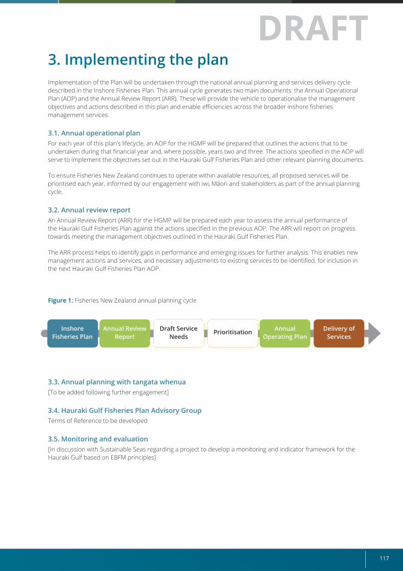
117
3. Implementing the planImplementation of the Plan will be undertaken through the national annual planning and services delivery cycle described in the Inshore Fisheries Plan. This annual cycle generates two main documents: the Annual Operational Plan (AOP) and the Annual Review Report (ARR). These will provide the vehicle to operationalise the management objectives and actions described in this plan and enable efficiencies across the broader inshore fisheries management services.
3.1. Annual operational planFor each year of this plan’s lifecycle, an AOP for the HGMP will be prepared that outlines the actions that to be undertaken during that financial year and, where possible, years two and three. The actions specified in the AOP will serve to implement the objectives set out in the Hauraki Gulf Fisheries Plan and other relevant planning documents.
To ensure Fisheries New Zealand continues to operate within available resources, all proposed services will be prioritised each year, informed by our engagement with iwi, Māori and stakeholders as part of the annual planning cycle.
3.2. Annual review reportAn Annual Review Report (ARR) for the HGMP will be prepared each year to assess the annual performance of the Hauraki Gulf Fisheries Plan against the actions specified in the previous AOP. The ARR will report on progress towards meeting the management objectives outlined in the Hauraki Gulf Fisheries Plan.
The ARR process helps to identify gaps in performance and emerging issues for further analysis. This enables new management actions and services, and necessary adjustments to existing services to be identified, for inclusion in the next Hauraki Gulf Fisheries Plan AOP.
Figure 1: Fisheries New Zealand annual planning cycle
3.3. Annual planning with tangata whenua[To be added following further engagement]
3.4. Hauraki Gulf Fisheries Plan Advisory GroupTerms of Reference to be developed
3.5. Monitoring and evaluation[In discussion with Sustainable Seas regarding a project to develop a monitoring and indicator framework for the Hauraki Gulf based on EBFM principles]
Inshore Fisheries Plan
Annual Review Report
Annual Operating Plan
Delivery of Services
Draft Service Needs
Prioritisation
Revitalising the Gulf – Government action on the Sea Change Plan118
Legislative context The Fisheries Act 1996 outlines the laws that relate to the governance of fisheries resources and how they should be managed, and recognises New Zealand’s international obligations relating to fishing.
Treaty of Waitangi (Fisheries Claims) Settlement Act 1992:
The Treaty of Waitangi (Fisheries Claims) Settlement Act 1992 (the Settlement Act) gives effect to the settlement of claims relating to Māori fishing rights. Obligations under the Settlement Act can be considered in two broad categories:
• specific obligations relating to use – both commercial and non-commercial, and
• more general obligations relating to the right of tangata whenua to participate in fisheries management decisions and have their values and aspirations given particular regard.
The Minister has legal obligations [can expand on these] to iwi under the Fisheries Protocols that are attached to the Deed of Settlements.
The Hauraki Gulf Marine Park Act 2000 recognises the Hauraki Gulf Marine Park as being nationally significant. The purpose of this Act is to:
• integrate the management of the natural, historic, and physical resources of the Hauraki Gulf, its islands, and catchments;
• establish the Hauraki Gulf Marine Park;
• establish objectives for the management of the Hauraki Gulf, its islands, and catchments;
• recognise the historic, traditional, cultural, and spiritual relationship of the tangata whenua with the Hauraki Gulf and its islands; and
• establish the Hauraki Gulf Forum.
The Fisheries Act 1996 (section 11) requires that, in setting or varying any sustainability measures in the Gulf, the Minister takes account of section 7 and section 8 of the Hauraki Gulf Marine Park Act 2000. These sections recognise the national significance of the life supporting capacity of the Hauraki Gulf, and define management objectives for its protection.
Other legislation that contributes to the management of the wider fisheries ecosystem includes the:
• Resource Management Act 1991 which is New Zealand’s primary legislation for managing the environment, including air, soil, fresh water and coastal marine areas;
• Wildlife Act 1953 which gives partial or full protection to all but one species of seabird;
• Marine Mammals Protection Act 1978 which makes provision for the protection, conservation, and management of marine mammals within New Zealand waters; and
• Marine Reserves Act 1971, which provides for the establishment of marine reserves that, aside from exceptions, exclude all forms of fishing.
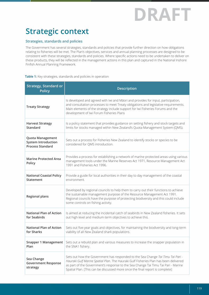
119
Strategic context Strategies, standards and policies
The Government has several strategies, standards and policies that provide further direction on how obligations relating to fisheries will be met. The Plan’s objectives, services and annual planning processes are designed to be consistent with these strategies, standards and policies. Where specific actions need to be undertaken to deliver on these products, they will be reflected in the management actions in this plan and captured in the National Inshore Finfish Annual Planning Framework.
Table 1: Key strategies, standards and policies in operation
Strategy, Standard or Policy
Description
Treaty Strategy
Is developed and agreed with Iwi and Māori and provides for input, participation, and consultation processes to meet Treaty obligations and legislative requirements. Main elements of the strategy include support for Iwi Fisheries Forums and the development of Iwi Forum Fisheries Plans
Harvest Strategy Standard
Is a policy statement that provides guidance on setting fishery and stock targets and limits for stocks managed within New Zealand’s Quota Management System (QMS).
Quota Management System Introduction Process Standard
Sets out a process for Fisheries New Zealand to identify stocks or species to be considered for QMS introduction.
Marine Protected Area Policy
Provides a process for establishing a network of marine protected areas using various management tools under the Marine Reserves Act 1971, Resource Management Act 1991 and Fisheries Act 1996.
National Coastal Policy Statement
Provide a guide for local authorities in their day to day management of the coastal environment.
Regional plans
Developed by regional councils to help them to carry out their functions to achieve the sustainable management purpose of the Resource Management Act 1991. Regional councils have the purpose of protecting biodiversity and this could include some controls on fishing activity.
National Plan of Action for Seabirds
Is aimed at reducing the incidental catch of seabirds in New Zealand fisheries. It sets out high-level and medium-term objectives to achieve this.
National Plan of Action for Sharks
Sets out five-year goals and objectives, for maintaining the biodiversity and long-term viability of all New Zealand shark populations.
Snapper 1 Management Plan
Sets out a rebuild plan and various measures to increase the snapper population in the SNA1 fishery.
Sea Change Government Response strategy
Sets out how the Government has responded to the Sea Change Tai Timu Tai Pari - Hauraki Gulf Marine Spatial Plan. The Hauraki Gulf Fisheries Plan has been delivered as part of the Government’s response to the Sea Change Tai Timu Tai Pari - Marine Spatial Plan. [This can be discussed more once the final report is complete]
Revitalising the Gulf – Government action on the Sea Change Plan120
Other government work programmes are exploring ways to strengthen and improve management tools that will influence the delivery of healthy and sustainable fisheries. These include:
• the Fisheries Change Programme, a Ministry for Primary Industries led programme to strengthen and modernise the way we manage our fisheries, ensuring their sustainability.
• marine protected areas policy reform; and
• action for healthy waterways which is a Government initiative led by the Ministry for the Environment to strengthen government obligations to protect and restore New Zealand’s waterways.
Aquaculture Strategy
Sets out the Government’s commitment to ensure aquaculture growth is environmentally sustainable and considers other uses and values of the coast and waterways. It also ensures iwi and broader Māori aspirations, including kaitiakitanga, are promoted.
Fisheries Act 1996
Hauraki Gulf Fisheries Plan
Hauraki Iwi Forum Fisheries Plans
National Inshore Finfish Fisheries Plan (5 year)
National Plans of Action Threat Management Plans
Medium-Term Research Plan
Annual Operational Plan (AOP)
Annual Review Report (ARR)
Key focus areas:
1. managing individual stocks
2. enabling multi-stock fisheries management
3. enhancing benefits for customary, commercial and recreational fishers
4. improving local fisheries
5. improving environmental performance
Treaty Obligations to Māori
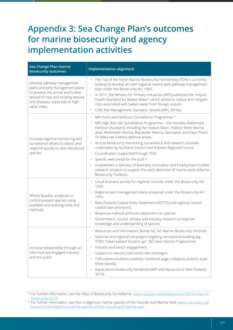
121
Appendix 3: Sea Change Plan’s outcomes for marine biosecurity and agency implementation activities
Sea Change Plan marine biosecurity outcomes
Implementation alignment
Develop pathway management plans and pest management plans to prevent the arrival and further spread of new and existing species and diseases, especially to high-value areas.
• The Top of the North Marine Biosecurity Partnership (TON) is currently looking to develop an inter-regional marine pest pathway management plan under the Biosecurity Act 1993.
• In 2017, the Ministry for Primary Industries (MPI) published the “Import Health Standard for Ballast Water”, which aimed to reduce and mitigate risks associated with ballast water from foreign vessels.
• Craft Risk Management Standard: Vessels (MPI, 2018a).
Increase regional monitoring and surveillance efforts to detect and respond quickly to new introduced species.
• MPI Ports and Harbours Surveillance Programme.33
• MPI High Risk Site Surveillance Programme – this includes Waitematā Harbour (Auckland, including the Viaduct Basin, Hobson West Marina area, Westhaven Marina, Bayswater Marina, Devonport and Kauri Point/Te Māta-rae-o Mana defence areas).
• Annual biosecurity monitoring, surveillance and research activities undertaken by Auckland Council and Waikato Regional Council.
• Co-ordination supported through TON.
• Specific web portal for the Gulf.34
• Involvement in Ministry of Business, Innovation and Employment-funded research projects to support the early detection of marine pests (Marine Biosecurity Toolbox).
Where feasible, eradicate or control present species using available and evolving tools and methods.
• Usual business activity for regional councils under the Biosecurity Act 1993.
• Regional pest management plans prepared under the Biosecurity Act 1993.
• New Zealand Coastal Policy Statement (NZCPS) and regional council coastal plan provisions.
• Response method and tools dependent on species.
• Government, council, tertiary and industry research to improve knowledge and understanding of species.
Increase stewardship through an informed and engaged industry and the public.
• Resources and information; Bionet NZ, NZ Marine Biosecurity Porthole.
• National and regional campaigns targeting recreational boating (eg, TON’s “Clean below? Good to go”, NZ Clean Marina Programme).
• Industry and sector engagement.
• Support to industry and sector-led campaigns.
• TON communications (website, Facebook page, collateral, posters, boat show stands).
• Aquaculture biosecurity handbook (MPI and Aquaculture New Zealand, 2016).
33 For further information, see the Atlas of Biosecurity Surveillance: www.mpi.govt.nz/dmsdocument/39674-atlas-of-biosecurity-2019.
34 For further information, see Non-indigenous marine species of the Hauraki Gulf Marine Park: www.inaturalist.org/projects/nonindigenous-marine-species-of-the-hauraki-gulf-marine-park.
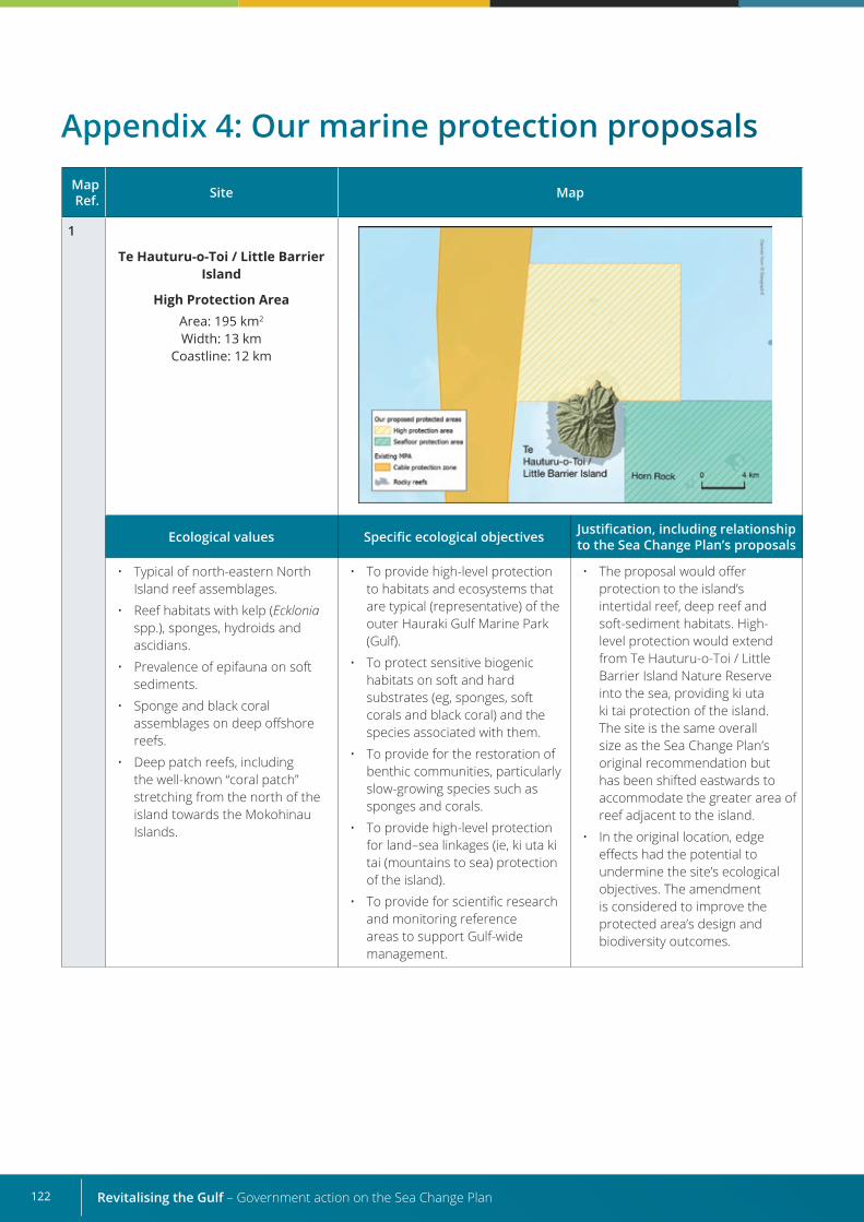
Revitalising the Gulf – Government action on the Sea Change Plan122
Map Ref. Site Map
1
Te Hauturu-o-Toi / Little Barrier Island
High Protection AreaArea: 195 km2
Width: 13 kmCoastline: 12 km
Ecological values Specific ecological objectives Justification, including relationship to the Sea Change Plan’s proposals
• Typical of north-eastern North Island reef assemblages.
• Reef habitats with kelp (Ecklonia spp.), sponges, hydroids and ascidians.
• Prevalence of epifauna on soft sediments.
• Sponge and black coral assemblages on deep offshore reefs.
• Deep patch reefs, including the well-known “coral patch” stretching from the north of the island towards the Mokohinau Islands.
• To provide high-level protection to habitats and ecosystems that are typical (representative) of the outer Hauraki Gulf Marine Park (Gulf).
• To protect sensitive biogenic habitats on soft and hard substrates (eg, sponges, soft corals and black coral) and the species associated with them.
• To provide for the restoration of benthic communities, particularly slow-growing species such as sponges and corals.
• To provide high-level protection for land–sea linkages (ie, ki uta ki tai (mountains to sea) protection of the island).
• To provide for scientific research and monitoring reference areas to support Gulf-wide management.
• The proposal would offer protection to the island’s intertidal reef, deep reef and soft-sediment habitats. High-level protection would extend from Te Hauturu-o-Toi / Little Barrier Island Nature Reserve into the sea, providing ki uta ki tai protection of the island. The site is the same overall size as the Sea Change Plan’s original recommendation but has been shifted eastwards to accommodate the greater area of reef adjacent to the island.
• In the original location, edge effects had the potential to undermine the site’s ecological objectives. The amendment is considered to improve the protected area’s design and biodiversity outcomes.
Appendix 4: Our marine protection proposals
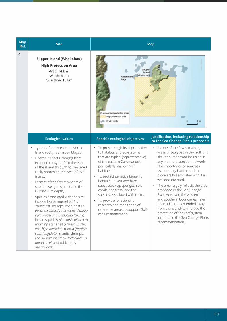
123
Map Ref. Site Map
2Slipper Island (Whakahau)
High Protection AreaArea: 14 km2
Width: 4 kmCoastline: 10 km
Ecological values Specific ecological objectives Justification, including relationship to the Sea Change Plan’s proposals
• Typical of north-eastern North Island rocky reef assemblages.
• Diverse habitats, ranging from exposed rocky reefs to the east of the island through to sheltered rocky shores on the west of the island.
• Largest of the few remnants of subtidal seagrass habitat in the Gulf (to 3 m depth).
• Species associated with the site include horse mussel (Atrina zelandica), scallops, rock lobster (Jasus edwardsii), sea hares (Aplysia keraudreni and Bursatella leachii), broad squid (Sepioteuthis bilineata), morning star shell (Tawera spissa; very high densities), tuatua (Paphies subtriangulata), mantis shrimps, red swimming crab (Nectocarcinus antarcticus) and tubiculous amphipods.
• To provide high-level protection to habitats and ecosystems that are typical (representative) of the eastern Coromandel, particularly shallow reef habitats.
• To protect sensitive biogenic habitats on soft and hard substrates (eg, sponges, soft corals, seagrass) and the species associated with them.
• To provide for scientific research and monitoring of reference areas to support Gulf-wide management.
• As one of the few remaining areas of seagrass in the Gulf, this site is an important inclusion in any marine protection network. The importance of seagrass as a nursery habitat and the biodiversity associated with it is well documented.
• The area largely reflects the area proposed in the Sea Change Plan. However, the western and southern boundaries have been adjusted (extended away from the island) to improve the protection of the reef system included in the Sea Change Plan’s recommendation.
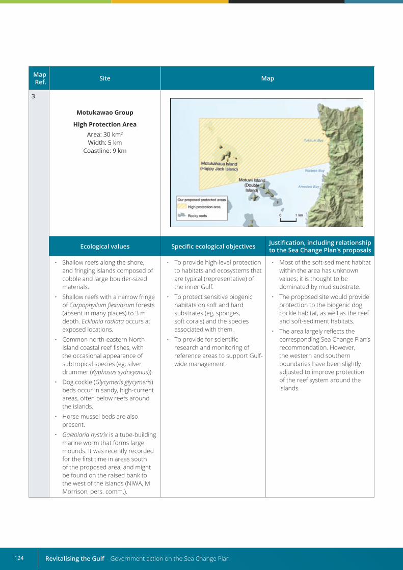
Revitalising the Gulf – Government action on the Sea Change Plan124
Map Ref. Site Map
3
Motukawao Group
High Protection AreaArea: 30 km2
Width: 5 kmCoastline: 9 km
Ecological values Specific ecological objectives Justification, including relationship to the Sea Change Plan’s proposals
• Shallow reefs along the shore, and fringing islands composed of cobble and large boulder-sized materials.
• Shallow reefs with a narrow fringe of Carpophyllumflexuosum forests (absent in many places) to 3 m depth. Ecklonia radiata occurs at exposed locations.
• Common north-eastern North Island coastal reef fishes, with the occasional appearance of subtropical species (eg, silver drummer (Kyphosus sydneyanus)).
• Dog cockle (Glycymeris glycymeris) beds occur in sandy, high-current areas, often below reefs around the islands.
• Horse mussel beds are also present.
• Galeolaria hystrix is a tube-building marine worm that forms large mounds. It was recently recorded for the first time in areas south of the proposed area, and might be found on the raised bank to the west of the islands (NIWA, M Morrison, pers. comm.).
• To provide high-level protection to habitats and ecosystems that are typical (representative) of the inner Gulf.
• To protect sensitive biogenic habitats on soft and hard substrates (eg, sponges, soft corals) and the species associated with them.
• To provide for scientific research and monitoring of reference areas to support Gulf-wide management.
• Most of the soft-sediment habitat within the area has unknown values; it is thought to be dominated by mud substrate.
• The proposed site would provide protection to the biogenic dog cockle habitat, as well as the reef and soft-sediment habitats.
• The area largely reflects the corresponding Sea Change Plan’s recommendation. However, the western and southern boundaries have been slightly adjusted to improve protection of the reef system around the islands.
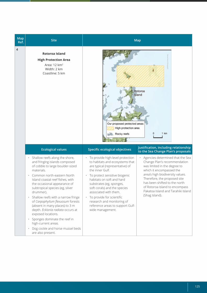
125
Map Ref. Site Map
4Rotoroa Island
High Protection AreaArea: 12 km2
Width: 2 kmCoastline: 5 km
Ecological values Specific ecological objectives Justification, including relationship to the Sea Change Plan’s proposals
• Shallow reefs along the shore, and fringing islands composed of cobble to large boulder-sized materials.
• Common north-eastern North Island coastal reef fishes, with the occasional appearance of subtropical species (eg, silver drummer).
• Shallow reefs with a narrow fringe of Carpophyllumflexuosum forests (absent in many places) to 3 m depth. Ecklonia radiata occurs at exposed locations.
• Sponges dominate the reef in high-current areas.
• Dog cockle and horse mussel beds are also present.
• To provide high-level protection to habitats and ecosystems that are typical (representative) of the inner Gulf.
• To protect sensitive biogenic habitats on soft and hard substrates (eg, sponges, soft corals) and the species associated with them.
• To provide for scientific research and monitoring of reference areas to support Gulf-wide management.
• Agencies determined that the Sea Change Plan’s recommendation was limited in the degree to which it encompassed the area’s high biodiversity values. Therefore, the proposed site has been shifted to the north of Rotoroa Island to encompass Pakatoa Island and Tarahiki Island (Shag Island).
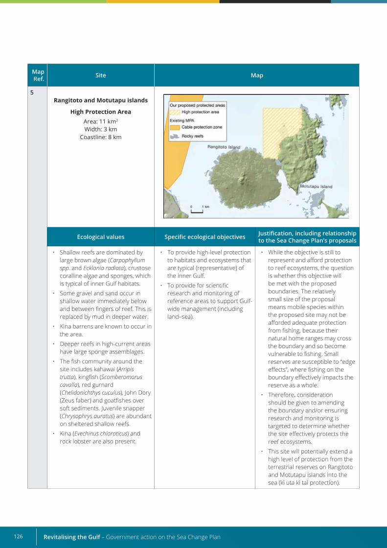
Revitalising the Gulf – Government action on the Sea Change Plan126
Map Ref. Site Map
5Rangitoto and Motutapu islands
High Protection AreaArea: 11 km2
Width: 3 kmCoastline: 8 km
Ecological values Specific ecological objectives Justification, including relationship to the Sea Change Plan’s proposals
• Shallow reefs are dominated by large brown algae (Carpophyllum spp. and Ecklonia radiata), crustose coralline algae and sponges, which is typical of inner Gulf habitats.
• Some gravel and sand occur in shallow water immediately below and between fingers of reef. This is replaced by mud in deeper water.
• Kina barrens are known to occur in the area.
• Deeper reefs in high-current areas have large sponge assemblages.
• The fish community around the site includes kahawai (Arripis trutta), kingfish (Scomberomorus cavalla), red gurnard (Chelidonichthys cuculus), John Dory (Zeus faber) and goatfishes over soft sediments. Juvenile snapper (Chrysophrys auratus) are abundant on sheltered shallow reefs.
• Kina (Evechinus chloroticus) and rock lobster are also present.
• To provide high-level protection to habitats and ecosystems that are typical (representative) of the inner Gulf.
• To provide for scientific research and monitoring of reference areas to support Gulf-wide management (including land–sea).
• While the objective is still to represent and afford protection to reef ecosystems, the question is whether this objective will be met with the proposed boundaries. The relatively small size of the proposal means mobile species within the proposed site may not be afforded adequate protection from fishing, because their natural home ranges may cross the boundary and so become vulnerable to fishing. Small reserves are susceptible to “edge effects”, where fishing on the boundary effectively impacts the reserve as a whole.
• Therefore, consideration should be given to amending the boundary and/or ensuring research and monitoring is targeted to determine whether the site effectively protects the reef ecosystems.
• This site will potentially extend a high level of protection from the terrestrial reserves on Rangitoto and Motutapu islands into the sea (ki uta ki tai protection).
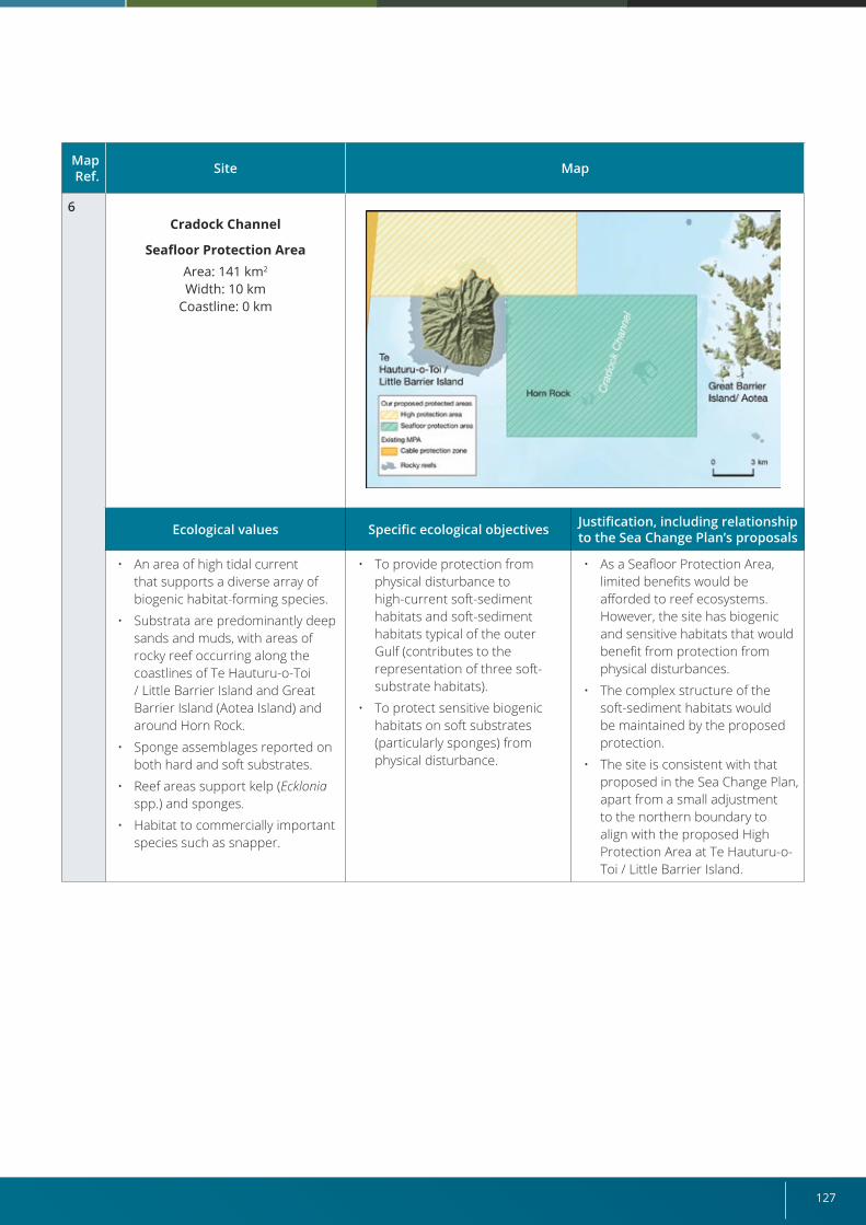
127
Map Ref. Site Map
6Cradock Channel
Seafloor Protection AreaArea: 141 km2
Width: 10 kmCoastline: 0 km
Ecological values Specific ecological objectives Justification, including relationship to the Sea Change Plan’s proposals
• An area of high tidal current that supports a diverse array of biogenic habitat-forming species.
• Substrata are predominantly deep sands and muds, with areas of rocky reef occurring along the coastlines of Te Hauturu-o-Toi / Little Barrier Island and Great Barrier Island (Aotea Island) and around Horn Rock.
• Sponge assemblages reported on both hard and soft substrates.
• Reef areas support kelp (Ecklonia spp.) and sponges.
• Habitat to commercially important species such as snapper.
• To provide protection from physical disturbance to high-current soft-sediment habitats and soft-sediment habitats typical of the outer Gulf (contributes to the representation of three soft-substrate habitats).
• To protect sensitive biogenic habitats on soft substrates (particularly sponges) from physical disturbance.
• As a Seafloor Protection Area, limited benefits would be afforded to reef ecosystems. However, the site has biogenic and sensitive habitats that would benefit from protection from physical disturbances.
• The complex structure of the soft-sediment habitats would be maintained by the proposed protection.
• The site is consistent with that proposed in the Sea Change Plan, apart from a small adjustment to the northern boundary to align with the proposed High Protection Area at Te Hauturu-o-Toi / Little Barrier Island.
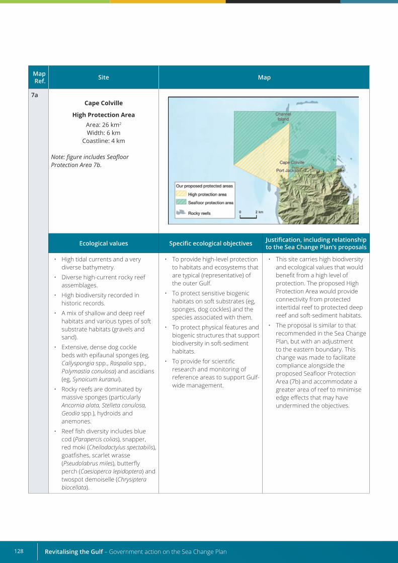
Revitalising the Gulf – Government action on the Sea Change Plan128
Map Ref. Site Map
7aCape Colville
High Protection AreaArea: 26 km2
Width: 6 kmCoastline: 4 km
Note: figure includes Seafloor Protection Area 7b.
Ecological values Specific ecological objectives Justification, including relationship to the Sea Change Plan’s proposals
• High tidal currents and a very diverse bathymetry.
• Diverse high-current rocky reef assemblages.
• High biodiversity recorded in historic records.
• A mix of shallow and deep reef habitats and various types of soft substrate habitats (gravels and sand).
• Extensive, dense dog cockle beds with epifaunal sponges (eg, Callyspongia spp., Raspalia spp., Polymastia conulosa) and ascidians (eg, Synoicum kuranui).
• Rocky reefs are dominated by massive sponges (particularly Ancornia alata, Stelleta conulosa, Geodia spp.), hydroids and anemones.
• Reef fish diversity includes blue cod (Parapercis colias), snapper, red moki (Cheilodactylus spectabilis), goatfishes, scarlet wrasse (Pseudolabrus miles), butterfly perch (Caesioperca lepidoptera) and twospot demoiselle (Chrysiptera biocellata).
• To provide high-level protection to habitats and ecosystems that are typical (representative) of the outer Gulf.
• To protect sensitive biogenic habitats on soft substrates (eg, sponges, dog cockles) and the species associated with them.
• To protect physical features and biogenic structures that support biodiversity in soft-sediment habitats.
• To provide for scientific research and monitoring of reference areas to support Gulf-wide management.
• This site carries high biodiversity and ecological values that would benefit from a high level of protection. The proposed High Protection Area would provide connectivity from protected intertidal reef to protected deep reef and soft-sediment habitats.
• The proposal is similar to that recommended in the Sea Change Plan, but with an adjustment to the eastern boundary. This change was made to facilitate compliance alongside the proposed Seafloor Protection Area (7b) and accommodate a greater area of reef to minimise edge effects that may have undermined the objectives.
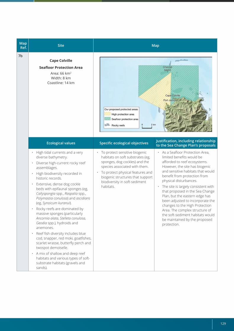
129
Map Ref. Site Map
7bCape Colville
Seafloor Protection AreaArea: 66 km2
Width: 8 kmCoastline: 14 km
Ecological values Specific ecological objectives Justification, including relationship to the Sea Change Plan’s proposals
• High tidal currents and a very diverse bathymetry.
• Diverse high-current rocky reef assemblages.
• High biodiversity recorded in historic records.
• Extensive, dense dog cockle beds with epifaunal sponges (eg, Callyspongia spp., Raspalia spp., Polymastia conulosa) and ascidians (eg, Synoicum kuranui).
• Rocky reefs are dominated by massive sponges (particularly Ancornia alata, Stelleta conulosa, Geodia spp.), hydroids and anemones.
• Reef fish diversity includes blue cod, snapper, red moki, goatfishes, scarlet wrasse, butterfly perch and twospot demoiselle.
• A mix of shallow and deep reef habitats and various types of soft-substrate habitats (gravels and sands).
• To protect sensitive biogenic habitats on soft substrates (eg, sponges, dog cockles) and the species associated with them.
• To protect physical features and biogenic structures that support biodiversity in soft-sediment habitats.
• As a Seafloor Protection Area, limited benefits would be afforded to reef ecosystems. However, the site has biogenic and sensitive habitats that would benefit from protection from physical disturbances.
• The site is largely consistent with that proposed in the Sea Change Plan, but the eastern edge has been adjusted to incorporate the changes to the High Protection Area. The complex structure of the soft-sediment habitats would be maintained by the proposed protection.
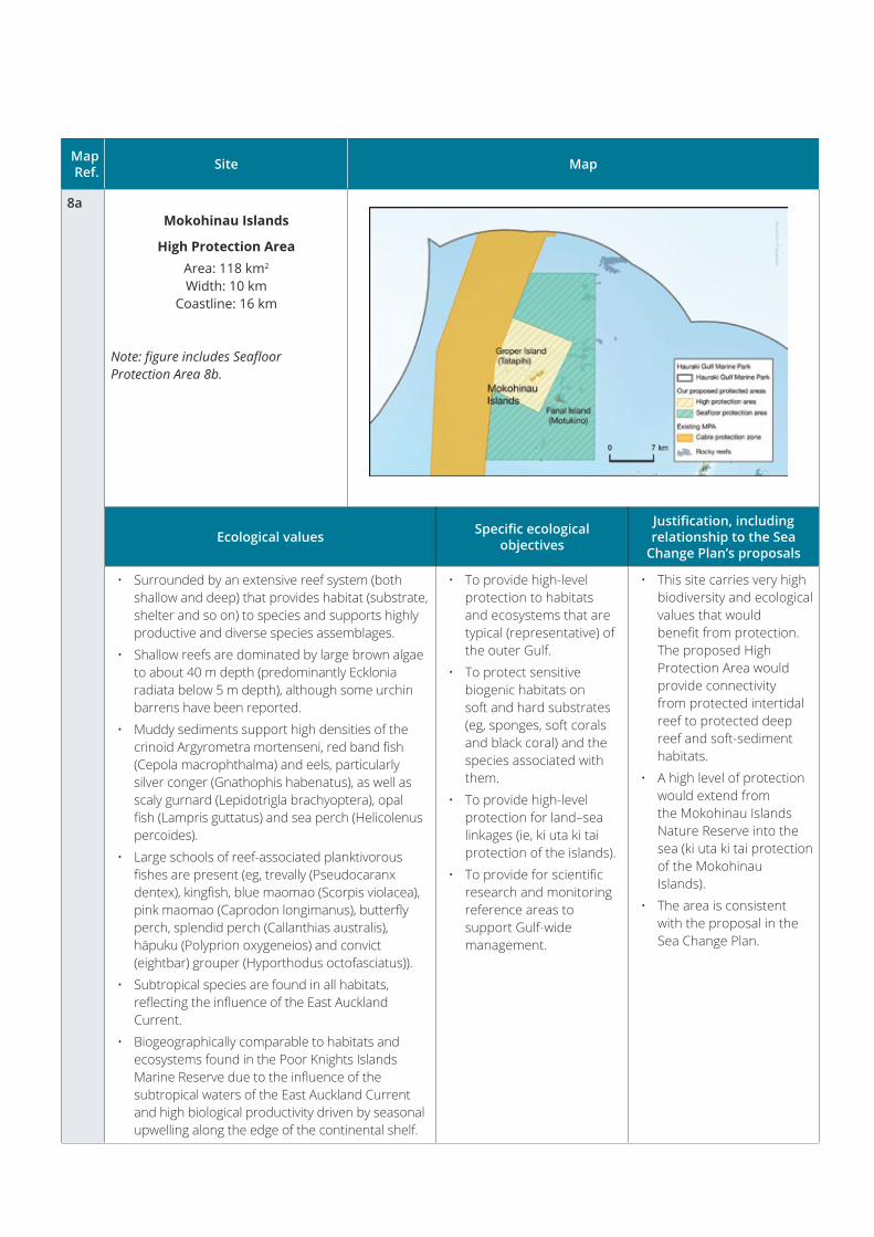
Map Ref. Site Map
8aMokohinau Islands
High Protection AreaArea: 118 km2
Width: 10 kmCoastline: 16 km
Note: figure includes Seafloor Protection Area 8b.
Ecological values Specific ecological objectives
Justification, including relationship to the Sea
Change Plan’s proposals
• Surrounded by an extensive reef system (both shallow and deep) that provides habitat (substrate, shelter and so on) to species and supports highly productive and diverse species assemblages.
• Shallow reefs are dominated by large brown algae to about 40 m depth (predominantly Ecklonia radiata below 5 m depth), although some urchin barrens have been reported.
• Muddy sediments support high densities of the crinoid Argyrometra mortenseni, red band fish (Cepola macrophthalma) and eels, particularly silver conger (Gnathophis habenatus), as well as scaly gurnard (Lepidotrigla brachyoptera), opal fish (Lampris guttatus) and sea perch (Helicolenus percoides).
• Large schools of reef-associated planktivorous fishes are present (eg, trevally (Pseudocaranx dentex), kingfish, blue maomao (Scorpis violacea), pink maomao (Caprodon longimanus), butterfly perch, splendid perch (Callanthias australis), hāpuku (Polyprion oxygeneios) and convict (eightbar) grouper (Hyporthodus octofasciatus)).
• Subtropical species are found in all habitats, reflecting the influence of the East Auckland Current.
• Biogeographically comparable to habitats and ecosystems found in the Poor Knights Islands Marine Reserve due to the influence of the subtropical waters of the East Auckland Current and high biological productivity driven by seasonal upwelling along the edge of the continental shelf.
• To provide high-level protection to habitats and ecosystems that are typical (representative) of the outer Gulf.
• To protect sensitive biogenic habitats on soft and hard substrates (eg, sponges, soft corals and black coral) and the species associated with them.
• To provide high-level protection for land–sea linkages (ie, ki uta ki tai protection of the islands).
• To provide for scientific research and monitoring reference areas to support Gulf-wide management.
• This site carries very high biodiversity and ecological values that would benefit from protection. The proposed High Protection Area would provide connectivity from protected intertidal reef to protected deep reef and soft-sediment habitats.
• A high level of protection would extend from the Mokohinau Islands Nature Reserve into the sea (ki uta ki tai protection of the Mokohinau Islands).
• The area is consistent with the proposal in the Sea Change Plan.
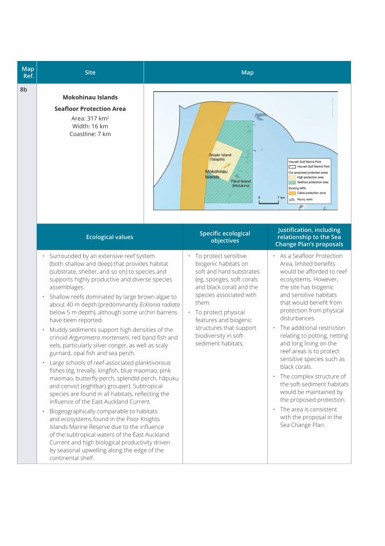
Map Ref. Site Map
8bMokohinau Islands
Seafloor Protection AreaArea: 317 km2
Width: 16 kmCoastline: 7 km
Ecological values Specific ecological objectives
Justification, including relationship to the Sea
Change Plan’s proposals
• Surrounded by an extensive reef system (both shallow and deep) that provides habitat (substrate, shelter, and so on) to species and supports highly productive and diverse species assemblages.
• Shallow reefs dominated by large brown algae to about 40 m depth (predominantly Ecklonia radiata below 5 m depth), although some urchin barrens have been reported.
• Muddy sediments support high densities of the crinoid Argyrometra mortenseni, red band fish and eels, particularly silver conger, as well as scaly gurnard, opal fish and sea perch.
• Large schools of reef-associated planktivorous fishes (eg, trevally, kingfish, blue maomao, pink maomao, butterfly perch, splendid perch, hāpuku and convict (eightbar) grouper). Subtropical species are found in all habitats, reflecting the influence of the East Auckland Current.
• Biogeographically comparable to habitats and ecosystems found in the Poor Knights Islands Marine Reserve due to the influence of the subtropical waters of the East Auckland Current and high biological productivity driven by seasonal upwelling along the edge of the continental shelf.
• To protect sensitive biogenic habitats on soft and hard substrates (eg, sponges, soft corals and black coral) and the species associated with them.
• To protect physical features and biogenic structures that support biodiversity in soft-sediment habitats.
• As a Seafloor Protection Area, limited benefits would be afforded to reef ecosystems. However, the site has biogenic and sensitive habitats that would benefit from protection from physical disturbances.
• The additional restriction relating to potting, netting and long lining on the reef areas is to protect sensitive species such as black corals.
• The complex structure of the soft-sediment habitats would be maintained by the proposed protection.
• The area is consistent with the proposal in the Sea Change Plan.
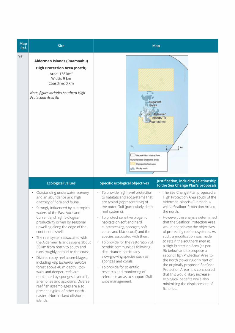
Map Ref. Site Map
9aAldermen Islands (Ruamaahu)
High Protection Area (north)Area: 138 km2
Width: 9 kmCoastline: 0 km
Note: figure includes southern High Protection Area 9b
Ecological values Specific ecological objectives Justification, including relationship to the Sea Change Plan’s proposals
• Outstanding underwater scenery and an abundance and high diversity of flora and fauna.
• Strongly influenced by subtropical waters of the East Auckland Current and high biological productivity driven by seasonal upwelling along the edge of the continental shelf.
• The reef system associated with the Aldermen Islands spans about 30 km from north to south and runs roughly parallel to the coast.
• Diverse rocky reef assemblages, including kelp (Ecklonia radiata) forest above 40 m depth. Rock walls and deeper reefs are dominated by sponges, hydroids, anemones and ascidians. Diverse reef fish assemblages are also present, typical of other north-eastern North Island offshore islands.
• To provide high-level protection to habitats and ecosystems that are typical (representative) of the outer Gulf (particularly deep reef systems).
• To protect sensitive biogenic habitats on soft and hard substrates (eg, sponges, soft corals and black coral) and the species associated with them.
• To provide for the restoration of benthic communities following disturbance, particularly slow-growing species such as sponges and corals.
• To provide for scientific research and monitoring of reference areas to support Gulf-wide management.
• The Sea Change Plan proposed a High Protection Area south of the Aldermen Islands (Ruamaahu), with a Seafloor Protection Area to the north.
• However, the analysis determined that the Seafloor Protection Area would not achieve the objectives of protecting reef ecosystems. As such, a modification was made to retain the southern area as a High Protection Area (as per 9b below) and to propose a second High Protection Area to the north (covering only part of the originally proposed Seafloor Protection Area). It is considered that this would likely increase ecological benefits while also minimising the displacement of fisheries.
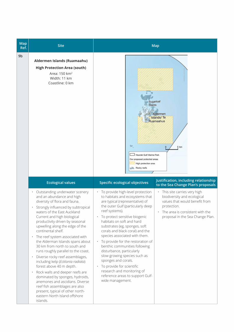
Map Ref. Site Map
9bAldermen Islands (Ruamaahu)
High Protection Area (south) Area: 150 km2
Width: 11 kmCoastline: 0 km
Ecological values Specific ecological objectives Justification, including relationship to the Sea Change Plan’s proposals
• Outstanding underwater scenery and an abundance and high diversity of flora and fauna.
• Strongly influenced by subtropical waters of the East Auckland Current and high biological productivity driven by seasonal upwelling along the edge of the continental shelf.
• The reef system associated with the Alderman Islands spans about 30 km from north to south and runs roughly parallel to the coast.
• Diverse rocky reef assemblages, including kelp (Ecklonia radiata) forest above 40 m depth.
• Rock walls and deeper reefs are dominated by sponges, hydroids, anemones and ascidians. Diverse reef fish assemblages are also present, typical of other north-eastern North Island offshore islands.
• To provide high-level protection to habitats and ecosystems that are typical (representative) of the outer Gulf (particularly deep reef systems).
• To protect sensitive biogenic habitats on soft and hard substrates (eg, sponges, soft corals and black coral) and the species associated with them.
• To provide for the restoration of benthic communities following disturbance, particularly slow-growing species such as sponges and corals.
• To provide for scientific research and monitoring of reference areas to support Gulf-wide management.
• This site carries very high biodiversity and ecological values that would benefit from protection.
• The area is consistent with the proposal in the Sea Change Plan.

Map Ref. Site Map
10aKawau Bay
High Protection AreaArea: 41 km2
Width: 7 kmCoastline: 23 km
Note: figure includes Seafloor Protection Area 10b.
Ecological values Specific ecological objectives
Justification, including relationship to the Sea
Change Plan’s proposals
• High geophysical diversity encompassing bays and estuaries of various sizes, sheltered coastal environments, and more exposed rocky reefs and soft-sediment areas.
• Highly diverse coastal ecosystem containing species commonly associated with relatively pristine environments (eg, sponge, rhodolith and horse mussel beds, kelp forests, scallops, dog cockles and pipi (Paphies australis)).
• Rocky reefs are dominated by crustose and turfing coralline algae, sponges, Carpophyllum spp., and Ecklonia spp.
• Sponge and rhodolith assemblages occur in the channels between the islands in the bay and extend towards the mainland in some areas. The proposal covers part of the large rhodolith bed that extends north to south through Kawau Bay, as well as large areas of low-density Atrina beds. Martins Bay historically contained a high-density Atrina bed that may still be present.
• Biogenic structures provide nursery habitats for juvenile demersal fishes, particularly snapper and scallops. Historically, the area is known to have been a nursery area for sharks, notably rig (spotted dogfish; Mustelus lenticulatus) and school shark (Galeorhinus galeus).
• To provide high-level protection to habitats and ecosystems that are typical (representative) of the inner Gulf.
• To protect sensitive biogenic habitats on soft and hard substrates (eg, sponges, shellfish beds, rhodoliths, dog cockles, soft corals) and the species associated with them.
• To provide for scientific research and monitoring of reference areas to support Gulf-wide management.
• Kawau Bay is a relatively pristine and highly diverse coastal ecosystem, so protecting the values associated with this area is warranted.
• The area is broadly consistent with the Sea Change Plan’s recommendation, with an amendment to decrease the site’s southern boundary to reduce the impact on fisheries immediately to the south of the proposed area (particularly long lining, Danish seining and recreational fishing). The reduction in area is unlikely to significantly affect the biodiversity values being protected by this area.
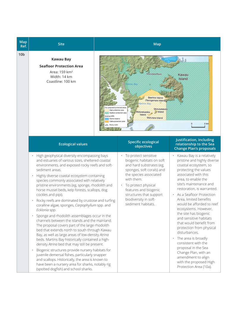
Map Ref. Site Map
10bKawau Bay
Seafloor Protection AreaArea: 159 km2
Width: 14 kmCoastline: 100 km
Ecological values Specific ecological objectives
Justification, including relationship to the Sea
Change Plan’s proposals
• High geophysical diversity encompassing bays and estuaries of various sizes, sheltered coastal environments, and exposed rocky reefs and soft-sediment areas.
• Highly diverse coastal ecosystem containing species commonly associated with relatively pristine environments (eg, sponge, rhodolith and horse mussel beds, kelp forests, scallops, dog cockles and pipi).
• Rocky reefs are dominated by crustose and turfing coralline algae, sponges, Carpophyllum spp. and Ecklonia spp.
• Sponge and rhodolith assemblages occur in the channels between the islands and the mainland. The proposal covers part of the large rhodolith bed that extends north to south through Kawau Bay, as well as large areas of low-density Atrina beds. Martins Bay historically contained a high-density Atrina bed that may still be present.
• Biogenic structures provide nursery habitats for juvenile demersal fishes, particularly snapper and scallops. Historically, the area is known to have been a nursery area for sharks, notably rig (spotted dogfish) and school sharks.
• To protect sensitive biogenic habitats on soft and hard substrates (eg, sponges, soft corals) and the species associated with them.
• To protect physical features and biogenic structures that support biodiversity in soft-sediment habitats.
• Kawau Bay is a relatively pristine and highly diverse coastal ecosystem, so protecting the values associated with this area, to enable the site’s maintenance and restoration, is warranted.
• As a Seafloor Protection Area, limited benefits would be afforded to reef ecosystems. However, the site has biogenic and sensitive habitats that would benefit from protection from physical disturbances.
• The area is broadly consistent with the proposal in the Sea Change Plan, with an amendment to align with the proposed High Protection Area (10a).
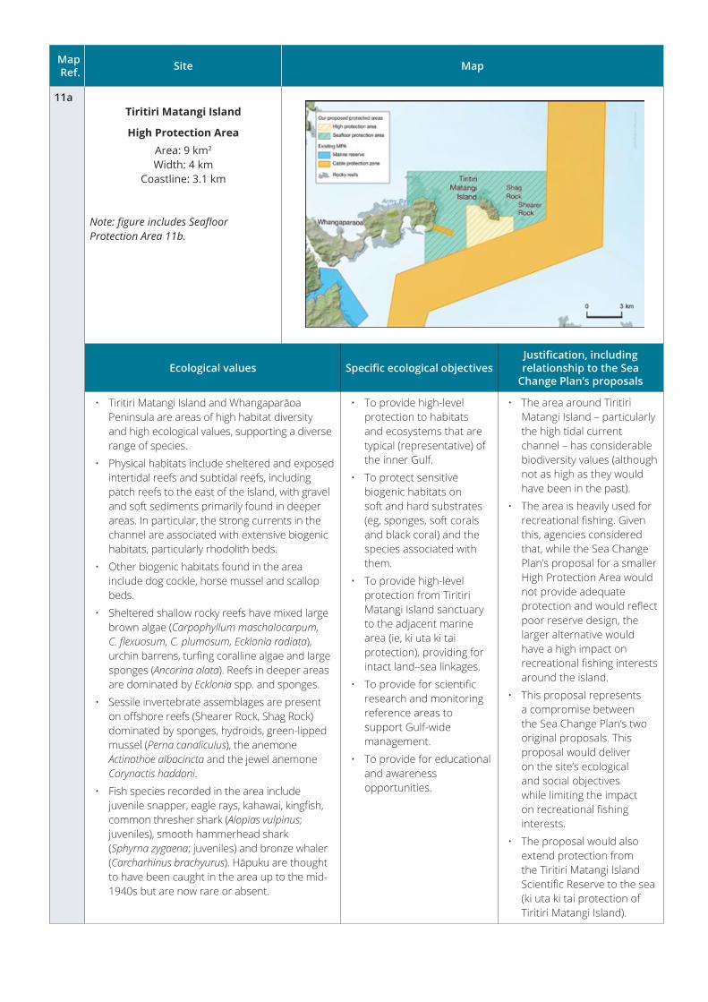
Map Ref. Site Map
11aTiritiri Matangi Island
High Protection AreaArea: 9 km2
Width: 4 kmCoastline: 3.1 km
Note: figure includes Seafloor Protection Area 11b.
Ecological values Specific ecological objectivesJustification, including relationship to the Sea
Change Plan’s proposals
• Tiritiri Matangi Island and Whangaparāoa Peninsula are areas of high habitat diversity and high ecological values, supporting a diverse range of species.
• Physical habitats include sheltered and exposed intertidal reefs and subtidal reefs, including patch reefs to the east of the island, with gravel and soft sediments primarily found in deeper areas. In particular, the strong currents in the channel are associated with extensive biogenic habitats, particularly rhodolith beds.
• Other biogenic habitats found in the area include dog cockle, horse mussel and scallop beds.
• Sheltered shallow rocky reefs have mixed large brown algae (Carpophyllum maschalocarpum, C.flexuosum,C.plumosum,Eckloniaradiata), urchin barrens, turfing coralline algae and large sponges (Ancorina alata). Reefs in deeper areas are dominated by Ecklonia spp. and sponges.
• Sessile invertebrate assemblages are present on offshore reefs (Shearer Rock, Shag Rock) dominated by sponges, hydroids, green-lipped mussel (Perna canaliculus), the anemone Actinothoe albocincta and the jewel anemone Corynactis haddoni.
• Fish species recorded in the area include juvenile snapper, eagle rays, kahawai, kingfish, common thresher shark (Alopias vulpinus; juveniles), smooth hammerhead shark (Sphyrna zygaena; juveniles) and bronze whaler (Carcharhinus brachyurus). Hāpuku are thought to have been caught in the area up to the mid-1940s but are now rare or absent.
• To provide high-level protection to habitats and ecosystems that are typical (representative) of the inner Gulf.
• To protect sensitive biogenic habitats on soft and hard substrates (eg, sponges, soft corals and black coral) and the species associated with them.
• To provide high-level protection from Tiritiri Matangi Island sanctuary to the adjacent marine area (ie, ki uta ki tai protection), providing for intact land–sea linkages.
• To provide for scientific research and monitoring reference areas to support Gulf-wide management.
• To provide for educational and awareness opportunities.
• The area around Tiritiri Matangi Island – particularly the high tidal current channel – has considerable biodiversity values (although not as high as they would have been in the past).
• The area is heavily used for recreational fishing. Given this, agencies considered that, while the Sea Change Plan’s proposal for a smaller High Protection Area would not provide adequate protection and would reflect poor reserve design, the larger alternative would have a high impact on recreational fishing interests around the island.
• This proposal represents a compromise between the Sea Change Plan’s two original proposals. This proposal would deliver on the site’s ecological and social objectives while limiting the impact on recreational fishing interests.
• The proposal would also extend protection from the Tiritiri Matangi Island Scientific Reserve to the sea (ki uta ki tai protection of Tiritiri Matangi Island).
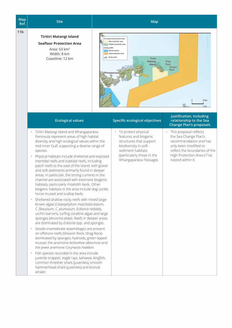
Map Ref. Site Map
11bTiritiri Matangi Island
Seafloor Protection AreaArea: 53 km2
Width: 8 kmCoastline: 12 km
Ecological values Specific ecological objectivesJustification, including relationship to the Sea
Change Plan’s proposals
• Tiritiri Matangi Island and Whangaparāoa Peninsula represent areas of high habitat diversity and high ecological values within the mid-inner Gulf, supporting a diverse range of species.
• Physical habitats include sheltered and exposed intertidal reefs and subtidal reefs, including patch reefs to the east of the island, with gravel and soft sediments primarily found in deeper areas. In particular, the strong currents in the channel are associated with extensive biogenic habitats, particularly rhodolith beds. Other biogenic habitats in the area include dog cockle, horse mussel and scallop beds.
• Sheltered shallow rocky reefs with mixed large brown algae (Carpophyllum maschalocarpum, C.flexuosum,C.plumosum,Eckloniaradiata), urchin barrens, turfing coralline algae and large sponges (Ancorina alata). Reefs in deeper areas are dominated by Ecklonia spp. and sponges.
• Sessile invertebrate assemblages are present on offshore reefs (Shearer Rock, Shag Rock) dominated by sponges, hydroids, green-lipped mussel, the anemone Actinothoe albocincta and the jewel anemone Corynactis haddoni.
• Fish species recorded in the area include juvenile snapper, eagle rays, kahawai, kingfish, common thresher shark (juveniles), smooth hammerhead shark (juveniles) and bronze whaler.
• To protect physical features and biogenic structures that support biodiversity in soft-sediment habitats (particularly those in the Whangaparāoa Passage).
• This proposal reflects the Sea Change Plan’s recommendation and has only been modified to reflect the boundaries of the High Protection Area (11a) nested within it.
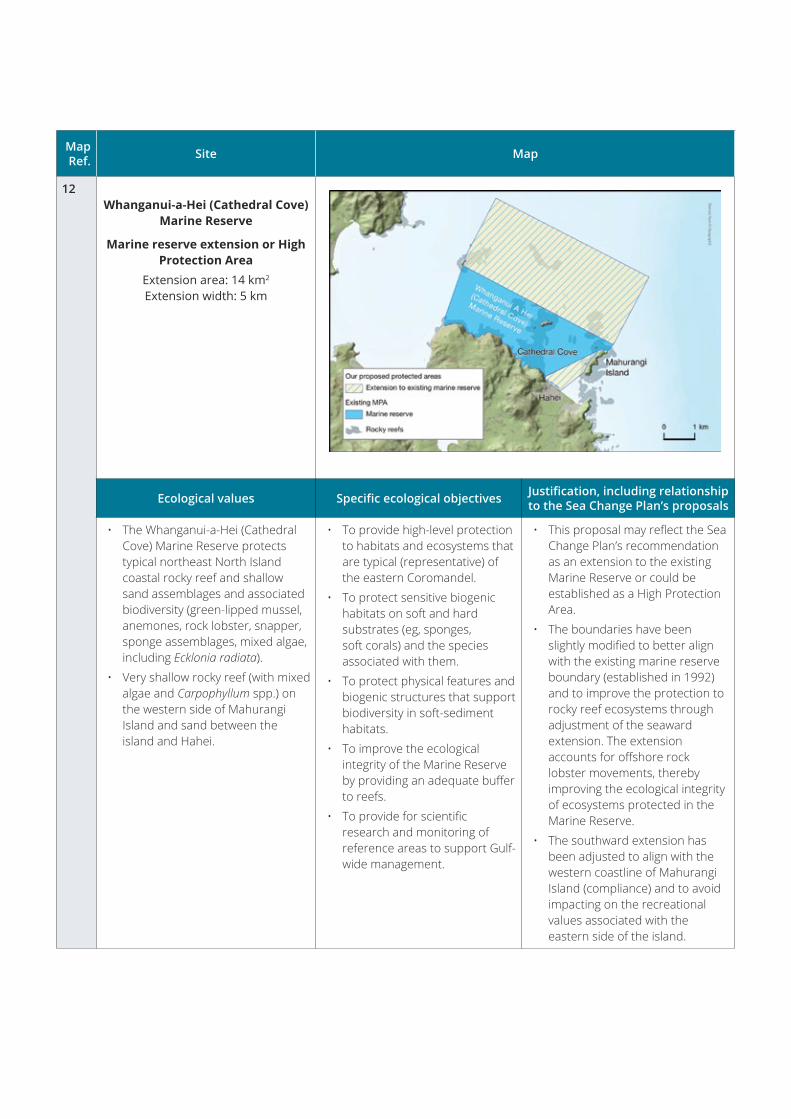
Map Ref. Site Map
12Whanganui-a-Hei (Cathedral Cove)
Marine Reserve
Marine reserve extension or High Protection Area
Extension area: 14 km2 Extension width: 5 km
Ecological values Specific ecological objectives Justification, including relationship to the Sea Change Plan’s proposals
• The Whanganui-a-Hei (Cathedral Cove) Marine Reserve protects typical northeast North Island coastal rocky reef and shallow sand assemblages and associated biodiversity (green-lipped mussel, anemones, rock lobster, snapper, sponge assemblages, mixed algae, including Ecklonia radiata).
• Very shallow rocky reef (with mixed algae and Carpophyllum spp.) on the western side of Mahurangi Island and sand between the island and Hahei.
• To provide high-level protection to habitats and ecosystems that are typical (representative) of the eastern Coromandel.
• To protect sensitive biogenic habitats on soft and hard substrates (eg, sponges, soft corals) and the species associated with them.
• To protect physical features and biogenic structures that support biodiversity in soft-sediment habitats.
• To improve the ecological integrity of the Marine Reserve by providing an adequate buffer to reefs.
• To provide for scientific research and monitoring of reference areas to support Gulf-wide management.
• This proposal may reflect the Sea Change Plan’s recommendation as an extension to the existing Marine Reserve or could be established as a High Protection Area.
• The boundaries have been slightly modified to better align with the existing marine reserve boundary (established in 1992) and to improve the protection to rocky reef ecosystems through adjustment of the seaward extension. The extension accounts for offshore rock lobster movements, thereby improving the ecological integrity of ecosystems protected in the Marine Reserve.
• The southward extension has been adjusted to align with the western coastline of Mahurangi Island (compliance) and to avoid impacting on the recreational values associated with the eastern side of the island.
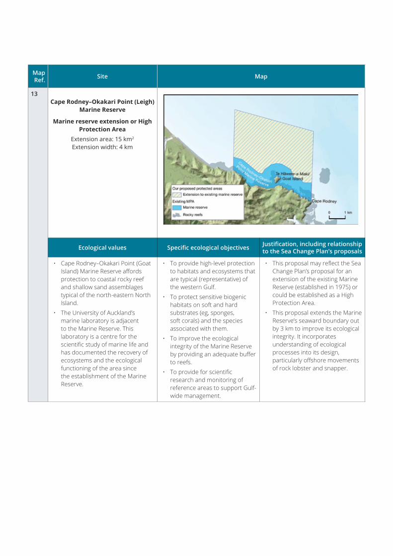
Map Ref. Site Map
13Cape Rodney–Okakari Point (Leigh)
Marine Reserve
Marine reserve extension or High Protection Area
Extension area: 15 km2 Extension width: 4 km
Ecological values Specific ecological objectives Justification, including relationship to the Sea Change Plan’s proposals
• Cape Rodney–Okakari Point (Goat Island) Marine Reserve affords protection to coastal rocky reef and shallow sand assemblages typical of the north-eastern North Island.
• The University of Auckland’s marine laboratory is adjacent to the Marine Reserve. This laboratory is a centre for the scientific study of marine life and has documented the recovery of ecosystems and the ecological functioning of the area since the establishment of the Marine Reserve.
• To provide high-level protection to habitats and ecosystems that are typical (representative) of the western Gulf.
• To protect sensitive biogenic habitats on soft and hard substrates (eg, sponges, soft corals) and the species associated with them.
• To improve the ecological integrity of the Marine Reserve by providing an adequate buffer to reefs.
• To provide for scientific research and monitoring of reference areas to support Gulf-wide management.
• This proposal may reflect the Sea Change Plan’s proposal for an extension of the existing Marine Reserve (established in 1975) or could be established as a High Protection Area.
• This proposal extends the Marine Reserve’s seaward boundary out by 3 km to improve its ecological integrity. It incorporates understanding of ecological processes into its design, particularly offshore movements of rock lobster and snapper.
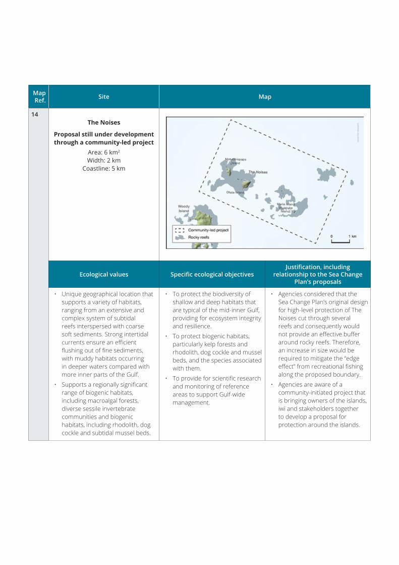
Map Ref. Site Map
14The Noises
Proposal still under development through a community-led project
Area: 6 km2
Width: 2 kmCoastline: 5 km
Ecological values Specific ecological objectivesJustification, including
relationship to the Sea Change Plan’s proposals
• Unique geographical location that supports a variety of habitats, ranging from an extensive and complex system of subtidal reefs interspersed with coarse soft sediments. Strong intertidal currents ensure an efficient flushing out of fine sediments, with muddy habitats occurring in deeper waters compared with more inner parts of the Gulf.
• Supports a regionally significant range of biogenic habitats, including macroalgal forests, diverse sessile invertebrate communities and biogenic habitats, including rhodolith, dog cockle and subtidal mussel beds.
• To protect the biodiversity of shallow and deep habitats that are typical of the mid-inner Gulf, providing for ecosystem integrity and resilience.
• To protect biogenic habitats, particularly kelp forests and rhodolith, dog cockle and mussel beds, and the species associated with them.
• To provide for scientific research and monitoring of reference areas to support Gulf-wide management.
• Agencies considered that the Sea Change Plan’s original design for high-level protection of The Noises cut through several reefs and consequently would not provide an effective buffer around rocky reefs. Therefore, an increase in size would be required to mitigate the “edge effect” from recreational fishing along the proposed boundary.
• Agencies are aware of a community-initiated project that is bringing owners of the islands, iwi and stakeholders together to develop a proposal for protection around the islands.

www.doc.govt.nz
www.mpi.govt.nz
www.mpi.govt.nz/fisheriesnz