revised list of historic sites and monuments · measure 19 (2015) annex revised list of historic...
TRANSCRIPT
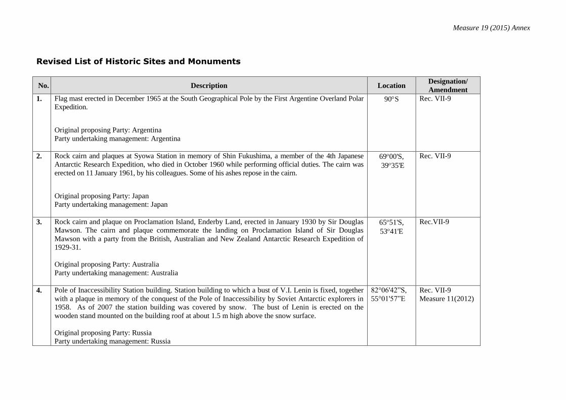
Measure 19 (2015) Annex
Revised List of Historic Sites and Monuments
No. Description Location Designation/
Amendment
1. Flag mast erected in December 1965 at the South Geographical Pole by the First Argentine Overland Polar
Expedition.
Original proposing Party: Argentina
Party undertaking management: Argentina
90S Rec. VII-9
2. Rock cairn and plaques at Syowa Station in memory of Shin Fukushima, a member of the 4th Japanese
Antarctic Research Expedition, who died in October 1960 while performing official duties. The cairn was
erected on 11 January 1961, by his colleagues. Some of his ashes repose in the cairn.
Original proposing Party: Japan
Party undertaking management: Japan
6900'S,
3935'E
Rec. VII-9
3.
Rock cairn and plaque on Proclamation Island, Enderby Land, erected in January 1930 by Sir Douglas
Mawson. The cairn and plaque commemorate the landing on Proclamation Island of Sir Douglas
Mawson with a party from the British, Australian and New Zealand Antarctic Research Expedition of
1929-31.
Original proposing Party: Australia
Party undertaking management: Australia
6551'S,
5341'E
Rec.VII-9
4. Pole of Inaccessibility Station building. Station building to which a bust of V.I. Lenin is fixed, together
with a plaque in memory of the conquest of the Pole of Inaccessibility by Soviet Antarctic explorers in
1958. As of 2007 the station building was covered by snow. The bust of Lenin is erected on the
wooden stand mounted on the building roof at about 1.5 m high above the snow surface.
Original proposing Party: Russia
Party undertaking management: Russia
82°06'42”S,
55°01'57”E
Rec. VII-9
Measure 11(2012)
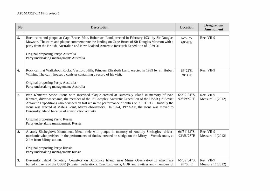
ATCM XXXVIII Final Report
No. Description Location Designation/
Amendment
5. Rock cairn and plaque at Cape Bruce, Mac. Robertson Land, erected in February 1931 by Sir Douglas
Mawson. The cairn and plaque commemorate the landing on Cape Bruce of Sir Douglas Mawson with a
party from the British, Australian and New Zealand Antarctic Research Expedition of 1929-31.
Original proposing Party: Australia
Party undertaking management: Australia
6725'S,
6047'E
Rec. VII-9
6. Rock cairn at Walkabout Rocks, Vestfold Hills, Princess Elizabeth Land, erected in 1939 by Sir Hubert
Wilkins. The cairn houses a canister containing a record of his visit.
Original proposing Party: Australia 1
Party undertaking management: Australia
6822'S,
7833'E
Rec. VII-9
7. Ivan Khmara's Stone. Stone with inscribed plaque erected at Buromsky island in memory of Ivan
Khmara, driver-mechanic, the member of the 1st Complex Antarctic Expedition of the USSR (1st Soviet
Antarctic Expedition) who perished on fast ice in the performance of duties on 21.01.1956. Initially the
stone was erected at Mabus Point, Mirny observatory. In 1974, 19th SAE, the stone was moved to
Buromsky Island because of construction activity
Original proposing Party: Russia
Party undertaking management: Russia
66°32’04”S,
92°59’57”E
Rec. VII-9
Measure 11(2012)
8. Anatoly Shcheglov's Monument. Metal stele with plaque in memory of Anatoly Shcheglov, driver-
mechanic who perished in the performance of duties, erected on sledge on the Mirny – Vostok route, at
2 km from Mirny station.
Original proposing Party: Russia
Party undertaking management: Russia
66º34’43”S,
92º58’23”E
Rec. VII-9
Measure 11(2012)
9. Buromsky Island Cemetery. Cemetery on Buromsky Island, near Mirny Observatory in which are
buried citizens of the USSR (Russian Federation), Czechoslovakia, GDR and Switzerland (members of
66°32’04”S,
93°00’E
Rec. VII-9
Measure 11(2012)
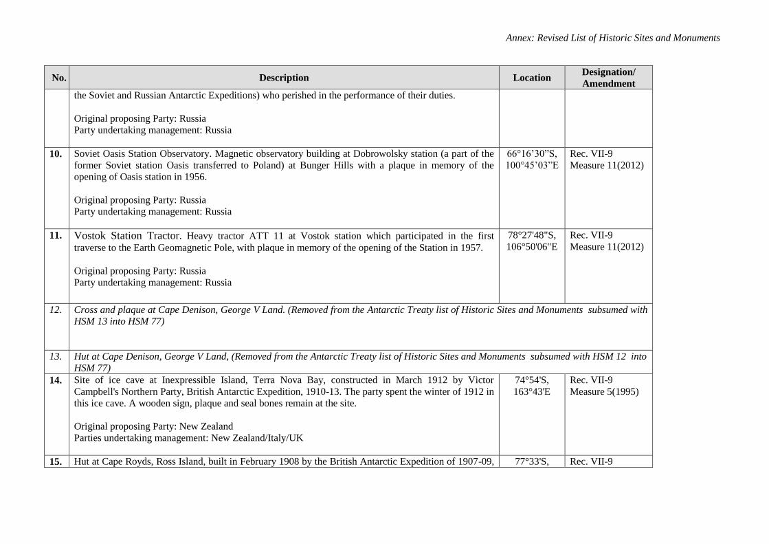
Annex: Revised List of Historic Sites and Monuments
No. Description Location Designation/
Amendment
the Soviet and Russian Antarctic Expeditions) who perished in the performance of their duties.
Original proposing Party: Russia
Party undertaking management: Russia
10. Soviet Oasis Station Observatory. Magnetic observatory building at Dobrowolsky station (a part of the
former Soviet station Oasis transferred to Poland) at Bunger Hills with a plaque in memory of the
opening of Oasis station in 1956.
Original proposing Party: Russia
Party undertaking management: Russia
66°16’30”S,
100°45’03”E
Rec. VII-9
Measure 11(2012)
11. Vostok Station Tractor. Heavy tractor АТТ 11 at Vostok station which participated in the first
traverse to the Earth Geomagnetic Pole, with plaque in memory of the opening of the Station in 1957.
Original proposing Party: Russia
Party undertaking management: Russia
78°27'48"S,
106°50'06"E
Rec. VII-9
Measure 11(2012)
12. Cross and plaque at Cape Denison, George V Land. (Removed from the Antarctic Treaty list of Historic Sites and Monuments subsumed with
HSM 13 into HSM 77)
13. Hut at Cape Denison, George V Land, (Removed from the Antarctic Treaty list of Historic Sites and Monuments subsumed with HSM 12 into
HSM 77)
14. Site of ice cave at Inexpressible Island, Terra Nova Bay, constructed in March 1912 by Victor
Campbell's Northern Party, British Antarctic Expedition, 1910-13. The party spent the winter of 1912 in
this ice cave. A wooden sign, plaque and seal bones remain at the site.
Original proposing Party: New Zealand
Parties undertaking management: New Zealand/Italy/UK
74°54'S,
163°43'E
Rec. VII-9
Measure 5(1995)
15. Hut at Cape Royds, Ross Island, built in February 1908 by the British Antarctic Expedition of 1907-09, 77°33'S, Rec. VII-9
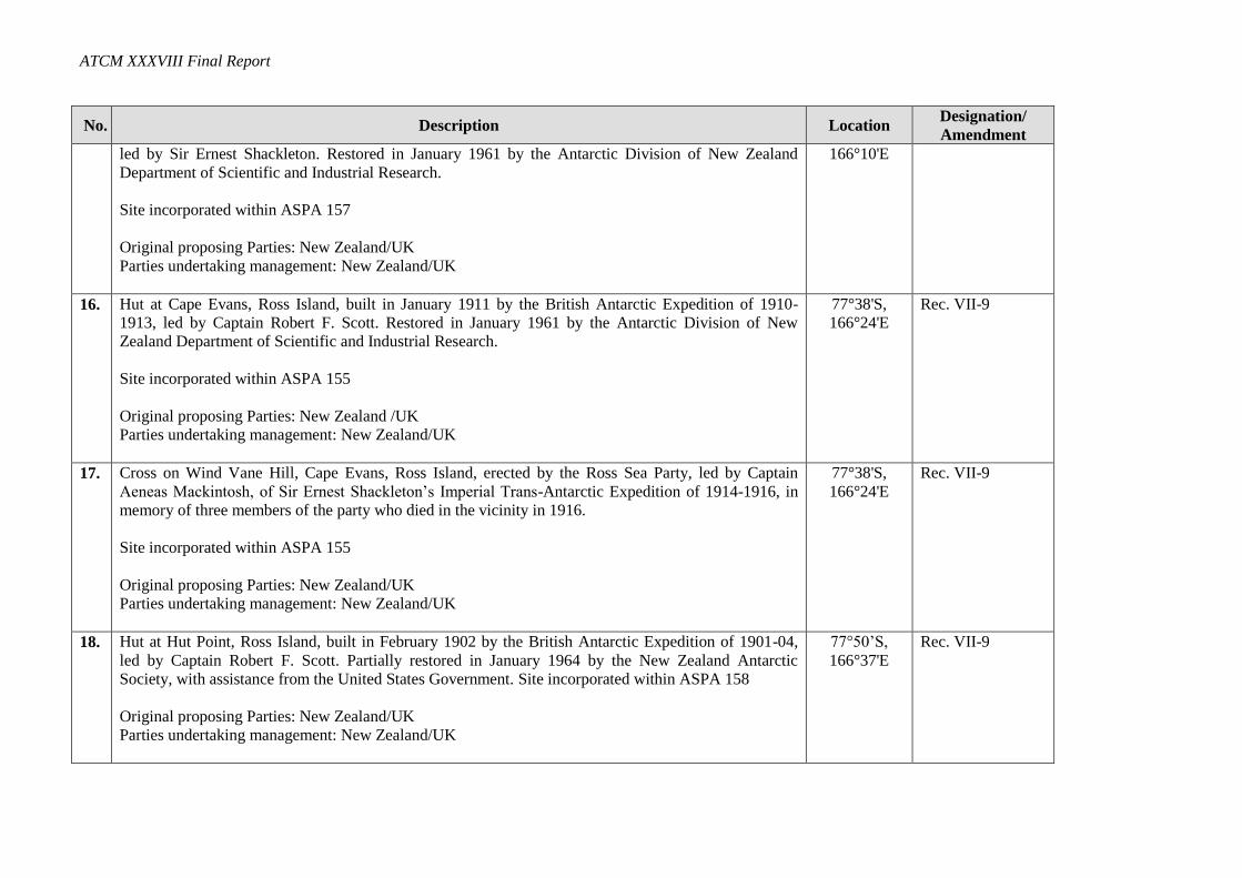
ATCM XXXVIII Final Report
No. Description Location Designation/
Amendment
led by Sir Ernest Shackleton. Restored in January 1961 by the Antarctic Division of New Zealand
Department of Scientific and Industrial Research.
Site incorporated within ASPA 157
Original proposing Parties: New Zealand/UK
Parties undertaking management: New Zealand/UK
166°10'E
16. Hut at Cape Evans, Ross Island, built in January 1911 by the British Antarctic Expedition of 1910-
1913, led by Captain Robert F. Scott. Restored in January 1961 by the Antarctic Division of New
Zealand Department of Scientific and Industrial Research.
Site incorporated within ASPA 155
Original proposing Parties: New Zealand /UK
Parties undertaking management: New Zealand/UK
77°38'S,
166°24'E
Rec. VII-9
17.
Cross on Wind Vane Hill, Cape Evans, Ross Island, erected by the Ross Sea Party, led by Captain
Aeneas Mackintosh, of Sir Ernest Shackleton’s Imperial Trans-Antarctic Expedition of 1914-1916, in
memory of three members of the party who died in the vicinity in 1916.
Site incorporated within ASPA 155
Original proposing Parties: New Zealand/UK
Parties undertaking management: New Zealand/UK
77°38'S,
166°24'E
Rec. VII-9
18. Hut at Hut Point, Ross Island, built in February 1902 by the British Antarctic Expedition of 1901-04,
led by Captain Robert F. Scott. Partially restored in January 1964 by the New Zealand Antarctic
Society, with assistance from the United States Government. Site incorporated within ASPA 158
Original proposing Parties: New Zealand/UK
Parties undertaking management: New Zealand/UK
77°50’S,
166°37'E
Rec. VII-9
Annex: Revised List of Historic Sites and Monuments
No. Description Location Designation/
Amendment
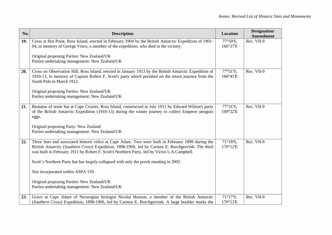
19.
Cross at Hut Point, Ross Island, erected in February 1904 by the British Antarctic Expedition of 1901-
04, in memory of George Vince, a member of the expedition, who died in the vicinity.
Original proposing Parties: New Zealand/UK
Parties undertaking management: New Zealand/UK
77°50'S,
166°37'E
Rec. VII-9
20.
Cross on Observation Hill, Ross Island, erected in January 1913 by the British Antarctic Expedition of
1910-13, in memory of Captain Robert F. Scott's party which perished on the return journey from the
South Pole in March 1912.
Original proposing Parties: New Zealand/UK
Parties undertaking management: New Zealand/UK
77°51'S,
166°41'E
Rec. VII-9
21. Remains of stone hut at Cape Crozier, Ross Island, constructed in July 1911 by Edward Wilson's party
of the British Antarctic Expedition (1910-13) during the winter journey to collect Emperor penguin
eggs.
Original proposing Party: New Zealand
Parties undertaking management: New Zealand/UK
77°31'S,
169°22'E
Rec. VII-9
22.
Three huts and associated historic relics at Cape Adare. Two were built in February 1899 during the
British Antarctic (Southern Cross) Expedition, 1898-1900, led by Carsten E. Borchgrevink. The third
was built in February 1911 by Robert F. Scott's Northern Party, led by Victor L.A.Campbell.
Scott’s Northern Party hut has largely collapsed with only the porch standing in 2002.
Site incorporated within ASPA 159.
Original proposing Parties: New Zealand/UK
Parties undertaking management: New Zealand/UK
71°18'S,
170°12'E
Rec. VII-9
23. Grave at Cape Adare of Norwegian biologist Nicolai Hanson, a member of the British Antarctic
(Southern Cross) Expedition, 1898-1900, led by Carsten E. Borchgrevink. A large boulder marks the
71°17'S,
170°13'E
Rec. VII-9
ATCM XXXVIII Final Report
No. Description Location Designation/
Amendment
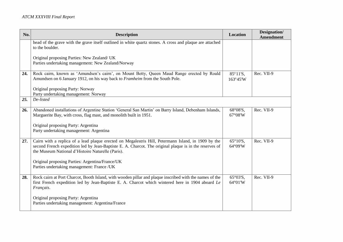
head of the grave with the grave itself outlined in white quartz stones. A cross and plaque are attached
to the boulder.
Original proposing Parties: New Zealand/ UK
Parties undertaking management: New Zealand/Norway
24.
Rock cairn, known as ‘Amundsen’s cairn’, on Mount Betty, Queen Maud Range erected by Roald
Amundsen on 6 January 1912, on his way back to Framheim from the South Pole.
Original proposing Party: Norway
Party undertaking management: Norway
8511'S,
16345'W
Rec. VII-9
25. De-listed
26. Abandoned installations of Argentine Station ‘General San Martin’ on Barry Island, Debenham Islands,
Marguerite Bay, with cross, flag mast, and monolith built in 1951.
Original proposing Party: Argentina
Party undertaking management: Argentina
68°08'S,
67°08'W
Rec. VII-9
27. Cairn with a replica of a lead plaque erected on Megalestris Hill, Petermann Island, in 1909 by the
second French expedition led by Jean-Baptiste E. A. Charcot. The original plaque is in the reserves of
the Museum National d’Histoire Naturelle (Paris).
Original proposing Parties: Argentina/France/UK
Parties undertaking management: France /UK
65°10'S,
64°09'W
Rec. VII-9
28. Rock cairn at Port Charcot, Booth Island, with wooden pillar and plaque inscribed with the names of the
first French expedition led by Jean-Baptiste E. A. Charcot which wintered here in 1904 aboard Le
Français.
Original proposing Party: Argentina
Parties undertaking management: Argentina/France
65°03'S,
64°01'W
Rec. VII-9
Annex: Revised List of Historic Sites and Monuments
No. Description Location Designation/
Amendment
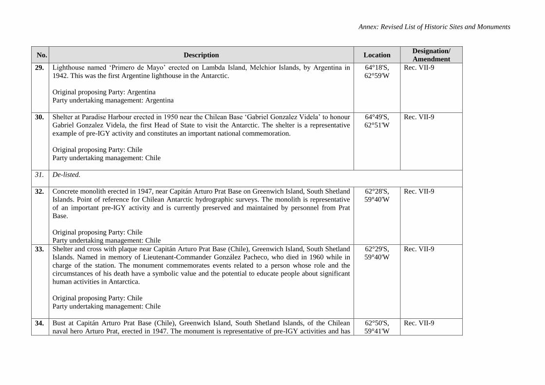
29. Lighthouse named ‘Primero de Mayo’ erected on Lambda Island, Melchior Islands, by Argentina in
1942. This was the first Argentine lighthouse in the Antarctic.
Original proposing Party: Argentina
Party undertaking management: Argentina
64°18'S,
62°59'W
Rec. VII-9
30.
Shelter at Paradise Harbour erected in 1950 near the Chilean Base ‘Gabriel Gonzalez Videla’ to honour
Gabriel Gonzalez Videla, the first Head of State to visit the Antarctic. The shelter is a representative
example of pre-IGY activity and constitutes an important national commemoration.
Original proposing Party: Chile
Party undertaking management: Chile
64°49'S,
62°51'W
Rec. VII-9
31. De-listed.
32. Concrete monolith erected in 1947, near Capitán Arturo Prat Base on Greenwich Island, South Shetland
Islands. Point of reference for Chilean Antarctic hydrographic surveys. The monolith is representative
of an important pre-IGY activity and is currently preserved and maintained by personnel from Prat
Base.
Original proposing Party: Chile
Party undertaking management: Chile
62°28'S,
59°40'W
Rec. VII-9
33. Shelter and cross with plaque near Capitán Arturo Prat Base (Chile), Greenwich Island, South Shetland
Islands. Named in memory of Lieutenant-Commander González Pacheco, who died in 1960 while in
charge of the station. The monument commemorates events related to a person whose role and the
circumstances of his death have a symbolic value and the potential to educate people about significant
human activities in Antarctica.
Original proposing Party: Chile
Party undertaking management: Chile
62°29'S,
59°40'W
Rec. VII-9
34.
Bust at Capitán Arturo Prat Base (Chile), Greenwich Island, South Shetland Islands, of the Chilean
naval hero Arturo Prat, erected in 1947. The monument is representative of pre-IGY activities and has
62°50'S,
59°41'W
Rec. VII-9
ATCM XXXVIII Final Report
No. Description Location Designation/
Amendment
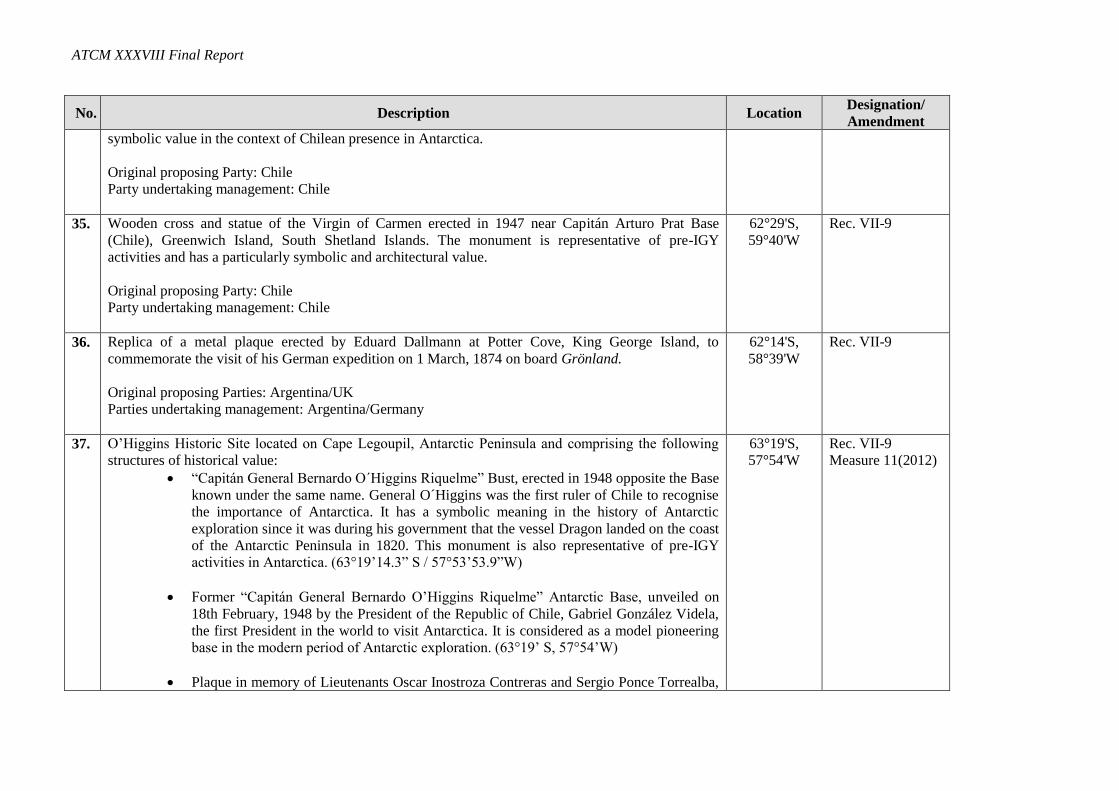
symbolic value in the context of Chilean presence in Antarctica.
Original proposing Party: Chile
Party undertaking management: Chile
35.
Wooden cross and statue of the Virgin of Carmen erected in 1947 near Capitán Arturo Prat Base
(Chile), Greenwich Island, South Shetland Islands. The monument is representative of pre-IGY
activities and has a particularly symbolic and architectural value.
Original proposing Party: Chile
Party undertaking management: Chile
62°29'S,
59°40'W
Rec. VII-9
36. Replica of a metal plaque erected by Eduard Dallmann at Potter Cove, King George Island, to
commemorate the visit of his German expedition on 1 March, 1874 on board Grönland.
Original proposing Parties: Argentina/UK
Parties undertaking management: Argentina/Germany
62°14'S,
58°39'W
Rec. VII-9
37. O’Higgins Historic Site located on Cape Legoupil, Antarctic Peninsula and comprising the following
structures of historical value:
“Capitán General Bernardo O´Higgins Riquelme” Bust, erected in 1948 opposite the Base
known under the same name. General O´Higgins was the first ruler of Chile to recognise
the importance of Antarctica. It has a symbolic meaning in the history of Antarctic
exploration since it was during his government that the vessel Dragon landed on the coast
of the Antarctic Peninsula in 1820. This monument is also representative of pre-IGY
activities in Antarctica. (63°19’14.3” S / 57°53’53.9”W)
Former “Capitán General Bernardo O’Higgins Riquelme” Antarctic Base, unveiled on
18th February, 1948 by the President of the Republic of Chile, Gabriel González Videla,
the first President in the world to visit Antarctica. It is considered as a model pioneering
base in the modern period of Antarctic exploration. (63°19’ S, 57°54’W)
Plaque in memory of Lieutenants Oscar Inostroza Contreras and Sergio Ponce Torrealba,
63°19'S,
57°54'W
Rec. VII-9
Measure 11(2012)
Annex: Revised List of Historic Sites and Monuments
No. Description Location Designation/
Amendment
who perished in the Antarctic Continent for the sake of peace and science, on 12th
August, 1957. (63°19’15.4” S / 57°53’52.9”W)
Virgen del Carmen Grotto, located in the surroundings of the base, built approximately forty years ago.
It has served as a place of spiritual withdrawal for the staff of the different Antarctic stations and
expeditions. (63°19’15.9” S / 57°54’03.2”W).
Original proposing Party: Chile
Party undertaking management: Chile
38. Wooden hut on Snow Hill Island built in February 1902 by the main party of the Swedish South Polar
Expedition led by Otto Nordenskjöld.
Original proposing Parties: Argentina/ UK
Parties undertaking management: Argentina/Sweden
64°22'S,
56°59'W
Rec. VII-9
39. Stone hut at Hope Bay, Trinity Peninsula, built in January 1903 by a party of the Swedish South Polar
Expedition.
Original proposing Parties: Argentina/UK
Parties undertaking management: Argentina/Sweden
63°24'S,
56°59' W
Rec. VII-9
40. Bust of General San Martin, grotto with a statue of the Virgin of Lujan, and a flag mast at Base
‘Esperanza’, Hope Bay, erected by Argentina in 1955; together with a graveyard with stele in memory
of members of Argentine expeditions who died in the area.
Original proposing Party: Argentina
Party undertaking management: Argentina
63°24'S,
56°59'W
Rec. VII-9
41. Stone hut on Paulet Island built in February 1903 by survivors of the wrecked vessel Antarctic under
Captain Carl A. Larsen, members of the Swedish South Polar Expedition led by Otto Nordenskjöld,
together with a grave of a member of the expedition and the rock cairn built by the survivors of the
wreck at the highest point of the island to draw the attention of rescue expeditions.
63°34'S,
55°45'W
Rec. VII-9
Measure 5 (1997)
ATCM XXXVIII Final Report
No. Description Location Designation/
Amendment
Original proposing Parties: Argentina/UK
Parties undertaking management: Argentina/Sweden/Norway
42. Area of Scotia Bay, Laurie Island, South Orkney Island, in which are found: stone hut built in 1903 by
the Scottish Antarctic Expedition led by William S. Bruce; the Argentine meteorological hut and
magnetic observatory, built in 1905 and known as Moneta House; and a graveyard with twelve graves,
the earliest of which dates from 1903.
Original proposing Party: Argentina
Parties undertaking management: Argentina/UK
60°46'S,
44°40'W
Rec. VII-9
43. Cross erected in 1955, at a distance of 1,300 metres north-east of the Argentine General Belgrano I
Station (Argentina) and subsequently moved to Belgrano II Station (Argentina), Nunatak Bertrab,
Confin Coast, Coats Land in 1979.
Original proposing Party: Argentina
Party undertaking management: Argentina
77°52'S,
34°37'W
Rec. VII-9
44. Plaque erected at the temporary Indian station ‘Dakshin Gangotri’, Princess Astrid Kyst, Dronning
Maud Land, listing the names of the First Indian Antarctic Expedition which landed nearby on 9
January 1982.
Original proposing Party: India
Party undertaking management: India
70°45'S,
11°38'E
Rec. XII-7
45. Plaque on Brabant Island, on Metchnikoff Point, mounted at a height of 70 m on the crest of the
moraine separating this point from the glacier and bearing the following inscription:
This monument was built by François de Gerlache and other members of the Joint Services Expedition
1983-85 to commemorate the first landing on Brabant Island by the Belgian Antarctic Expedition,
1897-99: Adrien de Gerlache (Belgium) leader, Roald Amundsen (Norway), Henryk Arctowski
64°02'S,
62°34'W
Rec. XIII-16
Annex: Revised List of Historic Sites and Monuments
No. Description Location Designation/
Amendment
(Poland), Frederick Cook (USA) and Emile Danco (Belgium) camped nearby from 30 January to 6
February 1898.
Original proposing Party: Belgium
Party undertaking management: Belgium
46. All the buildings and installations of Port-Martin base, Terre Adélie constructed in 1950 by the 3rd
French expedition in Terre Adélie and partly destroyed by fire during the night of 23 to 24 January
1952.
Original proposing Party: France
Party undertaking management: France
66°49'S,
141°24'E
Rec. XIII-16
47. Wooden building called ‘Base Marret’ on the Ile des Pétrels, Terre Adélie, where seven men under the
command of Mario Marret overwintered in 1952 following the fire at Port Martin Base.
Original proposing Party: France
Party undertaking management: France
66°40'S,
140°01'E
Rec. XIII-16
48. Iron cross on the North-East headland of the Ile des Pétrels, Terre Adélie, dedicated as a memorial to
André Prudhomme, head meteorologist in the 3rd International Geophysical Year expedition who
disappeared during a blizzard on 7 January 1959.
Original proposing Party: France
Party undertaking management: France
66°40'S,
140°01'E
Rec. XIII-16
49. The concrete pillar erected by the First Polish Antarctic Expedition at Dobrolowski Station on the
Bunger Hill to measure acceleration due to gravity g = 982,439.4 mgal ±0.4 mgal in relation to
Warsaw, according to the Potsdam system, in January 1959.
Original proposing Party: Poland
Party undertaking management: Poland
66°16'S,
100°45'E
Rec. XIII-16
ATCM XXXVIII Final Report
No. Description Location Designation/
Amendment
50. A brass plaque bearing the Polish Eagle, the national emblem of Poland, the dates 1975 and 1976, and
the following text in Polish, English and Russian:
In memory of the landing of members of the first Polish Antarctic marine research expedition on the
vessels ‘Profesor Siedlecki’ and ‘Tazar’ in February 1976.
This plaque, south-west of the Chilean and Soviet stations, is mounted on a cliff facing Maxwell Bay,
Fildes Peninsula, King George Island.
Original proposing Party: Poland
Party undertaking management: Poland
62°12'S,
59°01'W
Rec. XIII-16
51. The grave of Wlodzimierz Puchalski, surmounted by an iron cross, on a hill to the south of Arctowski
station on King George Island. W. Puchalski was an artist and a producer of documentary nature films,
who died on 19 January 1979 whilst working at the station.
Original proposing Party: Poland
Party undertaking management: Poland
62°13'S,
58°28'W
Rec. XIII-16
52. Monolith erected to commemorate the establishment on 20 February 1985 by the Peoples Republic of
China of the ‘Great Wall Station’ on Fildes Peninsula, King George Island, in the South Shetland
Islands. Engraved on the monolith is the following inscription in Chinese: ‘Great Wall Station, First
Chinese Antarctic Research Expedition, 20 February 1985’.
Original proposing Party: China
Party undertaking management: China
62°13'S,
58°58'W
Rec. XIII-16
53. Bust of Captain Luis Alberto Pardo, monolith and plaques on Point Wild, Elephant Island, south
Shetland Islands, celebrating the rescue of the survivors of the British ship Endurance by the Chilean
Navy cutter Yelcho displaying the following words:
“ Here on August 30 th, 1916, the Chilean Navy cutter Yelcho commanded by Pilot Luis Pardo Villalón
rescued the 22 men from the Shackleton Expedition who survived the wreck of the ‘Endurance’ living
61°03'S,
54°50'W
Rec. XIV-8
Rec. XV-13
Annex: Revised List of Historic Sites and Monuments
No. Description Location Designation/
Amendment
for four and one half months in this Island”.
The Monolith and the plaques have been placed on Elephant Island and their replicas on the Chilean
bases Capitan Arturo Prat (62o30'S, 59 o49'W) and President Eduardo Frei (62o12'S, 62 o12'W). Bronze
busts of the pilot Luis Pardo Villalon were placed on the three above-mentioned monoliths during the
XXIVth Chilean Antarctic Scientific Expedition in 1987-88.
Original proposing Party: Chile
Party undertaking management: Chile
54. Richard E. Byrd Historic Monument, McMurdo Station, Antarctica. Bronze bust on black marble, 5ft
high x 2ft square, on wood platform, bearing inscriptions describing the polar achievements of Richard
Evelyn Byrd. Erected at McMurdo Station in 1965.
Original proposing Party: USA
Party undertaking management: USA
77°51'S,
166°40'E
Rec. XV-12
55. East Base, Antarctica, Stonington Island. Buildings and artefacts at East Base, Stonington Island and
their immediate environs. These structures were erected and used during two U.S. wintering
expeditions: the Antarctic Service Expedition (1939-1941) and the Ronne Antarctic Research
Expedition (1947-1948). The size of the historic area is approximately 1,000 metres in the north-south
direction (from the beach to Northeast Glacier adjacent to Back Bay) and approximately 500 metres in
the east-west direction.
Original proposing Party: USA
Party undertaking management: USA
68°11'S,
67°00'W
Rec. XIV-8
56. Waterboat Point, Danco Coast, Antarctic Peninsula. The remains and immediate environs of the Waterboat
Point hut. It was occupied by the UK two-man expedition of Thomas W. Bagshawe and Maxime C. Lester
in 1921-22. Only the base of the boat, foundations of doorposts and an outline of the hut and extension still
exist. It is situated close to the Chilean station ‘President Gabriel Gonzáles Videla’.
Original proposing Party: Chile/UK
64°49'S,
62°51'W
Rec. XVI-11
ATCM XXXVIII Final Report
No. Description Location Designation/
Amendment
Parties undertaking management: Chile/UK
57. Commemorative plaque at ‘Yankee Bay’ (Yankee Harbour), MacFarlane Strait, Greenwich Island,
South Shetland Islands. Near a Chilean refuge. Erected to the memory of Captain Andrew MacFarlane,
who in 1820 explored the Antarctic Peninsula area in the brigantine Dragon.
Original proposing Parties: Chile/UK
Parties undertaking management: Chile/UK
62°32'S,
59°45'W
Rec. XVI-11
58. De-listed.
59. A cairn on Half Moon Beach, Cape Shirreff, Livingston Island, South Shetland Islands and a plaque on
‘Cerro Gaviota’ opposite San Telmo Islets commemorating the officers, soldiers and seamen aboard the
Spanish vessel San Telmo, which sank in September 1819; possibly the first people to live and die in
Antarctica.
Site incorporated within ASPA 149.
Original proposing Parties: Chile/Spain/Peru
Parties undertaking management: Chile/Spain/Peru
62°28'S,
60°46'W
Rec. XVI-11
60. Wooden plaque and cairn located at Penguins Bay, southern coast of Seymour Island (Marambio),
James Ross Archipelago. This plaque was placed on 10 November 1903 by the crew of a rescue mission
of the Argentinian Corvette Uruguay in the site where they met the members of the Swedish expedition
led by Dr Otto Nordenskjöld. The text of the wooden plaque reads as follows:
“10.XI.1903 Uruguay (Argentine Navy) in its journey to give assistance to the Swedish Antarctic
expedition.”
In January 1990, a rock cairn was erected by Argentina in memory of this event in the place where the
plaque is located.
Original proposing Party: Argentina
Parties undertaking management: Argentina/Sweden
64°16'S,
56°39'W
Rec. XVII-3
Annex: Revised List of Historic Sites and Monuments
No. Description Location Designation/
Amendment
61. ‘Base A’ at Port Lockroy, Goudier Island, off Wiencke Island, Antarctic Peninsula. Of historic
importance as an Operation Tabarin base from 1944 and for scientific research, including the first
measurements of the ionosphere, and the first recording of an atmospheric whistler, from Antarctica.
Port Lockroy was a key monitoring site during the International Geophysical Year of 1957/58.
Original Proposing Party: UK
Party undertaking management: UK
64°49'S,
63°29'W
Measure 4 (1995)
62. ‘Base F (Wordie House)’ on Winter Island, Argentine Islands. Of historic importance as an example of
an early British scientific base.
Original proposing Party: UK
Parties undertaking management: UK/Ukraine
65°15'S,
64°16'W
Measure 4 (1995)
63. ‘Base Y’ on Horseshoe Island, Marguerite Bay, western Graham Land. Noteworthy as a relatively
unaltered and completely equipped British scientific base of the late 1950s. ‘Blaiklock’, the refuge hut
nearby, is considered an integral part of the base.
Original proposing Party: UK
Party undertaking management: UK
67°48'S,
67°18'W
Measure 4 (1995)
64. ‘Base E’ on Stonington Island, Marguerite Bay, western Graham Land. Of historical importance in the
early period of exploration and later British Antarctic Survey (BAS) history of the 1960s and 1970s.
Original proposing Party: UK
Party undertaking management: UK
68°11'S,
67°00'W
Measure 4 (1995)
65. Message post, Svend Foyn Island, Possession Islands. A pole with a box attached was placed on the
island on 16 January 1895 during the whaling expedition of Henryk Bull and Captain Leonard
Kristensen of the ship Antarctic. It was examined and found intact by the British Antarctic Expedition
of 1898-1900 and then sighted from the beach by the USS Edisto in 1956 and USCGS Glacier in 1965.
Original proposing Parties: New Zealand/Norway/UK
Parties undertaking management: New Zealand/ Norway
71°56'S,
171°05'W
Measure 4 (1995)
ATCM XXXVIII Final Report
No. Description Location Designation/
Amendment
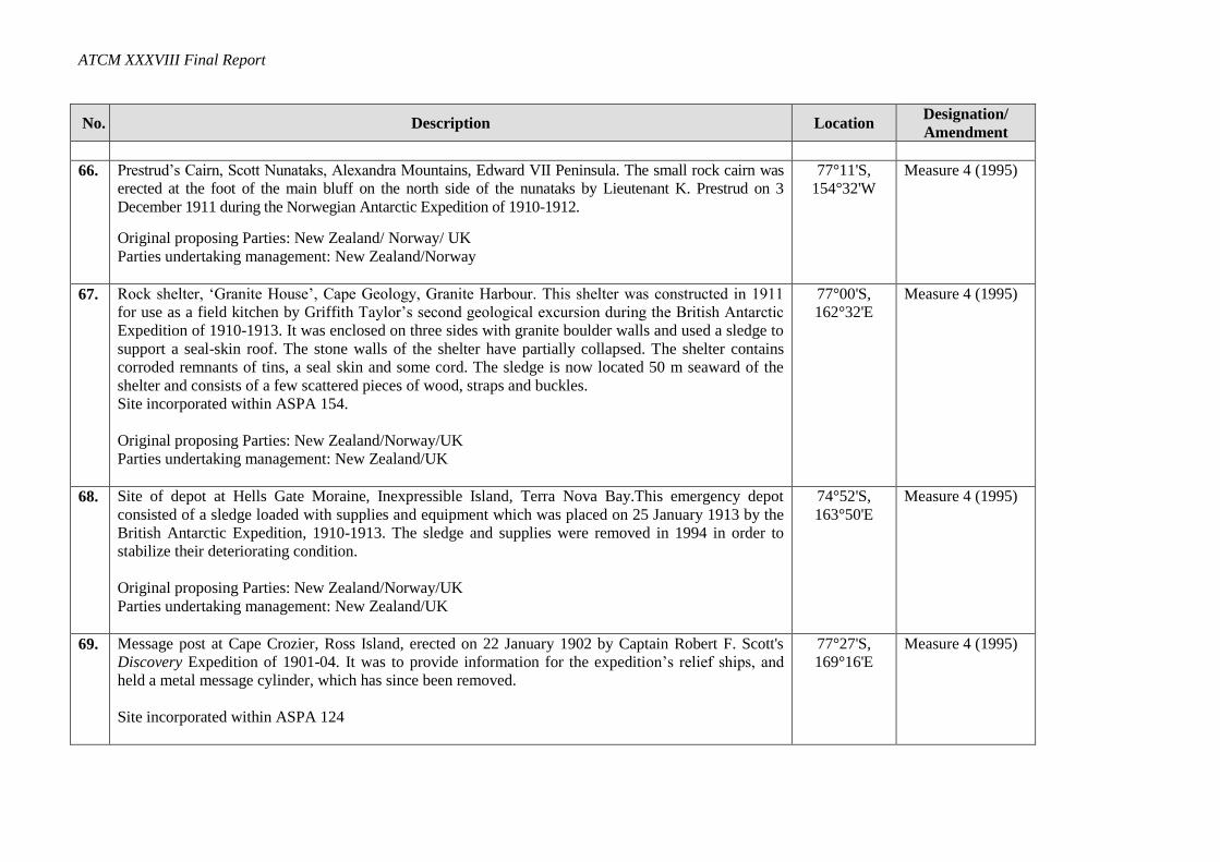
66. Prestrud’s Cairn, Scott Nunataks, Alexandra Mountains, Edward VII Peninsula. The small rock cairn was
erected at the foot of the main bluff on the north side of the nunataks by Lieutenant K. Prestrud on 3
December 1911 during the Norwegian Antarctic Expedition of 1910-1912.
Original proposing Parties: New Zealand/ Norway/ UK
Parties undertaking management: New Zealand/Norway
77°11'S,
154°32'W
Measure 4 (1995)
67. Rock shelter, ‘Granite House’, Cape Geology, Granite Harbour. This shelter was constructed in 1911
for use as a field kitchen by Griffith Taylor’s second geological excursion during the British Antarctic
Expedition of 1910-1913. It was enclosed on three sides with granite boulder walls and used a sledge to
support a seal-skin roof. The stone walls of the shelter have partially collapsed. The shelter contains
corroded remnants of tins, a seal skin and some cord. The sledge is now located 50 m seaward of the
shelter and consists of a few scattered pieces of wood, straps and buckles.
Site incorporated within ASPA 154.
Original proposing Parties: New Zealand/Norway/UK
Parties undertaking management: New Zealand/UK
77°00'S,
162°32'E
Measure 4 (1995)
68. Site of depot at Hells Gate Moraine, Inexpressible Island, Terra Nova Bay.This emergency depot
consisted of a sledge loaded with supplies and equipment which was placed on 25 January 1913 by the
British Antarctic Expedition, 1910-1913. The sledge and supplies were removed in 1994 in order to
stabilize their deteriorating condition.
Original proposing Parties: New Zealand/Norway/UK
Parties undertaking management: New Zealand/UK
74°52'S,
163°50'E
Measure 4 (1995)
69. Message post at Cape Crozier, Ross Island, erected on 22 January 1902 by Captain Robert F. Scott's
Discovery Expedition of 1901-04. It was to provide information for the expedition’s relief ships, and
held a metal message cylinder, which has since been removed.
Site incorporated within ASPA 124
77°27'S,
169°16'E
Measure 4 (1995)
Annex: Revised List of Historic Sites and Monuments
No. Description Location Designation/
Amendment
Original proposing Parties: New Zealand/Norway/UK
Parties undertaking management: New Zealand/UK
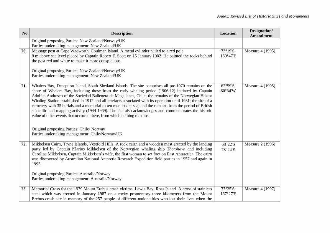
70. Message post at Cape Wadworth, Coulman Island. A metal cylinder nailed to a red pole
8 m above sea level placed by Captain Robert F. Scott on 15 January 1902. He painted the rocks behind
the post red and white to make it more conspicuous.
Original proposing Parties: New Zealand/Norway/UK
Parties undertaking management: New Zealand/UK
73°19'S,
169°47'E
Measure 4 (1995)
71. Whalers Bay, Deception Island, South Shetland Islands. The site comprises all pre-1970 remains on the
shore of Whalers Bay, including those from the early whaling period (1906-12) initiated by Captain
Adolfus Andresen of the Sociedad Ballenera de Magallanes, Chile; the remains of the Norwegian Hektor
Whaling Station established in 1912 and all artefacts associated with its operation until 1931; the site of a
cemetery with 35 burials and a memorial to ten men lost at sea; and the remains from the period of British
scientific and mapping activity (1944-1969). The site also acknowledges and commemorates the historic
value of other events that occurred there, from which nothing remains.
Original proposing Parties: Chile/ Norway
Parties undertaking management: Chile/Norway/UK
62°59'S,
60°34'W
Measure 4 (1995)
72. Mikkelsen Cairn, Tryne Islands, Vestfold Hills. A rock cairn and a wooden mast erected by the landing
party led by Captain Klarius Mikkelsen of the Norwegian whaling ship Thorshavn and including
Caroline Mikkelsen, Captain Mikkelsen’s wife, the first woman to set foot on East Antarctica. The cairn
was discovered by Australian National Antarctic Research Expedition field parties in 1957 and again in
1995.
Original proposing Parties: Australia/Norway
Parties undertaking management: Australia/Norway
6822'S
7824'E
Measure 2 (1996)
73. Memorial Cross for the 1979 Mount Erebus crash victims, Lewis Bay, Ross Island. A cross of stainless
steel which was erected in January 1987 on a rocky promontory three kilometers from the Mount
Erebus crash site in memory of the 257 people of different nationalities who lost their lives when the
77°25'S,
167°27'E
Measure 4 (1997)
ATCM XXXVIII Final Report
No. Description Location Designation/
Amendment
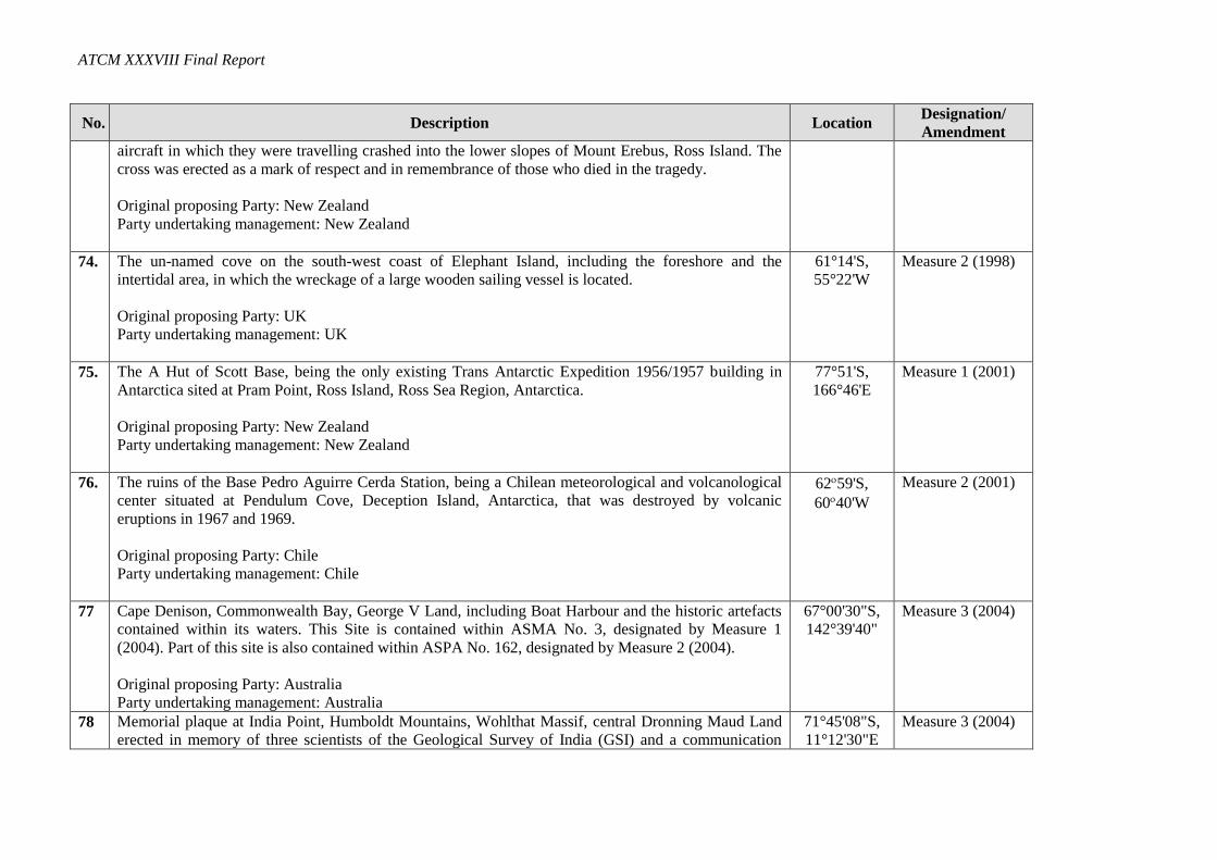
aircraft in which they were travelling crashed into the lower slopes of Mount Erebus, Ross Island. The
cross was erected as a mark of respect and in remembrance of those who died in the tragedy.
Original proposing Party: New Zealand
Party undertaking management: New Zealand
74. The un-named cove on the south-west coast of Elephant Island, including the foreshore and the
intertidal area, in which the wreckage of a large wooden sailing vessel is located.
Original proposing Party: UK
Party undertaking management: UK
61°14'S,
55°22'W
Measure 2 (1998)
75. The A Hut of Scott Base, being the only existing Trans Antarctic Expedition 1956/1957 building in
Antarctica sited at Pram Point, Ross Island, Ross Sea Region, Antarctica.
Original proposing Party: New Zealand
Party undertaking management: New Zealand
77°51'S,
166°46'E
Measure 1 (2001)
76. The ruins of the Base Pedro Aguirre Cerda Station, being a Chilean meteorological and volcanological
center situated at Pendulum Cove, Deception Island, Antarctica, that was destroyed by volcanic
eruptions in 1967 and 1969.
Original proposing Party: Chile
Party undertaking management: Chile
6259'S,
6040'W
Measure 2 (2001)
77 Cape Denison, Commonwealth Bay, George V Land, including Boat Harbour and the historic artefacts
contained within its waters. This Site is contained within ASMA No. 3, designated by Measure 1
(2004). Part of this site is also contained within ASPA No. 162, designated by Measure 2 (2004).
Original proposing Party: Australia
Party undertaking management: Australia
67°00'30"S,
142°39'40"
Measure 3 (2004)
78 Memorial plaque at India Point, Humboldt Mountains, Wohlthat Massif, central Dronning Maud Land
erected in memory of three scientists of the Geological Survey of India (GSI) and a communication
71°45'08"S,
11°12'30"E
Measure 3 (2004)
Annex: Revised List of Historic Sites and Monuments
No. Description Location Designation/
Amendment
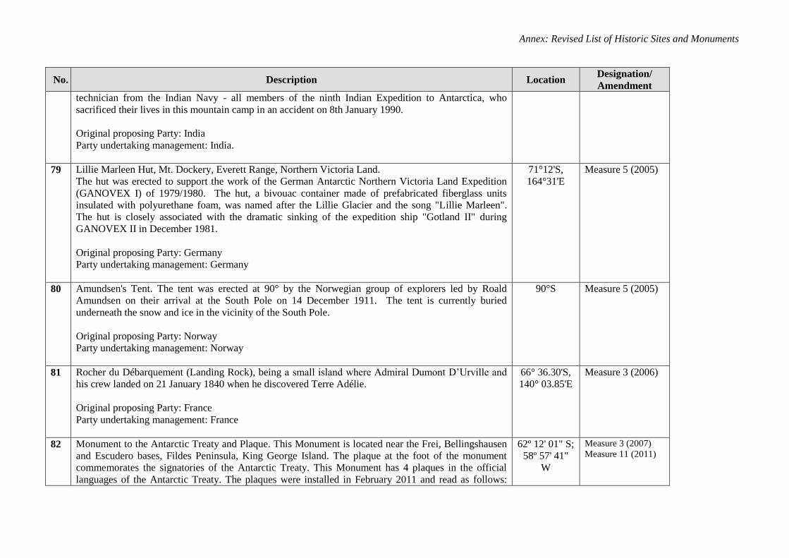
technician from the Indian Navy - all members of the ninth Indian Expedition to Antarctica, who
sacrificed their lives in this mountain camp in an accident on 8th January 1990.
Original proposing Party: India
Party undertaking management: India.
79 Lillie Marleen Hut, Mt. Dockery, Everett Range, Northern Victoria Land.
The hut was erected to support the work of the German Antarctic Northern Victoria Land Expedition
(GANOVEX I) of 1979/1980. The hut, a bivouac container made of prefabricated fiberglass units
insulated with polyurethane foam, was named after the Lillie Glacier and the song "Lillie Marleen".
The hut is closely associated with the dramatic sinking of the expedition ship "Gotland II" during
GANOVEX II in December 1981.
Original proposing Party: Germany
Party undertaking management: Germany
71°12'S,
164°31'E
Measure 5 (2005)
80 Amundsen's Tent. The tent was erected at 90° by the Norwegian group of explorers led by Roald
Amundsen on their arrival at the South Pole on 14 December 1911. The tent is currently buried
underneath the snow and ice in the vicinity of the South Pole.
Original proposing Party: Norway
Party undertaking management: Norway
90°S Measure 5 (2005)
81 Rocher du Débarquement (Landing Rock), being a small island where Admiral Dumont D’Urville and
his crew landed on 21 January 1840 when he discovered Terre Adélie.
Original proposing Party: France
Party undertaking management: France
66° 36.30'S,
140° 03.85'E
Measure 3 (2006)
82 Monument to the Antarctic Treaty and Plaque. This Monument is located near the Frei, Bellingshausen
and Escudero bases, Fildes Peninsula, King George Island. The plaque at the foot of the monument
commemorates the signatories of the Antarctic Treaty. This Monument has 4 plaques in the official
languages of the Antarctic Treaty. The plaques were installed in February 2011 and read as follows:
62º 12' 01" S;
58º 57' 41"
W
Measure 3 (2007)
Measure 11 (2011)
ATCM XXXVIII Final Report
No. Description Location Designation/
Amendment
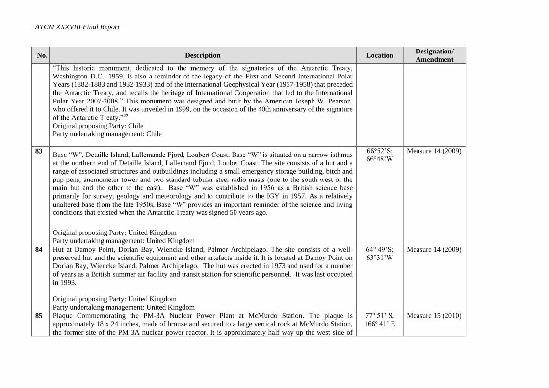
“This historic monument, dedicated to the memory of the signatories of the Antarctic Treaty,
Washington D.C., 1959, is also a reminder of the legacy of the First and Second International Polar
Years (1882-1883 and 1932-1933) and of the International Geophysical Year (1957-1958) that preceded
the Antarctic Treaty, and recalls the heritage of International Cooperation that led to the International
Polar Year 2007-2008.” This monument was designed and built by the American Joseph W. Pearson,
who offered it to Chile. It was unveiled in 1999, on the occasion of the 40th anniversary of the signature
of the Antarctic Treaty.”22
Original proposing Party: Chile
Party undertaking management: Chile
83 Base “W”, Detaille Island, Lallemande Fjord, Loubert Coast. Base “W” is situated on a narrow isthmus
at the northern end of Detaille Island, Lallemand Fjord, Loubet Coast. The site consists of a hut and a
range of associated structures and outbuildings including a small emergency storage building, bitch and
pup pens, anemometer tower and two standard tubular steel radio masts (one to the south west of the
main hut and the other to the east). Base “W” was established in 1956 as a British science base
primarily for survey, geology and meteorology and to contribute to the IGY in 1957. As a relatively
unaltered base from the late 1950s, Base “W” provides an important reminder of the science and living
conditions that existed when the Antarctic Treaty was signed 50 years ago.
Original proposing Party: United Kingdom
Party undertaking management: United Kingdom
66°52’S;
66°48’W
Measure 14 (2009)
84 Hut at Damoy Point, Dorian Bay, Wiencke Island, Palmer Archipelago. The site consists of a well-
preserved hut and the scientific equipment and other artefacts inside it. It is located at Damoy Point on
Dorian Bay, Wiencke Island, Palmer Archipelago. The hut was erected in 1973 and used for a number
of years as a British summer air facility and transit station for scientific personnel. It was last occupied
in 1993.
Original proposing Party: United Kingdom
Party undertaking management: United Kingdom
64° 49’S;
63°31’W
Measure 14 (2009)
85 Plaque Commemorating the PM-3A Nuclear Power Plant at McMurdo Station. The plaque is
approximately 18 x 24 inches, made of bronze and secured to a large vertical rock at McMurdo Station,
the former site of the PM-3A nuclear power reactor. It is approximately half way up the west side of
77o 51’ S,
166o 41’ E
Measure 15 (2010)
Annex: Revised List of Historic Sites and Monuments
No. Description Location Designation/
Amendment
Observation Hill. The plaque text details achievements of PM-3A, Antarctica’s first nuclear power
plant.
Original proposing Party: United States
Party Undertaking Management: United States
86 No.1 Building at Great Wall Station. The No.1 Building, built in 1985 with a total floor space of 175
square meters, is located at the centre of the Chinese Antarctic Great Wall Station which is situated in
Fildes Peninsula, King George Island, South Shetlands, West Antarctica. The Building marked the
commencement of China devoting to Antarctic research in the 1980s, and thus it is of great significance
in commemorating China’s Antarctic expedition.
Original proposing Party: China
Party undertaking management: China
62°13′4″ S,
58°57′44″ W
Measure 12 (2011)
87
Location of the first permanently occupied German Antarctic research station “Georg Forster”
at the Schirmacher Oasis, Dronning Maud Land. The original site is situated by the
Schirmacher Oasis and marked by a commemorative bronze plaque with the label in German
language:
Antarktisstation
Georg Forster
70° 46’ 39’’ S
11° 51’ 03’’ E
von 1976 bis 1996
The plaque is well preserved and affixed to a rock wall at the southern edge of the location.
This Antarctic research station was opened on 21 April 1976 and closed down in 1993. The
entire site has been completely cleaned up after the dismantling of the station was successfully
terminated on 12 February 1996. The site is located about 1.5 km east of the current Russian
Antarctic research station Novolazarevskaya.
Original proposing Party: Germany
Party undertaking management: Germany
70°46’39’’ S,
11°51’03’’ E
Elevation:
141 meters
above sea
level
Measure 18 (2013)
ATCM XXXVIII Final Report
No. Description Location Designation/
Amendment
88
Professor Kudryashov’s Drilling Complex Building. The drilling complex building was
constructed in the summer season of 1983-84. Under the leadership of Professor Boris
Kudryashov, ancient mainland ice samples were obtained.
Original proposing Party: Russian Federation
Party undertaking management: Russian Federation
78º28' S,
106º 48' E
Height
above sea
level 3488
m.
Measure 19 (2013)
89 Terra Nova Expedition 1910-12, Upper “Summit Camp” used during survey of Mount Erebus
in December 1912. Camp Site location includes part of a circle of rocks, which were likely
used to weight the tent valences. The camp site was used by a science party on Captain Scott’s
Terra Nova Expedition, who undertook mapping and collected geological specimens on Mount
Erebus in December 1912.
Original proposing Parties: United Kingdom, New Zealand and United States
Parties undertaking management: United Kingdom, New Zealand and United States
77⁰30.348’ S,
167⁰10.223’E
Circa 3,410m
above sea level
Measure 20 (2013)
90 Terra Nova Expedition 1910-12, Lower “Camp E” Site used during survey of Mount Erebus in
December 1912. Camp Site location consists of a slightly elevated area of gravel and includes
some aligned rocks, which may have been used to weight the tent valences. The camp site was
used by a science party on Captain Scott’s Terra Nova Expedition, who undertook mapping
and collected geological specimens on Mount Erebus in December 1912.
Original proposing Parties: United Kingdom, New Zealand and United States
Parties undertaking management: United Kingdom, New Zealand and United States
77⁰ 30.348’ S,
167⁰ 9.246’E
Circa 3,410 m
above sea level
Measure 21 (2013)
91 Lame Dog Hut at the Bulgarian base St. Kliment Ohridski, Livingston Island
The Lame Dog Hut was erected in April 1988, and had been the main building of St. Kliment
Ohridski base until 1998. It is presently the oldest preserved building on Livingston Island,
used as radio shack and post office, and hosting a museum exhibition of associated artefacts
62 degrees
38' 29" S, 60
degrees 21'
53" W
Measure 19 (2015)
Annex: Revised List of Historic Sites and Monuments
No. Description Location Designation/
Amendment
from the early Bulgarian science and logistic operations in Antarctica
Original proposing Party: Bulgaria
Party undertaking management: Bulgaria
92 Oversnow heavy tractor “Kharkovchanka” that was used in Antarctica from 1959 to 2010.
The oversnow heavy tractor “Kharkovchanka” was designed and produced at the Malyshev
Transport Machine-Building Plant in Kharkov specially for organizing inland sledge-tractor
traverses in Antarctica. This was the first non-serial transport vehicle of the Soviet machine-
building produced exclusively for operations in Antarctica. This tractor was not used outside
Antarctica. Thus, the STT “Kharkovchanka” is a unique historical sample of engineering-
technical developments made for exploration of Antarctica.
Original proposing Party: the Russian Federation
Party undertaking management: the Russian Federation
69°22′41,0″
S,
76°22′59,1″
E.
Measure 19 (2015)