review of assessment documentation for planning proposal · proposal and surrounding bushfire prone...
TRANSCRIPT

PO Box 34 FORSTER NSW 2428 Level 1 Building Q – Head Street Car Park
4 Head Street Forster 2428
Phone (02) 6555 5522
12 October 2018
Independent Planning Commission NSW Level 3, 201 Elizabeth Street SYDNEY NSW 2000
Our Ref: 18211
Attention: David Way Dear Mr Way,
Review of Assessment Documentation for Planning Proposal:
Ralston Avenue, Belrose
ABAC Australian Bushfire Assessment Consultants have been commissioned by the Independent Planning Commission to review a number of documents in relation to a planning proposal for a portion of land within a larger parcel described as Lot 1 DP 1139826, Ralston Avenue, Belrose.
1. Summary of findings
The objectives in part 1 of the s117(2) (now s9.1) Direction 4.4 Planning for Bushfire Protection (the Direction) are:
(a) to protect life, property and the environment from bush fire hazards, by discouraging the establishment of incompatible land uses in bush fire prone areas, and
(b) to encourage sound management of bush fire prone areas. Incompatible land uses would be those that, by their very nature, should be excluded from bushfire prone areas. This is recognised by discussion in the Travers Bushfire & Ecology assessment as to what land uses would be incompatible in the context of the planning proposal and surrounding bushfire prone environment. The nature of residential development per se does not lead to a conclusion that it is an incompatible land use in bushfire prone areas. The question then is whether the rezoning of the land for residential development as envisaged by this planning proposal is appropriate. The wording of 5(b) of the Direction requires that a planning proposal must introduce controls that avoid placing inappropriate developments in hazardous areas.

(18211) Independent Planning Commission 2 12 October 2018
Residential development would be considered to be an appropriate development when controls are adequate to mitigate risks arising from adjoining bushfire prone lands. Conversely, it would be concluded that residential development is inappropriate development in those areas when there are clear risks associated with its proposed introduction into a bushfire prone landscape. This requires a conclusion to be drawn that the risks posed to the residential development will be lessened to an acceptable level via the range of bushfire protection measures that are available to be implemented to protect the development. It is not a conclusion that can be arrived at solely via looking at the technical and numerical considerations. It is a conclusion which requires the exercise of caution and reference to clear evidence that the risks can be mitigated. This conclusion cannot be drawn following review of the documentation provided and an inspection of the site. This review has concluded that there are clear potential risks associated with progressing the planning proposal. It is considered that the possible risks associated with facilitating the rezoning of the land as proposed will be proportionally greater than the likely ability of the recommended range of bushfire protection measures to mitigate those risks. Unless and until all potential risks are mitigated or lessened to an acceptable level, then the planning proposal should not be supported.
2. The Review
This review has considered the relationship of the proposal with:
• The planning principles for rezoning to residential land in Section 2.3 of Planning for Bush Fire Protection 2006 (see Annexure 1);
• The specific objectives for subdivisions in Section 4.1.2 of Planning for Bush Fire Protection 2006 (see Annexure 2);
• The provisions of s117(2) (now s9.1) Direction 4.4 Planning for Bushfire Protection (see Annexure 3).
The documents reviewed are:
• Peer Review of Ralston Avenue Planning Proposal – Bushfire Planning by Blackash Bushfire Consulting dated 28 April 2016 (“the Blackash Review”). See Annexure 4;
• Bushfire Protection Assessment – Rezoning Application Lot 1 DP 1139826, Ralston Avenue, Belrose by Travers Bushfire & Ecology dated April 2017 (“the TBE assessment”). See Annexure 5; and
• Letter from NSW Rural Fire Service to Northern Beaches Council dated 18 October 2017. See Annexure 6.
In relation to the documents have been reviewed, the TBE assessment post-dates the Blackash Review. It is understood that the Blackash review was commissioned by the former Warringah Council (now Northern Beaches Council) to review a 2015 version of a TBE Bushfire Protection Assessment for the proposal.

(18211) Independent Planning Commission 3 12 October 2018
The 2017 TBE assessment was prepared ostensibly to address a number of the issues identified in the Blackash review. The RFS letter post-dates the 2017 TBE assessment. This review has found that while the TBE assessment has addressed some of the issues raised in the Blackash review, it has not demonstrated that the development proposed via the planning proposal is appropriate in the context of the surrounding bushfire prone landscape. The TBE assessment adopts a technical and numerical approach to the question as to the relationship between the planning proposal and the Direction. In several instances, the 2017 TBE assessment appears to seek to demonstrate compliance of the proposal with reference back to what the project objectives are, instead of the provisions of the Direction. This is not a criticism of the TBE assessment, which is an apparently sound assessment of the concept residential subdivision which is the subject of the planning proposal. The assessment does, however, appear more suited to an analysis of the proposal for the purposes of assessment of a Development Application as if the land was already rezoned for residential purposes. Unfortunately, the broader strategic question is not answered, however, and the assessment does not address the issue of whether or not the proposal is appropriate in the considerations of risk required by the Direction. Existing issues with respect to residential development on the urban interface with bushfire prone lands in the Belrose locality suggest that careful consideration should be given to whether there should be additional residential development potential created for lands that will be at or near the interface with bushfire prone lands. The planning proposal will, in effect, increase the perimeter of the Belrose residential lands relative to the extent of the existing interface with bushfire prone lands. The overarching issue is whether the concept proposed by the planning proposal would introduce an incompatible land use into the bushfire prone area. While this issue can be approached by consideration of a number of technical matters, the broader consideration relates to the appropriateness, or otherwise, of the planning proposal relative to risks associated with the surrounding bushfire prone area. The TBE assessment implicitly recognises that there are issues relating to existing development in the locality relative to adjacent bushfire prone areas. It is uncontroversial that the bushfire prone vegetated lands surrounding the Belrose locality poses a risk to existing residential development. This tends towards ensuring that consideration of the planning proposal should be approached from the point of view of policy issues relative to introduction of a relatively high yield residential development into an area which will create additional urban interface to the bushfire prone areas. The planning proposal involves the extension of residential development in a generally westerly direction from the existing Transgrid site. The proposal would see the proposed residential precinct surrounded by bushfire prone vegetation for the entirety of its northern, western and southern perimeters. The removal of hazardous vegetation would be limited to the development footprint and surrounding asset protection zones, but the vegetation to be removed is a limited portion
(18211) Independent Planning Commission 4 12 October 2018
of the overall tracts of bushfire prone vegetation which predominate the landscape west and north-west of the Belrose residential areas west of Forest Way. In relation to residential development to the south-east of the area the subject of the planning proposal, it is perhaps the case that the proposal, if realised, would benefit some eight (8) existing residential allotments along Elm Avenue and Calool Crescent which directly adjoin the eastern boundary of the south-eastern part of the subject land. The additional APZ for electrical easements would facilitate maintenance of land along a length of the urban/bushland interface in that area of approximately 225 metres. Overall, if the benefits that flow to the existing development is the removal of hazardous vegetation by the planning proposal, then the risk that arises as a consequence of the proposed residential precinct is that residential development will extend further west from the existing urban area into that vegetation and increase the net perimeter of residential areas that will be liable to exposure to a bushfire in that vegetation. Put simply, if a major bushfire event was to impact on the western part of the residential area in Belrose, any additional residential development that might result from the planning proposal would have negligible benefits in terms of mitigating bushfire impacts on existing residential properties. Any benefits that might arise in this respect would be offset by the risks for the additional residential development (159 allotments) extending west from Ralston Avenue and Wyatt Avenue into the area predominated and surrounded by bushfire prone vegetation. Consideration of the Blackash review and 2017 TBE assessment does not lead to the conclusion that the (now revised) concept presented via the planning proposal satisfactorily addresses all potential bushfire issues. The TBE assessment is technical in nature and does not resolve the strategic planning issues to demonstrate that the development is appropriate.
3. Consistency of the Planning Proposal with the Direction
It is not considered that the planning proposal is consistent with the Direction. Clause 7 of the Direction is:
A planning proposal may be inconsistent with the terms of this direction only if the relevant planning authority can satisfy the Director-General of the Department of Planning (or an officer of the Department nominated by the Director-General) that the council has obtained written advice from the Commissioner of the NSW Rural Fire Service, to the effect that, notwithstanding the non-compliance, the NSW Rural Fire Service does not object to the progression of the planning proposal.
The RFS has registered its objection to the planning proposal, advising that the proposed rezoning of the site to allow significant residential development is not supported. Review of the RFS letter dated 18 October 2017 (see Annexure 6) has concluded that a number of the grounds of objection are well founded.

(18211) Independent Planning Commission 5 12 October 2018
4. Conclusion
It is considered that the possible risks posed by surrounding bushfire prone land to the area of land proposed to be rezoned via the planning proposal will be proportionally greater than the likely ability of the recommended range of bushfire protection measures to mitigate those risks. Unless and until all potential risks are mitigated or lessened to an acceptable level, then the planning proposal should not be supported. Should you wish to discuss any aspect of this matter please contact me on 0407 221 488. Yours faithfully,
SIMON CARROLL Graduate Diploma in Design for Bushfire Prone Areas Graduate Diploma in Building Fire Safety & Risk Engineering Bushfire Planning and Design Accredited Practitioner Level 3 – NSW Accreditation Number BPAD9326
6 12 October 2018
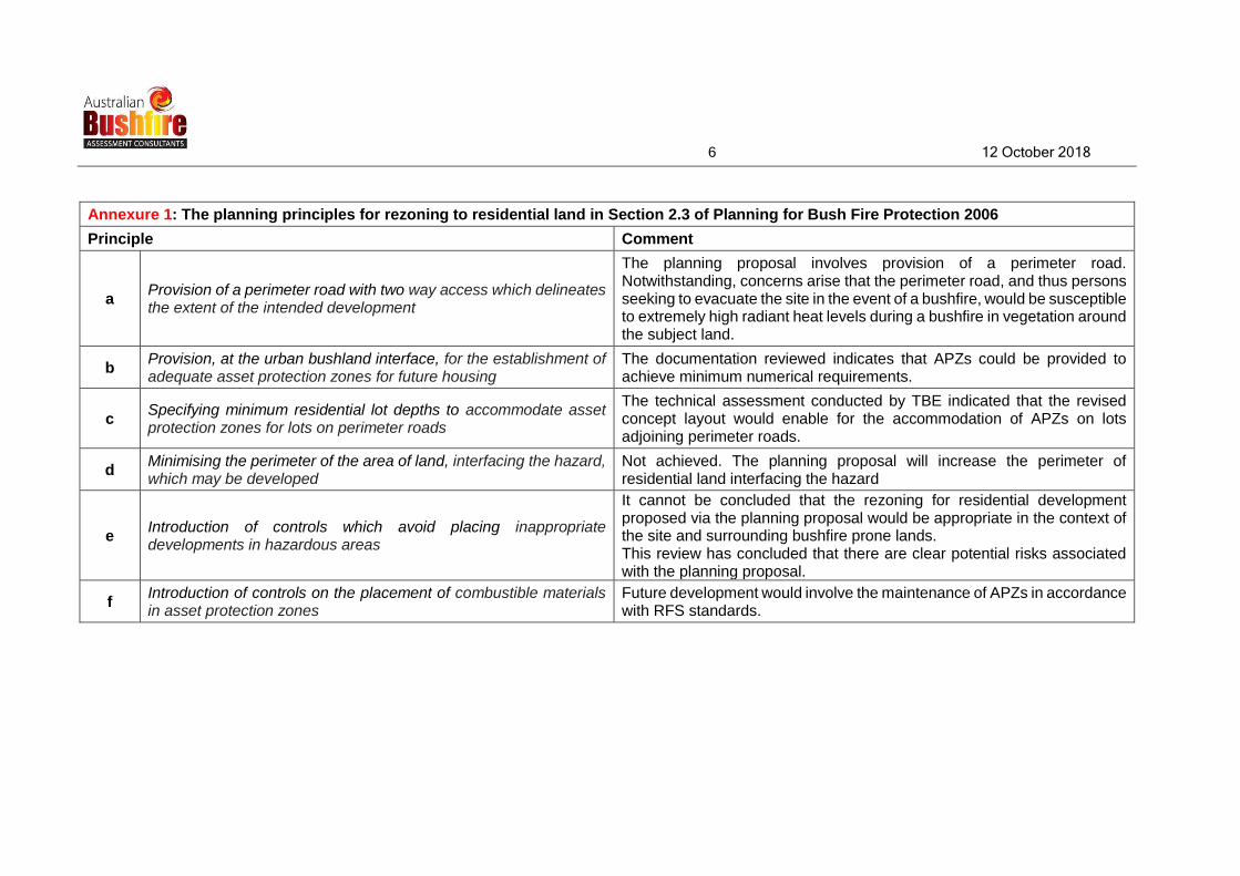
Annexure 1: The planning principles for rezoning to residential land in Section 2.3 of Planning for Bush Fire Protection 2006
Principle Comment
a Provision of a perimeter road with two way access which delineates the extent of the intended development
The planning proposal involves provision of a perimeter road. Notwithstanding, concerns arise that the perimeter road, and thus persons seeking to evacuate the site in the event of a bushfire, would be susceptible to extremely high radiant heat levels during a bushfire in vegetation around the subject land.
b Provision, at the urban bushland interface, for the establishment of adequate asset protection zones for future housing
The documentation reviewed indicates that APZs could be provided to achieve minimum numerical requirements.
c Specifying minimum residential lot depths to accommodate asset protection zones for lots on perimeter roads
The technical assessment conducted by TBE indicated that the revised concept layout would enable for the accommodation of APZs on lots adjoining perimeter roads.
d Minimising the perimeter of the area of land, interfacing the hazard, which may be developed
Not achieved. The planning proposal will increase the perimeter of residential land interfacing the hazard
e Introduction of controls which avoid placing inappropriate developments in hazardous areas
It cannot be concluded that the rezoning for residential development proposed via the planning proposal would be appropriate in the context of the site and surrounding bushfire prone lands. This review has concluded that there are clear potential risks associated with the planning proposal.
f Introduction of controls on the placement of combustible materials in asset protection zones
Future development would involve the maintenance of APZs in accordance with RFS standards.

7 12 October 2018
Annexure 2: The specific objectives for subdivisions in Section 4.1.2 of Planning for Bush Fire Protection 2006
Objective Comment
minimise perimeters of the subdivision exposed to the bush fire hazard. Hourglass shapes, which maximise perimeters and create bottlenecks, should be avoided
Not achieved. The planning proposal will increase the perimeter of residential land interfacing the hazard
minimise bushland corridors that permit the passage of bush fire Limited, if any, bushland corridors proposed but significant tracts of bushland with bushfire hazard potential will adjoin the site
provide for the siting of future dwellings away from ridge-tops and steep slopes - particularly up-slopes, within saddles and narrow ridge crests
The entire proposed residential precinct would be located upslope from bushland with bushfire hazard potential. Consideration of providing larger APZs is appropriate but it is unclear whether they would be adequate for degree of inherent risk posed by bushfire prone vegetation adjoining the site.
ensure that separation distances (APZ) between a bush fire hazard and future dwellings enable conformity with the deemed-to-satisfy requirements of the BCA. In a staged development, the APZ may be absorbed by future stages
This is not a matter that can be conclusively determined at planning proposal stage but the issue of whether APZs will be adequate for degree of inherent risk posed by bushfire prone vegetation adjoining the site is relevant.
provide and locate, where the scale of development permits, open space and public recreation areas as accessible public refuge areas or buffers (APZs)
In relation to the issue of a neighbourhood safer place (NSP), Section 3.10 of the TBE assessment discusses a “possible safer place” for the residential precinct the subject of the planning proposal. It is considered that a NSP must be incorporated within the proposed residential development and would be an essential ingredient in any package of bushfire protection measures if the planning proposal was to be adopted.
Area to bushland side of perimeter road to be maintained as an Outer Protection Area but concerns remain that persons seeking to evacuate the site in the event of a bushfire would be susceptible to extremely high radiant heat levels during a bushfire in vegetation around the subject land.
ensure the ongoing maintenance of asset protection zones Issues have been identified in relation to practical maintenance of land within APZs where slope >18°.

8 12 October 2018
Annexure 2: The specific objectives for subdivisions in Section 4.1.2 of Planning for Bush Fire Protection 2006
Objective Comment
provide clear and ready access from all properties to the public road system for residents and emergency services
The planning proposal involves provision of a perimeter road which has potential to be cut at two pinch points which remain in the revised concept layout. Also, in relation to “clear” access to roads for evacuating residents, concerns remain that persons seeking to evacuate via the perimeter road may susceptible to extremely high radiant heat levels during a bushfire in vegetation around the subject land.
ensure the provision of and adequate supply of water and other services to facilitate effective firefighting
No information available at the date of this review.

9 12 October 2018
Annexure 3: The provisions of s117(2) (now s9.1) Direction 4.4 Planning for Bushfire Protection
A planning proposal must: Comment
5
(a) have regard to Planning for Bushfire Protection 2006
The documentation reviewed has had regard to Planning for Bushfire Protection 2006. Annexures 1 and 2 have identified aspects of the planning proposal that are inconsistent with planning principles for rezoning to residential land in Section 2.3 and/or specific objectives for subdivisions in Section 4.1.2 of Planning for Bush Fire Protection 2006
(b) introduce controls that avoid placing inappropriate developments in hazardous areas
It cannot be concluded that the rezoning for residential development proposed via the planning proposal would be appropriate in the context of the site and surrounding bushfire prone lands. This review has concluded that there are clear potential risks associated with the planning proposal.
(c) ensure that bushfire hazard reduction is not prohibited within the APZ
This could be accommodated in land use controls if the planning proposal was to proceed.
6
(a) provide an Asset Protection Zone (APZ) incorporating at a minimum: (i) an Inner Protection Area bounded by a perimeter road or reserve which circumscribes the hazard side of the land intended for development and has a building line consistent with the incorporation of an APZ, within the property, and
(ii) an Outer Protection Area managed for hazard reduction and located on the bushland side of the perimeter road
The general layout of the revised concept technically meets this requirement.
The issue of whether APZs will be adequate for degree of inherent risk posed by bushfire prone vegetation adjoining the site is relevant.

10 12 October 2018
Annexure 3: The provisions of s117(2) (now s9.1) Direction 4.4 Planning for Bushfire Protection
A planning proposal must: Comment
(c) contain provisions for two-way access roads which links to perimeter roads and/or to fire trail networks
The general layout of the revised concept technically meets this requirement.
A two-way road system is critical, but issue remains that there is the possibility for some of the road system required for egress during a bushfire situation to be cut off. Noted that no APZ identified for areas of road network to the east of Precinct 3 and north of Precinct 8 (the two remaining pinch points).
No details as to fire trails. A site inspection has highlighted the significant topographical constraints which, in most cases, would preclude the design and establishment of an effective fire trail system to serve the area subject to the planning proposal.
(d) contain provisions for adequate water supply for firefighting purposes
No information available at the date of this review.
(e) minimise the perimeter of the area of land interfacing the hazard which may be developed
Not achieved. The planning proposal will increase the perimeter of residential land interfacing the hazard
(f) introduce controls on the placement of combustible materials in the Inner Protection Area
Future development would involve the maintenance of APZs in accordance with RFS standards.
11 12 October 2018
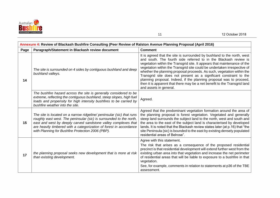
Annexure 4: Review of Blackash Bushfire Consulting (Peer Review of Ralston Avenue Planning Proposal (April 2016)
Page Paragraph/Statement in Blackash review document Comment
14
The site is surrounded on 4 sides by contiguous bushland and deep bushland valleys.
It is agreed that the site is surrounded by bushland to the north, west and south. The fourth side referred to in the Blackash review is vegetation within the Transgrid site. It appears that maintenance of the vegetation within the Transgrid site could be undertaken irrespective of whether the planning proposal proceeds. As such, vegetation within the Transgrid site does not present as a significant constraint to the planning proposal. Indeed, if the planning proposal was to proceed, then it is apparent that there may be a net benefit to the Transgrid land and assets in general.
The bushfire hazard across the site is generally considered to be extreme, reflecting the contiguous bushland, steep slopes, high fuel loads and propensity for high intensity bushfires to be carried by bushfire weather into the site.
Agreed.
15
The site is located on a narrow ridgeline/ peninsular (sic) that runs roughly east west. The peninsular (sic) is surrounded to the north, east and west by deeply carved sandstone valley complexes that are heavily timbered with a categorization of forest in accordance with Planning for Bushfire Protection 2006 (PBP).
Agreed that the predominant vegetation formation around the area of the planning proposal is forest vegetation. Vegetated and generally steep land surrounds the subject land to the north, west and south and the area to the east of the subject land is characterised by developed lands. It is noted that the Blackash review states later (at p.16) that “the site Peninsula (sic) is bounded to the east by existing densely populated residential areas of Belrose”.
17 the planning proposal seeks new development that is more at risk than existing development.
Agree with this statement.
The risk that arises as a consequence of the proposed residential precinct is that residential development will extend further west from the existing urban area into that vegetation and increase the net perimeter of residential areas that will be liable to exposure to a bushfire in that vegetation.
See, for example, comments in relation to statements at p36 of the TBE assessment.

12 12 October 2018
Annexure 4: Review of Blackash Bushfire Consulting (Peer Review of Ralston Avenue Planning Proposal (April 2016)
Page Paragraph/Statement in Blackash review document Comment
The narrowness and configuration of the site lends itself to be heavily impacted by the most intense bushfires being driven by strong northwesterly winds.
Agree that by the planning proposal involving the westerly extension of residential zoned areas into a bushfire prone area, there is an inherent risk of the site being impacted by bushfires that may occur in the vegetated lands adjoining the site to the north, west and south.
All access and egress points could be immersed in flame and will at some point have radiant heat levels that will be life threatening to people exposed in the open or in vehicles attempting to flee the site.
Agree with this statement. Egress routes generally involve use of parts of the perimeter roads. These roads, apart from area to be maintained as an Outer Protection Area, are adjacent to areas which will remain steeply sloping and vegetated.
19
The vegetation is directly adjacent to the connecting roads and the site. These areas are known as “pinch points”. It is possible that any of the forms of bushfire attack including smoke could cut the site off from surrounding areas, preventing access and evacuation.
The Blackash review predates the TBE assessment. The TBE assessment is based on a slightly revised concept and all but two of the pinch points identified were eliminated via the proposed concept. Noted that no APZ/OPA identified for areas of road network to the east of Precinct 3 and north of Precinct 8.
Access to the site could be cut off at the pinch points and emergency services are likely to be stretched beyond reasonable limits. More likely than not, services will not be able to be tendered to all of these developments.
Agreed, but as the Blackash review predates the 2017, it is noted that the revised concept assessed via the 2017 TBE assessment does reduce the number of pinch points to two areas where no APZ is identified for areas of road network to the east of Precinct 3 and north of Precinct 8.
21 The challenge presented in this Planning Proposal is to consider the context for managing risk as well as continuing to identify new risks that emerge over the life of the development.
Agreed.
22
Sound risk management and decisions that prevent exposing future occupants and fire fighters to an unacceptable level of bushfire risk should be the key consideration of the Planning Proposal and rezoning process. Unfortunately, the bushfire matters considered to date are of a technical nature and do not consider or address the broader risk management framework, principles of good risk
Agreed.

13 12 October 2018
Annexure 4: Review of Blackash Bushfire Consulting (Peer Review of Ralston Avenue Planning Proposal (April 2016)
Page Paragraph/Statement in Blackash review document Comment
management or consider exclusion of the development.
25
the TBE reports do not adequately discuss or determine Directive 4.4 (b) which is to ensure that rezoning of an area is appropriate for future development and that inappropriate development is not facilitated in hazardous areas.
Agreed. Residential development would be considered to be an appropriate development when controls are adequate to mitigate risks arising from adjoining bushfire prone lands.
This has not been demonstrated.
A Plan for Growing Sydney recognizes the need for a risk-based approach to planning and considering development and ensuring that new developments will not be placed in harm’s way and will not increase risk. The Ralston Avenue proposal fails to achieve this as is demonstrated throughout the report, particularly as it relates to evacuation
Agreed.
29
While it is acknowledged that the current Planning Proposal is not for “rural” development, the configuration of the land and adjoining unmanaged bushland does provide a high likelihood that the site will be isolated by high intensity fire. There is potential for the site to be impacted from four sides with prolonged bushfire attack in the form of ember attack, smoke, radiant heat and direct flame contact. Indeed, the narrowness and configuration of the site lends itself to be heavily impacted by the most intense bushfires being driven by north-westerly winds. The number of pinch points, location of bushfire fuel and connection of unmanaged areas presents an extreme risk to life. All access and egress points could be immersed in flame and will at some point have radiant heat levels that will be life threatening to people exposed in the open or in vehicles attempting to flee the site.
The land to the east of the subject land is developed land and the main areas of bushfire prone land adjoin the northern, western and southern peripheries of the subject land. Aside from that, this paragraph from the Blackash review summarises the major issues and risks with respect to the bushfire prone nature of the land around the area the subject of the planning proposal.
Those major issues and risks remain in relation to the revised concept (the subject of the 2017 TBE assessment).

14 12 October 2018
Annexure 4: Review of Blackash Bushfire Consulting (Peer Review of Ralston Avenue Planning Proposal (April 2016)
Page Paragraph/Statement in Blackash review document Comment
30
The TBE Bushfire Report deals well with the technical issues within the site. However, it fails to address issues from adjoining land and critical life safety issues that are beyond the ability of the Planning Proposal to control. One of the fundamental principles of PBP is that the Bushfire Protection Measures are contained within the overall development. In this case, the integrity of the Proposal and the linkages to surrounding areas are so great that the broader site context and associated issues must be more fully addressed.
Agreed.
The Planning Principles of PBP for Rezoning to Residential Land in Bushfire Prone Areas (PBP p4) requires the provision of a perimeter road with two-way access, which delineates the extent of the intended development. This has been provided in the proposed rezoning lot layout.
Agreed. See Table at Annexure 1 to this document.
The proposal through its configuration, fails to provide safe access. The proposal while providing perimeter roads, fails to provide safe access without direct contact with unmanaged bushland areas.
Agreed.
The access leading from Ralston Ave and Wyatt Ave into the site has significant potential to be cut by bushfire due to the proximity of the adjacent forested areas within Garigal National Park and adjoining land. The remnant areas have potential to carry fire that significantly compromises the access and egress into and out of the site.
Agreed in relation to Ralston Avenue.
The revised concept reduces the potential for Wyatt Avenue to be cut off.
31 much of the access areas within the site will receive radiant heat levels that are above life safety thresholds.
Agreed. It is considered that while a perimeter road is proposed, there are risks associated with relying on perimeter roads for evacuation in a bushfire emergency. This is simply because the land to one side of the perimeter road will contain the bushland that will potentially be on fire.

15 12 October 2018
Annexure 4: Review of Blackash Bushfire Consulting (Peer Review of Ralston Avenue Planning Proposal (April 2016)
Page Paragraph/Statement in Blackash review document Comment
32 The configuration of the site and road infrastructure will expose people in cars to life threatening radiant heat levels as the fire impacts the site.
Agreed that this is a possible risk. See comment in previous row re: text on page 31 of the Blackash review.
33
adaptive issues associated with the road layout and shelter options have not been included in the considerations of the Planning Proposal with reliance on technical aspects of PBP, particularly in light of a highly likely scenario of people being isolated either on foot or in cars within the site.
Agreed. Section 3.10 of the TBE assessment discusses the parameters for a possible Neighbourhood Safer Place (NSP) within the proposed residential precinct. Provision for a NSP within the proposed residential precinct would be an essential ingredient in any package of bushfire protection measures if the planning proposal was to be adopted.
A two-way road system is critical. Issues to be considered include the possibility for some of the road system required for egress during a bushfire situation to be cut off. Noted that no APZ identified for areas of road network to the east of Precinct 3 and north of Precinct 8 (the two remaining pinch points).
the reports do not show the location of proposed new fire trails with the existing fire trail network within the adjoining Garigal National Park. Fire trails play a critical control point in the provision of safe planned burning. This is a particularly relevant matter, as the boundary between the APZ, SFAZ and Land Management Zones (LMZ) will need to be delineated to facilitate ongoing management. The boundary between the LMZ and SFAZ will require a fire trail to provide access for fire fighters to undertake strategic planned burning in a safe way.
Agreed. A site inspection has highlighted the significant topographical constraints which, in most cases, would preclude the design and establishment of an effective fire trail system to serve the area subject to the planning proposal.
34 it is difficult to make a comparative assessment of the APZ as transects for slope have not been provided to assist readers to understand the nature of slopes on the site.
Agreed. It was noted in comments relating to the 2017 TBE assessment that the assessment of slope is unclear. It was also noted that, overall, from a strategic point of view, the assumption that steeper slopes predominate is an appropriate starting point for assessment of the planning proposal relative to the relevant parts of the Direction.

16 12 October 2018
Annexure 4: Review of Blackash Bushfire Consulting (Peer Review of Ralston Avenue Planning Proposal (April 2016)
Page Paragraph/Statement in Blackash review document Comment
35 there are a number of areas where APZs are not provided that result in pinch points and non-compliant APZs throughout the site.
Overall, it is clear that the area of the site is such that, at least arbitrarily, larger APZs could be provided to areas of residential development (subject to ecological constraints). This may have the effect of limiting residential development to a yield less than that contemplated by the (now revised) concept which is the basis of the planning proposal.
The issue of non-compliant numerical APZs at planning proposal stage is not considered significant, but it is an issue which highlights a potential risk of proceeding with the planning proposal.
It is noted that the revised concept assessed via the 2017 TBE assessment reduces the number of pinch points to two areas but, nonetheless the issue of pinch points remains. The remaining pinch points affect two areas along the perimeter road and must be addressed if the planning proposal is to proceed.
36 Isolated rural developments such as this can incorporate larger APZs and should consider the provision of APZs for the access roads that are below critical life safety thresholds.
While the nature of the concept for the planning proposal is not an isolated rural development, the incorporation of larger APZs and the provision of APZs for the access roads that are below critical life safety thresholds are issues that should be demonstrated in any planning proposal if it is proposing additional residential development in a bushfire prone area. The planning proposal fails in this regard.
37 APZs should be provided along the length of Wyatt and Ralston Avenue that eliminate pinch points and provide for the passage of people below critical for life safety thresholds.
Agreed. It is noted that the revised concept assessed via the 2017 TBE assessment reduces the number of pinch points to two areas but, nonetheless the issue of pinch points remains. The remaining pinch points affect two areas along the perimeter road and must be addressed if the planning proposal is to proceed.
38-39 Section 10.3
Noted that a number of the issues raised in relation to adequacy of APZs have been addressed via the revised concept. Issues that remain have been discussed in relation to various parts of the 2017 TBE assessment with respect to APZs and access.

17 12 October 2018
Annexure 4: Review of Blackash Bushfire Consulting (Peer Review of Ralston Avenue Planning Proposal (April 2016)
Page Paragraph/Statement in Blackash review document Comment
39 The management of the adjacent APZs, including the SFAZ will need to be provided in perpetuity and should be legally binding through easements or community title arrangements.
A community title arrangement has been discussed in the 2017 TBE assessment. This may be an appropriate arrangement so that costs are not borne by the wider community.
41 The interrelationship between APZs and the provision of access and critical life safety has not been demonstrated in the Planning Proposal.
Agreed. This is a major issue and leads to the conclusion that the risks to any future development are likely to outweigh the probable ability of the recommended bushfire protection measures to mitigate those risks.
45
If unimpeded access cannot be guaranteed to the site in light of smoke and fire impacts resulting in the potential for arcing, the Planning Proposal is fundamentally flawed. This would constitute grounds for refusal, as the proposal is incompatible with surrounding uses that present critical life safety issues.
It is recommended that consultation take place with Transgrid in relation to the significance of any issues to do with the potential for arcing during a bushfire emergency and smoky conditions in general.
47
Over time, it is likely that the impact associated with mitigating bushfire risk will be greater than that which is expressed in the TBE Fuel Management Report.
Such impacts should be considered in light of the high risk of the site and surrounds and the likely conservative approach that will be taken to mitigate bushfire impact on future assets and people.
If bushfire risks associated with any future development of the site are to be satisfactorily mitigated, then this will require more intensive physical works (APZs, access etc.). This may lead to tension with ecological/biodiversity considerations.
48 The Planning Proposal will place an increased burden on emergency services in the event of a bushfire in the vicinity of the site.
Agreed.
49
The Travers Bushfire and Ecology Bushfire Report, deals well with the technical issues within the site. However, it fails to address issues from adjoining land and critical life safety issues that are beyond the ability of the Planning Proposal to control.
Agreed.

18 12 October 2018
Annexure 4: Review of Blackash Bushfire Consulting (Peer Review of Ralston Avenue Planning Proposal (April 2016)
Page Paragraph/Statement in Blackash review document Comment
The reports do not address or consider the suitability of wider access issues. This is a significant oversight in the reports and is not in keeping with the principle of considering broader precinct level impacts of issues associated with a Planning Proposal.
Agreed.
50
The proposal has a number of design flaws within the site and external factors that present a critical and clear risk to life and the integrity of the development.
Agreed.
It is recommended that:
1. The planning proposal should more fully consider the strategic planning requirements of the S.117 Directive and linkages throughout Planning for Bushfire Protection regarding development in high-risk areas;
2. The linkages to surrounding areas and the broader site context and associated issues should be more fully addressed;
3. The RFS should reconsider the advice it has given in light of the findings of this report;
4. Clarification be sought regarding the intended locations of fire trails, construction implications, maintenance and agreement from adjoining managers of linkages;
5. APZs complying with Planning for Bushfire Protection should be provided throughout the site;
6. Consideration be given to managing the pocket park as an intensive APZ, housing or open space to remove the pinch point entirely;
7. The National Guidelines on Electrical Safety for Emergency Personnel (EN A DOC 009-2006) be reviewed in light of the significant potential for arcing to ground;
In relation to recommendations 1-8:
1. Not achieved via the revised concept/assessment;
2. Not achieved via the revised concept/assessment;
3. Discussed separately. The Blackash review predates the RFS letter of 18 October 2017;
4. Not achieved via the revised concept/assessment;
5. Not achieved via the revised concept/assessment but it is clear that the area of the site is such that larger APZs could be provided to areas of residential development and along evacuation routes. This may lead to tension with ecological/biodiversity considerations;
6. The “pocket park” has been significantly reduced via the revised concept/assessment and issues generally addressed;
7. It is recommended that consultation take place with Transgrid in relation to the significance of any issues to do with the potential for arcing; and

19 12 October 2018
Annexure 4: Review of Blackash Bushfire Consulting (Peer Review of Ralston Avenue Planning Proposal (April 2016)
Page Paragraph/Statement in Blackash review document Comment
8. Council, the RFS and the NSW Department of Planning re-evaluate the bushfire issues to address the fundamental planning question of site suitability and introducing controls that avoid placing inappropriate developments in hazardous areas.
8. Consideration of the Blackash review and 2017 TBE assessment does not lead to the conclusion that the (now revised) concept presented via the planning proposal satisfactorily addresses all potential bushfire issues. The TBE assessment is technical in nature and does not resolve the strategic planning issues to demonstrate that the development is appropriate.
20 12 October 2018
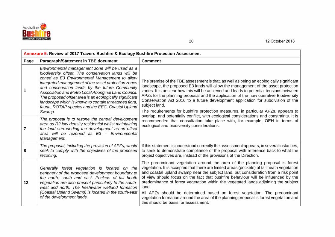
Annexure 5: Review of 2017 Travers Bushfire & Ecology Bushfire Protection Assessment
Page Paragraph/Statement in TBE document Comment
1
Environmental management zone will be used as a biodiversity offset. The conservation lands will be zoned as E3 Environmental Management to allow integrated management of the asset protection zones and conservation lands by the future Community Association and Metro Local Aboriginal Land Council. The proposed offset area is an ecologically significant landscape which is known to contain threatened flora, fauna, ROTAP species and the EEC, Coastal Upland Swamp.
The premise of the TBE assessment is that, as well as being an ecologically significant landscape, the proposed E3 lands will allow the management of the asset protection zones. It is unclear how this will be achieved and leads to potential tensions between APZs for the planning proposal and the application of the now operative Biodiversity Conservation Act 2016 to a future development application for subdivision of the subject land.
The requirements for bushfire protection measures, in particular APZs, appears to overlap, and potentially conflict, with ecological considerations and constraints. It is recommended that consultation take place with, for example, OEH in terms of ecological and biodiversity considerations.
7
The proposal is to rezone the central development area as R2 low density residential whilst maintaining the land surrounding the development as an offset area will be rezoned as E3 – Environmental Management.
8 The proposal, including the provision of APZs, would seek to comply with the objectives of the proposed rezoning.
If this statement is understood correctly the assessment appears, in several instances, to seek to demonstrate compliance of the proposal with reference back to what the project objectives are, instead of the provisions of the Direction.
12
Generally forest vegetation is located on the periphery of the proposed development boundary to the north, south and east. Pockets of tall heath vegetation are also present particularly to the south-west and north. The freshwater wetland formation (Coastal Upland Swamp) is located in the south-east of the development lands.
The predominant vegetation around the area of the planning proposal is forest vegetation. It is accepted that there are limited areas (pockets) of tall heath vegetation and coastal upland swamp near the subject land, but consideration from a risk point of view should focus on the fact that bushfire behaviour will be influenced by the predominance of forest vegetation within the vegetated lands adjoining the subject land.
All APZs should be determined based on forest vegetation. The predominant vegetation formation around the area of the planning proposal is forest vegetation and this should be basis for assessment.

21 12 October 2018
Annexure 5: Review of 2017 Travers Bushfire & Ecology Bushfire Protection Assessment
Page Paragraph/Statement in TBE document Comment
15
The Australian Standard AS3959 permits slopes up to and including 20 degrees for determination of bushfire attack (for assessments of building applications in bushfire prone areas). Figure 2.2 portrays the slopes in excess of 20 degrees for the two vegetation communities i.e. forest and heath. This clarifies the extent of steep slopes and their affectation.
This paragraph is the first of several which indicates that the assessment of slope is unclear.
Overall, from a strategic point of view and consideration of risk to the planning proposal, the assumption that steeper slopes predominate is an appropriate starting point for assessment of the planning proposal relative to the relevant parts of the Direction.
The RFS nominate 18 degrees as an upper limit for APZs except where it can be shown that fuels can be managed without risk to environmental resources e.g. soils and plants.
There are means to manage lands >18° for asset protection purposes subject to expert advice (e.g. geotechnical assessment and recommendations to maintain slope stability). Overall, however, this is irrelevant in the context of a planning proposal and is a matter for detail and assessment in any future development application.
16
As depicted in Figure 2.3 the majority of the APZ supports slopes of between 0–18 degrees arising from the many sandstone escarpments making up the yellow and blue coloured lands.
Figure 2.2 in the TBE assessment (page 15) indicates that there are substantial areas >20° around the area of the planning proposal, outside the red line indicating the outer extent of the APZ.
The extent of APZs should be based on the steeper slopes outside the APZ, as it is the slope of lands in this area that is most likely to influence bushfire behaviour. The slope of land within the APZ area is more a subject of management, whereas land outside the APZ will still constitute a hazard.
16
Section 2.3 – provides a summary of the bushfire attack assessment and the minimum required asset protection zones in compliance with BAL 29 building construction standards.
The TBE assessment adopts a technical and numerical approach to the question as to relationship between the planning proposal and the Direction.
This does not address the issue of whether or not the proposal is appropriate development for the purposes of the Direction but is more akin to an analysis of the proposal for the purposes of assessment of a Development Application (as if the land was already rezoned for residential purposes).
Any conclusion as to the appropriateness of the planning proposal should not be arrived at solely via looking at the technical and numerical considerations. It is a

22 12 October 2018
Annexure 5: Review of 2017 Travers Bushfire & Ecology Bushfire Protection Assessment
Page Paragraph/Statement in TBE document Comment
conclusion which requires the exercise of caution and reference to clear evidence that the risks can be mitigated.
20
APZs are generally situated on slopes of less than 18 degrees. There are a select few areas where the slopes exceed 18 degrees, these areas are rock ledges and can be incorporated into APZ management. Previous correspondence to the NSW RFS and the preparation of a Fuel Management Plan details the ongoing management of the APZs.
Instead of the slope of land within the APZs, it is the slope of the land outside the proposed APZ extents that is of concern (as this is land which will not be managed at all). Overall, this is a design/technical issue that would be informed by accurate identification of actual slope of land at development application.
The construction classification system is based on five (5) bushfire attack levels (BAL). These are BAL – Flame Zone (FZ), BAL 40, BAL 29, BAL 19 and BAL 12.5 (AS3959 (2009) – Construction of buildings in bushfire prone areas). The lowest level, BAL 12.5, has the longest APZ distance while BAL–FZ has the shortest APZ distance. These allow for varying levels of building design and use of appropriate materials which affects costs. This means that BAL 12.5 is much cheaper than BAL 29 when constructing a dwelling. However the length of the APZs for BAL 12.5 would be too long and a compromise would be BAL 19 being used as a satisfactory development aspiration
The cost of building construction is a factor to be considered by the end purchaser of residential land and is not relevant to the relationship between the planning proposal and the Direction.
The comments made in the Blackash review about the land the subject of the planning proposal being relatively isolated suggest that, if the planning proposal is to be supported, larger APZs should be adopted rather than the minimum APZs identified via a numerical analysis of what is, essentially a concept plan.
If there is to be a numerical determination of APZs for the purposes of the planning proposal, it is suggested that it is more appropriate to approach this via the adoption of a maximum slope for the perimeter of the development and apply a larger APZ than would ordinarily be applied to enable a building to be constructed to BAL-29. In other words, adopt the maximum assessed slope, identify and implement the APZ for BAL-19 but still require (through a community management statement or similar) that construction of the building be to BAL-29.

23 12 October 2018
Annexure 5: Review of 2017 Travers Bushfire & Ecology Bushfire Protection Assessment
Page Paragraph/Statement in TBE document Comment
21
Approximately 156 residential lots will be created within the R2 zone.
No other permissible uses within the R2 zone will be developed. The privately owned community title development management structure that can limit development type, materials and activities. This would include inappropriate development such as secondary dwellings, bed and breakfast accommodation, boarding houses, childcare centres, educational establishments, group homes and or hospitals. Many of these uses are Special Fire Protection Purpose and are therefore vulnerable to the effects of fire, often difficult to evacuate and more susceptible to smoke impacts and by their very nature should be listed in the community management statement as not permissible.
There are concerns that the appropriateness or otherwise of the type of development is sought to be justified by the zonings proposed for the land.
Evaluation as to the appropriateness of the planning proposal is to be informed by broader considerations relating to the context of the subject land and the relative risks posed by its location in the landscape. Decisions as to what zoning might be appropriate should only be made once the broader contextual analysis is complete.
Based on the assumption of 156 lots this would assume a population increase of 406 persons
This estimate might be accurate but only becomes relevant once the broader contextual analysis is complete.
Fuel management in the form of APZ maintenance will be undertaken in accordance with the fuel management plan and at the cost of the Community Association.
Agreed that this may be an appropriate arrangement so that costs are not borne by the wider community. This does not contribute to consideration of the appropriateness, or otherwise, of the planning proposal.

24 12 October 2018
Annexure 5: Review of 2017 Travers Bushfire & Ecology Bushfire Protection Assessment
Page Paragraph/Statement in TBE document Comment
APZs will also be provided to the main access routes and transmission lines and a community safe refuge could be provided within the development footprint. These measures have been designed to improve the existing situation for the surrounding community and to support fire fighting operations.
It is not clear how the planning proposal would improve the existing situation for the surrounding community and/or support fire fighting operations.
Agreed that APZs to the transmission lines is positive but it appears that maintenance of the transmission lines and any APZs could be implemented by Transgrid independent of the planning proposal.
The provision of a neighbourhood safer place (NSP)/community safe refuge would be an essential component of any future development of the subject land for residential purposes but would not bear any relationship to the wider community. This is discussed separately on page 28 of this review with respect to Section 3.10 of the TBE assessment).
A community title approach appears to be the favoured approach by the RFS. The community association would be bound under a positive covenant to manage the APZ on an ongoing basis as outlined in the fuel management plan and the community management statement with the terms being agreed during the subdivision development application.
Agreed that a community title approach may be appropriate, but this does not contribute to consideration of the appropriateness, or otherwise, of the planning proposal.
Consultation with the TransGrid asset manager team is also intended to effectively manage the surrounding asset protection zones within the TransGrid land.
Agreed that consultation with Transgrid would be positive, but this is not relevant to consideration of the appropriateness, or otherwise, of the planning proposal.
Discussed above that it appears that maintenance of the transmission lines and any APZs could be implemented by Transgrid independent of the planning proposal.
22
The portion of the bushfire asset protection zones that are located external to future private lots will be located on various land tenures, for example, public roadways, parklands as well as residual private lands owned and managed by the community association
As identified previously, as the land the subject of the planning proposal is relatively isolated, larger APZs should be adopted rather than the minimum APZs. In particular, APZs on the bushland side of the perimeter road should be maximised, based on maximum slopes and predominantly forest vegetation.

25 12 October 2018
Annexure 5: Review of 2017 Travers Bushfire & Ecology Bushfire Protection Assessment
Page Paragraph/Statement in TBE document Comment
set up under the provisions of the Community Title Legislation.
The boundaries of the SFAZ has been designed based on the site features that facilitate hazard reduction burning operations.
No details have been provided of the SFAZ.
Fire trail works if required will be undertaken in accordance with the design specifications outlined in PBP 2006 and in accordance with construction standards set by the RFS and or Warringah-Pittwater Bushfire Management Committee.
Issues were identified in the review of the Blackash document about the ability to provide fire trails. A site inspection has highlighted the significant topographical constraints which, in most cases, would preclude the design and establishment of an effective fire trail system to serve the area subject to the planning proposal.
23
This land will be managed by MLALC in accord with offset conditions issued by OEH.
Agreed that this may be an appropriate arrangement, but this does not contribute to consideration of the appropriateness, or otherwise, of the planning proposal.
The implementation of the APZs will require modification of 10.15ha of the E3 land (including TransGrid Easements). Attention has been given to the varying landscape character and the need to provide habitat function through the retention of various landscape elements such as trees, shrubs, sandstone outcrops, etc.
The implementation of APZs to the Transgrid infrastructure does not rely on the planning proposal.
There is apparent conflict between ecological objectives and bushfire protection imperatives and, given the inherent risks posed by bushfire prone areas around the site, any APZs should be maximised if the planning proposal is to be supported. It is recommended that consultation take place with, for example, OEH in terms of ecological and biodiversity considerations.
The issues which will govern the FMP’s success (include) maintenance of biodiversity through the appropriate management of fire regimes
There is apparent conflict between ecological objectives and bushfire protection imperatives and, given the inherent risks posed by bushfire prone areas around the site, any APZs should be maximised if the planning proposal is to be supported.
In terms of ecological and biodiversity considerations, it is recommended that consultation take place with, for example, OEH and any comments considered.

26 12 October 2018
Annexure 5: Review of 2017 Travers Bushfire & Ecology Bushfire Protection Assessment
Page Paragraph/Statement in TBE document Comment
Future residential development within the site will require access Ralston and Wyatt Avenue in the east to connect with the existing public road structure of Belrose. The two way road system is critical to bushfire planning be successful in any emergency event.
Agreed that two way road system is critical. Issues to be considered include the possibility for some of the road system required for egress during a bushfire situation to be cut off. Noted that no APZ identified for areas of road network to the east of Precinct 3 and north of Precinct 8.
PBP requires the perimeter road to form part of the APZ.
Agreed but as identified previously, while a perimeter road is proposed, there are risks associated with relying on perimeter roads for evacuation in a bushfire emergency. This is simply because the land to one side of the perimeter road will contain the bushland that will potentially be on fire.
26
Whilst the perimeter roads are susceptible to flame impingement the planning proposal complies with the purpose of the road system allowing for safe retreat for fire fighters into the internal road system ‘spine road design’.
This acknowledges the risks associated with relying on perimeter roads for evacuation in a bushfire emergency. Logic dictates that a “safer” area would be closer to the internal road system. Also, the potential for the road system to be cut needs further consideration as does the necessary inclusion of a neighbourhood safer place/refuge within the proposed residential precinct.
Also, in terms of a “safer” area internally within the residential precinct (the subject of the planning proposal), it has been discussed separately in this review that If development of the subject land is to proceed, the provision of a NSP within the confines of the development would be an essential component of any bushfire protection related measures.

27 12 October 2018
Annexure 5: Review of 2017 Travers Bushfire & Ecology Bushfire Protection Assessment
Page Paragraph/Statement in TBE document Comment
Part of the area south of the Ralston Avenue landscape is classified as ‘coastal upland swamp’ which is a wet swamp with vegetation rarely exceeding 1.5 metres and mostly between 1.0-1.5m. This is clearly an area of very low hazard and subsequently allows for a reduced asset protection zone.
A small area of heath (20 metres in width) is adjacent to the swamp and will remain. A small APZ will be located between the heath and the road corridor.
This is one of the pinch points which remain as an issue and concerns the area to the southern side of the Ralston Avenue access/egress roadway east of Precinct 3 where issues arise as to consistency with paragraph (6)(a)(ii) of the Direction. If the planning proposal is to be supported, it should be investigated whether land to the southern side of this part of the road can be established as an outer protection area so as to be consistent with the relevant aspect of the Direction.
This relates back to the issue of part of the perimeter road system having potential to be cut at this pinch point.
32
Evacuation capability is critical when considering bushfire planning for new residential developments. Given the inherent bushfire risk posed to future development, close examination of evacuation routes have been undertaken.
Agreed that evacuation capability is critical. This relates to definitive assessment as to the viability of egress routes to be relied upon during an emergency. Relevant is the provisions of the Direction with respect to provision of an outer protection area on the bushland side of the egress route (which is part of the perimeter road).
The road design has very specifically created linkages ‘from the perimeter road design into the central residential zone’ and vice versa, so that traffic flow can move away from the source of fire.
This acknowledges the risks associated with relying on perimeter roads for evacuation in a bushfire emergency. Logic dictates that a “safer” area would be closer to the internal road system, but it is the susceptibility of the perimeter road system (promoted by the Direction and PBP that is the more significant issue).
Evacuation can be thwarted by hazardous vegetation occurring near roads and causing pinch points.
Agreed. Relevant to this is the areas of road network to the east of Precinct 3 and north of Precinct 8 where no outer protection area is identified on the bushland side of the egress route (which is part of the perimeter road).

28 12 October 2018
Annexure 5: Review of 2017 Travers Bushfire & Ecology Bushfire Protection Assessment
Page Paragraph/Statement in TBE document Comment
34
There is potential for a NSP location within the planning proposal area as a site is available that can comply with the acceptable solutions (based on an FDI 120) identified in the NSW RFS document entitled ‘Neighbourhood Safer Places - Places of Last Resort Guidelines 2012/13 Bush Fire Season’ -see Figure 3.5 below.
Section 3.10 of the TBE assessment discusses a “possible safer place” for the residential precinct the subject of the planning proposal. In this respect, at page 34 of
TBE assessment it is stated that: “future development within the planning proposal area will have a level of bushfire protection that exceeds PBP and hence reliance upon (a neighbourhood safer place would be less so”. There is no agreement with this statement. If development of the subject land is to proceed, the provision of a NSP within the confines of the development would be an essential component of any bushfire protection related measures.
35 The key principle for the proposal is to ensure that future development is capable of complying with the Section 117 Direction and PBP.
The overarching issue is whether the concept proposed by the planning proposal would introduce an incompatible land use into the bushfire prone area.
This tends towards ensuring that consideration of the planning proposal should be approached from the point of view of policy issues relative to introduction of a relatively high yield residential development into an area which will create additional urban interface to the bushfire prone areas.
Incompatible land uses would be those that, by their very nature, should be excluded from bushfire prone areas. The nature of residential development per se does not lead to a conclusion that it is an incompatible land use in bushfire prone areas.
The wording of 5(b) of the Direction requires that a planning proposal must introduce controls that avoid placing inappropriate developments in hazardous areas.
Residential development would be considered to be an appropriate development when controls are adequate to mitigate risks arising from adjoining bushfire prone lands. Conversely, it would be concluded that residential development is inappropriate development in those areas when there are clear risks associated with its proposed introduction into a bushfire prone landscape.
It is not possible to conclude that the development envisaged by the planning proposal would be appropriate in the context of the subject land and surrounding lands. There are clear potential risks associated with the planning proposal.

29 12 October 2018
Annexure 5: Review of 2017 Travers Bushfire & Ecology Bushfire Protection Assessment
Page Paragraph/Statement in TBE document Comment
The past fire history of the surrounding landscape is such that considerable planning focus has been undertaken for traffic capability, asset protection, emergency management, fire trail construction, hazardous fuels management, building construction standards, water management and peripheral land management on land owned by the land owner. The bushfire risk posed to the rezoning proposal however can be mitigated if a full suite of bushfire protection measures (including APZs) are implemented and managed in perpetuity.
What is relevant in this instance is the consideration of whether it is appropriate to introduce a relatively high yield residential development into an area which will create additional urban interface to the bushfire prone areas.
The R2 low density residential zoning is a suitable development class and is unremarkable in comparison to other similar topographical developments.
Existing issues with respect to residential development on the urban interface with bushfire prone lands in the Belrose locality suggest that careful consideration should be given to whether there should be additional residential development potential created for lands that will be near the interface with bushfire prone lands. The planning proposal will, in effect, increase the perimeter of the Belrose residential lands relative to the interface with bushfire prone lands.
Safe evacuation can be provided through three evacuation routes leading through established residential areas and away from the hazard.
The policy considerations of the overall planning proposal are relevant to this matter. In relation to evacuation from the residential zoned lands proposed via the planning proposal, residents would rely on two evacuation routes via Wyatt and Ralston Avenues to access the existing road network serving existing residential lands to the east. The third evacuation route referred to by TBE is Elm Avenue, which intersects with Ralston Avenue to the east of the area subject to the planning proposal.
36 APZs can be provided that exceed the minimum requirements of PBP 2006 and AS3959.
This is a positive aspect, but as the land the subject of the planning proposal is relatively isolated, it is appropriate that larger APZs should be preferred to numerical minimum APZs. In particular, APZs on the bushland side of the perimeter road should be maximised, based on maximum slopes and predominantly forest vegetation.
30 12 October 2018
Annexure 5: Review of 2017 Travers Bushfire & Ecology Bushfire Protection Assessment
Page Paragraph/Statement in TBE document Comment
The wider landscape beyond the APZ will be managed by Strategic Fire Advantage Zones
No details as to SFAZ.
The planning proposal will improve bushfire protection measures afforded to existing development through the removal of hazardous vegetation and improved access for firefighting suppression.
This statement is a tacit acknowledgment of the broader bushfire related issues associated with residential development adjacent to the urban/bushland interface in this part of Belrose.
In relation to existing residential development to the south-east of the area the subject of the planning proposal, it is perhaps the case that the proposal (if realised) would benefit some eight (8) existing residential allotments along Elm Avenue and Calool Crescent which directly adjoin the eastern boundary of the south-eastern part of the subject land. The additional APZ for electrical easements would facilitate maintenance of land along a length of the urban/bushland interface in that area of approximately 225 metres.
Overall, if the benefits that flow to existing residential development near the subject land is the removal of hazardous vegetation by the planning proposal, then the risk that arises as a consequence of the proposed residential precinct (via the planning proposal) is that residential development will extend further west from the existing urban area into that vegetation and increase the net perimeter of residential areas that will be liable to exposure to a bushfire in that vegetation.
Put simply, if a major bushfire event was to impact on the western part of the residential area in Belrose, any additional residential development that might result from the planning proposal would have negligible benefits in terms of mitigating bushfire impacts on existing residential properties. Any benefits that might arise in this respect would be offset by the risks for the additional residential development (159 allotments) extending west from Ralston Avenue and Wyatt Avenue into the area predominated and surrounded by bushfire prone vegetation.

31 12 October 2018
Annexure 6: Letter from NSW Rural Fire Service to Northern Beaches Council dated 18 October 2017
Statement Comment
Any benefit to the existing community including the Sydney East Substation would be limited, and is reliant upon bush fire hazard reduction works on private lands, which could be undertaken even if the proposal did not proceed
Agreed. Discussed previously in this review.
Potential future occupants of the developed site would have an inadequate response time to safely and effectively evacuate the site in the event of a wild fire
No details to as to time for evacuation, but this review has discussed concerns with potential for radiant heat to impact on people using the perimeter road for evacuation and, also, for the potential for parts of the perimeter road to be cut.
The proposal as amended is not consistent with s.117(2) Environmental Planning and Assessment Act 1979 as it does not achieve the primary objectives: to protect life, property and the environment from bush fire hazards by discouraging the establishment of incompatible land uses in bush fire prone areas; and to encourage the sound management of bush fire prone areas
Agreed.
The Planning Proposal fails to demonstrate how the rezoning will:
• not increase the risk to life from bush fires, including firefighters;
• not place inappropriate development in areas exposed to an unacceptable bush fire risk;
• ensure that appropriate bush fire protection measures can be afforded to properties at risk;
• minimise negative impacts on the surrounding environment;
• ensure that provision is made for adequate evacuation for the community; and
• ensure that development is capable of complying with Planning for Bush Fire Protection 2006 (PBP).
Agreed.

32 12 October 2018
Annexure 6: Letter from NSW Rural Fire Service to Northern Beaches Council dated 18 October 2017
Statement Comment
The proposal cannot meet the aims and objectives of Planning for Bush Fire Protection 2006 (PBP) – (to provide for the protection of human life (including firefighters) and to minimise impacts on property from the threat of bush fire). Concerns are also held in relation to the ability of the conceptual subdivision design and layout to meet the future requirements of PBP as follows:
• The proposal requires APZs on land steeper than 18 degrees where on-going management practices are difficult. Clearing of large areas of vegetation destabilises the slope causing erosion and the advantage of an APZ is reduced as the canopy fuels are more readily available to a fire.
• Some dwellings will be located on the interface where slopes exceeding 20 degrees. The current building standards do not provide deemed-to-satisfy provisions for the determination of the maximum desired bushfire attack level (BAL 29) in these situations.
• The site is vulnerable at several pinch points along the perimeter road, potentially isolating the peninsular in the event of wild fire. Safe evacuation may not be available and with no refuge space.
• The proposed mitigation works to reduce bush fire risk to the site would place increased demand on resources and would not be sustainable.
• The proposed construction of new fire trails linking with existing fire trails is not supported as the extensive engineering works would further impact the environment.
Agree in general with these points.

33 12 October 2018
Annexure 6: Letter from NSW Rural Fire Service to Northern Beaches Council dated 18 October 2017
Statement Comment
The proposed development is likely to result in unsustainable and problematic bush fire risk management of the landscape for the NSW RFS and future land owners. This would place our own firefighting resources under increased pressure as well as placing firefighters and a new community within an unacceptable area of risk.
Agree in general with this statement.