review article: lake and breach hazard assessment for ...€¦ · the rio santa in the cordillera...
TRANSCRIPT

Nat. Hazards Earth Syst. Sci., 13, 1551–1565, 2013www.nat-hazards-earth-syst-sci.net/13/1551/2013/doi:10.5194/nhess-13-1551-2013© Author(s) 2013. CC Attribution 3.0 License.
EGU Journal Logos (RGB)
Advances in Geosciences
Open A
ccess
Natural Hazards and Earth System
SciencesO
pen Access
Annales Geophysicae
Open A
ccess
Nonlinear Processes in Geophysics
Open A
ccess
Atmospheric Chemistry
and Physics
Open A
ccess
Atmospheric Chemistry
and Physics
Open A
ccess
Discussions
Atmospheric Measurement
Techniques
Open A
ccess
Atmospheric Measurement
Techniques
Open A
ccess
Discussions
Biogeosciences
Open A
ccess
Open A
ccess
BiogeosciencesDiscussions
Climate of the Past
Open A
ccess
Open A
ccess
Climate of the Past
Discussions
Earth System Dynamics
Open A
ccess
Open A
ccess
Earth System Dynamics
Discussions
GeoscientificInstrumentation
Methods andData Systems
Open A
ccess
GeoscientificInstrumentation
Methods andData Systems
Open A
ccess
Discussions
GeoscientificModel Development
Open A
ccess
Open A
ccess
GeoscientificModel Development
Discussions
Hydrology and Earth System
Sciences
Open A
ccess
Hydrology and Earth System
Sciences
Open A
ccess
Discussions
Ocean Science
Open A
ccess
Open A
ccess
Ocean ScienceDiscussions
Solid Earth
Open A
ccess
Open A
ccess
Solid EarthDiscussions
The Cryosphere
Open A
ccess
Open A
ccess
The CryosphereDiscussions
Natural Hazards and Earth System
Sciences
Open A
ccess
Discussions
Review Article: Lake and breach hazard assessment formoraine-dammed lakes: an example from the Cordillera Blanca(Peru)
A. Emmer and V. Vil ımek
Department of Physical Geography and Geoecology, Charles University in Prague, Faculty of Science, Albertov 6,128 43 Prague 2, Czech Republic
Correspondence to:A. Emmer ([email protected]) and V. Vilımek ([email protected])
Received: 9 October 2012 – Published in Nat. Hazards Earth Syst. Sci. Discuss.: –Revised: 2 April 2013 – Accepted: 3 May 2013 – Published: 18 June 2013
Abstract. Glacial lake outburst floods (GLOFs) and relateddebris flows represent a significant threat in high mountain-ous areas across the globe. It is necessary to quantify thisthreat so as to mitigate their catastrophic effects. CompleteGLOF hazard assessment incorporates two phases: the prob-ability of water release from a given glacial lake is estimatedthrough lake and breach hazard assessment while the en-dangered areas are identified during downstream hazard as-sessment. This paper outlines a number of methods of lakeand breach hazard assessment, which can be grouped intothree categories: qualitative, of which we outline eight; semi-quantitative, of which we outline two; and quantitative, ofwhich we outline three. It is considered that five groups ofcritical parameters are essential for an accurate regionally fo-cused hazard assessment method for moraine-dammed lakesin the Cordillera Blanca. These comprise the possibility ofdynamic slope movements into the lake, the possibility of aflood wave from a lake situated upstream, the possibility ofdam rupture following a large earthquake, the size of the damfreeboard (or ratio of dam freeboard), and a distinction be-tween natural dams and those with remedial work. It is shownthat none of the summarised methods uses all these criteriawith, at most, three of the five considered by the outlinedmethods. A number of these methods were used on six se-lected moraine-dammed lakes in the Cordillera Blanca: lakesQuitacocha, Checquiacocha, Palcacocha, Llaca, Rajucolta,and Tararhua. The results have been compared and show thateach method has certain advantages and disadvantages whenused in this region. These methods demonstrate that the mosthazardous lake is Lake Palcacocha.
1 Introduction
The term glacial lake outburst flood (GLOF) is used to de-scribe the sudden release of water from a glacial lake (e.g.Benn and Evans, 1998; Clague and Evans, 2000). GLOFshave been studied in high mountainous areas across theglobe, including the Himalayas (Kattelmann and Watanabe,1997; Yamada, 1998; Quincey et al., 2007; Bajracharya et al.,2007), Karakoram (Hewitt, 1982), Hindu Kush (Iturrizaga,2005; Ives et al., 2010), Tian Shan (Narama et al., 2010;Bolch et al., 2011; Engel et al. 2012), Pamir (Mergili andSchneider, 2011), Caucasus Mts. (Petrakov et al., 2007), Pe-ruvian Andes (Reynolds, 2003; Vilımek et al., 2005a; Careyet al., 2012), Patagonia (Harrison et al., 2006; Dussaillantet al., 2009), Cascade Range (O’Connor et al., 2001), andBritish Columbia (Clague and Evans, 2000; Kershaw et al.,2005), as well as in the European Alps (Haeberli et al., 2001;Huggel et al., 2002) and Scandinavia (Breien et al., 2008).
GLOFs are characterised by a high transport and ero-sion potential (Cenderelli and Wohl, 2001; Breien et al.,2008) and, therefore, may convert rapidly into debrisflows (O’Connor et al., 2001) with densities of about1.5 t m−3 (Yamada, 1998). The maximal discharge may ex-ceed 104 m3 s−1 (Costa and Schuster, 1988), while volumeof the transported material may exceed millions of cubicmeters (Evans, 2002; Hubbard et al., 2005). GLOFs mostcommonly result from dynamic slope movements into thelake such as icefalls, rockfalls, or landslides (e.g. Costa andSchuster, 1988; Jiang et al., 2004; Awal et al., 2010). Thereare also other triggers including earthquakes (Lliboutry et al.,1977; Clague and Evans, 2000), intense rainfall/snowmelt(Yamada, 1998), the melting of buried moraine ice cores
Published by Copernicus Publications on behalf of the European Geosciences Union.

1552 A. Emmer and V. Vilımek: Lake and breach hazard assessment for moraine-dammed lakes
(Richardson and Reynolds, 2000b), the blockage of under-ground outflow channels (O’Connor et al., 2001; Jansky etal., 2006), and the downstream propagation of a flood wave(Vil ımek et al., 2005b). It is also possible for there to be noobvious dynamic cause, a phenomenon termed “dam self-destruction” (Yamada, 1998). The likelihood of these vari-ous triggers, as well as the stability of moraine dam, has tobe included in a precise hazard assessment (Richardson andReynolds, 2000a; Hegglin and Huggel, 2008).
It is clear that GLOFs and related debris flows are sig-nificant geomorphic processes that represent a considerablethreat to the inhabitants of high mountainous areas. Theseprocesses need to be studied thoroughly so as to mitigatetheir catastrophic effects or, ideally, to prevent them alto-gether (Silva and Caceres, 1995). It is, therefore, necessary toidentify the potentially hazardous lakes and model flood sce-narios so as to demarcate the endangered areas (Cenderelliand Wohl, 2001; Worni et al., 2012). The aim of this paperis to outline methods of lake and breach hazard assessmentfrom moraine-dammed lakes and then to apply a number ofthese to six selected moraine-dammed lakes in the CordilleraBlanca of Peru. It is then possible to discuss the suitabilityof each method in relation to the regional specifics of thismountain range.
2 Methodology
The potential hazard associated with six moraine-dammedlakes is assessed in this study: these are the lakes ofQuitacocha, Checquiacocha, Palcacocha, Llaca, Rajucolta,and Tararhua. They are all located within the basin of theRio Santa, which ultimately drains into the Pacific Ocean(Fig. 1). These lakes were chosen for two reasons. First,they offer a range of divergent characteristics, which is im-portant in order to identify differences between the variousmethods – three have natural dams (Quitacocha, Checquia-cocha, and Tararhua) whereas three have dams with reme-dial works; some have a surface outflow (Checquiacocha andTararhua) whereas others do not; some are in direct con-tact with a glacier (Palcacocha, Rajucolta and Llaca) whereasothers are not. Second, the required data were readily avail-able, from both remotely sensed imagery and fieldwork un-dertaken from May to July 2012 (at lakes Palcacocha andLlaca). The spaceborne and aerial images were used to ob-tain spatial information such as the distance between lakeand glacier, the area of mother glacier, the amount of glaciershrinkage, and the identification of surface outflow. We alsoused published and unpublished reports from the archivesof the Instituto Nacional de Recursos Naturales–AutoridadNacional del Agua in Huaraz and the Instituto GeologicoMinero y Metalurgico of Peru in Lima. These data sourceswere used to obtain specific information such as the occur-rence of piping through the moraine dam and bathymetricmeasurements. Table 1 presents a complete list of input data.
Fig. 1. The location of the selected lakes within the catchment ofthe Rio Santa in the Cordillera Blanca (base map:pubs.usgs.gov).
From the outlined methods we have used five of the qual-itative methods to assess the six lakes listed previously. Thepotential hazard was defined by the number of negative pa-rameters (parameters with a negative impact on the stabilityof a particular lake). The arithmetic mean of these results hasbeen calculated. It is not possible to define which parametersare more important and, therefore, all carry the same weight.However, as certain parameters are repeated (e.g. distancebetween lake and glacier or contact with glacier), this clearlyplaces greater weight on those stability parameters used bythe greatest number of researchers. It was not possible to con-sider the stability parameter relating to the area of the motherglacier from the method presented by Wang et al. (2008)because no critical value is given for this parameter. Thequalitative methods presented by Zapata (2002), Huggel etal. (2004), and Hegglin and Huggel (2008) were not consid-ered because certain necessary critical values are not givenand, therefore, the subjective component is too high. Semi-quantitative method presented by Bolch et al. (2011) andquantitative method presented by Wang et al. (2011) wereused according to original methodology described in Sect. 3.For determining whether ice cores are present within themoraine dam using airborne images, we used the methodpresented by McKillop and Clague (2007a). Unfortunately,it has not been possible to collect the required data for acomplete method of hazard assessment. It was also not pos-sible to use the method presented by Mergili and Schnei-der (2011) because we did not have enough data to calcu-late the topographic susceptibility index (TSI) and maximumpeak ground acceleration (PGA).
3 Approaches to lake and breach hazard assessment
It is difficult to accurately assess whether water will be re-leased catastrophically from a moraine-dammed lake. The
Nat. Hazards Earth Syst. Sci., 13, 1551–1565, 2013 www.nat-hazards-earth-syst-sci.net/13/1551/2013/

A. Emmer and V. Vil ımek: Lake and breach hazard assessment for moraine-dammed lakes 1553
Tabl
e1.
Cha
ract
eris
tics
ofst
udie
dm
orai
ne-d
amm
edla
kes
inth
eC
ordi
llera
Bla
nca
and
inpu
tdat
afo
rha
zard
asse
ssm
ent.
Lake
(Val
ley)
Ref
eren
ce
Qui
taco
cha
Che
cqui
acoc
haP
alca
coch
aLl
aca
Raj
ucol
taTa
rarh
ua(A
lpam
ayo)
(Gat
ay)
(Coj
up)
(Lla
ca)
(Raj
ucol
ta)
(Rur
ec)
Lake
char
acte
ristic
s
Alti
tude
[ma.
s.l.]
4724
4395
4566
4474
4273
4488
Volu
me
[mil.
m3]
3.23
2(2
011)
12.8
55(2
008)
17.3
25(2
009)
0.27
4(2
004)
17.5
46(2
004)
4.23
8(2
008)
INR
EN
A/A
NA
bath
ymet
ries
Lake
area
[×10
00m2
]13
0.4
351.
652
8.4
44.0
512.
735
8.0
INR
EN
A/A
NA
bath
ymet
ries
Lake
area
chan
geN
otsi
gnifi
cant
Not
sign
ifica
ntS
igni
fican
tgro
wth
Sig
nific
antg
row
thN
otsi
gnifi
cant
Not
sign
ifica
ntG
oogl
eE
arth
imag
es
Mor
aine
dam
char
acte
ristic
s
Dam
free
boar
d[m
]>
00
712
140
INR
EN
A/A
NA
bath
ymet
ries
Mor
aine
wid
th-t
o-he
ight
ratio
larg
ela
rge
larg
ela
rge
larg
ela
rge
Hug
gele
tal.
(200
4)m
etho
dolo
gy
Mea
nsl
ope
ofm
orai
neda
m[◦
]25
185
2123
7IN
RE
NA
/AN
Are
port
s
Top
wid
thof
the
dam
[mor
eth
an60
0m
]ye
sno
nono
noye
sG
oogl
eE
arth
imag
es
Mor
aine
slop
esst
a-bi
lised
byve
geta
tion
nono
yes
noye
sno
Goo
gle
Ear
thim
ages
,fiel
dst
udy
Pip
ing/
seep
age
yes
noye
sye
sno
noF
ield
stud
y,IN
RE
NA
repo
rts
Ice
core
(s)
pres
ence
noye
sye
sno
noye
sM
cKill
opan
dC
lagu
e(2
007a
)m
etho
dolo
gyR
emed
ialw
orks
none
none
Ope
ncu
t,ar
tifici
alda
mO
pen
cut,
artifi
cial
dam
Ope
ncu
t,ar
tifici
alda
mno
nee.
g.R
eyno
lds
(200
3);C
arey
(200
5)
Cha
ract
eris
tics
rela
ted
tom
othe
rgl
acie
r
Dis
tanc
ebe
twee
nla
kean
dgl
acie
r[m
]50
(200
5)37
0(2
003)
0(2
012)
0(2
012)
0(2
011)
250
(201
1)G
oogl
eE
arth
imag
es;fi
eld
stud
y
Slo
pebe
twee
nla
kean
dgl
acie
r[◦
]48
40–
––
34C
alcu
late
dfr
omG
oogl
eE
arth
Mot
her
glac
ier
snou
tst
eepn
ess
[◦]
1728
277
2433
Cal
cula
ted
from
Goo
gle
Ear
th
Are
aof
the
mot
her
glac
ier
[km
2]
0.9
2.1
4.4
1.5
3.0
0.8
Goo
gle
Ear
thim
ages
Gla
cier
Shr
inka
geN
otsi
gnifi
cant
yes
yes
yes
Not
sign
ifica
ntye
sG
oogl
eE
arth
imag
es
Cha
ract
eris
tics
rela
ted
tola
kesu
rrou
ndin
gs
Pos
sibi
lity
ofic
efal
lin
toth
ela
keye
sye
sye
sye
sye
sye
sF
ield
stud
y;G
oogl
eE
arth
imag
es
Pos
sibi
lity
ofro
ckfa
llin
toth
ela
keye
sno
yes
yes
nono
Fie
ldst
udy;
Goo
gle
Ear
thim
ages
Oth
ers
Hyd
rom
eteo
rolo
gica
lsi
tuat
ion
Hig
hm
ount
ain
trop
ical
Hig
hm
ount
ain
trop
ical
Hig
hm
ount
ain
trop
ical
Hig
hm
ount
ain
trop
ical
Hig
hm
ount
ain
trop
ical
Hig
hm
ount
ain
trop
ical
Am
esan
dF
ranc
ou,1
995
His
toric
alG
LOF
sN
one
reco
rded
Non
ere
cord
ed13
.12.
1941
and
19.3
.200
3N
one
reco
rded
24.6
.188
3N
one
reco
rded
Vil
ımek
etal
.(20
05b)
;Z
apat
a(2
002)
Pre
viou
sst
udie
sM
atel
lini(
1965
)M
atel
lini(
1965
)e.
g.C
arey
(200
5);
Vil
ımek
etal
.(2
005a
,b)
Ele
ctro
peru
(197
3);
Rey
nold
s(2
003)
Ele
ctro
peru
(199
5a);
Klim
es(2
012)
Ele
ctro
peru
(199
5b)
www.nat-hazards-earth-syst-sci.net/13/1551/2013/ Nat. Hazards Earth Syst. Sci., 13, 1551–1565, 2013

1554 A. Emmer and V. Vilımek: Lake and breach hazard assessment for moraine-dammed lakes
Fig. 2. The procedure for undertaking GLOF hazard, vulnerabil-ity, and risk assessment (Sources: Huggel et al., 2004; JTC1, 2004;Hegglin and Huggel, 2008; Richardson, 2010; Shrestha, 2010).
methods of lake and breach hazard assessment usually in-clude two groups of parameters: the first considers the pos-sibility of a triggering event while the second considers thedam stability (Richardson and Reynolds, 2000a; Hegglin andHuggel, 2008; Mergili and Schneider, 2011). It is, of course,possible that a flood may occur even if dam is thought to bestable.
In classic hydrology the flood probability may be de-rived from its frequency, but this cannot be used in relationto glacial lake outburst floods as they are usually one-offevents (Van Steijn, 1996; Hegglin and Huggel, 2008). Clagueand Evans (2000), O’Connor et al. (2001), and Huggel etal. (2004) define two stages of GLOF hazard assessment. Thefirst identifies the potentially hazardous lakes and assessesthe possibility of water release, the likely flood volume, andprobable maximal discharge (i.e. lake and breach hazard as-sessment). The second examines the downstream hazard andassesses the probability of a debris flow, the reach of the de-bris flow, and the areas that may be endangered. These areasmay then be classified according to their physical vulnera-bility. It is then possible to undertake a risk assessment forsettlements and infrastructure in order to determine physicaland social vulnerability (Fig. 2).
There are three approaches to assess the possibility of wa-ter release: qualitative; semi-quantitative; and quantitative.The methods are each based upon an evaluation of selectedstability parameters (i.e. the stability of the moraine dam, thelake, the area adjacent to the lake, and the glacier feedingthe lake). The various stability parameters are summarisedin Table 2. It is clear that some parameters are repeated ir-respective of the method with the most frequently consid-ered being the distance between the lake and the glacier andthe possibility of dynamic slope movements into the lake(e.g. icefalls or rockfalls). These represent the most frequenttriggers of GLOFs worldwide (e.g. Awal et al., 2010). Theother commonly considered parameters include the geom-etry of the dam, the freeboard-to-moraine crest height ra-tio, the moraine width-to-height ratio, and characteristics that
describe internal structure of the dam (e.g. piping or the pres-ence of an ice core).
3.1 The qualitative approach
In a qualitative approach, the stability parameters are nor-mally assessed subjectively according to the experience ofthe individual researcher. The majority of the qualitativemethods estimate those stability parameters that are thoughtto represent an increased hazard. The total number of qual-itative parameters considered by those studies outlined hereranges between two and eleven (Table 2). These methods aregenerally used for preliminary hazard assessments in orderto identify potentially hazardous lakes within large previ-ously unstudied areas in which it is not possible to apply an-other approach. The simplest way to assess the potential haz-ard is to identify those characteristics indicative of increasedhazard. For example, Clague and Evans (2000) showed thatthe probability of an outburst is high when the dam hasa small width-to-height ratio, when outflow occurs mainlythrough seepage, when there is no armoured overflow chan-nel, when the reservoir surface is normally close to the heightof the dam, when there are highly crevassed glaciers cling-ing to steep slopes directly above the reservoir, and whenthe slopes above the reservoir are subject to rockfalls. Costaand Schuster (1988) outline four parameters while Grabs andHanisch (1993) outline eleven parameters that suggest an in-creased hazard, while Zapata (2002) also introduced list ofparameters for hazard assessment.
The simplest method for initially assessing GLOF haz-ard was presented by O’Connor et al. (2001). This examinesonly two stability parameters in order to assess the poten-tial for moraine-dam breach, contact with a glacier and thedam freeboard (the vertical distance between the lake leveland the lowest point of the moraine crest). These param-eters have only two alternatives: “yes” or “no” for contactwith a glacier and “high” or “low” for the dam freeboard; thelatter is subjective as no critical value delimits “high” from“low”. Moreover, this method only considers the most com-mon cause of GLOFs, i.e. icefall into a lake producing surgewave. Nonetheless, four combinations with different aggre-gate hazards are possible (Table 3).
Huggel et al. (2004) used five stability parameters to ob-tain the qualitative probability of a GLOF (Table 4). Each pa-rameter was assigned a probability (low, medium, or high),and the overall hazard was considered to reflect the highestprobability level attained by any of the five parameters. Theparameters were defined subjectively as no critical valueswere given, with the exception of dam width-to-height ratio.This method has been applied widely by others including re-searchers working in the vicinity of Mt. Everest (Bolch et al.,2008). In the Cordillera Blanca the method was broadened toinclude piping and existing remedial measures (Hegglin andHuggel, 2008).
Nat. Hazards Earth Syst. Sci., 13, 1551–1565, 2013 www.nat-hazards-earth-syst-sci.net/13/1551/2013/

A. Emmer and V. Vil ımek: Lake and breach hazard assessment for moraine-dammed lakes 1555
Table 2.The stability characteristics assessed in previous studies.
Stability characteristic 1 2 3 4 5 6 7 8 9 10 11 12 13
Armoured overflow channel (natural or technical) x x xBuried ice present in moraine dam x x x x x x xCompound risk present xCrevassed glacier snout above lake x x xDam type x x x xDebris-flow occurrence after GLOF* xDistal flank steepness of the dam x x x x xDistance between lake and glacier x x x x x x xEvidence of recent small GLOFs xFlash flood occurrence after GLOF* xGlacier area x xGlacier advance xGlacier shrinkage xGlacier snout steepness x x x x xHydrometeorological situation x xLake area x x xLake area change x xLake depth xDam freeboard x x x x xLake freeboard-to-moraine crest height ratio x x x xLake volume x xMain rock type forming moraine xMoraine height-to-width ratio xMoraine slopes stabilised by vegetation xMoraine width-to-height ratio x x x x xPiping/seepage through moraine dam x x x x x xPossibility of landslide/rockfall into the lake x x x x xPossibility of dynamic slope movements into the lake (ice, rock material) x xPossibility of snow/ice avalanche into the lake x x x xSeismic activity x xSlope between lake and glacier snout xSlopes of lateral moraine/possibility of its fall into the lake xStagnant ice at the terminus xSupra-/englacial drainage xTop width of dam x
1: O’Connor et al. (2001); 2: Grabs and Hanisch (1993); 3: Huggel et al. (2004); 4: Hegglin and Huggel (2008); 5: Clauge and Evans (2000); 6: Costa and Schuster (1988); 7:Zapata (2000); 8: Wang et al. (2008); 9: Reynolds (2003); 10: Bolch et al. (2011); 11: McKillop and Clague (2007a, b); 12: Wang et al. (2011); 13: Mergili and Schneider (2011).* downstream hazard parameters.
Table 3. The qualitative probability of an outburst defined byO’Connor et al. (2001).
Contact Dam Outburstwith glacier freeboard potential
No High LowYes High MediumNo Low MediumYes Low High
Wang et al. (2008) used nine stability parameters with de-fined critical values to investigate two lakes in the Himalaya(Table 5) – these parameters and their critical values werebased in part on the work of Lu et al. (1999). The parameters
were selected if they were considered to offer a possiblemechanism for breaching while the critical values were de-fined subjectively. It follows that a potential hazard existswhenever a given critical value is exceeded. A number ofthese values were again used in the qualitative method pre-sented recently by Wang et al. (2011).
3.2 The semi-quantitative approach
In a semi-quantitative approach, the stability parameters areascribed quantitative scores, but with a large degree of sub-jectivity. Reynolds (2003) used nine stability parameters (Ta-ble 2) with each assigned points according to its influenceon the hazard: zero points if there is no impact, two points ifthere is a low impact, ten points if there is a moderate impact,and fifty points if there is a great impact. The overall hazard is
www.nat-hazards-earth-syst-sci.net/13/1551/2013/ Nat. Hazards Earth Syst. Sci., 13, 1551–1565, 2013

1556 A. Emmer and V. Vilımek: Lake and breach hazard assessment for moraine-dammed lakes
Table 4.The qualitative probability of a GLOF defined by Huggel et al. (2004).
Stability Characteristics Alternatives Probability of GLOF
Dam typeBedrock LowMoraine-dammed Medium to highIce-dammed High
Ratio of freeboard to dam heightHigh LowMedium MediumLow High
Ratio of dam width to heightLarge (>0.5) LowMedium (0.2–0.5) MediumSmall (0.1–0.2) High
Impact waves by ice- or rockfalls reaching the lakeUnlikely, small volume LowSporadic, medium volume MediumFrequent, large volume High
Extreme meteorological events (high temperature or precipitation)Unlikely LowSporadic MediumFrequent High
Table 5.The stability characteristics and their critical values defined by Wang et al. (2008).
Stability characteristics Critical value References
Top width of dam <600 m Lu et al. (1999)Distal flank steepness >20◦ Lu et al. (1999)Ice-core presence Yes Richardson and Reynolds (2000b)Ratio of dam width to height 0.1–0.2 Huggel et al. (2004)Glacier area Not stated Lu et al. (1999)Slope of glacier snout >8◦ Lu et al. (1999)Temperature and precipitation HighT , wetness HighT , dryness Lu et al. (1999); Huggel et al. (2004)Ratio of freeboard to dam height 0 WECS (1987)Lake–glacier proximity <500 m Lu et al. (1999)
then obtained from the total number of points (0: no hazard;50: minimal; 100: moderate; 125: high;>150: very high). Itwas considered that an outburst could occur at any time ifmore than 100 points were recorded. In contrast to Wang etal. (2008), each of the parameters contributes to the overallhazard, irrespective of the fact that no critical values havebeen defined. However, due to the subjective assignment ofpoints, this method cannot be classified as quantitative.
Bolch et al. (2011) used 11 weighted stability parametersin a study undertaken in Tien Shan. This method requiredthe parameters to be selected, which was done partly on thebasis of Huggel et al. (2004) and Bolch et al. (2008). Theparameters were then ranked according to their probable in-fluence on the occurrence of a GLOF. In this study the mostimportant was thought to be change in lake area rather thanthe possibility of an icefall or rockfall (Table 6). The weight-ing followed a simple linear distribution rule (i.e. the secondlowest weight is two times greater than the lowest weight;the third lowest is the sum of the second lowest plus the low-est weight and so on). The weights were multiplied by the
value obtained from the assessed stability parameters. Theoverall hazard is derived from the total sum of these num-bers with values of less than 0.1 representing very low haz-ard, 0.1–0.325 representing low hazard, 0.325–0.574 repre-senting medium hazard, and greater than 0.574 representinghigh hazard. This method is different to others as it is notspecifically a dam breach hazard assessment that aims to de-termine probability of flood occurrence. Instead, the down-stream hazard parameters are also assessed: the occurrencesof flash flood and debris flow following outbursts are used asvariables in the calculation.
3.3 The quantitative approach
In a quantitative approach, the subjective elements inthe hazard assessments are eliminated. McKillop andClague (2007a, b) assessed hazard through an investigationof 175 moraine-dammed lakes in British Columbia, includ-ing 11 in which dams had been breached. In this statisti-cal remote-sensing-based approach, 18 stability parameters
Nat. Hazards Earth Syst. Sci., 13, 1551–1565, 2013 www.nat-hazards-earth-syst-sci.net/13/1551/2013/

A. Emmer and V. Vil ımek: Lake and breach hazard assessment for moraine-dammed lakes 1557
Table 6.The selected stability characteristics and their weights defined by Bolch et al. (2011).
Stability characteristics Weight Alternatives
Lake area change 0.1661 Shrinkage (0)Growth<50 % (0.5)Growth<100 % (1)Growth<150 % (1.5)Growth>150 % (2)
Possibility of ice avalanche into lake 0.1510 Yes (1); No (0)
Possibility of rockfall/avalanche into lake 0.1359 Yes (1); No (0)
Ice-cored moraine 0.1208 Yes (1); No (0)
Debris flow 0.1057 Could occur (1); Could not occur (0)
Flash flood 0.0906 Could occur (1); Could not occur (0)
Direct contact with glacier 0.0755 Yes (1); No (0)
Lake area 0.0604 <50 000 m2 (0.5)50 000–100 000 m2 (1)>100 000 m2 (1.5)
Glacier shrinkage 0.0453 Significant (1); No (0)
Glacier slope<5◦at the terminus 0.0302 Yes (1); No (0)
Stagnant ice at the terminus 0.0151 Significant glacier velocity (0); No (1)
were considered. The results compared those lakes in whichGLOFs had occurred previously to those in which they hadnot. Regression analysis showed that only 4 of the 18 sta-bility parameters influenced the possibility of a GLOF: themoraine width-to-height ratio, the presence of an ice core,the lake area, and the main rock type within the moraine. Var-ious alternatives of non-quantitative parameters are replacedby numbers in outburst probability calculation. The weightsof these stability parameters were also calculated.
The calculated results (%) and related outburst proba-bilities are defined as follows: very low probability<6 %;low probability 6–12 %; medium probability 12–18 %; highprobability 18–24 %; and very high probability>24 %. Thismethod is essentially based on remote sensing with statis-tical analysis, although it is not possible to accurately deter-mine the presence an ice core by these means. Therefore, cer-tain morphological assumptions have to be made: a morainewith a rounded surface and minor superimposed ridges wasconsidered to be ice-cored; a disproportionately large endmoraine in front of a small glacier was suspected to be ice-cored, while a narrow sharp-crested moraine with an angularcross section was considered to be ice-free (McKillop andClague, 2007a). It is also not possible to determine the mainrock type from remotely sensed data, and so the availablegeological maps have to be used.
Wang et al. (2011) presented a quantitative method of lakeand breach hazard assessment based on an investigation of78 lakes in the southeastern Tibetan Plateau. In total five sta-bility parameters were assessed (Table 7), although the inputdata only consider one cause of GLOF – icefall into a lake.
The stability parameters were chosen on the basis that theycould be measured using the available remotely sensed data,that they acted independently, that the data type was continu-ous, and that they were consistent with those previously pro-posed for outburst lakes on the Tibetan Plateau (based on Luet al., 1999). A fuzzy consistent matrix method was used todetermine weighting of these stability parameters. The dis-tance between the lake and glacier was found to be the mostimportant characteristic with a weighting of 0.27 (Table 7).The threshold values were determined for each stability pa-rameter using statistical distribution methods (median, 25thand 75th percentiles) based on the list of values derived fromthe 78 investigated lakes. The probability of an outburst wascalculated as the sum of each individual indicator (see Ta-ble 7) multiplied by its respective weighting value. A resultof less than 0.5 represents a low potential for outburst, 0.5–0.7 a medium potential, 0.7–0.8 a high potential, and greaterthan 0.8 a very high potential for outburst flood.
Mergili and Schneider (2011) presented a remote-sensing-and GIS-based method for assessing lake outburst flood haz-ard in the Pamir region. Eight parameters (Table 2), includ-ing lake type, were considered in order to estimate outburstsusceptibility (four related to outbursts triggered by exter-nal forces and four related to outbursts triggered by internalforces). Critical values were given for all of the parameters(Table 8), and the subjective component is thereby elimi-nated. The susceptibility to outburst caused by either inter-nal forces or external forces may range from 0 to 4 points(−1, 0, 1 or 2 points for each parameter) while the overall
www.nat-hazards-earth-syst-sci.net/13/1551/2013/ Nat. Hazards Earth Syst. Sci., 13, 1551–1565, 2013
1558 A. Emmer and V. Vilımek: Lake and breach hazard assessment for moraine-dammed lakes
Table 7.The assessed stability characteristics, their weighting, and threshold values defined by Wang et al. (2011).
Limit values Weight (w)
Interval I II III IVStability characteristics 0.25 0.5 0.75 1Area of the mother glacier (km2) <0.5 0.5–1 1–2.5 >2.5 0.07Distance between lake and glacier (m) >600 300–600 80–300 <80 0.27Slope between lake and glacier (◦) <12 12–17 17–21 >21 0.22Mean slope of downstream face of moraine dam (◦) <10 10–14 14–22 >22 0.195Mother glacier snout steepness (◦) <14 14–19 19–26 >26 0.245
susceptibility to outburst is derived from the matrix of itscombination (0–6 points).
4 The study area of the Cordillera Blanca
4.1 Deglaciation and lake development in the CordilleraBlanca
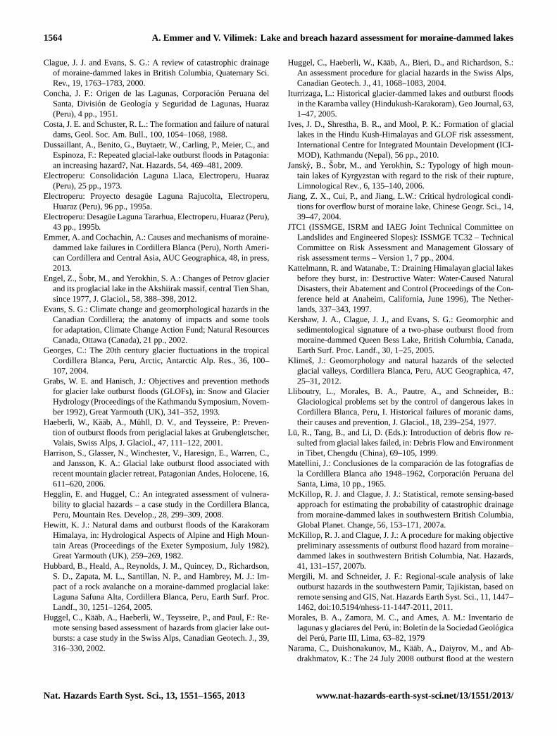
The study area forms part of the high Cordillera Blancain Peru, the most heavily glacierised tropical range in theworld (Ames and Francou, 1995). It is, however, clear thatmost of the glaciers are retreating. Georges (2004) showedthat the total glacial area decreased from 800–850 km2 in1930 to 600 km2 at the end of the 20th century. It is this in-tense deglaciation (Fig. 3) that has led to an increasing num-ber of potentially hazardous glacial lakes (bedrock, moraine-dammed, ice-dammed) (e.g. Hegglin and Huggel, 2008). Thenumber of significant glacial lakes in the region was 230, ofwhich 119 were moraine-dammed, at the beginning of the1950s (Concha, 1951). These figures had risen to 267 and148 by the late 1970s (Morales et al., 1979). It was laterfound that there were 899 glacial lakes across the region with424, of which 173 were moraine-dammed, located in the RioSanta Valley (Portocarrero, 1995). It is now thought that thereare more than one thousand glacial lakes in the CordilleraBlanca (A. Cochachin, personal communication, 2012).
It is known that GLOFs have been generated from someof these lakes. The most catastrophic occurred on 13 De-cember 1941 when analuvion occurred as a result of twomoraine ruptures at lakes Palcacocha and Jircacocha. It de-stroyed one-third of the city of Huaraz (Fig. 4) and claimedabout 6000 lives (Lliboutry et al., 1977). This event resultedin a number of glacial lake stability studies that investigatedthe possibility of further outburst floods in the CordilleraBlanca. Such flooding still occurs despite a range of remedialwork that has stabilised more than 30 dams (Reynolds, 2003;Carey, 2005). The three most recent events to have causeddamage occurred on 19 May 2003 at Lake Palcacocha in theCojup Valley (Vilımek et al., 2005b), on 11 April 2010 atlake no. 513 in the Hualcan Valley (Carey et al., 2011), andon the 8 February 2012 at lake Artizon Bajo in the Santa CruzValley (A. Cochachin, personal communication, 2012).
Fig. 3. The growing Lake Llaca with its retreating glacier and pro-truding basal moraine.
4.2 The regional specifics of the Cordillera Blanca
It is necessary to consider the regional specifics in or-der to accurately define the hazard from moraine-dammedlakes (Hegglin and Huggel, 2008). The GLOF triggers areknown to vary considerably across the globe. For example,more than one-third of such floods in the North AmericanCordillera have been caused by intense rainfall/snowmelt(Clague and Evans, 2000; O’Connor et al., 2001), whereasthis trigger has never been recognised in the CordilleraBlanca. In this region the most frequent trigger has been
Nat. Hazards Earth Syst. Sci., 13, 1551–1565, 2013 www.nat-hazards-earth-syst-sci.net/13/1551/2013/

A. Emmer and V. Vil ımek: Lake and breach hazard assessment for moraine-dammed lakes 1559
Table 8.The assessed stability characteristics and their critical values defined by Mergili and Schneider (2011).
Stability characteristics (criteria) Alternatives and critical values points
Topographic susceptibility index (TSI)Low (TSI< 10) 0Medium (10≤ TSI< 40) 1High (TSI≥ 40) 2
Calving into the lakeIs not possible 0Is possible 1
Seismic hazard (peak ground acceleration – PGA)Low (PGA< 500 cm s−2) 0High (PGA≥ 500 cm s−2) 1
Dam freeboardHigh (F > 25 m) −1Low (F ≤ 25 m) 0
Dam material
Embedded lake 0Block dam 0Debris dam 1Rocky swell dam 0Glacier or fresh moraine dam 2
Lake drainageSurface drainage 0No surface drainage 1
Lake area developmentStable/shrinking (rA1 andrA2 > 0.8) 0Growing (rA1 or rA2 ≤ 0.8) 1
Downstream slope of damGentle (tgβ<0.02) −1Steep (tgβ ≥ 0.02) 0
Fig. 4. An aerial photograph of the destroyed city of Huaraz follow-ing thealuvion from Lake Palcacocha. The area affected is definedby the orange line; the photograph was taken in 1948, seven yearsafter the flood (Source: INRENA/ANA, Project 2524).
icefall into the lake producing displacement waves (45 %)while the second has been landslides or rockfalls into thelake (35 %) (Emmer and Cochachin, 2013). Furthermore, inthis area, another important trigger is earthquakes as thesemay initiate mass movements or cause changes to the inter-nal structure of a moraine dam leading to piping and ulti-mately dam failure. There have also been instances in whichan upstream flood wave has propagated downstream and thencaused a GLOF (Vilımek et al., 2005b). This mountain rangehosts a number of lakes whose dams have been stabilisedby a range of remedial work (Reynolds, 2003; Carey, 2005)(Figs. 5 and 6), and such remediation also has to be consid-ered during the hazard assessment.
From the above and from our previous investigations(Vil ımek et al., 2005a, b; Emmer and Cochachin, 2013), itis proposed that the most important groups of parametersthat should be included in an assessment of the possibility ofwater release from moraine-dammed lakes in the CordilleraBlanca are the following:
i. The possibility of dynamic slope movement into the lakeThe first group of dynamic slope movements includesicefalls and avalanches. For a preliminary estimate ofwhether these slope movements could occur in a lake,it is important to take into account factors such as thedistance between the lake and the glacier, the slope be-tween the lake and the glacier, calving, and the slope
www.nat-hazards-earth-syst-sci.net/13/1551/2013/ Nat. Hazards Earth Syst. Sci., 13, 1551–1565, 2013

1560 A. Emmer and V. Vilımek: Lake and breach hazard assessment for moraine-dammed lakes
Fig. 5. The artificial dam and armoured outflow of Lake Llaca; thedam freeboard is 12 m.
of the glacier snout. The second group includes land-slides, rockfalls, and various types of flows. The mostimportant factors for these movements are thought to bethe slope of the internal face of a lateral moraine andthe presence of rocks predisposed to rockfalls directlyabove the lake.
ii. The distinction between natural dams and dams with re-medial worksIn the case of a natural dam, it is necessary to assessthe possibility of a dam breach by, for example, assess-ing the erodibility of the outflow channel(s), the damgeometry, the occurrence of seepage or piping, and theabsence or presence of an ice core. In the case of a damwith remedial work, the type of remedial work (tunnel,artificial dam, open cut or canal) should be considered.If a dam with remedial work is considered to be stable(resistant to erosion), there is still the possibility that itwill overflow (for this reason it is important to take intoaccount the dam freeboard).
iii. The dam freeboard (or ratio of dam freeboard)A sufficiently large dam freeboard (see Fig. 5) elimi-nates the possibility of dam overflow when slope move-ments are transported into the lake while artificial damsoften provide additional freeboard that has to be in-cluded in a hazard assessment. Furthermore, naturaldams without surface outflow are able to partially miti-gate displacement waves.
iv. The possibility of a flood wave from a lake situated up-streamIt may be that a flood wave generated from an upstreamlake leads to an outburst flood from a downstream lakeeven if its dam is considered to be stable and there areno obvious direct triggers (e.g. there is no possibility of
Fig. 6. Lake Palcacocha and its steep lateral moraines, which arepredisposed to slope movements, in July 2012. The inset shows thetwo artificial dams (highlighted in orange) and siphons (black pipeswithin the lake) constructed during autumn 2011; the dam freeboardis about 9 m.
a slope movement into the lake). It is, therefore, alwaysimportant to consider the potential threat posed by up-stream lakes.
v. The possibility of dam rupture following a large earth-quakeThe Cordillera Blanca is an active seismic region, andthere have been events recorded in which rupture of themoraine dam was initiated by a large earthquake.
5 Results
5.1 The qualitative approach
The results, presented in Table 9, indicate that none of theselected lakes obtained a “full score” of negative stabilityparameters following the method presented by O’Connor etal. (2001), which would reflect direct contact with glacierand water outflow over the crest of the moraine. It has beenfound that two lakes obtained two points while the other fourobtained three points from a maximum of four points fol-lowing the method of Costa and Schuster (1988). The othermethods also give scores that oscillate close to 50 % with theexception of that obtained for Lake Rajucolta following themethod of Clague and Evans (2000). The highest mean scorewas obtained for Lake Palcacocha (0.602), and it, therefore,appears to offer the greatest potential for flooding and repre-sents the most hazardous lake. It is notable that a flood oc-curred from this lake in May 2003, and siphons have sincebeen installed to lower the lake level and increase the damfreeboard (Fig. 6).
Nat. Hazards Earth Syst. Sci., 13, 1551–1565, 2013 www.nat-hazards-earth-syst-sci.net/13/1551/2013/

A. Emmer and V. Vil ımek: Lake and breach hazard assessment for moraine-dammed lakes 1561
Table 9.The results of the five qualitative methods investigated in this study (total number of investigated parameters in brackets).
Lake O’Connor Costa and Clague and Grabs and Wang Arithmetical. (2001) (2) Schuster (1988) (4) Evans (2000) (6) Hanisch (1993) (11) et al. (2008) (8) mean
Quitacocha 0/2 0.00 3/4 0.75 4/6 0.67 5/11 0.45 4/8 0.50 0.474Checquiacocha 1/2 0.50 3/4 0.75 3/6 0.50 5/11 0.45 4/8 0.50 0.540Palcacocha 1/2 0.50 3/4 0.75 3/6 0.50 7/11 0.63 5/8 0.63 0.602Llaca 1/2 0.50 2/4 0.50 3/6 0.50 4/11 0.36 4/8 0.50 0.472Rajucolta 1/2 0.50 2/4 0.50 1/6 0.17 4/11 0.36 4/8 0.50 0.406Tararhua 1/2 0.50 3/4 0.75 3/6 0.50 5/11 0.45 5/8 0.63 0.566
Table 10. The results of the semi-quantitative method defined byBolch et al. (2011).
Lake Result Potentialfor outburst
Quitacocha 0.589 HighChecquiacocha 0.513 MediumPalcacocha 1.042 HighLlaca 0.612 HighRajucolta 0.423 MediumTararhua 0.513 Medium
5.2 The semi-quantitative approach
The only semi-quantitative approach used was that of Bolchet al. (2011) as no critical values for an objective lake andbreach hazard assessment were defined by Reynolds (2003).It has been found that three of the lakes reflect a medium out-burst potential and three a high outburst potential (Table 10).The highest obtained score was that of Lake Palcacocha, mir-roring the mean results obtained by the qualitative methods,although its unusually high score may well result from thespecific weighting applied as this places considerable em-phasis on changes to the lake area. The lowest obtained scorewas that of Lake Rajucolta again mirroring the mean resultsobtained by the qualitative methods.
5.3 The quantitative approach
The only quantitative approach used was that of Wang etal. (2011). It has been found that all the lakes reflect mediumto very high outburst potential (Table 11). The highest ob-tained score, contradicting the results obtained by the qual-itative and semi-quantitative methods, was that of Lake Ra-jucolta. This is thought to reflect the fact that this methodplaces considerable emphasis on parameters associated withthe mother glacier – Lake Rajucolta is in direct contact withthe steep slopes of glacier snout, and, therefore, the outburstpotential is classified as very high. Moreover, this methoddoes not consider dam stability, and this is considered to bestable due to the sizeable dam freeboard. Lakes Palcacochaand Quitacocha also obtained scores that indicate a very highoutburst potential.
Table 11.The results of the quantitative method defined by Wanget al. (2011).
Lake Result Potentialfor outburst
Quitacocha 0.843 Very highChecquiacocha 0.799 HighPalcacocha 0.854 Very highLlaca 0.585 MediumRajucolta 0.939 Very highTararhua 0.751 High
6 Discussion
6.1 The methods of lake and breach hazard assessment
The assessment of the possibility of water release frommoraine-dammed lakes is associated with certain problemsbrought about by variability in some of the stability param-eters. This variability may be seasonal (e.g. fluctuations inthe lake water level) or irreversible (e.g. slope movements).It is also not possible to quantify some of stability parame-ters, such as the internal dam structure, without undertakingdetailed field study (O’Connor et al., 2001).
The outlined methods can all be applied over large areas,and each has specific advantages so that it is not possible tostate which is the most appropriate. In general these methodsallow a large number of lakes to be assessed using aerial pho-tography, photogrammetry, and satellite-derived data. Thedata can be analysed rapidly in geoinformation systems andthrough modelling. It is clear that different researchers as-sess hazard using different stability parameters, and these arealmost always selected subjectively according to the experi-ence of the researcher and the availability of specific data(the exception to this is the statistical study of McKillop andClague, 2007a, b). Indeed, the methods are all constrained bydata availability, and it is generally considered that this is themost significant limiting factor in hazard assessments.
The majority of the stability parameters can be obtainedand assessed reasonably accurately from high-resolution re-mote sensing images or aerial photographs. There are, how-ever, those that cannot, of which the most commonly requiredrelates to the presence or absence of an ice core within the
www.nat-hazards-earth-syst-sci.net/13/1551/2013/ Nat. Hazards Earth Syst. Sci., 13, 1551–1565, 2013

1562 A. Emmer and V. Vilımek: Lake and breach hazard assessment for moraine-dammed lakes
Table 12.The methods with regard to whether they take into consideration the regional specifics of the Cordillera Blanca.
Method A B C D E
O’Connor et al. (2001) Partly No Partly No NoCosta and Schuster (1988) Yes No No No NoClague and Evans (2000) Yes Yes Yes No NoGrabs and Hanisch (1993) Yes Partly Partly No NoZapata (2002) Yes No Yes No YesHuggel et al. (2004) Yes No Yes No NoWang et al. (2008) Partly No Yes No NoHegglin and Huggel (2008) Yes Yes Yes No NoBolch et al. (2011) Yes No No No NoReynolds (2003) Partly No Yes No NoWang et al. (2011) Partly No No No NoMcKillop and Clague (2007a, b) No No No No NoMergili and Schneider (2011) Yes No Yes No Yes
A: possibility of dynamic slope movement into the lake; B: distinction between natural dam anddam with remedial works; C: dam freeboard (or ratio of dam freeboard); D: possibility of floodwave from a lake situated upstream; E: possibility of dam rupture following a large earthquake.
moraine dam. This is an important consideration because itaffects dam stability and its internal structure. It cannot be as-sessed reliably without fieldwork using, for example, groundpenetrating radar (Reynolds, 2006) or electric-exploration re-sistivity (Yamada, 1998). A partial solution may come fromthe moraine morphology (McKillop and Clague, 2007a), butthis is not wholly accurate. In addition, other problematicstability parameters include lake bathymetry, the meteoro-logical regime, the occurrence of piping, and the main rocktype forming the moraine. These parameters cannot be deter-mined from remote sensing images, and therefore fieldworkis necessary. It is only with these data that precise hazard as-sessments for specific lakes can be undertaken. Nonetheless,all of the outlined methods help to recognise potentially haz-ardous lakes.
The qualitative and semi-quantitative methods includesubjective interpretations, and it is thus possible that differ-ent researchers may identify different hazards at the samesite. The qualitative methods usually have a wide applica-tion with no regional focus, whereas the semi-quantitativeand quantitative methods frequently focus on specific casestudies. These consider the local conditions and causes ofGLOFs more carefully than the qualitative methods althoughsome regionally focused methods are replicable in differentareas (e.g. McKillop and Clague, 2007a, b). The quantita-tive approaches are objective and the results are comparable.The characteristics are weighted according to their probableimpact on the occurrence of a GLOF or according to theirinfluence on dam stability.
6.2 Methods of hazard assessment and the regionalspecifics of Cordillera Blanca
In Sect. 4.2 we highlighted five groups of parameters thatwe consider to be crucial for an accurate regionally focused
hazard assessment method for moraine-dammed lakes inthe Cordillera Blanca. Table 12 shows the extent to whichthe summarised methods consider these five criteria. Themost suitable methods for use in Cordillera Blanca appearto be those presented by Clague and Evans (2000), Zap-ata (2002), Hegglin and Huggel (2008), and Mergili andSchneider (2011) as they incorporate three of the five criteria.
The majority of the methods incorporate the most com-mon trigger – dynamic slope movements into the lake – al-though this group of parameters includes both the possibilityof icefall or avalanche into the lake as well as the possibilityof rockfall or landslide into the lake. If the outlined methodonly considered one of these possibilities, the term “partly”was applied. In contrast, most of methods do not incorpo-rate the possibility of downstream flood wave propagationnor the possibility of dam rupture following a large earth-quake. These groups of parameters are difficult to quantifyand assess, but they are known to have caused GLOFs in theCordillera Blanca and are, therefore, important to include ina regional hazard assessment. The distinction between nat-ural dams and dams with remedial work has only been in-corporated into a small number of methods. It is, therefore,necessary to construct a new method that takes into accountall the regional specifics of the Cordillera Blanca so as to pro-vide precise lake and breach hazard assessments relating tothe moraine-dammed lakes within this mountain range.
6.3 The results of the lake and breach hazardassessment
The outlined methods show that potentially the most haz-ardous of the six lakes is Lake Palcacocha, even though thislake has been remediated. This paper, however, has beenwritten so as to summarise contemporary methods of lakeand breach hazard assessment for moraine-dammed lakes
Nat. Hazards Earth Syst. Sci., 13, 1551–1565, 2013 www.nat-hazards-earth-syst-sci.net/13/1551/2013/

A. Emmer and V. Vil ımek: Lake and breach hazard assessment for moraine-dammed lakes 1563
and discuss their applicability to glacial lakes within theCordillera Blanca. It has been shown that none of the outlinedmethods incorporate all of the criteria that we consider cru-cial for an accurate regional hazard assessment of moraine-dammed lakes in the Cordillera Blanca. We, therefore, rec-ommend that our results are treated tentatively. For exam-ple, the method presented by Clague and Evans (2000) wasdeemed to be one of the most suitable, and this suggests thatLake Quitacocha may be the most hazardous with a score of0.67.
7 Conclusions
This paper has summarised 13 methods of lake and breachhazard assessment for moraine-dammed lakes: eight arecharacterised as qualitative, two as semi-quantitative, andthree as quantitative. In total seven of the outlined meth-ods have been used to investigate six moraine-dammed lakeswithin the Cordillera Blanca. These methods show that mosthazardous lake is Lake Palcacocha, which is known to haveproduced two historical GLOFs (1941 and 2003). The re-sults have been obtained despite the fact that the lake hasbeen remediated. The mean of the five qualitative meth-ods gave a result of 0.602; the semi-qualitative method out-lined by Bolch et al. (2011) showed a high outburst potential(1.042), whereas the quantitative method outlined by Wang etal. (2011) showed very high outburst potential (0.854). Thesemethods show highly divergent results with regard to LakeRajucolta. The mean of the five qualitative methods gave aresult of 0.406; the semi-qualitative method showed only amedium outburst potential (0.423), whereas the quantitativemethod showed the greatest outburst potential (0.939).
The moraine-dammed lakes of the Cordillera Blanca areknown to be associated with specific characteristics that dif-fer from a number of other regions affected by GLOFs. Itis considered that to produce an accurate method of hazardassessment for the moraine-dammed lakes of this region, itis essential to incorporate the following parameters: the pos-sibility of dynamic slope movements into the lake; the pos-sibility of the downstream propagation of a flood wave; thepossibility of dam rupture following a large earthquake; thesize of the dam freeboard (or ratio of dam freeboard); anda distinction between natural dams and those with remedialwork. It is clear that none of summarised methods incorpo-rate all of these parameters with, at most, three of the fiveincluded by Clague and Evans (2000), Zapata (2002), Heg-glin and Huggel (2008), and Mergili and Schneider (2011).
It is now important to pay particular attention to theproblem of glacial lake outburst floods given global cli-matic change, glacial retreat, the development of new poten-tially hazardous glacial lakes, and population growth in theCordillera Blanca. The possibility of water release from amoraine-dammed lake is both difficult to predict and region-specific. The first step in effective hazard mitigation and risk
management is to reliably define those lakes that are poten-tially hazardous. It is, therefore, necessary to construct a newregional lake inventory and method of GLOF hazard assess-ment for the Cordillera Blanca.
Acknowledgements.The authors would like to especially thankMarco Zapata Luyo, Alejo Cochachin, and the staff at the InstitutoNacional de Recursos Naturales/Autoridad Nacional del Agua(Huaraz) for their scientific and logistic support. Bryn Hubbard,Martin Mergli and a third anonymous reviewer are thanked fortheir valuable comments and recommendations, which helped toimprove this work, while the Grant Agency of Czech Republic(Project GACR P 209/11/1000) and Grant Agency of CharlesUniversity (Project GAUK No. 70413) provided scientific andfinancial support.
Edited by: P. TarolliReviewed by: M. Mergili, B. Hubbard, and two anonymous referees
References
Ames, A. M. and Francou, B.: Cordillera Blanca – glaciares en lahistoria, Bulletin de l’Institut Francais d’Etudes Andines, 24, 37–64, 1995.
Awal, R., Nakagawa, H., Fujita, M., Kawaike, K., Baba, Y., andZhang, H.: Experimental study on glacial lake outburst floodsdue to waves over-topping and erosion of moraine dam, Annalsof Disaster Prevention Research Institute, 53, 583–594, 2010.
Bajracharya, B., Shrestha, A. B., and Rajbhandari, L.: Glacial lakeoutburst floods in the Sagarmatha region, Mountain Res. De-velop., 27, 336–344, 2007.
Benn, D. I. and Evans, D. J. A. (Eds.): Glaciers and Glaciation,Hodder Education, London, 1998.
Bolch, T., Buchroithner, M. F., Peters, J., Baessler, M., and Ba-jracharya, S.: Identification of glacier motion and potentiallydangerous glacial lakes in the Mt. Everest region/Nepal usingspaceborne imagery, Nat. Hazards Earth Syst. Sci., 8, 1329–1340, doi:10.5194/nhess-8-1329-2008, 2008.
Bolch, T., Peters, J., Yerogov, A., Pradhan, B., Buchroithner, M.,and Blagoveshchensky, V.: Identification of potentially danger-ous glacial lakes in the northern Tien Shan, Nat. Hazards, 59,1691–1714, 2011.
Breien, H., De Blasio, F. V., Elverhøi, A., and Høeg, K.: Erosionand morphology of a debris flow caused by a glacial lake outburstflood, Western Norway, Landslides, 5, 271–280, 2008.
Carey, M.: Living and dying with glaciers: people’s historical vul-nerability to avalanches and outburst floods in Peru, GlobalPlanet. Change, 47, 122–134, 2005.
Carey, M., Huggel, C., Bury, J., Portocarrero, C., and Haeberli, W.:An integrated socio-environmental framework for glacial hazardmanagement and climate change adaptation: lessons from Lake513, Cordillera Blanca, Peru, Climatic Change, 112, 733–767,2012.
Cenderelli, D. A. and Wohl, E. E.: Peak discharge estimates ofglacial-lake outburst floods and “normal” climatic floods in theMount Everest region, Nepal, Geomorphology, 40, 57–90, 2001.
www.nat-hazards-earth-syst-sci.net/13/1551/2013/ Nat. Hazards Earth Syst. Sci., 13, 1551–1565, 2013
1564 A. Emmer and V. Vilımek: Lake and breach hazard assessment for moraine-dammed lakes
Clague, J. J. and Evans, S. G.: A review of catastrophic drainageof moraine-dammed lakes in British Columbia, Quaternary Sci.Rev., 19, 1763–1783, 2000.
Concha, J. F.: Origen de las Lagunas, Corporacion Peruana delSanta, Division de Geologıa y Seguridad de Lagunas, Huaraz(Peru), 4 pp., 1951.
Costa, J. E. and Schuster, R. L.: The formation and failure of naturaldams, Geol. Soc. Am. Bull., 100, 1054–1068, 1988.
Dussaillant, A., Benito, G., Buytaetr, W., Carling, P., Meier, C., andEspinoza, F.: Repeated glacial-lake outburst floods in Patagonia:an increasing hazard?, Nat. Hazards, 54, 469–481, 2009.
Electroperu: Consolidacion Laguna Llaca, Electroperu, Huaraz(Peru), 25 pp., 1973.
Electroperu: Proyecto desague Laguna Rajucolta, Electroperu,Huaraz (Peru), 96 pp., 1995a.
Electroperu: Desague Laguna Tararhua, Electroperu, Huaraz (Peru),43 pp., 1995b.
Emmer, A. and Cochachin, A.: Causes and mechanisms of moraine-dammed lake failures in Cordillera Blanca (Peru), North Ameri-can Cordillera and Central Asia, AUC Geographica, 48, in press,2013.
Engel, Z.,Sobr, M., and Yerokhin, S. A.: Changes of Petrov glacierand its proglacial lake in the Akshiirak massif, central Tien Shan,since 1977, J. Glaciol., 58, 388–398, 2012.
Evans, S. G.: Climate change and geomorphological hazards in theCanadian Cordillera; the anatomy of impacts and some toolsfor adaptation, Climate Change Action Fund; Natural ResourcesCanada, Ottawa (Canada), 21 pp., 2002.
Georges, C.: The 20th century glacier fluctuations in the tropicalCordillera Blanca, Peru, Arctic, Antarctic Alp. Res., 36, 100–107, 2004.
Grabs, W. E. and Hanisch, J.: Objectives and prevention methodsfor glacier lake outburst floods (GLOFs), in: Snow and GlacierHydrology (Proceedings of the Kathmandu Symposium, Novem-ber 1992), Great Yarmouth (UK), 341–352, 1993.
Haeberli, W., Kaab, A., Muhll, D. V., and Teysseire, P.: Preven-tion of outburst floods from periglacial lakes at Grubengletscher,Valais, Swiss Alps, J. Glaciol., 47, 111–122, 2001.
Harrison, S., Glasser, N., Winchester, V., Haresign, E., Warren, C.,and Jansson, K. A.: Glacial lake outburst flood associated withrecent mountain glacier retreat, Patagonian Andes, Holocene, 16,611–620, 2006.
Hegglin, E. and Huggel, C.: An integrated assessment of vulnera-bility to glacial hazards – a case study in the Cordillera Blanca,Peru, Mountain Res. Develop., 28, 299–309, 2008.
Hewitt, K. J.: Natural dams and outburst floods of the KarakoramHimalaya, in: Hydrological Aspects of Alpine and High Moun-tain Areas (Proceedings of the Exeter Symposium, July 1982),Great Yarmouth (UK), 259–269, 1982.
Hubbard, B., Heald, A., Reynolds, J. M., Quincey, D., Richardson,S. D., Zapata, M. L., Santillan, N. P., and Hambrey, M. J.: Im-pact of a rock avalanche on a moraine-dammed proglacial lake:Laguna Safuna Alta, Cordillera Blanca, Peru, Earth Surf. Proc.Landf., 30, 1251–1264, 2005.
Huggel, C., Kaab, A., Haeberli, W., Teysseire, P., and Paul, F.: Re-mote sensing based assessment of hazards from glacier lake out-bursts: a case study in the Swiss Alps, Canadian Geotech. J., 39,316–330, 2002.
Huggel, C., Haeberli, W., Kaab, A., Bieri, D., and Richardson, S.:An assessment procedure for glacial hazards in the Swiss Alps,Canadian Geotech. J., 41, 1068–1083, 2004.
Iturrizaga, L.: Historical glacier-dammed lakes and outburst floodsin the Karamba valley (Hindukush-Karakoram), Geo Journal, 63,1–47, 2005.
Ives, J. D., Shrestha, B. R., and Mool, P. K.: Formation of glaciallakes in the Hindu Kush-Himalayas and GLOF risk assessment,International Centre for Integrated Mountain Development (ICI-MOD), Kathmandu (Nepal), 56 pp., 2010.
Jansky, B., Sobr, M., and Yerokhin, S.: Typology of high moun-tain lakes of Kyrgyzstan with regard to the risk of their rupture,Limnological Rev., 6, 135–140, 2006.
Jiang, Z. X., Cui, P., and Jiang, L.W.: Critical hydrological condi-tions for overflow burst of moraine lake, Chinese Geogr. Sci., 14,39–47, 2004.
JTC1 (ISSMGE, ISRM and IAEG Joint Technical Committee onLandslides and Engineered Slopes): ISSMGE TC32 – TechnicalCommittee on Risk Assessment and Management Glossary ofrisk assessment terms – Version 1, 7 pp., 2004.
Kattelmann, R. and Watanabe, T.: Draining Himalayan glacial lakesbefore they burst, in: Destructive Water: Water-Caused NaturalDisasters, their Abatement and Control (Proceedings of the Con-ference held at Anaheim, California, June 1996), The Nether-lands, 337–343, 1997.
Kershaw, J. A., Clague, J. J., and Evans, S. G.: Geomorphic andsedimentological signature of a two-phase outburst flood frommoraine-dammed Queen Bess Lake, British Columbia, Canada,Earth Surf. Proc. Landf., 30, 1–25, 2005.
Klimes, J.: Geomorphology and natural hazards of the selectedglacial valleys, Cordillera Blanca, Peru, AUC Geographica, 47,25–31, 2012.
Lliboutry, L., Morales, B. A., Pautre, A., and Schneider, B.:Glaciological problems set by the control of dangerous lakes inCordillera Blanca, Peru, I. Historical failures of moranic dams,their causes and prevention, J. Glaciol., 18, 239–254, 1977.
Lu, R., Tang, B., and Li, D. (Eds.): Introduction of debris flow re-sulted from glacial lakes failed, in: Debris Flow and Environmentin Tibet, Chengdu (China), 69–105, 1999.
Matellini, J.: Conclusiones de la comparacion de las fotografıas dela Cordillera Blanca ano 1948–1962, Corporacion Peruana delSanta, Lima, 10 pp., 1965.
McKillop, R. J. and Clague, J. J.: Statistical, remote sensing-basedapproach for estimating the probability of catastrophic drainagefrom moraine-dammed lakes in southwestern British Columbia,Global Planet. Change, 56, 153–171, 2007a.
McKillop, R. J. and Clague, J. J.: A procedure for making objectivepreliminary assessments of outburst flood hazard from moraine–dammed lakes in southwestern British Columbia, Nat. Hazards,41, 131–157, 2007b.
Mergili, M. and Schneider, J. F.: Regional-scale analysis of lakeoutburst hazards in the southwestern Pamir, Tajikistan, based onremote sensing and GIS, Nat. Hazards Earth Syst. Sci., 11, 1447–1462, doi:10.5194/nhess-11-1447-2011, 2011.
Morales, B. A., Zamora, M. C., and Ames, A. M.: Inventario delagunas y glaciares del Peru, in: Boletın de la Sociedad Geologicadel Peru, Parte III, Lima, 63–82, 1979
Narama, C., Duishonakunov, M., Kaab, A., Daiyrov, M., and Ab-drakhmatov, K.: The 24 July 2008 outburst flood at the western
Nat. Hazards Earth Syst. Sci., 13, 1551–1565, 2013 www.nat-hazards-earth-syst-sci.net/13/1551/2013/

A. Emmer and V. Vil ımek: Lake and breach hazard assessment for moraine-dammed lakes 1565
Zyndan glacier lake and recent regional changes in glacier lakesof the Teskey Ala-Too range, Tien Shan, Kyrgyzstan, Nat. Haz-ards Earth Syst. Sci., 10, 647–659, doi:10.5194/nhess-10-647-2010, 2010.
O’Connor, J. E., Hardison, J. H., and Costa, J. E. (Eds.): Debrisflows from failures of Neoglacial-age moraine dams in the ThreeSisters and Mount Jefferson Wilderness areas, Oregon, US Geo-logical Survey, Reston (Virginia), 93 pp., 2001.
Petrakov, D. A., Krylenko, I. V., Chernomorets, S. S., Tutubalina, O.V., Krylenko, I. N., and Sakhmina, M. S.: Debris flow hazard ofglacial lakes in the Central Caucasus, in: Debris-Flow HazardsMitigation: Mechanics, Prediction, and Assessment, edited by:Rickenmann, D. and Chen, C., Millpress, The Netherlands, 703–714, 2007.
Portocarrero, C. R.: Proyecto prioritario del afianzamiento hıdricodel rio Santa, Hidrandina S.A., Huaraz (Peru), 28 pp., 1995.
Quincey, D. J., Richardson, S. D., Luckman, A., Lucas, R. M.,Reynolds, J. M., Hambrey, M. J., and Glasser, N. F.: Early recog-nition of glacial lake hazards in the Himalaya using remote sens-ing datasets, Global Planet. Change, 56, 137–152, 2007.
Reynolds, J. M.: Development of glacial hazard and risk minimi-sation protocols in rural environments, Methods of glacial haz-ard assessment and management in the Cordillera Blanca, Peru,Reynolds Geo-Sciences Ltd., Flintshire (UK), 72 pp., 2003.
Reynolds, J. M.: Role of geophysics in glacial hazard assessment,Environ. Eng. Geosci., 24, 61–66, 2006.
Richardson, S. D.: Remote sensing approaches for early warning ofGLOF hazard in the Hindu Kush – Himalayan region, Uniten Na-tions International Strategy For Disaster Reduction (UN/ISDR),Kathmandu, 35 pp., 2010.
Richardson, S. D. and Reynolds, J. M.: An overview of glacial haz-ards in the Himalayas, Quaternary Int., 65/66, 31–47, 2000a.
Richardson, S. D. and Reynolds, J. M.: Degradation of ice-coredmoraine dams: implications for hazard development, in: Debris-Covered Glaciers (Proceedings of a workshop held at Seattle,Washington, USA, September 2000), The Netherlands, 187–197,2000b.
Shrestha, A. B.: Managing flash flood risk in Himalaya – informa-tion sheet # 1/10, International Centre for Integrated MountainDevelopment (ICIMOD), Kathmandu (Nepal), 4 pp., 2010.
Silva, M. L. and Caceres, F. V.: Plan para el control de huaycosy desborde pluviales en la ciudad de Huaraz, Procedimientosde la conferencia internacional sobre desastres naturales, Huaraz(Peru), 2 pp., 1995.
Van Steijn, H.: Debris-flow magnitude-frequency relationships formountainous regions of central and north-western Europe, Geo-morphology, 15, 259–273, 1996.
Vil ımek, V., Klimes, J., and Zapata, M. L.: Glacial lake outburstflood in the areas of Huaras, Cordillera Blanca, Peru, Studia Ge-omorphologica Carpatho-Balcanica, 39, 115–124, 2005a.
Vil ımek, V., Zapata, M.L., Klimes, J., Patzelt, Z., and Santillan, N.:Influence of glacial retreat on natural hazards of the PalcacochaLake area, Peru, Landslides, 2, 107–115, 2005b.
Wang, W., Yao, T., Gao, Y., Yang, X., and Kattel, D. B.: A first–order method to identify potentially dangerous glacial lakes in aregion of the southeastern Tibetan Plateau, Mountain Res. De-velop., 31, 122–130, 2011.
Wang, X., Liu, S., Guo, W., and Xu, J.: Assessment and simulationof glacier lake outburst floods for Longbasaba and Pida lakes,China, Mountain Res. Develop., 28, 310–317, 2008.
WECS (Water and Energy Commission Secretariat): Study ofglacier lake outburst floods in Nepal Himalaya, in: WECS In-terim Report, Kathmandu (Nepal), 1987.
Worni, R., Stoffel, M., Huggel, C., Volz, C., Casteller, A., and Luck-man, B.: Analysis and dynamic modeling of a moraine failureand glacier lake outburst flood at Ventisquero Negro, PatagonianAndes (Argentina), J. Hydrol., 11, 134–145, 2012.
Yamada, T.: Glacier lake and its outburst flood in the Nepal Hi-malaya, Japanese Society of Snow and Ice, Tokyo, 96 pp., 1998.
Zapata, M. L.: La dinamica glaciar en lagunas de la CordilleraBlanca, Acta Montana, 19, 37–60, 2002.
www.nat-hazards-earth-syst-sci.net/13/1551/2013/ Nat. Hazards Earth Syst. Sci., 13, 1551–1565, 2013