restoring the dead spaces underneath the elevated …
TRANSCRIPT

ESTONIAN UNIVERSITY OF LIFE SCIENCES
Institute of Agriculture and Environmental Sciences
Mohamed Elbih
RESTORING THE DEAD SPACES UNDERNEATH THE
ELEVATED HIGHWAYS TO THE PUBLIC REALM: A
CASE STUDY IN CAIRO, EGYPT
Master’s thesis
Curriculum in Landscape Architecture
Supervisor
Prof: Simon Bell
Spring semester, 2020
Tartu

I | P a g e
Estonian University of Life Sciences
Kreutzwaldi,1, 51006
Abstract of Master’s Thesis
Department: Landscape Architecture
Author: Mohamed Elbih
Supervisor: Prof. Simon Bell PhD.
Curriculum: Landscape Architecture
Place and Date: Tartu, 01-06-2020
Title: Restoring the Dead Spaces Underneath the Elevated Highways to the Public Realm: A Case Study in
Cairo, Egypt
Pages: 71 Figures: 35 Tables: 6 Appendices: 2
Keywords: Elevated highways, urban leftovers, urban voids, dead spaces, beneath highways, highway
overpasses, Landscape Architecture,
Abstract:
Currently, more than half of the world is living in cities. Most countries are becoming increasingly urbanized;
and for nearly a century, elevated highways have become vital element of urban development to cope with the
rapid expansion of urban cores. Unfortunately, it has inadvertently caused severe problems in most cities. The
massive infrastructures of those elevated highways have made cracks into the urban fabric, dispersed the
neighborhoods by facilitating traffic yet isolating people, and created unwelcoming spaces. This research looks
for answers how to rearrange priorities of the usage of the dead spaces beneath these structures, a method for
understanding urban behavior while taming the negative impacts of these elevated highways to reach a common
ground between the urge of urban growth and create a convenient space under such infrastructures. The research
will be based on case studies and examples to develop a clear guideline to fill those urban voids and explore
design principles to create an inviting environment in the least likely spaces, right beneath the elevated
highways. The research has exposed the problem in a hierarchy of diverse scopes, from the international level
in different locations globally. The fieldwork in Cairo is based on qualitative methods. In order to deduct
citizen’s preferences, in depth interviews had been made with residents.
II | P a g e
Acknowledgement
I cannot express enough gratitude to my supervisor Professor Simon Bell for his comprehensive
feedback, guidance, and continuing support. I offer my sincere appreciation to the rest of the
professors of the department for their valuable effort in my study period. Not to forget the
administrative staff for their help and support. Lastly to the Estonian university of Life Sciences
for the great opportunity.
I would like to thank my family for their support and love. Also, my cousin for his valuable help
with the fieldwork of the research. Finally, to my caring, loving and supporting fiancé for her
support and motivation, I cannot thank you enough.

III | P a g e
List of Content:
ABSTRACT ............................................................................................................................................. I
ACKNOWLEDMENTS ........................................................................................................................... II
TERMINOLOGY.....................................................................................................................................V
LIST OF TABLES ...................................................................................................................................V
LIST OF FIGURES ................................................................................................................................ VI
CHAPTER 1: INTRODUCTION ................................................................................. 1
1.1 PROBLEM FRAMING ...................................................................................................................... 1
1.2 DEAD SPACES DEFINED ................................................................................................ 2
1.3 THE CAUSES................................................................................................................ 3
1.3.1 THE DEPENDENCE ON THE AUTOMOBILE ................................................................ 3
1.3.2 THE GAP BETWEEN PLANNERS AND ARCHITECTS ................................................... 4
1.4 UNDERSTANDING CAIRO’S URBAN CHALLENGES AND POLICIES..................................... 5
CHAPTER 2: LITERATURE REVIEW ................................................................... 11
2.1 INTRODUCTION ......................................................................................................... 11
2.2 UNDERSTANDING URBAN SPATIALITY AND FUNCTIONALITY ........................................ 11
2.2.1 ROGER TRANCIK, FINDING LOST SPACE, 1986 ...................................................... 11
2.2.2 CHARLOTTE MALTERRE-BARTHES’ FUNCTIONS CLASSIFICATIONS, 2011. ............ 13
2.2.3 FUMIHIKO MAKI, INVESTIGATION IN COLLECTIVE FORM, 1964. ............................. 14
2.3 UNDERSTANDING PEOPLES’ BEHAVIORS ..................................................................... 14
2.3.1 WILLIAM WHYTE, THE SOCIAL LIFE OF SMALL URBAN SPACES, 1980. .................... 14
2.3.2 FRANCIS & MARCUS, DESIGN GUIDELINES FOR URBAN OPEN SPACE. ..................... 15
CHAPTER 3: FROM UNDESIRABLE TO DESIRABLE! ...................................... 17
3.1 ACCESS AND LINKAGES ............................................................................................. 18
3.2 COMFORT AND IMAGE ............................................................................................... 20
3.2.1 SENSES RELIEF ................................................................................................... 20
3.2.2 VISUAL COHERENCE ........................................................................................... 21
3.3 USES AND ACTIVITIES ................................................................................................ 24
3.4 SOCIABILITY ............................................................................................................. 29
IV | P a g e
CHAPTER 4: RESEARCH STRATGIES AND METHODS ................................... 31
4.1 INTRODUCTION ......................................................................................................... 31
4.2 MASR EL-GEDIDA’S BACKGROUND ............................................................................. 31
4.3 MASR EL-GEDIDA’S URBAN SHIFT .............................................................................. 34
4.4 MASR EL-GEDIDA’S NEW BRIDGES ............................................................................. 37
4.5 CAUSE OF SELECTION ................................................................................................ 39
4.6 THE VISION ............................................................................................................... 39
4.7 DESIGN CONCEPT ...................................................................................................... 40
4.8 RESEARCH OBJECTIVE ............................................................................................... 40
4.9 RESEARCH QUESTION ................................................................................................ 41
4.10 RESEARCH METHODOLOGY ...................................................................................... 41
4.11 FIRST QUESTIONNAIRE SURVEY ............................................................................... 42
4.12 SECOND QUESTIONNAIRE SURVEY............................................................................ 42
CHAPTER 5: FINFINGS AND RESULTS ............................................................... 44
5.1 FIRST INTERVIEW OF THE ELEVATED HIGHWAY .......................................................... 44
5.1.1 POSITIVE IMPRESSIONS ....................................................................................... 44
5.1.2 NEGATIVE IMPRESSIONS ..................................................................................... 45
5.2 SECOND INTERVIEW .................................................................................................. 49
5.2.1 BEFORE SEEING THE PROPOSALS ......................................................................... 50
5.2.2 AFTER SEEING THE PROPOSALS ........................................................................... 52
CHAPTER 6: DISSCUSSIONS .................................................................................. 55
CHAPTER 7: CONCLUSIONS AND RECOMMENDATIONS .............................. 72
7.1 RECOMMENDATIONS ................................................................................................. 63
7.2 FUTURE RESEARCH ................................................................................................... 63
7.3 LIMITATIONS ............................................................................................................ 63
BIBLIOGRAPHY ....................................................................................................... 65
APPENDICES ............................................................................................................. 70
APPENDIX 1: FIRST ROUND, INTERVIEWEES’ PROFILES ...................................................... 70
APPENDIX 2: SECOND ROUND, INTERVIEWEES’ PROFILES .................................................. 70

V | P a g e
Terminology:
Abbreviation Term
PPS Project for Public Spaces.
GOPP General Organization of Physical Planning.
GCR Greater Cairo Region.
CAPMS Central Agency for Public Mobility Statistics.
GARBLT General Authority for Roads, Bridges and Land Transport.
NOUH National Organization for Urban Harmony.
AFEA Armed Forces Engineering Authority.
EEAA Egyptian Environmental Affairs Agency.
List of tables:
Table number Description
Table 1.1 The age of bridges in Egypt. (GARBLT, 2015).
Table 4.1 The questionnaire of the first survey.
Table 4.2 The first questionnaire of the second survey (before seeing the proposals).
Table 4.3 The used criteria in the second survey (asked before and after).
Table 4.4 The second questionnaire of the second interview (before seeing the proposals).
Table 6.1 The set of proposals that used in the second interview.
VI | P a g e
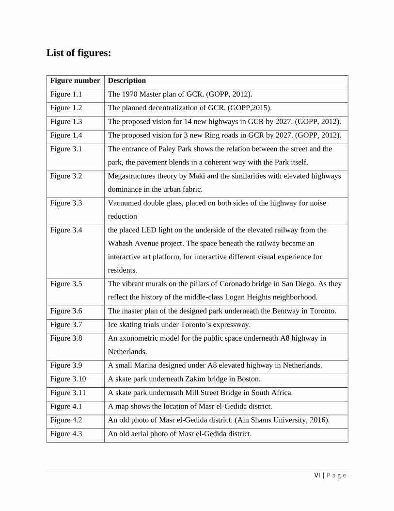
List of figures:
Figure number Description
Figure 1.1 The 1970 Master plan of GCR. (GOPP, 2012).
Figure 1.2 The planned decentralization of GCR. (GOPP,2015).
Figure 1.3 The proposed vision for 14 new highways in GCR by 2027. (GOPP, 2012).
Figure 1.4 The proposed vision for 3 new Ring roads in GCR by 2027. (GOPP, 2012).
Figure 3.1 The entrance of Paley Park shows the relation between the street and the
park, the pavement blends in a coherent way with the Park itself.
Figure 3.2 Megastructures theory by Maki and the similarities with elevated highways
dominance in the urban fabric.
Figure 3.3 Vacuumed double glass, placed on both sides of the highway for noise
reduction
Figure 3.4 the placed LED light on the underside of the elevated railway from the
Wabash Avenue project. The space beneath the railway became an
interactive art platform, for interactive different visual experience for
residents.
Figure 3.5 The vibrant murals on the pillars of Coronado bridge in San Diego. As they
reflect the history of the middle-class Logan Heights neighborhood.
Figure 3.6 The master plan of the designed park underneath the Bentway in Toronto.
Figure 3.7 Ice skating trials under Toronto’s expressway.
Figure 3.8 An axonometric model for the public space underneath A8 highway in
Netherlands.
Figure 3.9 A small Marina designed under A8 elevated highway in Netherlands.
Figure 3.10 A skate park underneath Zakim bridge in Boston.
Figure 3.11 A skate park underneath Mill Street Bridge in South Africa.
Figure 4.1 A map shows the location of Masr el-Gedida district.
Figure 4.2 An old photo of Masr el-Gedida district. (Ain Shams University, 2016).
Figure 4.3 An old aerial photo of Masr el-Gedida district.
VII | P a g e
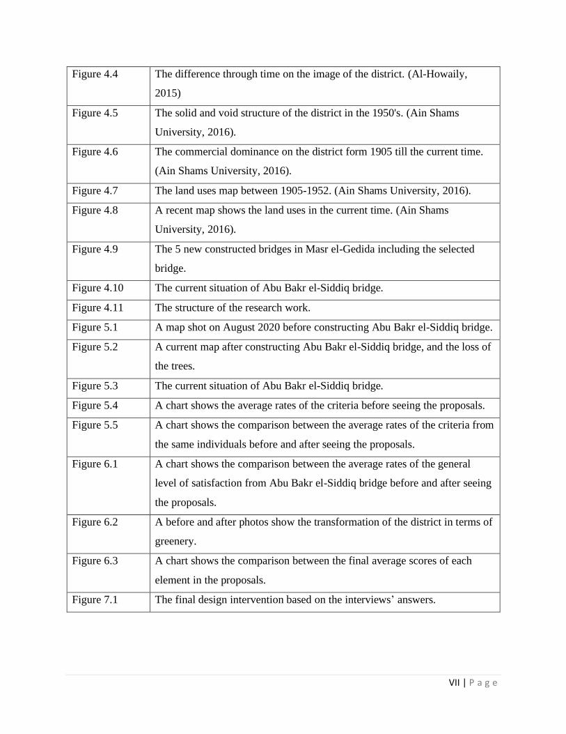
Figure 4.4 The difference through time on the image of the district. (Al-Howaily,
2015)
Figure 4.5 The solid and void structure of the district in the 1950's. (Ain Shams
University, 2016).
Figure 4.6 The commercial dominance on the district form 1905 till the current time.
(Ain Shams University, 2016).
Figure 4.7 The land uses map between 1905-1952. (Ain Shams University, 2016).
Figure 4.8 A recent map shows the land uses in the current time. (Ain Shams
University, 2016).
Figure 4.9 The 5 new constructed bridges in Masr el-Gedida including the selected
bridge.
Figure 4.10 The current situation of Abu Bakr el-Siddiq bridge.
Figure 4.11 The structure of the research work.
Figure 5.1 A map shot on August 2020 before constructing Abu Bakr el-Siddiq bridge.
Figure 5.2 A current map after constructing Abu Bakr el-Siddiq bridge, and the loss of
the trees.
Figure 5.3 The current situation of Abu Bakr el-Siddiq bridge.
Figure 5.4 A chart shows the average rates of the criteria before seeing the proposals.
Figure 5.5 A chart shows the comparison between the average rates of the criteria from
the same individuals before and after seeing the proposals.
Figure 6.1 A chart shows the comparison between the average rates of the general
level of satisfaction from Abu Bakr el-Siddiq bridge before and after seeing
the proposals.
Figure 6.2 A before and after photos show the transformation of the district in terms of
greenery.
Figure 6.3 A chart shows the comparison between the final average scores of each
element in the proposals.
Figure 7.1 The final design intervention based on the interviews’ answers.

1 | P a g e
Chapter 1: Introduction
Mainly, highways are one of the fundamental structures of mankind. It determines the growth of
the cities; hence their existence inside our cities is inevitable. If the city is a building, highways
would be its corridors. As a natural process, our cities are growing inorganically based on many
aspects, and planning differences. Highways are an integral part of any city; they always follow
urban expansion. “Elevated highways appear to have been constructed through four main areas of
the city: around the perimeter of the city, along rivers, in industrial areas, and through low-income
neighborhoods.” (Biesecker, 2015).
Therefore, it is crucial to urban expansion, supporting the economy, and connecting the cores of
the cities. In general, Elevated highways and bridges are important to facilitate the vehicular flow
inside the city in the crowded places to ease the movement between the urban and the rural areas.
1.1 Problem framing
Due to the rapid urban expansion, the viaducts and bridges are leaving vast areas of dead spaces
underneath; they are part of the urban space but unintendedly disconnected and unused. The
elevated highways have accidentally distorted the urban fabric of the city, disconnected
communities, and divided neighborhoods deteriorating people’s lives and the connection between
them. Since the essence of any city is its people being an integral part of how the city works, the
elevated highways are negatively affecting it on that matter. It creates a functional space above but
improperly empty and inefficient spaces underneath. “Revitalizing lost spaces is a workable way
to decrease the negative effects, resulting from inefficient urban spaces and the problems
associated with land shortage in large cities.” (Akbarpour & Tabibian, 2015).
“The spaces under the overpasses, bridges and any kind of urban infrastructure are regarded as
perilous, negative, and overbearing. However, architects and urban designers consider that these
spaces have potential to be transformed into distinguished space having visual pleasure.” (Chohan,
2014).
Referring to the possible locations of highways and in the context of the research, viaducts through
low-income neighborhoods are the most harmful to the community in terms of social exclusion;
2 | P a g e
People perceive those structures as edges; they are barriers cutting through neighborhoods, causing
significant segregation.
This research will discuss the questions of how we can fit public spaces beneath the elevated
highways? Why is it necessary? And why now? Under the theories of public space design
principles, to look for the reasons and solutions for the dispute between creating better
communities and for the common good of the society, and the existing culture and characteristics
of these spaces, based on international examples and precedent case studies focused on the
similarities and the differences regarding time frames, place limitations, and policies
considerations. Considering the nature of the place, although the negative impacts of the dead
spaces beneath the elevated highways (at the field level) are almost the same, solutions cannot be
the same.
1.2 Dead spaces defined
In 1986, Roger Trancik defined it in his book as ‘Lost Space’; according to him, “Lost space can
be regarded as the leftover unstructured landscape at the base of high-rise towers to the unused
sunken plaza away from the flow of pedestrian activity in the city. Lost spaces are also abandoned
waterfronts train yards, vacated military sites, and industrial complexes” (Trancik,1986)
Despite the term ‘Dead Spaces’ is commonly used, it means different things in different
disciplines. This definition has also been explored in prior studies, by several authors, who
emphasized and categorized those spaces. It was similarly described in a paper by Cravalho and
Nainoa, as a ‘non-place space.’
Primarily, the term “dead spaces” implies, more specifically, the spaces beneath the highways A
non-place space was referred to as “While they are still populated and frequented spaces, barely
any social interaction occurs within non-places, thus rendering them dead spaces.” (Naiona &
Caravalho 2015). “A problem of non-places, which produce an experience of loneliness, reducing
social interactions in public spaces to a few scenarios” (Lavrinec, 2011).
Generally, dead spaces are a result of unplanned planning. Usually, it is undesired spaces without
a positive impact on the community, unmeasurable urban leftovers without synchronization with
people’s needs, lacking social interactions. However, they have extremely high potential as places
for the public with many opportunities are hidden inside.

3 | P a g e
1.3 The causes
Elevated roads and highways are mostly a single-aim product from many aspects. The rising
demand for increasing the transportation model inside our cities is blinding planners from
considering and measuring other dimensions. “The planning and design of roads, like other modes
of transport, tends to become the preserve of blinkered specialists infatuated with the dream of
maximizing the transport mode for which they assume responsibility” (Turner, 1998). Highways
are serving the automobile movement between rural and urban cities; nevertheless, they cut the
dense fabric beneath, especially with the increased urbanization, highways have to cope with that
expansion to reduce the traffic congestion, which in turn damaging the landscape. This research
aims to restore the spaces beneath these structures (elevated highways and viaducts) again to the
hands of the public realm. If highways started to be built approximately sixty years ago, so why
are they such a dilemma in today’s cities? No specific answer can cover this question, the lifespan
of the highways is almost approximately sixty years, which is the same age as them; they were
designed not to last longer than that without significant redevelopment or major reconstruction.
Many cities have encountered the problem and started to re-act. For example, San Francisco
reconstructed the highways away from the dense fabric, in France and Netherlands, they
transformed those spaces into boulevards and commercial spots, in New-Mexico, and it has been
transformed into green spaces. In general, the solutions were different, but the purpose was a clear
one ‘The public realm.’ Trancik mentioned the main causes of dead spaces as a common rule in
his best-known book ‘Finding Lost Space.’ In the context of the research, only two main causes
can be discussed: (1) the dependence on the automobile. (2) The gap between planners and
architects.
1.3.1 The dependence on the automobile
Roads are a vital element in shaping our urban life, they are the arteries of every city, and they
support the pillars of the economy. Since the industrial revolution, industries had become the main
source of income for most people; hence, vehicular dependence has significantly increased to
connect workers to their jobs, causing shrinking of public spaces, and directing towards mobility,
communication, and most importantly, roads. Highways and roads are not just a way of getting
people from one place to another, but also, they are a vital factor of transporting goods in and out
of the city cores and induce the growth of the economy. “Gaining access to city centers would

4 | P a g e
mean that goods could more easily be shipped out and brought in, potentially boosting the
economy.” (Biesecker, 2015). As the process of developing these highways, many open spaces
have lost their cultural meaning, resulting in the isolation of societies, “Like urban renewal, the
highway projects forced tons of thousands of people to relocate, creating profound traumas
resulting from social disorientation” (Trancik, 1986).
Currently, most planners are concerned about limiting the automobile movement by creating
sidewalks and anti-cars streets, in addition to, creating few plazas and public spaces; to impose
more walkable zones for pedestrians free of vehicles. Surprisingly, that solution appeared to be a
problem because it created isolated zones without efficient transportation services, especially for
business. “Without automobile access the businesses on the car-less streets lost customers.
Deliveries were difficult.” (Samuel, 2006). On the contrary, other policies’ priorities – especially
in third world countries- are to enhance the streets network, giving the priority to the vehicles flow
to induce the economic life; as a result, less environmentally-walkable, and more car-dominance
cities.
That leads us to the importance of accessibility; it is fundamentally crucial for reviving a dead
space. Paley Park in New York City is a great example of integrating a street with public space;
the shift between the street and the park is appealing. Despite being a few meters from the noisy
street, but the park works as an ergonomic escape to the public. Regardless of the repulsive image
of the spaces beneath the bridges, access is an extra burden on the main problem.
1.3.2 The gap between Planners and Architects
Today, cities have many challenges than ever, one of the main causes is that the pace of the three-
dimensional and two-dimensional development (Planning and Architecture) has highly increased;
also, they suffer a rigid dichotomy. No doubt that planning has become a wider scope for planners,
there are more variables and inputs to be considered in the process than ever. It continuously
spreads in different directions due to the outbidding of many factors. This cause is a relevant
concern for experts for several decades. As previously reported in the literature, Maki and Trancik
mentioned it in their work; additionally, Wildavaky, back in the 1970s, mentioned that problem in
his articles “Planning has become so large that the planner cannot encompass its dimensions.
Planning has become so complex planners cannot keep up with it” (Wildavaky, 1973).

5 | P a g e
Architecture and planning have become more involved in their ambit, expanding the gap between
each other. “One of the problems with planning and Architecture today is that the spaces between
buildings are rarely designed” (Trancik, 1986). Since the beginning of the modern movement of
Architecture in the middle of the twentieth century, Architecture has adopted functionalism and
became internally involved in an approach different to Trancik’s theory of the modern movement
of Architecture. Architecture is a reflex of the surroundings, and a response from the context to fit
with the urban patterns and people’s behavior. The spatial process of the two disciplines is
different, but the aim is one. Currently, as mentioned, Planning and Architecture appear to be
indifferent routes; as a result, urban leftovers sprawled in our cities, especially viaducts, which are
a significant addition to the urban formula, resulting in amenities beneath the elevated highways
which are an extra burden on the city fabric.
1.4 Understanding Cairo’s urban challenges and policies
In the 1960s, Cairo suffered from saturation in its road networks, high population densities, over-
charge sewage networks, all leading to the proposal of the 1970 Cairo strategic plan (Sutton &
Fahmi, 2001) (Dessouky, 2016). As shown in the map (Figure 1.1), the movement of elevated
highways in Cairo started on the local master plan in 1970 by constructing The 6th October Bridge,
connecting both sides of the Nile, and approximately twenty kilometers long connecting the
Metropolitan City. Also, a report from the General Organization of Physical Planning (GOPP)
confirmed that the plan defined the ring road as the outer boundary for the urban agglomeration,
and proposed new urban communities outside of the urban areas to accommodate the rapidly
growing population (GOPP, 2012). The idea of planning the Outer Ring Road was to contain the
urban sprawl and new bridges to connect the eastern and western parts of the city (Sutton & Fahmi,
2001) (Dessouky, 2016). According to the Central Agency for Public Mobilization and Statistics
(CAPMAS), Egypt has 2267 bridges including elevated railways, pedestrian bridges, elevated
highway (CAPMAS, 2015). A recent report showed that 1762 of them are vehicular bridges, and
Cairo alone has 94 (CAMPS, 2019). These numbers reflect the pace of urban and road
development in Egypt. Planners and policymakers know that the population problem will keep
rising; accordingly, new satellite cities were proposed and connected with highways network to
back up the socio-economic growth (Dessouky, 2016). Since the strategic plan of 1970, Cairo has
changed drastically in all dimensions, and the following up process was slower than reality. While

6 | P a g e
the Masterplans continued to show the desired urban structure for GCR for the future, the
mechanism for enforcement of controlling and stipulating the changes in the urban structure was
generally insufficient (GOPP, 2012). Regarding elevated highways, stretching new bridges over
the central core of GCR was the easiest tool for planners for traffic congestions and connecting
neighborhoods A recent report from the General Authority for Roads, Bridges, and Land Transport
(GARBLT) showed that starting from the 1970s, on average, about 15 bridges were built each
year. However, this varied widely from year to year—in two instances, more than 100 bridges
were constructed in a single year, but in some years almost no bridges at all were constructed
(GARBLT, 2015). As Sims mentioned in his book, Understanding Cairo: A city out of control, the
complex network of elevated urban highways acted
Figure 1.1. The Master plan of 1970 and was confirmed on 1973, it was formulated to follow the rapid expansion, new highways network and the outer main Ring Road were proposed for increasing the transportation mobility. (GOPP, 2012)
7 | P a g e
as a blanket that was exclusively executed to serve car owners. Additionally, the network of urban
highways was developed as a tool to allow access to the newly trendy developed satellite cities,
where policymakers decided to ignore old cities and discard the surface and public transportation
to invest in a network that aims to improve access to the new towns (Sims, 2012) (Dessouky,
2016). Above that, roughly 50% of all bridges in the country were constructed about 50 years ago
(GARBLT, 2015).
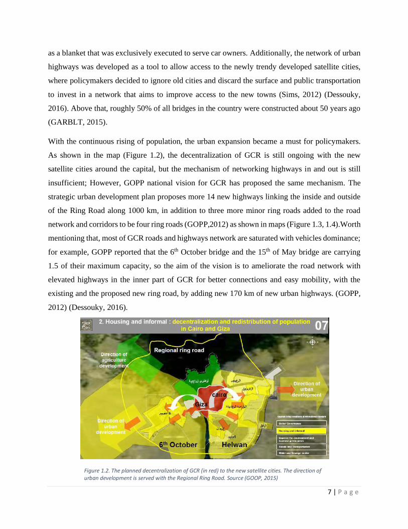
With the continuous rising of population, the urban expansion became a must for policymakers.
As shown in the map (Figure 1.2), the decentralization of GCR is still ongoing with the new
satellite cities around the capital, but the mechanism of networking highways in and out is still
insufficient; However, GOPP national vision for GCR has proposed the same mechanism. The
strategic urban development plan proposes more 14 new highways linking the inside and outside
of the Ring Road along 1000 km, in addition to three more minor ring roads added to the road
network and corridors to be four ring roads (GOPP,2012) as shown in maps (Figure 1.3, 1.4).Worth
mentioning that, most of GCR roads and highways network are saturated with vehicles dominance;
for example, GOPP reported that the 6th October bridge and the 15th of May bridge are carrying
1.5 of their maximum capacity, so the aim of the vision is to ameliorate the road network with
elevated highways in the inner part of GCR for better connections and easy mobility, with the
existing and the proposed new ring road, by adding new 170 km of new urban highways. (GOPP,
2012) (Dessouky, 2016).
Figure 1.2. The planned decentralization of GCR (in red) to the new satellite cities. The direction of urban development is served with the Regional Ring Road. Source (GOOP, 2015)

8 | P a g e
Figure 1.3. The yellow lines represent new 14 highway in the inner core of GCR by 2027 strategic vision stretching along 1000 km. (GOPP, 2012).
Figure 1.4. The red lines represent the new 3 proposed ring roads, besides the existing one, aiming for better accessibility in and out the outer cities around GCR by the year 2050. (GOPP, 2012).

9 | P a g e
Since the 1970’s master plan and the prosperity of constructing new elevated highways, many of
these bridges reached or near to the end of their life spans, and their alternatives have to be
considered, these highways were designed to last approximately 50-60 years, after which time they
require major repairs or reconstruction. We are now in the period of time when these highways are
reaching the end of their lifespan, and decisions have to be made for their future. (Biesecker, 2015).
According to Ahram Journal report, 700 bridges in Egypt exceeded their life spans, in other words
they are close to collapse (El Sharnoubi, 2014). Adjacent to this fact, GARBLT in their Project
Completion report stated the life spans of Egypt’s bridges as shown (in table 1.1). Approximately,
683 bridges had already reached their maximum life span, while 89 had exceeded it. Adding to
that the bad condition of the pillars, the viaducts that cross the Ring Road are mostly made of
concrete. Piles of garbage under these elevated viaducts often obstruct the passage of traffic. Shops
and the like occupy the areas under viaducts so that bearings near abutments often cannot be
inspected. (GARBLT,2015).
Table 1.1. Shows the age of Egypt's bridges, indicating the insufficient maintenance and the poor condition for many of them. Source (GARBLT, 2015)

10 | P a g e
Furthermore, due to the common dilemma of traffic congestions around GCR, policymakers are
striving to construct even more viaducts to solve the problems of traffic congestions in the inner
core of the capital. They are trying to decrease the road's intersections as possible by bridges and
flyovers, which makes the neighborhoods divided by megastructures that shatter urban tissue.

11 | P a g e
Chapter 2: Literature Review
2.1 Introduction
Seminal contributions have discussed this topic in previous studies. The following paragraphs are
the main findings of the research topic in several aspects. In this chapter, the main principles will
be discussed; and some existed international examples regarding the spaces beneath the elevated
highways will be analyzed. Due to the high volume of work, not all the findings will be brought
up, only the more comprehensive and related to the research's main task's principles. The upcoming
sources are demonstrating the stated problem.
2.2 Understanding urban spatiality and functionality
Urban spatiality and functionality are mainly about theoretical interpretations from well-known
urbanists, the spatial relationship between solid and void, and how it affects the movement of the
people. Additionally, it is about exposing the possible formal and informal functionality of these
spaces, to make the restoration of it as effective as possible to understand the spatial urban layers
in cities.
2.2.1 Roger Trancik, Finding Lost Space, 1986
Trancik in his best-known book ‘Finding Lost Space’ tackled the dilemma of urban challenges in
today’s cities. He focused on the city’s cores, criticized the modern role of planning, the way it
deals with spatial relations (between two and three-dimensional), and people’s uses. “The usual
process of urban development treats buildings as isolated objects sited in the landscape” (Trancik,
1986, p. 1). He also mentioned that, currently, the problem of the modern movement in today’s
cities is that it caused many improperly used vacant lands; hence, it left many dead spaces in the
urban cores. Although the disharmony between planners and architects resulted in a lack of
adequate design, dead spaces have a high potential for re-attracting people to deserted spaces. In
almost every city in the world, there are many unused or misused vacant lands, and the spaces
beneath the elevated highways seem to be a large section of them. Since those outdoor spaces
represent great opportunities, today’s designers have to restore it. “Designers of the physical
environment have the unique training to address these critical problems of our day, and we can

12 | P a g e
contribute significantly toward restricting the outdoor spaces of the urban core.” (Trancik, 1986,
p. 2)
Trancik defined lost spaces in cities as unstructured patterns, “Lost space can be regarded as the
leftover unstructured landscape at the base of high-rise towers to the unused sunken plaza away
from the flow of pedestrian activity in the city. Lost spaces are also abandoned waterfronts train
yards, vacated military sites, and industrial complexes.” (Trancik, 1986, p. 3). They are abandoned
lands lack of social interaction, and repelling any sort of positive contribution to society, “They
are ill-defined, without measurable boundaries, and fail to connect elements in a coherent way”
(Trancik, 1986, p. 4).
He also mentioned five main causes of the stated problem; Firstly, “the increased dependence on
the Auto-mobile”. Secondly, “the attitude of architects of the Modern Movement toward open
space”, Thirdly, “zoning and land-use policies of the urban-renewal period that divided the city”,
Fourthly, “unwillingness on the part of the contemporary institutions (public and private) to
assume responsibility for the public urban environment”, Fifth and lastly, “an abandonment of
industrial, military, or transportation sites in the inner core of the city.” (Trancik, 1986, p. 4).
Regarding the spaces beneath the elevated highways, Trancik's definition of lost spaces evolves
from chapter to another; he reviewed three main urban elements focusing on the success of such
spaces. First, the three-dimensional frame, which defines the edges of the space; for example, the
flyover structure and the level of enclosure of flyover structures, and its scale to users, second, the
two-dimensional pattern, which is about the textures, materials, and the composition of land
patterns. Third, Hardscapes like; benches, light posts, sculptures, trees, and any object presents
any sort of focal point on its own.
Turning to the three theories, he elaborated to understand the mechanism of spaces within the
different cities. First, the Figure-ground theory that discusses the spatial relation between solids
and voids; he supported it with few masterplans to explain how the dialogue between the buildings
and land patterns could be successful, and how the poor relation can negatively affect the
functionality of the outdoor space; Second, the linkage theory which is about linking between all
the layers of the city, more specifically, the movement of users within the physical environment.
He proposed three different formal types of the linkage theory, regarding the research scope, with
only one relevant type, he stated it as ‘mega-form’, he explained, “Structures are connected to a

13 | P a g e
linear framework in a hierarchical, open-ended systems, where linkage is physically imposed.”
(Trancik, 1986, P. 107).
According to the famous Japanese Architect Maki definition, Trancik conceptualized Mega-forms
or Megastructures as they tend to dominate the physical context without reference to the human
scale. Hence, this definition can be assigned to flyovers structures as it is connected to a linear
entity, creating a high potential space underneath it.
2.2.2 Charlotte Malterre-Barthes’ Functions Classifications, 2011.
More precisely, Charlotte Malterre-Barthes proposed five main points for a comprehensive
understanding of the functions of the spaces under elevated highways in urbanized cities. This
typology is helpful in the early phases of approaching these spaces because it is applicable in most
of the cases.
2.2.3 Public Spaces
1. Access to pedestrians only.
2. Function is determined by surrounding businesses and people.
3. Designed and maintained by the city’s authorities.
2.2.4 Public spaces with service functions
1. Mainly used for parking although some benches and street furniture
exist.
2. Used by another industry/business.
2.2.5 Transit space hub
1. Used for public transit.
2. Trains/depots/bus stops.
3. Good for shelter.
2.2.6 Transit Space Circulation
1. Public transit.
2. Vehicular
3. Circulation.
2.2.7 Inaccessible Space
1. Where only private industries and city employees/industry have access.

14 | P a g e
2.2.3 Fumihiko Maki, Investigation in Collective Form, 1964
In like manner, this concern goes further back to 1964. The Architect Fumihiko Maki explained
the problems of ‘Megastructure’ in-depth. According to Maki, “Megastructures is a large frame in
which all the functions of a city or part of a city are housed” (Maki, 1964), which goes along with
the function of today’s bridges. Maki concerned about the deviation of the conventional urban
image due to massing buildings and highways in cities. He believed that cities should grow in a
parallel with contemporary movements, socio-economic factors, to maintain the livability of
societies. He stated that we lack an adequate visual language to cope with the superhuman scale
of modern highway systems and with views from airplanes.
Back to Megastructures, Maki said that designers tend to be attracted to large-scale developments,
as it offers more opportunities for diverse grouped functions. However, it is only a useful tool if it
used in a way that coherently connects the city’s different layers; in other words, these structures
should not be singled function.
2.3 Understanding peoples’ behaviors
This part of the literature discusses the problem from the human perspective. Several contributions
had tackled the approach of people’s behaviors in urban spaces, explaining the general mechanism
of using these spaces, and how people perceive and interact with it.
2.3.1 William Whyte, The Social Life of Small Urban Spaces, 1980.
The urbanist William Whyte formed a research project on how urban spaces work from the
perception of people. He observed different plazas and parks, to see which successfully work for
users and which not. With such behavioral observation, he discovered some factors to understand
the dynamics of peoples’ interactions, and why they prefer a space more than another. People tend
to be attracted to certain activities such as music acts or art installations, as the author called it
‘triangulation’ which makes the strangers likely to have a conversation. “Sculpture can have
strong social effects. People are drawn to the sculpture, and drawn through it: they stand under it,
beside it; they touch it; they talk about it.” (Whyte, The Social Life of Small Urban Spaces, 1980).
Whyte focused on the circulation of people inside the urban spaces, and how the two-way
directions can make a difference for small conversations or slow down the pace of their movement.

15 | P a g e
Whyte also talked about movable chairs as a flexible element in the space that can make a
difference. People can adjust it as they prefer, it gives them a sort of control. Definitely, People
attract people; the bulk of people who are sitting, talking or eating are a key pull-factor; for
example, a food cart can create sort of a junction in the space; accordingly, leading people into
intersected paths. Crowds in certain open spaces add a sense of safety and assurance to it.
Moreover, Whyte tackled natural elements such as trees; besides its ability to create shaded areas,
it makes a pleasant barrier and a sense of protection. Trees, as well as, wind, sun, and water, all
play a vital part in the liveliness of parks and public spaces. Usually, streets surround spaces
beneath the elevated highways; therefore, the street is an essential element for the success of the
public space; it must end in a coherent way where the plaza or the public space ends. The
connection between what Whyte came across in his project and what mentioned in the research
leads us to the crux that we can follow the behavior pattern of users in public spaces; thus, apply
it under the viaducts. Simply, the planned composition of some of the mentioned elements can
drastically change the environment of those dead spaces. Generally, it is about the ultimate
planning and application to create a great, socially tangled city.
2.3.2 Francis & Marcus, Design Guidelines for Urban Open Space
Francis and Marcus contributed in the book ‘Design Guidelines for Urban Open Space’ and
successfully classified the users of plazas and public spaces into two categories. First, the ‘passers-
by’; the plaza for them is just on the way to their destination, the experience through their short
journey should be appealing, space should offer to seat along the walking paths and waiting areas
(Francis & Marcus, 1998) (Biesecker, 2015). Second, is the Lingerers, they have been classified
into two sub-categories; A) The Overt, which is their presence, including socializing and
participating in whatever the kind of activities. B) The Covert socializers who usually observe and
watch without actual interaction with the event or the people. Both types need an ergonomic space,
and because the seating area is an attractive element of its own; so, different compositions of
seating are required to fit their natural behavior. Movable chairs are efficient for the users to give
them the power of choice, for each activity should be served with seating to stimulate people,
especially The Overt. (Francis & Marcus, 1998) (Biesecker, 2015).
Eventually, what damages social life in cities is that buildings and urban spaces are not equally
treated, usually; they are not a cohesive product. “The usual process of urban development treats

16 | P a g e
buildings as isolated objects sited in the landscape, not as part of the larger fabric of streets,
squares, and viable open space.” (Trancik, 1986).

17 | P a g e
Chapter 3: From Undesirable to Desirable!
As explained above in the introduction, we discussed the spaces beneath the viaducts, defined its
meaning, and pointed out the causes of their existence. To analyze the potential solutions for the
stated dilemma, first, we must comprehend the nature of these residual spaces, to understand the
culture of the context, and to know the differences that create such urbanism conflict. Under the
main problem, that elevated structures create an edge that cuts many layers of the urban fabric,
land-uses, social life, open spaces, etc. In this chapter, we will discuss the ameliorating of these
spaces and to constitute the negative impacts on the community to be fully aware of the causes of
their repulsive image, to overcome this problem, in the context of what we demonstrated.
In every city of the world, what is more important than the buildings and roads are the open spaces
between them, they are fundamentally about people in the first place, they play a vital role in
people’s behavior, affect the quality of their life. They are an inevitable part of the city’s
development process. On the other hand, Public spaces vary from urban pockets to big open spaces.
“Public spaces range in form from informal street corners to grand civic set pieces. At a larger
scale, formal public spaces have long had an important role as the perceived centers of settlements
of all types and as the focus for public life, activities and events. At a smaller scale, they might
simply be somewhere to rest, hang out, or play whilst providing a visual pause in the flow of streets
through urban areas” (Carmona, 2018). The literature review showed that the negative effects have
been discussed by many authors, Peter Samuel suggested six main categories for the impacts of
these structures 1) increasing mobility and accessibility; 2) dominant structure in the urban fabric;
3) community segregation because of physical and psychological barriers and visual intrusion; 4)
undefined spaces which are often misused; 5) low natural lighting and ventilation under the
elevated structure; and 6) generation of negative or lost spaces. (Samuel, 2006)
In order to transform the spaces beneath the elevated highways to the public realm; first, we need
to conceptualize the purpose of successful public space, if we can assign a single purpose to make
a successful public space, it is where people go and meet, where people temporarily escape from
the clamor of the city. In that context, public spaces cannot be superficial, they should be complex,
yet flexible enough to accommodate people regardless of their preferences. Public spaces are a
physical space that is unique and attractive in an urban area. Public space also allows all people
from different backgrounds regardless of their personal, social, and cultural differences to use

18 | P a g e
public space. (Ramlee, 2015). Public spaces should accommodate change and people from all sorts
of background should be accessible to public spaces with the right to variety and flexibility
(Kurniawati, 2011)
According to Project for Public Space, there are four headings criteria for an efficient public space:
(1) Comfort and Image, (2) Access and Linkages, (3) Uses and Activities, (4) Sociability. The
contribution made here has wide similarities to the ultimate vision. In comparison with the
knowledge from the literature to these criteria, we can tackle the stated problem from a different
approach with a simplified pattern; to demonstrate, we will apply the criteria for successful public
spaces specifically to the main problem of these spaces.
3.1 Access and Linkages
In the previous section, we discussed the treatment of the unattractive views of the elevated
highways; in the meantime, accessing the spaces is also a great matter. Within dense cities, there
is more need for free public gathering space, and when there is not accessible space specifically
designed for social gatherings, people use what space is available. (Biesecker, 2015). Elevated
highways and viaducts that stretch alongside neighborhoods are mostly located in highly dense
zones with high traffic flow, centrally extending along the axial ground floor of the street
dominated by vehicles, not pedestrians. Certainly, it makes it difficult to access. Even more, the
relationship between these spaces and the main street is mostly rigid; users are less likely to use
the space if it is hard to access. In the meantime, to attract a plentiful amount of people, there has
to be a clear relationship between the space and the surroundings. It was highlighted in the
literature review that the linkage between the street and the public space is a crucial factor in the
efficiency of it. A good plaza starts at the street corner; if it is a busy corner, it has a brisk social
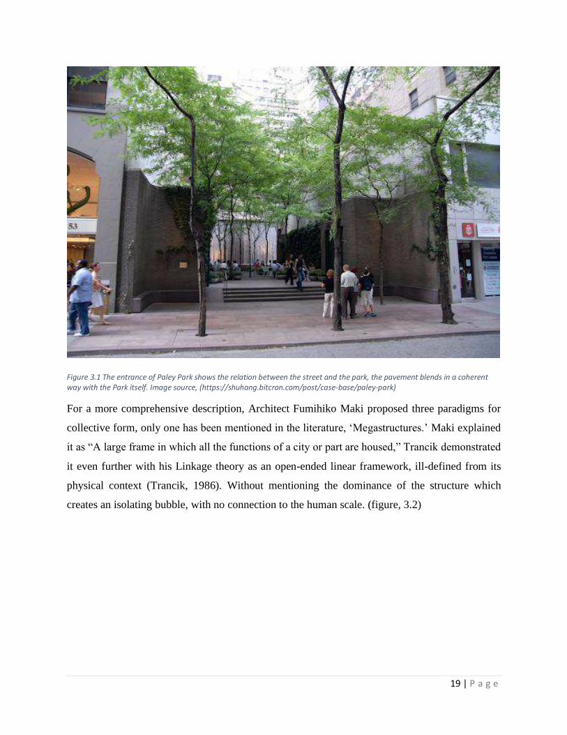
life of its own (Whyte, 1980). For example, in Paley Park in New York, the street is an integral
part of the park, the transition between them is practically coherent (figure, 3.1). The visual
connection to nature by the presence of water from the artificial waterfall and the trees grabs the
attention of the passing pedestrians; it works as a nexus to an efficient public space to visit. A local
food cart can boost a two-way circulation for pedestrians; for instance, in Cairo, many kiosks are
now located under the bridges. Moreover, these spaces are often used as public and private
transportation stops, where people can wait in a shaded area.
19 | P a g e
Figure 3.1 The entrance of Paley Park shows the relation between the street and the park, the pavement blends in a coherent way with the Park itself. Image source, (https://shuhang.bitcron.com/post/case-base/paley-park)
For a more comprehensive description, Architect Fumihiko Maki proposed three paradigms for
collective form, only one has been mentioned in the literature, ‘Megastructures.’ Maki explained
it as “A large frame in which all the functions of a city or part are housed,” Trancik demonstrated
it even further with his Linkage theory as an open-ended linear framework, ill-defined from its
physical context (Trancik, 1986). Without mentioning the dominance of the structure which
creates an isolating bubble, with no connection to the human scale. (figure, 3.2)

20 | P a g e
3.2 Comfort and Image
Undoubtedly, this seems to be a common problem. For a massive structure like an elevated
highway, maintaining an ergonomic space and appealing image to accommodate people, appears
to be unattainable. “Some researchers claim that such structures result in negative physical and
psychological health conditions, increasing the noise and air pollution, especially in residential
areas” (Appatova et al., 2008) (Lak, Ramezani & Aghamolaei, 2019). There are many negative
attributes of the spaces beneath elevated highways, which induces the repulsive image of these
spaces.
3.2.1 Senses relief
What makes people go to spend time in a plaza or a public space is that they want some relief from
the atmosphere in the city, relax their sight, and their ears. Several studies had emphasized on
mitigation of the negative health impacts of these structures, especially noise, which is one of the
most significant urban noises is the traffic. Noise, defined as “unwanted sound,” is perceived as
an environmental stressor and nuisance. Effects of noise can be defined as all those effects on
health and well-being caused by exposure to noise (Stansfeld & Matheson, 2003). “Noise
Figure 3.2 Megastructures theory diagram by Maki and the similarities with elevated highways dominance in the urban fabric. source, (Trancik, 1986)

21 | P a g e
emissions from various transportation modes have become a major concern to environmental and
governmental agencies in recent years for the great annoyance they cause to surrounding
communities.” (Baaj, 2001). Noise differs from one country to another depending on the density
of urbanization, and the culture of societies. Recently, mitigation of traffic noises has broadened,
in a study by Yildiz, he proposed Noise Insulation system; Generally, by implementing vacuumed
double-glass, placed on both sides of the elevated highway to mitigate the traffic noises (as shown
in the figure, 3.3). As a result, the noise level has decreased by 14%-17%; and so, it reached
moderate levels. Traffic noises depend on diverse factors “traffic noise is affected by such factors
as traffic volume, vehicle mix, pavement type, and vehicle conditions.” (Baaj, 2001). In the context
of the research, the pavement texture is crucial in the assessment, concrete tiles are highly
reflective surface otherwise, vegetated pavement, it can absorb noises additionally being visually
appealing.
3.2.2 Visual coherence
As we previously explained, the most significant impact of elevated structures is the visual
intrusion, especially in urban areas. Simultaneously, Highways can act as physical and
psychological barriers that create undesirable views, which make the pedestrian experience
unpleasant. (Trancik, 1986). This approach has been successfully brought up by Gerda R. Wekerle
and Carolyn Whitzman in their book, Safe Cities: Guidelines for Planning, Design, and
Figure 3.3 Shows vacuumed double glass, placed on both sides of the highway for noise reduction, source: Yıldız, (2016)
22 | P a g e
Management; People started to get used to the eyesore view of the elevated highways. Since most
of our information is acquired in a visual form, these structures can be a potential solution for a
positive impact assessment.
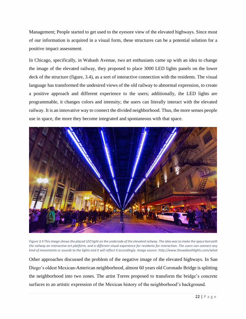
In Chicago, specifically, in Wabash Avenue, two art enthusiasts came up with an idea to change
the image of the elevated railway, they proposed to place 3000 LED lights panels on the lower
deck of the structure (figure, 3.4), as a sort of interactive connection with the residents. The visual
language has transformed the undesired views of the old railway to abnormal expression, to create
a positive approach and different experience to the users; additionally, the LED lights are
programmable, it changes colors and intensity; the users can literally interact with the elevated
railway. It is an innovative way to connect the divided neighborhood. Thus, the more senses people
use in space, the more they become integrated and spontaneous with that space.
Figure 3.4 This image shows the placed LED light on the underside of the elevated railway. The idea was to make the space beneath the railway an interactive art platform, and a different visual experience for residents for interaction. The users can connect any kind of movements or sounds to the lights and it will reflect it accordingly. Image source: http://www.thewabashlights.com/what
Other approaches discussed the problem of the negative image of the elevated highways. In San
Diego’s oldest Mexican-American neighborhood, almost 60 years old Coronado Bridge is splitting
the neighborhood into two zones. The artist Torres proposed to transform the bridge’s concrete
surfaces to an artistic expression of the Mexican history of the neighborhood’s background.

23 | P a g e
Currently, the columns of the bridge are sharing and reflecting the cultural environment of the
place. Using vibrant colors and pleasant paintings made by locals and artists (figure, 3.5), the space
became livable, visually more appealing for residents to visit, and spend time in; it became also a
sort of museum on its own. There are some tours led by volunteers to guide tourists in the
exhibition. This section presents a review of the recent literature on how art installations or
sculptures can make a difference; it makes people stop and look, helps for a small conversation,
and eye-catching from long distance.
Figure, 3.5. As shown, the vibrant murals on the pillars of the bridge. These murals are reflecting the history of the middle-class Logan Heights neighborhood, the murals made the space a historic landmark to the residents. Image source: https://medium.californiasun.co/chicano-park-san-diego-5506a203c527
The desired level of comfort for a random space underneath a busy highway or bridge seems to be
absurd; however, people perceive this image as separated visual elements, and certainly, the
distinctiveness of the placed elements in the view will spontaneously attract peoples’ attention.
More importantly, the sense of safety, cleanliness, and availability of places to sit comfortably,
will attract them.

24 | P a g e
3.3 Uses and Activities
One of the major attributes of successful public space is the activities that take place within it.
They are the main reason for people to come back, a distinction between a place as a set of elements
and a space as a dynamic field of every-day practices (Certeau 1988). In such spaces, forming a
certain use or public activities seems elusive, but exploiting these leftovers appears to be highly
underestimated. By initiating and participating in urban events, which set up an alternative model
of behavior and reshape routine routes and dynamics, new solidarities are being developed, some
of which are temporal, and some become long-term ones. (Lavrinec, 2011).
In Toronto, Canada, the Bentway is stretching for almost two kilometers isolating seven emerging
neighborhoods. Urban designer Ken Greenberg noticed the lack of public spaces in the area and
came up with the vision of developing a focal point for the seventy thousand residents of the
community, as he mentioned: “It was introducing something new into the gene pool of public
spaces.” The area was a formal industrial zone, and recently, factories moved out leaving an urban
gap behind accommodated by residential units after. The spatial of the expressway structure was
optimum for the idea of the linear park (figure, 3.6) with almost five stories high and 24 meters
wide. The space was appropriate to accommodate many sorts of activities; skating trails, hiking
trails, live performances, and events organized by the neighborhoods’ residents.
Figure 3.6. The master plan of the designed park. As shown the Bentway acts as physical barrier inside 7 neighborhoods in Toronto. The park stretches in a linear shape underneath the Bentway connecting the 7 neighborhoods back together. Source: https://medium.com/sidewalk-talk/the-future-of-public-space-is-now-arriving-beneath-a-busy-highway-35b1379d6fa (Image credits to Public Work)

25 | P a g e
The Bentway project is a great demonstration for reconnecting the city with its people. The
negative view of the expressway has changed; locals have integrated deeper with their
neighborhood. Ironically, the elevated highway became a new social node for the community and
changed the image of the city. (figure, 3.7).
Figure 3.7. Ice Skating trails is one of the divers uses and activities that regularly take place under Toronto’s expressway. The Bentway project is providing gathering spaces for Toronto’s residents from 7 neighborhoods. Photographer: Andrew Williamson. Source: https://urbannext.net/the-bentway/
Another intervention was carried out in Zaanstad, The Netherlands. The elevated highway A8
constructed in 1970, created a dichotomy between the North and the South sides of the Town, and
River Zaan. A Visual blockage was created, especially, from the River, besides a physical
blockage, concerning accessibility, and it was mostly functioned as parking. The Town’s design
consultant NL Architects cooperated with the City Council and the residents to think about the
potential needs and interests. After this successful participation, the project efficiently integrated
with the community. For commercial and recreational purposes, retail shops and supermarkets,
skateboarding parks, basketball courts, and many more activities were added. (Figure, 3.8). The

26 | P a g e
project did not only connect the residents from both sides of the Highway; but also, connected
them with the
Figure 3.8. An axonometric model shows the different uses of the project. The park in orange is the main gathering zone with commercial area in white surrounded by the Marina and the church square. Source: https://www.publicspace.org/works/-/project/d046-a8erna

27 | P a g e
Figure 3.9. The design integrated with the River Zaan and connected the residents with the river. The project accommodated different uses instead of damaging the landscape. Source: https://www.architonic.com/en/project/nl-architects-a8erna/5100103
river, by designing a small harbor where they can interact with the River differently (figure, 3.9).
A8 is a successful model to how to adapt with an elevated structure by emerging the people more
with their town and uncover new uses for the waste spaces beneath.
Similarly, in Boston under Zakim Bridge, the non-profit organization The Charles River
Conservancy came up with an idea to transform the unused space beneath the viaduct into a skate
park (figure, 3.10). In many places, skateboarding is overlooked at, by cities’ budgets. They are
oriented to invest more in functional and conventional purposes. The designer noticed that there is
a large community of skaters without a place to practice. The solution was not implemented
overnight; there was participation from the community and public hearing sessions about the
potential usage of the space. Currently, skateboarding enthusiasts come from all around the city to
practice because they finally have a proper space.
28 | P a g e
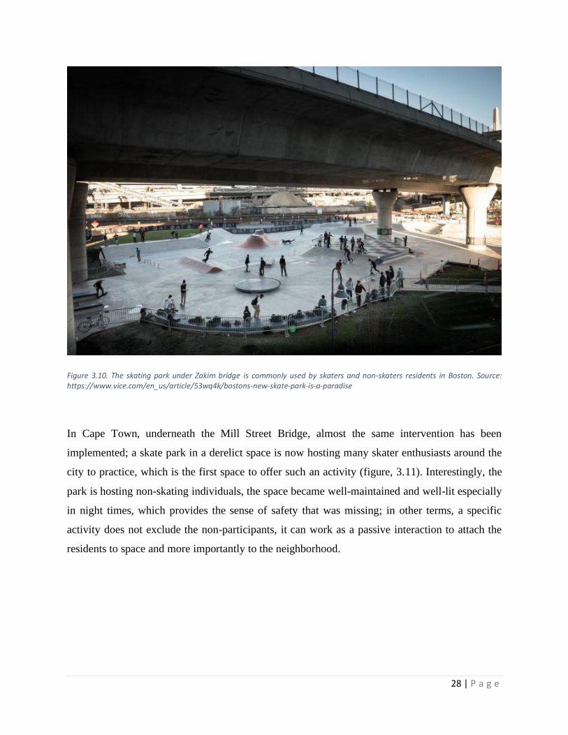
Figure 3.10. The skating park under Zakim bridge is commonly used by skaters and non-skaters residents in Boston. Source: https://www.vice.com/en_us/article/53wq4k/bostons-new-skate-park-is-a-paradise
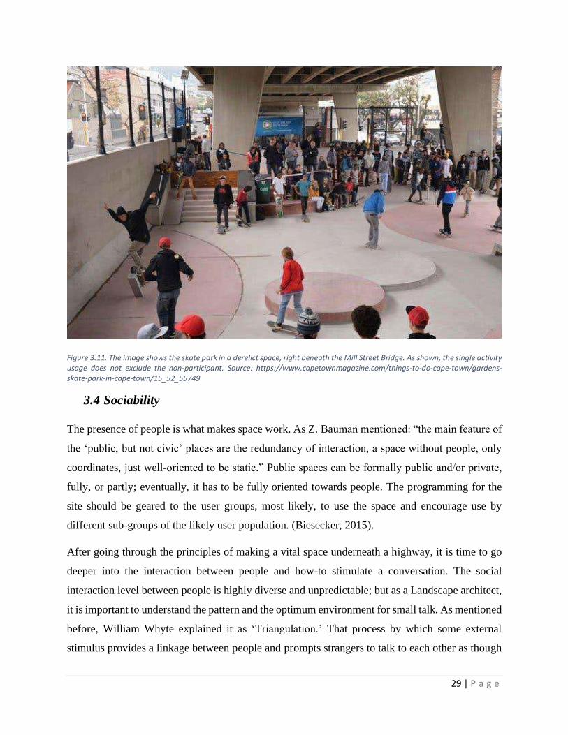
In Cape Town, underneath the Mill Street Bridge, almost the same intervention has been
implemented; a skate park in a derelict space is now hosting many skater enthusiasts around the
city to practice, which is the first space to offer such an activity (figure, 3.11). Interestingly, the
park is hosting non-skating individuals, the space became well-maintained and well-lit especially
in night times, which provides the sense of safety that was missing; in other terms, a specific
activity does not exclude the non-participants, it can work as a passive interaction to attach the
residents to space and more importantly to the neighborhood.
29 | P a g e
Figure 3.11. The image shows the skate park in a derelict space, right beneath the Mill Street Bridge. As shown, the single activity usage does not exclude the non-participant. Source: https://www.capetownmagazine.com/things-to-do-cape-town/gardens-skate-park-in-cape-town/15_52_55749
3.4 Sociability
The presence of people is what makes space work. As Z. Bauman mentioned: “the main feature of
the ‘public, but not civic’ places are the redundancy of interaction, a space without people, only
coordinates, just well-oriented to be static.” Public spaces can be formally public and/or private,
fully, or partly; eventually, it has to be fully oriented towards people. The programming for the
site should be geared to the user groups, most likely, to use the space and encourage use by
different sub-groups of the likely user population. (Biesecker, 2015).
After going through the principles of making a vital space underneath a highway, it is time to go
deeper into the interaction between people and how-to stimulate a conversation. The social
interaction level between people is highly diverse and unpredictable; but as a Landscape architect,
it is important to understand the pattern and the optimum environment for small talk. As mentioned
before, William Whyte explained it as ‘Triangulation.’ That process by which some external
stimulus provides a linkage between people and prompts strangers to talk to each other as though

30 | P a g e
they were not. (Whyte, 1980). In this chapter Whyte accentuated the importance of what we
discussed above (Comfort and Image, Access and Linkages, and Uses and Activities) he unified
them as stimulation for potential random conversation; for example, a food cart with two persons
eating at the same time, while coinciding with the moment, they become less self-involved; they
are more likely to start an interaction. Accordingly, the inducement for talking can be also physical
object, like sculpture; it has the exposure to be seen closely and to be even touched, same with
paintings or any art installations. Currently, art in plazas and public spaces is highly appreciated.
The great rush to provide art is perceived and valued by the public (Francis & Marcus, 1998).

31 | P a g e
Chapter 4: Research Strategies and methods
4.1 Introduction
After we discussed the dilemma internationally, now we can take a closer look at Egypt;
specifically, the Greater Cairo Region (GCR) elevated highways. Foundationally, and by implying
what we discussed about the causes of dead spaces in the first chapter, Cairo’s rapid urban
expansion in the last few decades has caused many planning errors. Rapid urbanization in Cairo
during the last century caused a fragmented spatial structure forming of several small cities shaping
the large metropolitan area. (Gauch 2000, Khalifa and Hamhaber, 2014). Therefore, the
dependence on vehicular movement has highly increased, so that stretching roads and bridges were
the main tool for planners to cope with that expansion. The literature review GCR currently has
1762 vehicular bridges in Egypt (CAPMS, 2015), and Cairo alone has 94 bridges (CAPMS, 2019).
In the meantime, the research work regarding the spaces beneath the elevated highways in Cairo
is still going on. Thus, the topic is not well-documented in general; however, in this chapter, we
will then analyze the intervention area of Masr EL-Gedida, which is located on the east side of
GCR.
4.2 Masr EL-Gedida background
Masr EL-Gedida District is one of the finest neighborhoods in Cairo; it was founded by the Belgian
engineer and Entrepreneur Baron Emban in 1905 to become the Eastern gate of Cairo (figure, 4.1).
The neighborhood was inspired by the European urban and architectural style; The unique
neighbor, Masr EL-Gedida district, lies on the Eastern side of Cairo around 8-10 kilometers far.
The historian Ilbert noticed that the planned urban expansion movement by Emban was as far as
possible from violating the cultivated lands to the desert. Robert Ilbert dated in his book
'Héliopolis, Le Caire 1905-1922' 'Genèse de Ville (Masr El-Gedida, Cairo, Genesis of the City),
the history of Masr EL-Gedida mentioning that Emban bought a vast land from the English
occupation to construct his new green city (Ilbert, 1981). The uniqueness of Masr El-Gedida is
that both western and eastern architectural and urban ideologies were adopted (Al-Howaily, 2015),
as shown in (figures 4.2 & 4.3). Emban wanted a unique image for the district, so he assigned
architects and planners from Belgium and the French colony to design the new city. Eventually,
the Neo-Classic Baroque Islamic style has led to sustaining Cairo's image, and to add to the cultural

32 | P a g e
sustainability of the town. (Al-Howaily, 2015). And because of that, the neighborhood was
targeting foreigners and upper-class residents. The concept of the initial plan could be considered
as a form of social segregation between the high and low-income classes; it also could be
understood as an ethnic form of isolation between the Egyptian Muslims and the foreign (non-
Muslims). (Al-Howaily, 2015).
The district is characterized by hosting highly distinguished and key Egyptian personnel on both
levels, culturally and socially (Al-Howaily, 2015). The concept of the district was to extend the
historical identity of Cairo; despite that, the targeted residents were mostly foreigners; the
architectural design was inspired by the Islamic architecture (Al-Howaily, 2015).
The district was flourished with green and open spaces; the maximum distance between the
residential units and public parks was 300 meters. The main streets vary from 30 – 40 meters wide,
with green traffic islands in the middle, smaller streets depend on their length but vary from 11.5
- 19 meters (Ain Shams University, 2016).
Figure 4.1. 10 km east of Metropolitan Cairo, the highlighted Masr El-Gedida district was the one of the first movements to build satellite city away from the capital center.

33 | P a g e
Figure 4.2. The picture shows the architectural style of the context, also the proportions of the streets' widths compared to the buildings’ heights. Source, (Ain Shams University, 2016).
Figure 4.3. An aerial photo shows the iconic Basilica and the green open spaces between the buildings. Photo courtesy: Masr El-Gedida Heritage Initiative. Source, https://linesmag.com/Masr El-Gedida-the-land-of-history-and-architecture/

34 | P a g e
4.3 Masr El-Gedida’s urban shift
As a result of the rapid increase of population, everywhere in Egypt, the district of Masr El-Gedida
has come across a series of significant transformations. The heights of the buildings started to rise
disproportionally with the streets’ widths, and the commercial activity started to be dominant in
most of the main axis of each neighborhood of the district. Al-Howaily showed the difference in
two pictures (figure, 4.4), the debacle of the identity, and the lost image of the district.
Throughout the whole century, the district was exposed to many major transformations starting
from the urban fabric. As we mentioned, Masr El-Gedida is a mixed district of networking and
radial grid, as shown (figure 4.5). (Ain Shams University, 2016). One of the main transformations
was the urban expansion vertically and horizontally. On the vertical dimension, the issued
regulations in 1905 were that the maximum height for residential buildings should not exceed five
floors (Ain Shams University, 2016). However, many formal and informal buildings had exceeded
the regulations due to the absence of firm and proper control. On the horizontal dimension, the
informal outbidding mechanism expanded while congregating through clusters in the whole
district, at the expense of green spaces, as shown in the charts (figure, 4.6). The residential use
increased since 1915, while the entertainment had significantly decreased from 25% to only 7%
(Entertainment in 1915 was mainly about green spaces) as a sign of environmental quality
deterioration. Meanwhile, commercial use has jumped to 18%; thus, it secured more flow of
vehicles to deliver goods in and out of the district. In the same token, the maps of land uses are
showing the mechanism of the expansion (figures 4.7 & 4.8).
Figure 4.4. The left picture shows the mosque square with the Basilica in the far perspective, the right one shows, that loss of the collective memory of the place. Source, (Al-Howaily, 2015)

35 | P a g e
Figure 4.6. The left chart indicates the land uses in 1905, while the right one is from current time. The commercial increase, transportation besides the major decrease in greenspaces are the significant transformation of the District, worth to mention the increase of population as well. Source (Ain Shams University, 2016).
Figure 4.5. This map shows the solid and void structure of the district in the 1950's, the urban fabric is a mixed of networking and radial grid. Source (Ain Shams University, 2016).

36 | P a g e
Figure 4.7. This map shows the land uses in the Monarchy Era (1905-1952). almost a total residential use. Source. (Ain Shams University, 2016).
Figure 4.8. This map shows the land uses in the current time, with an obvious commercial spread through the main axis. Source. (Ain Shams University, 2016).

37 | P a g e
The National Organization for Urban Harmony (NOUH) declared in 2012 that the whole district
is architecturally preserved due to its special value; the declaration included several regulations
regarding preserving architecture, urban fabric, and landscape. The preservation includes dealing
with ameliorating, maintaining, or demolition according to the condition (Al-Howaily, 2015).
4.4 Masr El-Gedida’s new bridges
This paper begins with a review regarding the causes of lost spaces, as mentioned; the main reason
is the increased dependence on the vehicular movement. In a dense city like GCR, vehicular
concentration, and highways became the regular image of the city’s life. Parking lots are an integral
part of every street corner, leaving a staggering percentage of urban land in major modern cities
devoted to the storage and movement of automobiles. (Trancik, 1986, p. 5). The predominance of
vehicles and the vast grey blanket of asphalt seems to be logical for a city (GCR) that
accommodates more than 20 million residents, including Cairo which accommodates almost 9.5
million residents, approximately 46,349 per kilometer square (according to CAPMAS).
Surprisingly, according to a recent report, only 2.3 million vehicles are registered in Cairo, 1.6
million of them are privately owned. (CAPMAS, 2016). Despite the major difference between
residents and car owners, the urban development in Cairo is almost fully poured to the service of
automobiles and traffic congestions, making less and fewer spaces for the overlooked pedestrians.
If we look at figure 4.6, we will notice the major spread of commercial use in the district, which
required gaining more access to the neighborhoods. As it was successfully established in the
literature review by Biesecker, “Gaining access to city centers would mean that goods could more
easily be shipped out and brought in, potentially boosting the economy, besides, allow for jobs and
people to move out of the city”. (Biesecker, 2015).
In August 2019, the immediate construction of five elevated highways in the district of Masr El-
Gedida -as a first phase- was carried on to solve the traffic congestions; the development plan for
the upcoming phases includes 5 to 7 additional bridges in the same area for the same purpose. On
one hand, this development plan would primarily induce the accessibility to the district, solving
major traffic congestions, besides it obtains a moderate hierarchy and a better connection to the
new satellite cities like Fifth settlement and the New Administrative Capital further East. On the
On the other hand, in such rich context like Masr El-Gedida, Five megastructures as elevated
roadways are a massive burden on the urban fabric. As shown in (figure 4.9), the bridges are

38 | P a g e
extending along the main axis of the district, cutting through the neighborhoods, acting as walls
causing dichotomy between communities.
As recent as January 2020, the construction of the 5 Bridges was finished as fast as possible with
the implementation period that lasted for only 4 months. As discussed above, the width of the main
axes varies from 30 to 40 Meters, yet, currently, it reached almost 50 meters to increase the
absorptive capacity of the roads. The streets have been stretched to 5 or 6 lanes after it was only
2; so, it increased the flow of vehicles in the neighborhoods, which was an extra factor that
hindered the pedestrians’ freedom. In other words, without a proper pedestrian path crossing the
50 meters wide street, there was a major difficulty in accessing different neighborhoods due to the
significant reduction in walkable paths compared to before. Additionally, the green traffic island
and the old tram where located in the center of the street had to be removed to construct the
viaducts. According to Egypt Independent, more than 550 trees had been uprooted and replaced
by concrete pillars. (Mounir, 2019), few of these trees were aged over 100 years.
Figure 4.9. The red highlights are the 5 new bridges as a first phase. The green highlighted circle is Abu Bakr al-Siddiq bridge (the selected bridge for the empirical scope). As shown, the bridges are placed above the main axis of mobility in the district to solve traffic congestions. Source. Google Earth, graphics by author.

39 | P a g e
4.5 Cause of selection
As we mentioned in the last chapter, the excavation of the foundations of the five bridges started
on August 2019, the work started immediately with no pauses, the construction continued around
the clock. After less than five months, vehicles were already moving back and forth on Abu Bakr
el-Siddiq Bridge. There are few reasons for choosing this bridge specifically: firstly, the sudden
change for such a massive structure (figure 4.10) that will help to get a genuine first impression of
the bridge, simply because all the potential interviewees already have a fresh before-and-after
image of the neighborhood; so feedbacks and impacts will be on the top of their thoughts;
Secondly, the vulnerability of the neighborhood, as we mentioned, the whole district has an iconic
image, unique history, and special architecture and urban style. This approach has not been
discussed anywhere in the literature. These facts tackling the impacts on that dimension are another
reason for selecting this bridge specifically.
Figure 4.10. The images show the dominance of the bridge inside the residential fabric of the neighborhood. Source: Author.
4.7 The vision
Masr El-Gedida community is deprived of support services for residents. The vision is to create a
multi-purpose community hub, which can work as a resource center to provide the community
with different services for all residents, regardless of their ages and social differences. On one
hand, on the first wave of the survey people pointed at the beneficial side of the bridge regarding
easing the traffic congestions of the vehicles; On the other hand, there were two main complaints:
firstly, the loss of greenery and its transformation into the concrete form, secondly, the loss of the
identity of the neighborhood. On account of these reasons, the foundation of the proposal is
established. Eventually, the ameliorating process should be oriented towards rebranding the
neighborhood, by accentuating the lost collective memory of the context; in addition to adding

40 | P a g e
vegetation vertically on the pillars of the bridge or the ground floor, to genuinely simulate how it
was before in different forms; besides, providing daily / weekly / monthly activities for all ages;
as well as, making public hearing sessions to listen to residents’ voice, and develop the
neighborhood. For such environments with active usage, residents will proactively initiate the
interaction, and the neighborhood will scale up the pace on the level of enlivening the
surroundings, most importantly, making the whole community socially entangled.
4.8 Design concept
Designing a space underneath an elevated highway is challenging; the main challenge is to get
people to go there. Public spaces in such noisy environments are not in people’s dictionary as they
usually seek conventional places. However, as we learned from the literature and the examples; it
is all about interacting with their city, people tend to use the space once they perceive it as an
opportunity to explore it themselves.
The design concept is to create a neutral space for people to explore it from their preferred
approach, and then reshape it with their own perception; the proposed design is to complement the
neighborhood to what it has lost, the extracted greenery, and the unique identity of it. Masr El-
Gedida is a multi-functional complex area on both levels, residential and commercial. Since the
elevated structure is relatively new, the impacts are not fully discovered; undoubtedly, it will not
be far from what we discussed previously. Accordingly, the spatial aspect of the structure is
offering a wide range of high potential interventions, the columns are structurally well-imposed,
and the deck of the bridge is spatially working in balance, creating repetitive rooms to
accommodate different functions.
4.9 Research Objective
As we discussed in chapter 2, the literature review has successfully shown a comprehensive
understanding of the history of the problem, internationally, by analyzing the theoretical data that
discussed the characteristics and the nature of these spaces, besides prior examples that tackled the
negative impacts of the elevated highways. So, the research aims to develop a criterion that can be
adaptive to these spaces to make successful public spaces in the selected area of Masr El-Gedida.
Eventually, combining these three headings as shown (figure 4.10), leads us to our objective which
is how to reclaim the dead spaces underneath the elevated highways to the public realm, and make
41 | P a g e
these vacant lands can be reused adaptively as successful public spaces, especially, in Cairo which
suffers from lack of plazas and public spaces, the plenty of elevated highways can be the future of
public spaces.
4.10 Research Question
Asserting on the objective, the research question is about exploring a method to restore the dead
spaces under the elevated highways by providing global evidences and guidelines to be tested as a
case study in Masr el-Gedida, Cairo.
4.11 Research Methodology
The research objective is a combination of three; first, the literature review. In the second chapter,
we brought up a large number of existing urban theories in which the broader literature has
examined. The authors clarified information about the background of the problem; specifically,
the urban and the spatial dimension of the dead spaces and elevated highways, and the human and
perception dimension, which discussed how people use these spaces, stating some factors that
can/not, attract the public. Second, the examples of prior studies and projects that successfully
handled the dilemma internationally from different angles based on multi inputs; Third, the
feedback from the qualitative interviews, which had been made in the selected area of Masr El-
Gedida.
After analyzing the literature, and understanding the problem, from the theoretical and the practical
aspect, we elaborated an approach from Project for Public Spaces (PPS) criteria (in chapter 3),
which is, a) Access and Linkages, b) Comfort and Image, c) Uses and Activities, d) Sociability.
The idea is directed to a qualitative method that consists of two phases, the first phase is to get an
initial thought of the bridge according to peoples’ perceptions, and determine the positive and
negative impacts from their point of views, set of questions (table, 4.1) had been asked to random
locals samples gender, age, and general profile. This phase helped to realize how locals had
perceived the structure. Since it is a recent construction; so, all the interviewees already had a
general before and after idea in general.
Based on the responses of the first phase and the studied examples from chapter 3, the second
phase came up with different alternatives on the shape of future activities and pictures of the space,

42 | P a g e
and how it will be (table, 6.1). The alternatives had been shown to a batch of different locals than
the first phase, with the most diversity as possible. On a satisfaction scale, locals will choose the
preferred choice of the potentiality of the space.
The fieldwork had been done by a friend who lives nearby the selected neighborhood; he made
face-to-face on-site interviews. The participants were selected with different genders and ages as
possible, likewise, between residents and workers (employees and shop owners). The questions
were directly asked, and the pictures were shown on printed sheets, while the answers were voice
recorded. Few of the residing participants (interviewer’s friends) received the questions and the
pictures electronically and voice-recorded their answers as well. All the recorded feedback had
been sent by the interviewer to be written down and analyzed.
4.12 First questionnaire survey
1- How long have you been living/working here?
2- In your opinion, what have been the main changes to the neighborhood resulting from
the bridge construction?
3- Apart from the change to traffic, has the bridge had a personal direct impact on you ?
o If yes, what kind of positive impact, if any?
o If yes, what kind of negative impact, if any?
4- What type of activities are taking place under the bridge? Negative or positive? Formal
or informal?
5- What services are missing from the neighborhood? Can they take place under the bridge?
Table 4.1. The asked questions in the first round of survey
4.13 Second questionnaire survey
1- Do you consider that the space beneath the bridge should remain as public spaces?
2- Do you think some or all the space could be privatized? If yes, why and what for?
3- On a scale from 1 to 5, how are you satisfied with the bridge?
Table 4.2. The asked questions in the second interview before seeing the proposals.
1- On a scale from 1 to 5, rate Access and Linkages.
2- On a scale from 1 to 5, rate Comfort and Image.
3- On a scale from 1 to 5, rate Uses and Activities.

43 | P a g e
4- On a scale from 1 to 5, rate Sociability.
Table 4.3. The proposed criteria had been asked twice, before and after seeing the proposals.
1- Why did you choose this as your preferred proposal?
2- If this design is implemented, would you use the space? How often? With whom
(friends - family - alone - all)?
3- If you visited it alone, would you participate in the activities or you just watch? (passive
or active participant)
4- Who do you think should maintain and be responsible for the space? Should residents
help to maintain the space?
5- On a scale from 1 to 5, how are you satisfied with bridge?
Table 4.4. The asked questions in the second interview after seeing the proposals.
Second round of
interviews
Final Design (figure 7.1)
Figure 4.11. The diagram shows the structure of the research work. Source. Author.
First round of
interviews
Developing proposals
Principles form the literature review
Inspirations form prior examples
44 | P a g e
Chapter 5: Findings & Results
In this chapter, and from the short review above, we will discuss the reason behind selecting this
bridge particularly in Cairo, and the key findings that were extracted from the two separate
interviews; so, we can analyze them together. The first interview was about the first impression of
the elevated highway. The second interview was about presenting the alternatives to a group of
locals to deduct their level of satisfaction.
5.1 First interview of the elevated highway
The interviews had been done 3 months after the construction of the bridge; so, the significant
change of the district was fresh enough to deduct the first impressions. The impressions were
classified into two parts, positive and negative, based on general questions (see table 4.1).
5.1.1 Positive impressions
All the participants flattered the traffic flow; they all agreed that there is no traffic congestion as
before, all the non-resident participants (who work in the district) pointed out the improvement of
the transportation and the ease of going back and forth. A1 is a shop owner, he claimed that he
was spending daily an hour and a half in the traffic because of the serious congestions, but
currently, he takes less than half an hour.
A2 who has been working in the area for 40 years, commented positively on the traffic flow, he
pointed out that the neighborhood is much quieter than before; he also said that the horns of the
overcrowded vehicles, especially on rush hours, were making too much noise. A6 who is a
housewife resident mentioned that now there is no more traffic congestion; she is enjoying the
quietness much more than ever. A4 who is a 22 years old resident, also flattered the new level of
quietness, he said: “before, at some point of the day it was unbearable noise because of the old
mini-buses and micro-buses, but now no need to horn anymore.”
Surprisingly, the noise was significantly reduced. In contrast with the literature, one of the bridge’s
impacts is reducing noise, or in other words, the neighborhood now is exposed to less noise than
before.

45 | P a g e
5.1.2 Negative impressions
As we filtered the impressions, the participants shared their negative thoughts about the bridge as
well. Regarding traffic improvement, some of the responses were indicating that the vehicles now
are too fast. A2 mentioned that on the lowest points of the bridge, cars are too fast because the
road has become wider and less crowded. A1 confirmed that he witnessed two different car
accidents after activating the bridge; he said that “Now it is not like before, the road became
appropriate for cars to speed up.” A4 also commented on the same issue; he mentioned that
crossing the street has become much harder, and with no proper pedestrian paths, it is much more
dangerous. A6 mentioned the difficulty of crossing the street as well.
The most common complaint was the loss of greenery. In chapter 4, it is pointed out that, trees had
been uprooted to construct the bridge. As a result, all the participants mentioned that they are
unsatisfied with the green-less neighborhood (figure 5.1, 5.2). Since the beginning of the
construction, residents were complaining about cutting the trees. A5, A6, and A9 said: “It is a
massacre to the neighborhood’s trees, how can we compensate this?” A3 mentioned that these
trees were the only source of greenery in the neighborhood, but now, it is just concrete and asphalt.
Armed Forces Engineering Authority (AFEA) claimed that they will restore the green lost image
of the neighborhood by placing natural vegetation on the sides of the bridge as well as the pillars.
All the nine participants emphasized that impact; particularly, residents A8 and A9 said that Cairo
suffers a major lack of green areas. At least, it is necessary to preserve what we already have.
As an illustration, figure 6.2 shows the crucial transformation implemented in a few months. As
all the participants emphasized, regardless of the structure of the bridge itself, the loss of the
historical tram, trees, and the greenery on sidewalks is the most severe impact.

46 | P a g e
Figure 5.1. This aerial shot has been taken on August 2019, which shows the trees and the patches of green areas that were placed in the central island, this also the railway of the historical tram of the district. Source Google Earth.
Figure 5.2. This is a current map of the area after the construction showing the loss the tram line and most importantly, all the trees. Source, Google Earth.

47 | P a g e
The time span between the two maps (figures, 5.1 & 5.2) is less than 5 months; however, the
change is drastic. Officials of the project and AFEA stated to the residents that these trees will be
replanted elsewhere, and according to the Egyptian Environmental Affairs Agency (EEAA), the
minister of environment Yasmin Fouad stated that at least double of the uprooted trees will be
replanted; but, A8 who is a member of the neighborhood committee said: “It does not make sense
to replant it elsewhere; we need them to be here in the neighborhood.” he also mentioned that there
is no space to plant any trees anymore; moreover, some of these trees were more than 50 years old
and this is an environmental disaster on the long run. In addition to that, this matter is a part of
EEAA’s job; they should consider other aspects of the project than just the traffic.
A4 who lives next to the bridge added that these trees were a source of birds’ sounds around sunrise
and sunset times, he said: “I used to open my window and enjoy bird’s sounds in the early
mornings, but I rarely hear it now.” A5, A7, and A9 mentioned that the trees were providing
shading areas for pedestrians, also there were benches on which some people used to rest and
sometimes to eat, A7 said “The street has few restaurants, people used to buy their food and eat it
on the benches, and to cover from the sun in hot times,” he also added: “This activity was a sort
of outing and gathering for some people.” A9 who is a resident mentioned that replacing that
number of trees with asphalt is unhealthy to the residents, she added that trees were slightly
alleviating the high temperatures in the summertime; unfortunately, it is no longer the case.
The second most common complaint was the impact on the neighborhood’s identity. Almost all
the participants noticed that the bridge has a great visual effect on the authenticity of the
neighborhood. A3 said that the area is not the same anymore; he stated it as “barely recognized.”
A2 said: “I have been working here for 40 years, but I feel like I am in a different neighborhood,”
he also said that the tram was an integral part of Masr El-Gedida’s image. A8 also said that
although the tram was inefficient and slow; however, it was a symbolic figure. He also pointed out
that considering the history of the place; Masr El-Gedida is too vulnerable to handle that amount
of bridges. A8 said that residents enjoyed the image of the old tram, despite being off service; he
added: “It is part of Masr El-Gedida’s spirit.”
Mostly all the participants expressed that the neighborhood has transformed; it became visually
unpleasant; the collective memory of the street has significantly shrunk. The literature did not
bring up any contributions on this issue; as we discussed, the bridges have social and physical
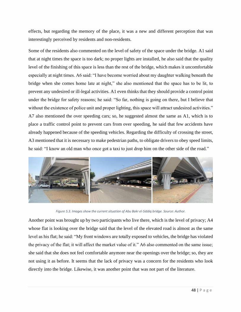
48 | P a g e
effects, but regarding the memory of the place, it was a new and different perception that was
interestingly perceived by residents and non-residents.
Some of the residents also commented on the level of safety of the space under the bridge. A1 said
that at night times the space is too dark; no proper lights are installed, he also said that the quality
level of the finishing of this space is less than the rest of the bridge, which makes it uncomfortable
especially at night times. A6 said: “I have become worried about my daughter walking beneath the
bridge when she comes home late at night,” she also mentioned that the space has to be lit, to
prevent any undesired or ill-legal activities. A1 even thinks that they should provide a control point
under the bridge for safety reasons; he said: “So far, nothing is going on there, but I believe that
without the existence of police unit and proper lighting, this space will attract undesired activities.”
A7 also mentioned the over speeding cars; so, he suggested almost the same as A1, which is to
place a traffic control point to prevent cars from over speeding, he said that few accidents have
already happened because of the speeding vehicles. Regarding the difficulty of crossing the street,
A3 mentioned that it is necessary to make pedestrian paths, to obligate drivers to obey speed limits,
he said: “I know an old man who once got a taxi to just drop him on the other side of the road.”
Figure 5.3. Images show the current situation of Abu Bakr el-Siddiq bridge. Source: Author.
Another point was brought up by two participants who live there, which is the level of privacy; A4
whose flat is looking over the bridge said that the level of the elevated road is almost as the same
level as his flat; he said: “My front windows are totally exposed to vehicles, the bridge has violated
the privacy of the flat; it will affect the market value of it.” A6 also commented on the same issue;
she said that she does not feel comfortable anymore near the openings over the bridge; so, they are
not using it as before. It seems that the lack of privacy was a concern for the residents who look
directly into the bridge. Likewise, it was another point that was not part of the literature.

49 | P a g e
The questions of the first interview aimed to know how locals perceive the bridge and what their
feedbacks are. Some individual feedback was pointed out by few participants; for example, A9
mentioned that the neighborhood is less walkable than before; she said: “I used to jog occasionally
with my dog, but now, I cannot do it anymore.”
Eventually, the participants were asked about the potential usage of the space underneath the
bridge, and the activities can be suitable there. Mostly, they suggested allowing some commercial
connection; A2 said that allowing businesses here will attract people to use the space; he said that
as long as the space is providing a service, people will use it. On the other hand, A8 suggested that
the city should offer few plots for only small and startup businesses to provide more opportunities
to unemployed citizens. He also stated that the process of choosing these businesses should be
legitimate and well-controlled to avoid any informal activities. In the like manner, A3 believes that
commercial purposes should be under the city's selective surveillance to avoid undesirable or
illegal activities. A6 and A4 said that any commercial activity is much better than leaving the space
useless. On the other hand, A1 (a shop owner) was concerned about the potential commercial use,
he agreed on the idea in general, but he said that it depends on the activity itself. He stated: “If
these businesses provide the same service I provide, it will negatively affect mine.” he added,
generally, the more existed people, the better for his business flow.
Finally, after all the participants gave their feedback, one last issue was brought up and indirectly
mentioned, which is the public participation in the development plan. Only A8 has mentioned, as
a member of the district committee, that he is not satisfied with not involving the residents in the
project. He said, certainly, the bridges will help to facilitate the traffic in the district. However,
residents should be taken into consideration, especially with the massive scale of the development.
This issue was deducted from all the participants. Many of them said that they knew about the
project only from the banners placed in the construction sites, which confirms the absence of public
participation.
5.2 Second interview
After collecting the segments of the first phase of the qualitative process and putting our hands on
the key points of the interviews, moving to the second interview, the idea is to integrate what we
tackled in the findings with the literature and the international examples. As a beginning, proposing
50 | P a g e
a set of different alternatives deducted from a new batch of participants to get the potential uses of
the space based on a satisfaction scale from 1 to 5 (see table 6.1.) Also, asking a small
questionnaire before and after the proposed alternatives to scale the impact of the design solutions.
The responses of the second interview are classified into two parts, before and after the design
intervention.
5.2.1 Before seeing the proposals
The second sample of participants was firstly asked to scale their overall satisfaction of the bridge,
and the possible uses for the space (see tables 4.2, 4.3), the 12 participants acknowledged that the
bridge has significantly facilitated the traffic; however, the average of their satisfaction level was
3.16/5. Mostly all the participants justified their score by mentioning the same common complaints
from the first interview. B2, a 27 years old resident gave it 1.5/5, she justified that a tunnel would
be much more efficient, and wouldn’t result in such undesirable major impacts caused by the
bridge.
Since the recreational use of the spaces underneath the bridges is generally odd to exist in Egypt,
few questions were asked to check the initial impressions of the intervention. These questions aim
to measure the participants’ feedback about the idea of developing the space underneath Abu Bakr
el-Siddiq Bridge; they are concentrating on the potential uses of the space.
The most highlighted concern of all the participants was not to privatize all the space and keep it
to the public. Mostly, all of them did not mind the possibility of allowing small businesses; yet,
controlled by the City. B5, who is a 38 years old resident, suggested dividing the area to plots
allowed to be rented as usufruct from the city's government. He also added that these businesses
have to be small because there is already enough commercial activity in the neighborhood. On the
other hand, few believe that it should be partly privatized. B4 preferred the privatization as she
believes that the quality of the private service is much better than the public one.
In the third chapter, we discussed the proposed criteria from PPS. As mentioned before, it was
based on 4 Main headings: (1) Access and Linkages, (2) Comfort and Image, (3) Uses and
Activities, (4) Sociability. Similarly, participants were asked twice, before and after seeing the
proposals, to rate each point on a scale from 1 to 5, to measure the difference, and to put the theory
to test. As shown (figure 5.4), participants gave the lowest rate to the sociability factor (0.42/5) as

51 | P a g e
they believed that the space is not attractive for any social interaction. The highest given score is
the uses and activities (2.37/5), most of them claimed that the U-turns under the bridge are often
used for informal microbuses stop, B9 said that he uses it for his transportation routine.
Comfort and Image score was relatively low (0.91/5). Basically, they mentioned again that the
bridge had negatively affected the whole image of the district, B6 said: “the structure is too
dominate which makes it hard to feel comfortable beneath it,” few mentioned that they are not
satisfied with the design of the columns. B8 stated: “the design of the columns looks odd and does
not go along with the style of the neighborhood.”
Lastly, Access and linkages had the second-lowest score (0.53/5). The participants repeated one
of the complaints of the first survey which is the difficulty of crossing the street due to the over
speeding cars; almost all of them highlighted the danger of the space because of the speed.
0
0.5
1
1.5
2
2.5
Access and Linkages Comfort and Image Uses and Activities Sociability
Figure 5.4. Based on the ranked questionnaire (1 to 5, as 5 is the highest), this Chart shows the results of the average score given by the 12 participants. Source, Author

52 | P a g e
5.2.2 After seeing the proposals
The proposals were presented in the form of images, as we discussed in the third chapter, then
participants were giving their feedback on each idea; additionally, few activities were inspired by
the previous examples and impressions of the first interview (see table 6.1.). The Majority of the
participants complained about the lack of lighting under the bridge; accordingly, two options were
proposed as shown (figure, 5.4); option A, the Underpass Art Park project in Washington D.C; it
is polycarbonate rods suspended from the elevated railway which is called “Rain”. Option B is in
Wabash Avenue, Chicago. It is 3000 colored LED light panels placed on the elevated highway.
Option B scored 4.32/5, while option A was 3.88/5; some justified that the polycarbonate rods
from option A might not be suitable for the bridge is not very high.
The next options were concerning sports usage; surprisingly, most of the participants preferred a
well-equipped outdoor gym over a football court. B6 and B11 mentioned that they are concerned
about the potential noise of the football court since it is a residential area, while some claimed that
there are already football courts nearby, and there is no necessity for more. For that reason, option
A (football court), scored at 1.27/5 while option B (outdoor gym) scored 3.92.
Turning to the seating in the space; according to the literature, movable chairs were recommended
from some studies. However, when participants were offered the choice between movable and
fixed seats, they preferred fixed seats with score 4.37/5, while they gave the movable chairs 2.34/5.
Mostly, they said that it could be stolen or easily broken.
As the pillars of the bridges were a common design tool in the examples, two options were
proposed for the treatment. Option A was a painting that stimulates the history of the district, and
option B was vegetation cover. All of the participants commented positively on option B rating
4.75/5, in the same way, option A scored 3.5/5. Also, most of them showed interest in option A;
they said that this could be a separate activity that takes place there.
Turning to the mentioned point of privatization of the space, Option A was establishing startup
businesses by youth like drink and food vendors. All the participants were satisfied and rated it at
5/5, and all the residents said that these projects already exist, mostly, in parking lots of the
neighborhood; allowing them to sell there would be a successful move. Additionally, many of
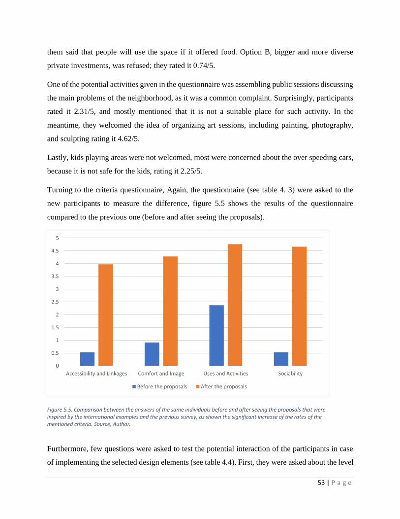
53 | P a g e
them said that people will use the space if it offered food. Option B, bigger and more diverse
private investments, was refused; they rated it 0.74/5.
One of the potential activities given in the questionnaire was assembling public sessions discussing
the main problems of the neighborhood, as it was a common complaint. Surprisingly, participants
rated it 2.31/5, and mostly mentioned that it is not a suitable place for such activity. In the
meantime, they welcomed the idea of organizing art sessions, including painting, photography,
and sculpting rating it 4.62/5.
Lastly, kids playing areas were not welcomed, most were concerned about the over speeding cars,
because it is not safe for the kids, rating it 2.25/5.
Turning to the criteria questionnaire, Again, the questionnaire (see table 4. 3) were asked to the
new participants to measure the difference, figure 5.5 shows the results of the questionnaire
compared to the previous one (before and after seeing the proposals).
Furthermore, few questions were asked to test the potential interaction of the participants in case
of implementing the selected design elements (see table 4.4). First, they were asked about the level
0
0.5
1
1.5
2
2.5
3
3.5
4
4.5
5
Accessibility and Linkages Comfort and Image Uses and Activities Sociability
Before the proposals After the proposals
Figure 5.5. Comparison between the answers of the same individuals before and after seeing the proposals that were inspired by the international examples and the previous survey, as shown the significant increase of the rates of the mentioned criteria. Source, Author.
54 | P a g e
of their interaction with the selected activities. Most confirmed that they will visit the space
regularly after the proposed implications, they mentioned that they would visit it once or twice a
week and they would participate in the activities that would take place. Additionally, the majority
prefer to visit it with their friends and families over being alone. Moreover, the participants
believed that maintaining the space should not be limited to the City; residents also should
participate in that matter. Eventually, they rated the bridge generally (in case of implementing the
project) at 4.33/5.
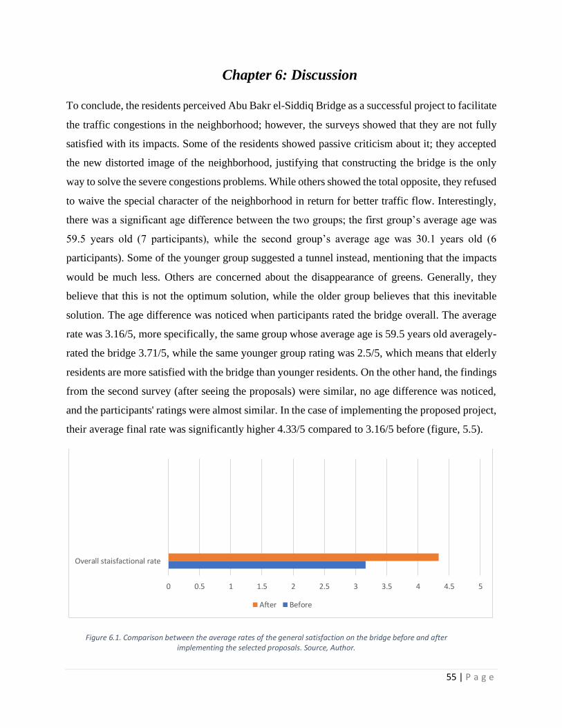
55 | P a g e
Chapter 6: Discussion
To conclude, the residents perceived Abu Bakr el-Siddiq Bridge as a successful project to facilitate
the traffic congestions in the neighborhood; however, the surveys showed that they are not fully
satisfied with its impacts. Some of the residents showed passive criticism about it; they accepted
the new distorted image of the neighborhood, justifying that constructing the bridge is the only
way to solve the severe congestions problems. While others showed the total opposite, they refused
to waive the special character of the neighborhood in return for better traffic flow. Interestingly,
there was a significant age difference between the two groups; the first group’s average age was
59.5 years old (7 participants), while the second group’s average age was 30.1 years old (6
participants). Some of the younger group suggested a tunnel instead, mentioning that the impacts
would be much less. Others are concerned about the disappearance of greens. Generally, they
believe that this is not the optimum solution, while the older group believes that this inevitable
solution. The age difference was noticed when participants rated the bridge overall. The average
rate was 3.16/5, more specifically, the same group whose average age is 59.5 years old averagely-
rated the bridge 3.71/5, while the same younger group rating was 2.5/5, which means that elderly
residents are more satisfied with the bridge than younger residents. On the other hand, the findings
from the second survey (after seeing the proposals) were similar, no age difference was noticed,
and the participants' ratings were almost similar. In the case of implementing the proposed project,
their average final rate was significantly higher 4.33/5 compared to 3.16/5 before (figure, 5.5).
0 0.5 1 1.5 2 2.5 3 3.5 4 4.5 5
Overall staisfactional rate
After Before
Figure 6.1. Comparison between the average rates of the general satisfaction on the bridge before and after implementing the selected proposals. Source, Author.

56 | P a g e
As we found and as shown in figure (5.6), the most controversial impact is the loss of the trees, all
the participants form both interviews had expressed their discontent from it. The residents
complained about cutting and uprooting the trees at the early stages of the construction; however,
the authorities did not give a sufficient alternative. Many residents and community associations
demanded to stop the construction, but it was already too late (Bakry, 2019). Afterward, the
responsible authority of the project AFEA had announced that these trees had been removed in a
way that will allow them to be replanted elsewhere, which is not a solution for the damaged
neighborhood. Additionally, after the rising discontent of most residents, the minister of EEAA
has announced that the district will be flourished with green covers and trees (Bakry, 2019), but
the streets and bridges are too dominant to accommodate any of her claims.
With such a major development of replacing the greenery in a historical district like Masr EL-
Gedida with 5 Bridges (as a first phase), there was no mention of interference to form the EEAA,
which means that this major development has not come across an efficient environmental impact
assessment process. Turning to individual feedback about the impact on weather, removing 550
trees from Abu Bakr el-Siddiq Street, and replacing it with asphalt will slightly increase the
temperature; this impact is a reasonable result of the absence of any environmental pre-assessment
plan.
Figure 6.2. The lower images show the green cover in the neighborhood before the construction of the bridge while the upper images show the, the significant degradation of green areas after the construction. Source: rassd.com

57 | P a g e
Due to its history and urban value, Masr el-Gedida is registered in NOUH as a heritage district;
however, the organization was not involved in the project. As a result, most of the participants
expressed that the neighborhood has visually changed because of these structures. Consequently,
the collective memory had been damaged; as mentioned, the district is more than 100 years old;
unfortunately, these structures have hidden a major part of its history and distorted its special
image. Unexpectedly, as far as we know, no previous research has investigated this impact, in
particular, the prior researches had not covered the impacts of elevated highways on the collective
memory of neighborhoods, but, it was a common concern in this case.
Regarding the literature review, it was common that noise is one of the main impacts of elevated
highways. Unexpectedly, it was the total opposite in our case; some participants mentioned that
currently, the street is quieter than before, previously, the congestions of vehicles were causing
much noise, especially in rush hours, and since the bridge facilitated the traffic, the noise was
significantly reduced. In fact, the interviewer mentioned that certainly, the moving cars over the
bridge are creating noise; however, it seems that the noise currently is much less than before.
The level of safety was a concern for some residents. As shown previously, safety is one of the
crucial factors that determine the attraction of space. The safer space is, the more likely to be
visited. Undesired spaces attract undesired people (Whyte, 1980), which is a common problem,
particularly in such spaces as we saw in several examples; yet, the solution was as common as the
problem, which is proper lighting. Some participants stressed on lighting the space; lighting will
give passers better sight on the space, and much fewer chances for undesired activities.
Another impact tackled for the first time is the privacy violation. It was not mentioned in the
literature; yet, the only two participants that complained about it are living almost on the same
level of the bridge, which means that all the residents surrounding the bridge on the same level are
most likely to have the same complaint.
Regarding the potential activities for the space, most of the participants suggested commercial use,
which is similar to most of the examples and the literature; however, they asserted to keep it to the
minimum, only small businesses due to the existing dominance of commercial use.
Many of the participants indirectly mentioned that the constructions started all of a sudden; no one
had prior knowledge about it, which is the usual situation in Egypt anyway. Almost all the

58 | P a g e
developments in Egypt do not include the public in the process, as we found out that even the
community associations did not take part in the mentioned project. That mainly explains the lack
of public spaces and parks all over the country. Recently, the regime is executing a great amount
of national infrastructural projects for the common good, which is reasonable for a developing
country; however, none of these projects include the public. That dysfunctional process is deprived
of the most important element, public participation.
Turning to the proposals’ questionnaire, in the table (6.1), these are the pictures that had been
shown to the participants. The selected interventions are inspired by worldwide examples. The
selected ideas and activities depend on the first interview and the general relevance of each activity
to the citizens. Each option in the table was rated individually, and all the ratings were averagely
calculated. Regarding the lighting, participants preferred option A over B with rate 4.32 to 3.88;
respectively, they were concerned about the length of the polycarbonate rods because the underside
of Abu Bakr el-Siddiq Bridge is not high enough (roughly 10 M).
Despite the popularity of Football in Egypt, they mostly expressed their concern about the possible
noise of the field users considering it is a residential neighborhood. Meanwhile, they agreed on the
idea of the outdoor public gymnastics; they rated it at 3.92/5. In the literature, we came across the
movable chairs as more preferred elements over fixed; however, they rated the fixed benches 4.23,
while they were concerned about that the movable chairs might be stolen or vandalized.
Expectedly, regarding the treatment of the columns, all the participants recommended the
vegetation cover, while the most suggested that the drawings could be done separately on
occasional events. Eventually, they liked the possibility of musical and artistic events, especially
if the art reflects the history of the district. Unexpectedly, they rated the public sessions for the
neighborhood’s problems at 2.31/5; they did not believe that it is the right place for such activity.

59 | P a g e
Intervention Option A Score/5 Option B Score/5
Lighting
The Wabash Avenue, colored LED placed on the underside of the elevated structure.
Source: http://www.thewabashlights.com/what
4.32
Suspended polycarbonate rods. Source: http://thewash.org/2018/11/27/nomas-
underpass-artwork-a-scenic-route-to-gentrification/
3.88
Sport
activities
Football field under beneath the Westway in London. Photographer: Gisela Erlacher
1.27
An outdoor gymnastics in Shanghai. Photographer: Gisela Erlacher
3.92
Seatings
design
Movable chairs in a public space beneath a bridge in Chongqing, China. Photographer:
Gisela Erlacher
2.34
Fixed seatings. Public space under a bridge in Boston. Source: The Underground at Ink Block.
https://undergroundinkblock.com/
4.27

60 | P a g e
Columns
treatment
Drawings on the bridge’s columns. Falomo Bridge, Nigeria. Source:
https://commons.wikimedia.org/wiki/File:Falomo_Underbridge.jpg
3.5
Vertical vegetation cover. Photo from New Mexico. Source: https://sitquije.com/estilo-
vida/jardines-colgantes-periferico
4.75
Type of
commercial
activity
Small or Startup businesses. Few shop under A8 Highway in Netherlands. Source:
https://www.architonic.com/en/project/nl-architects-a8erna/5100103
4.76
Major commercial investments. Photo credit: Tere Garcia. Source:
https://www.smartcitiesdive.com/ex/sustainablecitiescollective/transforming-between-spaces-
benefit-urban-communities/414286/
0.74
Type of
public events
Public sessions for residents to discuss the neighborhood problems (under the Bentway,
Canada). Source: https://www.thebentway.ca/event/sunday-
social-july-14/
2.31
Art activities reflects the history of the district like drawing, sculpting, photography, etc. Source: San
Diego, USA. https://medium.californiasun.co/chicano-park-
san-diego-5506a203c527
4.62
Table 6.1. The table shows the inspired selected interventions form examples worldwide. The selected ideas and activities are based on the first interview and the relevance of each activity to the citizens in general. Each option in the table has been rated individually, and all the ratings had been averagely calculated. Source: Author.
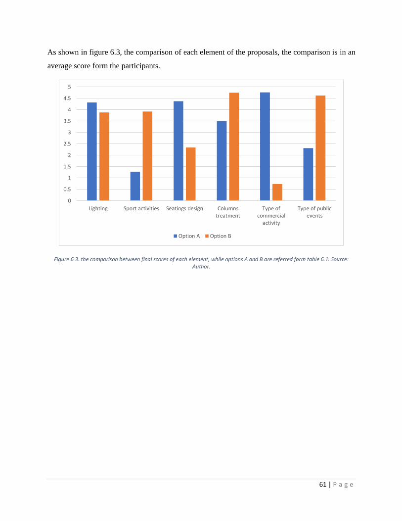
61 | P a g e
As shown in figure 6.3, the comparison of each element of the proposals, the comparison is in an
average score form the participants.
Figure 6.3. the comparison between final scores of each element, while options A and B are referred form table 6.1. Source: Author.
0
0.5
1
1.5
2
2.5
3
3.5
4
4.5
5
Lighting Sport activities Seatings design Columnstreatment
Type ofcommercial
activity
Type of publicevents
Option A Option B
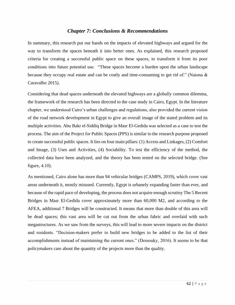
62 | P a g e
Chapter 7: Conclusions & Recommendations
In summary, this research put our hands on the impacts of elevated highways and argued for the
way to transform the spaces beneath it into better ones. As explained, this research proposed
criteria for creating a successful public space on these spaces, to transform it from its poor
conditions into future potential use. “These spaces become a burden upon the urban landscape
because they occupy real estate and can be costly and time-consuming to get rid of.” (Naiona &
Caravalho 2015).
Considering that dead spaces underneath the elevated highways are a globally common dilemma,
the framework of the research has been directed to the case study in Cairo, Egypt. In the literature
chapter, we understood Cairo’s urban challenges and regulations, also provided the current vision
of the road network development in Egypt to give an overall image of the stated problem and its
multiple activities. Abu Bakr el-Siddiq Bridge in Masr El-Gedida was selected as a case to test the
process. The aim of the Project for Public Spaces (PPS) is similar to the research purpose proposed
to create successful public spaces. It lies on four main pillars: (1) Access and Linkages, (2) Comfort
and Image, (3) Uses and Activities, (4) Sociability. To test the efficiency of the method, the
collected data have been analyzed, and the theory has been tested on the selected bridge. (See
figure, 4.10).
As mentioned, Cairo alone has more than 94 vehicular bridges (CAMPS, 2019), which cover vast
areas underneath it, mostly misused. Currently, Egypt is urbanely expanding faster than ever, and
because of the rapid pace of developing, the process does not acquire enough scrutiny The 5 Recent
Bridges in Masr El-Gedida cover approximately more than 60,000 M2, and according to the
AFEA, additional 7 Bridges will be constructed. It means that more than double of this area will
be dead spaces; this vast area will be cut out from the urban fabric and overlaid with such
megastructures. As we saw from the surveys, this will lead to more severe impacts on the district
and residents. “Decision-makers prefer to build new bridges to be added to the list of their
accomplishments instead of maintaining the current ones.” (Dessouky, 2016). It seems to be that
policymakers care about the quantity of the projects more than the quality.

63 | P a g e
“The development of this kind infrastructure would primarily increase the accessibility and
mobility of urban dwellers but at the same time become barriers that separate district or
neighborhood.” (Saouma, 2008).
This landscape has been bifurcated by these elevated highways, creating purely functional spaces
above and largely ignored spaces below. They have driven industries and jobs away from the urban
center and have isolated neighborhoods and divided communities. (Biesecker, 2015)
“The flyovers jump over some of the close-knit and most frenetic neighborhoods of the city. It is
a pandemonium of traffic above and a bedlam of traffic below All amenities being aimed at the
automated vehicles, the pedestrians are tacitly overlooked” (Roushan, 2013).
In figure 7.1, the final proposed design for the space underneath Abu Bakr el-Siddiq bridge. Based
on the participants’ preferences, the interpretation is to provide the residents a possible alternative
to re-raise the value of their neighborhood.
Figure 7.1. The final design intervention based on the participants contribution and the discussions. Source: Author

64 | P a g e
7.1 Recommendations
Undoubtedly, it appears that Egypt is outdated in terms of planning; after reaching the end in the
long process of researching, carrying out the fieldwork and surveys, a significant amount of
shortages came across. Firstly, regarding the policymakers, there are crucial gaps in the planning
process in Cairo, the public should be engaged since they are the first line of beneficiaries.
Secondly, it was clear that the project did not go through environmental impact assessment, as it
appears that pre-environmental assessment analysis in Egypt is usually overlooked.
7.2 Future research
In a qualitative method, the research tried to cover the impacts of the bridge; however, quantitative
research in larger samples should be done. Moreover, environmental analysis should be
implemented on bridges; a significant amount of discussions with the participants stressed on that
issue. Also, one of the participants mentioned that the value of his property has decreased because
the bridge violated its privacy. Accordingly, socio-economic research should cover this matter.
7.3 Limitations
There are few obstacles to the completion of the empirical work. First, due to the international
situation of COVID-19, there were not many pedestrians to interview; they were not even
welcoming the idea of being interviewed. Additionally, the authorities applied curfew situation
across the country, coinciding with the time of the empirical work, which made it harder to cover
a bigger batch of locals. Second, part of the interviewees is supposed to be policymakers,
stakeholders, and urban activists; yet unfortunately, that was not applicable in time because of
time limitation and being abroad. Eventually, since the construction of the selected bridge has
ended on January 2020, there were no reliable materials or studies found about it.

65 | P a g e
Bibliography
• Abd-Alla, S. Ferro, P. (2017). Greater Cairo and how the transport system is coping with
rapid expansion. [online] Available at: https://www.codatu.org/actualites/greater-cairo-
and-how-the-transport-system-is-coping-with-rapid-expansion/
• Alhowaily, A., (2015). "Sustainable Urbanization in the Egyptian Desert, the Case Study
Heliopolis – Investigating the Town Growth between 1905 and 1961 in Comparison to
the New Urban Communities’ Development within GCR." Unpublished M.Sc.
dissertation. Department of Urban Development, Technical University of Berlin.
• Appatova, A.S., Ryan, P.H., Lemasters, G.K., Grinshpun, S.A. (2008). "Proximal
exposure of public schools and students to major roadways: a nationwide US survey",
Journal of Environmental Planning and Management, Vol.51 No. 5, pp. 631-646
• Baaj, M. El-fadel, M. Shazbak, S. Saliby, E. (2001). “Modelling noise at elevated
highways in urban areas: a practical application.” Journal of Urban Planning and
Development.
• Biesecker, C. (2015). “Designing urban under highway spaces.” University of Georgia
Archives, Georgia.
• Recinos, E. (2016). Boston’s New 40,000-Square-Foot Skate Park Is a Paradise. [online]
vice.com. Available at: https://www.vice.com/en_us/article/53wq4k/bostons-new-skate-
park-is-a-paradise.
• Central Agency for Public Mobilization and Statistics. https://www.capmas.gov.eg/
• Certeau, M. (1988). The Practice of Everyday Life. Berkeley and Los Angeles, California:
University of California Press.
• Chicano Park. https://www.sandiego.org/articles/parks-gardens/chicano-park.aspx
• Chohan, A. (2014). Infrastructure Development and Implication of Negative Spaces in
City Centers. Ajman University, Ajman UAE. DOI: 10.5176/2251-3701_3.1.110
• Dessouky, N. (2017), Rethinking Cairo’s elevated urban highways: Scoping impacts and
potentials, The American University in Cairo, Digital Archive and Research Repository,
New Cairo, Egypt.
• El Sharnoubi, O. (2014), 700 bridges in Egypt close to collapse: Transport official
http://english.ahram.org.eg/News/116591.aspx

66 | P a g e
• Ezzat, A. Ibrahim, A. (2016). Goodbye, Heliopolis Metro. Watani. [online] Available at:
http://en.wataninet.com/culture/heritage/good-bye-heliopolis-metro/15584/.
• Francis, C., & Marcus, C. (1998), People Places: Design Guidelines for Urban Open
Space (2nd Edition). New York City: Van Nostrand Reinhold.
• General Authority for Roads, Bridges and Land Transport (GARBLT), (2015). The
Project for Improvement of the Bridge Management Capacity.
• General Organization of Physical Planning, (2012). Greater Cairo Urban Development
Strategy: Part I: Future Vision and Strategic Directions. Cairo.
• Heliopolis Transformation. (2016). This research is a part of fourth year students work in
Urban Planning Course. Ain Shams University, Cairo, Egypt.
• Ilbert, R. (1981). Heliopolis Le Caire 1905 - 1922 Genese D'une Ville. Paris: Editions Du
Centre National De La Recherche Scientifique.
• Miroff, N. (2013). In Mexico City, planners turn vacant space under freeways into places
to work, dine, play. The Washington Post. [online] Available at:
https://www.washingtonpost.com/world/the_americas/in-mexico-city-planners-turn-
vacant-space-under-freeways-into-places-to-work-dine-play/2013/05/28/ade28c26-c32e-
11e2-9642-a56177f1cdf7_story.html.
• Kurniawati, W. (2011). Public Space for Marginal People. Procedia Social and
Behavioral Sciences 36, 476-484.
• Lak, A. Ramezani, M. Aghamolaei, R. (2019). Reviving the lost spaces under urban
highways and bridges: an empirical study, Journal of Place Management and
Development 12(4).
• Lavrinec, J. (2011). Revitalization of Public Space: from "Non-places" to Creative
Playgrounds. Vilnius Gediminas Technical University. DOI: 10.3846/coactivity.2011.16
• Maki, F. (1960). Investigations in Collective Form. The School of Architecture,
Washington University.
• Mallonee, L. (2016). People Sure Get Creative with the Space Under Highway
Overpasses. [online] Available at: https://www.wired.com/2016/04/gisela-erlacherthe-
skies-of-concrete-unique-urban-spaces-underneath-the-worlds-highways/

67 | P a g e
• Malterre-Barthes, C. (2011). The Highway’s Shadow: Zurich Hardbrücke. In T. Hauck,
R. Keller, & V. Kleinkort (Eds.), Infrastructural Urbanism Addressing the In-between
(pp. 93–107). Berlin: DOM Publishers.
• Jaffe, E. (2018). The future of public space is now arriving — beneath a busy highway.
Medium. [online] Available at: https://medium.com/sidewalk-talk/the-future-of-public-
space-is-now-arriving-beneath-a-busy-highway-35b1379d6fa
• Jenkins, L. (2018). Mexico City’s vertical gardens: seeds of change or cynical
greenwashing? The Guardian. [online] Available at:
https://www.theguardian.com/cities/2018/oct/30/mexico-city-via-verde-vertical-gardens-
pollution-climate-change.
• McPhate, M (2018). San Diego’s Chicano Park, a Treasure and a Battleground.”
Medium. [online] Available at: https://medium.californiasun.co/chicano-park-san-diego-
5506a203c527
• Mohamed, A. A., Van Nes, A., Salheen, M. A., Khalifa, M. A., & Hamhaber, J. (2014).
Understanding urban segregation in Cairo: The social and spatial logic of a fragmented
city. Abu Dhabi, (UAE), 14-16 December 2014. CIB Middle East and North Africa
Research Network.
• Mounir, C. (2019). Trees razed for bridge construction in Heliopolis. Egypt Independent
[online] Available at: https://www.egyptindependent.com/trees-razed-for-bridge-
construction-in-heliopolis/
• Naiona, D. Cravalho, J. (2015). Revitalization of “Dead Space” Through the Use of
Interactive Intervention. University of Hawai.
• Nakamura, K. (2015). The spatial relationship between pedestrian flows and street
characteristics around multiple destinations. Faculty of Engineering, Kagawa University,
Japan.
• Paley Park. https://shuhang.bitcron.com/post/case-base/paley-park
• Passion Égyptienne (Egyptian Passion). http://www.passion-
egyptienne.fr/annees%201900%20Heliopolis.htm

68 | P a g e
• Roushan, N. (2013). In the Shadow: A Study for Utilization of Space under Flyovers in
Dhaka. Department of Architecture. BRAC University
• Samuel, P., Poole, R.W. (2006), Innovative Roadway Design: Making Highways More
Likable. Reason Foundation. Los Angeles, California, United States.
• Saouma, R. (2008). When a city embraces its paradoxes: Exploring the potential of
public spaces under elevated highways: A case study in Bourj Hammoud, Beirut.
Wageningen University & Research, Wageningen, The Netherlands.
• Savvides, A. (2004). Regenerating Urban Space: Putting Highway Airspace to Work.
Journal of Urban Design. 9(January), 47–71. DOI:
https://doi.org/10.1080/1357480042000187703
• Shred it Under the Mill Street at the Gardens Skatepark. [online] Available at:
https://www.capetownmagazine.com/gardens-skatepark
• Stansfeld, S. A., Matheson, M. P. (2003). Noise pollution: non-auditory effects on health.
British Medical Bulletin, 68(1), 243-257.
• Sutton, K., & Fahmi, W. (2001). Cairo’s urban growth and strategic master plans in the
light of Egypt’s 1996 population census results. Cities, 18(3), 135–149.
• Trancik, R. (1986). Finding Lost Space: Theories of Urban Design. New York: Van
Nostrand Reinhold Company Inc.
• The Bentway: Harnessing the Void Underneath the Infrastructure
https://urbannext.net/the-bentway/
• The Wablash Lights. http://www.thewabashlights.com/what
• Turner, T., 2003. Landscape Planning and Environmental Impact Design. London:
Routledge, p.312.
69 | P a g e
• Wekerle, G. R., & Whitzman, C. (1995). Safe cities: guidelines for planning, design, and
management. New York: Van Nostrand Reinhold.
• Yıldız, T. (2016). Prevention of Noise Pollution caused by Highways in Settlement Areas
via a Noise Insulation System. J Pollut Eff Cont 5: 178. DOI: 10.4172/2375-
4397.1000178
• Qamaruz-Zaman, N., Samadi, Z., & Azhari, N. F. N. (2016). Under the flyovers of Kuala
Lumpur: User centred activities in leftover spaces. Journal of Asian Behaviour Studies.
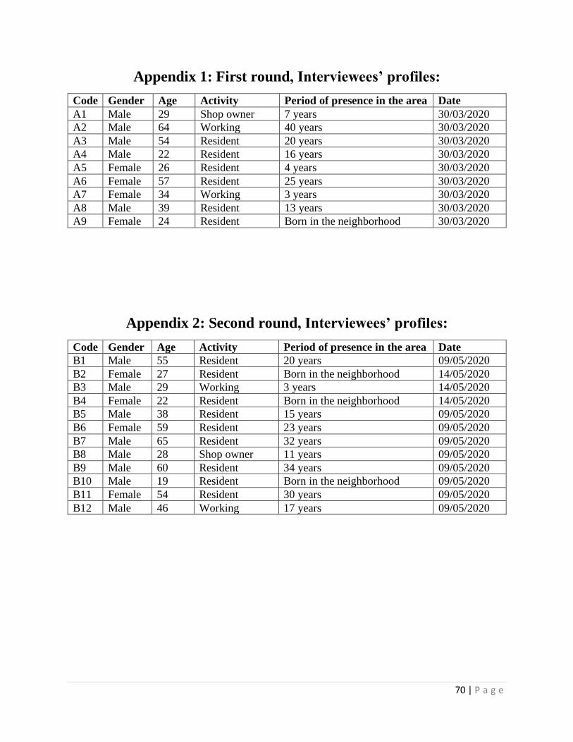
70 | P a g e
Appendix 1: First round, Interviewees’ profiles:
Code Gender Age Activity Period of presence in the area Date
A1 Male 29 Shop owner 7 years 30/03/2020
A2 Male 64 Working 40 years 30/03/2020
A3 Male 54 Resident 20 years 30/03/2020
A4 Male 22 Resident 16 years 30/03/2020
A5 Female 26 Resident 4 years 30/03/2020
A6 Female 57 Resident 25 years 30/03/2020
A7 Female 34 Working 3 years 30/03/2020
A8 Male 39 Resident 13 years 30/03/2020
A9 Female 24 Resident Born in the neighborhood 30/03/2020
Appendix 2: Second round, Interviewees’ profiles:
Code Gender Age Activity Period of presence in the area Date
B1 Male 55 Resident 20 years 09/05/2020
B2 Female 27 Resident Born in the neighborhood 14/05/2020
B3 Male 29 Working 3 years 14/05/2020
B4 Female 22 Resident Born in the neighborhood 14/05/2020
B5 Male 38 Resident 15 years 09/05/2020
B6 Female 59 Resident 23 years 09/05/2020
B7 Male 65 Resident 32 years 09/05/2020
B8 Male 28 Shop owner 11 years 09/05/2020
B9 Male 60 Resident 34 years 09/05/2020
B10 Male 19 Resident Born in the neighborhood 09/05/2020
B11 Female 54 Resident 30 years 09/05/2020
B12 Male 46 Working 17 years 09/05/2020

71 | P a g e
NON-EXCLUSIVE LICENCE FOR DEPOSITING THE FINAL THESIS AND
OPENING IT FOR THE PUBLIC AND THE SUPERVISOR’S CONFIRMATION FOR
ALLOWING THE THESIS FOR THE DEFENCE
Hereby I, Mohamed Elbih.
(16/05/92)
1. Grant Eesti Maaülikool, the Estonian University of Life Sciences, a free-of-charge non-
exclusive license to store the final thesis titled Restoring Dead spaces Underneath Elevated
Highways to the Public Realm: A Case Study in Cairo, Egypt. Supervised by Prof. Simon Bell,
PhD. For:
1.1. preservation.
1.2. depositing a digital copy of the thesis in the archive of DSpace and
1.3. opening it for the public on the Web until the validity of the term of protection of copyright.
2. I am aware that the author retains the same rights as listed in point 1.
3. I confirm that by being issued the CC license no rights deriving from the Personal Data
Protection Act and the Intellectual Property Rights Act have been infringed.
To err is human, to forgive; divine.
Any questions regarding the research or Copy Rights, please contact: [email protected]
Author of the final thesis _____________________________
Signature
In Tartu, 01.06.2020
_________________________________________________________________
The core supervisor’s approval for the final thesis to be allowed for defense
This is to confirm that the final thesis is allowed for defense.
………………………………………………… ………………………………..
Supervisor’s name and signature Date