resources and ecosystems sustainability, tourist ... · 1 resources and ecosystems sustainability,...
TRANSCRIPT

1
Resources and Ecosystems Sustainability, Tourist Opportunities, and Revived Economies of the Gulf Coast States
Act (RESTORE Act) Initial Funded Priorities List
The Gulf Coast Ecosystem Restoration Council (Council) hereby issues a final list of projects and programs (activities) to be funded pursuant to the RESTORE Act. This list of activities is called the Initial Funded Priorities List (FPL). This FPL will use currently available funds for planning and on-the-ground restoration activities in key watersheds across the Gulf. It also includes monitoring, community investments, and other Gulf-wide activities designed to lay a foundation for comprehensive restoration and effective use of future funding opportunities. These approved activities build upon past and ongoing restoration work and, where possible, leverage other funding sources. The following executive summary provides an overview of this FPL. Further detail can be found in the main document and appendices, including the Council’s responses to comments received from the public review of the draft FPL.
Executive Summary
The Gulf Coast region is vital to our nation and our economy, providing valuable energy resources, abundant seafood, extraordinary beaches and recreational activities, and a rich natural and cultural heritage. Its waters and coasts are home to one of the most diverse natural environments in the world – including over 15,000 species of sea life and millions of migratory birds. The Gulf has endured catastrophic events over the years, including major hurricanes such as Katrina, Rita, Gustav and Ike in the last 10 years alone. The region has also experienced the loss of critical wetland habitats, erosion of barrier islands, imperiled fisheries, water quality degradation and significant coastal land loss. More recently, the Deepwater Horizon oil spill significantly affected the health of the region’s ecosystem. As a result of the oil spill, the Council has been given the great responsibility of helping to address ecosystem challenges across the Gulf.
The Deepwater Horizon oil spill led to passage of the RESTORE Act (Act). The Act dedicates 80 percent of all Clean Water Act administrative and civil penalties related to the Deepwater Horizon oil spill to the Gulf Coast Restoration Trust Fund (Trust Fund). The Act also created the Council, an independent Federal entity comprised of the five Gulf Coast states and six Federal agencies. The Council will administer a portion of the Trust Fund known as the Council-Selected Restoration Component to “undertake projects and programs, using the best available science, which would restore and protect the natural resources, ecosystems, fisheries, marine and wildlife habitats, beaches, coastal wetlands, and economy of the Gulf Coast.” Pursuant to the Act, the Council approved an Initial Comprehensive Plan (Initial Plan) in August 2013i, ii that outlines an overarching vision for Gulf restoration and includes the following five goals:

2
(3) Replenish and Protect Living Coastal and Marine Resources
(4) Enhance Community Resilience
(5) Restore and Revitalize the Gulf Economy
As part of the Initial Plan, on August 13, 2015 the Council published, for public and Tribal review and comment over a 45-day period, a draft FPL proposing activities that the Council intended to prioritize for funding. During this time, the Council held public meetings in Alabama, Florida, Louisiana, Mississippi and Texas (Gulf States or States), and a Tribal engagement session in New Orleans. The Council has carefully reviewed all public comments provided on the draft FPL; responses to all public comments can be found at www.RestoreTheGulf.gov. Where appropriate, this final FPL addresses recommendations made by the public. This FPL serves as the basis for allocating funds under the Council-Selected Restoration Component of the RESTORE Act.
The members of the Council collaborated to build an FPL that responds to ecological needs regardless of jurisdictional boundaries. With this FPL, the Council is seeking to provide near-term “on-the-ground” ecological results, while also building a planning and science foundation for future success. The Council is focusing on ten key watersheds across the Gulf in order to concentrate and leverage available funds to address critical ecological needs in high priority locations. This FPL focuses on habitat and water quality, and includes restoration and conservation activities that can be implemented in the near term. It also supports project-specific planning efforts necessary to advance large-scale restoration. The comprehensive planning and monitoring efforts set forth in this FPL will provide Gulf-wide benefits into the future.
This FPL funds approximately $156.6 million in restoration activities such as hydrologic restoration, land conservation, and planning for large-scale restoration projects; and prioritizes 12 restoration activities for possible funding in the future, subject to environmental compliance and further Council review. The Council is reserving approximately $26.6 million for implementing priority activities in the future. Should the Council propose such prioritized activities for funding in the future, it will do so through a public process.
This FPL will provide substantial near-term ecological benefits and will help set the stage for future success with large-scale, comprehensive Gulf restoration. Among other activities, this FPL will:
(1) Restore and Conserve Habitat
(2) Restore Water Quality

3
• Restore over 200,000 acres of valuable forest and wetland habitat throughhydrologic restoration activities, for example by backfilling 16.5 miles ofabandoned oil and gas canals;
• Conserve approximately 18,485 acres of high value coastal habitat;
• Protect existing coastal ecosystems by plugging 11 abandoned oil and gas wells;
• Improve water quality by working with private land owners to eliminate the useof approximately 16,000 pounds of fertilizer annually up to 15 years, and byfunding activities that will result in water pollutant load reductions ofapproximately 60,000 pounds annually;
• Advance comprehensive restoration by funding a range of water quality and/orhabitat restoration planning efforts in 10 key watersheds and estuaries; and
• Invest in Gulf-wide science, coordination, and planning programs.
Funds reserved for future high-priority activities have the potential to restore and conserve thousands of additional acres of valuable coastal habitat as well as improve water quality in key watersheds. The planning activities in this FPL, if implemented in the future, could yield tens of thousands of additional acres of wetland restoration and many miles of living shorelines. Activities in this FPL will be conducted in cooperation with other ecosystem restoration and science initiatives occurring in the Gulf, including the ongoing Deepwater Horizon Natural Resource Damage Assessment (NRDA) and the National Fish and Wildlife Foundation (NFWF) Gulf Environmental Benefit Fund (GEBF).
On October 5, 2015, the United States announced that it and the Gulf States have lodged a consent decree in Federal court in New Orleans, LA (Consent Decree), providing for settlement of all civil claims against BP arising from the Deepwater Horizon oil spill. The settlement includes a payment to the United States of a civil penalty under the Clean Water Act of $5.5 billion, plus interest, payable over 15 years. Thus under the Act 80% of those payments, or $4.4 billion plus interest, would be dedicated to the Trust Fund and allocated to the Direct Component, the Council-Selected Restoration Component, the Spill Impact Component and the other components as defined by the Act.
There are, however, additional steps that must be completed before those funds become available. The Consent Decree will not become final until a 60-day public review and comment period, which began October 5, 2015, has ended and the Consent Decree has thereafter been approved by the court.
This FPL does not represent a precedent for future FPLs. The FPL will be reviewed at least annually, and future iterations will be developed as additional funding becomes available.
• Restore and Conserve Habitat by focusing on projects that restore and enhancethe health, diversity, and resilience of key marsh habitat and other coastal,estuarine, and marine habitats;

4
The Council anticipates that once the full amount of funds ultimately available under the RESTORE Act is certain, future FPL iterations would include significantly larger projects and project lists that reflect the full amount available to be spent for restoration activities. The types of activities included in future FPLs may differ from those contained herein, which are based on currently available funding and reflect priorities relevant at this stage in the Council’s planning.
The Council intends to play a key role in helping to ensure that the Gulf’s natural resources are sustainable and available for future generations. Currently available Gulf restoration funds and those that may become available in the future represent a great responsibility. The ongoing involvement of the people who live, work and play in the Gulf region is critical to ensuring that these monies are used wisely and effectively. The Council thanks all those who have participated in the FPL development process. Your input has been essential in the development of this FPL, and will continue to be critical as the Council moves forward with its mission to help restore the Gulf.

5
Table of Contents Section I. The RESTORE Act and the Gulf Coast Ecosystem Restoration Council ............ 6 Section II. Council Process for Developing the FPL .............................................................. 9 Section III. Restoration in Key Watersheds: Acting Now and Laying a Foundation for the Future ......................................................................................................................................12 Section IV. Categories of FPL Activities ................................................................................21 Section V. Compliance with Applicable Environmental Laws and Other Requirements ...26 Section VI. Next Steps and Looking to the Future ................................................................29 Appendix A to K. Projects and Programs in the FPL ..........................................................30 Appendix L. Funded Priorities List Acronyms ................................................................... 269 References ............................................................................................................................ 273

6
Section I. The RESTORE Act and the Gulf Coast Ecosystem Restoration Council
The RESTORE Act, passed in 2012, dedicates 80 percent of all Clean Water Act administrative and civil penalties related to the Deepwater Horizon oil spill to the Trust Fund. These funds are to be used for restoring and protecting the natural resources, ecosystems, fisheries, marine and wildlife habitats, beaches, coastal wetlands and economy of the Gulf Coast region. These efforts are not focused on restoration of natural resources injured as a result of the Deepwater Horizon oil spill – such injuries are the focus of the ongoing NRDA – but, rather, represent an opportunity to help address a variety of other past and ongoing factors that continue to harm the Gulf.
The Council was established by the RESTORE Act and is comprised of the Governors of the Gulf States, the Secretaries of the U.S. Departments of Agriculture, Army, Commerce, Homeland Security and the Interior, and the Administrator of the U.S. Environmental Protection Agency. The Secretary of the Department of Commerce currently chairs the Council. The Council is responsible for administering 60 percent of the total funding allocated from the Trust Fund: 30 percent (plus interest) under the Council-Selected Restoration Component and 30 percent under the Spill Impact Component (Figure 1).
Figure 1: Allocation of RESTORE Act Funds. The second box from the left represents the Council-Selected Restoration Component monies that will be used to fund the activities in this FPL.

7
Pursuant to the Act, the Council approved an Initial Plan in August 2013 that provides a framework for a coordinated, Gulf Coast region-wide restoration effort that restores, protects and revitalizes the Gulf Coast. The Initial Plan is to be updated every five years and sets forth the following five goals:
(1) Restore and Conserve Habitat – Restore and conserve the health, diversity and resilience of key coastal, estuarine and marine habitats.
(2) Restore Water Quality – Restore and protect water quality of the Gulf Coast region’s fresh, estuarine and marine waters.
(3) Replenish and Protect Living Coastal and Marine Resources – Restore and protect healthy, diverse and sustainable living coastal and marine resources.
(4) Enhance Community Resilience – Build upon and sustain communities with capacity to adapt to short- and long-term changes.
(5) Restore and Revitalize the Gulf Economy – Enhance the sustainability and resiliency of the Gulf economy.
As part of the Initial Plan, on August 13, 2015 the Council published, for public and Tribal review and comment over a 45-day period, a draft FPL proposing activities that the Council intended to prioritize for funding. Public meetings were held during this time in the Gulf States, and there was a Tribal engagement session in New Orleans. The Council has carefully reviewed all public comments provided on the draft FPL; responses to all public comments can be found at www.RestoreTheGulf.gov. Where appropriate, this final FPL addresses recommendations made by the public. This FPL represents initial investments for the critical needs of key watersheds along the Gulf Coast that will ultimately set a foundation for comprehensive Gulf-wide ecosystem restoration. It will also serve as the basis for allocating funds under the Council-Selected Restoration Component of the RESTORE Act.
Funding for the FPL comes from monies currently available within the Trust Fund. As a result of the settlement of Clean Water Act civil penalties against Transocean Deepwater Inc. and related entities, a total of $800 million, plus interest, has been deposited in the Trust Fund. Under the Act, 30 percent of that amount – approximately $241.4 million – is available for allocation by the Council for ecosystem restoration under the Council-Selected Restoration Component.
On October 5, 2015, the United States announced that it and the Gulf States have lodged a consent decree in Federal court in New Orleans, LA (Consent Decree), providing for settlement of all civil claims against BP arising from the Deepwater Horizon oil spill. The settlement includes a payment to the United States of a civil penalty under the Clean Water Act of $5.5 billion, plus interest, payable over 15 years. Thus under the Act 80% of those payments, or $4.4 billion plus interest, would be dedicated to the Trust Fund and allocated to the Direct

8
Component, the Council-Selected Restoration Component, the Spill Impact Component and the other components as defined by the Act.
There are, however, additional steps that must be completed before those funds become available. The Consent Decree will not become final until a 60-day public review and comment period, which began October 5, 2015, has ended and the Consent Decree has thereafter been approved by the court.
Of the $241.4 million available for the current Council-Selected Restoration Component from the settlement with Transocean Deepwater Inc. and related entities, the Council is approving approximately $156.6 million for funding this FPL, with approximately $26.6 million reserved for future activities. The Council anticipates requiring approximately $40 million to execute Council operations through 2023, including the administration of grant award and post-award oversight activities for both the Council-Selected Restoration Component and the Spill Impact Component.1 (If funding under the Consent Decree becomes available to the Council, then the Council’s level of operational costs would amount to approximately 4.4% of Council funding for both Components.2) The remaining approximately $18.2 million would be available for contingencies associated with FPL activities, updates and changes to the Initial Plan, and other programmatic activities the Council may pursue. If unforeseen events result in project costs exceeding budgets, then subject to Council approval, a portion of this remaining amount could be used to address those costs. Remaining funds will be available for use with future iterations of the FPL.
In an effort to incentivize cost savings and efficiency, if a Member completes an activity under budget, then subject to Council approval in accordance with the Act and all other applicable laws, the Council will take such savings into account when considering that Member’s proposals for future iterations of the FPL.
The U.S. Department of the Treasury is responsible for compliance and auditing. More information on the Department of Treasury’s role can be found here.
1 The Spill Impact Component is the other Restore Act Component administered by the Council. See the third box from the left in Figure 1. 2 The operations cost level is comprised of both administrative and programmatic expenses, and is different from the administrative expense cap imposed by the Act. At this 4.4% operating level, the Council will not exceed the Act’s 3% administrative expense cap.

9
Section II. Council Process for Developing the FPL
This FPL is designed to advance the goals and objectives set forth in the Act and the Initial Plan in a way that moves toward comprehensive Gulf restoration. Although the timing and amount of funds that will ultimately be available for such purposes will not be certain until the Consent Decree becomes final, the investments made in this FPL can help build an effective foundation for comprehensive restoration. To that end, the Council has focused this FPL on key watersheds and other activities that help build a strong base for future success. The process for developing this FPL is summarized below.
The FPL planning process formally began with an August 2014 Council request that its members submit proposals for potential funding, followed by a series of public engagement activities.iii, iv In addition to the goals and objectives of the Initial Plan, the activities submitted by the members were designed to meet priority criteria set forth in the RESTORE Act and the Initial Plan. The criteria include:
• Provide the greatest contribution to restoring and protecting the natural resources ofthe Gulf;
• Be large-scale and substantially contribute to the restoration and protection of the GulfCoast Ecosystem;
• Come from existing Gulf Coast State’s coastal restoration plans; and/or
• Provide for and restore long-term ecosystem resilience of resources most impacted bythe Deepwater Horizon oil spill.
For this FPL the Council requested that proposals focus on habitat and water quality,and encouraged members to also emphasize activities that are foundational, sustainable, likely to succeed, and for the benefit of human communities.v
Each Council member was invited to submit up to five proposals. In addition to their five proposals, Council members could also submit proposals on behalf of Federally-recognized Tribes (Tribes). In total, the Council received 50 submissions (including five proposed on behalf of Tribes). Within the 50 submissions, approximately 380 discrete components, referred to as “activities”, were proposed for potential funding and inclusion in the FPL. The submissions built upon experience from past ecosystem restoration plans and projects, and reflected public input provided to the Council during development of the Initial Plan and as part of the FPL development process.
The Council independently evaluated each of the submissions with respect to eligibility, consistency with the Act and the Initial Plan, best available science, environmental compliance and budget, producing seven “Context Reports” for each of the 50 submissions – 350 Context Reports in total. Independent scientists and other experts played a critical role in the review of

10
the submissions (see the External Science Review text box for more information). The Council used this and other information – including public input on the draft FPL – to help inform the selection of activities that meet the commitments set forth in both the Act and the Initial Plan. (Additional information on the public review of the draft FPL, a summary of public comments, and the Council’s responses to these comments can be found at www.RestoreTheGulf.gov.) All activities in this FPL come from the original member submissions. In some cases the activities are a component or smaller increment of an original submission. Additional details on the Council’s process for developing this FPL, as well as the submissions and Context Reports, are publicly available on the Council’s website.vi, vii
The Council has selected a cohesive suite of activities that, as a whole, will help establish a strong foundation for future Gulf restoration investments. The Council will leverage other restoration resources and to combine projects in a way that produces environmental benefits greater than the sum of the individual activities. Neither the Council nor any of its public or private restoration partners have sufficient funds to fully address the vast ecological challenges facing the Gulf. Effective leveraging of existing resources is critical for maximizing the “bang” for each coastal restoration “buck.”
To this end, the Council examined three different options for combining activities in order to produce an FPL that lays the foundation for comprehensive Gulf restoration. These options were in the form of themes around which numerous activities could be organized. Following are the three options considered by the Council:
Option 1: An FPL that focuses primarily on key ecosystems (such as high priority watersheds and basins) and the urgent needs within those areas. This option would direct available funds towards specific, high-priority geographic areas within the Gulf.
Option 2: An FPL that focuses primarily on protecting, restoring and rebuilding the Gulf ecosystem by conserving high value lands, and restoring water quality and habitat. This option would place a priority on implementing conservation and restoration measures in the near-term.
Option 3: An FPL that emphasizes the need to act now while also laying the foundation for future success by investing in planning and science. In addition to funding on-the-ground restoration and conservation actions, this option would also emphasize the value of investing in planning and other actions needed for future success.
External Science Review The RESTORE Act requires the Council to use the best available science in developing the FPL. To help meet this requirement, the Council utilized volunteer expert reviewers from within the Gulf Region and across the country. These volunteers represented a broad range of independent experts including ecologists, hydrologists, biologists, oceanographers and geologists. The experts produced three science reviews for each submission. The Council greatly appreciates the contributions of the volunteers in helping to ensure that this FPL is based on the best available science.

11
Each of these options could have been used to develop an effective FPL. However, after closely reviewing the member submissions, the RESTORE Act, the Initial Plan and the public input received over the past several years, the Council decided that a combination of the three options would offer the best path forward. In short, the Council decided to focus on funding conservation and restoration activities in ten key watersheds and estuaries, while also supporting planning, science and other activities that can set the stage for future success. Many stakeholders cautioned the Council against distributing the available funds in a way that supports disconnected (although beneficial) restoration projects; the Council was asked not to engage in “random acts of restoration.” The Council shares that perspective and believes that focusing on key watersheds and other foundational activities will ensure that the funds are spent in a way that contributes to comprehensive Gulf restoration.
The following section discusses the key watersheds and the activities the Council is conducting therein, the Gulf-wide investments designed to support holistic ecosystem restoration and lay the foundation for future success, and the large-scale ecological benefits the FPL is expected to produce.

12
Section III. Restoration in Key Watersheds: Acting Now and Laying a Foundation for the Future
Given the size and breadth of the Gulf Coast, it would be impossible to address all the ecological needs with the funds currently in hand. However, it is possible to begin making substantial gains in important areas by focusing resources on watersheds and estuaries that have been identified as priorities by the public, Council members and independent scientists. To that end, this FPL focuses on key watersheds and estuaries across the Gulf, using conservation and restoration techniques that are tailored to the needs of the specific area.
In some coastal watersheds, habitat loss and fragmentation is occurring at a rapid rate. Habitat conservation is critical in helping to secure an ecological foundation for restoration efforts. The habitat conservation activities in this FPL (comprehensive planning, easements, adoption of best management practices (BMPs), etc.) support ecosystem resilience by maintaining ecosystem connectivity, providing critical wildlife corridors, keeping working lands working and preserving the cultural heritage of the area. In some cases these actions are derived from existing plans and/or help expand existing large-scale conservation areas.
To meet the Council’s goals and objectives, habitat conservation must be paired with activities that restore, rebuild or replace habitats that have been degraded or lost in many watersheds. The habitat restoration measures in this FPL include practices such as reconstructing marsh in areas where it has been lost and enhancing estuaries, wetlands and other habitats by restoring historic or natural water flows through these systems. Since water is truly the lifeblood of coastal ecosystems, this FPL also includes activities to improve water quality by reducing pollutants and excess nutrients.
Just as it is critical to achieve “on-the-ground” results in the near term, it is equally important to lay a foundation for the future. Investments in planning can ensure that good projects are ready to go when additional funding becomes available. In some areas, complex and/or large-scale restoration projects are needed; in others, holistic watershed planning is necessary. While the Council is not in a position to fund implementation of all restoration activities today, it can fund planning efforts that are essential for advancing these efforts in the future. Much restoration planning has been done at state and watershed levels. The planning efforts included in this FPL build upon this existing information and are designed specifically to advance high-value activities.
Ten Key Watersheds and Estuaries
Laguna Madre: Located in the lower coast of Texas, the Laguna Madre area is rich in biodiversity and is the only hyper-saline coastal lagoon in North America. Laguna Madre is home to blue crabs, oysters, pelicans, plovers, shrimp and the Kemp’s Ridley sea turtle, which nests only on western Gulf beaches. However, the Laguna Madre area faces ecological challenges associated with invasive species, water quality and quantity, climate change and habitat fragmentation as the region continues to grow.viii, ix To address some of the most urgent

13
needs in this area, the Council will conserve valuable habitat and restore hydrology in the Bahia Grande coastal corridor. Specifically, approximately 1,850 acres of coastal habitat will be added to a 105,000-acre corridor of conservation lands. The Council will protect this investment through the plugging of high-risk oil and gas wells.x The Council is also funding planning and design activities necessary for future wetland restoration in this watershed. Council investments in this area will be leveraged with co-funding from NFWF and the Knobloch Foundation. In addition, the funding towards the Gulf-wide baseline flows and gage analysis project will provide valuable tools for future restoration activities related to freshwater inflows.xi, xii
Matagorda Bay: On the central Texas Coast, the Matagorda Bay system covers 627 square miles of open water. The system is separated and protected from the open Gulf of Mexico by 83 miles of barrier peninsulas and islands.xiii The system ranges from fresh to hyper-saline water and includes quiet coves and sloughs, emergent fringe marshes, maritime forests, and coastal habitats including beaches and dunes. This area is a biodiversity hotspot and supports endangered whooping cranes, piping plovers and sea turtles.xiv There is a unique opportunity in
this system to protect coastal habitats on a landscape scale because of its relative lack of habitat fragmentation and development. In 2014 the NFWF GEBF awarded $34.5 million to support land conservation in this area.xv The Council is building on this investment by co-funding additional land acquisition in this area with the Knobloch Foundation. Specifically, the Council will conserve approximately 6,500 acres of high-quality coastal habitats including emergent marshes, tidal flats, lagoons and coastal prairie with several miles of frontage on the Matagorda Bay system. These conservation activities will help protect extensive adjacent seagrass and shellfish beds. In conjunction with the Council investment in the baseline flows
and gage analysis project, these activities will collectively protect water quality and quantity in the future by providing tools for making restoration decisions to conserve local estuarine watersheds, filter runoff and groundwater recharge and preserve local freshwater inflows.

14
Galveston Bay: Located in the upper coast of Texas, this area supports one of the largest metropolitan areas in the United States. Approximately one third of all commercial fishing in Texas originates from this system. xvi The Galveston Bay system and surrounding land also supports habitat for colonial waterbirds and is a regionally significant reserve site and migratory stopover habitat for a number of state and Federal endangered species. Galveston Bay once had a thriving oyster industry and included areas of submerged aquatic vegetation. Unfortunately, this coastal system has been degraded due to the loss of freshwater inflow, water pollution, disease, predators, coastal development, erosion and invasive species.xvii To aid in addressing some of the most pressing habitat and water quality issues in this area, the Council is investing in planning to support future marsh restoration through beneficial use of dredged materials, as well as implementing activities that protect and restore riparian corridors. Riparian corridors are critical for stream ecosystems and help improve water quality in downstream areas, in this case Galveston Bay. This investment will build on a larger initiative of approximately $200M in the Houston area that is helping to restore the ecosystem as well as providing numerous community benefits. The Council’s investment in the Gulf-wide baseline flows and gage analysis project will also provide information on future restoration activities related to water quality and quantity.
Mississippi River Delta: Louisiana’s coastal wetlands are among the Nation’s most important natural resources, providing vast ecological and economic benefits to the Gulf and beyond. Louisiana is second only to Alaska in seafood landings,xviii and its coastal wetlands, ridges and barrier islands provide critical stopover habitat for millions of migratory birds. It is also a
working coast, with navigation and energy assets of national and international importance. Yet this highly valuable coastal system is under severe stress. In the past 80 years, coastal Louisiana has lost a wetland area the size of Delaware. xix Coastal Louisiana represents nearly 40 percent of the wetlands in the continental U.S., but also accounts for approximately 80 percent of the losses.xx This ongoing coastal land loss crisis results from alteration of the Mississippi River’s deltaic processes, reduced sediment inputs, dredging of canals for energy and navigation, natural processes, invasive species, and other factors. Increased rates of relative sea-level rise threaten to worsen the situation. This ongoing

15
loss puts at risk the life and livelihood of communities across Louisiana, and could have serious ecological and economic implications for the Gulf and the Nation. To help address this problem, the Council is investing in wetland restoration by funding important large-scale restoration planning efforts that would help restore deltaic processes, increase sediment inputs and rebuild lost coastal habitat in key areas. Specifically, the Council is funding planning and engineering to support re-introducing Mississippi River flows into the Maurepas Swamp, restoring the West Grand Terre Barrier Island and Golden Triangle marsh, and creation of living shoreline along the Biloxi Marsh. The Council is also funding a large-scale planning effort intended to help move the nation towards a more holistic management scheme for the Lower Mississippi River. Additionally, the Council is funding backfilling 16.5 miles of oil and gas canals to recreate freshwater wetlands and restore hydrology in Jean Lafitte National Historical Park and Preserve. The Council’s efforts build upon investments made by the state in its Comprehensive Master Plan for a Sustainable Coastxxi and other coastal restoration planning projects. The Council is also funding a ridge, marsh, and hydrologic restoration planning effort involving the Chitimacha Tribe of Louisiana. By investing in such projects, the Council hopes to help address natural/cultural resource issues important to Tribal Nations across the Gulf.
Mississippi Sound: Mississippi’s coastal waters include 758 square miles of estuaries, bays, bayous, tidal rivers and creeks, and other ecological assets that support commercial and recreational fishing and a nationally important oyster industry.
xxiii
xxii The Mississippi coast is laced with scenic streams including the longest undammed river in the lower 48 states, the Pascagoula. Mississippi’s coastal watersheds include barrier islands, marsh, maritime forest, pine savannahs, cypress swamp, oyster reefs, seagrass, salt flats and other resources. These important coastal areas are threatened by a variety of stressors, including pollution, coastal development, energy development, erosion, hydrological alteration, changes in freshwater inflow, structural marsh management and overfishing.xxiv The result has been a decline in the extent and health of critical habitats. To help address these challenges, the Council is investing in landscape-scale planning and restoration based on beneficial use of dredged materials, hydrologic restoration, land conservation and management, as well as a focused watershed study to address freshwater inflows and support restoration decision-making. This work
Building on Existing State Plans The Council is supporting a number of large-scale planning efforts to lay the foundation for critical projects that address habitat loss in the State of Louisiana and were identified in the State’s Comprehensive Master Plan for a Sustainable Coast. This is consistent with the RESTORE Act provision for prioritizing projects contained in existing Gulf Coast State comprehensive plans.

16
includes implementation of the Deer Island beneficial use project; strategic land conservation planning, education, and outreach; as well as acquisition in the areas of the upper reaches of the Tuxachanie/Tchoutacabouffa River in De Soto National Forest, Gulf Islands National Seashore, and Grand Bay. It will help restore and connect diverse habitats from east to west that are crucial for ecosystem and economic recovery in the northern Gulf coast. These investments build on the recent funding from the NFWF GEBF for habitat restoration and planning, as well as research funding from the Gulf of Mexico Research Initiative (GoMRI).
Mobile Bay: The Mobile River Basin drains two-thirds of the State of Alabama and portions of Mississippi, Tennessee, and Georgia before ultimately discharging to the Gulf of Mexico through a coastal area composed of terrestrial, freshwater, estuarine and marine ecosystems that support a diverse and important assemblage of plants and animals. Alabama ranks fifth
among U.S. states in biodiversity, and first among those east of the Mississippi River.xxv Alabama’s coastal resources support commercial and recreational activities including a deep-sea fishing industry, port and maritime industries, and tourism and recreation associated with both the Gulf-fronting sandy beaches and interior waterways such as the Mobile-Tensaw River Delta. The habitats around Mobile Bay are under stress due to factors such as land-use conversion, shoreline hardening, sedimentation, invasive species and water quality degradation. To help restore these diverse coastal resources, the Council is funding comprehensive
planning by the Mobile Bay National Estuary Programxxvi; planning to advance specific living shoreline and hydrologic wetland restoration and monitoring projects; oyster reef projects; and the final design and permitting of a 1,200 acre wetland creation site in the Upper Mobile Bay. In addition, investments will be made to implement submerged aquatic vegetation (SAV) restoration and monitoring projects.
Pensacola Bay: The Pensacola Bay estuary system covers 144 square miles and is comprised of several interconnected sounds or bays. The watershed’s diverse habitats support more than 200 species of fish and shellfish, including rare, imperiled, or threatened plant and animal species.xxvii
xxviii
Pensacola Bay was once known for its thriving oyster industry; but because of the lack of suitable substrate and disease, the oysters declined and have been slow to recover. During the 1960s, approximately 9,500 acres of seagrass were observed; by 2003 seagrasses in the system covered only around 511 acres.xxix In

17
addition, eight marine waterbody segments in the Pensacola Bay system are nutrient-impaired. To support comprehensive restoration of the Pensacola Bay system, the Council is funding both water quality and living shoreline projects that are leveraged with NFWF, NRDA and local funding. Specifically, the Council is funding planning, engineering, design, and environmental compliance activities for a proposed 24,800 linear foot rock and oyster reef breakwater. The Council is also funding planning activities needed to advance contaminated sediment removal in Bayou Chico, as well as implementation of stormwater and wastewater projects that will help improve water quality.
Apalachicola Bay: Florida’s Apalachicola/ Chattahoochee/Flint watershed contains some of the highest biological diversity east of the Mississippi River, including species (many threatened and endangered) of freshwater fish, birds, mammals, manatees, beach mice, and freshwater mussels.
xxxii xxxiii xxxiv
xxx, xxxi In recognition of the significance of the Apalachicola river and bay, they have been designated as environmentally sensitive
resources, including as a National Estuarine Research Reserve, an Outstanding Florida Water, a Florida Aquatic Preserve, and an International Man and the Biosphere Program waterbody. This area has been degraded by changes in freshwater flow from upstream dams and the use of river water for municipal, industrial and agricultural purposes. For many years, Apalachicola Bay has supported the largest oyster-harvesting industry in Florida, as well as extensive shrimping, crabbing and commercial fishing; however, the industry has been in decline due to ecosystem degradation. , , To help address these issues, the Council is investing in activities such as working with private landowners to restore water quality by implementing best management practices, as well as hydrologic restoration to restore fragile habitats. Specifically, the Council is funding implementation of water quality improvement projects on private lands, hydrologic restoration in Tate’s Hell State Forest, as well as planning for support of hydrologic restoration on approximately 1,000 acres of wetlands on the St. Joseph Bay State Buffer Preserve. The Council is also investing in oyster restoration that builds on other coastal restoration efforts such as those being made by the NRDA and a Gulf-wide project to develop a freshwater inflow tool that can aid in future decision making.xxxv
Working with Private Landowners to RESTORE the Gulf
The Council is partnering with private landowners in Florida to implement land use practices (known as Best Management Practices or BMPs) that will improve water quality and habitat. This initiative will help agricultural landowners manage the quality and quantity of waters that contribute to the Apalachicola and Suwannee Rivers and ultimately the Gulf. By cost sharing with private landowners, the Council will further leverage the currently available RESTORE funds.

18
Suwannee Watershed: The Suwannee Watershed covers more than 7,700 square miles in one of Florida’s least populated areas. The Watershed encompasses a number of smaller river basins, including the Suwannee River, and drains into the Big Bend Region, which contains one of the two largest contiguous seagrass beds in the continental U.S. xxxvi
xxxvii xxxviii
xxxix
The Big Bend Region supports a variety of bird species and other wildlife, and the seagrasses in this area sustain the premier Florida scallop population and recreational harvest, and provide important habitat for Federally listed species such as manatee, sturgeon, and sea turtles. , The Suwannee River drains a large agricultural basin and the nutrient loads from these agricultural activities is a considerable environmental stressor to the downstream habitat in addition to other stressors that reduce freshwater inflow. The Council is funding implementation of work with private landowners to improve irrigation system efficiency to conserve water and energy, while reducing nutrient loading, improving water quantity and quality, and restoring and protecting downstream habitat. These activities, in addition to the investments in decision support tools related water quantity, will lay the foundation for long-term restoration in this area.
Tampa Bay: More than 95 percent of the commercially and recreationally fished species in the Gulf depend on estuaries during some part of their life cycle.xl With Florida having almost half of the U.S. estuaries bordering the Gulf, xli restoring these estuaries is integral to sustaining a healthy Gulf ecosystem. Tampa Bay, the largest open-water estuary in Florida, at nearly 400 square miles, has a wide variety of animals including manatees, wading birds and over 200 species of fish. xlii However, many of these coastal resources have suffered loss from a variety of stressors, including elevated surface-water temperatures, tropical storms, coastal development and agriculture runoff, and invasive species. Restoration in the Tampa Bay area has been ongoing for many years and has resulted in water quality and habitat improvements. Yet work remains to be done to ensure the health and sustainability of this important coastal system. To that end, the Council is building on those prior efforts by investing in additional water quality and hydrologic restoration efforts, while also continuing to support the extremely successful Tampa Bay National Estuary Program. Specifically, the Council is funding planning to

19
support habitat restoration, water quality improvement, and mitigation of erosion along the Palm River at the mouth of McKay Bay. The Council is also funding planning to advance hydrologic restoration on approximately 140 acres of coastal upland, wetland, and subtidal habitats in the Robinson Preserve.xliii
Foundational Gulf-Wide Investments
In addition to focusing on key watersheds, Gulf-wide investments are important to support holistic ecosystem restoration and lay the foundation for future success. Details on some of the Council’s Gulf-wide and foundational restoration investments are discussed below.
Working with Partners: Over 85 percentxliv of the geographic acreage around the Gulf is in private ownership and is used for forestry and agriculture. The quality and, to a large extent, the quantity of fresh water entering the Gulf is affected by how those land uses are managed. The Council recognizes that the conservation legacy of state fish and wildlife agencies, Federal land management agencies, NGOs and private land stewards have provided a strong foundation to help protect and restore the ecological richness of the Gulf region. Land protection and conservation aimed at private landowners and other partners is a priority for foundationally securing Gulf-wide ecosystem integrity. The Council is supporting Gulf-wide grant programs that will make RESTORE funds available to enhance private/public partnerships that support land protection and conservation across the Gulf Coast.
Planning Tools: The Initial Plan identifies the need to improve science-based decision-making and develop comprehensive science tools to support future ecosystem investments. The Council is investing in a conservation prioritization tool and strategic conservation assessment to guide future habitat conservation efforts. The Council is also investing in a streamflow alteration mapping tool that can be used at the regional, state, and watershed level to facilitate the prioritization of future restoration actions that affect Gulf estuaries.
Monitoring: The Council recognizes the importance of measuring outcomes in order to achieve tangible results and ensure that funds are invested in a meaningful way. Monitoring can both assess the overall effectiveness of the Council’s currently selected investments and help inform the selection of future projects. While each Council-funded project will perform site-specific monitoring, the Council is also investing in a broader monitoring and coordination effort that will build on existing programs and establish protocols and standards to enable data to be aggregated. This investment will help the Council evaluate progress towards comprehensive ecosystem restoration and leverage ongoing efforts.
Leveraging and Co-Funding This FPL, if all proposed activities are fully implemented, leverages approximately $1.27 Billion in Gulf investments by other entities. This includes co-funding projects with NGOs such as the Knobloch Foundation, as well as others, and building on Gulf restoration activities from multiple partners and programs such as NRDA, NFWF, the Coastal Impact Assistance Program (CIAP), and existing capacities of the Member entities and others around the Gulf of Mexico.

20
In addition, to support science-based decision-making, the Council is investing in pilot projects that include data compilation, collection and assessment that will enable a better understanding of ecosystem change over time as a result of restoration and/or other human activities.
Restoring the Gulf while Investing in Local Communities: The Council is investing in a Gulf Coast Conservation Corps Program (GCCC Program) that will benefit both the environment and coastal communities by equipping local citizens with the knowledge, skills and ability to implement and manage conservation projects. The GCCC Program will build on existing training partnerships among Federal, state, academic, and non-profit organizations; recruit and train local workers; and provide paid, hands-on work experience. In addition, the Council recognizes the importance of working with the Federally-recognized Tribes and will incorporate a youth tribal component as part of the GCCC Program.

21
Section IV. Categories of FPL Activities
This FPL is comprised of two separate categories of activities. The purpose of these categories is to clearly distinguish between those FPL activities that the Council is currently approving and funding (Category 1 activities) and those that are Council priorities for further review and potential future funding (Category 2 activities).
This FPL funds approximately $156.6 million in Category 1 restoration activities such as hydrologic restoration, land conservation, and planning for large-scale restoration projects. For the possible implementation of activities in the future, the Council is reserving approximately $26.6 million. The Council is not, in this FPL, proposing to commit to the expenditure of any of these reserved funds for any particular activity, including any activity listed in Category 2. The reserved funds may be used for some, all or none of the activities listed in Category 2 and/or to support other activities not currently under consideration by the Council. Any subsequent material modifications of this FPL, and any related funding decisions, will be made by the Council through Significant Action Votes3.
As needed, the Council intends to review each activity in Category 2 in order to determine whether to: (1) move the activity to Category 1 and approve it for funding, (2) remove it from Category 2 and any further consideration, or (3) continue to include it in Category 2. Reasons for removing an activity from further consideration may include a failure to address legal requirements or the emergence of feasibility, environmental, scientific, technical, policy or other related issues.
If an activity is listed in both Categories 1 and 2, it means the Council is approving funding for the planning and/or technical assistance portion of the activity (in Category 1), while further considering whether to fund the associated implementation activity (in Category 2). Council approval of funding for a planning or technical assistance activity does not mean that the Council is committing to funding any associated implementation activities in the future.
The Council’s FPL is presented below. Details for each activity can be found in Appendices A to K.
3 Under the Act, a Significant Action Vote on a Council action means that an affirmative vote by the Chairperson and a majority of the State members is required for the action to become effective.

22

23
Initial Funded Priorities List
Activity Watershed/ Estuary Type FPL
Category Cost
Bahia Grande Coastal Corridor
Laguna Madre, TX
Implementation 1 $4,378,500
Plug Abandoned Oil and Gas Wells Implementation 1 $1,317,567
Bahia Grande Wetland System Restoration Planning 1 $404,318
Bahia Grande Wetland System Restoration Implementation 2 $968,863
Matagorda Bay System Priority Landscape Conservation
Matagorda Bay, TX Implementation 1 $6,012,000
Bayou Greenways Galveston Bay, TX
Planning & Implementation 1 $7,109,000
Texas Beneficial Use/Marsh Restoration Planning 1 $968,000 Jean Lafitte Canal Backfilling
Mississippi River Delta,
LA
Implementation 1 $8,731,000 West Grand Terre Beach Nourishment and Stabilization Planning 1 $7,259,216
Golden Triangle Marsh Creation Planning 1 $4,347,733 Biloxi Marsh Living Shoreline Planning 1 $3,220,460 Mississippi River Reintroduction into Maurepas Swamp Planning 1 $14,190,000
Lowermost Mississippi River Management Planning 1 $9,300,000
Bayou Dularge Ridge, Marsh & Hydrologic Restoration Planning 1 $5,162,084
Deer Island Beneficial Use Site
Mississippi Sound, MS
Implementation 1 $3,000,000 Strategic Land Protection, Conservation, and Enhancement of Priority Gulf Coast Landscapes
Planning & Implementation 1 $15,500,000
SeaGrant Education and Outreach Planning & Implementation 1 $750,000
The Mississippi Sound Estuarine Program
Planning & Implementation 1 $2,270,000
Enhancing Opportunities for Beneficial Use of Dredge Sediments Planning 1 $2,180,000

24
Coastal Alabama Comprehensive Watershed Restoration Planning Project
Mobile Bay, AL
Planning 1 $4,342,500
Alabama Living Shorelines Program Planning 1 $908,500 Comprehensive Living Shoreline Monitoring Planning 1 $25,000
Alabama Submerged Aquatic Vegetation Restoration & Monitoring Program
Implementation 1 $875,000
Marsh Restoration in Fish River, Weeks Bay, Oyster Bay & Meadows Tract
Planning 1 $907,954
Mobile Bay National Estuary Program Planning 1 $358,000 Upper Mobile Bay Beneficial Use Wetland Creation Site Planning 1 $2,500,000
Enhancing Opportunities for Beneficial Use of Dredged Sediments Planning 1 $3,000,000
Alabama Living Shorelines Program Implementation 2 $5,341,500 Comprehensive Living Shoreline Monitoring Implementation 2 $3,975,000
Marsh Restoration in Fish River, Weeks Bay, Oyster Bay & Meadows Tract Implementation 2 $2,250,089
Mobile Bay National Estuary Program Implementation 2 $1,742,000 Pensacola Bay Living Shoreline - Phase I
Pensacola Bay, FL
Planning 1 $231,314 Beach Haven - Joint Stormwater & Wastewater Improvement Project - Phase II
Implementation 1 $5,967,000
Bayou Chico Contaminated Sediment Removal- Planning, Design, and Permitting
Planning 1 $356,850
Pensacola Bay Living Shoreline - Phase I Implementation 2 $1,564,636 Apalachicola Watershed Agriculture Water Quality Improvements
Apalachicola Bay, FL
Implementation 1 $2,219,856
Tate’s Hell Strategy 1 Planning & Implementation 1 $7,000,000
Money Bayou Wetlands Restoration Planning 1 $387,726 Apalachicola Bay Oyster Restoration Planning 1 $702,000 Money Bayou Wetlands Restoration Implementation 2 $852,653 Apalachicola Bay Oyster Restoration Implementation 2 $3,978,000
Suwannee River Partnership Irrigation Water Enhancement Program
Suwannee Watershed,
FL Implementation 1 $2,884,000
Activity Watershed/ Estuary Type FPL
Category Cost

25
Palm River Restoration Project Phase II, East McKay Bay
Tampa Bay, FL
Planning 1 $87,750
Robinson Preserve Wetlands Restoration Planning 1 $470,910
Tampa Bay National Estuary Program Planning 1 $100,000 Palm River Restoration Project Phase II, East McKay Bay Implementation 2 $497,250
Robinson Preserve Wetlands Restoration
Implementation 2 $1,319,636
Tampa Bay National Estuary Program Implementation 2 $2,000,000 Council Monitoring & Assessment Program Development
Gulf-wide
Planning 1 $2,500,000
GOMA Coordination Planning 1 $375,000 Strategic Conservation Assessment Framework Planning 1 $1,879,380
Baseline Flow, Gage Analysis & On-Line Tool to Support Restoration
Planning & Implementation 1 $5,800,000
Gulf Coast Conservation Reserve Program
Planning & Implementation 1 $6,000,000
Gulf of Mexico Conservation Enhancement Grant Program Planning 1 $375,000
Gulf of Mexico Habitat Restoration via Conservation Corps Partnerships
Implementation 1 $8,000,000
Gulf of Mexico Estuary Program Planning 1 $2,200,000 Gulf of Mexico Conservation Enhancement Grant Program Implementation 2 $2,125,000
Activity Watershed/ Estuary Type FPL
Category Cost

26
Section V. Compliance with Applicable Environmental Laws and Other Requirements
The Council must comply with all applicable Federal environmental laws, executive orders and policies. As noted above, this FPL is comprised of two categories. With respect to Category 1 activities, the Council must comply with all applicable environmental requirements for those activities that could have an effect on the environment. Such activities can involve on-the-ground implementation of projects and programs. Some Category 1 activities involve only planning and technical assistance and, therefore, fall within one of the Council’s Categorical Exclusions. (Categorical Exclusions or “CEs” are discussed below.) Many of the planning and technical assistance activities in this FPL include funding to conduct the environmental compliance activities that would need to be completed for Council consideration before any implementation monies are approved in the future.
Activities in Category 2 are priorities for potential future funding for which the Council has made no present commitment other than further review and consideration. In the context of this FPL, where there is no commitment to funding, no Federal environmental laws, such as the National Environmental Policy Act (NEPA), are triggered.
A number of the activities approved for funding in this FPL have been previously reviewed in accordance with NEPA and other laws. In some cases, such NEPA analysis has been completed in the form of an Environmental Assessment (EA). Where appropriate, the Council is adopting existing NEPA documentation in order to expedite implementation of selected activities. Other FPL activities are covered by a CE, which is a type of NEPA compliance used for actions that neither individually nor cumulatively are expected to have a significant impact on the environment.
Where applicable, the attached appendices provide information regarding compliance with applicable environmental requirements. In cases where the Council is adopting an EA, a link to that document is provided, along with other compliance documentation. Where applicable, the appendices provide information on the CE or CEs the Council is using in association with a specific activity.
Along with many stakeholders, the Council is interested in providing on-the-ground environmental results as quickly as possible. When the Council published the draft FPL it indicated that it would review any additional environmental compliance documentation that became available prior to completion of the final FPL to determine whether this new information would allow the Council to move the given activity into Category 1. By collaborating among its membership, the Council has completed the environmental review of four activities that were listed in Category 2 of the draft FPL. This has enabled the Council to move these activities into Category 1 and approve them for implementation funding. Specifically, these activities are the Gulf Coast Conservation Reserve Program; Bayou Greenways; Baseline Flow, Gage Analysis & On-Line Tool to Support Restoration; and Tate’s Hell Strategy 1. The appendices for these activities have been updated accordingly and include

27
information pertaining to environmental compliance, along with links to the supporting documentation.
In addition to NEPA, the following Federal environmental laws, executive orders and polices—as well as other authorities not listed below—may be applicable to the Council’s approval of funding in this FPL, depending on the specific activity:
The Endangered Species Act (ESA) requires all Federal agencies to ensure that any action authorized, funded or carried out in the United States or upon the high seas is not likely to jeopardize the continued existence of any listed species or result in the destruction or adverse modification of designated critical habitat. Federal agencies have the responsibility for ensuring that a protected species or habitat does not suffer adverse effects from actions taken under Federal assistance awards, and for conducting the required consultations with the National Marine Fisheries Service (NMFS) and the U.S. Fish and Wildlife Service (FWS), as applicable.
The Magnuson-Stevens Fishery Conservation and Management Act requires Federal agencies that fund, permit or carry out activities which may adversely impact essential fish habitat to consult with NMFS regarding the potential effects of their actions, and respond in writing to NMFS recommendations. These recommendations may include measures to avoid, minimize, mitigate or otherwise offset adverse effects on essential fish habitat.
The National Historic Preservation Act requires Federal agencies to consult with State or Tribal Historic Preservation Officers, Federally-recognized Tribes or other applicable interested parties to identify historic properties, assess adverse effects to them and determine ways to avoid, minimize or mitigate adverse effects on historic properties.
The Fish and Wildlife Coordination Act requires Federal agencies that construct, license or permit water resource development projects to first consult with the FWS (and NMFS in some instances) and state fish and wildlife agencies regarding the impacts on fish and wildlife resources and measures to mitigate these impacts.
Executive Order 11988 (“Floodplain Management”) requires Federal agencies to reduce the risk of flood loss, to minimize the impact of floods on human safety, health and welfare and to restore and preserve the natural and beneficial values served by floodplains in carrying out certain agency responsibilities.
Executive Order 11990 (“Protection of Wetlands”) requires Federal agencies to minimize the destruction, loss or degradation of wetlands and to preserve and enhance the natural and beneficial values of wetlands in carrying out certain agency responsibilities.

28
Executive Order 12898 (“Environmental Justice in Minority Populations and Low Income Populations”) directs Federal agencies to make environmental justice part of their mission by identifying and addressing, as appropriate, disproportionately high and adverse human health or environmental effects of their programs, policies and activities on minority populations and/or low-income populations.
Executive Order 13653 (“Preparing the United States for the Impacts of Climate Change”) directs Federal agencies to identify opportunities to support and encourage smarter, more climate-resilient investments by states, local communities and Federally-recognized Tribes, including by providing incentives through agency guidance, grants, technical assistance and other programs.
In addition to these laws and executive orders, the Council has considered the applicability of the Federal Principles, Requirements and Guidelines for Water and Land Related Resources Implementation Studies (PR&G). The PR&G provides guidance for Federal agencies in evaluating and selecting water projects, including projects related to wetland restoration and other activities. Because the development of this FPL began before the release of the interagency guidance regarding the PR&G, this FPL has not be reviewed under the PR&G framework. For future FPLs, Federal members of the Council will re-evaluate the applicability of the PR&G framework as they consider proposed projects for approval.
Other environmental laws and requirements may apply at subsequent stages of the activities selected in this FPL; for example, compliance with the Clean Water Act would be required prior to implementation of an activity which would involve the discharge of fill material into waters of the United States. The Council and activity sponsor will ensure compliance with all applicable laws in the appropriate stages of the activity. The Council is committed to fully, effectively and efficiently addressing all applicable environmental laws and requirements.

29
Section VI. Next Steps and Looking to the Future
Funds approved in this FPL are available for transfer to the sponsor through either a Federal grant (if the sponsor is a State agency) or an interagency agreement (IAA) (if the sponsor is a Federal agency). The Federal Register notice Council Member Summary Notice of Application Process for Council-Selected Restoration Component Projects and Programs describes at a summary level the process for the distribution of funds under the Council-Selected Restoration Component. The Council member sponsors of approved activities have the primary responsibility for implementing those activities, subject to oversight by the Council.
In addition to helping develop an effective FPL, public and Tribal input will also help the Council as it considers the best way to develop future iterations of the Comprehensive Plan and accompanying FPLs. While the amount and timing of future funds will not be certain until the Consent Decree becomes final, the Council must be ready to effectively administer such funds. Lessons learned in developing this FPL will be applied to future efforts.
This FPL is a key step toward achieving comprehensive ecosystem restoration. The ongoing involvement of the people who live, work and play on the Gulf is critical to making this happen. The Council thanks all those who have participated in this critical effort and appreciates this continuing partnership in our effort to collectively restore the Gulf.

30
Appendix A to K. Projects and Programs in the FPL Table of Contents Appendix A to K. Projects and Programs in the FPL ..........................................................30
Appendix A. Laguna Madre ...................................................................................................31 Category 1:........................................................................................................................31 Category 2:........................................................................................................................43
Appendix B. Matagorda Bay ..................................................................................................47 Category 1:........................................................................................................................47 Category 2:........................................................................................................................51
Appendix C. Galveston Bay ..................................................................................................52 Category 1:........................................................................................................................52 Category 2:........................................................................................................................62
Appendix D. Mississippi River Delta ......................................................................................63 Category 1:........................................................................................................................63 Category 2:........................................................................................................................90
Appendix E. Mississippi Sound .............................................................................................91 Category 1:........................................................................................................................91 Category 2:...................................................................................................................... 113
Appendix F. Mobile Bay ...................................................................................................... 114 Category 1:...................................................................................................................... 114 Category 2:...................................................................................................................... 151
Appendix G. Pensacola Bay ................................................................................................ 165 Category 1:...................................................................................................................... 165 Category 2:...................................................................................................................... 176
Appendix H. Apalachicola Bay ............................................................................................ 179 Category 1:...................................................................................................................... 179 Category 2:...................................................................................................................... 197
Appendix I. Suwannee Watershed ...................................................................................... 204 Category 1:...................................................................................................................... 204 Category 2:...................................................................................................................... 207
Appendix J. Tampa Bay ...................................................................................................... 208 Category 1:...................................................................................................................... 208 Category 2:...................................................................................................................... 218
Appendix K. Gulf-wide ......................................................................................................... 228 Category 1:...................................................................................................................... 228 Category 2:...................................................................................................................... 266
Funded Priorities List Acronyms ...................................................................................... 269 References ............................................................................................................................ 273

31
Appendix A. Laguna Madre
Category 1:
Activity: Bahia Grande Coastal Corridor (BGCC) (Implementation) Unique Identifier: TX_RESTORE_001_000_Cat1 Location: Texas, Cameron County Type of Activity: Implementation FPL Category: 1 – Funding Approved Cost Estimate: $4,378,500 Responsible Council Member: State of Texas Partnering Council Members: Department of the Interior Originally submitted by: The State of Texas as a component within the proposal “Bahia Grande Coastal Corridor”
Executive Summary: Approximately 1,852 acres of land will be conserved through fee title and easement acquisition from willing sellers and added to a 105,000-acre corridor of conservation lands that includes the Laguna Atascosa National Wildlife Refuge (NWR), Boca Chica State Park and the Lower Rio Grande Valley NWR. This corridor also connects over 2 million acres of private ranchland located north of Laguna Atascosa NWR with the 1.3 million acre Rio Bravo

32
Protected Area, managed by the Commission Nacional De Areas Naturales Protegidas (CONANP) in Mexico.
PROJECT DESCRIPTION:
Specific Actions/Activities: Texas Parks and Wildlife Department, U.S. FWS, The Nature Conservancy (TNC) and The Conservation Fund have identified multiple parcels with willing sellers totaling over 10,000 acres as high priorities for acquisition. This proposal targets 1,852 acres for acquisition from willing sellers, either through fee simple purchase or conservation easements. This project builds upon the existing network of international, federal, state and local conservation areas; expands the scale of conservation across administrative and political boundaries and supports management and stewardship by the public or private entity best suited for meeting long-term conservation objectives. The lands or conservation easements purchased under this proposal will be held by U.S. FWS and be a part of the Laguna Atascosa National Wildlife Refuge.
Deliverables: Approximately 1,852 acres of valuable and resilient wildlife habitat will be permanently protected by fee simple purchase or through conservation easements. The target area includes the remaining 600 acres of the Bahia Grande System and key parcels of the Bahia Grande watershed. It will also complete a critical brush corridor historically used by endangered ocelots and conserve coastal prairie and marsh currently occupied by a breeding Northern aplomado falcon population vital to the endangered falcon's recovery.
Acquisition of these tracts will allow for future restoration activities that include the potential restoration and enhancement of 700-800 acres of drained saline and brackish marsh, 2000 acres of Coastal Prairie and restoration of natural freshwater flows to the Bahia Grande System. U.S. FWS is committed to maximizing coastal habitat values on acquired tract(s) through inventory, planning, active management, and where appropriate, restoration. Initial restoration activities are expected to be initiated within 3 years of acquisition.
Ecological Benefits/Outcomes and Metrics: This project will connect Laguna Atascosa NWR, Lower Rio Grande Valley NWR and Boca Chica State Park and connect over 2 million acres of intact habitat on private ranchland with the 1.3 million acre Rio Bravo Protected Area, managed by the CONANP in Mexico. This connection will provide additional protection for, and could prevent future listing of state threatened species like the reddish egret, Botteri’s sparrow, white-tailed hawk, white-faced ibis, Texas tortoise, Texas indigo snake and Texas horned lizard. Conserving additional portions of the Bahia Grande wetland system and portions of its watershed will secure valuable freshwater inflows and allow partners to complete hydrological restoration needed to increase tidal flows and divert freshwater inflows needed to fully restore this system. This would allow oyster beds and seagrasses to return to the system and bring back this once great fishery and the thousands of shorebirds, waterfowl and wading birds that used this system.

33
Desired future conditions in the BGCC will include stable to increasing populations of coastal grassland birds, including the aplomado falcon; maintenance of healthy lomas that provide for increasing populations of ocelots and other brush dependent species; estuarine and fresh marsh environments that provide historic levels of nursery habitat for commercially and recreationally important fisheries species, as well as improved habitat for shorebirds, wading birds and waterfowl. An Inventorying and Monitoring Plan has been developed for the BGCC. This plan is focused on all target species and would be used to measure migratory bird use, colonial nesting waterbird colonies, salinity and percent cover of submergent and emergent plants.
Leveraging and Co-Funding: o Co-funding: The Knobloch Foundation has committed to provide 10% of the project
cost, estimated at approximately $486,500.o Building on prior or other investments: The Migratory Bird Conservation Fund provided
$1,000,000 to purchase a portion of a tract in the BGCC. The Knobloch Foundation hascontributed $400,000 to purchase a portion of one of the tracts identified in the BGCC.
Duration of Activity: We expect the project to be completed within 3-5 years depending on the scale of funding.
Life of Activity: The project benefits are expected to last in perpetuity.
RESPONSE TO SCIENCE REVIEWS:
Summary of some of the comments which required responses: The objectives and methods used for this proposal have been outlined fairly specifically yet the scientific justification behind the objectives and methods are not specifically justified, it would be good to see a more peer-reviewed publications cited in support of this overall effort. There is no real discussion of alternative methods or approaches to this project. This proposal does not contain an explicitly stated monitoring plan. No milestones are offered to indicate successful progress to achieving project goals.
Methods for restoration of acquired lands are not well described. The proposal mentions restoration of hydrology, but no budget is proposed for land work, only vegetation control and re-vegetation. There is no discussion of the risks posed by proposed transportation projects in this area.
Summary of response: The Scientific underpinnings for objectives are based on the Land Protection Plan and Comprehensive Conservation Plan for Laguna Atascosa National Wildlife Refuge. Many of the objectives are further identified in Recovery Plans and Joint Venture Bird Conservation Plans.
An additional 30 peer reviewed citations supporting the plans for the BGCC have been provided.

34
There are not many alternative options to describe for the BGCC. These properties are being marketed for sale. Landowners are willing sellers and in one case the landowner wishes to execute a conservation easement. If these lands were not protected they would be sold to developers. The only other option is to locate a conservation buyer that is interested in conserving the land and holding the properties for conservation.
At the time the proposal was submitted, staff was developing an Inventory and Monitoring Plan. A draft of this plan, including milestones for success, has been completed and was submitted in the response. These plans are peer-reviewed.
Methods for restoration are simple and include plugging drainage ditches, installation of water controls structures and installation of culverts to restore hydrology. A budget for wetland restoration was not included as this would be accomplished through existing operational budgets or future grants.
There are multiple proposals for transportation plans in this geography. Partners have worked closely with local authorities and highway departments to ensure that wildlife habitats are protected and corridors are not fragmented by these proposals. We are confident that the BGCC objectives can be met with concurrent with the development of any proposed road projects.
ENVIRONMENTAL COMPLIANCE:
The Council has made the relevant determinations as set forth below and is adopting the 2010 Laguna Atascosa National Wildlife Refuge Comprehensive Conservation Plan Environmental Assessment (EA) prepared by the U.S. FWS in order to comply with the National Environmental Policy Act (NEPA) for the funding of this activity. Prior to adopting an EA, the Council must determine whether the actions covered by the EA and the Council’s proposed activity are substantially the same, and whether the EA adequately addresses potential direct and cumulative effects of the activity proposed for funding. The Council must also determine whether there are new circumstances, new information or changes in the action or its impacts not previously analyzed that may result in significantly different environmental effects from those assessed in the EA.
The Council has coordinated with the State of Texas (the sponsor of this activity) and the U.S. FWS and has determined that this activity has independent utility from all other Gulf restoration activities; is substantially the same as the action covered by the EA; and that there are no new circumstances, cumulative effects, new information or changes in the activity or its impacts not previously analyzed that may result in significantly different environmental effects from those assessed in the EA. The EA addresses the Endangered Species Act (ESA), environmental justice, archeological and historical resources, and other relevant regulatory matters. The U.S. FWS updated the ESA consultation for this EA on March 4, 2015 and found

35
that no changes were required. The U.S. FWS has also informed the Council that it is aware of no potential issues pertaining to the National Historic Preservation Act or Tribal consultation.
Based on this information, the Council has issued a Finding of No Significant Impact (FONSI) for this activity. This FONSI and the associated EA can be found here.

36
Activity: Plug Abandoned Oil and Gas Wells (Plug Abandoned Well, Tract 980S #1 (NPS-Padre Island-01); Plug Abandoned Well, Tract 1008S #1 (NPS-Padre Island-02); Plug Dunn McCampbell A-4 Well (NPS-Padre Island-03); Plug Dunn McCampbell 11-4 Well (NPS-Padre Island-03); Plug Dunn McCampbell A-8 Well (NPS-Padre Island-03); Plug State Tract 991-S #1 Well (NPS-Padre Island-03); Plug Dunn-Peach #1 Well (NPS-Padre Island-03); Plug Dunn-Peach #4ST Well (NPS-Padre Island-03); Plug Dunn-Peach #5 Well (NPS-Padre Island-03); Plug Dunn-Peach #6 Well (NPS-Padre Island-03); Plug Dunn-Peach #7C/7T Well (NPS-Padre Island-03)) (Implementation) Unique Identifier: DOI_RESTORE_003_049-051_Cat1 Location: Texas, Kleberg and Kenedy Counties Type of Activity: Implementation FPL Category: 1 – Funding Approved Cost Estimate: $1,317,567 Responsible Council Member: Department of the Interior (DOI) Partnering Council Member(s): State of Texas. Originally submitted by: The DOI as a component within the proposal “Abandoned Oil and Gas Well Plugging and Site Reclamation”
Executive Summary: Unplugged abandoned oil and gas wells pose risks to human safety, environmental risks to surface and subsurface resources through release of contaminants, and may perpetuate habitat loss. These risks increase with time due to continued deterioration, as does the cost to address them. The National Park Service (NPS) will work with the state of Texas to plug and reclaim eleven abandoned wells located in Padre Island National Seashore in order to negate these risks.
PROJECT DESCRIPTION:
Specific Action/Activities: NPS will plug the wells following Railroad Commission of Texas, Oil and Gas Division’s plugging standards in addition to BLM Onshore Order No. 2, Section 6 (Texas Administrative Code, Title 16, Part 1, Chapter 3, Rule 3.14, Plugging). The Railroad Commission of Texas’ “Well Plugging Primer, January 2000,” describes this process (http://www.rrc.state.tx.us/media/6358/plugprimer1.pdf). Plugging operations consist of removing the tubing, packer, and other completion equipment; pumping cement across producing zones; and placing cement plugs at various depths to protect freshwater zones. Finally, a cement plug is set at the surface to cap the well, and wellhead equipment is cut off. A permanent abandonment marker is placed to identify the well’s location when appropriate.
Deliverables: Eleven abandoned wells located at Padre Island National Seashore will be plugged per standards established by the Railroad Commission of Texas. These wells have the following identifiers: Tract 980S #1; Tract 1008S #1; Dunn McCampbell A-4; Dunn McCampbell 11-4; Dunn McCampbell A-8; State Tract 991-S #1; Dunn-Peach #1; Dunn-Peach #4ST; Dunn-Peach #5; Dunn-Peach #6; Plug Dunn-Peach #7C/7T.
Ecological Benefits/Outcomes and Metrics: While proper plugging of wells and reclamation of well sites involve relatively small land areas, they represent significant sources of petroleum

37
pollution that can impact groundwater, springs and seeps, and surface water. Elimination of the potential for contamination from these abandoned wells will result in protection of water quality in the adjacent waterways, improved habitat for dependent wildlife including endangered and migratory species, and improved visitor safety.
Leveraging and Co-Funding: NPS will utilize an additional $200,000 made available through a bond from the parties responsible for well abandonment.
Duration of Activity: Well plugging would be completed within a year of receipt of funds.
Life of Activity: Proper well plugging is considered a permanent fix for potential contamination.
RESPONSE TO SCIENCE REVIEWS:
Comment: The proposal mentions numerous times the high risk / high uncertainty associated with restoration of >3,000 acres of wind tidal flats at Padre Island National Seashore. I would need more information to comment on the potential success of the Padre Island National Seashore project, which constitutes a significant portion of the planned restoration effort.
Response: The NPS provided tested methods for operations in similar areas, established a clear understanding of the habitat of concern, and identified that this effort could result in new methods developed by an expert in the field. Wind tidal flat operations were removed from this proposal.
Comment: I believe literature sources are represented in a fair and unbiased manner. My only additional comment is that there are not really any outside references (e.g. from published literature from peer-reviewed journal sources).
Response: The NPS provided more than 70 additional references including peer reviewed journals and publicly available information from a variety of sources to establish a clear understanding and examples for a proven process to accomplish the established project goals.
Comment: Though the methods appear to be based on best available science, it is difficult to determine if the proposed restoration is justified because the risks of damage from abandoned oil and gas features has not been quantified. There is little to no scientific analysis of the hazards posed from abandoned oil and gas wells in terms of documented disturbances or statistical likelihood of impacts. Instead, the proposal lists possible impacts and risks with no discussion of the likelihood of such impacts (for example based on type or age of infrastructure or level of exposure to natural hazards).
Response: The Executive Summary of the original proposal provides an itemized list of the potential hazards to human safety and the environment associated with abandoned oil and gas features. Supplemental literature was provided to support these potential hazards. The rapid

38
corrosion of abandoned wellbores and pipelines, especially in these austere environments, is well established and some of the National Seashore’s abandoned wells date to the 1950s.
Comment: “This proposal does not full[y] characterize the scientific basis for this study. The proposal list[s] potential impacts of abandoned oil and gas wells without a treatment of the likelihood of such negative impacts. If a subset of this proposal is funded, it should focus on those abandoned oil and gas features that are most likely to cause negative impacts.”
Response: Proposed wells were evaluated and prioritized in order to identify abandoned wells most likely to cause negative impacts. Eleven of those wells have been chosen for the current proposal. Additional supporting literature was provided to characterize the scientific basis for this operation.
ENVIRONMENTAL COMPLIANCE:
DOI has advised the Council that this activity has independent utility from all other Gulf restoration activities and is covered by the DOI National Environmental Policy Act (NEPA) Categorical Exclusion (CE) for removal of non-historic materials and structures in order to restore natural conditions. The Council is using this CE for this activity, consistent with Section 4(d)(4) of the Council’s NEPA Procedures. Based on information provided by DOI, the Council has determined that this activity would not have significant effects on the environment individually or cumulatively. Based on information provided by DOI, the Council has also considered potential extraordinary circumstances, including potential negative effects to threatened and endangered species, essential fish habitat, Tribal interests and historic properties, where applicable, and has determined that no such circumstances apply. The Council’s NEPA Procedures and the signed CE form for this activity can be found here.

39
Activity: Bahia Grande Wetland System Restoration (Planning) Unique Identifier: DOC_RESTORE_001_001_Cat1 Location: Texas, Cameron County Type of Activity: Planning FPL Category: 1 – Funding Approved Cost Estimate: $ 404,318 Responsible Council Member: Department of Commerce (DOC)/National Oceanic and Atmospheric Administration (NOAA) Partnering Council Member(s): Department of Interior (DOI)/U.S. Fish & Wildlife Service U.S. (FWS), Texas Parks and Wildlife Department Originally submitted by: The DOC as a component within the proposal “Connecting Coastal Waters: Restoring Coastal Wetland Hydrology”.
Executive Summary: The Bahia Grande Wetland System Restoration project is part of the Connecting Coastal Waters (CCW) initiative NOAA will lead with partners to implement projects that restore the extent, functionality, and resiliency of Gulf Coast wetlands, and provide a science-based inventory of wetland hydrology restoration projects that make the greatest contribution to that goal. This project will complete planning and design with local partners to restore a natural hydrology to 600 acres of wetlands within the Bahia Grande ecosystem in Texas. A restoration plan, engineering design, regulatory compliance, monitoring and evaluation plan, and outreach and education plan will be completed for a project that if fully implemented will restore freshwater flows to La Laguna Larga in the upper Bahia Grande wetland system. Implementation of this project is described below in the Category 2 projects under activity with Unique Identifier DOC_RESTORE_001_001_Cat2.
PROJECT DESCRIPTION:
Specific Actions/Activities: The CCW initiative would restore and enhance ecosystem resilience, sustainability, and natural defenses by reestablishing natural hydrology and connectivity between freshwater and marine habitats in priority areas across the Gulf Coast. Bahia Grande is a large coastal wetland ecosystem that has been greatly affected by hydrological modifications such as channelization, ditching, and road construction. This project will complete the planning, engineering, and design required to restore freshwater flow to La Laguna Larga in the upper Bahia Grande System and enhance 600 acres of wetlands. The project will be implemented in cooperation with the Laguna Atascosa National Wildlife Refuge, the State of Texas, and other partners. Plans will also be developed for a robust monitoring and evaluation approach using objective measures of success. In addition, an outreach and education plan will be developed to engage the public and to transfer best practices to restoration practitioners and stakeholders.
Task 1: Planning and Local Involvement: A project team will be assembled to provide technical input and expertise. This task will also evaluate restoration strategies to address site-specific requirements and coordinate with state and federal regulatory agencies to incorporate their input at the earliest stages of project implementation.
Deliverable 1: Project team member’s list, roles, and team description.

40
Task 2: Engineering and Design: This task will evaluate restoration techniques capable of achieving the desired project outcomes. Engineering studies, modeling, if necessary, and a final design will be completed and approved by a professional engineer.
Deliverable 2.1: Plan of Work for Completion of Design. Deliverable 2.2: Final Design Report, including summary of environmental studies and models, a design drawings and specifications package approved by a professional engineer; and a project construction cost estimate.
Task 3: Regulatory Compliance: NOAA will conduct early coordination with regulatory agencies and ensure that all local, state, and federal permits are obtained prior to initiating construction. NOAA will also ensure compliance with the National Environmental Policy Act (NEPA).
Deliverable 3.1: Documentation of approval of all regulatory requirements, including NEPA evaluation, NOAA and DOI consultation letters, and final approved permits.
Task 4: Monitoring and Evaluation Plan: A monitoring and evaluation plan that builds on identified goals and objectives will be developed. The monitoring plan will detail specific parameters, collection methods, and quality assurance and quality control procedures. The data collected before and after project construction will identify problems, document progress toward goals and objectives, and inform adaptive management decision-making. The evaluation plan will identify project specific measures of success in meeting restoration goals and objectives.
Deliverable 4.1: Monitoring and Evaluation Plan.
Task 5: Outreach and Education Plan: The project team will develop a strategy for public engagement in cooperation with partners and existing community groups. Strategies may include site tours, presentations, outreach materials, videos, and other efforts to share project success.
Deliverable 5.1: Outreach and Education Plan.
Task 6: Inventory of Coastal Wetland Hydrology Restoration Opportunities: NOAA will lead a collaborative, science-based inventory of coastal wetland hydrology restoration projects to meet the Council’s goals for ecosystem restoration within the Texas Focus Areas of Laguna Madre, Matagorda Bay, and Galveston Bay. This task will expand the 2012 hydrology restoration inventory conducted by NOAA and Sea Grant to be compatible with the goals of the Council and leverage compatible watershed planning efforts by local partners. This task will be coordinated with inventory efforts conducted under DOC/NOAA projects in Alabama and Florida.
Deliverable 6.1: Inventory plan of work including focal areas, data standards, and project screening criteria to ensure that the best available science is applied to the inventory. Deliverable 6.2: Inventory report and online map of coastal wetland hydrology restoration opportunities.

41
Ecological Benefits/Outcomes and Metrics: Bahia Grande is a federally protected 20,000-acre coastal ecosystem that has been greatly affected by hydrological modifications. For more than seven decades, Bahia Grande and two smaller saltwater lagoons between Brownsville and Port Isabel have been cut off from the Laguna Madre Bay, landlocked behind spoil banks deposited during the dredging of the 17-mile long Brownsville Ship Channel in the early 1930s. This isolation left the Bahia Grande a vast flat of dry sediment with little to no value as habitat for fish and wildlife. This project would restore natural wetland hydrology by restoring the flow of fresh water from north of Highway 100 to La Laguna Larga and moderating salinity levels to 600 acres of this section of the Bahia Grande wetland system.
Leveraging and Co-Funding: The Bahia Grande Restoration Partnership, a coalition of 65 partners including NOAA, was formed to work towards restoration of Bahia Grande, including a restoration project in 2005 that reconnected the Bahia Grande with tidal waters. This project builds on these efforts by completing the planning required to implement activities included in the Bahia Grande restoration master plan using proven restoration techniques with a high likelihood of success.
Building on prior or other investments: o $13,000. Ducks Unlimited has performed an elevation survey of the area to base
future engineering design upon. o Ducks Unlimited produced a conceptual design for the project and the U.S. FWS
refuge staff has coordinated with Texas Department of Transportation regarding the need to reroute the water from a roadside ditch to flow under Highway 100. Upon funding of the project, U.S. FWS staff would provide technical assistance and coordination to inform the engineering and design phase of this project.
o NOAA will work with U.S. FWS to incorporate this project into their routinemonitoring and outreach programs.
Adjoining: o $2. 5million. Texas General Land Office (Coastal Impact Assistance Program-CIAP and
National Fish and Wildlife Gulf Environmental Benefit Fund-NFWF GEBF Funding), Bahia Grande Main Channel Construction. This project would widen the channel connecting the Bahia Grande system to the Brownsville Ship channel to increase tidal flushing and lower salinities for the system.
o $1.5 million. U.S. FWS and Ducks Unlimited (NFWF GEBF Funding), WetlandRestoration at Paso Corvino (Bahia Grande). This project would reconnect the Paso Corvino wetlands to the Bahia Grande to restore additional wetlands within the Bahia Grande System.
Duration of Activity: 2 years.
Life of Activity: N/A (Planning)
RESPONSE TO SCIENCE REVIEWS:

42
Comment: External science review of the Connecting Coastal Waters (CCW) proposal, which included a total of eleven projects, resulted in all or mostly positive comments, but with a request for more information. Reviewers requested information related to outcomes from planning, engineering, design, and permitting including: site-specific conditions, evaluation of uncertainties, risk, mitigation, and measures of success.
Response: This project will implement the planning, engineering, design, and permitting necessary to provide the detailed, site-specific information requested by external science reviewers. This project will also build on the approach to planning and monitoring described in the CCW proposal to develop site-specific, science-based objectives and a detailed monitoring and evaluation plan with measures of success. Additional evaluation of project uncertainties, risk, and mitigation will be completed through the environmental compliance process.
Comment: Another comment stated that Highway 100 was likely a greater contributor to hydrologic isolation than the dredging of the Brownville Ship Channel.
Response: Highway 100 is responsible for isolating this area from freshwater flows southward into the Bahia Grande system. The dredging of the Brownsville Ship Channel isolated the entire Bahia Grande from tidal flows. Both of these activities have affected the Bahia Grande on a landscape scale. At this time, the culverts under Highway 100 are designed to drain the project area. The planning phase of the project will determine the proper location of the culvert under this highway to most effectively move fresh water into the system.
ENVIRONMENTAL COMPLIANCE:
Council approval of funding for this activity will not involve or lead directly to ground-disturbing activities that may have significant effects on the environment individually or cumulatively, nor does it commit the Council to a particular course of action affecting the environment. The Council has considered potential extraordinary circumstances, including potential negative effects to threatened and endangered species, essential fish habitat, Tribal interests, and/or historic properties, where applicable, and has determined that no such circumstances apply. Accordingly, the Council has determined that this activity is covered by the Council’s NEPA Categorical Exclusion (CE) for planning, research or design activities (Section 4(d)(3) of the Council’s NEPA Procedures). The Council’s NEPA Procedures and the signed CE form for this activity can be found here.

43
Category 2:
Activity: Bahia Grande Wetland System Restoration (Implementation) Unique Identifier: DOC_RESTORE_001_001_Cat2 Location: Texas, Cameron County Type of Activity: Implementation FPL Category: 2 – Prioritized for Further Review Cost Estimate: $968,863 Responsible Council Member: Department of Commerce (DOC)/National Oceanic and Atmospheric Administration (NOAA) Partnering Council Member(s): Department of Interior/U.S. Fish & Wildlife Service (U.S. FWS), Texas Parks and Wildlife Department Originally submitted by: The DOC as a component within the proposal “Connecting Coastal Waters: Restoring Coastal Wetland Hydrology”.
Executive Summary: The Bahia Grande Wetland System Restoration project is part of the Connecting Coastal Waters (CCW) initiative NOAA would lead with partners to restore the extent, functionality, and resiliency of Gulf Coast. NOAA would work with partners to implement this project to restore freshwater flows to 600 acres of wetlands by re-routing freshwater flow north of Highway 100 into the Bahia Grande wetland system. NOAA would also work with partners to conduct monitoring of restoration outcomes, outreach and educational activities to share restoration practices and engage stakeholders.
PROJECT DESCRIPTION: If implemented in the future, the project would consist of the following.
Specific Actions/Activities: The CCW initiative would restore and enhance ecosystem resilience, sustainability, and natural defenses by reestablishing natural hydrology and connectivity between freshwater and marine habitats in priority areas across the Gulf Coast. Bahia Grande is a large coastal wetland ecosystem that has been greatly affected by hydrological modifications such as channelization, ditching, and road construction. This project would implement restoration activities, conduct monitoring to assess restoration outcomes, and engage in outreach and educational activities with restoration practitioners and stakeholders. The restoration of freshwater flows to 600 acres of wetlands would be accomplished by either filling a ditch that diverts freshwater flow or by installing a fixed crest weir in the ditch to divert water into the Bahia Grande. Installation of properly sized and located culverts under Highway 100 and land grading may be needed to ensure the desired water flow into the Bahia Grande. A monitoring plan would be implemented before and after construction to support an adaptive management approach. Outreach and educational activities would be conducted to share restoration practices and project results.
Task 1: Planning and Local Involvement: A project team would be assembled to provide technical input and expertise during the construction and monitoring of this project. Team

44
members would provide a multi-disciplinary approach to evaluate monitoring data and recommend any corrective actions necessary to meet restoration goals.
Deliverable 1: Project team member’s list, roles, and team description.
Task 2: Construction: NOAA would develop a contract statement of work, select a construction contractor, determine a schedule, and finalize construction plans. The construction task includes both the action of restoring the site and post-construction management including monitoring of the construction. Monitoring would occur before, during, and after construction to ensure work is progressing and completed as designed.
Deliverable 2.1: Construction Plan of Work and Bid Documents. Deliverable 2.2: Final construction as-built drawings and construction completion report.
Task 3: Monitoring and Evaluation: This task would implement a monitoring and evaluation plan developed through the project planning phase. The data collected before and after project construction would document progress toward achieving restoration project goals and objectives and inform adaptive management decision-making. Three types of monitoring would be conducted: 1) Pre-implementation monitoring—provides baseline information to compare with post implementation data to determine whether the restoration is having the desired effect; 2) Implementation monitoring—ensures the project is being implemented as planned and identifies needed modifications; and 3) Effectiveness monitoring—enables evaluation of whether a project has met its objectives.
Deliverable 3.1: Semi-annual Monitoring Reports and Data Sheets. Deliverable 3.2: Final Monitoring and Evaluation Report.
Task 4: Outreach and Education: The project team would implement the Outreach and Education Plan developed through the project planning phase in cooperation with partners and existing community groups. Strategies may include site tours, presentations, interpretive outreach materials, videos, and other efforts to share project success. Activities conducted would be documented, including copies of materials produced, and compiled into a final report.
Deliverable 4.1: Outreach and Education Report.
Ecological Benefits/Outcomes and Metrics: Bahia Grande is a federally protected 20,000-acre coastal ecosystem that has been greatly affected by hydrological modifications. For more than seven decades, Bahia Grande and two smaller saltwater lagoons between Brownsville and Port Isabel have been cut off from the Laguna Madre Bay, landlocked behind spoil banks deposited during the dredging of the 17-mile long Brownsville Ship Channel in the early 1930s. This isolation left the Bahia Grande a vast flat of dry sediment with little to no value as habitat for fish and wildlife. This project would restore natural wetland hydrology by restoring the flow of fresh water from north of Highway 100 to La Laguna Larga in the upper Bahia Grande System and moderating salinity levels to 600 acres of this section of the Bahia Grande wetland system.
Measures of Success: Specific metrics to evaluate the ecological benefits and outcomes would be established in the planning phase of this project. Potential measures of success include:
Restoration extent: Acres of wetlands with restored freshwater flows.

45
Hydrology Parameters: Water depth, salinity, flow patterns.
Leveraging and Co-Funding: The Bahia Grande Restoration Partnership, a coalition of 65 partners including NOAA, was formed to work towards restoration of Bahia Grande, including a restoration project in 2005 that reconnected the Bahia Grande with tidal waters. This project builds on these efforts by implementing activities included in the Bahia Grande restoration master plan using proven restoration techniques with a high likelihood of success.
Building on prior or other investments: o NOAA would work with the U.S. FWS to incorporate this project into their routine
monitoring and outreach programs. Adjoining: o $2.5 million. Texas General Land Office (Coastal Impact Assistance Program-CIAP and
National Fish and Wildlife Gulf Environmental Benefit Fund-NFWF GEBF Funding), Bahia Grande Main Channel Construction. This project would widen the channel connecting the Bahia Grande system to the Brownsville ship channel to increase tidal flushing and lower salinities throughout the system. This is the main component of the Bahia Grande Restoration Plan.
o $1.5 million. U.S. FWS and Ducks Unlimited (NFWF GEBF Funding), Wetland Restorationat Paso Corvino (Bahia Grande). This project would reconnect the Paso Corvino wetlands to the Bahia Grande to restore additional wetlands within the Bahia Grande System. This is a major component of the Bahia Grande Restoration Plan.
Duration of Activity: 3 years.
Life of Activity: Life span of culverts is conservatively estimated to be 25 years. The Bahia Grande (including the Channel F site) is protected in perpetuity as part of the U.S. National Wildlife System. With periodic maintenance, the life span of this project can be greatly lengthened.
RESPONSE TO SCIENCE REVIEWS:
Comment: External science review of the Connecting Coastal Waters proposal, which included a total of eleven projects, resulted in all or mostly positive comments, but with a request for more information. Reviewers requested information related to outcomes of planning, engineering, design, and permitting including, site-specific conditions, evaluation of uncertainties, risk, mitigation, measures of success, and data quality standards.
Response: This project would implement restoration activities with detailed restoration plans, certified engineering and design, and approved permits completed by the project planning phase (Category 1). The project’s construction design as well as the monitoring and evaluation plan would incorporate necessary steps to mitigate for project uncertainties and risk that would be identified in greater detail through the permitting and environmental compliance process conducted under the planning phase (see additional information below). This project would also implement a detailed monitoring and evaluation plan developed under the planning phase

46
that would collect data to evaluate project specific measures of success. Data collected under this proposal would undergo verification to ensure the quality, utility, and integrity of information collected.
Comment: Another review included a project specific comment that Highway 100 was likely a greater contributor to hydrologic isolation than the dredging of the Brownville Ship Channel.
Response: Highway 100 is responsible for isolating this area for freshwater flows southward into the Bahia Grande system. The dredging of the Brownsville Ship Channel isolated the entire Bahia Grande from tidal flows. Both of these activities have affected the Bahia Grande on a landscape scale. At this time, the culverts under Highway 100 are designed to drain the project area. The planning phase of the project would determine the proper location of the culvert under this highway to most effectively move fresh water into the system.
ENVIRONMENTAL COMPLIANCE:
The Council is listing this activity as a priority for potential future funding. Notwithstanding anything to the contrary set forth herein, at this time the Council is not approving or committing any funds for the implementation of this activity. Additional environmental compliance information is needed before the Council considers whether to approve funding for implementation of this activity.

47
Appendix B. Matagorda Bay
Category 1:
Activity: Matagorda Bay System Priority Landscape Conservation (Implementation) Unique Identifier: TX_RESTORE_002_000_Cat1 Location: Texas, Matagorda County Type of Activity: Implementation FPL Category: 1 – Funding Approved Cost Estimate: $6,012,000 Responsible Council Member: State of Texas Partnering Council Member(s): N/A Originally submitted by: The State of Texas as a component within the proposal “Matagorda Bay System Priority Landscape Conservation”
Executive Summary: The Matagorda Bay System Priority Landscape Conservation Project aims to conserve strategic lands adjacent to the Matagorda Bay/San Antonio Bay complex to help ensure long-term native diversity, productivity and resiliency of the entire bay estuary complex. In this activity, the State of Texas will acquire approximately 6,554 acres of high-quality coastal

48
habitats including emergent marshes, tidal flats, lagoons and coastal prairie with several miles of frontage on the Matagorda Bay system.
PROJECT DESCRIPTION:
Specific Actions/Activities: Texas Parks and Wildlife Department (TPWD) has a Land Conservation Program Team with expertise in negotiating, structuring, performing due diligence, identifying and resolving title issues and closing land transactions. The 6,554-acre subject tract is available from a willing seller, and a commitment to acquire the subject tract for conservation has already been negotiated. There are no comparable sales for this tract because of its uniqueness, but TPWD will work with the seller and appropriate brokers to arrive at a fair market value. Surveying is problematic along this shifting shoreline, but historical records, deeds and existing surveys will define any additional surveying needed to clearly establish the boundaries of the subject tract. TPWD will be responsible for due diligence including Phase I environmental reports, title and mineral runs, review of title commitments and structuring the closing.
Deliverables: There is a single deliverable that is acquisition of the subject 6,554-acre tract by TPWD and integration of the tract into the coastal conservation management system of TPWD and the conservation community. This integration includes establishing a schedule for baseline inventory, monitoring and management as appropriate.
Ecological Benefits/Outcomes and Metrics: The ecological benefits of this component of the project consist of removing a large swath of coastal wetlands and bay front from development that would be detrimental to a range of ecological values, including emergent marshes that are important nurseries for crustaceans and finfish; critical habitat for piping plovers; habitats modeled as extremely high quality for expanding populations of whooping cranes; nesting and foraging habitat for sea turtles; nearshore oyster reefs and seagrass beds; storm surge absorption and buffering; and sediment and nutrient attenuation. Threats to the property include wind farm development, ranching and potentially residential development.
Outcomes and metrics include the number of acres conserved, the area of high-quality and target habitats conserved, the potential for long-term management of the acquisition tract and the adjacent bay system, miles of contiguous shoreline protected, and the quality and quantity of storm surge protection and sediment and nutrient attenuation protected for future generations.
Metrics are both qualitative and quantitative. Fortunately, decades of data collected in the adjacent bay system provide a good baseline for understanding the dynamics of the system, measuring the responses of protective and management measures, and adapting management to achieve long-term ecosystem goals of protecting native diversity and productivity. These historical data include limited terrestrial surveys for specific features such as piping plover habitat; sea-rise and whooping crane habitat modeling underway by U.S. FWS; and 80 years of historic aerial imagery.

49
Leveraging and Co-Funding: o Co-Funding: The Knobloch Foundation has committed to provide 10% of the project
cost, estimated at approximately $668,000 including purchase price and all due-diligence costs, which will be higher than normal due to the complex surface and mineral history of the subject tract.
o Adjoining: This project also builds upon the recent $34.5 million acquisition of thePowderhorn Ranch that lies within the area targeted for conservation in this proposal. This property was obtained through funding provided to the State of Texas by the National Fish and Wildlife Foundation, Gulf Environmental Benefits Fund and the Texas Parks and Wildlife Foundation. In addition, TPWD is in the process of acquiring the undivided ownership interest in 289 acres of land adjacent to the subject tract, valued at $200,000.
Duration of Activity: Closing will likely occur within 6 months of available of funding.
Life of Activity: More than 100 years. Portions of the subject tract reach elevations of 12 to 15 feet, and although subject to erosion and overwashing events during hurricanes, have historically been rebuilt between storms as a result of local sediment dynamics. Likewise, much of the subject property is below one meter in elevation, but as it is subject to the same processes as adjacent barrier islands, is expected seek elevation equilibrium as storm washover events add sediments that would in part offset relative sea level rise. Even if much of the tract is ultimately submerged, the biological values as an increasingly wet system, and the value for storm surge protection and sediment/nutrient attenuation in the adjacent bay system are expected to be very significant for many decades to come.
RESPONSE TO SCIENCE REVIEWS:
Comment: Questions centered primarily around the availability of scientific literature available to substantiate the benefits of land conservation for achieving ecological benefits, and potential risks to the project due to lack of future funding and due to climate change and sea-level rise.
Response: There is a tremendous body of data that speaks to the negative biological impacts of coastal resource exploitation and development in watersheds that provide inflows to estuarine and marine systems. Likewise there is a significant body of data that articulates the values of conserving lands adjacent to shallow water and emergent systems, lands that protect wetlands, streams, and intact native vegetation cover, and lands that protect important habitat for coastal species, especially species in decline and species of greatest conservation need. In addition, it is considered to be intuitive that the protection of habitat to prevent fragmentation, pollution, invasive species, upsetting nutrient and sediment dynamics, draining wetlands or bulkheading waterfronts, and displacement of fish and wildlife, contributes to long-term conservation of native ecosystem health, diversity and productivity.

50
Risks associated with future lack of funding would not seriously affect the conservation value of the project, as most of these coastal systems require little active management. Funding may provide more opportunities for monitoring and certain limited active management such as prescribed fire and site/species-specific exotic species control. However, the primary benefits of long-term conservation of ecological values would remain intact. Sea-level rise may affect the project on a site-by-site basis. Tracts intended for acquisition are being selected on the basis of their contribution to landscape-scale protection of fish and wildlife values, and the expectation that there is room and topography to accommodate a shift of habitats up-gradient as waters rise over the next century.
Comment: Questions focused on lack of specificity regarding individual tracts in the overall landscape project strategy, lack of specificity regarding specific threats such as sea-level rise, and lack of specificity regarding monitoring protocols that would be employed to quantify project results.
Response: The lack of specificity regarding individual tracts is intentional, to protect landowners and sensitive land negotiations. The component proposed for the next phase of the Landscape Conservation Project involves approximately 6,554 acres and several miles of tidal coastline. The tract would be altered by sea-level rise, as it has been by generations of tropical storms. The applicant has reviewed a number of models and recent assessments of the projected rate and risks of sea-level rise. Past history of sea-level fluctuations, the geology of the landform, and the geological processes involved, including deposition of sediments by tropical storms during washover events, causes the project sponsor to believe that the subject tract would resist sea-level rise to a greater extent than that suggested by its current elevation and topography. The tract would have extreme biological value for a suite of coastal species, including listed species and species affected by the Deepwater Horizon oil spill, even as the land form and proportions of wetlands habitats fluctuations over time is response to changes in sea-level.
The protocols for baseline inventory, ongoing monitoring both on land and in adjacent estuarine waters, and for making informed decisions about management actions, are well established by TPWD from decades of experience in coastal sampling, monitoring and land management.
Comment: Similar questions regarding lack of detail, better articulation of short-term and long-term threats to the project, quantification of project monitoring metrics, and potential project failure such as unwilling sellers and/or the consequences of “no action.”
Response: As above, project metrics, including management plans, assembling and supplementing current inventories, defining adaptive management actions, and establishing monitoring and reporting metrics, will begin once the subject tract is under contract, and be fully formalized and adopted after acquisition. All such assessments, management actions and monitoring metrics will be fully consistent with current scientific standards. TPWD has considerable experience with preparing and implementing such plans. The consequences of “no

51
action” are as stated above and include the potential for accelerated degradation of coastal resources.
Comment: Additional information needed.
Response: For specific activities of the project that are funded and acquired, there will be a need for more clearly defined monitoring schedules to gauge project values and success, and to help guide future land conservation decision-making.
ENVIRONMENTAL COMPLIANCE:
The Council has made the relevant determinations as set forth below and is adopting the 2013 Texas Mid-coast National Wildlife Refuge Complex Comprehensive Conservation Plan and Environmental Assessment (EA) prepared by the U.S Fish and Wildlife Service (U.S. FWS) in order to comply with the National Environmental Policy Act (NEPA) for the funding of this activity. Prior to adopting an EA, the Council must determine whether the actions covered by the EA and the Council’s proposed activity are substantially the same, and that the EA adequately addresses potential direct and cumulative effects of the activity proposed for funding. The Council must also determine whether there are new circumstances, new information or changes in the action or its impacts not previously analyzed that may result in significantly different environmental effects from those assessed in the EA.
The Council has coordinated with the State of Texas (the sponsor of this activity) and the U.S. FWS and has determined that this activity has independent utility from all other Gulf restoration activities; is substantially the same as the action covered by the EA; and that there are no new circumstances, cumulative effects, new information or changes in the activity or its impacts not previously analyzed that may result in significantly different environmental effects from those assessed in the EA. The EA addresses the Endangered Species Act (ESA), environmental justice, archeological and historical resources, and other relevant regulatory matters. On January 27, 2015, the U.S. FWS informed the Council that no new species have been listed since the time when the EA was prepared and ESA consultation was originally conducted for this activity.
Based on this information, the Council has issued a Finding of No Significant Impact (FONSI) for this activity. This FONSI and the associated EA can be found here.
Category 2:
NONE
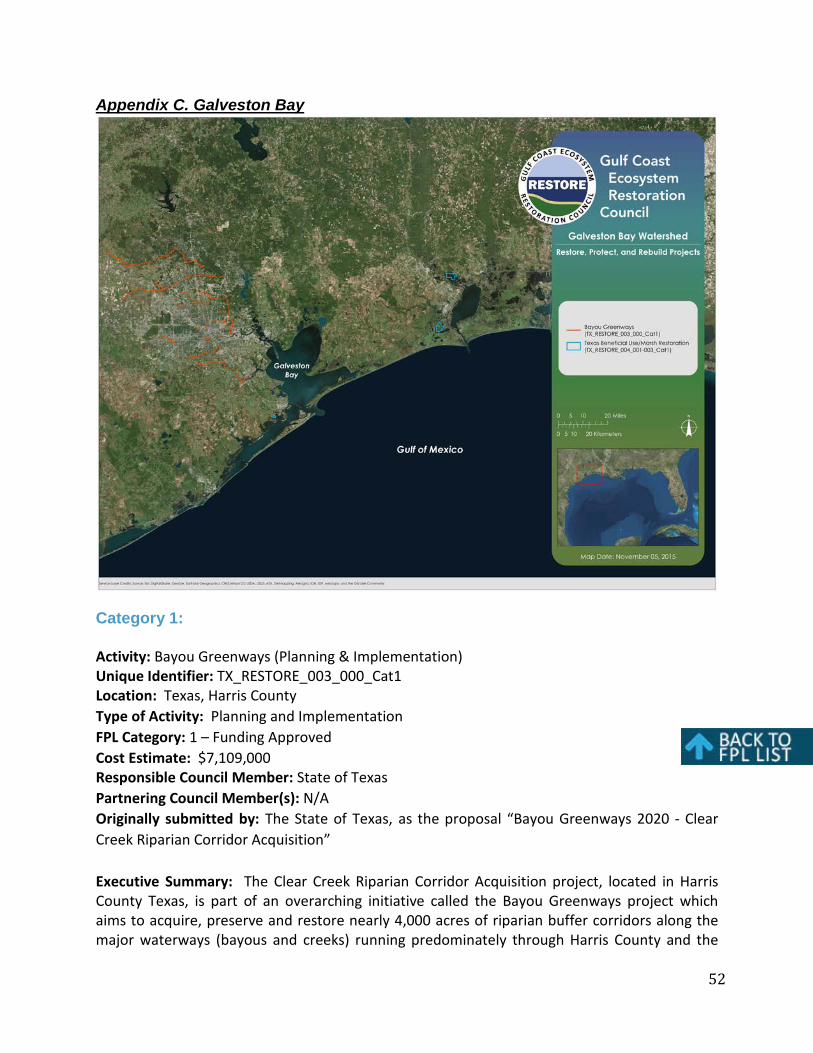
52
Appendix C. Galveston Bay
Category 1:
Activity: Bayou Greenways (Planning & Implementation) Unique Identifier: TX_RESTORE_003_000_Cat1 Location: Texas, Harris County Type of Activity: Planning and Implementation FPL Category: 1 – Funding Approved Cost Estimate: $7,109,000 Responsible Council Member: State of Texas Partnering Council Member(s): N/A Originally submitted by: The State of Texas, as the proposal “Bayou Greenways 2020 - Clear Creek Riparian Corridor Acquisition”
Executive Summary: The Clear Creek Riparian Corridor Acquisition project, located in Harris County Texas, is part of an overarching initiative called the Bayou Greenways project which aims to acquire, preserve and restore nearly 4,000 acres of riparian buffer corridors along the major waterways (bayous and creeks) running predominately through Harris County and the

53
City of Houston. The planning activity includes completing all due diligence for the acquisition of 80 to 100 acres of land in the Clear Creek Greenway project area and funding to begin managing the acquisition process. This includes the $150,000 budgeted for due diligence in the project application, plus $205,450 to begin administration and management for the project – totaling $355,450, 5% of the $7,109,000 project budget. The implementation activity includes the acquisition of 80 to 100 acres of land in the Clear Creek Greenway project area. This includes $6,620,000 budgeted for acquisition, plus $133,550 for administration and management.
PROJECT DESCRIPTION:
Specific Actions/Activities: Planning - The Houston Parks Board will hire a land agent to begin negotiations on properties that are currently listed for sale. At the same time the Houston Parks Board will contract with a land surveyor to provide strip maps showing parcel ownership from titles/deeds, an appraisal company to provide strip appraisals to determine basic land value of all parcels and an environmental company to provide preliminary environmental designation of the parcels. Once a contract is signed with the parcel owner, the contract is sent to a title company to determine if there is a clear title. Other due diligence includes property survey and a Phase I environmental report of the specific property. Should the Phase I environmental report require additional investigation, a Phase II environmental report would be provided. The Phase I ESA involves a review of records (site history, environmental setting, and regulatory records), a site inspection, and interviews. It seeks to identify Recognized Environmental Conditions at the property - or likely presence of any hazardous substances or petroleum products on a property under conditions that indicate an existing release, a past release, or a material threat of a release of any hazardous substances or petroleum products into structures on the property or into the ground, ground water, or surface water of the property. It is generally considered the first step in the process of environmental due diligence.
If a Phase I ESA identifies potential contamination of the site by hazardous materials (by onsite activity or adjacent property activity), a Phase II ESA may be conducted. The Phase II ESA includes sampling and laboratory analysis to confirm the presence of hazardous materials. If a Phase I ESA identifies potential contamination of the site by hazardous materials (by onsite activity or adjacent property activity), a Phase II ESA may be conducted. The Phase II ESA includes sampling and laboratory analysis to confirm the presence of hazardous materials.
Implementation – Upon completion of all due diligence and receiving clear title, the land agent for the Houston Parks Board will finalize the purchase of properties.
Deliverables: Preliminary planning and due diligence deliverables include strip map surveys to
determine ownership and size of properties, strip appraisals to provide property value of all parcels along the bayou and strip environmental investigations to determine, in general, if the parcels have any known environmental issues. Final due diligence deliverables include clear

54
title, boundary survey and environmental Phase I report (Phase II if required). Implementation deliverables include property deeds.
Ecological Benefits/Outcomes and Metrics: The primary objective of this proposal is to restore and conserve habitat, with secondary goals to restore water quality, replenish and protect living coastal and marine resources, enhance community resilience and restore and revitalize the Gulf economy. The project achieves the goal of habitat protection by purchasing and preserving land in perpetuity as parkland and the goal of habitat restoration through a robust (and already funded) maintenance program. This project would protect existing undeveloped riparian lands along the bayou, and secure their threatened flood retention properties into the future.
The measures of success are directly related to the acquisition and long-term management of riparian corridors to enhance habitat, improve water quality and floodwater mitigation. The project’s goals would be its measures of success - specifically for this project, acquisition of 80-100 acres of newly preserved green space to add to the 4,000 acres of green space to create 300 miles of connected riparian corridors.
Further, analysts estimate that the full Bayou Greenways project would conservatively generate more than $117 million in health, environmental, and economic benefits to Harris County every year on an overall investment for the region of $490 million.
Leveraging and Co-Funding: o Adjoining: The Houston Parks Board and the City of Houston are committed to
completing the Bayou Greenways project within the city limits by the year 2020. The City of Houston has provided a $100 million bond commitment for the Bayou Greenways 2020 project and the Houston Parks Board has raised $94 million as part of a capital campaign to match the bond. The countywide Bayou Greenways initiative is being implemented simultaneously by the Houston Parks Board and is anticipated to continue through 2025.
o Building on prior or other investments: The Bayou Greenways project is building uponapproximately $21 million in prior investments, including several local, state and federal grants, some of which are: 2006 Coastal and Estuarine Land Conservation Program (CELCP) grant in the amount of $374,338 for land acquisition for lower Brays Bayou Greenway; 2006 Coastal Impact Assistance Program (CIAP) grant in the amount of $738,000 for land acquisition for Sims Bayou Greenway; 2009/2010 CIAP grant in the amount of $200,000 for land acquisition for Brays Bayou Greenway; 2009 Statewide Transportation Enhancement Program (TE) grant in the amount of $1,970,390 for construction of shared-use path along Brays Bayou Greenway; Cypress Creek Greenway received a Houston-Galveston Area Council (H-GAC) Regional Plan for Sustainable Development Case Study grant in 2012; 2014 H-GAC Transportation Improvement Program (TIP) grant in the amount of $3,978,230 (CMAQ funding) for shared use path construction along Halls Bayou Greenway; 2014 TE grant in the amount of $607,430 for construction of shared-use path along Hunting Bayou Greenway; and 2014 TE grant in

55
the amount of $1,844,655 for construction of a bike/pedestrian bridge and trail segment along Brays Bayou Greenway.
Duration of Activity: The planning activity (due diligence) activity will be completed within four to six months. The implementation activity (land acquisition) would be completed within six to twelve months.
Life of Activity: Not applicable for planning activity. For implementation activity, land acquired would be protected as parkland in perpetuity. The 2020 Economic Development Agreement between the Houston Parks Board and the City of Houston provides a secure maintenance and restoration funding stream for at least 30 years.
RESPONSE TO SCIENCE REVIEWS:
Comment: Clarify the science or new science regarding land purchase for creating riparian corridors.
Response: There is considerable scientific literature documenting the numerous benefits - improved habitat, improved water quality, flood mitigation - provided by streamside riparian buffers. The proposal references national and regional studies, scientific literature, peer reviewed reports and publicly available information documenting the benefits provided by riparian buffers. The referenced literature strongly supports establishment, preservation and restoration of riparian buffers. Furthermore, preserving and restoring the bayou corridors has long been emphasized as a significant conservation priority within the region and specifically within the Galveston Bay Estuary Program’s strategic plan.
Comment: Expand on or fully explain the uncertainties.
Response: Not being able to acquire all the land needed was cited as an uncertainty that would impede the ability to create a complete, connected greenway/riparian system that would impede or negatively affect the intended results. Another risk or uncertainty is having an insignificant buffer to provide the desired result. While the minimum width for this program is 200 feet, this proposal seeks to acquire entire parcels along the bayou corridors to achieve the highest maximum benefit for flood mitigation and water quality improvements. The proposal also maintains that the riparian corridors must be properly managed or the intended results would not be met. Additionally, although studies note that the best biological health is impossible unless human presence is very low and the natural vegetation and soil systems are well preserved near streams and throughout watersheds, results indicate that structural best management practices appear to help in sustaining aquatic biological communities even at high urbanization levels.
Comment: Explain project manager experience managing similar projects.

56
Response: The proposal demonstrates that the Houston Parks Board and partners have conducted projects like this one for several years. The Houston Parks Board is the driving force behind the Bayou Greenways project and has established the process for its completion, maintenance and repair.
Comment: Describe monitoring, maintenance and risk mitigation plan.
Response: As noted in the Implementation Technology section and Monitoring and Adaptive Management section of the proposal, the project has the institutional and financial infrastructure to support the project for well over 10 years. The 2020 Economic Development Agreement between the Houston Parks Board and the City of Houston provides a secure maintenance and restoration-funding stream for at least 30 years on the project within the City limits of Houston. The maintenance standards meet national standards and include habitat restoration, control of invasive species and de-littering on a weekly basis. The Houston Parks Board has a dedicated Bayou Greenways Maintenance staff that monitors and manages the greenways daily.
Comment: Provide measures of success.
Response: The measures of success are directly related to the acquisition and long-term management of riparian corridors to enhance habitat, improve water quality and floodwater mitigation. The project’s goals would be its measures of success, specifically for this project, 80-100 acres of newly preserved green space to add to the 4,000 acres of newly preserved green space to create 300 miles of connected riparian corridors. This section of the Bayou Greenways Project is projected to provide approximately 6 miles of the 300 connected total miles.
Comment: Evaluate past successes and failures of similar efforts.
Response: The proposal demonstrates past successes of the project partners who have been acquiring riparian corridor and other properties for several years. The proposal also gives documentation of successes in the attached scientific literature. Applicant has no failures to report.
ENVIRONMENTAL COMPLIANCE:
Council approval of funding for the planning portion of this activity will not involve or lead directly to ground-disturbing activities that may have significant effects on the environment individually or cumulatively. The Council has considered potential extraordinary circumstances, including potential negative effects to threatened and endangered species, essential fish habitat, Tribal interests and/or historic properties, where applicable, and has determined that no such circumstances apply. Accordingly, the Council has determined that the planning portion of this activity is covered by the Council’s NEPA Categorical Exclusion (CE) for planning, research or design activities (Section 4(d)(3) of the Council’s NEPA Procedures).

57
As noted in the appendices for projects listed in Category 2 of the draft FPL, the Council would review any additional environmental compliance information that became available prior to completion of the final FPL to determine whether this new information would enable the Council to move the given activity into Category 1 and approve it for funding. In September 2015, the U.S. Department of Agriculture (USDA) informed the Council that implementation of Bayou Greenways would be covered by a USDA Forest Service CE for purchasing and conserving lands. Based on information provided by USDA and the Department of Interior (pertaining to the Endangered Species Act), the Council has determined that this activity would not have significant effects on the environment individually or cumulatively. The Council has considered potential extraordinary circumstances, including potential negative effects to threatened and endangered species, Tribal interests and historic properties, where applicable, and has determined that no such circumstances apply. Accordingly, the Council is using the USDA CE for approval of implementation funding for this activity, consistent with Section 4(d)(4) of the Council’s NEPA Procedures.). The Council’s NEPA Procedures and the signed CE form for this activity can be found here.

58
Activity: Texas Beneficial Use/Marsh Restoration (Marsh Restoration in the Nelda Stark Unit on the Lower Neches Wildlife Management Area (WMA); Marsh Restoration in the Salt Bayou Watershed on the J.D. Murphree WMA; Marsh Restoration in Pierce Marsh on West (Galveston) Bay) (Planning) Unique Identifier: TX_RESTORE_004_001-003_Cat1 Location: Texas, Orange, Jefferson and Galveston Counties Type of Activity: Planning FPL Category: 1 – Funding Approved Cost Estimate: $968,000 Responsible Council Member: State of Texas Partnering Council Member(s): Originally submitted by: The State of Texas, as the proposal “State of Texas Beneficial Use of Dredged Material Project Design Fund Phase I”.
Executive Summary: The State of Texas Beneficial Use of Dredged Material (BUDM), Project Design Fund Phase I project, located in Orange, Jefferson and Galveston Counties Texas, will facilitate the beneficial use of dredge materials through careful site selection, preparation of engineering and design plans, environmental compliance and permitting. The primary goal is to create shovel-ready placement areas that, if fully implemented, will transform areas that have subsided into open waters back to tidally influenced coastal wetlands. This method has proven to be a highly effective in restoring and creating habitat for fish and wildlife, improving water quality and enhancing natural storm buffers. The BUDM Project Design Phase I will provide funding for advance planning for three proposed BUDM projects: (1) Marsh Restoration in the Nelda Stark Unit of Texas Parks and Wildlife Department’s Lower Neches WMA within the Sabine Lake-Neches River Watershed; (2) Marsh Restoration in the Salt Bayou Unit of the J.D. Murphree WMA in the Salt Bayou Watershed; and (3) Marsh Restoration in Pierce Marsh on West Bay in the Galveston Bay Estuary. Texas has a history of successful BUDM projects and cooperative agreements among Texas natural resource agencies and the United States Army Corps of Engineers (USACE) in place through the Texas Coastal Management Program. In addition, the project proponent will coordinate with USACE and private dredging operations to identify potential source materials and timelines for placement of dredge materials.
PROJECT DESCRIPTION:
Specific Actions/Activities: Concepts for the three individual projects have been completed by resource managers. The project proponent will hire experienced coastal engineering firms to design and engineer the placement areas that should take 6-8 months to complete. During the development of project design features, individual project managers and coastal engineers will coordinate with the state and federal natural resource agencies to ensure that all design features comply with statutory obligations. When engineering and design is complete, project managers will pursue required permitting, which can take an additional 3-12 months, depending on the type of permit required. It is anticipated that engineering, design and permitting for the three individual projects should be completed by 12-24 months from the date that project design funding becomes available.

59
Deliverables: Preliminary deliverables include surveys of potential placement sites, engineering designs, permit documents, and monitoring plans to measure sedimentation rates and planting success. Specific measures of success for this project include completion of an approved project design, submission of all required permit applications to the respective agencies, and identification of at least one source of dredge material for construction of the project. Pending receipt of all necessary permits, the project should be made shovel ready by the end of the project period.
Ecological Benefits/Outcomes and Metrics: Each of the three BUDM projects addresses the serious issues of wetland loss, loss of important habitat for fish and wildlife, and water quality. The successful completion of the design projects will facilitate many additional acres of BUDM marsh from dredge projects that may have been too small in scope to afford the engineering and design costs. This project will take advantage of the economies of scale and enable building more marsh where it is needed.
This project lays the foundation for the restoration of thousands of acres of estuarine emergent marsh through BUDM. The habitats restored through this project are important to the life cycles, and therefore the sustainability, of many ecologically and economically significant marine species. The contributions of such natural resources on the ecology and economy of Texas are, in a major way, dependent upon the Sabine-Neches Watershed, the Salt Bayou Watershed, and Galveston Bay having habitats suitable to their development. Restoration of estuarine habitats is especially important not only to maintain essential habitat for commercially and recreationally important marine species, but also for their prey species, as so many of the prey species are also estuarine dependent. The marsh edge, in particular, serves as a critical transition between the emergent marsh vegetation and open water by providing a gateway for the movement of organisms and nutrients between intertidal and subtidal estuarine environments.
Leveraging and Co-Funding: o Adjoining: No additional funding is anticipated for these projects for engineering and
design. However, the process of engineering and design will rely upon participation by a host of project partners. These may include natural resource agency personnel (including representatives from the United States Fish and Wildlife Service, Texas Commission on Environmental Quality, Texas Parks and Wildlife Department, etc.), non-governmental organizations, and other potential future construction phase funding partners.
o Building on prior or other investments: Multiple project partners have historicallycommitted to restoring marsh within the proposed project areas using the technique of BUDM. Marsh construction projects using the beneficial use of dredged materials have been successfully implemented or are underway at each of the proposed project locations. This planning and design effort will build upon these previously implemented projects and the successful construction of additional marsh in these areas using BUDM

60
would substantially increase the amount of viable wildlife and fisheries habitat in these locations.
The USACE and regulatory permit review agencies are strongly encouraging applicants for dredging permits to beneficially use the material to create or enhance coastal marshes. Facilitation of additional BUDM is currently hindered by the lack of funding available for the planning, design and permitting for placement areas. By conducting needed design and engineering work, this project will facilitate continued benefits to the coastal environment, fish and wildlife communities, local industries and communities, and recreational users of these resources by providing areas to facilitate BUDM.
The goal of regional sediment management is shared by all five Gulf coast states, numerous federal agencies and nongovernmental organizations. Each additional designed project creates valuable data that can be shared with the public to increase knowledge about sediment transport rates and magnitudes. Texas is working towards a regional sediment management approach with the USACE and other stakeholders. The project designs funded by this project will move these efforts closer to fruition.
Duration of Activity: Once funded, the design and permitting Activity will be completed within 12-24 months.
Life of Activity: Not applicable for planning Activity.
RESPONSE TO SCIENCE REVIEWS:
Comment: Expand on the on the science and engineering behind beneficial use of dredged materials for wetland creation.
Response: The proposal is based on science and lessons learned on similar projects. Experience and monitoring of projects such as the Houston-Galveston Navigation Channel (HGNC) Beneficial Uses Plan in the mid-1990s used available science and case studies to implement multiple BUDM marsh restoration projects that restored over 4,500 acres of marsh in Galveston Bay. Through that effort, the HGNC Beneficial Uses Group (BUG) has monitored the constructed marshes and implemented an adaptive management program. The BUG was composed of state and federal resource agency staff, Port of Houston personnel, and environmental/engineering consultants. In 2003-2004 the BUG oversaw the development of the Marsh Monitoring Management and Maintenance Plan (M3 Plan) that reviewed lessons learned; identified goals, objectives, and standards; established monitoring and maintenance considerations; outlined program management; and provided guidance on a public information program.
The Texas General Land Office (GLO), through the Coastal Erosion Planning and Response Act (CEPRA) Program, and the Texas Parks and Wildlife Department (TPWD) have conducted numerous BUDM restoration projects since the late 1990s with the assistance of well-qualified

61
environmental/engineering consultants. Lessons learned from previous projects were incorporated into subsequent project designs and will be further refined in the design of the proposed projects.
Comment: Describe monitoring, maintenance and risk mitigation plan.
Response: The project is based on science and lessons learned on similar projects that communicates the risks and uncertainties in the scientific basis for such projects. Experience and monitoring of projects such as the HGNC Beneficial Uses Plan in the mid-1990s used available science and case studies to implement multiple BUDM marsh restoration projects that restored over 4,500 acres of marsh in Galveston Bay. Through that effort, the HGNC BUG has monitored the constructed marshes and implemented an adaptive management program.
Standard procedures for wetland restoration construction projects typically include pre-construction topo-bathy surveys to provide a baseline to monitor contractor performance. If there were significant differences in the elevations between the design/planning survey information and the pre-construction surveys, the construction oversight engineer would make any necessary adjustments to the design and issue revised construction documents to the contractor to reflect existing conditions at the initiation of construction. The pre-construction surveys and design/construction documents modifications (if needed) would be conducted and funded as part of the construction phase services and not included as part of the project design phase.
As part of the project design process, a project monitoring plan and adaptive management strategy would be developed for each individual project based upon the HGNC BUG M3 Plan. Each monitoring plan would identify key components of the constructed projects to monitor such as: sediment characteristics; elevation of placed dredged material; sediment settlement and compaction rates; development of hydrologic features; and vegetation coverage. An adaptive management approach would be taken to respond to any project deficiencies identified through the monitoring program.
Comment: Explain project manager experience managing similar projects.
Response: The GLO and the project partners are parties heavily associated with the proposed project and have extensive experience in successfully implementing BUDM restoration projects. The GLO CEPRA program has been in existence since 1999 and has overseen the construction of dozens of similar restoration projects. Staff with TPWD’s Coastal Fisheries Program and with Wildlife Management Areas have also overseen successful BUDM projects. In 2001, the GLO established a BUDM Memorandum of Agreement with the USACE Galveston District that streamlined the contracting process and outlined the project partner responsibilities for BUDM projects.

62
ENVIRONMENTAL COMPLIANCE:
Council approval of funding for this activity will not involve or lead directly to ground-disturbing activities that may have significant effects on the environment individually or cumulatively, nor does it commit the Council to a particular course of action affecting the environment. The Council has considered potential extraordinary circumstances, including potential negative effects to threatened and endangered species, essential fish habitat, Tribal interests and/or historic properties, where applicable, and has determined that no such circumstances apply. Accordingly, the Council has determined that this activity is covered by the Council’s National Environmental Policy Act (NEPA) Categorical Exclusion (CE) for planning, research or design activities (Section 4(d)(3) of the Council’s NEPA Procedures). The Council’s NEPA Procedures and the signed CE form for this activity can be found here.
Category 2:
NONE
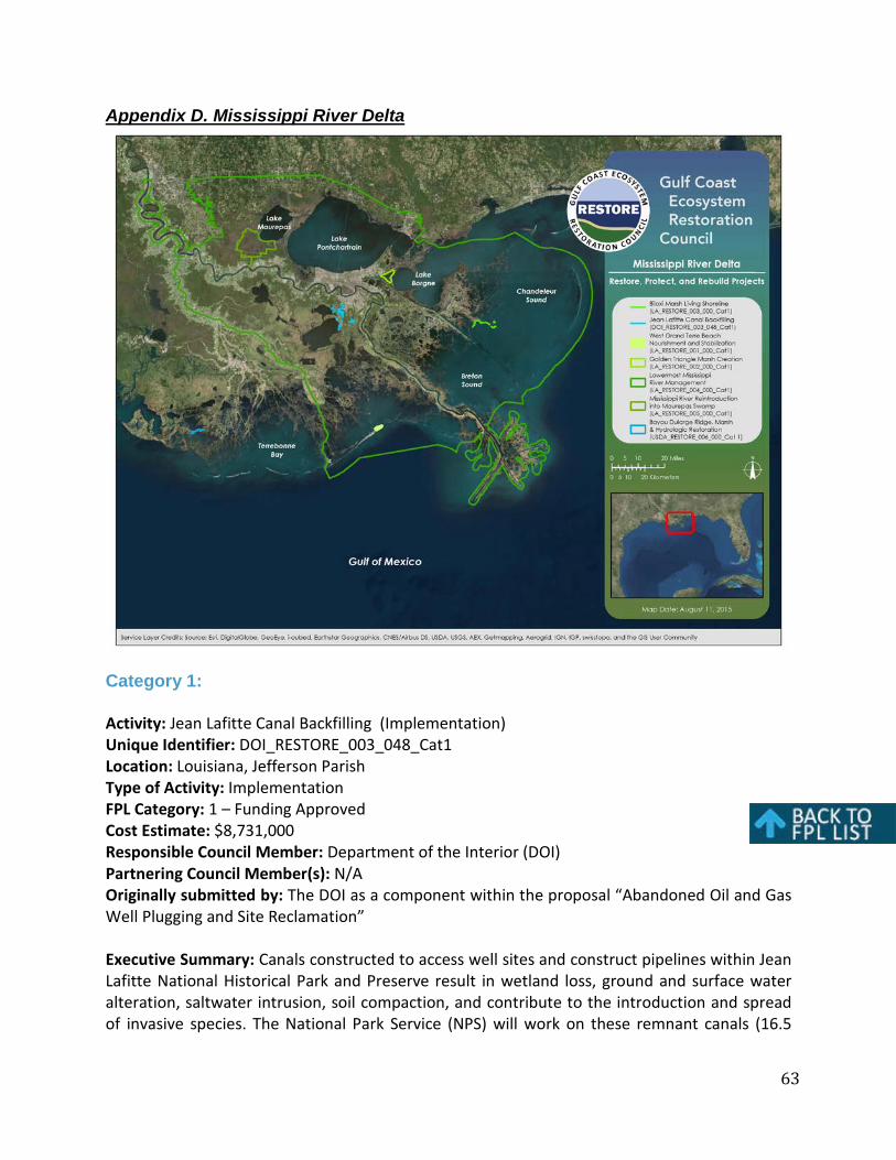
63
Appendix D. Mississippi River Delta
Category 1:
Activity: Jean Lafitte Canal Backfilling (Implementation) Unique Identifier: DOI_RESTORE_003_048_Cat1 Location: Louisiana, Jefferson Parish Type of Activity: Implementation FPL Category: 1 – Funding Approved Cost Estimate: $8,731,000 Responsible Council Member: Department of the Interior (DOI) Partnering Council Member(s): N/A Originally submitted by: The DOI as a component within the proposal “Abandoned Oil and Gas Well Plugging and Site Reclamation”
Executive Summary: Canals constructed to access well sites and construct pipelines within Jean Lafitte National Historical Park and Preserve result in wetland loss, ground and surface water alteration, saltwater intrusion, soil compaction, and contribute to the introduction and spread of invasive species. The National Park Service (NPS) will work on these remnant canals (16.5

64
miles) to restore to freshwater wetland and shallow water habitat by leveling spoil banks into canalways.
PROJECT DESCRIPTION:
Specific Action/Activities: This project involves reclamation of 16.5 miles of canals and their associated spoil deposits in the Barataria Unit of Jean Lafitte National Historical Park and Preserve in Louisiana. These canals were constructed prior to establishment of this NPS unit, and before the imposition of stricter regulatory requirements under the wetland provisions of the Clean Water Act. Reclamation of these canals and their associated spoil banks will restore wetland functions and values including hydrology (water, sediment, and nutrient movement), improve resiliency of ecosystems in the face of subsidence and climate change impacts (sea-level rise and intensified tropical storms), and improve visitor experience.
Canals will be reclaimed by degrading spoil banks to meet the level of the surrounding wetlands and partially filling the open water of the canals with the degraded soil and vegetative material. The canals will revert to marsh, swamp, and shallow water habitat through natural processes, thereby recreating freshwater wetlands. Leveling of spoil banks and dikes will be accomplished from the canals and/or the spoil banks using a marsh buggy, barge-mounted excavator, or similar earthmoving equipment. Access to the sites will be via canals and/or spoil banks. In consideration of habitat restoration/preservation and potential impacts to navigation and recreation, mitigation techniques will include: 1) Installing plugs or check meanders to prevent the dispersal of woody vegetation and sediment from partially filled canals into navigable waterways and impeding navigation or affecting aquatic habitats;2) Placing cut woody vegetation parallel to the banks of canals or chipping in place to prevent large woody debris from drifting into navigable waterways; 3) Gapping so spoil banks are intermittently breached to restore hydrological connections between canals and surrounding wetlands; and 4) Revegetating with native woody species those areas located adjacent to forested wetlands.
Deliverables: Reclamation of 16.5 miles of canals and their associated spoil deposits in the Barataria Unit of Jean Lafitte National Historical Park and Preserve in Louisiana. The canals will be reverted to marsh, swamp, and shallow water habitat, thereby recreating freshwater wetlands.
Ecological Benefits/Outcomes and Metrics: Reclamation of 16.5 miles of canals and their associated spoil banks will restore wetland functions and values including hydrology (water, sediment, and nutrient movement), improve resiliency of ecosystems in the face of subsidence and climate change impacts (sea level rise and intensified tropical storms), and improve visitor experience. Canal backfilling and spoil bank restoration at Jean Lafitte National Historical Park will enhance the resiliency of a significant wetland complex adjacent to more than 20 miles of the federal levee system protecting Greater New Orleans in an estuary that continues to experience one of the highest rates of land loss in the U.S.
Leveraging and Co-Funding:

65
o Building on prior or other investments: NPS has invested $1.64 million in restoringcanal-impacted wetlands at Jean Lafitte National Historical Park and Preserve in recentyears. This project will greatly enhance those efforts.
Duration of Activity: Six-month duration for canal restoration.
Life of Activity: Restoration of wetlands and hydrology would be permanent once established.
RESPONSE TO SCIENCE REVIEWS:
There were no specific science review comments on the proposed project in Jean Lafitte. However, the project is fully implementable and has completed its environmental compliance (see below). The Environmental Assessment referred to below has additional information on this specific project.
ENVIRONMENTAL COMPLIANCE:
The Council has made the relevant determinations as set forth below and is adopting the 2009 Canal Reclamation at Barataria Preserve Environmental Assessment (EA) prepared by the DOI in order to comply with the National Environmental Policy Act (NEPA) for the funding of this activity. Prior to adopting an EA, the Council must determine whether the actions covered by the EA and the Council’s proposed activity are substantially the same, and whether the EA adequately addresses potential direct and cumulative effects of the activity proposed for funding. The Council must also determine whether there are new circumstances, new information or changes in the action or its impacts not previously analyzed that may result in significantly different environmental effects from those assessed in the EA.
The Council has coordinated with the DOI and has determined that this activity has independent utility from all other Gulf restoration activities; is substantially the same as the action covered by the EA; and that there are no new circumstances, cumulative effects, new information or changes in the activity or its impacts not previously analyzed that may result in significantly different environmental effects from those assessed in the EA. The EA addresses the Endangered Species Act (ESA), environmental justice, archeological and historical resources, and other relevant regulatory matters. In April 2015, the DOI has informed the Council that no addition action is required pursuant to ESA.
Based on this information, the Council has issued a Finding of No Significant Impact (FONSI) for this activity. This FONSI and the associated EA can be found here.

66
Activity: West Grand Terre Beach Nourishment and Stabilization (Planning) Unique Identifier: LA_RESTORE_001_000_Cat1 Location: Jefferson Parish, Southeastern Louisiana Type of Activity: Planning FPL Category: 1 – Funding Approved Cost Estimate: $7,259,216 Responsible Council Member: State of Louisiana Partnering Council Member(s): N/A Originally submitted by: The State of Louisiana, as the proposal “West Grand Terre Beach Nourishment and Stabilization”.
Executive Summary: Louisiana’s Barataria/Plaquemines barrier island system, which extends approximately twenty-five miles along the shoreline from West Grand Terre to Sandy Point, is experiencing island narrowing and land loss due to a complex interaction of environmental factors, hurricane impacts, and human activity. These barrier islands were also heavily impacted by the April 2010 BP Deepwater Horizon oil spill. The proposed West Grand Terre Beach Nourishment and Stabilization project would restore and enhance dune and back-barrier marsh habitat on the key barrier island of West Grand Terre to provide storm surge and wave attenuation, thereby addressing gulf shoreline erosion, diminished storm surge protection, and the subsidence of back barrier marshes. This is a planning project that includes engineering and design of the West Grand Terre barrier island restoration, leading to construction-ready plans and specifications and the development of an adaptive management plan to guide decision-making for future project maintenance activities.
PROJECT DESCRIPTION:
Specific Actions/Activities: The funds approved for this activity provide for detailed engineering and design of the project resulting in construction-ready plans and specifications and the development of an adaptive management plan to guide decision-making for future project maintenance activities. If implemented, this project would be constructed by hydraulically dredging and pumping sediment from offshore deposits near the Quatre Bayou borrow site (approximately nine miles from the designated fill sites), which consists mostly of sands, silts, and other fill material suitable for beach/dune and marsh creation. The project consists of three fill activities: the Gulf of Mexico Beach/Dune, the Barataria Pass Beach/Dune, and the Marsh. Preliminary design of the project calls for slurry fill to be constructed to elevations ranging from +9.0-ft NAVD88 at the Gulf of Mexico Beach/Dune, to +2.4-ft NAVD88 at the Barataria Pass Beach/Dune and the Marsh. Earthen containment dikes would be constructed to facilitate the construction of the Marsh, and a rock dike structure would provide additional protection to West Grand Terre Island and Fort Livingston.
Deliverables: The approved funds cover all the activities needed for engineering and design of the project. Deliverables include a full set of plans and specifications, a completed design report and an actionable adaptive management plan. If implemented, the project would build an estimated 12,700 feet of beach and dune with an area of 235 acres, 66 acres of back-barrier

67
marsh, and a rock revetment to protect the restored marsh. These activities would conserve and replenish existing and created marsh and beach/dune habitat while maintaining shoreline integrity and increasing the island’s width and longevity.
Ecological Benefits/Outcomes and Metrics: The West Grand Terre Beach Nourishment and Stabilization project, if implemented in the future, would restore and enhance interior wetlands, which would benefit Gulf estuarine dependent marine species. This project would also protect, restore, and maintain ecologically important breeding and nesting habitat for Gulf species such as colonial nesting waterbirds, including Louisiana’s state bird, the brown pelican (Pelecanus occidentalis), and migratory shorebirds, including the endangered piping plover (Charadrius melodus). In addition, the project would promote community resilience and reduce risk to infrastructure by providing storm surge and wave attenuation.
Measures of success include restoration of beach, dune, and back-barrier marsh habitat for storm surge and wave attenuation. Project-scale performance measures would track progress towards meeting management goals and objectives. The Coastal Protection and Restoration Authority (CPRA) has several applicable coast-wide and programmatic data collection systems for program evaluation and facilitation. These systems include the Coastwide Reference Monitoring System-Wetlands (CRMS), the Barrier Island Comprehensive Monitoring Program (BICM), and the Louisiana Sand/Sediment Resource Database (LASARD). In addition, CPRA is currently working with the Water Institute of the Gulf to more fully develop a System-Wide Assessment and Monitoring Program (SWAMP) that would bring existing monitoring and assessment programs under one comprehensive umbrella to avoid duplication and improve efficiency. SWAMP would be a scalable program that would allow for data assessments to be completed at the project, basin, and program scales. Individual projects would generate monitoring plans, which would nest within the larger SWAMP framework and would allow for periodic assessment of project performance against performance expectations.
Leveraging and Co-Funding: o Building on prior or other investments: This project, if the planned-for contemplated
activities are eventually implemented, would be part of a suite of projects designed to restore, enhance, and protect the Barataria/Plaquemines barrier shoreline. Much of the success of the planning, design, and construction of these projects has been due to leveraging partnerships with multiple federal, state, and parish agencies. A project of the Coastal Wetlands Planning, Protection and Restoration Act (CWPPRA) Program, Vegetative Plantings of a Dredged Material Disposal Site on Grand Terre Island, was completed on West Grand Terre in 2001. A Coastal Impact Assistance Program (CIAP) project, East Grand Terre Island Restoration, was completed in 2011. The project was designed under the CWPPRA program in partnership with National Marine Fisheries Service (NMFS) and construction was funded through CIAP, Plaquemines Parish CIAP, and State surplus. Other nearby projects include two CWPPRA projects developed from the comprehensive Barataria Shoreline Complex project, which were designed and constructed in partnership with NMFS: (1) Pass Chaland to Grand Bayou Pass Barrier Shoreline Restoration (also known as Bay Joe Wise) and (2) Barataria Barrier Island
68
Complex Project: Pelican Island and Pass La Mer to Chaland Pass Restoration.4 Construction of the Bay Joe Wise project was completed in 2009. Scofield Island was designed under the CWPPRA program in partnership with NMFS and was completed using Berm to Barrier Funds in 2013. Chenier Ronquille Barrier Island Restoration was a CWPPRA project designed in partnership with NMFS and would be constructed through Natural Resource Damage Assessment (NRDA) Early Restoration Funds. Additional projects located in the Barataria/Plaquemines barrier shoreline include the Shell Island East and Shell Island West projects, which are components of the Louisiana Coastal Area (LCA) Barataria Basin Barrier Shoreline (BBBS) Restoration project, designed in partnership with the U.S. Army Corps of Engineers. Shell Island East was constructed in 2013 with Berm to Barrier funds while Shell Island West would be constructed using NRDA Early Restoration Funds. In sum, leveraging amounts in the form of building on prior or other investments is as follows:
CIAP: $25,426,247 CWPPRA: $153,192,047 BERM TO BARRIERS: $88,530,852 NRDA: $149,407,455 West Grand Terre Total Leveraging: $416,556,601
Duration of Activity: The timeline for this project is sixteen months for engineering and design, followed by twelve months of construction. The project’s projected start date is September 2015.
Life of Activity: Twenty years, if implemented.
RESPONSE TO SCIENCE REVIEWS:
Comment: CPRA is requesting funding for detailed engineering and design and adaptive management plan development. The Science Evaluations requested additional information regarding prior project development and future storm vulnerability.
Response: Regarding the basis of the design details outlined in the project proposal, the project has a long history of consideration and planning. The need and influence of the project on the overall landscape was established following the project effects modeling associated with the State of Louisiana’s 2012 Coastal Master Plan, wherein it was included as a component of the Barataria Pass to Sand Point Barrier Island Restoration Project. CPRA relied on a history of engineering and design of other projects on the Barataria Estuary Gulf shoreline, namely past work planning restoration of Chenier Ronquille and East Grand Terre, to underlie the preliminary design of the West Grand Terre Project proposed to the RESTORE Council.
4 The latter project is composed of two sections: the Chaland Headland segment, which was completed in 2007; and the Pelican Island segment, which was completed in 2013.

69
It is also important to note that prior efforts only established a preliminary design necessary to estimate costs and establish the need and feasibility of the project. This proposal seeks only those funds needed to carry the project into detailed engineering and design and specific pre-construction monitoring, modeling, and detailed adaptive management plan development. At the end of that process, the State would be ready to pursue funding for the actual construction of the project, and only after construction would the State be in a position to begin implementing post-construction Operations, Maintenance, Monitoring and Adaptive Management. All of that material would be publically available for review as it is developed and finalized.
Storm vulnerability and other uncertainties would likewise be addressed in connection with the engineering and design activities that are the focus of the proposed work. Specifically, CPRA and contract engineers typically subject barrier island project designs to hydrodynamic modeling replicating storms to ensure that project designs are resilient to such natural forces.
In short, while past efforts developed much of the technical justification for this project, there are still additional steps needed before this project can be submitted for construction funding. These steps include pre-construction monitoring, modeling, and the development of an Adaptive Management Plan. The decisions and documentation associated with these steps are the focus of this proposal.
ENVIRONMENTAL COMPLIANCE:
Council approval of funding for this activity will not involve or lead directly to ground-disturbing activities that may have significant effects on the environment individually or cumulatively, nor does it commit the Council to a particular course of action affecting the environment. The Council has considered potential extraordinary circumstances, including potential negative effects to threatened and endangered species, essential fish habitat, Tribal interests and/or historic properties, where applicable, and has determined that no such circumstances apply. Accordingly, the Council has determined that this activity is covered by the Council’s National Environmental Policy Act (NEPA) Categorical Exclusion (CE) for planning, research or design activities (Section 4(d)(3) of the Council’s NEPA Procedures). The Council’s NEPA Procedures and the signed CE form for this activity can be found here.

70
Activity: Golden Triangle Marsh Creation (Planning) Unique Identifier: LA_RESTORE_002_000_Cat1 Location: Orleans and St. Bernard Parishes, Southeastern Louisiana Type of Activity: Planning FPL Category: 1 – Funding Approved Cost Estimate: $4,347,733 Responsible Council Member: State of Louisiana Partnering Council Member(s): N/A Originally submitted by: The State of Louisiana, as the proposal “Golden Triangle Marsh Creation”.
Executive Summary: This is a planning project that includes engineering and design of the Golden Triangle Marsh Creation project, leading to construction-ready plans and specifications and the development of an adaptive management plan to guide decision-making for future project maintenance activities. The proposed Golden Triangle Marsh Creation project, if implemented in the future, would restore and protect approximately 600 acres of valuable wetland, fish, and wildlife habitat within the Golden Triangle, a narrow band of brackish marsh directly east of New Orleans between Lake Borgne and the confluence of the Mississippi River Gulf Outlet and the Gulf Intracoastal Waterway. Because the Inner Harbor Navigation Canal/Lake Borgne Surge Barrier stretches across the Golden Triangle Marsh, these wetlands provide an important natural buffer in the multiple lines of defense protecting geographically and socially vulnerable communities in New Orleans from storm surge. In addition, the Golden Triangle Marsh falls within – and would enhance if fully implemented – the Bayou Sauvage National Wildlife Refuge, which includes fresh and brackish marshes, coastal hardwood forest, and serves as valuable wildlife, fish, and shellfish habitat.
PROJECT DESCRIPTION:
Specific Actions/Activities: The funds approved for this activity provide for detailed engineering and design of the project, resulting in construction-ready plans and specifications and the development of an adaptive management plan to guide decision-making for future project maintenance activities. If implemented, this project would be constructed by hydraulically dredging and pumping sediment from Lake Borgne to a 600-acre fill site located approximately sixteen miles from the borrow site.5 Preliminary design of the project calls for the slurry fill to be constructed to a final elevation of +2-ft NAVD88.6 The borrow area, which consists mostly of
5 While Lake Borgne is currently the most cost effective borrow site for the project, other borrow sources (i.e. Mississippi River, offshore deposits, etc.) will be considered during the comprehensive planning and feasibility effort described here. 6 The fill would be constructed at a slightly higher elevation and is estimated to settle to the target elevation of +2-ft. This target elevation is standard practice for the State-federal Coastal Wetlands Planning, Protection and Restoration Act (CWPPRA) Program to ensure intertidal wetland functionality within three years after initial construction and provide for continued intertidal functionality over the planned twenty-year CWPPRA project life.

71
clays and silts, currently has a depth of -10-ft and would be dredged to a depth of -30-ft. Earthen containment dikes would be constructed to facilitate the construction of the marsh.
Deliverables: The approved funds cover all the activities needed for engineering and design of the project. Deliverables include a full set of plans and specifications, a completed design report and an actionable adaptive management plan. This proposed project, if implemented, would directly create approximately 600 acres of marsh near the western side of Lake Borgne, where there is currently little marsh acreage between the lake and the Greater New Orleans Metropolitan Area. Because wetlands can help reduce the effects of storm surge and wave action, restoring and maintaining this marsh area would protect nearby levee systems and local communities. In particular, the Golden Triangle Marsh Creation project is immediately adjacent to the Inner Harbor Navigation Canal/Lake Borgne Surge Barrier and would help buffer and protect this critically important protection feature.
Ecological Benefits/Outcomes and Metrics: If fully implemented in the future, this project would create important habitat for a wide variety of fish and wildlife species. Many of these species support recreationally- and commercially-important fishing and hunting industries, which are of major economic importance to the region. Because the project resides partially within the Bayou Sauvage National Wildlife Refuge boundary (the largest urban wildlife refuge in the United States), it would greatly benefit the fish and wildlife populations that utilize the refuge and enhance recreational opportunities in the area.
Like the nearby Central Wetlands Assimilation projects, this project would also improve water quality by using wetlands to remove excess nutrients and pollutants from secondarily-treated disinfected municipal effluent prior to discharge.7 The project’s proximity to New Orleans also provides a unique opportunity to promote natural resource stewardship and environmental education and outreach. The public can discover the economic, ecological, and aesthetic importance of Louisiana’s wetlands and the ecosystem services they provide.
Measures of success for the project include wetlands and wildlife habitat restoration as well as increased environmental education and public outreach. At the project-scale, performance measures would track the progress towards meeting management goals and objectives. The Coastal Protection and Restoration Authority (CPRA) is currently working with the Water Institute of the Gulf to more fully develop a System-Wide Assessment and Monitoring Program (SWAMP) that would bring existing monitoring and assessment programs under one comprehensive umbrella to avoid duplication and improve efficiency. SWAMP would be a scalable program that would allow for data assessments to be completed at the project, basin, and program scales. Individual projects would generate monitoring plans that would nest
7 Although wastewater would not be pumped into the Golden Triangle Marsh Creation project, the project should still improve water quality of effluent from the Greater New Orleans Metropolitan Area and other local non-point sources.

72
within the larger SWAMP framework and would allow for periodic assessment of project performance against performance expectations.
Leveraging and Co-Funding: o Building on prior or other investments: This project, if the planned-for contemplated
activities were eventually implemented, would play an integral role in a comprehensive, system-wide approach to effectively restore, enhance, and protect the Lake Borgne area. Much of the success of the planning, design, and construction of these projects has been due to leveraging partnerships with multiple federal agencies. Complimentary projects sponsored by the U.S. FWS under the Coastal Impact Assistance Program (CIAP) include the Orleans Land Bridge Shoreline Protection and Marsh Creation and Central Wetlands Assimilation Project, currently under construction. Projects constructed under the Coastal Wetlands Planning, Protection and Restoration Act (CWPPRA) program include Bayou Sauvage National Wildlife Refuge Hydrologic Restoration (also designed and constructed in partnership with U.S. FWS); Hopedale Hydrologic Restoration, constructed in partnership with the National Marine Fisheries Service; and Lake Borgne Shoreline Protection, constructed in partnership with the Environmental Protection Agency. 8 In sum, leveraging amounts in the form of building on prior or other investments is as follows:
CIAP: $24,360,000 CWPPRA: $34,562,807 Golden Triangle Marsh Creation Total Leveraging: $58,922,807
Duration of Activity: The timeline for this project is three years for engineering and design and permitting, followed by four years of construction.
Life of Activity: Twenty years, if implemented.
RESPONSE TO SCIENCE REVIEWS:
Comment: CPRA is requesting funding for detailed engineering and design and adaptive management plan development. The Science Evaluations requested additional information regarding several issues, including sea level rise and storm surge vulnerability.
Response: While these specific concerns are addressed more fully below, the majority of the concerns raised in the evaluations would be addressed in the detailed engineering and design phase, which is the focus of this funding proposal.
8 Other nearby planned restoration projects include Violet Diversion, Central Wetlands Diversion, Hopedale Marsh Creation, New Orleans East Landbridge Restoration, Lake Borgne Marsh Creation, Central Wetlands Marsh Creation, Biloxi Marsh Oyster Reef, Living Shoreline Protection, Bayou LaLoutre Ridge Restoration, Eastern Lake Borgne Shoreline Protection, MRGO Shoreline Protection, East New Orleans Landbridge Shoreline Protection, and Biloxi Marsh Creation.

73
Regarding sea level rise, it should be noted that the need and influence of the project on the overall landscape was established following the project effects modeling associated with the State of Louisiana’s 2012 Coastal Master Plan. During that modeling, an initial design of the project was subject to scenarios wherein a number of environmental drivers were varied, including eustatic sea level rise, subsidence and marsh vertical accretion. Restoration projects were evaluated within Master Plan project effects models, assuming predicted conditions of 0.5- and 1-meter eustatic sea level rise by 2100. Subsidence values imposed on the modeling were varied spatially throughout coastal Louisiana. Particulars regarding that specific uncertainty are detailed in Appendix C of the Louisiana’s 2012 Coastal Master Plan (http://coastal.la.gov/a-common-vision/2012-coastal-master-plan/cmp-appendices/). All of these phenomena governed estimates of future viability of the project in the face of environmental changes.
In addition to identifying the environment’s effect on the project (via sea level rise and wave action), modeling results and other project information contained in the Coastal Master Plan appendices also identified the project’s effect on the environment – especially the project’s effect on local wave fields as predicted by ADCIRC-based storm surge modeling. That modeling, combined with ecological effect models, identified the Golden Triangle Marsh Creation project as a critical component of a larger set of Biloxi Marsh and Lake Borgne shoreline marsh creation projects needed to reduce wave energy on the flood protection infrastructure of Orleans and St. Bernard Parishes.9
Comment: The Science Evaluations posed additional questions regarding specifically-planned dredging techniques, risk mitigation and adaptive management planning.
Response: It is important to note, however, that prior efforts only established a preliminary design necessary to estimate costs and the need and feasibility of the project. The Council is approving only those funds needed to carry the project into detailed engineering and design and specific pre-construction monitoring, modeling, and detailed adaptive management plan development. Factors such as sea level rise, subsidence and settlement would be considered in the design of the project. At the end of that process, the State will be ready to pursue funding for the actual construction of the project, and only after construction would the State be in a position to begin implementing post-construction Operations, Maintenance, Monitoring and Adaptive Management. All of that material would be publically available for review as it is developed and finalized and would be added to the State’s inventory of marsh creation project information. CPRA has been involved in the engineering and design of many marsh creation projects. Through our experiences, we have amassed a collection of past costs typically associated with certain activities. These costs were used to determine the Golden Triangle cost estimate.
9 See 2012 Coastal Master Plan project number 001.MC.13.

74
Regarding planned dredging and dredged material placement for this project, the State and its federal partners in the CWPPRA Program have a long history of conducting marsh creation/restoration projects using borrow material from adjacent open water bodies.10 This experience has allowed the State and its partners to establish a dredging template that avoids stagnant conditions and associated water quality problems in the borrow area, as well as geotechnical risks to the adjacent shorelines (generally by ensuring an adequate distance between the two). The State’s experience also supports an expectation of success from placing adjacent water bottom sediments on the marsh surface in a manner that achieves ecologically-successful restoration. Notably, dredged sediments within such projects’ footprints are not typically placed in water channels judged to be hydrologically or ecologically significant (e.g. Bayou Bienvenue) in order to ensure hydrologic exchange between open water and the marsh surface and to maximize fisheries and wildlife utilization benefits.
Additional technical details for this project would be developed by the engineering and design activities.
ENVIRONMENTAL COMPLIANCE:
Council approval of funding for this activity will not involve or lead directly to ground-disturbing activities that may have significant effects on the environment individually or cumulatively, nor does it commit the Council to a particular course of action affecting the environment. The Council has considered potential extraordinary circumstances, including potential negative effects to threatened and endangered species, essential fish habitat, Tribal interests and/or historic properties, where applicable, and has determined that no such circumstances apply. Accordingly, the Council has determined that this activity is covered by the Council’s National Environmental Policy Act (NEPA) Categorical Exclusion (CE) for planning, research or design activities (Section 4(d)(3) of the Council’s NEPA Procedures). The Council’s NEPA Procedures and the signed CE form for this activity can be found here.
10 See certain constructed marsh creation projects listed at http://lacoast.gov/new/Projects/List.aspx.

75
Activity: Biloxi Marsh Living Shoreline (Planning) Unique Identifier: LA_RESTORE_003_000_Cat1 Location: St. Bernard Parish, Southeastern Louisiana Type of Activity: Planning FPL Category: 1 – Funding Approved Cost Estimate: $3,220,460 Responsible Council Member: State of Louisiana Partnering Council Member(s): N/A Originally submitted by: The State of Louisiana, as the proposal “Biloxi Marsh Living Shoreline”
Executive Summary: This is a planning project that includes engineering and design of the Biloxi Marsh Living Shoreline project, leading to construction-ready plans and specifications and the development of an adaptive management plan to guide decision-making for future project maintenance activities. The Biloxi Marshes consist of approximately 49,000 hectares of brackish and salt marshes, which provide important storm buffer for New Orleans (a world-famous cultural and economic center for the Gulf region) as well as key habitat and ecosystem services. The marshes have been greatly impacted by shoreline erosion from wind-driven waves. The proposed Biloxi Marsh Living Shoreline project, if implemented in the future, would create approximately 47,000 feet of bioengineered oyster barrier reef fringing the marshes, which would reduce shoreline erosion and recession, prevent further marsh degradation, promote community resilience, and enhance local fisheries and oyster production.
PROJECT DESCRIPTION:
Specific Actions/Activities: The funds approved for this project provide for detailed engineering and design of the project, resulting in construction-ready plans and specifications and the development of an adaptive management plan to guide decision-making for future project maintenance activities. If implemented, the Biloxi Marsh Living Shoreline project would create a living breakwater structure by mechanically placing a manufactured product, or suite of products, off the shoreline of Eloi Bay and Eloi Point, near the mouth of Bayou la Loutre. The products may consist of concrete, plastic mesh, steel rebar, limestone, oyster shells, and/or concrete admixtures. These living breakwaters would be placed at the -2.0-ft contour and would extend offshore. The width of these living breakwaters would vary depending on manufactured product and wave conditions. The target height for the living breakwaters is mean water level (MWL). A mechanical dredge would be used to provide access and flotation to the project area.
Deliverables: The approved funds cover all the activities needed for engineering and design of the project. Deliverables include a full set of plans and specifications, a completed design report and an actionable adaptive management plan. Bioengineered oyster reefs, man-made structures designed to promote the formation of marsh-fringing oyster reefs, have been implemented in many locations in Louisiana. Such reefs significantly reduce shoreline erosion and recession while supporting aquatic ecosystems, local fisheries, and good oyster recruitment

76
and survival, such that the reefs created may be self-sustaining. If implemented, this project is expected to deliver similar outcomes.
Ecological Benefits/Outcomes and Metrics: The shell reefs created by oysters provide unique, structurally-complex habitat that support distinct and diverse aquatic communities, function as nursery habitat for many fish and shellfish species, and enhance local productivity. Because these reefs provide abundant and concentrated prey resources, they are valuable foraging sites for transient, predatory fishes such as flounder, drum, and speckled trout; therefore, oyster reefs likely enhance recreational fisheries. Oysters also enhance water quality by filtering large volumes of water daily to feed. By removing large amounts of carbon, phosphorus, and nitrogen incorporated into phytoplankton biomass, oysters can mitigate nutrient loading and help prevent eutrophication and hypoxia.
In addition to the aforementioned ecosystem benefits, oyster reefs help protect marsh habitats by reducing shoreline recession. Oyster reefs frequently occur just offshore of the marsh edge, and their vertical structure serves to attenuate wave energies and reduce water velocities resulting in reduced erosion as well as increased sediment deposition behind the reef, both of which act to stabilize the shoreline. However, many marsh-fringing, vertical oyster reefs have been lost due to saltwater intrusion, disease, and overharvest, and there has been a concomitant loss in shoreline erosion control.
The Biloxi Marsh Living Shoreline project would be deemed successful if monitoring shows that it reduces shoreline recession and supports good oyster recruitment and survival, such that the reefs are self-sustaining. Project-scale performance measures would track the progress towards meeting management goals and objectives. The Coastal Protection and Restoration Authority (CPRA) is currently working with the Water Institute of the Gulf to more fully develop a System-Wide Assessment and Monitoring Program (SWAMP) that would bring existing monitoring and assessment programs under one comprehensive umbrella to avoid duplication and improve efficiency. SWAMP would be a scalable program that would allow for data assessments to be completed at the project, basin, and program scales. Individual projects would generate monitoring plans that would nest within the larger SWAMP framework and would allow for periodic assessment of project performance against performance expectations.
Leveraging and Co-Funding: o Building on prior or other investments: As this project originally began as a Coastal
Impact Assistance Program (CIAP) project designed to evaluate the ability of reef-base technologies to withstand the surge associated with a Category 1 hurricane, CPRA is able to leverage the CIAP project’s initial engineering and design. The Biloxi Marsh Living Shoreline project, if the planned-for contemplated activities are eventually implemented, would build on this knowledge, as well as the Coastal Wetlands Planning, Protection and Restoration Act (CWPPRA) Program’s Terrebonne Bay Shore Protection Demonstration project, which evaluated various engineering structures’ effectiveness in reducing shoreline recession and enhancing local oyster production. Further, this project would benefit from the complementary CIAP Living Shoreline Demonstration project,

77
the CIAP Violet Diversion project, as well as the Nature Conservancy’s Lake Fortuna and Eloi Bay reef projects. In sum, leveraging amounts in the form of building on prior or other investments is as follows:
CIAP: $27,670,982 State: $22,000,000 CWPPRA: $2,718,768 Biloxi Marsh Total Leveraging: $ 52,389,750
Duration of Activity: The timeline for this project is twenty-five months for engineering, design and permitting, followed by twenty-five months of construction. The project’s projected start date is September 2015.
Life of Activity: Twenty years, if implemented.
RESPONSE TO SCIENCE REVIEWS:
CPRA is requesting funding for detailed engineering and design and adaptive management plan development. All three of the External Science Reviews were positive and did not express any significant concerns regarding the information presented in the proposal.
ENVIRONMENTAL COMPLIANCE:
Council approval of funding for this activity will not involve or lead directly to ground-disturbing activities that may have significant effects on the environment individually or cumulatively, nor does it commit the Council to a particular course of action affecting the environment. The Council has considered potential extraordinary circumstances, including potential negative effects to threatened and endangered species, essential fish habitat, Tribal interests and/or historic properties, where applicable, and has determined that no such circumstances apply. Accordingly, the Council has determined that this activity is covered by the Council’s National Environmental Policy Act (NEPA) Categorical Exclusion (CE) for planning, research or design activities (Section 4(d)(3) of the Council’s NEPA Procedures). The Council’s NEPA Procedures and the signed CE form for this activity can be found here.

78
Activity: Mississippi River Reintroduction into Maurepas Swamp (Planning) Unique Identifier: LA_RESTORE_005_000_Cat1 Location: St. John the Baptist, St. James, Ascension, and Livingston Parishes, Southeastern Louisiana Type of Activity: Planning FPL Category: 1 – Funding Approved Cost Estimate: $14,190,000 Responsible Council Member: State of Louisiana Partnering Council Member(s): N/A Originally submitted by: The State of Louisiana, as the proposal “Mississippi River Reintroduction into Maurepas Swamp”
Executive Summary: This is a planning project that includes engineering and design of the Mississippi River Reintroduction into Maurepas Swamp project, leading to construction-ready plans and specifications and the development of an adaptive management plan to guide decision-making for future project maintenance activities. The Maurepas Swamp is one of the largest areas of forested wetlands along the Gulf Coast, encompassing approximately 57,000 hectares of bald cypress-tupelo swamp west of Lake Pontchartrain. Historically, the swamp received sediment and nutrient inputs from the Mississippi River during seasonal overbank flooding; however, reduced freshwater inflow and sediment input has caused land loss within the sub-basin and resulted in the periodic introduction of brackish water from Lake Pontchartrain into Lake Maurepas and the swamp. The proposed Mississippi River Reintroduction into Maurepas Swamp Project, if fully implemented, would restore and enhance the health and sustainability of the Maurepas Swamp through the reintroduction of seasonal Mississippi River inflow.
PROJECT DESCRIPTION:
Specific Actions/Activities: The approved funds will provide for detailed engineering and design of the project, resulting in construction-ready plans and specifications and the development of an adaptive management plan to guide decision-making for future project maintenance activities. If implemented, the Mississippi River Reintroduction into Maurepas Swamp Project would consist of the following major components designed to divert fresh water from the river into the Maurepas Swamp: (1) a gated river intake structure, (2) box culverts through the levee, (3) a sedimentation basin, (4) a conveyance channel, and (5) a drainage pump station. The maximum design flow is 2,000 cubic feet per second. The project would be located near Garyville, LA in St. John the Baptist Parish. The intake structure would be comprised of three 10-ft x 10-ft sluice gates connected to three 10-ft x 10-ft box culverts that travel through the levee and underneath LA 44. The proposed conveyance channel extends just under 5½ miles from the river to a discharge point in the Maurepas Swamp approximately 1,000-ft north of I-10.
Deliverables: The approved funds cover all the activities needed for engineering and design of the project. Deliverables include a full set of plans and specifications, a completed design report

79
and an actionable adaptive management plan. This project, if implemented in the future, would restore and enhance a total of 18,300 hectares of forested wetland and provide increased habitat productivity, water quality, and community resilience since the Maurepas Swamp is a significant storm buffer for nearby communities. Thus, the project is an important component of a comprehensive, basin-wide strategy for restoring the Maurepas Swamp ecosystem. As a large-scale project, it would contribute substantially to the restoration of the Gulf Coast’s marine and wildlife habitats, natural resources, ecosystems, fisheries, beaches, and coastal wetlands.
Ecological Benefits/Outcomes and Metrics: In addition to restoring and enhancing a total of 18,300 hectares of forested wetland, if fully implemented in the future this project would provide a host of other benefits to fauna that are dependent on cypress-tupelo swamps. Increased primary productivity and water quality would increase food resources and subsequently increase secondary productivity of freshwater fish. Wading birds, migratory birds, bald eagles, alligators and other wildlife species would also benefit. The project, if implemented, also would maintain stands of mature bald cypress and other woody vegetation, which would ensure that suitable nesting areas are available for numerous bird species. Bald eagles, for example, predominantly use bald cypress when nesting in Louisiana, and the Maurepas Swamp supports a large number of nests. Thus, the project, if implemented, should greatly benefit populations of this important and protected species, among others.
If fully implemented in the future, increased fish and wildlife productivity would, in turn, provide greater opportunities for fishing, hunting, and wildlife watching. These are economically important industries in Louisiana and the region. The Maurepas Swamp, and more specifically the Maurepas Swamp Wildlife Management Area and Blind River, a scenic river that flows through the swamp, are popular areas for these activities.
The project, if implemented, also would improve coastal water quality since more than 90% of the nitrate introduced into the project area would be assimilated by the swamp. This would reduce the amount of nitrogen and other nutrients entering the Gulf of Mexico, which, in turn, would reduce hypoxia on the continental shelf.11
Measures of success for this project include restoration and enhancement of forested wetland health by diverting Mississippi River water into the project area. Project-scale performance measures would track progress towards meeting management goals and objectives. The Coastal Protection and Restoration Authority (CPRA) is currently working with the Water Institute of the Gulf to more fully develop a System-Wide Assessment and Monitoring Program
11Louisiana Nutrient Management Strategy: Protection, Improvement, and Restoration of Water Quality in Louisiana’s Water Bodies. Coastal Protection and Restoration Authority of Louisiana, Louisiana Department of Agriculture and Forestry, Louisiana Department of Environmental Quality, and Louisiana Department of Natural Resources, p. 50. May 2014. Baton Rouge, LA. Available at: http://www.deq.louisiana.gov/portal/Portals/0/planning/Nutrient%20Management%20Strategy/LA_Nutrient_Ma nagement_Strategy_FINAL_May%202014.pdf

80
(SWAMP) that would bring existing monitoring and assessment programs under one comprehensive umbrella to avoid duplication and improve efficiency. SWAMP would be a scalable program that would allow for data assessments to be completed at the project, basin, and program scales. Individual projects would generate monitoring plans that would nest within the larger SWAMP framework and would allow for periodic assessment of project performance against performance expectations.
Leveraging and Co-Funding: o Building on prior or other investments: This project, if the planned-for contemplated
activities are eventually implemented, would be an important component in a comprehensive, basin-wide strategy to restore the Maurepas Swamp ecosystem. A similar project, the Louisiana Coastal Area-funded Small Diversion at Convent/Blind River, proposes to introduce riverine fresh water, nutrients, and sediments into the southwest portion of the Maurepas Swamp through the Blind River. Another project, the Hydrologic Restoration of the Amite River Diversion Canal, proposes to re-establish hydrologic connectivity between natural water bodies and impounded swamps along the Amite River Diversion Canal. Further, following recent acquisitions by Louisiana’s Coastal Forest Conservation Initiative, much of the Maurepas Swamp has been incorporated into a wildlife management area now encompassing almost 42,000 hectares. This area, which is managed by the Louisiana Department of Wildlife and Fisheries, would protect and conserve habitat for a wide variety of wildlife species. In sum, leveraging amounts in the form of building on prior or other investments is as follows:
State and CWPPRA: $9,600,000 Maurepas Total Leveraging: $9,600,000
Duration of Activity: The timeline for this project is three years for permitting and land rights, followed by four years of construction. The project’s projected start date is Winter 2015.
Life of Activity: Fifty years, if implemented.
RESPONSE TO SCIENCE REVIEWS:
Comment: CPRA is requesting funding for detailed engineering and design and adaptive management plan development. The three External Science Reviews requested additional information regarding uncertainties/risk, project goals, socioeconomics, adaptive management, and cost effectiveness.
Response: As explained more fully below, however, these concerns will be addressed in the detailed engineering and design phase, which is the focus of this funding proposal.
The initial concept of the Maurepas Project was identified and developed in the 1993 Louisiana Coastal Restoration Plan, and has since been in most of the State and federal plans and programs. Project development has primarily occurred within the Coastal Wetlands Planning,

81
Protection and Restoration Act (CWPPRA) Program, comprised of the State (CPRA) and five federal agencies (Environmental Protection Agency (EPA), Department of Commerce/National Oceanic and Atmospheric Administration, Department of Agriculture/Natural Resources Conservation Service, U.S. Army Corps of Engineers (USACE) and Department of the Interior/U.S. FWS). The Maurepas Project was approved for feasibility-level engineering and design funding in 2001, and alternatives analyses were conducted on four separate diversion locations, preliminary project features, project benefits, and drainage and water quality issues. Key deliverables over the past decade have included a Hydrologic Modeling Report, Cultural Resources Report, Ecosystem Health Report, Flow Nutrient Salinity and Temperature Analysis Report, Water Quality and Ecological Risk Reports, Impact to Fisheries Report, and a draft Environmental Information Document prepared by the EPA. The project was also included in the State/USACE Louisiana Coastal Area (LCA), Louisiana Ecosystem Restoration Study as the Small Diversion at Hope Canal Project, which Congress recognized as one of five “Near-Term Critical Restoration Features for Conditional Authorization.” Relevant documentation on both programs’ efforts toward project planning and design can be found at http://lacoast.gov/new/Projects/Info.aspx?num=PO-29 and http://lca.gov.
Additional steps needed before this project can be submitted for construction funding include pre-construction monitoring, modeling, and development of an Adaptive Management Plan. CPRA recently assembled a Technical Advisory Group of leading swamp ecologists from the U.S. Geologic Survey and Louisiana universities to define realistic and quantifiable parameters to measure swamp health throughout the life of the project. Model review would guide further necessary modeling and data collection as the Operations, Maintenance, Monitoring, and Adaptive Management plans are developed. The decisions and documentation associated with these steps are the focus of this funded activity.
In addition, landowners have been identified, and the project has been well-supported by ongoing public meetings and stakeholder engagement efforts (including railroads, and industry in the area), with the primary expressed concern being the question of how much longer the swamp can survive without a river reintroduction project. The majority of the project area has been acquired by the Louisiana Department of Wildlife and Fisheries to serve public recreation needs, prevent conversion to non-forested use, conserve important, rare habitat in the area and preserve the storm buffering capacity of the swamp. A portion of the funding is for land title abstract and appraisal work for the diversion channel.
Additional technical details for this project will be developed during the engineering and design activities.
ENVIRONMENTAL COMPLIANCE:
Council approval of funding for this activity will not involve or lead directly to ground-disturbing activities that may have significant effects on the environment individually or cumulatively, nor does it commit the Council to a particular course of action affecting the environment. The Council has considered potential extraordinary circumstances, including potential negative

82
effects to threatened and endangered species, essential fish habitat, Tribal interests and/or historic properties, where applicable, and has determined that no such circumstances apply. Accordingly, the Council has determined that this activity is covered by the Council’s National Environmental Policy Act (NEPA) Categorical Exclusion (CE) for planning, research or design activities (Section 4(d)(3) of the Council’s NEPA Procedures). The Council’s NEPA Procedures and the signed CE form for this activity can be found here.

83
Activity: Lowermost Mississippi River Management (Planning) Unique Identifier: LA_RESTORE_004_000_Cat1 Location: Louisiana Type of Activity: Planning FPL Category: 1 – Funding Approved Cost Estimate: $9,300,000 Responsible Council Member: State of Louisiana Partnering Council Member: U.S. Army Corps of Engineers (USACE) Originally submitted by: The State of Louisiana as a component within the proposal “Lowermost Mississippi River Management”
Executive Summary: This large-scale program will build the technical knowledge base needed to develop a plan that moves the nation toward a more holistic management scheme for the Lower Mississippi River, which seeks to both enhance the great economic value of the River while also elevating the importance of ecological maintenance and restoration of the landscape through which it flows. This planning effort will advance the science developed under the Louisiana Coastal Area (LCA) Mississippi River Hydrodynamic and Delta Management Study (MRHDMS) to form the foundation for any future river management analysis by creating an integrated science-based management strategy for the Lower Mississippi River to improve navigation, reduce flood risk, and provide for a more sustainable deltaic ecosystem.
PROJECT DESCRIPTION:
Specific Actions/Activities: This effort will provide the technical information that would be needed to establish a plan to improve navigation, reduce flood risk, and provide for a more sustainable deltaic ecosystem in the future. The premise of that plan is that a sustainable navigation system requires a sustainable coast.
The program includes a full and objective assessment of the benefits and costs of the current management scheme for the Lower Mississippi River, including both the significant economic benefits, as well as future unintended adverse impacts to the coastal environments. The plan will evaluate alternatives to the current management scheme that would meet the aforementioned goal. It will also evaluate the benefits and costs of maintaining the current management scheme within a range of predicted futures, based on climate change, sea level rise and subsidence.
The program will build upon and complement the ongoing MRHDMS. The Mississippi River Hydrodynamic portion of MRHDMS included the development of single and multi-dimensional hydrodynamic and sediment transport models of the river channel and adjacent basins. The geomorphic assessment, field data collection and suite of models that have been developed allow the impacts of certain actions, specifically marsh creation and diversion alternatives along the Lower Mississippi River (LMR) to be evaluated within the Delta Management study. The MRHDMS was funded as a large-scale, long-term study to inform ecosystem restoration, and as such, navigation and flood control studies have not been fully incorporated. The MRHDMS
84
models have been developed to analyze large-scale ecosystem restoration projects associated with the current alignment of the Mississippi River. These models need to be adapted to adequately inform decisions for future river management analysis that includes other channel alignments and management strategies.
The preliminary formulation of the program includes five technical elements and a program management component. These elements are: 1) Extended applications of the Mississippi River Hydrodynamic Modeling Tools; 2) Subsidence Investigations; 3) The Impacts of Coastal Features on Storm Surge; 4) Genesis, Stability and Fate of Subaqueous Lateral Bars; and 5) Dredged Material Management. The State of Louisiana (State), USACE, Mississippi Valley Division (MVD) and New Orleans District (MVN), and research teams at the Water Institute of the Gulf (WI) and the USACE Engineering Research and Development Center (ERDC) will develop a detailed Scope of Work for each of the technical elements. The State and USACE will be full and equal partners in this program, with the total funding being split evenly (50/50) between the two parties, however some technical elements will not have an even distribution of funding. Technical elements 2-5 will have a primary agency responsible for leading element coordination and execution and as such, will receive the majority of the funding for that element. These elements will include some level of direct involvement from all agencies that will vary between elements. Program management will be a 50/50 division of funding and responsibility between the State and MVN.
This program will further develop the science needed to adequately inform decision makers on future LMR management and will include establishing existing and future without project conditions, and developing alternate river management schemes based on numerical modeling tools and other analyses developed under MRHDMS. These management schemes could include alternatives and/or key elements developed during the conduct of the Changing Course competition, as well as any other alternatives that optimize a balance between navigation, flood risk management, and ecosystem restoration. The scope of work will not include updating existing or developing new environmental compliance documentation associated with the Mississippi River.
Current plans for public engagement include using established MVN and CPRA processes for stakeholder involvement and an additional annual opportunity for program update and discussion with key stakeholders such as the navigation sector and non-governmental environmental organizations, as well as the general public at the State of the Coast or similar public forums.
Deliverables: This effort will result in the adaptation and application of the MRHDMS models that have been developed to analyze large scale ecosystem restoration projects associated with the current alignment of the Mississippi River to adequately inform decisions for future river management analysis that includes other channel alignments or management strategies. This will underpin the development of an implementable science-based management scheme for the Lower Mississippi River, geared toward improving navigation, reducing flood risk, and providing for a sustained deltaic ecosystem. In Progress Review (IPR) meetings will be held to

85
inform senior USACE and State leadership at key decision points in the analysis to allow leadership to inform the study path forward.
Ecological Benefits/Outcomes and Metrics: The program will result in an improved technical knowledge base necessary to develop a plan to enhance ecosystem sustainability in Mississippi River Deltaic Plain without negatively impacting navigation and flood risk management on the Mississippi River.
Leveraging or Co-Funding: o Building on prior or other investments:
o This program will build upon investments made for the MRHDMS, as well asinformation developed for the Louisiana Comprehensive Master Plan for aSustainable Coast and the Small Scale Physical Model (SSPM). The State andUSACE executed a 50/50 cost share agreement for $25.4 million for the conductof the MRHDMS. The MRHDMS includes the refinement of single and multi-dimensional hydrodynamic and sediment transport models of the river channeland adjacent basins that would allow the impacts of certain actions on the LowerMississippi River (LMR) to be evaluated. The suite of models developed underMRHDMS would be adapted to inform decisions for future river managementanalysis that include other channel alignments or management strategies.Another related effort is the Small Scale Physical Model project that was fundedunder the Coastal Impact Assistance Program (CIAP) for $13,520,000. Thereforein sum, leveraging amounts in the form of building on prior or other investmentstotals approximately $38.8 million.
o The program will also seek to collaborate with other ongoing Gulf CoastRestoration projects or research funded by oil spill recovery efforts, includingother RESTORE Act efforts, as well as activities arising from other fundingsources. In specific, contact has been made with Dr. Alex Kolker to discuss anypotential coordination of this program with his NOAA RESTORE Act ScienceProgram funded study entitled “The Central Role of the Mississippi River and itsDelta in the Oceanography and Ecology of the Gulf of Mexico Large MarineEcosystem.”
Duration of Activity: The study effort is estimated to take 3 years.
Life of Activity: Not applicable. This is a programmatic technical investigation.
RESPONSE TO SCIENCE REVIEWS:
Comment: The original RESTORE proposal for Lowermost Mississippi River Management included a National Environmental Policy Act (NEPA) component. As initially submitted and reviewed, the program endeavored to investigate the adequacy of existing NEPA documentation for navigation and flood risk reduction projects involving the Lowermost Mississippi River, and potentially initiate the formulation of updated Environmental Impact

86
Statements using the new information developed in the planning and analysis component of the program. The critical Science Evaluation comments for this proposal were focused entirely on the NEPA component of the project.
Response: At the suggestion of the Council, the original proposal was subsequently modified to remove the NEPA component of the project. The critical comments from the Science Evaluation, while valid for the original proposal, no longer apply to the modified proposal.
ENVIRONMENTAL COMPLIANCE:
Council approval of funding for this activity will not involve or lead directly to ground-disturbing activities that may have significant effects on the environment individually or cumulatively, nor does it commit the Council to a particular course of action affecting the environment. The Council has considered potential extraordinary circumstances, including potential negative effects to threatened and endangered species, essential fish habitat, Tribal interests and/or historic properties, where applicable, and has determined that no such circumstances apply. Accordingly, the Council has determined that this activity is covered by the Council’s National Environmental Policy Act (NEPA) Categorical Exclusion (CE) for planning, research or design activities (Section 4(d)(3) of the Council’s NEPA Procedures). The Council’s NEPA Procedures and the signed CE form for this activity can be found here.
This investigation will not result in the necessity to supplement the current environmental documentation for USACE actions on the lower Mississippi River.

87
Activity: Bayou Dularge Ridge, Marsh & Hydrologic Restoration (Planning) Unique Identifier: USDA_RESTORE_006_000_Cat 1 Location: The Bayou Dularge Ridge, which extends from northeast to southwest, historically restricted the Gulf marine influence into Louisiana’s Central Terrebonne marshes where the Atchafalaya influence is prominent. The project footprint or engineering design area includes the Grand Pass, a cut through Bayou Dularge Ridge south of Lake Mechant. Type of Activity: Planning FPL Category: 1 – Funding Approved Cost Estimate: $5,162,084 Responsible Council Member: This project is sponsored by the United States Department of Agriculture (USDA)/Natural Resources Conservation Service (NRCS) on behalf of the Federally Recognized Chitimacha Tribe of Louisiana. Partnering Council Member(s): N/A Originally submitted by: The USDA/NRCS for the Chitimacha Tribe, as the proposal “Bayou Dularge Ridge Restoration, Marsh Creation & Hydrologic Restoration; Phase I”
Executive Summary: This is a planning project that includes engineering and design of the Bayou Dularge Ridge (Ridge). It takes a regional approach that when constructed would re-establish hydrologic and salinity conditions, restore the Ridge and create/restore marsh to ensure the integrity of the Ridge, its salinity gradient function and the health of the marsh.
PROJECT DESCRIPTION:
Specific Actions/Activities:
Data Collection: USDA will complete surveying, geotechnical investigation, and magnetometer and side scan sonar surveys of the project area. Geotechnical investigations will be used to obtain information about the soil conditions below the surface. Magnetometer and side scan surveys will be done to determine the location of any possible pipelines and other metal objects within the project boundary.
Oyster Seed: The Louisiana Department of Wildlife and Fisheries (LDWF) requires a water bottom assessment for all projects occurring on Public Oyster Seed Grounds, and Public Oyster Seed Reservations. This assessment will be done to comply with these requirements to submit and seek approval of the LDWF prior to Coastal Use Permit issuance for project implementation at a later date.
Cultural Resources: Section 106 of the National Historic Preservation Act of 1966 (NHPA) and the National Environmental Policy Act (NEPA) require that the effects of this project be evaluated (see “Environmental Compliance” below). Section 106 also requires consultation with the Louisiana State Historic Preservation Office and appropriate Indian tribes to inform them, and consider their concerns or objections, if any. Finally, Section 106 requires that this investigation also include sub-bottom profiling, and side-scan sonar and magnetometer

88
surveys, and resulting data assessment by an archaeologist for the presence of submerged cultural resources. All necessary actions to achieve compliance will be completed.
Easements and Land Rights: Property potentially impacted by the project has to be identified. Temporary easements, servitudes, rights-of-way agreements will also be required prior to start of a construction phase. In addition, title research must be conducted to determine who owns or claims the land. Therefore, planning activities will include title search, pipeline identification, flow-lines identification, etc.
Deliverables: Phase I includes all activities necessary to get the project ready for construction. The deliverables will be a completed environmental assessment pursuant to NEPA (see “Environmental Compliance” below), full sets of plans and specifications, and a completed design report.
Ecological Benefits/Outcomes and Metrics: This is an engineering and design project. Ecological benefits/outcomes and metrics are contingent on the building/implementation of the project design. Upon receipt of additional funds, the project would be implemented and would result in the following benefits: 233 acres of hydrologic restoration, 282 acres of marsh creation and 25 acres of ridge restoration for a total 540 acres of total direct net acres of benefit.
Leveraging and Co-Funding: o Building on prior or other investments: This project is a component of a much broader
effort to restore coastal Louisiana. The project has been identified in the Louisiana State Master Plan (CPRA 2012) as a “priority location” and these components have been developed in collaboration with Louisiana Coastal Protection and Restoration Authority, Terrebonne Parish, and private landowners that are within the footprint of the project. In addition, the project has been vetted through a process of engineering and environmental scrutiny that includes the participation of several state and federal agencies including U.S. Fish and Wildlife Service, Environmental Protection Agency, National Oceanic and Atmospheric Administration/National Marine Fisheries Service, U.S. Army Corps of Engineers, and the LDWF.
NRCS has been working in this area for several decades and this particular project is one of several in long term plans to restore the western Terrebonne Basin. This project is synergistic with the Penchant Basin Plan that reestablished freshwater introduction from the Atchafalaya River through Bayou Penchant to this area.
Finally, there are several documents addressing the synergy of the proposed action with other Coastal Wetlands Planning, Protection and Restoration Act (CWPPRA) projects. USDA has multiple Reports to Congress and other public affairs documents that have a great detail of information of the success of CWPPRA and how every project has contributed benefits.

89
Duration of Activity: This is an engineering and design project (E&D). USDA’s forecast for E&D completion is 2 – 3 years depending on what work is completed in-house and what is contracted. “Duration of Activity” only becomes applicable when this project is implemented under other funding at a later date.
Life of Activity: This is an engineering and design project (E&D) project. USDA estimates that the E&D completion would be 2 – 3. Since the project design is not implemented until a later time, benefits would not be achieved until that date. Therefore, the “Life of Activity” is not applicable for this project.
RESPONSE TO SCIENCE REVIEWS:
The three external science reviews contain positive feedback for a number of proposal elements. One of the reviewers had more concerns or needed more “additional information” than the other reviewers. Given the response requirements (space limitation), where two or more of the reviewers express the need for clarification or more information, a summary response is provided below:
Comment: More than one of the reviewers made comments relative to the need for additional engineering data.
Response: This is a planning project that includes additional planning, geotechnical analyses, and design activities. The project goals and objectives were developed based on the needs and concerns for Bayou Dularge with respect to the implementation success of similar projects along the Gulf Coast. The goal of reestablishing the historic function of the Bayou Dularge Ridge is a practical goal with multiple benefits.
Comment: More than one of the reviewers made comments relative to the accessibility of the sited data.
Response: Data sources used in developing this proposal were sited within the proposal. The reports, studies, and data sets are easily attainable through an Internet search. The sources includes the following: (1) The Wetland Value Assessment (WVA 2013); U.S. Geological Service National Wetland Research Center (NWRC); Coastwide Reference Monitoring System (CRMS); and Vegetation types in coastal Louisiana in 2013: U.S. Geological Survey Scientific Investigations Map 3290.
Comment: Some elements of the proposal received mixed reviews, such as whether the project/program considered recent and relevant information.
Response: One reviewer stated “Yes – USGS’s land loss analysis is recent and relevant because it is for Terrebonne Parish from 1983 – 2013. The hydrodynamic modeling is recent and relevant as it was conducted in 2011 on the specific project area. The salinity productivity

90
algorithms were published by USGS in 2012 and used data from CRMS sites located in the specific project area.”
Comment: “….they base their results on models that use historical data rather than a smaller more recent data set.” He also implies that data points outside the confidence intervals invalidate the regression line as a true measure of central tendency.
Response: The regression line is correctly determined in part by inclusion of those data points and it is more scientifically sound to include a full data set rather than use a smaller data set.
Comment: Reviewers did raise concerns whether the proposal considered “other methods” for reaching the desired goal, risks, and monitoring.
Response: The proposal considered a variety of analyses and predictive models. Marsh restoration and the use of water control structures is not a new phenomenon. There are many success stories along the Gulf Coast to consult. The inherent risk associated with working in remote locations, soil suitability to support the structures were discussed in the proposal. The risk would be taken into account as part of the design and engineering phase of the project. Monitoring is not applicable to the planning phase. Monitoring would be conducted during the implementation and post-implementation phases.
ENVIRONMENTAL COMPLIANCE:
Council approval of funding for this planning activity will not involve or lead directly to ground-disturbing activities that may have significant effects on the environment individually or cumulatively, nor does it commit the Council to a particular course of action affecting the environment. The Council has considered potential extraordinary circumstances, including potential negative effects to threatened and endangered species, essential fish habitat, Tribal interests, and/or historic properties, where applicable, and has determined that no such circumstances apply. Accordingly, the Council has determined that this activity is covered by the Council’s National Environmental Policy Act (NEPA) Categorical Exclusion (CE) for planning, research or design activities (Section 4(d)(3) of the Council’s NEPA Procedures). The Council’s NEPA Procedures and the signed CE form for this activity can be found here.
Category 2:
NONE

91
Appendix E. Mississippi Sound
Category 1:
Activity: Deer Island Beneficial Use Site (Implementation) Unique Identifier: USACE_RESTORE_004_000_Cat1 Location: Mississippi Type of Activity: Implementation FPL Category: 1 – Funding Approved Cost Estimate: $3,000,000 Responsible Council Member: Department of the Army (USACE) Partnering Council Member: State of Mississippi Originally submitted by: The Army (USACE), as the proposal “Restoration of Deer Island with Beneficial Use of Dredged Material”
Executive Summary: Material dredged during maintenance of the Black Warrior – Tombigbee (BWT) Federal navigation project in Alabama will be used beneficially to construct a 5 acre Chenier (ridge) and to complete the construction of a 5 acre Chenier (ridge) that will create the containment component of a 40 acre beneficial use site on the northern side of Deer Island just

92
offshore of Biloxi, MS. Subsequent filling of the site with dredged material leveraged from the Biloxi Harbor Federal navigation project and local dredging projects would result in the creation of 40 acres of emergent tidal wetlands.
PROJECT DESCRIPTION:
Specific Actions/Activities: Between approximately 75,000 and 100,000 cubic yards (cys) of the coarse grain sandy material from the BWT, previously determined to be suitable for placement in the open waters of the Mississippi Sound, will be excavated and placed upon barges for transit to the restoration site. The barges will transport the material down river 80 miles and then across Mobile Bay and Mississippi Sound 80 miles to Deer Island. The barges will then be offloaded hydraulically to avoid excessive access channel construction and reduce delays associated with common low water events. Additional equipment, such as marsh buggies and bulldozers will be used to achieve the required grades and tolerances.
The containment features include the construction of a 5-acre Chenier (ridge) along the southern boundary of the site adjacent to the existing shoreline and the rehabilitation/completion of the northern containment berm. The southern Chenier will be constructed to an elevation of approximately +10 ft. along the entire southern footprint using the hydraulically placed sand. This feature will resemble naturally occurring sandy ridges that offer protection to the site from larger storm events as well as a natural wind driven source of sand over the life of the project. The southern Chenier will also act as a containment feature during the filling process preventing dredged material from spilling onto the existing island habitat. The northern berm at elevation + 7 ft. will initially act as containment for future fine grain dredge material placed over the next couple of years, but will eventually be degraded to allow for full tidal exchange and access for marine organisms once the new marsh is established. As the design dictates, an open area will remain at the west end of the site to allow some tidal influence and draining until the site becomes a fully functional marsh. Once all work is completed under this activity, the 40-acre site will be able to contain approximately 400,000 cys of local beneficial use dredge material.
Deliverables: Final plans and specifications, contract award and supervision/administration, and development/implementation of a monitoring and adaptive management plan. Construction of a 5 acre Chenier (ridge) along the southern boundary of the site adjacent to the existing shoreline and rehabilitation/completion of the northern containment berm.
Ecological Benefits/Outcomes and Metrics: Constructing this beneficial use containment site at Deer Island will allow for restoration, improvement, and protection of aquatic habitat on the Mississippi Coastal Preserves state lands and the adjacent Gulf sturgeon critical habitat within Mississippi Sound. Establishing the sandy earthen containment feature adjacent to Deer Island will encompass approximately 40 acres of open-water in Mississippi Sound and will allow for beneficial placement of suitable dredged material at an elevation to establish emergent tidal marsh habitat. These marshlands would protect the island from further erosive forces caused by routine wave energy. The marsh would provide areas for planting, if no natural colonization

93
occurs, and spread of wetland vegetation, such as Spartina alterniflora and Juncus Roemerianus, which serves to filter sediment from the water and increase dissolved oxygen levels. The created marshes would provide new feeding grounds supporting natural resources, ecosystems, fisheries, marine and wildlife habitats, and coastal wetlands of the Gulf Coast region. The site would be closely monitored to track the development of the marshes and make recommendations for modifying the sites, if needed, to increase viability and to ensure functional equivalency to surrounding marsh. All conditions established in the Department of the Army permit for this activity will be adhered to during construction.
Leveraging and Co-Funding: o Co-funding: Cost savings from the placement of dredged material into the constructed
containment site over the life of the project should reach $6M based on typical costs of $5/cys for Federal and $20/cys for local dredging projects.
o Adjoining: This project builds upon the Deer Island restoration efforts totaling over$25M which began in 2000 with the creation of 45 acres of emergent wetlands under the USACE Section 204 Continuing Authority, additional creation of wetlands on the northern shore of the island by the Mississippi Department of Marine Resources and local interests, filling of the western breach and augmentation of the southern shoreline by the USACE following Katrina and the upcoming Mississippi Coastal Improvement Program element to restore 400 acres on the eastern end of the island.
Duration of Activity: Construction could be implemented within 3 months of receiving funds and be completed within 6 to 9 months of initiation.
Life of Activity: Life span is expected to be a minimum of 50 years.
RESPONSE TO SCIENCE REVIEWS:
Comment: The overarching comments from the science reviews of the original proposal indicated that additional information would strengthen the proposal, this included providing more peer-reviewed studies associated with beneficial use, the chosen method, and similar projects; as well as additional information on ecological benefits, uncertainties, and measures of success.
Response: Additional Information related to the overarching comments is as follows.
General Takeaways: This project has been planned by Mississippi Beneficial Use Group beginning in 2012 as part of an overall effort concerning beneficial use of dredged material from Mississippi waters in compliance with Mississippi State Law (§49-27-61). The MDMR has the leverage to assess placement fees for private entity use of a designated beneficial use site that would be applied towards site maintenance and marsh creation.
Other Related Projects: The project builds on the experience and successes of similar projects that have been implemented by the Mobile District using dredged material from navigation

94
maintenance. An additional project that that has beneficially utilized dredged material is Macky Island in Florida. The information provided below, in how Macky Island was implemented, serves as a model for the Deer Island project.
Macky Island, associated with the Escambia River navigation project, was created to provide a disposal facility for the navigation channel in the lower Escambia River and mouth of Escambia Bay near Pensacola, Florida. A sound approach to accomplishing the long-term project needs provided numerous environmental and public benefits. Providing the long-term capability to maintain the Escambia River navigation project is essential towards sustaining vital commercial activities that are critical components of the local and regional economy. Construction activities consisted of the removal by pipeline dredge of material from within the footprint of the disposal area (see attached). An aquatic berm consisting of a geotube placed on a sandy base was constructed from the eastern end of the island extending around the south side forming an enclosed embayment for the purpose of wetland restoration. The area inside the aquatic berm is being used for advanced mitigation and creation of salt marsh habitat. Advanced mitigation is being conducted to compensate for impacts to wetland vegetation on the fringes of the upland portion of the island. Construction of Macky Island disposal area was conducted in three phases. The first phase consisted of the aquatic berm area on the south side of the island and was constructed prior to any initial maintenance dredging operations so that advanced mitigation actions could be initiated using on-site material from within the footprint of the aquatic berm. Smaller berms inside the perimeter of the aquatic berm area were also constructed for diversion of water flow and formation of wetland features.
The second phase, construction of the upland dike, during subsequent maintenance dredging of the navigation channel utilized the existing sand contained in the old disposal mounds on the island itself and sandy material from the channel dredging operations. The upland dike is being used to contain the fine-grained materials from subsequent dredging activities, allowing water to escape through strategically placed weirs. When the fine-grained material has become dewatered, it can be redistributed inside the aquatic berm area to form additional wetland features.
Phase three would be accomplished after many subsequent dredging activities. Future dredging activities would consist of using sandy material for the formation of desired wetland features inside the aquatic berm to encourage full wetland expansion inside the berm. Any additional sandy material not needed inside the berm, as well as the fine-grained materials, would be placed inside the upland containment area. Material can be redistributed and water flow redirected to achieve the desired wetland and to maintain water quality requirements.
An adaptive management approach has been implemented to fine tune disposal site activities so that the desired wetland would be achieved. The non-federal sponsor, Escambia County, has agreed to monitor the wetland restoration and mitigation throughout the phased implementation. A coordination team consisting of representatives from the County and the Corps has been established to continually reassess the monitoring plan to determine if the desired wetland creation objectives are being achieved and adapting the monitoring plan to

95
resolve any new issues that may arise. The purpose of the monitoring is to manage the Macky Island disposal site in an environmentally sustainable manner and assess expansion of the wetland vegetation growth towards the mitigation criteria. The Escambia County Department of Marine Resources is responsible for collecting and compiling a monitoring database for use on this effort. A similar adaptive management approach would be implemented at Deer Island to aid in the success of the project and address uncertainties.
Measures of Success: Prior to construction an interagency team will be established under the guidance of the existing Mississippi BUG to develop a specific protocol for monitoring the considered activity. The protocol would include project goals, objectives, performance criteria, monitoring methods and schedule, and potential adaptive management measures. In addition to the monitoring protocol for this specific activities the monitoring standards developed under the “Muck to Marshes” program under the State’s Department of Marine Resources and Mississippi Habitat Stewarts will be evaluated to provide at a minimum the monitoring required for the subsequent filling of the site and establishment of wetland. These monitoring standards include photographs, vegetation, macrofauna, and bird surveys at restoration locations including both beneficial use sites and reference (natural) sites. Conditions established in the Department of the Army Permit for this project will be followed in determining success of the activity.
Sediment Management Studies:
Much information was gleaned from a summary of case studies along the Gulf coast prepared by Byrnes and Berlinghoff (2011)12 for a variety of restoration projects that were implemented consisting of a variety of habitat types, restoration goals, and project sizes. The projects highlighted in this compilation exhibited their own unique characteristics that required specific approaches to restoration and conservation considering beneficial use of sediment including dredged material. A common approach was shared by each project in that they demonstrated effective use of sediment. Examples cited in this study varied from use of dredged material for bird habitat for avoidance of SAV impacts to similarly using material for containment dikes and marsh restoration. In all cases, sediment was used for habitat restoration rather than disposal outside the sediment system.
Another study by Parson and Swafford (2012)13 recognizing dredged material as a potential source of sediment to be considered in any conservation and restoration planning process was
12 Byrnes, M.R. and Berlinghoff, J.L., 2012. Gulf Regional Sediment Management Master Plan: Case Study Compilation. In: Khalil, S.M, Parson, L.E., and Waters, J.P. (eds) Technical Framework for the Gulf Regional Sediment Management Master Plan (GRSMMP), Journal of Coastal Research, Special Issue No. 60, 72-124.
13 Parson, L., and R. Swafford. 2012. Beneficial use of sediments from dredging activities in the Gulf of Mexico. In: S.M. Khalil, L.E. Parson and J.P. Waters (eds.), Technical Framework for the Gulf Regional Sediment Management Master Plan (GRSMMP). Journal of Coastal Research Special Issue No. 60, 45-50.

96
also considered in the course of preparing this proposal. The study recognized that wise use of sediment resources from dredging is integral to accomplishing the conservation and restoration initiatives and objectives being recommended under the Gulf of Mexico Alliance (GOMA). Keeping dredged sediments within the natural system or using it in the construction of restoration projects can improve environmental conditions, provide storm damage protection, and contribute to habitat creation and restoration goals. Hundreds of millions of cubic yards of sediments are dredged each year from Gulf ports, harbors, and waterways, much of which could be used beneficially.
A paper prepared by Reed et al. (2012)14 provides insight pertaining to water and sediment resource planning as an important component of natural resource management. Their study emphasizes that there may be ecologically disruptive consequences from conventional resource management plans and explores how sediment management methods may affect sediment dynamics in relation to the ecology of the habitats throughout the Gulf. Ideas are presented that should considered to prevent future disruptions of natural processes when implementing sediment management strategies. The implications of these different management techniques can lead to extensive changes in coastal habitats.
ENVIRONMENTAL COMPLIANCE:
The Council has made the relevant determinations set forth below and is adopting the 2011 Deer Island Environmental Assessment (EA) prepared by the USACE in order to comply with the National Environmental Policy Act (NEPA) for the funding of this activity. This EA has been supplemented to address potential impacts associated with the borrow site for this project. Prior to adopting an EA, the Council must determine whether the actions covered by the EA and the Council’s proposed activity are substantially the same, and whether the EA adequately addresses potential direct and cumulative effects of the activity proposed for funding. The Council must also determine whether there are new circumstances, new information or changes in the action or its impacts not previously analyzed that may result in significantly different environmental effects from those assessed in the EA.
The Council has coordinated with the USACE and has determined that the activity the Council is funding has independent utility from all other Gulf restoration activities; is substantially the same as the action covered by the EA; and that there are no new circumstances, cumulative effects, new information or changes in the activity or its impacts not previously analyzed that may result in significantly different environmental effects from those assessed in the EA. The EA addresses the Endangered Species Act (ESA), Magnuson-Stevens Fishery Conservation and Management Act, National Historic Preservation Act, Tribal consultation, environmental justice,
14 Reed, D.J., A.C. Hijuelos and S.M. Fearnley. 2012. Ecological aspects of coastal sediment management in the Gulf of Mexico. In: S.M. Khalil, L.E. Parson and J.P. Waters (eds.), Technical Framework for the Gulf Regional Sediment Management Master Plan (GRSMMP). Journal of Coastal Research Special Issue No. 60, 51-65.

97
and other relevant regulatory matters. The U.S. Fish and Wildlife Service updated the ESA consultation for this EA on January 27, 2015.
Based on this information, the Council has issued a Finding of No Significant Impact (FONSI) for this activity. This FONSI, the associated EA, and the Supplemental EA can be found here.

98
Activity: Strategic Land Protection, Conservation, and Enhancement of Priority Gulf Coast Landscapes in MS (Planning & Implementation) Unique Identifier: MS_RESTORE_001_002_Cat1 Location: Mississippi; Jackson, Harrison and Hancock counties Type of Activity: Planning and Implementation FPL Category: 1 – Funding Approved Cost Estimate: $15,500,000 Responsible Council Member: State of Mississippi Partnering Council Member(s): United States Department of Agriculture, Department of the Interior Originally submitted by: The State of Mississippi as a component within the proposal “Strategic Land Protection, Conservation, and Enhancement of Priority Lands within the Gulf of Mexico”.
Executive Summary: The components of the Strategic Land Protection, Conservation, and Enhancement of Priority Lands within Mississippi involve planning, strategy development, environmental compliance, and, where appropriate, acquisition of eligible properties. Priority areas for planning and environmental compliance for potential acquisitions could include: Graveline Bay, and Pascagoula / Escatawpa River systems (Jackson County); Turkey Creek, Wolf River (Harrison County); and Hancock County Marsh (Hancock County). Initial priority areas for acquisition were chosen by engaging state agency leads (Mississippi Department of Marine Resources as well as the Secretary of the State), and overlapping those priorities with several other vision and strategy documents, including the conservation vision of U.S. FWS, and the Partnership for Gulf Coast Land Conservation to create priority state acquisitions. Three focal areas were prioritized, where the applicable environmental laws have been addressed, these are: 1) Gulf Islands National Seashore with the National Park Service; 2) the Grand Bay National Wildlife Refuge complex; and 3) the upper reaches of the Tuxachanie /Tchoutacabouffa River in the De Soto National Forest.
PROJECT DESCRIPTION:
Specific Actions/Activities: Under the Strategic Land Protection, Conservation, and Enhancement of Priority Lands proposal, lands will be acquired from willing sellers, under a land acquisition program, using two methods: fee simple acquisition and conservation easements. The lands to be purchased will be carefully selected and acquired at fair market value, using UASFLA standards, unless landowners specifically prefer to do a bargain sale or donation. The expenditure of funds under the Program would occur based upon availability of prioritized, potential acquisition parcels. When available, MDEQ as the State Trustee would actively leverage funding opportunities to maximize the purpose of all acquisitions. The planning portion of the proposal will lead to a prioritized list of lands to be acquired and their eventual restoration, and also cover, from a programmatic perspective, the National Environmental Policy Act (NEPA) and other potentially applicable environmental requirements.
This proposal will also fund acquisition of parcels that have been identified as high priorities and where all applicable environmental laws have been addressed in three focal areas: 1) Gulf

99
Islands National Seashore with the National Park Service; 2) the Grand Bay National Wildlife Refuge complex; and 3) the upper reaches of the Tuxachanie /Tchoutacabouffa River in the De Soto National Forest. Specifically, the types of lands that are of interest to be acquired include:
• Gulf Islands National Seashore – vulnerable marsh habitat and coastal maritime forestcommunities (minimum 500 acres)
• Grand Bay National Wildlife Refuge Complex – coastal marsh habitat, long-leaf pineupland habitat, and transitional coastal communities (minimum of 300 acres)
• Upper reaches of Tuxachanie / Tchoutacabouffa River, De Soto National Forest –riparian corridors and long-leaf pine habitat (minimum of 200 acres)
The six factors listed below are not necessarily in any given priority order, but will be used to prioritize acquisitions within each of the focal areas:
• Scale that supports ecosystem processes: As a stand-alone project, or in conjunctionwith adjacent protected lands, conserves habitats and ecosystems on a scale thatsupports natural processes such as fire and predator-prey relationships, and of sufficientsize and diversity to meet life-cycle needs and genetic dispersal of focal species.
• Adjacency to existing publicly and/or privately owned/managed lands: This wouldcontribute to expanding the size of existing tracts of public lands that in theory supportlarger and more diverse plant and animal communities while also allowing forefficiencies with respect to costs associated with ongoing land management activities.
• Support priority birds and wildlife for the region: Habitats that already support prioritybirds and wildlife (and assumedly high overall biodiversity associated with high habitatquality) inherently have higher value as target sites for acquisition because of theopportunity to provide direct conservation protection of the site.
• Habitat quality and ecological services: This factor weighs the habitat quality of coastalwetland and upland habitats sites and the economic valuation of the associated level ofecological and economic services provided by that site. For example, an intact tidalmarsh promotes carbon sequestration as well as supports coastal fisheries and in turncontributes to the local and regional seafood economy.
• Ecological corridors: This factor considers how a site might contribute tocreating/expanding a natural ecological corridor across the coastal landscape, especiallyas part of a transition from one habitat type to the next. This factor may also dovetailwith the adjacency factor for some sites (i.e., located directly adjacent to an existingpublic holding).
• Identified in state and/or federal land acquisition plans and in regional managementplans: NGO organizations as well as federal and state agencies have produced countlessstrategies, reports, and prioritization lists of items for coastal restoration. There has

100
been significant due diligence behind identifying lands for priority acquisition. Lands that complement or build upon existing management plans would be prioritized for acquisition.
Deliverables: Acquisition of priority parcels within the State of Mississippi that will provide direct and indirect ecological benefits to Mississippi’s Gulf coastal landscape, expand conservation areas, and increase connectivity of protected areas. Furthermore, a prioritized list of acquisitions within the Mississippi Gulf Coast landscape that are covered under a programmatic NEPA document that, subject to compliance with NEPA and other Federal and state laws, will make land acquisitions eligible for future funding under RESTORE. This project anticipates the conservation of at a minimum 1000 acres of high value habitat.
Ecological Benefits/Outcomes and Metrics: Areas acquired will be placed in conservation for perpetuity. Ecological benefits would change as the system is restored but could include water quality and quantity improvements, biodiversity enhancements, increased habitat connectivity and reduced edge effects. Several hundred acres are anticipated to be acquired whether by acquisition or easement. The environmental compliance planning effort will lead to a prioritized list of lands to be acquired and cover all compliance associated with a land acquisition program as well as habitat restoration of those lands. When fully implemented, the land acquisition program, significant acreage of land would be conserved in perpetuity to provide direct and indirect ecosystem services to adjacent ecosystems, as well as downstream receiving waters of the Gulf of Mexico.
Leveraging and Co-Funding: o Building on prior or other investments: This proposal will be coordinated with and
leveraged against the $3.6 million NFWF GEBF Mississippi Comprehensive Restoration Plan as well as the DOI strategic conservation assessment (Unique Identifier MS_RESTORE_001_009_Cat1 in Appendix K. Gulf-wide) to ensure that the efforts are complementary of each other rather than duplicative.
Duration of Activity: 5 years.
Life of Activity: Over 30 years
RESPONSE TO SCIENCE REVIEWS:
Comment: A question was raised concerning the criteria of prioritizing lands on existing state, federal and non-governmental organization lists and a concern that the description of the criteria should be more explicitly tied to the primary goal of conserving and restoring habitat.
Response: The listing of a site on a current regional or federal land acquisition plan is only one of six factors to be considered; all six factors are important elements of an overall selection process.

101
Comment: Scientific evaluation comments included concerns regarding the effects of sea level rise, land subsidence, and proposed large-scale Mississippi River diversions on acquired lands or easements, rendering them functionally obsolete. One suggestion was that modeling and GIS-based spatial analyses could help address the issues of these and other science-based risks, in the planning stages.
Response: These risks will be fully evaluated under the related prioritization of tracts, and future planning component and will be used in the overall selection process for parcel acquisition or easements.
Comment: Another issue raised was that although the case was made for the need for land protection on private lands, the proposal also recognized that outright land acquisition is often infeasible and easements are a better option.
Response: Both options will be explored during the related planning component; it is likely that landowners will find value in both options during the implementation phase of the project.
Comment: For the planning and technical assistance request for funding there were no specific science review issues. In general scientific evaluation comments included concerns regarding the effects of sea level rise, land subsidence, and proposed large-scale Mississippi River diversions on acquired lands or easements, rendering them functionally obsolete.
Response: These risks will be fully evaluated under the prioritization of acquisition, as well as the environmental compliance planning component and will be used in the overall selection process for parcel acquisition.
Comment: Other comments included the need for more discussion of scientific lessons learned from previous efforts at land protection in the Gulf Region, additional science-based statistics on value of land conservation to habitat protection, and the inclusion of scientific case studies on the habitat benefits of land protection in the Gulf region.
Response: These will be more fully developed during the planning component and values and benefits captured as a result of lands acquired.
ENVIRONMENTAL COMPLIANCE:
Council approval of funding for the planning portion of this activity will not involve or lead directly to ground-disturbing activities that may have significant effects on the environment individually or cumulatively, nor does it commit the Council to a particular course of action affecting the environment. The Council has considered potential extraordinary circumstances, including potential negative effects to threatened and endangered species, essential fish habitat, Tribal interests and/or historic properties, where applicable, and has determined that no such circumstances apply. Accordingly, the Council has determined that this planning

102
activity is covered by the Council’s National Environmental Policy Act (NEPA) Categorical Exclusion (CE) for planning, research or design activities (Section 4(d)(3) of the Council’s NEPA Procedures).
The Council has reviewed the implementation portions of this activity with respect to compliance with NEPA and other applicable environmental requirements. These implementation components have independent utility – as implementation of any one of them would produce environmental benefits independent of the other conservation measures described herein. Accordingly, the Council is expediting implementation of high priority land acquisition using the following three NEPA compliance documents:
(1) For land acquisitions associated with the Grand Bay National Wildlife Refuge, the Council is adopting the 2012 Department of Interior Land Protection Plan and Final Environmental Assessment for the Expansion of the Grand Bay National Wildlife Refuge. The Council has prepared a Finding of No Significant Impact (FONSI) associated with this action.
(2) For land acquisitions associated with the De Soto National Forest, the Council is using a U.S. Department of Agriculture (USDA) CE. (Pursuant to the Section 4(d)(4) of the Council’s NEPA Procedures, the Council can use member CEs when that member has advised the Council that the CE is appropriate in the given case and that there are no extraordinary circumstances.) USDA has advised the Council that use of the subject CE would be appropriate for this action, and that there are no extraordinary circumstances.
(3) For land acquisitions associated with the Gulf Islands National Seashore, the Council is using a Department of Interior CE. The Department of Interior has advised the Council that this CE covers the subject land acquisition activities, and that there are no extraordinary circumstances. (Please note that the specific parcel numbers have been redacted, consistent with Council policy regarding non-disclosure of information pertaining to private lands. This policy can be found at Section 4(f) of the Council’s NEPA Procedures.)
For all land acquisitions in this program, the Council has also ensured compliance with the Endangered Species Act, National Historic Preservation Act, and other potentially applicable environmental requirements. The Council’s NEPA Procedures, signed CE documentation, and the EA/FONSI for these three independent activities can be found here.

103
Activity: SeaGrant Education and Outreach –Undertake education and outreach activities to describe the values of land protection for habitat, water quality improvement and for securing the future of the Gulf of Mexico in MS (Planning & Implementation) Unique Identifier: MS_RESTORE_001_011_Cat1 Location: Mississippi; Jackson, Harrison and Hancock counties Type of Activity: Planning and Implementation FPL Category: 1 – Funding Approved Cost Estimate: $750,000 Responsible Council Member: Mississippi Partnering Council Member(s): United States Department of Agriculture; Environmental Protection Agency; Department of the Interior Originally submitted by: The State of Mississippi as a component within the proposal “Strategic Land Protection, Conservation, and Enhancement of Priority Gulf Coast Landscapes”
Executive Summary: Extension, Outreach and Education (EOE) for land protection and conservation education is important to ensure conservation and restoration of coastal systems. This project will provide an EOE program in Mississippi that will ensure that the objectives and purposes of land conservation towards habitat stewardship and water quality improvement are being met by funding EOE activities with interested groups that have critical roles in land conservation and restoration. This project will serve as a pilot project for the Council to consider expanding Gulf-wide when future funds become available.
PROJECT DESCRIPTION:
Specific Actions/Activities: Develop an effective EOE program that will ensure that the objectives and purposes of land conservation towards habitat stewardship and water quality improvement are being met. The EOE will look to leverage existing education programs delivered by respective state, federal, and private organizations, as well as strongly encourage public/private partnerships to enhance effectiveness of EOE deliverables listed below. This EOE program will be coordinated with the Mississippi-Alabama Sea Grant Consortium (MASGC) as well as the Partnership for Gulf Coast Land Conservation (PGCLC). Both organizations could facilitate a small grants program, but it is envisioned based on timing that this portion of EOE activities could also be administered by the Mississippi Sound Estuarine Program (funded under a separate grant contract).
Deliverables: Build a state specific EOE group that includes members for Extension (Land Grant and Sea Grant programs), Outreach (communicators from land acquisition programs), educators (K-12 and higher education), and state representatives to establish EOE priorities in Mississippi.
Coordinate the development of and execution of a competitive process to fund EOE programs under the advisement of the established EOE group.

104
Coordinate and collaborate in a Gulf-wide EOE conference on land protection and conservation in year 3, in which grant recipients can meet to review EOE deliverables and products, and to create EOE partnerships for future collaborations in land protection and conservation.
Ecological Benefits/Outcomes and Metrics: Through this proposal the State of Mississippi is looking to invest in outreach and education that will further stewardship of our natural resources. Multiple community groups, public and private schools, individuals, and members of the public will be touched by these EOE deliverables.
Leveraging and Co-Funding: o Building on prior or other investments: This proposal could leverage the Land Trust
Alliance’s (LTA) National Excellence Program. Unknown dollar amount to be leveraged.
Duration of Activity: 3 years.
Life of Activity: Substantial return on investment with EOE investment with K-12 for 25+ years.
RESPONSE TO SCIENCE REVIEWS:
No comments were provided on the EOE portion of the Mississippi Land Proposal. Science components, as applicable, of respectively funded grants will be evaluated by the established EOE group.
ENVIRONMENTAL COMPLIANCE:
Council approval of funding for this activity will not involve or lead directly to ground-disturbing activities that may have significant effects on the environment individually or cumulatively, nor does it commit the Council to a particular course of action affecting the environment. The Council has considered potential extraordinary circumstances, including potential negative effects to threatened and endangered species, essential fish habitat, Tribal interests and/or historic properties, where applicable, and has determined that no such circumstances apply. Accordingly, the Council has determined that this activity is covered by the Council’sNational Environmental Policy Act (NEPA) Categorical Exclusion (CE) for training, technicalassistance and other related activities (Section 4(d)(1)(vi) of the Council’s NEPA Procedures). The Council’s NEPA Procedures and the signed CE form for this activity can be found here.

105
Activity: The Mississippi Sound Estuarine Program (Planning & Implementation) Unique Identifier: MS_RESTORE_003_000_Cat1 Location: Mississippi; Jackson, Harrison and Hancock counties Type of Activity: Planning and Implementation FPL Category: 1 – Funding Approved Cost Estimate: $2,270,000 Responsible Council Member: State of Mississippi Partnering Council Member(s): N/A Originally submitted by: The State of Mississippi, as the proposal “The Mississippi Sound Estuarine Program: A programmatic vision for bridging coastal restoration across the Gulf Region”.
Executive Summary: This activity will establish the Mississippi Sound Estuarine Program (MSEP) that bridges critical upland/terrestrial habitats to open blue water, connects research priorities with restoration goals, and will be able to engage the community of the Mississippi Sound that tailors Mississippi’s conservation needs with community benefits. Furthermore this activity will create a coordinated and collaborative effort to create a coupled river – to Mississippi Sound hydrodynamic model as a foundation for sustainable coastal restoration. The MSEP in the future would be an organization that could manage restoration priority outcomes, and direct restoration objectives such as education and outreach in the State.
PROJECT DESCRIPTION:
Specific Actions/Activities: This activity will establish the MSEP. The program will geographically encompass the Pearl River on the west to the Escatawpa River in the east. It will include the Hydrologic Unit Code (HUC) 8 watersheds of the Pearl and Escatawpa river systems, and all watersheds in between as an area of interest, but will also investigate level 3 eco-regions as potential boundaries as established by the Environmental Protection Agency (EPA). This activity will fund the strategic development of a vision, mission, and coordinated restoration action plan, as well as initial coordination efforts that will look across all current funding and planning efforts (National Fish and Wildlife Foundation, Natural Resource Damage Assessment, RESTORE, and other non-Deepwater Horizon related funding), leverage existing efforts (Mississippi Comprehensive Ecosystem Restoration Tool-MCERT) and provide an avenue of strategic coordination of coastal restoration investment. The establishment of the MSEP will create a single program whereby networks of government (both state and federal), scientists and academia, concerned citizens, and community organizations can be integrated into policy discussions, nurture stronger interpersonal ties between individuals, and act as a bridge to address terrestrial, estuarine, and open water concerns. There is a significant need for a coordinating structure to connect restoration and investment efforts of the large Mississippi state agencies, federal agencies, as well as the restoration and ecosystem based research of academic institutions (both community colleges and universities) towards a greater collaborative, cohesive, science-based restoration effort. The MSEP will be a bridging program between the Office of Restoration at Mississippi Department of Environmental Quality and the

106
Office of Coastal Resiliency and Restoration at the Mississippi Department of Marine Resources. Furthermore, the implementation portion of the MSEP undertakes foundational research, including field research, into how the Mississippi Sound and its upland systems interact. This activity will cover the initiation of a coordinated and collaborative effort to create a coupled river – to Mississippi Sound hydrodynamic model as a foundational element for sustainable coastal restoration. This objective’s effort will be a foundational step in identifying critical observational data gaps needed to support and implement an interdisciplinary modeling framework designed to address Mississippi’s directive towards sustainable coastal restoration. The modeling framework will be designed to directly benefit several restoration efforts such as marsh creation and preservation, artificial reef placement, support of beach re-nourishment, and supporting oyster reef restoration and production. The modeling framework will be developed in phases to provide a coupled hydrologic and hydrodynamic framework within which distributions of suspended sediment, nutrients, dissolved oxygen and other key water quality parameters can be added. Ground-truthing with new and existing data will validate the user- and public-friendly model, and the product will be applied to the adaptive measures for site restoration and management. Moreover, this foundational program will gain added value and potential leverage from other funded and proposed oil-spill research and modeling studies to provide the most effective use of restoration dollars.
Deliverables: 1) Develop a strategic comprehensive restoration action plan for sustainable coastal restoration with input from all the respective state, federal, non-governmental, and community-based organizations within the Mississippi Gulf Coast, as well as adjacent states. 2) Convene advisory teams that will be charged with respective engagement roles towards sustainable restoration and the finalization and adoption of the MSEP structural framework. 3) Initiate a coordinated and collaborative effort to create a coupled river – to Mississippi Sound hydrodynamic model as a foundation for sustainable coastal restoration. 4) Host or engage with annual restoration planning discussions that will highlight coastal restoration specific work in the MSEP area of interest and the Mississippi Sound. 5) Create and project a 10-year funding strategy for MSEP. The coupled river – Mississippi Sound hydrodynamic model will be a jointly funded project between the University of Southern Mississippi (USM), Mississippi State University, with collaboration with private industry partners for additional leveraging and coordination opportunities. Tasks under this modeling component will:
o Identify a priority modeling framework to couple rivers to Mississippi Soundhydrodynamics.
o Identify priorities and data gaps for model development.o Stand up a public- and user-friendly (e.g., for managers and decision-makers) River-to-
Sound model with data assimilation.
Ecological Benefits/Outcomes and Metrics: The MSEP will result in a coordinated leveraging of restoration efforts beyond the realm of Deepwater Horizon Oil Spill funding.
Leveraging and Co-Funding: o Building on prior or other investments: $3,600,000, National Fish and Wildlife
Foundation-Gulf Environmental Benefit Fund for Mississippi Comprehensive Ecosystem

107
Restoration Tool (MCERT) planning; and $11,000,000, USM-Gulf of Mexico Research Institute (GOMRI) – CONCORDE.
Duration of Activity: 3 years.
Life of Activity: Over 20 years.
RESPONSE TO SCIENCE REVIEWS:
Comment: The majority of the reviewer comments around the MSEP relate to the lack of clarity to the structure of the program, as well as program administration of the MSEP. There were references to why it wasn’t structured similar to a National Estuary Program (NEP) or a National Estuarine Research Reserve (NERR).
Response: The MSEP will look at other successful estuarine-like programs across the Gulf as well as the U.S., look at the advantages and disadvantages of these programs, understand lessons learned, and adopt the best to forge a new program. The MSEP will be focused in its mission (coordination of restoration), rather than disparate by trying to do everything. As indicated, statutory authority will need to be determined. Similar programs around the Gulf are supported federally (unlikely because it would require congressional action), through state agency funding, or setup as a non-profit organization. The options will be vetted to provide the greatest flexibility to future funding opportunities for the program. Further investigation as to geographical extent (i.e., HUC 8 watersheds vs. EPA level 3 ecoregions) will be undertaken to determine the best geographic scope for the MSEP. Discussions with adjacent states as well as the Mobile Bay NEP, Grand Bay NERR, as well as Lake Pontchartrain Basin Foundation (LPBF), will occur. This coordination is critical for success. Through the grants development phase the organization structure, administration, and overall objectives will also be clarified.
Comment: There were several comments concerning that the MSEP did not mention how it would quantify/qualify risks from sea level rise, climate change, catastrophic natural disasters, nor how the MSEP would identify measurable goals of restoring, enhancing, or conserving habitat. Additionally, there was a comment as to the scientific basis for the proposed geographic extent of the MSEP.
Response: All of these comments are valid; however, the purpose of the MSEP is not in driving to the understanding of quantifying risk of sea level rise on ecological communities (as a typical NERR objective), nor creating measurable goals for restoring and enhancing any habitat (typical NEP objective), but rather the MSEP looks to transcend those boundaries by singularly focusing on creating an opportunity for landscape scale coordination within the Mississippi Coastal landscape. In time, these objectives may become important to the stakeholders of Mississippi, and integrated accordingly. By coordinating the various state agencies (where both MDEQ and MDMR have new Offices of Restoration), engaging the various spatially distinct federal partners, and understanding the landscape of restoration (both DWH related, and others) the MSEP will significantly increase the ability to leverage, coordinate, and justify restoration

108
efforts. It will also bring all interested partners to the table to truly understand how a comprehensive restoration plan could be created that is to the benefit of the MS Coastal Landscape, and fits with the respective missions of the partner agencies. The geographic scope has a logical scientific basis - it captures all of the river inflows entering the Mississippi Sound - from the Pearl to the Pascagoula and all rivers and coastal streams between the two.
Comment: The majority of the reviewer comments around the modeling component of the MSEP were around the lack of clarity around which models may be used, how they would used, their strengths, weaknesses etc.
Response: The reason for this lack of clarity is that the framework for this coupling is dependent on the gathering of existing body of knowledge around which models have been created, for what environment, and their use in articulating our specific goals (i.e., hydrodynamics to discern changes in salinity, sediment, water quality dynamics). The joint collaborative effort will investigate and identify critical observational and modeling gaps to achieve the objective by investigating the modeling landscape in Mississippi and then chart the most user-friendly approach to implementation.
ENVIRONMENTAL COMPLIANCE:
Council approval of funding for the planning portion of this activity will not involve or lead directly to ground-disturbing activities that may have significant effects on the environment individually or cumulatively, nor does it commit the Council to a particular course of action affecting the environment. The Council has considered potential extraordinary circumstances, including potential negative effects to threatened and endangered species, essential fish habitat, Tribal interests and/or historic properties, where applicable, and has determined that no such circumstances apply. Accordingly, the Council has determined that this activity is covered by the Council’s National Environmental Policy Act (NEPA) Categorical Exclusion (CE) for planning, research or design activities (Section 4(d)(3) of the Council’s NEPA Procedures). The Council’s NEPA Procedures and the signed CE form for this activity can be found here.
The Council has also determined that the data collection component of this activity has independent utility and is covered by a U.S. Geological Survey CE for non-destructive marine surveys. (Pursuant to Section 4(d)(4) of the Council’s NEPA Procedures, the Council can use member CEs when that member has advised the Council that the CE is appropriate in the given case and that there are no extraordinary circumstances.) The U.S. Geological Survey has advised the Council that the subject CE covers the subject activity, and that there are no extraordinary circumstances. The Council’s signed CE for this activity can be found here.

109
Activity: Enhancing Opportunities for Beneficial Use of Dredge Sediments (Planning) Unique Identifier: MS_RESTORE_002_001-006_Cat1 Location: Mississippi; Jackson, Harrison and Hancock counties Type of Activity: Planning FPL Category: 1 – Funding Approved Cost Estimate: $2,180,000 Responsible Council Member: Mississippi Partnering Council Member(s): The State of Alabama and the U.S. Army Corps of Engineers (USACE) Originally submitted by: The State of Mississippi as a component within the proposal “Enhancing Opportunities for Beneficial Use of Dredge Sediments”
Executive Summary: Coastal retreat (caused by land subsidence, lack of sediment accretion, sea-level rise and storm-related erosion) is resulting in a loss of coastal habitat. Sediments from dredging activities are readily available and if properly managed, can be beneficially used as a sediment source for coastal wetland restoration, specifically for marsh creation. This project will provide funding for beneficial use (BU) planning, design, engineering, feasibility, and permitting to get sites construction ready so that a significant amount of habitat can be created when additional funds become available.
PROJECT DESCRIPTION:
Specific Actions/Activities: The objective of this project is to enhance Mississippi’s abilities to beneficially use dredge sediments by providing funding for planning, engineering and design, and permitting. This project purposefully connects and leverages the existing NFWF GEBF Utilization of Dredge Material for Marsh Restoration in Coastal Mississippi ($21.6M) by spatially separating these two efforts within the estuarine landscape of Mississippi. The NFWF project is interested in creation and restoration of marsh in MS priority bays and estuaries (St Louis Bay, Back Bay, and Pascagoula / Escatawpa systems). This project is focused solely on planning and engineering and design creates shelf ready marsh restoration projects in the Mississippi Sound and not in MS priority bays and estuaries, thus complementing the NFWF proposal.
Planning and site prioritization: There are several entities that are currently engaged with marsh restoration and creation using beneficial use of dredge sediments in coastal Mississippi, utilizing multiple funding sources. Engagement and coordination will result in leveraging these efforts to determine the best-coordinated use of this planning effort to create BU receipt sites that have been planned, designed, and permitted.
Determination of site characteristics through engineering and design: For the site locations that are chosen, preliminary engineering and design will be conducted to determine construction specifics of the containment, the marsh, and living shoreline/breakwater structure (if applicable). Key questions will include:
o What environmental variables would determine selection of hard versus softcontainment?

110
o Are there opportunities to “double-up” containment with breakwaters (depending onheight of the structure) if going the hard containment route?
o In what scenarios would a living shoreline/breakwater be appropriate for protection ofnew marsh?
Environmental compliance and permitting: For each marsh creation site the appropriate environmental permit and regulatory approvals will be secured. Appropriate state and federal agencies will be engaged from the initial stage of the project. From initial conversations with the Mississippi Department of Marine Resources, as well as the USACE, the following areas encompass potential BU sites as agreed upon by state and federal agency partners:
Lower Escatawpa: There have been extensive losses of the predominantly Juncus marsh complexes of the lower Escatawpa River near its confluence with the East Pascagoula River. At least 500 acres of marsh have converted to non-vegetated shallow water bottoms since the 1950’s. Marsh losses vary and would require different approaches to ensure efficient and sustainable restoration.
Back Bay Biloxi: Biloxi’s Back Bay has experienced extensive losses of Spartina / Juncus marsh. There are some interior subsided marsh areas but the majority of the restoration needs in this area are channel or lake edge.
Bayou Caddy: The USACE Mobile District has been engaged in extensive efforts to reign in erosion of chenier and marsh habitats in this area, where erosion rates exceed 40 ft. per year in some cases. There is an excellent opportunity to augment the USACE efforts and add additional marsh habitat in this area.
Tennessee Pipeline: The goal of this project is to restore approximately 45 acres of estuarine tidal marsh through the filling of a large floatation channel; reclaimed dredge material could then be pumped into the areas between the plugs to establish marsh.
New Round Island: New Round Island involves the restoration of marsh, chenier, maritime forest and beach/shorebird habitats on the relict north shoal of the remaining natural island. The currently permitted footprint for BU restoration of New Round Island is 220 acres of which only about 30 have been utilized.
East Bayou Casotte: This project, which would be located in relatively deep (6 to 10 ft.) waters on a relict shoal of the Grand Batture Islands, if implemented would restore approximately 1,500 acres of coastal island habitats including roughly 1,000 acres of tidal marsh with the balance composed of chenier, beach/dune and maritime forest.
Depending on coordination and leverage, focus on any one of these areas could vary based on completed work.

111
Deliverables: List of prioritized marsh creation sites, list of schedule and location of available dredge materials, preliminary engineering and design plans and permits for a subset list of construction-ready marsh creation sites.
Ecological Benefits/Outcomes and Metrics: The outcome of this planning, prioritization and technical assistance project is to establish beneficial-use specific receipt sites in Mississippi, for projects that would be foundational in maintaining long-term coastal resiliency of habitats and coastal wetlands.
Leveraging and Co-Funding: o Adjoining: USACE, Bayou Caddy Ecosystem Restoration (Shoreline Stabilization), an
unknown funding amount. o Building on prior or other investments:
Gulf Environment Benefit Fund Round 2 Mississippi - Marsh Restoration, NationalFish and Wildlife Foundation –$21,980,000.
Builds on existing efforts by Gulf of Mexico Alliance Habitat Conservation andRestoration Team (GOMA HCRT) 2009, 2010, the Gulf Regional SedimentManagement Master Plan as well as the Final Master Plan for the BU of DredgeMaterial for Coastal Mississippi and Project Management Plan for Selected BUProjects along Coastal Mississippi – unknown funding amount.
Duration of Activity: 3 years.
Life of Activity: Lifetime of sites would be based on permit duration.
RESPONSE TO SCIENCE REVIEWS:
Comment: Site selection methods not clearly defined/scientific details of BU determination/decision not described.
Response: BU sites listed in the RESTORE proposal were broad areas of interest to build back marsh, and increase the capacity to receive BU. The refined scientific details of specific location prioritization will occur during the planning and technical assistance phase.
Comment: Composition of the material/quality of dredged materials/effects from potential release of nutrients, carbon, sulfate from the emplaced material.
Response: Testing of all BU is mandatory and required by the Environmental Protection Agency and Mississippi Department of Environmental Quality. The Mississippi Department of Marine Resources has developed protocol for sampling, testing or evaluation of dredge materials for potential use in Mississippi’s BU Program.
Comment: Dredged material source location/ negative effects due to increased dredging.

112
Response: One of the project deliverables is a list and schedule of available dredge materials. Dredging will not be increased due to this project, but rather wasted dredge materials will be captured in the future with new receipt sites.
Comment: What can go wrong with Beneficial Placement? Is there a compilation of case histories that we can use?
Response: Intentional restoration of coastal marshes using BU has been occurring since at least 1969 (Seneca et al., 1976; Broome et al., 1989).
Comment: Determination of BU/modeling.
Response: Depending on the BU site location, varying degrees of engineering and design would be needed, and may include modeling if necessary. Engineering, design, and key planning steps would be undertaken to ensure the sustainability of any future construction project.
Comment: Dewatering of the materials- is it a problem?
Response: Design and engineering plans would take into account dewatering during placement of the dredged materials.
Comment: There were general comments associated with a lack of science behind the procedures and methods for creating BU sites, as well as the risks and uncertainties associated with the materials, dredging placement, etc.
Response: The planning, technical assistance, and permitting portion of this proposal would carefully weigh and consider all risks, uncertainties, and methodologies of BU placement to determine the most environmentally sensitive option moving forward.
ENVIRONMENTAL COMPLIANCE:
Council approval of funding for this activity will not involve or lead directly to ground-disturbing activities that may have significant effects on the environment individually or cumulatively, nor does it commit the Council to a particular course of action affecting the environment. The Council has considered potential extraordinary circumstances, including potential negative effects to threatened and endangered species, essential fish habitat, Tribal interests and/or historic properties, where applicable, and has determined that no such circumstances apply. Accordingly, the Council has determined that this activity is covered by the Council’s National Environmental Policy Act (NEPA) Categorical Exclusion (CE) for planning, research or design activities (Section 4(d)(3) of the Council’s NEPA Procedures). The Council’s NEPA Procedures and the signed CE form for this activity can be found here.

113
Category 2:
NONE

114
Appendix F. Mobile Bay
Category 1:
Activity: Coastal Alabama Comprehensive Watershed Restoration Planning Project (Planning) Unique Identifier: AL_RESTORE_003_000_Cat1 Location: Mobile and Baldwin Counties, Alabama Type of Activity: Planning FPL Category: 1 – Funding Approved Cost Estimate: $4,342,500 Responsible Council Member: State of Alabama Partnering Council Member(s): The US Environmental Protection Agency Originally submitted by: The State of Alabama, as the proposal “Coastal Alabama Comprehensive Watershed Restoration Planning Project”
Executive Summary: The State of Alabama will distribute RESTORE funds to the Mobile Bay National Estuary Program (MBNEP) for purposes of completing comprehensive Watershed Management Plans for 19 priority watersheds in coastal Alabama. The MBNEP adopted the

115
Watershed Management Planning Protocol and prioritized 31 coastal and intertidal watersheds for the development of standardized comprehensive management plans designed to guide future conservation and restoration efforts. To date, four watershed management plans are complete with implementation projects underway, ten others have been awarded funds through the National Fish and Wildlife Foundation’s (NFWF) Gulf Environmental Benefit Fund (GEBF), and RESTORE funds are approved for nineteen priority watersheds. Two of the nineteen priority RESTORE-funded watersheds will be co-funded with NFWF GEBF so that watershed management plans can be completed.
PROJECT DESCRIPTION:
With the publication of its updated Comprehensive Conservation and Management Plan (CCMP) in 2013, the MBNEP adopted a protocol of developing individual Watershed Management Plans at the 12-digit Hydrologic Unit Code (HUC) scale to guide science-based development of restoration goals within the estuary. Watershed planning is foundational and sustainable and represents a prudent way to fully evaluate and assess each watershed, determine a suite of projects and programs targeted to improve ecosystem services within those watersheds, and - most importantly - target limited implementation funds to areas where they would result in the greatest benefit.
Specific Actions/Activities: MBNEP will secure and oversee contractors who will develop components of each Watershed Management Plan. Where efficiencies can be realized, multiple watersheds may be treated under single contracts. Each plan will be produced in a standard format and will include: a detailed watershed description including hydrology, soils, demographics, land uses and cover, and political institutions; existing watershed conditions including flow, sediment transport, stream assessment, biological data and condition, and stakeholder input; identification of critical areas impacted by erosion and flooding and including degraded streams and wetlands; management measures; cost estimates; implementation strategies; financing alternatives; community outreach; and monitoring.
Deliverables: Watershed Management Plans will be produced for the following nineteen coastal Alabama watersheds: Deer River; Grand Bay/Bayou Heron; Oyster Bay; Dauphin Island; Little Lagoon; Upper Blackwater; Rains Creek; Halls Creek; Negro Creek; Cedar Creek; Bayou Sara; Lower Chasaw Creek; Garrows Bend; Bay Minette Creek; Fly Creek; Bridge Creek/Perdido Bay; Palmetto Creek; and the final two, that will be co-funded with NFWF GEBF, will be Tensaw Appalache and Wolf Bay Complex. The planning process is designed to build community partnerships; characterize current conditions in each watershed; identify goals and solutions for reducing pollutants entering the bay, sound, and Gulf waters; and establish implementation programs that include a schedule, interim milestones, criteria to measure progress, a monitoring component, information/education programs, and identification of technical and financial assistance needed to implement the plans.
Ecological Benefits/Outcomes and Metrics: The development of Watershed Management Plans is a foundational step in determining the critical ecological restoration needs for the

116
watershed while incorporating best available science and community stakeholder input. Each plan will identify and describe future restoration projects, quantify the expected ecological benefits, and provide metrics by which to gage success.
Leveraging and Co-Funding: o Co-funding: NFWF GEBF has committed to co-funding the completion of watershed
planning in two of the nineteen identified watersheds, contributing a total of $285,000. o Building on prior or other investments: Since 2008, the Mobile Bay NEP has invested
over $515,000 in funding to complete four watershed management plans. NFWF’s GEBF has made three investments in watershed management planning and implementation in coastal Alabama. In 2013, NFWF awarded $6.7 million in funds to implement portions of the completed D’Olive Bay Watershed Management Plan, including stream restoration and stormwater runoff projects, which also support submerged aquatic vegetation restoration. NFWF also awarded $2.05 million in funds to complete the Fowl River Watershed Management Plan while concurrently restoring 4 acres of wetland in the watershed. In 2014, NFWF awarded an additional $2.8 million in GEBF funds to conduct high-resolution habitat mapping for Alabama’s two coastal counties and to complete watershed management plans in seven priority watersheds. Since that time the scope of this award has been changed to include an additional two priority watersheds.
Duration of Activity: 5 years.
Life of Activity: It is anticipated that the completed Watershed Management Plans would guide implementation activities for the next 10-15 years.
RESPONSE TO SCIENCE REVIEWS:
Comment: Reviewers expressed concern that the proposal does not adequately address certain risks and uncertainties associated with Watershed Management Planning, particularly risks associated with climate change and local political will to implement plans.
Response: The MBNEP has developed a guidance document describing the Expected Watershed Plan Activities, which serves as the basis of the scope of services that would be provided to contractors in development of these plans. This framework was developed by the Mobile Bay NEP Science and Program Implementation Committees and modeled after vetted EPA guidance to ensure consistency among the various watershed management plans. As part of this scope of services, contractors must incorporate information related to climate change impacts, including hydrodynamic modeling, climate change scenarios, and sea level rise. With respect to political will to implement plans, the framework also includes a requirement for an extensive, stakeholder-driven community participation component. This has been a fundamental component for ensuring local will and political engagement to implement restoration measures that have been identified through this collaborative planning effort. As an example, the planning efforts for the D’Olive Bay Watershed successfully leveraged relationships between two municipalities, county government, and several agencies to

117
implement stream restoration in that watershed. It is further worth noting that two municipalities within this watershed have taken efforts since the plan’s development to make land use permitting procedures uniform within the watershed.
Comment: Reviewers suggested that additional information on the types of data to be used in developing these plans would strengthen the proposal and suggested that additional literature review be conducted. One reviewer requested more detail describing the planning process.
Response: Part of each watershed planning effort is to conduct extensive, foundational collection and analysis of existing literature and data for a specific watershed in order for gap analyses to be conducted. The scope of services document referenced above lists the specific types of information to be gathered and analyzed for each watershed and more thoroughly outlines the planning process. The data dredging effort of each plan aims to collect and synthesize all existing data, including peer reviewed published data as well as publicly available state and federal agency data.
Comment: Reviewers noted that, although this is a planning process, more information should have been provided to describe how each watershed plan would be monitored. Reviewers also inquired about future updates of the plan.
Response: Contractors selected to complete these plans would be required to develop a monitoring and evaluation component for each watershed to track the effectiveness of recommended actions in achieving estimated load reductions and objectives. The work of overseeing contractors, implementing restoration activities described in the plans, as well as future updates to the plan would be the responsibility of the MBNEP staff, the governing bodies within each watershed, and key stakeholders. Plans are anticipated to have a 10-15 year lifespan.
ENVIRONMENTAL COMPLIANCE:
Council approval of funding for this activity will not involve or lead directly to ground-disturbing activities that may have significant effects on the environment individually or cumulatively, nor does it commit the Council to a particular course of action affecting the environment. The Council has considered potential extraordinary circumstances, including potential negative effects to threatened and endangered species, essential fish habitat, Tribal interests and/or historic properties, where applicable, and has determined that no such circumstances apply. Accordingly, the Council has determined that this activity is covered by the Council’s National Environmental Policy Act (NEPA) Categorical Exclusion (CE) for planning, research or design activities (Section 4(d)(3) of the Council’s NEPA Procedures). The Council’s NEPA Procedures and the signed CE form for this activity can be found here.

118
Activity: Alabama Living Shorelines Program (Construction Planning Component) Unique Identifier: AL_RESTORE_004_001-003_Cat1 Location: Alabama, Mobile and Baldwin Counties Type of Activity: Planning FPL Category: 1 – Funding Approved Cost Estimate: $908,500 Responsible Council Member: State of Alabama Partnering Council Member(s): U.S. Army Corps of Engineers (USACE) Originally submitted by: The State of Alabama as a component within the proposal “Alabama Living Shorelines Restoration and Monitoring Project”
Executive Summary: Alabama will conduct all preliminary planning associated with the potential future construction of three (3) proposed Living Shorelines Projects (Coffee Island, Boggy Point, and Point aux Pins). Activities for this planning component will include field investigations, surveys, construction planning, engineering design, and regulatory compliance/permitting. Implementation of this project is described below in the Category 2 projects under activity with Unique Identifier AL_RESTORE_004_001-003_Cat2.
PROJECT DESCRIPTION:
Specific Actions/Activities: This activity will conduct all planning, engineering, design, and regulatory/permitting review associated with living shoreline projects at three locations.
1. Coffee Island Living Shorelines Project: The goals for this project site will involve theaugmentation and modification of the existing living shorelines breakwaters on the southeastern side of Coffee Island, in the Portersville Bay portion of Mississippi Sound. This project was originally constructed by The Nature Conservancy (TNC), which holds USACE permits for shoreline restoration at this site. While many of the breakwater segments are performing as expected, some areas need design modifications to achieve desired results. Therefore, the Alabama Department of Conservation and Natural Resources (ADCNR) and its partners are proposing a redesign evaluation that might include additional breakwater units, adding width or height to existing units, adding sediments landward of the breakwaters, planting vegetation and/or other techniques.
2. Boggy Point Living Shorelines Project: Goals for this project site involve the installation ofliving shorelines techniques adjacent to the ADCNR Boggy Point Boat Ramp Site in Orange Beach (Baldwin County) Alabama. This heavily used site has experienced significant shoreline erosion and salt marsh loss from Hurricanes Ivan and Katrina and from boat wakes. This project will involve placement of a living shorelines breakwater and the planting of native salt marsh vegetation. Given the presence of the previously existing marsh platform along the shoreline, no sediment placement is currently proposed.
3. Point aux Pins Living Shorelines Project: Goals for this project site include construction ofliving shorelines along the southeastern and southern tip of Point aux Pins to address severe

119
chronic erosion and shoreline loss at the site. The current proposal is to utilize 2-3 different living shorelines breakwater techniques at the site. However, this may change as engineering and design considerations dictate. Given that there is existing fringe marsh along the shoreline, no planting is currently proposed nor is the placement of sediments anticipated.
Deliverables: The construction planning activity will deliver the following.
o Site plans, survey documents, construction drawings and bid documents, packages andrequests for construction bids.
o Project permits and/or other regulatory clearances.
Ecological Benefits/Outcomes and Metrics: As shoreline armoring increases in our coastal estuaries, intertidal habitats continue to be lost. To address this issue, resource agencies, regulatory agencies, non-governmental organizations (NGOs) and other concerned partners have been actively promoting living shorelines as an alternative to traditional bulkheads and similar shoreline armoring. The proposed projects would address shoreline and salt marsh loss at each of the selected sites. As the projects are constructed and mature, it is anticipated that wave energies would be reduced, shoreline and salt marsh loss would be reversed and/or slowed, salt marsh would be restored and estuarine productivity would be increased.
Boggy Point: Planning effort targets installation of approximately 400 ft. of living shoreline breakwaters planting of approximately 0.32 acres of salt marsh. Project monitoring plan to be developed during planning phase.
Point aux Pins: Planning effort based upon installation of approximately 2,500 linear feet of living shorelines breakwaters and adjacent salt marsh protected. Project monitoring plan to be developed during planning phase.
Coffee Island: Project design and metrics to be determined during this planning phase.
Leveraging and Co-Funding: o Building on prior or other investments: Numerous state, federal, academic and NGO
partners have been constructing living shorelines projects over at least the past decade using a variety of funding sources. Since 2005, TNC, with various public and private partners, has implemented 17 living shorelines projects valued at approximately $9.2 million. At Point aux Pins, Alabama and the DISL have invested approximately $500,000 in a small scale, living shoreline project along the northeastern shoreline. A proposed DWH-NRDA Phase IV Early Restoration project would invest an additional $2.3 million to complete restoration of the northeastern shoreline. The RESTORE efforts will build upon past efforts and complement the proposed NRDA restoration effort.
Duration of Activity: 1-2 years for construction planning phase.
120
Life of Activity: It is recommended that implementation begin within 5 years of completing the planning activity.
RESPONSE TO SCIENCE REVIEWS:
Comment: One comment stated that there is a lack of supporting documentation, a lack of evidence supporting Living Shoreline techniques and that project success “appears to be taken for granted based on statements that others have implemented similar projects.”
Response: The use of the proposed Living Shorelines techniques has been well documented across the Gulf Coast and in other regions of the country. Coastal zone management policy makers and natural resources managers across the Gulf have recognized this and are actively pursuing the implementation of said techniques in place of shoreline armoring and to help restore shoreline habitats. Given this widespread advocacy for the implementation of Living Shorelines techniques, proposal citations focused on documents that characterize the current understanding of the extent of shoreline armoring along the Alabama Coast, the detrimental effects of shoreline armoring, regulatory policy manuals, and local and regional planning/policy documents. Each contains extensive documentation and additional scientific references on the subject of living shorelines. In addition, Alabama’s RESTORE proposal includes a monitoring activity (see the below Category 2 project with Unique Identifier AL_RESTORE_004_004_Cat2) to monitor the effectiveness of the variety of existing techniques at several locations in Coastal Alabama in order to contribute new scientific data to the discussion.
Comment: One comment also stated that “Water resource issues within these basins is not summarized per [water quality] or quantity per historic or predicted future values.”
Response: The proposed projects do not address water resources or water quality on a basin‐wide scale. The primary RESTORE objective for this proposal is to restore, protect, and enhance habitats. The level of wetland loss and shoreline armoring trends in coastal Alabama and/or around the Gulf region as a whole is well documented in the proposal and is the direct target of restoration activities.
Comment: One comment focused on movement of the proposed structures due to tropical storm events, structure replacement, hazards to navigation, etc.
Response: While such risks and uncertainties associated with coastal hazards are not unique to coastal Alabama or restoration projects generally, it is worth noting the following.
1. The Boggy Point project would be located in relatively sheltered waters with limitedfetch. The project would not be subject to severe wave action but could become submerged by storm surge. This is not expected to move the proposed materials.
2. The Point aux Pins project would most likely be constructed using wave attenuationunits. Such units are of sufficient weight that their movement is also not likely during tropical storm events.
121
3. All sites would be marked with signage, in order to address any potential hazard tonavigation issues.
ENVIRONMENTAL COMPLIANCE:
Council approval of funding for this activity will not involve or lead directly to ground-disturbing activities that may have significant effects on the environment individually or cumulatively, nor does it commit the Council to a particular course of action affecting the environment. The Council has considered potential extraordinary circumstances, including potential negative effects to threatened and endangered species, essential fish habitat, Tribal interests, and/or historic properties, where applicable, and has determined that no such circumstances apply. Accordingly, the Council has determined that this activity is covered by the Council’s National Environmental Policy Act (NEPA) Categorical Exclusion (CE) for planning, research or design activities (Section 4(d)(3) of the Council’s NEPA Procedures). The Council’s NEPA Procedures and the signed CE form for this activity can be found here.

122
Activity: Comprehensive Living Shoreline Monitoring (Planning) Unique Identifier: AL_RESTORE_004_004_Cat1 Location: Alabama, Mobile and Baldwin Counties Type of Activity: Planning FPL Category: 1 – Funding Approved Cost Estimate: $25,000 Responsible Council Member: State of Alabama Partnering Council Member(s): N/A Originally submitted by: The State of Alabama as a component within the proposal “Alabama Living Shorelines Restoration and Monitoring Project”
Executive Summary: The State of Alabama will develop a plan for monitoring and assessing the performance and efficacy of at least ten (10) proposed and existing living shoreline projects in coastal Alabama. This comprehensive monitoring effort will develop a standard set of monitoring parameters and implement a five (5) year living shorelines monitoring program that will allow for a robust comparison across all monitored projects, as well as an accurate evaluation of their success relative to specific site conditions, providing valuable information to resource managers, project proponents, homeowners and others interested in utilizing and promoting living shorelines techniques. This project will serve as a pilot project for the Council to consider expanding Gulf-wide when future funds become available. Implementation of this project is described below in the Category 2 projects under activity with Unique Identifier AL_RESTORE_004_004_Cat2.
PROJECT DESCRIPTION:
Specific Actions/Activities: o Develop standard set of monitoring parameters. This may include such parameters as
shoreline position, breakwater aerial extent and height, cross-shore topographic and bathymetric profiles, vegetation density and species composition, encrusting organism counts and/or measurements of secondary productivity or other similar parameters.
o Develop a standard monitoring protocol based on above noted parameters.o Finalize monitoring site list.
The purpose of this comprehensive monitoring activity is to evaluate the effectiveness of specific living shorelines techniques relative to specific site conditions. This will include an assessment of biological benefits as well as physical parameters (such as wave energy, sediment composition, erosion rates etc.). Ultimately, the goal of this effort is to determine best practices given site-specific physical conditions.
Deliverables: Standard Monitoring Protocol, including Standard Parameters and list of sites to be monitored.
Ecological Benefits/Outcomes and Metrics: As shoreline armoring increases in our coastal estuaries, intertidal habitats continue to be lost. To address this issue, resource agencies,

123
regulatory agencies, non-governmental organizations (NGOs) and other concerned partners have been actively promoting living shorelines as an alternative to traditional bulkheads and similar shoreline armoring. However, while it is generally known that living shorelines can provide erosion control and increased ecosystem services, it is also acknowledged that more data is needed on living shorelines efficacy.
This project will provide valuable data on the benefits of a wide range of proposed and existing living shorelines projects. This will include data on shoreline stabilization, biological productivity and similar parameters. This data can then be used to inform resource managers, consultants, homeowners and others decision makers interested in promoting and utilizing living shorelines in place of traditional shoreline armoring.
Leveraging and Co-Funding: o Building on prior or other investments: Numerous state, federal, academic and NGO
partners have been constructing living shorelines projects over at least the past decade using a variety of funding sources. Since 2005, The Nature Conservancy, with various public and private partners, has implemented 17 living shorelines projects valued at approximately $9.2 million. At Point aux Pins, Alabama and the DISL have invested approximately $500,000 in a small scale, living shoreline project along the northeastern shoreline. A proposed DWH-NRDA Phase IV Early Restoration project would invest an additional $2.3 million to complete restoration of the northeastern shoreline. The RESTORE efforts will build upon past efforts and complement the proposed NRDA restoration effort.
Duration of Activity: 1 year for plan development.
Life of Activity: Monitoring to be implemented for a five-year period.
RESPONSE TO SCIENCE REVIEWS:
A general response to the scientific reviews for this suite of living shoreline activities can be found in activity AL_RESTORE_004_001-003_Cat1. With respect to planning activities associated with the monitoring component, the following additional information is presented:
Comment: "It proposes foundational monitoring work for some basins and living shoreline structures, but proposes ongoing and concurrent implementation of submerged structures placement before foundational studies are complete."
Response: The reviewer is correct in the assertion that we seek to continue implementing living shoreline projects even though the comprehensive, regional living shoreline monitoring program would not be complete. Living Shoreline technologies have emerged and evolved over the last 15 years. While practitioners widely agree that these techniques are generally preferable to traditional shoreline armoring techniques, much work remains in the development of best practices for a wide variety of specific site conditions. Alabama has

124
implemented living shorelines projects in Point aux Pins and Coffee Island, so much is known about effectiveness of past techniques at those locations. It is also worth noting that these project areas were selected because of an extensive threat of continued losses of habitat to erosion in those areas (rates exceeding 12' of loss per year). By implementing these projects while also conducting regional monitoring, we seek to strike a balance between the need to act quickly to protect the shoreline while also adding to the volume of projects that would be analyzed for success of such techniques.
ENVIRONMENTAL COMPLIANCE:
Council approval of funding for this activity will not involve or lead directly to ground-disturbing activities that may have significant effects on the environment individually or cumulatively, nor does it commit the Council to a particular course of action affecting the environment. The Council has considered potential extraordinary circumstances, including potential negative effects to threatened and endangered species, essential fish habitat, Tribal interests, and/or historic properties, where applicable, and has determined that no such circumstances apply. Accordingly, the Council has determined that this activity is covered by the Council’s National Environmental Policy Act (NEPA) Categorical Exclusion (CE) for planning, research or design activities (Section 4(d)(3) of the Council’s NEPA Procedures). The Council’s NEPA Procedures and the signed CE form for this activity can be found here.

125
Activity: Alabama Submerged Aquatic Vegetation Restoration and Monitoring Program (Implementation) Unique Identifier: AL_RESTORE_005_001-002_Cat1 Location: Alabama, Mobile and Baldwin Counties Type of Activity: Implementation FPL Category: 1 – Funding Approved Cost Estimate: $875,000 Responsible Council Member: State of Alabama Partnering Council Member(s): N/A Originally submitted by: The State of Alabama, as the proposal “Alabama Submerged Aquatic Vegetation Restoration and Monitoring Project”
Executive Summary: Alabama will complete two (2) submerged aquatic vegetation (SAV) restoration and protection projects and map the extent and species composition of submerged aquatic vegetation (SAV) in coastal waters at least twice over a period of 6-8 years. The Lower Perdido Bay Sea Grass Protection and Restoration Project will include annual maintenance and replacement of seagrass protection zone signage, the installation of bird stakes to restore prop scars, and the production and distribution of educational materials to raise awareness of SAV resources in the lower Perdido Bay region. The Lower Mobile-Tensaw River Delta SAV Restoration Project will consist of a five year effort to restore Vallisneria sp. grass to its historical range in the upper Mobile Bay and lower Mobile-Tensaw Delta through collection, storage, and sowing of seed as well as direct planting of plugs grown in the lab. The Alabama Submerged Aquatic Vegetation Monitoring Program will map the extent and species composition of submerged aquatic vegetation (SAV) in coastal waters at least twice over a period of 6-8 years. Work will include acquisition of aerial imagery, analysis of said imagery to determine locations of SAV grassbeds, and field verification of extent and species composition of those beds.
PROJECT DESCRIPTION:
Specific Actions/Activities: Alabama will finalize all plans and specifications and acquire all necessary permitting to implement the following:
1. Lower Perdido Bay Sea Grass Protection and Restoration Project: Alabama and its localpartners will conduct a five (5) year seagrass protection and restoration program inlower Perdido Bay, including the areas around Terry Cove, Cotton Bayou, RobinsonIsland, Walker Island and Old River. This will include annual maintenance andreplacement of seagrass protection zone signage, monitoring of prop scars in the region,and installation of new bird stakes in prop scars as they are identified. Further,educational signage describing the importance of SAV will be placed and/or maintainedat strategic locations around the adjacent waterways, including boat launches andmarinas in the area. A seagrass protection educational brochure previously developedby The Nature Conservancy (TNC), Dauphin Island Sea Lab (DISL) and the City of Orange

126
Beach will also be updated and re-printed annually for distribution to tourists and residents at varying venues around the City.
2. Upper Mobile Bay and the Lower Mobile/Tensaw River Delta SAV Restoration Project:In order to speed the recovery of SAV in areas like Grand Bay in the lowerMobile/Tensaw River Delta and the shallow flats around Goat Island on the UpperMobile Bay, the Alabama Department of Conservation and Natural Resources (ADCNR)and its partners will conduct a five (5) year project to restore SAV in these and similarareas. These areas historically had extensive Vallisneria sp. beds that were lost duringthe 2004-05 Hurricane season and subsequent drought. This project will include thegathering of SAV seeds (Vallisneria sp.) during the late summer. These seeds will then bestored and over-wintered in a controlled environment. In the early spring, the seed willthen be sown in marked plots in areas known to historically have Vallisneria present(based on 1981 and 2002 mapping). Seeding plots will be marked in a non-permanentmanner using small PVC poles or similar materials. These plots will then be monitored todetermine project success. Seeds may also be utilized to grow SAV plugs in a nurserysetting for planting in the project areas.
3. Alabama Submerged Aquatic Vegetation Monitoring Program: Alabama will map theextent and species composition of SAV in Coastal Alabama waterways at least twiceover a 6-8 year period. Because the State and partner agencies have conducted severalSAV monitoring events over the last 15 years, the technical specifications are generallyin place. The State will update these monitoring protocols, and prepare a scope ofservices for procurement of data, and obtain all necessary environmental compliancereviews and permits. Aerial digital ortho-imagery of coastal waters will be obtained on aregular interval, approximately every 2-3 years, depending on suitability of waterconditions, weather, and tides during the SAV growing season (July-September). Aerialimagery will be analyzed to determine SAV coverage and a GIS shapefile of coveragewould be developed, with species composition noted for each polygon. Imageryacquisition, imagery analysis and field work to ground-truth SAV species and coveragewill be conducted in accordance with National Oceanic and Atmospheric Administrationprotocols. A report on SAV coverage, species composition and status and trends will bedeveloped from each monitoring event. Two (2) sampling events are contemplated, tobe conducted at an interval of 2-3 years depending on water clarity, tides andmeteorological conditions during aerial imagery acquisitions window. Depending oncosts and leveraging of partner funds, additional monitoring events may take place.
Deliverables: Lower Perdido Bay Sea Grass Protection and Restoration Project
o Project Implementation Plan.o Permits and/or other regulatory clearances.o Placement of Signage/Bird Stakes.o Educational Brochures.o Improved seagrass restoration and protection on Lower Perdido Bay.

127
o Annual Project/Monitoring Reports.o 5-Year Comprehensive Project Report.
Upper Mobile Bay and the Lower Mobile/Tensaw River Delta SAV Restoration Project o Scope of services for contractor RFP.o Permits and/or other regulatory clearances.o Increased Coverage of Vallisneria on the Upper Mobile Bay and Lower Mobile/Tensaw
River Delta.o Annual Project/Monitoring Reports.o 5-Year Comprehensive Project Report.
Alabama Submerged Aquatic Vegetation Monitoring Program o Scope of services for future SAV monitoring events, including technical specifications for
data collection and analysis. o Regulatory compliance review and acquisition of any necessary permits.o Request for proposals for professional services and a related contract agreement or a
contract agreement with a local, state or federal agency partner.o Aerial Digital ortho-imagery of Alabama coastal waters (2-3 sampling episodes over 6-8
years).o Monitoring reports for each sampling event, to include SAV mapping data, GIS data,
metadata, and other relevant information (such as status and trends assessment).
Ecological Benefits/Outcomes and Metrics: These projects will restore and/or protect vital SAV resources, increasing primary and secondary estuarine productivity in these areas. Additionally, education and outreach efforts will assist in reducing impacts to these resources, reducing the need for future restoration efforts.
Lower Perdido Bay Sea Grass Protection and Restoration Project: Existing seagrass beds will be protected through signage and educational activities. Prop scars will be restored through placement of bird stakes. The linear feet of prop scars restored will be reported.
Upper Mobile Bay and the Lower Mobile/Tensaw River Delta SAV Restoration Project: Vallisneria beds will be restored through the sowing of seeds and/or the planting of nursery plugs. Acreage of Vallisneria restored will be reported.
Alabama Submerged Aquatic Vegetation Monitoring Program: The data gathered will provide critical status and trends information to help determine the aerial extent and species composition of SAV in coastal Alabama, as well as changes over time. It will also help inform decisions on SAV restoration, protection and regulatory and policy changes. This data will also help inform regional resources managers on the status and trends in SAV coverage of the Gulf of Mexico as a whole and guide future restoration, protection and mapping efforts.

128
Leveraging and Co-Funding: o Building on prior or other investments: Several federal, state, academic and NGO
partners have actively pursued SAV restoration and monitoring in Coastal Alabama. The Nature Conservancy, DISL and the City of Orange Beach have been actively involved in seagrass restoration and protection in lower Perdido Bay. In 2010, the ADCNR and DISL invested $50,000 to study the feasibility of conducting Vallisneria seed collection and sowing for SAV restoration. In 2014, the DISL increased the pilot Vallisneria growing study to a full mesocosm scale using $200,000 of Coastal Impact Assistance Program funds distributed by the Baldwin County Commission. The Alabama Department of Conservation and Natural Resources and the Mobile Bay NEP have invested over $500,000 in SAV mapping efforts in Coastal Alabama with comprehensive mapping efforts completed in 2001, 2008, and 2009. The Mobile Bay NEP has planned another complete mapping effort to be conducted during the summer of 2015 using NFWF-GEBF watershed planning funding (See also AL_RESTORE_003_000_Cat1). Additionally, leveraged NOAA funds will be used to develop a pilot application to demonstrate how the Alabama Submerged Aquatic Vegetation Restoration and Monitoring Project can be scaled to the entire Gulf region using Gulf-wide standards developed under the NOAA-USGS Council Monitoring and Assessment Program (AL_RESTORE_002_001_Cat1). This application will also result in the development of a SAV Restoration Handbook that will illustrate best practices and lessons learned.
Duration of Activity: Restoration Components – 5 Years; Monitoring Component – 6-8 years
Life of Activity: Restoration Components – 5-10 Years; Monitoring Component – Indefinite, as data collected through this effort will be usable in status and trends analyses for decades to come.
RESPONSE TO SCIENCE REVIEWS:
Comment: One comment stated, “The objectives, to implement restoration efforts in Lower Perdido Bay, has been justified using peer reviewed and/or publicly available information. However, the methods have not been adequately justified. In fact, the Lower Perdido Bay is mostly covered with Halodule wrightii, but they plan on using Vallisneria americana. … There was an Appendix that indicated that Halodule would not be a good candidate for restoration from seeds after scientific research was done. An apparent after thought of that work, without rigorous scientific testing, was Vallisneria.”
Response: The Alabama proposal contained 3 distinct projects: Seagrass Restoration and Protection in Lower Perdido Bay; Vallisneria Restoration in Upper Mobile Bay/Lower Mobile/Tensaw Delta; and the Mapping of SAV in coastal Alabama. Alabama does not propose to sow Vallisneria seed in the Lower Perdido Bay ecosystem, nor does it propose to propagate Halodule from seed as repeatedly stated by the reviewer. This misunderstanding regarding species selection appears to be the basis of an unfavorable review. The seeding of Vallisneria in the Lower Mobile Delta is based on a proponent funded research project conducted by DISL

129
and habitat mapping data that has documented the presence of target species in the appropriate project locations.
Comment: Two reviewers requested more information about the inherent level of uncertainty with respect to climate change, sea level rise, and episodic (hazard) events.
Response: The techniques proposed for Lower Perdido Bay are proven low‐risk techniques that have been successfully utilized in that system and many other areas around the Gulf. Risks of failure due to extreme weather or climate change are understood by experienced restoration practitioners, and are not unique to coastal Alabama. Sea level rise is not considered a significant risk for this project. Barring an unforeseen and catastrophic rise in sea level, it is unclear why the current predicted rise in sea level (3‐6 mm/year) would be considered a risk in the 5‐10 year timeline indicated, especially given that SAVs grow submerged. The risk of tropical storms is recognized, and cited as a primary cause of SAV loss, especially in the Upper Mobile Bay/Lower Mobile/Tensaw Delta. Further, it is recognized that tropical storm events may occur during the project life span. However, such risk is universal to all estuarine restoration projects across the Gulf of Mexico Region. In regards to cold weather episodes, this risk is in similar nature to tropical storm events and cannot be predicted. Overall, while there are inherent risks with any estuarine restoration project, the project proponents do not believe the risks for this proposal exceed those of any other similar proposal.
Comment: A comment expressed concerns that the 2‐3 year aerial mapping frequency is not adequate to discern project success.
Response: The reviewer may be confusing the effectiveness monitoring of the two SAV restoration projects with the overall habitat mapping goals contained in the 3rd project activity. While it would be desirable to conduct yearly comprehensive SAV mapping in the entire Alabama coastal area, this is a rather expensive proposition to undertake and it does not appear justified. Additionally, given that Alabama would be mapping seagrass as well as brackish/freshwater systems, meteorological, tide and water clarity requirements are harder to meet during any given growing season, making it difficult to map each year. This is based on Alabama’s experience with previous mapping efforts conducted in 2000‐2001, and 2007‐2009. Successful mapping every 2‐3 years would greatly improve Alabama’s current understanding of SAV dynamics.
Comment: One reviewer questioned whether there are water quality criteria for sowing seed and postulated that water quality factors (rather than lack of seed source) could explain the lack of Vallisneria regeneration in portions of Mobile Bay and the Delta. Reviewer also requested evidence of success sowing Vallisneria in open bay waters.
Response: As noted in our proposal, the reason for the diminished SAV coverage on upper Mobile Bay and the Lower Mobile-Tensaw River Delta during the 2003-2006 time period correlates to the highly active tropical storm seasons of 2004 and 2005, followed by the severe

130
drought in 2006-2007. Similar losses in Vallisneria coverage on the upper Mobile Bay were seen during and immediately following the severe drought of 1984-85, with SAV mapping conducted in 1987 finding little to no Vallisneria south of I-10 during that mapping effort. Mapping in 1994, conducted after a number of years of normal to above normal winter and spring rainfall, showed extensive Vallisneria coverage in that same area, reinforcing the apparent link of Vallisneria coverage on upper Mobile Bay to normal rainfall.
The purpose of the proposed project is to “jump-start” Vallisneria recovery in those areas that have not recovered from the losses incurred during 2004-2007 by sowing seed in areas that had Vallisneria coverage before the tropical storm and drought events. There is no evidence that there has been large-scale water quality, turbidity, bottom topography and/or circulation changes on upper Mobile Bay or the Lower Mobile-Tensaw River Delta that would preclude successful submerged plant growth from seed in these areas. Further, as noted in the proposal, the DISL has recently demonstrated that seed collection is feasible and that these seeds are viable. Therefore, the ADCNR and its partners at the DISL believe that the project has a high probability of success. Additionally, the use of seeds to restore SAV, including Vallisneria, is supported by numerous studies. 15, 16, 17, 18
Comment: "I find the proposal a little light on references."
Response: Alabama submitted a targeted list of references that were relevant to the proposed activities. While not a comprehensive literature review on the subject, we provided specific peer reviewed, published documents to support the techniques proposed (e.g., utilization of bird stakes and use of NOAA protocols for SAV mapping/monitoring). With respect to the approach of sowing Vallisneria seed in the upper Mobile Bay/Lower Mobile-Tensaw Delta area, we submitted unpublished research conducted by the Dauphin Island Sea Lab that documented past success of this technique in Alabama, while referencing extensive refereed literature on the subject.
15 Using Seeds to Propagate and Restore Vallisneria americana Michaux (Wild Celery) in the Chesapeake Bay, Moore K.A. and Jarvis, J.C., 2007 (http://el.erdc.usace.army.mil/elpubs/pdf/sav07-3.pdf)
16 American Eelgrass (Vallisneria americana) Propagation Guide, Center for Plant Restoration and Coastal Plant Research, Biber et al. (http://www.usm.edu/gcrl/cpr/docs/planting.guides/CPR.Vallisneria.americana.pdf)
17 Kimber, Anne, "Decline and restoration of Vallisneria americana in the Upper Mississippi River" (1994). Retrospective Theses and Dissertations. Paper 10620. (http://lib.dr.iastate.edu/cgi/viewcontent.cgi?article=11619&context=rtd)
18 The Virginia Institute of Marine Sciences (VIMS) has also conducted extensive research and field implementation of seed collection and SAV restoration: http://web.vims.edu/bio/sav/restoration/index.html

131
Comment: One reviewer noted, "There is no explicit mention of an adaptive management plan in case the SAV coverage does not increase in those areas."
Response: Alabama has proposed very basic SAV restoration activities that have been successfully documented in the literature. We also propose increased monitoring of SAV in coastal Alabama in order to better assess the success of the proposed management and restoration efforts (which include sowing of Vallisneria seed and/or plugs in areas that once supported the species as well as use of bird stakes and education/outreach to restore and raise awareness of the damage boat propellers can do to grassbeds). With respect to Vallisneria, we do have options of direct seeding or planting of plugs grown in the lab. We would be able to monitor effectiveness and focus subsequent years to the most successful techniques. The most important component of adaptive management is effective monitoring, which represents the bulk of the proposed effort.
Comment: One reviewer noted, "Reasons have been provided as to why the methods are selected, but other methods have not been discussed. Perhaps clearer arguments can be included that sowing seeds indeed provides the solution to loss of SAV coverage."
Response: The presence of Vallisneria in the upper Mobile Bay and Mobile-Tensaw Delta has been monitored for decades. Areas that held extensive Vallisneria coverage in 1994 and 2002 surveys have since shown decline, which is largely attributed to tropical events and a drought conditions that existed between 2004 and 2007. Lack of a seed bank is considered the limiting factor in the return of Vallisneria to the area. As noted in the DISL study submitted with our proposal, the options for revegetation include sowing of seeds, growing plugs in a lab and planting them, or transplanting plants from existing beds to unvegetated areas. Research indicates that transplanting is least desirable, as it is costly and damages the healthy bed. According to DISL research, collecting seeds from healthy beds and sowing them to unvegetated areas or growing them in a lab is preferable and has proven successful for Vallisneria in our area.
ENVIRONMENTAL COMPLIANCE:
The Department of Interior (DOI) has advised the Council that the SAV restoration and monitoring activities have independent utility and would be covered by DOI National Environmental Policy Act (NEPA) Categorical Exclusions (CEs) for reintroduction or supplementation of native species and non-destructive data collection. (Though related, the SAV monitoring program is a coast-wide activity that could proceed independent of the SAV restoration activities.) The DOI has advised the Council that the subject CEs cover the subject activities, and that there are no extraordinary circumstances. The Council is using these CEs for these activities, consistent with Section 4(d)(4) of the Council’s National Environmental Policy Act (NEPA) Procedures, which enables the Council to use member CEs, where appropriate. Based on information provided by DOI, the Council has also considered potential extraordinary circumstances, including potential negative effects to threatened and endangered species, essential fish habitat, Tribal interests and historic properties, where applicable, and has

132
determined that no such circumstances apply. The Council’s NEPA Procedures and the signed CE form for this activity can be found here.

133
Activity: Marsh Restoration in Fish River, Weeks Bay, Oyster Bay & Meadows Tract (Planning) Unique Identifier: DOC_RESTORE_001_006-008_Cat1 Location: Alabama, Baldwin County Type of Activity: Planning FPL Category: 1 – Funding Approved Cost Estimate: $ 907,954 Responsible Council Member: Department of Commerce (DOC)/National Oceanic and Atmospheric Administration (NOAA) Partnering Council Member(s): Alabama Department of Conservation and Natural Resources Originally submitted by: The DOC as a component within the proposal “Connecting Coastal Waters: Restoring Coastal Wetland Hydrology”
Executive Summary: This project is part of the Connecting Coastal Waters (CCW) initiative NOAA will lead with partners to implement projects that restore the extent, functionality, and resiliency of Gulf Coast wetlands and provide a science-based inventory of wetland hydrology restoration projects that make the greatest contribution to that goal. This project will complete planning and design with local partners to restore a natural hydrology to a total of 470 acres of wetlands at three sites within the Mobile Bay ecosystem in Alabama. A restoration plan, engineering design, regulatory compliance, monitoring and evaluation plan, and outreach and education plan will be completed for three project activities that if fully implemented would restore coastal wetlands across Mobile Bay. Implementation of this project is described below in the Category 2 projects under activity with Unique Identifier DOC_RESTORE_001_006-008_Cat2.
PROJECT DESCRIPTION:
Specific Actions/Activities: The CCW initiative, if fully implemented, would restore and enhance ecosystem resilience, sustainability, and natural defenses by reestablishing natural hydrology and connectivity between freshwater and marine habitats in priority areas across the Gulf Coast. This project will complete the planning, modeling/flow regime analysis, engineering, and design required to restore wetlands at three sites across Mobile Bay: 1) Fish River and Weeks Bay Marsh Restoration would restore 70 acres of estuarine marsh by restoring dead-end canals that are degrading water quality and attracting invasive plants; 2) Oyster Bay Marsh Restoration would restore 150 acres of estuarine marsh by replacing undersized culverts, removing nuisance vegetation, and planting native species; and 3) Meadows Tract Marsh Restoration would restore tidal exchange to 250 acres of marsh and forested wetlands by replacing undersized culverts or making other hydrologic improvements. This project will develop plans for a robust monitoring and evaluation approach using objective measures of success for each project activity. An outreach and education plan will be developed to engage the public and transfer best practices to restoration practitioners.
Task 1: Planning and Local Involvement: A project team will be assembled to provide technical input and expertise. This task will also evaluate restoration strategies to address site-specific

134
requirements and coordinate with state and federal regulatory agencies to incorporate their input at the earliest stages of project implementation.
Deliverable 1: Project team member’s list, roles, and team description.
Task 2: Engineering and Design: This task will evaluate restoration techniques capable of achieving the desired project outcomes. Engineering studies, modeling, if necessary, and a final design will be completed and approved by a professional engineer.
Deliverable 2.1: Plan of Work for Completion of Design. Deliverable 2.2: Final Design Report, including summary of environmental studies and models, a design drawings and specifications package approved by a professional engineer, and a project construction cost estimate.
Task 3: Regulatory Compliance: NOAA will conduct early coordination with regulatory agencies and ensure that all local, state, and federal permits are obtained prior to initiating construction. NOAA will also ensure compliance with the National Environmental Policy Act (NEPA).
Deliverable 3.1: Documentation of approval of all regulatory requirements, including NEPA evaluation, NOAA and Department of the Interior consultation letters, and final approved permits.
Task 4: Monitoring and Evaluation Plan: A monitoring and evaluation plan that builds on identified goals and objectives will be developed. The monitoring plan will detail specific parameters, collection methods, and quality assurance and quality control procedures. The data collected before and after project construction will identify problems, document progress toward goals and objectives, and inform adaptive management decision-making. The evaluation plan will identify project specific measures of success in meeting restoration goals and objectives.
Deliverable 4.1: Monitoring and Evaluation Plan.
Task 5: Outreach and Education Plan: The project team will develop a strategy for public engagement in cooperation with partners and existing community groups. Strategies may include site tours, presentations, outreach materials, videos, and other efforts to share project success.
Deliverable 5.1: Outreach and Education Plan.
Task 6: Inventory of Coastal Wetland Hydrology Restoration Opportunities: NOAA will lead a collaborative, science-based inventory of coastal wetland hydrology restoration opportunities to meet the Council’s goals for ecosystem restoration within the Mobile Bay Focus Area. This task will expand the 2012 hydrology restoration inventory conducted by NOAA and Sea Grant to be compatible with the goals of the Council and leverage compatible watershed planning efforts by local partners. This task will be coordinated with inventory efforts conducted under DOC/NOAA projects in Florida and Texas.
Deliverable 6.1: Inventory plan of work including focal areas, data standards, and project screening criteria to ensure that the best available science is applied to the inventory.

135
Deliverable 6.2: Inventory report and online map of coastal wetland hydrology restoration opportunities.
Ecological Benefits/Outcomes and Metrics: 1) Fish River and Weeks Bay Marsh Restoration: This project is located within Weeks BayNational Estuarine Research Reserve (NERR) and supports approximately 70 acres of estuarine tidal marsh that were impacted during excavation of approximately 6 acres of canals. If the complete project is implemented, restoration of these canals would help restore water quality and provide suitable habitat for juvenile finfish, birds, and benthic invertebrates.
2) Oyster Bay Marsh Restoration: This project site includes approximately 150 acres ofestuarine tidal and brackish marsh. If the complete project is implemented, restoration of this site would be done by placing larger culverts at up to two locations to allow tidal flow across County Road 4 (CR4). This would allow finfish movement and provide more suitable habitat for birds and benthic invertebrates.
3) Meadows Tract Marsh Restoration: This project is located on 600 acres of publicly ownedlands that, together with adjacent private parcels, support nearly 250 acres of wetlands that historically drained into Mobile Bay. This project, if fully implemented, would restore flow and finfish movement and provide more suitable habitat for birds, invertebrates, and the endangered Alabama red-bellied turtle.
Leveraging and Co-Funding: • Adjoining:
o Fish River and Weeks Bay Marsh Restoration: The project is consistent with theNERR’s long-term plan and research goals including marsh habitat restorationwith prescribed fire, sea level rise vegetative community analysis ($370,000), andHarmful Algal Bloom monitoring ($6,000).
o Oyster Bay Marsh Restoration: This project is consistent with efforts by theMobile Bay National Estuary Program and City of Foley to develop a Bon SecourWatershed Management Plan under a National Fish and Wildlife Foundation GulfEnvironmental Benefit Fund grant.
o Meadows Tract Marsh Restoration: The project is consistent with the NERR’slong-term plan and is compatible with research goals including invasive speciesremoval ($5,000) and in-kind work including avian and herpetological surveysconducted by local graduate students and an AmeriCorps National CivilianCommunity Corps (NCCC) team that assisted with invasive species. The NERRwould incorporate hydrological analyses into their management plan for theMeadows Tract, which would include prescribed fire, invasive treatment, andresearch.
• Building on prior or other investments:o Fish River and Weeks Bay Marsh Restoration: Bathymetry surveys, soil borings,
and water quality ($25,000), preliminary design as part of the Facility MasterPlan ($65,000), and AmeriCorps NCCC dock and pier removal.

136
o Meadows Tract Marsh Restoration: Land acquisition in 2010 ($2.25 million), aHabitat Management Plan & Conservation / Forest Management Plan ($20,000),and a herpetological survey ($4,000).
Duration of Activity: 2 Years.
Life of Activity: N/A (Planning)
RESPONSE TO SCIENCE REVIEWS:
Comment: External science review of the CCW proposal, which included a total of eleven projects, resulted in all or mostly positive comments, but with a request for more information. Reviewers requested information related to outcomes that would come from planning, engineering, design, and permitting including, site-specific conditions, evaluation of uncertainties, risks, mitigation, and measures of success.
Response: This project will implement the planning, engineering, design, and permitting necessary to provide detailed, site-specific information requested by external science reviewers. This project also builds on the approach to planning and monitoring described in the CCW proposal to develop site-specific, science-based objectives and a detailed monitoring and evaluation plan with measures of success. Additional evaluation of project uncertainties, risks, and mitigation will be completed through the environmental compliance process.
Comment: On the Oyster Bay Marsh Restoration project, one comment was that there appears to be signs of stress on west end of property and need more budget details.
Response: The project budget and implementation methodology were developed with the City of Gulf Shores who has completed similar work on City roads. NOAA will develop a design plan and work close with City staff to determine the most feasible and cost effective design and implementation approach.
Comment: On the Oyster Bay Marsh Restoration project, one comment stated that Highway 4 needs to be part of the project.
Response: The purpose of this project entails replacement of the CR 4 culvert.
Comment: On the Meadows Tract Marsh Restoration project, one comment stated that wetlands “on the east side of Highway 98” do not match the GoolgeEarth, how were culvert locations identified, and how would the design plan for flow restrictions west of Hwy 98?
Response: The wetlands depicted on the proposal map are an aerial interpretation of the emergent wetlands on the east side of Highway 98. The National Wetlands Inventory (NWI) depicts a much larger wetland extent that includes emergent, scrub shrub, and forested wetlands. NOAA identified and field verified culvert locations. The project includes a design

137
phase to evaluate the most feasible implementation approach including size, drainage, and elevation of any installed culvert.
ENVIRONMENTAL COMPLIANCE:
Council approval of funding for this activity will not involve or lead directly to ground-disturbing activities that may have significant effects on the environment individually or cumulatively, nor does it commit the Council to a particular course of action affecting the environment. The Council has considered potential extraordinary circumstances, including potential negative effects to threatened and endangered species, essential fish habitat, Tribal interests, and/or historic properties, where applicable, and has determined that no such circumstances apply. Accordingly, the Council has determined that this activity is covered by the Council’s National Environmental Policy Act (NEPA) Categorical Exclusion (CE) for planning, research or design activities (Section 4(d)(3) of the Council’s NEPA Procedures). The Council’s NEPA Procedures and the signed CE form for this activity can be found here.

138
Activity: Mobile Bay National Estuary Program (Planning) Unique Identifier: EPA_RESTORE_002_004_Cat1 Location: Alabama, Mobile & Baldwin Counties Type of Activity: Planning FPL Category: 1 – Funding Approved Cost Estimate: $358,000 Responsible Council Member: Environmental Protection Agency (EPA) Partnering Council member(s): Alabama Originally submitted by: The EPA as a component within the proposal “Gulf National Estuary Program (NEP) and Lake Pontchartrain Basin Restoration Program (LPBRP) Comprehensive Plan Implementation Program”
Executive Summary: The Mobile Bay Estuary Program (MBNEP) – RESTORE Project Planning activity includes engineering and design of a stream restoration plan for restoring Twelve Mile Creek, one of six main tributaries within the Three Mile Creek Watershed; development of an invasive species control program focused on aquatic vegetation in Three Mile Creek; preparation of necessary environmental compliance and regulatory clearances documentation; quality assurance; and pre-restoration monitoring. The Planning activity of the MBNEP RESTORE project will ensure that the implementation phase, if funded, can proceed in a timely and fully-compliant manner, and will include adequate baseline monitoring data to measure results following implementation. MBNEP will be responsible for ensuring timely initiation and completion of the project elements, including compliance, monitoring and reporting requirements. Implementation of this project is described below in the Category 2 projects under activity with Unique Identifier EPA_RESTORE_002_004_Cat2.
Three Mile Creek and its surrounding watershed present an extraordinary opportunity for the cities of Mobile and Prichard, AL to transform a community liability into a waterway destination. Crossing and draining suburban and urban landscapes of greater Mobile, Alabama, it suffers from the negative effects of stormwater runoff and decaying infrastructure including trash/litter, bacteria from sewage (pathogens), excessive nutrients, invasive species, and erosion and sedimentation. If the stream restoration design and invasive species control and eradication were implemented, the project would lay the foundation for improving dissolved oxygen concentrations within the creek, thus restoring a healthy aquatic ecosystem and fishery.
PROJECT DESCRIPTION:
This MBNEP RESTORE Project Planning activity includes three key elements: 1) engineer and design a stream restoration design plan to address unstable banks and buffers along Twelve Mile Creek, a major tributary within the Three Mile Creek Watershed; 2) development of an invasive species control and eradication plan with a particular focus on aquatic vegetation; and 3) preparation of necessary environmental compliance and regulatory clearancesdocumentation.

139
Twelve Mile Creek, one of six main tributaries within the Three Mile Creek Watershed, originates in the extreme western portion of the watershed and flows a little over three miles north and east to its confluence with Three Mile Creek. A major issue within this tributary is stream-bank erosion that has progressed to the point of exposing a sanitary sewer line that extends along the south stream-bank. This pipe is particularly vulnerable to leaks and failure, which would significantly impact ambient water quality. In addition, sediment from channel and bank erosion has accumulated downstream, reducing creek water depth and the cross-sectional flow area, resulting in higher water flow velocities during storm events. This has led to further channel erosion and sediment transport to a downstream lake, carrying pollutants including oxygen-demanding substances and nutrients.
If the project is implemented, approximately 1,300 linear feet of stream would include re-establishment of vegetated banks and flood plain and installation of energy dissipation to reduce velocity of flowing water and significantly reduce a major source of sediment being transported downstream to ponds at Langan Park. Reducing sediment contributions to these ponds would pave the way for the City of Mobile to dredge them, increasing the ponds to their normal water depth/volume.
If the project is implemented, dredging of the Lake would, in turn, be a catalyst for initiating a comprehensive invasive species management and eradication program for the Three Mile Creek. This program, if fully implemented, would target island apple snails (Pomacea insularum), first discovered in Langan Park ponds in 2008. Since these snails have traveled into Three Mile Creek, the State of Alabama’s prime directive has been to keep the apple snails out of the Mobile-Tensaw Delta as these snails would compete with native species for limited resources. The non-native snails’ preferred food items include some of Alabama's most common and important aquatic plants: coontail (Ceratophyllum demersum), spiderlillies (Hymenocallis spp.), pickerelweed (Pontederia cordata) and bulltongue arrowhead (Sagittaria lancifolia). The apple snail prefers to lay its eggs on heavy-stemmed, emergent aquatic plants that grow over surface water including giant cutgrass (Zizaniopsis miliacea), cattails (Typha spp.) and arrow arum (Peltandra virginica), all native plants to the Three Mile Creek watershed. Many of the aquatic vegetation species in Three Mile Creek are non-native species, including Wild taro, or elephant's ear.
The invasive species control program, if fully implemented, would consist of a baseline survey to determine the scale and boundaries of treatment areas. A protocol of chemical, biological and mechanical treatments would be implemented followed by subsequent periodic surveys to determine the effectiveness of control treatments. Subsequent treatments/measures that require less effort with increased control and over time would be undertaken over a period of three years.
Specific Actions/Activities: The following activities will ensure that the MBNEP RESTORE project planning activity is properly and effectively conducted:
Task 1: Stream Restoration Engineering and Design.
140
Task 2: Development of Invasive Species Control and Eradication Plan, including baseline survey to determine the scale and boundaries of treatment areas to be addressed, protocol of chemical, biological, and mechanical treatments that would be implemented. Task 3: Preparation of necessary environmental compliance and regulatory clearances documentation.
Deliverables: o Stream Restoration Plan.o Invasive Species Control and Eradication Plan.o Environmental and Regulatory Documentation Package.
Ecological Benefits/Outcomes and Metrics: If implemented, the primary benefit of restoring an eroded segment of Twelve Mile Creek and controlling/eradicating invasive/nuisance species in Three Mile Creek and its associated tributaries would be improvement of water quality by controlling water flow and reducing sediment transport downstream to improve concentrations of dissolved oxygen. A secondary outcome would be improvement of Three Mile Creek watershed habitats for sustaining wildlife and freshwater fisheries.
The metrics to be used to measure success include, if fully implemented: up to 1,000 linear feet of stream and stream-bank restored; up to 7.5 acres of wet bank restored/protected from invasive/nuisance species; up to 100 acres of water surface area restored/protected from invasive/nuisance species; number of pounds of sediment removed from downstream transport (75% reduction in total suspended solids); percent increase in dissolved oxygen over a three year period (50%); and acres of wet bank with at least a 70% reduction in presence of apple snail within target area over a three year period.
Leveraging and Co-Funding: o Building on prior or other investments: The City of Mobile has included the dredging of
Langan Park ponds in its capital improvement budget for 2016-2017. This activity would complement and support implementation of the Invasive/Nuisance Species management plan.
Duration of Activity: Estimated 9-12 months from date MBNEP receives RESTORE funds for the Planning activity. Implementation of the stream restoration plan and the invasive species control and eradication program, including pre and post monitoring, is estimated to be 5 years.
Life of Activity: N/A – the ecological benefits would be provided with the implementation of the stream restoration plan and the invasive species control and eradication program.

141
RESPONSE TO SCIENCE REVIEWS:
Comment: One comment requested more reference information be provided on current major water quality and habitat issues for the NEPs, monitoring and adaptive management methods available for NEPs, and types of projects.
Response: Much more detailed information and references are readily available by visiting the respective NEP website(s). Here are those links: http://www.cbbep.org/; http://www.gbep.state.tx.us/; http://www.btnep.org/BTNEP/ho me.aspx; http://www.mobilebaynep.com/; http://www.tbep.org/; http://www.sarasotabay.org /; and http://www.chnep.org/.
Comment: One comment recommended adding climate change and SLR [Sea-Level Rise]-induced uncertainties and risks to the project selection criteria.
Response: The NEPs have incorporated and do address climate change impacts and adaptation measures into their Annual Plans. The NEPs have been conducting Vulnerability Assessments of their estuaries and have begun adaptive planning where warranted.
Comment: Reviewer agreed that obviously NEPs are a good group to do this work, but was disappointed in the effort put into this proposal. Said it read like “we are the ones to do this, so just give us the funding”. Also said the proposal said if the Council wanted to give them more than the requested amount, they would accept it.
Response: The NEPs have been very successful in establishing and implementing a science-based approach to assessing the stressors of their estuaries, as well as developing and implementing Comprehensive Plans that address those stressors. The NEPs can always utilize funding sources to implement additional specific actions.
Comment: Reviewer cited the following statement from the proposal “Due to the long history of success and the strong partnerships on which these programs are based, there is a very low risk that RESTORE Council-funded efforts would fail to meet RESTORE Council and NEP CCMP (Comprehensive Conservation and Management Plans) goals” and stated it was a bit high and mighty; at the very least not very self-reflecting. The reviewer also noted “Certainly each of the NEPs and the LBPRP have had ecosystem restoration project failures”
Response: While not all projects and programs planned, developed and implemented by the NEPs and the LPBRP have been successes, and there have been some project failures, the NEPs have been very successful (on the comprehensive scale) in establishing and implementing a science-based approach to assessing their estuaries, identifying the stressors, developing and implementing Comprehensive Plans, Annual Work Plans, and specific projects that address those stressors.

142
ENVIRONMENTAL COMPLIANCE:
Council approval of funding for this activity will not involve or lead directly to ground-disturbing activities that may have significant effects on the environment individually or cumulatively, nor does it commit the Council to a particular course of action affecting the environment. The Council has considered potential extraordinary circumstances, including potential negative effects to threatened and endangered species, essential fish habitat, Tribal interests, and/or historic properties, where applicable, and has determined that no such circumstances apply. Accordingly, the Council has determined that this activity is covered by the Council’s National Environmental Policy Act (NEPA) Categorical Exclusion (CE) for planning, research or design activities (Section 4(d)(3) of the Council’s NEPA Procedures). The Council’s NEPA Procedures and the signed CE form for this activity can be found here.

143
Activity: Upper Mobile Bay Beneficial Use Wetland Creation Site (Planning) Unique Identifier: USACE_RESTORE_005_000_Cat1 Location: Alabama Type of Activity: Planning FPL Category: 1 – Funding Approved Cost Estimate: $2,500,000 Responsible Council Member: Department of the Army/U.S. Army Corps of Engineers (USACE) Partnering Council Member: State of Alabama and Interagency Working Group members from the Department of the Interior and the Department of Commerce Originally submitted by: The USACE as a component of the proposal “Beneficial Use of Dredged Material to Create Emergent Tidal Marsh in Upper Mobile Bay”
Executive Summary: This planning effort will develop the final design and permitting of a 1,200 acre wetland creation site in the Upper Mobile Bay south of the US Highway 90/98 causeway. The site has been developed in coordination with an Interagency Working Group (IWG) established to evaluate sediment management practices in Mobile Bay.
PROJECT DESCRIPTION:
Specific Actions/Activities: The project is being conducted in partnership with the Alabama Department of Conservation and Natural Resources in coordination with the Mobile Bay IWG established to evaluate sediment management practices in Mobile Bay. Consisting of representatives from federal, state, and local agencies including academia and other stakeholders, the IWG recognizes this as an opportunity to extend beneficial use (BU) activities to habitat restoration that provides valuable ecosystem services to the Bay. Geotechnical investigations will be initiated to characterize the sediments of the defined area and provide the load bearing capacities of the existing bay bottom and to identify the potential for on-site borrow sources for the containment berms. These two pieces of information drive the overall engineering and design and the final construction cost of the project. Once the geotechnical results are obtained and processed, the design team and IWG will determine the final shape of the site as well as what portions would need armament and which areas would remain open for tidal influence. Following planning and engineering, final plans and specifications will be delivered along with the environmental compliance coordination and National Environmental Policy Act (NEPA) documentation. A Department of the Army permit will be submitted for in the name of the Alabama State Port Authority (ASPA), the local sponsor for the navigation project.
The intent of the final design will be to enable the entire site to have full tidal influence and allow marine life conveyance within the site until it is ultimately filled with dredged material and the wetlands are established. The design will provide for tidal channels throughout the wetlands to increase the edge effect of the vegetation and provide for appropriate spawning grounds for native estuarine species.
Deliverables: Geotechnical investigation for selection of the final project footprint, preliminary design, environmental evaluations, monitoring and adaptive management plan, NEPA

144
compliance documentation, Water quality and coastal zone consistency certifications, Department of Army permit application, Final plans and specifications.
Ecological Benefits/Outcomes and Metrics: The Mobile Bay and Mobile Harbor navigation channels are terminal repositories of sediments transported downstream from several riverine systems and consists of mostly fine grain sediments. Establishing BU and other environmentally acceptable alternatives within the Bay would contribute to much-needed conservation of various ecological resources that exist in the Bay system and for estuarine habitat restoration through the beneficial use of dredged sediments. If fully implemented, approximately 1,200 acres of habitat would be created and over $200M leveraged. Creating emergent tidal marsh in the upper Mobile Bay would produce productive habitat that provides valuable ecosystem services to the Mobile Bay. It is anticipated that submerged aquatic vegetation (SAV) would become established along the protected shorelines of the containment berms and open areas of the marsh cells. Creating the tidal marsh would accomplish restoration and protection of the natural resources, ecosystems, fisheries, marine and wildlife habitats, and coastal wetlands of the Gulf Coast region. Additionally, this project would directly benefit state or federally listed threatened and/or endangered species such as the Gulf Sturgeon, Alabama Red-Belly Turtle, and West Indian Manatee. By conducting this project, sediments which have traditionally been removed from the Mobile Bay littoral transport system would be placed back into the natural sediment system and used for habitat restoration. Additionally, construction of the project would reduce the need for additional upland disposal areas, the construction of which has traditionally impacted large acreages of wetlands and uplands. Secondary ecological benefits would cumulatively accrue through the improvement of water quality in the upper bay area and the provision of nursery habitat for coastal and marine species.
Leveraging and Co-Funding: o Co-funding: If fully implemented, cost savings from the placement of dredged material
into the constructed containment site over the life of the project should reach $200M based on typical costs of $3.50 per cubic yard for federal and $20 per cubic yard for local dredging projects.
o Building on prior or other investments: This project builds upon approximately $500k ofprior planning and other investments by the ASPA, USACE, and others as members of the IWG including extensive modeling and sediment transport studies of Mobile Bay, and cultural and SAV investigations of the 1,200 acre site. In addition, this project builds upon other ongoing sediment management efforts within the Mobile Bay system including filling of anoxic dredged holes in the bay and thin-layer placement of dredged material.
Duration of Activity: Geotechnical investigations will begin immediately following receipt of funds and the entire study will be complete within 18 – 24 months.
Life of Activity: Life span, if implemented, is expected to be a minimum of 50 years.
RESPONSE TO SCIENCE REVIEWS:

145
Comment: The overarching comments from the science reviews of the original proposal indicated that additional information would strengthen the proposal, this included providing more peer-reviewed studies associated with beneficial use and the methods, information on the budget, potential ecological benefits (if implemented), information on the potential risks (if implemented), measures of success, and a more complete description of containment alternatives.
Response:
Budget: The cost to transport the coarse grain sandy material from upland disposal areas on the Black Warrior – Tombigbee River is approximately $18-$23/CY, plus an additional $2M for equipment to build/place the 1,200 acre emergent tidal marsh. Cost for construction management and District support for a project of this magnitude is approximately 4% ($1M). Typically, the USACE Operations Division spends $3.5/CY to dredge the Mobile Bay navigation channel adjacent the 1,200 acre project in addition to the cost to mobilize and demobilize the attendant and disposal area plant each event. Alabama State Port Authority (ASPA) and private interest in the Mobile Harbor area typically spend approximately $20/CY to dredge and handle their maintenance dredge material. These are average costs and it should be noted that at least one private user of the Mobile Harbor recently paid a reported $200/CY because of the small quantity of dredged material to be removed. Using the average costs for dredging and disposal the approximate costs savings by providing the containment feature and allowing Federal Navigation material, assuming 90% participation by USACE and 10% ASPA/private, would reach $200M over the next 25 years. Additional maintenance funding (as needed) from both USACE and ASPA would be used to internally manage the fine-grained sediment in order to establish proper elevations for the marsh substrate and repair containment structures when needed. These management costs (adaptive management) of the fine-grained sediment for the 1,200-acre site could range from $500K to $1M annually. For every dollar of Restore funds spent, there would be approximately $8-$9 spent by others towards the project, not accounting for inflation over the next 25 years.
General Takeaways: This project has been planned by Mobile Bay Interagency Working Group beginning in 2011 as part of an overall effort concerning beneficial use of dredged material within the Bay system. This is a collaborative effort looking at the management of fine-grained sediments. The Alabama State Port Authority has the leverage to assess placement fees for private entity use that would be applied towards site maintenance and marsh creation.
Other Related Projects: The proposed project builds on the experience and successes of similar projects that have been implemented by the Mobile District using dredged material from navigation maintenance. An additional project that that has beneficially utilized dredged material is Macky Island in Florida (please see additional details in the RESPONSE TO SCIENCE REVIEWS for the Activity Deer Island Beneficial Use Site (Implementation) with the Unique Identifier USACE_RESTORE_004_000_Cat1 in Appendix E).

146
Measures of Success: A monitoring plan would be developed by an interagency working group to monitor environmental conditions created from implementation of the BU site throughout the construction and implementation phases. A coordination team would be assembled to continually reassess the monitoring plan to determine if the desired tidal marsh creation objectives are being achieved and adapting the monitoring plan to resolve any new issues that may arise. The purpose of the monitoring plan would be to manage the BU site in an environmentally sustainable manner. The Corps would compile a monitoring database for use on this and other similar projects along the Gulf coast. Monitoring would be conducted for a period of time as recommended by the IWG following the first phase of operation including the initial berm construction.
Prior to use of the disposal sites, the Corps has already conducted pre-disposal surveys to determine the bathymetry of the aquatic area and surroundings. This data would be used as a baseline for comparisons of future monitoring information. During construction and disposal operations, turbidity would be monitored to insure compliance with turbidity requirements regulated by the state. Following placement activities, the Corps would conduct surveys to evaluate and document changes to containment structures and bay bottom elevations. Photographs would be taken within and around the site to present any temporal changes. This data, in combination with the hydrographic surveys, would be utilized to assess the disposal area stability. The Corps would implement any adaptive management strategies to address uncertainties if the data shows it to be necessary, to insure success of the project. The monitoring plan would establish success criteria relating to but not limited to marsh vegetation growth as well as bird and fish usage.
Containment Alternatives: It should be noted that phase I involves finalizing the planning and design of the BU site. The type of containment alternatives would be an important outcome of this planning process. All viable containment methods and structures would be considered in this phase of the project based on the final size, location, and geotechnical properties of the site.
Sediment Management Studies: Please see additional details in the RESPONSE TO SCIENCE REVIEWS for the Activity Deer Island Beneficial Use Site (Implementation) with the Unique Identifier USACE_RESTORE_004_000_Cat1 in Appendix E.
ENVIRONMENTAL COMPLIANCE:
Council approval of funding for this activity will not involve or lead directly to ground-disturbing activities that may have significant effects on the environment individually or cumulatively, nor does it commit the Council to a particular course of action affecting the environment. The Council has considered potential extraordinary circumstances, including potential negative effects to threatened and endangered species, essential fish habitat, Tribal interests, and/or historic properties, where applicable, and has determined that no such circumstances apply. Accordingly, the Council has determined that this activity is covered by the Council’s National Environmental Policy Act (NEPA) Categorical Exclusion (CE) for planning, research or design

147
activities (Section 4(d)(3) of the Council’s NEPA Procedures). The Council’s NEPA Procedures and the signed CE form for this activity can be found here.
148
Activity: Enhancing Opportunities for Beneficial Use of Dredge Sediments (Denton Oyster Reef Restoration Through Beneficial Use of Upriver Sediment; Grand Bay Mississippi Sound Back-Barrier Island Restoration Project Feasibility Study; Lower Perdido Bay/Perdido Pass Navigation Project Hydrological Modeling and Sediment Budget Study) (Planning) Unique Identifier: MS_RESTORE_002_007-009_Cat1 Type of Activity: Planning FPL Category: 1 – Funding Approved Cost Estimate: $3,000,000 Responsible Council Member: State of Alabama Partnering Council Member(s): The State of Mississippi and the U.S. Army Corps of Engineers (USACE) Originally submitted by: The State of Mississippi as a component within the proposal “Enhancing Opportunities for Beneficial use of Dredge Sediments”
Executive Summary: Alabama will complete planning, design, engineering, and feasibility assessments for three project areas where future placement of dredged sediments would achieve habitat restoration. A continuous supply of materials exists from the maintenance of the Mobile Harbor Navigation Project as well as sandy sediments currently stored in upland dredged material disposal sites (UDMDS) along the Black Warrior-Tombigbee River system. Designing habitat restoration projects that are ready to utilize such materials saves money, creates habitat, and is a gulf-wide objective of the Gulf Regional Sediment Management Master Plan developed by the Gulf of Mexico Alliance Habitat Conservation and Restoration Team.
PROJECT DESCRIPTION:
Specific Actions/Activities: Specific project planning areas include: 1. Denton Oyster Reef Restoration Through Beneficial Use of Upriver Sediment: This project willcomplete Phase I planning, engineering, design, and permitting necessary for using available dredged sediments to restore and expand the 75-acre Denton Oyster Reef in Mobile Bay. The Denton Reef is currently comprised of oyster cultch inside a perimeter ring of concrete piles laid end-to-end. Historically, the reef has had limited production due to low dissolved oxygen (DO) levels at that water depth. Research indicates that if the reef can be elevated at least 2 ft. above surrounding waterbottoms, the low DO conditions can be avoided. The project concept is to utilize sand from the Black Warrior-Tombigbee River UDMDS sites, to elevate the reef above the hypoxic layer on the water bottoms. Oyster cultch material would then be placed on top of the sand fill. This phase of the project would include conducting engineering, design, hydrological and sediment transport modeling, field surveys and investigations, regulatory compliance and order of magnitude implementation cost estimates.
2. Grand Bay Mississippi Sound Back-Barrier Island Restoration Project Feasibility Study: Sincethe early 1900’s, the interior headland islands of Grand Bay in Mississippi Sound have experienced significant erosion. This includes the Grand Batture Islands, Marsh Island (Grand Bay) and the Isle Aux Dames at the south end of Point aux Pins. Most of these islands, with the exception of Marsh Island, are no longer visible above water and now consist mainly of large

149
sea grass shoals. This project activity will explore the feasibility of utilizing dredge sediments to restore/recreate these islands south of the existing shoals. Project activities will include field investigations, bathymetric and topographic surveys, geotechnical investigations, hydrological and sediment transport modeling, initial designs, regulatory compliance and order of magnitude construction estimates.
3. Lower Perdido Bay/Perdido Pass Navigation Project Hydrological Modeling and SedimentBudget Study: Aerial imagery and anecdotal observations indicate that the northern shoreline of Robinson Island in lower Perdido Bay has experienced increased erosion during the last decade. Additionally, shoaling patterns in lower Perdido Bay appear to have changed. Further, a hydrological model and sediment budget study linking lower Perdido Bay to the tidal inlet (and its associated ebb-tidal shoal) has never been conducted. This project will conduct such a study, the results of which will guide the dredging and sediment placement practices such that shoaling and erosion hot-spots can be addressed through beneficial use placement and/or directed dredging of the navigation project.
Deliverables: o Field Survey, Investigations, Studies and/or Reports.o Draft Construction Plans and Order of Magnitude Construction Estimate Project.o Activity Permits and/or Regulatory Compliance Documents.o Final Project Activity Reports.
Ecological Benefits/Outcomes and Metrics: These planning activities lay the groundwork for significant restoration activities in coastal Alabama. Once this planning phase is completed, the State would have a full understanding of the feasibility of conducting restoration projects in these areas, complete with restoration metrics (e.g., marsh acres to be restored, cubic yards of sediment to be used beneficially, etc.).
Leveraging and Co-Funding: o Building on prior or other investments: This project is part of a larger effort being
undertaken around the Gulf to promote BU of dredged materials for habitat restoration. Similar BU projects are in development and/or implementation Mississippi, Louisiana and Texas. Further, these efforts are consistent with the goals and objectives of the Gulf Regional Sediment Management Master Plan developed by the Gulf of Mexico Alliance Habitat Conservation and Restoration Team. This project would also aim to leverage ongoing maintenance dredging in order to avoid direct borrow dredging, reduce duplication of dredging effort and to reduce project costs. Additionally, the project would leverage USACE maintenance and operations costs by utilizing suitable dredged sediments that are currently taking up capacity in upland disposal sites. Ultimately, if implemented, the projects would restore salt marsh, back-barrier island and oyster reef habitat.
Duration of Activity: 3 years.

150
Life of Activity: 10-15 years, if implemented.
RESPONSE TO SCIENCE REVIEWS:
Comment: Reviewers raised a number of issues concerning which models would be utilized, what water quality parameters would be considered, circulation patterns and potential circulation changes in the project areas, sediment transport in the project area, composition of dredged sediments, project specific risks, and other similar issues.
Response: All of these issues are valid. However, the purpose of these project activities is to address such concerns during the engineering and design phase and to ensure that projects are properly designed, engineered and constructed.
This project is a component within the proposal “Enhancing Opportunities for Beneficial use of Dredge Sediments” proposed by the State of MS. The MS component of this proposal with Unique Identifier MS_RESTORE_002_001-006_Cat1 titled Lower Escatawpa; Back Bay Biloxi; Bayou Caddy; Tennessee Pipeline; Round Island; Hancock County Borrow Pitt (KGI) (Planning) is also proposed for funding in Appendix E. Mississippi Sound. Please see the RESPONSE TO SCIENCE REVIEWS in activity (MS_RESTORE_002_001-006_Cat1) for additional information.
ENVIRONMENTAL COMPLIANCE:
Council approval of funding for this activity will not involve or lead directly to ground-disturbing activities that may have significant effects on the environment individually or cumulatively, nor does it commit the Council to a particular course of action affecting the environment. The Council has considered potential extraordinary circumstances, including potential negative effects to threatened and endangered species, essential fish habitat, Tribal interests, and/or historic properties, where applicable, and has determined that no such circumstances apply. Accordingly, the Council has determined that this activity is covered by the Council’s National Environmental Policy Act (NEPA) Categorical Exclusion (CE) for planning, research or design activities (Section 4(d)(3) of the Council’s NEPA Procedures). The Council’s NEPA Procedures and the signed CE form for this activity can be found here.

151
Category 2:
Activity: Alabama Living Shorelines Program (Implementation) Unique Identifier: AL_RESTORE_004_001-003_Cat2 Location: Alabama, Mobile and Baldwin Counties Type of Activity: Implementation FPL Category: 2 – Prioritized for Further Review Cost Estimate: $5,341,500 Responsible Council Member: State of Alabama Partnering Council Member(s): N/A Originally submitted by: The State of Alabama as a component within the proposal “Alabama Living Shorelines Restoration and Monitoring Project”
Executive Summary: Following completion of the Alabama Living Shorelines Program Construction Planning Activity (See the above Category 1 project with Unique Identifier AL_RESTORE_004_003_Cat1), Alabama would secure contractors to construct living shorelines projects in Boggy Point (Baldwin County, AL) and Point Aux Pins (Mobile County, AL). Project-specific post-construction monitoring would also be conducted for a period of 5 years.
PROJECT DESCRIPTION: If implemented in the future, the project would consist of the following.
Specific Actions/Activities: This activity would result in the installation and project-specific post-construction monitoring of Living Shorelines at two locations:
1. Boggy Point Living Shorelines Project: Goals for this project site involve the installation ofliving shorelines techniques adjacent to the Alabama Department of Conservation and Natural Resources (ADCNR) Boggy Point Boat Ramp Site in Orange Beach (Baldwin County) Alabama. This site has experienced significant shoreline erosion and salt marsh loss from Hurricanes Ivan and Katrina and from boat wakes. This project would involve placement of a living shorelines breakwater and the planting of native salt marsh vegetation. Given the presence of the previously existing marsh platform along the shoreline, no sediment placement is currently proposed.
2. Point aux Pins Living Shorelines Project: Goals for this project site include construction ofliving shorelines along the southeastern and southern tip of Point aux Pins to address severe chronic erosion and shoreline loss at the site. The current proposal is to utilize 2-3 different living shorelines breakwater techniques at the site. However, this may change as engineering and design considerations dictate. Given that there is existing fringe marsh along the shoreline, no planting is currently proposed nor is the placement of sediments anticipated.
This portion of the project would include the construction of the projects and the implementation of a five (5) year project-specific post-construction monitoring at each location. Project construction would be based on the work products generated during the Planning

152
Phase of this project (see the above Category 1 project with Unique Identifier AL_RESTORE_004_003_Cat1), which includes the planning, design, engineering, field investigations, surveys and regulatory compliance portions of the project components. Monitoring would be conducted in accordance with the Standard Monitoring Protocols developed as part of the Comprehensive Living Shoreline Monitoring - All Locations (Planning) (see the above Category 1 project with Unique Identifier AL_RESTORE_004_004_Cat1).
Deliverables: o Constructed projects.o Project-specific post-construction monitoring program annual reports and 5-year
comprehensive report.
Ecological Benefits/Outcomes and Metrics: As shoreline armoring increases in coastal estuaries, intertidal habitats continue to be lost. To address this issue, resource agencies, regulatory agencies, non-governmental organizations (NGOs) and other concerned partners have been actively promoting living shorelines as an alternative to traditional bulkheads and similar shoreline armoring. The proposed projects would address shoreline and salt marsh loss at each of the selected sites. As the projects are constructed and mature, wave energies would be reduced, shoreline and salt marsh loss would be reversed and/or slowed, salt marsh would be restored and estuarine productivity would be increased.
Boggy Point: Planning effort targets installation of approximately 400 ft. of living shoreline breakwaters planting of approximately 0.32 acres of salt marsh. Post-construction project monitoring plan to be developed during planning phase.
Point aux Pins: Planning effort based upon installation of approximately 2,500 linear feet of living shorelines breakwaters and adjacent salt marsh protected. Post-Construction project monitoring plan to be developed during planning phase.
Leveraging and Co-Funding: o Building on prior or other investments: Numerous state, federal, academic and NGO
partners have been constructing living shorelines projects over at least the past decade using a variety of funding sources. Since 2005, The Nature Conservancy (TNC), with various public and private partners, has implemented 17 living shorelines projects valued at approximately $9.2 million. At Point aux Pins, Alabama and the DISL have invested approximately $500,000 in a small scale, living shoreline project along the northeastern shoreline. A proposed DWH-NRDA Phase IV Early Restoration project would invest an additional $2.3 million to complete restoration of the northeastern shoreline. The RESTORE efforts will build upon past efforts and complement the proposed NRDA restoration effort.
Duration of Activity: 1-2 years for construction phase.
Life of Activity: 20 years to indefinite.

153
RESPONSE TO SCIENCE REVIEWS:
A general response to the scientific reviews for this suite of living shoreline activities can be found in activity AL_RESTORE_004_001-003_Cat1. For purposes of the proposed living shorelines construction implementation component, the following additional information is presented:
Comment: One reviewer noted, "In my opinion, this particular proposal appeared a little fragmented, but willingly admitted gaps in data, monitoring, and funding inconsistencies in regards to the projects it seeks to complete. I would have liked to see more background information for the similar projects funded in the area to know whether they are on track for success or need revision as well."
Response: As described in the proposal, the State of Alabama and other partner entities have completed several living shorelines projects in coastal Alabama. At Point aux Pins, the State of Alabama, Dauphin Island Sea Lab and NOAA collaborated to install 4 experimental living shoreline breakwater structures on the northeast side of the site. Since its implementation, field observations suggest that the breakwaters are too far apart to protect the vast stretch of shoreline. We are recommending an adaptive management approach to augment the existing breakwater structures by filling in the gaps between treatments in order to provide better shoreline protection over a larger area. An aerial photo of the site was included in the proposal. We also propose extending living shorelines techniques around the southern tip of the property. At Coffee Island, TNC installed living shorelines breakwater segments along portions of the eastern side of the island. While many of the segments are performing well, some would need augmentation or placement of additional breakwater structures in order to achieve desired results across a large portion of the island.
ENVIRONMENTAL COMPLIANCE:
The Council is listing this activity as a priority for potential future funding. Notwithstanding anything to the contrary set forth herein, at this time the Council is not approving or committing any funds for the implementation of this activity. Additional environmental compliance information is needed before the Council considers whether to approve funding for implementation of this activity.

154
Activity: Comprehensive Living Shoreline Monitoring (Implementation) Unique Identifier: AL_RESTORE_004_004_Cat2 Location: Alabama, Mobile and Baldwin Counties Type of Activity: Implementation FPL Category: 2 – Prioritized for Further Review Cost Estimate: $3,975,000 Responsible Council Member: State of Alabama Partnering Council Member(s): N/A Originally submitted by: The State of Alabama as a component within the proposal “Alabama Living Shorelines Restoration and Monitoring Project”
Executive Summary: Utilizing the Comprehensive Monitoring Plan developed in the Alabama Living Shorelines Program (see the above Category 1 project Comprehensive Monitoring Activity, Planning Phase, with Unique Identifier AL_RESTORE_004_004_Cat1), the State of Alabama would monitor and assess the performance of at least ten (10) proposed and existing living shoreline projects in coastal Alabama for a period of 5 years. This would allow for a robust comparison across all monitored projects, as well as an accurate evaluation of their success relative to specific site conditions, providing valuable information to resource managers, project proponents, homeowners and others interested in utilizing and promoting living shorelines techniques. This project would serve as a pilot project for the Council to consider expanding Gulf-wide when future funds become available.
PROJECT DESCRIPTION: If implemented in the future, the project would consist of the following.
Specific Actions/Activities:
If funded, this project would utilize standard monitoring parameters and protocols developed during the Planning Phase to implement a five (5) year monitoring program for at least 10 proposed and existing living shoreline sites in coastal Alabama. Each site would be monitored for shoreline position breakwater aerial extent and height, cross-shore topographic and bathymetric profiles, vegetation density and species composition, encrusting organism counts and/or measurements of secondary productivity or other similar parameters. Monitoring reports would be generated annually and a comprehensive monitoring report would be produced at the end of the 5-year study period.
The purpose of this comprehensive monitoring activity is to evaluate the effectiveness of specific living shorelines techniques relative to specific site conditions. This would include an assessment of biological benefits as well as physical parameters (such as wave energy, sediment composition, erosion rates, etc.). Ultimately, the goal of this effort is to determine best practices given site-specific physical conditions.
Deliverables: o Yearly Interim Monitoring Reports.

155
o Final 5-Year Comprehensive Monitoring Report.
Ecological Benefits/Outcomes and Metrics: As shoreline armoring increases in coastal estuaries, intertidal habitats continue to be lost. To address this issue, resource agencies, regulatory agencies, non-governmental organizations (NGOs) and other concerned partners have been actively promoting living shorelines as an alternative to traditional bulkheads and similar shoreline armoring. However, while it is generally known that living shorelines can provide erosion control and increased ecosystem services, it is also acknowledged that more data is needed on living shorelines efficacy.
This project would provide valuable data on the benefits of a wide range of proposed and existing living shorelines projects. This would include data on shoreline stabilization, biological productivity and similar parameters. This data can then be used to inform resource managers, consultants, homeowners and others decision makers interested in promoting and utilizing living shorelines in place of traditional shoreline armoring.
Leveraging and Co-Funding: o Building on prior or other investments: Numerous state, federal, academic and NGO
partners have been constructing living shorelines projects over at least the past decade using a variety of funding sources. Since 2005, The Nature Conservancy, with various public and private partners, has implemented 17 living shorelines projects valued at approximately $9.2 million. At Point aux Pins, Alabama and the DISL have invested approximately $500,000 in a small scale, living shoreline project along the northeastern shoreline. A proposed DWH-NRDA Phase IV Early Restoration project would invest an additional $2.3 million to complete restoration of the northeastern shoreline. The RESTORE efforts will build upon past efforts and complement the proposed NRDA restoration effort.
Duration of Activity: 5 Years.
Life of Activity: 5 Years.
RESPONSE TO SCIENCE REVIEWS:
A general response to the scientific reviews for this suite of living shoreline activities can be found in activity AL_RESTORE_004_001-003_Cat1. For purposes of the proposed living shorelines monitoring implementation component, the following additional information is presented:
Comment: "The proposal seems like an effort to fill in the gaps of projects that have fallen by the wayside due to lack of funding, oversight, or are in need of revision. While the intentions seem valid, I feel a more detailed descriptive proposal for each concept would help the reviewer or funding agency fully understand the deliverables in a more confident manner."

156
Response: An initial list and map of sites to be monitored is included in the proposal. The planning phase would further identify the specific sites to be monitored as well as the scope and breadth of the measurements to be collected at each location. The ultimate goal of this monitoring program would be to identify a suite of best practices to use given certain site conditions. The planning component would fully define and describe the monitoring program and its deliverables prior to implementation funding being awarded.
ENVIRONMENTAL COMPLIANCE:
The Council is listing this activity as a priority for potential future funding. Notwithstanding anything to the contrary set forth herein, at this time the Council is not approving or committing any funds for the implementation of this activity. Additional environmental compliance information is needed before the Council considers whether to approve funding for implementation of this activity.

157
Activity: Marsh Restoration in Fish River, Weeks Bay, Oyster Bay & Meadows Tract (Implementation) Unique Identifier: DOC_RESTORE_001_006-008_Cat2 Location: Alabama, Baldwin County Type of Activity: Implementation FPL Category: 2 – Prioritized for Further Review Cost Estimate: $2,250,089 Responsible Council Member: Department of Commerce (DOC)/National Oceanic and Atmospheric Administration (NOAA) Partnering Council Member(s): Alabama Department of Conservation and Natural Resources (ADCNR) Originally submitted by: The DOC as a component within the proposal “Connecting Coastal Waters: Restoring Coastal Wetland Hydrology”
Executive Summary: This project is part of the Connecting Coastal Waters initiative NOAA would lead with partners to implement projects that restore the extent, functionality, and resiliency of Gulf Coast wetlands. This project would restore a natural hydrology to a total of 470 acres of wetlands at three sites within the Mobile Bay ecosystem in Alabama. At each site, this project would implement restoration activities, conduct monitoring to assess restoration outcomes, and engage in outreach and educational activities with restoration practitioners and stakeholders.
PROJECT DESCRIPTION: If implemented in the future, the project would consist of the following.
Specific Actions/Activities: The Connecting Coastal Waters (CCW) initiative would restore and enhance ecosystem resilience, sustainability, and natural defenses by reestablishing natural hydrology and connectivity between freshwater and marine habitats in priority areas across the Gulf Coast. This project would implement restoration activities, conduct monitoring to assess restoration outcomes, and engage in outreach and educational activities with restoration practitioners and stakeholders to restore wetlands at three sites across Mobile Bay, which are discussed in greater detail below.
1) Fish River and Weeks Bay Marsh Restoration would restore 70 acres of wetlands by back-filling dead-end canals with approximately 40,000 cubic yards of upland-sourced sediment to create both more natural tidal creeks and salt marsh habitat. In areas where berms/levees are present, berms would be graded to the elevation of the adjacent marsh. Existing drainage ways would be maintained and connected to the restored tidal creeks. Plant material from donor sites would be used to plant the filled areas at appropriate densities. Invasive species would be treated to reduce or remove them.
2) Oyster Bay Marsh Restoration would restore 150 acres of estuarine marsh by replacingundersized culverts, removing nuisance vegetation, and planting native species. Specific actions would be based on the design plan, including a hydrological assessment, developed under the

158
planning phase for this project to determine suitable locations, sizes, and elevations of replacement culverts. NOAA would remove sediments from existing and historic channels to restore natural flow patterns and to remove nuisance vegetation before replacing culverts. NOAA would coordinate with the City of Gulf Shores prior to and during construction. After culverts and headwalls are in place and the road surface is repaired, any remaining unvegetated areas would be replanted using native species from a suitable donor site.
3) Meadows Tract Marsh Restoration would restore tidal exchange to 250 acres of marsh andforested wetlands by improving hydrology and sheet flow within the site. This may include replacing undersized culverts at up to three locations where wetlands drain from the Meadows Tract to Mobile Bay. Specific actions would be based on the design plan, including a hydrological assessment, developed under the planning phase for this project to determine suitable locations, sizes, and elevations of replacement culverts or other hydrologic improvements. NOAA would remove sediments and vegetation to restore tidal channels, restore sheet flow and replace existing culverts if necessary. NOAA would coordinate with Baldwin County and the Alabama Department of Transportation to develop a traffic maintenance and utility relocation plan for the construction duration. During construction, erosion control Best Management Practices would be employed. After the new structures and improvements are in place and the road surface is repaired, any remaining unvegetated areas would be replanted using plants from a suitable donor site.
Task 1: Planning and Local Involvement: A project team would be assembled to provide technical input and expertise during the construction and monitoring of this project. Team members would provide a multi-disciplinary approach to evaluate monitoring data and recommend any corrective actions necessary to meet restoration goals.
Deliverable 1: Project team member’s list, roles, and team description.
Task 2: Construction: NOAA would develop a contract statement of work, select a construction contractor, determine a schedule, and finalize construction plans. The construction task includes both the action of restoring the site and post-construction management including monitoring of the constructed elements. Monitoring would occur before, during, and after construction to ensure work is progressing and completed as designed.
Deliverable 2.1: Construction Plan of Work and Bid Documents. Deliverable 2.2: Final construction as-built drawings and construction completion report.
Task 3: Monitoring and Evaluation: This task would implement a monitoring and evaluation plan developed through the project planning phase. The data collected before and after project construction would document progress toward achieving restoration project goals and objectives and inform adaptive management decision-making. Three types of monitoring would be conducted: 1) pre-implementation monitoring—provides baseline information to compare with post implementation data to determine whether the restoration is having the desired effect; 2) implementation monitoring—ensures the project is being implemented as planned and identifies needed modifications; and 3) effectiveness monitoring—enables evaluation of whether the project has met its objectives.

159
Deliverable 3.1: Semi-annual Monitoring Reports and Data Sheets. Deliverable 3.2: Final Monitoring and Evaluation Report.
Task 4: Outreach and Education: The project team would implement the Outreach and Education Plan developed through the project planning phase in cooperation with partners and existing community groups. Strategies may include site tours, presentations, interpretive outreach materials, videos, and other efforts to share project success. Activities conducted would be documented, including copies of materials produced, and compiled into a final report.
Deliverable 4.1: Outreach and Education Report.
Ecological Benefits/Outcomes and Metrics: o Fish River and Weeks Bay Marsh Restoration: This project is located within Weeks Bay
National Estuarine Research Reserve (NERR). The project site supports about 70 acres of estuarine tidal marsh that were impacted during the excavation of more than 6 acres of canals. Restoration of these canals would help restore water quality and provide suitable habitat for juvenile finfish, feeding areas for birds, and benthic invertebrates such as blue crab.
o Oyster Bay Marsh Restoration: This project site includes about 150 acres of estuarinetidal and brackish marsh. Restoration of this site would allow finfish movement andprovide more suitable feeding habitat for birds and benthic invertebrates.
o Meadows Tract Marsh Restoration: This project area supports about 250 acres ofwetlands that historically drained into Mobile Bay. This project would restore water flowand finfish movement and provide more suitable feeding habitat for birds,invertebrates, and the endangered Alabama Red-Belly Turtle.
Metrics to evaluate ecological benefits and outcomes would be established in planning phase of this project. Potential monitoring parameters to measure success include:
Project Constructed as Designed
Acres Restored
Flow Rate
Plant Coverage
Invasive Cover
Water Quality *
Fish River Oyster Bay Meadows Tract
*Water quality could include dissolved oxygen, salinity, and turbidity.
Leveraging: o Adjoining: Both Fish River/Weeks Bay and Meadows Tract projects would benefit from
other restoration and research projects planned by the Weeks Bay NERR for these properties including prescribed fire, invasive species eradication, and flora and fauna surveys.
o Building on prior or other investments: Technical input by Weeks Bay NERR and theCity of Gulf Shores staff during construction, operation, and maintenance phases. Local partners can assist with construction observation and identification of maintenance

160
needs and Gulf Shores would take responsibility for Oyster Bay post-construction inspection and maintenance.
Duration of Activity: 2 Years.
Life of Activity: Life span of culverts is conservatively estimated to be 25 years. The Fish River/Weeks Bay Restoration site is protected in perpetuity.
RESPONSE TO SCIENCE REVIEWS:
Comment: External science review of the Connecting Coastal Waters proposal, which included a total of eleven projects, resulted in all or mostly positive comments, but with a request for more information. Reviewers requested information related to outcomes of planning, engineering, design, and permitting including, site-specific conditions, evaluation of uncertainties, risk, and mitigation, measures of success, and data quality standards.
Response: This project would implement restoration activities with detailed restoration plans, certified engineering and design, and approved permits completed by the project planning phase. The project’s construction design, as well as the monitoring and evaluation plan, would incorporate necessary steps to mitigate for project uncertainties and risks that would be identified in greater detail through the permitting and environmental compliance process conducted under the planning phase (see additional information below). This project would also implement a detailed monitoring and evaluation plan developed under the planning phase that would collect data to evaluate project specific measures of success. Data collected under this proposal would undergo verification to ensure the quality, utility, and integrity of information collected.
Comment: On the Fish River and Weeks Bay Marsh Restoration portion, the review stated that filling channels must be accompanied by removal of levee.
Response: The project implementation includes both filling the canals and removing berms / levees. Additional detail has been provided above.
ENVIRONMENTAL COMPLIANCE:
The Council is listing this activity as a priority for potential future funding. Notwithstanding anything to the contrary set forth herein, at this time the Council is not approving or committing any funds for the implementation of this activity. Additional environmental compliance information is needed before the Council considers whether to approve funding for implementation of this activity.

161
Activity: Mobile Bay National Estuary Program (Implementation) Unique Identifier: EPA_RESTORE_002_004_Cat2 Location: Alabama, Mobile & Baldwin Counties Type of Activity: Implementation FPL Category: 2 – Prioritized for Further Review Cost Estimate: $1,742,000 Responsible Council Member: Environmental Protection Agency (EPA) Partnering Council Member(s): Alabama Originally submitted by: The EPA as a component within the proposal “Gulf National Estuary Program (NEP) and Lake Pontchartrain Basin Restoration Program (LPBRP) Comprehensive Plan Implementation Program”
Executive Summary: The Mobile Bay Estuary Program (MBNEP) – RESTORE Project Implementation activity includes restoring Twelve Mile Creek in accordance with the Stream Restoration Design Plan developed in the Planning activity; eradicating and controlling invasive species in Three Mile Creek in accordance with the Invasive Species Control and Eradication Plan developed in the Planning activity; adherence to environmental and other regulatory compliance requirements; quality assurance and post-restoration monitoring. The Implementation activity would ensure the stream restoration project and invasive species control and eradication are completed in a timely and fully-compliant manner. MBNEP would be responsible for ensuring timely initiation and completion of the project elements, including compliance, monitoring and reporting requirements.
Three Mile Creek and its surrounding watershed present an extraordinary opportunity to the cities of Mobile and Prichard, AL to transform a community liability into a waterway destination. Crossing and draining suburban and urban landscapes of greater Mobile, Alabama, it suffers from the negative effects of stormwater runoff and decaying infrastructure including trash/litter, bacteria from sewage (pathogens), excessive nutrients, invasive species, and erosion and sedimentation. Restoration of a degraded segment of Twelve Mile Creek would lay the foundation for improving dissolved oxygen concentrations within the creek, thus restoring a healthy aquatic ecosystem and fishery to the Three Mile Creek Watershed.
PROJECT DESCRIPTION: If implemented in the future, the project would consist of the following.
This MBNEP RESTORE Project Implementation activity includes: 1) restoration of Twelve Mile Creek in accordance with the Stream Restoration Plan; and 2) invasive species control and eradication in accordance with the Invasive Species Control Plan; 3) monitoring during and after construction and application of invasive species control and eradication measures; and 4) periodic surveys of project areas to ensure proper restoration of construction-disturbed areas in compliance with permits and to determine the effectiveness of invasive species control treatments.

162
Twelve Mile Creek, one of six main tributaries within the Three Mile Creek Watershed, originates in the extreme western portion of the watershed and flows a little over three miles north and east to its confluence with Three Mile Creek. A major issue within this tributary is stream-bank erosion that has progressed to the point of exposing a sanitary sewer line that extends along the south stream-bank. Due to stream-bank erosion and being exposed this pipe is particularly vulnerable to leaks and failure, which would significantly impact ambient water quality. In addition, sediment from channel and bank erosion has accumulated downstream, reducing creek water depth and the cross-sectional flow area, resulting in higher water flow velocities during storm events. This has led to further channel erosion and sediment transport to a downstream lake, carrying pollutants including oxygen-demanding substances and nutrients.
Restoration of approximately 1,300 linear feet of stream including re-establishment of vegetated banks and flood plain and installation of energy dissipation to reduce velocity of flowing water would significantly reduce a major source of sediment being transported downstream to ponds at Langan Park. Reducing sediment contributions to these ponds would pave the way for the City of Mobile to dredge them, increasing the ponds to their normal water depth/volume.
Dredging of the Lake would, in turn, be a catalyst for initiating a comprehensive invasive species management and eradication program for the Three Mile Creek. This program would target island apple snails (Pomacea insularum), first discovered in Langan Park ponds in 2008. Since these snails have traveled into Three Mile Creek, the State of Alabama’s prime directive has been to keep the apple snails out of the Mobile-Tensaw Delta as these snails would compete with native species for limited resources. The non-native snails preferred food items include some of Alabama's most common and important aquatic plants: coontail (Ceratophyllum demersum), spiderlillies (Hymenocallis spp.), pickerelweed (Pontederia cordata) and bulltongue arrowhead (Sagittaria lancifolia). The apple snail prefers to lay its eggs on heavy-stemmed, emergent aquatic plants that grow over surface water including giant cutgrass (Zizaniopsis miliacea), cattails (Typha spp.) and arrow arum (Peltandra virginica), all native plants to the Twelve Mile Creek watershed. Many of the aquatic vegetation species in Three Mile Creek are non-native species, including Wild taro, or elephant's ear.
The Invasive Species Control program would consist of a baseline survey to determine the scale and boundaries of treatment areas. A protocol of chemical, biological and mechanical treatments would be implemented followed by subsequent periodic surveys to determine the effectiveness of control treatments. Subsequent treatments/measures that require less effort with increased control and over time would be undertaken over a period of three years.
Specific Actions/Activities: The following activities would ensure that the MBNEP RESTORE project implementation activity is properly and effectively conducted.
Task 1: Restoration of Twelve Mile Creek in accordance with the Stream Restoration Plan.

163
Task 2: Control and eradication of invasive species in Three Mile Creek in accordance with the Invasive Species Control Plan. Task 3: Monitoring during and after stream restoration and during and after application of invasive species control and eradication measures to ensure compliance with environmental permits, conditions and other regulatory clearances and conditions. Task 4: Periodic surveys of project areas to ensure proper restoration of construction-disturbed areas in compliance with permits and to determine the effectiveness of invasive species control treatments.
Deliverables: o Progress reports (quarterly).o Environmental permit and regulatory clearance closeout reports (as required).o Project final report.o Up to 1000 linear feet of stream and stream-bank restoration
Ecological Benefits/Outcomes and Metrics: The primary benefit of restoring an eroded segment of Twelve Mile Creek and controlling/eradicating invasive/nuisance species in Three Mile Creek and its associated tributaries is improvement of water quality by controlling water flow and reducing sediment transport downstream to improve concentrations of dissolved oxygen. A secondary outcome is improvement of Three Mile Creek watershed habitats for sustaining wildlife and freshwater fisheries.
The metrics to be used to measure success include: Up to 1,000 linear feet of stream and stream-bank restored; up to 7.5 acres of wet bank restored/protected from invasive/nuisance species; up to 100 acres of water surface area restored/protected from invasive/nuisance species; number of pounds of sediment removed from downstream transport (75% reduction in total suspended solids); percent increase in dissolved oxygen over a three year period (50%); and acres of wet bank with at least a 70% reduction in presence of apple snail within target area over a three year period.
Leveraging and Co-Funding: The City of Mobile has included the dredging of Langan Park ponds in its capital improvement budget for 2016-2017. This activity has been identified as a priority within the City but has been put on hold in anticipation of addressing the source of the impairment to the ponds.
Duration of Activity: Estimated 5 years for implementation of the stream restoration plan and the invasive species control and eradication program, including pre and post monitoring. 5 years including pre and post monitoring.
Life of Activity: Over 20 years estimated.
RESPONSE TO SCIENCE REVIEWS:

164
N/A – Summary of Science Review Comments and Responses are included in the related Planning activity for this project in Category 1, Unique Identifier EPA_RESTORE_002_004_Cat2
ENVIRONMENTAL COMPLIANCE:
The Council is listing this activity as a priority for potential future funding. Notwithstanding anything to the contrary set forth herein, at this time the Council is not approving or committing any funds for the implementation of this activity. Additional environmental compliance information is needed before the Council considers whether to approve funding for implementation of this activity.

165
Appendix G. Pensacola Bay
Category 1:
Activity: Pensacola Bay Living Shoreline - Phase I (Planning) Unique Identifier: FL_RESTORE_001_002_Cat1 Location: Escambia County, Florida Type of Activity: Planning FPL Category: 1 –Funding Approved Cost Estimate: $231,314 Responsible Council Member: State of Florida Partnering Council Member(s): N/A Originally submitted by: The State of Florida as a component within the proposal “Pensacola Bay Watershed Restoration”
Executive Summary: The Pensacola Living Shoreline Phase I is a multi-phase living shoreline project that totals 24,800 linear feet of rock and oyster reef breakwater and 205 acres of emergent marsh and submerged aquatic vegetation (SAV) habitat. This component of the project provides funding for planning, engineering, design, environmental compliance, and

166
permitting for three sites. If fully implemented, the first of the three sites would be constructed adjacent to White Island in northwestern Pensacola Bay, and the other two sites are planned to be constructed on the eastern and southern shores of the Naval Air Station. Implementation of this project is described below in the Category 2 projects under activity with Unique Identifier FL_RESTORE_001_002_Cat2.
PROJECT DESCRIPTION:
Specific Actions/Activities: Activities associated with this component include surveying, data gathering and analysis, field assessments, planning, engineering, creation of final design, development of monitoring plan, and working with federal, state, and local agencies to obtain all applicable permits and complete environmental compliance.
Deliverables: Deliverables include 100% design plans and monitoring plan; all required permits from federal, state, and local agencies; and environmental compliance documentation.
Ecological Benefits/Outcomes and Metrics: Outcomes and metrics of the planning activity include: planning documents composed of site analyses of wind and wave energy, bank erosion rate and elevation, sediment type, flooding from rain and sea level rise, water quality impacts from anthropogenic sources, and watershed conditions; engineered drawings depicting the location of the living shorelines; monitoring plan; all required local, state, and federal permits; and completion of environmental compliance analysis.
Expected ecological benefits and metrics of the construction of the Pensacola Bay Living Shoreline – Phase I are available in the below Category 2 implementation project with Unique Identifier Pensacola Bay Living Shoreline – Phase I FL_RESTORE_001_002_Cat2.
Leveraging: See the below Category 2 implementation project with Unique Identifier Pensacola Bay Living Shoreline – Phase I FL_RESTORE_001_002_Cat2.
Duration of Activity: It is anticipated to take twelve months to complete the planning, design, environmental compliance and permitting.
Life of Activity: See the below Category 2 implementation project with Unique Identifier Pensacola Bay Living Shoreline – Phase I FL_RESTORE_001_002_Cat2.
RESPONSE TO SCIENCE REVIEWS:
Comment: Three science reviews were conducted as part of the Gulf Coast Ecosystem Council submission evaluation. Most of the remarks received relating to the Pensacola Bay Watershed proposal were favorable. Specific comments to the Pensacola Bay Living Shoreline – Phase I concerned post-monitoring details, quality of material, and the lack of a cost-benefit analysis.

167
Response: A monitoring plan will be developed following the completion of the planning and design. The monitoring plan will detail the collection methods, parameters to be measured, and quality assurance/quality control procedures. Sampling sites, as well as frequency and duration of sampling events, would be included. A verification process for all of the collected data would ensure quality and integrity of data.
Monitoring events would be conducted before construction occurs (baseline), during construction, and after construction is completed. The pre- and post-construction monitoring would enable comparisons to determine if the project has been successful in meeting its goals. Monitoring during construction would ensure that the project is being constructed according to plans and regulatory permit conditions, or if there are needed adaptive changes, adjustments, or modifications.
Water quality parameters to be monitored include depth, temperature, salinity, conductivity, dissolved oxygen, turbidity, total suspended solids, total nitrogen, total phosphorus, and fecal coliform bacteria. Vegetation parameters to be monitored include species present, percent coverage, percent survival, and height. Fishery habitat utilization parameters to be monitored include relative abundance and species diversity.
This living shoreline project will apply the expertise and lessons learned by Florida Department of Environmental Protection (FDEP) scientists and Escambia County scientists who designed, constructed, and monitored the very successful Project Greenshores in Pensacola Bay (www.epa.gov/gmpo/projects/greenshores_intro.html). It will provide a comprehensive science-based approach to restoration based on data and historical aerial photography that shows a loss of oyster reefs, emergent marsh, and SAV habitat in Pensacola Bay. The offshore breakwater reef base would be constructed with clean recycled concrete and limestone rock, as was utilized in the Greenshores in Pensacola Bay.
Even though a full cost-benefit analysis of the project was not completed, living shoreline projects provide new oyster reef habitat, new emergent marsh habitat, and new SAV habitat for fish, shrimp, crabs, birds, sea turtles and other estuarine species, and they provide forage and nesting areas for birds, attenuate wave energy, reduce shoreline erosion, stabilize sediments, increase water clarity, and decrease turbidity (Bilkovic and Mitchell, 2013). For these reasons, as well as the cost-effectiveness and sustainability of living shoreline projects when compared to hardened shorelines of seawalls and rock riprap, this approach and solution has been chosen for the western shore of Pensacola Bay.
ENVIRONMENTAL COMPLIANCE:
Council approval of funding for this activity will not involve or lead directly to ground-disturbing activities that may have significant effects on the environment individually or cumulatively, nor does it commit the Council to a particular course of action affecting the environment. The Council has considered potential extraordinary circumstances, including potential negative effects to threatened and endangered species, essential fish habitat, Tribal interests and/or

168
historic properties, where applicable, and has determined that no such circumstances apply. Accordingly, the Council has determined that this activity is covered by the Council’s National Environmental Policy Act (NEPA) Categorical Exclusion (CE) for planning, research or design activities (Section 4(d)(3) of the Council’s NEPA Procedures). The Council’s NEPA Procedures and the signed CE form for this activity can be found here.

169
Activity: Beach Haven - Joint Stormwater & Wastewater Improvement Project - Phase II (Implementation) Unique Identifier: FL_RESTORE_001_004_Cat1 Location: Escambia County, Florida Type of Activity: Implementation FPL Category: 1 – Funding Approved Cost Estimate: $ 5,967,000 Responsible Council Member: State of Florida Partnering Council Member(s): N/A Originally submitted by: The State of Florida as a component within the proposal “Pensacola Bay Watershed Restoration”
Executive Summary: Septic tanks and untreated stormwater runoff are still significant sources of pollutants to impaired Bayou Chico, an important habitat area within the Pensacola Bay watershed. This project activity includes the design, permitting of stormwater treatment facilities and connection of septic tanks to new central sewer infrastructure. This project will reduce sediment and nutrient loadings to Bayou Chico, reduce Biochemical Oxygen Demand (BOD), reduce total suspended solids (TSS), reduce turbidity, increase water clarity, and improve light penetration for photosynthesis to enable expansion of submerged aquatic vegetation (SAV) and emergent marsh habitat.
PROJECT DESCRIPTION:
Specific Actions/Activities: Specific activities include construction of stormwater treatment facilities, and wastewater improvements such as, septic tank removal and connection to central sewer. The wastewater infrastructure component of the project includes construction of approximately 6.4 miles of 8" gravity sewer main, 0.6 miles of 12” gravity main, and a new pumping station. The new collection system will provide wastewater service to approximately 760 properties. The stormwater treatment system will be constructed in the area where existing man-made ditches discharge untreated stormwater into the Jones Swamp area of Bayou Chico.
Deliverables: Deliverables associated with this component include construction completion and monitoring data.
Ecological Benefits/Outcomes and Metrics: Expected ecological benefits include reduced sediment and nutrient loadings to Bayou Chico, reduced BOD, reduced TSS, reduced turbidity, increased water clarity, and improve light penetration for photosynthesis to enable expansion of SAV and emergent marsh habitat. Expected annual pollutant load reductions include 1,206 pounds of nitrogen, 315 pounds of phosphorus, 7,082 pounds of BOD, 21,813 pounds of TSS, and 28,683 pounds of sediment. Specifically, this project addresses the following metrics: amount of nitrogen prevented from entering the system annually; amount of phosphorus prevented from entering the system annually; and amount of sediment prevented from entering the system annually.

170
Project TN TP BOD TSS Sediment
lbs/yr lbs/yr lbs/yr lbs/yr lbs/yr
Beach Haven Septic Abatement 241.3 965.0
94.5 220.6
985.3 6,096.9
0 21,813
0 28,683 Beach Haven Stormwater Retrofit
Totals 1,206.3 315.1 7,082.2 21,813 28,683
Leveraging and Co-Funding: o Co-funding: The Escambia County and the Emerald Coast Utilities Authority previously
entered into a $1 million contract for the project-related engineering design services and they have committed to a 50% cost share towards the implementation, or $4,987,250. The Escambia County Community Redevelopment Agency has committed $215,000 to the Beach Haven Joint Stormwater & Wastewater Improvement Project.
o Adjoining: The County Water Quality and Land Management Division has recentlyreceived a U.S. Environmental Protection Agency (EPA) 319 Grant to contribute $750,000 toward new stormwater treatment in Beach Haven. Escambia County Neighborhood Enterprise has committed $318,000 from Community Development Block Grant funds in addition to already funding $300,000 for the preliminary project design. National Fish and Wildlife Foundation has granted over $11 million in funding for stormwater treatment and stream restoration in the Bayou Chico watershed. Additionally, to date the Bayou Chico stakeholders have completed 52 projects at an estimate of $25 million.
o Building on prior or other investments: N/A
Duration of Activity: Three years from the time funds are awarded (this includes monitoring).
Life of Activity: At least a 25-year effective service life.
RESPONSE TO SCIENCE REVIEWS:
Comment: Three science reviews were conducted as part of the Gulf Coast Ecosystem Council submission evaluation. Most of the remarks received relating to the Pensacola Bay Watershed proposal were favorable. Comments specific to the Beach Haven – Joint Stormwater & Wastewater Improvement Project pertained to the past sources of contaminated sediment and whether or not they have been eliminated, the duration of the post-monitoring, commitment of partners, and type of anticipated outreach activities.
Response: Most of the sediment degradation is due to historic impacts, including industrial and domestic wastewater discharges, shipyard-related pollution, and long-term untreated stormwater runoff. Many of the discharges to the bayou have been eliminated and water quality has improved over the last decade, although some waterbody segments in Bayou Chico do not meet Florida’s bacteria and nutrient water quality criteria. The Florida Department of

171
Environmental Protection (FDEP) has adopted Total Maximum Daily Loads (TMDLs) restoration targets for these “impaired” waterbody segments. The bacteria TMDL for Bayou Chico calls for a 61% reduction in bacteria sources; the nutrient TMDL for a portion of Bayou Chico calls for a 30% reduction in both total nitrogen and total phosphorus. This project will assist in achieving the pollution reduction goals established for the Bayou Chico watershed.
There is currently an active water quality monitoring program in Bayou Chico for the Basin Management Action Plan (BMAP); this water quality monitoring data would also be included in the Monitoring Report. All monitoring will be in accordance with adopted Environmental Protection Agency and FDEP protocols and Standard Operating Procedures. To ensure that the Joint Stormwater/Wastewater Improvement projects perform as anticipated, and to improve the effectiveness and efficiency of implementation of future projects, an Adaptive Management strategy would be implemented. Additionally, the County or City will be required to test the stormwater treatment facilities every three years and provide documentation to the Water Management District that the systems are operating as designed. The maintenance requirements and three year testing requirements of the Northwest Florida Water Management District will also serve to ensure that the project would meet or exceed its service life.
In October 2011, the FDEP adopted the Bayou Chico Watershed BMAP that represents a collaborative effort by Escambia County, City of Pensacola, Emerald Coast Utility Authority, Escambia County Health Department, Florida Department of Transportation, Bayou Chico Association, U.S. Naval Air Station, the University of West Florida, the Bay Area Resources Council, and the Northwest Florida Water Management District. The plan identifies over 50 actions to address the water quality impairments in the six waterbody segments within the Bayou Chico watershed. The types of projects that stakeholders have been implementing that help to address these impairments include sanitary sewer expansion projects, stormwater improvements, pet waste ordinance adoption, septic tank inspections and testing (prior to property sales), neighborhood clean-sweep programs, barge and derelict vessel removals, Clean Marina and Boatyard Program implementation, and Bayou Chico channel dredging (improved flushing). The commitment of all these entities is well established.
Escambia County and the Emerald Coast Utilities Authority (ECUA) are the cooperating partners for the Beach Haven Joint Stormwater/Wastewater Improvement Project. Escambia County will be the lead agency and an Escambia County Senior Scientist will be the Project Manager. Escambia County will coordinate and manage all aspects of this project and ensure a successful completion.
Outreach associated with the Bayou Chico Watershed Basin Management Action has been ongoing since 2009 with the development of the plan. A total of nine technical meetings with local governments and community stakeholders were held. The purpose of the public meetings was to consult with key stakeholders to gather information on the impaired waterbody and its tributaries; identify potential sources; conduct field reconnaissance; define programs, projects, and actions currently under way; and develop the restoration plan contents and actions that

172
would result in improved water quality, with the goal of achieving the TMDL target reductions. Escambia County and ECUA would continue to keep stakeholders and the public informed through meetings, as well as on their website.
ENVIRONMENTAL COMPLIANCE:
The U.S. EPA has advised the Council that these water quality improvement activities are covered by an EPA Categorical Exclusion (CE). The Council is using this CE for these activities, consistent with Section 4(d)(4) of the Council’s National Environmental Policy Act (NEPA) Procedures, which enables the Council to use member CEs, where appropriate. Based on information provided by EPA and the Department of the Interior, the Council has considered potential extraordinary circumstances, including potential negative effects to threatened and endangered species, essential fish habitat, Tribal interests and historic properties, where applicable, and has determined that no such circumstances apply. The Council’s NEPA Procedures and the signed CE form for this activity can be found here.

173
Activity: Bayou Chico Contaminated Sediment Removal- Planning, Design, and Permitting (Planning) Unique Identifier: FL_RESTORE_001_005_Cat1 Location: Escambia County, Florida Type of Activity: Planning FPL Category: 1 – Funding Approved Cost Estimate: $356,850 Responsible Council Member: State of Florida Partnering Council Member(s): N/A Originally submitted by: The State of Florida as a component within the proposal “Pensacola Bay Watershed Restoration”
Executive Summary: Bayou Chico has experienced severe environmental degradation due to historic impacts, including industrial and domestic wastewater discharges, shipyard-related pollution and long-term untreated stormwater runoff. Legacy pollutants remain in the Bayou. This project will provide funds to Escambia County for planning, design, and acquisition of all federal and state environmental compliance and permits for the dredging and removal of sediments enriched with nutrients and hydrocarbons from the northern area of Bayou Chico.
PROJECT DESCRIPTION:
Specific Actions/Activities: The activities associated with this component include bathymetric surveying, sample collection and field assessments, data analysis, engineering and design, development of 100% design plans, acquiring all applicable federal, state, and local permits, and environmental compliance.
Deliverables: Deliverables associated with this activity include 100% design plans; all required permits from federal, state, and local agencies; and environmental compliance documentation.
Ecological Benefits/Outcomes and Metrics: Outcomes and metrics of the planning phase of the project include: planning the Bayou Chico Contaminated Sediment Removal Project to include sediment characterization, sediment quality analysis, and sediment quantity to be removed; including engineered drawings depicting the areas to be dredged and the quantities of dredged material to be removed; sediment disposal plans; permitting the Bayou Chico Contaminated Sediment Removal project to include environmental regulatory permits from the U.S. Army Corps of Engineers and the Florida Department of Environmental Protection (FDEP); and completion of environmental compliance analysis.
Expected ecological outcomes of the anticipated future implementation of the Bayou Chico Contaminated Sediment Removal Project include restored and greatly improved benthic habitat quality, increased biological diversity and productivity, and improved water quality. Additionally, recreational benefits include restored navigation and access by small boats.
Ecological benefits (if implemented):

174
o Restoration of benthic habitat for benthic invertebrates (base of food web) andfisheries;
o Improved water quality by removing contaminated sediment that is often re-suspendedin the water column;
o Improved water quality by improving assimilation of nitrogen and phosphorus; ando Improved water quality by reducing turbidity, improving water clarity, and increasing
light penetration.
Socio-economic benefits: o Increased recreation and commercial fisheries production;o Increased property values because of improved water quality;o Increased ecotourism opportunities because of improved water quality; ando Utilization of local engineering and construction work forces.
Leveraging and Co-Funding: o Adjoining: In 2014 the National Fish and Wildlife Foundation awarded over $11 million
to implement a suite of projects that would reduce sediment and nutrient loading to Bayou Chico. The County Water Quality and Land Management Division received an Environmental Protection Agency 319 Grant to contribute $750,000 toward new stormwater treatment in the Bayou Chico Watershed.
o Building on prior or other investments: To date the Bayou Chico stakeholders havecompleted 52 projects at an estimate of $25 million under the adopted Bayou Chico Basin Management Action Plan.
Duration of Activity: Two years from the time funds are received.
Life of Activity: N/A (Planning)
RESPONSE TO SCIENCE REVIEWS:
Comment: Three science reviews were conducted as part of the Gulf Coast Ecosystem Council submission evaluation. Most of the remarks received relating to the Pensacola Bay Watershed proposal were favorable. Comments specific to the Bayou Chico Contaminated Sediment Removal project pertained to the future implementation of the project such as the depth and frequency of dredging, the evaluation and disposal of sediment, and the type of environmental assessments.
Response: These items will be addressed as part of the planning and permitting, prior to future implementation.
Comment: Other comments received related to the current condition of the Bayou Chico watershed and the sources of pollutants to the bayou.

175
Response: Almost all of the sediment degradation is due to historic impacts, including industrial and domestic wastewater discharges, shipyard-related pollution, and long-term untreated stormwater runoff. Many of the discharges to the bayou have been eliminated and water quality has improved over the last decade, although some waterbody segments in Bayou Chico do not meet Florida’s bacteria and nutrient water quality criteria. The FDEP has adopted Total Maximum Daily Loads (TMDLs) restoration targets for these “impaired” waterbody segments. The bacteria TMDL for Bayou Chico calls for a 61% reduction in bacteria sources; the nutrient TMDL for a portion of Bayou Chico calls for a 30% reduction in both total nitrogen and total phosphorus. Existing water quality issues are being addressed by the FDEP Bayou Chico Basin Management Action Plan as well as by projects such as the National Fish and Wildlife Foundation’s Bayou Chico Restoration project. The implementation of this project would build on those efforts by addressing the removal of historic contaminated sediments.
ENVIRONMENTAL COMPLIANCE:
Council approval of funding for this activity will not involve or lead directly to ground-disturbing activities that may have significant effects on the environment individually or cumulatively, nor does it commit the Council to a particular course of action affecting the environment. The Council has considered potential extraordinary circumstances, including potential negative effects to threatened and endangered species, essential fish habitat, Tribal interests and/or historic properties, where applicable, and has determined that no such circumstances apply. Accordingly, the Council has determined that this activity is covered by the Council’s National Environmental Policy Act (NEPA) Categorical Exclusion (CE) for planning, research or design activities (Section 4(d)(3) of the Council’s NEPA Procedures). The Council’s NEPA Procedures and the signed CE form for this activity can be found here.

176
Category 2:
Activity: Pensacola Bay Living Shoreline - Phase I (Implementation) Unique Identifier: FL_RESTORE_001_002_Cat2 Location: Escambia County, Florida Type of Activity: Implementation FPL Category: 2 – Prioritized for Further Review Cost Estimate: $1,564,636 Responsible Council Member: State of Florida Partnering Council Member(s): N/A Originally submitted by: The State of Florida as a component within the proposal “Pensacola Bay Watershed Restoration”
Executive Summary: The Pensacola Living Shoreline Phase I is a multi-phase living shoreline project that totals 24,800 linear feet of rock and oyster reef breakwater and 205 acres of emergent marsh and submerged aquatic vegetation (SAV) habitat. This component of the project is for the implementation of approximately 2,000 linear feet of an offshore rock and oyster reef breakwater and approximately 25 acres of protected emergent marsh and SAV behind the breakwater adjacent to White Island in Escambia County, Florida.
PROJECT DESCRIPTION: If implemented in the future, the project would consist of the following.
Specific Actions/Activities: Activities associated with this component include the creation of approximately 2,000 linear feet of offshore rock and oyster reef breakwater and approximately 25 acres of protected emergent marsh and SAV behind the breakwater adjacent to White Island in Escambia County, Florida; and project monitoring, data analysis and reporting.
Deliverables: Deliverables would include approximately 2,000 linear feet of an offshore rock and oyster reef breakwater and approximately 25 acres of protected emergent marsh and SAV behind the breakwater adjacent to White Island in Escambia County, Florida; monitoring report; monitoring data; and estuarine habitats and water quality educational signage.
Ecological Benefits/Outcomes and Metrics: Environmental benefits of this living shoreline project would include improved water quality, new oyster reef habitat, new emergent marsh habitat, and new SAV habitat for fish, shrimp, crabs, birds, sea turtles and other estuarine species. The shorelines would be stabilized with vegetation, wave energy would be attenuated by the offshore oyster reef breakwater, and shoreline erosion would be reduced and provide shoreline protection. Water quality benefits would include reduced turbidity and increased water clarity resulting in increased light penetration for photosynthesis. Increased fishery production and increased fishery economic opportunities would be provided by the new fishery habitat created. The improvements to water quality would be important for ecotourism and recreational opportunities for visitors and local citizens. Additionally, socio-economic benefits would include increased recreation and commercial fisheries production, increased shoreline

177
and infrastructure protection, increased property values for protected properties, and utilization of local engineering and construction work forces.
Measurable goals, objectives and metrics would include constructing Phase 1 (Site A) of a viable living shoreline restoration project in Pensacola Bay that would include approximately 2,000 linear feet of rock and oyster reef breakwater and approximately 25 acres of emergent marsh and SAV habitat. Development of a monitoring plan as part of the planning activity would identify collection methods, parameters to be measured, and quality assurance/quality control procedure. Sampling sites, as well as frequency and duration of sampling events, would also be included.
Leveraging and Co-Funding: o Adjoining: $10.8 million of Natural Resource Damage Assessment Early Restoration
funds have been received for living shoreline restoration in Pensacola Bay.
Duration of Activity: Approximately 12 months.
Life of Activity: Once the project is constructed it is anticipated that the project’s ecological benefits would be sustainable over the long-term, at least 25 years, without any additional maintenance. Living shorelines address further shoreline erosion by providing long-term protection, by attenuating wave energy, decreasing shoreline erosion, and restoring of vegetated shoreline habitats through strategic placement of plants, and rock and oyster reef. For this reason, it is anticipated that this project would have a long lifespan and provide a greater resiliency to sea level rise.
RESPONSE TO SCIENCE REVIEWS:
Comment: Three science reviews were conducted as part of the Gulf Coast Ecosystem Council submission evaluation. Most of the remarks received relating to the Pensacola Bay Watershed proposal were favorable. Specific comments to the Pensacola Bay Living Shoreline – Phase I concerned post-monitoring details, quality of material, and the lack of a cost-benefit analysis.
Response: A monitoring plan would be developed following the completion of the planning and design. The monitoring plan would detail the collection methods, parameters to be measured, and quality assurance/quality control procedures. Sampling sites, as well as frequency and duration of sampling events, would be included. A verification process for all of the collected data would ensure quality and integrity of data.
Monitoring events would be conducted before construction occurs (baseline), during construction, and after construction is completed. The pre- and post-construction monitoring would enable comparisons to determine if the project has been successful in meeting its goals. Monitoring during construction would ensure that the project is being constructed according to plans and regulatory permit conditions, or if there are needed adaptive changes, adjustments, or modifications.

178
Water quality parameters to be monitored include depth, temperature, salinity, conductivity, dissolved oxygen, turbidity, total suspended solids, total nitrogen, total phosphorus, and fecal coliform bacteria. Vegetation parameters to be monitored include species present, percent coverage, percent survival, and height. Fishery habitat utilization parameters to be monitored include relative abundance and species diversity.
This living shoreline project would apply the expertise and lessons learned by Florida Department of Environmental Protection (FDEP) scientists and Escambia County scientists who designed, constructed, and monitored the very successful Project Greenshores in Pensacola Bay (www.epa.gov/gmpo/projects/greenshores_intro.html). It would provide a comprehensive science-based approach to restoration based on data and historical aerial photography that shows a loss of oyster reefs, emergent marsh, and SAV habitat in Pensacola Bay. The offshore breakwater reef base would be constructed with clean recycled concrete and limestone rock, as was utilized in the Project Greenshores in Pensacola Bay.
Even though a full cost-benefit analysis of the project was not completed, living shoreline projects provide new oyster reef habitat, new emergent marsh habitat, and new SAV habitat for fish, shrimp, crabs, birds, sea turtles and other estuarine species, attenuate wave energy, reduce shoreline erosion, stabilize sediments, increase water clarity, and decrease turbidity (Bilkovic and Mitchell, 2013). For these reasons, as well as the cost-effectiveness and sustainability of living shoreline projects when compared to hardened shorelines of seawalls and rock riprap, this approach and solution has been chosen for the western shore of Pensacola Bay.
ENVIRONMENTAL COMPLIANCE:
The Council is listing this activity as a priority for potential future funding. Notwithstanding anything to the contrary set forth herein, at this time the Council is not approving or committing any funds for the implementation of this activity. Additional environmental compliance information is needed before the Council considers whether to approve funding for implementation of this activity.

179
Appendix H. Apalachicola Bay
Category 1:
Activity: Apalachicola Watershed Agriculture Water Quality Improvement (Implementation) Unique Identifier: FL_RESTORE_002_005_Cat1 Location: Multiple Counties, Florida Type of Activity: Implementation FPL Category: 1 – Funding Approved Cost Estimate: $2,219,856 Responsible Council Member: State of Florida Partnering Council Member(s): United States Department of Agriculture (USDA) Originally submitted by: The State of Florida as a component within the proposal “Apalachicola Bay Watershed Restoration”
Executive Summary: The Florida Department of Agriculture and Consumer Services (FDACS) will provide oversight to administer cost share to landowners to implement FDACS and USDA Natural Resources Conservation Service (NRCS) water quality-focused Best Management Practices (BMPs) which will reduce pollutant loadings by 20-30% per application. The objective

180
of this activity is to complete participating farm enrollment in the program and implement the BMPs to reduce sediments and pollutants generated from agricultural operations in the focus area, which will also reduce their deposition into tributary streams of the Apalachicola River and improve agricultural irrigation efficiency in the Apalachicola River Basin including increased water conservation.
PROJECT DESCRIPTION:
Specific Actions/Activities: FDACS will contract with local soil and water conservation district boards to administer cost-share funding to assist participating farmers implement state-adopted BMPs that are consistent with NRCS conservation standards. FDACS Field staff and others will work with landowners to select the applicable BMPs and provide other technical assistance. The cost share-program will primarily be located in Jackson and Calhoun Counties and will include items such as guidance systems, precision soil sampling, remote-sensing techniques, variable-rate and section-control technology, and irrigation system retrofits. The project will include appropriate mitigation techniques, including not installing new micro-irrigation systems in 100-year floodplains, not hydrologically connecting pumps to streams containing listed mussels, following minimization techniques for impacts for the Eastern Indigo Snake, and establishing buffer zones and setbacks to avoid endangered species and active bald eagle nests.
Deliverables: Deliverables associated with this program include a list of enrollees, cost-share agreements with farmers, monitoring data, implementation of the BMPs, outreach and education workshops, educational written materials, and field-based BMP demonstrations.
Ecological Benefits/Outcomes and Metrics: The program’s ecological benefits will include more efficient agricultural operations, reduced nutrient loadings to the Apalachicola watershed, and increased water conservation. It will strengthen the economic viability and environmental compatibility of agriculture within the focus area. Documentation shows that improving irrigation system efficiency can conserve more than 56,000 gallons of water per pivot on a daily basis and result in more than 8,000 pounds less fertilizer being applied annually to the enrolled agricultural lands. Significant energy savings will also result. Metrics will include number of participating farmers, acres enrolled, BMP tools adopted, irrigation systems retrofitted.
Leveraging: Co-funding: Partners that will contribute either cost share or technical assistance
include USDA-NRCS, local soil and water conservation districts, the Northwest Florida Water Management District, and the Florida Department of Environmental Protection. The BMP implementation cost-share will be 75% for eligible practices, with producers contributing 25%, estimated at approximately $718,000.
Adjoining: N/A

181
Building on prior or other investments: The program will build on existing programs and resources that assist agricultural producers implement nutrient reduction (water quality) and water conservation practices.
Duration of Activity: Up to five years
Life of Activity: Approximately fifteen years
RESPONSE TO SCIENCE REVIEWS:
Comment: Three science reviews were conducted as part of the Gulf Coast Ecosystem Council submission evaluation. The disparate reviews of the Apalachicola Bay Watershed proposal provided specific comments regarding a lack of complete literature reviews, risk mitigation plans, and the need for experimental designs that include baseline data and monitoring strategies (e.g., where, when and what measurements would be made?) for the Apalachicola Watershed Agriculture Water Quality Improvement program. Additionally, another reviewer provided a comment related to quantitative goals not being set, rendering monitoring efforts largely irrelevant.
Response: This program is built on years of knowledge and experience developing and implementing agricultural BMPs and programs by the FDACS, USDA-Natural Resources Conservation Service, and Northwest Florida Water Management District. As such, literature reviews were not required and minimal risk is anticipated as the high interest level of local farmers in adopting new technologies is known. Additionally, the need for experimental design is not warranted since this type of program has been in existence for decades.
Baseline data, monitoring strategies, and quantitative goals will be established as part of the Apalachicola Watershed Agriculture Water Quality Improvement program. The program will make improvements to existing water quality, nutrient loads and water quantity amounts associated with currently active, working farms. The purpose of the monitoring is to track and document the number of enrollees and improvements to the water quality, quantity and conservation over time associated with the program.
ENVIRONMENTAL COMPLIANCE:
The U.S. Department of Agriculture (USDA) has advised the Council that these agriculture water quality improvement activities are covered by USDA Categorical Exclusions (CEs). The Council is using these CEs for these activities, consistent with Section 4(d)(4) of the Council’s National Environmental Policy Act (NEPA) Procedures, which enables the Council to use member CEs, where appropriate. Based on information provided by USDA, the Council has considered potential extraordinary circumstances, including potential negative effects to threatened and endangered species, essential fish habitat, Tribal interests and historic properties, where applicable, and has determined that no such circumstances apply. In using these CEs, the Council will employ the mitigation measures included in the USDA CE documentation pertaining

182
to protected species, cultural and archeological resources, wetlands, and floodplains. The Council’s NEPA Procedures and the signed CE form for this activity can be found here.
183
Activity: Tate’s Hell Strategy 1 (Planning & Implementation) Unique Identifier: USDA_RESTORE_002_001_Cat1 Location: Florida, Franklin County Type of Activity: Planning and Implementation Category: 1 – Funding Approved Cost Estimate: $7,000,000 Responsible Council Member: U.S. Department of Agriculture (USDA) Partnering Council Member(s): State of Florida Originally submitted by: The USDA as a component within the proposal “The Apalachicola Project Phase 1: Restoring Apalachicola Bay and Region”
Executive Summary: Tate’s Hell Strategy 1 contains both planning and implementation activities. $2,950,000 has been allotted for the planning activities and $4,050,000 for project implementation as described below.
Planning Component: This foundational project is for the development of a landscape scale hydrologic assessment, a Regional Restoration Decision Support System and a Comprehensive Hydrologic Assessment and Restoration Plan (CHAR Plan) for planning restoration activities in the Lower Apalachicola River basin. This plan identifies and prioritizes future restoration opportunities throughout the Lower Apalachicola River Basin and Apalachicola Region based on best available science to strategically target and prioritize restoration activities. Once this decision tool is implemented in Florida, it can be utilized throughout the Gulf by adding in the unique data that pertains to each specific region. This project will also provide funding for planning, engineering, design, environmental compliance, and permitting for the implementation of hydrologic restoration work identified as high priority in the Tate’s Hell State Forest (THSF) Hydrologic Restoration Plan developed by the Northwest Florida Water Management District (NWFWMD) and the Florida Forest Service (FFS).
Implementation Component: Work identified as high priority in the (THSF) Hydrologic Restoration Plan developed by NWFWMD and FFS as described in the planning component, will be implemented as a component of this project. The implementation will consist of installing low water crossings, ditch blocks, constructing bridges, installing/replacing culverts and surface stabilization of 65 miles of roads. Funding and implementation of the activities outlined would directly impact, and support restoration of 202,436 acres of forest (includes Tate’s Hell State Forest property/ownership). Approximately 2,100 acres of upland pine habitat (primarily longleaf) would be site prepped and planted on THSF in an effort to restore native habitat.
PROJECT DESCRIPTION:
Specific Actions/Activities: A landscape scale hydrologic assessment will be developed for watersheds adjacent to those being restored on THSF and adjacent watersheds on the Apalachicola National Forest (ANF) to improve water quality within the lower Apalachicola River Basin in future phases of this project. This comprehensive hydrologic plan will be developed through a contract and will utilize existing hydrologic assessments, existing GIS data, freely

184
available LiDAR data and field visits. The assessment will include water level and vegetation monitoring and analysis, determination of the completeness and effectiveness of previous hydrologic restoration activities, and comparison of current and historic hydrologic and vegetation conditions. This will involve coordination across all partner agencies: U.S. Forest Service (USFS), U.S. Fish and Wildlife Service (FWS), FFS, The Nature Conservancy (TNC) and NWFWMD.
To promote science-based decision-making and guide hydrologic and habitat restoration efforts, a Regional Restoration Decision Support System (RRDSS) will be developed. Data that is currently under the management of separate agencies (FFS, FWC, NWFWMD and USFS) can be incorporated into the system to create a functional large-scale RRDSS. Once applied initially to the Lower Apalachicola River Basin, the RRDSS will then be used to build an effective framework of regional hydrologic priorities versus focusing on specific agency needs bounded by real property lines. Once this decision tool is implemented in Florida, it can be utilized throughout the Gulf by adding in the unique data that pertains to each specific region.
The landscape scale hydrologic assessment results will be used in conjunction with the RRDSS to develop a CHAR Plan that identifies and prioritizes future restoration opportunities throughout the Lower Apalachicola River Basin and Apalachicola Regional Stewardship Alliance (ARSA) Region based on best available science. The primary emphasis will be where habitat and hydrologic restoration opportunities closely overlap. In addition, the USFS will develop an agreement with TNC to sell merchantable forest products resulting from these future restoration planned activities.
Activities associated with the THSF hydrologic restoration planning component include surveying, data gathering and analysis, field assessments, planning, engineering, creation of final designs, development of a monitoring plan, and working with federal, state, and local agencies to obtain all applicable permits and complete environmental compliance. The hydrologic restoration work anticipated includes installing low water crossings, ditch blocks, constructing bridges, installing/replacing culverts and surface stabilization of 65 miles of roads. Additionally, approximately 2,100 acres of upland pine habitat (primarily longleaf) would be site prepped and planted on THSF in an effort to restore native habitat.
A 2010-2020 Hydrologic Restoration Plan was developed for THSF that described and prioritized all hydrologic restoration needs on the Forest. Initial plan implementation has already begun, and all remaining hydrologic restoration work identified in high priority areas on THSF will be completed through this project. This will include: installing 54 low water crossings, installing 144 ditch blocks, constructing 3 bridges, installing/replacing 72 culverts, removing 20 culverts, installing 2 box culverts, and surface stabilization of 65 miles of roads. Before construction can begin, Clean Water Act 404 General Permits and NWFWMD Forestry Authorization Notices will be applied for once funding has been approved for specific construction projects on Tate’s Hell State Forest. This type of work has been quickly permitted in the past by the Army Corps of Engineers, approved by the State of Florida and listed in their Comprehensive Plans. The NWFWMD completes the application for this work and the permitting process typically takes 1-

185
2 months for completion and approval. When approved by the Council, the on-the-ground work will commence.
In addition to the construction work occurring on THSF, 2,100 acres of longleaf pine sites will be site prepped and planted to restore the native longleaf pine habitat on THSF. These restoration activities are outlined in the comprehensive 10-year Resource Management Plan for the Tate’s Hell State Forest developed by the FFS. Most of the target area is comprised of wetland habitats that drain into the New River and then into the salt marshes and estuary of St. George Sound just offshore from Carrabelle, Florida. Public outreach for the THSF restoration work will be through the THSF Liaison Committee, which meets twice per year.
Deliverables: Planning Component: A landscape scale hydrologic assessment, a Regional Restoration Decision Support System tool and a CHAR Plan. Deliverables associated with the THSF hydrologic restoration planning component include 100% design plans and monitoring plans: all required permits from federal, state, and local agencies; and environmental compliance documentation.
Implementation Component: The construction of 54 low water crossings, 144 ditch blocks, 3 bridges, installed/replacement of 72 culverts, 2 box culverts, and surface stabilization of 65 miles of roads. Also 2,100 acres of longleaf pine planted and growing trees for the restoration of native habitat. These projects will deliver a healthier habitat and cleaner hydrology to the Region and directly impact, and support restoration of 202,436 acres of forest (Tate’s Hell State Forest property/ownership).
Ecological Benefits/Outcomes and Metrics: The immediate outcome of this project will be the actual development of the assessment, decision support tool and the CHAR Plan. These three planning tools would lead to the implementation of coordinated restoration activities covering 2 million acres of land including 700,000 acres of public land. Additional outcomes will include direct hydrologic improvements (e.g., installation of low water crossings), wetland restoration, timber thinning, prescribed fire, longleaf restoration and invasives treatments. The USFS prototype RRDSS has already been utilized on the ANF, demonstrating there are over 60,000 acres of overstocked pine plantations needing thinning on the Forest alone. Based on additional data, the USFS has determined that thinning will nearly double the water yield from these overstocked areas. In addition to prioritizing future projects, these plans support four proposed ANF projects including over 70,000 acres of restoration. It will also be available to provide critical information for future landscape-scale restoration projects in Florida and across the Gulf Region.
These projects will improve the area’s hydrology, increase water yield and protect endangered and threatened species habitat. During the past century, the hydrology of the Apalachicola River Basin was altered dramatically with significant implications for the health and sustainability of the region’s current estuaries and nearshore coastal ecosystems. Restoring the Region with the proposed hydrologic construction projects to control the timing and delivery of freshwater inflows is critical for the long-term resilience of the Gulf of Mexico. Hydrologic

186
restoration monitoring will be performed at a subset of representative projects to quantify the success of restoration efforts. Monitoring would include permitting and construction, water levels (long term averages) and hydroperiod, pre- and post- construction vegetation surveys, and incidental wildlife occurrence observations. One objective measure will be if measured wetland hydroperiods are appropriate for the target community and if the wetland vegetation is indicative of appropriate hydroperiod conditions. Another measure will be evidence of the re-establishment of historical surface water drainage patterns.
There are many ecological benefits to restoring longleaf pine habitats. They provide critical habitat to a number of state and federally listed threatened and endangered species including red-cockaded woodpecker, frosted flatwoods salamander and gopher tortoise. The groundcover diversity per unit area within the longleaf pine ecosystem positions it within the most species rich plant communities outside of the tropics. When properly maintained with a natural fire regime, longleaf forests are more resistant to certain pests and more resilient during droughts and storms alike. Monitoring of this restoration effort will be performed by state forest staff and will include supervision of vendors contracted for both site preparation and tree planting activities. Post-planting monitoring will include survival check sampling after the first growing season, follow up observations, and re-sampling plots after 10 years. For the upland acres that are site prepped and planted on THSF, objective measures will include achieving desired survival rates for trees planted (≥75%), desired species increasing in frequency or abundance, and that the type and total coverage of tree, shrub and herbaceous species is appropriate for the target community.
Leveraging and Co-Funding: o Co-funding: Planning support for the hydrologic monitoring will be provided by TNC and
a portion of the FTE for this position will be covered through this project. . Match fromthe FFS will include a strong existing infrastructure of experienced staff, equipment,offices, and utilities.
o Adjoining: Restoration plans exist for many public and non-profit entities in the Region.These plans will be utilized and updated where appropriate with partner involvement.Partners with existing plans include the FFS, TNC, Florida Fish and Wildlife ConservationCommission, Department of Defense, Florida Department of Environmental Protection,FWS, Wakulla County, the NWFWMD and the ANF. The FFS is currently implementingsimilar projects on Tate’s Hell State Forest.
o Building on prior or other investments: Existing hydrologic plans for THSF, ApalachicolaRiver Wildlife and Environmental Area (ARWEA) and Apalachicola River WaterManagement Area will also be utilized to develop the CHAR Plan for the LowerApalachicola River Basin. This restoration plan will build on work already done on THSFand ARWEA and would leverage existing data sources (LIDAR, GIS infrastructuredatabases) to the fullest extent possible. Similarly, the RRDSS will leverage free 4-bandNational Agricultural Imagery Program imagery, Landsat imagery and GIS toolsdeveloped by the USFS Rocky Mountain Research Station. The RRDSS will also becoordinated with the new Longleaf Pine Ecosystem Geodatabase developed by the

187
Florida Natural Areas Inventory and FFS. The RRDSS will initially leverage the existing geodatabase and provide invaluable updates to this database in the Apalachicola region.
This project will leverage the significant investment already made by the NWFWMD and FFS to improve the hydrology on portions of THSF. To date this investment has been over $1.57 million worth of hydrologic improvements including installing 49 low water crossings, modifying 51 culverts, removing 13.4 miles of roads, blocking 106 ditches and installing 3 bridges. This investment does not include FFS and NWFWMD personnel and equipment used to help accomplish this work. The proposed work is building upon these successes to continue the much-needed hydrologic restoration work on THSF.
Duration of Activity: 5 years
Life of Activity: The useful lifespan of the planning effort is 15 years depending on best available science and technology. The lifespan of the implementation effort is over 50 years.
RESPONSE TO SCIENCE REVIEWS:
Comment: The three external science reviews contain mainly positive feedback about the proposal. They state the proposal appears to be “competently planned and well-documented” with the “strategic plans clearly presented… and the budget narrative is very detailed and reasonable”. As one reviewer states, “This is a good proposal implementing a truly ecosystem approach which integrates restoration of both upper watersheds and bay systems simultaneously and explicitly involves stakeholders... and shows an effective restoration effort model which is transferable to other Gulf regions”. Though one evaluator has limited expertise in the proposed subject area, they do “support the proposal in its application of modeling software to monitor regional conditions and foresee the impacts of changes”.
All three reviewers point out similar concerns in their reviews. These focus around the lack of a risk mitigation plan and planning for uncertainties.
Response: For the planning portion of the proposal, the actual tools themselves (hydrological assessment, decision support system and restoration plan) are included in order to increase the effectiveness of implementation and lower risk and uncertainties associated with landscape-scale restoration efforts. As stated in the proposal, these tools are being developed to reduce wildfire risk, increase climate change resilience and reduce the risk to endangered threatened and candidate species such as the gopher tortoise and indigo snake.
One risk associated with science-based restoration plans is data gaps. This risk is addressed in the proposal by the pre-plan elements being proposed—the hydrologic assessment and the Regional Restoration Decision Support System. These two tools will pull together peer reviewed scientific data, mapping data from all of the partners including data which is currently under the management of separate agencies as well as on-the-ground inventory data from Florida Natural

188
Areas Inventory. All of this data will be combined to write a science-based Comprehensive Hydrologic Assessment and Restoration Plan.
Another risk/ uncertainty with new technology development (RRDSS) is that it would not work. This is why the RRDSS in the proposal is based on a prototype that has been utilized by both the USFS Rocky Mountain Research Station and the ANF. The prototype is already demonstrating positive results for restoration on the ANF and expanding the use of it to surrounding properties is not expected to be a problem.
Another concern would be the use of the plans after they are written. Implementing these management plans can be a roadblock for many restoration efforts. Fortunately, through the 12 collaborative partnerships in the Apalachicola Region, the Apalachicola Regional Stewardship Alliance is able to address these concerns and quickly and efficiently implement plans. These tools and restoration plans will not only be utilized by the partners in the proposal but also can be replicated across the Gulf region for other landscape-scale restoration efforts.
Comment: As one reviewer states, “The method of ecosystem restoration by integrating upland watersheds and bay systems is scientifically sound and a superior approach than restoring the two systems separately”. This statement addresses the combined Tate’s Hell State Forest work of constructing to improve the hydrology of the area and the ecosystem restoration of longleaf pine habitat. The reviewers state that the project has a comprehensive plan (including social and ecological data) to measure success and justified objectives and methods through use of peer reviewed data. Though two of the reviewers are admitted non-experts in some of the land-based practices proposed, they state that the projects “appear to be competently planned and well-documented… and a good proposal implementing a truly ecosystem approach”.
The caveats contained in the evaluations pertain to the lack of risk planning and uncertainties in the proposal although one reviewer states “it is hard to see why the consequences of implementing this project would be anything but positive”.
Response: One reason that risk and uncertainties were not fully addressed within the page-limited proposal was because the construction and restoration work proposed has been evaluated extensively within the THSF Hydrologic Restoration Plan Volume I and II. Risk and uncertainties are addressed for all aspects of restoration including hydrology, topography, wildlife, archeology, and land management of the Forest. Extensive detail on hydrologic restoration, benefits, species of concern, and the feasibility of restoration are discussed. Environmental monitoring guidelines are listed with monitoring protocols for hydrology, vegetation and wildlife. Habitat management plans including longleaf pine restoration are also presented in detail. In Volume II, the Plan goes into specifics about the approach used to develop hydrologic plans and the use of road removals, low water crossings, ditch blocks, culvert modification and bridges. Details include risks and uncertainties related to project implementation, operation and maintenance, adaptive management and funding.

189
In conclusion, risks and uncertainties were addressed in the planning of these projects, though not specifically outlined in this proposal. Because the THSF Hydrologic Restoration Plan is referenced in our proposal and the activities proposed for funding are directly from this Plan, a discussion of risks and uncertainties within the proposal would not be able to describe the extensive work already outlined by the NWFWMD in the THSF Plan. All details can be found within the THSF Hydrologic Restoration Plan at: http://nwfwmdwetlands.com/index.php?Page=30
ENVIRONMENTAL COMPLIANCE:
Council approval of funding for the planning and implementation components of this project will not involve or lead directly to ground-disturbing activities that may have significant effects on the environment individually or cumulatively. The Council has considered potential extraordinary circumstances, including potential negative effects to threatened and endangered species, essential fish habitat, Tribal interests, and/or historic properties, where applicable, and has determined that no such circumstances apply. Accordingly, the Council has determined that the planning activities outlined in this project are covered by the Council’s National Environmental Policy Act (NEPA) Categorical Exclusion (CE) for planning, research or design activities (Section 4(d)(3) of the Council’s NEPA Procedures).
As noted in the appendices for projects listed in Category 2 of the draft FPL, the Council would review any additional environmental compliance information that became available prior to completion of the final FPL to determine whether this new information would enable the Council to move the given activity into Category 1 and approve it for funding. In September 2015, the U.S. Department of Agriculture (USDA) informed the Council that implementation of Tate’s Hell Strategy 1 would be covered by a USDA CEs for restoring native vegetation, wetlands, and related activities. Based on information provided by USDA and the Department of Interior (pertaining to the Endangered Species Act), the Council has determined that this activity would not have significant effects on the environment individually or cumulatively. The Council has considered potential extraordinary circumstances, including potential negative effects to threatened and endangered species, Tribal interests and historic properties, where applicable, and has determined that no such circumstances apply. Accordingly, the Council is using the USDA CEs for approval of implementation funding for this activity, consistent with Section 4(d)(4) of the Council’s NEPA Procedures. In using these CEs, the Council will employ the mitigation measures included in the USDA CE documentation pertaining to water resources, protected species and cultural resources. The Council’s NEPA Procedures and the signed CE form for this activity can be found here.

190
Activity: Money Bayou Wetlands Restoration (Planning) Unique Identifier: DOC_RESTORE_001_009_Cat1 Location: Florida, Gulf County Type of Activity: Planning FPL Category: 1 – Funding Approved Cost Estimate: $387,726 Responsible Council Member: Department of Commerce (DOC)/National Oceanic and Atmospheric Administration (NOAA) Partnering Council Member(s): Florida Department of Environmental Protection Originally submitted by: The DOC as a component within the proposal “Connecting Coastal Waters: Restoring Coastal Wetland Hydrology”
Executive Summary: This project is part of the Connecting Coastal Waters (CCW) initiative NOAA would lead with partners to implement projects that restore the extent, functionality, and resiliency of Gulf Coast wetlands and provide a science-based inventory of wetland hydrology restoration projects that make the greatest contribution to that goal. This project will complete planning and design with local partners to, if fully implemented, restore a natural hydrology to approximately 1,000 acres of wetlands on the St. Joseph Bay State Buffer Preserve in Florida. A restoration plan, engineering design, regulatory compliance, monitoring and evaluation plan, and outreach and education plan will be completed to implement this project activity to restore Gulf Coast wetlands in Florida. Implementation of this project is described below in the Category 2 projects under activity with Unique Identifier DOC_RESTORE_001_009_Cat2.
PROJECT DESCRIPTION:
Specific Actions/Activities: The Money Bayou basin includes over 1,800 acres of estuarine and freshwater marsh interspersed with forested wetlands. Money Bayou drains directly to the Gulf of Mexico between Cape San Blas and St. Vincent Island. Money Bayou basin is now protected within the St. Joseph Bay State Buffer Preserve; however, extensive ditching, road construction, and fire plow lines were constructed across the basin. These alterations disrupt the area’s natural hydrology, resulting in degraded wetlands, the loss of aquatic communities, and invasive plant species. This project will complete the planning, engineering, and design required to restore natural hydrology to approximate 1,000 acres of wetlands in the St. Joseph Bay State Buffer Preserve in Florida. Restoration activities required include filling ditches, installing or repairing culverts, installing low-water crossings, removing invasive plant species, planting native species, and prescribed burning in restored areas. This project will also develop plans for a robust monitoring and evaluation approach using objective measures of success. An outreach and education plan will be developed to engage the public and transfer best practices to restoration practitioners.
Task 1: Planning and Local Involvement: A project team will be assembled to provide technical input and expertise. This task will also evaluate restoration strategies to address site-specific

191
requirements and coordinate with state and federal regulatory agencies to incorporate their input at the earliest stages of project implementation.
Deliverable 1: Project team member’s list, roles, and team description.
Task 2: Engineering and Design: This task will evaluate restoration techniques capable of achieving the desired project outcomes. Engineering studies, modeling, if necessary, and a final design will be completed and approved by a professional engineer.
Deliverable 2.1: Plan of Work for Completion of Design. Deliverable 2.2: Final Design Report, including summary of environmental studies and models, a design drawings and specifications package approved by a professional engineer; and a project construction cost estimate.
Task 3: Regulatory Compliance: NOAA will conduct early coordination with regulatory agencies and ensure that all local, state, and federal permits are obtained prior to initiating construction. NOAA will also ensure compliance with the National Environmental Policy Act (NEPA).
Deliverable 3.1: Documentation of approval of all regulatory requirements, including NEPA evaluation, NOAA and Department of the Interior consultation letters, and final approved permits.
Task 4: Monitoring and Evaluation Plan: A monitoring and evaluation plan that builds on identified goals and objectives will be developed. The monitoring plan will detail specific parameters, collection methods, and quality assurance and quality control procedures. The data collected before and after project construction will identify problems, document progress toward goals and objectives, and inform adaptive management decision-making. The evaluation plan will identify project specific measures of success in meeting restoration goals and objectives.
Deliverable 4.1: Monitoring and Evaluation Plan.
Task 5: Outreach and Education Plan: The project team will develop a strategy for public engagement in cooperation with partners and existing community groups. Strategies may include site tours, presentations, outreach materials, videos, and other efforts to share project success.
Deliverable 5.1: Outreach and Education Plan.
Task 6: Inventory of Coastal Wetland Hydrology Restoration Opportunities: NOAA will lead a collaborative, science-based inventory of coastal wetland hydrology restoration opportunities to meet the Council’s goals for ecosystem restoration within the Apalachicola Bay Focus Area. This task will expand the 2012 hydrology restoration inventory conducted by NOAA and Sea Grant to be compatible with the goals of the Council and leverage compatible watershed planning efforts by local partners. This task will be coordinated with inventory efforts conducted under DOC/NOAA projects in Alabama and Texas.
Deliverable 6.1: Inventory plan of work including focal areas, data standards, and project screening criteria to ensure that the best available science is applied to the inventory.

192
Deliverable 6.2: Inventory report and online map of coastal wetland hydrology restoration opportunities.
Ecological Benefits/Outcomes and Metrics: The St. Joseph Bay State Buffer Preserve protects 5,019 acres in Gulf County. The St. Andrew Bay watershed, the Apalachicola River Basin, and the Money Bayou watershed all converge within the Preserve. The Money Bayou basin occupies over 1,800 acres within the Preserve including hundreds of acres of emergent estuarine and freshwater marsh that grade into wet prairie interspersed with cypress strands and islands of pine flatwoods. By protecting the Money Bayou basin, the Preserve also helps to protect nearshore waters where Money Bayou flows into the Gulf of Mexico; these nearshore waters are designated as critical winter feeding and migration habitat for Gulf Sturgeon, a federally endangered species. Preserve lands are of special biological significance and were acquired to protect a full range of threatened coastal habitats and species. Three globally imperiled plant species and 18 other confirmed rare, endangered, or threatened plants species occur within the Preserve. Extensive hydrological disruption has occurred on the Preserve since the early 1900s. Removing prior disturbances that have altered wetland community structure would promote natural water flow and restore historic wetland function by reconnecting natural drainage pathways within the watershed. This would improve the water quality of surface water flows and runoff discharge to surrounding waters. Restoring historic drainage patterns and hydrologic connectivity, along with restoring ground cover, would conserve soil and decrease turbidity in these water bodies during significant rainfall. Enhancing wetland hydrology and function would restore a mix of natural ecological communities that have been impacted across the Preserve including wet prairie, seepage slope, floodplain marsh, strand swamp, basin swamp, and dome swamp. In addition, this project will improve freshwater flow and reduce the amount of sediments transported to nearshore Gulf waters from the Money Bayou watershed, improving critical winter habitat for the Gulf Sturgeon. The measures of success for this planning project are the completion, with partners, of detailed planning, engineering and design that meet environmental compliance standards and is permitted for implementation, and detailed monitoring and evaluation and outreach and education plans. Together, these outcomes would inform the implementation phase of this project, including detailed restoration objectives, measures of success, and community engagement activities.
Leveraging and Co-Funding: o Building on prior and other investment: This project leverages extensive baseline data
and maps developed by the St. Joseph Bay Buffer Preserve as well as a collaborative management plan update that focused on hydrological restoration needs on the Preserve. In addition, the Friends of the St. Joseph Bay Preserve, a non-profit organization, conducts educational programs and volunteer activities that would be leveraged for this project to enhance outreach and education planning and community engagement.
Duration of Activity: 2 years.
Life of Activity: N/A (Planning)

193
RESPONSE TO SCIENCE REVIEWS:
Comment: External science review of the Connecting Coastal Waters (CCW) proposal, which included a total of eleven projects, resulted in all or mostly positive comments, but with a request for more information. Reviewers requested information related to outcomes that would come from planning, engineering, design, and permitting including, site-specific conditions, evaluation of uncertainties, risks, mitigation, and measures of success.
Response: This project will implement the planning, engineering, design, and permitting necessary to provide the detailed, site-specific information requested by external science reviewers. This project will also build on the approach to planning and monitoring described in the CCW proposal to develop site-specific, science-based objectives and a detailed monitoring and evaluation plan with measures of success. Additional evaluation of project uncertainties, risk, and mitigation will be completed through the environmental compliance process.
ENVIRONMENTAL COMPLIANCE:
Council approval of funding for this activity will not involve or lead directly to ground-disturbing activities that may have significant effects on the environment individually or cumulatively, nor does it commit the Council to a particular course of action affecting the environment. The Council has considered potential extraordinary circumstances, including potential negative effects to threatened and endangered species, essential fish habitat, Tribal interests and/or historic properties, where applicable, and has determined that no such circumstances apply. Accordingly, the Council has determined that this activity is covered by the Council’s National Environmental Policy Act (NEPA) Categorical Exclusion (CE) for planning, research or design activities (Section 4(d)(3) of the Council’s NEPA Procedures). The Council’s NEPA Procedures and the signed CE form for this activity can be found here.

194
Activity: Apalachicola Bay Oyster Restoration (Planning) Unique Identifier: FL_RESTORE_002_006_Cat1 Location: Franklin County, Florida Type of Activity: Planning FPL Category: 1 – Funding Approved Cost Estimate: $702,000 Responsible Council Member: State of Florida Partnering Council Member(s): N/A Originally submitted by: The State of Florida as a component within the proposal “Apalachicola Bay Watershed Restoration”
Executive Summary: Oyster reefs are important to Apalachicola Bay’s future; Beck et al. (2011) estimated that 85% of oyster reefs have been lost globally, with Apalachicola Bay being one area with significant remaining reefs (Beck et al. 2011). Therefore, placing substrate or "cultch" in bays where natural reproduction occurs, is among the most effective technique used to: 1) create reef infrastructure, 2) stimulate spat setting, 3) sustain oyster fisheries, 4) enhance community functions, 5) increase natural productivity, and 6) accelerate the recovery process. The objective of this activity is to extend the Deepwater Horizon Natural Resource Damage Assessment Early Restoration Phase III oyster cultch project by completing all applicable environmental compliance and permitting to restore approximately 219 additional acres of natural oyster reefs through the addition of approximately 43,858 cubic yards of cultch material. Implementation of this project is described below in the Category 2 projects under activity with Unique Identifier FL_RESTORE_002_006_Cat2.
PROJECT DESCRIPTION:
Specific Actions/Activities: Work with all applicable state and federal agencies to complete environmental compliance and acquire permits.
Deliverables: Deliverables associated with the planning include environmental compliance verification and permits.
Ecological Benefits/Outcomes and Metrics: Outcomes of the planning activity include all required local, state, and federal permits and completion of environmental compliance analysis. Expected ecological benefits and metrics of the actual program are available below in the Category 2 implementation project with Unique Identifier Apalachicola Bay Oyster Restoration FL_RESTORE_002_006_Cat2.
Leveraging: See the below Category 2 implementation project with Unique Identifier Apalachicola Bay Oyster Restoration FL_RESTORE_002_006_Cat2.
Duration of Activity: It is anticipated to take between six to twelve months to complete the environmental compliance and permitting.

195
Life of Activity: See the below Category 2 implementation project with Unique Identifier Apalachicola Bay Oyster Restoration FL_RESTORE_002_006_Cat2.
RESPONSE TO SCIENCE REVIEWS:
Comment: Three science reviews were conducted as part of the Gulf Coast Ecosystem Council submission evaluation. The three reviews of the Apalachicola Bay Watershed proposal were disparate. Some specific comments to the Apalachicola Bay Oyster Restoration project related to the number of literature reviews, the level of risk mitigation assessment, and monitoring strategies.
Response: Ten literature reviews and citations were provided as part of the Apalachicola Bay Oyster Restoration project. The array of topics covered by the cited literature include oyster reef restoration risk and management; biological and ecological assessment; economic valuation of ecosystem services; and oyster recovery. One citation was inadvertently not included on the reference list: Havens, K., Allen, M., Camp, E., Irani, T., Lindsey, A., Morris, J., Kane, A., Kimbro, D., Otwell, S.,
Pine, B., Walters, C., 2013. Apalachicola Bay Oyster Situation Report. University of Florida Institute of Food and Agricultural Science.
The Florida Department of Agriculture and Consumer Services (FDACS) has been involved in rehabilitating oyster reefs for more than sixty years and provides a multi-dimensional approach built on decades of experience. FDACS has a history of completing restoration projects following devastating natural disasters, such as hurricanes, floods and droughts (Berrigan 1988). Based on the type of project and the experience of the implementing entity, the referenced literature is sufficient for the purpose of this on the ground restoration project.
The proposal included a brief discussion on the risks and uncertainties of conducting oyster reef restoration. Review comments related to the lack of detail and brevity of the risk assessment are understandable if it were not for the extensive experience FDACS has conducting similar oyster cultch restoration in the Florida Panhandle. As stated above, they have conducted oyster restoration projects for decades and are well equipped to predict and address risks and uncertainties. The proposal did discuss the two largest risks: hurricanes and continued low freshwater flows. These have both been the cause of historic oyster population declines in the Apalachicola Bay.
The post construction monitoring and success criteria identified for this project are built on years of experience collecting, monitoring, and analyzing natural and restored reefs in the Apalachicola Bay area. The activities, expected outputs, and desired outcomes have all been identified. The post construction survey methodology is fully developed as stated in the Ecological Benefits/Outcomes and Metrics section, above.

196
ENVIRONMENTAL COMPLIANCE:
Council approval of funding for this activity will not involve or lead directly to ground-disturbing activities that may have significant effects on the environment individually or cumulatively, nor does it commit the Council to a particular course of action affecting the environment. The Council has considered potential extraordinary circumstances, including potential negative effects to threatened and endangered species, essential fish habitat, Tribal interests and/or historic properties, where applicable, and has determined that no such circumstances apply. Accordingly, the Council has determined that this activity is covered by the Council’s National Environmental Policy Act (NEPA) Categorical Exclusion (CE) for planning, research or design activities (Section 4(d)(3) of the Council’s NEPA Procedures). The Council’s NEPA Procedures and the signed CE form for this activity can be found here.

197
Category 2:
Activity: Money Bayou Wetlands Restoration (Implementation) Unique Identifier: DOC_RESTORE_001_009_Cat2 Location: Florida, Gulf County Type of Activity: Implementation FPL Category: 2 – Prioritized for Further Review Cost Estimate: $ 852,653 Responsible Council Member: Department of Commerce (DOC)/National Oceanic and Atmospheric Administration (NOAA) Partnering Council Member(s): Florida Department of Environmental Protection (FDEP) Originally submitted by: The DOC as a component within the proposal “Connecting Coastal Waters: Restoring Coastal Wetland Hydrology”
Executive Summary: The Money Bayou Wetlands Restoration project is part of the Connecting Coastal Waters (CCW) initiative NOAA would lead with partners to restore the extent, functionality, and resiliency of Gulf Coast wetlands. NOAA would work with partners to implement this project to restore a natural hydrology to approximately 1,000 acres of wetlands on the St. Joseph Bay State Buffer Preserve in Florida. NOAA would also work with partners to monitor restoration outcomes and conduct outreach activities to share restoration practices and engage stakeholders.
PROJECT DESCRIPTION: If implemented in the future, the project would consist of the following.
Specific Actions/Activities: The Connecting Coastal Waters initiative would restore and enhance ecosystem resilience, sustainability, and natural defenses by reestablishing natural hydrology and connectivity between freshwater and marine habitats in priority areas across the Gulf Coast. This project would implement restoration activities, conduct monitoring to assess restoration outcomes, and engage in outreach and educational activities with restoration practitioners and stakeholders. Restoration would include activities to restore natural sheet-flow and hydrologic connectivity of wetlands by filling over 2.5 miles of ditches; filling, grading, and replanting over 4 miles of elevated, unpaved roads; restoring and replanting over 1 mile of former fire plow lines; installing or repairing 18 to 20 low-water road crossings; and installing or replacing 4 to 5 culverts. Heavy equipment would be used to excavate segments of elevated road to restore natural grade; the excavated material would be used to fill in adjacent ditches when possible; and sites would be restored with native vegetation. In addition, mechanical restoration of more than 700 acres would be conducted by removing invasive and nuisance plant species, prescribed burning, and planting native species. Ground cover restoration in the form of planting Florida native wiregrass, Aristida stricta, would be completed after road removal and ditch filling. Approximately 6 miles of filled areas would require ground cover. A monitoring plan would be implemented before and after construction to support an adaptive management approach. The project-monitoring plan would include pre-construction monitoring to provide baseline information, during construction monitoring to ensure the

198
project is being implemented as designed, and post-construction monitoring to evaluate whether the project meets success criteria. Outreach and educational activities would be conducted to share restoration practices and project results.
Task 1: Planning and Local Involvement: A project team would be assembled to provide technical input and expertise during the construction and monitoring of this project. Team members would provide a multi-disciplinary approach to evaluate monitoring data and recommend any corrective actions necessary to meet restoration goals.
Deliverable 1: Project team member’s list, roles, and team description.
Task 2: Construction: NOAA would develop a contract statement of work, select a construction contractor, determine a schedule, and finalize construction plans. The construction task includes both the action of restoring the site and post-construction management including monitoring of the construction. Monitoring would occur before, during, and after construction to ensure work is progressing and completed as designed.
Deliverable 2.1: Construction Plan of Work and Bid Documents. Deliverable 2.2: Final construction as-built drawings and construction completion report.
Task 3: Monitoring and Evaluation: This task would implement a monitoring and evaluation plan developed through the project planning phase. The data collected before and after project construction would document progress toward achieving restoration project goals and objectives and inform adaptive management decision-making. Three types of monitoring would be conducted: 1) pre-implementation monitoring—provides baseline information to compare with post implementation data to determine whether the restoration is having the desired effect; 2) implementation monitoring—ensures the project is being implemented as planned and identifies needed modifications; and 3) effectiveness monitoring—enables evaluation of whether a project has met its objectives.
Deliverable 3.1: Semi-annual Monitoring Reports and Data Sheets. Deliverable 3.2: Final Monitoring and Evaluation Report.
Task 4: Outreach and Education: The project team would implement the Outreach and Education Plan developed through the project planning phase in cooperation with partners and existing community groups. Strategies may include site tours, presentations, interpretive outreach materials, videos, and other efforts to share project success. Activities conducted would be documented, including copies of materials produced, and compiled into a final report.
Deliverable 4.1: Outreach and Education Report.
Ecological Benefits/Outcomes and Metrics: The St. Joseph Bay State Buffer Preserve (Preserve) protects 5,019 acres in Gulf County. The St. Andrew Bay watershed, the Apalachicola River Basin, and the Money Bayou watershed all converge within the Preserve. The Money Bayou basin occupies over 1,800 acres, including hundreds of acres of emergent estuarine and freshwater marsh that grade into wet prairie interspersed with cypress strands and islands of pine flatwoods in a complex mosaic of habitats. By protecting the Money Bayou basin, the Preserve also helps to protect nearshore waters where Money Bayou flows into the Gulf of

199
Mexico; these nearshore waters are designated as critical winter feeding and migration habitat for Gulf Sturgeon, a federally endangered species. Preserve lands are of special biological significance and were acquired to protect a full range of threatened coastal habitats and species. Three globally imperiled plant species and 18 other confirmed rare, endangered, or threatened plants species occur within the Preserve. Extensive hydrological disruption has occurred on the Preserve since the early 1900s. Removing prior disturbances that have altered wetland community structure would promote natural water flow and restore historic wetland function by reconnecting natural drainage pathways within the watershed. This would improve the water quality of surface water flows and runoff discharge to surrounding waters. Restoring historic drainage patterns and hydrologic connectivity, along with restoring ground cover, would conserve soil and decrease turbidity into these water bodies during significant rainfall. Enhancing wetland hydrology and function would restore a mix of natural ecological communities that have been impacted across the Preserve, including wet prairie, seepage slope, floodplain marsh, strand swamp, basin swamp, and dome swamp. In addition, this project would improve freshwater flows and reduce the amount of sediments transported to nearshore Gulf waters from the Money Bayou watershed, improving critical winter habitat for the Gulf Sturgeon.
Measures of Success: Specific metrics to evaluate the ecological benefits and outcomes would be established in the planning phase of this project. Potential measures of success include:
o Construction Verification: Construction was completed as designed.o Restoration extent: Acres of wetlands with restored freshwater flows and/or
hydroperiod.o Hydrology Parameters: Water flow pattern.o Vegetation Parameters: Plant coverage (of native and invasive plant species) and
survival of planted native species.
Leveraging and Co-Funding: o Building on prior or other investments: This project would build upon significant prior
investments at the St. Joseph Bay Buffer Preserve made to protect and restore this important coastal area. The Preserve would provide staff expertise and basic equipment needs such as ATV/UTV vehicles during restoration. Preserve staff would also expand surface water level monitoring to include additional Money Bayou sites, and install photopoints at restoration locations. NOAA and FDEP would leverage existing Preserve partnerships with the Apalachicola Regional Stewardship Alliance, The Nature Conservancy, FDEP State Parks, Florida Forest Service, and Tyndall Air Force Base to maximize synergy with existing programs for prescribed burning and ground cover restoration and to involve stakeholders in many ways including providing volunteers to assist with post-restoration monitoring.
Duration of Activity: 3 years.
Life of Activity: By restoring coastal wetlands within the St. Joseph Bay State Buffer Preserve, this project would provide ecological benefits in perpetuity. Preserve staff are in place to

200
continue the monitoring and outreach of these restoration activities and have the following on-going programs underway: prescribed burning, invasive species monitoring/mapping, ground water monitoring, photopoint monitoring, and rare plant monitoring.
RESPONSE TO SCIENCE REVIEWS:
Comment: External science review of the Connecting Coastal Waters proposal, which included a total of eleven projects, resulted in all or mostly positive comments, but with a request for more information. Reviewers requested information related to outcomes of planning, engineering, design, and permitting including, site-specific conditions, evaluation of uncertainties, risk and mitigation, measures of success, and data quality standards.
Response: This project would implement restoration activities based on detailed restoration plans, certified engineering and design, and approved permits completed by the project planning phase. The project’s construction design, as well as the monitoring and evaluation plan, would incorporate necessary steps to mitigate for project uncertainties and risks that would be identified in greater detail through the permitting and environmental compliance process conducted under the planning phase (see additional information below). This project would also implement a detailed monitoring and evaluation plan developed under the planning phase that would collect data to evaluate project specific measures of success. Monitoring data collected for this project would undergo verification to ensure the quality, utility, and integrity of information collected.
ENVIRONMENTAL COMPLIANCE:
The Council is listing this activity as a priority for potential future funding. Notwithstanding anything to the contrary set forth herein, at this time the Council is not approving or committing any funds for the implementation of this activity. Additional environmental compliance information is needed before the Council considers whether to approve funding for implementation of this activity.

201
Activity: Apalachicola Bay Oyster Restoration (Implementation) Unique Identifier: FL_RESTORE_002_006_Cat2 Location: Franklin County, Florida Type of Activity: Implementation FPL Category: 2 – Prioritized for Further Review Cost Estimate: $3,978,000 Responsible Council Member: State of Florida Partnering Council Member(s): N/A Originally submitted by: The State of Florida as a component within the proposal “Apalachicola Bay Watershed Restoration”
Executive Summary: Oyster reefs are important to Apalachicola Bay’s future; Beck et al. (2011) estimated that 85% of oyster reefs have been lost globally, with Apalachicola Bay being one area with significant remaining reefs (Beck et al. 2011). Therefore, placing substrate or "cultch" in bays where natural reproduction occurs, is among the most effective technique used to: 1) create reef infrastructure; 2) stimulate spat setting; 3) sustain oyster fisheries; 4) enhance community functions; 5) increase natural productivity; and 6) accelerate the recovery process. This project, which is an expansion of a Deepwater Horizon Natural Resource Damage Assessment (NRDA) Early Restoration Phase III project, would restore approximately 219 acres of natural oyster reefs through the addition of approximately 43,858 cubic yards of cultch material to support successful oyster spat settlement and, ultimately, adult oysters.
PROJECT DESCRIPTION: If implemented in the future, the project would consist of the following.
Specific Actions/Activities: Specific activities associated with this project would include the placement of approximately 43,858 cubic yards of suitable oyster reef substrate through the use of barges and high-pressure water. Areas to be cultched would be marked with buoys or clearly marked stakes. Following the completion of the planting, oyster density (spat, sub-legal- and legal-sized) sampling would be conducted and analyzed at 6 months, 1 year and 2 years after clutching at each restoration site.
Deliverables: Deliverables associated with this activity include the restoration of approximately 219 acres of natural oyster reefs created in the Apalachicola Bay and monitoring data, which would be used to inform oyster fisheries managers of commercially productive reefs in the Apalachicola Bay.
Ecological Benefits/Outcomes and Metrics: This project, which is an expansion of a Deepwater Horizon Natural Resource Damage Assessment (NRDA) Early Restoration Phase III project, would restore approximately 219 acres of natural oyster reefs through the addition of approximately 43,858 cubic yards of cultch material to support successful oyster spat settlement and, ultimately, adult oysters. Ecological benefits associated with the Apalachicola Bay Oyster Restoration project are realized through an array of ecological services in the form of increased fishery and wildlife habitat; increased biodiversity and trophic dynamics; increased

202
filtering capacity to improve water quality and recycle nutrients; increased structural stability to reduce coastal erosion and to protect near shore resources; protection of water quality; and the protection of healthy, diverse and sustainable living coastal marine resources. Beyond the fact that oysters and oyster reef communities represent important food sources for many species of commercially important fish and invertebrates, functioning oyster reefs are also recognized as critical structural and community components which stabilize and sustain a broad array of ecological relationships (Peterson et. al 2003). Additional outcomes include economic benefits through harvesting, processing, and marketing fishery products locally and regionally by all who enjoy high-quality, wholesome Florida seafood.
The project’s metrics of success include densities of spat (<25 mm), sub-legal-sized (25 mm-75 mm) and legal-sized (75 mm) oysters. These would be determined following the completion of the planting. Oyster density (spat, sub-legal- and legal-sized) sampling would be conducted 6 months, 1 year and 2 years after clutching at each restoration site. Five locations would be sampled at each sample site. Ten replicate ¼ m2 quadrats would be conducted randomly at each location. All oysters and cultch within each quadrat would be collected for analysis. The analysis would include the determination of the total number of live and dead oysters with articulated shells. The shell height measurements for a maximum of 50 live oysters and cultch volume would be measured. A sub-sample of cultch and live oyster shells would be used to determine spat densities.
Leveraging and Co-Funding: o Adjoining: This project leverages over $12.1 million in oyster related projects in
Apalachicola Bay. Funds include over $4 million from the National Fish and Wildlife Foundation, $2.1 million from the NRDA Early Restoration Phase III project, and over $6 million from Federal Disaster Assistance.
Duration of Activity: Approximately 3 years from the time funding is received.
Life of Activity: Once the project is constructed it is anticipated that the project’s ecological benefits would be sustainable over the long-term without any additional maintenance. Individual oysters have a life expectancy of up to 20 years, however prior to harvesting it was not uncommon for oyster reefs to exist for centuries. Additionally, research conducted on undisturbed restored reefs suggests that they may persist for several decades (Grabowski et al. 2012).
RESPONSE TO SCIENCE REVIEWS:
Comment: Three science reviews were conducted as part of the Gulf Coast Ecosystem Council submission evaluation. The three reviews of the Apalachicola Bay Watershed proposal were disparate. Some specific comments to the Apalachicola Bay Oyster Restoration project related to the number of literature reviews, the level of risk mitigation assessment, and monitoring strategies.

203
Response: Ten literature reviews and citations were provided as part of the Apalachicola Bay Oyster Restoration project. The array of topics covered by the cited literature include oyster reef restoration risk and management; biological and ecological assessment; economic valuation of ecosystem services; and oyster recovery. One citation was inadvertently not included on the reference list: Havens, K., Allen, M., Camp, E., Irani, T., Lindsey, A., Morris, J., Kane, A., Kimbro, D., Otwell, S.,
Pine, B., Walters, C., 2013. Apalachicola Bay Oyster Situation Report. University of Florida Institute of Food and Agricultural Science.
The Florida Department of Agriculture and Consumer Services (FDACS) has been involved in rehabilitating oyster reefs for more than sixty years and provides a multi-dimensional approach built on decades of experience. FDACS has a history of completing restoration projects following devastating natural disasters, such as hurricanes, floods and droughts (Berrigan 1988). Based on the type of project and the experience of the implementing entity, the referenced literature is sufficient for the purpose of this on the ground restoration project.
The proposal included a brief discussion on the risks and uncertainties of conducting oyster reef restoration. Review comments related to the lack of detail and brevity of the risk assessment are understandable if it were not for the extensive experience FDACS has conducting similar oyster cultch restoration in the Florida Panhandle. As stated above, they have conducted oyster restoration projects for decades and are well equipped to predict and address risks and uncertainties. The proposal did discuss the two largest risks: hurricanes and continued low freshwater flows. These have both been the cause of historic oyster population declines in the Apalachicola Bay.
The post construction monitoring and success criteria identified for this project are built on years of experience collecting, monitoring, and analyzing natural and restored reefs in the Apalachicola Bay area. The activities, expected outputs, and desired outcomes have all been identified. The post construction survey methodology is fully developed as stated in the Ecological Benefits/Outcomes and Metrics section, above.
ENVIRONMENTAL COMPLIANCE:
The Council is listing this activity as a priority for potential future funding. Notwithstanding anything to the contrary set forth herein, at this time the Council is not approving or committing any funds for the implementation of this activity. Additional environmental compliance information is needed before the Council considers whether to approve funding for implementation of this activity.

204
Appendix I. Suwannee Watershed
Category 1: Activity: Suwannee River Partnership Irrigation Water Enhancement Program (Implementation) Unique Identifier: FL_RESTORE_003_003_Cat1 Location: Multiple Counties, Florida Type of Activity: Implementation FPL Category: 1 – Funding Approved Cost Estimate: $2,884,000 Responsible Council Member: State of Florida Partnering Council Member(s): United States Department of Agriculture (USDA) Originally submitted by: The State of Florida as a component within the proposal “Suwannee River Watershed Restoration”.
Executive Summary: Nutrient loading from agricultural activities is a considerable environmental stressor to the Suwannee River and Estuary. With this program the Florida Department of Agriculture and Consumer Services (FDACS) will oversee and work with the Suwannee River Partnership to build on a successful pilot program to improve irrigation system

205
efficiency similar to the U.S. Department of Agriculture/Natural Resources Conservation Service’s (USDA-NRCS) Agricultural Water Enhancement Program. These irrigation system improvements will conserve water and energy, as well as reduce nutrient loading to water resources.
PROJECT DESCRIPTION:
Specific Actions/Activities: FDACS will contract with local soil and water conservation district boards to administer cost-share funding to assist participating farmers implement state-adopted Best Management Practices (BMPs) that are consistent with NRCS conservation standards. FDACS Field staff and others will work with landowners in Suwannee and Lafayette Counties to select the applicable BMPs and provide other technical assistance. Activities will include converting irrigation systems from high-pressure to low-pressure systems; retrofitting center-pivot irrigation systems with new, more efficient spray nozzles; repairing leaks and end guns; installing end-gun shutoffs; and converting older diesel power units and pumps to newer, more efficient diesel or electric power units for reduced air emissions and fuel savings. The project will include appropriate mitigation techniques, including not installing new micro-irrigation systems in 100-year floodplains, following minimization techniques for impacts for the Eastern Indigo Snake, and establishing buffer zones and setbacks to avoid endangered species and active bald eagle nests.
Deliverables: Deliverables associated with this program include a list of enrollees, cost-share agreements with farmers, monitoring data, outreach and education workshops, educational written materials, and field-based BMP demonstrations.
Ecological Benefits/Outcomes and Metrics: The program ecological benefits and outcomes will include more efficient agricultural operations, reduced nutrient loadings to the Suwannee River watershed, and increased water conservation. It will strengthen the economic viability and environmental compatibility of agriculture within the focus area. Documentation shows that improving irrigation system efficiency can conserve more than 56,000 gallons of water per pivot on a daily basis and result in more than 8,000 pounds less fertilizer being applied annually to the enrolled agricultural lands. Significant energy savings will also result. Metrics will include the number of farmers participating, acres enrolled in the BMP program, BMP tools adopted, and irrigation systems retrofitted.
Leveraging and Co-Funding: Co-funding: The BMP implementation cost-share would be 75% for eligible practices,
with producers contributing 25%, estimated at approximately $930,000. Additionally, the Suwannee River Partnership has 65 signatories representing public and private organizations from federal, state, and local levels, with the express mission to cooperatively address water quality and water quantity issues in the Suwannee Basin. Partners that will contribute either cost-share or technical assistance include USDA-NRCS, local soil and water conservation

206
districts, the Suwannee River Water Management District, and the Florida Department of Environmental Protection.
Adjoining: N/A
Building on prior or other investments: The program will build on existing programs and resources that assist agricultural producers implement nutrient reduction (water quality) and water conservation practices.
Duration of Activity: Up to five years
Life of Activity: Approximately fifteen years
RESPONSE TO SCIENCE REVIEWS:
Comment: Three science reviews were conducted as part of the Gulf Coast Ecosystem Council submission evaluation. Most of the remarks received regarding the Suwannee River Watershed proposal were favorable. Specific comments pertaining to the Suwannee River Partnership Irrigation Water Enhancement program included the type of technological advancements used by the program, prioritization and implementation practices of best management practices (BMPs), monitoring strategies, and duration of program.
Response: This program will build off of a successful pilot program that FDACS and Suwannee River Partnership previously implemented, with USDA-NRCS funding. Only a small fraction of the producers that applied to that program were funded due to overwhelming demand and limited funds. Proven technological advancements to be implemented under this project include converting irrigation systems from high-pressure to low-pressure systems; retrofitting center-pivot irrigation systems with new, more efficient spray nozzles; repairing leaks and end guns; installing end-gun shutoffs; and converting older diesel power units and pumps to newer, more efficient diesel or electric power units for reduced air emissions and fuel savings.
FDACS is responsible for developing and adopting agricultural BMPs and manuals for agricultural operations, any proven advancements in BMP technology will be explored and considered as a viable option in achieving the goals of this program.
Farmers interested in employing the latest irrigation technology in nutrient and irrigation management will receive priority for funding. Additionally, producer applications will be ranked using a scoring system that includes the following considerations: whether producer has retrofitted the overhead irrigation system within the last 5 years with drop nozzles and upgraded nozzle packages to improve irrigation efficiency; whether producer participates in an FDACS BMP program or has a USDA-NRCS Conservation Plan with the irrigated acreage under application; the degree to which producer agrees to improve irrigation system efficiency by reducing overall system pressure; and whether producer upgrades an older diesel power unit to

207
a Tier III or newer unit or to a new electric system to improve fuel efficiency and/or reduce air emissions.
The post construction monitoring and success criteria identified for this program are built on years of knowledge developing and implementing agricultural BMPs and programs by the USDA-NRCS, FDACS, Northwest Florida Water Management District, and the Suwannee River Partnership.
The duration of this program will be based on the number of systems to be improved, which is estimated to be 112, and how quickly each irrigation system can be upgraded.
ENVIRONMENTAL COMPLIANCE:
The U.S. Department of Agriculture (USDA) has advised the Council that these irrigation water enhancement activities are covered by USDA Categorical Exclusions (CEs). The Council is using these CEs for these activities, consistent with Section 4(d)(4) of the Council’s National Environmental Policy Act (NEPA) Procedures, which enables the Council to use member CEs, where appropriate. Based on information provided by USDA, the Council has considered potential extraordinary circumstances, including potential negative effects to threatened and endangered species, essential fish habitat, Tribal interests and historic properties, where applicable, and has determined that no such circumstances apply. In using these CEs, the Council will employ the mitigation measures included in the USDA CE documentation pertaining to protected species, cultural and archeological resources, wetlands, and floodplains. The Council’s NEPA Procedures and the signed CE form for this activity can be found here.
Category 2:
NONE

208
Appendix J. Tampa Bay
Category 1:
Activity: Palm River Restoration Project Phase II, East McKay Bay (Planning) Unique Identifier: FL_RESTORE_004_003_Cat1 Location: Hillsborough County, Florida Type of Activity: Planning FPL Category: 1 – Funding Approved Cost Estimate: $87,750 Responsible Council Member: State of Florida Partnering Council Member(s): N/A Originally submitted by: The State of Florida as a component within the proposal “Tampa Bay Watershed Restoration”
Executive Summary: The project, if implemented, consists of extensive habitat restoration, water quality improvement, and mitigation of erosion along the Palm River at the mouth of McKay Bay. The objective of this activity is to complete all applicable environmental compliance and permitting for the restoration and stormwater ponds construction. If implemented it would

209
improve water quality and enhance upland and wetland areas on 53 acres of Southwest Florida Water Management District land. It would remove exotic vegetation, create an herbaceous wetland, and build three stormwater management areas to provide water quality treatment for 436 acres of residential, commercial and industrial developed land. Implementation of this project is described below in the Category 2 projects under activity with Unique Identifier FL_RESTORE_004_003_Cat2.
PROJECT DESCRIPTION:
Specific Actions/Activities: Work with all applicable state and federal agencies to complete environmental compliance and acquire permits.
Deliverables: Deliverables associated with the planning include environmental compliance verification and permits.
Ecological Benefits/Outcomes and Metrics: Outcomes of the planning activity include all required local, state, and federal permits and completion of environmental compliance analysis. Expected ecological benefits and metrics of the actual project are available in the below Category 2 implementation project with Palm River Restoration Project Phase II, East McKay Bay Unique Identifier FL_RESTORE_004_003_Cat2.
Leveraging and Co-Funding: See the below Category 2 implementation project with Palm River Restoration Project Phase II, East McKay Bay Unique Identifier FL_RESTORE_004_003_Cat2.
Duration of Activity: It is anticipated to take approximately six months to complete the environmental compliance and permitting.
Life of Activity: See the below Category 2 implementation project with Palm River Restoration Project Phase II, East McKay Bay Unique Identifier FL_RESTORE_004_003_Cat2.
RESPONSE TO SCIENCE REVIEWS:
Comment: Three science reviews were conducted as part of the Gulf Coast Ecosystem Council submission evaluation. Most of the remarks received in regard to the Tampa Bay Watershed proposal were favorable. Some comments specific to the Palm River Restoration Project Phase II, East McKay Bay pertained to the project’s contributions to the big picture of Tampa Bay and watershed restoration, effectiveness of stormwater ponds in water quality treatment, and the methods and measures to evaluate success of the activities, and the number of implementation method literature. Another comment received was on the risks and uncertainties such as the effects of climate change, altered water flow and sediment supply, sea level rise, and salt water intrusion on shoreline restoration and efficiency of stormwater treatment.
Response: Tampa Bay has extensive areas of impaired waterbodies (those not meeting water quality standards), which have adversely affected coastal habitats. The State of Florida has

210
established specific water quality restoration targets for Tampa Bay. This project would augment the extensive restoration work already underway to meet these goals, particularly through the Tampa Bay Estuary Program (www.tbep.org/) and the Southwest Florida Water Management District’s (SWFWMD) Surface Water Improvement and Management (SWIM) Program for Tampa Bay (www.swfwmd.state.fl.us/projects/swim/tampa_bay/) which the Palm River Restoration Project is listed as a priority project.
The 1987 Surface Water Improvement and Management (SWIM) Act was created to protect, restore and maintain Florida’s highly threatened surface water bodies. As part of the SWIM Program the SWFWMD identifies and implements water quality and habitat restoration projects. The SWFWMD Tampa Bay SWIM Plan’s (Plan’s) projects focus on reducing the pollution in stormwater runoff by reducing excess nutrients and other pollutants that affect water quality. As part of the Plan, challenges are identified, strategies and coordination with other agencies are developed, and success indicators are established. Additionally, a comprehensive literature review was conducted, which included 67 publications, as part of the Plan development.
To date the SWFWMD and its partners have implemented projects that provide water quality treatment of more than 140,000 acres of watershed and have restored over 11,000 acres of freshwater, estuarine, and upland habitat. This extensive knowledge and experience with on the ground restoration provides the assurance that the objectives of the Palm River Restoration project would be met and that the appropriate measures to evaluate the success of the project would be applied (see Ecological Benefits/Outcomes and Metrics section).
The Palm River Restoration Project Phase II project would be maintained by the SWFWMD, the entity responsible for flood protection, management of water supply, protection of water quality, and preservation of natural systems that serve water related functions, therefore a certain level of risk and uncertainty associated with the effects of climate change, altered water flow and sediment supply, sea level rise, and salt water intrusion were already addressed when the project was designed. As with all SWIM projects, adaptive management would be implemented to address any future changes to the project that may occur.
ENVIRONMENTAL COMPLIANCE:
Council approval of funding for this activity will not involve or lead directly to ground-disturbing activities that may have significant effects on the environment individually or cumulatively, nor does it commit the Council to a particular course of action affecting the environment. The Council has considered potential extraordinary circumstances, including potential negative effects to threatened and endangered species, essential fish habitat, Tribal interests and/or historic properties, where applicable, and has determined that no such circumstances apply. Accordingly, the Council has determined that this activity is covered by the Council’s National Environmental Policy Act (NEPA) Categorical Exclusion (CE) for planning, research or design activities (Section 4(d)(3) of the Council’s NEPA Procedures). The Council’s NEPA Procedures and the signed CE form for this activity can be found here.

211
Activity: Robinson Preserve Wetlands Restoration (Planning) Unique Identifier: DOC_RESTORE_001_011_Cat1 Location: Florida, Manatee County Type of Activity: Planning FPL Category: 1 – Funding Approved Cost Estimate: $470,910 Responsible Council Member: Department of Commerce (DOC)/National Oceanic and Atmospheric Administration (NOAA) Partnering Council Member(s): Florida Department of Environmental Protection (FDEP) Originally submitted by: The DOC as a component within the proposal “Connecting Coastal Waters: Restoring Coastal Wetland Hydrology”
Executive Summary: This project is part of the Connecting Coastal Waters (CCW) initiative NOAA would lead with partners to implement projects that restore the extent, functionality, and resiliency of Gulf Coast wetlands and provide a science-based inventory of wetland hydrology restoration projects that make the greatest contribution to that goal. This project will complete planning and design with local partners to, if fully implemented, restore the natural hydrology to approximately 140 acres of coastal upland, wetland, and subtidal habitats on Robinson Preserve in cooperation with Manatee County and other project partners. A restoration plan, engineering design, regulatory compliance, monitoring and evaluation plan, and outreach and education plan will be completed to implement this project. Implementation of this project is described below in the Category 2 projects under activity with Unique Identifier DOC_RESTORE_001_011_Cat2.
PROJECT DESCRIPTION:
Specific Actions/Activities: The Connecting Coastal Waters initiative would restore and enhance ecosystem resilience, sustainability, and natural defenses by reestablishing natural hydrology and connectivity between freshwater and marine habitats in priority areas across the Gulf Coast. This project will complete the planning, engineering, and design required to restore natural hydrology to approximate 140 acres of upland and wetland habitat on Robinson Preserve in the Tampa Bay watershed. Specific goals for the Robinson Preserve Wetland Restoration project include: 1) creation of coastal upland and wetland habitats and tidal creeks that would be designed to incorporate projected near-term sea level rise; 2) creation of high-quality estuarine subtidal habitats; and 3) restoration of a natural hydrology linking the coastal upland, wetland, and estuarine areas within the Preserve. This project will also develop plans for a robust monitoring and evaluation approach using objective measures of success. An outreach and education plan will be developed to engage the public and transfer best practices to restoration practitioners.
Task 1: Planning and Local Involvement: A project team will be assembled to provide technical input and expertise. This task will also evaluate restoration strategies to address site-specific requirements and coordinate with state and federal regulatory agencies to incorporate their input early in project implementation.

212
Deliverable 1: Project team member’s list, roles, and team description.
Task 2: Engineering and Design: This task will evaluate restoration techniques capable of achieving the desired project outcomes. Engineering studies, modeling, if necessary, and a final design will be completed and approved by a professional engineer.
Deliverable 2.1: Plan of Work for Completion of Design. Deliverable 2.2: Final Design Report, including summary of environmental studies and models, a design drawings and specifications package approved by a professional engineer; and a project construction cost estimate.
Task 3: Regulatory Compliance: NOAA will work with project partners to complete early coordination with regulatory agencies to ensure that all local, state, and federal permits are obtained prior to initiating construction. NOAA will also ensure compliance with the National Environmental Policy Act (NEPA).
Deliverable 3.1: Documentation of approval of all regulatory requirements, including NEPA evaluation, NOAA and Department of the Interior consultation letters, and final approved permits.
Task 4: Monitoring and Evaluation Plan: A monitoring and evaluation plan that builds on identified goals and objectives will be developed. The monitoring plan will detail specific parameters, collection methods, and quality assurance and quality control procedures. The data collected before and after project construction will identify problems, document progress toward goals and objectives, and inform adaptive management decision-making. The evaluation plan will identify project specific measures of success in meeting restoration goals and objectives.
Deliverable 4.1: Monitoring and Evaluation Plan.
Task 5: Outreach and Education Plan: The project team will develop a strategy for public engagement in cooperation with partners and existing community groups. Strategies may include site tours, presentations, outreach materials, videos, and other efforts to share project success.
Deliverable 5.1: Outreach and Education Plan.
Task 6: Inventory of Coastal Wetland Hydrology Restoration Opportunities: NOAA will lead a collaborative, science-based inventory of coastal wetland hydrology restoration projects to meet the Council’s goals for ecosystem restoration within the Tampa Bay Focus Area. This task will expand a 2012 hydrology restoration inventory conducted by NOAA and Sea Grant to be compatible with the goals of the Council and leverage compatible watershed planning efforts by local partners.
Deliverable 6.1: Inventory plan of work including focal areas, data standards, and project screening criteria to ensure that the best available science is applied to the inventory. Deliverable 6.2: Inventory report and online map of coastal wetland hydrology restoration opportunities.

213
Ecological Benefits/Outcomes and Metrics: Robinson Preserve is a 487-acre property located adjacent to the Palma Sola Bay at the confluence of Tampa Bay and Sarasota Bay. The Preserve contains a range of important coastal wetland habitats including mangrove, salt marsh, salt barren, coastal strand hammock and maritime hammock. This project will conduct planning and design to restore a 140 acres of a 150-acre expansion area recently acquired by Manatee County. The 150-acre expansion area currently consists of low ecological quality/former agricultural land, which had been in production for at least five decades and then left fallow for the past ten years. Furthermore, fill dirt had been piled over large portions of the site in preparation for a golf course community that was planned and permitted prior to acquisition of the land for conservation. The historical land uses have allowed nuisance and exotic vegetation to over-run the majority of the site and has severely limited ecological functions. When completed, the project would provide approximately 85 acres of upland habitats and 55 acres of created wetland and sub-tidal habitats, restoring a total of 140 acres of productive habitat from the former low quality agricultural land. Restoration of these important coastal habitat types would provide increased ecosystem services, including water quality improvements, juvenile fish nursery areas, and habitat for birds and other wildlife. The remaining 10 acres would be dedicated to the environmental education center, trails, parking, and other facilities to provide public access for recreation and education.
Leveraging and Co-Funding: o Building on prior or other investments: This project will leverage the past investments
by Manatee County to acquire and conserve the project area, which expanded the 482-acre Robinson Preserve by an additional 150 acres of adjacent lands valued at $3.2 million. In addition, this project will build upon restoration planning and design work being conducted by Manatee County in partnership with the Southwest Florida Water Management District and other partners. The Preserve will also construct low-impact recreational facilities and a visitor’s center to provide recreational and education opportunities for the community that would enhance outreach and education activities to be implemented through this project. In addition, this project will leverage the many partnerships and studies conducted for this high priority project by Manatee County, FDEP, Tampa Bay Estuary Program and Sarasota Bay Estuary Program.
Duration of Activity: 2 years.
Life of Activity: N/A (planning)
RESPONSE TO SCIENCE REVIEWS:
Comment: External science review of the Connecting Coastal Waters (CCW) proposal, which included a total of eleven projects, resulted in one all or mostly positive response and two generally positive responses, but with a need for more information. Reviewers requested information related to outcomes that would come from planning, engineering, design, and permitting, including site-specific conditions, evaluation of uncertainties, risks, and mitigation, and measures of success.

214
Response: This project will implement the planning, engineering, design, and permitting necessary to provide the detailed, site-specific information requested by external science reviewers. This project will also build on the approach to planning and monitoring described in the CCW proposal to develop site-specific, science-based objectives and a detailed monitoring and evaluation plan with measures of success. Additional evaluation of project uncertainties, risks, and mitigation will be completed through the environmental compliance process.
Comment: One review included a project specific comment related to whether preliminary design information was adequate to estimate proposed project costs.
Response: This project builds on long-term efforts by project partners to acquire and restore this expansion property to be part of Robinson Preserve. As part of those efforts, conceptual plans and restoration designs were developed that estimated both the types of habitats that should be restored, the approximate acreage on which restoration could occur and the activities that would be required. In November 2014, a conceptual restoration-planting plan was completed for the expansion area, identifying general locations for habitat restoration within the project area. Using this information and the extensive experience of the staff of Robinson Preserve, Manatee County, and other project partners, a conservative budget was developed for this project.
ENVIRONMENTAL COMPLIANCE:
Council approval of funding for this activity will not involve or lead directly to ground-disturbing activities that may have significant effects on the environment individually or cumulatively, nor does it commit the Council to a particular course of action affecting the environment. The Council has considered potential extraordinary circumstances, including potential negative effects to threatened and endangered species, essential fish habitat, Tribal interests and/or historic properties, where applicable, and has determined that no such circumstances apply. Accordingly, the Council has determined that this activity is covered by the Council’s National Environmental Policy Act (NEPA) Categorical Exclusion (CE) for planning, research or design activities (Section 4(d)(3) of the Council’s NEPA Procedures). The Council’s NEPA Procedures and the signed CE form for this activity can be found here.

215
Activity: Tampa Bay National Estuary Program (Planning) Unique Identifier: EPA_RESTORE_002_005_Cat1 Location: Florida, Hillsborough, Pinellas and Manatee Counties Type of Activity: Planning FPL Category: 1 – Funding Approved Cost Estimate: $100,000 Responsible Council Member: Environmental Protection Agency Partnering Council Member(s): State of Florida Originally submitted by: The EPA as a component within the proposal “Gulf National Estuary Program (NEP) and Lake Pontchartrain Basin Restoration Program (LPBRP) Comprehensive Plan Implementation Program”
Executive Summary: The Tampa Bay Estuary Program (TBEP)-RESTORE Project Planning activity includes environmental compliance attainment, quality assurance, and pre-monitoring activities for seven priority water quality and habitat improvement elements located throughout the Tampa Bay watershed which have been vetted by the local government and agency partners participating in TBEP. The Planning activity of the Tampa Bay RESTORE project will ensure that the implementation phase can proceed in a timely and fully-compliant manner, and will include adequate baseline monitoring data to measure results following implementation. TBEP will be responsible for ensuring timely initiation and completion of the project elements, including compliance, monitoring and reporting requirements. Implementation of this project is described below in the Category 2 projects under activity with Unique Identifier EPA_RESTORE_002_005_Cat2.
PROJECT DESCRIPTION:
Specific Actions/Activities: The following activities will ensure that the Tampa Bay RESTORE project meets all compliance requirements; has an adequate monitoring program in place to measure environmental results from implementation of the project elements; and conducts pre-project baseline monitoring.
Task 1: Evaluate the need for additional environmental compliance requirements for each program element, and conduct necessary evaluations to complete the compliance requirements.
Task 2: Complete a Quality Assurance Project Plan (QAPP) for federal approval, which will include a monitoring program (pre- and post-implementation) adequate to measure environmental benefits from project implementation. The QAPP will include monitoring objectives, statistical design, metrics, frequency and duration of measurements, methods and reporting requirements.
Task 3: Upon QAPP approval, complete pre-implementation (i.e., baseline) monitoring for the seven Tampa Bay RESTORE project elements.

216
Deliverables: o Completed environmental compliance documentation for the seven Tampa Bay
RESTORE project elements. o Approved QAPP.o Pre-implementation (i.e., baseline) monitoring results for each project element.
Ecological Benefits/Outcomes and Metrics: Seven elements of the Tampa Bay Water Quality and Habitat Restoration Project-Phase 1 would be implemented throughout the Tampa Bay watershed, collectively expected to result in 16.5 tons of nitrogen reduced per year; 268 acres of coastal habitat restored and 200 acres of seagrass created. The Planning activity of this project will define appropriate metrics to measure results, including water quality metrics (chlorophyll-a concentration, nutrient loading estimates) and habitat restoration metrics (acres of marsh, mangrove, seagrass enhanced or restored).
Leveraging and Co-Funding: o Co-funding: TBEP will be responsible for ensuring timely initiation and completion of the
project elements, including compliance, monitoring and reporting requirements. Anticipated funds needed to complete the Planning element (this proposal) include $30,000 - $50,000 TBEP Work Plan funds (federal and non-federal funds).
o Adjoining: In-kind from local government partners for Planning activity from each of theseven elements, estimated to be $10,000 per element ($70,000 in-kind total).
Duration of Activity: 6-9 months from TBEP receipt of RESTORE funds for the Planning activity.
Life of Activity: Ecological benefits would be provided by Implementation.
RESPONSE TO SCIENCE REVIEWS:
Comment: The comments were generally positive and supportive. One comment requested more reference information be provided on current major water quality and habitat issues for the NEPs, monitoring and adaptive management methods available for NEPs, and types of projects.
Response: Much more detailed information and references are readily available by visiting the respective NEP website(s). Here are those links: http://www.cbbep.org/; http://www.gbep.state.tx.us/; http://www.btnep.org/BTNEP/ho me.aspx; http://www.mobilebaynep.com/; http://www.tbep.org/; http://www.sarasotabay.org /; and http://www.chnep.org/
Comment: One comment recommended adding climate change and Sea-Level Rise (SLR)-induced uncertainties and risks to the project selection criteria.

217
Response: The NEPs have incorporated and do address climate change impacts and adaptation measures into their Annual Plans. The NEPs have been conducting Vulnerability Assessments of their estuaries and have begun adaptive planning where warranted.
Comment: Reviewer agreed that obviously NEPs are a good group to do this work, but was disappointed in the effort put into this proposal. Said it read like “we are the ones to do this, so just give us the funding”. Also said the proposal said if the Council wanted to give them more than the requested amount, they would accept it.
Response: The NEPs have been very successful in establishing and implementing a science-based approach to assessing the stressors of their estuaries, as well as developing and implementing Comprehensive Plans that address those stressors. The NEPs can always utilize funding sources to implement additional specific actions.
Comment: Reviewer cited the following statement from the proposal “Due to the long history of success and the strong partnerships on which these programs are based, there is a very low risk that RESTORE Council-funded efforts would fail to meet RESTORE Council and NEP CCMP goals” and stated it was a bit high and mighty; at the very least not very self-reflecting. The reviewer also noted “Certainly each of the NEPs and the LBPRP have had ecosystem restoration project failures”
Response: While not all projects and programs planned, developed and implemented by the NEPs and the LPBRP have been successes, and there have been some project failures, the NEPs have been very successful (on the comprehensive scale) in establishing and implementing a science-based approach to assessing their estuaries, identifying the stressors, developing and implementing Comprehensive Plans, Annual Work Plans, and specific projects that address those stressors.
ENVIRONMENTAL COMPLIANCE:
Council approval of funding for this activity will not involve or lead directly to ground-disturbing activities that may have significant effects on the environment individually or cumulatively, nor does it commit the Council to a particular course of action affecting the environment. The Council has considered potential extraordinary circumstances, including potential negative effects to threatened and endangered species, essential fish habitat, Tribal interests and/or historic properties, where applicable, and has determined that no such circumstances apply. Accordingly, the Council has determined that this activity is covered by the Council’s National Environmental Policy Act (NEPA) Categorical Exclusion (CE) for planning, research or design activities (Section 4(d)(3) of the Council’s NEPA Procedures). The Council’s NEPA Procedures and the signed CE form for this activity can be found here.

218
Category 2:
Activity: Palm River Restoration Project Phase II, East McKay Bay (Implementation) Unique Identifier: FL_RESTORE_004_003_Cat2 Location: Hillsborough County, Florida Type of Activity: Implementation FPL Category: 2 – Prioritized for Further Review Cost Estimate: $497,250 Responsible Council Member: State of Florida Partnering Council Member(s): N/A Originally submitted by: The State of Florida as a component within the proposal “Tampa Bay Watershed Restoration”
Executive Summary: The project consists of extensive habitat restoration, water quality improvement, and mitigation of erosion along the Palm River at the mouth of McKay Bay. It focuses on improving water quality and enhancing upland and wetland areas on 53 acres of Southwest Florida Water Management District land. It would remove exotic vegetation, create an herbaceous wetland, and build three stormwater management areas to provide water quality treatment for 436 acres of residential, commercial and industrial developed land.
PROJECT DESCRIPTION: If implemented in the future, the project would consist of the following.
Specific Actions/Activities: Construction of three stormwater ponds, exotic vegetation removal, native planting, monitoring, and perpetual maintenance of exotic species and the culverts/stormwater ponds by the Southwest Florida Water Management District.
Deliverables: Deliverables associated with this project include the construction of three stormwater ponds totaling 4.5 acres, creation of juvenile fisheries habitat, restoration of approximately eight acres of salt marsh and 32 acres of coastal uplands, and monitoring data.
Ecological Benefits/Outcomes and Metrics: Ecological benefits of this project would include the significant reduction of pollutants in stormwater runoff entering McKay Bay and, ultimately, Tampa Bay. The project is designed to remove an estimated 517 pounds of nitrogen annually. It would also reduce erosion, remove exotics and replant native vegetation to restore approximately eight acres of salt marsh and 32 acres of coastal uplands. The project would also benefit wildlife in the area. McKay Bay has been identified as highly important bird habitat, supporting many resident species as well as large numbers of migratory waterfowl and shorebirds that use the embayment as a feeding and resting site for several months each year.
The Palm River Restoration Project Phase II, East McKay Bay restoration project would be monitored and maintained for a two-year period after restoration by the construction contractor. Metrics would include exotic species to be maintained at <5% in the restored area

219
and a plant survival rate of > 90%. The Southwest Florida Water Management District would continue maintenance of the exotic species and culvers and stormwater ponds in perpetuity.
Leveraging and Co-Funding: o Co-funding: Local match totaling $900,000 provided by the Southwest Florida Water
Management District and the Florida Department of Transportation, amounts to 64% of the project total.
Duration of Activity: Approximately one year from the time funds are received.
Life of Activity: Once the project is constructed and the vegetation becomes established it is anticipated that the project’s ecological benefits would be sustainable over the long-term, at least twenty-five years, with minimal maintenance.
RESPONSE TO SCIENCE REVIEWS:
Comment: Three science reviews were conducted as part of the Gulf Coast Ecosystem Council submission evaluation. Most of the remarks received in regard to the Tampa Bay Watershed proposal were favorable. Some comments specific to the Palm River Restoration Project Phase II, East McKay Bay pertained to the project’s contributions to the big picture of Tampa Bay and watershed restoration, effectiveness of stormwater ponds in water quality treatment, and the methods and measures to evaluate success of the activities, and the number of implementation method literature. Another comment received was on the risks and uncertainties such as the effects of climate change, altered water flow and sediment supply, sea level rise, and salt water intrusion on shoreline restoration and efficiency of stormwater treatment.
Response: Tampa Bay has extensive areas of impaired waterbodies (those not meeting water quality standards), which have adversely affected coastal habitats. The State of Florida has established specific water quality restoration targets for Tampa Bay. This project would leverage the extensive restoration work already underway to meet these goals, particularly through the Tampa Bay Estuary Program (www.tbep.org/) and the Southwest Florida Water Management District’s (SWFWMD) Surface Water Improvement and Management (SWIM) Program for Tampa Bay (www.swfwmd.state.fl.us/projects/swim/tampa_bay/) which the Palm River Restoration Project is listed as a priority project.
The 1987 Surface Water Improvement and Management (SWIM) Act was created to protect, restore and maintain Florida’s highly threatened surface water bodies. As part of the SWIM Program the SWFWMD identifies and implements water quality and habitat restoration projects. The SWFWMD Tampa Bay SWIM Plan’s (Plan’s) projects focus on reducing the pollution in stormwater runoff by reducing excess nutrients and other pollutants that affect water quality. As part of the Plan, challenges are identified, strategies and coordination with other agencies are developed, and success indicators are established. Additionally, a comprehensive literature review was conducted, which included 67 publications, as part of the Plan development.

220
To date the SWFWMD and its partners have implemented projects that provide water quality treatment of more than 140,000 acres of watershed and have restored over 11,000 acres of freshwater, estuarine, and upland habitat. This extensive knowledge and experience with on the ground restoration provides the assurance that the objectives of the Palm River Restoration project would be met and that the appropriate measures to evaluate the success of the project would be applied (see Ecological Benefits/Outcomes and Metrics section).
The Palm River Restoration Project Phase II project would be maintained by the SWFWMD, the entity responsible for flood protection, management of water supply, protection of water quality, and preservation of natural systems that serve water related functions, therefore a certain level of risk and uncertainty associated with the effects of climate change, altered water flow and sediment supply, sea level rise, and salt water intrusion were already addressed when the project was designed. As with all SWIM projects, adaptive management would be implemented to address any future changes to the project that may occur.
ENVIRONMENTAL COMPLIANCE:
The Council is listing this activity as a priority for potential future funding. Notwithstanding anything to the contrary set forth herein, at this time the Council is not approving or committing any funds for the implementation of this activity. Additional environmental compliance information is needed before the Council considers whether to approve funding for implementation of this activity.

221
Activity: Robinson Preserve Wetlands Restoration (Implementation) Unique Identifier: DOC_RESTORE_001_011_Cat2 Location: Florida, Manatee County Type of Activity: Implementation FPL Category: 2 - Prioritized for Further Review Cost Estimate: $1,319,636 Responsible Council Member: Department of Commerce (DOC)/National Oceanic and Atmospheric Administration (NOAA) Partnering Council Member(s): Florida Department of Environmental Protection (FDEP) Originally submitted by: The DOC as a component within the proposal “Connecting Coastal Waters: Restoring Coastal Wetland Hydrology”
Executive Summary: The Robinson Preserve Wetlands Restoration project is part of the Connecting Coastal Waters (CCW) initiative NOAA would lead with partners to restore the extent, functionality, and resiliency of Gulf Coast wetlands. NOAA would work with partners to implement this project to restore 140 acres of upland and wetland habitat on a fallow parcel recently acquired to expand Robinson Preserve in the Tampa Bay watershed. NOAA would also work with partners to conduct monitoring of restoration outcomes and outreach and educational activities to share restoration practices and engage stakeholders.
PROJECT DESCRIPTION: If implemented in the future, the project would consist of the following.
Specific Actions/Activities: The CCW initiative would restore and enhance ecosystem resilience, sustainability, and natural defenses by reestablishing natural hydrology and connectivity between freshwater and marine habitats in priority areas across the Gulf Coast. This project would implement restoration activities, conduct monitoring to assess restoration outcomes, and engage in outreach and educational activities with restoration practitioners and stakeholders. Restoration activities would be conducted to: 1) create coastal upland, wetland habitats, and tidal creeks designed to incorporate projected near-term sea level rise; 2) create high quality estuarine subtidal habitats; and 3) restore natural hydrology linking the coastal upland, wetland, and estuarine areas. When completed, the project would provide about 85 acres of upland habitats and 55 acres of created wetland and sub-tidal habitats, for a total of 140 acres of productive habitat from fallow land. The remaining 10 acres would be dedicated to an environmental education center and other recreational facilities that would be constructed and managed by Manatee County. A monitoring plan would be implemented before and after construction to support an adaptive management approach. The monitoring plan would include pre-construction monitoring to provide baseline information, during construction monitoring to ensure the project is being implemented as designed, and post-construction monitoring to evaluate whether the project meets success criteria. Post-monitoring would be completed over 36-months following completion of restoration. Outreach and educational activities would be conducted to share restoration practices and project results.

222
Task 1: Planning and Local Involvement: A project team would be assembled to provide technical input and expertise during the construction and monitoring of this project. Team members would provide a multi-disciplinary approach to evaluate monitoring data and recommend any corrective actions necessary to meet restoration goals.
Deliverable 1: Project team member’s list, roles, and team description.
Task 2: Construction: NOAA would develop a contract statement of work, select a construction contractor, determine a schedule, and finalize construction plans. The construction task includes both the action of restoring the site and post-construction management including monitoring of the construction. Monitoring would occur before, during, and after construction to ensure work is progressing and completed as designed.
Deliverable 2.1: Construction Plan of Work and Bid Documents. Deliverable 2.2: Final construction as-built drawings and construction completion report.
Task 3: Monitoring and Evaluation: This task would implement a monitoring and evaluation plan developed through the project planning phase. The data collected before and after project construction would document progress toward achieving restoration project goals and objectives and inform adaptive management decision-making. Three types of monitoring would be conducted: 1) pre-implementation monitoring—providing baseline information to compare with post implementation data to determine whether the restoration is having the desired effect; 2) implementation monitoring—ensuring the project is being implemented as planned and identifies needed modifications; and 3) effectiveness monitoring—enabling evaluation of whether a project has met its objectives.
Deliverable 3.1: Semi-annual Monitoring Reports and Data Sheets. Deliverable 3.2: Final Monitoring and Evaluation Report.
Task 4: Outreach and Education: The project team would implement the Outreach and Education Plan developed through the project planning phase in cooperation with partners and existing community groups. Strategies may include site tours, presentations, interpretive outreach materials, videos, and other efforts to share project success. Activities conducted would be documented, including copies of materials produced, and compiled into a final report.
Deliverable 4.1: Outreach and Education Report.
Ecological Benefits/Outcomes and Metrics: The site contains a range of important coastal wetland habitats including mangrove, salt marsh, salt barren, coastal strand hammock and maritime hammock. Robinson Preserve has undergone extensive restoration from disturbed farmland to coastal and wetland habitats, including the restoration of tidal flow within the property. In addition, the Preserve was expanded with the acquisition of a 150-acre parcel in 2012. While significant portions of the overall site are either made up of extant mangrove swamp systems or recently restored areas, 150 acres of the site (Robinson Expansion) remain in need of restoration, providing ample opportunity to enhance regional ecosystem services and bolster wildlife populations. This project would continue these restoration efforts to restore 140 acres of the 150-acre expansion of Robinson Preserve from mostly disturbed land to native wetland and upland habitats by re-contouring the land, followed by planting with native
223
vegetation. The 150-acre expansion area was in agricultural production for at least five decades and has lay fallow for the past ten years. Fill was piled over large portions of the site for a golf course community before acquisition. Historical uses have allowed nuisance and exotic vegetation to overrun the majority of the site, severely limiting ecological functions. While the overall project planned by local partners involves enhancements for public access, all RESTORE funds received would be used for ecological restoration.
Measures of Success: Specific metrics to evaluate the ecological benefits and outcomes would be established in the planning phase of this project. Potential measures of success include:
Construction Verification: Construction was completed as designed. Restoration extent: Acres of upland and wetland habitats created/restored. Hydrology Parameters: Water flow pattern. Vegetation Parameters: Plant coverage (of native and invasive plant species) and survival of planted native species.
Leveraging and Co-Funding: o Building on prior or other investments: This project would partner with and leverage
the Robinson Preserve Expansion project being conducted by Manatee County and several partners to complete habitat restoration and enhancements as part of a larger approximately $13 million dollar project. This project would complement an approximately $27 million dollar investment made for restoration of the already established 482-acre Robinson Preserve. In addition, past investments by Manatee County to acquire and conserve the project area, which expanded the 482-acre Robinson Preserve by an additional 150 acres of adjacent lands are valued at $3.2 million dollars. This project would continue on-going restoration work, which includes removing invasive plant species and restoring tidal flow within the project site to lay the foundation for successful habitat restoration. The Preserve will also construct low-impact recreational facilities and a visitor’s center to provide recreational and education opportunities for the community that would enhance outreach and education activities to be implemented through this project. In addition, this project would leverage the many partnerships and studies conducted for this high priority project by Manatee County, FDEP, Tampa Bay Estuary Program and Sarasota Bay Estuary Program.
Duration of Activity: 3 years.
Life of Activity: By restoring habitat within Robinson Preserve, this project would provide ecological benefits in perpetuity. Preserve staff are in place to continue the monitoring of these restoration activities and have on-going habitat management and educational programs underway.
RESPONSE TO SCIENCE REVIEWS:
Comment: External science review of the Connecting Coastal Waters proposal, which included a total of eleven projects, resulted in one all or mostly positive response and two generally
224
positive, but with a need for more information. Reviewers requested information related to outcomes of planning, engineering, design, and permitting including, site-specific conditions, evaluation of uncertainties, risks, mitigation, measures of success, and data quality standards.
Response: This project would implement restoration activities based on detailed restoration plans, certified engineering and design, and approved permits completed by the project planning phase. The project’s construction design work as well as the monitoring and evaluation plan would incorporate necessary steps to mitigate for project uncertainties and risks that would be identified in greater detail through the permitting and environmental compliance process conducted under the planning phase (see additional information below). This project would also implement a detailed monitoring and evaluation plan developed under the planning phase that would collect data to evaluate project specific measures of success. Monitoring data collected for this project would undergo verification to ensure the quality, utility, and integrity of information collected.
ENVIRONMENTAL COMPLIANCE:
The Council is listing this activity as a priority for potential future funding. Notwithstanding anything to the contrary set forth herein, at this time the Council is not approving or committing any funds for the implementation of this activity. Additional environmental compliance information is needed before the Council considers whether to approve funding for implementation of this activity.

225
Activity: Tampa Bay National Estuary Program (Implementation) Unique Identifier: EPA_RESTORE_002_005_Cat2 Location: Florida, Hillsborough, Pinellas and Manatee Counties Type of Activity: Implementation FPL Category: 2 – Prioritized for Further Review Cost Estimate: $2,000,000 Responsible Council Member: Environmental Protection Agency (EPA) Partnering Council Member(s): State of Florida Originally submitted by: The EPA as a component within the proposal “Gulf National Estuary Program (NEP) and Lake Pontchartrain Basin Restoration Program (LPBRP) Comprehensive Plan Implementation Program”
Executive Summary: Seven elements of the Tampa Bay Estuary Program (TBEP)- RESTORE Project Implementation would be implemented throughout the Tampa Bay watershed, expected to collectively result in 16.5 tons of nitrogen reduced per year; more than 250 acres of coastal habitat restored and 200 acres of seagrass created. More than $3.4M from local, state and federal agencies is provided as cash match.
PROJECT DESCRIPTION: If implemented in the future, the project would consist of the following.
Specific Actions/Activities: Tampa Bay RESTORE Implementation project includes the following seven elements. Each element has been identified by TBEP partners as priority, and has been vetted and approved by the TBEP Boards.
o Coopers Point Water Quality Improvement (City of Clearwater),o Biosolids to Energy (City of St. Petersburg),o Copeland Park Stormwater Enhancements (City of Tampa),o Coastal Invasive Plant Removal (Hillsborough County),o Robinson Preserve Water Quality and Habitat Restoration (Manatee County),o Ft Desoto Recirculation and Seagrass Recovery (Pinellas County), ando Palm River Habitat and Water Quality Restoration Phase II (Southwest Florida Water
Management District).
Deliverables: Deliverables would include on-the-ground measurable ecological results as described in the Outcomes and Metrics section below, plus the following reporting elements to ensure accountability:
o Quarterly progress reports from each project element.o Pre- and post- implementation monitoring results from each project element.o A draft and final report from each project element.o A final collated report from all elements of the Tampa Bay RESTORE Implementation
project.
Ecological Benefits/Outcomes and Metrics: Collectively, implementation of the project elements are expected to result in 16.5 tons of nitrogen reduced per year; 268 acres of coastal
226
habitat restored and 200 acres of seagrass created. Water quality improvement activities include stormwater treatment in urban basins; tidal exchange restoration; best management practices on municipal athletic fields; and sheet flow restoration. In addition to the 16.5 tons of nitrogen reductions, 28 tons of greenhouse gas (GHG) emissions per year would be reduced, providing added climate change resiliency. GHG emissions reductions result from switching from fuel to biogas for municipal vehicles.
Habitat restored or created include: 200 acres of seagrass, 60 acres of mangroves, 8 acres of saltmarsh, 68 acres of coastal uplands, and 132 acres of shallow estuarine habitat. Habitat restoration includes invasive removal, sediment contouring, and native plantings.
Each element includes public outreach/education benefits, including volunteer involvement.
Leveraging and Co-Funding: o Co-funding: Cash leveraged for the Tampa Bay RESTORE Implementation project totals
$3.4M. Partner roles include project construction and long-term maintenance. Funding partners include the following.
Local Governments: $500,000 from Pinellas County, $279,412 from ManateeCounty, $271,000 from Hillsborough County, $328,570 from the City of Tampa, and $303,570 from the City of Clearwater.
State partners: $375,000 from Florida Department of Transportation and$1,253,570 from the Southwest Florida Water Management District.
Federal partners: $90,000 from U.S. Fish and Wildlife Service. In addition, theDepartment of Energy is providing $6M for the GHG emissions reduction element.
o Building on prior or other investments: Partners for all seven elements have investedin-kind time and funds to plan and permit these elements. Estimated in-kind services are $20,000 per project element ($140,000 in-kind equivalent).
Duration of Activity: All project elements and final deliverables are expected to be completed within 4 years of receipt of RESTORE funds.
Life of Activity: Longevity of ecological benefits of the water quality and habitat improvements included in this proposal is expected to be 30-70 years.
RESPONSE TO SCIENCE REVIEWS: N/A – Summary of Science Review Comments and Responses are included in the related Planning activity for this project (Unique Identifier EPA_RESTORE_002_005_Cat1).
ENVIRONMENTAL COMPLIANCE:
The Council is listing this activity as a priority for potential future funding. Notwithstanding anything to the contrary set forth herein, at this time the Council is not approving or committing any funds for the implementation of this activity. Additional environmental

227
compliance information is needed before the Council considers whether to approve funding for implementation of this activity.

228
Appendix K. Gulf-wide
Category 1:
Activity: Council Monitoring & Assessment Program Development Unique Identifier: DOC_RESTORE_002_001_Cat1 Location: Gulf-wide Type of Activity: Planning FPL Category: 1 – Funding Approved Cost Estimate: $2,500,000 Responsible Council Member(s): U.S. Department of Commerce (DOC)/National Oceanographic and Atmospheric Administration (NOAA) and U.S. Department of the Interior (DOI)/ U.S. Geological Survey (USGS) Partnering Council Member(s): All, as part of Council Monitoring & Assessment Work Group Originally submitted by: The NOAA/USGS a components within the proposals “Gulf of Mexico Habitat Mapping and Water Quality Monitoring Network” and “Adaptive Management and Technical Assistance in Support of Gulf Ecosystem and Economic Restoration”

229
Executive Summary: The monitoring and assessment program, administered jointly by NOAA and USGS, will fund the development of basic foundational components for Gulf region-wide monitoring in order to measure beneficial impacts of investments in restoration. Through collaboration with the Gulf States, federal, and local partners, academia, non-governmental/non-profit organizations, and business and industry, the program will utilize a Community of Practice (CoP) to leverage existing resources, capacities, and expertise and build on existing monitoring data and programs. The program will: (1) conduct an inventory and gap analysis of existing data and monitoring systems; (2) develop and provide recommendations to the Council for common standards and protocols; (3) establish metrics needed to measure influence of water quality and habitat restoration; (4) establish baseline conditions; and (5) provide recommendations to the Council on how to address gaps and future needs.
The minimum monitoring and assessment standards will be used to: (1) efficiently evaluate and report on the effectiveness of Council-selected restoration projects and programs, and (2) assess progress towards reaching the Council’s comprehensive ecosystem restoration goals and objectives. The program will also support the Council in its yearly reporting requirements to Congress.
PROJECT DESCRIPTION:
Specific Actions/Activities: The main objective of this program is to develop basic foundational components for Gulf region-wide monitoring in order to measure beneficial impacts of investments in Gulf restoration and provide the Council with necessary scientific information to inform future decision-making. The program will execute the following activities: (1) create an inventory of the existing habitat and water quality monitoring programs, data, protocols and standards; (2) determine the minimum monitoring elements needed to measure and evaluate the performance of the habitat and water quality restoration projects; (3) evaluate the suitability of the inventoried programs to monitor RESTORE Council projects and programs; (4) combine appropriate data from the existing programs into searchable databases for Council Member use; (5) examine the inventory to determine what data are missing (i.e. identify information gaps) that would be required for the RESTORE Council; (6) document the existing baseline habitat and water quality conditions prior to implementation of the restoration projects; the baseline conditions would serve as a basis for measuring change/progress after restoration; and (7) provide recommendations to supplement and refine the existing monitoring programs to fill-in the information gaps where possible.
Activities 1-7 will be implemented by using a collaborative organizational structure. A four member program advisory team (NOAA, USGS, and the Council’s Science Advisor, and one Council Member state) will be established to lead an interagency Council Monitoring and Assessment Working Group (CMAWG) that will include one representative from each Council Member. This working group will be responsible for coordinating the Council monitoring activities with substantial input from partners in the CoP (i.e., state and federal agencies, academia, non-governmental/non-profit organizations, business and industry). Additionally, we will institute a Monitoring Coordination Committee (MCC) to coordinate routinely with other Gulf

230
restoration funding organizations to exchange monitoring recommendations and program priorities; with the ultimate goal of adopting common monitoring and standards within different funding organizations across the Gulf. This will avoid duplication and provide leveraging and collaboration opportunities. This three-part structure provides opportunities to: share lessons-learned, best practices and resources related to the collection, assessment, and management of monitoring data in the Gulf.
Deliverables: Within the first three years, USGS, NOAA and the CMAWG will: (1) provide an inventory of existing habitat and water quality monitoring programs; (2) perform a quality assurance/quality control (QA/QC) review of existing monitoring programs to document the suitability of the data for use in the Council monitoring program; (3) document and catalog the monitoring protocols from existing programs; 4) document in a report the minimum monitoring and data standards needed to measure progress within the RESTORE Program; (5) conduct a data gap assessment and document in a report the required data that is missing and recommendations on how to best obtain the necessary data; (6) provide a habitat baseline assessment report to document the existing baseline habitat conditions prior to restoration; (7) provide a water quality baseline assessment report to document the existing baseline water quality conditions prior to restoration; and (8) provide monitoring deliverables in searchable databases and mapping applications that are publicly available on-line.
Ecological Benefits/Outcomes and Metrics: This proposal will enable the Council to achieve its mission of science-based comprehensive Gulf ecosystem restoration by providing a program to support the Council’s decision making. This program will provide the Council with information that will assist in prioritizing management needs, selecting and implementing restoration actions, and measuring the results of individual projects to determine progress and adjust course as needed. The monitoring and assessment program will be developed to provide information for the individual projects and also provide regional information to evaluate progress towards the Council’s goal of comprehensive, Gulf-wide restoration. Additionally, the monitoring program will help the Council meet its statutory reporting requirements. We will measure success by establishing a set of consistent minimum monitoring and data standards approved by the CMAWG. These monitoring standards will be developed in collaboration with all of the Council Members and will be complementary to other existing monitoring programs in the Gulf region.
Budget: o Program Management – $760K – will build on existing capabilities within NOAA and
USGS. o Minimum monitoring standards – $640K – Funds will be used to develop minimum
standards and protocols for both project scale and ecosystem scale monitoring as well as QA/QC data; once developed the protocols will be used Gulf wide by the Council.
o Inventory & gap analysis – $500K (leveraged funding)o Identify Monitoring Needs and Indicators- $375K – Funds are provided under
AL_RESTORE_002_001_Cat1 and will be used: (1) to determine what we are going tomonitor informed by stakeholder input; (2) to determine exact parameters that need to

231
be measured; and (3) to determine what indicators will be used (e.g., particular species). This leverages funds from the Gulf of Mexico Alliance (GOMA) as the CoP will help execute these activities.
o Establish Baseline Conditions – $700K – Funds will be used to create baseline status ofthe system so that we can do comparisons over time.
o Data visualization, application and management - $400K
Leveraging and Co-Funding: To jumpstart these efforts, NOAA is co-funding by investing $500K to begin the data and gaps analysis and begin to establish a baseline. Additionally, the Council is providing $375K to the Gulf of Mexico Alliance to coordinate the CoP.
o Co-funding: There will be partial salary match for the NOAA and USGS monitoringprogram leads from their respective agencies.
o Building on prior or other investments: Considerable cost reductions are present in thebudget request of this program due to use of existing NOAA/USGS infrastructure, labor, expertise and capabilities. Additionally, the program will leverage specialized expertise from the broad set of partners.
o Examples of programs that can be leveraged for this proposal include: Louisiana’sCoast-wide Reference Monitoring System and the Gulf Coastal Ocean Observing Systems. The USGS and NOAA will also tap into existing monitoring expertise and on-the-ground programs, both nationally and within the Gulf of Mexico region including NOAA and USGS Land Cover databases, Marine Ecological Classification Standards, Habitat Mapping Inventories and Advanced Technologies, and National Stream Quality Accounting Networks, among others. Monitoring information gathered will be made available to the public, and leveraged through existing web interfaces.
Duration of Activity: Initial phase three years.
Life of Activity: Greater than 20 years.
RESPONSE TO SCIENCE REVIEWS:
All of the science reviews were positive and identified that monitoring provides critical information for understanding the evolving ecosystem health of the Gulf and the effectiveness of restoration efforts. However, one review provided a generally positive review with a need for more information. It should be noted that the monitoring activity funded under this proposal does not include any new monitoring and data collection efforts, so the comments and responses below only address those pertinent to this activity and not the full, original proposal.
Comment: Specific to monitoring coordination, the review stated “Much of the success of the project hinges on how well the CoP handles its responsibilities, but the implementation of the CoP is not described well enough to ascertain if it will be possible for it to be effective. There are a lot of details left out between stating that the CoP will identify data gaps through stakeholder engagement and the process of actually carrying it through.”

232
Response: The GOMA will serve as the coordinating body for engagement with the monitoring CoP, under direction of a Council monitoring program management team. Current representation on the GOMA Data and Monitoring, Habitat, and Water Resources priority issue teams (PITs) will serve as the starting point for reach back to a larger monitoring CoP. Foundational monitoring program deliverables will be vetted through the CoP, with GOMA directing conference calls, webinars and workshops to gain feedback and recommendations on Council minimum monitoring standards, monitoring inventory/gap analysis, monitoring needs and indicators, and utility/applications of baseline data assessments.
Comment: The gap analysis, and the plan on prioritizing water quality package deployment locations, could be strengthened. On page 9 of the proposal it states that: “Gaps will be analyzed with input gathered from all stakeholders to determine regional spatial priorities.” Although the CoP is described in the Executive Summary to hold workshops for data inventory, identification of gaps and determining prioritization of monitoring needs, in the body of the proposal the workshops are only described to be for prioritization, governance and for the data collectors/users. There is a sentence in the risks section (2.5) that states the CoP will engage stakeholders, but neither the CoP nor the outreach section includes workshops for identifying gaps based on stakeholder needs. Although the proposal includes important ties to Gulf Coastal Ocean Observing Systems, SECOORA and GOMA, it fails to capitalize on the work that those organizations have already done to determine what the community of stakeholders needs in terms of monitoring. For example, GCOOS has conducted numerous stakeholder workshops to identify the priorities of various stakeholder groups and has collated that information along with priorities from specific marine management programs (e.g., hypoxia and HABS). These resources could be leveraged, along with the data inventories, in the process of the gap analysis.
Response: The original proposal included a prioritization of monitoring needs (based on stakeholder input) because it included funding to implement on-the-ground monitoring. This proposal does not include any new monitoring. However, recognizing the importance of building off of existing efforts (such as data inventories) and leveraging funding from other organizations, this monitoring proposal includes a broad participation through a three-part structure from experts across the Gulf. Stakeholder meetings will be conducted to gather input and facilitated by the Gulf of Mexico Alliance.
Comment: The implementation of the analyses of gaps and priorities is too vague. We are told that “Success will be [sic] result from the inclusion of collaborators across state, federal, academic, and NGOs … that a stepwise process for consensus building will be used to determine criteria, and that the CoP (somewhat vague itself) will score the identified needs and gaps to how well they meet the criteria.” Further a “participatory geographic prioritization process” will be implemented, but this is not really described.
Response: The CMAWG would be providing monitoring recommendations to the Council. Those recommendations will be developed using the governance structure described above, which will result in input from a broad coalition of monitoring collaborators and experts.

233
ENVIRONMENTAL COMPLIANCE:
Council approval of funding for this activity will not involve or lead directly to ground-disturbing activities that may have significant effects on the environment individually or cumulatively, nor does it commit the Council to a particular course of action affecting the environment. The Council has considered potential extraordinary circumstances, including potential negative effects to threatened and endangered species, essential fish habitat, Tribal interests, and/or historic properties, where applicable, and has determined that no such circumstances apply. Accordingly, the Council has determined that this activity is covered by the Council’s National Environmental Policy Act (NEPA) Categorical Exclusion (CE) for planning, research or design activities (Section 4(d)(3) of the Council’s NEPA Procedures). The Council’s NEPA Procedures and the signed CE form for this activity can be found here.

234
Activity: GOMA Coordination Unique Identifier: AL_RESTORE_002_001_Cat1 Location: Gulf-wide Type of Activity: Planning FPL Category: 1 – Funding Approved Cost Estimate: $375,000 Responsible Council Member: State of Alabama Partnering Council Member(s): This project represents a direct partnering between the Gulf of Mexico Alliance (GOMA) (currently chaired by the State of Alabama), the Department of Commerce (DOC) (represented by the National Oceanic and Atmospheric Administration-NOAA), and the Department of Interior (DOI) (represented by the U.S. Geological Survey-USGS). Further, GOMA’s committee structure has representation and support from all 5 Gulf States, as well as the DOC/NOAA, DOI/USGS, U.S. Army Corps of Engineers, US Department of Agriculture, as well as other agency and non-governmental organization partners. Originally submitted by: The State of Alabama as a component within the proposal “Gulf of Mexico Alliance Gulf-wide Restoration Coordination and Support”
Executive Summary: The Gulf of Mexico Alliance (GOMA) will further develop a Monitoring Community of Practice using expertise from existing GOMA Priority Issue Teams. This Community of Practice is the next logical step to a process established through a series of workshops conducted by GOMA from 2011 through 2014. This Monitoring Community of Practice will focus on providing feedback and input to the establishment of minimum monitoring standards and protocols developed by the RESTORE Council’s Monitoring and Assessment Work Group in support of the Council Monitoring & Assessment Program Development activity by DOI/USGS and DOC/NOAA.
PROJECT DESCRIPTION:
Specific Actions/Activities: GOMA will conduct five Community of Practice workshops in support of the Council Monitoring & Assessment Program Development activity. During these workshops, GOMA will coordinate and facilitate members of the Community of Practice to:
o Provide feedback on minimum monitoring standards developed by Council Monitoringand Assessment Workgroup (CMAWG) (please also see the Category 1 project with Unique Identifier DOC_RESTORE_002_001_Cat1);
o Provide feedback on gap analysis/inventory prepared by USGS and NOAA;o Help to identify monitoring needs and indicators;o Review baseline data and assessments; ando Distribute CMAWG products through various channels for review.
Deliverables: Deliverables for the development of a Monitoring Community of Practice will be workshop reports detailing agenda items and outcomes on the specific focus areas of each workshop.
235
Ecological Benefits/Outcomes and Metrics: The goal of the Monitoring Community of Practice will be to establish standardized monitoring practices and protocols through consensus from the broad base of expertise in the region. The ecological benefits of having standardized monitoring practices and protocols are: (1) baseline conditions and trends can be identified, allowing resource managers to understand ecosystem functions and responses to disturbances; (2) once ecosystem functions are understood, forecast models and predictive tools for restoration planning are much more accurate; and (3) restoration plans can be developed and implemented using the best available science to successfully manage ecological resources.
Leveraging and Co-Funding: o Adjoining: Approximately $2,500,000 is proposed for USGS and NOAA and an additional
$500K in existing NOAA funds are in place in this FPL to administer a Council Monitoring and Assessment Work Group (CMAWG), establish a Monitoring Coordination Committee, develop minimum monitoring standards and protocols, conduct an inventory and gap analysis, establish baseline conditions, and create a data visualization, application and management system. GOMA’s Monitoring Community of Practice is an adjacent project that will provide feedback and input to the above-mentioned products developed by USGS and NOAA.
o Building on prior or other investments: Recognizing the need for cooperation andcoordination among the various and disparate monitoring programs in the Gulf of Mexico, GOMA hosted a series of workshops from 2011 through 2014; at first only for water quality monitoring, and later broadening to include all types of monitoring. Partners from state and federal agencies, academia, non-governmental/non-profit organizations and businesses formed an “ad hoc” Monitoring Community of Practice, collaborating to develop a master vision and method for a coordinated, integrated monitoring system across the Gulf. In 2014, the effort resulted in the Gulf-wide Water Quality Monitoring Network plan and a recommendation to develop similar plans for other monitoring sectors. In 2015, this effort continues through the formation of a new Data and Monitoring Priority Issue Team that is poised to continue the development of a coordinated approach to monitoring in the Gulf of Mexico. Since 2011, approximately $92,500 has been invested by GOMA to develop the ad hoc Monitoring Community of Practice, hosting and facilitating workshops, including: $67,500 from grants from NOAA Regional Ocean Partnership program for Gulf-wide Monitoring Network plan development; $15,000 from GOMA reserves and participant registration fees for Gulf of Mexico Observations & Monitoring Workshops; and $10,000 value of in-kind services from GOMA staff to coordinate and facilitate Gulf-wide Monitoring Network plan and workshops.
Duration of Activity: 36 Months.
Life of Activity: Once the minimum monitoring standards and protocols are established for habitat and water quality monitoring, they would be accurate and appropriate indefinitely.

236
RESPONSE TO SCIENCE REVIEWS: All three external science reviews were found to be generally favorable.
ENVIRONMENTAL COMPLIANCE:
Council approval of funding for this activity will not involve or lead directly to ground-disturbing activities that may have significant effects on the environment individually or cumulatively, nor does it commit the Council to a particular course of action affecting the environment. The Council has considered potential extraordinary circumstances, including potential negative effects to threatened and endangered species, essential fish habitat, Tribal interests and/or historic properties, where applicable, and has determined that no such circumstances apply. Accordingly, the Council has determined that this activity is covered by the Council’s National Environmental Policy Act (NEPA) Categorical Exclusion (CE) for planning, research or design activities (Section 4(d)(3) of the Council’s NEPA Procedures). The Council’s NEPA Procedures and the signed CE form for this activity can be found here.

237
Activity: Create a strategic conservation assessment framework with Council Members through a collaborative conservation planning and design effort that would assist in decisions related to future land conservation. Unique Identifier: MS_RESTORE_001_009_Cat1 Location: All Gulf States Type of Activity: Planning FPL Category 1: 1 – Funding Approved Cost Estimate: $1,879,380 Responsible Council Member: Department of Interior (DOI) Partnering Council Member(s): All Council Members to be engaged. Originally submitted by: The State of Mississippi as a component within the proposal “Strategic Land Protection, Conservation, and Enhancement of Priority Gulf Coast Landscapes.” It was also submitted as a separate proposal “Strategic Conservation Assessment of Gulf Coast Landscapes” by the DOI.
Executive Summary: The “Strategic Conservation Assessment of Gulf Coast Landscapes” project is a DOI-led collaborative effort involving all RESTORE Council Members and the Landscape Conservation Cooperative (LCC) partnerships in the Gulf Coast Region (GCR). This project will develop a suite of tools that Council Members can use to identify and evaluate land conservation opportunities in the GCR that offer the greatest potential for shared economic and ecosystem benefits. These tools may also be used by Council Members, as appropriate, in the development of land conservation projects in the GCR.
PROJECT DESCRIPTION:
Specific Actions/Activities: This project will integrate a large number of land conservation plans already in existence across the Gulf and develop decision support tools that can assist Council Members with land conservation decisions that reflect a Gulf-wide perspective of land conservation based on local and shared priorities. Many of the existing land conservation plans are limited either geographically or organizationally and the goal of this proposal is to combine these previously existing plans in a set of decision support tools that span the limited geographic or administrative boundaries of the current plans. These tools and the subsequent analysis will help Council Members with decisions regarding land conservation that provide the greatest benefit to current and future ecosystem sustainability and resilience within the states and across the Gulf.
All of the Council Members will participate in the development of these tools. A Core Working Group, comprised of representatives from each RESTORE Council Member agency will oversee the project. The four Gulf LCCs would provide the science support for the development of this project. In addition, a series of stakeholder meetings – at least 4 in each state over the 3-year developmental period of the project – will provide opportunities for local community engagement as needed. A significant portion (nearly 30%) of the project budget is earmarked to support partner travel to these meetings to overcome one major hurdle in stakeholder participation.

238
This project has three objectives: 1. Develop shared goals and objectives for land conservation in the GCR;2. Develop tools to assist Council Members with decisions related to existing and future land
conservation proposals; and3. The Core Working Group will develop a GIS based tool useful in identifying shared land
conservation resource priorities across the GCR.
Specific actions and activities associated with achievement of these objectives include: 1. Establish the Core Working Group (approximately 15 people);2. Review existing plans to identify shared goals and priorities;3. Host stakeholder meetings throughout the process to obtain input on draft deliverables;4. Identify criteria for land conservation that reflect these shared goals and priorities;5. Develop a Conservation Planning Tool that applies these criteria so that Council
Members can use the tool to assess existing and future conservation proposals based onthe various resource and economic requirements and needs;
6. Develop a Strategic Conservation Assessment that identifies opportunities in the GCRfor land conservation based on the shared goals;
7. Develop models that optimize conservation investments over time; and\Conductoutreach to all Council Members to ensure understanding of how to use the decisionsupport tool.
Deliverables: Three decision support tools will be developed from this work: 1. A Conservation Planning Tool (CPT) in the first year that reflects Council Member’s shared goals
and priorities and can be used to evaluate the benefits of existing and future land conservation proposals;
2. Strategic Conservation Assessment (SCA) in year two that will provide CouncilMembers; a Gulf-wide prioritization at the catchment or broader watershed resolution that may be used in assessing land conservation investments; and
3. Advanced conservation modeling in year three will inform Council Members of theoptimal conservation project design and cost benefits within a specific landscape.
Ecological Benefits/Outcomes and Metrics: The value of conservation planning and design lies in its ability to strategically identify actions with the highest potential to achieve shared goals and priorities. The ecological benefits realized by making decisions informed by strategic planning versus “random acts of conservation” are well documented. Making wise choices on which lands to place in conservation can support local economies by increasing tourism, keeping working lands working (e.g., timber harvest, cattle ranching, etc.), and maintaining ecosystem goods and services (e.g., water quality). Tools like the CPT and SCA will increase the efficiency of decision-making on conservation actions selected by the Council Members. This will result in objectives and targets that can be met with less effort and maximize leveraging of available resources. The successful application of these planning tools will provide the best representation of outcomes and metrics for this project.
Leveraging and Co-Funding:

239
o Building on prior or other investments: This project builds on significant prior andongoing investments in planning and design by RESTORE Council Member states andagencies, the LCCs and other stakeholders along the Gulf. This project will helpbridge geographic and administrative planning efforts across the Gulf landscapes,building upon such foundational work as the State Wildlife Action Plans and theongoing coastal planning efforts of the Gulf States under the National Fish andWildlife Foundation Gulf Environmental Benefit Fund. These investments to datetotal in the tens of millions of dollars.
Duration of Activity: 3 years.
Life of Activity: N/A this is a planning tool.
RESPONSE TO SCIENCE REVIEWS:
The Department of the Interior’s “Strategic Conservation Assessment of Gulf Coast Landscapes” proposal details the specifics of the assessment framework referenced in Objective 3 of Mississippi’s “Strategic Land Protection, Conservation, and Enhancement of Priority Gulf Coast Landscapes”. All three of the External Science Reviews were positive and did not express any significant concerns regarding the information presented in the proposal.
ENVIRONMENTAL COMPLIANCE:
Council approval of funding for this activity will not involve or lead directly to ground-disturbing activities that may have significant effects on the environment individually or cumulatively, nor does it commit the Council to a particular course of action affecting the environment. The Council has considered potential extraordinary circumstances, including potential negative effects to threatened and endangered species, essential fish habitat, Tribal interests and/or historic properties, where applicable, and has determined that no such circumstances apply. Accordingly, the Council has determined that this activity is covered by the Council’s National Environmental Policy Act (NEPA) Categorical Exclusion (CE) for planning, research or design activities (Section 4(d)(3) of the Council’s NEPA Procedures). The Council’s NEPA Procedures and the signed CE form for this activity can be found here.

240
Activity: Baseline Flow, Gage Analysis & On-Line Tool to Support Restoration (US EPA & USGS Joint Proposal for Baseline Flow & Gage Analysis and On-Line Tool Development to Support Bay and Estuary Restoration in Gulf States) (Planning & Implementation) Unique Identifier: EPA_RESTORE_004_000_Cat1 Location: Gulf-wide flow assessment, Focus Watershed in Mississippi Type of Activity: Planning and Implementation FPL Category: 1 – Funding Approved Cost Estimate: $5,800,000 Responsible Council Member: Environmental Protection Agency (EPA) and Department of the Interior (DOI)/U.S. Geologic Survey (USGS) Partnering Council Member(s): All, with focus watershed study in Mississippi Originally submitted by: The EPA/USGS, as the proposal “US EPA & USGS Joint Proposal for Baseline Flow & Gage Analysis and On-Line Tool Development to Support Bay and Estuary Restoration in Gulf States”
Executive Summary: Adequate freshwater flow to the rivers and estuaries is not only critical to the health and function of those ecosystems, but it is also important for the support of a thriving state, local and coastal economy. The USGS and the EPA will collaborate on a comprehensive, large-scale project to provide vital information on the timing and delivery of fresh water to streams, bays, estuaries, and wetlands of the Gulf States. This proposal includes the installation and operation of eighteen streamgages, based on a flow alteration gap analysis, to create a more robust gage network and help to minimize flow alteration predictions in future analyses.
PROJECT DESCRIPTION:
Specific Actions/Activities: Streamflow metrics— describing critical low, average, and high flows from the Gulf States. The magnitude, duration, frequency, timing, and rate-of-change of flow are metrics that are critical to the ecological health of streams. Regionally consistent methods will be used to estimate these flow characteristics for gaged locations throughout the Gulf States. This regionally consistent information will provide a foundation for Gulf resource managers to prioritize streamflow restoration.
Streamflow alteration—Regional assessment of flow alteration in streams and rivers. Flow alteration will be estimated by comparing streamflows in watersheds with different amounts of urban and agricultural lands to streamflows in mostly forested watersheds. This analysis will also help identify gaps in the current streamflow gage network and will guide the selection of new gage locations. This activity will be coordinated with the Council Monitoring & Assessment Work Group inventory and gap analysis (Unique Identifier DOC_RESTORE_002_001_Cat1).
Trend analysis—human and climatic effects on flow alteration for streams, rivers, and freshwater inputs to estuaries. Trends in streamflow metrics will be assessed to evaluate whether and how climatic and human disturbances have influenced natural flows across the

241
Gulf States, and how these flows are changing through time. Evaluation of streamflow from a regional perspective will provide an indication of where natural flows in streams, rivers, and estuaries are under the greatest stress.
Streamflow Alteration Gap Analysis. A gap analysis of the existing USGS streamgage network (currently about 950 sites) in the Gulf States will identify the types and locations of watersheds where more streamflow information is needed to improve streamflow alteration model estimates. Six streamgages will be installed and operated beginning in year 4. An additional six gages will be added in years 5 and 6, for a total of 18 gages in year 7. Selection of gage locations will be prioritized to maximize the value of any existing information such as previous long-term flow records. Funding sources for continued operation of these gages will begin to be developed in year 6.
Focus Watershed Study in Mississippi—evaluating how changes in water management can reduce streamflow alteration. A streamflow accounting tool will be developed to evaluate how water withdrawals and reservoir operations alter flow magnitude, timing, duration, and frequency in streams and rivers throughout the focus watershed. In addition, the combined effects of multiple upstream withdrawal scenarios will help evaluate potential changes in freshwater inputs to the estuary.
Deliverables: Publications and Products
Streamflow metrics— describing critical low, average, and high flows from the Gulf States. Data from over 950 streamgages will be summarized using widely accepted metrics describing magnitude, timing, duration, frequency, and rate-of-change of flow.
Regional assessment of streamflow alteration in streams and rivers. A report will describe trends in streamflow data and assess how climate and human disturbance have changed natural flow conditions through time. Streamflow alteration will be calculated for gaged watersheds and estimated at ungaged areas in Gulf States. Recommendations on an optimal streamgage network for assessing flow alteration will be provided.
Online streamflow alteration mapping tool. Streamflow metrics, flow alteration, trends in flow alteration, and watershed characteristics for gaged/ungaged sites for Gulf States will be incorporated into an online mapping tool to provide access to data and visual representation of streamflow characteristics.
Eighteen streamgages will be installed to complement the existing gage network in the Gulf States. Selection of gage locations will be guided by the results of a gap analysis, indicating the kinds of basins that should be gaged in terms of basin size, land cover, geographic location, and human disturbance.
Focus Watershed Study in Mississippi—Evaluation of how resource management actions change streamflow metrics in a large river basin in Mississippi. Streamflow metrics and

242
ecological data will be evaluated and included in a flow accounting tool to determine how changes in water withdrawals and reservoir operations may affect freshwater ecosystems. Water withdrawal scenarios can then be weighed to determine which alternatives have minimal impacts
Press releases, webinars and fact sheets. A variety of communication products will be produced to communicate the importance of streamflow to healthy streams and estuaries. Successful streamflow restoration efforts across the Gulf States will also be highlighted.
Ecological Benefits/Outcomes and Metrics: The data and information provided through this proposal will support state and local freshwater flow decisions. The project will promote community resilience in helping Gulf communities in adapting to short and long-term changes in flows, and will improve science-based decision making in targeting and siting restoration work. Data collected at new gage locations will be available to extend models of flow alteration and ecological response to a broader range of sites as well as reducing model bias and making better use of existing gage networks.
Leveraging and Co-Funding: o Building on prior or other investments: The streamflow assessment will utilize data
from the USGS streamflow network of about 950 stream gages across the Gulf States, leveraging over $15 million in annual operating funds provided through the USGS Cooperative Water Program and the National Stream Information Program in cooperation with numerous local, state, and other federal agencies. Freshwater flows to coastal areas, improving connectivity and removing dams and barriers to restore habitat for species that migrate between the ocean and freshwater rivers and streams has long been a priority for many state and federal agencies and this project will build upon these long-standing efforts.
Duration of Activity: Project funds will be expended over a seven-year period.
Life of Activity: Consistent, regional streamflow alteration metrics can be used to inform and prioritize streamflow restoration plans for the next decade. Targeting new streamgages in under-represented areas in existing network in regard to basin size, land cover, geographic location, and human disturbance will improve future streamflow assessments. The plan is to develop long-term (10+ years) funding for these new and additional stream gages.
RESPONSE TO SCIENCE REVIEWS:
Comment: The majority of the reviewer comments were positive. One comment questioned how the online mapper would be developed to ensure it meets the needs of the targeted audience. “You can build it, but will they come”?

243
Response: Determining the target audience and getting routine feedback on the components and the look and feel of the online mapper are critical steps in developing a tool that can strike a delicate balance between ease of use and sufficient complexity to inform water resource management decisions. A Mapper Advisory team consisting of a broad suite of local, state, and federal partners will help identify the target audience for the online mapper and provide initial guidance on the content of the mapper. Small user groups consisting of the target audience will be brought in at various stages of development to provide feedback on the ease of use and content of the mapper. After it is released, website tracking information will provide an indication of mapper use.
Comment: One comment questioned the scale and location of the Focus Watershed and how many additional focus watersheds would be needed?
Response: The focus watershed will be in Mississippi and selected in cooperation with Mississippi partners to ensure the proposed technical approaches address the local, state, and regional ecological flow needs. A technical advisory team will provide feedback on the technical design of the project and get routine updates on progress and major findings. While the flow accounting model will be developed for a specific watershed in Mississippi, a similar process can be applied at additional watersheds. However, new flow accounting models would require additional investments.
Comment: One comment raised the issue of the lack of information on risks and uncertainty related to the existing stream gage network and how this could impair the stream flow analysis.
Response: Despite a large network of existing streamflow gages, there would be uncertainty in any assessment of streamflow metrics and alteration, as with all environmental resource models. Understanding the degree of uncertainty and where it is largest can assist the prioritization of new stream gages. It can take several years before significant flow information at these new sites can be used in regional flow assessments. Based on previous regional and national experience assessing streamflow conditions, the existing network can provide valuable information on streamflow metrics and alteration needed to inform current water resource decisions. Uncertainty must be quantified and reported so managers can incorporate into the decision making process.
Comment: One comment questioned the budget and made specific reference to year 6.
Response: The budget reflects the resources needed to develop a robust suite of indicators of streamflow metrics and alteration in streams (gaged and ungaged) and freshwater inputs to estuaries in Gulf States and represent this information in an online mapper and document the findings in reports. In year 6 of the proposal, about 24 percent of the funds will be allocated towards stream gaging. The remaining funds will be allocated to the evaluation of the flow accounting model (applying several flow scenarios developed in coordination with the technical advisory team and evaluating potential ecological impacts), and to write articles on linkages

244
between streamflow metrics and ecological communities and how streamflow metrics have changed over time at large river sites in the Focus Watershed.
ENVIRONMENTAL COMPLIANCE:
Council approval of funding for this activity will not involve or lead directly to ground-disturbing activities that may have significant effects on the environment individually or cumulatively, nor does it commit the Council to a particular course of action affecting the environment. The Council has considered potential extraordinary circumstances, including potential negative effects to threatened and endangered species, essential fish habitat, Tribal interests and/or historic properties, where applicable, and has determined that no such circumstances apply. Accordingly, the Council has determined that this activity is covered by the Council’s National Environmental Policy Act (NEPA) Categorical Exclusion (CE) for planning, research or design activities (Section 4(d)(3) of the Council’s NEPA Procedures).
As noted in the appendices for projects listed in Category 2 of the draft FPL, the Council would review any additional environmental compliance information that became available prior to completion of the final FPL to determine whether this new information would enable the Council to move the given activity into Category 1 and approve it for funding. In September 2015, the U.S. Department of the Interior (DOI) informed the Council that implementation of this activity would be covered by a U.S. Geological Survey CE for nondestructive data collection, inventory (including field, aerial, and satellite surveying and mapping), study, research, and monitoring activities. Based on information provided by DOI, the Council has determined that this activity would not have significant effects on the environment individually or cumulatively. The Council has considered potential extraordinary circumstances, including potential negative effects to threatened and endangered species, Tribal interests and historic properties, where applicable, and has determined that no such circumstances apply. Accordingly, the Council is using the DOI CE for approval of implementation funding for this activity, consistent with Section 4(d)(4) of the Council’s NEPA Procedures. The Council’s NEPA Procedures and the signed CE form for this activity can be found here.

245
Locations of existing USGS streamflow network that would be assessed to develop streamflow metrics and assess streamflow alteration.

246
Activity: Gulf Coast Conservation Reserve Program (GCCRP) (Planning & Implementation) Unique Identifier: MS_RESTORE_001_007_Cat1 Location: Texas, Mississippi, Alabama, and Florida Type of Activity: Planning and Implementation Category: 1 – Funding Approved Cost Estimate: $6,000,000 Responsible Council Member: U.S. Department of Agriculture (USDA) Partnering Council Member(s): The State of Mississippi Originally submitted by: The State of Mississippi as a component within the proposal entitled “Strategic Land Protection, Conservation, and Enhancement of Priority Gulf Landscapes”
Executive Summary: Given the popularity and success of USDA’s Natural Resource Conservation Service (NRCS) and Forest Service (FS) programs, their strong acceptance by private landowners, and the existence of an effective decentralized delivery system, there is a significant opportunity to create a conservation program that helps private landowners invest in conservation. In the five Gulf States, over 80 percent of the acreage is in private ownership (USDA-NRCS, 2014) and is used for forestry and agriculture. The Gulf Coast Conservation Reserve Program (GCCRP) will be established through USDA in Texas, Mississippi, Alabama, and Florida for the purpose of protecting and restoring critical wildlife habitat and improving water quality through the development of wildlife habitat, conservation, and forest management plans. The plans will identify natural resource concerns on private property throughout the Gulf Coast Region. Wildlife habitat restoration and natural resource conservation opportunities will be prioritized on individual land units. Plans will be then written based on best available science to strategically target and prioritize conservation activities. Conservation planning and environmental due diligence efforts will be completed during this phase of the project. Conservation practices and restoration activities will be implemented to address the priority resource concerns identified in the planning phase. Wildlife habitat restoration and natural resource conservation measures will be prioritized on individual land units and implemented based on best available science.
PROJECT DESCRIPTION:
Specific Actions/Activities: The quality and, to a large extent, the quantity of fresh water entering the Gulf is affected by how those land uses are managed and whether they are converted to more intensive urban purposes. Thus land protection and conservation aimed at private landowners is a priority for foundationally securing Gulf-wide ecosystem integrity. This action establishes the USDA’s Gulf Coast Conservation Reserve Program as a Gulf-wide conservation program that targets priority conservation in both pristine and degraded habitats and in both agricultural and forestry lands.
247
The GCCRP will be operated in a way similar to and parallel with the Environmental Quality Incentive Program, the Agricultural Conservation Easement Program, the Forest Legacy Program, the Land and Water Conservation Fund, and the Regional Conservation Partnership Program under the 2014 Farm Bill. The intent of the program is to allow for conservation planning on private lands including, but not limited to ecosystem restoration by conducting soil and water conservation for the benefit of water quality to priority bays and estuaries. The health of the Gulf of Mexico depends upon the health of its estuaries, and the health of those estuaries is influenced by what happens upstream along tributary rivers including the Mississippi.
USDA staff will engage state and local conservation partners in planning efforts to identify tracts of lands within the Gulf Coast Region that could benefit from conservation measures that would address natural resources and wildlife habitat degradation. These tracts of lands will be prioritized by watersheds (or sub-watersheds) that provide the most conservation benefit for the dollar invested. Conservation, forest management, and wildlife habitat plans will be developed to address the private landowners’ conservation goals.
The plans will document the natural resource concerns and conservation practices that would address the resource concerns. The plans will be developed with a regional perspective that fully considers the restoration and conservation needs of the Gulf Coast. Conservation practices that address water quality, wildlife habitat restoration and protection, and farmland preservation will be considered during the planning process.
Conservation practices that address water quality, wildlife habitat restoration and protection, and farmland preservation would be implemented according to NRCS and FS practice standards. The agencies’ existing conservation delivery system would be used to expedite the implementation efforts. This would involve coordination across all partner agencies, including other federal and state environmental agencies, local conservation districts, and nonprofit organizations with interest in natural resource conservation.
Deliverables: Conservation planning and practice implementation will be completed on approximately 9,000 acres. Conservation, forest management, and/or wildlife habitat plans on private lands address priority natural resource concerns within the Gulf Coast Region. Environmental due diligence, engineering planning and design, and permitting efforts will be completed within the planning phase. Practices will be implemented according to the conservation plans.
Ecological Benefits/Outcomes and Metrics: Conservation planning and National Environmental Policy Act (NEPA) compliance activities are necessary and labor-intensive tasks. There are educational and sustainability benefits to working with landowners to draft a conservation or restoration plan for their land. Conservation planning will be completed on approximately 9,000 acres. The immediate outcome of this project will be the actual conservation, forest management, and/or wildlife habitat management plans that address priority natural resource concerns in the Gulf region. The plans will be developed with the landowners’ conservation

248
goals in mind, which will facilitate ownership in the conservation and management activities that are required to have a positive impact on water quality and wildlife habitat conditions. These plans would lead to the implementation of conservation and restoration activities. Results would include improvement to the water quality and wildlife habitat conditions over time. An immediate response would be realized with the implementation of wildlife habitat practices such as prescribed burns, vegetation management, timber management, and hydrologic restoration. There would be incremental improvements to water quality with comprehensive conservation measures being implemented in the watershed. The conservation and restoration activities would be coordinated with conservation partners in the region. Future outcomes would include direct improvements in water quality, wetland and upland wildlife habitat, and forest health.
Leveraging and Co-Funding: USDA staff will engage state and local conservation partners in planning efforts to identify tracts of lands within the Gulf Coast Region that could benefit from conservation measures that address natural resources and wildlife habitat degradation. The agencies’ existing conservation delivery system will be used to expedite the project planning and implementation efforts. USDA staff time will be leveraged by the staff time of partnering agencies and organizations.
o Co-funding: Planning and practice implementation support for the GCCRP will beprovided by Texas, Mississippi, Alabama, and Florida.
o Adjoining: Existing holistic and individual plans will be considered and utilized whenapplicable/appropriate. Environmental due diligence, engineering planning and design, and permitting efforts will be completed for the previously planned tracts that are considered high priority.
o Building on prior or other investments: The USDA NRCS and FS programs are familiar tomany private landowners. The existing decentralized delivery system will provide a significant opportunity to expedite the recovery efforts in the Gulf Coast Region that helps private landowners invest in conservation. The agencies will make use of existing planning and environmental due diligence efforts to expedite the process of preparing the plans for implementation. The local USDA Service Centers have a record of landowners willing, ready, and able to participate in conservation programs.
Duration of Activity: Five years.
Life of Activity: Over 15 years depending on best available science and technology.
RESPONSE TO SCIENCE REVIEWS:
Comment: The three external science reviews contain mainly positive feedback about the proposal. Most of the comments relative to needing additional information were centered on risk and uncertainties. The reviewers point out similar concerns relative to the lack of a risk mitigation plan and planning for uncertainties.

249
Response: For the planning portion of our proposal, which is the focus of this project the actual plan itself (conservation, wildlife habitat, or forestry plan) will consider the impact of the conservation/restoration measures on natural resource concerns. The planned practices will be designed to improve the resource conditions. Conservation measures that would lead to long-term or significant adverse impacts to the environment, threatened and endangered species, or cultural and historical properties will not be implemented.
There are over 160 conservation practice standards in the NRCS National Handbook of Conservation Practices. NRCS has developed practice effects diagrams to illustrate the chain of expected direct, indirect, and cumulative effects of applying each conservation practice according to the standard for the land use for which it is intended.
NRCS undertakes environmental review19 at subsequent stages of conservation planning consistent with NEPA requirements, other requirements for protection of the environment, and NRCS regulations. This additional review includes conducting an onsite environmental evaluation (EE) and documenting the results on an EE worksheet before conservation/restoration implementation is initiated. The EE assesses the effects of conservation alternatives and provides information for the purpose of determining the need for consultation or to develop additional NEPA analysis.
In situations where a single conservation practice may result in increased risk to the condition of another resource, additional conservation practices are integrated into the conservation plan to avoid creating new resource concerns. The EE process helps to ensure that all potential impacts to natural resources are identified and appropriate alternatives and practices are available to the landowner.
Comment: What is the risk of land protection activities with respect to sea level rise (climate change), land subsidence, and potential effects of large-scale diversions?
Response: The area of consideration for these restoration and conservation efforts extend to land that is not immediately adjacent to the waters of the Gulf. The GCCRP will target conservation opportunities higher in the watershed, and treat them before the issues are realized in the Gulf. Improving the health of ecosystems and the water quality of rivers/streams through the implementation of proven conservation practices is not in conflict with climate change. It is prudent that there are continued efforts in restoring and protecting native wildlife habitat in response to habitat loss through land subsidence and urbanization.
The public has offered their support for programs similar to GCCRP as demonstrated through the funding of the 2014 USDA Farm Bill, which includes land acquisition and conservation programs (nationwide implementation)20. NRCS has experience with helping people help the
19 http://directives.sc.egov.usda.gov/RollupViewer.aspx?hid=29769 20 http://www.nrcs.usda.gov/wps/portal/nrcs/main/national/programs/
250
land through conservation planning and practice implementation dating back to September 13, 1933 (formerly the Soil Erosion Service). Through the establishment of the Conservation Effects Assessment Project (CEAP), NRCS along with its conservation partners have designed a project to quantify the ecological effects of the USDA conservation programs. The goal of the program is to improve efficacy of conservation practices and programs by quantifying conservation effects and providing the science and education needed to enrich conservation planning, implementation, management decisions, and policy. Conservation efforts in the Gulf have benefited and would continue to benefit from CEAP.
ENVIRONMENTAL COMPLIANCE:
USDA has advised the Council that these conservation practices are covered by USDA Categorical Exclusions (CEs). The Council is using these CEs for these activities, consistent with Section 4(d)(4) of the Council’s National Environmental Policy Act (NEPA) Procedures, which enables the Council to use member CEs, where appropriate. Based on information provided by USDA, the Council has considered potential extraordinary circumstances, including potential negative effects to threatened and endangered species, essential fish habitat, Tribal interests and historic properties, where applicable, and has determined that no such circumstances apply. In using these CEs, the sponsor will employ the mitigation measures included in the USDA CE documentation pertaining to aquatic resources, protected species, and cultural and archeological resources. The Council’s NEPA Procedures and the signed CE form for this activity can be found here.

251
Activity: Gulf of Mexico Conservation Enhancement Grant Program (Planning) Unique Identifier: MS_RESTORE_001_005_Cat1 Location: Gulf-wide Type of Activity: Planning FPL Category: 1 – Funding Approved Cost Estimate: $375,000 Responsible Council Member: Environmental Protection Agency (EPA) Partnering Council Member(s): ALL Originally submitted by: The State of Mississippi as a component within the proposal “Strategic Land Protection, Conservation, and Enhancement of Priority Gulf Coast Landscapes”
Executive Summary: As described in the proposal entitled MS Proposal for Strategic Land Protection, Conservation, and Enhancement of Priority Gulf Coast Landscapes, Objective 1-Action 2, EPA will develop the Gulf of Mexico Conservation Enhancement Grant Program (GMCEGP), a funding assistance opportunity to enhance private/public partnerships that support land protection and conservation across the Gulf Coast region. This program will be available to land conservation organizations such as land trusts, non-governmental organizations (NGOs), and state land preservation agencies across the Gulf of Mexico region through a competitive grant selection process. Implementation of this project is described below in the Category 2 projects under activity with Unique Identifier MS_RESTORE_001_005_Cat2.
The GMCEGP planning activity includes developing and conducting the funding assistance opportunity competition; evaluating and ranking the proposals received; documenting all necessary environmental and regulatory compliance and clearance that would be required tentative awardee(s); and documenting commitments of proposed 1:1 match requirements.
As part of the unfunded implementation activity of the GMCEGP (see the below Category 2 project with Unique Identifier MS_RESTORE_001_005_Cat2), the awardee will be responsible for ensuring timely initiation and completion of the scope of work for which funds were awarded, as well as ensuring compliance with all necessary environmental and regulatory compliance and clearances. Awardee(s) will also be responsible for documenting the required 1:1 match and ensuring project reporting required by the GMCEGP program agreement.
PROJECT DESCRIPTION:
The GMCEGP will make RESTORE funds available to enhance private/public partnerships that support land protection and conservation across the Gulf Coast. This program will be aimed at land conservation organizations such as land trusts, NGOs, and state land preservation agencies across the Gulf region. This GMCEGP has several objectives:
o Enhance land protection and conservation in priority landscapes of the Gulf;o Improve habitats and water quality across the Gulf; ando Enhance the understandings of the benefit of land protection to communities through
focused outreach and education supporting conservation and stewardship.

252
This GMCEGP will be administered through the EPA-Gulf of Mexico Program Office. The program will: 1) occur within the statutory geographic scope as articulated by Treasury regulations; 2) have a single call for proposals and will not be operated on an annual cycle; 3) require a mandatory 1:1 cost share component of in-kind or leveraged funds; 4) strongly encourage coordinated efforts between land conservation groups and their respective resource management agencies to enhance leveraging opportunities; and 5) fund projects that are foundational and sustainable to habitat protection and conservation and water quality improvement for the Gulf of Mexico.
The GMCEGP can be used to assist land conservation organizations to conduct necessary due diligence and conservation baseline assessments; restore or enhance previously preserved conservation lands (e.g. invasive species removal, hydrologic restoration); conduct regional assessments of conservation effectiveness; conduct economic evaluation of land conservation and restoration; and/or conduct economic evaluation of ecological services provided by the restored conservation land.
Specific Actions/Activities: Specific actions and activities of the planning activity of the Conservation Enhancement Grant Program include:
o Develop a Letter of Interest (LOI) and Request for Proposal (RFP) for land conservationprojects or programs;
o Conduct the funding assistance opportunity competition, including a webinar to answerquestions regarding the RFP;
o Evaluate and rank the proposals received;o Confirm all necessary environmental and regulatory compliance and clearance
documentation; ando Complete funding assistance agreements with awardee(s).
Deliverables: Deliverables of the planning activity of the Conservation Enhancement Grant Program include the following.
o Request for proposals (RFP), including project or program selection evaluation criteria;o Webinar to answer questions regarding the RFP process;o Proposal evaluations;o Documentation of necessary environmental and regulatory compliance for selected
proposals; ando Documentation of proposed match commitment.
Ecological Benefits/Outcomes and Metrics: Not applicable for the planning activity of the Conservation Enhancement Grant Program.
Leveraging and Co-Funding: o Co-funding: The funding opportunity that will be developed will require the recipients to
match the awarded funds at a 1:1 ratio.

253
Duration of Activity: Estimated project duration, period of time during which the funds would be expended and the planning activity of the GMCEGP is completed, will be 1 year from funds award date.
Life of Activity: N/A for planning activity of the GMCEGP.
RESPONSE TO SCIENCE REVIEWS:
Most of the science reviews associated with the MS Proposal for Strategic Land Protection, Conservation, and Enhancement of Priority Gulf Coast Landscapes focused on the planning and prioritization of acquisition components and are addressed in other related project(s). It is our understanding that there were no science comments associated with this component of the proposal for a GMCEGP to be administered through the EPA Gulf of Mexico Program for enhancing private/public partnerships that support land protection and conservation efforts across the Gulf region.
ENVIRONMENTAL COMPLIANCE:
Council approval of funding for this activity will not involve or lead directly to ground-disturbing activities that may have significant effects on the environment individually or cumulatively, nor does it commit the Council to a particular course of action affecting the environment. The Council has considered potential extraordinary circumstances, including potential negative effects to threatened and endangered species, essential fish habitat, Tribal interests, and/or historic properties, where applicable, and has determined that no such circumstances apply. Accordingly, the Council has determined that this activity is covered by the Council’s National Environmental Policy Act (NEPA) Categorical Exclusion (CE) for planning, research or design activities (Section 4(d)(3) of the Council’s NEPA Procedures). The Council’s NEPA Procedures and the signed CE form for this activity can be found here.

254
Activity: Gulf of Mexico Habitat Restoration via Conservation Corps Partnerships Unique Identifier: DOC_RESTORE_003_007_Cat1 Location: States of Texas, Louisiana, Mississippi, Alabama, and Florida Type of Activity: Programmatic Implementation FPL Category: 1 – Funding Approved Cost Estimate: $8,000,000 Responsible Council Member: Department of Commerce (DOC)/National Oceanic and Atmospheric Administration (NOAA), Economic Development Administration (EDA), Minority Business Development Agency (MBDA)) Partnering Council Member(s): Department of the Interior (DOI); States of Alabama, Florida, Louisiana, Mississippi, and Texas (“State” or “States”) Originally submitted by: The DOC as a component within the proposal “Gulf of Mexico Habitat Restoration via Conservation Corps Partnerships”
Executive Summary: The Gulf Coast Conservation Corps (GCCC) Program (Program) will establish a regional workforce-training program to benefit local communities and support long-term Gulf coast restoration implementation. Individuals trained under the program will help to execute priority restoration projects selected for funding and implementation under Deepwater Horizon-related recovery programs, including other activities funded in the FPL. GCCC workers will work only on projects or activities that are in compliance with all applicable environmental laws and regulations (“compliant”). GCCC benefits include recruiting and training local workers (particularly youth, veterans, and displaced workers) in a variety of habitat restoration techniques and providing paid, hands-on work experience in on-the-ground restoration projects. These jobs vary depending upon the scope of the project, but can include operators, machinists, welders, surveyors, and a variety of laborers, scientists, and managers. The GCCC Program will have two primary activities – the first overseen by DOC/NOAA and tailored to the unique needs and communities of each State, and the second overseen by DOI/Bureau of Indian Affairs (BIA) focused on tribal youth. DOI/BIA will work with the Federally Recognized Tribes within the Gulf Region to engage tribal youth in support of environmental restoration and implementation of projects selected by the Council. The GCCC Program will leverage existing partnerships among Federal, state, academic and non-profit organizations and provide opportunities for local citizens to gain part of the knowledge, skills and training necessary for implementation and management of restoration projects.
PROJECT DESCRIPTION:
Specific Actions/Activities: Over a three-year period, NOAA, in partnership with the EDA, MBDA, DOL, DOI and the States, will invest $8 million to help execute compliant priority coastal habitat restoration projects across the Gulf through a GCCC Program. The GCCC Program will have two primary activities – the first overseen by DOC/NOAA and tailored to the unique needs and communities of each State ($7.5M), and the second overseen by DOI/BIA focused on tribal youth engagement ($500k). DOC and its partners will work with these groups to recruit and train members in a variety of skills, and mobilize paid crews that will receive on-the-ground training through working on portions of other compliant projects. It is anticipated that GCCC

255
programs will support the restoration of coastal habitat, including oyster reef, marsh, seagrass, shorelines, long leaf pine forest/savanna, and coastal prairie.
The $7.5M that DOC/NOAA will oversee will be broken out as follows: o Restoration Implementation $5M: Each Gulf state will have GCCC labor and supplies
valued at $1 M to conduct restoration projects. Depending upon other leverage and costsharing within each state, the total value of the GCCC could extend beyond this amount.
o Program Planning and Development $2.5M: The basis of this proposal is to develop along-term regional conservation corps that will serve the Gulf coast for years to come.Developing this program will require program planning, training, recruitment, capacitybuilding, and an evaluation of leveraging opportunities and partnership development toachieve this goal. DOC/NOAA will complete thorough program planning, prior tomobilization of crewmembers. NOAA is planning to contract out portions of the projectto knowledgeable local or regional organization(s) to assist in the administration andoperational development of this program. Such activities will include developing andconducting recruitment strategies, managing and overseeing corps members, facilitatingtraining, and conducting education and outreach. This will be done through acompetitive bidding process. Program planning efforts, described in more detail below,will help to shape the competitive Federal Funding Opportunity (FFO) solicitation.Program planning for this project includes, but is not limited to:• Partnering with the RESTORE Council to identify restoration priorities for GCCC
labor to support implementation of FPL projectsThrough the Council, DOC/NOAA will partner with the other RESTORE members toprioritize restoration needs that are appropriate for Corps labor, so that training canbe tailored to best serve those needs. An inherent element of this project isintegration with RESTORE projects, as well as potentially other regional restorationopportunities to which their training qualifies.
• Recruitment, Training, and Evaluation of Leveraging Opportunities (ELO)DOC/NOAA are in close collaboration and are already utilizing national data systemsthrough the EDA and MBDA to identify economically depressed coastal communitiesand underserved sectors of their respective labor forces. Working in collaborationwith these bureaus, the Department of Labor, and state counterparts, DOC/NOAAwill focus corps recruitment within those sectors as appropriate to meet therestoration objectives of the selected projects and near-term restoration prioritieswithin each state. DOC/NOAA will also complete an ELO. After evaluating andidentifying leveraging opportunities, they will contract with local or regionalconservation groups experienced in corps education and training to assist inprogram development and execution as scoped and overseen by DOC/NOAA.Training will be orchestrated by DOC/NOAA, in collaboration with their contractorsand state partners, to focus on those skill sets required of the restoration tasksselected. Training logistics will be established to provide efficiencies across corpsmember groups, where knowledge and experience can be leveraged throughout theregion.
• Crew Scheduling and Mobilization

256
Once crews are developed and trained, DOC/NOAA will work with their contractors and state partners to establish construction schedules and timeframes for mobilizing trained crews to project sites. Schedules will be established for each calendar year in accordance with anticipated construction activities within each state.
• Continuing Education and TrainingIt is fully the intent of the GCCC to serve as a springboard to other restoration-based vocational training that is already present across the Gulf coast. Part of the up-front planning process will include leveraging existing vocational programs and continuing education, through coordination with the Departments of Commerce and Labor, state labor offices, and community colleges, to continue to provide opportunity to corps members after the life of this project.
Throughout the life of the program, DOC/NOAA commits to performance monitoring of both the restoration activities conducted by the GCCC, as well as performance metrics related to member recruitment goals, retention, labor hours, and job skills gained. This planning process is paramount to a successful program, and is expected to require the majority of the first year of activities.
DOC and DOI, working with State and federal partners, will determine compliant Gulf restoration project implementation needs. Through the pre-planning work for this project, the GCCC will then tailor work crews and training to both conduct on-the-ground work within the projects and monitor project performance over time. A corps organization or multiple organizations will be competitively selected to help coordinate the enhancement of local corps programs, recruitment of crew members, training, mentoring, labor and oversight, maintenance of administrative records, and support of some supply and equipment costs. The program will seek to help revitalize local economies through providing hands on skills training supporting these on-the-ground restoration projects, as well as help launch corps members into long-term vocational training for restoration-based careers.
DOI/BIA working with local tribes will design a tribal conservation corps program that will follow the model of adult mentors guiding crews of youth working on compliant conservation projects along with education, workforce programming and support services. Given the comprehensive nature of corps organizations, they can easily adapt program models to align with a variety of career pathways based on the type of project they are working on. The corps model also focuses heavily on ensuring essential skills. For the initial pilot program, DOI will focus on engaging with tribal youth from Federally Recognized Tribes in the Gulf Coast region, defined as within 25 miles of the Gulf States’ coastal zones.
Deliverables: The Program will provide support to compliant regional habitat restoration while providing training, skills, and hands-on experience to local communities. The Program will support and provide habitat restoration, the scale of which will be determined according to the projects identified, in concert with the other RESTORE members, for the GCCC to help implement. Through the tribal youth conservation corps activity, DOI/BIA will work with the Federally Recognized Tribes within the Gulf Region to engage tribal youth in compliant local

257
restoration projects. This will be accomplished through youth leadership and development, civic engagement, natural resource management, and hands-on job training.
Ecological Benefits/Outcomes and Metrics: The Program will support appropriate habitat restoration elements of the FPL, as well as other regional restoration opportunities. Where feasible, crewmembers will be trained in monitoring techniques to assist in accurate data collection and to provide an additional technical skill set.
In addition, labor statistics will be collected, including total number of crews employed, total labor hours, and training provided. Furthermore, DOC/NOAA and its project partners will meet during the course of project implementation to evaluate monitoring data, and project and corps’ performance, to make adjustments as needed to the program. As the program and local experience mature, DOC/NOAA and its partners will evaluate the efficacy of the Program and apply adaptive management principles to refine and optimize efficiencies.
Leveraging and Co-Funding: o Other Gulf restoration projects: The GCCC program would have the potential to
leverage labor and specialized training to potentially implement portions of other projects funded on this FPL or through other Gulf restoration efforts; and will utilize this experience towards the development of a local labor force to support implementation of future FPLs or other project opportunities in the region.
o Existing Groups: The GCCC will be formed by leveraging the expertise and proximity ofexisting institutions and training groups across the Gulf coast to form the core of the program.
Duration of Activity: 3 years.
Life of Activity: At least three years. Dependent upon leveraging opportunities.
RESPONSE TO SCIENCE REVIEWS:
Comment(s): There is a noticeable absence of detailed discussion of the scientific basis and techniques to be employed vis-a-vis the individual restoration projects, including, 1) it is unclear as to why the projects were selected; 2) there is inadequate documentation demonstrating that the proposed projects are consistent with existing restoration plans for the affected states; 3) no techniques/methodologies are presented in any detail to demonstrate that the restoration practices will reflect generally accepted principles and approaches used within the scientific, engineering, and design communities.
Response: A major element of this program is upfront collaboration with RESTORE state and federal partners, who are critical to shaping restoration project priorities based on existing and current planning efforts within each state. The projects submitted in the proposal were intended to be representative of the types of restoration work that the Corps members would be trained in, to be further developed based upon our initial collaboration with state and

258
federal partners. Given the reduction in budget, the focus of this proposal is to leverage the other projects funded on the FPL by training Corps members to complete elements of those projects, in lieu of designing and developing new projects independent of the FPL. This approach would not preclude work on the NERRS (as outlined in the proposal), but rather create synergies with the other FPL projects to demonstrate the efficacy of using conservation corps groups to conduct meaningful regional restoration. NOAA will work with the other Council Members to identify FPL projects in each respective state that best meet the objectives of the GCCC Program, and where the GCCC can contribute to efficient implementation of those projects. Given the reduction in administration and overhead requirements of this approach, each state will be able to benefit from more on-the-ground labor hours.
Comment: The project and contractor selection process is unclear; whereas, it seems more effective to issue an RFP to existing institutions to perform these functions of a Corps, rather than establish an entirely new entity in an already crowded set of institutional arrangements.
Response: DOC agrees that issuing an RFP to optimize participation within existing regional organizations is the most effective path to administering the program, which we have always seen as the primary leveraging opportunity of this proposal.
Comment(s): There is very little information on the scientific literature or other published information, to show the ecological, social, and economic benefits of conservation corps in achieving restoration results. It is possible that the proposal may have some merit at the conceptual level, but a compelling argument has not been made from either a scientific or job creation standpoint. Additionally, reports of previous NOAA conservation corps projects and any monitoring data associated with the success of ecosystem restoration conducted by the corps would be informative.
Response: While there aren’t many scientific studies on the ecological, social, and economic benefits of using a conservation corps to support restoration, NOAA has had success in implementing restoration through the use of Corps in other regions. We expect that the GCCC will bring similar economic and ecologic benefits to other regions. The NOAA Veterans Corps program, implemented in California is one example of the success of a conservation corps approach to restoration. As of March 2015, veterans in the program have completed 43 habitat restoration projects including constructing temporary fishways at the mouths of 20 tributaries to allow threatened salmon access to cold water within the Klamath River, and helping construct off channel habitats on Camp Creek to provide crucial overwintering habitat for coho salmon. The veterans have also contributed to monitoring of the Klamath River fall Chinook. The adult abundance data for this stock collected by the Veterans Corps supports an ocean harvest model that forecasts the number of Klamath River fall Chinook in the coming season to inform the design of ocean and river fisheries management and opportunities.
ENVIRONMENTAL COMPLIANCE:

259
Since all of the projects that the GCCC Program will support will be compliant, Council approval of funding for this training activity will not involve or lead directly to ground-disturbing activities that may have any independent significant effects on the environment individually or cumulatively, i.e., in addition to those already addressed by the environmental compliance processes of such projects. Accordingly, the Council has determined that this activity is covered by the Council’s National Environmental Policy Act (NEPA) Categorical Exclusion for training, technical assistance, and other related activities (Section 4(d)(1)(vi) of the Council’s NEPA Procedures). The Council’s NEPA Procedures and the signed CE form for this activity can be found here.

260
Activity: Gulf of Mexico Estuary Program (GMEP) (Planning) Unique Identifier: EPA_RESTORE_003_008_Cat1 Location: FL, Northwest Panhandle region Type of Activity: Planning FPL Category: 1 – Funding Approved Cost Estimate: $2,200,000 Responsible Council Member: Environmental Protection Agency (EPA) Partnering Council Member(s): Florida Originally submitted by: The EPA as a component within the proposal “Gulf of Mexico Estuary Program “
Executive Summary: This project will develop and stand-up a place-based estuary program encompassing one or more of the following bays in Florida’s northwest panhandle region: Perdido Bay, Pensacola Bay, Escambia Bay, Choctawhatchee Bay, St. Andrews Bay and Apalachicola Bay. The key components of the project include establishing the host organization, host organization hiring key staff, developing Management and Technical committees, determining stressors and then developing and approving a Comprehensive Plan (e.g., CCMP). Although this Estuary Program will be modeled after the structure and operation of National Estuary Programs (NEP) (e.g., Mobile Bay NEP and Tampa Bay Estuary Program), it will not be a designated NEP. This project will serve as a pilot project for the Council to consider expanding Gulf-wide when future funds become available.
PROJECT DESCRIPTION:
EPA, in collaboration with Florida, will engage key stakeholders in the northwest Florida panhandle region and request proposals to establish the northwest Florida panhandle estuary program. EPA will form a Technical Support Team (TST) that will include and actively engage the leadership and representatives of EPA, Florida, other state and federal Agencies, and several Gulf NEPs. This TST will work with the new Management Conferences to ensure the estuary program will be stood up and have full access to our Estuary Program’s expertise and knowledge in forming and having capacity to subsequently operate Management Conferences, public outreach programs, integrated science and developing Comprehensive Conservation and Management Plans (CCMPs). The TST will continue to operate following establishment of the Management Conference and Program Office at the pleasure of the Management Conference and Program Director and TST member availability.
EPA will utilize many elements of the successful management model established and used by the NEPs that were created by Section 320 of the 1987 Clean Water Act amendments and operate under EPA guidance. EPA, in collaboration with the TST and key stakeholders will request proposals to establish an organization to serve as the host organization for the estuary program. This host will provide administrative and financial management support for the program along with initial program organizational support.

261
Once the host is identified, a Management Conference will be established to direct the operation of the estuary program. A top-level organizational unit (TLOU) within the Management Conference will be established as the decision making body for the estuary program. This TLOU, often called the Policy Committee for NEPs, will be made up of top officials from key local, federal, and state resource or decision-making organizations for the estuary program study area. One of the first action items for the Policy Committee will be to direct the host organization to advertise for and hire a Program Director based on an approved position description and salary rate. The Program Director will be selected by and serve at the pleasure of the Policy Committee. This Program Director will receive direction from the TLOU of the Management Conference.
The estuary program director, working with the Policy Committee members, and with support from the TST, will develop the foundational components of the Management Conference and program office. The foundational components include the Director developed options for staffing the program office, options for a program budget, options for the organization and membership of the Management Conference committee structure, draft bylaws for the program office, and draft bylaws for all Management Conference organizational units. These option papers and draft documents will be submitted to the TST for review and comment and subsequently to the Policy Committee for review and approval.
Following approval of the foundational components of the Management Conference and program staffing by the Policy Committee, the Director will hire staff and establish the sub units of the Management Conference. The Director will draft a program workplan, with assistance from the TST, and will utilize the Management Conference to develop consensus, draft and submit the workplan to the TLOU for approval. This workplan will define the process to complete the development of a draft and final CCMP and any initial restoration actions.
The Management Conference is an inter-jurisdictional body of local elected officials, scientists, citizens, business leaders, commercial fishing, universities, federal and state agency directors, and representatives from agricultural, timber, ports, and industry. The Management Conference will act on recommendations from citizens, scientists, businesses, industries and other resource users, and implement local solutions to address complex water quality and habitat restoration and protection needs.
Once established, the Policy Committee for the estuary program will establish, following recommendations from the Program Director and the TST, appropriate subcommittees to facilitate the successful functioning of the Management Conference. Often but not always, the Management Conference includes a Management Committee, a Technical/Science Advisory Committee (TAC) and a Citizens Advisory Committee (CAC). A mid-level committee, often called a Management Committee, typically includes local, federal and state agencies as well as other key management stakeholders. The Management Committee receives, reviews and makes recommendations for actions to the Policy Committee. A TAC is typically comprised of scientists, engineers, and environmental professionals from a variety of sources including as appropriate: academia, non-governmental organizations, the local communities, business, state

262
resource agencies and federal resource agencies including EPA, U.S. Geologic Survey, Department of the Interior, National Park Service, U.S. Fish and Wildlife Service, National Oceanic and Atmospheric Administration, Natural Resources Conservation Service, and U.S. Department of Agriculture. A CAC is typically composed of local community organizations and key citizens that have an interest in the estuary and links essential for outreach and public input for the program. The TAC and CAC often report to the Management Committee.
Following the standup of the Management Conference and Program Office, the Management Conference will begin the process of determining the estuary-specific water quality and habitat significant resources, stressors, impacts, and action items that can be undertaken to address these stressors and impacts. This process will lead to the development of the CCMP that is unique to that estuary. The CCMP is approved by the Management Conference and EPA. Each CCMP will provide goals and objectives as well as specific actions to restore and protect the estuary based on a stakeholder driven process rooted in strong science.
The Goals, Objectives and Actions comprising the CCMPs will primarily focus on restoring water quality, while also addressing restoration and conservation of habitat, replenishing and protecting living coastal and marine resources, enhancing community resilience, and revitalizing the coastal economy. Specific actions identified may include: implementing best management practices for nonpoint source water quality improvement; protecting shoreline and upland habitat through easement or purchase; implementing green infrastructure measures; designing and constructing storm water parks; completing and implementing watershed management plans; protecting, restoring and managing critical aquatic, shoreline and upland habitat through a variety of hydrologic, landscape, vegetation and wildlife management actions; establishing living shoreline habitat; and implementing other water quality and habitat restoration techniques.
Specific Actions/Activities: o Establish TST.o Identify host organization.o Establish Management Committee.o Hire Program Director and Key Staff.o Develop Program Workplan.o Establish Committee(s).o Determine significant resources, stressors, impacts, and action items.o Develop and approve CCMP.
Deliverables: o Management Committee Structure.o HOST Organization agreement between stakeholders.o Interim Program Workplan.o Approved CCMP.

263
Ecological Benefits/Outcomes and Metrics: The approved Comprehensive Plan will provide the framework for the Estuary Program’s Goals and Objectives. Projects undertaken by the Estuary Program in the future would directly support those goals and objectives and outcomes would focus on restoring water quality, while also addressing restoration and conservation of habitat, replenishing and protecting living coastal and marine resources, enhancing community resilience, and revitalizing the coastal economy. Specific actions would likely include, but not be limited to: implementing best management practices for nonpoint source water quality improvement; protecting shoreline and upland habitat through easement or purchase; implementing green infrastructure measures; designing and constructing storm water parks; completing and implementing watershed management plans; protecting, restoring and managing critical aquatic, shoreline and upland habitat through a variety of hydrologic, landscape, vegetation and wildlife management actions; establishing living shoreline habitat; and implementing other water quality and habitat restoration techniques. Metrics would likely include, but not be limited to: number of acres of sea grass beds restored/protected; linear feet of shoreline restored/protected; number of acres of upland habitat restored/protected; and number of acres restored/protected from invasive species.
Duration of Activity: Estimate 5 years.
Life of Activity: Over 20 Years (if implemented). Following establishment of the Estuary Program and development of the Comprehensive Plan, projects would continuously be identified, incorporated into the Estuary Program’s Work Plan, funded and implemented in support of the Comprehensive Plan framework.
RESPONSE TO SCIENCE REVIEWS:
Comment: Very little scientific content is discernible in the proposal. Specifically, no proposed scientific methods (including field studies, laboratory investigations, or computer modeling) are provided to enable an appropriate scientific review or justification of such methods against publicly available information.
Response: The proposal focuses on developing and standing up new place-based estuary programs based on the model of EPA Estuary Programs. Following the standup of the Management Conference and Program Office, the science-based process will begin to assess and understand the estuary-specific water quality and habitat significant resources, stressors, impacts, and action items that can be undertaken to address these stressors and impacts. This process will lead to the development of the CCMP that is unique to that estuary.
Comment: The proposal does not discuss scientific uncertainties and risks, just programmatic and funding risks. None of the risks and uncertainties are linked to environmental or climatic factors.
Response: Scientific uncertainties and risks would be critical to the Management Conference and the science team as they assess and understand the estuary-specific resources, stressors,

264
impacts, and developing action items. The estuary programs incorporate environmental and climatic factors into the science-based process and the development of the CCMP.
Comment: Modeling the proposed program after the existing seven NEPs in the Gulf of Mexico is indeed commendable. However, the credibility of the proposal is undermined by the lack of explicit scientific connection -- just one example might be sufficient -- between the 12 priority estuaries and the NEPs/LPBRP.
Response: The premise of modeling the proposed estuary program(s) after those that have been established and operating in the seven NEPs in the Gulf of Mexico region is a sound approach. The NEPs are highly functioning, science-based programs that have developed unprecedented knowledge and understanding of their respective estuaries, their resources, stressors, and are focused on developing sustainable solutions.
Comment: The proposal lacks any science-based justification (peer-reviewed or publicly available) of existing water quality/resource impairments within the proposed estuaries that supports a science-based need for additional NEP's.
Response: While the proposal did not provide a summary of peer-reviewed and available justification for the need to stand up estuary programs in these proposed estuaries, there are numerous science-based, and peer reviewed, reports and documents available on the websites of each of the NEPs in the Gulf of Mexico region which provide robust justification for the need for standing up place-based estuary programs. Another excellent source of science-based, and peer-reviewed, reports and documents for each of the estuaries proposed can be found at EPA’s Surf Your Watershed - http://cfpub.epa.gov/surf/locate/index.cfm
Comment: Many existing NEP's have faced long and difficult struggles to meet CCMP goals. Having a plethora of new programs in itself poses a level of uncertainty and risk of meeting the proposal goals, and is a risk to existing Gulf NEP's by imposing additional time commitments of state and federal agency representatives and scientists to participate in more NEP's.
Response: It was noted in the proposal that ongoing funding for Estuary Programs is a risk, but each of the NEPs in the Gulf region have found ways to meet their funding needs (e.g. grants, business partnerships) over the decades. We believe there is adequate capacity of state and federal agency representatives and scientists in the Gulf region to participate in these proposed estuary programs without posing a risk to the already existing NEPs in the Gulf region.
ENVIRONMENTAL COMPLIANCE:
Council approval of funding for this activity will not involve or lead directly to ground-disturbing activities that may have significant effects on the environment individually or cumulatively, nor does it commit the Council to a particular course of action affecting the environment. The Council has considered potential extraordinary circumstances, including potential negative effects to threatened and endangered species, essential fish habitat, Tribal interests and/or

265
historic properties, where applicable, and has determined that no such circumstances apply. Accordingly, the Council has determined that this activity is covered by the Council’s National Environmental Policy Act (NEPA) Categorical Exclusion (CE) for planning, research or design activities (Section 4(d)(3) of the Council’s NEPA Procedures). The Council’s NEPA Procedures and the signed CE form for this activity can be found here.

266
Category 2:
Activity: Gulf of Mexico Conservation Enhancement Grant Program (Implementation) Unique Identifier: MS_RESTORE_001_005_Cat2 Location: Gulf-wide Type of Activity: Implementation FPL Category: 2 – Prioritized for Further Review Cost Estimate: $2,125,000 Responsible Council Member: Environmental Protection Agency (EPA) Partnering Council Member(s): ALL Originally submitted by: The State of Mississippi as a component within the proposal “Strategic Land Protection, Conservation, and Enhancement of Priority Gulf Coast Landscapes”
Executive Summary: As described in the proposal entitled MS Proposal for Strategic Land Protection, Conservation, and Enhancement of Priority Gulf Coast Landscapes, Objective 1-Action 2, EPA would develop and implement the Gulf of Mexico Conservation Enhancement Grant Program (GMCEGP), a funding assistance opportunity to enhance private/public partnerships that support land protection and conservation across the Gulf Coast region. This program would be available to land conservation organizations such as land trusts, non-governmental organizations (NGOs), and state land preservation agencies across the Gulf of Mexico region.
The GMCEGP implementation activity includes confirming all necessary environmental and regulatory compliance and clearance documentation has been provided by the selected awardee(s) in close coordination with the RESTORE Council, executing funding agreements with awardees, and documenting the required 1:1 match.
PROJECT DESCRIPTION: If implemented in the future, the project would consist of the following.
The GMCEGP would make RESTORE funds available to enhance private/public partnerships that support land protection and conservation across the Gulf Coast. This program would be aimed at land conservation organizations such as land trusts, NGOs, and state land preservation agencies across the Gulf region. This Grants Program would have several objectives:
o Enhance land protection and conservation in priority landscapes of the Gulf;o Improve habitats and water quality across the Gulf; ando Enhance the understandings of the benefit of land protection to communities through
focused outreach and education supporting conservation and stewardship.
This grants program would be administered through the EPA-Gulf of Mexico Program Office. The program would: 1) occur within the statutory geographic scope as articulated by Treasury regulations; 2) have a single call for proposals and would not be operated on an annual cycle; 3) require a mandatory 1:1 cost share component of in-kind or leveraged funds; 4) strongly encourage coordinated efforts between land conservation groups and their respective resource

267
management agencies to enhance leveraging opportunities; and 5) fund projects that are foundational and sustainable to habitat protection and conservation and water quality improvement for the Gulf of Mexico.
Implementation funding of the GMCEGP can be used to assist land conservation organizations to conduct necessary due diligence and conservation baseline assessments; restore or enhance previously preserved conservation lands (e.g. invasive species removal, hydrologic restoration); conduct regional assessments of conservation effectiveness; conduct economic evaluation of land conservation and restoration; and/or conduct economic evaluation of ecological services provided by the restored conservation land.
Specific Actions/Activities: Specific actions and activities of the implementation activity of the GMCEGP include:
o Confirming all necessary environmental and regulatory compliance and clearancedocumentation;
o Executing funding agreements with awardees;o Documenting required 1:1 match;o Monitor selected projects to ensure necessary environmental and regulatory
compliance and clearances; ando Monitor selected projects to ensure timely initiation and completion of the scope of
work for which funds were awarded.
Deliverables: Specific deliverables of the implementation activity of the GMCEGP include: o Documentation of all necessary environmental and regulatory compliance and
clearances for individual selected projects; o Executed funding agreements for individual selected projects;o Documentation of required 1:1 match for individual selected projects;o Project progress and financial reports;o Final progress and financial reports for individual projects; ando Summary Report of the GMCEGP.
Ecological Benefits/Outcomes and Metrics: Ecological Benefits/Outcomes derived from projects and programs funded by the GMCEGP would focus on conservation of habitat; enhancing land protection and conservation in priority landscapes; improving habitats and water quality on conserved lands; enhancing the understandings of the benefit of land protection to communities through focused outreach and education supporting conservation and stewardship; developing and implementing conservation management plans; protecting critical aquatic habitat; restoring and managing critical aquatic shoreline and upland habitat utilizing hydrologic, landscape, vegetation and wildlife management actions; and implementing other water quality and habitat restoration techniques. Metrics would likely include, but not be limited to: acres restored/protected; linear feet of shoreline restored/protected; acres of upland habitat restored/protected; and acres restored/protected from invasive species.
Leveraging and Co-Funding:

268
o Co-funding: The funding opportunity that would be developed would require therecipients to match the awarded funds at a 1:1 ratio.
Duration of Activity: Estimated project duration, period of time during which the funds would be expended and the project scope of work is completed, would be 1-3 years from funds award date.
Life of Activity: N/A for awardee(s) whose scope of work focuses on implementing planning efforts to enhance their land protection and conservation efforts. Varies for awardee(s) whose scope of work focuses on implementing improvement and restoration programs on conserved lands. Estimated life of 10-30+ years for implemented improvements and restoration efforts on conserved lands
RESPONSE TO SCIENCE REVIEWS:
Most of the science reviews associated with the MS Proposal for Strategic Land Protection, Conservation, and Enhancement of Priority Gulf Coast Landscapes focused on the planning and prioritization of acquisition activities and are addressed in other related activities. It is our understanding that there were no science comments associated with this component of the MS proposal for a GMCEGP to be administered through the EPA Gulf of Mexico Program for enhancing private/public partnerships that support land protection and conservation efforts across the Gulf region.
ENVIRONMENTAL COMPLIANCE:
The Council is listing this activity as a priority for potential future funding. Notwithstanding anything to the contrary set forth herein, at this time the Council is not approving or committing any funds for the implementation of this activity. Additional environmental compliance information is needed before the Council considers whether to approve funding for implementation of this activity.

269
Appendix L. Funded Priorities List Acronyms
ADCNR Alabama Department of Conservation and Natural Resources ANF Apalachicola National Forest ARSA Apalachicola Regional Stewardship Alliance ARWEA Apalachicola River Wildlife and Environmental Area ASPA Alabama State Port Authority BBBS Barataria Basin Barrier Shoreline BGCC Bahia Grande Coastal Corridor BIA Bureau of Indian Affairs BICM Barrier Island Comprehensive Monitoring Program BMAP Basin Management Action Plan BMP best management practices BOD biochemical oxygen demand BU beneficial use BUG Beneficial Uses Group BWT Black Warrior – Tombigbee Federal navigation project CAC Citizens Advisory Committee CCMP Comprehensive Conservation and Management Plans CCW Connecting Coastal Waters CEAP Conservation Effects Assessment Project CEPRA Coastal Erosion Planning and Response Act CE Categorical Exclusion CHAR Comprehensive Hydrologic Assessment and Restoration Plan CIAP Coastal Impact Assistance Program CMAWG Council Monitoring and Assessment Workgroup CONANP Commission Nacional De Areas Naturales Protegidas CoP Community of Practice CPRA Coastal Protection and Restoration Authority CPT Conservation Planning Tool CRMS Coastwide Reference Monitoring System-Wetlands CWPPRA Coastal Wetlands Planning, Protection and Restoration Act DHS Department of Homeland Security DISL Dauphin Island Sea Lab DO dissolved oxygen DOC Department of Commerce DOI Department of the Interior E&D engineering and design project EA Environmental Assessment ECUA Escambia County and the Emerald Coast Utilities Authority EDA Economic Development Administration EE environmental evaluation EIS Environmental Impact Statement

270
ELO evaluation of leveraging opportunities EOE Extension, Outreach and Education EPA Environmental Protection Agency EQIP Environmental Quality Incentives Program ERDC USACE Engineering Research and Development Center ESA Endangered Species Act FAA Federal Aviation Administration FDACS Florida Department of Agriculture and Consumer Services FDEP Florida Department of Environmental Protection FFO Federal Funding Opportunity FFS Florida Forest Service FONSI Finding of No Significant Impact FPL Funded Priorities List FWRI Florida Fish and Wildlife Research Institute FWS United States Fish and Wildlife Service GCCC Gulf of Mexico Habitat Restoration via Conservation Corps Partnerships GCCRP Gulf Coast Conservation Reserve Program GCR Gulf Coast Region GEBF Gulf Environmental Benefit Fund GHG greenhouse gas GLO Texas General Land Office GMCEGP Gulf of Mexico Conservation Enhancement Grant Program GMEP Gulf of Mexico Estuary Program GOMA Gulf of Mexico Alliance GoMRI Gulf of Mexico Research Initiative HCFCD Harris County Flood Control District HGNC Houston-Galveston Navigation Channel HPB Houston Parks Board HUC Hydrologic Unit Code IAA Interagency Agreement IPR In Progress Review IRT Interagency review team IWG Interagency Working Group JV Joint Ventures LASARD Louisiana Sand/Sediment Resource Database LCA Louisiana Coastal Area LCC Landscape Conservation Cooperative LDWF Louisiana Department of Wildlife and Fisheries LMR Lower Mississippi River LPBF Lake Pontchartrain Basin Foundation LTA Land Trust Alliance M3 Plan Marsh Monitoring Management and Maintenance Plan MASGC Mississippi-Alabama Sea Grant Consortium

271
MBDA Minority Business Development Agency MCC Monitoring Coordination Committee MCERT Mississippi Comprehensive Ecosystem Restoration Tool MDEQ Mississippi Department of Environmental Quality MDMR Mississippi Department of Marine Resources MMPA Marine Mammal Protection Act MRHDMS Mississippi River Hydrodynamic and Delta Management Study MSBU Mississippi Beneficial Use of Dredged Material Program MSBUG Mississippi Beneficial Use of Dredged Material Program Group MsCIP Mississippi Coastal Improvement Program MSEP Mississippi Sound Estuarine Program MSWCC Mississippi Soil and Water Conservation Commission MVN Mississippi Valley New Orleans District MWL mean water level NEP National Estuary Program NEPA National Environmental Policy Act NERR Grand Bay National Estuarine Research Reserve NERR National Estuarine Research Reserve NFWF National Fish and Wildlife Foundation NFWF GEBF National Fish and Wildlife Foundation Gulf Environmental Benefit Fund NGO Non-governmental Organization NHPA National Historic Preservation Act of 1966 NMFS National Marine Fisheries Service NOAA National Oceanographic and Atmospheric Administration NPS National Park Service NPS United States National Park Service NRCS Natural Resources Conservation Service NRDA Natural Resource Damage Assessment NWFWMD Northwest Florida Water Management District NWI National Wetlands Inventory NWR National Wildlife Refuge OCS Outer Continental Shelf PGCLC Partnership for Gulf Coast Land Conservation PIT priority issue team PR&G Principles, Requirements and Guidelines for Water and Land Related Resources
Implementation Studies QAPP Quality Assurance Project Plan RCPP Regional Conservation Partnership Program REPI Readiness and Environmental Protection Integration RESTORE Act Resources and Ecosystems Sustainability, Tourist Opportunities, and Revived
Economies of the Gulf Coast States Act RRC Railroad Commission of Texas RRDSS Regional Restoration Decision Support System

272
RSM Regional Sediment Management SAV submerged aquatic vegetation SCA Strategic Conservation Assessment SWAMP System-Wide Assessment and Monitoring Program SWAP State Wildlife Action Plan SWFWMD Southwest Florida Water Management District’s SWIM Surface Water Improvement and Management Act TAC Technical/Science Advisory Committee TBEP Tampa Bay Estuary Program TEK Traditional Ecological Knowledge THSF Tate’s Hell State Forest TLOU top-level organizational units TMDL Total Maximum Daily Loads TNC The Nature Conservancy TPWD Texas Parks and Wildlife Department TSS total suspended solids TST Technical Support Team UDMDS upland dredged material disposal sites USACE United States Army Corps of Engineers USCG United States Coast Guard USDA United States Department of Agriculture USFS United States Forest Service USGS United States Geological Survey WI Water Institute of the Gulf WMA Wildlife Management Area

273
References
ihttps://www.restorethegulf.gov/sites/default/files/GCERC%20Comp%20Plan%20Fact%20Sheet_3.pdf
iihttp://www.restorethegulf.gov/sites/default/files/Final%20Initial%20Comprehensive%20Plan.pdf iii https://www.restorethegulf.gov/release/2014/08/21/gulf-restoration-council-announces-proposal-submission-window-council-members
iv http://restorethegulf.gov/release/2014/09/12/public-engagement-and-meeting-information-1
vhttps://www.restorethegulf.gov/sites/default/files/GCERC%20Process%20Fact%20Sheet%200914_0.pdf
vihttps://www.restorethegulf.gov/sites/default/files/GCERC%20Process%20Fact%20Sheet%200914_0.pdf
vii https://www.restorethegulf.gov/release/2015/03/12/council-selected-restoration-component-proposals-and-context-reports
viiihttp://www.nps.gov/pais/learn/nature/laguna.htm
ixhttp://www.nature.org/ourinitiatives/regions/northamerica/unitedstates/texas/placesweprotect/laguna-madre.xml
xhttp://www.nola.com/environment/index.ssf/2015/07/share_of_aging_temporarily_sea.html#incart_most_shared-environment xi http://www.nfwf.org/gulf/Documents/TX_Powderhorn%20Acquisition_GEBF%20Project
%20One-pager_Public_Final.pdf
xii http://501c3lookup.org/knobloch_family_foundation/ xiii Armstrong, N.E. 1987. The ecology of open-bay bottoms of Texas: a community profile. U.S. Fish and Wildlife Service Biological Report 85(7.12). 104 pp.
xiv http://www.fws.gov/refuge/Aransas/wildlife_and_habitat/index.html
xvhttp://www.nfwf.org/gulf/Documents/TX_Powderhorn%20Acquisition_GEBF%20Project%20One-pager_Public_Final.pdf

274
xvihttp://www.tceq.state.tx.us/assets/public/permitting/watersupply/water_rights/eflows/20090701tsjbbasc_balboappt.pdf
xviihttp://www.epa.gov/gulfcoasttaskforce/pdfs/GCERTF-Book-Final-042712.pdf
xviii http://www.alaskapublic.org/2013/10/30/noaa-fisheries-releases-us-landing-figures/
xixhttp://www.usgs.gov/newsroom/article.asp?ID=2816#.VcjbIZNVhBc
xxhttp://pubs.usgs.gov/fs/la-wetlands/
xxi http://coastal.la.gov/a-common-vision/2012-coastal-master-plan/
xxiihttp://www.deq.state.ms.us/mdeq.nsf/pdf/FS_MS_2010_305_b_report/$File/MS_2010_305_b__Report.pdf?OpenElement
xxiiihttp://www.nature.org/ourinitiatives/regions/northamerica/unitedstates/mississippi/placesweprotect/pascagoula-river-watershed.xml
xxiv http://pubs.usgs.gov/sir/2006/5287/pdf/Miss_Sound_Gulf%20Islands.pdf
xxvhttp://www.encyclopediaofalabama.org/article/h-3462
xxvi http://www.mobilebaynep.com/
xxvii http://www.protectingourwater.org/watersheds/map/pensacola/
xxviii USEPA. 2004. (Macauley, J, Smith, L.M, and Ruth, B.F.). The Ecological Condition of the Pensacola Bay System, Northwest Florida (1994-2001). U.S. Environmental protection Agency, Office of Research and Development, National Health and Ecological Effects Research Laboratory, Gulf Ecology Division, Gulf Breeze, Florida.
xxix http://myfwc.com/media/2718442/pensacola-bay-santa-rosa-sound.pdf
xxxWhite, P.S., S.P. Wilds, and G.A. Thunhorst. 1998. Southeast. Pp. 255–314, In M.J. Mac, P.A. Opler, C.E. Puckett Haecker, and P.D. Doran (Eds.). Status and Trends of the Nation's Biological Resources. 2 vols. US Department of the Interior, US Geological Survey, Reston, VA. (http://www.nwrc.usgs.gov/sandt/SNT.pdf)
xxxiKeddy, Paul A. (1 July 2009). "Thinking Big: A Conservation Vision for the Southeastern Coastal Plain of North America". Southeastern Naturalist 8 (2): 213–226. doi:10.1656/058.008.0202

275
xxxiihttp://www.dep.state.fl.us/coastal/sites/apalachicola-ap/
xxxiiihttp://www.al.com/news/beaches/index.ssf/2014/09/florida_oysters_in_crisis_our.html
xxxiv http://www.protectingourwater.org/watersheds/map/apalachicola/
xxxvhttp://www.gulfspillrestoration.noaa.gov/oil-spill/gulf-spill-data/
xxxvi http://www.epa.gov/gulfcoasttaskforce/pdfs/GCERTF-Book-Final-042712.pdf
xxxvii http://www.dep.state.fl.us/coastal/sites/bigbend/
xxxviii http://www.protectingourwater.org/watersheds/map/suwannee/
xxxix http://myfwc.com/research/habitat/seagrasses/projects/active/big-bend/
xlhttp://www.epa.gov/gulfcoasttaskforce/pdfs/GCERTF-Book-Final-042712.pdf
xliUSEPA: 1999. Ecological Condition of Estuaries in the Gulf of Mexico. EPA 620-R-98-004. U.S. Environmental Protection Agency, Office of Research and Development, National Health and Environmental Effects Research Laboratory, Gulf Ecology Division, Gulf Breeze, Florida.
xlii http://www.protectingourwater.org/watersheds/map/tampa_bay/
xliiihttp://www.tbep.org/
xliv http://www.gulfofmexicoalliance.org/wp-content/uploads/2014/05/USDA-Gulf-Report.pdf