resource management guide - in.gov oak 361 30,390 203 17,110 565 47,500 black walnut 35 2,930 127...
TRANSCRIPT

Indiana Department of Natural Resources - Division of Forestry
RESOURCE MANAGEMENT GUIDE - DRAFT
STATE FOREST: Harrison Crawford COMPARTMENT: 7 TRACT: 05
Date: January 11, 2011 Forester: Wayne Werne
(Inventory – December, 2010)
INVENTORY SUMMARY
NUMBER OF STANDS: 4 Est. growth: 186 bd. ft/ac/yr**
PERMANENT OPENINGS: 0.0 ac Est. cutting cycle: 13-15 yrs
TOTAL ACREAGE: 84.1 ac (or 87 – see description in boundary section)
AVERAGE SITE INDEX: 75-85 (for upland oaks)
AVERAGE BASAL AREA: 130 sq. ft/ac
**Growth was calculated by using 2010 volume, subtracting the volume of 5872 bd ft/ac
from the 1985 inventory and the 103,000 bd. ft. from the 1990 sale, and dividing by 25
years of growth.
TRACT 705 TOTAL VOLUME (bd ft)
CUT LEAVE TOTAL
SPECIES per acre total per acre total per acre total
American beech 241 20,250 129 10,870 370 31,120
American elm - 35 2,930 35 2,930
Bitternut hickory 46 3,880 62 5,220 108 9,100
Black cherry 13 1,130 12 1,040 26 2,170
Blackgum 205 17,270 - 205 17,270
Black oak 361 30,390 203 17,110 565 47,500
Black walnut 35 2,930 127 10,710 162 13,640
Chinkapin oak - 42 3,570 42 3,570
Eastern white pine 88 7,360 252 21,220 340 28,580
Mockernut hickory - 12 1,020 12 1,020
Northern red oak 326 27,450 597 50,200 923 77,650
Pignut hickory 160 13,420 316 26,570 476 39,990
Shagbark hickory - 214 17,970 214 17,970
Sugar maple 427 35,880 1,002 84,310 1,429 120,190
Sweetgum 26 2,190 - 26 2,190
White ash 621 52,240 40 3,380 661 55,620
White oak 398 33,450 2,099 176,560 2,497 210,010
Yellow-poplar 498 41,890 713 59,950 1,211 101,840
TTOTAL 3,445 289,730 5,858 492,630 9,303 782,360

STAND 1 – Mixed mesophytic ACREAGE: 31.0
CUT LEAVE TOTAL SNAG
VOLUME/ACRE: 4,455 6,692 11,147
TOTAL VOLUME: 138,100 207,500 345,600
BASAL AREA/ACRE: 58.5 76.7 135.2
# TREES/ACRE: 75 173 248
STAND 2 – Oak hickory ACREAGE: 42.7
CUT LEAVE TOTAL SNAG
VOLUME/ACRE: 3,252 5,397 8,649
TOTAL VOLUME: 138,900 230,500 369,300
BASAL AREA/ACRE: 50.6 72.5 123.1
# TREES/ACRE: 101 173 274
STAND 3 – Old field - advanced ACREAGE: 7.1
CUT LEAVE TOTAL SNAG
VOLUME/ACRE: 308 4,512 4,820
TOTAL VOLUME: 2,200 32,000 34,200
BASAL AREA/ACRE: 42.5 96.2 138.7
# TREES/ACRE: 333 275 608
STAND 4 – Eastern white pine ACREAGE: 3.3
CUT LEAVE TOTAL SNAG
VOLUME/ACRE: 3,223 6,876 10,099
TOTAL VOLUME: 10,600 22,700 33,300
BASAL AREA/ACRE: 72.5 75.6 148.1
# TREES/ACRE: 139 114 253
Note: Please reference the appendix for tables and graphs of various stand statistics
TRACT BOUNDARIES: This tract is completely surrounded by private property, and
has a few boundary issues. These are described in detail as follows.
On the northeast corner of the tract, where it meets the road, is located a sandstone
cornerstone (presumed) with a cross scribed into the top. Next to it is a metal axle or
marker driven into the ground. Some years previous, a state carsonite boundary marker
was driven in here as well.
About 560 feet to the west is another sandstone cornerstone with a cross scribed into the
top of it. According to a survey done by Fewell, Pettitt, Bender, Hauersperger & Assoc.
(FPBH) done in 2001, this stone is not due west on what should be the property line. The
bearing between these stones is South 80 degrees, 29 minutes, 42 seconds East. FPBH

set a rebar about 85 feet southwest of this stone on what would make a much straighter
line between the stone by the road and the northwest corner of the property a quarter mile
to the west. This rebar is about 585 feet west of the stone by the road at a bearing of
South 88 degrees, 40 minutes East. It is currently not known why there is an offset
between two clearly marked cornerstones from what should be an east west line.
Toward the west from here about 1301 feet, FPBH set a Bernsten mounument at what
should be the northwest corner of the property, and there appears to be no other evidence
of a corner here, and no fencelines were noted in the area either.
South of here about 1274 feet, FPBH set a DNR carsonite close to a sandstone rock
which had flagging tied around it. This rock was not set firmly in the ground and had no
noticeable scribings on it, and appeared to be broken into actually two rocks. It was
noted as a cornerstone in the survey notes, but from examining it and comparing it to
other cornerstones in this area, it appeared to be a random rock that was coincidentally in
the approximate correct location for a quarter quarter corner on the line between sections
30 and 31.
South of this, approximately a quarter mile, was found an upright limestone set firmly
into the ground, which has been used and noted in the past as a cornerstone. It also had a
rebar driven in next to it, and there was an old state forest boundary sign located in this
vicinity as well. There was no fence noted along this entire western boundary between
these stones or south to Lickford Bridge Road.
At the south end of this west line, there was, and apparently still is, an encroachment
from the neighbor who has a yard barn and concrete pad located on state property. When
this had been found originally some years ago, I believe they made that neighbor tear
down the garage that had been built on that concrete pad, and there is a copy of the
Primavera survey noting this encroachment in the file. The driveway is also located on
state property.
Lickford Bridge Road forms the south boundary of the tract. There were no corners
noted on this south boundary, but the Primavera survey just mentioned did indicate a
rebar located somewhere slightly north of the road at the southwest corner. It is possible
there might be some reference set in the paved road, though none was found at the
southeast corner.
North of the southeast corner, the boundary is somewhere between the planted pine on
the state property and the fields on the private property to the east. There were some
insulators and wire noted north along this line, but some of the insulators were in the pine
trees, which I assume should clearly be on the state side of the line.
Farther to the north along this east line, there were some steel fence posts noted close to
the line, but by shooting the line from the north where more evidence exists, it appears
these fence posts are probably on the state side of the line, and do not line up north south

like they should. In this vicinity, the neighbor has numerous junk cars and tractors, and it
appears some of this junk is on the state side of the line.
Farther to the north from here, as the line goes down into the creek valley, there started to
be noted old fenceline in the trees, and these appeared to be on the line or close. The next
neighbor north of the one with the junk, showed me a rebar driven into the ground which
should mark the corner of his property, his sister’s property to the north, and state
property to the west. He had an insulated wire tied around a tree immediately adjacent to
this rebar. He said his father had told him that was the property corner, but he was not
sure if indeed it was exactly accurate. This rebar seems to line up with the fenceline to
the south.
Farther to the north where the state property corners and goes back east to the road, there
is no indication of any kind of corner, but there is additional fencing running north from
this general location interior to state property. There is also some old fence following the
east west line to the road in the vicinity of the neighbor’s house, where the line is
delineated by the pine on the state side of the line versus the field on the neighbor’s side.
The corner could be approximated by intersecting these two fencelines. On the southeast
corner on Dixie Road, FPBH set a Bernsten monument marking the corner, and Dixie
Road forms the remainder of the boundary back to the point of beginning.
Several years ago, Dwayne Sieg ran the boundary between the state and the last
mentioned neighbor which is the first neighbor south of state property on Dixie Road. At
the time, he did not know about the rebar representing the property corner farther to the
south, and his flagged line seemed to be located to the west of the line between that rebar
and the fencing found in the woods. The result of this appears to be that the line was
flagged to the west of where it actually is, and the neighbor for which he flagged the line
had her timber cut up to the flagged line. It seems that some of the trees that were cut
may indeed have been on the state side of the line.
Also, the deed calls for a square 40 acres, a rectangular 40 acres, and the remainder of a
quarter quarter section of 7 acres, totaling 87 acres. The GIS tract boundary comes out to
85 acres as drawn, while the acreage using lines drawn from on the ground corner
evidence comes out to 84.1 acres without the offset northern stone, and 87.6 acres
including the offset northern stone in the polygon.
ACCESS: This tract has direct access off of Dixie Road to the east for about ¼ mile of
length, and there is an old access road and gate near the southern end of the portion that
borders the road. The tract also borders Lickford Bridge Road on the south.
ACQUISITION HISTORY: The land that makes up this tract was acquired from only
one previous landowner – Herbert and Nellie Hibbs – in 1958 for an undisclosed sum of
money (deed #131.200). Although the deeded acreage is given as 87 acres, see the
explanation in the above Tract Boundary section, as it may vary from this number.

TRACT DESCRIPTION: This tract was divided into four stands based on cover type
and past management. These stands include: mixed mesophytic, oak hickory, old field –
advanced, and eastern white pine. These stands will be described in detail below.
Stand 1 – Mixed mesophytic
This 31-acre stand was intermingled with the oak hickory stand and was found primarily
on the lower slopes of the tract. But it was also dominant where there were sinkholes that
allowed for more mesic species to punctuate the oak hickory stand that covered most of
the tract. Usually the mixed mesophytic stands are dominated with a mixture of yellow-
poplar, white ash, and sugar maple, but this stand on this tract had a fairly high
component of sugar maple and also beech, so it might actually qualify as a true beech-
maple stand in places.
The total volume of the stand (11,150 bd. ft/ac) is composed primarily of sugar maple
(2860 bd. ft/ac), yellow-poplar (2300 bd. ft/ac), northern red oak (1120 bd. ft/ac), white
oak (1100 bd. ft/ac), and American beech (960 bd. ft/ac). The remaining 37% of the
volume consists of white ash, black oak, black walnut, and various other species.
Stand 2 - Oak hickory
This 43-acre stand covers the majority of the tract - primarily in the northern half of the
tract, with the exception of the lower areas along the drainage. In portions of the northern
section, this stand gradated into the mixed mesophytic dominated stand, which also
contained lesser quantities of the oak component.
Almost half the total volume of the stand (8650 bd. ft/ac) is composed of white oak (4080
bd. ft/ac). Other major components include northern red oak (827 bd. ft/ac), pignut
hickory (780 bd. ft/ac), sugar maple (740 bd. ft/ac), black oak (740 bd. ft/ac), and white
ash (630 bd. ft/ac). The remaining 10% of the volume consists of shagbark hickory,
blackgum, and various other species.
Stand 3 - Old field – advanced
This 7-acre stand is found primarily on the hillside in the southern portion of the tract, but
also on the lower slopes near the drainage in the north, and represents former agricultural
fields that have succeeded back to a hardwood mixture of poplar, sassafras, sweetgum,
and other species. Multiflora rose was a problem in portions of this stand, as were
grapevines in other areas. There was more of this agricultural land on the tract at one
time, but some of it was planted to pine years ago, and now makes up stand 4.
The total stand volume (4820 bd. ft/acre) is composed overwhelmingly of yellow-poplar
(3140 bd. ft/acre), but also northern red oak (970 bd. ft/acre), black walnut (390 bd.
ft/ac), and sweetgum (310 bd. ft/ac). Smaller sassafras was a noticeable component as
well.
Stand 4 – Eastern white pine
This small 3-acre stand is found in the southeastern portion of the southern half of the
tract and also a pocket in the southeastern portion of the northern half of the tract. As is
the case with the previous stand, these areas were historically cleared and farmed, and
then were converted back into forest again. In this case pine was planted in these areas –
mostly eastern white pine, but also some red pine. This stand has suffered some
noticeable wind damage in the last few years, and some trees were uprooted, while others
had their tops broken out.
The total stand volume (10,100 bd. ft/acre) is composed overwhelmingly of eastern white
pine (7640 bd. ft/acre) and yellow-poplar (1430 bd. ft/acre). The remaining 10% of the
volume consists of white oak, black oak, and northern red oak.
SOILS: The following soils are found on the tract in approximate order of importance.
CoF Corydon stony silt loam, 20-60% slopes Upland oak SI is 65-75, Yellow-poplar
SI is 80-90, est. growth is 155-220 bd. ft/ac/yr. for oaks and 260-335 bd. ft/ac/yr. for
yellow-poplar.
HaD2 Hagerstown silt loam, 12-18% slopes, eroded Upland oak SI is 85-95, Yellow-
poplar SI is 90-105, est. growth is 300-375 bd. ft/ac/yr. for oaks and 335-450 bd. ft/ac/yr.
for yellow-poplar.
HgD3 Hagerstown silty clay loam, 12-18% slopes, eroded Upland oak SI is 85-95,
Yellow-poplar SI is 90-105, est. growth is 300-375 bd. ft/ac/yr. for oaks and 335-450 bd./
ft/ac/yr. for yellow-poplar.
WeC2 Wellston silt loam, 6-12% slopes, eroded Upland oak SI is 70-80, Yellow-
poplar SI is 90-100, est. growth is 185-260 bd. ft/ac/yr. for oaks and 335-415 bd./ ft/ac/yr.
for yellow-poplar.
CtC3 Crider soils, 6-12% slopes, severely eroded Upland oak SI is 85-95, Yellow-
poplar SI is 90-105, est. growth is 300-375 bd. ft/ac/yr. for oaks and 335-450 bd. ft/ac/yr.
for yellow-poplar.
WeD2 Wellston silt loam, 12-18% slopes, severely eroded Upland oak SI is 70-80,
Yellow-poplar SI is 90-100, est. growth is 185-260 bd. ft/ac/yr. for oaks and 335-415 bd./
ft/ac/yr. for yellow-poplar.
BpD3 Baxter cherty silty clay loam, 12-18% slopes, severely eroded Upland oak SI
is 70-80, Yellow-poplar SI is 90-100, est. growth is 185-260 bd. ft/ac/yr. for oaks and
335-415 bd./ ft/ac/yr. for yellow-poplar.

Hm Haymond silt loam Yellow-poplar SI is 95-105, est. growth is 375-450 bd. ft/ac/yr.
for yellow-poplar.
RECREATION: This tract of state forest is an outlier surrounded by private land, and is
not adjoining the main block of the forest. As such, it has no official hiking or horse
trails, and probably only receives use for hunting purposes – one deer stand was located
next to private property, as was a feeding station and trail camera. Historically it seems
there has been illegal ATV use of the old roads in this tract, and some firewood cutting.
Numerous open sinkholes were noted in this tract, so it may receive some use by cavers,
but no large well-known official “caves” are present within the tract.
WILDLIFE: This tract represents typical upland forest habitat, in addition to a small
component of old field with smaller hardwoods, as well as a small area of pine.
Consequently, it likely receives use from a typical assemblage of common game and
nongame wildlife species such as white-tailed deer, wild turkey, squirrels, songbirds,
snakes, box turtles, and others. Hard mast food sources are provided by the oak hickory
stand, but another habitat component would come from the pine stand. This area
provides cover and bedding areas, especially during the winter months. Likely turkeys
and owls may roost in the pines.
Snags were tallied in this inventory for potential uses by wildlife. The following tables
summarize guidelines and actual data with regard to the new strategy for consideration of
the Indiana bat. The categories of optimal and maintenance guideline numbers were
broken down by size class subcategory, but are inclusive of size classes above that. In
other words, the maintenance guideline for number of snags in the 6” class and larger was
4 per acre, but of that number 0.5 per acre should be 20”+ and 3 should be 10’-18” or
greater. This was done because larger trees are more valuable and less common, and
were given the greater importance when calculating total guideline numbers.
Guidelines for preferred density of live and dead trees for use by Indiana bat:
# of live trees per acre Guidelines Tract 705 actual
maintenance present – harvest = residual
12”-18” DBH class 6 44.9 – 16.5 = 28.4
20” DBH and greater 3 15.4 - 6.0 = 9.4
Total 9 60.3 – 22.5 = 37.8
# snags per acre Guidelines Guidelines Tract 705
maintenance optimal actual
6” - 8” DBH class 1 1 6.8
10”-18” DBH class 2.5 5 4.7
20” DBH and greater 0.5 1 0.5
Total 4 7 12.0
These numbers show that both live tree densities as well as snag densities meet guidelines
on this tract. The result for large snags is consistent with several other recently
completed inventories on other tracts of the forest, where large snag densities are below
one per acre, though the density here is higher than on other tracts where densities seem
to hover at about 0.3 per acre. The vast majority of snags are in the smaller size classes,
which makes them unsuitable for most nesting or roosting purposes, but some feeding use
might be gained from them.
Management activities will not intentionally remove snags, with a few exceptions of
large recently dead trees or storm damage when possible, so the timber sale will not
negatively impact that component significantly. Creation of more snags in the larger size
classes could be undertaken by girdling large cull trees in a post-harvest TSI operation.
Additionally, management activities involving a timber sale should not affect this habitat
long-term from the perspective of any wildlife utilizing it due to the maintenance of a
forested habitat on the tract. Creation of openings and/or conversion of the pine areas
will create early successional forest habitat that will be beneficial to certain groups of
wildlife dependent upon this habitat. Likely, early successional habitat created with such
management will also benefit a wider segment of wildlife species that preferentially
utilize such habitat for feeding and cover more so than later successional stage habitat.
Since this tract does not border a major stream, there should be no disruption of any
potential travel corridors by forest management activities. The habitat on this tract in the
context of the surrounding landscape does not represent any special component that
would be used more preferentially or exclusively by wildlife for traveling or dispersion,
as riparian habitat might be, or as forest in a non-forested landscape might be.
However, Indian Creek (which is a perennial stream) is located between 1/8 to ¼ mile to
the west, and it is likely that this corridor on a larger scale is utilized for travelling and
dispersion by wildlife in general. It is also likely that wildlife that would utilize Indian
Creek directly would perhaps spend a portion of their life inhabiting this tract. Hawks or
eagles or herons that might hunt for fish in the creek could likely roost or nest in this tract
because of its proximity to the water source. Animals more dependent on permanent
water sources might also be more likely to inhabit this tract due to its proximity to water.
This tract might have a higher number of herptiles as well, due to the nearby availability
of water for breeding or daily water needs. Since any forest management activities would
not permanently deforest this tract or provide for long term or constant disturbance or
disruption, it is presumed that the long term effect on any of the wildlife mentioned above
would only be for a short term and temporary timeframe only.
Since this tract represents a component of contiguous forest, it is possible that forest
management activities might disrupt any forest interior species by creating edge habitat
for generalist species to “invade” the area. This would possibly occur if regeneration
openings were put in place that offered a habitat preferred by such generalist species

which might move in and start using such habitat. However, due to the geometry of this
tract (long and skinny), it is unlikely that it represents much in the way of isolated interior
forest habitat that might be preferred by some species of wildlife. In the context of the
surrounding landscape, this tract represents a moderate chunk of forest in a matrix of
surrounding forest-agricultural (open) land mix.
WATERSHED / HYDROLOGY: The majority of the tract contains flat ground to
gentle or moderately steep slopes that drain into an intermittent drainage that then drains
down Rocky Hollow to Indian Creek about a quarter mile to the west, which eventually
drains into the Ohio River. This area lies within a karst landscape with underground
drainage, and there are numerous sinkholes and some “caves” scattered within the tract.
There were at least 9 karst features that might be classified as caves found in the northern
portion of the tract – one of which was just off on private property, but looked like the
most promising cave. There was also a rockshelter feature near the ridgetop as well.
HISTORICAL AND CULTURAL: Cultural resources may be present on the tract but
their location is protected. Adverse impacts to significant cultural resources will be
avoided during any management or construction projects.
RARE, THREATENED, OR ENDANGERED SPECIES: The natural heritage
database check did not show any rare, threatened, or endangered plant or animal species
documented within this tract or nearby. There are several cave species found about a half
mile to the north in a larger cave located on private property that were on the list.
EXOTICS: There were several pockets of ailanthus found primarily in the northern half
of this tract (but also a pocket on Lickford Bridge Road at the south end) during
inventory. There are very likely more occurrences of this species throughout the tract.
Ailanthus seems to pop up wherever there is any kind of opening – even with one
windthrown tree – and its prolific seed production usually ensures that there will be
seedlings or saplings present in these openings wherever they happen to be. Several of
these trees were painted with pink bands with the idea that spot treatment in the near
future will be done, and the trees will be more identifiable with the paint.
The old field and pine stands contained areas of multiflora rose as well, which made
getting through them difficult. These areas were limited in their extent, but still represent
undesirable invasive presence in the stand. These stands also contained infestations of
Japanese honeysuckle as well, and it was forming mats in places where windthrown trees
had allowed light in. This species should also probably be controlled to limit interference
with tree growth, but it is widespread enough in thick cover, that control would be
difficult.

SILVICULTURAL HISTORY AND PRESCRIPTION:
General: Utilizing records of the past history of this tract, an inventory done in 1985
indicated a total standing volume of 5872 board feet per acre. The management plan for
this inventory was written in 1990. Shortly thereafter, there was a timber sale marked
and sold in 1990, which removed 103,100 board feet – mostly sugar maple, black oak,
red oak, white oak, and beech. There is no indication in the file if post harvest TSI was
performed.
The 2010 inventory shows 9303 board feet per acre, and this figures out to a growth rate
of 186 board feet per acre per year, after taking into account the volume removed in the
1990 sale and 25 years of growth since then.
The growth figures are respectable and may have higher potential if more frequent
management is applied to the tract, since it may be suffering from slowed or stagnated
growth with 20 years since the last harvest. It is hoped and assumed that this growth rate
can be increased into the future with the continued management and encouragement of
vigorous and healthy crop trees.
Number of trees per acre and basal area per acre figures indicate that stands 1 and 2 are
overstocked at between 110% to 120%. Stands 3 and 4 are off the charts at near 130-
145%. Removal of trees tallied as “cut” either via a timber sale or TSI would reduce the
stocking levels to about 65-90% stocking. Stocking levels would be reduced to a level
considered fully stocked above the B-line for all stands.
Due to the amount of volume being carried on the majority of the tract (9300 bd. ft/ac),
the length of time since the last managed sale (20 years back to 1990), and the general
size and condition of the overstory trees in the majority of the tract, the initial impression
was that a medium level thinning/improvement harvest could be undertaken in this tract
at any time. This would produce a sale volume of about 290,000 board feet or about
3450 board feet per acre and leave about 493,000 board feet, or about 5860 board feet per
acre.
It is recommended that Timber Stand Improvement (TSI) be undertaken in this tract after
the harvest to accomplish a variety of tasks, including completion of any marked
openings. TSI of pole-size trees may be required for thinning in places, and to open up
the understory for potential oak regeneration to take hold or be released. Vines did not
seem to be a big problem in this tract, but were present in some areas, and need to be kept
at bay with TSI activities as well. Extensive understory treatment of shade tolerant
species will be necessary to encourage oak regeneration where present. Ailanthus needs
to be monitored and eliminated when found to be present or establishing itself. There
were several small pockets of ailanthus noted at the time of inventory – mostly in the
northern half of the tract. All ailanthus should be killed pre-harvest.

Stand 1: Mixed mespophytic
This 31-acre stand contains a very high volume of 11,150 board feet per acre of which
4460 was classified as harvestable and 6690 was classified as residual. This would
remove 59 square feet of basal area, which would leave the residual stand with 77 sq. ft.
Stocking would drop from about 120% to about 70% with the indicated management
(fully stocked above the B-line).
Since the last harvest in this tract was 20 years ago, and because it currently contains a
high volume of harvestable material and a high volume of residual growing stock, the
recommendation would be to rank this stand as a medium to high priority for conducting
a harvest. Any timber sale would primarily include this entire stand as well as all of
stand 2, with some trees from stands 3 and 4. The majority (80%) of the harvest volume
for stand 1 (4460 bd. ft/ac) would be contained in yellow-poplar (1170 bd. ft/ac), sugar
maple (890 bd. ft/ac), white ash (860 bd. ft/ac) and American beech (610 bd. ft/ac). The
remainder would be contained in black oak, blackgum, northern red oak, and others.
Post harvest TSI should be performed to eliminate any residual cull or small pole-sized
trees not cut during the harvest, as well as thin where necessary, complete any
regeneration openings, and kill grapevines where present. A fair amount of understory
control may be necessary to limit the amount of beech that is coming in in places and to
prevent too much shade in the stand. As always, any ailanthus present should also be
treated and eliminated. There were some nice larger walnuts scattered throughout this
stand in places.
Stand 2: Oak hickory
This 43-acre stand covers over half of the tract, and contains a high volume of 8650
board feet per acre of which 3250 was classified as harvestable and 5400 was classified
as residual. This would remove 51 square feet of basal area, which would leave the
residual stand with 73 sq. ft. Stocking would drop from 110% to about 65% with the
indicated management (fully stocked above the B-line).
Since the last harvest in this tract was 20 years ago, and because it also currently contains
a high volume of harvestable material and a moderately high volume of residual growing
stock, it should be included with stand 1 as a medium to high priority for conducting a
harvest. The majority (75%) of the harvest volume for stand 2 (3250 bd. ft/ac) would be
contained in white oak (760 bd. ft/ac), white ash (600 bd. ft/ac), northern red oak (550 bd.
ft/ac), and black oak (520 bd. ft/ac), with pignut hickory, blackgum, sugar maple, and
various other species making up of the remainder of the harvest volume.
Most of the stand would probably be harvested under a single tree selection routine with
larger regeneration openings targeting groups of low-grade trees or multiple large trees
growing together. However, the last harvest seems to have removed most of the obvious
lower grade material. When possible, selection should also favor releasing future crop
trees. The residual stand should be heavier to white oak, with a lesser component of
other oak species, as well as mesophytic species. This stand as a whole contains a good
quality stand of white oak stems of medium to large size. The residual stand should
continue to maintain a high number of quality white oak stems. In 1985, the inventory
showed there to be 70,000 bd. ft of white oak, 11,000 bd. ft were cut in the sale, and the
current inventory shows there to be over 200,000 bd. ft present now. This species is the
dominant one in this tract as a whole, seems to be growing well and putting on volume,
and will continue to be the primary crop tree for management into the future.
Post harvest TSI should be performed to eliminate any residual cull or small pole-sized
trees not cut during the harvest, as well as thin where necessary, complete any
regeneration openings, and treat the understory to eliminate shade tolerant species in
favor of oaks and other more desirable species. As always, any ailanthus present should
also be treated and eliminated.
Stand 3: Old field - advanced
This 7-acre stand contains a volume of 4820 board feet per acre of which only 310 was
classified as harvestable and 4510 was classified as residual. This would remove 43
square feet of basal area, which would leave the residual stand with 96 sq. ft. Stocking
would drop from 145% to about 90% with the indicated management (fully stocked
above the B-line).
Since this stand intermingles with the more merchantable hardwood stands, there would
likely be some trees included from here along with any timber sale taking place in stands
1 and 2. Sweetgum and yellow-poplar would represent most of any stems included in a
harvest.
Control of invasive exotic honeysuckle and rose would be the primary management
needed in this stand, as well as TSI of the undesirable components such as sassafras and
sweetgum. There seems to be some good yellow-poplar and a few oaks coming up in this
area. Where there are sapling oaks present, these should be released from surrounding
competition to establish an oak component in this stand. The area should also be
monitored and treated for ailanthus that might have popped up.
Stand 4: Eastern white pine
This small 3-acre stand contains a volume of 10,100 board feet per acre of which 3220
was classified as harvestable and 6880 was classified as residual. This would remove 73
square feet of basal area, which would leave the residual stand with 76 sq. ft. Stocking
would drop from 130% to about 65% with the indicated management (fully stocked
above the B-line).

The majority (70%) of the harvest volume for stand 4 (3220 bd. ft/ac) would be contained
in eastern white pine (2230 bd. ft/ac) marked for thinning and improvement. There might
also be some yellow-poplar and white oak marked to make up the remainder of the
harvest volume. Likely a few hardwood trees would be marked to be included with the
hardwood sale across the rest of the tract, but the pine would be largely left alone. Since
the areas of pine are so small, it would not be feasible to thin them with a harvest. Either
TSI could be used to thin the poorer ones from the better ones, or the whole stand would
be cut to regenerate hardwoods. Wind has already damaged a lot of the trees in this
stand. Likely, the pine will be left uncut to provide for some habitat diversity for wildlife
and an aesthetic component in this tract.
PROPOSED ACTIVITIES LISTING
Winter 2010 Field inventory
Winter 2010 – Spring 2011 Write mgmt plan
Spring 2011 - Fall 2011 Basal bark treat ailanthus
Fall 2011 – Winter 2011 Mark timber sale
Spring 2012 - Summer 2012 Sell timber sale
2012 / 2013 Post harvest TSI
2017 Recon & monitor for exotics
2025-2027 Inventory for next mgmt cycle
To submit a comment on this document, click on the following link: http://www.in.gov/surveytool/public/survey.php?name=dnr_forestry
You must indicate the State Forest Name, Compartment Number and Tract Number in
the “Subject or file reference” line to ensure that your comment receives appropriate
consideration. Comments received within 30 days of posting will be considered.

APPENDIX
(Various tables and graphs describing tract 705)
A SUMMARY OF VARIOUS STATISTICS FOR TRACT 705
Summary of basal area (sq ft per acre)
STAND LEAVE CUT (SNAG)
TOTAL
(live)
Mixed mesophytic 76.7 58.5 ?? 135.2
Oak hickory 72.5 50.6 ?? 123.1
Old field - advanced 96.2 42.5 ?? 138.7
White pine 75.6 72.5 ?? 148.1
Summary of volume (bd ft per acre)
STAND LEAVE CUT TOTAL (live)
Mixed mesophytic 6692 4455 11147
Oak hickory 5397 3252 8649
Old field - advanced 4512 308 4820
White pine 6876 3223 10099
Summary of number of trees per acre
STAND LEAVE CUT (SNAG)*
TOTAL
(live)
Mixed mesophytic 173 75 ? 248
Oak hickory 173 101 ? 274
Old field - advanced 275 333 ? 608
White pine 114 139 ? 253
*snags/acre >= 9" DBH = 5.2/acre across entire
tract


A SUMMARY OF VOLUME PER ACRE (bd ft/ac) BY SPECIES FOR TRACT 705
Stand 1: Mixed mesophytic
Stand 2: Oak hickory
Volume (bd ft/ac)
Volume (bd ft/ac)
Species CUT LEAVE TOTAL
Species CUT LEAVE TOTAL
AMB 612 350 962
AMB 30 30
AME
95 95
BIH 57 57
BIH 125 90 215
BLG 206 206
BLC 37 34 71
BLO 523 213 736
BLG 274 274
BLW 69 69
BLO 261 230 491
ZCO 49 49
BLW 255 255
MOH 24 24
ZCO
47 47
NRO 550 277 827
EWP
109 109
PIH 239 541 780
NRO 128 989 1117
SHH 340 340
PIH 104 112 216
SUM 193 546 739
SHH
111 111
WHA 601 33 634
SUM 891 1968 2859
WHO 762 3317 4079
WHA 858 63 921
YEP 79 79
WHO
1100 1100
TOTAL 3252 5397 8649
YEP 1165 1139 2304
TOTAL 4455 6692 11147
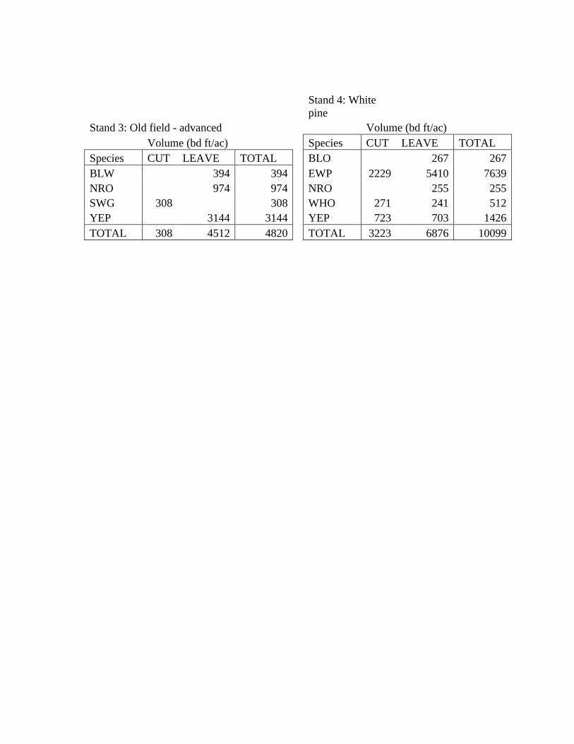
Stand 4: White
pine
Stand 3: Old field - advanced
Volume (bd ft/ac)
Volume (bd ft/ac)
Species CUT LEAVE TOTAL
Species CUT LEAVE TOTAL
BLO 267 267
BLW 394 394
EWP 2229 5410 7639
NRO 974 974
NRO 255 255
SWG 308 308
WHO 271 241 512
YEP 3144 3144
YEP 723 703 1426
TOTAL 308 4512 4820
TOTAL 3223 6876 10099


