resource assessment - houston · g r e e n b r i a r r i c e k i r b y h ol c m b e b el a i r b u...
TRANSCRIPT
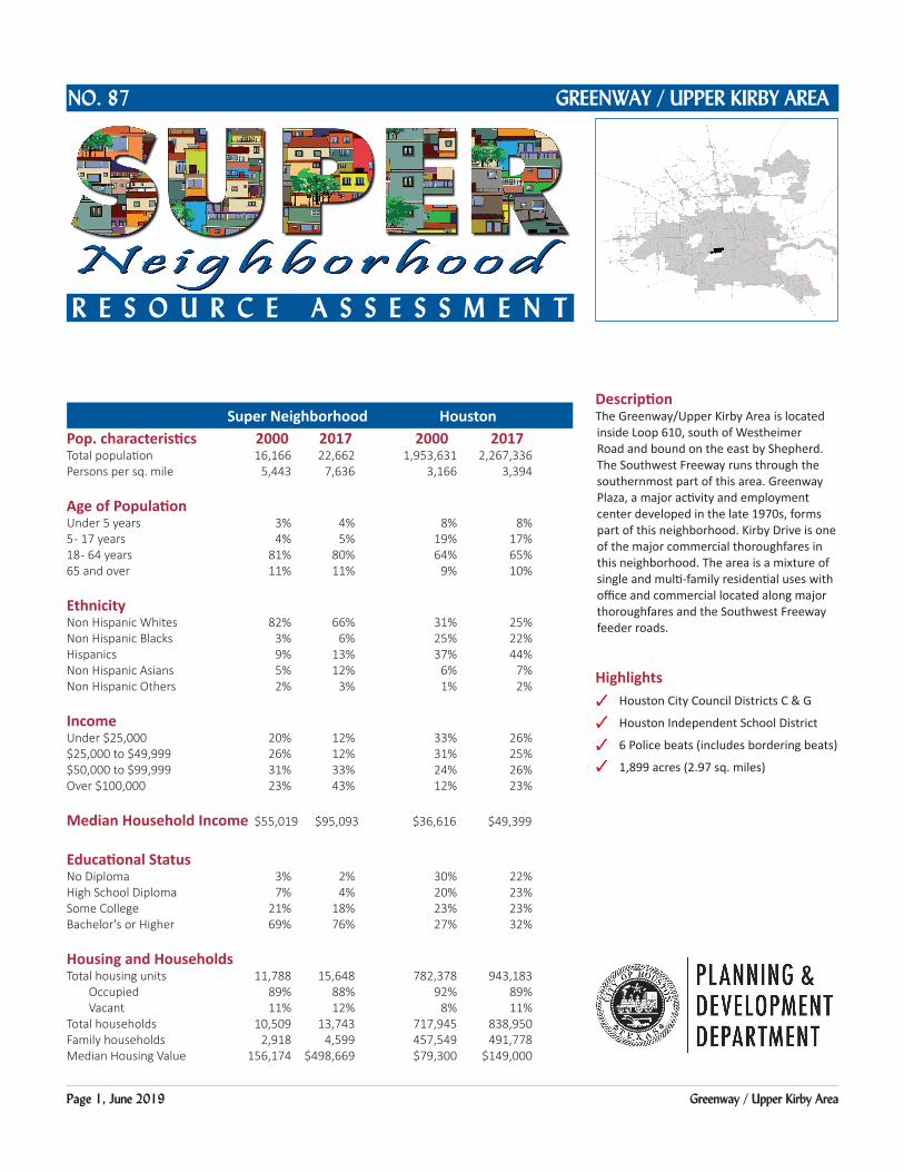
Page 1, June 2019 Greenway / Upper Kirby Area
DescriptionThe Greenway/Upper Kirby Area is located inside Loop 610, south of Westheimer Road and bound on the east by Shepherd. The Southwest Freeway runs through the southernmost part of this area. Greenway Plaza, a major activity and employment center developed in the late 1970s, forms part of this neighborhood. Kirby Drive is one of the major commercial thoroughfares in this neighborhood. The area is a mixture of single and multi-family residential uses with office and commercial located along major thoroughfares and the Southwest Freeway feeder roads.
Highlights Houston City Council Districts C & G
Houston Independent School District
6 Police beats (includes bordering beats)
1,899 acres (2.97 sq. miles)
Super Neighborhood HoustonPop. characteristics 2000 2017 2000 2017Total population 16,166 22,662 1,953,631 2,267,336 Persons per sq. mile 5,443 7,636 3,166 3,394
Age of PopulationUnder 5 years 3% 4% 8% 8%5 - 17 years 4% 5% 19% 17%18 - 64 years 81% 80% 64% 65%65 and over 11% 11% 9% 10%
EthnicityNon Hispanic Whites 82% 66% 31% 25%Non Hispanic Blacks 3% 6% 25% 22%Hispanics 9% 13% 37% 44%Non Hispanic Asians 5% 12% 6% 7%Non Hispanic Others 2% 3% 1% 2%
IncomeUnder $25,000 20% 12% 33% 26%$25,000 to $49,999 26% 12% 31% 25%$50,000 to $99,999 31% 33% 24% 26%Over $100,000 23% 43% 12% 23%
Median Household Income $55,019 $95,093 $36,616 $49,399
Educational StatusNo Diploma 3% 2% 30% 22%High School Diploma 7% 4% 20% 23%Some College 21% 18% 23% 23%Bachelor's or Higher 69% 76% 27% 32%
Housing and HouseholdsTotal housing units 11,788 15,648 782,378 943,183 Occupied 89% 88% 92% 89% Vacant 11% 12% 8% 11%Total households 10,509 13,743 717,945 838,950Family households 2,918 4,599 457,549 491,778Median Housing Value 156,174 $498,669 $79,300 $149,000
GREENWAY / UPPER KIRBY AREANO. 87
R E S O U R C E A S S E S S M E N T
Super Neighborhood Houston

Page 2, June 2019 Greenway / Upper Kirby Area
Greenway / Upper Kirby Area: Land Use
US 59
IH 610
KIRBY
WESLAYAN
SHEPHERDGRAY
SAN FELIPE
BUFFALO SPEEDWAY
NEW
CASTLE
POST OAK
UNIVERSITY
EDLOE
FOURNACE
GREENBRIARRICE
FARNHAM
RICHMOND
WESTHEIMER
ALABAMA
BISSONNET
WESTPARK
Freeway
Rail Road
Super Neighborhood Boundary
Single-family Residential
Multi-family Residential
Commercial
Office
Industrial
Public and Institutional
Transportation and Utilities
Parks and Open Space
Undeveloped
Agricultural Production
Open Water
Unknown
Source: City of Houston GIS Database,
Date: June 5, 2019
Harris County Appraisal District
I 0 0.5 10.25Miles
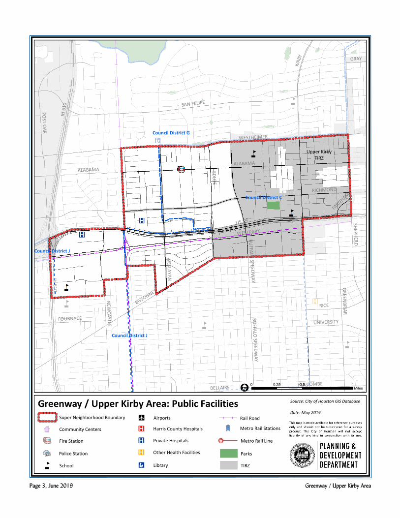
Page 3, June 2019 Greenway / Upper Kirby Area
Greenway / Upper Kirby Area: Public Facilities Source: City of Houston GIS Database
Date: May 2019
Council District G
Council District C
Council District J
Council District J
BISSONNET
RICHMOND
SAN FELIPE
SHEPHERD
ALABAMA
WESTPARKW
ESLAYAN
WESTHEIMER
EDLOE
POST O
AK
NEW
CASTLE
GREENBRIAR
RICE
KIRB
Y
HOLCOMBEBELLAIRE
BUFFALO
SPEEDWAY
FOURNACEUNIVERSITY
GRAY
FARNHAM
ALABAMA
BUFFALO
SPEEDWAY
US 59
IH 6
10
IH 610
US 59
Community Centers
Fire Station
ÆP Harris County Hospitals
ÆP Private Hospitals
ÆP Other Health Facilities
Æc Library
Metro Rail Stations
Police Station
Rail Road
å School
Parks
I0 0.5 10.25
Miles
Super Neighborhood Boundary
Metro Rail Line¬(Å
AirportsZ
TIRZ
Upper KirbyTIRZ

Page 4, June 2019 Greenway / Upper Kirby Area
Language Spoken at Home Employment Status
Housing Units by Year Built Housing Occupancy
97%
3%
Employed Unemployed
11%
24% 24%
10%12% 11%
5%2% 1%
0%
5%
10%
15%
20%
25%
30%
20100r Later
2000 to
2009
1990 to
1999
1980 to
1989
1970 to
1979
1960 to
1969
1950 to
1959
1940 to
1949
1939 or
earlier
75%
10%15%
0%
10%
20%
30%
40%
50%
60%
70%
80%
English Spanish Other
88%
12%
Occupied Vacant
Source: U.S. Census Bureau, 2000 American Community Survey, 2013-2017 Estimates