research activities on disaster management in usm -...
TRANSCRIPT

Research Activities on Disaster Management in USM
JASTIP –WP4 Symposium 22 March 2017
Prof. Dr. Ismail AbustanSchool of Civil Engineering
The 2nd Symposium on JASTIP Disaster Prevention International Cooperation Research(JASTIP-WP4 Symposium)
March 22-23, 2017, Kihada Hall, Obaku Plaza, Uji Campus, Kyoto University, Japan

PROGRAM RAMALAN DAN AMARAN BANJIR NEGARA NATIONAL FLOOD FORECASTING AND DISSEMINATION
PROGRAM
Sazali OsmanBAHAGIAN PENGURUSAN SUMBER AIR DAN
HIDROLOGIWater Resources Management and Hydrology Section

Maklumat Real Time
PENGESANAN Validasi dan Simpan Data
AMARAN DAN HEBAHAN
Communication & Big Data Analysis
Communication Big Data Analysis
KOMPONEN UTAMA PROGRAM RAMALAN DAN AMARAN BANJIR NEGARA (PRAB)
Ketepatan
0.5 meter
RamalanHujan
Cerapan hujan, sejatan, kelempapan tanah
Cerapan aras air dan kadar alir
Air Pasang / Surut
ProfilSungai
Topografi (DEM) & gunatanah
RAMALAN
PUSAT DATA RAMALAN
Amaran
2 Hari
Ramalan Aras Air
Peta BanjirRamalan
7 Hari

4
Sistem Penghantaran Data Bagi Sistem PRABF1
8.0 INOVASI SISTEM PENGHANTARAN DATA
FORECAST DATA CENTRE (FDC)
SG. TERENGGANUHYDROLOGICAL
STATION
FLOOD FORECASTING MODEL
JABATAN METEOROLOGI
MALAYSIA (JMM)SERVER
AGENCYJPS STATEJMMAgensi Pengurusan BencanaNegaraPolis DiRaja Malaysia
PUBLIC / MEDIATelevisionRadioWEB/Mobile Apps/ Facebook / Twitter Short Messaging SystemOpen DataSirenWarning Board
SG. KELANTANHYDROLOGICAL
STATION
SG. PAHANGHYDROLOGICAL
STATION
JMMNUMERICAL WEATHER
PREDICTION (NWP) / RADAR SERVER
AGENSI REMOTE SENSING MALAYSIA
UNMANED AERIAL VEHICLE (UAV) IMAGES
FLOOD WARNING AND DISSEMINATION
SYSTEM
SOURCE PROCESS STAKEHOLDER
5
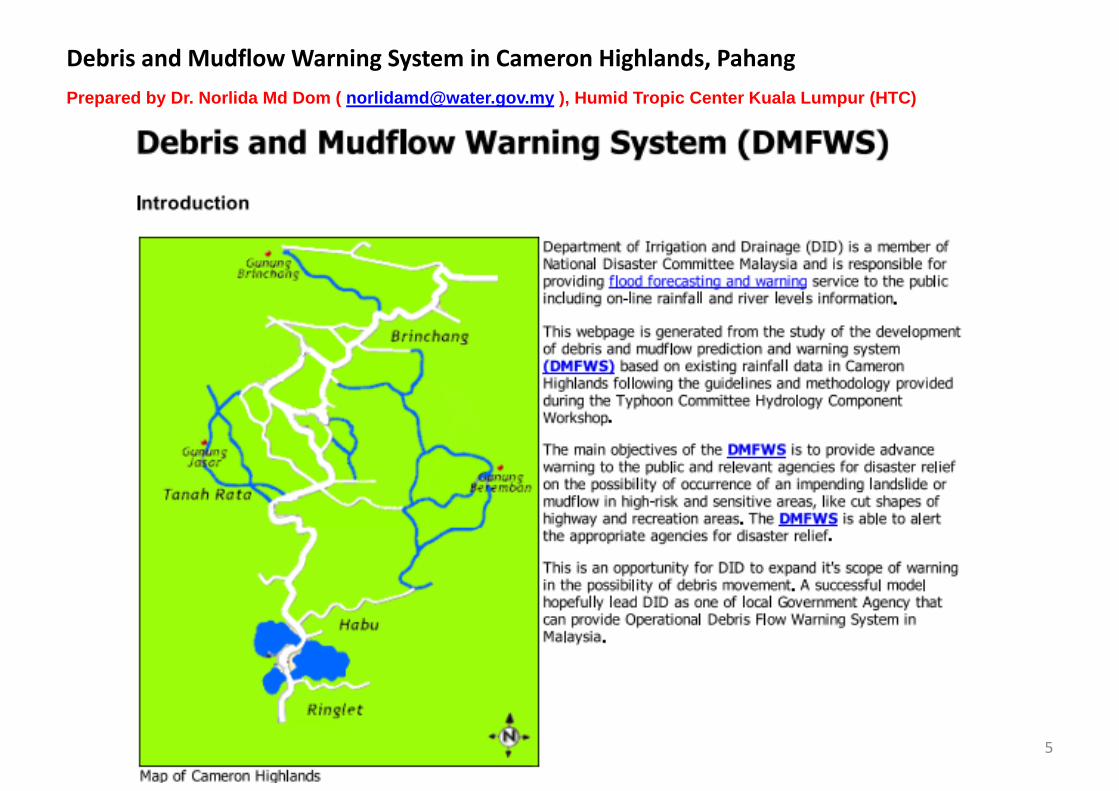
Debris and Mudflow Warning System in Cameron Highlands, PahangPrepared by Dr. Norlida Md Dom ( [email protected] ), Humid Tropic Center Kuala Lumpur (HTC)
Prof Dr Ir Mohd Nordin Adlan, School of Civil Engineering ([email protected])
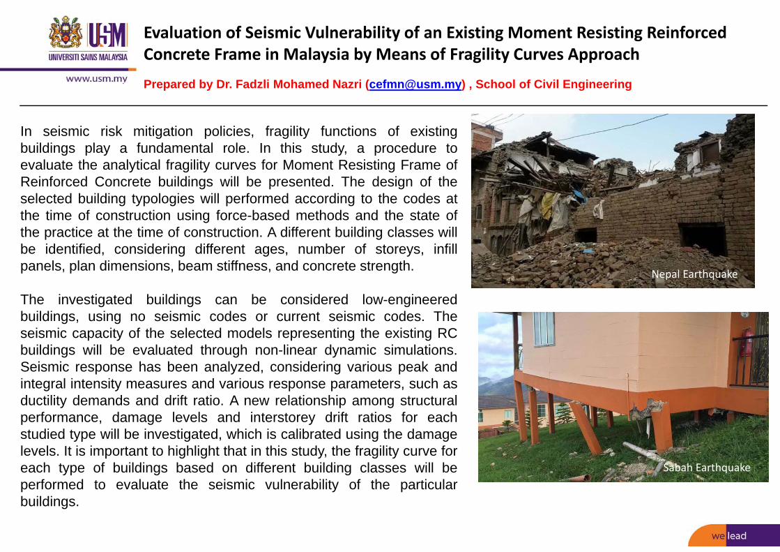
Evaluation of Seismic Vulnerability of an Existing Moment Resisting Reinforced Concrete Frame in Malaysia by Means of Fragility Curves Approach
Prepared by Dr. Fadzli Mohamed Nazri ([email protected]) , School of Civil Engineering
In seismic risk mitigation policies, fragility functions of existingbuildings play a fundamental role. In this study, a procedure toevaluate the analytical fragility curves for Moment Resisting Frame ofReinforced Concrete buildings will be presented. The design of theselected building typologies will performed according to the codes atthe time of construction using force-based methods and the state ofthe practice at the time of construction. A different building classes willbe identified, considering different ages, number of storeys, infillpanels, plan dimensions, beam stiffness, and concrete strength.
The investigated buildings can be considered low-engineeredbuildings, using no seismic codes or current seismic codes. Theseismic capacity of the selected models representing the existing RCbuildings will be evaluated through non-linear dynamic simulations.Seismic response has been analyzed, considering various peak andintegral intensity measures and various response parameters, such asductility demands and drift ratio. A new relationship among structuralperformance, damage levels and interstorey drift ratios for eachstudied type will be investigated, which is calibrated using the damagelevels. It is important to highlight that in this study, the fragility curve foreach type of buildings based on different building classes will beperformed to evaluate the seismic vulnerability of the particularbuildings.
Nepal Earthquake
Sabah Earthquake
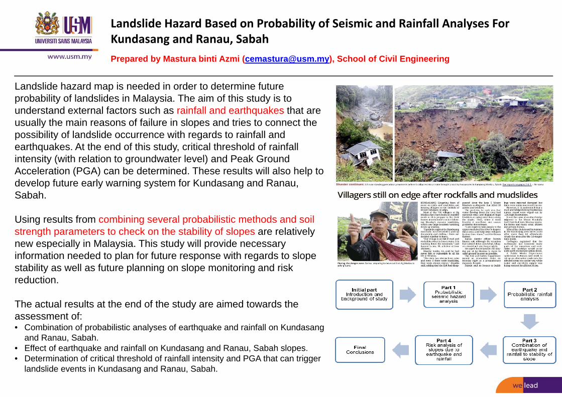
Landslide Hazard Based on Probability of Seismic and Rainfall Analyses For Kundasang and Ranau, SabahPrepared by Mastura binti Azmi ([email protected]), School of Civil Engineering
Landslide hazard map is needed in order to determine future probability of landslides in Malaysia. The aim of this study is to understand external factors such as rainfall and earthquakes that are usually the main reasons of failure in slopes and tries to connect the possibility of landslide occurrence with regards to rainfall and earthquakes. At the end of this study, critical threshold of rainfall intensity (with relation to groundwater level) and Peak Ground Acceleration (PGA) can be determined. These results will also help to develop future early warning system for Kundasang and Ranau, Sabah.
Using results from combining several probabilistic methods and soil strength parameters to check on the stability of slopes are relatively new especially in Malaysia. This study will provide necessary information needed to plan for future response with regards to slope stability as well as future planning on slope monitoring and risk reduction.
The actual results at the end of the study are aimed towards the assessment of:• Combination of probabilistic analyses of earthquake and rainfall on Kundasang
and Ranau, Sabah.• Effect of earthquake and rainfall on Kundasang and Ranau, Sabah slopes.• Determination of critical threshold of rainfall intensity and PGA that can trigger
landslide events in Kundasang and Ranau, Sabah.
Nepal Earthquake

The Effects of Local Soil Dynamic Properties on Non-Seismically Designed Reinforced Concrete Buildings due to Soil ExcitationPrepared by Taksiah A. Majid ([email protected]), Tan Chee Ghuan, School of Civil Engineering
The buildings in Malaysia are not designed to the resistance of seismicloading. The vulnerability of non-seismic designed buildings caused by farfield earthquakes (Sumatra and Philippines) or local earthquakes (Sabahand Bukit Tinggi) may significantly increase due the low performance of jointductility. The investigation of on-site dynamic performance and seismiccapacity of critical buildings will be performed to avoid any losses in future,especially the low to medium rise buildings that are more susceptible tovibration cause by near field earthquakes. The on-site measurement of soildynamic response and on-site measurement of building dynamic responsewill be performed to evaluate the actual dynamic behaviour of site andseismic performance of the building. The seismic demand and capacityanalysis of the buildings will be performed.
This study will developed (i) an empirical relationship of fundamentalperiod and height of building; (ii) an empirical relationship of damping andmode shape of building and (iii) the seismic demand and capacity of thebuilding. These results can be incorporated to the technical guideline for theearthquake resistant design of buildings. This study will benefit theconstruction industry in predicting the vulnerability index of the existing non-seismic designed buildings subjected to most probable earthquake (2% in50 years). Hence, retrofitting decision can be made if necessary. In addition,the procedure of designing and evaluation employed in the project will beuseful for design engineer in providing a safe design especially for high-risebuilding to reduce the urbanization risk due to pre- and post-earthquakeevents for sustainability of public facilities in Malaysia.
Figure 1: The amplification of seismic wave due local soil effect
Figure 2: Structural damages of non‐seismically designed buildings caused by local earthquake in
Ranau, Sabah

Determination of Dynamic Characteristics of Ground and Buildings in Ranau, Sabah using Microtremor TechniquePrepared by Assoc. Prof. Dr. Lau Tze Liang ([email protected]) School of Civil Engineering
The occurrence of 2015 Ranau earthquake has attracted the attentionof public and professionals on the safety of non-seismically designedbuildings under earthquake ground motions. Due to the lack ofresearch and information available for the dynamic characteristics ofthe site in Ranau, microtremor observation is one of the feasibletechniques that could be applied. This technique requires lessmanpower, cost and time consumption. This method involves themeasurement of low amplitude of ambient vibration caused by human-made or atmospheric disturbance. It has been proven to that thistechnique is able to predict the behaviour of ground due toearthquake.
Earthquake resistant design is essential for buildings in order towithstand the earthquake force. Fundamental period and dampingratio are dynamic properties of building that play important roles indynamic analysis. Microtremor observation will be adopted in thisresearch in order to record the motion of buildings. Nakamura’smethod will be adopted to determine the fundamental period ofbuildings. The damping ratio will be estimated based on half powerbandwidth method. The obtained findings will help in the analysis ofbuilding in Ranau subjected to earthquake loading.
Nepal Earthquake
Sabah Earthquake

The Application of Rainfall-Runoff-Inundation (RRI) Model on the 2014 Kelantan Extreme FloodPrepared by Prof. Dr. Hj Ismail Abustan School of Civil Engineering in Colabration og DPRI, Kyoto University, [email protected]
Sungai Kelantan catchment suffered a devastating flood disaster inlate December 2014 and this lead to destructive damages with 45,467people evacuated in Kelantan (26th Dec 2014). The chronology of theextreme flood started with torrential rains on the 17th of December,2014 which led to flash flooding that forced 3390 people in Kuala Krai,Kelantan to be evacuated from their homes. Continuous heavy rain forover three days (from the 21st to the 23rd of December, 2014) set arainfall record of 1 295 mm, equivalent to the amount of rain usuallyseen in a span of 64 days. This paper describes the assessment madeon the potential of Rainfall-Runoff-Inundation (RRI) model to simulatethe flood inundation for the Sungai Kelantan catchment based on two-dimensional diffusion wave equations. The RRI model was used todevelop the actual extent of the December 2014 flood for Kuala Kerai,Kelantan. A simulation for the whole month of December 2014 wasalso carried out using the RRI model to capture initial catchmentconditions. Initial simulation without rivers cross sectional informationwas found to lead to inaccurate inundation analysis. The resultshowever were found to be improved with a good agreement when thecross sectional of Sungai Galas and Sungai Lebir were included asmodel input. The RRI model was also found to simulate the observedflood inundation by remote sensing map for the 26th December 2014flood well. The monthly simulated result showed the two peaksdischarges and flood inundation for 19th December and 25thDecember 2014 to be similar to the ones reported by DID 2014 FloodReport. These findings led to the conclusion that the RRI model isuseful as a flood analysis tool and provider on related flood inundationinformation.
Nepal Earthquake
Sabah Earthquake

Study on the Sustainable Sand Removal Capacity of Sungai PerakPrepared by Prof. Dr. Hj Ismail Abustan School of Civil Engineering in collaboration with Dept of Irrigation and Drainage Malaysia ([email protected])
Universiti Sains Malaysia is requested by Drainage and IrrigationDepartment of Perak to study on the sustainable sand removalcapacity of Sungai Perak at Bota Kanan, Perak.
OBJECTIVES OF THE STUDYThe objective of the study are :a. to determine the potential volume of minable sand on the SungaiPerak, at Bota Kananb. to evaluate whether the proposed site is economically viable andenvironmentally suitable.This study includes field examinations consist ofgeological/geotechnical/geophysical explorations, river dischargemeasurement and grab sediment sampling which is integrated theirapplication to meet the objectives.
Nepal Earthquake
Sabah Earthquake
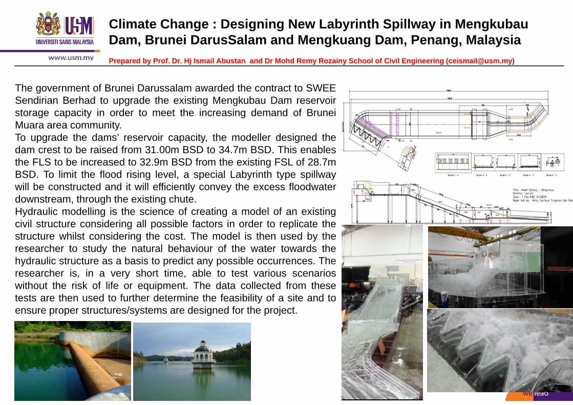
Climate Change : Designing New Labyrinth Spillway in MengkubauDam, Brunei DarusSalam and Mengkuang Dam, Penang, MalaysiaPrepared by Prof. Dr. Hj Ismail Abustan and Dr Mohd Remy Rozainy School of Civil Engineering ([email protected])
The government of Brunei Darussalam awarded the contract to SWEESendirian Berhad to upgrade the existing Mengkubau Dam reservoirstorage capacity in order to meet the increasing demand of BruneiMuara area community.To upgrade the dams’ reservoir capacity, the modeller designed thedam crest to be raised from 31.00m BSD to 34.7m BSD. This enablesthe FLS to be increased to 32.9m BSD from the existing FSL of 28.7mBSD. To limit the flood rising level, a special Labyrinth type spillwaywill be constructed and it will efficiently convey the excess floodwaterdownstream, through the existing chute.Hydraulic modelling is the science of creating a model of an existingcivil structure considering all possible factors in order to replicate thestructure whilst considering the cost. The model is then used by theresearcher to study the natural behaviour of the water towards thehydraulic structure as a basis to predict any possible occurrences. Theresearcher is, in a very short time, able to test various scenarioswithout the risk of life or equipment. The data collected from thesetests are then used to further determine the feasibility of a site and toensure proper structures/systems are designed for the project.
Nepal Earthquake
Sabah Earthquake

Flood Mitigation on Sarawak Barrage : Physical and Numerical ModelPrepared by Dr. Mohd Remy Rozainy .School of Civil Engineering ([email protected])
Nepal Earthquake
Sabah Earthquake
The Sungai Sarawak Regulation Schemeis a major civil engineering project in Kuching Sarawak,
Malaysia. This project incorporates a 3-in-1 infrastructure (barrage, shiploc and bridge) which is the first of its kind in SEA.
The purpose of the physical hydraulic and numerical models to achieve the following objectives:-1. To determine the scouring effects on the down stream of
the barrage in the physical model2. To propose a mitigation concept to reduce the effects of
scouring and upstream flooding2. To report dynamic response of the original and modified
the scouring downstream of the barrage.
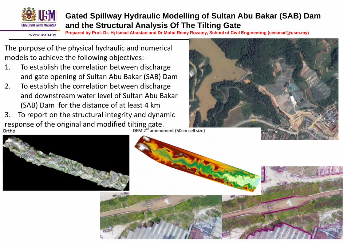
Gated Spillway Hydraulic Modelling of Sultan Abu Bakar (SAB) Dam and the Structural Analysis Of The Tilting GatePrepared by Prof. Dr. Hj Ismail Abustan and Dr Mohd Remy Rozainy, School of Civil Engineering ([email protected])
Nepal Earthquake
The purpose of the physical hydraulic and numerical models to achieve the following objectives:‐1. To establish the correlation between discharge
and gate opening of Sultan Abu Bakar (SAB) Dam 2. To establish the correlation between discharge
and downstream water level of Sultan Abu Bakar (SAB) Dam for the distance of at least 4 km
3. To report on the structural integrity and dynamic response of the original and modified tilting gate.

Short Term Rainfall Forecasting using Persistence Forecast Prepared by Dr Mahyun Abdul Wahab (UniMAP) and Prof. Dr. Hj Ismail Abustan , School of Civil Engineering ([email protected])
Knowledge of precipitation can lead to other research such as rainfall forecasting, flood forecasting, flood mitigation and others. Research on rainfall forecasting can be a good start before the implementation of flood forecasting and warning Most of flood forecasting and warning systems (FWS) are totally depending on the accuracy of rainfall forecasting
Z = 10R1.6
Z = 30R1.6
Z = 40R1.6 Z =
50R1.6
Z =200R1.6
ME ‐26.84 ‐1.52 2.69 5.48 ‐16.26MAE 27.21 5.43 3.75 5.73 16.26RMSE 31.40 7.24 7.06 8.51 18.38
BIAS 2.11 1.06 0.89 0.77 3.07R² 0.679 0.679 0.679 0.678 0.680r 0.82 0.82 0.82 0.82 0.83
0.00
2.00
4.00
6.00
8.00
10.00
12.00
14.00
16.00
18.00
1 21 41 61 81 101
121
141
161
181
201
221
241
261
281
301
321
341
361
381
401
421
441
461
481
501
521
541
561
581
601
621
641
661
Rainfall Intensity
(mm/hr)
Time (10 minutes interval)
Forec…Obser…
0.002.004.006.008.0010.0012.0014.0016.0018.00
Observed Forecasted

SIMULATION OF EVACUATION PROCESS AGAINST TSUNAMI DISASTER IN MALAYSIA Case studies : The Miami Beach, Penang by Dr Muhammad Salleh Abustan (UTHM)
and Dr Noorhazlinda Abd Rahman (USM)
The Miami Beach: Popular tourist attraction; Experienced tsunami attack
(2004); Record more than 5 fatalities; Topography different from other
beaches - crop rocks around the beach.
Motives of the study: To plan appropriate evacuation
routes and evacuation place; To obtain quick and safe
evacuation.
Scope of study: Used CBS-DE model, developed at
Laboratory of Hitoshi Gotoh in the year 2004.
Sim-1: current situation with one evacuation place
Sim-2: improvement with two evacuation place