request for viirs snow cover edr...request for viirs snow cover edr (binary snow cover only)...
TRANSCRIPT

Request for VIIRS Snow Cover EDR
(Binary Snow Cover only) Validated Stage 1 Maturity
Cryosphere Products Validation Team Peter Romanov, CUNY/CREST
Jeff Key, NOAA/NESDIS/STAR, Team Lead Paul Meade, Cryosphere Products JAM
8 January 2014
Validated Stage 1 Effectivity Date: 15 October 2012 (MX 6.4)

Outline
• VIIRS Snow Cover EDR: Specifications and Algorithms
• Binary Snow Cover - Maturity Evaluation - Maturity Justification Summary
• Planned Algorithm Improvements and Modifications
2

3
VIIRS Snow Cover Product Users
• U.S. Users − NSIDC - National Snow Ice Data Center − NIC - National/Naval Ice Center − OSPO - Office of Satellite and Product Operations − NOHRSC - National Operational Hydrological Remote Sensing Center − STAR- Center for Satellite Applications and Research − CLASS - Comprehensive Large Array-data Stewardship System
• User Community
− Agriculture − Hydrology − Numerical Weather Prediction − Transportation − Emergency Management − DOD

Stage 1 EDR Maturity Definition
• Algorithm Assessment – Evaluation of algorithm performance to
specification requirements – Evaluation of the effect of required
algorithm inputs – Error Budget – Quality Flag analysis/validation – Input from key users
• Identification of the processing environment
– IDPS Build Number and effectivity date – Version of LUT(s) used – Version of PCT(s) used – Description of environment used to
achieve particular stage of Validated 4
Using a limited set of samples, the algorithm output is shown to meet the threshold performance attributes identified in the JPSS Level 1 Requirements Supplement with the exception of the S-NPP Performance Exclusions. The list of required artifacts supporting each stage of Validated Maturity:
• Documentation – Current or updated ATBD – Current or updated OAD (algorithm-
related redline updates, if applicable) – README file for CLASS – Product User’s Guide
(Recommended)
• User Precautions – Identification of known issues – List of closed Discrepancy Reports
between previous maturity milestone and current maturity milestone.
• Assessment of outstanding Discrepancy Reports

VIIRS Snow Cover EDR: Summary
• The VIIRS Snow Cover/Depth Environmental Data Record (EDR) product consist of two products – Snow/no snow binary map – Snow fraction in a horizontal cell. Snow fraction is not
addressed in this review. • The Binary Snow Mask provides a mapping of snow covered
areas as either containing or not having snow • Binary Snow Mask is derived at the VIIRS imagery resolution
under clear sky conditions using daytime observations. • The performance of the product is largely dependent on the
quality of the VIIRS cloud mask.
5

Specification of the VIIRS Binary Map
6
RGB Image shows dense smoke (high absorption) in northwest, north central and central coastal portions of image.
6
Parameter Specification Value a. Binary Horizontal Cell Size, 1. Clear – daytime (Worst case) 0.8 km 2. Clear – daytime (At nadir) 0.4 km 3. Cloudy and/or nighttime N/A b. Horizontal Reporting Interval Horizontal Cell Size c. Snow Depth Range > 0 cm (Any Thickness) d. Horizontal Coverage Land e. Vertical Coverage > 0 cm f. Measurement Range Snow / No snow g. Probability of Correct Typing 90% h. Mapping Uncertainty 1.5 km
1. The probability of correct snow/no-snow detection applies only to climatologically snow-covered regions. 2. The accuracy of snow detection does not apply over forested/mountainous areas where snow may be hidden by vegetation or topographic shading. [Joint Polar Satellite System (JPSS) Program Level 1 Requirements SUPPLEMENT – Final Version: 2.9 June 27, 2013]

• The VIIRS Binary Snow Cover EDR algorithm is an adaptation of the heritage MODIS SnowMap algorithm (Hall et.al 2001) that classifies snow based upon the Normalized Difference Snow Index (NDSI) and additional reflectance, thermal and NDVI thresholds. Binary Snow Map is derived at 375 m spatial resolution at nadir.
Snow Cover EDR Algorithm
7

Summary of the Snow Cover EDR Algorithm Inputs
8
VIIRS 375m SDRs I1, I2, I3, I5 VIIRS 750m SDRs M15, M16 VIIRS 375m TC GEO VIIRS 750m TC GEO VIIRS Cloud Mask IP VIIRS AOT IP VIIRS COP IP
VIIRS Snow Cover Binary Map EDR VIIRS Snow Cover Fraction EDR
NPOESS xDRs & IPs
Auxiliary Data VIIRS Snow Cover Tunable Parameter File VIIRS Snow Cover Quality Tunable Parameter
Output EDRs & IPs Snow Cover EDR
Algorithm

Snow Cover EDR Processing Flow
9
Write Snow Binary Map and Snow Fraction Map
Products
Load and check SDR Reflectance and Brightness Temperatures
Initial Pixel Quality Checks
Construct VIIRS Moderate Resolution Snow Fraction Map 2x2 aggregation of Snow Binary Map
VIIRS 375m SDRs I1, I2, I3, I5 VIIRS 750m SDRs M15, M16
Construct VIIRS Imagery Resolution Snow Binary Map (NDSI based algorithm)
NDSI = (R0.64µm – R1.61µm) / (R0.64µm + R1.61µm) > 0.4 R0.865µm > 0.11 T11.45µm (TOA brightness temperature) < 281 K
For NDSI between 0.1 and 0.4 NDVI thresholds as a function of NDSI are used:
NDVI = (R0.865µm-R0.64µm)/(R0.64mm+R0.865µm) ndvi_lower = a1 + a2*NDSI ndvi_upper = b1 + b2*NDSI + b3*NDVI2+ b4*NDVI3 ( Klein et al., 1998)
Snow
VIIRS 375m TC GEO VIIRS 750m TC GEO VIIRS Cloud Mask IP VIIRS AOT IP VIIRS COP IP
Construct EDR Quality Flags for Snow Binary Map and
Snow Fraction Map

Status of Upstream Products
Snow Cover EDR performance depends on VIIRS SDR, VIIRS Cloud Mask IP and Aerosol Optical Thickness IP – VIIRS SDR Cal and Geo products reached provisional maturity
in March, 2013. – VIIRS Cloud Mask IP reached provisional maturity in
February, 2013 – VIIRS Aerosol Optical Thickness reached beta maturity in
September 2012 and provisional in March 2013
10

11
Validated Stage 1 Maturity Evaluation of the
Binary Snow Cover Map Product

• Evaluation approach:
– Qualitative visual analysis of the product, focus on • General consistency of mapped snow cover • Obvious failures of the algorithm/product
– Missed snow in the regions which are known to be snow covered – Mapped snow in the regions which are known to be snow-free – Misclassification of clear-sky snow-covered or snow-free scenes as
“cloudy”
– Qualitative and quantitative comparison of VIIRS maps with in situ data and other remote sensing-based snow cover products
• In situ snow cover observations • NOAA IMS interactive snow cover analysis • Automated snow cover products (MODIS, AVHRR)
12
Evaluation Approach (1/2)

• Details of Evaluation Approach – Different spatial scales
• On a per-granule basis (qualitative analysis) • Over Conterminous US (CONUS) when comparing to station data • Over Northern Hemisphere when comparing with IMS • Globally when comparing with MODIS and AVHRR products
– Time period covered
• Routine evaluation: since the beginning product generation • Maturity assessment basis: November 2012 to December 2013 (over 1 year)
– No major changes to the VIIRS cloud mask (VCM) • VIIRS global snow cover data were acquired, processed and examined on every
third day prior to October 2013 and daily afterwards. Over 160 global images were used for product evaluation.
– VIIRS IDPS EDR products were acquired from • NESDIS/STAR Central Data Repository (SCDR) • NASA Land Product Evaluation and Analysis Tool (PEATE) Element
13
Evaluation Approach (2/2)
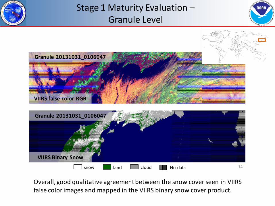
Stage 1 Maturity Evaluation – Granule Level
14
Overall, good qualitative agreement between the snow cover seen in VIIRS false color images and mapped in the VIIRS binary snow cover product.
snow cloud land No data
Granule 20131031_0106047
VIIRS false color RGB
VIIRS Binary Snow
Granule 20131031_0106047

Stage 1 Maturity Evaluation – VIIRS vs MODIS Snow Map
15
MODIS Aqua
March 2, 2013 (day 2013061)
VIIRS binary snow maps compare well to MODIS Terra & Aqua snow maps. There are some differences in the cloud mask applied in the VIIRS and MODIS products.
Due to a wider swath VIIRS daily global snow map has no gaps between adjacent swaths inherent to the MODIS global daily snow product.
NPP-Suomi VIIRS snow cloud land No data

Stage 1 Maturity Evaluation – VIIRS vs AVHRR Snow Map
16
VIIRS Binary Snow Map agrees well to NESDIS AVHRR METOP snow/ice map VIIRS Cloud Mask maps more clouds in midlatitudes than the AVHRR cloud mask.
AVHRR METOP
March 23, 2013
snow cloud land No data
S-NPP VIIRS
March 23, 2013

Stage 1 Maturity Evaluation – VIIRS vs AVHRR Snow (South America)
17
Part of the difference in the mapped cloud cover in AVHRR and VIIRS snow products is due to 4 hours difference in the satellite overpass time
snow cloud land No data
S-NPP VIIRS METOP AVHRR July 23, 2013 July 23, 2013
South America

Stage 1 Maturity Evaluation - VIIS vs NOAA IMS
18
VIIRS snow map
IMS Snow and Ice Chart
February 12, 2013
In clear sky portions of the image snow cover identified by VIIRS closely corresponds to the snow cover mapped interactively by IMS analysts.
snow cloud land No data

Stage 1 Maturity Evaluation – VIIRS vs NOAA IMS: Overlay
19
White: VIIRS & IMS snow, Light Gray: VIIRS clouds, Green: VIIRS & IMS snow-free land, Dark gray: no data
Snow omissions in the VIIRS map occur mostly over densely forested areas and along the snow cover boundary. Commission errors occur mostly in cloudy areas.
Omission (snow miss) Commission (false snow) VIIRS snow map errors:
IMS snow map with VIIRS binary snow cover map overlaid
December 26, 2013

20
Observations from WMO and US Cooperative network stations over Conterminous US and Southern Canada have been used for qualitative and quantitative validation of VIIRS Snow Maps The number of daily VIIRS-in situ match ups ranged from 150 to 1030
Stage 1 Maturity Evaluation – VIIRS Snow Map vs In Situ Observations
VIIRS snow map with station observation data on snow overlaid

21 Daily agreement between VIIRS daily snow retrievals and ground station data over CONUS area remains above 90% most of the time. The mean agreement in winter months is close to 94%.
Daily statistics of correspondence between VIIRS snow and in situ data
Percent agreement between VIIRS and in situ data
Stage 1 Maturity Evaluation – VIIRS vs Station Data: Daily Statistics

Stage 1 Maturity Evaluation – VIIRS vs NOAA IMS: Daily Statistics
22 Since the end of 2012 over Northern Hemisphere - The yearly mean agreement between daily VIIRS and IMS products was 98%. - The daily rate of agreement never fell below 93% - As compared to IMS, VIIRS more often mapped less snow than more snow - No substantial accuracy differences between North America and Eurasia
Statistics of daily comparison of VIIRS and IMS All land area included (no account for snow cover climatology)
Percent agreement between VIIRS and IMS products
within 25-600 N latitude band

Stage 1 Maturity Evaluation – Considering Snow Cover Climatology
23
Weekly snow occurrence probability based on IMS snow charts since 1972
Proper approach to validation of the snow product should account for the snow cover climatology Most important is the performance of the product in the region where the snow cover may or may not be present at the given time of the year (“snow possible”)
Northern Hemisphere North America Eurasia
All Land Area 98.0 97.8 98.0 “Snow Possible” 95.1 95.7 94.9
Mean agreement (%) of daily VIIRS snow to IMS in 2013
Agreement between the two products drops 2-3 % in the “Snow Possible” region as compared to “All Land”

Stage 1 Maturity Evaluation – Product Accuracy Change 2013 vs 2012
24
2012 2013
Northern Hemisphere
Total Agreement 98.2 97.2
False snow 0.53 0.42
Snow Miss 1.21 2.40
Cloud clear 34.2 42.9
VIIRS snow vs IMS in November-December: Comparison Statistics (%)
Changes in the product accuracy and error budget from 2012 to 2013 are minor and may be caused partially by different snow cover properties/distribution in the two years and partially by changes introduced to the VCM.

Stage 1 Maturity Evaluation – VIIRS vs MODIS Snow: Different Clear-Sky Fraction
25 In mid latitudes VIIRS VCM identifies considerably more clouds than MODIS. The difference is the largest in late spring and summer. More clouds means smaller effective (clear sky) area coverage of the VIIRS snow cover product.
Clear sky fraction in VIIRS and MODIS snow products is noticeably different

Stage 1 Maturity Evaluation – VIIRS, AVHRR, MODIS Snow vs IMS
26
VIIRS agreement to IMS is ~1% better than that of MODIS and AVHRR snow maps, however VIIRS identifies ~10-15% less cloud-clear scenes than MODIS and AVHRR. Better accuracy of VIIRS snow maps is attained (at least partially) at the expense of reduced effective clear-sky coverage
Agreement to IMS (%) Cloud-clear(%)*
VIIRS 98.0 38.6 MODIS (T) 97.3 49.1 MODIS(A) 97.1 48.3 AVHRR 97.9 55.0
Mean agreement to IMS and cloud-clear fraction of daily automated snow products in 2013
Northern Hemisphere
*Cloud-clear fraction is estimated in 25-600N latitude band

27
Identified Problems in the
VIIRS Binary Snow Cover Map Product

Cloud Mask Ambiguity
28
Neither ATBD nor OAD tells the user how to get the most optimal cloud mask for the product using the 4-category cloud confidence flag. This may cause confusion and incompatibility of snow maps generated from the same VIIRS snow product We recommend applying the most conservative cloud mask where only “confidently clear” pixels are assumed cloud-clear. Using more “relaxed” cloud masks increased the effective area coverage but also results in a substantial increase of snow mapping errors.

Overestimated cloud extent
29
Clear snow-covered pixels are often labeled as cloudy.
Most often this occurs along the snow cover boundary and in the mountains.
VIIRS RGB granule image
snow cloud land No data / not processed
VIIRS granule snow product

Overestimated cloud extent
30
Clear snow-covered pixels are often labeled as cloudy.
Most often this occurs along the snow cover boundary and in the mountains.
snow cloud land No data / not processed
Clear-sky pixels along the shore line are labeled as “probably clear” and therefore are included in the cloud mask.

31
Some clouds are missed by the VIIRS cloud mask (VCM).
Missed clouds are more often interpreted as snow and thus may appear in the snow product as spurious snow.
Update: The problem of missed clouds and subsequent false snow identification in the Amazon and in other tropical areas has been mostly fixed snow cloud land
Jan 13, 2013
False Snow

32
DRAFT
Occasional failures to detect snow shadowed by clouds.
snow
cloud
land
VIIRS snow cover, January 31, 2013 (day 2013031)
Missed Snow due to Cloud Shadows

Date&time :20130718_t1838355
Spurious water bodies in the VIIRS snow product due to misinterpretation of cloud shadows as “ephemeral water” by the VIIRS cloud mask algorithm
Problem: VCM interprets pixels with NDVI < 0.01 as “ephemeral water” and modifies the land/water mask accordingly by assigning an “inland water” flag to these pixels. However a large (if not the largest) portion of pixels with low NDVI actually represent cloud shadows and topographical shadows . As a result, the land/water mask in the snow product gets corrupted.
Corrupted Land/Water Mask
VIIRS Binary Snow Map Granule
34
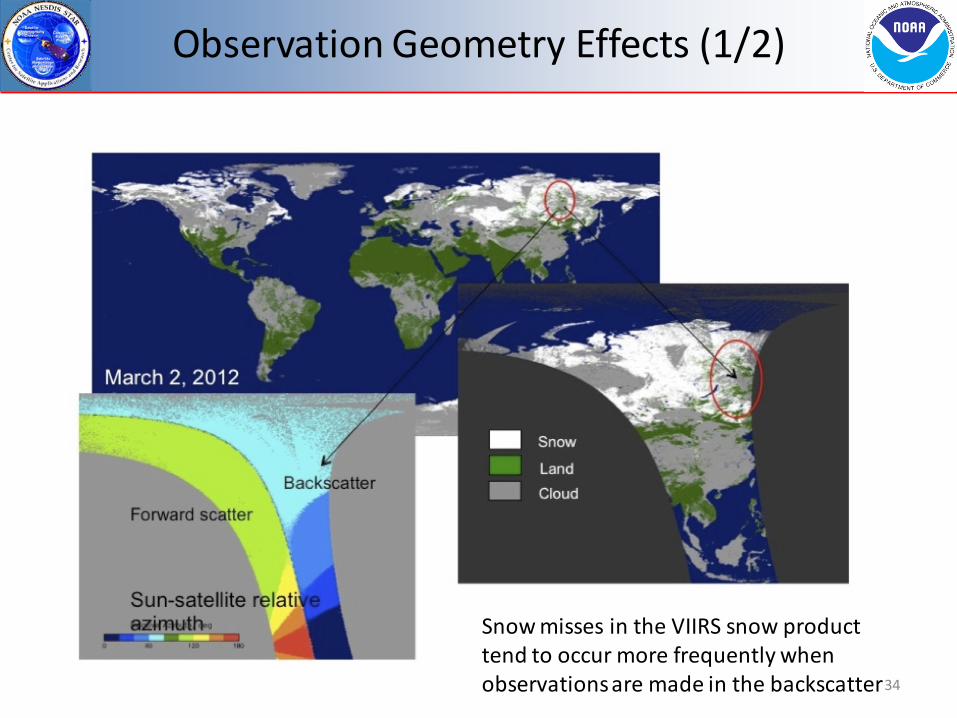
Snow misses in the VIIRS snow product tend to occur more frequently when observations are made in the backscatter
Observation Geometry Effects (1/2)

Observation Geometry Effects (2/2)
35
Efficiency of snow identification decreases at scan edges, most noticeably in the backscatter and over densely forested regions. This is partially due to the fact that the snow detection algorithm does not account for changing surface reflectance with view geometry.
backscatter forward scatter
VIIRS data over Northern Siberia Oct 24-31, 2013
Snow-covered taiga

Quality Flags
36
• Overall: 16 quality flags – Related to SRDs, clouds, aerosol, observation geometry, land/water,
surface type, results of spectral threshold test applied – Some flags are not obviously relevant (e.g., cloud phase, fire, snow
fraction exclusion)
• Most Important flags have been checked – Cloud Confidence – Land/Water – Input SDR quality – Solar zenith angle exclusion

Discrepancy Reports (DRs) Date Update/DR# Reason Status 12-20-2010 VIIRS Snow Cover EDR
Look-up/DR4138 Updated false snow thermal screening threshold. Previous threshold value was based on MODIS data. New threshold values has been derived from VIIRS F1 test program results
Completed Updated VIIRS-SCD-SNOW-COVER-LUT Revision Date: 2/11/2011 Source Version: ISTN_VIIRS_NGST_3.3.5 Source Files:snow_cover_btmax281K.lut Provenance Version ID: 1-D-NPP-2
03-31-2011 Snow algorithm inconsistent with new requirements/DR4246
Operational approach for snow fraction retrieval is inadequate
Not Completed
04-10-2013 (last update)
Snow EDR has fixed limit setting on solar zenith angle (SZA)/DR4895
Need to remove the fixed limits on solar zenith angle and make the limits tunable
Not Completed
04-25-2012 Alternative snow/ice grid needed to support algorithms/DR4700
Need to modify the Snow/Ice GranToGrid algorithm to make use of the NOAA Global Multisensor Automated Snow/Ice Map
Completed
06-18-2012 VIIRS-SNOW-COVER-QUAL LUT SZA Thresholds/DR4787
Updates needed to solar zenith angle thresholds in the VIIRS-SNOW-COVER-QUAL LUT and to the seed data for the GridIP-VIIRS-Snow-Ice-Cover-Rolling-Tile dataset
Completed VIIRS-SCD-SNOW-COVER-QUAL-LUT Revision Date: 08/23/2012 Source: CCR-12-480 Provenace Version ID: 1-0-CCR-12-480-JPSS-DPA-003; Bui ld Identifier: Mx7
04-12-2013 Request for Beta Maturity Status for VIIRS Cryospheres EDRs and Ips/DR7132
Approval requested for the Snow Cover EDR . Completed
37

Justification Summary (1/2)
38
Algorithm/Product Assessment • Performance: The product meets accuracy requirements under most conditions.
Evaluation is based on an over 1-year long time period of analysis from October 2012 to December 2013 and involves VIIRS global snow cover retrievals. The product can be offered for evaluation by the community, however the users has to be warned that product has flaws.
• Impact of algorithm inputs: Non-optimal performance of VCM results in occasional “false snow” identifications and frequent labeling of partially snow covered scenes as “cloudy”.
• Error Budget: Daily agreement with IMS is generally within 94-98% depending on whether the snow cover climatology is accounted for or not. The rate of agreement to the station data is 3-4% less. In both cases the accuracy of he product is within the required 90% probability of correct typing.
• Quality flag analysis: Land/water flag provided with the product may be set incorrectly. Cloud shadows and topographical shadows are frequently interpreted by the VCM as “ephemeral water” and the land water mask is modified accordingly. No problems in setting of other flags have been found.
• Input from users: The primary user is the National Ice Center. A NIC presentation was given at the Snow Cover EDR Provisional Maturity Review.

Justification Summary (2/2)
39
Processing Environment • IDPS build and effectivity date: MX 6.4, 15 October 2012 • Version of LUT(s): VIIRS-SCD-SNOW-COVER-
LUT_npp_20020101010000Z_20020101010000Z_ee00000000000000Z_PS-1-D-NPP-2-PE-_devl_dev_all-_all (2010 NPP prelaunch)
• Version of PCT(s): VIIRS-SCD-SNOW-COVER-QUAL-LUT_npp_20120501000000Z_20120501000000Z_ee00000000000000Z_PS-1-0-CCR-12-480-JPSS-DPA-003 (Updated by DR4787; implemented on IDPS operational system 11/30/2012)
Documentation • ATBD: ATBD is accurate, up-to-date and consistent with the current product • OAD: Operational Algorithm Description is accurate, up-to-date and consistent with the
current product • README file for CLASS: Will be produced (based on the Report) • Product User Guide: Deemed unnecessary given the abundance of other documentation on
algorithms, data formats, and cautionary notes
User Precautions • Identification of known issues: Known issues are identified in the current presentation and
in the corresponding in the Report. They will also be included in the README file to CLASS • Discrepancy Reports: Issues are being addressed

Future Plans
• Routine monitoring of the quality of VIIRS Binary Snow Map product will be conducted to assess its possible changes due to changes in the VIIRS cloud mask
• Detailed characterization of the product performance – Comprehensive evaluation of the product stratified by the season of the year,
climatic/geographic zone, surface cover type, observation geometry – More detailed analysis of the algorithm and product performance at local scales
• Continued evaluation of the product quality flags • Some changes/modifications to the Binary Snow Map algorithm
are currently considered – Replace fixed snow detection threshold values with variable values that depend on
the observation geometry. 40

Conclusions
• The VIIRS Binary Snow Cover Product (which is part of the VIIRS Snow Cover EDR) has reached the Validated Stage 1 maturity level based on the definitions and the evidence shown
• Issues have been uncovered during validation of the VIIRS Binary Snow Cover Product and solutions are being evaluated. – Improvements in the Snow Cover EDR performance are expected with
improved performance of the VCM
• The Validated Stage 1 effectivity date is October 16, 2012 (MX 6.4), as validation datasets produced after this time formed the basis of our evaluation.
41

Additional Supporting Documentation • List reports
Weekly, monthly, quarterly Progress Reports are posted at ftp://ftp.star.nesdis.noaa.gov/pub/smcd/emb/promanov/VIIRS_SNOW https://groups.ssec.wisc.edu/groups/jpss/cryosphere/reports
• TIM Meetings and Presentations Cal/Val Team Meeting, April 2012 TIM on snow/ice rolling tiles, June 2012 TIM on snow/ice rolling tiles, July 2012 DRAT on gridding, September 2012 TIM on automated snow/ice map use in Rolling Tiles, February 2013 TIM on gridding, April 2013 TIM on snow cover fraction, May 2013 Meeting with Surface Type EDR group, July 2013
42
• Publications and Presentations Key R.J., R. Mahoney, Y. Liu, P. Romanov, M. Tschudi, I. Appel, J. Maslanik, D. Baldwin, X. Wang, and P. Meade (2013) Snow and Ice
Products from Suomi NPP VIIRS. Accepted in JGR. Appel I. (2013) Remote Sensing Information for Snow Monitoring. Third International Symposium on the Arctic Research, Tokyo,
Japan, January 2013. Appel. I. (2012) Validation and Potential Improvements of the NPP Fractional Snow Cover Product Using High Resolution Satellite
Observations. 32nd EARSeL Symposium and 36th General Assembly, Mykonos, Greece, May 2012. Appel. I. (2012) Improved VIIRS Snow Cover Information for Terrestrial Water Cycle Applications. AGU Chapman Conference on
Remote Sensing of Terrestrial Water Cycle, Kona, Hawaii, February 2012. Romanov P., I. Appel (2012) Mapping Snow Cover with Suomi NPP VIIRS, EUMETSAT Conference, Gdansk, Poland, September 2012. Romanov P., I.Appel (2012) Snow cover products from Suomi NPP VIIRS: Current status and potential improvements, IGARSS,
Munich, Germany, July 2012. Romanov P., I. Appel (2012) Mapping Snow Cover with Suomi NPP VIIRS, NOAA 2012 Satellite Science Week. Meeting. Summary
Report. April 30 – May 4, 2012. Kansas City, Missouri.