republic of yemen ministry of water and environment...
TRANSCRIPT

1
Republic of Yemen Ministry of Water and Environment
Environmental Protection Authority
Pilot Program for Climate Resilience (PPCR) Investment I
Climate Information System and PPCR Coordination Project
Environmental and Social Management Plan (ESMP) for the
Modernization of the National Hydrometeorological and
Monitoring Networks
Report
(Final)
Prepared by
Dr. Khaled Ibrahim Hariri- Consultant.
Environment and Natural Resources
Management and Development.
12 February 2013
Pub
lic D
iscl
osur
e A
utho
rized
Pub
lic D
iscl
osur
e A
utho
rized
Pub
lic D
iscl
osur
e A
utho
rized
Pub
lic D
iscl
osur
e A
utho
rized
Pub
lic D
iscl
osur
e A
utho
rized
Pub
lic D
iscl
osur
e A
utho
rized
Pub
lic D
iscl
osur
e A
utho
rized
Pub
lic D
iscl
osur
e A
utho
rized
2

3
Table of Contents
I. Introduction ...................................................................................................................... 6
II. Background ...................................................................................................................... 7
III. The Project ....................................................................................................................... 8
IV. Objective of the ESMP ................................................................................................... 11
V. The Environment and Socio-cultural Environment ....................................................... 11
VI. Project Locations and potential impacts......................................................................... 18
VII. Environmental and Social Management Plan (ESMP) .................................................. 24
VIII. Mitigation Measures ....................................................................................................... 25
IX. The Negative Checklist (Site Selection Criteria) ........................................................... 29
X. Monitoring and Reporting .............................................................................................. 29
XI. Public consultation ......................................................................................................... 30
XII. Legislative and Regulatory Considerations.................................................................... 30
ANNEX 1. ToR for ESMP ....................................................................................................... 33
ANNEX 2. Group (1) ............................................................................................................... 40
ANNEX 3. Group (2) ............................................................................................................... 46
ANNEX 4. Group (3) ............................................................................................................... 52
ANNEX 5. Group (4) ............................................................................................................... 57
ANNEX 6. List of rain fall &meteorological and wad flood stations...................................... 59
ANNEX 7. CAMA/YMS stations ............................................................................................ 68
ANNEX 8. Stakeholders Met ................................................................................................... 69
ANNEX 9. Long term annual mean for weather elements ...................................................... 72
ANNEX 10. Meteorological stations NWRA .......................................................................... 74

4
Acronyms
AREA Agriculture Research and Extension Authority CAMA /YMS Civil Aviation and Meteorology Authority/Yemen Met.Station CC Climate Change CWMU Central Water monitoring Unit EEZ Extended Economic Zone EPA Environment Protection Authority EPL Environment Protection Law ESMP Environment and Social Management Plan FAO Food and Agriculture Organization GDP Gross Domestic Product GoY Government of Yemen GSCP Groundwater and Soil Conservation Project IMCCC International Monitoring Committee on Climate Change MAI Ministry of Agriculture and Irrigation NAPA National Adaptation Program NEAP National Environment Action Plan NIP National Irrigation Plan NSES National Sustainable Environment Strategy NWASA National Water and Sanitation authority NWRA National Water resources Authority PCMA Public Corporation for Maritime Affairs PCU Project central Unit PPCR Pilot Program for Climate Resilience RALP Rain-fed Agriculture and Livestock Project TDA Tihama Development Authority TS Technical Secretariat WB World Bank WMO World Meteorological Organization

5
Acknowledgement
The Consultant wishes to express his thanks to Engineer M. Shidiwa –Yemen EPA for his assistance in obtaining information on the locations of the meteorological stations belonging to various agencies. The Consultant acknowledges with gratitude Dr Abdo Al Maqaleh Deputy of CFAMA/YMS for his guidance and valuable advice given during the assignment. Many thanks are extended to Dr. HishamNagi for his assistance in the field visits to the sites, the photos taken and his technical inputs. Acknowledgement is to all stakeholders who had given their views on the project. Special thanks are extended to Ms. Lia Seighart, Mr. Abdoul-Wahab Seyni and Ms. Suiko Yoshijima from the World Bank for their assistance and various inputs to the study.

6
Environmental and Social Management Plan (ESMP) for the
Modernization of the National Hydrometeorological and
Monitoring Networks
“Environmental management is an integral component of effort to reduce poverty and achieve
sustainable and equitable growth”
(Declaration of the 2000 Millennium Summit, at UN)
I. Introduction
Over the last 50 years, human activities – particularly the burning of fossil fuels – have released sufficient quantities of carbon dioxide and other greenhouse gases to trap additional heat in the lower atmosphere and affect the global climate. In the last 100 years, the world has warmed by approximately 0.75oC. Over the last 25 years, the rate of global warming has accelerated, at over 0.18oC per decade. Sea levels are rising, glaciers are melting and precipitation patterns are changing. Extreme weather events are becoming more intense and frequent. The global average temperatures are projected to increase between 1.4 and 5.8 oC by the end of this century; an associated rise in sea level is also expected. The number of people at risk from flooding by coastal storm surges is projected to increase from the current 75 million to 200 million in a scenario of mid-range climate changes, in which a rise in the sea level of 40 cm is envisaged by the 2080s. Extremes of the hydrologic cycle (such as floods and droughts) are projected to increase with warmer ambient temperatures. Evidence is mounting that such changes in the broad-scale climate system may already be affecting human health, including mortality and morbidity from extreme heat, cold, drought or storms; changes in air and water quality; and changes in the ecology of infectious diseases (Impact of regional Climate Change on human health (Jonathan A et al, WHO - NATURE| volume 438|17 November 2005) Yemen is one of the least developed countries, and is located in an arid/semi-arid climatic zone. The country is characterized by limited resources and weak legal and institutional frameworks. High rates of poverty among the population and the low human resources development scores augment the driving forces necessitating actions depending on a clear prioritization of environmental issues and problems. Such actions ought to be based on the various development policies and strategies formulated by the relevant government agencies. It is predominantly a rural country and 83% of Yemen’s poor live in rural areas, where agriculture and fisheries are the main sources of livelihoods. It is a low-income country, with diverse social and economic challenges and high population growth rates of 3.02% annually. Average GDP per capita increases by only 1.5% per annum. Farming and agricultural related activities remain the main source of living for most Yemenis. The coastal zone of Yemen with its rich variety of natural habitats and species is a natural hub for development in terms of fisheries, coastal settlements,
7
coastal infrastructure (including roads and port facilities), and potential for tourism, maritime trade routes and new development initiatives. Fisheries and coastal resources account for the most important source of non-oil export revenues for Yemen. The rapid development of information and sensor technology and high integration of electronics and data communication have made automation of meteorological and hydrological networks increasingly affordable and attractive to Meteorological and Hydrological Services and other users, who need real-time weather data and monitoring of water systems such as rivers, lakes, reservoirs and ground water. Hydrometeorological networks, typically consisting of a large number of automatic monitoring stations, telecommunication systems, databases and application software for the users, are installed in a wide geographical area, often in remote locations. Capable of surviving harsh weather conditions, they provide valuable information on a large variety of weather parameters, precipitation, water quality and existing water reserves helping the authorities to make right and on-time decisions (Hannu Kokko Vaisala Oyj, Helsinki, Finland Integrated Hydrometeorological Monitoring Solutions and Network Management 2005).
II. Background
Due to its high vulnerability to climate change, Yemen was chosen as one of the pilot countries under the Pilot Program for Climate Resilience (PPCR). The objective of the PPCR is to provide incentives for scaled-up action and transformational change through pilot projects that demonstrate how to integrate climate risk and resilience into core development planning, while complementing other ongoing development activities in a given country. The PPCR will be country-led, and will enable pilot countries to transform country-specific plans and investment programs in order to address climate risks and vulnerabilities, building on National Adaptation Programs of Action (NAPAs) and other relevant country studies and strategies. Substantial programmatic resources will then be made available to help fund the newly identified public and private sector investments. The long term annual mean weather elements as described by the Civil Aviation and Meteorological Authority (CAMA) are in Annex 9.
The PPCR process will have two phases: Phase I will prepare the Strategic Program for Climate Resilience (SPCR), and Phase II will implement priority interventions identified under Phase I. Through a series of consultations with various stakeholders, including different line ministries and agencies of the Government of Yemen (GoY), development partners, and civil society, the Yemen-PPCR team developed the Phase I proposal, which has been approved by the PPCR Sub-Committee, the oversight entity for the PPCR. In Yemen, the PPCR process will concentrate on addressing the following four pillars under Phase I: (I) climate change information system and awareness raising related to climate resilience; (II) mainstreaming climate change resilience into core national development planning and capacity building; (III) developing the SPCR; and (IV) strengthening the Technical Secretariat (TS)/Environmental Protection Authority (EPA) and Program Coordination Unit (PCU) to facilitate implementation of the PPCR. Based on several consultations with national stakeholders, civil society and development partners, four main areas of interventions have been identified under the Phase II of the PPCR program and the Climate Info System & PPCR Coordination Project is one of the four interventions proposed.

8
III. The Project
The project would consist of the following four components:
o Component A: Institutional Strengthening and Capacity Building o Component B: Modernization and Expansion of the National Hydrometeorological
and Monitoring Networks o Component C: Enhancement of Service Delivery System o Component D: PPCR Program Management and Knowledge Sharing
Component A. Institutional Strengthening and Capacity Building: This component aims to improve climate resilience in Yemen through provision of weather, climate and water services that meet stakeholders’ needs by creating the conditions that ensure institutional, staffing and financial sustainability of the key providers. The activities of this component will be provided in the form of consulting and non-consulting services. Component B. Modernization of the National Hydrometeorological and Monitoring
Networks: This component aims to upgrade and expand the meteorological observations networks for meteorology, agro-meteorology and hydro-meteorology, ensuring that these networks are well functioning and interoperable between CAMA/YMS, MAI, NWRA and the development authorities (e.g., TDA, NHDA, ERDA) to ensure the efficient and timely transmission of information that is essential for management of disaster risks, agriculture and water resources. Collection and timely communication of high-quality data is the foundation of producing reliable weather forecasts and warnings as well as monthly and longer-term climate outlooks. This component will also contribute to the development of a pilot environmental monitoring system. The bulk of the activities in this component include procurement and installation of goods such as monitoring equipment and ICT. There are three subcomponents: (i) Subcomponent B.1 – Technical modernization of the observing networks, which includes:
(1.1) Rehabilitation and extension of the MAI agro-meteorological observing network; (1.2) Extending the weather and climate surface observing network for CAMA/YMS; (1.3) Replacement, rehabilitation and expansion of NWRA hydrometeorological network; (1.4) Delivery and installation of a Doppler weather radar to improve the monitoring and forecasting of high impact events associated with heavy precipitation and other weather related hazards including a) equipment and b) works; (1.5) Installing up to three upper air stations measuring profiles of temperature, humidity and wind speed and direction including a) equipment and b) works; (1.6) Upgrading of the CAMA/YMS calibration facilities including a) stationary laboratory for the use of all network operators and b) mobile calibration laboratory mostly supporting the operation of the CAMA/YMS weather and climate observing network; and (1.7) Installing marine observing stations in locations to be identified by CAMA/YMS in coordination with the Technical Committee.

9
(ii) Subcomponent B.2 – Modernization of the communication and ICT system, which includes: (2.1) Updating communication equipment of all observing networks (CAMA/YMS, MAI, NWRA and EPA); (2.2) Assessing and strengthening the national data management system, including archiving and data rescue; and (2.3) Upgrading operational satellite receiving systems for forecasting and mapping applications.
(iii) Subcomponent B.3 Design and pilot operation of an environmental monitoring system, which includes. (3.1) Developing a needs assessment and design of air quality monitoring networks; and (3.2) Piloting an operational air quality monitoring network.
Subcomponent B.1 will support the technical modernization of the networks. Extensive consultation with CAMA/YMS, MAI and NWRA was undertaken to determine the current status of the meteorological, agrometeorological and hydrometeorological networks, monitoring methods, transmission of observations, data processing, data archiving and delivery of services. Overall the CAMA/YMS network is in good shape for its primary mission to support civil aviation and there are very few issues with data transmission and communication. However, this network needs to be expanded to cover the entire country and to provide services to all sectors and the population. In contrast, the operational status of MAI and NWRA networks is much less clear in part because the overall irrigation and water management system is fragmented making it difficult for organizations to maintain central control over their networks, part of which are implemented by the regional development authorities. Many of the stations listed as operational by MAI and NWRA are in fact not reporting data and the status of the equipment is uncertain. Providing warnings of flash floods and creating a high-resolution climatology of precipitation requires the introduction of technologies such as radar, which are now in routine use by many National Meteorological Services (NMSs). Support for one Doppler radar is proposed, which will require it to be located optimally to provide nowcasting support for extreme rainfall events in high-risk areas as well as support routine forecasting services covering populated areas. CAMA/YMS have identified Dhamar Meteorological Station as the intended site for the radar. Coverage of the entire country would require more radar and this should be considered in future programs. The radar specifications will be determined during the initial phase of the program in consultation with the General Consultant/Systems Integrator and other radar experts as required. In general, S band has the bigger range coverage both in reflectivity (460km) and velocity (230 km). The radar should be a complete, fully coherent, Doppler weather radar consisting of a transmitter, receiver, antenna and servo system, signal processor, radar monitoring system, product generation and display system, power system and accessories. The system should integrate into the existing CAMA/YMS forecasting and warning system. Hydrologic applications are the main goal of the radars, thus specific robust and mature algorithms that have proven skills over complex terrain are needed. The radars algorithms should provide derived products for severe weather, automatic alert, rainfall accumulation for 1h, 3h, 24 h. Detection and analysis of weak signals is necessary for outflows, boundaries and other structures in the layers near the surface and superior clutter suppression ability is needed for intensive rainfall episodes. High frequency stability is needed for detection of large rainstorms, cyclones and strong convective precipitation while also detecting the weak dispersion signals

10
from low level wind shear and dry downbursts in clear air-mode is necessary for aviation purposes. The radar should give the forecaster the possibility to adjust the volume coverage patterns to the current type of weather, to cover the observation volume effectively and overcome the range/ velocity ambiguity problems. It should ensure high data accuracy and reliability through the use of accurate on-line calibration, built-in test and monitoring functions, and data quality control algorithms. Upper air measurements (vertical profiles of temperature, humidity and wind) are essential to initialize models at global scales and to support the forecasters analysis particularly for aviation operations. By providing upper air data on through the WMO GTS, global numerical weather prediction models on which CAMA/YMS depend for their operational forecasts will improve over the Southern Arabian Peninsula. CAMA/YMS calibration facility is sufficient for its current needs, but will need to be expanded to include the capability to provide support to all of the meteorological and hydrological stations in the future CAMA/YMS, MAI, NWRA’s network of networks. Mobile facilities are required to calibrate sensors in the field to minimize disruption of the network. CAMA/YMS is mandated to provide marine observations. The program will refurbish existing stations. Component C. Enhancement of Service Delivery System: This component aims to enhance the delivery of services. This is a key program component that provides for the implementation of a systematic upgrade of the weather, climate and water-related end-to-end services provided to all agencies, communities and individuals (See below). Goods and consulting services will be procured under this component. Component D: PPCR Program Management and Knowledge Sharing. This component will carry out the oversight of the PPCR implementation, including synthesizing the main results achieved by the investments under the SPCR1, monitoring gender sensitive approaches to project implementation, knowledge management, information sharing, public education and outreach activities geared towards improving information access and awareness rising of the challenges caused by climate. It will support the purchase of equipment, software, and technologies and will provide consultancy services to support investment and incremental operational costs of program management including that of consulting staff and training housed in the PPCR-PCU established in the EPA. There are three subcomponents mostly based on provision of consulting services:
1 The Yemen PPCR investments are: I) Climate Information System and PPCR Program Coordination (this Project); II) Pilot Scheme to Improve the Resilience of Rural Communities to Climate Change in Yemen (IRRCCC); and III) Climate-Resilient Integrated Coastal Zone Management.

11
IV. Objective of the ESMP
The purpose of an Environmental and Social Management Plan (ESMP) is to assess the potential environmental and social impacts including gender aspects of the Climate Information System and PPCR Coordination Project. Minor impacts are expected especially for the activities under the Component B1 such as installation of monitoring equipment and Doppler weather Radar, and upgrading marine observations. This study will address potential impacts of different alternatives and propose relevant mitigation measures and strategies. The study will establish clear directives and methodologies for the evaluation of activities to be financed by the project including site selection criteria. The study will culminate in an ESMP to ensure that all activities financed under the project are in compliance with the World Bank’s safeguard policies. The output of this consultancy is intended to help ensure that the proposed project will be environmentally and socially sound and sustainable. The (ESMP) is developed with the objective of liquidation of possible adverse environmental and social consequences, their neutralization or reduction to comprehensible level at installation, and operation.
V. The Environment and Socio-cultural Environment
Before addressing the environmental issues of Yemen and the socio-cultural environment it is important to note that Yemen still lacks an integrated system of environmental statistics. Policy makers need environmental information to prioritize problems and take necessary actions. There are a number of constraints to effective policy making, planning and environmental management in Yemen. First constraint is the lack of reliable and timely information on the impact of human activities on the environment and natural resources, and simultaneously, the outcome of the environmental degradation and irrational use of natural resources on the processes of impoverishment and the sustainable development of Yemen at large. The second constraint is improper management of available data and information as a result of a complex of factors including, but not limited to, the lack of financial resources, trained workforce, awareness and availability of information and/or institutional setup. Other constraints related to the lack of the processes of environmental information collection, production, and dissemination is evident in Yemen. Furthermore, the monitoring organizations do not feed their results into a common information system; and there is an absence of a comprehensive methodological environmental information system based on quantitative statistical data. Environment
During the past two decades the Government of Yemen (GoY) had increasingly given interest in improving management and development of the environment and the country’s natural resources. Prioritization of environmental issues proved to be of vital importance since 1995. With the contribution of all stakeholders (Government line ministries and their branches in the governorates, authorities of relevant sectors, private sector representatives, local CBOs, NGOsand academicians), the Environmental Protection Authority (EPA) launched the first National Environmental Action Plan (NEAP I) in 1995. Six years later NEAP II was similarly orchestrated by EPA. The Environment Protection Law (EPL) number 26 was issued in October 1995. Several policy papers and documents on the environment were subsequently presented at
12
the local, regional and international fora. In 2006 the EPA produced the NSES as a major strategic document establishing the outline for programs of action to mitigate adverse environmental impacts. The NSES identified the following driving forces and pressures on the environment of Yemen namely, agriculture, fisheries, manufacturing and mining, enegy, transportation, tourism, abd urbanization.
Land tenure issues arise in the particular geographic, economic and social contexts of the country concerned, and they can be understood only within those contexts. It is confirmed that this project will not trigger OP4.12 as site visits confirmed that all the potential project sites (Mokha, Aden, Mukalla, and Dhamar) belong to CAMA/YMS and there is no economic activities going on in those areas. As to the project locations for the rest of monitoring networks, site selection criteria has been prepared in order to make sure locations would be on government owned land. Socio-economic Context
The population of Yemen numbers almost 23 million. The country has one of the highest birth rates in the region, and the population has in recent years grown at 3.1 percent annually. The population is young, with two-thirds under the age of 25 and one in five persons between 15 and 24 years of age. Over 75 percent of the population is rural, and over 95 percent of the rural population is engaged in agriculture.2 Few households survive solely on income from agriculture. Poverty too is largely rural. When last measured in 1998, it was widespread (over 40 percent of the rural population lived on less than a dollar a day), and food poverty almost doubled from 9 percent to 17.5 percent between 1992 and 1998. Yemen is in fact the poorest country in the region. Yemen’s GNI per capita is US$521, compared to US$2,390 in the MENA Region and the GDP growth rate has steadily been falling. While Yemen is an oil producer, and oil revenues have driven the development of some large-scale agricultural production, the country is the smallest oil producer in the region. Oil revenue accounts for an estimated 70 percent of government revenue, but the country’s known reserves are projected to be reduced by 2012. Yemen is one of the poorest countries in the Arab region facing multiple challenges and crisis. Recently it witnessed a decline in the humanitarian and livelihood conditions, due to natural and human-made disasters, including armed-conflict and political unrest. The economy is dominated by the oil sector, which covers 27% of the Gross Domestic Product and 70% of export revenues. More than half of the population is below 15 years of age. Based on the poverty update (Dr. Heba El-Laythy Annex 6 of the 4th Development Plan for Poverty Reduction, July 2011); the proportion of the poor increased according to the 2010 food poverty line (extreme poverty) from 12.46% to 16.15% or about 30% compared to UNDP/World Bank/Government of Yemen, Poverty Assessment for 2005-2006. Both the poverty gap and severity also increased by a more accelerated rate than that of the proportion of the poor. This means that the poor have become poorer in the period 2006-2010 in terms of the food poverty line. While people living below the lower poverty line has slightly decline from 40.09% (2005/06) to 38.59% (2010), the poverty
2
Central Statistics Office, Ministry of Planning, Yemen, 2004 Census.

13
update indicated that prices of basic commodities and services increases to 15% as was the case in 2011 due to political unrest in Yemen, the lower poverty line can get worse to level beyond that of 1998, which is 42.5%. Unemployment is estimated at 52.9% and 44.4% among the 15-24 and 25-59 age groups respectively. Unemployment is fairly broad, cutting across urban and rural areas and was much exacerbated by the political unrest of 2011. According to the preliminary results of WFP Comprehensive Food Insecurity Survey, approximately 5 million of the population is food insecure. Although population growth rate has slightly decline 2.9 % (2010), it is still considered to be among the highest in the World and any annually adds additional new mouths to feed and new labor force seeking for employment opportunities, which does not match with economic growth estimated at negative as much as 20% in 2011.
Agriculture
Agriculture plays an important role in the economy, generating more than 15 percent of GDP since 1990 (20.4 percent in 2005 according to the Central Bank of Yemen) and employing more than half (54.2 percent in 2003) of the working population. Numerous environmental problems hamper growth in this sector—soil erosion, sand dune encroachment, and deforestation—but the greatest problem by far is the scarcity of water. Yemen is an arid country, and there are no permanent watercourses. Annual precipitation ranges from about 5 inches in the highlands, 15-20 inches in the lower highlands, and the 15-20 inches in the middle highlands. Throughout Yemen, precipitation is erratic and variable from year to year, and lengthy droughts occur. As a result of low levels of rainfall, agriculture in Yemen relies heavily on the extraction of groundwater, a resource that is being depleted. Yemen’s water tables are falling by approximately two meters a year. The use of irrigation has made fruit and vegetables Yemen’s primary cash crops, together with qat. Qat is a mildly narcotic and heavily cultivated plant that produces natural stimulants when its leaves are chewed. It plays a dominant role in the agricultural economy, constituting 10 percent of GDP and employing an estimated 150,000 persons while consuming an estimated 30 percent of irrigation water and displacing land areas that could otherwise be used for grains, coffee, fruits, and vegetables. Between 2000 and 2004, the growth rate for the agricultural sector for agriculture and fisheries (excluding qat) averaged a relatively stable 4 percent per annum; the growth rate for qat averaged between 15 and 20 percent per annum for the same period. The contribution of agriculture to the GDP has been steadily declining, and is currently estimated at between 16 and 20 per cent. Today, due to pressure on access to natural resources (most critically groundwater and land), few rural households can survive on agriculture alone. Subsistence agriculture has grown more tenuous, and there is considerable rural underemployment, though modest new employment opportunities are being provided by the qat sector. Most households cope by diversifying their income sources, largely through integration of urban and rural livelihoods. There is substantial labor migration from the rural areas, both permanent and seasonal, including migration to Saudi Arabia and the Gulf. Coastal Physical Environment
14
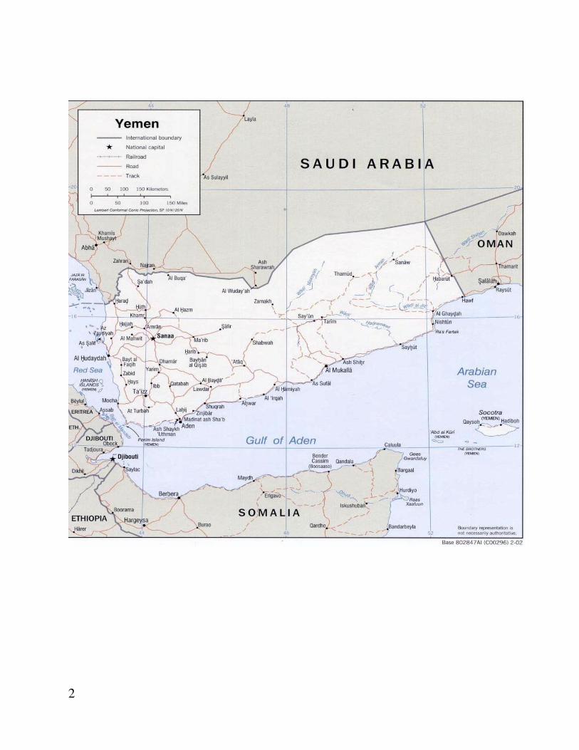
Yemen coast is characterized by a narrow coastal plain between the Gulf of Aden and the mountain range that parallels the shoreline. This coastal plain interspersed with volcanic intrusions right to the sea shore extending along the Gulf of Aden. The land rises steeply inland from the coastal plain to elevations of several thousand meters in the western part of the country. This range averages 1,070 m in height and influences the local weather, especially wind. Further east, towards Omani border, the elevations are not as great. Gulf of Aden is bounded on the north by the Yemeni coastline, and on the south it is bounded by the Somali Peninsula. The Yemeni coastal line along Gulf of Aden and Arabian Sea is approximately 1400 km long, extending from Bab el Mandab at the west to Ras Darbat Ali at the east. The landmasses surrounding the Gulf of Aden and Arabian Sea are characterized by hot and dry climates with little vegetation. Strong winds blowing across these areas often carry sand and dust. Coastal Geomorphology
The Gulf of Aden is a young ocean basin formed by the rifting of Asia (Arabia) from Africa (Somalia) (Girdler et al., 1980). It has a well-defined continental margin, small oceanic basin, and an active mid-ocean ridge (Sheba Ridge) in the center, characterized by a rift valley and fracture zones (Matthews et al., 1967; Bosworth et al., 2005). The rifting of the Arabian Peninsula was accompanied by violent movements in the earth’s crust, creating one of the world’s largest volcanic zones along the western and southern borders of the Arabian Peninsula. The Gulf of Aden coastline is characterized by sedimentary strata interbreeds of limestone, sandstone and shale with volcanic intrusions and extrusions. The old sedimentary strata are primarily marine sediments of Jurassic and Cretaceous periods (Mesozoic), whereas the coastal plains are often more recent alluvial and marine sediments (Al-Hubaishi et al., 1984). Most of the coastline exhibits signs of block faulting, raised beaches, pediments, wadi mouths, headlands, escarpments and dunes. Volcanic pyroclastics (fragmented material from explosive volcanic processes) from some shore areas are sometimes complex because they exhibit raised beaches with wave cut platforms and pediments, erosional features common to deserts. Most geo-morphological (tectonic, erosional and depositional) events, which have formed the present day coastline, took place in relatively recent, geological time, primarily during the quaternary period of the Cenozoic Era. The quaternary period and Pleistocene epoch are coincidental, occurring within the past three million years (before present). The Pleistocene epoch covers the time of most recent glacial and interglacial activity Fisheries Yemen’s 2,520km coastline extends from Saudi Arabia in the northwest to Oman in the east and is divided between the red Sea (650km), Gulf of Aden (1,550km) and Socotra Archipelago (320km). The 552,669km2 Exclusive Economic Zone (EEZ) includes some of the most productive waters and richest marine resources in the world as well as a variety of important ecosystems such as upwelling, coral reefs and mangroves supporting around 65 commercially important species including invertebrates (shrimp, lobsters, cuttlefish, sea cucumbers), pelagic (Yellowfin and longtail tuna, kingfish, Indian mackerel, Indian oil sardines) and demersal species (groupers, emperors, jacks, threadfin bream). The major environmental influence on the productivity of Yemen’s fisheries resources is the Indian Ocean monsoon system, in particular
15
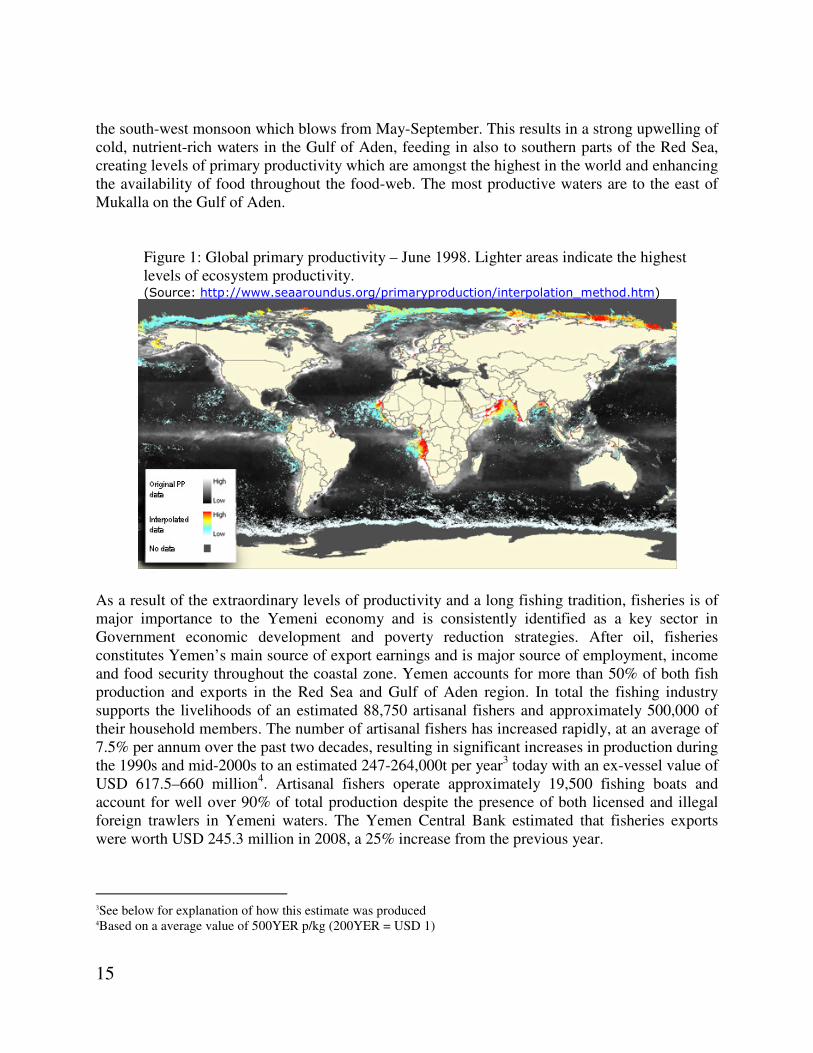
the south-west monsoon which blows from May-September. This results in a strong upwelling of cold, nutrient-rich waters in the Gulf of Aden, feeding in also to southern parts of the Red Sea, creating levels of primary productivity which are amongst the highest in the world and enhancing the availability of food throughout the food-web. The most productive waters are to the east of Mukalla on the Gulf of Aden.
Figure 1: Global primary productivity – June 1998. Lighter areas indicate the highest levels of ecosystem productivity. (Source: http://www.seaaroundus.org/primaryproduction/interpolation_method.htm)
As a result of the extraordinary levels of productivity and a long fishing tradition, fisheries is of major importance to the Yemeni economy and is consistently identified as a key sector in Government economic development and poverty reduction strategies. After oil, fisheries constitutes Yemen’s main source of export earnings and is major source of employment, income and food security throughout the coastal zone. Yemen accounts for more than 50% of both fish production and exports in the Red Sea and Gulf of Aden region. In total the fishing industry supports the livelihoods of an estimated 88,750 artisanal fishers and approximately 500,000 of their household members. The number of artisanal fishers has increased rapidly, at an average of 7.5% per annum over the past two decades, resulting in significant increases in production during the 1990s and mid-2000s to an estimated 247-264,000t per year3 today with an ex-vessel value of USD 617.5–660 million4. Artisanal fishers operate approximately 19,500 fishing boats and account for well over 90% of total production despite the presence of both licensed and illegal foreign trawlers in Yemeni waters. The Yemen Central Bank estimated that fisheries exports were worth USD 245.3 million in 2008, a 25% increase from the previous year.
3See below for explanation of how this estimate was produced 4Based on a average value of 500YER p/kg (200YER = USD 1)

16
Table 1: Estimated Number of Active Fishers and Boats by Governorate
Region Governorate Fishers Vessels
Red Sea Hajjah 2500 358
Hodeidah 43250 6178
Taiz 5000 714
Red Sea Subtotal 50750 7250
Gulf of Aden Lahej 1500 500
Aden 4100 1367
Abyan 5000 1666
Shabwah 1400 467
Hadhramut (not including Socotra) 14000 4667
Al Mahra 7000 2333
Gulf of Aden Subtotal 33000 11000
Socotra Socotra 5000 1250
TOTAL 88750 19500
Source: IFAD pre-formulation and formulation mission Nov. 2009 While official MFW figures estimate total fisheries production in 2008 at 132,062t, a collapse of 124,328t from its official peak of 256,300t in 2004, these figures, both peak and trough, are likely to be inaccurate as a result of logistical difficulties in collection, poor auction management including not weighing most of the fish sold, and deliberate misreporting of catches in order to avoid payment of a 3% levy on the value of catches introduced by the Government in 2004. Unfortunately over the past two decades there has been a serious lack of appropriate management of fisheries resources in Yemen such as effort control or enforcement of regulations due to lack of funding, lengthy and complex court procedures required to prosecute violations and a lack of awareness of the importance of proper management. This has resulted in damage to the resource base jeopardising its potential to contribute to future economic growth. As illustrated by the above figures the expansion of the fisheries sector in Yemen has been permitted to continue as though the productivity of the fisheries resources is unlimited, as opposed to subject to very real biologically and environmentally determined constraints. The increasing number of fishers has been encouraged as part of the government’s poverty reduction strategy. Furthermore there has been no thorough stock assessment in Yemeni waters since the 1970s and 1980s and there is a general lack of accurate data on the entire sector meaning there is no information available to inform the development of fisheries management measures. Table 2: Increase in Fishers, Boats and Catches 1995-2010 (Source MFW/FAO Fish stat)
Description 1995 2000 2005 2010(Mission estimates)
Number of fishers 30000 49114 65198 88750
Number of boats 10000 12560 16890 19500
Average Number of Fishers Per Boat
3 3.9 3.9 4.5

17
Total Catch (t) 107,970 142,198 238,400 247-264,000
Average Annual Catch p/Fisher (t)
3.6 2.9 3.7 2.8-3.0
Amongst all those involved in the fisheries private sector, from fishers to exporters, unanimity was expressed on the urgency with which fisheries management needs to be improved. The total catch is declining, particularly of high value species (cuttlefish, tuna and shrimp) and dramatic declines in the catch of some species have been experienced (lobster in particular). Total production figures are being maintained only by increasing fishing effort, fishing far outside the Yemeni EEZ, in the waters of neighbouring countries, and engaging in illegal and destructive fishing practices in an effort to sustain incomes. Reports were also received of declining average sizes of specimens caught which is another important indicator that overfishing is taking place. In the past cuttlefish of up to 12kg were not uncommon, now 4kg is considered large. Overfishing also affects marketing of the remaining stocks – average sizes of shrimp are reducing the quantities suitable for export to high value markets where large sizes are demanded. No major stock assessment has been conducted in Yemen’s waters since the 1970s and 1980s. A summary of regional stock assessments and potential yields estimated during the 1970s and 1980s was published by the FAO in 1989 (Sander & Morgan 1989) and another by PERSGA in 2004. Many species such as large pelagic fishes including kingfish and barracuda in Yemen have never been assessed or researched at all.
Vulnerability
Yemen can be classified as a system with moderate stress. It is highly vulnerable and attributed by low capacities. Yemen experiences relatively low environmental stress, but have very weak institutional capacity, and the country is in particular vulnerable to natural disasters, under nourishment, and lack of sanitation and safe water supply.Yemen has moderate attempts to reduce stresses, particularly those driven by population. This is not a promising sign although the situation is expected to improve with the interventions of the project. The environmental health is not good. Also signs for basic human sustenance, are not positive. Climate
The climate varies with elevation. The coast is hot and humid throughout the year. The central highlands, with villages at 10,000 feet (3,048 meters), experience an average annual high temperature of 70°F (21°C). Average Daily Temperatures in January: 13.9°C/57°F; in July: 21.7°C/71°F.The climate in Yemen is mostly dessert. Although it is hot and humid along the coastal sections, Yemen has an extraordinarily hot, dry and harsh desert in the east. Yemen is temperate in the western mountains which are affected by seasonal monsoons. Monsoon rains may occur from April to August and from November to January. Rainfall is scarce in the coastal desert regions, but runoff from higher elevations and a series of small dams and channels help support some crops. Mountainsides in the arable highlands are terraced to increase the area suitable for cultivation. Forests once covered the highlands, but overgrazing and logging have almost eliminated them. Excluding its coastal waters, Yemen has no permanent body of open water.

18
The average annual rainfall in Yemen is 508mm/20”. “Precipitation in Yemen is strongly influenced by relief and consequently varies considerably from place to place. Meteorological observations were made by J. E. Hasen, engineer, and Dr. Carlo Toffolon, then personal physician to the Imam, at Sana’a and Ta’izz, from 1942 to 1944. According to their observations at Ta’izz, the number of rains ranges from 90 to 160 per year, and annual precipitation ranges from 450 to 700 millimeters. Rainfall may exceed 50mm in a single torrential shower. Two rainy periods are distinguished at Ta’izz: (1) the most important period, in which precipitation may exceed 600mm, extends from April to May, or in some years, to June, and (2) a shorter period in which rain falls mostly during August and September. West winds predominate during the rainy seasons. At Sana’a annual precipitation ranges from 200 to 500 mm (60 to 90 showers) and also falls largely within two periods: (1) April to May and (2), the most important, from the later part of July through the first half of August. Clouds generally gather on the west slopes of the main massifs and cause very heavy rainfall which accounts for the erosive actions of the wadis, and the number of local springs. The greatest rainfall occurs in the south, central and western highlands and feeds innumerable wadis which, like the terraced mountainsides, are heavily cultivated. A short monsoon in April and May alternates with a heavier monsoon in July and August, but the remainder of the years features sunny days.
VI. Project Locations and potential impacts
Land tenure issues arise in the particular geographic, economic and social contexts of the country concerned, and they can be understood only within those contexts. It is confirmed that this project will not trigger OP4.12 as site visits confirmed that all the potential project sites (Mokha, Aden, Mukalla, and Dhamar) belong to CAMA/YMS and there is no economic activities going on in those areas. As to the project locations for the rest of monitoring networks, negative checklist (site selection criteria) has been prepared in order to make sure locations would be on government owned land. The present meteorological stations both manual and automatic stations belonging to the MAI are spread in agricultural areas in different governorates. Many of the stations comprise simple equipment like rain gauge buckets, and different wadi flow and weather measuring devices. Such equipment were run by the x- Groundwater and Soil Conservation project (GSCP) until the end of 2012. The GSCP handed the stations to the Rain-fed Agriculture and Livestock Project (RALP) and the National Irrigation Project (NIP). The Tihama Development Authority (TDA) operates several rainfall and weather stations. Annex (2) shows the locations of automatic rainfall stations in Hadhramut. Annex (3) shows a list of the hydro –meteorological stations in Taiz, Ibb, AdDhale, Lahej and Abyan. Annex (4) shows the stations the automatic rainfall stations, complete weather stations, manual rain gauge and wadi flow stations. Annex (5) shows the manual rainfall stations operated by the Central Water Monitoring Unit (CWMU) of the Irrigation Sector at MAI. The AREA operates a weather station in its HQ in Dhamar, and another one in its branch center in Seiyun. The station of AREA in El-Kod was completely destroyed and looted in Abyan by terrorists in 2011. Annex (6) shows the stations operated by TDA. Stations of NWRA are shown in annex (7). Given the short period for the consultancy, it was difficult to visit all of these stations. It is noteworthy that many of these stations were lost during the past

19
two years because of the violent events in the country. Collection of data is irregular and some
stations are no more functionalmainly due to lack of OM allocations.
CAMA/YMS has several meteorological stations. The following illustrative figure shows approximate locations of these stations. Annex (7) shows the exact co-ordinates for these meteorological stations.The Consultant managed to visit the sites of the Doppler weather radar Station in Dhamar and the marine stations in Mukalla, Mokha, and Aden.
Figure 3. Approximate locations of CAMA/YMS meteorological stations
20
CAMA /YMS sites
The Marine Stations
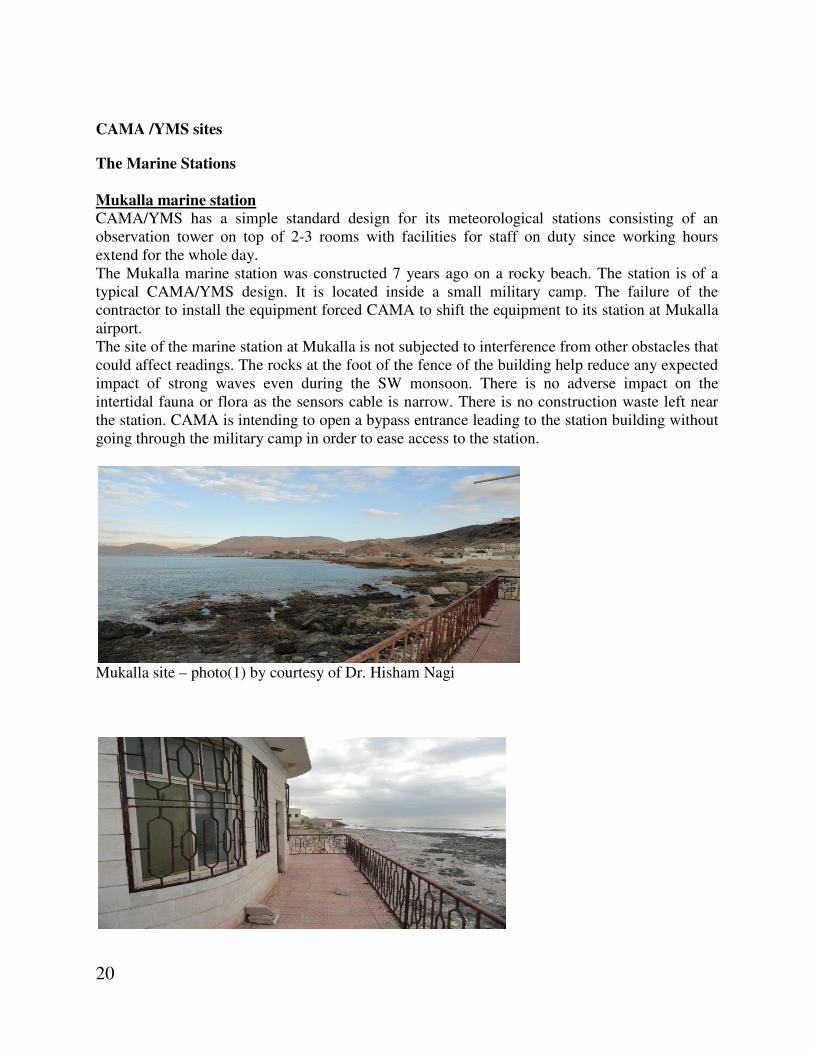
Mukalla marine station
CAMA/YMS has a simple standard design for its meteorological stations consisting of an observation tower on top of 2-3 rooms with facilities for staff on duty since working hours extend for the whole day. The Mukalla marine station was constructed 7 years ago on a rocky beach. The station is of a typical CAMA/YMS design. It is located inside a small military camp. The failure of the contractor to install the equipment forced CAMA to shift the equipment to its station at Mukalla airport. The site of the marine station at Mukalla is not subjected to interference from other obstacles that could affect readings. The rocks at the foot of the fence of the building help reduce any expected impact of strong waves even during the SW monsoon. There is no adverse impact on the intertidal fauna or flora as the sensors cable is narrow. There is no construction waste left near the station. CAMA is intending to open a bypass entrance leading to the station building without going through the military camp in order to ease access to the station.
Mukalla site – photo(1) by courtesy of Dr. Hisham Nagi

21
Mukalla site – photo(2) by courtesy of Dr. Hisham Nagi
Mukalla site – photo(3) by courtesy of Dr. Hisham Nagi Aden Marine Station
The second marine station of CAMA/YMS will be in Aden (at the present site of Gulf of Aden Ports Authority) and at Al Mokha Port. During the visit of the consultant, the part of the marine station on the roof of the Harbor Master’s Office was not functioning. However, the site itself is suitable and has no adverse environmental impacts and is not affected by ships movement in the harbor area. Mokha Marine Station
The third marine station of CAMA/YMS will be in Mokhaand it was confirmed that this is an existing observation station and upgrading has no adverse environmental impacts and is not affected by ships movement in the harbor area. It is worth mentioning that the modernization and upgrading of all the stations will be on the
present sites.

22
Doppler Weather Radar Station in Dhamar
Dhamar site – photo(1) evaporation unit by courtesy of Dr. Hisham Nagi
Dhamar site – photo(2) temperature instruments by courtesy of Dr. Hisham Nagi
Dhamar site – photo(3) meteorological station by courtesy of Dr. Hisham Nagi

23
Dhamar site – photo(4) Fence of the meteorological station
The CAMA/YMS monitoring station in Dhamar where Doppler Weather Radar is going to be installed is shown in photo (3) above. It is situated inside a brick fenced 30,800 sq m area belonging to CAMA (photo4). Wild grass is grown scattered inside the area. There are few qat farms outside the fence, but no residential buildings in the neighborhood. Photo (5) shows the wind velocity measurement device. It is expected that the emissions from the Weather Doppler Radar station will have no adverse impact on humans even on those who have electrical
hypersensitivity (EH) since the electromagnetic field (EMF) is very weak and the residential areas are too far to be affected. (Proceedings of International Workshop on EMF Hypersensitivity Prague, Czech Republic October 25-27, 2004) Since most of the meteorological stations fall under category C, and few stations like the weather Doppler Radar stations would fall under category B, there is no necessity to elaborate on the ESMP especially as the modernization and upgrading would occur in the existing sites.
Dhamar site – photo (5) Wind speed and direction measuring device
24
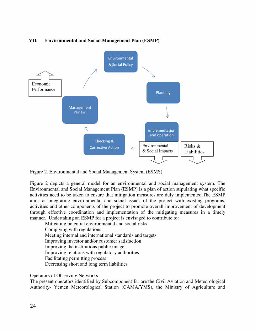
VII. Environmental and Social Management Plan (ESMP)
Figure 2. Environmental and Social Management System (ESMS) Figure 2 depicts a general model for an environmental and social management system. The Environmental and Social Management Plan (ESMP) is a plan of action stipulating what specific activities need to be taken to ensure that mitigation measures are duly implemented.The ESMP aims at integrating environmental and social issues of the project with existing programs, activities and other components of the project to promote overall improvement of development through effective coordination and implementation of the mitigating measures in a timely manner. Undertaking an ESMP for a project is envisaged to contribute to:
Mitigating potential environmental and social risks Complying with regulations Meeting internal and international standards and targets Improving investor and/or customer satisfaction Improving the institutions public image Improving relations with regulatory authorities Facilitating permitting process Decreasing short and long term liabilities
Operators of Observing Networks The present operators identified by Subcomponent B1 are the Civil Aviation and Meteorological Authority- Yemen Meteorological Station (CAMA/YMS), the Ministry of Agriculture and
Environmental
& Social Policy
Planning
implementation
and operation
Checking &
Corrective Action
Management
review
Economic Performance
Risks & Liabilities
Environmental
& Social Impacts

25
Irrigation (MAI), the Agricultural Research and Extension Authority (AREA), the National Water Resources Authority (NWRA) and the Environment Protection Authority (EPA). Other operators in the future could include the Ports Authorities, the Public Corporation for Maritime Affairs (PCMA) and the Marine Sciences and Fisheries Resources Research Authority (MSFRRA). These operators vary in institutional, technical and technological capacities. By far, CAMA/YMS is well developed in these capacities compared with the other authorities and has regional and international links to fulfill its mandate. In fact, CAMA/YMS has the capacity to train the technical personnel of the other authorities.
Safeguards category There are several hydrological and climate recording stations across the country run by the different operators. For various reasons including weak capacity, negligence and lack of O&M financing, many stations are not functioning. The project intends to provide modernization and upgrading of a number of stations. Many stations could be considered falling under Category C of the World Bank (WB) classification of projects. However, the marine stations and the Doppler Weather Radar station fall under Category B. Therefore, per the WBs Operation Manual, since projects are categorized according to the component with the potentially most adverse effects, this project is identified as Category B.
VIII. Mitigation Measures
A list of mitigations masures was developed in order to manage risks before, during and after the installation of Doppler Radar, marine observation equipment, and weather monitoring equipment. The matrices below elaborate minigations measures.

26
A. Before and during Installation Phase
Project Sub-Component B1
Action No.
Activity Potential Impacts
Mitigation and Control Measures
Performance Indicator Entity Responsible for the Action
Remarks
1. Habitat, Fauna and Flora Conservation Plan
Site preparation Crane and backhoe machinery
Noise Progressive engine ramp-up allowing an early escape of working zone
Contractor reports. EPA inspection reports.
Contractor EPA CAMA or relevant institute owning the meteorological station
N/A , no heavy construction machinery will be used
Site Management Management of night lighting
Disturbance of local fauna. Negative impacts of lighting on attraction of insect vectors
Use negative checklist Avoid working at night
Experts reports. EPA reports.
Contractor
It is not expected that construction works, if any, will take a long time.
2. Solid Waste and Waste Water Mitigation Plan
Management of Installation Materials
Generation of residual solids at quarries
Visual impacts, impacts on water and soil quality through leaching
Testing of materials, and, as necessary, collect and transport materials to suitable disposal sites
Periodic report on soil and water quality. Visual inspections
Contractor EPA CAMA or relevant institute owning the meteorological station
Construction is limited, thus removal of construction waste, if any, is possible through disposal to land fill daily.
3. Natural Resources Use Mitigation Plan
Water Water consumption
Drain on water resources
Implement water conservation measures. Justify processes used in the construction activities that consume the most water.
Contractor reports. EPA inspection reports. Experts reports. Monitoring reports.
Contractor
Water requirements will be minimum as the construction works are limited
4. Erosion and Sediment Control Plan (Not Applicable)

27
5. Fugitive Dust Control and Air Quality Mitigation Plan (Not Applicable because there is no dust coming out)
6. Noise Control Mitigation Plan
Management of construction materials
Use of explosive and operation of related equipment at quarries
High noise levels at the quarry sites
Use of equipment with low noise levels. Conduct operations such that noise is limited; use of earplugs and other safety equipment by workers. Periodic monitoring of noise and vibrations over several working days. Schedule noisy activities if activities are close to a residential area
Contractor reports. EPA inspection reports. Experts reports. Monitoring reports.
Contractor
Noise from construction is not expected as the construction works are limited
Site Vibrations on local residents
Equipment. Position non-mobile noise generating equipment
Contractor reports. EPA inspection reports. Experts reports. Monitoring reports
Contractor
B. After Installation Phase
1. Environmental Monitoring Plan
Land and coastal environment
Different activities
Adverse impacts on neighboring habitats and ecosystems
Monitoring of land and coastal environment (water, noise, vibration, air quality, flora, fauna)
Monitoring reports EPA reports
EPA CAMA or relevant institute owning the meteorological station
Although it is expected there will be no or negligible impacts on land and coastal impacts, it is recommended that there should be a simple
28
monitoring plan.
2. Vegetation Planting and Restoration of Natural Mitigation Plan (Not applicable)
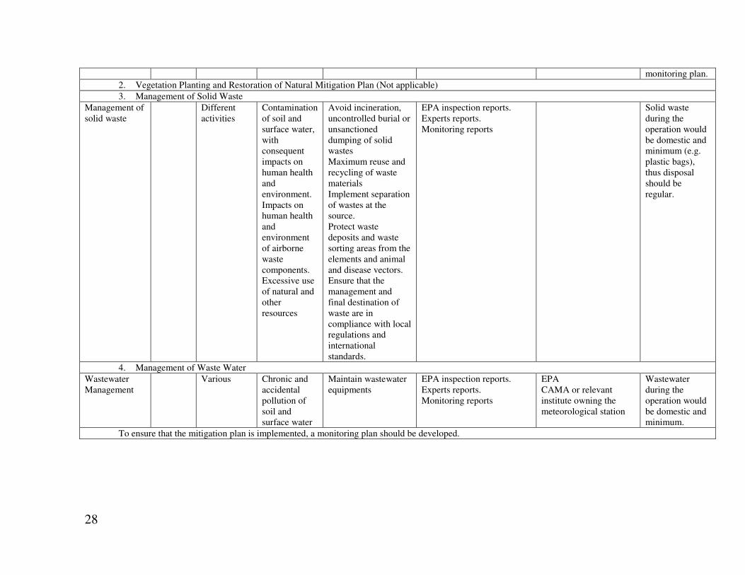
3. Management of Solid Waste
Management of solid waste
Different activities
Contamination of soil and surface water, with consequent impacts on human health and environment. Impacts on human health and environment of airborne waste components. Excessive use of natural and other resources
Avoid incineration, uncontrolled burial or unsanctioned dumping of solid wastes Maximum reuse and recycling of waste materials Implement separation of wastes at the source. Protect waste deposits and waste sorting areas from the elements and animal and disease vectors. Ensure that the management and final destination of waste are in compliance with local regulations and international standards.
EPA inspection reports. Experts reports. Monitoring reports
Solid waste during the operation would be domestic and minimum (e.g. plastic bags), thus disposal should be regular.
4. Management of Waste Water
Wastewater Management
Various Chronic and accidental pollution of soil and surface water
Maintain wastewater equipments
EPA inspection reports. Experts reports. Monitoring reports
EPA CAMA or relevant institute owning the meteorological station
Wastewater during the operation would be domestic and minimum.
To ensure that the mitigation plan is implemented, a monitoring plan should be developed.
29
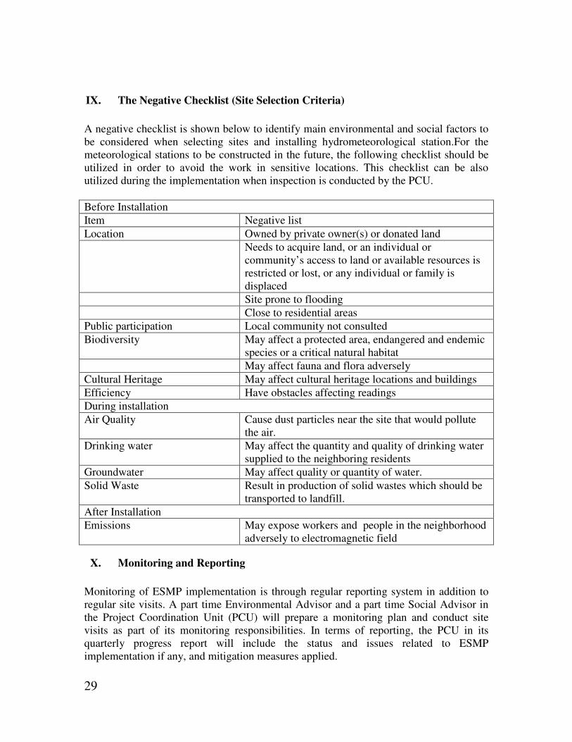
IX. The Negative Checklist (Site Selection Criteria)
A negative checklist is shown below to identify main environmental and social factors to be considered when selecting sites and installing hydrometeorological station.For the meteorological stations to be constructed in the future, the following checklist should be utilized in order to avoid the work in sensitive locations. This checklist can be also utilized during the implementation when inspection is conducted by the PCU.
Before Installation
Item Negative list
Location Owned by private owner(s) or donated land
Needs to acquire land, or an individual or community’s access to land or available resources is restricted or lost, or any individual or family is displaced
Site prone to flooding
Close to residential areas
Public participation Local community not consulted
Biodiversity May affect a protected area, endangered and endemic species or a critical natural habitat
May affect fauna and flora adversely
Cultural Heritage May affect cultural heritage locations and buildings
Efficiency Have obstacles affecting readings
During installation
Air Quality Cause dust particles near the site that would pollute the air.
Drinking water May affect the quantity and quality of drinking water supplied to the neighboring residents
Groundwater May affect quality or quantity of water.
Solid Waste Result in production of solid wastes which should be transported to landfill.
After Installation
Emissions May expose workers and people in the neighborhood adversely to electromagnetic field
X. Monitoring and Reporting
Monitoring of ESMP implementation is through regular reporting system in addition to regular site visits. A part time Environmental Advisor and a part time Social Advisor in the Project Coordination Unit (PCU) will prepare a monitoring plan and conduct site visits as part of its monitoring responsibilities. In terms of reporting, the PCU in its quarterly progress report will include the status and issues related to ESMP implementation if any, and mitigation measures applied.

30
XI. Public consultation
The consultations with the government authorities operating the meteorological stations, meetings with other stakeholders like farmers, water users, fishers and women were heldin December 2012 in Dhamar, Aden, Hadhramut, Seiyun, and Mulalla (Annex 8). The farmers, water users and fishers welcomed the supplyof modernized and upgraded stations. In fact, all wanted to have meteorological equipment with various complexities fitting the use of the stakeholder. According to Omar Qambeet –head of the Hadhramut Fishers Union, (see box 1), the fishers need quick information about climate change for safety purposes. There is a lapse of valuable time if they wait for information from the Fishers Union in Sana’a which receives the data from CAMA/YMS.
XII. Legislative and Regulatory Considerations
During the last two of the past century Yemen experienced serious economic difficulties which adversely impacted the social and economic situation and triggered accelerated environmental degradation. The unemployment, poverty, and general state of the -social and economic degradation in the country represented a growing threat to Yemen's environment. Since 1995 efforts were exerted to alleviate such problems. Liberalization of the economy, decontrol of prices, and floatation of the currency and encouragement of local and foreign investments were made. However, corruption and weakness of the institutional and legislative contexts hampered the realization of the changes attempted by the economic reform. Focus on environmental work and management evolved with institutional development from a stage focusing on combating environmental degradation and pollution to a stage centered more on sustainable use of the natural resources. The draft mandates of the Ministry of Water and Environment (MW&E) and the Environment Protection Authority (EPA) include the responsibilities to coordinate development of general environmental policy, environmental laws and standards, in addition to enhancing environmental awareness, dissemination of environmental information and development of national capacities. EPA reports directly to the MW&E. The EPA is also expected to meet the additional tasks mandated by the Environment Protection Law (EPL) of 1995,
“Fishers feel the changes in climate at sea while on the fishing grounds, they feel the sea level rise, current strength and approach. If possible, we recommend that the project supplies us with simple equipment to measure fundamental parameters to help fishers at sea. We will definitely need training on use of the equipment and how to maintain them and analyze the data.” Omar Qambeet Box. 1 Quotation from Mr. O. Qambeet Head of
Hadhramut Fishers Union 26/12/2012
31
particularly in environmental monitoring and impact assessment. Environmental management at sectoral levels including sectoral policy and legislation development is the responsibility of each relevant line ministry or agency in coordination with MW&E/EPA. The line ministries and agencies are also responsible for implementation of environmental activities within the context of their area of concern. There are also other support government ministries and agencies. These agencies support and facilitate realization and implementation of environmental activities and management tools. The public too contributes in environmental work either in an organized form i.e. non government organizations (NGOs), community based organization CBOs or through community participation at local levels. By the end of the 20th century Yemen had enacted several Laws and Republican Resolutions, bylaws and regulations pertaining directly or indirectly to the conservation of the environment and to natural resources as indicated in box 2 below. In addition, several resolutions issued by the Prime Minister are considered part of the overall legislation. Normally, such resolutions regulate the structure and functions of government agencies. They are considered legal documents as bylaws and regulations. The Environment Protection Law (26) of 1995 (EPL) is the main law governing protection of the environment. The Prime Minister’s Decree (148) of 2000 represents the bylaw interpreting the articles of the EPL. It is an important legal document governing in its annexes the lists of categories of projects requiring environmental impact assessments (EIA) in addition to other lists comprising some parameters for the purpose of environmental monitoring. Other important laws include the Water Law (33) for 2002 particularly Chapter (3) Articles (54-60) which regulate the pollution of water resources. Another relevant law is Law (21) for 1994 on Archeological Heritage particularly Part (3) Articles (10-19) which regulate the protection and maintenance of archeological structures (mobile or fixed). Several problems are witnessed at the legislative level including overlaps, ambiguity, redundancy, contradictions, conflicts and gaps in the laws pertaining to environmental issues and natural resources management. In addition, lack of awareness of the laws and the bylaws, clear correlations between penalties and non compliance had led to weak implementation.

32
Box 2 Yemen Laws and Republican Resolutions Relevant to the Environment.
Examples of such legislations include the following: Republican Resolution (Presidential Resolution) by law number (37) for 1991, territorial Sea, the Exclusive Economic Zone (EEZ) and the Continental Shelf Law number (43) for 1997 regarding amendments to the Republican Resolution by law (42) for 1992 concerning the regulation of fishing, living marine resources and their conservation. Republican Resolution by law (50) for 1991 on Mines and Quarries Republican Resolution by law (11) for 1993 on Protection of the Marine Environment from Pollution Republican Resolution by law (12) for 1994 on Crimes and Penalties Republican Resolution by law (21) for 1994 on Archeological Heritage Republican Resolution by law (22) on Tourism Republican Resolution by law number (22) for1991on Investment and its amendments by Law (14) for 1995 on Investment Republican Resolution by law (20) for 1995 0n Urban Planning Republican Resolution by law (21) for 1995 on State lands and Property Republican Resolution by law (26) for 1995 on the Protection of the Environment Prime Minister’s Decree (148) for 2000 on the Executive Regulations of the EPL (26) for 1995.
33
ANNEX 1. ToR for ESMP
Yemen – Pilot Program for Climate Resilience (PPCR) Investment I
Climate Information System and PPCR Coordination Project
Terms of Reference
Environmental and Social Management Plan (ESMP) I. Background
Due to its high vulnerability to climate change, Yemen was chosen as one of the pilot countries under the Pilot Program for Climate Resilience (PPCR). The objective of the PPCR is to provide incentives for scaled-up action and transformational change through pilot projects that demonstrate how to integrate climate risk and resilience into core development planning, while complementing other ongoing development activities in a given country. The PPCR will be country-led, and will enable pilot countries to transform country-specific plans and investment programs in order to address climate risks and vulnerabilities, building on National Adaptation Programs of Action (NAPAs) and other relevant country studies and strategies. Substantial programmatic resources will then be made available to help fund the newly identified public and private sector investments. The PPCR process will have two phases: Phase I will prepare the Strategic Program for Climate Resilience (SPCR), and Phase II will implement priority interventions identified under Phase I. Through a series of consultations with various stakeholders, including different line ministries and agencies of the Government of Yemen (GOY), development partners, and civil society, the Yemen-PPCR team developed the Phase I proposal, which has been approved by the PPCR Sub-Committee, the oversight entity for the PPCR. In Yemen, the PPCR process will concentrate on addressing the following four pillars under Phase I: (I) climate change information system and awareness raising related to climate resilience; (II) mainstreaming climate change resilience into core national development planning and capacity building; (III) developing the SPCR; and (IV) strengthening the Technical Secretariat (TS)/Environmental Protection Authority (EPA) and Program Coordination Unit (PCU) to facilitate implementation of the PPCR. Based on several consultations with national stakeholders, civil society and development partners, four main areas of interventions have been identified under the Phase II of the PPCR program and the Climate Info System & PPCR Coordination Project is one of the four interventions proposed. The main development objective of the proposed project is to improve the quality of hydro-meteorological and climate services provided to end-users and to strengthen knowledge management. The project will support the improvement of hydrometeorological and climate services delivery; increase climate resilience and reduce future economic losses associated with extreme weather caused by climate variability and change; and improve coordination and information sharing between all of agencies responsible for the collection of climate data, analysis and decision-support as well as maintain the oversight of the PPCR program, particularly in regards to knowledge management, awareness rising and information sharing with stakeholders. The project is to consist of the following components: Component A.Institutional Strengthening, Capacity Building and Implementation Support

34
Component B. Modernization of the National Hydrometeorological and Monitoring Networks Component C. Enhancement of the Service Delivery System Component D. Program Coordination and Knowledge Sharing
(i) Component A: Institutional Strengthening and Capacity Building. The objective of Component A is to create the conditions that ensure institutional, staffing and financial sustainability of organizations improving climate resilience in Yemen through provision of weather, climate and water services that meet stakeholders’ needs. There are three subcomponents:
• Subcomponent A.1 – Institutional Strengthening and Development of a legal and
regulatory framework, which includes: (1.1) CAMA/YMS institutional development
and strategic planning for weather and climate services; (1.2) Revising legal and
regulatory framework for all institutions; and (1.3) Assessing staffing and operating
and maintenance costs.
• Subcomponent A.2 – Capacity Building and Training, which includes: (2.1)
Developing and implementing a capacity training program for CAMA/YMS and
users, including personnel training and retraining, and education at universities and
short courses in WMO regional training centers; (2.2) Implementing training
activities – workshops and round table discussions for major users from sectors such
as: disaster risk management, agriculture, water resources, energy, heath and civil
aviation.
• Subcomponent A.3 Technical implementation support, which includes: (3.1)
Technical design of observing and forecasting systems.
(ii) Component B. Modernization of the National Hydrometeorological Observing
Networks: This component aims to upgrade and expand the meteorological observations networks for meteorology, agro-meteorology and hydro-meteorology, ensuring that these networks are interoperable between CAMA/YMS, MAI, NWRA and AREA to ensure the efficient and timely transmission of information that is essential for management of disaster risks, agriculture and water resources. Collection of high-quality data is the foundation of producing reliable weather forecasts and warnings as well as monthly and longer term climate outlooks. There are three subcomponents:
• Subcomponent B.1 – Technical modernization of the observing networks, which
includes: (1.1) Extending the weather and climate surface observing network for
CAMA/YMS; (1.2) Installing hydrometeorological stations to refurbish and expand
the existing hydrometeorological stations; (1.3) Installing automatic
agrometeorological stations to refurbish and expand the existing agro-meteorological
stations; (1.5) Installing at least one Doppler weather radar next to the monitoring
station in Dhamar to improve the monitoring and forecasting of high impact events
associated with heavy precipitation and other weather related hazards. (1.6) Installing
up to three upper air stations measuring profiles of temperature, humidity and wind
speed and direction; (1.7) Upgrading of the CAMA/YMS calibration laboratory for
the use of all network operators; and (1.8) installing up to 3 standard marine stations
in Mukalla, Aden, and al-Mukalla
• Subcomponent B.2 – Modernization of the communication and ICT system, which
includes: (2.1) Updating communication equipment of all observing networks
(CAMA/YMS, MAI, AREA, NWRA and EPA); (2.2) Assessing and strengthening

35
the national data management system, including archiving and data rescue; and (2.3)
Upgrading operational satellite receiving systems for forecasting and mapping
applications.
• Subcomponent B.3 – Design and pilot operation of an environmental monitoring
system, which includes. (3.1) Developing a needs assessment and design of air
quality monitoring networks; and (3.2) Piloting an operational air quality monitoring
network.
(iii) Component C. Enhancement of the Service Delivery System: This component aims to enhance the delivery of services. This is a key program component that provides for the implementation of a systematic upgrade of the weather, climate and water-related end-to-end services provided to all agencies, communities and individuals. There are four subcomponents
• Component C.1 – Enhancement of Public Weather Service for agriculture, water
resources and irrigation, DRM, media, civil aviation, health, energy, which includes:
(1.1) Upgrading CAMA/YMS forecaster workstations and software to integrate all
available observations and numerical weather prediction products to increase
efficiency in the preparation and delivery of weather forecasts and warnings; (1.2)
Introducing specialized communication instruments, including TV, radio, SMS,
Internet to improve the dissemination of forecasts and warnings in line with WMO
recommendations; and (1.3) Enhancing the capability to assess the impact of
forecasts and warning on end-users utilizing survey tools that provide capability to
differentiate the impact of the forecast on by gender, age and other demographic
indicators.
• Component C.2 – Support of Disaster Risk Management operations for all DRM
stakeholders. Given the importance of flash floods to Yemen, a complete end-to-end
pilot for two regions (in the range of 10-20,000 km2) is proposed. In this case end-to-
end means an early warning system with the capacity to provide guidance, alert
appropriate authorities and provide subsequent guidance to individuals and
communities through various channels including for example NGOs, CBOs and
CSOs, which includes: (2.1) Developing Standard Operating Procedures, guidelines,
warning protocols and signals agreed with all stakeholders including communities;
(2.2) Introducing forecaster workstations, communication systems and developing
software for a multi hazard warning and information delivery system, including
implementation of the WMO Flash Flood Forecasting Guidance System; and (2.3)
Providing operational training and drills with government stakeholders and
communities.
• Component C.3 – Improvement of Service Delivery to Sectorial, communities and
individuals differentiated by gender, age, and other demographic indicators, which
includes: (3.1) Improving quality and utility of weather and climate information for
water resources through NWRA; (3.2) Improving quality and utility of weather and
climate information for agriculture through MAI and AREA; and (3.3) Improving
quality and utility of weather and climate information for mariners.
• Component C.4 – Creation of the National Climate Service within CAMA/YMS,
which includes: (4.1) Introducing computer systems to access climate information

36
from national sources, WMO and other regional centers; (4.2) Translating and
delivering climate information in a form that can be easily understood and utilized by
end-users; (4.3) Developing a digital library of climate-relevant information from all
sectors for Yemen, including software to downscale climate forecasts; and (4.4)
Implementing a National Framework for Climate Services, as proposed in the WMO
Global Framework for Climate Services (GFCS), and support to sectoral working
groups, such as a Climate and Health Working Group or Climate and Agriculture
Working Group, which would provide local training and knowledge transfer to e.g.
communities, CSOs and CBOs
(iv) Component D: PPCR Program Management and Knowledge Sharing: This umbrella component aims to provide a single entry point for the management of the overall PPCR Program in particular in regards to coordination, awareness rising and knowledge management. This component will purchase equipment, software, and technologies and will provide consultancy services to support investment and incremental operational costs of program management including that of consulting staff and training housed in the PPCR-PCU established in the EPA. There are two subcomponents:
• Component D.1 – PPCR Coordination and Monitoring
(1.1) PPRC Implementation support (PCU), which includes fiducial responsibilities for the entire project (procurement administration and updating of the procurement plan, financial management and reporting, safeguards, monitoring and evaluation and reporting).
(1.2) Regularly consolidate the results achieved by the PPCR activities for presentation to the Inter-Ministerial Committee for Climate Change (IMCCC).
(1.3) Support and monitor the integration of gender sensitive approaches throughout PPCR implementation will be given a high priority.
• Component D.2 – Knowledge Sharing
(2.1) Carry out public education and outreach activities geared towards improving information access and awareness rising of the challenges caused by climate change.
(2.2) Carry out the coordination of the PPCR program implementation, particularly in regards to knowledge management and information/data sharing.
(2.3) Develop and disseminate targeted knowledge products that are relevant to a variety of stakeholders and distill in a synergistic effort the results achieved by the projects under the SPCR.
II. Objective of the ESMP:
The purpose of an Environmental and Social Management Plan (ESMP) is to assess the potential environmental and social impacts including gender aspects of the Climate Information System and PPCR Coordination Project. Minor impacts are expected especially for the activities under the Component B.1 such as installation of monitoring equipment and Doppler weather Radar, and upgrading marine observations. This study will address potential impacts of different alternatives and propose relevant mitigation measures and strategies. The study will establish clear directives and methodologies for the evaluation of activities to be financed by the project including site selection criteria. The study will culminate in an ESMP to ensure that all activities financed under the project are in compliance with the World Bank’s safeguard policies. The output of this consultancy is intended to help ensure that the proposed project will be environmentally and socially sound and sustainable.
37
III. Scope of Work
Primary tasks will be to assess potential environmental and social impacts including gender prior to and during project implementation, incorporate a system for monitoring those impacts, and develop a capacity building program for stakeholders to carry out effective risk management throughout the project. This will result in a final report that will address the following: 1) Describe the proposed project.Provide information of the activities under Component B.1
on the following: potential location of all project sites and general layout and extent of
facilities at project sites; design basis, size, capacity; pre-construction activities; construction
activities (if any), schedule, staffing and support, facilities and services; operation and
maintenance activities, management of risks, including health and safety; life expectancy for
major components.
. 2) Describe the Environment and Socio-cultural Environment. Assemble and evaluate and
baseline data on the environmental characteristics of the study area, including river
basin/watershed, inundation, floodplain and biological features (habitats and rare species,
fisheries), floodplain (recession) agriculture. Include maps and photos as appropriate.
a. Physical environment: geology, topography, soils, climate, surface and ground water
hydrology, erosion and sediment loading, existing/projected pollution discharges and
receiving water quality; instances of flooding, siltation/erosion;
b. Biological environment: flora and fauna, including rare or endangered species; sensitive
natural habitats, including parks and reserves; potential vectors for disease; exotics and
aquatic weeds; application of pesticides and fertilizers (current and projected)
c. Socio-cultural environment: land use; fisheries and farm/industrial outputs and inputs;
transportation; land tenure and land titling; present water supply and water uses (including
current distribution of water resources); control over allocation of resource use rights; gender
issue; water-related human health problems; cultural sites.
3) Preparation of site selection criteria. An Environmental and Social Management Plan will
be prepared for all of the known project existing sites. As to unknown sites, develop a site
selection criteria including negative checklist of the project sites such as locations which will
require private or community land acquisition, locations which has risk of flood, and
environmentally and socially sensitive areas, etc.
4) Legislative and Regulatory Considerations. Describe the relevant environmental laws,
regulations and standards at international, national, regional and local levels.
5) Determination of the Potential Impacts of and Impacts on the Proposed Project.
Consider the activities to be financed by the project, examine potential environmental and
social impacts including gender, both individual and cumulative, for each activity. The study
will consult information available from the existing PPCR project documents (PCN, ISDS,
Aide Memoires, examples of PPCR projects in other countries, etc). The study will describe
the principal problems and environmental and social impacts, which may result from
activities, and suggest appropriate mitigation measures.

38
6) Analysis of Alternatives to the Proposed Project. Describe alternatives that were
examined in the course of developing the proposed project and identify other alternatives that
would achieve the same objectives. Compare alternatives in terms of potential environmental
impacts, land requirements, capital and operating costs, reliability, suitability under local
conditions, and institutional, training, and monitoring requirements. When describing the
impacts, indicate which are irreversible or unavoidable and which may be mitigated. To the
extent possible, quantify the costs and benefits of each alternative, incorporating the
estimated costs of any associated mitigating measures. Include the alternative of not
constructing the project to demonstrate environmental conditions without it.
7) Development of an Environmental and Social Management Plan (ESMP). Estimate the
impacts and costs of the mitigation measures and of the institutional and training
requirements to implement them. Prepare an ESMP, including proposed work programs,
budget estimates the entity responsible for it financing, schedules, staffing and training
requirements, and other necessary support services to implement the mitigating measures,
monitoring, etc.
Prepare a detailed plan to monitor the implementation of mitigating measures and the impacts of the project during construction and operation. Include in the plan an estimate of capital and operating costs and a description of other inputs (such as training and institutional strengthening) needed to implement the plan. Develop a monitoring and evaluation system for environmental and social impacts and significant environmental and social values to be included in the overall project monitoring and evaluation system and clarify each role (who will do what and when?). The plan should define measurable indicators and propose methodologies for measurement, including a definition of who should measure the different indicators and at which intervals. Review the authority and capability of institutions at local, provincial/regional, and national levels and recommend steps to strengthen or expand them so that the ESMP may be effectively implemented. The recommendations may extend to new laws and regulations, new agencies or agency functions, intersectoral arrangements, management procedures and training, staffing, operation and maintenance training, budgeting, and financial support. An outline of the contents of the ESMP to be included in the project’s Operational Manual should be provided along with environmental/social protection clauses for contracts and specifications.
IV. Deliverables and Reporting
Specific outputs of this consultancy will be a final Environmental and Social Management Plan (ESMP) in English and in Arabic. The consultant will share the main findings with the stakeholders ans the suggested/agreed mitigation measures during a presentation and help the PCU organize a public consultation workshop by identifying the stakeholders (including civil servant, government officials, implementation agencies, NGOs, Enterprises involved in the equipment installation and works controlling entities eventually community representative around the selected sites etc.) to be invited. The consultant will summarize comments received at the public consultation and revised the draft ESMP accordingly.

39
During his field visits the consultant should ensure that all the investment should be done in the government existing land and no new land will be involved for these project activities. The consultant should report to the PCU. Electronic version of each document should be available in MS WORD format and in pdf files. V. Qualification
The successful consultant will be expected to assume responsibility for all matters related to the completion of the deliverables. The consultant must demonstrate:
• Proven experience of Environmental Assessment (EA), environmental management and
work on climate changes issues.
• At least 8 years of experience in similar assignments on environmental and social
assessment, management and/or climate change.
• Familiarity on the Bank safeguards Policies( OP4.01 and OP 4.12) will be a plus
VI. Duration
30 days starting from December 15, 2012 to January 30, 2013 VII. Reporting and Payment Schedule
The following reports will be presented:
• First draftESMP should be prepared no later than January 15, 2013. Once this
report is approved, 50% of the contract amount will be paid.
• Final ESMPincluding the results from the public consultation should be prepared
no later than January 30, 2013. Once this report is approved, 50% of the contract
amount will be paid.

40
ANNEX 2. Group (1)
Automatic Rain Fall Stations in Hadhramut Governorate GSCP Field Unit
Installation Date
S. No. of DPX Data Logger
S. No. Of Rain Gauge Bucket
Elev. (m)
N E Governorate
District Location Station Name
No.
22/5/2005
33 –8535 3007 – 98 692 87 47 48 04 56 15 Hadramut Syaun Ag. Training Center
Syaun 1
22/5/2005
16 – 8518 3015 =98 645 22 00 49 93 02 16 Hadramut Tareem Ag. Extension Unit
Tareem 2
24/5/2005
50 – 8507 3083 – 98 782 02 15 48 83 35 15 Hadramut Sah Ag. Extension Unit
Sah 3
24/5/2005
64 – 8566 3080 – 98 737 11 16 48 01 46 15 Hadramut Al-Khashah
Ag. Extension Unit in Qaudhah
Al-Khashah 4
25/5/2005
88 – 8590 3050 – 98 753 71 18 48 91 42 15 Hadramut Wadi Iyen and Hawrah
Ag. Compound In Ardh Al-MaKhashen
Hawrah 5
26/5/2005
13 – 8533 3008 – 98 681 05 25 48 74 48 15 Hadramut Al-Qatten
Buqshan Farm Al-Qatten 6
27/5/2005
95 – 8597 3089 – 98 672 89 37 48 36 55 15 Hadramut Shibam Branch of Water Co.
Shibam 7
28/5/2005
20 - 8522 3027 – 98 770 03 19 48 57 35 15 Hadramut Dowa'an Bin Mahfodh Farm Al-Mashhad
Dowa'an 8
6/6/2005 34 - 8536 3035 - 98 252 65 09 49 72 50 14 Hadramut Al-Mukala
Security Chick Point
Abdullah Gharib
9
8/6/2005 99 - 8601 3048 – 98 452 09 05 48 85 29 14 Hadramut Hajjer House of Ali Omar Mohamed Ba-Latief
Al-Sadarah 10

41
8/6/2005 82 – 8584 3111 – 98 49 17 39 48 05 08 14 Hadramut Mayfa'a Broom
Aiysha School Ba-Taiss
Al-Heylah 11
8/6/2005 66 – 8568 3036 – 98 17 98 58 48 91 2 14 Hadramut Mayfa'a Buroom
Health Unit Buroom 12ا
9/6/2005 39 – 8541 3033 - 98 28 24 42 48 96 06 14 Hadramut Mayfa'a Broom
Wadi Hijjir Development Project
Mayfa'a Hijjer
13

42
Installation Date
S. No. of DPX Data Logger
S. No. Of Rain Gauge Bucket
Elev. (m)
E N Governorate
District Location Station Name
No.
22/5/2005
33 –8535 3007 – 98 692 04 56 15 87 47 48 Hadramut
Syaun Ag. Training Center
Syaun 1
22/5/2005
16 – 8518 3015 =98 645 93 02 16 22 00 49 Hadramut
Tareem Ag. Extension Unit
Tareem 2
24/5/2005
50 – 8507 3083 – 98 782 83 35 15 02 15 48 Hadramut
Sah Ag. Extension Unit
Sah 3
24/5/2005
64 – 8566 3080 – 98 737 01 46 15 11 16 48 Hadramut
Al-Khashah
Ag. Extension Unit in Qaudhah
Al-Khashah
4
25/5/2005
88 – 8590 3050 – 98 753 91 42 15 71 18 48 Hadramut
Wadi Iyen and Hawrah
Ag. Compound In Ardh Al-MaKhashen
Hawrah 5
26/5/2005
13 – 8533 3008 – 98 681 74 48 15 05 25 48 Hadramut
Al-Qatten Buqshan Farm Al-Qatten 6
27/5/2005
95 – 8597 3089 – 98 672 36 55 15 89 37 48 Hadramut
Shibam Branch of Water Co.
Shibam 7
28/5/2005
20 - 8522 3027 – 98 770 57 35 15 03 19 48 Hadramut
Dowa'an Bin Mahfodh Farm Al-Mashhad
Dowa'an 8
6/6/2005 34 - 8536 3035 - 98 252 72 50 14 65 09 49 Hadramut
Al-Mukala
Security Chick Point
Abdullah Gharib
9
8/6/2005 99 - 8601 3048 – 98 452 85 29 14 09 05 48 Hadramut
Hajjer House of Ali Omar Mohamed Ba-Latief
Al-Sadarah
10
8/6/2005 82 – 8584 3111 – 98 49 05 08 14 17 39 48 Hadramut
Mayfa'a Broom
Aiysha School Ba-Taiss
Al-Heylah 11

43
8/6/2005 66 – 8568 3036 – 98 17 91 2 14 98 58 48 Hadramut
Mayfa'a Buroom
Health Unit Buroom 12ا
9/6/2005 39 – 8541 3033 - 98 28 96 06 14 24 42 48 Hadramut
Mayfa'a Broom
Wadi Hijjir Development Project
Mayfa'a Hijjer
13
Automatic Rain Fall Stations in Shabwah Governorate GSCP Field Unit
Installation Date
S. No. of DPX Data Logger
S. No. Of Rain Gauge Bucket
N E Elev. (m)
Governorate District Location Station Name
No.
1/5/2005 32-8534 3034 55 29 45
94 55 14 1232 Marib Hareeb Security Center Hareeb 1
1/5/2005 52-8554 3099 71 42 45
11 48 14 1145 Shabwah Bayhan Abdullah Al-Gaish House
Bayhan Al-Elya
2
2/5/2005 27-8529 3081 32 47 45
11 59 14 1169 Shabwah Bayhan GSCP (FU) Al-Nuqob
Nuqob 3
2/5/2005 113-8615 3014 27 10 46
19 35 14 1653 Shabwah Markhah Ag. Extension Center
Al-Hegair 4
3/5/2005 106-8608 3004 73 03 46
18 26 14 1215 Shabwah Khawrah Telecommunication Central
Khawrah 5
4/5/2005 28-8530 3108 06 29 46
80 29 14 1125 Shabwah Nessab Ag. Extension Compound
Nessab 6
5/5/2005 09-8511 3059 49 52 46
98 19 14 1216 Shabwah Al-Saeed
Telecommunication Central
Al-Saeed 7
6/5/2005 120-8622 3120 21 51 46
57 31 14 1207 Shabwah Ataq Agriculture Office Ataq 8
7/5/2005 107-8609 3093 31 04 47
69 20 14 947 Shabwah Hebban Agriculture Office Hebban 9
8/5/2005 63-8565 3045 00 34 0015 14 Shabwah Mayfaah Ag. Extension Mayfaah 10

44
47 Compound 9/5/2005 38-8581 3047 6320 47 55 01 14 17 Shabwah Rudhom Health Center Beir Ali 11
9/5/2005 84-8586 3026 86 43 47
41 50 14 212 Shabwah Rudhom Admin. Office Rudhom 12
11/5/2005 79-8581 3096 79 59 46
32 51 14 950 Shabwah Rudhom Health Unit Eyad 13
10/5/2005 119-8621 3032 43 25 47
67 20 15 1075 Shabwah Arrma Arrma Hospital Arrma 14
45
Manual Complete Weather and Manual Rain fall Gauge Stations in Shabwah Governorate GSCP Field Unit
Installation
Date S. No. Of
Rain Gauge Bucket
S. No. of DPX
Data Logger
E N Elev. (m)
Governorate District Location Station Name
No.
2/5/2005 ----- --- 11 59 14 3247 45 1169 Shabwah Bayhan Al-Nuqob
Bayhan 1
Automatic Wadi flow Station in Shabwah Governorate GSCP Field Unit
Installation
Date S. No. of DPX
Data Logger E N Elev.
(m) Governorate District Location Station
Name No.
1/5/2005 673 - 8472 02 57 14 99 30 45 1160 Marib Hareeb Darb Al-Mareef / Lafdhat Al-Fadhli
Hareeb 1
12/5/2005 668 – 8467 36 49 14 36 43 45 1263 Shabwah Bayhan Al-Qarnin / Byhan Alilia
Bayhan 2
14/5/2005 1124 -8500 72 43 14 59 06 46 1120 Shabwah Markhah Al-Hajar / Dafa Al-Sayed
Markhah 3
12/5/2005 1099 -84842 10 29 14 04 01 46 1155 Shabwah Khawrah Al-Garshah Khawrah 4 15/5/2005 1110 - 8492 47 32 14 26 32 46 1078 Shabwah Nessab Beer Al-Shaiessi/
Al-Oshah Hammam5 ا
17/5/2005 1123 - 8499 98 18 14 23 55 46 1225 Shabwah Al-Saeed Matrah Al-Thabit Yashbum 6

46
ANNEX 3. Group (2)
Hydro-meteorological Stations in (Taiz, Ibb, Al-Dhale’e, Lahej, and Abyan Governorates) GSCP (April – May, 2005)
Station Name
Station Type Location Elev. (M)
Coordinates (Degree)
Coordinates (Km) Model and Serial No.
E N E N data logger DPX
tipping bucket
1 Om-Sudah Auto. Rain Gauge
Om-Sudah near by the Water supply project
407 4533 41 13 28 50 98-3018 Dpx Rg- 842-8545-43
2 Om-Graidah
Auto. Rain Gauge
Arkuob Al-Ahmar Omar Ben Abdullaziz School
741 4617 49 13 56 30 98-3092 Dpx Rg-842-8542-40
3 Ludar Auto. Rain Gauge
Central High Lands Project Luder
1006 4551 35 1353 07 98-3021 DpxRg-842-8544-42
4 Mudiah Auto. Rain Gauge
Agr. Nursery - Mudiah
878 46 04 51
1356 42 98-3086 Dpx Rg-842-8556-54
5 Al-Mahfad Auto. Rain Gauge
Well of Al-Mahfad Water Supply Project
662 4654 41 1403 26 98-3040 Dpx Rg-842-8604-102
6 Shukrah Auto. Rain Gauge
Health Center –Shukrah
12 45 42 12
13 21 32 98-3105 Dpx Rg-842-8571-69
7 Al-Mugalah
Auto. Rain Gauge
Al-Mualah School
531 4627 07 1358 33 98-3013 Dpx Rg-842-8599-97
8 Om- Auto. Rain Water Reservoir 815 46 09 13 54 53 98-3075 Dpx Rg-842-

47
Kulaitah Gauge of Japan Water Supply (Om-Kulitah –Wadi Wager)
33 8515-13
9 Naser Faculty
Auto. Rain Gauge
Naser Faculty - Lahej
137 4453 12 1303 10 487710 1442984 98-3011 Dpx Rg-842-8617-115
10 Naser Faculty
Comp. Weather Station
Naser Faculty - Lahej
137 44 53 12
13 03 10 487710 1442984
Group (2): Hydro-meteorological Stations in (Taiz, Ibb, Al-Dhale’e, Lahej, and Abyan Governorates) GSCP (April – May, 2005) No Station
Name Station Type Location Elev.
(M) Coordinates (Degree)
Coordinates (Km) Model and Serial No.
E N E N data logger DPX
tipping bucket
11 Rehab Auto. Rain Gauge
Agri. Office Rehab
1540 411101 1572962 98-30 Dpx Rg-842-
12 Al-Dalil Auto. Rain Gauge
Agri. Office Al-Makader
1788 418612 1561427 98-30 Dpx Rg-842-8573-71
13 Al-Adharib Auto. Rain Gauge
Health
Compound –Al-Adharib
1704 408591 1505907 98-30 Dpx Rg-842-8583-81
14 Kadas Auto. Rain Gauge
Health Center –Kadass
1915 406032 1470226 98-3090 Dpx Rg-842-8575-73
15 Al-Rahidah
Auto. Rain Gauge
Agri. Center Al-Rahidah
1068 424636 1479131 98-3017 Dpx Rg-842-8555-53

48
16 Labuass Auto. Rain Gauge
Agri. Office Labuass
2230 526689 1533905 98-3053 Dpx Rg-842-8591-89
17 Rada’a Auto. Rain Gauge
Rural Development
Office – Al-Kubar
2168 481096 1591146 98-3054 Dpx Rg-842-8562-60
18 Tour Al-Baha
Auto. Rain Gauge
Sya’a – Tour Al-Baha
569 427523 1452300 98-3100 Dpx Rg-842-8580-78
19 Tour Al-Baha
Comp. Weather Station
Sya’a – Tour Al-Baha
569 427523 1452300
20 Rebat Al-Kala’a
Auto. Rain Gauge
Agr. Center (Rebat Al-Kala'a)
2551 428726 1570461 98-3042 Dpx Rg-842-8574-72
21 Rebat Al-Kala’a
Comp. Weather Station
Agr. Center (Rebat Al-Kala'a)
2551 428726 1570461
22 Yareem Auto. Rain Gauge
Agr. Compound Yareem
2661 432936 1581536 98-3704 Dpx Rg-842-8595
Group (2): Hydro-meteorological Stations in (Taiz, Ibb, Al-Dhale’e, Lahej, and Abyan Governorates) GSCP (April – May, 2005)
No Station Name
Station Type Location Elev. (M)
Coordinates (Degree)
Coordinates (Km) Model and Serial No.
E N E N data logger DPX
tipping bucket
23 Al-Radmah Auto. Rain Gauge
Agr. Center Al-Radmah
2212 397439 1748626 98-3119 Dpx Rg-842-8505

49
24 Al-Shuaib Auto. Rain Gauge
Al-Shuaib Police Station
2078 485336 1529531 98-3113 Dpx Rg-842-8552
25 Al-Barh Auto. Rain Gauge
Agr. Compound 524 359788 1487270 98-3070 Dpx Rg-842-8507-55
26 Al-Selow Auto. Rain Gauge
Al-Sharaf Village
1880 411638 1479268 98-3079 Dpx Rg-842-8567-65
27 Wadi Al-Kail
Auto Wadi Flow St.
Al-Rowaiy 917 385161 1466874 Dpx-wl65-841-8479-1059
28 Aqan Auto Wadi Flow St.
Wadi Aqan 508 461291 1478757 Dpx-wl65-841-8476-1087
29 Baizeg Dam
Auto Wadi Flow St.
Al-Wadi Al-Sagheer
193 484481 1450593 Dpx-wl65-841-8494-1114
30 Falej Dam Auto Wadi Flow St.
Al-Wadi Al-Kabeer
178 483668 1448167 Dpx-wl65-841-8471-672
31 Al-Katabiah
Auto Wadi Flow St.
Wadi Maden 573 428229 1453938 Dpx-wl65-841-8501-1125
32 Saba Dam (1)
Auto Wadi Flow St.
Wadi Al-Rabwah
612 483867 1492725 Dpx-wl65-841-8496-1119
33 Saba Dam (2)
Auto Wadi Flow St.
Wadi Al-Rabwah
612 484011 1492661 Dpx-wl65-841-841-671
34 Rebat Al-Kala’a
Manual Rain Fal
Agr. Center (Rebat Al-Kala'a)
2551 428726 1570461
35 Sya’ah Manual Rain Fall
Sya’a – Tour Al-Baha
569 427523 1452300

50
Group (2): Hydro-meteorological Stations in (Taiz, Ibb, Al-Dhale’e, Lahej, and Abyan Governorates) GSCP (April – May, 2005) No Station
Name Station Type Location Elev.
(M) Coordinates (Degree)
Coordinates (Km) Model and Serial No.
E N E N data logger DPX
tipping bucket
36 Naser Faculty
Manual Rain Fal
Naser Faculty - Lahej
137 4453 12 1303 10 487710 1442984 98-3011 Dpx Rg-842-8617-115
37 Al-Rawdah
Auto Wadi Flow St. Wadi Hassan 326 4535 37 1329 03
DPX
841-8495-1118
38 Al-Hashma
Auto Wadi Flow St. Wadi Bana;a 202 4516 35 1322 29
DPX
841-8473-674
39 Al-Dew Dam
Auto Wadi Flow St. Wadi Bana’a 76 4516 26 1312 46
DPX
841-8473-1102
40 Al-Fuad Dam
Auto Wadi Flow St. Wadi Ahwar 70 4640 47 1336 11
DPX
841-8477-1089
41 Wadi Malah
Auto Wadi Flow St. Mudiah 700 4609 34 1350 10
DPX
841-8482-1096
42 Al-Sadarah
Auto Wadi Flow St. Wadi Hajer 433 4805 06 1430 16
DPX
841-8497-1120
43 Al-Maber
Auto Wadi Flow St. Wadi Hajer 331 4833 46 1415 51
DPX
841-8493-1111
44 Dukim
Auto Wadi Flow St. Delta Tuban 4444 43 1317 12
DPX
841-8481-1095
45 Saylat Muka’a
Auto Wadi Flow St. Upper Warazan 1200 4410 00 1323 02
DPX
841-8486-1101

51
Group (2): Hydro-meteorological Stations in (Taiz, Ibb, Al-Dhale’e, Lahej, and Abyan Governorates) GSCP (April – May, 2005)
No Station Name
Station Type Location Elev. (M)
Coordinates (Degree)
Coordinates (Km)
Model and Serial No.
E N E N data logger DPX
tipping bucket
46
Al-Kuod
Comp. Weather Station
Al-Kuod Resarch Station 28
45 21 55 13 05 29
47
Al-Kuod Auto. Rain Gauge
Al-Kuod Resarch Station 28 4521 55 1305 29
98-3067 841-8589-87
48
Ahwar
Comp. Weather Station
Al-Habib Mashowr Farm 35 4643 22 1330 50
49
Ahwar Auto. Rain Gauge
Al-Habib Mashowr Farm 35 4643 22 1330 50
89-3057 98-3057
50 Al-Kuod
Manual Rain Fall
Al-Kuod Resarch Station 28 4521 55 1305 29
51 Ahwar
Manual Rain Fall
Al-Habib Mashowr Farm 35 4643 22 1330 50

52
ANNEX 4. Group (3)
Group (3): Automatic Rainfall Stations, Complete Weather Stations, and Manual Rain Gauge Stations
No. Station Name St. Type Location District
Governorate
Elev. Coordinate (S. Number)
Installation Date
(m) E N Tipping bucket
DPX Data logger
1 AL-Makash Com. W.S Near by Ag. Office
Sahar Sada'a 1905 43 43 12 16 57 16 Com. W.S
Com. W.S
15/05/05
2 AL-Makash Auto. Rain Gauge
Near by Ag. Office
Sahar Sada'a 1905 43 43 12 16 57 16 3055 8602 17/05/05
3 AL-Makash Manual Rain Gauge
Near by Ag. Office
Sahar Sada'a 1905 43 43 12 16 57 16 Nill Nill 17/05/03
4
Kharab Al-Marashi
Auto. Rain Gauge
On The Roof of Health Center
Kharab Al-Marashi
Al-Jawf 1398 44 17 28 16 33 26 3112 8558 18/05/05
5 Al-Hazem Auto. Rain Gauge
Roof of Ag. Office
Al-Hazem
Al-Jawf 1139 44 46 56 16 12 11 3037 8510 20/05/05
6 Hajjah Auto. Rain Gauge
Roof of Ag. Office
Hajjah Hajjah 1762 43 36 05 15 41 18 3023 8547 23/05/05
7 Haradh (Hayran)
Auto. Rain Gauge
Roof of Ag. Office
Khayran Hajjah 112 43 06 23 16 16 17
3068 8603 25/05/05
8 Abbs Com. W.S Al-Gar Abss Hajjah 84
42 59 12
16 02 14 Nill Nill 01/06/05
9 Abbs Auto. Rain Gauge
Al-Gar Abss Hajjah 84 42 59 12
16 02 14 3106 8614 01/06/05
10 Abbs Manual Rain Gauge
Al-Gar Abss Hajjah 84 42 59 12
16 02 14 Nill Nill 02/06/05

53
Group (3): Automatic Rainfall Stations, Complete Weather Stations, and Manual RainGauge in Dhamar, Sana'a and Amran Governorates
No. Station Name
St. Type Location District Governorate Elevation Coordinates S. Number Installation
Ee. (M) E N Tipping bucket
DPX Data logger Date
1 Al-Bayda
Auto. Rain Gauge
Roof of Ag. Office
Al-Bayda Al-Bayda 2015 45 34 16 13 5916 3044 8538 01/04/05
2 Sanaban Auto. Rain Roof of Al- Myfa'a Dhamar 2376 44 39 36 14 25 29 3001 8516 02/04/05
11 Al-Kadan Com. W.S
Near by Ag. Technical School
Al-Dhahi Al-Hodidah 187 43 15 22 15 15 23
Nill Nill 05/06/05
12 Al-Kadan Auto. Rain Gauge
Near by Ag. Technican School
Al-Dhahi Al-Hodidah 187 43 15 22 15 15 23
3094 8594 06/06/05
13 Al-Kadan Manual Rain Gauge
Near by Ag. Technican School
Al-Dhahi Al-Hodidah 187 43 15 22 15 15 23
Nill Nill 06/06/05
14 Bassat Com. W.S Near By Al-Hejjen Sport Way
Zabid Al-Hodidah 145 43 19 38 14 12 13
Nill Nill 08/06/05
15 Bassat Auto. Rain Gauge
Near By Al-Hejjen Sport Way
Zabid Al-Hodidah 145 43 19 38 14 12 13
1487 8509 09/06/05
16 Bassat Manual Rain Gauge
Near By Al-Hejjen Sport Way
Zabid Al-Hodidah 145 43 19 38 14 12 13
Nill Nill 09/06/05

54
Gauge Nagah School -Sanaban
Anss
3 Qa'a Shera'a
Auto. Rain Gauge
Roof of Agr. Multiplication Farm
Anss Dhamar 2510 44 48 04 14 2312 3013 8613 03/04/05
4 Maram Auto. Rain Gauge
Roof of Naser Ahmed Saber -Maram
Myfa'a Anss
Dhamar 2577 44 36 22 14 35 09 3116 8608 04/04/05
5 Rusabah Auto. Rain Gauge
Roof of Ag. Office
Jahran Dhamar 2340 44 19 49 14 42 39 3049 8519 06/04/05
6 Raydah Auto. Rain Gauge
Roof of Raydah Health Center.
Raydah Amran 2198 44 02 32 15 48 51 3054 8569 18/04/05
7 Huth Auto. Rain Gauge
Roof of Huth Health Center.
Huth Amran 1888 43 27 58 16 14 07 3073 8279 19/04/05
8 Hamdah Auto. Rain Gauge
Roof of Ayshah School -Hamdah
Raydah Amran 2219 43 28 03 15 44 60 3062 8508 20/04/05
9 Al-Sudah
Auto. Rain Gauge
Roof of Agr. Extension Center
Al-Sudah Amran 1979 43 46 46 15 27 35 3043 8549 21/04/05
10 Al-Mahweet
Auto. Rain Gauge
Agr. Nursery –Al-Rujom
Al-Rujom
Al-Mahweet
1443 43 37 40 15 27 33 3010 8619 28/04/05
11 Hada'a Auto. Rain Gauge
Britch School Mae'en Sana’a 2314 44 10 30 15 2016 08/05/05 ــــ ــــ
12 Rusabah
Comp. Weather St.
Near by Ag. Office
Jahran Dhamar 2340 44 19 49 14 42 39 06/04/05 ــــ ــــ
13 Al-Mahweet
Comp. Weather St
Agr. Nursery –Al-Rujom
Al-Rujom
Al-Mahweet
28/04/05 ــــ ــــ 33 27 15 40 37 43 1443
14 Hada'a
Comp. Weather St
Britch School Mae'en Sana’a 2314 44 10 30 15 2016 08/05/05 ــــ ــــ
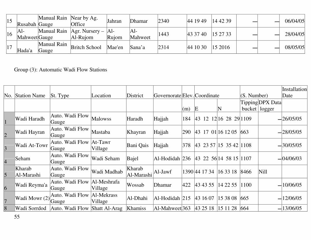
55
15 Rusabah
Manual Rain Gauge
Near by Ag. Office
Jahran Dhamar 2340 44 19 49 14 42 39 06/04/05 ــــ ــــ
16 Al-Mahweet
Manual Rain Gauge
Agr. Nursery –Al-Rujom
Al-Rujom
Al-Mahweet
28/04/05 ــــ ــــ 33 27 15 40 37 43 1443
17 Hada'a
Manual Rain Gauge
Britch School Mae'en Sana’a 2314 44 10 30 15 2016 08/05/05 ــــ ــــ
Group (3): Automatic Wadi Flow Stations
No. Station Name St. Type Location District Governorate Elev. Coordinate (S. Number) Installation Date
(m) E N Tipping bucket
DPX Data logger
1 Wadi Haradh
Auto. Wadi Flow Gauge
Malowss Haradh Hajjah 184 43 12 12 16 28 29 1109 26/05/05 ـــ
2 Wadi Hayran
Auto. Wadi Flow Gauge
Mastaba Khayran Hajjah 290 43 17 01 16 12 05 663 28/05/05 ـــ
3 Wadi At-Towr
Auto. Wadi Flow Gauge
At-Tawr Village
Bani Qais Hajjah 378 43 23 57 15 35 42 1108 30/05/05 ـــ
4 Seham
Auto. Wadi Flow Gauge
Wadi Seham Bajel Al-Hodidah 236 43 22 56 14 58 15 1107 04/06/03 ـــ
5 Kharab Al-Marashi
Auto. Wadi Flow Gauge
Wadi Madhab Kharab Al-Marashi
Al-Jawf 1390 44 17 34 16 33 18 8466 Nill
6 Wadi Reyma'a
Auto. Wadi Flow Gauge
Al-Meshrafa Village
Wossab Dhamar 422 43 43 55 14 22 55 1100 10/06/05 ـــ
7 Wadi Mowr (2)
Auto. Wadi Flow Gauge
Al-Mekrass Village
Al-Dhahi Al-Hodidah 215 43 16 07 15 38 08 665 12/06/05 ـــ
8 Wadi Sorrdod Auto. Wadi Flow Shatt Al-Arag Khamiss Al-Mahweet 363 43 25 18 15 11 28 664 13/06/05 ـــ
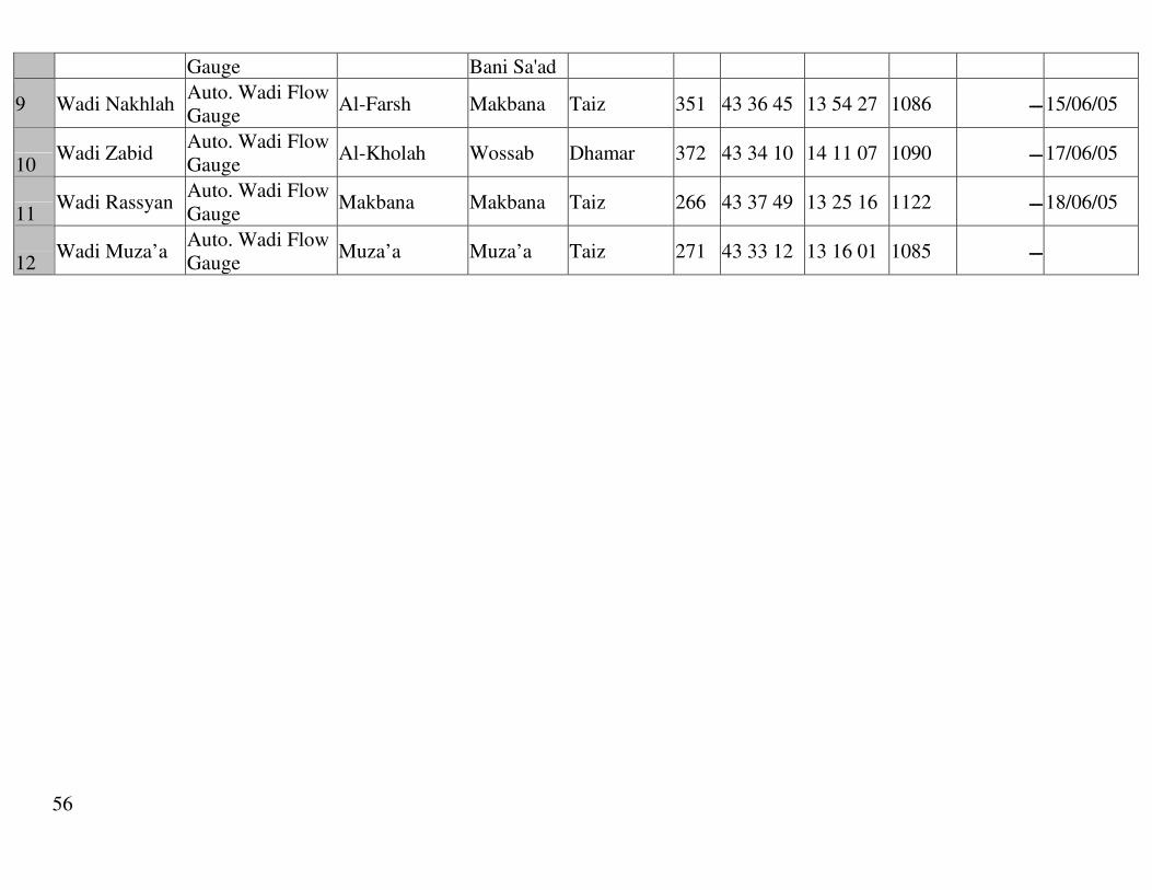
56
Gauge Bani Sa'ad
9 Wadi Nakhlah Auto. Wadi Flow Gauge
Al-Farsh Makbana Taiz 351 43 36 45 13 54 27 1086 15/06/05 ـــ
10 Wadi Zabid
Auto. Wadi Flow Gauge
Al-Kholah Wossab Dhamar 372 43 34 10 14 11 07 1090 17/06/05 ـــ
11 Wadi Rassyan
Auto. Wadi Flow Gauge
Makbana Makbana Taiz 266 43 37 49 13 25 16 1122 18/06/05 ـــ
12 Wadi Muza’a
Auto. Wadi Flow Gauge
Muza’a Muza’a Taiz 271 43 33 12 13 16 01 1085 ـــ

57
ANNEX 5. Group (4)
Group 4 Table (A-4): Location of the Manual Rainfall Stations installed by CWMU, with the support of CSCP
No. Location
Kind of Station
Station Name District
Gover-norate
Elev.
Deg.
Min.
Sec. E
Deg.
Min.
Sec. N
Inst. Date
157
Al-Nuqob GSCP-FU Office
Manual Rainfall Nuqob
Bayhan
Shabwah
1169 45 47 32 14 59 11
2/5/2005
158
Naser Faculty Lahej
Manual Rainfall
Naser Faculty
Al-Hawtah Lahej 137 44 53 12
487710 13 3 10
1442984
20/5/2005
159
Sya'a Tour Al-Baha
Manual Rainfall
Tour Al-Baha
Tour Al-Baha Lahej 569
427523
1452300
17/4/2005
160
Agr. Center Rebat Al-Kala'a
Manual Rainfall
Rebat Al-Kala'a Ketab Ibb
2551
428726
1570461
20/4/2005
161
Al-Kuod Resarch Station
Manual Rainfall
Al-Kuod
Zinjubar Abyan 28 45 21 55 13 5 29
21/7/2005
162
Al-Habib Mashhowr Farm
Manual Rainfa Ahwar Ahwar Abyan 35 46 43 22 13 30 50
29/7/2005
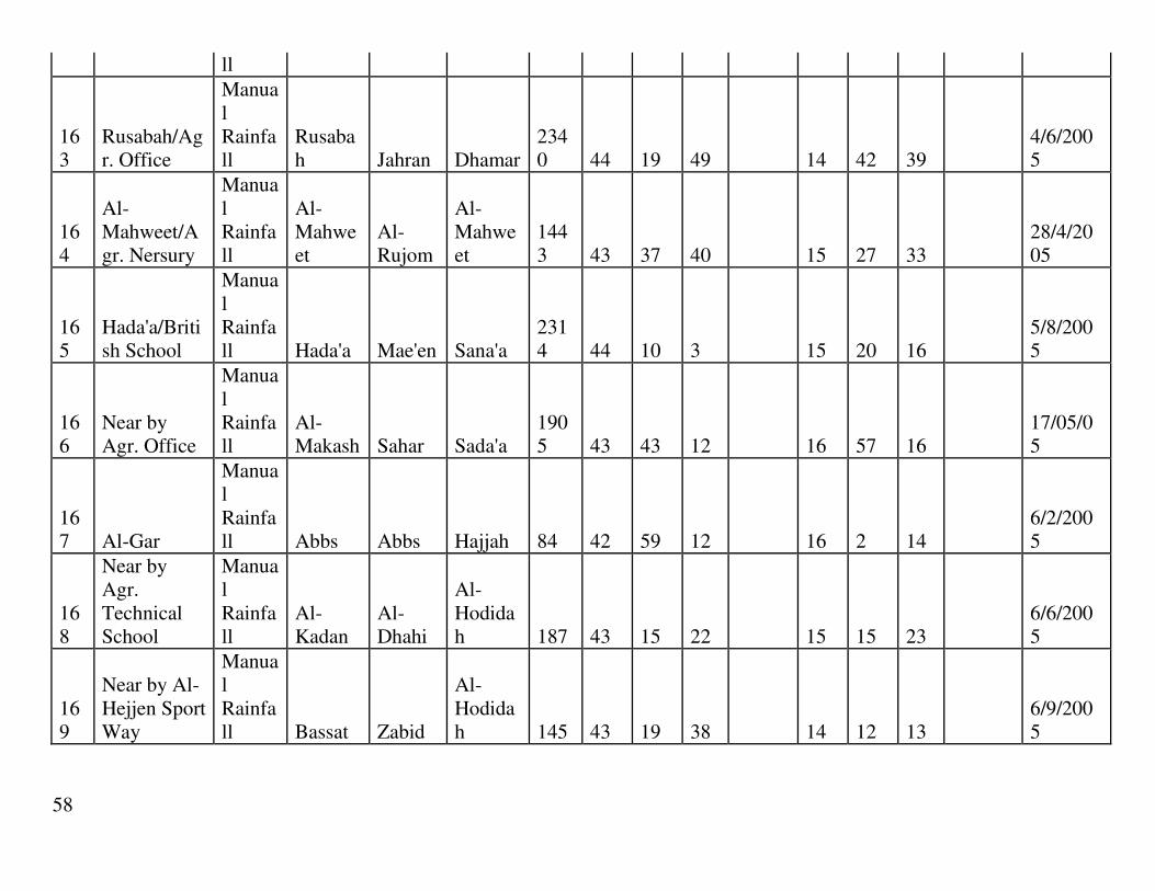
58
ll
163
Rusabah/Agr. Office
Manual Rainfall
Rusabah Jahran Dhamar
2340 44 19 49 14 42 39
4/6/2005
164
Al-Mahweet/Agr. Nersury
Manual Rainfall
Al-Mahweet
Al-Rujom
Al-Mahweet
1443 43 37 40 15 27 33
28/4/2005
165
Hada'a/British School
Manual Rainfall Hada'a Mae'en Sana'a
2314 44 10 3 15 20 16
5/8/2005
166
Near by Agr. Office
Manual Rainfall
Al-Makash Sahar Sada'a
1905 43 43 12 16 57 16
17/05/05
167 Al-Gar
Manual Rainfall Abbs Abbs Hajjah 84 42 59 12 16 2 14
6/2/2005
168
Near by Agr. Technical School
Manual Rainfall
Al-Kadan
Al-Dhahi
Al-Hodidah 187 43 15 22 15 15 23
6/6/2005
169
Near by Al-Hejjen Sport Way
Manual Rainfall Bassat Zabid
Al-Hodidah 145 43 19 38 14 12 13
6/9/2005

59
ANNEX 6. List of rain fall &meteorological and wad flood stations
LIST OF RAINFALL & METEOROLOGICAL AND WADI FLOOD STATIONS TIHAMA DEVELOPMENT AUTHURITY .
STATION NAME
OWNER SITE
RAINFALL OR METEO OR FLOOD
WADI LOCATION
ELVE (M) UTM N (M) UTM E
(M)
SUAQ-ALRABU HOUSE R Abs 1780000 301000 180 AL-GAR
TDA R + METEO
Abs 16 02 00 42 59 00 84
HARAD AL-QADEMA
OB-HO R HARAD 1818000 292000 90
AL-KHADRAH OB-HO R HARAD 1813000 283000 50 MIDE OB-HO R HARAD 1813500 266000 10 WASH’HA OB-HO R HARAD 1797294 327221 230
WADI HARAD TDA W-FLOOD HARAD 1822500 310500 220 AL-ZUHRA
TDA R + METEO
MAWR 1740600 287500 70
KUDMAT MARRARYAH
OB-HO R MAWR 1736000 306000 180
JABAL AL-MILH
OB-HO R MAWR 1733752 266200 20
AL-TURE OB-HO R MAWR 1723511 328437 200 HAJJAH SCHOOL R MAWR 1734425 349959 1650 AL-MAHABISHA
OB-HO R MAWR 1764000 332000 1600
AL-MAHWEET OB-HO R MAWR 1710488 344437 2100 BANI-UWAIR OB-HO R MAWR 1854231 359661 2100 HUTH OB-HO R MAWR 1795046 389900 1900
KHAMAR OB-HO R MAWR 1769232 389432 2356 SAQAYN OB-HO R MAWR 1865409 343753 2230 SIHARAH OB-HO R MAWR 1793364 361046 2200
SHIBAM OB-HO R MAWR 1715787 381700 2600 AL-QANAWIS TDA R HATAB SHAT AL-ERJ
TDA W – FLOOD
MAWR 1727400 316600 230

60
AL-ZAYDIYAH TDA R SURDUD 1696000 286000 60 AZZAN
SCHOOL R-(M-AUTO)
SUR 15 10 00 43 22 00 304
AL-KADEN AQ-INST R-METEO SUR 1687065 310790 167 SHAT AD-DARBA
TDA FLOOD SUR 1679000 337000 430
LIST OF RAINFALL & METEOROLOGICAL AND WADI FLOOD STATIONS TIHAMA DEVELOPMENT AUTHURITY .
STATION NAME
OWNER SITE
RAINFALL OR METEO OR FLOOD
WADI LOCATION ELVE
(M) UTM N (M) UTM E (M)
AL-HUDAYDAH TDA R-(M-AUT) SIHAM 1634000 280000 10
AL-MARAWEA TDA R-(M-AUT) SIH WAQIR TDA R SIH 1646152 315314 230 BAJIL 1
TDA R-(M-AUTO)
SIH 1665900 315600 185
DEIR-ZINQAH OB-HO R-(M-AUT) SIH 1660773 333352 450 MAHEL-SHAMERY
OB-HO R SIH 1657163 322570 200
MAGHRIBAH OB-HO R SIH 1644164 335030 1200 AL-DIBRAH OB-HO R SIH 1634730 369055 1000 AL-FAWARAH OB-HO R SIH 1658000 408000 1500
AL-AMIR OB-HO R SIH 1662444 360246 2200 AL-HAMAL OB-HO R SIH 1630958 386977 2000 AL-SUKHNAH OB-HO R-(M-AUT) SIH 1638658 331404 350
AL-HIMAH OB-HO R SIH 1667858 381777 1600 WALLAN OB-HO R SIH 1668200 421100 2500 AL-KHALIFA TDA R-METEO SIH 1646000 319000 139
MAHEL-SALEEM
TDA W-F SIH 1656000 326000 390
BAIT-ALFAQIH OB-HO R
AL-KIDYAH
1606700 317900 120
BAIT-ALSAID OB-HO R KID 1608200 334200 210 AL ZAFARAN TDA R-AUTO SIH 14 40 OO 43 05 00 50

61
LIST OF RAINFALL & METEOROLOGICAL AND WADI FLOOD STATIONS TIHAMA DEVELOPMENT AUTHURITY .
STATION NAME OWNER SITE
RAINFALL OR METEO OR FLOOD
WADI LOCATION ELVE
(M) UTM N (M) UTM E (M)
BASAT OB-HO R RIMAA 1585000 324000 150 AD-DIMNAH OB-HO R RIMAA 1588858 332858 270 AL-GHAWADER OB-HO R RIMAA 1586967 340037 350
AL-MAHATT OB-HO R RIMAA 1581596 316652 95 AL-QAHMAH OB-HO R RIMA 1581494 331011 180 AL-MISHRAFA TDA R RIMAA 1588777 345441 450
AL-HUSSAINYAH
TDA R-MET RIMAA 1587548 319778
AS-SANAM OB-HO R RIMA 1610544 421000 2400 NAJD-ALHADAD
OB-HO R RIMAA 1610562 415613 2300
AL-MASSNAH OB-HO R RIMAA 1620500 418700 2000 MADENAT-AS-SHARQ
OB-HO R RIMAA 1619888 388721 1500
HAMMAM-ALI OB-HO R RIMAA 1619806 408465 2000 AL-QIRNAH OB-HO R RIMAA 1597900 361670 900 AL-MISHRAFAH TDA W-FLOOD RIMAA 1590000 346000 390
ZABID-TOWN OB-HO R ZABID 1568674 318330 105 AL-JIRBAH TDA R-MET ZABID 1564899 330899 240 AL-UDAIN OB-HO R ZABID 1542405 400979 1700
IBB OB-HO R ZAB 1546053 411795 1800 WADI AL-HAR OB-HO R ZAB 1605044 412002 2000 RIHAB OB-HO R ZAB 1573500 411800 1500 DALIL-SUMARAH
OB-HO R ZAB 1560801 411846 1500
YARIM OB-HO R ZAB 1580700 433550 2400 AL-KOLAH TDA W-FLOOD ZAB 1561000 345000 320
AL-SAIDIYAH OB-HO R DAMI 1507000 334000 220 WADI-NAKHLAH
TDA W-FLOOD NAKH 1539000 347600 330
QABAN TDA W-FLOOD DAMI 1532000 349400 320

62
LIST OF RAINFALL & METEOROLOGICAL AND WADI FLOOD STATIONS TIHAMA DEVELOPMENT AUTHURITY.
STATION NAME OWNER SITE
RAINFALL OR METEO OR FLOOD
WADI LOCATION
ELVE (M) UTM N (M) UTM E
(M)
AL-BARH TDA R-MET RASYAN 1487288 359268 500 JABAL-HABASHI
OB-HO R RAS 1496460 368336 950
HAJDAH OB-HO R RAS 1501965 373774 1150
ALKUDEYHAH TDA
R + METEO
RAS 1492989 330429 120
AL-RUBEI OB-HO R RAS 1501941 379185 1250 MAQBANA OB –HO R RAS 1510600 356000 980
ALNOZEYHA OB-HO R RAS 1507900 367200 750 ALDABAB OB-HO R RAS 1496300 386300 1200 WADI RASYAN
TDA W – FLOOD
GORGE 1483000 346000 270
ALGHURAFI OB-HO R- MAWZA

63
LIST OF RAINFALL & METEOROLOGICAL AND WADI FLOOD STATIONS TIHAMA DEVELOPMENT AUTHURITY .
STATION NAME OWNER SITE
RAINFALL OR METEO OR FLOOD
WADI LOCATION
ELVE (M) UTM N
(M) UTM E (M)
BARQUQAH TDA R SIH 14 20 35 43 20 39 213 DEIR- MODAWER
TDA R SIH 15 03 00 43 15 00 138
AL-DURIHEME TDA R KIDIYAH 14 48 05 43 03 00 40
AL- MANSUREYAH
TDA R SIH 14 41 O8 43 18 31 137
AL-LAWEYAH TDA R KID 14 36 39 43 12 04 70 AL- NAJEYAH TDA R SUR 15 10 25 43 11 06 158
AL-MEGHLAF TDA R SUR 15 17 13 43 11 25 144 AL-TURBAH TDA R URJ 15 04 14 42 59 09 64 AL- DAHEY TDA R SUR 15 12 59 43 04 33 93
AL-AURSH TDA R SUR 15 13 58 42 56 27 57 AL-ZAIDEYAH TDA R SUR 15 19 50 43 00 57 74 DEIR-AL WAJEIH
TDA R SUR 15 19 09 43 06 03 106
BAJIL 2 OB-HO R SIH 15 04 54 43 18 09 184 ABBAL OB-HO R SIH 14 59 32 43 32 66 506 AL QUTAI OB-HO R- SIH 14 53 76 43 32 66 157
AL-HAJEILAH TDA R AL WALAG
14 58 81 43 37 49 652

64
LIST OF RAINFALL & METEOROLOGICAL AND WADI FLOOD STATIONS TIHAMA DEVELOPMENT AUTHURITY
STATION NAME
OWNER SITE
RAINFALL OR METEO OR FLOOD
WADI LOCATION ELV
(M) UTM N (M) UTM E (M)
TDA الحديده-مبنى الھيئه R-AUTOMAIC
SIHAM 1633776 280189 14
مبنى -الكرزومي المشروع
TDA R-AUTO SIHAM 1622421 287445 33
TDA R-AUTO SIHAM 1637677 294459 65 مبنى المخازن-جميشه
TDA R-AUTO SIHAM 1640862 297602 78 شمال اليومينالمركز -الجاح ا#على
ا+رشاديTDA R-AUTO RIMAA 1587012 293330 76
مبنى -الجراحي المركز البيطري
TDA R-AUTO ZABID 1562877 326920 192
TDA R-AUTO ZABID 1571852 318036 117 كمب الھيئه-زبيد TDA R-AUTO SIH 1645160 331081 484 محمية برع
CAMP-برقوقهTDA-
TDA R-AUTO SIH 1654547 322762 227
مبنى ادارة -الكدن مزرعة سردود
TDA R-AUTO SURDUD 1686468 312293 225
المركز -الضحي الزراعي
TDA R-AUTO SURDUD 1683007 293210 109
المشتل -المنيره الزراعي
TDA R-AUTO SURDUD 1694514 277276 44
المركز -الزيديه الزراعي
TDA R-AUTO SURDUR 1695887 286886 73
TDA R-AUTO MAWR 1730394 309863 184 كمب حاجز وادي مورالمركز -المشائف الزراعي
TDA R-AUTO MAWR 1734778 302865 144
المركز -قرية مور الزراعي
TDA R-AUTO MAWR 1732937 281675 80
AL JAROBAH FARM
TDA R-AUTO RIM 1588022 293620 80
HAIS TDA R-AUTO DAMMI 13 56 00 43 28 00 127 JABAL RAS TDA R-AUTO NAKHLA 13 59 00 43 37 00 410
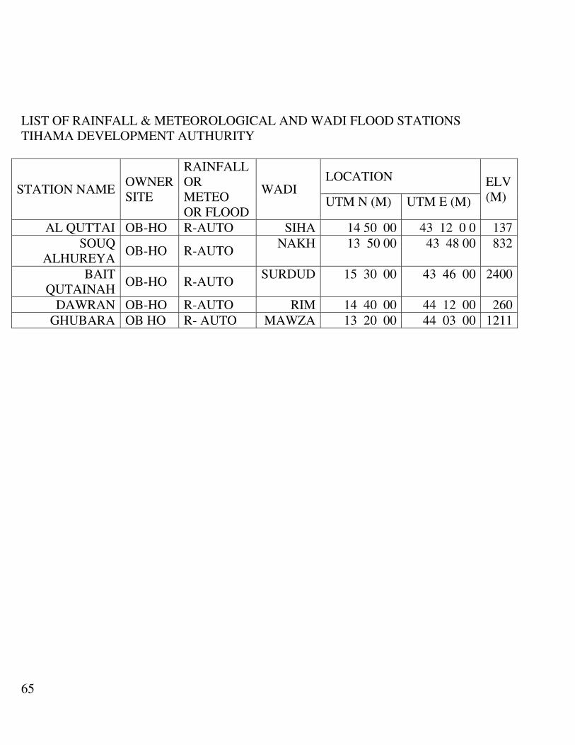
65
LIST OF RAINFALL & METEOROLOGICAL AND WADI FLOOD STATIONS TIHAMA DEVELOPMENT AUTHURITY
STATION NAME OWNER SITE
RAINFALL OR METEO OR FLOOD
WADI LOCATION ELV
(M) UTM N (M) UTM E (M)
AL QUTTAI OB-HO R-AUTO SIHA 14 50 00 43 12 0 0 137 SOUQ
ALHUREYA OB-HO R-AUTO
NAKH 13 50 00 43 48 00 832
BAIT QUTAINAH
OB-HO R-AUTO SURDUD 15 30 00 43 46 00 2400
DAWRAN OB-HO R-AUTO RIM 14 40 00 44 12 00 260 GHUBARA OB HO R- AUTO MAWZA 13 20 00 44 03 00 1211

66
LIST OF GROUND WATER MONITORING AUTOMATICLY STATIONS TIHAMA DEVELOPMENT AUTHURITY .
STATION NAME OWNER SITE
GROUND-WATER
WADI LOCATION ELVE
(M) UTM N (M) UTM E (M)
DEIR-ALSUAFA TDA EC-TEM SIHAM 1654800 308300 125
AL-YOUMAIN TDA
WATER-DEP
SIH 1640862 297602 78
ALHIZAM-ALAGHDR
TDA EC-TEM SIH 1638759 286796 56
AL-KARZUME TDA WAT-DEP SIH 1622562 287736 35
BIOT-BODAH TDA WAT-DEP SIHA 1628260 309645 65 AL-
BUKAREYAH TDA WAT-DEP RIM 1604454 311510 110
GHULAFEQAH TDA WAT-DEP RIM 1595615 286245 31 AL-
SHADELIYAH TDA EC-TEM RIM 1581599 325405 160
AL-QASSWERAH
TDA EC-TEM RIM 1583705 314684 111
AL-QRASHIYAH TDA WAT-DEP RIM 1580125 307411 81 AL-SHUMAH1 TDA EC-TEM RIM 1579752 297763 50
AL-SHUMAH 2 TDA WAT-TEM RIM 1579750 297762 50 AD-DRABISH TDA WAT-DEP RIM 1587762 303761 63
AL-MODAMEN TDA EC-TEMP ZABID 1561500 299606 16 AL-MAZAQY TDA WAT-DEP ZAB 1568000 320995 128
AL-ZAREBEH TDA WAT-DEP ZAB 1568704 327072 187 AL-RAUDAH TDA WAT-DEP ZAB 1565144 332774 251
HAJEAZ 3 TDA WAT-DEP ZAB 1565963 329855 205
ALMASAHEEB TDA WAT-DEP ZAB 1564739 324812 187 AL-LAWEYAH TDA EC KIDYAH 1615818 305766 64 AL-MEHRASA TDA WAT-DEP KIDYAH 1612657 316858 104
JABER TDA EC MAWR 1732423 309315 125 AL-GHURZAH TDA EC MAWR 1736833 288768 106 DEIR-FAQEER TDA WAT-DEP MAWR 1723505 286485 78
DEIR-DUKHNAH
TDA WAT-DEP MAWR 1722565 299907 120
ZUBAYAH TDA EC MAWR 1734610 281155 73
DEIR MAHJOB TDA EC MAWR 1725969 292080 76

67
AL URSH TDA WAT-DEP SURDUD 1684745 278785 57 AL-KADEN 1 TDA WAT-DEP SURDUD 1686240 312024 156
AL KADEN 2 TDA WAT-TEM SUR 1687065 310548 165 LEGEND :-
OB – HO OBSERVAL – HOUSE TDA TIHAMA DEVELOPMENT AUTHURITY R RAINFALL
W – F WADI – FLOOD METEO METEOROLOGICAL R – (M – AUTO)
RAINFALL – (MANUAL – AUTOMATIC )

68
ANNEX 7. CAMA/YMS stations
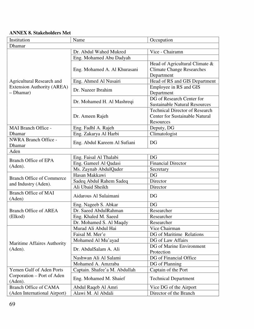
69
ANNEX 8. Stakeholders Met
Occupation Name Institution
Dhamar
Vice - Chairamn Dr. Abdul Wahed Mukred
Agricultural Research and Extension Authority (AREA) – Dhamar)
Eng. Mohamed Abu Dadyah
Head of Agricultural Climate & Climate Change Researches Department
Eng. Mohamed A. Al Khurasani
Head of RS and GIS Department Eng. Ahmed Al Nusairi
Employee in RS and GIS Department
Dr. Nazeer Ibrahim
DG of Research Center for Sustainable Natural Resources
Dr. Mohamed H. Al Mashreqi
Technical Director of Research Center for Sustainable Natural Resources
Dr. Ameen Rajeh
Deputy, DG Eng. Fadhl A. Rajeh MAI Branch Office - Dhamar Climatologist Eng. Zakarya Al Harbi
DG Eng. Abdul Kareem Al Sufiani NWRA Branch Office - Dhamar
Aden
DG Eng. Faisal Al Thalabi Branch Office of EPA (Aden).
Financial Director Eng. Gameel Al Qadasi
Secretary Ms. Zaynab AbdulQader
DG Hasan Makkawi Branch Office of Commerce and Industry (Aden).
Director Sadeq Abdul Rahem Sadeq
Director Ali Ubaid Sheikh
DG Aidarous Al Sulaimani Branch Office of MAI (Aden)
DG Eng. Nageeb S. Abkar
Branch Office of AREA (Elkod)
Researcher Dr. Saeed AbdulRahman
Researcher Eng. Khaled M. Saeed
Researcher Dr. Mohamed S. Al Maqdy
Vice Chairman Murad Ali Abdul Hai
Maritime Affaires Authority (Aden).
DG of Maritime Relations Faisal M. Mer’e
DG of Law Affairs Mohamed Al Mu’ayad
DG of Marine Environment Protection
Dr. AbdulSalam A. Ali
DG of Financial Office Nashwan Ali Al Salami
DG of Planning Mohamed A. Amzraba
Captain of the Port Captain. Shafee’a M. Abdullah Yemen Gulf of Aden Ports Corporation – Port of Aden (Aden).
Technical Department Eng. Mohamed M. Shaief
Vice DG of the Airport Abdul Raqeb Al Amri Branch Office of CAMA (Aden International Airport) Director of the Branch Alawi M. Al Abdali

70
(Aden).
President Dr. Adel A. Abdul Razzaq Yemeni Society for Environment and Sustainable Development (Aden).
DG Eng. Nageeb Numan
Local Company for Water and Sanitation (Aden).
Engineer Eng. Amnah Ben Salman
Engineer Eng. Arwa Humadi
Engineer Tawfeeq Al Saqaf
Director of lab Salem S. Mohamed
Director of Development Project Guma’a Aithan
Hadhramut
Chairman Dr. Abdullah Al Gharabi Yemen Fisheries Authority (Hadhramut).
DG of Fisheries Eng. Saeed S. Al Ta’ees
Director of Monitoring Mohamed S. Ba Taweel
DG Eng. Awad S. Al Qanzal
Local Company for Water and Sanitation - Mukalla (Hadhramut).
Vice DG Eng. Abdul Raheem M. Al Tamimi
Financial Director Saleh A. Ba Yazeed
Director of Water Resources Department
Eng. Marwan A. Bar’ood
Chairman Captain. Salem A. Al Ba’asi Yemen Arabian Sea Ports Corporation (Hadhramut).
Accounting Director Nabeel A. Ben Ayfan Branch Office of Maritime Affaires Authority (Hadhramut).
DG Eng. Mohamed F. Abdoon
Branch Office of MAI (Hadhramut).
Director of Irrigation Department
Eng. Mohamed A. Ghuneem
Director of Extension Department
Eng. Fahmi A. Rwayshed
Director of Animal Health Dr. Abdul Salam S. Al Tameeme
Assistant Deputy Governor Fahd Salah Al A’agam Governorate of Hadhramut.
Director Colonel. Omar A. Ba Zayban Civil Defence – Sayun – Ministry of Interior (Hadhramut).
DG Dr. Abdullah S. Alwan Branch Office of AREA – Sayun (Hadhramut).
Engineer Eng. Qaid A. Al Katheri
Researcher Eng. Awad S. Ba Saleh
DG Eng. Abdul Kareem S. Ba Hakeem Branch Office of NWRA – Sayun (Hadhramut). Director of Studies Eng. Abdul Azeez S.Ba Musleh
DG Thabit Al Sa’ady Branch Office of EPA (Hadhramut)
DG Eng. Omar S. Ba Muhaimood Branch Office of MAI – Sayun (Hadhramut).
President Abdul Hakeem A. Abdul Azeez Al Ghaith Society – Sayun (Hadhramut). General Secretary Awad K. Al Sa’ady
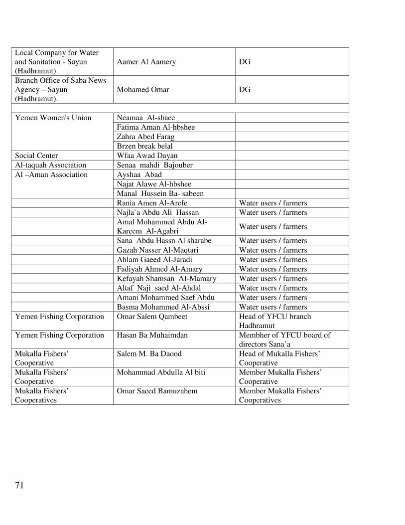
71
DG Aamer Al Aamery Local Company for Water and Sanitation - Sayun (Hadhramut).
DG Mohamed Omar Branch Office of Saba News Agency – Sayun (Hadhramut).
Neamaa Al-sbaee Yemen Women's Union
Fatima Aman Al-hbshee
Zahra Abed Farag
Brzen break belal
Wfaa Awad Dayan Social Center
Senaa mahdi Bajouber Al-taquah Association
Ayshaa Abad Al –Aman Association Najat Alawe Al-hbshee
Manal Hussein Ba- sabeen
Water users / farmers Rania Amen Al-Arefe
Water users / farmers Najla`a Abdu Ali Hassan
Water users / farmers Amal Mohammed Abdu Al-Kareem Al-Agabri
Water users / farmers Sana Abdu Hassn Al sharabe
Water users / farmers Gazah Nasser Al-Maqtari
Water users / farmers Ahlam Gaeed Al-Jaradi
Water users / farmers Fadiyah Ahmed Al-Amary
Water users / farmers Kefayah Shamsan AI-Mamary
Water users / farmers Altaf Naji saed Al-Ahdal
Water users / farmers Amani Mohammed Saef Abdu
Water users / farmers Basma Mohammed Al-Abssi
Head of YFCU branch Hadhramut
Omar Salem Qambeet Yemen Fishing Corporation
Membher of YFCU board of directors Sana’a
Hasan Ba Muhaimdan Yemen Fishing Corporation
Head of Mukalla Fishers’ Cooperative
Salem M. Ba Daood Mukalla Fishers’ Cooperative
Member Mukalla Fishers’ Cooperative
Mohammad Abdulla Al biti Mukalla Fishers’ Cooperative
Member Mukalla Fishers’ Cooperatives
Omar Saeed Bamuzahem Mukalla Fishers’ Cooperatives
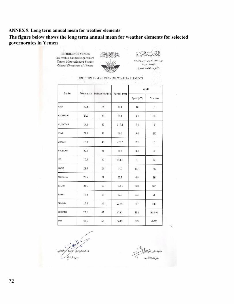
72
ANNEX 9. Long term annual mean for weather elements
The figure below shows the long term annual mean for weather elements for selected
governorates in Yemen

73

74
ANNEX 10. Meteorological stations NWRA
GOV_NAME_E CATCHMENT STATIONID STATIONNAM LATITUDE LONGITUDE SHORTTYPE
Al-Hodaida Northern Tihamah Catch 163 WADI HARAD 16.47 43.20 SLV
Al-Hodaida Northern Tihamah Catch 164 WADI HAYRAN 16.20 43.28 SLV
Al-Hodaida Wadi Mawr 678 KUDMAH 15.67 43.19 RAN
Al-Hodaida Wadi Mawza' 100 MAWZA 13.27 43.55 SLV
Al-Hodaida Wadi Nakhlah 88 NAKHLAH 13.91 43.61 SLV
Al-Hodaida Wadi Rima' 104 BASAT 14.33 43.37 RAN
Al-Hodaida Wadi Siham 166 KHALIFAH 14.87 43.30 MET
Al-Hodaida Wadi Siham 165 MAGHREBA 14.87 43.47 RAN
Al-Hodaida Wadi Siham 782 SIHAM-A 14.97 43.38 SLV
Al-Hodaida Wadi Surdud 723 ZAYDIYAH 15.33 43.01 RAN
Al-Hodaida Wadi Surdud 172 SHAT ADDARBA 15.19 43.42 SLV
Al-Hodaida Wadi Zabid 89 ALJIRBAH 14.15 43.43 MET
Al-Hodaida Wadi Zabid 731 ZABID 14.18 43.35 RAN
Al-Hodaida Wadi Zabid 784 ZABID-A 14.12 43.56 SLV
Al-Mahwit Wadi Mawr 389 MAHWIT 15.47 43.55 RAN
Amran Wadi Mawr 505 KHAMIR 16.00 43.97 RAN
Amran Wadi Mawr 719 SHAHARAH 16.20 43.70 RAN
Dhamar Wadi Rima' 110 MISHRAFA 14.37 43.57 MET
Dhamar Wadi Rima' 147 HAMAMALI 14.65 44.15 RAN
Dhamar Wadi Rima' 148 ASHSHIRQ 14.63 43.97 RAN
Dhamar Wadi Siham 151 AL-HAMAL 14.75 43.95 RAN
Dhamar Wadi Zabid 90 FULAYH 14.18 43.70 RAN
Dhamar Wadi Zabid 729 WADI-HAR 14.52 44.23 RAN
Hajja Northern Tihamah Catch 509 AL-RABU 16.08 43.13 RAN
Hajja Northern Tihamah Catch 519 MIDI 16.31 42.82 RAN
Hajja Northern Tihamah Catch 520 KHADRAH 16.39 42.97 RAN
Hajja Northern Tihamah Catch 522 ALKADIMA 16.43 43.05 RAN
Hajja Northern Tihamah Catch 717 WASH'HA 16.25 43.38 RAN
Hajja Wadi Mawr 469 AT-TUR 15.58 43.38 RAN
Hajja Wadi Mawr 480 MIKRAS 15.65 43.26 RAN
Hajja Wadi Mawr 485 HAJJAH 15.68 43.60 RAN
Hajja Wadi Mawr 506 MAHABISH 16.00 43.50 RAN
Hajja Wadi Mawr 781 MAWR-A 15.62 43.29 SLV
Ibb Wadi Bana 730 YARIM 14.30 44.38 RAN
Ibb Wadi Zabid 81 AL-UDEIN 13.95 44.08 RAN
Ibb Wadi Zabid 85 IBB 13.98 44.18 RAN
Ibb Wadi Zabid 87 ADDALIL 14.12 44.18 RAN
Ibb Wadi Zabid 94 RISABA 14.22 44.18 RAN
Raymah Wadi Rima' 783 RIMA-A 14.38 43.57 SLV
Raymah Wadi Siham 159 ALDABIRA 14.78 43.78 RAN
Sa'ada Wadi Mawr 718 UWAIR 16.77 43.68 RAN
Sa'ada Wadi Mawr 720 SAQAYN 16.87 43.53 RAN
Sana'a Wadi al Jawf 722 SHIBAM-T 15.52 43.92 RAN
Sana'a Wadi Rima' 124 HABAKA 14.45 43.72 RAN
Sana'a Wadi Siham 173 ALFOWARA 15.00 44.15 RAN
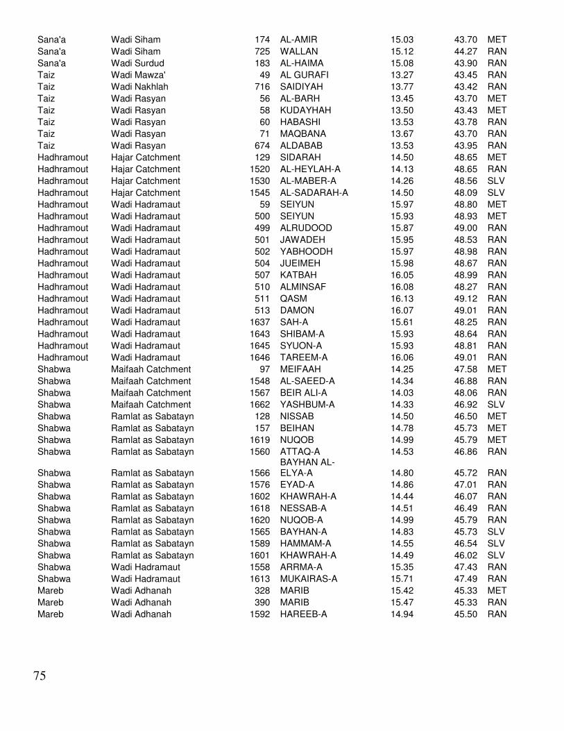
75
Sana'a Wadi Siham 174 AL-AMIR 15.03 43.70 MET
Sana'a Wadi Siham 725 WALLAN 15.12 44.27 RAN
Sana'a Wadi Surdud 183 AL-HAIMA 15.08 43.90 RAN
Taiz Wadi Mawza' 49 AL GURAFI 13.27 43.45 RAN
Taiz Wadi Nakhlah 716 SAIDIYAH 13.77 43.42 RAN
Taiz Wadi Rasyan 56 AL-BARH 13.45 43.70 MET
Taiz Wadi Rasyan 58 KUDAYHAH 13.50 43.43 MET
Taiz Wadi Rasyan 60 HABASHI 13.53 43.78 RAN
Taiz Wadi Rasyan 71 MAQBANA 13.67 43.70 RAN
Taiz Wadi Rasyan 674 ALDABAB 13.53 43.95 RAN
Hadhramout Hajar Catchment 129 SIDARAH 14.50 48.65 MET
Hadhramout Hajar Catchment 1520 AL-HEYLAH-A 14.13 48.65 RAN
Hadhramout Hajar Catchment 1530 AL-MABER-A 14.26 48.56 SLV
Hadhramout Hajar Catchment 1545 AL-SADARAH-A 14.50 48.09 SLV
Hadhramout Wadi Hadramaut 59 SEIYUN 15.97 48.80 MET
Hadhramout Wadi Hadramaut 500 SEIYUN 15.93 48.93 MET
Hadhramout Wadi Hadramaut 499 ALRUDOOD 15.87 49.00 RAN
Hadhramout Wadi Hadramaut 501 JAWADEH 15.95 48.53 RAN
Hadhramout Wadi Hadramaut 502 YABHOODH 15.97 48.98 RAN
Hadhramout Wadi Hadramaut 504 JUEIMEH 15.98 48.67 RAN
Hadhramout Wadi Hadramaut 507 KATBAH 16.05 48.99 RAN
Hadhramout Wadi Hadramaut 510 ALMINSAF 16.08 48.27 RAN
Hadhramout Wadi Hadramaut 511 QASM 16.13 49.12 RAN
Hadhramout Wadi Hadramaut 513 DAMON 16.07 49.01 RAN
Hadhramout Wadi Hadramaut 1637 SAH-A 15.61 48.25 RAN
Hadhramout Wadi Hadramaut 1643 SHIBAM-A 15.93 48.64 RAN
Hadhramout Wadi Hadramaut 1645 SYUON-A 15.93 48.81 RAN
Hadhramout Wadi Hadramaut 1646 TAREEM-A 16.06 49.01 RAN
Shabwa Maifaah Catchment 97 MEIFAAH 14.25 47.58 MET
Shabwa Maifaah Catchment 1548 AL-SAEED-A 14.34 46.88 RAN
Shabwa Maifaah Catchment 1567 BEIR ALI-A 14.03 48.06 RAN
Shabwa Maifaah Catchment 1662 YASHBUM-A 14.33 46.92 SLV
Shabwa Ramlat as Sabatayn 128 NISSAB 14.50 46.50 MET
Shabwa Ramlat as Sabatayn 157 BEIHAN 14.78 45.73 MET
Shabwa Ramlat as Sabatayn 1619 NUQOB 14.99 45.79 MET
Shabwa Ramlat as Sabatayn 1560 ATTAQ-A 14.53 46.86 RAN
Shabwa Ramlat as Sabatayn 1566 BAYHAN AL-ELYA-A 14.80 45.72 RAN
Shabwa Ramlat as Sabatayn 1576 EYAD-A 14.86 47.01 RAN
Shabwa Ramlat as Sabatayn 1602 KHAWRAH-A 14.44 46.07 RAN
Shabwa Ramlat as Sabatayn 1618 NESSAB-A 14.51 46.49 RAN
Shabwa Ramlat as Sabatayn 1620 NUQOB-A 14.99 45.79 RAN
Shabwa Ramlat as Sabatayn 1565 BAYHAN-A 14.83 45.73 SLV
Shabwa Ramlat as Sabatayn 1589 HAMMAM-A 14.55 46.54 SLV
Shabwa Ramlat as Sabatayn 1601 KHAWRAH-A 14.49 46.02 SLV
Shabwa Wadi Hadramaut 1558 ARRMA-A 15.35 47.43 RAN
Shabwa Wadi Hadramaut 1613 MUKAIRAS-A 15.71 47.49 RAN
Mareb Wadi Adhanah 328 MARIB 15.42 45.33 MET
Mareb Wadi Adhanah 390 MARIB 15.47 45.33 RAN
Mareb Wadi Adhanah 1592 HAREEB-A 14.94 45.50 RAN
76
References
• Agricultural Statistics Pamphlet 2009, Department of Statistics and Agricultural Information, Ministry
of Agriculture and Irrigation, Yemen, 2009.
• General Dept of Agricultural Statistices& Documentation Agricultural Statistices Pamphlet 2007,
Ministry of Agriculture & Irrigation, Yemen, 2007.
• Agricultural Statistices Pamphlet 2008, Department of Statistics and Agricultural Information, Ministry
of Agriculture and Irrigation, Yemen, 2008.
• A promising Sector for Diversified Economy in Yemen: National Agriculture Sector Strategy 2012 –
2016, Ministry of Agriculture and Irrigation, Yemen, 2012.
• Assessing the Impact of Climate Change on Water Resources and Socio-Economic Vulnerability in the
ESCWA Region: A Methodological Framework for Pursuing an Integrated Assessment, United Nations
Economic and Social Commission for Western Asia (ESCWA), UN, 2011.
• Study of Impact Assessment for the year 2006, Final Report, Environmental Resources Department,
International Consultancy Corporation, Social Fund for Development, Yemen, 2007.
• Annual Report 2011, Social Fund for Development, Yemen, 2011.
• Maps of Agricultural and Environmental Resources in the Republic of Yemen, Fadhl H. Mutlaq, et al.,
Department of Remote Sensing and GIS, Centre of Sustainable Natural Resources Researches,
Agricultural Research and ExtensionAuthority, Yemen, 2005.
• The Guide for Agricultural Climate in Yemen (1881 – 2004), Mohamed A. Al-Khurasani, Agricultural
Research and ExtensionAuthority, Yemen, 2005.
• Conducting Ecological Gap Assessments, A Quick Guide fro Protecting Area Practitioners, Forest
Stewardship Council, 1996.
• Feasibility Study for Long-term Wadi Rehabilitation, Final Report, WadiHadramaut Agricultural
Development Project (Phase II), Binnie& Partners Consulting Engineers, UK, Minsitry of Agriculture
and Agrarian Reform, People’s Democratic Republic of Yemen, 1987.
• Environmental Situation in the Republic of Yemen, (Third Report), EPA, Ministry of Water and
Environment, Yemen.
• Adaptation to Climate Change Using Agrobiodiversity Resources inthe Rainfed Highland of Yemen
(GEF- Project), M.Farea&B.Köstner, TechnischeUniversität Dresden, (CUABCCA-Yemen), Project
Assignment, Agrobiodiversity Component, Survey Report, 2010.
• Climate change impact assessment on the, agriculture and water sectors, Republic of Yemen, Draft
Report, HR Wallingford, 2009.

77
• Multilateral United Nations Framework Convention on Climate Change, UN, 2004.
• Assessing the Impact of Climate Change and Variability on the Water and Agriculture Sectors, and the
Policy Implications, WB, 2010.
• Report on the Activity of EPA, Hadhramout, 2010.
• Environmental Situation of Hadramout Governorate, Annual Report, 2010.
• Kokko, H. Integrated Hydrometeorological MonitoringSolutions and Network Management.
• Nature’s Conservation Private Limited, Environmental and Social Management Framework for
Implementation of Building Resilience to Climate Related Hazards, Pilot Programme for Climate
Resilience-PPCR under Environmental Impact Assessment Programme,2012.
• Agrawal, A. The Role of Local Institutions in Adaptation toClimate Change, 2008.
• Anonymous, Assessing the Impact of Climate Change and Variability on the Water and Agriculture
Sectors, and the Policy Implications, 2010.
• SENES Consultants India Pvt. Ltd. Environmental Impact Assessment for Development of Bus Rapid
Transit System in Naya Raipur Chhattisgarh, 2011.
• Anonymous, Summary Environmental and Social Management Plan, Geothermal Exploration Project,
Djibouti.
• Anonymous, Electromagnetic Hypersensitivity, 2004
• Moultrie, S. Environmental and Social Analysis for Water and Sewerage Corporation Support Program,
New Providence Water Supply and Sanitation Systems Upgrade, BH-L1028, Final Draft, 2011.
• Patz, J. A.; Campbell-Lendrum, D.; Holloway, T. and Foley J. A. Impact of Regional Climate Change
on Human Health, 2005.