reproductions supplied by edrs are the best that can be ... · document resume. so 032 775. rice,...
TRANSCRIPT

ED 453 129
AUTHORTITLE
INSTITUTIONISBNPUB DATENOTEAVAILABLE FROM
PUB TYPEEDRS PRICEDESCRIPTORS
IDENTIFIERS
ABSTRACT
DOCUMENT RESUME
SO 032 775
Rice, Gwenda A.; Bulman, Teresa L.Fieldwork in the Geography Curriculum: Filling theRhetoric-Reality Gap. Pathways in Geography Resource Series,Title No. 22.National Council for Geographic Education.ISBN-1-884136-18-42001-00-0098p.; Cover page varies.National Council for Geographic Education, 16A Leonard Hall,Indiana University of Pennsylvania, Indiana, PA 15705-1087($14.95); Tel: 724-357-6290; Fax: 412-357-7708; E-mail:[email protected]; Web site: http://www.ncge.org.Guides Classroom Teacher (052)MF01/PC04 Plus Postage.Elementary Secondary Education; *Field Studies; *GeographyInstruction; Inquiry; Instructional Effectiveness;Investigations; Observation; *Skill Development; SocialStudiesConceptual Approach
Fieldwork provides an opportunity to reinforce previousclass-based learning and presents students with an opportunity to encounternew ideas and practice new skills. In the K-12 classroom, however, therhetoric-reality gap between the declared need for fieldwork and doingfieldwork is striking. This project seeks to narrow the gap between rhetoricand reality by providing K-12 teachers with guidelines for integratingfieldwork into the geography curriculum. The emphasis throughout the projectis on strategies that are local, small-scale, easy to implement, andinexpensive. The project framework is comprised of three interlinkedapproaches: observation, investigation, and inquiry. These approachesrepresent a progression in skills from activities that are teacher-directed,qualitative, and prescriptive to those that are more student-directed,interactive, and open-ended. The guide includes thirteen step-by-stepexamples of fieldwork activities, addressing the National Geography Standardsand the Advanced Placement Human Geography Course, in both physical and humangeography for grades K-12 and the university level. It provides checklistsfor pre-field planning, reconnaissance of the site, preparation and training,data collection, and evaluation of the findings. The project guide is dividedinto the following chapters: (1) "Fieldwork in the Geography Curriculum:Filling the Rhetoric-Reality Gap"; (2) "Survey of the Literature on HowFieldwork Affects Learning"; (3) "Designing, Planning, and ImplementingFieldwork"; and (4) "Examples of Fieldwork." Contains extensive references,as well as many tables, figures, cartoons, and photographs. (BT)
Reproductions supplied by EDRS are the best that can be madefrom the original document.

Mlle Ma 22
A PATHWAYS IN GEOGRAPHYResource Publication
National Council forGeographic Education FIELDWORK.
IN THEGEOGRAPHYCURRICULUM:FILLING THE
RHETORIC-REALITY GAP
Gwenda A. Rice andTeresa L. Bulman
BEST COPY AVAILABLE
2 I
1
PERMISSION TO REPRODUCE ANDDISSEMINATE THIS MATERIAL HAS
BEEN GRANTED BY
TO THE EDUCATIONAL RESOURCESINFORMATION CENTER (ERIC)
U.S. DEPARTMENT OF EDUCATIONOffice of Educational Research and Improvement
EDUCATIONAL RESOURCES INFORMATIONCENTER (ERIC)
This document has been reproduced asreceived from the person or organizationoriginating it.
Minor changes have been made toimprove reproduction quality.
Points of view or opinions stated in thisdocument do not necessarily representofficial OERI position or policy.

TITLES IN THE PATHWAYS IN GEOGRAPHY SERIES
1. Gersmehl, Philip J. 1991, 1996 (Revised). The Language of Maps.2. Andrews, Sona Karentz, Amy Otis-Wilborn, and Trinka Messenheimer-Young 1991. Beyond Seeing and
Hearing: Teaching Geography to Sensory Impaired Children-An Integrated Curriculum Approach.3. Waterstone, Marvin 1992. Water in the Global Environment.4. Martinson, Tom L. and Susan Brooker-Gross, eds. 1992. Revisiting the Americas: Teaching and Learning
the Geography of the Western Hemisphere.5. LeVasseur, Michal 1993. Finding a Way: Encouraging Underrepresented Groups in Geography-An
Annotated Bibliography.6. Ennals, Peter, ed. 1993. The Canadian Maritimes: Images and Encounters.7. Slater, Francis 1993. Learning through Geography.8. Baumann, Paul R. 1994. Up Close from Afar: Using Remote Sensing to Teach the American Landscape.9. Benhart, John E. and Alex Margin 1994. Wetlands: Science, Politics, and Geographical Relationships.
10. Ulack, Richard, Karl B. Raitz, and Hilary Lambert Hopper, eds. Lexington and Kentucky's Inner BluegrassRegion.
11. Forsyth, Alfred S., Jr. 1995. Learning Geography: An Annotated Bibliography of Research Paths.12. Petersen, James F. and Julie Tuason, eds. 1995. A Geographic Glimpse of Central Texas and the
Borderlands: Images and Encounters.13. Castner, Henry W. 1995. Discerning New Horizons: A Perceptual Approach to Geographic Education.14. Thomas, James W. ed. 1996. A Teachers Index to FOCUS, 1950-1993.15. Betts, Jeanette Gardner, Susan W. Hardwick, and Gail L. Hobbs, eds. 1996. Santa Barbara and
California's Central Coast Region: Images and Encounters.16. Oldakowski, Ray, Laurie Molina, Betsy Purdum, eds. 1997. Growth, Technology, Planning, and
Geographic Education in Central Florida: Images and Encounters.17. Prorok, Carolyn V. and Kiran Banga Chhokar, eds. 1998. Asian Women and Their Work: A Geography of
Gender and Development.18. Estaville, Lawrence E. and Carol J. Rosen, eds. 1997. Teaching American Ethnic Geography.19. Davidson, Fiona, Jonathan I. Leib, Fred M. Shelley, and Gerald Webster, eds. 1998. Teaching Political
Geography.20. Oliver, John E., ed. 1998. Renaissance in the Heartland: The Indiana Experience: Images and Encounters.21. Pikora, Theodore S. and Stephen S. Young, eds. 1999. Boston and New England: Advancing the
ReVolution in Geographic Education in a Region of Change.22. Rice, Gwenda A. and Teresa L. Bulman 2001. Fieldwork in the Geography Curriculum: Filling the
Rhetoric-Reality Gap.
Special Publications Advisory BoardSalvatore J. Natoli, Editor of Special Publications, Washington, D.C.Eugene J. Kinerney, University of Maryland, College ParkMary Anna Taylor, Delaware Geographic Alliance, University of Delaware, Newark, Del.
National Council for Geographic Education Officers 2001Robert S. Bednarz, President, Texas A & M University, College Station, Tex.Jody Smothers Marcello, Vice President, Curriculum and Instruction, Sitka School District, Sitka, AlaskaGwenda A. Rice, Vice President, Curriculum and Instruction, Western Oregon University, MonmouthSusan Hardwick, Vice President, Research and External Relations, University of Oregon, EugeneCharles Fitzpatrick, Vice President, Publications and Products, ESRI Schools and Libraries, Saint Paul, Minn.Howard G. Johnson, Vice President of Finance, Jacksonville State University, AlabamaSandra F. Mather, Recording Secretary, West Chester University of PennsylvaniaRuth I. Shirey, Executive Director, Indiana University of PennsylvaniaJames F. Petersen, Past President, Southwest Texas State University, San Marcos
National Council for Geographic Education, 16A Leonard Hall, Indiana University of Pennsylvania,Indiana, Pennsylvania 15705
© 2001

Title No. 22
A PATHWAYS IN GEOGRAPHY
Resource Publication
National Council forGeographic Education
FIELDWORKIN THE GEOGRAPHYCURRICULUM:FILLING THE
RHETORIC-REALITY GAP
Gwenda A. Rice andTeresa L. Bulman
The PATHWAYS IN GEOGRAPHY series has been
created by the Special Publications AdvisoryBoard of the National Council for GeographicEducation to support the teaching and learningof themes, concepts, and skills in geography atall levels of instruction.

About the AuthorsDr. Gwenda H. Rice is a professor in the College of Education, Western Oregon University, Monmouth,
Oregon.Dr. Teresa L. Bulman is professor of geography, Department of Geography, Portland State University,
Portland, Oregon.
DedicationTo the teachers of the Oregon Geographic Alliance and their students who were instrumental in develop-
ing the activities in this book
AcknowledgmentsThe authors wish to acknowledge the following who contributed to the development of these activities:National Council for Geographic Education Curriculum and Instruction Committee Task Force on
Fieldwork; Portland State University Faculty Development Grant Program, and Western Oregon UniversityFaculty Development Grant Program.
We thank the following for allowing us to adapt their materials:Jean Shuman (Oregon Geographic Alliance and Madras Elementary School, Madras, Oregon) for "MyFavorite Place;"Lydia Lewis (National Geographic Society) and Judy Dollard (Eisenhower Middle School, Kansas City,Kansas) for "Landscape Observation;"Don Everhard (Rolling Ridge Elementary School, Olathe, Kansas) and Judy Dollard (Eisenhower MiddleSchool, Kansas City, Kansas) for "Analyzing the Local Shopping Mall ;"John Mairs (Southern Oregon University) for "Urban Frontage Analysis;" andCatherine M. Lockwood (Chadron State College, Nebraska) and Lawrence Handley (United StatesGeological Survey, Natural Wetlands Research Center, Lafayette, La.) for "Urban Sleuthing Using Maps,Aerial Photography, and Fieldwork."Tim Van Slyke for art work.
We thank the following for use of materials:United Media for using the "Peanuts" cartoons;Sue Mappin for using the "Bus" cartoon; andKing Features Syndicate for using the "Family Circus" cartoon.
PATHWAYS IN GEOGRAPHY SERIES Title Number 22
Fieldwork in the Geography Curriculum: Filling the Rhetoric-Reality GapCopyright© 2001 by the National Council for Geographic Education
No part of this book may be reproduced or transmitted in any form by any means, electronic or mechanical,including photocopying, recording, or by any information storage or retrieval system without written permis-sion of publisher.
For information about the title or the series:National Council for Geographic Education16A Leonard HallIndiana University of Pennsylvania, Indiana, PA 15705
ISBN 1-884136-18-4
II

ContentsChapter
1: Fieldwork in the Geography Curriculum: Filling the Rhetoric-Reality Gap 1
2: Survey of the Literature on How Fieldwork Affects Learning 7
3: Designing, Planning, and Implementing Fieldwork 11Designing Fieldwork 11
Activity Selection 12Observation Fieldwork 12Investigation Fieldwork 12Inquiry Fieldwork 13Site Selection 14Inclusiveness: Fieldwork for Students with Special Needs 14Planning Fieldwork 15Document Preparation 15Site Preparation and Reconnaissance 16Briefing and Orientation 16Fieldwork Safety 18Observation and Instrument Briefings 18Data Collection 18Field Logs and Data Sheets 19Field Equipment 19Data Analysis and Presentation of Fieldwork 20Organization of Raw Data 20Analysis 21Presentation of Fieldwork 21Assessment of Fieldwork 32
4: Examples of Fieldwork 41#1 Basic Observation Skills 43#2 Rosie's Walk: An Observational Walk 47#3 Mapping a Trail or Area 49#4 Landscape Observation 54#5 Microclimates: Indoors and Outdoors 58#6 Streamflow: Estimation of Speed and Volume 63#7 Assessing Water Quality 66#8 My Favorite Place 70#9 Land Use: A Street Frontage Survey 73#10 Urban Transportation: A Public Transit Survey 77#11 Analysis: The Local Shopping Mall 81#12 The Busy Street: Traffic Flow Survey 83#13 Urban Sleuthing Maps, Aerial Photography, and Fieldwork 86
References 89
List of Figures
1.1 Processes in Fieldwork 43.1 to 3.20 Data Display Examples 24-31
6

List of Tables1.1 Fieldwork Activities that Address the National Standards 1
1.2 Advanced Placement Human Geography Course Content 2
1.3 Framework for Conducting Fieldwork 3
1.4 Progression in Fieldwork: Pre-School to Grade 5 5
1.5 Progression in Fieldwork: Grades 6 to 12 6
2.1 Objectives for Fieldwork 9
4.1 Fieldwork Examples 42
List of Cartoons3.1 Rainy Day (Peanuts) 14
3 2 Broken Down Bus (Jay) 16
3.3 Field Data (Peanuts) 19
3.4 Field Report (Peanuts) 22
3.5 Butte/Beaut (The Family Circus) 41
List of Photographs1 Using all the senses in fieldwork 12
2 Wetlands Investigation 13
3 Stream Investigation 17
4 Analyzing and organizing data in the field 22
5 Cemetery Fieldwork 55
6 Streamflow data collection 64
7 Water quality testing 66
iv

1FIELDWORK IN THE GEOGRAPHY CURRICULUM:
FILLING THE RHETORIC-REALITY GAP
Tell me and I will surely forget.Show me and I might remember.
But make me do it, and I will certainly understand.Tom Magliozzi of "Car Talk" on National Public Radio
Geographers have always recognized fieldwork as an important component of the geographycurriculum. Fieldwork certainly provides an opportunity to reinforce previous class-based learningand presents students with an opportunity to encounter new ideas and practice new skills. Sauer(1956) noted that the "principal training of the geographer should come, where possible, by doingfieldwork." More recently, Gober (1997:1) has written of the importance of fieldwork to geography,noting that:
most geographers have a deep connection with place, one that has drawn us to thefield, one that we communicate to students, and one that binds us together as anintellectual community. At its very heart is our interest in real places, how they look,feel, and work. Fieldwork is fundamental to the way many geographers understandthe world.
This perspective is often true at the college level, where programs specifically address field tech-niques and require students to do field-based projects. In the K-12 classroom,, however, the rheto-ric-reality gap between the declared need for fieldwork and doing fieldwork is more striking. Theconnections with the curriculum are often tangential and fieldwork becomes an add-on to class-
Table 1.1.Examples of Fieldwork Activities that
Address the National Geography Standards
The World in Spatial Termsfollowing directions and routesmaking sketches, sketch maps, models of placesdrawing mental maps of places before andafter fieldwork activitiesanalyzing different types of maps and photosof the local region before, during, andafter fieldwork
Places and Regionswhat place are likewhat people dochanges in placescomparing own locality with other localities
Physical Systemsidentifying landscape featureswhat weather and seasons are likewhere water comes from and howliving things use itwater flooding, eroding, and creating land
(Sources: Geography for Life 1994 and Cat ling 1995)
Human Systemswhere people live and why they live therewhy people movewhat kinds of transportation people usewhat kinds of journeys people makewhat uses people make of buildingswhat kinds of goods and services areavailable
Environment and Societyhow people have changed the environmenthow people might improve the environmentidentifying places that are vulnerable topollution and need protection
The Uses of Geographyidentifying different points of view thatinfluence development of policies to guideusing and managing resourcesidentifying local problems that have aspatial dimension and developing possiblesolutions
1

Fieldwork in the Geography Curriculum
Table 1.2.Advanced Placement Human Geography Content Outline
GeographyI: Its Nature and Perspectives
A. Geography as a field of inquiryB. Evolution of key geographical concepts and models associated with notable geographersC. Key concepts underlying the geographical perspective: space, place, and scaleD. Key geographical skillsE. Sources of geographical ideas and data: the field, census data, etc.
II: PopulationA. Geographical analysis of populationB. Population distribution and compositionC. Population growth and decline over time and spaceD. Population movement
III: Cultural Patterns and ProcessesA. Concept of cultureB. Cultural differencesC. Environmental impact of cultural attitudes and practicesD. Cultural landscapes and cultural identity
IV: Political Organization of SpaceA. Nature and significance of political boundariesB. Evolution of the contemporary political patternsC. Challenges to inherited political-territorial arrangements
V: Agricultural and Rural Land UseA. Development and diffusion of agricultureB. Major agricultural production regionsC. Rural land use and changeD. Impact of modern agriculture
VI: Industrial and Economic DevelopmentA. Character of industrializationB. Spatial aspects of the rise of industrial economiesC. Contemporary global patterns of industrialization/resource extractionD. Impacts of industrialization
VII: Cities and Urban Land UseA. Definition of urbanizationB. Origin and evolution of citiesC. Functional character of contemporary citiesD. Built environment and social spaceE. Responses to urban growth
room learning rather than an extension of it. For many teachers, fieldwork is an expensive andtime-consuming undertaking to squeeze into an already overcrowded curriculum. The logistics aredaunting, involving endless phone calls, coordinating permission slips, securing chaperones,scheduling buses, and accommodating other teachers' schedules. Fieldwork is perceived as nomore than a field trip. Too often the "connections with the curriculum are tenuous and the fieldtrip is viewed as a unique and isolated event occurring at the end of a course as a sort of summa-ry and glorified school picnic (Rice, 1998: 1)."
The purpose of this project is to narrow the gap between rhetoric and reality by providing K-12
2

Fieldwork in the Geography Curriculum
classroom teachers with guidelines for integrating fieldwork into the K-12 curriculum. Using theLonergan and Anderson (1988:64) definition of the field as any place "where supervised learning cantake place via first-hand experience, outside the constraints of the four-walls classroom setting,"and recognizing the difficulties for K-12 teachers of organizing fieldwork, the emphasis throughoutthis work is on strategies that are local, small-scale, easy to implement, and inexpensive.
Our goal is to demonstrate the power and potential of fieldwork for learning geography and topresent fieldwork as a learning event that is an integral and indispensable component of the cur-riculum. We present fieldwork as an opportunity for teachers to design activities that address theNational Geography Standards (Table 1.1) and the Advanced Placement (AP) Human GeographyCurriculum (Table 1.2) and to provide arenas for students to hone their geographic skills.
Central to the project is a developmental conceptual framework for thinking about fieldwork(Table 1.3). adapted from work by Bland et al. (1996). This framework comprises three inter-linkedapproachesobservation, investigation, and inquiry. These approaches represent a progression inskills from activities that are teacher-directed, qualitative, and prescriptive to those that are morestudent-directed, interactive, and open-ended. Observation activities, for example, include sketch-ing or photographing the landscape, taking a guided tour of the school grounds, Central BusinessDistrict (CBD) or local historic district, or following a trail. Examples of the investigation approachinclude measuring such phenomena as the micro-climate components of a classroom, storefrontage and building heights in the CBD, traffic counts at peak periods or stream flow in a localcreek. It could also involve conducting surveys to determine shopping patterns, pedestrian move-ment, or journeys to school, and mapping land use at various locations. More open-ended inquiryprocesses might include generating and testing hypotheses. Other inquiry examples include eval-uating access for disabled students in the school, investigating litter problems in the school vicin-ity, or assessing the need for a new traffic light in the local neighborhood (Rice 1998). Teacherscan use each approach independently or as a continuum of increasingly complex but interde-pendent activities as students move from observation to investigation to inquiry. The processesoutlined in Figure 1.1 illustrate this interdependence and provide an excellent way for students tolearn and use the five geographic skills: asking geographic questions, acquiring geographicinformation, organizing geographic information, analyzing geographic information, and answeringgeographic questions. Tables 1.4 and 1.5 outline a developmental progression in fieldwork and theskills that are learned at each level with examples of fieldwork topics for both urban and rural envi-ronments.
Table 1.3. Framework for Conducting Fieldwork
Observation <=> <=> Investi:ation <=> <=> In'ux of Activity look and see field stud field discove
look and listen field measurement :, eneratin: h je otheses.., ded tour investi atin h pothesis testin:field demonstration model testin IP roblem solvin:
Characteristics e assive transmission active interactiveteacher-centered teacher-led, student-
centeredstudent centeredinteroretive
specific focus systematic open-endedqualitative andquantitative
qualitative quantitative (data-oriented)
observation-oriented measurement-oriented outcome-orientedinformation-based activity-based discovery-based
(interpretive)
(Adapted from Bland et al. 1996)
3
10

Fieldwork in the Geography Curriculum
In designing effective and safe fieldwork, teachers have to ask many questions and make manychoices (see Chapter 3). They need to consider the skill level of their students and the difficulty ofthe tasks they wish them to perform as well as the level of supervision they need. Teachers alsoneed to consider the geographical idea and concept to be studied and how it fits into the curricu-lum (Rice 1998). For fieldwork to be successful, planning is essential. This project outlines keyplanning steps for designing, implementing and follow-up, including checklists for pre-field plan-ning, reconnaissance of the site, preparation and training of students in the necessary skills, con-ducting the fieldwork and data collection, and follow-up and evaluation of the findings anddebriefing. Drawing from experiences working with teachers and K-12 students, the final sectionincludes examples of local fieldwork activities in both physical and human geography for differ-ent grade levels. These activities are easy to implement, illustrate the approaches in the frame-work, and address the National Geography Standards and the AP Human Geography Curriculum.
Figure 1.1 Processes in Fieldwork
question/brainstorm
formulate hypotheses
test hypotheses
problem-solve
ask new questions
tmeasure
tabulate
survey/sample
calibrate
map
observe
listen
write
draw/sketch
photographfollow a trail
(Adapted from Bland et al., 1996.)
11

Fieldwork in the Geography Curriculum
Table 1.4 Progression in Fieldwork: Pre-school to Grade 5
Pre school Grades K-1 Grades 2-3 Grade 4-5
RuralEnvironment
Line mapJourney to schoolLand use mapJourney or trans-portationFollow the stream
Line mapJourney aroundschoolHousing typesLand use mapsSchool grounds-location of facilitiesImaginary mapsMy ideal farmLarge-scale maps
Field sketchingRural landscapeassessmentsDevelopmentfrompartially drawn toown drawingWildlife areaLocationnew carpark or play areaWater environmentriver, lake, pond,stream
Location ofsupermarketMappingland useand routesResearchWeatherMicro-climate sites,aspectEnvironmentalchangeRestoration of dam-aged environments
SkillsDevelopment
Directed questionsData handlingTechnical, locationlanguageData handling
QuestionsWhat if?Why? (adult scribe)ObservationsSimilarities and dif-ferencesData handlingTechnical, locationallanguageOwn symbolsFreehand symbolsFreehand symbols,keysPeer evaluationgroup workMake models
Directed questionsAnnotations/FollowmethodsReasoning and dis-cussionplan and doScale plansmeasurementsIssues-managementRecord dataanalysisMethods of presen-tationMaking modelsDirected questionsHypothesis, What if?Data handling
Predictiongroupselection of three sitesDifferent mapskeys,function of maps,design?Collect and analyzedataAwareness of issuesempathyMake deductions,draw conclusionsUse of instruments,technical skillsCross reference overtime, other localities
UrbanEnvironment
Line mapShopping mallJourney to schoolLand use mapGround floor useJourney or transportDelivery routefoodHighway or railroadmap
Line mapJourney aroundschoolHousing typesLand use mapsSchool grounds orpark location offacilitiesRetail plan withinstorefresh orcanned or frozenImaginary mapsMy ideal retail cen-ter or play areaLarge scale maps
Field sketchingUrban landscapeassessmentsDevelopmentfrompartially drawn toown drawingWildlife areaLocationnew carpark, crossing areaor play areaWater environ-mentriver
Location of super-marketMappingland use,routesResearchRole play of proposalWeatherMicro-climatessiteor aspectEnvironmental changeRestoration of dam-aged environments
(Adapted from "Progression in Fieldwork," undated, Field Studies Council)

Fieldwork in the Geography Curriculum
Table 1.5 Progression in Fieldwork: Grades 6-12
Grades 6-8 Grades 9-10 Grades 11-12
RuralEnvironment
Urban or rural land usetransectsPark footpath erosion,visitor use parkingRiver studysurfacespeeds in different partsof the stream. Waterquality, erosion of banksSmall rural townold ornewGentrification, vacationhomes rentals, changesin service provision
River studyvelocity vari-ations downstream andwithin channel cross-sec-tionsRural transectland usemappingFarm surveysFarming, forestry, recre-ation land use conflicts,especially within nationalparksLand usecommercial,recreation fundingoptionsRural-urban hierarchyservices
Tourism vs. historicalpreservationpotentialconflictLand use mappingasso-ciation within other fac-tors (slope, geology, etc.)Coastal forms andprocessesRiver forms and process-es, frictionRelations between othervariables.Implications for channelor flood managementWaste management
SkillsDevelopment
Mappingland use areasand transectsMeasuring: Use of keysand legendsIncreasing breadth oftechniquesIdentifying chemical sub-stanceskits, stripsData loggingEnvironmental assess-ment and personal per-ceptions
Monitoring change, datalogging, sediment sam-pling and using question-nairesMapping land useUsing technologyRole playingChoosing appropriatetechniques
Environmental impactassessmentSoilsdepth, textures,pH. MoistureSedimentsize shape,and sortingIdentifying plants andanimalsEcological techniquestran-sects, sampling strategiesSurveyingriver gradientor slope. Beach profilesDevelopmentusingquestionnairesTechniques to exploreenvironmental variablesand justifying choices
UrbanEnvironment
Macro-climatic studies inlocal area, wind speed,acid rainLand use transectsthrough area, maps, etc.Development models ofgrowth and developmentover space and timeSpheres of influenceenvironment trafficcounts, noise meters
Contrasting neighbor-hoodsenvironmentalassessmentStructure of settlementstransects land use mapsMap rails in parksBypass of relief roadsstudying issues, effects.ConflictsPark land useplanningin citiesRural-urban hierarchysettlement functionsUrban servicesprovisionin different sizes of set-tlements
Settlementstructure andchange, clustering ofretail outlets, hierarchyprime land valuesPlanninge.g., pedestrianaccessibility, urban pollu-tionTourismfacilities andprovision: accessibility.Parking, environmentalchange, local reactionIssues and variety ofresponse for solutionsSiting new developmenttransect studiesWaste management
(Adapted from "Progression in Fieldwork," undated, Field Studies Council)
6

2SURVEY OF LITERATURE ON How FIELDWORK
AFFECTS LEARNING
The real voyage of discovery consists notin seeking new landscapes but in having new eyes.
Marcel Proust
Among geography teachers, fieldwork has long been a popular teaching strategy. Many authorshave advanced rational arguments for the integration of fieldwork into the curriculum as a way tobring about learning in both affective and cognitive realms (Boardman 1974, Kaplan 1974, Marotzand Rundstrom 1986, Mc Ewen 1996). Sauer (1956: 290) wrote that fieldwork promotes "a feelingof personal discovery and curiosity." Other geographers view fieldwork as an opportunity for stu-dents to engage actively in problem-solving and to experience firsthand how geographic approach-es to problem-solving apply to real world situations (Nordstrom 1979, Marotz and Rundstrom1986, Jackson et al. 1997). Rynne (1998) sees fieldwork as going beyond merely reinforcing class-based learning to providing opportunities for students to encounter new ideas and practice newskills.
Fieldwork also provides opportunities for students to conduct original research and make geo-graphic study relevant (Geography for Life 1994: 42-43). At the high school and undergraduate lev-els, fieldwork is important for developing in students the skills to be qualified practitioners in allaspects of geography since much great research in the discipline is based upon fieldwork (Gold1991). Fieldwork also has a role as a vehicle for integrating and illustrating theoretical conceptsand models taught within the discipline (Kern and Carpenter 1986, Lonergan and Anderson 1988,McQueen et al. 1990, Mc Ewan 1996). As Boardman (1974: 160) noted, "many models featured ineveryday school geography bear little resemblance to the everyday observable world, a world whichin most instances begs to be explored and examined at first hand in the field." Fieldwork links geo-graphic concepts introduced in class and real-life application of these concepts.
Both theoretical and empirical research support, though limited, a field approach to learning.Piaget advocates that providing direct experiential, relational opportunities assists in and enhanceslearning (Siegler 1986). Novak (1986: 2) contends that direct experience with real objects andprocesses can "give form and meaning to primary concepts and facilitate differentiation and appli-cation to more complex concepts." Other research (Wiley and Humphrey 1985, Kern and Carpenter1986, Wheater 1989) suggests that fieldwork is particularly effective in fostering student under-standing of abstract topics and higher level concepts that can be easier to teach in the field thanin the class. Fieldwork, therefore, in addition to enhancing observation and data collection skills,enables students to connect concepts (such as land-use patterns) with the student's personalobservation and experiences (mapping land-use change). This is particularly true for younger chil-dren who are acutely aware of their environment. They are naturally curious about places andeager to explore them. Fieldwork for this age group can be very useful in developing acquisition ofgeographic concepts and vocabulary (Milner 1996).
An important value of fieldwork is in the affective realm and the research generally supportsthis. Studies by Ignatiuk (1978), Smith (1979), and Kern and Carpenter (1984) found that a field-work approach has a pronounced positive influence on student attitudes toward environmentalconcepts and on student motivation and enjoyment. Barrat and Hall (1998) found that fieldworkbuilds students' self-reliance and gives them confidence in their new abilities. Fieldwork canimprove student-staff relations and encourage the development of greater social integration of thestudent cohort. Fieldwork can be an effective way to enhance social skills for students with spe-cial needs. A study by Shelly and Owen (1999) found that using outdoor learning experiences forstudents with special needs increased motivation, self-esteem, and levels of both cooperation andindependence.
7
14

Fieldwork in the Geography Curriculum
The empirical evidence for the effectiveness of fieldwork in bringing about cognitive learning isless well documented, particularly for geography (Wise and Okey 1963, Mackenzie and White 1982,Jackson et al. 1997). The work of McKenzie and White (1982) provides some valuable insights intothe nature of learning and fieldwork. They found that students who were active in data collectionand were provided with experiential activities, retained related subject matter more effectivelyafter twelve weeks than those who were passive recipients of information. Their work indicates theneed for teachers to design fieldwork activities that are meaningful and directly connected to thecurriculum.
Gagne and White (1978) and Wittrock (1994) contend that, for learning to be effective, newinformation needs to be related to prior knowledge. Rynne (1998:206), building on these ideas, rec-ommends that "deliberate efforts need to be made in designing fieldwork that gets students toform 'episodes', or memory events, and to link them with other knowledge. " Topics covered in thefield need to be taught and discussed before the students go into the field in order to provide acontext for the fieldwork. Without this context, students' abilities to process new material will beinhibited. In addition, teachers must use and incorporate the information gathered in the field intosubsequent classroom learning. Otherwise, "it will remain isolated and not become part of the stu-dents' long-term memory stores (Rynne 1998: 207)." This indicates the need for careful planningand structured activitiesboth prior to and subsequent to the fieldwork, in the briefing anddebriefing components. Howie (1974: 33) advocates the need for extensive and structured pro-grams of advance organization in order to gain maximum benefit from field experiences including"teacher-in service training, classroom development of advance organizers, the field experience,and follow-up in the classroom, with further application and conceptualization." Research byGenera (1981) and Falk and Bailing (1982) confirm that preparation at several levels leads to suc-cessful fieldwork. In both studies, student cognitive gain increased significantly with the use ofpre-trip materials and preparation. Desinger (1984) supports this view by suggesting that out-of-classroom learning experiences are not sufficient in themselves to produce significant cognitivegains but ample evidence indicates that in-the-environment instruction is effective in promotingand achieving cognitive gain when effectively planned and staffed.
Fieldwork can also be good preparation for the workplace in the context of the learner-practi-tioner activity (Hale 1986, Fryer 1991, Garver 1992, Slater 1993). The experience can prepare stu-dents for work that is specific to the discipline such as planning or resource management.Fieldwork can also enhance a range of transferable skills such as communication and presenta-tions skills, group and leadership skills, organizational and problem-solving skills. For example, inOregon, service learning is an important component of the high school level Certificate ofAdvanced Mastery (CAM). Schools place students with organizations (local businesses and servic-es, government, local, state, and national agencies, and planning departments) and students workas an employee or intern of the organization for a period of time. As Kent et al. (1997: 318) havenoted, teachers should see these opportunities "a new and important format for fieldwork in geog-raphy." Numerous possibilities are also available for enhancing concepts taught in the AdvancedPlacement (AP) Human Geography curriculum (Table 1.2) in this type of fieldwork.
Another avenue for fieldwork in the curriculum is the community service or community actioncomponent that many schools are now requiring for graduating seniors. In a high school inPhilomath, Oregon, community service is part of the geography curriculum and teachers and stu-dents used it as a vehicle for fieldwork and to enhance geographic skills while meeting the com-munity service requirement. At a middle school in Dundee, Oregon, students collected traffic sur-vey data within the context of a geographic study of their town and in response to a refusal by theOregon Department of Transportation (ODOT) to install a traffic light near an elementary school.The students presented their fieldwork results to the community and to ODOT and, three weekslater, ODOT approved the light. The Governor of Oregon even visited the school to congratulatethe "traffic light geographers (Zirschky 1989)."
8
15

Fieldwork in the Geography Curriculum
Table 2.1 Objectives for Fieldwork
Subject-specific Objectives:teach specialist field techniques and research methods;use experimental data to solve specific problems;demonstrate theory in practice;foster awareness of other places and cultures;expose students to a variety of approaches to the discipline;provide an opportunity for independent research by students;provide real material and context for geographic questions;enhance analytical and interpretive skills;teach students to observe, measure, and record.
Transferable Skills:provoke students to ask question and identify problems;stimulate independent thinking;motivate and teach students to become self-directed learners;enhance communication and presentation skills;develop group-work skills;develop leadership skills;become aware of the parallels between skills involved in carrying out fieldwork and those inemployment in the real world.
Socialization Skills and Personal Development:stimulate and enhance enthusiasm for study;develop respect for the environment;encourage and develop social integration among students;enhance staff-student relations.
Modified from: Kent, M. et al. (1997). "Fieldwork in Geography Teaching: A Critical Review of the Literatureand Approaches." Journal of Geography in Higher Education 21(3): 320.
In Table 2.1, Kent et al. (1997) identify objectives related to fieldwork in three broad categories:objectives that are specific to the discipline such as (a) integration of the subject from theory intopractice and training students in observation, measurement, and recording; (b) objectives that dealwith transferable skills such as group and leadership skills; and (c) those objectives that are in theaffective realm that address socialization and personal development including stimulation andenthusiasm for learning and development of respect for the environment. The growing body ofresearch provides evidence for usefulness and importance of geographic fieldwork in the curricu-lum, combined with the growing demand for community-based and service-learning programs, andmeans that the opportunities and avenues for fieldwork in the K-12 curriculum are likely to grow.What teachers will need, given the practical constraints of doing fieldwork, are field activities thatare local, small-scale, easy to implement, and inexpensive to accomplish.
9

3DESIGNING, PLANNING, AND IMPLEMENTING FIELDWORK
Nothing is more miserable or more profitless than the day in the country in which theteacher tries to lead along a route he does not know, through country of which he is
ignorant, a group of children who are being given nothing to do but walk.From a 1950 British teaching manual
In designing and planning fieldwork, the teacher needs to create an activity that will introduceor reinforce geographic concepts, demonstrate data collection and analysis techniques, and devel-op presentation methods and skills that will help reinforce the concepts. The design of a particu-lar field activity is a function of two essential elements: the educational objectives teachers wishstudents to achieve and the practical limitations of time, materials, sites, and group size. Fieldworkplanning is the completion of all the steps necessary to implement the design. The specific stagesof fieldwork include:
Designing FieldworkActivity selectionSite selectionInclusiveness: Fieldwork for all students with special needs
Planning FieldworkDocument (Archival) preparationSite preparationBriefing and orientation
Doing the Fieldwork: Data CollectionField logs and data sheetsField equipment
Data Analysis and Presentation of ResultsAssessment
Designing FieldworkThe teacher needs to make the initial assessment of whether field activity is appropriate and con-
nects closely to the curriculum and teaching goals. Once a teacher decides that fieldwork is theappropriate strategy to enhance learning, the teacher must choose which fieldwork is appropriate.The pedagogical questions that govern the choice of a specific activity include:
Why am I offering this particular activity?What are the learning outcomes? Which geography standards and skills do the learning out-comes address?What is the focus of the activity?Why is this particular activity appropriate?Are the students ready for the activity?Have the students previously experienced the particular activity or key aspects of it?What knowledge and skills does the activity require and how will this activity providethem?How will the activity stimulate student interest?How will the students work (individually or in groups)?What equipment and materials will we need?How will we assess the experience?Will the students have the opportunity to apply what they have learned through activity inother settings? If so, how will they accomplish them?
11

Fieldwork in the Geography Curriculum
Assuming that fieldwork is appropriate in the context of the learning goals, the teacher mustclearly define and demonstrate how closely the objectives of the fieldwork connect to the learningobjectives of the classroom curriculum. The teacher can select a field activity that addresses par-ticular geography standards, or can create an activity that specifically relates to and enhancesclassroom learning. The type of fieldwork will depend on the level of student knowledge andpreparation that falls along the continuum from observation to investigation to inquiry (see Table1.3). As students learn to ask increasingly complex geographic questions, they will move fromquestions of observation to questions of investigation and inquiry, and the fieldwork they engagein will reflect this increasing complexity (see Tables 1.4 and 1.5).
Activity Selection:
Observation Fieldwork is relatively easy to organize and conduct since it is rooted in the basicquestions of: What do you see (hear, smell, touch)? and How do you describe it? Observationalactivities can intensely engage young students who are just learning how to articulate, in wordsand drawings, what they see in the world around them. For more mature students, observationalactivities may not be as engaging but the skill is as critical and can be made more challenging ifyou expect students to compare findings or focus on specific follow-up questions. Observationfieldwork should always allow for independent observation: students need to use their senses anddescribe what they see, hear, smell, taste and touch, without the bias of previous observations orconclusions by others.
In observation fieldwork the questions studentsaddress are fairly straightforward. For example, if (
ostudents are studying
water body) vegetation, the basic observation ques-tions
located on the bank of a natural water course oral)riparian (related to or living
tions might be: What kind of vegetation is it? Howclose is the vegetation to the stream? How dense isthe vegetation? Very young students might beaddressing questions as simple as: What colors arethe plants? How tall are the plants? Do the plantshave seeds? Do different plants have differentodors? For very young students the questions mightrelate simply to shapes or colors (see FieldworkActivity #1). No matter how basic (or complex) thequestion, the essence of observational fieldwork isthat the students use their senses to take in thelandscape and compare their findings with previousknowledge.Investigative fieldwork moves the students along"the continuum to a point where they are engaging in
ing to find answers to more complex questions.
amethodologies, making comparisons, and attempt-,
Students may employ particular methodologies,directed or controlled by the teacher. Students mayspeculate about processes that they cannot observe
an veg-directly, but that they may discern from the data.For example, investigative fieldwork on riparian veg-etation may ask: How does the riparian vegetation
1. Using all the senses in fieldwork:Ashland, Oregon middle school students.
12
In

Fieldwork in the Geography Curriculum
differ from local non-riparian vegetation? Does riparian vegetation seem to prefer saturated soil orwell-drained soil, and why? Does the vegetation vary with the slope of the river bank? Investigativefieldwork usually involves measurement of, for example, relative size, shape, number, and rate ofvarious observations.
Inquiry fieldwork involves students in the methods of carrying out fieldwork. Students may helpdesign the research questions, formulate hypotheses to be tested in the field, and select the fieldsites. Students studying the riparian zone may ask questions such as: How will stream channeldynamics affect the location, density and type ofriparian vegetation? How will upstream and ups-
, .lope land use affect riparian vegetation? The open-4 -ended nature of inquiry fieldwork will often lead
to discovery-based interpretationand more questions. # r:+#'
In designing fieldwork, teachers face many ques-tions and choices, from the pedagogical to thepractical. Kent et al. (1997) have identified andsummarized recent research on the several pointsthat teachers should consider in deciding, betweenthe classroom and the field, which are the mostsuitable teaching and learning strategies:
Deep knowledge of a locality seems to bemost effectively and easily acquiredthrough multi-sensory experience and par-ticipation in activity. Although this form ofdiscovery is holistic, it requires a highdegree of student autonomy and can betime-consuming.The sheer diversity of experience available in most field activities means that if a specificlearning outcome is desired, teachers must carefully control and focus some aspects of thefieldwork.Field preparation (supporting materials, maps, and briefings) has a significant affect on thesuccess of fieldwork, but teachers need to structure it to challenge, not spoon-feed, stu-dents.Research has proved that inquiry-based fieldwork is a particularly effective vehicle forlearning and for deepening understanding, but poor preparation can limit its effectiveness.Students can acquire field skills only though direct participation.Contact with practitioners in the field can provide students with insight into the researchprocess, and increase student motivation and achievement.
The practical variables that govern the choice of fieldwork are:The nature of the location and environment of the fieldworkThe distance from schoolThe duration of the field activityThe preparation of the students for the fieldworkThe age and size of the classThe number of staff (parents, teachers, and other chaperones) involved, and their level ofknowledge of the field activityThe resources needed (such as field equipment)Access and opportunity at the field site for all studentsWeather restrictions
2. Investigation of wetlands vegetation
13

Fieldwork in the Geography Curriculum
74741,111111fP`"TrArniipI REMEMBER ONCE(WEN WE WENT ON AFIELD TRIP, AND ITDIDN'T RAIN.ANDWE AU. LEARNEDA LOT AND WEALL 14AD A 600D
TIME...
WHEN?WREN?
Ming411111411411111A4451WI4EN7
IL'AIEN'JP/
Per!fi 111114114111411_IfJ)1111
15)11/1/
Iv! ik 14",1171;
WI4EN?
it ni
algaOJAI ei FI
..: .autiktimruniliuraut.
Answering these questions collectively will guide the teacher to the field activity that bestaddresses the specific learning objective.
Site Selection:Teachers often associate fieldwork with the complicated logistics of transport vehicles (from
school buses to family vans), camping gear, kitchen gear, and other issues associated with long-term or distant fieldwork. Teachers can help students perform fieldwork, however, within walkingdistance of school. Local area fieldwork can even include the school building and school yard,which can alleviate many problems often connected with more ambitious fieldwork in distant loca-tions. An audit of the local area for fieldwork involves appraising the area in and around the schoolto identify sites which are accessible for fieldwork, which students can study using photographs,maps and other available data as well as the specific planned fieldwork (Catling 1995). Teachersneed to address safety issues (see below), especially pedestrian access and road traffic.
InclusivenessFieldwork with students with special needs:Teachers can design fieldwork to ensure that all students have appropriate field experiences,
whether the students are disabled, are just beginning to learn English, or are especially talented ingeography. Students with special needs share in the benefits of fieldwork along with other stu-dents. Shelley and Owen 1999) demonstrated that using outdoor learning experiences for childrenwith special needs increased student motivation, self-esteem, and levels of both cooperation andindependence. Teachers can easily provide field opportunities for students with special needs inmany cases. For example, in engaging students in basic field observation skills, allowing the stu-dents to sketch findings as well as write about them can enhance the experience for children withdyslexia or other reading disabilities. Similarly, using symbols as well as words in mapping activi-ties can help the dyslexic or reading-challenged student (Nichols and Greenwold 1999). Activitiesdesigned to be inclusive of all students need not limit or detract from the field experience. Forexample, engaging students in activities that require the use of senses other than sight canimprove sighted-students' skills as well. Multi-sensory fieldwork, such as evaluation of traffic noisepatterns, benefits all students. Students should learn to use not only eyes but also hearing, smell,taste, and touch.
Teachers can best achieve the process of inclusion if they have the support of school adminis-trators and colleagues in preparing and carrying out fieldwork in situations that can meet theneeds of all students. Such support can range from allocating time in the curriculum for fieldworkto helping secure and fund vans for students with disabilities. The teacher's primary work inensuring inclusiveness involves planning for the individual student within the context of the fieldactivity. For example, is the site wheelchair accessible? Can disabled students use the particularfield instruments with relative facility? Can the instruments be adapted, or can the student begiven an equally important role to play in data gathering, such as recording the readings, or tak-
14
20

Fieldwork in the Geography Curriculum
ing a leadership role in assigning other students to particular tasks or instruments? Having all stu-dents work together in fieldwork will help the able-bodied students to realize the talents and capa-bilities of their challenged peers.
In addition, the nature of field study itself can enhance student involvement by some tradition-ally uninvolved students. Research in environmental fieldwork shows that socio-economically dis-advantaged students are often alienated by the way teachers present geography and environmen-tal science subjects (Padgett 1994). Involving students in field investigations directly related totheir communities [e.g., lead (Pb) contamination studies] can increase participation and motivationamong those students in the disadvantaged group.
For non-native speaking students, fieldwork can provide exciting opportunities to learn in anenvironment where the focus is on experiential and hands-on learning. Students can learn not onlythrough active participation but can describe what they observe through sketches, rather thanwords, eliminating the barriers of unfamiliar vocabulary and grammar. As sketchers or sample col-lectors, the students share equally in the responsibilities in the field, and become full participants.
In those situations where a class has students who are particularly gifted in geography, fieldworkcan provide a challenging opportunity for them to extend their learning. Teachers can give thesestudents key responsibility for creating hypotheses, designing research, and documenting researchin preparation for the entire class going into the field. Teachers can also give students opportuni-ties for independent projects, where an open-ended context may help them develop research ques-tions and hypotheses and test them in the field.
In essence, fieldwork provides an opportunity to allow students to work in groups at a level par-ticularly appropriate to each individual's skill and knowledge level.
Planning FieldworkAfter the teacher designs an appropriate field activity, the next step is specific planning for the
implementing the field activity. Although the teacher has a significant portion of the planningresponsibility, students can also participate in some components of planning. Broadly speaking,teachers can divide planning into three components: document (archival) preparation, site prepa-ration, and briefing and orientation.
Preparation for fieldwork involves planning a calendar, collecting documents, and preparing stu-dents to make observations, use field equipment and collect and present data. How many of eachof these components you will require is a function of the specific field activity and the students'maturity.
The calendar for fieldwork should include time for in-class discussion of the fieldwork, practicewith equipment and data collection, and discussion and presentation of results. Although somefield activities can incorporate all three in the span of a single class session, most fieldworkrequires anywhere from several hours or classes to several weeks to complete.
Document Preparation: Both students and teachers, especially at the upper grade levels, can per-form document (or archival) research, from collecting maps and brochures to reading relevant lit-erature. Materials can come from libraries, the Internet, previous classes (especially if a teacher isdoing a longitudinal study over a period of years), oral histories, and classroom texts. From docu-ments students can get a sense of the field site and of the skills needed to do the fieldwork. Forexample, by using maps students can trace the route to the field site and identify key features atthe field site. Young students can learn to identify landscapes and features of the built environ-ment, and locate them on a map. Such preparation can also help students to recognize and iden-tify map symbols. With sufficient guidance students can prepare their own field manuals and datasheets.
If the teacher plans to bring archival material into the field, consider protecting it against the ele-ments. For example, laminating maps will keep them dry, and enable them to be used again andagain. A less expensive alternative is to cover documents with cellophane.
15

Fieldwork in the Geography Curriculum
Site Preparation and Reconnaissance: Site preparation involves ensuring that you have obtainedappropriate permissions, the site is accessible when you need it, and you have tested and con-firmed the transportation plan. Whenever possible, do a dry run (practice exercise)! If students willbe collecting samples from the site, make sure permission has been obtained. If you require accessto public land, you should confirm that public access is available at the site on the dates needed.It helps to call the relevant agency to confirm this information; roadwork or maintenance programscan block access and spoil the best-laid plans. Plan the timing of your site visit around tides, draw-bridge openings, or whatever else might be along the route or at the site. Unscheduled road clo-sures and vehicle breakdowns are difficult to plan for; teachers must fall back on ingenuity andthe ability to deal with the unexpected.
If private land is involved in the fieldwork, obtain permission to go onto the land well ahead oftime. Owners are often enthusiastic aboutsupporting school fieldwork and can provideon-site assistance and information to stu-dents. Teachers must advise students to treatthe land, whether public or private, withrespect. Enthusiastic thank-you letters tolandowners from students are not only con-siderate but can go a long way toward ensur-ing access for future classes.
Plan realistic itineraries and routes. A com-mon problem is underestimating the amountof time fieldwork takes. Although a dry-runcan greatly facilitate planning travel time,only when you are in the field with the stu-dents can you assess how much time you willneed to accomplish your work. Plan to takemore time than you think you will need! If stu-dents with special transportation or otherneeds are in the class, you must plan addi-tional accommodations for them to ensuretheir full participation in the fieldwork.
Another critical element in the reconnaissance involves estimating group sizes and numbers ofgroups. Often this is a function unrelated to site and more closely related to available staff.. Thenumber of chaperones (teachers, parents, pre-service teachers, and staff) may determine how largea group, and how many sub-groups, can go into the field. Some school districts have set ratios ofnumber of pupils per chaperone, which often varies by grade level. Teachers need to check theschool and district guidelines. In addition, some sites may also restrict group sizes. For example,many federal wilderness areas limit the size of groups to no more than 12 people; often buildingsand museums limit group sizeparticularly older, historic structures that tend to have smallMOMS.
Students usually bring food and drink for all-day fieldwork, but an extra water supply can behelpful. For long field days, plan ahead for bathroom stops. Vehicle refueling stops may be neces-sary if the fieldwork is not local. Teachers need to identify and comply with whatever permissionsand safety measures the school requires (such as parental signatures, and at a minimum, a basicFirst Aid kit for bee stings and cuts should be available in the field). Brief both staff and studentson safety issues (see below). If necessary, make finance and insurance arrangements (check districtand school guidelines).
Briefing and Orientation: Preparation for fieldwork should give students the opportunity toexplore the requirements you expect from them in the field and to acquire knowledge and skills
16
0 04.

Fieldwork in the Geography Curriculum
necessary to carry out the fieldwork (Kent et al. 1997). At this stage in the fieldwork it is impor-tant to make sure the students see the link between the fieldwork and the curriculum so that field-work does not become an add-on or prize. Briefings and orientations, including practice fieldwork,can increase the educational effectiveness of fieldwork. Hence, briefings and orientations shouldestablish a familiarity with the geography of the field site, and understanding of the key objectivesof the fieldwork, and a sense of preparedness and safety. Orion et al. (1986) and Falk et al. (1978)have suggested that the novelty of the field site, the students' previous familiarity with the proj-ect, and the students' previous outdoor experience influence students' ability to learn in the field.To the extent a student gains familiarity with the site and practical outdoor skills (including safe-ty), the more the student can focus on the fieldwork at hand. Students need a clear understandingof the objectives of the fieldwork and analysis. They need to understand the overall objective, suchas analysis of riparian vegetation, as well as discuss key questions related to each component ofthe field activity prior to going into the field. Assign students responsibilities as individuals or assub-groups. Students will begin to think about what they are likely to encounter in the field andwill begin to understand how the data collection relates to the objectives.
Pre-fieldwork orientations, where you introduce students to the lay of the land and have anopportunity to ask questions, will help give students a sense of familiarity with the geography ofthe site and the surrounding area. Discuss basic information such as dress, equipment and food,along with how to conduct themselves in the field. Students may be fearful or uncomfortable inunfamiliar settings. City students may fear going into a forested setting for the first time, may beafraid of animals or of getting lost, or fearful of excessive noise or traffic (such as rural studentsin a city center for the first time), or concerned about the dirt and muck often encountered in field-work (Bixler et al. 1994). Such fears and discomforts pose barriers to learning. They distract stu-dents' attention from the fieldwork and consume valuable time as teachers need to correct mis-conceptions or over-inflated concerns. Students con-cerns can be quite exotic and unexpected, especially ''`;
those of younger students. One of the authorsencountered this with a group of Oregon elementary 04.students who were doing fieldwork in a city forest.One third-grade girl became nearly panic-stricken asthe group walked into a stand of trees, and she beganclinging (with great force!) to the teacher's jacket. Itturned out that the young student, who was fromIndia and had only recently arrived in the UnitedStates, was absolutely convinced that a tiger wasgoing to leap out from the forest, something her par- yikents had warned her about repeatedly in their townnear a game preserve in India.
The orientation process can alleviate many of thefears and concerns of students simply by letting stu-dents know in advance what they are likely (and notlikely) to encounter. Once in the field, you can oftendispel discomforts by example. The teacher whofearlessly wades into the muck, or shows no hesita-tion in holding slimy creatures serves as the ideal etrole model for fieldwork!
3. Students from Jefferson ElementarySchool, Corvallis, Oregon, study Dixon
Creek that runs adjacent to their school.
17

Fieldwork in the Geography Curriculum
Fieldwork Safety: Teachers should brief students on safety well in advance of the fieldwork,including advising students to behave responsibly and not put themselves or others in danger.Discuss appropriate clothing and footwear, and where necessary advise students to inform you ofspecial diet or health restrictions (such as asthma). Discuss concerns and issues with parents ofdisabled students; be informed about the students' physical needs before going into the field.
Anticipate, and advise the students about weather, water and terrain hazards, and animals (frombees to snakes to domestic dogs and cats). Students may need advance briefing in order to pre-pare. For example, if the fieldwork involves negotiating difficult terrain, students may need to pur-chase proper footgear. Just before departure remind students about immediate hazards such astraffic. Students are more visible to traffic if they wear bright-colored clothing. Young studentsshould use a buddy system and wear name tags (with the school information) in case they strayfrom the fold. Safety briefing should include safe use of field equipment such as knives and rockhammers. Although low student to staff ratios can ensure higher degrees of safety, it is not alwayspossible to have a large staff. Encourage students to support each other and to cooperate in ensur-ing field safety.
Brief the staff as well about safety and student conduct. Allocation of responsibilities should beclear, and advise students that all staff (including parents and volunteers in the field) have author-ity to assist the teacher in the field.
Observation and Instrument Briefings: Preparing students for fieldwork includes teaching themto make observations and to use field equipment. Some fieldwork is specifically designed to devel-op or enhance observations skills (see Fieldwork Activity # 2) but all fieldwork involves using theseskills, and students need at least a basic preparation before going into the field if time in the fieldis to be well spent. Depending on grade level and the planned fieldwork, use different activities tohone students' observation skills. For example, if students are doing a survey of land forms, thenhaving students identify land forms using slides or photographs beforehand will reinforce theirknowledge of those land forms, as well as build their confidence in their observation skills.Similarly, if students will be doing an architectural survey, use slides and photographs not only tofamiliarize students with architectural styles but to engage students in recognizing the distin-guishing characteristics they can expect to see in the field. Very young students may need to prac-tice basic skills, such as following a route from instructions or even just identifying left, right, over,and under. Students can also practice sketching, map interpretation, and similar skills before head-ing into the field.
Require instrument briefings not only to familiarize students with how to use equipment but toensure that they handle the equipment safely. For example, students doing a microclimate surveyare likely to use compass and thermometers (air and soil). Before heading to the school yard orlocal park, students can learn how to use the compass and how to place soil thermometers with-out destroying the sensing tip. Students can also learn how to work cooperatively to collect data,as one student gives the instrument reading and another records it. It is also useful to practicerecording skills, since incomplete data, or illegible data, will not be useful when the studentsreturn to the classroom.
Be prepared to brief students again in the field, especially if you plan a variety of activities orparticular safety issues arise. Students get enthusiastic, excited, and distracted in the field, espe-cially if it is a new environment for them, so continual briefings may be required to focus theirattention.
Data CollectionOnce you brief and orient the students the class is ready to head into the field. Data collection
is a skill that requires practice and tools. The practice comes in the field, from observation, record-ing and sample collection. The tools are data sheets, field logs, and field equipment.
Much of data collection is observation. Observation skills involve students sensing, and then
18
'4

Fieldwork in the Geography Curriculum
describing, what they see, hear, smell, touch or taste. Encourage students to be curious (ask ques-tions), look carefully (keep a sharp eye or nose), keep an open mind (trust your own senses), takenotes (using words, figures or maps), note distinctions among features, and make comparisons.
Data collection may also include measuring what students observe and collecting samples.Measuring can include not just areal measurements, but counts and timings. Collect samples in thefield for later analysis and interpretation in the classroom. It is important to discuss proper sam-ple collection and ethics with students before going into the field. Establish clear procedures forsample collection; students should not, in their abundant enthusiasm, collect large numbers ofsamples that they will only throw away in the field or upon returning to the classroom.
Field Logs and Data Sheets: Students should record in field logs and on data sheets what theyobserve and measure in the field (see examples in Fieldwork Activities 5, 6, 7, and 9). The purposeof field logs is to record field experiences and observations, to serve as an aid to memory, to recordchanges over time (hourly, daily, seasonal, annual), and to record experiments, photos, and mis-cellaneous materials. The journals of Lewis and Clark are an excellent historical example of fieldlogs.
PEANUTS by Charles M. Schtilz
Field logs consist of three basic components: field preparation materials, including maps, direc-tions, statement of objectives, and the like; data sheets and road logs; and journal notes andsketches. Field logs vary in style and complexity, with the experience and knowledge level of thestudent as well as with the complexity of the project. At a minimum, a field log should contain:
Date, time and place of observationsPurpose of observationsDetails of observations and data collectionSketches where appropriate
The art of taking field notes consists of writing legibly, sketching where appropriate (no matterhow bad an artist you are), annotating clearly, and stating the obvious. Too often the notes hasti-ly scribbled in the field are illegible back in the classroom. The general guidelines to students inkeeping usable field logs are:
Write legibly.Record observations immediately (no matter how difficult the writing circumstances are).Details are easily forgotten.
19n r

Fieldwork in the Geography Curriculum
Write down as much as possible; do not hesitate to write down the obvious, and be asprecise as possible.Use sketches and maps where appropriate.
Students can rewrite field logs after the fieldwork is over (see sample in Fieldwork Activity # 4).This can give students an opportunity to augment their observations, make conclusions, or simplyclean up a messy sheet. Data collection in the rain or other inclement weather can be a trial. Anexpensive solution is to use weatherproof paper and pens. An inexpensive alternative is to covereach clipboard with an oversized piece of clear cellophane, large enough for a student to drape thecellophane over the writing arm.
Design data sheets for recording the specific data you might expect to gather from the fieldwork.The design of the data sheet should take into account the writing experience of the students andthe organizational abilities of the students. Young students will need larger spaces for taking notesand sketching their observations; mature students may want to participate in the design of thedata sheets. As a general rule, make sure the data sheet provides lines for name, date, and place,leaves plenty of space for students to write, and has clearly labeled columns and rows (where thoseare utilized).
Student field logs can have a long life. Teachers can keep student field logs for longitudinal stud-ies of land use changes over time near the school, or of flood events in nearly streams. Studentscan look at field logs prepared by students ten years before, and use those field logs as part of thedocument research for the current fieldwork.
Field Equipment: Fieldwork can measure a range of parameters, such as traffic patterns, buildingtypes, soil and water pH, micro-climate, vegetation, topography, and land use. Some fieldworkrequires very little equipment, but at a minimum students will need something on which to writeand something with which to write. Clipboards and pencils, along with appropriate data sheets,will often suffice (though even clipboards can be dispensed with if the students have sturdyenough paper pads).
The essence of equipment planning is to make sure that you have the right equipment (will itmeasure what you intend it to measure?), enough equipment (how many students can you have ina group and still give every student an opportunity to actually use the equipment?), and workingequipment (check all functions and batteries before you go into the field). Field equipment can becostly to buy, operate and maintain. For example, simple pyrometers to measure solar radiationcan cost thousands of dollars; batteries for all sorts of field instruments are not cheap. Usually achoice of field equipment for specific field activities may have inexpensive substitutes available forelaborate professional-grade equipment (e.g., to measure humidity, students can use classroom-made sling psychrometers costing only a few dollars instead of battery-operated hygrometers cost-ing tens of dollars).
Some fieldwork requires more sophisticated equipment for measuring, recording, or collectingsamples. In-class training on the use of the equipment will be necessary and beneficial. Give stu-dents the opportunity to become proficient before they take the instruments into the field and itwill not only save time in the field but will increase their confidence. Some instruments can be dif-ficult for students, especially young students, to operate. Even holding an instrument steady canchallenge some students (e.g., holding a compass steady or level for more than a few seconds mayrequire some practice). Choose equipment that students can understand how to use and to physi-cally operate.
In selecting instruments, consider the units of measurement you will need: what units of meas-urement are available in the instruments, what units of measurement are preferred in the curricu-lum, and what units can be used consistently among the various instruments. For example, it willlikely confuse students if the soil thermometers are in Celsius and the air thermometers are inFahrenheit, or the tape measure is in meters but students have not yet learned metric units.
Instruments should be durable: they will be subject to all sorts of abuse not only in the field but
20
2 A.

Fieldwork in the Geography Curriculum
in traveling to and from the field. For example, glass thermometers and psychrometers are some-what cheaper than hygrometers (that measure temperature and relative humidity), but hygrome-ters have no easily breakable glass components and last longer. Fiberglass measuring tapes tendto outlast their cloth counterparts (that tear and rot) and their metal counterparts (that rust andbend). Reel-in tapes seem convenient, but are much harder to keep clean than open-faced tapes.Although it may cost more initially, try to invest in well-made, durable field equipment that is easyto maintain and use.
Teachers should brief students on equipment safety, use and care. Students should learn habitsof good field equipment care: using it properly and carefully, keeping it clean (or cleaning it thor-oughly after use) and making sure to save the batteries by turning off all field equipment when itis not in use.
Numerous equipment catalogues are available on the Internet and through school districts.Sometimes the least expensive equipment can be found through professional supply stores. Forexample, companies that supply equipment to public and private foresters often have inexpensivetape measures, thermometers and compasses, as well as educational discounts. Always ask for aneducator discount even when buying supplies from local grocery stores. Parents (or the companiesthey work for) can often be good sources of new or used equipment.
Data Analysis and Presentation of FieldworkWhen students have completed the data collection, and are back in the classroom, it is impor-
tant to allocate time for them to discuss and present their findings. The basic follow-up to field-work consists of: organization of raw data; group discussions of findings (to develop a consensuswithin the group before presenting results); class discussion of findings and comparisons amonggroups; presentation of findings. These activities provide students with the opportunity to analyzewhat they have discovered and to design an effective way to present their discoveries.
Organization of raw data: Once back in the classroom, students need to review their journals anddata sheets to organize the data they have collected. This requires some preliminary decisionsabout how they will present the data (what graphics, tables, figures they will use), that in turn willdepend on whether the presentation is oral, written, or both. Numerical data is often first organ-ized in tabular form, with rough graphics helping students to visualize their findings. A wide rangeof tabular, graphic, and cartographic techniques are available to students; allowing them to exploreand select from the many options helps build student confidence in the use of different and some-times more sophisticated techniques (Richardson and St. John 1989).
Analysis: Kent et al. (1997) have suggested the use of extended debriefings designed to guide stu-dents through the analysis component of fieldwork while integrating the field experience with thelearning objectives in the classroom. To this end, debriefings should:
Encourage a thorough integration of the geographic concept with the field experience,including making sure students see how the fieldwork connects to the curriculum they havebeen studying.Be conducted promptly while the experience is still fresh and students can share- and-com-pare observations.Allow comparison with documents (archival materials) and other sites, where appropriate.
It is equally critical to allow sufficient time for analysis since this is when students can grapplewith the geographical concept that prompted the fieldwork and relate it to their experience in thefield. Lonergan and Anderson (1988) have observed that fieldwork is complex and time-limited,resulting in insufficient time in the field for students to do analysis. As the students begin to grap-ple with data organization and analysis, they should be able to make connections to the curricu-lum. A fundamental goal is that students see how the fieldwork connects to concepts previouslypresented in class.
21

Fieldwork in the Geography Curriculum
In analyzing their fieldwork students need to review the data sheets, field logs, maps, sketches,photos and field observations and findings. From this, students can draw preliminary conclusionsrelated to the geographic question posed at the outset of the fieldwork. Where possible, studentscan compare their conclusions with previously researched archival data (or last year's students'findings if such longitudinal studies using the same field site are available). Students can thenarrive at conclusions and pose new questions and new hypotheses for future examination.
Presentation of Fieldwork: Presentation of fielddata and conclusions is as important as the col-lection of field data. Presentation allows the stu-dents to demonstrate what they did and what
4. 1
they learned in the data collection and analysis.4
Presentations of results can take a wide variety offorms, and should be integrated into the largercurricular framework. For example, if oral com-munication skills are stressed in the classroom,then oral presentation of field findings should be
-part of the presentation format. Similarly, if thegeography and art teachers have the opportunityto collaborate, then an artistic rendering, viamodel or sketch, could be incorporated in thefindings.
For upper grades, fieldwork presentation also 4. Analyzing and organizing data in the field.provides an opportunity to enhance students' data Markham Elementary School,processing skills (spreadsheet use, graphic design, Oregon field project.and word processing). For younger students it pro-vides an opportunity for them to see that an idea can be presented or described in a variety of for-mats. For example, elementary students can learn and apply simple mathematics concepts such asgraphing using field data. Students can use their imagination and individual talents in presentingfieldwork, A student with an artistic bent might display detailed and technically exquisite fieldsketches or maps. A student with a mathematical frame of mind might generate data table andgraphs. The technologically oriented student or group might put it all together in a virtual pres-entation or multi-media display.
Regardless of the particular fieldwork or data collected, there are fundamental and wide-rangingtechniques of data presentation. The techniques can be divided into four broad categories:
Text, such as written descriptions, summaries, conclusionsPictures, such as field sketches, photos, or other imagesMaps, such as sketched maps, base maps, or archival mapsGraphs, such as pie charts, flow diagrams, or data table.
V14
.11.2Za
I
TH15 15 MY REPORTON THE FIELD TRIPWE TOOK YESTERDAY..
ILL
(TI.1ATI5 ABOUT IT
aim
/.
2208

Fieldwork in the Geography Curriculum
Which presentation technique the student selects will be in part functions of the fieldwork objec-tive. The particular data collection may lend itself to a specific form of presentation, or the teachermight want the student to work on a particular skill or technique or for a group of students topresent a range of skills or techniques. The student competence level also governs presentation.Obviously, most first graders are unlikely to create correlation scattergraphs, but even young geog-raphers can create pictorial bar graphs. The greater the student knowledge and skill level, thewider the range of presentation options. The more sophisticated the student, the more the studentcan actively select the appropriate data display technique.
Text is often used to describe the purpose and scope of the fieldwork, a summary of the activi-ties, and the conclusions reached. The text of the purpose and scope of the fieldwork can (andshould!) be drafted before the fieldwork begins, as part of the preparation process. Studentsshould be able to derive the text of the summary as well as conclusions from the consensus builtby the students during the debriefing and analysis as they compare notes on their individual obser-vations.
A fundamental form of fieldwork presentation is field sketching, drawings made in the field thatshow some feature of interest, from a land form to a building, to a plant or flower. Field sketchingencourages the student to make close and accurate observations, and to focus on what is impor-tant for purposes of the field activity. Unlike photographs, field sketches can delete or add criticaldetails, or emphasize particular aspects of the feature. Make certain students label all field sketch-es accurately according to time, date, and place, and should include notes about key features.
Use maps (including base maps, profiles and cross-sections) to give location information or pres-ent findings. Also use archival maps for comparison with current site characteristics; map overlayscan highlight changes over time.
Data tables and charts are a concise way of presenting data collected in the field. The data aredivided into appropriate rows and columns with complete labeling. As a general rule, the tableshould have a concise title and clearly identified units of measurement.
Graphs, like data tables, are of many different types and can be used to present raw or manipu-lated data. The type of graph used is largely dependent on the type of data and skill and knowl-edge level of the student. Richardson and St. John (1989) have described generalized data displaytechniques for particular types of information gathered. Table 3.1 presents an adaptation of theirtechniques list adopted for elementary and secondary fieldwork; Figures 3.1-3.20 are examples ofthe display techniques.
Photographs can provide striking visual images of the field site, detail impressions of the mate-rials being studied, or amusing shots of the students in action in the field. Whatever their function,the photographs should be clearly labeled (title, date, and names of persons in the photo). Videodisplays can enliven fieldwork presentations and can provide an historic record of site andmethodology.
Surveys are frequently a part of fieldwork, such as students' analysis of shopping patterns orrecreation use analysis. If you are using surveys in fieldwork, a copy of the questionnaire and adescription of the survey sample should be an element in the fieldwork presentation.
A Note on Information technology and fieldwork: You should attempt to use information tech-nology to support local fieldwork, particularly as part of briefing materials (Warburton and Higgitt1997; Be llan and Schleurman 1998). From site-specific information to academic background on atopic or issue, information technology can provide not only archival material but can elicit somesurprising research questions. For example, high school students in Portland, Oregon, were doingarchival research on a local stream and discovered via the Internet that theirs was virtually the onlystream in that region of the city. They wondered why and, through web-based research and a fieldvisit to the regional mapping agency, discovered that nearly all the pre-urbanization streams haddisappeared. This in turn led to fieldwork on rediscovering the paths of the buried and culvertizedstream systems.
23

Fieldwork in the Geography Curriculum
Table 3.1: Data Display Techniques
Type of Information or Data CollectedIntroducing a subject matter or area
Organizing raw data for analysis and displayRepresenting sequential data that change over time
Representing data at specific locations and withdefinable categories
Representing connections between two sets of dataRepresenting data that show a specific orientationData composed of a number of elements that total100%
Representing measurements of side views
Representing data collected either continuously orat intervals along a transect
Representing data showing spatial variation ata given time using underlying base maps
Representing data that show spatial variation ofmovement and flows
Modified from Richardson and St. John (1989)
Display Techniques Figure NumberBase maps 3.1Data tables 3.2Field sketches 3.3Maps 3.4
Data tables 3.2
Line chartsLine graphsPictogramsBar graphsHistogramsPie chartsScattergraphsRose diagramsTriangular graphs(three data items)
Bar graphs
3.53.63.73.83.9
3.103.11
3.123.13
3.7
Profiles/transects 3.14a & bCross sections 3.15Scattergraphs 3.11
Profiles and cross-sections 3.14; 3.15Divided bars 3.16Dot maps 3.17Symbols/proportional symbols 3.18Isopleths 3.19Composite bar graphs 3.20Flow lines 3.21
Using information technology in the field through equipment such as Global Positioning Systemscan provide ground truth information. Using geographic information systems can also assist indata analysis and presentation upon completion of the data gathering portion of the fieldwork.Internet sites can provide maps, photos, and other archival material for use in preparing and pre-senting fieldwork.
Increasingly, virtual fieldwork, using information technology, is being promoted as a less expen-sive alternative to actual fieldwork. Field trip simulations, used in in-class learning stations (Gressand Scott 1996; Crampton 1998) can inform students about exotic or distant places, but cannotreplace the pedagogic benefits of on-site fieldwork. Exploration of distant places is different fromfieldwork.
Information technology, from digital video displays to computerized geographic informationsystems, to interactive computer presentations, provides exciting opportunities for visual displaysof fieldwork. The fundamentals remain the same such as data collection in the field followed byanalysis. In many cases, a hand-drawn field map may be as effective a display technique as a multi-colored, laser-printed, publication-ready map. Where the curriculum encourages the use of infor-mation technologies, or where particular students have greater levels of engagement when usingsuch technologies, fieldwork presentation provides an ideal opportunity for challenging studentsto translate what they have sensed and measured into displays accessible to any viewer.
2430

Fieldwork in the Geography Curriculum
Figures 3.1-3.20: Data Display Techniques
Fig. 3.1. Base Map
Alaska
Fig. 3.2. Data Table
Number of vehicles on Marsh StreetTime: 8-9am 9-10am 10-11am 11-12 noon
Cars 74 42 45 65Small Trucks 12 17 21 5Big Trucks 8 9 13 11Motorcycles 0 1 2 0Police cars 2 1 0 1
Other 4 2 3 1
Fig. 3.3. Field Sketch
Field sketch of Langden Brook looking downstream from G.R. 603504 showing the main valley features.
(Source: Jay 1987
2531

Fieldwork in the Geography Curriculum
Fig. 3.4. Maps
Origin and Diffusion of the Betel Nut Palm
o)2)._/,
r.
AFE OF wiORIGIN
A. INDIAN PENINSULA. 13TH 2ND CENTURIES B.C.-B. SOUTHERN CHINA, 2ND CENTURY B.C.C. ARABIAN PENINSULA. 10TH CENTURY A.O.D. EUROPE. 14TH CENTURY A.D.E. EASTERN AFRICA / SOUTH AMERICA, 19TH CENTURY A.D.
Fig. 3.5 Line Chart
pH Ranges of Aquatic Life
Most acidic
1 2 3 4 5 6
Neutral
7 8 9 10 11
Most alkaline
12 13 14
Fig.
10
8
6
2
0
3.6. Line Graph
1111111U111111=11111111MIN
11111U1111111111111OWIIINg11111111/.111111111111=
Rough" fish: carp, catfishAlgae and other plantsBass
Snails, tadpoles, clams
Trout, most flies, salmonids
6 9
12
11111111"411111INIM1111111111111INW/111111M111111111MM
6.5
6.5
8.5
97 Aug Sep Oct Nov
Bushels of apples harvestedon the Marks Farm per day
6.5 7.5
Fig. 3.7. Pictogram
Number of cars on Marsh Street (April 4, 1990)
1 - 2 p.m. 400 4g112 - 1 p.m. 440 011 = 10 Cats
11- 12 p.m. 404 414 40010 - 11 a.m. 400 401 4g9- 10 a.m. 404 400 444 400 404
3 - 9 a.m. 400 400 400 404 404 A26
32

Fieldwork in the Geography Curriculum
600
500
400
300
200
100
0
Fig. 3.8. Bar Graph
Precipitation
T1
Jan Feb Mar Apr May Jun Jul Aug Sep Oct Nov Dec
24
20
16
12
8
4
0
Fig. 3.9. Histogram
A histogram to show the size distribution of 100 pebblesmeasured on a stretch of mountain stream in North Wales
Frequencypercentage
(Source: jay 1987)
Size Classes
27

Fieldwork in the Geography Curriculum
Fig. 3.10. Pie Chart
Gift shops15%
Clothing40%
Retail Functions on Main St.
Public Other%5% 2 /o
Restaurants23%
)Services15%
Fig. 3.11. Scattergraph
Fig. 3.12. Rose Diagram
Wind direction and strengthsobserved at PDX for 1999
% frequencies100 20
28

Fieldwork in the Geography Curriculum
Fig. 3.13. Triangular Graph
10
20
30
70
80
90
lo
LAY
.9 A
YAMA GLAVA
AVAWY LOA AV ,OA VA
GLAWATAWIYITIIITAITIAY" AVA
WAWA VA I N I V 21 /funVA TM
%TATA VAWAVA
0 `0PERCENT SAND
Fig. 3.14a. Transect
100 200 300 400 500 600 700 800 900
Distance in metersVegetation Transect: Vertical Zonation
Fig. 3.14b. Profile
Soil Profile
gravelly silty clay loampH 6.62
claypH 6.61
claypH 4.31
very gravelly clay loampH 3.99
very gravelly claypH 3.88
very gravelly silty loampH 3.90
29
r

Fieldwork in the Geography Curriculum
Fig. 3.15. Cross Section
1
0.50-0.5-1
-1.5-2-2.5-3
0
Distance across stream (in meters)
Fig. 3.16. Divided Bars
Distribution of grape varieties along Napa Valley Road (1999)
Napa Valley Road
Chardonnay
1,`.Pinot Noir
Merlot
Cabernet Sauvignon
Fig. 3.17. Dot Map
Population Distribution
One dot represents 1,000 Persons
Source. Oldakowski, R., L Molina, and B. Purdum 1997. Growth, Technology, Planning, and Geographic Educationin Central Florida: Images and Encounters. Indiana, Pa.: National Council for Geographic Education, 39.
30

Fieldwork in the Geography Curriculum
Fig. 3.18. Symbols / Proportional Symbols
Morning traffic across Wilsonville Bridge8 am -9 am Monday, March 3
-411. 1-5 North
3 cm
,.!RPRI.,,..,.. 1 CM
1-5 South 1 cm = 100 vehicles
Fig. 3.19.3.19. Isopleth Map
Mean annual precipitation in Napa County, California
Fig. 3.20. Composite Bar Graph
150
120
90
60
30
0WEST EAST NORTH SOUTH
IM Low= Medium=High
31
37
Fieldwork in the Geography Curriculum
Assessment of FieldworkAssessment of fieldwork involves evaluation of the preparation, implementation, analysis, and
presentation of the fieldwork. Assessment serves not only to provide formal feedback to the stu-dent but also to integrate the field experience with the curriculum.
Positive attitudes and perceptions are crucial if students are to learn proficiently. In fact, teach-ers must devote considerable time toward developing students' beliefs, attitudes, and values. Yet,for a variety of reasons, teachers tend to ignore the affective realm when articulating objectives oroutcomes and when designing ways to assess them. Richard Stiggins (1994: 327) has pointed outthat, "affect is every bit as important to student well-being as are knowledge, thinking, skills, andproduct outcomes." Marzano (1992: 125) echoes this view:
Although acquiring content knowledge is important, it is not perhaps the mostimportant goal of education. Ultimately, developing mental habits that will enableindividuals to learn on their own whatever they want or need to know at any pointin their lives is probably the most important goal of education.
The level of fieldwork in which the students have been engagedobservation, investigation,inquirywill govern the assessment criteria and process to a large degree. It is possible to assessa variety of geographic content, geographic skills, social skills and technology skills, depending onthe structure and requirements of the fieldwork and presentation. Teachers must also assess thequality of presentation and presentation skills. For example, if you require oral presentations, thenyou must incorporate assessment of a student's public speaking skills in the overall assessment ofthe fieldwork as well as evaluating information technology skillsthe ability of students to enterand manipulate data in software programs, and use appropriate display techniques for the results.
Often fieldwork involves group work. This provides an opportunity for the teacher to assessorganizational, leadership, and participation skills, but it also provides an opportunity for stu-dents to assess each other and to think critically about their own fieldwork and presentations. Usepeer assessment, particularly at the upper grade levels, not only to engage students in the assess-ment process and to develop assessment skills but to alleviate some of the concerns students oftenhave with regard to assessment of group activity. Assessment of group activity, where studentsshare marks, also provides a practical real world work experience.
The entire class can evaluate student oral reports and give students the opportunity to engagein the evaluation of content and quality of oral presentations, which will no doubt cause them tothink about the content and nature of their own oral presentation. Peer assessment is usuallyanonymous, and can be used at several stages in the process, such as after students complete firstdrafts of field reports. Students then have an opportunity to revise field reports based on peerreview. We provide below a series of scoring guides for assessment of a range of fieldwork skillsin both the cognitive and the affective realms,
32
n 3

Fieldwork in the Geography Curriculum
Scoring Guide #1: Self Evaluation: Student Checklists for Revision
Self-evaluation and monitoring progress are important stages in fieldwork if students are tobecome autonomous learners. One method of self-evaluation is to have students use checklists toevaluate their work and to make revisions prior to turning in the final product or making presen-tations. Below are some examples of checklists that teachers can use for fieldwork.
Checklist for Written or Oral Presentation of Fieldwork
Teachers can adapt this list for either an oral presentation or a written one.
Instructions: Use this checklist to evaluate your work before you make your final presentation.To get the highest score you will want to check each of the following.
My presentation has a clear purpose and I can clearly state the geographic question(s)investigated.I can describe how:I made observations and collected data;I organized the data; andI analyzed the data to answer the geographic question(s).My field logs and data sheets are complete, detailed, and accurate.I have created maps, graphs, sketches or other visuals to organize my results.Maps, graphs, and other visuals are accurate, neat, and have titles or labels.I have used the maps, charts, and other visuals to analyze my results.I have supported my conclusions with specific information from my fieldwork includingthe visuals.I have organized my presentation with an introduction, middle, and conclusion.
Student Checklists for Maps, Graphs, and Other Visuals
Maps:My map has a clear title that explains its purpose.I have included a key or legend in which I explain all symbols.My map is neatly drawn, detailed, labeled, and easy to read.I have included a scale.My map is oriented properly towards North with a North sign or compass rose.
Graphs:I chose the best type of graph to use to display my data.My graph has a clear title which explains its purpose.I have placed the data I collected on the graph accurately using the correct axis.I have labeled each axis correctly.I chose a scale for each axis that uses the space well and is appropriate for the data.I used color and shading to make the graphs easy to read.I included a key to my graph.My graph was neat and easy to read.
Charts, Diagrams, and Sketches:I have included a title that clearly explains its purpose.I have clearly labeled my chart, diagram, or sketch.My chart, diagram, or sketch is neat and easy to read.
33r:Y a..hj=

Fieldwork in the Geography Curriculum
Scoring Guide #2:Attitude, Conduct, Collaboration, and Leadership: A Numerical Rating Scale
Directions: Indicate how often the student demonstrates each of these behaviors while engaged infieldwork in the field and in the classroom. For each behavior:
Circle 4 if the student consistently demonstrates that behavior.Circle 3 if the student usually demonstrates that behavior.Circle 2 if the student seldom demonstrates that behavior.Circle 1 if the student rarely demonstrates that behavior.
Conduct and Attitude4 3 2 1 A Demonstrates respect and enthusiasm for the purpose of the fieldwork.4 3 2 1 B Demonstrates a willingness to ask questions and to identify and solve problems.4 3 2 1 C Effectively contributes to deepen and broaden the discussion of the fieldwork process.4 3 2 1 D Demonstrates a capacity for autonomous learning (is self-directed).4 3 2 1 E Demonstrates a respect for the environment in which the fieldwork takes place.4 3 2 1 F Demonstrates an awareness of and appreciation for safety in the field.
Collaboration4 3 2 1 A Works to help achieve the goals of the group.4 3 2 1 B Communicates well with other group members.4 3 2 1 C Helps to make sure that the group works well together.4 3 2 1 D Performs a variety of tasks in the group.
Leadership4 3 2 1 A Takes clear responsibility for the group's performance.4 3 2 1 B Is willing to monitor roles and responsibilities within the group.4 3 2 1 C Takes stock of the overall direction of the fieldwork and effectiveness of the process,
and takes opportunities to redirect group as necessary.4 3 2 1 D Offers appropriate feedback and effective guidance to other group members.4 3 2 1 E Takes steps to involve reticent participants and insure that they address unnoticed
points.
3440

Fieldwork in the Geography Curriculum
Scoring Guide #3:Written Presentation (Middle and High School)
Exemplary: Exceptional writing and use of graphics. 1Distinctive use of tables and figures. Sophisticateduse of concepts and problem-solving approaches.Demonstrates strong understanding of geo-graphic concepts and the use of fieldworkto demonstrate concepts
Strong: Text and graphics are clearlylinked. Few mistakes in content. Gooddemonstration of skills. Clear linkswith geographic concepts
3 Proficient: Text and use of graphicsmeet the standard. Demonstrates basicmastery of skills. Reflects an under-standing of key concepts and links withfieldwork and data. Presentation hasmore strengths than weaknesses.
4 Emerging: Text and graphics are incomplete and superficial.Links between ideas are unclear. Some mastery of content andskills but major gaps or mistakes are apparent.
rJBeginning: Texts and graphics are minimal. Shows lack of understanding ofkey concepts and skills. Writing and use of graphics contain major errors. Thefieldwork and data are not linked to key geographic concepts.
35

Fieldwork in the Geography Curriculum
Scoring Guide #4:Oral Presentation of Fieldwork Results: A Holistic Scoring Guide
S Excellent: The studentdescribes clearly the fieldwork question(s) and procedures for collecting, organizing, and ana-lyzing the fieldwork data.gives specific information from the fieldwork results to support the conclusions drawn anddescribed.presents maps, graphs, sketches, and other supporting visuals that are accurate, clear, neat,appropriate for the data, and labeled.uses visuals to make the presentation more effective.delivers an engaging report that contains consistently correct sentence structure. Eye contact ismade throughout most of the presentation.provides fieldwork topic shows strong evidence of preparation, organization, and enthusiasmfor the fieldwork topic.answers questions from the audience clearly with specific and appropriate information.
4 Very Good: The studentdescribes the fieldwork question(s) investigated and procedures for collecting, organizing, andanalyzing the fieldwork data.provides an adequate amount of information to support the conclusions that are drawn anddescribed.uses maps, graphs, and other visuals that are appropriate for the data, neat, and labeled.mentions the visuals in the presentation.delivers a presentation in which sentence structures are generally correct.shows evidence of enthusiasm, preparation, and organization for the fieldwork topic.answers questions from the audience clearly.
3 Good: The studentdescribes the fieldwork question(s) and procedures for collecting, organizing, and analyzing thefieldwork data.states conclusions but supporting information is not as strong as a 4 or a 5.uses maps, graphs, and other visuals and mentions them in the presentation.delivers a presentation in which sentence structures are generally correct.shows some indication of preparation and organization.answers questions from the audience.
2 Limited: The studentstates the fieldwork question(s) investigated but fails to fully describe the procedures for col-lecting, organizing, and analyzing the fieldwork data.gives no conclusions to answer the fieldwork question(s).uses a map or graph that is not referred to in the presentation.delivers a presentation in which sentence structures are understandable but with some errors.lacks evidence of preparation and organization.answers questions from the audience with only the most basic responses.
1 Poor: The studentmakes the presentation without stating the fieldwork question(s) or describing the procedurefor collecting, organizing, or analyzing the fieldwork data.answers the fieldwork question unclearly and states no adequate conclusionshas no maps, chart, or other visuals.presents a delivery that is difficult to follow.evidences no indication of preparation or organization.answers questions from the audience providing only the most basic, or no, response.
0 No attempt
36
42

Fieldwork in the Geography Curriculum
Scoring Guide #5: Oral Presentation (High School)
Evaluation of OralPresentation
VeryGood
Good Average Poor Inadequate
Quality of oralpresentation
Clarity 5 4 3 2 1
Audibility 5 4 3 2 1
Enthusiasm 5 4 3 2 1
Pace of delivery 5 4 3 2 1
Relevance and depthof information
Logical,coherentstructure
10 8 6 4 2
Use of relevantmaterial 10 8 6 4 2
Quality of supportmaterials used
Visual aids 5 4 3 2 1
Stimulatedquestions 5 4 3 2 1
Ability torespond toquestions 5 4 3 2 1
Time management Presentedwithin allowedtime
5 4 3 2 1
Allocatedenough timeto each topic 5 4 3 2 1
Subtotals
TOTAL
37

Fieldwork in the Geography Curriculum
Scoring Guide #6:Oral Presentation (Middle and High School)
This may be used as a checklist for students as they prepare oral presentations, as a peer-reviewscoring guide, or as a teacher's scoring guide.
Element AboveAverage
Average NeedsWork
Content:
The ideas relate to the fieldwork and data analysis
The presentation has a clear purpose and conclusion
The presentation gives supporting details
The presentation uses appropriate citations andresources
Gears the presentation to the audience
Language and graphics:
Uses clear, accurate, and descriptive vocabulary
Uses appropriate technical and non-technicallanguage
Uses correct grammar
Draws graphics visibly and clearly
Uses graphics appropriate for the discussion
Organization and Delivery:
Clear introduction, middle, and conclusion ofpresentation
Clear order and good pacing of ideas
Uses effective transitions from point to point
Maintains eye contact and appropriate voice volumeand pacing
Speaks clearly and avoids pauses and "ums"
Body language (expressions/gestures) augmentseffectiveness
3844

Fieldwork in the Geography Curriculum
Scoring Guide #7: For Oral Presentation: Elementary Grades
I stood up straight and faced the audience 9 e 0I spoke clearly and loudly 9 e 0I maintained eye contact with the audience 9 e 0I varied my tone to emphasize points 9 e 0I changed facial expression and tone of voice 9 e 0I was well organized 9 e 0I didn't repeat myself 9 e 0I avoided saying "urn" and making similar
expressions 9 e 039
4.5

Fieldwork in the Geography Curriculum
Scoring Guide #8 Peer Review of Fieldwork Presentation
Your NameFor each member of your group, including yourself, assess her or him on each of the criterialisted belowBe sure to provide justification for your response on the back of this formFor each criterion, rate each member of your group as follows:
Outstanding contribution +2
note that each row must
to zero, and the students'
must sum to zero
Above average contribution +1 Please
Average contribution 0 sum
Below average contribution -1 totals
Little or no contribution -2
Assessment Criteria StudentName
StudentName
StudentName
StudentName
StudentName
StudentName
Logistics: Did the studentparticipate in fieldwork preparationand meet group deadlines?Leadership: Did the student provideleadership through listening toothers and helping thegroup to function as a team?Group dynamics: Did the studentshare group responsibility withoutargument or disruptionIntellectual contribution: Did thestudent provide useful ideas,helpful suggestions, and feedbackto the group?Verbal presentation: Did thestudent help in presenting thefieldwork in accordance with groupdecisions?Research/writing/editing: Did thestudent write the field report inaccordance with the groupdecisions?Total for each student
40
46

4EXAMPLES OF FIELDWORK
"Just do it!"Nike
The following fieldwork activities are representative samples of a range of elementary and sec-ondary geographic field projects. Teachers have field-tested each of these activities at a variety ofprofessional geography meetings and in schools. The fieldwork described can be a starting pointfor teachers. Teachers can build upon, modify, or extend each of these activities. In several cases,we describe field-tested extensions.
The fieldwork in these activities is inexpensive; most involve little or no field equipment (otherthan clipboard and pencils), or require inexpensive materials. Teachers can carry on the fieldworkexercises, in most cases, at or near the school building. Although the land-use survey activities aremost useful in urban settings, teachers can adapt them to more rural environments. The fieldworkexercises do not require complex planning or execution, both of which can inhibit teachers fromexperimenting with them.
Table 4.1 is a guide to the fieldwork examples, with designations of geographic topic, principalgrade, setting (rural or urban), and national geography standard and AP topic addressed. The guideshould not limit the adaptation of the exercises or their use in other grade levels or locations. Anexercise in observation skills that teachers can adapt for all grade levels precedes the fieldworkactivities.
Information on the National Geography Standards is available in Geography for Life: NationalGeography Standards. 1994. Washington, D.C.: National Geographic Research and Exploration forthe American Geographical Society, Association of American Geographers, National Council forGeographic Education, and the National Geographic Society. (Available from the National Councilfor Geographic Education, 16A Leonard Hall, Indiana University of Pennsylvania, Indiana, PA15705, $7.00 plus postage and handling.)
THE FAMILY CIRCUS
"That's abutte.""A BEAUT?Gee, Mommy,it's nothin' I'Dever call abeaut."
47 41

Fieldwork in the Geography Curriculum
Table 4.1 Fieldwork Examples
# Fieldwork Grade Level Observation/Investigation/Inquiry
GeographicField
National Geog-raphy Standardsand AdvancedPlacement
1 Basic observationskills
K-12 Observation NA: in-class NA
2 Rosie's Walk:An ObservationalWalk
Pre-School andElementary
Observation Rural or Urban 4
3 Mapping a trailor area
UpperElementary toHigh School
Investigation Rural or Urban 1
4 LandscapeObservation
Elementary+ Observation Rural or Urban 3, 8, 12
5 Micro-climates:indoors andoutdoors
Elementary andMiddle School
Investigation/Inquiry
Rural or Urban 7, 14, 15
6 Streamflow UpperElementary toHigh School
Investigation Rural or Urban 4, 7, 14, 15
7 Assessing WaterQuality
Elementary Investigation Rural or Urban 14, 16
8 Landscape Survey:Playground "MyFavorite Place"
Early Elementary Observation/Investigation
Rural or Urban 3
9 Land Use Survey:Street FrontageAnalysis
Upper MiddleSchool
Investigation Urban 12, 3; AP I, VII
10 Land Use Survey:Transportation
Middle School+ Investigation Urban 12, 15, 18; AP I,II, VI, and VII
11 Land Use Survey:the LocalShopping Mall
Middle School Investigation Urban 3, 1, 8
12 Traffic FlowSurvey
Elementary Investigation Urban 3
13 Land Use Survey:Urban Sleuthingwith Maps andPhotos
High School Inquiry Urban 17, 18; andAP VI and VII
+ = Appropriate at and just above the indicated level
42 /18

Fieldwork in the Geography Curriculum
Fieldwork #1Basic Observation Skills
Overview:The purpose of this exercise is to engage students in developing observation skills. Teachers
have used these exercises with students from kindergarten through the master's degree level.Although the more sophisticated students generally perform better in both observing and describ-ing, they usually omit some critical factor! The design of this activity is for classroom use and cantake from one-half hour to a few hours depending on extensions you choose to use.
Grade Level: All grade levels
National Geography Standards addressed: Observation skills relate to most of the geographystandards.
Geographic skill addressed: Basic observation skills
Objectives:The overall objective of these exercises is
to give students an opportunity to honetheir observation skills. Students can workindividually, in groups, or as an entire class.Teachers can tie the exercises to buildingvocabulary (e.g., naming parts of a tree),writing skills, and literature (see Extensionbelow). Encourage students to be as descrip-tive as possible. Students often need to workon stating the obvious: one group of stu-dents asked to describe a pine cone gave noindication of its size or color, since theybecame focused on its scales!
Specific objectives:Students will (a) describe (orally or in writ-
ing) the characteristics of an object or set ofobjects; and (b) compare characteristics ofobjects.
Materials and equipment:a. One exercise requires that each student
or group of students have an object toobserve.
b. The second exercise requires any collec-tion of similar yet individually distinctiveitems: different tree species, pine cones,leaves, etc. You can use the real objects,such as pine cones, or you can use silhou-ettes (such as tree outlines) or pictures.
Douglas Fir
Mountain Hemlock
Sample Sheet of Trees(Not to Scale)
Pacific Silver Fir
Noble Fir
Sugar Pine
4349

Fieldwork in the Geography Curriculum
Procedures:a. For the first exercise, ask the students to
describe the object without naming it. Forexample, if you give the students Douglas fircones, they should describe the cones indetail (all aspects of color, shape, size, etc.)but not identify the object as a pine cone.Students can compare lists, or compile acomposite list with the best descriptors. Ifthe students work in two groups (and cannothear each other working) then you can giveeach group a different object to describe(e.g., a pine cone and a monkey wrench). Thegroups can then switch lists of descriptors,with the assignment to draw or identify theobject described by the list.
b. Give the class a collection of items (orpictures or silhouettes; see sample sheets oftrees and pine cones). Ask the class to list allthe ways in which the items are alike and allthe ways in which they are different. It helpsfocus the students' attention if you do notask them to try to identify the particularspecies of plant or leaf: rather work withthem to describe the item's characteristics.If each item has a distinctive characteristicthen students can use that as a means toidentify the item in the field. For example,the sample sheet displays silhouettes of fiveconifers. A distinctive feature of the secondconifer is that its leader, or highest tip,droops. This is a distinguishing characteris-tic of mountain hemlock and is an easy wayto spot them in the field.
Sample Sheet of Cones(Not to Scale)
Douglas Fir
Mountain Hemlock
White Pine
Noble Fir
Sugar Pine
Presentation suggestions:Students can make composite lists and sketches, as well as write descriptive paragraphs about
the items and the comparisons.
Extensions:You can tie observation exercises to literature particularly for young students. They can read (or
you can read) a story that features a particular object, preceded or followed by an observation exer-cise that helps fix that feature in their minds. This will help them build identification keys for laterfieldwork. For example, students can use the conifer species exercise, followed by a retelling of theNative American tale of Hemlock (attached) that helps students remember mountain hemlock isthe tree with the drooping leader (and small cones). Similarly, you can relate Douglas fir cones tothe "Magic Cloak" story (attached).
4450

Fieldwork in the Geography Curriculum
Trees: The Story of Mountain Hemlock
Many moons ago none of the great forest conifers had cones. Neither Douglas fir, nor pine, norcedar, nor hemlock, nor firs, nor redwoods, nor any of the other great trees of the forest had cones.The trees had grown for many moons, but had no seeds to grow new trees.
One day the gods of the forest called all the conifers together and said to them: "We love all thegreat conifers of the forest. Your branches and needles provide homes and food for so many ofthe animals of the woods, and when we sprinkle you with snow you shimmer with beauty as youreflect the sun. We want you to thrive and produce many young conifers. So we will give each ofyou cones with seeds!" At that point, the gods built a large table out of branches, twigs, and nee-dles, and invited the conifers to step forward for their cones!
With great excitement all the conifers ran to form a line, and began to approach the table toreceive their cones. Hemlock, who was a bit of a bully, decided that he wanted to get the biggestcone in the forest, which he figured would be the first to be handed out. So he jostled and pushedhis way to the front of the line, finally stepping in front of Sugar Pine at the very beginning of theline. But the forest gods had their eye on Hemlock, and when he arrived at the front of the line theyscolded him, saying "Shame on you, Hemlock! You are a bully! And selfish! And much too proud!Shame on you for pushing all the other conifers out of the way. You go to the back of the line!"
And so Hemlock did. Sugar Pine, who was then first in line, received the largest cone in the for-est. Longer than your foot! And so on down the line the cones were distributed. By the timeHemlock finally arrived at the table, the only cone that was left was a little egg-shaped cone, assmall as your thumb. But the gods weren't done with Hemlock yet! They scolded him further, say-ing "Hemlock, it was very bad of you to behave like such a bully, pushing and shoving the othertrees around like that. We're not sure you've learned your lesson even though we have given youthe smallest cone! So as a reminder of your bad behavior, you and all of your descendants will for-ever hang your heads in shame!" And until this day, whenever you see a mountain hemlock in theforest, you will see that it hangs its head in shame.
(An oral tradition story, as told by a Native American storyteller to T. Bulman at the WarmSprings Museum, Warm Springs Reservation, Oregon.)
45

Fieldwork in the Geography Curriculum
Magic Cloak: The Story of Douglas Fir
Many moons ago there was a kind and generous Indian girl who lived with her people at footof the mountains. Her job was to collect berries and fruits from the forest. Her great-grandmoth-er had given her a cloak to keep her warm and in which to carry all the fruits and berries home. Infact, it was a magic cloak, given to her people by the forest gods! Wherever she placed it down onthe forest floor, nuts and berries could be found all around!
In time, the Indian girl became a friend to all the animals in the forest. She shared her food withthem, and they would visit and play with her when she came to the forest.
One day when the girl was collecting nuts and berries, a terrible storm broke over the mountain.Thunder and lightning all around! A huge bolt of lightning struck a mighty tree, and the tree caughton fire. Quickly the forest began to burn. The animals and the Indian girl ran away as fast as theycould, but the fire was so big and moved so quickly, they could not get away. Tired and exhaust-ed, the girl stopped, and so did all her animal friends. Chipmunk shouted, "If we all hide under-neath the magic cloak then surely the fire will go right over us and do us no harm!" But as all theanimals ran under the cloak it quickly became clear that there would be no room left for the Indiangirl. She had to either save herself, or save all her friends. She didn't hesitate: she threw the cloakover all of her animal friends so they would be safe!
When the fire finally died down, the gods of the forest saw all the animals slowly creeping outunharmed from under the cloak. The gods called all the animals together and said: "We want tohonor the young Indian girl, whose great bravery and generosity saved you all, all her friends thatshe safely hid under her magic cloak. And so, we will take the most magnificent tree in the forestthe great Douglas fir and we will make his cone reflect her moment of bravery."
And so, to this day, the Douglas fir cone has little bracts under its scales that look just like lit-tle animals hiding underneath a magic cloak.
(An oral tradition story, as told by a Native American storyteller to T. Bulman at the WarmSprings Museum, Warm Springs Reservation, Oregon.)
46

Fieldwork in the Geography Curriculum
Fieldwork #2Rosie's Walk: An Observational Walk
Overview:In this activity, kindergarten students learn directional vocabulary, learn to follow verbal direc-
tions culminating in a guided walk around their school where they observe their surroundings andrecord their observations by drawing pictures. The activities can span over several days.
Grade level: Preschool to Grade 1
National Geography Standards Addressed:#4. The physical and human characteristics of place.
Geographic Skills: How to make observations; how to follow directions
Grade Level: K-1
Objectives: Students will:a. learn directional vocabulary including right and left;b. follow verbal directions and directional arrows to get to a set point;c. follow a trail and observe and record their observations through drawings.
Materials and equipment:Pat Hutchins 1986. Rosie's Walk. New York: First Aladdin Paperbacks Edition.Large cardboard arrows.Sheets of paper labeled 1 Right, 1 Left, 2 Right, 2 Left, 3 Right, and 3 Left.Three large red cardboard stop signs.String or chalk
Procedures:Activity 1
a. Read the story Rosie's Walk to the class.b. Discuss the key directional words used in this studyover, under, around, etc.c. Introduce the words right and left and give students opportunities to practice using those
terms.d In the classroom or playground, set up a simulated walk that follows the same sequence of
directions. Rosie took. Tell the students to pretend they are Rosie and that they will be takinga similar walk. Lead the class through the walk by giving verbal directions.
Activity 2a. Put the students in pairs and give each pair a large arrow.b. In the playground, ask the students to walk so many paces, turn in different directionsleft,
right, in front, behindwith their arrow pointing in the assigned direction.c. Ask the students the following questions:
What can you see?What is your arrow pointing to?Where are you facing?What are you next to?What is behind you?
47
,1

Fieldwork in the Geography Curriculum
Activity 3a. Create a string or chalk train with three stopping points. Mark each of the stopping points
with red symbols.b. Ask the students to go in pairs to each stop and look to their right. On the sheet marked 1
Right, one of the students will draw what he or she sees in that area. The pairs then changedirections and turn to the left and on the sheet marked 1 Left, the second students draws whatshe or he sees. They repeat this process for each station.
c. Back in the classroom, use a large wall to tape the pictures for 1 Right together in a group,the ones for 1 Left in another group, etc.
d. Ask the students to look at each group of pictures. Talk about the similarities and differencesin the pictures in terms of what the students observed.
Adapted from: Milner, A. M. 1986. Geography Starts Here! Sheffield: The Geographical Association:18-21.
48

Fieldwork in the Geography Curriculum
Fieldwork #3Mapping a Trail or Area
Overview: In this field exercise students will construct a map of a trail or an area. The first partof the fieldwork involves gathering data in the field using tape measures and compasses to meas-ure distances and angles. The second part consists of the conversion of the field data into a map.Just about any site will do: the classroom, any place in the schoolyard, or any site that has eithera trail or an area where students can work without interfering too much with other users of thesite. For young students, a small area such as a basketball court or part of a playground will bechallenging enough; older students can take on extensive trails or complicated areas.
Grade Level: Upper elementary through high school
National Geography Standard addressed:#1. How to use maps and other geographic representations, tools, and technologies to acquire,process, and report information from a spatial perspective
Objectives:Students will:
a. use compass and tape measures to record angles and distances.b. organize geographic mapping data using data sheets.c. use map data by translating field data to make maps.d. work with questions of scale (and at upper grades, questions of triangulation).e. use cartographic techniques to create and present maps.
Materials and equipment:For the entire class:
Tape measures for each group (preferably 30-50 meters or 100 feet long)Flag markers (or hand-made flaga meter or yard stick with a small paper flag or index cardattachedwill dO fine)Protractor for each groupLarge sheet of butcher block paper for each group
For each student:Data sheetClipboard and pencilCompass
Procedure:In-class preparation:
This exercise assumes that the students have had a general introduction to how a compassworks. If triangulation will be used to make an area map, this concept will also need to beexplained; map making is a wonderful example of how to apply the concept.
As part of in-class preparation, students can hand-draw a model of the area to be mapped. Thesesketch maps have several purposes: as an example of mental maps (for comparison later on to thereal map); to give the students a general sense of what their map will look likethe general shapeof the trail or area they will map (this will be particularly useful when the students begin to makethe map and have to figure out scale); and as a handy guide for locating where the numbered flagshave been placed at the site.
The students (or teacher) should then place the flag markers, labeled in large numbers consecu-
4955

Fieldwork in the Geography Curriculum
tively from flag #1, along the trail or along the perimeter of the area, making sure that a studentstanding at one flag can see the next consecutive flag clearly.
Gathering the data:Demonstrate how to use compasses and how to take a reading from one point or mapping sta-
tion to another.Pairs will practice using their compasses by taking readings from each other. Have partners
stand at opposite flagging stations and take compass readings of each other. Their readings shouldbe 180 degrees different (students can use this as a way to judge the accuracy of their readings).
When the pairs are proficient and comfortable using their compasses and taking readings, it willbe time to map the area or trail.
Hand out field sheets that have pre-assigned mapping stations for each pair. Assign each pair toa starting set of two stations and each pair will migrate to other stations in the order on their fieldsheet.
Each pair must get accurate compass readings from the mapping stations to which they areassigned. One partner will take a reading from the source mapping station to the destination map-ping station while the other partner will take the reading from the destination mapping stationback to the source mapping station. Each pair will record both readings on the field sheet. Theirreadings each time should be 180 degrees different. Allow some rounding (up to 5 degrees or so)especially for younger students.
The students then need to take a distance measurement between the stations. If you are map-ping a trail, students will have to take distance measurements between each station. If you aremapping an area, you can measure distances between each set of stations, or you can measure onlythe distance between the first and second stations. This will be the baseline from which you cando triangulation for all the other mapping stations if you are mapping an area.
Making the map:Compile all the field sheets. For each group have ready a ruler, a protractor, several sharp pen-
cils, and a large sheet of white paper.The first task for the students is to determine the scale of the map. The best way to do this is to
determine the longest distance between points in the mapping area and then adjust the scale tobest fit the sheet of paper. When choosing the scale be sure to leave lots of margin on the paper.Some trial and error may be needed here.
Trail map:Using the sketch map as your guide, and labeling the top of your blank sheet as the direction
North, place the first mapping station on your sheet. (Example: if the first mapping station is locat-ed in the northwest corner of the mapped area, place this first mapping station in the upper leftportion of the sheet).
First determine the angle of the line between the first two stations. All degree measurements cen-ter around North which is 0 and 360 degrees. Place the protractor so that 0 degrees is towards thetop of the page (North), and then place a small pencil tick mark at the number on the protractorthat corresponds to the degree measurement of your first station reading. (Be sure your protrac-tor is placed directly North-South, use the straight edge of the paper to line up the protractor.)
Now place the ruler on the straight line from the mapping station through the tick mark. Convertthe distance measured between the two mapping stations to the scale of the map. For example, ifthe distance is 10 meters (or 10 feet) and the scale is 1:10, the line would be 1 meter (or 1 foot)long. Draw the line at the correct distance. Place a dot on the end of the line, and label this station.Continue for each set of stations until the trail is finished. The map can then be enhanced withappropriate cartographic material. Note that the ruler will make the trail appear as a series ofstraight lines; some interpolation (or artistic license) may be used to make the map more realistic.
SO

Fieldwork in the Geography Curriculum
Area map:Follow the procedure for a trail, or use the following triangulation process. Gather the angle and
distance measures from the two mapping stations that were measured with a tape measure. Theseare your base stations and your baseline. Using the sketch map as your guide, and labeling the topof your blank sheet as the direction North, place the first mapping station on your sheet.
First determine the angle of your baseline. All degree measurements center around North whichis 0 and 360 degrees. Place the protractor so that 0 degrees is towards the top of the page (North),and then place a small pencil mark at the number on the protractor that corresponds to the degreemeasurement from the first station to the second. (Be sure your protractor is placed directly North-South, use the straight edge of the paper to line up the protractor.)
Now place the ruler on the straight line from the first mapping station through the tick mark.Convert the distance measured between the two mapping stations (let's call them A and B) to thescale of the map. For example, if the distance is 10 meters (or 10 feet) and the scale is 1:10, theline would be 1 meter (or 1 foot) long. Draw the baseline at the correct distance. Place a dot on theend of the line, and label these mapping stations appropriately (A and B).
From these two established mapping stations, you can draw angle lines from each station to eachof the other stations using the compass readings collected. Instead of drawing a line a specific dis-tance, just draw a line that extends from the base station to the edges of the paper.
When two lines drawn from the two separate mapping stations (A and B) to the same third map-ping station converge, that will be the location of that new mapping station.
When you have connected all the intersected lines, you will have a map of the area.You can then erase the excess lines, or transfer the map to a clean sheet of paper. You will need
to interpolate the shape of the curves in the area so that the map does not appear to be a seriesof perfectly straight lines.
Presentation models and assessment: The principal presentation is the map itself, along with anytext, photos, or other materials. You can prepare the sketch maps of the site prepared in classahead of time and can incorporate them in the presentation.
Extensions:Students can make maps of trails or areas as a community service project for local parks, play-grounds, or other civic venues.
51

Fieldwork in the Geography Curriculum
Student Name:
Mapping Field SheetArea
Record your angles and return angles (set of angles should differ by 180°)
From mapping station 1 to 2: From mapping station 2 to 1:
From mapping station 1 to 3: From mapping station 3 to 1:
From mapping station 1 to 4: From mapping station 4 to 1:
From mapping station 1 to 5: From mapping station 5 to 1:
From mapping station 2 to 3: From mapping station 3 to 2:
From mapping station 2 to 4: From mapping station 4 to 2:
From mapping station 2 to 5: From mapping station 5 to 2:
Base line distance (from Station to Station ):
Distance from 1 to 2
Distance from 2 to 3
Distance from 3 to 4
Distance from 4 to 5
52
u$

Fieldwork in the Geography Curriculum
Student Name:
Mapping Field SheetTrail
Record your angles and return angles (set of angles should differ by 180°)
station 2 to 1: Distance:
station 3 to 2: Distance:
station 4 to 3: Distance:
station 5 to 4: Distance:
station 6 to 5: Distance:
station 7 to 6: Distance:
station 8 to 7: Distance:
station 9 to 8: Distance:
station 10 to 9: Distance:
From mapping station 1 to 2:
From mapping station 2 to 3:
From mapping station 3 to 4:
From mapping station 4 to 5:
From mapping station 5 to 6:
From mapping station 6 to 7:
From mapping station 7 to 8:
From mapping station 8 to 9:
From mapping station 9 to 10:
53

Fieldwork in the Geography Curriculum
Fieldwork #4Landscape Observation
Overview: This activity is an effective beginning step for training students to be discerningobservers, or developing their geographic eye. Ideally, the teacher should carry it out in a relative-ly open area where students can see in all directions, such as an open field or top of a hill. Beforethis activity, review with students the difference between human and physical characteristics.During this activity students will observe and record both physical and human characteristicswhile facing the different cardinal directions of the field study site.
National Geography Standards addressed:#4 The physical and human characteristics of places
Grade Level: K-4
Objectives:At grades K-2 students will orally describe human and physical characteristics of the field study
site.At grades K-2 students will analyze what they have seen and answer the teachers questions oral-
ly.At grades 3-5 students will sketch one view of the human and physical characteristics of the field
study site.At grades K-2 students will analyze what they have seen and answer the teachers questions oral-
ly.At grades 3-5 students will accurately join their drawing with those of their classmates to create
a diorama in-the-round of the field study site.
Materials:Large compass arrows for all cardinal directions.ClipboardsBlank paper8"x10" cardboard frames for viewing the landscape. These can also be made with coat hangerspulled into a viewing square.
Procedures:Grades K-2
1. Make large compass arrows for each child in your class. Mark 1/4 of them North, 1/4 of themSouth, 1/4 of them East, and 1/4 of them West.
2. Review with the class the difference between human and physical characteristics. Tell themthat they will be geo-explorers and make observations (look at) as aplace and field study site.
3. Choose a location that is in the middle of the field study site. Pass out the arrows to the stu-dents. With the aid of a compass, have the group with the North arrows stand in a line and faceNorth. After they are in a line, have students put their arrows on the ground facing North. The restof the class should sit in front of them and face the same direction. The students that are facingNorth are to tell the teacher everything that they observe (i.e., type of buildings, signs, plants, ani-mals, transportation routes, water features, building materials, people, etc). The teacher is torecord everything that the students in turn tell him or her. The students that are seated are askedto remain silent and just observe. After the North group is finished, the other students can namethings that were not mentioned.
54
60

Fieldwork in the Geography Curriculum
4. Next, have the students with East arrows stand in a line and face East. Repeat the same processas listed above. Do the same for South and West.
5. After this is complete, engage the class in a discussion about what they learned about thisplace. On a large piece of chart paper, record their answers. Guide them with questions. The ques-tions you ask will depend on the type of area they are observing. In a park, for example, you mightuse these questions:
Do many people use this place? What have you observed that helps you answer this question?What do you see that helps people get to this place?Do you think this place is pretty? Why or why not?What have you seen that people have placed here? What was not put here by people?Do you see anything that shows that this place has changed or is changing?How is this place like other places? How is it different?
Grades 3-51. Review with the class the difference between human and physical characteristics. Tell them
that in the field they will work in teams of two using their powers of observation to study the phys-ical and human characteristics of the field study site.
2. Divide the class into teams of two. Pass out a clipboard with two pieces of sketch paperattached, an 8" x 10" cardboard frame, and a pencil to each team of two students.
3. Choose a location that is in the middle of the field study site. With the aid of a compass, locateNorth. Have 1/4 of the class face North, 1/4 face West, 1/4 face South, and 1/4 face East. Studentswill sit in that location and take two minutes to observe only what is directly in front of their eyesbefore drawing. At the end of two minutes the teacher will instruct the class to start sketching onlywhat is directly in front of their eyes, taking in as much detail as possible. Make sure that theymake a note in the top right hand corner the direction they are facing while they sketch. One stu-dent will hold a frame approximately two feet in front of the student that is making the sketch.Note: The frame helps focus the student; without it the eyes tend to wander around a large area.The student holding the frame is not to give verbal prompts to the student sketching. Encouragestudents to write the colors that they see down on their sketch. Give them a minimum of ten min-utes to work on this sketch. After approximately ten minutes have passed have the studentsexchange places and the other student will sketch (see example of sketch below from a field log).
4. After this is complete, engage the class in a discussion about what they learned about thisplace. On a large piece of chart paper record their answers. Guide them with the following ques-tions:
How have people changed the landscape here?What do you think the physical land was like before it was changed by humans?What kind of building mate-rial is used? Why?What signs of transporta-tion do you see?Are there any indications ofhow people make their liv-ing?Are there any signs of dif-ferent cultures?Are there any plants? If so,what do you think deter-mined their being in thisplace?
5. Investigating historical land use in a cemetery.
55
61

Fieldwork in the Geography Curriculum
Do animals other than humans use this place? If so, how do they get the things they need tolive?Do you see any indications that this place is changing or has changed over time?Why do you think people would like or not like this place?What conclusions can you draw from this experience?
5. When you return to class, divide the class into two partsthe group that sketched first andthe group that sketched second. Remind the class which directions in the classroom are North,South, East, and West. Have each group arrange themselves and their pictures in the right order torepresent a picture in the round of the field study site. If wall space is available, have students tapetheir sketches to the appropriate wall in the correct order. This will generate discussion about howwe all see things differently.
Extensions for Higher Grade Levels:Older students in urban or rural landscapes can complete this activity. In addition to observing
and analyzing what they see, they can speculate on future changes in the landscape or look for cor-relations between models studied in class and the patterns they observe in the field.
56

Fieldwork in the Geography Curriculum
Sample Page from a Field Log
Date: October 12, 1996Time: 2 PMPlace: Malheur Field Station, SE Oregon
I am standing on the top of Coyote Butte (elev. approx. 4,500 ft.) having just climbed up to theone-mile nature trail. It is hot (around 80°) and the sky is clear. I have a 360° view from here.
I'm here to take cloud observations. At this time of the year rain falls in the high desert andclouds vary in form from the flats to the mountains. My observations from 1PM to 2PM are as fol-lows.
;CA etc-a-rv
44-1.4-"e"wt,iiv4A4/
coot A Ins / 3 1 cianAiole-a...{ frn,,g 44 . More-c.444.1.4..tet, etiln.A. 144 "444
/041...Aa;Py Pt -... 4+ .4-et..2-.0
frtf,v-ei M fa- AAA
rayzil. IZ4je- A"leed
64.0( 14 4led
C.44wieserea--
°at "tr-its,1.- .
STUNS
63 57

Fieldwork in the Geography Curriculum
Fieldwork #5Microclimates: Indoors and Outside
Overview: Elementary and middle school students can evaluate the effects of solar radiation ontemperature and humidity, as well as how structures and vegetation influence temperature andhumidity. Students can use thermometers and sling psychrometers for this activity, although moreexpensive hygrometers are easier (and safersince they contain no glass parts!) for young childrento read and use. This exercise has three parts, each of which students can accomplish independ-ently: indoor microclimates, outdoor microclimates, and dark vs. light surfaces.
Grade Level: Elementary and middle school
National Geography Standards addressed:#7. The physical processes that shape the patterns of Earth's surface
#14. How human actions modify the physical environment#15. How physical systems affect human systems
Objectives: The main objective of this fieldwork is to understand how climate varies at a localscale.Students willa) collect data on temperature and humidity from a variety of sites.b) organize the geographic data.c) analyze the data, noting contrasts and similarities.d) consider the factors that affect microclimates, indoors and outdoors, particularly the effects
of solar radiation and humidity.e) present their findings using graphic and cartographic skills.
Materials and equipment:For in-class preparation exercise (dark vs. light surfaces):
Heat lamp [or reflector lamp with 100 watts (or greater) bulb]; on a very sunny, hot day, youcan place the cups near a sunny window instead of using a heat lamp1 dark metal can or cup (painted or purchased from science supply company)1 silver or white metal can or cup (painted or purchased)2 thermometers (alcohol-filled preferable)2 insulated lids (purchased, or use 1-2 cm (0.4-0.8 in.) thick Styrofoam, cut to fit)Data sheets
For indoor microclimate:Map of classroom or school building (can be hand-drawn by students)Thermometers (one per student group)Sling psychrometer (one per student group)(Students can use hygrometers instead of thermometers and sling psychrometers)Data sheet
For outdoor microclimate: same as indoor except map should be of the outdoor site.(Optional equipment: rain gauge, soil thermometer and wind meter or anemometer)
Procedures: This exercise assumes that the students have had a general introduction to weather,solar radiation, temperature and humidity. Students need to understand the concept of absorbtiv-ity (dark surfaces absorb more heat and light more rapidly than light surfaces); middle school stu-dents can be introduced to vocabulary such as albedo (the fraction of radiation that a surface orbody reflects). For in-class preparation, review the procedures and data sheets with the students,
58

Fieldwork in the Geography Curriculum
introducing any new vocabulary words and explaining how they will use the data sheets.
1. For the in-class exercise comparing dark and light surfaces: The students will study the scien-tific basis of something with which they have practical experience: dark surfaces are hotterthan light surfaces on a hot day (consider bare feet on asphalt vs. cement surfaces, or blackcars vs. white cars in the hot sun). They will measure the rate of temperature increase usingtwo different surface colors.
Cut small slits on the insulated lids. Slide the thermometers through the slits, and place the lid onthe cans.
Record the initial temperature (Time = 0) in each can (the temperatures should be identical). Placethe cans side-by-side, about 10 cm (3.9 in.) from the heat source (lamp or window). Place thecans in such a way that the students do not need to disturb the cans in order to take temper-ature readings. Turn on the heat lamp.
Record the temperatures at fixed intervals (five minutes is recommended)Students analyze the findings and discuss: Was there a difference between the cans? Which sur-
face heats more quickly and why? What predictions can you make about other light or dark sur-faces (clothing, cars, sidewalks, etc.) and what choices would you make based on the weather?
2. For the indoor microclimate exercise: Students will determine if different parts of the schoolbuilding or classroom have different temperature and humidity levels (students can think ofthis in terms of comfort levelsthe coldest spot in the room vs. the warmest spot). Because somany buildings are climate controlled, this works best if the students select sites that are asdifferent as possible. Examples of contrast include: dark, enclosed closets vs. a spot near asunny window; bathrooms (which have some moisture content) vs. dry areas near heat sources.Different sections of a room often have enough contrast, especially if places in the room varyfrom high sun to high shade.
Using a map of the classroom or building (or data sheets), record the temperature and humidity atvarious intervals at the selected sites throughout the day.
Students should analyze the data to determine if temperature and humidity changed throughoutthe day, and at what rates.
Students can discuss their findings, considering: Why did (or why didn't) temperature and humid-ity change throughout the day? Why were the rates of change different or the same? Where isthe most comfortable seat in the class (at any given time)?
3. For the outdoor microclimate exercise: Follow the basic procedure for indoor microclimate,although the outdoor variables can be more complex (different degrees of shade, vegetationcover of different types; paved surfaces vs. vegetative surfaces) giving the students a widerrange of results. Outdoor temperatures are not controlled; the outdoor fieldwork is best doneon a sunny, calm day, when the contrast among sites will be greatest.
Record temperature and humidity on the data sheets, noting the site characteristics.Students analyze the data and discuss their findings, considering: What factors affected the
results? Consider variables such as surface color, degree of shade, and closeness to water ormoist vegetation.
Presentation suggestions: Students can use the data sheets as their primary presentation. Variousgraphs, showing rates of temperature increase or variability of temperature and humidityamong sites, can be used. Maps of the data sites can also be incorporated in the presentation.
Extensions:Students can develop and test hypotheses related to the fieldwork. For example: Which area in the
room will be hottest? Will shaded areas be hotter or colder than sunny areas ?. Will vegetated
G59

Fieldwork in the Geography Curriculum
areas be more humid than paved surfaces, such as basketball court?Outdoors students can also measure soil temperature, wind speed, and rain variations at different
sites.Students can measure changes at a given time, or over a long period of time (weeks or an entire
school year).Students can focus solely on surface variations, measuring the temperature of as many different
surfaces at the same time (then discuss absorbtivity or albedo).Zoo extension: When visiting the zoo, students can measure temperature and humidity in differ-
ent controlled environments (assuming the zoo has sites such as penguin houses, rain forestexhibits, tropical aviaries or other climate-controlled sites. The data can help students under-stand variations in ecosystems and in habitat needs of animals.
6066

Fieldwork in the Geography Curriculum
Microclimates Outdoors
Names: Names:
Site:Identifyand de-scribe eachsite.
Time ofday
Air tern-perature
Relativehumidity
usinghygrometer
Soil tem-perature
Dry bulb Wet bulb Relativehumidityusing slingpsychrometer
Location#1
Location#2
Location#3
Location#4
6. 61

Fieldwork in the Geography Curriculum
Microclimates Indoors
Names: Names:
Site: Identify anddescribe each site,including degree ofsunlight and close-ness to water andair vents
Time ofday
Airtempera-ture
Relativehumidity
usinghygrometer
Soiltempera-ture
Dry bulb Wet bulb Relativehumidity
usingslingpsychrometer
Location#1
Location#2
Location#3
Location#4
6268

Fieldwork in the Geography Curriculum
Fieldwork #6Streamflow: Estimation of Speed and Volume
Overview: The purpose of this fieldwork is to estimate streamflow at a given point on a stream.Streamflow calculations are vital for flood control (helping to predict flood conditions), irrigation(water availability is estimated by streamflow), reservoir regulation, and river regulation (for watersports such as whitewater rafting). Just about any stream site will do. Keep in mind, however, bothsafety (avoid fast, deep streams) and the fact that if you are going to measure volume, studentswill need to be able to throw a rope across the stream (and if possible wade across the stream).
Grade Level: Middle school through high school
National Geography Standards addressed:# 4. The physical and human characteristics of places# 7. The physical processes that shape the patterns of Earth's surface#14. How human actions modify the physical environment#15. How physical systems affect human systems
Objectives: The main objective of this fieldwork is to introduce students to streamflow measure-ments of speed and volume. Students will
a) formulate hypotheses about streamflow.b) measure streamflow and complete data sheets in the field.c) use math skills to calculate streamflow data.d) organize and present streamflow data.e) analyze their findings and discuss the implication of streamflow for urban and rural uses.
Materials and equipment:For the class (or each group):
Measuring tape (at least 30 meters or 100 feet long)Meter or yard sticks3 corks or large pieces of orange peel3 stopwatchesString or cord (2 pieces, each long enough to reach across the stream; tie a rock or very smallsand bag weight to one end of each section of string)
For each student:Clipboard and pencilGraph paper
Procedures:In-class preparation:
Teachers can use this fieldwork as part of a unit on floods, urban development, erosion, or a hostof other human and physical geography topics. Students need to be familiar with measurementsof speed and volume. In the United States, stream flow is measured in cubic feet per second; 1cubic foot per second is referred to as a .1 second-foot flow and is a way of describing the quanti-ty of water flowing past a given point on a stream in a given time.The second-feet flow formula components are:
Cubic feet per second = volume (cubic feet) ÷ time (seconds)Velocity = feet per second = number of feet ± (seconds)
Volume = mean width (W) times mean depth (D) times length (L)
6369

Fieldwork in the Geography Curriculum
In the field: Mark off 100 feet (about 34 meters) (L) of a stream section. You can use smallerstream sections if necessary. Throw a rope across the stream at the beginning and ending pointsof the stream section. (If the stream is shallow, students can walk the rope across the stream; youcan also purchase or make ropes with small sand bags tied at one end, which are easier to toss andwill hold fast.)
To measure speed: Toss the cork or orange peel into the water several meters upstream from thefirst rope (try to hit the center of the stream so the cork or peel has a better chance of floating thefull distance). Measure the time it takes the cork or orange peel to cover the 100-foot distance andcalculate the velocity of the water; repeat this measurement at least 5 times and calculate the mean(average) velocity.
To measure volume: Use the ropes to measure the width of the stream at several points in the100 foot long stream section and calculate the mean width (W). Use the measuring sticks to meas-ure the depth of the stream at several points in the stream section and calculate the mean depth(D).
Calculate the volume of the section you have measured V = W x D x L.Now calculate Second-Feet Flow (1 cubic foot per second equals a 1 second-foot flow).
Presentation models and assessment: Students can use a variety of flow graphs, cross sections,and maps to present their findings, along with any text, photos, or other materials.
Extensions:1. Students can measure and compare several reaches (segments) along the stream and graph the
resulting calculations of flow (flow rate will change depending on the width or narrowness andshallowness or depth of the stream in each segment).
2. Students can measure the streamflow over a period of time (days, weeks, or academic year).They can use the comparative data to discuss seasonality of streamflow, effects of precipitationevents, effects of riparian vegetation on streamflow, etc.
3. The United States measures water volume in acre-feet. One acre-foot is equal to the amount ofwater needed to cover an acre of land to a depth of one foot (325,851 gallons or 43,560 cubic feet).By using this standard, students can calculate how many acre-feet this stream produces in a 24-hour period:
1 cubic foot per second flow (times) 24 hours = 1 acre 2 feet deep = 2 acre-feet
e4
6. Streamflow data collection by Markham Elementary School Oregon students.
6470

Fieldwork in the Geography Curriculum
Streamflow Calculations
Name:
Stream name:
Stream location:
Date:
Weather conditions (last 48 hours)
Velocity: Seconds/100 ft
Mean velocity = sum of trial times divided by 5
To change "seconds / 100 ft. into feet / second,"Divide velocity by Mean velocity
Trial 1:
Trial 2:
Trial 3:
Trial 4:
Trial 5:
Mean velocity
Width: feet depth feet Volume: cubic feet
Point 1: Point 1: Mean width ( ) x
Point 2: Point 2: Mean depth ( ) x
Point 3: Point 3: Length (100) =
Mean width Mean depth Volume
Cubic feet/second: Volume/mean time
65
7.

Fieldwork in the Geography Curriculum
Fieldwork #7Assessing Water Quality
Overview: The main objective of this field exercise is to collect samples of water from differentsources, including different reaches of a stream, different streams, or different sites on a pond.Students will evaluate the water qualitydegree of pollutionbased on sight and smell. Studentswill discuss why variations in the water samples exist and what might have caused the pollution.Young students can gain an appreciation of the variability of water quality, and in the process learnbasic observation skills. This activity will require no expensive instrumentation but you must beable to gain access to a stream or creek for sample collection. Although it is best for the studentsto do the sample collecting, lack of access or concerns about contaminated water, for example, mayhinder this. Teacher-collected samples, however, can still serve as useful in-class observation skillsexercises.
Grade Level: Elementary
National Geography Standards addressed:#14. How human actions modify the physical environment#16. The changes that occur in the meaning, use, distribution, and importance of resources
Objectives: Students willa) analyze water samples based on sight and smell.b) collect and organize data on water samples.c) hypothesize about the variations in the characteristics of water samples.d) present their findings, orally or in writing.
Materials and equipment:Data sheets: visual and olfactory data sheets; map of
stream (or other collection site)Small clear bottles (glass or plastic): enough for each group
of students to have one bottle, preferably with a wideneck and a tight lid
Water samples: One sample from tap water, and at leasttwo other samples from different sources of differentreaches of a stream (if the samples are numbered butunidentified then students can evaluate them withoutbias).
Rubber or latex gloves: for collecting samples from pollut-ed sites
(Journal: if students collect the samples)
Procedures: This exercise assumes that the students havehad a general introduction to water quality. For in-classpreparation, review the data sheets with the students, intro-ducing any new vocabulary and explaining how the studentswill use the data sheets. Using a map of the stream or othercollection area, have the students locate the sample collec-tion sites. 7. Testing water quality by
Markham Elementary School,Oregon students.
66 72

Fieldwork in the Geography Curriculum
Collect the water samples, including sediment, debris, vegetation or other materials floating inthe water. If the students collect the samples, have them keep a journal noting where they collecteach sample and the general characteristics of the sample site (the teacher can provide this if theteacher collects the samples).
Distribute the samples so that each group of students has at least three samples. If you want thestudents to perform a blind evaluation, number the samples but do not identify them. Students canlater guess the nature and source of the samples. Otherwise, label the samples.
Students then complete the data sheets and discuss the results.
Presentation models and assessment: Students can use the data sheets as their primary presen-tation. They can also use bar graphs, showing degrees of pollution, for the visual survey. They canalso incorporate maps of the data sites in their presentations.
Extensions:Middle school extensions:
1. Have students identify appropriate sites for sample collection based on their development ofrelevant criteria for site selection (e.g., location of stream, land use along the stream, accessibility.)
2. Before they collect samples, have students develop hypotheses about whether the samples willvary, and why. Have students test the hypotheses and draw conclusions.
Elementary and middle school extensions:1. If students collect the samples they can also measure stream temperature at each site and
speculate as to why temperature varies along the stream.2. Color charts and standardization: Elementary students can use color charts (e.g., Munsell-type
charts*) to compare the color of particularly murky or algae water samples. This provides anopportunity for students to learn basic concepts of standardization as they form a group consen-sus about which colors apply to which samples.
Additional samples: Students can bring water samples from water bodies near their homes forevaluation in class.
Note: *Munsell-type charts are based upon a standard color identification system developed byA. H. Munsell in 1915 when he used three parametershue, value, and chromathat correspondto the basic parameters, dominant wave length, reflectance, and purity to set up such a standardcolor identification system.
73 67

Fieldwork in the Geography Curriculum
Water Data Sheet: Sight and Smell ObservationsStudent name
Sample # Color Smell Foams Loose material
Color: To measure color, place the sample bottle on a sheet of plain white paper and compare thecolor of the water to the paper. Colors range from clear to blue to brown to variations of green.
Smell: Sniff the water (not too close!). Smell will range from none to mild vegetative smells tostrong sewage and chemical smells.
Foams: Shake the sample bottle for at least 30 seconds; if foam appears, measure how long ittakes for the foam to disappear. Polluted water has lots of foam.
Loose material: Some water has a lot of sediment or other debris material in it. To measure thesematerials, take a thick ball-point pen and draw a line on a piece of white paper. Place a clear, emptywater bottle on top of line. Shake the water sample and pour it into the empty bottle. When theline disappears from view, stop pouring. Measure the depth of the water in the bottle. The greaterthe depth, the less polluted the water. Clean water = approx. 20 cm; heavily polluted water is lessthan 3 cm.
68
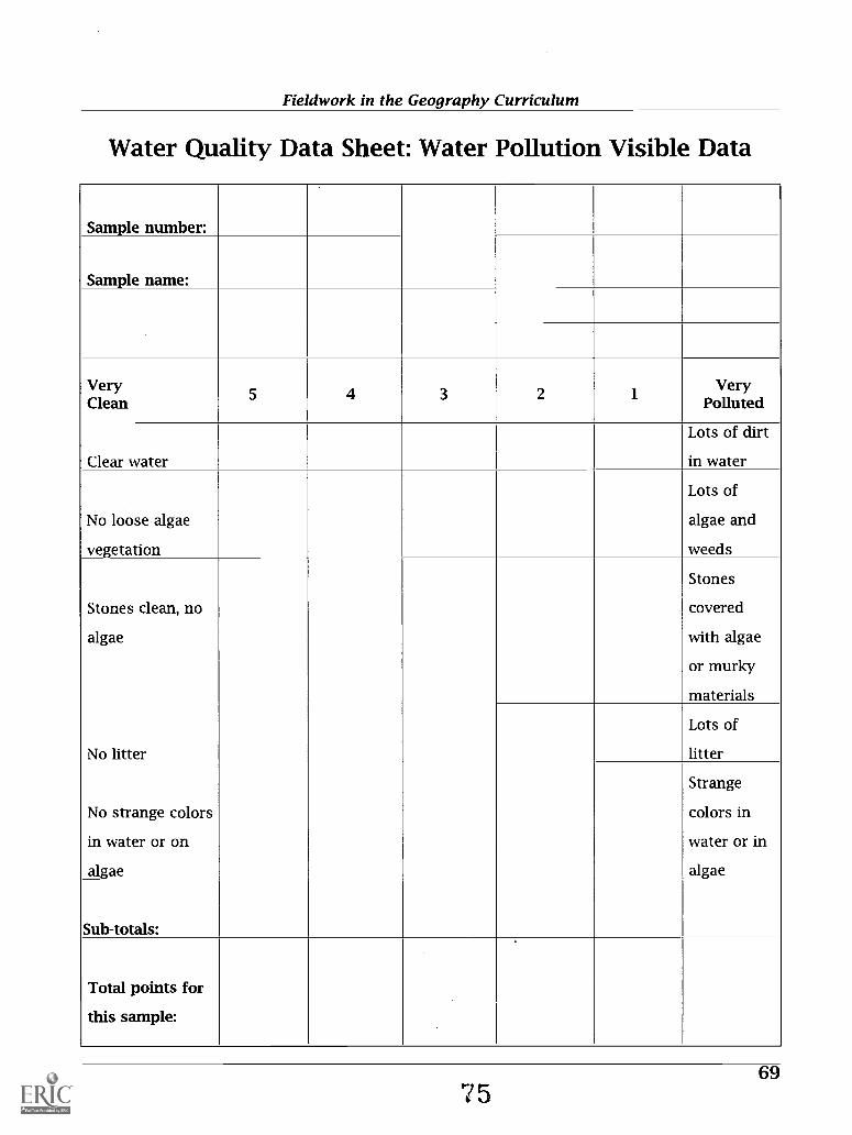
Fieldwork in the Geography Curriculum
Water Quality Data Sheet: Water Pollution Visible Data
Sample number:
Sample name:
VeryClean 5 4 3 2 1
VeryPolluted
Clear water
Lots of dirt
in water
No loose algae
vegetation
Lots of
algae and
weeds
Stones clean, no
algae
Stones
covered
with algae
or murky
materials
No litter
Lots of
litter
No strange colors
in water or on
algae
Strange
colors in
water or in
algae
Sub-totals:
Total points for
this sample:
697

Fieldwork in the Geography Curriculum
Fieldwork #8My Favorite Place
Overview: This activity helps young students to develop greater geographical awareness by tap-ping into their natural curiosity about their immediate worldthe school playground. Studentscreate a map of the playground and address the question of where on the playground most kinder-gartners or first graders like to play. They survey their class and one other class and tabulate theresults by creating pictographs. Note: It is possible that the school administration may alreadyhave set up play sites or areas for different age groups. Students can also create pictographs ofthese sites or areas.
National Geography Standards Addressed:#3. How to analyze the spatial organization of people, places, and environments on the earth's
surface.
Grade Level: K-1
Objectives: Students will:a) create, read, and interpret a map;b) conduct a survey among fellow students;c) graph and analyze the results of the survey.
Materials and equipment:A large outline map of the playground drawn on butcher paper.Pictures (photos, sketches, or symbols) of the playground structures on which students play.Worksheets with map of the playground with rebus cues for the survey.Avery dots in two colors.Tape, glue, and pens or crayons.
Procedures:1. Teacher poses questions to the class:
Where do you like to play at recess?What is your favorite play structure on the playground?Where do you think most students in this class or in another class like to play?How could we find out?
2. Teacher takes the students to the playground and asks them to identify all the possible placesto play on the playgroundswings, tires, seesaws, etc.
3. Place on the ground a large butcher paper outline map of the playground that contains somelandmarks to help orient the map. Ask the students to observe the location of one particularplay structure on the playground (e.g., the swing), and ask them where it should be on the out-line map. Paste a picture of that structure on the map in its correct location. Do the same forall the structures. The students will see the relationship between the actual playground and arepresentation of the playgroundthe map.
4. Ask the students to identify their favorite play structure and to place a red Avery dot on themap next to that structure to indicate their choice. Discuss the patterns that may emerge.
5. Tell the class that they will be surveying another class to identify their favorite structures.Match students from the class with students from the second class. Give each student a sheetthat has a map of the playground and rebus cues of all the structures. The students are to asktheir partners from the other class to look at the playground map and circle the picture oftheir favorite play structure.
70 6 6

Fieldwork in the Geography Curriculum
6. In the classroom, the students place green Avery dots to indicate the choices of their partnersfrom the other class.
7. Ask the students to count both sets of dots for each play structure. Using pictures of the playstructures, they can create two sets of pictographsone showing the choices of each class andone showing the combined results of the survey.
8. Students analyze their findings and brainstorm other ways they could have answered thequestion, "Where is your favorite place to play on the playground?"
Map of Playground
a
a
aIIII
SI MA Or_/
71
77

Fieldwork in the Geography Curriculum
Student's Name
Date
Where I Like to Play Best
At the hoopNear the tree
On the playing field
On the swings
On the slide
On the see-saw
On the monkey bars
On the climber
Students record with a sticker where seven students surveyed liked to play most.
72

Fieldwork in the Geography Curriculum
Fieldwork #9Land Use: A Street Frontage Survey
Overview: This fieldwork examines retail activity and other land use (function categories) in adowntown retail area. Students will collect data (measurements and counts), use maps, make maps,analyze data, and present the data in a variety of graphic forms. Students can make this frontagesurvey in any size city (and they have!) from small rural cities like Burns, Oregon (population 2,975and falling) to large urbanized areas like Portland, Oregon (population 750,000 and rising). Themap that follows this lesson shows the area investigated by five groups of students examiningretail functions in Ashland, Oregon.
Grade Level: Upper middle school through high school
National Geography Standards addressed:#12. The processes, patterns, and functions of human settlement#13. How the forces of cooperation and conflict among people influence the division and control
of Earth's surface
Connection to Advanced Placement content:VI: Industrial and Economic Development
VII: Cities and Urban Land Use
Objectives: The main objective of this fieldwork is to introduce students to downtown retail func-tions and geographic theories related to urban geography. It also engages students in classifyingand quantifying functional units (establishments) for presentation purposes. It assumes that thestudents have been introduced to concepts of spatial interaction and hierarchy of central places,including concepts of:
Central place: A settlement or location providing services such as public administration, retail-wholesale trade, financial services, and professional services (such as doctors and lawyers) overa large area.
Urban or central place function: A retail store or service establishment, sometimes referred to as afunctional unit, in a central place; for example, several clothing stores in a central place providethe apparel function of that place.
Central Business District (CBD): Traditional center of a city; downtown, the commercial core wheregoods and services are offered for sale in a dense collection of establishments; usually the old-est part of a town, where land values are highest.
Threshold: The minimum amount of purchasing power necessary to support the supply of a goodor service from a central place; usually measured by the number of persons per functional unitin the trade area.
Range of a good: The distance over which people are prepared to travel in order to obtain a par-ticular good or service.
Specific objectives: Students will;a) analyze the location and volume of urban retail functions.b) identify, classify, measure and map retail functions in an urban setting.c) analyze and present their findings using graphic and cartographic skills.
Materials and equipment:For the class (or each group):
73

Fieldwork in the Geography Curriculum
Measuring tape-30 meters or 100 feet long preferred. (Note: Students can pace off the dis-tance instead of using a measuring tape if the students have learned to measure their pace withsome degree of accuracy.)
For each student:Clipboard and pencilMapsData Sheets
Procedures:In-class preparation: Discuss concepts, vocabulary and data gathering techniques.Divide students into survey groups, one group for each section to be surveyed. Students should
familiarize themselves with the map of their survey area, and with the function categories on thedata sheet.
Data Collection: Students should survey their sections of the urban area, gathering street-levelfrontage-foot data by function on the data sheet. Note that students are observing only street-level functions, not upper floors. Students will probably come across functions that do not neat-ly fit into a particular category; they will have to make judgment calls, and should keep notes.
Presentation models and assessment:When the data collection is complete, students should consolidate the field data from their sur-
vey area and from all survey areas combined. Using computer spreadsheets and a variety of graph-ic techniques, such as land use maps and pie charts, students can present the data and key find-ings, augmented by text, photos, or other materials.
Extensions:1. If students each year do urban land use surveys at a school, and the records of those surveys
(data and presentations) are kept, then students can compare changes in land use and func-tion categories over time. Such longitudinal surveys can show dramatic changes within a fewshort years.
2. Students in one city can exchange data with students in another city for comparative urbananalysis.
(Adapted from fieldwork designed by John Mairs at Southern Oregon University for use by theOregon Geographic Alliance)
CENTRAL BUSINESS DISTRICT:Street-level function and footage
Keep track of the number of each type of function you find on the street.Measure the street frontage of each establishment. Record the total street frontage for each func-
tion category.
74

CIT
Y O
F A
SHL
AI\
D

Fieldwork in the Geography Curriculum
Central Business District Tally Sheet: Street Level Function and Footage
Establishments: Number ofEstablishments
Length of frontagefor each
Total frontageFeet
RETAIL GOODSAntiquesApparel: GeneralApparel: ChildrenApparel: MenApparel: WomenApparel: SportApparel: ShoeArt (sales; framing)Auto partsBookstoresCameraDrug store; varietyStationaryElectronicsFood: processingFood: specialtyFlorists (gifts)Gifts; souvenirsGlass (windows; mirrors)JewelryLiquor; wine shopsLumberMusic (recorded; instruments)Print, copy shops
SERVICESContractors (construction; landscape)Financial (non-bank)Hair careInsuranceLegalMedical (doctors; dentists, health)Newspaper officesProfessional offices (lawyers; CPAs, etc.)Real estate salesTourist services, guidesUtilities
RESTAURANTSTAVERNS; BARSAUTO SERVICESREPAIR SHOPSHOTEL, MOTEL, B&BTHEATERS (RECORDED; LIVE)TRANSPORTATIONCHURCHES; SOCIAL ORGANIZATIONSPUBLIC OFFICES, LIBRARY, MUSEUMSPARKING LOTSPARKSRESIDENTIALVACANT SHOPSVACANT FRONTAGEWAREHOUSE
76 S A.

Fieldwork in the Geography Curriculum
Fieldwork #10Urban Transportation: A Public Transit Survey
Overview: Students will explore the urban landscape and land use changes in the urban environ-ment by riding public transit. They will compare their observations about the landscape with theirknowledge of three classic models of urban land use, and they will draw conclusions about urbangrowth and land use in their own city. The map that follows this lesson shows the route taken bystudents in Portland, Oregon, on the Portland light-rail system; it runs from the densely-developedurban center to the farmland on the urban growth fringe. Any similar route that takes studentsthrough a variety of urban built environments is suitable for this fieldwork. If the students takethe same route both directions, they can focus on one side of the street or rail on the way out, andon the other side on the way in.
Grade Level: Upper middle school through high school
National Geography Standards addressed:#12. The processes, patterns, and functions of human settlement#15. How physical systems affect human systems#18. How to apply geography to interpret the present and plan for the future
Connection to Advanced Placement content:VI: Industrial and Economic Development
VII: Cities and Urban Land Use
Objectives:Students will
a) hypothesize about land use change and its relation to urban transit, focusing on questions oflocation, routes, and patterns.
b) observe land use change along an urban transect.c) compare their observed findings of land use change with models of land use change discussed
in class.d) sketch and write about their field observations and report on their urban land use findings.
Materials and equipment:Clipboards and writing implements for sketchingField logsBus tickets (many transit authorities give discounted or free passes to students)
Procedures:In-class preparation: Students need to be introduced to the models and vocabulary of urban
geography related to urban zonation (see examples attached). Students should also familiarizethemselves with the route to be traveled and get some sense of the patterns they might expect tosee. They can hypothesize about what they will see, and develop theories about why certain landuses occur where they do.
For younger students it may be useful to give them some guided questions to answer about theroute. You will need to tailor the questions to the particular route.
Sample questions, used on the light-rail route in Portland, include:What bridge did we take across the Willamette?Why was the Burnside route chosen for the light-rail system?Why is there a big turn at 122d St. in an otherwise fairly straight route?
77
83

Fieldwork in the Geography Curriculum
Data Collection: Students will board public transit at one end of the route they will take. As theymove along the route, they will sketch land use and make field notes concerning the types ofland use, density of land use, and factors that might cause land use change along the route. Inaddition to changing patterns of land use, students should note and attempt to define chang-ing economic regions. They should also make and note additional observations that add to thewealth of the information about the urban landscape, such as differences in age of buildings,relative number of trees and parks, and major or minor transit intersections.
Upon returning to the classroom, students can post their sketches, and compare observa-tions. Students should discuss whether their city fits any of the urban models discussed inclass. They can also discuss why the transit system followed the route it did (this is especiallyuseful when using light-rail, as opposed to a bus system, since physical or cultural considera-tions often restrict light-rail routes).
Specific questions the students can consider include:Would public transit be an asset or a detriment in the following areas:Residential neighborhoods?Light commercial areas?Industrial areas?Mixed use areas?Can you predict how specific areas along the route might look different in 10 years (andwhy)?What are the strengths and weaknesses of the present public transit system?
Presentation suggestions: In addition to posting field sketches, students can prepare detailedmaps of the route they traveled, including the information from all their observations.
Extensions:1. Many cities are in the process of designing new mass transit routes; students can predict the
course of those routes, or offer suggested routes based on their knowledge of the city.2. Using historical maps, students can investigate abandoned transit routes and discuss the
urban development processes that might have caused abandonment. In some cities, rails have beenconverted to trails, offering an ideal site not only for historical research but for a good hike!
Examples of Urban Zonation
Different models use different terms for zones in the urban environment. Some examples are:Central Business District (CBD): Traditional center of a city; downtown, the commercial core where
goods and services are offered for sale in a dense collection of establishments; usually the old-est part of a town, where land values are highest.
Transition Zone: An area changing from one principal use to another. Usually has a mixture ofolder, established industries, some shops and services, and relatively low quality housing.
Low-income Residential: Houses often built on small lots, older houses, houses in need of repair(fixer-uppers).
Moderate-income Residential: housing two-to-five decades old; some semi-detached properties,large lots with moderate landscaping and gardens; often in the transition area of urban to sub-urban.
High-income Residential: Large, detached properties, significant landscaping and gardens; often aturban fringe.
78

Fieldwork in the Geography Curriculum
Models of Urban Land Use
Burgess's Model (Concentric Zone Theory)1. Central Business District (CBD)2. Transition Zone3. Low-income Residential4. Residential ZoneS. Commuter Zone
Hoyt's Model (Sector Theory)1. Central Business District (CBD)2. Wholesale Light Manufacturing3. Low-income Residential4. Moderate-income ResidentialS. High-income Residential
Harris's and Ullman's Model (Multiple Nuclei Theory)1. Central Business District (CBD)2. Wholesale Light Manufacturing3. Low-income Residential4. Medium-Income ResidentialS. High-Income Residential6. Heavy Manufacturing7. Outlying Business District8. Residential Suburb9. Industrial Suburb St
Source: After Chauncy D. Harris and Edward L. Ullman 1945. Annals of the American Academy ofPolitical and Social Science, CCXLII (November) 7-17.
79
85

OS
Ruby Junction/1 97th Ave
Gresha., Central
co co co Iv to a Jo. 0 CP 'V 0
ssii trag
i
ocionaw lo 014
Cleve and Avenue
ssalcbcl va utnpvikin3 AticivA0oao vompoo

Fieldwork in the Geography Curriculum
Fieldwork # 11Analyzing the Local Shopping Mall
Overview: Most students have well developed mental maps of their neighborhood shopping malland can find their way to the local GAP Store blindfolded! Teachers can tap into this geographicalawareness by using the mall as a fieldwork site for studying an array of geographic phenomena,particularly those pertaining to economic interdependence and land use decisions.
In this fieldwork, students examine the location of the mall in the community, survey shoppersto determine shopping and traffic patterns, and analyze spatial relationships between the differ-ent types of retail establishments. Preparation done in the classroom prior to going out to the fieldis critical as is the work done after they have gathered their data. Students need to have context inwhich to place their findings. This activity is designed primarily for students in grades 6 to 8 butcould easily be extended to those in higher grades.
National Geography Standards Addressed:#3. How to analyze the spatial organization of people, places, and environments.#11. How to analyze the patterns and networks of economic interdependence.
Grade level: 6-8
Objectives: Students will:a) analyze the location of the mall in their local community with regard to accessibility and
transportation networks;b) identify, classify, and map the types of retail stores located in the mall;c) identify and analyze shopping patterns among customers using the mall;d) identify and determine the trade catchment area for the mall.
Materials and equipment:Maps of the community showing the location of the mall, transportation networks, and zoning
designations.Maps of the area showing land use before the building of the mall.Air photos of the area.Outline maps of the mall layoutClipboards.
Procedures:1. After discussion about the function and role of the mall in their community, assign students to
one of four major fieldwork areas that focus on the:location, history, and design of the mall;mapping and classification of retail establishment including the location of anchor (principal)stores;shopping patterns of customers; andidentification of the trade catchment area of the mall.
2. Students in each of the four groups brainstorm ideas and identify key geographic questions theycan investigate for their particular area. Some examples of geographic questions could be:
Where is the mall located in terms of absolute and relative location?Why did developers choose this particular location?What was the previous use of the land?How old is the mall?What types of retail establishments are found in the mall?
81

Fieldwork in the Geography Curriculum
Is there a pattern to the location of types of stores?Are certain types of stores clustered in the same area?What are the anchor stores in the mall and where are they located?What is the traffic pattern in and out of the mall?How far away are the shoppers who come to the mall?How do they travel to the mall?How often do they come to the mallin a week or month or year?If you were a prospective storeowner, where would locate your store and why?
3. Each group identifies and designs appropriate strategies for collecting data in order to answertheir particular geographic question(s)surveys, mapping, tally sheets, interview questions,indexes, retail establishment classification systems. etc. The teacher might provide studentswith models and should evaluate and check the data collection sheets, map outlines, surveys,etc. before students can use them in the field.
4. Students collect the data at the mall.5. Upon returning to the classroom, students organize the data collected using maps, charts,
graphs, photos. etc. They analyze their results and present their findings to the rest of the class.6. The teacher facilitates the discussion of findings and analysis through a series of questions sum-
marizing the key findings and asks students to speculate on the future role of malls in the com-munity.
Adaptations:1. Teachers can adapt this fieldwork for upper elementary students. The students, however, would
need more direction and guidance from the classroom teacher.2. Teachers can use Farmers' Markets and Flea Markets instead of malls.
82 c, 3

Fieldwork in the Geography Curriculum
Fieldwork #12The Busy Street: Traffic Flow Survey
Overview: Participants will study traffic congestion in urban centers or in their school neighbor-hood by conducting a survey of the volume and type of traffic occurring at a key intersection ofstreets during specific times of the day. The activity could be part of a unit dealing with the devel-opment of cities and industrialization or it could be part of a study of the local community. Theresults of the survey might lead to a discussion and subsequent request for a new pedestriancrossing, additional crossing guards during school hours, or the installation of a new traffic light.
National Geography Standards Addressed:#3. How to analyze the spatial organization of people, places, and environments.
Grade level: K-6
Objectives: Over a specific time period, participants will:a) count the number of vehicles passing through a particular intersection; andb) identify and classify the types of vehicles observed.
Materials and equipment:Grade 3-6
Charts with columns for different types of vehicles (trucks, cars, taxis, motorcycles, buses,etc.).
K-2Charts with pictures of different types of vehicles.Clipboards.
Procedures:1. In the classroom, before going out to conduct the survey, students brainstorm ideas about
where they think traffic congestion might occur in the school neighborhood, when it is most like-ly to occur, and the type of vehicles they are likely to encounter. The discussion might also focuson the rise and role of the automobile in our society.
2. Students are given instructions and practice on how to gather the traffic data once they are inthe field. Students may be assigned to work in pairs.
3. Each participant, or pair of participants, is given a chart with columns for different types ofvehicles (trucks, cars, taxis, motorcycles, buses, etc). For the K-2 level, the chart will contain pic-tures of the types of vehicles.
4. Each participant or pair is assigned a particular type of vehicle to observe.S. During a five minute (or longer) period, participants record the numbers of their assigned vehi-
cles.6. In the classroom, students create graphs (pictographs for the K-2 level) of their data.7. Teacher leads the discussion of findings and analysis through a series of questions:
What did you find out?What type of vehicles were most common and why?How would the traffic be different on a weekday, at weekends, or at different times of theday?From where do the vehicles come?Are there any traffic congestion problems? If yes, what can we do about them?
83

Fieldwork in the Geography Curriculum
Extensions:1. Conduct traffic flow counts at the same spot at different times of the day to compare traffic
patterns.2. Conduct traffic flow counts at several different locations in order to compare patterns and
identify possible congestion spots.3. Carry out a survey of pedestrians to identify how many people travel in and out of the area,
identifying the type of transportation that they use.
84

Fieldwork in the Geography Curriculum
Traffic Survey Data Sheet
Name:
Date: Day of the week:
Time start: Time finish:
Cars Trucks Vans Motorcycles Police Cars Other
8591

Fieldwork in the Geography Curriculum
Fieldwork #13Urban Sleuthing Using Maps, Aerial Photography,
and FieldworkOverview: This project introduces students to basic map identification skills, historical map com-parisons, and photo interpretation. The fieldwork focuses on using documentary materials to iden-tify and analyze historical and current urban patterns and changes in land use, buildings, andinfrastructure.
Grade Level: High school
National Geography Standards addressed:#1. How to use maps and other geographic representations, tools, and technologies to acquire,
process, and report information from a spatial perspective#3. How to analyze the spatial organization of people, places, and environments on Earth's surface#4. The physical and human characteristics of places#12. The processes, patterns, and functions of human settlement#14. How human actions modify the physical environment#17. How to apply geography to interpret the past#18. How to apply geography to interpret the present and plan for the future
Connections to AP Content:VI: Industrial and Economic Development
VII: Cities and Urban Land Use
Objectives:Students will:
a) Observe a selected area of an urban environment to test hypotheses about land use changeb Collect information and record field notes to understand changes that have taken place in
the urban landscapec) Do field mapping and create manual GIS (Geographic Information System) street overlay(s)d) Ground truth* aerial photography and maps (Ground truth data obtained on the ground to
guide computer-assisted interpretation of remotely-sensed data.)e) Interpret, analyze and draw conclusions from data to explain the changes in an urban land-
scape
Materials and equipment: Check with your school or town librarian for the mapping and photo-graphic materials. City and county offices, or local historical societies, may also have this mate-rial available. Materials for each group include:
Color infrared aerial photographs of a section of your city or town1890s Sanborn insurance mapsStreet map of the area to be investigatedOverlaysMagnifying glassPencilRed penBlack penNote paperClipboardButterfly clip
86 92

Fieldwork in the Geography Curriculum
Introduction: The exercises in this fieldwork show how to do fieldwork using maps, aerial pho-tography, observation, and analysis to answer a geographic question. Historical maps, such as oldplat maps or Sanborn insurance maps, are records of time periods for which we can use theseimages for comparison with other maps and with aerial photography. Other maps such as streetmaps and topographic maps show general orientation, topography, and prominent features. Aerialphotographs are actual images of what is on the surface of the earth. We can use these images forrecording information, location, and annotating information on the ground.
Procedure:In-class preparation: Comparison of maps with aerial photography:Students should prepare the maps and photographs for use in the field. Using the maps and pho-
tographs students can suggest hypotheses to be tested in the field concerning land use change.Before beginning, have students figure out the scale of the maps they are using (Sanborn mapsare often approximately 1:1,400 or 1" represents 116 feet).1. Orient street map and aerial map:
a. Locate north on the street map (you may need to use a state road map to orient the streetmap).
b. Locate street patterns, shorelines, or other features on the street map.c. Orient the photo to north.d. Note the difference in scale between the street map and the aerial photograph. Find the
same identified features on the aerial photograph.2. Create street map overlay on city map.
a. Place a clear film overlay on top of the street map.b. Tape the overlay at the top edge.c. Use the red pen to draw and label the key streets in the area you investigated. The streets
should form an enclosed form (such as a rectangle or triangle or any other enclosed shape).3. Create street map overlay on the aerial photograph.
a. Place a clear film overlay on top of the aerial photograph.b. Tape the overlay at the top edge.c. Place a north arrow at appropriate center edge of photo.d. Use the red pen to outline (that is, draw along both sides of the street) and label the same
key streets.4. Create building overlay on the aerial photograph.
a. Place a second clear film overlay on top of the aerial photograph.b. Tape the overlay at the top edge of the aerial photograph and over the street overlay.c. Register overlay with aerial photograph. Use two corners, a park, or large structure to reg-
ister.d. Use red pen to outline buildings within the area of streets identified on the street overlay
(use magnifying glass, if necessary).5. Create map on overlay of same street on the Sanborn map.
a. Place a clear film overlay on top of the Sanborn map.b. Tape the overlay at the top edge of the map.c. Use black pen to outline (mark both sides of street) and label the same key streets as above.
6. Compare the Sanborn map to the aerial photograph for the area to be investigated.a. Compare the Sanborn map to the aerial photograph. Using the overlay on the Sanborn map,
cross-hatch in red in the area to be investigated all the buildings from the Sanborn map thatalso appear on the aerial photograph.
b. Cross-hatch within the area, in black, all the streets that appear in the aerial photographthat are not on the Sanborn map.
c. What changes to you see? How can you explain the changes?
87
93

Fieldwork in the Geography Curriculum
In the field: Before heading into the field, tape another clear overlay on the Sanborn map, on topof the street overlay.1. Pace and estimate distances of each block and building front in the area. Use the red pen to
map buildings within the area. Name buildings mapped and note any dates for building con-struction.
2. Where possible, enter buildings and identify current use; interview people where possible.3. Write observations and other relevant information on overlays or in field logs. For selected
stops and observation sites, record the following information:a. time and date,b. proximal location (include city, state, street address if known, cross street and any other
pertinent information),c. field sketch notable markings or other interesting objects,d. write descriptions, other information (such as interview notes), impressions, and supposi-
tions,e. annotate photography and maps (use overlays).
Analysis: In analyzing their fieldwork students should do at least the following:1. Review maps, photography, and notes of observations and findings.2. Draw conclusions and discuss results of the hypotheses tested.3. Compare field observations with aerial photograph and map observations to analyze:
a. What information did the fieldwork provide that was not available from the maps and aer-ial photographs?
b. What information did the Sanborn map provide that was not available on the aerial map orfrom the fieldwork?
c. What information did the aerial photograph provide that was not available on the Sanbornmap?
88

Fieldwork in the Geography Curriculum
REFERENCES
Barratt, Robert, and Judith Hall 1998. "Geography Fieldwork in an Upland Environment: DevelopingStudent Self-reliance." Teaching Geography 23 (July): 118-124.
Bein, Frederick and Patrick Rea 1992. "Project Marco Polo: Bridging the Gap between Natural andSocial Sciences." Journal of Geography 91(4): 159-165.
Be llan, J. M. and G. Scheurman 1988. "Actual and Virtual Reality: Making the Most of Field Trips."Social Education 62(1): 35-40.
Benz, Grace. 1962. "An Experimental Evaluation of Field Trips for Achieving Informational Gainsin a Unit on Earth Science in Four Ninth Grade Classes." Science Education 46(1): 43-49.
Bergon, Frank, ed. 1989. The Journals of Lewis & Clark. New York: Penguin Books.Bixler, Robert D., Cynthia L. Carlisle, William E. Hammitt, and Myron F. Floyd 1994. "Observed Fears
and Discomforts among Urban Students on Field Trips to Wildland Areas." Journal ofEnvironmental Education 26(1): 24-33.
Bland, K., Bill Chambers, Karl Donert, and Tony Thomas 1996. "Fieldwork." In Baily, P. and Fox, P.(Eds.) Geography Teachers' Handbook. Sheffield, England: The Geographical Association.
Boardman, D. 1974. "Objectives and Constraints in Geographical Fieldwork." Journal of CurriculumStudies 6: 158-166.
Catling, S. 1995. "Auditing Your Local Area's Geography." In De Villers, M. (Ed.) Developments inPrimary Geography: Theory and Practice. Sheffield, England: The Geographical Association.
Crampton, Jeremy W. 1998. "Integrating the Web and the Geography Curriculum: The BosnianVirtual Field Trip." Journal of Geography 98: 155-168.
Daly, John L. 1990. "Focus on Geography-Team Themes and Field Experiences." Journal ofGeography. July/August: 153-155.
Disinger John. F. 1984. "Field Instruction in School Settings." ERIC/SMEAC EnvironmentalEducation Digest : No. 1.
Disinger, John F. 1985. "Environmental Education Research News." The Environmentalist 5(2): 85-88.
Falk, J. H. and J. D. Balling 1982. Improving the Quality of Single Visit Field Trips to the NationalZoological Park: Development of Pre-trip Materials and an Assessment of Learning and Behavior.Edgewater, Md.: Chesapeake Bay Center for Environmental Studies.
Falk, J. H., W. W. Martin, and J. D. Balling. 1978. "The Novel Field Trip Phenomenon: Adjustment toNovel Settings Interferes with Task Learning." Journal of Research in Science Teaching 15: 127-134.
Field Studies Council, et al. n.d. Progression in Fieldwork: 4-19. Sheffield, England: The GeographicalAssociation (brochure).
Fryer, K. H. 1991. "Regional Geological Context for a Course in Petrography." Journal of GeologicalEducation 38: 393-397.
Gagne, R. M. and R. T. White 1978. " Memory Structures and Learning Outcomes." Review ofEducational Research 48: 187-222.
Garver, J. I. 1992. "A Field-based Course in Stratigraphy and Sedimentology." Journal of GeologicalEducation 40: 119-124.
Gennaro, E. D. 1981. "The Effectiveness of Using Pre-visit Instructional Materials on Learning for aMuseum Field Trip." Journal of Research in Science Teaching 18(3): 275-281.
Geography for Life: National Geography Standards 1994. Geography Education Standards Project.Washington DC: National Geographic Research and Exploration for the American GeographicalSociety, Association of American Geographers, National Council for Geographic Education, andNational Geographic Society.
Gober, Patricia. 1997. "President's Column." Association of American Geographers Newsletter32(8): 1-2.
89

Fieldwork in the Geography Curriculum
Gold, J. R. 1991. "Fieldwork." Teaching Geography in Higher Education: A Manual of Good Practice.Oxford: Blackwell: 21-35.
Gress, Gary and Rebecca W. Scott 1996. "Field Trip Simulation: Developing Field Skills in a JuniorHigh Classroom." Journal of Geography 95(4): 154-167.
Hale, Monica 1986. "Approach to Ecology Teaching: The Educational Potential of the LocalEnvironment." Journal of Biological Education 20: 179-184.
Hale, Monica 1985. "Expanding the Horizons of Urban Ecology." Journal of Biological Education19(4): 259-262.
Harbeck, Richard 1997. "Field Studies of Human Systems: A Cooperative Learning FieldInvestigation." Journal of Geography 96(4): 211-306.
Harris, Chauncy D. and Edward L. Ullman 1945. "The Nature of Cities," Annals of the AmericanAcademy of Political and Social Science, CCXLII, 1945.
Holdrich, Karen 1998. "Using Field Equipment." Teaching Geography (July): 129-132.Howie, T. R. 1974. "Indoor or Outdoor Environmental Education." Journal of Environmental
Education 6(20): 32-36.Hurt, Douglas A. 1997. "Main Street: Teaching Elementary School Students Standards-Based Urban
Geography." Journal of Geography Nov./Dec.: 280-28Ignatiuk, G.T. 1978. Influence of the Amount of Time Spent in Field Trip Student Activities towards
Science and the Environment. Regina: Saskatchewan School Trustees Association. ED 180758.Jackson, Nancy L., Maureen L. Cerrato, and Norbert Elliot 1997. "Geography and Fieldwork at the
Secondary School Level: An Investigation of Anthropogenic Litter on an Estuarine Shoreline."Journal of Geography. Nov./Dec.: 301-306.
Jay, L. J. 1987. Starting to Teach Geography. Sheffield, England: The Geographical Association.Kaplan, R. 1974. "Some Psychological Benefits of an Outdoor Challenge Program." Environment and
Behavior 6: 101-116.Kent, M., David D. Gilbertson, and Chris 0. Hunt, 1997. "Fieldwork in Geography Teaching: A
Critical Review of the Literature and Approaches." Journal of Geography in Higher Education21(3): 313-332.
Kern, E. and J. Carpenter 1986. "Effect of Field Activities on Student Learning." Journal ofGeological Education 34: 180-185.
Lanegran, David A. and Patrice H. St. Peter 1993. "Travel, Tourism, and Geographic Fieldwork:Project Marco Polo 1992." Journal of Geography 92(4): 160-165.
Lee, Jeffrey A. and Linda Lea Jones. 1993. "Teaching the Process of Science in Geography Courses."Journal of Geography. Sept./Oct. 223-233.
Lisowski, Marylin. 1987. The Effect of Field-Based Experiences on Students' Understanding ofSelected Ecological Concepts. Ph.D. Dissertation, Ohio State University. 241 pp.
Lonergan, N. and L. W. Anderson 1988. "Field-based Education: Some Theoretical Considerations."Higher Education Research and Development 7: 63-77.
Mackenzie, Andrew and R. T. White 1981. "Fieldwork in Geography and Long Term MemoryStructures." Annual Meeting of the American Educational Research Association. Los Angeles,Calif.
Marotz, G. A. and R. A. Rundstrom. 1986. "A Problem-Solving Approach to Field Instruction."Journal of Geography 85:263-266.
Martin, Wade. 1981. "Environmental Effects on Learning: The Outdoor Field Trip." ScienceEducation 65(3): 301-309.
Marzano, R. J., D. Pickering, and J. McTighe. 1993. Assessing Student Outcomes. Alexandria, Va:Assocation for Supervision and Curriculum Development.
May, Jon. 1999. "Developing Fieldwork in Social and Cultural Geography: Illustrations from aResidential Field Class in Los Angeles and Las Vegas." Journal of Geography in Higher Education23(2): 207-225.
90

Fieldwork in the Geography Curriculum
May, Stuart and Julia Cook. 1993. Fieldwork in Action 2: An Enquiry Approach. Sheffield, England:The Geographical Association.
May, Stuart, Paula Richardson, and Val Banks. 1993. Fieldwork in Action: Planning Fieldwork.Sheffield, England: The Geographical Association.
May, Stuart. 1996. Fieldwork in Action 4: Primary Fieldwork Projects. Sheffield, England: TheGeographical Association
Mc Ewan, L. 1996. "Fieldwork in the Undergraduate Program: Challenges and Changes." Journal ofGeography in Higher Education 20: 379-384.
McQueen, K., G. Taylor, M. Brown and W. Mayer 1990. "Integration of Teaching and Research in aRegional Mapping Project." Journal of Geological Education 38: 88-93.
Mackenzie, A. A. and R. T. White 1982. "Fieldwork in Geography and Long Term Memory Structure."American Educational Research Journal 19 (4); 623-624.
Milner, A. M. 1996. Geography Starts Here. Sheffield, England: The Geographical Association.Nichols, Sarah, and Lynn Greenwold 1999. "Geography Rules KO!" Primary Geographer 36
(January): 8-10.Nordstrom, K. F. 1979. "The Field Course in Geography: A Conceptual Framework." Journal of
Geography 78: 267-272.Novak, J. D. 1976. " Understanding the Learning Process of Teaching Methods in the Classroom,
Laboratory, and Field." Science Education 60: 1-11.Orion, N., A. Hofstein, and E. Mazor 1986. "A Field-Based High School Geology Course: Igneous and
Metamorphic Terrains, an Israeli Experience." Geology Teaching 11: 16-20.Orion, N. 1989. "Development of a High-School Geology Course Based on Field Trips." Journal of
Geological Education, 37: 13-17.Padgett, David A. 1994 "Involving Disadvantaged Youth in Lead Contamination Investigations to
Enhance Interest in Geography and Environmental Science." Journal of Geography. Nov./Dec.:268- 273.
Parson, Helen E. and Ian A. McKay 1989. "A Field Method for Investigating the Cultural Landscape."Journal of Geography 88(3): 1989.
Post, Ben. 1993. Community Officials as a Resource for Studying the Local Community. Perspective22(2): 12.
Rice, G. 1998. "Fieldwork and the National Geography Standards." Ubique. American GeographicalSociety, December.
Richardson, D. A., and P. R. St. John 1989. Methods,of Presenting Fieldwork Data. Sheffield, England:The Geographical Association.
Richardson, Paula and Rex Walford 1998. Fieldwork in Action 5: Mapping Land Use. Sheffield,England: The Geographical Association.
Richardson, Paula 1998. "Fieldwork." In Primary Geography, ed. Roger Carter. Sheffield, England:The Geographical Association: 181-195.
Rynne, Elizabeth 1998. "Utilitarian Approaches to Fieldwork: A Critique." Geography 8: 205-212.Sauer, C.O. 1956. "The Education of a Geographer." Annals of the Association of American
Geographers. 46: 287-299.Shelley, Sue, and David Owen 1999. "The Impact of Learning in the Environment on Children with
Special Needs." Primary Geographer 36 (January): 14-15.Siegler, R. S. 1986. Children's Thinking. Englewood Cliffs, N.J.: Prentice-Hall.Smith, C. A. 1979. The Effects of an On-Site and Community Outdoor Education Program on Selected
Attitudes Towards School of Sixth Grade Students. Plattsburg, N.Y.: State University College.Slater, F. 1993. "Locality-Based Studies and the Enterprise Initiative." Journal of Geography in
Higher Education 20: 55-63.Stiggins. R. 1994. Student-Centered Classroom Assessment. New York, N.Y.: Merrill.Trygestad, JoAnn, and Jasmine Melson 1993. "Project Marco Polo: Experiences Applying
Geography." Journal of Geography 92(4): 170-175.
9197

Fieldwork in the Geography Curriculum
Warburton, Jeff and Higgitt, Martin 1997. "Improving the Preparation for Fieldwork with 'IT': TwoExamples from Physical Geography." Journal of Geography in Higher Education 21(3): 333-347.
Wheater, C.P. 1989. "A Comparison of Two Formats for Terrestrial Behavior Ecology Field Courses."Journal of Biological Education 23: 223-229.
Wiley, D. A. and D. W. Humphrey 1985. "The Geology Field Trip in Ninth Grade Earth Science."Journal of Geological Education 33: 126-127.
Wise, K and J. Okey 1963. "A Meta-analysis of the Effects of Various Science Teaching Strategies onAchievement." Journal of Research on Science Teaching 20 (5): 419-435.
Wittrock, M. C. 1994. "Learning as a Generative Process." Educational Psychologist 11: 87-95.Zirschky, R. Dwight 1989. "Traffic Light Geography: A Fifth Grade Community Project. "Journal of
Geography 88(4): 124-125.
92
08

U.S. Department of EducationOffice of Educational Research and Improvement (OERI)
National Library of Education (NLE)Educational Resources information Center (ERIC)
NOTICE
Reproduction Basis
IC
This document is covered by a signed "Reproduction Release(Blanket)" form (on file within the ERIC system), encompassing allor classes of documents from its source organization and, therefore,does not require a "Specific Document" Release form.
This document is Federally-funded, or carries its own permission toreproduce, or is otherwise in the public domain and, therefore, maybe reproduced by ERIC without a signed Reproduction Release form(either "Specific Document" or "Blanket").
EFF-089 (312000)