report to the hearing officer - san diego c ity of s a n d iego report to the hearing officer...
TRANSCRIPT
THE C ITY OF S A N D IEGO
REPORT TO THE HEARING OFFICER
HEARING DATE: August 14,2013 REPORT NO. HO 13-068
ATTENTION:
SUBJECT:
LOCATION:
OWNER: APPLICANT:
SUMMARY
Hearing Officer
PALM PROPERTIES PROJECT NUMBER: 271456
Block bounded by Quince Street, Fifth A venue, Palm Street and Sixth A venue. Current addresses are: 290 I, 2929 and 2941 Fifth A venue; 2900 and 2950 Sixth Avenue; and 535 N. Quince Street
Palm Properties, LP William A. Steen & Associates
Issue: Should the Hearing Officer approve a request for a Site Development Permit to demolish existing structures (except the historical structure located at 2900 6th Avenue) and construct a new 145-unit, multi-family residential building, a 66-unit extended stay hotel , with retail and commercial spaces, and subterranean parking located in the block bounded by Quince Street, 5th Avenue, Palm Street and Sixth Avenue in the Uptown Community Plan area?
StruT Recommendations:
1. Certify Mitigated Negative Declaration No. 27 I 456 and Adopt the Mitigation, Monitoring and Reporting Program; and
2. Approve Site Development Permit No. 954116.
Community Planning Group Recommendation: The Uptown Planners voted I 4-0-l to recommend approval of the proposed project on October 2, 2012, with no recommended conditions.
Environmental Review: A Mitigated Negative Declaration, Project No. 271456, has been prepared for the project in accordance with State of California Environmental Quality Act (CEQA) Guidelines. A Mitigation, Monitoring and Reporting Program has been prepared and will be implemented which will reduce, to below a level of significance,

any potential impacts identified in the environmental review process regarding Historical Resources (Archaeology), Paleontological Resources and Transportation.
Housing Impact Statement: The Uptown Community Plan designates the 1.337~acre project site for CommerciaVResidential (73 to 110 dwelling units per acre) and Very High Residential (73 to 110 dwelling units per acre) uses. According to the project's site area, approximately 98 to 147 dwelling units would be allowed. The proposal of a mixed development consisting of 145 dwelling tmits, ground level commercial retail, and a 66~ unit extended stay hotel would implement the existing land use designation. The project would result in the demolition of existing of commercial structures and the creation of 145 for-rent housing units. No affordable housing units are proposed with this project.
BACKGROUND
The project site is the full block bounded by Quince Street, 51h Avenue, Palm Street and 6th
Avenue in the CV-1 and l\tiR-400 Zones of the Mid-City Communities Plrumed District, the Airpmi Approach Overlay Zone, the FAA Part 77 Notification Area, the Transit Area Overlay Zone, and the Residential Tandem Parking Overlay Zone, within the UptoV\n Community Plan area. Current addresses include: 2901,2929 and 2941 5th Avenue; 2900 and 2950 6th Avenue; and 535 N. Quince Street. The site is comprised of Assessor's Parcel Nos. 452-663-04,04, 05, 06, 07, 08,09 and 10.
The project proposal includes the demolition of most structures within the square block, and the construction of a new mixed use development. With project impkiw.:ntatiun, only lhe exisling historical structure located at 2900 61
h Avenue (HRB Site No. 938- George and Alice Hazzard House), would remain on the site. This historical building is currently used as office space (approximately 5,600 square feet), which would continue. The new improvements would include the construction of a new, 145-unit, multi-family residential building (approximately 200,358 square feet) and a new, 66-unit extended stay hotel (approximately 58,846 square feet), with retail and commercial space (approximately 8,965 square feet) and recreational and support space (approximately 12,300 square feet) in two, approximately 150-foot-high towers. Off-street parking (343 parking spaces required; 377 spaces provided, which includes 12 tandem spaces) are proposed in a subterranean parking structure.
Surrotmding land uses consist of residential and commercial uses to the north and west, and the Urban Discovery Academy (a charter school serving students K-8) to the south. Balboa Park is located on the east side of the project site, on the other side of6111 Avenue.
DISCUSSION
Site Development Permit:
A Site Development Permit for the Mid-City Communities Planned District is required for the proposed mixed-use development exceeding the thresholds in Table 1512-02A, per SDMC Section 1512.0203(b )(2), and for one deviation from the development regulations. This one
- 2-

deviation is from Street Wall Height requirement of the CV -1 zone, and is specified as stepping the building above the street wall back 8 to 11 feet from the street wall instead of 15 feet as required. This deviation is supported because the overall design of the building meets the purpose and intent of the regulation by providing a strong horizontal division separating the base of the building at the maximum street wall height from the remainder of the building shaft which is stepped back from the face of the street wall. This reduces the perceived scale of the height of the building as viewed by a pedestrian in the right-of-way adjacent to the site, which is the intent of the regulation.
Community Plan Consistency:
Through the incorporation of a 15-foot setback from the property line with landscaping along Quince Street, the project would meet the objective and recommendation in the Urban Design Element of the community plan for maintaining and enhancing pedestrian and auto views of Balboa Park and as well as assist in creating visual entryways to Balboa Park. A pool and terrace that would be located on the roof of the northwest portion of the proposed project, balconies for the residential units, and plaza located along 6th Avenue would implement the guideline in the Urban Design Element of the community plan for maximizing useable open space for residential projects. Additionally, the proposed project would implement policies within the Urban Design Element for the provision of streets trees through the incorporation of 36-inch box canopy trees and 24-inch box palm trees along Quince Street, 5th A venue, and Palm Street. A double row of pahn trees would be planted along 61
h Avenue to complement the existing tree pattern along 6th A venue and on the Balboa Park side of the street.
The project would also meet the objective in the Conservation, Cultural, and Heritage Resources objective of preserving historic structures at their original location as well as in their historic context whenever possible, by maintaining the existing, historic 2-story structure at its current location at 2900 6th Avenue (HRB Site No. 938- George and Alice Hazzard House).
The proposed project is located along 5th Avenue which is identified in the community plan as a Class III bikeway. A goal ofthc Mobility Hlcment of the General Plan is to encourage bicycling as a viable travel choice within the City. The project would assist in attaining this goal by providing 93 bicycle spaces where 71 arc required and locating bicycle storage facilities on all parking levels. In addition five locations for bike racks would be provided at street level along 5th Avenue where the commercial-retail component ofthc project is proposed.
Policy NE-A.4 of the Noise Element ofthe General Plan requires an acoustical study consistent with Acoustical Study Guidelines (Table NE-4 of the General Plan) for proposed developments in areas where the existing or future noise level exceeds or would exceed the "compatible" noise level thresholds as indicated on the Land Use- Noise Compatibility Guidelines (Table NE-3 of the General Plan), so that noise mitigation measures can be included in a development project's design to meet noise guidelines. According to Table NE-3, a proposed mixed-use project 'vith an exterior noise exposure level of 60 to 65 CNEL would be "conditionally compatible" and must attenuate exterior noise to an indoor noise level of 45 CNEL. An acoustical report prepared for the proposed project evaluated traffic noise impacts on 51
h and 61h
- 3 -
Avenues as well as minor contributions from Palm and Quince Streets. The outdoor balcony areas of residences facing 51
h and 61h Avenues or those with a partial street view, a.<; well as
other outdoor balcony areas below a height of 60 feet, would exceed the 65 CNEL requirement for outdoor noise levels. To mitigate for exterior noise impacts at all outdoor residential use areas (up to a height of 60 feet) the proposed project would incorporate as a design feature, 4-foot-high noise watts along balconies or higher noise barriers in exterior use areas to attenuate exterior noise to below 65 CNEL. The sound attenuations barriers would need to be constructed as stated in the acoustical report to reduce noise exposure levels at or below 45 CNEL. Incorporation of this project design feature would attenuate exterior traffic noise to below a level of significance. The requirement for the incorporation of these design features has been included as a Condition of permit approval.
To mitigate for interior noise below 45 CNEL within the proposed residential development or 50 CNEL for commercial, the project would be required to comply with Title 24. The project will be required to complete an interior noise analysis (exterior to interior study) prior to building permit issuance to show the incorporation of appropriate architectural materials, and techniques that would achieve interior noise levels in habitable rooms, specifically 45 CNEL for residential and 50 CNEL threshold for outdoor areas established by the City's General Plan. The requirement for this interior noise analysis has been included as a Condition of permit approval.
Phasing of Improvements:
The applicant has n~que~teU approval for phasing of lht: prupust:d dcvdupmenl, ami has provided a phasing plan within Exhibit A. Staff has reviewed the proposed phasing plan, and has included specific conditions of approval within the draft permit to ensure the proposed development will comply with applicable requirements and potential issues that can arise during phasing, including public improvements, parking, landscaping, etc. Proposed phasing includes:
• Phase I: a. RcmodeVremove 15' end of existing buildings fronting 51h Avenue b. Construct a portion of the basement parking with an interim ramp c. Construct the residential (north) tower d. Construct the vehicular driveway e. Construct a portion of the commercial motor court f Construct the outdoor gathering place between residential tower and historic
building g. Restore the historic structure h. Construct the easterly public improvements
• Phase 2: a. Demolish remainder of2 northwesterly buildings fronting 5th Avenue b. Construct a portion of the basement parking with the permanent ramp c. Demolish the interim ramp
-4-
d. Construct the residential motor court e. Construct the 2-story building as retail-with community amenities above f. Construct the 1-story building as retail with outdoor pool terrace above g. Construct the northwesterly public improvements
•Phase3: a. Demolish remaining buildings fronting 5th A venue b. Construct the remaining basement parking under the commercial (south) tower c. Construct the commercial (south) tower d. Construct the remaining portion of the commercial motor court e. Construct the southwesterly public improvements
Historic Preservation:
Project implementation includes the preservation of the existing structure at 2900 6th A venue (HRB Site No. 938- George and Alice Hazzard House) in its current location, which is at the northwest corner of 6th A venue and Palm Street. The proposed project has been designed around this existing structure. The building is currently used as an oflice and this use is proposed to continue. The project as presented is consistent with the U.S. Secretary of the Interior's Standards and is therefore exempt from the requirement to obtain a Site Development Permit in accordance -with SDMC Section 143.0220(a). The permit has been conditioned to ensure that any and all revisions to this structure, no matter how minor, will require review and approval by the City of San Diego, Development Services Department, Plan-Historic staff, consistent vvith lhe San Diego Municipal Code.
Mitigated Negative Declaration:
A Mitigated Negative Declaration, Project No. 271456, has been prepared for the project in accordance with state of California Environmental Quality Act (CEQA) Guidelines. A Mitigation, Monitoring and Reporting Program has been prepared and -will be implemented which \Vill reduce, to below a level of significance, any potential impacts identified in the environmental review process regarding Historical Resources (Archaeology), Paleontological Resources and Transportation. The mitigation measures primarily include monitoring for archaeological and paleontological resources, and payment of a fairshare contribution of20.1% of the cost of installation of a traffic signal at the intersection of 5111 A venue and Quince Street, along -with any needed restriping and signage modifications.
Community Concerns:
The Uptown Planners voted unanimously to recommend approval of the proposed project after discussion in which the applicant confirmed their agreement to leave the existing historic structure in place. No other comments have been received during the course of project review.
- 5 -

Conclusion:
Staff has determined the proposed project complies with the applicable sections of the San Diego Municipal Code as described in the draft permit and resolution, and recommends the Hearing Officer approve the project as conditioned.
ALTERNATIVES
1. Approve Site Development Permit No. 954116, with modifications.
2. Deny Site Development Permit No. 954116, if the findings required to approve the project cannot be aJfirmed.
Respectfully submitted,
:]L,~~ Michelle Sokolowski, Development Project Manager
Attachments:
1. Aerial Photograph 2. Community Plan Land Usc Map 3. Project Location Map 4. Project Data Sheet 5. Draft Permit Resolution with Findings 6. Draft Permit with Conditions 7. Draft Environmental Resolution with rviMRP 8. Project Plans (Hearing Officer only) 9. Community Planning Group Recommendation 10. Ownership Disclosure Statement
- 6-
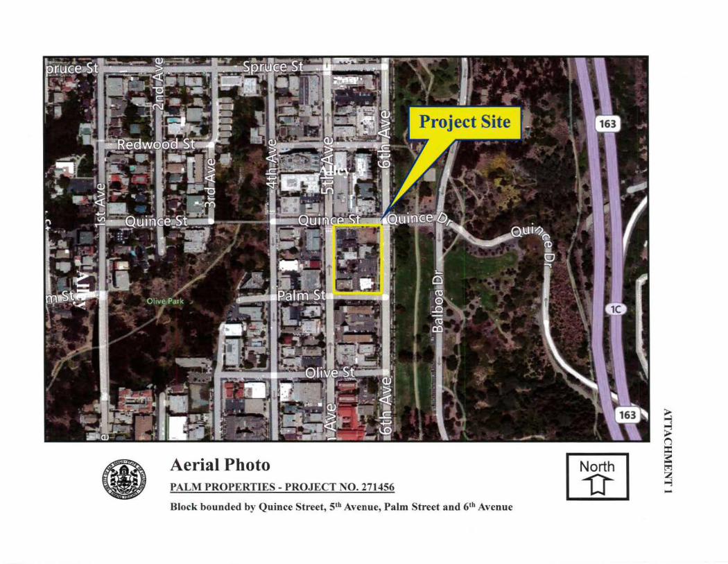
• Aerial Photo PALM PROPERTIES- PROJECT NO. 271456
Block bounded by Quince Street, S1h Avenue, Palm Street and 61h Avenue I~ I
~ ~
~ ~ ....., .......

-_,,-
S 10 du/n• 10-l!i duf" 1-;.,](lllul'~:
2'J·H dula.:.' 11•7.) OU/tc' 7 3-110 OUIIK M•~>olU&ulll'ftldtrtt.:ll ("I lvheG Use 11/~d<!>rttll ~!>I M•41d Uu I ~ti'dtrt•lll (e) (C>mm 1 Re'llll<trtl.11 (3) Comm 1 Res.dertlel (4 1 ~o;omm Jnes.dertJal lSI .:'t:~mm I Ot,do!trtlul (8) IICtlkt~<l~t~ (J) I" lflt••dut~t il (A)
Ollc~, RMI<ltlnl• ~ ( " ) Nfi!~OftlOOd Lomm (r.,\ld 31 HU~ol>l·•l '"W.Jiucll Ltb<aty r .. •.l (')ffuJt n,. ~.tobon p -~
Community Land Use Map
PALM PROPERTIES- PROJECT NO. 271456
ATTACHMENT2
~ N
1'2000
Block bounded by Quince Street, S1h Avenue, Palm Street and 61h Avenue
'SpruceSt
<
...,., .... Q) 0 > ? <( ,....
+J V' VI ,.... .-
a..\<
aim St
•
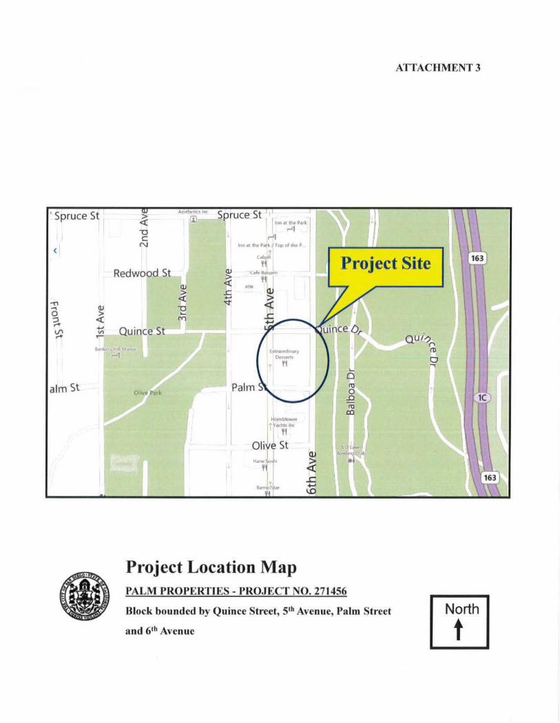
ATTACHMENT 3
>
~ SpruceSt 1
bln •• th• Po~tt ,...,, c
N lnn.ot ~ Porlc1Top ol U.. P
Redwood St
LIIJ " c.f•Liu.rn
Project Site ,. ~ < -o .... t'Y"l
Quince St
r-'1
Palm
l+umblowtY•hh Inc
ft
oliye St
'it &.mo:\lilr
Project Location Map PALM PROPERTIES- PROJECT NO. 271456
Block bounded by Quince Street, Sth Avenue, Palm Street
and 61h Avenue
QUi-? ("\ ro 0 ..,
North
t
Attachment 4
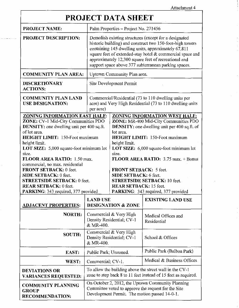
PROJECT DATA SHEET PROJECT NAME: Palm Properties- Project No. 271456
PROJECT DESCRIPTION: Demolish existing structures (except for a designated historic building) and construct two 150-foot-high towers containing 145 dwelling tmits, approximately 67,811 square feet of extended-stay hotel & commercial space and approximately 12,300 square feet of recreational and support space above 377 subterranean parking spaces.
COMMUNITY PLAN AREA: Upto\Vll Community Plan area.
DISCRETIONARY Site Development Permit ACTIONS:
COMMUNITY PLAN LAND Commerciat!Rcsidential (73 to 110 dwelling units per USE DESIGNATION: acre) and Very High Residential (73 to 11 0 dwelling units
per acre)
ZONING INFORMATION EAST HALF: ZONING INFORMATION WEST HALF: ZONE: CV-1 Mid-City Communities PDO ZONE: MR-400 Mid-City Communities PDO DENSITY: one dwelling unit per 400 sq.ft. DENSITY: one dwelling unit per 400 sq.ft. of of lot area. lot area. HEIGHT LIMIT: 150-Foot maximum HEIGHT LIMIT: 150-Foot maximum height limit. height limit. LOT SIZE: 5,000 square-foot minimum lot LOT SIZE: 6,000 square-foot minimum lot stze. stze. FLOOR AREA RATIO: 1.50 max. FLOOR AREA RATIO: 3.75 max.+ Bonus commercial, no max. residential FRONT SETBACK: 0 feet. FRONT SETBACK: 5 feet. SIDE SETBACK: 0 feet. SIDE SETBACK: 6 feet. STREETSIDE SETBACK: 0 feet. STREETSTDE SETBACK: 10 feet. REAR SETBACK: 0 feet. REAR SETBACK: 15 feet. PARKING: 343 required, 377 provided PARKING: 343 required, 377 provided
LAND USE EXISTING LAND USE ADJACENT PROPERTIES: DESIGNATION & ZONE
NORTH: Commercial & Very High Medical Offices and Density Residential; CV -1 Residential & MR-400.
SOUTH: Commercial & Very High Density Residential; CV -1 School & Offices &MR-400.
EAST: Public Park; Unzoned. Public Park (Balboa Park)
WEST: Commercial; CV -1. Medical & Business Offices
DEVIATIONS OR To allow the building above the street wall in the CV -1
VARIANCES REQUESTED: zone to step back 8 to 11 feet instead of 15 feet as required.
COMMUNITY PLANNING On October 2, 2012, the Uptown Community Planning
GROUP Connnittee voted to approve the request for the Site
RECOMMENDATION: Development Permit. The motion passed 14-0-1.
ATTACHMENT 5
HEARING OFFICER RESOLUTION NO.
SITE DEVELOPMENT PERM"""t=T:-::No:oO. 954116 PALM PROPERTIES- PRO.JECT NO. 271456 (MMRP)
DRAFT
WHEREAS, PALM PROPERTIES LP, A DELAWARE PROPERTIES LP, A CALIFORNIA LIMITED with the City of San Diego for a permit to demolish existing located at 2900 6th A venue, -which will remain as office ' thmily residential building, a 66-unit extended stay and support facilities, and subterranean parking (as Exhibits 10A 11 and corresponding conditions ofon•om
portions of a 1.337-acre site;
WHEREAS, the project! ~~~!!7:~~;y~~s~.ri~~~~~:r~~~ Addition, according to IV Recorder (APN 45;!-6(i3-C14;t
PARTl>/Ef.lSH"JP and PALM filed an application
(except the historical structure a new 145-unit, multi-
. commercial spaces, recreational
n s~~~i~~;~~~::;'~ to the approved a .954116),on
A;•enuO; P<Ilm Street and 6th
Di5:ttir:t, the Airport Area Overlay Zone, and the
'l,IHmit;y Plan area. Current addresses 535 N. Quince Street;
inclusive, Block 29, Horton's mewt.nce of the San Diego County
Wl!EREAS, on~iJ}diit I Developm~nt !rerlnit No. NOW, THEIU;FORE,
... ii~. Heariri·g;'Y~fticer Otfihe City of San Diego considered Site
pursuant to the Land Dheloprnent Code of the City of San Diego; • ,
BE IT RESOL~\>y the l-lcaringDfticer oflrte City of San Diego as follow" '<-;},
That the Hearing Offi'2er a~opts the following written Findings, dated August 13, 2013.
FINDINGS: ·~· ' Site Development Permit Findings- SDMC Section 126.0504(a)
1. The proposed development will not adversely affect the applicable land use plan.
The proposed project includes the demolition of existing structures (except the historical structure located at 2900 6111 Avenue, which will remain as office space) and construction of a new 145-unit, multi-family residential building, a 66-unit extended stay hotel, with retail and commercial spaces, recreational and support facilities, and subterranean parking.
Page 1 of 10
ATTACHMENT 5
The UptolNTl Community Plan designates the 1.337-acre project site for Commercial/Residential (73 to 110 dwelling units per acre) and Very High Residential (73 to 11 0 dwelling units per acre) uses. According to the project's site area, approximately 98 to 147 dwelling units would be allowed. The proposal of a mixed development consisting of 145 dwelling units, ground level commercial retail, and a 66-unit extended stay hotel would implement the existing land use designation. The project would result in the demolition of existing of commercial structures (except the historic building located at 2900 6th Avenue [HRB Site No. 938- George and Alice Hazzard llouseJ) and the creation of 145 rental housing lmits.
Through the incorporation of a 15-foot setback from the line with landscaping along Quince Street, the project would meet the objective and in the Urban Design Element of the community plan for maintaining and pedestrian and auto views of Balboa Park and as well as assist in creating visual Balboa Park. A pool and terrace that would be located on the roof of the project, balconies for the residential units, and plaza located along 6th·AVenue the guideline in the Urban Design Element of the commlll1ity alan for maximizing . .open space for residential projects. Additionally, the proposed projeCt would implement policie-~:-:within the Urban Design Element for the provision of streets trees through the incq~ration of 36~iri,ch box canopy trees and 24-inch box palm trees along Quince Street, 5th AveiiU·€; and Palm Str~( A double row of palm trees would be planted along 6th Avenue to complement the existing tree pattern along 6111
A venue and on the Balboa Park sidr of the street.
The project would also :rg~et the objective in the Conservation, Cultural, and Heritage Resources objective of prese~1i1s'tf?J!l:\. st~ctt_IT~S-~t their-.or~ginal ;loc~tion as well as in thei~ historic context whenever :@JS5able, By-rqamtaimng_the ex1stmg, htstQnc 2-story structure at 1ts current location at 2900 6lt$2zttenue (H~B Site No'. 938- George and Alice Hazzard House).
The -"; " 5th Avenue which is identified in the community plan as a - Element of the General Plan is to encourage bicycling
City. project would assist in attaining this goal by whete~71 are required and locating bicycle storage facilities on all
a~~~:~~ll~~,:l~~o.~ca~iiii~ons for bike racks would be provided at street level along 5th : < • component of the project is proposed.
Policy NE-A.4 'o(~ Noise El~ent of the General Plan requires an acoustical study consistent ~ith Acoustical St~S!o/fl1IDes (Tab~e NE-4 of the General Plan) for prop~sed dev~lopments m areas where the exiS~e5r future nmse level exceeds or would exceed the ·'compatible" noise level thresholds aS''fridicated on the Land Use- Noise Compatibility Guidelines (Table NE-3 of the General Plan), so that noise mitigation measures can be included in a development project's design to meet noise guidelines. According to Table NE-3, a proposed mixed-use project with an exterior noise exposure level of 60 to 65 CNEL would be "conditionally compatible" and must attenuate exterior noise to an indoor noise level of 45 CNEL. An acoustical report prepared for the proposed project evaluated traffic noise impacts on 5th and 6111
Avenues as well as minor contributions from Palm and Quince Streets. The outdoor balcony areas of residences facing 5111 and 6th Avenues or those with a partial street view, as well as other outdoor balcony areas below a height of 60 feet, would exceed the 65 CNEL requirement
Page 2 oflO
2.
ATTACHMENT 5
for outdoor noise levels. To mitigate for exterior noise impacts at all outdoor residential use areas {up to a height of 60 feet) the proposed project would incorporate as a design feature, 4-foot-high noise walls along balconies or higher noise barriers in exterior use areas to attenuate exterior noise to below 65 CNEL. The sound attenuations barriers would need to be constructed as stated in the acoustical report to reduce noise exposure levels at or below 45 CNEL. Incorporation of this project design feature would attenuate exterior traflic noise to below a level of significance. The requirement for the incorporation of these design features has been included as a Condition of pcnnit approval.
To mitigate for interior noise below 45 CNEL within the P~Qj-2sed residential development or 50 CNEL for commercial, the project would be required~C$'d}5ffiply with Title 24. The project will be required to complete an interior noise analysis (dttl!rior to interior study) prior to building permit issuance to show the incorporation t)f appropt:jate architectural materials, and techniques that would achieve interior noise levels itl ~abitaBl~~tf1?mS, specifically 45 CNEL for residential and 50 CNEL threshold fOr outdoor are'as establishe~~Jhc City's General Plan. The regt.rirement for this interior noise analysis has been included"~~:a,,Condition of permit ,,h approval. '\.!~;~,
syJ;i~~~ '\\.~""
As proposed, the project would with applicable Mobility and therefore the project would not
The proposed pnl1¢!~ fl1cbadc•S located at 2900 unit, multi-family
Policy NE·A.4 with Acoustical
'masrem with thl;( Uptown Communitji>[)~ap_, as well as policies ·cOntained in the GenerafPlan,
;imcpa<:tthe applic~ble land use plans.
deJmolllion of existing structures (except the historical structure will remaiv. as office spaCe) and construction of a new 145-
a 66-unit extended stay hotel, with retail and connnercial _ and subterranean parking.
with the development regulations in effect for the subject Permit No. 954116, as well as other regulations and
per the San Diego Municipal Code. The proposed apjolicoalllcbuilding and fire code requirements.
of the General Plan requires an acoustical study consistent (Table NE-4 of the General Plan) for proposed developments
~~c~~~:~~.noise level exceeds or would exceed the "compatible" noise level thresholds fl on the Land Usc- Noise Compatibility Guidelines (Table NE-3 of the General Plan), so that noise mitigation measures can be included in a development project's design to meet noise guidelines. According to Table NE-3, a proposed mixed-use project with an exterior noise exposure level of60 to 65 CNEL would be "conditionally compatible" and must attenuate exterior noise to an indoor noise level of 45 CNEL An acoustical report prepared for the proposed project evaluated traffic noise impacts on 5th and 6th A venues as well as minor contributions froin Palm and Quince Streets. The outdoor balcony areas of residences facing 5th and 6th Avenues or those with a partial street view, as well as other outdoor balcony areas below a height of 60 feet, would exceed the 65 CNEL requirement
Page 3 of 10
3.
ATTACHMENT 5
for outdoor noise levels. To mitigate for exterior noise impacts at all outdoor residential use areas (up to a height of 60 feet) the proposed project would incorporate as a design feature, 4-foot-high noise walls along balconies or higher noise barriers in exterior use areas to attenuate exterior noise to below 65 CNEL. The sound attenuations barriers would need to be constructed as stated in the acoustical report to reduce noise exposure levels at or below 45 CNEL. Incorporation of this project design feature would attenuate exterior traffic noise to below a level of significance. The requirement for the incorporation of these design features has been included as a Condition of pefrnit approvaL
To mitigate for interior noise below 45 CNEL \\rithin the proposed residential development or 50 CNEL for commercial, the project would be with Title 24. The project v-rill be required to complete an interior noise to interior study) prior to building permit issuance to show the · architectural materials, and techniques that would achieve interior noise lev~ · -- specifically 45 CNEL for
-'"'' "' residential and 50 CNEL threshold for outdoor--~\-~:ls established ]?y the City's General Plan. The requirement for this interior noise analqsis'.~s been included as a Condition of permit
' ' approval. , , .:
A Mitigated Negative DeclaratioQ;J;l,flS , California Environmental QualitJt~\CEQA) · ·. Reporting Program has been prer<iWrfui~'f!ill be · level of significance, any potentialltfJPact~·:ideniilied regarding Historical R~sp,~gces (ArchaeoJogy),
','C :, ·;[;"·
Therefore, the propc\sed deiiOI!i!~V'ent wotllJ! nof'b<i welfare.
pnJjerot in accordance with State of A Mitigation Monitoring and
11l:pted which will reduce, to below a environmental review process
) R.escmnoes and Transportation.
to the public health, safety and
'with-~ applicable regulations of the Land
unit, m11ltl"f
spaces,
politicm of existing structures (except the historical structure · · as office space) and construction of anew 145~
66~unit extended stay hotel, v.,..ith retail and commercial facilities, and subterranean parking.
The site is located' MR~400 Zones of the Mid~City Communities Planned District, the Airport Overlay Zone, the FAA Part 77 Notification Area, the Transit Area Overlay Zone, and the Tandem Parking Overlay Zone, -within the Uptown Community Plan area. A Site Development Permit is required for the proposed mixed-use development exceeding the thresholds in Table 1512-02A, per SDMC Section 1512.0203(b)(2), and for one deviation from the development regulations. TI1is one deviation is from Street Wall Height requirement of the CV~ 1 zone, and is specified as stepping the building above the street wall back 8 to 11 feet from the street wall instead of 15 feet as required. This deviation is supported because the overall design of the building meets the purpose and intent of the regulation by providing a strong horizontal division separating the base of the building at the maximum street wall height from the remainder of the building shaft which is stepped back from
Page 4 oflO
1.
ATTACHMENT 5
the face of the street walL This reduces the perceived scale of the height of the building as viewed by a pedestrian in the right-of-way adjacent to the site, which is the intent of the regulation.
Conditions are included with the permit that require conformance with all applicable regulations, including the deviation as allowed through the Site Development Permit process.
Therefore, the proposed development will comply with the applicable regulations of the Land Development Code.
Conformance with Community Plan and De,sigQj The proposed use and project
design meet the purpose and intent of the q:~:;~~~=~~~:~:::~; Planned District (Section 1512.0101), and the following {1 to the-si~e: the Mid-City Community Plan, the Greater North Park the State Univ<if!?ity Community Plan, the Uptown Community Plan, the Mid-City' Plan (California ~Sta:te Polytechnic University, Pomona; Graduate studies in ~hite,dure; Julie, 1983), Design Manual for the Normal the City Heigh,ts Demonstration Area (HCH Associates and Design Study for the Commercial Revitalization ofEl Cajon Quigley, Kathleen McCormick), The North Park Oesign Study, Volume 2, Design Manual (The Jerde and Sears Site Development Program (Gerald, and will not adversely affect the Community Plan or the General Plan of ofS~~Diego.
. li " The pr~~?E!~~ pr~~ect ih-l~lfS'.~e,de~:<ll,itio~ df!fisting structures (except ~e historical structure locaieq(<:j.:ft~OO 6 ~venuei }Y:Qich w11l rCmmJI a~ce space) and construction of a new 145-uni;t,fn~h'Tii-family r~t<ntiaNiilllding, a 66-ifiUteXtended stay hotel, with retail and commercial spa~esf~_creational ~CtS.UJ?port ·facilities, and.~ubterranean parking .
. ;,::~ ·+±: A Site D~\~opment Pemui:a:Dr the Mid~City Communities Plrumed District is required for the proposed miix~d-use developnient exceeding the thresholds in Table 1 512-02A, per SDMC Sec~io~ 1~12.020~~)(2), and fo~ one dev~ation from the ~evelopment re?ulatio~s. This one. deVIatiOn ts from Street Wall Hetght requirement of the CV -1 zone, and ts specified as steppmg the building above the stre6t>wall back 8 to 11 feet from the street wall instead of 15 feet as required. This deviation is supported because the overall design of the building meets the purpose and intent of the regulation by providing a strong horizontal division separating the base of the building at the maximum street wall height from the remainder of the building shaft which is stepped back from the face of the street wall. This reduces the perceived scale of the height of the building as viewed by a pedestrian in the right~of-way adjacent to the site, which is the intent of the regulation.
The Uptown Community Plan designates the 1.337-acre project site for Commercial/Residential (73 to 110 dwelling units per acre) and Very High Residential (73 to 110 dwelling units per acre) uses. According to the project's site area, approximately 98 to 147 dwelling units would be
Page 5 of 10
ATTACHMENT 5
allowed. The proposal of a mixed development consisting of 145 dwelling units, ground level commercial retail, and a 66-unit extended stay hotel would implement the existing land use designation. The project would result in the demolition of existing of commercial structures (except the historic building located at 2900 6th Avenue [I-IRB Site No. 938- George and Alice Hazzard House J) and the creation of 145 rental housing units.
Through the incorporation of a 15-foot setback from the property line with landscaping along Quince Street, the project would meet the objective and recommendation in the Urban Design Element of the community plan for maintaining and enhancing pedestrian and auto views of Balboa Park and as well as assist in creating visual entryway~-to Balboa Park. A pool and terrace that would be located on the roof of the northwest portio:f! ~ftfh'e proposed project, balconies for the residential units, and plaza located along 61
h Avenue jl:~d implement the guideline in the Urban Design Element of the community plan for maxiriiiiril:& useable open space for residential projects. Additionally, the proposed project would irhJ,lem1tifpolicies within the Urban Design Element for the provision of streets trees through the incorporatiQnnf 36-inch box canopy trees and 24-inch box palm trees along Quince street, 5th A venue, and Prurn Street. A double row of palm trees would be planted along 61
h Avenue;to complement the existing tree pattern along 61h
A venue and on the Balboa Park side of the street 4~, 4'1\:>" " ' '"'" ,,
The project would also meet the 'W\}ect~ye in the Con~~p;r'i\tion, Cultural, and Heritage Resources objective of preserving historic stru,p~-~t their origi~Jocation as well as in their historic cont~xt whenever possible, by mait{~~ng the, e::-;:isting, h~~c ~-story structure at its current location at 2900 .. (HRB Sr~o. 9}8- Geqrge .ri'f.J'.Il\.Jtcc Hazzard House).
The proposed Class III as a viable travel
prov~ding ~~i,cycle park111g le\'e~.· [n A vi)Ue where the
4 .
' ' ' >; \'-'> \:~
51h Avenue which·iU.~ti.fied in the community plan as a EI~ent of the aeheral Plan is to encourage bicycling
'l'he prQject would assist in attaining this goal by required and locating bicycle storage facilities on all
bike racks would be provided at street level along 5th componeht of the project is proposed.
Policy of the General Plan requires an acoustical study consistent with (Tab~ NE-4 ofthc General Plan) for proposed developments m areas noise level exceeds or would exceed the "compatible" noise level on the Land Use- Noise Compatibility Guidelines (Table NE-3 of the noise mitigation measures can be included in a development project's design to guidelines. According to Table NE-3, a proposed mixed-use project with an exposure level of 60 to 65 CNEL would be "conditionally compatible" and must attenuate exterior noise to an indoor noise level of 45 CNEL. An acoustical report prepared for the proposed project evaluated traffic noise impacts on 5th and 61h
Avenues as well as minor contributions from Palm and Quince Streets. The outdoor balcony areas of residences facing 5th and 61
h Avenues or those with a partial street view, as well as other outdoor balcony areas below a height of 60 feet, would exceed the 65 CNEL requirement for outdoor noise levels. To mitigate for exterior noise impacts at all outdoor residential use areas (up to a height of 60 feet) the proposed project would incorporate as a design feature, 4-foot-high noise walls along balconies or higher noise barriers in exterior use areas to attenuate
Page 6 of 10
2.
ATTACHMENT 5
exterior noise to below 65 CNEL. The sound attenuations barriers would need to be constructed as stated in the acoustical report to reduce noise exposure levels at or below 45 CNEL. Incorporation of this project design feature would attenuate exterior traffic noise to below a level of significance. The requirement for the incorporation of these design featmes has been included as a Condition of permit approval.
To mitigate for interior noise below 45 CNEL within the proposed residential development or 50 CNEL for commercial, the project would be required to comply with Title 24. The project will be required to complete an interior noise analysis (exterior to interior study) prior to building permit issuance to show the incorporation of appr2,_;r;i,ate architectural materials, and techniques that would achieve interior noise levels in hab~!~ltfrooms, specifically 45 CNEL for residential and 50 CNRL threshold for outdoor areas esta1:!1lshcd by the City's General Plan. The requirement for this interior noise analysis has been inax1l~cd as a Condition of permit approval. ., ··<,~_1ft;<
As proposed, the project would be consistent with the Uptown C~him.Jgrity Plan, a':i well as with applicable Mobility and Noise Element policies contained in the Ge~-efitLPlan. The usc and project design do meet the purpose and intent of,"thc Mid-City Comm~lfl:~s.Jllanned District
~r;"'· " \ Ordinance and would not , . , ·the Upto\\1l~~Qfumunity Plan. ~<~.
:::'-"',' '('
Compatibility with ,SUfTO'UDilingi
compatible with existing and constitute a disruptive .~l<'m'mt architectural
The'·:fDuposed development will be on adJ{rt,ng properties and wiJI not
and ·Colnmunity. In addition, !1'£/IOod and community will be achieved
the derqolition of most structures within the square block, and the deve·iopment. With project implementation, only the existing
6lli Avenue (HRB Site No. 938- George and Alice Hazzard House), would This historical building is currently used as office space (approximately , which would continue. The new improvements would include the construction of a , multi-family residential building (approximately 200,358 square feet) and a new, ·extended stay hotel (approximately 58,846 square feet), with retail and commercial space (approximately 8,965 square feet) and recreational and support space (approximately 12,300 square feet) in two, approximately 150-foot-high towers. Off-street parking (343 parking spaces required; 377 spaces provided, which includes 12 tandem spaces) are proposed in a subterranean parking structure.
Surrounding land uses consist of residential and commercial uses to the north and west, and the Urban Discovery Academy (a charter school serving students K-8) to the south. Balboa Park is located on the east side of the project site, on the other side of61
h Avenue.
Page 7 of 10
ATTACHMENT 5
The proposed project is a mixed use residential and commercial project within an area designated for such uses. The project provides for the preservation of designated historic resources, while upgrading commercial uses, as emphasized in the Plan. The building design utilizes urban design features to provide custom design, which will enhance the neighborhood and is compatible with the surrounding development, and observes all development regulations, with the exception of street wall deviation, which is permitted as allowed through the Site Development Permit process.
Therefore, the proposed project would achieve architectural harmony with the surrounding neighborhood and community to the extent possible.
3. No Detriment to Health, Safety and Welfare. The propJ.;a use, because of conditions that have been applied to it, will not be detrimental to !Jl,,~health, safety and general welfare of persons residing or working in the area, and wi~~pJradversely affect other property in the •••ty ·~ VICllll • , , ',;" ' ),
,' ':,-?, The proposed pro~ect includes the demoliti~;n of existing structur~S1{(~ept the historical structure located at 2900 6t Avenue, which \\ill renfd:in as office space) and c,.truction of a new 145-unit, multi-family residential building, a 66-unit -extcnde~,Wl hotel, Wlfu retail and conunercial spaces, recreational and support f~ilities, and subterr~'arking.
;,jji •• .. The proposed project would com~1}' ,~the developmei}rt ,regulations in effect for the subject pr~per.ty as desc.ri?ed in Site D~velo~eilt P~it No. 954.11Q:. as w~l~ as other regulations and gmdelmes pertammg to the subJect pr~rty per ~e San Dieg'~,Murnctpal Code. The proposed development would cotp_pzy \fith all apJ:!fcable ~.l!lildillg and fi~de requirements.
: '\;p .)', ' " Policy NE-A.4 of'theNoise Ele11Jfnt ofthi.~al Plan reqcires an acoustical study consistent with Acoustical Study Guidelin~~(Tablc NE~~~fthe General Plan) ibr proposed developments in ~reas.wherr~Qe existi~g o_rJUtur~~~ise lcve~ceeds ~r would ex_c~e.d the ':co~patible" nmse.J;'te1 tht~~s as mdicated on.the_--~ ~ey-,_ Nmse Compatr.bihty G~dehnes (Table NE":'~1'the General E§\!1), so that nmse t~Utton measures can be mcluded m a development projeCtj,design to mfl\: l10ise guid~!,ines. According to Table NE-3, a proposed mixed-use project !With an exterior 1~e exposUre level of 60 to 65 CNEL would be ''conditionally compatible" 3J1-d must atte~te exterior noise to an indoor noise level of 45 CNEL. An acoustical repo'i-t-prepared fd!-lhe proposed project evaluated traffic noise impacts on 51
h and 61h
A venues as welt~inor c ~, tj}.butions fi-om Palm and Quince Streets. The outdoor balcony areas of residenceS~ <ahd 6th Avenues or those with a partial street view, as well as
'i ,, t, • •
other outdoor balcon -<below a hetght of 60 feet, would exceed the 65 CNEL reqmrement for outdoor noise levels': o mitigate for exterior noise impacts at all outdoor residential use areas (up to a height of 60 feet) the proposed project would incorporate as a design feature, 4-foot-high noise walls along balconies or higher noise barriers in exterior use areas to attenuate exterior noise to below 65 CNEL.- The sound attenuations barriers would need to be constructed as stated in the acoustical report to reduce noise exposure levels at or below 45 CNEL. Incorporation of this project design feature would attenuate exterior traffic noise to below a level of significance. The requirement for the incorporation of these design features has been included as a Condition of permit approval.
Page 8 of 10
ATTACHMENT 5
To mitigate for interior noise below 45 CNEL within the proposed residential development or 50 CNEL for commercial, the project would be required to comply with Title 24. Tbe project will be required to complete an interior noise analysis (exterior to interior study) prior to building permit issuance to show the incorporation of appropriate architectural materials, and techniques that would achieve interior noise levels in habitable rooms, specifically 45 CNEL for residential and 50 CNEL threshold for outdoor areas established by the City's General Plan. The requirement for this interior noise analysis has been included a,_<; a Condition of permit approval.
A Mitigated Negative Declaration has been prepared for the project in accordance with State of California Environmental Quality Act (CEQA) Guidelines. A Mitigation Monitoring and Reporting Program has been prepared and will be imi_l)Jrented which will reduce, to below a level o.f sign.iftc~nce, any potential impacts identifi~~- ithi~ ~e environmental review pro~ess regardmg H1stoncal Resources (Archaeology), ~~~ -ologH:'~l ¥-esources and TransportatiOn.
}'I
Therefore, the proposed development wotUd-l]Otbe detrimental to th~public health, safety and welfare, and will not adversely a1Tect other prOperty in the vicinity. i:\~
'
4. Adequate Public Facilities (Pari< deficient mixed residential/commercial pro,jectSL;Within the on Map Number B-4104 that are not exehtpte4 by or (B), the proposed development provides a minimum cif 750 usable recreational open space area per The ali-site space area shall not be located within site usJtl for vehicle and egress, and shall be configured tQ of 16 feet,tfl e-ach' The area will be landscaped
' i, '•' and may also and recrefj~mnal
The project $fte is not apply to this .ct. The neighborhoods 'a&: those Urbanized Planned 41 01 and those nei!~lfbi
- Atexisting structures (except the historical structure aS:,9ffice space) and construction of a new 145-
a E'6-14'\!Je:dendt:d stay hotel, with retail and commercial subterranean parking.
pai'~feficit:nt neighborhood, therefore, this finding does not Communities Planned District identifies facility deficient
>r:~~~~~t:h:~a~t,,:atre shown on Map No. B-4104. The Central r i all neighborhoods that are shown on Map No. B-are no longer within the Mid-City Communities Planned District.
5. Adequate Lighting. In the absence of a street light within 150 feet of the property, adequate neighborhood-serving security lighting consistent with the Municipal Code is provided onsite.
The proposed project includes the demolition of existing structures (except the historical structure located at 2900 61h Avenue, which will remain as office space) and construction of a new 145-unit, multi-family residential building, a 66-unit extended stay hotel, with retail and commercial spaces, recreational and support facilities, and subterranean parking. The project has been conditioned to conform with all current street lighting standafds according to ihe adopted City of
Page 9 of 10
ATTACHMENT 5
San Diego Street Design Manual and Council Pol icy 200-18. Implementation and review of these requirements will occur during the construction permit stage of this project
6. The proposed use will comply with the relevant regulations in the San Diego Municipal Code.
The proposed project includes the demolition of existing structures (except the bistorical structure located at 2900 6th Avenue, which will remain as office space) and construction of a new 145-unit, multi-family residential building, a 66-unit extended stay hotel, with retail and commercial spaces, recreational and support facilities, and subterranean parking.
' ,, The site is located in the CV -1 and MR-400 Zones District, the Airport Approach Overlay Zone, the the Transit Area Overlay Zone, and the Residential Tandem · within the Uptown Community Plan area. A Site proposed rnixed~use development exceeding the thresholds in per 1512.0203(b )(2), and for one deviation from the This one is from Street Wall Height requirement of the CV ~I zone, and is as st}Rping the '· above the street wall back 8 to 11 feet from the str~~t waH f~s required. 1s supported because the overall de.sign·ofthc the purpose and of the regu~ation by providing~ strong horizont@;~division separ~ti~g the base ~ft~c building at the maxtmum street wall hctght from the remao/nder of the bmldth~ shaft whtch ts stepped back from the tRee of the street WlJ~.- ._. This reducegrthe perceived scale of th,v height of the building as viewed_ by a pedestrian>i[(~~&~t~of-vfdy adjacent to'~~ site, which is the intent of the regulat1on. ,: -,~> c -,,
<::: "',.
Conditions are included with tq~~eJ'!nit that rc_q1J-ire conformance with all applicable regulations, includi~!ilh,e d<:~~tion as all<;>~tr:l!il11~h the·!;~ Development Permit process.
r$j< , tl+:t· _,if, ~;,{:, \ Thelr(\J!f~·, the pr~Po4e'li dev~fo~~ent will coil1!>ly,with the applicable regulations of the Land
Dev~l~~ent Code. · '·~" • BE IT FURTHE~~SOL VED that, based ·!Jthe fmdings hereinbefore adopted by the Hearing Officer, Site Development p~·i;mit No. 954116 is hereby GRANTED by the Hearing Officer to the referenced Owner/Permittee, in the fo~w. exhilJits, terms and conditions as set forth in Permit No. 954116, a copy of which is attached hereto arf~_:'P :a part hereof.
"-'),( 47:-.
Michelle Sokolowski Development Project Manager Development Services
Adopted on: August 14,2013
Job Order No. 24002485
Page 10 of 10
RECORDING REQUESTED BY CITY OF SAN DIEGO
DEVELOPMENT SERVICES PERMIT INTAKE, MAIL STATION 501
WHEN RECORDED MAIL TO PROJECT MANAGEMENT
PERMIT CLERK MAIL STATION 501
INTERNAL ORDER NUMBER: 24002485
ATTACHMENT 6
' USE
lll; <RAFT ,
This Site Development Perll)it No. 9541 'f~' · ····:~~<ti;~,-~he '~~kj~' g Officer of the City of San ···~· ,,'{A;:, ' DiegotoPALMPROPEIJJl . ,ADE ,.JVARF.f'L .. •DP RTNERSIIIPandPALM
PROPERTIES LP, A CAtlFO ·., .k'). LIMit ......• J?, Owner/Permittee, pursuant to San Diego Mtmicipaf Cod.~ [SDMDection 1 03. The 1.'3:37-acre site is the full block bounded by Quince Stree~;~h Ave~'g~ •. PalmS and 6th Avenue, in the CV-1 and MR-400 Zones of~~~~tr_ Coffi'~~~ pis --~the Airport Approach. Ove~la~ .. zone, the FAA Pa,rt~l\J6trfiC4\ttonArCllf{tTran~~pverlay Zone, and the Residentmllandem Parkinf,~erlay Zone, wtJ~jn th'e.~~wn Corfllit~ity Plan area. The project site is legally describe~; Lots A tlnouklJi:J•, im~1ft,~e, Block 29, Horton's Addition, according to Map thereofby<!L.ih~ockling on''lil~Jn tJ;e'<:tf;f!lie of the San Diego County Recorder (APN 452-663-04,04,05, Obii!Jt'J;;.08, 09 and 1\li!!. Currciliil!tddresses mclude: 2901,2929 and 2941 5th Avenue; 2900 and 2950 6\~venue; and"'~ N. Quince Street
'>' '''
Subject to th~ terr~s,_ ~4~riditions set forth in this Permit, permission is granted to Owner/Permittee to demoli¥~-~Xisting structures (except the historical structure located at 2900 61
h Avenue, which will remal:li as office space) and construct a new 145-unit, multi-family residential building, a 66-unit extended stay hotel, vvith retail and commercial spaces, recreational and support facilities, and subterranean parking, described and identified by size, dimension, quantity, type, and location on the approved exhibits [Exhibit ''A11J dated August 14, 2013, on file in the Development Services Department.
The project shall include:
Page I ofll
ATTACHMENT6
a. ·lhe demolition of all structures, with the exception of the existing historical structure located at 2900 6th Avenue (I-IRB Site No. 938- George and Alice Hazzard House), which will remain as office space, approximately 5,600 square feet;
b. The construction of a new, 145-unit, multi-family residential building (approximately 200,358 square feet) and a new, 66-unit extended stay hotel (approximately 58,846 square feet), with retail and commercial space (approximately 8,965 square feet) and recreational and support space (approximately 12,300 square feet) in two, approximately 150-foot-high towers above subterranean parking (343 parking spaces required; 377 spaces provided, which includes 12 ta~~ spaces);
b. A deviation from the Street Wall Height require,m;4Ut{~l'f'the CV -1 zone to allow the building above the street wall to step back 8 lfl?:l;il~'IJ'qj"orn the street wall instead of 15
. ~~' "'~ feet as requtred; ,~)}'- <,-re z ,{
c. Landscaping (planting, <Trigattort an
d. Off-street parking (343 parking spaccS-12 tandem spaces) in a subterranean
related imp£b"e:tpents);
<l,t'-' , spaces provid:etl, which includes
and
e. Public and private accessory irnproyyments by the Development Services Department to be consistent with 1heJand"¥se standards for this site in accordance with the adopted co:inmunity-~1~, the California Environmental Quality Act [CEQA] Guidelines, thtd::ity~ngincer's requirements. zoning
Permit, and:A'm'Y oti16l( applicable regulations of the ~~
l. ~ ~. . nmst ~tili~etl~wj~in thirtyl~~ (36) months after the date on which all rights - exptred. Yrtlbs perllllf'Si, not utthzed m accordance \Vlth Chapter 12, Article 6,
Division · SDMC within the 36' . th period, this permit shall be void unless an Extension ofTime has been ghlnted. An -: Uch Extension of Time must meet all SDMC requirements and applicable guidelines in effect at the time the extension is considered by the appropriate decision_~er. This )cnnit must be utilized by August 28, 2016.
' 2. No permit for the ConStruction, occupancy, or operation of any facility or improvement describyd herein shall be granted, nor shall any activity authorized by this Permit be conducted on the premises until:
a. The Owner/Permittee signs and returns the Permit to the Development Services Department; and
b. The Permit is recorded in the Office of the San Diego County Recorder.
Page2ofll
ATTACHMENT 6
3. While this Permit is in effect, the subject property shall be used only for the purposes and under the terms and conditions set forth in this Pennit unless othenvise authorized by the appropriate City decision maker.
4. This Permit is a covenant numing with the subject property and all of the requirements and conditions of this Permit and related documents shall be binding upon the Owner/Permittee and any successor( s) in interest
5. The continued use of this Permit shall be subject to the regulations of this and any other applicable governmental agency.
,, Jr,1fr:; ' -"'<}\:>
6. Issuance of this Permit by the City of San Diego does -~~_f,i~uthorize the Ovvner/Permittee for this Permit to violate any Federal, State or City law,s; Jr~~es, regulations or policies including, but not limited to, the Endangered Specie,s Act bf 197msA] and any amendments thereto (16 U.S.C. § 1531 et seq.). ~~.
~ L.
7. · I'he Owner/Permittee shall secure all necc~sa~ building permits'~f~ Owner/Permittee is informed that to secure these permits, substantial building mo~Jications and site improvements may be required to comply with applicable building, fire, me'challical, and plumbing codes, and State and Federal disability access laws.
; : : . . l ·~
8. Construction plans shall be in subs~tial.C~nformity tci Ex~ibit "A." Changes, modifications, or alterations to the constrltgtion plans are prohibi~ttd unless appropriate application(s) or amencln;t~Jitt~)'.:tR this Perihit have been granted.· ·
·;~ •r·. . . .
If any ctndition of this . on challe~ge by the Ov...ner/Permittee of this Permit, is found or hel¢:£y a court : to be invalid, unenforceable, or unreasonable, this Permit sff~~·:be void. HoWeVer, in event, the Owner/Permittee shall have the right, by paying appli~'h~le processing f¢~s, to bring a request for a new permit without the !!invalid" conditions(s) back:.to tl:J_e discretiOnary body which approved the Permit for a determination by that body as to wheth~ll of the findings necessary for the issuance of the proposed permit can still be made in the absehce of the "invalid" condition(s). Such hearing shall be a hearing de novo, and the discretionary body shall have the absolute right to approve, disapprove, or modify the proposed permit and the condition(s) contained therein.
10. This Permit may be developed in phases. Each phase shall be constructed prior to lease to individual tenants to ensure that all development is consistent with the conditions and exhibits approved for each respective phase per the approved Exhibit "A," and as conditioned further within this Permit.
Page3of11
ATTACHMENT6
ENVIRONMENTAL/MITIGATION REQUIREMENTS:
11. .Mitigation requirements in the Mitigation, Monitoring, and Reporting Program [MMRP] shall apply to this Permit. These MMRP conditions are hereby incorporated into this Permit by reference.
12. The mitigation measures specified in the .MMRP and outlined in Mitigated Negative Declaration, No. 271456, shall be noted on the construction plans and specifications under the heading ENVIRONMENTAL MITIGATION
13. The Owner/Pennittee shall comply with the IVJJV'!Kl
Declaration No. 271456, to the satisfaction of the City Engineer. Prior to issuance of any cm1stt·uc1U'l~ be adhered to, to the satisfaction of the City MMRP shall be implemented for the followin
Historical Resources (Archaeology),
14. Prior to the issuance of any buildit affordable housing requirements of the (SDMC § 142.1301 etseq.),·
AIRPORT REQll~MENTS: ' . ,,
·mi1tce shall comply with the - Housing Regulations
15. Prior to ~~e ofari&s.ol}S~~~-permit, R Owner/Permittee shall provide a valid "Detenniuatj~~Bazar&~fAH Na'Vii!Uit'&lJ" is~d by the Federal Aviation Administration lFAA]JZ 7 ··> ~. ~%~~> .·
?,/; : "
pe1cmi!, the Owner/Permittee shall obtain a bonded for this project. All grading shall conform to
City of San Diego Municipal Code in a manner satisfactory
17. This project proposes to export 80,000 cubic yards of material from the project site. All export material shall be discharged into a legal disposal site. The approval oftbis project does not allow the onsite processing and sale of the export material unless the underlying zone allows a construction and demolition debris recycling facility \Vith an approved Neighborhood Use Permit or Conditional Usc Permit per LDC Section 141.0620(i).
18. Prior to the issuance of any construction permits, the Owner/Permittee shall enter into a Maintenance Agreement for the ongoing permanent RMP maintenance, satisfactory to the City Engineer.
Page 4 of!!
ATTACHMENT6
19. Prior to the issuance of any construction permits, the Owner/Permittee shall incorporate any construction Best Management Practices necessary to comply with Chapter 14, Article 2, Division 1 (Grading Regulations) of the San Diego Municipal Code, into the construction p(ans or specifications, satisfactory to the City Engineer.
20. Prior to the issuance of any construction permits, the Owner/Pennittee shall submit a Water Pollution Control Plan (WPCP). The \VPCP shall be prepared in accordance with the guidelines in Appendix G of the City's Storm Water Standards, satisfactory to the City Engineer.
21. Prior to the issuance of any construction permits, the O.'W'"I!'ermilttee shall update the Water Quality Technical Report (WQTR) incorporate the type and location of all post-construction Best Management Practices (BMPs) , ', f111-¥ construction drawings, in accordance with the approved Water Quality · "~isfactory to the City Engineer.
22. All driveways and curb openings shall SDG-163 and SDG-163, satisfactory to the
23. Prior to issuance of an•yy1!~~;~:~ share contribution (20.1 %) tc Quince Street with any needed Engineer, consistent with Condition
26. Prior to issuam;:e of any co~truction permits for public right-of-way improvements, complete landscape,~~,~ructi9fi~4~cuments for right-of-way improvements shall be submitted to the Development SerV!'E~~:}?~A4d:0Jent for approvaL Improvement plans shall show, label and dimension a 40 square fo&t_:;fr¢li' around each tree which is unencumbered by utilities. Driveways, utilities, drains, water and sewer laterals shall be designed so as_not to prohibit the placement of street trees.
27. Prior to issuance of any grading permits, complete landscape construction documents, including an automatic permanent irrigation system, shall be submitted to the Development Services Department for approvaL The plans shall be in substantial conformance to Exhibit 'A,' on file in the office of Development Services.
Page 5 of11
ATTACHMENT 6
28. In the event that a foundation only permit is requested by the Owner/Permittee, a site plan or staking layout plan shall be submitted- identifying all landscape areas consistent with Exhibit 'A,' Landscape Development Plan, on file in the Office of the Development Services Department. These landscape areas shall be clearly identified with a distinct symbol, noted with dimensions and labeled as 'landscaping area.'
29. Prior to issuance of any construction permits for buildings complete landscape and irrigation construction documents consistent with the Land Development Manual: Landscape Standards shall be submitted to the Development Services Department for approval. 'lbe construction documents shall be in substantial conformance with,Exhibit 'A,' Landscape Development Plan, on file in the Office of the Development Spes Department. Construction plans shall provide a 40 square foot area around each tree w):iiC:fi is unencumbered by bardscape and utilities as set forlh under LDC 142.0403(b)5. •;·
30. Prior to issuance of any Certificate of Occup~_$, it shall be'tfi~:J,:esponsibility of the Owner/Permittee to install all required landsc!}pe #Itl obtain all requlrq_Q;:l~ndscape inspections. A "No Fee" Street Tree Permit shall be obtairi~d for the installation, estff~shment, and on-going maintenance of all street trees.
',, ''.:>"~' 31. All required landscape shall b~j11tained in a disease, weed and litter :tree:tondition at all times. Severe pruning or "topping" ~~~s ~-pot permitled. The trees shall be maintained in a safe manner to allow each tree to grow,f@_,its 1'\J.aturc height and spread.
1':0'" "!,,,
32. Prior .to issuance.?,~ atlY co~~t~uct.io~-:~it f?~Jtrking structures, the ?wncr/Permittee shall subrmt on the p~mg and npgatwn ptahs a s.I&wed statement by a Reg1stercd Structural Engineer indicating t'ti:tit supportirlg'§tructures are Cf~igned to accommodate the necessary structural loads and associated pl~~f~ and irrigatio~.
,',<"fiT; ' y:;~,fd ;;-;:_ \, -~ 33. Any r~~d dl'auting that cfr~S· "'it:hiii\l yeard a±:installation shall be replaced within 30 calendt\r da§S of plarlf'<{eath with':m~ ,same siZe an_c_t:sp,ecies of plant material shown on the approv'8d plttn. Required shrubs of ti~. that die 3''"years or more after installation shall be replaced w1it.1s gallon size or 60-incll$px: size material, respectively. Development Services may authoriifltctjustment of the size anCfC]_'Uffiltity of replacement material where material replacement wdttld ~cur in inacc~ssiblc areas or where the existing plant being replaced is larger than a 15 gall~hrub or 6Q:-inch box tree.
PLANNINGillESJGN REQUIREMENTS:
34. Owner/Permittee shall maintain a minimum of 343 off-street parking spaces (230 residential and 113 commercial parking spaces (including 10 accessible spaces); 18 motorcycle parking spaces, 71 bicycle parking spaces; and 2 off-street loading spaces) on the property at all times in the approximate locations shown on the approved Exhibit "A," to the satisfaction of the Development Services Department. Parking spaces shall comply at all times with the SDMC and shall not be converted for any other use unless othefVI'ise authorized by the appropriate City decision maker in accordance with the SDMC. At all times and during all phases of the project, the minimum number of parking spaces required by the Land Development Code will be
Page 6 of!!
ATTACHMENT 6
provided onsite for each pha-;e/portion of the project, and as further specified in Condition 43, below.
35. A minimum of 2 off-street loading areas shall be maintained permanently on the property in the approximate location shown on the site plan, satisfactory to the Development Services Department. All loading areas shall conform to the San Diego Municipal Code standards and shall not be converted and/or utilized for any other purpose, unless otherwise authorized in writing by the Development Services Department Director.
36. A topographical survey conforming to the provisions of the SDMC may be required if it is determined, during construction, that there may be a conilif!kb!;ltween the building(s) tmder construction and a condition of this Permit or a regulatio.J;I~Jthe underlying zone. The cost of any such survey shall be borne by the Owner/Permitte~. '' ,,, - -< ,,-
,0 '~-
37. The project includes a deviation from the str:e~t· Wall Height requirement of the CV -1 zone to allow the building above the street wall to ' D>ack 8 to 11 feet from~ street wall instead of 15 feet as required, as more fully shown on _."A," , August 14,-'~~·
. ,, ·>·
38. All signs associated with this with sign d~~ia established by the City-wide sign regulations.
39. All private outdoor lighting oh,,n'i\.c :ha<led where such lights are locat>"t'IS!d
on the same premises !ii\'~:uJatiOJrrs in the SDMC
)." \
41. The proje~·shall incorporlity and additional studies specified in the "Acoustical RepJ?tfor Palm Pr~J?~rties, LLC- 5th and Palm Project," prepared by Helix Environmental Planning,datcd NoVember 9, 2012, (herein incorporated with Exhibit "A") as noise mitigation measufe§ if! a~-~prdance with the Noise Element of the City of San Diego's General Plan, satisfactory t~tiJ.~-.-Development Services Department.
a. Prior to building permit issuance, confonnance with noise mitigation measures shall be required and shall include:
1. Provision of project design features to ensure that on-site operation of retail and commercial uses do not cause internal project exceedancc of City noise ordjnances at the proposed residences, commercial uses, and the extendedstay (hotel);
n. Provision of project design features for exterior use areas;
Page7ofll
A TlACHMENT 6
111. Provision of an interior noise analysis of the proposed residences to determine the appropriate measures that shall be incorporated into building design to ensure that residential interior noise levels would be below 45 CNEL; and
IV. Provision of design features described in iii., above.
b. Prior to final inspection:
1. The Owner/Permittee shall submit one copy of the interior noise Analysis with construction documents to the Building Inspector; and
n. The Building Inspector shall verify the sound_,attcnuation barrier has been constructed in accordance with the Construction documents.
ENVIRONMENTAL SERVICES DEPARTMENT REQUIMMENTS: .. ·:,_
42. Prior to obtaining a building permit for_!;/·ip;hase, the Enviro~~~.tal Senrices Department shall attend a preconstruction me ¥"to ensure compliance'iz'Mith the Waste . Management Plan and the City's Municipal Co ·:requirements, which sh<ill~JJ~<_;onfrrmed by Development Services Department, Planning Review staff. ·
NTS:
43. Phased improvements shall be
a. Phas~~all include: Pa:rm;~ii!"!fthe fairshare c:ontribution (20.1% of the cost of installi18:Q of a traffic · of 51
h Avenue and Quince Street v-.rith any'tl:eeded . modification, satisfactory to the City Engineer) Monitoring and Reporting Program for thisftPi:~,$ct consistent · 13 of this permit; installation of main driveWi)t~ from Palm ~d and parking for Phase 1.
Phase 2 shall include: 'R~g for Phase 2.
c. P:h8f~) shall include: Parking for Phase 3 and completion of all remaining reqU.nts per Exhibit "A," and this permit.
<<J PUBLIC UTILITIES DEPARTMENT REQUIREMENTS:
44. Phased improvements shall be allowed as follows:
a. Phase 1 shall include: The abandonment of the existing 6 inch water mains and replacement v-.rith 12 inch water mains in Quince and Palm Streets, and the acceptance by PUD of the City of San Diego.
b. Phase 2 shall include: the abandonment of existing unused water services and the installation of new water services (the completion of all remaining requirements per Exhibit "A," and this permit)
Page8ofll

ATTACHMENT 6
c. No improvements will be required in Phase 3 since all required improvements shall occur during Phases 1 and 2.
45. Prior to the issuance of any building permits, the Ovmer/Perrnittee shall apply for a plumbing permit for the installation of appropriate private back flow prevention devicc(s), on each water service (domestic, fire and irrigation), in a manner satisfactory to the Director of Public Utilities and the City Engineer. BfPDs shall be located above ground on private property, in line with the service and immediately adjacent to the right-of-way.
46. Prior to the issuance of any building permits, the and bond, the design and construction of all public water meters, in accordance with established criteria in the Diego Water Facility Design Guidelines and City re!~ulEttiOns, thereto. ~
lfnilttccshall assure, by permit including services and
edition of the City of San and practices pertaining
47. Prior to the issuance of any building perA,'thc Owner/PermitteJ' J assure, by permit and bond, the design and construction of all p~bfc,-,scwcr facili~ies are to ccordance with established criteria in tbc most curre~t City of San Diego_~~*esign guide.
', '~- ' "
48. All proposed private water and sewer facilities locaf~ci within a single lot are to be designed to meet the :equirem.ents of the California yni~ Plumbing~~~.de and will be reviewed as part of the buildmg permit plan check. · · ._::,,,
,,(f; -,_,,. 'V 49. No trees or shru~~;e~~eeding three feet in~,e~~t at matti~~!=Y shall be installed within ten feet of any water and·-fiil~,er facilities. ·.,i'.c;·,;; ' ~
~> ·;}' ,,,. q'
50. Prior to the issuance h£ any builljjn!blpermitS, Jhe Owner/Permittee shall assure, by permit and bonj=la't caP (a~:en) ~{the prop.crfY ~ine:{¥?-.,i.exis~ing unused sc:-ver lateral and install new sewer JJtf(s) whtch ~t,l~;tbe located outstde ~~y drtveway or vebtcular use area.
51. Pri~;·Ft9 t;hc issuance ~:f any buildin~:t:Jcnnits, the Owner/Permittee shall assure, by permit and bond, to· rerttove (kill) at the:main an')4.~isting unused water service.
INFORMATION Q~Y:
• The issuance of this discretionary use permit alone does not allov.r the immediate commencement or continued operation ofihe proposed use on site. The operation allowed by this discretionary usc permit may only begin or recommence after all conditions listed on this permit are fully completed and all required ministerial permits have been issued and received final inspection.
• Any party on whom fees, dedications, reservations, or other exactions have been imposed as conditions of approval of this Permit, may protest the imposition within ninety days of the approval of this development permit by filing a written protest Vvith the City Clerk pursuant to California Government Code-section 66020.
Page9ofll
ATTACHMENT 6
• This development may be subject to impact fees at the time of construction permit issuance.
APPROVED by the Hearing Officer of the City of San Diego on August 14, 2013, by Resolution No. __ _
Page 10 of II
ATTACHMENT 6
Site Development Permit No. 954116 Date of Approval:
AUTHENTICATED BY THE CITY OF SAN DIEGO DEVELOPMENT SERVICES DEPARTMENT
MICHELLE SOKOLOWSKI Development Project Manager
NOTE: Notary acknowledgment must be attached per Civil Code section 1189 ct seq.
,, ' -: :~;-,,--~~:, '
T~e und~rsigned O':ner/Pcrmitte~b~cution her~-~~rccs to each and ~very condition of this Permit and promtscs to perform each an:d-:~~~~y obhgJ-fti~,_of Owner/Penmttcc hereunder.
,, 'ii-' '
NOTE: Notary acknowledgments must be attached per Civil Code section 1189 et seq.
,~, '
PALlVL\~;\lOP/I,iums LP, ADELA WARE LIMITE.ARTNERSHIP
~ --- Owne~/Pennittee '"
By~~~----------------NAME TITLE
PALM PROPERTIES LP, A CALIFORNIA LIMITED PARTNERSHIP
Owner/Permittee
By~~~-----------------NAME TITLE
Page 11 of!!

PALM PROPERTIES -PROJECT NO. 271456 HEARING OFFICER
RESOLUTION NO. HO-· ___ _
ADOPTED ON AUGUST 14,2013
ATTACHMENT?
WHEREAS, on February 17, 2012, Larry Cushman submitted an application to Development Services
Department for a Site Development Permit for the Palm Properties Project; fiDd
WHER}:AS, the matter was set for a Public Hearing to be COI).duct~d by the Hearing Officer of the City of
San Diego; and ~:-. _ ,_ J , 'Vj-
WII£REAS, the issue was heard by the City of Sa·t~ Hearing ome~r on August 14, 2013; and -"'"''/'j ' ~ ~·
\V1IEREAS, tmder Charter section 280(a)(2) ¢{S r&'solution is not subject to vetQ by the Mayor because this
matter requires the City Council to act as a quasi-judici~l ,b.<J public hearing is required by'-law implicating due
'~llt " . process rights of individuals atlCcted by th4 deQision, and the Co~hcn (S required by law to consider evidence at the
hearing and to make legal findings based on the evf-,.~e presented; atfd ' ' >
WHEREAS. the Cit);:;~SS·_?cn Diego Hearii~fficc~S!de_red the issu,discussed in Mitigation Negative
Declaration No. 271456i~afadoll) prepared forthi_~~rojeCii'NOW THERE?FORE,
BE IT RESOLV-~~y the Hearing Officer ~tit i~ certified that the Declaration has been completed in ''": <>-' )\
complianc~,~ith the Cal-i!~~ia·~~onmental Quali~tct JrJ!f'{O (CEQA) (Public Resources Code Section 21000
et seq.), ai·;~ended, and tW~,,~EQA Guideline;:theret~;~Califomia Code of Regulations, Title 14, Chapter 3,
Section 15'&® et seq.), that the Mctaration retlects the independent judgment ofd1e City of San Diego as Lead
Agency and that th6 i,Rformation contained in said Declaration, together with any comments received during the : T'' '
public review process, h~c
1n reviewe~and considered by the City of San Diego Hearing Officer in connection
with the approval of the Pr~tt.
BE IT FURTHER RESOLVED, that the City of San Diego Hearing Officer finds on the basis of the entire
record that project revisions now mitigate potentially significant effects on the environment previously identified in
the lnitial Study, that there is no substantial evidence that the Project will have a significant effect on the
environment, and therefore, that said Declaration is hereby adopted.
BE TT FURTHER RESOLVED, that pur~uant to CEQA Section 21081.6, the City of San Diego Hearing
Officer hereby adopts the Mitigation Monitoring and Reporting Program, or alterations to implement the changes to
Pagel ofl4

ATTACHMENT 7
the Project as required by this Hearing Officer in order to mitigate or avoid significant effects on the environment,
which is attached hereto as Exhibit A.
BE IT FURTHER RESOLVED, that the Declaration and other docwnents constituting the record of
proceedings upon which the approval is based are available to the public at the office of the Development Services
Department, 1222 First Avenue, San Diego, CA 92101.
BE IT FURTHER RESOLVED, that Development Services Staff is directed to file a Notice of
Determination with the Clerk of the Board of Supervisors for the County o~~~~Diego. . ., .. ·i"
By: Michelle Sokolowski, Development Project Manjtger
ATTACHMENT:
Page 2 of 14
ATTACHMENT 7
EXHIBIT A
MITIGATION MONITORING AND REPORTING PROGRAM
Site Development Permit
PROJECT NO. 271456
This Mitigation Monitoring and Reporting Program is designed to ensure compliance with Public Resources Code Section 21081.6 during implementation ofm~·ti ation measures. This program identifies at a minimum: the department responsible for the _ring, what is to be monitored, how the monitoring shall be accomplished, the monitoring arid: -~porting schedule, and completion requirements. A record of the Mitigation M9nitoriQ_g and Reporting Program will be maintained at the offices of the Entitlements Division, 1222 FifstAvcnue, Fifth Floor, San Diego, CA, 92101. All mitigation measures contained irt the Mitl~ed Negative Declaration No. 271456 shall be made conditions of Site Development Permit as m.ay,1Qe further described below. - , z~:v: A. GENERALREQUIREMENTS-PAR'f<I \~*-.
Plan Check Phase (prior to permit issuan~)~) . _s~».
1. Prior to the issuance of a Notice To PrOceed (NTP) as Demolition, Grading or Building, or · cm1sli'U
Development Services Department (DSD) )~:;£~~;~~~:~ approve all Construction Documents (CD), (J requirements are the design.
or any con~;~ltion permits, such lated activity on~site, the De:;ig11ee (ED) shall reyiew and
etc.) to ensure the Ml\1RP
+ ,_ 3. These n~f ;mi~~~hown specifif14 ftpengineedTfg .
~. . .
fifst thnle Q) sheets of the construction docwnents in the format ?cume"t tcm1llates as shown on the City website:
on which pages the "Environmental/Mitigation
~~~~~l(!,~!- The Development Services Director or City "Manager may require appropriate surety it bonds from private Permit Holders to ensure the long term performance or implementation of required mitigation measures or programs. The City is authorized to recover its cost to offset the salary, overhead, and expenses for City personnel and programs to monitor qualifying projects.
B. GENERAL REQUIREMENTS- PART JJ Post Plan Check (After permit issuance/Prior to start of construction)
I. PRE CONSTRUCTION MEETING IS REQUIRED TEN (IO) WORKING DAYS PRIOR TO BEGINNING ANY WORK ON TIDS PROJECT. The PERMIT HOLDER/OWNER is responsible to_ arrange and perform this meeting by contacting the CITY RESIDENT ENGINEER (RE) of the Field
Page3ofl4
ATTACHMENT 7
Engineering Division and City staff from MITIGATTON MONITORlNO COORDINATION (MJv:lC). Attendees must also include the Permit holder's Representative(s), Job Site Superintendent and the following consultants:
Note:
Qualified Archaeologist Qualified Native American monitor Qualijietl Paleontologist
Failure of all responsible Permit Holder's representatives and consultants to attend shall require an additional meeting with all parties present.
CONTACT INFORMATION: ~,y:.~,F a) The PRIMARY POINT OF CONTACT is the ~t~~~:;)?ield Engineering Division -858-627-3200 •''2;
" b) For Clarification of ENVIRONMENTAL IREMENTS;~t is also required to call RE and MMC at 858-627-3360
2. MMRP COMPLIANCE: This Project, Project Environmental Document# 271456, shall conform associated Environmental Docmncnt Designee (MMC) and the City En:gine< be annotated (i.e. to explain when and Additional clarifying infonnation may appropriate (i.e., specific loc~tions, times
Note: Permit Holder's
NONE
# 27145,6,and/or 'qutircm<:nts cOUtained in the
of the DSD'S-,Ellvironmental not be reduced or changed but may
location of verifying proot: etc.). sheets and/or specifications as
,i'/!Si":are any discrepancies in the All conflicts must be approved by RE and
4. MONITORING E~Al~ All consultants are required tO sUbmit, to RE and NIMC, a monitoring exhibit on a llxl7 reduction ofthe appropriate construction plan, such as site plan, grading, landscape, etc., marked to clearly show the specitic areas including the Lll\tllT OF WORK, scope ofthilt discipline's work, and notes indicating when in the construction schedule that work will be petformed. When necessary for clarification, a detailed methodology of how the work will be performed shall be included.
NOTE: Surety and Cost Recovery- When deemed necessary by the Development Services Director or City
Manager, additional surety instruments or bonds from the private Permit Holder may be required to ensure the long term performance or implementation of required mitigation measures or
Page 4 of 14
ATTACHMENT?
programs. The City is authorized to recover its cost to offset the salary, overhead, and expenses for City personnel and programs to monitor qualifying projects.
5. OTHER SUBMITTALS AND INSPECTIONS:
The Permit Holder/Owner's representative shall submit all required documentation, verification letters, and requests for all associated .inspections to the RE and MMC for approval per the following schedule:
Document Submittal/Inspection Checklist
Issue Area General General meeting Paleontology Archaeology Bond Release
Document submittal Assoc Inspectlf!J1/Approvals/Notes. Consultant Qualification Letters Prior·-'to Pre-construction Meeting Consultant Canst. Monitoring Exhibits 'Pttor to or at the Pre-Construction
Paleontology Reports Archaeology Reports ' .. 14
f'" Request for Bond Release letteJf}"
Paleo~logy site observation Archol~~~y/Historic site observation Final :M:Nf:RP inspections prior to Bond Release Leifer
C. SPECIFIC MMRP ISSUE AREA CONDITIONS/REQUIREMENTS / ' '
HISTORICAL RESOURCES (ARCHAEOLOGY)
I.
1. of any constructioq pent;~ its, including but not limited to, the tirst Demolition Plans/B~rmits and lluilding Plans/Permits or a Notice to
~;:~:~~::~~si but prior tQZtlle first preconstruction meeting, whichever is applicable, tt Deguty D.irelltor (ADD) Environmental designee shall verify
~ tha~,ti£quirements for Archaeolo~ical Monitoring and Native American monitoring ;!};', have l'f~n£ted on the applicable ~;i,\9;f!ruction documents through the plan check
,:, process. Y ll '·<'' :B?~etters of Quali rf¢ation have been submitted to ADD
"'1. The applicant shall submit a Jetter of verification to Mitigation Monitoring Coordination (~~C) !dentifyi~g the Princtpfil ~vestigat~r (~!) for the project ~d th~ names_ of all pe~~/-1? mvolved m the archaeological momtormg program, as dehned m the Ctty of San Dieg~§torical Resources Guidelines (HRG). If applicable, individuals involved in the archae01Jk;ical tn(;mltoring program must have completed the 40-hour HAZWOPER training With ce).1:1fication documentation.
2. :MMC will proVide a letter to the applicant confirming the qualifications of the PI and all persons involved in the archaeological monitoring of the project meet the qualifications established in the HRG.
3. Prior to the start of work, the applicant must obtain written approval from MMC for any personnel changes associated with the monitoring program.
11. Prior to Start of Construction A. Verification of Records Search
l. The PI shall provide verification to MMC that a site specific records search (114 mile radius) has been completed. Verification includes, but is not limited to a copy of a
Page 5 of 14
III.
ATTACHMENT 7
confirmation Jetter from South Coastal Information Center, or, ifthe search was in-house, a letter ofveritication from the PI stating that the search was completed.
2. The letter shall introduce any pertinent infOrmation concerning expectations and probabilities of discovery during trenching and/or grading activities.
3. The PI may submit a detailed letter to .M:MC requesting a reduction to the% mile radius.
B. PI Shall Attend Precon Meetings 1. Prior to beginning any work that requires monitoring; the Applicant shall arrange a
Precon Meeting that shall include the PI, Native American consultant/monitor (where Native American resomces may be impacted), Construction Manager (CM) and/or Grading Contractor, Resident Engineer (RE), Buildi~spector (BI), if appropriate, and :MMC. The qualified Archaeologist and Native Ani#fi:pan Monitor shall attend any grading/excavation related Precon Meetings tq 4t:ltl'Comments and/or suggestions concerning the Archaeological Monitoring ~atldv;ith the Constmction Manager and/or Grading Contractor. , Z 1P ' 'L;~", a. If the Pl is unable to attend the PreCoil Meeting, th~~~icant shall schedule a
focused Precon Meeting \-vith :MI\1~. the PI, RE, CM o~$:1, if appropriate, prior to the start of any work that requires njprBtoring.
2. Identify Areas to be Monitored ~' t a. Prior to the start of any work that req~i,(eS morfi~!f}fing, the PI s.hll}l-submit an
Archaeological Monitoring Exhibit(~) ~with' verification thadhe AME has been reviewed and approved by the Native Arril}iCiin consultant/monitor when Native American resources may be impacted) baSM 011 the appropriate construction documents (reduced to llx17)~:~MC ide~tifyillg,thc areas to be monitored including the delineation of gradmgf~iwJ-V,ation lingt~.:
b. The Alvffi.'t'~ll be based on the resuL}gu?f~. site spce~ recorlh sean.;h as well as inJ~mnitfon regarding existing lm!)$Vlt-s0ih:cynditjons (native or formation).
3. Vlhen·":l\Jonitoring Will Occur 't::.:~-. ·· - ·· a. Prior to; the start of any work,~ shall also submit a construction schedule to
:MMC th.Jdugh the.RE inP.icat.ing~'en and where monitoring will occur. ~§{i;t:rhr PI ma~i@~nlh~k ;deta~1ed ~cttef~~MC prior to the start of work or during ' ~"C'orls~tion ~questing a mo~tj~·'l:o the monitoring program. 'l'his request shall
be baSefi!'o.n relevarit informatid1fl$'i1th as review of final construction documents which ini(~te sik Cqnditions such as depth of excavation and/or site graded to
:, _, bedrock, efQ."; which rlHl~~educe or increase the potential for resources to be present.
During '&n.struction l:1\ A. Monito~(s) SlJall be Pr~~ht During Grading/Excavation/Trenching
1. The Arclf[~elogicfltMonitor shalt be present full-time during all soil disturbing and grading/eXC1Ytj~~-PJtrenching activities which could result in impacts to archaeological resources as tM:~'fflHled on the AME. The Construction Manager is responsible for notifying theRE, PI, and MMC of changes to any construction activities such as in the case of a potential safety concern within the area being monitored. In certain circumstances OSHA safety requirements may necessitate modification of the AME.
2. The Native American consultant/monitor shall determine the extent of their presence during soil disturbing and grading/excavation/trenching activities based on the AME and provide that infOrmation to the PI and MMC. If prehistoric resources are encountered during the Native American consultant/monitor's absence, work shall stop and the Discovery Notification Process detailed in Section III.B-C and IV.A-D shall commence.
3. The PI may submit a detailed letter to IvTh1C during construction requesting a modification to the monitoring program when a field condition such as modern
Page 6 of14
ATTACHMENT7
disturbance post-dating the previous grading/trenching activities, presence of fossil formations, or when native soils arc encountered that may reduce or increase the potential for resources to be present
4. The archaeological and Native American consultant/monitor shall docwnent field activity via the Consultant Site Visit Record (CSVR). The CSVR's shall be faxed by the CM to theRE the first day of monitoring, the last day of monitoring, monthly (Notification of Monitoring Completion), and in the case of ANY discoveries. TheRE shall forward copies to MMC.
B. Discovery Notification Process 1. In the event of a discovery, the Archaeological Monitor shall direct the contractor to
temporarily divert all soil disLurbing activities, includ:tng but not limited to digging, trenching, excavating or grading activities in the area·Q-f discovery and in the area reasonably suspected to overlay adjacent resources arid immediately notify theRE or BI, as appropriate.
2. The Monitor shall immediately notify the PI (unless M ·or is the PI) of the discovery. 3. The PI shall immediately notify MM<;:.by ph;ne of the very, and shall also submit
written documentation to IvlMC witpin 24 hours by fax or ·1 with photos of the resource in context, if possible. '·#
4. No soil shall be exported off-site unlit a determination can be m de regarding the significance of the resource specifically if Native Ametican resources are encountered.
C. Determination of Si_gnificalf_e. ·.: ... t*~t " . . 1. The PT and NatJVe Am~f,i.can co~sultant!mo:ihtilfs:Where NatJ.ve Amencan resources are
~iscovercd shall evaluate tE-e sigili;fkance ofth'e'te~ource. If Human Remains arc mvolved, follow protocol tn Section IV below. "0.:/·,. a. The PJ immediately n~tify M_Mi~_phone<t~t~~scl~ss ~ignificance ..
. shall als~~-~bnut.v;1?'fotG4it;~.MC JW.l.H.;almg whelht:r addittonal . "/i, .. ,.,. ~"'"'''\
b.
an tils!ori:cal a project in CEQA
nificanLt,1he PI .sf{all subm·it~ Archaeological Data Recovery has been reviewed by the Native American obtain WJ .. 1(\jq1 approval from MMC. Impacts to significant
disturbing activities in the area of If a unique archaeological site is also
as CEQA, then the limits on the amount(s) that be required to pay to cover mitigation costs as indicated
""''P·• shall not apply. significant, the PI shall submit a letter to MMC indicating that
curated, and documented in the Final Monitoring Report indicate that that no further work is required.
N. Discovery of Hurititn ,Re'iii,ins "'' !
If human remains are diScovered, work shall halt in that area and no soil shall be exported off-site until a determination can be made regarding the provenance of the hwnan remains; and the following procedures as set forth in CEQA Section 15064.5( e), the California Public Resources Code (Sec. 5097.98) and State Health and Safety Code (Sec. 7050.5) shall be undertaken: A. Notification
I. Archaeological Monitor shall notify theRE or Bl as appropriate, :MMC, and the PI, if the Monitor is not qualified as a PI. MMC will notify the appropriate Senior Planner in the Environmental Analysis Section (EAS) of the Development Services Department to assist with the discovery notification process.
2. The PI shall notify the Medical Examiner afier consultation with the RE, either in person or via telephone.
Page 7 of14
ATTACHMENT 7
B. Isolate discovery site 1. Work shall be directed away from the location of the discovery and any nearby area
reasonably suspected to overlay adjacent human remains until a detennination can be made by the Medical Examiner in consultation with the PI concerning the provenance of the remains.
2. The Medical Examiner, in consultation with the PI, will determine the need for a field examination to determine the provenance.
3. If a field examination is not warranted, the Medical Examiner will determine with input from the PI, if the remains are or are most likely to be of Native American origin.
C. If Humcm Remains ARE determined to be Native American
D.
1. The Medical Exmniner will notify the Native ~;~:f !::~;~Commission (NAIIC) within 24 hours. By law, ONLY the Medical E can this call.
2. NAHC will immediately identify the person : determined to be the Most Likely Descendent (MLD) and provide contact ',
3. The MLD will contact the PI within 24 the Medical Examiner has completed coordination, to begin the process in accordance with CEQA Section 15064.5(e), the and Health & Safety Codes.
4. The MLD will have 48 hours to to the property owner or representative, for the treatment or' with proper dignity, of the human remains and associated grave goods. ,,:,~
5. Disposition of Native American Hwnan Reih~ins Wm be determined between the MLD and the PI, and, if: /' ~ -_--, , ,",\f;( ' a. The NAI-IC is unable toTdentify. the .MLD, OK the MLD failed to make a
recommendation withi(t~·48 hour'~:aHer being notified by the Commission; OR; b. The ._ . or autho'rized r~prbsjilltative rejects. rccommendat~on of the .MLD
, accordance y.r1th PRG" 5097.94 (k)~:the NAIIC fruls to provide hleto tl" lai\doWlTJ;)'tTHilN,
c. sites, the Landowner shall do one or more of the following: (1) . the NA}IC; (2) Record: an :or cons~~tion casement on the site;
"' ->k (3Mi. ecord , With:J"ac Cb..~'f\ly. "'d. t:i' he · ofmulti/tt~ N~~~American hwnan remains during a ground
dish b~11g land activftY, the landowner may agree that additional conferrkrFWith is necessary to consider culturally appropriate treatment of multiple ~ative Amerie:an human remains. Culturally appropriate treatment of such a discoVery may be asCertained from review of the site utilizing cultural and z .
~~i:~~;~~:e~:::!~:· Where the parties are unable to agree on the appropriate the hwnan remains and items associated and buried with Native shall be reinterred with appropriate dignity, ptrrsLJ.allt to
NOT Native American 1. The PI shall contact the Medical Examiner and notify them of the historic era context of
the burial. 2. The Medical Examiner will detennine the appropriate course of action with the PI and
City staff(PRC 5097.98). 3. If the remains are of historic origin, they shall be appropriately removed and conveyed to
the San Diego Musewn of Man for analysis. The decision for internment of the human remains shall be made in consu11ation with MJ\.1C, EAS, the applicru1t/landowner, any known descendant group, and the San Diego Museum of Man.
V. Night and/or Weekend Work
Page 8 of 14
VI.
ATTACHMENT 7
A. If night and/or weekend work is included in the contract 1. When night and/or weekend work is included in the contract package, the extent and
timing shall be presented and discussed at the precon meeting. 2. The follo,ving procedures shall be followed.
a. No Discoveries In the event that no discoveries were encountered during night and/or weel(cnd work, the PI shall record the information on the CSVR and submit to :M:MC via fax by 8AM of the next business day.
b. Discoveries All discoveries shall be processed and docwnented using the existing procedures detailed .in Sections lfl - During Construction, and ·lV- Discovery of Human Remains. Discovery ofhwnan remains shall alW~ 'be treated as a significant discovery. '0
c. Potentially Significant Discoveries
If the PI determines that a ~~~~::;:~~ s~iu:i~;~~~;:~~:~1; been made, the procedures detailed under f~ and N -Discovery of
d. The PI shall immediately or by 8AM of the next business day to Human Remains shatl;:~e,1::~~~i~~~~~:~ report and discuss the· in Section III-B, unless other specific arrangements have been
B. If night and/or weekend WOf~~~comes 1. 'l11e Construction ManagetY:S.~ notify the
hours before the work is t6·~~Jti .....
the course of construction as appropriate, a minimum of24
2. TheRE, or BI, as appropri~t~- s·h: .. ify ·: C. All other proc~d~res described ~Y~ shalr·'S$ly""·~s .
• i; ·:~~* . .:. \ , .... .,-,f)Jy\0 t~, ' Post Constr~ctiP~· . · ' ··:;~., .. ·>{$!~_ '4?.~:·;;~- ''-A. Preparatwn.~SubmrttaJ·.of Draft Mo,W: .. g Report· ?.d!'
1. The PI S~~ubmit two c?pies of.raft Monitoring ~epo_rt (even if ne?ative ), . . ,.,rrep.a:ed m a:~.f~rdan~e .w~~tJie I-Iist~cai_Resources Gmdelmes (Appendrx C~D) whrch
.. , :·j~I[be~ the results, an~lysr~~d ~~nclu~_19~s of all phases ofth~ ArchacologJcal . . ·, ~~mtonJf&Program (wrth appropttaW,gra}:lhtcs) to .MMC for revtew cmd approval w1thm · 90 days foT~~g the completion O~nitoring. It should be noted that it' the PI is
"' unable to ~it the Draft Monitoring Report within the allotted 90-day timeframe }. hresulting fro-it ijel,ays witb:@palysis, special study results or other complex issues, a
·';; .. dule shall be-submitte<f·to MMC establishing agreed due dates and the ~sion for subn;tittal of monthly status reports until this measure can be met. a. '':F:Qr significant irchaeological resources encountered during monitoring, the
Afcha~o~~ai Data Recovery Program shall be included in the Draft Monitoring Report-· .. :-" .. ·.
b. Recordirif$ftes with State of California Depmiment of Parks and Recreation The PI shall be responsible for recording (on the appropriate State of California Department of Park and Recreation fonns-DPR 523 A/13) any significant or potentially significant resources encountered during the Archaeological Monitoring Program in accordance with the City's Historical Resources Guidelines, and submittal of such forms to the South Coastallnfonnation Center with the Final Monitoring Report.
2. MMC shall return the Draft Monitoring Report to the PI tOr revision or, for preparation of the Final Report.
3. The PI shall submit revised Draft Monitoring Report to MMC for approval. 4. .MMC shall provide written verification to the PI of the approved report.
Page9ofl4

I.
ATTACHMENT7
5. M:MC shall notify theRE or BI, as appropriate, of receipt of all Draft Monitoring Report submittals and approvals.
B. Handling of Artifacts 1. The Pl shall be responsible for ensuring that all cultural remains collected are cleaned and
catalogued 2. The PI shall be responsible for ensuring that all artifacts arc mmlyzed to identify function
and chronology as they relate to the history of the area; that faunal material is identified as to species; and that specialty studies are completed, as appropriate.
3. The cost for curation is the responsibility of the property owner. C. Curation of artifacts: Accession Agreement and Acceptance Vetification
1. The PI shall be responsible for ensuring that all · associated with the smvey, testing and/or data recovery for this project are -' curated with an appropriate institution. This shall be completed in .MMC and the Native American representative, as applicable.
2. The PI shall include the Acceptance curation institution in the Final Monitoring Report submitted to the ~~<!J!Bi
3. When applicable to the situation, i~~;i~~;e;~~:~~ American consultant/monitor l\ treated in
to ensure no
approved rinal Monitoring Report to the RE or BIas appropriate, and one (even if negative), within 90 days after notification from MMC that · been approved.
2. TheRE shall, in / !Notice of Completion and/or release of the
Perfo;'fuance Bond fbil~:~~fu,::~i:~;~~;;:;;a~~c~opy of the approved Final Monitoring Report frtlm .MMC '" Verification from the curation
to Permit Jssd"aiice -> >-. ·-•· 2ntitlernents Plan Gheek ':l~
Priorto issuanc~' of any conJritlction permits, including but not limited to, the first Permit, Demolition Plans/Permits and Building Plans/Penn its or a Notice to
Subdivisibns, but prior to the fust preconstruction meeting, whichever is Assistant Deputy Director (ADD) Environmental designee shall verify
~~~,~~;;~~~~&:~~~n~£~o:r Paleontological Monitoring have been noted on the appropriate
B. Letters of Qualification have been submitted to ADD 1. The applicant shall submit a letter of verification to Mitigation Monitoring Coordination
(MMC) identifying the Principal Investigator (PI) for the project and the names of all persons involved in the paleontological monitoring program, as defined in the City of San Diego Paleontology Guidelines.
2. MMC will provide a letter to the applicant confirming the qualitlcations of the PI and all persons involved in the paleontological monitoring of the project.
3. Prior to the start of\.vork, the applicant shall obtain approval from MMC for any persormel changes associated with the monitoring program.
Page10of14
ATTACHMENT 7
II. Prior to Start of Construction
III.
A. Verification of Records Search 1. The PI shall provide verification to MMC that a site specific records search has been
completed. Verification includes, but is not limited to a copy of a confitmatiooletter from San Diego Natural History Museum, other institution or, if the search was in-house, a letter ofverillcation from the PI stating that the search was completed.
2. The letter shall introduce any pertinent information concerning expectations and probabilities of discovery during trenching and/or grading activities.
B. Pl Shall Attend Precon Meetings 1. Prior to beginning any work that requires monitorin~~ Applicant shall arrm1ge a
Precon Meeting that shall include the PI, ConstructitqiJMcmager (CM) and/or Grading Contractor, Resident Engineer (RE), Building , ,_ (Bl), if appropriate, and MMC.
2.
The qualified paleontologist shall attend · related Precon Meetings to make comments and/or · Monitoring program with the a. If the PI is unable to attend
site specific records search asw<,ll
. .
the PI shall s~b~ta e appropriate construction areas to be monitored including shall be based on the results of a
existing known soil conditiilt (l~Jlti~e or formation:). ', , , ,
3. When _ pifOring Will Occur :-;~ a. PrlQ';t: o the start of any work, th:¢ PI shall also Si'lMnit a construction schedule to
M~-~ough theRE indicating when and where monitoring will occur. The P(ffi_ay , a detailed letter to MMC prior to the start of work or during
;~,, potential ~~-+
'.f(:;.
a modification to the monitoring program. This request shall information sucii as review of 'final construction documents
such as depth of excavation and/or site graded to bedrock, of fossil resources, etc., which may reduce or increase the
present.
During <;OJJ~ruction A. Momtottif'tall be P;;Vl~f:,~;~:~ Grading/Excavation/Trenching
I. The sl full-time during grading/excavationitrenching activities as thai could result in impacts to formations with high and moderate
resource The Construction Manager is responsible for notifying theRE, PI, and MMC of changes to any construction activities such as in the case of a potential safety concern within the area being monitored. In certain circumstances OSHA safety requirements may necessitate modification of the PME.
2. The PI may submit a detailed letter to l\fMC during construction requesting a modification to the monitoring program when a field condition such as trenching activities that do not encounter formational soils as previously assumed, and/or when unique/unusual fossils are encountered, which may reduce or increase the potential for resources to be present.
3. The monitor shall document field activity via the Consultant Site Visit Record (CSVR). The CSVR's shall be faxed by the CM to theRE the tirst day of monitoring, the last day
Page II of14
IV.
ATTACHMENT7
of monitoring, monthly (Notification of Monitoring Completion), and in the case of ANY discoveries. The RE shall forward copies to :MMC.
B. Discovery Notification Process 1. In the event of a discovery, the Paleontological Monitor shall direct the contractor to
temporarily divert trenching activities .in the area of discovery and immediately notify the RE or BI, as appropriate.
2. The Monitor shall immediately notify the PI (unless Monitor is the PI) of the discovery. 3. The PI shall immediately notify MMC by phone of the discovery, and shall also submit
written docwnentation to MMC within 24 hours by fax or email with photos of the resow·ce in context, if possible.
C. Determination of Significance .··-, .. 1. ·me PI shall evaluate the significance of the resolfce;JPs--
a. The PI shall immediately notify rvt:MC by phone to discuss significance determination and shall also submit a J0l\1MC indicating whether additional mitigation is required. The _ (Jf for fossil discoveries shall be at the discretion of the PI.
b. If the resource is significant, (PRP) and obtain written be mitigated before grcJund clis . activities in the
Recovery Program
""'"'"resources must oveJrv "'ill be
allowed lo resume. - . -~" c. If resource is not signHicant (e.g., sma·J)~i~ibt&'f broken fragments or
other scattered corfi.W.\)h fossils) the PI shalJ .ttoti fy the RE, or 8 I as appropriate, lhat a non-significant disci'h>e,ry h~.S been made. Tlie Paleontologist shall continue to monitor the area withdtjt no'ti'fication to :MMC uij~s a significant resource is
encountc~,~-~; . :; : , . . . "_<;;- :-; _ _ d. The_ ~I ~hf~~~~-~tt a lctt~tf~:~C tndtc~ttn? thaf(~stl resources wtll be collected,
c~ted, m1d d\~ented ul·~ FJ~'-omtohng Report. The letter shall also intllq;;lte that no '~~er work fS re fed.
' "' ·:'0\; ' ' .-;. " .
Night and/or Weekclld Wo.tk: ··. -/-."' -;; .~+. '{i~~~!' weekeiict: ~6rkif~:et1Jd.~d i&~e contract
·, . ~h~n Jl*tfut and/or-r:~:kend w~rk~--~~(:afed in the contra~t package, the extent and (; tunmg slin be prese}\~e:g.and dJscusseO:;at the precon meetmg.
The following procedures shall be followed. a. No Discoveries "· '"'·
In the event that no discoV~bes were encountered during night and/or weekend work, "~l,e PI shall record the information on the CSVR and submit to :M:MC via fax by ~on the next business day.
b. Disco~es,; · All dis~4Jes·shall be processed and documented using the existing procedures detailed IU.Sections III -During Construction.
c. Potentially Significant Discoveries If the PI determines that a potentially significant discovery has been made, the procedures detailed under Section III- During Constn1ction shall be followed.
d. The PI shall immediately contact MMC, or by 8AM on the next business day to report and discuss the findings as indicated in Section III-B, unless other specific arrangements have been made.
B. If night work becomes necessary during the course of construction 1. The Construction Manager shall notify theRE, or 81, as appropriate, a minimum of24
hours before the work is to begin. 2. TheRE, or Bl, as appropriate, shall notify l\1MC immediately.
Page 12ofl4
ATTACHMENT7
C. All other procedures described above shall apply, as appropriate.
V. Post Construction A. Preparation and Submittal of Draft Monitoring Report
1. The PI shall submit two copies of the Draft Monitoring Report (even if negative), prepared in accordance with the Paleontological Guidelines which describes the results, analysis, and conclusions of all phases of the Paleontological Monitoring Program (with appropriate graphics) to MMC for review and approval within 90 days following the completion of monitoring, a. For significant paleontological resources encountered during monitoring, the
Paleontological Recovery Program shall be · the Draft Monitoring Report. b. Recording Sites with the San Diego Natural
The PI shall be responsible for · forms) any significant or potentially significant fossil during the Paleontological Monitoring Progran1 in accordance -PaJeontological Guidelines, and submittal of such forms to the San Di¢go His~ Musemn with the Final Monitoring Report. ,z_ . '· ~-.
2. MMC shall return the Draft Mon~.~~~ Report to the PI for t~t4>n or, for preparation of the Final Report. ''i4:_A~ t~
3. The PI shall submit revised Draft MoiVW'~?f~g Repo~ Jv(MC for ftRproval. 4. MMC shall provide 'v:ti'J:en verification tOs~e P,J~f,fhe approved repOrt. 5. MM~ shall notify the R;B Qf BI, as appropria~~,W'freceipt of all Draft Monitoring Repmt
su~mttt~ls an? appro~als~- <>:~ B. IIandlmg of Fossil Remams ";, .> '':" '-:.;:->\
1. The PI shall be responsible~- ~!lsurihg th~Pn~P fossfli\m;~ins collected are cleaned and
2. ~~=l~r;ir be responsible for·-~uring ~~~;~t:~~~ re~;~ns are analyzed to identify functw~d chronology as they reJate to the geologic history of the area; that faunal material rlt:~~!ltified as to species; \ind 0at specialty studies are completed, as appropriat~~:·.··, .J(:
C. tp~tjo~.±&lf.fossil ~l'l~s: Dee(J::O'itUift mld:Acceptance Verification . t ~.7 -:mrhe'l~IfS:hajlb~~p.sible for"'en!!lt!JW.£. fuat all fossil remains associated with the
':-: monit.oring:tfb.t; this j3tdj~ct are pc~tly curated 'vith an appropriate institution. :f:r"' The PI shall iiJ~de th-~eptance Verification from the curation institution in the Final '{ f !vfonitoring RC'Pasubmittqd. to the RE or BI and MMC.
D. Fitl,.onitoring Re~(s) 1. Tb.lPI shall subm\f'!~o copies of the Final Monitoring Report to MMC (even if
neglitiv~-_ within ~0 ~ays after notification from MMC that the draft report has been approve P . ·
2. The RE ~- ilti; in nfrcase, issue the Notice of Completion LUltil receiving a copy of the approved Filial Monitoring Report from :M:MC which includes the Acceptance Verification from the curation inslilution.
TRANSPORTATION
1. Prior to issuance of any building permit, the Owner/Permittee for Phase 1 shall pay a fair share contribution of20.1% of the cost of installation of a traffic signal at the intersection of Fifth Avenue and Quince Street with any needed re-striping, and signage modification satisfactory to the City Engineer.
Page 13 of14
ATTACHMENT 7
The above mitigation monitoring and reporting program ·will require additional fees and/or deposits to be collected prior to the issuance of building permits, certificates of occupancy and/or final maps to ensure the successful completion of the monitoring program.
Pagel4of14
ATTACHMENT 8
PROJECT PLANS
As attachment to Hearing Officer Package Only
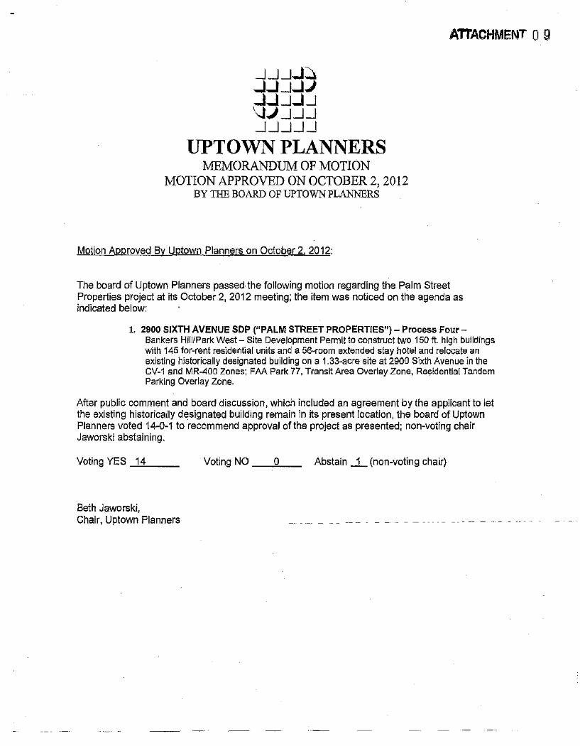
_j_j_j...J~ ...J...J_j...JJ ...J...J_j ... U \JJ _j_j_j _j_j_j_j_j
UPTOWN PLANNERS MEMORANDUM OF MOTION
MOTION APPROVED ON OCTOBER 2, 2012 BY THE BOARD OF UPTOWN PLANNERS
Motion Approved By Uptown Planners on October 2. 2012:
ATTACHMENT 0 9
The board of Uptown Planners passed the following motion regarding the Palm Street Properties project at its October 2, 2012 meeting; the item was noticed on the agenda as indicated below:
1. 2900 SIXTH AVENUE SOP ("PALM STREET PROPERTIES")- Process FourBankers Hill/Park West- Site Development Permit to construct two 150ft. high buildings with 145 for-rent residential units and a 56-room extended stay hotel and relocate an existing historically designated building on a 1.33-acre site at 2900 Sixth Avenue in the CV-1 and MR-400 Zones; FAA Park 77, Transit Area Overlay Zone, Residential Tandem Parking Overlay Zone.
After public comment and board discussion, which included an agreement by the applicant to let the existing historically designated building remain in its present location, the board of Uptown Planners voted 14-Q-1 to recommend approval of the project as presented; non-voting chair Jaworski abstaining.
Voting YES _1-"4'----- Voting NO _ _,_o __ Abstain _j_ (non-voting chair)
Beth Jaworski, Chair, Uptown Planners
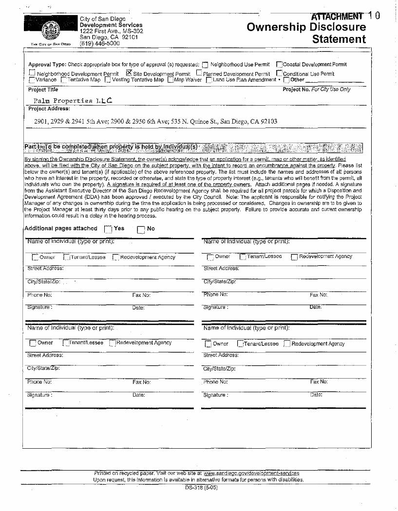
AI IACHMENT 1 0 Ownership Disclosure
Statement
Approval Type: Check appropriate box for type of approval (s} requested: D Neighborhood Use Permit r=;coastal Development Permit
fJ Neighborhood Development Permit IR Site Development Permit 0 Planned Development Permit Cconditional Use Permit ~Variance C:'Ten!ative Map fJ Vesting Tentotive Map QMap Waiver C::Land Use Plan Amendment • I:] other
Project Title Project No. For City Use Only
Palm Properties L.L.C Project Address:
2901,2929 & 2941 5th Ave; 2900 & 2950 6th Ave; 535 N. Quince St., San Diego, CA 92103
' i . Please list the owner(s) and tenant(s) (if applicable) of the above referenced property. The list must include the names and addresses of all persons
an interest in the property, recorded or othe!Wise, and state the type of property interest {e.g., tenants who will benefit from the permit, all I looH,Hicoll~ who own the property). A signature is required of at least one of the property owners. Attach additional pages if needed. A signature
Assistant Executive Director of the San Diego Redevelopment Agency shall be required for all project parcels for which a Disposition and I~::~~:~~~;,~: Agreement (DDA) has been approved I executed by the City Council. Note: The applicant is responsible for notifying the Project ~~ any changes in ownership during the time the application is being processed or considered. Changes in ownership are to be given to
Manager at least thirty days prior to any public hearing on the subject property. Failure to provide accurate and current ownership I lcioccO>iloo could result in a delay in the hearing process.
IA<Iditio'"'' pages attached CJ Yes ['No
Name of Individual (lype or pnnt): Name of lndrv1dual (type or prrni):
c 0Wil<;>l LJTenantiLessee c· Redevelopment Agency ["' Owner ['_ TenantfLessee [J Redevelopment Agency
Street ress: Street Address:
City/State/Zip: City/State/Zip:
Phone No: Fax No:
Date: rgna ure : a e:
Name of Individual (type or print): Name of Individual (type or print):
C Owner fJTenantflessee []Redevelopment Agency [j Owner ~Tenant/Lessee [J Redevelopment Agency
Street Address: Street Address:
City/State/ ip: City/State/Zip:
Phone No: Fax No: Phone No: Fax No:
Signature: Date: Signature; Date:
Printed on recycled paper. Visit our web srte at ~,-,andiego.govldevelopment-~ Upon request, this infonnation Is available in alternatJve formats for persons with disabilities.
DS-318 (5-05}
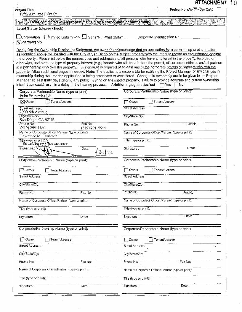
ATTACHMENT 1 0 Project No. (For City Use Only)
r.'corporation f!Umited Liability -or- 0 General) What State?~~- Corporate Identification No.-~~~~~!Z"JPartnership
By signing the Ownership Disclosure Statement. the owner(s) acknowledge that an application for a permit. map or other matter as identified above will be filed with the City of San Diego on the subject property with the intent to record an encumbrance against the property .. Please list below the names, titles and addresses of all persons who have an interest in the property, recorded or otherwise, and state the type of property interest (e.g., tenants who will benefit from the permit, all corporate officers, and all partners in a partnership who own the property). A signature is required of at least one of the corporate officers or partners who own the nrotE11Y:. Attach additional pages if needed. Note: The applicant is responsible for notifying the Project Manager of any changes in ownership during the time the application is being processed or considered. Changes in ownership are to be given to the Project Manager at least thirty days prior to any public hearing on the subject property. Failure to provide accurate and current ownership information could result in a delay in the hearing process. Additional pages attached C_'Yes C No
Corporate/Partnership Name (type or print): Palm Properties LP
15(] Owner r Tenant/Lessee
Street Address: 2900 6th A venue City/State/Zip: San Diego, CA 92103
one o: Fax o: (619) 299-4160 (619) 291-5544
Name of Corporate Officer/Partner (type or print): Lawrence M. Cushman
Title (type or printl\ Secrj~ry 4 reasurer
Signature,: "\._
c. owner 0 Tenant/Lessee
Street Address:
City/State/Zip:
Phone No:
Date:
Fax No:
Name of Corporate Officer/Partner (type or print):
Title (type or print):
Signature: Date:
Corporate7Partnershlp Name (type or pnnf):
cowner 0 Tenant/Lessee
Street Address:
City/State/Zip:
Phone No: Fax No:
Name ol Corporate Officer/Partner (f)lpe or pnnl):
Title (type or print):
Signature: Date:
Corporate/Partnership Name (type or print):
O Owner ~Tenant/Lessee
Street Address:
City/State/Zip:
Phone No: Fax No:
Name of Corporate Officer/Partner (type or print):
Title (type or print):
Signature : Date:
Corporate/Partnership Name (type or print):
C. Owner [J Tenant/Lessee
Street Address:
City/State/Zip:
one No: Fax No:
Name of Corporate Officer/Partner (type or print):
Title (type or print):
Signature: Date:
Corporate/Partnership Name (type or print):
L Owner [J Tenant/Lessee
Street Address:
City/State/Zip:
Phone No: Fax No:
Name of Corporate Officer/Partner (type or print):
Title (type or print):
Signature : ate: