report to metro housing on a … n7297 prepared by c. j. ross date november 2007 report to metro...
TRANSCRIPT

Reference
N7297
Prepared By
C. J. Ross
Date
November 2007
REPORT TO METRO
HOUSING ON A
GEOTECHNICAL INVESTIGATION
FOR THE PROPOSED
KWA NGQATHU (NTSHONGWENI
PHASE 2) HOUSING PROJECT,
KWAZULU-NATAL

TABLE OF CONTENTS
1. Terms of Reference 1
2. Scope of Report 1
3. Information Supplied 2
4. Site Description 2
5. Fieldwork 3
6. Geology & Subsoils 4
6.1 Overview
6.1.1 Natal Group Sandstone Bedrock
6.1.2 Soil Cover
6.1.3 Characteristics of the Soil Cover
6.1.4 Irregularities in Bedrock Surface
6.2 Geotechnical Zonation
6.2.1 Geotechnical Zone 1
6.2.2 Geotechnical Zone 2
6.2.3 Geotechnical Zone 3
6.2.4 Geotechnical Zone 4
7. Groundwater 11
8. Laboratory Testing 11
9. Stability Assessment 13
9.1 Potentially Unstable Areas
9.2 Former Borrow Areas
10. Excavatability 16
11. Earthworks 17
12. Road Subgrade Assessment 19
13. Potential Borrow Areas 20
14. Subsoil Drainage 21
15. Founding Assessment 21
16. Sizing of Erf 23
17. Wastewater Disposal 23
18. Stormwater Management 25

TABLE OF CONTENTS (Cont./….)
APPENDICES
Appendix 1 Soil Profiles
Appendix 2 Dynamic Cone Penetrometer (DCP) Test Results
Appendix 3 Photographs
DRAWINGS
Dwg No. N7297/01 Geotechnical Site Plan
Dwg. No. N7297/02 Geotechnical Site Plan

REPORT TO METRO HOUSING ON A GEOTECHNICAL INVESTIGATION FOR
THE PROPOSED KWA NGQATHU (NTSHONGWENI PHASE 2) HOUSING
PROJECT, KWAZULU-NATAL
November 2007 Davies Lynn & Partners (Pty) Ltd Page 1
Ref. N7297
1. TERMS OF REFERENCE
In reply to a request dated 10th July 2007, Davies Lynn & Partners (Pty) Ltd
[DLP] submitted to Metro Housing a quotation to undertake geotechnical
investigations for the proposed Kwa Ngqathu (Ntshongweni Phase 2)
Housing Projects on the 16th July 2007. DLP were subsequently appointed
to carry out the above investigations.
2. SCOPE OF REPORT
This report documents the findings of the geotechnical investigation carried
out for the proposed Kwa Ngqathu Housing Project. The scope of this report
is as follows:
!" To describe and present the fieldwork and laboratory testing carried out
during the investigation;
!" To assess the site geology and geotechnical characteristics of the subsoil
materials with respect to suitability for the proposed development and
engineering services; and
!" To recommend sound and economical development practices and initial
founding guidelines to ensure long-term stability of the development
based on the geotechnical conditions encountered.

REPORT TO METRO HOUSING ON A GEOTECHNICAL INVESTIGATION FOR
THE PROPOSED KWA NGQATHU (NTSHONGWENI PHASE 2) HOUSING
PROJECT, KWAZULU-NATAL
November 2007 Davies Lynn & Partners (Pty) Ltd Page 2
Ref. N7297
3. INFORMATION SUPPLIED
For the purpose of this investigation, DLP have made use of the following
information:
!" Orthophoto imagery and cadastral information from the eThekwini
Municipality GIS database;
!" Plans showing the proposed layout of erven and roads prepared by
Future Works;
!" Site survey, aerial photography and contour information provided by
MPL Land Survey;
!" 1:50 000 topographical map 2930; and
!" 1:250 000 Geological Series 2930 DURBAN.
4. SITE DESCRIPTION
The proposed development area is situated on elevated plateau land above
the western flank of the Sterkspruit River and a few kilometres upstream of
the Shongweni Dam. The Ntshonweni Township borders the site along the
southwestern side. Elevations across the proposed development area range
from approximately 640m to 500m MSL.
The topography of the site is dominated by a central and elevated spur
which grades in a southeasterly direction with several smaller spurs radiating
outwards interspersed with moderately sloping valley lines. A very steep
escarpment occurs along the northern and eastern boundaries of the
proposed development area.
The western part of the site is semi-formally developed on moderately to
steeply sloping easterly facing Hillside.

REPORT TO METRO HOUSING ON A GEOTECHNICAL INVESTIGATION FOR
THE PROPOSED KWA NGQATHU (NTSHONGWENI PHASE 2) HOUSING
PROJECT, KWAZULU-NATAL
November 2007 Davies Lynn & Partners (Pty) Ltd Page 3
Ref. N7297
5. FIELDWORK
The fieldwork for this investigation comprised the following activities:
!" An evaluation of the area at desktop level, during which existing
geological and topographical maps were sourced and assessed;
!" A subsurface geotechnical investigation comprising excavation, profiling
and backfilling of inspection pits and auger borings across the proposed
development area in order to establish the subsoil geology and shallow
groundwater conditions;
!" A terrain reconnaissance of the site to map the geomorphology and
profile existing cuttings or exposures to supplement the subsurface
geotechnical investigation. Soil profiles were logged and they are
included in Appendix 1 of this report;
!" Performance of Dynamic Cone Penetrometer (DCP) tests in order to
assess the relative densities and approximate CBR of the insitu subsoils.
The DCP tests results are included in Appendix 2 of this report;
!" Performance of percolation tests in accordance with SABS 0400
requirements (refer to Section 16 of this report for results and
recommendations);
!" Sampling of the various subsoils encountered for laboratory testing. A
number of bulk disturbed samples were retrieved from selected
inspection pits within the proposed Kwa Nqathu Housing Project areas
and submitted to a commercial soils testing laboratory. The laboratory

REPORT TO METRO HOUSING ON A GEOTECHNICAL INVESTIGATION FOR
THE PROPOSED KWA NGQATHU (NTSHONGWENI PHASE 2) HOUSING
PROJECT, KWAZULU-NATAL
November 2007 Davies Lynn & Partners (Pty) Ltd Page 4
Ref. N7297
testing and results thereof are discussed in more detail in Section 8 of
this report.
The positions of the above field tests, recorded with a hand-held GPS, are
shown on the accompanying Geotechnical Site Plans (Drawing Number
N7297/01 and N7297/02). Selected photographs of inspection pits and the
site development area showing subsoil and topographical conditions
respectively are attached to this report in Appendix 3.
6. GEOLOGY & SUBSOILS
6.1 Overview
The proposed development area is underlain by bedrock of and subsoils
derived from the Natal Group Sandstone. The Natal Group Sandstone
beneath the study area varies from highly weathered feldspathic soft rock to
hard rock quartzite outcrop. The quartzite horizons are resistant to
weathering and form the prominent cliff faces that occur above the
Sterkspruit River.
The soils overlying the sandstone bedrock are very sandy in nature and are
highly susceptible to erosion by channelled water flow.
In the western sector of the study area the colluvial sandy soils contain
numerous sandstone boulders scattered throughout the profile.

REPORT TO METRO HOUSING ON A GEOTECHNICAL INVESTIGATION FOR
THE PROPOSED KWA NGQATHU (NTSHONGWENI PHASE 2) HOUSING
PROJECT, KWAZULU-NATAL
November 2007 Davies Lynn & Partners (Pty) Ltd Page 5
Ref. N7297
The soils overlying the spur crests are typically very thin (<0,3m). Subsoil
profiles vary considerably across the site, typically related to
geomorphological and historic weathering conditions. In terms of
engineering characteristics, four (4No) geotechnical zones have been
identified in the area where similar subsoil conditions exist. These
geotechnical zones are discussed in more detail in Section 6.2 of this report
below, and illustrated on the attached Geotechnical Site Plan (Drawing
Number N7297/01 and N7297/02).
6.1.1 Natal Group Sandstone Bedrock
The Natal Group Sandstone generally comprises a pinkish brown, fine to
medium grained sandstone with intercalated maroonish pink, micaceous
arkosic horizons and minor maroon siltstone horizons. The sandstone is
well bedded with bedding thickness generally in the range 200mm to
1000mm. Jointing in the sandstone is well developed and continuous,
normally medium spaced except in the vicinity of fault and shear zones,
where closely spaced jointing occurs. In its unweathered state the
sandstone is a medium hard to very hard rock becoming a soft, friable rock
with increased weathering. In particular the micaceous arkosic sandstone
on weathering forms an expansive sandy clay residuum. In general, due to
the regional geological structure of tilted fault bounded blocks, the
sandstone bedding dips in a south easterly or easterly direction at angles of
about 5 to 15 degrees.

REPORT TO METRO HOUSING ON A GEOTECHNICAL INVESTIGATION FOR
THE PROPOSED KWA NGQATHU (NTSHONGWENI PHASE 2) HOUSING
PROJECT, KWAZULU-NATAL
November 2007 Davies Lynn & Partners (Pty) Ltd Page 6
Ref. N7297
6.1.2 Soil Cover
Soils developed on the Natal Group Sandstone are characteristically sandy.
On hilltops and hillsides, the soil cover is generally shallow (0,2m to 1,0m
thick), the sandy topsoil resting directly on the underlying weathered
sandstone, from which it has been derived mainly by physical
disintegration. On lower slopes and in valley bottoms soil thickness
increases to between about 2,0 and 4,0m in which a residual sandy clay
horizon is generally developed between the sandy topsoil and the
underlying bedrock. Furthermore, in poorly drained areas a subhorizon of
the sandy topsoil has been formed by the continuous ground water flow
along the topsoil/bedrock interface. This horizon is called the “E horizon”
(Elluvial) and is often termed “running sand”. This horizon will be shown
to be extremely important in later discussions of ground water movement
and slope failures.
Sandy Topsoil Horizon – is generally a light grey, loose, silty, fine SAND
exhibiting a high collapse potential. The permeability of the topsoil is
moderate to high (Coefficient of permeability K typically in the range 1 x
10-2 to 10-3mm/s).
“E” Horizon – Running Sand is typically a clean, almost white, loose, fine
to medium sand, normally saturated throughout the year and exhibiting
high permeabilities in the range K = 1 x 10⁻¹ to 1 x 10⁻²mm/s.
Residual Sandy Clay – is typically a yellowish orange mottled grey, stiff,
fissured and micro-fissured, sandy, silty clay of low permeabilities in the
range K = 10-4 to 10-6mm/s.

REPORT TO METRO HOUSING ON A GEOTECHNICAL INVESTIGATION FOR
THE PROPOSED KWA NGQATHU (NTSHONGWENI PHASE 2) HOUSING
PROJECT, KWAZULU-NATAL
November 2007 Davies Lynn & Partners (Pty) Ltd Page 7
Ref. N7297
6.1.3 Characteristics of the Soil Cover
The overriding characteristics of the SANDS encountered in the sandy soils
derived from the Natal Group Sandstone which are important in slope
stability considerations may be summarised as :
1. Uniform rounded fine grained sand with slight silt content.
2. Very loose to loose, voided structure exhibiting a high collapse
potential with typical in-situ densities 1500-1600 kg/m3.
3. Non-cohesive, exhibiting an angle of internal friction 0 of between
about 28 and 30o and an effective cohesion of zero.
4. Moderate to high permeability.
5. Highly erodable.
6.1.4 Irregularities in Bedrock Surface
The sandstone bedrock surface generally runs parallel to the natural ground
surface. However, due to variations in weathering and rock hardness, the
Sandstone bedrock surface is irregular giving rise to variations in soil
thickness. Thicker soil cover occurs generally over softer bands of
sandstone and over more weathered zones. Conversely, soil cover is
shallower over harder resistant bands. In places the hard sandstone
outcrops on surface. Within shear zones gulleys may also develop along
the bedrock surface which become buried channels down which ground
water gravitates.

REPORT TO METRO HOUSING ON A GEOTECHNICAL INVESTIGATION FOR
THE PROPOSED KWA NGQATHU (NTSHONGWENI PHASE 2) HOUSING
PROJECT, KWAZULU-NATAL
November 2007 Davies Lynn & Partners (Pty) Ltd Page 8
Ref. N7297
6.2 Geotechnical Zonation
6.2.1 Geotechnical Zone 1
Geotechnical Zone 1 is characterised by weathered sandstone outcrop. This
zone is typically located around the northern fringe above the steeply
sloping hillside and in the area where quarrying has been undertaken in the
past as indicated on the Geotechnical Site Plan attached.
The topsoil in Geotechnical Zone 1 varied from 0,0m to 0,2m in thickness
and was typically described as dry to slightly moist, dark brown, very loose
to loose, fissured, trace fine gravelly, Sand.
Beneath the topsoil weathered Sandstone was encountered. The weathered
Sandstone was described as (W4/3) light maroon blotched pale orange,
highly to slightly weathered soft to medium hard rock SANDSTONE.
6.2.2 Geotechnical Zone 2
Geotechnical Zone 2 is characterised by a thin (0,2 – 0,5m) thick sandy
colluvium overlying highly weathered, medium grained, medium bedded,
extremely soft to soft rock SANDSTONE.
In this zone the weathered sandstone is typically pickable to depths of
approximately 1,2m below N.G.L.

REPORT TO METRO HOUSING ON A GEOTECHNICAL INVESTIGATION FOR
THE PROPOSED KWA NGQATHU (NTSHONGWENI PHASE 2) HOUSING
PROJECT, KWAZULU-NATAL
November 2007 Davies Lynn & Partners (Pty) Ltd Page 9
Ref. N7297
6.2.3 Geotechnical Zone 3
Geotechnical Zone 3 is characterised by loose sandy soils overlying residual
sandstone and/or weathered Sandstone bedrock. This zone dominates the
site as indicated on the Geotechnical Site Plan attached.
The topsoil in Geotechnical Zone 3 varied from 0,1m to 0,3m in thickness
and was typically described as dry to slightly moist, light brown to brown to
brownish grey, very loose, slightly silty to SILTY SAND.
Immediately beneath the topsoil, loose sands typically described as very
slightly to slightly moist, greyish brown to light brown to pale orange brown
to very light grey, very loose to loose, silty to slightly silty SAND. These
loose sands were observed to extend to depths of between 0,5m and 1,5m
(with a thickness ranging between 0,3m and 2,0m). These loose sands are
typically low in strength, highly erodible and potentially unstable in terms of
trench excavations, however they are good road subgrade and select
materials (subject to compaction).
Underlying the loose sands, laterite and/or residual sandstone generally
occurs. The laterite is typically described as very slightly to slightly moist,
orange brown to reddish orange blotched brown, brownish grey and
reddish, medium dense (dense in places), medium to fine ferruginised
gravelly to GRAVELLY, slightly to moderately clayey SAND and varies
between 0,2m and greater than 0,5m in thickness.
The residual sandstone is typically described as dry to slightly moist, pinkish
brown to brownish grey to pale reddish brown blotched orange, red and/or
brown, loose to medium dense to dense, silty, locally slightly clayey SAND
to stiff, SANDY CLAY with minor to abundant Sandstone gravel and small

REPORT TO METRO HOUSING ON A GEOTECHNICAL INVESTIGATION FOR
THE PROPOSED KWA NGQATHU (NTSHONGWENI PHASE 2) HOUSING
PROJECT, KWAZULU-NATAL
November 2007 Davies Lynn & Partners (Pty) Ltd Page 10
Ref. N7297
boulders in places. firm to stiff, sandy to SANDY CLAY and ranges from
approximately 0,5m to 1,4m in thickness.
6.2.4 Geotechnical Zone 4
Underlying the topsoil as very slightly moist, brown, medium dense to
dense, silty, sandy to SANDY GRAVEL or very slightly moist, greyish brown
to dark orange brown, loose to medium dense, silty to slightly clayey SAND
with minor to abundant Sandstone gravels and hard rock boulders was
typically encountered to between 1,5m and 2,5m depth.
Weathered Sandstone bedrock described as (W4/3) pale pink to pink to pale
orange or yellow brown, highly to medium weathered, medium hard to hard
rock SANDSTONE was recorded at depths between 1,5m and 2,5m within
Geotechnical Zone 4. A bedding orientation dipping less than 10o towards
the southeast was recorded in this area.
Valley Head Areas
Within the valley head areas saturated e-horizon type sands (running sands)
typical occur beneath a shallow topsoil layer. With increasing depth these
sands grade into residual clayey soils and/or completely weathered soft rock
sandstone.
Due to the permeable nature of the e-horizon sands, soaking rains easily
infiltrate the subsoils and migrate downslope along the bedrock surface.
Over prolonged periods of rainfall the entire subsoil profile becomes
saturated to ground level with the potential for liquefaction of the soils and
the potential for mudflows and/or landslides.

REPORT TO METRO HOUSING ON A GEOTECHNICAL INVESTIGATION FOR
THE PROPOSED KWA NGQATHU (NTSHONGWENI PHASE 2) HOUSING
PROJECT, KWAZULU-NATAL
November 2007 Davies Lynn & Partners (Pty) Ltd Page 11
Ref. N7297
7. GROUNDWATER
Shallow groundwater seepage activity was not recorded in any of the
inspection pits excavated during the field investigation. However, it should
be noted that the field investigation was after a fairly dry winter season.
It is therefore considered that intermittent seepage activity could develop
along the interface between relatively more permeable sandy soils and the
less permeable residual subsoils or weathered bedrock, particularly after
prolonged or intensive rainfall periods.
Areas where shallow groundwater seepage activity may develop seasonally
or intermittently are indicated on the attached Geotechnical Site Plans.
8. LABORATORY TESTING
In order to assist with classifying the major subsoil materials across the site,
and to assess their suitability for use in earthworks and road construction,
laboratory testing has been undertaken on bulk disturbed samples retrieved
from inspection pits during the field investigation.
The results of the laboratory testing are summarized in the Table 1 overleaf.
The implications of these results in terms of material assessment and
classification applicable to the proposed development are briefly discussed
below and in more detail subsequently in the relevant sections of this report.

REPORT TO METRO HOUSING ON A GEOTECHNICAL INVESTIGATION FOR
THE PROPOSED KWA NGQATHU (NTSHONGWENI PHASE 2) HOUSING
PROJECT, KWAZULU-NATAL
November 2007 Davies Lynn & Partners (Pty) Ltd Page 12
Ref. N7297
Table 1: Summary of Laboratory Test results
Sample No. 1 2 3
Inspection
Pit No.
Sample
Depth (m) 0,5m 0,6m 0,6m – 1,1m
Material Description Brown, silty SAND
Light maroon blotched pale
orange, completely weathered
extremely soft to very soft rock
SANDSTONE
Orange brown, moderately
clayey SAND
Origin Loose Sands Natal Group Residual Sandstone
% Gravel 0,4 0,3 0,1
% Sand 82,6 83,7 56,8
% Silt 11,2 14,4 23,3
Soil
Mort
ar
% Clay 5,8 1,6 19,8
Liquid Limit 17 16 22
Plasticity Index 0 NP 6
Linear Shrinkage 0 0 3,3
Grading Modulus 1,06 0,82 0,63
Maximum Dry Density
(kg/m3) 2064
Optimum Moisture
Content (%) 9,5
90% 2
95% 5
98% 6
CB
R a
t %
Mod.
AA
SH
TO
100% 11
CBR Swell (%) 0,00
Group Index
Classification A-2-4 (0) A-2-4 A-4
TRH 14 Classification G10
Table 1 above reflects the variety of subsoils across the proposed
development area, and indicates their engineering properties.
Plasticity Indices ranged from Non Plastic for the loose sands, residual
sandstone and weathered Sandstone bedrock to a PI of 6 for the residual
moderately clayey sands. Similarly, linear shrinkages varied from 0,0% for
the loose sands, residual sandstone and weathered Sandstone bedrock to
3,3% for the residual clayey sands.

REPORT TO METRO HOUSING ON A GEOTECHNICAL INVESTIGATION FOR
THE PROPOSED KWA NGQATHU (NTSHONGWENI PHASE 2) HOUSING
PROJECT, KWAZULU-NATAL
November 2007 Davies Lynn & Partners (Pty) Ltd Page 13
Ref. N7297
Maximum Dry Densities of the loose sands, residual sandstone, laterite and
weathered Sandstone bedrock tested varied between 1999kg/m3 and
2064kg/m3 while the Optimum Moisture Contents ranged from 5,7% to
11,6% respectively.
Typical (average) TRH 14 classifications for the loose sands, laterite,
residual sandstone and weathered Sandstone of between G8 and G10 are
anticipated based on the results of the laboratory testing undertaken. The
residual clayey sand is expected to exhibit a TRH 14 classification of
approximately G10.
9. STABILITY ASSESSMENT
The findings of this geotechnical investigation indicate that most of the land
on which development is proposed is mostly stable and suitable for
development subject to the following precautions to ensure long-term
stability:
!" Formation of cut and fill embankments in accordance with the
recommendations in Section 11 of this report;
!" Provision of adequate stormwater control facilities such as retention
structures, interceptors, as well as midblock drainage and similar such
measures to reduce concentrated overland flows;
!" Establishment of erosion protection measures at all stormwater outlets or
headwalls, particularly in areas where the highly erodible, loose sands
prevail; and

REPORT TO METRO HOUSING ON A GEOTECHNICAL INVESTIGATION FOR
THE PROPOSED KWA NGQATHU (NTSHONGWENI PHASE 2) HOUSING
PROJECT, KWAZULU-NATAL
November 2007 Davies Lynn & Partners (Pty) Ltd Page 14
Ref. N7297
!" Adherence to the foundation and wastewater disposal recommendations
in Sections 15 and 16 of this report respectively.
9.1 Potentially Unstable Areas
The characteristics of the Natal Group Sandstone soils which give rise to
potential unstable slope conditions comprise :
1. The sandy soils are highly permeable, readily permitting infiltration of
large volumes of rain water.
2. The sandy soils are generally thin, 1,0 to 2,0m thick, and therefore
soon become saturated during periods of prolonged rain. On sloping
ground this causes, firstly, high seepage pressures as the ground water
flows downslope giving rise to instability, and secondly results in
surface flow over the highly erodable, saturated soils.
3. The sandy soils exhibit a very loose, voided and open structure of
typical in-situ densities 1500-1600kg/m3, and exhibit high potentials
for collapse when saturated under load.
4. The sandy soils are non-cohesive and silty, and the individual grains
are subangular to rounded, resulting in low angles of internal friction
in the range 0 = 28o to 30o. The sandy soils are therefore highly
erodable.
5. The sandy soils are low in humic content (pedologically classified as
Orthic A soils) and thus not particularly nutrient rich and do not

REPORT TO METRO HOUSING ON A GEOTECHNICAL INVESTIGATION FOR
THE PROPOSED KWA NGQATHU (NTSHONGWENI PHASE 2) HOUSING
PROJECT, KWAZULU-NATAL
November 2007 Davies Lynn & Partners (Pty) Ltd Page 15
Ref. N7297
support good grass growth. This adds to the erodability risk due to
patchy grass growth.
6. The development of the ‘E’ horizon “running sand” results in artesian
conditions of excess groundwater pressure on the lower slopes and in
the valley head areas.
It is evident that any slopes steeper than 14o – 16o (batter greater than
1:4) will be unstable if the slope should become fully saturated. In the
elevated terrain of portions of Kwa Ngqathu, many slopes exceed
14o-16o and where the landform and geological conditions are
conducive to saturation of the soil mantle (for example, steep slopes
and Valley Heads) potentially unstable slope conditions exist.
Accordingly in these areas viz slopes steeper than 1:4 (14 degrees)
and within the valley head areas as shown on Dwg. No. N7297/02
the potential for instability exists and as such these areas should be
excluded from development.
9.2 Former Borrow Areas
This area demarcated in the southeastern sector of the Geotechnical Site
Plan drawing N7297/1 has been subjected to erosion by channelled water
flow with evidence of liquification scars and erosion to bedrock level in
numerous areas.
This area will require remedial earthworks prior to development with
provision of erosion protection measure, drainage control measures and
with the founding of all structures i.e. house foundations, manhole culverts
etc keyed into the sandstone bedrock below the sandy colluvium.

REPORT TO METRO HOUSING ON A GEOTECHNICAL INVESTIGATION FOR
THE PROPOSED KWA NGQATHU (NTSHONGWENI PHASE 2) HOUSING
PROJECT, KWAZULU-NATAL
November 2007 Davies Lynn & Partners (Pty) Ltd Page 16
Ref. N7297
10. EXCAVATABILITY
The final depths to which the inspection pits were excavated during the field
investigation give a good indication of the depths to which excavations with
a TLB (backacter) or similar plant can be achieved with relative ease. Based
on this, as well as engineering experience with subsoils of similar nature, the
classes of excavation which should be expected and catered for during
excavations into the various materials is outlined overleaf.
With reference to Section 6.2 of this report above, excavations within the
topsoil, loose sands, residual laterite, laterite, residual sandstone and
completely weathered Sandstone are considered to classify as soft
excavation in terms of SABS 1200 DA criteria. In this regard, excavations to
at least 1,0m within Geotechnical Zones 2, 3 and 4 should classify as soft
excavation. Excavation within Geotechnical Zone 1 and 2 below a level of
1,0m depth below N.G.L. to approximately 2,0m depth below N.G.L. will
classify as intermediate and/or boulder Class B.
Sidewalls of excavations within the loose sands (typical of Geotechnical
Zone 3 and 4) are prone to caving in. Therefore care should be taken to
ensure safety of workers in trenches greater than 1,0m depth within these
subsoils. For example, battering of side slopes to minimum 1:1,5 or use of
temporary shoring measures.
Excavations within openly jointed Sandstone and highly to medium
weathered Sandstone bedrock (ie. typically within Geotechnical Zones 1
and 2) are expected to classify as boulder class B and intermediate to hard
rock excavation respectively in terms of SABS 1200 DA criteria. In this
regard, allowances for limited heavy ripping and/or blasting are
recommended in these areas.

REPORT TO METRO HOUSING ON A GEOTECHNICAL INVESTIGATION FOR
THE PROPOSED KWA NGQATHU (NTSHONGWENI PHASE 2) HOUSING
PROJECT, KWAZULU-NATAL
November 2007 Davies Lynn & Partners (Pty) Ltd Page 17
Ref. N7297
11. EARTHWORKS
Considering the undulating topography of the area, it is expected that much
of the road construction will adopt a cut-to-fill methodology, while cut-to-fill
platforms are anticipated on the majority of sites to facilitate construction. All
cut and fill earthworks / embankment construction should be carried out in
accordance with the current SANS/SABS 1200 series.
Generally, road embankments and housing platforms may be constructed
with the in-situ subsoils. Materials to be avoided in embankment
construction however include the topsoil and residual laterite clays.
The following measures are recommended :
!" Site earthworks of road cuts and embankments should be carefully
planned together with house site earthworks.
!" Bank batters should be kept to a maximum of 1 : 2 (26o). All banks
should be properly grassed.
!" Ensure that house platforms are graded to discharge along contour and
not downslope.
!" Driveways should be hardened. Driveways on properties below road
level should be graded to discharge into the house stormwater
reticulation system and should be graded such that overflow of surface
runoff discharges out along contour and not downslope.

REPORT TO METRO HOUSING ON A GEOTECHNICAL INVESTIGATION FOR
THE PROPOSED KWA NGQATHU (NTSHONGWENI PHASE 2) HOUSING
PROJECT, KWAZULU-NATAL
November 2007 Davies Lynn & Partners (Pty) Ltd Page 18
Ref. N7297
!" All structures, ie. houses, manholes, culverts, should be founded
through the sandy topsoil onto the sandstone bedrock wherever
possible.
!" Ensure that the home owners in potential problem areas are aware of
the situation and therefore care for their homes in a responsible
manner.
Where ground slopes exceed 1:6, benching into the insitu materials should
be carried out prior to placement and compaction of fills. Fill for road
embankments should be placed in layers not exceeding 300mm and
compacted to minimum 93% Mod AASHTO maximum dry density.
Boulders greater than 200mm must be removed from the fill material to
enhance compaction and reduce the risk of piping. Fill for housing platforms
should be placed in layers not exceeding 200mm and compacted to
minimum 90% Mod AASHTO maximum dry density. Regular compaction
density control tests should be performed during the development of fill
embankments as specified in SANS/SABS 1200 DA.
The following batters are recommended:
!" 1:1+ (45o or greater) for cuts within medium to slightly weathered
Sandstone bedrock, depending on joint / bedding orientation and
condition;
!" 1:1,5 (34o) for cuts within completely to highly weathered Sandstone
bedrock, depending on joint / bedding orientation and condition;
!" 1:2 (26o) for cuts within all other subsoils subject to a maximum height
of 1,5m; and
!" 1:2 (26o) for fill embankments subject to a maximum height of 1,5m.

REPORT TO METRO HOUSING ON A GEOTECHNICAL INVESTIGATION FOR
THE PROPOSED KWA NGQATHU (NTSHONGWENI PHASE 2) HOUSING
PROJECT, KWAZULU-NATAL
November 2007 Davies Lynn & Partners (Pty) Ltd Page 19
Ref. N7297
The cut batters recommended above for bedrock are subject to the rock
being intact and not showing adverse bedding / joint orientations or clay
gouge. It is recommended that a geotechnical consultant inspects and
approves these slopes immediately after construction.
Materials meeting the requirements for “Bedding Sands” as described in
SANS/SABS 1200 LB definitions were not encountered on site during the
field investigation. Accordingly, allowance for importing suitable sands for
support and covering of pipes in service trenches should be made.
12. ROAD SUBGRADE ASSESSMENT
With reference to Sections 6 and 8 of this report, the anticipated TRH 14
classifications for the various subsoils on the site as well as the geotechnical
zone in which they could occur at road subgrade level are summarised in
Table 2 below.
Table 2: Summary of Road Subgrade Assessment
Material Brief Description
Geotechnical Zone in
which material could occur
at road subgrade level
TRH 14
Residual Laterite Reddish, sandy to SANDY CLAY Geotechnical Zone 3 <G10
Loose Sands Brown, silty SAND Geotechnical Zone 3 G8
Residual
Sandstone
Brown to orange to pinkish to
yellow, sandy CLAY to moderately
clayey SAND with weathered
Sandstone inclusions
Geotechnical Zones 3 and 4 <G10-G5
(W5) Sandstone Light maroon to pale orange to
pinkish, extremely soft to very soft
rock SANDSTONE Geotechnical Zones 1, 2 and 3 G7
(W3) Sandstone Pale pink to pale orange to yellow
brown, medium hard to hard rock
SANDSTONE Geotechnical Zone 4 G6-G5

REPORT TO METRO HOUSING ON A GEOTECHNICAL INVESTIGATION FOR
THE PROPOSED KWA NGQATHU (NTSHONGWENI PHASE 2) HOUSING
PROJECT, KWAZULU-NATAL
November 2007 Davies Lynn & Partners (Pty) Ltd Page 20
Ref. N7297
In terms of Table 2 above, where encountered at road subgrade level, it is
generally recommended that the in-situ materials be ripped to a minimum
depth of 400mm and recompacted to 93% Mod AASHTO Maximum Dry
Density at Optimum Moisture Content. Where topsoil, residual laterite clays
or clayey residual sandstone is encountered however, these materials should
be undercut by 400mm, removed to spoil and replaced with selected
material classifying as G7 or better in terms of TRH14 criteria compacted to
93% Mod AASHTO Maximum Dry Density at Optimum Moisture Content.
The above recommendations are based on a limited number of tests and
should suffice for initial planning and costing purposes. More regular and
detailed laboratory testing and classification of in-situ road subgrade
materials is recommended (and will be required) during construction, as
specified by SANS/SABS 1200.
13. POTENTIAL BORROW AREAS
The loose sands in Geotechnical Zone 3 and weathered Sandstone bedrock
in Geotechnical Zone 1 and 2 are considered to be suitable sources of
shallow borrow material. In terms of TRH 14 criteria, these subsoils typically
classify as G7 to G5. However given the restrictions with regard to housing
densities, steep slopes and erosion susceptibility it is not recommended that
materials be borrowed in this area other than that removed in cut for
roadworks.

REPORT TO METRO HOUSING ON A GEOTECHNICAL INVESTIGATION FOR
THE PROPOSED KWA NGQATHU (NTSHONGWENI PHASE 2) HOUSING
PROJECT, KWAZULU-NATAL
November 2007 Davies Lynn & Partners (Pty) Ltd Page 21
Ref. N7297
14. SUBSOIL DRAINAGE
It is considered that some form of subsoil drainage will be required within
any poorly drained slopes affected by perennial and/or seasonal shallow
groundwater seepage activity. It is provisionally anticipated that subsoil
drainage measures will be required where services / development traverses
areas of potential groundwater seepage demarcated on the attached
Geotechnical Site Plan. (Valley Head Areas)
The requirement for and details of any subsoil drainage measures along
proposed cut embankments and as a protection for the road prism from
groundwater ingress should however be confirmed on site during
construction.
15. FOUNDING ASSESSMENT
The preliminary geotechnical investigation has identified several factors that
impact on the founding conditions across the proposed residential
development. These are:
#"Variation in natural depths to competent founding materials
With reference to Section 6 of this report, the depth to suitable founding
materials (below any low strength sands and/or expansive clays) varies
considerably within the proposed development area.
#"Differential conditions resulting from cut-to-fill earthworks
Across sloping portions of the development area, cut-to-fill earthworks
are likely to result in shallow founding over the cut layout with deeper
founding over the fill portions. In terms of the above, siting of proposed

REPORT TO METRO HOUSING ON A GEOTECHNICAL INVESTIGATION FOR
THE PROPOSED KWA NGQATHU (NTSHONGWENI PHASE 2) HOUSING
PROJECT, KWAZULU-NATAL
November 2007 Davies Lynn & Partners (Pty) Ltd Page 22
Ref. N7297
houses on cut terraces would maximise opportunities for shallower
founding.
In terms of the above, various founding options are presented and discussed
below.
Option 1 : Conventional, shallow strip foundations
The economic use of conventional, shallow strip foundations is considered
feasible across much of the proposed development area. Areas within which
these foundations are likely to be feasible include Geotechnical Zones 1 and
2 where shallow bedrock occurs. These foundations are also likely to be
feasible in portions of Geotechnical Zone 3, particularly along cut portions
of platforms where approved founding materials may be encountered at less
than 1,0m depth.
Option 2 : Reinforced strip foundations on mass concrete pads
Where approved founding materials typically exceed 1,0m depth but are
within approximately 2,0m of platform level, mass concrete pads founded
into the Sandstone bedrock may be constructed with reinforced strip
foundations spanning between the pads. These foundations should prove
feasible within Geotechnical Zone 1, as well as beneath fill portions of
platforms within Geotechnical Zone 2 and portions of Geotechnical Zone 3.
Option 3 : Raft foundations
Given the highly erodable nature of the sandy subsoils and the potential for
collapse type settlement it is recommended that consideration be given to
founding of the structures on raft foundations. The design of rafts should

REPORT TO METRO HOUSING ON A GEOTECHNICAL INVESTIGATION FOR
THE PROPOSED KWA NGQATHU (NTSHONGWENI PHASE 2) HOUSING
PROJECT, KWAZULU-NATAL
November 2007 Davies Lynn & Partners (Pty) Ltd Page 23
Ref. N7297
take into account potential differential settlements across cut-to-fill lines as
well as potential collapse settlement in the sandy subsoils. Geotechnical
Zones 3 and 4 would require the use of raft foundations with pier supports
through any fill portions.
16. SIZING OF ERF
Minimum plot sizes is mainly dependant on slope and socio-economic
requirements. Geotechnical considerations include susceptibility of the soils
to movement, slope stability and the proposed sanitation methods.
It is recommended that a minimum plot size of 500m2 be considered for
development of the southeasterly facing spur area and immediate surrounds
(Geotechnical Plan N7297/1 refers).
In the western sector where steeper slopes prevail it is recommended that
plots sizes of 1000m2 be considered. (Refer Geotechnical Plan N7297/2)
It is recommended that provisions be made for the creation of open
areas/green belts in the areas of potential instability. Similarly it is
recommended that planning development across the valley head areas as
identified in the Geotechnical Plan N7297/2 be avoided.
17. WASTEWATER DISPOSAL
Percolation testing in accordance with SABS 0400 criteria has been
undertaken as part of this geotechnical investigation. Percolation tests were
carried out at locations indicated on the attached Geotechnical Site Plan.

REPORT TO METRO HOUSING ON A GEOTECHNICAL INVESTIGATION FOR
THE PROPOSED KWA NGQATHU (NTSHONGWENI PHASE 2) HOUSING
PROJECT, KWAZULU-NATAL
November 2007 Davies Lynn & Partners (Pty) Ltd Page 24
Ref. N7297
The tests were carried out within the various subsoils encountered to
determine their percolation characteristics.
Percolation rates of between 180mm/hr and 480mm/hr were recorded,
indicating that the requirement for a minimum 25mm fall in 30 minutes was
typically met in some areas.
However it is considered that disposal of wastewater by subsoil percolation
not be considered for the Kwa Ngqathu Phase 2 Housing Development due
to the very shallow soil cover and potential for slope instability associated
with saturation of the cohesionless soils above bedrock.
Accordingly in areas with soil cover exceeding 1,0m depth VIPs with urine
diversion could successfully be employed. However due to the cohesionless
nature of the subsoils pit lining support will be required.
Generally the construction of the VIPs with urine diversion should be
located downslope of the dwelling and below fill embankments.
In areas of shallower soil cover overlying highly weathered sandstone
bedrock a combination of excavation into the bedrock and/or the
construction of raised, lined and sealed latrines would be required.
In areas of hard rock exposure difficulties associated with excavations of the
pits is to be expected and may require pneumatic tools to construct the pit.
Raised lined and sealed pit latrines will be required.

REPORT TO METRO HOUSING ON A GEOTECHNICAL INVESTIGATION FOR
THE PROPOSED KWA NGQATHU (NTSHONGWENI PHASE 2) HOUSING
PROJECT, KWAZULU-NATAL
November 2007 Davies Lynn & Partners (Pty) Ltd Page 25
Ref. N7297
18. STORMWATER MANAGEMENT
Within the proposed development area it is important to control and
dispose of stormwater effectively as uncontrolled runoff will cause damage
to property and may erode and destabilise large areas of this site as much of
the site is covered with highly erodible subsoils. The objectives of a
stormwater management system should thus be as follows:
$" To adequately dispose of runoff from developed areas without
causing soil saturation or erosion. This is particularly important on
steep slopes and where erodible subsoils exist;
$" To provide overland or piped flow routes to cater for major storms
and thereby minimising any risk of damage to property;
$" Stormwater systems should be designed to function adequately with
low maintenance in the long terms, and should cater for silting.
$" Installation of Midblock Stormwater Reticulation is Recommended
- Avoid use of stormwater soakpits or uncontrolled discharge
on surface.
- Avoid at all costs soakpits located in fill embankments near to
houses.
$" Soakpits – if soakpits are used they should be properly designed
with large retention chambers and adequate dormant open space for
infiltration. The plot sizes should be increased accordingly.

REPORT TO METRO HOUSING ON A GEOTECHNICAL INVESTIGATION FOR
THE PROPOSED KWA NGQATHU (NTSHONGWENI PHASE 2) HOUSING
PROJECT, KWAZULU-NATAL
November 2007 Davies Lynn & Partners (Pty) Ltd Page 26
Ref. N7297
$" Roads – should cross fall into the slope wherever possible in order to
serve as cut-off channels should mud rushes occur upslope thereof.
$" Stormwater Pipes – keep pipe grades steep to avoid clogging, design
for silting where reductions in grade occur (eg. oversize pipes, drop
manholes). Oversize critical stormwater lines and especially inlets.
$" Plan for runoff and groundwater seepage from outside and upslope
of the development.
$" Plan for long term maintenance, eg. low level bridge/valley head
crossings which can withstand over-topping during heavy rains, eg.
open greenbelts vs. culverts subject to blockages.
$" Plan for overland flow and provide erosion protection along such
routes.
Stormwater from roads should be attenuated in temporary detention
facilities with subsequent slow rate of discharge into valley bottoms or
drainage courses provided that adequate erosion protection measures are
provided.
-------oo0oo-------

APPENDIX 1
Logs of Soil Profiles
Dwg. N7297/01 – SP1 to SP21
Dwg. N7297/02 – SP1 to SP15

DRAWING N7297/01
(SP1 TO SP21)

PROJECT: KWA NGQATHU HOUSING PROJECT –PHASE 2
DATE: 05 / 11 / 2007 SOIL PROFILE NO.
SP 1 LOCATION: NTSHONGWENI LOGGED BY: M. DANIEL
DEPTH(M)
DESCRIPTION
.........
.........
.........
.........
0,5
.........
.........
.........
.........
1,0
.........
.........
.........
.........1,5
.........
.........
.........
.........2.0
.........
.........
.........
.........2,5
.........
.........
.........
.........3,0
.........
.........
.........
.........3,5
.........
.........
.........
.........4,0
.........
.........
.........
.........4,5
.........
.........
.........
.........5,0
Slightly moist, greyish brown, very loose, trace gravelly, slightly silty medium to fine SAND. [Topsoil/Colluvium]
W4/3, pinkish grey / greyish brown, highly to medium weathered, medium to fine grained, medium to thickly bedded, medium to widely jointed, joints slightly rough and stained orange, soft rock – SANDSTONE. [Natal Group]
Note
Bedding orientation of Sandstone 258o / 10
o SW
0.15m
2.50m
WATER TABLE : Not encountered
CLIENT : METRO HOUSING REF. NO.
N7297
FIG. NO.

PROJECT: KWA NGQATHU HOUSING PROJECT – PHASE 2
DATE: 05 / 11 / 2007 SOIL PROFILE NO.
SP 2 LOCATION: NTSHONGWENI LOGGED BY: M. DANIEL
DEPTH(M)
DESCRIPTION
.........
.........
.........
.........
0,5
.........
.........
.........
.........
1,0
.........
.........
.........
.........1,5
.........
.........
.........
.........2.0
.........
.........
.........
.........2,5
.........
.........
.........
.........3,0
.........
.........
.........
.........3,5
.........
.........
.........
.........4,0
.........
.........
.........
.........4,5
.........
.........
.........
.........5,0
Moist, greyish brown, very loose to loose, trace gravelly, slightly silty medium to fine SAND. [Topsoil/Colluvium]
(W4) moderate brown, highly weathered, medium to fine grained with coarse zones, medium bedded, medium jointed to openly jointed in places, very soft rock – SANDSTONE. [Natal Group]
(W4/3) pinkish grey, highly to medium weathered, medium to fine grained, medium bedded, medium jointed, soft rock – SANDSTONE. [Natal Group]
2.00m
2.50m
2.70m
WATER TABLE : Not encountered
CLIENT : METRO HOUSING REF. NO.
N7297
FIG. NO.

PROJECT: KWA NGQATHU HOUSING PROJECT – PHASE 2
DATE: 05 / 11 / 2007 SOIL PROFILE NO.
SP 3 LOCATION: NTSHONGWENI LOGGED BY: M. DANIEL
DEPTH(M)
DESCRIPTION
.........
.........
.........
.........
0,5
.........
.........
.........
.........
1,0
.........
.........
.........
.........1,5
.........
.........
.........
.........2.0
.........
.........
.........
.........2,5
.........
.........
.........
.........3,0
.........
.........
.........
.........3,5
.........
.........
.........
.........4,0
.........
.........
.........
.........4,5
.........
.........
.........
.........5,0
(W2) pale pinkish grey / grey, slightly weathered, medium to fine grained thickly bedded, widely jointed, medium hard rock – Sandstone. [Natal Group]
- Thinly bedded very soft rock horizons [0,5m to 1.0m thick] located upslope of this profile
1.10m
WATER TABLE : Not encountered
CLIENT : METRO HOUSING REF. NO.
N7297
FIG. NO.

PROJECT: KWA NGQATHU HOUSING PROJECT – PHASE 2
DATE: 05 / 11 / 2007 SOIL PROFILE NO.
SP 4 LOCATION: NTSHONGWENI LOGGED BY: M. DANIEL
DEPTH(M)
DESCRIPTION
.........
.........
.........
.........
0,5
.........
.........
.........
.........
1,0
.........
.........
.........
.........1,5
.........
.........
.........
.........2.0
.........
.........
.........
.........2,5
.........
.........
.........
.........3,0
.........
.........
.........
.........3,5
.........
.........
.........
.........4,0
.........
.........
.........
.........4,5
.........
.........
.........
.........5,0
(W4/3) Pinkish grey, highly to medium weathered, medium grained, thickly bedded, widely jointed, soft rock – SANDSTONE. [Natal Group]
(W4) Orange / pinkish grey, highly weathered, medium to fine grained, thickly bedded, widely jointed, very soft rock – Sandstone. [Natal Group]
1.10m
1.80m
WATER TABLE : Not encountered
CLIENT : METRO HOUSING REF. NO.
N7297
FIG. NO.

PROJECT: KWA NGQATHU HOUSING PROJECT – PHASE 2
DATE: 05 / 11 / 2007 SOIL PROFILE NO.
SP 5 LOCATION: NTSHONGWENI LOGGED BY: M. DANIEL
DEPTH(M)
DESCRIPTION
.........
.........
.........
.........
0,5
.........
.........
.........
.........
1,0
.........
.........
.........
.........1,5
.........
.........
.........
.........2.0
.........
.........
.........
.........2,5
.........
.........
.........
.........3,0
.........
.........
.........
.........3,5
.........
.........
.........
.........4,0
.........
.........
.........
.........4,5
.........
.........
.........
.........5,0
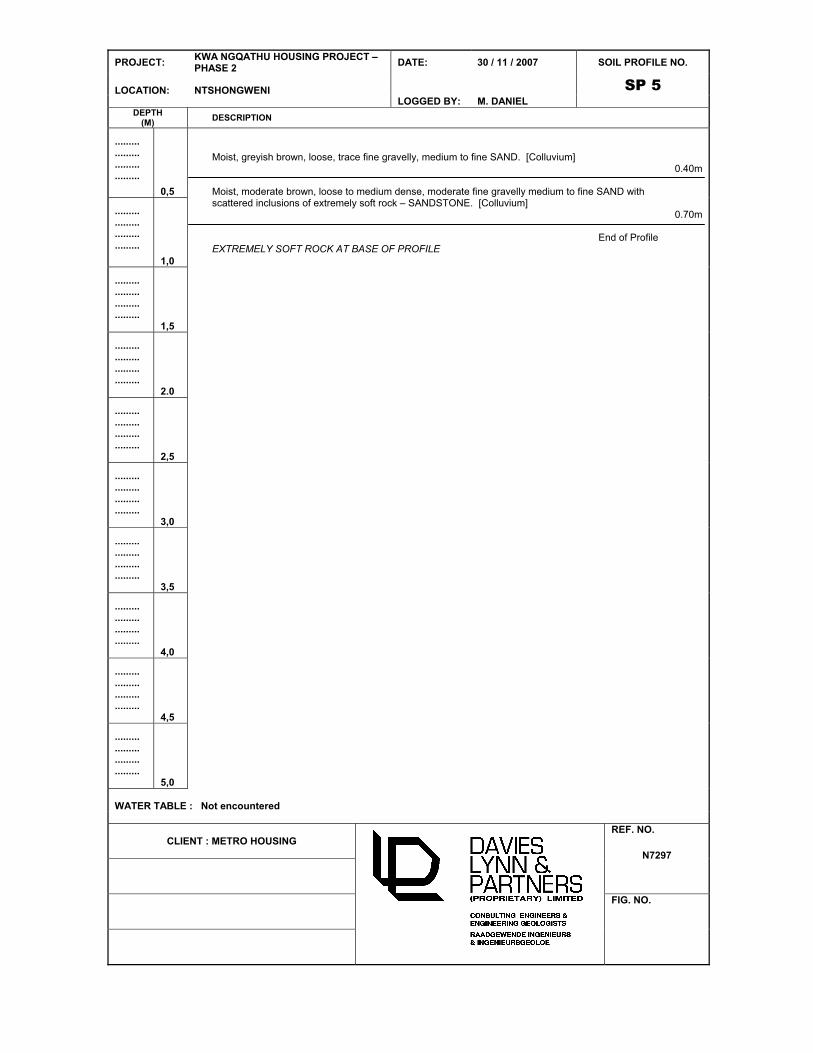
Moist, greyish brown, very loose to loose, trace gravelly, slightly silty medium to fine SAND. [Topsoil/Colluvium]
(W4) Orange brown, highly weathered, medium grained, openly jointed, extremely soft rock to very soft rock – SANDSTONE. [NatalGroup]
1.00m
1.40m
WATER TABLE : Not encountered
CLIENT : METRO HOUSING REF. NO.
N7297
FIG. NO.

PROJECT: KWA NGQATHU HOUSING PROJECT – PHASE 2
DATE: 05 / 11 / 2007 SOIL PROFILE NO.
SP 6 LOCATION: NTSHONGWENI LOGGED BY: M. DANIEL
DEPTH(M)
DESCRIPTION
.........
.........
.........
.........
0,5
.........
.........
.........
.........
1,0
.........
.........
.........
.........1,5
.........
.........
.........
.........2.0
.........
.........
.........
.........2,5
.........
.........
.........
.........3,0
.........
.........
.........
.........3,5
.........
.........
.........
.........4,0
.........
.........
.........
.........4,5
.........
.........
.........
.........5,0
Slightly moist to moist, greyish brown, very loose to loose, trace gravelly, slightly silty medium to fine SAND. [Topsoil / Colluvium]
(W4) Orange brown, highly weathered, medium to coarse grained, openly jointed, extremely soft rock – Sandstone. [Natal Group]
0.80m
1.30m
WATER TABLE : Not encountered
CLIENT : METRO HOUSING REF. NO.
N7297
FIG. NO.

PROJECT: KWA NGQATHU HOUSING PROJECT – PHASE 2
DATE: 05 / 11 / 2007 SOIL PROFILE NO.
SP 7 LOCATION: NTSHONGWENI LOGGED BY: M. DANIEL
DEPTH(M)
DESCRIPTION
.........
.........
.........
.........
0,5
.........
.........
.........
.........
1,0
.........
.........
.........
.........1,5
.........
.........
.........
.........2.0
.........
.........
.........
.........2,5
.........
.........
.........
.........3,0
.........
.........
.........
.........3,5
.........
.........
.........
.........4,0
.........
.........
.........
.........4,5
.........
.........
.........
.........5,0
Moist to wet, greyish brown, very loose to loose, trace gravelly, medium to fine SAND. [Topsoil/Colluvium]
(W4) Dark orange brown to dark yellowish orange, highly weathered, openly jointed, very soft rock to soft rock – Sandstone.
Note : Advanced weathering of joints with black/reddish iron coating on joint surfaces.
Note
Lower half of profile poorly exposed
1.50m
2.10m
WATER TABLE : Not encountered
CLIENT : METRO HOUSING REF. NO.
N7297
FIG. NO.

PROJECT: KWA NGQATHU HOUSING PROJECT – PHASE 2
DATE: 05 / 11 / 2007 SOIL PROFILE NO.
SP 8 LOCATION: NTSHONGWENI LOGGED BY: M. DANIEL
DEPTH(M)
DESCRIPTION
.........
.........
.........
.........
0,5
.........
.........
.........
.........
1,0
.........
.........
.........
.........1,5
.........
.........
.........
.........2.0
.........
.........
.........
.........2,5
.........
.........
.........
.........3,0
.........
.........
.........
.........3,5
.........
.........
.........
.........4,0
.........
.........
.........
.........4,5
.........
.........
.........
.........5,0
Moist, greyish brown, very loose to loose, trace gravelly, slightly silty medium to fine SAND. [Topsoil/Colluvium]
(W4) Orange brown, highly weathered, medium to coarse grained, medium bedded, openly jointed, extremely soft rock to very soft rock – SANDSTONE. [Natal Group]
0.80m
1.00m
WATER TABLE : Not encountered
CLIENT : METRO HOUSING REF. NO.
N7297
FIG. NO.

PROJECT: KWA NGQATHU HOUSING PROJECT – PHASE 2
DATE: 05 / 11 / 2007 SOIL PROFILE NO.
SP 9 LOCATION: NTSHONGWENI LOGGED BY: M. DANIEL
DEPTH(M)
DESCRIPTION
.........
.........
.........
.........
0,5
.........
.........
.........
.........
1,0
.........
.........
.........
.........1,5
.........
.........
.........
.........2.0
.........
.........
.........
.........2,5
.........
.........
.........
.........3,0
.........
.........
.........
.........3,5
.........
.........
.........
.........4,0
.........
.........
.........
.........4,5
.........
.........
.........
.........5,0
Slightly moist to moist, greyish brown, very loose to loose, slightly silty medium to fine SAND. [Topsoil/Colluvium]
0.90m
WATER TABLE : Not encountered
CLIENT : METRO HOUSING REF. NO.
N7297
FIG. NO.

PROJECT: KWA NGQATHU HOUSING PROJECT – PHASE 2
DATE: 05 / 11 / 2007 SOIL PROFILE NO.
SP 10 LOCATION: NTSHONGWENI LOGGED BY: M. DANIEL
DEPTH(M)
DESCRIPTION
.........
.........
.........
.........
0,5
.........
.........
.........
.........
1,0
.........
.........
.........
.........1,5
.........
.........
.........
.........2.0
.........
.........
.........
.........2,5
.........
.........
.........
.........3,0
.........
.........
.........
.........3,5
.........
.........
.........
.........4,0
.........
.........
.........
.........4,5
.........
.........
.........
.........5,0
(W4) Orange grey, highly weathered, medium grained, medium bedded, openly jointed, extremely soft rock – SANDSTONE. [Natal Group]
(W4) Pinkish grey to brownish grey, highly weathered, medium grained, medium bedded, medium jointed, extremely soft rock to very soft rock – SANDSTONE. [Natal Group]
0.30m
0.90m
WATER TABLE : Not encountered
CLIENT : METRO HOUSING REF. NO.
N7297
FIG. NO.

PROJECT: KWA NGQATHU HOUSING PROJECT – PHASE 2
DATE: 05 / 11 / 2007 SOIL PROFILE NO.
SP 11 LOCATION: NTSHONGWENI LOGGED BY: M. DANIEL
DEPTH(M)
DESCRIPTION
.........
.........
.........
.........
0,5
.........
.........
.........
.........
1,0
.........
.........
.........
.........1,5
.........
.........
.........
.........2.0
.........
.........
.........
.........2,5
.........
.........
.........
.........3,0
.........
.........
.........
.........3,5
.........
.........
.........
.........4,0
.........
.........
.........
.........4,5
.........
.........
.........
.........5,0
Moist, greyish brown, very loose to loose, trace to minor gravelly, slightly silty medium to fine SAND. [Topsoil / Colluvium]
(W4) Yellowish grey, highly weathered, coarse grained, medium bedded, openly jointed, extremely soft rock to very soft rock – SANDSTONE. [Natal Group]
0.50m
0.80m
WATER TABLE : Not encountered
CLIENT : METRO HOUSING REF. NO.
N7297
FIG. NO.

PROJECT: KWA NGQATHU HOUSING PROJECT – PHASE 2
DATE: 05 / 11 / 2007 SOIL PROFILE NO.
SP 12 LOCATION: NTSHONGWENI LOGGED BY: M. DANIEL
DEPTH(M)
DESCRIPTION
.........
.........
.........
.........
0,5
.........
.........
.........
.........
1,0
.........
.........
.........
.........1,5
.........
.........
.........
.........2.0
.........
.........
.........
.........2,5
.........
.........
.........
.........3,0
.........
.........
.........
.........3,5
.........
.........
.........
.........4,0
.........
.........
.........
.........4,5
.........
.........
.........
.........5,0
Slightly moist to moist, moderate orange brown, loose, fine to medium slightly to moderately clayey SAND. [Colluvium]
2.00m
WATER TABLE : Not encountered
CLIENT : METRO HOUSING REF. NO.
N7297
FIG. NO.

PROJECT: KWA NGQATHU HOUSING PROJECT – PHASE 2
DATE: 05 / 11 / 2007 SOIL PROFILE NO.
SP 13 LOCATION: NTSHONGWENI LOGGED BY: M. DANIEL
DEPTH(M)
DESCRIPTION
.........
.........
.........
.........
0,5
.........
.........
.........
.........
1,0
.........
.........
.........
.........1,5
.........
.........
.........
.........2.0
.........
.........
.........
.........2,5
.........
.........
.........
.........3,0
.........
.........
.........
.........3,5
.........
.........
.........
.........4,0
.........
.........
.........
.........4,5
.........
.........
.........
.........5,0
Moist, moderate brown, very loose to loose, trace gravelly, slightly silty medium to fine SAND. [Topsoil / Colluvium]
(W4) Pinkish / orange / yellowish grey to micaceous purple grey, highly to medium weathered, medium to fine grained, thickly bedded, medium to widely jointed, soft rock – Sandstone. [Natal Group]
Note
Bedding dipping at 120o / 16
o SE
0.70m
3.70m
WATER TABLE : Not encountered
CLIENT : METRO HOUSING REF. NO.
N7297
FIG. NO.

PROJECT: KWA NGQATHU HOUSING PROJECT – PHASE 2
DATE: 05 / 11 / 2007 SOIL PROFILE NO.
SP 14 LOCATION: NTSHONGWENI LOGGED BY: M. DANIEL
DEPTH(M)
DESCRIPTION
.........
.........
.........
.........
0,5
.........
.........
.........
.........
1,0
.........
.........
.........
.........1,5
.........
.........
.........
.........2.0
.........
.........
.........
.........2,5
.........
.........
.........
.........3,0
.........
.........
.........
.........3,5
.........
.........
.........
.........4,0
.........
.........
.........
.........4,5
.........
.........
.........
.........5,0
Slightly moist to moist, moderate orange brown, very loose to loose, trace gravelly, slightly to moderately clayey fine to medium SAND. [Colluvium]
- Contains minor ferricrete nodules at base.
(W4) Orangish / pinkish grey, highly weathered, medium to fine grained, medium bedded, medium to openly jointed, soft rock – Sandstone. [Natal Group]
2.70m
3.20m
WATER TABLE : Not encountered
CLIENT : METRO HOUSING REF. NO.
N7297
FIG. NO.

PROJECT: KWA NGQATHU HOUSING PROJECT – PHASE 2
DATE: 05 / 11 / 2007 SOIL PROFILE NO.
SP 15 LOCATION: NTSHONGWENI LOGGED BY: M. DANIEL
DEPTH(M)
DESCRIPTION
.........
.........
.........
.........
0,5
.........
.........
.........
.........
1,0
.........
.........
.........
.........1,5
.........
.........
.........
.........2.0
.........
.........
.........
.........2,5
.........
.........
.........
.........3,0
.........
.........
.........
.........3,5
.........
.........
.........
.........4,0
.........
.........
.........
.........4,5
.........
.........
.........
.........5,0
Moist, greyish brown, very loose to loose, trace gravelly, slightly silty medium to fine SAND. [Topsoil/Colluvium]
Pale pinkish grey, highly weathered, fine to medium grained, medium to thickly bedded, widely to openly jointed, extremely soft rock to very soft rock – Sandstone. [Natal Group]
- Inferred medium hard rock at 2.30m
1.60
1.90m
WATER TABLE : Not encountered
CLIENT : METRO HOUSING REF. NO.
N7297
FIG. NO.

PROJECT: KWA NGQATHU HOUSING PROJECT – PHASE 2
DATE: 05 / 11 / 2007 SOIL PROFILE NO.
SP 16 LOCATION: NTSHONGWENI LOGGED BY: M. DANIEL
DEPTH(M)
DESCRIPTION
.........
.........
.........
.........
0,5
.........
.........
.........
.........
1,0
.........
.........
.........
.........1,5
.........
.........
.........
.........2.0
.........
.........
.........
.........2,5
.........
.........
.........
.........3,0
.........
.........
.........
.........3,5
.........
.........
.........
.........4,0
.........
.........
.........
.........4,5
.........
.........
.........
.........5,0
Moist, greyish brown, very loose, trace gravelly, slightly silty medium to fine SAND. [Topsoil/Colluvium]
(W4/3) Orange / pink / purple grey, highly weathered to medium weathered, fine to medium grained, thickly to medium bedded, medium to widely jointed, soft rock to medium hard rock – Sandstone. [Natal Group]
Bedding orientation – 210o / 10
o SW
1.50m
3.10m
WATER TABLE : Not encountered
CLIENT : METRO HOUSING REF. NO.
N7297
FIG. NO.

PROJECT: KWA NGQATHU HOUSING PROJECT – PHASE 2
DATE: 05 / 11 / 2007 SOIL PROFILE NO.
SP 17 LOCATION: NTSHONGWENI LOGGED BY: M. DANIEL
DEPTH(M)
DESCRIPTION
.........
.........
.........
.........
0,5
.........
.........
.........
.........
1,0
.........
.........
.........
.........1,5
.........
.........
.........
.........2.0
.........
.........
.........
.........2,5
.........
.........
.........
.........3,0
.........
.........
.........
.........3,5
.........
.........
.........
.........4,0
.........
.........
.........
.........4,5
.........
.........
.........
.........5,0
Moist, greyish brown, very loose to loose, trace gravelly slightly silty medium to fine SAND. [Topsoil/Colluvium]
(W4) Pinkish / orange grey, highly weathered, medium grained, medium to thickly bedded, medium to openly jointed, extremely soft rock to very soft rock – Sandstone. [Natal Group]
0.50m
0.80m
WATER TABLE : Not encountered
CLIENT : METRO HOUSING REF. NO.
N7297
FIG. NO.

PROJECT: KWA NGQATHU HOUSING PROJECT – PHASE 2
DATE: 05 / 11 / 2007 SOIL PROFILE NO.
SP 18 LOCATION: NTSHONGWENI LOGGED BY: M. DANIEL
DEPTH(M)
DESCRIPTION
.........
.........
.........
.........
0,5
.........
.........
.........
.........
1,0
.........
.........
.........
.........1,5
.........
.........
.........
.........2.0
.........
.........
.........
.........2,5
.........
.........
.........
.........3,0
.........
.........
.........
.........3,5
.........
.........
.........
.........4,0
.........
.........
.........
.........4,5
.........
.........
.........
.........5,0
Moist, pinkish grey, very loose to loose, slightly silty medium to fine SAND. [Topsoil / Colluvium]
1.50m
WATER TABLE : Not encountered
CLIENT : METRO HOUSING REF. NO.
N7297
FIG. NO.

PROJECT: KWA NGQATHU HOUSING PROJECT DATE: 05 / 11 / 2007 SOIL PROFILE NO.
SP 19 LOCATION: NTSHONGWENI LOGGED BY: M. DANIEL
DEPTH(M)
DESCRIPTION
.........
.........
.........
.........
0,5
.........
.........
.........
.........
1,0
.........
.........
.........
.........1,5
.........
.........
.........
.........2.0
.........
.........
.........
.........2,5
.........
.........
.........
.........3,0
.........
.........
.........
.........3,5
.........
.........
.........
.........4,0
.........
.........
.........
.........4,5
.........
.........
.........
.........5,0
Moist, greyish brown, very loose to loose, trace gravelly, slightly silty medium to fine SAND. [Topsoil/Colluvium]
Moist, moderate orange brown, loose, trace to minor gravelly, slightly clayey fine to medium SAND. [Colluvium]
Reddish / orange grey, medium bedded, openly jointed, extremely soft rock Sandstone present at bottom of profile.
0.70m
1.50m
WATER TABLE : Not encountered
CLIENT : METRO HOUSING REF. NO.
N7297
FIG. NO.

PROJECT: KWA NGQATHU HOUSING PROJECT – PHASE 2
DATE: 05 / 11 / 2007 SOIL PROFILE NO.
SP 20 LOCATION: NTSHONGWENI LOGGED BY: M. DANIEL
DEPTH(M)
DESCRIPTION
.........
.........
.........
.........
0,5
.........
.........
.........
.........
1,0
.........
.........
.........
.........1,5
.........
.........
.........
.........2.0
.........
.........
.........
.........2,5
.........
.........
.........
.........3,0
.........
.........
.........
.........3,5
.........
.........
.........
.........4,0
.........
.........
.........
.........4,5
.........
.........
.........
.........5,0
Slightly moist, greyish brown, medium dense to loose, slightly silty medium to fine SAND. [Topsoil/Colluvium]
1.50m
WATER TABLE : Not encountered
CLIENT : METRO HOUSING REF. NO.
N7297
FIG. NO.

PROJECT: KWA NGQATHU HOUSING PROJECT – PHASE 2
DATE: 05 / 11 / 2007 SOIL PROFILE NO.
SP 21 LOCATION: NTSHONGWENI LOGGED BY: M. DANIEL
DEPTH(M)
DESCRIPTION
.........
.........
.........
.........
0,5
.........
.........
.........
.........
1,0
.........
.........
.........
.........1,5
.........
.........
.........
.........2.0
.........
.........
.........
.........2,5
.........
.........
.........
.........3,0
.........
.........
.........
.........3,5
.........
.........
.........
.........4,0
.........
.........
.........
.........4,5
.........
.........
.........
.........5,0
Slightly moist to moist, greyish brown, trace gravelly, loose, slightly silty, fine to medium SAND. [Topsoil/Colluvium]
1.50m
WATER TABLE : Not encountered
CLIENT : METRO HOUSING REF. NO.
N7297
FIG. NO.

DRAWING N7297/02
(SP1 TO SP15)

PROJECT: KWA NGQATHU HOUSING PROJECT – PHASE 2
DATE: 30 / 11 / 2007 SOIL PROFILE NO.
SP 1 LOCATION: NTSHONGWENI LOGGED BY: M. DANIEL
DEPTH(M)
DESCRIPTION
.........
.........
.........
.........
0,5
.........
.........
.........
.........
1,0
.........
.........
.........
.........1,5
.........
.........
.........
.........2.0
.........
.........
.........
.........2,5
.........
.........
.........
.........3,0
.........
.........
.........
.........3,5
.........
.........
.........
.........4,0
.........
.........
.........
.........4,5
.........
.........
.........
.........5,0
Moist, moderate brown to pinkish brown, loose, trace fine gravelly, medium to fine SAND. [Colluvium]
End of Profile
1.50m
WATER TABLE : Not encountered
CLIENT : METRO HOUSING REF. NO.
N7297
FIG. NO.

PROJECT: KWA NGQATHU HOUSING PROJECT – PHASE 2
DATE: 30 / 11 / 2007 SOIL PROFILE NO.
SP 2 LOCATION: NTSHONGWENI LOGGED BY: M. DANIEL
DEPTH(M)
DESCRIPTION
.........
.........
.........
.........
0,5
.........
.........
.........
.........
1,0
.........
.........
.........
.........1,5
.........
.........
.........
.........2.0
.........
.........
.........
.........2,5
.........
.........
.........
.........3,0
.........
.........
.........
.........3,5
.........
.........
.........
.........4,0
.........
.........
.........
.........4,5
.........
.........
.........
.........5,0
Slightly moist, greyish brown, loose, trace fine gravelly with scattered gravel to boulder sized sandstone fragments, medium to fine SAND. [Colluvium]
Moist, moderate brown, loose, moderate fine gravelly medium to fine SAND with moderate to abundant extremely soft rock sandstone boulders and coarse gravel. [Colluvium]
(W4) pinkish / orange grey, highly weathered, medium to coarse grained, thickly to medium bedded, medium to widely jointed (openly jointed at top of unit), very soft rock to soft rock – SANDSTONE.
End of Profile
Note
Bedding of Sandstone dipping at 20o towards 124 SE.
0.50m
0.80m
1.50m
WATER TABLE : Not encountered
CLIENT : METRO HOUSING REF. NO.
N7297
FIG. NO.

PROJECT: KWA NGQATHU HOUSING PROJECT – PHASE 2
DATE: 30 / 11 / 2007 SOIL PROFILE NO.
SP 3 LOCATION: NTSHONGWENI LOGGED BY: M. DANIEL
DEPTH(M)
DESCRIPTION
.........
.........
.........
.........
0,5
.........
.........
.........
.........
1,0
.........
.........
.........
.........1,5
.........
.........
.........
.........2.0
.........
.........
.........
.........2,5
.........
.........
.........
.........3,0
.........
.........
.........
.........3,5
.........
.........
.........
.........4,0
.........
.........
.........
.........4,5
.........
.........
.........
.........5,0
Moist, greyish brown, loose, trace fine gravelly, medium to fine SAND. [Colluvium]
(W4) Purple / orange grey, highly weathered, medium to coarse grained, medium bedded, medium to widely jointed (openly jointed at top), extremely soft rock with very soft rock zones – SANDSTONE.
End of Profile
0.60m
1.20m
WATER TABLE : Not encountered
CLIENT : METRO HOUSING REF. NO.
N7297
FIG. NO.

PROJECT: KWA NGQATHU HOUSING PROJECT – PHASE 2
DATE: 30 / 11 / 2007 SOIL PROFILE NO.
SP 4 LOCATION: NTSHONGWENI LOGGED BY: M. DANIEL
DEPTH(M)
DESCRIPTION
.........
.........
.........
.........
0,5
.........
.........
.........
.........
1,0
.........
.........
.........
.........1,5
.........
.........
.........
.........2.0
.........
.........
.........
.........2,5
.........
.........
.........
.........3,0
.........
.........
.........
.........3,5
.........
.........
.........
.........4,0
.........
.........
.........
.........4,5
.........
.........
.........
.........5,0
Slightly moist, greyish brown, loose, trace fine gravelly, medium to fine SAND. [Colluvium]
(W4) Orange brown, highly weathered, medium grained, medium bedded, openly jointed to closely jointed, extremely soft rock – Sandstone.
(W4) Purple grey, highly weathered, medium to coarse grained, medium to thickly bedded, widely jointed, very soft rock to soft rock – SANDSTONE.
End of Profile
0.90m
1.40m
1.70m
WATER TABLE : Not encountered
CLIENT : METRO HOUSING REF. NO.
N7297
FIG. NO.
PROJECT: KWA NGQATHU HOUSING PROJECT – PHASE 2
DATE: 30 / 11 / 2007 SOIL PROFILE NO.
SP 5 LOCATION: NTSHONGWENI LOGGED BY: M. DANIEL
DEPTH(M)
DESCRIPTION
.........
.........
.........
.........
0,5
.........
.........
.........
.........
1,0
.........
.........
.........
.........1,5
.........
.........
.........
.........2.0
.........
.........
.........
.........2,5
.........
.........
.........
.........3,0
.........
.........
.........
.........3,5
.........
.........
.........
.........4,0
.........
.........
.........
.........4,5
.........
.........
.........
.........5,0
Moist, greyish brown, loose, trace fine gravelly, medium to fine SAND. [Colluvium]
Moist, moderate brown, loose to medium dense, moderate fine gravelly medium to fine SAND with scattered inclusions of extremely soft rock – SANDSTONE. [Colluvium]
End of Profile EXTREMELY SOFT ROCK AT BASE OF PROFILE
0.40m
0.70m
WATER TABLE : Not encountered
CLIENT : METRO HOUSING REF. NO.
N7297
FIG. NO.

PROJECT: KWA NGQATHU HOUSING PROJECT – PHASE 2
DATE: 30 / 11 / 2007 SOIL PROFILE NO.
SP 6 LOCATION: NTSHONGWENI LOGGED BY: M. DANIEL
DEPTH(M)
DESCRIPTION
.........
.........
.........
.........
0,5
.........
.........
.........
.........
1,0
.........
.........
.........
.........1,5
.........
.........
.........
.........2.0
.........
.........
.........
.........2,5
.........
.........
.........
.........3,0
.........
.........
.........
.........3,5
.........
.........
.........
.........4,0
.........
.........
.........
.........4,5
.........
.........
.........
.........5,0
Slightly moist, greyish brown, loose, medium to fine SAND with moderate to abundant inclusions of coarse gravel to boulder sized SANDSTONE. [Collluvium]
(W4) Orange brown to pinkish brown, highly weathered with minor completely weathered zones, medium grained with scattered medium to coarse and fine to medium zones, medium bedded, closely jointed to medium jointed below 1,30m, extremely soft rock – SANDSTONE.
End of Profile
0.70m
2.20m
WATER TABLE : Not encountered
CLIENT : METRO HOUSING REF. NO.
N7297
FIG. NO.

PROJECT: KWA NGQATHU HOUSING PROJECT – PHASE 2
DATE: 30 / 11 / 2007 SOIL PROFILE NO.
SP 7 LOCATION: NTSHONGWENI LOGGED BY: M. DANIEL
DEPTH(M)
DESCRIPTION
.........
.........
.........
.........
0,5
.........
.........
.........
.........
1,0
.........
.........
.........
.........1,5
.........
.........
.........
.........2.0
.........
.........
.........
.........2,5
.........
.........
.........
.........3,0
.........
.........
.........
.........3,5
.........
.........
.........
.........4,0
.........
.........
.........
.........4,5
.........
.........
.........
.........5,0
Very slightly moist, greyish brown, loose, trace fine gravelly, medium to fine SAND. [Colluvium]
Very slightly moist, greyish brown, loose, fine gravelly medium to fine SAND with abundant boulder sized inclusions of orange grey extremely soft rock medium to coarse SANDSTONE. [Colluvium]
(W4) Purple / orange grey, highly weathered, medium grained, thickly bedded, widely jointed, extremely soft rock – SANDSTONE.
End of Profile
0.20m
0.80m
1.30m
WATER TABLE : Not encountered
CLIENT : METRO HOUSING REF. NO.
N7297
FIG. NO.

PROJECT: KWA NGQATHU HOUSING PROJECT – PHASE 2
DATE: 30 / 11 / 2007 SOIL PROFILE NO.
SP 8 LOCATION: NTSHONGWENI LOGGED BY: M. DANIEL
DEPTH(M)
DESCRIPTION
.........
.........
.........
.........
0,5
.........
.........
.........
.........
1,0
.........
.........
.........
.........1,5
.........
.........
.........
.........2.0
.........
.........
.........
.........2,5
.........
.........
.........
.........3,0
.........
.........
.........
.........3,5
.........
.........
.........
.........4,0
.........
.........
.........
.........4,5
.........
.........
.........
.........5,0
Slightly moist to moist, moderate brown, loose, trace fine gravelly, medium to fine SAND. [Collluvium]
End of Profile
1.30m
WATER TABLE : Not encountered
CLIENT : METRO HOUSING REF. NO.
N7297
FIG. NO.

PROJECT: KWA NGQATHU HOUSING PROJECT – PHASE 2
DATE: 30 / 11 / 2007 SOIL PROFILE NO.
SP 9 LOCATION: NTSHONGWENI LOGGED BY: M. DANIEL
DEPTH(M)
DESCRIPTION
.........
.........
.........
.........
0,5
.........
.........
.........
.........
1,0
.........
.........
.........
.........1,5
.........
.........
.........
.........2.0
.........
.........
.........
.........2,5
.........
.........
.........
.........3,0
.........
.........
.........
.........3,5
.........
.........
.........
.........4,0
.........
.........
.........
.........4,5
.........
.........
.........
.........5,0
Slightly moist, greyish brown, loose, trace fine gravelly, medium to fine SAND with scattered coarse gravel to boulder sized fragments of medium grained extremely soft rock SANDSTONE. [Colluvium]
Moist, greyish brown, loose to medium dense, moderate to abundant fine gravelly medium to fine SAND with abundant coarse gravel to boulder sized fragments of extremely soft rock to very soft rock SANDSTONE. [Colluvium]
End of Profile
ORANGE / PURPLE GREY, MEDIUM GRAINED, VERY SOFT ROCK SANDSTONE AT BASE OF PROFILE
0.50m
0.80m
WATER TABLE : Not encountered
CLIENT : METRO HOUSING REF. NO.
N7297
FIG. NO.

PROJECT: KWA NGQATHU HOUSING PROJECT – PHASE 2
DATE: 30 / 11 / 2007 SOIL PROFILE NO.
SP 10 LOCATION: NTSHONGWENI LOGGED BY: M. DANIEL
DEPTH(M)
DESCRIPTION
.........
.........
.........
.........
0,5
.........
.........
.........
.........
1,0
.........
.........
.........
.........1,5
.........
.........
.........
.........2.0
.........
.........
.........
.........2,5
.........
.........
.........
.........3,0
.........
.........
.........
.........3,5
.........
.........
.........
.........4,0
.........
.........
.........
.........4,5
.........
.........
.........
.........5,0
(W4) Pale pinkish / orange grey, highly weathered, micaceous, medium grained, thinly to medium bedded, openly to very closely jointed, extremely soft rock – SANDSTONE.
(W4) Pale pinkish grey, highly weathered, micaceous, medium grained, thinly bedded, medium jointed, extremely soft rock to very soft rock – SANDSTONE.
End of Profile
0.50m
0.70m
WATER TABLE : Not encountered
CLIENT : METRO HOUSING REF. NO.
N7297
FIG. NO.

PROJECT: KWA NGQATHU HOUSING PROJECT – PHASE 2
DATE: 30 / 11 / 2007 SOIL PROFILE NO.
SP 11 LOCATION: NTSHONGWENI LOGGED BY: M. DANIEL
DEPTH(M)
DESCRIPTION
.........
.........
.........
.........
0,5
.........
.........
.........
.........
1,0
.........
.........
.........
.........1,5
.........
.........
.........
.........2.0
.........
.........
.........
.........2,5
.........
.........
.........
.........3,0
.........
.........
.........
.........3,5
.........
.........
.........
.........4,0
.........
.........
.........
.........4,5
.........
.........
.........
.........5,0
Slightly moist to moist, greyish brown, loose, trace fine gravelly, medium to fine SAND. [Colluvium]
End of Profile
0.80m
WATER TABLE : Not encountered
CLIENT : METRO HOUSING REF. NO.
N7297
FIG. NO.

PROJECT: KWA NGQATHU HOUSING PROJECT – PHASE 2
DATE: 30 / 11 / 2007 SOIL PROFILE NO.
SP 12 LOCATION: NTSHONGWENI LOGGED BY: M. DANIEL
DEPTH(M)
DESCRIPTION
.........
.........
.........
.........
0,5
.........
.........
.........
.........
1,0
.........
.........
.........
.........1,5
.........
.........
.........
.........2.0
.........
.........
.........
.........2,5
.........
.........
.........
.........3,0
.........
.........
.........
.........3,5
.........
.........
.........
.........4,0
.........
.........
.........
.........4,5
.........
.........
.........
.........5,0
Very slightly moist to slightly moist (becoming moist to very moist below 0,80m), greyish brown, loose, trace fine gravelly, medium to fine SAND. [Colluvium]
End of Profile
1.10m
WATER TABLE : Not encountered
CLIENT : METRO HOUSING REF. NO.
N7297
FIG. NO.

PROJECT: KWA NGQATHU HOUSING PROJECT – PHASE 2
DATE: 30 / 11 / 2007 SOIL PROFILE NO.
SP 13 LOCATION: NTSHONGWENI LOGGED BY: M. DANIEL
DEPTH(M)
DESCRIPTION
.........
.........
.........
.........
0,5
.........
.........
.........
.........
1,0
.........
.........
.........
.........1,5
.........
.........
.........
.........2.0
.........
.........
.........
.........2,5
.........
.........
.........
.........3,0
.........
.........
.........
.........3,5
.........
.........
.........
.........4,0
.........
.........
.........
.........4,5
.........
.........
.........
.........5,0
Very slightly moist to slightly moist, greyish brown, loose to medium dense (partially cemented through termite activity), trace fine gravelly medium to fine SAND with moderate to abundant coarse gravel sized SANDSTONE fragments below 1.10m.
End of Profile
1.30m
WATER TABLE : Not encountered
CLIENT : METRO HOUSING REF. NO.
N7297
FIG. NO.

PROJECT: KWA NGQATHU HOUSING PROJECT – PHASE 2
DATE: 30 / 11 / 2007 SOIL PROFILE NO.
SP 14 LOCATION: NTSHONGWENI LOGGED BY: M. DANIEL
DEPTH(M)
DESCRIPTION
.........
.........
.........
.........
0,5
.........
.........
.........
.........
1,0
.........
.........
.........
.........1,5
.........
.........
.........
.........2.0
.........
.........
.........
.........2,5
.........
.........
.........
.........3,0
.........
.........
.........
.........3,5
.........
.........
.........
.........4,0
.........
.........
.........
.........4,5
.........
.........
.........
.........5,0
Slightly moist, greyish brown, loose, trace fine gravelly, medium to fine SAND becoming gravelly at base. [Colluvium]
(W4) Orange brown to pinkish brown, highly weathered, medium grained with medium to coarse grained zones, medium to thickly bedded, medium jointed (openly jointed at top of unit), extremely soft rock – Sandstone.
- Open joint at 1,10m infilled with very moist colluvium indicating possible seepage level.
End of Profile
0.80m
1.70m
WATER TABLE : Not encountered
CLIENT : METRO HOUSING REF. NO.
N7297
FIG. NO.

PROJECT: KWA NGQATHU HOUSING PROJECT – PHASE 2
DATE: 30 / 11 / 2007 SOIL PROFILE NO.
SP 15 LOCATION: NTSHONGWENI LOGGED BY: M. DANIEL
DEPTH(M)
DESCRIPTION
.........
.........
.........
.........
0,5
.........
.........
.........
.........
1,0
.........
.........
.........
.........1,5
.........
.........
.........
.........2.0
.........
.........
.........
.........2,5
.........
.........
.........
.........3,0
.........
.........
.........
.........3,5
.........
.........
.........
.........4,0
.........
.........
.........
.........4,5
.........
.........
.........
.........5,0
Slightly moist, greyish brown, loose to medium dense, moderate gravelly medium to fine SAND. [Collluvium]
(W4) Pinkish grey, highly weathered, medium grained, micaceous, medium bedded, openly to very closely jointed, extremely soft rock – SANDSTONE.
(W4) Pinkish grey, highly weathered, medium to coarse grained, micaceous, thickly to medium bedded, medium to widely jointed, very soft rock – SANDSTONE.
End of Profile
1.00m
1.30m
2.10m
WATER TABLE : Not encountered
CLIENT : METRO HOUSING REF. NO.
N7297
FIG. NO.

APPENDIX 2
Dynamic Cone Penetrometer (DCP) Test Results
Dwg. N7297/01 – DCP1 to DCP16
Dwg. N7297/02 – DCP1 to DCP15

DRAWING N7297/01
(DCP1 TO DCP16)

PROJECT: KWA NGQATHU HOUSING PROJECT - PHASE 2 DATE: 08/11/2007
LOCATION: NTSHONGWENI LOGGED BY: M. DANIEL
DEPTH DCP 1 EQV. DCP 2 EQV. DCP 3 EQV. DCP 4 EQV. DCP 5 EQV.
(m) Blows/100mm CBR. Blows/100mm CBR. Blows/100mm CBR. Blows/100mm CBR. Blows/100mm CBR.
2 4 2 4 1 1 R 1 1
1 1 1 1 2 4 1 1
2 4 1 1 0 <1 1 1
1 1 1 1 1 1 1 1
0.5 1 1 1 1 1 1 1 1
1 1 2 4 1 1 2 4
1 1 1 1 1 1 1 1
2 4 1 1 0 <1 2 4
1 1 2 4 1 1 2 4
1.0 1 1 2 4 1 1 2 4
2 4 2 4 1 1 3 6
2 4 2 4 5 10 3 6
3 6 2 4 4 8 3 6
3 6 2 4 5 10 3 6
1.5 4 8 2 4 3 6 3 6
3 6 3 6 4 8 2 4
4 8 3 6 7 15 2 4
3 6 3 6 7 15 2 4
10 22 4 8 17 41 7 15
2.0 14 32 4 8 25 50 8 17
9 20 15 36 24 50 R
10 22 R 30 50
20 50 14 32
21 50 11 25
2.5 20 50 5 10
10 22 24 50
5 10 R
25 50
>30
3.0
3.5
4.0
4.5
5.0
FROM 0 2 4 6 8 10 0 2 4 6 8 10 0 2 4 6 8 10 0 2 4 6 8 10 0 2 4 6 8 10
TO 2 4 6 8 10 + 2 4 6 8 10 + 2 4 6 8 10 + 2 4 6 8 10 + 2 4 6 8 10 +
NOTE: The equivalent CBR values above are provided as an indication only. R - Refusal
REF.No.
N7297
FIG.No.
DYNAMIC CONE PENETRATION TESTS
CLIENT : METRO HOUSING

PROJECT: KWA NGQATHU HOUSING PROJECT - PHASE 2 DATE: 08/11/2007
LOCATION: NTSHONGWENI LOGGED BY: M. DANIEL
DEPTH DCP 6 EQV. DCP 7 EQV. DCP 8 EQV. DCP 9 EQV. DCP 10 EQV.
(m) Blows/100mm CBR. Blows/100mm CBR. Blows/100mm CBR. Blows/100mm CBR. Blows/100mm CBR.
1 1 1 1 2 4 1 1 1 1
2 4 2 4 1 1 1 1 11 25
0 <1 1 1 2 4 6 12 20 50
1 1 2 4 2 4 15 36 13 30
0.5 1 1 1 1 1 1 13 30 12 27
0 <1 2 4 1 1 R 26 50
1 1 2 4 2 4 R
1 1 1 1 2 4
3 6 2 4 1 1
1.0 4 8 2 4 2 4
7 15 1 1 2 4
3 6 2 4 2 4
2 4 2 4
2 4 3 6
1.5 15 36 2 4
R 2 4
2 4
12 27
17 41
2.0 R
2.5
3.0
3.5
4.0
4.5
5.0
FROM 0 2 4 6 8 10 0 2 4 6 8 10 0 2 4 6 8 10 0 2 4 6 8 10 0 2 4 6 8 10
TO 2 4 6 8 10 + 2 4 6 8 10 + 2 4 6 8 10 + 2 4 6 8 10 + 2 4 6 8 10 +
NOTE: The equivalent CBR values above are provided as an indication only. R - Refusal
REF.No.
N7297
FIG.No.
DYNAMIC CONE PENETRATION TESTS
CLIENT : METRO HOUSING

PROJECT: KWA NGQATHU HOUSING PROJECT - PHASE 2 DATE: 08/11/2007
LOCATION: NTSHONGWENI LOGGED BY: M. DANIEL
DEPTH DCP 11 EQV. DCP 12 EQV. DCP 13 EQV. DCP 14 EQV. DCP 15 EQV.
(m) Blows/100mm CBR. Blows/100mm CBR. Blows/100mm CBR. Blows/100mm CBR. Blows/100mm CBR.
2 4 0 <1 1 1 R 10 22
1 1 0 <1 1 1 16 39
1 1 1 1 2 4 13 30
1 1 0 <1 2 4 11 25
0.5 2 4 0 <1 5 10 9 20
1 1 1 1 15 36 12 27
2 4 1 1 22 50 12 27
2 4 1 1 25 50 6 12
2 4 1 1 19 47 7 15
1.0 2 4 1 1 18 44 6 12
2 4 1 1 21 50 R
1 1 1 1 12 27
3 6 2 4 R
4 8 21 50
1.5 5 10 R
6 12
21 50
35 50
40 50
2.0 R
2.5
3.0
3.5
4.0
4.5
5.0
FROM 0 2 4 6 8 10 0 2 4 6 8 10 0 2 4 6 8 10 0 2 4 6 8 10 0 2 4 6 8 10
TO 2 4 6 8 10 + 2 4 6 8 10 + 2 4 6 8 10 + 2 4 6 8 10 + 2 4 6 8 10 +
NOTE: The equivalent CBR values above are provided as an indication only. R - Refusal
REF.No.
N7297
FIG.No.
DYNAMIC CONE PENETRATION TESTS
CLIENT : METRO HOUSING

PROJECT: KWA NGQATHU HOUSING PROJECT - PHASE 2 DATE: 08/11/2007
LOCATION: NTSHONGWENI LOGGED BY: M. DANIEL
DEPTH DCP 16 EQV. DCP EQV. DCP EQV. DCP EQV. DCP EQV.
(m) Blows/100mm CBR. Blows/100mm CBR. Blows/100mm CBR. Blows/100mm CBR. Blows/100mm CBR.
2 4
3 6
12 27
11 25
0.5 4 8
1 1
2 4
1 1
2 4
1.0 9 20
12 27
18 44
12 27
11 25
1.5 8 17
5 10
7 15
8 17
7 15
2.0 6 12
5 10
R
2.5
3.0
3.5
4.0
4.5
5.0
FROM 0 2 4 6 8 10 0 2 4 6 8 10 0 2 4 6 8 10 0 2 4 6 8 10 0 2 4 6 8 10
TO 2 4 6 8 10 + 2 4 6 8 10 + 2 4 6 8 10 + 2 4 6 8 10 + 2 4 6 8 10 +
NOTE: The equivalent CBR values above are provided as an indication only. R - Refusal
REF.No.
N7297
FIG.No.
DYNAMIC CONE PENETRATION TESTS
CLIENT : METRO HOUSING

DRAWING N7297/02
(DCP1 TO DCP15)
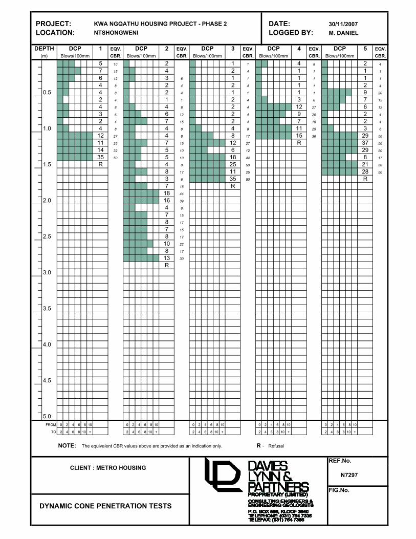
PROJECT: KWA NGQATHU HOUSING PROJECT - PHASE 2 DATE: 30/11/2007
LOCATION: NTSHONGWENI LOGGED BY: M. DANIEL
DEPTH DCP 1 EQV. DCP 2 EQV. DCP 3 EQV. DCP 4 EQV. DCP 5 EQV.
(m) Blows/100mm CBR. Blows/100mm CBR. Blows/100mm CBR. Blows/100mm CBR. Blows/100mm CBR.
5 10 2 1 1 4 8 2 4
7 15 4 2 4 1 1 1 1
6 12 3 6 1 1 1 1 1 1
4 8 2 4 2 4 1 1 2 4
0.5 4 8 2 4 1 1 1 1 9 20
2 4 1 1 2 4 3 6 7 15
4 8 4 8 2 4 12 27 6 12
3 6 6 12 2 4 9 20 2 4
2 4 7 15 2 4 7 15 2 4
1.0 4 8 4 8 4 8 11 25 3 6
12 27 4 8 8 17 15 36 29 50
11 25 7 15 12 27 R 37 50
14 32 5 10 6 12 29 50
35 50 5 10 18 44 8 17
1.5 R 4 8 25 50 21 50
8 17 11 25 28 50
3 6 35 50 R
7 15 R
18 44
2.0 16 39
4 8
7 15
8 17
7 15
2.5 8 17
10 22
8 17
13 30
R
3.0
3.5
4.0
4.5
5.0
FROM 0 2 4 6 8 10 0 2 4 6 8 10 0 2 4 6 8 10 0 2 4 6 8 10 0 2 4 6 8 10
TO 2 4 6 8 10 + 2 4 6 8 10 + 2 4 6 8 10 + 2 4 6 8 10 + 2 4 6 8 10 +
NOTE: The equivalent CBR values above are provided as an indication only. R - Refusal
REF.No.
N7297
FIG.No.
DYNAMIC CONE PENETRATION TESTS
CLIENT : METRO HOUSING

PROJECT: KWA NGQATHU HOUSING PROJECT - PHASE 2 DATE: 30/11/2007
LOCATION: NTSHONGWENI LOGGED BY: M. DANIEL
DEPTH DCP 6 EQV. DCP 7 EQV. DCP 8 EQV. DCP 9 EQV. DCP 10 EQV.
(m) Blows/100mm CBR. Blows/100mm CBR. Blows/100mm CBR. Blows/100mm CBR. Blows/100mm CBR.
2 4 2 2 4 2 4 1 1
2 4 1 1 1 1 1 4 8
1 1 2 4 1 1 1 1 2 4
26 50 5 10 1 1 2 4 7 15
0.5 19 47 7 15 1 1 2 4 7 15
28 50 4 8 2 4 2 4 9 20
R 25 50 2 4 3 6 15 36
5 10 1 1 20 50 20 50
7 15 3 6 25 50 10 22
1.0 7 15 4 8 R R
27 50 1 1
31 50 1 1
19 47 2 4
23 50 5 10
1.5 R 9 20
R
2.0
2.5
3.0
3.5
4.0
4.5
5.0
FROM 0 2 4 6 8 10 0 2 4 6 8 10 0 2 4 6 8 10 0 2 4 6 8 10 0 2 4 6 8 10
TO 2 4 6 8 10 + 2 4 6 8 10 + 2 4 6 8 10 + 2 4 6 8 10 + 2 4 6 8 10 +
NOTE: The equivalent CBR values above are provided as an indication only. R - Refusal
REF.No.
N7297
FIG.No.
DYNAMIC CONE PENETRATION TESTS
CLIENT : METRO HOUSING

PROJECT: KWA NGQATHU HOUSING PROJECT - PHASE 2 DATE: 30/11/2007
LOCATION: NTSHONGWENI LOGGED BY: M. DANIEL
DEPTH DCP 11 EQV. DCP 12 EQV. DCP 13 EQV. DCP 14 EQV. DCP 15 EQV.
(m) Blows/100mm CBR. Blows/100mm CBR. Blows/100mm CBR. Blows/100mm CBR. Blows/100mm CBR.
2 4 2 3 6 2 4 2 4
1 1 1 2 4 2 4 2 4
2 4 1 1 1 1 2 4 1 1
9 20 1 1 1 1 1 1 1 1
0.5 11 25 1 1 1 1 1 1 3 6
32 50 1 1 3 6 2 4 2 4
R 1 1 4 8 1 1 5 10
R 7 15 1 1 11 25
12 27 1 1 14 32
1.0 5 10 1 1 7 15
3 6 2 4 36 50
12 27 2 4 32 50
11 25 2 4 R
15 36 2 4
1.5 26 50 4 8
21 50 2 4
29 50 3 6
20 50 4 8
18 44 3 6
2.0 17 41 10 22
7 15 R
15 36
20 50
26 50
2.5 12 27
R
3.0
3.5
4.0
4.5
5.0
FROM 0 2 4 6 8 10 0 2 4 6 8 10 0 2 4 6 8 10 0 2 4 6 8 10 0 2 4 6 8 10
TO 2 4 6 8 10 + 2 4 6 8 10 + 2 4 6 8 10 + 2 4 6 8 10 + 2 4 6 8 10 +
NOTE: The equivalent CBR values above are provided as an indication only. R - Refusal
REF.No.
N7297
FIG.No.
DYNAMIC CONE PENETRATION TESTS
CLIENT : METRO HOUSING

APPENDIX 3
Photographs
Plates 1 through 14

PLATE 1
View of Hard Sandstone Outcrop

PLATE 2
View of Southeasterly Sloping Spur

PLATE 3
View of Thin Sandy Colluvium Cover Overlying Completely Weathered Sandstone
Bedrock Exposed in Inspection Pit

PLATE 4
Rock Outcrop

PLATE 5
Subsoil Exposure

PLATE 6
Former Borrow Area Showing Erosional Scars

PLATE 7
Profile of Erodable Sandy Soils

PLATE 8
Landform Showing Evidence of Erosion from Channelled Water Flow

PLATE 9
View of Valley Head Area Susceptible to Landslide – No Development Recommended in
this Area

PLATE 10
Shallow Colluvial Soils Overlying Sandstone Bedrock

PLATE 11
Cut Embankment into Sandstone Bedrock Behind Existing Dwelling
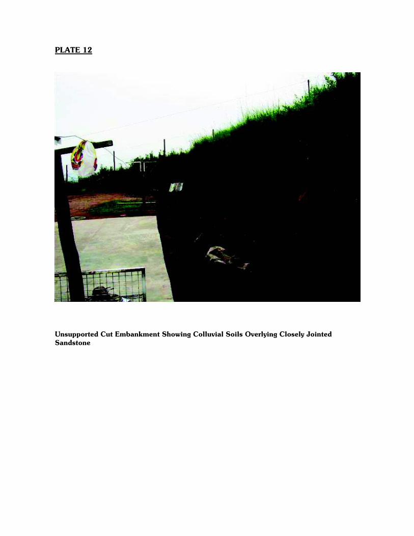
PLATE 12
Unsupported Cut Embankment Showing Colluvial Soils Overlying Closely Jointed
Sandstone

PLATE 13
VALLEYARE HEAD A
VALLEY HEADAREAD
View of Steep Slopes within Upper Sectors of Valley Head – Potentially Unstable

PLATE 14
View of Unvegetated Sandy Soils with Erosion

DRAWINGS
Geotechnical Site Plans
Dwg No’s N7297/01 & N7297/02

