report title: peace site c summary status report issuer: bc hydro
TRANSCRIPT
Report Title: Peace Site C Summary Status Report Issuer: BC Hydro and Power Authority Date: March 1991 NOTE TO READER: INFORMATION CONTAINED IN THIS REPORT MAY BE OUT OF DATE AND BC HYDRO MAKES NO STATEMENT ABOUT ITS ACCURACY OR COMPLETENESS. USE OF THIS REPORT AND/OR ITS CONTENTS IS AT THE USER’S OWN RISK. During Stage 2 of the Site C Project, studies are underway to update many of the historical studies and information known about the project. The potential Site C project, as originally conceived, will be updated to reflect current information and to incorporate new ideas brought forward by communities, First Nations, regulatory agencies and stakeholders. Today’s approach to Site C will consider environmental concerns, impacts to land, and opportunities for community benefits, and will update design, financial and technical work.

PEACE SITE C SUMNLARY STATUS REPORT
A 900 W1W ELECTRICAL GENERATION FACILITY
AND TWO 5001tV TRANSMISSION LINES
AT SITE C ON THE PEACE RIVER IN BRITISH COLUWIBIA
TABLE OF CONTENTS
1.0 Introduction .......................................................................................... 1 - 1
.................................................... 2.0 Project Description and Schedule 2 - 1
3.0 Project Rationale ................................................................................. 3 - 1
............................................................ 4.0 Public Consultation Program 4 - 1
............................................................................ 5.0 Engineering Studies 5 - 1
6.0 Er~vironmental Studies ........................................................................ 6 - 1
B.C. Hydro and Power Authority
March 1991

SECTION 1.0 - INTRODUCTION
B . C . Hydro previously made application fo r an Energy Project Cer t i f ica te '
(EPC) fo r the Peace Si te C Project pursuant t o the U t i l i t i e s Commission
Act. The application was made in 1980 and reviewed by the Brit ish
Columbia U t i l i t i e s Commission (BCUC) in public hearings from November 1981
t o November 1982.
BCUC recommended tha t an EPC not be issued until two conditions were met:
tha t the load forecast be acceptable and demonstrate the need t o begin
construction of S i t e C in order t o avoid supply deficiencies; and tha t
S i t e C be demonstrated as the best project based on a comparison of to t a l
engineering, construction, environmental and other social costs of
a l ternat ive projects. The B . C . Cabinet refused the issue of the
Cer t i f ica te in 1983.
I n 1989 B . C . Hydro was forecasting the possible need fo r new supply by
jus t before the turn of the century and therefore undertook preparatory
work on the Peace S i t e C Project. The objective was t o shorten the
project lead time so that S i t e C would be a viable contingency option t o
meet any early supply need. The circumstances which would require an
early addition t o B . C . Hydro's Electrical System have not transpi red.
Nonetheless, B . C . Hydro wishes t o maintain S i t e C as a viable option fo r
the future.
This report out1 ines B . C . Hydro's current s t a t e of preparedness on S i t e C ,
organized in accordance with the Guide to the Energy Project Review
Process. I t includes:
- a description of the project and a proposed construction schedule
- a summary of the rationale for S i t e C as an option fo r the future
- a summary of public consultation carried out t o date and t o be
continued
- a summary of the engineering and environmental studies carried out
t o date
The report i s accompanied by copies of reports generated during the
current preparatory phase for S i t e C . These reports generally update
e a r l i e r material , submitted during the previous application process, much
of which i s s t i l l relevant. No environmental issues have been ident i f ied
which, in the opinion of B . C . Hydro, would negate the BCUC finding se t out in the 1983 S i t e C Report a t page 268.
"In sum, while the Commission recognizes that major impacts will r e su l t
from the S i t e C project , the Commission concludes tha t they are not so
large as t o make them unacceptable. Provided tha t appropriate conditions
are placed on Hydro and that the government responds t o the special needs
created in the region, the impacts can be successfully and acceptably
managed. "
For fur ther information please contact:
Mr. Lachlan Russel Project Manager B . C . Hydro and Power Authority 14th Floor, 1125 Howe Street Vancouver, Brit ish Columbia V6Z 2K8 Telephone: (604) 633-3534
SECTION 2.0 - PROJECT DESCRIPTION AND SCHEDULE
2.1 GENERATING STATION
2.1.1 GENERAL
The Site C dam and power station, proposed to be located 62 km from the B.C.-Alberta border, would be the third facility in the B.C. Hydro system to utilize the Peace River. The W.A.C. Bennett Dam is located about 177 km upstream of the British Columbia-Alberta
border. The associated Wi 1 1 iston Lake reservoir has the capacity to regulate the flow in the Peace River, which powers two generating
stations at present. The G.M. Shrum Generating Station, located at
183 m high W.A.C. Bennett Dam, houses 10 generating units with a maximum continuous generating capacity of 2730 megawatts (MW). The
Peace Canyon hydroelectric facilities, located 22 km downstream of
the W.A.C. Bennett Dam, comprise a 50 m high dam and a four-unit powerplant with maximum generating capacity of 700 MW.
The Peace Site C Project would be a hydroelectric installation converting the potential energy of the flow of the Peace River at
Site C into electrical energy in a 900 MW capacity power station. Energy studies of the combined operation of the upstream stations,
G.M. Shrum and Peace Canyon, and of the potential Site C plant have demonstrated that Site C would have an annual average long-term
production of 4710 GWh.
PROJECT SETTING - SITE SPECIFIC
Site Geoloav
The proposed Site C damsite and reservoir are located where the Peace River has carved a valley a few kilometres wide and 190 to
2 3 0 m deep in a relatively flat to slightly rolling plain. The damsite is located about 7 km southwest of the city of Fort St. John
and 0.8 km downstream of the mouth of the Moberly River (Fig. 2 -1) .
The s i t e of ins ta l la t ions was chosen as the most favourable of a
ser ies of a l ternat ives studied along the course of the Peace River
downstream from Peace Canyon.
Base rock a t the s i t e consists o f relat ively so f t horizontally
bedded shale which has an upper surface a t elevation 460 m and which
has been eroded t o a depth of approximately 60 m t o form a wide f l a t
valley. Across the valley f loor the rock i s overlain by some 10 m of a1 luvium which contains the meandering flow channel of the r iver .
Above the rock surface on both sides of the valley are interbedded
overburden deposits of c lay, s i l t , sand and gravel which have an
overall thickness of 140 m and an upper surface a t approximately
elevation 600 m . The eroded surface of the rock i s exposed in the
lower 50 m on both banks, and a gravel covered mid-slope te r race
occurs on the south bank a t the approximate level of the dam c res t .
To be addressed in the design of the dam and associated works i s a
ser ies of weak f l a t seams present in the bedrock.
The valley slopes and terraces are wooded. Many shal low s l ides have
occurred in the overburden material , par t icular ly on the north bank.
Hvdrol oav
Detailed analyses have been made of meteorological and hydrological
records from sub-basins forming the S i t e C drainage area. This
includes the Williston reservoir basin as well as the local
t r ibu ta r i e s below Williston which contribute to the flow a t S i t e C .
A n estimate of the Probable Maximum Precipitation fo r the basin has
been developed and from t h i s the Probable Maximum Flood (PMF) fo r
S i t e C has been calculated. With the allowance fo r the regulatory
ef fec ts of the Williston Reservoir, the peak flow of the PMF a t
S i t e C will be approximately 18,200 m3/s. Taking into account
his tor ical floods and the extremes in operating conditions of
Wil l is ton reservoir , the Project Design Flood (PDF) has been

Figure 2-1
REGIONAL CONTEXT OF SITE C PROJECT
calculated at 11,900 m3/s. This measurement has been used to
determine the proportions of the spillway. The reservoir and
discharge faci 1 ities have been designed to accommodate both the PMF and PDF. During the early years of construction and until the dam
embankment has reached the level of the cofferdam, the diversion
works would be capable of passing a flood which has a return period
of 50 years.
2.1.3 PROJECT FEATURES
The project would comprise a zoned earthfill dam across the river
with a gated spillway, a power intake structure, a powerhouse and
switchgear facilities on the south bank. A project road from the north bank is planned to cross the river by bridge 4 km downstream
from the site, and would provide construction period access and permanent access to the powerstation and spillway (Fig. 2 - 2 ) . The
main project components are described below.
Earthfill Dam
The dam would be designed as a zoned embankment consisting of a
central impervious core with outer shells of sands and gravels. It
would extend about 1100 m long at the crest and 60 m high above
river level. The cofferdams, which form part of the temporary river diversion works, would be incorporated into the upstream and
downstream toes of the main embankment. The base of the impervious
core would be set in a trench excavated through the alluvium and
into the base rock to provide a water tight cut-off. The dam
embankment, i ncl udi ng the cofferdams, would be constructed of
materials obtained from excavations for the works and from selected
borrow areas. The design will ensure that the structure and
foundation rock would accept all loads with complete safety.

CONSTRUCTION ACCESS AND PERMANENT ROADS LEGEND TO THE DAM SITE AT SITE C permanent road
---= temporary road Elevations in metres ASL.
Diversion Tunnels and Low Level Outlet
During construction of the dam, spillway and power ins t a l l a t ions ( a t
least until the f i r s t turbine i s ready for t e s t i n g ) , the r ive r would
be diverted through two 9.8 m diameter concrete 1 ined tunnels in the
north abutment. Each tunnel would be about 650 m l o n g and have a
gated concrete intake s t ructure a t the upstream end. Embankment
cofferdams near the tunnel intakes and out le t s would protect the dam
working areas during the diversion period. When storage i s t o
commence, one tunnel would be closed using the intake gate and
permanently blocked with a concrete plug. During f i l l i n g and unt i l
the reservoir reaches the spillway cres t leve l , water would be
released through the second tunnel t o s a t i s fy downstream
requirements. Subsequently t h i s tunnel would also be closed and
p l ugged .
Reservoir
The reservoir would flood 46 km2 of land t o create a to ta l water
surface of 94.4 km' with a maximum normal operating level of
461.8 m . I t would extend upstream for a distance of 83 km t o the
out le t of the Peace Canyon generation s ta t ion . A t the S i t e C dam,
the water depth would be 52 m and the gross volume of the storage
would be 2310 million m3/s. (See Section 2.1.7 fo r Operation of
S i t e C Reservoir) .
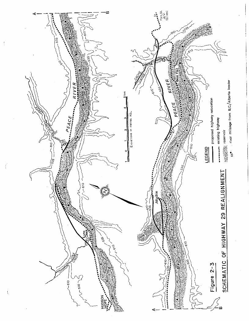
The reservoir created by a dam a t the S i t e C would inundate
approximately 23 km of Highway 29 between Hudson's Hope and Bear
Flats . The major affected sections of the highway would be near
Lynx Creek, Farrell Creek, Cache Creek and the Halfway River (Fig.
2-3) . Preliminary studies by B . C . Hydro and the Ministry of
Highways have resulted in the proposed re-alignment of Highway 29.
This realignment and construction would impact surrounding
landowners, 23 known heritage resource s i t e s , as well as
recreational use and access a1 ong the reservoi r .

Spillway
The spillway would be adjacent t o the dam on the south abutment. I t
would have a gated cres t s t ructure with an inclined concrete-lined
chute leading t o a submerged "hydraulic j u m p " type energy d iss ipa tor
near the downstream toe of the dam. The diss ipator would be
designed t o absorb suf f ic ien t energy from the spillway discharge t o
ensure tha t downstream erosion would not endanger the dam or
powerstation.
The spillway, with s i l l a t elevation 446.5 m , would be f i t t e d with
s ix radial gates. I t would be designed t o pass the design flood of
11,900 m3/s with the reservoir a t elevation 461.8 m and would be
capable of passing the probable maximum flood with the reservoir a t
elevation 466.3 m , 4.5 m above normal maximum operating level . Due
to the control exercised by the Williston Reservoir upstream on the
Peace River and the adoption of flood forecasting procedures,
operation of the S i t e C spillway w o u l d be an infrequent event when
the power plant i s fu l ly commissioned.
Powerplant and Switching Fac i l i t i e s
The intake s t ruc ture for the powerplant would be in l ine with, and
adjacent t o , the spillway s tructure. The intake channel would be
common t o the intake s t ructure and the spillway. The intake
s t ruc ture , approximately 400 m long and 45 m high, would consis t of
s ix separately gated openings each connected through a s tee l
penstock t o the scrol l case of a Francis turbine housed in the
powerstation downstream. The 9.35 m diameter penstocks would be
encased in concrete and partly buried in granular backfil l behind
the intake s t ructure. The surface powerstation would contain s i x
units rated a t 150 MW each ( to t a l 900 MW) under a head of 48.4 m . The to ta l discharge under t h i s head would be approximately
2200 m3/s.

Al though t h e s t a t i o n would be operated remo te l y f rom t h e G.M. Shrum
g e n e r a t i n g s t a t i o n upstream, o r f rom t h e Burnaby Mounta in System
C o n t r o l Cent re near Vancouver, a c o n t r o l room f o r l o c a l c o n t r o l
would be p rov ided i n t h e s e r v i c e bay. F o l l o w i n g t r a n s f o r m a t i o n t o
138 kV, power f rom t h e genera to rs would be de l i v e r e d by c a b l e t o t h e
sw i t chgea r b u i l d i n g l o c a t e d on a p l a t f o r m excavated i n t h e
overburden s l ope above and t o t h e south o f t h e power s t a t i o n . From
here t h e o u t p u t f rom t h e p l a n t would be d e l i v e r e d t o t h e Peace
Canyon Swi tchyard by two 500 kV t r ansm iss ion l i n e s and t o F o r t S t .
John by t h e e x i s t i n g 138 Kv l i n e .
2.1.4 SIGNIFICANT CHANGES S I N C E 1980
No s i g n i f i c a n t changes t o t h e p r o j e c t have been i n t r o d u c e d s i n c e
1980, a l t hough t h e accumulat ion of a d d i t i o n a l h y d r o l o g i c a l and
g e o l o g i c a l da ta i n t h e i n t e r v e n i n g p e r i o d has l e d t o some des ign
re f inements . Fo r example, t h e d i v e r s i o n t u n n e l s have been reduced
i n s i z e and t h e c o n f i g u r a t i o n o f t h e cof ferdams t o be used f o r
c o n s t r u c t i o n has been mod i f i ed . There would a l s o be ad justments i n
t h e a l ignments o f some o f t h e access roads i n t h e s i t e area as w e l l
as t h e s i t i n g o f some of t h e c o n s t r u c t i o n f a c i l i t i e s .
2.1.5. PROJECT SCHEDULE
Cur ren t schedu l i ng s t u d i e s s t i l l t o be completed, i n d i c a t e t h a t an
86 month p e r i o d ( 7 yea rs , 2 months) would be r e q u i r e d f rom t h e d a t e
o f i s s u e o f t ende r o f t h e f i r s t s i t e c o n s t r u c t i o n c o n t r a c t s t o t h e
i n - s e r v i c e da te of t h e f i r s t two u n i t s ( F i g . 2 -4 ) .
B.C. Hydro resource p l a n n i n g a n t i c i p a t e s an s i n - s e r v i c e da te f o r t h e
p r o j e c t o f 1 December i n t h e y e a r t h a t energy i s f o r e c a s t t o be
a v a i l a b l e . Given t h e a n t i c i p a t e d c o n s t r u c t i o n p e r i o d , a 1 December
i n - s e r v i c e d a t e would r e q u i r e t h a t t h e f i r s t s i t e c o n s t r u c t i o n
c o n t r a c t s be i ssued f o r ' t e n d e r on 1 October , 7 yea rs and 2 months
e a r l i e r t han t h e i n - s e r v i c e date. Th i s would a1 low about s i x months
t i n e f o r submission o f tenders , award o f c o n t r a c t s and m o b i l i z a t i o n

ACTIVITY
YEAR 1 YEAR 2 YEAR 3 YEAR 4 YEAR 5 YEAR 6 YEAR 7 YEAR'8
PROJECT APPROVAL , A
PEACE RIVER BRIDGE 6 ACCESS ROADS CAMP 6 OFFICES HIGHWAY RELOCATION RESERVOIR CLEARING
DIVERSION TUNNELS
EARTHFILL DAM COMMENCE RESERVOIR F I L L I N G
SPILLWAY STRUCTURE INTAKE STRUCTURE GRAVITY SECTIONS f TRAINING WALLS
POWERPLANT STRUCTURE POWERPLANT COMPLETION
INSTALL TURBINES INSTALL GENERATORS UNIT Yi62 I N SERVICE UNIT Y3 I N SERVICE UNIT Y 4 I N SERVICE UNIT #5 I N SERVICE UNIT 16 I N SERVICE
TRANSMISSION L INES f PEACE CANYON SUBSTATION T/L 6 SUBSTATION READY FOR SERVICE

over the winter so that commencement of on-si te construction work
could take place in the spring, approximately 1 April , and the use
of the fu l l construction season of the f i r s t year would be assured.
CONSTRUCTION
The f i r s t major construction a c t i v i t i e s would be creation of access
t o the project s i t e , construction of the labour camp and excavations
on the north and south banks of the r iver . I n i t i a l excavations on
the north bank would establish upstream a n d downstream portals f o r
the diversion tunnels to permit a s t a r t on underground excavation.
The intake and out le t channels would be isolated from the r ive r by
local cofferdams. Excavations on the south bank would remove a
large volume of b u l k excavation before award of the f ina l
construction contracts t o complete the excavations and build the
concrete s t ructures .
I n i t i a l on-site construction contracts and turbine and generator
design, supply and ins ta l la t ion contracts would be simultaneously
tendered. Closure of the cofferdams to divert the r iver t o allow
construction of the e a r t h f i l l embankment would take place in the
f a l l of the third year of construction. The completed diversion
tunnels would be opened and the r iver channel blocked with upstream
and downstream cofferdams. After excavation of the riverbed and
preparation of the foundations, the main e a r t h f i l l dam would be
b u i l t . The construction period fo r e a r t h f i l l would be r e s t r i c t ed by
seasonal weather variations b u t would be completed by the s t a r t of
summer of the seventh year. One diversion tunnel would then be
closed t o permit reservoir f i 1 1 ing whi l e required r iver flows are
maintained through the other tunnel. When the reservoir level
reaches the spi 1 lway overflow level the other diversion tunnel would
be closed and the r iver flows would be maintained through the
spillway or through the generating uni ts .
Following excavations on the south bank of the r i v e r , s t a r t i n g in
spring of year four, the major powerplant and spillway concrete
structures would be b u i l t . Progress would be scheduled so that
ins ta l la t ion of the turbines could begin a t the end of year f ive .
The f i r s t two units would be available for tes t ing in the f a l l of
year seven when water i s available from the reservoir. The unit
tes t ing would be completed and commercial operation could s t a r t by
1 December of year seven. Work areas and borrow p i t s used during
construction would be graded and seeded in an appropriate manner
when these areas are no longer required.
Although a weighted average l i f e of 70 years has been used as the
cessation of economic v iabi l i ty of such dams i t i s estimated tha t
the actual project l i f e may be many times greater . Even i f
substantial sedimentation occurs in the reservoir over a few hundred
years, the project could continue in operation.
2 .1 .7 OPERATIONS A N D MAINTENANCE
The S i t e C plant would be operated t o meet B . C . Hydro system load
requirements in a manner consistent with the upstream plants , G . M .
Shrum (GMS) and Peace Canyon ( P C N ) . These p l ants are expected t o
continue t o provide a s ignif icant amount (40%) of the system energy
generation and have suf f ic ien t f l e x i b i l i t y and capacity t o meet a
variable system 1 oad with f 1 uctuations over periods ranging from
hours t o years. These changes in generation t o meet system loads
would mean tha t the S i te C outflows would siinilarly change.
Since PCN and Si te C have limited storage available fo r the re-
regulation, or modification, of upstream plant outflows, or fo r the
regulation of inflows from t r ibu ta r i e s , and in order to prevent o r
reduce s p i l l a t these projects , the reservoir levels a t PCN and
S i t e C are expected to f luctuate . The amount of the reservoir
fluctuations would vary in response t o upstream discharges, local
inflows, and available generating uni ts . The f luctuat ions could be
dai ly , weekly, and seasonally. The expected daily operating range
of fluctuation for S i t e C based on past experience a t PCN and
Revelstoke, would be two meters or less fo r 80% of the time.

However, drawdowns u p t o s ix meters or more could occur for
emergency or unusual system conditions (e.g. loss or r e s t r i c t ion of
generating units a t one of the projects , res t r ic t ions on system
generation or transmission f a c i l i t i e s , e t c . ) or pr ior t o the
f reshe t , b u t with an expected frequency of less than 1% of the time.
Infrequently, the S i t e C reservoir could be surcharged above the
normal maximum reservoir level due t o unexpected r a in fa l l runoff
from the local basin.
The S i t e C ta i lwater levels would vary with plant discharges. The
magnitude, f luctuat ions, and dis t r ibut ions of plant discharge
between generation releases and s p i l l releases, would depend upon
a v a i l a b l e g e n e r a t i n g u n i t s , a1 lowab le r e s e r v o i r
fluctuations,including reservoir surcharge, emergency or unusual
system conditions, and local basin inflow conditions. During the
freshet i t may be necessary fo r plant discharge t o increase
s ignif icant ly to pass floods on the Halfway,and the Moberly r ive r s .
Reservoir f i l l i n g would be carried out under the direction of the
B . C . Hydro Engineering Department t o ensure tha t controlled f i l l i n g
occurred with a l l the necessary monitoring.
Consistent with other hydroelectric generating units of simi 1 a r s i ze
and design in B . C . Hydro's system, the maintenance on the S i t e C
units would probably be carried out as follows f o r each uni t : s ix
weeks for major maintenance work in the f i r s t yearland two weeks fo r
minor work and warranty inspection in the second year, and four
weeks a1 ternate years thereaf te r .
2.2 SITE C 500 kV TRANSMISSION L I N E
2.2.1 G E N E R A L
The two proposed 500 kV transmission l ines would run from the
proposed S i t e C hydroelectric development near F t . S t . John t o the
existing B . C . Hydro hydroelectric development a t Peace Canyon near
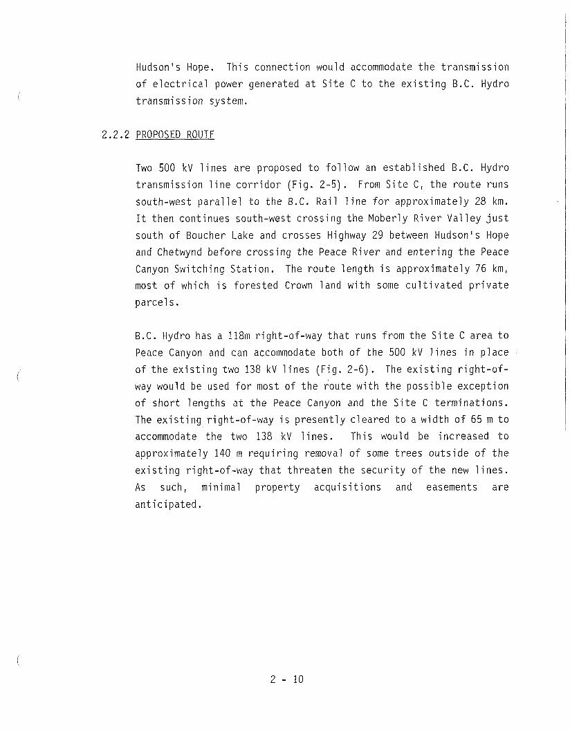
Hudson's Hope. This connection would accommodate the transmission
of electrical power generated at Site C to the existing B.C. Hydro
transmission system.
2.2.2 PROPOSED ROUTE
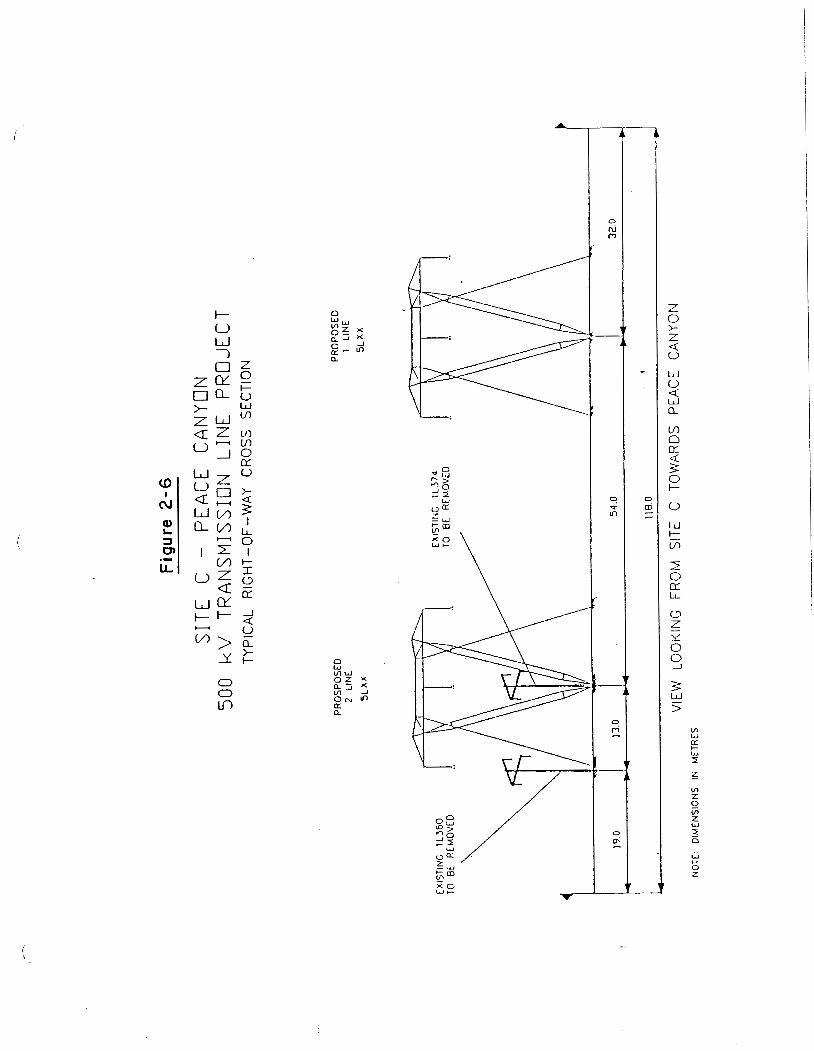
Two 500 kV 1 ines are proposed to follow an established B.C. Hydro
transmission line corridor (Fig. 2-5). From Site C, the route runs
south-west parallel to the B.C. Rail line for approximately 28 km.
It then continues south-west crossing the Moberly River Val ley just
south of Boucher Lake and crosses Highway 29 between Hudson's Hope and Chetwynd before crossing the Peace River and entering the Peace
Canyon Switching Station. The route length is approximately 76 km, most of which is forested Crown land with some cultivated private
parcels.
B.C. Hydro has a 118m right-of-way that runs from the Site C area to
Peace Canyon and can accommodate both of the 500 kV lines in place
of the existing two 138 kV 1 ines (Fig. 2-6). The existing right-of-
way would be used for most of the route with the possible exception of short lengths at the Peace Canyon and the Site C terminations.
The existing right-of-way is presently cleared to a width of 65 m to accommodate the two 138 kV lines. This would be increased to approximately 140 m requiring removal of some trees outside of the
existing right-of-way that threaten the security of the new lines.
As such, minimal property acquisitions and easements are
anticipated.

2.2.3 TRANSMISSION
The proposed lines would be single 500 kV AC transmission lines
physically similar to the existing 500 kV lines running south from G.M. Shrum Generating Station and Peace Canyon. The basic tower
design (Fig. 2-7) would be a single-circuit lattice steel structure
supporting three electrical phases in a horizontal (flat)
configuration. Each phase would consist of four sub-conductors
arranged in a square bundle.
The relatively flat roll ing terrain traversed by the route would
allow use, for approximately 90% of the route, of the guyed type
towers. Self-supporting structures would be used only for line
terminations, long spans, and large line deflections.
The distance between the structures would vary depending on the
terrain; however, in most cases it would be between 400 and 500 m typical of B.C. Hydro's 500 kV lines. The average structure height
would be approximately 28 m. The conductor to ground clearance
would vary but the minimum would be 11 m. B.C. Hydro designs for
transmission lines, including their ground clearances, meet or exceed Canadian Standards Association (CSA) requirements.
2.2.4 CLEARING, CONSTRUCTION AND RIGHT-OF-WAY ACCESS
There is existing road access along portions of the route as a
result of the construction and maintenance of the two existing 138
kV lines. Some additional access would be required from the existing roads to new individual structure and work sites. Due to
normally wet soil conditions, some winter construction techniques
for winter roads and clearing were utilized for the installations of
sections of these 138 kV lines. It is, therefore, anticipated that
due to both technical and environmental factors, similar line
clearing and construction and road construction techniques would be
necessary for the two proposed 500 kV lines.

Figure 2-5
PROPOSED ROUTE FOR 500kV TRANSMISSION LINE- SITE C/PEACE CANYON

2.2.5 ANCILLARY FACILITIES
Line terminations and associated switching facilities would be
installed at both Site C and Peace Canyon. This equipment could be accommodated within the existing station boundaries at Peace Canyon
and within the development area at Site C.
SECTION 3.0 - PROJECT RATIONALE
In its 1990 Electricity Plan, B.C. Hydro established the following
resource development priority , based on cri teri a such as cost-
effectiveness, avai labi 1 ity, pub1 ic acceptability, socio-economic and environmental impacts, uncertainty and transmission impacts;
1. Power Smart -- increased efficiency of electricity end-use 2. Coordination and Major Purchases
3. Resource Smart - - increased efficiency of B.C. Hydro's existing facilities
4. Private Sector Generation, Self-generation and Load Displacement
5. New hydroelectric generation in developed river basins
6. New hydroelectric generation in undeveloped river basins
The current outlook for the quantity and price of resources available in
categories 1 to 4 i.s such that these resources appear to be sufficient to meet forecast electricity demands until almost the turn of the century,
when the Canadian Entitlement of the Columbia River Treaty Downstream
Benefits begins reverting to British Columbia. Under current demand
projections and on the assumption that these resources (plus the return of the Canadian Entitlement of the Col umbi a River Treaty Downstream Benefits)
will be available in sufficient quantity, it appears that no major new
hydroelectric generation faci 1 i ties requiring construct ion of dams, either in developed or undeveloped basins, would be required to be in-service
until early in the next century.
Because of the uncertainties involved in forecasting future demand for
electricity and in predicting the degree of success of the various initiatives in categories 1 to 4, preliminary studies were carried out for
a number of potential contingency options, including the Peace Site C
Project. These studies are currently being finalized and documented in a
manner which will maintain the project as a viable option for future
supply and will facilitate reactivation of the project when required.

B . C . Hydro's resource development planning includes a r i sk management
s t rategy to protect against the r isks of over-supply and under-supply in
the event of s ignif icant demandlsupply imbalances during the forecast
period. Over-supply risks occur when projects are bu i l t too ear ly ,
potent ial ly causing energy surpluses. Under-supply r isks occur when
projects are not bui l t in time and higher cost options must be u t i l ized t o
meet demands.
The S i t e 'C Project plays a vi ta l role in B . C . Hydro's r isk management
s t rategy for responding to higher than expected growth in e l ec t r i ca l
demand. By having brought the S i t e C studies to an advanced stage of
licence application readiness, B . C . Hydro's a b i l i t y t o react ivate the
project quickly, i f required, i s enhanced.
I n the event tha t a s ignif icant long-term trend indicating a future under-
supply s i tuat ion were t o emerge, measures involving substantial
commitments such as advancement of new generation f a c i l i t i e s , would be
required. For example, some of the higher than expected load growth
scenarios suggest tha t a major project or additional IPPs could be
required in the early 2000's. Alternatively, the unavai labi 1 i ty of other
resources, such as the Canadian Entitlement of the Columbia River Treaty
Downstream Benefits, could resul t in a s imilar requirement in the ear ly
2000 ' s .
The S i t e C Project w o u l d n o t be sui table for meeting short-term under-
supply s i tua t ions , in view of the s i ze of the project and the re la t ive ly
lengthy lead time required t o bring i t into service. Short-term
variat ions, which may balance out over the longer term, can be addressed
by measures such as appropriate reservoir management ( e .g . , del i berate
f i 1 1 ing or draf t ing of reservoi rs ) , variations in non-firm energy
purchases, adjustment of in te r rupt ib le e l e c t r i c i t y exports, and
adjustments of existing thermal plant use.

SECTION 4.0 - P U B L I C CONSULTATION PROGRAM
INTRODUCTION
4.1.1 History and Update of Public Consultation Proaram
The public information and consultation program for the S i t e C
project began in 1975 with p u b 1 i c discussion in i t i a t ed by B . C . Hydro
about the al ternat ives (Si tes C and E ) fo r developing the Peace
River between the Peace Canyon development and the Alberta border.
Between 1975 and 1977 several infor~nation bul le t ins were published
and meetings were held with the Regional Di s t r i c t , property owners,
in te res t groups, Indian Bands and the public.
Detailed studies on S i t e C were distributed in 1979 throughout the
Peace River area and t o Government, public in t e res t groups and
l ib ra r i e s throughout the province. B . C . Hydro's information program
was focused in the region with the opening of a S i t e C Infor~nation
Centre in Fort S t . John in 1980, followed by open house meetings and
the dissemination of information through displays, f i lms, f ac t
sheets and summary documents.
Upon submission of the EPC application in September 1980, B . C . Hydro
ha1 ted active consul ta t ion except for providing information as
requested, since i t did not wish t o be perceived as lobbying the
public or BCUC.
Since the 1983 decision by B C U C , no fur ther action was undertaken by
B . C . Hydro until 1989. Once the new S i t e C project mandate was
in i t i a t ed in May 1989, B . C . Hydro commenced preparations fo r a
possible new application fo r conditional approval of an EPC as a
contingency measure, and began a new public consultation program.
I n t h i s program, numerous project fac t sheets , project newsletters
and reports were dis t r ibuted in the study area and throughout the
province. Letters were sent to 123 people in response to requests
for information, or comments about, the project.
Meetings were held with special interest groups and the public
during 1989. These included:
- over 30 special interest group meetings;
- four pub1 ic information meetings in communities in the region; - four open houses in communities in the region.
The consultation process involved identification of issues and
concerns related to Site C, a review by the public of the degree to
which the issues and concerns were properly stated and described,
and inclusion of these issues and concerns in a new round of
environmental studies commencing i n mid 1990.
More detail on this program is provided in the "Peace River Site C
Public Consultation Program, Final Report" published as a separate
document.
Positions with regard to the project were provided to B.C. Hydro in a "Position Paper of the District of Hudson's Hope" and by letter
dated May 3, 1990, with attachment, from the Peace River Regional
District.
4.1.2 Studv Area and Participants
The study area for consultation on the Site C project was structured
to incorporate both local/regional concerns and province-wide
concerns. The regional study area included a1 l interest groups, the publ ic, and communities potentially affected by, or with an interest
in, the proposed Site C dam. Specific communities in the region
i ncl uded : - Fort St. John
- Taylor
- Dawson Creek

- Pouce Coupe - Hudson's Hope
- Chetwynd
In all, over 35 interest groups were identified ranging from
environmental groups (e.g. The Peace Valley Environmental
Association), to business interests (e.g., Chambers of Commerce and
labour organizations). A full list of interest groups is provided in the "Peace River Site C Public Consultation Program, Final Report".
The focus of the current program was on regional stakeholders (communities, interest groups, native groups and the pub1 ic) . Local governments were active in the consultation program. These included
one regional district, six incorporated municipal i ties, and various
'Indian bands within the Treaty 8 Tribal Association and the Peace
Tribal A1 1 iance. Contacts were a1 so establ i shed with provinci a1
MLAs, federal MP's, school boards, hospital boards, the R.C.M.P.,
major industries, citizen's committees, wildlife associations,
several other provinci a1 and 1 ocal interest groups, local newspapers, radio stations and interested individuals.
4.2 METHODOLOGY
The public consultation program has been conducted consistent with
the requirements of the "Utilities Commission Act" (1980), as
out1 ined in the provincial government's "Guide to the Energy Project Review Process" (1982). The expectations of the federal government
agencies with an interest in the project were also addressed.
4.2.1 Internal Organization
B.C. Hydro's Public Information and Consultation Program is the
responsibility of its External Relations Department (Government and
Public Affairs Division). The 1989/1990 Site C Public Consultation
Program was'designed and conducted by a consultant, the DPA Group
Inc., commissioned by B.C. Hydro, External Relations department,
under the direction of the Site C project manager. Interaction with
the consultant was coordinated by the External Relations coordinator
and included a team drawn from the Site C project team, B.C. Hydro's
Envi ronmental Resources department, and other B. C. Hydro
representatives as required. The consultant assumed primary responsibility for the consultation program and was assisted by various members of the project team and other B.C. Hydro staff.
4.2.2 Operational Principles for Public Consultation
The approach adopted in the current program was designed to be a constructive, open and interactive planning process providing local
and provincial interest groups and individuals the opportunity to
participate.
Operating principles adopted by the publ ic consultation team and the
B.C. Hydro participants in the program, and the results achieved,
include:
- commitment to meaningful public involvement where the public
feels some ownership over the process; characterized by an
open exchange of information; - recognition that public involvement requires provision of
information, however incomplete, to participants; even when final answers were not known, it was better to give the publ ic
draft and incomplete information to demonstrate commitment to
an open process;
recognition of the importance of publ ic input in the design of the public involvement program itself; local representatives
were requested to help design the public involvement program; - sensitivity to the public consultation process and the role of
the consultant as an independent facilitator; the consultant's
role was clearly established as a faci 1 itator, working with the public to help identify and express issues, concerns and

suggestions; and working with B.C. Hydro to provide responses to these in a way which was easily understood by the public.
4.2.3 Consultation Proaram 0b.iectives
The overall goal and objectives established for the public
involvement program are:
Goal :
- To identify issues and concerns about the Site C project, and
to assist B.C. Hydro in finding ways to resolve these concerns.
Guiding Principle:
- To identify and respond to community concerns in a pro-active
and open manner.
Specific Objectives
- To foster an understanding of the project, the project
planning process and the potential implications of the
project; - To provide ongoing opportunities for residents and B.C. Hydro
to exchange information and views; - To achieve some measure of public consensus on the issues and
on how best to address them; - To provide useful input to B.C. Hydro regarding appropriate
mitigation, compensation and enhancement strategies; - To demonstrate B.C. Hydro's commitment to responding to
community concerns in an open, honest and straight-forward
manner.

The public was fully informed of these objectives through meetings
with interest groups, public meetings and open houses, and
news1 etters .
4.3 CONSULTATION PROGRAM DESIGN
The basic design for the consultation program involved several
activities as follows:
- identify the study area and its various com~nunities, political
structures, and public interests; - contact the various community interests and cooperatively
develop an information and consultation plan; - inform the pub1 ic of the project's requirements through
published information, meetings, displays, telephone
information "hot-line", and other means; - develop dialogue through various forums, e.g., written or
telephone response to publications, informal meetings, open
houses, drop-in centres, as appropriate; - facilitate interactions of the communities and other
stakeholders with B.C. Hydro; - identify, define, and document the concerns raised by the
publ ic; - respond to public concerns and resolve problems where
possible; - identify and incorporate potential mitigation strategies,
compensation, and other options in the project's design to address issues raised by stakeholders;
- prepare a summary report on public consultation.
Within this general framework, the consultation program included two
general components:
- formation of a local public consultation committee;
- the consultation process itself.

4.3.1 The Local Site C Public Consultation Committee
A Consultation Committee was formed in 1989 to provide advice to the
consultant regarding the design and execution of the Public Consultation Program. Its membership included representatives from
the following communities/organizations:
- Chetwynd
- Dawson Creek
- Fort St. John
- Hudson's Hope
- Peace Liard Wildlife Association
- Peace River Regional District - Peace Valley Environmental Association - Taylor
- Treaty 8 Tri bal Associ at i on
The objectives for providing advice to the consultation team, agreed
to by the Committee, were to:
- work with the consultant to devise a consultation process
which would maximize the amount of meaningful and useful input
from the community; - communicate with the community and the consultant to ensure
that a1 1 members of the community had access to the pub1 ic consultation process;
- attend the public meetings and open houses in individual
members' respective communities; - work with the consultants to ensure that a1 1 issues, concerns,
and resolutions were fully and accurately documented and
communicated in such a way that the community understood; - provide feedback to the consultant on the effectiveness of the
Public Consultation and to provide recommendations for
improvements to the process on an ongoing basis.

The Committee met with the consultant 4 times between September 1989
and January 1990. Details of the Committee's input i s provided in
the Public Consultation Report accompanying t h i s application. The
Committee was instrumental in helping t o ref ine the design fo r the
consultation program. Suggestions which they made ranging from
venue selection for open houses t o advertising were incorporated
,into the program.
4 .3 .2 Public Consultation Process
Following review of the proposed consultation process with the
S i t e C Consultation Committee, adjustments were made to r e f l ec t
t h e i r suggestions on how t o maximize public access t o , and
part ic ipat ion i n , the process.
I n summary terms, the general s t ructure of the process i s as
follows:
- information meetings to introduce the S i t e C Project t o the
p u b l i c , describe the proposed consul ta t ion program, and begin
t o identify t h e i r comments;
- meetings with in te res t groups to assemble focused information
on t h e i r concerns; - a comprehensive statement of suggestions, comments, issues and
concerns reviewed with the public t o ensure tha t a l l areas are
covered; - preparation (by B . C . Hydro) of responses; (not completed)
- review of responses by the pub1 i c (not conducted).
The consultation program was generally accepted by local groups and
members of the public. The consultation team was able t o develop a
comprehensive l i s t of the issues and concerns to which B . C . Hydro
has made a commitment t o respond.

B.C. Hydro is designing a program of ongoing communication within the region which, primarily through its local offices, will continue to interact with the community groups.
4.4 PUBLIC CONCERNS
4.4.1 Pro.iect Re1 ated Concerns
4.4.2 General Public Concerns
These are presented in the Peace River Site C Public Consultation
Program, Final Report.
4.5 PUBLIC INPUT TO ENVIRONMENTAL STUDIES
The next step in the process was for B.C. Hydro to prepare a response document which would then be reviewed by the public. The
issues and concerns documented to date were used in the preparation
of Terms of Reference for the environmental studies. B.C. Hydro
intended to use these study results to prepare the response
document. This document would then be presented to the public for
their review and input.
The 1990 public consultation program associated with the environmental studies consisted of the following main activities:
- ongoing communication with the public - review of Terms of Reference
- communication between the environmental consultants and the
pub1 ic; - ongoing meetings with the consultation committee
4.5.1 Communication with the Public
To inform the public of the environmental studies, a newsletter was
prepared by B.C. Hydro and distributed in September 1990 to all

households in the region by mail drop. The newsletter provided a
s t a tus report on S i t e C , notice of Hydro's intention t o undertake
the environmental s tudies , and brief summaries of each study.
4.5.2 Review of Terms of Reference
The consultation committee was asked t o advise on the best method t o
obtain public review of the Terms of Reference, and i t recommended
tha t the Terms of Reference be mailed t o the in t e res t groups fo r
t h e i r input. A l e t t e r was sent inviting in teres t groups t o review
the Terms of Reference and provide comments t o the public
consul ta t ion consultant. Fol low-up phone cal l s were made t o ensure
tha t the in te res t groups understood the material and the process fo r
review. Written comments were received from 5 of the 45 in t e res t
groups and local governments which were invited to comment.
The in teres t groups which received an invi tat ion t o comment on the
Terms of Reference are l i s t ed in Table 4-1.
Comments recei ved on the Terms of Reference suggested additional
emphasis on the following study discipl ines:
- Socio-economic Studies
- Heritage Resources
- Climate
- Downstream Studies
Details on comments submitted by in teres t groups are presented in
the "Peace River S i t e C Pub1 i c Consul ta t ion Program, Final Report."
4.5.3 Communication with the Environmental Consultants
To ensure that the conduct of the environmental studies was
consistent with the principles and objectives of the public
consultation program, the public consultation consultant conducted
a workshop with a1 1 the environmental consultants. The objective of

the workshop was to inform all consultants of the results of the
public consultation process, highlighting the issues and concerns obtained to date, discussing areas of overlap between studies, and
ways to reduce the dernands on the public (i.e. combining meetings). DPA sent a bi-monthly report to all consultants informing them of all study activities, and helped to coordinate meetings held in the
region.

SECTION 5.0 - ENGINEERING STUDIES
INTRODUCTION
By 1982, when previous engineering studies were suspended, extensive site explorations had been carried out and the designs and planning for Site C had advanced to the stage where drafts of technical specifications and tender drawings had been prepared for:
- the majority of the infrastructure works including the left
and right bank access roads the main construction camp and a
bridge across the Peace River;
- the turbines;
- a single civil package (PC-1) including the entire diversion
works, the first stage left bank stabilization works, the first and second stage cofferdams and the dam embankment; and
- supply of the gates, gate hoists and stoplogs for the
diversion tunnel portal structures including the associated
embedded parts.
In 1988, B.C. Hydro load forecasts indicated that it would be prudent to resume engineering activities on Peace Site C as part of a contingency plan to reduce the project lead time. At the same time it was decided to transfer engineering design to the private
sector and, following a thorough competitive selection process,
Klohn-Crippen Consultants Ltd. were hired to carry out the
engineering. Extensive review of the existing designs was carried out and subsequently Kl ohn-Cri ppen assumed professional
responsibility for the design of Site C, with some minor modifications, and advanced engineering and technical specifications for the critical early contracts.

5.2 PROCUREMENT
Consistent with B . C . Hydro's objective of maximizing potential
benefits t o the economic development of BC, a review of contract
packaging was undertaken and i s described in Report No. ~ ~ 0 3 '
"Preparatory Engineering Activi t ies for the S i t e C and Keenleyside
Projects - Contract Packaging", which i s included with t h i s
submission.
The general conclusion from t h i s review was t h a t , while s igni f icant
benefits should accrue t o the Province from small contracts , these
should be assessed against the potential increased costs and r i sks
t o a project before determining the specific contract packaging.
The review of S i t e C contract packaging resulted in subdivision of
many of the contracts or iginal ly envisaged in the early 1980's. A
l i s t of the currently proposed contracts i s contained in Table 5-1.
The following tender documents fo r the early c r i t i c a l contracts have
now been prepared t o an advanced draf t stage (shelf ready), whereby
they could be quickly f inal ized and issued.
Clearing - Left Bank
Campsite - Grading and Access Road
Diversion Tunnels and Tunnel Cofferdams
Clearing - Right Bank
Right Bank Access Roads
Turbines and Governors
Campsite Services
Peace River Bridge
Prefabricated Camp Buildings
Diversion Gate Embedded Parts
Diversion Outlet Stoplog Embedded Parts
5.3 DESIGN STATUS
5.3.1 Introduction
Klohn-Crippen commenced engineering activities on Site C at the end of 1988 and, with the exception of completion of a study on the Probable Maximum Flood (PMF), ceased design activities by June 1990 at B.C. Hydro's direction.
Report No. ~ ~ 7 3 ' "Peace River Site C, Shelf Ready Design Status
Report", included with this submission, has been prepared to document the status of engineering activities as of November 1990
and to provide information required to permit an efficient start up of engineering work in the future. A detailed schedule for the
recommencement of design activities is included in the report.
Engineering activities were coordinated under B.C. Hydro's project management requirements which are described in Section 5.4, adopting the Work Breakdown Structure as the project management framework.
5.3.2 Accomplishments
During the course of the engineering activities Kl ohn-Cri ppen issued 53 reports, their subconsultants 11 reports and B.C. Hydro two
related engineering reports. These provide a comprehensive record of the status of engineering on the project and are listed in Table 5-2.
The primary objectives of Kl ohn-Cri ppen ' s work program were met. Professional responsibility for design of Site C was transferred to Klohn-Crippen, they became fami 1 iar with B.C. Hydro's design
practices and engineering and technical specifications for the early contracts were completed.

The following are some of the significant accomplishments achieved as well as the engineering and technical specifications for the early contracts listed in Section 5 . 2 .
- A field investigations program was carried out in 1989 to
provide additional information on foundation conditions and
construction materials. One result was a reduction in required overburden excavation on the north bank from the
early 1980's estimate of 1 5 . 2 million m3 to 8.6 million m3.
- Due to changed operating conditions at G.M. Shrum Generation
Station upstream, the diversion tunnels diameters have been
reduced from 11.2 m to 9.8 m.
- It was decided to locate a construction camp on each bank of
the river, as compared with the original concept of one camp
on the north bank.
- Joint studies (Kl ohn-Crippen/B.C. Hydro) on the Probable
Maximum Flood (PMF) for the project were undertaken. These
studies have extended over a lengthy period due to involvement
of key personnel in other activities. This basic design parameter is expected to be satisfactorily defined by mid-
1991.
- New computerized digitized mapping was prepared for the
damsite and reservoir area.
- A review of the stability, of the reservoir shoreline was
initiated. Existing instrumentation was rehabilitated and some new instrumentation was instal led. A monitoring program was implemented and is ongoing.
5.4 PROJECT MANAGEMENT SYSTEM
5.4.1 Introduction
In response to some concerns expressed at the BCUC hearings on
B.C. Hydro's 1980 application for an Energy Project Certificate for the Site C Project, B.C. Hydro advised that it was in the process of
modifying its traditional approach to management for 1 arge hydroelectric projects from a functional management system to a
project management system. B.C. Hydro's commitment was emphasized in 1985 with the formation of a Project Management Division. Formal
pol icies and procedures for project management together with
operational requirements were compiled in manuals issued in 1989.
In early 1989 a further initiative was introduced to develop a Work
Breakdown Structure (WBS) as a fundamental management tool for the Site C Project in accordance with current project management
philosophy.
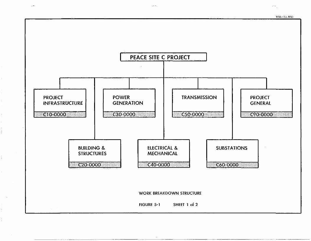
5.4.2 Work Breakdown Structure
The WBS is a hierarchal information classification system, typical ly
described or displayed in the form of a tree diagram (Figure 5-1).
Each box in the tree is described as an element of the WBS and the
elements portraying the final breakdown are unique, each with a
precise scope and a distinct set of specified results to be
delivered.
The WBS is, foremost, a tool for subdividing the scope of a project
into manageable portions. The topmost element in the WBS tree
contains the entire project scope. In subsequent development of the
detailed description, the total scope is systematically subdivided
into facilities, then into features, sub-features and finally to
elements classified as work packages. Work packages are defined
such that a single party is responsible for achieving the specified
results or deliverables and each work package can stand alone.
5 - 5
I PEACE SITE C PROJECT I
C
PROJECT POWER TRANSMISSION PROJECT INFRASTRUCTURE GENERATION GENERAL
. . . . . . . . . . . . . . . . . . . . . . . . ...: . ..:.,...:: . :::::. . . . :.:::::::<c . . . 1 :o;i@'Joo ::;i:il::i::ii:l; j;i;;?::;i;I:i$;:j.l,: . . . . . . . .
ELECTRICAL & SUBSTATIONS STRUCTURES MECHANICAL

BUILDINGS & STRUCTURES C20-0000
DIVERSION
C2A.0000
WATER RETENTION APPROACH 8 TAILRACE SPILLWAY
STRUCTURES CHANNELS
C2B-0000 C2C-0000 C2D-0000
POWER INTAKES
8 PENSTOCKS
C2E-0000
SURFACE
POWERHOUSE
C2F-0000
SWITCHGEAR GENERAL
BUILDING
C2G-0000 C2Z-0000
DIVERSION
GATES 8 GUIDES
C2A-A000
DESIGN 8 DWGS
CZA-AOID
.- SUPPLIED PRIM. EMBED. 8
GUIDES - CLOSURE GATES
C2A-A015
SUPPLIED PRIM. EMBED. 8.
GUIDES - REGUL. GATES
C2A-A02S
SUPPLIED PRIM. EMBED. 8
GUIDES - STOPLOGS
C2A-A035
.- SUPPLIED CLOSURE GATES
C2A-A04S
SUPPLIED REGULATING - GATES
C2A-A05S
SUPPLIED STOPLOGS - C2A-A065
.- SUPPLIED CLOSURE GATE HOISTS
C2A-A07S
- SUPPLIED REGULATING
GATE HOISTS
C2A-A085
- INSTALLED CLOSURE I. .. GATES PRIM. EMBEDMENTS
CZA-A01 C
- INSTALLED CLOSURE
GATES GUIDES
C2A-A02C
- INSTALLED CLOSURE GATES
C2A-A03C
- INSTALLED REGULATING
GATES PRIM. EMBEDMENTS
C2A-AO4C
- INSTALLED REGULATING
GATE GUIDES
C2A-A05C
- INSTALLED REGULATING
GATES
C2A-AO6C
- INSTALLED STOPLOG
PRIM. EMBEDMENTS
C2A-A07C
- INSTALLED STOPLOG
GUIDES
C2A-AOBC
- INSTALLED STOPLOGS
C2A-A09C
RESIDENT ENGINEERING
DIVERSION GATES 8 GUIDES
CZA-A01 R
DIVERSION
TUNNELS
C2A-BOO0
I
-. DESIGN 8 DRAWINGS
DIVERSION TUNNELS
CZA-001 D
UNDERGROUND STRUCT'S - DIVERSION TUNNELS
C2A-B01C
INLET STRUCTURES
DIVERSION TUNNELS
C2A-B02C
- OUTLET STRUCTURES
DIVERSION TUNNELS
C2A-B03C
- RESIDENT ENGINEERING
DIVERSION TUNNELS
C2A-801 R
LOG BOOM
DIVERSION
C2A-COO0
.- DESIGN 8 DRAWINGS DIVERSION LOG BOOM
C2A-CO1 D
CONSTRUCTED DIVERSION
LOG BOOM
CZA-COl C
DEBRIS DISPOSAL SYSTEM I- C2A-C02C
1- RESIDENT ENGINEERING
DIVERSION LOG BOOM
WORK BREAKDOWN STRUCTURE
FIGURE 5-1 SHEET 2 of 2
CONCRETE PLUGS
DIVERSION
C2A-DO00
t DESIGN 8 DRAWINGS
DIVERSION TUNNEL
CONCRETE PLUGS
C2A-DO1 D
- CONCRETE PLUGS
DIVERSION TUNNEI
CZA-DO1 C
L RESIDENT ENGINEERING
DIVERSION TUNNEL
CONCRETE PLUGS
C2A-DO1 R
DIVERSION
GENERAL
~ Z ~ ~ E ~ s l o N ARRANGEMENT
DRAWINGS 8 REPORTS DBM
C2A-ZO 1 D

Numbers of work packages are combined to provide the supply, construct and service contracts which are finally awarded to del iver
the entire project.
The breakdown is also used to illustrate increasing detail for project estimating and cost reporting throughout the project
1 ifecycle. Costs appl icable to individual elements can be estimated with increasing accuracy as the design is developed. The WBS facilitates the roll up to individual structures for capitalization
or taxation purposes.
Each work package is assigned a start and completion date determined
from the project schedule allowing the reporting and summarizing of schedules similar to costs and scope.
The WBS is used as the central management tool for achieving the
assigned project objectives for scope, cost and time. The principal
applications are:
Linking performance standards. Scope and design management.
Cost estimating and reporting.
Activity scheduling.
Assigning scope to individual contracts.
A unique code consisting of letters and numbers is assigned to each
element of the WBS. This code becomes the predominant information
discipline for the Project. The WBS code must be used for, or
included as an identifier in:
Scope Statements
Drawings
Project Budget
Task Assignment Documents
Files Reports and Other Deliverables

Early in the development of the WBS, Walter A. Wawruck, Project Management Services, a Consultant on Project Management was hi red to assist with the development of the tree and to be the Principal
Author of the Guidelines for the WBS Manual.
Within the Manual there are two types of guidelines. General guidelines covering policy, management policies and description of processes. Secondly specific guidelines contain detailed instructions for carrying out a specific operation or step in a large operation. Typically they deal with the preparation of a form
or document.
WBS Di rectorv
The scope management process includes the development of a WBS directory. The WBS Directory is the project baseline document.
The basic content of the directory is the documentation of
B.C. Hydro and other stakeholder requirements for the project and the description of how these requirements will be achieved.
Scope statements have been and are currently being prepared.to reflect the current status of the design of the Project.
To aid the user in a search for items whose WBS code identifier she or he does not know, the Directory contains 1 istings of WBS element code numbers and titles. These listings follow the hierarchal code
sequence, and include a listing segregated by work package type.

T OF FORESEFN CONTRACTS
Page 1 of 9
Contract Number
PC-lA*
PC-lB*
PC-lC*
--
PC-IF*
PC-IG*
PC-lOA*
--
PC-ll*
PC-13*
- -
- -
--
--
--
--
- -
Description
Clearing - Left Bank
Campsite - Grading and Access Road 1
Diversion Tunnels and Tunnel Cofferdams
Main Earthfill Dam with Cofferdams and Excavations on Left Bank
Clearing - Right Bank
Right Bank Access Roads
Campsite Services 1,3
Asphalt Paving - Campsite and Approach ~oadl"
Peace River Bridge
Prefabricated Camp Buildings 1
Campsite Construction - B.C. Hydro Offices and Buildings 1
Camp Catering and Housekeeping 1,2
Petroleum Products Storage Depot
Campsite services233
Prefabricated Camp Buildings 2
Campsite Construction - B.C. Hydro Offices and Buildings 2
Bulk Excavation on Right Bank with Cofferdam for Outlet Channel
E&M Input
X
X
X
Supply
X
X
X
Construction
X
X
X
X
X
X
X
X
X
X
X
X
X
Possible B.C. Firm
X
X
?
X
X
X
X
X
X
X
X
X
X
X

(a) a m (continued) Page 2 of 9
Denotes advanced draft contracts as of June 1990. It is considered that engineering has advanced sufficiently on these packages that tenders could be issued within about thirty days of approval to proceed, provided that the relevant outstanding issues listed in Section 3.0 and Section 5.0 could be resolved prior to tender issue.
Contract Number
--
- -
- -
- -
- -
- -
- -
--
Denotes Left Bank Campsite Denotes Right Bank Campsite "Campsite Services" include supplying and installing underground services (water, sewer, gas), water storage tanks, water pumping system, sewage treatment plant, buildings to house such services and electrical power and lighting distribution systems. "Powerplant Completion" would be a general contract including civil, mechanical and electrical works. Civil works would include the latter stages of secondary concrete and miscellaneous structural, building and architectural finishes in the powerhouse and elsewhere for the powerplant. See separate lists for details of mechanical and electrical works.
Description
Powerplant and Spillway - Main Contract
Penstocks and Couplings (Design, Supply and Install)
Powerhouse Superstructure
Powerplant Completion 4
Spillway Bridge
Switchgear Building
Reservoir Clearing
Environmental Reinstatement
E&M Input
X
X
X
X
X
Supply Construction
X
X
X
X
X
X
X
X
Possible B.C. Firm
X
X
X
X
X
X

Page 3 of 9
Contract Number
PC-.?**
Description
Turbines and Governors (Design, Supply and Install)
SUPPLY OF DIVERSION TUNNEL EQUIPMENT
Electrical Input
X
PC-30A*
--
--
PC-30D*
- -
Prescriptive Specifications
Diversion Gate Embedded Parts
Closure and Regulating Gates
Regulating Gate Hoisting Equipment
Diversion Outlet Stoplog Embedded Parts
Outlet Stoplogs and Lifting Beam
SUPPLY OF DRAFT TUBE GATES
Performance Specifications
X
X
--
-- --
Supply
X
X
X
X
X
Guides and Embedded Parts for Draft Tube Gates
Draft Tube Gates
Draft Tube Gate Crane (Design, Supply & Supervise Instn.)
SUPPLY OF POWER INTAKE EQUIPMENT
Supply & Install
X
X
X
X
X
X
X
--
--
--
--
X
X
X
X
Possible B.C. Firms
X
X
Intake Gate Guides and Embedded Parts
Intake Gates
Intake Gate Hoists
Bulkhead Gate Guides and Embedded Parts
Installation Supervision
X
X
X
X
X
X
X
X
X
X
X
X
X
X
X
X
X
X
X
X

( b ) 1 Cantl-acts (continued) Page 1 of 9
Supply & Install
Electrical Input
X
- Contract Number
- -
- -
- -
SUPPLY OF SPILLWAY EQUIPMENT
Possible B.C. Firms
X
X
X
Supply
X
X
X
Prescriptive Specifications
X
X
Description
Bulkhead Gates
Intake Gantry Crane (Design, Supply & Supervise Instn.)
Intake Trash Racks
Installation Supervision
X
Performance Specifications
X
X
X
X
X
X
X
X
X
X
X
- -
--
- -
- -
--
POWERPLANT EQUIPMENT
X
X
X
X
X
Seal Plates and Embedded Parts for Spillway Gates
Spillway Gates with Post- tensioning Equipment
Spillway Gate Hoists
Guides and Embedded Parts for Spi 1 lway Stoplogs
Spillway Stoplogs and Lifting Beam
-
- -
--
- -
- -
- -
- - -
X
X
X
X
Powerhouse Cranes (Design, Supply & Supervise Instn.)
Equalizer Beam (Supply)
Pumps (Design and Supply)
Air Compressors (Design and Supply)
Fire Protection Systems and Equipment (Design & Supply)
Tanks and Receivers (Design & Supply)
X
X
X
-
X
X
X
X
X
X
P S
ps --
PC
PC
PC
PC
--
>I
a 0
a
I
pue fs$kun fiukuo~$kpuo3 dke -
f iuk~snp JLP -
$uaudknba 6ullpueq dke -
(pappaqua -uou) s a h l e ~ pue 6ukdkd -
:JO uok$elle$suk pue K ~ d d n s
:$uaudbnba $ u e l d ~ a ~ o d pak~ddns aAoqe 40 uoL$el le$suI
:9NIafll3NI NOI13ldW03 lNVld83MOd
--
--
--
- -
- -
- -
JaqmnN $3ed$uo3
$uaud~nb3 uok$eJauag JaMod K ~ e k ~ ~ x n w
( L Lelsu1 pue K ~ d d n s 'u6ksaa) s ~ o ~ e h a l 3
(K~ddns pue ufibsaa) $uaud!nbg f i u ~ ~ p u e ~ ~ekda$ew
(K1ddns pue u 6 ~ s a a ) ~uaudbnb3 doqsydo~
(K~ddns 9 u f i~saa ) $mud ~ n b j $ u a u $ e a ~ l a b e ~ a s
(K~ddns ufiksaa) luaudknb3 $ u a u $ e a ~ l Ja$eM
U O L $ ~ ~ J ~ S J ~ uo~skhdadns
u o k $ e ~ l e $ s u ~
X
X
X
sudkj ' 3 -9 J ~ ~ C S S O ~
i
X
~ l e $ s u ~ 9 K ~ d d n s
X
S U O L $ Q ~ L J L ~ ~ ~ S aA~$db.i3sa~d
X
X
X
X
X
m u 1 ~ ~ 3 ~ ~ 7 3 a l g
i
3d
3d
3d
3d
K ~ d d n s
X
X
X
X
X
suok$e3~4b3ads a 3 u e u d o ~ ~ a d

('4 cal C o i u m (contil~ued') Page 6 of 9
LEGEND
Contract Number
* Denotes advanced draft contracts as of June 1990. It is considered that engineering has advanced sufficiently on these packages that tenders could be issued within about thirty days of approval to proceed, provided that the relevant outstanding issues listed in Section 3.0 and Section 5.0 could be resolved prior to tender issue. ** It is considered that tenders for this contract could be issued within six months of a decision to proceed.
I - Installation Only ps - To be installed under the Powerhouse Superstructure Contract pc - To be installed under the Powerplant Completion Contract D - Conceptual design and selection of key equipment by Klohn-Crippen K - Selection only of key equipment by Klohn-Crippen
Description
other general finishing work to complete auxiliary mechanical systems.
Electrical Input
Prescriptive Specifications
Performance Specifications
Supply Supply & Install
X
Possible B.C. Firms
Installation Supervision
Page 7 of 9
Supply
X
X
X
X
X
X
X
X
X
X
B
X
B
X
B
Installation Supervision
X
X
X
X
X
X
X
X
Supply & Install
X
X
Performance Specifications
X
X
X
X
X
X
X
X
X
X
X
X
X
X
X
X
Possible B.C. Firms
X
X
X
Prescriptive Specifications
X
Input from Other Disc.
M& E
M&E
T&S
--
Contract Number
PC-3**
- -
--
--
- -
--
--
--
--
--
- -
--
--
- -
--
--
--
Description
Generators (Design, Supply and Install)
Generator Transformers 13.8 to 138 kV
System Transformers 512.5/138 - 12.6 kV
Excitation Systems
Turbine Governor Actuators
Generator Terminal Equipment
100 kV C.G.I. Switchgear
138 kV C.G.I. Switchgear
12.6 kV Metalclad Switchgear
12.6 kV-600 V Main Station Service Switchboard
AD/DC Distribution Switchboards
100 kV Surge Arresters
100 kV and 138 kV Line Termination Towers (Supply)
100 kV Capaciter Voltage Transformers -- 12.6-12.6 kV LTC Transformers
138 kV Cable Circuits (Design, Supply and Install
138 kV Surge Arresters

(4 Electl-lcal ((coi~tinued) Page 8 of 9
Supply
B
X
X
X
X
X
X
X
X
X
X
H
Performance Specifications
X
X
X
X
Prescriptive Specifications
X
X
X
X
X
X
X
Input from Other Disc.
M& E
M& E
Contract Number
- -
- -
- -
--
--
- -
--
--
--
--
- -
- -
Installation Supervision
-
Supply & Install
I
I
X
X
Description
138 kV Capacitor Voltage Transformers
Protection and Control - Printed Circuit Boards (Supply)
Protection and Control - Switchboards, Consoles and Cabinets (Supply)
Protection and Control Sub- assembly Equipment (Supply)
Fault Recorder
Monitoring Equipment
Transformer Fire Protection Controls (Supply)
Station Service Air Compressor Controls (Supply)
125 and 24 V Station Batteries
125 and 24 V Battery Chargers (Supply)
125 and 24 V DC Supply Cubicles (Supply)
Powerplant Completion including:
- installation of above supplied equipment
- grounding
- conduits & ducts
- cable trays and supports
Possible B.C. Firms
X
X
X
X
X
X
X
X

( c ) Flectlual C ~ ~ I U L L S - - - 7 (continued) Page 9 of 9
** It is considered that tenders for this contract could be issued within six months of a decision to proceed.
Contract Number
M - Mechanical Input T - Transmission Line Input B - Bulk Order by B.C. Hydro I - Installation Only
E - Electrical Input S - Structural Input H - Other Direct Supply by B.C. Hydro
Description
- lighting fixtures
- receptacles and switches
- wires and cables
- motor starters
- motor starters - heating and ventilation
- other general finishing work to complete ancillary electrical systems
Input from Other Disc.
Prescriptive Specifications
Performance Specifications
Supply
H
H
Supply & Install
X
X
I
I
X
X
Possible B.C. Firms
Installation Supervision

Page 1 of 9
TABLE 5-2
BIBLIOGRAPHY
SITE C REPORTS
ISSLJED DLJRING 1989/90/91 BY
KLOHN-CRIPPEN
Report KC01 - Review of Hydrotechnical Studies Undertaken Prior to
1989, Task CH 10, February 1990.
Report KC02 - Contract PC-1, General Review, Task CD40, June
1 989.
Report I<C03 - Contract Packaging (Site C and I<eenelyside), Task GCIO,
June 1989.
Report I<C04 - Contract PC-10: General Review and Report, Task CG70,
June 1989.
Report KC06 - Review of Cofferdam Designs, Task CD10, August 1989.
Report l<C07 - Review of Left Bank Sl'opes, Task CG10, August 1989.
Report KC08 - Proposed 1989 Exploration Program, Task CG50, April
1989.
Report KC09 - PC-I: Reference Information Review and Report on
Existing Information, Task CD50, May 1989.
Page 2 of 9
9. Re11o1-t I<C I0 - Turbine Contract Policy (Site C and I<eenleyside), Task
GC20, J~ily 1989.
10. Report I<C 1 1 - Left Bank Diversion Tunnels Portal Exciiv:ttion in
Rock, Task CG40, June 1989.
1 1 . Re1~oi.t I<C12 - Preliminary Assessment of Left Bank Slopes, Task CG30,
April IOf iO.
12. Report 1<C 13 - Review of Rock Slope Designs, Task CG40, August 1989.
13. Rcl>ort 1<C 14 - Diversion Design Floocl, Task CH40, December 1989.
14. Rel)ort I<C 15 - Rcview of the Layout of the Riglit Bank Structures, Task
CHXO, Noveml>e~- 1989.
15. Report KC16 - Review of Pore Pressure Response ancl Dissir);ltion of Weak
Seams, Task CD 10, Augi~st 1989.
10. Report KC17 - Review of Rebound in Rock, Task CG40, September 1989.
17. Report KC 18 - PC 1 1 : General Review and Relwrt, Task CB 10, Decenil>er.
1989.
18. Report KC20 - Design and Instrun~entation of Test Fill, Task CD10, July
1989.
9 Report KC21 - Review of Construction Materials Investigations, Task
CD20, July 1989.

Page 3 of 9
20. Rcpot-t I<C22 - Diversion and Low Level Outlet Studies, Task CH50,
Dcceml)cr 1980.
21. "Report KC23 - S1,illw:ry Design Floods, Task CH30, Draft report to be
l'inalizecl Mat-ch 1001.
22. Report KC24 - Preliminary Assessment of Right Bank Slopes, Appl-oach
Channel, Task CD70, June 1990.
23. Report KC25 - Review of the Electrical Equipment, Task CF40, September
24. Report KC26 - Seismicity Review Upd:ite, Task CDlO, January 1990.
25. Report KC27 - Manpower and Camp Estimate Update, Task CAIO, May
1990.
26. Report KC29 - Review of Earthfill Dam Design, Task CDlO, September
1989.
27. Report I<C31 - Mechanical Equipment Review ancl Report, Task CM40,
October 1089.
28. Report KC34 - PC-2: General Review ancl Report, Task CD80, November
1 989.
2 Report KC35 - Summary oflnformation for Advisory Board Meeting No. 6,
2 to 6 Octobel- 1989, Report on Status as at 31 August 1989, September
1989.

Page 4 O F 9
30. +Report I<C36 - Switchgear Selection, Task CFIO, Illcomplete Draft
Report, not F in~~ l i~cc l .
3 1. Report KC37 - Geotecl~liicnl Database Recommenclation Report, Task
CG20, Noveniber 1989.
32. Report I<C40 - Slope Stability Analyses of Preliminary Earthfill Dam
Sections, Task C2C-BOI Dl March 1990.
33. Report KC42 - Investigations of Temporary Riprap, Task CG.50, January
1990.
34. Report I<C43 - I089 Investigation Program Report on the Left Bank
Trough, Task CG50, March 1990.
35. Report I(C.14 - Construction Mitterials Impervions Fill, Prelinlinary Search
for Glitcial Till, Task CG50, Janitary 1990.
36. Report I<C45 - Hyclrotechnicnl ancl Meteorological Reference l~~for~na t io l? ,
Task CD50, Deceniber 1989.
37. Report KC46 - Tailwater Stuclies, Task CD71, April 1990.
38. "Report I<C47 - Hydraulic Model Studies, Instructions for Si11,mitting
Proposals ~ i n c l Conditions for Providing Consulting Services, Task CH70,
Draft Report, not Finalized.
39. Report KC49 - Diversion Design Flood, Risk Analysis Optimization, Task
CH40, November 1990.

Page 5 of 9
40. Report KC50 - Preliminary Layout of the Right Bank Structures, Task
CH70, July 1990.
41. Report l<CSI - Instr~~mentation iind Data EvaI~lation For n Proposecl Test
Enit~ankn~ent, Task C2C-BOI D, Miirch 1990.
42. Report KC52 - Report on Preparatory Engineering Activities (PEA) - 1989
(Site C ant1 I<eenelysicle), Task CPIO, J u l y 1990.
43. Report 1<C53 - Absessment of Upl~er Left Bank Overburclen Deposits, Task
C9B-BO3D, April 1990.
44. Report I<C54 - Assessment of Lower Left Bank Overb~~r-clen Deposits, Task
C9B-B03D, J u l y 1090.
45. Report KC55 - Con~parison of Cofferclam Schemes, Task C2C-ZOlD, April
1990.
4 Report I<C60 - Evaluation of Concrete Aggregates for Left Bank
Stri~ctures, Task C2Z-ZO 1 D, June 1900.
47. Report KC61 - Penstock Optimization and Turbine Characteristics, Task
C2E-Z0 1 D, J 11 ly 1990.
4 'kRel,ort I<C62 - Switchgear Building, Task C2G-AOlD, Draft of
Geoteclinical Section only, not Finalized.
40. Report l<C63 - Powerhoi~se Standby Generating Units, Task C2Z-ZOlD,
April 1990.
Page 6 of 9
Report KC64 - Diversion Tunnel Design, Task C2A-201 D, July 1990.
Report I(C69 - Construction Materials Investigations, Task C9B-BO3D, J~t ly
1990.
Report KC73 - Advance to Shelf Ready Design Status Report, Task
C9A-B02M, Volume 1 of 2, March 199 1 .
Re11o1.t KC85 - Rel>oi~ncl of Excavations in Shale, Task C2Z-ZOID,
December 1990.
".Report KC93, Local Basin Design Floods, Task C9B-A03D, D ral't
Fet~rii:~~-y 109 I.

Page 7 of 9
SITE C REPORTS
ISSUED DURING 19X9/9O
BY I<LOHN-CRIPPEN SIIBt'ONSIJLTANTS
1 . Reclamation Criteria, Sli:~le Slope Revegetation, Site C Dam Project, by
Polstcr Envi~.onmentitl Services, October 1989.
7 -. Evalulion ol' Aggreg:~te Sources l'or Supply ol 'concrete Agglxgute - Site C
Lel't Bank, Ily Lcvclton :rncl Associates Ltd., March 1990.
3. Sitc C PI-ojcct, East B L I I I ~ Alkali Aggreg:lte Reactivity of Mortar Bars Made
wit11 I h l i t n c l Aggrcgi~tc NBRI Test Method, by Levelton ancl Associates Ltcl.,
MLI 1 . ~ 1 1 1000.
4. Peace Rivcl. Site C Project, Degracliition Stuclies, by Northwest
Hydri~i~lic Consilllants L(cI., March 1990.
- 3 . Pcitce River Sitc C Project, Review of Erosion Protection Works, (Task
CZZ-ZOI D) by Pilclysh & Associittcs Consultants Ltd., May 1990.
0. Laboratory Tcht~ng Report on Shi~le Bedrock Testing for Site C, by Goldcr
Associate!, Ltd., M:ry 1000.
7. Laboi- tory Testing Rcl~ort 011 Soils ancl Concrete Aggregate Testing for
Peace River Sitc C Project, 3 Volumes, by Golcler Associates Ltd., Julie
1990.

Page 8 of 9
Cross-Sections for Site C Project, CS 1, CS2, CS3, CS4, Peace River, Data
Report by McElhanney Associates, 1989.
Site C Peace River PI-oject, Access Ro:lcl ProFile, ASCII ProCile Listings,
Eustings, Nortliings, Elcv:ttions, Description and Chainage, Data Report by
McElhanney Associates, 1989.
Site C Peace River Project, Access Road Cross Sections, ASCII Cross
Sections Listings, Chi~inages, Eastings, Northings, Elevations, Data Report
by McElhali~~ey Associates, July 1989.
Site C Peace River Project, Diversion Tunnel Outlet Portals Cross Sections
CSI A-CS I B, CS2A-CS2B, CS3A-CS3B, CS4A-CS4B, CSSA-CSSB, Data
Report by McEllianney Associates, August 1989.

I . Report H2243 -
2. Report H2299 -
Page 9 of 9
SITE C REPORTS
ISSUED DURING 1989J90
BY B.C. HYDRO
Peace River Site C Project, Reservoir Slopes, January 1990.
. Peace River Site C PMPJPMF Review, April 1990.

SECTION 6.0 - ENVIRONMENTAL STUDIES
6.1 Introduction
The 1980 Site C EPC application was based primarily on environmental
and socioeconomic studies undertaken from 1975 through 1978. The
various study reports were appended to the application and were
reviewed extensively by provincial, regional and local agencies and public groups. BCUC held extensive public hearings on Site C in
1981-1982 in which environmental and socioeconomic impacts were
reviewed and discussed by numerous witnesses and intervenors. BCUC (1983) concluded from the evidence presented that the project would
have numerous environmental impacts but these could be managed in
such a way as to render them acceptable from a regional and
provincial perspective.
The only major deficiency in environmental studies was identified as
being in the fisheries area. The socioeconomic data was seen to be
in need of updating at the time of the hearings, and since data in
this subject area has limited shelf-life, many of the BCUC
recommendations called for deferral of decisions on impacts and
compensation until actual impacts could be detected via the proposed
monitoring program.
In 1989 when there was an apparent need to prepare for the project
as a planning contingency, an update of the fisheries impact
assessment was initiated to address the previously identified
deficiency. This assessment was to depend upon the results of a two
year fisheries study program. No other new environmental field work
was commissioned until 1990, when it became obvious that a new
application for the project would be required to address both the
provincial and federal regulatory processes.
B . C . Hydro, with help from a variety of consultants, compiled
detailed terms of reference, which i t f e l t would update a l l of the
environmental work t o a level suf f ic ien t t o meet the needs of both
provincial and federal processes. Some of t h i s material was
reviewed with government agencies and changes were made to the
proposed programs. Work on the new "update s tudies" began fo r most
subject areas about mid summer 1990.
A t the same time tha t update studies were developing, B . C . Hydro was
experiencing increased success with conservation programs, such as
Powersmart, and a l te rna te energy supply, such as tha t obtained
through cogeneration and coordination agreements, looked more
promising. The contingency requirement to prepare f o r a new S i t e C
application diminished. Accordingly most of the new studies have
been carried out to the revised inventory stage with deferral of
environmental impact assessments until the forecast need fo r the
project i s more imminent. This deferral r e su l t s from the
uncertainty of how contemporaneous environmental s tudies should be
with project application.
The following information summarizes the work accomplished t o date
and the major findings within each environmental subject area.
Details are available in the reports accompanying t h i s submission as
l i s t ed in Table 6-1.
A geographic information system has been used t o compile and display
the updated environmental resource data. The information will be
produced a t a 1:50,000 scale . Databases from various sources,
including those available from several provincial government
ministries have been used. As well as the thematic information
available from each of the environmental d isc ip l ines , there will be
a presentation of updated land use information. The GIs report i s
being produced by Hugh Hamilton L t d .

TABLE 6 - 1 PEACE RIVER SITE C PROJECT
RECENT ENVIRONMENTAL REPORTS
REPORT TITLE
F i s h e r i e s H a b i t a t and T r i b u t a r y Surveys - Year 1 (January 1991)
F i s h e r i e s H a b i t a t and T r i b u t a r y Surveys - Year 2 (January 1991)
Peace R i v e r S i t e C Spo r t F i s h i n g Survey (March 1991)
F i s h Movements and Popu la t i on S t a t u s - 1989 S t u d i e s
F i s h Movements and Popu la t i on S ta tus - 1990 S t u d i e s
H e r i t a g e Resources Assessment S t a t u s Repor t (February 1991)
Rec rea t i on and Tour ism Assessment S i t e C P r o j e c t - D r a f t S ta tus Repor t (February 1991)
A g r i c u l t u r e
Consumptive W i l d l i f e - Volume 1
Consumptive W i l d l i f e - Volume 2 Review o f Ungu la te I n v e n t o r i e s and Harves t and Trapp ing Returns
I n i t i a l Review o f S i t e C C l ima te Impacts (September 1990)
Env i ronmenta l - Resources - Mapping
F o r e s t r y
AUTHOR
Aqua t i c Resources L t d .
Aqua t i c Resources L t d .
The DPA Group I n c . and Western Renewable Resources
RL&L Env i ronmenta l Se rv i ces L t d .
RL&L Env i ronmenta l Se rv i ces L td .
Arcas C o n s u l t i n g Arch. L t d .
MacLaren P l ansearch
Norecol Envi r o n . Consu l t an t s L t d .
Keystone Bio-Research
D.A . B lood and Assoc ia tes
S tan ton E. T u l l e r
Hugh H a ~ n i l t o n L t d .
I n d u s t r i a1 F o r e s t r y Se rv i ces L t d .

6.2 CLIMATE
6.2.1 Backaround
The climate of the Peace region i s c lass i f ied as being cold and
relat ively dry and c l ea r . Temperatures typical ly range from an
average rninimum of -13" C in January to an average maxiinu~n of 22' C
in July. Mean annual precipitation over the Peace valley i s 398 m m , with November through March precipitation f a l l ing as snow. Wind
speeds across the Peace valley average 7 km/hr near Hudson Hope and
10 km/hr near Fort S t . John; the dominant direct ions a re southwest
in summer and southwest or northeast in winter.
Local climates within the confines of the Peace River valley below
Peace Canyon d i f f e r s l igh t ly from those on the surrounding plateau
due t o lower elevations, protection from winds and south-facing
aspects along some terraces. The differences are considered t o be
s ignif icant t o the maintenance of ecosystems within the val ley, such
as grassland slopes. Growing degree days recorded near Bear Flat
are 2190 along the lower te r races , 2380 along the intermediate
terraces and 2040 on the plateau. The average f r o s t f r ee period i s
111 days within the valley, and lower r iver terraces have a s l igh t ly
higher r isk of f ros t occurrence. Summer dew point temperatures are
near 6' C, with the Peace River having very l i t t l e e f fec t on dew
f a l l within the valley. Valley fogs are extreme from July through
September.
6 . 2 . 2 Previous Studies and Impact Assessments
Potential climate changes due to reservoir formation were assessed
by Thurber Consultants L t d . (1979) based on data from several
Ministry of Environment s ta t ions located on the upper and lower
valley terraces and on data collected in 1976-77 from transects
across the valley . A background review (Atmospheric Environment
Services 1976) deal t with climatic changes resul t ing from the

formation of Williston Lake in 1968. Additional climatic
assessments were made by the Ministry of Environment and presented
to the BCUC during the 1981/82 public hearings regarding Site C. The low density of recording stations and the short lengths of
record available were significant constraints on the precision of
climatic impact predictions.
The proposed Site C reservoir would be relatively small in surface
area and width. In general, any reservoir-induced climate
modifications are considered 1 i kely to be measurable only within the confines of the valley and probably only within 600 m of the
shore1 ines. Very small reductions (~0.5' C) in mean daily summer
temperatures were predicted, with si~ni 1 arly small increases in dai ly minimum summer tetnperatures and mean daily fall and early winter
temperatures. The number of growing degree days was expected to be
slightly lower (possibly 5 percent less). Small increases in frost
risk were anticipated during crop growing seasons, but could not be
quantified. Evaporation was expected to be slightly lower from May
through July, and slightly higher from August through October (magnitude of change - 0.15 gm/cm2 per day). Mean daily humidity was expected to decrease from May through October (magnitude of
change - 0.12 mb) although nighttime humidity in late summer and
fall would likely be slightly higher ( = 0.5 mb). Small increases in
wind speed ( - 10 %) were expected throughout the year. Fog
frequency was expected to increase from April through December (by
4 to 24 days, depending on the mixing depths) , and fog density from May through October was expected to be higher (by 0.15 to 0.4 gm/m2,
again depending on the mixing depths).
The main concerns with climatic changes in the Peace valley relate
to:
- increased humidity and fog leading to a deterioration in crop drying conditions in late summer and early fall;

- decrease in summer temperatures leading to a reduced crop
growing season; - increased fog occurrence leading to visibility problems along
Highway 29 and at Fort St. John airport; and - an increased risk of icing along the highway and on bridges.
The BCUC concluded that climatic effects on agriculture would be uncertain and limited in extent; they could be significant to some
farmers within the valley. They recommended that priority be given
to crop drying in the agricultural compensation program.
6.2.3 Recent Studies
No further climate impact assessments have been carried out. A
review of the climatic issues (Tuller 1991) indicates that the
climatic data base for the Peace valley is still characterized by
short periods of record, limited spatial coverage, missing data and
a small number of data elements recorded. The 1 ack of humidity data from within the valley is a particular obstacle to improved impact
assessment. An additional 3 to 5 years of wind speed and
temperature data have become avai 1 able since the previous assessment and could be analyzed to improve some aspects of the previous impact
predictions. However, no major improvements to the previous overall
impact predictions can yet be made.
6.2.4 Study Status
Any climatic changes caused by the Site C project would be
re1 atively small and 1 imi ted in geographic extent. Any specific
cases of impacts arising from climactic change, e.g. crop drying at
locations within the vicinity of the reservoir could be dealt with
through local ized mi tigation or compensation measures, such as
provision of crop dryers.

A n adequate network of cl imate recording s t a t i o n s would be required
t o obtain t he necessary spa t i a l coverage of the Peace val ley f o r
f u tu r e meso- and microcl imatic impact predic t ions and t o monitor
actual cl imate changes resu l t ing from rese rvo i r formation.
Temperature, humidity, p rec ip i t a t ion and wind speed and d i r ec t i on
would have t o be recorded a t r e l a t i ve ly high frequencies t o obtain
a meaningful data base.

6.3 LANDFORMS A N D SOILS
6.3.1 Backsround
The Peace valley i s a major feature of the Peace Lowlands, and i s a
deeply incised valley floored with active f luvial materials and
bounded by glacio-fluvial terraces, r iver-cut benches and unstable
val 1 ey wall s . The vall ey i s bordered by rol l ing plateau u p 1 ands and
f l a t benchlands. The northern side of the valley i s generally less
s teep, more densely vegetated and less geologically act ive than the
south side.
The main Peace valley has reached a stage of re la t ive maturity in
terms of downcutting and bank erosion, b u t most t r i b u t a r i e s ,
including the Halfway and Moberly r ivers which would flow into the
reservoir, are more active and unstable. Lands 1 ides are s igni f icant
features of the Peace Valley. Four major s l ides have occurred
within the past 80 years. Slides are of several types including
surface erosion due t o water in the bedrock or overburden,
flowslides or rotations i n overburden, and s l ides within bedrock.
The geological s t r a t a underlying the reservoir area are composed
predominantly of interbedded Cretaceous shales and sandstones. A t
least 750 million m3 of gravel are estimated to ex is t between S i t e C
and Hudson Hope; use of these resources t o date has been minimal.
The Gething formation under1 ies the shales and sandstones and bears
coal seams. The Wilder gas f i e ld l i e s a t a depth of some 2100 m
below ground surface and extends along both sides of the Peace
valley upstream of the Moberly-Peace confluence. Five of eight
wells are currently in production.
Soils in the valley bottom and along the lower terraces are mainly
cumulic regosols and or thic eu t r ic brunisols of a l luvial origin and
variable texture, depth and moisture- holding capacity. They are
generally f e r t i l e with low amounts of organic matter. Soi ls along

the higher terraces are rego black and eut r ic brunisols of good t o
moderate drainage and high f e r t i l i t y . Soils adjacent t o the valley
rim b u t outside the inundation zone of the proposed reservoir are
mainly of glacio-fluvial origin and are moderately well- drained and
moderately f e r t i l e .
6.3.2 Previous Studies and Impact Assessments
Physical impacts re1 ated t o geological conditions were documented
fo r the previous EPC application by Thurber Consultants (1979).
About 20 percent of the r iver valley between S i t e C and Hudson Hope
i s regarded as having no potential for i n s t a b i l i t y , the remaining 80
percent has a high probabi 1 i ty of overburden sl ides occurring within
the next 70 years. Particular s i t e s with major s l i d e potential are
located near Attachie ( s i t e of a major s l ide in 1973), a t Tea Creek
and on the Moberly River. Damage t o surrounding areas and
vegetation would occur in the immediate vicini ty of such s l i d e s , b u t
hydraulic model si~nulations indicate tha t waves resulting from such
s l ides would not overtop nor endanger the physical in tegr i ty of the
dam. Bank overburden deposits along the upper end of the reservoir
near Hudson Hope have been ident i f ied as being unstable.
The reservoir would not affect any present mineral, natural gas or
gravel extraction in the Peace valley. To date , no resource
extraction has been directed a t the coal deposits near Hudson Hope,
part of which underlie the valley and proposed future reservoir .
One exis t ing gas well qear S i t e C would be flooded, b u t other wells
and the gas f i e l d i t s e l f would be unaffected. A gas pipe1 ine above
the dam s i t e would require relocation.
The region has a low level of his tor ical seismicity. Most of the
catalogued earthquakes which occurred within an area bounded by
119"W and 1 2 3 ° ~ , and 54"N and 58"N are between magnitude 3.0 and 3.5
( r i ch te r sca le ) . The largest event on record i s 3.7 which was
centred in the Rocky Mountains.

The potential for reservoir induced seismicity (RIS) at Site C is
considered to be very low. This conclusion is supported by the lack of RIS at Bennett Dam which has a larger and deeper reservoir.
The dam structure would be designed to withstand a peak ground
acceleration of 0.139 which is equivalent to an earthquake of
magnitude 6.0 located at a distance of 50 km from Site C.
Earthquake risks to the dam were evaluated and considered
insignificant.
6.3.3 Recent Studies
No additional studies have been undertaken on landforms and soils within the project area by B.C. Hydro. A revised soi 1 survey of the
area based on 1:100,000 scale mapping was published by Agriculture
Canada in 1988. The main project and reservoir configurations have
not changed since the previous studies and EPC application and the impact assessments are still valid. A refined revised application
of the safeline concept to protect future development near
reservoirs is being developed by B.C. Hydro.
6.3.4 Studv Status
Some further detailed studies of soils and landforms will be
required when the project reaches an advanced stage of design and is
scheduled for development. Most of these will be related to
reclamation of construction sites and borrow and spoi 1 areas, and to
specific requirements such as the identification of significant
topsoil deposits which could be considered for removal prior to
reservoir flooding.
6.4 A G R I C U L T U R E
6.4.1 Backaround
Approximately 75 percent of the Peace River valley from Hudson Hope
to the Alberta border i s estimated t o be sui table fo r cul t ivat ion
and the production of a range of vegetable, cereal and forage crops.
The agricultural land capabili ty ratings are 1 t o 4 with
agricul tural climate capabili ty ratings 1 and 2 . About 40 percent
o f so'ils in the valley are of recent a l luvial or ig in , and a
proportion of these so i l s on terraces and islands became part of the
agricultural resource base fol lowing control of seasonal f 1 oodi ng by
the upstream W . A . C . Bennett Dam. Because of the re la t ive ly more
favourable climate and higher proportion of productive so i l types, the Peace valley has a higher agricultural potential than the r e s t
of the Peace River agricultural region.
As with the r e s t of the agricultural region, actual agricul tural use
of the Peace valley i s less than i t s potential and i s constrained by
economic, marketing, land tenure and infrastructural fac tors .
Cereals including wheat, barley, oats and canola are the major
agricultural crops. Frost damage in early f a l l and a high incidence
of precipitation during harvesting periods are regionally
s ignif icant constraints t o grain production and storage. Large areas
are u t i l ized for forage and forage seed production or for pasture.
Relatively small areas are cultivated for vegetables. Beef c a t t l e
are the dominant livestock resource, and production i s based on
combinations of pasture, feed s t a l l operations and extensive range
grazing on crown land.
The south b a n k of the Peace val ley i s crown land with very 1 imited
agricultural use because of access 1 imitations and steep t e r r a in
along the valley rim. Privately owned and leased lands exitend
along the north bank.. All lands with soi l capabili ty rat ings of
1 though 4 are presently included in the Agricultural Land Reserve.

Numerous agricultural development programs are under way within the
Peace agricultural region. Most are di rected a t improvement of crop
and livestock production through technological development, market
development, training and information.
6.4.2 Previous Studies and Impact Assessments
For the previous EPC appl icat ion, agricultural resource impacts were
assessed and described by Canadian Bio Resources Consultants L t d .
(1979). The loss of land of agricultural capabili ty rat ings 1
through 4 from reservoir formation was estimated a t 3200 ha, while
inundation loss of a l l land of potential agricultural use (classes
1 through 6 ) was measured a t 4130 ha. Of t h i s t o t a l , only about
88 ha was then in agricultural use (including pasture) .
Construction and other s i t e a c t i v i t i e s would have affected another
166 and 178 ha respectively. Total agricultural l a n d alienation due
t o the project a t that time was estimated a t 18 percent of the Peace
River valley. These numbers are currently being updated, b u t
s ignif icant changes are n o t anticipated.
Project impacts on actual agricultural use were not quant i ta t ively
measured pr ior t o the previous EPC application. Eight farming
operations were identified as being potentially impacted by par t ia l
flooding or by having portions of the lands included within a
safe l ine . Secondary impacts l i s t ed b u t not quantified included
reduction of 1 and parcels t o agricultural ly uneconomic s i z e s ,
e f fec ts of Highway 29 relocation, and changes t o local water tab les .
Changes t o agricultural use within or close t o the reservoir area
since the previous studies have been 1 imi ted in extent. Small areas
have been brought under cultivation while other areas have been l e f t
fa1 1 ow. Basic information on the agricultural resource base has
been improved by so i l surveys undertaken by Agriculture Canada. The
flood reserve extending from S i t e C t o near the B.C.-Alberta border
was cancel led by a Cabinet Order-in-Council in May 1985 and t h i s
could af fec t agricultural resource use in the region.

6.4.3 Recent Studies
Additional studies of the agricultural resources in the project area
were s tar ted in mid-1990 and are being wound down by March 1991.
The emphasis of t h i s recent work i s on: - updating agricultural resource inventories;
- identifying and interpreting any s ignif icant trends in
resource ava i l ab i l i t y , quality and use; - providing a forecast of the most l ikely trends in agricul tural
resource use within the region and study area; and - evaluating the agricultural significance of the removal of the
S i t e E hydroelectric flood reserves below S i t e C .
Major sources of new agricultural resource inventory are air-photo
interpretat ion and information provided by regional agencies,
agricultural organizations and local and regional agricul tural
experts. Agricultural inventory information wi 1 1 be avai 1 able in
report tables and tex t and as part of a GIs-based land resources
inventory .
6.4.4 S t u d v Status
An updated agricultural resource inventory will be avai lable by
March 1991. This i s intended to be a major component of the basis
fo r the development of an impact assessment. Since agricul tural
production in the impact area i s in the hands of pr ivate land-
owners, compensation for los t agricultural land would have t o be
addressed a t two leve ls , f i r s t l y to land and secondly t o the
agricultural resource base.
A passive program of land acquisition by B . C . Hydro through
responding to requests t o s e l l within the future reservoir area was
reinstated in 1989 and i s expected t o continue. If the project were
t o proceed, a l l privately owned and leased properties within the
reservoir safe1 ine would be acquired by B . C . Hydro, with f u l l market
value being paid to the owners. Easements could be negotiated with
owners of marginally affected properties. Management and use of
lands adjacent to the reservoir have yet to be defined.
Compensation for lost agricultural resources could effectively be
developed in cooperation with the Ministry of Agriculture and
Fisheries. A number of possibilities, identified to date but not yet investigated in detail, include:
- development of new agricultural areas through provision of
roads and other supporting infrastructure;
- enhancement of the agricultural productivity of existing lands
within the Peace agricultural region through techno1 ogical and
research development.
Mitigation of impacts to agricultural land use and land-owners were
extensively reviewed by BCUC during the previous EPC application and
the recommendations remain val i d l a1 though these would be updated
and reviewed with regional agencies and the agricultural community
if and when the project is reinstated. These include:
- reclamation of sites disturbed by construction and their
return to the agricultural land base; - continued agricultural use of lands acquired by B.C. Hydro;
- consolidation and amalgamation of fractioned parcels to
adjacent agricultural units; - mitigation of impacts due to Highway 29 relocation; - provision of crop drying facilities on lands near the
reservoi r; - development of a land-use plan and participation by Hydro to
minimize secondary impacts on remaining agricultural and other land: identification of areas where topsoil could be removed
and conserved is an element of the plan.

6.5 FOREST RESOURCES
6.5.1 Backaround
The proposed Si te C project l i e s within the boreal white spruce
biogeoclimatic zone which extends across extensive areas of northern
B . C . Dominant t r e e species are white spruce, lodgepole pine, balsam
poplar and aspen. Periodic wildfires have influenced fores t stand
composition and successional s ta tus within the region. Within the
Peace Val 1 ey , elevations , slopes, aspect, erosion, seasonal
floodplain inundation (pr ior to W . A . C . Bennett Darn construct ion) ,
local water tables and soi l accumulations a l l a f fec t fores t
composition and growing conditions. Forest composition i s
heterogeneous, with numerous small dispersed stands of spruce and
lodgepole pine. Aspen and poplar stands are dominant a t the lower
elevations.
The S i t e C reservoir area l i e s along the boundary of two Timber
Supply Areas - Fort S t . John and Dawson Creek. Logging, along with
agriculture and petroleum extract ion, i s a major economic ac t iv i ty
in the region. Crown timber supply commitments fo r the two TSA's
exceed 2 mi 1 1 ion m3 per year and demand i s expected t o exceed supply
within the near future. Current timber harvests are dominated by
coniferous species, spruce and lodgepole pine, b u t deciduous timber
i s becoming increasingly more important with the development of pulp
and processing mi 11s a t Taylor, Dawson Creek and Chetwynd. About
650,000 mVyr of deciduous timber are currently harvested in the two
TSA's. Timber resources within close reach of the major milling
centres a t Fort S t . John and Dawson Creek have been largely uti 1 ized
during the f i r s t cut rotat ion, and licensees are having t o harvest
and transport logs over increasingly greater distances.

6.5.2 Previous Studies and Impact Assessments
Forest resource impacts described in the 1980 E P C application were
based on studies and assessments undertaken from 1975 through 1978
(Reid Collins and Associates L t d . 1979). No commercial logging of
the fores ts within the proposed reservoir area had been undertaken
u p t o tha t time (nor since) due t o d i f f i c u l t access, re la t ive ly low
merchantable coniferous timber volumes, and the ava i l ab i l i t y of
economically more a t t r ac t ive timber resources elsewhere in the
reg i on.
The to ta l forested area which would be flooded was estimated t o be
3824 ha, of which merchantable coniferous timber (predominantly
white spruce) occupied 950 ha (27 percent) with a to t a l coniferous
volume of 272,390 m3. This volume represented an 8-month timber
supply for an average sawmill in the region. The average annual
increment of coniferous timber in the whole reservoir area was
estimated a t 8373 ~ n ' / ~ r , i .e . about one week's supply fo r an average
sawmi 1 1 . The Ministry of Forests (1981) reviewed the assessments
and estimated that i f potential agricultural areas and inaccessible
and/or environmentally sensi t ive areas were excluded then only 1724
ha of 1 and producing 4736 m3/yr coniferous timber could be regarded
as part of the normal timber resource base. About 13 percent of the
area was estimated t o have good coniferous growing conditions (good s i t e index), about 52 percent was rated moderate and the remaining
35 percent was rated poor. No merchantable (coniferous) timber
would have been impacted by dam construction a c t i v i t i e s . Highway 29
relocation w o u l d have affected about 5 ha containing an estimated
1580 m3 merchantable timber.
6.5.3 Recent Studies
I n mid-1990 a new forest resource inventory of the reservoir area
and the transmission right-of-way from Peace Canyon t o S i t e C was
in i t i a t ed (Industrial Forestry Service L t d , in preparation). The

source of the inventory i s Ministry of Forests (MOF) a i r photo
surveys and 1:20,000 fores t cover mapping, s i t e c lass indices and
associated area-volume and mean annual increment estimates prepared
from 1987 through 1989. I n i t i a l l y the multiple objectives of the
forest studies included the development of a timber and vegetation
clearing plan for the reservoir a n d construction s i t e . A review of
previous reservoir clearing programs in B . C . was t o be undertaken t o
provide useful pointers for the S i t e C program. Also included were
preliminary studies to establish the basis for a future compensation
program for rep1 acing impacted fores t resources. These 1 a t t e r study
elements were postponed when work on the project was deferred in
l a t e 1990. The requirement for a detailed impact assessment fo r
fores t resources was also postponed, b u t inasmuch as the inventory
of the reservoir and construction areas represents most of the
d i rec t project impacts, a provisional impact assessment may be
available. These i n i t i a l studies are scheduled fo r completion by
March 1991.
6 .5 .4 S t u d v Status
The impact assessment would be completed when the project was close
t o an EPC application. I t would include an assessment of the
impacts of reservoir clearing and the avai 1 abi 1 i ty of 1 arge volumes
of timber within a short time frame on the local fores t industry, as
well as an assessment of the significance of the loss of part of the
future resource base on long-term forest resource extraction in the
two T S A ' s .
A s e t of clearing standards would be established fo r the reservoir .
BCUC recommended that these be established by the Ministry of
Forests. The chief goals of clearing standards would be t o maximize
resource extract ion, minimize wastage and t o remove as much organic
material from the area as possible pr ior t o flooding t o protect
water qua1 i ty .
A reservoir clearing plan would be developed, preferably on a jo in t
basis between B . C . Hydro and the Ministry of Forests with public
input. The chief concerns would be t o develop the necessary
infrastructure and arrangements with licensees and contractors t o
ensure maximum clearing within the time frames imposed by
construction scheduling and coffer dam closures. Agreement would
have t o be reached between the various par t ies on the extent of
clearing beyond the actual reservoir floodline so as to address a l l
concerns related to water qual i ty , protection of f i sh and wi ld l i fe
habi ta t s , future recreational use and public safety.

6.6 W I L D L I F E
6.6.1 Backaround
The Peace lowlands, including the Peace valley above S i t e C , have
the mildest climate and lowest snowfall in the Peace region.
Together with vegetation diversi ty and a large amount of land-water
interface, these factors are responsible fo r the area having a re lat ively high abundance and diversi ty of wi ld l i fe .
Mule deer are presently the most abundant ungulate species in the
region. This i s a change since the previous assessment. White-
t a i l ed deer are increasing in numbers throughout the region, with
highest numbers in the Peace lowlands and agricul tural areas. Moose
are the second most abundant ungulate in the region and valley, and
use most habitats except intensive agricul tural areas. Elk are
increasing rapidly within the Peace Lowlands and are heavily
dependent on montane shrub-grassland slopes fo r winter habi tats .
A variety of furbearers occur -throughout the valley and include
beavers, muskrats, snowshoe hares, red squ i r r e l s , shor t - ta i led
weasels, martens, f i shers , mink, wolverines and o t t e r s . Carnivores
include coyotes, red foxes, lynx and wolves. The Peace valley i s an
important flyway for mi grating waterfowl , and ducks, geese and swans
move westward along the valley from mid-April t o mid-May, and back
again in l a t e f a l l . Canada geese and shorebirds breed in the
reservoir area. Boudreau Lake, near the confluence of the Moberly
and Peace r ive r s , i s a proposed ecological reserve and a prominent
bird nesting area in the Peace region.
6.6.2 Previous Studies and Impact Assessments
Previous assessments were based on limited f i e l d data acquired in
1976 and 1977 ( D . A . Blood & Associates 1978). Total loss of
habitats within the Peace valley was predicted fo r 4625 ha.
Reduction of moose carrying capacity was estimated a t 125 t o 250 b u t

u p t o 500 were judged t o use t h e p o t e n t i a l r e s e r v o i r a r ea in seve re
w i n t e r s . About 50-250 dee r would have been impacted by h a b i t a t
l o s s . Impacts on t h e Moberly e l k herd were not f i rmly e s t a b l i s h e d
due t o t h e lack of d a t a . S i g n i f i c a n t reduct ions in a v a i l a b l e
h a b i t a t would have occurred f o r beaver , wease ls , martens, coyo tes ,
lynx, snowshoe ha res , red s q u i r r e l s and black bea r s .
6 .6 .3 Recent S tud ie s
The Ministry of Environment commenced a 1:50,000 s c a l e b iophys ica l
mapping inventory of t h e lower Halfway River a rea in 1986 and sub-
sequent ly extended t h e inventory t o inc lude t h e a rea south of t h e
Peace River. In e a r l y 1991 t h e Minis t ry provided mapped and
d i g i t i z e d da ta covering t h e S i t e C p r o j e c t s tudy a rea t o B . C .
Hydro's consu l t an t s who e s t a b l i s h e d t h e b iophys ica l d a t a base on a
Geographic Informati on System (GIs) . The mapping provides a
s t anda rd ized , updated and q u a n t i t a t i v e b a s i s f o r w i l d l i f e and
vegeta t ion s t u d i e s wi th in t h e p r o j e c t a r e a .
Fur ther w i l d l i f e s t u d i e s were i n i t i a t e d in J u l y 1990 on t h e major
wi l d l i f e spec ie s used consu~nptively f o r hunting and t r app ing . A 1 1
avai 1 a b l e da t a on ungulates and t h e p r i n c i p l e f u r b e a r e r s , inc luding
a e r i a l survey and r ad io - t r ack ing d a t a and hunting and t r app ing
s t a t i s t i c s were provided by t h e Minis t ry of Environment t o B . C .
Hydro's c o n s u l t a n t s . Analysis of t h e d a t a w i l l be completed by
March 1991 and i s expected t o provide a good b a s i s f o r an assessment
of regional and loca l populat ion s i z e s and t r e n d s and t h e e x t e n t of
hunting and f u r h a r v e s t s .
To provide more s i t e - s p e c i f i c information f o r t h e r e s e r v o i r a r e a , a
program of r a d i o - c o l l a r i n g and t r a c k i n g l a r g e ungulates was
i n i t i a t e d in J u l y 1990. By January 1991 a t o t a l of 13 moose, 8 e l k
and 9 deer had been provided with r a d i o c o l l a r s and were being
t racked from t h e a i r on a twice-weekly b a s i s . The r ad io - t r ack ing
program i s scheduled t o r u n t o a t l e a s t June 1991, and d e t a i l e d
ana lyses of ungulate movements wi 11 be provided a t t h a t t ime. Moose
tend t o move frequently within and through the reservoir area,
suggesting tha t a large population makes intermittent use of the
areas t o be flooded. Deer and elk have been found to be f a r more
sedentary. A preliminary aer ial census of the reservoir area in
January 1991 revealed the presence of 342 deer, 142 moose and 2 e lk .
Track counts of the major fur-bearing species are being conducted
throughout the winter of 1990/91 and will provide more precise
estimates of furbearer densi t ies within the major biophysical
habitats in the reservoir area. Aerial and r iver surveys in the
l a t e f a l l of 1990 indicated a to ta l of 77 act ive beaver lodges twice
the number recorded during the previous impact assessments in
1976177.
6.6.4 S t u d v Status
Radio-tracking of moose, deer and elk i s scheduled for completion by
June 1991. A l l wi ldl i fe study ac t iv i ty in 1990 and 1991,
principal ly radio-tracki ng of ungulates plus seasonal surveys of
furbearers, waterfowl and u n g u l a tes , has been directed a t developing
a be t te r inventory of wi ld l i fe populations and movernents within the
project area. No impact assessments have been made.
Studies on biological communities and other wi ld l i fe species of non-
consumptive value were considered fo r 1990/91 b u t were not
undertaken. The main objectives of these studies would be t o obtain
a measure of the biodiversity of the project impact area, t o
determine how t h i s would be affected by reservoir flooding and
project development, and t o determine the s ta tus of fauna and f lo ra
species of special concern due t o t h e i r conservation s t a t u s , r a r i t y ,
aesthet ic values, e t c .
Close l iaison has been established with the regional Ministry of the
Environment on the wildl i fe s tudies . I n fu ture , attention would be
directed towards the planning and eventual establishment of
compensation programs. The scope and intent of such planning would

be influenced by progress on simi 1 ar co~npensation programs now being developed co-operatively between the Ministry and B .C. Hydro for
Williston and Mica reservoir areas. Compensation-related items
which have been identified for discussion and eventual study include
surveys of potential compensation areas, preferably near the reservoir and possibly including lands already acquired by B.C.
Hydro, establishment of goals and techniques to be employed in
habitat enhancement for ungulate species, identification of areas
suitable for non-consumptive wildlife enhancement such as wildlife
viewing areas.
Mitigation of expected impacts to wildlife were extensively reviewed
during the previous EPC application and BCUC hearings. These measures would be continued, refined and expanded if the project were to proceed, based on the latest inventory data and on changes
to project design and land use patterns, and would include:
- developing a reservoir clearing schedule so as to minimize
wildlife impacts
- appropriate management of activities and waste disposal at
construction camps; and
- minimizing construction of roads and public access.

6.7 FISHERIES
6.7.1 Background
A to ta l of eleven species of sport f i sh are found in the Peace River
S i t e C study area. Major species, in order of numerical importance,
include mountain whitefish, Arctic gray1 ing, rainbow t r o u t , lake
whitefish, and walleye. Low numbers of b u l l t r o u t , kokanee,
northern pike, goldeye, and burbot are also present. Mountain
whitefish are very abundant upstream from Taylor. Densities of t h i s
species increase in most reaches during the open water season, which
suggests the occurrence of an upstream movement. Arctic grayling
and rainbow t rout appeared t o have sedentary popul a t i ons . B u l l
t rou t are low in number b u t widespread throughout the r ive r .
Kokanee were also 1 imited in number and concentrated in known areas.
Warm water species such as walleye, northern pike, goldeye, and
burbot exhibited very low catch rates b u t were most often
encountered in the reach below the Pine River to the BC/Alberta
border.
Four coarse f i sh species were encountered during f i sher ies surveys
of the Peace River. Longnose sucker was the dominant species
numerical l y , fol lowed by 1 argescale sucker, white sucker, and
northern squawfish. Large spawning concentrations of suckers were
observed a t creek mouths, par t icular ly a t Farrell Creek during
spring .
6.7.2 Previous Studies and Impact Assessments
An inventory of f ish populations in the S i t e C area was conducted
during the period 1974 - 1977, and the major impacts of the S i t e C
development on the f i sheri es resource were descri bed by Renewabl e
Resources Consulting Services L t d . ( R R C S 1979). Alteration of the
present r iver ine system into a standing water body and blockage of
upstream f i sh movements a t the damsite were the major impacts noted.
The surface water area of the r iver in the reservoir location would
increase in area (from 48.4 km2 to 94.4 km2) due to the flooding.
The increase in aquatic habitat wi 1 1 result in increased
phytoplankton and zooplankton production.
Without enhancement, it was predicted that northern pike populations
would increase in response to growth of aquatic vegetation in littoral areas of the reservoir, and mountain whitefish and Arctic
grayling numbers would remain at present levels. Bull trout may
increase although greater angling pressure may reduce their numbers.
Rainbow trout numbers are predicted to be low in the reservoir due to the limited availability of suitable spawning habitat.
Based on limited data, a maximum sustainable yield of sportfish for
the existing riverine system was estimated at 12,000 fish per year, and the Site C reservoir was predicted to support slightly increased
angling (RRCS 1979). The Ministry of Environment (1981) concluded,
based on the same limited data, that the sustainable yield of the riverine system would be 18,000 fish per year, and that without
enhancement, angling use would drop to about 75% of the level expected without the project.
The potential exists for high total dissolved gas (TDG) levels
downstream of Site C during periods of spi 1 lway discharge, which could cause gas bubble disease in fish. B.C. Hydro (1982) assessed
the potential for problems during spillway discharge and predicted that at spillway flows of less than 2200 m3/s, TDG levels should not
exceed 120% saturation; however, above 2200 m3/s, the .predicted TDG
levels increase rapidly. Discharge from infrequent spillway
operation should be below 2200 m3/s more than 99% of the time with
five or six units in operation. According to project scheduling at
least four units will be operational during the high flow period in the summer following startup. In conclusion, once Site C is in full operation, any problems associated with high TDG levels should occur
infrequently; however, spi 1 1 way discharge greater then 2200 m3/s
could result in mortality to downstream fish stocks even when the

high discharge is only for a short duration.
The BCUC concluded that there was insufficient information on the fisheries resource and its utilization in the project area on which
to base a compensation value, and recommended that additional studies be undertaken as a condition of any Energy Project
Certificate for the Site C development. It recommended that:
- B.C. Hydro conduct a detailed angling and creel survey;
- B.C. Hydro gather information on sportfish movements in the
Peace River and tributaries to assist in determining the
impacts of flooding and the prospects for survival of existing
stocks, This included investigation of sportfish migration
and life-history patterns related to habitat associations to
a1 low identification of critical 1 imi ting factors and designing appropriate enhancement measures to provide
compensation in kind;
- B.C. Hydro, in consultation with the Ministry of Environment,
conduct studies to ascertain the most effective manner in
which shoreline and tributary enhancement programs might be
developed for the reservoir. Identification of potenti a1
spawning areas using existing maps, 1 i terature and fol low-up field studies were recommended to determine suitability and
feasibility of pre-impoundment enhancement methods;
- the appropriate government agency undertake the studies needed
to provide information on the productivity of existing
reservoirs, particulary northern ones, so that a body of
knowledge be developed on the biological impact of the
conversion of rivers to reservoirs. The levels of mercury in
fish in existing reservoirs should be included in these
studies to assist the Ministry of Environment in designing the appropriate enhancement program.

BCUC recommended mitigation measures as follows:
- minimize sediment loadings during construction;
- implement sui table handling of waste materials in order t o
minimize water pollution.
BCUC also recommended that when the above studies are completed,
appropriate compensation measures be determined in the post-
development monitoring program, using the evaluation parameters
adopted by BCUC.
I n 1985, the B . C . Ministry of Environment conducted an angling use
and creel survey of the section of the Peace River between the Peace
Canyon Dam and Farrell Creek (Hammond 1986). They found tha t
rainbow trout were the most commonly caught spor t f i sh , b u t , due t o
release of undersized t r o u t , lake whitefish and mountain whitefish
contributed most t o the harvest. An estimated 8629 anglers fished
fo r a to ta l of 16 898 hours, and caught an estimated to ta l of 7667
f i s h . This represented an average catch ra te of 0.45 f i sh per rod-
hour. Hatchery f i s h , stocked into Dinosaur Lake, made u p 38% of the
rainbow trout harvest, indicating that entrainment out of the
reservoir i s s ignif icant to the downstream sport f ishery.
I n 1988, B.C. Hydro undertook a mercury sampling program in 12 B . C .
reservoirs and 2 control lakes. In t h i s study, mercury
concentrations in f i sh t i s sue , water samples, and sediments were
measured. A limited number of f i sh samples were collected from
within the S i te C area.
6 . 7 . 3 Recent Studies
B . C . Hydro in i t ia ted a program designed to address the deficiencies
ident i f ied in the BCUC report . After a review of the d ra f t terms of
reference for the f i r s t year of a planned two year study, in
consultation with representatives of the B . C . Ministry of the
6 - 25

Environment, the scope of the studies was agreed upon. Meetings
were held with local environmental groups and rod and gun clubs in
Fort St. John, Hudson Hope, Chetwynd, and Dawson creek to outline
the studies and to receive comments.
In 1989, B.C. Hydro commissioned pre-construction studies to update
the pre-development database relating to the fisheries resource and
its use, and to identify feasible mitigation and enhancement opportunities that exist in the development area. The studies were grouped into three components: a sport fishing survey (The DPA
Group Inc.), fish habitat and tributary surveys (Aquatic Resources
Ltd.) , and fish movements and population status programs (R. L.&L.
Environmental Services Ltd.).
6.7.4 Status of Study Components
The final report of the sportfishing survey is to be submitted by 31
March 1991. The report will document sportfishing use of the Peace
River between the Peace Canyon Dam and Taylor. Activity is assessed
by a combination access point and aerial overflight creel survey.
Fishing activity is summarized by month, location and angler type and information on fishing method, angler residence, and age group
is provided. Sportfish catches are summarized by size and age
classes for each species and is broken down into harvested and
released fish categories. Biomass of harvested fish is also provided.
Aquatic Resources Ltd. submitted a draft report of the 1989 studies
in January 1991. A habitat map atlas (large format; limited
distribution) will also be submitted in early March 1991. The
report and atlas contain information on fish habitat in the Peace River tributaries in the area between Hudson Hope and Fort St. John.
Also included in the report are descriptions of fish populations, assessments of tributary habitats removed by reservoir creationland
potential enhancementlmitigation opportunities. A draft report of
the 1990 studies was submitted in February 1991. It contains

detai 1 ed information on habitat use by sportf i sh for spawning and
rearing purposes in selected t r ibu ta r i e s , as we1 l as assessments of
enhancementlmi t igat ion potenti a1 . Final reports for the 1989 and
1990 studies and the habitat map a t l a s are expected by the end of
March 1991.
R . L . & L completed a f inal report of the 1989 studies in March 1990.
The f inal report of the 1990 studies will be available in ear ly
April 1991. The reports contain information on f i sh abundance,
dis t r ibut ion and habitat use, l i f e history data , feeding habits and
macroparasi t e s in the mainstern Peace and Halfway r ivers . Population
estimates were developed fo r major sportfish species and seasonal
movement patterns were assessed using tag recoveries and an
extensive radio te l einetry program. Information on temperature
regimes and water quality are also contained in the reports.
Sport Fi shinq Survev
The estimated e f fo r t over the 12 month ( i . e . , May 1989 t o April
1990) period was 6485 angler-days for shore anglers and 1495
angler-days for boat anglers. Over half t h i s e f fo r t was expended in
the Hudson Hope region with less than 6% occurring below the
proposed dam s i t e . I n t o t a l , 9782 game f i sh were caught by Peace
River anglers - 6422 were kept and 3360 were released. Mountain
whitefish were the most abundant species captured followed by
rainbow trout and Arctic grayling.
Most anglers (90%) were local residents. The main types of gear
used incl uded 1 ures (65%) , bai t (33%) , and f 1 ies (38%) . Rainbow
t rout were the most sought a f t e r species (75%) followed by Arctic
gray1 ing (36%).
Most anglers harvested t rout in the 290 t o 340 mm s ize-class with
Arctic gray1 ing and whitefish species being s l igh t ly 1 arger.
Rainbow trout and Arctic grayling ranged in age from two t o f i v e
years. The majority of rainbow trout being captured were age three ,
whereas Arctic grayling were equally comprised of age three and four
year 01 ds .
Fisheries Habitat and Tributary Surveys
I n general, the loss of unique t r ibutary habitat due t o reservoir
creation will be minimal.
Significant losses will include spawning habitats in the Moberly
River and Lynx Creek.
Fish population densi t ies were relat ively low in a1 1 t r i bu ta r i e s . Maurice Creek contained the highest densi t ies of rainbow trout of
a l l t r ibu tar ies examined and appeared to be the most important spawning t r ibutary for rainbow trout from the Peace River. Although
Lynx Creek appeared t o provide rearing habitat for rainbow t r o u t ,
the habitat capacity was limited due to the high s i l t load. Cache,
Wilder, Far re l l , and Ground Birch creeks and Cameron River had very
few sportfish and relat ively high densi t ies of suckers and minnows.
Clear water t r ibu ta r i e s of the upper Halfway River appeared t o have
extensive rearing habitat for several sportfish species, mountain
whitefish being the most prevalent species sampled. The Moberly
River appeared to be an important spawning area fo r mountain
whitefish and Arctic grayling.
Spawning and rearing habitats within the S i t e C reservoir will
probably be limited and species such as Arctic grayling, rainbow
t r o u t , or wall eye w o u l d 1 i kely require hatchery support t o maintain
numbers. Enhancement opportunities may exis t in t r ibutary streams
such as Lynx Creek ( i . e . , reduce s i l t loads by diverting springs in
Brenat Creek) and Maurice Creek ( i . e . , provide spawning channels).
Habitats in the upper Halfway system which do not appear t o be near
carrying capacity can be stocked with bull t rout and rainbow t rout
t o increase angling opportunities.

Fish Movements and Population Status
Major f ish species encountered in the mainstem Peace River included
mountain whitefish, lake whitefish, Arctic grayling, rainbow t r o u t ,
longnose sucker, and largescale sucker. Low numbers of b u l l t r o u t ,
kokanee, walleye, and northern pike also were present. With the
expection of walleye and northern pike a l l species were most
abundant upstream of the proposed dam s i t e . Resident populations of
sportfish species in the mainstem Halfway River were l imited.
Mountain whitefish was the only species which appeared t o spawn
successfully in the mainstem Peace and Halfway r ivers while others
spawned outside the study area ( i . e , walleye), or attempted to use
small t r ibutary streams. Radio telemetry resu l t s indicate tha t
rainbow trout entered Maurice and Lynx creeks during spawning and
b u l l t rout undertook extensive migrations into the upper t r i b u t a r i e s
of the Halfway River system.
A 1 1 f ish populations appeared to be "sedentary", except wal leye,
which undertook post-spawning migrations from Alberta into the
S i t e C study area. The proportion of the walleye population which
passed the proposed dam s i t e was suspected of being very small.
Population estimates were developed for mountain whitefish, lake
whitefish, Arctic grayling, rainbow t r o u t , and walleye.
Mercury concentration in muscle t i ssue samples were typical of
background levels for the species examined and did not exceed
federal guide1 ines for maximum a1 1 owabl e concentrations fo r human
consumption.

6.8 S O C I O E C O N O M I C
6.8.1 Background
The Si te C dam would be located approximately seven kilometres
southwest of the City of Fort S t . John. While impacts would be
concentrated in Fort S t . John and i t s iminedi a te area, the study area
for socioeconomic issues would a1 so cover the nearby communities
(and adjoining hinterland) of Taylor, Hudson's Hope, Dawson Creek,
Chetwynd and Tumbler Ridge. These communities would be faced with
managing a variety of socioeconomic, 1 and use and municipal planning
consequences related to the p ro jec t ' s construction and operations
e f fec ts . Dawson Creek, Chetwynd, and Tumbler Ridge are also of
study relevance because of t h e i r roles as sub-regional business and
labour market centres , and the fac t tha t they f a l l within the
pro jec t ' s natural commuting shed.
The primary area boundaries, therefore, correspond to the 1 arger
Fort S t . John (Fort S t . John, Hudson's Hope, Taylor) and Dawson
Creek (Dawson Creek, Chetwynd, Tumbler Ridge and Pouce Coupe) sub-
areas of the Peace River-Liard Regional Dis t r ic t .
6.8.2 Previous Studies and Impact Assessments
Socioeconomic impact studies were prepared by Canadian Resourcecon
L t d . e t a1. (1979), Thurber Consultants L t d . (1979) and Christine
Latty and Associates (1980) . The fol lowing i s a summary of the
impacts identified and the reaction of the regulatory agencies t o
t h i s information.
Empl ovment and Income
From the previous hearings, BCUC concluded tha t local hiring could
well be the most s ignif icant compensation to the region for the
adverse impacts suffered. Basic employment during the construction
phase would increase sharply and induce employment growth in
6 - 30

non-basic sectors. The short-term ef fec ts on employment and income
levels from project construction, with the majority of jobs
concentrated in the vicini ty of Fort S t . John, would greatly exceed
the long-term impact of plant operation. Project-i nduced
stimulation of the regional economy would lead t o the creation of
service sector jobs which will be available to residents of Fort S t .
John and others in the region.
The principal employment e f fec ts of the project that were forecasted
in 1980 by B . C . Hydro consultants were as follows: - Manpower requirements fo r project construction, highway
relocation, reservoir logging and clear ing, and transmission
l ine construction would to ta l 5400 man-years over the eight
year construction period; 1360 man-years would be required in
the peak year of construction;
- Employment of regional residents on various aspects of the
project w o u l d be a pr ior i ty of the project , with as much as 45
percent of the to ta l labour requirement coming from the
region. This regional labour employment would be expected t o
peak in the f i f t h year of construction;
I t was estimated that 55 percent of the to t a l construction
work force would come from outside the region, and tha t
approximately 1200 non-resident workers would move into the
area. O f t h i s t o t a l , i t was estimated tha t 1000 workers would
l ive in camps located a t the project s i t e , and tha t the
remaining 200 construction workers and supervisory personnel
would l ive with t h e i r families in the nearby areas ,
principally Fort S t . John;
- Indirect employment generated through 1 ocal expenditures by
project contractors was forecast t o to ta l 50 jobs in year
three of project construction.

Net employment growth in regional service sec tors ,
a t t r ibutable t o project re1 ated increases in population and
income, was projected t o peak a t 150 jobs in years four and
f ive of project construction;
- A 1 1 short-term enipl oyment increases would di sappear once
construction of the project was completed, decl ining a f t e r the
peak construction year;
- When operational, the project would employ a permanent
workforce of 25 persons with primarily technical and
~nanageri a1 backgrounds, 1 i kely froin outside the study region.
This would lead t o a total increase in local employment of
nearly 40 jobs;
I t was expected that price levels in Fort S t . John would r i s e
due to buoyant economic conditions during project
construction. Therefore, certain segments of the local
population, such as those on fixed incomes and those dependent
on various forms of social assistance and disabi 1 i t y pensions,
would experience a reduction in purchasing power;
A t the end of the S i t e C construction period, employment would
decline sharply for the project and in businesses tha t had
hired additional s t a f f t o cope with project-induced ac t iv i ty .
I n i t s 1983 report , BCUC recommended tha t :
- B . C . Hydro and the Ministry of Labour and Consumer Services
consult with relevant trade unions to faci 1 i t a t e increased
local membership in unions, a t leas t fo r the duration of the
project;
A procurement agreement to encourage hi ring 1 ocal residents
and purchasing from local suppliers be reached between B . C .
Hydro, the Ministry of Labour and Consumer Services and union

representatives. The Allied Hydro Council Agreement had
previously enforced the following hiring sequence a t B . C .
Hydro construction s i t e s : - registered union members in the local areas;
- registered union members from outside the area; - non-union workers from the local area;
- non-union workers from elsewhere.
- B . C . Hydro make i t known whether the Allied Hydro Counci 1
greement would be renewed and S i t e C designated a closed or
open s i t e . If S i te C was to be i s designated a closed s i t e ,
the provincial government, in cooperation with B . C Hydro,
should work with union contractors to increase local
membership as required, based on the conclusions of a labour
market assessment. If S i t e C was to be designated an open
s i t e , B.C.Hydro should advise contractors of local hiring
requirements, i f any, perhaps through the inclusion of
appropriate clauses in the tendering agreements;
- the need for a t ra ining program be established immediately
before an EPC was issued, based on economic conditions
prevailing a t that time. If the need was establ ished, B . C .
Hydro should pay for and administer the t ra ining programs in
consultation w i t h the appropriate unions.
BCUC stated that the need for training programs would require
knowledge of the labour market conditions a t the time of project
construction, and, therefore, could not be assessed unt i l
construction was about t o commence. Both the region and the
Province as a whole have a sizeable construction work force which
would require minimal, i f any, additional t ra ining t o meet the needs
of t h i s project. The ava i lab i l i ty of ski l led workers for project
construction and, therefore, the need for t ra ining programs would be
dependent on the level of construction ac t iv i ty in the province and
on the degree t o which local hiring for the project was t o be
requi red.

BCUC concluded that the magnitude of'the impacts of the post-
construction decline would depend on the extent of alternative
employment opportunities available at the end of the project, both
within and outside of the region. It agreed with B.C. Hydro that
few mitigative measures could be taken with respect to any
significant post-construction decl ine, except to advise the manpower
and employment services as early as possible about the end of the
construction phase in order to facilitate retraining and rehiring of local residents or relocation of those available to move to other
projects.
Population
The trend in growth in the northeast B.C. region was upward in the
early 1980's with dramatic growth until 1981. Thereafter, the rate
of growth fell by 6% to 1986. The long-term outlook for the sector
remains positive with current growth in the petrochemical and forest
industries, and with potential for increased agricultural and
tourism development.
Construction of Site C would create considerable additional
employment in the Fort St. John area. Direct employment would be
available on the project itself and employment opportunities in
non-basic sectors would increase as well. While many of these new
jobs would be taken by current residents of the region, the
magnitude of the employment increase means that non-residents would
fill a large number of the employment vacancies. The resultant
in-migrati on would create a 1 arge yet re1 ati vely short-term increase in the area's population. This influx would consist of project
workers living in the construction camp near the site, project
workers relocating their families to the region and other
non-residents who would fill jobs in the local service sector.
The project-i nduced population increase would add pressure on
municipal services and infrastructure. Re1 ated financi a1 impacts
resulting from the anticipated additional costs to be borne by local

government, and the impact of t r an s i en t construction workers on t he
community's socia l f ab r i c and the qua l i ty of l i f e , would requ i re
study during preparatory s tages of the p ro jec t .
Based on t he impacts i den t i f i ed during t he l a s t appl ica t ion and
review process, t he present est imation of project impacts on t he
population has not changed and i s :
- Approximately 55 percent of the t o t a l construction work fo rce
would come from outs ide the region, peaking a t approximately
1200 non-resident workers;
Of t he se , about 1000 workers would 1 ive in camps located a t
the p ro jec t s i t e during t he peak year of const ruct ion. The
remaining 200 construction and supervisory personnel would
l i v e with t h e i r famil ies in t he nearby a r ea s , p r i nc ipa l l y
Fort . S t . John;
In-migration t o t he region of construction workers and t h e i r
famil ies and o ther non-residents f i l l i n g vacant pos i t ions in
local se rv ice sec to rs would increase the res iden t population
of the Fort S t . John area by 800 during the peak year of
const ruct ion;
The short-term increase in population a t t r i b u t a b l e t o p ro j ec t
construction would largely disappear following completion of
the construction s tage . I t i s assumed t h a t some of those who
move t o the area might choose t o remain i f employment
oppor tuni t ies a r e ava i l ab le in t he region as work on S i t e C
nears completion;
I t i s estimated t h a t t he S i t e C project would d i r e c t l y
con t r ibu te t o a 1 ong-term popul a t ion increase in Fort S t . John
of 80 people;

Land Use
Impacts predicted during the l a s t BCUC review of t he app l ica t ion
re la ted t o land use, which a r e s t i l l r e levan t , include:
- Termination of p r i va t e ownership in the area which would be
affected by the rese rvo i r through B . C . Hydro's responsive land
acqu is i t ion program; - Forced re loca t ion ;
- Alte ra t io r t o property below the s a f e l i ne of t he r e s e rvo i r ;
- Termination of a1 1 types of 1 and use in t he flooded area of
the rese rvo i r ; - Relocation of Highway 29 and o ther f a c i l i t i e s ; - Biophysical changes due t o flooding and c lea r ing ; - Additional planning cos t s f o r the Regional D i s t r i c t ; - Altera t ion in land values due t o perceived imminence of dam
const ruct ion.
BCUC urged B . C . Hydro t o make every e f f o r t t o de l inea te a f a i r means
of acquiring addit ional land i f S i t e C proceeds, and in d i spos i t ion
of land not u l t imate ly required f o r the p ro jec t .
Land use planning which responds t o biophysical capabi 1 i t i e s and
community a sp i r a t i ons , r a t he r than t o pressure f o r development, was
deemed des i rab le . Sub-regional planning f o r ag r i cu l t u r a l , r e s iden t i a l and recreat ional development was proposed and r e t en t i on
of public access t o the Peace River was supported.
BCUC concluded t h a t land use impacts, mit igation and compensation be
referred t o a monitoring program. In general , B . C . Hydro would be
responsible only f o r def inable , t ang ib le impacts. Appropriate
government agencies were requested t o undertake development of a land use plan, and B . C . Hydro was required t o pay f o r incremental
project-induced cos t s , t o p a r t i c i p a t e in the plan development, and
t o comply with the p rac t i ces prescribed in the plan regarding
management and maintenance of 1 ands not required f o r p ro j ec t
operation. Planning costs fo r the Regional Dis t r ic t would be
covered by additional revenues derived from a levy on the project .
BCUC recommended that the flood reserve on the Peace River val ley
from the Alberta border t o S i t e C be removed.
B . C . Hydro announced a responsive land acquisition policy in 1977
which provided fo r purchase a t f a i r market value of a l l pr ivate
lands below the safe l ine , with an of fer to lease back the land t o
each rancher or farmer a t market rent . Sel l e r s would be offered the
right of f i r s t refusal t o buy back the property a t the or iginal
purchase price i f the project were abandoned: This policy was
withdrawn in October 1981.
A land acquisition program similar t o the responsive program of 1977
- 1981 was re ins t i tu ted in September 1989. Owners of the property
which w o u l d be required for the project have the option t o s e l l t o
B . C . Hydro. The program will resu l t in the acquisit ion of only
minimal property r ights required fo r safe operation of the project .
The flood reserve from the Alberta border t o S i t e C was removed by
Cabinet Order-in-Council in 1985.
Housina and Infrastructure
B . C . Hydro and i t s consultants estimated that accornmodation could be
needed in Fort S t . John for project personnel and service sector
workers and t h e i r families during the peak construction years . This
could resu l t in the need fo r u p t o 280 additional housing uni t s .
The influx of construction personnel t o Taylor and Hudson's Hope
would be small and ef fec ts minor. The flooding of properties in the
Lynx Creek subdivision of Hudson's Hope could reduce tax revenue t o
the d i s t r i c t . The pumphouse, water intake and i n i t i a l part of the
dis t r ibut ion system fo r domestic water in Hudson's Hope would also
be inundated.
Since 1980, the population of t he area has decreased s l i g h t l y ,
t he r e fo r e , the demand f o r housing and the re la ted se rv ices in the
City of Fort S t . John and t he Vil lage of Taylor has remained
re1 a t i ve ly s t ab l e . Potential expansion resu l t ing from several
planned indus t r i a l p ro jec t s cou'ld lead t o an inf lux of population
throughout the region, and would require an update of housing
a v a i l a b i l i t y and s u i t a b i l i t y , as we1 1 as potent ia l f i s c a l impacts in
t he af fected areas .
The rese rvo i r created by a dam a t S i t e C would inundate
approximately 23 km of Highway 29 between Hudson's Hope and Bear
F l a t s . The major af fected sec t ions of t he highway would be near
Lynx Creek, Far re l l Creek, Cache Creek and the Halfway River.
Prel iminary s tud ies by B . C . Hydro and the Ministry of Highways have
resul ted in the proposed re-a1 ignment of Highway 29. This
re-alignment and construction would impact surrounding landowners,
23 known her i tage resource s i t e s , as we1 1 as rec rea t iona l use and
access a1 ong t he rese rvo i r .
BCUC did not endorse t he compensation package agreed t o by Fort S t .
John and B . C . Hydro. Numerous impacts were not seen as a l eg i t imate
expense of the project s ince t he magnitude of socia l impacts was
unknown. BCUC recommended instead t h a t the matter of impacts,
mit igation and compensation f o r the City of Fort S t . John be
re fe r red t o a monitoring program. Therefore, i t was recognized t h a t
a negotiated agreement should not be made a condit ion of t he Energy
Project C e r t i f i c a t e .
To s a t i s f y concerns in Hudson's Hope, BCUC recommended t h a t a s a
condition of the Water License, B . C . Hydro carry out such monitoring
of bedrock banks as d i rected by the Water Comptroller. BCUC a l s o
recommended t h a t t he monitoring repor ts be made pub l ic , and t h a t any
cor rec t ive action required be ca r r i ed out by B . C . Hydro.
With regard t o the flooding of municipal land and p rope r t i e s , BCUC
recommended t h a t as a condit ion of the Energy Project C e r t i f i c a t e ,
6 - 38
B . C . Hydro negotiate financial compensation fo r the Corporation of
Hudson's Hope in an amount equal t o the estimated net decline in
property tax revenue a t t r ibutable t o los t land plus the replacement
or repair cost of municipal works, land and f a c i l i t i e s tha t will be
lo s t or damaged.
BCUC concluded tha t any costs to the Peace-Liard Regional Dis t r ic t
for additional planning be compensated through revenues from a levy
on project construction f a c i l i t i e s . Any remaining shor t fa l l should
be deal t with by the monitoring program.
BCUC recommended tha t B . C . Hydro n o t be required t o pay fo r
increased costs claimed by Taylor with respect t o i t s water intake
constructed pr ior to BCUC hearings.
Communitv Services
I n 1980, B . C . Hydro estimated project-induced impacts on community
services for the peak year of project construction and employment t o
include: additional ambulance attendants, doctors, hospital beds,
den t i s t s , one p u b 1 i c health nurse, social services clerks and social
workers, teachers, classrooms, and probation o f f i ce r s .
Social service issues ident i f ied in the BCUC hearings related t o the
magnitude of the impacts, the extent to which the S i t e C project
would be responsible, the measures that should be undertaken, and
who should undertake them.
Also in 1980 i t was estimated tha t the project would af fec t Fort S t .
John most d i rec t ly . This community had a t t ha t time already
experienced the s t r e s s and disruption of rapid growth and a large
t ransient population. The major social problems in Fort S t . John,
typical of rapid-growth, highly t ransient population centers , were
alcohol abuse and the attendant increase in t r a f f i c accidents, a
r is ing crime ra t e , a migrant school population with a high drop out
r a t e , and under-financed t ransients seeking work in the area. The

ef fec t of the project would be t o exaggerate exis t ing community
problems and service gaps.
L i t t l e evidence was presented a t the hearing on other social service
impacts, such as human resources and education. However,
intervenors were general ly concerned that those impacts be
monitored.
BCUC recommended that :
- the extent of B . C . Hydro's responsibil i ty fo r health and
hospital service costs be determined by the monitoring
program; - B . C . Hydro's responsibil i ty in the matter be careful ly limited
t o reimbursement f o r the extra health and hospital services
required as a resu l t of S i t e C ; and, - the assessment of other social service impacts be referred t o
the monitoring program.
When, and i f , such impacts were identified and B . C . Hydro's share or
responsibil i ty determined, appropriate mitigation or compensation
measures were t o be taken a t B . C . Hydro's expense.
Social Values and Communi.ty Stabi 1 i t y
Early S i t e C hearings noted that the region has a s tab le core
population, b u t has been subject t o the "boom and bust" e f f ec t s of
external economic ventures. There i s a high level of community
cohesion and pol i t ica l effectiveness in each of the affected
communities. There i s a re la t ive ly low level of crime, alcohol and
d r u g abuse, and other social deviation a t the present time. Long-
term residents value t h e i r physical environment highly, as well as
wishing t o retain the exis t ing social values and qual i ty of l i f e .
The sense of community in the town of Fort S t . John has increased
during the slower growth phase of the 1980's. Community recreat ion,

cul tural events, the a r t s community, ethnic associations and other
organizations have grown and prospered. These values would be
endangered by a radical change in the community composition or by
events such as an increase in alcoholism and vagrancy a t t r ibu tab le
t o non-resident workers and t ransients .
Flooding would require relocation of about 25 families in the valley
and would cause s t r e s s , and a loss of "sense of place", fami l ia r i ty
and belonging.
The values of the r iver valley, including the aes the t ics ,
t radi t ional use and other non-tangibles, a t t r ibuted t o enjoyment of
t h i s natural environment would be los t by i t s replacement with a
man-made reservoi r .
BCUC was of the opinion that the social loss of pr ivate lands
transferred out of the A L R could not be compensated, as there were
no relevant guidelines.
Native P e o ~ l es
Issues raised by the Treaty 8 Tribal Association during BCUC
hearings on behalf of the concerned Indian bands ( the Blueberry,
Doig, Halfway, Salteau and West Moberly) included:
- the survival o f the native subsistence economy in l igh t of
S i t e C and other development projects in the region, since
ef fec ts are cumulative on the l i f e s t y l e of the native people.
The bands have experienced a great deal of pressure as a
resu l t of development projects in northeastern B . C . which
endanger the t radi t ional subsistence 1 i fes ty l e . Increased
recreational hunting pressure was ci ted as the greatest t h rea t
t o the bands' resource base.
- the substance and s ta tus of Treaty 8 , and the protection i t
affords t o native hunting and trapping r ights . The United
Native Nations suggested that the land t i t l e and t rea ty s ta tus
should be se t t l ed before any new development i s a1 lowed t o
proceed.
- the proposed mitigation and compensation measures, including
matters related t o the protection of wi ld l i fe .
Three project impacts that could affect native hunting are:
- the flooding of the reservoir which wi 1 1 r e su l t in the loss of
some wi ld l i fe habitat; - the loss of the valley as a wintering and calving range for
moose, which i s the s taple of the native d i e t ; - the invasion of recreational hunters fur ther into native
hunting t e r r i t o r i e s when they are displaced from the S i t e C
area. This would be aggravated i f there were a road across
the dam, since new access would be provided t o the south s ide
of the Peace River.
BCUC concluded that the his tor ical confl ic t between the native
subsistence economy, Treaty 8 land resolution, and the development
plans for the provincial economy were outside i t s terms of
reference. However, BCUC concluded tha t the project impacts would
be s ignif icant to the native population of the region and noted tha t
the experience of the Ingeni ka people when Will iston Lake reservoir
was created was relevant in anticipating the social and economic
impacts. BCUC agreed that there was a widespread subsistence
economy in the S i t e C region which depends on hunting and trapping
and that wi ld l i fe habitat would be l o s t , par t icular ly moose
wintering and calving grounds, i f the dam were t o be constructed.
The Commission believed tha t the question of the cumulative impacts
of development projects on the native economy should not be
addressed by a S i t e C monitoring program or by any spec i f ic
conditions in the Energy Project Cer t i f ica te . I t also be1 ieved tha t

i t was n o t the appropriate body t o interpret the t rue meaning of
Treaty 8. That issue must be resolved in other forums since i t
affects a l l competing uses of land in the region.
BCUC recommended tha t the impacts on native hunting, trapping and
f ishing, and the social framework of native comlnunities were t o be
deal t with by the monitoring program which would:
- identify what those impacts will be;
- p u t in place speci-fic programs fo r monitoring resu l t s ; - take steps t o see that negative impacts are of fse t and
redressed; - depend on native input t o identify any adverse e f f ec t s and
relnedi es .
I n order t o ensure tha t the native population i s compensated in
kind, BCUC recommended that the compensation package for wi ld l i fe
impacts be determined by the Ministry of Environment in consul ta t ion
with the native people, and that the package provide f o r the
Indians' consu~nptive use of wi l d l i f e .
BCUC recommended tha t neither B.C . Hydro nor the Ministries be
required t o make any d i rec t payments t o the native people. The
Indians were t o report impacts t o the monitoring program, with
suggestions for remedial measures. This was in accordance with the
native people's expressed desire to be a1 lowed to develop t h e i r own
mitigation and compensation measures. BCUC fur ther recommended tha t
B.C. Hydro be directed t o provide funds fo r those measures which are
approved by the monitoring authority.

6.8.3 Recent Studies
A small amount of socioeconomic related work was completed in fiscal
1990-91 as part of the program intended to bring the project to "shelf-ready" status. The overall objective would be to present a
socioeconomic inventory and impact analysis which would meet or
exceed the requirements for a new EPC application,and for the
federal government's Environmental Assessment and Review Process
(EARP) for the project.
The uncertainty regarding the timing of the project and the time sensitivity of socioeconomic data, which must be current to be
useful, has been a constraint to extensive research. Therefore, much of the base1 ine data which will eventually be necessary was not
collected during this phase. Instead, the work was focused on defining a clearly-understood approach and responding to issues and
concerns raised by the public consultation process. The approach
was designed to address those concerns of government agencies and
the public which were raised since the previous application. In addition, the input of related environmental studies is required and
will be included as background to a Socioecono~nic Impact Assessment
(SIA) .
The SIA is planned to occur in four phases: Phase 1, Scoping;
Phase 2, Baseline and Impact Assessment; Phase 3, Review of
Deficiencies; and Phase 4, Mi tigation and Compensation Negotiations.
The overall objectives of the SIA are:
- to develop a comprehensive socioeconomic baseline profile for
the area impacted; - to project area conditions without the Site C development; - to evaluate the economic and social impacts of project
construction and operations; - to examine mitigation and compensation options.

This Sta tus Report i s limited t o Phase 1 , Scoping, in response t o
t he p ro jec t requirements in 1990-91.
The following basel ine p r o f i l e data requirements were i den t i f i ed :
- Area and major cen t re h i s t o r i c a l and projected population
s e r i e s , with subser ies c l a s s i f i c a t i o n c h a r a c t e r i s t i c s , i . e . ,
on migration and r a t e s of natural increase and age/sex
spec i f i c population cohor ts .
The a v a i l a b i l i t y of t h i s data s e r i e s was ve r i f i ed through the
Central S t a t i s t i c s Bureau, Ministry of Finance, Vic to r ia ,
which can provide the necessary information on a 20-year
planning horizon, by local health area and major population
cen t re .
- Area and major cen t re h i s t o r i c a l 1 abour force and unernpl oyment
data s e r i e s , with subser ies c l a s s i f i c a t i o n c h a r a c t e r i s t i c s by
gender and occupation.
The a v a i l a b i l i t y of t h i s information was ve r i f i ed through
Canada Employment and Immigration sources , including both t he
Vancouver o f f i c e (covering Br i t i sh Columbia) and area Canada
Employment Centres ( C E C ) . The spec i f i c data s e r i e s ava i l ab l e
( f o r example, unemploy~nent r a t e s , pa r t i c ipa t ion r a t e s , numbers
of UIC claimants, numbers of employable income a s s i s t ance
cases , duration of claims, e t c . ) can be supplemented on an
industry and occupational bas is through occasional labour
market reviews and updates generated by t he area C E C .
Additional invaluable sources of information a r e major
employers and t rade union cen t res , on local labour

demandlsupply conditions and ski 1 1 avai 1 abi 1 i ty, as we1 1 as
other labour force information.
Area economic, business and sectoral profile. A variety of
sources were identified that could provide the background information necessary to construct such a profile. These
include the Peace River-Liard Regional District offices and
reports, the BC Regional Index, area regional and local
economic development off ici a1 s , and area business and
municipal representatives; for example, Chambers of Commerce.
In addition, inore detailed sector-specific profi les can be prepared through the offices of the relevant provincial
government ministries, specifically Agriculture and Fisheries; Forestry; Energy, Mines and Petroleum Resources; and Tourism.
This study component would be coordinated with related envi ronmental studies, i .e. agriculture, forestry and touri sin.
Area social and municipal infrastructure and services. The
following specific areas are included:
- educational and training facilities and loading; - health and social services faci 1 ities and loading; - area housing and land inventory; - municipal infrastructure and services, including social
and recreational services and fire and police
protection; - regional land use and land planning regulations.
This information base would be assembled through on-site
interviews with relevant area authorities, i.e, local school
district officials; the provincial Ministry of Education;
local health district officials; hospital administrators,
provinci a1 Ministries of Health; Soci a1 Services and Housing;
Canada Mortgage and Housing; and private property market
representatives and municipal offici a1 s.

- The municipal fiscal profile of Fort St. John. This
information can be assembled directly from Fort St. John
offici a1 s, supplemented by provincial municipal
statistics (the annual "Blue Book", published by the
Ministry of Municipal Affairs, Victoria).
- A profile of the populations and services of native
Indian reserves within the study area.

6.9.1 Background
More than a dozen Provincial Parks and Recreation Areas offer day
and overnight facilities within the Site C study region. These opportunities are augmented by a number of additional sites
maintained by the B.C. Forest Service, the Regional District, B.C.
Hydro, Municipalities, the private sector and the Ministry of
Highways.
Between the Peace Canyon dam and the proposed Site C damsite, there
are approximately six roadside reststops, three river access points
from Highway 29, seven informal boat launches, five recreation
reserves and a municipal park.
Primary use of existing regional faci 1 ities involves fishing, boating, hunting and camping or a combination of these activities.
Overnight use of Provincial Parks indicates a heavy transient component during July and August, particulary on or near the main
A1 as ka Highway route.
It appears that the region serves largely as an interim destination for most visitors rather than a final destination.
Non-resident tourist use is generally of short duration and usually
excludes river boating due to the specialized nature of the sport.
Recreational activities in the Peace River Valley are currently
impeded by poor and infrequent access to the river, lack of publicly
owned useable shoreline and absence of basic facilities for public
use. These factors are not insurmountable which may indicate that
there has not been a heavy demand for improvement.
Although the Peace River and its valley constitutes a valuable
recreational resource, it competes with other water areas rivers in
6 - 48

the region. Existing evidence of public ac t iv i ty on the r iver
appears t o resul t from repeated use by a small group of riverboat
enthusiasts.
6.9.2 Previous Studies and Impact Assessments
Impacts on the recreational resources and use in the Peace region
were presented in Edwin Reid and Associates L t d . (1979); DPA
Consulting L t d . (1981), and B.C. Hydro Properties Division (1981).
Government position papers a1 so reviewed t h i s subject area (Mini s t r y
Lands, Parks and Housing 1981; 1982). A tourisrn impact study was
prepared by Canadian Resourcecon L t d . in 1980.
S i t e C would eliminate river-based recreational opportunities,
including many a t t r ac t ive a c t i v i t i e s on the islands. The projected
appearance of the S i t e C reservoir , analyzed from vantage points
along Highway 29, would be a dramatic element in the landscape, b u t
would lack the variety of the present watercourse. The reservoir
would be closer to the highway than the r iver i s a t present and the
water surface would be v is ib le for almost 35 k m , as compared t o
16 km. The flooding of islands and small channels would cause the
greatest loss of a t t ract iveness . There would also be a net loss of
a t t r ac t ive shoreline, and the recreation capabi l i t ies along the
Moberly and Halfway arms of the reservoir would also be reduced.
The reservoir i s expected to a t t r a c t similar numbers of people from
the surrounding area as previously used the r ive r , b u t the r e l a t ive
importance of recreational a c t i v i t i e s would change. General
boating, fishing and camping would be more popular, b u t hunting
might decl ine somewhat in popularity depending on game management
practices. River canoeing and r iver boating would be l o s t , b u t f l a t
water canoeing might increase.
The qua1 i t y of reservoir recreation might be reduced due t o
f luctuating water levels , f loat ing debris and rough water

conditions, which have posed problems a t other locations. There i s
also concern that safety on the reservoir would be reduced due t o
debris and an unstable shoreline.
BCUC recommended that as a condition of the E P C , B . C . Hydro pay an
amount equal t o the present value of the recreational loss , and tha t
these funds should be used t o develop programs that would contribute
t o enhancing recreation both on the reservoir and on remaining
r ivers in the region. Public access t o the water would be increased
by developing four areas on the north shore of the reservoir
sui table for campground, picnic, boat launching or day-use
faci 1 i t i e s u p t o Provincial Parks Branch standards. Land use
planning s tudies , including recreation capabi l i ty , would be required
a f t e r reservoir f i 1 1 ing to determine the optimal location and design
of f a c i l i t i e s .
From the compensation package, BCUC recommended that the Ministry of
Parks develop recreation prograins that enhance r iver and reservoir
recreation in consultation with local authori t ies . Further funds
were t o be se t aside for the development of Alwin Holland Park by
Hudson's Hope and for the development of wilderness campsites by the
River Rats C l u b .
Canadian Resourcecon (1980) projected that there w o u l d be no loss in
regional tourism as a resul t of the project as other regional
opportunities would meet t h i s demand. However, the a t t rac t ion of
the project may actually increase the number of tou r i s t s v i s i t i ng
t h i s area of the region b o t h during construction and a f t e r S i t e C i s
completed.
A Tourism Development Strategy was completed in l a t e 1989 fo r the
Peace River - Liard Community Futures Association.

6.9.3 Recent Studies
As part of activities to update Site C environmental studies to a
shelf ready status, MacLaren Plansearch conducted some recent (1990)
work on a recreation and tourism assessment for the Site C project. A summary of their activities and results follows:
The study process was organized in a series of Tasks within four
phases. They include:
Phase I: Refinement of Terms of Reference and Data Gathering
Phase 11: Collection of New Data, on Site Investigation
Phase 111: Identification of Impacts, Mitigative Measures and Opportunities for Enhancement
Phase IV: Identify Additional Research Studies
TASKS ACCOMPLISHED TO DATE:
PHASE I: REFINEMENT OF TERMS OF REFERENCE AND DATA GATHERING
Task 1: Meeting with Client
Initial meetings were held with the Senior Environmental Coordinator
and members of the project team.
Topics covered were:
- discussion of the activities of the Study - transfer of all available documentation and background
information - establishment of communication linkages
- identification of ongoing studies by B.C. Hydro
- outlining of the proposed schedule
6 - 51

- definition of project status, related issues and concerns and
the work plan.
This task was completed.
Task 2: Refinement of Terms of Reference
This task was completed to the draft level as directed by the client. Copies were circulated to stakeholders for commentary and
feedback.
Task 3: Meetinas with Reaulatory Bodies
Work on this task was not initiated.
Task 4: Review of Documents/Literature/Inventory Area
A review was made of all documents that provide information on the recreation and tourism resources. It was carried out concurrently
with the agency consultation process. This task was completed.
PHASE I I: NEW DATA COLLECTION AND ANALYSIS AND ON SITE INVESTIGATION
Task 5: Assess Recreation Demand and Tourism Market Potential
Using available literature and interviews a review was made of:
- existing/potential recreation demand;
- tourism market potenti a1
This task was partially completed through 1 i terature review,
interviews, and a field visit to the .Site C Impoundment area and
Peace River Region. A full resource evaluation has not yet been
completed. Regional recreation resources were inventoried and G I s

recreation mapping was completed.
The current recreation usage of the Site C area was assessed. A pre, post, and construction phase Assessment was not carried out.
Task 6: Initial Data Gap Identification
lhis task was completed.
Task 7: Presentation to Client
A review was presented to the client by both meeting and progress
report as speci f i ed .
Task 8: Recreation and Tourism Resource Analysis
A review of recreation and tourism resources in the region and
communities to be affected by impoundment was made.
The region was visited by two team members who investigated all
indoor and outdoor recreation features and facilities, tourism
accommodation attraction and operations as well as ancillary community and regional infrastructure. The one week field visit
focused on updating of the recreation and tourist resources.
The resulting data is summarized in this status report, and is by no means comprehensive. More detai 1 ed research is requi red. No trans-
border issues were addressed.
Task 9: Review of Local/Provincial Trends
This task was completed in a summary fashion for use projections for
the Site C impoundment area, and for general tourism demand for the area.
Task 10: Future Demand and Market Pro.jections
This task was not undertaken.
Task 11: Meeting with Local Recreation Leaders and Travel Industrv Operators
Technical information meetings were held with selected individuals
in the recreation and tourism industry: They include:
- Hotel/Motel Operators - Chamber of Commerce
- Community Administrators
- Campground Di rectors - Recreation Directors
- Tourism Development Officers
Emphasis was placed on determining their long term plans and the compatibility of recreation and tourism initiatives. This task was
completed.
Task 12: Assessment of Completeness of Database
Data gaps for immediate action or future study are identified on the basis of existing documentation as well as comprehensive on-site
analyses. This task was completed.
Task 13: Preparation of Recreation and Tourism Resources Assessment Information Baseline
Several elements of this task have been assembled, but not yet written up in report format.
Task 14: Presentation to Client
This task was not undertaken.

PHASE 111: IDENTIFY IMPACTS A N D MITIGATIVE MEASURES
Substantial information and data relevant t o Phase 111 has been
assembled.
The tasks under t h i s phase are Task 15: Ident i f icat ion of Impacts
of Construction and Operators of S i t e C; and Task 16:
Identification of Mitigative Measures and Enhancement Opportunities.
These tasks have not been completed.
PHASE IV: IDENTIFY A D D I T I O N A L R E S E A R C H A N D STUDIES
Some elements of t h i s phase have been assembled. Tasks 17 and 18
were not undertaken.
E V A L U A T I O N O F K E Y R E S O U R C E S A N D ISSUES
Key resources that were evaluated included:
- Natural Resources: v i s t a s , vegetation, parks, waterways;
- Cultural Resources: special events, ethnic groups;
- Historic Resources re1 ated t o tourism and recreation;
- Community Resources, e.g. community centres , museums, parks,
area; - Commercial Recreation Resources, e.g. pools, golf courses;
- Tourism Plant, e.g. accommodation, food services , a t t r ac t ions ,
operators and suppliers; - Regional and Community Infrastructure, e .g . a i rpo r t s , roads,
waterways; - Current environmental a t t i t udes , (Environmental Scan);
- Agency and stakeholder in t e res t s ;
- Needs of regulatory bodies.
Field Visit to Region
A field visit to review and inventory tourism, community recreation, and outdoor recreation features and facilities was completed. Interviews to update existing data and a field survey of the
communities and the river corridor were undertaken by the consultants. Community recreation facilities were evaluated in
terms of their capacity to absorb increased utilization and their
present condition. Information for the G I s mapping project was
col 1 ected.
Current facilities, usage, and long term plans and prospects are identified in the interview transcripts from the field visit. Notes
for a preliminary regional analysis of recreation and tourism were developed ,. including the identification of positive and negative impacts of the project on community plans, strategies, and
resources. No specific work was~commenced on the impact assessment
of the pre-construction, construction and operational phases of
Site C development.
The interviews confirmed ongoing resident use of the Peace River Resource at varying levels within each community. Hudson's Hope
interviewees identified the river as an essential part of their
lifestyle. Informal riverside facilities continue to provide water
based activities with additional capacity available.
Each community in the region continues to develop plans to enhance
recreation opportunities for their residents, and tourists. Outdoor
recreation use of the Peace River corridor by residents is based on
informal facilities and there hasnot been asignificant increasein ,
demand in the past 5 years.
Development of regional outdoor recreation opportunities has
provided additional capacity over the past decade for residents.
Outdoor activities conducted in the area continue to closely resemble those reported in the 1979 study. There appears to be an
6 - 56

increase in touring activity and in Wildlife viewing. Cross-country $
skiing was identified as in increasing activity as well.
GIs Base Map Preparation
A base map was prepared updating the outdoor recreation resource
inventory for the Site C impoundment, as specified in the terms of reference. The map included current viewscapes and incorporated the
Provincial map symbol system for recreation. The base map was
forwarded to Hugh Hamilton and Associates for conversion into GIs
format. An accompanying map key was constructed indicating the point information to be entered into the GIs system. This data
updates the original study prepared by Edwin, Reid and Associates in
March, 1979. The GIs base map was completed by the second week of February, 1991. Twenty-four sites were identified and described.
Tourism impacts which concerned the public in the 1989/1990 public
meetings included the general effect of the project on the tourism, loss of aesthetics of the flooded valley, potential impacts on the
proposed underground museum at Hudson's Hope, effect on the region's
tourism strategy and its plans for a 1992 Alaska Highway 50th
Anniversary celebration, and the potenti a1 for enhancement of
tourism by assess to the south side of the river.
6.10 H E R I T A G E R E S O U R C E S
6.10.1 Backaround
Four basic kinds of heritage resources have been ident i f ied in
the S i t e C study area.
Prehistoric Resources
Archaeological s i t e s and objects dating to the period pr ior t o he
arr ival of Europeans in the Peace River region in the l a t e 18th
century. These include seasonal v i l lages , short and long term
camps, tool production locations, animal k i l l s i t e s , rock ca i rns ,
e t c . Prehistoric s i t e s dating back 10,500 years have been found
in the region.
Historic Resources
Buildings, archaeological s i t e s , and objects dating t o the period
following the arrival of Europeans in the Peace River region.
These include fur trade " f o r t s , " homesteads, old wagon roads,
missions, e t c . Historic resources from two periods are present
in the region: early Fur Trade period f o r t s , and settlement
period s i t e s . The former include f o r t s and small posts such as
Rocky Mountain Fort and Rocky Mountain Portage House located
along the r iver dating between 1794 and the 1860s; the l a t t e r
consist mainly of log s t ructures of various types dating between
the 1860s and about World War 11.
Pal eontol oai c Resources
Fossils and places which contain fossi 1s (paleontological s i t e s ) .
Ethno~raphic Resources
Places of traditional social, religious, and other importance to native people which, because they do not contain any physical
remains, do not qualify as archaeological heritage sites. Information about the existence and nature of ethnographic sites
is usually obtained through interviews of native people, although
archival and literature research is another source of such
information. Ethnographic sites, and their contemporary use, are usually the main focus of the heritage concerns of native people
for projects such as Peace Site C.
6.10.2 Previous Studies and Impact Assessments
The heritage resource study cited in the 1980 EPC application
(Spurling 1978, 1980) documented 241 heritage sites within or
near the proposed reservoir, of which 30% have been previously
disturbed, primarily by agricultural operations, road
construction and natural erosion. Earlier reports provided
background survey information (Fladmark, 1975; Spur1 ing et a1 . , 1976). The Site C reservoir was projected to inundate 64 known
heritage sites, 16 of which were historic in origin, including
the Rocky Mountain Fort and Rocky Mountain Portage House sites.
Adverse effects of flooding include loss of access for further
investigations and possible physical changes due to continued
inundation. The surface of these sites could also be disturbed
during reservoi r clearing operations .
Approximately 49 known sites occur very near full supply level
where beaching, water erosion and minor sloughing would be
greatest. It is expected that all of these sites would be
directly affected. An additional 41 known sites occur above full supply level and beyond the zone of local beach erosion. The
degree to which these 41 sites would be affected would depend on
the degree of active erosion or instability that develops.
The relocation of Highway 29 and construction a t the damsite
could dis turb another 23 k n o w n s i t e s bringing the to ta l number of
known heritage s i t e s d i rec t ly affected by the S i t e C development
to 146.
The Heritage Conservation Branch expressed concern about
potential additional damage t o , or loss o f , heritage resources.
froin post-construct i on devel op~nent .
The execution of a comprehensive mitigation program would allow
some of these resources t o be salvaged or protected. The nature
and extent of the resource base would be destroyed by inundation. -.
BCUC did not recommend tha t B . C . Hydro be required to compensate
for the value of heritage resources in the region. F i r s t , i t
viewed these values as impossible to measure, and, second, the
project would not preclude the immediate excavation of heritage
s i t e s pr ior to the construction of S i t e C .
BCUC s ta ted that B . C . Hydro must match funds raised by the
government through public subscription fo r the extra capital cost
of a heritage resource recovery program u p t o a maximum of
$500,000. B . C . Hydro was t o continue working with the Ministries
to establ ish a program for impact resolution, including the
significance of area and items t o be affected.
The public expressed concern in the 1989/1990 public meetings
about the archaeological s i t e s which would be l o s t , including the
h is tor ic O l d Fort s i t e on the south bank of the r ive r , and about
B . C . Hydro policy on protection of h is tor ic s i t e s and
compensation.
Since the BCUC hearings, both the Rocky Mountain Fort and Rocky
Mountain Portage House s i t e s have been excavated by Simon Fraser
University through Heritage Trust F u n d financing. The regional

tourism associations report increased interest in heritage resources in recent years drawing more tourists to the region.
6.10.3 Recent Studies
A study was initiated in 1990 to update the heritage resource
impact assessment for Site C. The work was conducted by Arcas
Ltd. In particular, the assessment was to define changes which have occurred in the heritage baseline information since B.C.
Hydro's 1980 EPC application for the Project, and to collect the
data needed to meet or exceed the requirements for a new EPC
application and for the federal government's Environmental
Assessment and Review Process (EARP) for the Project.
B.C. Hydro's draft terms of reference for the update studies
identified more than a dozen objectives, and divided the assessment into four sequential phases. The four phases
consistent with that used in the provincial Archaeological Impact
Assessment and Review Process, are:
Phase I - Terms of Reference
Phase I1 - Overview
Phase I11 - Impact Assessment
Phase IV - Fol 1 ow-up
Work Undertaken and Methods
This section summarizes by phase the work undertaken to date (July 16, 1990 to March 30, 1991). Where appropriate, the methods used in the assessment are outlined.
Terms of Reference (Phase I)

Interest Groups
Public and in teres t group meetings were held by D P A Group and B . C .
Hydro in the region as part of the Pro jec t ' s public consultation
program. Heritage concerns were raised a t a few meetings. These
meetings took place pr ior t o the in i t i a t ion of the heritage
assessment, and are not part of t h i s study. The resu l t s of these meetings were forwarded t o Arcas L t d .
Draft Terms of Reference were sent t o a number of local i n t e re s t
groups by DPA Group for review as part of the public consultation
program. These groups were ident i f ied before the heritage
assessment was i n i t i a t e d , and t h i s ac t iv i ty was not part of the
heritage assessment. Additional in te res t groups were ident i f ied by
Arcas L t d . and t h e i r names forwarded t o DPA Group.
As part of t h i s study Arcas L t d . held ~ o n ~ u l t a t i o n s in person, by
telephone, or by mail with the following in teres t groups and
individuals t o identify heritage concerns about the Project:
- North Peace Historical Society
- Dr. Finola Finlay, Campus Principal, Northern Lights College,
Fort S t . John - Mr. Keary Walde, archaeologist, Heritage North Consulting
Services, Fort S t . John - Mrs. Myrna Gething, Chairperson "Rendezvous ' 9 2 " , Hudson's
Hope - Ms. Donna Kyllo, Curator, Fort S t . John - North Peace Museum,
Fort S t . John - Ms. Janice McCarthy, Curator, Hudson's Hope Museum, Hudson's
Hope - Mr. Frank Koop, resident , Fort S t . John
The study also identified a number of provincial and national
in t e re s t groups with a potential in te res t in the Project.

Requlatory Aqencies
As part of this assessment, Arcas Ltd. held consultations in person
or by mail with the following agencies to identify regulatory and other requirements pertaining to heritage resources for an EPC
application and EARP review:
- Archaeology Branch, B.C. Ministry of Municipal Affairs,
Recreation and Culture, Victoria - B.C. Ministry of Native Affairs, Victoria
- Ministry of Communications, Ottawa
The Ministry of Native Affairs is a new provincial regulatory since
the last EPC application. Similarly, the Ministry of Communications is a new federal regulatory agency as is the Federal Environmental
Assessment Review Office which had not been consulted at the time
completion of the assessment was deferred.
Native Heritaqe Concerns
Initial attempts were made to contact local native Indian groups as
a prerequisite to identifying their heritage resource concerns about
the Project. Robin Ridington, the anthropologist/ethnographer on the study team, made initial telephone and written contact with the
Halfway River Indian Bank, the Doig Indian Band, and the Treaty 8
Tribal Association. Subsequently Arnoud Stryd, the Study Director,
was contacted by Harry Slade, counsel for the Treaty 8 Tribal
Association regarding participation by the Association and its
member banks in the Heritage Resources Assessment.
Other EARP Experiences
Three individuals familiar with heritage studies for recent large-
scale hydroelectric developments outside of British Columbia were
briefly consulted by Arcas Ltd. to determine their experience with
federal regul atory requi rements . They were: (1) Dr. Marty Magne,

Director of Research, Archaeological Survey of Alberta, who
participated in designing the heritage studies fo r the Oldman
Project; ( 2 ) Dr. Jirn Finni gan, Archaeology Section, Saskatchewan
Research Council, w h o directed a number of the heritage s tudies fo r
the Rafferty-A1 ameda Project; and (3) Dr. David Burley, Simon Fraser
University, who co-di rected the heritage studies for Nipawin Project
in Saskatchewan.
Definition of a Heritaqe Assessment Plan
No heritage assessment plan was prepared because the Terms of
Reference for the assessment had not been f inal ized.
Establishment of Final Terms of Reference
Even though a number of possible changes t o the Terms of Reference
were identified during the review of the draf t terrns, no attempt was
made t o prepare f inal Terms of Reference fo r the assessment because
consultations with regulatory agencies, native people, and in t e res t
groups had n o t yet been completed.
Overview (Phase 11)
Review of Previous and Current Heritaae - Studies
This task consisted of three main a c t i v i t i e s .
Review of previous heritaae studies
This review included the ident i f icat ion and review of the following:
- ident i f icat ion and review of heritage documentation from the
1980 EPC application - ident i f icat ion and review o f publications and reports dealing
with previous heritage studies in the region
identification and review of the documentation (field notes, excavation records, catalogues, etc .) from previous Peace
Site C heritage studies by Fladmark, Alexander, and Spurling presently stored at Simon Fraser University
identification and review of the documentation for non-Peace
Site C heritage studies in the area
discussion of previous studies in the region with the
archaeologist and others who had conducted or participated in
these studies.
Search of B.C. Archaeoloaical Site Inventorv
As part of the review of previous heritage studies, a search of the B.C. Archaeological Site inventory in Victoria was
undertaken for registration forms of archaeological sites
already recorded in the area.
Review of current heritaae studies and plans
This task consisted of:
- discussions with heritage specialists and interest
groups resident in the Project area as to their current
and future heritage study plans - discussions with heritage specialists presently
conducting research in the area, or who have recently
carried out research in the area, to determine their current and future research plans
- discussions with the Archaeology Branch
Prel iminary Assessment of Site Significance and, Project Impacts
As part of the review of the revised EPC application, a
preliminary assessment of site significance and potential
Project impacts was undertaken. This assessment followed the

procedures out1 ined in the British Columbia Archaeological Impact Assessment Guidelines (1989).
Identification of Additional Data Resuirements and Studies
A considerable effort was made to identify and assess the additional data and studies which would be needed for an EPC application and EARP review. The emphasis on this task occurred because this information was needed in the preparation of a timetable for completion of the heritage study. Three approaches were used:
- heritage experts, fami 1 i ar with the Project area and the
requirements of an AIARP Impact Assessment were asked their professional opinions on the current state of heritage information for the area, and what sti 1 1 needed to be known or done in order to meet the requirements of an AIARP Impact Assessment. The experts were:
Ms. Diana A1 exander, archaeol ogi st, Simon Fraser
University , Burnaby Dr. David Burley, archaeologist, Simon Fraser University, Burnaby
Fr. Finola Finlay, historic archaeologist (currently
Campus Principal, Northern Lights Col lege, Fort St. John) Dr. Knut Fladmark, archaeologist, Simon Fraser University , Burnaby Dr. Scott Hamilton, historic archaeologist, Lakehead University
Mr. Geordie Howe, archaeologist, Arcas Ltd.
Dr. Marty Magne, Di rector of Research, Archaeological
Survey of Alberta, Edmonton Dr. Jack Nance, archaeologist, Simon Fraser University Dr. Robin Ridington, anthropologist, University of British Columbia, Vancouver
6 - 6 6

Mr. Bjorn Simonsen, archaeologist, Bastion Group
Heritage Consultants, Victoria
Mr. Brian Spur1 ing, archaeologist, Saskatchewan Culture,
Multiculturalism & Recreation, Saskatoon
Mr. Keary Wal de, archaeol ogi s t , Heritage North
Consulting Services, Fort S t . John
- the heritage 1 i t e ra ture was examined f o r c r i t i c a l
assessment of the Peace S i t e C studies tha t have been
conducted, and for suggestions or recommendations as t o
fur ther data and assessment needs.
- in te res t groups and other individua.1~ were asked what
they thought s t i 1 1 needed t o be done in order t o address
t h e i r heritage concerns for the Project. These were
then divided into requests for Impact Assessment
actions/information and Mitigation actions/information.
Only those concerned with the Impact Assessment are
included in t h i s study since mitigation concerns are
beyond the scope of the present assessment.
Overview Report
No Overview report was prepared.
Impact Assessment (Phase 1111
This phase has n o t been undertaken.
Follow-up (Phase IV)
This phase has n o t been undertaken.

6.11 WATER R E S O U R C E S
6.11.1 Backaround
Water resources in the S i t e C project area have been studied
under the general categories of hydrology, water qua1 i ty and use,
and downstream. Hydrology studies include flow regimes, sediment
bal ances and ice condi t i ons .
The land area tha t naturally drains t o the proposed S i t e C dam
s i t e on the Peace River t o t a l s approximately 85,000 km2 (32,700
m i ) . The Lake Wil l is ton drainage basin accounts fo r about 82
percent of t h i s to ta l area; the Halfway River drainage basin
about 12 percent; and the Moberly River drainage basin about 2
percent. Other smaller drainages downstream of the Bennett Dam
make up the t o t a l .
The ra te a t which water i s released from the Bennett Dam i s
dependent mainly on power demands. Monthly flows are re la t ive ly
constant (k15 percent) and the preregul ation flood flows caused
by the melt of the large snow pack west of the Rocky Mountains
have been eliminated. The Halfway and Moberly r ivers which flow
into the Peace River downstream of the Bennett Dam exhibi t
typical seasonal flood and low flow charac ter i s t ics as well as
flood flows produced by summer rain storms.
On an annual basis , the Peace River flow a t Hudson Hope,
averaging 1044 m3/s represents 90 percent of to ta l inflow into the
area; the Halfway River, averaging 80 m3/s represents about 7
percent of the to ta l inflow. In May and June when the
t r ibu ta r i e s downstream of Williston Lake are in f r e she t , the
average monthly Peace River flow a t Hudson Hope drops t o around
75 percent of the to ta l inflow into the area; in January, when
the t r ibu ta r i e s exhibit seasonal low flow, the Peace flow
represents 98 percent of to ta l inflow.

6.11.2 Previous Studies and Impact Assessments
Hvdrol ogy
The hydrologic charac ter i s t ics , sediment regime and ice
conditions of the Peace River were summarized by Thurber
Consultants L t d . (1979a), based primarily on e a r l i e r reports
prepared by B . C . Hydro (1976; 1977). Since the S i t e C reservoir
will be operated primarily as run-of-the-river, the flow regime
downstream of the project will not be al tered appreciably a f t e r
i n i t i a l f i l l i n g .
Bed-load materi a1 s entering the reservoir from the t r ibu ta r i e s
will be deposited in the reservoir forming gravel del tas a t the
heads of the t r ibutary arms. Most of the larger sized par t ic les
of the suspended load ( i . e . sand and s i l t s ize) wi 1 1 be deposited
in the reservoir, and some of the f ine r clay par t ic les will a lso
s e t t l e out before the water i s passed downstream. I t i s
estimated that the Halfway River arm of the reservoir would take
about 50 years to f i l l with sediments, while the Moberly River
arm and the main reservoir would take centuries t o f i l l .
Stream bed degradation and bank erosion processes which are now
occurring in the t r ibu ta r i e s in the S i t e C area would be halted
by the ponding of the reservoir.
Ice cover wi 1 1 form on the reservoir in most years , although open
water will pers i s t for more than 13 km below the Peace Canyon
Dam, and in the forebay area of the S i t e C dam. Thin ice or open
water areas would be expected t o prevail down much of the center
of the reservoir.
The major potential impacts on hydrological aspects of the
proposed project are the downstream ef fec ts as summarized:

- decreased f 1 ows during reservoi r f i 1 1 i ng , with part i cul a r
concern about the timing of decreased flows; - reduced suspended sediment loads t o downstream areas including
the Peace Athabasca de l ta ;
- reduced ice cover in downstream areas;
- reduction of peak flows (by attenuation of flood flows from
the Halfway and Moberly r ivers) which may have an ef fec t on
downstream areas such as the Peace-Athabasca de l ta .
A review of present and expected ice regimes within the S i t e C
area has been completed (Klohn-Crippen Consultants L t d . 1989).
They noted tha t ice cover currently extends as f a r upstream as
S i t e C in 1 out of 10 years.
Water Qual i tv and Use
A n assessment of water quality and water use in the S i t e C area
was conducted in 1977-1978 (Canadian Bio Resource Consultants
(CBRC) 1979a). The major e f fec ts of the S i t e C development on
water quality and use will be related primarily to increased
water temperature and decreased suspended sediment leve ls . Other
water quality parameters such as dissolved oxygen levels and
nutrients are expected t o remain similar t o present conditions.
Average water temperature in the S i t e C reservoir during the
summer months i s expected t o be 2'-3' C higher than in the r ive r
a t present, reaching a maximum in July of about 13.5' C a t the end
of the reservoir nearest the dam. Thermal s t r a t i f i c a t i o n of the
reservoir i s not expected to occur, a1 though s t r a t i f i c a t i o n may
develop in the t r ibutary arms under cer tain conditions. The
t r ibutary arms, especial ly the Moberly, may experience greater
temperature increases in l a t e summer due t o low flows and
associated long retention time of water.

Turbidity and suspended sediment levels within the reservoir a re
expected t o be less than presently encountered in the Peace River
since the sediment will s e t t l e out in the calmer waters of the
reservoir. The t r ibutary arms, however, wi 1 1 experience turbid
conditions during freshet and major storm events due t o incomplete se t t l i ng of inflowing sediment material .
Only three major users in the study area draw water from the
Peace River - two for domestic water for communities and one f o r
cooling and process waters for a Taylor refinery. Small
i r r iga t ion projects occur a t Bear Flats and a t Taylor. The
ef fec ts of the S i t e C development on water supply use should be
beneficial due to a reduction in seasonal suspended sediment
levels and increased summer water temperature which may be be t t e r
fo r i r r iga t ion purposes. However, these warmer waters may have
a negative e f fec t on downstream industries tha t use the waters
for cooling.
With regard t o increased water temperatures and the potential
e f fec t on downstream cooling water use, the 1983 BCUC report
concluded that "Westcoast Transmission f a c i l i t i e s might be
affected, b u t the exact nature and consequence cannot be
identified a t t h i s time".
The B . C . Ministry of Environment generally agreed with the
resu l t s of the C B R C (1979a) study. The Ministry, however, f e l t
that the water temperature increases predicted may be overstated
since greater evaporation might of fse t the heat gain ( B . C .
Ministry of Environment 1981; p.BZ6). No detailed evidence
supporting t h i s concern was presented. The Ministry a l so
concurred with BCUCt s position on downstream industri a1 users
(e.g. Westcoast Energy and Petro Canada) and was prepared t o
advise B . C . Hydro and Westcoast on the design of a monitoring
program.

The public concerns regarding water quality include both seepage
from the For t S t . John dump and the possible accu~nulation of
mercury in the reservoir.
Environment Canada has measured chemical parameters in the Peace
River supplementing studies done a t seven s ta t ions between the
W.A.C. Bennett Dam and the B.C.-Alberta border in 1975-1976
(Sheehan 1986), maintains a water qual i ty monitoring s i t e near
the B.C.-Alberta border and conducted a study of dioxins and
furans in sediment and f i sh in the Peace River in relat ion t o the
Fibreco P u l p Mil 1 during the summer of 1989 ( S . Sheehan, pers,
comm.). B . C . Hydro in i t i a t ed a seasonal water quality and water
temperature study as part of the f i she r i e s inventory program.
Downstream
I n the past , the assessment of downstream impacts has been
covered by several separate reports , including those related t o
hydrology, suspended sediment, water qual i t y , ice regimes and
supersaturation. I t was f e l t , however, tha t there i s now a need
to consol idate the information into one report and t o analyze the
data t o determine the expected impacts for downstream
environmental and social resources. The in i t i a t ion of t h i s more
comprehensive e f fo r t i s described in the next section.
6.11.3 Recent Studies
Downstream
A l i s t of available studies has been prepared, and cross-
referenced under subject headings corresponding t o each of the
environmental studies t o be performed. A brief summary of some
of the major studies will be included in the report , as
background t o developing terms of reference. I n some instances,
i t will be suggested that former sampling locations ( i . e .

surveyed cross sections for geomorphology studies) should be reoccupied to permit comparison with existing data and avoid
duplication of effort.
Prel irninary Hvdrol oqv Report
Most of the existing Peace River flow re,gime has been fairly we1 1
defined in the report by the Hydro1 ogy Subcommittee associated with the B. C. /A1 berta Water Management Agreement (1990) . However, the proposed Site C regulated flow regime has not yet been defined and routed downstream, so that a comparison can be made with the existing Peace River flow regime. The furthest
downstream station where effects of the proposed Site C
regulation will be felt should be identified.
Study Schedule
A schedule for the sequencing and approximate duration of the individual downstream environmental studies has been prepared,
with the relative timing of studies. The absolute timing for
commencement of the studies is independent of this schedule.
Outline of A~proach to Impact Assessment
This section outlines suggested integrated studies approach to be
followed by the team of consultants participating in the Peace
River Site C downstream environmental impact assessment. The use
of common data sets and sampling sites to the greatest extent
possible will be stressed in order that a consistent and
efficient study is performed. The impact assessment would depend
upon the following anticipated studies:
Flow Regime
Thermal Regime
Ice Regime
Sediment Regime '

Channel Morphology and Riparian Vegetation
Water Qua l i t y - Reservoir and Downstream
Fisher ies
Wildl i fe - Furbearers, Waterfowl and Ungulates
Preparation of d r a f t terms of reference f o r t he physical impact
s tud ies were prepared. However, the downstream l i m i t s of t he
study s t i l l need t o be defined. This requires information on the
proposed S i t e C regulated flow regime s t i 1 1 t o be suppl i ed . The
flow regime study should be t he f i r s t t o proceed, as a l l of t he
o ther s tud ies wil l require t h i s information.
Outl ines f o r the biological s tud ies have been prepared, b u t
cannot be completed a t t h i s time.
References
Over f i f t y references on t he Peace River below Taylor have been
compiled and reviewed.