report - punjab urban planning and development authority
TRANSCRIPT

MASTER PLAN
2010-31
DEPARTMENT OF TOWN AND COUNTRY PLANNING
PUNJAB
CONTENTS Chapter No. Name of the Chapter Page No.
PREFACE 1 I EXECUTIVE SUMMARY 2-8
1.1 Introduction 1.2 Regional Setting 1.3 Historical Back Ground 1.4 Legal Framework 1.5 Population Growth 1.6 Population Density 1.7 Employment 1.8 Present Land Use 1.9 Transport Network 1.10 Physical Infrastructure 1.11 Traffic 1.12 Social Infrastructure 1.13 Environment 1.14 Population and Employemnt forecast 1.15 Vision-2031 1.16 Strategies to attain the vision 1.17 Visualizing the future 1.18 Proposed Land Use and Road Network 1.19 Zoning Regulations II INRODUCTION 9-18 2.1 State of Punjab 2.2 District Fatehgarh Sahib Punjab
2.2.1 Origin of the District 2.2.4 Inter-District Variation in Urbansiation 2.2.6 Location, General Boundaries and Total area of the District 2.3 Town Profile-Fatehgarh Sahib
2.3.1 Historical Background 2.3.2 Regional setting and Linkages 2.3.3 Physiography 2.4.1 Drainage system of L.P.A. 2.5 Majro Events in the Development History
2.5.1 Development Milestones in Fatehgarh Sahib-Sirhind 2.5.2 Institutional Milestone 2.5.3 Planning and Adminstrative Milestones III NEED FOR MASTER PLAN 19-29 3.1 Background
LEGAL FRAMEWORK FOR PREPARATION AND IMPLOYMENTATION MASTER PLAN
3.2.1 LEGAL SET UP 3.3 Main Provisions of the Law
3.3.1 The Punjab Regional And Town Planning Development (Amendment) Act, 2006
3.4 The following sections of the Act dealing with the preparation

of Master Plans Development Control
3.5. Other Legislations 3.6.1 Context with respect to Fatehgarh Sahib-Sirhind 3.7 Previous Efforts / Review In Terms of Master Plan 3.8 Delineation of Local Planning Area Fatehgarh Sahib-Sirhind IV POPULATION, HOUSING, ECONOMY AND
EMPLOYMENT 30-42
4.1 Indroduction 4.2 Population Growth 4.3 Fatehgarh Sahib-Sirhind Town 4.4 Population Growth
4.4.2 Ward Wise Detail of Population 4.4.3 Population Density 4.5 Sex Ratio 4.6 Caste Composition 4.7 Literacy 4.8 Economic / Industrial Base 4.9 Occupational Structure 5 Migration
5.1 Migration at Punjab Level 6 Housing 7 Economy 8 Recent Development Initiatives V EXISTING LAND USE 43-52 5.1 Preparation of base map 5.2 Enhacement through field surveys-Land Use and Road network 5.3 Existing Land use: Fatehgarh Sahib-Sirhind, L.P.A 5.4 Exsiting Land use: Fatehgarh Sahib-Sirhind (M.C. Limit +
O.G)
5.5.1 Residential 5.5.2 Commercial 5.5.3 Industrial 5.5.4 Public & Semi Public 5.5.5 Traffic & Transportation
5.5.6.1 Existing Road-Rail Transport Network 5.5.6.2 Road Network at L.P.A. Level 5.5.6.3 Road Network at City Level 5.5.6.4 Road Intersections 5.5.6.5 Road Under Passes (RUPs) 5.5.6.6 Rail Network 5.5.6.7 Level Crossing / R.O. Bs 5.5.6 Recreational 5.5.7 Rural and Agriculture 5.5.8 Heritage 5.5 Existing Strategy for Development of Town under IDSMT VI TRAFFIC & TRANSPORTATION 53-64 6.1 Introduction

6.2 Context of Fatehgarh Sahib-Sirhind Town 6.3 Existing Road Network Hierarchy
VOLUME CAPACITY RATIO ON MAJOR ROADS OF FATEHGARH SAHIB-SIRHIND
VII EXISTING PHYSICAL INFRASTRUCTURE 65-68 7.1 Water Supply 7.2 Sewerage 8.1 Storm Water Drainage 8.2 Solid Waste Management
VIII EXISTING & ONGOING INFRASTRUCTURE 69-71 8.1 Dedicated Freight Corridor 8.2 Mathura-Jalandhar Pipeline (M J P L) IX SOCIAL INFRASTRUCTURE 72-78 Introducation
9.1 Educational Facilties 9.2 District Institute Of Education And Training Fatehgarh Sahib 9.3 The District Library, Fatehgarh Sahib 9.4 Medical Facilities 9.5 Post and Telegraph 9.6 Fire Prevention and Protection 9.7 Power Supply 9.8 Sports and Recreational Facilities 9.9 Recreational Facilities 9.10 Sports X ENVIORNMENT 79-83
10.1 Introduction 10.2 Quality of underground water
Environment Status XI HERITAGE CONSERVATION 84-104
11.1 Built Heritage 11.2 Construction and other operations in the protected areas 11.3 Protection of Monuments 11.4 Prohibted of ceratin action monuments 11.5 Heritage Proposals 11.6 Constitution 11.7 Proposal Of Heritage Committee XII PLANNING PROBLEMS IN FATEHGARH SAHIB-
SIRHIND L.P.A. 105-108
1) Inadequate Infrastructure XIII Master Plan Fatehgarh Sahib-Sirhind 109-144 13.1 Master Plan Components 13.2 Master Plan Objectives 13.3 Visualising The Future
13.3.1 Vision 2031-Local Planning Area, Fatehgarh Sahib-Sirhind 13.4 S.W.O.T Analysis 13.5 Vision 2031
Development controls and Zoning Regulations 145-165

LIST OF PLANS
Sr. No. Plans 1 Existing Drainage Network Plan Drawing No. D.T.P. (F.G.S.)-1609/10
dt. 1-10-2010. 2 L.P.A. Fatehgarh Sahib Drawing No. D.T.P. (F.G.S.)- 1413/10
dt.15-4-2010 3 Distribution / Growth of Population Drawing No. D.T.P. (F.G.S.) 1611/10
dt: 4-10-2010. 4 Wardwise Population Density within M.Cl. Limit Plan Drawing No.
D.T.P. (F.G.S.)-1610/10 dt: 1-10-2010 5 Existing Land Use Plan-2010 Drawing No. D.T.P. (F.G.S.) 1540/10
dt: 25-6-2010 6 Planned & Unplanned Residential Area Plan Drawing No. D.T.P. (F.G.S.)
1612/10 dt: 4-10-2010 7 Plan Showing Land under Shiromani Gurudwara Parbandhak Committee
Drawing No. D.T.P. (F.G.S.) 1624/10 dt: 15-10-2010 8 Existing Road Hierarchy Plan Drawing No. D.T.P. (F.G.S.)-1619/10
dt: 11-10-2010 9 Existing Transport Network Plan Drawing No. D.T.P. (F.G.S.)-1618/10
dt: 7-10-2010 10 Water Supply Network Plan within M.Cl. Limit Drawing No. D.T.P.
(F.G.S.) 1613/10 dt: 5-10-2010. 11 Water Supply Network Plan within L.P.A. Drawing No. D.T.P. (F.G.S.)
1614/10 dt: 5-10-2010. 12 Sewerage Network Plan Drawing No. D.T.P. (F.G.S.) 1615/10
dt. 6-10-2010 13 Proposed Dedicated Freight Corridor Line by DFC. Corp. Ltd., Drawing
No. D.T.P. (F.G.S.)-1621/10 dt:12-10-2010 14 Petroleum Pipeline (IOCL) Passing through Villages in L.P.A. Drawing
No. D.T.P. (F.G.S.)-1616/10 dt: 6-10-2010. 15 Plan Showing Petroleum Gas Pipe Line (G.A.I.L.) Drawing No. D.T.P.
(F.G.S.)-1626/10 dt: 9-12-2010 16 Ongoing / Proposed NH1 Development by NHA1 Drawing No. D.T.P.
(F.G.S.)-1620/10 dt: 11-10-2010 17 Social Infrastructure Plan Drawing No. D.T.P. (F.G.S.) 1617/10
dt: 7-10-2010 18 Existing Religious, Historical and Protected Monuments Plan Drawing No.
D.T.P. (F.G.S.)-1622/10 dt:12-10-2010 19 Part Plan Showing the Protected Monuments Drawing No. D.T.P.
(F.G.S.)-1623/10 dt: 13-10-2010 20 Proposed Landuse Plan 2010-31 Drawing No. D.T.P. (F.G.S.) 1630/11
dt: 04-04-2011 21 Proposed Traffic Transport Network Plan Drawing No. D.T.P. (F.G.S.)-
1628/11 dt: 18-1-2011

List of Annexure Sr. No. Annexure
1 Annexure-1 Notification of LPA u/s 56(1) of PRTD (Amendment) Act 2006
2 Annexure-2 Designation of Planning Agency u/s 57 of PRTD (Amendment) Act 2006
3 Annexure-3 1st Think Tank committee meeting dated 25-6-2010
4 Annexure-4 2nd Think Tank committee meeting dated 23-9-2010
5 Annexure-5 3rd Think Tank committee meeting dated 31-12-2010
6 Annexure-6 Mathura-Jalandhar Pipeline (MJPL) by IOCL
7 Annexure-7 List of Villages Through Which Iocl Pipeline Is Passing
8 Annexure-8 List of Villages Through Which G.A.I.L. Pipeline Is Passing
9 Annexure-9 Detail of Development On National Highway-1 by NHAI
10 Annexure-10 Details Of Proposed Passes By NHAI
11 Annexure-11 List Of Industries In Sirhind Within M.Cl.
12 Annexure-12 Detail of Panchayt/Shamlat Land
13 Annexure-13 Cross Section Detail of Proposed Roads Hierarchy

1
PREFACE
The L.P.A. Fatehgarh Sahib-Sirhind was declared u/s 56 (1) of the Punjab Regional and
Town Planning and Development (Amendment) Act 2006 vide notification No. 12/37/06-4
HG1/915 dated 29/1/08 and Chief Town Planner, Punjab vide notification no. 12/37/2006-
4HG1/921 dt. 29/1/08 was designated as the planning agency u/s 57 for formulation of
comprehensive integrated master plan for L.P.A., Fatehgarh Sahib-Sirhind. The preparation
of master plan involves the co-operation of several governmental departments as well as non-
governmental agencies. Chief Town Planner, Punjab as planning agency would like to thank
all the concerned departments/ agencies with particular mention of the members of "Think
Tank Committee" for their valuable suggestions and support.
The master plan document reflects the commitment and dedication of various departments/
agencies to this, whose help and guidance rendered is greatly appreciated.
This Report of L.P.A., Fatehgarh Sahib-Sirhind Master Plan 2010-2031 consists of the
following sets of reports and supporting documents:-
• Executive summary of
• LPA, Fatehgarh Sahib-Sirhind Master Plan
• Development Framework
• Existing Conditions
• Planning Parameters & analysis
• Planning Proposal
• Infrastructure Proposals
• Development Controls & Zoning Regulations
This Report is accompanied by L.P.A. Fatehgarh Sahib-Sirhind, Existing Land Use Plan and
Proposed Land Use Plan.
Note:
In the occurrence of conflict in interpretation of data/ area within the study area; the
information in the GIS format will be deemed as truthful version and shall prevail.

2
CHAPTER - I
EXECUTIVE SUMMARY
1 Introduction
1.1 Fatehgarh Sahib town having great historical, religious and archaeological
background has derived its name from the name of historic Gurudwara Fatehgarh
Sahib which was named after the name of Sahibzada Fateh Singh, the younger of the
two martyred sons of Guru Gobind Singh Ji. Fatehgarh Sahib was given the status of
a town on December, 1996 by forming a Nagar panchayat that was later on merged
with the Sirhind Municipal Council on April 8, 1998. Now this town is officially
known as Fatehgarh Sahib-Sirhind and is the district head quarter of district
Fatehgarh Sahib. Thereafter deriving impetus from it being a centre of religious
importance along with it being a seat of great administrative and other activities,
pleasant environment and strategic location near to Chandigarh as well as industrial
town Gobindgarh, the town not only catered to its own requirements but also of its
surrounding area. Therefore, recognizing the immediate need for regulating the
development in its catchment/influence area, Govt. of Punjab declared the L.P.A.
Fatehgarh Sahib-Sirhind on 29-01-2008 and designated the Chief Town Planner,
Punjab as the Planning agency for preparation of master plan of L.P.A. Fatehgarh
Sahib-Sirhind comprising of category III Fatehgarh Sahib-Sirhind town having Type
B municipal status along with adjoining 132 villages covering an area of 33354 Hect.
(as per revenue record) out of which 19.15sq.kms. is municipal area and the
remaining is rural. According to 2001 census, the total population of L.P.A Fatehgarh
Sahib-Sirhind was 149140 out of which 49825 was urban.
1.2 Regional Setting
Fatehgarh Sahib-Sirhind town is located on Ambala-Ludhiana National Highway no.1
and thus is well connected through road linkages to other important towns/cities of
Punjab as well U.T. Chandigarh. The town lies between 76°-22’ E to 76°- 25’ E
longitudes and 30°-36’ to N 30°-39’ N latitude. The town has one railway station on
Delhi-Amritsar broad-gauge double railway line and another on Sirhind-Nangal
railway line.

3
1.3 Historical Background
Fatehgarh Sahib town symbolizes sacrifice of two sons of the tenth Sikh Guru Sh.
Guru Gobind Singh Ji and Sirhind town; the erstwhile head quarter of Fatehgarh
Sahib Tehsil is also apparently a town of considerable antiquity.
1.4 Legal Framework
The Punjab Regional and Town Planning and Development Act 1995 (Amendment)
2006 provides the legal framework for preparation of Master Plan. The four stage
process involves declaration of Local Planning Area, designation of Planning
Agency, preparation of present land use map and preparation and approval of Master
Plan. The contents of the Master Plan as laid down by the Act are;
(a) Broad indication of the manner in which the land in the area should be used.
(b) Allocation of areas or zones of land for use for different purposes.
(c) Indication, definition and provision of the existing and proposed highways,
roads, major streets and other lines of communication.
(d) Indication of areas covered under heritage site and the manner in which
protection, preservation and conservation of such site including its regulation
and control of development, which is either affecting the heritage site or its
vicinity, shall be carried out.
(e) Regulations to regulate within each zone the location, height, number of
storeys and size of buildings and other structures, open spaces and the use of
buildings and structures
The Act also provides for “Control of Development and Use of Land in Area where
Master Plan is in Operation”
1.5 Population growth
The population of LPA Fatehgarh Sahib-Sirhind was 1,49,140 persons (as per census
2001) growing at a decadal growth rate of about 18.85% during 1991-2001. The
details are summarized in table below:

4
Table No. 1 Growth rate of Population of Fatehgarh Sahib- Sirhind- town, Rural Area
and Fatehgarh Sahib- Sirhind L.P.A. 1981, 1991, 2001
Sr No.
Year Sirhind-Fatehgarh Sahib town (M.Cl.)
Rural Total
Population Growth rate %age
Population Growth rate %age
Population Growth rate %age
1 2 3 4 7 8 9 10
1 1981 30380 -- 81151 -- 111531 --
2 1991 30818 1.44 94664 16.65 125482 12.51
3 2001 49825 61.67 99315 4.91 149140 18.85
Source: District Census Handbook, Fatehgarh Sahib, Patiala and Ropar.
1.6 Population Density
The average gross population density of Fatehgarh Sahib-Sirhind town is 26 persons
per hectare and gross population density of Fatehgarh Sahib-Sirhind LPA is 4.47
persons per hectare.
1.7 Employment
The occupational structure helps to determine the economic status of the town. During
the decade 1991-2001, the growth of workers as percentage of total population of
L.P.A. (participation rate) has increased from 29.25% to 33.63% whereas during the
same decade the percentage of Non-workers has decreased from 70.56% to 67.69%
which clearly indicate a positive impact on the economy of the area.
1.8 Present Land Use
The preparation of Existing Land Use map was undertaken with the help of Punjab
Remote Sensing Centre (PRSC), Ludhiana. The maps based on satellite imageries
were updated by undertaking field surveys. Out of total LPA area i.e. 83165.37
acre(33670.19 hectares) (as per PRSC), 76725.69 acres (92.26%) is occupied by
agricultural use followed by residential 3160.26 acres (3.8%), traffic and
transportation 2107.14acre (2.53%), public semi/public 488.94 acre (0.59%),
commercial 304acre (0.37%), industrial 147.60 acre(0.18%), governmental 142acre
(0.17%) and recreational 46.18acre (0.5%)and heritage 43.56acre (0.05%). For
Fatehgarh Sahib-Sirhind town, out of total area of 4730.17 acres (1915 hectares)
3184.94acre (67.33%) is occupied by rural agriculture, followed by residential use
570.42 acres(12.06%), traffic & transportation 335.92acres (7.10%), public and semi
public 287.36acres (6.08%), commercial use 156.68 acres (3.31%), governmental

5
69.30acres (1.47%), recreational 44.43acres (0.94%), heritage 43.56 acres(0.92% and
industrial use 37.56acres (0.79%).
1.9 Transport Network
The regional road network of LPA Fatehgarh Sahib-Sirhind comprises of National
Highway-1 i.e. Ambala-Ludhiana G.T Road (NH-1) forming the major spine of this
area. Apart from this major spine, State Highway 12A i.e. S.A.S. Nagar-Chunni-
Sirhind Road (Schedule Road-31), Major District Road i.e. Sirhind-Patiala Road
(MDR-31) and Bassi-Sirhind Road (MDR-31) are major roads of LPA. This road
network defines the connectivity of the town with other parts of the country as well as
state along with various village link roads. The total length of above major roads
within M.Cl. limit is appx.12.52 kms and within the Local Planning Area, it is app.
54.21 kms. Inspite of adequate right of way of above major roads, numerous
encroachments mainly within the municipal area have considerably reduced the
usage/ efficiency of these major roads.
1.10 Physical Infrastructure
Keeping in view the growth of population of the town, five tube-wells (as per M.Cl
records) were installed till today in order to meet the growing demand of water in the
town. There is only one OHSR having water storage capacity of 2 lac gallons. For
water supply, Municipal Council has divided the entire town of area 19.15 sq. kms
into 17 wards. As per municipal sources, 70% of urban area is covered under water
supply network, whereas rest of the 30% area is not yet served with water supply.
As regards sewerage network 34% of the population of Fatehgarh Sahib-Sirhind town
has access to sewerage system and rest 66% population is unserved. The sewage of
this town is disposed off in Sirhind Choe.
As regards storm water network, the Fatehgarh Sahib-Sirhind town has neither the
provision of storm water network nor does it seem to be on the top priority list of
Municipal Council.
The collection and transportation of municipal solid waste is managed by the
Municipal Council headed by the President. There are 40-45 solid waste collection
points within M.Cl. area and solid waste collected is dumped in trenches in village
Sheikhupura but this is not the form of sanitary land fill as required by the Municipal
Solid Waste Rules of the Ministry of Environment and Forest.

6
1.11 Traffic
Traffic studies carried out by this department DTP Fatehgarh Sahib indicate that there
is more than almost one third i.e. 31.57% of total volume of LPA traffic on the G.T.
Road. There is no planned truck terminal but a private truck stand run by a truck
union (appx.3acres) located on Fatehgarh Sahib-Sirhind by-pass road near its junction
with the G.T. Road. But due to this area being insufficient, trucks are parked
haphazardly along the road creating unsightly environment and traffic problems.
There is no planned bus stand and all the buses stop by the side of Fatehgarh Sahib-
Bassi Pathana road further leading to congestion, unsafe and chaotic traffic
conditions.
1.12 Social Infrastructure
There is sufficient number of educational institutions in Fatehgarh Sahib-Sirhind
L.P.A. but health facilities are not up to the mark. The sports and recreational
facilities are also not adequate at town level although number of educational institutes
have made provision for such facilities within their campuses. There is neither cinema
nor the theatre for the entertainment of local folks and commuters. Beside these, there
is no club/community centre present in the town either.
1.13 Environment
The environment is more or less clean and clear due to absence of industries. The
ground water is available at appx 400 feet and surface water available at appx 120
feet.
1.14 Population and Employment Forecast
The population of LPA Fatehgarh Sahib-Sirhind is estimated to grow to 2.38 lac out
of which the population of Fatehgarh Sahib-Sirhind town is estimated to be 1.20 lac
by 2031 and the employment for this LPA by 2031 is estimated to be appx 1lac.
1.15 Vision-2031
A specially constituted Think Tank Committee comprising of official and non-official
representatives from all walks of life articulated the Vision-2031 for Fatehgarh Sahib-
Sirhind as below :
“Keeping in consideration the historical/religious importance of town and its
present administrative and institutional character, to develop the town as a
religious-cum-tourist, administrative and institutional centre and to provide good

7
quality of life to all its existing and future residents irrespective of caste, creed,
gender, along with economical and social status for sustainable development.”
1.16 Strategies to attain the vision
Based on SWOT (Strength, Weakness, Opportunity and Threats) analysis during
Think Tank Committee meetings, it was unanimously agreed upon that the strategies
to attain this above quoted vision would require spatial and land use planning,
infrastructure planning and financing, enabling private investment in economic
growth, ensuring environmentally sustainable development etc. The role of master
Plan in this regard would be that of facilitating a spatial and Land use planning
framework conducive to attaining the vision. On the other hand, if the future structure
is visualized as compact city which is easier to service, it might increase the land price
where development is permissible and might cause unauthorized development where
it is not. The extent of urbanization visualized is therefore not narrowly linked to land
required for accommodating the population and economic activities by 2031.
1.17 Visualizing the future structure of a town/ city is a delicate issue because the extent of
urbanization visualized cannot be narrowly linked to merely physical land
requirement for the projected population and economic activities by 2031. Therefore
for L.P.A. Fatehgarh Sahib-Sirhind the extent of urbanisable area has been based on
the requirement for various activities along with desirable transport network and the
areas that would acquire development potential on account of such transport network.
1.18 Proposed Land Use and Road Network
In the light of above inferences, proposed land use plan and road network plan have
been incorporated in the Master Plan. The land within L.P.A. has been zoned for
Residential, Commercial, Industrial, Mix land use and Rural and Agricultural
purposes. However specific designation for public purposes like schools, hospitals,
playgrounds etc have not been ear-marked. The arterial road network has been
proposed. The proposed land use plan is shown in drawing no. DTP (FGS) 1630/11
dated 04/04/2011.
The arterial road network proposed comprising of five categories of roads viz R1-
(above 150 feet), R2 (150 feet), R3 (100 feet), R4 (80 feet) and R5(60 feet) has been
shown on the proposed land use plan drawing no. DTP (FGS) 1630/11 dated
04/04/2011.

8
1.19 Zoning Regulations
The Punjab Regional Town Planning & Development (Amendment) Act, 2006
provides for the “Control of Development and Use of Land in Area where Master
Plan is in Operation.” However for control of development through parameters like
sub-division of land, ground coverage, FAR, parking requirements, norms for
building construction etc. have already been established on a state wide basis by the
Government in the absence of statutory master plans. The zoning regulations included
in the master plan are therefore confined to only the use of land.
9
CHAPTER - II
INTRODUCTION
2.1 State of Punjab
2.1.1 Punjab is the border state of Northern India, situated along the Indo-Pak border, and
forms a part of the vast Indo-Gangetic Plain. The state covers a total area of 50,362sq.kms
comprising of 12,329 inhabited villages and 120 towns and had a population of 20.28
millions as per 1991 census. On the sunrise of 1st March, 2001, population of state of Punjab
rose to 24.29 million out of which 8.25 million persons lived in urban centers. Thus the
percentage of urban population in the state recorded a growth of 37.58% during 1991-2001
decade in comparison with the national figure of 27.78% and this trend is likely to continue
in the coming years. The process of rapid urbanization during the last 4 decades (1961-2001)
gained momentum due to setting-up of Mandi townships and that of New Urban and
Industrial Estates. This urban growth has been a natural consequence of various socio-
economic factors and is mainly concentrated along the fast growing central corridor of
Ludhiana-Amritsar (along G. T. Road, i.e. N. H. 1).
2.1.2 Punjab is urbanizing rapidly and its future seems to be urban. With urbanization
standing at 33.95%, Punjab is ranked fifth major urbanized state of India after Tamil Nadu
(43.86%), Maharashrta (42.40%), Gujarat (37.35%) and Karnataka (33.98%) and most
urbanized state in the North West region of the country. The percentage of urban population
in Punjab has been on the rise continuously.
Table No. 1 Trends in Urbanization-Punjab 1901-2001
Census year
Total number of UAs/Towns
Total Population
Total urban population
Percentage of urban population
Decennial Growth Absolute Percent
Annual exponential growth rate(urban)
1. 2. 3. 4. 5. 6. 7. 8.
1901 76 7544790 934766 12.39 - - -
1911 62 6731510 813224 12.08 -121542 -13.00 -1.38
1921 59 7152811 869526 12.16 56302 06.92 0.67
1931 66 8012325 1168413 14.58 298887 34.37 3.00
1941 75 9600236 1657415 17.26 489001 41.85 3.56
1951 110 9160500 1989267 21.72 331853 20.02 1.84
1961 106 11135069 2567306 23.06 578039 29.06 2.58
1971 106 13551060 3216179 23.73 648873 25.27 2.28

10
1981 134 16788915 4647757 27.68 1431578 44.51 3.75
1991 120 20281969 5993552 29.55 1345468 28.95 2.58
2001 157 24289296 8245566 33.95 2252341 37.58 3.24
2.1.3 Looking at the growth of urban population vis-à-vis population of state during last
century (1991-2001) it has been observed that while total population of the state merely
increased approximately 3 times (7.5 to 24.28 millions), during this very period urban
population recorded enormous increase of 9 times (0.9 to 8.25 million) indicating a sharp rise
in urban population. However, during the same period rural population grew only by 2.5
times (6.61 to 16.02 millions). In 1901 when every 8th person was urbanite, in 2001 every 3rd
person came to live in the cities/towns. The trends of urbanization were slow in the first half
of century when urban population merely doubled (0.93 to 1.98 million) in the space of 5
decades (1901-1951). However, it picked up in the post-independence era and urban
population grew by more than 4 times (1.98 to 8.25 million) during the second half of century
(1951-2001). In absolute numbers, increase in urban population recorded during the last
century was 73.11 lakh persons whereas level of urbanization increased merely from 12.39%
to 33.95% indicating the massiveness of the state’s urbanization. Last decade witnessed a
sharp rise of 37.38% in urban population whereas in absolute number the addition to the
urban centres was of the order of 22, 52, 341. From the ongoing trend it can be envisaged that
urban growth will be much faster in years to come.
2.1.4 State of Punjab recorded a population of 2, 42, 89.296 in 2001. During 1991-2001,
population of state increased by 40.07 lac out of which addition to urban population was of
the order of 22.52 lac (56%) due to the fact that number of urban centres recorded a sharp
increase from 120 to 157. Concentration of population in urban areas of Punjab is very high
as compared to rural areas. Villages recorded low density as compared to urban areas giving a
density ratio of 1:12 in favour of urban centres. Apparently, Punjab is one of the most densely
populated state in India.
2.1.5 It is expected that by 2011, population of the state would be of the order of 305 lakhs
out of which urban component would be 40% i.e. two out of every five Punjabis will be
urban residents. In absolute numbers the urban population would be around 120 lakhs and
decadal addition to urban centres would be 38 lakhs. Thus annual addition to urban
population which was 2.3 lakh during 1991-2001 would go upto 3.8 lakh during 2001-11
period. This would further result in excessive concentration of urban population.

11
2.1.6 There has been polarization of population towards class I towns with major
contribution coming from these towns. As against 17.38% of population living in Class-I
towns in 1901, their share went up to 58.39% in 2001. However, Class -II town recorded a
marginal growth from 12.97% to 16.45% whereas Class-III towns recorded decline in
population from 15.67% to 12.50%. However , decline was sharp in the population of Class
IV & V towns which came down from 20.45% & 27.47% to 9.82% and 2.52% respectively.
Class-VI towns followed the same trend with their population share getting marginalized
from 6.06% to 0.33%. Thus the share of Class III, IV, V & VI towns sharply declined from
69.63% to 22.16%. Table 2 shows class of towns wise trends in urban population in Punjab.
Table No. 2 Trends in Urban Population in Different Size-categories of Cities and Town
Years Class I Class II Class III Class IV Class V Class VI All Classes 1951 3
[33.11] (658,725)
2 [7.73]
(153,719)
17 [26.17]
(520,558)
20 [14.44]
(287,223)
36 [13.18]
(262,197)
2 [5.37]
(106,845)
110 [100.00]
(1,989,267) 1961 4
[38.25] (981,890)
5 [10.15]
(260,707)
23 [28.11]
(721,684)
20 [10.44]
(267,913)
35 [10.38]
(266,439)
19 [2.67]
(68,673)
106 [100.00]
(2,567,306 1971 4
[40.52] (1,303,128)
8 [15.84]
(509,389)
22 [22.20]
(714,176)
31 [13.32]
(428,413)
29 [6.84]
(219,911)
12 [1.28]
(41,162)
106 [100.00]
(32,161,79 1981 7
[46.38] (2,155,714)
10 [14.39]
(668,780)
27 [20.24]
(940,482)
36 [11.28]
(524,505)
40 [6.50]
(301,905)
14 [1.21]
(56,371
134 [100.00]
(4,647,757) 1991 10
[54.16] (3,246,224)
18 [19.91]
(1,193,171)
25 [12.92]
(774,453)
46 [10.82]
(648,230)
14 [1.72]
(102,945)
7 [0.47]
(28,202)
120 [100.00]
(5,993,225) 2001 14
[58.38] (4,814,405)
19 [16.45]
(1,356,386)
35 [12.50]
(1,030,623)
54 [9.82]
(809,366)
28 [2.52]
(207,891)
7 [0.33]
(26,895)
157 [100.00]
(8,245,566) Source: Census of India, 1951,1961,1971,1981, 1991, 2001
Note :- (1) Number of towns in each category (without bracket) ,
(2) Percentage of in each class [ ]
(3) Total population in each class ( ):

12
2.2 District Fatehgarh Sahib
2.2.1 Origin of the District
Fatehgarh Sahib District was constituted on April 13th 1992 by carving out portions of
Ludhiana, Fatehgarh Sahib - Sirhind and Ropar districts. The district derived its name from
its headquarters place, Fatehgarh Sahib named after the name of historic Gurdwara Fatehgarh
Sahib which is said to have derived its name from Sahibzada Fateh Singh, the youngest of the
martyred sons of Guru Gobind Singh who were bricked alive at this place in 1704 by Wazir
Khan, the then Fauzdar of Sirhind. According to another version, the name is also on account
of Fateh (means victory) of Garh (means Fort) of Sirhind by Sikhs under the command of
Banda Bairagi. The fort was built by Ferozeshah Tuglaq. A memorial with the name of
Fatehgarh Sahib was raised in 1710 during days of Banda Bairagi over the remains of the
fort.
2.2.2 Prior to the Independence, the main area of the present Fatehgarh Sahib was
administered by the erstwhile Princely States of Fatehgarh Sahib - Sirhind and Nabha except
few villages which were part of British territory. At that time Bassi (now Bassi Pathana the
tahsil headquarters of present Fatehgarh Sahib District) was the headquarters of Amargarh
Nizamat (District) of Fatehgarh Sahib - Sirhind State. Amloh (presently tehsil headquarters of
the District) was Nizamat (District) of Nabha Sahib. After Independence with the formation
of PEPSU, in 1948 Fatehgarh Sahib was made a district of the new State. In 1953 the

13
Fatehgarh Sahib District was merged with Fatehgarh Sahib -Sirhind District and Fatehgarh
Sahib was made a tehsil/subdivision with its headquarters at Bassi-Pathana which was later
shifted to Fatehgarh Sahib. The Fatehgarh Sahib with its headquarters at Fatehgarh Sahib was
again made a separate district on 13th April, 1992.
2.2.3 According to the 2001 Census, the population of the district was 5,38,041 persons
(3,86,950 Rural and 1,51,091 urban) comprising 2,90,137 males and 2,47,904 females. In
terms of population the district ranked 17th in the State having 2.20 % population of the State
as a whole.
2.2.4 Inter-District Variation in Urbanisation
Within the state due to overall economic development of districts not being homogenous the
disparity in level of urbanization is quite marked among the districts and accordingly
percentage of urban population differs in different districts. If Ludhiana is the most urbanized
district of the state with 55.80% of its population living in urban areas, Nawanshahar is the
least urbanized district with merely 13.80% of urban population. Thus, as against Ludhiana
where every alternate person lives in urban centres, in Nawanshahar every seventh persons is
an urbanite. In Fatehgarh Sahib - Sirhind, Faridkot, Kapurthala districts every third person is
a resident of urban area. Four districts namely Ludhiana, Amritsar, Jalandhar and Fatehgarh
Sahib - Sirhind are the most urbanized districts of state which have higher level of
urbanization that the state average as rest of 13 districts have lower level of urbanisation than
state’s average as indicated in the table below :
Table No. 3: Ranking of districts by percentage of urban population - 2001
Sr. No.
State/District Percentage of Urban Population to total population of the district
Rank 2001
2001 1. 2. 3. Punjab 33.95
1. Ludhiana 55.80 01 2. Jalandhar 47.45 02 3. Amritsar 40.00 03 4. Fatehgarh Sahib - Sirhind 34.98 04 5. Faridkot 33.89 05 6. Kapurthala 32.59 06 7. Rupnagar 32.46 07 8. Bathinda 29.78 08
9. Sangrur 29.26 09
10. Fatehgarh Sahib 28.08 10

14
11. Firozepur 25.81 11
12. Muktsar 25.52 12
13. Gurdaspur 25.46 13
14. Mansa 20.68 14
15. Moga 20.04 15 16. Hoshiarpur 19.66 16
17. Nawanshahar 13.80 17
2.2.5 The concentration of urban population is increasing over a period of time with few
districts dominating the state scenario. Ludhiana district alone accounts for one-fifth
(20.50%) of the urban population of the state whereas its share of total population is merely
one-eight (12.48%). Three most urbanisation districts namely : Ludhiana, Amritsar and
Jalandhar share about one-half (46.66%) of the states total population Jalandharwhile three
least urbanized districts of Mansa, Fatehgarh Sahib, Nawanshahar account for merely 4.55%
of states urban population. Nawanshahar district has merely 0.98% of state’s urban
population and occupies the position at the bottom thereby reflecting a wide disparity in the
distribution of urban population in different districts of the state. Incidentally three highly
urbanised districts namely Ludhiana, Amritsar and Jalandhar are all located along the G.T.
road indicating the massive population concentration along central corridor due to the
availability of effective road and rail linkages. This emphasizes the need for developing
adequate rail and road linkages in other 14 districts of the state for connecting these districts
with main centres of the state and the country so as to divert further population into these
districts.
2.2.6 Location, General Boundaries and Total area of the District
Fatehgarh Sahib falls in the Patiala Division and lies between 30°-27’ and 30°-46’ North
latitude & 76°-04’ and 76°-38’ East longitude. It lies in the south-eastern part of the state and
is surrounded by Ropar, S.A.S Nagar, Ludhiana and Sangrur Districts.
2.2.7 Fatehgarh Sahib District comprises of 455 villages (450 inhabited and 5 uninhabited)
spread over four Tehsils and one sub-tehsil viz. Amloh, Bassi-Pathana, Fatehgarh Sahib and
Khamano and along with Sub-tehsil Gobindgarh of Tehsil Amloh.
2.2.8 According to Director of land of records, Punjab, Jalandhar, the area of Fatehgarh
sahib district during 2000-2001 was 1, 147, 79 sq.km which accounts approximately 2.34
percent of the area of the state. Fatehgarh Sahib district is the smallest district in the state in
terms of area. The Tehsil wise area of Fatehgarh sahib district is given below:

15
Table No. 4 Tehsil wise area - District Fatehgarh Sahib
Sr. No. Tehsil Area(Sq.km) 1 Fatehgarh Sahib 484.09 2 Bassi Pathana 206.57 3 Amloh 261.20 4 Khamano 195.93 Total 1,147.79
(Source: Director Land Records, Punjab, Jallandar)
2.3 Town Profile – Fatehgarh Sahib
2.3.1 Historical Background
Fatehgarh Sahib-Sirhind town having great historical religious and archaeological
background has derived its name from the name of historic Gurudwara Fatehgarh Sahib
which was named after the name of Sahibzada Fateh Singh, the younger of the two martyred
sons of Guru Gobind Singh Ji. Fatehgarh Sahib was given the status of a town on December,
1996 by forming a Nagar panchayat that was later on merged with the Sirhind Municipal
Council on April 8, 1998. Now this town is officially known as Fatehgarh Sahib-Sirhind and
is the district head quarter. Thereafter Deriving impetus from it being a centre of religious
importance along with it being a seat of great administrative and other activities pleasant
environment and strategic location near to Chandigarh as well as industrial town Gobindgarh,
the town not only catered to its own requirements but also for its surrounding area.

16
2.3.2 Regional setting and Linkages
Location
The town is located on Ambala-Ludhiana G.T. Road at distance of about 28km from
Rajpura and 65 kms from Ludhiana and 30 kms from Patiala 52 km away from Chandigarh.
The town lies between 30°-36’ to 30°-39’north latitude and 76°-22’ to 76°-25’east longitude.
It is well connected with road and railway network having facility of Sirhind junction railway
station on Delhi-Amritsar broad-gauge double railway line and another Sirhind-Nangal
railway line and Fatehgarh Sahib Railway station on it.
2.4. Physiography
Fatehgarh Sahib-Sirhind L.P.A covers northern eastern part of Fatehgarh Sahib District and is
a part of the great plains of North India. Fatehgarh Sahib-Sirhind forms a part of Punjab plain
or Indo-Gangetic plain and is characterised by flat featureless surface with deposition of
alluvial soils in recent geological past brought by river originationg in Himalayas. Basically it
is a flat featureless plain but spaitial variation is also experienced in surface configuration.
It is a gently sloping plain with elevations ranging from 273mts in north and 259 in south
thus having a range of 14 metres only indicates gentle slope. It has a mean elevation of about
256m and gently slopes from North-East towards South-West. The elevations are higher in
east than west. The terrain is flat and featureless. Being alluvial in origin, its soils are well
drained and are very fertile. A favourable sub soil water condition has led to the development
of tubewell irrigation.
2.4.1 Drainage system of L.P.A 1. Sirhind Choe : this is a major seasonal stream originating near Sirhind town from rain
waters of the area. It flows through northwestern part of the district and then crossing
through Nabha tehsil it enters the Sangrur District.
2. Sirhind Distributory :
3. Saidpura Minor :
4. Rajindergarh Minor :
5. Rajpura Distributary :
6. Narainawala Choe :
7. Pataila ki Rao : Its also known as Patialawali Nadi and runs through southerneastern
part of the district. This stream originates in Shiwalik Hills and after traversing
through Kharar enters Fatehgarh Sahib Sirhind LPA from southwest part of district. It
ultimately joins Ghaggar River after flowing in Patiala District


17
8. Nirwana Branch : This is a distributary of main Sirhind Canal running down parallel
to the National highway from southwest to southeast part of the Fatehgarh Sahib
Sirhind LPA.
9. Tara Minor :
10. Sangatpura Minor :
2.5. Major Events in the Development History
2.5.1 Development Milestones in Fatehgarh Sahib-Sirhind:
Fatehgarh Sahib has both historic and religious importance and came into existence with
effect from 13th April, 1992, Baisakhi Day, the most auspicious day for the hardworking
Punjabi farmers. It derived its name from Sahibzada Fateh Singh, the youngest son of 10th
Guru of Sikhs, Sri Guru Gobind Singh Ji, who was done to death mercilessly by the Mughal
emperor Aurangzeb in 1705. The historic city of Sirhind bears testimony to the atrocities of
the Mughal emperor is known to be the past capital of 'Hind' which was destroyed by Banda
Singh Bahadar.
iii) History of the District as an administrative Unit and the Changes in its Component
Parts:- Prior to the Independence, the main area of the present Fatehgarh Sahib District was
administered by the erstwhile Princely States of Fatehgarh Sahib - Sirhind and Nabha except
few villages which were part of British territory. At that time Bassi (now Bassi Pathana the
tehsil headquarters of present Fatehgarh Sahib District) was the headquarters of Amargarh
Nizamat (District) of Fatehgarh Sahib - Sirhind state. Amloh (presently tehsil headquarters of
the District) was Nizamat (District) of Nabha State. After Independence with the formation of
PEPSU, in 1948 Fatehgarh Sahib was made a district of the new State in 1953 the Fatehgarh
Sahib district was merged with Fatehgarh Sahib - Sirhind district and Fatehgarh Sahibwas
made a tehsil / sub disvision with its headquarters at Bassi Pathana which was later shifted to
Fatehgarh Sahib. The Fatehgarh Sahib with its headquarters at Fatehgarh Sahib was again
made a separate district on 13th April 1992. The district was created by including the
Fatehgarh Sahib / Sirhind tehsil and Amloh sub tehsil, Khamano, Bassi Pathana. Beside this
there is one sub tehsil Mandi Gobindgarh.
2.5.2. Institutional Milestone
The city of Fatehgarh Sahib-Sirhind has many institutional milestones like Mata Gurji
college, Baba Banda Singh Bahdur Engineering college and polytechnic, District Library

18
Fatehgarh-Sahib, Lincoln College of Law and Education and the first World Sikh University
was set up in 2009.
Table: Institutional Milestones of Fatehgarh Sahib / Sirhind
Sr. No. Events 1 Mata Gujri College 2. Baba Banda Singh Bahdur Engineering college 3. Baba Banda Singh Bahdur Polytechnic college 4. District Library Fatehgarh Sahib 5 Lincoln College of Law & Education 6. Shri Granth Sahib World Sikh University
Source: DTP Office, Fatehgarh Sahib
2.5.3. Planning and Administrative Milestones
Fatehgarh Sahib-Sirhind has always remained an administrative hub and possesses sound
planning structure. One of the major developments to look after the public amenities of the
town was the establishment of Municipal Council in April 8, 1998 . A major landmark in the
history of town planning of Fatehgarh Sahib - Sirhind was the setting up of the Office of
Divisional Town Planner in July 1995. Initially to regulate uncontrolled development Govt.
had declared an area of 1340 Acres approximately (comprising mainly of SGPC land and
Aam Khas Bagh) u/s 5(7) of the Punjab Scheduled Roads & Controlled Areas (Restriction of
unregulated development) Act, 1963 vide notification no. 1365-2 ; ft II 35072 dated 31-08-
1977 in Punjab gazette of along with the existing land use plan drawing no. DTP(P) 1295/75
& development Plan drawing no. DTP (P) 1296/75 dated. 25-04-1975. First Outline Draft
Master Plan was prepared for Fatehgarh Sahib - Sirhind in 1992.

19
CHAPTER - III
NEED FOR MASTER PLAN
3.1 Background
3.1.1 The rapid growth of urbanisation and inability to effectively organise the physical
growth has brought with it large number of complex urban problems such as encroachment
on roads, haphazard and sub-standard physical development, squatting on public land, mixed
land use, sub-standard and haphazard construction in shape of unauthorised colonies and
pressures on existing infrastructures etc. This unplanned and uncontrolled sprawling growth
posed a serious problem of unhealthy environment in human settlements leading to
proliferation of slums. Due to economic constraints, the local agencies have not been able to
meet the growing demand for urban service land which has led to mushroom growth of
industries along the highways and unauthorised residential colonies without basic services
and amenities in and around cities/towns. Life and living conditions of people in these human
settlements are fast deteriorating.
3.1.2 Master Plan has been considered as one of the most effective mechanism to promote
planned growth of the urban centers. It provides a tool for the authorities to take decision
with regard to current and future development related issues. Master Plan provides the
framework for rationalizing the orderly movement of traffic and transportation within the city
and defines the area for laying down net-work of various services. The plan is used for
promoting integrated development of the urban centre by rationalizing its pattern of land use
and their interrelationship. It also defines the strategies and solutions for overcoming the
existing problems of the urban centers and to overcome its infrastructural and service related
inadequacies. In addition, it provides options for accommodating the future addition to
population which is likely to come to the urban centre due to natural growth and migration.
Master Plan acts as a tool for determining the infrastructure cost which would be required to
make the city sustainable. It also suggests ways and means to overcome the existing
inadequacies and weaknesses of the urban centre to remove all bottlenecks in the rational
development to make the urban centre a vibrant entity. It also envisages appropriate quality
of life to all the existing and future residents of the city, including poorest of the poor.
LEGAL FRAMEWORK FOR PREPARATION AND IMPLEMENTATION MASTER PLAN
3.2.1 LEGAL SET UP
3.2.2 Legislative support is an essential tool to control the planning and development
activity in a state. Some states like Goa, Gujarat, Himachal Pradesh, Karnataka, Madhya

20
Pradesh, Maharashtra, Manipur and Mizoram etc have comprehensive legislation which
provided for urban planning and development in a regional perspective beyond the city limits
and coordinated with the overall framework of economic development, priorities and
resource availabilities.
3.2.3 Punjab state is the new entrant in this field. The first ever legal tool namely The
Punjab Regional and Town Planning and Development Act, 1995 (PRTPDA) was enacted in
the year 1995 (Punjab Act No.11 of 1995) which has been amended in the year 2006 and now
this act is known as “The Punjab Regional and Town Planning and Development
(Amendment) Act 2006” (Punjab Act No. of 2006). This is an act to make provision for
better planning and regulating the development and use of land in planning areas delineated
for that purpose, for preparation of Regional Plans and Master Plans and implementation
thereof, for the constitution of a State Regional and Town Planning and Development Board,
for guiding and directing the planning and development processes in the State, for the
constitution of a State Urban Planning and Development Authority, Special Urban Planning
and Development Authorities and New Town Planning and Development Authorities, for the
effective and planned development of planning areas and for undertaking urban development
and housing programs and schemes for establishing new towns and for matters connected
therewith or incidental thereto.
3.2.4 Prior to the enactment of the Act ibid the Town Planning Activity within urban areas
was being governed by different legislations such as The Town Improvement Act 1922, The
Punjab Municipal Act 1911, The Punjab Municipal Corporation Act 1976, The Punjab Urban
Estates (Development and Regulation) Act 1964 etc and for areas falling outside municipal
limits in the periphery of urban centers, these was ‘The Punjab Scheduled Roads And
Controlled Areas Restriction of Unregulated Development Act 1963(Now repealed) but no
comprehensive legislation was available for the overall control and development at local and
regional level.
3.3 MAIN PROVISIONS OF THE LAW 3.3.1 THE PUNJAB REGIONAL AND TOWN PLANNING AND DEV ELOPMENT
(AMENDMENT) ACT 2006
3.3.2 This act is the sole legal framework available for preparing Master Plans and
Regional Plans. It is a comprehensive act and provides for the manner in which the use of
land in the area of a planning authority shall be regulated. The act also prescribes specific
time period for various steps in the plan preparation process.

21
3.3.3 The act intends to achieve the following main objectives:
I. To consolidate, with suitable modifications, in one place laws dealing with the
different aspects of urban development.
II. To set up a high powered Board to advise the State Government and to guide and direct
planning and development agencies, with respect to matters pertaining to the planning,
development and use of urban and rural land.
III. To set up a State level Urban Planning and Development Authority and to provide for the
setting up of a Special Urban Planning and Development Authorities and New Town
Planning and Development Authorities to promote and secure better planning and
development of different regions, areas and cities.
IV. To create a legal and administrative set up for the preparation and enforcement of Master
Plans for regions, areas and for existing and new cities.
V. To make the whole program of urban development mainly a self-sustaining and self-
paying process.
VI. To interlink land development and house construction permitting full exploitation of the
urban land resource to provide a boost to the program of house construction, especially
the EWSs of Society.
VII. To provide a legal, administrative and financial framework for the preparation and
execution of Town Development Schemes aimed at filling the gaps in the required
civil infrastructure and securing the renewal and redevelopment of congested and
decayed areas in the existing towns.
3.4 The following are the sections of the Act dealing with the preparation of Master Plans:
U/S 56(1)
Under section 56(1) of this chapter, Local Planning Areas are notified in the official
gazette for preparing Master Plan. Once an area has been declared under section-56 (1), no
person can institute or change the use of land for any purpose or carry out any development
in respect of any land without the previous permission of competent authority until the
Master Plan comes into operation. However, this prohibition does not apply to any area
comprised in abadi deh of any village falling inside its lal lakir or phirni.
U/S 57
This section deals with the designation of Planning Agencies. As soon as may be,
after declaration of a local planning area or a site for new town, the State Government may
designate planning agency for that area.
22
U/S 58
Section 58 of the act states that;
(1) The Designated Planning Agency will work under the overall directions and
control of the State Government.
(2) The state Government may assign any or all of the following functions to the
Designated Planning Agency, namely to
(i) Carry out survey of the regional planning area, local planning area or a site for
new town, as the case may be, and prepare reports on the surveys so carried out;
(ii) prepare an existing land use map and such other maps as may be necessary for
the purpose of preparing regional plan and outline master plan, a new town
development plan or a comprehensive master plan, as the case may be;
(iii) Prepare a regional plan, an outline master plan, a new town development
plan or a comprehensive master plan.
(3) Subject to and in accordance with the directions of the Govt., a designated planning
agency shall exercise all such powers as may be necessary or expedient for the purposes of
carrying out its functions under this act and also perform any other functions which are
supplemental, incidental or consequential to any of the functions specified in sub section (2)
or as may be prescribed.
U/S 59
This section deals with the preparation of present land use map and fixes six months
time for this purpose, which may be extended by the State Govt. from time to time.
U/S 60
Section 60 provides for expenses that the State Government may determine for
payment to the designated planning agency as contribution towards the expenses incurred by
it in the discharge of its functions.
3.5 Chapter X
This chapter deals with the preparation and approval of Master Plans of towns / cities.
U/S 70 (1)
This section states that the planning agency shall not later than one year after
declaration of planning area and after the designation of that agency for that area shall
prepare and submit to the state government a master plan for its approval. The Master Plan so
prepared shall –
a) Indicate broadly the manner in which the land in the area should be used.

23
b) Allocate areas or zones of land for use for different purposes.
c) Indicate, define and provide the existing and proposed highways, roads, major
streets and other lines of communication.
d) Indicate areas covered under heritage site and the manner in which protection,
preservation and conservation of such site including its regulation and control of
development, which is either affecting the heritage site or its vicinity, shall be
carried out.
e) Include regulations to regulate within each zone the location, height, number of
storeys and size of buildings and other structures, open spaces and the use of
buildings, structures and land.
U/s 70 (2)
Section 70(2) regulates the form and contents of the master plan and shall include
such maps in descriptive matter as may be necessary to explain and illustrate the proposals in
the master plan.
U/s 70 (3)
This section has the provision for the state government to direct the designated
planning agency to publish the existing land use plan and master plan and the information
regarding the place or places where copies of the same may be inspected by the public for
inviting objections in writing with respect to existing land use plan and master plan within a
period of 30 days from the date of publication.
U/s 70 (4)
Under this sub section, the state government after considering the objections and in
consultation with the board may direct the designated planning agency to modify the master
plan or approve it as such.
U/s 70 (5)
Under this sub section, the Designated Planning Agency after approval of the state
government shall publish the final master plan in the official gazette after carrying out the
modification if any under intimation to the state government within a period of 30 days from
the date of according approval by the state government.
U/s 75
According to this section, the Master Plan shall come into operation from the date of
publication. Refer to sub section 5 of section 70.

24
U/s 76
This section provides for the amendment in the master plan and says that at any time
after the date on which the master plan for an area comes into operation, and at least once
after every ten years, after that date, the Designated Planning Agency shall after carrying out
such fresh surveys as may be considered necessary or as directed by the government, prepare
and submit to the government, a Master Plan after making alterations or additions as it
considers necessary.
Development Control Chapter XI of the Punjab Regional& Town Planning & Development Act provides for
“Control of Development and Use of Land in Areas where Master Plan is in Operation”. This
chapter in conjunction with the Punjab Regional Town Planning & Development (General)
Rules 1996 has laid down the;
(a) Procedure for applying for development permission
(b) The manner in which development permission may be granted., including the
provisions for deemed permission.
(c) Validity and lapsing of development permission
(d) Provision serving “acquisition notice” if beneficial use of land is rendered impossible.
(e) Control of unauthorized development
• In Chapter XII, Section 91 of the Act deals with the preparation of Town Development
Schemes. Although Town Development Scheme does not have any role to play in the
preparation of Master Plan but has a significant role in the implementation of Master Plan
proposals by way of planned development and through making land available for the
open spaces, recreation, education and health services, transport and communication
network, water supply, sewerage, sewage disposal and other public utilities including
electricity and gas etc. It has a vital role in the preservation and protection of objects of
historical importance i.e. natural beauty or heritage and of building actually used for
religious purposes. Similarly it takes care of imposing conditions and restrictions with
regard to open spaces to be maintained around buildings and various development
controls etc.
In addition to above, Chapter XIV of the Act provides for “Control and Development
along Scheduled Roads”.
2.8.1. Other Legislations
The acts mentioned below though do not have direct role in the preparation of Master Plan
but have a definite role to play in the implementation of the Master Plan.

25
Punjab Town Improvement Act, 1922
The Punjab Town Improvement Act, 1922 is another tool which plays a significant role for
the implementation of Master Plans in the following manner:
(i) It helps to provide planned development through the mechanism of Development
Schemes.
(ii) It makes land available for the development of social and physical infrastructure like
schools, health, parks and play grounds, good road network etc.
(iii) Social housing can be made available within the purview of this act.
Punjab Apartment and Property Regulation Act, 1995 (PAPRA)
The Punjab Apartment and Property Regulation Act, 1995 has been enacted with a view to
regulate the promotion of the construction, transfer and management of apartments on
ownership basis, to regulate colonies and property transactions and to provide for registration
of promoters and estate agents and enforcement of obligations on promoters and estate
agents. Before the enactment of 1995 Act, the Punjab Regulation of Colonies Act, 1975
occupied the field. However, it was felt that the private colonizers were operating in the State
with the sole motive of making profits without considering the interest and rights of
individual buyers of plots / flats. In order to check, control and regulate the activities of
private colonizers and to protect the interest of the consumers keeping in view the National
Housing Policy, the legislature enacted the 1995 Act.
This act is an important tool for ensuring planned development within the framework of
Master Plan. Master Plan envisages good living environment with a reasonable level of social
and physical infrastructure for the inhabitants. This act helps in achieving these objectives of
the Master Plan if enforced in the right manner and enacting proper urban land development
policies in the following manner:
1. It provides planned development thus checking, controlling and regulating the activities
of the private developers.
2. It makes available funds for off-site or external development.
3. It provides land for the development of physical and social infrastructure through the
mechanism of planned development.
4. It also has the provision to make social housing available at low prices for Economically
Weaker Section of the society.
The flow chart showing the process of Master Plan preparation and approval is illustrated
below:

26

27
Context with respect to Fatehgarh Sahib-Sirhind 3.6.1 Fatehgarh Sahib-Sirhind was developed by Mughals and has old as well new
development. It is a basically historic/ religious town which experienced unplanned
development in the past. It is a predominantly agricultural town whose majority of population
share is engaged in agriculture but on account of it being declared a district head quarter, the
new development trends resulted in workforce shifting from the primary sector to
secondary/tertiary sectors. The town is strategically located along G.T. Road and adjacent to
the renowned steel town Gobindgarh.
3.6.2 The town lacked planned shopping centers with organized parking which gave birth to
mushrooming of commercial activities along important town roads. It also lacked adequate
infrastructure in respect of housing units, water supply, sewerage, parking space and parks
and open spaces. The existing road network does not have proper defined road hierarchy and
has narrow and zig-zag roads with poor road geometrics. These roads are encroached by local
shopkeepers, Khokas, rehris and vehicle parking leading to congestion and difficult traffic
flow. The town is also devoid of planned bus terminus and buses presently are parked on
Sirhind road creating chaos and traffic hazards.
3.7 Previous Efforts/Review In Terms of Master Plan:-
3.7.1 Realizing the tremendous religious/historic significance of this town, initially to
regulate uncontrolled development Govt. had declared an area of 1340 Acres approximately
(comprising mainly of SGPC land and Aam Khas Bagh) u/s 5(7) of the Punjab Scheduled
Roads & controlled areas (Restriction of unregulated development) Act, 1963 vide
notification no. 1365-2 ; ft II 35072 dated 31-08-1977 in Punjab Gazette along with the
existing land use plan drawing no. DTP(P) 1295/75 & development Plan drawing no. DTP
(P) 1296/75 dated. 25-04-1975. The Director of Housing and Urban development Punjab
exercised the powers of the competent authority.
Detail of area of controlled area development plan
1. Agriculture & Rural 1,196.00
2. Residential 5.00
3. Commercial 0.10
4. Public & Semi-Public facilities (a) Educational {2.5}
(b) Religious {48.5} 52.2
(c) Disposal works {1.2}

28
5. Governmental 1.00
6. Roads/Rastas 25.7
7. Prohibited
Choes/Nallahs etc 60.00
___________________
Total 1,340.00
___________________
Under the Punjab and regional town planning development act 1995 the first Outline draft
Master Plan (1996-2016) for Fatehgarh Sahib-Sirhind town drawing no. DTP (FGs) 87/99
dated 15-2-1999 was prepared but unfortunately, it could not be implemented due to lack of
statutory framework support. The land use detail of this plan is as below:
Table No: Land use detail of Outline Draft Master Plan (1999)
S. No Land use Area (in acres) percentage 1 Residential 2312 38.73 2 Commercial 295 4.94 3 Industrial 405 6.79 4 Transportation 1035 17.34 5 Public and Semi public 440 7.37 6 Recreational 662 11.10 7 Governmental 305 5.11 8 Agricultural 515 8.63 Total Urban Area 5969 100 Rural zone 6524.26 Total urban area 12493.26
3.8 Delineation of Local Planning Area Fatehgarh Sahib-Sirhind
• For the preparation of Master Plan Fatehgarh Sahib-Sirhind under the Punjab
Regional and Town Planning and Development(Amendment) Act 2006 Local
Planning area for an area of 33354 hectares was notified by the Govt. vide
notification No. 12/37/2006-4-HGI-1/ 915 dated 29.1.2008 and Chief Town Planner,
Punjab vide notification no. 12/37/2006-4HG1/921 dt. 29/1/08 was designated as the
planning agency for formulation of comprehensive integrated master plan for L.P.A.,
Fatehgarh Sahib-Sirhind.
• Based on Satellite imagery data by Remote sensing centre Ludhiana, L.P.A drawing
no. DTP (FGS) 1413/10 dt.15.4.2010 for an area of 33354 hectares comprising of
Fatehgarh Sahib-Sirhind Town and adjoining 132 villages was prepared.

29
3.8.1 While delineating Local Planning Area of Fatehgarh Sahib-Sirhind, the
relevant factors (with respect to Fatehgarh Sahib-Sirhind Town) mentioned in Rule 22
of the Punjab Regional and Town Planning and Development (General Rules) 1995
have been considered.


30
CHAPTER – IV
POPULATION, HOUSING, ECONOMY AND EMPLOYMENT
4.1 Introduction
4.1.1 Modern day cities have complex structure comprising of numerous & intertwined/
interwoven relationships due to which town planning judgments cannot be merely treated as
technical-oriented as they affect the lives and interests of the whole community. In the
present context, the slogan " Planning by the people and Planning for the people " exhibits a
shifts from Physical design oriented basic concept of town planning to more of a socially
relevant and sensitive model of town Planning encompassing socio-economic richness and
viability of existing communities.
4.1.2 The economic sectors i.e. primary, secondary and tertiary form the economic base of
the town. Nothing can hamper the physical growth/ development of an area more than the
economic incompetence. It is imperative to lay more stress on tertiary sector activities like
I.T., ITES, Commerce, development of wholesale markets and informal sectors etc.
Modernization/ up gradation of existing industries in any urban settlement along with
provision of necessary infrastructural facilities and services imparts further impetus to
economic growth. An economically viable area is adjudged by its ability to sustain certain
magnitude of economic activity along with its capacity to provide employment opportunities
which in turn affects not only the size of population but its dispersal also, because any
specific economic system tends to arrange people in specified pattern. For a predominantly
historical\religious city like Fatehgarh Sahib-Sirhind along with some market activities on
account of it being a centre of business, the thrust imparted on account of it being accorded
the status of district headquarter further added another dimension to the texture of this town
by infusing more administrative, institutional and multifarious nature of activities thereby
controlling further population distribution and density.
4.1.3 The identity of a town depends upon the character of its population. Demographic
profile determines the demographic character of the town area in terms of population, growth
rate, density, literary rate etc. which further helps in determining the social as well as the
economic character of the area. The decade wise study of Fatehgarh Sahib-Sirhind city has
been done to bring out the trends about various demographic characters. The natural
population growth has special significance because it is a vital index of economic

31
development, social awakening, historical and cultural background of the town. The
population per unit area defines the density of population with the help of which it is easy to
know how dense the area is? High density means that the area needs to be decongested where
as low density implies capacity to accommodate more people.
4.1.4 Therefore, the study of socio-economic and demographic factors plays an important
role in defining the character of a town as well as the urban limits of a town/city. The
following studies related to socio-economic and demographic factors for Fatehgarh Sahib-
Sirhind town have been conducted to know the socio-economic and demographic character of
this town.
4.2 POPULATION GORWTH:-
4.2.1 The Local Planning Area of Fatehgarh Sahib-Sirhind comprises of two urban
settlements i.e. Fatehgarh Sahib and Sirhind out of which Fatehgarh Sahib was accorded the
status of a town on December 23, 1996 by forming a Nagar Panchayat which was later
merged with Sirhind Municipal Council on April 8, 1998 and thereafter was renamed
Sirhind-Fatehgarh Sahib. The Local Planning Area Fatehgarh Sahib-Sirhind comprising of
132 villages witnessed a growth rate of 18.85% for the decade 1991-2001.
Table No. 1 Population growth rate of Local Planning Area
Sr. No. Year Population Decadal growth rate (% age)
1. 1981 111531 --
2. 1991 125482 12.51
3. 2001 149140 18.85
Decadal Population
Source: District Census Handbook Fatehgarh Sahib, Patiala

32
4.2.2. Fatehgarh Sahib-Sirhind is an important historically/religiously rich town which is
fast emerging into a hub of multifarious activities like administrative, educational, institution,
cultural & etc.
4.3 FATEHGARH SAHIB-SIRHIND TOWN
Fatehgarh Sahib-Sirhind is an important religious/historical town of tourist interest having
status of class III tier town with type B municipal status. The Table No 2 below clearly
indicates large variations as well as enormous ups and downs in decadal growth rate. The
town had a growth rate of 23.05% during the decade 1951-1961 whereas during the decade
1961-1971, it witnessed a tremendous spurt in growth rate from 23.05% to 87.63% which
declined for the decade 1971-1981 to 68.52% & further massively declined to 14.42% during
the decade 1981-1991 and it witnessed a sudden massive rise to 61.67% growth rate during
the decade 1991-2001.
Table No. 2 Growth trends-Urban Population in Punjab and Fatehgarh Sahib-Sirhind
YEARS URBAN POPULATION OF PUNJAB (PERSONS)
POPUPLATION OF FATEHGARH SAHIB-SIRHIND M.Cl
POPULATION OF FATEHGARH SAHIB-SIRHIND M.Cl AS PERCENTAGE OF TOTAL URBAN POPULATION OF PUNJAB
DECADAL GROWTH RATE OF URBAN POPULATION OF PUNJAB (%)
DECADAL GROWTH RATE OF POPULATION OF FATEHGARH SAHIB-SIRHIND CITY (%)
1951 1989267 7808 - - - 1961 2567306 9608 0.37% 29.06% 23.05 1971 3216179 18028 0.56% 25.27% 87.63 1981 4647757 30380 0.65% 44.51% 68.52 1991 5993552 30818 0.51% 28.95% 1.44 2001 8245566 49825 0.60% 37.58% 61.67
Source: Census of India
The above table clearly indicates that the decadal %age growth rate of Fatehgarh Sahib-
Sirhind city has been by and large tremendously faster as compared to the Punjab State.
4.4 POPULATION GROWTH
4.4.1 A small Town Committee was constituted at Sirhind a little before 1947. Fatehgarh
Sahib-Sirhind had urban population of merely 7808 persons in the year 1951. Keeping in
view the importance of Fatehgarh Sahib, on 23rd December 1996, it was accorded the status
of Nagar Panchayat. But the towns of Sirhind and Fatehgarh Sahib were so intermingled that
it was very difficult to recognize their separate identities and therefore, to solve this problem


33
both the Council and Nagar Panchayat were merged into one on 8th April 1998 and now it is
known as Sirhind-Fatehgarh Sahib Municipal Council.
As per 2001 Census, the town with an area of 19.15 sq. km had a population of 49825
persons out of which 26,717 were Males and 23,108 were Females. The ratio of urban-rural
population in the Fatehgarh Sahib district was 28.08:71.92 and tehsil Fatehgarh Sahib was
26.75:73.25 against the State's 33.92:66.08.
4.4.2 WARD WISE DETAIL OF POPULATION:- Fatehgarh Sahib- Sirhind Municipal Council comprises of 17 wards spread over an area of
19.15 square kilometer. The town due to its historical/religious background and in the present
context as a hub of administrative, institutional, educational & cultural importance has
considerable green cover and recreational area.
Table No. 3 Ward Wise Population
Ward No. Ward Wise Population 1 2999 2 2960 3 3047 4 2484 5 2675 6 4217 7 3018 8 2801 9 2484 10 5803 11 2684 12 2710 13 3088 14 3771 15 2707 16 3208 17 3157 Ramdass Nagar 1104 Shekhupura 636 Total 55503
(Source: M.Cl. Fatehgarh Sahib-Sirhind, 2010)
4.4.3 POPULATION DENSITY:- The density of population is the sole indicators highlighting the intensity of the developed area with the help of which further area requirement can be determined. Table No. 4 Population density
Year Population Density Persons/Sq. Km Persons/hectare 1981 111531 3 1991 125482 4 2001 149140 5


34
Density of population has raised from 3 persons per hectare in the year 1981 to 5 persons per
hectare in the years 2001.
Figure No-2
4.5 Sex Ratio
As per census 1991 the sex ratio was 878 females for every 1000 males in the Local Planning
Area Fatehgarh Sahib-Sirhind whereas in the year 2001 the sex ratio was 870 females for
every 1000 males which show that the sex ratio has declined during the decade 1991-2001.
The sex ratio of the Local Planning Area was slightly lower compared to that Punjab State in
2001 which was 876 females.
Table No. 5 Sex ratio Year Total Males Females Sex ratio 1991 125482 66819 58663 878 2001 149140 79767 69373 870
(Source: District Census Handbook Fatehgarh Sahib, Patiala)
0
20000
40000
60000
80000
100000
120000
140000
160000
1991 2001
Total
Population of Males & Females of L.P.A.
Year
No
. o
f P
ers
on
s
FigureNo.3

35
Population of Males and Females of
Figure no. 4.
4.6 Caste Composition
The Scheduled Castes population in the Fatehgarh Sahib district as per 2001 census
constitutes 30.67 per cent of the total population as against 28.85 per cent of the State as a
whole whereas that of Fatehgarh Sahib-Sirhind town is slightly lower i.e. 27.76%age of the
total population.
Table No. 6 Scheduled caste population & percentage of Schedule caste population to total Population in Fatehgarh Sahib-Sirhind town
Sr. No. Year Schedule caste population %age of SC Pop. to total Pop. Total Male Female 1. 1991 32802 17584 15218 26.14% 2. 2001 41407 22141 19266 27.76%
(Source: District Census Handbook Fatehgarh Sahi, Patiala & Ropar)
0
10000
20000
30000
40000
50000
1991 2001Year
Figure No-5

36
4.7 Literacy
The District Fatehgarh Sahib has higher %age of literates (74.10%) as compared to the State
average of 69.95%. The district occupies 7th rank in literacy amongst the districts of Punjab
State whereas in Fatehgath Sahib-Sirhind city and its surrounding area the literacy rate is
comparatively lower i.e. 65.19 %. The year-wise literacy rate is given below:
Table No. 7 Literacy Rate
Sr. No.
Year Total Population of L.P.A. Sirhind-Fatehgarh Sahib
Total literates Males Females
Persons %age Number %age Number %age 1. 1991 125482 67592 53.87% 39598 58.58 27994 41.42 2. 2001 149140 97225 65.19% 54934 56.50 42291 43.50 (Source: District Census Handbook Fatehgarh Sahib, Patiala & Ropar)
Figure No-6 Literacy Rate
4.9 Economic/ Industrial Base
Fatehgarh Sahib which was initially a small settlement of tourist interest, historical and
religious significance, after having been accorded the status of district head quarter, became a
centre of administrative, educational and other activities. Whereas Sirhind town like other
Indian towns has both old as well as new development. Old Sirhind town has densely built-up
unplanned area dating back to Mughal period and is basically a market town with 71% of its
workforce employed in trade and other services. The town also has some industrial units
pertaining to agricultural machinery and transport parts. The town has fertile agricultural
surroundings producing large quantities of wheat, rice and sugarcane. A new grain market of
appx 72.19acres has already been developed by State Marketing Board. Due to its strategic
location along G.T. Road and nearness to Steel Town Fatehgarh Sahib-Sirhind, this town has

37
great industrial potential as well. Fatehgarh Sahib being more of a historical, religious town
was initially as well as today more or less dependent on Sirhind town fulfilling for its
residential, recreation and other requirements.
4.9 Occupational Structure
This occupational structure helps to determine the economic status of a town. During the
decade 1991-2001, the growth of workers has 29.25% been merely 33.63% in the Local
Planning Area Fatehgarh Sahib and out of total workers, the 25.75% are cultivators, 11.2%
are agricultural labourer, 2.57% in household industry and 61.16% of workers engaged in
others.
Table No. 8 Growth of Workers & Non Workers in Local Planning Area Fatehgarh Sahib-Sirhind
Sr. No.
Year Total Population
Total Workers
%age Non-Workers
%age Marginal Workers
%age
1. 1991 125482 2. 2001 149140 50151 33.63 92210 61.83 6779 4.54 (Source: District Census Handbook Fatehgarh Sahib/Patiala & Ropar)
Figure No-7
Table No. 9 Detail of Workers Sr. No. Year Total
Workers Cultivators Agricultural
labourers Household industries
Others
No. %age No. %age No. %age No. %age 1. 1991 2. 2001 50151 12414 24.75 5779 11.52 1285 2.57 30673 61.16
(Source: District Census Handbook Fatehgarh Sahib and Patiala

38
0
10000
20000
30000
40000
50000
60000
1991 2001
Total Workers
Cultivators
Agriculture/Labourers/Workers
House Hold
Others
No
. o
f W
ork
ers
Year
Figure No.8
5. Migration
The Census of India defines the migration as:
Migrants by place of birth: Migrants by place of birth are those who are enumerated at a
village/town at the time of census other than their place of birth.
Migrant by place of last residence: A person is considered as migrant by place of last
residence, if the place in which he is enumerated during the census is other than his place of
immediate last residence.
5.1. Migration at Punjab Level
Being a prosperous state, Punjab attracts a large number of people from within India and
outside India. Migration in Punjab is predominantly male sex selective and it affects the
demographic profile of the state. Approximately 0.81 million people from outside Punjab and
0.02 million from outside India migrated to Punjab whereas 0.5 million out migrated from the
state. Agricultural development due to green revolution has worked as a pull factor for
migrants from U.P, Bihar, Haryana, Orissa etc.
� Migration in Fatehgarh Sahib - Sirhind
According to Census 2001, about 5.07% share of the total population of Fatehgarh Sahib -
Sirhind are in-migrants coming from different parts of the country for higher education as
well as for job purposes.
6. Housing The Census of India defines a 'Census House' as a building or a part of a building having a
separate main entrance from the road, common courtyard or staircase etc., used or recognised
as a separate unit. Hence, the 'Census House' has been taken as a unit for the study of housing
component in Master Plan Fatehgarh Sahib - Sirhind which not only includes residential

39
component but also comprises of other type of buildings like shops, offices, hospitals etc.
However, main focus of the study is on the residential and other uses. Housing characteristics
(stock) reflects the economic and social status of the people residing in a particular area.
The growth of residential houses and households has been found to be keeping pace with the
growth of population. Housing stock from the year 1991 to 2001reveals that the number of
occupied residential houses in the city increased from 5061 to 6270 because of the rapid
urbanization of the city. The growth of 16% has been witnessed in the decade of 1991-2001.
The household size of population of the Fatehgarh Sahib - Sirhind city shows an inverse
correlation with the number of households and occupied residential houses in Fatehgarh
Sahib - Sirhind town. The household size which was 5.5 in 1991, decreased to 5.0 in the year
2001. Consequently, the number of households and number of occupied residential houses
increased during this decade. The fast paced development, awareness among people of a
small family and breaking up of joint families into nuclear families has resulted into the
decrease in the household size of the city.
� Housing Characteristics
� Pattern of use of housing stock
The pattern of use of census houses in Fatehgarh Sahib - Sirhind, in the year 2001 reveals that
69.2% of houses in Fatehgarh Sahib-Sirhind are used for residential purposes. The use of
residential premises for other purposes is also widespread. Moreover it has been observed
that every 8th house in the city is being used as shop/office whereas every 23rd house in the
city is used for school, hotel, lodge, guest house, nursing home, dispensary, workshop,
workshed, place of worship and other non-residential uses and every 30th house of the city is
used for both residential and other purposes.
� Type of housing structure
As per 2001 Census, in Fatehgarh Sahib-Sirhind town 96% of houses have permanent
structure, 3% of total census houses have semi-permanent structure and 1% of temporary
housing structure.
7. Economy
Punjab being an agrarian state, agriculture has played a pivotal role in the economic
development of the state. Through green revolution in the 60’s, Punjab took a major stride in
increasing its productivity of food grains, especially of wheat and rice. It contributed
significantly towards strengthening India's self-sufficiency by contributing a major share in
the central pool over a period of time. During 2006-07, it contributed 75.3% wheat and

40
31.2% rice to the central pool. However, the growth of secondary sector especially of
manufacturing sector is not of satisfactory level. Neighbouring states got an edge over Punjab
in the growth of manufacturing sector due to locational advantages and due to more
conducive policy regime. Punjab has grown at a rate of 5.08% during 10th Five Year Plan as
compared to 7.77% at all India level. Its secondary sector has grown at 8.40% as compared to
9.46% at all India level.
Table No. : Key Economic Indicators
Item Unit 2004-05 2005-06 2006-07 GSDP at 1999-2000 prices Rs. (Crores) 81229.39 85729.29 91148.12
Growth Rate of GSDP at 1999-00 Prices
Percent 5.2 5.54 6.32
Per Capita Income at 1999-00 Prices (Rs) 27851 28872 30158 Percentage Share to Central Pool Wheat % 55 60.9 75.3 Rice % 36.9 32 31.2 Electricity Generated (mk w.h) 21296 24642 23695 Per Capita Power consumption (kw.h) 871 906 968 Source: Economic survey of Punjab, 2007-2008
The overall economy of Punjab has witnessed a growth rate of 5.54% at constant (1999-
2000) prices during 2005-06 and 6.32% during 2006-07. The share of agriculture (proper) in
GSDP has declined from 26.2 % in 1999 - 2000 to 20.65% in 2006-07. The share of primary
sector which includes agriculture and livestock has come down from 37.53% in 1999-2000 to
31.97% in 2006-07. The share of secondary sectors has increased from 22.75% 1999-2000 to
25.90% in 2006-07, which is mainly due to increase in activity of construction sector. The
share of tertiary, which comprises of services sector, has increased from 39.72% in 1999-
2000 to 42.13% in 2006-07. This growth is mainly due to increase in contribution of
transport, storage & communication, trade, hotels & restaurants and banking & insurance
sector. It is evident that this structural change in Punjab’s economy is the main underlying
reason for sustained urbanization.
� Manufacturing Industry
Industrially, both L.P.A and Fatehgarh Sahib-Sirhind city are underdeveloped. A very few
number of medium and small scale industries have been set up in and around the whole city as
per annexure 11. Yet it is worth mentioning that small number of workers of main workers of
Fatehgarh Sahib - Sirhind town are engaged in industrial sector, out of which 11.55% workers
are engaged in non-household industries while 3.60% workers are engaged in household
industry.

41
� Warehousing & Wholesale Trade
When wholesale trade and warehousing sector of L.P.A is examined, then it is observed that
wholesale trade and warehousing is primarily concentrated in and around Fatehgarh Sahib -
Sirhind town. Majority of the warehouses and godowns are located on the Sirhind road. Good
number of Fatehgarh Sahib-Sirhind town population is engaged in wholesale and retail trading
for which grain market of appx of 54 acre is already established by Punjabi State Marketing
Board. This shows that this sector provides job opportunities to a major chunk of population
of Fatehgarh Sahib - Sirhind. Therefore it shows that Fatehgarh Sahib - Sirhind town serves as
a major wholesale hub in the L.P.A region.
� Tourism and Hospitality:
From the tourism point of view, Fatehgarh Sahib - Sirhind city has huge potential since the
town has great historical relevance where many heritage buildings like Gurudwara Fatehgarh
Sahib, Gurudwara Jyoti Sarup, Ruaza Sharif, Aam Khas Bagh, Tomb of Ustad and Shagird,
etc. are situated. The city has great tourism potential but the tourism is still underdeveloped.
To cater to the needs of tourists as well as local people, the town should’ve adequate number
of hotels and restaurants spread in different parts of Fatehgarh Sahib-Sirhind. Presently, the
town has a few hotels, guest houses and rest houses are located in different areas of the city.
The city also have a heritage hotel named as Maulsari Tourist Complex, within Aam Khas
Bagh premises which was being run by the Punjab Tourism Development Corporation which
was located in the heart of Fatehgarh Sahib - Sirhind city but which is not in running
condition presently.
� Finance, Insurance and Banking:
Finance, insurance and banking sector plays a vital role in the economy of Fatehgarh Sahib -
Sirhind L.P.A, Fatehgarh Sahib - Sirhind city is more developed in terms of banking,
insurance and finance sector. There are few banks located in Fatehgarh Sahib - Sirhind city.
The office of State Bank of Patiala is located here. Number of insurance companies and
finance companies are located providing financial assistance to the city population as well as
the population of L.P.A. There are few banks located in rural areas but majority of L.P.A.'s
population come to Fatehgarh Sahib - Sirhind city for their financial trade. Out of the total
workforce of this area the workers engaged in financial sector forms a small share.
8. Recent Development Initiatives
Several recent development initiatives have been identified within Fatehgarh Sahib - Sirhind
L.P.A which will have a considerable impact upon the development of Fatehgarh Sahib -

42
Sirhind city as well as that of L.P.A. The boom in real estate activities especially during
recent years has also been experienced in Fatehgarh Sahib - Sirhind L.P.A particularly. With
the development of PUDA approved colonies like Puri Developers, S.S. Promoters, Maafi
Promoters, Jai Ma Developers, Paradise Developers, etc will be contributing in enhancing the
economic development of this area.
Similarly the upcoming Guru Granth Sahib World University in Attewali within Fatehgarh
Sahib - Sirhind L.P.A. will generate enormous employment and would contribute
significantly towards overall development of Fatehgarh Sahib-Sirhind L.P.A.

43
CHAPTER-V
EXISTING LAND USE 5.1. Preparation of base map
The work of preparation of base map for Fatehgarh Sahib-Sirhind L.P.A was assigned to
Punjab Remote Sensing Centre (P.R.S.C.), Punjab Agricultural University (P.A.U.),
Ludhiana as per the decision taken in the meeting held on dated 20th of October 2007 in the
committee room of PRSC, Ludhiana and as per the instructions issued to Punjab Remote
Sensing Centre, Ludhiana by Chief Town Planner, Punjab vide their memo no 4827 CTP
(Pb.)/SP 480 dated 22-10-2007. The base map of entire Sirhind-Fatehgarh L.P.A is generated
on 1:26,000 scale using Cartosat I data of 2.5m spatial resolution. The Cadastral maps of the
villages falling in L.P.A were procured from the District Revenue Office by the office of
District Town Planner, Fatehgarh and these maps have been scanned in the office of PRSC,
Ludhiana and registered with Cartosat I data to demarcate village boundaries. The features
like forests, roads, rails, high and low lands, canals, minors, drains and settlements etc. have
also been delineated from Cartosat I data by the concerned agency and shown on the draft
base map prepared on the basis of satellite imagery. After editing the map details, the
attributes to different features were assigned. The Quickbird data (satellite imagery) has been
received by the PRSC, Ludhiana from National Remote Sensing Agency, Department of
Space, GOI, Hyderabad.
5.2. Enhancement through field surveys-Land use and Road network The draft base map for Fatehgarh Sahib-Sirhind L.P.A and the densely built up areas (i.e. core
areas) received from Punjab Remote Sensing Centre, P.A.U., Ludhiana were updated through
ground-truthing conducted by the office of D.T.P Fatehgarh Sahib. The various land uses have
been identified at the site and earmarked accordingly. Similarly the road network, drains,
distributaries and other communication zones have been verified and checked at site. After
conducting field surveys, the necessary feedback was supplied to P.R.S.C Ludhiana which after
incorporating the same ultimately prepared an updated base map. The Office of D.T.P
Fatehgarh Sahib again conducted second round of field verification (ground truthing) after
which the corrections were made available to the staff of the concerned department, whom the
staff of D.T.P office personally assisted in getting them incorporated for the preparation of final
Existing Land Use Plan (ELU).

44
5.3. Existing Land use: Fatehgarh Sahib-Sirhind, L.P.A The Existing Land Use (ELU) Plan, Drg. no DTP(FGS) 1540/10 based on base map dated
25-6-2010 prepared by Punjab Remote Sensing Centre, Ludhiana shows the existing land use
of Fatehgarh Sahib-Sirhind L.P.A. on which, following is the break-up of Existing Land use
of Fatehgarh Sahib-Sirhind L.P.A:-
Table No. 5.3. Existing Land use: Fatehgarh Sahib-Sirhind, L.P.A
Sr. No. Land-Use Area (Acres) % age
1. Residential 3160.26 3.80
2. Commercial 304.00 0.37
3. Industrial 147.60 0.18
4. Traffic &
Transportation
2107.14 2.53
5. Public & Semi Public 488.94 0.59
6. Recreational 46.18 0.05
7. Governmental 142.00 0.17
8. Agriculture 76725.69 92.26
9. Special Heritage 43.56 0.05
Total 83165.37(33670.19ha) 100
Source: Punjab Remote Sensing Centre, Ludhiana
5.4. Existing Land use: Fatehgarh Sahib-Sirhind (M.C. Limit)
The total area of Municipal Council of Fatehgarh Sahib-Sirhind is 19.14sq.kms. The detail of
major existing land uses within the M.C. Limits is given in Table below:
Table No. 5.4.:- Fatehgarh Sahib-Sirhind area under different land use (M.Cl.)
Sr. No. Land Use Area (Acres) %age
1. Residential 570.42 12.06
2. Commercial 156.68 3.31
3. Industrial 37.56 0.79
4. Traffic & Transportation 335.92 7.10
5. Public & Semi public 287.36 6.08
6. Recreational 44.43 0.94
8. Rural and Agriculture 3184.94 67.33
9 Governmental 69.30 1.47
10 Special Heritage 43.56 0.92
Total 4730.17(1915ha) 100
Source P.R.S.C. Ludhiana
5.4.1. Residential
It is quite evident from the Table no. 4.3 that residential use has the largest share of
developed area within LPA. Out of the total LPA area of 83165.37 acres (including Fatehgarh
Sahib-Sirhind urban agglomeration), 3160.26 acres (3.8%) is under residential use which


35

45
includes both planned and unplanned residential development. Out of the total developed
residential area, most is unplanned/unregulated development and only 103.87(a+b) acres area
constituting planned development in the form of upcoming private colonies as per list given
below and depicted on plan Drg. no.1610/10 DT: 4-10-2010 attached:-
Table no 5.4.1. List of Approved Residential Colonies within M.Cl
S.NO. NAME OF COLONIES AREAS IN AREAS 1 Palm City Extension 4.88 2 Palm City 5.895 3 Modern Valley 5.42 4 Shamsher Singh Avenue 9.44
a)Total 25.635 Source: DTP Office, Fatehgarh Sahib
Table no 5.4.2. List of Approved Residential Colonies outside M.Cl
S.NO. NAME OF COLONIES AREAS IN AREAS 1 Paradise Colony 8.71 2 S.S. City 8.75 3 S.S. Enclave 8.41 4 Golden City 9.63 5 Dream Land 8.59 6 V.S. Enclave 8.48 7 Rajdhani Enclave 9.93 8 Rajdhani Greens 7.43 9 Modern Valley 5.42 10 Mehak Apartment 2.89
b)Total 78.24 Source: DTP Office, Fatehgarh Sahib
5.4.2. Commercial
The commercial use is the most important use of the urban area though it may have lesser
share in the area extent; it plays a vital role in the formation of city character. In case of
Fatehgarh Sahib-Sirhind LPA, the total area covered under planned as well as unplanned
commercial use is 304 acres (0.37%). The majority of unplanned commercial area is confined
to inner city which is in the form of linear bazaars and is lacking in parking and other public
amenities. Outside M.Cl limits main commercial (retail) activity is along the main roads. The
wholesale Grain market of 54 acres is located on Sirhind road.
5.4.3. Industrial
Fatehgarh Sahib-Sirhind being predominantly a religious, historical and archeological town
does not have much industrial development. Out of the total LPA area, merely 147.60 acres

46
(0.18%) is under this use and out of this total area, 101.19 acres is under six Rural Industrial
Focal Points which are located in villages Kharrah, Nabipur, Mathi, Baras, Bhagrana and
Badali Ala Singh having 20.75 acres, 19.80 acres, 18.15 acres, 14.20 acres, 14.75 acres,
13.54 acres areas respectively. There are total 187 numbers of planned plots of sizes varying
from 250sq.yds to 2000sq.yds within these rural industrial focal points.
Apart from the above, within M.Cl there are about 55 industrial units (as per annexure-11)
operating having area of apprx 8 acres. Beside this rest of the industrial development is either
along National Highway-1/ Sirhind road in the form of truck body building workshops or
different types of industries in the scattered form. In these workshops the body-building of
trucks, buses etc is done along with the repairs. There are also few rice-shellers and tool
manufacturing industries distributed in different parts of LPA.
5.4.4. Public & Semi Public
This use comprises of areas covered under Govt./Semi Govt. offices, Education, Health,
Socio-cultural, Cremation grounds etc. As per table of existing land use, the total area
covered by this use is 488.94 acres (0.59%). Under this use, educational land use is
comparatively on a higher side due to number of educational institutions like Mata Gujri
College and Baba Banda Singh Bahadur college (degree/post graduation colleges of fame)
and along with an upcoming university namely Guru Granth Sahib World University. Being
district headquarter, the town has a planned District Administrative Complex of 12 acres area
and in addition to this, Fatehgarh Sahib-Sirhind is having branch offices of many prestigious
departments of the state namely PSPCL, Public Health, P.W.D B&R, Excise & Taxation
along with the area under Jail, Police lines, Govt. Dairy Farm etc. This use also includes area
under religious places and cultural places like clubs, community centers, district library,
along with 9 cremation grounds and 2 burial grounds. As per plan attached Drg. No. DTP
(FGS) 1624/10 dated 15/10/2010, about 1300 acres (appx.) of land is under SGPC ownership.
5.4.5. Traffic & Transportation
This use comprises of roads, railway line & station, truck terminus, bus terminus, bridges and
flyovers. As per table of existing land use, the total area covered by this use is 2107.14 acres
(2.53 %). There are two northern railway lines namely Ambala-Ludhiana and Sirhind-Nangal
along with two railway stations namely Sirhind Junction and Fatehgarh Sahib. Apart from
these, LPA is well-served by major roads such as national highway, state highway, major


47
istrict roads, other district roads and other links roads. The further detailed study of traffic &
transportation has been covered in next chapters ahead.
5.4.5.1. Existing Road-Rail Transport Network
Transport is the backbone of economy and social structure of any region. If urban centers
have been recognized as engines of economic growth, traffic and transportation has rightly
been termed as wheels of such engines. Road and Rail network plays a vital role in the urban
planning and traffic & transportation has been considered as a function of land use planning.
Transport network is considered as the life line of the city and if any bottleneck or
obstructions comes in between, it poses a severe threat to day to day life of the city people.
The good road and rail network is the symbol of the sound development of any city and the
study of transportation helps in understanding the existing situation, potentials, weaknesses
etc. and helps to draft out strategies and projects for the future development.
Road and Rail sector occupy the significant roles in the transport sector of Fatehgarh Sahib-
Sirhind and surrounding areas. The road network has been studied in terms of classification
of roads, length of roads, cross section of roads (divided and undivided carriageways), area
under major existing roads and major road intersections. Available data regarding rail
network has also been studied.
5.4.5.2. Road Network at L.P.A. Level
A) Fatehgarh Sahib-Sirhind L.P.A is well served by roads connecting it to various parts of
country as well as the state. National Highway (N.H.-1) stretches within LPA from village
Malikpur to Jiwanpura. There are two State highways passing through L.P.A. namely S.A.S
Nagar–Chunni-Sirhind- Gurudwara Jyoti Sarup- Madhopur Chowk-Patiala Road(SH – 12A
and Schedule Road no. -31) and SH–12B (Madhopur by-pass road to Bhaironpur along
Sirhind minor along with major district road; MDR–31 namely Sirhind-Patiala road(also
Schedule No -31). There are five Other District Roads(ODR) which are listed below:
A) MDR – 31 (Fatehgarh Sahib- Sirhind-Patiala Road)
B) SH – 12A (Chungi No. 4 to Over Bridge to G.T. Road)
C) SH – 12B (Madhopur By-Pass Road to Bharonpur along distributory)
D) ODR – 3 (Officer Colony-Mata Gujri Senior Secondary School)
E) ODR – 6 (Brahman Majra phatak to G.T. Road)
F) ODR – 7 (Raipur Gujran to ITI Bassi-Pathana)
G) ODR – 14 (Old Sirhind to Sirhind Mandi)

48
H) ODR – 17 (G.T. Road-Sadhugarh-Hansali-Badali Ala Singh)
All the above major roads except G.T. Road(NH-1) within LPA have mostly undivided
carriageways and have divided carriageway only at few points inside M.Cl. limits.
Table No. 5.4.5.2. Length & width of Major Roads in Fatehgarh Sahib-Sirhind L.P.A
Sr.
No.
Name of Roads Length of roads in
L.P.A. (Km)
Width of
road (ROW)
(in feet)
Divided/
undivided
Total Outside
M.C. limits
1. National Highway-1 16.51 2.31 297’-00” Undivided
2. SH-12A(Fatehgarh
Sahib- SAS Nagar)
16.38 2.64 70’-00” Undivided
3. SH-12B(Madhopur By-
pass to Bhaironpur)
5.28 - 35’-06” Undivided
4. ODR-3(Officer colony-
Mata Gujri Sen. Sec.
School)
0.66 0.66 Undivided
5. ODR-6(Brahman Majra
Crossing –G.T. Road)
1.32 1.32 67’-00” Undivided
6. ODR-7(Raipur Gujran-
ITI Bassi)
3.17 - Undivided
7. ODR-14(Old Sirhind-
Sirhind Mandi)
1.84 1.84 28’-00” Undivided
8. ODR-17(G.T. Road-
Sadhugarh-Hansali-
Badali Ala Singh)
10.9 - 43’-00” Undivided
9. Sirhind-Patiala Road 11.55 1.25 88’-00” Undivided
10. Sirhind-Bassi Pathana
Road
3.96 3.96 110’-00” Undivided
11. Tarkhan Majra to
Bhadson
1.32 - 40’-00” Undivided
Source: Field survey, DTP Office, Fatehgarh Sahib, 2010
The existing road network in Fatehgarh Sahib-Sirhind L.P.A shows that it is well served by
the regional roads providing it a high level of connectivity with other parts of the state. These
roads have a total length of 72.89 kilometers within L.P.A out of which 14 km fall within M.
Cl. limits.
5.4.5.3. Road Network at City Level
The existing road network in the city is partially radial in pattern assuming the road stretch
between Gurudwara Fatehgarh Sahib and Gurudwara Jyoti Sarup as central point. SH-12A

49
(SAS Nagar–Chunni-Sirhind Road, Sirhind –Patiala road and Sirhind-Bassi Pathana Road
form Tri-junction near Gurudwara Jyoti Sarup creating conflicting traffic point.
The above mentioned major city roads carry the traffic from one segment to another and have
irregular alignments and frequent intersections with various road widths varying from 8 feet
to 35 feet leading to serious capacity constraints. The length of these roads has been
measured i.e. 14 km from their respective starting points to the end of M.C.Limit.
Table no. 5.4.5.3. length & width of Major Roads in Fatehgarh Sahib-Sirhind(M.Cl)
Sr.
No.
Name of the Road Length in
K.M.
Width of
Carriage way (
in meter)
Divided/ Un-
divided
2. SH-12A(Fatehgarh Sahib-
SAS Nagar)
2.64 70’-0” Un-divided
3. SH-12B(Madhopur By-pass
to Bhaironpur)
- 35’-6” Un-divided
4. ODR-3(Officer colony-Mata
Gujri Sen. Sec. School)
0.66 40’-0” Un-divided
5. ODR-6(Brahman Majra
Crossing –G.T. Road)
1.32 67’-0” Un-divided
6. ODR-7(Raipur Gujran-ITI
Bassi)
- Un-divided
7. ODR-14(Old Sirhind-Sirhind
Mandi)
1.84 28’-0” Un-divided
8. ODR-17(G.T. Road-
Sadhugarh-Hansali-Badali
Ala Singh)
- 43’-0” Un-divided
9. Sirhind-Patiala Road 1.25 88’-0” Un-divided
10. Sirhind-Bassi Pathana Road 3.96 110’-0” Un-divided
11. Tarkhan Majra to Bhadson - 40’-0” Un-divided
Source: Field Survey, 2010; D.T.P Office, Fatehgarh Sahib
5.4.5.4. Road Intersections
While examining the road network of the city a total number of five road intersections have
been identified within the limits of Municipal Council which remain almost busy throughout
the day. The detail of road intersections is given in the table below:-
Table No. 5.5.4. Road Intersections in Fatehgarh Sahib-Sirhind City
Sr. No. Name of Intersections Type of Junction
1. Sirhind-Chunni Road(near Jyoti Sarup Sahib) with Sirhind-
Patiala Road
Signalised(T-Junction)
2. G.T Road with road leading from Chungi No. 4 to G.T. Road Signalised(T-Junction)
3 G.T. Road with Patiala-Sirhind Road Signalised(Cross-Junction)

50
4. G.T. Road with Railway Road Non-Signalised(T-junction)
5. G.T. Road with road leading to Grain Market-Brahman Majra
level crossing
Non-signalised(T-Junction)
6. G.T. Road with Khanpur link road Non-signalised(T-junction)
7. Bassi-Sirhind Road with road leading to Sirhind city Non-signalised( Y-Junction
Source: Field Survey, 2010; D.T.P Office, Fatehgarh Sahib
From the above table it is evident out of seven major intersections only three are signalized
and rest is non-signalized. Apart from these there are numerous irregularly aligned/ frequent
intersections in the inner part of the city.
5.4.5.5. Road Under Passes (RUPs)
City has no road under pass to facilitate pedestrian movement.
5.4.5.6. Rail Network
Rail is considered as the lifeline of a nation and a good rail network boosts the economy.
Fatehgarh Sahib-Sirhind is very fortunate in terms of rail network as it has double broad-
gauge Delhi-Ambala-Amritsar railway line alongwith Sirhind-Nangal branch line. Many
trains pass through these railway lines connecting this city to various cities and states of
India. The main rail routes passing through Fatehgarh Sahib-Sirhind have been listed in the
table given below:
Table No. 5.4.5.6. Railway Routes in Fatehgarh Sahib-Sirhind
Sr. No. Name of the route Important cities connected
1. Ludhiana-Ambala Ambala, Kurushetra, Saharnpur, Bareli
2. Delhi-Nangal Dam Bareli-Delhi, Ambala, Saharnpur,
3. Sirhind-Amritsar Amritsar, dehradun, Hawra, Katihar, Baruni, Mumbai,
Nanded-Hajoor Sahib
4. Sirhind-New Delhi Jammu-New Delhi-Pune, Amrtisar-Katihar, Amritsar-
Mumbai, Amritsar-Hajoor Sahib
Source: Station Master, Railway, Sirhind and Fatehgarh Sahib 2010
5.4.5.7. Level Crossings / R.O.Bs
Although, there is one railway line i.e. branch line of Ambala passing from the middle of city
yet there are 5 level crossings on Ambala-Ludhiana railway line and 3 level crossing on
Sirhind-Nangal branch line which are all manned. This railway line has one running R.O.B
and another one under- construction at Brahmanmajra Road to reduces the chaotic traffic
condition at the level crossings. The detail of ROB’s is given in the table below:

51
Table No. 5.4.5.7. Detail of R.O.Bs
Sr. No. Name of Level Crossings/ R.O.B/ Underpass Location Status
1. Chopra Restaurant to 4 no. Chungi Road Fatehgarh
Sahib
Running
2. Brahmanmajra Road Fatehgarh
Sahib
Under-Consrtruction
Source: Field Survey, 2010; D.T.P Office, Fatehgarh Sahib
5.4.6. Recreational
This use comprises of playgrounds, stadiums, sports complex, parks and gardens and open
spaces. As per the table of existing land use, the total area covered under this use is 46.18
acres (0.05%). Except for the provision of playgrounds or sports related infrastructure within
the existing educational/technical institutions, the city does not have any kind of planned
recreational spaces/buildings. There is no cinema/multiplex in the town for the entertainment
of local population. Though there are a few small parks in the form of totlots but they are also
not very well-maintained.
5.4.7. Rural and Agricultural
This is the predominant land use within LPA comprising of 76725.69 acres (92.26%). There
are unevenly distributed chunks of agricultural land falling within M.Cl. limits which lie to
the north of Fatehgarh Sahib-Sirhind LPA. Narwana Branch and Sirhind Choe along with
other distributaries pass through the LPA area.
5.4.8. Heritage
The heritage includes places of tourist interest like fort/ heritage buildings, etc and this use
covers 0.05% of total developed area with 43.56 acres of land. Prominent heritage buildings
falling within LPA Fatehgarh Sahib-Sirhind, are Aam-Khas-Bag, Todar Mal Haweli, Tomb
of Shagird, Tomb of Ustad, Sadhna Ksai has been taken under this use.
5.5. Existing Strategy for Development of Town under IDSMT
During the 8th Five Year Plan, under IDSMT the State Govt. selected this town for
strengthening its economic base with a view to:
1.) Generate employment opportunities.
2.) Develop growth centers for the betterment of rural hinterland by adopting a regional
development approach.
3.) Provide infrastructural facilities to support employment generation activities.

52
4.) Evolve resource generating schemes.
Under this scheme, Central assistance (45%) Punjab State (30%) and 25% by local body was
to be contributed to execute listed below works as per resolution number 584, dated 9-21996
passed by M.Cl. Fatehgarh Sahib-Sirhind:
A) Construction of link roads.
B) Construction / upgradation of road and side drains.
C) Provision of Bus Terminus.
D) Development of shopping center.
E) Localized drain- works.
F) Streetlights
G) Slaughter house
H) Cycle/ Rickshaw stand
I) Parks and Playgrounds.
J) Traffic management scheme and social amenities.
As per municipal sources, under the above IDSMT scheme a community center near Naina
Devi Mandir in Sirhind city, a public park near Naina Devi Mandir, a shopping centre
opposite Bachat Bhawan. Another shopping center in existing Sabzi Mandi, Shopping
complex opposite grain market, street light and strengthening of exisiting road, another
existing road improvement have been accomplished so far.

53
CHAPTER VI
TRAFFIC & TRANSPORTATION
6.1. Introduction
Urban transport is regarded as the single-most important component instrumental in shaping
the development of cities, towns and urban living. While urban areas are termed as engines of
economic growth, urban transport can be viewed as the wheels of that engine. Transportation
is critical for the economic growth of the cities. Urban transport planning along with policy
directly influences efficiency and the welfare of city-dwellers. Furthermore, there are strong
linkages between urban development, transportation network, energy conservation, and
aesthetic & pollution free environment.
6.2. In Context of Fatehgarh Sahib-Sirhind town
Traffic & transportation is an inseparable and vital constituent of communication system
which in the modern context is undoubtedly an indispensable link in all walks of life
comprising of roadways, railway, airways, waterways, post & telegraph, telephones, radio,
T.V. etc. It plays a prominent and meaningful role in stimulating the economic development
of an area as well as influences its cultural life.
Traffic & transportation is considered as an inevitable function of land use planning. Urban
transport is an integral part of urban planning because apart from defining the form of a town,
the smooth functioning and productivity of any urban centre clearly hinges on the efficacy of
traffic & transportation system. Since roads and streets or transport network are equated with
arteries/veins of human body whereas traffic on roads/streets is comparable to blood flowing,
so any blockage/ obstruction in this system acts like clot in the blood invariably leading to
numerous complications.
Therefore, traffic & transportation has emerged as the most critical/sensitive issue in the
context of effective planning & proper functioning of urban centers.
Fatehgarh Sahib-Sirhind strategically located on N.H. 1 has developed historically without
any planning but strategic location of Ambala-Ludhiana Railway line in its proximity has
imparted it further strong and due impetus/advantage. There are trends of further
development emerging along National Highway No.-1, Sirhind-Bassi Pathana Road (MDR-
31), Fatehgarh Sahib-Chunni Road (SH-12A), and Fatehgarh Sahib-Sirhind-Patiala Road
(MDR-31).
The growth of town has largely been haphazard/ unplanned as a result of which road network
within town does not follow any well-defined hierarchy and it is predominantly need based.

54
With approximately only 7% area of the town under roads & streets, the road network is
incapable of catering to the ever-rising traffic demand of the city.
Fatehgarh Sahib-Sirhind town is an important historic, religious and administrative town
which is fast emerging as an educational/institutional hub resulting in large volumes of mixed
traffic conditions especially during peak hours contributing to further deterioration of already
chaotic/pathetic traffic and transportation network of the city resulting in enormous suffering
to the road-users.
6.3. Existing Road Network Hierarchy:-
1. The major road network converges with Ambala-Ludhiana G.T. Road (NH-1) which
along with Ambala-Ludhiana Railway line forms the major spine of Fatehgarh Sahib-Sirhind
LPA. Apart from the central major spine i.e. NH-1, other major roads are as below:-
A) MDR – 31 (Sirhind-Patiala road)
B) SH – 12A (Chungi No. 4 to Over Bridge to G.T. road)
C) SH – 12B (Madhopur By-Pass road to village Bhaironpur along distributory)
D) ODR – 3 (Officer Colony-Mata Gujri Senior Secondary School)
E) ODR – 6 (Brahman Majra Crossing to G.T. road)
F) ODR – 7 (Raipur Gujran to ITI Bassi-Pathana)
G) ODR – 14 (Old Sirhind to Sirhind Mandi)
H) ODR – 17 (Jalbehri Dhumi-Sadhugarh-Hansali-Badali Ala Singh)
Fig: 6.1. Main road network system in the Town

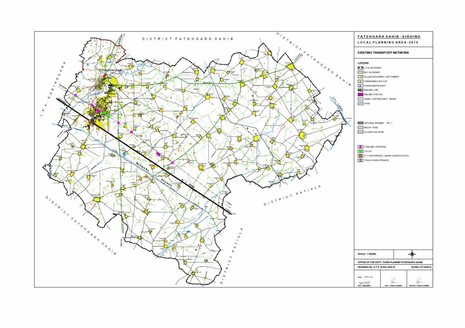
48

55
The preparation of Master Plan to meet the future traffic needs and to facilitate movement of
vehicles on roads, the following transport studies relating to length of carriage way, right of
way & road cross sections have been carried out of existing roads whose detail is as below :
Table No. 6.1: Carriage way, Road cross-section and length of major roads passing through
Fatehgarh Sahib-Sirhind LPA
Sr. No.
Name of Roads Length of roads in L.P.A. (Km)
Width of road (ROW) (in feet)
Divided/ undivided
Total Outside M.C. limits
1. National Highway-1 16.51 2.31 297’-00” Undivided 2. SH-12A(Fatehgarh
Sahib- SAS Nagar) 16.38 2.64 70’-00” Undivided
3. SH-12B(Madhopur By-pass to Bhaironpur)
5.28 - 35’-06” Undivided
4. ODR-3(Officer colony-Mata Gujri Sen. Sec. School)
0.66 0.66 Undivided
5. ODR-6(Brahman Majra Crossing –G.T. Road)
1.32 1.32 67’-00” Undivided
6. ODR-7(Raipur Gujran-ITI Bassi)
3.17 _ Undivided
7. ODR-14(Old Sirhind-Sirhind Mandi)
1.84 1.84 28’-00” Undivided
8. ODR-17(G.T. Road- Sadhugarh-Hansali-Badali Ala Singh)
10.9 _ 43’-00” Undivided
9. Sirhind-Patiala Road 11.55 1.25 88’-00” Undivided 10. Sirhind-Bassi Pathana
Road 3.96 3.96 110’-00” Undivided
11. Tarkhan Majra to Bhadson
1.32 _ 40’-00” Undivided
Source: Traffic Survey 2010, DTP Office, Fatehgarh Sahib
� Vehicle composition on main Road Network
The o/o District Town Planner, Fatehgarh Sahib conducted the traffic volume survey of the
following main roads of Sirhind-Fatehgarh Sahib city in order to know the vehicular
composition and volume on these roads.
A mixed composition of vehicles i.e. heavy vehicles like trucks, buses, tractor, medium
vehicles like tempos, cars etc, two wheelers like motor cycles, scooters etc, four wheelers and
other light weight vehicles like cycles, hand carts etc are widely observed on the main roads
of Sirhind-Fatehgarh Sahib city.

56
The vehicular composition on main roads reveal that main roads namely Ambala-Ludhiana
Road (G.T. Road), Fatehgarh Sahib-Sirhind-Patiala Road, Fatehgarh Sahib-Sirhind-Chunni
Road and Fatehgarh Sahib-Sirhind-Bassi Road has mixed vehicular composition with
predominantly cars, jeeps, buses, trucks, tractor trailers and autos moving on these main
roads. In the case of inner main roads of the city, the use of cycles and motor cycles as means
of transport is predominant.
� Volume Capacity Ratio on Main Roads of Sirhind-Fatehgarh Sahib City
The volume capacity Ratio indicates the capacity of roads to hold a given volume of vehicles.
The capacity of urban road is normally expressed in terms of a common unit, namely
Passenger Car Unit (PCU). The relative PCU of particular vehicle type is affected to a great
extent by increase in its proportion in the total traffic. The value of volume capacity ratio if
comes out to 1 is considered as an ideal condition. If the ratio exceeds 1, it indicates over
utilization/ congestion or if it is below 1, the road capacity is under-utilized. Following table
shows recommended PCU factors for various types of vehicles on urban roads as given in
UDPFI Guidelines.
Table No. 6.2: Recommended PCU factors for various types of vehicles on urban roads:
Sr. No. Type of vehicles Equivalent PCU factors
1. Cycle 0.4
2. Two Wheeler M/Cycle or Scooter 0.5
3. Passenger Car, Pick up Van 1.0
4. Auto Rickshaw 1.2
5. Cycle Rickshaw/Tonga 1.5
6. Truck or Bus 2.2
7. Agricultural Tractor Trailor 4.0
Source: UDPFI Guidelines.
The urban roads are broadly classified under three categories:-
� Arterial Road: The Road which connects the town to a State Highway or a National
Highway is termed as arterial road. Main characteristics of arterial roads are:
i) Road for intra-urban through traffic.
ii) No frontage access.
iii) No standing vehicles and very little cross traffic and minimum roadway intersection
spacing 500 m.
� Sub Arterial Road: These roads are also known as major roads or second roads. They
are contained within city limits and they connect important town centers. Main
characteristic of sub arterial roads are:

57
i) Roads for intra-urban through traffic with frontage access but no standing vehicles having
high cross traffic.
ii) High capacity intersection and minimum roadway intersection spacing 300 m.
� Collector Street: These roads are also known as the minor roads. They collect traffic
from various parts of the town and lead it to another minor road or major road. Main
characteristics of collector streets are:
i) Streets for collecting and distributing traffic from arterial roads to local streets.
ii) Providing access to arterial and sub-arterial road.
iii) Having free frontage access but no parked vehicle and having heavy cross traffic and
minimum roadway intersection spacing 150m.
Table No. 3.2(b): Volume Capacity Ratio(VC Ratio) on Main Roads of Sirhind-Fatehgarh Sahib
City
TRAFFIC SURVEY ON BASSI PATHANA - FATEHGARH SAHIB R OAD
Time Car/ Jeep
Bus Truck Two wheeler Scooter/ Motor- cycle
Tractor Trolly / Tempo
Three wheeler
Cycle Rickshaw Tempo/ 4 wheeler
Animal Cart
Others Total
9-11 A.M.
410 175 140 425 135 125 65 10 -- -- -- 1485
12-2 P.M.
430 75 50 440 80 60 50 5 -- -- -- 1190
3-5 P.M.
410 55 55 510 55 60 70 5 -- -- -- 1220
Total 1250 305 245 1375 270 245 185 20 -- -- -- 3895
TRAFFIC SURVEY ON BASSI PATHANA - FATEHGARH SAHIB R OAD
Time Car/ Jeep
Bus Truck Two wheeler Scooter/ Motor- cycle
Tractor Trolly / Tempo
Three wheeler
Cycle Rickshaw Tempo/ 4 wheeler
Animal Cart
Others Total
9-11 A.M.
360 125 145 280 180 105 70 10 -- -- -- 1275
12-2 P.M.
335 80 90 390 120 90 40 5 -- -- -- 1150
3-5 P.M.
485 60 80 385 65 40 25 5 -- -- -- 1145
Total 1180 265 315 1055 365 235 155 20 -- -- -- 3570
From the table above it is evident that during morning and evening peak hours out of the total
number of vehicles 1485 and 1220 respectively, the maximum number (almost 35%)
comprises of two-wheelers with the number of cars/jeeps occupying second position (30%)

58
whereas number of slow moving vehicles like cycle and rickshaws is the least. The heavy
vehicles like trucks, buses and tractors constitute almost 23% of the total number of vehicles
on this road. The VC Ratio on this road comes out to be 0.775 which being less than 1
indicates under utilisation of this road.
TRAFFIC SURVEY ON FATEHGARH SAHIB – CHUNNI ROAD
Time Car/ Jeep
Bus Truck Two wheeler Scooter/ Motor- cycle
Tractor Trolly / Tempo
Three wheeler
Cycle Rickshaw Tempo/ 4 wheeler
Animal Cart
Others Total
9-11 A.M.
310 10 20 560 20 60 90 15 -- -- -- 1085
12-2 P.M.
375 30 20 650 15 75 80 15 -- -- -- 1260
3-5 P.M.
210 15 15 415 15 50 25 10 -- -- -- 755
Total 895 55 55 1625 50 185 195 40 -- -- -- 3100
TRAFFIC SURVEY ON CHUNNI - FATEHGARH SAHIB ROAD
Time Car/ Jeep
Bus Truck Two wheeler Scooter/ Motor- cycle
Tractor Trolly / Tempo
Three wheeler
Cycle Rickshaw Tempo/ 4 wheeler
Animal Cart
Others Total
9-11 A.M.
460 15 10 730 15 85 30 10 -- -- -- 1355
12-2 P.M.
525 30 30 900 20 75 45 5 -- -- -- 1630
3-5 P.M.
245 25 15 420 10 40 20 5 -- -- -- 780
Total 1230 70 55 2050 45 200 95 20 -- -- -- 3765
From the table above it is evident that during morning and evening peak hours out of the total
number of vehicles 1085 and 755 respectively, the maximum number (almost 53%)
comprises of two-wheelers with the number of cars/jeeps occupying second position (28%)
whereas number of slow moving vehicles like cycle and rickshaws is the least. The heavy
vehicles like trucks, buses and tractors constitute only 1.6% of the total number of vehicles
on this road. The VC Ratio on this road comes out to be 0.6 which being less than 1 indicates
under utilisation of this road.
TRAFFIC SURVEY ON SIRHIND-AMBALA(G.T. ROAD)
Time Car/ Jeep
Bus Truck Two wheeler Scooter/ Motor- cycle
Tractor Trolley / Tempo
Three wheeler
Cycle Rickshaw Tempo/ 4 wheeler
Animal Cart
Others Total
8-10 A.M.
470 105 275 180 85 -- 5 6 -- -- -- 1126
12-2 P.M.
1115 475 820 415 290 15 -- 3130
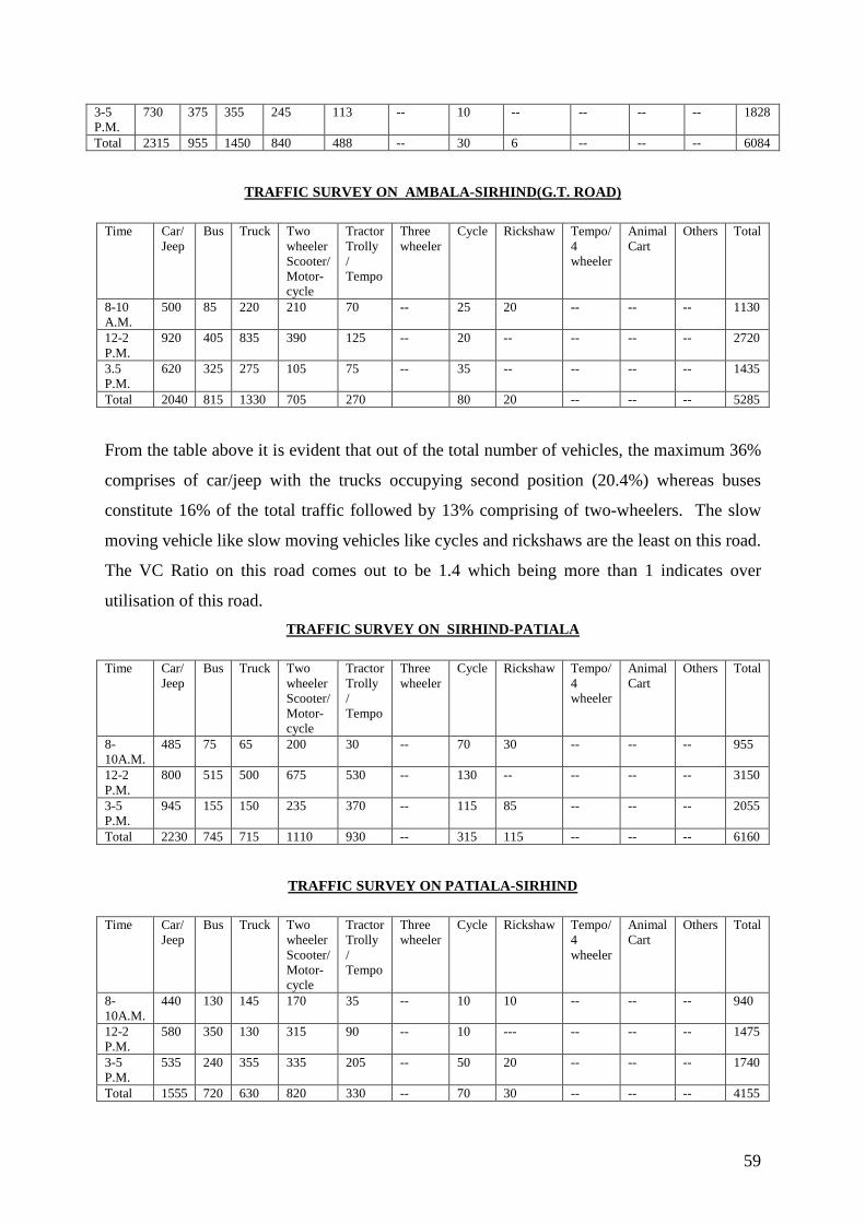
59
3-5 P.M.
730 375 355 245 113 -- 10 -- -- -- -- 1828
Total 2315 955 1450 840 488 -- 30 6 -- -- -- 6084
TRAFFIC SURVEY ON AMBALA-SIRHIND(G.T. ROAD)
Time Car/ Jeep
Bus Truck Two wheeler Scooter/ Motor- cycle
Tractor Trolly / Tempo
Three wheeler
Cycle Rickshaw Tempo/ 4 wheeler
Animal Cart
Others Total
8-10 A.M.
500 85 220 210 70 -- 25 20 -- -- -- 1130
12-2 P.M.
920 405 835 390 125 -- 20 -- -- -- -- 2720
3.5 P.M.
620 325 275 105 75 -- 35 -- -- -- -- 1435
Total 2040 815 1330 705 270 80 20 -- -- -- 5285
From the table above it is evident that out of the total number of vehicles, the maximum 36%
comprises of car/jeep with the trucks occupying second position (20.4%) whereas buses
constitute 16% of the total traffic followed by 13% comprising of two-wheelers. The slow
moving vehicle like slow moving vehicles like cycles and rickshaws are the least on this road.
The VC Ratio on this road comes out to be 1.4 which being more than 1 indicates over
utilisation of this road.
TRAFFIC SURVEY ON SIRHIND-PATIALA
Time Car/ Jeep
Bus Truck Two wheeler Scooter/ Motor- cycle
Tractor Trolly / Tempo
Three wheeler
Cycle Rickshaw Tempo/ 4 wheeler
Animal Cart
Others Total
8-10A.M.
485 75 65 200 30 -- 70 30 -- -- -- 955
12-2 P.M.
800 515 500 675 530 -- 130 -- -- -- -- 3150
3-5 P.M.
945 155 150 235 370 -- 115 85 -- -- -- 2055
Total 2230 745 715 1110 930 -- 315 115 -- -- -- 6160
TRAFFIC SURVEY ON PATIALA-SIRHIND
Time Car/ Jeep
Bus Truck Two wheeler Scooter/ Motor- cycle
Tractor Trolly / Tempo
Three wheeler
Cycle Rickshaw Tempo/ 4 wheeler
Animal Cart
Others Total
8-10A.M.
440 130 145 170 35 -- 10 10 -- -- -- 940
12-2 P.M.
580 350 130 315 90 -- 10 --- -- -- -- 1475
3-5 P.M.
535 240 355 335 205 -- 50 20 -- -- -- 1740
Total 1555 720 630 820 330 -- 70 30 -- -- -- 4155

60
From the table above it is evident that during peak hours out of the total vehicles moving on
this road, the maximum 37% comprises of car/jeep with the two-wheelers occupying second
position (18.7%) whereas bus constitute 14% of the total traffic followed by 13% comprising
of trucks and tractors each. The slow moving vehicles like cycles and rickshaws with 10% are
the least on this road. The VC Ratio on this road comes out to be 0.8 which being less than 1
indicates under utilisation of this road.
VOLUME CAPACITY RATIO ON MAJOR ROADS OF FATEHGARH S AHIB-
SIRHIND
The volume capacity ratio indicates the capacity of roads to hold a given volume of vehicles.
The capacity of urban road is normally expressed in terms of a common unit namely
Passenger Car Unit (PCU). The relative PCU of particular vehicle type is affected to a great
extent by increase in its proportion in the total traffic. The value of volume capacity ratio if
comes out to 1 is considered as an ideal condition. If the ratio exceeds 1, it indicates over
utilization/congestion or if it is below 1, the road capacity is under-utilised. The following
table shows recommended PCU factors for various types of vehicles on urban roads as given
in UDPFI Guidelines:
Table: 6.3. PCU factors for various types of vehicles
S.No. Type of Vehicles Equivalent PCU Factors
1 Cycle 0.4 2 Two wheeler, motor cycle or
scooter 0.5
3 Passenger car, pick up van 1.0 4 Auto rickshaw 1.2 5 Cycle rickshaw. Tonga 1.5 6 Truck or bus 2.2 7 Agricultural tractor-trailor 4.0
The volume capacity ratio on the major 4 roads of Fatehgarh Sahib-Sirhind town ranges
between 0.24 -1.7 which reveals that these roads (except G.T. road) are wide enough to
accommodate the present volume of traffic and have smooth traffic flow. Only Ambala-
Ludhiana (G.T. Road) is having Volume Capacity Ratio more than 1.7 due to heavy and
medium vehicular regional traffic such as truck, buses, car/jeeps and tractor/trailors, etc.

61
6.4. Detail of various existing road cross sections:
S.NO. NAME OF THE ROAD
CROSS-SECTION REMARKS
1. Ambala-Ludhiana Road(G.T. Road)
The 6-laing project for development of this raod is being undertaken by presently NHAI
2. Fatehgarh Sahib-Sirhind-Patiala Road
Inspite of road condition being good, yet due to high volume of mixed traffic condition it becomes accident prone and as a result it requires road geometry/ width improvement.
3. Fatehgarh Sahib - S.A.S. Nagar
Keeping in view vicinity to SAS Nagar and large volume of traffic during peak hours, requires road width /geometry improvement in M.C. limit

62
4. Fatehgarh Sahib-Sirhind-Bassi Pathana Road
Due to high volume of mixed traffic, poor road condition and being accident prone, it requires road geometry/ width improvement.
5. Madhopur - Bhaironpur
The road condition is good with moderate traffic volume.
6. Tarkhan Majra- Bhadson Road
The road condition is good with moderate traffic volume.
7. Chungi No. 4 – Jandu Workshop
The road condition is good with moderate traffic volume.

63
8. Railway Station – G.T. Road
The road condition is good with moderate traffic volume.
9. Brahman Majra Railway Crossing - G.T. Road (Near Grain Market)
The road condition is good with moderate traffic volume.
10. G.T. Road - Badali Ala Singh
The road condition is good with moderate traffic volume.
11. Sirhind Town – Sirhind Mandi
The road condition is good with moderate traffic volume.

64
� Bus Transport
� Bus Terminal
There is no planned bus terminal in Fatehgarh Sahib-Sirhind city and buses are operating
from a temporary bus stand located in Sirhind city which is basically patch of vacant land
along Sirhind Road where Ram Leela and Dushehra celebrations are held. The most preferred
mode of transport in the area is bus transport as buses from all the districts of Punjab and
neighboring states on their way halt at the bus stand and a few local buses originate and
terminate at the existing bus stand. Bus transport is also considered as a preferred means of
transport for the daily commuters which considerably contribute to the increasing bus traffic.
There is a proper linkage between temporary bus stand and railway station making it suitable
and convenient mode of transportation. The over bridge on Ludhiana-Ambala railway line
joining Todar Mal Gate road to Chungi No. 4 road has been developed and heavy vehicular
regional traffic has been diverted through the over bridge. There is no cycle rickshaw stand,
auto rickshaw stand or taxi stand in and around the bus stand, with the result these are parked
along road side along with rehriwallas which reduces the effective width of roads, resulting in
congestion, chaos and lowering of journey speed.
65
CHAPTER -VII
EXISTING PHYSICAL INFRASTRUCTURE
7.1. Water Supply
The 74th Constitutional Amendment envisages the provision of water supply to be legitimate
function of the municipalities. The system was made operational in the year 1949 and was
completely based on ground water. With the town getting power supply, the shallow tubewell
were replaced by deep tubewells and system of pumping/extracting the water was, made
through new electric motors. Piped water supply was first introduced in Fatehgarh Sahib–
Sirhind town just couple of year after constitution of M.Cl.
� Source of Water Supply
The system of water supply is based upon the underground water by digging wells in the city
and pumping it to the destinations.
� System of Water Supply and Area Coverage
Municipal Council Fatehgarh Sahib–Sirhind provides water supply to the city and takes care
of its operational and maintenance services. The state level agency i.e. Punjab Water Supply
and Sewerage Board (PWSSB) handles the entire process of planning, designing, laying the
major network and construction of tube wells and OHSR. The town has direct system of
water supply through pumping or dual system and in both the cases is underground water. As
far as the existing water supply network is concerned, M.Cl has 5 tube wells serving 70% of
the population of the city i.e. out of total M.Cl area of 19.15sq.kms appx. 9.2sq.kms M.Cl
area accommodating 39860 population of the city is served with water supply. There is only
one OHSR with capacity of 2 lac gallons within M.Cl. (as shown in plan attached).
� Water supply network (LPA) rural
The water supply pattern of the villages falling in LPA the as shown on Drg No DTP (FGS) -
1613/10 dated 5-10-2010 reflect that 100% of population of the LPA is covered by the water
supply. In this LPA, there are 60 OHSRs capacity ranging from 25000 gallons to 150000
gallons to serve the water demand.
The total water supplied on per capita basis in LPA works out to be 120 LPCD. The duration
of water supply is thrice a day amd the total works out to be 12hrs on dily basis.


56

66
7.2. Sewerage The quality of life of a city depends upon the kind of urban amenities with which it is being
provided. This includes not only potable water supply but also the kind of waste water
disposal system the city is equipped with. It is the necessity of the day to have an efficient
sewerage network in all the cities and Fatehgarh Sahib–Sirhind town is not an exception.
� Area Coverage
Fatehgarh Sahib–Sirhind M.Cl. provides the facility regarding disposal of sewerage from the
council area. This includes waste generated both from domestic, commercial and institutional
units operating in the town. Out of the total city area 19.15sq.kms, the area covered under the
sewerage network is to the extent of 34% i.e. 6.5 sq.kms accommodating appx 16940
population is covered. The city presently has total length of 31.87km sewer and as per data
procured from M.Cl there is further proposal to add 54.97 km length of sewer to cover up the
rest of unserved area.
� Population Coverage
As far as the population of the Fatehgarh Sahib–Sirhind city is concerned about 34% of the
total population has the facility of sewerage system whereas 66% of the population is devoid
of this facility resulting in the poor sanitation conditions. M.Cl has total 4100 sewerage
connection at present out of which are 2724 are in running state. This also leads to the high
degree of pollution of underground water and poor environment in and around their habitat.
� Quality of waste generated
The city has a total water supply of 19mld (million liter per day) out of which 80% is
considered to be the wastage and only 20% of the water is consumed actually. Hence the
sewerage works out to be 15mld.
� Waste Disposal
At present the disposal of the waste generated in the city is being done in Sirhind Choe through
main pumping station of 66mld (million liters per day) located on Sheikhupura.
7.3. Storm Water Drainage
The rain water in the present context is a precious source of water supply but neither the town
has any storm water network nor does it seem to be on the top priority list of M.Cl so far.
Moreover no concentrate efforts are under way to conserve this valuable resource by
indgenious methods of rain water harvesting due to which the rain water harvesting is largely


67
discharged into the existing sewerage network leading to choking of the sewer pipes,
overflow of the sullage and backflow of the sewerage water.
Therefore, it’s a matter of great urgency to have a separate storm water network design and
put in place for this town along with the preservation of existing natural drainage network as
a integral part of the development process by declaring them as protected areas.
It would also be worthwhile to explore the mechanism of rain water harvesting to be made
applicable for large industrial, residential, commercial and institutional areas to recharge the
ground water.
7.4. Solid Waste Management Solid waste is a combination of unwanted and discarded materials from households,
commercial and industrial operations besides street sweeping. Increase in urban population
coupled with change in life style and economic prosperity has lead to generation of
considerable solid waste. Solid waste has emerged as the major problem in urban areas with
regard to its affective managements. Solid waste arising from human activity has emerged as
one of the major environmental issue leading to extensive pollution and threat to human
health.
There has been no formal study estimating the amount of solid waste generated in the
Municipal Council Fatehgarh Sahib–Sirhind. The amount of garbage generated is roughly
estimated (as per UDPFI guidelines for small towns) to the tune of 45.1 metric tons which
includes solid waste generated by domestic sector, malba of houses, green belt/sabzi mandi,
slaughter house and hospitals. Higher garbage generation can be attributed to the living style
and the economic character of the city.
Solid Waste Management is the prime responsibility of Municipal Council Fatehgarh Sahib–
Sirhind within the Municipal Council area. Council discharges this duty through the
infrastructure created for collection, storage, transportation and disposal. The public Health
department of the Council is vested with the responsibility of day to day solid waste
collection and disposal. The Council organizes the collection and transportation through its
own conservancy workers and a fleet of vehicles and dumpers-placers. Municipal Council
collects solid waste from all the residential areas within its municipal limits collection facility
is provided in 90% area occupied by people.

68
In order to effectively cover the entire city, 40-45 garbage collection sites of community bins
have been provided by the Municipal Council out of which 45 sites have containers for
garbage collection and after collection waste are disposed off in open site in village
Sheikhupura.
Although Municipal Council has not made any arrangement of segregation of solid waste but
rag pickers on their own segregate some of the plastic, glass and other material at the
collection point and sell them to kabaris.
� Disposal of solid waste
The method adopted by the Municipal Council for disposal of the solid waste is through the
mechanism of landfills. At present Municipal Council uses one site for dumping of the solid
waste. The site is located at Sheikhupura. Presently solid waste is being dumped in
Sheikhpura near encamping ground. The solid waste collected at 40-45 sites created at the
community level is transported to dump site. The landfill site is not lined and properly
defined. Moreover, land filling is being done in an unscientific manner. The waste is directly
dumped, without any segregation. There is no compaction of the waste undertaken to
compress it since no road rollers are available with the Health Deptt. for this purpose. In the
absence of scientific disposal of the waste lot of valuable waste is lost due to absence of
recycling.
Further, in the absence of defined boundaries, animals like pigs etc. vegetate on the waste. In
addition, due to unscientific disposal of the waste, lot of foul smell is generated due to the
presence of organic waste polluting the environment in the process. No treatment of the solid
waste is undertaken during the dumping process as required in the system of sanitary
landfills. This dump site is very close to residential colony, the occupants of which have to
face this ugly scene. Council is looking for a suitable dump site. Thus the present practice of
disposing solid waste does not comply with Municipal Solid Waste Rules 2000 of the
Ministry of Environment and Forest Govt. of India.

69
CHAPTER VIII EXISITING & ONGOING INFRASTRUCTURE DEVELOPMENT
8.1. DEDICATED FREIGHT CORRIDOR
The information/data elaborated below regarding Dedicated Freight Corridor Line was
collected from the concerned office through personal efforts of the staff of this office.
Introduction Dedicated Freight Corporation of India (DFCCIL) is a special purpose Vehicle set up under
the administrative control of Ministry of Railway to undertake planning & development,
mobilization of financial resources and construction, maintenance and operation of the
Dedicated Freight Corridors. DFCCIL was incorporation in October 2006 under Indian
Companies Act 1956. The plan to construct dedicated freight corridors across the country
marks a strategic inflexion point in the history of Indian Railways that has essentially run
mixed traffic across its network. Once completed, the dedicated freight corridors will enable
Indian Railways to improve its customer orientation and meet market needs more effectively.
Creation of rail infrastructure on such a scale – unprecedented in independent India – is
also expected to drive the establishment of Industrial corridors and logistic parks along its
alignment.In the first phase, DFCCIL will construct two corridors – the Western DFC and
Eastern DFC – spanning a total length of about 2800 route km. The Eastern Corridor,
starting from Ludhiana in Punjab will pass through the states of Haryana, Uttar Pradesh and
terminate at Dankuni in West Bengal. The Western Corridor will traverse the distance from
Dadri to Mumbai, passing through the states of Delhi, Haryana, Rajsthan, Gujarat and
Maharashtra.
The alignment from Dankuni – Khurja is double line and from Khurja to Ludhiana is
single line.
2. Standards of Construction
Technical parameters adopted for Khurja – Ludhiana single line are as below:-
(i) Trace Structure – Substructure including formation & bridges and sleepers to be
planned for 32.5 tone axle load. 68 kg rails to be provided. Turnouts will be 1 in 12.
(ii) Loop length should be 750 meters with provision from extension up to 1500 meters in
future.
(iii) C/C spacing of track of DFC lines is kept as 6 m. Minimum distance from adjacent
railway line as 7 m. Ruling gradient adopted is 1 in 200 (compensated).


70
(iv) U;Maximum degree of the curve is restricted to 2.5 degree (700 m radius). Vertical
curves have been provided, where the algebraic difference in change of grade is equal
to or more than 0.4%. For vertical curve minimum radius of 2500 m has been
adopted.
(v) For road under bridge a vertical clearance adopted for NH & SH as 5.5 m, for mettled
road as 4.6 m and other katcha roads as 3.6 m. in Punjab, Harvest Combine is required
to move in the fields, height of which is 14 feet (4.270 m). Hence clearance on
mettled road has been kept as 4.6 m.
(vi) Vertical MMD for the Eastern corridor as 5.1 meters.
(vii) ROBs/RUBs – The norms for replacement of LCs by ROBs/RUBs would be 50,000
TVUs.
(viii) Electric Traction System – 2 x 25 KV OHE systems to be adopted.
(ix) Signaling – Automatic signaling with 2 km. spacing between signals to be adopted.
Absolute block system for single line. Station interlocking shall have provision for
future upgradation to unable to CTC operations.
(x) Telecommunication – Independent OFC system to be provided for DFC. GSM-R
system for mobile train radio communication to be adopted.
3. Route Maps: DFC alignment is on left hand side of existing track from Khurja to Rajpura and from
Sirhind to Sanehwal, from Rajpura to Sirhind it is on right side Sketch I and II.
8.2. MATHURA - JALANDHAR PIPELINE (M J P L). The information/data elaborated below regarding Mathura-Jalandhar Pipeline was collected
from the concerned office through personal efforts of the staff of this office.
1. Indian Oil Corporation Limited had laid a cross country Product Pipeline from
Mathura to Jalandhar under “The Petroleum and mineral Pipelines (Acquisition of
Right of user in Land) Act 1962” and the said pipeline is meeting the Petroleum
product requirement of all the Northern States including defence.
2. This Pipeline is transporting highly inflammable petroleum products. Mathura –
Jalandhar pipeline is laid by adhering to various National & International codes &
OISD standard for the safety of the adjoining residents as well as to carryout regular
preventive maintenances for up keeping health of the pipeline.
While processing NOC the following guidelines as per petroleum Act are strictly adhere to:
a) Our pipelines are normally laid at a depth of one M below the ground level
maintaining 18 M wide ROW throughout from Mathura to Jalandhar for regular

70

70


71
patrolling and time-to-time maintenances of the pipeline. Restrictions regarding the
use of land there should not be any permanent structure like building, tank, reservoir,
Dam or plant any tree across ROW as it will bring hindrances for the movement of
heavy machineries during maintenance emergency activities. No dwelling unit to be
constructed within 20.50 M from either side edges of the R.O.W. No. flares fire or
higher temperature activities to be carried out near pipeline as it transports highly
Petroleum products, which may cause fire. All required precautions may please be
looked into. A safe distance of 150 meter from pipeline to be maintained for the
Industrial activities. Only Green belt to be maintained across the ROW including
cultivation.
b) Permission for crossing of pipeline ROW by construction the boundary wall in
emergency cases are accorded with a provision of suitable beam structure with the
condition that, wall may be dismantled for movement of heavy equipments like bull
dozer, excavators etc. during emergency and repair by the licensee. Moreover, for the
regular inspection, entry to License of his authorized representative to be allowed. For
each crossing activity, separate permission would be required form IOCL. Necessary
charges fee (depending upon estimated cost of the work to be carried out by you in
ROW) would be communicated to you for each crossing. An agreement will also be
signed for crossing permission. No heavy vehicular movement is allowed to avoid
rupture direct load to the pipeline. However in specific cases for the movements of
heavy vehicles Culvert Bridge are to be made across/over the ROW with prior
permission in writing. No construction activities are to be started in ROW without
permission in writing.
3 You are requested to put forward your detailed proposal for processing the permission
for forthcoming project. You may feel free to ask any clarification on the subject
matter.
8.3. GAS AUTHORITY INDIA LIMITED GAS PIPELINE As shown on plan Drg. No. DTP (FGS) 1626/10 dated 9/12/2010 gas pipeline by Gas
Authority of India (G.A.I.L.) is passing through villages (as per annexure no. 8).
8.4. DEVELOPMENT BY NATIONAL HIGHWAY AUTHORITY OF INDIA (NHAI) The detail of proposed development by National Highway Authority India is as per attached
plan Drg. No. DTP (FSG) 1620/10 dated 11/10/2010.
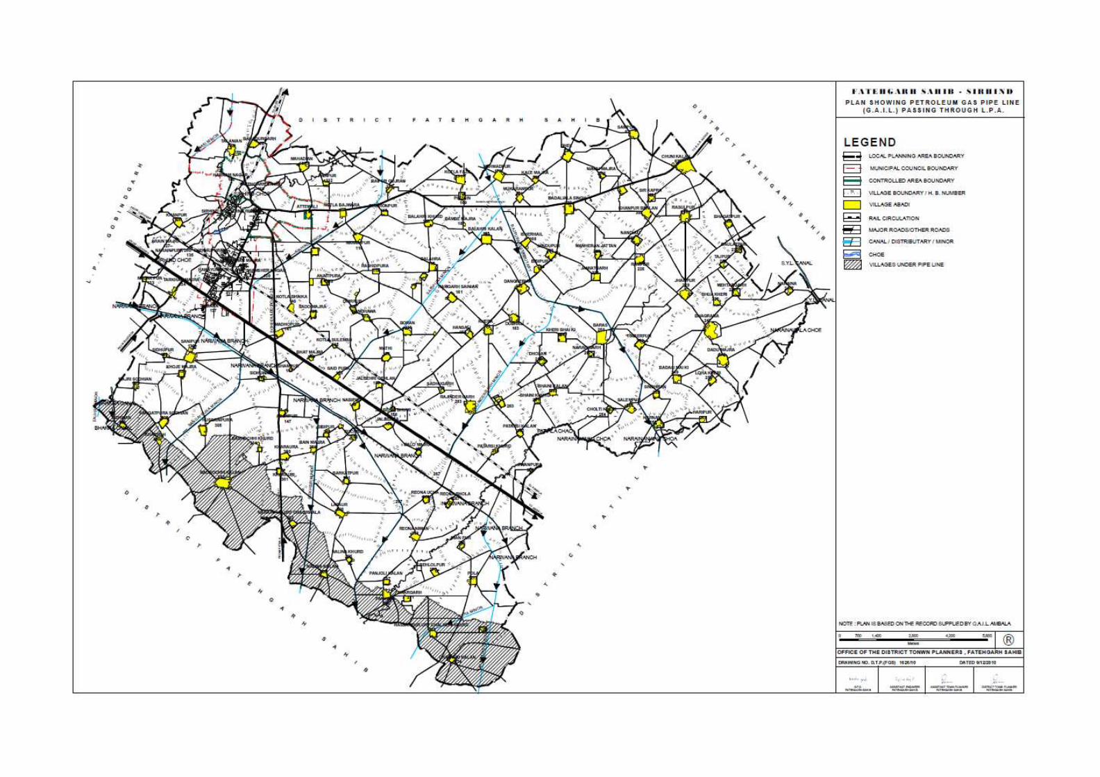

72

72
CHAPTER IX SOCIAL INFRASTRUCTURE
9.1. Introduction
Social infrastructure constitutes various facilities pertaining to education, health, recreational,
cultural and other public amenities/facilities available in urban areas at various levels whose
availability and accessibility determines the quality of life of an urban center. Therefore,
provision of social infrastructure of appropriate level assumes high significance in the context
of growth and development of urban areas for which it becomes essential pre-requisite to
properly assess the adequacy/inadequacy of existing social infrastructure based on population
norms defined, qualitatively, quantitatively and spatially because for efficient functioning of
urban areas, it is not merely the quantity or quality of social infrastructure but more
importantly the spatial distribution of these facilities in a manner that will help in improving
the operational efficiency of the town as well as the surrounding areas.
In addition, it needs to be ascertained that spatial distribution of the social infrastructure is
such that it is available to the entire population and is within their easy reach. Often it is
found that social infrastructure is concentrated in few pockets of the town whereas certain
areas have been found to be deficient. This adversely impacts the community living in
deficient areas which are required to travel considerable distance to avail them. In the
process, town faces problems due to unnecessary travel necessitated by irrational distribution
of these services. Therefore, proper and efficient functioning of the urban centers it is not
only critical, that urban infrastructure in appropriate quality and quantity are provided but
also it will be important that they are spatially distributed in a manner so as to cover the entire
town and its population. This would not only minimize travel within the town but would also
improve the operational efficiency of the town and its community. Keeping in view above the
available social infrastructure in this town as shown on Drg. No DTP (FGS) 11617/10 dated
7-10-2010 have been studied and evaluated.
Educational Facilities
Educational facilities play an important role in the overall development of a city. These
facilities enhance economic growth and employment. Sirhind-Fatehgarh Sahib town in this
context has been fortunate enough to have large number of educational institutes and boasts
of being the educational hub of the state. Fatehgarh Sahib- Sirhind town and its L.P.A have
large number of educational institutes both at lower and higher level of education which not
only cater to the needs of the city but also to the region and the nearby towns/cities.
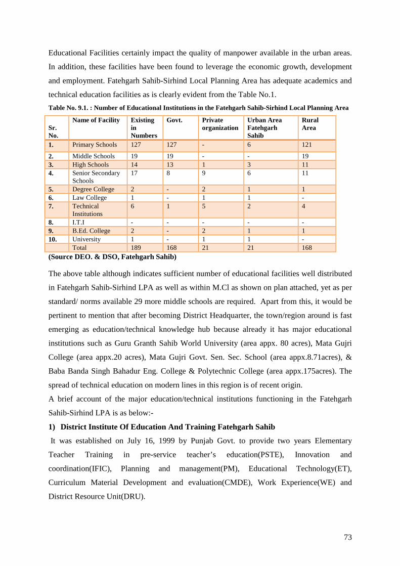
73
Educational Facilities certainly impact the quality of manpower available in the urban areas.
In addition, these facilities have been found to leverage the economic growth, development
and employment. Fatehgarh Sahib-Sirhind Local Planning Area has adequate academics and
technical education facilities as is clearly evident from the Table No.1.
Table No. 9.1. : Number of Educational Institutions in the Fatehgarh Sahib-Sirhind Local Planning Area
Sr. No.
Name of Facility Existing in Numbers
Govt. Private organization
Urban Area Fatehgarh Sahib
Rural Area
1. Primary Schools 127 127 - 6 121
2. Middle Schools 19 19 - - 19 3. High Schools 14 13 1 3 11 4. Senior Secondary
Schools 17 8 9 6 11
5. Degree College 2 - 2 1 1 6. Law College 1 - 1 1 - 7. Technical
Institutions 6 1 5 2 4
8. I.T.I - - - - - 9. B.Ed. College 2 - 2 1 1 10. University 1 - 1 1 - Total 189 168 21 21 168 (Source DEO. & DSO, Fatehgarh Sahib)
The above table although indicates sufficient number of educational facilities well distributed
in Fatehgarh Sahib-Sirhind LPA as well as within M.Cl as shown on plan attached, yet as per
standard/ norms available 29 more middle schools are required. Apart from this, it would be
pertinent to mention that after becoming District Headquarter, the town/region around is fast
emerging as education/technical knowledge hub because already it has major educational
institutions such as Guru Granth Sahib World University (area appx. 80 acres), Mata Gujri
College (area appx.20 acres), Mata Gujri Govt. Sen. Sec. School (area appx.8.71acres), &
Baba Banda Singh Bahadur Eng. College & Polytechnic College (area appx.175acres). The
spread of technical education on modern lines in this region is of recent origin.
A brief account of the major education/technical institutions functioning in the Fatehgarh
Sahib-Sirhind LPA is as below:-
1) District Institute Of Education And Training Fatehg arh Sahib
It was established on July 16, 1999 by Punjab Govt. to provide two years Elementary
Teacher Training in pre-service teacher’s education(PSTE), Innovation and
coordination(IFIC), Planning and management(PM), Educational Technology(ET),
Curriculum Material Development and evaluation(CMDE), Work Experience(WE) and
District Resource Unit(DRU).

74
2) Baba Banda Singh Bahadur Engg. College, Fatehgarh Sahib
The college was established in 1993 by Baba Banda Singh Bahadur Education Trust under
the patronage of Shromani Gurudwara Parbandak Committee, Amritsar with the approval of
Govt. of Punjab. The college has magnificent campus which is spread over 175 acres with
two administrative and teaching blocks, well-equipped laboratories, workshops, well-stocked
library, three hostels and well maintained play grounds/lawns. The college is affiliated to
Punjab Technical University (PTU), Jalandhar presently and also imparts B.Tech degree in
Computer Science and Engg. (CSE), Communication Engg. and Mechanical Engg.
3) The District Library, Fatehgarh Sahib
The district library was established on 21 June, 1995 after formation of Fatehgarh Sahib
district and it is under the control of D.P.I. (colleges) Punjab. It is equipped with books appx
numbering 20099 and has reading room services for general public.
Medical Facilities
The work of providing medical relief was greatly accelerated after Independence. Under the
democratic set-up the need of healthy life has been realised. Since the launching of the Five
Year Plans, rapid strides have been made in the expansion of medical services in this area. As
per shown in the table below, number of medical institutions such as hospitals, dispensaries
and private nursing home have been established which have adequate and qualified staff. The
detail of the medical facilities is given below:
Table No.: 9.2. Medical Facilities Sr. No. Name of Facility Existing in
No. Urban Rural
1. Hospital i) Upto 25 beds ii) Upto 50 beds iii) Upto 100 beds
- - 1
- - 1
- - -
2. Child Health Centre 2 1 1 3. Primary Health Centre/Mini P.H.C. 4 - 4 4. Sub-Health Centre/Health Centre 13 - 13 5. Ayurevaedic Dispensary 1 1 - 6. Civil Dispensary 3 3 - 7. E.S.I Dispensary 1 1 - 8. Private Nursing Home 10 10 - Total 35 17 18 (Source: Health Department, Fatehgarh Sahib)
The health of its citizens tops the Govt. agenda and provision of health services across
various sections of society is also its top priority. Though initially health care remained in the
public domain, gradually private players started playing a significant role in providing health-


75
based services. The same is the case with L.P.A Fatehgarh Sahib-Sirhind where govt. as well
as private operators plays a very significant role in providing health care facilities.
Fatehgarh Sahib-Sirhind town has a civil hospital of area 5 acres which is meeting the health
demand of LPA population as well as M.Cl. This Civil hospital established in 1985 with 50
beds has presently 100 beds capacity.
Apart from the above medical facilities, there are enough veterinary institutes for the live
stocks population of this area as shown in the table below:
Table No.: 9.3 Veterinary Facilities
Sr. No.
Name of the Facility Existing in No. Urban Rural
1 Hospital 12 1 11 2 Dispensary 6 0 6 Total 18 1 17 Source: Veterinary Department
Post and Telegraph The new age technology has taken great strides as far as modes of communications are
concerned which are not only faster but cheaper also. Still, post and telegraph remains the
most popular option of communication for vast chunk of population which in the Indian
context is still from the rural strata.
There are total 18 post offices operational in the Fatehgarh Sahib-Sirhind L.P.A. out of which
sixteen number are branch level post offices and 2 sub-post offices as shown in the table
below :-
Table No.: 9.4. Post Offices
Sr. No.
Name of Facility Existing in Numbers
Urban Rural
1. Main Post Office - - - 2. Sub-Post Office 2 2 - 3. Branch Post Office 16 - 16 Total 18 2 16 Source: Superintendent Post office, Fatehgarh Sahib
Fire Prevention and Protection
Fire accidents have become a common day phenomenon, so to prevent & protect from fire it
is necessary to provide essential services in the city. Due to the advancement in technology
and high rise construction, the industrial accidents, short-circuiting in commercial
establishments are most vulnerable for fire incidents. It becomes the foremost obligation of

76
the govt. to provide security from these accidents and this issue assumes for greater
significance and the need to redress it in the month of December during Jod Mela.
• Availability of Fire Stations
There is one fire station having an area of one acre in the city. In case of emergency this
serves not only the city but also the entire district. So, the area need to be served by Fire
Station is very large and unmanageable. Thus as per norms atleast one more fire station
would be required to cater the projected population.
• Existing infrastructure in Fire Stations
As per the information supplied by the respective fire stations, there are only five fire tenders
in the stations, a fire jeep and no ambulance.
Table No.: 9.5. Existing infrastructure in Fire Stations
Sr. No. Name of Facility Norms Existing Surplus Deficiency
1 Fire Station 1 fire station or sub-fire station within 1 to 3 km to be provided for 2 lakh population
1 - 1
Source: Fire Station Master, Sirhind.
Power Supply The Power supply to Fatehgarh Sahib-Sirhind city and L.P.A is provided by Punjab State
Power Corporation Ltd. through two grid stations of 66 KV capacity installed in this L.P.A. and
both are situated within the limits of M.Cl. The detail of Grid stations of Punjab State Power
Corporation Ltd is given in Table No. below:
Table No.: 9.6. Grid Stations in Fatehgarh Sahib-Sirhind City
Sr.
No.
Name and Location Capacity Location
1 Power Grid Station, Sirhind 66KV Within M.Cl.
2. Power Grid Station, Attewali 66KV Within M.Cl.
Source: Punjab State Power Corporation Limited Office, Fatehgarh Sahib
Sports and Recreational Facilities:
For physical and social development of individual, recreational facilities are far and foremost
important. Therefore, the provision of these facilities at local; sub city and city level in a
balanced form is necessary. Recreational facilities exist in the shape of parks, open spaces,
stadiums, museums, sport related activities, clubs, amusement parks etc. In order to cater to
the essential needs of the individuals and communities these facilities need to be provided.

77
Fatehgarh Sahib-Sirhind town, except for the provision of stadium/sports related facilities
within existing educational/technical institutes, is lacking in recreational facilities at city
level.
Recreational facilities:
Recreational facilities constitute an important element of physical and social development of
an individual and for that reason, their provision and balanced spatial distribution at the local,
sub-city and town level assumes importance. There is no cinema/multiplex in the town and
apart from it; the town does not have any town level museum, stadium or auditorium etc as
evident from the table below:
Table No. 9.7. Recreational Facilities Sr. No. Name of Facility Existing in Numbers 1. Parks 1 2. Cinemas - 3. Multiplex - 4. Stadium 1 5. Museum - 6. Swimming Pool - 7. Clubs - 8. Library 1 9. Amusement Park -
(Source: Municipal Council, Fatehgarh Sahib- Sirhind)
Even the existing park doesn’t conform to the planning norms specified for parks and open
spaces. Thus there is an urgent need to create adequate number of parks and open spaces in
the town as per the specified norms besides ensuring their rational distribution in the town in
order to ensure their availability to all the residents of the town including poorest of the poor.
In addition to the open spaces, city would require the creation of sports facilities at the
neighbourhood level and at the town level with the aim of development of sports and play
areas for all age groups at appropriate levels. To achieve this objective, sports facilities at
various levels of the town including housing clusters, neighbourhood, district and town on as
per norms should be created.
Sports:
Sports facilities should be developed based on a well defined layout plan and landscape plan
with adequate parking facility. In addition, the existing sports infrastructure should be
upgraded and efficiently replanned to improve the level of facilities. New play field areas
should be preferably provide/develop in the vicinity of educational institutions and
landscaped areas. In order to facilitate the provision of sports related facilities available open
spaces within the existing educational or other institutions should be considered as the best

78
options in order to optimize the use of scarce open spaces available within the town. The
sports facilities should be made integral part of institutional development for making their
optimum use.
In the present scenario, with the advancement of technology in the sphere of
Telecommunication sector, large number of private investors has entered into this sector for
providing these services to the public. Keeping in view the enormous communication
network by private investors and increasing population, the govt. sector is also required to
expand/upgrade its existing operational system of communication for the overall
development of economy as well-fare of the public at large.

79
CHAPTER –X
ENVIRONMENT Introduction
Environment concerns came to be highlighted in India only from the 1970s onward, when the
progress of development in general, and the increasing pace of industrialization in particular,
began to leave visible adverse environment impact.
10.1.1 The National Policy on environment was formulated with the following main objectives mentioned below:
(i) To ensure sustained and equitable use of resources for meeting the basic needs of the
present and future generations without causing damage to the environment.
(ii) To prevent and control further deterioration in land, water and air which constitute
our life support system.
(iii) To take steps for restoration of ecologically degraded areas and for
environmental improvement in our rural and urban settlements.
(iv) To conserve and nurture the biological diversity and resources through
environmentally sustainable development and management of ecosystems with special
emphasis on our mountains, marine and coastal desert, wetlands and riverine ecosystems.
10.1.2 Environment Protection has emerged as a biggest challenge to the human society in
the recent times. Where, industrialization is the answer to the ever increasing needs of
growing population for the survival of human race, at the same time, preservation of the
natural resources, control of pollution are the need of hour. We need to follow the path of
sustainable development in harmony with the environment. Reuse, recycling & re-circulation
are the necessities to reduce waste/ pollutants to minimize environmental pollution.
10.1.3 In order to have uniform laws, all over the country for broad environmental issues
endangering the health & safety of our people as well as of our flora and fauna and also to
check environmental degradation, the Parliament of India has enacted the following laws.
1. The Water (Prevention & Control of Pollution) Act, 1974 as amended to date.
2. The Water (Prevention & Control of Pollution) Cess Act, 1977.
3. The Air (Prevention & Control of Pollution) Act, 1981 as amended to date.
10.1.4 The aforesaid laws have been adopted by the Govt. of Punjab to control
environmental pollution in the State.
10.1.5 Punjab Pollution Control Board has been entrusted the task of implementation of
environmental laws in the State of Punjab and District Fatehgarh Sahib falls under the

80
Jurisdiction of Environmental Engineer, Punjab Pollution Control Board, Fatehgarh Sahib-
Sirhind.
10.2 Quality of underground water
10.2.1 In the Fatehgarh Sahib, LPA the depth of shallow tube wells range from 70 feet to
280 feet, 32 numbers of samples were collected during random sampling from different
existing shallow tube wells ranging from 70 feet to 280 feet in depth from different villages.
These samples were got chemically analyzed for the following parameters:
Co32-; Hco3-; Ca+Mg; cl-; RSc; Ec; & ph.
The results of the chemical analysis revealed that the ground water quality (from irrigation
point of view) is generally fit in all the blocks of Fatehgarh Sahib District.
10.2.2 In order to study the groundwater contamination due to effluents released by different
industries, ground water monitoring was done at Fatehgarh Sahib-Sirhind under the project of
Central Pollution Control Board, Government of India. Five number Groundwater stations
(hand pumps) were selected for collecting monthly ground water samples during the year
1994. The study showed that the groundwater at the shallow level contains quantities of more
than the permissible limits which is due to the effluents from the chemical fertilizers, etc.
In Fatehgarh Sahib-Sirhind town, the number of industries is very negligible and these are
non-polluted type of industries so industries are not participating as major polluter of the city
environments. Impact of pollution has been witnessed in the town in the form of quality of
water including both surface and underground, noise pollution, degradation of the natural
resources, etc. These environmental problems are at its minimal stage except water, calling
for an immediate action.
10.2.3 The intensity of the pollution in terms of water have been evaluated than the
water and noise in order to clearly understand the level and causes of pollution existing
within the town so that appropriate strategies are put in place to tackle the problem of
pollution .
Environment Status
Fatehgarh Sahib-Sirhind city is predominantly occupied by the service class people and there
are not many industries in the surrounding areas of Fatehgarh Sahib-Sirhind City. The main
industries which could have significant impact on the local environment include Gupta
Industrial Corporation, Nehra Refrigeration Centre, Tej Metal Works, Vikarm Plastics, New
Sudarshan Foundry, K.L. industries and Shivam Paint and Plywood Company, etc.

81
Industries are very few in numbers and are of service kind of industries such as workshop,
truck body building, automobile repair, etc. On the whole impact of industries on the local
environment is negligible.
Air Pollution
There is minimal air pollution due to the lesser industrial activities and agricultural
predominance in Fatehgarh Sahib-Sirhind City. The main sources of air pollution in a city
are burning of LPG gas/kerosene oil in households/restaurants, vehicular movement within
and around the city, operation of D G Sets in case of failure of electrical power etc. Apart
from these, after harvesting, the burning of leftover of crops by farmers is also a major source
of pollution in city. The air pollution due to the burning of LPG gas/kerosene oil is minimal.
Apart from this there is a carcass on the G.T Road where dead animals and their remaining
material are put to left in the open air after dehiding. Vultures and other animals feed on meat
of these carcasses. The entire activity is a nuisance and a hazard to the public health. The
stinking odour produced from this carcass adding air pollution to the local environment. One
can’t stand nearby this place so there is urgent need to clear/shift this activity from this place.
Though, there are provision and guidelines available under the Environment (Protection) Act,
1986. But local urban body is not taking any appropriate action to solve/remove this problem.

82
• Water pollution
Rapidly increasing urbanization and excess use of insecticides, pesticides and weedicides has
not only adversely impacted the quality of ambient air in the town but also has affected the
town's water resources also.
Fatehgarh Sahib-Sirhind city is having the maximum water pollution problem. The main
source of water pollution is sewage generation from the households. In city areas, sewage
generation @ 108 liters/person/day is considered. Accordingly, Fatehgarh Sahib-Sirhind City
generates around 65000 Kiloliters of sewage per day. The sewage is transported through
sewerage lines laid throughout the city and finally all the sewerage is disposed off into
Sirhind Choe, Fatehgarh Sahib-Sirhind. There are no sewage treatment plants installed in the
city for the treatment of sewage. The Municipal Council Fatehgarh Sahib-Sirhind is planning
to install the sewage treatment plant for the treatment of sewage generated from the city.
After treatment, the sewage will not have any adverse effect on the Sirhind Choe.
The regular withdrawal of underground water i.e. through tube wells for water supply is
another serious problem associated with the city. Average ground water table in the area is
going down day by day. The ground water withdrawal rate is much more than the recharge
potential in Fatehgarh Sahib-Sirhind City. Considering the same, to overcome the long term
impacts, rain water harvesting systems should be adopted in the city.
Quality of Under Groundwater for Irrigation:-
In district Fatehgarh Sahib.
Ground water pollution
i) Hand pumps and shallow tube wells drawing water from first aquifer are found
susceptible to ground water pollution in areas close to industrial units.
ii) Not only the industrial areas but also the areas having mixed land use are being
adversely affected due to the presence of toxic pollutants like cyanide and hexavalent
chromium in excessive proportion in the ground water.
iii) Ground water available along the G.T. Road has also been found to contain large
volume of polluting contents like Chrome etc. Effluents containing toxic metals from
large number of electroplating units are seeping into ground water due to discharge of
untreated/partially treated effluents into the ground.

83
iv) The pollution of the soil & ground water has also been caused by the dumping of the
industrial wastes (effluents and solid waste) into the open ground leading to
stagnation which leads to various environmental problems.
v) The use of polluted ground water for agricultural purposes has also led to the
degradation of the soil and presence of heavy metals into soil and vegetable crops
grown in the area
Noise pollution
There is minimal noise pollution due to vehicular traffic, especially the trucks, buses and cars
on the main roads. No other source of noise is there, except for certain occasions of social or
community celebrations. As such, the effect is well within the permissible levels and is not
stressful.

84
CHAPTER XI HERITAGE CONSERVATION
11.1. Built Heritage
Heritage has an important role in shaping the destiny of the community. These foot prints of
past provide us with vital information and knowledge about the ancient culture, way of life,
level of development, building architecture besides physical, social and economic edges of a
society of a particular period. It becomes important that these repositories of knowledge
forming irreversible links between past and present are not only carefully and thoughtfully
preserved but also appropriately maintained and developed in order to ensure that they are not
lost to the posterity.
India has inherited enormous wealth of built heritage, State of Punjab in general and
Fatehgarh Sahib-Sirhind city in particular has also followed the footprints of the great nation
and state. Fatehgarh Sahib-Sirhind is known in the State as well as in the country for its
places of historical, religious and archaeological interest.
The description of various places of interest in the district having historical, religious and
archaeological significance of tourist appeal is given below:
1. Gurudwara Fatehgarh Sahib: -
The Gurudwara with its annexes honor
the martyrdom of the two younger
sons, Sahibzada Zorawar Singh (9
Years) and Sahibzada Fateh Singh (7
Years) of Guru Gobind Singh, who
refused to apostatise from religion and
truth under threat from Wazir Khan,
the then Fauzdar of Sirhind. They
were bricked alive in 1704 and were
suffocated to death in the walls which
were raised around them. A memorial
with the name of Fatehgarh Sahib was
raised in 1710 during the days of Banda Bahadur over the spot where the two Sahibzadas
(Sons of Guru Gobind Singh) were bricked alive. After the final Sikh conquest of Sirhind in
1964, the place was occupied by Maharaja Ala Singh, the founder of the Patiala State. A
Figure 1: Gurudwara Fatehgarh Sahib, Fatehgarh Sahib

85
memorial Gurudwara was built on the ruins of the demolished structures and for its
maintenance some land was donated by the Maharaja. Maharaja Ranjit Singh also assigned to
it the land revenue if few villages. Maharaja Karam Singh of Patiala gifted land of five
villages to the Gurudwara.
The main entrance to the Gurudwara was built by Maharaja Yadvindra Singh of Patiala in
1953. In an underground cell of the Gurudwara the historical wall where the younger sons of
Guru Gobind Singh were bricked alive has been preserved. The sanctuary containing the
historical wall is known as Gurudwara Bhora Sahib.
Gurudwara Burj Mata Gujri is located in the main complex of Gurudwara
Fatehgarh Sahib. On the site where Mata
Gujri and her two little grand sons, Fateh
Singh and Zorawar Singh were kept in
detention and receipt of the shocking news
of their execution, Mata Gujri breathed her
last. During those times, this part of the fort
was known as Thanda Burj which was
considered a cool place during the summer.
But it was a punishment for Guru's sons
and his mother to keep them here in
extreme winter. Later on, Gurudwara Mata Gujri was constructed in her memory at this
place. A Gurudwara known as Shahid Ganj has also been built to commemorate the memory
of brave skihs who laid down their lives while fighting against the Mughals forces.
A very big hall in the memory of Seth Todar Mal who purchased land by
paying gold coins for the cremation of the said martyrs has been constructed behind the main
gurudwara. A big tank has also been built in the complex. A grand Jor Mela is held here in
the month of December every year when a large number of people from far and near visit this
place.
2. GURUDWARA JYOTI SARUP
This Gurudwara is about 2 km to the south of Gurudwara Fatehgarh Sahib and on
Sirhind-Chandigarh road. It was at this place where cremation ceremonies of Mata Gujri, the
mother of Guru Gobind Singh and his two younger sons Zorawar Singh and Fateh Singh
were performed under duress. It is said that Wazir Khan refused to allow the cremation of
Figure 2: Gurudwara Burj Mata Gujri, Fatehgarh Sahib

86
bodies unless the land for this purpose was purchased by spreading gold coins (mohurs). Seth
Todar Mal who was an ardent devotee of Guru Gobind Singh Ji, purchased this piece of
land by offering gold coins as demanded. In order to pay tribute to Todar Mal for his act of
courage and bravery, the road leading to this gurudwara and further going to Chandigarh has
been named after him. A new gurudwara has been constructed recently at the place of old
gurudwara.
3. RAUZA SHARIF
The Rauza or Dargah of Hazrat Mujaddid-Alfi-Sani-Sheikh Ahmad Farooqi is
situated to the north of Gurudwara Fatehgarh Sahib. Of all the tombs, big or small of Sirhind,
the mausoleums of Mujaddid and his
successors are undoubtedly the best
maintained. These are regarded as
very sacred by the Muslims, in
general and the nobility of Kabul in
particular pays visit to this place of
pilgrimage. Sheikh Ahmed Farooqi
lived at this place during the times of
Akbar and Jahangir from 1563 to
1624. The Sheikh is held in high
esteem and is considered by Sunni
Muslims to be second to Prophet. For this reason, this mausoleum is regarded as Second
Mecca by Sunni Muslims all over the world. The Urs celebration (death anniversary) of the
Figure 4:Rauza Sharif, Fatehgarh Sahib
Figure 3: Gurudwara Jyoti Sarup , Fatehgarh Sahib

87
Mujaddid has been held here for more than 300 years and is largely attended by Muslims
from Pakistan, Afghanistan, Indonesia, Bangladesh and other Muslim countries.
The mausoleum is a fine building made of bricks partly overlaid with stone and marble. Close
to it there is the mausoleum of Rati-ud-Din, an ancestor of the Mujaddid. Not from here are
the rauzas of Mujaddid's sons Khawaja Muhammad Sadiq and Khwaja Muhammad Masum.
The rauja of later is sometimes called rauza chini on account of its excellent mosaic work. In
its premises are many other graves of the members of the house of the said reformer and
some members of the ruling family of Kabul. There is a grand mosque with a basement and a
small tank for performing ablution before the prayers. The shrine has since been taken over
by Government of India as a historic monument and regular employees have been kept here
for its maintenance, up keep and care.
4. AAM KHAS BAGH
One of the most remarkable monuments of the Mughal period the Bagh Aam Khas (some
times pronounced as Aam-o-Khas Bagh) is situated on the eastern side of the city, not far
away from the main road from Sirhind to Bassi Pathana. Recognizing is historical and
architectural value, the department of Archeology; Punjab took it in its hands. The work of its
conservation started after declaring it protected in 1976 issuing a Notification No. 2740-4
TC-76/15186 dated 7-6-1976 under the “The Punjab Ancient & Historical Monuments and
Archeological Sites & remains Act, 1964. The Aam Khas Bagh was a highway-inn for the
use of royalty as well as common
people which was initially built by
Babar, extended and almost rebuilt by
Emperor Shah Jahan. Both Jahangir
and Shah Jahan used to stay here while
going to and coming back from Lahore.
There are two enclosures known as the
Aam(public) and Khas(private for the
Emperor’s use). The first enclosure or
the khas was contained by a wall and
separated from Aam, the Daulat
Khana-E-Khas or the place which stood looking over the fountains are the cause way over the
tank on the one side and the Mehtabi Chabutra on the other. The royal part of the building has
mammoth water storage tank, a palace with beautiful murals on its walls, complete with hot-
Figure 5: Aam Khas Bagh, Sirhind

88
and-cold air-conditioning facilities and a unique hydraulic system to work fountains. It
provided ample facilities for rulers to camp here while in transit. Some portions of these
buildings have now been renovated. There is a Tourist Restaurant Known as Maulsari Tourist
Complex Run by the Punjab Tourism Development Corporation. It provides boarding and
lodging facilities to the visitors and rare plants are also being maintained. It is a very good
spot for tourists.
The brief description of the monuments situated in the vicinity of the Aam Khas Bagh is as
under:-
i) Sard Khana:-
This monument was built by Emperor Jahangir. This is air conditioned chamber of that time.
The water was pulled out through large pulleys from the adjoining well and was passed
through water channels running through the walls of this building and was used for fountains
and creating waterfalls.
ii) Sheesh Mahal:-
This beautiful building was known as
Daulat-Khana-E-Khas and was also called
Sheesh Mahal. This was built by the orders
of Emperor Jahangir. The domes of this
monument were decorated with glazed tiles,
some of which can be noticed even today.
iii) Hamam (Bath):-
This monument was constructed by the
orders of Emperor Jahangir. In this, water
was taken through underground terracotta
channels and unique method of heating the
water was adopted. There is a Mehtabi-
Chambutra in the centre which has fallen
down. The passage midway through the
tank was fenced with Red Stone, Jali which
was removed and reused for enhancing the
beauty of some palaces at Patiala. On the
east and west sides of this tank quarters for Mughal Employees were built.
Figure 5 (a): Sheesh Mahal
Figure 5 (b): Hamam (Bath)

89
iv) Tank: -
This tank was prepared by the orders of
Emperor Jahangir. There was Mehtabi-
Chabutra in the centre which has fallen down.
On the east and west sides of this tank
quarters for Mughal Employees were built.
The total area of the complex is 700' x 485'
and the Tank is 320' x 280'. On the northern
side there was beautiful enclosure having a
garden of size 600' x 400' during those times.
v) Daulat Khana-E-Khas: -
The double storeyed monument was built by Mughal Emperor Shah Jahan as his private
residence. This must have been the most beautiful building of those times. All the rooms and
main walls of building were decorated with designs. The central hall measured 18 x 14 and
eastern walls were having two tall minarets. On the northern side there were many tanks and
fountains which added to the grandeur of this building.
4. MATA SHRI CHAKRESHWARI DEVI JAIN TEMPLE VILLAGE ATT EWALI
It is situated in village Attewali opposite to Gurudwara Jyoti Sarup on Sirhind-Chunni-
Chandigarh road. This ancient temple is said to be nearly 1000 years old. The legend goes
that during the times of Maharaja Prithivi Raj Chauhan, a large number of pilgrims from
Rajasthan were going on bullock-carts
to the ancient Jain Temple of Kangra
(situated still in Kangra Fort) to have the
blessing of Lord Adinath. The pilgrims
had also brought an idol of Mata
Chakreshwari Devi, an ardent
worshipper (known as Rakshak Devi for
Lord Adinath) of Lord Adinath. The
pilgrims were very much pleased and
they established the idol of Mata
Chakreshwari Devi at this place and
built a small but beautiful temple there. The pilgrims settled here and also in the neighbouring
settlements. An annual function is held on 14th moon day of Asooj, i.e. 4th day after Dussehra
Figure 5 (c): Tank
Figure 6: Mata Chakreshwari Devi, Sirhind-Chunni road

90
which is attended by a large number of devotees. The festival opens on the night of 13th Moon
day and closes on Puranmashi. Food and refreshment is served to all the devotees.
6. TOMB OF USTAD AND SHAGIRD
There are two tombs situated at a distance of about kilometre west of Rauza Sharif in village
Talanian which are commonly known as the tombs of Ustad (master mason) and Shagird
(apprentice mason). It is said that these buildings were constructed by them during their life-
time, some times in the 16th century. The tombs separated from each other by a distance of
about 200 metres are fair examples of contemporary architectural skill including glazed
ornamentation.
The designs of two are identical but there are few differences in minor details. The both
buildings have been protected by Punjab Govt. issuing notification number 362-T&C-
76/19434 dated 15-7-76 under the Punjab Ancient and Historical Monuments and
archaeological Sites and Remains Act, 1964.
7. GURUDWARA SHAHID GANJ
There is one more gurudwara called Gurudwara Shahid Ganj. It is situated just a Km from
Gurudwara Fatehgarh Sahib. It commemorates the martyrdom of those Sikhs who were killed
by the tyrannical Mughals. It is said at this place bullock carts loaded with the corpses of
slain Sikhs, which were being taken to Delhi by the Mughal forces for getting prize, were
captured by the Sikh warriors of this area and cremated.
Figure 7(b): Tomb of Shagird, Talania Figure 7(a): Tomb of Ustad, Talania

91
8. DARGAH OF BABA SALAR PIR
The Dargah of Baba Salar Pir is situated in old
Sirhind near Das Nami Akhara. It is held in
great esteem by people of Sirhind and
surrounding area. Baba Salar Pir is said to be the
contemporary of Guru Gobind Singh. He was
well known for his spiritual powers and
performance of miracles. It is believed that he
could make a wall move through his spiritual
power.
In the month of July, a big fair is held for six
days and food is served to the people. Wrestling
bouts and musical performances by eminent singers are held. A large number of people pay homage
to their Pir for fulfillment of their cherished desires.
9. DERA BABA DAS NAMI AKHARA
This religious place is situated very close to the
dargah of Baba Salar Pir. It commemorates the
memory of Baba Hardit Giri who was a great
saint. Annual congregations are held here for
three days that is on the Friday, Saturday and
Sunday after Dewali. On Monday, a grand
Bhandara is held. Preachers deliver religious
Figure 9: Dargah Baba Salarpir, Old Sirhind
Figure 8: Gurudwara Shahid Ganj, Fatehgarh Sahib
Figure 10: Dera Baba Das Nami Akhara, Old Sirhind

92
sermolns to the people.
Janam Ashtmi and Shivratri are also celebrated here with great enthusiasm. Langar (free kitchen) is
served to the people on both these occasions. A Sanskrit School is also being run by the Managing
Committee of the Dera.
10. MOSQUE OF SADHANA KASI AT SIRHIND
This mosque is situated in the North-West of Sirhind-Ropar Railway Line just near level
crossing. This historical monument is under the control of Archaeology Department. It is made of
'Sirhind Bricks' and its painting are of 'I' art. It consists of grey sand, stone blocks, kankar blocks & of
Lakhauri bricks. Arches of the mosque
indicate the date of its construction as
contemporary to the tomb of Subhan
Begum. Sadana was a Sindhi saint and
contemporary to saint Nam Dev(1271-
1347). The mosque has three
compartments i.e. north, south and
central ones. The north and south
compartments have two domes on
each. One 'Shabad' of Sadhana Kasai
had been incorporated in the holy Shri
Guru Granth Sahib.
11. JAHAJI HAWELI
This building is situated across the
railway line at Fatehgarh Sahib are the ruins
of palatial building. As this ruined building
resemble to a Ship that is why this is known
as Jahaji Haveli in local areas. The
significance of this monument is that it is
one of the few surviving ruins of
architecture of the Mughal reign.
At the end of 1704 AD, the young
Sahibjadas of Guru Gobind Singh Ji, baba
Zorawar Singh and Baba Fateh Singh were bricked alive in a wall. When nobody else came forward
to receive the bodies of the two Sahibjadas, Diwan Todar Mall Jain is said to have gathered courage to
Figure 12: Jahaji Haveli, Old Sirhind
Figure 11: Sadhana Kasai, Old Sirhind

93
intervene and ensure that the innocent young Sahibjadas were cremated with due respect. Diwan
Todar Mall risked the wrath of the Wazir of Sirhind and took possession of their bodies with the
intension of performing their last rites.
Enclosed within high walls this was built in two triple-storied blocks separated by a
courtyard attached with low structures. This Haweli was constructed some time in the middle
of 17th century. The monument was declared protected by Punjab Govt. under “The Punjab
Ancient and Historical Monuments and archaeological Sites and Remains Act, 1964”.
12. FOUR CEMMEMORATIVE GATES
The town has four Commemorative Gates namely Baba Moti Ram Commemorative Gate on
Sirhind-Bassi Road, Baba Banda Singh Bahadur Commemorative Gate on Chunni Sirhind
Road, Todar Mall Commemorative Gate on Fatehgarh Sahib-Sirhind Road and Nawab Sher
Mohammad Khan Commemorative Gate on Patiala-Madhopur Road which add to the
grandeur and historical/religious significance of this town.
Figure 13: Baba Moti Ram Mehra Commemorative Gate

94
Figure 14 : Dewan Todar Mall Commemorative Gate
Figure 15: Nawab Sher Khan Commemorative Gate
Figure 16:: Baba Banda Singh Bahdur Commemorative Gate
13. MADRASSA NIZAMIA MAJDIYA HIFAZUL KURAAN, BARAS
This site is located in village Baras of Fatehgarh Sahib-Sirhind LPA and 10 km away from the
Fatehgarh Sahib and Sirhind town. There are around 12 mazaars of Ambiya's. And two Mazar's of
Nabi's.


95
Figure 17: Madrassa Nizamia Majdiya Hifazul Kuraan, Baras
Considering the heritage conservation “plan for the state of Punjab by its Minister of Cultural
Affairs S. Hira Singh Gabria to get cleared all the historic monuments and buildings in the
state of illegal encroachments and to exploit the tourism potential by opening sites to visitors
After conservation wink, it becomes imperative to include these state objectives within the
town’s master plan objectives.
Presently the state of Punjab has statuary provisions in the form of “The Punjab Ancient and
Historical Monuments and Archeological Sites and Remains Act 1965” for preservation and
conservation of protected monuments that are notified under the above act.
The Act Defines the following terms as:-
(1) “Ancient Monument” means any structure, erection or monument, or any tumulus or
place
of interment, or any cave, rock-sculpture, inscription or monolith, which is of historical,
archaeological or artistic interest, or any remaining thereof, and includes—
(a) the side of an ancient monument;
(b) such portion of land adjoining the site of an ancient monument as may required for
fencing or covering in or otherwise preserving such monument; and
(c) the means of access to and convenient inspection of an ancient monument.
2) "Protected Area" means any archaeological site and remains which is declared to be of
national importance by or under this Act.
3) “Prohibited Area” or “Regulated Area” means an area near or adjoining a protected
monument which the government has by notification in the official gazette, declares to
be a prohibited area or as the case may, a regulated area, for purposes of mining

96
operation or construction or both.
4) "Protected Monument" means an ancient monument which is declared to be of national
importance by or under this Act.
CONSTRUCTION AND OTHER OPERATIONS IN THE PROTECTED AREAS
The Govt. of India prohibited the constructions/ mining operations up to a distance of
100mtrs in prohibited area and 200mtrs further beyond it in regulated area from the
protection limits of the monuments by issuing the notification no 1764 dated 16-june-1992.
The main purpose of this notification was to exercise the effective control for preservation of
environs around the monuments. The new construction and other development activities are
still taking place in the close proximities of protected monuments despite regularly writing to
District Authorities.
There are five protected monuments which are falling within the Fatehgarh Sahib-Sirhind
LPA and these are:
1) AAM KHAS BAGH
One of the most remarkable
monuments of the Mughal period
the Bagh Aam Khas (some times
pronounced as Aam-o-Khas Bagh)
is situated on the eastern side of the
city, not far away from the main
road from Sirhind to Bassi Pathana.
Recognizing is historical and
architectural value, the department
of Archeology, Punjab took in hand.
The work of its conservation started after declaring it protected in 1976 issuing a
Notification No. 2740-4 TC-76/15186 dated 7-6-1976 under the “The Punjab Ancient &
Historical Monuments and Archeological Sites & remains Act, 1964. The Aam Khas
Bagh was a highway-inn for the use of royalty as well as common people which was
initially built by Babar, extended and almost rebuilt by Emperor Shah Jahan. Both
Jahangir and Shah Jahan used to stay here while going to and coming back from Lahore.
There are two enclosures known as the Aam(public) and Khas(private for the Emperor’s
use). The first enclosure or the khas was contained by a wall and separated from Aam,
Figure 13: Aam Khas Bagh, Sirhind

97
the Daulat Khana-E-Khas or the place which stood looking over the fountains are the
cause way over the tank on the one side and the Mehtabi Chabutra on the other. The royal
part of the building has mammoth water storage tank, a palace with beautiful murals on
its walls, complete with hot-and-cold air-conditioning facilities and a unique hydraulic
system to work fountains. It provided ample facilities for rulers to camp here while in
transit. Some portions of these buildings have now been renovated. There is a Tourist
Restaurant Development Corporation. It provides boarding and lodging facilities to the
visitors and rare plants are also being maintained. It is a very good spot for tourists.
The brief description of the monuments situated in the vicinity of the Aam Khas Bagh is
as under:-
i) Sard Khana:-
This monument was built by Emperor
Jahangir. This is air conditioned chamber of
that time. The water was pulled out through
large pulleys from the adjoining well and
was passed through water channels running
through the walls of this building and was
used for fountains and creating waterfalls.
ii) Sheesh Mahal:-
This beautiful building was known as
Daulat-Khana-E-Khas and was also called
Sheesh Mahal. This was built by the orders
of Emperor Jahangir. The domes of this
monument were decorated with glazed tiles,
some of which can be noticed even today.
Figure 8(b): Sheesh Mahal
Figure 13(a): Sard Khana

98
iii) Hamam (Bath):-
This monument was constructed by the
orders of Emperor Jahangir. In this,
water was taken through underground
terracotta channels and unique method
of heating the water was adopted.
iv) Tank: -
This tank was prepared by the orders of Emperor Jahangir. There was Mehtabi-Chabutra
in the centre which has fallen down. On the east and west sides of this tank quarters for
Mughal Employees were built. The total area of the complex is 700' x 485' and the Tank
is 320' x 280'. On the northern side there was beautiful enclosure having a garden of size
600' x 400' during those times.
v) Daulat Khana-E-Khas: -
The double storeyed monument was built
by Mughal Emperor Shah Jahan as his
private residence. This must have been
the most beautiful building of those
times. All the rooms and main walls of
building were decorated with designs.
The central hall measured 18 x 14 and
eastern walls were having two tall
minarets. On the northern side there were
many tanks and fountains which added to
the grandeur of this building.
2) MOSQUE OF SADHANA KASI AT SIRHIND
This mosque is situated in the North-West
of Sirhind-Ropar Railway Line just near
level crossing. This historical monument is
under the control of Archaeology
Department. It is made of 'Sirhind Bricks'
and its painting are of 'I' art. It consists of
Figure 13(c): Hamam (Bath)
Figure 13(e): Daulat Khana-E-Khas
Figure 14: Sadhana Kasai, Sirhind

99
grey sand, stone blocks, kankar blocks & of Lakhauri bricks. Arches of the mosque
indicate the date of its construction as contemporary to the tomb of Subhan Begum.
Sadana was a Sindhi saint and contemporary to saint Namdev(1271-1347). The mosque
has three compartments i.e. north, south and central ones. The north and south
compartments have two domes on each. One 'Shabad' of Sadhana Kasai had been
incorporated in the holy Shri Guru Granth Sahib.
JAHAJI HAWELI
This building is situated across the railway line at Fatehgarh Sahib are the ruins of palatial
building. As this ruined building resemble to a Ship that is why this is known as Jahaji
Haveli in local areas. The significance of this monument is that it is one of the few
surviving ruins of architecture of the Mughal reign.
At the end of 1704 AD, the young Sahibjadas of Guru Gobind Singh Ji, baba Zorawar
Singh and Baba Fateh Singh were
bricked alive in a wall. When nobody
else came forward to receive the bodies
of the two Sahibjadas, Diwan Todar Mall
Jain is said to have gathered courage to
intervene and ensure that the innocent
young Sahibjadas were cremated with
due respect. Diwan Todar Mall risked the
wrath of the Wazir of Sirhind and took
possession of their bodies with the
intension of performing their last rites.
Enclosed within high walls this was built in two triple-storied blocks separated by a
courtyard attached with low structures. This Haweli was constructed some time in the
middle of 17th century. The monument was declared protected by Punjab Govt. under
“The Punjab Ancient and Historical Monuments and archaeological Sites and Remains
Act, 1964”.
Figure 15: Jahaji Haveli

100
3) TOMB OF USTAD AND SHAGIRD
There are two tombs situated at a distance of about kilometre west of Rauza Sharif in village
Talanian which are commonly known as the tombs of Ustad (master mason) and Shagird
(apprentice mason). It is said that these buildings were constructed by them during their life-
time, some times in the 16th century. The tombs separated from each other by a distance of
about 200 metres are fair examples of contemporary architectural skill including glazed
ornamentation. The designs of two are identical but there are few differences in minor details.
The both buildings have been protected by Punjab Govt. issuing notification number 362-
T&C-76/19434 dated 15-7-76 under the Punjab Ancient and Historical Monuments and
archaeological Sites and Remains Act, 1964.
PROTECTION OF MONUMENTS
The Archaeological Survey of India (ASI), as an attached office under the Department of
Culture, Ministry of Tourism and Culture, is the premier organization for the archaeological
researches and protection of the cultural heritage of the nation. Maintenance of ancient
monuments and archaeological sites and remains of national importance is the prime concern
of the ASI. Besides it regulate all archaeological activities in the country as per the provisions
of the Ancient Monuments and Archaeological Sites and Remains Act, 1964. It also regulates
Antiquities and Art Treasure Act, 1972.
For the maintenance of ancient monuments and archaeological sites and remains of national
importance the entire country is divided into 24 Circles. The organization has a large work
force of trained archaeologists, conservators, epigraphist, architects and scientists for
conducting archaeological research projects through its Excavation Branches, Prehistory
Figure 16(b): Tombs of Shagird, Talania Figure 16(a): Tombs of Shagird, Talania


101
Branch, Epigraphy Branches, Science Branch, Horticulture Branch, Building Survey Project,
Temple Survey Projects and Underwater Archaeology Wing.
Prohibition of certain actions within monuments - No person shall within a protected
monument,-
1) Undertake any construction/excavation or mining operation within a protected area
except under and in accordance with a permission granted in this behalf by the
Government.
2) Do any act which cause or is likely to cause damage or injury to any part of the
monument;
3) Discharge any fire-arms;
4) Cook or consume food except in area if any permitted to be used for same purpose;
5) Hawk or sell any goods or ware or convass any customer for such goods or wares or
display any advertisement in any form or show a visitor round for monetary
consideration except under the authority of or under and in accordance with the
condition of license granted by archeological officer;
6) Beg for alms;
7) Violate any practice, usage or custom applicable to or observed in the monument;
8) Bring, for any purpose other than the maintenance of the monument-
i) Any animal;
ii) Any vehicle except in areas reserved for the parking thereof.
Penalty- whoever-
i) Unlawfully undertake an excavation for archeological purposes in any protected area.
ii) Contravenes any of the conditions of a license shall be punishable with fine which may
extend to rupees 5000/-.
2. HERITAGE PROPOSALS
2.1.The Punjab Heritage and Tourism Promotion Board In order to preserve and conserve the rich heritage and promote tourism of Punjab including
Fatehgarh Sahib-Sirhind, the govt. of Punjab has constituted 'The Punjab Heritage and
Tourism Promotion Board with following aims and objectives:-
1) To take all necessary steps for planning, coordination and implementation of all activities,
events, celebrations, projects and other matters connected therewith for the conservation,

102
preservation, dissemination and documentation of Cultural Heritage of Punjab in all its
forms and for the development of tourism in the state.
2) To undertake the overall comprehensive development of heritage properties in Punjab
including their landscaping, renovation and setting up infrastructure such as conference
centres, auditoriums, museums, libraries, hotels etc. with a view to promote tourism.
3) To do any and everything to promote, preserve, propagate, culture and tourism in Punjab.
Without prejudice to the generality of the foregoing objects, the Board shall, in particular,
have the following immediate objectives for its programmes and activities:
i) To coordinate with Government of India, various State Government. Organisations,
NGOs and other organisations, as well as eminent individuals within India and abroad for
seeking financial contributions for the fulfillment of the objectives.
ii) To secure the participation and involvement of the largest number of Government
Organisations and widest cross section of individuals worldwide with a view to preserve
the cultural heritage of Punjab and develop tourism in the State.
The constitution of 'The Punjab Heritage and Tourism Promotion Board' at the State Level is
as follows:-
Official Members
I CONSTITUTION
Chief Minister, Punjab Chairman
1) Finance Minister, Punjab Member
2) Minister of State for Tourism & Cultural Affairs, Punjab ”
3) Principal Secretary to Chief Minister, Punjab ''
4) Secretary to Government of Punjab, Department of ”
Housing & Urban Development
5) Secretary to Government of Punjab, Department of Tourism ”
6) Secretary to Government of Punjab, Department of Local Government ”
7) Secretary to Government of Punjab, Department of Culture, Archaeology ”
& Museums
8) Secretary to Government of Punjab, Department of Public Works ”
(Building and Roads)

103
9) Principal Secretary to Government of Punjab, Department of finance ”
10) Chief Town Planner, Punjab ”
11) Chief Architect, Punjab” 12) Director Cultural Affairs, Archaeology & Museums, Punjab ”
Proposal of Heritage Committee
Though such an agency is there at the state level as mentioned above, but constitution of
Heritage Committee at city level is of immense importance which can provide expert advice
for listing, identifying and documenting by preparing measure drawings wherever possible
and detailed architectural photography may be done with the help of institutions and
Architecture Colleges imparting training in architectural conservation Also grading of these
listed buildings needs to be done with a view to manage their conservation, reuse and
redevelopment. The broad framework of classification and grading is given as under:-
Heritage Buildings/Precincts may be graded into three categories. The meaning of these
Grades and basic category for development permissions are as follows:
Listing does not prevent change of ownership or usage. However such usage should be in
harmony with the said listed precinct/buildings given in zoning regulations:-
Grade-I Grade-II Grade-III
A. DEFINITION:
Heritage Grade-I comprises of buildings, and precincts of national or historical importance, embodying excellence in architectural style, design, technology and material usage, they may be associated with a great historical event, personality, movement or institution. They have been and are, the prime landmarks of the City.
Heritage Grade-II (A & B) comprises of buildings of regional or local importance, possessing special architectural or aesthetical merit, cultural or historical value, though of a lower scale than in Heritage Grade-I. They are local landmarks, contributing to the image and identity of the City. They may be the work of master craftsmen, or may be models of proportion and ornamentation, or designed to suit particular climate.`
Heritage Grade-III comprises of buildings, and precincts of importance for town scope including rock formations they evoke architectural aesthetic or sociological interest though not as much as in Heritage Grade-II. These contribute to determine the character of the locality, and can be representative of life style of a particular community or region and, may also be distinguished by setting on a street line, or special character of the facade and uniformity of height, width and scale.
B. OBJECTIVE: Heritage Grade-I richly deserves careful preservation.
Heritage grade-II deserves intelligent Conservation
\Heritage Grade-III deserves protection of unique features and attributes.
C. SCOPE FOR CHANGES: No interventions would be permitted either on the exterior or interior unless it is necessary in the interest of strengthening, and prolonging the life of the buildings or precincts or any part or features thereof. For this purpose, absolutely essential and minimal changes would be allowed and they must be in accordance with the
Grade-II(A) Internal changes, and adaptive reuse will be generally allowed, but external changes will be subject to scrutiny. Care would be taken to ensure the conservation of all special aspects for which it is included in Heritage Grade-II Grade-II(B) In addition to above extension or additional buildings in the same plot or compound could, in certain circumstances, be allowed
External and internal changes and adaptive reuse would generally be allowed. Changes can include extensions, additional buildings in the same plot or compound provided that extension/ additional buildings is in harmony with and does not detract from the existing heritage building/precinct especially in terms of height and/or facade. Reconstruction may be allowed when the building is structurally weak or

104
original provided that the extension/additional buildings is in harmony with (and does not detract from) existing Heritage Building(s) or precincts especially in terms of height and facade.
unsafe or when it has been affected by accidental fire or any other calamity or if reconstruction is required to consume the permissible Floor Space Index and no option other than reconstruction is available.
D. PROCEDURE:- Development permission for the changes would be given by Municipal Council, Fatehgarh Sahib-Sirhind, Development Authority on the advice of the proposed Heritage Committee to be appointed by State Government
Development permission for the changes would be given by Municipal Council, Fatehgarh Sahib-Sirhind Development Authority in consultation with Heritage Conservation Committee
Development permission would be given for change by Municipal Council, Fatehgarh Sahib-Sirhind, Administrator Development Authority itself but in consonance with guidelines, which are to be laid down by Heritage Conservation Committee.
E. VISTAS/SURROUNDING Development : All development in areas surrounding Heritage Grade-I shall be regulated and controlled, ensuring that it does not mar the grandeur of or views from, Heritage Grade-I.
Following is the recommended composition of Heritage Committee at city level under the
chairmanship of Deputy Commissionor Fatehgarh Sahib-Sirhind:-
1. Administrator GMADA/PDA
2. Chairman of Gurudwara Fatehgarh Sahib
3. Senior Architect, Patiala/GMADA
4. District Town Planner, Fatehgarh Sahib
5. P.W.D, B & R
6. Historian from Mata Gujri College, Fatehgarh Sahib
7. Executive Engineer, Public Health, Fatehgarh Sahib
8. Representative of NGOs
Any proposal for reconstruction, redevelopment of listed heritage buildings and
protected monuments / regulated precinct may be referred to the above Heritage Committee
and recommendations by this committee be made to the competent authority be it Municipal
Corporation or GMADA. The committee will put forth its consolidated proposals for
conservation, redevelopment and reuse of various heritage buildings to 'The Punjab Heritage
and Tourism Promotion Board' who would arrange the financial help for these proposals.

105
CHAPTER XII
PLANNING PROBLEMS IN FATEHGARH SAHIB-SIRHIND LPA
Every city/town whether planned/unplanned has got certain unique problems, this town is
also no exception and some of the major problems identified are listed below:
1) Inadequate Infrastructure
The analysis of infrastructure shows that this town doesn’t have adequate infrastructure in
respect of housing units, organised commercial centre/medical/public facilities, socio-
cultural centres, recreational facilities, water supply, sewerage, proper road network,
street lights, parking space and open spaces, etc.
With the town fast emerging as an educational/ knowledge hub, it is imperative to cater to
the multitude of younger generation likely to be added in the coming years to the social
fabric of this town for which the recreational facilities along with higher order of
multifarious socio-cultural amenities will become a pre-requisite to ensure high class
good environment
As per census 1991, there were 6200 families housed in 5000 dwelling units thereby
leading to housing shortage of 1200 housing units. But the actual housing shortage could
be much more than the above figures because most of families have been living in Sub
standard houses devoid of required infrastructure facilities.
2) Inadequate Physical Infrastructure:
a) Water Supply: The water supply within the town is ground water based which is
extracted through tube wells and supplied to the residents through the OHSRs. In terms
of physical infrastructure the water supply and sewerage is the main problem faced by
the local population because the major part of town is unserved by the water supply. Out
of total 17 wards only Ward No. 4, 7-13 wards are served with water supply having 4100
connections whereas rest are deprived of this facility. The total number of water
connections is 2724 in running state.
In addition water table is going down day by day due to regular extraction of water
through tubewells, sub-merisble pumps, etc. The option of rain water harvesting,
recycling of waste water, minimising the water waste and creating awareness among
community for water conservation needs to be explored to minimise the pressure on
ground water and recharge the ground water. At present rain water harvesting is practiced
neither at town level nor at individual house level.

106
No formal system of water treatment is in operation in all the settlements due to the
absence of water treatment plant. Water is treated through chlorination or bleaching
powder. No scientific system is being practised to check the quality of water supplied.
b) Sewerage Network:
In Fatehgarh Sahib-Sirhind M.Cl about 34% population is served by sewerage network
covering 39% of total area and remaining is devoid of the provision of formal network.
Out of total 17 wards only ward no. 7-13 are either fully or partially served and 1-6 are
totally unserved. In the absence of the formal network the remaining population is
dependent on the system of septic tank/soak pits and independent institutional set ups.
Morever, the folks residing in slums and below poverty line who have no acess to these
facilities defecate in open fields creating environmental nuisance.
The villages falling in LPA also don’t have sewerage network. They’re dependent on the
alternative systems of septic tanks/soakage pits. There is no sullage collected due to
absence of sewerage system. Unfortunately, the town doesn’t has a system of sewerage
treatment plant; hence sullage is pumped into Sirhind choe near village Shekhupura.
3) Inadequate Road Network
The existing road network of the town doesn’t have any proper hierarchy and most of the
roads are narrow and zig-zag with the poor road geometrics. Besides, most of these roads
are enchroached by shops, khokhas, rehris and parking vehicles, which make the smooth
flow of traffic difficult. Some of areas even don’t have pucca roads. The town also lacks
proper bus stand resulting in haphazard parking along Sirhind-Bassi Road which most of
the times leads to chaotic and mixed traffic conditions.
Traffic Problems
The traffic problems in the city of Fatehgarh Sahib-Sirhind are as follows:-
I) Through Traffic :- The major traffic problem of Fatehgarh Sahib-Sirhind is passing of
the regional traffic through the city which adds to the volume of the city traffic and
creates congestion. With the major regional roads namely Schedule Road 31, Bassi-
Pathana-Fatehgarh Sahib Road, Fatehgarh Sahib-Chuni road converging in the city, the
situation becomes more critical especially in front of District Administrative Complex.
II) Congestion during Jod Mela:- Fatehgarh Sahib renowned for its a historic and religious
importance/significance witnesses tremendous traffic/transportation problems during the
huge fair namely Jod Mela which is held here annually in the month of December in the

107
rememberance of martyrdom of two youngest Sahibjajdas i.e. Sahibjada Fateh Singh and
Zorawar Singh. This Jod Mela attracts the large number of people from far and near
resulting in traffic blockage problem on almost all the roads leading to historic
Gurudwaras Roadside temporary shops and vendors further worsens this problem. The
district administration has to share the major burden of putting in tremendous efforts in
advance for managing this annual event.
Apart from this annual event there is another fair realted to Muslim community which is
held at Rauza of Dargah Shaikh Ahmed where thousands of pilgrims from various parts
of India, Pakisatan, Afganistan and other Muslim countries visit this place every year to
participate in the celebrations known as Urs of Shaikh Ahmed. This huge crowd of
pilgrims also creates traffic problems on road in front i.e Sirhind-Bassi road.
During the Think Tank Committee meetings held on 25-6-2010, 23-9-2010 and 31-12-
2010 all members of the committee including worthy Deputy Commissioner, Fatehgarh
Sahib emphasised on tackling the issue of acute traffic congestion during this event.
Although S.G.P.C. along with Deptt of PWD (B& R) Sirhind is in the process of
strengthening the existing village link road from G.T. Road to Khanpur, Sirhind and upto
village Talania by increasing metal width from 10 feet to 18 feet yet there is an utmost
need to provide a ring road or an alternative by-pass to tackle this critical issue.
4) Encroachment around the Historical Monuments: - Fatehgarh Sahib – Sirhind LPA
has 5 protected historical monuments and these are Aam Khas Bagh, Tomb of Ustad,
Tomb of Shagird, Mosque of Sadhna Kasai, Haweli Todar Mall (Jahaji Haweli).
According to the “The Punjab Anceint Historical Monuments and Archeological Sites
and Remains Act, 1964” the constructions/ mining operations upto a distance of 100 mtrs.
is prohibited in prohibited area and 200 mtrs further beyond it in regulated area from the
protection limits of the monuments. Inspite of the provisions of ths said Act all the five
Proctected Monuments are presently in a state of dilapilation and experiencing
encroachments all around their building precints as depicted on Drg. No 1623/10 DTP
(FGS): 13-10-2010 clearly in violation of this Act, thereby defeating the very purpose of
the Act provided to protect the old, historical & ancient and archeological structures.
Even local people are not aware of this valuable heritage. Children are using some
buildings as their playground. Considering the enormous heritage value and tourism

108
potential of such monuments, greater attention is required to protected these buildings /
monuments.

109
CHAPTER - XIII
MASTER PLAN FATEHGARH SAHIB- SIRHIND
13.1 Master Plan Components Master Plan endeavours to achieve integrated growth of a town with emphasis on
preservation of ecology and creation of physical and social environment for improved quality
of life of its residents. It is an important instrument for guiding and regulating development of
a city over a period of time and contributes to planned development both conceptually and
operationally. Under the Punjab Regional & Town Planning & Development Act, 1995,
Amended Act, 2006 master plan of a Local Planning Area shall;
a) indicate broadly the manner in which the land in the area should be used;
b) allocate areas or zones of land for use for different purpose;
c) Indicate, define and provide the existing and proposed highways, roads, major streets
and other lines of communication.
d) indicate areas covered under heritage site and the manner in which protection,
preservation and conservation of such site including its regulation and control of
development which is either affecting the heritage site or its vicinity, shall be carried
out;
e) Include regulations (hereinafter called "Zoning Regulations") to regulate within each
Zone the location, height, number of storey's and size of buildings and other
structures, open spaces and the use of buildings, structures and land.
13.2 Master Plan Objectives
13.2.1 Keeping in view the planning problems elaborated earlier, the town needs proper
planning so that these problems are well taken care of and fulfill the following objectives:-
1. Planning of Local Planning Area is planned as an integrated single entity as an
integrated single entity.
2. To co-relate the growth trends within Local Planning Area with the growth trends /
development proposals of the adjoining Local Planning Areas.
3. To develop the economic base of the town by providing planned industrial area and
improved organised commercial centre at the sect oral level.

110
4. To achieve improved hygienic & sanitary conditions by providing a proper system of
sewerage, surface drainage and better drinking water facilities in the town.
5. To achieve balanced development of Social, Cultural-Recreational amenities & other
public facilities through provision of planned parks, open spaces, playgrounds,
social & cultural centers etc. to meet the needs of the population, both at Sector &
City level.
6. To increase the accessibility of the area to the region.
7. To make the town development self financing.
8. To effect minimum dislocation of people and their activities.
9. To make land allocation in an environmentally sustainable manner.
10. To make land available for public purpose.
13.2.2 Other objectives related to urban management, urban finance and local economic
development etc. are outside the scope of Master Plan and hence not deliberated because the
scope of master plan is confined to the broad proposals and allocation of land for various uses
such as residential, industrial, commercial, recreational, public and semi-public etc.
13.3 VISUALISING THE FUTURE
Introduction
It is of utmost significance to project the future requirements in terms of population
and economic possibilities so as to formulate effective and realistic proposals for master plan.
But prior to that detailed study / analysis of L.P.A. Fatehgarh Sahib.-Sirhind and S.W.O.T.
(strengths, weakness, opportunities and threats) analysis has been done in order to frame a
sound and workable vision-2031 for L.P.A. Fatehgarh Sahib.-Sirhind.
13.3.1 Vision 2031 - Local Planning Area, Fatehgarh Sahib.-Sirhind
Government of Punjab has undertaken preparation of master plans throughout the State.
Master Plans need to be guided by the shared long-term vision of the city and not merely by
projections of current trends. However, visualising future city is not a technical activity to be
performed by the town planners alone. Enlightened citizens have to contribute to the process.
Therefore Chief Secretary to Govt. of Punjab, Chandigarh vide U.O. letter dt. 2.12.08 to all

111
the Deputy Commissioner of the state proposed to set up a think tank committee (comprising
of 10-12 members) in each city/ town to develop vision 2031 for the city/ town under the
Chairmanship of Deputy Commissioner with the District Town Planner acting as the member
secretary along with members drawn from Public Sector, Private Economic Sector and Social
Sectors.
Think Tank Meeting:
The meeting under the chairmanship of Mr. Yashvir Mahajan I.A.S. & Deputy Commissioner
Fatehgarh Sahib were held on dated 25-06-2010, and important conclusive inferences drawn
after discussions have been incorporated in the concept Plan. For preparation of Fatehgarh
Sahib-Sirhind Master Plan, the Think Tank Committee constituted consisted of the following
members:-
1. Deputy Commissioner, Fatehgarh Sahib.
2. Additional Chief Administrator PUDA, Patiala.
3. Director, Environmental Department, Punjab, Sector-38, Chandigarh.
4. Executive Engineer, Punjab PSEB, Sirhind.
5. Executive Engineer, B & R Branch, Sirhind.
6. Executive Engineer, Public Health, Fatehgarh Sahib.
7. Forest Department Officer, Fatehgarh Sahib.
8. Environment Engineer, Punjab Pollution Control Board, Nabha Road Patiala.
9. District Educational Officer (Secondary), Fatehgarh Sahib.
10. District Manager, District Industrial Centre, Fatehgarh Sahib.
11. E.O. M.C., Fatehgarh Sahib- Sirhind.
12. Chief Medical Officer, Fatehgarh Sahib.
13. Minister, Chamber of Commerce, -Fatehgarh Sahib- Sirhind.
14. Minister, Industrial association, -Fatehgarh Sahib- Sirhind.
15. Manager, Gurudwara Fatehgarh Sahib.
16. Head of the Department (Civil), Baba Banda Singh Bahadur Engineering College,
Fatehgarh Sahib.
13.4. S.W.O.T. ANALYSIS
STRENGTHS, WEAKNESS, OPPORTUNITIES & THREATS
• The Strength Weakness (limitation) Opportunities Threats (SWOT) Analysis of
L.P.A.:- The present strengths and the weakness of Fatehgarh Sahib- Sirhind LPA and the
Opportunities and threats lithely to be experienced by the Fatehgarh Sahib- Sirhind L.P.A

112
have been deliberated in the think tank meetings. The following strengths, weaknesses,
opportunities and threats for Fatehgarh Sahib- Sirhind L.P.A have emerged from such
deliberations
STRENGTHS
1) Being district headquarter of Fatehgarh Sahib District, Fatehgarh sahib is an
administrative center of Fatehgarh Sahib District.
2) Important urban centre of Punjab having religious cum historic significance.
3) Rail and road connectivity with all major urban centers of state as well as nation for
the smooth maneuvering of passengers and goods.
4) Religious place of state having Gurudwara Fatehgarh Sahib, Jyoti Saroop, Mata Gujri,
etc.
5) Town acts as pilgrim destination during major religious events and fairs for national
and international visitors.
6) Host religious and traditional fairs and festivals signifying Sikh religion.
7) Also acts as an educational and an institutional centre having World Sikh University,
Degree colleges and Engg. Colleges, etc.
8) Availability of land at cheaper prices in comparison to most of the other important
cities of Punjab i.e. Ludhiana, Patiala, Jalandhar and S.A.S Nagar.
9) Eco-friendly environment of Fatehgarh Sahib- Sirhind city provides healthy
opportunities for sustainable development.
10) The town lies on the National Highway Number One which is an advantage in its
growth and development.
WEAKNESSES AND THREATS
The town has numerous of weaknesses and threats which can be enumerated as below:
1) The town growth is largely marked by haphazard, unplanned and unauthorized growth
leading to uneconomical use of land.
2) Unplanned commercial development along the streets and road network including
conversion of residential areas into shop for trade and commerce without adequate
parking provisions.
3) Negligence in care take and maintenance of historic buildings and monuments. Folks
are also not aware of historic importance and value of such structures.

113
4) No new investment especially in the field of industries is another threat to further
expansion of city
5) Congestion and main road blockage during the religious fairs and congregations.
6) Road encroachments by on-street parking and informal market players in various
areas.
7) Narrow streets and roads in the core/interior areas leading to obscure flow of traffic.
8) The town also lacks in commercial such as city center, multiplexes, malls and
recreational facilities such as Cinemas, multiplexes and club, etc.
13.5. VISION 2031:
The Vision for L.P.A. Fatehgarh Sahib-Sirhind 2031 has been framed on the basis of the
discussions held with various stakeholders, intellectuals, non-government organizations,
community based organizations, professionals, elected members and officials of the urban
local body, professionals from the town and country planning department, detailed study and
analysis made of the existing and historical growth and development mechanism.
Fatehgarh Sahib-Sirhind as a potential to develop as a multifunctional town. The town has
high degree of potential to emerge as an administrative, religious / historical tourist centre,
educational / institutional centre and recreational centre being district head quarter. But
required level of support systems, quality infrastructure, policy options, State-of-art
developmental and institutional mechanisms are put in place. In order to make Fatehgarh
Sahib- Sirhind and emerge as humane, productive, sustainable, eco-friendly pollution free
and vibrant urban, the future of the envisioned as:
VISION
Based on the inferences drawn during the meetings of Think Tank Committee and
keeping in view the present scenario, vision 2031 for Sirhind-Fatehgarh town finalised is as
below:
“Keeping in consideration the historical/religious importance of town and its present
administrative and institutional character, to develop the town as a religious-cum-tourist,
administrative and institutional centre and to provide employment, good quality of life to
all its existing and future residents irrespective of caste, creed, gender, economical and
social status for sustainable development.”

114
o The above mentioned vision of Sirhind-Fatehgarh town for 2031 can be achieved by
following:
� Ensured higher order of better urban governance.
� High degree of operational efficiency.
� Higher order of economic productivity.
� Ensured environmental sustainability
� Rationalized land use pattern;
� Assured quality of higher order of infrastructure and services.
� Improved traffic and transportation system.
� Assured safety of residents and communities
Based on SWOT (strength, weakness, opportunity and threats) analysis during Think Tank
Committee meetings, the following strategies are required to be developed so as to attain the
above quoted vision-2031;
MISSION STATEMENT FOR FOCUSED AREAS:
In order to achieve the objectives and goals enshrined in the vision statement, mission
statements for various focused areas has been detailed below:
a) Growth Management
• Promoting planned development through effective city planning.
• Rationalizing land use pattern for effective traffic management and provisions of
basic services and amenities.
• To rationalize the Peri-urban development.
• To minimize haphazard, unplanned and sub standard growth.
• Making effective plan implementation and enforcement as integral part of city
planning and development process.
• Conserving the cultural fabric.
• Making growth management process more participatory.
• Review of development plan on regular basis.
• Improving system of building plan approval through use of IT and GIS.
• Making urban development self sustaining.
• Leveraging growth management process for resource generation.
b) Urban Environment
• Urban environment to be made integral and essential part of city development
process.

115
• Environment to be made integral part of planning and decision making process.
• Effective treatment of all sewage generated with in the city.
• Improving solid waste management.
• Creating / developing new and improving existing gardens, parks and open spaces.
• Promoting better waster management.
• Making city free from air, water, land and noise pollution.
• Promoting optimum use of natural resources.
• Minimize growth of slums / shanty towns and improving existing slums.
c) Urban Services:
i) Water supply
• To ensure safe, equitable, reliable, adequate and quality water supply.
• To ensure 100% coverage of the town.
• To improve operational efficiency of water supply system by minimizing wastage and
leakage.
• Remove illegal water connection and public stand posts (DSP).
• To minimize the ground water consumption by promoting water conservation.
• To promote rain water harvesting and recycling of water.
ii) Sewerage and Drainage:
• Total coverage of the town with sewerage and drainage system including slums.
• To promote eco-friendly decentralized treatment system.
• To minimize sewerage generation through water saving appliances.
• To promote recycling of sewerage.
• To promote protection of natural water bodies.
• To promote optimum use of storm water as an alternate source of water supply.
iii) Solid waste management
• To improve the solid waste management in the town using best practices.
• To use PPP model for Solid waste management.
• To promote “Recycling” of SWM.
• To make solid waste management people centric.
• To integrate solid waste disposal and rag pickers for efficient solid waste management
and resource / employment generation for poor.

116
• To create awareness for minimizing solid waste generation.
iv) Storm water disposal
• Revive the storm water disposal system of the town.
• To improve the capacity of the existing water bodies.
• To make optimum use of storm water for reducing the demand of fresh water.
• To improve the natural water drainage channels by de silting and stopping the sewage
water from entering the channels.
• Construction of Storm water disposal channels and integration each and every house
into the system.
• Integration the storm water channels into development using land suitability analysis.
v) Traffic and Transportation
• To improve safety, mobility and efficiency of inter and intra city traffic.
• To segregate and rationalize the inter and intra city traffic.
• To improve road geometry and road capacity of existing network.
• To use planning as a mechanism for rationalizing and minimizing traffic.
• To minimize pollution caused by traffic and transportation and improve environment.
• To create new road network and to improve the existing network to promote
operational efficiency of traffic.
• To review the existing activity pattern to rationalize the traffic.
• To provide adequate parking spaces to remove traffic bottlenecks.
vi) Urban poor
• Making urban poor integral part of the planning, growth and development process.
• Improving accessibility to basic services.
• Providing better living environment and option.
• Creating enough employment opportunities for improving financial status.
• Providing adequate opportunities for creating affordable shelter duly supported by
basic services.
• Empowering poor to be integral part of development process.
• Poverty alleviation programme to be made more focused and poor centric
vii) Social Infrastructure
• To provide adequate sites based on norms, for various social infrastructures.
• To involve private and corporate sectors for providing / developing and maintenance
of social infrastructure.

117
• To make optimum use of mechanism of planned development for developing
adequate and quality infrastructure.
• To promote community participation in maintenance and upkeep of social
infrastructure.
viii) Urban Governance
• To make urban local body a role model for good governance.
• To create appropriate and effective mechanism for grievance redressal.
• To improve and strengthen the urban local body in terms of structure and quality
manpower and resources.
• To create appropriate mechanism for promoting higher interface between ULB and
communities on regular basis at ward and ULB levels.
• Making urban governance citizen centric.
• Adopting best practices and systems for improving, transparency, grievance redressal
and accountability.
• To improve service delivery at minimum cost.
• To effectively involve NGOs / CBOs.
13.6. Population Projections 2031
The population is the basic human factor for which planning is done and the population
projection for 2031 has been done keeping in view the past growth trends of LPA urban as
well as rural as per table below:
Table no. 13.1. Past Growth trends in LPA Fatehgarh Sahib-Sirhind
YEARS 1981 1991 2001 LPA 1,11,531 125,482 1,49,140 GROWTH RATE IN % 12.51 18.85
AVERAGE GROWTH RATE 15.68 M.Cl. 30,380 30,818 49,825 GROWTH RATE IN % 1.44 61.67
AVERAGE GROWTH RATE 31.56 RURAL 81,151 94.664 99,315 GROWTH RATE IN % 16.65 4.91
AVERAGE GROWTH RATE 10.78 Source: District Census Handbook,
For the purpose of population projections, following three methods have been applied:
1. Ratio method or sharing pattern method
2. Arithmetic Increase Method:

118
3. Geometric Increase Method
In addition to this, the government policies and the opportunities affecting the growth of the
town and rural areas of LPA, Fatehgarh Sahib- Sirhind has also been kept in mind.
1. Geometrical Increase Method This method is based on the assumption that percentage increase from decade to decade
remains constant. Therefore, the average value of the percentage increase is calculated and
the future population is calculated at this rate. This method gives result on higher side as
average growth rate is compounded over the decades.
P n = P o + P o (1 + R) t
100
Where P n Stands for projection population
P o Stands for population of base year.
R Stands for rate or growth.
t Stands for number of decades.
Table No. 13.2. Population increase rate in LPA
Year Total population
(LPA)
Increase in
population
Rate of increase
1981 1,11,531 -- --
1991 1,25,482 13951 12.51%
2001 1,49,140 23658 18.85%
Total Growth Rate 31.36%
Average growth rate
over decade
15.68%
The population as per above method is calculated for the years 2006, 2011, 2016, 2021, 2026 & 2031 as below:- Year Population
2006 1,61,578
2011 1,75,054
2016 1,89,654
2021 2,05,471
2026 2,22,607
2031 2,41,172

119
Table No. 13.3. Population increase rate in LPA(Rural)
Year
Total population
(Rural)
Increase in
population
Rate of increase
1981 81,151 -- --
1991 94,664 13513 16.65%
2001 99,315 4651 4.91%
Total Growth Rate 21.56%
Average growth rate
over decade
10.78%
The population as per above method is calculated for the years 2006, 2011, 2016, 2021, 2026 & 2031 as below:-
Year Population
2006 1,05,165
2011 1,11,359
2016 1,17,918
2021 1,24,863
2026 1,32,217
2031 1,40,005
Table No. 13.4. Population increase rate in M.Cl. Year Total population (M.Cl.) Increase in
population
Rate of increase
1981 30380 -- --
1991 30818 438 1.44%
2001 49825 19007 61.67%
Total Growth Rate 63.11%
Average growth rate over decade 31.56%
The population as per above method is calculated for the years 2006, 2011, 2016, 2021, 2026 & 2031 as below:- Year Population
2006 57937
2011 67369
2016 78337
2021 91090

120
2026 1, 05,919
2031 1, 23,163
2. Arithmetical Increase Method
This method based on the assumption that the population in increasing at a constant
rate. Rate of change of population with time is constant.
dp= C (a constant)
dt
P2 – P1 = C (t2 – t1)
Where P1 = Population at the time t1 first census
P2= Population at the time t2 last census
The value of ‘C’ is determined. Population after ‘n’ decades can be determined by Pn = P +
nc
Year Population
M.C. Rural LPA
2006 50757 99548 150323
2011 51725 99781 151506
2016 52775 100014 152689
2021 53625 100247 153872
2026 54575 100480 155055
2031 55525 100713 156238
13.5.1. Projected Population by Ratio or sharing pattern method
Ratio Method or Sharing Pattern Method
In order to achieve more realistic picture of projected population it has been decided to
follow the share of urban and rural population of LPA, Fatehgarh Sahib-Sirhind town to the
total urban and rural population of Punjab state. Report of the technical group on Population
projections constituted by the National Commission on Population entitled "POPULATION
PROJECTIONS FOR INDIA AND STATES 2026" has provided projection of Punjab urban,

121
Punjab rural and their share in the total population of the state upto year 2026 as represented
in table below:
Table: 13.6. Projected Population of Punjab Total, Punjab Urban and Punjab Rural 2001-2026
Year 2001 2006 2011 2016 2021 2026
Punjab Total 24359 26059 27678 29112 30323 31345
Punjab Urban 8263 9439 10681 11940 13185 16456
Percentage Urban 33.92 36.22 38.59 41.01 43.48 52.50
Growth rate of Punjab Urban in
%
- 14.23 13.16 11.79 10.43 24.81
Punjab Rural 16096 16620 16997 17172 17138 14889
Percentage Rural 66.08 63.78 61.41 58.99 56.52 47.50
Growth rate of Punjab rural in % - 3.28 2.26 1.03 -0.20 -13.14
(Population in Thousands)
The percentage share of Fatehgarh Sahib-Sirhind town and rural population of LPA, Sirhind-
Fatehgarh town to total urban and rural population respectively of Punjab is calculated and is
given in table below:
Table: 13.7. Percentage share of Fatehgarh Sahib-Sirhind town and Rural Population of LPA, Sirhind-Fatehgarh town to Total Urban and Rural Population of Punjab 1981-2001
S.NO. PERCENTAGE SHARE OF
FATEHGARH SAHIB- SIRHIND
TO THE TOTAL URBAN
POPULATION OF PUNJAB 1981-
2001
FATEHGARH SAHIB-
SIRHIND TOWN M.C. +
U.A.
RURAL
1 1981 1991 2001 1981 1991 2001 1981 1991 2001
2 0.65% 0.51% 0.60% 0.67 0.66 0.62 0.66 0.62 0.61
(Source: Census of India 1981, 1991, 2001)
For projecting the urban population i.e. of Fatehgarh Sahib- Sirhind, the percentage of urban
population (Fatehgarh Sahib- Sirhind) is derived from the total urban population of Punjab in
year 2001 which comes out as 0.60%. This figure of 0.60% has been used constantly for
projecting the urban population for Sirhind-Fatehgarh town for the year 2006, 2011, 2016,
2021, and 2026. For calculating the projected population of 2031, the growth rate of previous
five years is taken. Besides this, the floating population of about 10% has also been added to
the projected population.
Similarly, for projecting the rural population of LPA, Fatehgarh Sahib- Sirhind town, the
percentage share of LPA, Fatehgarh Sahib- Sirhind town’s rural population has been derived
from total rural population of Punjab in the year 2001 which comes out as 0.61% and the

122
same has been used constantly for projecting rural population upto the year 2016. Thereafter
growth rate of 2011–16 i.e. 5.56% has been taken for calculating the projected population of
LPA, Fatehgarh Sahib- Sirhind town rural for the year 2021, 2026 and 2031 because the
growth rate of Punjab rural during the year 2016 - 2021 and 2021 – 2026 is negative. The
Projected population of Fatehgarh Sahib- Sirhind town and LPA, Fatehgarh Sahib- Sirhind &
rural is given in the table below:
Table no 13.8. Population Projection Phase Wise of LPA and Rural
SR. NO.
YEAR RURAL AREAS LPA SIRHIND-FATEHGARH SAHIB
PROJECTED POPULATION
GROWTH RATE %
PROJECTED POPULATION
GROWTH RATE (%)
PROJECTED POPULATION
GROWTH RATE (%)
1 2006 59000 - 86000 - 151000 -
2 2011 69000 16.92 90000 4.65 166000 9.93
3 2016 81000 17.1 95000 5.56 184000 10.84
4 2021 95000 19.98 100000 5.26 205000 11.41
5 2026 113000 18.09 105000 5 229000 11.71
6 2031 131000 16.13 110000 4.76 254000 10.92
The average population projection of LPA, RURAL and M.Cl. by above three methods is as
below:
Table no 13.9. Population Projection by all the three methods, (LPA)
Year Arithmetical increase method
Geometrical increase Method
Ratio or sharing pattern method
Average of three methods
2006 1,60,969 1,61,578 1,51,000 157849 2011 1,72,798 1,75,054 1,66,000 171284 2016 1,84,627 1,89,654 1,84,000 186093 2021 1,96,456 2,05,471 20,5,000 202309 2026 2,08,285 2,22,607 2,29,000 219964 2031 2,20,114 2,41,172 2,54,000 238428
Table no. 13.10. Population Projection by all the three methods, (Rural)
Year Arithmetical increase method
Geometrical increase Method
Ratio or sharing pattern method
Average of three methods
2006 1,01,641 1,05,165 86000 97602 2011 1,03,966 1,11,359 90000 101775 2016 1,06,292 1,17,918 95000 106403 2021 1,08,617 1,24,863 1,00,000 111160 2026 1,01,943 1,32,217 1,05,000 113053 2031 1,13,268 1,40,005 1,10,000 121091

123
Table no.13.11. Population Projection by all the three methods, (M.Cl.)
Year Arithmetical increase method
Geometrical increase Method
Ratio or sharing pattern method
Average of three methods
2006 59329 57937 59000 58755 2011 68832 67369 69000 68400 2016 78336 78337 81000 79224 2021 87839 91090 95000 91309 2026 97342 105919 1,13,000 105420 2031 1,06,846 123163 1,31,000 120336
Average population projection by all three methods
Table no. 13.12. Average population projection by all three methods Year
Average population projection M.Cl.
Average Population Projection Rural
Average Population Projection LPA
2006 58755 97602 157849
2011 68400 101775 171284
2016 79224 106403 186093
2021 91309 111160 202309
2026 105420 113053 219964
2031 120336 121091 238428
13.5.2 Employment data category wise is available for Fatehgarh Sahib- Sirhind town, as
well as villages of L.P.A., Fatehgarh Sahib- Sirhind and for Fatehgarh Sahib- Sirhind LPA
Rural and Urban. For the year 2001 and forecast for the year 2031 are calculated as given in
tables below:
Table No. 13.13: Detail of Main Workers of Fatehgarh Sahib- Sirhind town (Including U.A) to the Total Population and Category wise Employment to Main Workers (Year 2001)
Sr.
No.
Category Fatehgarh
Sahib-
Sirhind
M.C.
Main
workers
as % of
populatio
n and
Category
as % of
Main
workers
Rural Main
workers
as % of
populatio
n and
Category
as % of
Main
workers
L.P.A.
Fatehgarh
Sahib-
Sirhind
Main
workers
as % of
populatio
n and
Category
as % of
Main
workers
1. 2. 3. 4. 5. 6. 7. 8.

124
1. Population 49825 -- 99315 -- 149140 --
2. Main
Workers
15816 31.74 34335 34.57 50151 33.63
a) Cultivators 668 4.22 11746 34.21 12414 24.75
b) Agricultural
Labourers
858 5.42 4921 14.33 5779 11.53
c) House Hold
Industries
572 3.62 713 2.08 1285 2.56
d) Others 13718 86.74 1695
5
49.38 30673 61.16
Source: District census Handbook 2001
Table No. 13.14: Projected Main Workers and employment category wise in LPA Fatehgarh Sahib-
Sirhind 2031
Sr.
No.
Data and
Assumption 2031
M.Cl. Rural L.P.A.
Population 120336 121091 238428
Main Workers 50228 41861 92089
1. Cultivators 1758 14321 16079
2. Agricultural Labourers 2009 5999 8008
3. House Hold Industries 1507 871 2378
4. Others 44954 20760 65624
Source: Computed Values by District Town Planning Office, Fatehgarh Sahib
13.5.3 Quantitatively the above assumptions and output imply that:
1) The workforce participation rate that was 43% in 2001 remains unchanged for
2031.
2) The main workers residing in Local Planning Area urban are also expected to witness
a three fold increase in different economic activities.
The town will be able to attain the above population especially after the development of
better infrastructure and good connectivity being further enhanced through ongoing National
Highway development project of National Highway Authority of India (NHAI) and rail
connectivity being enhanced through creation of rail infrastructure i.e. dedicated freight
corridor to improve customer orientation and meet market needs as shown on attached plans
respectively DTP(FGS) 1620/10 dated 11/10/2010 and DTP(FGS) 1621/10 dated
12/10/2010. The planned growth will provide better accessibility, abundant housing, adequate
educational, medical and recreational facilities and utilities network etc. So it is envisage that
master plan proposals will have to cater to 1, 20,336 population.

125
13.6. Proposed city structure-2031
The cities grow organically depending upon the availability of land, easy accessibility and
growth potential. On the basis of various field studies done by the office of District Town
Planner, Fatehgarh Sahib, and noticeable development activities have been detected
prominently on Chunni-Sirhind road, Sirhind-Bassi road, Sirhind-Patiala road and G.T. Road.
Keeping in view the past as well as present trends along with the vision 2031 for this city,
basic city structure envisaged for future is “A Compact Core with expansion on all sides as
well as along major transport arteries.”
13.7. PROPOSED LANDUSES REQUIREMENTS 2031
The master plan proposals involve the integration of various proposed land uses i.e.
residential, commercial, industrial, traffic and transportation, public and semi-public
facilities, recreational, governmental, etc. The future trends of activities have also been kept
in mind while preparing the planning proposals so as to eliminate the possible
obstacles/hazards.
The town is predominantly residential having rich religious/historical background and town
doesn’t have a strong economic base for its self sustainability. Although of late, after
acquiring the status of the district headquarter, the town has witnessed tremendous spurt as
far as educational institutes and other multifarious activities are concerned, yet new growth
trends have also been observed due to its vicinity to S.A.S Nagar/Chandigarh as well as
industrial town Gobindgarh.
Therefore, keeping in view the above and norms and standards of various organizations for
land use requirements, the projected requirements for different land uses have been worked
out as below:
The areas covered by the Master plan under various land uses are given as under:
A) Residential Land Use:
As per the Census data available and projections for LPA for the year 2031, the population to
be accommodated by the year 2031 shall be 2,38428 has been arrived at as illustrated below.
Considering the existing population density of the urban settlement as predominantly below
100p/acre but keeping in view the envisioned development of the city, 300p/acre gross

126
residential density is proposed within M.Cl on the basis of which residential requirement is
worked out for population of 2,38428 to be appx. 795acres.
Year Existing Population Projected Population
M.Cl Rural M.Cl. Rural
2001 49825 99315 - -
2031 1,20,336 1,21091
B) Commercial requirements:
As per norms given in the UDPFI Guidelines the area requirements for commercial activity
has been worked out. As per the classification of town given for medium size town has a
population upto 5 lac whereas the large city size starts from population of minimum 25lac.
Table No. 13.16. Hierarchy of commercial centers Planning unit Class of settlements
S M L Population served Hierarchy of
commercial centre
Housing cluster - * * 1000-4000 Cluster centre
Sector - * * 5000-20000 Sector centre
Community * * * 25000-100000 Community centre
District - * * 125000-500000 District centre
Sub city - - * 25 lacs -50 lacs Sub City centre
City - - * 50 lacs+ City
S = Small towns; M=Medium towns; L= Large towns
As per observation of past trends, assuming that the town would remain a medium size town,
so the commercial area requirements have been calculated as per UDPFI Guidelines for

127
gross residential area requirement of 795 acres which comes out to be 40 acres (5% of gross
residential area).
C) INDUSTRIAL USE
Since the town doesn’t have sound economic base presently, thus to provides sustainable
development base for envisioned development, industrial area requirements as per UDPFI
guidelines for medium have been postulated for gross residential area which comes out to be
appx 80 acres (10 % of the gross residential area).
D) PHYSICAL INFRASTRUCTURE
Physical infrastructure is the basic requirement of urban life and its adequacy and
accessibility are two important ingredients. In this town existing physical infrastructure i.e.
water supply and sewerage system, is inadequate with very low accessibility of the same.
a) Water supply
The standards for the physical infrastructure (water supply) are as below:
Table No 13.17(a) Standards of water supply requirements for various uses
Size of town
S.No. Aspects Small (<50,000) Medium (>50,000) Large and metro (>10
lac)
1. Domestic
Absolute Min.
b) Desireable
70lpcd
100lpcd
70-100 upper limit
above 1,00,000
135-150lpcd
135lpcd it can be
reduced upto 70 lpcd
15-200lpcd upper limits
for metro cities income
areas the standards to
lpcd
2. Non-Domestic
Institutional
Industrail
Fire Fighting
Public Purpose
Refer next table
-do-
1% of total
demand
10-15lpcd
20-25lpcd
30-35lpcd
Source: UDPFI guidelines
Table No 13.17(b) Standards of water supply requirements for various uses
S.No. Institutions Litres per head per day
1 Hospital (including laundry)
� No. of beds exceeding 100
� No. of beds not exceeding 100
450(per bed)
340(340 per bed)
2 Hotels
3 Hostels

128
4 Nurses homes & medical quarters
5 Boarding schools/colleges
6 Restaurants
7 Airports/Seaports
Junction stations & intermediate
stations where mail or express
stoppage (both railway and bus
stations) is provided
70
Terminal stations 45
Intermediate stations (excluding
mail and express stops)
45 (could be reduced where no
bathing rooms are required to be
provided)
Day schools/colleges 45
Offices 45
Factories 45 (could be reduced where no
bathing rooms are required to be
provided)
Cinema, concert halls & theaters 15
E) ROAD NETWORK AND TERMINI REQUIREMENTS
• Road Network At City Level
It has come to the fore from the study of Traffic and Transportation that number of main
roads and regional roads merge in Fatehgarh Sahib- Sirhind town and create traffic problems
like bottlenecks, traffic congestion and various other traffic snarls. As per the traffic volume
survey conducted by this office, it has been observed that most of the main roads of
Fatehgarh Sahib- Sirhind town are underutilized, whereas two major roads viz. Sirhind-
Patiala and Sirhind-Chungi No. 4 to G.T. Road carry more volume of traffic than their
carrying capacity. In the absence of detailed traffic studies for projecting vehicular growth in
this town the standard given by Indian Road Congress [IRC] have been adopted which says
that if reliable data is not available then the growth rate of 7.5% for National Highways and
urban roads and 6% for rural roads can be assumed for calculation and the same is adopted.
Since there are many factors which govern the growth of traffic, the long term projections of
traffic can be estimated only after detailed studies and transport modeling. Therefore traffic
on main city roads is projected for the year 2031 as given in table below:

129
Table No. 13.18: Traffic on main city roads is projected for the year 2031
Sr.
No.
Name of The Road Existing
volume in
PCU/hr
Projected
2010 2031
1 Ambala-Sirhind Road(G.T.Road) 5685 6083
2 Sirhind-Patiala Road 5158 5519
3 Fatehgarh Sahib-Chunni Road 3433 3639
4 Bassi-Pathana-Fatehgarh Sahib
Road
3733 30994
Norms and Standards for Traffic and Transportation
The norms and standards for Traffic and Transportation as suggested by UDPFI Guidelines
are listed as follows:
Road Hierarchy
a) R1: 200’ and above
b) R2: 150’
c) R3: 100’
d) R4: 80'
The ROW of above roads will incorporate provisions for footpaths and cycle tracks as per
standards given below:
Footpath
The width of footpaths is listed as below:
Minimum width 1.5 m
Adjoining shopping frontage At least 3.5 m
Longer shopping frontage Minimum 4.5 m
Width should be increased by 1m in business / shopping areas
Cycle Track
The minimum width of cycle tracks should be 2m. Each additional lane, where required,
should be one meter. The capacity of cycle tracks recommended is as below:
Width of Cycle Track Width in meters Capacity (Cycles / hr)
One way Two way
Two lanes 3 250-600 50-250
Three lanes 4 >600 250-600
Four lanes 5 >600

130
Passenger Car Units (PCU)
Table No. 13.19. Recommended PCU factors for various types of vehicles on urban roads:
Sr.
No.
Vehicles Equivalent PCU Factors
Percentage composition of vehicle type in stream of
traffic
5% 10%
Fast Vehicles
1 Two wheeler motor cycle or scooter 0.5 0.75
2 Passenger Car, pick up van 1.0 1.0
3 Auto rickshaw 1.2 2.0
4 Light commercial vehicle 1.4 2.0
5 Truck or bus 2.2 3.7
6 Agricultural Tractor Trailor 4.0 5.0
Slow Vehicles
7 Cycle 0.4 0.5
8 Cycle rickshaw 1.5 2.0
9 Tonga (Horse drawn vehicle) 1.5 2.0
10 Hand – Craft 2.0 3.0
Source: IRC Code: 106-1990
Design Service Volume
The design service volumes for different categories of urban roads are shown in the table
given below:
Table No. 13.20. Recommended Design Service Volumes (PCU’s per hour)
Sr. No. Type of
Carriageway
Total Design Service Volume for different road
categories
Arterial Sub –Arterial Collector
1 2-lane (one way) 2400 1900 1400
2 2-lane (two way) 1500 1200 900
3 3-lane (one way) 3600 2900 2200
4 4-lane undivided (two way) 3000 2400 1800
5 4-lane divided (two way) 3600 2900 -
6 6-lane undivided (two way) 4800 3800 -
7 6-lane divided (two way) 5400 4300 -
8 8-lane divided (two way) 7200 - -
The area under this use has been calculated considering norms of 12% of total LPA which
comes out to be 9896 acres out of which 2107 acres area is already under this use, thus 7779
acres additional area requirement.

131
F) SPACE NORMS FOR SOCIAL INFRASTRUCTURE AND PUBLIC UT ILITIES
The land required for social infrastructure for health, police, fire, education and recreational
facilities for this town.
ASPECTS NORMS (PERSON)
NORMS AREA/UNIT (IN ACRES)
No. of units required
TOTAL AREA (in acres)
REMARKS
College 1,00,000 1 4 3 12 Presently appx 235 acres area is already under this use.
Sen. Sec. School
7500 32 1.6 15 51.2 Already 17 Sr. Sec Schools and 15 more required
Middle School
5,000 48 0.4 29 19.2 29 more required
Primary School
25,00 95 0.08 - 7.6 Already 127
Total 90.00
Guru Granth Sahib World University having an area of appx. 80 acres is coming up opposite
to Jyoti Sarup gurudwara.
From the above, it is evident that 90 acre area is required for educational land use where as
already appx 235 acres is under this use due to this town emerging as educational hub for the
surrounding region. Since the town is also being envisioned as future knowledge hub,
additional area of appx 401acres is proposed under educational/institutional landuse.
Comparative statement of Norms and Standards suggested by Master Plan Zoning Regulations
/ Punjab Govt. Policies, UDPFI Guidelines and Delhi Master Plan is given as under:-
Aspect As per zoning regulations and sub division clauses for Master Plans in Punjab / Govt. Policies
UDPFI Guidelines Delhi Master Plan
Primary School Population: 3,000-4,000 Number of students: 600 Area Old city (over 650 ppha): 0.2 ha Outer areas (less than 650 ppha): 0.5 ha
Population: 5,000 Number of students: 500 Area per school: 0.4 ha Covered area: 0.20 ha Minimum play field area: 0.20 ha
Population: 10,000 Area: 2000-4000 sq m
Senior Secondary
Population: 12,000 to 20,000
Population: 7,500 Number of students: 1,000
Population: 10,000 Area: 6000-8000 sq m

132
School Number of students: 1000 Area Old city (over 650 ppha): 1.00 ha Outer areas (less than 650 ppha): 2.5 ha
Area per school: 1.60 ha Covered area: 0.60 ha Minimum play field area: 1.00 ha
College Population: 30,000 Number of students: 800 Area Old city (over 650 ppha): 2.50 ha Outer areas (less than 650 ppha): 5.00 ha
Population: 1,25,000 Number of stude nts: 1000-1500 students Area per college: 4.00 ha Covered area: 1.80 ha Play field area: 1.80 ha Residential / hostel area: 0.40 ha
Population: 5,00,000 Area: As per UGC Norms
University N.A. New University Area: 60.00 ha
4 sites in urban extension to be provided at city level Area: Up to 20.00 ha
Technical Education Centre
N.A. Population: 10,00,000 Area per centre: 4.00 ha Area per technical centre: 2.10 ha Area per ITI: 1.40 ha Area per coaching centre: 0.30 ha
Population: 5,00,000 Area: 4000 sq m
New Engineering College
Number of students: 300 Area Old city: (over 650 ppha): 1.00 ha Outer areas (less than 650 ppha): 2.50 ha
2 numbers to be provided in urban extension Number of students: 1500-1700 Area per college: 60.00 ha
Population: 5,00,000 Area: As per AICTE norms
Medical / Pharmacy College
Area: 5 acres (Rural) Area: 2.5 acres (Distt. Headquarter Corporation Limit)
2 site of 15 ha each in urban extension including space for specialized general hospital.
Population: 10,00,000 Area: As per Medical Council of India / Regulatory Body
Dispensary Population: 5,000 Area: 0.1 ha
Population: 15,000 Area: 0.08 to 0.12 ha
Population: 10,000 Area: 800-1200 sq m
Primary Health Center
Nursing Home N.A. Population: 45,000-1,00,000 Capacity: 25 to 30 beds Area: 0.20 to 0.30 ha
Population: 50,000 Area: 1000-2000 sq m
General Hospital
Population: 50,000 Area: 2.5 ha
Population: 2,50,000 Capacity: 500 beds Area for hospital: 4.00 ha Area for resi accommodation: 2.00 ha Total area: 6.00 ha
Population: 5,00,000 Capacity: 501 beds and above Area: 25,000-45,000 sq m
Veterinary Hospital
N.A. N.A. Population: 5,00,000 Area: 2,000 sq m

133
Community Hall and Library
N.A. Population: 15,000 Area: 2,000 sq m
N.A.
Club N.A. Population: 1,00,000 Area: 10,000 sq m
Population: 5,00,000 Area: 5000 sq m
Amusement Park
N.A N.A Up to 10 ha
City level park N.A N.A Population: 5,00,000 Area: 10 acres
Neighborhood level park
N.A N.A Population: 10,000 Area: 10,000 sq m
Golf Course N.A N.A Population: 10,00,000 Area: 10-30 ha
Sports Centre / Stadium
N.A N.A Population: 5,00,000 Area: 3-10ha
Post and Telegraph Office
Population: 10,000 Area: 0.1 ha
N.A. Population: 10,00,000 Area: 2,500 sq m
Religious Building
Population: 15,000 Area: 0.1 ha
N.A. Population: 10,00,000 Area: 40,000 sq m
Old Age Home N.A. N.A. Population: 5,00, 000 Area: 1,000 sq m
Orphanage / Children Centre
N.A. N.A. Population: 5,00,000 Area: 1,000 sq m
Multipurpose Ground (Exhibition cum Fair Ground)
N.A. N.A. Population: 1,00,000 Area: 20,000 sq m
Burial / Cremation Centre
N.A. N.A. Population: 10,00,000 Area: 10,000 sq m
Electric Sub Station
Population: 50,000 Area: 0.4 ha
N.A. Population: 5,00,000 Area: 29,600 sq m
Police Post N.A. Population: 40,000- 50,000 Area: 0.16 ha (area inclusive of essential residential accommodation)
Population: 1,00,000 Area: 1000 sq m
Police Station / Police Division
Population: 50,000 Area: 0.8 ha
Population: 90,000 Area: 1.5 ha Area inclusive of essential residential accommodation 0.05 ha additional to be provided for civil Defence and home guards
Population: 2,50,000 Area: 10,000 sq m
Police Line N.A. Population: 20,00,000 Area: 4.00 to 6.00 ha
1 for each administrative zone to be provided at city level Area: 2.0 ha
District Jail N.A. Population: 10,00,000 Area: 10.00 ha
Population: 25,00,000 Area: 5.0 ha

134
Fire Station N.A. 1 fire station or sub-fire station within 1 to 3 km to be provided for 2 lakh population Area for fire station with essential residential accommodation: 1.00 ha Area for sub-fire station with essential residential accommodation: 0.60 ha
3 Fire Stations for 5,00,000 population within radius of 5 to 7 km Area: 10,000 sq m
From the comparative table of norms and space standards as given above, the norms
suggested by UDPFI Guidelines have been found more suitable for the preparation of Master
Plan LPA Fatehgarh Sahib- Sirhind because of the following reasons:
• The norms and standards suggested by UDPFI Guidelines are more detailed and cover
almost each and every physical and social infrastructure as compared to Govt. policies.
• Norms and standards suggested by UDPFI Guidelines are more realistic and suitable to
local conditions such as prevailing development controls, availability of land, land prices
etc.
• UDPFI Guidelines suggest different norms and standards for different category of towns
like small and medium towns, large cities and hill areas which are not available in other
guidelines.
PROPOSED LAND USE PLAN 2010-2031
Although it has been observed from the studies that there is a tendency of growth along
transport corridors, considering areas of potential development, wider areas of development
have been considered. Therefore the proposed areas under various land use zones will exceed
the areas calculated for different uses which are the minimum required.
After going through the detailed studies of existing land uses and surveys conducted by DTP
office Fatehgarh Sahib pertaining to LPA Fatehgarh Sahib-Sirhind and discussions held in
“Think Tank” committee meetings and further based on certain analysis, assumptions and
projected population of LPA Fatehgarh Sahib-Sirhind, Proposed Land Use Plan 2010-2031
has been prepared in which different land uses like residential, commercial, industry,
transportation and heritage are earmarked.
The land use distribution of the proposed area of M.Cl Fatehgarh Sahib-Sirhind 2010-2031 is
given in table below:

135
Break-up of Major Proposed Land use Zones within M.Cl. (2010-2031)
Table No. 9 Detail of Land Use Area within M.Cl
Source: Punjab Remote Sensing Centre, Ludhiana
Table No. 10: Detail of Land Use Area of LPA 2010-2031
S.No. Land uses LPA area (in acres) %age
1 Residential 8133.74 9.8
2 Commercial 480.54 0.58
3 Industrial 1650.91 1.98
4 Traffic & Transportation 3075 3.70
5 Public/ Semi public 446.18 0.53 6 Mix land use 4126.92 4.96 7 Heritage 43.56 0.05
8 Recreational 625.51 0.75 9 Governmental 133.91 0.16 10 Rural &Agriculture 64449.1 77.49
Total 83165.37 100 Source: Punjab Remote Sensing Centre, Ludhiana.
Break-up of Major Proposed Land Use Zones within Urbanisable area of LPA(2010-31)
LPA Area - 83165.37 Acres (33165.19 ha)
Net Planned/ Urbanisable Area- 18716.27 Acres (22.51%)
Area under Agriculture and Water Bodies- 64449.10 Acres (77.49%)
A) PROPOSED RESIDENTIAL ZONE
The existing and proposed residential areas have been divided into various densities which
are based on the study of ward wise density of the city in 2010 as covered in Chapter of
Existing Land Use. This study leads to the range observed of gross densities which varies
from less than 50 or 51 to 70person/acres.
Therefore, making an allowance for areas for social infrastructure and roads, etc, two gross
residential densities RD1 and RD2 have been proposed as shown on Proposed Land Use
S.NO. LANDUSE AREAS (IN ACRES) %age 1 Residential 2083.647 44.05 2 Commercial 308.062 6.52 3 Industrial 7.99 0.16 4 Traffic & Transportation 128.199 2.8 5 Public/Semi Public 282.293 5.86 6 Mix Land Use 205 4.33 7 Heritage 43.56 0.92 8 Recreational 37.783 0.79 9 Governmental 41.452 0.88 10 Rural & Agriculture 1592.187 33.66 Total 4730.173 100

136
Plan. Details shown below have been proposed for existing and proposed residential areas in
the Master Plan:-
I Residential Density RD1
The residential area under RD1 (300 person per acres) comprises of old /new city area as well
as proposed residential but within M.Cl. limits. The average gross residential density within
M.Cl. limits is quite low, large chunks of vacant lands are still to be developed. This zone has
as well as further, likely to acquire greater potential for growth in future.
II Residential Density RD2
The new proposed residential areas outside M.Cl. limit shall have gross residential density of
200 persons per acres.
In order to encourage flatted residential development and to preserve the valuable agricultural
land, residential density @60 dwelling units per acre shall be permissible for stand-alone
group housing projects.
In the Proposed Land Use Plan care has been taken to accommodate already existing
residential area within the L.P.A. Fatehgarh Sahib-Sirhind However, residential area has been
rationalized keeping in view the existing distribution of population in the town and the
density pattern to be achieved in the Master Plan.
Note: It would be pertinent to mention here that the area of villages Talania (H.B. No. 104) and Bahadurgarh (H.B. No. 106) inspite of being within M.Cl. limit has been kept under Rural Zone keeping in view the existing growth scenario. The land use designation for this area may be reviewed after 5 years of implementation of Master Plan proposals.
B) COMMERCIAL ZONE
As per occupational structure as discussed in Chapter housing, population and economy, the
largest share of workforce of Fatehgarh Sahib Sirhind city is engaged in commercial activity.
The study reveals that the existing city which acts as Central Business District (C.B.D) or the
main commercial centre of city is very congested where lack of parking facilities and
inadequate approach etc. are the major problems, therefore to serve the additional population
of the city, more new commercial areas are proposed to be developed in the new expansions.
It has also been kept in mind that this town will continue to function as a regional centre and
will serve the larger area than its planning area. More commercial centers will be required in
new residential areas. The existing commercial areas shall remain the part of proposed
Commercial Land Use Zone. Thus total area comprising of 48.54 acres as shown in table
above which has been proposed for this land use.

137
The latest trend of commercial development i.e. Shopping Malls and Multiplexes can also
come up in this area along major road in the proposed mix land use zone. The commercial
centre of 65 acres is also proposed along R2(150’) wide road i.e. SH 12B. However present
city centre would continue to maintain its status in spite of the challenges of future
developments.
C) Industrial Zone
The proposed area worked out for industrial use comes out to be 80 acres which is based on
existing trends and to provide economic base for sustainable development of this area. The
percentage of work force engaged in industrial sector may increase with the passage of time
depending upon the new liberal industrial policy of Punjab Govt. and presuming the initiation
of Dedicated Freight Corridor along existing railway line further giving the boost to the
industrial/logistic corridor planning in this area. Keeping in view the above facts, industrial
zone comprising of 1650.91 acres has been proposed between the G.T. Road and Ambala-
Ludhiana Railway line. This zone has been proposed keeping in view the accessibility from
G.T. Road and at the same time this site has the advantage of railway siding for the
development of industrial growth.
Where the Industrial and Residential Land Use Zones coincide, 15m wide green strip of
broad leaved trees shall be provided within the industrial use zone as per the notification
issued by Punjab Pollution Control Board.
D) Traffic and Transport Network
For Master Plan of L.P.A. Fatehgarh Sahib Sirhind extensive road network has been proposed
taking into account the existing road network and connectivity requirements. The entire
network may be developed in phases as the traffic demand builds up. However, it would be
desirable that landuse proposals of Master Plan may be reviewed as the road network actually
develops.
For the integrated planning of urban and rural growth in L.P.A., Fatehgarh Sahib-Sirhind, the
transportation system is required to provide an integrated, safe and efficient system for
transportation of people and goods for which an area of about 3075 acres (3.70%) of net
urbanisable area has been earmarked for traffic and transportation.
I. Proposed Road Network :
The proposed road network for L.P.A., Fatehgarh Sahib Sirhind, has been developed in
collaboration with the proposed land use pattern as shown in the Plan drawing no. DTP
(FGS) 1628/11 dated 18/1/2011 as well as on Proposed Land Use Plan drawing no. DTP

138
(FGS) 1630/11 dated 4/4/2011. Efforts have been made to follow the existing road network
while proposing the new hierarchy of the roads (see an Annexure 13 for detail).
The following hierarchy of roads has been proposed
R-1 above 150 feet.
R-2 150 feet.
R-3 100 feet.
R-4 80 feet.
R-5 60feet.
As per the projected volume of traffic the major roads of L.P.A. are going to be over
crowded. It would be pertinent to mention that for the efficacious, safe and smooth flow of
traffic, National Highway Authority of India (NHAI) is already in the process of developing
requisite infrastructure for G.T. Road as shown on attached Ongoing and Existing
Infrastructure Development Plan Drg. No 1620/10 dated 11-10-2010 as well as on proposed
land use plan. Thus, the existing right of way (ROW) of G.T. road has been retained as such
with no further proposal for its widening.
Having due regard to the huge congregation during Jod Mela and “Think Tank” meeting
decisions, major road (R2) 150’ wide has been proposed connecting G.T. Road with Bassi
Road so as to smooth and easy maneuvering of lesser volume of traffic specifically during
this period. Similarly another major road (R2) 150’ wide has been proposed connecting
Patiala-Madhopur Road to Sirhind-Chunni Road and further leading to ITI-Bassi Road.
Having consideration for better connectivity of future urabanisable area, the proposal has
also been mooted for widening of existing old G.T. Road and Badali Ala Singh-Hansali Road
to (R3)100’ wide and the road leading from Badali Ala Singh-Hansali Road to village Baras
along Rajpura Distributary to R5(60’).
Apart from the above keeping in view the vicinity of existing railway station of village
Jalbheri Gehalan, R3(100’wide) has also been proposed on both sides of railway line within
the designated Industrial zone beyond proposed Dedicated Freight Corridor railway line
within 30mts no construction zone so as to facilitate the flow of traffic from industrial
area/freight corridor. There are three ROBs proposed as shown on Proposed Land Use Plan
drawing for hassle free and safe flow of traffic across railway line.


102

139
G.T. Road, other scheduled Roads and along R-1, R-2 and R-3 (Existing and proposed
roads) within the L.P.A. shall have 5 mts. no-constructions zone on both side of ROW of
these roads.
10mt wide buffer zone along minor/drains/choes has also been proposed as shown on
attached plan. The location of this area is shown in the proposed land use plan of LPA
Fatehgarh Sahib-Sirhind. Similarly green belt of 10 meters on either side of Sirhind Choe has
also been proposed as Buffer zone.
E) Public & Semi-Public
As it has already been discussed in previous chapters of the report, there are several
categories of designated areas such as Public & Semi-public uses existing in this city and in
LPA. The existing important educational institutes namely Baba Banda Singh Bahadur Engg.
& Polytechnic college, Mata Gujri College and Guru Granth Sahib World University have
been proposed to be retained and have been spot zoned as designated area. Similarly the other
existing educational institutes have been shown as part of residential zone. More such
institutes will be required in new residential areas but the sites would be earmarked only at
the stage of preparation of sector plans.
F) Mixed land use zones
The co-existence of residential with commercial and residential with industrial activities is a
common character of our cities. This character is more prevalent in this organically grown
town along G.T. Road having major regional linkages like Sirhind-Chunni-S.A.S. Nagar
Road(as depicted in Existing Land Use Plan). This character of land use generally called
“Mixed Land use” has developed over a period of time necessitated by the socio-economic
habits of the people. The economic role played by these areas cannot be ignored. Hence it is
imperative to make these areas continue to play an active economic role and the suitable
strategy is required for allowing mixed use activities appropriate to the character of the areas
with greater flexibility in terms of permitting green and low air polluting industries along
with residential use in these areas.
Mixed Land Use Zone have been proposed of 150 meters on the both sides along all the
major roads (except National Highway No. 1 where it is proposed 200 meters) falling in LPA
as shown on Proposed Land Use Plan Drg No. (FGS) 1630/11 dated 04/04/2011.

140
General Terms and Conditions Governing Industrial Mix Use
Mixed land use shall be permissible subject to the following terms and conditions:
� No new industry other than green and low air polluting industry as specified by
Punjab Pollution Control Board shall be permissible in this zone.
� Parking shall be provided within the premises as per State Govt.’s prescribed norms.
� The existing obnoxious, hazardous, inflammable, non-compatible and polluting
industries who voluntarily shift within 5 years to the designated industrial zones, the
owner shall be eligible to put his/her plot, so vacated, to any other compatible use
(including commercial use) subject to the provision of building bye laws and master
plan conditions applicable for that particular land use in that particular area without
paying conversion charges otherwise section 79 of the Punjab Regional Town
Planning and Development (Amendment) Act 2006 will be applicable.
G) Heritage and Conservation
Considering the heritage conservation “plan for the state of Punjab by its Minister of Cultural
Affairs S. Hira Singh Gabria to get cleared all the historic monuments and buildings in the
state of illegal encroachments and to exploit the tourism potential by opening sites to visitors
After conservation wink, it becomes imperative to include these state objectives within the
town’s master plan objectives. Already, the state of Punjab has constituted The Punjab
Heritage and Tourism Promotion Board” as described below:
The Punjab Heritage and Tourism Promotion Board In order to preserve and conserve the rich heritage and promote tourism of Punjab including
Fatehgarh Sahib-Sirhind, the govt. of Punjab has constituted 'The Punjab Heritage and
Tourism Promotion Board with following aims and objectives:-
1) To take all necessary steps for planning, coordination and implementation of all activities,
events, celebrations, projects and other matters connected therewith for the conservation,
preservation, dissemination and documentation of Cultural Heritage of Punjab in all its
forms and for the development of tourism in the state.
2) To undertake the overall comprehensive development of heritage properties in Punjab
including their landscaping, renovation and setting up infrastructure such as conference
centres, auditoriums, museums, libraries, hotels etc. with a view to promote tourism.
3) To do any and everything to promote, preserve, propagate, culture and tourism in Punjab.
Without prejudice to the generality of the foregoing objects, the Board shall, in particular,
have the following immediate objectives for its programmes and activities:

141
i) To coordinate with Government of India, various State Government. Organisations,
NGOs and other organisations, as well as eminent individuals within India and abroad for
seeking financial contributions for the fulfillment of the objectives.
ii) To secure the participation and involvement of the largest number of Government
Organisations and widest cross section of individuals worldwide with a view to preserve
the cultural heritage of Punjab and develop tourism in the State.
The constitution of 'The Punjab Heritage and Tourism Promotion Board' at the State Level is
as follows:-
Official Members
I CONSTITUTION
Chief Minister, Punjab Chairman
1) Finance Minister, Punjab Member 2) Minister of State for Tourism & Cultural Affairs, Punjab ” 3) Principal Secretary to Chief Minister, Punjab '' 4) Secretary to Government of Punjab, Department of ” Housing & Urban Development 5) Secretary to Government of Punjab, Department of Tourism ” 6) Secretary to Government of Punjab, Department of Local Government ” 7) Secretary to Government of Punjab, Department of Culture, Archaeology ” & Museums 8) Secretary to Government of Punjab, Department of Public Works ” (Building and Roads) 9) Principal Secretary to Government of Punjab, Department of finance ” 10) Chief Town Planner, Punjab ” 11) Chief Architect, Punjab ” 12) Director Cultural Affairs, Archaeology & Museums, Punjab ”
Keeping in view the significance of existing character of the city along with the vision 2031,
for effective implementation of the aims and objectives of the above said Board, a heritage
committee proposal at city level has been mooted as illustrated below:
Proposal of Heritage Committee
Though such an agency is there at the state level as mentioned above but constitution of
Heritage Committee at city level is of immense importance which can provide expert advice
for listing, identifying and documenting by preparing measure drawings wherever possible
and detailed architectural photography may be done with the help of institutions and
Architecture Colleges imparting training in architectural conservation Also grading of these

142
listed buildings needs to be done with a view to manage their conservation, reuse and
redevelopment. The broad framework of classification and grading is given as under:-
Heritage Buildings/Precincts may be graded into three categories. The meaning of these
Grades and basic category for development permissions are as follows:
Listing does not prevent change of ownership or usage. However such usage should be in
harmony with the said listed precinct/buildings given in zoning regulations:-
Grade-I Grade-II Grade-III
A. DEFINITION:
Heritage Grade-I comprises of buildings, and precincts of national or historical importance, embodying excellence in architectural style, design, technology and material usage, they may be associated with a great historical event, personality, movement or institution. They have been and are, the prime landmarks of the City.
Heritage Grade-II (A & B) comprises of buildings of regional or local importance, possessing special architectural or aesthetical merit, cultural or historical value, though of a lower scale than in Heritage Grade-I. They are local landmarks, contributing to the image and identity of the City. They may be the work of master craftsmen, or may be models of proportion and ornamentation, or designed to suit particular climate.
Heritage Grade-III comprises of buildings, and precincts of importance for town scope including rock formations they evoke architectural aesthetic or sociological interest though not as much as in Heritage Grade-II. These contribute to determine the character of the locality, and can be representative of life style of a particular community or region and, may also be distinguished by setting on a street line, or special character of the facade and uniformity of height, width and scale.
B. OBJECTIVE: Heritage Grade-I richly deserves careful preservation.
Heritage grade-II deserves intelligent Conservation
\Heritage Grade-III deserves protection of unique features and attributes.
C. SCOPE FOR CHANGES: No interventions would be permitted either on the exterior or interior unless it is necessary in the interest of strengthening, and prolonging the life of the buildings or precincts or any part or features thereof. For this purpose, absolutely essential and minimal changes would be allowed and they must be in accordance with the original
Grade-II (A) Internal changes, and adaptive reuse will be generally allowed, but external changes will be subject to scrutiny. Care would be taken to ensure the conservation of all special aspects for which it is included in Heritage Grade-II Grade-II(B) In addition to above extension or additional buildings in the same plot or compound could, in certain circumstances, be allowed provided that the extension/additional buildings is in harmony with (and does not detract from) existing Heritage Building(s) or precincts especially in terms of height and facade.
External and internal changes and adaptive reuse would generally be allowed. Changes can include extensions, additional buildings in the same plot or compound provided that extension/ additional buildings is in harmony with and does not detract from the existing heritage building/precinct especially in terms of height and/or facade. Reconstruction may be allowed when the building is structurally weak or unsafe or when it has been affected by accidental fire or any other calamity or if reconstruction is required to consume the permissible Floor Space Index and no option other than reconstruction is available.
D. PROCEDURE:- Development permission for the changes would be given by Municipal Council, Fatehgarh Sahib-Sirhind, Development Authority on the advice of the proposed Heritage Committee to be appointed by State Government
Development permission for the changes would be given by Municipal Council, Fatehgarh Sahib-Sirhind, Development Authority in consultation with Heritage Conservation Committee
Development permission would be given for change by Municipal Council, Fatehgarh Sahib-Sirhind, Development Authority itself but in consonance with guidelines, which are to be laid down by Heritage Conservation Committee.
E. VISTAS/SURROUNDING

143
Development : All development in areas surrounding Heritage Grade-I shall be regulated and controlled, ensuring that it does not mar the grandeur of or views from, Heritage Grade-I. Following is the recommended composition of Heritage Committee at city level under the
chairmanship of Deputy Commissioner Fatehgarh Sahib-Sirhind:-
1. Administrator GMADA/PDA
2. Chairman of Gurudwara Fatehgarh Sahib
3. Senior Architect, Patiala
4. District Town Planner, Fatehgarh Sahib
5. P.W.D, B & R
6. Historian from Mata Gujri College, Fatehgarh Sahib
7. Executive Engineer, Public Health, Fatehgarh Sahib
8. Representative of NGOs
Any proposal for reconstruction, redevelopment of listed heritage buildings and protected
monuments / regulated precinct may be referred to the above Heritage Committee and
recommendations by this committee be made to the competent authority be it Municipal
Corporation or GMADA. The committee will put forth its consolidated proposals for
conservation, redevelopment and reuse of various heritage buildings to 'The Punjab Heritage
and Tourism Promotion Board' who would arrange the financial help for these proposals.
LPA Fatehgarh Sahib–Sirhind has 5 protected historical monuments declared by the State
Department of Cultural Affairs, Archeology and Museums, Punjab under the “The Punjab
Ancient Historical Monuments and Archeological Sites and Remains Act, 1964”. The
Archeology Survey of India recommends that the constructions/ mining operations upto a
distance of 100mts is prohibited in prohibited area and 200mts further beyond it in regulated
area from the protection limits of the monuments. As described in previous chapter of
“Planning Problems”, all the five Protected Monuments are presently in a state of dilapidation
and experiencing encroachments all around their building precincts as depicted on Drg. No.
1623/10 DTP (FGS) dated 13-10-2010 clearly in violation of this central Act, thereby
defeating the very purpose of the Act provided to protect the old, historical & ancient and
archeological structures.

144
Thus it becomes the responsibility of the concerned department/authority competent to enact
this relevant Act to ensure that all the encroachments and violation by residential, commercial
or other constructions around these five monuments are cleared off.
H) Proposal of Heritage Village
Considering the enormous religious/heritage value and significance of the LPA area in which
Baras village (H.B. No.256) has an important Muslim Mosque having religious significance
next to Mecca-Madina named Madrassa Nizamia Majdiya Hifazul Kuraan (Moza Baras). A
religious fair is held twice in the months of April and September here in which large number
of pilgrims visit from far and near resulting in heavy traffic on the road leading to this village.
Keeping this in view, therefore for better and improved connectivity to this important village,
60’ wide(R5) road has been proposed along Rajpura distributary from the proposed
100’wide(R3) Badali Ala Singh-Hansali road’. The village Baras has been proposed as a
Heritage village.
Thus it becomes the responsibility of the concerned department/authority competent to enact
the relevant heritage conservation act 1964 to ensure that effective measures are stringently
implemented for retaining the tremendous heritage value of this village.
I) Rural and Agricultural Zone
With the intention of preserving the basic character of agriculture, the remaining part of the
rural area which has not been proposed for any other use will be retained as predominantly
agricultural. This zone also includes village Abadis and their permitted expansion upto 100
metres from existing phirni. This zone broadly comprises of agriculture, poultry, piggery,
horticulture, floriculture, forest and other uses complimentary to agriculture are proposed, the
detail of which is given in zoning regulations. Out of total area of LPA Fatehgarh Sahib-
Sirhind, 64449.1 acres have been proposed to be kept under rural and agricultural zone which
is 77.49% of total area. Drg no. DTP(FGS) 1630/11 dated 04/04/2011 clearly shows that
major share of land is allocated to rural and agriculture zone.

145
DEVELOPMENT CONTROLS AND ZONING REGULATIONS
Special and Detailed Development Controls
The purpose of the Development Control Regulations (DCR) is to assist developers and end-
users within the L.P.A. Fatehgarh Sahib-Sirhind to strive for more quality and
environmentally-friendly development.
In addition to the common development control parameters applicable in the state of Punjab,
there are certain special and detailed controls that are applicable specifically within the
L.P.A. Fatehgarh Sahib-Sirhind due to the predominantly religious/heritage character of the
town.
These DCRs are applicable to new and future developments and developers are required to
abide by the zoning and planning intentions of the master plan. However, development
proposals that have been granted approval by the Competent Authority previously will
continue to be honored and shall not be affected by these controls.
The Chapter XI of the Punjab Regional and Town Planning and Development Act, 1995
provides for ‘Control of Development and Use of Land in Area where Master Plan is in
Operation.’ The chapter lays down the procedural framework for exercising the development
control. “Development” as defined by the Act means the carrying out of building,
engineering, mining, quarrying or other operation in, on, over or under land or making of any
structural or material changes in any building or land including that which affects the
appearance of any heritage site and includes demolition of any part or whole of the building
or change in use of any building or land and also includes reclamation, redevelopment, a
layout or sub-division of any land.
It would have normally been expected that a Master Plan includes regulations dealing with all
facets of “development”. However since statutory Master Plans were not available,
Government has issued many regulations on state-wide basis to govern key facets of
development such as sub-division and layout of land under PAPRA, FAR, ground coverage,
parking, building design and construction etc. It is therefore proposed to retain these
regulations out of which key regulations currently inforce in L.P.A. Fatehgarh Sahib-Sirhind
are reproduced below:
Residential
Note I:

146
Minimum road width in residential areas shall not be less than 40' (12mts). If the existing
road is less than 40' (12mts) the proposed land on both sides shall be safe guarded for
widening to comply with the minimum requirements. The building heights on these roads
shall not exceed ground +2 (G+2 storeys).
Note II:
F.A.R., height and ground coverage for individual residential plots within municipal areas,
building byelaws of municipal council shall be applicable and outside municipal council
limit, the building bye-laws of respective Development Authority shall apply.
Parking requirement for plotted developments
Plot size * Parking requirement
85 sq m less (100 sq yd or less) 2 scooter parking spaces 86-168 sq m (101 -200 sq yd ) 1.5 car parking spaces
within plot area 168-425 sq m (201-500 sq yd) 2 car parking spaces
within plot area 425 sq m or more (500 sq yd and above) 3 car parking spaces
within plot area * Deviation of up to 10 % of this control is allowed, if it is arising from site conditions/
constraints.
Group Housing
1 Minimum Plot size • Within MC limits As per municipal byelaws (within M.C. limits). • Outside MC limits
a) For General Category b) For EWS
As per decision of the govt. time to time.
2 Minimum Road width For group housing stand alone projects, minimum width of approach road is 60' but the promoter is required to leave space from his own land for widening it to 80' and the space so left shall be public space. In the planned colony, group housing shall not be permissible on a road less than 60' wide.
3 Minimum Frontage 20 meters 4 Permissible FAR 1:1.75 5 Permissible Height There shall be no restriction on the height of building
subject to clearance from Air force Authorities and fulfillment of other rules such as setbacks, distance between buildings etc. However structural safety and fire safety requirement as per National Buildings Code shall be compulsory.
6 Parking provisions For group housing residential developments, the requisite parking provision is 1.5 ECS per 100 sq. m of covered area. The maximum provision allowable for group housing projects is 3 ECS per dwelling unit.

147
Note:
i) Construction of residential houses sold by promoters on floor basis shall also be
considered as group/ flatted housing development and parking requirements shall
be as per the norms applicable to group housing.
ii) Size of front gate on boundary wall and construction of front boundary wall is
optional to meet the parking requirements.
iii) Any change or decision taken by Govt. at later date shall be applicable.
Farm House
Minimum area 2.5 acres FAR 0.04 Ground Coverage 2% Number of storeys 2 Height Single Storey 18’-0”
Double Storey 28’-0” Hard Surface 10%
Note:
In case of farm houses, an independent access from a “Revenue Rasta” or a public road shall
suffice.
Commercial
Commercial uses in residential and Industrial zones located within and outside the municipal
limits shall be permissible along 80 feet-wide roads with minimum frontage of 20 meters.
However area requirement for such commercial development within M.C. limits shall be as
per the Municipal bye-laws, rules and regulations. Single storey commercial on 60 feet wide
road shall be permissible.
For stand-alone commercial complexes with height greater than three stories within as well as
outside the Municipal limits, the additional criteria listed in table shall apply.
Table No. 10
Additional criteria for stand-alone commercial complexes (more than three storeys)
1.
Minimum area required
Within M.C. limits as per municipal bye-laws outside M.C. limit 1000 square meters.
2. Minimum frontage 20 meters 3. Maximum F.A.R. 1:1.75 4. Maximum height There shall be no restrictions on the height of
building subject to clearance from Air Force Authority and fulfillment of other rules such as setbacks, distance between buildings etc. However, structural safety and fire safety requirements as per N.B.C. shall be compulsory.
5. Maximum ground coverage
40%

148
6. Parking For projects with no multiplexes, the minimum parking shall be 2 ECS per 100 sq m of covered area (including circulation area)
For projects with multiplexes/ cinemas/ theatres, the minimum parking shall be: a) 3 ECS per 100 sq m of covered area, in respect
of the covered area of the multiplex component + 30 % of the total covered area of that component and
b) 2 ECS per 100 sq m of covered area, in respect of balance commercial component and circulation area.
Parking norms within the municipal limits shall be same as notified by the Department of Local Government.
7. Basement Multi level basement will be allowed behind the building in zoned area except in setbacks provided it is proposed for parking purposes only and satisfy the public health and structural requirements.
8. Minimum approach road width
80 feet
9. Landscape Minimum 15% of the total area is to be reserved for landscaping purposes.
10. For movement of fire tender
The minimum Setback distance is to comply with the existing norms and standards.
Any change or decision taken by Govt. at later date shall be applicable.
The E.C.S. shall be counted as below:
• 23 square meters for open parking.
• 28 square meters for parking under stilts on ground floor.
• 32 square meters for parking in the basement.
Commercial at local level
There will be provisions for small-scale, single-storey commercial facilities at the local level
within as well as outside the Municipal limits, subject to these abutting on roads with a
minimum width of 18 m (60 feet) with minimum setback of 6 meters from the road for
parking purpose.
These commercial facilities are intended to serve the needs of local residents only, and will
not be shown separately on the master plan.
Vehicular Access
Vehicular access to all properties within and outside the municipal limits that abut
national highways and scheduled roads shall be via service lanes with a minimum width
of 6 m (20 feet).

149
The front setback for these properties is:
� Within municipal limits: 5 m;
� Outside LPA limits: 5m of ROW of 60mt wide roads.
Institutional
Minimum area and size shall be as per affiliating authority norms with minimum frontage of
20 mts and road width 60 feet, (except in case of nursery and primary schools) F.A.R. 1:1,
ground coverage 40%. Zoning plan shall be got approved from competent authority. Other
building regulations shall be governed by zoning plan approved by competent authority.
Industrial
All kinds of industries including I.T. Park/ Industrial Park, Logistic Park, Educational
institutions, Hotels, Warehouses, Storage, Cold Stores along with orange and green non-
polluting industry as per PPCB shall be permissible in the designated industrial Land use
zone subject to meeting with the norms regarding distance from residential area, social
Institutes etc. & environmental standards notified by PPCB and state govt. policies/ directions
from time to time.
Commercial activities are allowed on 80 feet road with in industrial use zone.
Size of Industrial Plot and F.A.R.
The size of plot shall be governed by the nature of industrial activity.
• Industrial/ I.T. Park shall have minimum 10 acres area. In I.T. park, I.T.
component shall have F.A.R. 1:2 and in industrial park for industrial component
F.A.R. shall be 1:1 and other components shall have F.A.R. as mentioned for
different land uses in Master Plan. In industrial park, only green and orange
industries shall be allowable.
• Residential component: Residential component in the industrial plot/ premises
shall not exceed 5 % of the area of the site and shall be within the maximum
permissible area.
• Height: There shall be no restrictions on height of buildings subject to clearance
from Air Force Authority and fulfillment of other rules such as setbacks, distance
between buildings etc. However, structural safety and fire safety requirements as
per N.B.C. shall be compulsory.
• Road width: Minimum road width in industrial areas shall not be less than 40'
(12mts). If the existing road is less than 40' (12mts) the proposed land on both

150
sides shall be safe guarded for widening to comply with the minimum
requirements.
• Parking and loading & unloading: All industrial units falling in this zone shall
make adequate arrangement for parking and loading & unloading of goods
within their premises. No parking of vehicles and loading and unloading of
goods shall be permissible on road side.
Logistic Park
The main usage for this use is a warehouse space for both fast turnover storage and
distribution as well as for bulk and long term storage center. There can be a business center
located at the main entrance to each of the logistics block to serve as a business hub with
offices and adequate amenities catering to the logistics industry.
• Building Intensity (Floor Area Ratio)
The floor area ratio for the logistics zone is 0.6. The calculation of minimum floor area ratio
shall exclude the land set aside for future extension.
• Building Coverage and Height Control
The building coverage for the logistics use shall not exceed 50%. The floor to ceiling height
for a single storey logistics uses is 7.0 meters.
Environment considerations:
• Minimum buffer of 15 meters green belt of broad leaf trees should be provided
between residential areas and industries.
• All residential colonies, commercial establishments like shopping malls,
multiplexes etc. shall maintain a minimum distance of 250 meters from the
hazardous (maximum accident hazardous) industries notified by Director
General, Factory Adviser Service Labour Institute. The distance should be
measured from source of pollution/ hazard in the industrial premises to the
building lines as per zoning plan of the colony/ complex. However for specified
type of industries such as rice shellers/ sella plant, brick kilns, stone crushers, hot
mix plants etc. standards prescribed by PPCB and other concerned deptt. shall
apply.
Other development controls and guidelines required
• Regulation for village Abadi: Special building regulation shall be prepared for
the development and regulation of area falling within the Lal Dora or phirni of
the villages falling in the Local Planning Area.

151
• The existing High Tension lines shall be shifted along the road but outside the
Right of way to ensure unhindered ROW for traffic and other services for all
times.
• The minor/ drains shall have minimum 10 meters wide green strips on each side.
Other major water bodies shall have minimum 30 meters green strips on each
side as shown on the proposed land use plan 2010-2031. Realignment of water
bodies shall be permissible wherever feasible, subject to the certification by the
Engineering Department to ensure free flow of storm water.
• Contiguous expansion of village Abadi in non-residential zones of master plan is
permissible up to the extent (100 mts.) as shown in the Proposed Land Use Plan.
However for the village Abadi falling in the residential zone of Master Plan no
such limit has been ear marked as the area around these villages is already
proposed as residential.
Land for Public Purposes
To facilitate development, it is necessary to accord top priority to the implementation of
public utilities and infrastructure (such as roads, parks, green belts etc.) which will in turn
encourage urbanization. However, the respective technical agency or authority will not be
able to proceed with its implementation programs until the ownership of private land affected
by these public utilities and infrastructure has been transferred to the state or to the concerned
authority(s).
Acquisition of private land for this purpose can be carried as per the Govt. policies.
Transferable Development Rights
It is necessary to speed up the process of development. For that, the development of public
utilities such as roads, parks, green belts etc., should be done on top priority. To make it
realistic, it is necessary that the land falling under roads, parks and green belts should be
transferred to Urban Development Authorities. To acquire this land, the prevalent way
adopted till date, is the cash payment of land acquired and 2nd option is to get the land
through land pooling scheme which is time consuming process. To speed up the development
process and to protect the interest of land owners, the land owners may be given the option of
transfer development rights on the pattern of Maharashtra because it is relatively simple and
straightforward to implement and execute. The requisite public infrastructure projects can be
implemented quickly, thus facilitating rapid urban development and most importantly, the
interests of affected land owners will be protected.

152
The TDR scheme shall be restricted to development projects for public infrastructure and
facilities which shall be announced from time to time. The additional FAR shall not be
transferable from one LPA to another.
Detailed policy guidelines on the operation and implementation of TDR Scheme should be
prepared and announced by the competent authority in due course of time.
Zoning Regulations
The zoning regulations proposed for adoption in L.P.A Fatehgarh Sahib-Sirhind are as
below:-
Chief Town Planner, Punjab being the planning agency designated under section 57 of “The
Punjab Regional and Town Planning and Development (Amended) Act, 2006” for the Local
Planning Area, Fatehgarh Sahib-Sirhind declared under section 56(i) of the said Act,
following the requirement under clause (d) of sub section 1 of section 70 of “The Punjab
Regional and Town Planning and Development (Amended) Act, 2006” hereby makes
following Zoning Regulations as part of the Master Plan prepared for the Local Planning
Area, Fatehgarh Sahib-Sirhind.
SHORT TITLE, SCOPE, EXTENT & COMMENCEMENT
Title
These Regulations shall be called the Zoning Regulations for Local Planning Area,
Fatehgarh Sahib-Sirhind Master Plan 2010 (hereinafter referred to as “these Regulations”).
Scope of the Regulations
The scope of thse regulations is limited to defining permissible land uses in various land use
zones depicted in the proposed land use plan forming part of the Master Plan. Other aspects
of “development” such as sub-division and layout of land or intensity of development
measured through FAR, ground coverage, parking requirements, building design and
construction etc. will be governed by other acts and regulations promulgated by Government
from time to time. Competent Authorities under such regulations shall ensure that the
developments permitted by them are in conformity with these regulations.
Jurisdiction
These regulations shall apply to all “development” in the Local Planning Area, Fatehgarh
Sahib-Sirhind declared under section 56(i) of “The Punjab Regional and Town Planning and
Development (Amendment) Act, 2006” vide notification no 12/37/06-4HG-1/915 dt:29-01-
2008

153
Date of Coming into Force
These Regulations shall come into force on the day on which the designated Planning
Agency publishes the final Master Plan along with these regulations in the Official Gazette
after obtaining the approval of the State Government under sub section (5) of section 70 of
“The Punjab Regional and Town Planning and Development (Amendment) Act, 2006”.
Till such approval, the authorities in considering the application for permission for
development shall have due regard to the draft proposals including these regulations.
DEFINITIONS
For the purpose of these zoning regulations, the following definitions, unless the context
otherwise requires, shall apply:
1) “Act” means the Punjab Regional and Town Planning and Development
(Amendment) Act, 2006(Punjab Act No.11 of 1995).
2) “Government” means the Government of the State of Punjab.
3) "Chief Town Planner” means the Chief Town Planner of the Department of Town &
Country Planning, Punjab or any other officer to whom his powers are delegated.
4) "Planning Agency” means the Town and Country Planning Department, Punjab
designated as such under Section 57 of the Punjab Regional and Town Planning and
Development Act( Amendment)2006 for Local Planning Area Fatehgarh Sahib-
Sirhind “ Proposed Landuse Plan” means the plan showing the proposed and
admissible uses of different areas and land use zones covered in the Local Planning
Area, Fatehgarh Sahib-Sirhind.
5) “Local Planning Area” means the Local Planning Area declared under section 56(1)
of “The Punjab Regional and Town Planning and Development (Amendment) Act
2006” vide notification no.12/37/06-4HG-1/915 dt:29-01-2008
6) “Existing Landuse Plan” means the plan showing the different landuses existing at
the time of preparation of the Existing Land Use Plan of Local Planning Area,
Fatehgarh Sahib-Sirhind and as indicated on Drawing No. DTP (FGS) 1540/10 dt:
25-06-2010
7) “Proposed Landuse Plan” means the plan showing the proposed and admissible uses
of different areas and Land use zones covered in the Local Planning Area, Fatehgarh
Sahib-Sirhind and as indicated on Drawing No. DTP (FGS) 1630/11 dated
04/04/2011

154
8) “Non-Conforming Building or Use” means use in respect of any land or building in
the Local Planning Area, the existing use of which land or building is contrary to the
prescribed landuse.
9) “Sector Plan” means the detail plan of a part of Master Plan as delineated in the plan
showing different zones and this sector plan will show all or any of the following:-
a) Area earmarked for various land uses as per approved Proposed Land Use
Plan.
b) Existing railway lines, existing land proposed road network, water bodies etc.
c) Area temporarily or permanently prohibited for the building operation.
d) Any other detail required to the provided in the sector plan.
10) “Zoning Plan” means the plan of area or part there of or supplementary layout plan
approved by the Chief Town Planner, Punjab and maintained in the office of
Competent Authority showing the permitted use of land and such other restrictions
on the development of land as may be prescribed in the zoning regulations, for any
part or whole of the area such as sub-division of plots, open spaces, streets, position
of protected trees and other features in respect of each plot, permitted land use,
building, height, coverage and restrictions with regard to the use and development of
each plot in addition to such other conditions as laid down in these regulations
hereafter.
11) "Mixed land use" means the area where multiple use of land is allowed to co-exist
subject to fulfillment of environmental safeguards.
12) “I.T. Park”: Information Technology can be defined in various ways. Among the
most common is the BEA’s (Bureau of Economics Analysis) category “Office,
Computing and Accounting Machinery (OCAM) which consist primarily of
computers. Some researchers look specifically at computer capital while others
consider the BEA’s broader category.”
13) “Fashion Technology Park”: Design when applied to fashion means art dedicated to
creation of wearing apparel and life style. Fashion design is creating new clothing
designs and setting or wearing them.”
14) “Knowledge Park” Such parks in residential land use zones can have only such
activities which are absolutely non –polluting, non hazardous Environment friendly,
free from noise & vibrations, having no polluting effects on air and water and causing
no nuisance whatsoever. Uses in such parks will be determined by Chief Town
Planner, Punjab.

155
15) “Logistic Park” is an integrated facility to serve as a business hub for storage,
insurance and distribution purposes for the trading of manufactured products.
16) “Farm House” Farm house means a building allowed on a holding of agricultural
land for residential and agricultural activity of the land holder. The total floor area of
such farm house shall not exceed 2% of the area of holding or 200sq.mtr.whichever is
less.
17) “House Hold Industry”: House Hold Industry means house hold occupation/
Industry conducted only by family members/persons residing in the dwelling with or
without power and not contrary to the provisions of the Water Pollution (Prevention
and Control) Act 1974 Air pollution (prevention and Control) Act 1981 and
Environment (Protection) Act 1986.
18) “Cottage Industry”: Industrial units employing less than 10 workers, not creating
excessive traffic and not omitting fumes, noise and effluents injurious to the existing
sewers and not contrary to the provisions of the Water Pollution (Prevention and
Control) Act 1974, Air Pollution(Prevention and Control) Act 1981 and Environment
(Protection) Act 1986.
19) “Industries”: This includes green, orange and red category and any other category as
categorized by PPCB/Department of Industries or as amended from time to time. It
excludes mining and quarrying.
20) “Public and Semi Public activities”: Public and semi public activities means
governmental/ semi governmental offices, educational, medical institutions,
recreational and entertainment facilities, cultural and religious institutions etc.
Terms and phrases used, but not defined in these regulations, shall have the
same meaning as assigned to them in the Act.
LAND USE ZONES
The proposed land use plan incorporated in the Master Plan of LPA, Fatehgarh Sahib-Sirhind
depicts the following land use zones
1. Residential
2. Commercial
3. Industrial
4. Mixed Landuse
5. Rural and Agricultural
USE PROVISIONS IN LAND USE ZONES
Permissible uses in the above land use zones are given below:-

156
Residential: Permissible Uses
Housing
- Plotted housing, Group housing, Farm houses
- Old age homes, Orphanages, Homes for mentally/physically challenged children,
leprosy ashram, hostel
- Services apartments, Hotels, Motels, Guest houses, Dharamshalas, Lodging houses,
Serai, Rayan Baseras
- Jails, Asylums, Reformatories
Trade
- Retail trade and service shops, restaurants.
- Professional services such as those provided by lawyers, accountants, town planners,
architects and others, A.T.M., Cyber Cafes.
- Rehri Markets
- Departmental stores, shopping malls
- Filling stations
- Gas distribution (without storage of cylinders)
- Milk chilling plant (in low density residential only)
- Gas godown / kerosene oil storage / fire cracker storage (in low density residential
zone on independent plot only which shall be permissible till that time the residential
or any other activity compatible to residential comes within a radius of 100 mtrs from
the site)
- Dhobi ghats
- Household industry, Cottage industry, Atta chakki
- Repairs of household articles, cycles & scooters
- I.T. Park, Knowledge Park, Fashion Technology Park
Public, Semi-Public
- Education-schools, coaching classes, I.T.I. polytechnic, engineering college, medical
college and other degree colleges, university, professional research and training
Institutions, advanced education and training like IIM or IIT.
- Health-care Clinics, health centers, dispensaries, nursing homes / nursing care
facilities health clubs, hospitals (including super specialty hospitals subject to
notification no.17/7/5-4HG-2/311,dt:11-1-2008),veterinary dispensaries and hospitals.

157
- Art, entertainment cultural and religious activities such as libraries, museums, clubs,
marriage palaces, bhawans, sports activities including parks, gardens, play grounds,
swimming pools, gymnasia, stadia, golf courses etc., amusement parks, cinemas,
auditoriums, theaters, places of worship.
- Public utilities and Services-Fire station, Dhobi ghat, Police stations, Post office, etc.,
Bus Stand, Auto Rickshaw / Taxi Stand, Telecom & Transmission Towers.
- Plant, nurseries and green houses related to nurseries, floriculture
- Cemeteries / Cremations ground / Graveyard / existing Caracus sites.
- Water harvesting measures
Any other use not mentioned above but sub-servient to residential use shall be allowed
with special permission from Chief Town Planner, Punjab.
Commercial: Permissible uses
Trade
- Retail trade, business showrooms & service shops, restaurants.
- Rehri Markets, Informer markets
- A.T.M., Cyber Cafes
- Super markets, Departmental stores, shopping malls, multiplex
- Trade fairs, Exhibition & Convention centers
- Filling stations
- Gas distribution (without storage of cylinders)
- Printing presses, Atta chakki
- Automobile showrooms & motor market (Garages)
Housing
- Service apartments, Hotels, Motels, Guest Houses, Dharamshalas, Lodging Houses - Residential on upper floors only
Offices
- Offices of all types
Public Semi-Public
- Education-coaching classes, distant education, I.T. enabled services
- Health care- Clinics, health centers dispensaries, nursing homes, hospitals
- Art, entertainment, cultural and religious activities such as libraries, museums,
marriage, marriage palaces, sports activities including parks, gardens, play grounds,

158
swimming pools, gymnasia, stadia, golf courses etc., amusement parks, cinemas,
auditoriums, theater, betting & gambling, pubs & bars, night clubs, night food streets,
discotheques.
- Plant, nurseries and green houses related to nurseries, floriculture
- All public utilities and Services-Fire station, police stations, post office etc., Bus
Stand, Auto Rickshaw/Taxi Stand, Telecom & Transmission Towers
- Water harvesting measures
Any other use not mentioned above but sub-servient to commercial use shall be allowed
with special permission from Chief Town Planner, Punjab.
Industrial: Permissible uses
- All types of industries as classified by the department of industries and commerce
further categorised by PPCB (Punjab Pollution Control Board) and following uses are
permissible in the industrial zone:
- Junk yards, disposals works, gas works, power plant
- I.T. Parks, Knowledge Parks, Industrial Parks, Fashion & Technology park, Film City
- Warehouses, godown & covered storage for industries, cold stores, logistic parks,
freight complex, container yards, dry port, weigh bridges
- Loading & unloading yards, truck terminals, bus terminals, railway station and siding,
railway yards, helipads, metro stations
- Tempo / Taxi stand, Bust stops, Tonga stand
- *Petrol filling / service stations, fuel storage, LPG storage, storage of fire crackers
- Education-Schools, coaching classes, I.T.I., polytechnic, engineering college, medical
college and other degree colleges, universities, professional research and training
Institutions, advanced education and training like IIM or IIT.
- Health care- Clinics, health centres, dispensaries, nursing homes, health clubs,
hospitals, including super specialty hospitals (subject to notification no.…………..),
veterinary dispensaries and hospitals
- Entertainment centre, multimedia centre, hotel, restaurant, showroom of mills,
marriage palaces, places of worships, automobile showrooms
- Govt., Semi-Govt. / Private business offices, financial institutions
- Residences for watch & ward staffs, residences for industrial workers / management
- All public utilities, police beat box, fire station, cemeteries / graveyard, caracus site
(existing only), slaughter houses
- Farming, quarrying
159
*The sitting of petrol pumps shall be subject to instructions / guide lines of IRC / MORTH
/ TCPO / Punjab Govt. issued from time to time
Any other use not mentioned above but sub-servient to industrial use shall be allowed
with special permission from Chief Town Planner, Punjab.
Wholesale and Warehousing Zone: Permissible uses
- Whole sale trades with storage of all commodities including grain, fruit & vegetable
market, iron and timber markets
- Residences for watch and ward staff
- Retail trade including markets for fruit & vegetables, meat & fish, super markets,
informal shopping
- Department stores, Malls including super Market, Multiplexes & Restaurants
- Showrooms of mill / factory retail outlets
- Petrol filling / service stations
- Kerosene storage / gas godown and storage of fire works
- Trade fairs, Exhibition & Convention centres
- Manufacturing of food products, furniture, repair of machinery & equipment
- Milk Chilling independent plot, Pasteurisation Plant, cold storage
- Warehousing, Rail and Air Freight terminals, Truck terminals, Bus terminals, Logistic
Park Storage, Godown, Freight Complex, Container Yards
- Telecom & Transmission towers
- Medical & Dental dispensary, Veterinary dispensary
- Places of worship
- Marriage Palaces
- Police Station, Fire Station, Cemeteries, Grave yards, Cremation grounds
- Water collection, treatment & Supply
- Sewerage
- Water harvesting measure
- Plant nursery, green houses related to nursery, floriculture
Any other use not mentioned above but sub-servient to whole sale and warehousing zone
shall be allowed with special permission from Chief Town Planner, Punjab.
Mixed Landuse Zone: Permissible uses

160
- All uses permissible in residential, commercial and 95 industries not included in
green, orange and red category as listed by PPCB or as amended from time to time
shall be permissible subject to environmental safeguards.
- The mixed land use zone shall not include uses like manufacturing industries
prohibited in such area by the Science, Technology and Environment Deptt. Existing
industries including orange/red category along G.T. Road falling under Mixed Land
Use Zones may continue to operate as well as allowed expansion within existing
premises/area subject to fulfillment of the terms and conditions of Punjab Pollution
Control Board.
Any other use not mentioned above but sub-servient to mixed land use zone shall be
allowed with special permission from Chief Town Planner, Punjab.
Rural & Agricultural Zone: Permissible Uses
This zone is sub divided into two zones viz Villages Abadis and 100mts around phirni
and rest of the area.
Permissible uses in Village Abadis and area upto 100mts of phirni
- Residential development in the form of plotted and group housing
- Educational, Medical, Cultural, Religious and Recreational uses which commensurate
with the scale of village population
- Local commercial, service industry, dhobi ghat
- Public utilities & Services including communication towers
Permissible uses in the rest of the area
- Farm houses, hostels for students, working women
- Old age homes, orphanages, jails asylums
- Agriculture, Horticulture, Dairy, Piggery, Fishing, Poultry Farming, Mushroom
growing centre, Slaughter house
- Milk collection centers, Chilling Stations and Pasteurization plants, Rice Shellers,
Processing of farm (grains, fruits and vegetables) product, Brick Kiln, Lime Kiln,
Charcoal Kiln
- Storage of fuel oils, LPG Storage Godowns, storage of Fire Crackers, wholesale trade
of agricultural products only Warehousing, Godowns, Logistic park, Cold storage,
Cement / Sand and Concrete mixing plan

161
- Railway station, sidings, bus stops, truck terminal, container yard, air freight and
parking area
- Public buildings and utilities including Electric sub-stations, sewage treatment plant
(STP) solid waste dump site, Caracas disposal site
- Transmission and telephone lines and poles, telecommunication towers, surface
drainage, water bodies including irrigation canals
- Afforestation including orchards, gardens and commercial timber, Land preservation
and conservation measures such as storage, check dams, Water harvesting measures
- I.T. Park, Knowledge Park, Fashion Technology Park
- Education-Schools, coaching classes, I.T.I., polytechnic, engineering college, medical
college and other degree colleges, universities, professional research and training
Institutions, advanced education and training like IIM or IIT.
- Health care- Clinics, health centres, dispensaries, nursing homes / nursingcare
facilities health clubs, hospitals (including super specialty hospitals) (subject to
notification no..…………..), veterinary dispensaries and hospitals
- Art, entertainment, cultural and religious activities such as libraries, museums, clubs,
trade fairs, exhibition, mela grounds, camping grounds, marriage, palaces, bhawans,
sports activities including parks, gardens, play grounds, swimming pools, gymnasia,
stadia, golf courses etc., amusement parks, places of worship.
- Panchayat ghars, dharamshalas and any other project of Central and State Govt.
agencies / Deptt. / undertaking / Local Bodies.
Any other use not mentioned above but sub-servient to rural & agricultural zone shall be
allowed with special permission from Chief Town Planner, Punjab
DESIGNATED AREAS
Following areas have been specially designated in the proposed land use plan.
1. Traffic and Transportation
2. Recreational Uses
3. Utilities
4. Public & Semi-Public
5. Protected Monuments / Conservation Sites
6. Heritage Buildings and Sites
7. Other Special Areas
8. Prohibited Areas

162
9. Forest Areas
USE PROVISIONS IN DESIGNATED AREAS
Following uses are permissible in the designated areas
1. Traffic & Transportation: Permissible uses
Rail yards, Railway stations & siding, Transport Nagar (including, Post & Telegraph offices
& Telephone exchange, dhabas, labour yards, areas for loading and unloading, stores, depots,
and offices of goods booing agencies, Petrol Filling station & service garages, parking
spaces, public utilities and buildings broadcasting station, Bust Terminus & depot, bust stop
shelter, taxi / tonga / rickshaw / scooter stands, parking spaces.
2. Recreational Uses: Permissible uses
Sports Complex, Sports training centers, Swimming Pools with built up areas bit exceeding
2% Regional parks, Local Parks, Green Belts, Play Grounds, Holiday Resorts with ground
coverage not exceeding 2%, open air cinema / auditorium, shooting ranges with built up area
not exceeding 2%.
The area specifically designated as recreational belonging to S.G.P.C., between Gurudwara
Fatehgarh Sahib and Baba Banda Singh Bahadur Engg. & Polytechnic College shall be used
as major public parks, open spaces, orchards and gardens, play grounds & camping grounds
with no permanent building activity subject to clearance from Drainage deptt.
3. Utilities: Permissible uses
Water supply, Sewerage system (including main pumping station and Sewage Treatment
Plant ({STP}), drainage, storm water, waste processing and disposal, electricity,
communication systems and related installations etc.
4. Public and Semi-Public activities: Permissible uses
Governmental and Semi-Governmental offices, Governmental administrative centres,
Secretariat, Educational-Cultural and Religious institutions including theaters, auditoriums
etc. Medical Health Institutions, Community Centers, Club, Orphanage, Old Age Home,
Banks, Police Stations etc.
The area specifically designated as Social & Cultural/Institutional belonging to S.G.P.C. shall
be used for Traditional Exhibition, Cultural Fairs, Art & Craft Exhibitions, Social & Cultural
Institutions, Monuments and Religious Buildings.
163
5. Heritage Buildings and Sites
Material changes to heritage buildings by way of repair, replacement, reconstitution or
change of use of any part or whole of the heritage building will require prior consent of the
Heritage Committee (when constituted) New construction on the heritage site shall be in
conformity with the design, materials and elevation of the existing heritage structure and shall
be permitted only with the consent of Heritage Committee.
6. Other Use: Permissible uses
All the uses related to Defense Service and any other use as decided by the Ministry of
Defense. No other uses are permitted.
7. SPECIAL CONDITIONS
• The sitting of Petrol Pump/ Filling Stations shall be subject to fulfillment of instructions/
guidelines of IRC/MORTH/TCPO/ Punjab Govt. issued from time to time.
• Minimum width of access road for warehousing uses shall be 40’.
• All public and semi-public uses in residential zone shall be located on independent plots
with minimum access of 80’.
• All types of industries permitted in the designated land use zone are subject to the
fulfillment of conditions and specified design parameters issued by industries department
/ Punjab Pollution Control Board from time to time.
8. EXCEPTIONS
• As provided under section 79 of “The Punjab Region and Town Planning and
Development (Amendment) Act 2006, after coming into operation of this Master Plan,
no person shall use or permit to be used any land or carry out any development in any
area otherwise than conformity with this Master Plan.
• Provided that the competent authority may allow the continuance of any use of any land,
for a period not exceeding ten years, upon such terms and conditions as may be provided
by regulations made in this behalf, for the purpose and to the extent, for and to which it
was being used on the date on which this Master Plan came into operation.
• Notwithstanding the above, the uses specifically provided for in the Sector / Zonal Plans
shall be permissible or as may be allowed by the Chief Town Planner, Punjab after
special appeal where Sector / Zonal Plan is not prepared.
• Uses determined by the Chief Town Planner, Punjab as compatible with uses permissible
should be in compliance with these regulations.

164
• Developments approved prior to coming into force of these regulations shall be deemed
to be in compliance with these regulations.
• The site on which various projects have been approved or whose change of land use has
already been permitted by competent authority /Govt. such sites shall be deemed to be
adjusted subject to the terms and conditions of approved/C.L.U.
• Uses of Land covered under Optimum Utilization of Vacant Govt. Land (OUVGL)
Scheme of the State Government shall be determined by the Government at any
appropriate time notwithstanding the provisions of these regulations subject to the
fulfillment of other requisites area, road width and frontage etc. of the respective land
use.
• In the event of conflict in interpretation of data within the study area the information in
the GIS format will be deemed as the accurate version and shall prevail.
• In case the area of project falls partially under no construction zone along a water body,
relaxation of saleable upto 5% on the total area of the project shall be allowed towards
calculation of saleable area in lieu of the area falling under the no construction zone. In
case, the area falling under no construction zone is less than 5% of the total area of the
project then the relaxation shall be proportionately less.
• The buildings / premises for which the existing (present) land use has been retained as
such in Master Plan may continue to operate without time limit. However, in case the
present use of the buildings / premises is discontinued (partially or wholly) these
buildings / premises or part thereof may be put to any compatible use (except industry)
with the surrounding use zone in the Master Plan provided it fulfills the other
development regulations / controls as laid down in the Master Plan or as prescribed by
the Govt. / Local Body from time to time.

165
IMPLEMENTATION OF THESE REGULATIONS
(a) All authorities competent to grant permission for layout or sub-division of land
or construction of building or development of land in any other form shall
ensure that the permitted development is in compliance with these regulations.
(b) Land owners desirous of developing their land can obtain permission by
applying to the designated authority as per list of permissible uses in writing and
giving details of their land along with necessary maps.
(c) Similarly land owners proposing development of certain uses on their land can obtain
a certificate of "Compliance with Master Plan" from a designated authority.
(d) Projects approved/C.L.U granted by the Housing and Urban Development department
prior to the notification of Master Plan shall stand adjusted in the Master Plan
irrespective of their Land Use shown on the proposed Land Use plan provided that
such projects fulfill the terms and conditions of Approval / C.L.U.
(e) Any CLU cases related to villages through which IOCL or GAIL pipeline is passing,
shall require the applicant to get due NOC from the concerned competent authority.

Annexure-1
GOVERNMENT OF PUNJAB
DEPARTMENT OF HOUSING AND URBAN DEVELOPMENT
(HOUSING–1 BRANCH)
NOTIFICATION
Date: 29/1/08
No. 12/37/06-4HG1/915 Whereas it appears to the Governor of Punjab that to meet the challenge of rapid growth of Fatehgarh Sahib-Sirhind City and to provide for a workable framework comprehensive planned and regulated development, preparation of Statutory Master Plan of Fatehgarh Sahib-Sirhind city is very essential. Hence in order to develop Fatehgarh Sahib-Sirhind City and its surroundings in orderly manner and to prepare its Master Plan under "The Punjab Regional and Town Planning and Development Act, 1995", the Governor of Punjab is pleased to declare the Local Planning area of Fatehgarh Sahib-Sirhind City within the meaning of sub section (1) of section 56 of the Punjab Regional and Town Planning and Development (Amendment) Act, 2006. The total area Proposed for Local Planning Area Fatehgarh Sahib-Sirhind comprising of 132 settlements is 33354 Hectares (82384.38 Acs.) including Fatehgarh Sahib-Sirhind town. The schedule of boundary of Local Planning Area is given below:-
Schedule of Boundary
NORTH: Starting from Point 'A' which is formed at the right edge of Ambala-Ludhiana G.T. Road (N.H. No. 1), moving Eastwards along the Western revenue boundaries of village Khanpur (H.B. No. 126), crossing Ambala-Ludhian Railway line, village Harnam Nagar (H.B. No. 105), village Talania (H.B. No. 104) & thereafter along the Northern revenue boundaries of village Talania ((H.B. No. 104), village Bahadurgarh (H.B. No. 106), crossing Morinda-Sirhind Road & Railway line, village Mohadian (H.B. No. 109), crossing Sirhind Choe and village Mir Pur (H.B. No. 112), village Raipur Gujran (H.B. No. 113), village Kotla Fazil (H.B. No. 171), village Mehmadpur (H.B. No. 170), village Kale Majra (H.B. No. 220) Ghel (H.B. No. 219), crossing link road, village Sampla (H.B. No. 63) then along Eastern revenue boundaries of village Chunni Kalan (H.B. No. 62) crossing S.A.S. Nagar-Sirhind-Patiala Scheduled Road No. 31, village Bhagatpur (H.B. No. 235), village Daulat Pur (H.B. No. 232), village Tajpur (H.B. No. 233), village Naraina (H.B. No. 245) crossing S.Y.L. Canal upto point ‘B’ which is formed at the Eastern side of S.Y.L. Canal.

EAST: Thence from point ‘B’, crossing S.Y.L. Canal, moving Southwards along the revenue boundaries of village Naraina (H.B. No. 245), village Dadu Majra (H.B. No. 246), village Loha Kheri (H.B. No. 250), village Haripur (H.B. No. 251), village Harnan (H.B. No. 253), village Cholti Kheri (H.B. No. 254), Bhaini Khurd (H.B. No. 261), village Patarsi Kalan (H.B. No. 262), village Jiwanpura (H.B. No. 265), crossing Ambala-Ludhiana Railway line & G.T. Road (N.H.No.1), village Mianpur (H.B. No. 266), crossing Narwana Canal, village Pola (H.B. No. 272), village Hassanpur / Chhaleri Khurd ((H.B. No. 273) & village Chhaleri Kalan (H.B. No. 274), upto point ‘C’ which is the tri-junction point of village Chhaleri Kalan (H.B. No. 274), village Mehmdipur (H.B. No. 287) & Sehra ( (H.B. No. 275), of District Patiala.
SOUTH: Thence from the point ‘C’ moving Westwards along the Southern revenue boundaries of village Chhaleri Kalan (H.B. No. 274), village Hassanpur (H.B. No. 273), village Panjola (H.B. No. 295), village Nalina Kalan (H.B. No. 326), village Narainpur urf Chaurwala (H.B. No. 302), crossing S.A.S. Nagar-Sirhind-Patiala Scheduled Road No. 31, village Badhochhi Kalan (H.B. No. 303), crossing link road, village Kharrah (H.B. No. 309), village Sidhwan (H.B. No. 308), crossing Bhakhra Canal upto point ‘D’ which is the tri-junction point of village Sidhwan (H.B. No. 308), village Sunderpur (H.B. No. 51) & village Jallah (H.B. No. 50).
WEST: Thence from point ‘D’ moving Northwards along the revenue boundaries of village Majri Sodhian ((H.B. No. 307), village Sidhupur (H.B. No. 130), village Sani Pur (H.B. No. 132), village Malakpur (H.B. No. 133), crossing Narwana Canal & village Tarkhan Majra (H.B. No. 134), crossing Sirhind Choe, Ambala-Ludhiana G.T. Road (N.H.No.1), village Arain Majra (H.B. No.127) & village Khanpur (H.B. No. 126), upto point ‘A’ which is the point of start.
The boundaries of Local Planning Area Fatehgarh Sahib–Sirhind are specially shown on the Drawing No. DTP (FGS) 771/07, dt: 19-11-07. All the provisions laid down u/s 56(2) of “The Punjab Regional and Town Planning and Development Act, 1995 (Amended 2006)”and all the concerned rules framed under this Act have been taken into consideration.
(Arun Goel, I.A.S.) Chandigarh Secretary to Government of Punjab Dated Housing & Urban Development Authority

Endst. No. 12/37/2006-4HG1/ Dated, Chandigarh, the: A copy along with spare copy is forwarded to the Controller, Printing & Stationary, Punjab, Chandigarh with the request that this notification may be published in the official gazette (Extra ordinary) and 100 copies of the printed notification may be sent to the Government for record. Sd/ Additional Secretary Department of Housing & Urban Development Endst. No. 12/37/2006-4HG1/917 Dated, Chandigarh, the: 29/1/08 A copy is forwarded to the Chief Town Planner, Punjab, Chandigarh w.r.t. his letter No. 263-CTP (PB)/SF-46 dt. 17/01/2008 for information & necessary action. Additional Secretary Department of Housing & Urban Development Endst. No. 12/37/2006-4HG1/ Dated, Chandigarh, the: A copy is forwarded to the Chief Administrator, PUDA, S.A.S. Nagar for information & necessary action. Additional Secretary Department of Housing & Urban Development Endst. No. 12/37/2006-4HG1/ Dated, Chandigarh, the: A copy is forwarded to the Deputy Commissioner, Fatehgarh Sahib for information & necessary action. Additional Secretary Department of Housing & Urban Development Endst. No. 12/37/2006-4HG1/ Dated, Chandigarh, the: A copy is forwarded to the Director information Technology, Punjab with a request that this notification may kindly be published on the website of Government of Punjab. Additional Secretary Department of Housing & Urban Development fgZmnzeD BzL 956^57 ;hNhgh (gp) $ n?;an?ca^46 fwshL 20$2$08
fJ; dk fJZe T[skok fibQk Bro :'iBkeko, cfsjrVQ ;kfjp, ;hBhno Bro :'iBkeko, w[jkbh B{z ;{uBk ns/ b'VhAdh ekotkJh fjZs G/fink iKdk j?. w[Zy Bro :'iBkeko, gzikp, uzvhrVQ.

Endst. No. 12/37/2006-4HG1/ Dated, Chandigarh, the: A copy along with spare copy is forwarded to the Controller, Printing & Stationary, Punjab Chandigarh with the request that this notification may be published in the official gazette (Extra ordinary) and 50 copies of the printed notification may be sent to the Government for record. Additional Secretary Department of Housing & Urban Development Endst. No. 12/37/2006-4HG1/923 Dated, Chandigarh, the: A copy of the above is forwarded to the following for information and necessary action:- 1) Chief Town Planner, Punjab, Chandigarh. 2) Chief Administrator, PUDA, S.A.S. Nagar. 3) Additional Chief Administrator, PUDA, Patiala. Additional Secretary Department of Housing & Urban Development
fgZmnzeD BzL 954^55 ;hNhgh (gp) $ n?;an?ca-46 fwshL 20$2$08
fJ; dk fJZe T[skok fibQk Bro :'iBkeko, cfsjrVQ ;kfjp, ;hBhno Bro :'iBkeko, w[jkbh B{z ;{uBk ns/ b'VhAdh ekotkJh fjZs G/fink iKdk j?.
w[Zy Bro :'iBkeko, gzikp, uzvhrVQ.
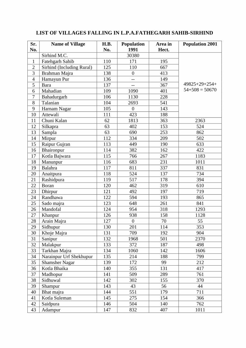
LIST OF VILLAGES FALLING IN L.P.A.FATHEGARH SAHIB-S IRHIND
Sr. No.
Name of Village H.B. No.
Population 1991
Area in Hect.
Population 2001
Sirhind M.C. 30380
49825+29+254+ 54+508 = 50670
1 Fatehgarh Sahib 110 171 195 2 Sirhind (Including Rural) 125 110 667 3 Brahman Majra 138 0 413 4 Hamayun Pur 136 -- 149 5 Bara 137 -- 367 6 Mahadian 109 1090 401 7 Bahadurgarh 106 1130 228 8 Talanian 104 2693 541 9 Harnam Nagar 105 0 143 10 Attewali 111 423 188 11 Chuni Kalan 62 1813 363 2363 12 Silkapra 63 402 153 524 13 Sampla 63 690 253 862 14 Mirpur 112 334 209 502 15 Raipur Gujran 113 449 190 633 16 Bhaironpur 114 382 162 422 17 Kotla Bajwara 115 766 267 1183 18 Manunpur 116 683 231 1011 19 Balahra 117 811 337 831 20 Anaitpura 118 524 137 734 21 Rashidpura 119 517 178 394 22 Boran 120 462 319 610 23 Dhirpur 121 492 197 719 24 Randhawa 122 594 193 865 25 Sado majra 123 648 261 841 26 Mandofal 124 954 318 1293 27 Khanpur 126 938 158 1128 28 Arain Majra 127 0 70 55 29 Sidhupur 130 201 114 353 30 Khoje Majra 131 709 192 904 31 Sanipur 132 1968 501 2370 32 Malakpur 133 372 187 498 33 Tarkhan Majra 134 1060 142 1606 34 Narainpur Urf Shekhupur 135 214 188 799 35 Shamsher Nagar 139 172 99 212 36 Kotla Bhaika 140 355 131 417 37 Madhopur 141 509 289 761 38 Sidhuwal 142 302 155 370 39 Shampur 143 43 56 44 40 Bhat majra 144 551 179 711 41 Kotla Suleman 145 275 154 366 42 Saidpura 146 504 140 762 43 Adampur 147 832 407 1011

44 Bibipur 148 378 157 510 45 Nabipur 149 641 230 1354 46 Longo Majri 150 170 43 237 47 Barkatpur 151 633 271 795 48 Buchra 152 617 252 868 49 Dalo Majra 153 468 206 620 50 Jalbehre 154 777 318 996 51 Sadhugarh 155 99 126 135 52 Jalbehra 156 93 78 139 53 Jalbehri Gehlan 157 939 306 1177 54 Mathi 158 782 283 873 55 Rampur Nauabad 159 143 101 123 56 Hansali 160 580 279 692 57 Ramagarh Sainian 161 541 158 644 58 Dangherian 162 891 305 984 59 Dubhali 163 636 254 774 60 Balahri Kalan 164 828 443 998 61 Balahri Khurd z 1516 459 1794 62 Isherhail 166 771 259 973 63 Bambe Majra 167 108 113 122 64 Balahri Khurd 168 441 247 588 65 Pirijain 169 400 196 1024 66 Mehmadpur 170 1121 213 264 67 Niamu Majra 171 740 306 1038 68 Niamu Majra 218 205 149 239 69 Ghel 219 1015 381 1213 70 Kale Majra 220 284 84 263 71 Mukarampur 221 446 169 561 72 Badali Ala Singh 222 1378 254 1999 73 Hindupur 223 564 178 842 74 Bibipur 224 594 239 707 75 Jamiatgarh 225 496 269 769 76 Manheran 226 437 96 644 77 Nandiali 227 415 201 499 78 Rampur 228 787 205 1024 79 Jhampur 229 1046 365 1263 80 Bhua Kheri 230 319 126 421 81 Mehtabgarh 231 326 156 447 82 Daulatpur 232 130 63 152 83 Tajpur 233 192 178 321 84 Rasulpur 234 821 213 1228 85 Bhagatpur 235 348 234 514 86 Timberpur 242 652 226 850 87 Naraina 245 321 394 489 88 Dadu Majra 246 1256 321 1482 89 Bhagrana 247 2190 458 2837 90 Badali Mai Ki 249 732 281 728 91 Loha Kheri 250 454 193 495

92 Haripur 251 175 163 198 93 Sindhran 252 410 181 532 94 Harnan 253 502 253 666 95 Cholti Kheri 254 372 230 445 96 Salempur 255 534 246 666 97 Baras 256 2088 840 2159 98 Narainagarh 257 162 151 195 99 Kheri Bhai Ki 258 549 191 633 100 Bholan 259 250 155 368 101 Bhaini Kalan 260 493 224 615 102 Bhaini Khurd 261 158 154 200 103 Patarsi Kalan 262 371 218 449 104 Rajindergarh 263 1154 616 1642 105 Patarsi Khurd 264 208 206 267 106 Jiwanpura 265 364 282 431 107 Mianpur 266 512 309 593 108 Reona Bhola 267 643 302 851 109 Reona Ucha 268 721 216 923 110 Behlolpur 270 545 516 835 111 Reona Niwan 269 717 494 947 112 Amargarh 271 403 109 518 113 Pola 272 1178 535 1486
114 Hassanpur Urf Chalheri Khurd
273 777 447 924
115 Chalheri Kalan 274 920 398 1226 116 Panjola 295 471 227 648 117 Nalian Khurd 296 362 246 568 118 Panjoli Kalan 297 719 241 924 119 Lataur 298 873 472 1356 120 Rain Majra 299 341 128 457 121 Kharaura 300 652 230 917 122 Kharapuri 301 661 134 812 123 Khanpur Behlan 302 801 330 1045 124 Narainpura Urf Chorwala 302 321 304 881 125 Badhochhi Kalan 303 2387 923 2890 126 Badhochhi Khurd 304 335 82 464 127 Hussainpura 305 811 479 989 128 Sangatpura Sodhian 306 1229 300 1410 129 Majri Sodhian 307 414 208 493 130 Sidhwan 308 542 165 664 131 Kharrah 309 274 198 347 132 Nalina Kalan 326 798 293 1069
Total 111531 33354 148236 District Won
Planner,
Note: *Villages (Sr. No. 3 to 5) are part of Fatehgarh Sahib-Sirhind M.C.

Annexure-2
PUNJAB GOVERNMENT
DEPARTMENT OF HOUSING AND URBAN DEVELOPMENT
(HOUSING BRANCH-1)
NOTIFICATION
DATED 29-01-08
No. 12/37/2006-4HG1/921 whereas the Governor of Punjab was pleased to declare the Local Planning Area of Fatehgarh Sahib-Sirhind City and its surrounding area u/s 56(1) of "The Punjab Regional and Town Planning and Development Act 1995" vide notification No. 12/37/2006-4HG1/915 dated: 29-1-2008
Further the Governor of Punjab is pleased to designate the Chief Town Planner, Punjab as Planning agency for the above Local Planning area under Section 57 of "The Punjab Regional and Town Planning and Development Act, 1995".
Arun Goel
Dated, Chandigarh Secretary to Government of Punjab
24-01-2008 Department of Housing and Urban Development

Annexure-3
fwsh 25^6^2010 B{z ;t/o/ 11L00 ti/ wkB:'r fvgNh efwPBo, csfjrVQ ;kfjp ih dh gqXkBrh j/m “fd gzikp foIBb n?Av NkT{B gb?fBzr n?Av fvt?bgw?AN (nw?Avw?ZN) n?eN, 2006” sfjs wk;No gb?B, csfjrVQ ;kfjp^;ofjzd ftIB^2031 pDkT[D fjZs rfms “fEze N?Ae ew/Nh” dh whfNzr dh ekotkJhL^
ftP/ sfjs fwsh 25^6^2010 B{z csfjrVQ ;kfjp^;ofjzd, wk;No gb?B d/ ;pzX ftZu j'Jh whfNzr ftZu j/m fby/ nfXekoh ;kfjpkB Pkfwb j'J/L^
1H ;qh r[ogkb f;zx ufjb, T[g w?fi;No/N, csfjrVQ ;kfjp.
2H ;qh oe/P e[wko f;zrbk, n?;HvhHJhH, g[Zvk, gfNnkbk.
3H fJziH jogkb f;zx, n?;HvhHJhH, gktoe'w ;ofjzd.
4H ;qh G{fgzdo f;zx, n?;HvhHJhH, GtB s/ wkor Pkyk, ;ofjzd.
5H ;qh nkoH ghH r[gsk, gpfbe j?bE, csfjrVQ ;kfjp.
6H ;qh i/HghH f;zx, fibQk f;Zfynk nc;o (;?L), csfjrVQ ;kfjp.
7H ;qh wj/P yzBk, fibQk w?B/io, fibQk T[d:'r e/Ado, r'fpzdrVQ.
8H ;qh oki fePB, w?Apo, dcL ekoi^;kXe nc;o, Bro e"A;b, r'fpzdrVQ.
9H vkL nkoHe/H ;{d, nf;;N?AN f;tb ;oiB, csfjrVQ ;kfjp.
10H ;qh r[oBkw f;zx, gqXkB, u?Apo nkc ewo;, csfjrVQ ;kfjp n?N, r'fpzdrVQ.
11 ;qL nwoihs f;zx, w?B/io, r[odtkok csfjrVQ ;kfjp.
fibQk Bro :'iBkeko, csfjrVQ ;kfjp B/ ps"o w?Apo ;eZso whfNzr ftZu nkJ/ j'J/ ;w{j w?ApoK B{z ih nkfJnK efjzd/ j'J/ wk;No gb?B d/ T[bheD ns/ fJ; d/ wzst, fJ; d/ nzdo g?Ad/ oep/ ns/ nk;^gk; d/ fgzvk I' fe b'eb gb?fBzr J/ohJ/ nXhB g?Ad/ jB, pko/ t/otk fdzd/ j'J/ ;w{j w?ApoK B{z 2010^31 sZe d/ wk;No gb?B d/ ;pzX ftZu ft;Ekog{ote ikDekoh fdZsh.
gqXkB ih B/ T[go'es ikDekoh fi; ftZu fibQk Bro :'iBkeko tZb'A ;{fus ehsk frnk ;h fe fJ; b'eb gb?fBzr J/ohJ/ fi; dk e[Zb oepk 33354 j?eN/no ns/ fi; ftZu fJ; Pfjo d/ nk;^gk; d/ 132 fgzv Pkfwb ehs/ rJ/ Jb T[jBK d/ ;[uZi/ ftek; bJh :'iBkpZX sohe/ Bkb ezw ehsk ikDk nfs io{oh j?. fJj ezw r[odtkok csfjrVQ ;kfjp d/ brd/ Pfjdh I'V w/b B{z w[Zy oZyd/ j'J/ fi; ftZu fe jo ;kb bZyK dh

frDsh ftZu PoXkb{ ;oXkibh G/N eoB bJh nkTAd/ jB, T[jBK B{z w"i{dk s"o s/ nkT[AdhnK n"eVK fit/A fe gkofezr, No?fce n?Av NoK;g'oN/PB ftZu ;[uko[esk ns/ fJ; d/ Bkb jh n?rihfpi;BI $ B[wkfJPK d/ bJh yk; EktK fB;fus ehshnK ikD sK I' GftZy ftZu fJBQK n"eVK dk ;kjwDk Bk eoBk gt/.
fJ; T[gozs r[odtkok csfjrVQ ;kfjp d/ w?B/io ;qL nwoihs f;zx tZb'A ;[MkJ/ sZEK Bkb ;fjwsh gqrNkJh ns/ T[jBK B/ pDB tkb/ wk;No gb?B ftZu fJBQK wZdK B{z soihj d/D bJh fejk ns/ Bkb r'fpzdrVQ Pfjo s'A pZ;h gmkDK tZb nkT[D ikD tkb/ No?fce B{z csfjrVQ ;kfjp^;ofjzd s'A pkjo jh pkjo fe;/ w"i{dk ;Ve fijk fe fgzv ykBg[o tkbh ;Ve nkfd B{z u"Vk ekoB dh sithi okjhA fB:zsfos eoB bJh th fejk.
T[go'es Bkb ;fjwsh gqrNkT[Ad/ j'J/ fibQk f;Zfynk nc;o(;), csfjrVQ ;kfjp tZb'A th I'V w/b d/ ;Bw[Zy fJ; Pfjo d/ uko/ gk;/ No?fce ftZu ;[ftXk bJh fJe fozr o'v sithi eoB dk ;[Mkn fdZsk frnk j?.
gqXkB ih tZb' T[go'es ;[MktK B{z T[bhe/ ik oj/ wk;No gb?B ftZu jo gZy'A fXnkB ftZu oZyD bJh fibQk Bro :'iBkeko B{z fejk ns/ nkJ/ j'J/ ;w{j w?ApoK B{z fibQk Bro :'iBkeko tZb'A wk;No gb?B B{z fsnko eoB ;pzXh wzrh rJh ;{uBk ;w/A f;o d/D pko/ fejk sK I' fJj wk;No fwE/ Nhu/ nB[;ko w[ezwb ehsk ik ;e/.
nzs ftZu ;w{j w?ApoK d/ XzBtkd ;fjs whfNzr dh ;wkgsh ehsh rJh.
fvgNh efwPBo,
csfjrVQ ;kfjp.

Annexure-4
fwsh 23^9^2010 B{z ;t/o/ 12L30 ti/ wkB:'r fvgNh efwPBo, csfjrVQ ;kfjp ih dh gqXkBrh j/m “fd gzikp foIBb n?Av NkT{B gb?fBzr n?Av fvt?bgw?AN (nw?Avw?ZN) n?eN, 2006” sfjs wk;No gb?B, csfjrVQ ;kfjp^;ofjzd ftIB^2031 pDkT[D fjZs rfms “fEze N?Ae ew/Nh” dh whfNzr dh ekotkJhL^
ftP/ sfjs fwsh 23^9^2010 B{z csfjrVQ ;kfjp^;ofjzd, wk;No gb?B d/ ;pzX ftZu j'Jh whfNzr ftZu j/m fby/ nfXekoh ;kfjpkB Pkfwb j'J/L^
1H ;qhwsh nzfwqs e"o frZb, tXhe w[Zy gqPk;e, g[Zvk, gfNnkbk.
2 fJziH J/Hn?;H frZb, ekoiekoh fJzihBhno, gktoe'w, ;ofjzd.
3H ;qh G{fgzdo f;zx, n?;HvhHJhH, GtB s/ wkor Pkyk, ;ofjzd.
4H ;qh Xowgkb, n?;HvhHJhH, gpfbe j?bE, csfjrVQ ;kfjp.
5H ;qh joihs f;zx, ekoiekoh fJzihBhno, ghgh;hph, gfNnkbk.
6H ;qh i/HghH f;zx, fibQk f;Zfynk nc;o (;?L), csfjrVQ ;kfjp.
7H ;qh wj/P yzBk, fibQk w?B/io, fibQk T[d:'r e/Ado, r'fpzdrVQ.
8H ;qh oki fePB, w?Apo, dcL ekoi^;kXe nc;o, Bro e"A;b, r'fpzdrVQ.
9H vkL nkoHe/H ;{d, nf;;N?AN f;tb ;oiB, csfjrVQ ;kfjp.
10H ;qh Gos G{PB, gqXkB, u?Apo nkc ewo;, csfjrVQ ;kfjp n?N r'fpzdrVQ.
11H ;qh phHn?BH r[gsk, JhHUH fJzv;Nohnb n?;';hJ/PB (nkb fJzvhnk ;Nhb oh^o'bo n?;';hJ/PB $ ;wkb ;e/b), csfjrVQ ;kfjp^;ofjzd n?N r'fpzdrVQ.
12H ;qL nwoihs f;zx, w?B/io, r[odtkok csfjrVQ ;kfjp.
fibQk Bro :'iBkeko, csfjrVQ ;kfjp B/ ps"o w?Apo ;eZso whfNzr ftZu nkJ/ j'J/ ;w{j w?ApoK B{z ih nkfJnK efjzd/ j'J/ wk;No gb?B d/ T[bheD ns/ fJ; d/ wzst, fJ; d/ nzdo g?Ad/ oep/ ns/ fJ; b'eb/ gb?fBzr J/ohJ/ nXhB g?Ad/ 132 fgzvK ;pzXh vkfJo?eNo, gzikp fow'N ;?Afz;zr, b[fXnkDk s'A gqkgs r{rb ;hN; d/ nkXko s/ rokT{Av No{fEzr eotkT[D T[gozs vkfJo?eNo
gzikp fow'N ;?Af;zr, b[fXnkDK s'A gqkgs w"i{dk G"A^tos'A gb?B B{z j'o ;pzfXs ftGkrK s'A gqkgs ;{uBK d/ nXko s/ w"i{dk ;';b $ fciheb fJzBcok;Noeuo d/ ;Bw[Zy csfjrVQ ;kfjp^;ofjzd Pfjo dh ;No?AE, ngou{BNhI n?Av Eo?N; B{z fXnkB ftZu oZyd/ j'J/ gfjbh “fEze N?Ae” ew/Nh whfNzr ftZu fdZs/ j'J/ ;[MktK B{z fXnkB ftZu oZyd/ j'J/ ;hBhno Bro :'iBkeko, n?;HJ/Hn?;H Bro ih Bkb ftuko^tNKdkok eoB T[gozs fsnko ehs/ ezB;[gu{nb gb?B ;pzXh ft;Ekog{ote ikDekoh fdzd/ j'J/ fJ; s/ ;w{j Pkwb w?ApoK s'A T[jBK dh pvw[Zbh okJ/ $ sefBeh :'rd/D d/D bJh p/Bsh ehsh rJh.
gqXkB ih tZb'A T[go'es ikDekoh s/ j'o ukBDK gkT[Ad/ j'J/ csfjrVq ;kfjp^;ofjzd d/ ;[uZi/ ftek; bJh ;w{j w?Apo ;kfjpkB B{z nkgD/^nkgD/ ftGkr Bkb ;pzXs n"eVK pko/ ikD{ eotkT[D bJh fejk frnk.

r[odtkok csfjrVQ ;kfjp d/ w?B/io ;qL nwoihs f;zx tZb'A r'fpzdrVQ s'A pZ;h gmkDK Pfjo tZb ikD tkb/ No?fce B{z ftP/P s"o s/ Pfjdh I'V w/b d"okB nkT[D tkbh No?fce gZy'A n"eVK d/ wZd/ Bio csfjrVQ ;kfjp^;ofjzd s'A pkjo ihHNhH o'v s'A w"i{dk fgzv ykBg[o B{z iKdh ;Ve ;pzXh n?etkfJo ehsh G"A pko/ dZf;nk fi; ;pzXh gqXkB ih tZb’A ghHvpfb:H ftGkr d/ B[wkfJzd/ s'A g{oh gq'i?eN fog'oN ;w/s fvN/b fibQk Bro :'iBkeko, csfjrVQ ;kfjp d/ dcso B{z G/iD bJh fejk frnk.
fJzihBhno J/Hn?;H frZb tZb'A ew/Nh B{z ikD{ eotkfJnk frnk fe T[jBK d/ ftGkr tZb'A fgzv Bphg[o fty/ brGr 3H5 J/eV oep/ ftZu 66 e/HthH rfoZv ;N/PB ;Ekfgs eoB bJh ykbh gzukfJsh IwhB b?D bJh T[gokbk ehsk ik fojk j? ns/ fJ; s'A fJbktk fJ; whfNzr d"okB g/P ehs/ ezB;/gu{nb gb?B csfjrVQ ;kfjp^;ofjzd Pfjo bJh sithi fJzv;Noh I'B d/ ;Bw[Zy xZN'^xZN 200 e/HthH rfoZv ;N/PB bJh 15^20 J/eV oepk b'VhAdk j'D pko/ ikD{ eotkfJnk frnk.
whfNzr ftZu Pkwb fJzv;Nohnb n?;';hJ/PB d/ B[wkfJzfdnK tZb'A fgzv wZbeg[o (jHpH BzL 133) dh iwhB nzdo ihHNhHo'v Bkb ;Ekfgs fJekJhnK B{z ezB;/gu{nb gb?B d/ fwe; fJzv;Nohnb I'B ftZu Pkwb ehs/ ikD ;pzXh fJsoki gqrNkT[Ad/ j'J/ fJ; oep/ B{z r'fpzdrVQ Pfjo d/ wk;No gb?B Bkb brd/ j'D d/ ;Bw[Zy T[;/ soi s/ fJzv;Nohnb I'B sithi eoB dk ;[Mkn fdZsk frnk, fi; d/ ;pzX ftZu fibk Bro :'iBkeko tZb'A Go';k fdZsk frnk fe fJ; B[Zes/ pko/ T[Zu gZXo s/ ;hBhno nfXekohnK Bkb ftuko^tNKdkok ehsk ikt/rk.
nzs ftZu ;w{j w?ApoK d/ XzBtkd ;fjs whfNzr dh ;wkgsh ehsh rJh.
fvgNh efwPBo,
csfjrVQ ;kfjp.

Annexure-5
fwshL31^12^2010 B{z d[gfjo 12H30 ti/ wkB:'r fvgNh efw;aBo, csfjrVQ ;kfjp ih dh gqXkBrh j/m "fd gzikp foiaBb n?Av NkT{AB gb?fBzr n?Av fvt?bgw?AN (nw?vw?AN) n?eN, 2006" sfjs wk;No gb?B, csfjrVQ ;kfjp^;ofjzd ftiaB^2031 pDkT[D fjZs rfms "fEze N?Ae ew/Nh" dh whfNzr dh ekotkJhL^
ft;a/ sfjs fwshL31^12^2010 B{z csfjrVQ ;kfjp^;ofjzd wk;No gb?B d/ ;pzX ftZu j'Jh whfNzr ftZu j/m fbZy/ nfXekoh ;kfjpkB ;akwb j'J/L^
1H ;qh oe/;a e[wko f;zrbk, n?;HvhHJhH, tXhe w[Zy gq;k;ae, g[Zvk, gfNnkbk.
2H ;qh ;[fozdo f;zx, n?;HvhHJhH, tXhe w[Zy gq;k;ae, g[Zvk, w[jkbh.
3H fJziH ofizdo f;zx, n?;HvhHUH, gktoe'w, ;ofjzd.
4H ;qh G{fgzdo f;zx, n?;HvhHJh, GtB s/ wkor ;akyk, ;ofjzd.
5H ;qh gqw'd uzd, ekoiekoh fJzihBhno, gpfbe j?bE, csfjrVQ ;kfjp.
6H ;qh joihs f;zx, ekoiekoh fJzihBhno, ghgh;hph, gfNnkbk.
7H ;qh GHf;zx, fiabQk f;Zfynk nc;o (;?L), csfjrVQ ;kfjp.
8H ;qh wfjzdo f;zx, ;hH;H, fiabQk T[d:'r e/Ado, r'fpzdrVQ.
9H ;qh irihs f;zx ;akjh, ekoi^;kXe nc;o, Bro e"A;b, csfjrVQ ;fjp^;ofjzd.
10H vkHnkoHe/H;{d, nf;;N?AN f;tb ;oiB, csfjrVQ ;kfjp.
11H ;qh phHphHfizddb, gqXkB, u?Apo nkc ewo;, csfjrVQ ;kfjp n?N r'fpzdrV.
12H ;qh phHn?BH r[gsk, JhHUH, fJzv;Nohnb n?;';hJ/;aB (nkb fJzvhnk ;Nhb
oh^o'bo n?;';hJ/;aB$ ;wkb ;e/b), csfjrVQ ;kfjp^;ofjzd n?N r'fpzdrVQ.
13H ;qh r[oBkw f;zx, u?Apo nkc ewo;, csfjrVQ ;kfjp n?N r'fpzdrVQ.
14H ;qh wBdhg, nkb fJzvhnk n?;';hJ/;aB, csfjrVQ ;kfjp.
15H ;qh ybhck ;fJ:d w[jZwd ;kfde oiak, o'ik ;ohc, ;ofjzd.
16H ;qh e[bihs f;zx, fiabQk b'e ;zgoe nc;o, csfjrVQ ;kfjp.
fiabQk Bro :'iBkeko, csfjrVQ ;kfjp B/ ps"o w?Apo ;eZso whfNzr ftZu nkJ/ j'J/ ;w{j w?ApoK B{z ih nkfJnk efjzd/ j'J/ fsnko ehs/ vokcN ;e?u wk;No gb?B fi;B{z B{z gfjbh$ d{ih "fEze N?Ae" ew/Nh whfNzr ftZu fdZs/ j'J/ ;[MktK B{z fXnkB ftZu oZye/ pDkT[D pko/ ikD{ eotkfJnk ns/ b'eb gb?fBzr

J/ohnk d/ ;w[Zu/$ ;[uZi/ fte; fjZs sithias ;Noeuob co/wtoe fi; ftZu sithias o'v fjokoeh ns/ sithias ;oe{b/;aB g?NoB ;w/s tZy^tZy b?Av :{fiia bJh v?ihrB/fNv ia'Bia pko/ ukBDk gkfJnk .
gqXkB ih tZb'A T[go'es ikDekoh s/ j'o ukBDK gkT[Zd/ j'J/ csfjrVQ ;kfjp^;ofjzd d/ ;[uZi/ ftek; bJh ;w{j w?po ;fjpkB B{z ngD/^ngD/ ftGkr Bkb ;pzXs n"eVK iK e'Jh j'o b'VK pko/ ikD{ eotkT[D bJh fejk frnk ns/ n?eN sfjs b'eb gb?fBzr J/ohnk fveb/nov j'D T[gozs th nB^nE'okJhiav$ nB^o?r{b/fNv j' oj/ ftek; dh ;jh o'eEkw d/ B[Zes/ B{z w?Apo ;?eNoh tZb'A T[Zu gZXo s/ go;hT{ eotkT[D d/ fBod/;a fdZs/ .
whfNzr ftZu jkiao fJzv;hNohnb n?;';hJ/;aB d/ B[wkfJzfdnK tZb'A e[ZM J/ohJ/ B{z fJzv;Nohnb ia'B ftZu ;akwb eoB dk ;[Mkn fdZsk frnk fi; ;pzXh wkB:'r gqXkB ih tZb'A nkgDh gqsh p/Bsh fiabQk Bro :'iBkeko, csfjrVQ ;kfjp d/ dcso ftZu pDdh ekotkJh fjZs g/;a eoB bJh fejk frnk .
fJzihBhno ofizdo f;zx tZb'A ew/Nh B{z ikD{ eotkfJnk frnk fe T[jBK d/ ftGkr tZb'A fgzv Bphg[o ftZy/ 220 e/HthH rfoZv ;N/;aB ;Ekfgs eoB bJh iawhB b?D bJh T[gokbk ehsk ik fojk j? .
gqXkB ih tZb'A ;e?u wk;No gb?B s/ s;Zbh gqrNkT[Ad/ j'J/ whfNzr d"okB ;kjwD/ nkJ/ e[ZM B[ZefsnK s/ ftuko eoB bJh fiabQk Bro :'iBkeko, csfjrVQ ;kfjp B{z nkyd/ j'J/ ew/Nh tZb'A fJ; gb?B dh gqtkBrh fdZsh rJh .
nzs ftZu ;w{j w?ApoK d/ XzBtkd ;fjs whfNzr ;wkgs ehsh rJh .
fvgNh efw;aBo,
csfjrVQ ;kfjp.

Annexure-6 MJPLAMB ML 4.2 Dated: 14.12.2007 The Director Projects PSEB. NPL. Patiala Punjab Sub: NOC for Setting up Thermal Power Station at Village Nalash-Sural near Rajpura adjoining Mathura-Jalandhar Pipeline (MJPL). Dear Sir This has reference to your Memo No. 175 Raj 401 date 30.11.2007 and subsequent visit of Sh. Ajay Gupta & Sh. S.K. Jain on 03.12.2007 seeking NOC for the proposed 1320 MW Thermal Power Plant near Rajpura adjoining MJPL. In this connection we would like to bring to your kind notice that. 1. Indian Oil Corporation Limited had laid a cross country Product Pipeline from Mathura to
Jalandhar under “The Petroleum and mineral Pipelines (Acquisition of Right of User in Land) Act 1962” and the said pipeline is meeting the petroleum product requirement of all the Northern States including Defence.
2. The site of 1320 MW Thermal Power Plant is proposed on the 18 M wide Right of Way (ROW) of the said Pipeline. This pipeline is transporting highly inflammable petroleum products. Mathura-Jalandhar pipeline is laid by adhering to various National & International codes & OISD standard for the safety of the adjoining residents as well as to carryout regular maintenance for up keeping the health of the pipeline. While processing NOC the following guidelines as per petroleum Act are strictly adhered to:- a) Our pipelines are normally laid at depth of one M below the ground level, maintaining
18 M wide ROW throughout from Mathura to Jalandhar for regular patrolling and time-to-time maintenances of the pipeline.
b) Restriction regarding the use of land: there should not be any permanent structure like building, tank, reservoir, dam or plant any tree etc across ROW as it will bring hindrances for the movement of heavy machineries during maintenance emergency activities.
c) No dwelling unit to be constructed within 20.50 M from either side edges of the
R.O.W. d) No flare or higher temperature activities are to be carried out near pipeline as it
transports highly inflammable Petroleum products, which may cause fire. All required precautions practices may please be looked into. A safe distance of 150 meter from pipeline to be maintained for the Industrial activities.

e) Only Green belt to be maintained across the ROW including cultivation.
f) Permission for crossing of pipeline ROW by constructing the boundary wall in emergency cases are accorded with a provisions of the suitable beam structure with the condition that wall may be dismantled for the movement of heavy equipments like bull dozer, excavator etc, during emergency and repair by the licensee. Moreover, for regular inspection entry to Licence permission or his authorized representative to be allowed. For each crossing activity separate permission upon would be required from IOCL. Necessary charges fee (depending upon estimated cost of the work to be carried out by you in ROW) would be communicated to you for each crossing. An agreement will also be signed for crossing permission.
g) No heavy vehicular movement is allowed to avoid rupture direct load to the pipeline. However in specific cases for the movements of heavy vehicles culvert bridge are to be made across/over the ROW with prior permission in writing.
h) No construction activities are to be started in ROW without permission in writing.
3 You are requested to put forward your detailed proposal for processing the permission for
the forthcoming project. Further, you may feel free to ask any clarification on the subject matter.
Thanking you, Yours faithfully, O.P. Khatri, Chief Operations Manager.

Annexure-7
LIST OF VILLAGES THROUGH WHICH IOCL PIPELINE IS PAS SING
LIST OF VILLAGES FALLING IN L.P.A.FATEHGARH SAHIB-S IRHIND
Sr. No. Name of Villages Hadbast No.
1 Harnan 253
2 Salempur 255
3 Rain Majra 299
4 Baras 256
5 Kheri Bhai Ki 258
6 Dangherian 162
7 Balahri Kalan 165
8 Balahri Khurd 168
9 Raipur Gujran 113
10 Mehmadpur 170
LIST OF VILLAGES FALLING IN L.P.A. BASSI PATHANA
Sr. No. Name of Villages Hadbast No.
Bassi Pathana Urban
1 Mehmudpur 175
2 Mehdoodan 81
3 Abdullapur 80
4 Jodhpur 174

Annexure-8
LIST OF VILLAGES THROUGH WHICH G.A.I.L. PIPELINE IS PASSING
Sr. No. Village Name Hadbast No.
1 Chhaleri Kalan 274
2 Hussainpur (Chhalari Khurd) 305
3 Panjola 295
4 Nalina Kalan 326
5 Chaurwala 302
6 Badhochi Kalan 303
7 Kharrah 309
8 Sidhwan 308
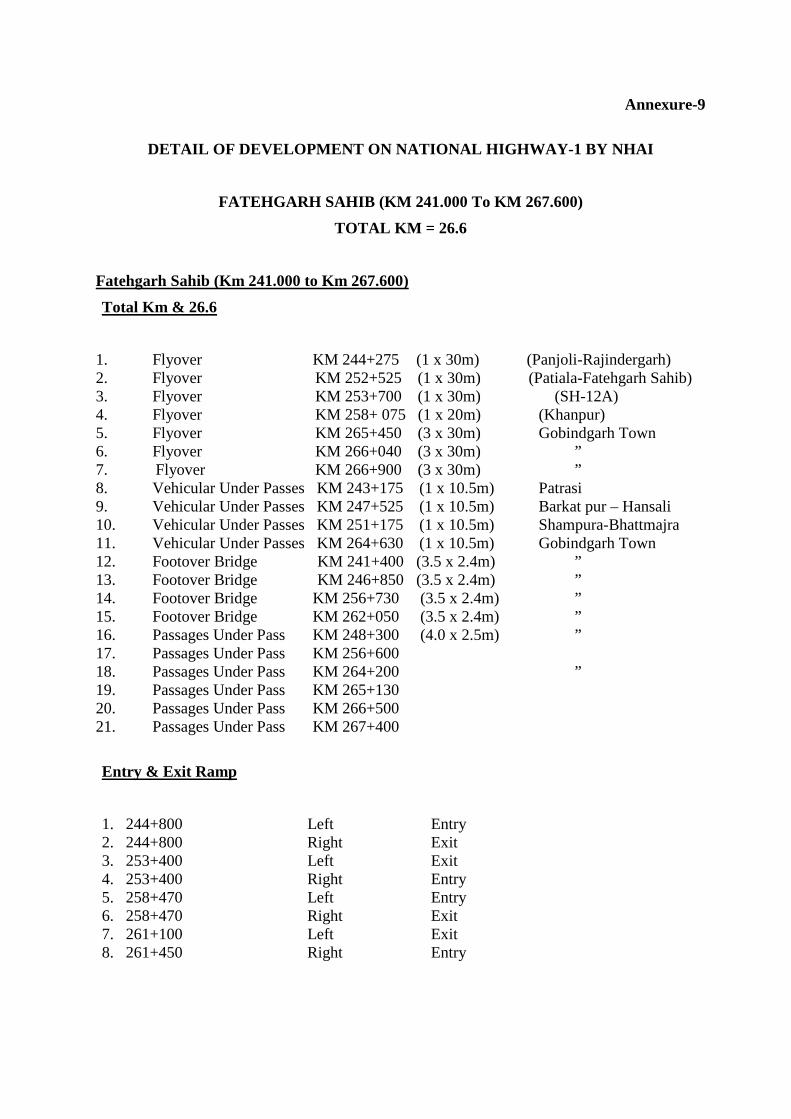
Annexure-9
DETAIL OF DEVELOPMENT ON NATIONAL HIGHWAY-1 BY NHAI
FATEHGARH SAHIB (KM 241.000 To KM 267.600)
TOTAL KM = 26.6
Fatehgarh Sahib (Km 241.000 to Km 267.600)
Total Km & 26.6
1. Flyover KM 244+275 (1 x 30m) (Panjoli-Rajindergarh) 2. Flyover KM 252+525 (1 x 30m) (Patiala-Fatehgarh Sahib) 3. Flyover KM 253+700 (1 x 30m) (SH-12A) 4. Flyover KM 258+ 075 (1 x 20m) (Khanpur) 5. Flyover KM 265+450 (3 x 30m) Gobindgarh Town 6. Flyover KM 266+040 (3 x 30m) ” 7. Flyover KM 266+900 (3 x 30m) ” 8. Vehicular Under Passes KM 243+175 (1 x 10.5m) Patrasi 9. Vehicular Under Passes KM 247+525 (1 x 10.5m) Barkat pur – Hansali 10. Vehicular Under Passes KM 251+175 (1 x 10.5m) Shampura-Bhattmajra 11. Vehicular Under Passes KM 264+630 (1 x 10.5m) Gobindgarh Town 12. Footover Bridge KM 241+400 (3.5 x 2.4m) ” 13. Footover Bridge KM 246+850 (3.5 x 2.4m) ” 14. Footover Bridge KM 256+730 (3.5 x 2.4m) ” 15. Footover Bridge KM 262+050 (3.5 x 2.4m) ” 16. Passages Under Pass KM 248+300 (4.0 x 2.5m) ” 17. Passages Under Pass KM 256+600 18. Passages Under Pass KM 264+200 ” 19. Passages Under Pass KM 265+130 20. Passages Under Pass KM 266+500 21. Passages Under Pass KM 267+400
Entry & Exit Ramp
1. 244+800 Left Entry 2. 244+800 Right Exit 3. 253+400 Left Exit 4. 253+400 Right Entry 5. 258+470 Left Entry 6. 258+470 Right Exit 7. 261+100 Left Exit 8. 261+450 Right Entry

Service Road
1. KM 243+900 252+225 5.5m Bothside 2. KM 252+225 257+000 7m Bothside 3. KM 257+000 260+000 5.5m Bothside 4. KM 260+000 260+350 7m Bothside 5. KM 260+100 277+100 7m Bothside

Annexure-10 DETAILS OF PROPOSED PASSES BY NHAI
S.NO. KM. STONE TYPE OF PASSES DISCRIPTION
1 KM 244+ 275 FLYOVER PANJOLI- RAJINDERGARH
2 KM 244+ 275 FLYOVER PATIALA-FATEHGARH SAHIB
3 KM 244+ 275 FLYOVER SH-12A
4 KM 244+ 275 FLYOVER KHANPUR
5 KM 244+ 275 VEHICULAR UNDER PASS PATARSI
6 KM 244+ 275 VEHICULAR UNDER PASS BARKATPUR-HANSALI
7 KM 244+ 275 VEHICULAR UNDER PASS SHAMPUR-BHATMAJRA
8 KM 244+ 275 FOOTOVER BRIDGE
9 KM 244+ 275 PASSAGE UNDER PASS
10 KM 244+ 275 PASSAGE UNDER PASS
11 KM 244+ 275 PASSAGE UNDER PASS

Annexure-11
LIST OF INDUSTRIES AT INDUSTRY AREA, PUMP NAGAR, SI RHIND
WITHIN M.Cl.
Sr. No. Name of Industry
1 Bharat Development Industries 2 Mangal Mahal Marriage Palace
3 Royal Enterprices
4 Nikhil Industries
5 Sat Pal Flour and Oil Mills
6 Gupta Industrial Corporation 7 Adarsh Industrial Corporation
8 Nehra Refrigeration Centre 9 Super Steels
10 Landmark signboars Pvt. Ltd.
11 Pardesi Indutry
12 Tej Mechanical works
13 Tushar Graphics 14 Mitter Engineering works, Sirhind
15 Rakesh Engg. Works
16 Vikram Plastics
17 K.L. Mechanical works
18 Akal Mechanical works 19 Paras Enterprises
20 Paras Industries (Regd.) 21 S.K. Bansal Industries
22 New Sudershan Foundry
23 Subhash Mechanical works
24 Manoj Industries
25 M/S Jai Dayal Chander Mohan 26 Spall Mechanical works
27 Tewenty First Sunshine Plastic Industry
28 K.L. Industries
29 Inder Inudstries
30 Navdeep Industries 31 Navdeep Traders and Engineers Pvt. Ltd.

32 Pawanpreet Plastic Industry
33 Rajinder Plastic
34 Bhupindera Industry
35 Shivam Paint and Plywood company 36 Rakesh Traders, wholesale dealer and godown
37 Thakur Welding works 38 Janta Tent house
39 Batra Traders
40 Jai Durga Trading company
41 R.C. Industries
42 Modi Hardware Store 43 S.N. Industries
44 Varun Pumps
45 Bharat Gas LPG Godown
46 Nandu Mal Piare Lal Kerosene Oil dump
47 Guru Kirpa Castings 48 Sodhi Sodha Water Factory
49 Auto Continental Pvt. Ltd. 50 Naresh Bardana Store and godwon
51 Karma Electricals Industries
52 Big Boss Techno. Crate Equipments
53 Newtan Industries
54 Malhotra Maruti Car Service Centre 55 Anand Plastic Grain Factory

Annexure-12
tZb'A fibQk ftek; ns/ gzukfJs nc;o, csfjrVQ ;kfjp. tZb fibQk Bro :'iBkeko, fibQk gqzpXeh ezgb?e;, csfjrVQ ;kfjp. BzL 1913 $ohvo fwshL 08^11^2010 ftPkL^ b'eb gb?fBzr J/ohnk csfjrVQ ;kfjp nXhB g?Ad/ t/en?Av gzukfJs$Pkwbks b?Av ;pzXh. jtkbkL^ nkg d/ dcso dk gZso BzL 1466^vhNhgh(cr;) n?w 27 fwsh 01^11^2010 d/ ;pzX ftZu. T[go'es ftP/ s// jtkb/ nXhB gZso d/ ;pzX ftZu fbfynk iKdk j? fe rokw gzukfJs dh
Pkwbks IwhB dh pdbh jo ;kb ;oeko dhnK jdkfJsK nB[[;ko ehsh iKdh j? ns/ e'Jh th irQk ykbh
(t/e?AN) BjhA j?. pbke ;ofjzd dh Pkwbks IwhB dk e[Zb oepk 5904 J/eV j? fi; ftZu'A 3955 J/eV m/e/ s/
fdZsk ik u[Zek j? ns/ 1949 J/eV e'oN e/;K$BikfJI epfinK nXhB j?. fJ; bJh fJ; dcso dh ;{uBk
fBZb ;wMh ikt/rh.
;jh
fibQk ftek; ns/ gzukfJs nc;o, csfjrVQ ;kfjp.

Annexure- 13
Cross Sections of Proposed Road Hierarchy
FIG. 1: R-2 ROAD (150’)
FIG. 2: R-3 ROAD (100’)
FIG. 3: R-4 ROAD (80’)

FIG. 4: R-5 ROAD (60’)