report on jure landslide, mankha vdc, … nepal government ministry of irrigation report on jure...
TRANSCRIPT

1
Nepal Government
Ministry of Irrigation
Report on
Jure Landslide, Mankha VDC, Sindhupalchowk District
The Report based on the Study committee formulated by
Ministry of Irrigation (Minister Level) on August 24, 2014 AD (2071/05/08 BS)
(Translated and edited from Nepali to English by: Mr. Shanmukhesh Chandra Amatya, Sr. Div. Hydro-geologist,
Landslide Management Section Chief, DWIDP)
September 21, 2014 AD
(2071/06/05 BS)
2
1. Background
A huge landslide disaster was occurred on August 2, 2014 (2071/04/17 BS) Saturday, at 2.36
Am in the Jure, Ward no 1 and 5 of Mankha Village Development Committee (VDC) and
Ward no. 5 of Ramche VDC, Sindhupalchowk district. The gigantic landslide disaster
affected huge losses of life and property in the area. The massive landslide dammed
completely the Sunkoshi River forming a lake of about 3km long and 300 to 350 m width and
the Natural dam.
In this regard a Study Committee was formulated by Government of Nepal (Minister Level
decision) on August 24, 2014 AD (2071/05/08 BS). The Study Committee was given the
mandates for technical study of the Jure landslide, to find out the cause of the landslide,
possibility of losses of life and property due to occurring landslide in the same place in
future, to find out the Mitigation measures of the Jure Landslide that the Ministry of
Irrigation have to do, Suggestion and Proposition for policies that the Government of Nepal
have to follow to mitigate the losses of life and properties from similar Landslides in the
country. The Study committee started the work from August 27, 2014 (2071/05/11 BS) and
visited the Landslide site two times for preliminary study.
The present report is based on the available maps, data and study reports, site investigation,
site photographs, GPS survey, and interviews from the victims and so on.
2. Extraordinary Landslide
The landslide occurred in the Jure, Sindhupalchowk (Figure 1) is a unusual mass movement.
This type of landslide can be found in the mountainous countries such as Switzerland, Japan,
and Canada and periodically in Nepal. We can also find this type of massive landslides along
the rivers which flow from Tibet to Nepal such as Karnali river, Gandaki river, Marsyangdi
river and Tamakoshi river.
The Jure landslide is a typical rock avalanche or slope failure type of mass movement. The
rock fragments were dropped from about 800m height to the base of the landslide where the
speed could be from 60 to 70m per second. The air in the Sunkoshi narrow valley was
trapped by the dropping of the huge mass of the landslide suddenly so that the rock fragments
spread up to the opposite bank of the Sunkoshi river and due to surging of the Sunkoshi and
the landslide material, the Dabi khola and surrounding villages with jungles were badly

3
damaged up 100m high. The dust of the landslide was reached up to 600m height which
covered the Dabi Khola village area.
The landslide created about 13.5 million tons of rock debris and dust. The rock debris
avalanche dammed the Sunkohsi river completely within approximately 2 -3 minutes. A local
quake of 3.3 magnitudes was recorded on that day due to the landslide. The two gates of the
Sunkoshi hydropower dam was damaged due to the pressurized surging of the mud and
debris created in the Sunkoshi river. After few minutes of this event the flow of the Sunkoshi
was stopped and it took about 12 hours to over top the Natural dam created by the landslide.

4
Figure 1: GIS map showing Tracks and Location of study points
during the Jure Landslide study, Sindhupalchowk.

5
3. Physical Status
The rock type in the landslide area is phyllite, schist and quartzite. The Araniko Highway
study in 1987 AD (2044 BS) also noticed the landslide in Jure area. Similarly the landslide
was clearly seen in the Google Earth map since 3-4 years but it was difficult to assume such
type of gigantic event will happen.
There are many studies of such type of landslides in other countries also. The Landslide of
Alm in Switzerland and landslide of Randa were the examples of them. This type of mass
movement weakens from the joints and cracks instead of from some particular surface, in the
result, the mass will be moved down due to instability and gravity force.
Similar type of environment was created in the Jure landslide also. The comparatively thick
2-3 hard layers of rocks preventing the mass to move down but in the lapse of time, the rock
mass continuously weakened due to the weathering activities and pore water pressure, in the
result, the mass movement activated down suddenly.
Mainly four types of joint sets were identified in the Jure landslide area. First one is the joints
along the foliation of the rock which dips about 20-30 degree toward NW. Second joint sets
are nearly vertical from which most of the water falls of the area are flowing down. The third
joint sets are parallel to the landslide slip surface or along the slope of the mountain and the
fourth joint sets dipping about 40-50 degree toward West inside the landslide rock. The
surface water entered inside of the mountain through those joints. In the time lapse of
hundreds of year, the retaining force of the landslide decreased continuously and the mass
movement was triggered by rainfall.
4. Present Status of the Landslide
The Jure landslide can be divided into 7 parts. Which are explained separately as follows.
4.1 Crown Part: The altitude of the crown part of the landslide is about 1650m msl. The
land surface in the crown part is still in unstable condition. There are present of many
cracks, spring water is coming out, different blocks are moving and toppling down from
the cracks, trees are tilting down to different directions and about 300m width and about
15m depth body mass are in process to move or slip down slowly. (Figure 2,3,4,5 &6). It
was noted that the surface water was flowing into the cracks developed in the crown area

6
near the Tate village since 2 years and the location was descended with some kind of
sounds just two days before the disaster event. In the mean time, the villagers were
shifted from that location to safe site before two days knowing such a hazardous
condition of the site. The landslide in the crown part was initiated at about 5Am in that
day as per the villagers. The village road near the Tate village also was damaged by the
landslide event (fig.5) but it is now maintained by the villagers. The villagers of the Tate
village mentioned that the crown part area of the landslide was in risky condition since
long time ago.
Figure 2: Cracks and disturbed surface in the Crown part of the Jure Landslide
7
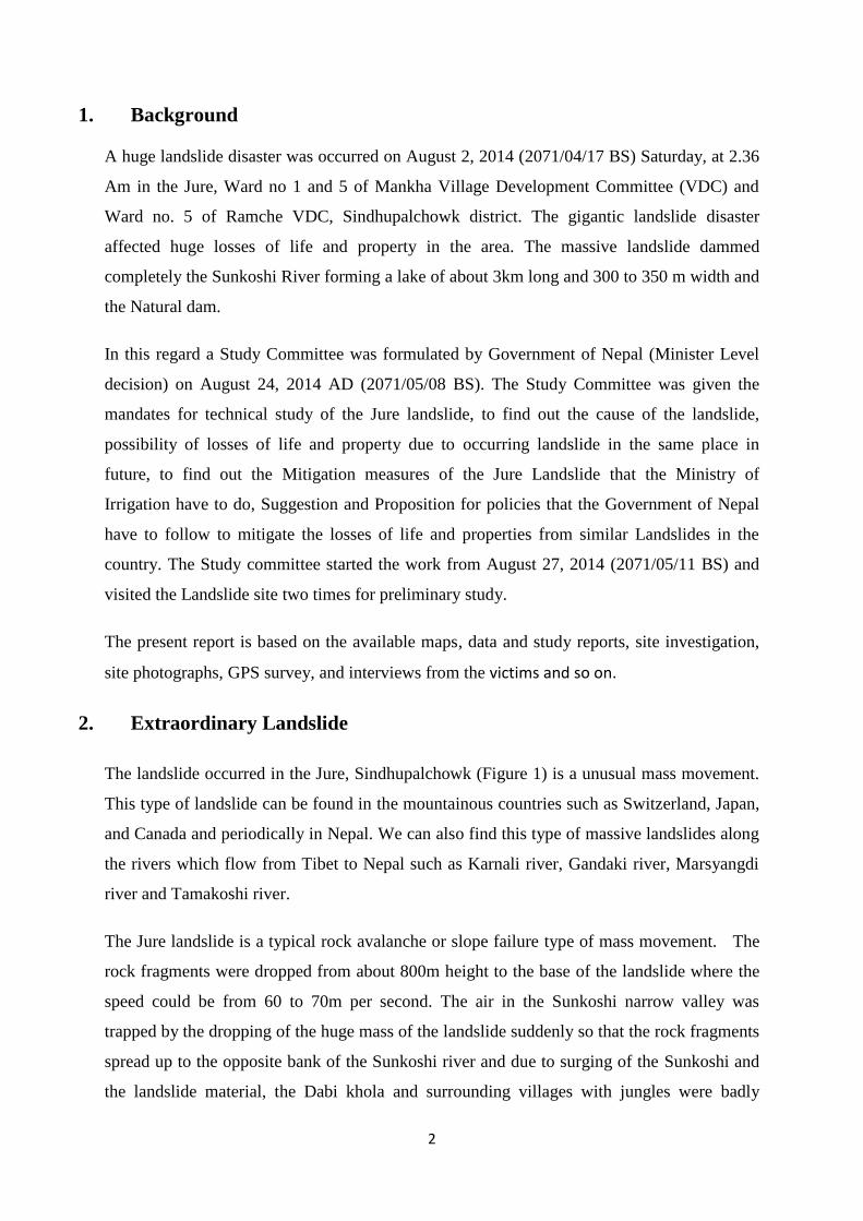
Figure 3: Disturbed and inclined trees in the crown part of the Landslide
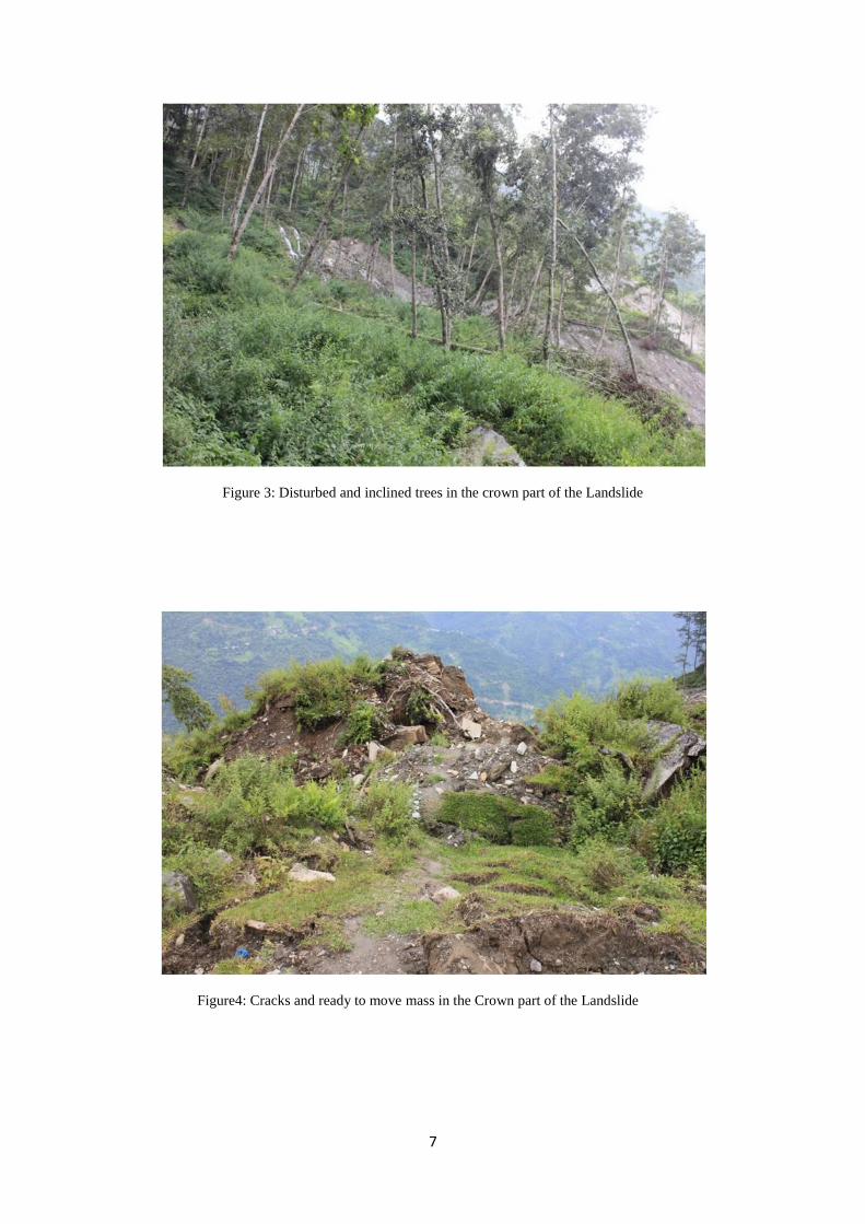
Figure4: Cracks and ready to move mass in the Crown part of the Landslide

8
Figure 5: Subsided village road in the crown part of the Landslide
Figure 6: Streams flowing at the Crown part of the Landslide
9
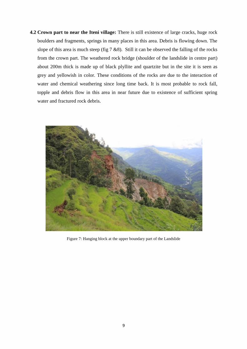
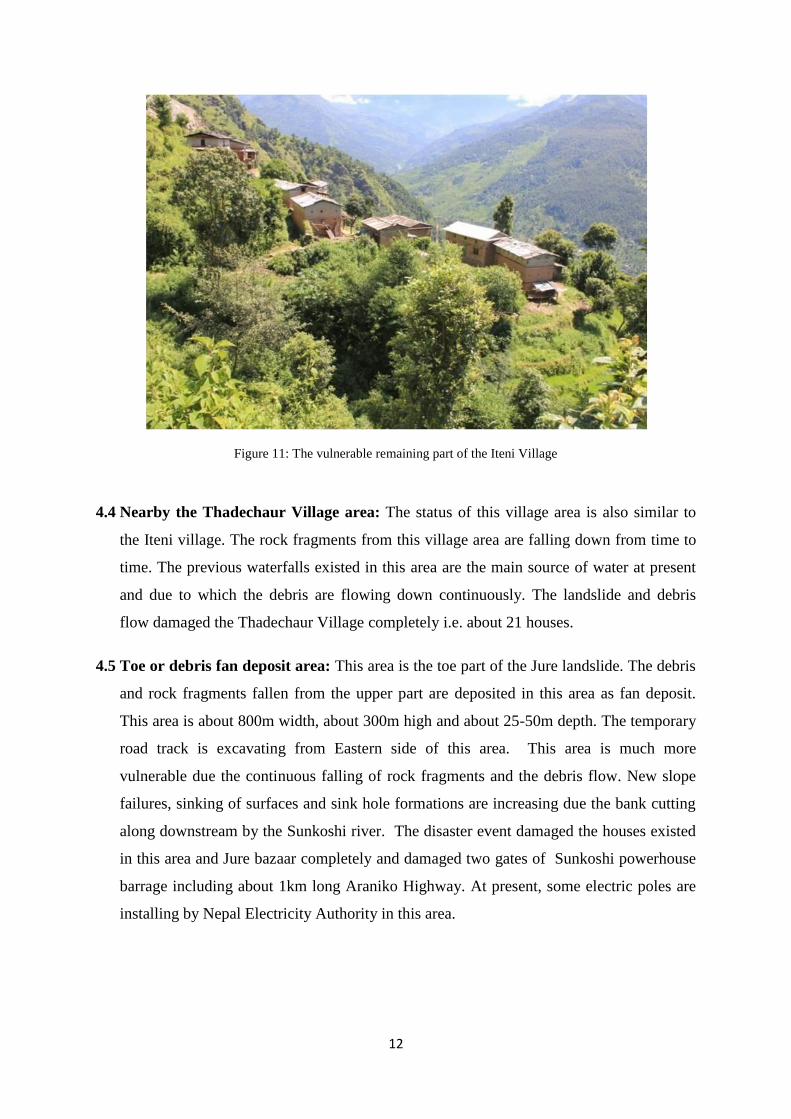
4.2 Crown part to near the Iteni village: There is still existence of large cracks, huge rock
boulders and fragments, springs in many places in this area. Debris is flowing down. The
slope of this area is much steep (fig 7 &8). Still it can be observed the falling of the rocks
from the crown part. The weathered rock bridge (shoulder of the landslide in centre part)
about 200m thick is made up of black plyllite and quartzite but in the site it is seen as
grey and yellowish in color. These conditions of the rocks are due to the interaction of
water and chemical weathering since long time back. It is most probable to rock fall,
topple and debris flow in this area in near future due to existence of sufficient spring
water and fractured rock debris.
Figure 7: Hanging block at the upper boundary part of the Landslide
10
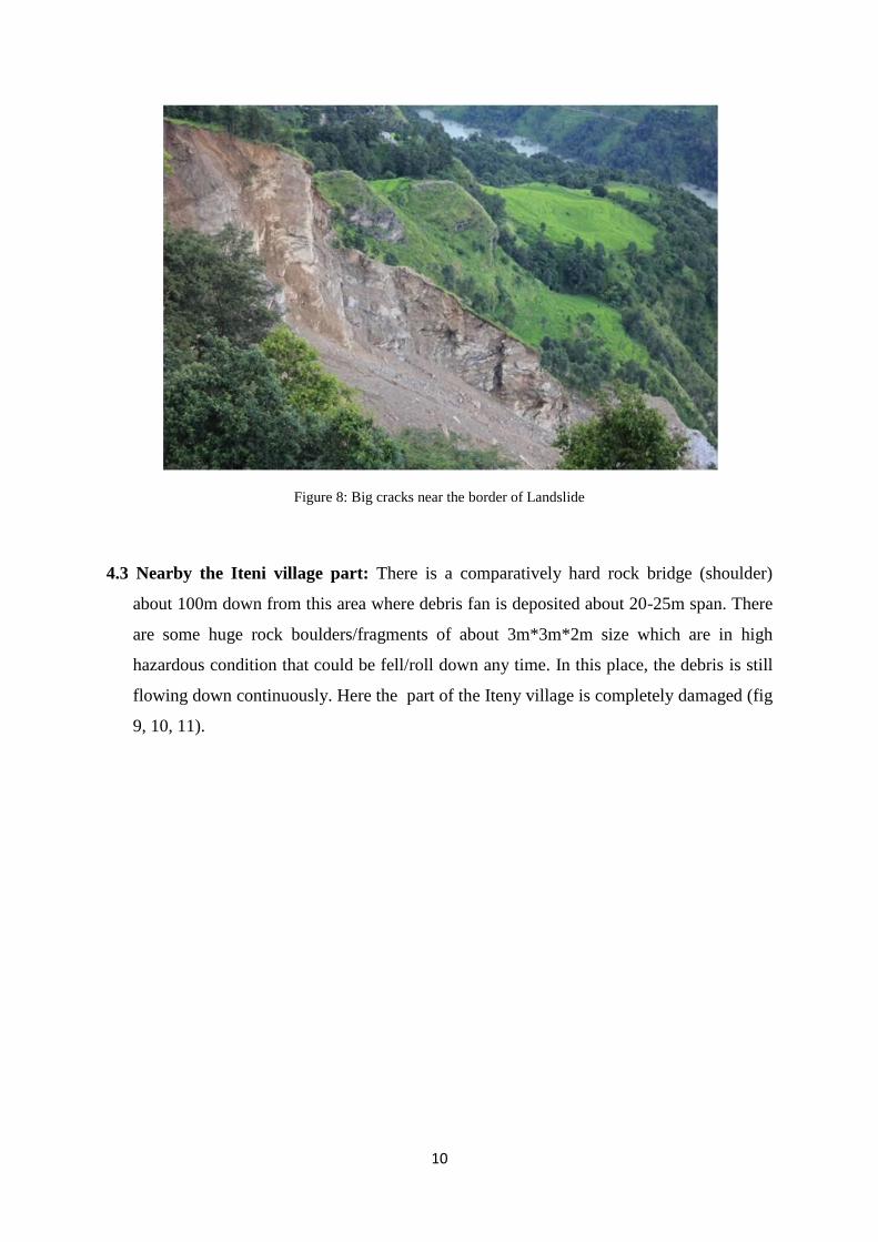
Figure 8: Big cracks near the border of Landslide
4.3 Nearby the Iteni village part: There is a comparatively hard rock bridge (shoulder)
about 100m down from this area where debris fan is deposited about 20-25m span. There
are some huge rock boulders/fragments of about 3m*3m*2m size which are in high
hazardous condition that could be fell/roll down any time. In this place, the debris is still
flowing down continuously. Here the part of the Iteny village is completely damaged (fig
9, 10, 11).

11
Figure 9: Landslide near the damaged village Iteni
Figure 10: Landslide block moving down near the Iteni Village
12
Figure 11: The vulnerable remaining part of the Iteni Village
4.4 Nearby the Thadechaur Village area: The status of this village area is also similar to
the Iteni village. The rock fragments from this village area are falling down from time to
time. The previous waterfalls existed in this area are the main source of water at present
and due to which the debris are flowing down continuously. The landslide and debris
flow damaged the Thadechaur Village completely i.e. about 21 houses.
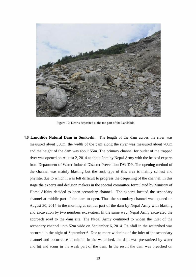
4.5 Toe or debris fan deposit area: This area is the toe part of the Jure landslide. The debris
and rock fragments fallen from the upper part are deposited in this area as fan deposit.
This area is about 800m width, about 300m high and about 25-50m depth. The temporary
road track is excavating from Eastern side of this area. This area is much more
vulnerable due the continuous falling of rock fragments and the debris flow. New slope
failures, sinking of surfaces and sink hole formations are increasing due the bank cutting
along downstream by the Sunkoshi river. The disaster event damaged the houses existed
in this area and Jure bazaar completely and damaged two gates of Sunkoshi powerhouse
barrage including about 1km long Araniko Highway. At present, some electric poles are
installing by Nepal Electricity Authority in this area.
13
Figure 12: Debris deposited at the toe part of the Landslide
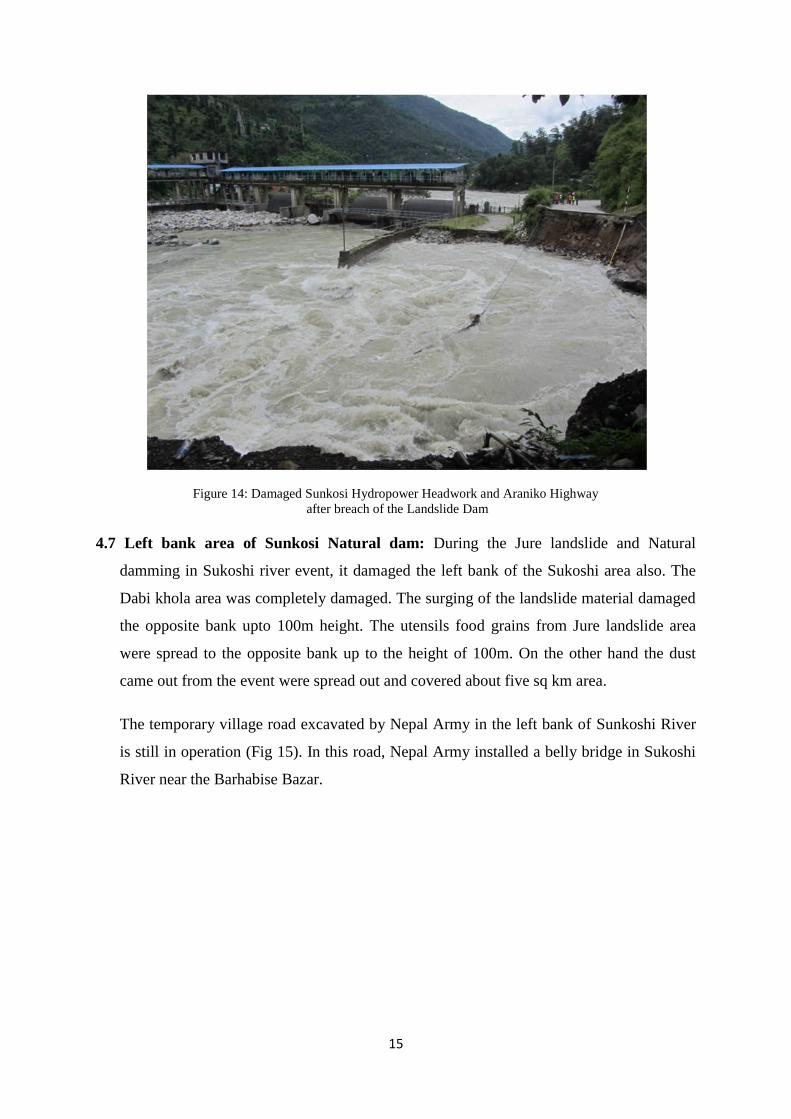
4.6 Landslide Natural Dam in Sunkoshi: The length of the dam across the river was
measured about 350m, the width of the dam along the river was measured about 700m
and the height of the dam was about 55m. The primary channel for outlet of the trapped
river was opened on August 2, 2014 at about 2pm by Nepal Army with the help of experts
from Department of Water Induced Disaster Prevention DWIDP. The opening method of
the channel was mainly blasting but the rock type of this area is mainly schiest and
phyllite, due to which it was felt difficult to progress the deepening of the channel. In this
stage the experts and decision makers in the special committee formulated by Ministry of
Home Affairs decided to open secondary channel. The experts located the secondary
channel at middle part of the dam to open. Thus the secondary channel was opened on
August 30, 2014 in the morning at central part of the dam by Nepal Army with blasting
and excavation by two numbers excavators. In the same way, Nepal Army excavated the
approach road to the dam site. The Nepal Army continued to widen the inlet of the
secondary channel upto 52m wide on September 6, 2014. Rainfall in the watershed was
occurred in the night of September 6. Due to more widening of the inlet of the secondary
channel and occurrence of rainfall in the watershed, the dam was pressurized by water
and hit and scour in the weak part of the dam. In the result the dam was breached on

14
September 7, 2014 at 1am and continued up 4Am (Fig. 13 and 14). Since the breaching
occurred slowly and it took about 4hrs, the damages by the breach were nominal and no
causalities. The Department of Hydrology and Metrology recorded the discharge during
the breaching of the dam at Pachuwaghat real time gauze station which was located at
downstream from Khadichaur Bridge. As per the record, the normal flow was 300
cu.m/sec and the maximum discharge was 1350 cu.m/sec and the historic capacity of
channel was 1700-1800 cu.m/sec. So the maximum flow was within the capacity. After
the breaching of the dam, the water level in the reservoir was decreased by 20m. The
study Report of Hazard Mitigation in the Northern Sunkoshi and Bhote Koshi Water
Catchment Areas, Nepal (HMWA), 1996 reported that under the Natural dam, the River
terrace of sand, clay and gravel boulders were existed.
Figure 13: Opening of Secondary Channel in the Landslide Dam
15
Figure 14: Damaged Sunkosi Hydropower Headwork and Araniko Highway
after breach of the Landslide Dam
4.7 Left bank area of Sunkosi Natural dam: During the Jure landslide and Natural
damming in Sukoshi river event, it damaged the left bank of the Sukoshi area also. The
Dabi khola area was completely damaged. The surging of the landslide material damaged
the opposite bank upto 100m height. The utensils food grains from Jure landslide area
were spread to the opposite bank up to the height of 100m. On the other hand the dust
came out from the event were spread out and covered about five sq km area.
The temporary village road excavated by Nepal Army in the left bank of Sunkoshi River
is still in operation (Fig 15). In this road, Nepal Army installed a belly bridge in Sukoshi
River near the Barhabise Bazar.

16
Figure 15: The alternate temporary road to Barahbise constructing by Nepal Army
5. Loses of Life and Property
The losses of life and property data as per the Ministry of Home Affairs in the disaster area
are given below.
Migrated family number due to the Jure Landslide Group A Date: Sept 07,2014 (2071/05/22BS)
S.N. V.D.C. House Family Total population Total death Migrated No Remarks
1. Mankha 36 181 116 65 2. Ramche 3 11 8 3 3. Tekanpur 3 32 21 11 4. Dhuskun - - - -
Total 42 224 145 79
Group B
S.N. V.D.C. House Family Migrated No Remarks
1. Mankha 58 300
2. Ramche 27 153 3. Tekanpur 19 112 4. Dhuskun 9 36
Total 113 601
Group C
S.N. V.D.C. House
Family population Remarks
1. Mankha 25 115
2. Ramche 39 216
Total 64 331

17
Rescue and Relief data in Sunkoshi Jure Landslide Disaster
1. Total number of death and lost 156
2. Number of Names identified death and lost 145
3. Number of Names not identified death and lost 11
4. Total dead body found 33
5. Total number of live rescued 27
6. Total Migrated House number A= 42 B= 113 C= 64 Total 219
7. Total Migrated population A= 79 B= 601 C= 331 Total 1011
8. Number of people received the amount for Funeral management 144
9. Number of people received the house damaged cost 36
10. People getting relief card A= 33 B 89
11. Number of people received the relief material 384
12. Number of institutes and personnel who had donated 366
13. The total collected Cash by donation NRs 16,204,105
6. Immediate steps to be done to mitigate the Landslide Disaster
It is clear from the above mentioned data that the Landslide is not yet stabled. The Iteni
village is in Hazardous zone. The debris flow and rock debris falling from upside on the
newly opened track road is still continuing and the bank cutting by the Sunkoshi river is not
yet stopped. In this regard the following attempts are recommended to implement.
a) The landslide and debris flow in the Head part of the Jure landslide is still active. So
first of all the water available in the crown part should be managed by diverting to
another safe side. The landslide and debris flow countermeasure work should be done.
b) About 100m from the Landside boundary should be warned as Hazardous area. Any
type of land uses as Residence, Irrigation and so on should be stopped at the moment.
c) The unstable part in the Crown part of the landslide should be removed and water
management should be done in this area.
d) The weathered and unstable cliffs with cracks in the shoulder should be trimmed.

18
e) The newly track road is aligned through the toe part of the landslide where the
probability of rock falling and debris flow is high. So the protection wall in upper part
of the road and scouring by Sunkoshi in the lower part of the road should be
protected.
f) Geophysical and Geotechnical study of the Jure Landslide is recommended. As per
the study report the mitigation measures of the landslide should be done.
7. Lesson Learned from the Jure Landslide
The unexpected gigantic Jure Landslide gave us the following lessons.
a) Such type of landslide can damage multiple infrastructures at once. It damaged not
only the life and property of the villages rather damaged the hydropower such as
Sanima and Sunkoshi, dammed the Sunkoshi River which created the threats upto
Koshi River Barrage, inundated many villages, the Arniko highway was destructed
which braked the national daily revenue about NRs. 30 million.
b) The rescue and relief done by the government was found not so effective. In this
connection we felt the need of coordination between the different government
institutions also.
c) We felt deficit of capable machineries and trained man power to fight such type of
gigantic events and also the shortage of related experts such as geologists, engineer,
and social coordinator to tackle such type of events.
d) The information dissemination was not satisfactory and managed. The media
published information which was deviated from real data and created havoc in the
public. Similar cases were happened in 1993 disaster in central Nepal also. These
cases are due to the lack of practices of field study and investigation and
authentication of information.
e) Financial and physical relief provided from Nepalese people, Nepal government, and
different national and international institutions are more appreciable in the time of
such type of disasters.
19
8. Policy making
1. To manage a holistic disaster, an autonomous, powerful and capable institute should
be established which should have sound financial resources, technical experts
including with the related equipments, technology and well managed laboratory.
2. Although, the existing line institutions such as Department of Water Induced Disaster
Prevention, Department of Mines and Geology, Department of Soil Conservation and
Watershed Management, Department of Hydrology and Meteorology, and National
Disaster Relief Committee of Ministry of Home Affairs are involving in Disaster
Mitigation field, it is found that there is a lack of coordination, data sharing and
communication to each other. The available disaster experts in different institutes can
be identified/listed out which will be useful for the responsible authorized Disaster
Institute that will be established in near future.
3. Instead of providing the authority about disaster mitigation related works to different
institutions, rather it is needed to study the disasters, preparedness for pre-disaster,
Rescue and relief during the disaster, categorization of disaster and hazard mapping,
development of early warning system, awareness training to the people living in the
hazardous areas, to provide disaster mitigation technology and so on which should be
authorized to a single institute.
4. The topographical maps, satellite images, aerial photos, digital maps, hydrological
and meteorological data and maps of the disaster area, and landslide disaster reports
should be collected to study the natural disasters like landslide, flood, soil erosion,
and earthquake and so on. To keep those materials in managed way, a well
management library is needed under the newly formulated institute.
5. In relation to the study and investigation of disasters, it is needed to bring universities
also in study and investigation scope with financial and technical aspects.
6. In the case of residence in flood plain areas, it should be categorized first the flood
hazard zone and the people staying in the high hazard zone should be shifted to other
safe site immediately.

20
7. The disaster management structure for the central level institute is needed to be as
follows.
8. The under mentioned officials should be managed as per the above mentioned
structure.
a. Disaster Management Ministry/Institute
Here the following officials should be nominated as members with the Prime
Minister as coordinator.
i. Prime Minister Chair Person/Coordinator
ii. Home Minister Member
iii. Defense Minister Member
iv. Finance Minister Member
v. Chief Secretary Member
iv. The chief of the all sections mentioned in the structure will be
secretary level and all of them will be member of the Disaster
Management Ministry/Institute.
b. Preparedness Section
This Section will do
i. Improvement of the people’s awareness
ii. Hazard Mapping
Disaster Management Ministry/Institute
Preparedness
Section
Rescue and
Relief
Section
Emergency
construction
Section
Monitoring and
Evaluation
Section
Research and
Training
Section
21
iii. Risk Mapping
iv. Early Warning System Development
v. Technology Development
The related experts to this section will be geologist, engineer, GIS experts, and
social workers and so on.
c. Rescue and Relief Section
This section will do
i. Emergency information communication/dissemination,
ii. Rescue of the victims immediately in the disaster area,
iii. Mobilization of emergency materials for relief of the disaster
victims,
This section should have the trained manpower from police, armed police,
army, Red Cross society with availability of trained dogs including
materials (tents, utensils, food etc), equipments and transportation vehicles
for rescue and relief purpose.
This section should have the experts like Geologist, Civil Engineer,
Seismologist, and Hydrologist, social workers and so on.
d. Emergency construction Section
This Section will do
i. Emergency survey, maintenance and construction works in the
disaster areas
Equipments and materials needed for this section are Heavy Machineries
and equipments, gabion wires boxes, construction materials and so on.
Man power and experts needed for this section are Civil Engineer,
Engineering Geologist, GIS Expert, and Mechanical Engineer and so on.
22
e. Monitoring and Evaluation Section
Regular monitoring and evaluation of the disasters all over the country have to
be done and report it.
This section should have a well managed Data centre and a well equipped
library.
The related manpower and experts for this section will be Engineering
Geologist, Civil Engineer, GIS Expert, and Mechanical Engineer.
f. Research and Training Section
This section will do study and research of the disaster area and prepare reports
with important recommendations. Different types of awareness trainings
including audio-visual, disaster information dissemination to the people of
disaster area and other disaster prone areas will be organized. Publications of
output of research and study
This section should have well equipped and well managed laboratory with
related technicians. The laboratory should have facilities to analysis and study
different types of disasters with models for flood, different types of landslides,
earthquakes and other disasters.
This section should have equipments as equipments related to early warning
system, accelerometer, seismograph, hydrometer, drilling machine system,
GIS and remote sensing Imaginaries, and other latest technologies.
The manpower and experts for this section will be Civil Engineer,
Engineering Geologist, GIS Expert, and Mechanical Engineer.
23
Appendices
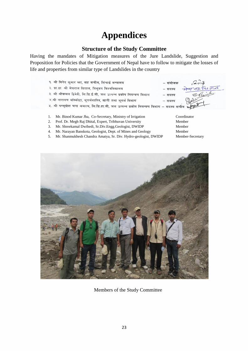
Structure of the Study Committee
Having the mandates of Mitigation measures of the Jure Landslide, Suggestion and
Proposition for Policies that the Government of Nepal have to follow to mitigate the losses of
life and properties from similar type of Landslides in the country
Members of the Study Committee
1. Mr. Binod Kumar Jha, Co-Secretary, Ministry of Irrigation Coordinator
2. Prof. Dr. Megh Raj Dhital, Expert, Tribhuvan University Member
3. Mr. Shreekamal Dwibedi, Sr.Div.Engg.Geologist, DWIDP Member
4. Mr. Narayan Banskota, Geologist, Dept. of Mines and Geology Member
5. Mr. Shanmukhesh Chandra Amatya, Sr. Div. Hydro-geologist, DWIDP Member-Secretary

24
Appendix A
SEISMIC RECORD
Seismic data recorded from Taplejung to Pyuthan District stations on August 2, 2014 AD morning
(2071/04/17BS)
GMT Time Local Time Intensity (ml)
20:46 02:31
20:47 02:32
20:48 02:33
20:51 02:36 3.3
21:04 02:49
22:56 04:41
Source: National Earthquake Centre, Department of Mines and Geology, Lainchaur, Kathmandu, Nepal.

25
Appendix B
Volume of the Lake formed by Jure Landslide Damming
Approximately 8million cubic meter volume of water was dammed by the Landslide and
other details are presented as follows.
Length of Lake formed by Natural Dam 3.1 km
Width of the Lake (Max.) 390m
Width of the lake (Ave.) 195m
Area covered by lake 453,500 Sq.m.
Depth of the lake (max.) 47m
Depth of the lake (ave) 21m
Input to the lake from upstream 200 cu.m.
Duration of Damming of the river (full) 11 hours
Duration of Damming of the river (partial) 1 hour
Volume of the water in the lake (about) 8.0 million cu.m
26
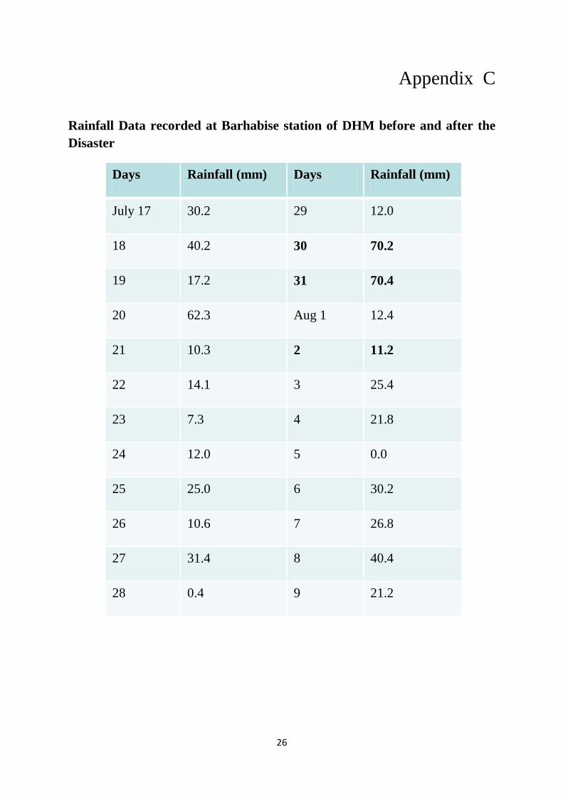
Appendix C
Rainfall Data recorded at Barhabise station of DHM before and after the
Disaster
Days Rainfall (mm) Days Rainfall (mm)
July 17 30.2 29 12.0
18 40.2 30 70.2
19 17.2 31 70.4
20 62.3 Aug 1 12.4
21 10.3 2 11.2
22 14.1 3 25.4
23 7.3 4 21.8
24 12.0 5 0.0
25 25.0 6 30.2
26 10.6 7 26.8
27 31.4 8 40.4
28 0.4 9 21.2

27
Appendix D
Landslide photographs in Ramche and Mankha VDCs
Photo 1: Temporary Araniko Highway track at toe of the Landslide
Photo 2: Big rock boulders fallen from the Landslide

28
Photo 3: Rock fragments fallen from the Landslide
Photo 4: Damaged houses due to the Landslide
29
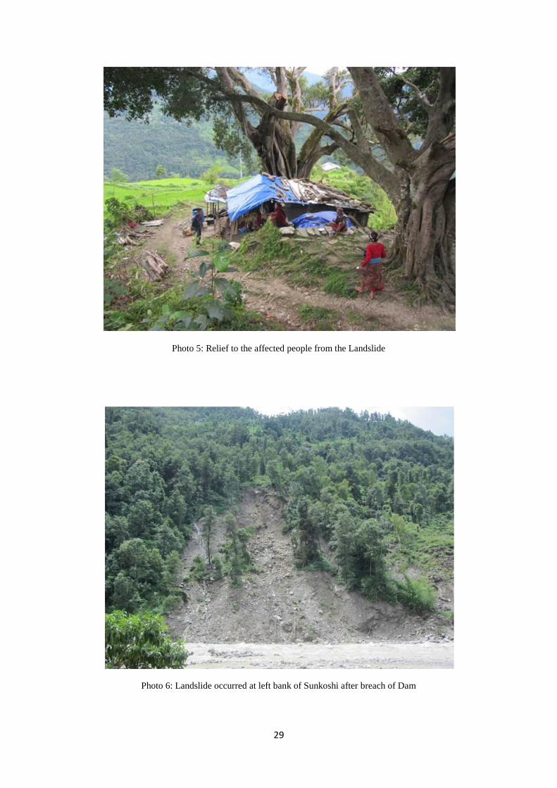
Photo 5: Relief to the affected people from the Landslide
Photo 6: Landslide occurred at left bank of Sunkoshi after breach of Dam