report on canal deliveries from boise … on canal deliveries from boise river and different...
TRANSCRIPT

REPORT ON CANAL DELIVERIES FROM
BOISE RIVER AND
DIFFERENT FEATURES AFFECTING THESE DELIVERIES FOR THE IRRIGATION SEASON
OF 1986
(DATA FOR THIS REPORT GATHERED BY THE WRITER WHILE ACTING IN THE CAPACITY OF
WATERMASTER OF THE BOISE RIVER.)
(COOPERATIVE DATA ALSO FURNISHED BY THE UNITED STATES BUREAU OF RECLAMATION.)
BY
LEE SISCO
WATERMASTER, BOISE RIVER

SUMMARY
1986 has been a year of change for Water District #63.
Mr. Henry Koelling officially retired as of the 30th of June
1986, after about 11 years of service to the Water Users of
the Boise Valley.
Mr. Lee Sisco was hired by the Water Users to fill the
Watermaster position vacated by Mr. Koelling. Several small
additions were made by Mr. Sisco, one of these was the
computerized storage accounting program that was developed
by Mr. Bob Sutter of the Department of Water Resources. This
program, once implemented, should provide an accurate
up-to-date accounting of not only storage use, but of
reservoir accrual.
This annual report is reflective of the new computer
use, with several of the charts and/or appendixes being
generated by this new process. The report has been trimmed
down somewhat in the amount of information that has been
provided in previous reports, but still should provide an
accurate picture of the water uses within the Boise Basin.
As the author evaluates the current data being generated,
additional information may be added to the reports in the
future.
All of the data presented in this report will be based
on an Irrigation Year, that being from November 1st to
October 31st. Only information concerning the Annual Water
Users Meeting or budget matters will be based on a Calendar
Year.
The April 1, 1986, snow survey showed the Boise Basin at
nearly 120% of normal, which made the outlook for a good
1

I'
water year very bright. The total natural flow in Acre Feet
for the 1986 Irrigation Year was 2,906,262 Ac.Ft .. The peak
natural flow of the Boise River was 18,000 C.F.S. occuring
on May 31st and the lowest was 585 C. F. S. on August 30th.
The maximum discharge from Lucky Peak Reservoir was 11, 500
and occured on the 6th, 7th and 8th of June, due to a large
runoff event that the reservoirs could not handle at normal
discharges.
Irrigation started on the Boise River system on the 4th
of April and continued until the 15th of October. The basin
provided an above average water supply throughout the
irrigation season, which left the reservoirs with a very
good carry over.
2
I I I i
CANAL REGULATION
Canal regulation (storage started) in 1986 on June 29th,
and was reqired for the balance of the i rr iga t ion season.
There was a two week dry and hot spell in May that forced
some additional water use, but the natural flow of the Boise
River held strong thru July and a smaller than normal amount
of storage was used.
The later part of the irrigation season (September) had
an abundance of rain and the canal diversions cutback, with
some major canals shutting off in late September. The
remaining canals shut off between October 9th and the 15th.
The appendix
with daily flows
shows the di versions in downstream order
in C.F.S. and monthly and yearly totals of
both C.F.S. and Acre Feet.
STORAGE WATER
The first storage water used in the system started on
the 29th of June 1986, and continued in varing amounts until
the 15th of October 1986. As of the 31st of October 1986,
which ends the 1986 irrigation year, there was 328,892
Ac.Ft. left in Anderson Ranch Reservoir, 188,054 Ac.Ft. in
Arrowrock Reservoir and 37,241 Ac.Ft. stored in Lucky Peak
Reservoir. The total left in storage at the end of the 1986
irrigation year was 554,187 Ac.Ft.
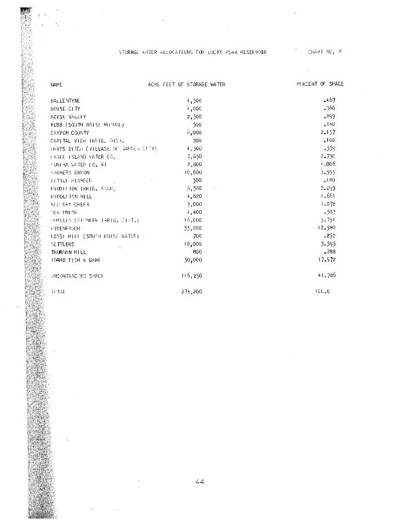
Chart #8 shows the amount of storage that each of the
storage holders are entitled to from the three reservoirs
and Chart # 9 is the 1986 storage account of the various
space holders.
The storage for 1986 was figured using a computerized
41
water
shows
used
right and storage accounting program.
the preliminary gaging station and
in the accounting program. This data
The appendix
reservoir data
is subject to
some later revision but was the best available at the time
the program was run.
MISCELLANEOUS
Chart #10 is general information on the number of acres
that are under each canal. These acres represent J the best
available information at this time, due to the age of the
information caution should be used in its use.
42
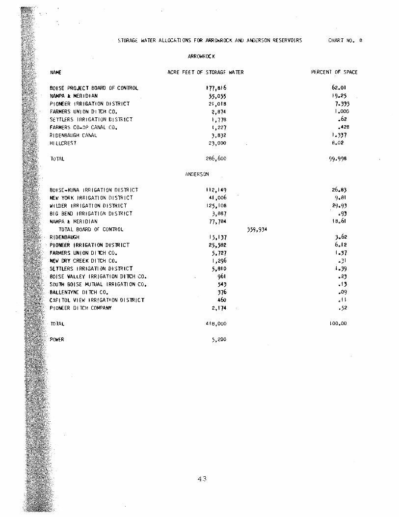
STORAGE WATER ALLOCATIONS FOR ARROr.'HOCK ANJ ANJERSON RESERVOIRS
NAME
BOf SE PROJECT BOARD OF CONTROL
NAMPA l MERIDIAN
PIONEER IRRIGATION DISTRICT
FARMERS UNI ON DI TI:H CO.
SETTLERS I RR I GATI ON DIS TR tCT
FARMERS CO-OP CANAL CO.
RIDENBAUGH CANAL
HILLCREST
TLlTAL
BOISE-KUNA IRRIGATION DISTRICT
NEW YORK IRRIGATION DISTRICT
WILDER !RR IGATt ON DI STRICT
BIG BE~ IRRIGATIGN DISTRICT
NAMPA l MERIDIAN
TOTAL BOARD OF CONTROL
R tDE NBAiJ;H
PIONEER IRRIGATION DISTRICT
FARMERS UNION DI lCH CO.
NEW DRY CREEK DITI:H CO.
SETILERS IRRIGATIQN DISTRICT
BOISE VALLEY IRRIGATION DITCH CO.
SOUTH BOISE MUTUAL IRRIGATION CO.
BALLENTYNE DllCH CO.
CAPITOL VIEW IRRIGATION DISTRICT
PIONEER DI TI:H COMPANY
TOTAL
ARROWROCK
ACRE FEET OF STORAGE WATER
tn,a16 55,055 21,0IB 2,874 I, 778 1,227 3,032
23,000
206,600
ANDERSON
112, 149 41 ,006
125, 108 J,BB7
77,704
15, 137 25,502 5,727 I ,296 5,a10
961 543 376 46o
2, 174
418,000
.5,200
43
359,934
CHART NO. 6
PERCENT OF SPACE
62.01 19.25 7.333 1.000 .62 .428
I .337 a.02
99.998
26.e3 9.01
29.93 .9,
1Ba61
.;1 1.:n .23 .1, .09 .11
.52
100.00
STURAGf: ;,:1TER ..\Lt.OCMIOl~S FOR LUCK'l' Pf:AK RESERVOIR
NAME ACRE FEET OF STORAGE ~iATER
lJALLE N1YNl
801SECl1Y
IJO I SE Vi1LLEY
BUBB ( sourn HOI SE llilill.J.1\L)
CANYON COUN1Y
Ci\PITAL VIE\-! IRRIG. ;Ji:;i,
!J/1VIS DITCH (VI LLAGt \JF ,:;ARf;l \ c:l lY)
l f1Glf: I SlflND v'f, TER CC,
I ur~E l'J\ \\f,, TER co. µI Ff\flMERS UNION
LITTLE f' I ONE Eh
/.'IDDLETON IRRIG. h,';s~;,,
I·: I DOLE TOllJ MI LL
~m· D~:Y CREEK
'ff\~ UNI '.)I,!
i'llYLLIS ("'11'1FE" IRRIG, '.,'J',1.j
h' I DE '~f't,UGH
ROSSI MILL (SOUTH f~OISE v.A1U..)
')EHLERS
niURt4\N Ml LL
IDAHO FI SH & GAl<l
lJNCONTIV\C1ED SPACE
1,300 I ,ooo 2,500
,500
6,ooo 300
I, 500 7,650 ?,800
10,000
500
6,380 4 '620
3,000 1, 400
16,000
35,000 700
10,000 800
50,000
116, 250
278,200
44
PERCENT OF SPACE
.467 o36o .s99 0 180
2.157 • I 08
.539 2 0 750 i .006
3.595 .180
2.293 I .661 1.07e ,503
5. 751 I 2~580
.252 3.595 .288
17.972
41,786
100,0

.f> ',_..,
Canal Company
Ballentyne Boise City Boise Valley Bubb (So. Boise Mut.) Canyon County Capital View Davis Eagle Island Canals Euceka #1 Facmecs Union
Little Pioneec Middleton Ice. Middleton Mill New Dry Cceek New Union New York* Phyllis*** Ridenbaugh Rossi Mill Sebcee
Total Available
l,676 1,000 3,461 1,043 6,000
760 1,500 7,650 2,800
18,601
2,674 6,380 4,620 4,296 1,400
591,380 62,653 53,969
700 1,227
Settlecs** 18,960 Thucman Mill 800 Lucky Peak Nucsery 200 Id. Dept. of F & G 50,000 Anderson Dam Powec 5,200 U.S.B.R. Uncontcacted 120,771
Totals 969,721
BOISE RIVER STORAGE ACCOUNTS -1986- IN ACRE FEET
Total 1986 Storage Used
629 155 335
83 2,882
0 52
944 298
8,699
611 1,498 1,085
0 256
379,686 27,761 15,539
22 0
6,794 0
108 2,495
0 3,441
453,373
Balance End of Season
1,047 845
3 ,126 960
3,118 760
1,448 6,706 2,502 9,902
2,063 4,882 3,535 4,296 1,144
211,694 34,892 38,430
678 1,227
12,166 800
92 47,505
5,200 117,330
516,348
Accowcock Unused
J,227
92
22,800
24,119
Andee son Caccyovec
0
626 460
460
0
1,563
1,296
211, 694 18,892
3,430
2' 166
5,200
245,787
Chact 9
Lucky Peak Cacryover
1,047 845
2,500 500
3,118 300
1,448 6,706 2,502 9,902
500 4,882 3,535 3,000 1' 144
16,000 35,000
678
10,000 800
47,505
94,530
246,442
*Less 1100 Ac.Ft. of Arcowrock Stocage and 272 Ac.Ft. of Andecson Stocage tcansfeced to Settlecs, 53 Ac.Ft. of Accowcock Storage transfecced to Phyllis to iccigate Government lands. •* Inccease Settlers Stocage 1100 Ac.Ft. of Accowrock and 272 Ac.Ft. of Andecson Stocage to ice. Government land. *** Increase Phyllis Acrowrock Stocage 53 Ac.Ft. to ircigate Govecnment land. State of Idaho Depactment of Fish and Game stocage to be used during the wintec months. All uncontcacted stocage to be celeased by ocder of the U.S. Buceau of Reclamation.
JUI
).

).
2_,.
3.
"l
C:REv"fT£
ff{[)r/iP{
m 8cJ/.SE
(!
)5,0/S
0
J J --r I I.....{,..

5000 ../ l3194'5-8-0 TW Sy_
)31ll!-ll00 ~i.OIGOO
..., 1~'2.0S.SOO
I ?:i 2.
/13 \$~COO
(;;©
@ ~ \.3\~DOOO ~
fW() i<-..tl?>~C\OS"Oo
!3\~ 4000
\32.01500
" I ?>2.0 2.C>OO
_ __..,..,.._,,13'2.0 4500 __ ..... r~i.o 3500
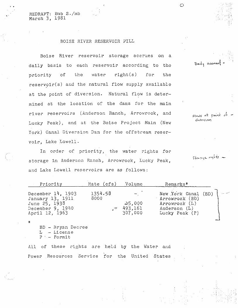
REDRAFT: Bob S./mb March 3, 1981
BOISE RIVER RESERVOIR FILL
Boise River reservoir storage accrues on a
daily basis to each reservoir according. to the
priority of the water right(s) for the
reserv9ir(s) and the natural flow supply available
at the point of diversion. Natural flow is deter-
mined at the lo ca ti on of the dams for the main
0
river reservoirs (Anderson Ranch, Arrowrock, and
Lucky Peak), and at the Boise Project Main (New
t=l owS a:t poi'l+ o ~ -
d1vCrS1W\
York) Canal Diversion Dam for the offstream reser-
voir, Lake Lowell.
In order of priority, the water rights for
storage in Anderson Ranch, Arrowrock, Lucky Peak,
and Lake Lowell reservoirs are as follows:
Priorit;y
December 14, 1903 January 13, 1911 June 25, 1938 December 9, 1940 April 12, 1963
* BD - Bryan Decree L - License P · - Fermi t
Rate (cfs) Volume
1354.58 8000
45' 000 "'' 493,161
307,000
Remarks*
New .Yo.rk Canal Arrowrock (BD) Arrowrock (L) Anderson (L) Lucky Peak (P)
All of these rights are held by the Water and
' Power Resources Service for the United States
(BD)

-2-
Department of Interior.
The New York Canal right of 1354.58 cfs
is an irrigation right which can also be used to
store water in Lake Lowell Reservoir during the
non-irrigation season. 1 The volume of water
storaole per annum is limited by the physical
capacity of Lake Lowell 1 177,150 acre-feet.
Identified transmission losses in the New York
Canal from November 1 to April 1 may be diverted
in addition to the physical capacity of Lake
Lowell to compensate for such losses.
Arrowrock Reservoir is filled according to two
rights, one for 8000 cf s for a physical capacity
of 275,000 acre-feet, and another for 15000 acre-
feet with no limit on the diversion rate.
However, because of siltation the current total
physical capacity is 286, 600 acre-feet, so that
the latter value is limited at the time of this d''
agreement to 11,600 acre-feet:
Anderson Ranch Reservoir is filled by a right
for 493,161 acre-feet with no limit on diversion
rate. This right is limited by dead storage of
28~980 acre-feet plus normally inactive storage of
40,981 acre-feet to 423,200 acre-feet active
-3-
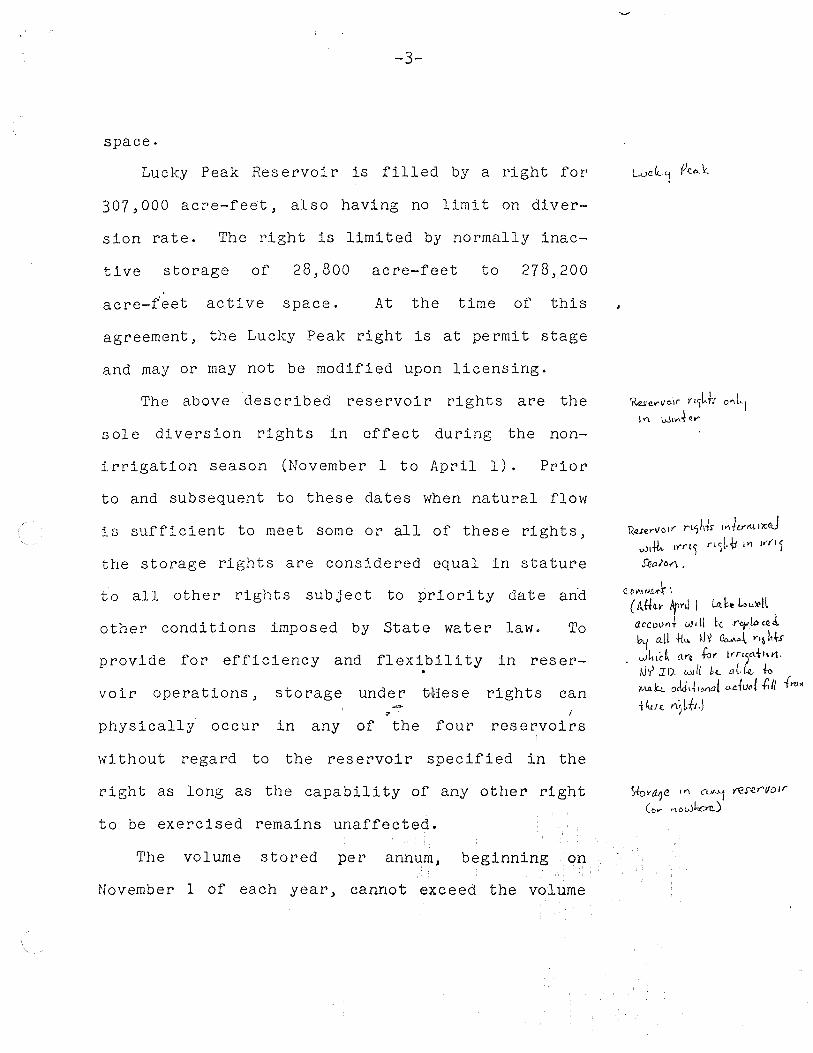
space.
Lucky Peak Reservoir is filled by a right for
307,000 acre-feet, also having no limit on diver-
sion rate. The right is limited by normally inac
tive storage of 28,800 acre-feet to 278,200
acre-feet active space. At the time of this
agreement, the Lucky Peak right is at permit stage
and may or may not be modified upon licensing.
The above described reservoir rights are the
sole diversion rights in effect during the non-
irrigation season (November 1 to April 1). Prior
to and subsequent to these dates when natural flow
is sufficient to meet some or all of these rights,
the storage rights are considered equal in stature
to all other rights subject to priority date an·d
other conditions imposed by State water law. To
provide for efficiency and flexibility in !:'es er-. voir operations, storage under tMese rights can
" I physically occur in any of the four r'eservoirs
with out regard to the reservoir specified in the
right as long as the capability of any other right
to be exercised remains unaffected.
The volume stored per annum, beginning on
November 1 of each year, cannot exceed the volume
'Resu1101r rt'jk-h o"LI I'\ W1y\fe,...
\(Q..rer\/alf" rU)~tr ,,.,Jey1t1.i)Cd wt-It. ll"'l"l) n5[,v Jl'1 , ... n1 JJ!(l/0"1 •
C.Dl'.H~ ',
( t\.tl4-v AJ>nl I Lit k Lou~ll accoVtl + vJ • H be. "o/["' CR.A. ~ a..tl .\-k. ~Jy ~~ n~ hts u.1kii:~ aYc few 1.-r15a{1u1.
tJ'( :w. will k aLk ~ ~k.t. 0Jd1~1ot10! a.duo/ .{;// f.,o.
-!lun n5Lfi.J
Stovit?e "' CL.v'"-1 Y€rer1101r
Ct,. ... ,,,owkcrc)
-4-
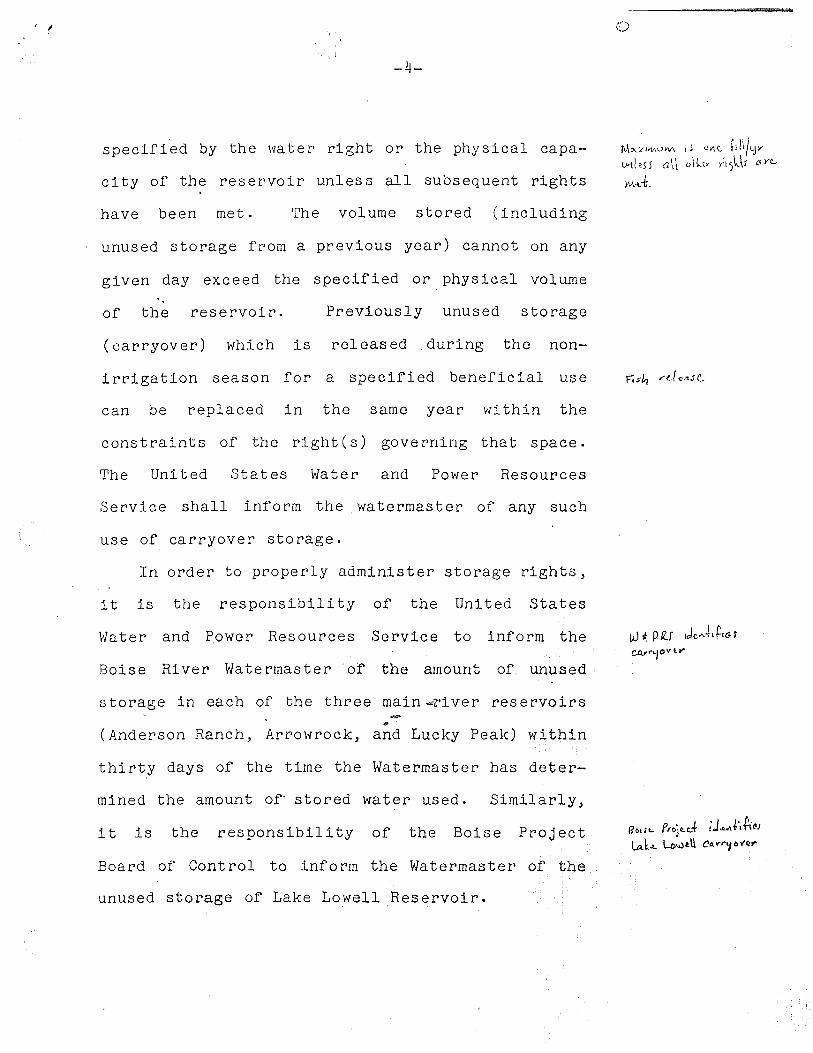
specified by the water right or the physical capa-
city of the reservoir unless all subsequent rights
have been met. The volume stored (including
unused storage from a previous year) cannot on any
given day exceed the specified or physical volume
of the reservoir. Previously unused storage
(carryover) which is released during the non-
irrigation season for a specified beneficial use
can be replaced in the same year within the
constraints of the right(s) governing that space.
The United States Water and Power Resources
Service shall inform the watermaster of any such
use of carryover storage.
In order to properly administer storage rights,
it is the responsibility of the United States
Water and P_ower Resources Service to inform the
Boise River Watermaster of the amount of unused
storage in each of the three main ....-r•i ver reservoirs -.. (Anderson Ranch, Arrowrock, and Lucky Peak) within
thirty days of the time the Watermaster has deter-
mined the amount of· stored water used. Similarly,
it is the responsibility of the Boise Project
Board of Control to inform the Watermaster of the
unused storage of Lake Lowell Reservoir.
M<>--<h'\l\'-'M ( S uvi{'., f1H/yv t.vd ~s 5 a \l ()-\{," rt'}'-\;! Ci ye_.
MA.
tJ t_ p /(J 1Jc. . ..J1ttG f CCV"'-jov l.-
l?o•I'- Projc.d ;J •. ,.J,Aes t.a.b. Lou.itU C!<>--r'"'fo'f~'I'
-5-
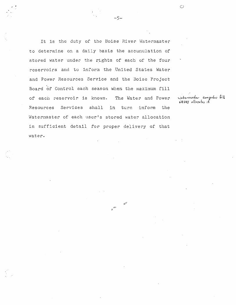
It is the duty of the Boise River Watermaster
to determine on a daily basis the accumulation of
stored water under the ~ights of each of the four
reservoirs and to inform the .United States Water
and Power Resources Service and the Boise Project
Board of Control each season when the maximum fill
of each reservoir is known. The Water and Power
Resources Services shall in turn inform the
Watermaster of each user's stored water allocation
in sufficient detail for proper delivery of that
water.
u.».\-e,..-f!M.•fw- CD~rlfttJ (2, ll ).)~ Pfll <Llloeo-hJ it

TWIN Si'~INGS !3/850C>O
/YIOl?ES Cl:!EEK 13 :i.aooc>o
v
I
F-V: r:n.we:e.. v 1 w..e:: !3!?4-c>CJC?
RNDEK:SoP Rf\M::H, /3JC/O.S-C>O ~
! v
kDIVHS~~-~ I k/AA I ,
: /3:203~ ~
501si::: t> I
J3Z0550D I@ 1'i,1
GLEN 100CJD ~ . /:3 :20&,000 I
~IDDLfroN I I J3Z.I0056
FNE />11LE.
@
I
__ _,_~_\lx_ __ J
CJllJ.DtutL.L !32.1/00
F'AR/llA 132.13000
(Jooo M-
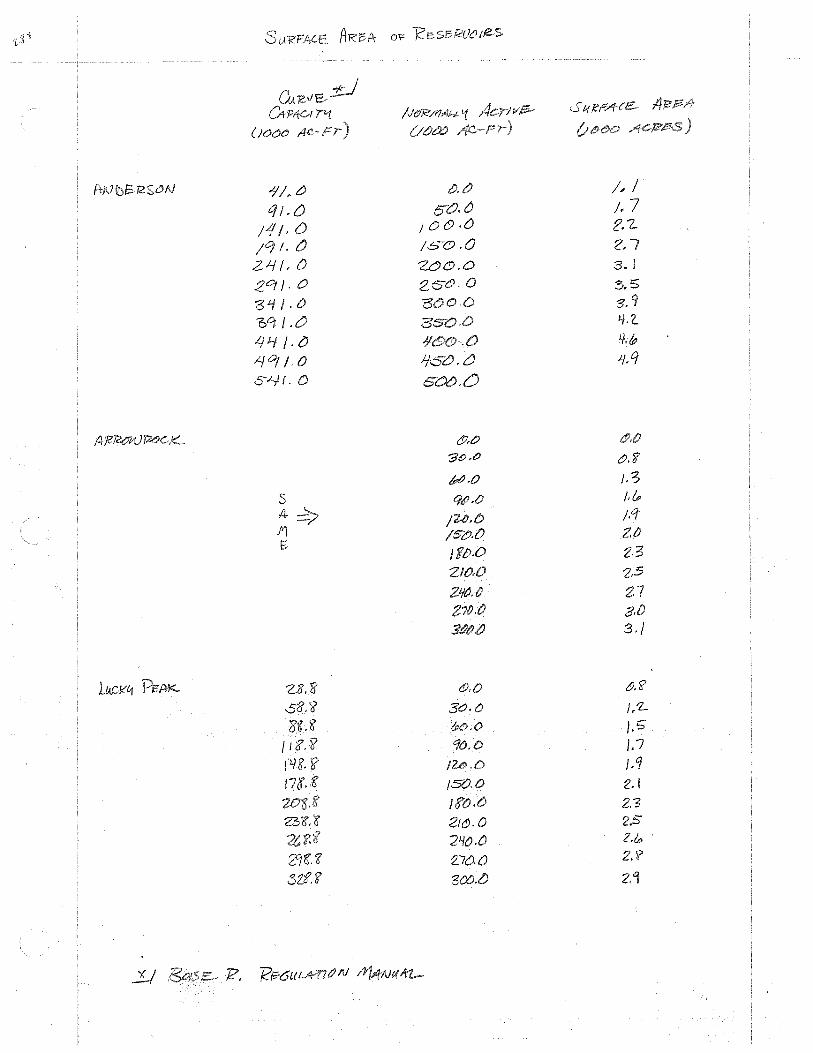
Pri'J ~13- .l/ /. 0 t!). CJ /,,I q I.{) e;O.tJ /, 7
, {) I CJ c5) .{J 2.1-;q /. tJ 16-<9 .a 2.7 2.1-f f, 0 3.1
ZO/J. o !5.5
3'-//.0 '3. '1 'b'i /.0 LJJ..f /.{)
.tf °' /. 0 )fOCJ.0 ;;,q S.J..ff. 0 soc>.{)
(fJ,O
"JltJ.t? c!J' 'i !PtJ.O /,3
s /,/p
4 ;,q .111 /S"&.0 2.f) f;
J
2.s Z.7
3./
l..14ok''1 Z8.8' c!),O &.'?
s8.~ 3c;, () I. 'L
~ &o.o /.5 / I '&'. !? D J.7 l Jll!J. /. q
/5().0 2.1 2.'3
Zt6.0 240.0 2./o .
21'€:. <t 2,7{).{) ?
31.f.~

0.1 0. 2'1
o.2. 0 .otf. 1
o.~ o. O Sf
o.c../- o.o 71
0. 5" o. o?k
0 .G. o.o 0.1 0 7
o. e>.091 () .'i 0.0'15"
0 o. I. I (),
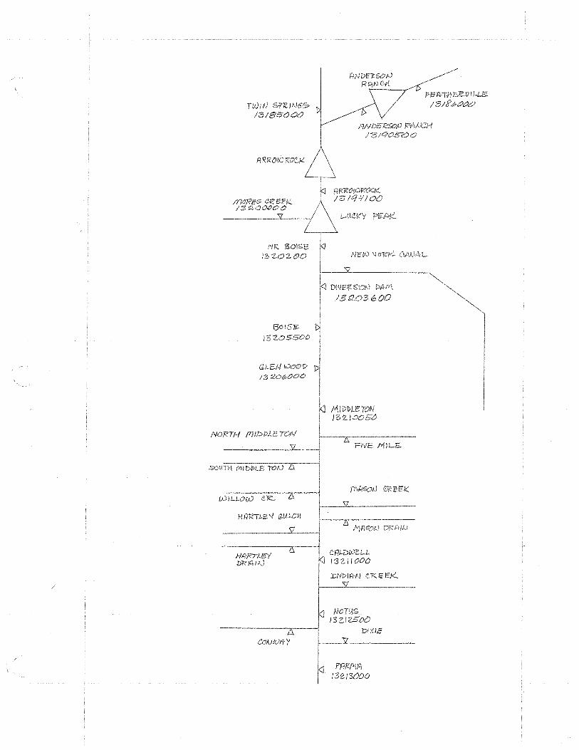
TWIN /3/850CJC!
C}fli-DWE:LL J3Z/1000
J:NPl'f'.tN CR.EEK
NOTUS 13(..IZSOtJ
Dl'l.l.E
13Zi3000

TWIN Si'~!NGS> /3/8SC>cX>
/170R'CS CREEK /'3 ~OOt>C>O
Nrt soise: 13-Z..OZOO
i="lii 1+ I Ji e.:e iJ I !.LE5-/ 3 / S' ,i, OC)c:J
RNDEK:SoP RA~ /31C/OS-OO
R!<ROt<.)R'~ /31q 1!JO()
I N'6l0 ~ O!!:/<'.. C-AIJ,.\ L
1---~v___~~~~~~~
~ DJVfl1'.Sk'.?tJ !>Arr\
/3t20~ 31.P o-0
1301sc: ll J3Z.OS500
GLEN 00C?D
1320&000
MIDDLETON 132-)0056
FNE />llLE..
CflJ-D(J)f:LL 132.ilOO
J:Nl>Jl'lfJ <'.K.EEK
NOWS. !3 G.1250()
'DI Xie
PARP\f~ 132.)3()()0
3-
::;, 0 ;.- 4 0 = zz.. 3
58
/Z..4 J5~
= = tz:z ..
:::.

0
'210 9 I -=6 10
I 10 ~
!S'Z.10'18'1?
IrvD1 )3 11 44
)3
D1 }'3Z..J z

)
ZJ
C), 3
),

:
iv
FIGURE 3. Boise River Diversions and Drains lucKY PEAK RESERVOIR
PENITENTIARY CANAL-- ---BOISE PROJECT MAIN <NEW YORK) CANAL 61.2
58. 8 BARBER DAM
58.3 --RIDENBAUGH CANAL
Boise C1rv CANAL--
52.8 52.0
--Buua, l'IEEVES #1 & #2, Rossi MILL \.ANALS
Boise RIVER AT Bo!SE
-+-SETTLERS CANAL
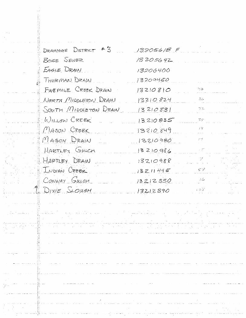
....... DRAINAGE DISTRICT fl3
- .... DAVIS DITCH
51. 0 _...,.THURMAN i'II LL CANAL FARMERS UN I ON AND BolSE VALLEY CANALS-- 50.4
BolSE SEWER ...... ..
NEW BRY CREEK AND NEW HION LANALS--
ilALLENTYNE CANAL+-
46.4
EAGLE I SlAND
EAGLE DRAIN······· ...•.... THURMAN DRAIN
l'llDDLETON CANAL•--· EUBEKA #1 AND PHYLLIS
~ EAGLE
SLAND-ANALS
LITTLE PIONEER CANAL•-.._ __ .....-_ __, CANALS
38.0 CANYON COUNTY CANAL-- 32.9
32.4 -•CALDWELL HIGHLINE CANAL
27 .7 ........ FIVEMILE CREEK HORT!! AND
SOUTH MIDDLETON DRAIN......... 26,3
WILLOW CREEK········ 24.7 23.2 ········MASON CREEK AND DRAIN
22.6 -•RIVERSIDE AND PIONEER DIXIE CANllLS
HARTLEY DRAIN AND GULCH······ 22.4 SEBREE, CAMP8ELL, AND
:ilEBENBERG CANALS•- 21.9 21.1 CALDWELL BRIDGE
19.7 ·········INDIAN CREEK
- .... Mcl1ANUS AND TEATER CANALS
17, 9 -•EUREKA #2 CANAL
17.6 -•UPPER CENTER POINT CANAL
-· Boww.N AND Sw I SHER CANAL
16, 0 -+. LOWER CENTER Po INT CANAL
13.8 Boise RIVER AT NoTus
CONWAY GULCH-· .. ··
BAXTER AND BOONE CANALS•
ANDREWS CANAL•-
PIAMMoN PUMPS•-
RIVER MILE C.,
·······DIXIE SLOUGH
-•HAAS CANAL
-+-!~LAND HIGHLINE CANAL
-+-McCoNNEL ISLAND CANAL

E'PA- 0f' 130t'S.'e-
Q (cF>) IG
I°?> Z,e?Z.OC>O NI?._ Boise /.141 3z'-\<,,
132.0SSOO A-T BotSe ///,,0 0 _q
DD ~!:> 13
J../'iC/
l~?LJ&OOO <iil-.8'N Ill 3'3 7 45
31
4
/3Zl0000 7itJ !<?5
,~ z ooso AJ~ /Y1 83 JS
FWS /Yi I L.C,, C ~ ISZ...
A.JORI/< ~I..{
/Z. I J ~
ft14-!:,0N 'ZI
/Yl4'::><"V ) l.j °' H4~TL5V Gu~
3:.1
132.llOCiO 11-T d4LDNS:LL 310 &J./3 /CJ 3
It.Jb 1.AIV Cl?6'SJ(. /{p{
I'? I
/'3 Z.JZ5"0t) Al fJOTUS /./ J Lt. "7 J fl I CONWA: V 55
DI XI E PF=..A I AJ zz.-z.. D/tJE RS 10 IVS 173
}3Z.13~00 NR tf{) f? 217 217
- /YllDDLE
: .43

)3Z..OZOO
13:205500
1320~0t:i0
13ZI0000
13'2..Jc:>OSO
13 'Z.J I 000
13ZJ'2500
13-ZI
WV IDEAlTI Fl Eb
FIVE /YI/Le CR.. Nr:Jfe:'TH /Yl Jf)DlfE-
60 IA Iii /r) I D{)l,B ,VAJ
WILLOW
/fJl+SOAJ OT<?~E!I:::-
ftl~ON
AT Ne>iVt<;
CoNl\JAq <6ULCJ-l
b IX I 15- D;;:A)I\)
NR
/
/S-4
/7
J 58' 5&:>
15
53 :3
if g!f
3b
41..//
CJ I l
)
Z/
35
0
2-/
1z6 37
2.
7) JU ~SI Oil) DAJill4' f
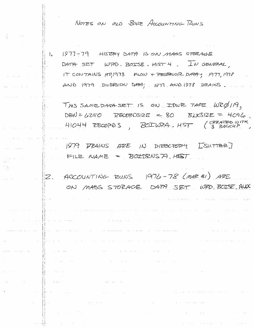
/)'\tts SAMC..D~.3eT JS. GI\) ::i::1)w}:::._ TA-PE fJJK:¢ /IC/)
DW =- ~-Z,S-() 72~\ZDS12E ==- 'g() 75,LJ(,SJZE: --.:::. 40ct&, '
.l) IOY 1-f -et@~ S J Bor-(A)\:2A- .. HS( { c!F-"'t~u1:.'v->t 1
} 9.rt J7l!,4/ f\JS 1+7Z£ I AJ :D JloE~:,,-rvM L.SlA ~)
Pl LIS NA-faE -=- 1SG:t"D12/VS M. J-1f!i;T
80
2. DO
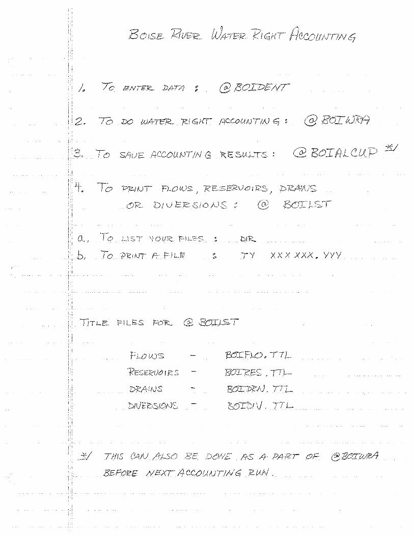
T 0 SAU /¥'--COU
To f=Wl{)S
b, To 'PK.1
DMIAJS
THIS
SBFo'!Z£
G
I I
PIK
'/ xxxx
:;:;?
~
~ ~ <;:)
Q
~ lJ) ~ t'1 r-
";:)
::r er ~ ~
~ ID :r
\0 r-c:: .. 0
() <::::) c::i I;:;
~
c
<;;::i <;:) '{) ' ~ ~
""'
~ ;Q
::i-
J <t !-
~

Oa <:) Cl J I (\) ~ <::i -- ~~ (j
r<J ~ N l\l ct: 41 ::r u ""'
~ <:) <:I <;;:, ~ <::; ~
~ ::::> ,, lit ~
" <:_)
<:) <:::; CJ '9 \'{\
'5 N ~ \) 2 ~
8 e;: \)o ~
'($" ~ ~
Cl <::i '5
r::- II) ~ '(:;
-=::i
""' ~
::r ::r
c{J
()
~ <:) ~
('{)
F a t'-l
"' "' In flt C\,) \/) ::r I;! 0 ... ~ l.J.I
j -l <:)
[
2 r- ()
0 ul
<:) I'-<:) 0 lo "9 ::r
r- ....;:, :r r-r-

_j <:;'.)
<:) S( l/)
ti "' i.:. ('() r:-
~ <:) "3 ~ <;:) ~
~. I-
<:) '2l <:) (;) ::t---
~ IS' ""' If)
r-()
::r- "" () "J
~ :f '5 <;:)
' 11) _j N I' -l C) ()
LL '00
<;;J <:::;
-:r
~ er r-: 0 '.:!-
b i- " cs w ()

<:::> Cl <;J
(:) <;:) <.:5
" :i:-
Cl °" <;:) <:J '\)
..J :i N '5
~ '() I;:)
t() lJ)
F ln ~ r-
f? ~ :r
tJ \\l ('/)
0
() <;;) ":J (:) ~ <;:)
')a
~
" J 'N <;;:)
111 ':>
µ:z

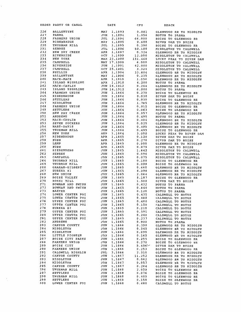
ORDER PARTY OR CANAL
1 2 3 4 5 6 7 8 9
10 11 12 13 14 15 16 17 18 19 20 21 22 23 24 25 26 27 28 29 30 31 32 33 34 35 36 37 38 39 40 41 42 43 44 45 46 47 48 49 50 51 52 53 54 55 56 57 58 59 60 61 62 63 64 65 66 67 68 69 70 71 72 73 74 75
FARMERS UNION BOISE VALLEY NEW DRY CREEK NEW UNION BALLENTYNE BOISE CITY LITTLE PIONEER NEW YORK RIDEN BAUGH BUBB ROSSI MILL ME EVES THURMAN MILL RIDENBAUGH WARM SPRINGS MIDDLETON FLOW CALDWELL FLOW NOTUS FLOW FARMERS UNION RIDEN BAUGH SETTLERS FARMERS UNION MIDDLETON FARMERS UNION SETTLERS NEW DRY CREEK ANDREWS MACE-CATLIN SEVEN SUCKERS HART-DAVIS THURMAN MILL NEW YORK RIDENBAUGH BUBB LEMP BUBB SIEBENBERG SEBREE CAMPBELL THURMAN MILL THURMAN MILL GRAHAM-GILBERT EUREKA #1 NEW UNION BOISE VALLEY ROSSI MILL BOWMAN AND SWISH BOWMAN AND SWISH BAXTER LOWER CENTER POI LOWER CENTER POI UPPER CENTER POI UPPER CENTER POI EUREKA #2 UPPER CENTER POI UPPER CENTER POI UPPER CENTER POI ANDREWS MIDDLETON SURPRISE VLY FAR NEW DRY CREEK NEW YORK PHYLLIS SETTLERS CANYON COUNTY MIDDLETON MIDDLETON LITTLE PIONEER BOISE CITY PARKS FARMERS UNION BOISE CITY FARMERS UNION CALDWELL HIGHLIN CANYON COUNTY MIDDLETON
DATE
JAN 1,1000 JAN 1,1000 JAN 1,1000 JAN 1,1000 JAN 1,1000 JAN 1,1000 JAN 1,1000 JAN 1,1000 JAN 1,1000 JAN 1,1000 JAN 1,1000 JAN 1,1000 JAN 1,1000 JAN 1,1000 JAN 1,1000 JAN 2,1000 JAN 2,1000 JAN 2,1000 JUN 1,1864 JUN 1,1864 JUN 1,1864 JUN 1,1864 JUN 1,1864 JUN 1,1864 JUN 1,1864 JUN 1,1864 JUN 1,1864 JUN 1,1864 JUN 1,1864 JUN 1,1864 JUN 1,1864 SEP 1,1864 APR 1,1865 APR 1,1865 APR 1,1865 APR 1,1865 JUN 1,1865 JUN 1,1865 JUN 1,1865 JUN 1,1865 JUN 1,1865 JUN 1,1865 JUN 1,1865 JUN 1,1865 JUN 1,1865 JUN 1,1865 JUN 1,1865 JUN 1,1865 JUN 1,1865 JUN 1,1865 JUN 1,1865 JUN 1,1865 JUN 1,1865 JUN 1,1865 JUN 1,1865 JUN 1,1865 JUN 1,1865 JUN 1,1865 MAY 1,1866 MAY 1,1866 MAY 1,1866 MAY 1,1866 MAY 1,1866 MAY 1,1866 JUN 1,1866 JUN 1,1866 JUN 1,1866 JUN 1,1866 JUN 1,1866 JUN 1,1866 JUN 1,1866 JUN 1,1866 JUL 3,1866 JUN 1, :).867 JUN 1,1867
CFS
22.790 10.030
9.470 1.210 3.040 3. 010 4.460 3.675 1.800 1.125 0.750 0.150
11.420 1.027 2.554
250.000 50.000 50.000 1.080 0.120 0.120
20.000 7.141 0.059 0.252 0.228 1. 980 1.615 0. 101 1.980 1. 9 8 0
12.000 0.480 1. 080 3. 6 0 0 0. 3 0 0 7.368 0.384 0.300 0.720 0.396 2.640
19.992 8.256
32.748 6.000 1.728 3.360 0.480 1.740 1.920 1.920 0.600 0.840 2.364 0.960 0. 9 4 8 3.600 0.400 3.000 0.540
15.100 21.715
9.250 1.560 1.380 0. 3 6 0 0.660 1.020 1. 0 8 0
21.825/ 1. 012 9.240
45.006 0. 2 4 6
REACH
BOISE TO GLENWOOD BR BOISE TO GLENWOOD BR GLENWOOD BR TO MIDDLTN GLENWOOD BR TO MIDDLTN GLENWOOD BR TO MIDDLTN DIVSN DAM TO BOISE GLENWOOD BR TO MIDDLTN LUCKY PEAK TO DIVSN DAM DIVSN DAM TO BOISE DIVSN DAM TO BOISE DIVSN DAM TO BOISE DIVSN DAM TO BOISE BOISE TO GLENWOOD BR DIVSN DAM TO BOISE GLENWOOD BR TO MIDDLTN GLENWOOD BR TO MIDDLTN MIDDLETON TO CALDWELL CALDWELL TO NOTUS BOISE TO GLENWOOD BR DIVSN DAM TO BOISE BOISE TO GLENWOOD BR BOISE TO GLENWOOD BR GLENWOOD BR TO MIDDLTN BOISE TO GLENWOOD BR BOISE TO GLENWOOD BR GLENWOOD BR TO MIDDLTN NOTUS TO PARMA GLENWOOD BR TO MIDDLTN GLENWOOD BR TO MIDDLTN GLENWOOD BR TO MIDDLTN BOISE TO GLENWOOD BR LUCKY PEAK TO DIVSN DAM DIVSN DAM TO BOISE DIVSN DAM TO BOISE GLENWOOD BR TO MIDDLTN DIVSN DAM TO BOISE MIDDLETON TO CALDWELL MIDDLETON TO CALDWELL MIDDLETON TO CALDWELL BOISE TO GLENWOOD BR BOISE TO GLENWOOD BR GLENWOOD BR TO MIDDLTN GLENWOOD BR TO MIDDLTN GLENWOOD BR TO MIDDLTN BOISE TO GLENWOOD BR DIVSN DAM TO BOISE NOTUS TO PARMA NOTUS TO PARMA NOTUS TO PARMA CALDWELL TO NOTUS CALDWELL TO NOTUS CALDWELL TO NOTUS CALDWELL TO NOTUS CALDWELL TO NOTUS CALDWELL TO NOTUS CALDWELL TO NOTUS CALDWELL TO NOTUS NOTUS TO PARMA GLENWOOD BR TO MIDDLTN DIVSN DAM TO BOISE GLENWOOD BR TO MIDDLTN LUCKY PEAK TO DIVSN DAM GLENWOOD BR TO MIDDLTN BOISE TO GLENWOOD BR GLENWOOD BR TO MIDDLTN GLENWOOD BR TO MIDDLTN GLENWOOD BR TO MIDDLTN GLENWOOD BR TO MIDDLTN BOISE TO GLENWOOD BR BOISE TO GLENWOOD BR DIVSN DAM TO BOISE BOISE TO GLENWOOD BR GLENWOOD BR TO MIDDLTN GLENWOOD BR TO MIDDLTN GLENWOOD BR TO MIDDLTN

ORDER PARTY OR CANAL
76 77 78 79 80 81 82 83 84 85 86 87 88 89 90 91 92 93 94 95 96 97 98 99
100 101 102 103 104 105 106 107 108 109 110 111 112 113 114 115 116 117 118 119 120 121 122 123 124 125 126 127 128 129 130 131 132 133 134 135 136 137 138 139 140 141 142 143 144 145 146 147 148 149 150
MIDDLETON CANYON COUNTY THURMAN MILL SETTLERS THURMAN MILL SETTLERS LOWER CENTER POI HAAS MIDDLETON MAMMON THURMAN MILL LOWER CENTER POI ANDREWS PIONEER DIXIE NEW YORK RIVERSIDE CALDWELL HIGHLIN CANYON COUNTY RIDENBAUGH CONWAY-HAMMING LITTLE PIONEER PENITENTIARY BUBB ANDREWS MACE-CATLIN SEVEN SUCKERS ME EVES MIDDLETON FARMERS UNION NEW DRY CREEK THURMAN MILL THURMAN MILL HART-DAVIS SEVEN SUCKERS HART-DAVIS SEVEN SUCKERS SEBREE WARM SPRINGS THURMAN MILL THOMAS AIKEN CONWAY-HAMMING MIDDLETON BALLENTYNE FARMERS UNION RIDENBAUGH SETTLERS BALLENTYNE BALLENTYNE BALLENTYNE RIDENBAUGH SETTLERS MAMMON MAMMON HAAS PARMA ISLAND HIGHLINE NEW DRY CREEK LOWER CENTER POI NEW DRY CREEK THOMAS AIKEN BAXTER PARMA NEW DRY CREEK THURMAN MILL THURMAN MILL CALDWELL HIGHLIN PARMA PARMA PARMA PARMA RIVERSIDE THURMAN MILL THURMAN MILL BARBER THURMAN MILL
DATE
JUN 1,1867 JUN 1,1867 JUN 1,1868 JUN 1,1868 JUN 1,1868 JUN 1,1868 JUN 1,1868 JUN 1,1868 JUN 1,1868 JUN 1,1869 JUN 1,1869 JUN 1,1869 JUN 1,1869 JUN 1,1869 JUN 1,1869 JUN 1,1869 JUN 1,1869 JUN 1,1869 APR 1,1870 JUN 1,1870 JUN 1,1870 JUN 1,1870 JUN 1,1870 JUN 1,1870 JUN 1,1871 JUN 1,1871 JUN 1,1871 JUN 1,1871 JUN 1,1871 JUN 1,1871 JUN 1,1872 JUN 1,1872 JUN 1,1872 JUN 1,1872 JUN 1,1872 JUN 1,1872 JUN 1,1875 JUN 1,1876 JUN 1,1876 JUN 1,1877 JUN 1,1877 JUN 1,1877 JUN 1,1877 JUN 1,1877 JUN 1,1877 JUN 1,1877 APR 1,1878 APR 1,1878 APR 1,1878 MAY 1,1878 MAY 1,1878 JUN 1,1878 JUN 1,1878 JUN 1,1878 JUN 1,1878 APR 1,1879 JUN 1,1879 JUN 1,1879 APR 1,1880 APR 1,1880 APR 1,1880 JUN 1,1880 JUN 1,1880 JUN 1,1880 OCT 20,1880 OCT 29,1880 JUN 1,1881 JUN 1,1881 JUN 1,1881 JUN 1,1881 APR 15,1882 JUN 1,1882 JUN 1,1882 JUN l,l882 JUN 1,1882
CFS
0. 2 2 8 1.056 8.155 0.305 1. 6 2 0 0.600 1. 9 2 0 5.124 0.840 1. 0 8 0 0.960 2.160 5.100
19.860 0.204 1. 2 0 0
21.720 0.600 0.480 1.560
15.432 1. 3 44 0.600 0.780 4.673 0.043 1.080
19.460 0.157 0. 6 02 0.420 0.840 2. 316 0.324 1. 6 8 0 0. 3 0 0 6.000 1. 3 80 0. 2 6 4 3.120 0.540
65.708 0.360 1. 870 0.240 0.270 0.480 0.840 0.480
101.760 0.240 2.520 2.016 5.280 2.640 1. 80 0
18.792 2. 4 0 0 0.264 0.060 1. 9 20 1.056 1.090 1.440 0.540
16.560 0.960 0.204 0.480 0.780 2.204 0.540 0.360 0.960 1. 3 20
REACH
GLENWOOD BR TO MIDDLTN GLENWOOD BR TO MIDDLTN BOISE TO GLENWOOD BR BOISE TO GLENWOOD BR BOISE TO GLENWOOD BR BOISE TO GLENWOOD BR CALDWELL TO NOTUS NOTUS TO PARMA GLENWOOD BR TO MIDDLTN NOTUS TO PARMA BOISE TO GLENWOOD BR CALDWELL TO NOTUS NOTUS TO PARMA MIDDLETON TO CALDWELL LUCKY PEAK TO DIVSN DAM MIDDLETON TO CALDWELL GLENWOOD BR TO MIDDLTN GLENWOOD BR TO MIDDLTN DIVSN DAM TO BOISE GLENWOOD BR TO MIDDLTN GLENWOOD BR TO MIDDLTN LUCKY PEAK TO DIVSN DAM DIVSN DAM TO BOISE NOTUS TO PARMA GLENWOOD BR TO MIDDLTN GLENWOOD BR TO MIDDLTN DIVSN DAM TO BOISE GLENWOOD BR TO MIDDLTN BOISE TO GLENWOOD BR GLENWOOD BR TO MIDDLTN BOISE TO GLENWOOD BR BOISE TO GLENWOOD BR GLENWOOD BR TO MIDDLTN GLENWOOD BR TO MIDDLTN GLENWOOD BR TO MIDDLTN GLENWOOD BR TO MIDDLTN MIDDLETON TO CALDWELL GLENWOOD BR TO MIDDLTN BOISE TO GLENWOOD BR GLENWOOD BR TO MIDDLTN GLENWOOD BR TO MIDDLTN GLENWOOD BR TO MIDDLTN GLENWOOD BR TO MIDDLTN BOISE TO GLENWOOD BR DIVSN DAM TO BOISE BOISE TO GLENWOOD BR GLENWOOD BR TO MIDDLTN GLENWOOD BR TO MIDDLTN GLENWOOD BR TO MIDDLTN DIVSN DAM TO BOISE BOISE TO GLENWOOD BR NOTUS TO PARMA NOTUS TO PARMA NOTUS TO PARMA NOTUS TO PARMA NOTUS TO PARMA GLENWOOD BR TO MIDDLTN CALDWELL TO NOTUS GLENWOOD BR TO MIDDLTN GLENWOOD BR TO MIDDLTN NOTUS TO PARMA NOTUS TO PARMA GLENWOOD BR TO MIDDLTN BOISE TO GLENWOOD BR BOISE TO GLENWOOD BR GLENWOOD BR TO MIDDLTN NOTUS TO PARMA NOTUS TO PARMA NOTUS TO PARMA NOTUS TO PARMA MIDDLETON TO CALDWELL BOISE TO GLENWOOD BR BOISE TO GLENWOOD BR GLENWOOD BR TO MIDDLTN BOISE TO GLENWOOD BR

ORDER PARTY OR CANAL
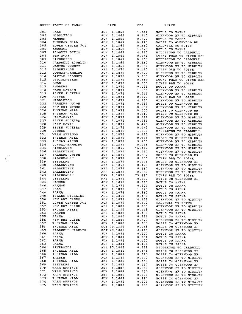
151 152 153 154 155 156 157 158 159 160 161 162 163 164 165 166 167 168 169 170 171 1 72 173 174 175 176 177 1 78 179 180 181 182 183 184 185 186 187 188 189 190 191 192 193 194 195 196 197 198 199 200 201 202 203 204 205 206 207 208 209 210 211 212 213 214 215 216 217 218 219 220 221 222 223 224 225
SETTLERS WARM SPRINGS WARM SPRINGS WARM SPRINGS THURMAN MILL WARM SPRINGS WARM SPRINGS SETTLERS SETTLERS NEW DRY CREEK BALLENTYNE NEW DRY CREEK NEW DRY CREEK SEBREE THURMAN MILL RIVERSIDE EUREKA #2 PIONEER DIXIE EUREKA #2 BOWMAN AND SWISH UPPER CENTER POI LOWER CENTER POI PHYLLIS RIVERSIDE SETTLERS NEW DRY CREEK DAVIS RIVERSIDE BOWMAN AND SWISH CAMPBELL EUREKA #2 NEW YORK PIONEER DIXIE UPPER CENTER POI NEW DRY CREEK BALLENTYNE BALLENTYNE BALLENTYNE BALLENTYNE BALLENTYNE NEW DRY CREEK BALLENTYNE NEW DRY CREEK ANDREWS SEBREE RIDENBAUGH BUBB NEW YORK BUBB BUBB BUBB BUBB BUBB BUBB BUBB BUBB CRAWFORTH PARMA WARM SPRINGS WARM SPRINGS RIVERSIDE RIVERSIDE RIVERSIDE PHYLLIS CONWAY-HAMMING DAVIS MIDDLETON FARMERS UNION NEW DRY CREEK ANDREWS SETTLERS BALLENTYNE MIDDLETON RIVERSIDE NEW DRY CREEK
DATE
JUN 1,1882 JUN 1,1882 JUN 1,1882 JUN 1,1882 JUN 1,1882 JUN 1,1882 JUN 1,1882 JUN 1,1882 APR 1,1883 MAY 1,1883 MAY 1,1883 MAY 1,1883 MAY 1,1883 JUN 1,1883 JUN 1,1883 JUN 1,1883 JUN 1,1883 JUN 1,1883 NOV 9,1883 NOV 9,1883 NOV 9,1883 NOV 9,1883 JUN 1,1884 JUN 1,1884 OCT 17,1884 JUN 1,1886 JUN 1,1886 JAN 23,1887 OCT 1,1887 OCT 1,1887 OCT 1,1887 OCT 1,1887 OCT 1,1887 OCT 1,1887 JUN 1,1888 JUN 1,1888 JUN 1,1888 JUN 1,1888 JUN 1,1888 JUN 1,1888 JUN 1,1888 JUN 1,1888 JUN 1,1888 JUN 1,1888 JUL 1,1888 AUG 20,1888 MAR 1,1889 MAR 1,1889 MAY 1,1889 MAY 1,1889 MAY 1,1889 MAY 1,1889 MAY 1,1889 MAY 1,1889 MAY 1,1889 MAY 1,1889 MAY 1,1889 MAY 1,1889 JUN 1,1889 JUN 1,1889 JUN 1,1890 JUN 1,1890 JUN 1,1890 SEP 1,1890 JUN 1,1891 JUN 1,1891 JUN 1,1891 JUN 1,1891 JUN 1,1891 JUN 1,1891 JUN 1,1891 JUN 1,1891 APR 15,1893 MAY 1,1893 MAY 1,1893
CFS
0.240 0.480 0. 2 6 4 0.264 0.900 0.816 1.320 0. 4 3 2 0.600 0.134 0.454 0.042 0.231
12.000 0.540 4.800 1.020 1.380
10.980 0.120 0.300 1. 6 2 0
31.860 12.000 59.436
9 .132 8.040 2.400 0. 4 2 0 7.260
17.160 0.720 1. 320 1. 800 4. 716 2.400 0.780 0. 8 4 0 0.876 0.600 0 .12 0 0. 3 0 6 0.534 0.540
30.000 217.164
0.504 5. 3 4 0 0.036 0.012 1.440 3.600 1.764 0.030 0.060 0.018 0.960 0.480 0.036 0.720 0.432 0.060 0.240
120.000 1. 3 20 0.324 9.850 0. 0 4 6 0. 3 04 2.100
44.064 0.480 0. 9 6 0
48.000 0.414
REACH
BOISE TO GLENWOOD BR GLENWOOD BR TO MIDDLTN GLENWOOD BR TO MIDDLTN GLENWOOD BR TO MIDDLTN BOISE TO GLENWOOD BR GLENWOOD BR TO MIDDLTN GLENWOOD BR TO MIDDLTN BOISE TO GLENWOOD BR BOISE TO GLENWOOD BR GLENWOOD BR TO MIDDLTN GLENWOOD BR TO MIDDLTN GLENWOOD BR TO MIDDLTN GLENWOOD BR TO MIDDLTN MIDDLETON TO CALDWELL BOISE TO GLENWOOD BR MIDDLETON TO CALDWELL CALDWELL TO NOTUS MIDDLETON TO CALDWELL CALDWELL TO NOTUS NOTUS TO PARMA CALDWELL TO NOTUS CALDWELL TO NOTUS GLENWOOD BR TO MIDDLTN MIDDLETON TO CALDWELL BOISE TO GLENWOOD BR GLENWOOD BR TO MIDDLTN BOISE TO GLENWOOD BR MIDDLETON TO CALDWELL NOTUS TO PARMA MIDDLETON TO CALDWELL CALDWELL TO NOTUS LUCKY PEAK TO DIVSN DAM MIDDLETON TO CALDWELL CALDWELL TO NOTUS GLENWOOD BR TO MIDDLTN GLENWOOD BR TO MIDDLTN GLENWOOD BR TO MIDDLTN GLENWOOD BR TO MIDDLTN GLENWOOD BR TO MIDDLTN GLENWOOD BR TO MIDDLTN GLENWOOD BR TO MIDDLTN GLENWOOD BR TO MIDDLTN GLENWOOD BR TO MIDDLTN NOTUS TO PARMA MIDDLETON TO CALDWELL DIVSN DAM TO BOISE DIVSN DAM TO BOISE LUCKY PEAK TO DIVSN DAM DIVSN DAM TO BOISE DIVSN DAM TO BOISE DIVSN DAM TO BOISE DIVSN DAM TO BOISE DIVSN DAM TO BOISE DIVSN DAM TO BOISE DIVSN DAM TO BOISE DIVSN DAM TO BOISE NOTUS TO PARMA
z.o w o.1go ro
NOTUS TO PARMA GLENWOOD BR TO MIDDLTN GLENWOOD BR TO MIDDLTN MIDDLETON TO CALDWELL MIDDLETON TO CALDWELL MIDDLETON TO CALDWELL GLENWOOD BR TO MIDDLTN GLENWOOD BR TO MIDDLTN BOISE TO GLENWOOD BR GLENWOOD BR TO MIDDLTN BOISE TO GLENWOOD BR GLENWOOD BR TO MIDDLTN NOTUS TO PARMA BOISE TO GLENWOOD BR GLENWOOD BR TO MIDDLTN GLENWOOD BR TO MIDDLTN MIDDLETON TO CALDWELL GLENWOOD BR TO MIDDLTN
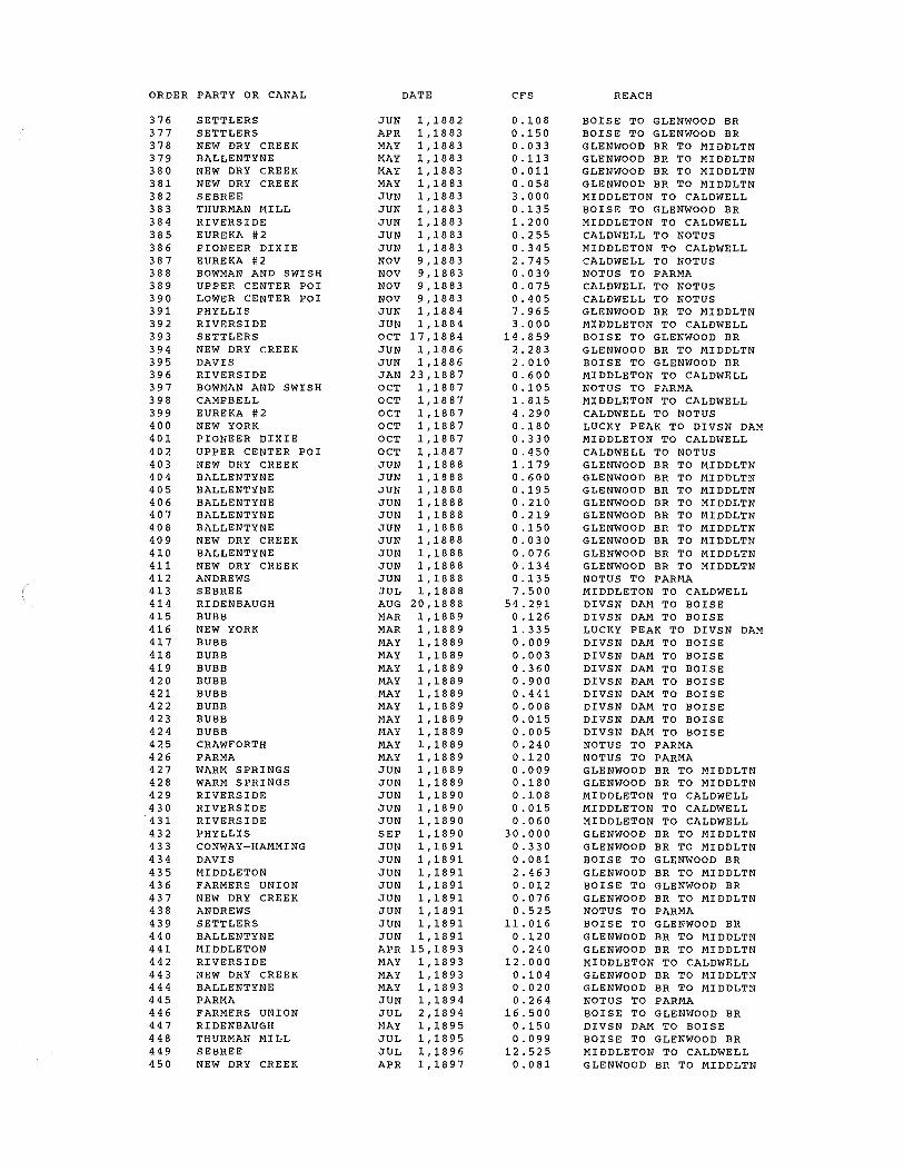
ORDER PARTY OR CANAL
226 227 228 229 230 231 232 233 234 235 236 237 238 239 240 241 242 243 244 245 246 247 248 249 250 251 252 253 254 255 256 257 258 259 260 261 262 263 264 265 266 267 268 269 270 271 272 273 274 275 276 277 278 279 280 281 282 283 284 285 286 287 288 289 290 291 292 293 294 295 296 297 298 299 300
BALLENTYNE PARMA FARMERS UNION RIDE NBA UGH THURMAN MILL SEBREE NEW DRY CREEK RIVERSIDE NEW YORK CAMPBELL RIVERSIDE CAMPBELL PHYLLIS BALLENTYNE MACE-MACE ISLAND HIGHLINE MACE-CATLIN ISLAND HIGHLINE FARMERS UNION RIDE NBA UGH SETTLERS MIDDLETON FARMERS UNION SETTLERS NEW DRY CREEK ANDREWS MACE-CATLIN SEVEN SUCKERS HART-DAVIS THURMAN MILL NEW YORK RIDENBAUGH BUBB LEMP BUBB SIEBENBERG SEBREE CAMPBELL THURMAN MILL THURMAN MILL GRAHAM-GILBERT EUREKA #1 NEW UNION BOISE VALLEY ROSSI MILL BOWMAN AND SWISH BOWMAN AND SWISH BAXTER LOWER CENTER POI LOWER CENTER POI UPPER CENTER POI UPPER CENTER POI EUREKA #2 UPPER CENTER POI UPPER CENTER POI UPPER CENTER POI ANDREWS CANYON COUNTY MIDDLETON MIDDLETON LITTLE PIONEER BOISE CITY PARKS FARMERS UNION BOISE CITY FARMERS UNION CALDWELL HIGHLIN CANYON COUNTY MIDDLETON MIDDLETON CANYON COUNTY THURMAN MILL SETTLERS THURMAN MILL SETTLERS LOWER CENTER POI
DATE
MAY 1,1893 JUN 1,1894 JUL 2,1894 MAY 1,1895 JUL 1,1895 JUL 1,1896 APR 1,1897 OCT 1,1899 MAR 23,1900 MAY 17,1900 JUN 1,1901 OCT 25,1901 APR 1,1904 MAY 1,1906 APR 1,1910 APR 1,1910 JUN 14,1912 JUN 14,1912 JUN 1,1864 JUN 1,1864 JUN 1,1864 JUN 1,1864 JUN 1,1864 JUN 1,1864 JUN 1,1864 JUN 1,1864 JUN 1,1864 JUN 1,1864 JUN 1,1864 JUN 1,1864 SEP 1,1864 APR 1,1865 APR 1,1865 APR 1,1865 APR 1,1865 JUN 1,1865 JUN 1,1865 JUN 1,1865 JUN 1,1865 JUN 1,1865 JUN 1,1865 JUN 1,1865 JUN 1,1865 JUN 1,1865 JUN 1,1865 JUN 1,1865 JUN 1,1865 JUN 1,1865 JUN 1,1865 JUN 1,1865 JUN 1,1865 JUN 1,1865 JUN 1,1865 JUN 1,1865 JUN 1,1865 JUN 1,1865 JUN 1,1865 JUN 1,1866 JUN 1,1866 JUN 1,1866 JUN 1,1866 JUN 1,1866 JUN 1,1866 JUN 1,1866 JUN 1,1866 JUL 3,1866 JUN 1,1867 JUN 1,1867 JUN 1,1867 JUN 1,1867 JUN 1,1868 JUN 1,1868 JUN 1,1868 JUN 1,1868 JUN 1,1868
CFS
0.081 1.056
66.000 0.600 0. 3 9 6
50.100 0.324
12.000 131.460
6.000 42.000
3. 3 2 4 33.804 0.235 1.056 4.200 0.264 6.000 0.270 0.030 0. 0 3 0 1. 78 5 0.015 0.063 0.057 0.495 0.404 0.025 0.495 0.495 3.000 0.120 0.270 0.900 0.075 1.842 0.096 0.075 0.180 0.099 0.660 4.998 2.064 8.187 1.500 0.432 0.840 0.120 0.435 0.480 0.480 0.150 0.210 0.591 0.240 0.237 0.900 0.390 0.345 0.090 0.165 0.255 0.270 5. 456>" 0.253 2. 310
11.252 0.062 0.057 0.264 2. 0 3 9 0.076 0.405 0.150 0.480
REACH
GLENWOOD BR TO MIDDLTN NOTUS TO PARMA BOISE TO GLENWOOD BR DIVSN DAM TO BOISE BOISE TO GLENWOOD BR MIDDLETON TO CALDWELL GLENWOOD BR TO MIDDLTN MIDDLETON TO CALDWELL LUCKY PEAK TO DIVSN DAM MIDDLETON TO CALDWELL MIDDLETON TO CALDWELL MIDDLETON TO CALDWELL GLENWOOD BR TO MIDDLTN GLENWOOD BR TO MIDDLTN GLENWOOD BR TO MIDDLTN NOTUS TO PARMA GLENWOOD BR TO MIDDLTN NOTUS TO PARMA BOISE TO GLENWOOD BR DIVSN DAM TO BOISE BOISE TO GLENWOOD BR GLENWOOD BR TO MIDDLTN BOISE TO GLENWOOD BR BOISE TO GLENWOOD BR GLENWOOD BR TO MIDDLTN NOTUS TO PARMA GLENWOOD BR TO MIDDLTN GLENWOOD BR TO MIDDLTN GLENWOOD BR TO MIDDLTN BOISE TO GLENWOOD BR LUCKY PEAK TO DIVSN DAM DIVSN DAM TO BOISE DIVSN DAM TO BOISE GLENWOOD BR TO MIDDLTN DIVSN DAM TO BOISE MIDDLETON TO CALDWELL MIDDLETON TO CALDWELL MIDDLETON TO CALDWELL BOISE TO GLENWOOD BR BOISE TO GLENWOOD BR GLENWOOD BR TO MIDDLTN GLENWOOD BR TO MIDDLTN GLENWOOD BR TO MIDDLTN BOISE TO GLENWOOD BR DIVSN DAM TO BOISE NOTUS TO PARMA NOTUS TO PARMA NOTUS TO PARMA CALDWELL TO NOTUS CALDWELL TO NOTUS CALDWELL TO NOTUS CALDWELL TO NOTUS CALDWELL TO NOTUS CALDWELL TO NOTUS CALDWELL TO NOTUS CALDWELL TO NOTUS NOTUS TO PARMA GLENWOOD BR TO MIDDLTN GLENWOOD BR TO MIDDLTN GLENWOOD BR TO MIDDLTN GLENWOOD BR TO MIDDLTN BOISE TO GLENWOOD BR BOISE TO GLENWOOD BR DIVSN DAM TO BOISE BOISE TO GLENWOOD BR GLENWOOD BR TO MIDDLTN GLENWOOD BR TO MIDDLTN GLENWOOD BR TO MIDDLTN GLENWOOD BR TO MIDDLTN GLENWOOD BR TO MIDDLTN BOISE TO GLENWOOD BR BOISE TO GLENWOOD BR BOISE TO GLENWOOD BR BOISE TO GLENWOOD BR CALDWELL TO NOTUS
ORDER PARTY OR CANAL
301 302 303 304 305 306 307 308 309 310 311 312 313 314 315 316 317 318 319 320 321 322 323 324 325 326 327 328 329 330 331 332 333 334 335 336 337 338 339 340 341 342 343 344 345 346 347 348 349 350 351 352 353 354 355 356 357 358 359 360 361 362 363 364 365 366 367 368 369 370 371 372 373 374 375
HAAS MIDDLETON MAMMON THURMAN MILL LOWER CENTER POI ANDREWS PIONEER DIXIE NEW YORK RIVERSIDE CALDWELL HIGHLIN CANYON COUNTY RIDENBAUGH CONWAY-HAMMING LITTLE PIONEER PENITENTIARY BUBB ANDREWS MACE-CATLIN SEVEN SUCKERS ME EVES MIDDLETON FARMERS UNION NEW DRY CREEK THURMAN MILL THURMAN MILL HART-DAVIS SEVEN SUCKERS HART-DAVIS SEVEN SUCKERS SEBREE WARM SPRINGS THURMAN MILL THOMAS AIKEN CONWAY-HAMMING MIDDLETON BALLENTYNE FARMERS UNION RIDENBAUGH SETTLERS BALLENTYNE BALLENTYNE BALLENTYNE RIDENBAUGH SETTLERS MAMMON MAMMON HAAS PARMA ISLAND HIGHLINE NEW DRY CREEK LOWER CENTER POI NEW DRY CREEK THOMAS AIKEN BAXTER PARMA NEW DRY CREEK THURMAN MILL THURMAN MILL CALDWELL HIGHLIN PARMA PARMA PARMA PARMA RIVERSIDE THURMAN MILL THURMAN MILL BARBER THURMAN MILL SETTLERS WARM SPRINGS WARM SPRINGS WARM SPRINGS THURMAN MILL WARM SPRINGS WARM SPRINGS
DATE
JUN 1,1868 JUN 1,1868 JUN 1,1869 JUN 1,1869 JUN 1,1869 JUN 1,1869 JUN 1,1869 JUN 1,1869 JUN 1,1869 JUN 1,1869 JUN 1,1869 APR 1,1870 JUN 1,1870 JUN 1,1870 JUN 1,1870 JUN 1,1870 JUN 1,1870 JUN 1,1871 JUN 1,1871 JUN 1,1871 JUN 1,1871 JUN 1,1871 JUN 1,1871 JUN 1,1872 JUN 1,1872 JUN 1,1872 JUN 1,1872 JUN 1,1872 JUN 1,1872 JUN 1,1875 JUN 1,1876 JUN 1,1876 JUN 1,1877 JUN 1,1877 JUN 1,1877 JUN 1,1877 JUN 1,1877 JUN 1,1877 JUN 1,1877 APR 1,1878 APR 1,1878 APR 1,1878 MAY 1,1878 MAY 1,1878 JUN 1,1878 JUN 1,1878 JUN 1,1878 JUN 1,1878 APR 1,1879 JUN 1,1879 JUN 1,1879 APR 1,1880 APR 1,1880 APR 1,1880 JUN 1,1880 JUN 1,1880 JUN 1,1880 OCT 20,1880 OCT 29,1880 JUN 1,1881 JUN 1,1881 JUN 1,1881 JUN 1,1881 APR 15,1882 JUN 1,1882 JUN 1,1882 JUN 1,1882 JUN 1,1882 JUN 1,1882 JUN 1,1882 JUN 1,1882 JUN 1,1882 JUN 1,1882 JUN 1,1882 JUN 1,i882
CFS
1. 281 0.210 0.270 0.240 0.540 1.275 4.965 0.051 0.300 5.430 0.150 0.120 0.390 3.858 0.336 0.150 0.195 1.168 0. 011 0.270 4.865 0.039 0.151 0.105 0.210 0.579 0.081 0.420 0.075 1.500 0.345 0.066 0.780 0.135
16.427 0.090 0.467 0.060 0.068 0.120 0.210 0.120
25.440 0.060 0.630 0.504 1. 3 20 0.660 0.450 4.698 0.600 0.066 0.015 0. 4 8 0 0.264 0. 2 7 2 0.360 0 .135 4.140 0.240 0.051 0 .120 0.195 0.551 0.135 0.090 0.240 0.330 0. 0 6 0 0. 12 0 0.066 0. 0 6 6 0.225 0.204 0.330
REACH
NOTUS TO PARMA GLENWOOD BR TO MIDDLTN NOTUS TO PARMA BOISE TO GLENWOOD BR CALDWELL TO NOTUS NOTUS TO PARMA MIDDLETON TO CALDWELL LUCKY PEAK TO DIVSN DAM MIDDLETON TO CALDWELL GLENWOOD BR TO MIDDLTN GLENWOOD BR TO MIDDLTN DIVSN DAM TO BOISE GLENWOOD BR TO MIDDLTN GLENWOOD BR TO MIDDLTN LUCKY PEAK TO DIVSN DAM DIVSN DAM TO BOISE NOTUS TO PARMA GLENWOOD BR TO MIDDLTN GLENWOOD BR TO MIDDLTN DIVSN DAM TO BOISE GLENWOOD BR TO MIDDLTN BOISE TO GLENWOOD BR GLENWOOD BR TO MIDDLTN BOISE TO GLENWOOD BR BOISE TO GLENWOOD BR GLENWOOD BR TO MIDDLTN GLENWOOD BR TO MIDDLTN GLENWOOD BR TO MIDDLTN GLENWOOD BR TO MIDDLTN MIDDLETON TO CALDWELL GLENWOOD BR TO MIDDLTN BOISE TO GLENWOOD BR GLENWOOD BR TO MIDDLTN GLENWOOD BR TO MIDDLTN GLENWOOD BR TO MIDDLTN GLENWOOD BR TO MIDDLTN BOISE TO GLENWOOD BR DIVSN DAM TO BOISE BOISE TO GLENWOOD BR GLENWOOD BR TO MIDDLTN GLENWOOD BR TO MIDDLTN GLENWOOD BR TO MIDDLTN DIVSN DAM TO BOISE BOISE TO GLENWOOD BR NOTUS TO PARMA NOTUS TO PARMA NOTUS TO PARMA NOTUS TO PARMA NOTUS TO PARMA GLENWOOD BR TO MIDDLTN CALDWELL TO NOTUS GLENWOOD BR TO MIDDLTN GLENWOOD BR TO MIDDLTN NOTUS TO PARMA NOTUS TO PARMA GLENWOOD BR TO MIDDLTN BOISE TO GLENWOOD BR BOISE TO GLENWOOD BR GLENWOOD BR TO MIDDLTN NOTUS TO PARMA NOTUS TO PARMA NOTUS TO PARMA NOTUS TO PARMA MIDDLETON TO CALDWELL BOISE TO GLENWOOD BR BOISE TO GLENWOOD BR GLENWOOD BR TO MIDDLTN BOISE TO GLENWOOD BR BOISE TO GLENWOOD BR GLENWOOD BR TO MIDDLTN GLENWOOD BR TO MIDDLTN GLENWOOD BR TO MIDDLTN BOISE TO GLENWOOD BR GLENWOOD BR TO MIDDLTN GLENWOOD BR TO MIDDLTN
ORDER PARTY OR CANAL
376 377 378 379 380 381 382 383 384 385 386 387 388 389 390 391 392 393 394 395 396 397 398 399 400 401 402 403 404 405 406 407 408 409 410 411 412 413 414 415 416 417 418 419 420 421 422 423 424 425 426 427 428 429 430 431 432 433 434 435 436 437 438 439 440 441 442 443 444 445 446 447 448 449 450
SETTLERS SETTLERS NEW DRY CREEK BALLENTYNE NEW DRY CREEK NEW DRY CREEK SEBREE THURMAN MILL RIVERSIDE EUREKA #2 PIONEER DIXIE EUREKA #2 BOWMAN AND SWISH UPPER CENTER POI LOWER CENTER POI PHYLLIS RIVERSIDE SETTLERS NEW DRY CREEK DAVIS RIVERSIDE BOWMAN AND SWISH CAMPBELL EUREKA #2 NEW YORK PIONEER DIXIE UPPER CENTER POI NEW DRY CREEK BALLENTYNE BALLENTYNE BALLENTYNE BALLENTYNE BALLENTYNE NEW DRY CREEK BALLENTYNE NEW DRY CREEK ANDREWS SEBREE RIDENBAUGH BUBB NEW YORK BUBB BUBB BUBB BUBB BUBB BUBB BUBB BUBB CRAWFORTH PARMA WARM SPRINGS WARM SPRINGS RIVERSIDE RIVERSIDE RIVERSIDE PHYLLIS CONWAY-HAMMING DAVIS MIDDLETON FARMERS UNION NEW DRY CREEK ANDREWS SETTLERS BALLENTYNE MIDDLETON RIVERSIDE NEW DRY CREEK BALLENTYNE PARMA FARMERS UNION RIDENBAUGH THURMAN MILL SEBREE NEW DRY CREEK
DATE
JUN 1,1882 APR 1,1883 MAY 1,1883 MAY 1,1883 MAY 1,1883 MAY 1,1883 JUN 1,1883 JUN 1,1883 JUN 1,1883 JUN 1,1883 JUN 1,1883 NOV 9,1883 NOV 9,1883 NOV 9,1883 NOV 9,1883 JUN 1,1884 JUN 1,1884 OCT 17,1884 JUN 1,1886 JUN 1,1886 JAN 23,1887 OCT 1,1887 OCT 1,1887 OCT 1,1887 OCT 1,1887 OCT 1,1887 OCT 1,1887 JUN 1,1888 JUN 1,1888 JUN 1,1888 JUN 1,1888 JUN 1,1888 JUN 1,1888 JUN 1,1888 JUN 1,1888 JUN 1,1888 JUN 1,1888 JUL 1,1888 AUG 20,1888 MAR 1,1889 MAR 1,1889 MAY 1,1889 MAY 1,1889 MAY 1,1889 MAY 1,1889 MAY 1,1889 MAY 1,1889 MAY 1,1889 MAY 1,1889 MAY 1,1889 MAY 1,1889 JUN 1,1889 JUN 1,1889 JUN 1,1890 JUN 1,1890 JUN 1,1890 SEP 1,1890 JUN 1,1891 JUN 1,1891 JUN 1,1891 JUN 1,1891 JUN 1,1891 JUN 1,1891 JUN 1,1891 JUN 1,1891 APR 15,1893 MAY 1,1893 MAY 1,1893 MAY 1,1893 JUN 1,1894 JUL 2,1894 MAY 1,1895 JUL 1,1895 JUL 1,:).896 APR 1,1897
CFS
0.108 0.150 0.033 0.113 0.011 0.058 3.000 0.135 1.200 0.255 0.345 2.745 0.030 0.075 0.405 7.965 3.000
14.859 2.283 2.010 0.600 0.105 1.815 4.290 0 .18 0 0.330 0.450 1.179 0.600 0.195 0.210 0. 219 0.150 0.030 0.076 0.134 0.135 7.500
54.291 0.126 1.335 0.009 0.003 0.360 0.900 0.441 0.008 0.015 0.005 0.240 0 .12 0 0.009 0.180 0.108 0.015 0.060
30.000 0.330 0.081 2. 4 6 3 0.012 0.076 0.525
11. 016 0.120 0.240
12.000 0.104 0.020 0.264
16.500 0.150 0.099
12.525 0.081
REACH
BOISE TO GLENWOOD BR BOISE TO GLENWOOD BR GLENWOOD BR TO MIDDLTN GLENWOOD BR TO MIDDLTN GLENWOOD BR TO MIDDLTN GLENWOOD BR TO MIDDLTN MIDDLETON TO CALDWELL BOISE TO GLENWOOD BR MIDDLETON TO CALDWELL CALDWELL TO NOTUS MIDDLETON TO CALDWELL CALDWELL TO NOTUS NOTUS TO PARMA CALDWELL TO NOTUS CALDWELL TO NOTUS GLENWOOD BR TO MIDDLTN MIDDLETON TO CALDWELL BOISE TO GLENWOOD BR GLENWOOD BR TO MIDDLTN BOISE TO GLENWOOD BR MIDDLETON TO CALDWELL NOTUS TO PARMA MIDDLETON TO CALDWELL CALDWELL TO NOTUS LUCKY PEAK TO DIVSN DAM MIDDLETON TO CALDWELL CALDWELL TO NOTUS GLENWOOD BR TO MIDDLTN GLENWOOD BR TO MIDDLTN GLENWOOD BR TO MIDDLTN GLENWOOD BR TO MIDDLTN GLENWOOD BR TO MIDDLTN GLENWOOD BR TO MIDDLTN GLENWOOD BR TO MIDDLTN GLENWOOD BR TO MIDDLTN GLENWOOD BR TO MIDDLTN NOTUS TO PARMA MIDDLETON TO CALDWELL DIVSN DAM TO BOISE DIVSN DAM TO BOISE LUCKY PEAK TO DIVSN DAM DIVSN DAM TO BOISE DIVSN DAM TO BOISE DIVSN DAM TO BOISE DIVSN DAM TO BOISE DIVSN DAM TO BOISE DIVSN DAM TO BOISE DIVSN DAM TO BOISE DIVSN DAM TO BOISE NOTUS TO PARMA NOTUS TO PARMA GLENWOOD BR TO MIDDLTN GLENWOOD BR TO MIDDLTN MIDDLETON TO CALDWELL MIDDLETON TO CALDWELL MIDDLETON TO CALDWELL GLENWOOD BR TO MIDDLTN GLENWOOD BR TO MIDDLTN BOISE TO GLENWOOD BR GLENWOOD BR TO MIDDLTN BOISE TO GLENWOOD BR GLENWOOD BR TO MIDDLTN NOTUS TO PARMA BOISE TO GLENWOOD BR GLENWOOD BR TO MIDDLTN GLENWOOD BR TO MIDDLTN MIDDLETON TO CALDWELL GLENWOOD BR TO MIDDLTN GLENWOOD BR TO MIDDLTN NOTUS TO PARMA BOISE TO GLENWOOD BR DIVSN DAM TO BOISE BOISE TO GLENWOOD BR MIDDLETON TO CALDWELL GLENWOOD BR TO MIDDLTN

ORDER PARTY OR CANAL
451 452 453 454 455 456 457 458 459 460 461 462 463 464 465 466 467 468 469 470 4 71 472 473 474 475 476 477 478 479 480 481 482 483 484 485 486 487 488 489 490 491 492 493 494 495 496 497 498 499 500 501 502 503 504 505 506 507 508 509 510 511 512 513 514 515 516 517 518 519 520 521 522 523 524 525
RIVERSIDE NEW YORK CAMPBELL RIVERSIDE CAMPBELL PHYLLIS BALLENTYNE MACE-MACE ISLAND HIGHLINE MACE-CATLIN ISLAND HIGHLINE FARMERS UNION RIDENBAUGH SETTLERS MIDDLETON FARMERS UNION SETTLERS NEW DRY CREEK ANDREWS MACE-CATLIN SEVEN SUCKERS HART-DAVIS THURMAN MILL NEW YORK RIDENBAUGH BUBB LEMP BUBB SIEBENBERG SEBREE CAMPBELL THURMAN MILL THURMAN MILL GRAHAM-GILBERT EUREKA #1 NEW UNION BOISE VALLEY ROSSI MILL BOWMAN AND SWISH BOWMAN AND SWISH BAXTER LOWER CENTER POI LOWER CENTER POI UPPER CENTER POI UPPER CENTER POI EUREKA #2 UPPER CENTER POI UPPER CENTER POI UPPER CENTER POI ANDREWS CANYON COUNTY MIDDLETON MIDDLETON LITTLE PIONEER BOISE CITY PARKS FARMERS UNION BOISE CITY FARMERS UNION CALDWELL HIGHLIN CANYON COUNTY MIDDLETON MIDDLETON CANYON COUNTY THURMAN MILL SETTLERS THURMAN MILL SETTLERS LOWER CENTER POI HAAS MIDDLETON MAMMON THURMAN MILL LOWER CENTER POI ANDREWS PIONEER DIXIE
DATE
OCT 1,1899 MAR 23,1900 MAY 17,1900 JUN 1,1901 OCT 25,1901 APR 1,1904 MAY 1,1906 APR 1,1910 APR 1,1910 JUN 14,1912 JUN 14,1912 JUN 1,1864 JUN 1,1864 JUN 1,1864 JUN 1,1864 JUN 1,1864 JUN 1,1864 JUN 1,1864 JUN 1,1864 JUN 1,1864 JUN 1,1864 JUN 1,1864 JUN 1,1864 SEP 1,1864 APR 1,1865 APR 1,1865 APR 1,1865 APR 1,1865 JUN 1,1865 JUN 1,1865 JUN 1,1865 JUN 1,1865 JUN 1,1865 JUN 1,1865 JUN 1,1865 JUN 1,1865 JUN 1,1865 JUN 1,1865 JUN 1,1865 JUN 1,1865 JUN 1,1865 JUN 1,1865 JUN 1,1865 JUN 1,1865 JUN 1,1865 JUN 1,1865 JUN 1,1865 JUN 1,1865 JUN 1,1865 JUN 1,1865 JUN 1,1866 JUN 1,1866 JUN 1,1866 JUN 1,1866 JUN 1,1866 JUN 1,1866 JUN 1,1866 JUN 1,1866 JUL 3,1866 JUN 1,1867 JUN 1,1867 JUN 1,1867 JUN 1,1867 JUN 1,1868 JUN 1,1868 JUN 1,1868 JUN 1,1868 JUN 1,1868 JUN 1,1868 JUN 1,1868 JUN 1,1869 JUN 1,1869 JUN 1,1869 JUN 1, :).869 JUN 1,1869
CFS
3.000 32.865
1.500 10.500
0. 8 31 8.451 0.059 0.264 1.050 0.066 1.500 0.450 0.050 0.050 2.975 0.025 0.105 0.095 0.825 0.673 0. 04 2 0.825 0.825 5.000 0.200 0.450 1.500 0.125 3.070 0.160 0. 12 5 0.300 0.165 1.100 8.330 3.440
13.645 2.500 0.720 1.400 0.200 0.725 0.800 0.800 0.250 0.350 0.985 0.400 0.395 1.500 0.650 0.575 0.150 0.275 0.425 0.450 9.094 0.421 3. 8 50
18.752 0 .10 2 0.095 0. 4 4 0 3.398 0.127 0.675 0.250 0. 8 0 0 2 .135 0.350 0.450 0.400 0.900 2.125 8.275
REACH
MIDDLETON TO CALDWELL LUCKY PEAK TO DIVSN DAM MIDDLETON TO CALDWELL MIDDLETON TO CALDWELL MIDDLETON TO CALDWELL GLENWOOD BR TO MIDDLTN GLENWOOD BR TO MIDDLTN GLENWOOD BR TO MIDDLTN NOTUS TO PARMA GLENWOOD BR TO MIDDLTN NOTUS TO PARMA BOISE TO GLENWOOD BR DIVSN DAM TO BOISE BOISE TO GLENWOOD BR GLENWOOD BR TO MIDDLTN BOISE TO GLENWOOD BR BOISE TO GLENWOOD BR GLENWOOD BR TO MIDDLTN NOTUS TO PARMA GLENWOOD BR TO MIDDLTN GLENWOOD BR TO MIDDLTN GLENWOOD BR TO MIDDLTN BOISE TO GLENWOOD BR LUCKY PEAK TO DIVSN DAM DIVSN DAM TO BOISE DIVSN DAM TO BOISE GLENWOOD BR TO MIDDLTN DIVSN DAM TO BOISE MIDDLETON TO CALDWELL MIDDLETON TO CALDWELL MIDDLETON TO CALDWELL BOISE TO GLENWOOD BR BOISE TO GLENWOOD BR GLENWOOD BR TO MIDDLTN GLENWOOD BR TO MIDDLTN GLENWOOD BR TO MIDDLTN BOISE TO GLENWOOD BR DIVSN DAM TO BOISE NOTUS TO PARMA NOTUS TO PARMA NOTUS TO PARMA CALDWELL TO NOTUS CALDWELL TO NOTUS CALDWELL TO NOTUS CALDWELL TO NOTUS CALDWELL TO NOTUS CALDWELL TO NOTUS CALDWELL TO NOTUS CALDWELL TO NOTUS NOTUS TO PARMA GLENWOOD BR TO MIDDLTN GLENWOOD BR TO MIDDLTN GLENWOOD BR TO MIDDLTN GLENWOOD BR TO MIDDLTN BOISE TO GLENWOOD BR BOISE TO GLENWOOD BR DIVSN DAM TO BOISE BOISE TO GLENWOOD BR GLENWOOD BR TO MIDDLTN GLENWOOD BR TO MIDDLTN GLENWOOD BR TO MIDDLTN GLENWOOD BR TO MIDDLTN GLENWOOD BR TO MIDDLTN BOISE TO GLENWOOD BR BOISE TO GLENWOOD BR BOISE TO GLENWOOD BR BOISE TO GLENWOOD BR CALDWELL TO NOTUS NOTUS TO PARMA GLENWOOD BR TO MIDDLTN NOTUS TO PARMA BOISE TO GLENWOOD BR CALDWELL TO NOTUS NOTUS TO PARMA MIDDLETON TO CALDWELL

ORDER PARTY OR CANAL
526 527 528 529 530 531 532 533 534 535 536 537 538 539 540 541 542 543 544 545 546 547 548 549 550 551 552 553 554 555 556 557 558 559 560 561 562 563 564 565 566 567 568 569 570 571 572 573 574 575 576 577 578 579 580 581 582 583 584 585 586 587 588 589 590 591 592 593 594 595 596 597 598 599 600
NEW YORK RIVERSIDE CALDWELL HIGHLIN CANYON COUNTY RIDENBAUGH CONWAY-HAMMING LITTLE PIONEER PENITENTIARY BUBB ANDREWS MACE-CATLIN SEVEN SUCKERS ME EVES MIDDLETON FARMERS UNION NEW DRY CREEK THURMAN MILL THURMAN MILL HART-DAVIS SEVEN SUCKERS HART-DAVIS SEVEN SUCKERS SEBREE WARM SPRINGS THURMAN MILL THOMAS AIKEN CONWAY-HAMMING MIDDLETON BALLENTYNE FARMERS UNION RIDENBAUGH SETTLERS BALLENTYNE BALLENTYNE BALLENTYNE RIDENBAUGH SETTLERS MAMMON MAMMON HAAS PARMA ISLAND HIGHLINE NEW DRY CREEK LOWER CENTER POI NEW DRY CREEK THOMAS AIKEN BAXTER PARMA NEW DRY CREEK THURMAN MILL THURMAN MILL CALDWELL HIGHLIN PARMA PARMA PARMA PARMA RIVERSIDE THURMAN MILL THURMAN MILL BARBER THURMAN MILL SETTLERS WARM SPRINGS WARM SPRINGS WARM SPRINGS THURMAN MILL WARM SPRINGS WARM SPRINGS SETTLERS SETTLERS NEW DRY CREEK BALLENTYNE NEW DRY CREEK NEW DRY CREEK SEBREE
DATE
JUN 1,1869 JUN 1,1869 JUN 1,1869 JUN 1,1869 APR 1,1870 JUN 1,1870 JUN 1,1870 JUN 1,1870 JUN 1,1870 JUN 1,1870 JUN 1,1871 JUN 1,1871 JUN 1,1871 JUN 1,1871 JUN 1,1871 JUN 1,1871 JUN 1,1872 JUN 1,1872 JUN 1,1872 JUN 1,1872 JUN 1,1872 JUN 1,1872 JUN 1,1875 JUN 1,1876 JUN 1,1876 JUN 1,1877 JUN 1,1877 JUN 1,1877 JUN 1,1877 JUN 1,1877 JUN 1,1877 JUN 1,1877 APR 1,1878 APR 1,1878 APR 1,1878 MAY 1,1878 MAY 1,1878 JUN 1,1878 JUN 1,1878 JUN 1,1878 JUN 1,1878 APR 1,1879 JUN 1,1879 JUN 1,1879 APR 1,1880 APR 1,1880 APR 1,1880 JUN 1,1880 JUN 1,1880 JUN 1,1880 OCT 20,1880 OCT 29,1880 JUN 1,1881 JUN 1,1881 JUN 1,1881 JUN 1,1881 APR 15,1882 JUN 1,1882 JUN 1,1882 JUN 1,1882 JUN 1,1882 JUN 1,1882 JUN 1,1882 JUN 1,1882 JUN 1,1882 JUN 1,1882 JUN 1,1882 JUN 1,1882 JUN 1,1882 APR 1,1883 MAY 1,1883 MAY 1,1883 MAY 1,1883 MAY 1,1883 JUN l,i883
CFS
0.085 0.500 9.050 0.250 0.200 0.650 6.430 0.560 0.250 0.325 1. 94 7 0.018 0.450 8.109 0.066 0.251 0.175 0.350 0.965 0.135 0.700 0.125 2.500 0.575 0.110 1.300 0.225
27.378 0.150 0.779 0.100 0 .112 0.200 0.350 0.200
42.400 0.100 1. 050 0.840 2. 2 0 0 1.100 0.750 7.830 1.000 0 .110 0.025 0.800 0.440 0.454 0.600 0.225 6.900 0. 4 0 0 0.085 0.200 0. 3 2 5 0.919 0.225 0.150 0.400 0.550 0.100 0. 2 0 0 0 .110 0 .110 0.375 0.340 0.550 0.180 0.250 0.056 0.189 0.018 0.096 5.000
REACH
LUCKY PEAK TO DIVSN DAM MIDDLETON TO CALDWELL GLENWOOD BR TO MIDDLTN GLENWOOD BR TO MIDDLTN DIVSN DAM TO BOISE GLENWOOD BR TO MIDDLTN GLENWOOD BR TO MIDDLTN LUCKY PEAK TO DIVSN DAM DIVSN DAM TO BOISE NOTUS TO PARMA GLENWOOD BR TO MIDDLTN GLENWOOD BR TO MIDDLTN DIVSN DAM TO BOISE GLENWOOD BR TO MIDDLTN BOISE TO GLENWOOD BR GLENWOOD BR TO MIDDLTN BOISE TO GLENWOOD BR BOISE TO GLENWOOD BR GLENWOOD BR TO MIDDLTN GLENWOOD BR TO MIDDLTN GLENWOOD BR TO MIDDLTN GLENWOOD BR TO MIDDLTN MIDDLETON TO CALDWELL GLENWOOD BR TO MIDDLTN BOISE TO GLENWOOD BR GLENWOOD BR TO MIDDLTN GLENWOOD BR TO MIDDLTN GLENWOOD BR TO MIDDLTN GLENWOOD BR TO MIDDLTN BOISE TO GLENWOOD BR DIVSN DAM TO BOISE BOISE TO GLENWOOD BR GLENWOOD BR TO MIDDLTN GLENWOOD BR TO MIDDLTN GLENWOOD BR TO MIDDLTN DIVSN DAM TO BOISE BOISE TO GLENWOOD BR NOTUS TO PARMA NOTUS TO PARMA NOTUS TO PARMA NOTUS TO PARMA NOTUS TO PARMA GLENWOOD BR TO MIDDLTN CALDWELL TO NOTUS GLENWOOD BR TO MIDDLTN GLENWOOD BR TO MIDDLTN NOTUS TO PARMA NOTUS TO PARMA GLENWOOD BR TO MIDDLTN BOISE TO GLENWOOD BR BOISE TO GLENWOOD BR GLENWOOD BR TO MIDDLTN NOTUS TO PARMA NOTUS TO PARMA NOTUS TO PARMA NOTUS TO PARMA MIDDLETON TO CALDWELL BOISE TO GLENWOOD BR BOISE TO GLENWOOD BR GLENWOOD BR TO MIDDLTN BOISE TO GLENWOOD BR BOISE TO GLENWOOD BR GLENWOOD BR TO MIDDLTN GLENWOOD BR TO MIDDLTN GLENWOOD BR TO MIDDLTN BOISE TO GLENWOOD BR GLENWOOD BR TO MIDDLTN GLENWOOD BR TO MIDDLTN BOISE TO GLENWOOD BR BOISE TO GLENWOOD BR GLENWOOD BR TO MIDDLTN GLENWOOD BR TO MIDDLTN GLENWOOD BR TO MIDDLTN GLENWOOD BR TO MIDDLTN MIDDLETON TO CALDWELL
ORDER PARTY OR CANAL
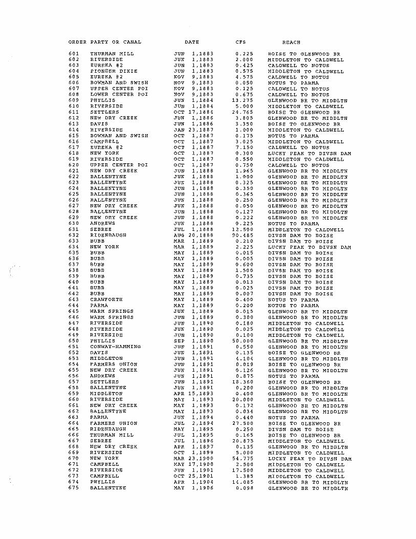
601 602 603 604 605 606 607 608 609 610 611 612 613 614 615 616 617 618 619 620 621 622 623 624 625 626 627 628 629 630 631 632 633 634 635 636 637 638 639 640 641 642 643 644 645 646 647 648 649 650 651 652 653 654 655 656 657 658 659 660 661 662 663 664 665 666 667 668 669 670 671 672 673 674 675
THURMAN MILL RIVERSIDE EUREKA #2 PIONEER DIXIE EUREKA #2 BOWMAN AND SWISH UPPER CENTER POI LOWER CENTER POI PHYLLIS RIVERSIDE SETTLERS NEW DRY CREEK DAVIS RIVERSIDE BOWMAN AND SWISH CAMPBELL EUREKA #2 NEW YORK RIVERSIDE UPPER CENTER POI NEW DRY CREEK BALLENTYNE BALLENTYNE BALLENTYNE BALLENTYNE BALLENTYNE NEW DRY CREEK BALLENTYNE NEW DRY CREEK ANDREWS SEBREE RIDENBAUGH BUBB NEW YORK BUBB BUBB BUBB BUBB BUBB BUBB BUBB BUBB CRAWFORTH PARMA WARM SPRINGS WARM SPRINGS RIVERSIDE RIVERSIDE RIVERSIDE PHYLLIS CONWAY-HAMMING DAVIS MIDDLETON FARMERS UNION NEW DRY CREEK ANDREWS SETTLERS BALLENTYNE MIDDLETON RIVERSIDE NEW DRY CREEK BALLENTYNE PARMA FARMERS UNION RIDENBAUGH THURMAN MILL SEBREE NEW DRY CREEK RIVERSIDE NEW YORK CAMPBELL RIVERSIDE CAMPBELL PHYLLIS BALLENTYNE
DATE
JUN 1,1883 JUN 1,1883 JUN 1,1883 JUN 1,1883 NOV 9,1883 NOV 9,1883 NOV 9,1883 NOV 9,1883 JUN 1,1884 JUN 1,1884 OCT 17,1884 JUN 1,1886 JUN 1,1886 JAN 23,1887 OCT 1,1887 OCT 1,1887 OCT 1,1887 OCT 1,1887 OCT 1,1887 OCT 1,1887 JUN 1,1888 JUN 1,1888 JUN 1,1888 JUN 1,1888 JUN 1,1888 JUN 1,1888 JUN 1,1888 JUN 1,1888 JUN 1,1888 JUN 1,1888 JUL 1,1888 AUG 20,1888 MAR 1,1889 MAR 1,1889 MAY 1,1889 MAY 1,1889 MAY 1,1889 MAY 1,1889 MAY 1,1889 MAY 1,1889 MAY 1,1889 MAY 1,1889 MAY 1,1889 MAY 1,1889 JUN 1,1889 JUN 1,1889 JUN 1,1890 JUN 1,1890 JUN 1,1890 SEP 1,1890 JUN 1,1891 JUN 1,1891 JUN 1,1891 JUN 1,1891 JUN 1,1891 JUN 1,1891 JUN 1,1891 JUN 1,1891 APR 15,1893 MAY 1,1893 MAY 1,1893 MAY 1,1893 JUN 1,1894 JUL 2,1894 MAY 1,1895 JUL 1,1895 JUL 1,1896 APR 1,1897 OCT 1,1899 MAR 23,1900 MAY 17,1900 JUN 1,1901 OCT 25,1901 APR 1, :).904 MAY 1,1906
CFS
0.225 2. 00 0 0.425 0.575 4.575 0.050 0.125 0.675
13.275 5.000
24.765 3.805 3.350 1. 000 0.175 3. 0 2 5 7.150 0.300 0.550 0.750 1.965 1.000 0.325 0.350 0.365 0.250 0.050 0.127 0. 2 2 2 0.225
12.500 90.485
0. 210 2.225 0.015 0. 0 0 5 0.600 1. 500 0.735 0. 013 0.025 0.007 0.400 0. 2 00 0. 015 0.300 0.180 0.025 0. 10 0
50.000 0.550 0.135 4 .10 4 0.019 0.126 0.875
18.360 0.200 0.400
20.000 0.172 0.034 0.440
27.500 0.250 0.165
20.875 0. 13 5 5.000
54.775 2.500
17.500 1.385
14.085 0.098
REACH
BOISE TO GLENWOOD BR MIDDLETON TO CALDWELL CALDWELL TO NOTUS MIDDLETON TO CALDWELL CALDWELL TO NOTUS NOTUS TO PARMA CALDWELL TO NOTUS CALDWELL TO NOTUS GLENWOOD BR TO MIDDLTN MIDDLETON TO CALDWELL BOISE TO GLENWOOD BR GLENWOOD BR TO MIDDLTN BOISE TO GLENWOOD BR MIDDLETON TO CALDWELL NOTUS TO PARMA MIDDLETON TO CALDWELL CALDWELL TO NOTUS LUCKY PEAK TO DIVSN DAM MIDDLETON TO CALDWELL CALDWELL TO NOTUS GLENWOOD BR TO MIDDLTN GLENWOOD BR TO MIDDLTN GLENWOOD BR TO MIDDLTN GLENWOOD BR TO MIDDLTN GLENWOOD BR TO MIDDLTN GLENWOOD BR TO MIDDLTN GLENWOOD BR TO MIDDLTN GLENWOOD BR TO MIDDLTN GLENWOOD BR TO MIDDLTN NOTUS TO PARMA MIDDLETON TO CALDWELL DIVSN DAM TO BOISE DIVSN DAM TO BOISE LUCKY PEAK TO DIVSN DAM DIVSN DAM TO BOISE DIVSN DAM TO BOISE DIVSN DAM TO BOISE DIVSN DAM TO BOISE DIVSN DAM TO BOISE DIVSN DAM TO BOISE DIVSN DAM TO BOISE DIVSN DAM TO BOISE NOTUS TO PARMA NOTUS TO PARMA GLENWOOD BR TO MIDDLTN GLENWOOD BR TO MIDDLTN MIDDLETON TO CALDWELL MIDDLETON TO CALDWELL MIDDLETON TO CALDWELL GLENWOOD BR TO MIDDLTN GLENWOOD BR TO MIDDLTN BOISE TO GLENWOOD BR GLENWOOD BR TO MIDDLTN BOISE TO GLENWOOD BR GLENWOOD BR TO MIDDLTN NOTUS TO PARMA BOISE TO GLENWOOD BR GLENWOOD BR TO MIDDLTN GLENWOOD BR TO MIDDLTN MIDDLETON TO CALDWELL GLENWOOD BR TO MIDDLTN GLENWOOD BR TO MIDDLTN NOTUS TO PARMA BOISE TO GLENWOOD BR DIVSN DAM TO BOISE BOISE TO GLENWOOD BR MIDDLETON TO CALDWELL GLENWOOD BR TO MIDDLTN MIDDLETON TO CALDWELL LUCKY PEAK TO DIVSN DAM MIDDLETON TO CALDWELL MIDDLETON TO CALDWELL MIDDLETON TO CALDWELL GLENWOOD BR TO MIDDLTN GLENWOOD BR TO MIDDLTN

ORDER PARTY OR CANAL DATE CFS REACH
676 MACE-MACE APR 1,1910 0. 4 40 GLENWOOD BR TO MIDDLTN 677 ISLAND HIGHLINE APR 1,1910 1.750 NOTUS TO PARMA 678 MACE-CATLIN JUN 14,1912 0 .110 GLENWOOD BR TO MIDDLTN 679 ISLAND HIGHLINE JUN 14,1912 2.500 NOTUS TO PARMA 680 FARMERS UNION JUL 2,1894 32.676 BOISE TO GLENWOOD BR 681 NEW YORK MAR 23,1900 35.316 LUCKY PEAK TO DIVSN DAM 682 NEW YORK DEC 14,1903 812.748 LUCKY PEAK TO DIV SN DAM 683 PHYLLIS APR 1,1905 183.936 GLENWOOD BR TO MIDDLTN 684 SEBREE APR 1,1905 92.670 MIDDLETON TO CALDWELL 685 BUBB APR 1,1905 3. 2 4 0 DIVSN DAM TO BOISE 686 PHYLLIS APR 1,1908 32.700 GLENWOOD BR TO MIDDLTN 687 NEW YORK APR 1,1909 175.500 LUCKY PEAK TO DIVSN DAM 688 NEW YORK JUN 16,1909 380.400 LUCKY PEAK TO DIVSN DAM 689 RIVERSIDE APR 1,1910 38.268 MIDDLETON TO CALDWELL 690 MCMANUS AND TEAT APR 1,1910 2. 016 CALDWELL TO NOTUS 691 ARROWROCK JAN 13,1911 4800.000 ANDSN RANCH TO ARROWROCK 692 RIVERSIDE APR 4,1914 10.620 MIDDLETON TO CALDWELL 693 PIONEER DIXIE JUL 9,1914 12.540 MIDDLETON TO CALDWELL 694 FARMERS UNION JUL 2,1894 8.169 BOISE TO GLENWOOD BR 695 NEW YORK MAR 23,1900 8. 8 2 9 LUCKY PEAK TO DIVSN DAM 696 NEW YORK DEC 14,1903 203.187 LUCKY PEAK TO DIVSN DAM 697 PHYLLIS APR 1,1905 45.984 GLENWOOD BR TO MIDDLTN 698 SEBREE APR 1,1905 23.167 MIDDLETON TO CALDWELL 699 BUBB APR 1,1905 0.810 DIVSN DAM TO BOISE 700 PHYLLIS APR 1,1908 8.175 GLENWOOD BR TO MIDDLTN 701 NEW YORK APR 1,1909 43.875 LUCKY PEAK TO DIVSN DAM 702 NEW YORK JUN 16,1909 95.100 LUCKY PEAK TO DIVSN DAM 703 RIVERSIDE APR 1,1910 9.567 MIDDLETON TO CALDWELL 704 MCMANUS AND TEAT APR 1,1910 0.504 CALDWELL TO NOTUS 705 ARROWROCK JAN 13,1911 1200.000 ANDSN RANCH TO ARROWROCK 706 RIVERSIDE APR 4,1914 2.655 MIDDLETON TO CALDWELL 707 PIONEER DIXIE JUL 9,1914 3.135 MIDDLETON TO CALDWELL 708 FARMERS UNION JUL 2,1894 13.615 BOISE TO GLENWOOD BR 709 NEW YORK MAR 23,1900 14.715 LUCKY PEAK TO DIVSN DAM 710 NEW YORK DEC 14,1903 338.645 LUCKY PEAK TO DIVSN DAM 711 PHYLLIS APR 1,1905 76.640 GLENWOOD BR TO MIDDLTN 712 SEBREE APR 1,1905 38.612 MIDDLETON TO CALDWELL 713 BUBB APR 1,1905 1.350 DIV SN DAM TO BOISE 714 PHYLLIS APR 1,1908 13.625 GLENWOOD BR TO MIDDLTN 715 NEW YORK APR 1,1909 73.125 LUCKY PEAK TO DIVSN DAM 716 NEW YORK JUN 16,1909 158.500 LUCKY PEAK TO DIVSN DAM 717 RIVERSIDE APR 1,1910 15.945 MIDDLETON TO CALDWELL 718 MCMANUS AND TEAT APR 1,1910 0.840 CALDWELL TO NOTUS 719 ARROWROCK JAN 13,1911 2000.000 ANDSN RANCH TO ARROWROCK 720 RIVERSIDE APR 4,1914 4. 4 2 5 MIDDLETON TO CALDWELL 721 PIONEER DIXIE JUL 9,1914 5.225 MIDDLETON TO CALDWELL 722 SEVEN SUCKERS OCT 2,1915 0.580 GLENWOOD BR TO MIDDLTN 723 BOISE VALLEY JUL 19,1921 1.200 BOISE TO GLENWOOD BR 724 ARROWROCK JUN 25,1938 7562.390 ANDSN RANCH TO ARROWROCK 725 ANDERSON RANCH DEC 9,1940 248631.712 FTHRVL TO ANDERSN RANCH 726 LOWER CENTER POI MAY 15,1950 1.600 CALDWELL TO NOTUS 727 LUCKY PEAK APR 12,1963 154776.910 ARROWROCK TO LUCKY PEAK 728 SHIPLEY MAR 15,1965 0.220 CALDWELL TO NOTUS 729 MAMMON FEB 21,1967 0.560 NOTUS TO PARMA 730 CAMPBELL FEB 19,1980 0. 6 4 0 MIDDLETON TO CALDWELL 731 MACE-CATLIN JUL 21,1980 0.720 GLENWOOD BR TO MIDDLTN 732 EAGLE ISLAND PAR JUL 8,1982 0.440 GLENWOOD BR TO MIDDLTN 733 BOISE WATER CORP APR 1,1985 2. 4 0 0 BOISE TO GLENWOOD BR

NUMBER
13190000
13194000 13194000 13194000 13194000
13201500
13202995 13202995 13202995
13203000 13203000 13203000 13203000 13203000 13203000 13203000 13203000 13203000 13203000 13203000 13203000 13203000 13203000 13203000 13203000 13203000 13203000 13203000 13203000 13203000 13203000 13203000 13203000 13203000 13203000 13203000 13203000 13203000
13203527
13203760 13203760 13203760 13203760 13203760 13203760 13203760 13203760 13203760 13203760 13203760 13203760 13203760 13203760 13203760 13203760 13203760 13203760 13203760 13203760 13203760 13203760 13203760
PARTY OR CANAL
ANDERSON RANCH
ARROWROCK ARROWROCK ARROWROCK ARROWROCK TOTAL
LUCKY PEAK
PENITENTIARY PENITENTIARY PENITENTIARY TOTAL
NEW YORK NEW YORK NEW YORK NEW YORK NEW YORK NEW YORK NEW YORK NEW YORK NEW YORK NEW YORK NEW YORK NEW YORK NEW YORK NEW YORK NEW YORK NEW YORK NEW YORK NEW YORK NEW YORK NEW YORK NEW YORK NEW YORK NEW YORK NEW YORK NEW YORK NEW YORK NEW YORK NEW YORK NEW YORK TOTAL
SURPRISE VLY FAR
RIDENBAUGH RIDENBAUGH RIDENBAUGH RIDENBAUGH RIDENBAUGH RIDENBAUGH RIDENBAUGH RIDENBAUGH RIDENBAUGH RIDENBAUGH RIDENBAUGH RIDENBAUGH RIDENBAUGH RIDENBAUGH RIDENBAUGH RIDENBAUGH RIDENBAUGH RIDENBAUGH RIDENBAUGH RIDENBAUGH RIDENBAUGH RIDENBAUGH RIDENBAUGH TOTAL
YR-MO-DY
19401209
19110113 19110113 19110113 19380625
19630412
18700601 18700601 18700601
10000101 18640901 18660501 18690601 18871001 18890301 19000323 18640901 18690601 18871001 18890301 19000323 18640901 18690601 18871001 18890301 19000323 19000323 19031214 19090401 19090616 19000323 19031214 19090401 19090616 19000323 19031214 19090401 19090616
18660501
10000101 10000101 1864-0601 18650401 18700401 18770601 18780501 18880820 18950501 18640601 18650401 18700401 18770601 18780501 18880820 189!10_501 18640601 18650401 18700401 18770601 18780501 18880820 18950501
CFS
248631.712
4800.000 1200.000 2000.000 7562.390
15562.390
154776.910
1. 3 4 4 0. 3 3 6 0.560 2. 2 4 0
3.675 12.000 15.100
0. 2 0 4 0.720 5.340
131.460 3. 0 0 0 0.051 0. 18 0 1. 335
32.865 5.000 0. 0 8 5 0. 30 0 2.225
54.775 35.316
812.748 175.500 380.400
8. 8 2 9 203.187 43.875 95.100 14.715
338.645 73.125
158.500 2608.255
3. 0 0 0
1. 8 00 1. 0 27 0 .12 0 0. 4 8 0 0.480 0. 2 4 0
101.760 217.164
0. 6 0 0 0. 0 3 0 0. 12 0 0.120 0. 0 6 0
25.440 54.291
0.150 0. 0 50 0.200 0. 2 0 0 0. 10 0
42.400 90.485
0.250 537.567
REACH
FTHRVL TO ANDERSN RANCH
ANDSN RANCH TO ARROWROCK ANDSN RANCH TO ARROWROCK ANDSN RANCH TO ARROWROCK ANDSN RANCH TO ARROWROCK
ARROWROCK TO LUCKY PEAK
LUCKY PEAK TO DIVSN DAM LUCKY PEAK TO DIVSN DAM LUCKY PEAK TO DIVSN DAM
LUCKY PEAK TO DIVSN DAM LUCKY PEAK TO DIVSN DAM LUCKY PEAK TO DIVSN DAM LUCKY PEAK TO DIVSN DAM LUCKY PEAK TO DIVSN DAM LUCKY PEAK TO DIVSN DAM LUCKY PEAK TO DIVSN DAM LUCKY PEAK TO DIVSN DAM LUCKY PEAK TO DIVSN DAM LUCKY PEAK TO DIVSN DAM LUCKY PEAK TO DIVSN DAM LUCKY PEAK TO DIVSN DAM LUCKY PEAK TO DIVSN DAM LUCKY PEAK TO DIVSN DAM LUCKY PEAK TO DIVSN DAM LUCKY PEAK TO DIVSN DAM LUCKY PEAK TO DIVSN LUCKY PEAK TO DIVSN LUCKY PEAK TO DIVSN LUCKY PEAK TO DIVSN DAM LUCKY PEAK TO DIVSN DAM LUCKY PEAK TO DIVSN DAM LUCKY PEAK TO DIVSN DAM LUCKY PEAK TO DIVSN DAM LUCKY PEAK TO DIVSN DAM LUCKY PEAK TO DIVSN DAM LUCKY PEAK TO DIVSN DAM LUCKY PEAK TO DIVSN DAM LUCKY PEAK TO DIVSN DAM
DIVSN DAM TO BOISE
DIVSN DAM TO BOISE DIVSN DAM TO BOISE DIVSN DAM TO BOISE DIVSN DAM TO BOISE DIVSN DAM TO BOISE DIVSN DAM TO BOISE DIVSN DAM TO BOISE DIVSN DAM TO BOISE DIVSN DAM TO BOISE DIVSN DAM TO BOISE DIVSN DAM TO BOISE DIVSN DAM TO BOISE DIVSN DAM TO BOISE DIVSN DAM TO BOISE DIVSN DAM TO BOISE DIVSN DAM TO BOISE DIVSN DAM TO BOISE DIVSN DAM TO BOISE DIVSN DAM TO BOISE DIVSN DAM TO BOISE DIVSN DAM TO BOISE DIVSN DAM TO BOISE DIVSN DAM TO BOISE

NUMBER PARTY OR CANAL
13204005 BUBB 13204005 BUBB 13204005 BUBB 13204005 BUBB 13204005 BUBB 13204005 BUBB 13204005 BUBB 13204005 BUBB 13204005 BUBB 13204005 BUBB 13204005 BUBB 13204005 BUBB 13204005 BUBB 13204005 BUBB 13204005 BUBB 13204005 BUBB 13204005 BUBB 13204005 BUBB 13204005 BUBB 13204005 BUBB 13204005 BUBB 13204005 BUBB 13204005 BUBB 13204005 BUBB 13204005 BUBB 13204005 BUBB 13204005 BUBB 13204005 BUBB 13204005 BUBB 13204005 BUBB 13204005 BUBB 13204005 BUBB 13204005 BUBB 13204005 BUBB 13204005 BUBB 13204005 BUBB 13204005 BUBB 13204005 BUBB 13204005 BUBB 13204005 BUBB
TOTAL
13204020 MEEVES 13204020 MEEVES 13204020 MEEVES 13204020 MEEVES
TOTAL
13204060 ROSSI MILL 13204060 ROSSI MILL 13204060 ROSSI MILL 13204060 ROSSI MILL
TOTAL
13204190 BOISE CITY 13204190 BOISE CITY 13204190 BOISE CITY 13204190 BOISE CITY
TOTAL
13205515 SETTLERS 13205515 SETTLERS 13205515 SETTLERS 13205515 SETTLERS 13205515 SETTLERS 13205515 SETTLERS 13205515 SETTLERS 13205515 SETTLERS 13205515 SETTLERS 13205515 SETTLERS 13205515 SETTLERS
YR-MO-DY
10000101 18650401 18650401 18700601 18890301 18890501 18890501 18890501 18890501 18890501 18890501 18890501 18890501 18650401 18650401 18700601 18890301 18890501 18890501 18890501 18890501 18890501 18890501 18890501 18890501 18650401 18650401 187006-01 18890301 18890501 18890501 18890501 18890501 18890501 18890501 18890501 18890501 19050401 19050401 19050401
10000101 18710601 18710601 18710601
10000101 18650601 18650601 18650601
10000101 18660601 18660601 18660601
18640601 18640601 18660501 18680601 18680601 18770601 18780501 18820601 18820601 18830401 18841017
CFS
1.125 1.080 0. 3 0 0 0.600 0.504 0.036 0.012 1.440 3. 6 0 0 1.764 0.030 0. 0 6 0 0. 018/ 0.270 0.075 0.150 0.126 0.009 0. 0 0 3 0.360 0. 9 0 0 0.441 0.008 0.015 0.005 0.450 0.125 0.250 0.210 0.015 0.005 0. 60 0 1. 50 0 0.735 0. 013 0.025 0.007 3. 2 4 0 0.810 1. 3 50
22.266
0.150 1. 0 8 0 0.270 0. 4 50 1.950
o_'. 75,,Q, 6. 0 0 01 1. 5o oi ~-~oJ
10.750
3. 010 21.825
5.456 9. 0 9 4
39.385
0 .120 0.252 9.250 0. 3 0 5 0. 6 0 0 0. 2 70 0. 2 4 0 0.240 0. 4 3 2 0.600
59.436
REACH
DIVSN DAM TO BOISE DIVSN DAM TO BOISE DIVSN DAM TO BOISE DIVSN DAM TO BOISE DIVSN DAM TO BOISE DIVSN DAM TO BOISE DIVSN DAM TO BOISE DIVSN DAM TO BOISE DIVSN DAM TO BOISE DIVSN DAM TO BOISE DIVSN DAM TO BOISE DIVSN DAM TO BOISE DIVSN DAM TO BOISE DIVSN DAM TO BOISE DIVSN DAM TO BOISE DIVSN DAM TO BOISE DIVSN DAM TO BOISE DIVSN DAM TO BOISE DIVSN DAM TO BOISE DIVSN DAM TO BOISE DIVSN DAM TO BOISE DIVSN DAM TO BOISE DIVSN DAM TO BOISE DIVSN DAM TO BOISE DIVSN DAM TO BOISE DIVSN DAM TO BOISE DIVSN DAM TO BOISE DIVSN DAM TO BOISE DIVSN DAM TO BOISE DIVSN DAM TO BOISE DIVSN DAM TO BOISE DIVSN DAM TO BOISE DIVSN DAM TO BOISE DIVSN DAM TO BOISE DIVSN DAM TO BOISE DIVSN DAM TO BOISE DIVSN DAM TO BOISE DIVSN DAM TO BOISE DIVSN DAM TO BOISE DIVSN DAM TO BOISE
DIVSN DAM TO BOISE DIVSN DAM TO BOISE DIVSN DAM TO BOISE DIVSN DAM TO BOISE
DIVSN DAM TO BOISE DIVSN DAM TO BOISE DIVSN DAM TO BOISE DIVSN DAM TO BOISE
DIVSN DAM TO BOISE DIVSN DAM TO BOISE DIVSN DAM TO BOISE DIVSN DAM TO BOISE
BOISE TO GLENWOOD BR BOISE TO GLENWOOD BR BOISE TO GLENWOOD BR BOISE TO GLENWOOD BR BOISE TO GLENWOOD BR BOISE TO GLENWOOD BR BOISE TO GLENWOOD BR BOISE TO GLENWOOD BR BOISE TO GLENWOOD BR BOISE TO GLENWOOD BR BOISE TO GLENWOOD BR

NUMBER PARTY OR CANAL
13205515 SETTLERS 13205515 SETTLERS 13205515 SETTLERS 13205515 SETTLERS 13205515 SETTLERS 13205515 SETTLERS 13205515 SETTLERS 13205515 SETTLERS 13205515 SETTLERS 13205515 SETTLERS 13205515 SETTLERS 13205515 SETTLERS 13205515 SETTLERS 13205515 SETTLERS 13205515 SETTLERS 13205515 SETTLERS 13205515 SETTLERS 13205515 SETTLERS 13205515 SETTLERS 13205515 SETTLERS 13205515 SETTLERS 13205515 SETTLERS 13205515 SETTLERS
TOTAL
13205517 DAVIS 13205517 DAVIS 13205517 DAVIS 13205517 DAVIS 13205517 DAVIS 13205517 DAVIS
TOTAL
13205613 BOISE CITY PARKS 13205613 BOISE CITY PARKS 13205613 BOISE CITY PARKS
TOTAL
13205622 THURMAN MILL 13205622 THURMAN MILL 13205622 THURMAN MILL 13205622 THURMAN MILL 13205622 THURMAN MILL 13205622 THURMAN MILL 13205622 THURMAN MILL 13205622 THURMAN MILL 13205622 THURMAN MILL 13205622 THURMAN MILL 13205622 THURMAN MILL 13205622 THURMAN MILL 13205622 THURMAN MILL 13205622 THURMAN MILL 13205622 THURMAN MILL 13205622 THURMAN MILL 13205622 THURMAN MILL 13205622 THURMAN MILL 13205622 THURMAN MILL 13205622 THURMAN MILL 13205622 THURMAN MILL 13205622 THURMAN MILL 13205622 THURMAN MILL 13205622 THURMAN MILL 13205622 THURMAN MILL 13205622 THURMAN MILL 13205622 THURMAN MILL 13205622 THURMAN MILL 13205622 THURMAN MILL 13205622 THURMAN MILL 13205622 THURMAN MILL 13205622 THURMAN MILL 13205622 THURMAN MILL 13205622 THURMAN MILL 13205622 THURMAN MILL
YR-MO-DY
18910601 18640601 18640601 18680601 18680601 18770601 18780501 18820601 18820601 18830401 18841017 18910601 18640601 18640601 18680601 18680601 18770601 18780501 18820601 18820601 18830401 18841017 18910601
18860601 18910601 18860601 18910601 18860601 18910601
18660601 18660601 18660601
10000101 18640601 18650601 18650601 18680601 18680601 18690601 18720601 18720601 18760601 18800601 18801020 18820601 18820601 18820601 18820601 18830601 18950701 18640601 18650601 18650601 18680601 18680601 18690601 18720601 18720601 18760601 18800601 18801020 18820601 18820601 18820601 18820601 18830601 18950701
CFS
44.064 0. 0 3 0 0. 0 6 3 0.076 0. 150 0. 0 6 8 0. 0 6 0 0. 0 6 0 0 .10 8 0.150
14.859 11.016
0.050 0.105 0.127 0.250 0 .112 0.100 0 .10 0 0. 18 0 0.250
24.765 18.360
186.848
8.040 0. 3 2 4 2. 010 0.081 3. 3 50 0.135
13.940
1. 0 20 0.255 0.425 1.700
11.420 1. 980 0.720 0.396
.1L..J...&.& 1.620 0.960 0.420 0. 8 4 0 0.264 1. 4 4 0 0. 5 4 0 0.540 0.360 1. 3 20 0. 9 0 0 0.540 0. 39~ 0.495 0.180 0.099 2. 0 3 9 0. 4 0 5 0. 2 4 0 0 .10 5 0. 210 0.066 0.360 0.135 0. 13 5 0.090 0.330 0.225 0.135 0.099
REACH
BOISE TO GLENWOOD BR BOISE TO GLENWOOD BR BOISE TO GLENWOOD BR BOISE TO GLENWOOD BR BOISE TO GLENWOOD BR BOISE TO GLENWOOD BR BOISE TO GLENWOOD BR BOISE TO GLENWOOD BR BOISE TO GLENWOOD BR BOISE TO GLENWOOD BR BOISE TO GLENWOOD BR BOISE TO GLENWOOD BR BOISE TO GLENWOOD BR BOISE TO GLENWOOD BR BOISE TO GLENWOOD BR BOISE TO GLENWOOD BR BOISE TO GLENWOOD BR BOISE TO GLENWOOD BR BOISE TO GLENWOOD BR BOISE TO GLENWOOD BR BOISE TO GLENWOOD BR BOISE TO GLENWOOD BR BOISE TO GLENWOOD BR
BOISE TO GLENWOOD BR BOISE TO GLENWOOD BR BOISE TO GLENWOOD BR BOISE TO GLENWOOD BR BOISE TO GLENWOOD BR BOISE TO GLENWOOD BR
BOISE TO GLENWOOD BR BOISE TO GLENWOOD BR BOISE TO GLENWOOD BR
BOISE TO GLENWOOD BR BOISE TO GLENWOOD BR BOISE TO GLENWOOD BR BOISE TO GLENWOOD BR BOISE TO GLENWOOD BR BOISE TO GLENWOOD BR BOISE TO GLENWOOD BR BOISE TO GLENWOOD BR BOISE TO GLENWOOD BR BOISE TO GLENWOOD BR BOISE TO GLENWOOD BR BOISE TO GLENWOOD BR BOISE TO GLENWOOD BR BOISE TO GLENWOOD BR BOISE TO GLENWOOD BR BOISE TO GLENWOOD BR u (l_,, BOISE TO GLENWOOD Bgl,__2~ BOISE TO GLENWOOD BR BOISE TO GLENWOOD B~ BOISE TO GLENWOOD BR BOISE TO GLENWOOD BR BOISE TO GLENWOOD BR~
BOISE TO GLENWOOD BR BOISE TO GLENWOOD BR BOISE TO GLENWOOD BR BOISE TO GLENWOOD BR BOISE TO GLENWOOD BR BOISE TO GLENWOOD BR BOISE TO GLENWOOD BR BOISE TO GLENWOOD BR BOISE TO GLENWOOD BR BOISE TO GLENWOOD BR BOISE TO GLENWOOD BR BOISE TO GLENWOOD BR BOISE TO GLENWOOD BR

NUMBER PARTY OR CANAL
13205622 THURMAN MILL 13205622 THURMAN MILL 13205622 THURMAN MILL 13205622 THURMAN MILL 13205622 THURMAN MILL 13205622 THURMAN MILL 13205622 THURMAN MILL 13205622 THURMAN MILL 13205622 THURMAN MILL 13205622 THURMAN MILL 13205622 THURMAN MILL 13205622 THURMAN MILL 13205622 THURMAN MILL 13205622 THURMAN MILL 13205622 THURMAN MILL 13205622 THURMAN MILL 13205622 THURMAN MILL
TOTAL
13205638 BOISE WATER CORP
13205640 FARMERS UNION 13205640 FARMERS UNION 13205640 FARMERS UNION 13205640 FARMERS UNION 13205640 FARMERS UNION 13205640 FARMERS UNION 13205640 FARMERS UNION 13205640 FARMERS UNION 13205640 FARMERS UNION 13205640 FARMERS UNION 13205640 FARMERS UNION 13205640 FARMERS UNION 13205640 FARMERS UNION 13205640 FARMERS UNION 13205640 FARMERS UNION 13205640 FARMERS UNION 13205640 FARMERS UNION 13205640 FARMERS UNION 13205640 FARMERS UNION 13205640 FARMERS UNION 13205640 FARMERS UNION 13205640 FARMERS UNION 13205640 FARMERS UNION 13205640 FARMERS UNION 13205640 FARMERS UNION 13205640 FARMERS UNION 13205640 FARMERS UNION 13205640 FARMERS UNION 13205640 FARMERS UNION
TOTAL
13205641 BOISE VALLEY 13205641 BOISE VALLEY 13205641 BOISE VALLEY 13205641 BOISE VALLEY 13205641 BOISE VALLEY
TOTAL
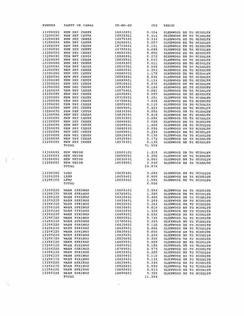
13206090 NEW DRY CREEK 13206090 NEW DRY CREEK 13206090 NEW DRY CREEK 13206090 NEW DRY CREEK 13206090 NEW DRY CREEK 13206090 NEW DRY CREEK 13206090 NEW DRY CREEK 13206090 NEW DRY CREEK 13206090 NEW DRY CREEK 13206090 NEW DRY CREEK 13206090 NEW DRY CREEK 13206090 NEW DRY CREEK 13206090 NEW DRY CREEK 13206090 NEW DRY CREEK
YR-MO-DY
18640601 18650601 18650601 18680601 18680601 18690601 18720601 18720601 18760601 18800601 18801020 18820601 18820601 18820601 18820601 18830601 18950701
19850401
10000101 18640601 18640601 18640601 18660601 18660601 18710601 18770601 18910601 18940702 18640601 18640601 18660601 18660601 18710601 18770601 18910601 18940702 18640601 18640601 18660601 18660601 18710601 18770601 18910601 18940702 18940702 18940702 18940702
10000101 18650601 18650601 18650601 19210719
10000101 18640601 18660501 18710601 18790601 18800401 18800601 18830501 18830501 18830501 18860601 18880601 18880601 18880601
CFS
0.825 0. 3 0 0 0.165 3.398 0.675 0.400 0.175 0.350 0.110 0. 6 0 0 0.225 0.225 0.150 0.550 0.375 0.225 0.165
47.072
2. 40 0
22.790 1. 0 80
20.000 0.059 1. 080 1.012 0.157 1.870 0. 0 4 6
66.000 0.270 0.015 0.270 0.253 0. 0 3 9 0.467 0. 012
16.500 0.450 0. 0 2 5 0.450 0. 4 21 0. 0 6 6 0.779 0.019
27.500 32.676
8.169 13.615
216.090
10.030 32.748
8.187 13.645 1. 2 0 0
65.810
9.470 0.228 0.540 0. 6 0 2
18.792 0.264 1. 0 9 0 0.134 0.042 0. 2 31 9 .13 2 4.716 0 .12 0 0.534
REACH
BOISE TO GLENWOOD BR BOISE TO GLENWOOD BR BOISE TO GLENWOOD BR BOISE TO GLENWOOD BR BOISE TO GLENWOOD BR BOISE TO GLENWOOD BR BOISE TO GLENWOOD BR BOISE TO GLENWOOD BR BOISE TO GLENWOOD BR BOISE TO GLENWOOD BR BOISE TO GLENWOOD BR BOISE TO GLENWOOD BR BOISE TO GLENWOOD BR BOISE TO GLENWOOD BR BOISE TO GLENWOOD BR BOISE TO GLENWOOD BR BOISE TO GLENWOOD BR
BOISE TO GLENWOOD BR
BOISE TO GLENWOOD BR BOISE TO GLENWOOD BR BOISE TO GLENWOOD BR BOISE TO GLENWOOD BR BOISE TO GLENWOOD BR BOISE TO GLENWOOD BR BOISE TO GLENWOOD BR BOISE TO GLENWOOD BR BOISE TO GLENWOOD BR BOISE TO GLENW,OOD BR_ BOISE TO GLENWOOD BR BOISE TO GLENWOOD BR BOISE TO GLENWOOD BR BOISE TO GLENWOOD BR BOISE TO GLENWOOD BR BOISE TO GLENWOOD BR BOISE TO GLENWOOD BR BOISE TO GLENWOOD BR BOISE TO GLENWOOD BR BOISE TO GLENWOOD BR BOISE TO GLENWOOD BR BOISE TO GLENWOOD BR BOISE TO GLENWOOD BR BOISE TO GLENWOOD BR BOISE TO GLENWOOD BR BOISE TO GLENWOOD BR BOISE TO GLENWOOD BR BOISE TO GLENWOOD BR BOISE TO GLENWOOD BR
BOISE TO GLENWOOD BR BOISE TO GLENWOOD BR BOISE TO GLENWOOD BR BOISE TO GLENWOOD BR BOISE TO GLENWOOD BR
GLENWOOD BR TO MIDDLTN GLENWOOD BR TO MIDDLTN GLENWOOD BR TO MIDDLTN GLENWOOD BR TO MIDDLTN GLENWOOD BR TO MIDDLTN GLENWOOD BR TO MIDDLTN GLENWOOD BR TO MIDDLTN GLENWOOD BR TO MIDDLTN GLENWOOD BR TO MIDDLTN GLENWOOD BR TO MIDDLTN GLENWOOD BR TO MIDDLTN GLENWOOD BR TO MIDDLTN GLENWOOD BR TO MIDDLTN GLENWOOD BR TO MIDDLTN
NUMBER PARTY OR CANAL
13206090 NEW DRY CREEK 13206090 NEW DRY CREEK 13206090 NEW DRY CREEK 13206090 NEW DRY CREEK 13206090 NEW DRY CREEK 13206090 NEW DRY CREEK 13206090 NEW DRY CREEK 13206090 NEW DRY CREEK 13206090 NEW DRY CREEK 13206090 NEW DRY CREEK 13206090 NEW DRY CREEK 13206090 NEW DRY CREEK 13206090 NEW DRY CREEK 13206090 NEW DRY CREEK 13206090 NEW DRY CREEK 13206090 NEW DRY CREEK 13206090 NEW DRY CREEK 13206090 NEW DRY CREEK 13206090 NEW DRY CREEK 13206090 NEW DRY CREEK 13206090 NEW DRY CREEK 13206090 NEW DRY CREEK 13206090 NEW DRY CREEK 13206090 NEW DRY CREEK 13206090 NEW DRY CREEK 13206090 NEW DRY CREEK 13206090 NEW DRY CREEK 13206090 NEW DRY CREEK 13206090 NEW DRY CREEK 13206090 NEW DRY CREEK 13206090 NEW DRY CREEK 13206090 NEW DRY CREEK 13206090 NEW DRY CREEK
TOTAL
13206092 NEW UNION 13206092 NEW UNION 13206092 NEW UNION 13206092 NEW UNION
TOTAL
13206205 LEMP 13206205 LEMP 13206205 LEMP
TOTAL
13206220 WARM SPRINGS 13206220 WARM SPRINGS 13206220 WARM SPRINGS 13206220 WARM SPRINGS 13206220 WARM SPRINGS 13206220 WARM SPRINGS 13206220 WARM SPRINGS 13206220 WARM SPRINGS 13206220 WARM SPRINGS 13206220 WARM SPRINGS 13206220 WARM SPRINGS 13206220 WARM SPRINGS 13206220 WARM SPRINGS 13206220 WARM SPRINGS 13206220 WARM SPRINGS 13206220 WARM SPRINGS 13206220 WARM SPRINGS 13206220 WARM SPRINGS 13206220 WARM SPRINGS 13206220 WARM SPRINGS 13206220 WARM SPRINGS 13206220 WARM SPRINGS 13206220 WARM SPRINGS 13206220 WARM SPRINGS 13206220 WARM SPRINGS
TOTAL
YR-MO-DY
18910601 18930501 18970401 18640601 18710601 18790601 18800401 18800601 18830501 18830501 18830501 18860601 18880601 18880601 18880601 18910601 18930501 18970401 18640601 18710601 18790601 18800401 18800601 18830501 18830501 18830501 18860601 18880601 18880601 18880601 18910601 18930501 18970401
10000101 18650601 18650601 18650601
18650401 18650401 18650401
10000101 18760601 18820601 18820601 18820601 18820601 18820601 18890601 18890601 18760601 18820601 18820601 18820601 18820601 18820601 18890601 18890601 18760601 18820601 18820601 18820601 18820601 18820601 18890601 18890601
CFS
0.304 0. 414 0.324 0.057 0.151 4.698 0.066 0.272 0. 0 3 3 0. 011 0.058 2. 2 8 3 1.179 0. 0 3 0 0. 13 4 0. 0 76 0. 10 4 0.081 0.095 0. 2 51 7.830 0.110 0.454 0.056 0.018 0. 0 9 6 3. 8 0 5 1.965 0.050 0. 2 2 2 0.126 0.172 0 .135
71.555
1.210 8.256 2.064 3. 4 4 0
14.970
3. 6 0 0 0. 9 0 0 1. 5 0 0 6. 0 0 0
2.554 1. 380 0. 4 8 0 0.264 0.264 0.816 1. 3 20 0. 0 3 6 0.720 0.345 0. 120 0.066 0. 0 66 0. 2 0 4 0. 3 3 0 0.009 0. 18 0 0.575 0. 2 0 0 0 .110 0.110 0.340 0.550 0.015 0. 3 0 0
11.354
REACH
GLENWOOD BR TO MIDDLTN GLENWOOD BR TO MIDDLTN GLENWOOD BR TO MIDDLTN GLENWOOD BR TO MIDDLTN GLENWOOD BR TO MIDDLTN GLENWOOD BR TO MIDDLTN GLENWOOD BR TO MIDDLTN GLENWOOD BR TO MIDDLTN GLENWOOD BR TO MIDDLTN GLENWOOD BR TO MIDDLTN GLENWOOD BR TO MIDDLTN GLENWOOD BR TO MIDDLTN GLENWOOD BR TO MIDDLTN GLENWOOD BR TO MIDDLTN GLENWOOD BR TO MIDDLTN GLENWOOD BR TO MIDDLTN GLENWOOD BR TO MIDDLTN GLENWOOD BR TO MIDDLTN GLENWOOD BR TO MIDDLTN GLENWOOD BR TO MIDDLTN GLENWOOD BR TO MIDDLTN GLENWOOD BR TO MIDDLTN GLENWOOD BR TO MIDDLTN GLENWOOD BR TO MIDDLTN GLENWOOD BR TO MIDDLTN GLENWOOD BR TO MIDDLTN GLENWOOD BR TO MIDDLTN GLENWOOD BR TO MIDDLTN GLENWOOD BR TO MIDDLTN GLENWOOD BR TO MIDDLTN GLENWOOD BR TO MIDDLTN GLENWOOD BR TO MIDDLTN GLENWOOD BR TO MIDDLTN
GLENWOOD BR TO MIDDLTN GLENWOOD BR TO MIDDLTN GLENWOOD BR TO MIDDLTN GLENWOOD BR TO MIDDLTN
GLENWOOD BR TO MIDDLTN GLENWOOD BR TO MIDDLTN GLENWOOD BR TO MIDDLTN
GLENWOOD BR TO MIDDLTN GLENWOOD BR TO MIDDLTN GLENWOOD BR TO MIDDLTN GLENWOOD BR TO MIDDLTN GLENWOOD BR TO MIDDLTN GLENWOOD BR TO MIDDLTN GLENWOOD BR TO MIDDLTN GLENWOOD BR TO MIDDLTN GLENWOOD BR TO MIDDLTN GLENWOOD BR TO MIDDLTN GLENWOOD BR TO MIDDLTN GLENWOOD BR TO MIDDLTN GLENWOOD BR TO MIDDLTN GLENWOOD BR TO MIDDLTN GLENWOOD BR TO MIDDLTN GLENWOOD BR TO MIDDLTN GLENWOOD BR TO MIDDLTN GLENWOOD BR TO MIDDLTN GLENWOOD BR TO MIDDLTN GLENWOOD BR TO MIDDLTN GLENWOOD BR TO MIDDLTN GLENWOOD BR TO MIDDLTN GLENWOOD BR TO MIDDLTN GLENWOOD BR TO MIDDLTN GLENWOOD BR TO MIDDLTN

NUMBER PARTY OR CANAL
13206260 GRAHAM-GILBERT 13206260 GRAHAM-GILBERT 13206260 GRAHAM-GILBERT
TOTAL
13206265 BALLENTYNE 13206265 BALLENTYNE 13206265 BALLENTYNE 13206265 BALLENTYNE 13206265 BALLENTYNE 13206265 BALLENTYNE 13206265 BALLENTYNE 13206265 BALLENTYNE 13206265 BALLENTYNE 13206265 BALLENTYNE 13206265 BALLENTYNE 13206265 BALLENTYNE 13206265 BALLENTYNE 13206265 BALLENTYNE 13206265 BALLENTYNE 13206265 BALLENTYNE 13206265 BALLENTYNE 13206265 BALLENTYNE 13206265 BALLENTYNE 13206265 BALLENTYNE 13206265 BALLENTYNE 13206265 BALLENTYNE 13206265 BALLENTYNE 13206265 BALLENTYNE 13206265 BALLENTYNE 13206265 BALLENTYNE 13206265 BALLENTYNE 13206265 BALLENTYNE 13206265 BALLENTYNE 13206265 BALLENTYNE 13206265 BALLENTYNE 13206265 BALLENTYNE 13206265 BALLENTYNE 13206265 BALLENTYNE 13206265 BALLENTYNE 13206265 BALLENTYNE 13206265 BALLENTYNE 13206265 BALLENTYNE 13206265 BALLENTYNE 13206265 BALLENTYNE 13206265 BALLENTYNE 13206265 BALLENTYNE 13206265 BALLENTYNE
TOTAL
13206270 CONWAY-HAMMING 13206270 CONWAY-HAMMING 13206270 CONWAY-HAMMING 13206270 CONWAY-HAMMING 13206270 CONWAY-HAMMING 13206270 CONWAY-HAMMING 13206270 CONWAY-HAMMING 13206270 CONWAY-HAMMING 13206270 CONWAY-HAMMING
TOTAL
13206274 EAGLE ISLAND PAR
13206290 THOMAS AIKEN 13206290 THOMAS AIKEN 13206290 THOMAS AIKEN 13206290 THOMAS AIKEN 13206290 THOMAS AIKEN 13206290 THOMAS AIKEN
TOTAL
YR-MO-DY
18650601 18650601 18650601
10000101 18770601 18780401 18780401 18780401 18830501 18880601 18880601 18880601 18880601 18880601 18880601 18910601 18930501 19060501 18770601 18780401 18780401 18780401 18830501 18880601 18880601 18880601 18880601 18880601 18880601 18910601 18930501 19060501 18770601 18780401 18780401 18780401 18830501 18880601 18880601 18880601 18880601 18880601 18880601 18910601 18930501 19060501
18700601 18770601 18910601 18700601 18770601 18910601 18700601 18770601 18910601
19820708
18770601 18800401 18770601 18800401 18770601 18800401
CFS
2. 6 4 0 0.660 1.100 4. 4 0 0
3. 0 4 0 0.360 0.480 0. 8 4 0 0. 4 8 0 0.454 2. 4 0 0 0.780 0.840 0.876 0. 6 0 0 0. 3 0 6 0. 4 8 0 0.081 0.235 0. 0 9 0 0.120 0.210 0.120 0 .113 0. 60 0 0.195 0.210 0.219 0. 15 0 0.076 0.120 0. 0 2 0 0.059 0.150 0. 20 0 0.350 0.200 0. 18 9 1.000 0.325 0. 3 50 0.365 0.250 0.127 0.200 0.034 0. 0 9 8
18.392
1.560 0.540 1. 32 0 0.390 0 .135 0. 3 3 0 0.650 0.225 0.550 5.700
0.440
3.120 0.060 0.780 0.015 1. 3 0 0 0.025 5.300
REACH
GLENWOOD BR TO MIDDLTN GLENWOOD BR TO MIDDLTN GLENWOOD BR TO MIDDLTN
GLENWOOD BR TO MIDDLTN GLENWOOD BR TO MIDDLTN GLENWOOD BR TO MIDDLTN GLENWOOD BR TO MIDDLTN GLENWOOD BR TO MIDDLTN GLENWOOD BR TO MIDDLTN GLENWOOD BR TO MIDDLTN GLENWOOD BR TO MIDDLTN GLENWOOD BR TO MIDDLTN GLENWOOD BR TO MIDDLTN GLENWOOD BR TO MIDDLTN GLENWOOD BR TO MIDDLTN GLENWOOD BR TO MIDDLTN GLENWOOD BR TO MIDDLTN GLENWOOD BR TO MIDDLTN GLENWOOD BR TO MIDDLTN GLENWOOD BR TO MIDDLTN GLENWOOD BR TO MIDDLTN GLENWOOD BR TO MIDDLTN GLENWOOD BR TO MIDDLTN GLENWOOD BR TO MIDDLTN GLENWOOD BR TO MIDDLTN GLENWOOD BR TO MIDDLTN GLENWOOD BR TO MIDDLTN GLENWOOD BR TO MIDDLTN GLENWOOD BR TO MIDDLTN GLENWOOD BR TO MIDDLTN GLENWOOD BR TO MIDDLTN GLENWOOD BR TO MIDDLTN GLENWOOD BR TO MIDDLTN GLENWOOD BR TO MIDDLTN GLENWOOD BR TO MIDDLTN GLENWOOD BR TO MIDDLTN GLENWOOD BR TO MIDDLTN GLENWOOD BR TO MIDDLTN GLENWOOD BR TO MIDDLTN GLENWOOD BR TO MIDDLTN GLENWOOD BR TO MIDDLTN GLENWOOD BR TO MIDDLTN GLENWOOD BR TO MIDDLTN GLENWOOD BR TO MIDDLTN GLENWOOD BR TO MIDDLTN GLENWOOD BR TO MIDDLTN
GLENWOOD BR TO MIDDLTN GLENWOOD BR TO MIDDLTN GLENWOOD BR TO MIDDLTN GLENWOOD BR TO MIDDLTN GLENWOOD BR TO MIDDLTN GLENWOOD BR TO MIDDLTN GLENWOOD BR TO MIDDLTN GLENWOOD BR TO MIDDLTN GLENWOOD BR TO MIDDLTN
GLENWOOD BR TO MIDDLTN
GLENWOOD BR TO MIDDLTN GLENWOOD BR TO MIDDLTN GLENWOOD BR TO MIDDLTN GLENWOOD BR TO MIDDLTN GLENWOOD BR TO MIDDLTN GLENWOOD BR TO MIDDLTN
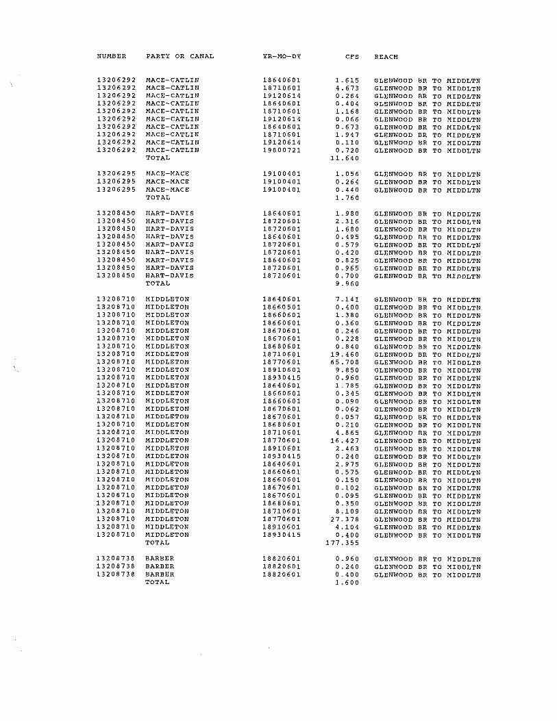
NUMBER PARTY OR CANAL
13206292 MACE-CATLIN 13206292 MACE-CATLIN 13206292 MACE-CATLIN 13206292 MACE-CATLIN 13206292 MACE-CATLIN 13206292 MACE-CATLIN 13206292 MACE-CATLIN 13206292 MACE-CATLIN 13206292 MACE-CATLIN 13206292 MACE-CATLIN
TOTAL
13206295 MACE-MACE 13206295 MACE-MACE 13206295 MACE-MACE
TOTAL
13208450 HART-DAVIS 13208450 HART-DAVIS 13208450 HART-DAVIS 13208450 HART-DAVIS 13208450 HART-DAVIS 13208450 HART-DAVIS 13208450 HART-DAVIS 13208450 HART-DAVIS 13208450 HART-DAVIS
TOTAL
13208710 MIDDLETON 13208710 MIDDLETON 13208710 MIDDLETON 13208710 MIDDLETON 13208710 MIDDLETON 13208710 MIDDLETON 13208710 MIDDLETON 13208710 MIDDLETON 13208710 MIDDLETON 13208710 MIDDLETON 13208710 MIDDLETON 13208710 MIDDLETON 13208710 MIDDLETON 13208710 MIDDLETON 13208710 MIDDLETON 13208710 MIDDLETON 13208710 MIDDLETON 13208710 MIDDLETON 13~08710 MIDDLETON 13208710 MIDDLETON 13208710 MIDDLETON 13208710 MIDDLETON 13208710 MIDDLETON 13208710 MIDDLETON 13208710 MIDDLETON 13208710 MIDDLETON 13208710 MIDDLETON 13208710 MIDDLETON 13208710 MIDDLETON 13208710 MIDDLETON 13208710 MIDDLETON
TOTAL
13208738 BARBER 13208738 BARBER 13208738 BARBER
TOTAL
YR-MO-DY
18640601 18710601 19120614 18640601 18710601 19120614 18640601 18710601 19120614 19800721
19100401 19100401 19100401
18640601 18720601 18720601 18640601 18720601 18720601 18640601 18720601 18720601
18640601 18660501 18660601 18660601 18670601 18670601 18680601 18710601 18770601 18910601 18930415 18640601 18660601 18660601 18670601 18670601 18680601 18710601 18770601 18910601 18930415 18640601 18660601 18660601 18670601 18670601 18680601 18710601 18770601 18910601 18930415
18820601 18820601 18820601
CFS
1.615 4.673 0. 2 6 4 0.404 1.168 0.066 0.673 1. 947 0.110 0.720
11.640
1.056 0.264 0.440 1.760
1. 9 8 0 2.316 1.680 0.495 0.579 0.420 0. 8 2 5 0.965 0.700 9. 9 6 0
7.141 0.400 1. 3 8 0 0. 3 6 0 0.246 0.228 0. 8 4 0
19.460 65.708
9.850 0. 9 6 0 1.785 0.345 0.090 0. 0 6 2 0.057 0.210 4.865
16.427 2. 4 6 3 0.240 2.975 0.575 0.150 0 .10 2 0.095 0.350 8.109
27.378 4.104 0. 4 0 0
177.355
0.960 0. 2 4 0 0.400 1.600
REACH
GLENWOOD BR TO MIDDLTN GLENWOOD BR TO MIDDLTN GLENWOOD BR TO MIDDLTN GLENWOOD BR TO MIDDLTN GLENWOOD BR TO MIDDLTN GLENWOOD BR TO MIDDLTN GLENWOOD BR TO MIDDLTN GLENWOOD BR TO MIDDLTN GLENWOOD BR TO MIDDLTN GLENWOOD BR TO MIDDLTN
GLENWOOD BR TO MIDDLTN GLENWOOD BR TO MIDDLTN GLENWOOD BR TO MIDDLTN
GLENWOOD BR TO MIDDLTN GLENWOOD BR TO MIDDLTN GLENWOOD BR TO MIDDLTN GLENWOOD BR TO MIDDLTN GLENWOOD BR TO MIDDLTN GLENWOOD BR TO MIDDLTN GLENWOOD BR TO MIDDLTN GLENWOOD BR TO MIDDLTN GLENWOOD BR TO MIDDLTN
GLENWOOD BR TO MIDDLTN GLENWOOD BR TO MIDDLTN GLENWOOD BR TO MIDDLTN GLENWOOD BR TO MIDDLTN GLENWOOD BR TO MIDDLTN GLENWOOD BR TO MIDDLTN GLENWOOD BR TO MIDDLTN GLENWOOD BR TO MIDDLTN GLENWOOD BR TO MIDDLTN GLENWOOD BR TO MIDDLTN GLENWOOD BR TO MIDDLTN GLENWOOD BR TO MIDDLTN GLENWOOD BR TO MIDDLTN GLENWOOD BR TO MIDDLTN GLENWOOD BR TO MIDDLTN GLENWOOD BR TO MIDDLTN GLENWOOD BR TO MIDDLTN GLENWOOD BR TO MIDDLTN GLENWOOD BR TO MIDDLTN GLENWOOD BR TO MIDDLTN GLENWOOD BR TO MIDDLTN GLENWOOD BR TO MIDDLTN GLENWOOD BR TO MIDDLTN GLENWOOD BR TO MIDDLTN GLENWOOD BR TO MIDDLTN GLENWOOD BR TO MIDDLTN GLENWOOD BR TO MIDDLTN GLENWOOD BR TO MIDDLTN GLENWOOD BR TO MIDDLTN GLENWOOD BR TO MIDDLTN GLENWOOD BR TO MIDDLTN
GLENWOOD BR TO MIDDLTN GLENWOOD BR TO MIDDLTN GLENWOOD BR TO MIDDLTN

NUMBER
13208740 13208740 13208740 13208740 13208740 13208740 13208740 13208740 13208740 13208740 13208740 13208740 13208740
13209480 13209480 13209480 13209480 13209480 13209480 13209480 13209480 13209480 13209480 13209480 13209480 13209480 13209480 13209480 13209480
13209482 13209482 13209482
13209630 13209630 13209630 13209630 13209630 13209630 13209630
13209990 13209990 13209990 13209990 13209990 13209990 13209990 13209990 13209990 13209990 13209990 13209990
PARTY OR CANAL
SEVEN SUCKERS SEVEN SUCKERS SEVEN SUCKERS SEVEN SUCKERS SEVEN SUCKERS SEVEN SUCKERS SEVEN SUCKERS SEVEN SUCKERS SEVEN SUCKERS SEVEN SUCKERS SEVEN SUCKERS SEVEN SUCKERS SEVEN SUCKERS TOTAL
PHYLLIS PHYLLIS PHYLLIS PHYLLIS PHYLLIS PHYLLIS PHYLLIS PHYLLIS PHYLLIS PHYLLIS PHYLLIS PHYLLIS PHYLLIS PHYLLIS PHYLLIS PHYLLIS TOTAL
EUREKA #1 EUREKA #1 EUREKA #1 TOTAL
LITTLE PIONEER LITTLE PIONEER LITTLE PIONEER LITTLE PIONEER LITTLE PIONEER LITTLE PIONEER LITTLE PIONEER TOTAL
CANYON COUNTY CANYON COUNTY CANYON COUNTY CANYON COUNTY CANYON COUNTY CANYON COUNTY CANYON COUNTY CANYON COUNTY CANYON COUNTY CANYON COUNTY CANYON COUNTY CANYON COUNTY TOTAL
13210005 CALDWELL HIGHLIN 13210005 CALDWELL HIGHLIN 13210005 CALDWELL HIGHLIN 13210005 CALDWELL HIGHLIN 13210005 CALDWELL HIGHLIN 13210005 CALDWELL HIGHLIN 13210005 CALDWELL HIGHLIN 13210005 CALDWELL HIGHLIN 13210005 CALDWELL HIGHLIN
TOTAL
YR-MO-DY
18640601 18710601 18720601 18720601 18640601 18710601 18720601 18720601 18640601 18710601 18720601 18720601 19151002
18660501 18840601 18900901 19040401 18840601 18900901 19040401 18840601 18900901 19040401 19050401 19080401 19050401 19080401 19050401 19080401
18650601 18650601 18650601
10000101 18660601 18700601 18660601 18700601 18660601 18700601
18660601 18670601 18670601 18690601 18660601 18670601 18670601 18690601 18660601 18670601 18670601 18690601
18660703 18690601 18801029 18660703 18690601 18801029 18660703 18690601 18801029
CFS
0.101 0.043 0.324 0.300 0.025 0. 011 0. 0 81 0.075 0.042 0.018 0 .13 5 0.125 0.580 1. 8 6 0
21.715 31.860
120.000 33.804
7.965 30.000
8.451 13.275 50.000 14.085
183.936 32.700 45.984
8.175 76.640 13.625
692.215
19.992 4.998 8. 3 3 0
33.320
4. 4 6 0 0.660
15.432 0.165 3.858 0.275 6. 4 3 0
31.280
1.560 45.006
1.056 0.600 0.390
11.252 0.264 0.150 0.650
18.752 0.440 0.250
80.370
9. 2 4 0 21.720 16.560
2.310 5.430 4.140 3.850 9. 0 50 6. 9 0 0
79.200
REACH
GLENWOOD BR TO MIDDLTN GLENWOOD BR TO MIDDLTN GLENWOOD BR TO MIDDLTN GLENWOOD BR TO MIDDLTN GLENWOOD BR TO MIDDLTN GLENWOOD BR TO MIDDLTN GLENWOOD BR TO MIDDLTN GLENWOOD BR TO MIDDLTN GLENWOOD BR TO MIDDLTN GLENWOOD BR TO MIDDLTN GLENWOOD BR TO MIDDLTN GLENWOOD BR TO MIDDLTN GLENWOOD BR TO MIDDLTN
GLENWOOD BR TO MIDDLTN GLENWOOD BR TO MIDDLTN GLENWOOD BR TO MIDDLTN GLENWOOD BR TO MIDDLTN GLENWOOD BR TO MIDDLTN GLENWOOD BR TO MIDDLTN GLENWOOD BR TO MIDDLTN GLENWOOD BR TO MIDDLTN GLENWOOD BR TO MIDDLTN GLENWOOD BR TO MIDDLTN GLENWOOD BR TO MIDDLTN GLENWOOD BR TO MIDDLTN GLENWOOD BR TO MIDDLTN GLENWOOD BR TO MIDDLTN GLENWOOD BR TO MIDDLTN GLENWOOD BR TO MIDDLTN
GLENWOOD BR TO MIDDLTN GLENWOOD BR TO MIDDLTN GLENWOOD BR TO MIDDLTN
GLENWOOD BR TO MIDDLTN GLENWOOD BR TO MIDDLTN GLENWOOD BR TO MIDDLTN GLENWOOD BR TO MIDDLTN GLENWOOD BR TO MIDDLTN GLENWOOD BR TO MIDDLTN GLENWOOD BR TO MIDDLTN
GLENWOOD BR TO MIDDLTN GLENWOOD BR TO MIDDLTN GLENWOOD BR TO MIDDLTN GLENWOOD BR TO MIDDLTN GLENWOOD BR TO MIDDLTN GLENWOOD BR TO MIDDLTN GLENWOOD BR TO MIDDLTN GLENWOOD BR TO MIDDLTN GLENWOOD BR TO MIDDLTN GLENWOOD BR TO MIDDLTN GLENWOOD BR TO MIDDLTN GLENWOOD BR TO MIDDLTN
GLENWOOD BR TO MIDDLTN GLENWOOD BR TO MIDDLTN GLENWOOD BR TO MIDDLTN GLENWOOD BR TO MIDDLTN GLENWOOD BR TO MIDDLTN GLENWOOD BR TO MIDDLTN GLENWOOD BR TO MIDDLTN GLENWOOD BR TO MIDDLTN GLENWOOD BR TO MIDDLTN

NUMBER PARTY OR CANAL
13210049 MIDDLETON FLOW
13210984 RIVERSIDE 13210984 RIVERSIDE 13210984 RIVERSIDE 13210984 RIVERSIDE 13210984 RIVERSIDE 13210984 RIVERSIDE 13210984 RIVERSIDE 13210984 RIVERSIDE 13210984 RIVERSIDE 13210984 RIVERSIDE 13210984 RIVERSIDE 13210984 RIVERSIDE 13210984 RIVERSIDE 13210984 RIVERSIDE 13210984 RIVERSIDE 13210984 RIVERSIDE 13210984 RIVERSIDE 13210984 RIVERSIDE 13210984 RIVERSIDE 13210984 RIVERSIDE 13210984 RIVERSIDE 13210984 RIVERSIDE 13210984 RIVERSIDE 13210984 RIVERSIDE 13210984 RIVERSIDE 13210984 RIVERSIDE 13210984 RIVERSIDE 13210984 RIVERSIDE 13210984 RIVERSIDE 13210984 RIVERSIDE 13210984 RIVERSIDE 13210984 RIVERSIDE 13210984 RIVERSIDE 13210984 RIVERSIDE 13210984 RIVERSIDE 13210984 RIVERSIDE 13210984 RIVERSIDE 13210984 RIVERSIDE 13210984 RIVERSIDE 13210984 RIVERSIDE
TOTAL
13210989 PIONEER DIXIE 13210989 PIONEER DIXIE 13210989 PIONEER DIXIE 13210989 PIONEER DIXIE 13210989 PIONEER DIXIE 13210989 PIONEER DIXIE 13210989 PIONEER DIXIE 13210989 PIONEER DIXIE 13210989 PIONEER DIXIE 13210989 PIONEER DIXIE 13210989 PIONEER DIXIE
TOTAL
13210992 SEBREE 13210992 SEBREE 13210992 SEBREE 13210992 SEBREE 13210992 SEBREE 13210992 SEBREE 13210992 SEBREE 13210992 SEBREE 13210992 SEBREE 13210992 SEBREE 13210992 SEBREE 13210992 SEBREE 13210992 SEBREE 13210992 SEBREE
YR-MO-DY
10000102
18690601 18820415 18830601 18840601 18870123 18900601 18900601 18900601 18930501 18991001 19010601 18690601 18820415 18830601 18840601 18870123 18900601 18900601 18900601 18930501 18991001 19010601 18690601 18820415 18830601 18840601 18870123 18871001 18900601 18900601 18900601 18930501 18991001 19010601 19100401 19140404 19100401 19140404 19100401 19140404
18690601 18830601 18871001 18690601 18830601 18871001 18690601 18830601 19140709 19140709 19140709
18650601 18750601 18830601 18880701 18960701 18650601 18750601 18830601 18880701 18960701 18650601 18750601 18830601 18880701
CFS
250.000
1. 2 0 0 2. 2 0 4 4.800
12.000 2. 4 0 0 0.432 0. 0 6 0 0.240
48.000 12.000 42.000
0. 3 0 0 0.551 1. 200 3. 0 0 0 0.600 0 .10 8 0.015 0.060
12.000 3. 0 0 0
10.500 0.500 0. 919 2.000 5.000 1. 0 00 0.550 0.180 0.025 0.100
20.000 5.000
17.500 38.268 10.620
9.567 2.655
15.945 4.425
290.924
19.860 1.380 1.320 4.965 0.345 0. 3 3 0 8.275 0.575
12.540 3.135 5.225
57.950
0. 3 8 4 6.000
12.000 30.000 50.100
0.096 1. 50 0 3.000 7.500
12.525 0.160 2.500 5.000
12.500
REACH
GLENWOOD BR TO MIDDLTN
MIDDLETON TO CALDWELL MIDDLETON TO CALDWELL MIDDLETON TO CALDWELL MIDDLETON TO CALDWELL MIDDLETON TO CALDWELL MIDDLETON TO CALDWELL MIDDLETON TO CALDWELL MIDDLETON TO CALDWELL MIDDLETON TO CALDWELL MIDDLETON TO CALDWELL MIDDLETON TO CALDWELL MIDDLETON TO CALDWELL MIDDLETON TO CALDWELL MIDDLETON TO CALDWELL MIDDLETON TO CALDWELL MIDDLETON TO CALDWELL MIDDLETON TO CALDWELL MIDDLETON TO CALDWELL MIDDLETON TO CALDWELL MIDDLETON TO CALDWELL MIDDLETON TO CALDWELL MIDDLETON TO CALDWELL MIDDLETON TO CALDWELL MIDDLETON TO CALDWELL MIDDLETON TO CALDWELL MIDDLETON TO CALDWELL MIDDLETON TO CALDWELL MIDDLETON TO CALDWELL MIDDLETON TO CALDWELL MIDDLETON TO CALDWELL MIDDLETON TO CALDWELL MIDDLETON TO CALDWELL MIDDLETON TO CALDWELL MIDDLETON TO CALDWELL MIDDLETON TO CALDWELL MIDDLETON TO CALDWELL MIDDLETON TO CALDWELL MIDDLETON TO CALDWELL MIDDLETON TO CALDWELL MIDDLETON TO CALDWELL
MIDDLETON TO CALDWELL MIDDLETON TO CALDWELL MIDDLETON TO CALDWELL MIDDLETON TO CALDWELL MIDDLETON TO CALDWELL MIDDLETON TO CALDWELL MIDDLETON TO CALDWELL MIDDLETON TO CALDWELL MIDDLETON TO CALDWELL MIDDLETON TO CALDWELL MIDDLETON TO CALDWELL
MIDDLETON TO CALDWELL MIDDLETON TO CALDWELL MIDDLETON TO CALDWELL MIDDLETON TO CALDWELL MIDDLETON TO CALDWELL MIDDLETON TO CALDWELL MIDDLETON TO CALDWELL MIDDLETON TO CALDWELL MIDDLETON TO CALDWELL MIDDLETON TO CALDWELL MIDDLETON TO CALDWELL MIDDLETON TO CALDWELL MIDDLETON TO CALDWELL MIDDLETON TO CALDWELL

NUMBER
13210992 13210992 13210992 13210992
13210993 13210993 13210993 13210993 13210993 13210993 13210993 13210993 13210993 13210993 13210993 13210993 13210993
13210994 13210994 13210994
13210999
13211001
13211725 13211725 13211725 13211725 13211 725 13211 725 13211725 13211725 13211725 13211725 13211725 13211725
PARTY OR CANAL
SEBREE SEBREE SEBREE SEBREE TOTAL
CAMPBELL CAMPBELL CAMPBELL CAMPBELL CAMPBELL CAMPBELL CAMPBELL CAMPBELL CAMPBELL CAMPBELL CAMPBELL CAMPBELL CAMPBELL TOTAL
SIEBENBERG SIEBENBERG SIEBENBERG TOTAL
CALDWELL FLOW
SHIPLEY
EUREKA #2 EUREKA #2 EUREKA #2 EUREKA #2 EUREKA #2 EUREKA #2 EUREKA #2 EUREKA #2 EUREKA #2 EUREKA #2 EUREKA #2 EUREKA #2 TOTAL
13211735 UPPER CENTER POI 13211735 UPPER CENTER POI 13211735 UPPER CENTER POI 13211735 UPPER CENTER POI 13211735 UPPER CENTER POI 13211735 UPPER CENTER POI 13211735 UPPER CENTER POI 13211735 UPPER CENTER POI 13211735 UPPER CENTER POI 13211735 UPPER CENTER POI 13211735 UPPER CENTER POI 13211735 UPPER CENTER POI 13211735 UPPER CENTER POI 13211735 UPPER CENTER POI 13211735 UPPER CENTER POI 13211735 UPPER CENTER POI 13211735 UPPER CENTER POI 13211735 UPPER CENTER POI 13211735 UPPER CENTER POI 13211735 UPPER CENTER POI 13211735 UPPER CENTER POI
TOTAL
YR-MO-DY
18960701 19050401 19050401 19050401
18650601 18871001 19000517 19011025 18650601 18871001 19000517 19011025 18650601 18871001 19000517 19011025 19800219
18650601 18650601 18650601
10000102
19650315
18650601 18830601 18831109 18871001 18650601 18830601 18831109 18871001 18650601 18830601 18831109 18871001
18650601 18650601 18650601 18650601 18650601 18831109 18871001 18650601 18650601 18650601 18650601 18650601 18831109 18871001 18650601 18650601 18650601 18650601 18650601 18831109 18871001
CFS
20.875 92.670 23.167 38.612
318.589
0.300 7.260 6.000 3.324 0.075 1. 815 1.500 0.831 0 .12 5 3. 0 2 5 2.500 1. 3 8 5 0.640
28.780
7.368 1.842 3.070
12.280
50.000
0.220
0. 8 4 0 1.020
10.980 17.160
0. 210 0.255 2.745 4.290 0.350 0.425 4.575 7.150
50.000
1. 920 0.600 2.364 0.960 0.948 0.300 1. 8 0 0 0. 48 0 0 .150 0.591 0.240 0.237 0.075 0.450 0.800 0.250 0.985 0.400 0.395 0.125 0.750
14.820
REACH
MIDDLETON TO CALDWELL MIDDLETON TO CALDWELL MIDDLETON TO CALDWELL MIDDLETON TO CALDWELL
MIDDLETON TO CALDWELL MIDDLETON TO CALDWELL MIDDLETON TO CALDWELL MIDDLETON TO CALDWELL MIDDLETON TO CALDWELL MIDDLETON TO CALDWELL MIDDLETON TO CALDWELL MIDDLETON TO CALDWELL MIDDLETON TO CALDWELL MIDDLETON TO CALDWELL MIDDLETON TO CALDWELL MIDDLETON TO CALDWELL MIDDLETON TO CALDWELL
MIDDLETON TO CALDWELL MIDDLETON TO CALDWELL MIDDLETON TO CALDWELL
MIDDLETON TO CALDWELL
CALDWELL TO NOTUS
CALDWELL TO NOTUS CALDWELL TO NOTUS CALDWELL TO NOTUS CALDWELL TO NOTUS CALDWELL TO NOTUS CALDWELL TO NOTUS CALDWELL TO NOTUS CALDWELL TO NOTUS CALDWELL TO NOTUS CALDWELL TO NOTUS CALDWELL TO NOTUS CALDWELL TO NOTUS
CALDWELL TO NOTUS CALDWELL TO NOTUS CALDWELL TO NOTUS CALDWELL TO NOTUS CALDWELL TO NOTUS CALDWELL TO NOTUS CALDWELL TO NOTUS CALDWELL TO NOTUS CALDWELL TO NOTUS CALDWELL TO NOTUS CALDWELL TO NOTUS CALDWELL TO NOTUS CALDWELL TO NOTUS CALDWELL TO NOTUS CALDWELL TO NOTUS CALDWELL TO NOTUS CALDWELL TO NOTUS CALDWELL TO NOTUS CALDWELL TO NOTUS CALDWELL TO NOTUS CALDWELL TO NOTUS
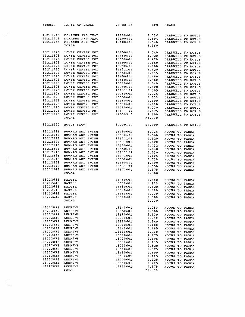
NUMBER PARTY OR CANAL
13211745 MCMANUS AND TEAT 13211745 MCMANUS AND TEAT 13211745 MCMANUS AND TEAT
TOTAL
13211825 LOWER CENTER POI 13211825 LOWER CENTER POI 13211825 LOWER CENTER POI 13211825 LOWER CENTER POI 13211825 LOWER CENTER POI 13211825 LOWER CENTER POI 13211825 LOWER CENTER POI 13211825 LOWER CENTER POI 13211825 LOWER CENTER POI 13211825 LOWER CENTER POI 13211825 LOWER CENTER POI 13211825 LOWER CENTER POI 13211825 LOWER CENTER POI 13211825 LOWER CENTER POI 13211825 LOWER CENTER POI 13211825 LOWER CENTER POI 13211825 LOWER CENTER POI 13211825 LOWER CENTER POI 13211825 LOWER CENTER POI
TOTAL
13212499 NOTUS FLOW
13212548 BOWMAN AND SWISH 13212548 BOWMAN AND SWISH 13212548 BOWMAN AND SWISH 13212548 BOWMAN AND SWISH 13212548 BOWMAN AND SWISH 13212548 BOWMAN AND SWISH 13212548 BOWMAN AND SWISH 13212548 BOWMAN AND SWISH 13212548 BOWMAN AND SWISH 13212548 BOWMAN AND SWISH 13212548 BOWMAN AND SWISH 13212548 BOWMAN AND SWISH
TOTAL
13212645 BAXTER 13212645 BAXTER 13212645 BAXTER 13212645 BAXTER 13212645 BAXTER 13212645 BAXTER
TOTAL
13212832 ANDREWS 13212832 ANDREWS 13212832 ANDREWS 13212832 ANDREWS 13212832 ANDREWS 13212832 ANDREWS 13212832 ANDREWS 13212832 ANDREWS 13212832 ANDREWS 13212832 ANDREWS 13212832 ANDREWS 13212832 ANDREWS 13212832 ANDREWS 13212832 ANDREWS 13212832 ANDREWS 13212832 ANDREWS 13212832 ANDREWS 13212832 ANDREWS
TOTAL
YR-MO-DY
19100401 19100401 19100401
18650601 18650601 18680601 18690601 18790601 18831109 18650601 18650601 18680601 18690601 18790601 18831109 18650601 18650601 18680601 18690601 18790601 18831109 19500515
10000102
18650601 18650601 18831109 18871001 18650601 18650601 18831109 18871001 18650601 18650601 18831109 18871001
18650601 18800401 18650601 18800401 18650601 18800401
18640601 18650601 18690601 18700601 18880601 18910601 18640601 18650601 18690601 18700601 18880601 18910601 18640601 18650601 18690601 18700601 18880601 18910601
CFS
2.016 0.504 0. 8 4 0 3. 3 6 0
1.740 1. 9 2 0 1. 9 20 2.160 2. 4 0 0 1. 6 20 0.435 0.480 0. 4 8 0 0.540 0.600 0. 4 0 5 0.725 0. 8 0 0 0. 8 0 0 0. 9 0 0 1. 00 0 0.675 1. 6 0 0
21.200
50.000
1.728 3.360 0.120 0. 4 2 0 0. 4 3 2 0.840 0. 0 3 0 0.105 0.720 1. 40 0 0. 0 50 0.175 9. 3 8 0
0.480 1. 920 0 .12 0 0.480 0.200 0.800 4. 0 0 0
1. 9 8 0 3.600 5.100 0.780 0.540 2 .10 0 0.495 0. 9 0 0 1.275 0.195 0.135 0.525 0. 8 2 5 1.500 2.125 0.325 0.225 0.875
23.500
REACH
CALDWELL TO NOTUS CALDWELL TO NOTUS CALDWELL TO NOTUS
CALDWELL TO NOTUS CALDWELL TO NOTUS CALDWELL TO NOTUS CALDWELL TO NOTUS CALDWELL TO NOTUS CALDWELL TO NOTUS CALDWELL TO NOTUS CALDWELL TO NOTUS CALDWELL TO NOTUS CALDWELL TO NOTUS CALDWELL TO NOTUS CALDWELL TO NOTUS CALDWELL TO NOTUS CALDWELL TO NOTUS CALDWELL TO NOTUS CALDWELL TO NOTUS CALDWELL TO NOTUS CALDWELL TO NOTUS CALDWELL TO NOTUS
CALDWELL TO NOTUS
NOTUS TO PARMA NOTUS TO PARMA NOTUS TO PARMA NOTUS TO PARMA NOTUS TO PARMA NOTUS TO PARMA NOTUS TO PARMA NOTUS TO PARMA NOTUS TO PARMA NOTUS TO PARMA NOTUS TO PARMA NOTUS TO PARMA
NOTUS TO PARMA NOTUS TO PARMA NOTUS TO PARMA NOTUS TO PARMA NOTUS TO PARMA NOTUS TO PARMA
NOTUS TO PARMA NOTUS TO PARMA NOTUS TO PARMA NOTUS TO PARMA NOTUS TO PARMA NOTUS TO PARMA NOTUS TO PARMA NOTUS TO PARMA NOTUS TO PARMA NOTUS TO PARMA NOTUS TO PARMA NOTUS TO PARMA NOTUS TO PARMA NOTUS TO PARMA NOTUS TO PARMA NOTUS TO PARMA NOTUS TO PARMA NOTUS TO PARMA
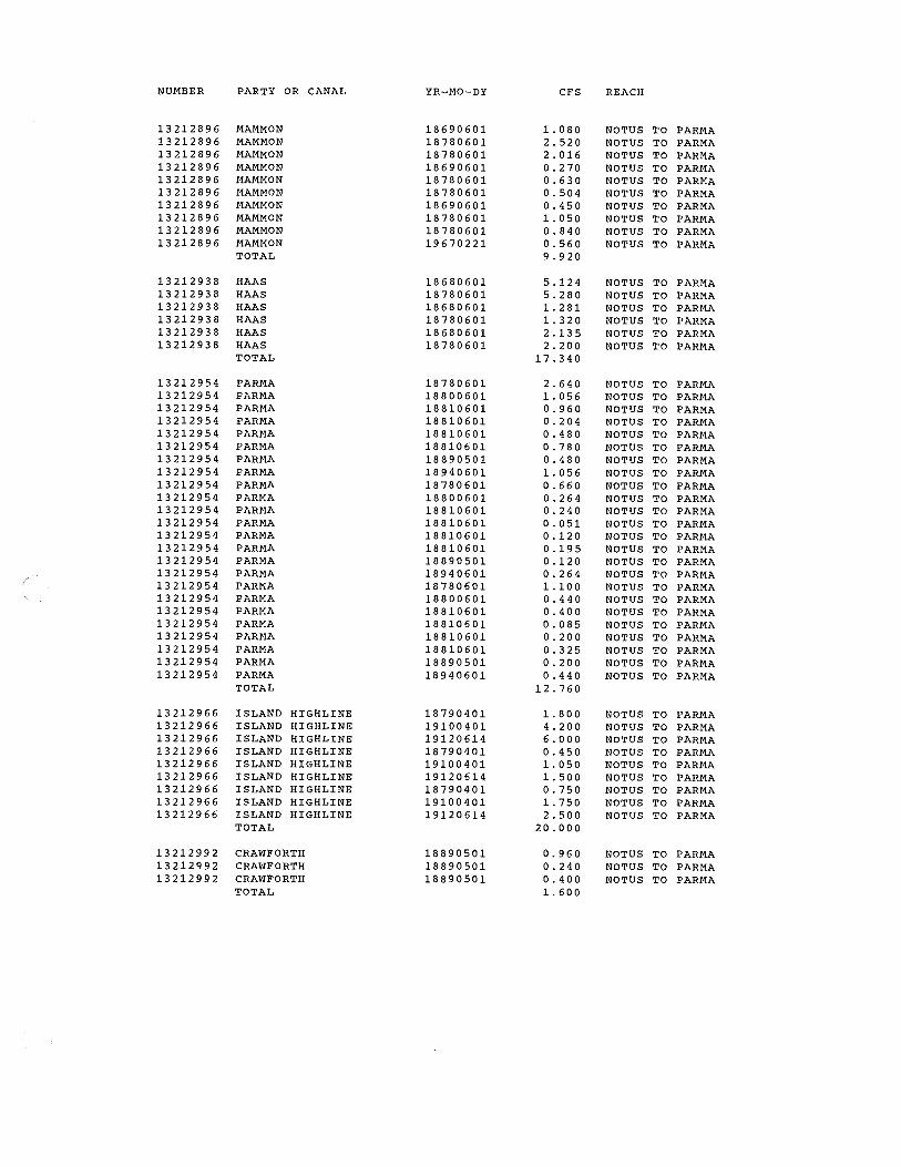
NUMBER PARTY OR CANAL YR-MO-DY CFS REACH
13212896 MAMMON 18690601 1.080 NOTUS TO PARMA 13212896 MAMMON 18780601 2.520 NOTUS TO PARMA 13212896 MAMMON 18780601 2. 016 NOTUS TO PARMA 13212896 MAMMON 18690601 0.270 NOTUS TO PARMA 13212896 MAMMON 18780601 0.630 NOTUS TO PARMA 13212896 MAMMON 18780601 0.504 NOTUS TO PARMA 13212896 MAMMON 18690601 0. 4 5 0 NOTUS TO PARMA 13212896 MAMMON 18780601 1.050 NOTUS TO PARMA 13212896 MAMMON 18780601 0. 8 4 0 NOTUS TO PARMA 13212896 MAMMON 19670221 0.560 NOTUS TO PARMA
TOTAL 9.920
13212938 HAAS 18680601 5.124 NOTUS TO PARMA 13212938 HAAS 18780601 5.280 NOTUS TO PARMA 13212938 HAAS 18680601 1. 2 81 NOTUS TO PARMA 13212938 HAAS 18780601 1.320 NOTUS TO PARMA 13212938 HAAS 18680601 2.135 NOTUS TO PARMA 13212938 HAAS 18780601 2. 2 0 0 NOTUS TO PARMA
TOTAL 17.340
13212954 PARMA 18780601 2. 6 4 0 NOTUS TO PARMA 13212954 PARMA 18800601 1.056 NOTUS TO PARMA 13212954 PARMA 18810601 0.960 NOTUS TO PARMA 13212954 PARMA 18810601 0. 2 04 NOTUS TO PARMA 13212954 PARMA 18810601 0.480 NOTUS TO PARMA 13212954 PARMA 18810601 0. 7 8 0 NOTUS TO PARMA 13212954 PARMA 18890501 0. 4 8 0 NOTUS TO PARMA 13212954 PARMA 18940601 1.056 NOTUS TO PARMA 13212954 PARMA 18780601 0.660 NOTUS TO PARMA 13212954 PARMA 18800601 0.264 NOTUS TO PARMA 13212954 PARMA 18810601 0. 2 4 0 NOTUS TO PARMA 13212954 PARMA 18810601 0.051 NOTUS TO PARMA 13212954 PARMA 18810601 0. 12 0 NOTUS TO PARMA 13212954 PARMA 18810601 0.195 NOTUS TO PARMA 13212954 PARMA 18890501 0.120 NOTUS TO PARMA 13212954 PARMA 18940601 0.264 NOTUS TO PARMA 13212954 PARMA 18780601 1.100 NOTUS TO PARMA 13212954 PARMA 18800601 0. 4 4 0 NOTUS TO PARMA 13212954 PARMA 18810601 0.400 NOTUS TO PARMA 13212954 PARMA 18810601 0.085 NOTUS TO PARMA 13212954 PARMA 18810601 0. 20 0 NOTUS TO PARMA 13212954 PARMA 18810601 0.325 NOTUS TO PARMA 13212954 PARMA 18890501 0.200 NOTUS TO PARMA 13212954 PARMA 18940601 0.440 NOTUS TO PARMA
TOTAL 12.760
13212966 ISLAND HIGHLINE 18790401 1. 8 0 0 NOTUS TO PARMA 13212966 ISLAND HIGHLINE 19100401 4.200 NOTUS TO PARMA 13212966 ISLAND HIGHLINE 19120614 6. 0 0 0 NOTUS TO PARMA 13212966 ISLAND HIGHLINE 18790401 0. 4 5 0 NOTUS TO PARMA 13212966 ISLAND HIGHLINE 19100401 1.050 NOTUS TO PARMA 13212966 ISLAND HIGHLINE 19120614 1.500 NOTUS TO PARMA 13212966 ISLAND HIGHLINE 18790401 0.750 NOTUS TO PARMA 13212966 ISLAND HIGHLINE 19100401 1.750 NOTUS TO PARMA 13212966 ISLAND HIGHLINE 19120614 2.500 NOTUS TO PARMA
TOTAL 20.000
13212992 CRAWFORTH 18890501 0.960 NOTUS TO PARMA 13212992 CRAWFORTH 18890501 0.240 NOTUS TO PARMA 13212992 CRAWFORTH 18890501 0.400 NOTUS TO PARMA
TOTAL 1. 60 0


£ /. /'1v
13 )1../ CJ3
2- 'ii 21
3 PrvrowV'() /.5) 000 .l/ 2~ ..Juvt 3¥
kf IJ0/3 I I q
ltA~ I
.!../
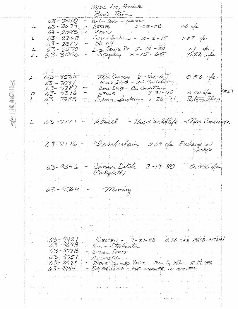
L
L
)._ .
p )._
L
- J{}- z - 1-s
-10 )
I -

ti
Jj /3 •to 32.8'ZO
J3ZO(J?O
3.
1320 8.
13 zo 30 L1rn.:e
.Y PD *3 /3Z.03000 3.&
:'!!l )3 IDSN
}3 ;;{O 1.1 BlABB I, IZ
13 /Y}11-L- 0.750
/3 <9£ 150
13 JI. 4
/.0
!'3
z . 7
.21 012161
/WPTCrft .DJZA1P.J Ft-Ot(J

DIS/RIBUIE- l)D :P.:- z_
/UO{ TZ?
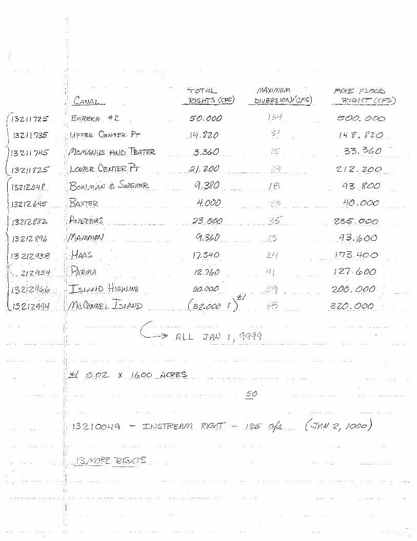
13Zll 5 50.
13Zll J4.f20 Z! __,. J 4
3 11 3.3Cr;0
,;(, /, I .zoo
Cf' I 0
1-f.
C/3.
17, P73. L
llLI 132
132-1
12
I&,
l3
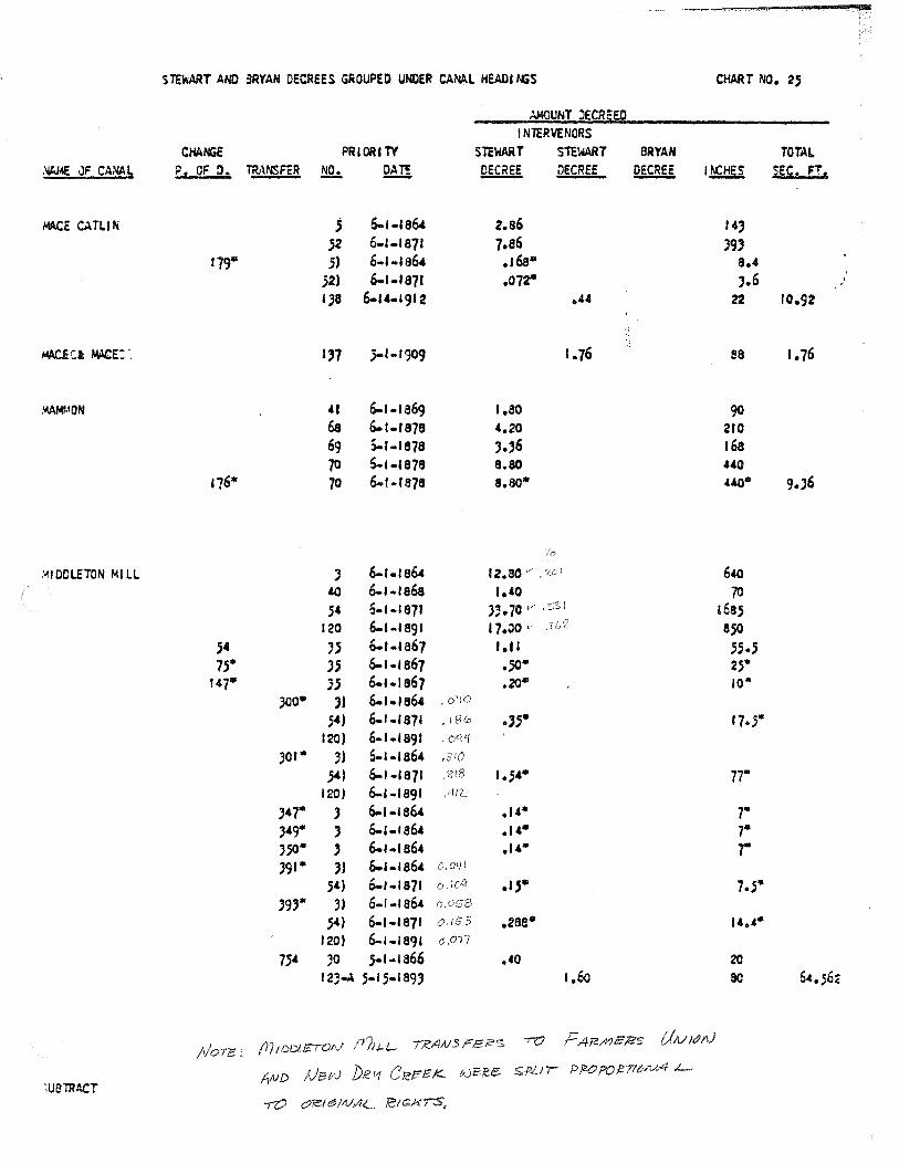
STEWART ANO 3RYAN DECREES GROUPED UNDER CAN,&.L HEADI l\GS CHART NO. 2S
).MOUNT :lECR5ED I NTERVENORS
CHA ta PRIORI TY SltWART STEWART BRYAN TOTAL ~ JF CANAL F. OF O. TR.<\NSFER !!Q.:. ~ ~ DECREE ~ l~HES sec. Fr,
Ml\CE c.\TLIN ; 6-1-186' z.a6 "' 52 6-l-1871 7.s6 J9) 179• .5) 6-1-186' .166* 8.4
52) 6-1-1871 .01r ,.6 . ;
1)8 6-14-1912 .44 22 10.92
~Ci r.w:e:·. ''7 )-1-1909 1.76 ea 1.76
AAMf.!QN 41 6-1-1a69 1.20 90 68 6-1-1878 4.20 210 69 S..r-1a7a ,.,6 168 70 5-1-&878 8.80 440
176* 70 6-r-ra7a a.so• 440• 9.J6
.'.110DLETON Ml LL J 6-1-1864 12.80 v • '{C ! 640 40 6-1-1868 1.40 70 S4 6-1-1871 J;.70 v .5-:SI 16a5
120 6-l·IS<JI 17.00 v aso 5' '' 6-1-1a67 t .II 55.; 1;• JS 6-1-1a67 • .so· 2.5'*
147• )j 6-1.1a67 .20• 10«
JOO* ,, 6-1-1864 • oy!O
54) 6-1-1871 • I S(o .,,. 17.5• 120) 6-1-1891
JOI* J) 5-1-1864 }') 6-1-1871 . ?18 1.54• 77•
120) 6-1-1591 ,"liL
J47* ) 6-1-1864 .14* .,. )49* ' 6-1-1864 .u• 7• J.50* ' 6-1-1864 .1,• 7• J91* J) 6.1-1864 O.O'll
54) 6-1-1871 o.ldl .1;• 7.5• J9)* J) 6-1-1864
54) 6-1-1871 0.153 .2sa• ''·'· 120) 6-1-1891 (J ,017
754 JO ;-1-1a66 .40 20 12:;-A 5.15.189) 1.6o so 64.56c
/I/ore: TR.AN.:SrE'ii"'S -ro F A12/YJE'lZ5 IJ;v1tJN
fl.ND ])R- '-1 C R?f5E K- v.Jf:;f!,E. S.PLll PfZO?O~fltJN-4 L....
)UBTRACT -rO C1'/el~llUAL '/CIGH77S,
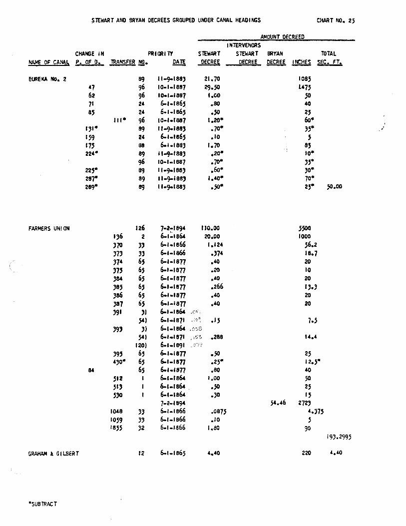
~TEWART AND BRYAN DECREES GROUPED UN>ER CANAL HEADI MiS CHART NO. 25
.A)4QUNT DECREED I NT£RVENORS
CHANiE IN Pft1~11Y STEWART STEWART BRYAN TOTAL NA.\4£ OF CANA. L P. OF D. TRANSFER !!!• Q!Jl DECREE DECREE ~ l~HES SEC. FT.
E~Et<A No. 2 !19 11·9-188) 21. 70 1oas •7 96 10-1.1aa7 29.so l475 62 96 I0.1·1887 1.00 So 71 24 6-1-186,S .so 40 a.s 24 6-1 .. 1a6.s .sa 2.S
111• 96 10·1·1887 1.20• 6o• 131• !19 11-9-188) .10• ;.s• '
. 159 24 6-1.1e65 .10 ' 115 88 6-1.1aa3 1. 70 8.5 224"' !19 11+1aa3 .20* to•
96 10-1-1887 .10• 3S"' 22.s• 89 11-9-1883 .6o• ;o• ar 89 1 l·C)-188) 1.40• 10• 289* !19 11-9-1883 .;o* 2s• 50.00
FARMERS UNION 126 7·2:1894 110.00 .S.500 136 2 6-1-1864 20.00 1000 370 '' 6-1-1866 1.124 56.2 37' " 6-1-1866 .)74 1a.7 374 6.S 6-1-1a77 ·'° 20
'7' 6.S 6-1-1877 .20 10 384 6,S 6-1-1an ·'° 20
;a.s 6.s 6-t-1877 .266 .,., 386 65 6-t-1877 ·'° 20
387 6S 6-1-1977 .40 20
391 3) 6-1-1864 .041
S4) 6-1.1a7t , IO~ · '' 1.s '9' 3) 6-1.1s64
541 6-1.1s71 ,15?:> .288 "·' 120) 6-1.1991 39.S 6.s 6-1-1a77 .so 25 430"' 6,S 6-1-11177 .25• 12.5•
65 6-1.1a77 .so 40 .512 6-1-1864 1.00 50 51) 6-1-1864 .sa 25 .530 6-1-1a64 .;o 1.5
7·2-f894 ,54 • .66 272' 1~8 '' 6-t-1866 .0875 '·'75 1059 33 6-1 .. 1a66 .ro s 18.5.5 32 6-1-1866 1.ao 90
193.2995
GRAHAM l G 1 lBERT 12 6-1-1a6; '·'0 220 '·'°
"'SUBTRACT
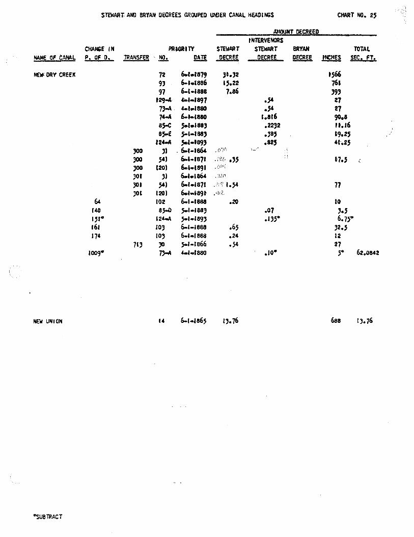
S"TadMT Al«l BRYAN DECREES GROUPED UNJER CANAL HEADINiS CHART NO. 2,
~DECREED
tNTERVENORS CHAN&E IN PR-t.ORITY STEWART STEWART BRYAN TOTAL
~E OF CANAL P. OF D. TRANSFER . .!?.:. J!m DECREE DECREE DECRE!i l!e.ll SEC. FT.
Naf: ORY CREEK 72 &..r.ra79 )t.)2 tS66 9) 6-lel886 .,.22 76• 97 6-l·l888 1.a6 )9)
t29-4 "-•-•897 .,.. Z7 73-A 4-1 .. 1880 .,.. 27 74-A 6-t-C880 1.a16 go.a 85-C ,S.lel88) .2232 u.16 aSt-E j-1-188) .,a, l9.2' '
f 24-4 ,. ••• 89, .12, ,, .. 2, '°°
,, . 6-r-1864 .010
)00 ,,, 6-1-1871 ,/ .n .. n.s ..
'°° t20) 6-l-l891 JOI J) 6.1.1864 .310
JOI ,.., 6-1.1a71 .. ,.. 77 JOl 120) 6.l-l89t ,I./ I z_
64 102 6-t-1888 .20 10 140 8.5-Q }-l•IB8J .07 ,., ., .. 124-\ S-1•189) .J).5* 6.75• 161 IOJ 6-1-1888 .65 )2 • .S 174 IOJ 6-1-1888 .24 12
7l) JO 5-1-1866 .54 27 1009• .,,...._ 4-l-f880 .10• ,. 62.0842
NEW UNION 688 I). 76
-SUS TRACT

-WATER LICENSE
Water License No._3_3_4_8_7 ________ Priority February 21, 1967 Amount __ o_. _5_6_c_._f_._s_. ___ _
THIS IS TO CERTIFY, that __ _,,_J-"'O=H=N _n. MC CUR!l~Y,__ __
of~ __ P_a_n_n_a~,_Id_a_h_o __________ , made application for a permit to appropriate the public waters of
the State of Idaho, dated February 21, 1967 ; that Permit 33487'---______ was issued pursuant
to said application; that the proposed works were completed on or about ___ l_9_6_7 ___________ _
with a storage/or carrying capacity of ___ 4_._9_c_._f_._s_. ______ , said works consisting of ______ _
pum2 and motor ________ ;and that on January 20, 196_8 ____ _
proof was made to the satisfaction of the State Reclamation Engineer, of the beneficial use of ~ 126
acre feet per season, with a maximum rate of diversion of 0. _5_6 ______ cubic feet per second of the waters
of __ ~Bo~i_s~_Rive~r ___ _ _ _____ , tributary of_ _ _§11_ak~Rivei: _________ _
for the purpose of irri@_ti_·o_n _______ from April 1 to_O_c_t_o_be_r_3_1 ______ _
and for ____________ from to ; and for
_______________ from ____________ to __________ ; and that the use
of said waters has been made in accordance with the laws of Idaho, and is hereby confirmed by the State Recla-
mation Engineer and entered in the records of the Idaho Department of Reclamation: the point of diversioro 15
located in Lot 9 _(SW v.__§_\\f _____ 11.)Sec.~-- ____ , T._5 N._ __ , R.___!UY_. __ , B.M., and
other additional points ___ _ -----, in the County of
(;any_~n ___ _ _ ____ ; and that the amount of water to which such right is
entitled and which is herel:y confirmed, for the purposes aforesaid, is limited to an amount actually beneficially
used for said purposes and shall not exceed_~_!~ acre feet per year.
Description and location of plJce of use:
NEl/4 NWl/4 S~l/4 SEif• TWP. RANGE SEC. TOTALS
Nev .. NWl/4 SW1/• SEl/.c NEl/4 NWl/4 SW1/4 SEl/4 NEl/4 NW1/4 SWI/• SE'/• NEl/4 NWl/4 SWl/4 SEl/4
~t Ji_ _f?_'W.__ 2G
~-~---· ·-- ---- ---- - -- -- g_~ --- 27.9 --·
Total number of acres irrigated __ _...2,_7~ • ..,9'------
The right to the use of the water hereby confirmed is restricted to the lands or place of use herein described,
as provided by the laws of Idaho.
Witness the seal and signature of the State Reclamation Engineer,
____.!£!:!!_day of Nov_:_e:::m=be~r _______ , 19~.
t .. 0 05~~~1
~. --~""'"'·'"'·-•K'·v-'""'-',,.; ,.~. . ... "'"'' ""'"w'"'~'.;.,,c "'"""·L-""'""''-·""' ''~·"'''""'"'""'".i. .. ,.•"""'"'"''-'H·§"'.'1.::/..~Z.,,_,,,.,,,""'"'·
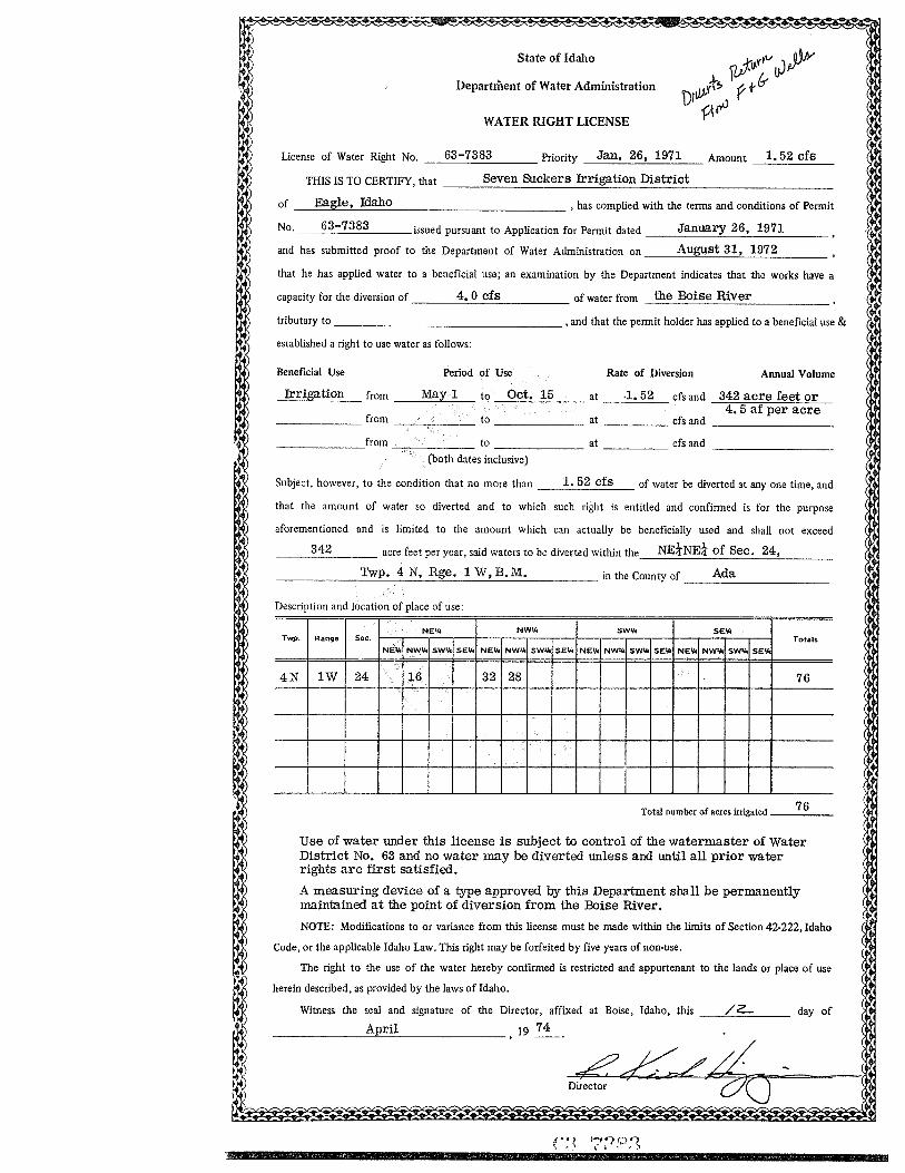
)
l
)
) ) )
) )
)
------------ -----
State of Idaho
Department of Water Administration
WATER RIGHT LICENSE
License of Water Right No. __ 6_3_-_7_3_8_3 ____ Priority Jan. 26, 1971 Amount 1. 52 cfs
1 THIS IS TO CERTIFY, that ___ s_e_v_e_n_Su_c_k_e_r_s __ Irr_i"'ga_ti_._o_n_Di_._s_tr_1_·c_t _________ _
l l l
)
~
) )
)
)
1)
1)
1) •) •) 1) 1) 1) 1)
1)
1) 1)
1)
1)
,)
)
l
) ) )
) ) ) )
• 1) 1) )
)
)
)
)
)
)
of Eagle, Idaho , has complied with the terms and conditions of Permit
No. ----'-6-'-3_--'-7-'-3-'-8_3 ___ issued pursuant to Application for Permit dated ___ J_a_n_ua_ry-.:;__2_6"-,_1_9_7_1 __ _
and has submitted proof to the Department of Water Administration on ___ A_;__u_,,gu<-.c:.sc..:t_3_1,_, _1_9_7_2 ___ _
that he has applied water to a beneficial use; an examination by the Department indicates that the works have a
capacity for the diversion of ____ 4_._0_c_f_s _____ of water from the Boise River
tributary to -----------------, and that the permit holder has applied to a beneficial use &
established a right to use water as follows:
Beneficial Use Period of Use Rate of Diversion Annual Volume
-=Ir;:_r....:1::.· ga=-=t-=-io;:..:n=-- from __ Ma_~y_l __ to Oct. 15 at .1. 52 cfs and 342 acre feet or 4. 5 af per acre
______ from ______ to _______ at cfs and ---------
_______ from ------ to _______ at cfs and ---------(both dates inclusive)
Subject, however, to the condition that no more than __ 1_. _5_2_c_f_s __ of water be diverted at any one time, and
that the amount of water so diverted and to which such right is entitled and confirmed is for the purpose
aforementioned and is limited to the amount which can actually be beneficially used and shall not exceed
342 acre feet per year, said waters to be diverted within the NE!NE! of Sec. 24,
______ Tw_~p_. _4_N_,_R~g_e_. _l_W_,_B_. M_. _____ in the County of ___ A_d_a _____ _
Description and location of place of use:
SWl/4 SEl/4 NE'h TYtl). Range Sec. f----.---,.--.--+---..--,---,--+--,...--,---...-----1---.---,----.--l Totals
NEl/4 NWl/4 SWl/4 SEl/4 NEl/4 NW¥ SWl/4 SEl/4 NEl/4 NWl/4 SWl/o SEV. NE"" NWV. SW.... SE~
4N lW 24 16 32 28 76
Total number of acres irrigated __ 7_6 __
Use of water under this license is subject to control of the watermaster of Water District No. 63 and no water may be diverted unless and until all prior water rights are first satisfied.
A measuring device of a type approved by this Department shall be permanently maintained at the point of diversion from the Boise River.
NOTE: Modifications to or variance from this license must be made within the limits of Section 42-222, Idaho
Code, or the applicable Idaho Law. This right may be forfeited by five years of non-use.
The right to the use of the water hereby confirmed is restricted and appurtenant to the lands or place of use
herein described, as provided by the laws of Idaho.
Witness the seal and signature of the Director, affixed at Boise, Idaho, this _ __,/'--2-...;___ __ _ day of
April 19 ~-
I
I
I
I
I
I
I
I
I I
I
I
I I
I
I
I
I I I I
( ( I
I (
(
I I
I
I I
I
I
I
I
I
I
I
I
I
I
I I
I
I
I
I
I I

State of Idaho
Department of Water Resources
WATER RIGHT LICENSE
license of Water Right No. _6_3_-_7_7_2_1 ____ Priority February 12, 1973 Amount __ 6_._0_c_f_s_
THISISTOCERTIFY,that K.T. ATWELL, ORR. GLAISYER, OR J. GLAISYER, OR H. EISMAN or N. BIDEGENATE, OR S. JONES
of Boise Idaho , has complied with the tenns and conditions of Permit
No. 63-7721 issued pursuant to Application for Permit dated February 12, 1973
and has submitted proof to the Department of Water Resources on February 15, 1978
that he has applied water to a beneficial use; an examination by the Department indicates that the works have a
capacity for the diversion of __ 6~.'""'3'-'c"-f'""'s°'----- of water from Boise River
tributary to Snake River
established a right to use water as follows:
Beneficial Use Wildlife Propagation
4N 3H 7 \,
, and that the permit holder has applied to a beneficial use and
Annual Volume
Total number of acres irrigated -----
NOTE: Modifications to or variance from this licen5e must be made within the limits of Section 42-222, Idaho
Code, or the applicable Idaho Law. This right may be forfeited by five years of non-use.
The right to the use of the water hereby confurned is restricted and appurtenant to the lands or place of use
herein described, as provided by the laws ofldaho.
Witness the seal and signature of the Director, affixed
August

• • Form 202 3/78
!dent. No. 63-9346 STATE OF IDAHO
DEPARTMENT OF WATER RESOURCES
APPLICATION FOR PERMIT ~~PPi(OVED To appropriate the public waters of the State of Idaho
1. Name of applicant C. E. HARRIS Phone 459-6015
Post office address _ _,_R""'o'""u,_,t=e_rr"-" 5"-'-, -=B'-"o"'x'-"-5"-0 O""'O"""''--"C=a'-'-1-=-dw,_,_e,,,_l_,_l'--'''---"I""D---'8"'3~6"""'0'""5'---__________ _
2. Source of water supply Boise River which is a tributary of Snake River
3. Location of point of diversion is _N_E __ % of _NW __ % of Section --=l-=5 ___ Township_~4N __ _
Range ~B.M. ___ Ca_n~y~o_n ________ County, additional points of diversion if any:
4. Water will be used for the following purposes:
Amount • 64 for {cfs or acre-feet per annum)
i rri qat ion purposes from 4/15 (both dates inclusive) to 10/15
~1';1~~~,;-feet per annu!?r -------purposes from ---- to ----- (both dates inclusive)
~1';1~~~r;-feet per annu!?r ------- purposes from ____ to _____ (both dates inclusive)
~:;1~~~r;-feet per annu!?r _______ purposes from ____ to _____ (both dates inclusive)
5. Total quantity to be appropriated:
a. --~·~6~4~---- cubic feet per second and/orb. ___________ acre-feet per annum.
n \ JJ r ''"'fY'.o'O? '--'U' '
6. Proposed diverting works:
a. Description of ditches, flumes, pumps, headgates, etc. ---"Ccua"-'n+y,.,_o.Lln_D"-t,._"t..,c"'-'h"--"C""o,_.._...c_...a.Lln..._a_._l _t],!o.,__1u" r-'r___,i-:,g~a_..t.soe,,._d_
ground
b. Height of storage dam ______ feet, active reservoir capacity _____ acre-feet; total reservoir
capacity ____ acre-feet, materials used in storage dam:
Period of year when water will be diverted to storage------- to -~--!Month/Day} (Month/Day}
inclusive.
c. Proposed well diameter is ____ inches; proposed depth of well is ____ feet.
7. Time required for the completion of the works and application of the water to the proposed beneficial
use is _ _,,5'---- years (minimum 1 year - maximum 5 years).
8. Description of proposed uses: a. If water is not for irrigation:
( 1) Give the place of use of water: % of % of Section ____ Township ____ _
Range B.M.
(2) Amount of power to be generated: _____ _ horsepower under __ _ feet of head.
(3) List number of each kind of livestock to be watered ------------------
(4) Name of municipality to be served --------------,or number of families to be
supplied with domestic water ______ _
(5) If water is to be used for other purposes describe: ------------------

11. Map of proposed project: show clearly the proposed point of diversion, place of use, section number, township and range number.
I I 1 I I I I I I I I I I I I I I I I I I I I I I ----r--- ----r--- ----r--- ----r--- ----r--------r--- ----r--- ----r---· I I I I I I I I I I I I I I I I I I I I I I I I I I I I I I I I
\ 11 I \ \ I : I
I I I I I I I I I I I I I I I I ----r--- ----r--- ----r--- ----r--- ----r--------r--- ----r--- ----r----1 I I I I I I I I I I I I I I I I I I I I Jf3w I I I i i
____ J ________ J_____ ! 01f-<-1t\_ ~-------1-l~-~---J ____ ~ ___ J ___ _ I I I ~ I I I I I I I t' ("\ I I I I I I , ~Iii I 25a. i ~ I I I I
I I I I I I I I i I I I I I I I I I I I I I I I I I
~---i----~---i----~---i----~---i----~---i----~---i----~---i--~-~---i---~ I I I I I I I I II I I I I I I I I ! I ! ! I I ! ! i I I I I I I I I I
----~----~---~----~---~--------~--------~----~---~----~---~----~---~----! I I I I I I I I I I I I I I I I I I ! ! ! ! I I ! ! I I I I I i I I I I
~--i--------i----~---1----"---i----"---i--------i--------i----1---i--__J ! J ! ! \ I ! !
Scale: 2 inches equal 1 mile.
BE IT KNOWN that the undersigned hereby makes application for permit to appropriate the public waters of the State of Idaho as herein set forth.
x<:.--C-~ (Applicant)
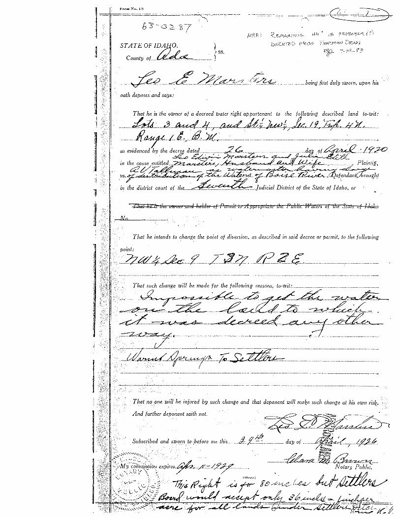
j
I
Form No. l:J
STATE OF ID1f10.A }
County of_ ... ~--------·-···, ss,
NOTF:-: '<.EJAA/N//\JG· 1-)Li" is p203,"'51/1.
:r:i1ut.0coD F'<O.l'ci /ii0F.:yn/.;1J DJ?,,wJ 12{9-- 7-H- if 3
···----~------~--dz~, ___ ,_(~---- .. ________ being first duly sworn, upon his
oath deposes and says:
That he is the owner of a decreed water right appurtenant to ihe following described land lo-wit:
________ ;hM _______ a ___ ~ __ )f7
___ ~ _ _,&_f_),u!_j:;_k/ __ !fr_¥ ___ /LXc ______ _ __________ fi.a.:ur ___ [_:,:;; ___ tfil_ __ ';t{_ ________ : ____________ ______________________________________________________________ : ____________________ _
as evidenced by the d~da~-:i;~--~------;_·d~:!_~--~.f.'?20 in the cause entitled ... L;n~/--~~W.~-.,.--------------• Plaintiff,
_vs.~~2&-~~ef~h_t in the district court of the _____ ~_Judicial District of the Stale of Idaho, or ·. •
"l lfat hii:Ok-the oll?11c1 m1J Jiolde1 of Pe11nil to A pplVpliate the :Public !Waters of the 3tale of l<kko
__,l\~T.u.a __ • ______________ ,
.That he intends lo change the point of diversion, as described in said decree or permit, lo the following
point:
. ___ Zza14_de:: ____ :z ______ z3..4_ .... ti? .. ?.. .. ~.------------------------------------------------
·---·----~-·------ .. ---~;; .... ________________ .,. __________________________________ ---- . - ---- -- -- --------------- ------------ --- ---- -----------. --------------------------· ....
That. no one will be injured by such change and that deponent will make such change al his own risk.
And further deponent saith not.
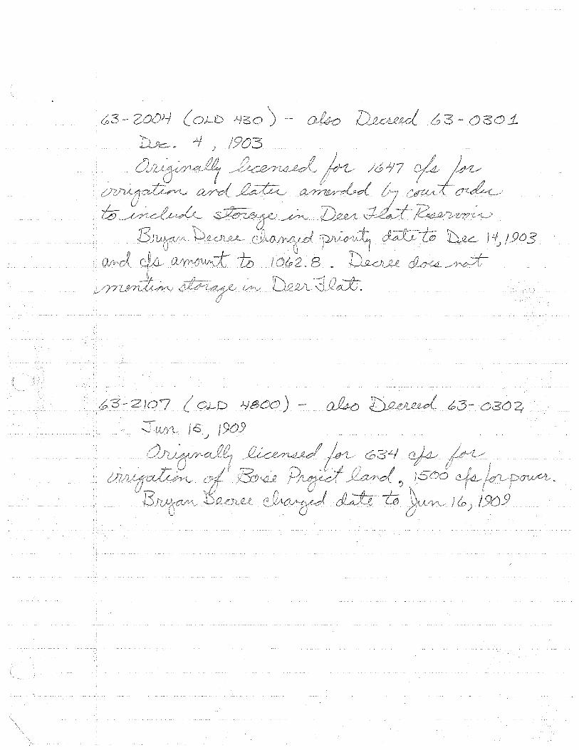
0 - a j_
) - Dk
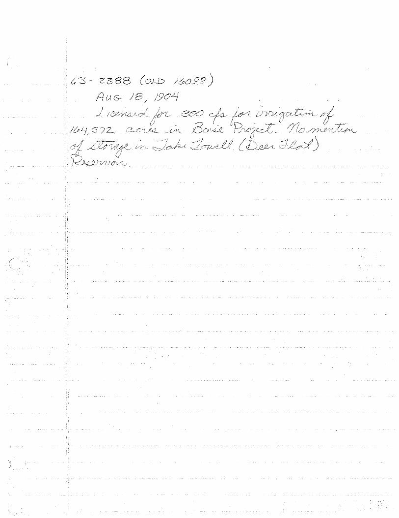
t3- Z38 (oJ-D )
HUG- )
)_
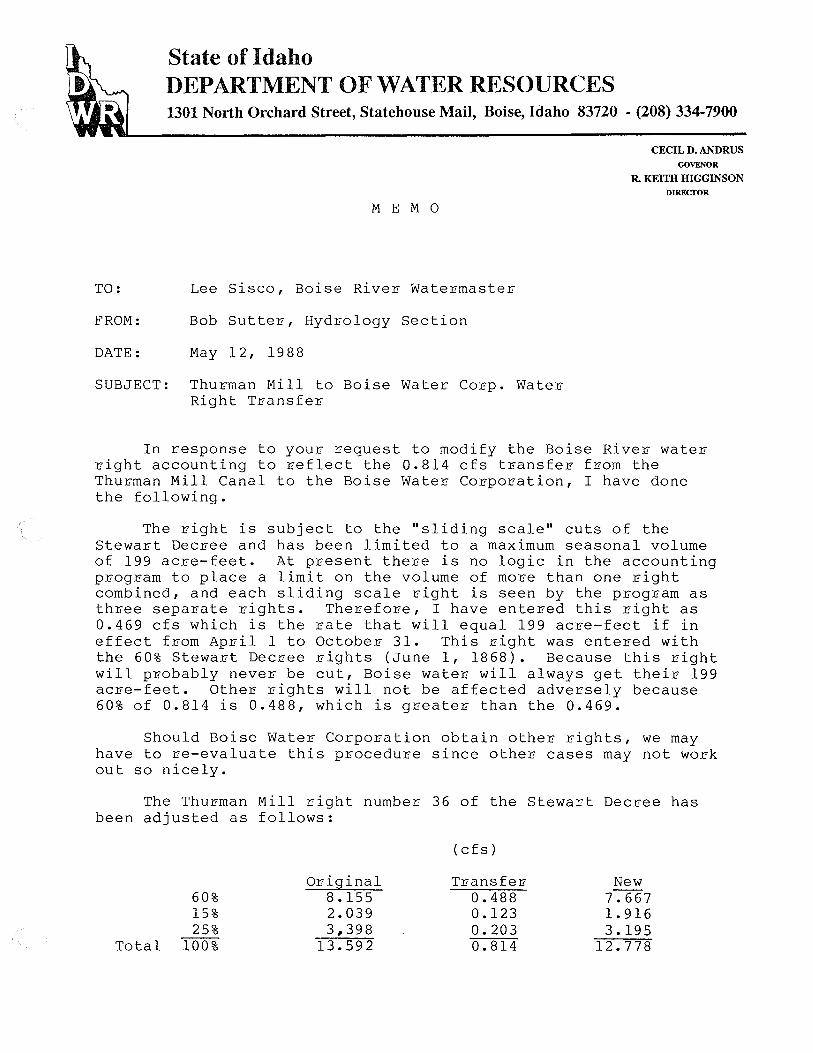
State of Idaho DEPARTMENT OF WATER RESOURCES 1301 North Orchard Street, Statehouse Mail, Boise, Idaho 83720 - (208) 334-7900
M E M 0
TO: Lee Sisco, Boise River Watermaster
FROM: Bob Sutter, Hydrology Section
DATE: May 12, 1988
SUBJECT: Thurman Mill to Boise Water Corp. Water Right Transfer
CECIL D. ANDRUS GOVENOR
R. KEITH HIGGINSON DIRECTOR
In response to your request to modify the Boise River water right accounting to reflect the 0.814 cfs transfer from the Thurman Mill Canal to the Boise Water Corporation, I have done the following.
The right is subject to the "sliding scale" cuts of the Stewart Decree and has been limited to a maximum seasonal volume of 199 acre-feet. At present there is no logic in the accounting program to place a limit on the volume of more than one right combined, and each sliding scale right is seen by the program as three separate rights. Therefore, I have entered this right as 0.469 cfs which is the rate that will equal 199 acre-feet if in effect from April 1 to October 31. This right was entered with the 60% Stewart Decree rights (June 1, 1868). Because this right will probably never be cut, Boise water will always get their 199 acre-feet. Other rights will not be affected adversely because 60% of 0.814 is 0.488, which is greater than the 0.469.
Should Boise Water Corporation obtain other rights, we may have to re-evaluate this procedure since other cases may not work out so nicely.
The Thurman Mill right number 36 of the Stewart Decree has been adjusted as follows:
(cfs)
Original Transfel1 New 60% 8.155 0.488 7.667 15% 2.039 0.123 l. 916 25% 3.,398 0.203 3.195
Total 100% 13.592 0.814 12.778

State of Idaho DEPARTMENT OF WATER RESOURCES 1301 North Orchard Street, Statehouse Mail, Boise, Idaho 83720 -(208) 327-7900
ME M 0
TO: Lee Sisco, Boise River Watermaster
FROM: Bob Sutter, Hydrology Section
DATE: April 1, 1990
SUBJECT: Boise City Canal to Boise Water Corp. Water Right Transfer
CECIL D. ANDRUS
GOVERNOR
R. KEITH HIGGINSON DIRECTOR
In response to your request to modify the Boise River water right accounting to reflect the 0.680 cfs transfer from the Boise City Canal to the Boise Water Corporation, I have done the following.
The right is subject to the "sliding scale" cuts of the Stewart Decree and has been limited to a maximum seasonal volume of 167 acre-feet. At present there is no logic in the accounting program to place a limit on the volume of more than one right combined, and each sliding scale right is seen by the programs as three separate rights. Therefore, I have entered this right as 0.393 cfs which is the rate that will equal 167 acre-feet if in effect from April 1 to October 31. This right was entered with the 60% Stewart Decree rights (June 1, 1866). Because this right will probably never be cut, Boise will always get their 167 acre-feet. Other rights will not be affected adversely because 60% of 0.680 is 0.408, which is greater than the 0.393.
Should Boise Water Corporation obtain other rights with later priority dates, we may have to re-evaluate this procedure since other cases may not work out so nicely.
The Boise City Canal right number 33 of the Stewart Decree has been adjusted as follows:
Total
BS:cjk
60% 15% 25%
100%
(in cfs)
Original 21.825 5.456 9.094
36.375
Transfer 0.408 0.102 0.170 0.680
New 21.417 5.354 8.924
35.695
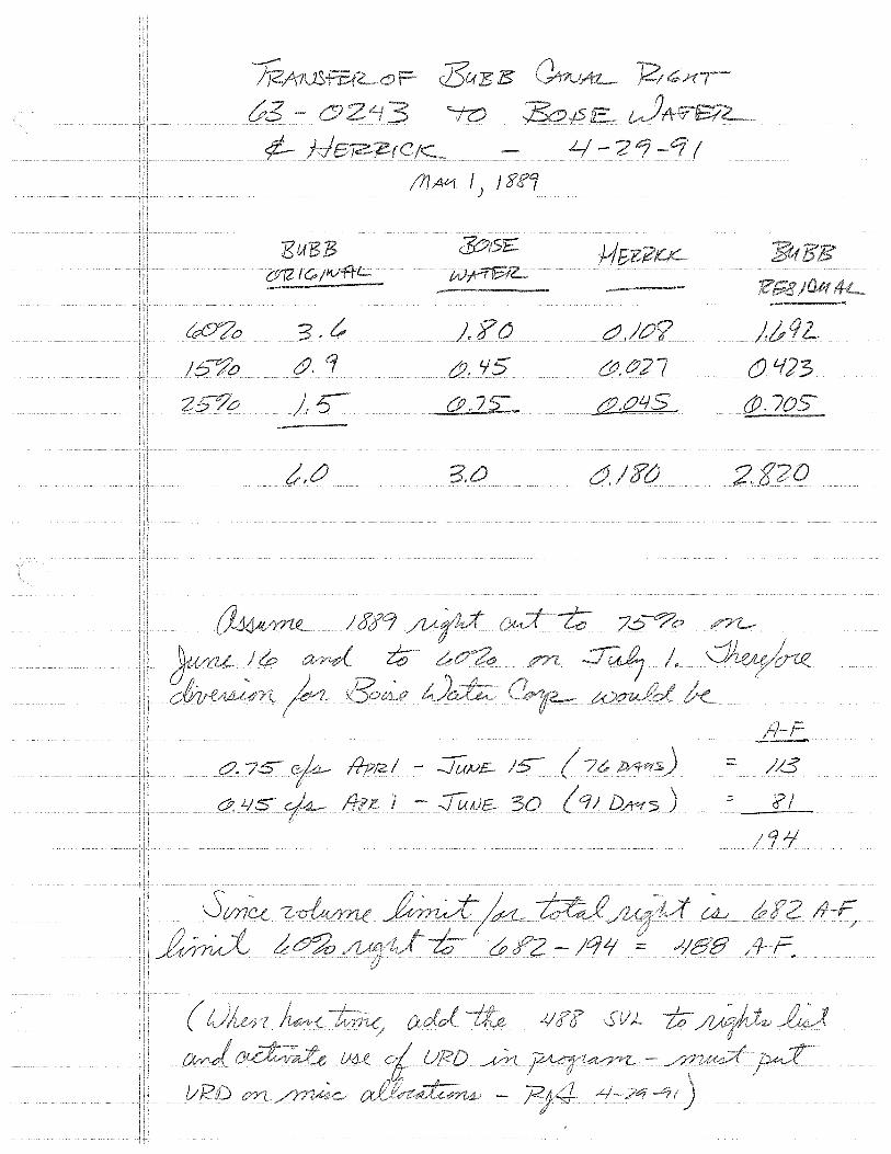
3usE "'-f?:)
L/-2'7 I !fl At1 I; J l?.f''J
EuB:B $:Y6'1:::-C912 I<; ;11./'f+L.
~o 3, ;.?o cJ,/Oy
!6"°'70 &, &. '15 &.t/27 (J. lf]3
), ~ &_.OL/S - (JJ. 7{JS
CJ. 7.S- I - :JUµ£ = /8
-- ( q; DA"f>) .:::. 'i? I Ol, LIS - -J UA)£
'l "I
~/µ__ -)qi/ cf? :::::: ,l/88
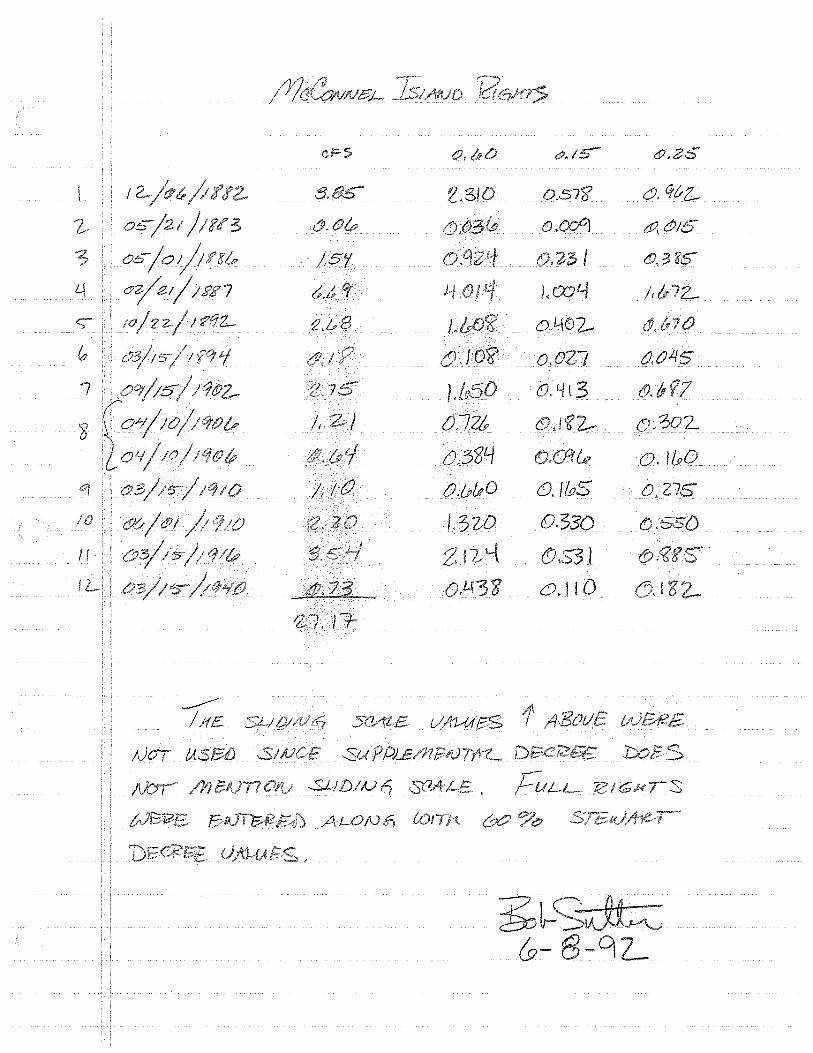
I
?- Ob/21 3
os-/o/;t'8l>
oz/21/1RJ!7
?C/'L
I
'8
c
/,5'/
~,&,
/, I
/I
. I
::Su
-..5.LJD/IJ
ALON
iRO
{),72t
{>,584 0.&&0
/.3
&. d),35
0.57'fl CJ. CJ-vz_
{) a:z {f}/5
3
)r 72-
o.4~2-
{),027 &,045
tSJ. L/ l 3 &<?7 .3o2-
o.J&O
{)./I.PS {), 276
D.330
<!J.$"3 I 6'.110 l8
s

u
F I ~k-1B.M. NOV 1 ~ i98S
BlLL&tf1zli21BLJitK -' r'"'sPUTY CLERK __ _
IN THE DISTRICT COURT OF THE THIRD JUDICIAL DISTRICT OF THE
STATE OF IDAHO, IN AND FOR THE COUNTY OF CANYON
an
vs.
Plaintiff,
) ) ) ) ) ) )
Watermaster of ) the Boise River, IDAHO DEPARTMENT ) OF WATER RESOURCES, BOISE-KUNA ) IRRIGATION DISTRICT, BOISE ) PROJECT BOARD OF CONTROL, NAMPA- ) MERIDIAN IRRIGATION DISTRICT, ) PIONEER IRRIGATION DISTRICT, ) RIVERSIDE IRRIGATION DISTRICT, . }
·:wu:.o~:""tlffff'<rA<rr-O'N·'t>rsTRrc'.r:,..~' · "''"~ ·) .,...._., -.. ,,__, ~ ....
-- -;_, ..... )
Defenda·rit·s: ·) )
~~~~~~~~~~~~~~~~~-:--
Case No. L-34498
FINDINGS OF FACT, CONCLUSIONS OF LAW AND DECREE
FINDINGS, CONCLUSIONS ANO OECRE~, ;Page: 1·

(
'\( A)
''-> 0.-\9 I
/I} \{i
duty of water (0.022 cfs) which in this case equals 0.638 cfs and which is rounded to 0.64 cfs.
8 4. This water right of McConnell Island Ditch Company, Limited is described more particularly as follows: a) source of water supply: Boise River b) date of priority: April 1 0 , 1906 c) rate of diversion: 0.64 cf s d) nature of use: Irrigation e) point of diversion: Lot 1 (SESE),
Section 7, TSN, R5W, B.M. f) place of use: See attached Second
Amended Schedule I g) period of use: March 15 of each year
through November 15 of the same year h) annual volume of consumptive use: 104
afa.
85. The rights 'of the plaintiff herein decreed shall be subject to all prior decrees determining rights to the use of water from the Boise River, as described in the First Amended Report, and shall be subject to the findings of fact and conclusions of law upon which the prior applicable decrees are based.
2. Second Amended Schedule I, which is attached
hereto and incorporated herein as if set forth in full, lists
each water right determined by this decree.
(JIM R. DOOLITTLE
District Judge
FIND,INGS I CONCLUSIONS AND DECREE' Page 16

r
Right Number
63-4632A
63-4632B
63-4632C
63-46320
Name and Priority Address Date
-Mcconnel Island 12/06/1882 Ditch Co., Ltd. Rt. 3
83660
SECOND AMENDED SCHEDULE I
S T A T E 0 F I D A H 0
DEPARTMENT OF t,,TATER RESOURCES LISTING OF RIGHTS
Use Period Cons. Volume Use From To Max. Rate
Irrigation 3/15 11/15 630.0 AFA 1'-l 31"1 3.85 CFS
Parma, ID Remarks: Place of use on lands of McConnel Island
Ditch Co. , Ltd. -£.ee Page 5, Second Amended Scfieduie r:-
Mcconnel Island 05/21/1883 Ditch Co., Ltd. Rt. 3
83660
Irrigation 3/15
Parma, ID Remarks: Place of use on lands of McConnel Island
11/15 9.0 AFA 0.06 CFS
Ditch Co., Ltd. s,u, P1H1f' 5. St"eemti A1wmlecl Scheclule J.
Mcconnel Island 05/01/1886 Ditch Co., Ltd. Rt. 3
83660
Irrigation 3/15
Parma, ID Remarks: Place of use on lands of Mcconnel Island
11/15 252.0 AFA 1.54 CFS
Ditch Co. , Ltd. f>ee Pa f1f' 5. :Secoml Amended £ehedule I,
Mcconnel Island 02/21/1887 Ditch Co., Ltd. Rt. 3
83660
Irrigation 3115
Parma, ID Remarks: Place of use on lands of Mcconnel Island
11/15 1094.4 AFA 6.69 CFS
Ditch Co. , Ltd. See Pal!!e 5, geeond Amended Schedule I.
Source: Tributary to:
Diversion Point
Lot 1 (SESE) S 7, T5N, R5t,,T
Lot 1 (SESE) S 7, T5N, R51l
Lot 1 (SESE) S 7, T5N, R51l
Lot 1 (SESE) S 7, T5N, R5t,,T
(
Boise River Snake River
Basis For Right
Beneficial Use
Beneficial Use
Beneficial Use
Beneficial Use

Page 2
Right Number
. .-
63-4632E
63-4632F
63-4632G
63-46328
Name and Address
Mcconnel Island Ditch Co., L~d. Rt. 3 Parma, ID 83660
Priority Date
10/22/1892
,. S T A T E 0 F I D A H 0
DEPARTMENT OF \/ATER RESOURCES LISTING OF RIGHTS
Use
Irrigation
Use Period From To
311S 11/lS
Cons. Volume Max. Rate
439.0 AFA 2.68 CFS
Remarks: Place of use on lands of Mcconnel Island Ditch. Co., Ltd. See Page 5, Seeeme Amended Schedule I . ...,
Mcconnel Island 0311S/1894 Irrigation 3/lS 11/lS - ·28.8 AFA Ditch Co., Ltd. 0.18 CFS Rt. 3 Parma, ID 83660 Remarks: Place of use on lands of Mcconnel Island
Ditch Co., Ltd. £ee Page 5, ~Qcond AmeTJ:tted Schedule~
Mcconnel Island 091 /1902 Irrigation 3/lS 11/lS 4SO.O AFA -Ditch Co., Ltd. 2.7S CFS Rt. 3 Parma, ID 83660 Remarks: Place of use on lands of Mcconnel Island
Ditch Co., Ltd. ~ge 5, Second Amended £chedule !'.
Mcconnel Island 04/10/1906 Irrigation 3/lS 11/lS 198.0 AFA Ditch Co., Ltd. 1. 21 CFS Rt. 3 Parma, ID Remarks:
83660 Place of use on lands of Mcconnel Island Ditch Co. , Ltd. -S.e.e-Page 5, -See one Amended Schedule I.
Source: Tributary to:
Diversion Point
Lot 1 (SESE) S 7, TSN, RS\/
Lot 1 (SESE) S 7, TSN, RS\/
Lot 1 (SESE) S 7, TSN, RS\/
Lot 1 (SESE) S 7, TSN, RSTJ
\
Boise River Snake River
Basis For Right
Beneficial Use
Beneficial Use
Beneficial Use
Beneficial Use

Page 3
Right Number
..
M
Name and Address
Priority Date
S T A T E 0 F I D A H 0
DEPARTMENT OF VATER RESOURCES LISTING OF RIGHTS
Use Use Period From To
Cons. Volume Max. Rate
63-4632~ Mcconnel Island 04/10/1906 Ditch Co., Ltd.
Irrigation 3/lS 11/lS 104.0 AFA 0.64 CFS
N 63-4632\
63-4632J
63-4632K
Rt. 3 Parma, ID Remarks:
83660 Place of use on lands of Mcconnel Island Ditch Co., Ltd. S~e Pa~e 5. SeeoRd AmeRded 5chedule I .
Mcconnel Island 03/lS/1910 Ditch .Co., Ltd. Rt. 3
83660
Irrigation 3/lS
Parma, ID Remarks: Place of use on lands of Mcconnel Island
11/lS - 180. 0 AFA 1.10 CFS
Ditch Co., Ltd. &ee Pa~e 5. SeeGnd AmeRdecl Scheclule-f.
Mcconnel Island 06/01/1910 Ditch Co., Ltd. Rt. 3
83660
Irrigation 3/lS
Parma, ID Remarks: Place of use on lands of Mcconnel Island
11/lS 360.0 AFA 2.20 CFS
Ditch Co., Ltd. ~e Page 5, Secoad Amended £chedule I. _,
Mcconnel Island 03/lS/1916 Ditch Co., Ltd. Rt. 3
83660
Irrigation 3/lS
Parma, ID Remarks: Place of use on lands Island
11/lS S79.6 AFA 3.S4 CFS
Ditch Co., Ltd. .
Source: Tributary to:
Diversion Point
Lot 1 (SESE) S 7, TSN, RSV
Lot 1 (SESE) S 7, TSN, RSV
Lot 1 (SESE) S 7, TSN, RSV
Lot 1 (SESE) S 7 , . T SN, RSV
Boise River Snake River
Basis For Right
Beneficial Use
Beneficial Use
Beneficial Use
Beneficial Use
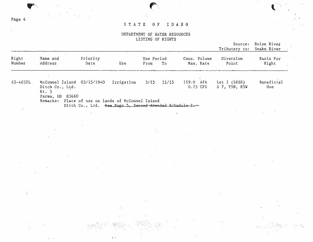
Page 4
Right Number
r
63-46321
Name and Address
Priority Date
Mcconnel Island 03/15/1940 Ditch Co., Ltd. Rt. 3 Parma, ID 83660
("'
S T A T E 0 F I D A H 0
DEPARTMENT OF YATER RESOURCES LISTING OF RIGHTS
Use
Irrigation
Use Period From To
3/15 11115
Cons. Volume Max. Rate
119.0 AFA 0.73 CFS
Remarks: Place of use on lands of HcConnel Island Ditch Co., Ltd. ~ee Page 5, Seeon~ded SchedYle I,-"-
Source: Tributary to:
Diversion Point
Lot 1 (SESE) S 7, T5N, R5\l
l
Boise River Snake River
Basis For Right
Beneficial Use
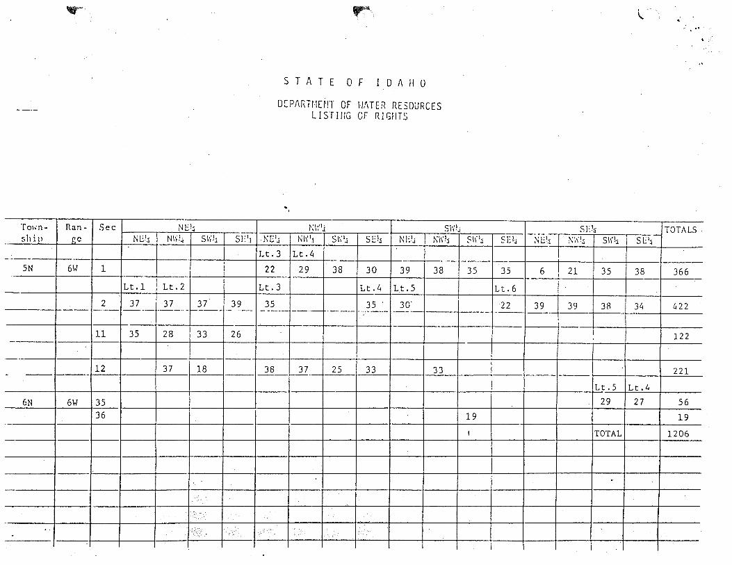
.-
T01m- Ran- Sec NEl:i ship i::c N1):1 N\\l~ S\i'!.i s1: 1.1 ..
-·-- -I
SN 6W 1 I Lt.1 Lt. 2
2 37 37 37 39 ----- ,_ __ --- ___ ,,_ ----
11 35 28 33 26
---12 37 18 - -->----
6N 6W 35 36
-
.. -
.-
S T A T E 0 F I D A H 0
DCPAf\HIO!l OF l·J/\TER RESOURCES LISTillG or RlGflTS
... ~;1·:1j S\'ilj
l\[lj N\1".1 s1·; 1.i SE!~ NE1J !\ll"l Sli 1.;
Lt.3 Lt. 4· •... ----
22 29 38 30 39 38 35
Lt.3 Lt.4 Lt. 5
35 35 . 30' --··- ·--·- -· .. --.. ·-/ ·--·- --·-----
-----
38 37 25 33 33 -
19 ,
.·
\.
s1;!., TOTALS 5E!..i ;-.;u:: ~\\!:1 S\1'!:i SE 1
.;
i -
35 6 I 21 I 35 38 366
Lt. 6 I I
22 -2?-.~~~- 38 34 422 ---.__ -
122
221 --Lt. S Lt. 4
29 27 56
19
TOTAL 1206
~
13190000 13194000 13201050 13201500 13202995 13203000 13203527 13203760 13204005 13204020 13204060 13204190 13205515 13205517 13205613 13205622 13205638 13205640 13205641
-----0206090 13206092 13206205 13206220 13206260 13206265 13206270 13206274 13206290 13206292 13206295 13208450 13208710 13208738 13208740 13209480 13209482 13209630 13209990 13210005 13210049 13210984 13210989 13210992 13210993 13210994 13210999 13211001 13211003 13211603 13211725 13211735 13211745 13211825 13212499 13212548 13212645 13212832 13212896 13212938 13212954 13212966 13212992 13212994
3 4 6 6 7 7 8 8 8 8 8 8 9 9 9 9 9 9 9
10 10 10 10 10 10 10 10 10 10 10 10 10 10 10 10 10 10 10 10 10 11 11 11 11 11 11 12 12 12 12 12 12 12 12 13 13 13 13 13 13 13 13 13
lANDERSON RANCH lARROWROCK
LUCKY PEAK NURSERY lLUCKY PEAK lPENITENTIARY
NEW YORK lSURPRISE VLY FARMS/
RIDENBAUGH BUBB
lMEEVES, ROSSI MILL BOISE CITY SETTLERS DAVIS
lBOISE CITY PARKS THURMAN MILL BOISE WATER CORP FARMERS UNION BOISE VALLEY NEW DRY CREEK NEW UNION
lLEMP lWARM SPRINGS lGRAHAM-GILBERT
BALLENTYNE lCONWAY-HAMMING lEAGLE ISLAND PARK lTHOMAS AIKEN lMACE-CATLIN lMACE-MACE lHART-DAVIS
MIDDLETON lBARBER-lSEVEN SUCKERS
PHYLLIS EUREKA #1 LITTLE PIONEER CANYON COUNTY
lCALDWELL HIGHLINE lMIDDLETON FLOW lRIVERSIDE lPIONEER DIXIE
SEBREE lCAMPBELL lSIEBENBERG lCALDWELL FLOW lSHIPLEY lWAGNER lSIMPLOT lEUREKA #2 lUPPER CENTER POINT lMCMANUS AND TEATER lLOWER CENTER POINT lNOTUS FLOW lBOWMAN AND SWISHER lBAXTER lANDREWS lMAMMON lHAAS lPARMA lISLAND HIGHLINE lCRAWFORTH lMCCONNEL ISLAND
13206290 AIKEN CANAL 13212832 ANDREWS CANAL 13206265 BALLENTYNE CANAL 13212645 BAXTER CANAL 13204190 BOISE CITY CANAL l3205641XBOISE VALLEY CANAL 13212548 BOWMAN AND SWISHER CANAL 13204005 BUBB CANAL 13210005 CALDWELL HIGHLINE CANAL 13210993 CAMPBELL CANAL 13209990 CANYON COUNTY CANAL 13206270 CONWAY-HAMMING CANAL 13205517 DAVIS CANAL 13209482XEUREKA #1 13211725 EUREKA #2 13205640 FARMERS UNION CANAL 13206260 GRAHAM-GILBERT CANAL 13212938 HAAS CANAL 13208450 HART-DAVIS CANAL 13212966 ISLAND HIGHLINE CANAL 13206205 LEMP CANAL 13209630 LITTLE PIONEER CANAL 13211825 LOWER CENTER POINT CANAL 13206292 MACE-CATLIN CANAL 13206295 MACE-MACE CANAL 13212896 MAMMON PUMPS 13212994 MCCONNEL ISLAND CANAL 13211745 MCMANUS AND TEATER CANAL 13208710 MIDDLETON CANAL 13206090 NEW DRY CREEK CANAL l3206092XNEW UNION CANAL 13203000 NEW YORK CANAL 13212954 PARMA CANAL 13202995 PENITENTIARY CANAL 13209480.PHYLLIS CANAL 13203760 RIDENBAUGH CANAL 13210984 RIVERSIDE CANAL 13204060 ROSSI MILL CANAL 13210992 SEBREE CANAL 13205515 SETTLERS CANAL 13208740 SEVEN SUCKERS CANAL 13210994 SIEBENBERG CANAL 13205622 THURMAN MILL CANAL 13211735 UPPER CENTER POINT CANAL 13206220 WARM SPRINGS CANAL 13201050 LUCKY PEAK NURSERY 13203527 SURPRISE VLY FARMS 13204020 MEEVES CANAL 13204070YRIVER RUN 13205613 BOISE CITY PARKS 13206274 EAGLE ISLAND PARK 13208738 BARBER PUMPS 13211001 SHIPLEY PUMPS 13211003 WAGNER PUMPS 13211603 SIMPLOT PUMPS 13211747YATWELL 13212992 CRAWFORTH PUMPS

13201050 LUCKY PEAK NURSERY 13202995 PENITENTIARY CANAL 13203000 NEW YORK CANAL 13203527 SURPRISE VLY FARMS 13203760 RIDENBAUGH CANAL 13204005 BUBB CANAL 13204020 MEEVES CANAL 13204060 ROSSI MILL CANAL 13204070 RIVER RUN 13204190 BOISE CITY CANAL 13205515 SETTLERS CANAL 13205517 DAVIS CANAL 13205613 BOISE CITY PARKS 13205622 THURMAN MILL CANAL 13205640 FARMERS UNION CANAL 13205641 BOISE VALLEY CANAL 13206090 NEW DRY CREEK CANAL 13206092 NEW UNION CANAL 13206205 LEMP CANAL 13206220 WARM SPRINGS CANAL 13206260 GRAHAM-GILBERT CANAL 13206265 BALLENTYNE CANAL 13206270 CONWAY-HAMMING CANAL 13206274 EAGLE ISLAND PARK 13206290 THOMAS AIKEN CANAL 13206292 MACE-CATLIN CANAL 13206295 MACE-MACE CANAL 13208450 HART-DAVIS CANAL 13208710 MIDDLETON CANAL 13208738 BARBER PUMPS 13208740 SEVEN SUCKERS CANAL 13209480 PHYLLIS CANAL 13209482 EUREKA #1 CANAL 13209630 LITTLE PIONEER CANAL 13209990 CANYON COUNTY CANAL 13210005 CALDWELL HIGHLINE CANAL 13210984 RIVERSIDE CANAL 13210992 SEBREE CANAL 13210993 CAMPBELL CANAL 13210994 SIEBENBERG CANAL 13211001 SHIPLEY PUMPS 13211003 WAGNER PUMPS 13211603 SIMPLOT PUMPS 13211725 EUREKA #2 13211735 UPPER CENTER POINT CANAL 13211745 MCMANUS AND TEATER CANAL 13211747 ATWELL 13211825 LOWER CENTER POINT CANAL 13212548 BOWMAN AND SWISHER CANAL 13212645 BAXTER CANAL 13212832 ANDREWS CANAL 13212896 MAMMON PUMPS 13212938 HAAS CANAL 13212954 PARMA CANAL 13212966 ISLAND HIGHLINE CANAL 13212992 CRAWFORTH PUMPS 13212994 MCCONNEL ISLAND CANAL
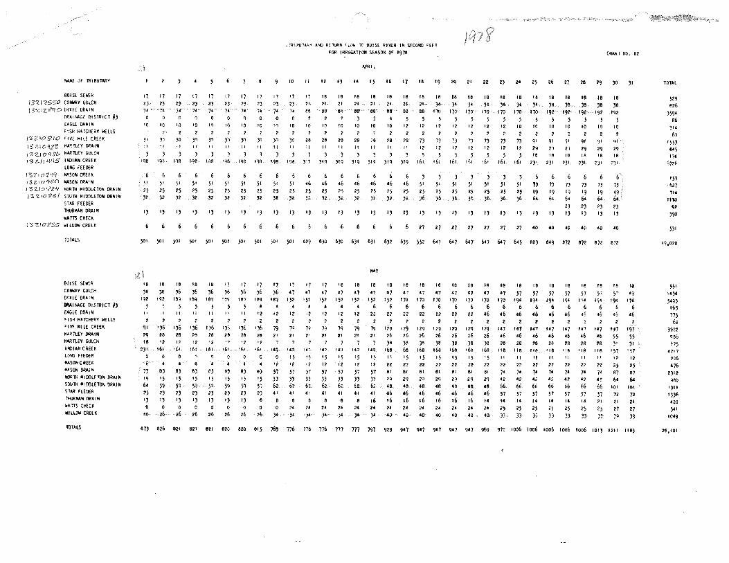
- OF TRIBUTARY
BOISE SElol'R 13'21?$$<' CONWAY GULCH
DIXIE DRAIN ORAIW-GE DISTRICT I/) [AGL[ Dl<AI N
FISH HATCll[RY lol'LLS /'3ZIO:;i'IO 'IVE Mil[ CREH
I 3'<!:.I HARTLEY DRAIN / '3 Z.I O q St. HARTLEY GULCH
J "3 Z-11 J.!CIS INIJIAN CRHK LONG FEEDER AASOll CREEK
I 3 Z,10 'tii'O MASON DRAIN
I 3-Z..IO 'li'Z'I ~lit lllOOLETON DRAIN )3-ZJOl?3/ S'llJTH MIDDLETON ORAllll
S TAA FEEDER Tl«JRMAN OAAIN liAm CHECK
) 3 Zi 0 8'3S WILLOW CREEK
TOTALS
BOISE SEW!:R
COM<AY GULCH DIXIE DRAIN llllAINAGE DISTRICT N) EAGLE DRAIM <i SH HATCHERY ;.'fLLS
'IV!' MILE CREH l<ARTLEY ORAi!; HARTLEY GULCH
llCllAN CREEK LONG FEEDER MASON CREE~
f<.'SON DRAIN llCIATH MIOOLETO" DRAIN SOUTH ~IOOlETON DRAIN STAR HEOER l>MlW.N OfiAlll al.TIS CHfCf( WILLOW CREEK
fOTllS
17 <)
7•
IQ
JI ,,
1qs
17
23 74
17
23 7C
10 10
~· 2 ,, 30
II H
I 9~ 118
;1 ;1 51
25 J2
25 25 )2 J2
,, ,, ,, 6
_ ffilfll.ITAkY A'ID RETURN ''°"' TO BOISE RIVER IN SfCOIID >EET fOI< IRRl(;l.TION SEASON OF 1978 Ct<AkT Nil. 12
17 23 74
•o 2
3ry II
198
17 2)
7•
10
? ,, "
118
17 2)
74
0
10
2
30 II
iqe
17 23 74
10
?
}1
II
IQB
17 2)
?•
17
2)
7•
10 If)
1 2 ,., ,., ! I II
3 198 198
10
17
23 74
10
2
30
" 198
II
'7 21
BB
2 10
2
28 ,, )'1
51 51 ;1 51 51 51 51 •6 q n Q Q Q • H H H H
13 1, 13 I) 13
6
25 25 25 J! 32 J<
I) 13 I)
12
18
21
BB
,, 18 21
BB
14
18 21
t!lt'
3
~IL
15
18 21
88
3
16
16
21·
86
17
18
21· SB
ta
16
21
88
10 IO 10 10 10 5
12
2 26 II
5 12
2 2 2 2 28
" 28 26 28 ?8 73
12 II II If II
)IQ 319 319 )IQ 319 319 161
•6 •6 •6 •6 •6 •6 ;1 25 25 25 25 25 25 25 1: }2 J2 32 J2 J2 J6
13 13 I) 13 IJ I) IJ
19 20 21 22 2) 24 25 26 27 28 29 30 JI
18 18 18 18 18 18 18 ,. 18 IB 18 IB 18
)B
192
~ ,. ,. ,. ,. ,. ~ ~ ~ ~ IN IN IN IN 17D 170 170 I" I" I" I" 5 5 5 5 5 5 5 5 5 5 5 5
10
2
12
?
73 12
5 161
12
2
7} I?
5 161
51 51
25 25 J6 36
13 13
12
2
7J 12
I 6t
12
?
73 I?
5 I 61
12
2
7) 12
5 161
51 51 51
25 2.S 25 36. 36 36
13 I) 13
10 M 10 10 10
2 2 ? 2 2
73 91 91 11 91 12 29 21 21 29 5 18 18 18 IA
161 231 231 231 2JI
6 51 7' 7) 7) 7) 25 19 19 lg 19 36 64 64 64 6'
23 23 13 I) IJ 13 I)
IO
2
91
29 18
2JI
QI
29 18
?JI
73 73 19 19 6' 64 23 23 13 13
(, ti 6 27 27 27 27 27 27 27 •o 40 •o 40 40 •o
501 501 501 501 501 501 501 501 )O• 501 629 630 630 631 631 632 635 551 647 647 647 6•7 647 6•5 823 e•9 672 e72 572 672
18 18 18
38 JS }6 192 192 181
5 1. ti ti
2 2 2
<j1 I J6 136
?9 28 28 18 '2 I?
231 161 •61
0 0 0 '6 73 83 8)
19 I 5 15
6' 59 59 23 2' 23 13 ,, ,,
0 0 0 40 26 26
18 18
}6 J6
189 I 89 ; 5
If II
2 2
136 136 28 28 f 2 '2
161 161
• 83 83 I} I 5 59 5; 2J 2J ,, 13
c 0 26 26
I 7 36
199
5
" 13f,
2e
•6• 0
8, 15 5q 23 1)
0
26
17 17 17 36 36 )6
181 ll!'l 189 5 4 •
II 12 !2
2 2 2
136 t)b 79 28 <8 21
'2 I? 7
161 161 149
0 0 0
12
83 6) 57 I j 15 ))
5'l 5; 62 23 2) 4 I ,,
0 0 0
26 26 ,.
17
•7 152
12
2
70 21
"" 15
'2
57
" 62
" 2•
)'
17
•7 I 52
• 12
N 2•
"' •; 12
57 33 62
" ?•
J•
17 •7
I 52
12
?
1g 21
.. , I 5 12
57
" 62
" e 2• j•
16
•7 152
' 12
?
n 21
7 14'.J
15 12
57 ))
62
" 2' ,.
18
•7 I 5?
• n
79 21
7 14Q.
15 12
57 ))
62
" 8 24
"
~y
18
•7 152
6 22
2
79 21
7 14Q
I; I?
57 33 62
" 16 24
3•
18
•7 152
6 22
2
1?9 26 3B
16e
15 22
81
29 48
46 16 2• 40
18 18 16
47 •7 •1 170 170 170
6 6 6 22 22 22
2 2 ' I 29 129 129 26 16 26
)8 )6 )8
165 168 168 15 15 15 22 22 22 81 61 81
29 29 29 •8 48 48
•6 •6 •6 16 16 16
2• 24 2•
•o 40 •o
16
•? 170
6 22
2
129 26 )B
168 15 22 Bl
29
•a •6 16
2• 40
18 16 18 IB 18
•7 •7 •7 57 57 '70 170 170 19• 19•
6 6 6 6 6 22 •6 •6 46 •6 2 2 2 2 2
129 129 147 147 U7 26 26 •6 46 •6
3BJB282Bl'!I •68 168 llB 118 llB
15 I 5 II 11 11
2? 22 22 22 22
81 81 7• 7• 7• 2 9 29 42 42 42
48 48 66 66 66
•6 •6 57 57 S7 16 " .. " 14 24 24 2, 25 25
40 40 " " 3)
16
57 194
6 •6
1•7 •6 28
118
II
22
7• •?
66 57 14
2)
33
18 IB IB 18 18
57 57 57 5' •9 194 104 19• 19• '74
6 6 6 6 6
•6 •6 •6 •6 •6 2 2 2 2 2
147 "' 147 197 197 •6 •6 •6 55 55
28 28 28 'I 31 11e 11s tte 157 1s1
11 11 II 12 f2' 22 22 22 2j 25
7• 1• 7• 87 87 62 42 42 ~ 64 66 66 66 IOI 101
57 57 57 72 72
" 14 21 21 21 25 2) 2; l7 27
J;'3H)QJ9
87) 826 821 821 021 820 820 815 76, 776 776 776 777 177 797 929 947 947 947 'f47 947 9b9 971 1006 1006 1006 1006 1006 101) 1211 1183
TOTAL
529 826
359' 86
314 l>:i
155)
u5 194
672~
151 I 627
7" IUO
92 390
531
19,020
s51 14)4
5493 165
775 62
n22 985
&15 4717
216 •76
2}12
180
1911
1336 420
541 1049
28,101
47'30"
12
-· .. - l l~~·.i " ""'.'--1:1--- -
. S-N -t ~~~ls'_c_?~j-------" ,, ·22'::: .~.,,,
-· ~\_
f Ir·· "·-. · .J /:. I " t (._,,,~-~ '\ ~b ,• i:).1 ' l \'::;:i ·cf ., 1;-· 'ii' 'i i )/~.''.:~ ,.\;, 1·::)-.u. _'._ \•I:) "-" " "' "=~ -•' ! • : ,,,, 1' ~
~)3;, c· \~>'."\. . . . .. -, I j ; · .. --.. t,_. 2321 I, ,
· """:""""". ~.... 1 l .L. _.,. ."' ~ .. \'1 ' ' \ J. "'"'s- ' ,,:.-/ ' ·20·
v -· ···+: .... ' 'r!.' ' (2?::-;; k~ ·~'H=t:::!;L dJ,. ... ' \t~ ~ / : (.
-22so... ,· .
\ ---:::?1/ \ / ."/
----~·- /· 1··. · ... · ~~ .. ·
\
-.!'·." . .} .. A<I:~ ~-q· . I / j\ :_ ~2294' 7· A ~
:,.,,_, ""s-
f:;:s o•
J·/;'/:· :. <
, .l ./ .·
.-
2<'9s
I
~"' ~/.-/
~ G
>---____~
\. Q ii(:
Lr
~~""'o
--/-··
i<:f:> i
..
• 0.
8
"--~-------
\ o. 0 '·~
180 000 FEET (I D~HO)
*.,,.. IGN''• .. Mly
11 I
~ -V'
2256
20
57'30"
io--;, ...... (
2260--·
1000 E
0
I 2
'\
1000
'\
.5
10
·/·:~ =. /-·~'.·· /
·~·-• • oJ(o.°" f >/' < • ) - l - .,... ~ ........,_,
'.'?
"1.6.\\2225 ~
L
\I .. ""..,,,,·~----..._ 1· .- .,. -------P,q/:?41~""'·"r····~,\i,q'[:\
L· .,,
;'g .. ,
(W/llDER) 2671 Ill NW
SCALE 1:24000 0
2000 3000 4000
0
5000 6000
/
. iz&O).:/
·/:/ ' I ·.I \ \, '·""-..
'-. ', '- ' -~'
/;: ; It__.
// .·-' MARKET
\
~-~
11\· " .. ---.,. I It · · ~~ •
//-;:::::::::::S.A' /.'-~ I
//,.... I
~"'I i .:>;<c ~
o·\ .I». 0\ ~ i•" \ \ I\ '---·-JI/( ~--- . .,
'"' ~.{'""/,.,¢' --'-..,___~ ··y -;----- ---"";'
. ~ -~\.... fi@ / cJ'::'.:'(.,-· 55' 5Q7 I 2 950 000 FEET (OREG.);
./_ WILDER 5 Ml. T HOMEDALE 10 Ml.
7000 FEET:
KILOMETER
/
===='f: ,., .·: i" I
•• • .1
"' ';'.'., 0
ROAD
2310
\.
i 5Q8 e • INTERIO>
'O:TTE 24 Ml. '>'IA 2.7 Ml.
2671 IV SW I PARMA) ·-··I·
21 ·:__ ___ _ ~.{;-"~~-" 'f BM 2268
CANAL ::::::--
0
" "'
------------
I
I.
\
\
·-.._____.
2412;jl
''" ·- ~-\
BM 2417. ~ B.QSS ..... 3 LATERAL
i24:~.·;
.\_i;'i~ ""
7.5 MINUTE SERIES (TOPOGRAF :) . 1>-' (<
I 11 • II
II
'f 2413====== 11
u !!' ·'-Ji-- lJ I l!'
'""' i1 I _ __..---ir--..:·· l ll ____ ,~----=~\ \,
\ II ' ,, JI '
"- II '--.. i ·II ----~------- -tt--/
II II
.~'GO®' i "'~ 26 I"''.::
~ G:l
~;,c~-16~ , I <:a I I ..J
i1 .~...;'' l 0 //
25 4843
u rr · i;.i.!·'.-IL___~_Jj 24061, 2409
ff \ J·

······· ;::::\;:;\,,.·.·:
.-:~:.:-.~· ... <::--'
~=--··_ ... , ........ ",,. I\_\) -- --~ 3· 0:\1 ·~ / % '.<. '{ ~ ..•.... : /''.::: ! ': ~>•o ··••·····•••· ..... '•,> k~ ~""l"""~ll'""'''""·~1 ...... 1l··~""'"~"""'::· .. ···· ---, ................... - ..
··---... ___ ~:;:::l \ ~ ')' / '""' ,. ,; II /~ f .: II f~~:"
·-.. ~ ''~t~~--y¥ell.": 1 i;2~~;~~;1~
• ~ 0
[1:~ \) i~1 .. /····..:t· l . J! ... ,,."/' '. ·· ;~.v-- ,.,
,.JI" . .,.. " ···r ~ ··. •,, • t~r.:~; ;; 1";~0 •.. , .• ·-:..· "'- u v !/ ,~·- 0 L.~t: -~ .
~: • :

~~~ f"CVMU .. .,ft' _-=i\ w•-. :~lll-lUJ.',]j"" ,( <( \ \,'\.oz: l\:k:: ·.}:>$~; ;1-.~::· ......
~:::~~~~-~~~=:--:==c==="(~~-~,~~~~~·~1n~§'~~~F··~~=vT :::~·:::::~·;;;-;;;.·;if287 ' 117,,-....:: ' ~ 94 '\:
,/'7 /---::::-~
I •
·-~
~
:>~ .... ' ..... ·:_.,, ..... ""' ·~· ":: .. :·11:. '":.' .. :":: .:":: .. :"
<:.
<.::~:::--·--·· .. i--·
f/r/ y: ;>'' ;i,°'" ;i-
L·::~:~~; 83\,,.,
(:·-- ... _
.,
,.-·.:: 41:·
>"°·-25 ____ __._;;:= --.- -1.-. ._, "..J
0
4f
4:
·31{t:i:=:~~7!J(:-~:::'c!!:::;-··"'

~ \CJ oi Cl:
"' a -.J
~
40'
4834
~
112.:i .. II II "'""o;. :·· .;,====!
e,·. f
,-----· !t: ' :~ I
.•·· .'·11,
/ :!'. < " 1;' •• 111·
::!: ·1 ____ W£_§.T ~ii ___ _
!11
II : -:1. ,, ,., I
II IJ II II II
H.tHWA\' ':
C ·• ·UNION
~ ... ~· 0 t::s .,:::::.: I f:.:·:·'·''''''l ~-~ u ' : Si~wftil1~ .. ,.,.,.,.,,,_ •.• ,.... . ----
~t'..':il g±J1· .... -~-- :_ /~ =--=--~ ,_, . . -~;~-~- -- - -~. -- --
II[]
-·.11
~I .H II
__..----:~ ;_,=o-
20_ PACIFIC
BM
<".;o ..
:,:Jj$1rof~~? ··· .. / 2l04)'l.Lj


... ::::.1..:0:-.·.
/ ~DE:
r;:
~~··· ..
~ { .
/,.
Frahklin
:11: c r·' ',, \ \: ~\
.•
11 )
+ ''·-············· ... .... ----.....
...... \
"·~-~~
.. "'<S>o
D •
~"· (!)
.,,~ . .. ? . ~- ... _,
i.,• _, Ill
··· . ._ ·· ... · ... ·<::::
'•
f-/0 --'-·=·= 11. --==;;:;;:= .. - .-"==-- ' ~ • Ci
. "(
.· ~
. "(
: u '-<>..,so
12
'o ..• -:_-.·,
4839
~ 0 :c "(
-:Ci ~-Q~ o. a: 5E :'5-(/)o,j
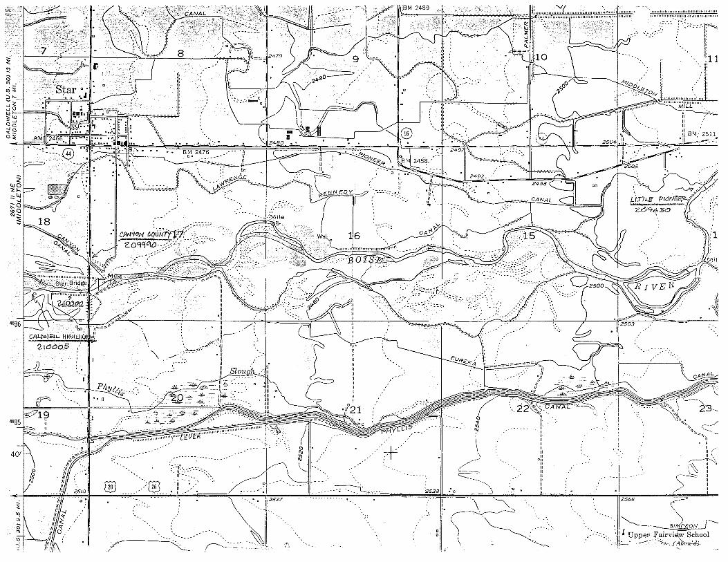
8 ~
~,~·r, !..~ l ' C' .:,,~:·,· "'t>
~ • '"~'"''I • ' ' 0 ~ ·star 0 _. : 0
' '• " ::it-. "' .
~2 I ·11 :.11 1~ t ' ~ ..... J •• • '.---'....,. ____________ ,
' . / ::s: lU Cl ..J ..J Cl
"'~ o::;:
.. '.·
--1
, ..... ,
... 0,
[§3
,,. ........
CP..NON c;tiN~ift;fjr·-~~~~:· 20::_~~>;~~-:x_-:::;:=_:_;-~:-
·- -::: ;-:::.j
/.' II .· , II .
\
"\.
H,-----:'11
/··.".II ... :~_<,,_. ·II /' '--. II
---- ::~
~:] JJU o 1111 1111 llll 1111
:-:-:---···~~ --~······''"'"~'''~'.''."'''''''""'lo-• V E ·--.. --- i''°."\>.
': :~:::::-:-.-::-:. :=:; ::. -,® II ,• 26 II
•• _•_..JL,_..- ,. ... --:! .-2527
-·--.:.
-~ ,,----..___ .. _ --· ! --
'' " v "
-.. ·---·---=.::~.!~ -.. ::_ .. _,
C)
[;'!
"' ··+·· _ .... · ,··
... ····~..,_.,.,.,._ .. -. -~
_,
'
2s3a
0 0
·'
I•
... II ;:......::..-. '
... \
\ \ ....-
/ ~ -~
----..... ___ '::, .·.'l.
,. ,. -:. " " ··~-. .,
\ -~(~~~ "···:. ') .---··.>
\ - ·. - -----
11111111111111111111111111111•••11111111 ...................
/'- ~1·101 .. --;;_,,
)
ZCJ9&>30
-~~~ J 2503 ,: .-
J 2556
~ ~ _[Up~: F~·v.~~:ool
-.

'-.j i
!:·------------_,,;
i ·~- ,..--<.... ' -u:~ \.
2492_
~~:c" ·~~
"
-:
.. : : : -- I
: :-~::,
~\~l======~;:=
1, ~: '..·
-.. - .. ...... "
~( _ .. ----~ 0 '1-
J --------... '<1 ~-~ .. -- .. ~-
\ \. -------,_
_,
""' ---.._.-. --..
.. " i C:~' "~-~}:<:>;~LL ': ' ; ""'""['"""""~'!"""'""'"'"'""" -
-
' c\ -·11~ ' ·I~·''·
,. ,;
- - -- ;;_-u-_:::;:::·
;-., : ' ..... ' ' ..... ' ·-. ..... ._: ..
". '-:..:.-----1211 ', _- ',_____ ..... -- ... 7'-,
..... ..... . I I I '--...;
--.-.- I 8A~L£UT.LN£ --'
CANAL
E p
11'~,
24 "'-fN- l:[ "-<\:~~~-::~"-. __ · .. I G I 'j., l :_ '\ l1 ~ lJ ·. :-. •.
·: -.... --, . "~,~.'
·'----.. ' ...
'---
..... .....
-, :.-
;:: Q.
"' (,.)
..:~
""' _,_
4835
401
~~ °'::: lo'. II)

~ ~ ({) ....
401
"'I{) (') -~ gl 0 0:: i & ~ 2 ,,,
,·2545
,--. White Cross School -"'
(Aban'd):
~
-- . :;J' ,0/Ai.C}!t·~SPR111J(,.S ,- .• • ·
i_ ~q~z:e:o 22 '00
-.<? II H II I/
// \\• //
· "'==~.?sal=~ II II II II II II II II•
1,',
'\ \
~ . \ '< i • o ~~\V/';., 0 ,\~_~!
FEAT ER-'~, .. -ORY:> ) f;---,
1_,,?)i:
14
··-w <: "{ ..J
~_,,,-
,,...,..,,_
- ' -------r~"/;~: \__ If ", ~
" ,/
-::---//
~--,/ ,;'

'/Jo ,.,.,
L1"Mi":1rz ...
zoc.-z..oS
II II II
I/ IJ
\\~=::::p====;:;// ,\2581 II II II II II II II II•
DRY II II II
--·-II ""'''''''''''""'"!" . '
I
....... _.;· ~ .............
----~·~~~:.- ,' -·
,==27~=~:=~===1r·-~=;~=-~ ' "' ~.2.652
' :-., ~~~~ ~~
'·-~'
\\ '.::.-""-.,
=1i
~1~:0~ gj l . l 1 ;o~=. 4J <:: -.: _,
I -- ·--'=c========,1J2608 J; :· i '>·
..
' ' ". \ -:-·. \ \ ;,.
<:·~\O'
3 5 -=-----..!J -. ·.\ I
Q ' ... , \ \
-.: " ' '. •H~-- ... ,,' '..,_:~_ .. ,
. \·!I
•')
~ n;,
&lk ~ QI II•
2617
:~ ,/
·~ /
/)6_?(
i¢/i / ~olrt-
4J . :a:/ I '/
Pierce Park. • • • • CAST/£ ·ROAD 40' I School LJ.. l 2520 • • • • • i
I
"'~ ., ... ~ .... '. •1 'Ii oi
a - • •t ••••
~~~40' "';'<#,•· th di * -. c,. ~l;,f ...
~~~~~-ll:'J\\'1"~7'J!l,'''1h4Tut'Mv£W,',.~j-...... • ry'r'!'J"· "''.;AX #,,·,- 1 ' '.· f, I ·• '.-.:':~~i:~J!R~."<<~',=~~~'t}:!:- .~:...c ~ ·f:JffY'M;Wi. ~:0S£V?,J.',:_...<~tl..."";':'f":'.'.'·;;t.", J.. , '"I::
":.~~~~~;;"':::·~.~~':"~I.~~ ~ o.s:;~~
:_ ,-~;; .·;~:~~-.~» ·- ' ·-"
..... ':'~·~.·(>'~:: ·. ~'-:'.'
"'P· ~'
"-,-~-.
·-h
•.-
4834
T 4 N
~ a1 •
43°37'30" 116°15'
0 1>-"' nC ,_c, C:ont·:,· ':v USGS an-:l NOSi'IOAA
563
*
12'30" s54 • 565 2771 //SW
SCALE 1:24000
--. ,;-
. ' ... ~ /./~
' . \ . \
3l1< J' I fL. '< \~
~ 0 .~~~~--~~- ~-F-::==::t: __ .t:===i ..::.~- :::3 __ .F-...:=::L: -~---~-=====-- -:::-:::::=-::~ ~-
.:;''.,~~0·,'
:1·~-n;-;- . :---. , . . ' :
" '• 0 llJ.J Y :.)Li_ 'I• II• •· - . : . ; ·""JoM730 · - . ·11 11• :\,~ • : . ... . . ·. • ~·-~·: ·---~\ . I
~~) i
• fl~ .. , .. ,
\II•
-,
"'"')'\ " ~ ( ...
/ " " ~
( "' ~
_. '----.. ... ... ' ~" ( ' .... __ ... ('---, --- '. ~ ,' ... ~ , ___ ~\f~ . ~~-_ _;:___-_~- ---~0<2 :: ___________ _:,)_:,
(' " C9o , ... --- -, ,, " . ~k c
,, /<~------ . "-->-t'\<, .H" :.<"'- -\ " "---~' . ~--3ef 1\ ~~ \ ~__,.··, ,__ ,__ ~
~··_ ·--:u ••
, ... -.-- .. ,, . '-, .
Cl
~ "' ~----- )// 25
(~i~~(:-:~~~~ '•
.• ======! :· .. I
___ z770 ---
: -----= 0-:---::::::~ ... __ ,
I ,.-o
t,1:1 "' //,~,v , .•51),v..r e,tl l cf!.f:
'·::;

R~:~voil'~";'~ ··-"/<::-~-· 1i'~·1 ' . ···[\ . 1. ! ii .. \~'·. i 1 (' \ ·--<'s·Ji:.-<-1 /' { / ·~/ ~!-~'~".' '\/ • ·':~-' '~ .-~ , f.r~ rr 1 .· . · .. \.....:__., . • '' .• ·r1· ' '-----7 .. _,,, . - V · 1 . . __, ·- ·. 11 I
">~ -..., ~~ • / "':=:;;;,-:~!(,',-:: ': •> \ .::-,,})::;) ' '·• 'i'~ ( !.,/' > /~'.j\tl' ; '~ ~ :·f:~ :, ' : •-l\~~~-2 :~~~~·~?~·,.:) ';/<··~~i: i I 'i> ->, . .. ,.......':~ ,/ ~.;.'l,._.,,.-. -'' , /' -.·-/ •. # .• , . .-· ..• \' \ ·-:;_...--..~..:::::. --~ . ' ' ._ ,4'. - \ i _,c----1 '\ ' ' :·· - ..
'\:S'\ .. -:-.;·.·:'>-~ ( 34~ ·tr,1 .. --~~)) .. ·.t" .. -.'' ::.:o:c· ~q~/. <.· \.·.\'--==.·-.-7/£::-0. ·.c."'·· .U .,.·,.: ."2.(rrJ·· ... :11 '~
:Park \0)\( °\j d-_> J' c!) rw: VA: ) \1
~:'2/~ ·;0:\~\ r~ 11
~ 2794 ~ ,; -_ .\~. \ ;\ . f 26 '" / 1 h ,
,, \ - ' )I I I \ ·; \. 1\1 ' I I ' I I
·ptJO, /' I "' 2.D3/bOO / / ~ ~ - " , ' ' v ,:;- ./ n ...._,, v ~ : 'Z:fl.,.sxr"''- // • Barber ~--;-···~~· - , I '../ ' <; .__., i • U ) ~ \f,\ ! ~\ :t . •I ;/ I ~ • 0 / , ! '• / . // J 845 \ I' I ' ·11~ I \
1
\ ,ll S f-. : //~\ I ' [ ' ' '-' / // I ) i I 'J ~ '\ [ ) '--""/
::i • <// ' <§ 0 , • • . -- rk , / r,// I _ ~ '- //1
'ir f'-l..I ~OUJ l.b3~2 .. 0jr'\: .. / .. ~I '•. "la.')\ • ~cg- · j· " -- •·/ ,f;/ ~ I v'P _:l //;1
Iii . ~I I {
4824 29
- , y Ponds ~ 1 I ~ • ./ _,.-----/ ll \ _ ;\ ,J 1 r- • // \\\,, \ - tu ~2755 // • · '-- ·1. \.J
1 I \ · fd// '"' ·-..., · ' ~~ ~~ ... s~;se? ./.[·_> ../- l ~'" -- 1cl-
1;..-07
"..'.: .. / //lri~. L /·~' I ~~~;89'··~ \.) 0 '...__O • · . O·,or• ~-·· -""""- · • -n \\ { . '), f?oA OJ __ 1 ___ arn _,___ .- , ,, 11 • , /J 1 ---- ~o ~ ·~ "'· ;;;;767-: -. ~-____ i_.:::.~:b. X3341 :: /"-, . ,J'-" 'I // - I \ ' ,,.---.., >f-" 'i(. :::_ xJ"11le 59 • : ' ~ ::-
1 · V- -- --,..L-- .--:. --v )'.. ___ /'.._ _____ L 1 _ ,__. / • «,.,_,f:r,) '· - ( !C _/ I // -- / 'I ;' 0 ' ' ·T--------.,.---·-----.,.
.t-_,;,'::.;,¥~"'0 ·- ',O-q -- I ~- ( "'""' , ,/ I l~,-...._V, I '· \ 48 I ¥'''!. . "!.-"' ' // "' -r' ' I <r-" \ \ '
23 {' ~"' I " "'< -'> • .- ""'- f' i-....::-::;- , ...J ; ..i -, G~~ , \ '~, \J (, ,/ ~ i,_.,//,7..-.:; ).fJJ ~ ... -- "\'-~
"' .::"' ·\ /? // \ ~ / 1·· ;1~-r-- _-::3 ! Ii\ " "' '"' ' -..__,/ ( ' -~ \\ / .... Q ~ J ' 11 I "-' ''' . J It -/ ~ \ ( ".. · 1 ( / \ ' ' ~ ,,, • I ff I - __, .. -~ ' (
'. I ~~ "' I ' jll ~ 0v. ;( '-, ; \ ' ~_,, ' ' • I ! 7 ,r"'· \(> ' I -'< J ~ ' I • ' . 11 --~= 0 ,..> I ---::-o ~
"' ' I IJ ' ( _--- ' ' /-. "'··'" I ! ·., J/ ;' ~ ..... ---•---7· ( .' \X(J615 ) /I '
'1
"'' 0. , . ' I& ~- '• I \ \ {._,,,. ' '; I' " "''.:::., ''--. I ~-- \_) / ,/ - ', '" I \J - '
' ~ "· '"°'' ·- I . J-- ,/ . ~ , / ~2" 0 ~ '"~,.. ;~ •• ·" //. ,,, !l,. /'.' .. ' ' ··.- "··, (J > / --" ,,.!.y ·":_, --+~ . // \ ; . ,·.- 34 \ . . . ' ., / --\ "'-.,>:::::-...... \ <"- I! -..__./ ··/ .· - . .· ''-J~ ,. / 3 r-
~~ '......_ "·, . !"·:::.~~ .. , ", \~\ ,J ... : ·: ·. . ·! . -· ' ' ~""~ ·-c--:_., I "·..:'~ \ (- 11--. ( l < . · . · , \ 0 I '> ~ "",,;;':'->. 1 J-o~", ·._ \ '\ z<Pula - ... :--~ _ · ' , \ " "-0-. ', 1> " ' <$' \\ ·-··"'''j ~- - / -- ") ~ I '~'.c., ',. -r .... , \ )- \\ . ~ ) l . ·r::--· ~· /.7 /' 4124 ', "'~''· •, . ._•,--,'. \\ •.. \ , . ·· . . \ .~. " I I! L., I
,,._,,, • '.,,,........ \\ (' ( ' .... I '--' \,,/' /\ ...... (' i ~ ""~~·, I ''-°''- '-. \\ ) ,_; . . ";' \- ·-, \ '-, ·"' I ,, 11' ' ' . 0....., I\ \
> "· '>~'-· • "o'.~\,-. \: .. '~f1 ' J<_.l . 1...---7 ~ ,-,J' ( / ' 1 c__....-...:_~,' 4822
..--:--',._'.
(~~·, I "°&•''" •• \\o\ I/ 00 ! l /1 11·-~ /~.;:.; ''"I '\ ''<·.·· \'.'• ' '·. \ \ ' ./ I ,,. I u ' . ,
\' >, "'-,::,., ·• \, ' •• •• • \ l / : I, ,: " I ,_,. ' T 21'l '· '\ \3017: ''<>''- ' '· !__ ~----+-----=-~'---':__l _A _______ ::::.. __ ;., I ,/\ \ \ '
,
1
\ ~ <:,~\, ,;- Jt. v.J-4 ~ --·/ '-.__,) \l ;\ "-J-",,---·~--~,-- \--\--=.---.-:-. f-,---.\'._,'·, . . ";,~·~ c>A..~ ' ~ I ' \ 'I . ..._ I,.,' .
• ~- "~ ',, 1 1;7[ c / • . .- , . \ 11 / • Spring \~ ;( . "'<~',, I 'J) '\ . ''.i ~ ) \ I "1;v( '.
' - ~. "'- r--..~ I \ \ \ "' '•,, '-.. ) v """ ! . :] ·)' / I I . 32'30"
482J
4820
' '
\ \, •·•. I ' ..: _ _,./} ' / \ ' /_, ' \I ' '. '"' • o ':, / ' / • \ Spring · >'"----.... .. · ~~ -._~2.03521 ',,11;/ ·, r A;wr1SN1A!~ \_,/L' -·~ ~ "'~ . ~ ~ x f;\ q - ' ,,,-;·~~-
\ "'"' ',, \ 20-Z Cf> ' / '' ' it ( r--7
~ "'">,;-. ' , i _/\.. /I J ' ! "''· ' '--'__. • ... / \\ , I '-. ~" / "' .-0:\ \
•' ""';., -?'<'Ql'.::> ' "' ,Y\\ ~ _. ~ ·~ -~u~ ~ ' --";
11 Diversion Dam :5 5
·., -~3745
'
\\
"~~--,Y-<i\ \\. '\. ~ ", -.... .. \ ~ ..... ' \ '
· ... -~',, \ "' ··.203000·, ' \ \\ ',_ -, -
\ "' . ~&./" \
" --z,y b ~ ·.. -~·
\ ii\ . " ~ '-·..:.:,, - '/. ===="'.="°·=="'-"'=~"'"'"'=·==== ================~-='L" ·. ·. '--:_ . ",---u~_,.~:·.
\J/37 ', -- ~--- .. ,
\ ' - ~ ', \
·., . \ ., \
\ ·.. ' \ f501SE 1?, NR &1se--!;
. \:"
,'
/
zozc~ ~
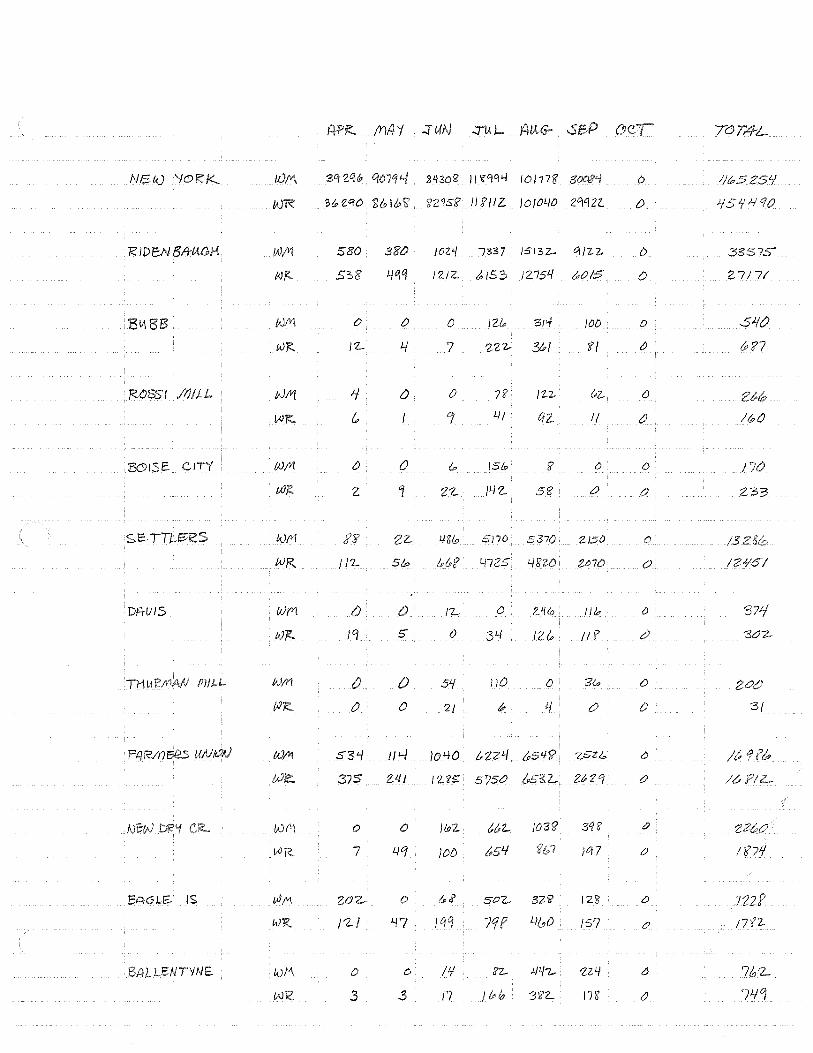
(Y)/i '/ .:::rtAN .JU.I- TdT,4-L
NEu.) '/(') /JJ/I\ 3q zq&i 21!30:?? I/ '?'1,Cfi.f 101778' 3003'1 0 JJ!t:'52S'I
WR 'MZ"?O 2lblb'i? n'lsi? II f/IZ. /0/01..10 zciqn {) Jf 5 Ji If
RID E:N 5A-UGH /!J/Y1 580 380 /02'/ /337 /5132- 01IZ.2- () 3§:575"
(JJj?.. 5"::,8 12.1 z. &153 /2754 !POIS 0 2 7/ 7(
Blil t<J/Yl () 0 {) !Zic 31'1 JOO 0 St/(/
Wi':. J'Z... /../ 7 222- 3/PI I? l () (p '?7
;<0851 vJft[ 1 0 0 7'? I z.-z, t;z_ ()
VJ~ & °I 41 qz I/ a !iPO
&9!SE CITY /)J/lt 0 0 (.,, /St,, :? {) () I
tU/i! z '1 2'Z. HZ.. 5'6 t) 0 233
S.E-TTL.~k:S '1)/V[ iz. 48/s; 5110 5370 ZJ50 0 /3
tv~ I /'L SIP LJ725 1-/l?W Z,1'70 0 !VIS/
DA-VIS (/)(1 () J'Z... C! l'Uo Jib {) 371
(;)](_ /CJ 5' 0 34 126' JI f "30~
TMU N/rl a 51./ 110 () 3& 0
0 0 '2{ dP l/ () 0 '3(
FAR/YI 5e:s t<J~ S3'-/ II;.../ )040 t,ZVI zsz;,,, 0 /6.
375 VII /US 5?50 z_ 26' 2 '1 (') /&
l;J !'\ 0 0 JlPZ t&Z.. )031? 3q8' tJ
V4R. 7 4q )OD t#5lf )0/ 7 tJ I '671/
EAGLE.- IS ())I'\ u;rz. .. 0 t..;? soz.. 32'ii' 128 0 )22f?
WR. /'2-/ Lf7 Hf /../(,0 15? 0 17'{7-
LEN TYNE /;Jtl\. 0 0 /11 d'Z- J.ll/7- 'ZZ'/ 6 7/o'Z-
/Al£ 3 3 J7 3l?Z.. in {) 7L/°I

A /!IA'/ ::JWJ :JlAL AUG- -SEP OCT TOTl'fL
/Vl!DDLETOAJ Wfl 4lb y 7qi-J €,370 IOL/Z.. 0 () Sb f(o
J.i'73 160 2'?'70 //5/ () 0 571&:>
PH 'ILIS5 /,\)/VI 1-\530 81PZO 3550 15'97'9 l.ttt:ZO 0 SOJ.f~f?
IN J< 4 3lf5/t> Lj/2.(p (.,!.{Oh .=,-og;&
LITTLE !NM 0 0 LJ6t.f 554 0 0
tvl<. 4 150 l-/4S1 1-/fp 'l 0 (J
c L\OIJ /;J('I\ 11-)L[ 0 I L/Lj )OIO '3 I IP 0 24??0
WI< 57 )Ob3 757 zi? (J 2 zt '-I
WM D IJ () 0 0 {) {) 0
WR 53 (J 0 0 () {) 352...
.SE'E>!::E£ IVM () D {) 0 0 0 0 0
Wf<'. 141 I 40 0 {) 0 0 0 J J-IS I
0 0 0 0 0 0 0 ()
W'R. LJ'f 0 0 () 0 0 /-/S
-SI :BER& 0 0 0 0 0 {) D 0 :!!/ v :!!./
z.... () 0 ;40 17 57 0 2-
CA>..WSLJ. - /,J)ffl 0 0 0 0 0 0 () 0 /tJOTllc:S
11?0'1 0 0 25/) 0 () 0 2-1 '-f '1
NoTUS- () 0 0 0 0 0 GI 0 P~A- 0 () 0 CJ 0 {) 0
?\JR.. /1333 {,, 71,. I °8 t, l&q I &uSS
WJ<:. 0 I qt,,/ 3 33lo0 '2212- () /'Z,037 ...
TOTAL £JM. 5<'.1}.f707
&,aqos;z_

20102..'10
:2ob2 .~o
2081.f.i:-o
WbZ.Cf 2. 2.0bZ.ct<;;'
20'37.¥0
NAME OF CANAL
ANDREWS
BALLENTYNE
BAXTER
;f30f$E•CJ~JY
~ 80,.,.M.AN-SW I SHER
BIJBB·(SOUTH BOISE MU1UAL)
CALDWELL HIGH LINE
CAMPBELL (CANYON)
CANYON COUNTY
•G'O!Wl~~8MI~
DAVIS DITCH
EUREKA #2
FARMERS UNI ON
G RAl'!MllGc<fil!8'6l<iT HAAS
•Almtikfil@'~~"t!S
I S LAND HIGH LI N6 '."'6;MR;
LI TTLE PI ONEER
LOWER CENTER POI NT
;Mt\'e1£~A:tll!l'iR
IWIMON
~~CONNEL IS LAND
MCMANUS l TEATER
~J;~YES~#2 MIDDLEffiN
NEW DRY CREEK
NEW YORK CANAL ( B. OF C.)
PARMA
PHYLLIS
RI DENBAUGH RIVERSIDE
~ •RGSSil~'lSt
SEBREE (FARMERS CO-OP)
SETTLERS
SIEBENBERG
THURMAN MI l L
UPPER CE~TER POI NT
TOTAL CANAL DIVERSIONS
Ml SCELLANEOUS
TOTAL DIVERSIONS
4
B
17
15
J5
4
9 40
J5
2
4
6 18
14
J5
4
15 42
36
26
6 25
I 18
I 17 J 39
9 I 9 4 54
J 47
62 Bl 10 84
0 0 0
8 8 9 116 12) 1297
237 251 2,5".40
2 2 3 10 11 I I)
II 11 111
37 36 3 55 6 6 7
4 3 4 5 4 39
3J J4 3 29
6 7 15 2 2 4
0 I 8
27
6 26 18
17 38
9 12
54
47
28
6 28 18
16
38
8
12
54 47
74 77 0 0
9 9 94 91
240 241
2 2
I J I)
II I I
53 51 7 8
37 36 28 ?6 14 14
4 4
7 7
29
6 29 18
16
36
8
12
43 48
76 0
9 89
0
2
13 11
49 8
34 2)
13 4
6
30
6 30 18
15 )8
IJ 43 48
31
6 31 18
15
39
6 I)
4J 46
73 85 0 6 9 10
Bfi 83 241 249
2 2
I J I J 1 l 11
4 7 4 5 8 8
33 34 2J 22
I) I)
4 4
5 5
19 2
)
17 I :rJ )'2 3 I )0 29 28
6 2
0
3 7 7 7 6 6 3 2 2 2 2 2
0 0 0 0
155 171 I 81 8 I I 74 I .q I 44 I 52 142
85 85 E )4 54 54 73 63 63
2041 2026 21~46 2735 2746 2741 27•1 27•6
20 20 I 39 38 36 35 3J 32 9 II Ill II 10 10 10 10>
293 293 3;379 )81 379 379 389 379
539 553 227 223
10 10
248 245
164 146
0 0 4 4
33 34 25 26 10 10
54 0
22)08
I 11
26273
300
311
II
270
J52 292
0
II
260
383 287
0
II
219
18187 185 185 184
0 0 0 0
10 10 9 8
3 33 32 32 31 2 20 20 21 2 !
I 6 7 7 7
493 JOO
0
II
200
186
0 8
32 22
7
493 282
0
12
222
187
0
7 32 22
7
4627 4672 491140 .'1401 5398 5126 5460 5479
TOTAL
107 446
550 1163
1170
0
280
379 1403
1294
2576 89
292
)403
7790
/8
369 )41
14 53 20)
1205
985 423
6o 257
CJ45
150 66
4
5574
2AJ6
79953 908
351
12757
15557 8312
19
332 8517
5851
39 331
1050
726 196-\~
169690 206
16ga96
p

13205617 DRAINAGE DISTRICT *3 13205642 BOISE SEWER 13206400 EAGLE DRAIN 13209450 THURMAN DRAIN 13210810 FIVEMILE CREEK 13210824 NORTH MIDDLETON DRAIN 13210826 STAR FEEDER 13210828 LONG FEEDER 13210829 WATTS CHECK 13210831 SOUTH MIDDLETON DRAIN 13210835 WILLOW CREEK 13210849 MASON CREEK 13210980 MASON DRAIN 13210986 HARTLEY GULCH 13210988 HARTLEY DRAIN 13211445 INDIAN CREEK 13212550 CONWAY GULCH 13212890 DIXIE SLOUGH

13205642WBOISE SEWER 13212550 CONWAY GULCH 13212890 DIXIE SLOUGH 13205617WDRAINAGE DISTRICT *3 13206400WEAGLE DRAIN 13210810 FIVEMILE CREEK 13210988 HARTLEY DRAIN 13210986 HARTLEY GULCH 13211445 INDIAN CREEK 13210828WLONG FEEDER 13210849 MASON CREEK 13210980 MASON DRAIN 13210824 NORTH MIDDLETON 13210831 SOUTH MIDDLETON 13210826WSTAR FEEDER 13209450WTHURMAN DRAIN 13210829WWATTS CHECK 13210835 WILLOW CREEK
DRAIN DRAIN

- Of TRIBUTARY
801 SE SE"1'R
COlfllAY GULCH OIJI£ DRAIN
l'IA1~£ DISTRICT f) EAGU Dl<AIN
FISH HATCHERY WlLLS FIVE MIU CREE<
MNillEY Ol<AIN
MR ll£ Y GULCH ll«HAN CREE« LOI(; FEEDER llASON CRH~ MSON Ol<AIN
~TH IOOOLElON DRAIN
SOUTH lllOOLElON DllAlll
STAR HED£R lltlllMAN DRAIN
llATlS CHECK 111 LLOW CRH~
lOTALS
601 SE S£""R
CO!tjAY GIMH DIXIE DRAIN WllllGE DISTRICT f) EAGLE DRAIN FISH llATt:HfllY llELLS FIVE lilllE CREEfi HARTLEY DRA 1H HAA TLEY GULCH ll()IAN CREEK LQllC; FEEDER
lllASOH CREEK MSOOI DRAIN
11'.JR'/l< 11/00LETOll llRAlll
SOU'/l< l<IOOL[TOVI DRAIN
SlM FEEDER lHl.lll<AN llRAlll _.m cH£n Wlllllll CREE~
lOTALS
2• •q
'74 6
•6
197
55 31
157 12
?5 67 64
IOI
71 21
?7 )9
2• ., 17t
6 •6
1q7
55 ,, 157
12
25
67 6•
IOI
72 21
27
39
2•
•1
17•
6 •6
1g7
55 31
157 12
25
67
64 IOI
72 ~I
27 30
2•
•9 f74
6 •6
107
55 31
157
If
2;
67 (,.;
IOI )2
27
)9
24
49
'7' 6
52 ?
197 55 31
157
I?
25 87
64 101
72
22
27
39
2•
•9 17•
6 52
2
I jO
6o 27
127
29 n •O
6" 66 22
18
22
24
52 182
6
52 2
150
6o 27
IZ7 8
29
79 40 64,
66 22
18
22
24
52 182
6 52
?
I jO
6o ?7
127 8
29 79
40 64 66
16
22
111111UTAl!Y AICl 11£1\JRN FLOW TO BOISE R!VER IM StCOl«l fHT FOR fRf!IGATIOOI SEASON OF 1978
JUN[
10 II 12 1, 14 15 16 17 .. 19 20 21 22 ,, 24 25
2• z• 52 52
182 182
6 6 52 52
2 2
150 150
6o 6o 27 27
127 127
8
2' 29 79 79 •o •o 6' 64 66 66 22 22 18 HJ
22 22
,, 52
182
6 52
2
150
6o 27
•27 8
29 79 40
64 66
22 18
2?
z• 52
182
8
51
z 150
6o 27
127
8
29 79 •O
64 66 27 18
22
24
52 182
e 51
2
161
77 34
141
9 ,2 125
40
99 70 27
26
'3
24
52 100
8
51
2
161
17 ,, 141
32
125
40
99 70 27 26 3;
2• 24
52 52 180 too
e 8
51 51
2 2 .61 161
77 77 3• 3'
141 ,,.
)2 32
125 125
•o •o 99 99 70 70
27 27 26 26
" "
24
52 180
B
51
161
77 3•
141
,2 125
•o 99 70 27
26
3)
2•
52 lllO
8
51 2
161
77 ,. 141
9 )2
125
40
99 70 27
26 ,3
2•
52 180
• 64
161
77 )4
141
32
125
•o 99 70 21
26
33
2( 24 24 24 2• 2• 52 57 57 57 H 57
100 218 218 210 218 218
' ' ' 4 • • 64 6• 6' 64 64 64
2 2 2 2 2 2 16o 16o 16o 16o 16o 16o 66 66 66 66 66 66 ,, J• )4 ,. )4 3•
146 146 146 146 146 146' 7 7 7 7 7 7
22 zt 22 22 2l 22
107 107 107 107 107 107
36 ;6 )6 )6 )6 )6 es ee ee 88 88 88
7)7)1)7) 7' 7) 21 21 21 21 21 21
28 28 28 28 28 28
2Q 20 20 20 20 20
OllRT l«l, 12
26 21 28 29 )0 ,,
24 24
57 57 210 z•e
6 6 67 67
2 16o 148 66 70 3• )8
146 1q7 7 q
2Z 28
107 I)?
36 '5 88 121
7' 78
H 22 28 22
20 26
2• 2• 24
5' 54 5' ?21 221 221
6 6 6
67 67 67
i.e 1 ce 148 70 70 70
)8 )8 )8
197 197 197
9 9 9 28 28 28
132 1)2 1)2
'5 '5 ., 121 121 121
78 78 76 22 22 22
22 22 22
26 26 26
1189 1189 1189 1189 !196 1019 10)0 10)0 10)0 10)0 IOJO 10)6 119) 1191 1191 1191 1191 1191 119' If)( 1177 1171 1177 1177 1177 118) 1)10 1)10 1)10 1)10
('4 ,.. 24 24
5' 5' 5' 5' 221 Z21 221 221
6 6 • 67 67 5 1 51
U!.t 1'8 1'! 1qo
10 70 70 77 ,. '8 )8 )I
197 197 107 246 q 9 q 7
28 28 ?8 )? 1;2 ,,, 1)? 173
•; ,, •5 •6 121 121 121 137
78 78 78 76
22 22 27 27
22 22 l2 2Z
26 26 2t co
24/ 24
6o 6o ))6 ,,6 • •
51 51
2 2 1qq 1qq
77 77 31 )I
2•6 2•6
7 7 )? ,,
173 17)
•6 46 137 1)7
76 76
f7 27 22 22
•O 40
24
6o n6
51
2
199 77
'I 2•6 7
)2 17)
46 1)7
76
27 22
40
24
6o ,)6
• 51
199 77 }I
246
7 )2
17)
•6 1)7
76
27 22
•o
2• 6o
3)6
51
1qg
77 ,, 246
7 )2
173
•6 1'7
76
27 2Z 40
24
6o ,,6 5
J8
1:n
77 ;1
2•f 7 ,2
I 7}
46 1)7
76
" n 40
24
6o ,,6
J8 2
1)8
51
N 16?
e n
121
)6 IJ7
6) .. 22 ,2
N
% I~
5 J8
2
1)8
51
24 IH
e n
127 )6 ~7
~
" n n
24
~
·~ 5 J8
2
IJ8 51
N IH
8
" 127 )6 ~1
~ .. " p
2•
56 188
5 ,e 1)8
51
24
I 62
e 29
1z7
36 i:n 63
" 22
}2
.AJLY
24
56 180
5 ,e 2
I )9
s1 2•
182
29
127
36 107
6J IC
22
)2
" -·~ 5 J8 2
IJ8 51
" IH
8
" 127 )6 I~
~
" n ~
2• 56
188
5q
I }8
51
2• 162
e 29
127
)6 107
6) 21
22
)2
25
56 188
59 2
157
66 27
182
$
24
111
64 103
71 21
22
22
25
" 177
Yi 2
157
66 27
182
8 24
111
64 10)
71
21
22
22
2)
5• 177
59 2
157
66
27 182
8
z• I 11
64 10)
11 21
22
22
25 25
5• 54
177 177
59 59 2 2
157 1)7
66 66 27 27
182 182
e 2( Z4
I II Ill 64 64
10) 10)
71 71 21 21
22 22
22 22
25 25
5' " 177 177
• e j<J 59 , 2
157 157
66 66 n 21
182 182
• 8 24 24
fl I II I 66 6'
10) I 03 71 71
21 2;
22 22
22 22
25
5' 177
8
59
146 69 )6
16)
10
27 109
6o 9'J 78 2) 12 ,,
Q ~
158 8
M 2
I" 69 )6 I~
10
n 109 6o 99 78 n 12
19
25 51
158 e
59
146
69 ;6
16)
10
27 109 00 99 78 23 12
19
25 51
t,e 8
59
146 6'J ;6
16; 10
27 1oq
6o 99 78 2) 12
19
25
51
158 e
59 2
146 69 )6
16) 10
27
109 6o 99
78 23 12
19
2} 25
jl 51
1511 158 8 7
59 55 2 2
tt6 1'6 69 69
36 36 16) 16;
10 10
27 27 109 1oq
6o 6o
99 '" 78 78 2) 25
12 12
19 19
,,10 1)10 1207 146q 1590 15qo 15w 1590 ''90 1565 129e 1"6 1u6 11•6 11•6 1"6 117) 1212 1199 1199 1199 1199 1199 1205 1176 1154 1154 1154 1154 "S' 1151
TOTAL
720
I 563 5767
180
•68e 6o
•87• 1q76
97< 4'71
264 BUI
'"0 1)12
27•6
21 J5 6e• 727 82(
J•,9"
758 1712
6739 166
163e 62
•12• 2051
9•0 6oo2
258 e6e
4036 1577 3cs5
2250
664 612
069
)9,611

IW<f Of TRIBUTARY
801 SE SfllER co ... AY GUl.Cff DIXIE DllAlll OllAlllAG£ DISTI!ICT f) EAliLf DRAIN FISH l<AlCHERY llELLS FIVE MILE CREEK HARllEY DRAIN HAA TLEY GULCH llllllAN CREE« LON; fEEDER MASON CREEK l<ASON DRAIN NORTH flllOOLHON MAIN
SOUTH flllOOLETDN DRAIN STAI! FEEDER
ll«JRMAN 0AA I N
11>.m CHECK WILLOW CREEK
TOTALS
BOISE SEllER CO...T CULCH OIXIE DRAlll
lllAl""GE OIS'lltlCT f) EllGLE DRAIN FISH HA'!t:HERY lotllS Fl\'i llllE CREEK HAR Tl.ET ORA IN HAATLEV G!JLCH llVIAN CREEK LON; FEEOEll l<ASONCREO MSON !ll!AIN NDR1H l>HOOLETDN DRAlll SOOTH MIOOLETDfll DRAIN STAil HEDER
1-111.N DRAlll ltlm CHECK Wtll!N CREEK
TilTAlS
1/
25 51
158 7
55 2
139 68
" '" 10
26
n1 ., 9)
76
25 20
17
l5 56
218
7 55
139 68 ,,
158 10 26
127 ., n 76 25 20
17
~ %
tt8 7
" 2
'" 6s
" 158 10
d •n ., • 76 u 20
17
25 56
218
7
" 2
1'9 6s
" 1}8
10
26 127 ., 9)
76 25 20
17
u ~
tt8 7
" 2
IH 6e
" 1}8
ID ~
1n Q
" 76 u • 17
25
56 218
7
" 2
1)9 68
" 15e 10
16
127 ., 9, 76 25 20
17
7
25 56
218
9 5) 2
1'9 6s
" 158 ID 26
127 ., 9)
76 25 20
17
l5 56
218 q
5) 2
155 66
27 174
12 24
118 62 99 77 25
11 19
25 •9
211
9 5) 2
155 66
27 174
" ,. 118
62 qq 77 15 17
19
lllllllllARY A'Cl RETURN FU,. TO 601)[ RlvtR IN SlCONIJ Ff[ T
FDR IRRl .... TION SEASON Of 1976
4UGUS1
CHART llO. n
ID II It I) " 15 16 17 18 19 20 ll U 2) 2' Zj 26 27 H Z9 )0 )I
2)
49 211
9
s' 2
155 66 27
174 12 24
115
~
99 77 25 17
19
25 '9
211
9 5)
' 155 66 n
174
It
2' 118
62
99 77 25 ,, 19
25
49 211
9 5) 2
155 66
27 174
" 24
118
62 99 77 25
t7 19
25
49 211
5J 2
155 66
27 174
12 2•
116 62
99 77 25
17 19
15 •9
zu 12
55 2
155 66 27
17 .. IP
" 118
62 99 n 2, t7 19
25
•9 211
12
55
;1 I
6o II
291 1)
25
"9 112
124
'JO 2' 22 ,6
25
58 19a
12
H
211
6o 18
292 ,, 25
"9 112
12•
90 2)
22
)6
25 .58
198 12
55
211
6o 18
292 I)
25
1•9 112
124
90 2}
22 )6
25
58 198 It
55
211
6o 18
292 ,, 25
149 112 iz4,
'JO 2, 22 ,6
Zj
.58 198
12
55
211
6o II
292 ,, 115
1•9 112
U4
'JO ,, Z2 )6
25 58
198
12 }j
211
6o 18
292 ,, 2'
u9 112
124
90 2)
22 )6
25 15
58 .58 19e 1911
8 8
'9 09 2
211 I 50 6o 6, 18 15
292 170 I) 10
25 28 149 125
112 •9 f24, 11)
90 6o 20 20 22 17
)6 '6
,, 57
221
8
•9 2
150 6) 15
170 10 28
128 49 8)
6o 20 17 )4
25 S7
221
'9 z
150 6) 15
qo 10 28
128
•9 6)
6o 20 17 )6
25 57
221
5
•9 t
150 6) 15
170 10
H 128
•9 8)
6o 20 17 ,6
25
57 221
• 49
2
150 6)
'5 170
10 28
125
'9 BJ 6o 20
17 )6
26
}7
221
8
49
2 1)0
6, 15
170 10 28
128
49 8)
6o 20 17 )6
2il 57
m 12
5) 2
1)0
6) 15
''Ill 10 28
128
'9 ,, 6o 21
17 )6
26 I 26 57 S'
UI 2'? 12 12
5, 5) 2 2
161 161
7' 7' 27 r7
"7 1)1
9 9 2• 24
"9 149 •9 49
IOI IOI
1' n 21 21
II II ., .,
2' 5•
227 12
'' 2
161
7' 27
''7 9
24
"9 49
IOI 7)
21
II ., "" 1155 1198 1198 1199 1198 1198 12J8 1224 122• 1224 122• 1224 1227 1529 1525 1525 1515 1525 1515 1512 tt6q 1191 1191 1191 1191 1192 1201 12•9 ltS! 1252
24 24 24 2• 2• 2• 2•
S4 5• S' S4 S' 84 114
227 2?7 227 227 227 21& 216 12 12 12 12 12 12 12
SJ 5) 5' 56 ~ 56 ~ 2 z 2 2 2 2 2
161 161 161 161 161 161 161
737)7)7.168 68 68 27 27 27 ?7 27 27 27
•n in •n •n 152 152 152 9 9 9 9 9 9
2• 14 2• 24 24 24 2•
"9 149 140 "9 "6 146 146
•9 •9 •9 •o 56 56 56 IOI IOI IOI IOI 110 110 llO 7)7)7)7)70 70 70 21 21 21 2J 2) 2J 23 II 11 II IJ tO 10 fO
., ., ., ., 40 4;i 40
2' 84
216
12
~
161
68
27 I 52
9 2•
146 56
110
70 ,, 10
40
2• 5'
lib 12
56 2
161
6e
27 '52
9 2•
"6 56
uo 70 2)
10
40
ZJ 84
216 12
56 2
161
68 27
152
9 t•
146
56 110
70 2)
10
40
2)
84
216
10 48
2 161
68
27
'52 9
24
tt6
s6 110
70 16 10 40
SEPTEMEER
2) 2J 2) 1M 79 71J
216 225 225 10 10 10
48 48 •B
2 2 2 I 68 166 11!8
62 62 62 )5 )5 )5
258 2}8 158 5 f 5
29 29 29 161 161 161
Ill Ill '" 9• 9' 9• 66 66 66 16 16 16
8 8 8
59 59 59
2) ,. 225
10 48
2
1118 62 )5
2}8
5 2'l
161 I II
9• 66 16
8
59
2)
78
225 10
•8 2
168
62
)5 2}8
5 29
161 It I
9' 66 16
59
0 '/fl
225 10
48
188
62 }5
255
5 29
161 111
9• 66 16
6
59
2}
78 225
10 40
2
166
62 ,5 2)8
5 29
161 111
9' 66 19 e
59
2)
'IS 225
10
40 2
166
56 28
190
22
1)8
57 85 6) 19 e
•5
2)
80 242
ID 40
2
166
56 28
190 e
22 1)8
57 85 6, 19 8
45
IJ II) 80 80
242 242
10 10 •o 40
2 2 166 166
56 56 28 28
190 190 8 8
22 22
I )8 1)8
57 57 85 85 6) 63 19 19
II B ., 45
!)
80 242
10 40
2 166
56 28
190 8
22
')8
S7 85 6} 19 8
•5
I) 2) 23 llO 00 !Ml
242 242 2•2 10 9 40 ., .,
2 2 2 166 166 12)
S6 ~ 6o 26 26 ,,
190 190 ,,,
8 6 22 22 17
1)8 1)8 96 51 57 }) 85 85 71 6) 6} •5 19 2) 2) 8 ll 8
•s 45 n
2)
"' 216
9
" 2 12) 6o }I ,,, 6
17
96 5) 71
45 2)
8 2)
2)
72 216
9
" 2 12)
6o JI
1)1
6 17 ,6 5) 71
•s 2)
a 2J
2)
72 216
9
" 2 12)
6o )I
l}I
6 17
96 53 71
•5 2)
e 2)
2)
72 216
9
" 2
12)
6o )I
I }I
6 17
96
SJ 71
•5 2)
e 2)
12}0 1250 1251 1255 1271 1290 1290 1zqo 1290 1259 1272 1475 u7s 1478 "78 "78 1478 un 126) 1282 12e2 12e2 1202 1202 12e6 roe• 1050 1050 1050 1050
TilTAL
780 16qq 65•5
29) 1641
62 )068 2018
7)2
596<) )42
79J 4101
2009 )096 2)40
710
565 88}
'9,651
699 2252
67eo )14
141)
6o •e6< 1eq• 89)
s•o' 220
706 4191
2029 t782 1910
6o7 ~66
1295
)8,578

l<'.Ml: OF 1Rl8UTAAY
BOISE SEWER COMIAY GULCH OIXlf llR41N
ORAllW;E OISlRICT fJ EAGLE DRAIN FISH HAlt:HERY ll{LLS
FIVE Mi LE CRfEK
HARTLEY ORAlll HAR TlEY GULCH lllJIAN CRHK lOM; FEED£R
Ml.SON CREEK "'-SOH DRAIN NOl!lli MlllDl.ETDll ORAlff SOUlli lllOOlETDll DRAIN
ST.Ill FEEDER l!MlMAN ORA 111 ljATJ'S CHECK 111 llOW CREEK
TllTAlS
BOISE Sf"l:R COlliAY GULCH OlllE DRAIN
a1llllGE DIS11UCT f) EAGLE OllAlll fl SH HA lt:Hl:RY lotllS FIVE MILE CREEK HARTLEY DRAlll llAATLEY GULCH llCJIAN CREE« lOM; FEEDER Ill.SON CREE~ MSON DRAIN Gllf MIOOLE'lll«I Dl!Afll SOU'lll IOOOlETDll DRAIN Sllll FEED€R 'llUl"'-N Dl!Alfl WAm CH£C« WI llOll CREEK
TIJTAlS
I
I
2)
72 216
9 ., 2
12)
6n ,, ,,, 6
17
96 ,, 71
•5 23 e
2)
1050
f 1
2) 2)
72 72 216 ?16
9 9 )Q ~ 2 2
12) 127 6o 5'l )I ?•
1)1 178
6 8
17 " 96 Ill
5) 94 71 90 •5 )9 22 22
8 10
2, )7
1047 11!1
' I 6 7 a
Z) n 2) 2) 2)
73 n 7J 73 n )10 )10 )10 )10 JIO
9 9 q q 9 J9 n )1 )9 n z 2 2 2 2
127 127 127 127 127
59 59 59 59 59 2• 24 2, 2• 24
l"/ll 178 178 l"/ll 178 e e 8 8 8
21 ZI 21 21 21
111 I II Ill flt 111
9• 9• q• 9• 9•
90 90 90 90 90 )9 39 )9 ,9 )9 22 22 22 22 22
10 10 10 10 10 )7 'H )7 n n
1276 1276 1276 1276 1276
llllBtilARr Al() RE T\Jli~ FL™ TD Bel'.[ RIVER I• SECOl«l •HT F(Jl ll!!!IGAT!Olf SfASON OF 1978 CliART llO, IZ
OCTOBER
Q 10 II 12 I) " 15 16 17 .. 19 fO 21 2l ZJ ,, 25 26 z7 28 29 '° ,, TOTAL
2) l) Z) 2) 2) 22 22 ,,, n 73 7' 73 n 7J n 1092
''O JIO 281 291 281 281 281 422) 5 8 8 8 8 e 8 128 •• .,
" " .,
" " liot 2 2 2 2 2 2 2 )0
127 122 122 122 122 122 122 1867 59 61 61 61 61 6• 61 899 2• )5 J5 '5 J5 )5 )5 440
178 189 18<) 189 I 80 le<j 189 t64! e 8 8 8 8 8 e 116
" 18 18 18 18 18 f8 289 111 128 128 128 f 28 128 128 1737 9• e6 e6 86 86 e6 66 1260 90 84 84 et 84 8l 64 tr76 )9 5' 54 5' 54 54 54 687 2, 2) z, 2) 2) z, 2)
))8 10 10 10 10 10 10 10 u6 n " " " " n " 50)
1278 1)06 1279 1279 1275 1278 1278 18,6)7

GlA!N - -> -
lb.A-liJ -- --
S fllllE
\ \ \

A PK'.l
~---- S/f/IJ..E 30 N MIDDU: Ti'-"o=tJ _____ '>'
Pi;;(/, S KIDl>J...eTON -=-=----4' ~ WILl-OW C=~------>
IJJDlAtJ CR_
Ii
<2>.A-IN - -
CONIAJA'/ \'1 ____ __,._
<!3:---=.:f.>1:..:;.;X..:.;;I E:...___ )3 (o
GAllJ -- -- --?>
'2ll<3ll:.::::. -JOO
'f'Pt :::... (g'3 '? TTL- CoN :::: 538'
PRAINS ::: 1wg + zo + 1s3 = ()fJID - 1//7 -

l'ZD- 1cig= 9 [ t:;l/S~JS = 131
TTL (Qr0 -::. iiSCJ -
$/ N MIDDLIS 'Ti.__,.o=tJ ____ '>
(p5 s Ml Of}).l!; TON' ·..=;.:...;; ___ _...,
/ 0 WI Ll-OcP Cit. ·-...;;,_ ___ __,.
GAIN - - -> 31- H~Y ""'"<i=t>...'----~> '80 HA 12T J..e'{ _,.p_...i;,,.__ __ __,,.,,
50 CO/IJWA'/
GAIAJ -- --7-
------ S /'flllE
-E----~/.'IASQV= cg,. 'i
<E.-<.----m='dSON Dfe... 5()
~ sz1 +so -r :<so = UtJID coAJ :.: ""'22
= 32/ + c zzJ +

t&c'e-2-SS = -1,9 I_D1VSNS :: 785
TTL =
.Pl<A s =-
/). {'J 1.D C9 - 71l> -
3 'J., N MIDDL! "lic.:::O=tJ ___ -:;.
7 D s /'\I Ol)J...e TON' ·=----4)
}CJ WI Ll-OW C-.... ~-------
GAIN - - -> 37 }-!Afm..i!Y ,,,.Ii=""'------>> '61 HA?rJ..e;'{ _,.O_,,.L,__ __ _...,.,,
CONWAY 5z_ _____ ,,..
GAJIJ - --~
+- ,,:, a +-Z?L :::::.- ti.9 7 = 11
w!!t------ S' /YI llE 50
-----'~~· Cl(!.. g <E:-<---___.tn..ua::ltSON Df!. SI --
= 335 -rG,O -r = :::_ /pO /I =
Z-17- + - Z(pf
A /Z,()
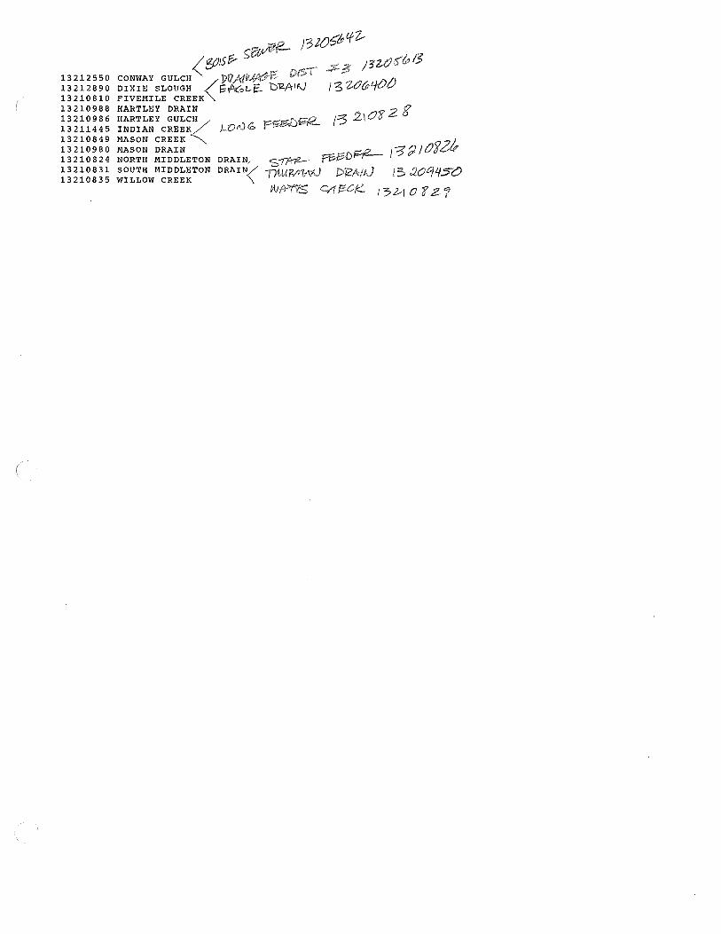
13212550 13212890 13210810 13210988 13210986 13211445 13210849 13210980 13210824 13210831 13210835
<fjJ1St-coNwAY GULCH ])17.AflU'~E'. DIXIE SLOUGH <\;f\61..-E£_ b"g.f'ril\J FIVEMILE CREEK HARTLEY DRAIN
HARTLEY GULC<H INDIAN CREEK j_OrV iO MASON CREEK MASON DRAIN ...-r,- i::::r-. ~ I~~ I O'i 2/, NORTH MIDDLETON DRAIN/ S"ff'r72- ~'"'
SOUTH MIDDLETON DRAIN/ T/t!A/?/YIMJ 5 aoq450 WILLOW CREEK '\
lAJfr/75 41 i!=C;J:::: I 5 bl 0 'f Z "J

)3
I 3 Z...10
3
J ~"' /0
}32/0
/3210
)3ZI
13
FIVE:M
//CJ~TH

08/02/83
13205b18 DD #3 lllSC11AP-G£, CUBIC ~££[ P£k S£CUNU, l RRlG11THPl YO>< ''i.tV[;;Mflr:R ino I'll UCTDB,;1< 1977
Me: AN v 11[,ue:s
fl A Y N[]V D;;c dAH "1£1.l MAR AP Ii ·~A y JUN ,JlJL, AUG SE:P OCT
1 --- --- --- --- --- o.o 1.0 B.O o.O 9,0 9,0 6,0 2 --- --- --- --- --- o.o 1. () 8,0 b. (J Y,0 8,0 6.0 3 --- --- --- --- --- o .o l. n 7. () b. () 9.0 9.0 6,0 4 --- --- --- --- --- !) • 0 1,fl 7. I) b.O 9.0 8,0 6,0 5 --- --- --- --- --- o.o 1.0 7. () 6 .. 0 9,0 9,0 6.0
b --- --- --- --- --- () .o 5,0 7 ,() 1 ll 9.0 Y.O :~. 0 7 --- --- --- --- --- o.o 5. o 7.0 10 9.0 9.0 3,0 8 --- --- __ .... --- --- o.o 5.0 7.0 JU 9,0 9,0 3. () 9 --- --- --- --- --- o.o s.o ., • o l 0 9.0 9,0 3.0
10 --- --- --- --- --- 0. () 5. (l 7,0 10 9. () 9.0 3.0
11 --- --- --- --- --- o.o 5.0 7.0 l 0 9.0 10 3.0 12 --- --- --- --- --- o.o 5.0 7. u 1.0 9.0 1 () 3. () 13 --- --- --- --- --- o.o 5.0 7. () l 0 9.0 10 3,0 14 --- --- --- --- --- o,o 5.0 6,0 1 () 9. () 10 3,0 15 --- --- --- --- --- o.o 5.0 6.0 10 9. () 10 3,0
16 --- --- --- --- --- o.o s.o 6,0 10 9,0 Hl 17 --- --- --- --- --- o.o 5.0 b. () 10 9,0 10 18 --- --- --- --- --- o.o 7,0 6. () 10 9,0 10 J. 9 --- --- --- --- --- o.o 9. [) 6,0 10 9,0 10 20 --- --- --- --- --- o.o 10 6.0 l ll 9,0 8.0
2J --· --- --- --- --- o.o to 6 .o 10 9,0 ., • 0
22 --- --- --- --- --- () .o 1 (} 6. () 9.0 9.0 6,0 23 --- --- --- --- --- 1. 0 10 6.0 \!. 0 9.0 6.0 24 --- --- --- --- --- 1. 0 10 6 .o 9,0 9,0 6. () 25 --- --- --- --- --- 1.0 10 6. 0 9. () 9,0 6,0
26 --- --- --- --- --- 1. () :to b,O 'J. u 9. (J 6.0 27 --- --- --- --- --- 1. 0 10 6,0 9.0 9,0 6,0 28 --- --- --- --- --- 1. 0 tO b. () 9,0 9.0 t>,0 29 --- --- --- --- --- 1. 0 10 6. () 9.0 9. () 6,0 30 --- --- --- --- --- 1. 0 10 6,0 9, I) 9,0 6. () 31 --- --- --- --- --- --- 10 --- 9. () 9.0
TOTAL 0 \) (I (J 0 8 201 195 2d0 279 247 60 MC:AN 0 0 0 (I () 0 6 ., 9 9 8 4
MAX 1 10 8 10 9 10 6 MIN 0 l 6 b 9 6 3
l\C•FT 0 () I) \I 0 16 399 387 ~'.:>5 553 490 1J 9
''A Tl~ R YEAI' J 977 TUl'AL l'.rlll MEAN 3 AC•F"l' 2519

08/02183
13205642 BOJSF; SE.Vi£!< DISCHARGE, CUBIC fEEf PER SECOND, IRRIGATION YEAP NOVEMBER 1Y7b ra OCTOBER 1977
ME:AN VAf,IJ&:S
OAY f.llJV ut•:c JA111 r'r:H M11H APR ~AY JUN dUIJ ALIG SEP OCT
1 --- --- --- --- --- 19 21 23 29 27 24 19
2 --- --- --- --- --- 19 21 23 'l.9 27 211 19
3 --- --- --- --- --- l9 21 23 29 27 24 J. 9 <! --- --- --- --- --- 20 2 l 23 29 27 24 19 5 --- --- --- --- --- 20 21 23 2\1 27 24 19
0 --- --- --- --- --- 20 21 23 29 27 24 19 ., --- --- --- --- --- 20 2l. 23 'l.'J 27 24 19
B --- --- --- --- --- 20 2 J 23 i9 27 24 19 9 --- --- --- --- --- 20 21 23 29 27 24 19
10 --- --- --- --- --- 20 7.1 23 :19 27 24 19
11 --- --- --- --- --- 20 it 23 29 27 24 l 9
12 --- --- --- --- --- 20 'll 23 /.9 27 24 19 13 --- --- --- --- --- 20 21 23 29 27 24 1.9
14 --- --- --- --- --- 20 21 23 29 27 24 21 15 --- --- --- --- --- 20 ?.l 23 29 27 24 21
lb --- --- --- --- --- 20 21 23 29 27 23 !"/ --- --- --- --- --- 20 /. l 23 29 27 23 18 --- --- __ .,... --- --- 20 21 '2.3 29 27 23 19 --- --- --- --- --- 20 21 23 29 27 23 20 --- --- --- --- --- 20 21. 23 29 2'I 23
21 --- --- --- --- --- 20 21 23 29 27 23 22 --- --- --- --- --- 20 2J 23 29 27 23 23 --- --- --- --- --- 7.0 21 23 29 27 23 24 --- --- --- --- --- 20 21 23 29 27 23 25 --- --- --- --- --- 20 2 l 23 29 28 23
26 --- --- --- --- --- 20 21 23 29 28 23 27 --- --- --- --- --- 20 21 23 29 28 2.3 28 --- --- --- --- --- 20 22 25 2Y 28 23 29 --- --- --- --- --- 20 22 25 21 28 23 30 --- --- --- --- --- 20 22 25 n 28 l3 .31 --- --- --- --- --- --- 22 --- 21 28
TOTAL l) v () 0 IJ 597 655 69b 893 844 705 289
MF~Af\I (j 0 <) fJ 0 20 21 23 :19 27 24 19 MAX 20 22 25 29 2B 24 21. MlN 1 9 21 23 2'/ 27 23 19
AC-F"l' I) 0 (J () () 1200 1. 300 1400 l 8 () () 1700 1400 573
wAn:1; H:AR 1gn 'J'U.U\L 46/9 ME: At; 13 i\C•F'l 92fll

08/02/83
1320640() EAGLE DRAlN DJSCHANGE, CUBIC fEET PER SECOND, IRRIGATION YEAP NOVEMBER 1Y7b ru OCTOBEN 1977
14EAN VALUES
DA'{ NIJ V DEC JAN n,e MAR ~PR "1 i\ y JUN JUL, i\llG Se:P OCT
1 --- .., __ --- --- --- 10 36 45 t>U 30 5•1 34 2 --- --- --- --- --- 12 3n 45 54 30 54 33
3 --- --- --- --- --- 16 36 43 54 35 54 31 4 --- --- --- --- --- 18 36 43 54 35 54 31 5 --- --- --- --- --- 18 36 41 54 40 54 31
6 --- --- --- --- --- 18 lb 40 ~3 42 54 30
7 --- --- --- --- --- 17 37 42 53 45 52 30 17 39 44 52 4q 52 29
9 --- --- --- --- --- 17 41 45 49 49 50 29 10 --- --- --- --- --- 16 •l 1 48 48 49 50 29
l 1 --- --- --- --- --- J.6 •11 49 4~ 49 48 29 12 --- --- --- --- --- 16 41 50 48 49 48 29 13 --- --- --- --- --- lb <ll :50 4d 49 48 29 1.4 --- --- --- --- --- 20 ao 50 48 49 1!8 29 15 --- --- --- --- --- 20 40 50 48 47 45 29
lb --- --- --- --- --- 2'1 40 49 40 47 44
17 --- --- --- --- --- 24 411 47 40 47 4?. 1. 8 --- --- --- --- --- 26 43 47 40 48 40 19 --- --- --- --- --- 26 45 47 40 48 40 20 --- --- --- --- --- 24 47 46 I! I) 49 40
21 --- --- --- --- --- 22 49 46 43 49 40 n --- --- --- --- --- 20 50 46 43 50 41)
23 --- --- --- --- --- lH 51 45 44 50 40 24 --- --- --- --- --- 17 51 44 45 50 40 ?.5 --- --- --- --- --- 15 50 43 45 52 40
26 --- --- --- --- --- l8 5() 42 LJ5 52 40 27 --- --- --- --- --- 20 48 42 43 53 40 28 --- --- --- --- --- 25 47 45 40 53 35 29 --- --- --- --- --- 30 46 48 38 54 35 30 --- --- --- --- --- 36 45 50 3b 54 35
31 --- --- --- --- --- --- 45 --- 34 54
·ror11L () 0 0 IJ I) 592 1324 1372 141 ., 1457 1356 452 "lfcAN () 0 0 \) 0 20 <l 3 46 46 47 45 30
MAX 36 51 50 ~4 54 54 34
MIN l 0 36 40 34 30 35 29 AC-F''l' () () () 0 u [200 2600 2700 2800 2900 2·100 B97
WATER YEAI~ 1977 TUT AL 7 97 (J 1•11,:AN 22 AC-n ! 5800

00/()2/83
1320<;4!)0 TIHIRMA•J Ul<l\l ill DISCtil\RGE:, CIJIHC F E:£T Pim SECOND, IRRIGATION Yr:AP WUV£MR£R 191b TU OCTOBER 1977
l~l';AN VAl,U~S
D~Y NOIJ Dl':C Jf\{\I ~ E:B MAR APH ''AY ,JIJN .JUl.1 A/JG s~;p OCT
l3 26 17 22 27 27 21 2 --- --- --- --- --- l3 2'I 18 24 26 27 21 3 --- --- --- --- --- 13 2'/ 18 24 25 27 21 4 --- --- --- --- --- 13 27 19 24 25 27 21 5 --- --- --- --- --- 10 27 j 9 24 25 26 21
6 --- --- --- --- --- 10 26 19 24 25 26 21 7 --- --- --- --- --- 10 7.6 19 24 25 2b 21 8 --- --- --- --- --- l () 26 20 :rn 25 26 21 9 --- --- --- --- --- 10 25 21 28 25 26 21
10 --- --- --- --- --- 9. () 25 n 28 25 26 21
11 --- --- --- --- --- 9.0 24 n 2tl 22 26 21 1' --- --- --- --- --- 9. () 24 23 28 22 27 21 13 --- --- --- --- --- 9.0 23 24 21 22 27 21 14 --- --- --- --- --- 10 23 23 26 22 27 21 15 --- --- --- --- --- 1.1 7.0 '22 25 22 27 21
16 --- --- --- --- --- 12 21 21 25 22 27 17 --- --- --- --- --- 13 21 20 24 23 27 J 8 --- --- --- --- --- l 4 21 20 24 23 2(J
19 --- --- --- --- --- 15 21 20 24 24 20 20 --- --- --- --- --- 16 21 19 25 24 20
2 l --- --- --- --- --- 16 21 19 25 24 20 22 --- --- --- --- --- 16 22 19 2b 24 20 23 --- --- --- --- --- 16 22 19 28 ?.3 20 2,l --- --- --- --- --- 16 22 19 28 23 20 25 --- --- --- --- --- 16 20 19 29 24 23
26 --- --- --- --- --- 20 20 20 29 24 23 27 --- --- --- --- --- 21 18 7.1 29 25 23 28 --- --- --- --- --- 22 18 21 ~8 26 23 29 --- --- --- --- --- 24 18 22 2~ 27 23 30 --- --- --- --- --- 25 17 22 27 27 23 31 --- --- --- --- --- --- t7 --- 27 27
l'OTAL 0 () () 0 () 421 696 607 810 753 730 315 ME:AN (J 0 () I) 0 14 22 20 26 24 24 21
MAX 25 27 24 29 2'/ 27 21 MIN 9 l'I 17 n 22 20 21
AC-!;"!' I) () /) 0 0 B35 J 4 00 J.200 1 bOO 1500 I 400 625
1vA1'E:R YE;AH 191 ·1 TUfAL 4332 /.\l!;A!'J 12 1\C-f l' 8593
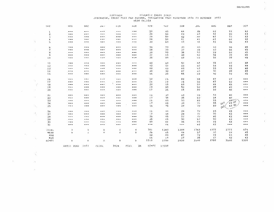
08/02/83
132.108 lO FlVEMILE CREEK DRAIN DISCHARGE, CUBIC PEET PEH SECOND, IRRJGATTQN YEAH NOVEMBER 1Yl6 ro UCTDBEM 1977
MEAtJ V l\f,UES
DAY NDV rmc .J Al~ n:B M!\R APR i.~ A y JUN JU[, AIJG SE:P OCT
l --- --- --- --- --- 20 45 44 3S 62 93 43 2 --- --- --- --- --- 20 50 43 40 61 90 43 > --- --- --- --- --- 20 50 42 40 61 70 43 4 --- --- --- --- --- 20 50 41 41 61 60 43 5 --- --- --- --- --- 20 60 40 41 61 ~6 43
6 --- --- --- --- --- 25 70 39 IJS 60 56 45 7 --- --- --- --- --- 28 70 37 ,, 5 60 56 45 8 --- --- --- --- --- 30 80 36 ~o 59 60 45 9 --- --- --- --- --- 37 80 39 51) 58 70 45
10 --- --- --- --- --- 38 Bfl 40 blJ 58 70 45
11 --- --- --- --- --- 40 60 50 bS 55 90 48 12 --- --- --- --- --- 4.2 50 60 67 54 93 48 13 --- --- --- --- --- 40 40 80 b1 53 93 48 111 --- --- --- --- --- 38 30 87 65 50 90 45 15 --- --- --- --- --- 36 20 85 bO 50 70 45
l6 --- --- --- --- --- 30 l 5 80 Sti 47 60 17 --- --- --- --- --- 26 10 75 ~5 47 50 18 --- --- --- --- --- 20 15 60 50 48 45 19 --- --- --- --- --- 19 20 50 5U 49 40 20 --- --- --- --- --- 17 25 45 50 50 <10
21 --- --- --- --- --- 16 30 40 55 53 40 22 --- --- --- --- --- l 7 35 35 60 54 40 23 --- --- --- --- --- 16 40 33 65 55 40~
24 --- --- --- --- --- 1 7 45 30 "/U 55 1,lr1 (-'43 l/O 25 --- --- --- --- --- 16 45 29 10 60 '3 43 'iO
1}
26 --- --- --- --- --- 16 4S 29 n 65 43 27 --- --- --- --- --- 17 45 28 72 70 43 28 --- --- --- --- --- 2 ~' 45 27 70 BO 43 29 --- --- --- --- --- 35 45 30 bl 90 43 30 --- --- --- --- --- 40 44 35 65 93 43 31 --- --- --- --- --- --- 44 --- b2 93
TOTAL [) () 0 0 () 781 1383 1389 1762 1872 1773 674 MEAN () () 0 0 () /.6 45 46 57 60 59 45
MAX 42 80 87 72 93 93 48 MIN 16 to 27 35 47 40 43
AC-F'T () u (l () 0 1500 2700 2800 3500 3700 3500 1300
WATlrn iEAI\ l 977 TUTAL 9634 ME:AN 26 AC-PT l 9 l ()()

08/02/83
J 321<J824 NORTH ~IDUL~TON 8NAlN DlSCHAHGE:, CUBIC FEET PER SE:CUND, IRRIGATION YEAR NIJVEMBER 1976 TU UCTDBEH 1977
ME:1\1i VALUl':S
IJAY NDV ur:c dAf\l ft:B MAI< A Pl< M1\Y Jl)N dlJ(, AUG SE:P OCT
34 3 J 60 40 24 58 57 'l. --- --- --- --- ,.. __
34 32 50 4:, 24 50 Sb 3 --- --- --- --- --- 34 32 45 so 28 <10 56
4 --- --- --- --- --- 34 35 40 ~2 28 35 56
5 --- --- --- --- --- 311 37 30 5<l 30 35 56
b --- --- --- --- --- 30 40 ?.5 54 34 31 56 ., --- --- --- --- --- 30 42 21 54 35 31 56 8 --- --- --- --- --- 28 50 50 54 35 35 54 9 --- --- --- --- --- 28 55 70 5.3 36 37 54
lO --- --- --- --- --- 27 5'1 80 53 36 40 52
11 --- --- --- --- --- 26 55 90 ~3 36 42 52 12 --- --- --- --- --- 25 53 1 0 () 53 34 43 52 13 --- --- --- --- --- 26 52 l05 50 34 43 52 14 --- --- --- --- --- 27 51 108 51 32 43 52 15 --- --- --- --- --- 28 45 .t 00 52 32 43 52
16 --- --- --- --- --- 29 43 80 45 32 43 t7 --- --- --- --- --- 30 42 70 40 32 43 l.8 --- --- --- --- --- 33 42 60 35 32 43 19 --- --- --- --- --- 34 42 50 32 32 43 /.() --- --- --- --- --- 35 •12 45 32 32 43
21 --- --- --- --- --- 34 42 41 35 32 45 22 --- --- --- --- --- 30 42 41 n 32 45 23 --- --- --- --- --- 26 12 40 39 32 50 24 --- --- --- --- --- 24 42 40 40 33 50 25 --- --- --- --- --- 22 44 38 40 40 55
26 --- --- --- --- --- 2 (I 48 38 41 45 55 27 --- --- --- --- --- 21 50 38 35 50 57 28 --- --- --- --- --- ?.3 53 37 30 53 57 29 --- --- --- --- --- 25 59 'J7 :1.8 55 57 30 --- --- --- --- --- 3() 60 40 27 58 57 31 --- --- --- --- --- --- bl --- 26 58
TOTAi" (I () 0 () 0 861 1421 1669 1330 1126 1349 813
M~;AN f) (I l) tj () 29 45 56 43 36 45 54 MAX 35 61 !OB 54 58 58 57 MlN 20 3 J 21 26 24 31 52
Ac-n· () () 0 (/ I) 1700 2800 3300 2b00 2200 2700 1600
'IATP:H YEl\H 1977 TU l'At, 85b9 MEAt~ 23 AC•FT ! 700tl
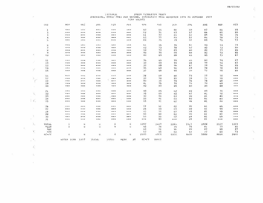
08/02/1:!3
132t0B3l sourH ~IDDLETON DRAIN DISCHARGE, CUBIC fEEf PER SECOND, IRRIGATION YEAR NOVEMBER 197b ro OCTOBER 1977
MEAN VALUES
IJA y NOV ou: JAN n::'l MAR ~PR 'IAY clllN J II(, AUG SEP OCT
1 --- --- --- --- --- 60 65 88 bO 87 B1 85 2 --- --- --- --- --- 62 70 fl5 57 86 80 80 3 --- --- --- --- --- bl 71 fJO 57 85 78 75 4 --- --- --- --- --- 62 77 8 0 57 84 78 73 5 --- --- --- --- --- 62 75 79 ,, "/ 83 75 73
6 --- --- --- --- --- bl 75 78 51 83 73 73 7 --- --- --- --- --- 62 73 78 1j 7 82 B 80 8 --- --- --- --- --- 50 72 80 60 82 73 85 9 --- --- --- --- --- 40 70 85 65 82 73 85
to --- --- --- --- --- 40 69 88 b!:> 80 73 87
11 --- --- --- --- --- 35 69 90 6!:> 80 74 87 l2 --- --- --- --- --- 30 69 94 b5 79 74 87 13 --- --- --- --- --- 32 69 96 6 I 79 74 85 14 --- --- --- --- --- 36 69 <l6 69 78 '10 80 15 --- --- --- --- --- 37 69 90 7 ll 77 70 80
16 --- --- --- --- --- 38 69 88 73 77 '/()
l7 --- --- --- --- --- 39 70 80 75 77 70 ( 18 --- --- --- --- --- 40 70 75 76 78 69
19 --- --- --- --- --- 41 75 70 76 79 b9 20 --- --- --- --- --- 42 80 65 HO 80 69
21 --- --- --- --- --- 40 85 62 82 80 70 2~ --- --- --- --- --- 35 89 62 8"/ 81 70 23 --- --- --- --- --- 30 90 62 YO 81 80 24 --- --- --- --- --- 20 9l 62 93 81 80 25 --- --- --- --- --- 15 gt 62 '18 81 80
26 --- --- --- --- --- 12 9J 62 99 81 85 27 --- --- --- --- --- 25 90 62 99 81 99 28 --- --- --- --- --- 40 9() 62 95 81 99 29 --- --- --- --- --- 50 90 62 YU 81 99 30 --- --- --- --- --- 6() 89 62 88 81 89 31 --- --- --- --- --- --- 89 --- 88 Bl
TOTAL 0 () () I) 0 1257 2417 2285 23 l 7 2508 2317 1215 ME:AN () () u (I 0 42 78 7o 75 81 77 81
MAX 62 91 96 9Y 87 99 87 MHI 12 65 62 57 77 b9 73
AC•FT 0 0 () () () 2500 4800 4500 4tJ00 5000 4600 2400
WATER YEAR 1977 TU l'llfJ 143lb Ml; AN 39 AC-F"T 284\10

08/02/83
13210835 WlL[;[)I< CREE:I< OlSCHAl<Ge", CUBIC FE:E:T PER SECOND, IRRIGATION YEAP NOVEMBEP 1916 TO OCTOBER 1977
MEAN VAf;UF:$
OAY HUV IJF;C c!AN F'l::B MAR APR '.\ ~ y Jl!M dU!., AUG SEP OCT
1 --- --- --- --- --- 35 l\l 51J 3.U 13 30 57
2 --- --- --- --- --- 35 10 45 ". o 13 30 58
3 --- --- --- --- --- 35 10 40 6. IJ 13 30 60
4 --- --- --- --- --- 35 ! 0 30 b. () 15 30 61 5 --- --- --- --- --- 35 \5 20 6.0 15 30 60
6 --- --- --- --- --- 35 1 7 15 6.u 15 30 60 ., --- --- --- --- --- 35 20 .11 b. (l 18 30 58
8 _,...,. --- --- --- --- 35 25 11 6. {) l.8 25 55
9 --- --- --- --- --- 35 29 15 b. () 19 2U 54 10 --- --- --- --- --- 35 31 18 7. () 19 20 52
11 --- --- --- --- --- 35 30 19 7,0 19 18 50 12 --- --- --- --- --- 35 30 20 7,0 19 15 49 13 --- --- --- --- --- 35 29 21 7.0 18 14 45
14 --- --- --- --- --- 35 27 21 10 18 l.4 40 15 --- --- --- --- --- 35 26 20 12 18 11 40
l.b --- --- --- --- --- 35 26 18 14 17 lb 17 --- --- --- --- --- 35 26 17 l6 17 18 l8 --- --- --- --- --- 30 24 15 ) 6 16 20 19
..., __ --- --- --- --- 39 24 J. 2 16 15 22 20 --- --- --- --- --- 40 23 12 lb 12 24
21 --- --- --- --- --- 39 23 l 1 lb to 26 22 --- --- --- --- --- 35 23 11 15 9.0 30 L3 --- --- --- --- --- 30 22 11 14 B.O 34 24 --- --- --- --- --- 25 22 8. () 14 8. () 40 25 --- --- --- --- --- lB 30 s.o 13 15 42
26 --- --- --- --- --- 11 35 t),I) l 3 20 44 27 --- --- --- --- --- 11 1+0 5,0 i3 25 44 28 --- --- --- --- --- 11 45 3. () 13 30 48 29 --- --- --- --- --- 11 50 3.0 i3 3() so 30 --- --- --- --- --- 11 51 3.0 l3 30 55 31 --- --- --- --- --- --- 5l --- 13 30
TOTAL 0 0 () <j 0 906 834 499 329 542 863 799 MEAN 0 \) 0 () () 30 27 1'I 11 17 29 53
MAX 40 51 50 lb 3() 55 61
MIN 11 to 3 3 8 14 40
AC-fl 0 (J 0 (I 0 1ll00 1700 1000 653 [j 00 1700 lbOO
\'/ATEI< iEAR t 971 TlHAI, 4 772 ME:AN 13 AC-r-T Y465

08/02/83
13210849 MASIJN CREE;r-. lllSCHAkGi:.., CUBIC n:i::.r p~~k SECONlJ, IRRIGATION YEAR NOVEMBER 1976 ru UCTDB!R 1977
e1e:AN Vl\l,LIE5
lJA Y NOV DicC 1J/\N FEB MAR 4PH "'A y JUN cllJI, AUG SE;P OC'f
1 --- --- --- --- --- s.o H • (i 18 1 ~) 20 20 21 2 --- --- --- --- --- 5.0 R.O .l8 15 20 20 21
5.0 h.O 19 l.O 20 1B 2 l. 4 --- --- --- --- --- 5.0 &.O 19 20 18 18 21 5 --- --- --- --- --- 5 .. 0 g.o 20 20 l 7 18 21
6 --- --- --- --- --- 6.0 tO 21 20 17 18 21 7 --- --- --- --- --- 6.0 12 22 18 16 20 21 8 --- --- --- --- --- 8.0 \8 22 17 16 21 21 9 --- --- --- --- --- 9. () 20 22 lb 16 22 20
1.0 --- --- --- --- --- JI} 2:l 22 15 16 23 20
l l --- --- --- --- --- 12 23 23 14 14 24 18 1£ --- --- --- --- --- l3 23 23 u 12 25 18 l3 --- --- --- --- --- 13 23 23 12 !() 2r· .o 18 14 --- --- --- --- --- 12 24 24 12 9,0 25 18 ... 15 --- --- --- --- --- 10 24 24 14 9.0 24 18 \
16 --- --- --- --- --- 10 24 24 H 8.0 24 17 --- --- --- --- --- 8,0 25 24 15 B.O 22 18 --- --- --- --- --- 9.o 25 '.24 1~ A.O n 19 --- --- --- --- --- 1.0 25 24 1~ 9.0 22 20 --- --- --- --- --- 6 .o ?5 2'! 15 9.0 22
21 --- --- --- --- --- b.O 25 24 15 9.0 ~2
22 --- --- --- --- --- 7,0 24 20 15 10 22 23 --- --- --- --- --- 1.0 24 15 15 10 22 24 --- --- --- --- --- 8.0 23 10 l 5 10 22 25 --- --- --- --- --- 8.0 23 9.0 15 10 20
2b --- --- --- --- --- 9.0 22 5,0 15 15 20 27 --- --- --- --- --- 9.0 22 5.0 ~() 15 20 28 --- --- --- --- --- 9. () 7.1 l () 21! 15 20 29 --- --- --- --- --- 9. () 21 10 20 :rn 20 30 --- --- --- --- --- 9,0 20 15 20 20 20 31 --- --- --- --- --- --- 18 --- 2U 20
TOTAL () () 0 0 0 2q5 b04 563 50'1 426 641 298 ·~r,AM () i) 0 0 () B 19 19 1 b 14 21 20
MAX ! 3 25 24 20 20 25 21 MIN 5 6 5 12 8 18 18
,\c-•·T IJ tJ u (J () 486 1200 1100 1 () u o 845 l.300 591
WATP:R n:AI< 1471 TU!'Al, 3281 '1t:AN 9 AC-F'T 650EI
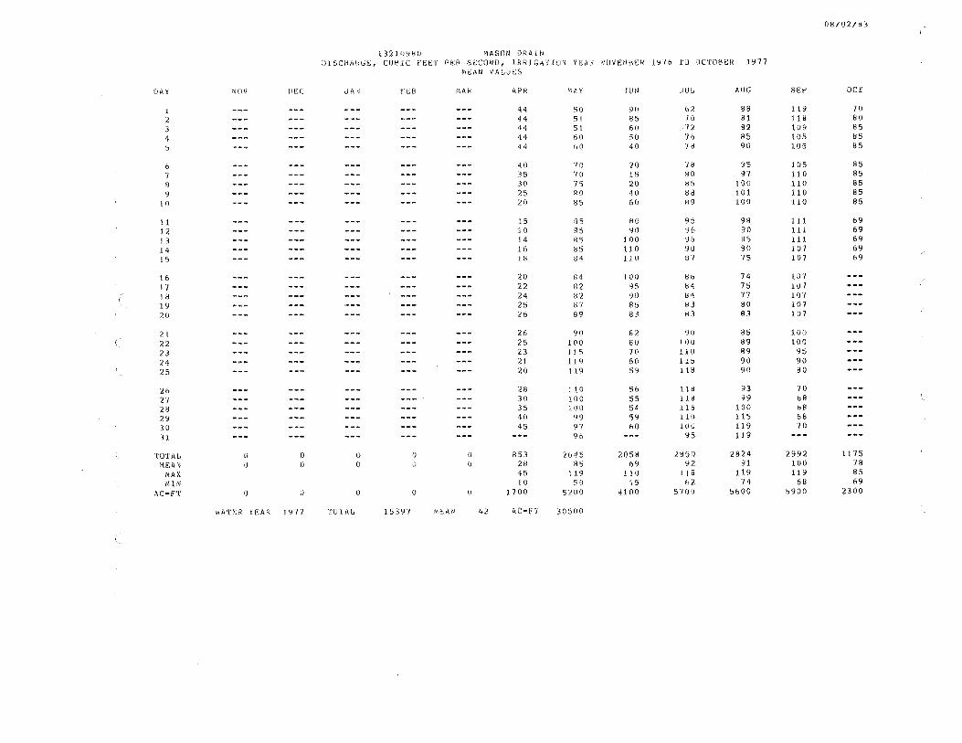
08/02/83
l3210Y80 MASON ORAll' DJSCHAHGE, CUBlC FEET PER SECOND, IRRJGATJON YEAR NOVEMBER 1Y76 TO JCTOB!R 1977
MEAN VALUES
DAY NOV Oe:C JAN FEll MAK APR 'I A Y JUN JUL ALIG Sl<:P OC'f
1 --- --- --- --- --- 44 50 90 62 88 119 70
2 --- --- --- --- --- 44 51 85 /IJ 81 118 80 3 --- --- --- --- --- 1i4 51 60 72 82 109 85 4 --- --- --- --- --- 44 60 50 '/6 85 105 85 5 --- --- --- --- --- •14 60 40 ·1 e 90 l.05 85
6 --- --- --- --- --- 40 70 20 '18 \15 105 95 7 --- --- --- --- --- 35 7 [) 15 80 97 110 85
8 --- --- --- --- --- 30 75 20 85 l 00 110 85 9 --- --- --- --- --- 25 80 40 HU 101 110 85
1 () --- --- --- --- --- 20 85 60 89 JOO :110 85
11 --- --- --- --- --- 15 85 8() 9:'.> 98 111 69
12 --- --- --- --- --- 10 85 90 96 90 1.l 1 69 J 3 --- --- --- --- --- 14 85 100 95 BS 111 69 14 --- --- --- --- --- 16 85 110 9U 80 107 69 15 --- --- --- --- --- 18 84 110 87 75 107 o9
lb --- --- --- --- --- 20 84 100 86 74 lll'I
l'/ --- --- --- --- --- 22 ll2 95 84 75 107 --- (-
18 --- --- --- --- --- 24 82 90 84 77 107 l. 9 --- --- --- --- --- 25 87 85 8" 80 107 20 --- --- --- --- --- 26 89 83 83 83 107
21 --- --- --- --- --- 26 90 82 YO 85 l.00 22 --- --- --- --- --- 25 100 80 lOU 89 100 23 --- --- --- --- --- 23 J 1 5 70 1J. 0 89 95 24 --- --- --- --- --- 2J .t 19 60 115 90 90 25 --- --- --- --- --- 20 l J 9 59 11 B 90 80
26 --- --- --- --- --- 28 I 1 0 Sb 118 93 7 ()
27 --- --- --- --- --- 30 100 55 l 18 99 bB 28 --- --- --- --- --- 35 100 54 .lJ 5 100 68 2'1 --- --- --- --- --- 40 99 59 1l 0 115 68
30 --- --- --- --- --- 45 97 60 1 () () 119 70
31 --- --- --- --- --- --- 96 --- 95 119
TOTAL () 0 0 0 () B53 /.645 2058 28!)1) 2824 2992 1175 MEAN I) 0 (J u 0 2R RS ()9 92 91 100 78
MAX •15 119 l!U !.l 8 1J. 9 119 85 MlN 10 50 15 62 74 68 69
AC-F'T 0 I) u <) 0 1700 5200 41 Ofl 5700 SbOO 5900 2300
wATtrn YE:AI< 1977 TO l'AL 15397 ME.AN 42 AC-f'T 30500

08/02/83
13/.10986 HAllTLE:Y GlJL,CH UlbCHAHGE, CU~IC FEET PEM SECOND, IRRIGATION YEAR NOVEMBER 1Ylb ro JCTOBER 1977
Mr;A<1 VAIJUt~S
DAY NOV Ill,,( dAN fl;B ~AR APR '~A y Jl!N JUL AUG SE:P OCT
1 --- --- --- --- --- 16 ,,, 35 l 1 j 6 1Y 18 2 --- --- --- --- --- 18 33 33 1.1. 17 19 18 3 --- --- --- --- --- 25 34 30 J. s j 7 19 J.8
4 --- --- --- --- --- 2b 34 27 16 19 18 18 5 --- --- --- --- --- 27 30 25 17 19 18 18
b --- --- --- --- --- 27 28 20 l1 19 17 16 7 --- --- --- --- --- 22 n 20 l7 21 1'I 16 8 --- --- --- --- --- 20 24 20 1l 21 17 16 9 --- --- --- --- --- 15 20 21 n 21 17 16
I 0 --- --- --- --- --- to 20 23 u 21 16 lb
J.l --- --- --- --- --- 8. () 20 25 18 2l 16 16 12 --- --- --- --- --- 6.0 2ti 25 18 21 lb 16 13 --- --- --- --- --- 8. (J 2h 26 18 21 15 16 14 --- --- --- --- --- 1 (I 30 26 1H 21 15 16 1.5 --- --- --- --- --- 14 30 24 18 21 14 16
lb --- --- --- --- --- 18 :n 2 () 1 f:> 20 14 17 --- --- --- --- --- 20 31 18 lb 20 12 18 --- --- --- --- --- 20 30 !& lb 20 12 19 --- --- --- --- --- 21 ;>9 14 15 20 lO 20 --- --- --- --- --- 21 25 l 4 15 ?.O 10
l.1 --- --- --- --- --- 20 25 \3 15 20 10 ?.2 --- --- --- --- --- 1B 23 13 15 21 15 23 --- --- --- --- --- 16 2?. 13 15 21 15 24 --- --- --- --- --- 16 20 12 15 21 20 25 --- --- --- --- --- 15 21 12 15 21 20
26 --- --- --- --- --- 20 25 t2 14 20 23 27 --- --- --- --- --- 25 26 11 ill 20 23 28 --- --- --- --- --- 30 ?.'/ t! l 4 20 ?.2 29 --- --- --- --- --- 31 30 t1 15 19 20 30 --- --- --- --- --- 32 35 J 1 15 19 20 31 --- --- --- --- --- --- 36 --- lb 19
TUT AL () () 0 0 () 575 1150 58 .I <lH I 617 499 250 '1r;AN IJ () l) 0 0 19 7.7 19 lb 20 17 17
MAX 32 36 35 1~ 21 23 18 MIN 6 20 11 !.\ 16 1 () 16
AC-FT 0 0 () 0 () J. j 00 J 71)() l 200 1000 1200 1 ()()() 49&
vlATf.R n:AR 1977 TlJl'f\L, 3859 Mi!:AN 11 4C-F'I 765<)

OB/02183
132109H8 HARI'LfCY DRAIN DJSCl11\HGE;, CIJHIC FEl'..T PER Se:CllNO, IRRIGATION YEAH NOVEM8ER 19/b ro UCTOYER 1977
MEAN VAt,USS
l)A y MOV iH;C J1\N r'UI Mf1R APR 'IA Y JUN JUI, AUG Sl"P OC'l'
1 --- --- --- __ ,... --- 20 80 55 10 55 76 50
2 --- --- --- --- --- 20 81 60 bl 54 7U 40
3 --- --- --- --- --- 20 H2 63 ,b5 54 50 40
4 --- --- --- --- --- 20 80 68 b3 52 40 38
5 --- --- --- --- --- 20 78 70 bl 50 40 38
b --- --- --- --- --- 20 75 70 bl! 48 3'/ 38
7 --- --- --- --- --- 18 70 71 oO 45 31 35 8 --- --- --- --- --- lb 68 73 50 42 37 33
9 --- --- --- --- --- 16 65 75 !:> 7 43 45 33
10 --- --- --- --- --- 15 64 78 55 43 45 33
11 --- --- --- --- --- 14 64 81 ~5 45 50 32 12 --- --- --- --- --- 13 62 85 55 45 57 32
13 --- --- --- --- --- 15 60 85 55 47 57 32
14 --- --- --- --- --- 15 SB 87 55 47 55 30
15 --- --- --- --- --- 18 57 80 54 48 50 20
16 --- --- --- --- --- l8 51) 75 5 '~ 49 50
17 --- --- --- --- --- 20 55 7 () 53 49 50
18 --- --- --- . --- --- 22 57 65 53 45 48 19 --- --- --- --- --- 24 59 60 53 43 48 20 --- --- --- --- --- 26 60 55 bO 42 tl8
21 --- --- --- --- --- 30 62 50 oO 40 50 22 --- --- --- --- --- 32 63 58 7 () 38 55 23 --- --- --- --- --- 34 65 60 70 36 56
24 --- --- --- --- --- 35 66 68 HU 40 57
25 --- --- --- --- --- 37 65 69 tt5 45 58
26 --- --- --- --- --- 39 60 70 Ho 50 58
27 --- --- --- --- --- 50 60 70 80 65 58 28 --- --- --- --- --- bO 513 71 78 70 58
29 --- --- --- --- --- 65 57 71 "/5 75 55 30 --- --- --- --- --- 75 55 70 65 '16 55 31 --- --- --- --- --- --- 51 --- b(J 76
TOTAL 0 0 0 0 0 fl27 1993 2083 1':J7 1 1557 1550 524
"IEAN 0 0 l) () () 28 64 69 b4 50 52 35
MAX 75 (l2 87 U5 76 'lb 50 MIN 13 51 50 53 36 37 20
AC•fT 0 0 0 () () 1600 4000 4100 3900 3100 3100 1000
vrnn:R n:AR 19 7 I TUI' Al, 10505 »li'.:AN 29 AC-F'T 208()()
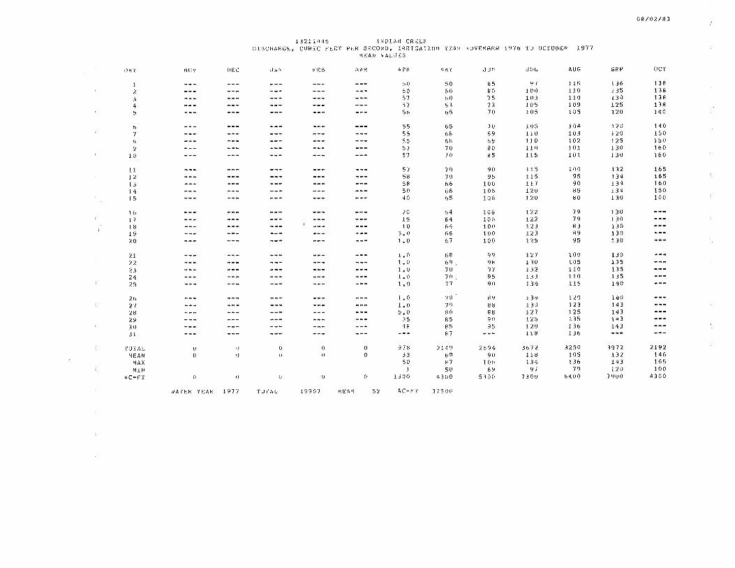
08/02/83
l32l1445 lNDJAN CRl~i':f(
DISCHARGE, CUBIC f~ET PtH SECOND, IRRIGATlON YEAR NUVEMBER 1976 10 OCTOBER l 9TI MEAN VALlJE:S
I)~ y l~tl v l>EC dAN e EB MAR APR MAY JUN JlllJ AUG SE:P OC'f
l --- --- --- --- --- bO 50 85 ~I ll 5 136 138
2 --- --- --- --- --- 60 60 80 l 00 110 135 l.38 3 --- --- --- --- --- 57 60 75 10.l 110 l30 138
4 --- --- --- --- --- 57 63 73 J05 109 125 138
~ __ .,. --- --- --- --- 56 G5 70 J.05 105 120 140
b --- --- --- --- --- 55 65 '/() 11)5 104 120 140 7 --- --- --- --- --- 55 68 69 110 103 120 150 8 --- --- --- --- --- 55 bll 69 110 102 125 150 9 --- --- --- --- --- 57 70 80 :l10 101 130 160
10 --- --- --- --- --- 57 7 () 85 115 101. 130 160
11 --- ......... --- --- --- 57 70 90 l 15 100 132 165 12 --- --- --- --- --- 58 70 95 J.15 95 134 165 13 --- --- --- --- --- 58 66 100 1 l 7 90 134 160 14 --- --- --- --- --- 50 66 106 1 :lll 85 1. 34 150 15 --- --- --- --- --- 40 65 106 1:10 80 130 100
16 --- --- --- --- --- 20 64 106 l'a '/9 130 1 7 --- --- --- --- --- 15 64 .106 122 79 130 18 --- --- --- --- --- 10 64 100 123 83 130 19 --- --- --- --- --- ~. () 66 lOO 123 89 130 20 --- --- --- --- --- 1. 0 67 100 125 95 130
21 --- --- --- --- --- I. n 68 99 121 100 130 22 --- --- --- --- --- 1. () 69 9B .l3 0 105 135 2.l --- --- --- --- --- l. 0 70 97 132 110 135 24 --- --- --- --- --- t. () 70 95 133 110 135 25 --- --- --- --- --- 1. 0 77 90 134 115 140
2b --- --- --- --- --- l.. 0 7ll 89 l. 3 1f 120 140 27 --- --- --- --- --- l.O 79 88 J.3 0 123 143 28 --- --- --- --- --- 5.0 HO 88 127 125 143 29 --- --- --- --- --- 35 85 9fl l2o 135 143 30 --- --- --- --- --- '+8 85 95 120 l. 36 143 31 --- --- --- --- --- --- 87 --- 118 136
roT 1\l, 0 0 0 0 0 978 2149 2694 367 i. 3250 3972 2192 1\EAN () 0 (J () 0 33 6q 90 11& 105 132 146
MAX 61) f37 106 134 136 143 165 MIN l 50 69 9/ 79 120 100
AC-;"I' ti () lJ () () l 900 4300 5300 7 300 6400 7900 4300
1<ATE:R YIOAR 197'/ TU 1.'AIJ 18907 Wi~:AN 52 AC•F'T 37 500
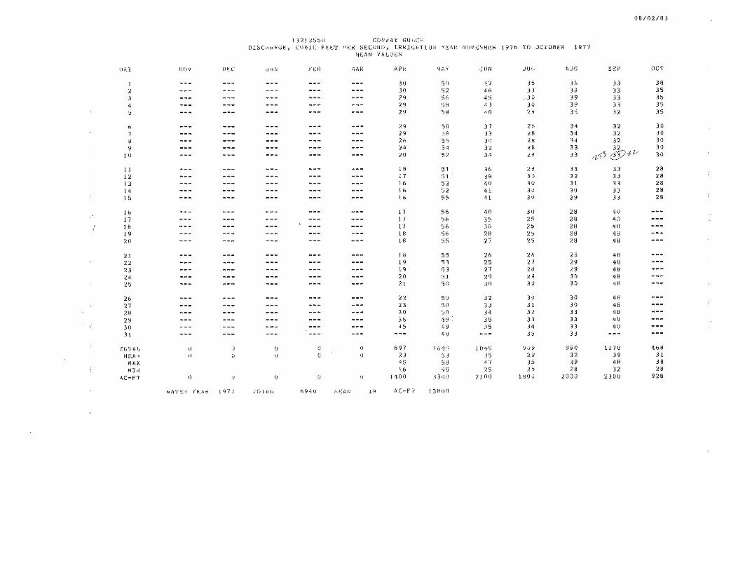
08/02/83
1321255() CCJNW~Y GULCH DISCHARGE, CUBlC FEET PER SECUNO, IRRIGATION YEAR NOVEMBER 1976 TO JC10BER 1977
"1E:AN VALIJC:S
De. Y IJOV D!!.C Ji\!IJ f C:B MAI< APR MAY JUN dUIJ AUG SE:P OCT
1 --- --- --- --- --- 30 50 47 35 36 33 38 2 --- --- --- --- --- 30 52 46 33 38 33 35 3 --- --- --- --- --- 29 56 45 3U 39 33 35
4 --- --- --- --- --- 29 58 43 3U 39 33 35 5 --- --- --- --- --- 29 58 40 2~ 36 32 35
0 --- --- --- --- --- 29 58 37 28 34 32 30 7 --- --- --- --- --- 29 58 33 L8 34 32 30 8 --- --- --- --- --- 26 55 30 28 34 32 30 9 --- --- --- --- --- 24 54 32 28 33 32 30
10 --- --- --- --- --- 20 52 34 21l 33 a<J'7 @7V- 30
1l --- --- --- --- --- lH 51 36 28 .33 33 28 12 --- --- --- --- --- 17 51 38 31) 32 33 28 13 --- --- --- --- --- 16 52 40 30 3l 33 28 14 --- --- --- --- --- 16 52 41 30 .30 33 28 15 --- --- --- --- --- 16 55 41 30 29 33 28
16 --- --- --- --- --- 17 56 40 30 28 '10
17 --- --- --- --- --- 17 56 35 25 28 40 18 --- --- --- --- --- 17 56 30 ?5 28 40 19 --- --- --- --- --- 18 56 28 25 28 48 20 --- --- --- --- --- 18 55 27 25 28 48
21 --- --- --- --- --- lB 55 26 l.6 29 48 22 --- --- --- --- --- 19 53 25 21 29 48
23 --- --- --- --- --- 19 53 27 28 29 48 24 --- --- --- --- --- 20 51. 29 :l 9 30 48 25 --- --- --- --- --- 21 50 30 30 30 48
20 --- --- --- --- --- 22 50 32 30 30 48
27 --- --- --- --- --- 23 50 33 31 30 48 28 --- --- --- --- --- 30 50 34 3< 33 48 29 --- --- --- --- --- 35 <l9 35 33 33 48 30 --- --- --- --- --- 45 49 35 34 33 40 31 --- --- --- --- --- --- '+8 --- 35 33
TOTAL () \) (J I) (J 697 1649 .1 049 9\J9 990 1178 468
ME:AN 0 0 IJ 0 () 23 53 35 ;!9 32 39 31 MAX 45 SH 47 35 39 48 38
MlN 16 48 25 /.5 28 32 28 AC-F'T I) \) 0 l) 0 1400 3300 2100 lHOU 2000 2300 928
WATER Yr!:AR 197'/ TD l Al, f>94V f\C:AN l '.J l\C•f r 1 3HOO
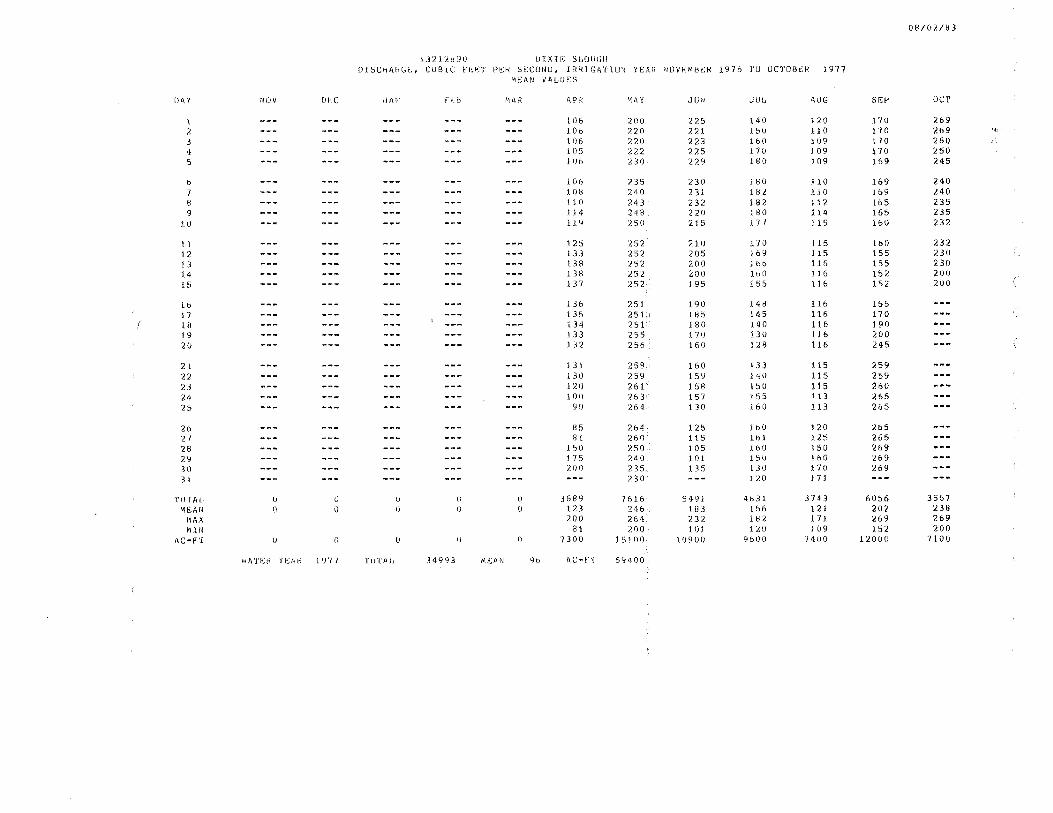
08/02/83
l.l212890 Lllxu; SLOUl;H DlSCHAHb~, CUBIC r~~T PE:H SECONU, IRRIGATION YEAR NOVEMBEH 1Y76 ro OCTDBEk 1977
MEAN VALUES
ll ~ y NOV (Jf<C .JMJ PE.ft> MAH 1\PR '~A y JUN JUL t\UG sr'P OCT
l --- --- --- --- --- 106 200 225 140 120 170 269 2 --- --- --- --- --- 106 2 20 221 151! l10 170 269 .. '
3 --- --- --- --- --- 106 220 223 lbO [(}9 170 260 4 --- --- --- --- --- 105 n2 225 170 109 170 250 5 --- --- --- --- --- 1 ()6 '230 229 180 l 09 169 245
b --- --- --- --- --- 106 235 230 180 110 169 240 1 --- --- --- --- --- 1fJ8 240 231 182 11 0 169 240 8 --- --- --- --- --- 110 ?.4 3 232 1f32 112 165 235 9 --- --- --- --- --- 114 248 220 180 114 165 235
10 --- --- --- --- --- 1l9 25() 215 l 7 I 115 1 blJ 232
11 --- --- --- --- --- 125 252 210 170 115 160 232 12 --- --- --- --- --- 133 252 205 169 115 155 230 13 --- --- --- --- --- l38 252 200 1 bb 116 155 230 14 --- --- --- --- --- 138 252 200 160 116 152 200 15 --- --- --- --- --- 137 252 195 155 116 152 200
16 --- --- --- --- --- 136 251 190 148 116 155 l 7 --- --- --- --- --- 135 251 185 J.45 116 170 18 --- --- --- --- --- 134 251 180 t40 l.16 190 19 --- --- --- --- --- l.3 3 255 ! 70 130 llb 200 20 --- --- --- --- --- 132 256 16 (I 128 llb 245
21 --- --- --- --- --- 131 258 160 133 115 259 22 --- --- --- --- --- 130 259 159 140 115 259 23 --- --- --- --- --- 120 261 158 l5U l.1 5 260 24 --- --- --- --- --- 100 2b3 157 155 l J.3 2&5 25 --- --- --- --- --- YO 264 1 3 () 160 113 265
2b --- --- --- --- --- 85 264 125 lbO 120 2b5 27 --- --- --- --- --- 8 l 260 115 1bl 125 265 28 --- --- --- --- --- 1 50 250 105 .l bO 150 269 2'1 --- --- --- --- --- 175 240 101 lSO 160 269 30 --- --- --- --- --- ~00 215 135 J.31) 170 269 3 .l --- --- --- --- --- --- 230 --- 120 171
TD L'Af, () 0 0 0 0 3689 7616 5491 4831 3743 6056 3567 '~EAN 0 \) () IJ 0 123 246 183 lb6 1 21 202 238
MAX 200 264 232 1 BI. 1 71. 269 269 MIN 81 200 101 1.20 1 09 152 200
ilC-F'l' () 0 {J 0 0 7300 151()0 10900 9oOO 1400 12000 7100
»ATER H~A!< 1977 Tul'A1J 34993 Mc; AN 9b AC•e"l' 69400
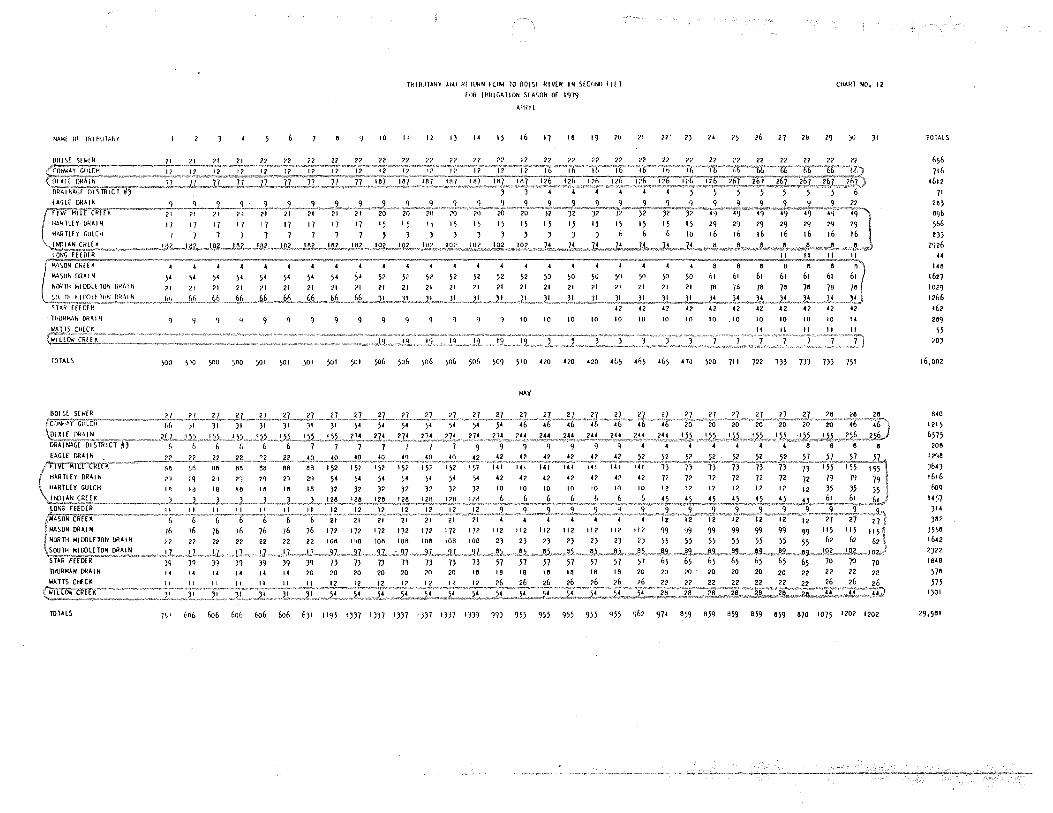
NAM~ or THlfitJTJ.hY
· n1t1R>IAN ORAi N
lOlALS
lHUR""-N OffAIN
101ALS
10
lklB\llAl<Y AIU HI llll<N fl<M 10 BOIS! RIVlR IN S!C<1Nll Ill T
FOi< IRl<IGAl!ON 51 ASON Of 1979
Al'lll L
II 12 I) .. I) 16 17 18 19 ?0
10 10 10 10 10
,.
10
CHARl NO, 12
2>' 2) " ?) 26 27 20 29 JO )I
10 10 10 . 10 10 10 10 10 "
100 1"0 )00 )OO 501 501 501 501 501 506 506 506 506 506 509 510 '20 420 420 465 465 46) 4].J 520 711 722 7)) 7JJ DJ 751
MAY
7•,1 606 6o6 60(• 6o6 6o6 6)1 1195 1))7 1))7 1))7 IJ)7 1))7 1})9 99) 955 955 955 955 955 <J62 974 8)9 859 859 859 859 670 1075 1202 1202
TOTALS
656 716
•612
71 28)
8•)6
566 t))
2926 .. 148
1627 1029
1266 462
289
55 ?O)
16,002
840 1215
6575 206
I ?qe
)64) 1616 6oq
I <4 ~i?
)14
)6?
)5\6 1642
2)22
1848
578
m 1)01
29,981
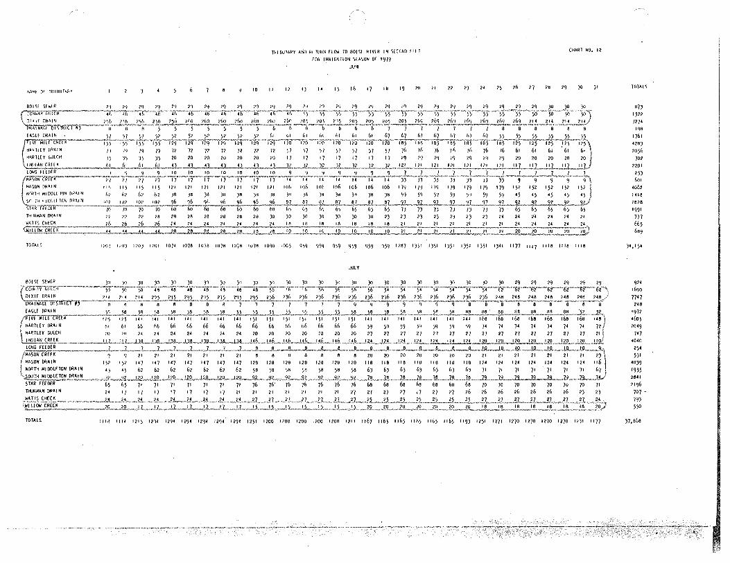
M4f (H no fiUT4f.'Y
H~ll£Y GUlCll
INfllANCKffl<
LONG fHllfR
•%6N"rn!TK W.50N f>NAI N
10
rn1BUlAkY AN;) m fllHN fl!M 10 BOIS! RIVlR IN 5[((•NI> 1111
fOR ll<l<IG~l!ON \IASON or 197'1
.Jl!Nf
II 11 I) 14 15 I& 17 18 19 20
106
CHARl NO. 12
11 n 2J 2< 25 26 27 26 29 JO )I
152 N•~lH MJDDll ll)N flRAI N h? 02 )6 )6 )8 )!I )6 )8 )8 )II J!I )8 )d )II )8 )8 \') j'J 51 59 5'1 59 59 •5 '5 •5 '5
,'1,L..._j.? __ ,2..~_2£ 7) 65 65 65 6 5
n111RMAN ORA.IN
101AL5
lHUR~A~ DRAIN
TOTALS
7)
'"1 ?2 ?2 16 2A 2A 20 28 26 28 JO )0 )0 )0 JO JO )O 2J 2J 1) 2) 2) 2) 2) 24 24 2< 24 24 65 14
l?Ol 1,\l) 110) 1101 10)4 1076 10"/8 10)6 10/6 1076 10'10 •005 q5q ')59 9•,9 9)~ 959 959 1187 1)51 1)51 1)51 1)51 1)\1 1)41 1177 1117 1116 1116 1116
.AJlY
111•1 1114 1215 1114 119• 129< 129• 1294 1294 1151 1100 1100 1200 1100 1100 1211 1167 1165 1165 Iii» llL5 1165 119) 1151 1171 1170 1270 1170 1270 l<)I 1177
TOlAL S
67)
1521
727• 198
1761
'28)
2056
702
2101
25) 601
•ol2 1418
2628
1991
777 665 6119
)•, 15•
924
1690
7747 248
1972
46o5
2049
747
•o4o 254 5)1
40J9
19)5 2641
2196
707 -
79) 550
)),668

NAM( or lHIRUJMH
nnJRl\AN ORAi N
W4TIS CHlC~
I I h llfi
r,, (,/
n n
116 116 116
b7 67 67
2) n 2J
10
116 qs 98 98 98
67 57 ;7 .57 57
22 22 22 22 22
TklBUlAHY Af'U HtllJHN HIJW 10 tiOISI kll/lR IN StCllNU llf r
fOk tkklG•TION \lA~ON or 1~79
/\\JGIJ) T
II 12 I J 14 I 5 t(, 17 18 19 20
90 •)O 98 (I) 71 J ~>I J "J 21 J ?I J 71 'l
57 57 ;7 95 'J5 95 95 95 55 95
CHART NO. 12
" 22 ?) 2• 25 2£' 27 28 29 JO JI
I )b I 5b I ~6
66 66 66 bb bb bb 66 50 50 I _1,~ •••. ,.! I!'. .• \ \ 11. • 't!. 0 ,} !.". •. U.L ..• '!.'. .•• Jl_l_~,.'!! ___ ~_;_i~~--~--8-1 --12-~72. 7J 7J 7J "/) 7J /) 1,6 66 66 66 66 66 f,6 71 71 71
22 n 22 22 ?2 22 2.(' 22 22 20 20 20 20 20 20 20 17 I/ 17 17 17
TOTALS II')) II)'/ 11)/ llJ/ 11)7 1146 107) 102) 10?7 1027 1077 107) 1019 IAl7 15A6 15<8 15<8 15A8 15AO 15)7 IJl2 12<2 "" 12•2 17A2 12<2 12J6 1161 1201 1201 1701
c,EPTI MBf R
\
I DIXIE DR'IN 7(" 71.• ~r'lffsffiTCrff'''_, •. ;·· q q q q
14 I IAI I Al 141
50 50 50 50 50 50 50 j6 ;6 56 51,
,,,,,6.6 "' .§~. ,,,, ,66, . 66 ~L of! ..6~ •. , 5L ,. 5,7, 57 .. )J, )I 70 70 70 70 70 70 70 65 65 65 65
THUR""'H DRAIN I) 18 16 18 18 18 16 16 JO JO JO JO JO JO JO 29 2'J 29 29 29 29 29 JO JO JO JO JO JO JO
TOTALS 1702 1207 1197 1714 117) 117J 117) 1173 117) 1196 1126 1115 1115 1115 1115 1115 1117 1116 1127 1126 1126 1126 112& 1128 1082 llJJ llJJ llJJ llJJ llJJ
TOTAL~
9•9 1761 7127
26o
16o7
5099 2260
914
J•;;6 7)9
690
•549 2128
2697 217)
646
704
')84
JB,27J
919
lb19
727J
270
l4J2 •026
70JI
777 2BJ5 265 518
•J29 1640
1929
200J
76) -641 .
1076
J4,)16
I
I

1<1-Mf or 1111 fillTIJlY
n1uRAAN OOAI N
TOTALS
BO! SE SEWER
CO..,AV GULCH
DIXIE DRAIN
DRAINAGE DISTRICT#}
EAGLE OOAI N
FIVE Ml LE CREEK
HARllfV OOAI N
HARTLEY GULCH
PlllAN CREEK
LONG FEEDER
MASON CREEK
MASON !JRAI N
NORTH MIOOLFTON !JRAIN
SOUlli Mi OOL£TON ORAi N
STAR FEE!l(R
lHURMAH DfiAI N
WATTS Cf£CK
WI llOW CREEK
TOTALS
I 2 }
JO 10 JO
1110 ll<j? 11 !\?
• 5 6 7 e 9 10
JO }O JO JO 28 28 26
110? 11e2 llft.? 118~ 1165 1006 9•6
lHIBUTARY Alll RI TURN FLOW 10 BO!Sl klVLR IN SlC<>NO 11£ l CHART NO. 12 fOR IRRIGATION SlA\ON or 19-,q
0( 11JOfH
II 12 IJ I• 15 16 17 18 19 ?O ,, 22 2J 2• 25 26 27 26 29 JO JI TOTALS
4U
R?J
}7JJ 16J
6o2
II 50 970
270
1900
105
190
IB•9
90• e51
BhJ 26 2A 28 20 28 •J•
}}2
•96
q•6 <J4h 1)46 9•6 9•6 16,079

Al<ll'I.
State of Idaho ft, DEPARTIVIENT OF \YATER RESOURCES h Western Region, 2735 Airport Way, Boise, Idaho 83705-5082 - (208) 334-2190
February 2, 1993
Kenneth Henley Project Manager, 214 Broadway Boise, ID 83702
Boise Project Board of Control
CECIL D. ANDRUS GOVERNOR
R. KEITH IDGGINSON DIRECTOR
RE: Storage of Mores Creek Water in Lucky Peak Reservoir
Dear Ken:
I am in receipt of your letter dated December 11, 1992, in which you requested information regarding the potential for storage of Mores Creek water in Lucky Peak Reservoir for subsequent conveyance to Lake Lowell. In preparing this response I have reviewed the letter on the same subject from Jerrold D. Gregg of the U.S. Bureau of Reclamation dated January 5, 1993, and the water delivery accounting mechanisms established by this Department for Water District 63.
In Idaho, for systems on which the Bureau of Reclamation operates multiple reservoirs, it is common for water to be stored upstream from the reservoir which is to receive a certain priority water right. For example, water could be temporarily held at Anderson Ranch Reservoir under the Arrowrock water right, for later transmittal to Arrowrock. However, this type of storage is subject to three limitations, which are consistent with both Idaho water law and my understanding of Bureau of Reclamation contract provisions.
First, each water right is allowed to be filled under its priority one time only. Subsequent filling can occur only if all other storage rights on the system have been filled and all natural flow water rights are being satisfied. Second, only water tributary to a specific reservoir can be accrued to that reservoir. For example, Mores Creek water cannot be accrued to Anderson Ranch Reservoir.
The third storage limitation is unique to off-stream reservoirs such as Lake Lowell. For this type of reservoir, storage can occur only when water is being diverted to the reservoir. During periods of icing, canal maintenance, or for other reasons when flows are not being diverted to the reservoir, storage does not occur.
Page 2 Storage of Mores Creek Water in Lucky Peak Reservoir February 2, 1993
The storage difference between on-stream and off-stream reservoirs is based on operational parameters. On-stream reservoirs are utilized for flood control and hydropower optimization purposes that necessitate integrated management. Off-stream reservoirs have a narrower range of functions and a reduced need for integrated management. Watermaster accounting for Anderson Ranch, Arrowrock and Lucky Peak Reservoirs includes detailed storage quantities, inflows, outflows, and reach/gain computations. Stored water deliveries to and from Lake Lowell are not monitored by the Watermaster. Lake Lowell is not entitled to the upstream storage privileges and requirements of the on-stream reservoirs. To do so would cause injury to the on-stream spaceholders.
It is important to note that the storage water rights for all four Boise River basin reservoirs are in the name of the United States of America. Decision-making relative to the use of water by contract holders is the responsibility of the Bureau of Reclamation in only the three on-stream reservoirs. The Watermaster of Water District 63 advises the Bureau as to the storage accrued under each on-stream storage water right, and the Bureau advises him regarding which contract holders are to receive storage water.
Based on this discussion, I am not aware of any legal manner by which Lake Lowell contract holders would be able to temporarily store water in Lucky Peak Reservoir for subsequent conveyance to Lake Lowell.
Sincerely,
David R. Manager,
f2:-1 ~ J-__ Tuthill, Jr.~ P.E. Western Regional Off ice
cc: Lee Sisco, Watermaster, Water District 63 Norman c. Young, IDWR Jerrold D. Gregg, BOR
·''
United States Department of the Interior
IS 11.EPLY
llEFER TO: PN 440
Mr. Jeffrey C. Fereday
BUREAU OF RECLAMATION PACIFIC NOR TllWEST RECIO:-:
FEDERAL BUILDING & U.S. COURTHOUSE· BOX 04~ - 550 WEST FORT STREET
BOISE, IDAHO 8~724
AU'G ~ o l~dti
Givens, McDevitt, Pursley, Webb & Buser P.O. Box 2720 Boise, Idaho 83701
Dear Mr. Fereday:
fil~(G~uw~ID AUG 26 1986
Department of Water Resources
This letter is sent in response to your August 7, 1986, letter regarding the proposed municipal water service contract between the United States and the Boise Water Corporation (BWC).
We agree that the requested changes numbered 1 and 4 in your letter are points well taken, and we have changed them as you suggested.
We disagree with your suggested changes to the contract which would. allow BWC to take credit for amounts of water held over by paying only for the amount of water which is actually released from the 1,000 acre-feet of storage space each year. ·,
The holdover provisions in paragraphs lO(b) and ll(a) do not allow BWC either to hold or to release more than 1,000 acre~feet in any year. The purpose of the holdover provisions is to serve as a possible hedge against a dry year as noted in your letter. This purpose is the same for all contracts for storage space in Anderson Ranch Reservoir. To change the holdover provisions so that BWC would pay for only the water released each year and not for the entire space would give them a right existing
' · contractors do not have.
If the 1,000 acre-feet of storage space is found to be too low or too high, this contract can be terminated and replaced by a new one provided space is available at that time. Currently, only 4,200 acre-feet of additional space is available. The limited amount of space available is also a factor in our decision to not permit BWC to pay for what is actually needed each year, as determined by the Idaho Department of Water Resources (IDWR), while actually tying up a greater amount of reservoir space.
As we understand BWC's arrangement with the IDWR, the 1,000 acre-feet of storage is an estimated average of storage space needed during the foreseeable future to replace surface flows taken by Ranney collectors. Therefore, to be able to pay less in years when less than 1,000 acre-feet is needed and to not pay more when more is needed would be having it both ways.
'l
We hope you and BWC find the enclosed municipal water service contract (containing the two revisions previously menti-0ned) for the fixed amount of 1,000 acre-feet of storage 'acceptable and sufficient. · If you still · want to discuss the proposed 'contract, please call Larry Parsons of our office at 334-9504 to arrange a meeting.
Enclosure
cc: Mr. Robert P. Walker, P.E. District Engineer Boise Water Corporation P.O. Box 7488 Boise, Idaho 83707
(with enclosure)
Sincerely yours, ·
11~~-~~
~~anal Director
Mr. Kenneth Dunn Idaho Department of Statehouse
Water Resources
' '•
Boise, Idaho 83720 with enclosure
State Watermaster Water District No. 63 214 Broadway Avenue Boise, Idaho 83702 · (with enclosure)
2
; .

Article No.
1 2-8
9 10 11 12 13
I 14 '.
15 16 17
PN DRAFT 2/14/86 Revised 3/7/86 Revised 5/28/86 Revised 8/18/86 Contract No.
UNITED STATES DEPARTMENT OF THE INTERIOR
BUREAU OF RECLAMATION '
MUNICIPAL WATER SERVICE CONTRACT BETWEEN THE UNITED ST.ATES AND THE BOISE WATER CORPORATION
Contents
Title .,
Preamble . . . . . . . . . . . . . . . Explanatory Recitals . . . . . . . . . . . . . . . . Term of Contract . . . . . . . . . . . . . . Water to be Made Available to the Contractor . . . . . Rate and Method of Payment . . . . . . . . . . . . . . . . Measurement and Responsibility for Distribution Termination of Contract . . . . . . . . . . . . . United States not Liable for Water Shortage . . . . Contract - Not a Water Right . . . . . . . . . . Books, Records and Reports . . . . . . Standard Contract Articles . . . . Signatures . . • . . . . . . . . . . . . . . . . Acknowledgments · . . . . . . . . . . . . . . Exhibit A
.' \
Page No.
1 . 1 3 . 3 . 4 5 . 6 6 7 . 7 . '
. 7 8 9

r
PN DRAFT 2/14/86 Revised 3/7 /86 Revised 5/28/86 Revised 8/18/86 Contract No.
UNITED STATES DEPARTMENT OF THE INTERIOR
BUREAU OF RECLAMATION
MUNICIPAL WATER SERVICE CONTRACT BETWEEN THE UNITED STATES AND THE BOISE WATER CORPORATION
THIS CONTRACT, made this __ day of------' 19_. , '
'.
pursuant to the Act of Congress approved June 17, 1902 (32 Stat. 188), and
acts amendatory thereof or supplementary thereto, and particularly
section 9(c)(2) of the Reclamation Project Act of 1939 (53 Stat. 1187),
collectively known as the Federal Reclamation laws, between THE UNITED
STATES OF AMERICA, hereinafter referred to as the United States, repre-
sented by the officer executing this contract, hereinafter referred to as
the Contracting Officer, and the BOISE WATER CORPORATION, an Idaho Corpor-
ation~ with its principal place of business in Boise, Idaho, hereinafter
referred to as the Contractor, . . , I.
WITNESSETH THAT: .
EXPLANATORY RECITALS
2. WHEREAS, the United States has constructed and is operating the
Anderson Ranch Dam and Reservoir on the Boise River as part of the Boise
Project in which there is water stored which can be used for the irri
gation of land and for other beneficial uses, which stored water was
appropriated by the United States pursuant to the laws of Idaho for
beneficial use under the Federal Reclamation Laws; and
Recital 2

.' \
·. 3. WHEREAS, the Contractor, under permit from the Idaho Department of
Water Resources (IDWR), currently operates four Ranney collectors at sites
situated adjacent to the Boise River as part of their municipal water
supply; and
4. WHEREAS, as a result of a study required by the IOWR, it has been
determined that a portion of the water co 11 ected by the Ranney co 11 ectors
is obtained from surface flows of the Boise River, and the Contractor has,
therefore, requested long-term contractual arrangem~nts for 1,000 acre
feet of storage space in Anderson Ranch.Reservoir fo provide those surface
flows; and
5. WHEREAS, the United States is currently involved in the Boise
Project Power Modification Study (BPPMS) with the primary objective of
arriving at recommendations for hydropower development at Boise River dams
i~ concert with other functional needs of the Boise River system including
those of the Contractor; and
. 6~ WHEREAS, the BPPMS operation studies for the Boise River system
~how that the United States can effectively change the use of the active
power space in Anderson Ranch Reservoir to j-0int municipal and industrial
(M&I) and power, thus making reservoir space available to the Contractor. r'
Such joint use of reservoir space will not impair the efficiency of the
Boise Project for irrigation nor interfere with the operation of the
project for flood control, hydroelectric,power generation, or other
existing beneficial uses; and
7. WHEREAS, the .United States w.i 11 ~ecure from the IDWR appropriate
wa.ter. us~: authorizations app l i cable to t_he use of water under Idaho law;
and
Recital s 3, 4, 5, 6, 7
2

, . ..\ -~ ,,.. : :. : .. • . . __ ...... ~ ·~~.'.>.t;_::;~~_.:_._~. "_':"'1 -~. _ ..... 7_·~.· L~_·:_~.~.-.:_;·:.~_:=.-.·:· .. ;.-,· ... ~:·.·:~:"'.:_~,---.~---~.-· . . : ·.~:~;:.7:-·- ~--'.;.t?;i,:-~ \' " . -. - ~ ,._ .~ .. :-' ~
...
8. WHEREAS, compliance with the National Environmental Policy Act of
1969 has been met through a Categorical Exclusion Checklist dated April 2,
1985, which evaluated the impacts of changing the use of this part of the
water storage space in Anderson Ranch Reservoir from power to joint-use
M&I and power.
NOW THEREFORE, in consideration of the mutual. and dependent
covenants herein contained, the parties .hereto agree as follows:
TERM OF CONTRACT
9. This contract .shall become effective on the date first-above
written and will continue in effect for a period of 40 years unless pre-
viously terminated under the provisions .of Article 12 hereof: Provided,
That upon expiration of the 40-year term, this contract may be renewed
taking into consideration conditions then existing and under provisions
mutually acceptable to the parties.
WATER TO BE MADE AVAILABLE TO THE CONTRACTOR
10. (a) During the term of this contract, the United States shal 1
make available to the Contractor and the Contractor shall pay for, as
provided in Article 11 hereof, the water from 1,000 acre-feet of storage
space in Anderson Ranch Reservoir. All active space in Anderson Ranch
Reservoir will be treated with the same priority for determining the
amount of stored water available. Losses or shortages resulting from the
storage operati ori wi 11 Qe prorated equally.
{b) .Up to 1,000 acre-feet of water from storage space in Anderson .. ,\•· ... ' .
Ranch Reservoir will be released by the United States. each year. The
·amount of water released from this space, the rate at which this water is

. ~ ' . -'•.,:. t~ .... . .. -~"---~~ .. ,,.,,., ... ,:., ..... •, .. ' :~.;.,,,,,~·;
released, and the timing of these releases will be done as directec I
State Wate~master. Unused water in this space may be held over in
Anderson Ranch Reservoir from year to year.
RATE AND METHOD OF PAYMENT
11. (a) Each year the Contractor shall pay for 1,000 acre-feet 01
storage space in Anderson Ranch Reservoir at the rate of $17.54 per ac
foot, whether or not the water in this space is utilized and regardless
any held over water.
(b} From time to time, but not less often than once every
5 years. the rate per acre-foot (including operation, maintenance, and
replacement costs) will be reviewed by the Contracting Officer and
revised, if necessary, taking into account any changes in project costs,
allocation of costs, interest rates, or other related factors.
(c) The initial payment to the United States for the first year's
water shall be due upon execution of this contract.
{d) Subsequent annual payments shall be due on January 1 of the
year following the date -0f this contract and each year thereafter:
Provided, That the dates of payment may be changed if mutually agreeable
to the Contracting Officer and the Contractor.
(e) All payments from the Contractor to the United States under
this contract shall be made by the medium requested by the United States
on the date payment is due. The required method of payment may include
checks, wire transfers, or other types of payment specified by the United
States.

, ' .. ·1'-
-~ :'f" ..... :~ ..... , . .,._ .. ' . ~ .
. ' '\ '·
.. ·,
MEASUREMENT AND RESPONSIBILITY FOR DISTRIBUTION
12. (a) The water to be furnished to the Contractor will be measured
by facilities operated by the United States and delivered into the Boise
River. At the option of the United States, the Anderson Ranch Reservoir
stored water to which the Contractor is entitled may be measured and
delivered to or for the Contractor at the outlet works of Anderson Ranch
Reservoir, Arrowrock Reservoir, or Lucky Peak Reservoir. The Contractor
shall incur all transportation and administration losses from the point of
such delivery to the place of use.
(b) The Contractor agrees to provide measuring devices which are
acceptable to the State Watermaster in charge of the distribution of water
from the Boise River at or near the Contractor's point of diversion to
measure the quantities of surface and ground water collected by the Ranney
collectors. The Contractor is responsible for making any arrangements
with the State of Idaho for the collection of such water. The Contractor
sha 11 pay any charges required by the IDWR -for the State Watermaster 1 s
handling or administration of this water.
(c) The United States shall not be responsible for the control,
carriage, handling, use, disposal, or distribution of water taken by the
Contractor hereunder, and the Contractor shall hold the United States
harmless on account of damage or claim of damage of any nature whatsoever,
including property damage, personal injury, or death arising out of or
connected with the control, carriage, handling, use, disposal, or
distribution of such water by the Contractor.
;

·. TERMINATION OF CONTRACT
13. (a) This contract shall be terminated and water service hereunder
shall cease at the option of the United States at any time if the Contrac
tor is delinquent in payments required under this contract or upon failure
of the Contractor to comply wit.h other provisions herein or to abide by
any lawful notice, order, rule, or regulation of the United States and the
State of Idaho, now or hereafter established affecting water service
hereunder: Provided, That the United States notifies the Contractor of
any delinquency or deficiency by written notice and the Contractor fails
to comply with said notice within 60 days.
(b) The Contractor shall have the right to terminate this
contract for any reason:, Provided, That notice of the intent by the Con
tractor to terminate this contract shall be in writing to the Contracting
Officer at least 60.days prior to the termination date proposed: Provided
further, That termination under this provision shall become effective no
sooner than January 1 of the next ca] endar year fo 11 owing s.uch written
notice.
{c) Termination. of this contract for any cause shall not relieve
the Contractor of any obligations incurred by way of this contract prior
to termination •
. UNITED STATES NOT LIAeLE FOR WATER SHORTAGE
14. On account of drought, errors in. operation, or other causes, there
may occur at times a shortage during any year in the quantity of water
. a~ai. l ~b 1 e. to tile Contractor by the United States pursuant to this con-
: tract, and in no event shall any liability accrue against the United
States . or any of. its officers, agents, or employees for any damage dtrect.
·. · or indirect, arising therefrom. No proportionate adjustment in payments
required will be made to the extent water is not available in Anderson I
Ranch Reservoir for diversio~ under this contract.
CONTRACT - NOT A WATER RIGHT
15. No provisions of this contract, nor any renewal thereof, nor the
furnishing of water hereunder will be construed to either bind the United
States after the expiration of this contract or as the basis of a perma
nent water right.
BOOKS, RECORDS AND REPORTS '
16. The Contractor shall establish and maintain accounts and other
books and records pertaining to administration of the terms and conditions
of this contract, including: water supply data, water use data, and other
matters that the Contracting Officer may require. Reports thereon shall
be furnished as the ContractinR Officer may require. Subject to appli
cable Federal laws and regulations, each party to this contract shall have
the right during office hours to examine and make copies of the other
party's books and records relating to matters covered by this contract.
STANDARD CONTRACT ARTICLES
17. This contract is subject to standard contract provisions listed.
below. The full text of these articles is attached as Exhibit A and is
hereby made a part of this contract.
A •. CHARGES FOR DELINQUENT PAYMENTS
B. GENERAL OBLIGATION--BENEFITS CONDITIONED UPON PAYMENT
C. NOTICES
D. CONTINGENT ON APPROPRIATION OR ALLOTMENT OF FUNDS
E. OFFICIALS NOT TO BENEFIT
Articles 15, 16, 17
7 . . ~ .
; .

'\
. F. ASSIGNMENT LIMITED--SUCCESSORS AND ASSIGNS OBLIGATED
G. RULES, REGULATIONS, AND DETERMINATIONS
H. QUALITY OF WAT~R
I. WATER AND AIR POLLUTION CONTROL
J. WATER CONSERVATION
K. EQUAL OPPORTUNITY
L. COMPLIANCE WITH CIVIL RIGHTS LAWS AND REGULATIONS
IN WITNESS WHEREOF, the parties hereto have signed their names the
day and year first above written.
UNITED STATES OF AMERICA
By "'"R-e g-:i-o-n a....,,l-..,,,..D1...-. r-e-c t,.._o-r-, ....,P,....,.N,--,.,-Re_g...,..i-o n-B urea u of Reclamation
BOISE WATER CORPORATION (SEAL)
By------------Attest: Title:
By------------Title:
.,.•'.
Article 17 (Continu~d) 8

' :
....
•.t.
''.
:!:f~ '··:,
. t·
\l \
•.
· STATE OF IDAHO ) . s s
County of Ada )
On this day of , 1986, personally --~- ---..,------------~
appeared before me , to me known to be the official of the United States of America that executed the within and foregoing instrument and acknowledged said instrument to be the free and voluntary act and deed of said United States, for the uses and purposes therein mentioned, and on oath stated that he was authorized to execute said instrument.
IN WITNESS WHEREOF, I have hereunto set my hand and affixed my official seal the day and year first above written.
(SEAL)
STATE OF IDAHO SS
County of Ada
Notary Public in and for the State of Idaho Residing at Boise
· My commission ex pi res:
* * * * * * * * * *
On this day of , 1986, before me ~~- -------~------~
---------------------------, a Notary Public, persona 11 y appeared
and ~k-no_w_n __ t_o_m_e __ t_o ___ b_e_r_e_s_p_e_c_t-iv-e~l-y--t~he Pre-s-id_e_n_t---an_d __ S_e_c_re_t_a_r_y_o_f,,__t~he___,,B~o~i-se-Water Corporation, and the persons who executed the within instrument on behalf of said corporation, and acknowledged to me that said corporation executed the same.
IN WITNESS WHEREOF, I have hereunto set my hand and affixed my official seal the day and year first above written.
(SEAL)
9
Notary Public in and for the State of Residing at My commission expires:

STUDY/l'ROJECT REQUEST
Dqte Initiated August 7, 1986 TO~ ·Resource Analysis Division
FROM: Resources Admin. Division· ·Requested Completion Date Prior to 1987 irrigati season w1th some supporti~g work contin
TITLE : __ B_o_i_s_e_R_i v_e_r_A_c_c_o_u_n t_,_· n_g ______ --1.I~.· ----------------
PROBLEM AND/OR PURPOSE: The Boise River Watermaster needs a computerized accounting
system to determine natural flow and stored water use including the determination
of storage accrual under the various reservoir rights ..
:SCOPE (level or extent of detail): Complete the development of accounting procedures
which have been initially set up and are now being installed on a temporary basis for the 1986 season.
DESCRIPTIONS OF WORK REQUESTED:_.,__--------------------1. Review diversions and rights
2. Review storage rights
3. Review all aspects of accounting procedure
4. Prepare discussion memorandum for consideration by department administration and watermaster dealing with water delivery policy questions which ma,y arise.
· 5. Complete any required changes in the accounting process and assist watermaster in injtial use of procedure. This step may involve requesting assistance from D.P. Section for items related to data management. 1
6. Prepare a draft user's manual for watermaster
' ,.
REQUEST ORIGINATOR:
/ :r;p Dave Tuthi 11 =:Z__Bob Fleenor~ Norm Young
TYPE OF REPORT: See 4 and 6 above.
DISPLAY TABLES: YES NO ANTICIPATED MAN-DAY EFFORT: 3+ man-months
.------------------------------------------------~--------------------------~---
-~ DATE: ___ _ APPROVED BY -~-~~~-~
ASSIGNED TO:
ACTUAL MAN-DAYS: -----
I if.
" b'f AICY

Redraft 2/4/87
f
l
f

as
' ,0
.5
non- i
,00
1
s
i f i 1 1
limi
0

f
278 200
lie s
s
f
i
t
, cannot
i
s
s
se
to
in any of
volume spec
the re
r) s
07 0
0
i
are
I:'.'
1
i
servoir
c
if
s
This s
1
11 c
t
visi
i 0 l vi i
t rec
j OW5 iti s.
l
i

s e
flows at
ioriti
rual
i
1 f il
i s
ho
canal
i
crual. CArrowrock is
in
tionally among the Lucky Peak irrigation users (111,950 ac ft},
Idaho Fish and Game use (50,000 ac ft} and the remaining non-
contracted space (42,350 ac ft}. If the deficit were greater
than the Lucky Peak capacity, the remainder would be propor-
tionally shared by the Anderson Ranch contractors.
During the irrigation season as natural flows decline to
such level that not all rights can be fully satisfied, the canal
rights are progressively adjusted to 75 percent, then 60 percent
in accordance with the sliding scale. If there were unsatisfied
reservoir rights, they would be cut to zero if necessary to
prevent sliding scale cuts to irrigation users.
Stored water use will be charged whenever a diversion
exceeds the right it is entitled to exercise at that time. This
includes any diversion in excess of its total rights when all
rights are good, or excesses above the applicable sliding scale
rights. If flood control releases occur after these stored water
charges, the stored water use account will be returned to zero.
In determining natural flows at the reservoirs, evaporation
will be added back, because under natural conditions, this loss l'lot
would~occur. At the end of the irrigation season, the storage
accounts must therefore also be adjusted for this loss.
6

Implications of Accounting Changes
Probably the most significant effect of the accounting
change results from computation and allocation of natural flow at
each reservoir. The former method allocated the total physical
fill based upon the overall right sequence: Arrowrock, Anderson
Ranch and Lucky Peak. This had the effect of crediting natural
flow upstream. Mores Creek water was moved to Arrowrock and
Anderson until they filled. After Arrowrock filled, gain below
Anderson Ranch was moved into Anderson until it filled.
The new method will always result in some accrual to Lucky
Peak because of its location. Following is a comparison of
accounting effects on accrual using 1973 and 1977 data.
Allocation (1000 AC FT) 1973 1977*
Former New Former New
Anderson Ranch 420.6 389.7 219.0 219.0 Arrowrock 286.6 286.6 263.7 226.5 Lucky Peak 211.1 249.2 182.0 214.0
* 1977 allocation was changed due to adjustments between Lake Lowell and Arrowrock. Such adjustments were not made in other
years and are not reproducible.
In most other recent years, the system approximately filled
and only minor differences would result.
With the exception of 1977, Lake Lowell's storage condition
has had no direct effect on accrual in the main river reservoirs.
7
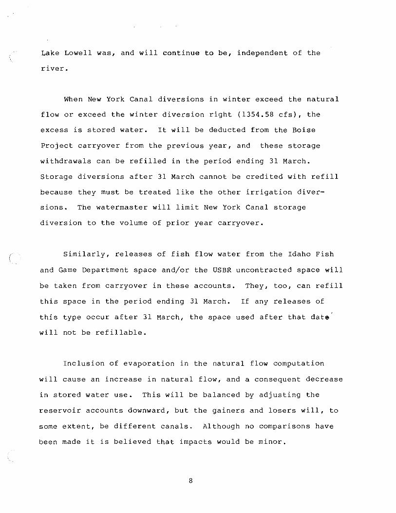
Lake Lowell was, and will continue to be, independent of the
river.
When New York Canal diversions in winter exceed the natural
flow or exceed the winter diversion right (1354.58 cfs), the
excess is stored water. It will be deducted from the Boise
Project carryover from the previous year, and these storage
withdrawals can be refilled in the period ending 31 March.
Storage diversions after 31 March cannot be credited with refill
because they must be treated like the other irrigation diver
sions. The watermaster will limit New York Canal storage
diversion to the volume of prior year carryover.
Similarly, releases of fish flow water from the Idaho Fish
and Game Department space and/or the USBR uncontracted space will
be taken from carryover in these accounts. They, too, can refill
this space in the period ending 31 March. If any releases of
this type occur after 31 March, the space used after that date
will not be refillable.
Inclusion of evaporation in the natural flow computation
will cause an increase in natural flow, and a consequent decrease
in stored water use. This will be balanced by adjusting the
reservoir accounts downward, but the gainers and losers will, to
some extent, be different canals. Although no comparisons have
been made it is believed that impacts would be minor.
8

Computation of gains below Lucky Peak will result in less
stored water use because of the increase in natural flow
available.
When conditions are such that no natural flow need be passed
at Middleton and/or Caldwell, flows of cfs and cfs at
these locations will be designated as "operational flow" to
prevent stored water from passing these points. Below these
locations, the operational flow will revert to natural flow.
Stored water use can occur before peak storage is reached
for the three main river reservoirs. The result will be slightly
greater fill and more storage use in some years.
Possible Other Future Changes
The following items will not be addressed in 1987 accounting
but may require work in the future.
(1) If it is determined that use of real time data results
in substantial error, it may be appropriate to make revisions at
the end of the season and run a revised final accounting.
(2) Because of its interchange with Indian Creek, there is
an apparent need to gage the Riverside Canal above that stream.
(3) Consideration should be given to incorporating travel
9

time in the process of determining natural flow.
(4) A method should be devised for estimating river diver
sion by the Boise Water Corporation Ranney collectors and other
non-agricultural diversions.
10

United States Department of the Interior l\lJREAll OF RECLAMATION
CENTRAi. SNAKE l'ROJEC:TS OFFICE 21-1 BROAllWA Y A VENUE
BOISE. IDAllO s.no2
I' RI l'I Y
RlllR 111400 June 26, 1986
651.
Mr. Carl Padour, Manager Boise Project Board of Control 214 Broadway Avenue Boise, Idaho 83702
Subject: 1986-87 Lucky Peak Orawdown
Dear Mr. Padour:
·~
In order to accommodate the Lucky Peak Powerplant construction with the requested elevations outlined by your letter of May 8, 1986, for the period August 4, 1986, through January 10, 1987, adjustments in the total !3oise System operation 111ust be made. Many of the ramifications of this schedule were discussed at the May 28, 1986, meeting in your office. Without going into all of the operational changes that will be required to meet the requested elevations for Lucky Peak, it must be understood that any water released above the irrigation requirements because of the requested elevations, before the end of the 1986 irrigation season will be charged to the system space held by the districts involved in the powerplant construction. In addition, a~ter the 1986 irrigation season any water released above the 150 ft /s minimum flow from Lucky Peak, which cannot be stored because of the requested elevations and the resulting impact on flood control needs, will be charged to the system space held by the districts involved in the powerplant construction. Space held by these districts equivalent to these amounts will have the last refill priority to all other storage in the system, including the noncontracted or streamflow maintenance space in Lucky Peak. This will prevent injury to other storage rights and users in the system not involved in the powerplant project. We will notify you of the amount that is being charged to the districts involved in the construction, so that you may make any change in the construction schedule of elevations needed at Lucky Peak.
In the event space held by the districts involved in the powerplant construction (herein B.O.C.) does not fill in 1987 as a result of the events described above, the Bureau of Reclamation on the B.O.C.'s request will make a portion of its streamflow maintenance water available on the following conditions:
(1) In the event during the 1986-87 storage season the B.O.C.'s space fails to fill by more than 10,000 acre-feet, the Bureau, up to a maximum of 44,700 acre-feet, will make its streamflow maintenance water available during the 1987 irrigation season to cover 50 percen~ of such shortage, provided however, no streamflow maintenance water will be made available to provide irrigation carry over for the 1988 irrigation season.
(2) The B.O.C. agrees to subordinate its water rights to the extent necessary to repay the Bureau's streamflow maintenance space as follows:
(a) During the 1987-88 storage season, the first waters accruing to the B.O.C. 1 s space will be transferred to the Bureau's streamflow maintenance space in Lucky Peak Reservoir so that 28,800 acre-feet will be available:for release from October 15, 1988, to April 15, 1989. A similar transfer will be made during the 1988-89 storage season provided that the transfer during the 1988-89 storage season shall be sufficient to repay the full amount of water borrowed in 1987.
(b) The maximum repayment required from the B.O.C. will be the amount borrowed from the streamflow maintenance space in the 1987 irrigation season, provided however:
(i) As consideration for making water from the streamflow maintenance account available to the B.O.C. as provided above, the B.O.C. will transfer to the Bureau of Reclamation's streamflow maintenance account a volume of water in addition to the quantity borrowed in the event and to the extent that there exists a shortage in the
3Bureau of Reclamation's account necessary to permit releases of
80 ft /s (28,800 acre-feet) from October 15, 1989, to April 15, 1990. Assuming the streamflow maintenance account fills in 1986, there is now a sufficient amount of water in the account to make diversions during the release periods from 1986 to 1989, with only 15,900 acrefeet available for the October 15, 1989, - April 15, 1990, release period. The maximum transfer prior to and during the above release period will not exceed 12,900 acre-feet under this sub-paragraph.
(ii) In the event the system fills at any time from the date hereof to April 15, 1990, these conditions will terminate and no further repayment of space will be required.

If this understanding is acceptable to the Board of Control, I would appreciate your indicating such by having the Chairman of the Boise Project Board of Control sign the concurrence line on the bottom of this letter and return it to me as soon as possible. ·~
Sincerely yours,
Project Superintendent
CONCUR
!/~Chairman, "1- .. u"";/?f{ cf" oater ·

.·t· :~,
··........ -, ...,Q .. -,, 4c.3 ' 1 I .._. H • F. -. -·, .....
A~mERSDn
95350. AF
327229 .. HF
307_ CFS
·~
U. S. BUREAU OF RECLAMATION BOISE RIVER BASIN
RESERUOIR STATUS REPORT oi:irn i::lRE RE CORDED AS a F Dl=IIT SHOl.JN RELEASES t'-r4'-r' L~ R ')J Ot~ SU8:SEQ U ENT DA'rS
DATE· FEB 11~1987 S'f'STEM l 5 O. 62 OF CA PAC ITf'
"-·-··-·-..... _ .. 288, G80 H • F •
TOTfiL5
TOTAL SPi::JCE 3?381 e . r=l F 30374_ AF
256226_ AF TD THL STOF.:RG E 801 1 33 • i::l F ARROl.iPOC r.
IRRIGHTION CANALS
-197.
FLOl.J AT GLENL.JJO LI BR IDt'3E
·1..,::i IF" I c:. • ·-· ·='
, [L CFS 1 ...... ____ - .- ,.... ..
----- cG .:.1 J .:: r" 1 H , F • ---·~-----
LI_~~:-::~---------- 17079_ AF
247292_ AF
7'35. CFS
:;-;;-----f---~----------------===-~=~-------) L.F -' ,.. ""'fi0 CFS ---.:::._ ----· .. .... · _______ .. .:! - - ------
/ /-- ~1ELl '-rlJ R K CANAL ( /
I ~ I /
/' /_.I
I / ,/
1 G9 I 100 H . F. CE~fTR R L SNHKE PROJECTS OFF JCE
42f374. AF 121:1~ 2 6 • l=IF
..... -..... -.... 214 E:RDADL.f:l"rJ AU:lWE BOISE, IORHO 83702 PHONE 334-146G
Lr:!KE L D l.JELL
.............................................................................................................. __ .... _ .................................................................. --.. ---·--"'-·'"·"'·"'··--............................................................................................... _ .. _ ............................. _ .......................... _ ............................................................................................................................... _ ............................................................... ..

$
OPERATIONAL FORECAST FOR FEB 1, 1987 RUN MADE 5-FEB-87 10:11!38
LUC - LUCKY PEAK LAKE NR BOISE, ID MAXIMUM'SPACE AVAILABLE - 974200. AF
' " MAR 1 TARGET FOR SPACE
FEB FEB EST MAR Jf'iN FEB AVE
APR
FEB FEB EST A Pr\ JAM FEB AVE
MAY
FEB FEB EST MAY JAN FEB AVE
JUN
FEB FEB EST JUN JAN FEB AVE
JUL
FEB FEB E!H JUL JAN FEB AVE
1-JUL 31 FORECAST 1-FEB 28 EXPECTED RUNOFF
MAF\ 1 Fm:ECAST 1 SPACE f.;:EQ
31 SPACE i'.Wf.1IL 1-FEB 28 RELEASE REQUIRED
RELEASE FOR 28 DAYS
1 TARGET FOR SPACE
1-JUL 31 FORECAST 1-MAR 31 EXPECTED RUNOFF
APR 1. FOl~l::CAST 1 SPACE REQ
31 SPf.1CE AlJAIL 1-MAR 31 RELEASE REQUIF\ED
RELEASE FOR 59 DAYS
1 TARGET FOR SPACE
1-JUL 31 FORECAST 1-APR 30 EXPECTED RUNOFF
MAY 1 FDr..:ECAST 1 SPACE F:EU
31 SPACE f.Wf.iIL 1-APR 30 RELEASE REQUIRED
RELEASE FOR 89 DAYS
1 TARGET FOR SPACE
1--JUL 31 nrnECAST 1-MAY 31 EXPECTED RUNOFF
JUN 1 F or.;;ECAST 1 SPACE fffC~
31 SPACE At)AIL 1-MAY 31 RELEASE REQUIRED
RELEASE FOR 120 DAYS
1 TARGET FOR SPACE
1-JUL 31 FOF\ECAST 1~JUN JO EXPECTED RUNOFF
JUL 1 FOF:ECAST 1 SPACE REQ
31 SPACE AtH~IL
1-JUN 30 RELEASE REQUIRED RELEASE FOR 150 DAYS
900.0 KAF ( 51%) 47.8 (% NORMAL)
852.2 50.0
378.9 ·-281.1 --50c'i2. CFB
900.0 KAF < 51%> 140.5 <PROJ EQN) 759.5
0 • () 3'7 !3. 9
--238. 4 --2037. CFS
900.0 KAF < 51%) 299.4 (% NORMAL> f.iOO.f.i
33.6 378.9 ·-4 ~) • 9 --260. CF~>
900,0 KAF ( 51%> 577.8 (% NORMAL) 322+2
0 c:· . '"' 378.S> 199.4
838 •. CFS
900.0 KAF ( 51%) 811.3 <%NORMAL> 88. 'J o.o
378.9 432.4 14~'i3. CF!:l
THE SPACE REQUIREMENT IS BASED ON RUNOFF FORECASTS FROM JAN 1 TO JUL 13
\301$€ 'Yll~fZ 18 >Jov 8 /
Posr:~I{ ut~ UJ~lZ.
VLLtll a.J.1a l 1o -Ii~ , )'J/L(k~~f'] e.
Ter+ C
LtJ1 I do
IJTW } MRP I I~.
D

8otJ£
')
w/
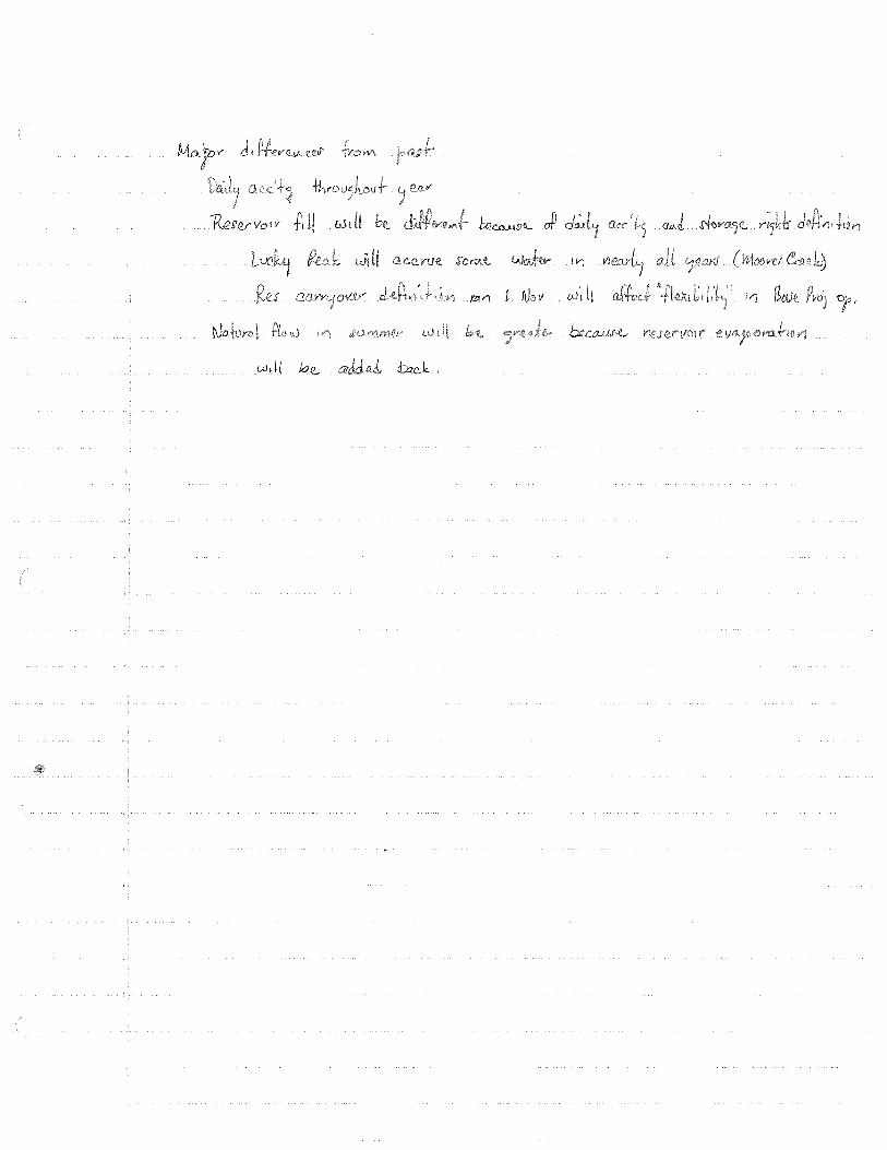
IV)
.l?li>1 t f\Jo ti ~0·t ti
tw_CCJJ,.U~
d:ack .

99362
a of the r ation Manual which Col.
have supplied discussed it th them.
Aprf l 2, 1981
yours$
l

r
REDRAFT: Bob S./mb March 3, 1981
BOISE RIVER RESERVOIR FILL
Boise River reservoir storage accrues on a
daily basis to each reservoir according. to the
priority of the water right(s) for the
reserv9ir(s) and the natural flow supply available
at the point of diversion. Natural flow is deter-
mined at the location of the dams for the main
river reservoirs (Anderson Ranch, Arrowrock, and
Lucky Peak), and at the Boise Project Main (New
York) Canal Diversion Dam for the offstream reser-
voir, Lake Lowell.
In order of priority, the water rights for
storage in Anderson Ranch, Arrowrock, Lucky Peak,
and Lake Lowell reservoirs are as follows:
Priority Rate (cfs) Volume Remarks*
!='loc,)5 a.t potnfd 1v{''StW1
December 14, 1903 January 13, 1911 June 25, 1938 December 9, 1940 April 12, 1963
1354.58 8000
~5 l 000 493,161 307,000
New York Canal (BD) Arrowrock (BD) Arrowrock (L) Anderson (L)
* BD - Bryan Decree L - License P - Permit
Lucky Peak (P)
All of these rights are held by the Water and
Power Resources Service for the United States

-2-
Department of Interior.
The New York Canal right of 1354.58 cfs
is an irrigation right which can also be used to
store water in Lake Lowell Reservoir during the
non-irrigation season. , The volume of water
storaole per annum is limited by the physical
capacity of Lake Lowell, 177, 150 acre-feet.
Identified transmission losses in the New York
Canal from November 1 to April 1 may be diverted
in addition to the physical capacity of Lake
Lowell to compensate for such losses.
Arrowrock Reservoir is filled according to two
rights, one for 8000 cfs for a physical capacity
of 275,000 acre-feet, and another for 15000 acre
feet with no limit on the diversion rate.
However, because of siltation the current total
physical capacity is 286,600 acre-feet, so that
the latter value is limited at the time of this
agreement to 11,600 acre-feet.
Anderson Ranch Reservoir is filled by a right
for L193,161 acre-feet with no limit on diversion
rate. This right is limited by dead storage of
28~980 acre-feet plus normally inactive storage of
40,981 acre-feet to 423,200 acre-feet active
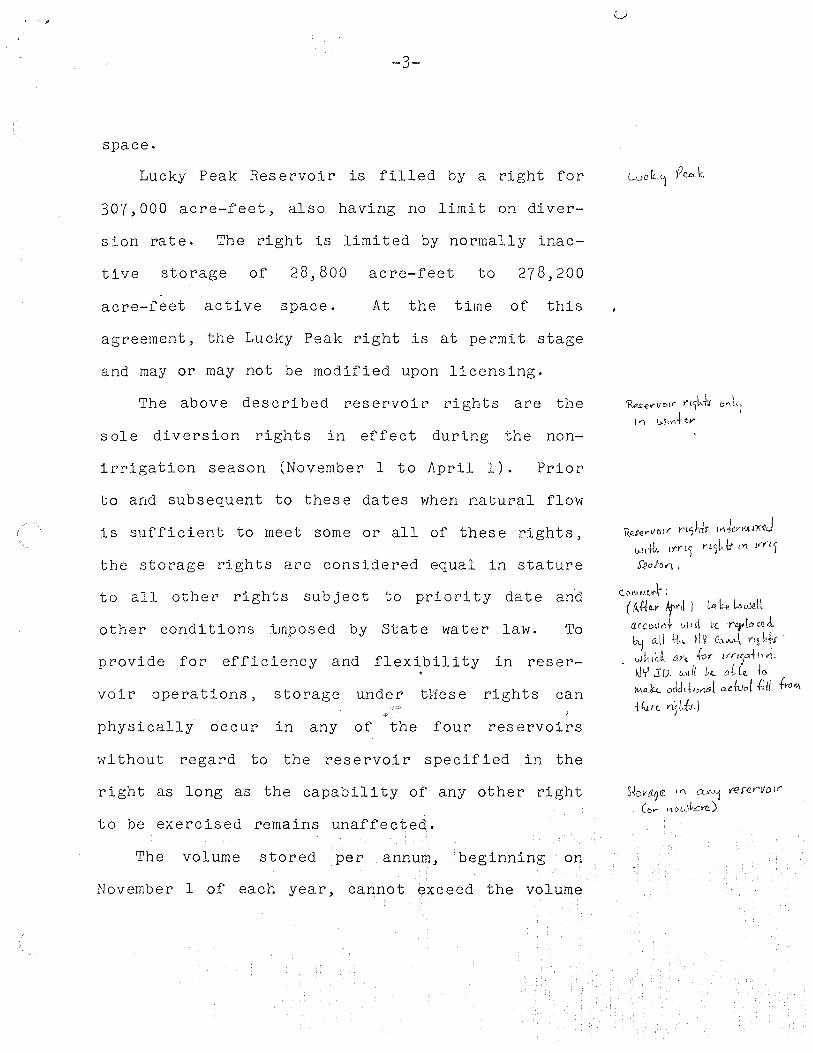
,.
-3-
space.
Lucky Peak Reservoir is filled by a right for
307,000 acre-feet, also having no limit on diver-
sion rate. The right is limited by normally inac-
tive storage of 28,800 acre-feet to 278,200
acre-feet active space. At the time of this
agreement, the Lucky Peak right is at permit stage
and may or may not be modified upon licensing.
The above described reservoir rights are the
sole diversion rights in effect during the non-
irrigation season (November 1 to April 1). Prior
to and subsequent to these dates when natural flow
is sufficient to meet some or all of these rights,
the storage rights are considered equal in stature
to all other rights subject to priority date an·d
other conditions imposed by State water law. To
provide for efficiency and flexibility in reser-
voir operations, storage under 'tl1ese rights can I
physically occur in any of the four reservoirs
without regard to the reservoir specified in the
right as long as the capability of any other right
to be exercised remains unaffected.
The volume stored per annum, beginning on
November 1 of each year, cannot exceed the volume
Rese..-vo1>· n1kt1 o"Ll I>'\ W1v\t~v
l(.uer\/01r rt1h4r l<'\JenuJx:11d Wti{;. t>"f'l) n5~ tr I Yl irn)
S'12aio-11 ,
C Dl\lfAU't '.
(/i.Jto..Y Afml I Lit k a.cco<Jrtf vJ di Lt rey[,c, i,;'1 a_ll ~j Y Qc.._,,~ YL~
uJLuc ~ Mc
IJ'r' J: D. lo.II Ii b~ to M<Cb .. odd1~1Mai ndu,,f .{,(/ .f,.o...,
1/un >"15ikl
S~on:zqe '" CL"''! 'f€S"!Yf'1Jo ir
(b..- I\ D~\kc>C)

-4-
specified by the water right or the physical capa-
city of the reservoir unless all subsequent rights
have been met. The volume stored (including
unused storage from a previous year) cannot on any
given day exceed the specified or physical volume
of the reservoir. Previously unused storage
(carryover) which is released during the non-
irrigation season for a specified beneficial use
can be replaced in the same year within the
constraints of the right(s) governing that space.
The United States Water and Power Resources
Service shall inform the watermaster of any such
( use of carryover storage.
In order to properly administer storage rightsJ
it is the responsibility of the United States
Water and Power Resources Service to inform the
Boise River Watermaster of the amount of unused
storage in each of the three main ver reservoirs
(Anderson Ranch, Arrowrock, and Lucky Peak) within
thirty days of the time the Watermaster has deter-
mined the amount of· stored water used. Similarly,
it is the responsibility of the Boise Project
Board of Control to inform the Watermaster of the
unused storage of Lake Lowell Reservoir.
~A~XJML'>V\ ( l OV)\'.. fiH/yv u,11Qs5 a\.l J.kc, 0t'Jl\.-! <>-Y<--
w,-d.
tJ ~ PIU 1Jc"'"·Lt1Gs CAr"''-jOV l,..
(?btl<- Pr~j"-d ;J.td\.J.'iAes Lal..._ Lo1UtU Co. rr-'1 o'1Q>"

-5-
It is the duty of the Boise River Watermaster
to determine on a daily basis the accumulation of
stored water under the rights of each of the four
reservoirs and to inform the United States Water
and Power Resources Service and the Boise Project
Board of Control each season when the maximum fill
of each reservoir is known. The Water and Power lt.X>h,rMO-ff<..v C<>M-J11Ift! ~ \l iJe P~J o.lloco.tes it
Resources Services shall in turn inform the
Watermaster of each user's stored water allocation
in sufficient detail for proper delivery of that
water.
TO: Robert J. Sutter
FROM: Mr. Bob Sutter
MEMO
REDRAFT:RJS:mb January 23, 1981
SUBJECT: BOISE RIVER RESERVOIR FILL AND STORED WATER USE
Preparatory to drafting the reservoir fill section for the new
Boise River Reservoir Operations Manual, I have examined previous
watermaster reports and talked with the watermaster concerning
the fill. The main question is whether or not the present fill
criteria is consistent with volumes, rates, and priority dates of
existing water rights. The remainder of this memo explains the
current methods and then discusses the validity of these methods
and possible changes.
Reservoir fill is computed each spring when the three main
river reservoirs (Anderson, Arrowrock, Lucky Peak) reach their
maximum combined contents. The logic in this is that at this
time, the natural flow has diminished and/or irrigation demand
has increased such that there is no excess water for storage and,
therefore, the reservoirs can accrue no more. This would nor-
mally occur at or after the beginning of the irrigation season
(April 1). It is possible that maximum main river storage could
occur prior to April 1 if releases to Lake Lowell exceeded the
natural flow. It is unclear whether such releases would, in some
situations, affect the computation of reservoir fill.
In average to above average water years, the fill computation
is relatively simple with Arrowrock receiving the first 286,600

-2-
acre-feet of new fill, Anderson Ranch the next 423,200 acre-feet
(or an amount necessary to reach 423,200 considering previously
unused storage), and the remainder is credited to Lucky Peak.
Previously unused storage (carryover) in Arrowrock is treated as
new fill while carryover in Anderson Ranch and Lucky Peak is re
tained in each user's storage account. It appears that the above
procedure is followed whenever runoff is sufficient to fill
Arrowrock and at least partially fill Anderson Ranch. It also
appears that carryover and actual contents of Lake Lowell do not
enter into the fill computations of the main river reservoirs in
these years. To include Lake Lowell in such a computation would
in fact be difficult since storage is normally being used from
Lake Lowell several days before the main river reservoirs.
In a below average year when runoff is so low that Lake
Lowell and Arrowrock cannot both be filled, there appears to be no
set procedure for allocating the new fill between Lake Lowell and
Arrowrock. When such a condition occurs (as did in 1977),
apparently the Boise Project may wish to classify a portion of
storage in Lake Lowell as Anderson Rancn storage to reduce the
fill of Arrowrock Reservoir by making more space in Lowell and
allowing more storage there. It should be noted here that this
in no way affects the physical location of the water at the
beginning of the season, but it does affect somewhat the later
distribution of the water. The amount transferred is apparently
based on records kept by the Boise Project Board of Control.
-3-
There is no evidence that this allocation of fill would occur
differently should another water short year such as 1977 take
place. Because of the Anderson water accounting transfer, Lake
Lowell was allowed to accrue storage water in a main river reser
voir without actually diverting the water through the New York
Canal.
In 1977, the Water and Power Resources Service developed a
procedure to include Lake Lowell in the fill allocation. This
was done because the old method which did not include Lake Lowell
did not "fairly account for carryover in Lake Lowell." The total
fill is computed as the sum of the maximum storage in the three
main river reservoirs, the maximum storage in Lake Lowell, and
Lake Lowell "feed water". The new fill is then distributed first
to Lake Lowell and Arrowrock proportionally to their capacities,
then to Anderson Ranch and, finally, to Lucky Peak.
In order to assess the above fill techniques, it is necessary
to identify the water rights for the four reservoirs involved.
From a search of licenses, permits, and decrees, the following
rights were found:
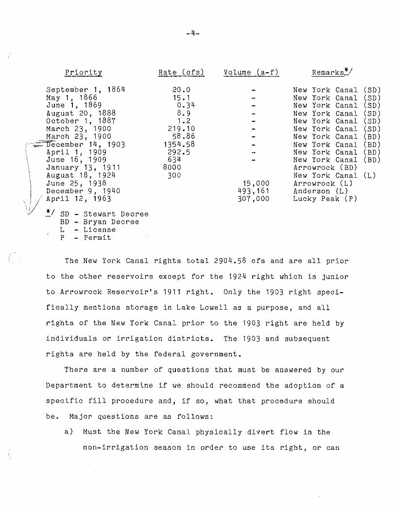
-4-
Priority Rate (cfs) Volume (a-f) Remarks .. ~/
September 1, 1864 20.0 New York Canal (SD) May 1, 1866 1 5 • 1 New York Canal (SD) June 1 ' 1869 0.34 New York Canal (SD) August 20, 1888 8.9 New York Canal (SD) October 1, 1887 1. 2 New York Canal (SD) March 23, 1900 219.10 New York Canal (SD) March 23, 1900 58.86 New York Canal (BD)
ember 1 4 ' 1903 1354.58 New York Canal (BD) April 1, 1909 292.5 New York Canal (BD) June 16 ' 1909 634 New York Canal (BD) January 13, 1 9 11 8000 Arrowrock (BD) August 18, 1924 300 New York Canal (L) June 25, 1938 15,000 Arrowrock (L) December 9, 1940 493,161 Anderson (L) April 12, 1963 307,000 Lucky Peak (P)
*I SD - Stewart Decree BD - Bryan Decree L - License p - Permit
The New York Canal rights total 2904.58 cfs and are all prior
to the other reservoirs except for the 1924 right which is junior
to Arrowrock Reservoir's 1911 right. Only the 1903 right speci-
fically mentions storage in Lake Lowell as a purpose, and all
rights of the New York Canal prior to the 1903 right are held by
individuals or irrigation districts. The 1903 and subsequent
rights are held by the federal government.
There are a number of questions that must be answered by our
Department to determine if we should recommend the adoption of a
specific fill procedure and, if so, what that procedure should
be. Major questions are as follows:
a) Must the New York Canal physically divert flow in the
non-irrigation season in order to use its right, or can
-5-
Lake Lowell store its water in a main river reservoir?
In other words, because of its offstream nature, should
it be treated like other canals, or simply as a main
river reservoir?
b) Are the reservoirs on the Boise River limited to complete
fill only once from November 1 to November 1, and if so,
does this apply to Lake Lowell?
c) Can stored water from Anderson Ranch or Arrowrock that is
diverted to Lake Lowell via the New York Canal be "moved"
back to Anderson Ranch so that it can be rediverted in a
low water year?
d) In the event that answers to the above questions indicate
that Lake Lowell should be accounted for in a manner
parallel to the three main river reservoirs, should the
watermaster treat the New York Canal as a branch of the
main river and account for stored water use above and
below Lake Lowell?
e) Can all of the New York Canal rights listed earlier be
used to accumulate storage in Lake Lowell in the non
irrigation season?
f) When both Arrowrock and Lake Lowell have filled, can
inflow below Arrowrock be credited to Anderson Ranch
Reservoir?
All of the above questions relate in some way to the off
stream storage in Lake Lowell. It is doubtful whether the usual
-6-
water right conventions can provide the necessary answers and,
therefore, we possibly cannot provide a written fill procedure
for the Boise. This may be particularly so since the federal
government owns the rights for all of the reservoirs.
Concerning the new fill procedure developed by the Water and
Power Resources Service, the information we have received would
have to be explained in much greater detail to determine if it
would work in all cases. It is also unknown whether or not the
new procedure has been formally adopted and used in the years
subsequent to 1977, or simply forgotten.
Regardless of the answers to the above questions, it is cer
tain that the accounting of what water is going where and under
what right on the Boise River is very confusing to the observer.
RJS:mb

UNITED STATES
DEPARTMENT OF THE INTERIOR
GEOLOGICAL SURVEY
WATER RESOURCES DIVISION Box 036 Federal Building, Room 365
550 West Fort Street
r .: l~ :::: ,9a1
Departn
Boise, Idaho 83724 December 30, 1981
Mr. Murland Packer Idaho Department of Water Resources Statehouse Boise, ID 83720
Dear Mr. Packer:
Last February we contracted with your office to make discharge measurements and prepare rating tables for 13 irrigation drains in the lower Boise River basin (see list below). On three of the sites we established gaging stations and collected continuous gage-height record and are now in the process of preparing that data for publication as a part of our annual publication Water Resources Data for Idaho - 1981.
With this letter, I have enclosed a copy of the list of discharge measurements, a copy of the rating table, and a copy of the rating curve defined at each site. Please advise me if you want me to furnish this data to Boise River Watermaster, Henry Koheling, or if you wish to deal with him directly. The
( list of stations follows:
1. 13-2064.00 Eagle Drain at Eagle, Idaho 2. 13-2094.50 Thurman Drain near Eagle, Idaho 3. 13-2108.10 Fivemile Creek Drain nr Middleton, Idaho 4. 13-2108.24 North Middleton Drain at Middleton, Idaho 5. 13-2108.31 South Middleton Drain nr Middleton, Idaho 6. 13-2108.35 Willow Creek at Middleton, Idaho 7. 13-2108.49 Mason Slough nr Caldwell, Idaho 8. *13-2109.83 Mason Creek nr Caldwell, Idaho ~ 9. 13-2109.86 West Hartley Gulch nr Caldwell, Idaho
10. 13-2109.87 East Hartley Gulch nr Caldwell, Idaho 11. *13-2114.45 Indian Creek at mouth at Caldwell, Idaho 12. 13-2125.50 Conway Gulch at Notus, Idaho 13. *13-2128.90 Dixie Drain nr Wilder, Idaho
*Gaging stations.
Please let us know when we can be of further service to you.
RWH:ljd Enclosures
FOR THE DISTRICT CHIEF, E. F. HUBBARD
Sincerely,
~cJ4~ Robert W. Harper ~Surface Water Chief
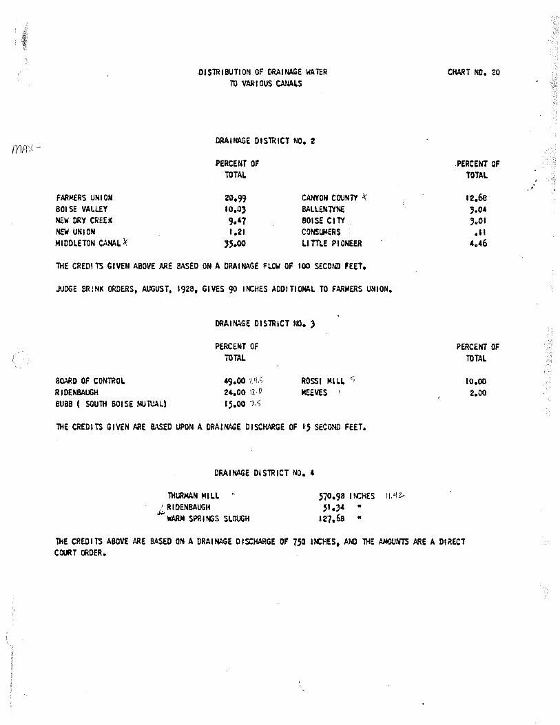
mm<
FARMERS UNI ON BOISE VALLEY NEW ORY CREEK NEW UNION MIOOLETON CANAL)(
-OISiR18UTION OF DRAINAGE WAlER TO VARIOUS CANALS
DRAINAGE DIS1RICT NO. 2
PERCENT OF TOTAL
20.99 CANYON COUN1Y .l(
10.0, SALLEN1YNE 9.47 BOISE CllY 1.21 CONSll4ERS
,s.oo LITTl.E PIONEER
iHE CREDI TS GIVEN ABOVE ARE BASED ON A DRAINAGE FLOW OF 100 SECOND FEET.
JUDGE MINK ORDERS, AUGUST, 1928, GIVES 90 IN:HES ADDITIONAL TO FARMERS UNION.
a~o OF CONiROL RIOENBAUGH
DRAINAGE OtS1RICT oo. )
PERCENT OF TOTAL
49.00 24.00 \],./)
ROSSI MlLI. c; MEEVES \
BUBB ( SOUlH BOISE MJl\JAL) 15.00 /.C,
lHE CREDITS GIVEN ARE BASED UPON A DRAINAGE DISCHMGE OF I} SECOND FEET.
DRAINAGE DIS1RICT MO. 4
THURMAN MILL .' RIDENBAUGH ~
WARM SPRl~S SLOUGH
S10. 98 I N:HES II. Y z.,
s1.,4 " 127.68 ..
CHART NO. 20
PERCENT OF TOTAL
12.68 ,.o.-,.01
·" 4.46
PERCENT OF TOTAL
10.00 2.00
1HE CREDI TS ABOVE ARE BASED ON A DRAl~GE DISCHARGE OF 7.50 IN:HES, AND lHE AMOONiS ARE A DIRECT COURT ORDER.
. .

REDRAFT: Bob S./mb
BOISE RIVER RESERVOIR FILL
Boise River Reservoir fill normally commences
near the end of the irrigation season as irriga-
tion dive rs ions diminish. Storage accrues on a
daily basis to each reservoir according to the
priority of the water right(s) for the
reservoir(s) and the natural flow supply available
at the point of diversion. Natural flow is deter-
mined at the location of the dams for the main
11 -Lver reservoirs (Ande1~son Ranch, Arrowrock, and
Lucky Peak), and at the Boise Project Maj.n (New
York) Canal Diversion Dam for the offstream reser-
voir, Lake Lowell.
In ocder of prioei ty, the water rights for
storage in Andeeson Ranch, Arrowrock, Lucky Peak,
and Lake Lowell reservoirs are as follows:
rJotes a,.,tJ QtJru.f.i&Yjf
::_~-~-~~-c~:· 1 ~ Y\ ,,J / s +.:~~
Acc.i'tl.0-~ u.,J (..r {l r '/ J' I h r; ']if J
! .f (' o YJ .r, cit r~,j fo CCC u r 1LJt.cJJ,.i-
1J ciu1 J clivus10Y1 -labJ ;;fa.cc.- (jr riaf Uri~-,/ lt..J.... vo/u,,,,,c.. /,,.,,,, iJ vo ,J..tL
S 1,-,cc... L, LovJe/I &J1/i l(j
Priorit Rate cfs Volume o!uJ~.r ''f-,1/" {l,1r >nU1>'.S flv,J-
I::i 1 * Lucl'-'1 f.l~o L:.. will acu·u~ .\emarKs, so.--1t vJo·)u,
December 14, 1903 April 1, 1909 .June 16, 1909 .January 13, 1911 August 18, 1924 .June 25, 1938 December 9, 1940 April 12, 1963
* BD - Bryan Decree L - License P - Permit
1354.58 292.5 6 311
8000 300
15,000 L\93,161 307,000
New York Canal (BD) New York Canal (BD) New York Canal (BO) Arrowrock (BD) New York Canal (L) Arruwrock (L) Anderson (L) Lucky Peak (P)
el.Cnj ';JeLl"' fy0 ,,,.. f'/)or-e.J Cvcd
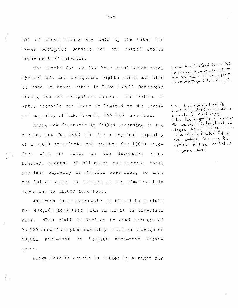
-2-
All of these rights are held by the Water and
Power Reg~es Service for the United States
Department of Interior.
The rights for the New York Canal which total
2581.08 cfs are irrigation rights which can also
be used to store water in Lake Lowell Reservoir
during the non-irrigation season. 'rhe volume of
water storable per annum is limited by the phys i-
cal capacity of Lake Lowell, 177,150 acre-feet.
Arrowrock Reservoir is filled according to two
rights, one for 8000 cfs for a physical capacity
of 275,000 acre-feet, and another for 15000 acre-
feet with no limit on the diversion rate.
However, because of siltation the current total
physical capacity is 286;600 acre-feet, so that
the latter value is limited at the time of this
agreement to 11,600 acre-feet.
Anderson Ranch Reservoir is filled by a right
for 493,161 acre-feet with no limit on diversion
rate. This right is limited by dead storage of
28,980 acre-feet plus normally inactive storage of
acre-feet to 423,200 acre-feet active
space.
Lucky Peak Reservoir· is filled by a right for

-3-
307,000 acre-feet, also having no limit on diver-
sion rate. The right is limited by normally inac-
tive storage of 28,800 acre-feet to 278,200
acre-feet active space. At the time of this
agreement, the Lucky Peak right is at permit stage
and may or may not be modified upon licensing.
The above described reservoir eights are the
sole diversion rights in effect during the non-
irrj_gation season (October 15 to April 1). Prior
to and subsequent to these dates when natural flow
is sufficient to meet some or all of these rights,
the storage rights are consideced equal in stature
to all other rights subject to priocity date and
other conditions imposed by State wate11 law. To
provide for efficiency and flexib:Lli ty in reser-
vo i 11 operations, storage under these rights can
physically occur in any of the four reservoirs
without regard to the resecvoir specified 1.n the
right as long as the capability of any othec right
to be execcised remains unaffected.
'I'he volume stored in any one season cannot
exceed the volume specified by the water right or
the physical capacity of the reservoir unless all
subsequent rights have been met. The volume
Co.n... wr1j,d10Y\. '''blJts be. /1M1tc,(
t CJ A?v-< \ I T.o Oc;to'Der !5 [;,,~ e.)
)V' --l 1 uJ ;,..t~ovt-hi S.<!--0 .S.OY\ ?

-4-
stored (including unused storage from a previous
year) cannot on any given day exceed the specified
or physical volume of the reservoir'. Previously
unused storage (carryover) which is released during
the non-irrigation season for flood control or
flow maintenance can be replaced in the same year
within the constraints of the right(s) governing
that space. The United States Water, and Power
Resources Service shall inform the watermaster of
any such use of carryover storage.
In order to properly administer storage rights,
it is the responsibility of the United States
Water and Qefou!C.e5
Pov-ier A Secvice to inform the Boise River
Wa te rmas te r of the amount of unused storage in
each of the three main river reservoirs (Anderson
Rane h, Ar rowrock, and Lucky Peak) within thirty
days of the time the Watermaster has determined
the amount of stored water used. Similarly, it is
the responsibility of the Boise Project Boacd of
Control to inform the Watermaster of the unused
storage of Lake Lowell Reservoir.
It is the duty of the Boise River Watermaster
to determine on a daily basis the accumulation of
stored water under the rights of each of the four

-5-
reservoirs and to inform the United States Water
and Power Resources Service and the Boise Project
Board of Control each season when the maximum fill
of each reservoir is known.
Resources Services shall
Watermaster of each user 1 s
The Water and Power
in turn 1nforrn the
stored water cliou:ifton
accumula-
tion in sufficient detail for proper delivery of
that water.

REDRAFT: Bob S./mb March 3, 1981
BOISE RIVER RESERVOIR FILL
Boise River reservoir storage accrues on a
daily basis to each reservoir according to the
priority of the water right(s) for the
reservoir(s) and the natural flow supply available
at the point of diversion. Natural flow is deter-
mined at the location of the dams for the main
river reservoirs (Anderson Ranch, Arrowrock, and
Lucky Peak), and at the Boise Project Main (New
York) Canal Diversion Dam for the offstream reser-
voir, Lake Lowell.
In order of priority, the water rights for
storage in Anderson Ranch, Arrowrock, Lucky Peak,
and Lake Lowell reservoirs are as follows:
Priority
December 14, 1903 January 13, 1911 June 25, 1938 December 9, 1940 April 12, 1963
* BD - Bryan Decree L - License P - Permit
Rate (cfs)
1354.58 8000
Volume
15,000 493,161 307,000
Remarks*
New York Canal (BD) Arrowrock (BD) Arrowrock (L) Anderson (L) Lucky Peak (P)
All of these rights are held by the Water and
Power Resources Service for the United States

-2-
Department of Interior.
The New York Canal right of 1354.58 cfs
is an irrigation right which can also be used to
store water in Lake Lowell Reservoir during the
non-irrigation season. The volume of water
storable per annum is limited by the physical
capacity of Lake Lowell, 177, 150 acre-feet.
Identified transmission losses in the New York
Canal from November 1 to April 1 may be diverted
in addition to the physical capacity of Lake
Lowell to compensate for such losses.
Arrowrock Reservoir is filled according to two
rights, one for 8000 cfs for a physical capacity
of 275,000 acre-feet, and another for 15000 acre
f eet with no limit on the di version rate.
However,
physical
because of
capacity is
siltation the current
286, 600 acre-feet, so
total
that
the latter value is limited at the time of this
agreement to 11,600 acre-feet.
Anderson Ranch Reservoir is filled by a right
for 493,161 acre-feet with no limit on diversion
rate. This right is limited by dead storage of
28~980 acre-feet plus normally inactive storage of
40,981 acre-feet to 423,200 acre-feet active

-3-
space.
Lucky Peak Reservoir is filled by a right for
307,000 acre-feet, also having no limit on diver
sion rate. The right is limited by normally inac
tive storage of 28,800 acre-feet to 278,200
acre-feet active space. At the time of this
agreement, the Lucky Peak right is at permit stage
and may or may not be modified upon licensing.
The above described reservoir rights are the
sole diversion rights in effect during the non
irrigation season (November 1 to April 1). Prior
to and subsequent to these dates when natural flow
is sufficient to meet some or all of these rights,
the storage rights are considered equal in stature
to all other rights subject to priority date and
other conditions imposed by State water law. To
provide for efficiency and flexibility in reser
voir operations, storage under these rights can
physically occur in any of the four reservoirs
with out regard to the reservoir specified in the
right as long as the capability of any other right
to be exercised remains unaffected.
The volume stored per annum, beginning on
November 1 of each year, cannot exceed the volume

-4-
specified by the water right or the physical capa
city of the reservoir unless all subsequent rights
have been met. The volume stored (including
unused storage from a previous year) cannot on any
given day exceed the specified or physical volume
of the reservoir. Previously unused storage
(carryover) which is released during the non
irrigation season for a specified beneficial use
can be replaced in the same year within the
constraints of the right(s) governing that space.
The United States Water and Power Resources
Service shall inform the watermaster of any such
use of carryover storage.
In order to properly administer storage rights,
it is the responsibility of the United States
Water and Power Resources Service to inform the
Boise River Wa termas ter of the amount of unused
storage in each of the three main river reservoirs
(Anderson Ranch, Arrowrock, and Lucky Peak) within
thirty days of the time the Watermaster has deter
mined the amount of stored water used. Similarly,
it is the responsibility of the Boise Project
Board of Control to inform the Watermaster of the
unused storage of Lake Lowell Reservoir.

-5-
It is the duty of the Boise River Watermaster
to determine on a daily basis the accumulation of
stored water under the rights of each of the four
reservoirs and to inform the United States Water
and Power Resources Service and the Boise Project
Board of Control each season when the maximum fill
of each reservoir is known. The Water and Power
Resources Services shall in turn inform the
Watermaster of each user's stored water allocation
in sufficient detail for proper delivery of that
water.
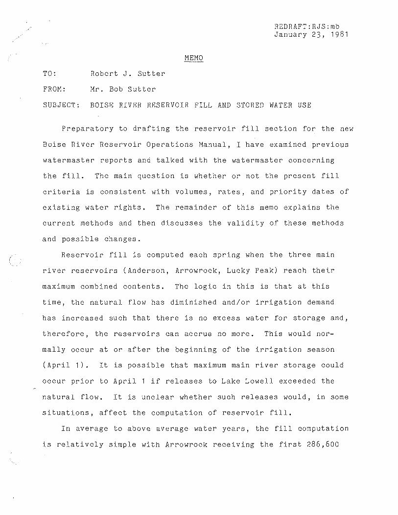
TO: Robert J. Sutter
FROM: Mr. Bob Sutter
MEMO
REDRAFT:RJS:mb January 23, 1981
SUBJECT: BOISE RIVER RESERVOIR FILL AND STORED WATER USE
Preparatory to drafting the reservoir fill section for the new
Boise River Reservoir Operations Manual, I have examined previous
watermaster reports and talked with the watermaster concerning
the fill. The main question is whether or not the present fill
criteria is consistent with volumes, rates, and priority dates of
existing water rights. The remainder of this memo explains the
current methods and then discusses the validity of these methods
and possible changes.
Reservoir fill is computed each spring when the three main
river reservoirs (Anderson, Arrowrock, Lucky Peak) reach their
maximum combined contents. The logic in this is that at this
time, the natural flow has diminished and/or irrigation demand
has increased such that there is no excess water for storage and,
therefore, the reservoirs can accrue no more. This would nor-
mally occur at or after the beginning of the irrigation season
(April 1). It is possible that maximum main river storage could
occur prior to April 1 if releases to Lake Lowell exceeded the
natural flow. It is unclear whether such releases would, in some
situations, affect the computation of reservoir fill.
In average to above average water years, the fill computation
is relatively simple with Arrowrock receiving the first 286,600

-2-
acre-feet of new fill, Anderson Ranch the next 423,200 acre-feet
(or an amount necessary to reach 423,200 considering previously
unused storage), and the remainder is credited to Lucky Peak.
Previously unused storage (carryover) in Arrowrock is treated as
new fill while carryover in Anderson Ranch and Lucky Peak' is re
tained in each user's storage account. It appears that the above
procedure is followed whenever runoff is sufficient to fill
Arrowrock and at least partially fill Anderson Ranch. It also
appears that carryover and actual contents of Lake Lowell do not
enter into the fill computations of the main river reservoirs in
these years. To include Lake Lowell in such a computation would
in fact be difficult since storage is normally being used from
Lake Lowell several days before the main river reservoirs.
In a below average year when runoff is so low that Lake
Lowell and Arrowrock cannot both be filled, there appears to be no
set procedure for allocating the new fill between Lake Lowell and
Arrowrock. When such a condition occurs (as did in 1977),
apparently the Boise Project may wish to classify a portion of
storage in Lake Lowell as Anderson Ranch storage to reduce the
fill of Arrowrock Reservoir by making more space in Lowell and
allowing more storage there. It should be noted here that this
in no way affects the physical location of the water at the
beginning of the season, but it does affect somewhat the later
distribution of the water. The amount transferred is apparently
based on records kept by the Boise Project Board of Control.

-3-
There is no evidence that this allocation of fill would occur
differently should another water short year such as 1977 take
place. Because of the Anderson water accounting transfer, Lake
Lowell was allowed to accrue storage water in a main river reser
voir without actually diverting the water through the New York
Canal.
In 1977, the Water and Power Resources Service developed a
procedure to include Lake Lowell in the fill allocation. This
was done because the old method which did not include Lake Lowell
did not "fairly account for carryover in Lake Lowell." The total
fill is computed as the sum of the maximum storage in the three
main river reservoirs, the maximum storage in Lake Lowell, and
Lake Lowell "feed water". The new fill is then distributed first
to Lake Lowell and Arrowrock proportionally to their capacities,
then to Anderson Ranch and, finally, to Lucky Peak.
In order to assess the above fill techniques, it is necessary
to identify the water rights for the four reservoirs involved.
From a search of licenses, permits, and decrees, the following
rights were found:

-4-
Priority Rate (cfs) Volume ( a-f) Remarks~/
September 1 ' 1864 20.0 New York Canal May 1 , 1866 15 • 1 New York Canal June 1 ' 1869 0.34 New York Canal August 20, 1888 8.9 New York Canal October 1 ' 1887 1. 2 New York Canal March 23, 1900 219.10 New York Canal March 23, 1900 58.86 New York Canal December 1 4 ' 1903 1354.58 New York Canal April 1 ' 1909 292.5 New York Canal June 16 ' 1909 634 New York Canal January 13, 1 9 11 8000 Arrowrock (BD) August 18' 1924 300 New York Canal June 25, 1938 15,000 Arrowrock (L) December 9, 1940 493,161 Anderson (L) April 1 2 ' 1963 307,000 Lucky Peak (P)
*I SD - Stewart Decree BD - Bryan Decree L - License p - Permit
The New York Canal rights total 2904.58 cfs and are all prior
to the other reservoirs except for the 1924 right which is junior
to Arrowrock Reservoir's 1911 right. Only the 1903 right speci-
fically mentions storage in Lake Lowell as a purpose, and all
rights of the New York Canal prior to the 1903 right are held by
individuals or irrigation districts. The 1903 and subsequent /
rights are held by the federal government.
There are a number of questions that must be answered by our
Department to determine if we should recommend the adoption of a
specific fill procedure and, if so, what that procedure should
be. Major questions are as follows:
a) Must the New York Canal physically divert flow in the
non-irrigation season in order to use its right, or can
(SD) (SD) (SD) (SD) (SD) (SD) (BD) (BD) (BD) (BD)
( L)

-5-
Lake Lowell store its water in a main river reservoir?
In other words, because of its offstream nature, should
it be treated like other canals, or simply as a main
river reservoir?
b) Are the reservoirs on the Boise River limited to complete
fill only once from November 1 to November 1, and if so,
does this apply to Lake Lowell?
c) Can stored water from Anderson Ranch or Arrowrock that is
diverted to Lake Lowell via the New York Canal be 11 movedll
back to Anderson Ranch so that it can be rediverted in a
low water year?
d) In the event that answers to the above questions indicate
that Lake Lowell should be accounted for in a manner
parallel to the three main river reservoirs, should the
watermaster treat the New York Canal as a branch of the
main river and account for stored water use above and
below Lake Lowell?
e) Can all of the New York Canal rights listed earlier be
used to accumulate storage in Lake Lowell in the non
irrigation season?
f) When both Arrowrock and Lake Lowell have filled, can
inflow below Arrowrock be credited to Anderson Ranch
Reservoir?
All of the above questions relate in some way to the off
stream storage in Lake Lowell. It is doubtful whether the usual

-6-
water right conventions can provide the necessary answers and,
therefore, we possibly cannot provide a written fill procedure
for the Boise. This may be particularly so since the federal
government owns the rights for all of the reservoirs.
Concerning the new fill procedure developed by the Water and
Power Resources Service, the information we have received would
have to be explained in much greater detail to determine if it
would work in all cases. It is also unknown whether or not the
new procedure has been formally adopted and used in the years
subsequent to 1977, or simply forgotten.
Regardless of the answers to the above questions, it is cer
tain that the accounting of what water is going where and under
what right on the Boise River is very confusing to the observer.
RJS:mb

51 l. 761
Memorandum
To: RO 100, 700, 760 Project Superintendent, CSPO, Boise, Idaho
From: 761
Subject: New Method Adopted for Allocation of Boise System Storage
I. Introduction
The 1977 water year appears to be the driest of record for the Boise River. Insufficient water will accrue to Arrowrock Reservoir to fill its storage right. This is the primary factor which makes the allocation method currently used unreasonable and inadequate. A new method is proposed which calculates storage carryover and new accrual more strictly. This new method has been adopted after consultation with the Central Snake Project Office, the Boise River Watermaster, and the manager of the Boise Project Board of Control.
II. How the Old Method Works
As an example, the 1976 allocation was done as follows:
Reservoir
Arrowrock Anderson Lucky Peak
Content on day of maximum upner system storage (June 23, 1976) in A.F.
266,557 423,368 264,756
Total 954,681
Note: Lake Lowell has not entered into the total storage computation under the old method. On June 23, it contained 122,088 A.F. and maximum for the year was 167,789 on May l. It has been assumed to fill if its maximum content plus subsequent feed water exceeds its 177,000 A.F. capacity.
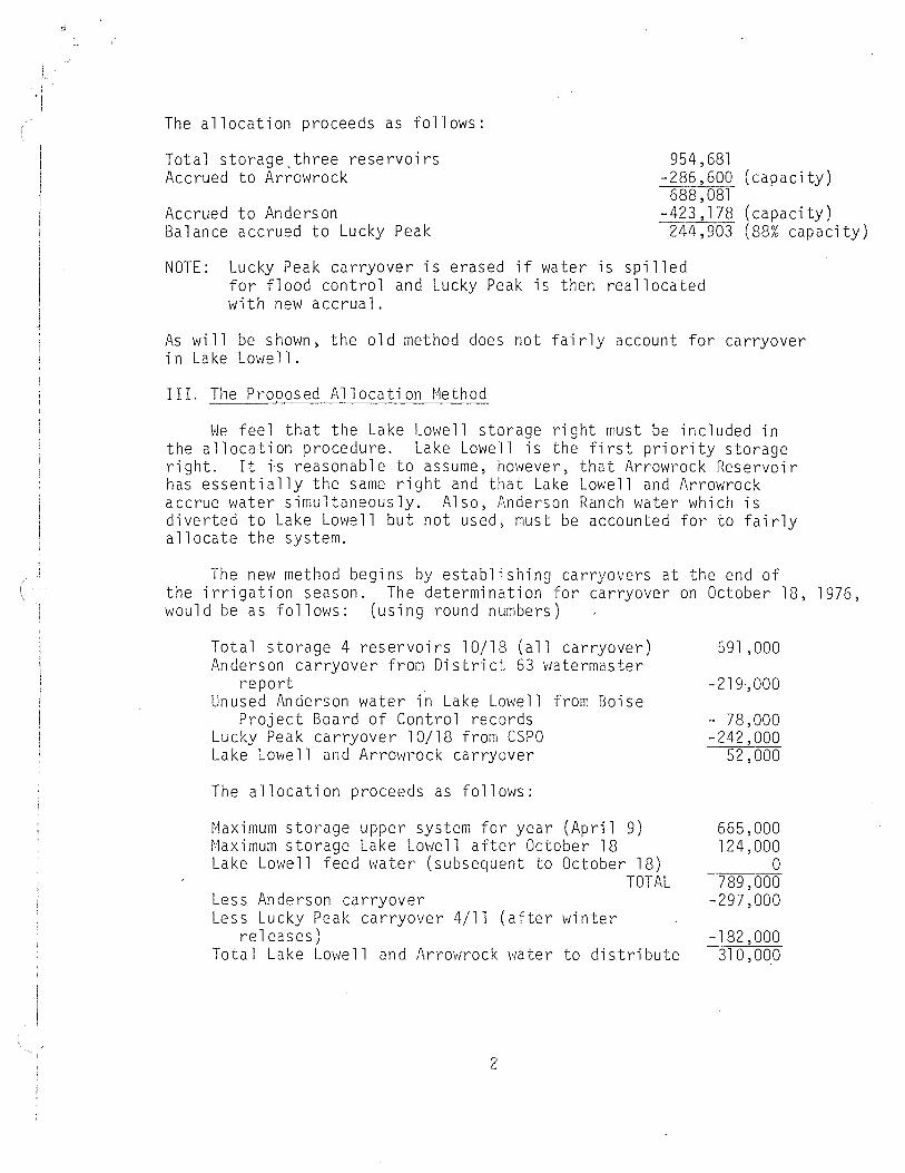
The allocation proceeds as follows:
Total storage_three reservoirs Accrued to Arrowrock
954 '681 -286,600 (capacity)
688 '081 Accrued to Anderson Balance accrued to Lucky Peak
-423,178 (capacity) 244,903 (88% capacity)
NOTE: Lucky Peak carryover is erased if water is spilled for flood control and Lucky Peak is then reallocated with new accrual.
As will be shown, the old method does not fairly account for carryover in Lake Lowell.
III. The Proposed Allocation Method
We feel that the Lake Lowell storage right must be included in the allocation procedure. Lake Lowell is the first priority storage right. It is reasonable to assume, however, that Arrowrock Reservoir has essentially the same right and that Lake Lowell and Arrowrock accrue water simultaneously. Also, Anderson Ranch water which is diverted to Lake Lowell but not used, must be accounted for to fairly allocate the system.
The new method begins by establishing carryovers at the end of the irrigation season. The determination for carryover on October 18, 1976, would be as follows: (using round numbers)
Total storage 4 reservoirs 10/18 (all carryover) Anderson carryover from District 63 v1atermaster
report Unused Anderson water in Lake Lowell from Boise
Project Board of Control records Lucky Peak carryover 10/18 from CSPO Lake Lowell and Arrowrock carryover
The allocation proceeds as follows:
Maximum storage upper system for year (April 9) Maximum storage Lake Lowell after October 18 Lake Lowell feed water (subsequent to October 18)
TOTAL Less Anderson carryover Less Lucky Peak carryover 4/11 (after v1inter
releases) Total Lake Lowell and Arrowrock water to distribute
2
591,000
-219,000
- 78,000 -242,000
52,000
665,000 124,000
0 789,000
-297,000
-182,000 310,000

\
' , '
The 310,000 is divided between Lake Lowell and Arrowrock according to their active storage capacities. Arrowrock has 61.82 percent of the total active capacities of 463,600 and Lake Lowell has 38. 18 percent. This allocates 191,600 to Arrowrock .and 118,400 to Lake Lowell. Arrowrock is further divided between Board of Control water (89.28%) and other users (l 0. 72%). This gives the Board of Control about 171 ,060, and the others about 20,540 in Arrowrock.
IV. Ordinary Application of the Nevi Method
It is useful to consider how the new method which includes Lake Lowell in the storage computations would work in a larger year. A rework of the 1976 allocation from Section II using the new method would look like this:
Total storage 4 reservoirs 10/15 Anderson carryover from Di strict 63 report Unused Anderson water in Lake Lowell from
Boise Project Board of Control records Lucky Peak carryover 10/15 from CSPO Lake Lowe 11 and Arrowrock carryover
Maximum storage upper system (June 23) + Maximum storage Lake Lmve 11 (May l) + Lake Lowell feed water after 10/15
Less Anderson carryover Less Lucky Peak carryover (flood spills)
606,089 -301,594
. 0 -202,292 102,203
954,681 167,789
9,211 JJ TOTAL l, 131 ,681
-301 ,594 0
TOTAL TO ALLOCATE 830,087
Accrued to Lake Lowell
Accrued to Arrowrock
Accrued to Anderson Balance accrued to Lucky Peak
- 177 '000 653,000
-286,600 366,487
-121,606'!:_/ 244,881 (88%)
l/ Maximum storage plus feed water not greater than 177,000 capacity. 2! Total Anderson cannot exceed 423,200.
D Yribar:db 5/3/77
3