report of the 2 gofc-gold workshop on reducing emissions
TRANSCRIPT

Report of the 2nd GOFC-GOLD Workshop on Reducing Emissions from Deforestation
“Measuring and monitoring greenhouse gas emissions from deforestation in developing countries:
From case studies to implementation guidelines”
St. Cruz, Bolivia 17-19 April 2007
Martin Herold, Jacqueline Sambale and Christiane Schmullius
GOFC-GOLD Report No. 30
Land Cover Project Office
Jena, Germany September 2007

ii
Global Observation of Forest and Land Cover Dynamics (GOFC-GOLD) is a coordinated international effort to ensure a continuous program of space-based and in situ forest and other land cover observations to better understand global change, to support international assessments and environmental treaties and to contribute to natural resources management.
GOFC-GOLD encourages countries to increase their ability to measure and track forest and land cover dynamics by promoting and supporting participation on implementation teams and in regional networks. Through these forums, data users and providers share information to improve understanding of user requirements and product quality.
GOFC-GOLD is a Panel of the Global Terrestrial Observing System (GTOS), sponsored by FAO, UNESCO, WMO, ICSU and UNEP. The GOFC-GOLD Secretariat is hosted by Canada and supported by the Canadian Space Agency and Natural Resources Canada. Other contributing agencies include NASA, ESA, START and JRC. Further information can be obtained at http://www.fao.org/gtos/gofc-gold

Report of the 2nd GOFC-GOLD Workshop on Tropical Deforestation
iii
Executive summary As the United Nations Framework Convention on Climate Change nears the end of a 2 year evaluation period on the issue of Reducing Emissions from Deforestation in Developing Countries (RED-DC), participating countries have agreed on the need to address this globally important source of greenhouse gas emissions. The GOFC-GOLD network has emerged as an important expert forum to provide information and technical guidance on how remote sensing tools and methods, coupled with ground/based inventories, can support policies to monitor and reduce these emissions. GOFC-GOLD has maintained close communication with the negotiation process.
This workshop brought together relevant international actors on REDD policy development, and remote sensing and forest monitoring experts to discuss recent progress and synthesize experience from a suite of ongoing REDD monitoring case studies. Countries participating in the current debate have officially referenced the value of remote sensing tools and methods for deforestation monitoring, and have identified specific needs and goals related to their implementation.
Most of the REDD pilots projects presented started in 2006/07. Many have already completed an estimation of deforestation for a historical reference period. The application of remote sensing was found suitable and applicable in all national circumstances, with many kinds of sensors and approaches contributing. Different national conditions may require the use of different sensors, methods, and efforts in capacity building. Only a few studies have fully addressed forest degradation and actual estimations of carbon emissions (using field data and IPCC GPG). The experiences presented can serve as a starting point for national monitoring activities, and can be modified in response to expected progress in establishing an international policy framework for reducing emissions from deforestation. The suggested starting point would be to account for gross carbon emissions only in existing forest areas on a national basis using historical Landsat data for 1990, 2000 and 2005.
The workshop further discussed key technical issues (i.e. degradation, accuracy assessment) and laid the foundations for preparation of a “sourcebook” that will summarize the technical consensus on current and future earth observation capabilities for monitoring deforestation and its emissions, and focus on providing current best practices for utilizing remote sensing tools for REDD implementation.
The outcomes of the workshop have been presented during a joint ESA/GOFC-GOLD side event at SBSTA 26 and progress on the sourcebook development will be presented at SBSTA 27/COP13 in December 2007.

Report of the 2nd GOFC-GOLD Workshop on Tropical Deforestation
iv
Contents Executive summary ................................................................................................................... iii Contents..................................................................................................................................... iv Acronyms ................................................................................................................................... v 1 Background and objectives ................................................................................................ 1 2 Participants ......................................................................................................................... 2 3 Agenda ............................................................................................................................... 2 4 Summary of presentations and discussed topics ................................................................ 2
4.1 Recent developments and policy discussions within the UNFCCC .......................... 2 4.2 Ongoing mapping activities and RED-DC case studies............................................. 4 4.3 Presentations and discussions on methodological issues ........................................... 7 4.3.1 Contribution from medium resolution sensors....................................................... 7 4.3.2 Carbon stock estimates: accurate or conservative approach .................................. 8 4.3.3 Degradation monitoring methods........................................................................... 8 4.3.4 Monitoring changes in carbon stocks in selectively logged forests ....................... 9 4.3.5 Radar capabilities ................................................................................................... 9 4.3.6 Validation issues .................................................................................................. 10
5 Breakout group discussions.............................................................................................. 10 5.1 Preparation of a RED sourcebook............................................................................ 10 5.2 Discussions on technical issues................................................................................ 13
References ................................................................................................................................ 14 Appendix 1 - List of participants.............................................................................................. 15 Appendix 2 – Agenda............................................................................................................... 19 Appendix 3 – Documents ......................................................................................................... 21

Report of the 2nd GOFC-GOLD Workshop on Tropical Deforestation
v
Acronyms ALOS Advanced Land Observing Satellite COP Conference of the Parties ESA European Space Agency FAO Food and Agriculture Organization FRA Forest Resources Assessment GHG Greenhouse gases GOFC-GOLD Global Observation of Forest Cover and Land Dynamics GPG Good Practice Guidelines GTZ German enterprise for international cooperation (Deutsche
Gesellschaft für Technische Zusammenarbeit) IPCC Intergovernmental Panel on Climate Change IRS Indian Remote sensing Satellite JRC Joint Research Center of the European Commission LARN Latin America Regional Network Meeting MDGLS Mid Decadal Global Land Cover Set MPI BGC Max-Planck Institute for Biogeochemistry, Jena REDD Reducing Emissions from Deforestation and forest Degradation RED-DC Reducing Emissions from Deforestation in Developing
Countries SBSTA Subsidiary Body for Scientific and Technical Advice TREES Tropical Ecosystem Environment Observation System UNFCCC United Framework Convention on Climate Change

Report of the 2nd GOFC-GOLD Workshop on Tropical Deforestation
1
1 Background and objectives Since its establishment in 2005, the GOFC-GOLD Working Group on Monitoring Tropical Deforestation has continuously contributed to the UNFCCC REDD policy process (fig. 1). The first GOFC-GOLD Tropical Deforestation workshop, held 21-22 March 2006 in Jena, Germany, has provided a first consensus perspective from the earth observation community on scientific and methodological issues related to the item “reducing emissions from deforestation in developing countries” (RED-DC), as discussed in the framework of the UNFCCC process. The resulting short report presented a first and general vision of the earth observation community and was distributed at the 1st UNFCCC RED-DC ad-hoc workshop held in Rome in August 2006 and presented at SBSTA-25/COP-12 (DEFRIES, 2007a).
Building on the latest developments emerging from the policy discussions (e.g. SBSTA-25 Item 5, UNFCCC workshop, held 7-9 March 2007 in Cairns, Australia), a second GOFC-GOLD workshop on the RED-DC issue aimed to further discuss technical options for measuring and monitoring deforestation in developing countries and extrapolating/estimating related greenhouse gas emissions. Furthermore the goal was to initiate the development of a more detailed technical-guidelines-type document with specific methodological recommendations based on case study experiences currently ongoing. The objectives of the workshop were:
1. Discuss and learn from recent and ongoing case studies on the RED-DC issues and synthesize their practical experiences.
2. Discuss key challenging issues: degradation monitoring, methods for estimating carbon emissions, approaches for reference period validation and accuracy.
3. Plan the way forward: • Organize the development of methodological guidelines towards a detailed
technical protocol for measuring and monitoring including ‘reliability’ assessments,
• Formulate technical and methodological recommendations for implementation at regional and national scales.
Fig. 1: Engagement of GOFC-GOLD in the UNFCCC RED process

Report of the 2nd GOFC-GOLD Workshop on Tropical Deforestation
2
The results and outcomes of the workshop have been presented at the ESA/GOFC-GOLD side event at SBSTA-26 in May 2007, in Bonn. The REDD implementation sourcebook is currently in preparation by the GOFC-GOLD Working Group and will be presented at COP-13, in December 2007.
2 Participants More than 40 participants attended the workshop, including members of the GOFC-GOLD Executive Committee and the Land Cover Implementation Team, members of the REDD Working Group as well as international scientists and national representatives from Bolivia, Colombia, Brazil and India. Thus, the workshop brought together scientists and end users to exchange and discuss experiences and needed requirements. A detailed participants list is attached in Appendix 1.
3 Agenda The workshop included one day of presentations and two days of breakout group discussions. The presentations were organized in the following sessions emphasizing the workshop objectives:
• UNFCCC: recent developments and policy discussions • Ongoing mapping activities and REDD case studies • Data access and methodological issues
In breakout group discussions methodological issues and the outline of the planned sourcebook were discussed. A detailed agenda is attached in Appendix 2.
4 Summary of presentations and discussed topics
4.1 Recent developments and policy discussions within the UNFCCC The first session provided background information on the status of the international discussions to integrate mechanisms for the protection of forest into a post Kyoto agreement. Gisela Ulloa from the Bolivian Clean Development Office and Andrea García Guerrero (Ministry of Environment, Colombia) summarized REDD policy approaches and the proposed incentives with a focus on their technical implications. They emphasized the current status of negotiations referring to the outcomes of the recently held UNFCCC-REDD workshop in Cairns and the 25th SBSTA in May.
Positive incentives comprise a mechanism that accounts for carbon and non-CO2 emission reductions in existing forest areas as well as a stabilization fund accounting for carbon emissions in order to maintain and stabilize existing forest areas. Furthermore, special enabling funds will be established to prepare and support developing countries for their participation in both of these mechanisms. The related technical issues for the implementation of these mechanisms are the correct estimation of deforestation and forest degradation and carbon stock. Therefore, standards and methods are needed to measure emission reductions.
The role of remote sensing in this context has been emphasized. Current remote sensing tools in conjunction with field inventories allow the estimation of land use change; carbon stocks and emissions but all still yield uncertainties. Wall-to-wall assessments are ideal, but sampling works fine especially when resources and capacity are limited. Existing guidelines (e.g. IPCC GPG) provide guidance and quality assurance. Currently, it is not possible to directly measure carbon from space. New SAR sensors (e.g. ALOS) have great potential, but more research is needed in this area as well as more ground measurements. The importance of

Report of the 2nd GOFC-GOLD Workshop on Tropical Deforestation
3
consistency in forest classifications for integrating remote sensing information has been underlined. An important issue remains the problem of forest degradation. It is an important source of emissions but not straightforward to assess in full detail. Tools can be developed by using default parameters and/or literature review or stratified sampling. Accounting for degradation will help with environmental integrity, leakage, and increased participation. Tracy Johns (Joanneum Research) compared the technical needs of actual proposals from different countries and institutions. A selection is summarized in table 1. All submissions from parties and organizations are available on the UNFCCC website of the REDD workshop in Cairns: http://unfccc.int/methods_and_science/lulucf/items/3896.php. They differ in approach, data needs and application level. It was underlined that some of the proposals do not provide detailed information on the definitions used and weather forest degradation is included or how the IPCC Tiers are integrated in the approaches.
Tab. 1: Examples of REDD proposals presented at the workshop (T. Johns)
SUMMARY APPLICATION LEVEL DATA NEEDS
Brazil, CfRN, COMIFAC
Historical Reference Approach: crediting for deforestation rates below a country-specific reference emission Rate (RER), applying Tier 2, use IPCC
National - annual emissions - recalculation of RER
India
Compensate countries for maintaining and increasing forests by effective conservation and forest cover increase
National
- baseline C-stock - C-stock net change
(incl. deforestation and regrowth)
Papua New Guinea
Calculation of “Reference emission rates” for a reference period subtracted by activity data
National - baseline emission rates
Cou
ntri
es
Tuvalu
Forest Retention Certificates for an estimated reduction of GHG emissions by a specific project over a period of time
Project
- baseline deforestation rate
- initial C-stock - C-stock change (5
years interval) - Leakage estimate
Climate Focus
Carbon stock approach: credits for carbon in aboveground biomass; reserve over parts of national forests; creditable projects outside of these reserves
Project or National
- C-stock - C-stock change
Environmental Defense
Compensated Reductions: credits for reduction of deforestation rate below baseline
National - average emission
(1980) - annual emissions
Oth
ers
Joanneum Research/ UCS/
Woods Hole Research/IPAM
Corridor approach: includes upper and lower bounds of reference level emission “corridor”
National - historical emissions - annual emissions

Report of the 2nd GOFC-GOLD Workshop on Tropical Deforestation
4
The inclusion of forest degradation is an important topic and supported by many countries. If degradation is addressed, it requires increased intensity and effort of monitoring schemes and therefore has implications for cost, mapping unit and periodicity of data acquisition. The topic of gross or net accounting relies on the question of whether the focus remains on emissions only or includes regrowth/sequestration as well. The gross emission is supported by Brazil and the CfRN, the net accounting is favored by India.
Lucio Pedroni presented the World Bank carbon funds and facilities. The World Bank (WB) proposes a “Forest Carbon Partnership Facility” providing a system of positive incentives post-2012 that includes REDD through capacity building and pilot performance based payment. Therefore the WB is currently preparing a project-based methodology for REDD activities based on spatial boundaries between reference region, project area and a leakage belt. The methodology was presented in detail.
4.2 Ongoing mapping activities and RED-DC case studies During the following sessions, representatives from developing countries and research institutes presented examples of ongoing REDD case studies and national activities in countries in South America, Africa and South East Asia. The presentations focused on technical and methodological specifications i.e. data used, monitoring methods, forest definition, costs and accuracy. A summary is given in table 2.
Espen Volden (ESA), Tracy Johns (Joanneum Research) and Joerg Seifert-Granzin (FAN Bolivia) presented the ongoing Cameroon and Bolivia case studies, a joint project between ESA, GAF AG, GTZ and FAN Bolivia in cooperation with the national authorities. The project aims to develop methodological tools for monitoring deforestation (wall-to-wall) and degradation (hot spots) and to test crediting proposals in support of the UNFCCC process. Based on the analysis of optical satellite data (mainly Landsat) in conjunction with field measurement, forest maps as well as historic and current deforestation rates and patterns will be derived and serve as input for biomass modeling and emissions projections. The methods used follow the IPCC guidelines. In addition, a scenario analysis tool will be developed to test and refine different policy options. It will be non country specific to be applicable in other countries. Training courses on degradation detection and workshops on inventories are envisaged to build capacity in the relevant institutions of Cameron and Bolivia.
Devendra Pandey (Indian Forest Survey) presented the Indian forest monitoring program that was implemented in 1987. The monitoring system follows a country wide wall-to-wall approach mapping forest cover every two years by digital and visual interpretation of Landsat and IRS imagery. The problem of trees outside of forest, i.e. tree patches that cover less than 1 ha, was emphasized. In the monitoring it is addressed by the use of high resolution data.
Martin Herold (GOFC-GOLD Land Cover IT Office) presented outcomes of the deforestation mapping in the Republic of Vanuatu, as part of the Vanuatu Carbon Credits Project. Because of its relatively low deforestation rate, this pacific island state is of interest as it serves as an example of countries where international drivers and the neighboring states poses external pressure. Based on the analysis of optical satellite imagery a historical forest database has been developed with a wall-to-wall approach, including forest cover and forest cover change maps. These results provide the input for a method comparison of three different incentive approaches.
Frédéric Achard (JRC) presented methods and results of the TREES (Tropical Ecosystem Environment Observations by Satellite) project – a large-scale project for monitoring tropical forests and deforestation processes, initiated in 1992, in cooperation with FAO. The ongoing third project period, TREES-3, will assess tropical humid and dry forests as well as Eurasian boreal forests for the time steps 1990-2000-2005-2010. It will provide input for the FAO

Report of the 2nd GOFC-GOLD Workshop on Tropical Deforestation
5
Forest Resource Assessment Remote Sensing survey (FRA-RS). The forest change assessment consists of a systematic sampling using a regular sample design based on units of 1° x 1° latitude/longitude across the tropics and an adapted scheme outside the tropics. The assessment will provide global and regional forest conversion rates, methods for national forest conversion rates, and a national carbon stock estimate per forest type. As a conclusion, it was underlined that the RED-DC process can benefit from existing global datasets and initiatives (e.g. GlobCover, MODIS Hot Spots, JRC TREES-3 & FAO FRA-2010). Global maps and monitoring can be used for stratification by ecological zone (e.g. for carbon stock estimations) or hot spots change detection (e.g. forest cover change estimates).
Marc Steininger gave a presentation on the research activities of Conservation International in the Amazon-Andes region. The project covers forested areas of Bolivia, Peru, Ecuador, Colombia and Venezuela and aims to map deforestation (wall-to-wall) for the period from 1990 to 2000, based on Landsat imagery, in order to define the baseline deforestation rate for these countries. The accuracy of the forest cover product is more than 90 % and was assessed through a validation based on aerial photographs. Based on the mapping results deforestation rates and CO2-emissions will be derived. Furthermore, the results of methodological studies analyzing the effect of resolution and sampling design in stratified sampling strategies have been discussed. It was concluded that monitoring of deforestation is affordable and capacity in most countries exists, with some international guidance and that high resolution maps are needed for the baseline definition, updating these maps is much less intensive.
The Amazon Program of the Woods Hole Research Center was presented by Wayne Walker. The program studies the effect of different policy scenarios and aims to develop a spatial statistical model that predicts future deforestation from past patterns. The results reveal that a governance scenario in comparison to “business-as-usual” results in a 50 % reduction in carbon emissions. Such models can be developed for any tropical country that has at least two dates of land cover mapped and can help countries develop CR programs. The presented Africa Program of the WHRC seeks to map land cover and biomass at local to regional scales (e. g. in the Congo Basin), estimate rates of land use change for carbon flux modeling and to build capacity to improve remote sensing and GIS capabilities among protected area managers. Furthermore, the radar capabilities in the field of biomass mapping have been emphasized and will be presented in the methodological section below.
Danilo Mollicone (MPI) presented the case study of Papua New Guinea (PNG) addressing the changes in forest area and carbon pools. A REDD mechanism should account for gross carbon emission reductions and non-CO2 emission reductions only in existing forest areas on a national basis. He emphasized the technical advantages of such an approach:
• Smaller area to monitor, • Easier detection of changes in canopy cover, • No need to account for forest “sink” capacity, • No overlapping with other activities (afforestation, reforestation, plantation for bio-
energy CDM), • Chance to evaluate “real” emission reduction.
PNG was selected as case study due to the difficult conditions that complicates the application of remote sensing techniques (e.g. highly fragmented territory (islands); difficult topography; cloud coverage). The analysis followed a systematic sampling approach based on the FRA sampling with increased sampling plot size of 900 km², covering approx. 9 % of country land. The mapping is conducted for the period from 1990-2000, based on the Landsat data available at the Global Land Cover Facility archive. The examples of three different deforestation types referring to different driving forces were shown, ranging from small scale logging activities (resulting to less than 1 ha deforested area), indigenous forest use with unsustainable land use

Report of the 2nd GOFC-GOLD Workshop on Tropical Deforestation
6
leading to more than 30 % deforested area. To assess changes in C stock, permanent forest plot are established, distributed according to the PNG main forest types.
Tab. 2: Examples of current national case and REDD pilot studies presented during the workshop
STUDY AREA PARTNERS ADDRESSED ISSUESTIME
FRAME DATA MMU APPROACH
Amazon-Andes (Bolivia, Peru, Ecuador, Colombia, Venezuela)
Conservation International and national partners
National deforestations rates, National CO2 emissions for baseline 1990-2000
1990-2000 Landsat 2 ha wall-to-wall
Central Africa (Congo)
Woods Hole Research Center
mapping land cover change and biomass, carbon flux modeling
MODIS, Landsat wall-to-wall
Bolivia
Cameroon
FAN Bolivia GAF AG ESA
deforestation degradation biomass LU change policy scenarios
1990-2000-2005
Landsat, ASTER, AWIFS
wall-to-wall (deforestation)hot spot (degradation)
India Indian Forest Survey
forest cover map, growing stock estimation
since 1987, every 2 years
Landsat, IRS 1 ha wall-to-wall
Papua New Guinea
MPI BGC Jena
changes in forest area and carbon pool
1990-2000 Landsat 1 ha statistical sampling
Republic of Vanuatu
Victoria University Wellington, FSU Jena
Deforestation area estimation
1990-2000-2005
Landsat SPOT ASTER
0.5 ha wall-to-wall
TREES-3 (Latin America, Tropical Africa, SE-Asia)
JRC, FAO-FRA
global and regional forest conversion rates, national C-stock estimate per forest type
1990-2000-2005-2010
Mainly Landsat 0.5 ha statistical
sampling
Most of the presented case studies focused on national level monitoring and gross forest loss. During the discussions different aspects have been reviewed. Many kinds of remote sensing sensors can contribute to REDD. Furthermore, all studies underlined the importance of field data as an information source, while their link to the remote sensing data remains an issue. An important issue is the forest definition and the related MMU for the detection. The smaller the MMU size, the more difficult and more expensive is its detection. Using Landsat-type data, changes with a minimum area of 0.5-1 ha are technically feasible to detect. The national experiences vary from 0.5 ha up to 2 ha (see tab. 2). Another important issue is the cost factor. Depending on the study area, the budget of the individual case studies varied from 100,000 Euro (small island countries) up to 1 Million Euro for large countries. Concerning the project design, the national representatives especially welcomed those projects conducted in coordination with the countries authorities, especially for the development of deforestation baselines.
Report of the 2nd GOFC-GOLD Workshop on Tropical Deforestation
7
In summary, the following conclusions can be drawn from the case studies: • Consistency of products and methods will improve credibility of estimates of GHG
emissions reductions. • Direct biomass mapping remains a challenge. • Capacity building is essential and should be integrated into the process. • Land cover is easier to detect than land use (from remote sensing). • Appropriate sensors and methods differ depending on the conditions of different places. • Monitoring systems can benefit from existing global datasets and initiatives: FAO FRA
2010, MODIS VCF hot spots, GLOBCOVER.
4.3 Presentations and discussions on methodological issues During this session methodological issues of forest monitoring and carbon stock estimations have been addressed, including forest definitions, sensors resolution, accuracy and validation.
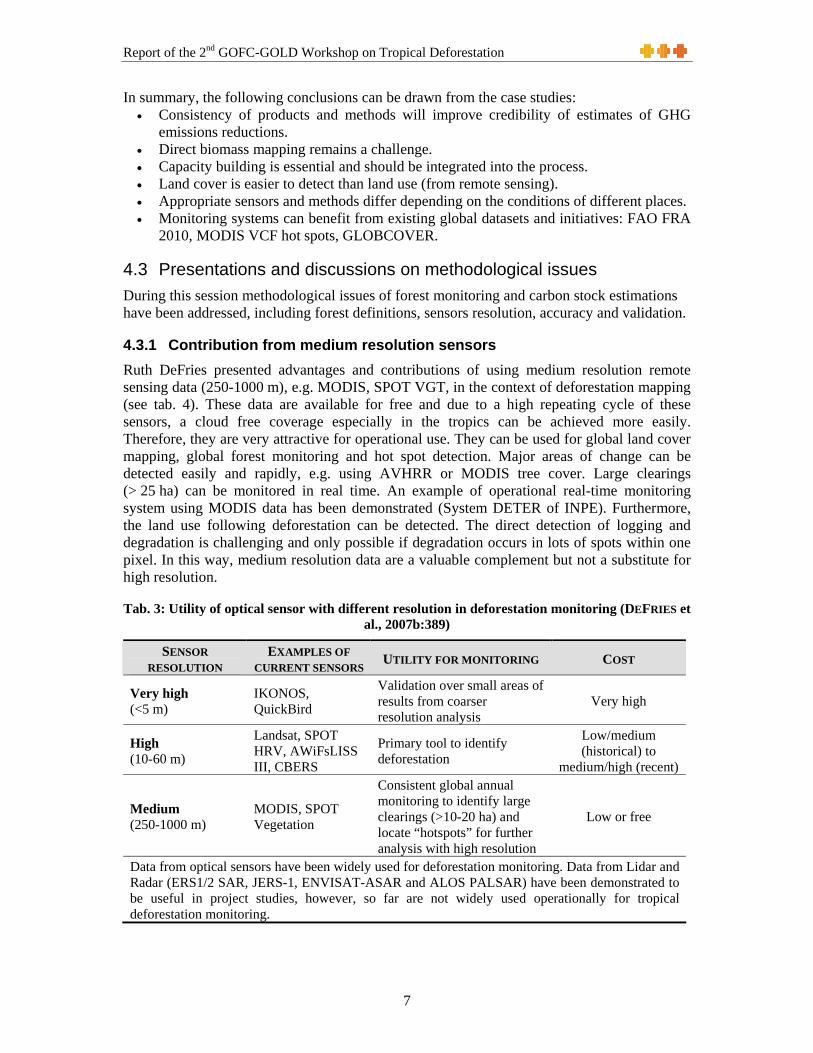
4.3.1 Contribution from medium resolution sensors Ruth DeFries presented advantages and contributions of using medium resolution remote sensing data (250-1000 m), e.g. MODIS, SPOT VGT, in the context of deforestation mapping (see tab. 4). These data are available for free and due to a high repeating cycle of these sensors, a cloud free coverage especially in the tropics can be achieved more easily. Therefore, they are very attractive for operational use. They can be used for global land cover mapping, global forest monitoring and hot spot detection. Major areas of change can be detected easily and rapidly, e.g. using AVHRR or MODIS tree cover. Large clearings (> 25 ha) can be monitored in real time. An example of operational real-time monitoring system using MODIS data has been demonstrated (System DETER of INPE). Furthermore, the land use following deforestation can be detected. The direct detection of logging and degradation is challenging and only possible if degradation occurs in lots of spots within one pixel. In this way, medium resolution data are a valuable complement but not a substitute for high resolution.
Tab. 3: Utility of optical sensor with different resolution in deforestation monitoring (DEFRIES et al., 2007b:389)
SENSOR RESOLUTION
EXAMPLES OF CURRENT SENSORS UTILITY FOR MONITORING COST
Very high (<5 m)
IKONOS, QuickBird
Validation over small areas of results from coarser resolution analysis
Very high
High (10-60 m)
Landsat, SPOT HRV, AWiFsLISS III, CBERS
Primary tool to identify deforestation
Low/medium (historical) to
medium/high (recent)
Medium (250-1000 m)
MODIS, SPOT Vegetation
Consistent global annual monitoring to identify large clearings (>10-20 ha) and locate “hotspots” for further analysis with high resolution
Low or free
Data from optical sensors have been widely used for deforestation monitoring. Data from Lidar and Radar (ERS1/2 SAR, JERS-1, ENVISAT-ASAR and ALOS PALSAR) have been demonstrated to be useful in project studies, however, so far are not widely used operationally for tropical deforestation monitoring.
Report of the 2nd GOFC-GOLD Workshop on Tropical Deforestation
8
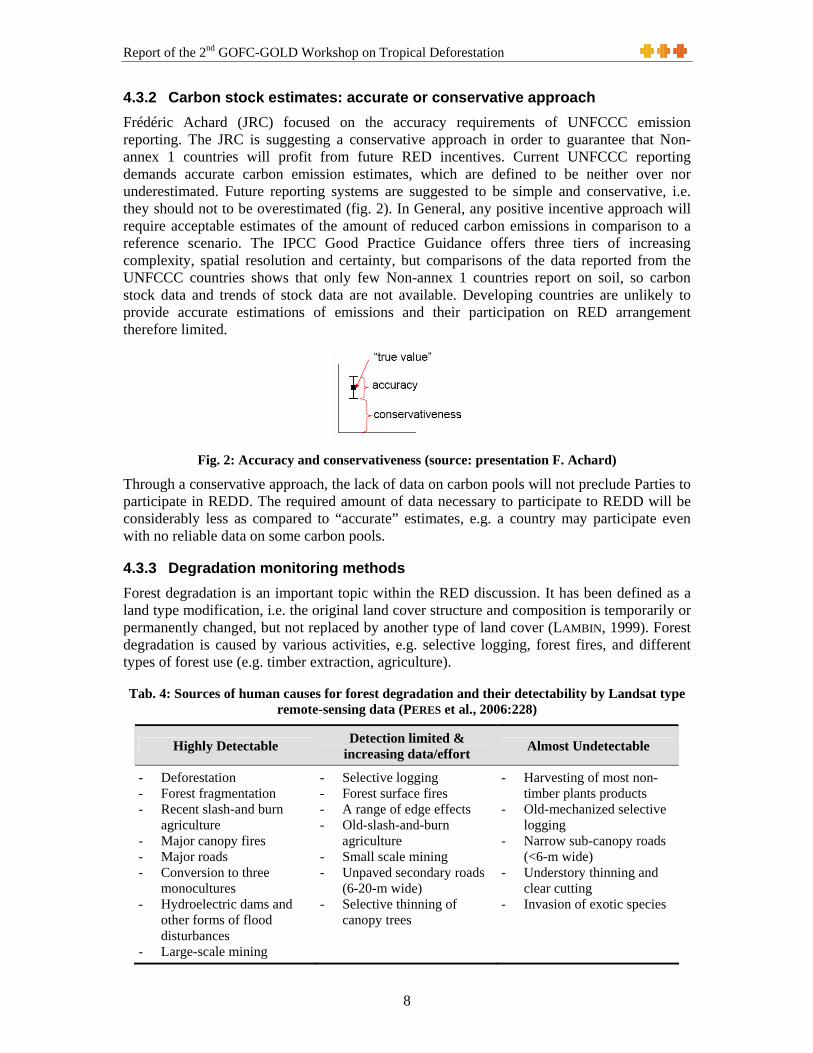
4.3.2 Carbon stock estimates: accurate or conservative approach Frédéric Achard (JRC) focused on the accuracy requirements of UNFCCC emission reporting. The JRC is suggesting a conservative approach in order to guarantee that Non-annex 1 countries will profit from future RED incentives. Current UNFCCC reporting demands accurate carbon emission estimates, which are defined to be neither over nor underestimated. Future reporting systems are suggested to be simple and conservative, i.e. they should not to be overestimated (fig. 2). In General, any positive incentive approach will require acceptable estimates of the amount of reduced carbon emissions in comparison to a reference scenario. The IPCC Good Practice Guidance offers three tiers of increasing complexity, spatial resolution and certainty, but comparisons of the data reported from the UNFCCC countries shows that only few Non-annex 1 countries report on soil, so carbon stock data and trends of stock data are not available. Developing countries are unlikely to provide accurate estimations of emissions and their participation on RED arrangement therefore limited.
Fig. 2: Accuracy and conservativeness (source: presentation F. Achard)
Through a conservative approach, the lack of data on carbon pools will not preclude Parties to participate in REDD. The required amount of data necessary to participate to REDD will be considerably less as compared to “accurate” estimates, e.g. a country may participate even with no reliable data on some carbon pools.
4.3.3 Degradation monitoring methods Forest degradation is an important topic within the RED discussion. It has been defined as a land type modification, i.e. the original land cover structure and composition is temporarily or permanently changed, but not replaced by another type of land cover (LAMBIN, 1999). Forest degradation is caused by various activities, e.g. selective logging, forest fires, and different types of forest use (e.g. timber extraction, agriculture).
Tab. 4: Sources of human causes for forest degradation and their detectability by Landsat type remote-sensing data (PERES et al., 2006:228)
Highly Detectable Detection limited & increasing data/effort Almost Undetectable
- Deforestation - Forest fragmentation - Recent slash-and burn
agriculture - Major canopy fires - Major roads - Conversion to three
monocultures - Hydroelectric dams and
other forms of flood disturbances
- Large-scale mining
- Selective logging - Forest surface fires - A range of edge effects - Old-slash-and-burn
agriculture - Small scale mining - Unpaved secondary roads
(6-20-m wide) - Selective thinning of
canopy trees
- Harvesting of most non-timber plants products
- Old-mechanized selective logging
- Narrow sub-canopy roads (<6-m wide)
- Understory thinning and clear cutting
- Invasion of exotic species

Report of the 2nd GOFC-GOLD Workshop on Tropical Deforestation
9
These activities cause a loss in the carbon stocks that is less than from deforestation, but cumulative effects over several years can result in significant carbon emissions making it an important process to be considered in forest monitoring. The detection of forest degradation is more challenging as it results in a complex of different land cover types (e.g. undisturbed forests, canopy gaps, areas of exposed soils, dead vegetation). Different monitoring methods and detection indicators are required, depending on area and intensity of the degradation. Carlos Souza (IMAZON) demonstrated available remote sensing methods to detect these forest disturbances by presenting examples of the Brazilian Amazon. Degradation can be observed directly or indirectly by remote sensing or by inventory based approaches, i.e. field surveys. Different remote sensing methods exist ranging from canopy damage detection, mapping of active fires, detecting of the required infrastructure (i.e. log landings and roads) (SOUZA et al., 2005). Hot spot sampling may be the most effective approach.
4.3.4 Monitoring changes in carbon stocks in selectively logged forests Methods to estimate carbon stocks in selectively logged forest were presented by Sandra Brown (Winrock International). In general, forest logging leads to a decrease in the carbon stocks in living biomass and to an increase the stocks in dead wood and wood products. The presented approach is based on field measurements that assess directly the changes in live and dead carbon stocks by using biomass regressions and expressed in units of removed timber volume or gap areas. To finally estimate the carbon impacts, these data have to be combined with timber harvest records or area measures of forest gaps. This method can be accomplished without remote sensing data if extraction rates and logged area are known. Nevertheless, remote sensing monitoring would provide an independent monitoring method of forest gaps, but needs to be done in the year of active logging as forest gaps close quickly and are hard to detect. Results from a study in the Congo basin that combined field data with optical data, from aerial transects flown over the logging concessions, showed that the extraction of 9.6 m³/ha lead to total loss of carbon of 8.8 tC/ha of concession. It has been concluded that describing the range of activities that cause carbon stocks to degrade can help to formulate appropriate methods for measuring and monitoring the carbon impacts. Furthermore, robust and validated methods exist for estimating change in carbon stocks from selective logging, with low uncertainty, while methods for slash and burn agriculture could readily be developed. Methods for other causes need further research.
4.3.5 Radar capabilities The capabilities of SAR sensors for forest monitoring and biomass mapping were presented by Wayne Walker (Woods Hole Research Center) on the example of the recently launched ALOS sensor. ALOS has an operational acquisition strategy providing annual, pan-tropical, wall-to-wall datasets over the next 5 years. Full resolution scenes at 6-12.5 m are available at moderate costs ($125). ALOS mosaic at 50 m resolution will be available freely. Annual global mapping of all forest biomes on Earth with dual-polarimetric high resolution observations will be available. Cloud penetration and day/night capability of SAR sensors make them a powerful data source, especially for tropical applications. The L-HH/HV polarization on ALOS is a powerful combination for forest monitoring and makes them ideal for compilation of annual pan-tropical forest-/non-forest maps. The full resolution data are sensitive to biomass. It was emphasized that SAR data processing tools have moved from research to application status, they are user friendly, freely available and suitable for in-country capacity building. Furthermore, the long-term availability of SAR data is guaranteed as Japan, Europe, USA and other nations are planning long wavelength missions with polarimetric capabilities.

Report of the 2nd GOFC-GOLD Workshop on Tropical Deforestation
10
4.3.6 Validation issues Curtis Woodcock (Boston University) discussed the issue of validation. He emphasized that it is important both during the production and after the completion of land cover maps. All land cover maps should be validated and the validation material should be published. Statistically valid estimates of map accuracy are essential to validation of land cover products and their ultimate acceptance and use. Having the variance of these estimates is also important. Design-based sampling provides a flexible yet rigorous approach for accuracy assessment. A set of core analysis methods for accuracy assessment exist which should be routinely adopted as a baseline for reporting map accuracy. There is considerable room for building upon these core methods to pursue additional dimensions of map accuracy. In the domain of validation of change detection there is considerable need for development of methods for separating land cover conversion from interannual variability in ecosystem response to climate variability. An additional problem is posed by lack of certainty regarding the historical status of landscapes. It was noted that in many developing countries there are obvious limitations in the availability of appropriate reference data for 1990-2000. More reference data are usually available for 2000-2005. Given the constraints for providing a statistically robust land change accuracy assessment in all places, the earth observation community proposes the approach of using “best efforts” and “continuous improvement”, similar to that applied in the National Carbon Accounting System of Australia (LOWELL et al., 2003). This perspective assumes that an internationally agreed and suitable mapping approach is applied in a transparent and consistent manner to derive the best national estimates. Time series consistency in terms of geolocation, spectral characteristics, climate variability and phenology, clouds and topography should be properly addressed. The monitoring should ideally work backwards from a most recent reference point to use the highest quality data first and allow for progressive improvement in methods. Growing experiences (knowledge of source and significance of potential errors), ongoing technical developments, and evolving national capacities will provide continuous improvements and, thus, successively reduce the uncertainty in the deforestation estimates. If no robust reference data are available, at a minimum, a consistency assessment should allow some estimation of the forest change quality, i.e. reinterpretation of small samples in an independent manner by regional experts. Any uncertainty bounds should be treated conservatively. A full accuracy assessment should be included for future deforestation monitoring. Such an effort would need to employ higher resolution or in situ data and agreed international technical guidelines that will evolve over time.
5 Breakout group discussions
5.1 Preparation of a RED sourcebook In the first sessions of breakout groups, the outline and content of the intended guidebook has been discussed in detail. The proposed contents are given below. The comments and suggestions of the present UNFCCC negotiator have been very fruitful for these discussions. They emphasized that a detailed sourcebook, summarizing what is possible, at what precision and costs would of high value for the countries. The intended guideline will address this need and summarize available methods and future projections and provide the direct link from the observation measurements to the UNFCCC reporting. The contents as suggested by the two breakout groups are presented in table 5 and 6, below. It is currently in preparation and will be presented at COP 13 in November 2007, in Bali, Indonesia.

Report of the 2nd GOFC-GOLD Workshop on Tropical Deforestation
11
Tab. 5: Suggested content for RED sourcebook by BOG1
Sourcebook Outline
1. Introduction:
Background: - relative importance of deforestation emissions - limitations-assess gross deforestation - C pools to assess - scale issues-tools for national, sub national, project levels - link to global estimates, e.g. FAO-FRA - accuracy-what is measured - feeds into national communications (UNFCCC)
Scope: - target audience-national level guidance - which topics included - flexible approach-array of methods - links to IPCC methods guide & tiers
Definitions: - refer to approach for Annex 1 countries - discuss inclusion of RS in ground-based approach
2. Guidance on Monitoring
(state of the art; add value to IPCC guide; limitations of tier levels) Monitoring Deforested Area:
- Technical Methods - Data Availability and Access - National Capacity required for Monitoring - Accuracy assessment - Case studies
Monitoring Forest Degradation: - Technical Methods - Data Availability and Access - National Capacity required for Monitoring - Accuracy assessment - Case studies
Carbon Stocks: estimating stocks and monitoring changes Estimating GHG Emissions from Reduced Deforestation at the National Level (also project level) New directions and initiatives for monitoring (data and methods)
3. Guidance on Reporting
- refer to UNFCCC requirements - How to translate monitoring results? - Which methods useful? - reporting limitations using tiers 1, 2 or 3
4. New directions and initiatives
- evolving technologies - other C pools
5. References
6. Available Resources

Report of the 2nd GOFC-GOLD Workshop on Tropical Deforestation
12
Tab. 6: Suggested content for RED sourcebook by BOG2
Estimating CO2 Emissions from Land Cover Change
Two books:
Technical book Policy Implications
Audience remote sensing specialists, forestry sector and policy makers
Introduction
Section 1: Review of definitions and methodological implications
- Biomass - Deforestation - Degradation - Leakage - Devegetation - Boundary issues - Scale - Historical emissions and projections
Section 2: Field methods for estimating biomass
- Methods o Approaches for tiers (defaults and data sources) o Allometric models o Sampling design o Field measurements o Carbon pools
- Uncertainty - Cost
Section 3: Remote sensing methods
- Land cover mapping Methods, Uncertainty, Cost
- Land use mapping Methods, Uncertainty, Cost
- Land cover change detection Methods, Uncertainty, Cost
- Forest degradation (logging, fire, climate changes, others?) Methods, Uncertainty, Cost
- Land cover dynamics Methods, Uncertainty, Cost
Section 4: Integration – estimating CO2 emissions
- Methods for extrapolation of biomass plot measurements - Stocks and emissions
o Models o …
- Uncertainty (integration)
Section 5: Projections - Existing modeling approaches a. Agents and drivers b. Types of models (bookkeeping, econometric
models, spatially explicit models) o Amount and location of deforestation
c. Calibration and validation techniques d. Temporal framework e. Uncertainty
- Projected scenarios and monitoring

Report of the 2nd GOFC-GOLD Workshop on Tropical Deforestation
13
Section 6: Capacity building
Policy brief: Policy Implications
o Independent verification o Sovereignty
Boxes: successful cases of the above sections.
5.2 Discussions on technical issues A final discussion session focused on technical issues and reviewed topics that were addressed in the related presentation session. Recalling these presentations, the following conclusions were drawn:
• Forest degradation is important, yet poorly defined or characterized. • Validation is important and is needed to characterize the uncertainty • Measurement and monitoring systems should be simple and provide conservative
estimates
The issue of forest definition was emphasized. Within the UNFCCC, forests are defined broadly as patches of at least 0.5-1 ha that are covered to at least 10-30 % by trees of a minimum height of 2-5 m. While an accepted deforestation definition exists, a commonly accepted definition for degradation is still needed. The IPCC GPG definitions are applied by the CfRN but many countries apply individual definitions (e.g. Australia, Brazil, Thailand, Nepal) using differing concepts e.g. are forest-type or biome-based definition as e.g. in Brazil or COMIFAC. Each option represents different technical EO requirements and impacts: cost, data availability, ability to harmonize and compare data, etc.
Concerning the derivation of reference scenarios it was stated that they can be derived consistently from 1990s onwards with confidence. Measurement and monitoring systems should be simple and provide conservative estimates. The recommended minimum requirements for a historic deforestation reference are as follows: • Using available 1990, 2000, 2005 global Landsat mosaics:
o (in 2008, the MDGLS data set will be freely available, consisting of data from Landsat 5/7, Aster, EO-ALI, built on the existing Geocover data), additional datasets usually increases accuracy (and cost)
o Data found useful: SPOT (1990-present), ASTER (2000-present), Indian satellites, CBERS, DMC …
o Inter-annual variability should be considered • National level monitoring of gross deforestation:
- 1-5 ha minimum change mapping unit - Visual scene to scene interpretations of forest cover change - Sophisticated (digital) approaches may lead to more accurate results - Wall-to-wall approach is common and provide full coverage of historical
deforestation and hot spots - Sampling approaches needs less resources

Report of the 2nd GOFC-GOLD Workshop on Tropical Deforestation
14
References DEFRIES, R., ACHARD, F., BROWN, S., HEROLD, M., MURDIYARSO, D., SCHLAMADINGER, B. &
C. DESOUZA JR. (2007a): Reducing Greenhouse Gas Emissions from Deforestation in Developing Countries: Considerations for Monitoring and Measuring. GOFC-GOLD Report Series 26
DEFRIES, R., ACHARD, F., BROWN, S., HEROLD, M., MURDIYARSO, D., SCHLAMADINGER, B. &
C. DESOUZA JR. (2007b): Earth observations for estimating greenhouse gas emissions from deforestation in developing countries. Environmental Science & Policy 10: 385-394
GEIST, H. J. & E. F. LAMBIN (2002): Proximate causes and underlying driving forces of
tropical deforestation. Bioscience 52(2):143-150 HEROLD, M., SAMBALE, J. & C. SCHMULLIUS (2007): Report of the 1st Workshop on
Monitoring Tropical Deforestation for Compensated Reductions, 21-22 March 2006, Jena, Germany. GOFC-GOLD Report Series 27
LAMBIN, E. (1999): Monitoring forest degradation in tropical regions by remote sensing: some
methodological issues. Global Ecology and Biogeography 8:191–198 LOWELL, K., WOODGATE, P., JONES, S. & G. RICHARDS (2003): Continuous improvement of
the National Carbon Accounting System land cover change mapping. National Carbon Accounting System Technical Report No. 39, Australian Greenhouse Office, Canberra
PERES, C. A., BARLOW, J. & W. F. LAURANCE (2006): Detecting anthropogenic disturbance in
tropical forests. Trends in Ecology and Evolution, 21 (5):227-229 SOUZA, C. M., FIRESTONE, L., SILVA, L. M. & D. ROBERTS (2003): Mapping forest degradation
in the Eastern Amazon from SPOT 4 through spectral mixture models. Remote Sensing of Environment 87:494-506
SOUZA, C. M., ROBERTS, D. A. & M. A. COCHRANE (2005): Combining spectral and spatial
information to map canopy damage from selective logging and forest fires. Remote Sensing of Environment 98:329-343

Report of the 2nd GOFC-GOLD Workshop on Tropical Deforestation
15
Appendix 1 - List of participants Name Representing Contact GOFC-GOLD Invitees Achard, Frédéric JRC, European
Commission Global Vegetation Monitoring Unit Joint Research Centre, TP 641 21020 Ispra (VA), Italy [email protected]
Brady, Michael Executive Director GOFC-GOLD
Canadian Forest Service – Natural Resources Canada 580 Booth Street Ottawa, Ontario K1A 0E4, Canada [email protected]
Brown, Sandra Winrock International, USA
Winrock International – Ecosystem Services Unit 1621 N. Kent Street, Suite 1200 Arlington, VA 22207, USA [email protected]
Csiszar, Ivan Fire IT Dept of Geography and Earth System Science Interdisciplinary Center 1121 Lefrak, College Park, MD 20742, USA [email protected]
Columba, Karin Executive Director FAN Bolivia
Fundacion Amigos de la Naturaleza Old Highway to Cochabamba Km. 7, Box 2241 Santa Cruz, Bolivia http://www.fan-bo.org
DeFries, Ruth University of Maryland, USA
Dept of Geography and Earth System Science Interdisciplinary Center 2181 Lefrak Hall, College Park, MD 20742, USA [email protected]
DeSouza, Carlos IMAZON IMAZON - Instituto do Homem e Meio Ambiente da Amazônia Caixa Postal 1015 CEP Belém-PA 66017-000, Brazil [email protected]
DiBella, Carlos REDLatif Instituto de Clima y Agua INTA-Castelar Los Reseros y las cabaña 1712 Castelar - Buenos Aires, Argentina [email protected]
García Guerrero, Andrea
Ministry of Environment, Colombia
Colombian Climate Change Mitigation Group Ministry of Environment, Housing and Territorial Development Calle 37 No. 8-40, Colombia [email protected]
Guzman, Rudy CADEFOR Centro Amazónico de Desarrollo Forestal Santa Cruz, Bolivia [email protected]
Herold, Martin Land Cover IT office, Germany
Department of Geography, Friedrich Schiller University Jena Grietgasse 6 07743 Jena, Germany [email protected]

Report of the 2nd GOFC-GOLD Workshop on Tropical Deforestation
16
Johns, Tracy Johanneum Research / CAN
Joanneum Research Institute for Energy Research Elisabethstrasse 5 8010 Graz, Austria [email protected]
Killeen, Timothy Conservation International
Conservation International [email protected]
Mattsson, Eskil Göteberg University, Sweden
Göteborg University – Earth Sciences Centre Box 460 SE-405 30 Göteborg, Sweden [email protected]
Mollicone, Danilo
MPI BGC Jena, Germany
Max-Planck-Institute for Biogeochemistry Hans-Knöll-Str. 10 07745 Jena, Germany [email protected]
Munilla, Isabel World Resources Institute
World Resources Institute 10 G Street, NE (Suite 800) Washington, DC 20002 USA [email protected]
Pandey, Devendra
Director General, Forest Survey of India
Forest Survey of India (FSI) Ministry of Environment & Forests Kaulagarh Road, P.O., IPE Dehradun - 248 195, India [email protected]
Pedroni, Lucio World Bank Tropical Agricultural Research and Higher Education Center (CATIE) 7170 Turrialba, Costa Rica [email protected]
Resnikowski, Heidy
Superintendencia Forestal
Superintendencia Forestal Bolivia http://www.sforestal.gov.bo
Sambale, Jacqueline
Land Cover IT office Department of Geography, Friedrich Schiller University Jena Grietgasse 6 07743 Jena, Germany [email protected]
Seifert-Granzin, Joerg
FAN Bolivia Fundacion Amigos de la Naturaleza Old Highway to Cochabamba Km. 7 Box 2241, Santa Cruz, Bolivia [email protected]
Steininger, Marc Conservation International
Scientific Director Center for Applied Biodiversity Science (CABS) [email protected]
Ulloa Gisela CDM Coordinator, Bolivia
Ministry of Planning of Development, CDM Office Mercado Street, 1328, Marisca Bolivian Building, Mezzanine La Paz, Bolivia [email protected]
Volden, Espen European Space Agency
ESA-ESRIN Via Galileo Galilei Casella Postale 64, 00044 Frascati, Italy [email protected]

Report of the 2nd GOFC-GOLD Workshop on Tropical Deforestation
17
Wachholtz, Rolf Superintendencia
Forestal Superintendencia Forestal Nacional de Bolivia Av. 2 de Agosto No. 6 Casilla de Correos 7091 Santa Cruz, Bolivia [email protected]
Walker, Wayne Woods Hole Research Woods Hole Research Center, 149 Woods Hole Road, Falmouth, MA 02540-1644, USA [email protected]
Woodcock, Curtis
Co-chair Land Cover IT
Department of Geography Boston University 675 Commonwealth Avenue Boston, MA 02215, USA [email protected]
Local Invitees Andrade, Marcos Universidad Mayor
San Andres Universidad Mayor de San Andrés Av. Villazón, 1995 - Casilla Postal 4787 La Paz, Bolivia http://www.umsanet.edu.bo/
Quezada, Belen Museo de la Historia Natural Noel Kempff Mercado
Museo de la Historia Natural Noel Kempff Avenida Irala 565 - Casilla Post al 2489 Santa Cruz - Bolivia http://www.museonoelkempff.org/
Campero, Henry WWF Bolivia WWF Bolivia Programme Office Av. Beni Calle Los Pitones No. 2070 Santa Cruz, Bolivia [email protected]
Camargo, Rodney
Superintendencia Forestal
Superintendencia Forestal Nacional de Bolivia Av. 2 de Agosto No. 6 Casilla de Correos 7091, Santa Cruz, Bolivia http://sig.sforestal.gov.bo/
Cuellar, Saul FAN Bolivia Fundacion Amigos de la Naturaleza Old Highway to Cochabamba Km. 7 Box 2241, Santa Cruz, Bolivia http://www.fan-bo.org
Erik Armijo BOLFOR II BOLFOR II Av. 2 de Agosto y Cuarto Anillo, P.O. Box: 6204 Santa Cruz de la Sierra, Bolivia [email protected]
Harper, Grady Conservation International
Conservación Internacional Bolivia Calacoto, Calle 13, Nº 8008 La Paz - Bolivia [email protected]
Mendez, Dorys Prefectura Santa Cruz http://www.santacruz.gov.bo/index.php
Ortiz, Shirley Prefectura Santa Cruz http://www.santacruz.gov.bo/index.php
Paz, Clea Conservation International Bolivia
Conservación Internacional Bolivia Calacoto, Calle 13, Nº 8008 La Paz - Bolivia [email protected]

Report of the 2nd GOFC-GOLD Workshop on Tropical Deforestation
18
Quevedo, Lincoln
Universidad Autonoma Gabrel Rene Moreno
Universidad Autonoma Gabrel Rene Moreno – Santa Cruz http://www.uagrm.edu.bo/
Quispe, Jaime FAN Fundacion Amigos de la Naturaleza Old Highway to Cochabamba Km. 7 Box 2241 Santa Cruz, Bolivia http://www.fan-bo.org
Rojos, José Manuel
Fundacion NATURA NaturaBolivia Av, Irala 421, 2do piso Santa Cruz-Bolivia www.naturabolivia.org
Segales, Jaime Superintendencia Forestal
Superintendencia Forestal Nacional de Bolivia Av. 2 de Agosto No. 6 Casilla de Correos 7091, Santa Cruz, Bolivia http://sig.sforestal.gov.bo/
Soria, Liliana Museo de Historia Natural Noel Kempff Mercado
Museo de la Historia Natural Noel Kempff Avenida Irala 565 - Casilla Post al 2489 Santa Cruz - Bolivia http://www.museonoelkempff.org/
Steven Price BOLFOR II BOLFOR II Av. 2 de Agosto y Cuarto Anillo, P.O. Box: 6204 Santa Cruz de la Sierra, Bolivia [email protected]
Vargas, Maria Teresa
Fundacion NATURA NaturaBolivia Av, Irala 421, 2do piso Santa Cruz-Bolivia www.naturabolivia.org
Villegas, Zulema Instituto Boliviano de Investigacion Forestal (IBIF)
Instituto Boliviano de Investigacion Forestal (IBIF) Cuarto Anillo esq. Av. 2 de Agosto Santa Cruz- Bolivia http://www.ibifbolivia.org.bo/

Report of the 2nd GOFC-GOLD Workshop on Tropical Deforestation
19
Appendix 2 – Agenda Measuring and monitoring greenhouse gas emissions from deforestation in
developing countries: from case studies to implementation guidelines Monday, April 16th, Los Tajibos Convention Center
10.00 – 16.00 GOFC-GOLD Latin America Regional Network meeting Brady/DeSouza/Herold 19.00 – 21.00 Ice breaker event (optional)
Tuesday, April 17th, Los Tajibos Convention Center
SESSION 0: Welcome and setting the stage (Chair: Brown)
10.00 – 10.10 10.10 – 10.20 10.20 – 10.30 10.30 – 11.00
Start of Workshop / Welcome by FAN Bolivia GOFC-GOLD intro and welcome Working group report and meeting objectives Welcome and perspectives from Bolivia
Seifert-Granzin/ Columba Brady DeFries Ulloa
11.00 – 11.15 Break
SESSION 1: UNFCCC – Recent developments and policy discussions
11.15 – 11.35 11.35 – 12.05 12.05 – 12.25 12.25 – 12.45
REDD process overview and Colombian perspectives Future policy scenarios: definitions, accounting rules … World Bank perspectives and methodology Report on LARN workshop outcomes
Guerrero Johns Pedroni DeSouza
12.45 – 13.45 Lunch
SESSION 2: Ongoing mapping activities and REDD case studies
13.45 – 14.10 14.10 – 14.30 14.30 – 15.00 15.00 – 15.30 15.30 – 16.00
FAN Bolivia experiences Cameron case studies and experiences India examples and experiences Contribution from medium resolution analysis Vanuatu case study
Seifert-Granzin/ Johns Volden Pandey DeFries Herold
16.00 – 16.30 Break
SESSION 3: Ongoing mapping activities and REDD case studies
16.30 – 17.00 17.00 – 17.30 17.30 – 18.00 18.00 – 18.30
JRC TREES-3 / FAO FRA 2010 Conservation international case studies Woods hole research center case studies Concluding discussion
Achard Steininger Walker DeFries
19.00 – 21.00 Joint evening event with Bolivian participants
Wednesday, April 18th, Los Tajibos ConventionCenter
SESSION 4: Breakout group discussions I
08.30 – 09.00 09.00 – 09.15 09.15 – 11.00
Reflection on case study presentation Discussion and formation of breakout groups Breakout group discussions I
Woodcock Achard All

Report of the 2nd GOFC-GOLD Workshop on Tropical Deforestation
20
11.10 – 11.30 Break
SESSION 5: Breakout group presentations I
11.30 – 12.30 Breakout group presentations I All 12.30 – 14.00 Lunch
SESSION 6: Data access and methodological issues
14.00 – 14.25 14.25 – 14.50 14.50 – 15.15 15.15 – 15.40 15.40 – 16.05
MPI-BGC case studies and experiences (PNG etc.) Carbon stock estimates: accurate or conservative approach Degradation monitoring methods Monitoring changes in carbon stocks in logged forests Validation issues
Mollicone Achard DeSouza Brown Woodcock
16.05 – 16.30 Break
SESSION 7: Breakout group discussions II
16.30 – 16.50 Discussion and formation of breakout groups De Fries 16.50 – 18.30 Breakout group discussions II All 19.00 – 21.00 Workshop dinner BBQ- Casa del Camba
Thursday, April 19th , Los Tajibos ConventionCenter
SESSION 8: Breakout group presentations II + summary discussions
09.00 – 10.00 10.00 – 10.30
Breakout group presentations II Discussions and charge for writing teams
All Defries/Achard
10.30 – 11.00 Break
SESSION 9: Writing session I
11.00 – 12.30 Writing team sessions All 12.30 – 14.00 Lunch
SESSION 11: Writing sessions II
14.00 – 16.00 Writing team sessions All 16.00 – 16.30 Break
SESSION 12: Summary session
16.30 – 17.30 17.30 – 18.30
Report from writing teams Summary discussions and action items
All DeFries/Achard
18.30 Meeting adjourn 19.00 Dinner

Report of the 2nd GOFC-GOLD Workshop on Tropical Deforestation
21
Appendix 3 – Documents GTOS/GOFC-GOLD submission to UNFCCC on the issue for reducing emissions from deforestation in developing countries (RED-DC) following the SBSTA invitation to Parties and accredited observers to submit their views by 23 February 2007
The technical panel of the Global Terrestrial Observing System (GTOS) on “Global Observation of Forest Cover and Land Dynamics” (GOFC-GOLD) coordinated the preparation of a report as outcome of an established working group on the item “reducing emissions from deforestation in developing countries and considerations for monitoring and measuring” (available at: http://www.fao.org/gtos/doc/pub46.pdf).
The report highlights technical considerations for measuring and monitoring GHG emissions from deforestation and GHG emissions reductions from avoiding deforestation that need to be addressed in more detailed guidelines and protocols. It is a first consensus perspective from the earth observation community on related scientific and methodological issues with some key conclusions: • Analysis of remotely sensed data from aircraft and satellite is the only practical approach
to measure changes in forest area in developing countries at national scales. Since the early 1990s, changes in forest area can be measured from space with confidence.
• Various methods are available and appropriate to analyze satellite data for measuring changes in forest cover. These methods range from low cost visual photo-interpretation to sophisticated digital analysis. A variety of methods can be applied depending on national capabilities, deforestation patterns, and characteristics of the forest. Quantifying the accuracy of the result and ensuring that consistent methods are applied at different time intervals is more critical than applying standard methods across all countries.
• Data sources exist to determine reference emission scenarios for the 1990s. Averted emissions can be estimated from short term (<5 years) extrapolations of current trends and historical deforestation rates and from existing estimates of forest carbon stocks.
• Estimates of carbon stocks of forests undergoing deforestation are less well known for many developing countries, but default data exist for all are reported in recent IPCC and FAO reports. Guidelines already exist for carbon accounting and are detailed in the IPCC Good Practice Guidance Report (2003) and in the IPCC methods for national inventories of GHGs.
• Key constraints in implementing national systems for monitoring changes in forest cover are cost and access to high resolution data and capacities to use and analyze them.
• New technologies and approaches are developing for monitoring changes in carbon stocks using a combination of satellite and airborne imagery that will reduce uncertainties in accounting for changes in GHG emissions. International coordination and resources are also needed to further test and implement these technologies.
The report presents a first and general vision of the earth observation community potential assistance to this UNFCCC process. With the evolving discussions in the UNFCCC forum, the intention is to develop a more detailed technical-guidelines-type document with specific methodological recommendations. For this matter GOFC-GOLD will host a second workshop synthesizing the experiences from recent remote sensing case study in different parts of world. The workshop will be held on 17-19 April 2007 in cooperation with FAN Bolivia in Santa Cruz, Bolivia. The workshop will further discuss technical options for measuring and monitoring deforestation in developing countries and for estimating related greenhouse gas emissions with the following specific objectives:

Report of the 2nd GOFC-GOLD Workshop on Tropical Deforestation
22
• Discuss and synthesize the practical experiences of recent and ongoing case studies on the RED-DC issue (the workshop presentations will be focused on actual case studies, e.g. Bolivia, PNG, India, Cameroon, and Vanuatu)
• Discuss further key challenging issues (i.e. degradation monitoring, forest area change versus emissions, validation and accuracy, costs)