report-land tenure considerations for neighbourhood ... · land tenure considerations for...
TRANSCRIPT

Working paper
Land tenure
considerations for
neighbourhood
planning
Thierry Ngoga Hoza
January 2018
When citing this paper, please use the title and the followingreference number:C-43418-UGA-1
2
Executive summary The land tenure regime in Uganda is considered to be one of the most complex in the world, particularly in Kampala where four different land tenure systems operate alongside each other. This has had a significant impact on growth and investments in the city. It has also made planning more challenging. However, land use planning is important to be able to co-ordinate the private and public investments and thus to enable productive and liveable density in cities. Furthermore, well-functioning urban areas require that economies of scope and complementarities be leveraged in the provision of physical infrastructure like roads, drainage, street lighting, electricity, water, sewerage, and waste disposal, as well as policing and health care. With foresight and strong implementation, urban planning can provide the coordination required between various public and private sector actors.
There have been numerous attempts to design urban plans for Kampala in the past. Most recently, a comprehensive Kampala Physical Development Plan (KPDP) was finalised in 2012, to guide urban planning in the city. However, the implementation of the KPDP was contingent, in its assumptions at the outset, upon a resolution of Kampala's land tenure regime constraints. This is due to the fact that the authors of the KPDP correctly noted that resolving the land issue would enable the property market to function more efficiently. Although there have been some achievements in the field of land regularisation and administration to date, administrative and political challenges mean that overall resolution is not likely in the short term. The land tenure regime remains one of the most binding structural constraints to effective physical planning in the city as it continues to grow.
Given the challenges in implementing the KPDP to date, the Kampala Capital City Authority (KCCA) has now decided to operationalise the plan through smaller integrated neighbourhood planning projects. Following a comprehensive analysis of the importance of urban planning and detailed descriptions of planning in the context of Uganda, this paper provides recommendations on how this can be more effectively done within the complexities of Kampala’s land tenure system. It details one potential participatory methodology, namely tenure-responsive land use planning, which is suitable in this context. An outcome of this type of planning may be to enhance tenure security in the city. To illustrate how this methodology may be implemented successfully in practice, it details the examples of Ghana and Laos where it has been successfully used.
3
Table of contents Listoffiguresandboxes....................................................................................................1
Listofacronyms................................................................................................................1
Executivesummary...........................................................................................................2
Tableofcontents...............................................................................................................3
Section1:Introduction......................................................................................................5
Section2:Anoverviewofurbanisation,urbanplanningandlandtenuresecurityinAfrica72.1 Urbanisation..................................................................................................................73.2 Urbanplanning..............................................................................................................83.3 Landtenuresecurity....................................................................................................10
Section3:Uganda’slandtenureregimeanditslegalframework.....................................113.1 FreeholdLandTenure(FHLT)........................................................................................123.2 LeaseholdLandTenure(LHLT)......................................................................................123.3 MailoLandTenure(MLT).............................................................................................133.4 CustomaryLandTenure(CLT).......................................................................................143.5 UrbanlandtenuresecurityinKampala........................................................................14
Section4:PlanningwithintheKCCA................................................................................164.1 OverviewofKampalaandKCCA’smandate..................................................................164.2 Strategicplanningframework......................................................................................174.3 KampalaPhysicalDevelopmentPlan(KPDP)................................................................184.4 Otherchallengesforplanning......................................................................................20
Section5:Combiningplanningwithlandtenureharmonisationandregulation..............215.1 Planningasapathtolandtenureregularisation..........................................................215.2 TenureResponsiveLandUsePlanning(TR-LUP)...........................................................235.3 CasestudiesinTenureResponsiveLandUsePlanning(TR-LUP)...................................25Box1:LandadministrationprojectinGhana...........................................................................26Box2:Land-useplanningprojectinLaos..................................................................................275.4TR-LUPversusparticipatoryland-useplanning...................................................................295.5 Considerationforimplementingneighbourhoodplanning...........................................29
Section6:Conclusionandpolicyrecommendations.........................................................306.1 ConsiderationofTR-LUPinKampala............................................................................306.2 Enhancecapacityandaddressresourceconstraintsofplanningauthorities................316.3 Assessmentofexistingconditions:Apathtolandtenureregularisation......................316.4 Inventoryofpreviousplanninginitiatives....................................................................316.5 TherolesofKCCAandlocalgovernment......................................................................326.6 Pilotneighbourhoodplans...........................................................................................326.7 Improvingcoordination...............................................................................................336.8 Strengtheningurbandevelopmentstakeholders’coordination....................................336.9 Localknowledgeiskey.................................................................................................336.10 Resourcesforrelocation..............................................................................................346.11 Makingurbandevelopmentandplanningapriority.....................................................34
References......................................................................................................................35
Legislationandpolicies....................................................................................................37
5
Section 1: Introduction Kampala, the capital of Uganda and seat of the government, is at the core of the country’s urban structure. The city was originally planned for 150,000 inhabitants but its current resident population is 1.75 million, with a daily work force of about 4.5 million (KCCA 2012). The city's annual demographic growth rate is 3.9% and its population is estimated to reach 20 million by 2040 (KCCA, 2012). Urbanisation is a transformative force that can be harnessed for a more sustainable development trajectory, with cities taking the lead to address many of the global challenges of the 21st century, including poverty, inequality, unemployment, environmental degradation and climate change (UN-Habitat 2016). Therefore, successful urbanisation is critical for national economic development (Collier, 2016). However, Kampala's burgeoning urbanisation, coupled with the fact that much of the urbanisation to date has occurred in a haphazard manner, has led to various problems. These include the development of scattered unplanned settlements and slums, aggravated by the encroachment into marginal land, especially wetlands, and inadequate provision of housing, employment, services, utilities and amenities by the city to a majority of the population. Thus, many of Kampala’s inhabitants generally have a very low standard of living, with low quality of life and very limited amenity and service provision (Kampala's Strategic Plan 2014-2019; KCCA, 2012). This has contributed to the city remaining unproductive and increasingly difficult to manage, negatively affecting economic development.
In order to reverse this trend and better plan for the two-thirds of the city that is still to be developed (Collier 2016), in 2012 the KCCA developed a physical plan known as Kampala Physical Development Plan (KPDP), the first step to guide orderly physical and sustainable development of the city via a participatory process. To date, much of the KPDP has not been implemented, in part due to the infeasible assumptions made at the outset. Thus, the KCCA now wants to expand on it and implement it via a series of integrated neighbourhood plans for different parts of the city.
According to Lall et al (2017), land use planning, encompassing zoning and building regulations, is one of the most valuable tools that governments can use to guide development and promote productivity and liveability in their cities. At the core of land use planning is the joint balancing of competing land uses by all stakeholders and the joint identification of those uses for which the highest consensus can be achieved – ideally for the purpose of sustainability. This makes land use planning a central prerequisite for any spatial development that aims at social, ecological and economic sustainability (GIZ, 2011). However, land use is also closely related to land-ownership and property rights regimes prevailing in an area. This, in turn, influences possible land uses and, thus, land tenure is increasingly addressed in land use planning (GIZ, 2011).
6
The land tenure regime in Uganda, considered to be one of the most complex in the world (Bernard et al., 2016; Collier et al., 2015; Dobson et al., 2014), comprises of:
(i) Leasehold land, which is managed by the Kampala District Land Board, under the Ministry of Lands, Housing and Urban Development (MLHUD);
(ii) Freehold land, owned by private individuals as well as other public institutions, NGOs, religious organisations and charities and managed by the Uganda Land Commission;
(iii) Customary land comprising land held under customary law;
(iv) Mailo land, established under the 1903 Buganda Land Agreement, owned by the Buganda Kingdom and managed by the Buganda Land Board, further divided into:
a. Private mailo, which is held by individuals;
b. Public mailo owned by the Buganda Kingdom.
In Kampala, unlike other Ugandan cities, customary land is virtually non-existent. Thus, the other three types co-exist, with the dominant form of landholding being mailo, followed by leasehold and freehold land respectively (Muinde, 2013). Although planning will be essential for Kampala’s transition into a productive city, it will only be successful if it is responsive to the land tenure regime.
There have long been calls for reform of the land tenure regime, but this is a highly political issue and, thus, it is unlikely to happen in the near future. The city, however, will continue to grow despite the land tenure regimes, and planning must still take place. Apart from the complex nature of the land tenure regime, Kampala is also characterised by unclear property rights. This is often cited as one of the main reasons why urban land re-development in Kampala has been slow.
This paper aims to identify and examine the considerations with respect to land tenure that future neighbourhood planning needs to take into account, by:
• Reviewing existing legislation with respect to the Uganda government’s urban land policy, including the Ugandan Constitution, the Land Act and the Uganda National Land Policy (UNLP);
• Assessing the KPDP within the context of the existing land tenure system and how it can be translated into neighbourhood planning. In particular, reform of the existing land tenure system is considered as a prerequisite for the implementation of the current KPDP.
• Proposing a method to undertake neighbourhood planning, without land tenure reform as a pre-requisite. Although reforming the land tenure systems will be fundamental to supporting more efficient and equitable growth in the city, various political and administrative reasons mean this is unlikely to happen in the near future.
7
This paper uses mainly secondary data via a review of existing literature in order to outline policy considerations and recommendations for Kampala’s neighbourhood planning process to proceed within the existing land complexity. It is supplemented with information from unstructured interviews with key informants who were purposively selected. The interviews were conducted with key officials from KCCA’s Directorate of Strategy and Business Development, and Directorate of Physical Planning; the Uganda Land Commission (ULC); the Kampala District Land Board (KDLB); the Buganda Land Board (BLB); the Ministry of Lands, Housing and Urban Development (MLHUD); and other stakeholders in July 2017.
The rest of the paper is divided into the following sections: Section 2 looks at urbanisation, urban planning and land tenure security in Africa more generally, and Section 3 provides an overview of Uganda's land tenure regime and, more specifically, its legal framework. Section 4 is devoted to a description of the KCCA as an authority as well as its KPDP, the strategic planning framework. Section 5 considers how planning can be combined with land tenure harmonisation and regularisation and Section 6concludes with policy recommendations.
Section 2: An overview of urbanisation, urban planning and land tenure security in Africa
2.1 Urbanisation
Africa is rapidly urbanising. Its urban population currently comprises about 472 million people, with this number estimated to double over the next 25 years as more migrants are pushed to cities from the countryside. Some of the largest cities are growing as fast as 4% per annum (World Bank, 2017). Urbanisation is a transformative economic force that can be harnessed for a more sustainable development trajectory, with cities taking the lead to address many of the global challenges of the 21st century, including poverty, inequality, unemployment, environmental degradation and climate change. Consequently, successful urbanisation is critical for economic development. Although African cities are experiencing rapid population growth, their economic growth (as predicted by theory and other region’s historical experiences) has not kept pace.
Many African cities share three main features that constrain urban and economic development:
(i) Cities are densely populated, yet the downsides of density are not being effectively managed (Glaeser & Dempster, 2015). This results in large unplanned, informal dwellings that are of low quality and which have inadequate access to clean water, sanitation and other infrastructure. An estimated 60% of the region’s urban population live in areas that are
8
considered to be overcrowded. A major reason that governments cannot manage this is that the urbanization of people is not accompanied by commensurate increases in financing. Thus, housing, infrastructural facilities and other capital investments are lacking. It is estimated across the region, housing investment lags urbanization by nine years;
(ii) Cities are disconnected due to a lack of reliable transport and other infrastructure, limiting workers' job opportunities as well as the ability of firms to fully benefit from agglomeration economies. Connectivity is a key ingredient of unleashing the productivity miracle in cities (Collier 2016);
(iii) African cities are costly to live and also to do business in. In fact, cities across the continent are estimated to be among the costliest in the world, both for firms and for households. One major for this is due to their inefficient spatial form (World Bank, 2017; United Nations 2015a; Dasgupta et al, 2014).
3.2 Urban planning
For urbanisation to be efficient and effective in providing the backbone of growth, landed property rights play a critical role. They affect the transfer of land between users and in turn, land prices determine the intensity of investments in structures. However, both land transfers and prices are affected by land use regulation and urban planning, which are the policies that determine how and where land is used. The importance of urban planning and suitable land use regulations are central for enhancing urban connectivity, productivity, and liveability as well as helping ameliorate negative externalities and coordination failures.
Unregulated landed property markets are unlikely to achieve adequate urban densities and support efficient urban form. This is because land markets do not internalise the competing positive and negative effects that density levels have on urban development. On the one hand, density is a public good that enables cost-effective infrastructure provision, and facilitates the productive clustering of businesses and workers. Yet there are downsides to density in the form of congestion, crime, flood-risk, and the spread of contagious disease. Land use planning may therefore be necessary to co-ordinate the private and public investments that enable productive and liveable density. Furthermore, well-functioning cities require that economies of scope and complementarities be leveraged in the provision of physical infrastructure like roads, drainage, street lighting, electricity, water, sewerage, and waste disposal alongside policing and health care. With foresight and strong implementation, urban planning can provide the coordination required between various public and private sector actors to facilitate effective urban development (World Bank, 2017).
9
Planning regulations such as zoning ordinances and building codes are the key instruments that are used by planning authorities to implement urban plans (World Bank, 2017). Strong planning authorities have the ability to enforce these plans, policies and regulations and thus these types of authorities are essential to protect private property rights. Building a well-functioning city is contingent upon secure and thus enforceable rights over land and property. For example, these are critical in terms of implementing land registers or mortgage collateral, to name just some examples, and to encourage investment in landed property.
In this context of African cities, however, this type of adequate urban planning becomes very challenging. Many urban plans and authorities appear to be rendered ineffective. For example, they are not coordinating investment in structures or managing the spatial form of cities across different levels of government. As the World Bank explains, urban planning has traditionally been a function of central governments and only gradually, since the mid-to-late 1900s, has its decentralization gained momentum (World Bank 2017). These shifts are usually formalized through some form of legislation that empowers local governments to undertake their own urban planning activities. However, such devolution of responsibilities is not entirely clear-cut or always accompanied by the necessary fiscal empowerment. At the local level, the systems and institutions to support inclusive and effective community participation may also be lacking. Most African countries have vertical institutional fragmentation and a complex relationship among the multiple bodies. Ultimately, this results in both national and city-level agencies being involved in land and urban management, more specifically, as well as in infrastructure and services provision. The outcome is overlapping mandates coupled with unclear regulatory scope and responsibilities. Such ambiguities blur the lines of accountability and complicate planning, implementation, monitoring, and enforcement. A siloed mentality across sectors and departments also perpetuates institutional fragmentation working against coordination (World Bank, 2017).
A further difficulty is the inappropriate adoption of planning models and regulatory codes, many of which have been inherited from colonial times or imported from developed countries (Goodfellow, 2013). Such planning models and regulations are often applied without due regard to the local context, which makes compliance and enforcement difficult. For example, many urban plans do not give sufficient regard to their financing, market dynamics or distributional impacts. Standards regarding minimum lot sizes, for example, may be intended as pro-poor land use regulations, but in practice they limit households’ investment choices. For example, in Brazil these minimum lot sizes have been associated with increased slum formation (Lall et al, 2006). Indeed, evidence from around the world indicates that inappropriate minimum standards actually increase informal development, even on formally titled land.
Where urban planning regulations make it economically infeasible for households and firms to acquire planned land, they are forced to seek alternative sources,
10
thereby contributing to extensive and sprawling informal settlements. Thus, certain interventions in urban land markets can negatively affect affordability and access to serviced land if they are not benchmarked against what the local population can afford to pay. Furthermore, in some cases, guidelines are not sufficiently articulated, granular, or transparent to support consistent and enforceable development planning (World Bank, 2017).
A further challenge emanates from capacity and resource constraints. A survey of 12 African countries in 2011 found, on average, 0.89 planners for every 100,000 people which is a far lower ratio than in high-income countries. For example, the number of planners for every 100,000 people were estimated at 0.26, 0.34, 37.63, and 23.47 for Uganda, Tanzania, UK and Australia respectively (Africa Planning Association & UN-Habitat, 2014). It reported that recruiting skilled urban planners in a reasonably short time is a challenge in Africa, although institutional processes may have been at fault. According to the World Bank (2017), the lack of staff capacity constrains effective management and undermines implementation, and is even more crippling to enforcement, which is often the greatest challenge even where all necessary structures and regulations are in place.
3.3 Land tenure security
As earlier noted, landed property rights play a critical role in urbanisation as they affect the transfer of land between users and the associated prices determine the intensity of investments in structures. Urban land is a vital economic asset but its transactions are viable only where purchasers can rely on enduring extra-legal documentation of ownership (World Bank, 2017). Thus, secure landed property rights, in the form of clear land tenure, play an equally important role in urbanisation. According to the World Bank, formal landed property markets offer purchasers the protection of the state and clear rights to urban land are a precondition for formal land markets (World Bank 2017).
African cities struggle with overlapping, complex and sometimes contradictory land tenure systems that include a mix of formal, customary, and other regimes. Such systems are often one of the most cumbersome regulatory burdens constraining efficient urbanisation. When these systems pose barriers to urban land access, they impede the consolidation of plots and the evolution of land use. For example, it may mean that firms cannot readily buy well-located land to convert it from low-density residential use into higher-density apartments or build clusters of new commercial structures. This is due to the fact that land transactions are also long, costly, and complicated (World Bank 2015c). Such market constraints also reduce the collateral value of structures, giving developers little incentive to invest in residential height while tempting all parties to enter informal arrangements (Collier 2016). Unclear landed property rights severely constrain urban land redevelopment throughout the continent, imposing high costs (World Bank, 2017).
11
The World Bank (2017) also emphasizes the need for formal landed property markets to operate efficiently, to prevent spatial fragmentation and cities’ relatively low capital investment near their core. Therefore, not only will efficient land markets, supported by strong urban plans and land use regulations, notably increase economic efficiency, they will also help African cities tap the potential of rising land values to finance infrastructure and other public goods.
Section 3: Uganda’s land tenure regime and its legal framework As in many African countries, Uganda has a pluralistic legal regime where both formal and informal laws govern landownership. The 1995 Ugandan Constitution was the first legislation under the current political regime to reform land. It did this by reversing the 1975 Land Reform Decree that had previously nationalized land. The Constitution vested land in the Uganda citizens and recognises four types of land tenure systems, namely freehold, leasehold, mailo and customary land (Constitution 1995). These fundamentals have been further enshrined in the 1998 Land Act and the 2013 Uganda National Land Policy (UNLP). The Constitution, the Land Act and the UNLP, therefore, provide the main legislative basis for land tenure including, land use, administration and management.
In Uganda, about 95% of landowners do not have registered land titles to guarantee their security of tenure. The problem of accessing land titles is compounded by bureaucratic administration, manual operations, corruption, low level of funding to the sector, legal and regulatory constraints, attitude, culture, squatters, historical issues, shortage of relevant skills such as land surveying and many other related problems (Government of Uganda, 2010). According to Ravnborg et al (2013), although land titles and other conventional written tenure documentation may contribute to bolster the perception of tenure security, they are just one among many elements that, in combination, shape this. Tenure security for the poor can best be improved by recognizing a range of types of land tenure beyond individual titles (UN-Habitat, 2014).
According to Mabikke (2016), most reforms for improving land tenure security in Uganda emanated from the 1995 Constitution, which has a number of provisions on land administration and management and also provided for the enactment of a Land Act that was promulgated in 1998. Although the spirit of the 1998 Land Act was to ensure a fully decentralised land administration and management system in Uganda, it outlined a complex implementation structure. Following a review of the 1998 Land Act, a 10-year Land Sector Strategic Plan (LSSP) was developed and a number of strategies were adopted to review the policy and legal framework, protect rights of vulnerable groups, and improve land services delivery. This was to be done through modernisation of the land registry, and support of decentralised land administration institutions, among other things. Some of the activities implemented under the LSSP
12
included the development of the UNLP, the development of strategies for protection of rights of vulnerable groups including women, children and the disabled, and supporting alternative land dispute resolution via land tribunals and local council courts (Ohene et al, 2013). With only 5% of the land formally demarcated and registered under LSSP, one of the cornerstone activities under LSSP-II is to register and therefore formally title the remaining 95% of the land, mostly under CLT as part of the National Planning Authority’s Vision 2040 Vision (Mabikke, 2016).
3.1 Freehold Land Tenure (FHLT)
According to the Land Act 1998, FHLT involves the holding of registered land in perpetuity or for a period less than perpetuity that may be fixed by a condition. Most importantly, the holder of the land has various rights including to sell, lease, mortgage, pledge and sub-divide. It comprises land owned by private individuals as well as public institutions, NGOs, churches, mosques and charities. The grantee of freehold land is entitled to a certificate of title and freehold land grants were made by the Crown during colonial times, and later by the Uganda Land Commission (ULC) after independence. Currently, the registration of all freehold land is done by the Ministry of Lands, Housing and Urban Development (MLHUD) and the ULC manages government owned land across the country and is land that has been granted to grantees as freehold. The 1998 Land Act also has provisions to convert land from leasehold and customary ownership to freehold, which is then governed in the same way.
3.2 Leasehold Land Tenure (LHLT)
The 1998 Land Act defines LHLT as a type of tenure that is created either by contract or by operation of law between two parties under which one person, being the landlord or lessor, grants or is deemed to have granted another person, the tenant or lessee, exclusive possession of land. This is usually, but not necessarily, for a period defined, directly or indirectly, by reference to a specific date of commencement and a specific date of ending. Land under LHLT comprises all land that was formerly held by the colonial government and whose ownership fell to the government, under ULC, after independence. In Kampala, this comprises KCCA’s land and this is currently managed by the Kampala District Land Board (KDLB), an entity of the MLHUD (Muinde, 2013). Therefore, for this type of land holding, leasehold certificates are awarded by the KDLB or UCL. The rights incidental to this type of landownership are the rights to use, sub-divide, mortgage, and transfer (sub-lease and sell/assign) subject to the consent of KDLB or ULC. Furthermore, under the Land Act 1998, leases that were granted before the promulgation of the Act can be converted to freehold. Leasehold land is also held by individuals who occupy land customarily and can be issued with certificates of
13
customary ownership but, as Muinde (2013) notes, such certificates are rarely issued.
3.3 Mailo Land Tenure (MLT)
MLT traces its origin to the 1900 Agreement during the colonial period that culminated in the allocation of land in the Ugandan Protectorate between the Crown, (i.e. the British) and the Buganda Kingdom (Lwasa, 2010). According to the Land Act 1998, this type of tenure involves the holding of registered land in perpetuity, which permits the separation of ownership of land from the ownership of developments on land made by a lawful or bona fide occupant. The Act defines lawful occupants as those who occupied land with the consent of the owner, including those who have purchased land, as well as those who entered land as customary tenants but whose tenancy was not disclosed or compensated for by the registered owner when a certificate of leasehold was issued. It also defines those who occupied land by virtue of the Busuula and Envujjo Law and the Toro and Ankole Landlord and Tenant Laws. The Act also outlines the rights of bona fide occupants, those who occupied and utilized or developed any land unchallenged by the registered owner or agent of the registered owner for 12 years or more before the enactment of the 1995 Constitution. It also includes those who had been settled on land by the government, which may include a local authority. Under the Land Act, the registered mailo owner of land, as with the freehold owner, has the rights to use, sell, lease, mortgage, pledge and sub-divide. The documentary evidence of ownership is a certificate of title issued by the Buganda Land Board (BLB). At the same time, the lawful and bona fide occupants, who pay ground rent to the registered land owner, have the rights to use, assign, sublet, pledge, create third party rights, and sub-divide subject to the consent of the registered landowner. For them, the evidence of ownership is a certificate of occupancy.
The Land Act and Constitution guarantee security of occupancy by the lawful and bona fide tenants and the Land (Amendment) Act 2010 grants statutory protection to the bona fide and lawful holders and their successors against any arbitrary eviction as long as the nominal ground rent, prescribed by law, is paid. There are two types of mailo land: private mailo land that is held by private individuals and public mailo land which is the land that was returned by the central government to the Buganda Kingdom in 1993 under the Traditional Ruler’s Restitution of Assets and Properties and managed by the Buganda Land Board (BLB) (Muinde, 2013). Ultimately, MLT is an amalgamation of freehold and leasehold land tenure.
14
3.4 Customary Land Tenure (CLT)
CLT, as described by the Land Act 1998, is a form of tenure applicable to a specific area of land, a specific description or class of persons and that is governed by rules generally accepted as binding and authoritative by the class of persons to which it applies. It provides for communal ownership and use of land in which parcels of land may be recognised as sub-divisions belonging to a person, a family or a traditional institution, which is owned in perpetuity. According to Obbo (2015, cited in Ssemutooke, 2015), under CLT obtaining a private certificate of title by individuals is possible, whereby they simply have to agree with the community that owns the land, such as the clan or tribal chiefs, and then the respective land boards take up the process of issuing the title. Where the title issued is not freehold, the Constitution makes provision for it to be converted to freehold land. The 1995 Land Act also provides that any person, family or community holding land under customary tenure on former public land as a lease may acquire a certificate of customary ownership in respect of that land and may convert it to freehold land. Although CLT is the predominant form of landholding across the country, making up about 80%, (Mabikke 2016), in Kampala it is virtually non-existent. Therefore, it is the three other land tenure systems that co-exist in the city with MLT being the dominant tenure accounting for an estimated 52-71% of landholding (Muinde, 2013).
3.5 Urban land tenure security in Kampala
Uganda's multifarious and complex land tenure regime is generally considered to be a source of insecurity as it results in unclear property rights. According to the UNLP (2013), land disputes have become part of defining contemporary Uganda and disputes have increased over the years due to, among other things, the enormous population increase. It is noted in the UNLP (2013) that CLT, for example, is often associated with three problems: it does not provide security of tenure for landowners, it impedes the advancement of land markets, and often it discriminates against women. In practice, the CLT continues to be treated as inferior, compared to other forms of registered landed property rights, denying it opportunity for greater and deeper transformation. In particular, it is regarded as lesser in terms of dispute resolution and mediation compared to the statutory system as well as in terms of titles for proof of ownership in courts of law (UNLP, 2013). In a study of 3,754 households across 18 districts by Rugadya et al (2008), 35% of households were affected by land disputes and most of them (60%) took place under the CLT.
In Kampala, the functioning of the formal sector land market is constrained by a number of factors, including the existing land tenure regime (Giddings, 2009). According to the Ugandan government (GoU, 2010), the ambiguity of the different systems of landownership complicates access to land, especially, for those that may want to use it as a factor of production. For example, regarding MLT, the predominant tenure system in Kampala, there is the separation of ownership of land
15
from that of structures, creating a dual system of property ownership. This results in conflicting interests and overlaps in rights on the same piece of land (UNLP 2013). Ruleker (2006) describes this challenge as creating legal ownership of land which the owner does not occupy and occupation of land that the occupant does not own. Giddings (2009) further notes that the dual system of landownership and the unplanned, disorganized settlement patterns on mailo land have, for example, had a significant effect on the development of an efficient land market in the Kampala region. The Land (Amendment) Act 2010 grants statutory protection to the bona fide and lawful holders and their successors against any arbitrary eviction, as long as the prescribed nominal ground rent is paid. However, according to the UNLP (2013), the nominal ground rent that is supposed to be paid is often ignored, which creates land use deadlock between the registered landowners and the tenants. This results in conflicts and, in many cases, evictions. It is also not uncommon for three parties to claim ownership over the same piece of mailo land: by law, occupants on mailo land have to consent to land transfer by the registered owner and, while an occupant is supposed to be listed as an encumbrance on the landowner’s title in the registry, such information is often missing. Thus, land transfers often occur without the new transferees being aware that there are occupants or tenants on the land. More generally, therefore, the definition of rights accorded to bona fide occupants continue to be contested by landowners (UNLP, 2013).
Collier et al (2015) looked at landed property rights urban investment in Kampala and found that households with weaker property rights invested less in housing quality than those with stronger property rights, thereby establishing a causal link between land tenure systems and the development of slums. In terms of the nexus between land tenure systems and productivity in Kampala, research conducted by Bernard et al (2016) showed that the land tenure regime explained much of the variation in productivity and density across space, affecting up to 38% of productivity and 48% in amenity value across the city. It further showed that CLT and MLT, while increasing residential densities actually reduced economic activity, leading to high-density low-income neighbourhoods, exacerbating the issues faced in informal settlements within the city. These findings underpin the fact that landed property rights play an important role in the urban development process (Olgilvieand, 2014; Besleyyand, 2010). Such rights stimulate investment by reducing the likelihood that landed property will be seized by others, enabling the use of landed property as collateral for borrowing funds that can be used for investment, and facilitating the transfer of landed property to others via renting or selling (Collier et al, 2015).
Overall, the land tenure regime in Kampala affects the growth of the city and its services in numerous ways including:
(i) Limiting the supply of developable land for housing, public services, economic activity, especially for activities requiring large parcels and/or concentrations of activity;
16
(ii) Enabling and encouraging land speculation and distorting the property market;
(iii) Directing development to the urban periphery where land is more available, thereby distorting the spatial structure on the metropolitan, city and local scales
(iv) Minimal, if any, maintenance of most properties;
(v) Requiring enormous financial resources and planning time to enable land acquisition for infrastructural development and public service facility provision, effectively restricting infrastructural and service provision;
(vi) Constricting and limiting local initiative and entrepreneurship by limiting access to mortgage finance for most home owners with unregistered properties; and
(vii) Deterring foreign investors.
Overall, the lack of access to land and the fear of eviction epitomise a pervasive exclusion of poor people from mainstream social, economic and civic opportunities, particularly, women (UN-Habitat, 2014). Therefore, the land tenure regime is often considered to be one of the main factors militating against effective planning in Kampala.
Section 4: Planning within the KCCA
4.1 Overview of Kampala and KCCA’s mandate
Kampala was established as a municipality in 1947 and became Uganda’s capital city at independence in 1962. The city is said to have originally been built on seven hills, but over the years its limits have substantially expanded to include many surrounding communities. Thus, Kampala has since grown to be the largest urban centre and only official city in Uganda. It is the country’s economic hub, accounting for 80% of the country’s industrial and commercial activities and generates over 60% of national GDP. About 23% of Kampala’s area is fully urbanized, a significant portion (60%) is semi-urbanized, and the rest considered to be rural settlements.
In the post-independence era, Kampala was managed under the Ministry of Local Government. In 2010, an Act of Parliament, the Kampala Capital City Act, was enacted, and this transformed Kampala into a central government entity managed by the KCCA. Thus, Kampala is now administered by the central government and has its own ministry. The implementation of the 2010 Act started on the 1st March 2011.
The aims and objectives of KCCA are captured its mission and vision statements, namely, "To deliver quality service to the city." In other words, the city has committed itself to providing and facilitating the delivery of quality and innovative public services to residents and visitors to Kampala, enabling recipients to realize their individual
17
and community goals. Its vision is "To be a vibrant, attractive and sustainable city," that is, it seeks to become a healthy, economic and socially viable city that incorporates sustainability activities in its endeavours via efficient use of the environment, guarantees intergenerational respect, and protects the biodiversity and natural ecosystems in order to make the city an admirable, green, secure and hospitable city.
Based on these mission and vision statements, the functions of KCCA, as stipulated in the 2010 Act, are multifarious, including initiation, formulation and implementation of policy; enactment of appropriate legislation for the proper management of the capital city; setting of service delivery standards and monitoring the delivery of services; determination of taxation levels; promotion of economic development in Kampala; construction of local roads and major drains and their maintenance; carrying out of physical planning and development control; and assisting in the maintenance of law, order and security.
Kampala is currently characterised by uncontrolled and unplanned settlements, growing slums juxtaposed with urban affluence, poor infrastructure and service delivery, rampant corruption and total financial breakdown. Thus, as part of its mandate, the immediate preoccupation of KCCA was to tackle these problems. Consequently, from 2011 to 2014, KCCA implemented a series of flagship projects under the four thematic areas of operational excellence, human and social development, economic development, and planned and green environment.
4.2 Strategic planning framework
Following the achievements in the period 2011 to 2014 and the lessons learnt, the KCCA Strategic Plan 2014-2019 was developed to address the most pertinent issues continuing to affect Kampala. The Strategic Plan spells out KCCA's efforts to concentrate its planning and development within a long-term framework and is anchored in Uganda’s Vision 2040, which outlines the path to transform the country into a modern prosperous country with per capita GDP of US$9,500 by the year 2040. The Strategic Plan was developed through wide stakeholder participation and underpins KCCA's commitment to carrying out its mandate and providing quality services. The Strategic Plan focuses on fulfilling KCCA's vision of building a vibrant, attractive and sustainable city.
Execution of the Strategic Plan is premised on four core themes, with each having its own objectives and programmes or projects. These are to be implemented over the five-year period. The four thematic areas are:
(a) Planned and green urban environment;
(b) Economic growth and the integrated city transport infrastructure;
18
(c) Social development, health and education; and
(d) Operational excellence and governance.
Under the first theme, KCCA seeks to ensure that communities and neighbourhoods live harmoniously while taking care of the environment for intergenerational equity and sustainable development. Therefore, the KCCA seeks to promote a physical planning approach that integrates climate change and city resiliency as principles for sustainable urban development in order to realize an aesthetic and attractive city. The focus is on enhancing integrated spatial planning processes, improving the attractiveness of the city, and promoting the city’s resilience and adaptation to climate change through integrated neighbourhood planning.
4.3 Kampala Physical Development Plan (KPDP)
Over the past 50 years, Kampala has not had a well-designed and effective physical development plan. The absence of a well-defined urban design to direct development has had a significant impact on the quality and accessibility of key infrastructure, affordable housing, meaningful employment, and green parks and spaces. Directing and influencing infrastructure investment, public and green spaces, movement of goods and services, human settlements and economic engagement are at the centre of any sustainable city and the restoration of planned order is, thus, very critical in Kampala’s transformation agenda. The KPDP covers various aspects of the city structure, including its transportation system, landscape resources, city planning zones, population distribution, city services hierarchy, city centre components and residential area planning.
The KPDP is therefore a comprehensive and ambitious plan, started before the 2010 KCCA and finalised in 2012, after which it was passed. It was then approved by the National Physical Planning Board under the MLHUD in 2013. The objectives of the KPDP are to guide orderly physical and sustainable development of Kampala. The KPDP is to update and replace the 1994 Structure Plan and to provide short and long term developmental goals for the KCCA. These goals are to:
(i) Create a multifocal and multifunctional city centre composed of special components of metropolitan importance;
(ii) Enlarge and extend the central business district (CBD);
(iii) Construct an urban freeway for better accessibility to employment and businesses;
(iv) Develop Kampala as a lakefront city and to connect the lake to the inner city;
(v) Change the attitude towards wetlands within the city and develop them to become lively, healthy and functional central parks of the city;
19
(vi) Create a new hierarchy of service centres and sub-centres and to stop the endless linear sprawl of shops and public services;
(vii) Crystallize a new spatial system, as part of the city centre, for cultural activities, recreation and tourism;
(viii) Develop the hill tops for public use, recreation and tourism;
(ix) Define and designate new urban quarters and precincts as planning entities for better control, management and development;
(x) Encourage new housing models, including affordable housing, in future design of quarters and precincts;
(xi) Strengthen existing cores, develop KCCA and new satellite towns, and construct a metropolitan road system.
Given the complexities of land, it is therefore not surprising that the 2012 KPDP premises planning upon reform of the land tenure regime. The reforms outlined by the KPDP include:
(i) Resolving the dual ownership structure on MLT;
(ii) Overall enhancement of land tenure security in a manner that enables and encourages maintenance and upgrading, as well as development and redevelopment of any specific property;
(iii) Ensuring land information accessibility and transparency;
(iv) Defining statutory approval and implementation of an effective, economic land acquisition system for infrastructure and public service provision with a combination of stream-lined compulsory acquisition procedures and reasonable compensation; and
(v) Effective on the ground land regularisation including survey and claim resolution, with priority for public lands and approval and implementation of sectional title legislation.
Detailed neighbourhood schemes are to be developed to guide planning for strategic infrastructure development and socioeconomic investments in the city and the project will be implemented in three phases:
(i) Phase I will involve the preparation of detailed master plans for the current and extended CBD, lakefront, central parks, boulevards, and some of the precincts to be developed will include Nakasero, Nsambya, the cultural heritage precinct in Mengo, the Kampala industrial area, Makerere and Kyambogo as knowledge precincts, and Bwaise–Kalerwe as a special flood-prone planning precinct.
(ii) In Phase II, the preparation of master plans would be for Nakawa, Lubaga, Kawempe and Makindye Divisions. Planning for Nakawa-Mukono corridor shall be done in conjunction with Wakiso and Mukono districts as
20
domiciliary districts to support the high transient population and the need to create urban growth centres to release pressure on Kampala as a major source of employment.
(iii) The final Phase, Phase III, will cover the Kampala-Entebbe corridor as a special planning zone.
As indicated, the implementation of the KPDP was contingent, in its assumptions at the outset, upon resolving Kampala's land tenure regime's constraints. This is due to the fact that the authors of the KPDP correctly noted that resolving the land issue would enable the property market to function more efficiently. However, although there have been some achievements in the field of land regularisation and administration to date, there have been no reforms to the dual land tenure regime, for example. This regime results in one of the most binding structural constraints, especially to effective physical planning. Due to the political nature of the land issue, it is unlikely, however, that this will be resolved in the near future. Therefore, any planning framework for the city has to work within this complexity, as the city will continue to grow.
To facilitate this, the KCCA has now decided to operationalise the KPDP via smaller integrated neighbourhood planning projects. Therefore, in the following sections, this paper will show ways in which neighbourhood planning is possible even in Kampala’s current complex land tenure regime.
It should be noted, however, that in the long term it will be of critical importance to address the land tenure question more comprehensively. This will be fundamental to ensure efficient and productive urbanisation, for example, by more easily enabling densification and upgrading of the built stock in Kampala. Achieving the vision and mission of the KCCA is also contingent on Kampala's land tenure regime. However, waiting for this to comprehensively happen would also negate any planning in the short term.
4.4 Other challenges for planning
There are other challenges outside the land tenure system which, if not resolved, also affect planning in the city. These will also need to be addressed, independently of the land tenure system. These include:
Central government commitment to urban development: Through its budget, the central government does not give adequate priority to urban development, despite urban areas producing over 60% of the GDP for Uganda (KCCA 2012). For example, the MLHUD is the least funded ministry. The overall lack of resources could jeopardize urban development agenda.
Capacity and resources for planning departments: Planning departments within the MLHUD, the KCCA and local planning authorities have insufficient resources and
21
capacity to plan, implement and oversee the plans implementation for the entire of the Greater Kampala Metropolitan Area (GKMA).
Improved coordination among planning authorities: For the planning of the GKMA to be effective, there needs to be strong coordination between KCCA, the MLHUD (being the ministry responsible for physical planning throughout the country), as well as each of the GKMA’s individual local authorities. Therefore, it is important to finalise the planning framework for the GKMA in order to ensure effective coordination of all investment projects. Furthermore, it is important to link the structures to coordinate physical planning throughout the whole country.
Strengthening urban development stakeholders’ coordination: There are a number of development partners supporting the KCCA on infrastructure development and, to a lesser extent, planning. For instance, the Japan International Cooperation Agency (JICA) is interested in funding the neighbourhood plans as well as various other urban infrastructure developments, including the Kampala flyover project, and traffic management. The World Bank is heavily involved in urban development through their work under the Kampala Infrastructure Investment Development Programme (KIIDP) and UK’s Department for International Development (DfID) and the European Union are also planning to work in this area. It is an asset to the city to have a number of organisations interested in Kampala's urban development, however, strong coordination of these efforts will be key. The urban interventions must also reflect the real priority needs of KCCA and GKMA’s residents.
Section 5: Combining planning with land tenure harmonisation and regulation Land tenure harmonisation and regularisation are fundamentally about land title registration, i.e. landed property ownership registration or formalisation of land titles to boost tenure security and improve the functioning of land markets. There is debate in land-related research on whether land use planning can succeed without resolving fundamental ownership issues (Chigbu et al, 2016). In some cases, legally enforceable land ownership is a pre-requisite to make sure a clear owner is responsible for adherence to land use requirements. However, there are a number of examples in developing countries (see Section 5.2) where land use planning has been part of an ongoing process of resolving land tenure issues, rather than something that has to take fully regularised landed property rights as a prerequisite.
5.1 Planning as a path to land tenure regularisation
According to contemporary schools of thought, one of the main purposes of land use planning is to identify the most appropriate uses of land within human settlements by establishing where and how land use already occurs. Following this, one can
22
effectively control the land’s performance. This approach requires an understanding of human-to-land relationships that subsist on a parcel or in an area in terms of the different types of property ownerships and rights including restrictions, benefits and privileges. The central thesis is that land use planning can stimulate tenure security. Alternatively, tenure security can also be an outcome of land use planning in that it can delineate or remedy unclear land borders and property rights. Therefore, it creates opportunities for citizens’ participation as a tool for resolving land conflicts. It also contributes towards keeping or producing records concerning landed property ownership and rights, including privileges and interests, which all enhance tenure security. This approach further posits that land use planning can be implemented with the recognition that landed property ownership and rights are not static, but rather exist in various forms across a continuum. Therefore, tenure security can be enhanced through the recognition of these various forms of property rights and by creating a better understanding of social and legal protections for the various forms. This is possible by adopting transparent rules to govern the allocation and disposal of interests in land during the planning process.
The premise of this school of thought is infusing collaborative governance into land use planning and, according to Tippett et al, this type of governance must first and foremost involve participatory engagement of all stakeholders (cited in Chigbu et al, 2016). Furthermore, a collaborative governance process must embrace five major processes of participation in planning:
(i) Inform: Information provision and communication about planning;
(ii) Design: Active engagement in developing options and plans;
(iii) Consult: Consultation to elicit response to options and plans;
(iv) Deliver: Community-devolved implementation and management of plans;
(v) Monitor: Review of effectiveness and learning cycle to incorporate learning from implementation.
Applying these processes in land use planning can also be important in limiting elite capture and tokenism, which are major insecurity-generating factors in land tenure. Therefore, infusing collaborative governance into land use planning practices has the potential to produce tenure security outcomes.
Collaborative governance also has the capacity to engender different forms of commitments that can help enhance the land use planning process to improve tenure. O’Brien identifies the various kinds of commitments in this regard, including commitments to (Chigbu et al, 2016):
(i) Identify common ground, which will provide opportunity for agenda-framing in the context of tenure security improvement in land use planning;
(ii) Change that can foster common interests among stakeholders.
23
(iii) Identify and remedy conflicts arising from overlapping authorities, conflicting tenures, ambiguous regulations/policies on the use of land;
(iv) Meaningful stakeholder inclusion, which can help to enforce legitimacy of land use planning outcomes, of which tenure security can be one;
(v) Flexible leadership and shared authority as the participatory aspect of collaboration enables co-ownership of the land use planning process that enforces shared authority among stakeholders;
(vi) Authentic face-to-face dialogue, which can enhance trust and direct interaction between stakeholders in a land use planning process. For example, a resolution of land conflicts demands personal mediation and this constitutes the surest way of improving tenure.
5.2 Tenure Responsive Land Use Planning (TR-LUP)
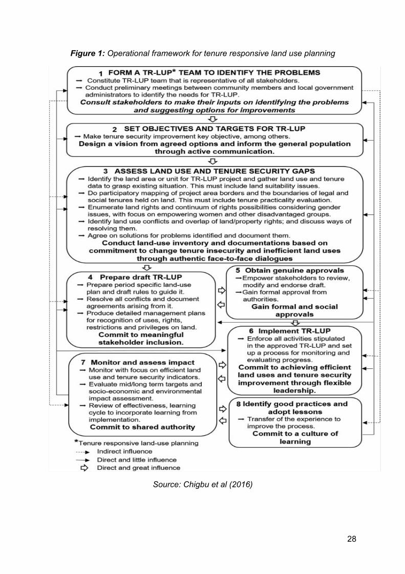
Chigbu et al (2016) also developed a TR-LUP operational framework based on practical examples from three case study land use projects in Ghana (West Africa), Laos (Southeast Asia) and Chile (South America) on land-use planning with land tenure security outcomes. The framework is shown in Figure 1. Two of the case study projects (Ghana and Laos) used by these authors are summarised in Boxes 1 and 2.
The description of the eight stages in Figure 1 by Chigbu et al (2016) is encapsulated as follows:
Stage 1: The first stage commences with the creation of a land use planning team that is representative of a wide range of stakeholders. The processes of forming this team could be election or nomination by local land users. The latter is preferable for accountability purposes. The election process can be done in preliminary meetings between community members and local government administrators. Collaborative consultation will serve as a key process at this stage. Out of the eight steps, this stage is very critical as it can determine what happens in all the other stages of the TR-LUP process. This stage, apart from having a direct and strong influence on the setting of objectives and targets for the TR-LUP, also indirectly and significantly influences the remaining stages during implementation.
Stage 2: This stage involves setting objectives and targets for TR-LUP and this is a crucial stage where the planning team works with the local communities to prioritise their needs. It then uses these to formulate clear and realistic objectives, including land tenure security improvements as one of the key ones. This is very important as it may otherwise not be feasible in later implementation. The processes of designing the process and informing the objectives can serve as key processes for collaborative governance.
24
Stage 3: At this stage, collaborative assessments are undertaken to grasp the land use and tenure security gaps in the project areas. Undertaking land use inventories based on face-to-face dialogue as well as making commitments to positive changes to land tenure security, is an important feature at this stage. To be able to do this, data collection on land rights, tenure, use, environmental and legal, cultural, political as well as socioeconomic information is required. Subsequently, the data analysis involves the use of technical and analytical tools such as land capability classifications, mapping of natural resources, trend and historical analysis, use of aerial photographs, GIS data, satellite images and topographic maps, among many others. In analysing the problems, it is important to assess, enumerate and record land use, social tenure as well as findings on land rights. Furthermore, it should go beyond identifying existing land uses and land rights problems. For example, it could involve discussing ways of resolving conflicts through direct resolution mechanisms or the participatory determination of compensation benchmarks. This type of process will help develop an effective strategy for the resolution of later, potentially contentious, claims.
Stage 4: At this stage, a draft land use plan that is tenure responsive is prepared. Depending on the other objectives, the stakeholders may have in terms of land use planning, the scope of this initial draft will vary depending on the context within which it’s developed. For example, one practical approach could be to zone the land into future priority uses. Ideally, allocation of land use should follow the collective decision about final uses for the land. Including local land users in this process means that it can also form the basis for their community action plans and participation. Issues relating to the protection of land rights as well as social values are important considerations to take into account while drafting local regulations, agreements, certification documents and detailed management plans. The recognition of already existing land use as well as the existence of land rights on a continuum is mandatory. This will help in making the process participatory.
Stage 5: The draft plan is then presented to stakeholders for approval. At this stage, it is necessary to use community meetings to ratify the proposed plan and document all outputs. As noted by IFAD, at this stage the “roles and responsibilities of the different stakeholders in implementing the plan, as well as a timeline, and how and from where the activities will be resourced, should be detailed in the plan. The plan should be checked for mainstream issues such as gender, climate change adaptation and disaster risk management” (cited in Chigbu et al, 2016). The proposed plan should be submitted to the relevant authorities for endorsement. Any other documentation arising from the consultations can also be submitted as an addendum to the plan. If the plan is not recognised by the authorities, it needs to be re-drafted by the stakeholders and ultimately re-submitted. Once it is approved, it is then adopted as a working document.
Stage 6: Implementation of the approved plan is the sixth stage. This entails executing the tenets of the plan. Given the approach adopted by this process and
25
the fact that the communities were involved, the implementation should lead to the emergence of improvements in land use and tenure security. This also requires flexible and committed leadership.
Stage 7: The penultimate stage is the setting up of a process for monitoring and evaluating progress in implementation. This creates effective feedback mechanisms for necessary adaptions and improvements. At this stage, it is important to make decisions on how to continue to update the plan, including the timeframe in which this should be done. Data collected at this stage can be used to influence future activities carried out in other areas as well (see Stage 8).
Stage 8: This is the final stage and is used to identify best practices from the overall process, as based on shared agreement. This can then be transferred to other projects or parts of a country with a commitment to learning on urban planning.
The main advantage of TR-LUP is that it makes planning possible even in circumstances of widespread tenure insecurity, as in the case of Kampala. Using this framework, planning can proceed prior to tenure harmonisation and regularisation. Furthermore, in comparison to other approaches, TR-LUP consciously prioritises land tenure security as one of its goals. It also forms the basis of land tenure harmonisation and regularisation, thereby facilitating easy registration or formalisation of land titles. Finally, the participatory and collaborative approaches adopted in TR-LUP ensure easy acceptance of planning by the citizenry, thus usually making implementation more effective. One of the main disadvantages of TR-LUP is the fact that it is an extremely multidisciplinary, participatory and collaborative process involving a large number of stakeholders. Therefore, coordinating such a process to incorporate all views can be administratively burdensome and costly.
5.3 Case studies in Tenure Responsive Land Use Planning (TR-LUP)
Chigbu et al (2016) opine that the Ghanaian project demonstrates how the development of structure plans, stakeholder collaboration, recording, mapping, documentation and recognition of existing customary landed property rights in the course of land use planning ultimately supported the regularisation of property rights. This then enhanced tenure security. In the case of Laos, the authors conclude that it provides evidence of how tenure can be improved by recognising the landed property rights of minority groups and by conflict resolution based on agreements signed between stakeholders.
26
Box 1: Land administration project in Ghana
According to Nyasulu (cited in Chigbu et al, 2016), contestations over land rights in Ghana during the land-use planning process are common. This case study showed how land-use planning was able to deal with this situation in the peri-urban area of Awutu Breku, which is the capital of Awutu Senya District. The land-use planning project implemented in the area was designed to improve land tenure security and information systems. The project area consisted of 987 parcels of land owned by three so-called land-owning families. A land-owning family in Ghana may vary considerably in household size, comprising between 10 and 300 households. The project area was characterised by a pluralistic legal system in which statutory and customary tenure systems overlapped. However, the land-owning families held the majority of their land under customary tenure. Ghana has a Spatial Development Framework (SDF) for country-wide development and the project considered the concept of the SDF for its implementation prior to its official approval. This enabled the development of structure plans. Utility mapping, street naming and numbering (geocoding) exercises were enforced and tenure security concerns formed a component of land-use planning through its link to land registration as critical policy issues. Collaborative planning was conducted based on broad stakeholder participation at regional levels and meetings at local levels. Various meetings were organised and the essence of such meetings was to define the interests of the government, donors, landowning families and residents, including individuals and businesses. The process relied on indicative maps based on approximate scales of 1:100,000–1:200,000, with features including land type and intensity of developments, as well as inputs from structure plans and community participation. Linkage of customary land information to formal registration records and titling systems was carried out. Local plans and building permits were prepared and conducted based on site plans. A local plan which identifies all land parcels in the area was produced based on information agreed upon by the citizens.
In terms of tenure security, the issuance of development permits to landowners or users for improvements on their land (e.g. buildings) improved their de facto security considerably. At the same time, their de jure tenure security also improved, as their land records were linked to the registration and titling system. The production of a local plan that identifies all land parcels and locations improved the perception of tenure security by citizens because it serves as public reference material for land identification. Landowners, whose lands were previously undocumented, now use the local plan as proof for documentary identification of their land. In addition, the collaborative procedure for the land-use planning project led to the formalisation of tenure for informal land and developments, leading to tenure improvements in the area. In cases where some residents had developed their land prior to the project, the land-use planning process was made to cater for such existing developments. It made the landowners view the process from the perspective of development protection. Therefore, it also served as a means of formalising informal developments. However, in cases where planning preceded development, landowners were made to follow the guidelines prescribed by the land-use planning process. Under this scenario, landowners considered land-use planning as a development control measure and this enhanced their tenure security.
27
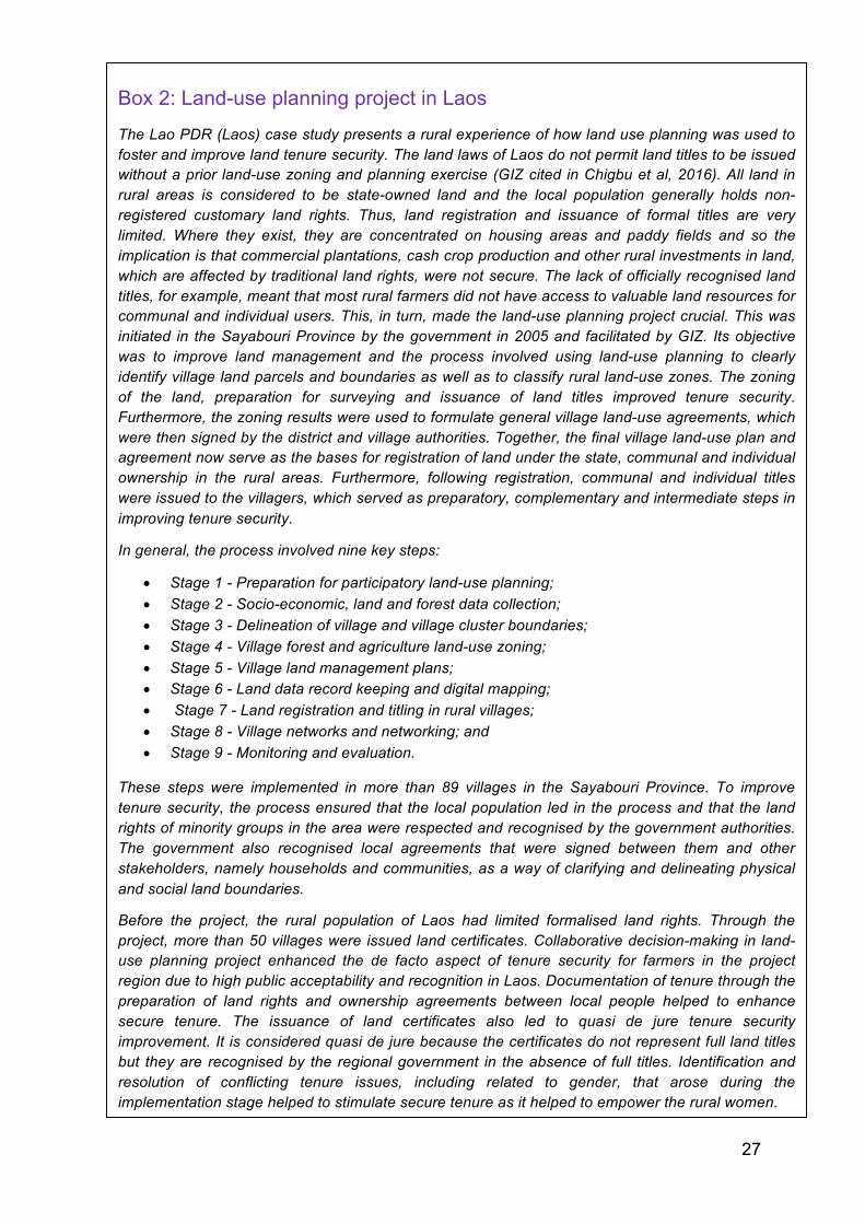
Box 2: Land-use planning project in Laos
The Lao PDR (Laos) case study presents a rural experience of how land use planning was used to foster and improve land tenure security. The land laws of Laos do not permit land titles to be issued without a prior land-use zoning and planning exercise (GIZ cited in Chigbu et al, 2016). All land in rural areas is considered to be state-owned land and the local population generally holds non-registered customary land rights. Thus, land registration and issuance of formal titles are very limited. Where they exist, they are concentrated on housing areas and paddy fields and so the implication is that commercial plantations, cash crop production and other rural investments in land, which are affected by traditional land rights, were not secure. The lack of officially recognised land titles, for example, meant that most rural farmers did not have access to valuable land resources for communal and individual users. This, in turn, made the land-use planning project crucial. This was initiated in the Sayabouri Province by the government in 2005 and facilitated by GIZ. Its objective was to improve land management and the process involved using land-use planning to clearly identify village land parcels and boundaries as well as to classify rural land-use zones. The zoning of the land, preparation for surveying and issuance of land titles improved tenure security. Furthermore, the zoning results were used to formulate general village land-use agreements, which were then signed by the district and village authorities. Together, the final village land-use plan and agreement now serve as the bases for registration of land under the state, communal and individual ownership in the rural areas. Furthermore, following registration, communal and individual titles were issued to the villagers, which served as preparatory, complementary and intermediate steps in improving tenure security.
In general, the process involved nine key steps:
• Stage 1 - Preparation for participatory land-use planning; • Stage 2 - Socio-economic, land and forest data collection; • Stage 3 - Delineation of village and village cluster boundaries; • Stage 4 - Village forest and agriculture land-use zoning; • Stage 5 - Village land management plans; • Stage 6 - Land data record keeping and digital mapping; • Stage 7 - Land registration and titling in rural villages; • Stage 8 - Village networks and networking; and • Stage 9 - Monitoring and evaluation.
These steps were implemented in more than 89 villages in the Sayabouri Province. To improve tenure security, the process ensured that the local population led in the process and that the land rights of minority groups in the area were respected and recognised by the government authorities. The government also recognised local agreements that were signed between them and other stakeholders, namely households and communities, as a way of clarifying and delineating physical and social land boundaries.
Before the project, the rural population of Laos had limited formalised land rights. Through the project, more than 50 villages were issued land certificates. Collaborative decision-making in land-use planning project enhanced the de facto aspect of tenure security for farmers in the project region due to high public acceptability and recognition in Laos. Documentation of tenure through the preparation of land rights and ownership agreements between local people helped to enhance secure tenure. The issuance of land certificates also led to quasi de jure tenure security improvement. It is considered quasi de jure because the certificates do not represent full land titles but they are recognised by the regional government in the absence of full titles. Identification and resolution of conflicting tenure issues, including related to gender, that arose during the implementation stage helped to stimulate secure tenure as it helped to empower the rural women.
28
Figure 1: Operational framework for tenure responsive land use planning
Source: Chigbu et al (2016)

29
5.4 TR-LUP versus participatory land-use planning
The developers of the operational framework differentiate between TR-LUP and other more traditional participatory land use planning processes. There are similarities with TR-LUP, in the sense that both depend on participation as a principle and planning as the methodology or platform for implementation. However, the traditional land use planning approach primarily depends, in most cases, on the government and its administrative agencies taking the lead. It thereby works on the premise that the regulation of land use is a primary function of local governments, rendering it a top-down in approach. Furthermore, traditional land use programme is mostly non-participatory and non-collaborative in both the design and implementation stages, and therefore it relies almost entirely on zoning to enable permission for various types of land use. The ultimate goal of these more traditional methods is to guide and regulate development. However, the ultimate outcome, in most cases, is to restrict rather than enable, tenure security.
The key difference between these two methodologies, however, is in their primary objectives. Participatory land use planning focuses primarily on ensuring that local land users are given the opportunity to play a central role in decision-making processes concerned with the land and resources they use and depend upon (Chigbu et al, 2016). TR-LUP, on the other hand, ensures a conscious method of exploring tenure security opportunities as a primary concern in the land use planning process (Chigbu et al, 2016).
5.5 Consideration for implementing neighbourhood planning
The need for localised neighbourhood plans cannot be over-emphasised. This is because often, in many African cities, the urban master plans that are developed are difficult to implement or enforce. This is partly due to the inappropriate adoption of planning models and regulatory codes inherited from colonial regimes or imported from developed countries, which neglect local reality. Furthermore, most physical plans, including Uganda’s, are developed based on a more westernised concept of urbanisation and require a lot of resources to implement them. To avoid designing plans that will be challenging to implement, there is a strong need to have a plan contextualised for Uganda’s urban reality. This means it is critical to ensure that proposed standards, under the forthcoming neighbourhood plans, take into consideration the local reality from a social, economic and cultural context, as well as the affordability from an implementation perspective. This would encourage flexibility and innovation in terms of space use and the understanding of the environment. Both mixed use and clustering approach should be encouraged where possible, but they should be driven by sensible economic factors specific to each local area.
30
Ultimately, neighbourhood planning is very critical at this stage considering KCCA’s strategic planning and vision of making Kampala an attractive and resilient city. By not carrying out neighbourhood planning, it could jeopardise the achievement of this ambitious development vision. For example, without it, some of the critical issues such as the number of residents and associated types of land rights, socio-economic conditions of each neighbourhood, and cost associated with the development of concerned neighbourhoods will be unknown. In addition, the proliferation of informal settlements will continue, making future planning even more difficult and costly. However, if neighbourhood planning is undertaken, it would not only resolve the planning issue, but it will also provide a framework of land tenure regularisation.
Section 6: Conclusion and policy recommendations In 2012, the KCCA prepared a comprehensive and ambitious plan, the KPDP, to guide orderly physical and sustainable development of Kampala. However, the struggles KCCA has faced in implementing the KPDP partly result from the assumptions that the KPDP was built on, such as the overall resolution of the land tenure challenge. The KCCA’s Strategic Plan 2014-2019 was therefore developed to expand on the KPDP through integrated neighbourhood planning, thus facilitating KPDP’s implementation. This is a very positive step, with the next question focused on overcoming the remaining challenges for successful execution. This section offers some future-looking recommendations for policy action in this regard.
6.1 Consideration of TR-LUP in Kampala
Since the resolution of Kampala’s land tenure challenges is unlikely to be completed in the near future, while the city continues to grow, it is important that effective planning takes place within these complexities. The TR-LUP operational framework, combining planning and tenure security or regularisation, is considered to be the best approach. If this community-participatory planning approach is adopted, especially in those areas where tenure status is ambiguous, it will not only ensure community participation, but also be an opportunity to raise awareness of the value of planning and bringing clarity to the land tenure issues. Residents in Kampala could also, to a certain degree, have ownership over the planning process and this could positively and incrementally impact on land tenure regularisation. Therefore, KCCA and the Ugandan government should work together to encourage community-based planning. This would also yield more sustainable results in the long-term.

31
6.2 Enhance capacity and address resource constraints of planning authorities
As earlier indicated, TR-LUP is a multidisciplinary, collaborative and trans-sectoral process. Thus, its implementation cannot be limited to a single profession. Consequently, a broad team with knowledge and experience in land use planning and tenure security issues, as well as those with academic and professional training in disciplines such as sociology, economics, spatial planning or real estate surveying are required for this process. It is also important that there local context experience included in the proposed project area.
For this to be carried out effectively, planning departments within the MLHUD, KCCA and other local authorities need to be strengthened in terms of capacity and resources. In particular, current capacity should be assessed against the task ahead. Once these gaps have been identified, recruitment of additional staff with the relevant expertise should be undertaken. Furthermore, sufficient resources, including for capacity building, should be allocated to ensure that the planning departments can effectively deal with future demands that come with the integrated neighbourhood planning. Given the diverse expertise that is required in TR-LUP, it may not be necessary to recruit all the relevant personnel on a permanent basis, therefore some of them could be engaged on temporary basis as and when their expertise is required in the planning process.
6.3 Assessment of existing conditions: A path to land tenure regularisation
An effective planning process needs to be supported by reliable evidence to ensure that the neighbourhood plans that are developed capture the reality on the ground. For example, a detailed inventory of type of rights and their beneficiaries for each tenure system, at least for those areas considered for neighbourhood planning, should be undertaken. This should be combined with assessing existing local neighbourhood conditions, and the outcome should be able to help with an understanding of the types of rights that exist on each plot and who would be affected. This will also help determine the level of compensation that might be required if the neighbourhood plan implementation requires relocation. This inventory should be done before the neighbourhood planning design. This process would also facilitate land tenure regularisation as it will provide a dataset of residents, their tenure systems, rights and obligations.
6.4 Inventory of previous planning initiatives
There have been a number of planning initiatives, including KPDP in 2012 and the Kampala City Physical Plan of 1994. Thus, as part of the design process for
32
neighbourhood planning, it is very important to understand why there were constraints to implementing previous plans. This will help to put in place mitigating strategies to ensure that whatever challenges the previous initiatives faced are not repeated.
6.5 The roles of KCCA and local government
The role of localised government entities, such as the sub-county, parish and village/ward, during neighbourhood plan development is vital. Once designed, neighbourhood plans will have to be implemented and enforced by KCCA and local governments. Therefore, local leaders and other stakeholders need to be fully involved in the neighbourhood plan design. Effective neighbourhood plans would require capacity in both the planning and implementation process. KCCA should assess which planning roles and responsibilities can be devolved. Nevertheless, neighbourhood plan design requires full time involvement of KCCA, especially, its Directorate of Physical Planning, and MLHUD.
6.6 Pilot neighbourhood plans
Land tenure complexity in Kampala requires a localised planning approach which may vary from one area to another given the differences in challenges across the city. Thus, pilot planning exercises need to be undertaken and they should be carried out in the prioritised areas which have been selected by KCCA. The pilot exercises should be representative of Kampala’s land tenure regime. The criteria for area selection should be based on factors that could, for example, boost economic growth, improve livelihoods of urban residents or protect the environment. Other distinguishing factors can include:
(i) Areas with clarity in terms of tenure systems and rights associated with them;
(ii) Areas where land tenure security issues exist; (iii) Areas which already have some form of planning and those that do not
have.
Designing neighbourhood plans through a pilot phase would ensure that any lessons to be learnt from the pilot phase would inform how the rest of planning should proceed in order to make it effective. It would also provide an indication of resources needed to implement the neighbourhood plans. After the pilot planning exercise, it would be worthwhile for neighbourhood plans to commence with what is already there. This means areas should be selected where suggested plans will not require too much change to the area as well as areas where in-situ upgrading is possible.
33
6.7 Improving coordination
Effective urban planning for Kampala cannot be done by one authority in isolation and, therefore, there is the need for a holistic planning approach. First and foremost, planning will have to go beyond KCCA's administrative boundaries and encompass the whole GKMA. Given the importance of the city for Uganda, planning for Kampala is also important for the country and in particular MLHUD’s work overall. Therefore, even though KCCA is its own central government entity, a strong and regular working partnership is needed between KCCA, MLHUD and the other local governments within the GKMA to ensure and effective and inclusive planning process. This will also ensure that Kampala’s physical planning initiatives are in harmony with the rest of the country. At the same time, Kampala’s urban development and planning needs to have a strong foundation within the national development framework.
6.8 Strengthening urban development stakeholders’ coordination
As earlier noted, there are various organisations supporting a number of city development projects. This is an asset to have a number of organisations interested in Kampala's urban development. However, to be more effective, the importance of strong coordination between the organisations and their projects cannot be over-emphasised. The recently established Urban Development Partner’s Group is a good start for such a platform. However, coordination mechanisms need to go further and intimately involve and be led by KCCA and MLHUD. This is to ensure that all Kampala urban initiatives are properly coordinated and that optimum result is achieved while avoiding duplication. The level of planning coordination should not be an ad hoc one, rather it needs to be regular and should involve senior officials from all actors involved.
6.9 Local knowledge is key
While international expertise may be required for some technical areas and for financing, it is imperative to have local planners fully involved in this process. The outcome of the planning process needs to be something that can be implemented, and therefore something that local people can relate to and understand. This necessarily implies plans that take into consideration existing situations and reality on the ground. Therefore, there’s a need to use local expertise, particularly people in positions of authority, in designing the proposed neighbourhood plans. To this end, it is important to involve local research institutions. They will have a key role to play, especially when it comes to understanding the historical development of Kampala, existing challenges and possible solutions. Their in-depth assessment and understanding of urban development trends is important.
34
6.10 Resources for relocation
Whether an in-situ upgrading approach is adopted or the re-development of the neighbourhood, there is no doubt that some form of relocation and compensation will be required. The neighbourhoods to be planned would vary in terms of their characteristics and there is, therefore, the need for them to be assessed. Firstly this will help establish which approach, in-situ upgrading or complete re-development, is the most appropriate. It has already been indicated that in the past there have been upgrading attempts in Kampala that lacked any comprehensive spatial vision or wider context. Rather, such intervention programs relied heavily on the free market, generally without adequate preparation or infrastructure and the outcomes have been gentrification as well as the proliferation of slums.
Thus, in situations where affected communities need to be relocated, the sites should be planned and provided with the required infrastructure and services in advance to ensure that there is no proliferation of informal settlements. KCCA needs to designate areas where affected people can move to, even if the city needs to acquire this land. This will require proper coordination with the other authorities in the GKMA due to the fact that many of these relocation sites may necessarily be out of Kampala. The resource implications of whichever planning approach is adopted may be significant and thus KCCA will have to consider alternative financing mechanisms.
6.11 Making urban development and planning a priority
For urbanisation to be efficient and effective, the central government needs to prioritise it. Without strong political will and adequate resource allocation for urban development, transformational initiatives, including neighbourhood plans, will be jeopardised. The holistic urban planning approach needed for KCCA and its surrounding areas requires central government’s full commitment and support, coordination and guidance. As it stands, there is an urgent need to establish an entity which will be responsible to coordinate physical planning in the GKMA area as a whole. The MLHUD, responsible for physical planning in the country, can then ensure that physical planning in urban as well as rural areas is well-coordinated.
35
References Africa Planning Association and UN-Habitat (2014) The State of Planning in Africa.
An Overview. Nairobi, Kenya: UN-Habitat.
Ahene, R., Nsamba-Gayiiya, E., Satana, S. (2013, December) Land sector strategic plan, 2013–2023. Kampala, Uganda: Ministry of Lands, Housing and Urban Development.
Alowo, R. (2017) Eco homes offer solutions to challenges in our housing sector (Online) Daily Monitor, 26 January 2017 Edition, Available at: http://www.monitor.co.ug/OpEd/Letters/Eco-homes--solutions---challenges--housing-sector/806314-3787070-5udvr4z/index.html [Accessed 18 August 2017].
Bernard, L. Bird, J. Venables, A. J. (2016) The urban land market: A computable equilibrium model applied to Kampala City, University of Oxford.
Biryabarema, E. (2017) Uganda's plan to allow forceful takeover of private land stirs anger (Online), Daily Monitor, 25 July, 2017 Edition, Available at: https://www.reuters.com/article/us-uganda-land-idUSKBN1AA26O [Accessed 14 August 2017].
Chigbu, U. E., Schopf, A., de Vries, W. T., Masum, F., Mabikke, S., Antonio, D., Espinoza, J. (2016) Combining land-use planning and tenure security: a tenure responsive land-use planning approach for developing countries, Journal of Environmental Planning and Management, 60(9), pp. 1622-1639.
Collier, P. (2016) African Urbanisation: An analytical Policy Guide, International Growth Centre (IGC).
Collier, P., Jones, P., Barauh, N., Haas, A. (2015) Property Rights and Urban Development, Paper presented at East and Central African Regional Cities Development Forum, Kampala, Uganda, 24 May.
Dasgupta, B., S. V. Lall, Lozano-Gracia, N. (2014) Urbanization and Household Investment, Policy Research Working Paper 7170, World Bank, Washington, DC.
Deutsche Gesellschaft für Internationale Zusammenarbeit (GIZ) (2011) Land Use Planning: Concept, Tools and Application, Federal Ministry for Economic Cooperation and Development.
Dobson, S., Lutwama, M., Mugisa, F. (2014) Negotiated Planning: Breaking the Implementation Impasse in Kampala, World Bank: Conference Paper for Annual World Bank Conference on Land and Poverty.
Giddings, S. W. (2009) The Land Market in Kampala, Uganda and its Effect on Settlement Patterns, International Housing Coalition, Washington, DC.
Glaeser, E. and Dempster H. (2015) Contagion, Crime and Congestion. International Growth Centre: London School of Economics
36
Goodfellow, T. (2013) Planning and Development Regulation amid Rapid Urban Growth: Explaining Divergent Trajectories in Africa, Geoforum 48, pp.83–93.
Government of Uganda (2010) National Development Plan 2010/11–2014/15, Kampala, Uganda.
Government of Uganda (2012) Kampala Physical Development Plan. Kampala, Uganda.
Kampala Capital City Authority (KCCA) (2012) Updating Kampala Structure Plan and Upgrading the Kampala GIS Unit, Draft Final Report.
Kato, J. (2015) Shs175b to boost Uganda’s housing sector (Online), Daily Monitor, 12 August 2015 Edition, Available at: http://www.monitor.co.ug/Business/Shs175b-to-boost-Uganda-s-housing-sector-/-/688322/2828584/-/118kp6s/-/index.html [Accessed 19 August, 2017).
Lall, S. V., Henderson, J. V., Venables, A. J. (2017) Africa's Cities: Opening Doors to the World. Washington, DC: World Bank.
Lall, S. V., Wang, H. G., da Mata, D. (2006) Do Urban Land Regulations Influence Slum Formation? Evidence from Brazilian Cities. World Bank, Washington, DC.
Lwasa, S. (2010) Urban Land Markets, Housing Development and Spatial Planning in Sub-Saharan Africa: A Case of Uganda. UK: Nova Science Publishers.
Mabikke, S. B. (2016) Historical Continuum of Land Rights in Uganda: A Review of Land Tenure Systems and Approaches for Improving Tenure Security, Journal of Land and Rural Studies 4(2), pp.153–171.
Mafabi, D. (2017) 50 government projects stall over land disputes (Online), Daily Monitor, Wednesday, 19 July 2017 Edition, Available at: http://www.monitor.co.ug/News/National/50-government-projects-stall-over-land-disputes/688334-4021990-xnqakyz/index.html [Accessed 14 August 2017].
Muinde, D. K. (2013), Assessing the Effects of Land Tenure on Urban Developments in Kampala, MSc Thesis submitted to Faculty of Geo-Information Science and Earth Observation, University of Twente, The Netherlands.
Musisi, F. (2017) Cabinet clears draft law for forceful seizure of land (Online), Daily Monitor, Sunday 18 June 2017 Edition, Available at: http://www.monitor.co.ug/News/National/Cabinet-draft-law--forceful--land/688334-3974854-g2s0raz/index.html [Accessed 14 August 2017].
Rugadya, M. A., Nsamba-Gayiiya, E., Mutyaba, R. L., Kamusiime, H., Asiimwe, J. B., Namakula, V. (2008) Final Report on the Integrated Study on Land and Family Justice, Ministry of Justice and Constitutional Affairs.
Ravnborg, H. M., Bashaasha, B., Pedersen, R. H., & Spichige, R. (2013), Land tenure security and development in Uganda (Danish Institute for International Studies (DIIS) Policy Brief), Copenhagen, Denmark.
37
Ruleker, G (2006) Land Tenure Policies Complicating Development in Kampala, The Monitor, April 24, 2006.
Ssemutooke, J. (2015) Explaining the different types of land tenure (Online), Daily Monitor, Wednesday February 11 2015 Edition, Available at: http://www.monitor.co.ug/Magazines/HomesandProperty/land-tenure-home/689858-2619680-iv4ifmz/index.html [Accessed 12 August 2017].
Strategic Plan 2014-2019: Laying the Foundation for Capital City Transformation, Kampala Capital City Authority (KCCA).
Uganda Bureau of Statistics (UBOS) (2014) Uganda National Household Survey 2012/2013, Kampala: UBOS.
United Nations Human Settlements Programme (UN-Habitat) (2014) Land tenure security in selected countries. Synthesis Report. Nairobi, Kenya: UN-Habitat.
United Nations Human Settlements Programme (UN-HABITAT) (2012), Uganda Urban Housing Sector Profile, Nairobi: UN-HABITAT.
United Nations Human Settlements Programme (UN-Habitat) (2016) Urbanisation and Development: Emerging Futures, World Cities Report, UN-Habitat.
United Nations (2015a) Millennium Development Goals Indicators. Indicator 7.10 Proportion of Urban Population Living in Slums (Online), Available at: http://mdgs.un.org/ unsd/mdg/seriesdetail.aspx?srid=710. [Accessed 12 August 2017].
World Bank (2015c) Stocktaking of the Housing Sector in Sub-Saharan Africa: Challenges and Opportunities, Washington, DC: World Bank.
World Bank (2015d) Stocktaking of the Housing Sector in Sub-Saharan Africa: Challenges and Opportunities, Washington, DC: World Bank.
Legislation and policies The Constitution of the Republic of Uganda, 1995 Land Reform Decree, 1975 The Land Act 1998, Chapter 227 The Uganda National Land Policy, 2013
Designed by soapbox.co.uk
The International Growth Centre (IGC) aims to promote sustainable growth in developing countries by providing demand-led policy advice based on frontier research.
Find out more about our work on our website www.theigc.org
For media or communications enquiries, please contact [email protected]
Subscribe to our newsletter and topic updates www.theigc.org/newsletter
Follow us on Twitter @the_igc
Contact us International Growth Centre, London School of Economic and Political Science, Houghton Street, London WC2A 2AE