report june 2013 rics research - homepage - communities@rics · pdf filerics research report...
TRANSCRIPT

rics.org/research
An Investigation into the Relationship between Land Administration and Economic Development
RICS RESEARCH
Report June 2013

An Investigation into the Relationship between Land Administration and Economic Development
Rep
ort f
or R
oyal
Inst
itutio
n of
Cha
rter
ed S
urve
yors

03
Rep
ort f
or R
oyal
Inst
itutio
n of
Cha
rter
ed S
urve
yors
Funded by:
The RICS Research Trust, a registered charity established by RICS in 1955 to support research and education in the field of surveying.
The views expressed by the author(s) are not necessarily those of RICS nor any body connected with RICS. Neither the authors, nor RICS accept any liability arising from the use of this publication.
Copyright RICS 2013
A report for Royal Institution of Chartered Surveyors
Report written by:
Henley Business School, University of ReadingWhiteknights, Reading, UK
Prof. Pete Wyatt Real Estate & [email protected]
Gandhi Subedi PhD Student, Real Estate & [email protected]
rics.org/research
RICS Research team
Dr. Clare Eriksson FRICS Director of Global Research & [email protected]
James Rowlands Global Research & Policy Project [email protected]
Amanprit Johal Global Research & Policy Project [email protected]
Published by:
RICS, Parliament Square, London SW1P 3AD United Kingdom
04
Con
tent
sRICS Research – An Investigation into the Relationship between
Land Administration and Economic Development
Exec
utiv
e S
umm
ary Executive Summary ............................................................................................................................................05
1.0 Introduction ...............................................................................................................................................061.1 Research Aim and Research Questions ...............................................................................................................06
2.0 Land and its Interaction ...................................................................................................................072.1 Meaning and Definition .........................................................................................................................................072.2 Administration of Land .........................................................................................................................................082.3 Conceptualization of Land in Economic Theories .................................................................................................092.4 Empirical Studies .................................................................................................................................................09
3.0 Methods .......................................................................................................................................................11
4.0 Results and Discussion ....................................................................................................................124.1 Economic Impact of Land Titling in Thailand ........................................................................................................124.2 Surveying Settlement in Bangladesh and its Economic Impact .............................................................................16
5.0 Conclusion .................................................................................................................................................27
6.0 References .................................................................................................................................................28
List of TablesTable 1 Key performance indicators of the Thailand Land Titling Project (until the end of Phase III) ...........................13
Table 2 Correlation coefficients .................................................................................................................................26
Table 3 One way ANOVA by land rights ....................................................................................................................26
List of FiguresFigure 1 Land management paradigm ........................................................................................................................08
Figure 2 Sale and mortgage registered in the land offices (from 1985 to 2010) ...........................................................14
Figure 3 Revenue collected from mortgage and sells during 1985 to 2010.................................................................15
Figure 4 Agriculture value added (in million Baht) from 1981 to 2010 ..........................................................................15
Figure 5 Map of Tangail district ...................................................................................................................................17
Figure 6 Area of land owned by the respondents (in kattha) .......................................................................................19
Figure 7 Number of parcels hold by the respondents .................................................................................................19
Figure 8 Type of property held by the respondents .....................................................................................................19
Figure 9 Period of land settlement ..............................................................................................................................19
Figure 10 Advantages of land settlement......................................................................................................................20
Figure 11 Role of institutions in securing property rights ...............................................................................................21
Figure 12 Ways the land administration organizations protect property rights ...............................................................21
Figure 13 Land use ......................................................................................................................................................23
Figure 14 Activities on land ...........................................................................................................................................23
Figure 15 Sources of investment ..................................................................................................................................24
Figure 16 Average annual investment per kattha of land ...............................................................................................24
Figure 17 Average annual income per kattha of land ....................................................................................................25
Figure 18 Average land value per kattha of land ...........................................................................................................25

05
rics.org/researchEx
ecut
ive
Sum
mar
y Land is the source of all material wealth and is a resource without which life on earth cannot be sustained. It is the property right that establishes the man-land relationship, so property rights should be clearly defined and properly recorded. The fundamental issues of management and distribution of land and the structure of property rights are determined by the land policy of a country and the land administration and associated systems support to translate such policies into reality.
The theories of land tenure and property rights assert individualization and security of property rights facilitates institutional credit, encourages investment and increase the economic productivity. It also increases the value of the land. It means that secure property rights result in the increased collateral value, use value and exchange value of land. On the other hand, a good land administration structure is required to ensure the access to and maintaining of, property rights. To summarize, the land administration functions ensure the secure property rights which in turn support in increasing collateral, use and exchange value of land and hence to the economic development of a country.
The land administration theory also states that land administration activities support the economic, social and environmental development of a country. This research is mainly focused on the economic aspect and aims to investigate the relationship between land administration and economic development. In this research, the land titling program of Thailand is studied as a successful example of this process and the surveying settlement program in Bangladesh is selected as a detailed comparative case study.
In Thailand, 20 year Land Titling Project was introduced in 1985 which was completed in 2004. As a result of land titling, the number of each of the sell and mortgage deeds registered in the land offices increased from approximately 400,000 of to 1,000,000; the revenue collected from the registration of sales and mortgage deeds increased from 1,021 and 787 million Baht to 28,785 and 4,545 million Baht respectively; and the gross value added from the agriculture sector increased from 167,025 million to 1,303,580 million Baht (more than 7 times) during 1985 and 2010. Researches also revealed that the effect of land registration on access to credit was clearly established and the economic performance between titled and untitled farmers was found to be different.
In Bangladesh, surveying settlement is the initial act of surveying and creating initial cadastral map through systematic titling or systematic adjudication of titles. The result of the analysis data collected from Suruz village of Gharinda Union shows that after the surveying settlement,
• The landowners are enjoying the rights to ownership, sale, mortgage and lease;
• Land related activities including innovative farming, cash cropping, planting trees, and new ways of animal husbandry are increased after having the land certificate from settlement.
• Access to institutional credit became possible.
• The level of investment, income and land value was also found increased significantly.
• The correlation of land rights with access to credit, land related investment, income and land value is established.
Thus, land administration system is playing a vital role in providing security of property rights which, in turn, supports the economic development by increasing collateral, use and exchange value of land.

RICS Research – An Investigation into the Relationship between Land Administration and Economic Development
rics.org/research
06
Land is a major source of wealth. It accounts for 50% to 75% of the national wealth in many developing countries (Bell, 2006). An estimate of 20% or more of any nation’s GDP comes from land, property and construction (UNECE, 1996). Land and real property constitutes a major portion of private property. Also, its availability is key to human existence, and its distribution and use are vital importance (Simpson, 1976). Fundamental issues of management and distribution of land and land related benefits are determined by the land policy of each country; the land administration and associated systems are the mechanisms that translate such policy into practice.
The Theory of Land Administration proposed by Williamson, Enemark et al. (2010) asserts that within the country context, land management activities may be described by three components: land policies, land information infrastructure, and land administration functions that support sustainable development. Similarly, the land tenure theories like the Evolutionary Theory of Land Rights assert that individualization of land rights contributes to economic development by providing opportunity to use land as collateral and increasing incentives to invest that results in increased agricultural production and higher land value. It also reduces government expenditure on court litigation and maintains social peace and political stability. Likewise, de Soto (2000) has opined that the formalization of property rights produce six effects that allow the citizens to generate capital: fixing the economic potential of assets, integrating dispersed information into one system, making people accountable, making assets fungible, and protecting transactions.
The neo-classical model predicts that productivity would be higher when tenure becomes more secure and individualized via three effect; greater investment demand, greater credit supply and greater aggregate production (Smith, 2005). Although there are some unsatisfactory results from Africa (e.g., Ouedraogó, Sawadogo et al., 1996; Galiani and Schargrodsky, 2010; Ho, and Spoor, 2006; Bradstock, 2005), most of the studies show that land tenure security increases agricultural productivity and supports in economic development by increasing credit supply and hence agricultural productivity (Feder and Onchan, 1987; Deininger and Jin, 2006). North (1990) has considered the institutions as the rules of the game and organizations as players. Accordingly, the property rights are institution or the rules of the game and the land administration system is a player. So, the role of the land administration system in economic development is also equally important. However, there is lack of empirical researches that investigate such roles and hence, this study aims to fulfill this gap.
1.0
Intro
duct
ion
2.0
Land
and
its
Inte
ract
ion1.1 Research Aim and Research
QuestionsThis research aims to examine the role of land administration in economic development. The realization of this aim requires fulfillment of the following objectives:
a. What are the roles and functions of the land administration system?
b. Is there any difference in property rights situations before and after land titling?
c. How the property rights can be made secure? Which institution is responsible in this regard?
d. Does the property rights situation affect land use?
e. Is there any relationship between property rights and access to institutional credit?
f. Does the property right affect land related investment and income?
g. Does the investment increase the land-related income?
h. Is there any relationship between property rights and land value?
i. How does a land administration system affect the economic development of a country?
While answering these research questions, this report reviews the relevant literature first followed by a brief description about the methodology applied. Then the results from the case studies of Thailand and Bangladesh are presented and discussed. Finally, a conclusion is drawn from the whole study.

RICS Research – An Investigation into the Relationship between Land Administration and Economic Development
rics.org/research
07
The meaning and definition of land is presented first and then a short description of its administration and its conceptualization in different theories is presented, followed by a discussion of empirical studies.
2.1 Meaning and Definition Land has been defined in many ways. Henssen (1989) has stated that land is “an area of the surface of the earth together with the water, soil, rocks, minerals and hydrocarbons beneath or upon it and the air above it. It embraces all things which are related to a fixed area or point of the surface of the earth, including the areas covered by water, so including the sea”. According to the Law of Property Act, 1925 of the United Kingdom, ‘it includes land of any tenure, and mines and minerals [...] buildings or parts of buildings and other corporeal hereditaments; also a manor, and advowson, and a rent and other incorporeal hereditaments, and an easement, right, privilege, or benefit in, over, or derived from land; but not an undivided share in land’. Thus, land includes not only tangible, physical property like fields, houses or soil, but also intangible rights in land, such as the right to walk across a neighbor’s drive-way (an example of an easement), the right to control the use to which a neighbor may put his land (a ‘restrictive covenant’), or the right to take something from another’s land, such as fish (being a profit and example of an ‘incorporeal hereditament’). As a matter of physical definition, ‘land’ is both the physical asset and the rights which the owner or others may enjoy on or over it (Dixon, 1994).
Land has unique characteristics that make it a fundamental object of property in every society. It is immovable and theoretically indestructible, enabling a successful claimant to recover the lost property object rather than only receive
2.0
Land
and
its
Inte
ract
ion
compensation for damages. To reflect this real action of recovery, the common law classifies land as real property (Nichols, 1993 citing Walker). The definition of land in the Land Administration Guidelines (UNECE, 1996) includes land and anything attached to the land including buildings, apartments and other construction and natural objects such as trees as real property. Because of the immovability and inseparability in nature, it cannot be held like other physical assets. It is the right that establishes the relationship between man and land. So, the right should be clearly defined and properly recorded in order to avoid ambiguity and disputes over ownership.
Land is an ultimate resource without which life on earth cannot be sustained. It is the source of all material wealth. Simpson (1976) has promptly observed that “from it we get everything that we use or value, whether it be food, clothing, fuel, shelter, metal, or precious stones. We live on the land and from the land, and to the land our bodies or our ashes are committed when we die”. He has further argued that “the availability of land is the key to human existence, and its distribution and uses are of vital importance.” The UNECE (2005) has also described its importance from different perspectives: “from a physical perspective, it is the space in which we move and create shelter and from which we obtain our food and water. From an ecological perspective, it plays a vital role in the breeding and survival strategies of many living species and all too often is the reason why country fights country and neighbor feuds with neighbor. From an economic point of view, it is a foundation on which wealth is built. From a legal standpoint, it is an abstract set of property rights, while from a social and cultural perspective, it is a taproot through which people draw spiritual sustenance. It is the ultimate resource without which no nation can exist.”
RICS Research – An Investigation into the Relationship between Land Administration and Economic Development
rics.org/research
08
2.2 Administration of Land Land is an important but scarce resource. So, it should be managed properly in order to obtain maximum benefit from it. The process by which the resources of land are put into good effect is known as land management (UNECE, 1996) which includes the formulation of land policy, the preparation of land development and land use plans, and the administration of a variety of land-related programs (Dale and McLaughlin, 1988). Every government is closely related in the process of environmental protection as well as social and economic development of their country. In the words of Henssen and Williamson (1990) “government, as the guardian of the social and community interests, is closely involved in [...] the process and developments regarding the protection of nature, quality of life and the progress in prosperity of the countries”. They have further added that “the management and administration of land plays an important and central role in all these issues”. Government needs to translate these issues into policies and there are a number of tools or options at their disposal such as financing, legislative, planning, educational, research and organization policies. Information supply is another tool which should be regarded in relation to other tools; the system of land recording has an important place within it.
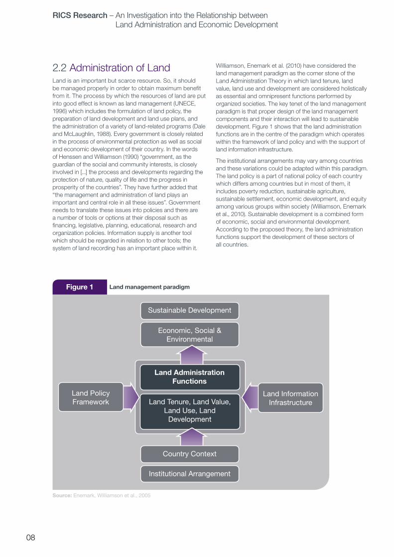
Williamson, Enemark et al. (2010) have considered the land management paradigm as the corner stone of the Land Administration Theory in which land tenure, land value, land use and development are considered holistically as essential and omnipresent functions performed by organized societies. The key tenet of the land management paradigm is that proper design of the land management components and their interaction will lead to sustainable development. Figure 1 shows that the land administration functions are in the centre of the paradigm which operates within the framework of land policy and with the support of land information infrastructure.
The institutional arrangements may vary among countries and these variations could be adapted within this paradigm. The land policy is a part of national policy of each country which differs among countries but in most of them, it includes poverty reduction, sustainable agriculture, sustainable settlement, economic development, and equity among various groups within society (Williamson, Enemark et al., 2010). Sustainable development is a combined form of economic, social and environmental development. According to the proposed theory, the land administration functions support the development of these sectors of all countries.
Figure 1 Land management paradigm
Source: Enemark, Williamson et al., 2005
Sustainable Development
Economic, Social & Environmental
Land Tenure, Land Value, Land Use, Land
Development
Country Context
Institutional Arrangement
Land Administration Functions
Land Information Infrastructure
Land Policy Framework

RICS Research – An Investigation into the Relationship between Land Administration and Economic Development
rics.org/research
09
2.3 Conceptualization of Land in Economic Theories The role of land, its conceptualization, and its measurement in economic theory has changed considerably over time (Hubacek, Jeroen et al, 2006). Land remains a major factor of economic production and principal source of revenue and wealth until classical economic period. For the Mercantilists, land was an important source of wealth, as it allowed the feeding of a growing population and served as a source of precious materials; in addition, it functioned as a source of pivotal element in the feudal order, being the stable basis of military, judicial, administrative, and political systems (Hubacek, Jeroen et al., 2006). Land and labour were considered as two basic elements of production and the objects of commerce (Polanyi, 1957). The physiocrats believed that agriculture produces net product (Currie, 1981) and an increase in net product allowed the landowner to make improvements to land (Hubacek, Jeroen et al., 2006). They were in favor of the private property rights in land. Quesnay, in his Tableau Economique, argued that security of ownership is the essential foundation of the economic order of society. The classical economists considered land, labour and capital as main factors of production and believed in division of labour as a source of increase in production.
The neoclassical economists did not pay much attention to land and even eliminated it from the factors of production. Their simplification of personifying the firm and assuming that it maximizes profits made sense in the context of unrestricted market exchange, full information, and fully defined private property rights (Eggertsson, 1990). However, in a particular domain, the property rights to resources may not be fully allocated or privately held, and transaction costs may be positive (Alessi, 1983). So, since the early 1960’s, a great deal of work has sought to revise the theory and to extend its range of application by focusing on the individual as the basic unit of analysis and by taking into account the constraints imposed by positive transaction and adjustment costs as well as by the structure of property rights (Alessi, 1983). Coase argued that in a world of positive transaction costs, governance structures matter for efficiency outcomes according to transaction costs theory (Coase, 1937) and legal rules matter for efficiency outcomes according to property rights theory (Coase, 1960). That is, the governance structures as well as the legal rules may affect the outcome of a firm. Whereas Coase’s work examined the consequences that followed from an existing private-ownership system, Demstez sought to explain why such a system would come into existence (Demstez, 2002). The property rights theories, as put forth by Demstez (1967) assert that property rights develop to internalize externalities (beneficial and harmful effects) when the gains of internalization become larger than the cost of internalization. According to him, some communities may have less well-developed private ownership systems and more highly developed state ownership systems. But when the
economic value of property rights increases in response to changes in technology and relative prices, the benefits from introducing private ownership system outweighs its costs and hence the property rights will be developed. Similarly, North (1990) considered legal rules (that is, property rights) as an institution and the government structures as the player. He has divided the total costs of production into the resource inputs of land, labour, and capital involved both in transforming the physical attributes of a good and in transacting. According to him, institutions affect the performance of the economy by their effect on the costs of exchange and production and how well institutions solve the problem of coordination and production is determined by the motivation of the players, the complexity of the environment, and the ability of the players to decipher and order the environment (measurement and enforcement).
2.4 Empirical Studies Although a good land administration system can contribute to the economic development of a country, there are few studies that tried to establish a link between them. Feder, Onchan et al. (1987) compared the economic performance of two groups of farmers in rural Thailand, one without legal title and operating in forest reserves, and another having legal titles and operating outside the forest reserve boundaries. The effect of land registration on farmer’s access to credit was clearly established, as were differences in economic performance between titled and untitled farmers. Also, van der Molen (2003) tried to analyze the macro-economic effect of land ownership using secondary data from the Central Bureau of Statistics of the Netherlands and concluded that the presence of good land administration [or security of land tenure] is responsible for a growth of 5.9% of the GDP annually in The Netherlands. Similarly, Deininger and Jin (2005) tried to quantitatively explore the link between tenure security and productivity enhancing investments using a data set from Ethiopia and identified that government action to increase tenure security and transferability of land rights can significantly enhance rural investment and productivity. Moreover, Li, Rozelle et al. (1998) have concluded that the right to use land for long (or indefinite) periods of time encourages the use of land-saving investments. Likewise, Lin (1992) has identified that moving from collective to household farming led to a big increase in agricultural productivity related to the acquisition of property and land rights in China. Furthermore, Salas, Knight et al. (1970) have found that in Costa Rica, positive correlation (in the range of 0.40 to 0.67) existed between the degree of ownership security and farm investment per unit of land.
On the other hand, many of the studies, especially from African countries, have shown that there is no significant relationship between individualization of land rights and farm productivity. For instance, Galiani and Schargrodsky (2010) have evaluated the causal effects of property rights on economic development and identified that entitled
RICS Research – An Investigation into the Relationship between Land Administration and Economic Development
rics.org/research
10
families substantially increased housing investment, reduced household size, and enhanced the education of their children relative to the control group; however, these effects did not take place through improvements in access to credit. They have further argued that land titling can be an important tool for poverty reduction, albeit not through the shortcut of credit access, but through the slow channel of increased physical and human capital investment, which should help to reduce poverty in future generations. Also, Brassalee, Gaspart et al. (2001), in their study in Houet Province in southern part of Burkaina Faso, expressed doubt on the existence of a systematic influence of land tenure security on investment and concluded that the traditional village order provide the basic land rights required to stimulate small-scale investment. Similarly, Bugri (2008) has concluded that tenure security is a necessary but not a sufficient condition for improvement in agricultural production and environmental management in Ghana. Moreover, Besley’s (1995) study reached the conclusion that better land rights facilitate investment in Wassa but not in Anloga. Another study of 36 villages in central Uganda concludes that investment enhances tenure security, yet the converse relationship is not true (Baland, Gaspart et al., 1999).
There are few PhD dissertations which are concerned about the issues of social and behavioural aspects of land administration. For instance, Griffith-Charles (2004) has identified that, as posited in the Evolutionary Theory of Land Rights, the presence of a comprehensive registration system did not induce a large volume of formal transactions; instead, land titling and land registration are only two of several supportive factors that create an environment in which land markets would grow. Likewise, Ting (2002) determined some principles of land administration that could guide the development of land administration infrastructures to address the governance needs of evolving rights and responsibilities between government, corporate bodies, community groups and individuals to better support sustainable development objectives.
Like the conceptualization of land in the economic theories, the traditional concept of defining development in terms of growth of GNI and GDP is also changing over time. Sen (1999) proposed the capability approach of development. Similarly, Todaro and Smith (2006) proposed to include some noneconomic institutional factors also including the nature of land tenure arrangements; the structure of credit, the organization and motivation of government bureaucracies; the machinery of public administrations, among others. Similarly, Thirlwall (2011) also included high investment and an institutional framework like the secure property rights, the rule of the land and political stability, among others, as major determinants of rapid growth and development.
From the above discussion, it is clear that economic factors such as increase in investment, income and prices as well as non-economic institutional factors like the security of property rights, the rule of the land, and governance factors are also major determinants of development. Land cannot be neglected from the factors of production since it possesses the use value and provides the foundation for all economic activities. It is the property rights that add the exchange and collateral value in land. Property rights are the rules of the game or institution and the land administration organizations are the players. The purpose of the rules is to define the way the game is played but the objective of the team within that set of rules is to win the game- by a combination of skills, strategy, and coordination, by fair means and sometimes by foul means (North, 1990). Land policy defines the property rights structure and the land administration system implements the policy by means of cadastral surveying, land registration, land valuation and land use management within the country context. Only good land governance can ensure the security of land rights, transfer of land with lower transaction costs and use of land as collateral, and hence contribute to the economic development of a country by increasing the use value, exchange value and collateral value of land and incentives to invest.
3.0
Met
hods

RICS Research – An Investigation into the Relationship between Land Administration and Economic Development
rics.org/research
11
Both qualitative (for instance, Zevenbergen, 2002; Nkwae, 2006) and quantitative (for instance, Griffith-Charles, 2004) approaches are employed in the field of land administration research. The quantitative approach is appropriate for research in the field of cadastral development, which aims to investigate correlations between variables or studied phenomena whereas, qualitative research is more appropriate for researchers who aim to explore and understand the nature of a phenomenon (Cagdas & Stubjkaer, 2009). This research aims to establish the correlation between studied phenomena and also study its nature. Due to the nature of the study and considering the advantages of methodological triangulation, a mixed method approach was adopted.
Case study is the strategy of inquiry applied in this research. The land administration system of Bangladesh forms the main case study and the surveying settlement program of Gharinda Union of Tangail district is a sub-case within it. Additionally, the land titling program of Thailand, which has been considered as a best example of land titling, is also studied for comparison purposes.
Both primary and secondary data were collected using multiple methods of data collection, including survey questionnaire, observation, face-to-face interview and informal discussion. The field work in Bangladesh was conducted during February and April, 2012 and in Thailand during September and October, 2012. Semi-structured questionnaires were used to collect data from a randomly selected sample of 403 landowners of the Suruz village of Gharinda Union, Tangail district of Bangladesh. Around 20 people from different sectors including the university professors, land rights activists, land administrators, lawyers and deed writers, real estate agencies, and banks took part in the discussion during the field work in Bangladesh. Similarly, high and mid-level land professionals, senior consultants in the field of land tenure and university professors were among the key respondents interviewed during field work in Thailand. The land registration process of both countries was also observed by visiting the local Registry Office of Tangail, Dhaka and Provincial Land Office, Pakkret, Bangkok. The publications of and reports of the government organizations including land departments, national statistical bureau and the central banks and non-government organizations were also collected during the field work. Other secondary sources of data include library and online sources.
The quantitative data collected from the survey were analyzed using quantitative data analysis software (SPSS). The qualitative data collected from interviews, informal discussion, observation and field notes were transcribed and entered into the qualitative data analysis software (NVIVO).
3.0
Met
hods

RICS Research – An Investigation into the Relationship between Land Administration and Economic Development
rics.org/research
12
The data collected from field studies in Bangladesh and Thailand are presented and discussed below:
4.1 Economic Impact of Land Titling in ThailandHistorically, all land in Thailand belonged to the King. At that time, there was no land-ownership as such but people could occupy and use the land. The land itself didn’t have cash value but the agricultural products did have (Boonyabancha, 1983).
Responsibility of administering private land in Thailand was assigned to the Department of Land (DOL) which was established in 1901. A program of land titling program also began in the same year; however, a large amount of privately held land remained untitled until 1980s. The Provincial Land Office could issue title deeds (Chanod or NS4) after the land parcel had been surveyed and charted on a cadastral map. Initially, cadastral maps were produced using plane-table instruments but later on control surveys based on local coordinate datum were established and used to produce cadastral maps. In this connection, Burns (2004) has observed that the availability of survey control and cadastral maps was therefore a major constraint for the DOL in being able to issue land titles to eligible landholders. He has further described that ‘in the 1960s the DOL introduced 1/4,000 scale rectified photomaps as a spatial framework for issuing titles. This increased the DOL’s ability to issue titles, but survey control was still required for the rectification of the aerial photography. In the early 1980s titles were therefore largely confined to the central plains and the provincial cities and their environs. In the 1970s a new type of certificate of utilization (Nor-Sor-Sarm-Kor or NS3K or exploitation testimonial)) was introduced. This document had the same legal status as the NS3 (Nor-Sor-Sarm or certificate of utilization) but was issued using as a survey/map base a new series of enlarged aerial photographs at a nominal scale of 1/5,000. The enlarged photographs were used in the field as a map base for the adjudication of NS3K. A major program of systematic registration of rights in rural areas was introduced and in the decade from the mid 1970s about 7.33 million NS3K were issued covering 6.34 million ha (about 12.3% of the area of Thailand)’.
Thailand has the largest area of arable land of all South-East Asian countries and is the second biggest net food explorer after the United States. The planned development effort in Thailand was started in 1961. During 1960 and 1975 agricultural production grew at an average rate of about 5% per annum but this pattern of growth, based in large part on the cultivated area expanding at an average of over 4% per annum, appeared to be slowing and the agricultural production in the second half of the 1970s grew at less than 4% per annum (Department of Land, 1983). On the other hand, out of the total land area of 321 million rai (513,000 square kilometers) (1 rai= 1,600 square meter),
4.0
Res
ults
and
Dis
cuss
ion 60.9% was under the State land including 50.6% belonging
to the forest and national park, 26.3% was privately held including 5.9% as Title Deed (NS4) and 20.4% as Certificate of Utilization (NS3K), and 12.8% as undocumented land and land under restricted tenure (Department of Land, 1983). It shows that only around one quarter of land was under the use right and the full title was assigned to a very small amount of land. Similarly, studies for the fifth Five-Year National Social and Economic Development Plan (NSEDB) (1982-1986) estimated that only about 12% of the 23.7 million ha of occupied agricultural land was held by title deeds, a further 49% was held by lesser documents, 18% was occupied by persons who may have a claim but lacked documentation, and 21% was illegally occupied forest land (Burns, 2004).
The Fifth National Economic and Social Development Plan (1982-86) aimed at increasing productivity through further expansion of the infrastructure and improved efficiency in the use of land and water, which includes the policy direction to speed up the distribution of land ownership through land reform and the provision of land titles for agricultural purposes in order to create employment security for farmers and eradicate social inequality (NESDB, 1981). However, the DOL was unable to support these policy objectives. As observed by Burns (2004), major inconsistencies in the geodetic control in the 29 local origins leading to errors in the mapping and charting of titles, insufficient control to support the issuance of titles in much of the country, particularly in rural areas, lack of accurate, up-to-date large-scale cadastral mapping to support the title registers in Bangkok and many major cities, inconsistencies in the land registers maintained by DOL at Province and District levels, dated photographic detail on the enlargements that supported the NS3K documents and the degrading paper maps, and the limited systematic registration capacity were the major hindrances faced by the DOL. He has also mentioned that it was estimated that it would take the DOL over 200 years to complete the issuance of titles to all eligible landholders.
As per the objective of the Fifth Plan, the Third Ministry of Interior Plan (1982-86) also adopted the policy of accelerating the issuing of land documents in both rural and urban areas, establishing a system of land valuation and land tax, and accelerating the program of aerial photography, ground control and cadastral map production. The First Land Administration Plan (1982-86) of the Department of Land was also consistent with the objectives of the Fifth Plan of the Thai Government as well as the Third Plan of the Ministry of Interior (DOL, 1983). The Royal Thai Government (RTG) gave high priority to this project and requested the World Bank for support. The possibility of obtaining the World Bank assistance for the project was initially discussed between officers of the RTG and the World Bank in 1980/81 (DOL, 1983). The project was designed to complete within 20 year period during 1985 to 2004 which was divided into four five-year strategic plans. The first one commenced in October 1985.

RICS Research – An Investigation into the Relationship between Land Administration and Economic Development
rics.org/research
13
The objectives of the project are fully consistent with the aims of the Fifth Plan, Third Ministry of Interior Plan and the First Land Administration Plan (Jeffers and Onsrud, 1989). The main original objectives of the project were to provide secure land tenure to eligible landowners, develop the long term sustainability of the DOL institutional capacity, improve land administration service delivery, and to develop an effective national property valuation function (World Bank, 2003). The objectives remained unchanged throughout the implementation period. However, the design of the property valuation component had to be revised since the Government was unable to provide the 574 staff required to achieve the property valuation expansion due to the downturn in the Thai economy and a consequent freeze in staff recruitment. The Bank had extended the project completion and loan closing dates by two years at the request of the Thai Government (World Bank, 2003).
As mentioned above, the project was divided into four main phases. The output of the projects until 2001 is presented in Table 1.The first phase commenced in 1985 and completed in 1992. A key emphasis in this phase was in strengthening and extending the survey and map infrastructure and building a strong systematic registration capability (Burns, 2004). In this phase, a total of 1.63 million titles over 7.83 million rai were issued in five provinces in the north and four provinces in the north-east. Other activities undertaken during the first phase included a review of DOL organization and management operations, strengthening of DOL headquarters and land registration services, including the
construction of a network of new branch provincial land offices, an urban mapping program to compile a new series of large scale cadastral maps in urban areas from existing survey/map records, support for the newly formed Central Valuation Authority (CVA) and support for the tertiary education sector (Burns, 2004).
In the second (1991-1994) and third (1995-2001) phases, there has been a continued emphasis on the systematic registration activity, but a shifting emphasis from technical aspects to a focus on aspects such as strategic planning, IT planning, human resources management and development and improved service delivery (Burns, 2004). During second phase, 30 adjudication parties were formed, 67 branch land offices were established and all targets of aerial photography and cadastral surveying and mapping were either achieved or exceeded, but the target of issuance of titles was reduced from 3 million parcels over 18 million rai to 2.1 million parcels over 12.32 million rai. The World Bank published the Implementation Completion Report on March, 2003 after the completion of the third phase of the project which concludes that the first three of the four objectives of the project were achieved satisfactorily. The objectives of developing an information system (IS) strategy and an effective property valuation system were met only partially. The output indicators presented in Table 1 show that the progress of the project remained satisfactory except the recruitment of valuation staffs and the construction of regional CVA buildings.
Table 1 Key Performance Indicators of the Thailand Land Titling Projects (Until the end of the Phase III)
Fiscal Year Ground Survey Photomap
NS-3K Conversion
Title Certificates Total Titles
1,985 17,860 – – 17,860 4,557,050
1,986 83,010 – – 83,010 4,754,914
1,987 168,753 2,984 9,525 181,262 5,336,139
1,988 209,462 24,705 103,390 337,557 5,825,081
1,989 166,398 89,535 185,490 441,423 6,331,810
1,990 152,453 133,676 287,292 573,421 6,912,552
1,991 233,039 86,894 218,435 538,368 7,544,002
1,992 335,020 100,014 164,607 599,641 8,698,393
1,993 192,395 100,215 168,600 461,210 9,588,918
1,994 130,122 155,306 215,690 501,118 10,514,823
1,995 235,967 117,677 256,877 610,521 11,501,914
1,996 271,221 83,203 496,094 850,518 12,700,276
1,997 256,629 144,057 405,345 806,032 13,989,192
1,998 369,008 132,467 262,712 764,187 15,652,263
1,999 375,941 202,867 143,519 722,327 16,748,352
2,000 319,405 197,649 120,503 637,557 17,690,421
2,001 207,341 119,297 54,275 380,913 18,988,810
Total 3,724,024 1,690,546 3,092,355 8,506,925

RICS Research – An Investigation into the Relationship between Land Administration and Economic Development
rics.org/research
14
Figure 2 depicts the number of transaction registered in the land offices between 1985 and 2010. The figure shows that all types of transactions were increased after 1985 with some fluctuations followed by a sharp decrease after 1996 to reach the lowest level in 2000. The number increased again until 2004 with a slight decrease until 2007 followed by an increasing trend and reached to a peak in 2010.
The revenue collected from registration of sale, mortgage and other documents collected between 1985 and 2010 is presented in Figure 3. The graph shows that the total revenue increased sharply after 1987 from around 2,700 million and reached to 32,000 million in 1996 followed by a sharp decrease to reach around 8,000 million in 2,000. It again increased dramatically to reach around 38,000 million baht in 2004 followed a decreasing trend until 2009 and reached to the peak in 2010. The revenue collected from mortgages has also followed a similar trend which reached to peak of around 7,800 million in 1996 by increasing more than 10 times from 1985. Then, it increased until 2006 but reached to the lowest level in 2008 after a sharp decrease from 2007. The trend followed by the revenue collected from sale of land and property seems interesting; it was decreased for the first year then remaining almost same followed by a sharp increase in the third year and then repeating the same cycle except a continuous increase from 2008 to 2010.
Figure 4 presents the amount of GDP generated from the agriculture sector between 1961 and 2011. It has been increasing smoothly until 1971 followed by a considerable increase to reach around 190,000 million baht in 1983. Then it decreased slightly but again increased from 1986. Then it increased steadily except slight fall in 1993, 1999, and 2009.
From figures 3 and 4, it is clear to see that there is substantial increase in the amount of titled land, transactions on sale and mortgage and the revenue collected from this sector, although it decreased during the financial crisis of 1998. Agricultural production also increased tremendously after the introduction of land titling program. Empirical research done by Feder, Onchan et al. (1987) also shows that the effect of land registration on farmer’s access to credit was clearly established and the economic performance between titled and untitled farmers is found to be different. They have also observed that titled farmers in Thailand invest more than the untitled farmers, undertake more land improvements, utilize more production inputs, and have significantly higher productivity. Thus, land titling has a positive impact on Thai economy.
Source: Department of Lands, Thailand, 2012
Figure 2 Transactions of sale and mortgage registered in the land offices (from 1985 to 2010)
MortgageSale
1994 1995 1996 1997 1998 1999 2000 2001 2002 2003 2004 2005 2006 2007 2008 2009 20101985 1986 1987 1988 1989 1990 1991 1992 1993
400,000
600,000
800,000
0
200,000
1,400,000
1,200,000
1,000,000
Year
Num
ber
of t
rans
actio
ns

RICS Research – An Investigation into the Relationship between Land Administration and Economic Development
rics.org/research
15
2009 2010
Source: Department of Land, Thailand, 2012
Source: Department of Land, Thailand, 2012
Figure 3
Figure 4
Revenue collected from mortgage and sells during 1985 to 2010
Agricultural value added (in million Baht) (from 1981 to 2010)
MortgageSale
1994 1995 1996 1997 1998 1999 2000 2001 2002 2003 2004 2005 2006 2007 20081985 1986 1987 1988 1989 1990 1991 1992 1993
10,000
15,000
20,000
0
5,000
35,000
30,000
25,000
Year
Rev
enue
(Bah
t in
mill
ions
)
Year
Source: Department of Land, Thailand
1994 1995 1996 1997 1998 1999 2000 2001 2002 2003 2004 2005 2006 2007 2008 2009 20101985 1986 1987 1988 1989 1990 1991 1992 1993
400,000
600,000
800,000
0
200,000
1,400,000
1,200,000
1,000,000
Valu
e (B
aht
in m
illio
n)
2009 2010
RICS Research – An Investigation into the Relationship between Land Administration and Economic Development
rics.org/research
16
4.2 Surveying Settlement in Bangladesh and its Economic ImpactThe People’s Republic of Bangladesh was formed in 1972. It remained under India until 1947 and then as the East Pakistan State until its liberation. The total land area of Bangladesh is 147,500 square kilometers. Administratively, the country is divided into five Development Regions, 64 Districts (Zila), 489 Thana (Upazila) and around 4,500 Union Parishads. Its lowest level administrative unit is the village.
In ancient Bengal both the King and peasants did have combined rights to land; the former as the sovereign and the later as the actual tiller. The Mughal rulers changed the land tenure system substantially. At that time, most of the land belonged to the state although they had recognized private property in land by selling it to individuals to some extent. Zamindars and Talukdars were appointed to collect land revenue from peasants. A customary land tenure system known as Raiyat was also practiced.
The current land tenure system is mainly based on permanent settlement originated during British period. The Titular Emperor Shah Alam of Delhi granted the Dewani of Bengal, Behar and Orissa to the East India Company on 12th August, 1765 (Khan, 2011). The Company continued the existing land tenure system at the beginning and allowed the institutions of Zamindars, Talukdars and Lakhirajdars to operate without many problems (Asiatic Society of Bangladesh, 2012). The Company made some arrangement to appoint some supervisors to look after the land revenue collection mechanism since they found some problems in the existing system. However, after few years, the Company introduced the concept of permanent settlement. The Quinquennial Settlement of 1777, restoration of Zamindari rights in 1778 and the Decennial Settlement of 1790-91 were the practices established by the Company. The Decennial Settlement was turned into the Permanent Settlement Regulation (Bengal Regulation 1 of 1793) on 22nd March, 1793. The short term objectives of regulation were to place revenue paying on a definite footing and make revenue collection sure and certain, ensuring minimum revenue, relieving officials of revenue matter and engaging them in other spheres of administration, and forging an alliance between the Zamindar class and the colonial rulers. The long term objective was to invest surplus capital in various sectors of agriculture (Asiatic Society of Bangladesh, 2012).
Various Acts and Rules proclaimed during and after British Rule had shaped the rights of Zamindars and tenants on land. Permanent Settlement Regulation, 1793, Bengali Tenancy Act, 1885, Non-Agricultural Tenancy Act, 1949, The Estate Acquisition and Tenancy Act, 1950, Tenancy Rules, 1954, Defense of Pakistan Ordinance, 1965, Bangladesh Abandoned Property Order, 1972, Return of Vested Property Act, 2001 and so on. Likewise, Survey
Act, 1875, Non-agricultural Khas Land Management and Settlement Policy, 1995, and Agricultural Khas Land Management and Settlement Policy, 1997 are some laws related to land management, and the Registration Act, 1908 is concerned with the registration of land.
The East Bengal State Acquisition and Tenancy Act 1950, passed by the provincial legislative assembly on the basis of the recommendations of the Floud Commission, was a landmark in the history of tenurial legislation (Asiatic Society of Bangladesh, 2012). This Act abolished the zamindari system by acquisition of all types of intermediary rent receiving interests that existed between the government at the top and the tenants cultivating the land at the bottom, brought the tenants directly under the government and changed the mutual rights and obligations between the government and raiyats under the new dispensation. After the enactment of this Act, the government remained the lord superior and tenants or raiyats became holders of land under the government. The tenants pay rents to the government directly and all lands available for settlement would henceforth be settled by the government through its agency, the district collector, with the tenants directly. The rights and obligations of the tenants would be regulated by the terms of the deed of settlement called kabuliyat enforceable through courts of law. The Act also fixed the maximum amount of land to be held by a family or body as 100 Bighas (33 acres) which was raised to 375 Bighas in 1961 and was again brought down to 100 Bighas in 1972. The surplus land was used for settlement of landless or marginal farmers. The holding of agricultural land was lowered to 6o Bighas intended to broaden the base of holders of subsisting and economic holdings through redistribution of ceiling surplus land (Asiatic Society of Bangladesh, 2012). In 1976, the Land Development Tax Ordinance was enacted to rationalize the revenue structure and to mobilize more domestic resources for development.
Surveying settlement is the initial act of surveying and creating the initial cadastre or ‘mouza’ map of an area. Revisional settlement or the activity of the resurveying settled areas is to reflect changes since settlement. The process of land settlement substantially follows typical practice for land settlement activities- often known as ‘systematic titling’ or ‘systematic adjudication of titles’- in most other countries. The surveying and settlement operations have defined the rights and obligations of Zamindars and Raiyats according to the Bengal Tenancy Act, 1885. This Act settled the general principles by which the relation between the landlord and tenant was regulated (Kabir, 1969:13).
The survey and settlement operations were undertaken in different stages in different parts of the country. As described by Asiatic Society of Bangladesh (2012), the district-wide surveying and settlement operations were initiated in three stages. The first cycle initiated in 1888/89 and completed with the settlement in Dinajpur district during 1934-40. The second cycle was started from

RICS Research – An Investigation into the Relationship between Land Administration and Economic Development
rics.org/research
17
Chittagong district (1923-33) and carried out till 1950. It was called revisional settlement and was undertaken on the basis of cadastral maps and records. The state acquisition settlement operations were carried out after the proclamation of East Bengal State Acquisition and Tenancy Act, 1950 with the abolition of Zamindari system. Another settlement operation was carried out during 1965 and 1978. A new scheme of conducting survey and settlement was adopted in 1984 under which the entire country was covered by a plan to take up settlement operations simultaneously with 22 original district headquarters working as operational centers within the undivided districts called zones. These were called zonal settlements. Ten such zones including Tangail were selected for conducting settlement operations; however, it became difficult to run. So, only five districts, namely, Comilla, Mymensingh, Tangail, Rangpur and Bogra were selected for settlement. On completion of the settlement operations, the Settlement Officer writes a final report containing inter alia, statistical data on land tenure pattern, agrarian infrastructure, crop pattern, etc.
Figure 5 Map of Tangail district
Tangail is one of the 17 districts of Dhaka Division which is bordered with Jamalpur district on the north, Dhaka and Manikganj on the south, Mymenshing and Gazipur on the east and Sirajganj on the west (figure 5). Its area is 3,424.39 square kilometer. It consists of 11 upazilas, 8 municipalities, 72 wards, 211 mahallas, 103 union parishads and 2,431 villages.
The selected study area is the Suruj Village, one of the villages in Gharinda Union. Gharinda is one of the unions of Tangail Sadar Upajila and is bordered with Tangail Sadar, Karatia and Gala unions and Basail district. According to the Population Census, 2001, the total household number of the Gharinda Union is 5,867 and the total population is 28,315. The total number of households of Suruj village is 878 as per the information provided by the Union during the field study. 439 landowners were randomly selected of which 36 landowners could not be contacted and hence only 403 were surveyed. The respondents were asked about the role of the land administration system in securing property rights, changes to land related investment, income and land price after land settlement. They were also asked to evaluate the land registration process and answer questions.
Source: Asiatic Society of Bangladesh, 2012

RICS Research – An Investigation into the Relationship between Land Administration and Economic Development
rics.org/research
Land HoldingFigure 6 depicts the percentage of people holding different amount of land which clearly shows that most (82%) have up to 20 katthas (one kattha equals to 720 square feet) of land. Similarly, around 15% of landowners are holding between 20 and 40 katthas of land. It is interesting to note that the number of landowners holding more than 80 katthas of land is negligible.
The landowners are holding maximum 5 parcels. As presented in Figure 7, around one-third of the owners have five parcels. Similarly, around 27% own four parcels and 20% own three parcels. The number of people having only one parcel is less than the others four.
18
The results presented in Figure 8 show that around 97% of the respondents have both house and land and only 3% have house only. However, the proportion of people having only land is negligible.
The results presented in Figure 9 show that, among the 403 respondents, 367 people (91.07%) have khutiyan as an evidence of property. Most of the respondents (96.5%) had got their land settled more than 15 years ago, only around 3.2% of respondents had got their settled between 10 to 15 years ago. It is interesting to note that only one respondent had got land settled during the 5-10 years period.

RICS Research – An Investigation into the Relationship between Land Administration and Economic Development
rics.org/research
19
Figure 6 Area of land owned by the respondents (in kattha)
Figure 8 Type of property held by the respondents
Figure 7 Number of parcels held by the respondents
Figure 9 Period of land settlement
41 to 60 kattha
2%
House
3.22%10–15 year period
3.2%
61 to 80 kattha
1%
Land
0.25%5–10 year period
0.25%
How much land do you own?
What type of property do you have?
How many parcels do you have?
When was the decision of land settlement made?
up to 20 kattha
82%
Both land and house
96.53%More than
15 year period
96.5%
1 Parcel
7%
5 Parcels
33%
4 Parcels
27%
3 Parcels
20%
2 Parcels
13%21 to 40 kattha
15%

RICS Research – An Investigation into the Relationship between Land Administration and Economic Development
rics.org/research
20
Advantages of Land SettlementThe respondents were asked about the advantages of land settlement. Figure 11 shows that almost all of the respondents were of the opinion that it helps in protecting the property rights of the owner and serves as good evidence of it. Similarly, around 93% of the landowners believe that it provides security for the investment and 76.92% consider the perceived social security will be increased after having secured land rights. Similarly, access to institutional credit (67%), ease of transfer (63%) and lower interest on credit (54%) were the stated advantages of land settlement. Likewise, 42% of the landowners believe that there is possibility of long-term investment after land settlement.
Figure 10 Advantages of land settlement
Role of Institutions in Securing Property RightsFigure 11 shows the role of different institutions in securing property rights. Accordingly, an overwhelming majority of people believe that land administration organizations have a key role and the court has medium level role in this matter. The role of other government agencies seems less significant.
The respondents were also asked how land administration organizations help in protecting property rights. Figure 12 shows that almost all of them believe that these organizations protect the property rights by surveying and mapping the land, providing land information and by registering the transactions. Managing land records (45%) and providing evidences (26%) are other ways of securing rights respondents identified.
Advantages
Legal Evidence
Protection of Property
Easiness in Sale/Transfer
Access to Credit
Lower Interest Rate
Security of Investment
Security of Investment
Possibility of long-term investment
20
40
60
0
100
80
Res
pon
den
ts (%
)
Yes NoAre the following advantages of land settlement?

RICS Research – An Investigation into the Relationship between Land Administration and Economic Development
rics.org/research
21
Figure 11
Figure 12
Role of institutions in securing property rights
Ways the land administration organizations protect property rights
100
50
20
60
30
70
0
40
10
90
80
Institutions
How do you rank the role of the following institutions in securing property rights?
Res
pon
den
ts (%
)
Land Administration Organizations
Court Other Government Organizations
Highest
Low
High
Negligible
Medium
100
50
20
60
30
70
0
40
10
90
80
Ways of securing property rights
Does the land administration organizations support in securing property rights in the following way?
Res
pon
den
ts (%
)
by surveying and mapping the land
by managing the land records
by providing land information
by registering the land
by providing required evidences
Yes No

RICS Research – An Investigation into the Relationship between Land Administration and Economic Development
rics.org/research
22
Impact of Land Settlement The land owned by the households was used mainly for shelter and agriculture before settlement. Hardly any people used their land for commercial purposes. There is no change in the use of land as shelter after settlement. However, the percentages of landowners using land as agriculture slightly decreased and that of using land for commercial purpose increased by around 3% (Figure 13).
Figure 14 shows that most landowners (around 90%) had built houses on their land prior to settlement whereas around 20% of them rebuilt or made new houses after settlement. Almost of the households had used their land for agriculture from the beginning. Only a few respondents (around 9%) had farmed the land in innovative way before settlement, however, more than 61% of them are doing such farming after settlement. The percentage of people doing cash cropping also increased from around 40% to 70% during this period. Most of the respondents have had performed the tasks of leveling land (96%) and constructing irrigational canal (93%) on their land respectively prior to settlement. However, the proportion of landowners fencing their land, planting trees and planting fruits increased from around 6%, 19% and 6% to 19%, 42% and 18% respectively after settlement. Similarly, the percentage of people involved with animal husbandry rose from around 59% to 87% after settlement.
Personal saving and borrowings were the main sources of investment before settlement as shown in Figure 15. The percentage of landowners using personal borrowing for investment decreased dramatically from 66% to 4%. It is interesting to note that none of the landowners have taken credit from the institutional sectors before settlement; however, around 78% of respondents have used such sources after settlement.
Figure 16 shows that the amount of investment has increased remarkably after settlement. Around 75% of the respondents used to spend around 2 thousand per kattha before settlement, whereas 42% and 46% of them are spending about 6 and 10 thousands respectively after settlement.
The amount of land related income has also increased after settlement. The data presented in Figure 17 depicts that 21, 66 and 9% of the landowners used to earn about 2, 6 and 10 thousand Taka per kattha respectively before settlement but after settlement more than 80% of them have earned more than or equal to 10 thousands Taka per kattha. It is interesting to note that none of the respondents had earned about 18 thousand taka before settlement but after settlement more than 5% became able to earn that amount of money from their land.
After settlement, value of land increased dramatically. Figure 18 depicts around 43 and 37% of the landowners indicated that the value of their land was around 75 and 125 thousand per kattha respectively whereas more than 69% of the respondents stated that value of their land is around 225 thousand per kattha.

RICS Research – An Investigation into the Relationship between Land Administration and Economic Development
rics.org/research
23
Figure 13
Figure 14
Land use
Activities on land
100
50
20
60
30
70
0
40
10
90
80
For what purpose have you used or are you using your land before & after settlement?
Have you done following activities on your land?
Res
pon
den
ts (%
)
Shelter Agriculture Commercial Purpose
Before settlement
Before settlement
After settlement
Land use
100
50
20
60
30
70
0
40
10
90
80
Res
pon
den
ts (%
)
Building House
Innovative Farming
Cash Cropping
Land Levelling
Construction of Irrigation
Canal
Fencing Planting Trees
Planting Fruits
Animal Husbandry
After settlement
Actvities

RICS Research – An Investigation into the Relationship between Land Administration and Economic Development
rics.org/research
24
Figure 15 Sources of investment
100
50
20
60
30
70
0
40
10
90
80
Have you used money from the following sources for land related investment?
Res
pon
den
ts (%
)
Personal Saving Personal Lending Bank or Finance
Before settlement
After settement
Sources of Investment
Figure 16 Average annual investment per kattha of land
How much money you have invested in average kattha of land?
Before settlement
After settement
100
50
20
60
30
70
0
40
10
90
80
Res
pon
den
ts (%
)
2 6 10 14 18
Investment per kattha (in Tk 000s)

RICS Research – An Investigation into the Relationship between Land Administration and Economic Development
rics.org/research
25
Figure 18 Average land value per kattha of land
How much is the average value of per kattha of your land?
Before settlement
After settlement
100
50
20
60
30
70
0
40
10
90
80
Res
pon
den
ts (%
)
25 75 125 175 225
Land Value per kattha (in Tk 000s)
Figure 17 Average annual income per kattha of land
How much have you earned in average per kattha of your land per annum?
Before settlement
After settlement
100
50
20
60
30
70
0
40
10
90
80
Res
pon
den
ts (%
)
2 6 10 14 18
Avearage Annual Income per kattha (in 000s)

RICS Research – An Investigation into the Relationship between Land Administration and Economic Development
rics.org/research
26
It is evident that land related investment, income and land value has increased after the settlement. There might be several other reasons but the change in land right situation is one of the major changes resulting from the surveying settlement. A bivariate correlation was used to determine whether there is any correlation among such variables. Table 2 shows that the land right is positively correlated with the investment, income and land right. All of these correlations are significant at 1% of significance.
Also, a one way analysis of variance was undertaken in order to identify whether there is any relationship between
Table 2 Correlation coefficients
Correlations
Land Rights Annual expenses Annual Income Land price
Land RightsPearson Correlation 1 .318** .248** .259**
Sig. (2-tailed) .000 .000 .000
N 806 806 806 806
Annual expenses
Pearson Correlation .318** 1 .885** .852**
Sig. (2-tailed) .000 .000 .000
N 806 806 806 806
Annual Income
Pearson Correlation .248** .885** 1 .880**
Sig. (2-tailed) .000 .000 .000
N 806 806 806 806
Land pricePearson Correlation .259** .852** .880** 1
Sig. (2-tailed) .000 .000 .000
N 806 806 806 806
Table 3 One-way ANOVA by land rights
ANOVA
Sum of Squares df Mean Square F Sig.
Annual expenses
Between Groups 3254454.339 1 3254454.339 90.468 0
Within Groups 28922574.31 804 35973.351
Total 32177028.65 805
Annual Income
Between Groups 5403533.267 1 5403533.267 52.504 0
Within Groups 82744211.96 804 102915.687
Total 88147745.23 805
Land priceBetween Groups 2.10E+09 1 2.10E+09 57.956 0
Within Groups 2.92E+10 804 36268821.167
Within Groups 3.13E+10 805
land rights with investment, income and land value. From the analysis, the observed value is to be found higher than the table value (Table 3). It also shows that there is a relationship between land rights with investment, income and land value.
Thus, from the above discussion, the surveying settlement process and associated provision of secure land rights to owners contributed in widening access to institutional credit, and increasing land related investment, income and land value.
**. Correlation is significant at the 0.01 level (2-tailed).

RICS Research – An Investigation into the Relationship between Land Administration and Economic Development
rics.org/research
27
5.0
Con
clus
ions
This research investigates the relationship between land administration and the economic development. The role of property rights in the economic development has been highlighted in some land tenure and economic theories. For instance, the land tenure theories and the neo-classical model states that security and individualization of property rights increase productivity by rising investment, credit supply and aggregate production. It also increases the value of land. Similarly, the transaction costs theories, property rights theories and the institutional theories recognized the role of governance and property rights structure for economic efficiency. Moreover, the land tenure arrangements and the institutional framework like the secure property rights and the rule of the land are also regarded as the determinants of rapid economic growth and development. The land administration theory also asserts that the land administration functions support the economic development of a country, among others.
The land titling program of Thailand is considered as a successful project which provided title certificates to most land owners. As a result, the land owners were able to obtain institutional credit and land market activities are also increased. The data shows that number of mortgage and sales deeds registered in the land offices increased from around 400,000 in 1985 to around 1,000,000 in 2010. Similarly, the revenue collected from the registration of sale and mortgage deeds was around 1,021 and 787 million Baht, which reached to more than 28,000 and 4,500 million respectively in 2010. Similarly, the GDP value added from the agriculture also seems increased dramatically during this period from less than 200,000 million Baht in 1985 to around 1,300,000 million, that is, more than 7 times. Other empirical researches also revealed that the effect of land registration on farmer’s access to credit was clearly established and the economic performance between titled and untitled farmers is found to be significantly different.
Surveying settlement and revisional settlements are the mode of providing property rights to the land owners in Bangladesh. The first cycle of settlement was initiated in 1888/89 and completed by 1940. A new scheme of conducting survey and settlement called zonal settlement was adopted in 1984 and was completed in the case study area of Tangail district in 2008/09. The data collected during field study in Suruz village of Gharinda Union, Tangail, shows that the landowners are now enjoying the rights of ownership of their land, rights to sell, mortgage and lease after having the khutian, the land certificate. Land related activities including innovative farming, cash cropping, planting trees, and new ways of animal husbandry are found to have increased after settlement. The access to institutional credit became possible after having evidence of ownership and around 80% of the landowners have exploited such facilities. Most of the land owners were investing around 2 thousand Taka before settlement but now investing up to 6 to 10 thousands per kattha. The level of income is also found increased from around 6 thousand to up to 10 to 14 thousands per kattha. Some of the landowners were earning even more. The average land value is also found increased significantly. Also from the correlation analysis and analysis of variance, a relationship between land rights and investment, income and land value is established. Thus, surveying settlement is found crucial to provide land rights to the landowners which contributed in reducing interest rate, getting access to institutional credit, and increase in land related investment, income and land value.
In conclusion, land administration could play a vital role in providing security to the property rights which in turn, supports in economic development of a country by increasing collateral, use and exchange value of land.
RICS Research – An Investigation into the Relationship between Land Administration and Economic Development
rics.org/research
28
6.0
Ref
eren
ces
Alessi, L. d. (1983). “Property Rights, Transaction Costs, and X-Efficiency: An Essay in Economic Theory.” The American Economic Review 71(1): 64-81.
Amin, M. A. and M. A. Salam (2012). A Manual of Land Laws in Bangladesh. Dhaka, Shams Publications.
Asiatic Society of Bangladesh (2012). Banglapedia. Dhaka, Asiatic Society of Bangladesh. Online source, http://www.banglapedia.org/HT/T_0044.HTM Accessed on 18 December, 2012.
Baland, J.-M., F. Gaspart, et al. (1999). Poverty, Tenure Security and Access to Land in Central Uganda: The Role of Market and Non-Market Processes. Notre-Dame de la Paix, Sciences Economiques et Sociales.
Bell, K. C. (2006). World Bank Support for Land administration and Management: Responding to the Challanges of the Millennium Development Goals. 23rd FIG Conference. Munich, Germany, FIG.
Besley, T. (1995). “Property Rights and Investment Incentives: Theory and Evidence from Ghana.” Journal of Political Economy 103(5): 903-937.
Boonyabancha, S. (1983). Land Tenure Issues Related to Housing the Poor. Tallberg, Sweden, Centre for Housing and Human Settlement Studies, National Housing Authority, Thailand.
Bradstock, A. (2005). “Changing livelihoods and land reform: Evidence from the Northern Cape province of South Africa.” World Development 33(11): 1979-1992.
Brasselle, A.-S., F. Gaspart, et al. (2001). “Land tenure security and investment incentives: puzzling evidence from Burkina Faso.” Journal of Development Economics 67(2): 373-418.
Bugri, J. T. (2008). “The dynamics of tenure security, agricultural production and environmental degradation in Africa: Evidence from
stakeholders in north-east Ghana.” Land Use Policy 25(2): 271-285.
Burns, A. F. (2004). Thailadn’s 20 Year program to title rural land. Washington, DC, World Bank.
Çagdas, V. and E. Stubkjær (2009). “Doctoral research on cadastral development.” Land Use Policy 26(4): 869-889.
Coase, R. (1937). “The nature of the firm.” Economica 4: 386-405.
Coase, R. (1960). “The problem of social cost.” Journal of Law and Economics 3: 1-44.
Currie, J. M. ( 1981). The economic theory of agricultural land tenure. Cambridge, Cambridge University press.
Dale, P. F. and J. McLaughlin (1999). Land Administration. Oxford, Oxford University Press.
de Soto, H. (2001). The Mystery of Capital. London, Black Swan.
Deininger, K. and S. Jin (2005). “The potential of land rental markets in the process of economic development: Evidence from China.” Journal of Development Economics 78(1): 241-270.
Deininger, K. and S. Jin (2006). “Tenure security and land-related investment: Evidence from Ethiopia.” European Economic Review 50(5): 1245-1277.
Demsetz, H. (1967). “Toward a theory of property rights.” The American Economic Review 57(2, Papers and Proceedings of the Seventy-ninth Annual Meeting of the American Economic Association): 347-359.
Demsetz, H. (2002). “Toward a theory of property rights II: The Competition between Private and Collective Ownership.” THe Journal of Legal Studies 31(S2): S653-S672.

RICS Research – An Investigation into the Relationship between Land Administration and Economic Development
rics.org/research
29
Department of Land (1983). The Land Titling Project: Proposal to the World Bank Bangkok, Thailand.
Dixon, M. (1994). Principles of Land Law. London, Cvendish Publishing Limited.
Eggertsson, T. (1990). “The role of transaction costs and property rights in economic analysis.” European Economic Review 34(2-3): 450-457.
Enemark, S., I. P. Williamson, et al. (2005). “Building Modern Land Administration System in Developed Economies.” Journal of Spatial Science 50(2): 51-68.
Feder, G. and T. Onchan (1987). Land Policies and Farm Productivity in Thailand, The World Bank and The Johns Hopkins University Press.
Galiani, S. and E. Schargrodsky (2010). “Property rights for the poor: Effects of land titling.” Journal of Public Economics 94(9-10): 700-729.
Griffith-Charles, C. (2004). The impact of land titling on land transaction activity and registration system sustainability: a case study of St. Lucia University of Florida PhD.
Henssen (1989). “Land registration, cadastre and the interaction: especially for the development of countries.”
Henssen, J. L. G. and I. P. Williamson (1990). Land registration, cadastre and its interaction: a world perspective, Proceedings XIX FIG Congress, Commission 7. XIX FIG Congress, Helsinki, FIG.
Ho, P. and M. Spoor (2006). “Whose land? The political economy of land titling in transitional economies.” Land Use Policy 23(4): 580-587.
Hubacek, K., Jeroen C. J. M., et al. (2006). “Changing concepts of ‘land’ in economic theory: From single to multi-disciplinary approaches.” Ecological Economics 56: 5-27.
Jeffers, H. A. and H. J. Onsurd (1989). “The Thailand land Titling Project: An Overview.” Surveying and Mapping 49(1): 17-20.
Kabir, L. (1969). Land Laws in East Pakistan: The Bengal Tenancy Act, 1885. Dhaka, Law House.
Khan, M. A. (2011). Land Laws of Bangladesh. Dhaka, Bangladesh Law Book Company.
Li, G., S. Rozelle, et al. (1998). “Tenure, land rights, and farmer investment incentives in China.” Agricultural Economics 19(1-2): 63-71.
Lin, J. Y. (1992). “Rural Reforms and Agricultural Growth in China.” The American Economic Review 82(1): 34-51.
NESDB (1981). The Fifth National Economic and Sociol Development Plan (1982-1986). Bangkok, National Economic and Social Development Board, Thailand.
Nichols, S. (1993). “Land registration and cadastral systems tools for land information and management : by Gerhard Larsson Longman scientific and technical, Harlow, UK, 175 pp.” Land Use Policy 10(2): 177-178.
Nkwae, B. (2006). Conceptual Framework for Modelling and Analysing Perubian Land Problems in Southern Africa Department of Geodesy and Geometrics Engineering. Frederiction, University of New Brunswick. PHD.
North, D. (1990). Institutions, Institutional Change, and Economic Performance. Cambridge, Cambridge University Press.
Ouedraogó, R. S., J.-P. Sawadogo, et al. (1996). “Tenure, agricultural practices and land productivity in Burkina Faso: some recent empirical results.” Land Use Policy 13(3): 229-232.
Polyani, K. (1957). The Great Transformation. New York, Farrar & Rinehart.

RICS Research – An Investigation into the Relationship between Land Administration and Economic Development
rics.org/research
30
Salas, O., F. knight, et al. (1970). Land titling in Costa Rica: a legal and economic survey, USAID and university of Costa Rica Law School.
Sen, A. (1999). Development as Freedom. Oxford, Oxford University Press.
Simpson, S. R. (1976). Land Law and Registration. Cambridge, London, Cambridge University Press.
Smith, R. (2005). Land Tenure and Farm Performance in Zambia’s Southern Province. School of Oriental and African Studies, University of London. PhD.
Thirwall, A. P. (2011). Economics of Development. Basingstoke, UK, Palgrave McMillan.
Ting, L. (2002). Principles for an integrated land administration system to support sustainable development, University of Melbourne. PhD.
Todaro, M. P. and S. C. Smith (2006). Ecibinuc Development. Harlow, UK, Pearson Education Ltd.
UNECE (1996). Land Administration Guidelines. New York, Geneva, United Nations Economic Commission for Europe: 81.
UNECE (2005). Land Administration in the UNECE Region. New York and Geneva, United Nations Economic Commission for Europe.
van der Molen, P. (2003). Some micro economic aspects of land administration. 2nd FIG Regional Conference. Marrakech, Morocco, FIG.
Willaimson, Enemark, et al. (2010). Land Administration for Sustainable Development. Redlands, Califormia, ESRI Press Academic.
World Bank (2003). Implementation Completion Report (CPL-37970) on a Loan in the amount of US$18.1 million to the Royal Government of Thailand for a Land Titling Project, World Bank.
Zevenbergen, J. (2002). Systems of Land Registration, Aspects and Effects. Delft, The Netherlands, Technical University Delft. PHD.

RICS Research – An Investigation into the Relationship between Land Administration and Economic Development
rics.org/research
31

rics.org/research
RICS HQ
Parliament Square London SW1P 3AD United Kingdom
Worldwide media enquiries:
Contact Centre:
e [email protected] t +44 (0)24 7686 8555 f +44 (0)20 7334 3811
Advancing standards in land, property and construction.
RICS is the world’s leading qualification when it comes to professional standards in land, property and construction.
In a world where more and more people, governments, banks and commercial organisations demand greater certainty of professional standards and ethics, attaining RICS status is the recognised mark of property professionalism.
Over 100 000 property professionals working in the major established and emerging economies of the world have already recognised the importance of securing RICS status by becoming members.
RICS is an independent professional body originally established in the UK by Royal Charter. Since 1868, RICS has been committed to setting and upholding the highest standards of excellence and integrity – providing impartial, authoritative advice on key issues affecting businesses and society.
RICS is a regulator of both its individual members and firms enabling it to maintain the highest standards and providing the basis for unparalleled client confidence in the sector.
RICS has a worldwide network. For further information simply contact the relevant RICS office or our Contact Centre.
Asia Room 2203 Hopewell Centre 183 Queen’s Road East Wanchai Hong Kong
t +852 2537 7117 f +852 2537 2756 [email protected]
Americas One Grand Central Place 60 East 42nd Street Suite 2810 New York 10165 – 2810 USA
t +1 212 847 7400 f +1 212 682 1295 [email protected]
Oceania Suite 2, Level 16 1 Castlereagh Street Sydney, NSW 2000 Australia
t +61 2 9216 2333 f +61 2 9232 5591 [email protected]
Europe (excluding United Kingdom and Ireland) Rue Ducale 67 1000 Brussels Belgium
t +32 2 733 10 19 f +32 2 742 97 48 [email protected]
Africa PO Box 3400 Witkoppen 2068 South Africa
t +27 11 467 2857 f +27 86 514 0655 [email protected]
Middle East Office G14, Block 3 Knowledge Village Dubai United Arab Emirates
t +971 4 375 3074 f +971 4 427 2498 [email protected]
India 48 & 49 Centrum Plaza Sector Road Sector 53, Gurgaon – 122002 India
t +91 124 459 5400 f +91 124 459 5402 [email protected]
United Kingdom Parliament Square London SW1P 3AD United Kingdom
t +44 (0)24 7686 8555 f +44 (0)20 7334 3811 [email protected]
Ireland 38 Merrion Square Dublin 2 Ireland
t +353 1 644 5500 f +353 1 661 1797 [email protected]
JUN
E 2
013/
DM
L/18
141/
RE
SE
AR
CH