report book 97/37a a beginner's guide to picking
TRANSCRIPT

REPORT BOOK 97/37a
A BEGINNER’S GUIDE TO PICKINGBASEMENT FROM WIRELINELOGS, COOPER BASIN AREA
by
R K BoucherPetroleum Division
Revised and corrected versionReport Book 97/37
July 1997
FEBRUARY 1998
© Department of Primary Industries and Resources South Australia, 1998This report is subject to copyright. Apart from fair dealing for the purposes of study, research, criticism or review
as permitted under the Copyright Act, no part may be reproduced without written permissionof the Director-General of Primary Industries and Resources South Australia.

2
CONTENTS PAGE
ABSTRACT 4
INTRODUCTION 4
BASEMENT LITHOLOGIES AND HOW TO IDENTIFY THEM ON WIRELINE LOGS 4
SEDIMENTS OVERLYING BASEMENT 6
DISTINGUISHING COOPER AND EROMANGA BASIN SEDIMENTS FROM BASEMENT 6
IDENTIFICATION OF ALTERED AND FRESH BASEMENT ON WIRELINE LOGS 6
ADDITION AND REMOVAL OF THE MERRIMELIA FORMATION AND TIRRAWARRASANDSTONE 7
SIGNIFICANCE OF THE ALTERED ZONE TO PETROLEUM DRILLING 7
SIGNIFICANCE OF THE ALTERED ZONE TO PETROLEUM PROSPECTIVITY 7
RECOGNISING THE ALTERED ZONE FROM CUTTINGS DESCRIPTIONS IN WELLCOMPLETION REPORTS 8
RECENT CASE STUDIES OF INCORRECTLY AND CORRECTLY PICKED BASEMENT 8Moomba 82 8Arrakis 1, Arrakis North 1, Dune 1 8Mataro 1 8Farina 2, Augusta 1 and Warki 1 8Lycosa 1, Moolalla 1 and the Greater Daralingie Area 8Coruna 1 9North Cooper Basin Margin Wells 9Katingawa 1, Goyder1 9Big Lake Field 9
CONCLUSION 9
REFERENCES 9
TABLES
1. Depths (KB logger, feet) to the top and base and thickness of the altered zone for theDaralingie area, Cooper Basin 11
2. Depths (KB logger, feet) to the top and base and thickness of the altered zone for theToolachee area, Cooper Basin 14
3
FIGURES
1 Stratigraphic summary of the eastern Warburton Basin (Plan 1997-0808) 172a Example log signatures for the Dullingari Group. The lithology is characterised by
slightly elevated and uniform gamma ray values and a neutron/density crossover asper a shale. A washed out caliper, relatively slower sonic and low resistivity valuescharacterise the altered zone. Typically, resistivity values will be elevated off scalebeneath the altered zone, unlike this example. (Plan 1997-0724) 18
2b Example log signatures for the Kalladeina Formation. The altered zone in this exampleis actually a Cambrian karst and is overthrust by older Kalladeina Formation (Carroll1990) which appears to contain thin interbedded Jena Basalt (high, spiky PEF, RHOB;see Fig. 2f). (Plan 1997-0725) 19
2c. Example log signatures for the Pando Formation, characterised by high gamma ray values,erratic resistivity values and neutron/density crossover representing a sand.(Plan 1997-0726) 20
2d. Example log signatures for the Innamincka Formation, characterised by erratic,slightly elevated gamma ray and resistivity values and a neutron/density values as per atight sandstone. (Plan 1997-0727) 21
2e. Example log signatures for the Mooracoochie Volcanics, characterised by elevatedgamma ray values and neutron/density values like a sandstone. Gamma ray valuesvary in differing examples. Hole conditions in ‘unaltered’ Mooracoochie Volcanicsare typically very good and display an in-gauge caliper, fast sonic and elevatedresistivity values. (Plan 1997-0728) 22
2f. Example log signatures for the Jena Basalt, characterised by a low gamma ray, veryhigh PEF and density and very high neutron values. (Plan 1997-0729) 23
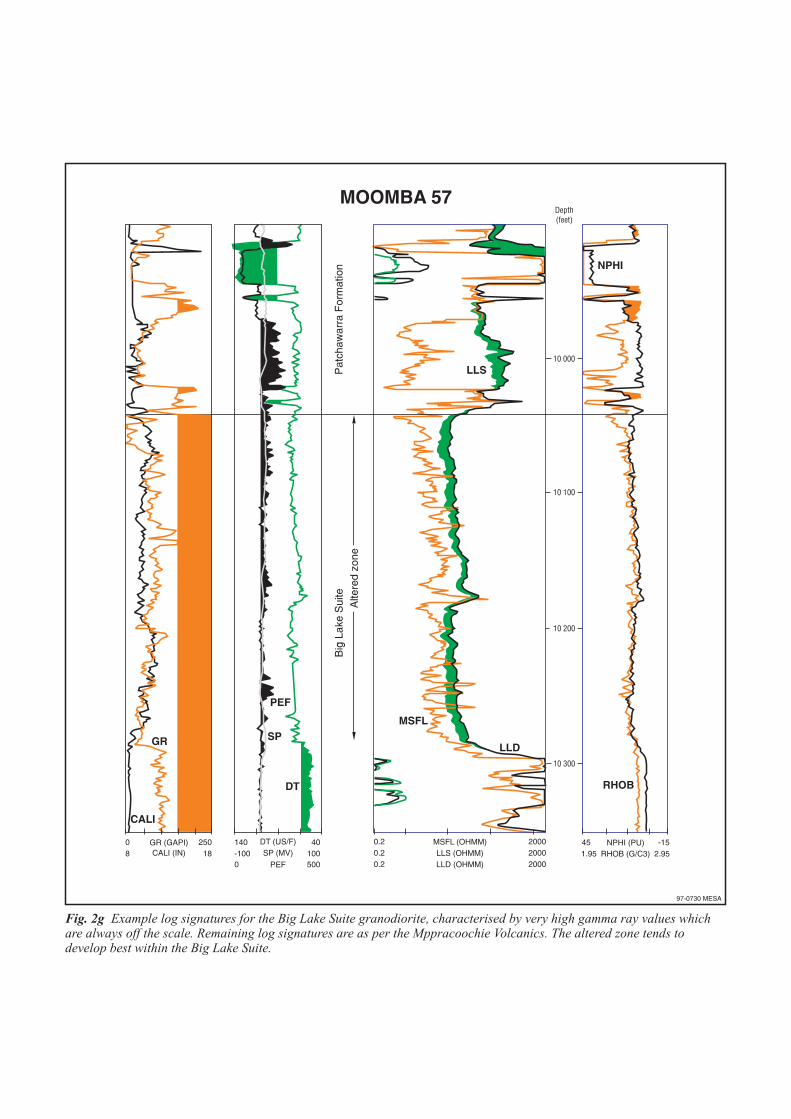
2g. Example log signatures for the Big Lake Suite granodiorite, characterised by very highgamma ray values which are always off the scale. Remaining log signatures are as perthe Mooracoochie Volcanics. The altered zone tends to develop best within the BigLake Suite. (Plan 1997-0730) 24
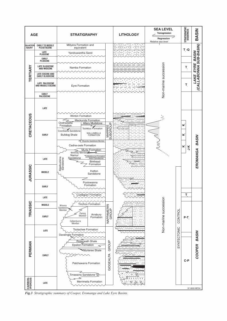
3. Stratigraphic summary of the Cooper, Eromanga and Lake Eyre Basins. (Plan 1997-0731) 254. Cross section of the southern Toolachee area showing layer cake stratigraphy after the
topographic lows have been filled. The disappearance (eg. Toolachee 10, 32) andappearance of carbonaceous shales (eg. Toolachee 25, 30) assist in locating thepre-Permian section. (Plan 1997-0732) 26
5. The altered zone in Lycosa 1 and Moolalla 1 (although not easily recognisable examples)was interpreted as the Merrimelia Formation (Westgarth 1992). This mistaken identityresulted in continued drilling in these wells which fortuitously led to basement gasdiscoveries. (Plan 1997-0733) 27

4
PRIMARY INDUSTRIES AND RESOURCESSOUTH AUSTRALIA
REPORT BOOK 97/37a
A BEGINNER’S GUIDE TO PICKING BASEMENT FROMWIRELINE LOGS, COOPER BASIN AREA
R K Boucher1
Picking the top of basement beneath the Cooper and Eromanga Basins in South Australia has proven to bedifficult in recent years. Criteria are established to recognise basement lithologies on wireline logs and todistinguish them from the overlying sediments. Of great assistance, is the recognition of an altered zone at thetop of basement which has characteristic log signatures and been mistaken in the past for Carboniferous,Permian and Triassic, granitoids, volcanics and sediments. This zone in known to seal Permian hydrocarbons inbasement reservoirs at several localities.
1 Present address:
Whitehorse Geoscience Pty LtdSuite 6, 560 Lonsdale StreetMelbourne VIC 3000email: [email protected]
INTRODUCTION
Basement in the Cooper Basin area is typicallyconsidered to be composed of sediments andvolcanics of the Warburton Basin, Carboniferous00granodiorite of the Big Lake Suite andProterozoic sedimentary and metamorphic rocks(Fig. 1). Traditionally, basement has been difficultto distinguish whilst drilling, on wireline logs andon seismic. However, recognition of a zone ofalteration (now believed to be saprolite) has madebasement picking easier on wireline logs (Boucher1996) and should lead to the easier identificationwhilst drilling and on seismic.
This work is part of an ongoing, broader reservoirstudy of the Warburton Basin. The task of mappingthe zone of alteration and picking top basementfrom wireline logs is not yet complete.
BASEMENT LITHOLOGIES ANDHOW TO IDENTIFY THEM ONWIRELINE LOGS
Basement lithologies (Fig. 1) include Proterozoicmetamorphics, Mooracoochie. Volcanics,Kalladeina Formation carbonates and shales, ‘Jena
Basalt’, Dullingari Group shales and sandstones,Pando Formation sandstones and shales,Innamincka Formation sandstones (red beds) andBig Lake Suite granodiorite. They have their owndistinct log characteristics. Details of theselithologies can be found in reports by Gravestock etal. (1995), Gatehouse (1983, 1986), Gatehouse etal. (1995), Sun (1996) Sun et al. (1994), Roberts etal., (1990) Taylor et al., (1991), Zang (1993) andBoucher (1994, 1996).
Unfortunately, many type sections are in old wells,with old and incomplete logging suites.Traditionally, older wells are those with core. It israre for wells with modern, complete logging runsto have cut a core to make the comparison.Exceptions to this include Lycosa 1 and Big Lake52, both with steeply dipping Dullingari Group,shales and siltstones.
Logs which are used to discriminate between theselithologies are the gamma ray, PEF, neutron anddensity logs. In many wells, the latter are not run,yet the gamma ray is usually sufficient. Thecaliper, occasional dipmeter log and drilling ratesassist in establishing whether the zone is or is notbasement. Sonic and resistivity logs providefurther supporting evidence to discriminatebetween basement and the overlying sediments, but

5
do not assist in distinguishing basement lithologies.Instead, these logs assist to determine the amountof alteration of the basement. Where possible,examples have been included to show both thealtered and fresh zones. This section will deal withlog signatures over ‘fresh’ intervals and the alteredzone is considered later in this report. To conformwith current usage, Cooper Basin log depths arereported in feet. A template specifically designedto highlight basement lithologies is shaded whenthe logs display:
• Gamma ray values exceeding 150 API• PEF values exceeding 2.6 barns/electron• Sonic values faster than 60 µsec/ft• Neutron/Density values read as per a shale (NB:
traditionally the crossover is made to representsandstone lithologies)
• Density values greater than 2.6 g/cm3
The dominant lithology encountered is DullingariGroup shale (Fig 2a). Characteristically, thegamma ray is elevated beyond ‘normal’ shalevalues (typically 150-170 API) and exceeds valuesfor Cooper and Eromanga Basin siltstones. Gammaray values are generally very uniform. The onlyexception is in the Toolachee area whereoccasional quartzite beds occur (occasionally up to80’ thick and commonly 5’ to 20’ thick).Neutron/density crossovers are typical of shalesand density values often reach 2.7 g/cm3.Occasional spikes on resistivity logs can indicatefractures, but in general resistivity values are veryhigh, often exceeding 2000 ohm-m. This lithologyis also represented by fast sonic values and an in-gauge caliper. Metamorphic Proterozoic schistshave only been encountered in a few wells (e.g.Mulga 1, Gurra 1) and logs appear similar toDullingari Group.
Sun (1996) has outlined facies types of theKalladeina Formation and logged numerous holes.Unfortunately the holes with the most drilledsection are without a complete log suite. Gammaray values of Kalladeina Formation carbonates aretypically low but variable depending on facies type(Fig. 2b). Neutron/density logs can vary, althoughdensity values are typically high. PEF values areoften high. ‘Hard’ limestone is typicallyrepresented by slow drilling rates, in gauge caliperand fast sonic.
Pando Formation sandstone typically displaysvariable, yet often elevated gamma ray values (60-260 API units; Gravestock et al., 1995).Neutron/density values will appear as for sand and
resistivity values can be erratic and may not beexpected to be as high as other lithologies. PandoFormation shales are difficult to distinguish fromDullingari Group on wireline logs. The exactnature and distribution of the Pando Formation isstill being ascertained. However it can beidentified on logs when the gamma ray values areelevated and the neutron/density logs read as asandstone. An example of the sandstone faciesoccurs in Daralingie 1 (Fig. 2c).
Innamincka Formation red beds have mostly beenintersected on ridges on the Innamincka 1:250,000map sheet (Townsend and Thornton 1975) wherethey often subcrop beneath, and are difficult todistinguish from, red beds of the NappamerriGroup. Tucker (1993) did have some success indiscriminating between the two units whenmeasuring their magnetic susceptibility. Gammaray, neutron and density values are typical forsandstones (Fig. 2d). Erratic resistivity values areoften characteristic of the Innamincka Formation.
Mooracoochie Volcanics display a variety ofgamma ray values, but are typically elevated.Neutron/density logs will read as sand, reflectingthe high silica content, (Fig. 2e). Usually theMooracoochie Volcanics are a thick, uniform andhard lithology. Hole conditions are therefore verygood, with the caliper in gauge, high resistivity andfast sonic values.
The ‘Jena Basalt’ (informal name) has a verydistinct log characteristic (Fig. 2f). Density valuesare usually very high, often exceeding 2.8 g/cm3
whilst neutron values are unusually low, oftenreading greater than 40 porosity units, combining toshow a wide separation. PEF values are very high,often over 5. Gamma ray values are generally low,around 50 API and the sonic is variable. The ‘JenaBasalt’ was initially identified from thin sectionsand magnetic susceptibility measurements(Boucher 1991) where values of up to 6,000 nTwere recorded in comparison to values less than100 for Warburton Basin sediments. However, thevalues decrease rapidly when the volcanics arealtered.
The Big Lake Suite is most easily recognisable byits characteristically high gamma ray values,commonly exceeding 300 API (Fig. 2g; note back-up scale). This distinguishes the granodiorite fromMooracoochie Volcanics with all other logsappearing similar. In the area west of the WoolooTrough which was covered by a recentaeromagnetic survey, the areal extent of the Big
6
Lake Suite can be seen as an aeromagnetic highwith a low core, indicating the pluton may bezoned. Recent drilling at Dune 1, Wooloo South 1and Mataro 1 confirms the aeromagnetic high doesindeed represent the pluton.
SEDIMENTS OVERLYINGBASEMENT
The stratigraphy of the Cooper, Eromanga andLake Eyre Basins is given in Figure 3. Themajority of the wells which reach basement havePatchawarra Formation as the overlying deposit.Towards the basin edges and on some ridges, otherCooper Basin sediments or lowermost EromangaBasin sediments (Poolowanna Fm or Hutton Sst)overlie basement. Many wells with MerrimeliaFormation sediments did not reach basement, this iscommon on the Innamincka 1:250,000 sheet .
DISTINGUISHING COOPER ANDEROMANGA BASIN SEDIMENTSFROM BASEMENT
Aside from the Merrimelia Formation, sedimentsoverlying basement are terrigenous clasticsandstone, siltstone and coal and are relatively easyto distinguish from basement on wireline logs.Glacigenic sediments of the Merrimelia,particularly when reworked from nearby basementare more difficult to distinguish.
The Patchawarra, Epsilon, Daralingie andToolachee Formations contain fining andcoarsening upwards sequences (in addition tocoals) that are easily distinguishable from basementwhich typically has a more uniform gamma ray,regardless of whether these are high or low values.Most of the basement lithologies are relativelymore indurated than the Cooper and Eromangabasin sediments and, where ‘fresh’, the basement iseasily identifiable by an in gauge caliper, fast sonicvalues, high resistivity values and slow drillingrates. When altered, logs display characteristicsignatures which are considered below.
The unit which is the most problematic is theInnamincka Formation, especially when overlain bythe Nappamerri Group and both units are flat-lying.The sonic and resistivity values in the InnaminckaFormation are not necessarily indicative ofbasement and it is difficult to pick the top of theInnamincka Formation from logs.
Given that the Patchawarra Formation commonlyoverlies basement and that the sedimentation isrelatively uniform and extensive, it is easy to pickbasement by noting where fluvial lithologies, inparticular coals, appear and disappear (Fig. 4).This can only be done by viewing the logs in threedimensions. Cross sections are not sufficient.Sufficient well control is also required.
IDENTIFICATION OF ALTEREDAND FRESH BASEMENT ONWIRELINE LOGS
A zone of alteration has been recognised tocommonly occur at the top of basement. The exactnature of this zone is yet to be established,however, it is most likely to be saprolite (E.B.Joyce pers. comm.). This zone has distinctcharacteristics which are common to manybasement lithologies and can be easily recognised.The most characteristic feature is very low(typically 20 ohm-m) and uniform resistivityvalues. This contrasts to typically high values inthe fresher zone below. The caliper is typicallywashed out, yet in gauge below and the sonic isusually significantly slower that the fresh zonebelow. Gamma ray, neutron, density and PEFvalues show no change or a slight shift to the right.The dramatic shift in sonic values can produce aseismic reflector, where the zone is sufficientlythick, producing an intra-basement reflector.
By being able to identify the altered zone, itbecomes a lot easier to pick basement. This featureoccurs in the majority of the wells in the region (forexample, 90% of the wells in the Daralingie andMoomba areas). The development of the zone is inpart controlled by lithology. The alteration processproduces clay minerals which require anappropriate parent rock. The granodiorite,volcanics and shales readily show this feature. It isnot as well developed in sandstones or carbonates.

7
ADDITION AND REMOVAL OF THEMERRIMELIA FORMATION ANDTIRRAWARRA SANDSTONE
Traditionally, the ‘altered zone’ has been mistakenfor the Merrimelia Formation or in the Moombaarea, the Tirrawarra Sandstone. Boucher (1996)has outlined that all Tirrawarra Sandstone (with theexception of wells drilled on the flanks of thestructure, which include Big Lake wells) is actuallyaltered Big Lake Suite granodiorite. Similarly,wells in the southern part of the basin, previouslyconsidered to have contained the MerrimeliaFormation do not (e.g. Table 2). Instead, thisinterval has been found to have been in thealteration zone. In particular, the greater Daralingieand Toolachee areas have had almost their entire‘Merrimelia Formation’ revised as basement.
In contrast, the areas along the ridges flanking thesouthern Nappamerri and Allunga Troughs, havehad what has previously been considered to bebasement turn out to be Merrimelia Formation.Suspicions were aroused when the altered zone didnot appear in wells in this area, implying thatbasement had never been reached in manyinstances. Examples occur in Beckler 1 andGoyder 1.
Picks for the top and base of the altered zone in theDaralingie and Toolachee areas are given in Tables1 and 2.
SIGNIFICANCE OF THE ALTEREDZONE TO PETROLEUM DRILLING
Traditionally, wells have reached total depth nearthe top of basement, where drilling has continuedfar enough into basement to allow for a full loggingrun over the Cooper and Eromanga basin intervals.However, prognosing where basement is likely tobe has been difficult in the past, particularly wherethe seismic expression of basement is not clear orhindered by an additional ‘intrabasement’ reflector.Inconsistent picking of basement, alternatingbetween the top or base of the altered zone (forexample in the Toolachee area) has meant thatpicking basement on seismic based on these datahas at times meant crossing reflectors. Pickingbasement should become easier now that this zoneof alteration has been recognised. Similarly,basement should become easier to pick whilstdrilling by looking for features of the altered zone.
SIGNIFICANCE OF THE ALTEREDZONE TO PETROLEUMPROSPECTIVITY
Several basement discoveries have been made inthe Cooper Basin area, all found updip and sourcedfrom Permian units. Sturt 6 flowed oil at 1250BPD from fractured Mooracoochie Volcanics.These volcanics were unaltered and the trap wassealed by Patchawarra Formation shales. Sturt 7,drilled in part to follow up on this discoveryintersected altered Mooracoochie Volcanics wherethe fractures were presumably cemented and testingresulted in no flow to the surface. This examplehighlights two areas that need to be investigated.Firstly, is it possible to predict which wells arelikely to contain an altered zone? And secondly,how significant are structures to potentialreservoirs? Sturt field lies on a basement thrustfaulted structure which no doubt induced thefractures. Where the volcanics are flat lying,fracturing may not have occurred.
Three wells near the flank of the Wooloo Troughhave encountered basement reservoired petroleum,all sealed by the altered zone; Moolalla 1 (0.79, 2.0,9.6 and 4.0 MMCFD), Lycosa 1 (4.1, 3.2 and 1.4MMCFD) and Farina 1 (0.44 MMCFD and oilrecovered in the sample chamber). A test in thealtered zone in Moolalla 1, like elsewhere in thebasin, flowed gas at rate too small to measure (illitewhich commonly occurs in the altered zone isnotorious for soaking up a little gas and oil, so it iscommon to get shows whilst drilling through thealtered zone). Almost 40 wells have now beendrilled in prospective areas adjacent to the Woolooand Allunga Troughs. Of these wells, only 5 fullypenetrated the altered zone in Warburton Basinsediments. Given that three of these werediscoveries, basement in the area must beconsidered highly prospective for futureexploration.

8
RECOGNISING THE ALTEREDZONE FROM CUTTINGSDESCRIPTIONS IN WELLCOMPLETION REPORTS
Characteristic terms are often used in wellcompletion reports when describing the alteredzone. Lithologically descriptions of the alteredzone, commonly referred to as the MerrimeliaFormation or Tirrawarra Sandstone, are similar tothat of the zone beneath it. However, clayminerals, siderite concretions, patchy calcitecement and quartz overgrowths are commonlydescribed in the altered zone. Aside from thesedifferences, the fresh rock beneath the altered zoneis commonly given the prefix ‘meta’ in an attemptto show it differs, despite usually having the samelithology, but a slower drilling rate.
RECENT CASE STUDIES OFINCORRECTLY AND CORRECTLYPICKED BASEMENT
MOOMBA 82
Moomba 82 was drilled in April 1997, over a yearafter Santos was informed that the TirrawarraSandstone did not exist in the Moomba field(except downflank of the structure). alteredgranodiorite was encountered beneath thePatchawarra Formation and gas shows wererecorded in the altered zone, as is common. Thislithology was again recorded as TirrawarraSandstone and drilling continued to the rig’scapacity. The altered zone was not fully penetratedand one of the thickest zones in the basin wasencountered, 846+ feet. It took 4 days to drill thisinterval. In addition, two drill stem tests and anMDT pressure survey were conducted, all of whichare in essentially unprospective granodiorite.
ARRAKIS 1, ARRAKIS NORTH 1,DUNE 1
Both Arrakis 1 and Arrakis North 1 wereinterpreted to contain Merrimelia Formation.Neither does, instead this is the altered zone.Arrakis North 1 reached basement at 7880’, yetwas interpreted to have not reached the MerrimeliaFormation until 8074’. The interval between 7880’and 8074’ was believed to have been PatchawarraFormation.
Dune 1, drilled downflank from Arrakis 1 wasprognosed to penetrate 917’ of PatchawarraFormation sediments. This was in part based on amisinterpretation of the thickness of PatchawarraFormation in Arrakis North 1 where an extra 294’was believed to exist. When the well was drilledPatchawarra Formation was 469’ thinner thanprognosed. The best test in the well came from thealtered zone within the Big Lake Suite, at a rate toosmall to measure. This zone is mistakenly believedto be granite wash, as opposed to an in situweathered layer.
MATARO 1
Like Dune 1, Mataro 1 lies on the aeromagnetichigh which characterises the Big Lake Suite. Thewell was drilled between Wooloo 1, Wooloo South1 and Topwee 1, all underlain by granodiorite. Thewell was prognosed with a pre-Permian secondarytarget yet the well intersected granodiorite beneaththe Patchawarra Formation.
FARINA 2, AUGUSTA 1 ANDWARKI 1
Based on the hydrocarbons in basement in Farina 1,several wells were been proposed to drill intobasement to test for hydrocarbons. Farina 2,Augusta 1 and Warki 1 did not penetrate the alteredzone and therefore failed to test the play.
LYCOSA 1, MOOLALLA 1 AND THEGREATER DARALINGIE AREA.
Lycosa 1 drilled in 1990, penetrated what wasthought to be Merrimelia Formation and continueduntil basement was reached (Fig. 5). The so calledMerrimelia Formation is actually altered DullingariGroup. This error was fortunate, however, becausethe additional drilling resulted in a gas discoverybeneath the altered zone. Similarly, gas occursbeneath the altered zone in Moolalla 1 (Taylor et al.1991).
Westgarth (1992) undertook a study of the entireregion to accurately pick the basement andMerrimelia Formation as well as to establishguidelines for picking these units. It wasrecommended that these criteria be appliedbasinwide. Unfortunately, the altered zone was notrecognised and, as in Lycosa 1 and Moolalla 1 (Fig.5) it was described as Merrimelia Formation inmost instances. Westgarth did state that it isdifficult to distinguish between the two as they are
9
lithologically similar. This in the correct context istrue, however in many examples Westgarth used,the reasons they are so similar is because they arein fact the same unit.
CORUNA 1
Coruna 1 was drilled on a fault block on thenorthern Cooper Basin margin. A thick lowerPermian section was prognosed and interpreted bySantos, including 203’ of Toolachee Formation,205’ of Epsilon Formation, 295’ of PatchawarraFormation and 59’ of Tirrawarra Sandstoneoverlying the Mooracoochie Volcanics. However,the logs would appear to entirely representbasement beneath the carbonaceous shale picked asthe top Toolachee Formation. Lithologicaldescriptions of these intervals change little and readlike the Mooracoochie Volcanics below. Oil andgas shows were encountered throughout most of theMooracoochie Volcanics.
NORTH COOPER BASIN MARGINWELLS
Wells drilled in the north Cooper Basin margin areain South Australia where the Nappamerri Groupoverlies basement typically mistake the alteredzone for part of the Nappamerri Group. In threewells, Telopea 1 and 2 and Keleary 3, oil showshave occurred within the altered zone which mayadd to the confusion, however, a DST in Telopea 2resulted in no flow to surface.
Typically an extra member is added to the basalNappamerri group to account for the altered zone.In Telopea 1 (Fig. 2e), Telopea 2 and Fulcia 1 thealtered zone is mistaken for the CallamurraMember and; in Keleary 1 and 3, the PaningMember. A basal shale of the Wimma Sandstonemember is mistaken for the altered zone in Keleary2. Walkillie 1 well proposal does not subdivide theNappamerri Group, however, 41 feet of interpretedbasal Nappamerri Group is actually alteredMooracoochie Volcanics. No altered zone existsin Crumpa 1 or Caraway 1, however in Caraway 1,295+ feet of Mooracoochie Volcanics areinterpreted as the Callamurra Member. Crumpa 1and Deramookoo 1 are the only wells in the areawhere basement has been correctly picked. InDeramookoo 1, 67 feet of altered MooracoochieVolcanics are correctly included within thebasement.
KATINGAWA 1, GOYDER 1
Katingawa 1 was drilled down flank of the KidmanField. basement was interpreted at 9922’, however,it is now believed the Merrimelia Formation occursat 9186’. basement possibly occurs at 9912’, butthis is 721’ higher than geophysical prognosiswhich may yet prove to be correct. Likewise inGoyder 1, it is believed that the well did notpenetrate basement, but instead reached total depthin thick Merrimelia Formation. An interestingfeature on logs is the occurrence of three stackedfluvio-lacustrine facies in Goyder 1.
BIG LAKE FIELD
In the northeastern part of the Big Lake field, theBig Lake Suite and Dullingari Group subcropbeneath the Cooper Basin. These aredistinguishable where elevated gamma ray valuesare indicative of the granodiorite and core in BigLake 52 is of steeply dipping Dullingari Group. Tothe southwest of the field, it is uncertain if anyremaining Big Lake well has intersected basement.No evidence of an altered zone exists and logsignatures are not indicative of basement. Cuttingsof these wells have been sampled and thin sectionsare being prepared to assist with interpretation.
CONCLUSION
Examples of various basement lithologies has beengiven to enable these lithologies to be discriminatedfrom the overlying, dominantly fluvial, Cooper andEromanga Basin sediments.
An altered zone at the top of basement enables easyrecognition of pre-Cooper Basin lithologies whereit is present. The altered zone acts locally as a sealfor Permian hydrocarbons in updip basementreservoirs. This play, although proven successful,is essentially untested.
REFERENCES
Boucher, R. K., 1991. The tectonic framework ofthe Murteree Ridge, Warburton Basin: structuralimplications for the Cooper and EromangaBasins. National Centre for Petroleum Geologyand Geophysics, University of South Australia.Honours Thesis. (Unpublished).

10
Boucher, R. K., 1994. Igneous associations in theeastern Warburton Basin. In: 12th AustralianGeological Convention, Perth 1994. GeologicalSociety of Australia. Abstracts, 37:40.
Boucher, R. K., 1996. Big Lake Suite not TirrawarraSandstone in the Moomba Field, Cooper Basin,SA South Australian Department of Mines andEnergy. Report Book. 96/31
Carroll, P. G., 1990. Pre-Permian Structure andProspectivity at Gidgealpa, South Australia.National Center for Petroleum Geology andGeophysics, Adelaide University. M.Sc. Thesis.Unpublished.
Gatehouse, C. G., 1983. Geology of the WarburtonBasin in South Australia. South AustralianDepartment of Mines and Energy. Report Book.82/81
Gatehouse, C. G., 1986. The Geology of theWarburton Basin in South Australia. AustralianJournal of Earth Sciences. 33:161-180.
Gatehouse, C. G., Fanning, C. M. & Flint, R. B.,1995. Geochronology of the Big Lake Suite,Warburton Basin, northeastern South Australia.Geological Survey of South Australia, QuarterlyGeological Notes. in prep.
Gravestock, D. I., Callen, R. A., Alexander, E. M.& Hill, A. J., 1995. STRZELECKI map sheet.South Australia. Geological Survey. GeologicalAtlas 1:250,000 Series, sheet SH54-2. -Explanatory Notes
Roberts, D. C., Carroll, P. G. & Sayers, J., 1990.The Kalladeina Formation - A Warburton BasinCambrian Carbonate Play. APEA Journal30(1):165-183.
Sun, X. W., 1996. Sequence stratigraphy,sedimentology, biostratigraphy and palaeontologyof the eastern Warburton Basin
(Palaeozoic), South Australia. National Centrefor Petroleum Geology and Geophysics,University of South Australia. PhD Thesis.(Unpublished).
Sun, X. W., Stuart, W. J. & Warren, J. K., 1994.Stratigraphy and sedimentology of Cambro-Ordovician successions, eastern WarburtonBasin, South Australia. PESA Journal 22:107-11
Roberts, D. C., Carroll, P. G. & Sayers, J., 1990.The Kalladeina Formation - A Warburton BasinCambrian carbonate play. APEA Journal30(1):165-183.
Taylor, S., Solomon, G., Tupper, N., Evanochko, J.,Horton, G., Waldeck, R. & Phillips, S. 1991.Flank Plays and Faulted Basement: NewDirections for the Cooper Basin. APEA Journal31(1):56-73.
Townsend, I. J. & Thornton, R. C. N., 1975.INNAMINCKA map sheet. South Australia.Geological Survey. Geological Atlas 1:250,000Series, sheet SG54-14.
Tucker, L. R., 1993. Magnetic susceptibility ofCooper and Warburton Basin sedimentary rocks.Pilot study. Department of Mines and Energy,South Australia. Report Book 92\65.
Westgarth, M. 1992. Delineation and correlation ofthe pre-Patchawarra Formation sediments of thegrater Daralingie and Wooloo Trough.Department of Mines and Energy. Open FileEnvelope, 8126 (unpublished).
Zang, W. L., 1993. Early Ordovician tidalinfluenced deltaic deposits and petroleumreservoirs, eastern Warburton Basin, SouthAustralia, Australia. South AustralianDepartment of Mines and Energy. Report Book.96/31
11
Table 1 Depths (KB logger, feet) to the top and base and thickness (in feet) of the altered zone forthe Daralingie area, Cooper Basin.
altered ZoneWell Top Base Thickness Formation
Arrakis 1 7784 7923 139 DULLINGARI GPArrakis North 1 7880 np 150+ DULLINGARI GPAtreides 1 7348 7417 69 BIG LAKE SUITEBarina 1 7427 np 239+ DULLINGARI GPBarina 2 7503 np 127+ DULLINGARI GPBartilla 1 7027 np 172+ DULLINGARI GPBobs Well 1 9302 9475 173 DULLINGARI GPBoobook 1 9268 np 298+ DULLINGARI GPBoxwood 1 6157 6203 46 Mooracoochie VolcBoxwood 2 5730 5740 10 Mooracoochi VolcBungee 1 8026 np 173+ DULLINGARI GPBungee 2 8178 np 127+ DULLINGARI GPCaladan 1 7008 np 172+ DULLINGARI GPCaladan Northeast 1 7090 np 208+ DULLINGARI GPCowan 1 abs 7174 0 Pando FmCowan 2 7396 np 208+ Pando FmCowan 3 abs 7596 0 Pando FmDaralingie 1 7156 7364 208 Pando FmDaralingie 2 7671 7740 69 Pando FmDaralingie 3 7460 np 66+ ?DULLINGARI GPDaralingie 4 7465 7534 69 ?DULLINGARI GPDaralingie 5 6861 6970 109 Pando FmDaralingie 6 7227 np 81+ Pando FmDaralingie 8 7370 np 112+ ?Pando FmDaralingie 9 7522 np 121+ Pando FmDaralingie 10 abs 7219 0 Pando FmDaralingie 11 7637 np 83+ DULLINGARI GPDaralingie 13 7536 7590 54 Pando FmDaralingie 14 7504 np 222+ ?Pando FmDaralingie 15 7635 np 180+ ?Pando FmDaralingie 16 7505 np 136+ ?DULLINGARI GPDaralingie 17 7610 np 169+ ?DULLINGARI GPDaralingie 18 7856 np 342+ Pando FmDaralingie 19 7797 np 409+ Pando FmDaralingie 20 7611 np 163+ Pando FmDaralingie 21 7603 7698 95 Pando FmDaralingie 22 7745 7840 95 Pando FmDaralingie 23 7544 np 182+ Pando FmDaralingie 24 7734 np 151+ Pando FmDeina 1 7610 7807 193 Pando FmDirkala 1 6762 np 108+ DULLINGARI GPDirkala 2 6893 np 149+ DULLINGARI GPDirkala 3 6822 np 95+ DULLINGARI GPDirkala South 1 6918 np 134+ DULLINGARI GPDirkala West 1 6790 np 153+ DULLINGARI GP

12
altered ZoneWell Top Base Thickness Formation
Dune 1 8553 8646 93 BIG LAKE SUITEDunoon 1 4733 4760 27 ?DULLINGARI GPFarina 1 7410 7502 92 Kalladeina FmGaranjanie 1 6922 6958 35 Pando FmGaranjanie 2 7079 np 97+ Pando FmGaranjanie 3 7196 7287 91 Pando FmJaspa 1 5698 5792 94 ?Mooroochie Volc.Karilla 1 6888 np 189+ ?DULLINGARI GPKarina Southwest 1 7053 np 140+ Mooracoochie VolcKeena 1 6436 np 170+ ?DULLINGARI GPKeena 2 6445 np 152+ ?DULLINGARI GPKeena 3 6549 np 150+ ?DULLINGARI GPKirralee 1 abs 10308 0 DULLINGARI GPKopi 1 8433 np 185+ DULLINGARI GPKoree 1 7468 7511 43 DULLINGARI GPKujani 1 6842 np 126+ DULLINGARI GPKujani 2 7010 np 150+ DULLINGARI GPLycosa 1 8304 8512 208 DULLINGARI GPManooka 1 abs 6300 0 DULLINGARI GPMerinda 1 8688 np 134+ DULLINGARI GPMoolalla 1 8084 8428 344 Pando FmPampari 1 4933 4967 34 ?DULLINGARI GPPando 1 5699 5750 51 Pando FmPando 2 5923 5969 46 Pando FmPando North 1 6354 6424 70 Pando FmPando South 1 5836 5904 68 Pando FmPandruannie 1 5918 np 112+ DULLINGARI GPPintari 1 abs 5670 0? Mooracoochie VolcPintari North 1 abs 6168 0 Mooracoochie Volc.Pogona 1 8320 8397 77 BIG LAKE SUITEThurakinna 1 7755 np 100+ ?DULLINGARI GPThurakinna 2 7916 np 119+ ?DULLINGARI GPThurakinna 3 7740 np 143+ ?DULLINGARI GPThurakinna 4 7836 np 120+ ?DULLINGARI GPThurakinna 5 7898 np 107+ ?DULLINGARI GPTopwee 1 abs 7291 0 BIG LAKE SUITEWancoocha 1 6269 6420 151 DULLINGARI GPWancoocha 2 abs 5742 0 Pando FmWancoocha 3 abs 5966 0 Pando FmWancoocha 4 abs 5808 0 Pando FmWancoocha 5 5860 np 155+ Pando FmWancoocha 6 5829 np 83+ Pando FmWancoocha 7 abs 5944 0 Pando FmWaukatanna 1 8512 np 177+ Pando FmWirrarie 1 6754 7022 268 DULLINGARI GPWirrarie 2 6890 np 119+ DULLINGARI GPWirrarie North 1 6895 np 124+ DULLINGARI GPWooloo 1 7525 7545 20 BIG LAKE SUITE

13
altered ZoneWell Top Base Thickness Formation
Wooloo South 1 8164 8242 78 BIG LAKE SUITEYalcumma 1 9650 np 137+ ?DULLINGARI GPYapeni 1 7325 np 147+ DULLINGARI GPYapeni 2 7700 np 70+ DULLINGARI GP

14
Table 2 Depths (KB logger, feet) to the top and base and thickness (in feet) of the altered zone for theToolachee area, Cooper Basin. Picks from well completion reports are provided for comparison.
altered Zone WCR # CORES # DST'SWell Top Base Thickness Formation Merrimelia
Fmbasement "A
"FRESH "A
"FRESH
Alisma 1 9333 9494 161 DULLINGARI GP abs 9404Allambi 1 8565 8620 55 DULLINGARI GP abs 8565Amyema 1 7761 np 140+ DULLINGARI GP abs 7776Aroona 1 7075 np 239+ DULLINGARI GP 7076 7250Azolla 1 7750 7880 130 DULLINGARI GP 7750 7862Bagundi 1 7012 np 291+ DULLINGARI GP abs 7012Bagundi 2 7234 7335 101 DULLINGARI GP abs 7258Bagundi 3 7256 7290 34 DULLINGARI GP abs 7256Bagundi 4 7013 7250 237 DULLINGARI GP 7013 7255 1Baratta 1 7372 7453 81 'Jena Basalt' 7405 7508Baratta 2 7410 7517 107 DULLINGARI GP abs 7410Baratta South 1 7598 np 153+ DULLINGARI GP 7598 7626Baratta West 1 7560 7718 158 DULLINGARI GP abs 7520Barcooloo 1 7072 7122 50 DULLINGARI GP abs 7074Battunga 1 8190 np 141+ DULLINGARI GP abs 8202Boongala 1 8712 8763 51 DULLINGARI GP 8712 8786Brumby 1 7655 np 44+ DULLINGARI GP abs 7659 1Brumby 2 7666 7732 66 DULLINGARI GP abs 7692Brumby 3 7898 7994 96 DULLINGARI GP 7898 8076Brumby 4 7558 7664 106 DULLINGARI GP abs 7558Brumby 5 7696 np 74+ DULLINGARI GP 7696 npBrumby 7 7776 np 155+ DULLINGARI GP abs 7776Burruna 1 5978 6023 45 DULLINGARI GP 5966 npCaraka 1 7947 np 322 DULLINGARI GP 7947 8155Chilcarrie 1 7318 np 210+ DULLINGARI GP abs 7330Childie 1 6847 np 104+ DULLINGARI GP abs 6847Coobowie 1 ABS 4798 0 DULLINGARI GP abs 4778Coochilara 1 8920 np 81+ DULLINGARI GP abs 8921Coochilara 2 8701 8814 113 DULLINGARI GP abs 8818 1Dieri 1 7789 np 105+ DULLINGARI GP abs 7789Dilchee 1 9050 np 101+ DULLINGARI GP abs 9052Dilchee 2 8922 np 151+ DULLINGARI GP abs 8922Gahnia 1 9144 9274 130 DULLINGARI GP abs 9145Grystes 1 7602 7608 6 DULLINGARI GP abs 7603Kapinka 1 7834 np 218+ DULLINGARI GP 7834 7887Katingawa 1 abs 9703 0 DULLINGARI GP abs 9922Keeto 1 7580 np 193+ DULLINGARI GP 7522 7580Keeto 2 7479 7532 53 DULLINGARI GP abs 7479Kerna 1 8413 np 117+ DULLINGARI GP abs 8413Kerna 2 A 8740 np 172+ DULLINGARI GP abs 8814Kerna 3 8289 np 141+ DULLINGARI GP abs 8289Kerna 4 8510 np 178+ DULLINGARI GP abs 8509Kerna 5 8416 8532 116 DULLINGARI GP abs 8416 1Kidman 1 abs 7580 0 DULLINGARI GP abs 7583 1Kidman 2 7337 7402 65 DULLINGARI GP 7336 7393Kidman 3 7474 7482 8 DULLINGARI GP 7462 7447Kidman 5 7210 7322 112 'Jena Basalt' 7212 7318Kidman 7 7220 7243 23 'Jena Basalt' 7296 7326Kidman 8 7509 np 144+ ?DULLINGARI GP 7472 7510Kidman North 1 7475 np 136+ DULLINGARI GP abs 7475Kidman North 2 7490 np 134+ DULLINGARI GP abs 7487Maraku 1 7348 7506 158 DULLINGARI GP 7348 7509
15
altered Zone WCR # CORES # DST'SWell Top Base Thickness Formation Merrimelia
Fmbasement "A
"FRESH "A
"FRESH
Marsilea 1 8063 8106 43 DULLINGARI GP abs 8063Mataranka 1 7464 np 226+ DULLINGARI GP 7464 7511Mettika 1 8096 8192 96 DULLINGARI GP abs 8096Mettika 2 8244 np 139+ DULLINGARI GP abs 8244Mettika 3 8186 np 172+ DULLINGARI GP abs 8186Mettika 4 8178 8302 124 DULLINGARI GP abs 8178Mettika 5 8094 np 173+ DULLINGARI GP abs 8096Mundi 1 7868 7985 117 DULLINGARI GP 7868 7994Mundi 2 7797 np 170+ DULLINGARI GP 7803 7834Mundi 3 7557 np 212+ DULLINGARI GP 7558 7580 1Mundi 4 7742 7870 128 DULLINGARI GP 7754 7774Mundi 5 7751 7882 131 DULLINGARI GP 7751 7836Munkarie 1 7500 7591 91 DULLINGARI GP 7503 7595 1Munkarie 2 7486 np 223+ DULLINGARI GP 7487 7683Munkarie 3 7610 7770 160 DULLINGARI GP 7654 7769Munkarie 4 7305 7602 297 DULLINGARI GP 7398 7598 1Munkarie 5 7920 np 179+ DULLINGARI GP np 7919Munkarie 6 7608 7834 226 DULLINGARI GP 7608 7795 1Munkarie 7 7438 7532 94 DULLINGARI GP 7438 npMunkarie 8 7320 7440 120 DULLINGARI GP 7291 np 1Narcoonowie 1 6108 6280 172 DULLINGARI GP 6112 6161 1 1Pelketa 1 7091 np 109+ DULLINGARI GP abs 7096Plantago 1 9060 np 149+ DULLINGARI GP abs 9060Tarwonga 1 7819 np 183+ DULLINGARI GP 7818 7869Tarwonga 2 7868 8058 190 'Jena'/DULLINGARI 7870 8055Tarwonga 3 7824 np 67+ DULLINGARI GP 7824 7868 1Tarwonga 4 7687 np 153+ DULLINGARI GP 7687 7748Tilparee A1 6845 6998 153 DULLINGARI GP 6855 6987 1 1Toolachee 1 6990 7044 54 DULLINGARI GP 6988 7062 2 1 1Toolachee 2 7145 7170 25 DULLINGARI GP abs 7145 1 1 1Toolachee 3 7538 7620 82 DULLINGARI GP 7555 7615Toolachee 4 7310 7367 57 DULLINGARI GP 7312 7362 1Toolachee 5 7417 7434 17 DULLINGARI GP abs 7418 1 1Toolachee 6 7695 np 49+ DULLINGARI GP 7671 7695Toolachee 7 7785 np 31+ DULLINGARI GP 7785 npToolachee 8 7666 np 95+ DULLINGARI GP 7666 7686Toolachee 9 7700 np 103+ DULLINGARI GP abs 7700 1Toolachee 10 7504 np 100+ DULLINGARI GP 7474 7504Toolachee 11 7527 7578 51 DULLINGARI GP abs 7526Toolachee 12 7557 np 120+ DULLINGARI GP 7556 npToolachee 13 7630 np 140+ DULLINGARI GP 7634 7666Toolachee 14 7430 7539 109 DULLINGARI GP 7430 7472Toolachee 15 7470 7547 77 DULLINGARI GP 7470 7544Toolachee 16 6927 np 157+ DULLINGARI GP abs 6927Toolachee 17 7912 7964 52 DULLINGARI GP 7914 7962Toolachee 18 ABS 7514 0 DULLINGARI GP abs 7514Toolachee 19 7748 np 155 DULLINGARI GP abs 7748Toolachee 20 7845 7908 63 DULLINGARI GP abs 7846Toolachee 21 7597 np 80+ DULLINGARI GP abs 7597Toolachee 23 7650 np 120+ DULLINGARI GP 7650 7741Toolachee 24 7495 7564 69 DULLINGARI GP 7495 7564Toolachee 25 7584 np 143+ DULLINGARI GP 7584 7636Toolachee 26 7488 7632 144 DULLINGARI GP 7488 7590Toolachee 27 7455 7545 90 DULLINGARI GP 7456 7537Toolachee 28 7523 np 157+ DULLINGARI GP 7522 7594

16
altered Zone WCR # CORES # DST'SWell Top Base Thickness Formation Merrimelia
Fmbasement "A
"FRESH "A
"FRESH
Toolachee 29 7240 np 100+ DULLINGARI GP 7241 7266Toolachee 30 7930 np 100+ DULLINGARI GP abs 7930Toolachee 31 7729 7866 137 DULLINGARI GP 7729 7834Toolachee 32 7342 np 98+ DULLINGARI GP abs 7342Toolachee 33 7230 7330 100 DULLINGARI GP 7230 7250Toolachee 34 7460 np 180+ DULLINGARI GP 7456 7475Toolachee 35 7745 np 97+ DULLINGARI GP abs 7745Toolachee 36 7042 7200 158 DULLINGARI GP abs 7042Toolachee 37 7574 7594 20 DULLINGARI GP abs 7574Toolachee 38 7474 7530 56 DULLINGARI GP abs 7474Toolachee 39 abs 8190 0 DULLINGARI GP abs 8199Toolachee 40 7823 np 127+ DULLINGARI GP abs 7826Toolachee 41 7257 7386 129 DULLINGARI GP abs 7362Toolachee 42 7548 7604 56 DULLINGARI GP abs 7548 1Toolachee 43 7481 7563 82 DULLINGARI GP abs 7479 1 1Toolachee 44 7356 7410 54 DULLINGARI GP abs 7356Toolachee 45 7529 np 130+ DULLINGARI GP abs 7532Toolachee 46 7356 7393 37 DULLINGARI GP 7270 7355 1 1Toolachee 47 7608 7654 46 DULLINGARI GP abs 7560Toolachee 48 7646 7712 66 DULLINGARI GP abs 7712Toolachee 49 7389 7539 150 DULLINGARI GP 7389 7454Toolachee 50 7712 7790 78 DULLINGARI GP abs 7742Toolachee 51 abs 7103 0 DULLINGARI GP abs 7103 1Toolachee East 1 8370 np 50+ DULLINGARI GP abs 8370Toolachee East 2 8248 np 70+ DULLINGARI GP abs 8248Toolachee North 1 7540 np 200+ DULLINGARI GP abs 7556Ungari 1 6418 6510 92 'Jena Basalt' abs 6418Verbena 1 8192 8252 60 DULLINGARI GP abs 8198Wirha 1 6266 np 88+ DULLINGARI GP abs 6266Witchetty 1 7155 7196 41 DULLINGARI GP 7155 7189Wuroopie 1 6464 np 254+ DULLINGARI GP 6448 6532