rep 1025 2011 ntl nest survey may 24-26 11 rev1
TRANSCRIPT
October 25, 2011
NORTHWEST TRANSMISSION LINE PROJECT
OSPREY, EAGLE AND HERON NEST SURVEY (MAY 24-26, 2011) RESULTS
REP
OR
T
Report Number: 10-1422-0072/2000/2500
Distribution:
2 Copies - BC Hydro
2 Copies - Golder Associates Ltd.
Submitted to:
BC Hydro Suite 1100, Four Bentall Centre 1055 Dunsmuir Street Vancouver, BC V7X 1V5 iPAS Document #H337988-NTLD-H600-0004
OSPREY, EAGLE AND HERON NEST SURVEY (MAY 24-26, 2011) RESULTS, NORTHWEST TRANSMISSION LINE PROJECT
October 25, 2011 Report No. 10-1422-0072/2000/2500 i
Table of Contents
1.0 INTRODUCTION ............................................................................................................................................................... 1
2.0 OBJECTIVES ................................................................................................................................................................... 1
3.0 SURVEY APPROACH AND METHODS .......................................................................................................................... 2
4.0 RESULTS ......................................................................................................................................................................... 3
4.1 Survey Flights ...................................................................................................................................................... 3
4.2 Nest Locations ..................................................................................................................................................... 3
4.3 Other Notable Observations ................................................................................................................................ 5
5.0 SUMMARY AND DISCUSSION ........................................................................................................................................ 5
6.0 CLOSURE ......................................................................................................................................................................... 6
7.0 REFERENCES .................................................................................................................................................................. 7
TABLES
Table 1: Summary of Survey Flight Data and Field Conditions for the NTL Osprey, Eagle and Heron Nest Survey, May 24-26, 2011 ............................................................................................................................................................... 3
FIGURES
Figure 1: May 24th to 26th, 2011 Aerial Stick Nest Survey Map
Figure 2: May 24th to 26th, 2011 Aerial Stick Nest Survey Map
Figure 3: May 24th to 26th, 2011 Aerial Stick Nest Survey Map
Figure 4: May 24th to 26th, 2011 Aerial Stick Nest Survey Map
Figure 5: May 24th to 26th, 2011 Aerial Stick Nest Survey Map
Figure 6: May 24th to 26th, 2011 Aerial Stick Nest Survey Map
Figure 7: May 24th to 26th, 2011 Aerial Stick Nest Survey Map
Figure 8: May 24th to 26th, 2011 Aerial Stick Nest Survey Map
APPENDICES
APPENDIX A Photographs
OSPREY, EAGLE AND HERON NEST SURVEY (MAY 24-26, 2011) RESULTS, NORTHWEST TRANSMISSION LINE PROJECT
October 25, 2011 Report No. 10-1422-0072/2000/2500 1
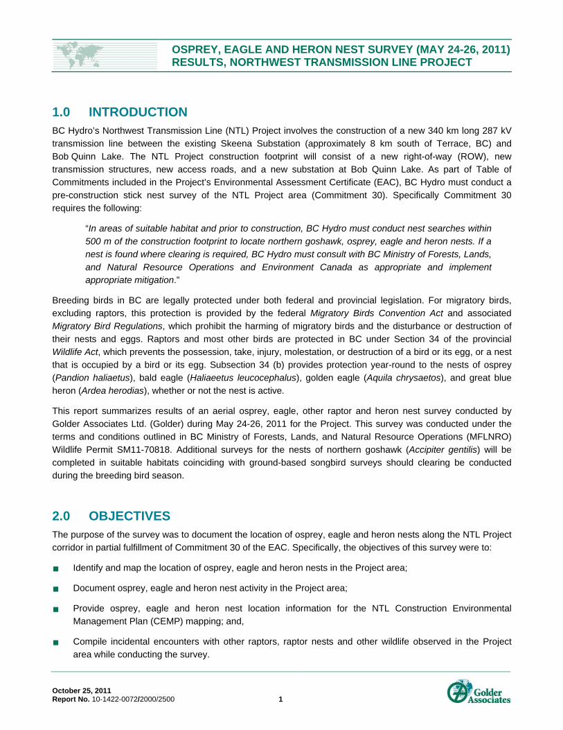
1.0 INTRODUCTION BC Hydro’s Northwest Transmission Line (NTL) Project involves the construction of a new 340 km long 287 kV
transmission line between the existing Skeena Substation (approximately 8 km south of Terrace, BC) and
Bob Quinn Lake. The NTL Project construction footprint will consist of a new right-of-way (ROW), new
transmission structures, new access roads, and a new substation at Bob Quinn Lake. As part of Table of
Commitments included in the Project’s Environmental Assessment Certificate (EAC), BC Hydro must conduct a
pre-construction stick nest survey of the NTL Project area (Commitment 30). Specifically Commitment 30
requires the following:
“In areas of suitable habitat and prior to construction, BC Hydro must conduct nest searches within
500 m of the construction footprint to locate northern goshawk, osprey, eagle and heron nests. If a
nest is found where clearing is required, BC Hydro must consult with BC Ministry of Forests, Lands,
and Natural Resource Operations and Environment Canada as appropriate and implement appropriate mitigation.”
Breeding birds in BC are legally protected under both federal and provincial legislation. For migratory birds,
excluding raptors, this protection is provided by the federal Migratory Birds Convention Act and associated
Migratory Bird Regulations, which prohibit the harming of migratory birds and the disturbance or destruction of
their nests and eggs. Raptors and most other birds are protected in BC under Section 34 of the provincial
Wildlife Act, which prevents the possession, take, injury, molestation, or destruction of a bird or its egg, or a nest
that is occupied by a bird or its egg. Subsection 34 (b) provides protection year-round to the nests of osprey
(Pandion haliaetus), bald eagle (Haliaeetus leucocephalus), golden eagle (Aquila chrysaetos), and great blue
heron (Ardea herodias), whether or not the nest is active.
This report summarizes results of an aerial osprey, eagle, other raptor and heron nest survey conducted by
Golder Associates Ltd. (Golder) during May 24-26, 2011 for the Project. This survey was conducted under the
terms and conditions outlined in BC Ministry of Forests, Lands, and Natural Resource Operations (MFLNRO)
Wildlife Permit SM11-70818. Additional surveys for the nests of northern goshawk (Accipiter gentilis) will be
completed in suitable habitats coinciding with ground-based songbird surveys should clearing be conducted
during the breeding bird season.
2.0 OBJECTIVES The purpose of the survey was to document the location of osprey, eagle and heron nests along the NTL Project
corridor in partial fulfillment of Commitment 30 of the EAC. Specifically, the objectives of this survey were to:
Identify and map the location of osprey, eagle and heron nests in the Project area;
Document osprey, eagle and heron nest activity in the Project area;
Provide osprey, eagle and heron nest location information for the NTL Construction Environmental
Management Plan (CEMP) mapping; and,
Compile incidental encounters with other raptors, raptor nests and other wildlife observed in the Project
area while conducting the survey.
OSPREY, EAGLE AND HERON NEST SURVEY (MAY 24-26, 2011) RESULTS, NORTHWEST TRANSMISSION LINE PROJECT
October 25, 2011 Report No. 10-1422-0072/2000/2500 2
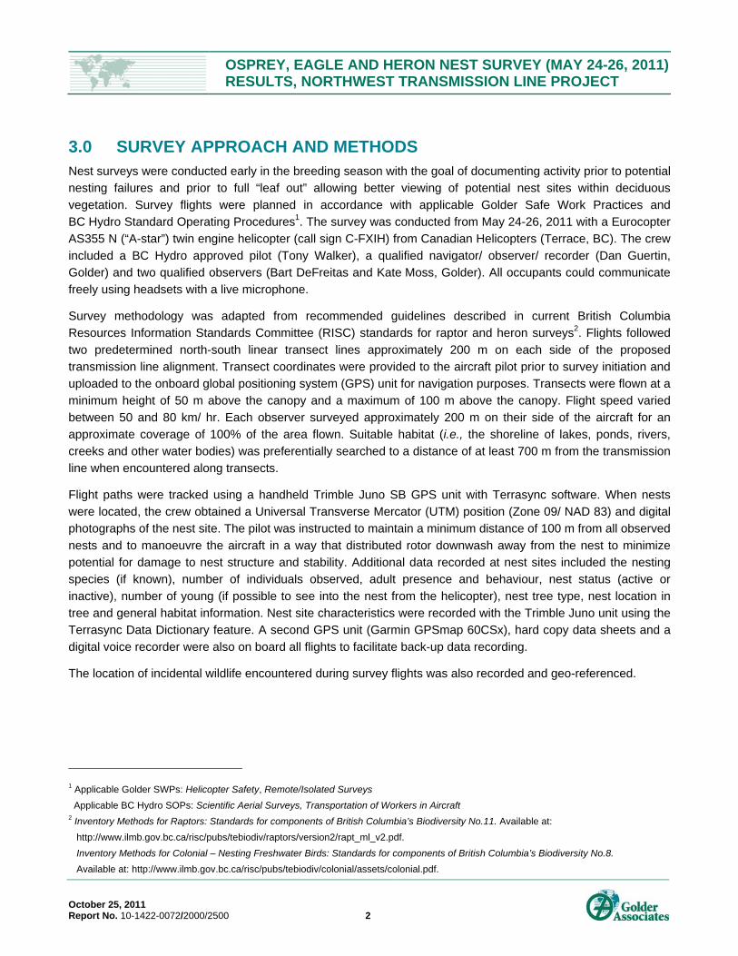
3.0 SURVEY APPROACH AND METHODS Nest surveys were conducted early in the breeding season with the goal of documenting activity prior to potential
nesting failures and prior to full “leaf out” allowing better viewing of potential nest sites within deciduous
vegetation. Survey flights were planned in accordance with applicable Golder Safe Work Practices and
BC Hydro Standard Operating Procedures1. The survey was conducted from May 24-26, 2011 with a Eurocopter
AS355 N (“A-star”) twin engine helicopter (call sign C-FXIH) from Canadian Helicopters (Terrace, BC). The crew
included a BC Hydro approved pilot (Tony Walker), a qualified navigator/ observer/ recorder (Dan Guertin,
Golder) and two qualified observers (Bart DeFreitas and Kate Moss, Golder). All occupants could communicate
freely using headsets with a live microphone.
Survey methodology was adapted from recommended guidelines described in current British Columbia
Resources Information Standards Committee (RISC) standards for raptor and heron surveys2. Flights followed
two predetermined north-south linear transect lines approximately 200 m on each side of the proposed
transmission line alignment. Transect coordinates were provided to the aircraft pilot prior to survey initiation and
uploaded to the onboard global positioning system (GPS) unit for navigation purposes. Transects were flown at a
minimum height of 50 m above the canopy and a maximum of 100 m above the canopy. Flight speed varied
between 50 and 80 km/ hr. Each observer surveyed approximately 200 m on their side of the aircraft for an
approximate coverage of 100% of the area flown. Suitable habitat (i.e., the shoreline of lakes, ponds, rivers,
creeks and other water bodies) was preferentially searched to a distance of at least 700 m from the transmission
line when encountered along transects.
Flight paths were tracked using a handheld Trimble Juno SB GPS unit with Terrasync software. When nests
were located, the crew obtained a Universal Transverse Mercator (UTM) position (Zone 09/ NAD 83) and digital
photographs of the nest site. The pilot was instructed to maintain a minimum distance of 100 m from all observed
nests and to manoeuvre the aircraft in a way that distributed rotor downwash away from the nest to minimize
potential for damage to nest structure and stability. Additional data recorded at nest sites included the nesting
species (if known), number of individuals observed, adult presence and behaviour, nest status (active or
inactive), number of young (if possible to see into the nest from the helicopter), nest tree type, nest location in
tree and general habitat information. Nest site characteristics were recorded with the Trimble Juno unit using the
Terrasync Data Dictionary feature. A second GPS unit (Garmin GPSmap 60CSx), hard copy data sheets and a
digital voice recorder were also on board all flights to facilitate back-up data recording.
The location of incidental wildlife encountered during survey flights was also recorded and geo-referenced.
1 Applicable Golder SWPs: Helicopter Safety, Remote/Isolated Surveys
Applicable BC Hydro SOPs: Scientific Aerial Surveys, Transportation of Workers in Aircraft 2 Inventory Methods for Raptors: Standards for components of British Columbia’s Biodiversity No.11. Available at:
http://www.ilmb.gov.bc.ca/risc/pubs/tebiodiv/raptors/version2/rapt_ml_v2.pdf.
Inventory Methods for Colonial – Nesting Freshwater Birds: Standards for components of British Columbia’s Biodiversity No.8.
Available at: http://www.ilmb.gov.bc.ca/risc/pubs/tebiodiv/colonial/assets/colonial.pdf.

OSPREY, EAGLE AND HERON NEST SURVEY (MAY 24-26, 2011) RESULTS, NORTHWEST TRANSMISSION LINE PROJECT
October 25, 2011 Report No. 10-1422-0072/2000/2500 3
4.0 RESULTS
4.1 Survey Flights The survey flights were conducted during favourable weather conditions and required approximately 16.6 hrs of
flying time over the three day survey period. Survey flight data and field conditions are summarized in Table 1
and Figures 1 to 8.
Table 1: Summary of Survey Flight Data and Field Conditions for the NTL Osprey, Eagle and Heron Nest Survey, May 24-26, 2011
Date Departure
Time
Flight
Time (hr) Environmental Conditions at Departure
Total Flight Distance (km)
24 May 2011 0945 4.7 16°C, overcast (100% cloud cover), moderate breeze (approx. 25 km/ hr), good visibility (approx. 32 km)
352
25 May 2011 0925 6.9 16°C, mostly cloudy (90% cloud cover), moderate breeze (approx. 20 km/ hr), good visibility (approx. 32 km)
374
26 May 2011 0930 5.0 16°C, overcast (100% cloud cover), light rain, light breeze (approx. 5 km/ hr), good visibility (approx. 14 km)
255
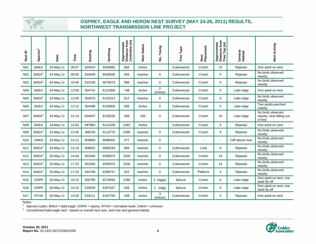
4.2 Nest Locations
Thirteen bald eagle nests were observed during survey flights (Table 2, Figures 1 to 8). All observed nests
were located in cottonwood (Populus balsamifera) trees along watercourses. Nest sites ranged from
approximately 306 to 1,535 m from the transmission line centreline. Four nests were considered active
based on the location of adult birds (i.e., an adult bird on the nest or perched nearby). Nine additional nests
were empty and considered inactive at the time of the survey (Table 2). Although no bald eagles were
observed in proximity to the inactive nests, the nests were distinguishable from other raptor nests based on
overall nest size, nest tree (i.e., cottonwood) and general habitat surrounding the nest site (i.e., riparian
habitat).
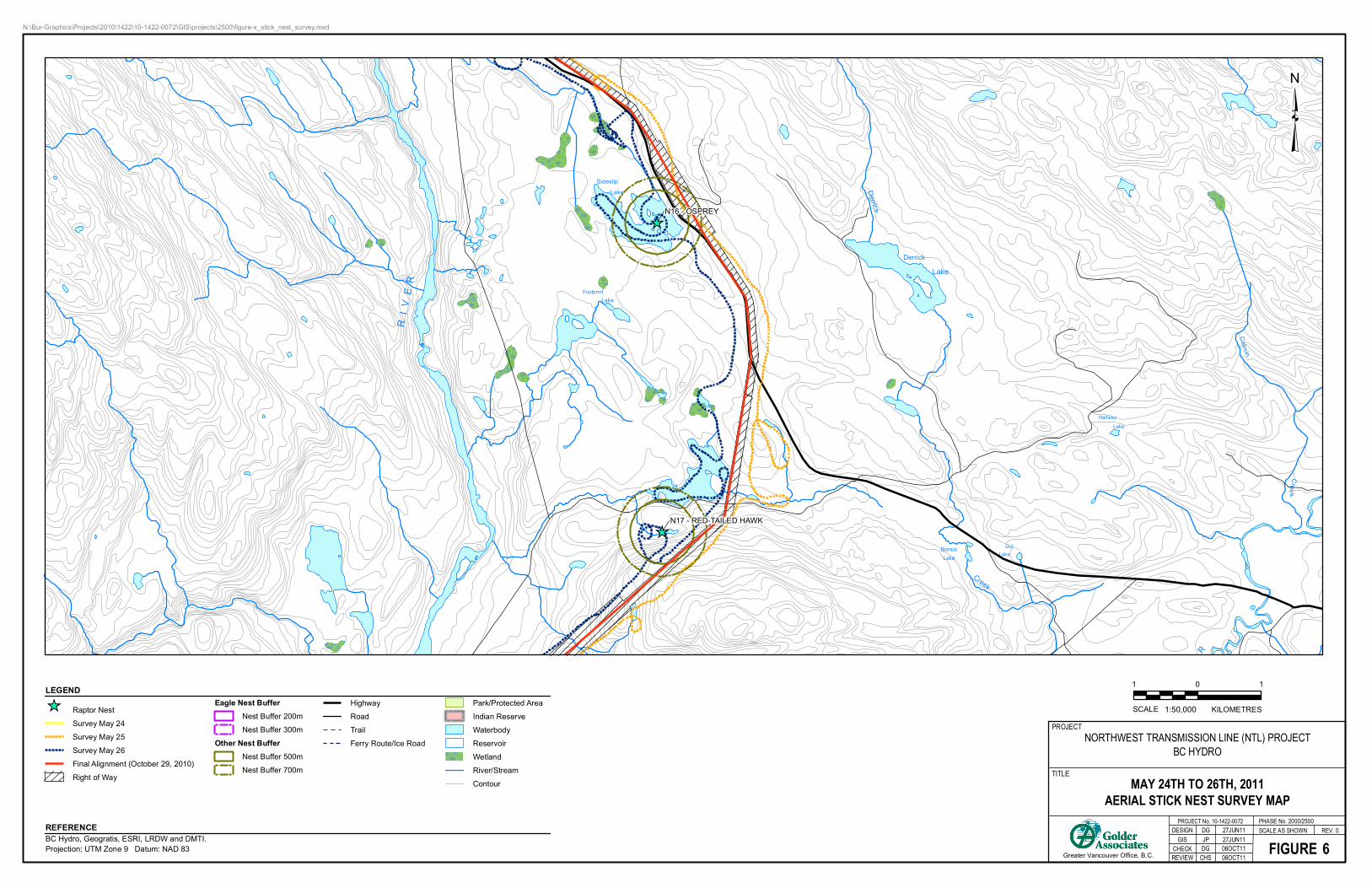
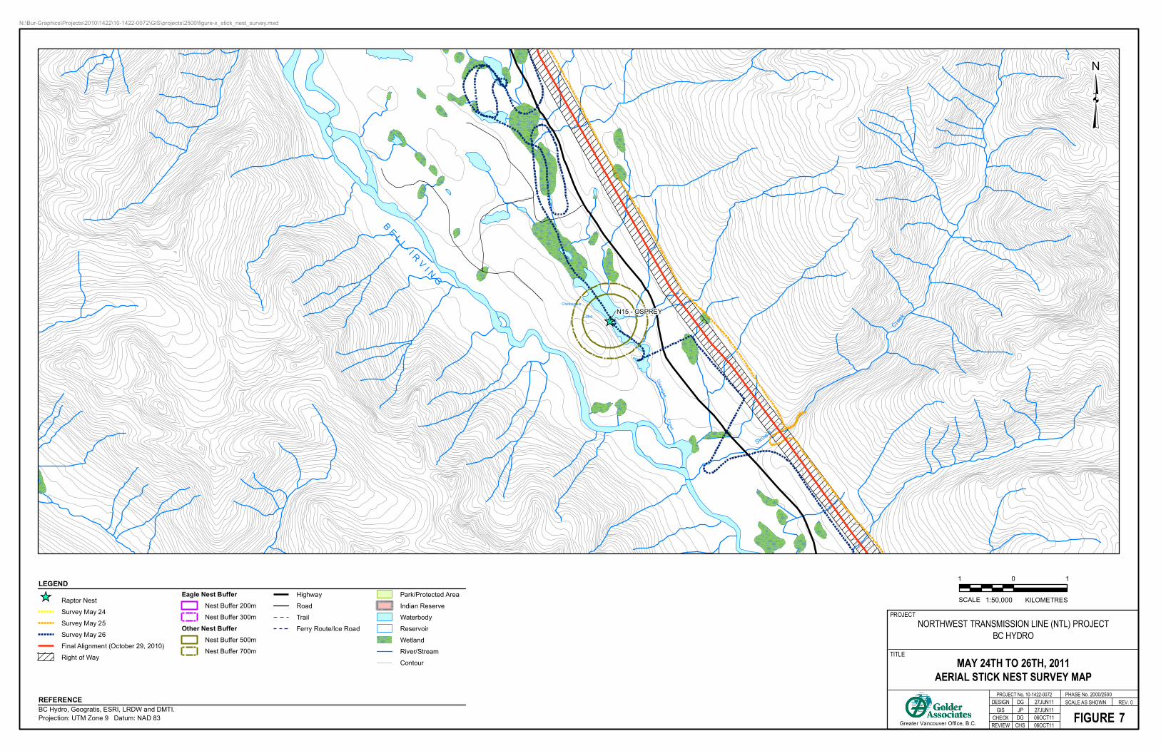
Two osprey nests were observed during survey flights (Table 2, Figures 6 and 7). Nests sites were located
556 and 1280 m from the transmission line centreline. Both nests were located at the top of a spruce tree
situated along a lakeshore. Two adult birds were present at both nests. Both nests contained eggs.
Two other nests were observed during survey flights: an active red-tailed hawk nest and an unoccupied
nest that was not identified to species (Table 2, Figures 6 and 3, respectively). The red-tailed hawk nest
was located in the crotch of a cottonwood tree, approximately 438 m from the NTL transmission line
centreline, and contained three chicks. The unidentified nest was observed on the side of a cliff
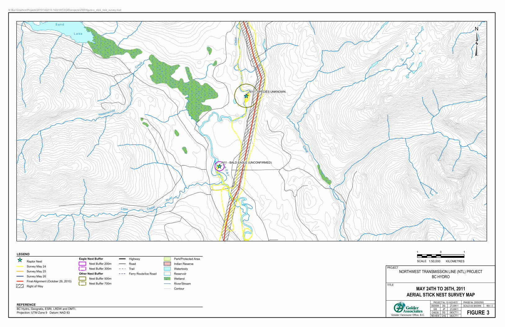
approximately 477 m from the NTL transmission line centreline (Figure 3). No birds were observed near the
cliff nest, and the nest was considered inactive at the time of the survey.
OSPREY, EAGLE AND HERON NEST SURVEY (MAY 24-26, 2011) RESULTS, NORTHWEST TRANSMISSION LINE PROJECT
October 25, 2011 Report No. 10-1422-0072/2000/2500 4
Nes
t ID
Sp
ecie
s1
Dat
e
Tim
e
Eas
tin
g
No
rth
ing
Ap
pro
xim
ate
D
ista
nce
fro
m
Cen
trel
ine
(m)
Nes
t S
tatu
s
No
. Yo
un
g
Tre
e T
yp
e
Nes
t P
lace
me
nt
Ap
pro
xim
ate
D
ista
nce
fro
m
Tre
e T
op
(m
)
Gen
era
l H
abit
at
Bir
d A
cti
vity
N01 BAEA 24-May-11 09:57 520424 6038992 669 Active - Cottonwood Crotch 10 Riparian One adult on nest.
N02 BAEA2 24-May-11 09:59 520409 6039066 683 Inactive 0 Cottonwood Crotch 5 Riparian No birds observed nearby
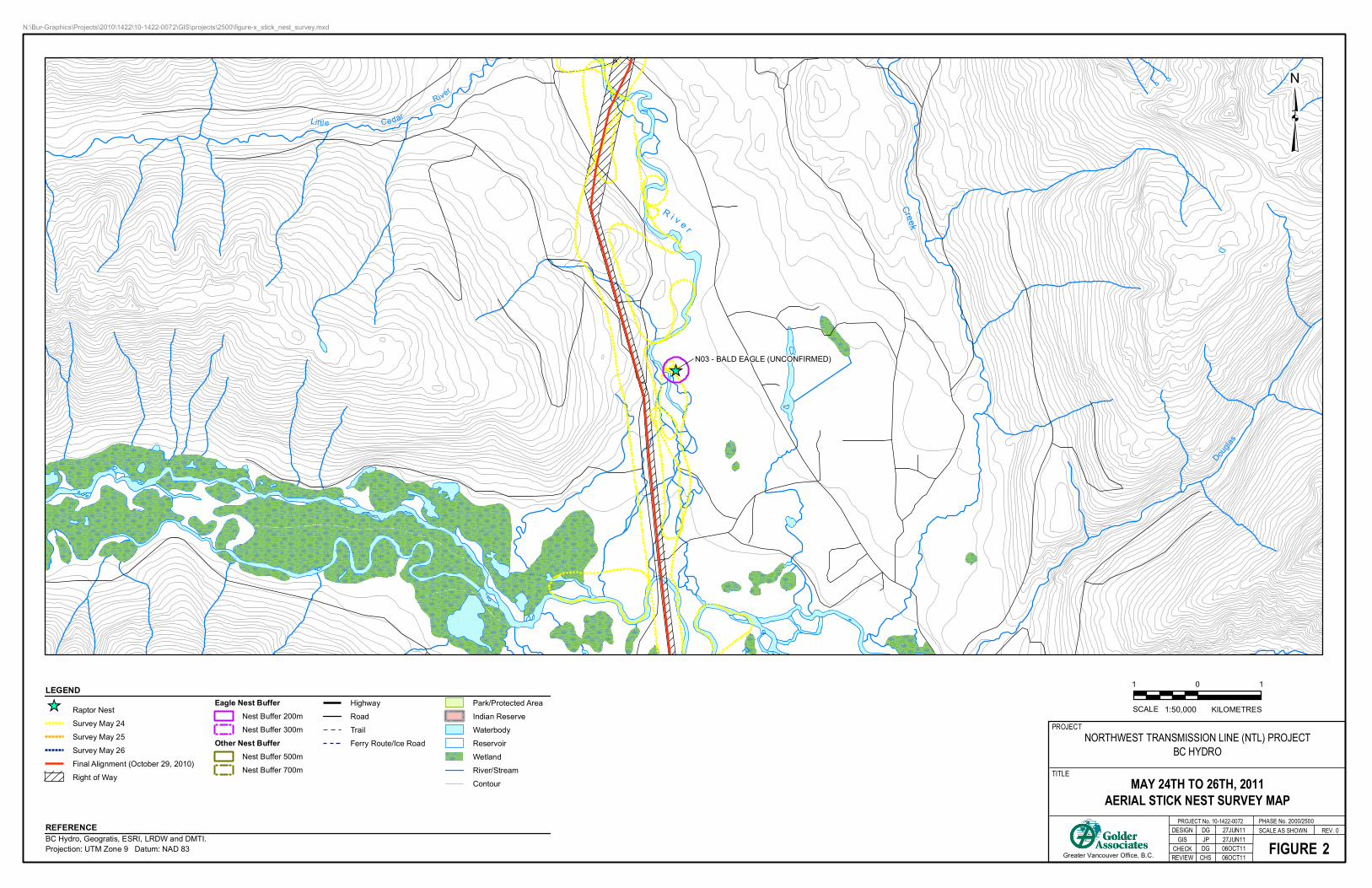
N03 BAEA2 24-May-11 10:46 510190 6079573 596 Inactive 0 Cottonwood Crotch 5 Riparian No birds observed nearby
N04 BAEA 24-May-11 12:06 504741 6131958 748 Active 2
(chicks) Cottonwood Crotch 5 Lake edge One adult on nest
N05 BAEA2 24-May-11 12:09 504576 6132012 912 Inactive 0 Cottonwood Crotch 5 Lake edge No birds observed nearby
N06 BAEA 24-May-11 12:12 504498 6130906 306 Active 0 Cottonwood Crotch 5 Lake edge Two adults perched nearby
N07 BAEA2 24-May-11 12:14 504047 6130226 399 Old 0 Cottonwood Crotch 10 Lake edge No birds observed nearby; nest falling out of tree
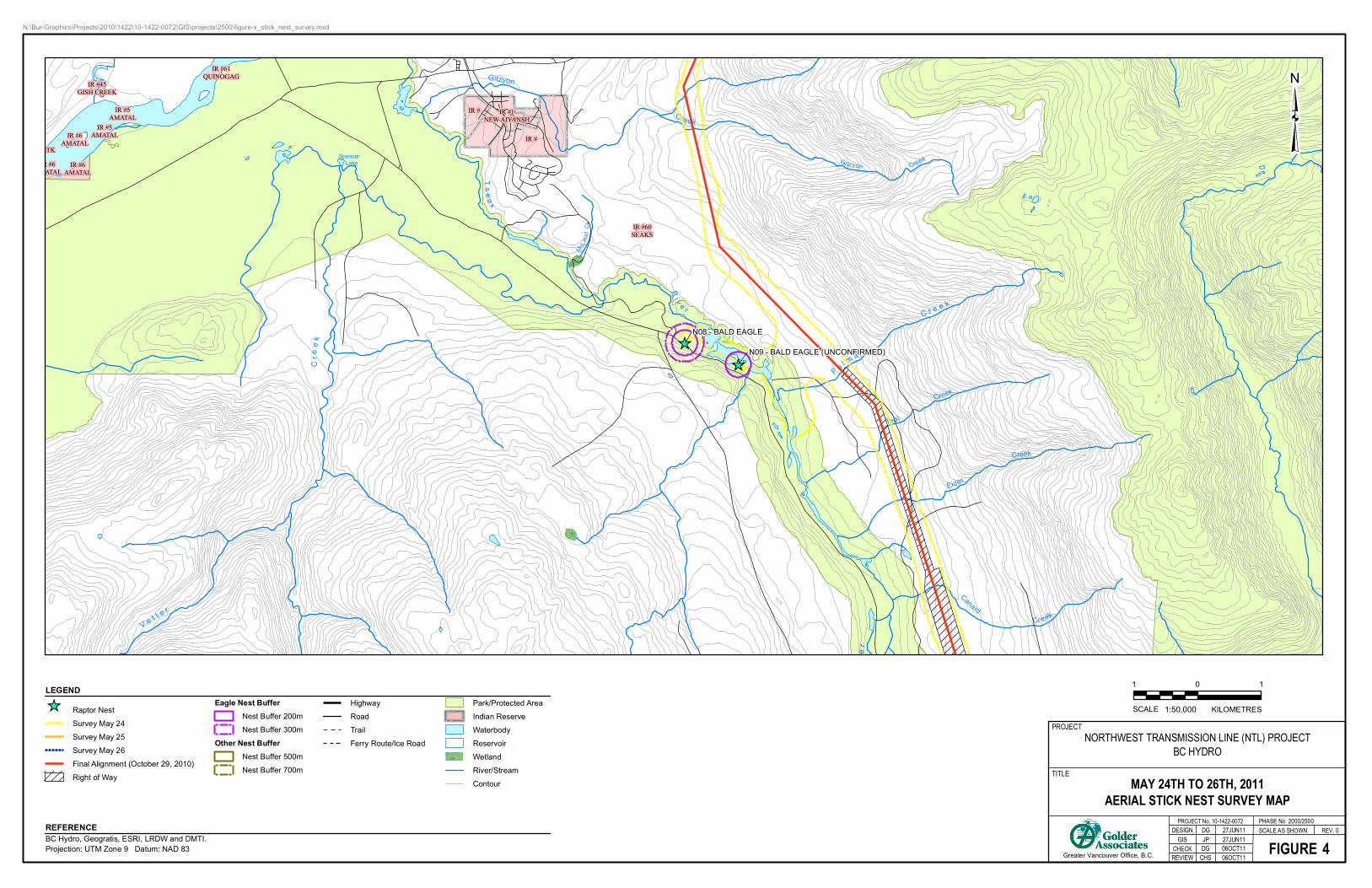
N08 BAEA 24-May-11 13:43 497863 6114109 1452 Active - Cottonwood Crotch 5 Riparian One adult on nest
N09 BAEA2 24-May-11 13:45 498706 6113770 1090 Inactive 0 Cottonwood Crotch 5 Riparian No birds observed nearby
N10 UNKN 24-May-11 14:12 509800 6088302 477 Inactive 0 - - - Cliff above river No birds observed nearby
N11 BAEA2 24-May-11 14:19 508652 6085294 993 Inactive 0 Cottonwood Limb 0 Riparian No birds observed nearby
N12 BAEA2 25-May-11 14:44 452456 6290974 1535 Inactive 0 Cottonwood Crotch 10 Riparian No birds observed nearby
N13 BAEA2 25-May-11 17:23 452456 6290974 1535 Inactive 0 Cottonwood Crotch 15 Riparian No birds observed nearby
N14 BAEA2 25-May-11 17:24 444789 6288757 522 Inactive 0 Cottonwood Platform 5 Riparian No birds observed nearby
N15 OSPR 26-May-11 10:15 455785 6278494 1280 Active 2 (eggs) Spruce Crown 0 Lake edge One adult on nest, one adult fly-off
N16 OSPR 26-May-11 14:15 519030 6167627 556 Active 1 (egg) Spruce Crown 0 Lake edge One adult on nest, one adult fly-off
N17 RTHA 26-May-11 14:28 519111 6162760 438 Active 3
(chicks) Cottonwood Crotch 5 Riparian One adult on nest
Notes: 1 Species codes: BAEA = bald eagle, OSPR = osprey, RTHA = red-tailed hawk, UNKN = unknown 2 Unconfirmed bald eagle nest - based on overall nest size, nest tree and general habitat
OSPREY, EAGLE AND HERON NEST SURVEY (MAY 24-26, 2011) RESULTS, NORTHWEST TRANSMISSION LINE PROJECT
October 25, 2011 Report No. 10-1422-0072/2000/2500 5
4.3 Other Notable Observations
In addition to the birds listed above, two bald eagles, two ospreys, two red-tailed hawks and one turkey
vulture (Cathartes aura) were observed during survey flights. No nests were observed near these birds.
Nine moose (Alces americanus) including two cow/ yearling pairs were observed.
Seventeen black bears (Ursus americanus) including four cubs and two sow/ cub pairs were observed.
One grizzly bear (Ursus arctos) was observed.
5.0 SUMMARY AND DISCUSSION The osprey, eagle and heron nest survey was completed during favourable weather conditions. A total of 17 nest
sites were observed along the transmission line alignment, including 10 inactive bald eagle nests, three active
bald eagle nests, two active osprey nests, one active red-tailed hawk nest and one inactive unknown nest. As
indicated in Table 2, most observed nests (n=13) were located greater than 500 m from the centreline. Four
nests were within 500 meters, but more than 300 m from the centreline. All observed nests were associated with
a water body (i.e., river, lake, pond or drainage).
Provincial Best Management Practices (BMPs) for raptors provide suggested minimum year-round vegetative
setbacks from raptor nests in undeveloped environments of 200 m for bald eagle nests and 500 m for other
raptors (Demarchi et al. 2005). In addition to the recommended vegetative buffers, the provincial BMP document
suggests an additional buffer of 100 m for eagles and 200 m for other raptors that is free of loud noises and
other human disturbances around active nests. Figures 1 through 8 indicate that the majority of the nests
encountered during the survey are outside of the extended BMP-recommended buffers (i.e., vegetated setback
plus no disturbance buffer). One bald eagle nest (N06), one osprey nest (N16), and the red-tailed hawk nest
(N17) appear to be within the extended BMP recommended buffers for active nests. In addition, nest N10
appears to be within the BMP recommended buffer for inactive nests.
The NTL Construction Environmental Management Plan (CEMP) was developed specifically for the NTL Project
in consultation with the Working Group, which consists of First Nations, Nisga’a Nation, federal, provincial and
local government agencies. Section 5.9 (Birds) of the CEMP recommends avoidance of construction activities in
the vicinity of osprey, eagle, other raptor or heron nests, where possible, and adherence to buffer zones,
management zones and procedures for working around identified active raptor nests. The CEMP indicates that
setbacks from site-specific features would be determined by the Environmental Officer, and if necessary, through
consultation with agencies having jurisdiction. The CEMP indicates that if a nest cannot be avoided or work must
be undertaken within recommended buffers, a site specific disturbance minimization and monitoring plan be
established in consultation with the Environmental Officer and MFLNRO.

OSPREY, EAGLE AND HERON NEST SURVEY (MAY 24-26, 2011) RESULTS, NORTHWEST TRANSMISSION LINE PROJECT
October 25, 2011 Report No. 10-1422-0072/2000/2500 7
7.0 REFERENCES Demarchi, M.W., M.D. Bentley, and L. Sopuck. 2005. Best Management Practices for Raptor Conservation
during Urban and Rural Land Development in British Columbia. Prepared by LGL Limited Environmental
Research Associates for BC Ministry of Environment. Victoria, British Columbia, Canada.

Eneeksaguilaguam
R I V E R
Ck
Ck
S K
E E
N A Thorn
hill
Ck
HELLSGATESLOUGH
S K E
E N
A
ZY
MA
GO
TIT
Z R
N01 - BALD EAGLE
N02 - BALD EAGLE (UNCONFIRMED)
KEITH AVE
IR #1KITSUMKAYLUM
IR #3ZIMAGORD
IR #6KULSPAI
N:\Bur-Graphics\Projects\2010\1422\10-1422-0072\GIS\projects\2500\figure-x_stick_nest_survey.mxd
LEGEND
BC Hydro, Geogratis, ESRI, LRDW and DMTI.Projection: UTM Zone 9 Datum: NAD 83
REFERENCE REV. 0
Greater Vancouver Office, B.C.
DESIGN
MAY 24TH TO 26TH, 2011AERIAL STICK NEST SURVEY MAP
FIGURE
PROJECT No. 10-1422-0072SCALE AS SHOWN
PROJECT
TITLE
GIS
REVIEW
DG 27JUN11
CHECK
NORTHWEST TRANSMISSION LINE (NTL) PROJECTBC HYDRO
JP 27JUN11
PHASE No. 2000/2500
Raptor Nest
Survey May 24
Survey May 25
Survey May 26
Final Alignment (October 29, 2010)
Right of Way
Eagle Nest BufferNest Buffer 200m
Nest Buffer 300m
Other Nest BufferNest Buffer 500m
Nest Buffer 700m
Highway
Road
Trail
Ferry Route/Ice Road
Park/Protected Area
Indian Reserve
Waterbody
Reservoir
Wetland
River/Stream
Contour
KILOMETRES
1 10
1:50,000SCALE
1DG 06OCT11CHS 06OCT11
Creek
Dou
glas
W h
Littl e Cedar
River
R i v e r
RI
N03 - BALD EAGLE (UNCONFIRMED)
N:\Bur-Graphics\Projects\2010\1422\10-1422-0072\GIS\projects\2500\figure-x_stick_nest_survey.mxd
LEGEND
BC Hydro, Geogratis, ESRI, LRDW and DMTI.Projection: UTM Zone 9 Datum: NAD 83
REFERENCE REV. 0
Greater Vancouver Office, B.C.
DESIGN
MAY 24TH TO 26TH, 2011AERIAL STICK NEST SURVEY MAP
FIGURE
PROJECT No. 10-1422-0072SCALE AS SHOWN
PROJECT
TITLE
GIS
REVIEW
DG 27JUN11
CHECK
NORTHWEST TRANSMISSION LINE (NTL) PROJECTBC HYDRO
JP 27JUN11
PHASE No. 2000/2500
Raptor Nest
Survey May 24
Survey May 25
Survey May 26
Final Alignment (October 29, 2010)
Right of Way
Eagle Nest BufferNest Buffer 200m
Nest Buffer 300m
Other Nest BufferNest Buffer 500m
Nest Buffer 700m
Highway
Road
Trail
Ferry Route/Ice Road
Park/Protected Area
Indian Reserve
Waterbody
Reservoir
Wetland
River/Stream
Contour
KILOMETRES
1 10
1:50,000SCALE
2DG 06OCT11CHS 06OCT11
Clear
C
Littl e Cedar
River
C e d a r
R
Hadenschild
Cre
e k
Ce
da
r
L a k e
S a n d
N10 - SPECIES UNKNOWN
N11 - BALD EAGLE (UNCONFIRMED)
N:\Bur-Graphics\Projects\2010\1422\10-1422-0072\GIS\projects\2500\figure-x_stick_nest_survey.mxd
LEGEND
BC Hydro, Geogratis, ESRI, LRDW and DMTI.Projection: UTM Zone 9 Datum: NAD 83
REFERENCE REV. 0
Greater Vancouver Office, B.C.
DESIGN
MAY 24TH TO 26TH, 2011AERIAL STICK NEST SURVEY MAP
FIGURE
PROJECT No. 10-1422-0072SCALE AS SHOWN
PROJECT
TITLE
GIS
REVIEW
DG 27JUN11
CHECK
NORTHWEST TRANSMISSION LINE (NTL) PROJECTBC HYDRO
JP 27JUN11
PHASE No. 2000/2500
Raptor Nest
Survey May 24
Survey May 25
Survey May 26
Final Alignment (October 29, 2010)
Right of Way
Eagle Nest BufferNest Buffer 200m
Nest Buffer 300m
Other Nest BufferNest Buffer 500m
Nest Buffer 700m
Highway
Road
Trail
Ferry Route/Ice Road
Park/Protected Area
Indian Reserve
Waterbody
Reservoir
Wetland
River/Stream
Contour
KILOMETRES
1 10
1:50,000SCALE
3DG 06OCT11CHS 06OCT11
Gitzyon
Creek
SpencerLake Gitzyon Creek
F u l m
a r
C r e e k
Teal
Creek
Eider
Creek
T s e
a x
R i v e r
McL
eo
d C
k
C r
e e
k
V e t t e r
Canard
Creek
e r
N08 - BALD EAGLE
N09 - BALD EAGLE (UNCONFIRMED)
IR #
IR #
IR #1NEW AIYANSH
IR #6AMATAL
IR #6AMATAL
IR #5AMATAL
IR #45GISH CREEK
IR #60SEAKS
MTK
IR #61QUINOGAG
IR #5AMATAL
R #6ATAL
N:\Bur-Graphics\Projects\2010\1422\10-1422-0072\GIS\projects\2500\figure-x_stick_nest_survey.mxd
LEGEND
BC Hydro, Geogratis, ESRI, LRDW and DMTI.Projection: UTM Zone 9 Datum: NAD 83
REFERENCE REV. 0
Greater Vancouver Office, B.C.
DESIGN
MAY 24TH TO 26TH, 2011AERIAL STICK NEST SURVEY MAP
FIGURE
PROJECT No. 10-1422-0072SCALE AS SHOWN
PROJECT
TITLE
GIS
REVIEW
DG 27JUN11
CHECK
NORTHWEST TRANSMISSION LINE (NTL) PROJECTBC HYDRO
JP 27JUN11
PHASE No. 2000/2500
Raptor Nest
Survey May 24
Survey May 25
Survey May 26
Final Alignment (October 29, 2010)
Right of Way
Eagle Nest BufferNest Buffer 200m
Nest Buffer 300m
Other Nest BufferNest Buffer 500m
Nest Buffer 700m
Highway
Road
Trail
Ferry Route/Ice Road
Park/Protected Area
Indian Reserve
Waterbody
Reservoir
Wetland
River/Stream
Contour
KILOMETRES
1 10
1:50,000SCALE
4DG 06OCT11CHS 06OCT11

win
amuc
k L
ake
ck
Creek
Khi
mat
lque
North
Dragon Lake
Hoadley
Creek
N A
S
S
Khimatlque
Cre
ek
Nort
h
Sea
skin
nish
Creek
N06 - BALD EAGLE
N04 - BALD EAGLE
N07 - BALD EAGLE (UNCONFIRMED)
N05 - BALD EAGLE (UNCONFIRMED)
IR #2TSIMMANWEENCLIST
IR #49KWINAMUCK
IR #2TSIMMANWEENCLIST
N:\Bur-Graphics\Projects\2010\1422\10-1422-0072\GIS\projects\2500\figure-x_stick_nest_survey.mxd
LEGEND
BC Hydro, Geogratis, ESRI, LRDW and DMTI.Projection: UTM Zone 9 Datum: NAD 83
REFERENCE REV. 0
Greater Vancouver Office, B.C.
DESIGN
MAY 24TH TO 26TH, 2011AERIAL STICK NEST SURVEY MAP
FIGURE
PROJECT No. 10-1422-0072SCALE AS SHOWN
PROJECT
TITLE
GIS
REVIEW
DG 27JUN11
CHECK
NORTHWEST TRANSMISSION LINE (NTL) PROJECTBC HYDRO
JP 27JUN11
PHASE No. 2000/2500
Raptor Nest
Survey May 24
Survey May 25
Survey May 26
Final Alignment (October 29, 2010)
Right of Way
Eagle Nest BufferNest Buffer 200m
Nest Buffer 300m
Other Nest BufferNest Buffer 500m
Nest Buffer 700m
Highway
Road
Trail
Ferry Route/Ice Road
Park/Protected Area
Indian Reserve
Waterbody
Reservoir
Wetland
River/Stream
Contour
KILOMETRES
1 10
1:50,000SCALE
5DG 06OCT11CHS 06OCT11
Sideslip
Lake
Footprint
Lake
R I V
E
R
Derrick
Lake
Derrick
DotBonus
LakeLake
Creek
Halfway
Lake
Calm
in
Cre
ek
ER
N16 - OSPREY
N17 - RED-TAILED HAWK
N:\Bur-Graphics\Projects\2010\1422\10-1422-0072\GIS\projects\2500\figure-x_stick_nest_survey.mxd
LEGEND
BC Hydro, Geogratis, ESRI, LRDW and DMTI.Projection: UTM Zone 9 Datum: NAD 83
REFERENCE REV. 0
Greater Vancouver Office, B.C.
DESIGN
MAY 24TH TO 26TH, 2011AERIAL STICK NEST SURVEY MAP
FIGURE
PROJECT No. 10-1422-0072SCALE AS SHOWN
PROJECT
TITLE
GIS
REVIEW
DG 27JUN11
CHECK
NORTHWEST TRANSMISSION LINE (NTL) PROJECTBC HYDRO
JP 27JUN11
PHASE No. 2000/2500
Raptor Nest
Survey May 24
Survey May 25
Survey May 26
Final Alignment (October 29, 2010)
Right of Way
Eagle Nest BufferNest Buffer 200m
Nest Buffer 300m
Other Nest BufferNest Buffer 500m
Nest Buffer 700m
Highway
Road
Trail
Ferry Route/Ice Road
Park/Protected Area
Indian Reserve
Waterbody
Reservoir
Wetland
River/Stream
Contour
KILOMETRES
1 10
1:50,000SCALE
6DG 06OCT11CHS 06OCT11
B E L L - I R V I N
G
Oweegee
Lake
Ow
eegee
Cre
ek
Cre
ek
Skowill
N15 - OSPREY
N:\Bur-Graphics\Projects\2010\1422\10-1422-0072\GIS\projects\2500\figure-x_stick_nest_survey.mxd
LEGEND
BC Hydro, Geogratis, ESRI, LRDW and DMTI.Projection: UTM Zone 9 Datum: NAD 83
REFERENCE REV. 0
Greater Vancouver Office, B.C.
DESIGN
MAY 24TH TO 26TH, 2011AERIAL STICK NEST SURVEY MAP
FIGURE
PROJECT No. 10-1422-0072SCALE AS SHOWN
PROJECT
TITLE
GIS
REVIEW
DG 27JUN11
CHECK
NORTHWEST TRANSMISSION LINE (NTL) PROJECTBC HYDRO
JP 27JUN11
PHASE No. 2000/2500
Raptor Nest
Survey May 24
Survey May 25
Survey May 26
Final Alignment (October 29, 2010)
Right of Way
Eagle Nest BufferNest Buffer 200m
Nest Buffer 300m
Other Nest BufferNest Buffer 500m
Nest Buffer 700m
Highway
Road
Trail
Ferry Route/Ice Road
Park/Protected Area
Indian Reserve
Waterbody
Reservoir
Wetland
River/Stream
Contour
KILOMETRES
1 10
1:50,000SCALE
7DG 06OCT11CHS 06OCT11

Hodder
Creek
Mehan
Lake
Sn
ow
ba
nk
Snow
bank
Ck
Cre
ek
N14 - BALD EAGLE (UNCONFIRMED)
N13 - BALD EAGLE (UNCONFIRMED)
N12 - BALD EAGLE (UNCONFIRMED)
N:\Bur-Graphics\Projects\2010\1422\10-1422-0072\GIS\projects\2500\figure-x_stick_nest_survey.mxd
LEGEND
BC Hydro, Geogratis, ESRI, LRDW and DMTI.Projection: UTM Zone 9 Datum: NAD 83
REFERENCE REV. 0
Greater Vancouver Office, B.C.
DESIGN
MAY 24TH TO 26TH, 2011AERIAL STICK NEST SURVEY MAP
FIGURE
PROJECT No. 10-1422-0072SCALE AS SHOWN
PROJECT
TITLE
GIS
REVIEW
DG 27JUN11
CHECK
NORTHWEST TRANSMISSION LINE (NTL) PROJECTBC HYDRO
JP 27JUN11
PHASE No. 2000/2500
Raptor Nest
Survey May 24
Survey May 25
Survey May 26
Final Alignment (October 29, 2010)
Right of Way
Eagle Nest BufferNest Buffer 200m
Nest Buffer 300m
Other Nest BufferNest Buffer 500m
Nest Buffer 700m
Highway
Road
Trail
Ferry Route/Ice Road
Park/Protected Area
Indian Reserve
Waterbody
Reservoir
Wetland
River/Stream
Contour
KILOMETRES
1 10
1:50,000SCALE
8DG 06OCT11CHS 06OCT11
OSPREY, EAGLE AND HERON NEST SURVEY (MAY 24-26, 2011) RESULTS, NORTHWEST TRANSMISSION LINE PROJECT
October 25, 2011 Report No. 10-1422-0072/2000/2500
APPENDIX A Photographs
APPENDIX A Photographs
October 25, 2011 Project No. 10-1422-0072/2000/2500 1/2
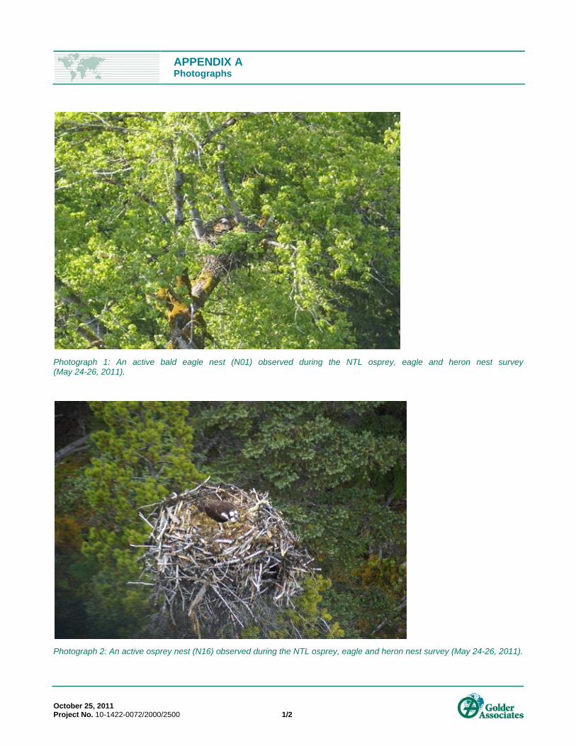
Photograph 1: An active bald eagle nest (N01) observed during the NTL osprey, eagle and heron nest survey (May 24-26, 2011).
Photograph 2: An active osprey nest (N16) observed during the NTL osprey, eagle and heron nest survey (May 24-26, 2011).
APPENDIX A Photographs
October 25, 2011 Project No. 10-1422-0072/2000/2500 2/2
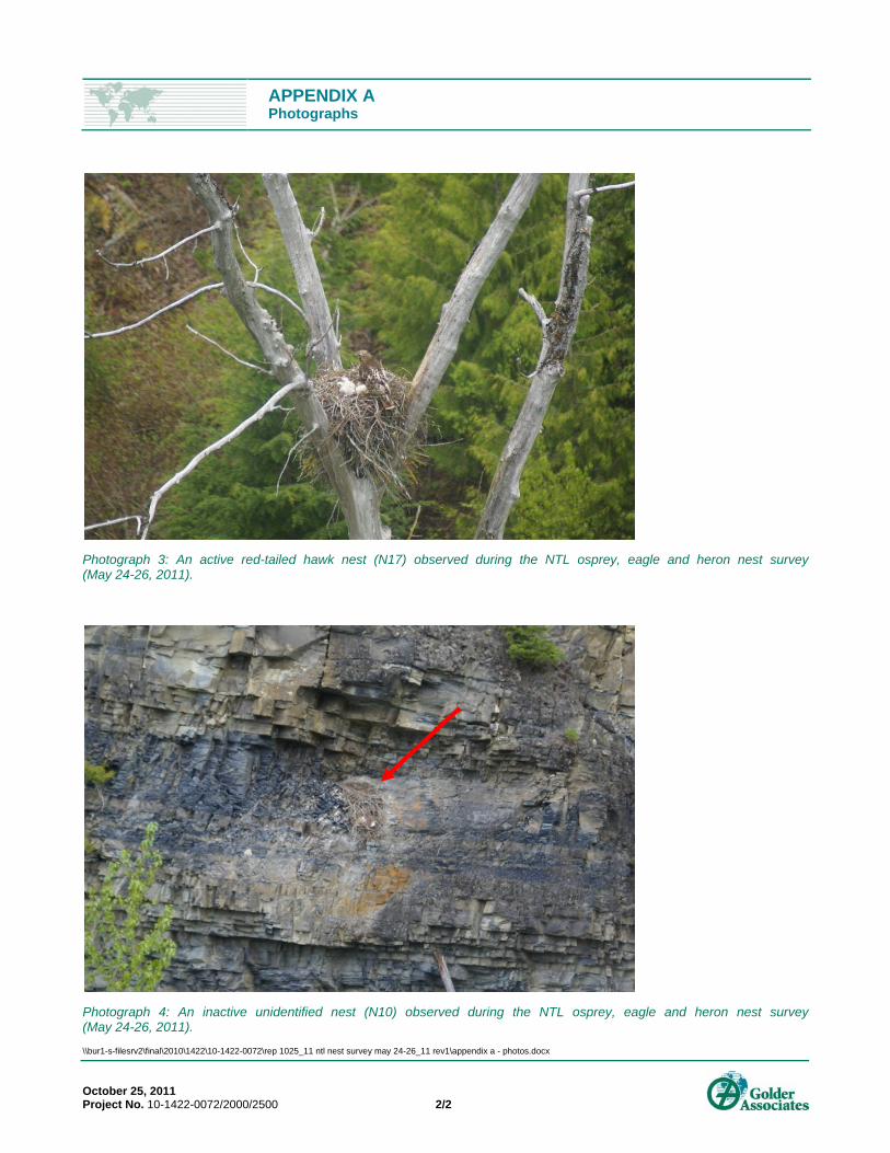
Photograph 3: An active red-tailed hawk nest (N17) observed during the NTL osprey, eagle and heron nest survey (May 24-26, 2011).
Photograph 4: An inactive unidentified nest (N10) observed during the NTL osprey, eagle and heron nest survey (May 24-26, 2011).
\\bur1-s-filesrv2\final\2010\1422\10-1422-0072\rep 1025_11 ntl nest survey may 24-26_11 rev1\appendix a - photos.docx
Golder Associates Ltd.
500 - 4260 Still Creek Drive
Burnaby, British Columbia, V5C 6C6
Canada
T: +1 (604) 296 4200