renewable energy development zones (redz) · pdf file · 2015-06-18energize re:...
TRANSCRIPT

Energize RE: Renewable Energy Supplement - June 2015 - Page 15
REIPPPP Projects
Renewable energy development zones (REDZ) by Mike Rycroft, editor, Energize RE
Selection of sites for the fi rst projects in the REIPPP programme was the responsibility of the bidders; and environmental, grid connection and socio-economic assessments done after the fi rst round of bidding were the responsibility of the project developer. This resulted in duplication of effort for macro or wide area factors common to projects in the same area, with resultant complex and costly assessment processes. In addition, factors such as economic development were not taken into account in the bids.
To reduce these factors the DEA initiated a project where factors common to a specific designated area, with the highest potential for development of renewable energy (RE), could be pre-assessed on a once-off basis, reducing the necessity to do this process independently for all projects. The areas chosen are known as renewable energy development zones (REDZ). This article is based on a summary of presentations on REDZ from the CSIR, the DoE and the DEA.
The DEA, in discussion with DoE, has been mandated to undertake a st rategic environmental assessment (SEA) to identify and designate these areas, and the CSIR has been appointed to manage wind and solar PV SEA processes. The SEAs will be undertaken in order to identify geographical areas most suitable for the rollout of wind and solar PV energy projects and the supporting electricity grid network. The process will also provide a platform for coordination between the various government departments who have a mandate in terms of issuing environmental authorisations or consents to allow for a more streamlined authorisation process. It is intended that through the SEA process, all participating departments will be able to pre-assess the requirements for which they have a mandate and be in a position to either issue general authorisations, exemptions, or delist energy applications based on adherence to certain conditions, guidelines or protocols.
Site specific factors will still need to be assessed, but the burden is greatly reduced. Projects outside of the zones must still undergo the full assessment process. The project is one of 17 strategic infrastructure projects (SIPs), designed to address the infrastructure needs to support economic development and trade whilst simultaneously addressing the needs of the poor.
Renewable energy development zones (REDZs) are gazetted geographical areas:
In which clusters (several projects) of wind and solar PV development will have the lowest negative impact on the environment while yielding the highest possible social and economic benefit to the country.
That are widely agreed to have strategic importance for wind and solar PV development.
Where the environmental and other authorisation processes have been aligned and streamlined based on scoping level pre-assessments and clear development requirements.
Where proact ive and soc ia l i sed
investment can be made to provide time-efficient infrastructure access.
The project involved a strategic environmental assessment of the chosen areas which was aimed at being:
Integrative – including all factors that required assessment, such as environmental economic and social.
Fig. 1: Normalisation of network capacity. (CSIR)
Fig. 2: Solar PV potential development map. (CSIR)

Energize RE: Renewable Energy Supplement - June 2015 - Page 16
REIPPPP Projects
Network capacity 2016 transmission substations (wind & solar)
Assumptions:
1) Substations in areas with area stability limit >1000 MW included
2) Substations with transformer N-1 limit indicated as N/A were assigned the busbar N-1 limit
3) Substations with only one transformer were assigned that transformer’s capacity
4) Substations with transformer limit as determined >100 MW included
Distance Normalisation factor Data source Scale
<10 km +5%Eskom generation connection capacity assessment of the 2016 transmission network 2013 (GCCA – 2016)
National
10 – 50 km +2,5%
50 – 100 km +0%
100 – 150 km –2,5%
>150 km –5%
Table 1: Network capacity normalisation factors. (DEA)
Fig. 3: Exclusion mask for solar. (CSIR)
Regionally spatial – covering specific geographic areas.
Guiding – providing planning information and protocols and identifying strategic development areas.
The wind and solar PV study areas have been identified through negative (areas to be avoided for large-scale wind and solar PV development) and positive (determination of development potential based on wind and solar resource as well as technical and social pull factors) mapping.
Areas chosen
The initial process was limited to areas that were already being used by successful REIPPP bid projects. The wind assessment domain for this first iteration of the SEA is based on the wind atlas for South Africa (WASA) coverage available at the time of commencing the SEA (i.e. parts of Northern Cape, Western Cape and Eastern Cape provinces).
The solar PV assessment domain was based on the location of the majority of existing solar PV project applications at the commencement of the SEA and includes the five provinces of Northern Cape, Western Cape, Eastern Cape, Free State, and North West. Excluded were KwaZulu-Natal and Mpumalanga.
Resource potential
The base of the study was the resource potential for wind and solar for the chosen areas. The next step in the process was the of identification and assessment of a large number of factors which could affect the potential for renewable energy in the areas.
Development potential
Pos i t ive factors which favoured the development of RE in the area – positive mapping and priority zones. The potential for development as based on the resource potential was normalised or adjusted, by adding or subtracting development potential percentiles for the following factors:
Generator network losses: additional or Fig. 4: The final focus areas for the REDZs. (DEA)
Energize RE: Renewable Energy Supplement - June 2015 - Page 17
REIPPPP Projects
Combination of the exclusion zone mask with the development potential map produced a number of study areas, which were then subjected to industry input on development priorities over a 15 year period.
The final result was the eight study areas which were subjected to more detailed assessment and scoping to produce the eight REDZ shown in Fig. 4. The final study has produced a set of guidelines relating to what can and can’t be done in the REDZ, due to development density, visual impact and other issues. Having this information available as well as site development protocols avoids having to go through approval and assessment processes for every project.
The REDZ project has been completed and it is anticipated that the proposals will be submitted to cabinet in July 2015. Once gazetted the REDZ project will greatly assist the development of RE systems.
References[1] CSIR “DEA national wind and solar PV SEAs to
facilitate the efficient and effective rollout of wind and solar PV energy in SA phase I study areas” www.csir.co.za/nationalwindsolarsea.
[2] CSIR “DEA national strategic environmental assessment for the efficient and effective rollout of wind and solar photovoltaic energy-Phase I study areas metadata and notes” www.csir.co.za/nationalwindsolarsea.
[3] DEA “Solutions for roll out of renewable energy-taking our work forward” Presentation to Sapvia, 18 March 2015.
Contact Mike Rycroft, EE Publishers, [email protected]
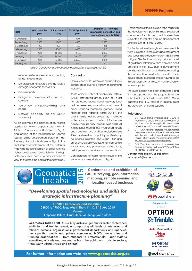
REDZWind potential
(MW)Solar potential
(MW)Total RE potential
(MW)
Long term ( 6 – 10 year) transmission connection and evacuation capacity (MW)
1-Overberg 600 100 700 1000
2-Komsberg 2500 4000 6500 2500
3-Cookhouse 1200 400 1600 1886
4-Stormberg 2500 1500 4000 1545
5-Kimberley 400 18 000 18 400 2020
6-Vryburg 400 16 000 16 400 2531
7-Upington 600 34 000 34 600 5075
8-Springbok 3900 19 000 22 900 3240
Table 2: Generation and evacuation potentials for each REDZ (Author)
reduced network losses due to the siting of the RE generators
DTI proposed renewable energy related strategic economic zones (SEZs)
Industrial ports
Designated provincial solar and wind corridors
Seat of local municipalities with high social needs
Network capaci ty (as per GCCA substation)
As an example the normalisation factors applied to network capacity are shown in Table 1. The impact is illustrated in Fig. 1. Application of the normalisation factors results in a final development potential map. The map for solar is shown in Fig. 2. The final step of development of the potential map was the identification of areas with the highest development potential within the high potential areas, from a provincial point of view. This formed the basis of the study areas.
Constraints
Construction of RE systems is excluded from certain areas due to a variety of constraints including:
South African National biodiversity institute (SANBI) protected areas, such as Forest Act protected areas; island reserves; local nature reserves; mountain catchment areas; national botanical gardens; world heritage sites; national parks; SANBI CBA’s and threatened ecosystems; strategic water source areas; national freshwater ecosystem priority areas; wetlands of international importance; threatened forests and coastlines; bird and bat exclusion areas (IBAs); land use-land capability and field crop boundaries; scientific land usage – SKA and astronomical observatories, and infrastructure – road and rail, powerlines, substations, buildings, airports and telecommunications
Consideration for these factors results in the exclusion zone mask shown in Fig. 3.
Conference and exhibition of GIS, surveying, geo-informatics,
mapping, remote sensing and location-based business
GI 2015 Conference and Exhibition: 08h00 to 17h00, Tues, Wed & Thurs 11, 12 & 13 Aug 2015
Venue: Emperors Palace, Ekurhuleni, Gauteng, South Africa
Geomatics Indaba 2015 is a fully inclusive geomatics sector conference, exhibition and training event, encompassing all levels of interested and relevant persons, organisations, government departments and agencies, municipalities, public and private companies, NGOs, universities and training organisations – from students to professionals; junior staff to executives, offi cials and leaders; in both the public and private sectors; from South Africa, Africa and abroad.
For further information see website: www.geomatics.org.za
“Developing spatial technologies and skills for strategic infrastructure planning”
Hosted by:
Supported by:
IMSSA
Platinum
Diamond
Silver
Bronze