remedies to resolve property line problems - plso conf handouts/js... · remedies to resolve...
TRANSCRIPT

Professional Land Surveyors of Oregon
Remedies to Resolve Property Line Problems 2016 PLSO Conference – Measure of Tomorrow
Presented By:
John B. Stahl, PLS, CFedS
Cornerstone Land Consulting, Inc.
www.CPLSinc.com
ABSTRACT
Remedies to Resolve Property Line Problems
Surveyors are often the first to discover a boundary problem. When the surveyor
discloses the problem and walks away, what other remedies are available to the surveyor?
What knowledge, skills and expertise can the surveyor bring to the resolution table? We
will discuss the various remedies which can be used to deal with property line problems,
whether caused by a failure in the title documentation or a failure in the location of the
boundary. We will discuss the surveyor’s role in applying the laws designed to assist in
the resolution process from mediation to litigation.
INSTRUCTOR BIOGRAPHY
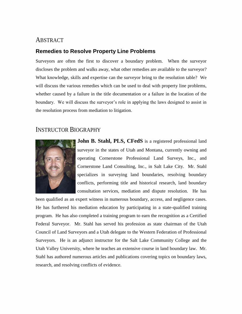
John B. Stahl, PLS, CFedS is a registered professional land
surveyor in the states of Utah and Montana, currently owning and
operating Cornerstone Professional Land Surveys, Inc., and
Cornerstone Land Consulting, Inc., in Salt Lake City. Mr. Stahl
specializes in surveying land boundaries, resolving boundary
conflicts, performing title and historical research, land boundary
consultation services, mediation and dispute resolution. He has
been qualified as an expert witness in numerous boundary, access, and negligence cases.
He has furthered his mediation education by participating in a state-qualified training
program. He has also completed a training program to earn the recognition as a Certified
Federal Surveyor. Mr. Stahl has served his profession as state chairman of the Utah
Council of Land Surveyors and a Utah delegate to the Western Federation of Professional
Surveyors. He is an adjunct instructor for the Salt Lake Community College and the
Utah Valley University, where he teaches an extensive course in land boundary law. Mr.
Stahl has authored numerous articles and publications covering topics on boundary laws,
research, and resolving conflicts of evidence.

TABLE OF CONTENTS
Remedies to Resolve Property Line Problems.................................................................... 1
Boundary Agreements .................................................................................................... 3
Expressed Agreements ................................................................................................ 4
Implied Agreements (Acquiescence) .......................................................................... 7
Estoppel....................................................................................................................... 9
Practical Location ..................................................................................................... 10
Boundary Adjustment ................................................................................................... 13
Easements and Licenses ................................................................................................ 16
Variances....................................................................................................................... 19
Actions Involving Real Property .................................................................................. 20
Quiet Title Action ......................................................................................................... 21
Declaratory Judgment ................................................................................................... 23
Action for Reformation ................................................................................................. 25
Deed Construction vs. Reformation .......................................................................... 26
Effect of a Correction Deed ...................................................................................... 27
Summary ....................................................................................................................... 28

NOTES:
________________________________________________________________
________________________________________________________________
________________________________________________________________
________________________________________________________________
________________________________________________________________
________________________________________________________________
________________________________________________________________
________________________________________________________________
________________________________________________________________
________________________________________________________________
________________________________________________________________
________________________________________________________________
________________________________________________________________
________________________________________________________________
________________________________________________________________
________________________________________________________________
________________________________________________________________
________________________________________________________________
________________________________________________________________
________________________________________________________________
________________________________________________________________
________________________________________________________________
________________________________________________________________
________________________________________________________________
________________________________________________________________
________________________________________________________________
________________________________________________________________
________________________________________________________________
©2016 Cornerstone Land Consulting, Inc. Page 1
REMEDIES TO RESOLVE PROPERTY LINE PROBLEMS
By John B. Stahl, PLS, CFedS
Most boundary line problems are caused by one of two things: a failure in the
documentation or a failure in the physical location. One important thing to remember is
that the vast majority of boundary problems are not caused by landowners. They are
caused by the professionals who assist the landowners in the conveyance of their
property. When a landowner wishes to convey a portion of their land to another, most
don’t attempt to do that alone as they simply don’t have the skills, knowledge or expertise
to perform the necessary work themselves. For that reason, they must rely upon the
professions for assistance. Each professional brings their expertise to the table. The real
estate agent brings their marketing skills, the title agent their documentation skills, the
attorney their knowledge of legal practices, and the surveyor their feet, eyes and ears on
the ground. Each of the professions has a unique, yet sometimes overlapping role which
allows them to understand enough of each others’ roles to work well as a team, yet
confident enough in that knowledge to blame the others for the problems that arise.
When boundary problems are first discovered, they are often discovered by the
professionals. The controversies we discover are often ancient mistakes; mistakes which
are only brought to light by modern techniques. Tools such as FastMap® and AutoCad®
as well as the many incredibly informative GIS systems available today seem to expose
boundary problems which have long remained dormant; problems waiting for discovery
so we can “kick that sleeping dog.” Once the dog is kicked, too many seem satisfied to
document the problem, and then pass the problem on to the landowner to resolve, as if the
landowner has any ability to understand the problem or the skills necessary to resolve the
problem. The problem is often dumped into the landowner’s lap by the professionals
who hide themselves behind exceptions and disclaimers rather than assisting to confront
the problem discovered and to resolve it.
Too often, our thoughts turn to litigation as the solution to the problem. All the attorney
needs to know is the name and address of the neighbor so the lawsuit can be filed. After

©2016 Cornerstone Land Consulting, Inc. Page 2
all, the courts can resolve the problem, right? There are many opportunities for
resolution of boundary line problems that are designed with the landowners in mind. The
true authority to resolve any boundary issue lies with the two adjoining landowners.
They have all of the power and ability to resolve the issue; what they don’t have is the
knowledge to properly assess the problem and
to design the proper remedy.
Proper resolution of any problem begins with
discovering the root of the problem. Rushing
head long into a solution without first defining
the nature of the discrepancy can yield
disastrous and expensive results. Employing
the surveyor early on can yield quick and permanent solutions through the joint
resolution of commonly held boundary problems. The neighbor, the unfortunate
recipient of a hasty lawsuit, likely shares the same problem as the client who initiated the
contact. The boundary is, by definition, their common line, therefore, it is a common
problem, shared by both and which can only be resolved by both.
The professional’s knowledge must encompass the rules and procedures that the court
utilizes in determining the position of a boundary. The surveyor already uses the same
processes as the judge and jury to reach the ultimate conclusion of where the boundary is.
The documentary, demonstrative, and testimonial evidence gathered to assess the nature
of the problem will provide vital clues toward proper resolution. The courts and the
legislature have established the rules for the professionals to apply to the unique facts as
the case admits and expresses their opinion as to appropriate solution to the problem.
An undefined problem has an infinite number of solutions. - Robert A. Humphrey
For every complex problem, there is a solution that is simple, neat, and wrong. - H. L. Mencken

©2016 Cornerstone Land Consulting, Inc. Page 3
BOUNDARY AGREEMENTS
There are uncountable scenarios by which boundary lines are established and
perpetuated. The courts have categorized them into five general classifications: written,
oral, or implied agreements, the doctrine of estoppel and practical location. Just as in
any contract, the best way to form the agreement is to clearly express the terms of the
agreement and to express those terms in writing. The writing should be clear and
concise, as any ambiguity in the terms expressed might cause future problems.
It is important to clearly understand the nature of the agreement. Are the owners
agreeing to establish the location of the boundary, or is their agreement to erect some
barrier now with the anticipation of determining the true boundary location at a later date
and to relocate the improvements? Are the parties entering into a new agreement for the
purpose of settling an uncertainty, dispute or current controversy, or are they
documenting an agreement which has already taken place? The form of the agreement
document might differ, depending upon the particular circumstances present.
Occasionally, the landowners will enter an agreement to establish their boundary location
without putting the terms of their agreement in writing. Their agreement might be
expressed orally, or it might be formed through an unspoken agreement implied by their
mutual recognition and acquiescence over a long period of time. The courts have,
historically upheld all three forms of agreement which, once entered into, will fix the
location of the existing boundary between the landowners. The landowners are the ones
who hold the authority to establish their boundaries. Every boundary is created and
established by the agreement of adjoining landowners.
There is a fundamentally important distinction between the title conveyance document
and a boundary line agreement. The principle purpose of the conveyance document is to
recognize and document the exchange of rights, title or interests in the property itself.
Conveyance documents affect the nature of the estate and the transfer of the estate from
one owner to another. Boundary line agreements, however, have no affect on title to the
property. The agreement only serves to define the location of the existing boundary.

©2016 Cornerstone Land Consulting, Inc. Page 4
Boundary agreements do not and cannot create a new boundary! This important
distinction must be understood. The only way to create a boundary is for the landowners
to intentionally convey title to a newly created parcel or strip with the intent to divide an
existing estate. The voluntary conveyance of title requires a conveyance document which
should be made in one of the common statutory forms of a warranty deed, special
warranty deed, a quitclaim deed, or a trust deed. Any valid estate should be traceable to a
conveyance document made in writing and, preferably, duly recorded.
"There are three essential requirements for application of the doctrine of boundary by
agreement. First, there must be an initial uncertainty or dispute as to the "true"
location of the boundary. The stated purpose of this requirement is to prevent the
agreement from falling within the Statute of Frauds or violating other real property
conveyancing requirements, for it establishes that the parties are resolving a dispute by
mutually fixing an unknown boundary rather than by making a conveyance of land. See
Harris et ux v. Backus et al, 212 Or 695, 710, 321 P2d 315 (1958) (quoting Note, 28 Or
L Rev, supra, at 364). The element of resolution of uncertainty may also provide the
consideration for the agreement. Note, 28 Or L Rev, supra, at 364. In Oregon the
requirement is liberally construed; it is not necessary that the boundary be
unascertainable, only that the parties be uncertain about its location, Harris et ux v.
Backus et al, supra, 212 Or at 710-11, although it appears that the boundary must not
be too easily ascertainable. See Drury et ux v. Pekar et al, 224 Or 37, 44, 355 P2d 598
(1960). The fact that the boundary could have been located by a survey does not
prevent application of the doctrine. See Wampler v. Sherwood, 281 Or 261, 269-70, 574
P2d 319 (1978); see also Satchell v. Dunsmoor, 179 Or 463, 172 P2d 826 (1946)." 1
Boundary agreements can only be formed by adjoining landowners for the purpose of
physically establishing the location of their existing common boundary on the ground. If
the parties to the agreement know the location of their common boundary, they are
prevented from entering an agreement to establish its location somewhere other than the
known location. The agreement must be made for the purpose of removing any doubt or
uncertainty that is discovered regarding the boundary location. As such, the agreement
is relied upon to settle the doubt by defining the location of the existing estate boundary.
EXPRESSED AGREEMENTS
Expressed agreements can be made either in oral or in written form. If a written
agreement is disclosed in the title record, the agreement is typically as binding as the
1 Ross v. Delorenzo, 65 Or.App. 586, 672 P.2d 1338 (Or.App. 11/23/1983)
©2016 Cornerstone Land Consulting, Inc. Page 5
written conveyance document which created the boundary. The written agreement
should contain the consent of both parties establishing the boundary line together with a
description of the physical characteristics of the boundary line location. The description
does not have to be based upon a survey, but must be able to be located and must be
physically defined on the ground; i.e. a boundary line described as “along the existing
fence running in a general north-south direction located approximately 28 feet westerly
from the northwest corner of the foundation of the residence at …” is quite sufficient of
being readily discoverable as defined.
Expressed agreements may also be proved by direct evidence of an oral agreement
between the two landowners. The agreement may not have been between the current
landowners, but may have been between any two adjoining prior owners, likely the
owners who constructed the improvement marking the boundary. The evidence of an
expressed agreement will become obvious when the adjoining landowners or the prior
owners who constructed the improvement are interviewed to discover their knowledge
regarding the improvement that is in conflict. The interview would reveal from both
parties a recollection of a specific agreement that was made to construct the fence line in
its current position. Both parties should be able to recount the dates, times, conditions or
circumstances surrounding the agreement. The evidence may not be in complete
harmony, as each party’s memory may differ slightly, but must be substantially
corroborative. The evidence gathered by the surveyor should include the owners’
knowledge regarding the boundary location at the time of the agreement. The evidence
should be sufficient to establish that there was an uncertainty or a dispute concerning the
boundary line that was settled by the agreement. The evidence should also reveal what
subsequent actions the parties took in reliance upon the agreement, as such actions would
also corroborate or consummate the terms of their agreement.
“There are three elements necessary to establish a boundary by agreement: (1) there
must be an initial uncertainty or dispute as to the true location of the boundary; (2) the
uncertainty must be resolved by an agreement, express or implied, to recognize a
particular line as the boundary; and (3) the parties must evidence their agreement by
subsequent activities. Gibbons v. Lettow, 180 Or App 37, 43-44, 42 P3d 925 (2002). To

©2016 Cornerstone Land Consulting, Inc. Page 6
satisfy the second element, the boundary at issue must be intended by the parties to be
permanent, rather than temporary or a mere barrier. Ross v. DeLorenzo, 65 Or App
586, 590, 672 P2d 1338 (1983), rev den, 296 Or 411 (1984). Furthermore, a
"boundary by agreement may not be established by placing a fence where both parties
think the actual boundary lies; the agreed-upon boundary must represent an attempt to
resolve the parties' uncertainty as to the true location of the boundary." Gibbons, 180
Or Appat 44. With respect to the third requirement, where the boundary is set by "an
express oral agreement," the party seeking to establish a boundary by agreement must
have occupied land under the boundary agreement. Ross, 65 Or at 590”2
Upon discovery of a previously expressed agreement, the landowners should be
encouraged to document their agreement. They should document the conversations that
took place, the nature of the conversations, and the terms of the agreement. If possible, a
written boundary line agreement should be prepared and recorded to document the
parties’ agreement in writing and to provide constructive notice of the agreement. The
goal is to assist the parties by documenting the existing prior agreement. The agreement
documentation should include a reference to a current survey and the survey should make
a circular reference to the agreement. And, most importantly, the written agreement
should describe in sufficient detail the location and the physical characteristics of the
boundary. The physical characteristics are the most discernable features that can be
instantly recognized by the landowners. Their certainty in the boundary location will
stabilize their boundary and will prevent future strife and litigation.
Documentation can vary depending upon the common practices within the jurisdiction
where the property lies. If surveys are recorded in the grantor/grantee system along with
conveyance documents, both parties could sign the survey recording their agreement. If
not, the agreement can be recorded in the index system in the form of a boundary line
agreement or a series of affidavits by both owners and the surveyor. If the parties are
reluctant to formulate a record, the surveyor may be able to perpetuate the evidence in a
narrative or surveyor’s report and record it in the survey repository. There are always a
number of possible alternatives available to the professional and the landowners to
perpetuate the evidence in the record.
2 Wright v. Wells, 218 P.3d 569, 231 Or.App. 349 (Or.App. 10/14/2009)

©2016 Cornerstone Land Consulting, Inc. Page 7
IMPLIED AGREEMENTS (ACQUIESCENCE)
Evidence gathered to prove an implied agreement will differ from other forms of
agreement. Implied agreement, as the title suggests, is an agreement that is evidenced by
implication. The doctrine is based upon the long-term concept of repose. There is no
direct evidence available that supports the notion that an oral agreement has taken place.
The only evidence available is the physical remnant (i.e., the fence line) which stands as a
memorial to the consummated agreement that must have taken place sometime in the
distant past. Interview of the landowners will typically result in a finding that the parties
aren’t aware of who built the fence or why it was constructed. All that is known is that
the fence line has been in existence for an excess of typically 20 years (jurisdictions vary
on the length of time required) and that the fence line is believed by both parties to
properly mark the boundary line between them. It is important to gather evidence of use
which supports the claim of mutual recognition and acquiescence to the line intended as a
boundary. The party’s frame of mind is important to establish the mutual recognition or
assent forming the agreement. The evidence gathered will, again, substantially prove that
the boundary line has been established under one or more of the legal doctrines.
“Boundary by acquiescence is related to boundary by agreement. Boundary by
acquiescence allows courts to recognize a boundary line to which parties have agreed
for a substantial period of time – long enough that the courts will recognize the
boundary line "in the interests of justice." Id. At the very least, however, the location of
the true boundary must be unknown or disputed. Gibbons, 180 Or App at 46.”3
Gathering and documenting the evidence prior to the disclosure of the boundary problem
is critical. The surveyor, upon discovery that the physical improvements do not align
with the boundary location as reflected in the title record, should inquire as to the origin
of the improvements. The only way for this information to be gathered is by interviewing
the landowners prior to disclosing the location of the boundary. The landowners should
be asked if they know about the origin of the improvements. Who might have
constructed them and what might they have relied upon to determine their placement.
Other important questions might also include their treatment of the fence or whether they
3 Powers Ranch Company, Inc., An Oregon Corporation v. Plum Creek Marketing, Inc., An Oregon
Corporation; and Plum Creek, No. A142396 (Or.App. 06/08/2011)
©2016 Cornerstone Land Consulting, Inc. Page 8
are aware of any surveys or monuments which might indicate their boundary locations.
The process of the conversation will disclose the landowner’s current belief of the fence
as marking their boundary at a time prior to discovery that the improvement may or may
not mark their boundary.
The key evidence which can be recovered from the interview will disclose necessary
facts about their occupation and their mutual recognition and acquiescence in the line as
their common boundary. It is important to maintain the proper decorum during the
interview so the true thoughts and beliefs of the owners are obtained. The interviewee
should be careful to not ask leading questions. Questions such as: “Where do you think
your boundary is?” Or, “Do you think the fence is your boundary?” should be avoided.
It’s up to the surveyor to determine the boundary location, not the landowner.
“An examination of the Oregon cases dealing with the two theories of "boundary by
acquiescence" and "boundary by practical location" reveals that the courts often have
used the labels interchangeably to refer to the same theory -- the establishment of a
boundary other than the one in the deeds by express or implied agreement. See, e.g.,
Corson v. Williford, 44 Or App 145, 151, 605 P2d 1194 (1980) (referring to the theory
as "boundary by acquiescence," but citing for support Kincaid v. Peterson, 135 Or 619,
297 P 833 (1931), in which the theory is referred to as "doctrine of practical location");
see also Comment, 28 Or L Rev 362 (1949). To avoid perpetuating this confusion, we
will henceforth use the more accurate term "boundary by agreement" to refer to the
theory. Ross v. DeLorenzo, 65 Or App 586, 591, 672 P2d 1338 (1983). [The term
"acquiescence" also has been used in the past to denote another theory by which courts
recognize a boundary line which has been mutually acquiesced in by adjoining
landowners for a substantial period of time. See Ross v. DeLorenzo, supra, citing
Bernheim v. Talbot, 54 Or 30, 100 P 1107 (1909). Even if the elements of an agreement
are not present, the boundary line acquiesced in may be recognized in the interest of
justice. This theory was not raised in the present case.]
However, from the evidence, we find the other inference -- that the parties were
uncertain as to the boundary -- the more likely one. The area was dense timber; there is
no suggestion there had been a recent -- or any -- survey; and there is no evidence that
the parties established the line from one monument to another.] Plaintiff's father and
defendants' predecessor in interest established the fenceline together. That conduct
implies an agreement between them that the fenceline would serve as the boundary
dividing the two properties. After the fence was erected, both parties' predecessors in
interest limited their acts of ownership to their respective sides of the fence; for almost
50 years no one questioned plaintiff's family's right to the disputed strip. Taking the

©2016 Cornerstone Land Consulting, Inc. Page 9
evidence as a whole, we conclude that the fenceline established in 1929 is the boundary
between plaintiff's and defendants' parcels.” 4
One key principle should be kept in mind when confronted by the evidence in support of
an implied agreement: the existing agreement can be improved upon by adequately
documenting the evidence of its existence. The evidence discovered should be disclosed
on the survey, it should be documented on an owner’s affidavit, or, it should be converted
to a written boundary agreement which recognizes the mutual recognition and
acquiescence of the physical boundary and the number of years by both landowners,
signed, notarized and recorded in the title record. Ensuring that the best efforts are made
to produce a written agreement which recognizes the existing agreement is the surest way
to perpetuate the physical boundary which has proven itself over an excess of 20 years as
the true and correct boundary between the adjoining owners. Documentation of the
boundary location, when coordinated by the landowners’ efforts, will further substantiate
their belief in their common boundary and will perpetuate that belief.
ESTOPPEL
Estoppel is an equity doctrine designed to prevent injury by a party who, acting in good
faith, relied upon an assertive representation made by one party who, when discovered to
be in error, now repudiates the representation. The reliant party, having made substantial
expenditures based upon their reliance, is caused injury by the change in representation.
"Equitable estoppel" or "estoppel in pais" is that condition in which Justice forbids that
one speaks the truth in his own behalf.5
"This doctrine of equitable estoppel or estoppel in pais is that a person may be
precluded by his act or conduct, or silence when it was his duty to speak, from asserting
a right which he otherwise would have had. The one invoking such doctrine must show
that he was entitled to rely upon such conduct, action or silence, that he acted
thereupon and would be prejudiced if the doctrine of estoppel were not applied." 6
Boundaries established through elements of estoppel are unique from those of an oral
agreement or implied agreement. The estoppel arises, not from an expressed two-party
4 Blaisdell v. Nelsen, 66 Or.App. 511, 674 P.2d 1208 (Or.App. 01/18/1984) 5 Peerless Supply Co. v. Industrial Plumbing & Heating Co., 460 S.W.2d 651, 665[13] (Mo. 1970). 6 Seguin et al. v. Maloney-Chambers, 198 Or 272, 287, 253 P2d 252, 256 P2d 514 (1953).
©2016 Cornerstone Land Consulting, Inc. Page 10
agreement, but from the representation of one party and the reliance by the second party
upon the representation made as the truth of the matter represented. The reliant party
must then act upon the representation made through the expenditure of substantial costs
or effort to establish the improvements contemplated. Upon discovery of the truth, the
party making the representation is estopped from claiming the truth, not because of the
truth, but because of the inequity of the injury which may result from a change in the
representation made.
The difficulty in determining the establishment of a boundary founded in an estoppel
isn’t in obtaining the evidence of the representation made or the reliance made upon the
representation. The difficulty is in determining whether the reliance amounts to a
substantial measure. The measure of the injury caused by the change in representation is
seemingly subjective in its application. The measure isn’t associated with any time
element as found in the long period of time requirement for acquiescence; the measure is
in the form of a quantifiable injury.
The Oregon courts have identified two prongs attributed to the doctrine of estoppel;
estoppel by reason of long-continued tacit acquiescence and estoppel by an affirmative
action coupled with substantial reliance. The case of City of Molalla v. Coover, 192 Or.
233, 235 P.2d 142 (Or. 08/14/1951), contains a thought provoking discussion of the
nuances of the two prongs with regard to private improvements encroaching upon public
rights of way. The court expressed its hesitancy to apply the prong of tacit acquiescence,
overruling its 1903 decision in Schooling v. Harrisburg, 42 Or. 494, 71 P. 605. The court
stopped short of determining “whether estoppel may in exceptional cases be predicated
upon affirmative action by a city or its officers need not be and is not here decided.”
PRACTICAL LOCATION
The remaining establishment doctrine, referred to as practical location, may be borne out
by the evidence and the circumstances revealed by landowner interviews regarding the
history of their land and its use, occupation and development. Boundary lines established
by practical location commonly align with the principles of reputation or common report

©2016 Cornerstone Land Consulting, Inc. Page 11
in the surveying industry. The evidence supporting the origin of the monuments
recovered by the surveyor may have faded during the passage of time. The landowners
may be aware that a monument exists but are not aware of who may have placed it there
or why. The monument may be different than originally called for and there is no
pedigree which can prove that the monument is a faithful perpetuation of the original
position.
What will become obvious is that a number of parties are aware of the monument
position and likely a number of surveys of neighboring or remote properties have been
performed in reliance upon it. Details regarding the origin of the monument may have
simply been lost in time. The evidence may show that the adjoining landowners are
aware of the monument, have relied upon it to determine their boundary line, and
installed improvements in accordance with it. There may be others who have had
occasion to rely upon the same monument to determine other adjacent boundary lines.
The repeated and consistent use of the monument over a long term of years by numerous
parties constitutes a substantial reliance which may sufficiently elevate the monument to
acceptable status under a number of combined agreement doctrines, principally supported
by the doctrine of repose.
Practical location arises when the location of the boundary improvements have always
been believed to be on the true line. No one has questioned the positions of the
improvements and no dispute has arisen. The parties have lived and continue to live in
peace and harmony, yet for some inexplicable reason, the improvements are located
incorrectly. One of the common presumptions undertaken by the doctrine is that the
parties nearest to the original transaction were fully aware of the boundaries of the parcel
being conveyed. The parties likely had a survey performed and the boundaries were
marked upon the ground. Through some mistake or inadvertence, the record failed to
coincide with the markings and the improvements were erected in a position other than
described in the conveyance document.
Some key elements to look for when recognizing evidence of practical location are:

©2016 Cornerstone Land Consulting, Inc. Page 12
(1) Age of the improvements in proximity with the date of the original
conveyance;
(2) geometry of the original parcel relative to the improvements along successive
boundaries;
(3) harmony of improvements along successive boundaries of adjoining parcels;
(4) lateral displacement of improvements along successive boundaries of the
subject or adjoining parcels; and
(5) rotational displacement of improvements along successive boundaries of
subject or adjoining parcels.
The common evidence recovered indicates a harmony with the overall geometry of the
improvements when compared to the record. The boundaries occupied by the
improvements generally conform to the boundaries described in the record. The
improvements indicate either a lateral or rotational displacement of the parcel and
perhaps neighboring parcels.
The doctrines of practical location and practical construction are quite similar in their
presentation, both favoring the same result but under slightly variant conditions. The
doctrine of practical construction is a means for explaining ambiguous terms contained in
the title document through the actions of the original parties to the conveyance. The
doctrine of practical location relies solely upon the implications drawn from the actions
by subsequent or unknown parties acting outside of the original document. Where the
original conveyance document resulted in some latent ambiguity, and subsequent parties
resolve that ambiguity through a good faith effort to locate the boundaries according to
their perceived understanding of the intent of the original parties.
"Practical location" has been used to describe at least four separate doctrines:
practical construction, estoppel, agreement and acquiescence. See, generally, Note, 28
Or L Rev, supra. "Practical construction" properly relates to the actions of adjoining
landowners in locating a boundary on their land when the deed description is
ambiguous. In essence, the parties to the deed construe the ambiguous description by
locating the boundary on the land consistent with their interpretation of the
conveyances. See Weniger v. Ripley, 134 Or 265, 293 P 425 (1930); Clark v. Hindman,
46 Or 67, 79 P 56 (1905).
The term "acquiescence" or "boundary by acquiescence" has at times been considered
synonymous with "practical location" in Oregon, at least where the agreement is
implied rather than express. See, e.g., Wampler v. Sherwood, 281 Or 261, 269-70, 574
P2d 319 (1978); Drury et ux v. Pekar et al, 224 Or 37, 44, 355 P2d 598 (1960). The

©2016 Cornerstone Land Consulting, Inc. Page 13
recognition of such agreements differs from the establishment of title by adverse
possession in that such agreements are not considered to transfer title but rather fix the
deed's boundary line by estoppel or agreement, see Kincaid v. Peterson et al, 135 Or
619, 628, 297 P 833 (1931).
In Corson v. Williford, 44 Or App 145, 605 P2d 1194 (1980), we indicated that the
period of occupation must last for the period specified in ORS 12.050. 7
As evidence continues to fade with the marching of time, the courts are less reluctant to
rely upon the implications made by long-standing physical evidence of boundaries. The
doctrines of repose, estoppel and implied agreement serve the purpose of stabilizing land
boundaries as they have physically existed by presuming that the parties have established
their boundaries in accordance with surveys, monuments and knowledge of the intent of
the original parties. The establishment was made in good faith and the lands were
occupied in conformance with the requirements of law. Direct knowledge of the reasons
for the locations, the existence of original monuments, or evidence of who may have
established the improvements or why they were established have all been lost. What
remains is the evidence of the physical improvements. They stand alone as a testament to
the boundary; all other evidence has faded away with the passage of time.
BOUNDARY ADJUSTMENT
The boundary adjustment process is one which incorporates the landowners’ intent to
create a new boundary in a location that it currently does not exist. The adjustment will
result in an exchange of title between the owners and will affect the record size and
description of the existing parcels. Boundary adjustments are typically controlled by a
statutory or administrative process common in many states. Some refer to the process as
a “Lot Line Adjustment” or a “Property Line Adjustment.” The typical approach
involves the preparation of a boundary survey that identifies the existing record title
boundaries together with the location of all occupational improvements and on-site
dwellings that may be affected by side yard or rear yard setback requirements. The
survey will typically show pertinent third party easements and encumbrances located on
the subject parcels.
7 Ross v. Delorenzo, 65 Or.App. 586, 672 P.2d 1338 (Or.App. 11/23/1983)

©2016 Cornerstone Land Consulting, Inc. Page 14
An important distinction exists between a boundary agreement and boundary ajustment.
A boundary agreement is prepared when the parties are uncertain about the location of
their boundary and desire to remove the uncertainty by establishing the location of their
existing common boundary. A boundary adjustment is prepared when the owners are
aware of their existing boundary location, but desire to create another boundary that is
more convenient for their purposes. An adjustment creates a new boundary, where an
agreement merely establishes the location of the existing boundary.
In states where the recording of the survey is made in the official title record, the local
reviewing agency will examine the proposed boundary adjustment to confirm that no new
violations of existing zoning ordinances will result from the adjustment. The existing
building locations are checked for setback compliance and the overall parcel
configuration is checked against minimum area and frontage requirements. The survey
map is then signed by the surveyor and the consent to record is signed by the affected
landowners in a process similar to other platting laws.
The survey map filed in the title record and acting as the conveyance document should
contain the original record descriptions of each parcel, new descriptions of each of the
new parcel configurations, and cross-conveyance language to facilitate the title exchange.
The final map is then recorded along with any required transaction documents. The map,
in some jurisdictions, may be accompanied by separate document for the purpose of
exchanging title in accordance with the newly formed descriptions.
In states where the surveys are recorded in a non-public repository, such as the County
Surveyor’s records which are separate from the title records, the review process is
typically similar to that stated above. The final survey map will show the same pertinent
information and will contain the surveyor’s certification statement, existing parcel
descriptions, and new parcel descriptions. The recorded title exchange document should
contain the original record descriptions of each parcel, new descriptions of each of the
new parcel configurations, and cross-conveyance language to facilitate the title exchange.

©2016 Cornerstone Land Consulting, Inc. Page 15
The title exchange document will be recorded in the public deed records with reference
made in the caption of the description to the recorded survey.
Oregon’s property line adjustment process is defined under ORS 92 – Subdivisions and
Partitions:
§ 92.192. [Effective 1/1/2016] Property line adjustment; zoning ordinances; lot or
parcel size
(1) As used in this section:
(a) "Ground water restricted area" has the meaning given that term in ORS 195.300.
(b) "High-value farmland" has the meaning given that term in ORS 195.300.
(c) "High-value forestland" has the meaning given that term in ORS 195.300.
(d) "Waiver" has the meaning given that term in ORS 195.300.
(2) Except as provided in this section, a lawfully established unit of land that is reduced
in size by a property line adjustment approved by a city or county must comply with
applicable zoning ordinances after the adjustment.
(3) Subject to subsection (4) of this section, for land located entirely outside the
corporate limits of a city, a county may approve a property line adjustment in which:
(a) One or both of the abutting lawfully established units of land are smaller than the
minimum lot or parcel size for the applicable zone before the property line adjustment
and, after the adjustment, one is as large as or larger than the minimum lot or parcel
size for the applicable zone; or
(b) Both abutting lawfully established units of land are smaller than the minimum lot or
parcel size for the applicable zone before and after the property line adjustment.
(4) On land zoned for exclusive farm use, forest use or mixed farm and forest use, a
property line adjustment may not be used to:
(a) Decrease the size of a lawfully established unit of land that, before the relocation or
elimination of the common property line, is smaller than the minimum lot or parcel size
for the applicable zone and contains an existing dwelling or is approved for the
construction of a dwelling, if another lawfully established unit of land affected by the
property line adjustment would be increased to a size as large as or larger than the
minimum lot or parcel size required to qualify the other affected lawfully established
unit of land for a dwelling;
(b) Decrease the size of a lawfully established unit of land that contains an existing
dwelling or is approved for construction of a dwelling to a size smaller than the
minimum lot or parcel size, if another lawfully established unit of land affected by the
property line adjustment would be increased to a size as large as or larger than the
minimum lot or parcel size required to qualify the other affected lawfully established
unit of land for a dwelling;

©2016 Cornerstone Land Consulting, Inc. Page 16
(c) Allow an area of land used to qualify a lawfully established unit of land for a
dwelling based on an acreage standard to be used to qualify another lawfully
established unit of land for a dwelling if the land use approval would be based on an
acreage standard; or
(d) Adjust a property line that resulted from a subdivision or partition authorized by a
waiver so that any lawfully established unit of land affected by the property line
adjustment is larger than:
(A) Two acres if the lawfully established unit of land is high-value farmland, high-value
forestland or within a ground water restricted area; or
(B) Five acres if the lawfully established unit of land is not high-value farmland, high-
value forestland or within a ground water restricted area.
History. Amended by 2015 Ch. 423, §1, eff. 1/1/2016.
In states where there is no provision for the recording of private surveys, the only record
of the boundary adjustment is made in the title exchange documents that are filed in the
deed record. It is imperative that the description makes reference to the specific
monuments set by the surveyor with clear references to all controlling monuments found
and set. A copy of the survey that was reviewed by the governing agency may be filed as
part of their review records, but the final copy will likely be retained in the private
surveyor’s records with copies retained by each of the landowners.
EASEMENTS AND LICENSES
An “Easement,” by definition, is the right of use of real property by one other than the
owner. A landowner’s estate is comprised of a bundle of title, rights and interests in real
property. Easements are typically classified into one of two possible categories;
“appurtenant” or “in gross.” Easements are a property “right,” which is conveyed by the
servient estate in the same fashion that “title” is conveyed; the conveyance should be
made in writing and duly recorded to protect the interest of the easement holder.
An easement estate in gross is held by the individual owner of the estate without
connection to any particular parcel of real property. The most common examples of an
easement in gross are found in commercial utility corridor easements used for
transmission of power, gas, telephone, and fiber optic lines, to name a few. These
easements are owned by the utility company, not for the benefit of any particular parcel,

©2016 Cornerstone Land Consulting, Inc. Page 17
but for the benefit of the easement holder. Another example of an easement in gross
would be a permissive use granted to or reserved by an individual for the right to fish on
a particular tract of land.
Easements in gross are typically considered as non-transferrable interests in real property.
They are held by the individual for as long as the individual survives. In the case of a
utility corporation, the corporation may undergo name changes or acquisitions, but the
corporation holding the easement remains and the purpose for which the easement was
created remains. In the case of an individual, the right to transfer must be stated in the
easement grant, or it is presumed to be non-transferrable. A license is another type of
property right which is typically a non-transferable interest being similar to an easement
in gross, except a license is considered as a terminable right being temporary in nature.
An easement in gross or a license, not being created for the benefit of any particular
parcel, affects only the servient estate from which the right was acquired. An
appurtenant easement is created for the particular benefit of a certain parcel of land. The
parcel which benefits from the appurtenant easement is referred to as the dominant estate.
Most easements created are appurtenant, or “easements appurtenant.” Appurtenant
easements could comprise the right of an adjoining landowner (the dominant estate) to
cross a particular parcel (the servient estate) for access, utility line installation, or to
provide additional parking, for example. The easement rights are associated with,
attached to, and become a part of the dominant parcel. As such, the rights are considered
to be “attached to” and “to run with” the title to the dominant parcel whether or not they
are mentioned in the conveyance.
"This proceeding is one in declaratory judgment for the purpose of defining the rights
of the respective parties arising from an easement granted by plaintiffs to defendants in
connection with the sale of land. Plaintiffs contend that the rights created by the
easement inure only to inhabitants of the land conveyed in the same instrument with the
easement. Defendants claim that the easement is appurtenant to other land owned by
them adjacent to that conveyed at the time of the grant of the easement.
"The parties concede that the easement is 'appurtenant' as opposed to one 'in gross', but
a controversy exists as to whether defendants actually had acquired the adjacent
property prior to the easement grant or that plaintiffs knew of such acquisition.

©2016 Cornerstone Land Consulting, Inc. Page 18
"Defendants argue the usual doctrine applies that an easement appurtenant can provide
a right of use for access to or from adjacent property if such was the intent of the
parties at the time of the grant. While this may be correct under some circumstances,
the Court finds that the evidence does not establish such an intent on the part of the
plaintiff grantors. Under this finding, the rule as set forth in College Inns of America v.
Cully, 254 Or 375 that 'a right of way appurtenant to the land conveyed cannot be used
by the owner of the dominant [tenement] to pass to or from other land adjacent to or
beyond that to which the easement is appurtenant' controls. (See also Beloit Foundry
Co. v. Ryan, 28 Ill. 2d 379, 192 NE 2d 384.)" 8
Easements, being a property right associated with the servient estate, do not require a re-
conveyance to terminate. Termination of easements requires only a “release of
easement” affidavit or, when the easement is a public roadway, an order to “vacate” the
easement. Once terminated, the easement right is automatically restored to the servient
estate from which it was taken.
The servient estate has little to no control over the dominant estate holder’s use of the
easement after it is granted, making the creation of the easement a critical time for the
servient estate holder. The particular extent of the easement rights should be negotiated
and documented in the easement grant at the time that it is created, as another opportunity
may not arise. Any covenants, conditions or restrictions imposed upon the easement
holder should be carefully expressed. The dominant and servient estates should also be
carefully defined. The rights associated with the easement may be purchased, acquired,
or negotiated by either estate; however, failing an ability to reach a subsequent agreement
between the estates, the original easement terms will stand.
Easement negotiations which are limited to the duration of ownership of the properties
must be renegotiated with each land sale, or the easement right may automatically
terminate. While seemingly providing a simple fix for the short term, the easement
negotiations are bound to ultimately break down and pose a very real problem for
subsequent purchasers. Common driveways, constructed in full agreement of the owners
at the time, when not properly documented, can pose problems for the future landowners.
8 Parker v. Marshall, 284 Or. 745, 588 P.2d 40 (Or. 12/29/1978)

©2016 Cornerstone Land Consulting, Inc. Page 19
“We begin with plaintiffs' argument that, when an easement is described by metes and
bounds, the easement holder has an absolute right to use the entire easement. We
disagree. It is well established that "an easement holder can make only such use of an
easement as is reasonably necessary to accomplish the purpose for which the easement
is granted[,] and the remaining dominion over the land upon which the easement lies
continues with the servient landowner. The reasonable necessity of a proposed use of
an easement is a fact-based inquiry and must be determined from the circumstances of
each case." Clark v. Kuhn, 171 Or App 29, 33, 15 P3d 37 (2000). Even when an
easement is described by metes and bounds, "the physical location of the easement does
not define the uses of the property by the servient and dominant estate owners." Id. at
34.” 9
Easement negotiations can often provide a solution to an otherwise complex
encroachment issue. The encroaching parties may seek redress for their encroachment
through acquisition of an easement or a license which will eliminate the encroachment by
converting the offending use into a permissive one. An easement may be granted for the
life of an encroaching building, for example. If the building is ever destroyed by fire,
raised, or reconstructed, the offending encroachment can be removed and the servient
estate restored. An offending fence line or landscape improvements may be licensed to
remain, “until such time as either party exercises their right to remove or replace” it.
VARIANCES
Land use ordinance violations can be quite common in urban settings. The zoning
restrictions imposed upon small urban lots often result in building footprints which
attempt to maximize the full use of the available property. Side yard, front yard and rear
yard setback requirements, minimum area requirements, impermeable surface area
requirements, and height restrictions are only a few of the restrictions which may be
inadvertently violated in the process of developing a property.
The Land Use Board of Appeals (LUBA) is established as an appeal process to be used
before a violation occurs; however, their power to grant variances from the zoning
restrictions is extremely limited. Often physical hardships caused by the nature of the
building lot, its terrain or its odd-shaped configuration may form a reason for the Board
9 D'Abbracci v. Shaw-Bastian, No. A119830 (Or.App. 08/10/2005)

©2016 Cornerstone Land Consulting, Inc. Page 20
to grant a variance for a particular proposed construction. The Board has no authority,
however, to grant a variance based upon a self-imposed hardship.
Section 1205.02(A) of the zoning ordinance allows the granting of a variance if
[c]compliance with the applicable requirement or standard of the ordinance would
create a hardship due to one or more of the following conditions:
"1. The physical characteristics of the land, improvements, or uses are not typical of the
area. When the requested variance is needed to correct an existing violation, that
violation shall not be considered as a condition 'not typical of the area.'
2. The property cannot be developed to an extent comparable with other similar
properties in the area if the requirement or standard is satisfied.
3. Compliance with the requirement or standard would eliminate a significant natural
feature of the property.
4. Compliance with the requirement or standard would reduce or impair the use of
solar potential on the subject property or adjacent properties."10
It is important, when reviewing zoning conditions for a particular property, to consider
the date the property was created and the dates when the various improvements were
erected. Record of the improvement dates may be found in the in the tax assessment
records or may be confirmed by historical aerial photography. Zoning ordinances, being
dynamic over time, often change throughout the history of a property. Improvements
constructed in compliance with an ordinance in existence at the time of construction, may
be found in non-compliance with the current zoning ordinance. Such construction would
be “grandfathered” and would not require a variance for its continued existence. The
improvement would be found in compliance with the ordinance in effect at the time of
the construction and the newer ordinance would have no affect on that particular
improvement. If a new improvement is contemplated, the new improvement will be
subject to the current ordinance.
ACTIONS INVOLVING REAL PROPERTY
Real property actions can involve a wide variety of constitutional, statutory, and
administrative actions which impact the rights, title or interests that comprise an estate.
Actions involving the right of possession, the right to a mineral estate, subjacent and
10 Kelley v. Clackamas County, 158 Or.App. 159, 973 P.2d 916 (Or.App. 02/03/1999)

©2016 Cornerstone Land Consulting, Inc. Page 21
lateral support, timber rights or the right to cross an adjoining property are only a few of
the types of actions which involve real property. Actions involving interests in property
may include claims which impact a property’s development through regulatory interests.
Determination of a flood protection zone, a wetland restriction or a homeowners’
association rule might raise a cause for an action.
ACTIONS FOR RECOVERY OF REAL PROPERTY
ORS 105.005 Right of action; recovery; damages. (1) Any person who has a legal
estate in real property and a present right to the possession of the property, may
recover possession of the property, with damages for withholding possession, by an
action at law. The action shall be commenced against the person in the actual
possession of the property at the time, or if the property is not in the actual possession
of anyone, then against the person acting as the owner of the property.
(2) In an action brought under subsection (1) of this section or in a separate action for
damages only, a person who, throughout the vesting period, used or occupied land of
another with the honest and objectively reasonable belief that the person was the actual
legal owner of the land shall not be liable for:
(a) Double or treble damages under ORS 105.810 (1) to (3) or 105.815; or
(b) The value of the use or occupation of the land by the person throughout the
vesting period. [Amended by 1989 c.1069 §2; 1991 c.109 §1; 1999 c.544 §3]
The actions may include trespass involving injury to the property or the partitioning of an
estate due to descent or the break-up of a partnership; or, actions against property
regarding mortgages and lien rights. Particular actions involving real property will fall
into three specific categories which comprise the real property estate: 1) actions affecting
title to land, or ownership in the land itself, 2) actions affecting real property rights to
which the property is either servient (or subject to) or dominant (appurtenant), or 3)
actions concerning regulatory and third-party interests in real property.
QUIET TITLE ACTION
Actions affecting land ownership may stem from a variety of causes. Research of the
title record may disclose an apparent break in the continuity of the title chain. A missing
signature on a document or the root of title formed in a “wild deed” from a party outside
of the chain of title, may disclose a fault which prevents the current deed holder from
proving their ownership of a particular parcel. The ownership is found to have a

©2016 Cornerstone Land Consulting, Inc. Page 22
particular weakness possibly in the form of a missing partner or a missing relative who
may be unavailable through death or disappearance.
Quiet title actions may also be used to effectively remove abandoned rights or claims
against property such as an abandoned easement, the purpose for which has been lost by
destruction of the dominant estate. The quiet title action is often combined with a
declaratory action which would first determine the current status of the easement to
determine that it has, in fact, been abandoned through non-use or destruction of the
dominant estate; then followed with a quiet title action to declare the easement terminated
and the right restored to the underlying fee.
SUITS TO QUIET TITLE AND REMOVE CLOUD
ORS 105.605 Suits to determine adverse claims. Any person claiming an interest or
estate in real property not in the actual possession of another may maintain a suit in
equity against another who claims an adverse interest or estate therein for the purpose
of determining such conflicting or adverse claims, interests or estates. Any municipal
corporation or county of this state claiming any interest or estate in real property which
is not in the actual possession of another, including real property acquired by
foreclosure of delinquent tax liens situated in the same county, may maintain a suit in
equity against all persons who claim an adverse interest or estate in all or any part of
the property for the purpose of determining the conflicting or adverse claims, interests
or estates. One or more parcels may be included in one suit and the issue made by the
pleadings in any suit by a municipality or county relating only to a certain parcel or
part of the real property, shall be separately tried and determined upon motion of any
interested party.
Filing of a lis pendens against the property will place an otherwise bona fide purchaser on
notice of the pending action. The lis pendens and the subsequent release recorded
following a settlement of the causes of action, serve as constructive notice for present and
future purchasers that an issue has been litigated which affects the real property estate.
The results of the action are preserved in the public record in the form of the final
judgment or settlement agreement contained in the court records. It is most advisable
that the final judgment affecting the property be properly filed and indexed in the title
records in the county where the property is located.
Quiet title actions are not designed for the purpose of determining land boundary
locations. Ownership (title) to a particular parcel of land has no connection with a

©2016 Cornerstone Land Consulting, Inc. Page 23
determination of the location or extent of the ownership. Quiet title actions are meant to
resolve questions about the nature of property ownership. A quiet title action results in
quieting the title of the entire property against any named adverse claimants who claim a
right, interest or title over the same property.
Quiet title actions are frequently argued by creating a false strip of land, a “gap” or an
“overlap” “parcel” which ownership is in doubt. The vast majority of these actions are
based upon the false premise that this “gap parcel” or “overlap parcel” is an intentionally
created parcel of land of unknown ownership or of competing ownership which must
now be resolved. If this “gap parcel” truly exists, then there must be a conveyance
document which creates either the adjoining properties wherein the owner intentionally
retained ownership of the “gap parcel,” or there must be a document creating the “gap
parcel” directly. The questions which should arise whenever a “gap” is depicted on a
survey are, who, and for what purpose was that “gap” was intentionally created, and
where is its root of title? If those questions can be answered affirmatively, then you are
not dealing with a “gap parcel,” but are instead dealing with three parcels of land. If the
gap parcel is truly an independently owned third parcel of land, then its ownership may
be properly argued.
The quiet title statute does not limit the availability of the quiet title action to fee title
owners. A person holding the possessory interest in a property through a lease-hold
interest, may have the ability to maintain a quiet title action against an unknown and
unused easement which affects their right to possess under the lease. 11
DECLARATORY JUDGMENT
A declaratory judgment is a judicial remedy which permits an individual, uncertain of the
extent of their rights, duties or obligations in a variety of subjects, including real
property, to invoke an action to clarify the uncertainty. The plaintiff in the action makes
a request of the court to eliminate an uncertainty through the application of the legal
principles designed as a remedy to the question at hand. The request may include any
11 Holladay Towne Center, L.L.C v. Brown Family Holdings, L.L.C, 2011 UT 9 (Utah 02/01/2011)

©2016 Cornerstone Land Consulting, Inc. Page 24
number of neighbor disputes ranging from boundary locations to the impact of a
neighbors tree reaching across the boundary.
DECLARATORY JUDGMENTS
ORS 28.010 Power of courts; form of declaration. Courts of record within their
respective jurisdictions shall have power to declare rights, status, and other legal
relations, whether or not further relief is or could be claimed. No action or proceeding
shall be open to objection on the ground that a declaratory judgment is prayed for. The
declaration may be either affirmative or negative in form and effect, and such
declarations shall have the force and effect of a judgment. [Amended by 2003 c.576
§302]
ORS 28.020 Declarations as to writings and laws. Any person interested under a deed,
will, written contract or other writing constituting a contract, or whose rights, status or
other legal relations are affected by a constitution, statute, municipal charter,
ordinance, contract or franchise may have determined any question of construction or
validity arising under any such instrument, constitution, statute, municipal charter,
ordinance, contract or franchise and obtain a declaration of rights, status or other
legal relations thereunder.
The typical boundary dispute where adjoining landowners question the location of the
common boundary which separates their two estates is perfectly suited for a declaratory
judgment action. There is no question of title involved in the determination, making a
quiet title action superfluous. Most boundary location judgments accept the ownership of
the adjoining properties as given fact, often with little or no support proven by the chain
of title to the property claimed. The conveyance documents may be entered into
evidence, not for the purpose of proving title to the property, but for examination of the
descriptions which created the boundary in question and for the purpose of providing the
documentary evidence supporting a particular claim. In most boundary cases, the
element of title is a moot point. The landowners aren’t arguing about their title, they are
arguing about the location of the extent of their title; i.e. the boundary location.
ACTION TO ESTABLISH BOUNDARY
ORS 105.705 Right to bring action; filing of judgment. (1) When any dispute or
controversy exists between owners of adjacent or contiguous lands in this state,
concerning the boundary lines thereof, or the location of the line dividing such lands,
any party to the dispute or controversy may bring an action in the circuit court in the
county where all or part of the lands are situated, for the purpose of having the
controversy or dispute determined, and the boundary line or dividing line ascertained
and marked by proper monuments upon the ground where such line is ascertained.
©2016 Cornerstone Land Consulting, Inc. Page 25
(2) Upon final determination of the dispute by the court, the clerk of the court shall
file one copy of the judgment in the office of the county surveyor, one copy in the office
of the county assessor and one copy in the office of the county officer who keeps the
records of deeds for recording in the county deed records. [Amended by 1965 c.24 §1;
1979 c.284 §97]
A declaratory judgment may be issued in combination with other forms of relief such as
an award for damages or an injunctive relief. Equitable remedies, such as boundary
establishment doctrines, are suitable for declaratory actions. When an uncertainty arises
over the location of the common boundary between to landowners, the question posed is
not one of title or ownership of the adjoining properties, but is one of the extent or limit
of their title; i.e. where is the boundary? A declaratory judgment may be pursued to first
determine the location of the boundary before an action of trespass or a claim of
prescriptive easement is pursued.
ACTION FOR REFORMATION
The original grantor and grantee often enter into a mutual agreement based upon
mistaken or erroneous information or a misrepresentation or fraud. Such misinformation
may result in the establishment of a boundary which conflicts with the mutual intent of
the parties. From the contractual perspective, there was sufficient meeting of the minds;
however, both minds were equally dissuaded by the misinformation and the subsequent
agreement results in a mutual mistake.
Upon discovery of the mistake or fraud, the original parties are not bound by the mistake
and may modify the original conveyance to correct the deficiency. The modification of
the original agreement requires recognition of the mutual mistake by both of the original
parties and a mutual understanding as to the effect of the mistake. The parties can “open”
the original conveyance document and “reform” the agreement to reflect their true intent.
The reformation is not a process which is intended to alter the original agreement, but is
one which alters the words of the document to reflect the original agreement.
“"The purpose of reformation by a court of equity is to make an erroneous instrument
express correctly the real agreement between the parties." Manning Lumber Co. v.
Voget, 188 Or 486, 500, 216 P2d 674 (1950). The absence of language in a deed is not

©2016 Cornerstone Land Consulting, Inc. Page 26
conclusive evidence of the lack of an antecedent agreement, justifiable mistake, or of
any other element of proof required in a reformation action.” 12
When one of the parties refuses to recognize the mutual mistake, the other party may seek
remedy in court under a claim of reformation based upon the mutual mistake. The
burden of proof of the mistake is placed upon the challenging party but, if proven, the
court can order the reformation of the original conveyance.
DEED CONSTRUCTION VS. REFORMATION
The courts recognize a distinct and important difference between deed construction and
deed reformation. The rules of construction are limited to determining the intent of the
parties from the expressed language of the conveyance document. Extrinsic evidence
may be used to explain or supplement the meaning of an ambiguous term, but cannot be
used to reform the language of the document itself. The language of the deed, with or
without the use of extrinsic evidence will guide the construction of its meaning.
The reformation process is strictly applied. The process allows the language of the
document itself to be modified to conform to the original agreement between the parties
only in light of a mutual mistake or a mistake by one and fraud by another. The language
of the document is clearly mistaken resulting in its failure to properly express the
agreement of the parties.
“A deed is subject to the ordinary rules of contract construction. RealVest Corp. v.
Lane County, 196 Or App 109, 116, 100 P3d 1109 (2004). In a dispute over the
meaning of a contract, a party is entitled to summary judgment only if the terms of the
contract are unambiguous. Milne v. Milne Construction Co., 207 Or App 382, 388, 142
P3d 475, rev den, 342 Or 253 (2006). A term in a contract is ambiguous if, when
examined in the context of the contract as a whole, including the circumstances in
which the agreement was made, it is susceptible to more than one plausible
interpretation. Batzer Construction, Inc. v. Boyer, 204 Or App 309, 319, 129 P3d 773,
rev den, 341 Or 366 (2006); see also Abercrombie v. Hayden Corp., 320 Or 279, 292,
883 P2d 845 (1994) (a court may "consider parol and other extrinsic evidence to
determine whether the terms of an agreement are ambiguous"); City of Eugene v.
Monaco, 171 Or App 681, 687, 17 P3d 544 (2000), rev den, 332 Or 240 (2001) ("[T]he
12 Becker v. Pieper, 176 Or.App. 635, 32 P.3d 912 (Or.App. 09/26/2001)

©2016 Cornerstone Land Consulting, Inc. Page 27
extrinsic evidence that may be considered is limited to the circumstances under which
the agreement was made."). 13
EFFECT OF A CORRECTION DEED
The correction deed is the common instrument used to remedy a mutual mistake made in
an original conveyance. A correction deed can be used to reform the original document
which failed to express the original agreement of the parties. The correction deed, when
executed, will reach back to the time of the original agreement and amend the terms of
the agreement to conform to the intent of original agreement. Such reformation of the
agreement terms is considered to be effective as of the date of the original agreement.
Subsequent agreements prepared in reliance upon the original agreement will also be
considered amended in conformance with the original agreement as long as amendment
will not affect the rights of a bonafide purchaser.
“A corrective deed relates back to the time of the original conveyance. "The doctrine of
relation back permits a party to a conveyance of real property to correct an erroneous
legal description in the original deed by filing a subsequent or 'correction' deed; the
correction then becomes effective as of the date of the original deed." Sartain v. Fid.
Fin. Serv., Inc., 775 P.2d 161, 164 (Idaho Ct. App. 1989); see also infra ¶ 23 & ¶ 26.
… A corrective warranty deed, in order to be effective, must be executed by the same
grantor that executed the original warranty deed. "[A] mistake in the description of the
land conveyed may be corrected by a subsequent deed executed by the same grantor for
the purpose of correcting the description and confirming in the grantee the title to the
land intended to have been described in the prior deed[.]" 23 Am. Jur. 2d Deeds § 333
(1983).
… 23 Am. Jur. 2d Deeds § 11 (2002), under the heading "Confirmation deed," states
that "[t]he purpose of a correction deed is to admit mutual error and change the
original instrument to conform to the true intent of the parties. A mistake in the
omission of parties may be corrected by a deed of correction to effectuate the intention
of the parties." The 1983 edition of 23 Am. Jur. 2d provides a more complete
explanation of the manner in which a deed and a corrective deed operate together as
one valid conveyance. A deed of confirmation may be appropriately utilized in order to
remove doubts as to the operativeness of a prior deed to convey title to the land
intended.… [T]he two deeds, taken together, will operate to pass the title to the grantee
named therein. The correction deed need not restate all material portions of the deed
being corrected if such portions contain no errors. 23 Am. Jur. 2d Deeds § 333
(1983).14
13 Cassidy v. Pavlonnis, 205 P.3d 58, 227 Or.App. 259 (Or.App. 04/01/2009) 14 Love v. Arnold Industries, Inc., 63 P. 3d 721, 2002 UT 133 (Utah 12/31/2002)

©2016 Cornerstone Land Consulting, Inc. Page 28
A corrective deed may provide the most effective remedy to effectuate a repair in the title
record when the parties executing the original document are available and willing to
cooperate in the correction. The correction must, however, include only those changes
necessary to properly document the original agreement.
SUMMARY
It is well understood that evidence of boundary locations will change over time.
Monuments are destroyed and rehabilitated; they are replaced by new monuments.
Technological advancements enhance the precision with which the surveyor can measure.
These changes in evidence should not be equated with changes of title. Just because the
surveyor today measures a distance with more precision than the same distance contained
in the title record, is no reason to alter the title record. The surveyor should document the
evidence of the boundary location and should perpetuate that evidence in the survey
records. The title record, however, should be preserved.
The purpose of the title record is to maintain the intent of the parties and to ensure their
agreement is perpetuated in their own terms and by their own words. Improper
modifications made to land title descriptions can cause irreparable damage to the title
record created by the original parties to a conveyance. A chain of title, consistent since
its beginning, can be forever altered by the insertion of an as-surveyed description
containing words and phrases not included in the document under which title is held.
When appropriate, changes to the title record which improperly reflect the original intent
of the parties should be made by the proper instrument – a correction deed. Aside from
those corrections, the surveyor should promote stability in land boundaries by
perpetuating boundary location evidence in the survey records. Future surveyors can,
relying upon the title record, also rely upon the survey record as extrinsic evidence
faithfully perpetuating the location of the land boundaries they pursue.