remediated sites and brownfields success stories in...
TRANSCRIPT

Ana Payá Pérez, Sara Peláez Sánchez, Marc Van Liedekerke
A report of the European Information and Observation Network’s National Reference Centres for Soil (Eionet NRC Soil)
Remediated sites and brownfields Success stories in Europe
2015
EUR 27530 EN
Editors

This publication is a Monograph by the Joint Research Centre, the European Commission’s in-house science service. It aims to provide evidence-based scientific support to the European policy-making process. The scientific output expressed does not imply a policy position of the European Commission. Neither the European Commission nor any person acting on behalf of the Commission is responsible for the use which might be made of this publication.
Contact information:
Ana Payá PérezEuropean CommissionInstitute for Environment and SustainabilityLand Resources Management 21027-Ispra (VA) ItalyTel:+39 0332 785414Fax: +39 0332 786394E-mail: [email protected]
https://ec.europa.eu/jrchttp://esdac.jrc.ec.europa.eu
JRC Science Hubhttps://ec.europa.eu/jrc
JRC98077
EUR 27530 EN
ISBN 978-92-79-52797-5 (PDF)ISBN 978-92-79-52796-8 (print)
ISSN 1831-9424 (online)ISSN 1018-5593 (print)
doi:102788/406096 (online) doi:102788/01889 (print)
© European Union, 2015
Reproduction is authorised provided the source is acknowledged.
All images © Authors, year / Photostock (unless otherwise specified). Cover page images from top left to bottom right: NRC Soil Switzerland Federal Office for the Environment FOEN and République, 2011; Departamento de Edafoloxía e Química Agrícola, Facultade de Bioloxía, Universidade de Santiago de Compostela, 2014; OVAM, 2004; NRC Soil Switzerland Federal Office for the Environment FOEN, 2005; The Venice Waterfront; Google Maps, 2014; SPAQUE, 2004; VEGA s.c.a r.l., 2014.
How to cite: JRC, 2015. Remediated sites and brownfields. Success stories in Europe; EUR 27530 EN; doi 102788/406096

Remediated sites and brownfields Success stories in Europe
This land was the best in the world, but in
comparison of what then was, there are remaining
only the bones of the wasted body. All the richer
and softer parts of the soil having fallen away,
and the mere skeleton of the land being left.
Plato 360 b.c.
The nation that destroys its soil destroys itself.
Franklin D. Roosevelt
When soil becomes sicker, so too
do the people who rely on it.
This week Editorials. Nature, Vol 517, 22
January 2015
EnvironmentJointResearchCentre

TABLE OF CONTENTS
Foreword 7Executive summary 9
Contributors and editors 10
List of abreviations 12
Introduction: background on soil contamination and remediation in Europe 15
References 21
Summaries of countries 23
Austria 24
Belgium 24
Denmark 25
France 25
Italy 26
Portugal 26
Serbia 27
Slovakia 27
Slovenia 28
Spain 28
Switzerland 29
The Netherlands 29
United Kingdom 30
Historical achievements 31
Stories of soil remediation in the Netherlands 32
The final countdown, in the Netherlands 40
An innovative remediation scheme in response to pollution events in UK 48
20 years of soil remediation policy in Flanders, Belgium 58
25 years of environmental expertise in the Wallonia region, Belgium 66

Brownfields 73
Park of Nations: an example of soil decontamination and urban regeneration of a
brownfield site in the city of Lisbon 74
Rehabilitation of the former gas plant in Cannes, France, to its redevelopment of a mixed
development zone 80
Urban development of the Rhône–Saône confluence, France 82
Microbiological remediation of soil contaminated with thermo oil in Extremadura, Spain 84
Remediation of a former gas plant site in Delémont, in the canton of Jura, Switzerland:
land recycling in the city centre 92
The Bois Saint-Jean site in Seraing, Belgium: various types of pollution and a large site
remediation with special techniques 96
Assessing remediation strategies in a complex fractured bedrock aquifer polluted by
chlorinated volatile organic compounds at a former production site, in Catalonia, Spain 98
Remediation and monitoring of a commercial site in Carouge, in the canton of Geneva,
Switzerland: chromium (VI) contamination in the groundwater 104
The gasworks-site in Mons, Belgium: remediation of an old site to build offices and
a housing project 108
Remediation of Austria’s largest gasworks-site, transforming it into a new city
quarter 110
The Tubize Plastics site in Tubize, Belgium: the story of fast remediation work for
a building project 116
The Cokerie Flemalle site in Flemalle and Seraing, Belgium: development of a
trimodal platform and a business park 118
Redevelopment of brownfields in the urban context of Porto Marghera, Venice, Italy 120
Landfillremediation 127
Fischer-Landfill: remediation of a hazardous landfill for saving Vienna’s future
groundwater resource, Austria 128
Remediation of a landfill site: municipal solid waste landfill at Baarburg,
the canton of Zug, Switzerland 132
Kölliken hazardous waste landfill. Complete dismantling of a hazardous waste landfill
in a residential area, Switzerland 136

Mining sites
Flood disaster and contaminated sites in Serbia 2014 142
Human health protection
High levels of lead in the Upper Meža Valley, Slovenia 148
Remediation of a 300-metre shooting range in the canton of Fribourg, Switzerland 156
Networking 159
Information system on contaminated sites in Slovakia 160
Access to test sites for investigation and remediation technology in Denmark 166
Risk assessment of the large polluted area in the municipality of Portoscuso, Italy 168
Research
Peatland soils: archives of atmospheric metal pollution in Spain 176
Educational
The Enviróza school programme. A successful example of involving the public in
addressing contaminated sites in Slovakia 182

Remediated sites and brownfields. Success stories in Europe. 7
Foreword
Healthy soils are indispensable for life, for food production, for human health and for biodiversity. They reduce our vulnerability to climate change and to floods and droughts. While soil is often perceived to be abundant, it is a non-renewable resource. It takes around 100 years for 1cm of soil to form in temperate climates. Still, according to the 2012 report of the Joint Research Centre “State of the Soil in Europe” there is an estimate of 3 million potentially contaminated sites in Europe, where soil contamination is suspected and detailed investigations are needed.
I am therefore very pleased to present the report of the European Information and Observation Network’s National Reference Centres for soil (Eionet NRC soil) on Remediated sites and brownfields; Success stories in Europe which provide a concrete hope for the future. Indeed evidence that action at all level to remediate polluted soils is possible and can be successful should be an incentive to do more to counteract current trends of soil degradation. This report published by the European Environment Agency (EEA) and the European Commission on the occasion of the 2015 International Year of Soil contains 29 success stories of remediation of contaminated sites in 13 European countries illustrating how the soil remediation and brownfield regeneration can contribute to sustainable soil management and provide an alternative to new land take. Those remarkable examples cover very different types of contamination and different projects of remediation. I hope it will serve as an inspiration for competent authorities, businesses, professionals in land planning, but also for those citizens looking for solutions for current problems.
The world’s population is expected to reach 9 billion by 2050 who aspire to higher standards of living. This means that by 2050 demand for food, feed and fibre might increase by 70%. Yet, land -especially fertile land - is a very limited resource. Globally, we depend on just 15% of the terrestrial surface for food production, as the rest is not suitable for agriculture. In this context we have no choice but to use the natural resources more efficiently. And the soil is certainly a key finite resource! Achieving a land and soil degradation neutral world is one the targets of the recently adopted Agenda 2030 to sustainable development which apply to developing and developed countries. This will require further action at national, European and global level.
In the State of Environment Report 2015 the European Environment Agency underlines that the ability of the European soil to deliver ecosystem services is under increasing pressure; the observed rates of soil sealing, erosion, contamination and decline in organic matter all reduce soil capability. The current land take of around 250 hectares per day means that, every year at EU level we lose a surface area larger than the city of Berlin, or, every ten years, a surface area equal to Cyprus. Most of this lost soil comes from agricultural land, with a particular toll on fertile soils surrounding our cities and villages, due to urban sprawl.
Daniel Calleja Crespo Director-General DG EnvironmentEuropean Commission

8 Remediated sites and brownfields. Success stories in Europe.
The EU committed in the 7th Environmental Action Programme to the objective that “by 2020 land is managed sustainably in the Union, soil is adequately protected and the remediation of contaminated sites is well underway” and that “Environmental considerations including water protection and biodiversity conservation should be integrated into planning decisions relating to land use so that they are made more sustainable, with a view to making progress towards the objective of ‘no net land take’, by 2050.” This ambitious objective requires a profound rethinking on the way we use our soil, and on land use priorities.
Tackling past soil pollution and regenerating brownfield sites is an efficient way of limiting land take and soil sealing, hence preserving agricultural land or green areas, and their ecosystem services. This is part of a circular economy that does not waste resources, but it treats them in order to recycle them. This offers also business opportunities for the operators in the field, and Europe is a leader in many of these technologies.
In absence of soil legislation at European level we do not have a precise figure of soil contamination in the EU. Of the circa 115 000 contaminated sites that have already been identified in Europe, nearly half of them (46%) have already been remediated. While the combined surface area of these sites is not known - it could vary from a few square metres for a small petrol station to tens of square kilometres for big industrial sites - but it is likely to be very large. The potential is therefore significant for soil remediation.
Soil contamination is very often perceived as a burden by policy and decision makers and as a threat by citizens. For local authorities the remediation effort is often heavy in terms of costs and complexity. However this compilation of success stories clearly demonstrates that this challenge can be tackled with determination in cooperation with local partners and city authorities to offer new development opportunities. The remediation of contaminated sites offers clearly a significant potential for green growth and jobs, which are at the centre of the action of the European Commission.

Remediated sites and brownfields. Success stories in Europe. 9
Over 200 years of industrialisation have caused soil contamination to be widespread in Europe. Decision makers, scientists, businesses and individual citizens generally accept and understand the impacts of air and water pollution on human health and environment, but the impacts of soil contamination have a much lower profile. Soil contamination is very often perceived as a burden for policy makers and public administration and as a potential threat for citizens’ health and environment.
From the 1980s until today Europe has developed numerous laws to reduce and remediate the adverse effects of soil pollution. Each country has gathered very valuable information and published their own work in the national language (normally not accessible and not known by other countries in Europe), on how to manage contaminated sites that originated from industrial settlements, urbanization or by accidents.
This document is published at the initiative of the Eionet National Reference Centres for Soil, which established in 2015 an ad-hoc working group on contaminated sites and brownfields in Europe.The objective was to collect cases and successful stories of remediated sites and brownfields, harmonise and facilitate exchanges of information on contaminated soils and soil remediation between the Eionet contributing countries. These stories have been compiled in the present report as a publication to the International Year of Soil 2015. It aims to contribute to a better understanding of the remediation of contaminated
sites and brownfields rehabilitation which is essential for sustainable land use management and to share best practices and new techniques in soil remediation and management of contaminated sites, meanwhile raising awareness of the enormous efforts needed to succeed.
This document presents examples of success stories of remediation of contaminated soils in various contexts and different European countries. It is not meant to provide an exhaustive inventory of remediated sites in all countries.
Thirteen countries comprising 19 European regions present a total of 29 cases which illustrate how soil and brownfields remediation along with sustainable land management have become essential for reversing the trend of soil degradation and ensuring the provision of ecosystem services by soil.
The cases show progress in research and innovative technologies of soil remediation, new outstanding approaches to soil remediation management, beneficial integration of stakeholders in decision-making and fruitful progress in raising public awareness and citizen science.These success stories have also achieved the restoration, safeguarding and longterm ensurance of some of the most widely recognized functions of soils, such as support for water regulation and purification, provision of new habitat for organisms, food, fibre and fuel, promotion of cultural and recreation areas and foundation for human infrastructure.
Executive summary

10 Remediated sites and brownfields. Success stories in Europe.
Editors
Ana Payá Pérez (JRC); Sara Peláez Sánchez (Consultant); Marc Van Liedekerke (JRC).
Authors
Alain Davit; Albert Soler; Ana Payá Pérez; Antonella Vecchio; Antonio Martínez Cortizas; Arnaud Péters; Bavo Peeters; Beat Jordi; Benjamin U.Müller; Benoît Stevenin; Branislava Dimić; Carme Audí-Miró; Christian Andersen; Christoph Reusser; Christophe Badertscher; Christophe Rasumny; Christoph Troxler; Clara Torrentó; Co Molenaar; Cristian Romero Herrera; Cristina Cavaco; Daniela Minto; Dietmar Müller-Grabherr; Dietmar Paul Schöberl; Dragana Vidojević; Eddy Van Dyck; Erich Pacola; Francisco Antonio Moreno González; Geertrui Louwagie; Gianfranco Mulas; Harald Biester; Jacinto Villanueva Redondo; Jana Šimonovičová; Janine Zürcher; Jaromír Helma; Johan Ceenaeme; Jordi Palau; José Eugenio Soba Aguilar; Josiane Masson; Juan Rafael Pérez Ledesma; Justo Tenorio Cózar; Katarína Paluchová; Kees Versluijs; Lourdes López-Merino; Luis Rodríguez Lado; Malin Kylander; Marta Pérez Rodríguez; Marco Falconi; Marta Afonso; Martin Checa Andrés; Massimo Marchesi; Matej Ivartnik; Maurizio Guerra; Mauro Gallo; Michael Hughes; Michael Zorzi; Michel Dachouffe; Michiel Gadella; Mònica Rosell; Noemi Silva Sánchez; Natalie Holehouse; Natasa Baćanović; Nataša Kovač; Neda Hudopisk; Neus Otero; Norbert Näguele; Olalla López Costas; Olivier Defêchereux; Peter Kuhn; Richard Bindler; Ramon Aravena; Raquel Vinuesa Campo; Roland Rohrhofer; Romano Dalla Piazza; Stefan Recht; Timothy Mighall; Thomas Lepke; Tommaso Santini.
Contributors and editors
Advisory group
Arwyn Jones (JRC); Geertrui Louwagie (EEA); Josiane Masson (DG Environment); Luca Montanarella (JRC).
Production and editing support
Jose Joaquim Blasco (JRC).

Remediated sites and brownfields. Success stories in Europe. 11
Country Contact Organization
Austria Dietmar Müller-Grabherr Environment Agency Austria
Belgium (Flanders) Johan Ceenaeme OVAM
Belgium (Wallonia) Esther Goidts Natural Resources and Environment Public Administration of Wallonia
Italia Marco Falconi ISPRA
Portugal Cristina Cavaco Direção-Geral do Território
Serbia Dejan Lekić Ministry of Agriculture and Environmental Protection
Slovakia Elena Bradiaková Slovak Environment Agency
Slovenia Nataša Kovač Slovenian Environment Agency
Spain Antonio Callaba de Roa Ministerio de Agricultura, Alimentación y Medio Ambiente
Switzerland Christoph Reusser Bundesamt für Umwelt BAFU
The Netherlands Kees Versluijs RIVM / Milieu en Veiligheid
United Kingdom Natalie Holehouse Department for Environment, Food and Rural Affairs
International Ana Payá Pérez Joint Research Centre European Commission
International Josiane Masson DG Environment European Commission
International Geertrui Louwagie European Environment Agency
Acknowledgement and contributors

12 Remediated sites and brownfields. Success stories in Europe.
List of abreviations
Acronyms Terminology
ADEME French Agency for Environment and Energy ManagementBTEX Benzene, Toluene, Ethylbenzene, XyleneBOFAS Soil Remediation Fund for Petrol StationsCDC Centre for Disease Control and PreventionCH4 MethaneCHC Chlorinated HydrocarbonCHF Swiss Franccm Centimetercm2 Square centimeterCS Contaminated SitesCSM Conceptual Site ModelCSO Contaminated Sites OrdinanceCTCs Contamination Threshold ConcentrationsDGMA General Direction of Environment, SpainDS Deep SoilDSP Danish Soil Partnership EOX Organic Halogen CompoundsEPA Environmental Protection ActERDF European Regional Development FundETV Environmental Technology Verification g Gramg/L Gram per litreGIS Geographical Information Systemha HectareHOI Hydrocarbon Oil IndexHPDE High Density PolyethyleneHTF Heat Transfer FluidIBBT Institute for Broadband TechnologyID form Identification FormIEUBK Model for Determination of Exposure Routes in View of Site
Remediation, SloveniaISCS Information System of Contaminated Siteskm Kilometerkm2 Square kilometerkg Kilogram (103 g)

Remediated sites and brownfields. Success stories in Europe. 13
KEPLER Kepler, Ingeniería y Ecogestión S.L.KUVIER Kuvier, the Biotech Company, S.L.l literMAK-values Maximum Workplace Concentrationsm Meterm2 Square metersm3 Cubic metersmg Milligrams (10-3 g)mm Millimeter (10-3 m)ng nanogram (10-9 g)O2 QxygenOCRCS Ordinance on the Charge for the Remediation of Contaminated Sites OVAM Public Waste Agency of FlandersPAHs Polycyclic Aromatic HydrocarbonsPAIS Public Administration Information SystemPBET test Multivalent Test on Lead BioaccessibilityPCE PerchloroethylenePID Photo-Ionization DetectorPPI Public Private Innovation PPP Public Private Partnership PTS Thermo-Solar PlantQHRA Quantitative Health Risk AssessmentQRA Quantitative Risk AnalysisRTCs Risk Threshold ConcentrationsSEA Slovak Environment AgencySMDK Special Waste Landfill Site, SwitzerlandSMEs Small and Medium-sized EnterprisesSMoE Slovak Ministry of the EnvironmentSPLA Planning Local Public Department, FranceSS Surface SoilSV Screening Value t Tonnes (106 g)TCE TrichloroethyleneTPH Total Petroleum HydrocarbonsTS Top SoilVEGA VEnice GAtewayVLABOTEX Flemish Soil Remediation Fund for Textile Care

14 Remediated sites and brownfields. Success stories in Europe.
VOC Volatile Organic Compoundsµg (mc) Microgram (10-6 g)°C Degrees celsius°F Degrees fahrenheit% Percentage

Remediated sites and brownfields. Success stories in Europe. 15
Introduction: background on soil contamination and remediation in Europe
About Eionet NRC Soil
The European Environment Information and Observation Network’s (Eionet) is a partnership liaison of the EEA and its member and cooperating countries. It consists of the EEA itself, a number of European Topic Centres (ETCs) and a network of around 1,500 experts from 39 countries in up to 400 national bodies dealing with environmental information. These experts are designated as National Focal Points (NFPs) and National Reference Centres (NRC).
Eionet NRC are individuals or groups with relevant expertise in a national environmental organisation nominated and funded by the country to work with the EEA and relevant ETCs. NRC are located in organisations which are regular collectors or suppliers of environmental data at the national level and/or possess relevant knowledge regarding various environmental issues, monitoring or modelling. NRC are organised around specific environmental areas - for example soil. The overall NRC structure, including the identification of relevant environmental themes, varies in accordance with the requirements and priorities of the EEA multi-annual work programme.
Through Eionet, the EEA brings together environmental information from individual countries concentrating on the delivery of timely, nationally validated, high-qualiy data. This knowledge is made available through the EEA website and forms the basis of both thematic and integrated environmental assessments. The European Commission, the European Parliament, national and regional authorities in the Eionet countries, the scientific world and a wide range of
non-governmental organisations are among the regular users of the databases and information products.
In the area of soil, the European Commission’s Joint Research Centre (JRC) has the responsibility for the European Soil Data Centre, the thematic centre for soil-related data in Europe. In that capacity JRC is interacting with the Eionet NRC for Soil for the management of soil data and information.
For a full picture of the role of Eionet, please consult this EEA brochure
Eionet member countries and cooperating countries. More information at EEA brochure
Database/E
EA
/2012

16 Remediated sites and brownfields. Success stories in Europe.
Soil policy context
In September 2006 the Commission adopted a Soil Thematic Strategy1 including a proposal for a Soil Framework Directive2. This originated from the need to ensure a sustainable use of soils and protect their function in a comprehensive manner in a context of increasing pressure and degradation of soils across the EU. Taking note that the proposal has been pending for almost eight years without a qualified majority in the Council in its favour, the Commission decided to withdraw the proposal, opening the way for an alternative initiative in the next mandate3. In withdrawing the proposal for a Soil Framework Directive, the Commission indicated that “The Commission remains committed to the objective of the protection of soil and will examine options on how to best achieve this. Any further initiative in this respect will however have to be considered by the next college4.” The commitment to sustainable soil use is in line with the Seventh Environment Action Programme (7th EAP)5 which provides that by 2020 “land
Cooperation between National Focal Points (NFPs), The European Environment Agency (EEA) and European Topic Centres (ETCs). Eionet Connects. Sharing environmental information in Europe. More information at EEA brochure
is managed sustainably in the Union, soil is adequately protected and the remediation of contaminated sites is well underway” and commits the EU and its Member States to “increasing efforts to reduce soil erosion and increase organic matter, to remediate contaminated sites and to enhance the integration of land use aspects into coordinated decision-making, involving all relevant levels of government, supported by the adoption of targets on soil and of objectives land as a resource and land planning”. It also states that “The Union and its Member States should also reflect as soon as possible on how soil quality issues could be addressed using a targeted and proportionate risk-based approach within a binding legal framework”.
The 2012 Commission reports on the implementation of the Soil Thematic Strategy and ongoing activities6 and on the State of Soil in Europe7 highlighting the continuous degradation of soils in Europe. The European
Database/E
EA
/2012
1 COM(2006)231.
2 COM(2006)232.
3 OJ C 163, 21.5.2014, p. 4.
4 OJ C 163, 28.5.2014, p. 15.
5 Decision N° 1386/3013/EU of the European Parliament and of the Council of 20 November
2013 on a General Union Environment Action Programme to 2020 “Living well, within the
limit of our planet” (OJ L 354, 28.12.2013, p. 171-200).
6 COM(2012) 46.
7 The State of Soil in Europe, EUR 25186 EN.

Remediated sites and brownfields. Success stories in Europe. 17
environment- state and outlook 2015 (SOER 2015)8 underlines that “soil stores, filters and transforms a range of substances including nutrients, contaminants and water. In parallel, this function in itself implies potential trade-offs: a high capacity to store contaminants may prevent groundwater contamination, but this retention of contaminants may be harmful for biota. The issue of contamination is crucial for this function as both diffuse and point source pollution can impact human health and ecosystem services,
thus affecting a soil’s capacity to “regenerate”.To date, soil is not subject to a comprehensive and coherent set of rules in the Union. The protection and sustainable use of soil9 is scattered in different Community policies contributing in various degrees to mainly indirect protection of soil, for example through environmental policies on waste, water, chemicals, industrial pollution prevention, nature protection and biodiversity, nitrates and pesticides, sewage sludge, forestry strategy, climate change
European legislation and policy instruments related to the protection of the soil environment
adaptation and mitigation, and biofuels.For soil contamination 13 different pieces of EU legislation apply, for example:
• Directive 1999/31/EC on the landfill of waste10 addresses the presence of toxic substances resulting from a land-filling operation, on the condition that it had not been closed and covered before 16 July 1999.
• Directive 2004/35/EC on environmental liability11 requests liable operators to undertake the necessary preventive and remedial action for a range of polluting activities, provided that serious pollution was caused after April 2007
• Directive 2010/75/EU on Industrial Emissions12 aims to ensure that the operation of an industrial installation does not lead to
8 http://www.eea.europa.eu/soer-2015/europe/soil 9 As mentioned in the Soil Thematic Strategy as overall objective
10 OJ L 182, 16.07.1999, p. 1 11 OJ L 143, 30.4.2004, p. 56
Database/A
uthors

18 Remediated sites and brownfields. Success stories in Europe.
the deterioration in the quality of soil (and groundwater), and requires establishing, through baseline reports, the state of soil and groundwater contamination. However, a large number of installations do not fall under the scope of the directive.
The EU Cohesion Policy plays a role for the rehabilitation of certain industrial sites and contaminated land: in the period 2007-2013, 3.1 billion euro have been allocated to eligible regions (mostly in Hungary, Czech Republic and Germany). The Cohesion Funds and the European Regional Development Fund (ERDF) continue to support the regeneration of brownfield sites under the current programming period 2014-2020.
Within Regional Policy Investment priorities relating to the environment (Art.5(6) ERDF and Art. 3(c) CF the following is included:
a) Protecting and restoring biodiversity, soil protection and restoration
and promoting ecosystem services including NATURA 2000 and green infrastructures.
b) Action to improve the urban environment, revitalisation of cities, […] regeneration and decontamination of brownfield sites (including conversion areas), reduction of air pollution and promotion of
noise-reduction measures. c) Limiting land take on greenfields and
recycling of land, including remediation of contaminated sites. Complementary state
aids for the remediation of soil contamination can be granted under the
Environmental Aid Guidelines provided that the ‘polluter pay principle’ is respected.
At national level the situation varies a lot from one Member State to the other; only a few Member States have specific and comprehensive legislation on soil protection, very often national soil legislation is limited to soil contamination and soil sealing. The others rely on provisions on soil protection in the environmental legal acquis.
Monitoring the management of contaminated sites
In the area of soil contamination, the Soil Thematic Strategy (COM(2006) 231) proposed that Member States draw up a list of sites polluted by dangerous substances with concentration levels posing a significant risk to human health and the environment, and of sites where potentially polluting activities have been carried out (landfills, airports, ports, military sites, petrol and filling stations, etc.). The proposal for a Soil Framework Directive (COM (2006) 232) lists such potentially polluting activities.
The indicator “Progress in the management of contaminated sites” (LSI 003), which is part of the thematic cluster of land and soil indicators (LSIs) of the EEA, has been agreed by the Eionet NRC Soil more than a decade ago. It is used to track progress in the management of local soil contamination in Europe, and is also used for reporting on the State of the Environment (SOER). The “Progress in the management of Contaminated Sites in Europe” (2014) report, produced by the JRC in collaboration with the EEA and its 39 Eionet countries, presents the current state of knowledge about such progress (based on data collected in 2011-2012). In the 2011-2012 data collection exercise, parameters on the number of sites were introduced, specifically the parameters “Potentially Contaminated Sites”, “Contaminated Sites” and “Sites under Remediation”. In previous data collection exercises, all parameters focused on the management steps (i.e. preliminary study, preliminary investigation, main site investigation, and implementation of risk reduction measures).
According to this report, the number of potentially contaminated sites is estimated at 2.5 million. About one third of an estimated total of 342 thousand contaminated sites have already been identified and about 15% of this estimated total have been remediated. Waste disposal and treatment contribute most to soil contamination
12 OJ L 334, 17.12.2010, p. 17

Remediated sites and brownfields. Success stories in Europe. 19
(38%), followed by the industrial and commercial sector (34%). Mineral oil and heavy metals are the main contaminants contributing for around 60% to soil contamination. In terms of budget, the management of contaminated sites is estimated to cost around 6 billion euro annually to European countries. However, it has been recognised that the comparability of the data across countries is limited. Although definitions of potentially contaminated sites, contaminated sites and sites under remediation have been introduced with the latest update of the indicator, it emerged that countries and regions measure the progress in the management of contaminated sites in different ways, owing to the variability in legislative frameworks. This variability applies both to terminology (inventory vs register, contamination vs pollution) and methodology (e.g. prioritisation, liability,…). For the purpose of the next indicator (LSI 003) update, a common understanding of the key terminology and operational procedure (management steps) is needed so that comparability across countries can be improved.
The research and development
The EU Research and innovation programmes,
such as Horizon 2020 and LIFE+ projects, are contributing to improving the knowledge base on soils and soil protection measures, along with the JRC which hosts the European Soil Data Centre.The publication ‘LIFE and Soil protection’ (2014)14 provides information on 23 LIFE projects on soil contamination. In these projects diverse pollution activities like landfills and waste treatment plants, industrial pollution – mainly heavy metals and mineral oil, mining, quarrying and military use are addressed.
The EU Research Framework Programme FP7 has financed 7 projects for a total budget of 28,460,484 million euro. More recently in 2014-2015, two calls for proposals have been launched under the Horizon 2020 “Societal Challenges on Climate Action, Environment, Resource Efficiency and Raw Materials”15:
1. SC5-8-2014: Preparing and promoting innovation procurement for soil
decontamination (2 million euro).
2. SC5-10-2014/2015: Coordinating and supporting research and innovation for the management of natural resources (9 million euro).
Most frequently occurring contaminants in soil and groundwater in Europe. Legend: BTEX, aromatic hydrocarbons; CHC, chlorinated hydrocarbons; PAH, polycyclic aromatic hydrocarbons
Database/Van Liedekerke et. al. (2014)
14 Full report is available in the EC Website: http://ec.europa.eu/environment/life/project/Projects/index.
cfm?fuseaction=home.getProjects&themeID=42&projectList
15 More information is available in the EC Website: http://ec.europa.eu/research/participants/data/ref/
h2020/wp/2014_2015/main/h2020-wp1415-climate_en.pdf

20 Remediated sites and brownfields. Success stories in Europe.
a. [2014] Enhancing mapping ecosystems and their services
b. [2014] Structuring research on soil, land-use and land management in Europe
c. [2015] An EU support mechanism for evidence-based policy on biodiversity & ecosystems services.
Nowadays, public and private organizations are producing more evidence of the current and long-term impacts on human health and the environment from exposure to contaminants from soil and groundwater. This is very relevant at the local level, around contaminated sites, but has also implications at regional and national level. Following the initiative of the WHO meeting in Syracuse (2011) and Catania (2012) a new COST Action on Industrially Contaminated Sites and Health Network (ICSHNet) has been launched in May 2015 aiming to identify the knowledge gaps and research priorities, and propose harmonized methodologies and guidance on the environmental health issues related to industrially contaminated sites in Europe. The Action is focusing on four main Tasks, strictly interconnected to each other, and 4 Working Groups (WGs) will address these tasks and will contribute to the completion of the Action objectives:
WG1: Environment and health data: identification of needs and priorities to guide the collection and organization of environment and health data concerning industrially contaminated sites;
WG2: Methods and tools for exposure assessment: identification of needs and priorities for the design of strategies to evaluate exposures to environmental contaminants in populations residing in industrial contaminated sites;
WG3: Methods and tools for health risk and health impact assessment: identification and evaluation of methods and tools to guide health risk and health impact assessment in industrially contaminated sites;
WG4: Risk management and communication: development of guidance on
risk management and risk communication on environmental health risks in industrially contaminated sites.
In all these areas (industrial contamination, landfilling, innovative restoration technologies, education, and others…) there is a need to improve or update the knowledge base through a continuous dialogue with stakeholders, using existing platforms (NICOLE, Common Forum, CLAIRE, EUGRIS, Eionet NRC Soil, etc.) and research institutions (agencies, research councils and universities) across Europe.

Remediated sites and brownfields. Success stories in Europe. 21
References
• WHO (2013) report of two Workshops on Contaminated Sites and Health: Syracuse (Italy) 2011 and Catania (Italy) 2012. www.euro.who.int
• EC (2013) – In depth report “ Soil Contamination: Impacts on Human Health”, Science for Environmental Policy, September 2013 Issue 5. http://ec.europa.eu/science-environment-policy
• Van Liedekerke M. (2014) – Progress in the management of contaminated sites in Europe, 70 pp. EUR 26376 EN
• Paganos P., Van Liedekerke M., Yigini Y., and Montanarella L. (2013) - Contaminated sites in Europe: Review of the current situation based on data collected through a European Network. J. of Environmental and Public Health, article ID 158764.
• EEA (2014) - Environmental Indicator Report 2014 Environmental Impacts of Production - Consumption Systems in Europe. http://www.eea.europa.eu/publications/environmental-indicator-report-2014
• EEA (2015) - SOER 2015 - The European environment - state and outlook 2015: http://www.eea.europa.eu/soer
• ESDAC – European Soil Data Centre: http://esdac.jrc.ec.europa.eu/
Healthy soils for healthy life
International Year of Soils 2015
Essentially, all life depends upon the soil...
there can be no life without soil and no soil without life;
they have evolved together.
Dr. Charles E. Kellogg

Remediated sites and brownfields. Success stories in Europe. 23
AUSTRIABELGIUMDENMARKFRANCEITALYPORTUGALSERBIASLOVAKIASLOVENIASPAINSWITZERLANDTHE NETHERLANDSUNITED KINGDOM
Summaries of countries

24 Remediated sites and brownfields. Success stories in Europe.
Belgium. Large-scale asbestos remediation works
Austria. Large diameter boreholes and steel piling coffers
Belgium, Bois Saint-Jean. Remediation works
Austria. Excavation of the contaminated sediments below groundwater table
Austria
Austria presents a brownfield remediation project launched in 2008: simmering gasworks-site’s groundwater and soil was found to be highly contaminated. Some prevention structures were installed such as an hydraulic barrier, a pump and a treatment system. These measures were useful to permanently prevent a further infiltration of pollutants in the ground, as well as to protect groundwater reservoirs from effluviums coming from contaminated sites. In parallel, several projects focusing on the reuse of the gasworks-site facilities were launched as Gasometer City. The Fischer-Landfill, a former gravel pit used as a landfill for dumping municipal and industrial waste represented an opportunity to test new pre-treating in-situ techniques as well as to preserve a supply of drinking water to the city of Vienna.
Belgium
During the 2015 international year of soils it is a good moment to look back at some important achievements over the past year in Belgium. In the region of Flanders a wide range of best practices can be found: some successful urban redevelopment projects (Park Spoor Noord and De Krook), a European funded project (CityChlor), the development of two Flamish remediation funds (BOFAS and VLABOTEX) and a large-scale asbestos remediation. In the region of Wallonia the coalfields heritage from the 19th century has led authorities to start a process of collecting historical information to boost early remediation. Remediated former coke-oven have lead to the development of a new business park for SMEs. The Tubize Plastics site was also remediated and comprises today a commercial premise, apartments and parking facilities. A former gas works site was transformed into offices and residential area. Another successful remediation project converted an old slag and domestic refuse heap into the well known Liege Science Park.
© RO
HRH
OFE
R ZT G
mbH
/Photostock
© BA
LSA G
mbH
/Photostock
© SPA
QU
E/Photostock
© O
VAM
/Photostock

Remediated sites and brownfields. Success stories in Europe. 25
Denmark
A major obstacle to the development of techniques for the investigation and remediation of soil contamination is the lack of opportunities to test the techniques on existing contaminants. The main objective of the network of test sites in Denmark is to provide easy and free access for national or international technology developers and researchers to develop, test and document new approaches to site investigation and remediation. The current five test sites are already well investigated and they represent different types of contamination under various physical conditions, so that in combination they provide opportunities for testing many scenarios. Several methods have already been tested. Two of the sites operated in cooperation with research institutions.
France1
In France, the Perrache peninsula, between the Rhone and Saône rivers in Lyon, has since long been dedicated to industry and transport; this area benefits now from one of the largest urban redevelopment projects in Europe. The aim of this project was to reduce groundwater and soil contamination by applying novel physical-chemical soil treatment processes to finally create a new district in the city centre. Another contaminated land, located in the center of Cannes, a former gas plant, GDF-Suez, was transformed into an eco-district using various techniques, of which thermal desorption is the most relevant.
France, Cannes. Remediation works at former GDF-Suez gas plant
© G
RS Valtech – Salah Benacer
1 France EIONET NRC Soil acknowledge the material submited by GRS Valtech, though they do
not formally endorse the related cases

26 Remediated sites and brownfields. Success stories in Europe.
Italy
With brownfield remediation in south-west Sardinia, Italy presents an innovative approach for the assessment and management of contaminated soils. It allowed the redevelopment of a big portion of the Portoscuso municipality achieving also a high level of stakeholders involvement in the process of risk assessment of groundwater and soil contamination. Porto Marghera (Venice) is another good example of brownfield remediation that limits the loss of land thanks to the engagement of public, private and research institutions.
Portugal In 1998, an abandoned industrial area, in the eastern part of Lisbon, was chosen to locate the World Exhibition Expo 98. At the time, the aim was setting up the exhibition site and to create a new modern neighbourhood for the city. Nevertheless, soil studies revealed the presence of hydrocarbons with values above the accepted limits for residential use. A pioneer approach was taken, which included soil decontamination and a set of other environmental procedures.
Italy, Venice. Piazza Auriga – external space in the heart of VEGA Park
Portugal, Lisbon-. The intervention area World Exhibition Expo 98
© D
GT/Photostock
©V
EG
APark/Photostock

Remediated sites and brownfields. Success stories in Europe. 27
Serbia
During May 2014, heavy rainfall in Serbia led to a rapid increase of water levels in the main rivers of western, south-western, central and eastern Serbia. Among other environmental problems the incident at the Stolice mine tailing in Kostajnik (Krupanj) is one of the most serious emanating environmental problems. The second major issue was found at the mine Tamnava field in the mining basin Kolubara, where a large flood wave filled the mine with water and sludge. The rising frequency of natural hazards such as these floods has increased the awareness of environmental risks and the need for fighting against climate change and its consequences.
Slovakia
In 2010, the Slovak ministry of the environment and other government departments launched an information system of contaminated sites to mitigate harmful effects of soil contamination on the health of the public and the quality of environment. In another project, called Enviróza, the Slovak government promoted environmental education activities in relation to contaminated sites; it is a citizen science program involving public participation in scientific research. Its main objective is to update information about selected contaminated sites registered in the information system of contaminated sites in Slovakia.
Slovakia. Field inspection and evaluation of the school-identified sites for the school programme Enviróza
© E
nviróza School Programm
e/Photostock

28 Remediated sites and brownfields. Success stories in Europe.
Slovenia
In 2007, the Upper Meža valley, in Slovenia, has been declared as a contaminated site due to high levels of lead in the environment; this led to special remediation program to protect human health, especially children’s health. After intervention, concentrations of lead in the environment declined as well as lead concentration in children’s blood. However, after the initial drop in the first years, concentrations stayed at the same level. In the future, more targeted work with smaller groups and individual children will be required in order to further reduce the burden of lead pollution.
Slovenia, Upper Meža Valley
Spain
In Catalonia, a complex and fractured aquifer impacted by multiple sources of chlorinated compounds was remediated by combining monitored natural biodegradation and induced abiotic degradation. Recently, thermo oil was accidentally spilt in a solar farm in Extremadura; soils contaminated with biphenyl and biphenyl oxide were remediated by adding heterotrophic bacteria ex-situ in dynamic biopiles. The university of Santiago de Compostela in Galicia, conducted many investigation campaigns in contaminated peat lands. The main goal was to improve knowledge of atmospheric metal pollution linked to mining and metallurgy and to establish links between soil science and other sciences/disciplines.Spain, North West. Peat core sampling to investigate into
the microbial composition of the peat

Remediated sites and brownfields. Success stories in Europe. 29
Switzerland
At the Baarburg municipal solid waste landfill, seepage water was contaminated with ammonium, nitrite and CHCs; a selected remediation strategy was necessary: re-laying of a drinking-water channel, separation of the landfill seepage water, sealing of the surface area and degasification. In Carouge, chromium VI contamination originating from an electroplating company affected a drinking-water resource. Hydraulic barriers and extraction were implemented to remove chromium VI. In Delémont, contaminated groundwater from a former gas plant was pumped out and treated. The remediated area was transformed into new buildings and recreational spaces. At the Kölliken hazardous waste landfill, groundwater and soil contamination was removed by applying different enclosure techniques. In the canton of Fribourg, a civilian shooting range area was heavily contaminated with lead putting at risk a drinking water collection point which was remediated and transformed into agricultural lands.
Switzerland, Delémont. Worker taking soil samples
The Netherlands
The story of soil remediation in the Netherlands is told in 4 case studies, each with successes and drawbacks. A site near Rotterdam was isolated because it seemed impossible to remediate. Nowadays, the site will be remediated and will be brought back in business. A second story is on communication procedures. The third story is on remediation of a site during bussiness. Also it demonstrates the current strategy of tackling first the individual sources of groundwater pollution, then organizing integral groundwater management to handle the remaining dispersed plumes. The last story looks into the decades long procedure to make inventories of possibly polluted sites, set priorities and investigate to recognize the sites with unacceptable risks, to remediate them immediately. This paved the way to a more relaxed management of the other sites in line with spatial planning. The Netherlands also presents another study case in which is explained how successful remediation policies and lessons learned over a period of 35 years led to the end of the Dutch Soil Protection Act.
©A
uthors/Photostock

30 Remediated sites and brownfields. Success stories in Europe.
United Kingdom
England and Wales present the legislative regime for contaminated land and three case studies detailing the problems and associated remediation schemes. One case study presents the phased investigation and remediation of a residential site in Bawtry and Doncaster, as well as a precedent in case law for liability from previously nationalised industries; a second case presents a site in Hampole Quarry where an innovative remediation scheme was needed in response to unique circumstances. Finally, a third case in Mirfield West Yorkshire describes a big river pollution event with a successful outcome; the current site owners continue to operate the plant and monitor the river and the groundwater.
United Kindom, Hampole Quarry. Illegally tipped tyres in the quarry
© E
nvironmental A
gency UK
, 2008/Photostock
Remediated sites and brownfields. Success stories in Europe. 31
1. Netherlands: Stories of soil remediation
2. Netherlands:Thefinalcountdown
3. United Kingdom: An innovative remediation scheme in response to
pollution events in UK
4. Belgium: 20 years of soil remediation policy in Flanders
5. Belgium: 25 years of environmental expertise in the Wallonia region
Historical achievements

Historical achievements
32 Remediated sites and brownfields. Success stories in Europe.
LOCATION Multiple locations, the Netherlands
POLLUTANT Industrial waste: creosotes, oil products, tar, coal, tarmac and chemical products
SOURCEDestiIlation plant, road tar, creosote and benzene production site. Fuel production, dump site for oil, chemical and hospital waste. Factory of asbestos cement products. Former railways yard
GENERAL CLEAN UP OBJECTIVES Reduction of groundwater and soil contamination
REMEDIATION ACTIONS
Dewatering, water treatment, steel dams reinforcement, isolation, groundwater extraction, excavation, gas drainage, in-situ chemical oxidation, in-situ groundwater cleaning, application of Fentons Reagens, injection of ozone and peroxide, multiphase extraction of groundwater and pure pollutant
SITE/END USE Industrial site
SOCIAL-LEGAL ISSUES
Human health risks, threats to valuable protected wood and heathland areas and drinking water production area
KEY LEARNING/EXPERIENCE TO SHARE
Implementation of a successful communication procedure, new method of remediation of a site during business. New way of integral groundwater quality management
1. Stories of soil remediation in the Netherlands

Remediated sites and brownfields. Success stories in Europe. 33
Historical achievements
© Google maps /Photostock
The study cases
1. The EMK-site at Krimpen aan den IJssel:Isolation of pollution that cannot be cleaned
The EMK– site, near Rotterdam is one of the most polluted sites in the Netherlands. From shipyards and a brickyard in the 16th century it developed into a coal tar destiIlation plant, a road tar, creosote, and benzene- production site. The produced solid waste was used to elevate the surface level and process water emitted into the river. In later years fuel was produced from waste oil without commercial success and the site degraded into a collection and dump site for oil, chemical and hospital waste.
The owners went broke in 1980 and the Dutch government became the owner. The existing tanks, installations and waste materials were removed. For many years it was thought that remediation of the soil would be too costly. For that reason the site had been egalized with the available debris and isolated (1988-89) by a tarmac surface sealing and sideways by steel pile dam on a cement-bentonite wall down to a depth of about 27 meters below surface level. Soon it was found that the groundwater level on the site had risen and the resulting pressure deformed the steel piling dam slowly on the
lowest place of the site. This relates to the filling of ditches around the site reducing the draining effect in the polder area. Soon it was found unexpected leakage of groundwater into the site between the steel and the cement-benton-ite. As ditches were filled in the polder area around the site, the drainage in the area was reduced and an unexpected larger groundwater flow was directed towards the site. The groundwater entered the site through a split / cleft between the feet of the steel piles and the apllied cement-bentonite, a construction which appeared not to be perfect. This resulted the groundwater level rose higher on the site, while the intention was that it should be lower than the groundwater level around the site to prevent an outflow of contaminated groundwater. Since 1994 DCMR, the environmental protection agency of local and regional authorities in the Rijnmond region, controls and takes care for the maintenance of the constructions on behalf of the responsible ministry. This involved the necessary additional dewatering and water treatment, repairs and reinforcement of the steel dams. The methane content demands safety measures connected to the groundwater extraction. Outside the isolated part, the same pollutants are found, though still in low concentrations, most probably because they
Dr. Kees Versluijs RIVM National Institute for Public Health and the Environment, the Netherdlands Site location, EMK-site at Krimpen aan den IJssel
©G
oogle Maps/Photostock

34 Remediated sites and brownfields. Success stories in Europe.
Historical achievements
remained initially outside the isolation.
The costs and imperfections in the isolation added to the feeling that the isolated site is a useless financial burden and the possibilities of remediation were gaining interest. The government wants to get rid of the costs of the obligation to maintain the protecting constructions forever. On the site, the organic pollutants lighter than water formed floating layers on the groundwater. Ahead of further developments the removal of these layers was a ‘no regret’ first step towards a more sustainable situation.
Cleaning and reuse of the site
The unused empty tarmac surface, is located in an economic developing area. The surrounding Stormpolder area is developing as a business and living area. The municipality raised the plan to remediate the site completely and redevelop the area. A business case for redevelopment was produced to make estimations of the balance of costs and benefits. In this case it was crucial that a remediation of the site to make it fit for industrial use only was no option in the eighties. The remediation plan depends on the further site investigation for pollutants and on obstacles after removal of the tarmac top layer. The pollution is found mainly in the first 8 meters, without subsiding layers of pollution. Experience learned that stench prevention is important for surrounding inhabitants. The surface will be made fit for industrial use. This involves a deeper isolation layer with gas drainage and special rules for laying foundations.
In May 2015 the Ministry, the municipality, the province and the water board signed an agreement aiming for remediation and redevelopment. The aim is to welcome the first businesses on the site halfway 2017.
Wider implications
Similarly other isolated sites are now investigated aiming to avoid eternal costs and efforts of aftercare and promoting better use of the site. In several other isolated sites the reuse of the site had been already part of the original plan. Examples are the Griftpark Utrecht, now a public
garden and the Volgermeerpolder, north of Amsterdam, a former landfill with toxic waste now isolated (with aftercare), with a designed wetland on the covered top. This wetland fits in the wider landscape and is made attractive for waterbirds, other animals, plants and natruralists (see: http://www.volgermeer.nl/info/General/).
Conclusions
The successes:
• Risks from a heavy polluted site are effectively reduced at an early stage.
• Since the early years of soil remediation new rules were developed as more experience with site investigations and management was gained and a more realistic risk assessment was developed. The new rules also gave possibilities for a change of site management for the sites for which the earlier approach resulted in high costs of aftercare.
• In a second stage, the isolated polluted site, unfit for further use, will be brought back in business.
© K
ees Versluijs /Photostock

Remediated sites and brownfields. Success stories in Europe. 35
Historical achievements
The drawbacks:
• The isolation construction made unexpected maintaining costs necessary in new developing situations.
• The early lack of experience and the optimistic principle of multi-functionality may have led to excessive costs. In the early years of soil remediation in the Netherlands the aim was to clean any polluted site to a level of very low concentrations of the remaining pollutants and make it fit for all/many most kinds of reuse (multi-functional), meaning to result in very low concentrations of the remaining pollutants. This was optimistic regarding costs and technical possibilities and may have led to excessive costs in the past. Now the rule is to make a site fit for current or intended use.
2. Remediation of asbestos pollution around the village Goor
The largest factory of asbestos cement products in the Netherlands was located in the village of Goor (province Overijssel). The connection with soil was the use of asbestos containing waste materials in road foundations and surfaces and in farmyards in the wide surroundings. It is demonstrated that the drift into the air of particles originating from the surface of these materials has induced asbestos related mesothelioma cancer. Since 2005, these surfaces have been identified and remediated in and around Goor in an action program besides the ongoing soil remediation program. Smaller similar factories also existed elsewhere in the Netherlands but had generally less impact on the surrounding soil. However, the application of asbestos in heating installations, buildings, ships, trains, car and bicycle brakes, carpets etcetera makes it a wider problem than in soil pollution only. The inventory of possibly polluted sites, based on historic activities, was used to identify the smaller factories as a basis for an investigation into production volumes, application and waste flows. The inventory also gives insight in the number and types of historic sites with asbestos applying activities.
Around Goor a more diffuse asbestos soil pollution remained. This was found in a residential area in 2002 and returned as a problem in other residential areas, up to this year (2015). The municipality of Goor currently spends annually 0.4 million Euro on this problem. In 2014 the province Overijssel introduced a 10 million euro program to remediate where necessary the home gardens and public spaces in Goor and surrounding municipalities and the government reserved another 38 million euro for the province Overijssel for the period 2016-2020.
After the completion of a housing area in 2002 the new inhabitants who bought plots from the municipality found asbestos materials in the gardens and contacted the municipality. They were angry, disappointed and afraid for their health. The province was involved as the local authority on soil pollution and organized meetings, which became in a first instance highly emotional. Newsletters informed the inhabitants on the organization and results of the soil investigations, the restitution arrangements and the follow up. The soil investigations showed that asbestos pollution present in the soil was very heterogeneous.
An independent assessor valued the damage restitutions. However, the intention to remediate only selected plots became a reason for distrust. The province formed a project group including representatives of the inhabitants and organized meetings frequently. The occurring problems were discussed, clear agreements were made and followed up. After signing the agreements of restitution and going through the necessary procedures the remediation actions started in March 2004. The original idea to remediate only the plots where asbestos was found during investigations was abandoned in favor of taking away the soil on all plots, because during the excavations it appeared that asbestos was also present on places where earlier investigations did not identify it.As a consequence, all inhabitants received a damage restitution. Soon after the works the gardens were recreated and most inhabitants were very pleased with the practice of the remediation and the restitution.
Historical achievements
36 Remediated sites and brownfields. Success stories in Europe.
Conclusions
The successes:
• Local problems of asbestos in the soil solved; good communication and restitution procedures.
• Increased alertness on the problem and a financial reserve for similar situations.
The drawbacks:
• Late action, after the creation of residential area.
• Historic applications of asbestos in buildings remain a reoccurring problem.
3. Soil remediation by the Netherlands railways. The SBNS- Foundation for Soil Remediation Netherlands Railways
In 1995 the Netherlands Railways (NS) were transformed from national railways to a (more or less) independent business. The historic soil pollution caused by the former activities of the NS and it predecessors was considered an obstacle for future business management. On polluted railway yards, layers of coal ash and incidental leakages from transported oil products and chemicals were commonly found. Even unexploded bombs and ammunition could be found. To ease the transformation of the NS to an independent non-profit organization the Foundation for Soil Remediation Netherland Railways (SBNS) was established to handle the pollution problem.
The participants are the NS and its subsidiary and connected companies, and the Ministries covering Transport and the Environment. The total budget of 23 million euro a year was brought in by these parties. SBNS completed about 50 remediations a year and is one of the larger initiating parties for soil remediations. It is involved with activities such as the development of new infrastructure and railways station areas that involve more and more underground constructions. It makes plots of land ready for use and makes the sale of plots possible and more profitable. SBNS looks after project management, outsourcing investigations and remediation.
Quality standards have been developed for the smaller standard investigations and remediations as well as for the remediation in complex situations. In the latter case owners, users and neighboring citizens are usually involved. The aim is to minimize the necessity of aftercare. The investigation reports, remediation plans and the evaluation reports are, like for other polluted sites, reviewed and certified by the local authorities.
In 2014, about 1,000 remediation were finished and about 8,000 reports of the results were available for the participants in an electronic system. Every 5 years the progress is assessed and in 2014 it was decided that an overview should be made of the remaining obligations aiming to finish the job. Based on the overview made and the accounting report of March 2015, it was decided to finish the job by the end of the year 2016.
In 2008, the SBNS performed a study on the railway related soil pollution in Europe for the International Union of Railways and came to an estimation of about 25,500 polluted sites in 9 countries.
An example- Soil remediation on a site during business – sources and plumes
Crailoo is a former railways yard on the border of the municipalities of Hilversum and Bussum of about 17.5 hectares, but only 80 meters wide, beside the railway line in use and it appeared to a complex remediation. It is still the property of the NS and hired by a firm which makes railways materials among which ultralong rails of 360m long to be transported by rail throughout the Netherlands. When planning a new office it was discovered that on the spot where the rails leave the factory is a site with soil pollution risks, to be remediated with urgency. The probable cause of the pollution was the impregnation of wooden railway sleepers with creosotes in the first half of the 20th century. This resulted in serious soil and groundwater pollution with creosotes and oil products. The dispersion in the groundwater is a reason for urgency, especially because it threats valuable protected wood and heathland areas, as well

Historical achievements
Remediated sites and brownfields. Success stories in Europe. 37
as a drinking water production area. However, it was tried not to hold up the production or hinder transport on the busy railway line. The ongoing production was facilitated by building a mobile platform for the transport path of the produced rails. It was constructed within 4 hours. During rail bar production, the remediation could take place underneath. The stability of the railways line in use was secured by a dam-wall around the excavated site. The polluted soil was excavated down to 6 meters and the resulting 8,000 tonnes of soil were brought to a certified soil cleaning plant. The groundwater pollution was considered to go down to at least 35 meters. The polluting creosote oil, a non-standardized mixture of oil products, is heavier than water, forms a no floating layer on the groundwater and sinks deep into the soil. By using in-situ chemical oxidation in the center of the groundwater pollution, it was aimed to prevent further dispersion of the pollutants to create a stable situation in about 2 years (no longer feeding the plumes of polluted groundwater). After the excavation and a pilot on the site, the in-situ groundwater cleaning installation was built in 18 weeks in 2008. This involved 15km of underground piping.
The application of Fentons Reagens, however, did not work very well, probably because of the calcareous soil. Further investigation into the problem resulted in finding a nearby second but separated polluted spot of 60 meters deep.
In 2014, a second more extended full scale groundwater remediation was set up, covering both polluted spots and again allowing continuous business on the site. Two techniques were combined:
(1) The injection of ozone and peroxide for decomposition and mobilization (Perozone-technique, which works also in calcareous soils).
(2) A multiphase extraction of groundwater and pure pollutant.
The removal of the pollutant appeared to be very successful. The remediation will continue until the removed amount of pollutants is too small to justify further efforts. Remaining pollutants will be considered as a plume.
The completion of the remediation is scheduled for the end of the year 2016. The two remediations described mainly relate to the source of the pollution. The plumes still have to be considered. In the region many more pollution plumes in the groundwater were found, sometimes coming together, sometimes travelling far from the source in the permeable soil, driven by groundwater extractions. In such a complex situation groundwater management based on the remediation of individual sites is no longer a feasible option. This is the reason for a regional groundwater management plan for the Gooi region in which the province and municipalities cooperate. In this plan about 100 sites are involved, including the groundwater pollution plumes from the Crailoo site. On the basis of a fixed financial contribution by each polluter the authorities will take over the responsibility and monitor and manage the groundwater quality of this region. For SBNS this means it will have to negotiate on the financial contribution to this management plan. When agreed it will no longer be liable for this groundwater pollution.
Conclusions
The successes:
• Remediation of the source of groundwater pollution with minimal damage to site use and production processes.
• Incorporation of the management of the pollution plumes into a regional groundwater management plan.
The drawbacks:
• Discovery of the situation of pollution only in relation to a new building plan and in a first instance too limited in size.
4. Sites with high urgency of soil remediation in the Netherlands
In the year 2009, an agreement was made on the management of soil pollution between the Netherlands central government, provinces and a range of municipalities with many polluted sites. This agreement is known as the Covenant on the

38 Remediated sites and brownfields. Success stories in Europe.
Historical achievements
management of urgent sites. Earlier, in 2005 an inventory was made of all possibly polluted sites (some 400,000 sites with expected soil values higher than intervention values, based on historic possibly polluting activities (the activities were possibly polluting, to a level that site management is possibly neccesary, to be found out in soil investigations). The main policy aim was to prevent that this burden, the heritage of historic activities, should become a reason for nuisance and economic stagnation far into the future. The data on the sites are collected in a uniform way by provinces and municipalities using a national standard data exchange protocol ‘SIKB0101 Soil management’. Also tools for doing automated consistency checks on the data were provided.The main subject of the Convenant was to make a selection of the sites with unacceptable immediate risk in the current situation and manage these sites as soon as possible, preferably before 2015. In the meantime the management of soil pollution became common practice as one of the topics in spatial planning. However, the need for immediate site management, due to
suddenly discovered unacceptable human risks, frustrates citizens and officials. The agreement aimed to solve this part of the problem and make a more relaxed approach towards the remaining soil pollution possible.
The goal to manage all known urgent sites was easier to reach for the sites to be initiated and managed by the authorities than for the sites to be initiated by the owners and polluters, i.e. where the polluter should pay. A strictly formal approach of the local authorities towards the owners and polluters appeared to be not very fruitful in many occasions. To overcome this, several local authorities formed ‘coffee drinking’ teams that made a more informal contact with the owners of smaller sites, to inform how the situation of the owners is and which problems they have, to explain about the rules and technical possibilities and the possibilities of subsidies and co-financing. In the background, an experienced team, in which also SBNS participates, could assist in finding the possible routes in the financial-legal-land-scape. Additionally the local authorities could bring in sites with a lack of progress into a
Site of remediation along the railway line.
©SBN
S/Photostock

Historical achievements
Remediated sites and brownfields. Success stories in Europe. 39
Historical achievements
‘pool’ to discuss the approach with experienced volunteering colleagues from other organizations. To reach the goal in time, some local authorities made investigations on their own account for sites which should actually be initiated by the owners.
At this moment in time (2015) it can be concluded that the approach of the Covenant worked well in the sense that in 2011 the inventory contained 400 sites with unacceptable human risks and at the end of 2015 all these sites are expected to be managed. It soon became clear, however, that not every possible site was covered. False negatives in the selection, new soil investigations and changing soil use led to identification of about 10 new sites with human risk each year.
When groundwater is the receptor and dispersion takes place, the threat is towards the groundwater quality and more indirectly to humans. About 1,100 sites were found without direct human risks but with unacceptable dispersion risks (large size of the polluted water body or a rapid dispersion).
The management includes actions firstly to neutralize the known sources of pollution for each site and secondly to manage the groundwater quality. The latter in relation to the site only, or in a more integrated approach for a larger area containing a range of sites. The management of these 1,100 sites will take some time to start, up to 2020, and the continuing management will take some more decades. For drinking water wells and industrial wells for human consumption, both with high quality demands, it appeared that even a small and light contamination might be of importance.
Risk for soil ecology is based on the adverse effects on soil organisms. The result of the verdict of substantial risks for the soil ecology is usually followed by a public discussion on the value of the ecology above the ground and on the possible damage from cleaning actions. This often leads to the conclusion that no or minimal actions should
be chosen, the latter aiming for long term effects.
Conclusions
The successes:
• Sites with unacceptable risks are for a large part recognized and managed.
• Soil information systems give site developers information where to expect soil pollution.
• Unexpected need for immediate actions on soil pollution management has been minimized.
The drawbacks:
Unexpected need for immediate actions on soil pollution management cannot be excluded.
• Site management does not always mean remediation with removal of the pollution and this will lead to a continuous need for control and aftercare.
Futher readings
• Directive restoration and management (water) soil quality: http://www.bodemrichtlijn.nl/ with translationservice in many languages, contains the Handbook of Soil Remediation Techniques
• Soilpedia:http://soilpedia.nl/ (in Dutch, but many project documents in English)
• Ministry of Infrastructure and the Environment: http://rwsenvironment.eu/ (English)
• RIVM reports: http://www.rivm.nl/en (English; 800+ reports connected with soil)
• Website SIKB: http://www.sikb.nl/474 (English)
• Website soil policy: http://rwsenvironment.eu/subjects/soil/

40 Remediated sites and brownfields. Success stories in Europe.
Historical achievements
LOCATION Multiple locations, the Netherlands
POLLUTANT Unspecified
SOURCE Multiple sources
GENERAL CLEAN UP OBJECTIVES Remediation of contaminated sites
REMEDIATION ACTIONS Unspecified
SITE/END USE Brownfields and residential areas
SOCIAL-LEGAL ISSUES
Unacceptable risks for human health, ecology or migration of contaminants
KEY LEARNING/EXPERIENCE TO
SHARE
New environment and planning act, stakeholders engagement, new integrated legislation
2. The final countdown, in the Netherlands

Historical achievements
Remediated sites and brownfields. Success stories in Europe. 41
The study case
The Netherlands is situated in the delta of the rivers Rhine and Meuse in the North-Western part of Europe. The Netherlands is a very densely populated country, with 17 million inhabitants. The population density is 400 inhabitants/km2, whereas, for comparison, the USA has a population density of 31 inhabitants/km2. So the pressure on land is high, especially in urban areas. The same pressures on land occur in other countries with densely populated urban areas. The Netherlands is a prosperous, highly developed country. Administratively, The Netherlands is divided into 12 provinces, 393 municipalities and 24 regional water authorities. All these regional and local authorities are competent in (different areas of) spatial planning, water management and soil and sediment management. The Dutch society is of a social-liberal nature with increasing public awareness for sustainable development and the preservation of natural areas. Land use, especially in urban areas, is dense (about 90% of the population lives in cities). This caused, in earlier times both local (severe) contaminated sites and diffuse (light) contamination.
In the topsoil, the groundwater and aquatic sediments, a large variety of contaminants have accumulated. The Netherlands are faced
with approximately 60,000 sites that require remediation or some form of management (e.g. containment, capping). Of these 60,000 sites, approximately 2,000 sites poseunacceptable risks and require urgent remediation (approximately 400 for human health, 200 for ecology and 1400 for migration of contamination into groundwater).
The policy on contaminated land has its origin in the early 1980s of the 20th century when the first disgrace in soil contamination became apparent. In the small town of Lekkerkerk a residential area had been built upon a former industrial dump site and indoor air concentration of Benzenes caused health problems. This triggered public awareness and political commitment, inventory programs and soil protective policies.
The policy on contaminated land evaluated from a strict preventive policy and a foresight of total multifunctional clean-up of all contaminated sites in the 1980s towards a more realistic policy which remained strictly preventive but amended the clean-up ambitions towards functional remediation of heavily contaminated sites. This resulted in the remediation of sites that had to be remediated for other reasons than the
Sites with unacceptable risks for human health
Database/M
inistry of Infrastructure and Environm
ent
Michiel GadellaCo MolenaarMinistry of Infrastructure and Environment The Netherlands

Historical achievements
42 Remediated sites and brownfields. Success stories in Europe.
environment (e.g. the redevelopment for housing on former industrial sites) and therefore left urgent sites abandoned and not remediated.
The soil policy makes a clear distinction between historical contamination and new contamination. The distinction is juridical marked by the year 1987 when the Soil Protection Act came into force. Because of the aim of preventing further soil contamination, polluters have to clean-up immediately any soil contamination which is caused after 1987. All historically contaminated sites need to be remediated; the urgency depends on the risks. When the risks are unacceptable, the remediation should start as soon as possible. In other cases it is preferable to remediate at a natural (redevelopment) moment.
The soil policy and remediation operation is fully decentralized to the 12 provinces and 29 largest municipalities, so in total 41 authorities are competent. The main reason for this decentralized operation is the fact that the solution for soil contamination is often found in spatial planning at a local level. Remediation in combination with building activities is more cost efficient and more accepted by the public. Funding of the remediation operation is essential.
The Dutch government has funded the operation with an average annual budget of 100 million Euro over the last two decades. This budget is shared among those 41 competent authorities. Furthermore private companies who remediate their historically contaminated sites get a contribution from the government for the remediation costs at an average of 35% and a maximum of 70%. Due to the clear political goal, remediation of urgent sites must be started before the year 2020, this budget has survived various political debates.
A new transition in the soil policy became apparent in the first decade of this century. From a political perspective there was a need to focus on remediating urgent sites. It is difficult to explain to society that so many years after the pollution was caused there are still unacceptable risks at numerous sites. At the same time, in a broader perspective, there is a trend to integrate sectorial legislation
on the environment and spatial planning. Environmental legislation consists of dozens of laws and hundreds of regulations for land use, residential areas, infrastructure, the environment, nature and water. Each has its own starting points, procedures and requirements. This makes the execution and enforcement of the legislation too complex. Consequently, it takes too long to get projects started.
The Dutch government intends to make a legal framework with more flexibility for the competent authorities and will combine the laws on the environment and planning in a single Environment & Planning Act (foreseen in 2018). The Act will replace 23 existing laws, including the Water Act, the Spatial Planning Act and the Soil Protection Act. Through this new Environment & Planning Act the Government wants to improve links between:
• different projects and activities (in the fields of spatial planning, the environment and nature);
• sustainable developments such as locations for wind farms;
• the various regions.
This Act will result in fewer regulations and will reduce the burden of conducting studies. At the same time, decisions on projects and activities can be made better and more quickly. Moreover, the Act is more in line with the latest European policy and allows more room for private initiatives.
The aim is that remediation of contaminated sites is fully integrated in the development of brownfields and residential areas. One of the most important preconditions for transferring the Soil Protection Act into the integrated Environment and Planning Act is the approach and remediation of urgent sites. When all urgent sites are remediated sectorial legislation on soil remediation can be withdrawn. After remediating these urgent sites, soil contamination will still be an issue but will be just one of the aspects that have to be taken into account when an initiative for a development is taken. A set of general rules for dealing with contaminated soils in building projects will make a development more predictable in advance.This paper describes the approach on remediating all urgent sites in the Netherlands in the last 5

Historical achievements
Remediated sites and brownfields. Success stories in Europe. 43
years and the coming 5 years (2009-2015 and 2016-2020): the final countdown. Furthermore this paper describes the outline of the soil legislation within the Environment and Planning Act. The paper ends with lessons learned over the past 35 years of dealing with contaminated land.
Program 2009-2015
In 2009, an agreement was signed by the Ministry of Infrastructure and Environment, the provinces, municipalities and water boards. This agreement marked the start of an unprecedented effort to cleanup all urgent sites in the Netherlands. This agreement aimed at the remediation of all urgent sites with unacceptable human risks by the year of 2015. Furthermore the aim was to identify all urgent sites with unacceptable risks for ecology or migration of contaminants into groundwater also by the year 2015. In terms of finance, a budget of 700 million euro for the period 2010-2015 was foreseen and shared among the 41 competent authorities for soil remediation.The agreement did not only focus on action on the urgent sites, it also had the aim to stimulatecompetent authorities to develop and implement policies for the regulation and stimulus of ecosystem services such as subsurface cold and heat storage in aquifers.
This paper only addresses the subject of remediation in the Netherlands of urgent sites Inventory: project ‘Focus’. The Netherlands face, on the basis of a desk study in 2009, 225,000 locations withpotential soil contamination. These sites are selected as potentially contaminated because of their historical use based on historical archives, permits and areal photography. Actual investigation of these sites is needed to determine if the sites are contaminated and to what extent. In many cases, based upon investigation, it is concluded that these sites need no further action. In some cases however these sites pose unacceptable risks for human health, the ecology or migration of the contaminants in groundwater.
In 2009 a project called ‘Focus’ was initiated with the goal to prioritize the sites with unacceptable risks for human and the environment.. This project started with the inventory of 225,000 locations
with potential soil contamination. From the inventory all sites with an above average chance to be severely contaminated were selected for investigation. For example sites with an historical use as dry cleaner or gasworks were selected and investigated. Other sites, such as sites for storage of building materials, were not selected for investigation because there is only a small chance of detecting unacceptable risks at such a site. For asbestos (for example in road constructions) specific programs have been drawn up.
Since provinces and larger municipalities are the competent authorities for soil remediation and private owners have obligations to conduct investigations and, if necessary, remediate their sites, close collaboration of all involved authorities was needed to complete an inventory of this magnitude. A team of experts of the government and the different competent authorities was formed to stimulate and support provinces and municipalities in their inventory program and to monitor the progress. This team is called the Program Management Team.This resulted in 2011 in a combined list of approximately 400 urgent sites with unacceptable risks for human health. Unacceptable risks for humans occur when indoor air concentrations of contaminants exceed limit values or when humans are over-exposed to contaminants as a result of ingestion (hand-mouth-behaviour) and food consumption. Contaminated groundwater used for human consumption is defined under the risks for migration of the contaminants in groundwater. Furthermore the inventory also resulted in 2013 in a list of approximately 1,600 urgent sites with unacceptable risks for the ecology (200) or migration of contaminants in groundwater (1,400).
Prioritizing the sites with risks for humans–thefinalcountdown.
The 41 competent authorities for soil remediation have drawn up programs for the remediation of sites with unacceptable risks for humans. For remediation, about 50 % of these locations have to be financed by the authorities because of public ownership or because the owner has no means of funding the remediation. For the other half of these 400 locations, existing private

Historical achievements
44 Remediated sites and brownfields. Success stories in Europe.
The final countdown for sites with human risks (in Midterm review 2013, Doorpakken)
owners/polluters have to pay for the remediation. For these sites private owners can be forced to remediate their location within a period of 4 years. Private owners get a contribution from the government of about 35% on average (maximum 70%) of the total cost for remediation.The Program management Team has been monitoring the progress of the programs of the 41 competent authorities in order to assess the progress towards the overall goal to remediate all urgent sites with unacceptable risks for humans by the end of 2015. The table above depicts the progress over the period 2011-2014. The table above might suggest that progress is insufficient (50-100/year) to address all urgent sites with unacceptable risks for humans before the end of 2015. More detailed information over the remaining 181 locations indicates that for 90 locations remediation is already in progress and will be ended before the end of 2015. For just 24 locations remediation before the end of 2015 is uncertain. For these locations financial or legal issues are the basis of delay until 2016.
Overall the program is a success. Sites with unacceptable risks are prioritized and the countdown is almost completed for sites with unacceptable risks for humans. This success has to be attributed to the following key-factors:
• Decentralized operation. The local approach towards businesses and landowners is more successful than a central approach because of the existing network structure. Decentralized-
operation also builds capacity.• Funding. The countdown is conducted in a
period of financial crises. With hardly any urban development no additional funders were available and therefore funding of remediation.
• Collaboration, knowledge transfer and monitoring.
A decentralized operation breeds specialists in different organisations. Train the trainer programs have proven to be very successful. It is also evident that not every program of each individual competent authority is conducted at the same speed and success. Collaboration in terms of knowledge transfer, monitoring and benchmarking is needed to keep everybody focussed on the goal of remediating these locations. The formation of the Program Management Team has proven to be a strong point in the operation.
Program 2016-20201
The inventory of other urgent sites resulted in a list of 1,600 urgent sites with unacceptable risks for ecology (200) or migration of contaminants to the groundwater (1,400). Of course sites with human risks still have top-priority, but also groundwater contamination due to the implementation of the EU Water Framework Directive and Groundwater Directive. Groundwater contamination is more complex and often too costly to remediate. Therefore the approach in remediating the source and managing the
Database/Ministry of Infrastructure and Environment
Number of sites Remaining number of sitesTime
1 Convenant Bodem en ondergrond 2016-2020

Historical achievements
Remediated sites and brownfields. Success stories in Europe. 45
plume of the contaminants on an area based approach is often advised. An area based integrated approach requires also to incorporate other interests such as heat and cold storage in the aquifer. Groundwater as a resource for drinking water and the food and drink industry is a very important economic factor, therefore the 2009-2015 program needs to be extended.
The Dutch government, provinces, water boards and municipalities have drawn up a new agreement and a 5 year program with the aim of dealing with these 1,600 locations and establishing new legislation for the period after this final countdown. The parties involved are aware that the soil and the subsoil make an increasingly important contribution to the achievement of societal goals (the provision of energy, the provision of drinking water, groundwater reserves, agriculture, cultural history, nature and climate mitigation and adaptation). They want to increase this contribution as much as possible in an innovative manner, taking into account the natural qualities of the soil and water system and the (targeted) surface and underground functions. The parties involved intend to work towards a further development to achieve sustainable management and use of the soil and subsoil.
For the period 2016-2020 a total budget of 550 million euro is provided by the government and shared among the 41 competent authorities.
Urgent sites with unacceptable risks for the ecology.
When a location has a large surface, contaminants are widely spread and the location is situated in an area where there is interest in developing nature or the location is part of the national ecological structure, remediation of a location can be urgent for reasons of good ecology. A special risk assessment has been developed by the RIVM. In the program for 2016-2020 the competent authorities have to deal with some 200 urgent sites with unacceptable ecological risks. For about 100-150 of these locations it is expected that further investigation will lead to the decision not to remediate. Remediation in a natural environment can damage the
habitat of species of interest who have settled on contaminated sites. If for example a colony of badgers has settled in on an abandoned site, remediation of the site is prohibited because the badgers are a protected species.For about 50-100 of these urgent ecological sites remediation is foreseen in the period 2016-2020.
Urgent sites with unacceptable risks for migration of contaminants to groundwater.
Not all locations with an impact on groundwater quality are selected as urgent. A set of criteria is issued by the government in order to identify the most urgent locations. The set of criteria is as follows:
• The volume of affected groundwater is over 6,000m3 and the annual increase in volume is over 1,000m3
• There is a layer of contaminants on top or below the aquifer.
• The contaminated groundwater is located nearby a vulnerable object, for example within a protected area for water supply for human consumption or a protected area in accordance with the EU Water Framework Directory.
Given these criteria approximately 1,400 locations have been selected by the 41 competent authorities as urgent for unacceptable risks for migration of the contaminants in groundwater.A large part of these locations will not be remediated on the basis of a site by site approach. Due to the fact that they are all historical contaminations, a lot of these locations are situated in the vicinity of each other and plumes of contaminants have mixed in the saturated zone, especially in urban areas. Therefore a more area based and integrated approach is foreseen for many of these locations. An area based and integrated approach is more complex because more stakeholders are involved. It takes a lot of effort from local authorities to commit all stakeholders to participate in an area based approach.
The common ground however is that collaboration within a logical area will be more cost-effective. A lot of knowledge and experience on this has

Historical achievements
46 Remediated sites and brownfields. Success stories in Europe.
been built up for example in the CityChlor project.
The aim of the new agreements is that all sites with urgent (unacceptable) risks for migration of contaminants into the groundwater will be remediated or under control by the end of 2020. Competent authorities face the challenge to decide whether an integrated area based approach is suitable for their problem sites. Moreover the competent authorities have to stimulate private owners and companies to start remediating before 2020. All competent authorities are drawing up plans for the upcoming period in order to comply with the new agreement. A new Program Management Team will be formed to stimulate and help competent authorities and to monitor the progress of the goals of the agreement.Private companies have contributed to the remediation of many contaminated sites over the last 35 years. Special programs have been carried out for filling stations, drycleaners, railway stations and gasworks. Further and intensive collaboration with private companies is foreseen for the coming period. The possibilities for receiving a contribution from the government for private investment in soil remediation will be modernized. Some administrative burdens will be dissolved and the possibilities forreceiving a contribution for an area based approach will be widened. Private companies also have a great interest in clean groundwater as a source for their production.
The parties involved in the agreement and private parties will investigate the possibilities of a contribution from companies who have interest in clean groundwater in the costs for managing the groundwater plumes.
New legislation
When all urgent sites with unacceptable risks are remediated or under control, soil remediation of the other less contaminated sites can be integrated in the regular spatial planning processes. In the future, remediation of contaminated land in the Netherlands will no longer be a stand-alone process but will only occur as a side activity of developments or in case the ecosystem functions of the groundwater are
under pressure. Therefore the Soil Protection Act will be withdrawn in 2018 and legislation oncontaminated land will be incorporated in the new Environment and Planning Act. The Environment and Planning Act is now under development; some broad outlines for soil already exist:
• Most important is that the new legislation will not alter the way soil protection is regulated. There is no right on pollution so that new contamination will remain forbidden. As much as possible generic rules for soil protection will be incorporated into the Environment and Planning Act.
• For the remaining historical contamination, the site specific approach will be transformed into a development based approach, combining different interests. As long as there is no development no actions have to be taken. If a location is historically contaminated the competent authority can consider to advise the owner of the location to take specific precautions (for example no consumption of vegetables from the garden).
• If a development is planned the initiator needs to assess the quality of the soil. The initiator will be facilitated with a register of conducted investigations and soil quality maps in order to reduce the burden of investigations. If the soil at the location of development meets the standards for the future function, no further (soil) action is needed.
• When the soil quality does not fit for the future function, remediation is needed. A set with generic rules about risk assessment and remediation will be incorporated into the legislation. No specific permits are needed for remediating. Therefore remediation will be carried out as a natural part of the development.
• The Environment and Planning Act provides the competent authorities with integrated instruments. For example an integrated long term perspective for the area drawn in a plan. With these instruments the contribution of soil and subsoil to societal goals can be addressed.

Historical achievements
Remediated sites and brownfields. Success stories in Europe. 47
Lessons learned
Since Lekkerkerk, 35 years have passed. In these years many sites have been remediated and a lot of knowledge has been generated. The end of an era of remediation is in sight, the countdown is nearly completed.
What can be learnt from the Dutch approach? Some key success factors are already mentioned. The most important lessons learned are:
• A long term political and financial commitment is needed to solve the problem of contaminated land.
• A strict preventive policy and legislation is essential. This is also beneficial for the industry because prevention measures are cheaper than cleaning up.
• It takes more than a generation to build up knowledge and experience and complete a thorough inventory of the magnitude of the problem of contamination land.
• Decentralized operation is an essential factor
in the Netherlands, because of the build-up of capacity, the relation to spatial planning and the close connection of the authorities with the owners of contaminated land.
• Focus is needed on the countdown of top-priority locations in order to incorporate soil remediation in the normal process of redevelopment of urban areas and brownfields.
• The need for integrated legislation on the environment and spatial planning has been a great stimulus for the focus on remediating the contaminated locations with urgent, unacceptable risks.
The Netherlands have a broad base of experts on dealing with contaminated land. For the upcoming 5 years these experts do have a home market and will contribute to the final countdown. After the period 2015-2020 these experts will find their way in multidisciplinary teams dealing with issues on environment and planning. For foreign countries which still have a large task in dealing with contaminated land these experts could be a welcome source of knowledge.

48 Remediated sites and brownfields. Success stories in Europe.
Historical achievements
LOCATION England and Wales, United Kingdom
POLLUTANT Tars, benzo(a)pyrene, pesticide products containing creosote, disposed tyres
SOURCE Gasworks, munitions manufacture, uncotrolled dump site, chemical plant
GENERAL CLEAN UP OBJECTIVES Remediation of soil, groundwater and river contamination
REMEDIATION ACTIONS
Excavation, soil rehabilitation with clean soil, separator, tyre removal, geogrid membranes, free phase interception trench
SITE/END USE Residential, industrial , and land reclamation to ecological habitat
SOCIAL-LEGAL ISSUES
Land reclamation and changes in UK law about contaminated land liability from previously nationalised industries and clean up of major river pollution affecting local community
KEY LEARNING/EXPERIENCE TO
SHARE
The change in UK case law on liability from previously nationalized industries
3. An innovative remediation scheme in response to pollution events in UK

Historical achievements
Remediated sites and brownfields. Success stories in Europe. 49
Michael Hughes Senior AdvisorE&B Land & Contamination Management Environment Agency United Kingdom
Natalie Holehouse Department of Environment Food and Rural Affairs United Kingdom
The study cases
Environmental protection is a devolved issue and different regimes exist in each of the countries that make up the UK. This paper deals with the approach taken in England and Wales. In England and Wales, it has been estimated that there may be around 300,000 hectares of land potentially affected by contamination based on previous land use. Expenditure on measures to address contamination is estimated to be in the region of £1 billion per year. The underlying principles of contaminated land policy in England and Wales are about dealing with a legacy of historic contamination, whilst at the same time ensuring that efforts to find and remediate contaminated land are proportionate and affordable. It is also about ensuring that the side effects of intervention such as property blight and public stress/anxiety are kept to a minimum. The approach is risk-based, light-touch and proportionate and has led to one of the best land recycling rates in Europe. This is borne out by the work carried out by NICOLE (European network of industrial landowners and environmental service providers) in 2011, where it was reported that the UK was considered to have a level of brownfield activity that was a step greater than existed in other European countries. Around 90% remediation of land contamination that has taken place has been under the
planning regime as part of redevelopment, to make the land suitable for its new use, or undertaken voluntarily by landowners to increase the capital value of their land. Where there is unlikely to be a market solution and where it is determined that land is causing significant harm, or there is a significant possibility of harm to human health, controlled waters or the wider environment, contaminated land is cleaned up under Part 2A of the Environmental Protection Act 1990 and supporting Statutory Guidance. This is known in the UK as the ‘Part 2A’ regime. Local Authorities are the regulatory authorities under Part 2A. They are responsible for finding and ensuring the removal of unacceptable risks from land contamination. In some cases (known as ‘special sites’), for example where groundwater is contaminated, the Environment Agency is the enforcement authority Methodology
The UK works on a risk based approach to make sites suitable for use. The existence of significant harm or the significant possibility of significant harm is assessed on a case by case basis through detailed risk assessment. In order for risk to be present a pollutant-pathway-receptor linkage must be present. Risk assessment has to be
Bawtry Gasworks May 1948
© A
uthor/Photostock

Historical achievements
50 Remediated sites and brownfields. Success stories in Europe.
carried out in the context of the site’s current use. The regime operates under the ‘polluter pays’ principle and wherever possible the polluter should pay for the costs of remediation. These can be either the person who caused the pollution or knowingly permitted it, known as Class A persons. Where a Class A person cannot be found to bear the responsibility, the person who owns or occupies the land then becomes responsible, known as Class B persons. Regulators do however have discretionary powers to exclude both Class A and Class B persons from liability if it will result in undue hardship. If liability cannot be pinned on a polluter or an owner/occupier, the local authority is liable by default (or the Environment Agency in the case of Special Sites). Below is an outline of the different factors that facilitate contaminated land remediation in the UK in both a market and Part 2A context:
• Role of legislation to encourage the voluntary remediation of contaminated sites and use of enforcement action on high risk sites (Part 2A).
• Role of the UK National Planning Policy Framework that encourages brownfield redevelopment and which allows land
remediation works to be embedded in the overall design of the development, thereby facilitating more sustainable and cost-effective clean-up.
• Liability rules under Part 2A which serve as a framework for how liability for remediation costs can be transferred by corporate bodies, in line with the polluter pays principle. This strengthens market confidence in liability transfer.
• Risk assessment, cost-benefit tools, generic screening thresholds and sustainability appraisals which all support proportionate and cost effective action. In England and Wales, no threshold values are set for when remediation must take place. Instead, a methodology has been developed to identify values for individual chemicals, at values which enable low-risk sites to be exempted from further investigation. This methodology results in threshold values known as Category 4 Screening Levels (C4SLs), which are still highly precautionary, but more proportionate than the earlier system of ‘minimal risk’. C4SLs are widely considered to be more appropriate as development-led remediation standards. See figure page 51..
© /Photostock
Three elements need to be present for there to be a pollutant linkage and thus a risk: • Source (of contamination) • Receptor (sensitive to contamination) • Pathway (for contamination to travel along between source and receptor)
Without a pollutant linkage there is no risk and no remediation is needed.
Database/environm
ent-agency UK
Database/environm
ent-agency UK

Historical achievements
Remediated sites and brownfields. Success stories in Europe. 51
• Corporation tax incentives for land remediation through Land Remediation Relief, which provides a 100% deduction for the cost of land remediation including establishing the level of contamination for companies that acquire land in a contaminated or derelict condition. An additional 50% deduction can be claimed in computing its taxable profits.
• Land not blighted by registration. Although difficult to base on evidence, the market-led approach in the UK has worked well, due in part to the policy decision not to include a requirement to keep registers of potentially contaminated sites in the Part 2A legislation.
• While a landfill tax discourages ‘dig and dump’ remediation, surplus soils which are still suitable for an alternative uwse can be recycled as resource not as waste. The introduction of the Development Industry Code of Practice concerning the Definition of Waste in 2008 has meant that over 16,00,000 million cubic metres of excavated material that would otherwise have gone to landfill has been reused, saving 250,000,000 euro.
Prevention of new contamination is legislated through: The Environmental Damage (Prevention and Remediation) Regulations 2009, Groundwater (England and Wales) Regulations 2012 and the Environmental Permitting
(England and Wales) Regulations 2010.The three case studies below represent the phased investigation and remediation of a residential site, as well as a precedent in case law for liability from previously nationalised industries (Bawtry); a site where an innovative remediation scheme was needed in response to unique circumstances (Hampole Quarry); and a big river pollution event with a successful outcome (Mirvale Chemical Works).
Former Bawtry Gasworks, Bawtry and Doncaster: 2002-2006
Cost: £1,515,000,000 (The inspection of Areas 1-3 cost £261,000 and £1,254 million for remediation of the 20 properties in Phase 1)Environmental Outcome: Gasworks contamination removed from gardens of 20 properties, protecting health and reducing pollution risk to underlying major aquifer.
The site
The Bawtry Gasworks to the south of Doncaster was used to produce town gas between 1915-1952. After several transfers of ownership, it was eventually transferred to the National Grid as a result of privatisation of the gas industry. As with many former gas works, in the 1960s it became redundant with the shift to natural gas and was sold to a housing developer. The
Database/environm
ent-agency UK

Historical achievements
52 Remediated sites and brownfields. Success stories in Europe.
developer obtained planning consent to build houses on the land. The site was redeveloped in 1967 and accommodates around 90 properties covering an area of around 2.8 hectares. The site is situated on the Permo Triassic major sandstone aquifer within Special Protection Zone (SPZ) II for an abstraction borehole 1.8km to the north.
The problem
The housing estate was built on the site by the developer, but the pits containing tars and certain other underground storage tanks were never removed. It was only in October 2001, when a resident of that housing estate was digging in the garden, that a tar pit was discovered.
For investigation, the site was divided into threeareas. Area 1 covered approximately 0.3ha, including 10 semi-detached properties, and was the area known to have contained the main gasworks production plant. Area 2 covered approximately 2Ha within the boundary of the
former gasworks and included 65 residential properties. Area 3 covered approximately 0.5ha adjacent to the eastern boundary of the works and included a further 16 residential properties.
The inspection of Areas 1, 2 and 3 was carried out by contractors appointed by the Environment Agency on behalf of Doncaster Council. The inspection was carried out in two phases. The inspection of Area 1 was completed in early 2003, and resulted in Doncaster Council determining Area 1 (10 properties) as contaminated land and a ‘special site’. The main risk-driver was elevated concentrations of organics, principally benzo(a)pyrene in shallow soils. After applying corrections to take account of bioaccessibility, concentrations of other metal contaminants (e.g. arsenic) were not considered to present a significant risk.
The inspection of Areas 2 and 3 was carried out in August and September 2004 and reported in April 2005. Area 2 was also found to be contaminated, either during the active lifetime of the gasworks by ad-hoc disposal of waste or by spreading
Bawtry Gasworks -developed site – present day
© A
uthor/Photostock

Historical achievements
Remediated sites and brownfields. Success stories in Europe. 53
of contaminated waste during the demolition of the gasworks structures. It also showed materials from the former gasworks may have been spread over Area 3 during redevelopment. The inspection concluded that a number of properties in Areas 2 and 3 met the definition of contaminated land but the contamination present was unlikely to cause a risk to groundwater.
A practical area for Phase 1 of remediation was identified as a housing block centred on Area 1, and included some properties from Area 2 that formed the remainder of the housing block.
The solution
The Environment Agency identified several Class A Appropriate Persons liable for the contamination. These included National Grid Gas Plc (i.e. the arm of National Grid plc that deals with gas supply to the UK) and its predecessors, representing the “gas industry” as causers of the contamination, and the housing developer who was identified as a knowing permitter. However, as the development company had been dissolved, there were “missing” appropriate persons, so the Environment Agency decided not to recover all its costs from National Grid (i.e. company that supplies gas and electricity to the UK). This gave them the power to carry out the works and recover a proportion of the costs at a later date.
A more detailed site survey was undertaken to locate any remaining underground structures. All structures in Area 1 were removed together with any contaminated materials. Contaminated soils from the residents’ gardens were then removed to a depth of at least 60cm, and a separator was installed to prevent contact by residents with residual contamination at any lower depth. The soil dug out was removed from site either as hazardous or non-hazardous waste depending upon its classification. The cost differential was £150/m3 for disposal of hazardous soils and £64/m3 for non-hazardous soils. Clean fill was imported and the drainage/gardens were re-instated.
The Environment Agency monitored groundwater upstream and downstream of the site on three occasions during 2006/7
and concluded that the aquifer was no longer at risk from pollution. Doncaster Council cleaned up the remaining properties that had been determined as contaminated as Phase 2 of the remediation project.
Once remedial works were completed, the site gained national prominence due to court action between the Environment Agency and National Grid Gas Plc regarding liability for clean-up costs. The Environment Agency considered National Grid as a Class A Appropriate Person, as although they had never owned or operated the site (the site was sold before the gas industry was privatised in 1984), they were the statutory successors to the gas companies who contaminated the site between 1912-1952. In summer 2006, the High Court had comprehensively dismissed National Grid’s contention that the Environment Agency did not have any legitimate grounds for holding it to be an ‘Appropriate Person’ under the contaminated land regime and therefore accountable for the actions of its predecessors.
The case then moved directly from the High Court to the House of Lords in May 2007. In the House of Lords the High Court decision was overruled and it was found that National Grid was not an appropriate person under the contaminated land regime, and that as liabilities did not exist at the time of the statutory transfers through the Gas Act in 1984, they could not be deemed to have transferred to National Grid.This has set a precedent in UK case law that any contaminated land liability from previously nationalised industries will not pass to their statutory successors.
Hampole Quarry
Cost: £1.8 millionEnvironmental Outcome: Removal of illegally tipped tyres to reduce risk of fire and create an ecologically valuable habitat
The site
The Hampole Quarry site is a 3ha disused limestone quarry and former railway

Historical achievements
54 Remediated sites and brownfields. Success stories in Europe.
cutting located by a major road to the northwest of Doncaster. Between the 1970s and 1990s, the site was subjected to the uncontrolled dumping of approximately 23,000 tonnes of tyres (roughly 3 million).
The Problem
This stockpile of tyres posed a significant risk of combustion, which in turn would release toxic contaminants into the air and groundwater. Doncaster Council formally determined the site as Contaminated Land in 2003 and designated it a Special Site.
The solution
Phase 1 of remediation involved the research
and evaluation of the different methods of remediating the site. It was decided that the preferred solution was to remove and recycle the tyres. By September 2006, an access road had been built and around 8,000 tonnes of tyres had been removed. However, as the work progressed, it became clear that there were more tyres than originally thought. Even though 8,000 tonnes had been successfully removed, there were still between 12,600 – 5,600 tonnes of tyres left to clear. At this point, it was decided to halt the tyre removal and look at other options. Following much research, it was decided that the remaining tyres should be re-profiled into a regular shape and covered. The specifically designed cover would be engineered to comprise a layer of geogrid membrane, a layer of inert waste shale from a local source and completed with a layer of local limestone. It was important that the limestone
The quarry before any remedial works
From left to right: Laying the geogrid membrane.. Removal and recycling of tyres
© A
uthors/Photostock
© A
uthors/Photostock©
Authors/Photostock

Remediated sites and brownfields. Success stories in Europe. 55
Historical achievements
mix was similar to the soil that occurs naturally in the area. The surface would eventually ‘green over’ as local plants re-established themselves across the site. The benefits of this engineered cover meant that the remaining tyres would be stabilised; the risk of fire was greatly reduced; and the quarry and cutting would be restored as a valuable ecological habitat.
Work on the cover system started in January 2008. The site was cleared of debris and overhanging vegetation was cut back. Machinery was then used to move and level the tyres over the entire site, after which the contractors laid a geogrid membrane, with shale placed on top and levelled.
The contractors had completed laying the final limestone layer by end February 2008. Biodiversity specialists attended the site to ensure the final landform was suitable for ecological enhancement. This included rock piles for reptiles and wind breaks to create micro-climates.
Environment Agency staff had worked with ecologists from Doncaster Council and the Yorkshire Wildlife Trust, a local environment NGO, to ensure the development of the site as a habitat. In the longer term, the current owners, Crown Estates and Doncaster Council have worked together to monitor the site and ensure that the cover remains intact and the habitat develops.
Former Mirvale chemical works, Mirfield,WestYorkshire:1997-2002
Cost: £0.774 millionEnvironmental Outcome: Creosote pollution prevented from entering the River Calder, removing a visible oil slick from the surface of the river and making substantial improvements to water quality, ecology and local amenity.
The site
Mirvale Chemical works was situated on the banks of the River Calder just outside Mirfield, West Yorkshire. It sits on alluvial sands and gravels above the much older coal measures rocks. There is anecdotal evidence that there was a works on site as early as 1890 but the first detailed records
show that Mirvale was taken over for munitions manufacture during the First World War. In the 1950s it became a chemical plant and the scene of a massive fire in the 1970s. From 1920 to 1976 Mirvale Chemicals distilled coal tar, refined benzole, recovered naphthalene and produced organic pesticides including Agent Orange. There was continuous loss of chemicals to ground as well as catastrophic spillages from some of the 40,000 gallon tanks. These tanks appear to have been emptied into the ground, possibly towards the end of end of the tar distillery’s life or on conversion to a chemical works.
Coal tar distillation stopped prior to 1976 and the associated infrastructure was either removed or used on other parts of the site which are now occupied by other chemical manufacturers. The works became known as Mitchell Cotts Chemicals in 1976 and went through two changes of ownership until Dow Chemicals acquired it shortly after the site had been determined.
The problem
The River Calder had been polluted for many years by creosote from the former tarworks. The creosote was soaking through the soils, sand and gravels into the underlying groundwater and then the adjoining river. On calm days, the pollution caused a visible oil slick on the surface of the river extending from bank to bank and eventually turning to a grey-black sludge that would stick to vegetation and boats. The visible slick was accompanied by a distinctive
© A
uthors/Photostock

Historical achievements
56 Remediated sites and brownfields. Success stories in Europe.
foul smelling odour. Only when the slick hit a weir 800m downstream did it disappear. Mitchell Cotts sunk boreholes into their land to investigate the problem. They identified the presence of a Light Non-Aqueous Phase Liquid (LNAPL) plume with substantial floating free product. They also designed and operated a trial product recovery scheme between 1994-1995. The Environment Agency worked with Kirklees Council to find a longer term solution. A phased investigation strategy was developed and carried out by the Environment Agency under section 161 of Water Resources Act. Approximately £180,000 was spent between 1997-2000 to investigate the problem and define a solution.
The investigations identified that a single pollutant linkage existed whereby creosote containing pesticides (the substance) in the made ground (the source) was migrating downwards through the made ground and alluvial sands and gravels beneath the site (pathway) and entering the groundwater (receptor) beneath the site. Having reached the groundwater the lighter fraction of the creosote (LNAPL) was floating on the surface while the soluble element dissolved in the groundwater and the dense element (DNAPL) sunk through the groundwater to the bottom of the sand and the gravels. The LNAPL floating on the water table was migrating down the hydraulic gradient to the River Calder (ultimate receptor).
The solution
In January 2001, Kirklees Council determined the land as contaminated land under Part 2A and in April 2001 also designated it as a special site as the owners had an Integrated Pollution Control (IPC) permit. Following designation, the Environment Agency undertook further investigations into the liability for the contamination. The causers of the contamination were identified as Mirvale Chemicals that no longer existed. However, the current owners voluntarily agreed to take part in the remediation actions which were appointed on a 50:50 basis with the Environment Agency. The Environment Agency funded the capital costs of the scheme while Ascot Chemicals Ltd undertook to carry out ongoing operation, maintenance, monitoring and reporting.
Contractors were appointed to carry out the detailed design and construction specification for the preferred option of a free phase interception trench. This system was designed to reduce the amount of LNAPL entering the River Calder and involved collecting creosote from a horizontal pipe behind a sheet pile dam of 150m in length located next to the river upstream of the slick. Beneath Wheately Bridge, the sheet pile dam is replaced by a High Density Polythene Sheet dam held in place by stone filed gabions.
The LNAPL is lighter than water and floats on the surface of the groundwater allowing it to be skimmed off the surface. The trench is equipped by underground skimmer pumps which pump the creosote via a pipeline to a holding tank on the Mitchell Cotts site. The creosote collected in the tank is disposed off-site. The scheme does not deal with the dissolved part of the contamination plume which is addressed by dilution in the river. The residual creosote between the trench and the river was also left as this did not pose a long term threat to water quality Following a year-long negotiation with Railtrack who own the mainline viaduct under which the works had to be undertaken the cut off wall was installed.
The works were completed in July 2002 and have been a success. The barrier has almost entirely prevented further creosote from entering the river. Only rarely, following extreme rainfall are very small droplets of tar seen in the river adjacent to the site. The unpleasant smell has disappeared, even though the works are still there, which has improved Mitchell Cotts’ reputation with local communities.The current site owners continue to operate the plant and monitor the river and the groundwater. They produce an annual monitoring report containing weekly photographs of the river, the level of creosote in the monitoring boreholes and quarterly chemical samples of the river. They also empty the storage tank via a licensed contractor when needed and carry out ongoing maintenance (e.g. rectifying a geotextile that has been blinded by silt). Only small amounts of creosote have been collected in the tank but the pathway has been intercepted and there is no need for any further action at present.

Historical achievements
Remediated sites and brownfields. Success stories in Europe. 57
Quarry with final limestone layer
Further readings
• The Contaminated Land (England) (Amendment) Regulations 2012:http://www.legislation.gov.uk/cy/uksi/2012/263/made?view=plain Defra Contaminated Land Statutory Guidance - https://www.gov.uk/government/publications/contaminated-land-statutory-guidance
• Defra research on the development of Category 4 Screening Levels for assessment of land affected by contamination:http://randd.defra.gov.uk/Defaultocation=None&ProjectID=18341
• Defra/Environment Agency Model Procedures for the Management of Land Contamination:https://www.gov.uk/government/uploads/
system/uploads/attachment_data/file/297401/scho0804bibr-e-e.pdf
• The National Planning Policy Framework Planning Practice Guidance on Land Affected by Contamination:http://planningguidance.planningportal.gov.uk/blog/guidance/land-affected-by-contamination/Part 2A of the Environmental Protection Act 1990http://www.legislation.gov.uk/ukpga/1990/43/part/IIA
• Contaminated land technical guidance on UK Government website:https://www.gov.uk/government/collections/land-contamination-technical-guidance
© A
uthors/Photostock

58 Remediated sites and brownfields. Success stories in Europe.
Historical achievements
LOCATION Flanders, Belgium.
POLLUTANT Mineral oil, PAHs, BTEX, heavy metals, PER, coal tar, cyanide, chlorinated solvents, VOCs, asbestos
SOURCE Former industrial site, petrol stations, dry-cleaning activities, gasworks-site, asbestos manufacturing companies
GENERAL CLEAN UP OBJECTIVES
Reduce soil and groundwater contamination, minimizes operational ecological footprint
REMEDIATION ACTIONS Soil excavation, biological or thermal treatment
SITE/END USE
Modern urban renewal: urban park. Supporting green growth of petrol station and dry cleaners. Library, research centre,laboratories, squares and quays, bicycle and pedestrian lanes, city connections
SOCIAL-LEGAL ISSUES
Land reclamation and social concern about human health risk
KEY LEARNING/EXPERIENCE TO
SHARE
Promoting social participation, private companies engagement, new application of GIS analysis in contamianted soils, new ways of PER remediation
4. 20 years of soil remediation policy in Flanders, Belgium

Historical achievements
Remediated sites and brownfields. Success stories in Europe. 59
The study cases
During the international year of soils (2015), the Soil Decree which is the heart of the soil remediation policy in Flanders, celebrates its 20th birthday. This is a good moment to look back at some important achievements over the past years. The Flemish soil remediation policy is characterized by both a legal protection of buyers of land through the mandatory handover of a soil certificate and by an efficient government that has sufficient competence to intervene if necessary. The soil certificate and the handover of land is bounded by a strict legal framework with enforceable investigation and remediation obligations. In what follows, a wide range of best practices and achievements will be described: some successful urban redevelopment projects (Park Spoor Noord and De Krook), a European funded project (CityChlor), the development of two remediation funds (BOFAS and VLABOTEX) and a large-scale asbestos remediation.
1. Park Spoor Noord: green oasis in the heart of Antwerp
The site
The Belgian Railways were active on the site Spoor Noord in the north of Antwerp during the entire
20th century. The elongated area of 24 hectares (1.6km by 150m) is located in a residential area and separates the districts of Stuivenberg, Eilandje and Dam. For many decades, railcars and locomotives were maintained, repaired and parked here.
The problem
When these activities were relocated in 2000 an exploratory soil investigation had to be executed in accordance with the Soil Decree. It was found that the area was contaminated with mineral oil, PAHs, BTEX and heavy metals. In order to redevelop the site in a qualitative and integrated way, the city of Antwerp wanted to understand the challenges and needs in the area. Several studies were undertaken and the local residents were interviewed. The survey demonstrated very clearly the need for more green and open space in this part of town and in parallel a GIS analysis showed that only one out of eight houses had an outdoor area.
The solution
Subsidies granted by the federal government and the ERDF program ensured that the plans
©O
VAM
/ /Photostock
Eddy Van DyckHead of the department Soil Management and member of the management board at OVAMBelgium
Johan Ceenaeme Head of the division Soil Investigation and Remediation West at OVAM Belgium
Bavo PeetersInternational policy coordinator for the Soil Management division at OVAM Belgium
[email protected] [email protected]@ovam.be

Historical achievements
60 Remediated sites and brownfields. Success stories in Europe.
could be executed in the best possible way. This financial support, together with a tight time schedule and sufficient staff guaranteed the success of the project. To realize the project Belgian Railways sold an area of 18 hectares of the land to the city of Antwerp for one symbolic euro and they engaged themselves to the OVAM to carry out and finance the soil remediation. In return, Belgian Railways was allowed to redevelop another 6 hectares into a mixed area with housing, public facilities, offices, and businesses. To maximize the return of the developed area and to keep as many green space
as possible, high-rise buildings were permitted.
Conclusions
At present the site already accommodates the offices of Customs and Excise, two residential tower blocks and a college. In the near future a new hospital and two more towers will be added. The park has become a popular attraction and is the largest urban park in Antwerp. This green lung offers space for sports, leisure, recreation and social interaction, not only to local residents but also to people from the wider region.
© RCR A
randa Pigem V
ilalta Arquitectes +
Coussée &
Goris A
rchitecten/Photostock
The remediated site Spoor Noord in the north of Antwerp, Flanders, Belgium
©ec.europa.eu

Historical achievements
Remediated sites and brownfields. Success stories in Europe. 61
Besides nature, playgrounds, a skate park and a public meeting point you can linger around the fountains on the urban beach. This new pleasant and lively environment has not only increased the viability of the neighbourhood but also has proven to be beneficial to the local economy. Park Spoor Noord now connects the surrounding neighbourhoods that were previously separated by an inaccessible historically polluted industrial site. It is undoubtedly one of the most successful examples of modern urban renewal in Flanders.
2.Bofas:aprivatelyfinancedremediation fund for petrol stations
An estimated 24% of soil contamination in Flanders is caused by petrol stations. To address this issue in a structured and coordinated way, all three Belgian regions have signed a cooperation agreement in 2002. A soil remediation fund for this specific kind of contamination, named BOFAS, was established. The fund was operational in 2004 and provides operational and financial support for the remediation of historical pollution caused by petrol stations. The fund is financed through direct contributions from the oil producers (50%) and by a product tax on petroleum products bought in petrol stations (50%). Motorists pay 0,002 euro per liter of diesel and 0,003 euro per liter of gasoline. This represents a total annual operating budget for BOFAS of approximately 35 million euro.
The nature of the intervention by BOFAS depends on whether or not petrol selling activities have been stopped. In case of a complete shutdown of all activities BOFAS pays the full cost of the remediation of the historical contamination. In such case, the fund provides both financial as well as operational support during the remediation process. When the petrol station is not closed and activities are further continued, BOFAS contributes a maximum of 62,000 euro in the total remediation cost and takes over the administrative follow-up and the environmental consultancy. Remediation costs of new contamination (caused after 29 October 1995) cannot be reimbursed under any circumstances.
By early 2015 BOFAS has already initiated 1,776 descriptive soil investigations, 1,291 remediation
projects, and 1,095 soil remediation works, and has received 1,850 requests for reimbursement, which is an absolute success. Over the years extensive knowledge and experience with this very specific type of pollution has built up, thus efficiency, lead time and cost effectiveness are continuously improving. BOFAS also acts as an independent third party and as a mediator between the petrol station operator, the remediation contractor and the government. Thanks to its unique structure BOFAS has ensured that countless abandoned and contaminated petrol stations were remediated and redeveloped.
3. Vlabotex: a public private remediation fund for dry cleaners
The difficulties linked to contamination caused by dry-cleaning activities are now commonly well known. The use of harmful products in the chemical cleaning process often led to serious cases of soil contamination. PER, the active substance in dry cleaning products, is in fact poorly soluble and heavier than water which means that it can spread to great depth. This makes remediation approaches complex, expensive and often financially unfeasible, especially in a sector typically consisting mainly of small businesses. To support the dry cleaners in dealing with historical contamination the Flemish soil remediation fund for the textile care VLABOTEX was established in 2007 and licensed by the Flemish Government for a period of thirty years. A current or former owner or operator of a site where dry cleaning activities are or were performed and where historical soil contamination was caused by the use of chemical cleaning products, can sign an agreement with VLABOTEX. In exchange for a fixed annual fee over a period of 30 years VLABOTEX executes all soil investigation and remediation operations. The fund also takes over all legal remediation obligations. Costs associated with new soil contamination or pollution caused by activities other than dry cleaning are not eligible and must be fully borne by the operator or owner.
The annual fee for a dry cleaner who is still in business depends on the nature of the environmental permit, the turnover of the company and the degree of contamination

Historical achievements
62 Remediated sites and brownfields. Success stories in Europe.
in the groundwater. Former dry cleaners pay an annual contribution based on the cadastral income of the land and the degree of contamination in the groundwater.
VLABOTEX is half-financed by the contributions of its members. The other half comes from a yearly grant from the Flemish government. This public support makes joining the fund financially attractive for operators or owners. At present, about 200 current and former dry cleaners closed a contract with VLABOTEX. The dry cleaning fund over the years has acquired a lot of knowledge and experience with the specific contamination problems caused by PER.
The fund closely follows the innovations in the field of investigation and remediation techniques and applies the most appropriate approach to each case. In this way, contamination caused by dry cleaning can be tackled in a very efficient and effective way. After remediation these sites can be redeveloped.
4. De Krook: waterbound public and business facilities on a former gasworks-site
In the centre of Ghent, a brand new multimedia district with a public library is under construction on a site along the water that was once heavily contaminated. The project was named De Krook, an old Dutch word meaning ‘fold’ or ‘crease’ which refers to the curve that the river Scheldt makes next to the site.
The surrounding neighbourhood has been buzzing with activity for centuries. In the Middle Ages tanners worked themselves to the bone here. In 1824 the city established a gasworks plant on the site. The very harmful gas production process caused a large-scale soil and groundwater contamination with coal tar and cyanide over a total area of 3,000 m² and to a depth of 8 meters. Because of its strategic location in the heart of the historic centre, the redevelopment of the site can be an important leverage for economic and cultural development. The costs of the large-scale remediation operation were collectively borne by the OVAM and the cooperative De Waalse Krook.
The local water company diverted the public sewer system that runs under the site. The design of the remediation strategy was taking into account the planned development. The excavations that removed the polluted soil immediately vacated the space for the foundations of the construction project. In total, approximately 22,400m³ of earth were removed. A pile wall was placed to a depth of about 17 meters after which the groundwater was lowered using a filter drain. The pumped water went to an in-situ groundwater treatment unit and was then discharged into the river Scheldt.Tonnes of contaminated soil were excavated for biological or thermal treatment. In order to limit the impact at least 90 percent of the ground was carried off by boat. Instead of 1,610 trucks of about 25 tonnes each, 270 ships of 150 tonnes have transported the excavated soil. It is not evident to deploy boats in a city but
©TV
RCR A
rquitectes/Coussée en G
oris architecten/Photostock

Historical achievements
Remediated sites and brownfields. Success stories in Europe. 63
nevertheless inland waterway shipping has many advantages. The remediation works have caused almost no traffic in the downtown area and the inconvenience for local residents remained limited. Water transport is definitely more environmental-ly friendly than road transport and minimizes the ecological footprint of the operation.
The total cost of the remediation, diverting the sewage and the site preparation for the new library amounts to approximately 3.5 million euro.
For the redevelopment of the area the city of Ghent, the province of East Flanders, Ghent University and the Interdisciplinary Institute for Broadband Technology (IBBT) joined forces. The project includes the construction of a new library, a new Flemish research centre for new media and laboratories for the university of Ghent. The renovated Wintercircus building will house young, innovative and ambitious researchers and entrepreneurs, and businesses related to the central focus of the site: books, digital media and creativity. De Krook will thus become a place with international appearance where culture, media, economy and digital technology meet in an innovative way, and where everyone from Ghent and elsewhere can find inspiration and relaxation. The project also provides attractive squares and quays, bicycle and pedestrian lanes over the Scheldt, and new connections to the inner city.
5. Citychlor: developing an integrated remediation approach
Large-scale soil and groundwater contamination with chlorinated solvents is often an obstruction for urban development. In an urban environment multiple contaminations with VOCs are often mixed with each other and spread underneath buildings. In this context it is economically and
sustainably unfeasible to deal with the contaminated soil and groundwater in a traditional way. It leads to technical difficulties, but also to liability and financial discussions. An integrated and area-oriented approach is needed to tackle the problem.
A complementary team was put together with partners from Belgium, France, Germany and The Netherlands under the leadership of the OVAM in order to achieve this through the EU co-funded CityChlor project. The total research budget amounted to 5.2 million euro of which 50% was financed by the INTERREG IV B program for North West Europe. The project ran between 2009 and 2013.
CityChlor considered contamination from a very broad perspective and was not only focusing on the polluted location itself but also on the wider area. An integrated approach combines all aspects that are relevant to tackle the problems that pollution in an urban environment causes. Not only technical solutions are included, but also socio-economic aspects like urban development, communication, financial and legal aspects.
CityChlor provided building blocks for an integrated approach. Of course there is no fixed path towards the best solution. Every case has its own actors and context and demands a specific strategy. The project identified 10 success factors that are essential for the integrated approach and that will lead to sustainable urban development. CityChlor was not just a theoretical exercise.
The project also put the theory into practice. The conventional techniques that are applied for investigation and remediation have their limitations when dealing with chlorinated solvents. Promising innovative techniques exist, but do not easily find their way to the market. This

Historical achievements
64 Remediated sites and brownfields. Success stories in Europe.
barrier is often caused by a lack of knowledge on different levels. Experts and contractors do not always have the means to invest in experiments with new techniques, authorities are reluctant to accept techniques of which the results may be uncertain and clients are not eager to pay for experimental techniques.
Dissemination of knowledge can break this deadlock. CityChlor therefore collected experiences from field application of innovative techniques and implemented itself a number of techniques in pilot projects. New techniques have been tested and integrated approaches have been tried out. Pilot projects took place in the German city of Stuttgart, the Dutch city of Utrecht, the Flemish towns of Kortrijk and Herk-de-Stad, and near the French capital Paris. These pilots illustrated that the new approach can work. It was also clear that each type of pollution with chlorinated solvents requires its own specific solution.
Today the OVAM still benefits from the results of the project and the network. The suggested integrated approach is translated into daily policies and practices as much as possible. Sustainability, participation, consultation and communication have become central values. CityChlor definitely added value for all involved partners and stakeholders.
6.Large-scaleexofficioremediationofasbestos
The site
In the region around Kapelle-op-den-Bos and Willebroek waste products from local asbestos manufacturing companies were formerly often used as elevating or paving material. Despite the ban on the production of asbestos cement in 1998 historical asbestos waste is still found today in driveways, roadsides, sewers, wells, dams, sediment and field paths.
The problem and the solutions
Because of the risks of this harmful product to human health, the OVAM performs ex officio
soil remediations since 2004 by excavating the asbestos in 19 municipalities around Kapelle-op-den-Bos and Willebroek. Because the areas with asbestos in the soil are not registered or known, they must be inventoried first. Anyone who suspects that a site has been elevated or paved with asbestos waste can report this to the OVAM. An accredited land remediation expert will then be appointed by the OVAM to investigate the soil for the presence of asbestos by the manually digging of inspection holes. The identification of the asbestos is done visually. Depending on the findings and a risk assessment the soil remediation expert decides whether or not remediation is necessary.
Remediation is carried out at the expense of the OVAM by an accredited contractor, who will excavate a maximum of asbestos and fill up again with either cement stabilized sand, soil or turf. The asbestos is transported under strict security measures to a licensed landfill. The OVAM coordinates and fully finances the soil investigation and the removal of the asbestos.
Only the costs of decorative paving like cobbles, titles or gravel have to be borne by the owner. Since the start of the project OVAM received 2,000 reports of suspected presence of asbestos, remediated approximately 650 locations and removed 104,000 tonnes of asbestos production waste. With this approach the OVAM mitigates the harmful effects of the industrial past and contributes to a healthy environment in Flanders.
Conclusions
Thanks to the Soil Decree and the OVAM approximately 4,000 sites were remediated over the past 20 years, places where people can live, work, play or relax again. A lot of work has been done but there still are some major challenges to come.
The goal still is to have all remediations for historical soil contamination started by 2036. With only 20 years to go, we are exactly halfway.

Historical achievements
Remediated sites and brownfields. Success stories in Europe. 65
Workers removing asbestos
Further readings
• Lorquet, A. Urban development in Antwerp. Antwerp: City of Antwerp, 2012. pp 56-62.BOFAS. BOFAS na 10 jaar werking. De grond van de zaak: een propere bodem. 2015.
• Website to visit:
www.ovam.bewww.bofas.bewww.parkspoornoord.comwww.dekrook.bewww.vlabotex.bewww.citychlor.eu
© O
VAM
/Photostock

66 Remediated sites and brownfields. Success stories in Europe.
Historical achievements
LOCATION Wallonia, Belgium.
POLLUTANT Industrial waste
SOURCEFormer coalfield, manufacturing industries, steel industry and other derelict industrial sites
GENERAL CLEAN UP OBJECTIVES
Risk land management approach including mobilization of historical information
REMEDIATION ACTIONS Not relevant
SITE/END USE Urban regeneration
SOCIAL-LEGAL ISSUES
From the 60’s legal framework tackling specificaly coal brownfields, to the land planning concerns in the 70’s and 90’s, then integrating environmental and health issues after 2000, and finally standardizing the soil contamination management in 2008: an history of browfield management and enviromental expertise development
KEY LEARNING/EXPERIENCE TO
SHARE
From the 60’s to 2008 legal frameworks, inventories of potetialy polluted soils arises from geodatabase of historical data and is the key to public management of contaminated land
5. 25 years of environmental expertise in Wallonia, Belgium

Historical achievements
Remediated sites and brownfields. Success stories in Europe. 67
Charbonnage du Hazard à Cheratte (Visé) .
Arnaud PétersCHST-ULg Belgium
Michel Dachouffe SPW-DGO4 Belgium
Christophe RasumnySPW-DGO4Belgium
Olivier DefêchereuxCHST-ULg Belgium
© SPW
/Photostock
The study cases
Already in the early 19th century, the industrialization process of the Walloon area was concentrating around four coalfields — Borinage, Centre, Charleroi and Liège1 — located along the rivers Haine, Sambre and Meuse . At the end of the 1950s, the Belgian industry was affected by the 1958 European coal crisis.
The European Coal & Steel Community — established by the Treaty of Rome, which came into force in July 1952 — reacted by a program of industrial conversion which accelerated the closure of several Belgian coal mines and which contributed to the multiplication of wasteland.
After the golden sixties, the phenomenon of industrial restructuring was accelerated by the oil shock of the early 1970s. It spreaded gradually to manufacturing industries (mainly the textile industry) and, at the end of the 1970s, to the steel industry, very active in the region of Liège and Charleroi. During the
1 R. LEBOUTTE, Vies et morts des bassins industriels, Paris, 2003. The Campine basin will not be
operated until the 20th century.
1980s, the tertiary sector was affected in turn. The development of brownfield sites in Wallonia raised a series of issues not only with respect to urban planning but also regarding environmental protection. This contribution aims to illustrate tools and practices that were deployed to tackle this issue. It particularly emphasizes the contribution of interdisciplinary and operating methodologies developed in the context of the renovation of derelict industrial sites.
Theexperienceofrenovatingbrownfieldsites
The first legislative intervention for the management of brownfield sites occurred in the late 1960s. Two pieces of legislation from 1967 regulated the cleanup of coal sites and involved some charges to their owners. A first inventory, listing and describing the derelict coal mines, was produced2 . After this first experience, other inventories were created in order to list
2 The first inventory, only dedicated to the abandoned coal mines, counts 550 sites (1960s &
1970s).

Historical achievements
68 Remediated sites and brownfields. Success stories in Europe.
From left to right: Spatial distribution of industrial sites identified on the Vandermaelen map (1850) and example of planum
Database/A
uthors Ancient bolt factory, located in Morlanwelz, rehabilited in sports hall, offices, youth center (sports and social activities)
Before soil pollution explicitly appeared in the legislative framework for the management of disused sites, DGO4 chose to take into account the risk of soil pollution.
The objective was to overcome the weak points of legislation — the laws from 1978 and 1995 — which ignored the environmental and health concerns. In order to mobilize relevant information in terms of pollution risks during the renovation and remediation process of the SAED, the Walloon administration collaborated with a range of partners, including academic research centers. Between 1992 and 2000, the GEHAT-ULB (Groupe d’Etudes Habitat-Terri-toire - Université Libre de Bruxelles) and ISSeP
all the abandoned industrial sites3 . This type of directory was designed as a management tool for public authorities and as an information resource for public and private operators. In 1978, a general legislation was dedicated to the renovation of disused economical activity sites (SAED - sites d’activité économique désaffectés)4. The term refers to disused sites that host a large variety of activities (particularly industrial ones) and that hamper the local land planning. The main objective of the above mentioned piece of legislation was to foster the renovation of brownfield sites and the demolition of existing infrastructure. After the regionalization of Belgium, spatial planning and environmental policies, among other matters, were transferred to the three regions.
The General Directorate of Land planning, Housing and Heritage, called DGO4, became the administrative department in charge of renovation of sites. The 1978 legislation was followed by the Walloon decree of 4 May 1995, which introduced as a new priority the notion of environmental remediation — all the work required for the elimination of the causes preventing the reuse of a site — besides the concept of renovation.
3 The second inventory was produced at the end of the 1970s. It lists 1.250 sites.
4 Following article 167 of the Land planning Code the concept of disused sites means set of
properties, mainly built and unbuilt real estate, which hosted economical activity and for which
their current state is opposite to the good site layout
©SPW
Database/A
uthors

Historical achievements
Remediated sites and brownfields. Success stories in Europe. 69
Extract of the new SAR inventory, completed by CHST-ULg
database/CHST-ULg
(Institut Scientifique de Service Public) produced at the request of DGO4 historical and soils studies for a series of SAED. From 2000 to 2004, SPAQuE (Société Publique d’Aide à la Qualité de l’Environnement) was in charge with these type of preliminary studies. Since 2005, CHST-ULg (Centre d’Histoire des Sciences et des Techniques - Université de Liège) together with ISSeP, have been in charge with the initial expertise which includes a historical survey. This work of environmental analysis pursues a fundamental vocation: checking the compatibility of the future use of the site with its environmental condition.
Regarding SAED inventories, DGO4 demonstrated the same determination to take advantage from historical information. At the beginning of the 1990s, all 2,700 sites of the new inventory were classified in categories based on the level of pollution risk5. After this experience, each SAED inventory integrated information about former activities and environmental risk. Since 1990, the methodologies devoted to
5 This inventory was realized by SEGEFA-ULg (Service de géographie économique fondamentale
et appliquée - Université de Liège). Historical information has been completed by GEHAT-ULB.
The sites were classified into 4 categories: no risk expected, possible risk of limited importance,
possibility of a high risk, requiring additional investigation.
the environmental study of brownfield sites were improved and a two-step approach was defined6. Firstly, a historical study aims to identify and localize, through an important documentary research supplemented by field analysis, the industrial infrastructure, the successive industrial activities, the implemented technologies and, moreover, the potential pollution sources7. A specific document designed in a Geographical Information System, called “planum”, synthesizes all collected data. It represents in four dimensions the history of the site and underlines risk zones which require special attention. Historical information offers thus guidelines to the operators of the restoration and remediation works. Secondly, a study focusing on the analysis of vulnerability of soils is undertaken by ISSeP. It takes into account all available data (administrative, technical, environmental and historical).
6 D. DEBATTY, C. DELBEKE, G. GERON, J. MILLER, C. RASUMNY, “L’approche régionale de l’assainisse-
ment des friches industrielles et urbaines”, in Les Cahiers de l’Urbanisme, 18, 1997, p. 16-24 ; O.
DEFECHEREUX, M. MONIN, C. RASUMNY, V. SALPETEUR, A. WARIN, “Gestion du risque de pollution,
procédure mise en place pour les sites désaffectés”, in Ibid., 67, 2008, p. 56-60.
7 A. PETERS, O. DEFÊCHEREUX, R. AUSSEM, « L’histoire industrielle au service de l’assainissement
des sites et sols pollués », in I. PARMENTIER (dir.), La recherche en histoire de l’environnement :
Belgique, Luxembourg, Congo, Rwanda, Burundi, Actes PREBel, Namur, décembre 2008, Namur,
2010, p. 261-268.
Historical achievements
70 Remediated sites and brownfields. Success stories in Europe.
The site condition is then fully known and thesoil analysis strategies can be applied. If a pollution risk is identified, soils contamination are analyzed and described through field investigations (drillings, observations, soil samples, groundwater samples, etc.). In each risk zone, pollutants and potential transfers have to be identified. The expertise also assesses volumes of contaminated soil. If necessary, a characterization study is undertaken in order to assess possible threats associated with pollution. Finally, a pollution management plan identifies objectives and sanitation processes (off-site treatment, on-site treatment, containment, etc.).
Standardizationanddiffusionofthemethods in a new legal framework
A new acronym replaced SAED and extended its scope following the Walloon decree of 23 February 2006, defining priority actions for the Walloon future. The new term is sites to redesign (SAR-Sites à réaménager) and applies to all activities (economic or not) except housing. Furthermore, on the 4th December 2008, the Soil Decree entered into force. It met the priorities set by the proposed EU directive on soil protection8. The Walloon decree provides the legal framework of reference for the management of soil pollution9. Article ten of this legislative act establishes an inventory of potentially polluted sites, conceived as an information tool for remediation operators. Its ambition is to provide information at the scale of the cadastral parcel. Since 2010, CHST-ULg has been completing the inventory with historical data covering a long period: from the beginning of the 19th century to the end of the 20th century. Historical data collected by CHST-ULg is implemented in a Geographic Information System in which industrial sites are represented by areas of activity. To complete the inventory through validated historical data, a series of documentary resources — selected for the quality of information on industrial activities and location — have been systematically analyzed, i.e. topographic and
8 Framework directive on soil protection proposed by the Commission on 22 September 2006 (COM
(2006) 232 final) and adopted in first reading on 14 November 2007 by the European Parliament.
9 The decree came into force on 18th May 2009, except from Article 21. The Soil Decree is not yet
fully operational
industrial maps10, archives relating to industrial legislation11 and cadastral records12. The Soil Decree introduced a series of obligations and standards for the owners, operators and experts. The Walloon Code of Good Practices (CWBP - Code Wallon de Bonnes Pratiques) is a reference instrument illustrating the methods to implement13.The so-called orientation study, defined (within the CWBP) by the Reference guide for orientation study (GREO - Guide de Référence pour l’Etude d’Orientation), is the first step in a process questioning the soil quality and leading to the issuance of a soil test certificate required for any real estate transaction14. In collaboration with the General Directorate of Agriculture, Natural Resources and Environment (DGO3), CHST-ULg was responsible for designing the chapters regarding the historical study which appear as the first stage of the orientation study.
A methodology for the historical study of a potentially polluted land, based upon the accumulated expertise since the 1990s, has been developed. It relies on a two stages approach. Firstly, it is necessary to carry out a significant documentary research. In order to facilitate the research work, CHST-ULg issued an inventory of available documentary resources. It only considers the most relevant documents in relation to the objectives of the historical study. A typology of documentary resources and an analytical method were communicated to experts to ensure the quality of the collected historical data. During the second stage, a synthesis is realized through the confrontation of all sources of information, including the results of field prospection. The objective of this study is to offer guidelines for further work by describing precisely the state of the site and by distinguishing, in terms of
10 The analysis primarily targeted the topographic map at a scale of 1:10.000 of Vandermaelen,
realized at the end of the Industrial Revolution (1850).
11 From the 1810 French decree on classified establishments, the application of legislations devoted
to the regulation of industrial pollution generated rich documentary data.
12 The archives of the Belgian Cadastre are kept by the Administration générale de la documentation
patrimoniale (Service Public Fédéral Finances) and partly by the Archives générales du Royaume.
Organized by the Règlement pour la conservation du Cadastre (10/02/1835), the Belgian
Cadastre has mainly a tax vocation.
13 “Le CWBP constitue l’ensemble des procédures standards, mis à disposition du public par
l’administration”, Arrêté du Gouvernement wallon du 27/05/2009 relatif à la gestion des sols
(Art.1er).
14 The objective of the orientation study is defined as follows: “vérifier la présence éventuelle d’une
pollution de sol et de fournir, le cas échéant, une première description et estimation de l’ampleur
de cette pollution”.

Historical achievements
Remediated sites and brownfields. Success stories in Europe. 71
soil pollution, between suspected (potentially polluted) and not suspected (not potentially polluted) areas. Meanwhile, DGO4 confirmed theimportance of mobilizing historical data within the SAR strategy. Regularly updated SAR inventories offer ever more accurate historical information to guide operators in the redevelopment of sites. A new inventory (made by the “Converto/ Lepur-ULg / Walphot Consortium has recentlybeen released.
The sites are classified based on Annex 3 of the Soil Decree which offers a typology of industrial activities. At the request and with the support of DGO4, CHST-ULg was commissioned to complete the inventory with validated historical information. Within the SAR perimeters, research aims to define and locate, through specific documentation, historical activities.
The definition of activity areas (associated with a potential risk of pollution) offers relevant information to the operators of the rehabilitation of SAR. Such an inventory is conceived as a tool encouraging public operators and private investors to rehabilitate urban wastelands.
Conclusions
The methods tailored in Wallonia for the study of potentially polluted sites were initially implemented empirically. The objective was in the 1990s to improve the land planning strategy focusing more on the soil pollution factor. The experience of the rehabilitation of abandoned sites has provided a useful laboratory for developing the tools and practices during the 1990s and the 2000s. With the the new Soil Decree being passed in 2008, analytical approaches have been successively standardized and disseminated to all stakeholders involved in the management of potentially contaminated soils. An original aspect of the Walloon experience lies in the mobilization of historical information during early remediation. Historical data is seen as essential for informing and guiding the management of potentially polluted sites and soils. The historical study is, in the new legal framework, the first step of a process leading from the orientation study to the issuance of a soil test certificate. Moreover, in the field of SAR management, historical information is not only required at the stage of the case study, but also at the stage of the inventory.
Adolphe Maugendre’s litography representing the zinc smelter of Saint-Léonard in Liege. The smelter activity lasted from 1809 to 1880, and represents the historical cradle of Belgian zinc industry
© CHST-ULg/Photostock

72 Remediated sites and brownfields. Success stories in Europe.
Further readings
http://dgo4.spw.wallonie.be/dgatlphttp://dps.environnement.wallonie.be/http://web.philo.ulg.ac.be/chst/
© A
uthors/Photostock
Abandoned coal mine

Remediated sites and brownfields. Success stories in Europe. 73
1. Portugal: Park of Nations, an example of soil decontamination and urban
regeneration of a brownfield site in the city of Lisbon
2. France: Rehabilitation of the former gas plant in Cannes and its
redevelopment of a mixed development zone1
3. France: Urban development of the Rhône–Saône confluence1
4. Spain: Microbiological remediation of soil contaminated with thermo oil ,
in Extremadura
5. Switzerland: Remediation of a former gas plant site in Delémont, in the
canton of Jura, land recycling in the city centre
6. Belgium: The Bois Saint-Jean site in Seraing, various types of pollution
and a large site remediation with special techniques
7. Spain: Assessing remediation strategies in a complex fractured
bedrock aquifer polluted by chlorinated volatile organic compounds at a
former production site in Catalonia
8. Switzerland: Remediation and monitoring of a commercial site in Carouge,
in the canton of Geneva. Chromium (VI) contamination in the groundwater
9. Belgium: The gasworks-site in Mons, remediation of an old site to build
offices and a housing project
10. Austria: Remediation of Austria’s largest gasworks-site, transforming it
into a new city quarter
11. Belgium: The Tubize Plastics site in Tubize, the story of fast remediation
work for a building project
12. Belgium: The Cokerie Flemalle site in Flemalle and Seraing, development
of a trimodal platform and a business park
13. Italy: Redevelopment of brownfields in the urban context of Porto
Marghera, Venice
Brownfields

74 Remediated sites and brownfields. Success stories in Europe.
LOCATION Lisbon, Portugal
POLLUTANT Hydrocarbons
SOURCEDeposit of shipping containers, open dumps, heavy industries, oil refinery, oil tanks, fuel containers industrial, slaughter and urbanization
GENERAL CLEAN UP OBJECTIVES Remediation of groundwater and soil contamination
REMEDIATION ACTIONS
Excavation, removal of contaminated groundwater (including pumping, separation of water/oil, free product removal and water treatment), construction of a waterproof surface water drainage system
SITE/END USE Expo exhibition 1998 and new city neighbourhood
SOCIAL-LEGAL ISSUES Land reclamation
KEY LEARNING/EXPERIENCE TO
SHARE
Involvement of different stakeholders (public, private and research institutions), city image regeneration
1. Park of Nations: an example of soil decontamination and urbanregeneration of a brownfield site in the city of Lisbon
Brownfields

Remediated sites and brownfields. Success stories in Europe. 75
Brownfields
Aerial view of earthworks at Park of Nations
Cristina CavacoDeputy Director General in charge of the matters of territorial development, spatial planning and urban poli-ciesDireção Geral do Território (DGT) Portugal
Marta AfonsoTechnical officerDireção Geral do Território (DGT)Portugal
© Parque E
xpo /Photostock
The study case
Introduction
Park of Nations is today a residential neighbourhood and an office centre located in the eastern part of Lisbon capital city. It was constituted as a civil parish in 2013, counting now about 21,000 inhabitants1, a significant number compared to other Lisbon civil parishes. Well known for the innovative urban design, the mixed-use urban fabric and the ability to generate a new cultural, recreational and economic city centre, Park of Nations is considered a good example and a successful model of urban and environmental regeneration.
After 1992, when the candidature of Lisbon tohold an International Exhibition was accepted, the area of Park of Nations suffered one of the largest urban operations ever carried out in the Portuguese territory. 330 hectares, along a 4 kilometres riverfront, were completely
1 INE (2013). Censos 2011 - População residente por freguesia, CAOP 2013 (CSV)
transformed and renewed and a new metropolitan centre was built: the old industrial and degenerated eastern part of the city gave place to a bright and modern mixed-use urban structure, where public spaces play an important role. Believing that the fundamental objective was to create an inner city area and not an ephemeral exhibition site, the master plans and the projects stemmed from a primary principle: to combine permanence with ephemerality. The concept that the city should constitute a “heritage for the future” was the leitmotif for the intervention. The objective was to promote a global urban regeneration and environmental recovery of the entire brownfield.
Seventeen years have passed since Lisbon World Expo (1998) closed its gates. The area is now one of the most popular and liveable areas in the city, gathering inhabitants, visitors, tourists
[email protected]@dgterritorio.pt

76 Remediated sites and brownfields. Success stories in Europe. Remediated sites and brownfields. Success stories in Europe. 77
Brownfields Brownfields
Portugal applied for the great world exhibition, the intervention area was an old and abandoned industrial district of Lisbon Metropolitan Area, a dysfunctional site where several dangerous industrial installations and a navy deposit had been settled down. The area had also been converted in a deposit of shipping containers and open dumps, which represented a real danger to the environment and the public health3.
The strategy
A recovering strategy
The selection of the intervention area was based on several urban development studies, carried out by the municipality of Lisbon, which has considered the place as a potential area for the city to grow, without an increase of soil sealing. Nevertheless, a huge challenge had to be faced. Besides the presence of industrial facilities and infrastructures, the biggest problem was the presence of contaminated soils, mostly caused by the unregulated functioning of oil refineries, the sanitary landfill and the poor labouring conditions of many of the industries in the area. With the purpose of qualifying the entire eastern Lisbon, the intervention zone (IZ) was demarcated, embracing a total area of 330 hectares. In 1993, an Urbanization Plan (UP)
3 Vaz, J. (1999), O Plano de Urbanização da zona Envolvente da Expo’98. In Cavaco, C. (2005), A
brand new fragment in the city of Lisbon, The Expo´98 case study, FAUTL, 43rd International
Conference MCL, Venice, 24-25 June.
Contaminated soil.
and investors. Although criticisms have been made concerning the project and its management options, there is no doubt that the initiative represented a significant improvement for the area, fostering the quality of life of Lisbon citizens and pushing forward a new dynamics along the riverside regarding the relationship between the city and the river Tagus. Taking advantage from an existing abandoned industrial area, the initiative underpinned the opportunity to encompass the recovering of a significant amount of contaminated soils, instead of triggering the consumption of natural and agricultural land.
The problem
The intervention area: a historic background
The development of the area where the intervention took place dates back from the end of the nineteenth century. Boosted by the advent of industrialization and the presence of the railroad in the surroundings, a factory zone was established. In the beginning of the 40’s, several heavy industries and infrastructures settled in the area, including an oil refinery, a bunch of oil tanks and fuel containers and an industrial slaughterhouse. The industrial settlement has continued henceforth, without any spatial planning criteria, taking the main factories and the core activities as a driver for the emergence of a set of other small and medium sized industries. Illegal housing and slums have also arisen, propelled by the whole industrial dynamic, in an unlawful process of urbanization that has gone through a significant growth and consolidation until the end of the 70’s. Nonetheless, some of the industries have become obsolete over time and fell down into a process of decline, leading to the deactivation of some factory units that then were being substituted by harbour installations, other industries and a sanitary landfill.
The lack of environmental regulation at the time opened the door to all this without regard for the consequences on the environment and the public health2. When
2 Castel-Branco, C. (1999), O terreno da Expo´98 em 1993. Comissiariado da Exposição Mundial de
Lisboa (org.) O livro verde = the green book, Lisboa: ParqueExpo´98, pp 15-29
© Parque E
xpo/Photostock

76 Remediated sites and brownfields. Success stories in Europe. Remediated sites and brownfields. Success stories in Europe. 77
Brownfields Brownfields
From left to right: Recovered landfill and Tagus, Trancão green park
was drawn up under the direction of architect Vassalo Rosa. The aim of the plan was “the urban renovation and reconversion of the Redevelopment Area and the priority development of Expo’98”. The UP strategic objectives were:
• To promote the enhancement of the area along the Tagus river;
• To reinforce its central role in the Lisbon Metropolitan Area;
• To implement a multifunctional urban structure of high environmental and urban quality;
• To take maximum advantage of the holding of Expo’98 and to incorporate existing municipal and regional plans4.
Following this strategy, the existing industrial structures were demolished; some of them were deactivated, dismantled and moved to other places in the metropolitan area. An innovative recycling took place with the demolishing process. Recycled building materials were reused in the new constructions as a way to minimize both the consumption of non-renewable resources and the accumulation of rubbish dumps. The process of soil decontamination was, however, the main and most challenging step in the recovering strategy. The diagnostic studies carried out confirmed the presence of hydrocarbons at levels that surpassed the limits admitted for residential use. However, the contamination of the soils was not as deep as was expected at first. The clayey alluvial geologic composition of the soil, characterized by a low degree
4 Vassalo Rosa, L (1998), O projecto urbano da parque expo’98 in: Urbanismo: revista da associação
dos urbanistas portugueses, Ano 1 nº 1, pp. 26-32. In Cavaco, C. (2005), A brand new fragment
in the city of Lisbon, The Expo´98 case study, FAUTL, 43rd International Conference MCL, Venice,
24-25 June.
of permeability, might be one of the reasons that explains why contamination did not go beyond 2 meters of depth.
At the time, Portuguese law did not provide regulation to deal with the situation. An important constraint was the deadline of Expo´98 that required an extremely tight time-frame. Decontamination objectives were established based on Dutch and Canadian legislation. After the examination of several options, the following steps were established:
1. The removal of contaminated soils (including free product removal, transportation to a landfill and collection of samples for analysis in a Dutch laboratory);
2. The removal of contaminated groundwater(including pumping, separation of water/oil, free product removal and water treatment);
3. The deposition of contaminated soils into confined cells in an existing landfill;
4. The construction of a waterproof surface water drainage system;
5. The recovering of the landfill, by creating a green area with good quality topsoil, using the soil contained in the cells for the modelling of the land.
To give a better overall picture of the campaign, it is worth mentioning that about 5,200 cubic meters of contaminated groundwater were treated and 400 cubic meters of free product (i.e. the way the contaminant can be present in the soil, namely as a liquid free and pure product.. Besides, the contaminant also can be adsorbed by the soil tightly connected to its particles or dissolved in the groundwater) were
© Parque E
xpo /Photostock

78 Remediated sites and brownfields. Success stories in Europe. Remediated sites and brownfields. Success stories in Europe. 79
Brownfields Brownfields
Public spaces in the Park of Nations
© Parque E
xpo /Photostock
removed. To ensure the success of this strategy, the installation of a waste-water treatment moving plant was provided. At the end of the process, an environmental reconversion of the landfill was promoted, using the contaminated soils after a set of operations, as mentioned above. For what concerns the preparation of the topsoil (about 150,000 cubic meters), materials coming from different parts of the intervention zone were used such as surface water sediments, sludge of waste-water treatment plants and compost. In this step, research analysis allowed to identify adequate proportions of these different components, to ensure the best agricultural and environmental conditions for vegetation cover development. At the same time, other environmental recovery actions were implemented, with a high impact on territorial development, such as the cleaning up of the River Trancão, known at the time as the “most polluted” river of Europe and the creation of a green urban park.
From an exhibition enclosure to a living neighbourhood
In 1992, when Portugal was selected to host Expo 98, a commissioner and a management enterprise were appointed with the aim of launching and implementing the project. In 1994, the construction works started and, in May 1998, with the collaboration of 145 countries and 15 organizations, the exhibition site opened its gates for a period of 132 days5. Although many other world exhibitions had been
5 Guimarães, J. F. (2006), A cidade portuária, o porto e as suas constantes mutações, ´02, Coleção
Expoentes, Lisboa, Parque Expo.
previously prepared as authentic “non-cities”enclosured within the “real” city territories, this event was viewed as an opportunity to a achieve a greater desideratum – to build an urban site and create a new metropolitan centrality. This proposition was considered to be the only way to fight against negative spill-over effects non-cities usually produce on the surrounding urban structures. Instead of being implemented as autonomous buildings, the national pavilions and the ephemeral structures were inserted into bigger containers that would be removed after the end of the exhibition. This would allow for a future reutilization of the area regarding residential purposes, public services and other urban facilities. The idea was to look for a plan that could be flexible enough to adapt to a new circumstance and easily accommodate a new program. Other steps were also undertaken in order to positively regulate the impact of Expo in the urban fabric, namely:
• The integration of residential areas, public facilities and financial groups’ head offices and services;
• The implementation of new network systems of accessibility and communication;
• The change of the layout of the exhibition site into an authentic urban structure - a system of streets and squares.
Among others, these planning options aimed at promoting the progressive integration of the exhibition site into the daily-life urban fabric6. Today, almost eighteen years after the
6 Trigueiros, L. And Sat, C. (1998), Lisbon World Expo’98: Projects, Editores Literários Blau, Lisboa.

78 Remediated sites and brownfields. Success stories in Europe. Remediated sites and brownfields. Success stories in Europe. 79
Brownfields Brownfields
Intervention area at the Park of Nations
exhibition, the neighbourhood of the Park of Nations is definitely a market leader within the city of Lisbon for what concerns the demand for housing, offices and commercial areas. It is also a benchmark in terms of Lisbon’s cultural and recreational assets, representingalready an important tourist attraction of the city. Involving the city and the harbour, the reconversion of the riverfront has been the major achievement, now being considered as an inspiration to other harbour transformations7.
The results
Environmental and urban regeneration, a continuous process.
Although it cannot be said that the recovering process is now completely closed, since the area has entered into its own momentum, one can say that the main goals of the overall strategy have been achieved.An environmental monitoring plan was implemented, allowing for close follow-up of the environmental conditions and immediate response in case of environmental disruption.The landfill, involved by a green space for leisure and recreation, is also being regularly monitored. 56 interconnected wells for biogas extraction are spread around the top of the landfill, enabling to expel the gas, by means of suction pumps,to a Control Unit where several equipments (a compressor, an air dryer, a vacuum pump, etc.) are installed. The biogas is finally led
7 Ressano Garcia, P. (2010), Public Spaces at the urban conversion of Lisbon Expo’98, in AE… Revista
Lusófona de Arquitectura e Educação, n.º4, pp 107-138.
into a burner. The 56 wells also ensure the extraction of the leachate, whose quality does not raise any environmental concerns. This system is connected to a pipeline infrastructure and 9 pumping stations that drive the leachate to a wastewater treatment plant.For what concerns the urban regeneration, the Park of Nations has become a reference for the city of Lisbon and abroad, presenting a renovated urban image and new living standards. Nonetheless, there is still a range of remaining issues asking for further developments. One of them has to do with the articulation of the intervention area with the surroundings, since the priority development area of Expo’98 has pushed aside the strategic development of the entire eastern zone8. Another concern is accessibility. Apart from the good conditions in terms of the access to public transportation (e.g. train; metro, etc.), there is still a shortage of urban connections with the surrounding neighborhoods, some of them particularly sensible places since they are associated to social housing7.In general, the recovering process has evolved gradually, at a certain point fostered by the idea of turning the city back to the river. In fact, the experience of the Park of Nations has pushed forward other interventions along the riverfront, in a comprehensive regeneration process that has contributed a lot to regenerate the image of the whole city and to offer citizens new recreational areas and qualified public spaces.
Further readings:
© Parque E
xpo /Photostock
• Pedrosa, J. (2013), Parque das Nações, abordagem precursora ao desenho da cidade sustentável, Tese de Mestrado, UC, Coimbra.
• Parque Expo (2013) – Re:inventar o território: da Expo´98 ao Parque das Nações [Consult. on 2015 June] available in: https://fenix.tecnico.ulisboa.pt ownloadFile/3779579690611/Projecto_Parque_Nacoes_2Maio2013%20[Compatibility%20Mode].pdf
8 Portas, N. (1999), O pós-Expo e o resto à volta in A cidade da EXPO´98, Uma Reconversão na Frente
Ribeirinha de Lisboa? In Cavaco, C. (2005), A brand new fragment in the city of Lisbon, The Expo´98 case
study, FAUTL, 43rd International Conference MCL, Venice, 24-25 June.

80 Remediated sites and brownfields. Success stories in Europe.
LOCATION Cannes, France
POLLUTANT Hydrocarbons, tar, solvents
SOURCE Former gas plant
GENERAL CLEAN UP OBJECTIVES Reduce groundwater and soil contamination
REMEDIATION ACTIONS
Excavation, excavated soil reuse, thermal desorption, management and neutralization tanks on-site, reuse on-site of a part of excavated soils
SITE/END USE Mixed development zone: Eco-district
SOCIAL-LEGAL ISSUES Land reclamation
KEY LEARNING/EXPERIENCE TO
SHAREInnovative physical- chemical soil treatment process achieved
2. Rehabilitation of the former gas plant in Cannes and its redevelopment of a mixed development zone*, France
*France EIONET NRC Soil acknowledge this kind of submission by GRS Valtech, though they do not formally endorse the related cases
Brownfields

Remediated sites and brownfields. Success stories in Europe. 81
Brownfields
The study case
Located in the center of Cannes, just 600 meters from the «Croisette», the site to rehabilitate is a former GDF-Suez gas plant. The 2 hectares that make up this former industrial site will be redeveloped to a mixed development zone. At the heart of a vast development and urban renewal program, this real estate transaction is driven by the SNC Cannes Maria Aménagement, a company specifically created for the operation by the co-promotion Vinci Immobilier-Batim.The project, awarded in a national competition for eco-districts, aims to develop social diversity, both functional and intergenerational. To meet this objective, the program involves the completion of 270 houses with the latest standards of low consumption, public and commercial facilities, and public areas as the extension of the Commander Maria square.GRS Valtech, a specialized subsidiary of Veolia Environnement has been commissioned to carry out the cleanup, the transportation and the treatment of impacted excavated soil.
The strategy and results
The remediation works, which received financial aid as part of the 2011 brownfields recovery plan according to the ADEME (French Agency for Environment and Energy Management) aid process, included:
• Management and neutralization tanks on-site• Management and treatment of contaminated
excavated soil in accordance with the future
objective of the site (real estate development),• Reuse on-site of a part of the excavated
soil in accordance with the QHRA, conducted by the assistant to the Project Owner, ERG Environment.
At the end of this work, GRS Valtech was managing 22,236 tonnes of contaminated materials. The QHRA (Quantitative Health Risk Assessment) showed that about 3,600 tonnes of these materials could be used as backfill on site as part of the development of the real estate project. No less than five authorized treatment channels were sought for efficient orientation of the contaminated materials, according to the concentration encountered and realizable value: storage facility for non-hazardous waste, biocenter, cement works, thermal desorption and incineration.
Futher readings
www.grsvaltech.com
View of contaminated site.
Benoît SteveninHead of internatial department for GRS Valtech activity, subsidiary of VEOLIA Group France
©G
RS Valtech – Salah Benacer 2011/Photostock©
GRS Valtech – Salah Benacer/Photostock

82 Remediated sites and brownfields. Success stories in Europe.
LOCATION Perrache peninsula, France
POLLUTANT Unspecified
SOURCE Industrial and transport waste
GENERAL CLEAN UP OBJECTIVES Reduce groundwater and soil contamination
REMEDIATION ACTIONS
Excavation, physical-chemical soil treatment process, stabilization process, thermal desorption
SITE/END USE New district in the city centre
SOCIAL-LEGAL ISSUES Land reclamation
KEY LEARNING/EXPERIENCE TO SHARE
Innovative physical- chemical soil treatment process achieved
3. Urban development of the Rhône–Saône confluence, France*France EIONET NRC Soil acknowledge this kind of submission by GRS Valtech, though they do not formally endorse the related cases
Brownfields

Remediated sites and brownfields. Success stories in Europe. 83
Brownfields
The study case
The Perrache peninsula, a 150ha site, also called Confluence, is the meeting point between the Rhone and Saône rivers in Lyon.Long dedicated to industry and transport, this site benefits from one of the largest urban redevelopment projects in Europe. The aim of this project, led by the local authority is to reclaim these industrial and logistic brownfields in order to create a new district in the city centre. GRS Valtech, as a company specializing in the remediation of contaminated land, took part in this project, as the leader of the consortium in charge of building the future marine area in Lyon. With a large public square covering 4ha, with 2ha of docks in the heart of this urban development project, this public site will bring nature and water back into the city. GRS Valtech, as building works company, developed a remediation to transform a 3.5ha into offices and houses.
The strategy and the results
Creating a marine area
Excavation of more than 400,000t of materials: earthworks to clear the water level and by dredging to 2.2m below the water table, materials characterization, disposal of materials using different approved techniques in keeping
with the regulations in force such as 24,000t treated by thermal desorption in the GRS Valtech fixed centre at St Pierre de Chandieu a suburb of Lyon, 60,000t treated on site through an innovative physical- chemical soil treatment process (developed by GRS Valtech) to render the materials inert and so recycle them by reusing them on neighbouring sites to promote sustainable development. With the aim of stabilize the structure before starting underwater excavation, slurry walls were built to surround the dock, made up of moulded walls 80cm thick and 10 to 12m deep. To build these 900 linear meters, 7,500m3 of concrete were injected and five months of work were needed. Immediately afterwards, edge beams were fitted that surround the future dock and give it its final shape. As well as demolition of the old quays and opening the dock onto the Saône. On an area of over 3.5ha, analytical sorting and disposal of polluted materials was done using approved techniques.
In GRS Valtech’s fixed thermal desorption centre at St Pierre de Chandieu, 15,000t of earth were treated. Also, 7,000t of soil were treated by physical and chemical means on-site. Further readings
Current view of the new districi.
©G
RS Valtech – Olivier G
uerrin/Photostock
https://vimeo.com/77781998https://vimeo.com/44454135http://www.lyon-confluence.fr/http://www.grsvaltech.fr/index.php/en/
©SPLA
Lyon/Photostock
Benoît SteveninHead of internatial department for GRS Valtech activity, subsidiary of VEOLIA Group France

84 Remediated sites and brownfields. Success stories in Europe.84 Remediated sites and brownfields. Success stories in Europe.
LOCATION Extremadura, Spain
POLLUTANT HTF consisting of biphenyl and biphenyl oxides
SOURCE Oil accidentally spilt from solar field
GENERAL CLEAN UP OBJECTIVES Reduce groundwater and soil contamination
REMEDIATION ACTIONS
Excavation, liquid phase extracted with vacuum pumps, waste material stored in 5 compilations, heterotrophic bacteria digestion in ex-situ dynamic biopiles
SITE/END USE Concentrated solar power station
SOCIAL-LEGAL ISSUES Land reclamation
KEY LEARNING/EXPERIENCE TO
SHARE
New method tested fo the first time: thermal oil microbiological degradation of biphenyl and biphenyl oxide on site treatment using biopiles
4. Microbiological remediation of soil contaminated with thermo oil in Extremadura, Spain
Brownfields

Remediated sites and brownfields. Success stories in Europe. 85
Brownfields
The study case
In December 2011 thermo oil was accidentally spilt in the solar field of a PTS (Thermo-Solar Plant) in the Autonomous Community of Extremadura, where this fluid is used as a heat carrier. In this PTS cylindrical - parabolic technology is used. The technology is based on converging solar rays in reception tubes of high thermal efficiency, located in the focal line of the trough-shaped parabolic mirrors. Inside the tubes the sunrays heat the HTF (Heat Transfer Fluid) to approximately 400ºC. The heated fluid is then pumped through a series of heat exchangers in order to produce superheated steam. Conventional steam turbines convert the heat carried by the steam to electricity. The spilled thermo oil used as heat carrier consists of a mixture of two organic compounds, biphenyl and biphenyl oxide. The volume spilled was estimated to be 70m3, contaminating an area of 12,000m2 of soil. DGMA (General Direction of Environment) evaluated the area where the accident took place with the objective of
identifying the causes of the spillage as well as the scale of the environmental damage. Taking the data obtained and also the environmental legislation into account, it was agreed to initiate an environmentally responsible course of action at the expense of the responsible party. The aim of this administrative action was to specify the quantitative extent of the environmental damage and to assess the significance of this damage.
The problem
In the course of DGMA´s environmental requirements the party responsible for the environmental affection took a number of measures in order to prevent the situation from becoming more dangerous. Also the soil quality and the associated risks had to be analysed. As a first means of recovery the solid phase of the HTF was removed from the contaminated soil and the liquid phase was extracted with a vacuum
View of the Solar Plant
Fco. Antonio Moreno GonzálezDirección General de Medio Ambiente, Junta de ExtremaduraSpain
Stefan RechtCristian Romero Herrera José Eugénio Soba Aguilar Justo Tenorio CózarJacinto Villanueva Redondo Norbert NägueleDr. Martin Checa AndrésKepler, Ingeniería y Ecogestión, S.L.Spain
Raquel Vinuesa CampoKuvier, The Biotech Company, S.L.Spain
J. Rafael Pérez LedesmaDirección General de Medio Ambiente, Junta de ExtremaduraSpain
©K
EPLE
R/Photostock
Fco.Antonio Moreno González: [email protected]

86 Remediated sites and brownfields. Success stories in Europe. Remediated sites and brownfields. Success stories in Europe. 87
Brownfields Brownfields
pump. Subsequently the first layer of affected soil (where the contamination was visible for the naked eye) was excavated and the remaining area was covered with a polyethylene film. A volume of 1,752t of soil proved to be highly contaminated and was directly delivered to a waste disposal site for hazardous materials. The rest of the excavated soil (1,755t) was spread out on high density polyethylene sheets inside the plant. After analytical characterization of the excavated soil and the realization of an QRA (Quantitative Risk Analysis), target values were obtained (see table right column page 86). These target values set the maximum allowed concentration of pollutant which could remain in the soil remaining after excavation and the excavated soil after the recovery treatments. Based on the QRA results, DGMA declared the environmental damage at the site of the accident to be significant, requiring the organization responsible for the damage to present a project to ensure environmental recovery. The project presented was approved by the DGMA. In the development of the project specific environmental conditions, such as monitoring the environmental aspects, controlling the degradation in the biopiles, ensuring the quality of the air around the site and ensuring that more than 90% of the contaminated soil would be treated according to the proposed technique, were established.
The strategy
Excavation
After an initial urgent excavation, a second excavation was carried out in order to isolate the total amount of affected soil.The excavation was executed selectively to ensure that no clean soil was mixed with contaminated soil. So only polluted material was treated and the cost of the recovery could be kept to a minimum. This goal was achieved by using organoleptic differentiation and a Photoionization Detector (PID). Once the target values for the soil quality were achieved, the soil remaining after excavation was analyzed by taking samples from the walls and the bottom of the pit. Those samples were analyzed in a laboratory according to the ISO 17025 norm. If the results were found to be below the target values determined previously in
the QRA, the excavation was regarded as finished and the refilling of the pit would be started.
Treatment of the excavated soil
Before the excavated material was treated microbiologically, it was stored in 5 compilations which had previously been conditioned and which were isolated by polyethylene tarp. Dimensions and volumes of every single compilation were determined using a topographic survey; also considered was the level of contamination which had been analytically evaluated for each of them. In addition to the conditioning of the excavated material, the base for the construction of the biopiles was prepared. For this purpose an area of 5,430m2 was levelled and aggregate was spread in two separated zones: one measuring 3,450m2 and one 750m2. Those two zones formed Biopile 1 and Biopile 2 respectively as well as Biopile 3 later on. Within these areas two longitudinal ditches were excavated in order to collect liquids which could possibly leach from the soil treated. The aggregate was then levelled out again as well as compressed. Also a slope of 1% was incorporated in order to ensure that the leaching liquids could be collected in perimetral drains. A geotextile sheet was applied directly on top of the aggregate layer and a double-layer of high density thermally sealed polyethylene (1,5mm thickness) was spread on top of the geotextile. The polyethylene served to make the base of the biopile waterproof. Two tanks of 1,000L capacity were installed at the end of the drainage system to collect the leaching liquids: one for Biopile 1 and the other one for Biopile 2. The leaching liquids were purified using an activated carbon filter and were reused in the plant for biological treatment of soil which was set up next to the biopiles.
50251,7benzene
727.400biphenyl
54022.000biphenyl oxide
Target Value (mg kg-1)
Maximum Conc. (mg
kg-1)Compound
50251,7benzene
727.400biphenyl
54022.000biphenyl oxide
Target Value (mg kg-1)
Maximum Conc. (mg
kg-1)Compound
Target and maximum allowed values of the analyzed compounds
Database/K
EPLE
R

86 Remediated sites and brownfields. Success stories in Europe. Remediated sites and brownfields. Success stories in Europe. 87
Brownfields Brownfields
Assembling of the biopiles
Once the base for the biopiles was set up, the soil collected for recuperation was transferred to the site. Biopile 1 had a volume intake of 2,640m3 of contaminated soil, Biopile 2 of 1,111m3 and finally Biopile 3 of 98m3. During the course of the assembly of the biopiles the soil was turned a first time to homogenise the material.
Dismantling of the biopiles and relocation of the material
The depolluted soil was used for the recreation of a protecting wall of earth around the solar panels in order to decrease the impact of wind inside the installation. Once all the earth had been used in that way a new set of samples was taken for the last analysis. For this purpose 16 samples were analysed regarding the concentrations of biphenyl, biphenyl oxide, Hydrocarbon Oil Index (HOI), phenol and benzene. The analytical results are presented in the table Mean concentrations, right column page 87. Taking those values into account, it becomes clear that none of the concentrations exceeded the target value for soil quality.
Ambient actions after the soil recovery had taken place
Once the recovery of the soil polluted with thermo oil was carried out, the restoration of the site where the accident had taken place was the next step. All the means and materials used for the waterproofing of the zones of storage and treatment as well as the activated carbon employed in the purification of the leaching liquids - generally all the residues generated during the progress of the
project were handled and disposed of according to the current legislation and its compulsory rules. In order to ensure that the soil quality in the treatment zones was not altered, soil samples, not only of the zones where the treatment had taken place but also of the zones of storage, were taken and analysed. The results allowed the verification of the efficiency of the actions taken to protect the environment.To reinstall the site to its original form, the ditches and accesses constructed
Positioning of the 1.5mm high density polyethylene sheet Detail of the plant for soil treatment
©K
EPLE
R/Photostock
©K
EPLE
R/Photostock
©K
EPLE
R/Photostock
54015,3Biphenyl oxide
724,7Biphenyl
-<0,01Phenol
50<0,1Benzene
-<0,1HOI
Target Value , mg kg-1
Mean Value , mg kg-1Pollutant
SEPTEMBER 2014
54015,3Biphenyl oxide
724,7Biphenyl
-<0,01Phenol
50<0,1Benzene
-<0,1HOI
Target Value , mg kg-1
Mean Value , mg kg-1Pollutant
SEPTEMBER 2014
Mean concentrations in the protecting wall
Database/K
EPLE
R

88 Remediated sites and brownfields. Success stories in Europe. Remediated sites and brownfields. Success stories in Europe. 89
Brownfields Brownfields
were filled up and compacted.
Microbiological treatment
The thermo oil used in the thermal solar power plant as a heat carrier consists of a eutectic mixture of biphenyl (26.5%) and biphenyl oxide (73.5%). The two compounds are insoluble in water and toxic but not carcinogenic. It has to be pointed out that as a result of decomposition of this liquid, metabolites such as benzene and phenol can be formed which could also affect the environment at the site of treatment. The biodegradation of the contaminant hydrocarbon compounds is a process in which microorganisms mineralize the chemical compounds. They transform them to more simple compounds of a lower molecular weight, so that a complete mineralization can take place. During this process the metabolites benzene, toluene, phenol and organic acids are formed. To ensure the degradation takes place, certain environmental conditions (availability of oxygen, moisture and nutrients) are
Development of degradation, second tray (biodegradation)
Development of degradation first tray (natural degradation)bmp
Benzene concentrations during a period of three months
Values of the compounds of interest
necessary as well as an appropriate quantity of microorganisms. Those are generally native at the contaminated site and mostly aerobic. Preliminary tests
Before beginning the treatment in-situ at the contaminated site, two tests were carried out on laboratory scale. Hence the efficiency of the treatment could be evaluated for the soil in question. Also a possible accumulation of benzene in the ambient air around the biopile during the turning of the soil could be studied.When the microcosms were tested, the degradation of biphenyl and biphenyl oxide against time was proven to be greater when using bio augmentation (degrading microorganisms and nutrients had been added) compared to a sample where the only parameter controlled was the humidity. Tests regarding volatilization allowed specifying the concentration of benzene associated with a contaminated soil sample in conditions simulating the ones in the biopiles. Even though the concentrations determined were below the maximum value specified in the law for prevention of risks at the workplace,

88 Remediated sites and brownfields. Success stories in Europe. Remediated sites and brownfields. Success stories in Europe. 89
Brownfields Brownfields
the DGMA considered it to be necessary to control and monitor the values from an environmental point of view. This also applied to the emissions of biphenyl and biphenyl oxide.
Microbiological treatment of the excavated soil
For carrying out a project using biopiles it is crucial to add sufficient amounts of oxygen. In this specific project, high oxygen levels were maintained by turning the soil with a backhoe equipped with a shovel for crushing and soil-turning. To maximise efficiency and to ensure that the nutrients, the water and the microorganisms would reach every gram of soil, the turning of the soil was carried out while the soil was sprayed with a water and microorganism solution. The needed levels of humidity, oxygen and nutrients were based on regular analysis of samples taken at the biopiles. The quantity of microorganisms added was determined as a function of the concentrations of degrading microbiota and pollution, as well as from the volume of soil to be treated. In order to produce and maintain the microorganisms in perfect conditions, an automatic fermentation plant was installed next to the biopiles. Also mixtures of water and/or nutrients and/or microorganisms could be prepared there and then be used in the biopiles. Once one treatment was finished, the biopiles were covered with thin sheets of polyethylene. This served the purpose of protecting the biopiles from an excess of humidity due to rainfall on the one side and it also prevented the contamination from escaping into the environment on the other side.
Controlling and monitoring of the biopiles
During the project the physical, chemical and biological conditions in the treated soil were monitored exhaustively. The objective of this monitoring was the optimisation of the treatment and the revelation of any problems during the course of the process. There is a specific protocol for the evaluation of the treatment. It consists of regularly taking samples of every section of the biopile. Following this the biphenyl, biphenyl oxide, benzene and phenol concentrations were analyzed. Each biopile is divided into sections of a
volume of 250m3. Each section is subdivided into three parts where soil samples are taken in each subsection. The three samples of each section are taken into account to obtain an average value for the section. Parameters analysed on the site are pH, temperature, redox, conductivity, saltiness and humidity. In the laboratory, concentrations of nutrients, biphenyl, biphenyl oxide, benzene phenol, the respirometry and the microbiologic count are analysed. In the table below the results for pollutant-concentrations obtained during the microbiological treatment corresponding to each of the biopiles are presented. In all cases the degradation of the pollutants exceeded 84% meaning that their mean final concentration was below the desired target value established.The monitoring of the population dynamics was carried out using a test tray in the laboratory. The objective was to determine the presence of heterotrophic and potentially degrading microorganisms in the biopiles and to find their number in units forming colonies per
Soil turning and applying of the solution of nutrients and microorganisms.
©K
EPLE
R/Photostock
Concentrations of bacteria in biopile 1 over a period of 5 months (ufc g-1).
Database/K
EPLE
R/2014

90 Remediated sites and brownfields. Success stories in Europe. Remediated sites and brownfields. Success stories in Europe. 91
Brownfields Brownfields
gram (ufc g-1). Considering the concentration of bacteria in biopile 1 during 5 months, it becomes clear that the concentration of microorganisms which are potentially degrading rose as the project went on. This fact points out that the exogenic microorganisms added to the soil during the treatment are capable of adapting to their surroundings and consequently to carry out the biodegradation. The unfolding of the degradation processes in the field (Biopile 1) and in the laboratory tests (microcosm) are illustrated and compared. Clearly the laboratory tests allowed optimizing the treatment in the field in such a way that the results obtained in the biopile were even better than in the laboratory. Once the target values of the microbiological treatment had been reached, an analysis of the toxicity of the recovered soil was carried out by taking two samples per biopile. The biological samples of toxicity are used on a regular basis to evaluate enviromental samples. Those tests are based on the natural bioluminescence of a marine bacterium called Vibrio fischeri in the presence
of contaminating agents. The toxicity is expressed as the concentration of contaminating agent which generates the reduction of 50% of the initial luminescence (EC50).The results given by those biological tests of environmental toxicity showed that the toxicity was zero in all of the biopiles.
The results
The environmental recuperation works at the site were carried out during the course of 12 months, six of which were spent on microbiological treatment in the three biopiles. However they were not carried out simultaneously in each one of them. In Biopile 1 the targets were met within 5 months, in Biopile 2 in 5 months as well and in Biopile 3 in 4 months. The maximum concentrations of biphenyl and biphenyl oxide in Biopile 1 were initially measured to be 908mg kg-1 and 2,452mg kg-1, respectively. By applying the microbiological treatment the concentrations decreased to values below 7mg kg-1 of biphenyl and 19mg kg-1 biphenyl oxide. So the reduction of both compounds was close to 100%. In Biopile 2 the initial maximum concentrations were 327mg kg-1 of biphenyl and 889mg kg-1 of biphenyl oxide. Those values could be reduced to below 5 mg kg-1 for biphenyl and to below 13mg kg-1 of biphenyl oxide. This means a reduction close to 100% could be reached. The initial maximum concentrations for Biopile 3 were found to be 218mg kg-1 for biphenyl and 1,040mg kg-1 for biphenyl oxide. These concentrations were reduced to levels below 35mg kg-1 for biphenyl and below 96mg kg-1 for biphenyl oxide. This means the concentrations could be reduced by 84% and 90% of biphenyl and biphenyl oxide, respectively. In order to ensure the maximum security during the course of the soil turning works, an exhaustive monitoring of the ambient air around the biopiles was realized. This was due to an eventual accumulation of the metabolite intermediate benzene. However no significant benzene concentrations were detected in the active and passive sensors installed. The tests and analysis of micro organisms carried out in the laboratory allowed to optimize the microbiological treatment in the field. The efficiency of heterotrophic microorganisms for the degradation of biphenyl and biphenyl
a) Comparison of the degradation of biphenyl in the laboratory and in the field (percentage of degradation in days of treatment). b) Comparison of the degradation of biphenyl oxide in the laboratory and in the field (percentage of degradation in days of treatment).
a
b
90 Remediated sites and brownfields. Success stories in Europe. Remediated sites and brownfields. Success stories in Europe. 91
Brownfields Brownfields
oxide has proven to be significant. Those micro-organisms were created in the laboratory of KUVIER and multiplied and maintained at the plant of biological treatment installed at the site. The treatment in-situ has made it possible to recover 4,046m3 of affected soil in a short time. Hence its disposal could be avoided and an environmental benefit could be achieved.In the project described above a microbiological degradation of thermal oil composed of a mixture of biphenyl and biphenyl oxide has been achieved in an on site treatment by means of biopiles for the first time. Further readings
• Ley 26/2007, de 23 de octubre, de Responsabilidad Medioambiental.
• Ley 22/2011, de 28 de julio, de residuos y suelos contaminados.
• R.D. 9/2005, de 14 de enero, por el que se establece la relación de actividades potencialmente contaminantes del suelo y los criterios y estándares para la declaración de suelos contaminados.
• Ley 5/2010, de 23 de junio, de prevención y calidad ambiental de la Comunidad Autónoma de Extremadura.
• Wiley Online Library; GESUNDHEITSSCHÄDLI-CHE ARBEITSSTOFFE: Toxikologisch-Arbeits-medizinische Begründungen von MAK-Werten, 39. Lieferung, 2004–Diphenylether - DFG Deutsche Forschungs-gemeinschaft, Pages: 1–11,: Published Online:31 MAR 2005, DOI:10.1002/352760345X.ch15.
• Concise International Chemical Assessment Document 6 - Biphenyl: First draft prepared by Dr A. Boehncke, Dr G. Koennecker, Dr I. Mangelsdorf, and Dr A. Wibbertmann, Fraunhofer Institute for Toxicology and Aerosol Research, Hanover, Germany; Published under the joint sponsorship of the United Nations Environment Programme, the International Labour Organisation, and the World Health Organization, and produced within the framework of the Inter-Organiza-tion Programme for the Sound Management of Chemicals. 1.999.
• Ministerio Federal de Medio Ambiente, Alemania: Leitfaden Biologische Bodensanierung – 2002.
• Guía de Tecnología de Recuperación de Suelos Contaminados (2001-2006) Plan Regional de Actuaciones en Materia de Suelos Contaminados de la Comunidad de Madrid.
• Mª del Carmen Sabroso González, Ana Pastor Eixarch, Guía sobre Suelos Contaminados, Gobierno de Aragón.
• Proyecto LIFE de Demostración de la Tecnología de Biorremediación con Compostaje para la Recuperación y Gestión Urbanísitica Sostenible de Zonas Contaminadas en Desuso, Proyecto BIOSOIL life 2004 env/es/263.
• 1,1’-Biphenyl Fact Sheet: Support Document (CAS No. 92-52-4) Pollution Prevention and Toxics (7407)./ Chemical Fact Sheets./ February 1995 EPA 749-F-95-003.
• DOWTHERM A Heat Transfer Fluid.Ficha de datos de Seguridad. Dow Chemical Iberica S.L.
• KEPLER: Procedimiento Interno PT- 04 para la toma de muestras de suelo.
• KEPLER: Procedimiento Interno ITF07 para el Uso de Medidor Portátil de Conductivad del Agua y Salinidad del Suelo.
• KEPLER: Procedimiento Interno PG-KV-01 para el Recuento Microbiológico en Matriz Sólida.
• KEPLER: Procedimiento Interno PG-KV-03 para la preparación de medio de cultivo general GAE.
• KEPLER: Procedimiento Interno PG-KV-04 para la preparación de medio de cultivo específico Bushnell-Haas.
• KEPLER: Procedimiento Interno PG-KV-08 para la reproducción de Cultivos en Fermentador.
• KEPLER: Procedimiento Interno mPG-KV-10 para el mantenimiento de Cultivos en Biorreactores.
• Calidad del Suelo. Determinación del pH. Norma UNE 77305. Abril 1999.
• Calidad del Suelo. Determinación de la conductividad eléctrica específica. Norma UNE 77308. Enero 2001
• Anexo III Procedimiento para el análisis de muestras del suelo. IHOBE, S.A.

92 Remediated sites and brownfields. Success stories in Europe.
LOCATION Delémont, Switzerland
POLLUTANT PAH, BTEX: ethylbenzene. Cyanide and arsenic
SOURCE Former gas plant
GENERAL CLEAN UP OBJECTIVES Reduce groundwater and soil contamination
REMEDIATION ACTIONS Excavation, thermic treatment
SITE/END USE Housing
SOCIAL-LEGAL ISSUES Human health concern and land recycling
KEY LEARNING/EXPERIENCE TO
SHARE
Excavation and thermic treatment appeared as the best remediation method
5. Remediation of a former gas plant site in Delémont, in the canton of Jura, Switzerland: land recycling in the city centre
Brownfields
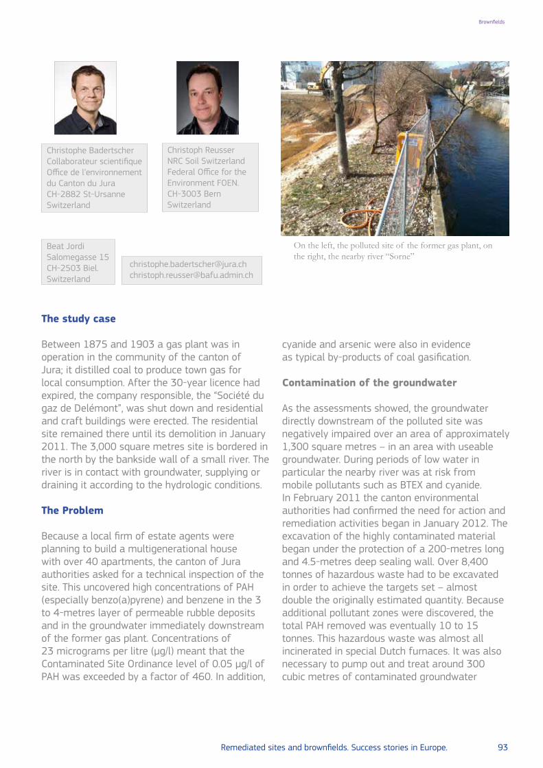
Remediated sites and brownfields. Success stories in Europe. 93
BrownfieldsBrownfields
The study case
Between 1875 and 1903 a gas plant was in operation in the community of the canton of Jura; it distilled coal to produce town gas for local consumption. After the 30-year licence had expired, the company responsible, the “Société du gaz de Delémont”, was shut down and residential and craft buildings were erected. The residential site remained there until its demolition in January 2011. The 3,000 square metres site is bordered in the north by the bankside wall of a small river. The river is in contact with groundwater, supplying or draining it according to the hydrologic conditions.
The Problem
Because a local firm of estate agents were planning to build a multigenerational house with over 40 apartments, the canton of Jura authorities asked for a technical inspection of the site. This uncovered high concentrations of PAH (especially benzo(a)pyrene) and benzene in the 3 to 4-metres layer of permeable rubble deposits and in the groundwater immediately downstream of the former gas plant. Concentrations of 23 micrograms per litre (µg/l) meant that the Contaminated Site Ordinance level of 0.05 µg/l of PAH was exceeded by a factor of 460. In addition,
cyanide and arsenic were also in evidence as typical by-products of coal gasification.
Contamination of the groundwater
As the assessments showed, the groundwater directly downstream of the polluted site was negatively impaired over an area of approximately 1,300 square metres – in an area with useable groundwater. During periods of low water in particular the nearby river was at risk from mobile pollutants such as BTEX and cyanide.In February 2011 the canton environmental authorities had confirmed the need for action and remediation activities began in January 2012. The excavation of the highly contaminated material began under the protection of a 200-metres long and 4.5-metres deep sealing wall. Over 8,400 tonnes of hazardous waste had to be excavated in order to achieve the targets set – almost double the originally estimated quantity. Because additional pollutant zones were discovered, the total PAH removed was eventually 10 to 15 tonnes. This hazardous waste was almost all incinerated in special Dutch furnaces. It was also necessary to pump out and treat around 300 cubic metres of contaminated groundwater
Beat JordiSalomegasse 15 CH-2503 Biel. Switzerland
Christoph Reusser NRC Soil SwitzerlandFederal Office for the Environment FOEN. CH-3003 BernSwitzerland
Christophe BadertscherCollaborateur scientifiqueOffice de l’environnement du Canton du JuraCH-2882 St-UrsanneSwitzerland
On the left, the polluted site of the former gas plant, on the right, the nearby river “Sorne”
[email protected]@bafu.admin.ch
© A
uthors/Photostock

94 Remediated sites and brownfields. Success stories in Europe. Remediated sites and brownfields. Success stories in Europe. 95
Brownfields Brownfields
in the course of remediation activities.
The Strategy and the results
Remediation objectives have been fulfilled.Through excavation of the biggest contaminant zones, the remediation objectives of a maximum of 0.05 µg benzo(a)pyrene per litre in the groundwater and of 0.5 µg PAH per litre in the groundwater that flows into the river have been achieved. Because it was not possible to remediate narrow polluted strips (e.g. in the area of the river’s bankside wall), these edge plots remain in the register of polluted sites.The total cost for inspection and remediation of the site was over 1.5 million CHF. The landowner
was aware of the pollution when buying the land. For this reason he also had to carry a small share of the cost. The former gas plant operator went long ago into liquidation so that the remaining share of the cost had to be carried by the canton of Jura and by the Confederation.The remediation process enabled a seriously contaminated area in the city centre of Delémont to be upgraded and attractive living space for broad population groups to be created in a well-developed situation close to the railway station. This form of land recycling was beneficial for the scarce resource of soil.
A Worker is taking soil samples
© A
uthors/Photostock

94 Remediated sites and brownfields. Success stories in Europe. Remediated sites and brownfields. Success stories in Europe. 95
Brownfields Brownfields
Accumulation of pollutants (black) on an impermeable marl layer (yellow-orange)
The projected new buildings on the remediated site
©K
URY
STÄH
ELIN
ARC
HITE
CTE
S/Photostock©
Authors/Photostock

96 Remediated sites and brownfields. Success stories in Europe.
LOCATION Wallonia, Belgium
POLLUTANTHeavy metals, arsenic, cyanides, PAHs, mineral oils, benzene, naphthalene, mineral oils, phenols, heavy metals, surfactants and cyanides
SOURCE Old slag and domestic refuse soil heap
GENERAL CLEAN UP OBJECTIVES Reduce groundwater and soil contamination
REMEDIATION ACTIONS
Soil excavation, levelling of the spoil heap, extinction of excavated materials and installation of a biofiltration capping. Revegetation using Miscanthus sp.
SITE/END USE Expansion of the Liege Science Park
SOCIAL-LEGAL ISSUES Land reclamation
KEY LEARNING/EXPERIENCE TO
SHARE
New way of inside construction of a treatment plant for treating base seepage from below the site
6. The Bois Saint-Jean site in Seraing, Belgium: various types of pollution and a large site remediation with special techniques
Brownfields

Remediated sites and brownfields. Success stories in Europe. 97
Brownfields
The study case
Presentation
Bois Saint-Jean is a 133.30ha plateau located on the territory of the City of Seraing at the centre of a triangle formed by the old commune of Ougree in the northwest, the Renory shunting yard in the northeast and the university domain of Sart-Tilman in the south.
History
The Bois Saint-Jean spoil heap was put into operation by the steel-making company Ougree-Marihaye in 1920. From the outset it was used to deposit slag and domestic refuse from the commune of Ougree. In the 1950s, two spoil heaps were operational on the site. Until 1987, the year in which the slag heap was closed, it was used to deposit, in addition to domestic and construction waste, gas scrubbing sludge from blast furnaces, sludge from blast furnaces, solid and liquid industrial residues, phytopharmaceutical waste, waste from various plants in the Liege industrial basin, as well as numerous illegal landfills.
The problem
Pollution
The characterization studies revealed the presence of heavy metals, arsenic, cyanides, PAHs, mineral oils. The soil analysis revealed the presence in the groundwater of benzene, naphthalene, mineral oils, phenols, heavy metals, surfactants and cyanides.
SPAQuE Communication Service.Belgium
Bois Saint-Jean, Belgium remediation works
Landscape after remediation works
© SPA
QU
E/Photostock
© SPA
QU
E/Photostock
The strategy
Works by SPAQuE
After historical overview, soil and water characterization studies and a feasibility study, SPAQuE removed cyanide-contaminated soil in 2002. In 2004 SPAQuE carried out safety work on the burning spoil heap (levelling of the spoil heap, extinction of excavated materials and installation of a biofiltration capping). In 2008 SPAQuE constructed a treatment plant for treating base seepage from below the site. Between 2009 and 2014, SPAQuE also cultivated Miscanthus sp. on part of the site.
The results
The purpose of the remediation carried out by SPAQuE was to allow a 40ha expansion of the Liege Science Park managed by SPI (the economic development agency for the province of Liège) and to accommodate research spin off companies associated to the University of Liege.
Further readings
www.spaque.bewww.spi.be

98 Remediated sites and brownfields. Success stories in Europe.
LOCATION Catalonia, Spain
POLLUTANT Chlorinated aliphatic hydrocarbons
SOURCE Industry waste: dry cleaning factories
GENERAL CLEAN UP OBJECTIVES Reduce groundwater and soil contamination
REMEDIATION ACTIONS
Monitoring natural biodegradation and induced abiotic degradation
SITE/END USE Aquifer
SOCIAL-LEGAL ISSUES Land reclamation
KEY LEARNING/EXPERIENCE TO
SHARE
New method of monitoring natural attenuation and alkaline hydrolysis
7.Assessing remediation strategies in a complex fractured bedrock aquifer polluted by chlorinated volatile organic compounds at a former production site in Catalonia, Spain.
Brownfields

Remediated sites and brownfields. Success stories in Europe. 99
Brownfields
The study case
Introduction
Chlorinated organic compounds, due to their widespread use as solvents by the industry and dry cleaning facilities, are prevalent contaminants in groundwater and soil. These compounds can migrate over long distances in aquifers leading, combined with the usual presence of multiple sources and the occurrence of transformation processes, to complex contaminated sites with multiple dissolved plumes. This scenario may be even more complicated in the case of fractured aquifers. Moreover, their remediation is extremely costly in most cases and the confidence whether
the proposed treatments will be effective or not is still difficult to predict. Therefore, major efforts for characterization of contaminated sites are needed in order to reduce the level of such uncertainties. Regarding site characterization, consultants and site managers usually need to allocate contaminant plumes to specific sources (source apportionment, SA) in order to define better conceptual models: this information is crucial to devise successful remediation and sampling strategies, including the design of suitable monitoring networks. For remediation treatments evaluation, the role of degradation processes (both biotic and abiotic) needs to be carefully quantified in order to differentiate it from other non-destructive processes, like sorption, dispersion or dilution, also responsible for decrease of contaminant concentration in contaminant plumes.
a) location of transects A and B Modified from Palau et al., 20141 and b) Geology, source loca-tions, groundwater monitoring system
Massimo MarchesiJordi PalauClara TorrentóCarme Audí-MiróMònica RosellNeus Otero Albert SolerGrup de Mineralogia Aplicada i Geoquímica de Fluids, Departament de Cristal·lografia, Mineralogia i Dipòsits Minerals, Facultat de Geologia, Universitat de Barcelona (UB), C/Martí Franquès, s/n. Barcelona Spain
Ramon AravenaDepartment of Earth and Environmental Sciences, University of Waterloo. Ontario.Canada
a)
b)
1 Palau, J., Marchesi, M., Chambon, J.C.C., et al. Multi-isotope (carbon and chlorine) analysis
for fingerprinting and site characterization at a fractured bedrock aquifer contaminated by
chlorinated ethenes. Science of the Total Environment 475 (2014) 61–70
[email protected]@[email protected]@uwaterloo.ca
Database/Palau et al.,2014

100 Remediated sites and brownfields. Success stories in Europe. Remediated sites and brownfields. Success stories in Europe. 101
Brownfields Brownfields
This is particularly important for monitored natural attenuation (MNA) applications, where exhaustive site characterizations are required in order to evaluate the feasibility of such approach. Conventional methods like geochemical characterization and evolution of parent / daughter compounds concentration relationship can present a high uncertainty, especially for sites with multiple contaminant sources or with complex hydrogeology settings, like fractured aquifers. In order to overcome such uncertainties, innovative tools such as compound-specific isotope analysis (CSIA) have been increasingly applied. CSIA is an analytical method which allows measuring the ratio of stable isotopes, e.g. δ13C and δ37Cl, on specific compounds in environmental samples. The rationale for using CSIA in SA is that the same contaminant in different sources may exhibit different initial isotopic composition; such difference can then be used to distinguish among different contaminant plumes, and eventually to link those plumes to their respective sources. In addition, stable isotope fractionation can provide a clear evidence for the occurrence of contaminant degradation processes. In general, when contaminants are degraded in the environment, the ratio of stable isotopes may change (so called isotope fractionation):
molecules containing the light isotope at the reactive position tend to react faster compared to the molecules containing the heavy isotope, leading to more positive δ values in the substrate. Then, the extent of degradation can be estimated from changes in the ratio of stable isotopes in the substrate remaining fraction. As a result, CSIA is a unique tool which enables to identify, and in some cases also to quantify, degradation processes. Data from CSIA not only can be used to evaluate natural processes (for MNA applications), it also can be applied to assess engineered and induced processes such as In-situ Chemical Oxidation (ISCO) or enhanced bioremediation (biostimulation or bioaugmentation) among other contaminant remediation treatments. Here, we show the results of two successful experiences of CSIA applications carried out for subsurface contamination characterization and remediation treatment evaluation in the Odena experimental field site. This experimental site is a complex fractured bedrock aquifer impacted by multiple sources and plumes of chlorinated organic contaminants. The “Agència de Residus de Catalunya, ARC” and the “Agència Catalana de l’Aigua, ACA” installed a high-resolution groundwater monitoring network that enables the use of this aquifer as experimental site
a) Table Chlorinated ethenes concentrations (mg/L) and isotopic compositions of PCE and TCE (‰) in the potential con-taminant sources. Isotope data are reported using the delta notation, δ(13C or 37Cl) = (Rs / Rstd) − 1 (Eq. 1), where Rs and Rstd are the 13C/12C and 37Cl/35Cl ratios of the sample and international standards; i.e., Vienna PeeDee Belemnite (VPDB) and Standard Mean Ocean Chloride (SMOC), respectively. b) Site map, the contour lines depict the plumes of total chlorinated ethene groundwater concentrations (sum of PCE, TCE and cDCE in μmol/L) and the values indicate the δ13Csum (‰). Modified from Palau et al. (2014), see reference 1 page 99
Fracture
B-29 B-4 B-20 Oct-02 Jun-03 Sep-04 5-Jul
PCE 575.1 1333 5.2 27.7 1.2 2.8 1.6
TCE 12.4 15.6 < 0.01 108.5 7.1 12.2 27
cDCE < 0.01 < 0.01 < 0.01 < 0.01 < 0.01 < 0.01 < 0.001
δ 13CPCE (VPDB)
-26.1 ± 0.5 -32.4 ± 0.5 -20.3 ± 0.9 -18.5 ± 0.5 -18.9 ± 0.5 -19.3 ± 0.4 -20.3 ± 0.3
δ 13CTCE (VPDB)
-40.5 ± 0.5 --- --- -16.6 ± 0.5 -15.6 ± 0.5 -16.8 ± 0.3 -23.9 ± 0.2
δ 37ClTCE (SMOC)
--- --- --- --- --- +0.66 ± 0.06 +0.53 ± 0.06
CompoundBarrels Tanka)
b)
Database/A
uthors/2014 Database/A
uthors/2014

100 Remediated sites and brownfields. Success stories in Europe. Remediated sites and brownfields. Success stories in Europe. 101
Brownfields Brownfields
to perform field investigations and future research projects. The main applications of CSIA in this experimental site were: (i) the use of multi-isotope approach (C and Cl) for source and plume identification, (ii) the coupling of stable isotopes and reactive transport modelling for biodegradation and mixing processes evaluation and, (iii) the use of CSIA for monitoring induced alkaline hydrolysis processes by construction waste recycling as passive remediation treatment.
The problem
Site characterization and monitoring.
The studied aquifer is located in Odena, at approximately 50km northwest of Barcelona (Spain). The aquifer is an unconfined fractured bedrock mainly consisting of limestone bed which forms a low permeability matrix with conductive fractures and fissures. The site is highly complex due to the presence of multiple contaminant sources: 1) an underground wastewater tank,
2) a disposal lagoon and 3) abandoned solvent barrels inside the manufacturing building (see figure in page 95 a) and b)). The main contaminants detected in groundwater were trichloroethene (TCE), perchloroethene (PCE) and chloroform (CF). Different measures for the mitigation of the contamination have been performed. For source treatment, the abandoned barrels and the highly contaminated soils in the focus areas (the wastewater tank and the disposal lagoon) were removed (March 2006) and replaced by two interception trenches filled with recycled concrete-based aggregates in order to stimulate potential alkaline hydrolysis processes. Regarding the dissolved plumes, monitored natural attenuation (MNA) was considered in addition to the source treatment. For site characterization and monitoring, ten multilevel nested wells were installed, leading to a total of 147 sampling points. Redox conditions, contaminant concentrations, δ13C and δ37Cl (chlorine isotope measurements only for TCE) were monitored during the 2
(Left panels) PCE, TCE and cDCE concentrations and δ13C (‰) values along transects B–B′. For TCE, δ13C (bold italics) and δ37Cl (standard in boxes) (‰) are indicated; (Right panels) Comparison of model simulations (lines) and field measurements (data points) for four different conceptual models of transect B: (1 & 2) reductive dechlorination to cDCE, (3) reductive dechlorination and mixing by dispersion with the transect A plume and (4) mixing of the tank plume with TCE leaching from the unsaturated zone between S-3 and S-6. Modified from Palau et al. (2014), see reference 1 page 99
Database/A
uthors/2014
Database/A
uthors/2014

102 Remediated sites and brownfields. Success stories in Europe. Remediated sites and brownfields. Success stories in Europe. 103
Brownfields Brownfields
years after the sources removal.
Source apportionment
A wide range in δ13CTCE and δ13CPCE was found for the potential contaminant sources The comparison of δ13CTCE, δ
13CPCE and the concentration weighted average isotopic composition of chlorinated ethenes (δ13Csum) between potential sources and monitoring wells, allowed for the differentiation between two plumes) in the fractured bedrock aquifer and the relation of these to the disposal lagoon (plume intercepted by transect A) and the underground tank (plume intercepted by transect B).
The strategy
Monitored Natural Attenuation (MNA).
No evidence of significant biodegradation of TCE and PCE was indicated by the isotopic signatures and daughter-product concentration data along transect A. In contrast, a significant shift in δ13CTCE from −15.6 to −8.2‰ and δ13CPCE from −17.9 to −16.2‰ was observed in transect B. A large shift towards δ13C values enriched in 13C with depth was observed for TCE (from −13.6 to −8.2‰) at well S-3, which points to the occurrence of TCE biodegradation. These isotopic data were consistent with high cDCE concentrations (up to 12 mg/L) and the stronger reducing conditions observed in this part of the aquifer. Downstream from S-3 (i. e. S-6 and S-10), the decrease in TCE concentration along the groundwater flow direction was not associated with a trend to more positive δ13CTCE. On the opposite, δ37ClTCE shifted to higher values (from +0.34‰ to +2.64‰), suggesting the occurrence of TCE degradation also downstream S3. Such trend towards higher δ37Cl values of TCE concurrent with an increase of the cDCE molar fraction along the groundwater flow direction suggested TCE reductive dechlorination. However, the C and Cl isotope values of TCE revealed the concurrence of source mixing along
(A) Schematic drawing and pictures of the installation of the trench located in the former disposal lagoon area. (B) Variation over time of CF concentration (green dia-monds) and carbon isotope ratios (δ13CCF, red circles) in the underground tank trench during the studied period. The dashed line indicates the day when the trench was completely emptied for the management of the contaminated water. Modified from Torrentó et al. (2).
the plume. A reactive transport model was used to simulate concentration and isotope data along transect B and the results demonstrate that the observed isotope pattern for TCE can be explained by the simultaneous effect of source mixing and biodegradation, particularly by model 4 which considered a mixing with TCE leaching from the unsaturated zone between S-3 and S-6.
Alkaline hydrolysis
Two interception trenches were installed in the unsaturated zone where contaminated soil was removed. The trenches were filled with concrete-based aggregates to induce alkaline hydrolysis of CF in the infiltration contaminated
2 Torrentó, C., Audí-Miró, C., Bordeleau, G., et al. 2014. The use of alkaline hydrolysis as a
novel strategy for chloroform remediation: The feasibility of using construction wastes
and evaluation of carbon isotopic fractionation. Environmental Science and Technology 48
(2014) 1869−1877

102 Remediated sites and brownfields. Success stories in Europe. Remediated sites and brownfields. Success stories in Europe. 103
Brownfields Brownfields
3 Maymó-Gatell, X., Nijenhuis, I., Zinder, S. H. Reductive dechlorination of cis-1,2-dichloroethene
and vinyl chloride by Dehalococcoides ethenogenes. Environmental Science and Technology
35 (2001) 516−521
4 Huling, S. G., Pivetz, B. E. In situ chemical oxidation-Engineering issue. EPA/600/R-06/072.
U.S. Environmental Protection Agency Office of Research and Development, National Risk
Management Research Laboratory: Cincinnati, OH, 2006
water before this reaches the aquifer. The concentration reduction of CF might be a key strategy for bioremediation purposes because CF is a potent inhibitor of several microbial processes, such as methanogenesis or reductive dechlorination of chlorinated ethenes3, the other major group of pollutants at the experimental site. Due to the recalcitrant nature of this compound, e.g. it is poorly reactive with common ISCO oxidants4, this alternative remediation strategy for CF-contaminated recharge water was for the first time implemented in a contaminated site. The trenches were filled with 40-70mm-sized recycled concrete-based aggregates from a construction and demolition waste recycling plant. During the first four years after the installation of the trenches, water accumulated in the trenches was occasionally removed for its management. During the next three years, CF concentration and carbon isotope ratios were monitored monthly in both trenches to assess the performance of the induced CF degradation. The concrete-based construction wastes maintained a constant pH of 11.6±0.3 in pore water during the entire study period, confirming the longevity of concrete-based aggregates for inducing alkaline conditions. Significant 13CCF enrichment was observed in both trenches, with isotopic shifts of up to 20 and 28‰, validating the capability of concrete-based construction wastes to induce alkaline hydrolysis of CF. Using the isotopic fractionation obtained from laboratory experiments (ƐC = -53±3‰), a maximum of approximately 30-40% of chloroform degradation was estimated in both trenches during the studied period.
Conclusions
Combined remedial actions have been applied a fractured bedrock aquifer, particularly Monitored Natural Attenuation (MNA) and enhanced alkaline hydrolysis. The site exhibited an especially high complexity due to the presence
of multiple contaminant sources and a wide variety of chlorinated volatile organic pollutants. The high-resolution groundwater monitoring network and the dual (chlorine and carbon) CSIA approach allowed the plumes characterization and linking them with their respective sources. In addition, the use of a reactive transport model including isotope data, in combination with an exhaustive evaluation of groundwater flow directions, contaminant distribution and redox conditions, revealed the occurrence of natural attenuation and mixing processes at the site.
The two recharge water interception trenches filled with concrete-based construction wastes produced extremely basic pH conditions inducing chloroform degradation by alkaline hydrolysis. The significant carbon isotopic fractionation associated with this process allowed to monitor the efficacy of this remediation approach. This strategy also implies the recycling of construction and demolition wastes for use in value-added applications. This article illustrates the potential of multi-isotope data for site characterization and contaminant transformation processes evaluation.
Further readings
http://www.gwrtac.org/http://www.chlorinated-solvents.eu/http://www2.epa.gov/science-and-techno logy/water-sciencehttp://toxics.usgs.gov/sites/nawc_page.htmlhttps://www.serdp-estcp.org/Program-Areas/Environmental-Restoration/Contaminated-Groundwaterhttp://www.itrcweb.org/http://www.ub.edu/minegeo/
• To have full access to the original article please go on see: http://www.ub.edu/minegeo/images/Papers/EIONET_ARC_2.pdf

104 Remediated sites and brownfields. Success stories in Europe.
LOCATION Carouge, Switzerland
POLLUTANT Chromium VI
SOURCE Former electroplating company
GENERAL CLEAN UP OBJECTIVES Reduce groundwater and soil contamination
REMEDIATION ACTIONS Hydraulic barrier and extraction pump
SITE/END USE Drinking-water resource
SOCIAL-LEGAL ISSUES Human health concern and land reclamation
KEY LEARNING/EXPERIENCE TO
SHARE
The use of large diameter drilling appeared to be the best excavation method in this urban area
8. Remediation and monitoring of a commercial site in Carouge, in the canton of Geneva, Switzerland. Chromium (VI) contamination in the groundwater
Brownfields

Remediated sites and brownfields. Success stories in Europe. 105
Brownfields
The study case
A company specialized in the surface finishing of metals operated on a 500 square metre site in Carouge in the canton of Geneva until 1996. The history of the former galvanizing enterprise, which specialized mainly in chromium and nickel baths, goes back to the early 1930s.
The problem
After the year 2000, an engineering office was tasked with checking the soil and groundwater immediately downstream of the polluted site and found high concentrations of the heavy metal chromium VI, which is carcinogenic and water-polluting. The volumes varied between 139 and 339 micrograms per litre (µg/l) and were far above the permitted maximum limit in the Contaminated Sites Ordinance of 10µg/l.A groundwater stream flowing 15 metres below ground surface in Carouge is additionally used for drinking-water in the surrounding area. The nearest collection point is located about 2 kilometres away from the contaminated site. To prevent the entry of chromium VI into the important drinking-water resource, the canton of Geneva
had the groundwater on the contaminated site pumped out and removed in 2001 so that a hydraulic barrier could be constructed. The effectiveness of this provisional immediate measure could be verified through a monitoring network with fixed observation tubes installed in the close vicinity.
The strategy
Excavation to a depth of 15 metres
Between 2010 and 2011 comprehensive remediation works were carried out at a cost of over 3 million CHF. The contaminated soil was excavated under a protective cover to ensure the safety of the employees and of the neighbours. After the two affected buildings had been demolished and dismantled, the material from the area of the former chromium baths had to be excavated to a depth of 15 metres. Altogether about 82 kilos of chromium VI were removed from the contaminated site. Experts calculate a residue of chromium VI in the subsoil of approximately 1-2 kilos.An irrigation test was carried out so that the
© W
ikipedia, 2005/Photostock
Beat JordiSalomegasse 15 CH-2503 BielSwitzerland
Christoph Reusser NRC Soil SwitzerlandFederal Office for the Environment FOEN. CH-3003 BernSwitzerland
Alain DavitHead of Contaminated sites SectionRépublique et Canton de Genève Service de géologie, sols et déchets (GESDEC)12 quai du RhôneCH-1205 GenèveSwitzerland

106 Remediated sites and brownfields. Success stories in Europe. Remediated sites and brownfields. Success stories in Europe. 107
Brownfields Brownfields
effects of remediation on the groundwater quality could be assessed. This practical test posed a few questions. For instance, the chromium VI content immediately downstream of the site first lays under the target maximum level of 10 µg/l for several weeks, but then rose to 60 µg/l and afterwards sank back to 20 µg/l. High concentrations of chromium VI occurred particularly after periods of continuous intensive precipitation.In the light of this situation, the canton of Geneva wants to continue monitoring the development
of the groundwater quality on the remediated site in Carouge until 2022. So far, monitoring has shown that, at times, chromium VI can reach a maximum level of around 5 µg/l of chromium VI in the piezometer monitoring network. However, no analysis at the drinking-water collection point has ever exceeded the level of 1 µg/l of chromium VI, which rules out a risk at the collection point.Because the company went bankrupt, the canton of Geneva had to pay most of the remediation costs. More than 1 million CHF were paid by the Confederation’s Contamination Fund.
Protective cover under construction
©N
RC Soil Sw
itzerland/Photostock

106 Remediated sites and brownfields. Success stories in Europe. Remediated sites and brownfields. Success stories in Europe. 107
Brownfields Brownfields
Pollution excavation under the protective cover by means of large diameter drilling.
©N
RC Soil Sw
itzerland/Photostock

108 Remediated sites and brownfields. Success stories in Europe.
LOCATION Wallonia, Belgium
POLLUTANT Cyclic aromatic hydrocarbons, heavy metals, mineral oils, ammonia, nitrates and tar
SOURCE Former gasworks-site
GENERAL CLEAN UP OBJECTIVES Reduce groundwater and soil contamination
REMEDIATION ACTIONS
Soil excavation, pumping, treatment of groundwater, outside soil treatment
SITE/END USE Offices and housing
SOCIAL-LEGAL ISSUES Land reclamation
KEY LEARNING/EXPERIENCE TO
SHARENew ways of outside soil treatment remediation
9. The gasworks-site in Mons, Belgium: remediation of an old site to build offices and a housing project
Brownfields

Remediated sites and brownfields. Success stories in Europe. 109
Brownfields
The study case
Presentation
The 1.40ha old gasworks-site is located within a rectangle formed by the streets of Cantonniers, Gazomètre, Buisseret and Pécher on the territory of the municipality of Mons. Between 1834 and 1960 the site was occupied by town gas and electricity production facilities.
History
Part of the site was occupied by two gas holders of 22,610m³ and 6,240m³ respectively, constructed by SA Gaz de Mons just before World War I. In 1948, the gasworks activity was closed, and the aboveground facilities of the gas holders were dismantled in 1958. Subsequently a section of the site was used as a scrap metal yard for the storage of various types of waste (copper, electrical wire, old transformers, etc.).
Old gasworks-site and remediation works in Mons, Belgium
Forem offices.
The problem
Pollution
The on-site characterization study revealed the presence of cyclic aromatic hydrocarbons, heavy metals, mineral oils, ammonia, nitrates and tar.
The strategy
Works by SPAQuE The remediation work was carried out between 2005 and 2006. The first stage included pumping and treatment of groundwater, soil excavation and transport of contaminated soil to an accredited disposal center, deconstruction of all the foundations of both gas holders, and backfilling of certain excavated areas. In a second stage, the last remaining buildings were deconstructed.
The results
Project
This remediation paved the way for the construction of the Forem offices in 2007. On the remainder of the site, a private developer completed a housing project comprised of apartments and single-family homes with garden.
Further readings
www.spaque.be
SPAQuE Communication Service.Belgium
©SPA
QU
E/Photostock
©SPA
QU
E, 2007/Photostock

110 Remediated sites and brownfields. Success stories in Europe.
LOCATION Vienna, Austria
POLLUTANTTar oil, PAH: benzene and other aromatic compounds. Hydrocarbons, phenols, cyanides (mostly as complex cyanides), and hydrogen sulphides
SOURCE Former gasworks-site
GENERAL CLEAN UP OBJECTIVES Reduce groundwater and soil contamination
REMEDIATION ACTIONS Soil excavation
SITE/END USE Housing and offices supply, cultural and recreational activities
SOCIAL-LEGAL ISSUES Land reclamation
KEY LEARNING/EXPERIENCE TO
SHARE
New method in the management of soil remediation: conceptual site model approach and GIS mapping tools of hot spots and groundwater contamination
10. Remediation of Austria’s largest gasworks-site, transforming it into a new city quarter
Brownfields

Remediated sites and brownfields. Success stories in Europe. 111
Brownfields
The study case
Historical background
On October 31st 1899 the newly constructed gaswork in the Vienna district Simmering began operation. It was the beginning of gas production by the municipality of Vienna. Previously gas had been supplied by about 20 private gasworks, mostly under foreign ownership. In the years following 1899 the private gasworks were steadily diminished. Most of the older gasworks were decommissioned and finally the entire gas production was in the hand of the municipality. Operating a gaswork on approximately 300,000m² and with the technical practices usual at that time involved intensive emissions. However in the early times of operations these emissions were not recognised as a release of hazardous substances, impacting the environment. As a consequence, old gasworks-sites show specific patterns of contamination which are likely to cause risks for human health or the environment.
The problem
The typical spectrum of pollutants is nowadays well described in specialist literature comprising tar oil (creosote) constituents (e.g. PAH), benzene and other aromatic compounds, hydrocarbons, phenols, cyanides (mostly as complex cyanides), and hydrogen sulphides. Further severe pollutant releases were caused during the 2nd World War,
as the Simmering Gasworks, like other important infrastructure, were a primary target for air raids. Several installations like the tar cisterns, the light oil manufacturing plant, and the gas purification (“washing plant”), were hit by bombs and massively damaged. In total 18 explosive and about 1,200 incendiary bombs struck the gasworks. In addition 313 artillery hits during ground battles in April 1945 were recorded.After the end of the war, fission of natural gas became viable and the primary technology for producing “city gas”. As a consequence, the production of gas from coal at the Simmering Gasworks was terminated on May 11th 1966.
The strategy
Investigation and evaluation of hazardous site W18 Simmering Gasworks-site remediation strategy
Causing serious contamination of soil and groundwater, Simmering Gasworks was one of the first historically contaminated sites to be listed in the national remediation program in 1990. Since 1993 several investigation campaigns were conducted to identify contamination hot-spots and to develop a good understanding regarding the distribution of contaminants. A widespread pollutant plume downstream of the site due to
DI Paul Schöberl Project Manager at Wiener Netze GmbH Austria
Roland Rohrhoferthe General Manager and senior partner of the company group Buero Rohrhofer & Partner Austria
Gasworks Simmering 1899 – 1966
© W
iener Netze G
mbH
/Photostock
[email protected]@rohrhofer.at

112 Remediated sites and brownfields. Success stories in Europe. Remediated sites and brownfields. Success stories in Europe. 113
Brownfields Brownfields
the massive gaswork specific contamination at the site was identified. Accordingly, by the year 2000 the site was classified as “priority class 1”, indicating urgency for financing and implementing remediation measures within the national remediation program. In particular the tar cisterns proved to be a hot-spot where large volumes of tar oil have penetrated the soil and partially the groundwater, sinking to the bottom of the aquifer to a depth of more than 10m. There a tar oil phase started to spread out laterally, following the structure given by the surface of the underlying, low permeable layer. As sound knowledge about the pollutant sources and their site-specific environmental and human health risks is needed forimplementation of tailor made management measures, a large number of boreholes were drilled. Numerous boreholes were adapted as groundwater monitoring wells. Due to the fact that hot spots are the origin of plumes in groundwater, transporting high loads of pollutants, further investigations were directed to identify these areas of high pollution load.To delineate hot spots, all available investigation results were statistically analysed and visualised.
GIS-based mapping of hot spots and groundwater contamination
Through the interpretation of aggregated data a Conceptual Site Model (CSM) was developed, which finally served as a tool for a general remediation concept on how to manage pollutant sources and contaminated groundwater.During the detailed design phase, reference parameters were identified and pollutant mass flow calculations were performed. The comparison of pollutant transport originating from different sources with a possible remediation efficiency
Distribution of soil contamination; 3D-visualisation . (Legend: blue = groundwater level; different colours indicate level of contamination of different pollutants)
Database/ Ö
KO
REA
L–ÖK
OA
UD
IT Gm
bH
Database/Ö
KO
REA
L–ÖK
OA
UD
IT Gm
bH

112 Remediated sites and brownfields. Success stories in Europe. Remediated sites and brownfields. Success stories in Europe. 113
Brownfields Brownfields
through natural degradation processes was used to support decisions on which and to what extent hot spots should be removed,. This finally resulted in the mapping of areas to be decontaminated by excavation. An overview with regard to polycyclic aromatic hydrocarbons (PAH), a substance group and reference parameter typical for tar oil contamination, is provided in GIS-based mapping of hot spots and groundwater contamination (figure page 112).In order to facilitate the vertical delineation of hot spots, a 3D-visualisation was developed which supported an optimal tendering process of necessary construction services and minimised costs for excavation and off-site soil treatment.
By 2009 the competent authority licensed a comprehensive remediation project to prevent and limit groundwater pollution which includes 4 major lines of action:
• Hydraulic barriers: based on a groundwater model, a pump&treat-system was designed. Contaminated groundwater is controlled by two lines of abstraction wells at the south-east-border of the site (see GIS-based mapping of hot spots, figure page 112), cleaned in a new constructed water treatment plant nearby, and infiltrated to groundwater or partially discharged to a branch of the river Danube.
• Removal of primary contamination sources: removal of the tar and ammonic cisterns, liquid residues, and of tar-filled pipelines and containers in order to permanently prevent further permanent discharge of contaminants.
• Clean-up of hot spots: soil excavation close to or below the groundwater table in order to limit pollutant mass flows and to reduce the costs of operating the hydraulic barrier downstream.
Water Treatment Plant (WAB)
© RO
HRH
OFE
R ZT G
mbH
/Photostock

114 Remediated sites and brownfields. Success stories in Europe. Remediated sites and brownfields. Success stories in Europe. 115
Brownfields Brownfields
• Recycling of brownfields: soil management and land development to reintegrate low contaminated areas into the economic cycle of the city.
Implementation of the safeguard and remediation measures
The remediation activities mentioned above were implemented in two construction phases between October 2010 and April 2014.
- Phase 1: remediation measures through excavation, treatment and disposal of approximately 100,000 tonnes of hazardous waste (especially tar and tar-oil contaminated soil in the area of the tar and ammoniac cisterns and of the hot spots);- Phase 2: construction and operation of the Hydraulic Barrier System consisting of two lines of abstraction wells with a total of 21 wells, a fully automated water treatment with a total capacity of 30l/s, an infiltration plant with 6 wells upstream of the contamination site, and a double pipeline to the outfall on the branch of the Danube (Donaukanal). Small scale methods
were used for the removal of the hot spots. Their goal was to temporarily delimitate the individual, local contamination sources (hot spots) and carry out the replacement of the soil. Overlapping large diameter (up to 2m) boreholes with casings down to the aquiclude (impervious layer) and steel piling coffers were used.
The results
Revitalisation and subsequent use of the former Simmering Gasworks
In parallel to the remediation activities at the hazardous site W18 Simmering Gasworks, the location of the former Simmering Gasworks is been being developed as a new city quarter from 1999 until the end of 2016, linking the functions of housing, recreation and commercial activities. The following projects are special highlights: the gas holders (“gasometer”) of the former Simmering Gasworks have been listed as industrial monuments since 1981. They were then being used for events and as the backdrops for films. In 1996 the City of Vienna decided to hold an architectural competition to gather
Pre-aeration and sedimentation tanks
© RO
HRH
OFE
R ZT G
mbH
/Photostock

114 Remediated sites and brownfields. Success stories in Europe. Remediated sites and brownfields. Success stories in Europe. 115
Brownfields Brownfields
ideas for the subsequent mixed use of the gas holders for housing, recreation and commercial activities. Well-known architects such as Jean Nouvel (gas holder A), Coop Himmelb(l)au (gas holder B), Manfred Wehdorn (gas holder C) and Wilhelm Holzbauer (gas holder D) designed the transformation of the gas holders. After the completion of construction in 2001, the company “Wiener Netze” rented and owned apartments, a student hall of residence, offices with a total of 11,000m2, a crèche and a cinema complex. In 2009, the housing supply at Gasometer City was expanded by another 170 units (Villa Verde). Additional housing is planned to be finished by the end of 2016 comprising 27 housing units embedded in the recreational area with a generous tree plantation. The built-up area around the Gasometer City received its own connection to the underground network in December 2000, becoming more attractive. After cessation of the production of city gas, the site of the former gasworks has continued to be used as operational center by the municipal company operating the city’s natural gas network “Wienenergie Gasnetz GmbH”. In the years 1998 to 2010 the site was successively adapted to
the needs of a modern gas network operator. In this development phase 14 buildings were constructed or rehabilitated. Historical buildings from the time of the city gas production were partially retained and given a new purpose.
In 2013 three municipal enterprises, Wien Energie Gasnetz GmbH, Wien Energie Stromnetz GmbHand Wien Energie Fernwärme were merged into a new enterprise: Wiener Netze GmbH (“Vienna Networks”), combining networks for gas, electrical power, district heating and communications in one enterprise. Within the framework of the project “Smart Campus”, the new headquarters of “Wiener Netze” will be constructed by the middle of 2016 on the former gasworks-site. From 2016 onwards 3000 employees will maintain and operate the electrical power net, the gas networks and the district heating network, based on the site of the former Simmering Gasworks.
Futher readings
http://www.wiener-gasometer.at;http://www.gasometer.ahttp://www.wien.gv.at/bauen-wohnen/wohnprojekt-simmering.html
From top to bottom and from left to right: Large diameter boreholes and steel piling coffers. Dismantling of tar storage facilities. Gasometer City and aerial view Operations Center of “Wiener Netze”.
© W
iener Netze G
mbH
/Photostock
© RO
HRH
OFE
R ZT G
mbH
/Photostock©
Um
weltbundesam
t Gm
bH/Photostock
© RO
HRH
OFE
R ZT G
mbH
/Photostock

116 Remediated sites and brownfields. Success stories in Europe.
LOCATION Wallonia, Belgium
POLLUTANT PAHs, heavy metals, mineral oils, groundwater organic compounds
SOURCE Former artificial silk factory
GENERAL CLEAN UP OBJECTIVES Reduce groundwater and soil contamination
REMEDIATION ACTIONS
Soil excavation, screening and transport to an accredited disposal center
SITE/END USE Commercial premises, apartments and parking facilities
SOCIAL-LEGAL ISSUES Land reclamation
KEY LEARNING/EXPERIENCE TO SHARE
New ways of outside soil treatment
11. The Tubize Plastics site in Tubize, Belgium: the story of fast remediation work for a building project
Brownfields
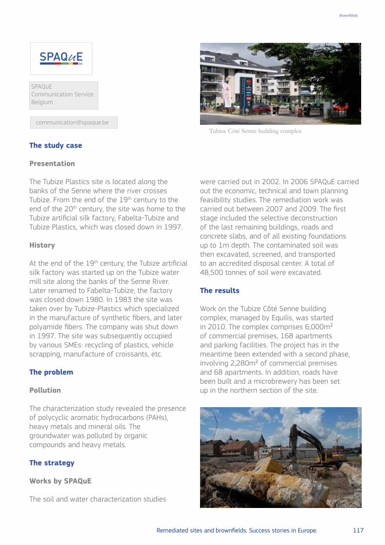
Remediated sites and brownfields. Success stories in Europe. 117
Brownfields
The study case
Presentation
The Tubize Plastics site is located along the banks of the Senne where the river crosses Tubize. From the end of the 19th century to the end of the 20th century, the site was home to the Tubize artificial silk factory, Fabelta-Tubize and Tubize Plastics, which was closed down in 1997.
History
At the end of the 19th century, the Tubize artificial silk factory was started up on the Tubize water mill site along the banks of the Senne River. Later renamed to Fabelta-Tubize, the factory was closed down 1980. In 1983 the site was taken over by Tubize-Plastics which specialized in the manufacture of synthetic fibers, and later polyamide fibers. The company was shut down in 1997. The site was subsequently occupied by various SMEs: recycling of plastics, vehicle scrapping, manufacture of croissants, etc.
The problem
Pollution
The characterization study revealed the presence of polycyclic aromatic hydrocarbons (PAHs), heavy metals and mineral oils. The groundwater was polluted by organic compounds and heavy metals.
The strategy
Works by SPAQuE
The soil and water characterization studies
were carried out in 2002. In 2006 SPAQuE carried out the economic, technical and town planning feasibility studies. The remediation work was carried out between 2007 and 2009. The first stage included the selective deconstruction of the last remaining buildings, roads and concrete slabs, and of all existing foundations up to 1m depth. The contaminated soil was then excavated, screened, and transported to an accredited disposal center. A total of 48,500 tonnes of soil were excavated.
The results
Work on the Tubize Côté Senne building complex, managed by Equilis, was started in 2010. The complex comprises 6,000m² of commercial premises, 168 apartments and parking facilities. The project has in the meantime been extended with a second phase, involving 2,280m² of commercial premises and 68 apartments. In addition, roads have been built and a microbrewery has been set up in the northern section of the site.
Tubize Côté Senne building complex
SPAQuE Communication Service.Belgium
Brownfields
©SPA
QU
E/Photostock
©SPA
QU
E/Photostock

118 Remediated sites and brownfields. Success stories in Europe.
LOCATION Wallonia, Belgium
POLLUTANTTar, cyanides, PAHs, MAH: benzene, mineral oils, heavy metals, phenol
SOURCE Former coke-ovens
GENERAL CLEAN UP OBJECTIVES Reduce groundwater and soil contamination
REMEDIATION ACTIONS
Soil excavation, heat treatment outside site, sorting and crushing waste and slag. Refilling using clean soil
SITE/END USE Logistics platform and business park for small and medium-sized companies
SOCIAL-LEGAL ISSUES Land reclamation
KEY LEARNING/EXPERIENCE TO SHARE
New ways of soil remediation methods ex-situ by heat treatment
12. The Cokerie Flemalle site in Flemalle and Seraing, Belgium: development of a trimodal platform and a business park
Brownfields

Remediated sites and brownfields. Success stories in Europe. 119
Brownfields
The study case
The Cokerie Flemalle site is located on the municipalities of Flemalle and Seraing. The site is bounded to the south-east by the river Meuse, some railways and a highway, to the west by a supermarket and elsewhere by shops and homes.
History
From 1922 to 1975, a battery of 113 coke-ovens was taken into operation in the eastern section of the site. The ovens were decommissioned in 1975. From 1922 to 1947, the western section was occupied by a desulphurisation plant, a gas holder and an electrical power station. In 1947, a second coke-oven plant was built, consisting of 44 ovens. In 1984, the company SA Espérance-Longdoz discontinued its operations at the site. Most of the technical installations were dismantled in 1990. In 2005, the site was bought by SPAQuE (http://www.spaque.be/).
The problem
Pollution
The soil and the groundwater were found to be highly contaminated. The analyses also revealed the presence of free-phase products (e.g. tar). Some pollutants were found in concentrations of up to 1,000 times higher than permissible levels: cyanides, polycyclic aromatic hydrocarbons, monocyclic aromatic hydrocarbons (benzene), mineral oils, heavy metals, phenol.
Cokerie Flemalle site
SPAQuE Communication Service.Belgium
©SPA
QU
E/Photostock
The strategy
Works by SPAQuE
The remediation work was divided into three stages: For stage I (2008-2009), 8,500 tonnes of cyanide-containing soil were cleared. The soil was transported to an accredited disposal center where it was subjected to heat treatment outside. For stage II (2009-2010), 122,000 m³ of waste and slag were sorted and crushed before being stored in an impermeable zone, with each lot to be analyzed and treated during the third stage of the work. The excavated area was backfilled using clean soil brought in from outside the site.For stage III (2011-2014), 336,000 tonnes of polluted soil were excavated and treated in an accredited disposal center where it was subjected to heat treatment. The excavated area was backfilled using clean soil brought in from outside the site.
The results
A future logistics platform and a business park for small and medium-sized companies is planned in close consultation with the local authorities. The site is divided into two areas:
• A trimodal logistics area (6,5 hectares);• A business park for small and medium-sized
companies (SMEs) and office spaces (1 hectare).These SMEs and offices will be
directly tied to the multimodal platform developed on the rest of the site and geared towards the local economic fabric.

120 Remediated sites and brownfields. Success stories in Europe.
LOCATION Venice, Italy
POLLUTANT Layer of pyrite ashes, heavy metals (Cu, As, Pb, Cd, Zn and Hg), vinyl chloride
SOURCE Chemical fertilizers waste and industrial waste
GENERAL CLEAN UP OBJECTIVES Risk assessment of groundwater and soil contamination
REMEDIATION ACTIONS Soil excavation, biodegradation
SITE/END USE House laboratories, offices, service industries
SOCIAL-LEGAL ISSUES Land reclamation
KEY LEARNING EXPERIENCE TO
SHARE
Engagement of different stakeholders: public, private and research institutions
13. Redevelopment of brownfields in the urban context of Porto Marghera, Venice, Italy
Brownfields

Remediated sites and brownfields. Success stories in Europe. 121
Brownfields
The study case
Historical and geographical background
The Scientific and Technological Park of Venice – Venice Gateway (VEGA) is located in the industrial area of Porto Marghera, 5km from Venice. The area where the park is located was occupied by a plant formerly owned by Enichem Agricultura. The plant was dedicated to the production of chemical fertilizers and was decommissioned in 1986. The area is located northeast of the industrial area of Porto Marghera, and overlooks Viale della Libertà, that is the road that connects the city of Venice to the mainland. This particular location is strategic from the point of view of urban planning within the City of Venice, as it makes the area well connected with the highway A4, with the Marco Polo international airport and the train station called Venezia Mestre. In 1993, VEGA - Science and Technology Park of Venice was founded as a non-profit organization, made up of thirty-four members, including the Venice City Council, which owns the majority of shares, the ENI Group, Veneto Innovation (the Agency for Innovation of the Veneto Region), Province of Venice, the two Venetian Universities Ca’
Foscari and IUAV, two banks and many small and medium enterprises. To face the slow decline of Porto Marghera as productive area, the consortium has proposed a revitalization of the local economy, through the introduction of a new model of environmental friendly development. Thanks to the help of University and Research Centers, investments became more attractive especially to innovative companies with high scientific and technological content. This completely transformed the strategic position for Veneto (Italy). Between the modern buildings of the center, VEGA restructured some parts that are outstanding as ancient remains of the productive vocation of the area (“industrial archeology”). Porto Marghera has been identified as an area in industrial decline and therefore had access to financing from European funds. VEGA could then count on more than 30 million euro managed by the Region of Veneto for demolition, construction of new facilities and acquisition of scientific instrumentation. During the first 10 years, VEGA has promoted the
Marco FalconiSoil Protection DepartmentInstitute for Environmental Protection and Research (ISPRA), Italy
Mauro GalloParco Scientifico e Tecnologico VEGA, Italy
Ing. Tommaso SantiniVEGA S.c.a.r.l. Parco Scientifico Tecnologico di Venezia. Italy
Dott.ssa Daniela MintoVEGA S.c.a.r.l. ParcoScientifico Tecnologico di Venezia. Italy
Aerial photo of the site in the 1960s Porto Marghera
©E
nte Zona Industriale Porto M
arghera/Photostock
[email protected]@[email protected]@vegapark.ve.it

122 Remediated sites and brownfields. Success stories in Europe. Remediated sites and brownfields. Success stories in Europe. 123
Brownfields Brownfields
urban transformation of an area of over 35ha, a strategic brownfield near Venice, connection between cities’ water and land, developing over 35,000m2 of buildings earmarked for a Science Park and activating business initiatives in research and innovation. After this first phase of expansion, supported by the transfer of areas from the members and by the access to European structural funds, the reconversion stopped. But in 2001, the next phase of development was made by a private investment, for the realization and the management of a further 40,000m2 of buildings. Again in 2007 with the acquisition by the Group “Condotte” of an area called VEGA 2, on which a multipurpose building complex is under construction, in which the new exhibition hall in Venice, to be inaugurated with Expo 2015 is built.Today VEGA is a business district which is spread over 80,000m2 of buildings, with more than 200 companies and 2,000 employees, 24 innovative start-ups, 18 registered patents, for a total turnover by the companies of more than 200 million euro. In addition to the 80,000m2 of buildings already realized there are further 150,000m2 in development.
The problem
The characterization phase
Between 1995 and 1996, Enichem Agricultura yielded the area “ex Ceneri” to the Venice City
Council. In August 1996, VEGA presented the results of a survey carried out in July 1996, proposing a reclamation project with capping of the not reusable polluted materials. Additional 29 surveys were then executed, 10 with a depth of 8m below ground surface, 19 with depth up to 2m. The results indicate the presence of a layer of pyrite ashes and the contamination of soil by heavy metals (Cu, As, Pb, Cd, Zn and Hg). Groundwater has the same type of contamination and is also degraded by the entrance of salt of brackish waters from the Venetian lagoon.This situation shows that there is a correspondence between soil contamination and groundwater probably due to the lack of lateral continuity of the silty – clayey layer. In addition, the presence of gypsum mud and hazardous toxic waste storage was observed.
The strategy
Rehabilitation and redevelopment of VEGA 1 (former “Enichem Agricoltura”)
The area of the Science and Technology Park was home to many productive activities that have changed and greatly affected the environmental quality of the area. In buildings that were in the area of the VEGA Park, production of sulphuric acid and ternary fertilizers and urea took place, as well as recovery of copper from pyrite ashes.
Area “ex Ceneri” – now VEGA 1 from south
© M
icrosoft VisualE
arth

122 Remediated sites and brownfields. Success stories in Europe. Remediated sites and brownfields. Success stories in Europe. 123
Brownfields Brownfields
In 1996, in many buildings material was still producted and wastes of various kinds were inside. The reclamation of the AREA 1 occurred in the period 1996-2000 through the implementation of the following phases:
1. Removal of explosive devices and explosive remnants of World War II;
2. Demolition of plants and buildings that are outdated and no longer convertible;
3. Environmental remediation of the soil;4. Securing of pyrite ashes with low iron content in containment tanks within the site;
5. Environmental restoration and vegetation cover of the tanks.
The redevelopment of this area has experienced four stages of evolution.
After the remediation, the building “Antares”, involving a 4ha area, was developed from an old warehouse of pyrite ashes and is now used as space for conferences and exhibitions. In the same area, two new buildings were
constructed: “Pegaso” that is hosting start-up companies and “Pleiades” which harbors houses, offices, research and analysis laboratories and has a parking roof of 3,200m2.In 1999 the building “Auriga” was ready together with the refurbished cooling tower “Hammon”, originally used as a refrigeration system of production cycles. The City Mall, over 1.2ha, is under construction. This will be used as a meeting and entertainment place designed for daily users of the Science Park and the city.In 2011, the “City of Music”, a multi-purpose exhibition hall open to the public, has been carried out thus completing the recovery of the entire quadrant “Vega 1”. Finally, in 2012 most of the roofs of buildings and parking areas were equipped with photovoltaic roofing for the production of sustainable electricity.
Rehabilitation and redevelopment of VEGA 2 (former “Depositi Costieri”)
VEGA 2 covers an area of about 10ha.The project started in 1998 with the demolition of all petroleum storage tanks (total capacity
Area “ex Cargo System” at the end of the 1980s – seen from the west.
©T
he Venice Waterfront/Photostock
Concentration of Vinyl Chloride in groundwater (in blue), the red line represents the Screening Value (SV).
Database/VegaPark

124 Remediated sites and brownfields. Success stories in Europe. Remediated sites and brownfields. Success stories in Europe. 125
Brownfields Brownfields
100,000m3) and was completed in about four years. Land reclamation has been obtained by applying biological technology through the implementation of biopile.
The surface of the entire site has been fully characterized and a total amount of 34,000m3 of soil have been identified for treatment. This land was removed by excavation and accumulated in biopile where the biodegradation process took place. When the quality objectives set by the project were reached, the soil has been repositioned in the area without the need for processing it outside the site. This technology is based on biodegradation processes that naturally occur in the soil, but are speeded up by controlling the soil parameters: moisture, porosity, oxygen and nutrients concentration. The total cost of the intervention was about 5 million euro. The completion of the disposal and reclamation project of the former “Depositi Costieri” has made the site available for the redevelopment plan of Porto Marghera. In May 2006, approval was given for the construction of four new buildings for over 60,000m2. Those buildings will house laboratories, offices and service industries. In this area, an exhibition pavilion was made accompanied by an urban renewal project which involved approximately 2/3 of the site. The pavilion extends to 14,000m2 and consists of a single span supported by four pillars 32 meters away from each other; the overall height is 20m. This Pavilion was opened on 3
May 2015 with the launch of Aquae EXPO 2015, a single exhibition dedicated to water, held in Venice until October 2015 after which it will host exhibitions, conferences, cultural and sport events.
Groundwater monitoring, risk assessment and remediation for VEGA 1 and VEGA 2
Through groundwater monitoring, the presence of different contaminants was detected, particularly heavy metals and chlorinated compounds.The reclamation project for groundwater was presented by VEGA in February 2009 following the signing of an agreement with the Italian State commiting to pay a financial contribution for implementing the public interventions of containment along the lagoon waterfront. This project consisted of: 1) Pump and treat the contaminants that exceeded 10 times the Italian Screening Values(SV); 2) Monitoring groundwater quality every 3 months. The parameters that exceed the value of 10 x SV were found to be almost exclusively the vinyl chloride and 1-1, Dichloroethylene.The graph in page 123 shows the trend of Vinyl Chloride from 2012 to 2015.In December 2011, VEGA has delivered the Site Specific Risk Assessment for the areas Vega 1 and Vega 2; it shows the complete absence of risk for the receptors in relation to all chemical compounds analyzed, as detected by periodic monitoring of groundwater.
Area “ex Depositi Costieri” at the end of reclamation project
© M
icrosoft VisualE
arth/Photostock

124 Remediated sites and brownfields. Success stories in Europe. Remediated sites and brownfields. Success stories in Europe. 125
Brownfields Brownfields
Rehabilitation and redevelopment of VEGA 3 (former “Agrimont Complessi”)
The area called VEGA 3, is situated on the continuation of the road axis that unites VEGA 1 and 2. It is served by a waterway and it can host up to 3ha of buildings. In this area, three large industrial sheds with reinforced concrete frame and other buildings of architectural interest are present. This site, built in the late 1940s, was used by a chemical facility to produce fertilizers
and is a fine example of industrial archeology. Industrial activity continued until 1997. The area is now owned by the real estate company “Complessi” that is going to realize a commercial area. The proposed project involves the creation of a complex of new buildings and archaeological-in-dustrial buildings, perfectly restored and modernized, that will articulate architecturally through a pedestrian square. 28,800m2 will be available, designed to adapt flexibly to the special requirements of space for various activities.
Area ex Agrimont Complessi - VEGA 3 from North Area VEGA 3 according to the development project
VEGA 2 – entrance of “Pianeta Acqua” exhibit
Città della Musica
© w
ww.aquae2015.org/Photostock
© G
oogle Maps/Photostock
© V
EG
A s.c.a r.l./Photostock
Google E
arth and eAm
biente s.r.l.
From right to left: Città della Musica and Piazza Auriga – external space in the heart of VEGA Park
©V
EG
A Park /Photostock

126 Remediated sites and brownfields. Success stories in Europe.
Brownfields
Rehabilitation and redevelopment of VEGA 4 (former “Ex Cargo System”)
VEGA 4 covers an area of approximately 5.9ha. It was purchased in 1928 and destined to storage and processing of wood for the production of wooden huts. The plant was destroyed by bombing during the Second World War and was never rebuilt. In the late seventies, the group Eni acquired the area and installed there a non-ferrous metal production, since 1986 the northern part of the site was used for coal storage. The redevelopment plan of the area consists of environmental interventions, new constructions (about 3.4ha), the recovery of an existing research centre, the creation of green areas (about 1.5ha) and parking. The buildings will develop along the perimeter of the big central natural area. The vertices will be constituted by towers that will qualify this area with a strong visual impact.
The results
The Science and Technology Park VEGA is an example of an effectively managed industrial restructuring. VEGA 1 has been completely reclaimed and returned to a good use: it is now an urban complex with high technology services and infrastructure that can attract and aggregate various companies and start-ups engaged in the green economy business.But the conversion process, which began in the latter half of the 1990s, and continued for nearly a decade, appears substantially detained.The problems found with the conversion of brownfields in the VEGA complex relate to several factors but mainly to the following:
• When developing the Venice Regulatory Plan, the designated land use of the area as “Science Park” dismissed other possible real estate investments;
• The cost of remediation and the complexity of the administrative process related to the brownfields reclamation.
Today, these critical issues can largely be considered overcome thanks to the work of local authorities (Veneto Region and the City of Venice in particular) and the trade associations that for
years have worked hard to achieve a streamlining of bureaucratic procedures and a decentralization of the control activity with particular reference to the administrative process of reclamation.
In 2012, the signing of the so-called new “Program Agreement for remediation and environmental rehabilitation of the site of national priority list of Porto Marghera” between the Ministry for the Environment, the Ministry of Infrastructure, Region Veneto, City of Venice, Province of Venice and Venetian Port Authority aimed to promote the process of industrial and economic revitalization of Porto Marghera, by facilitating processes of environmental restoration that enable the development of productive activities sustainable from an environmental perspective and consistent with the need to ensure increased employment.The agreement’s objective is to increase the efficiency of the administrative structure by decentralizing competencies and standardizing the methods of intervention, with the purpose of accelerating the reclamation program of the entire industrial area of Porto Marghera.
Further readings
• Various Authors, Il Progetto VEGA WATERFRONT (2014). Publisher Daily real estate s.r.l.Parco Scientifico e Tecnologico VEGA - Official web page: www.vegapark.ve.it Acquae Expo Venice 2015 - Official web page: www.aquae2015.org Company formed for the conversion and development of VEGA 3.:www.immobiliarecomplessi.it designers of VEGA 4: www.120lab.net – www.ingmaurogallo.com/eAmbiente/presentation_VEGA PARK.pdf
• 13 views of VEGA, short movie by Valentina Ciarapica and Claudia Rossini, projected at BJCEM Biennal of Mediterranean 2011, Venice Film Meeting 2011:https://vimeo.com/25232708
Brownfields

Remediated sites and brownfields. Success stories in Europe. 127
Landfillremediation
1. Austria: Fischer-Landfill.Remediationofahazardouslandfillforsaving
Vienna’s future groundwater resource
2. Switzerland:remediationofalandfillsite.Municipalsolidwastelandfill
at Baarburg in the canton of Zug
3. Switzerland:Köllikenhazardouswastelandfill.Completedismantlingofa
hazardouswastelandfillinaresidentialarea

128 Remediated sites and brownfields. Success stories in Europe.
Landfillremediation
LOCATION Vienna, Austria. Hydrogeological basin unit Mitterndorfer Senke
POLLUTANT Chlorinated hydrocarbons, PCE and TCE
SOURCE Former gravel pit used as landfill
GENERAL CLEAN UP OBJECTIVES Reduce groundwater and soil contamination
REMEDIATION ACTIONS
Excavation, pre-treating wastes in-situ: gas treatment, abstraction wells, recharging treated water to groundwater, refill and recultivation
SITE/END USE Drinking water and groundwater resource for the city of Vienna
SOCIAL-LEGAL ISSUES
Land reclamation, legal opposition of former operator to reclamation actions
KEY LEARNING/EXPERIENCE TO
SHARENew tool of pre-treating wastes in-situ
1. Fischer-Landfill: remediation of a hazardous landfill for saving Vienna’s future groundwater resource

Remediated sites and brownfields. Success stories in Europe. 129
Landfill remediation
The study case
General background
Mitterndorfer Senke is a hydrogeological unit that stretches from the mountain ridges approximately 50km south of Vienna towards north until the river Danube and is home to an important Central European groundwater resource as a part of the Vienna basin.This region developed its geological structure by the sinking of a basin along a geological fault system. During ice ages this basin formed a large depository for alluvial sands and gravels, sediments which nowadays hold a groundwater aquifer being unique and one of the most important in Central Europe. Given its significance for groundwater, exploitation for the supply of drinking water to Vienna and its surrounding started during the early 1950s. During the following decades, the general economic upturn and the vicinity to Vienna created an increasing demand on the construction of raw materials and, given the availability of large volume sediment deposits, exploitation of gravel flourished. This triggered massive impacts on groundwater as during the 1970s until the late 1980s landfilling of excavated gravel pits was common practice.
The problem
Evidencing and limiting groundwater contamination
By the early 1980s analytical laboratory methods and devices for trace analysis of organic
substances became generally available and referring to the aquifers within Mitterndorfer Senke a widespread contamination of groundwater by chlorinated hydrocarbons, in particular Tetra- and Trichloroethylene (PCE & TCE) was identified. In this context, the “Fischer-Landfill” gained a remarkable negative publicity. This former gravel pit was, without any technical adaptions, used as a landfill for dumping municipal wastes, notably large volumes of hazardous industrial wastes and barrels of chlorinated solvents. Already since the 1970s competent authorities started combating illegal activities as well as to withdraw existing licenses for waste disposals. However, as the former operator of the landfill made full use of legal courses, it took a long time for a final verdict coming into force. Regardless of pending legal decisions, the Ministry of Environment decided already in 1989 to control risks caused by “Fischer-Deponie” and possible leaking barrels, and to limit groundwater contamination. Consequently the construction of a hydraulic barrier downstream the landfill was commissioned: a more than 800m long row of 11 abstraction wells, a water treatment plant and wells for recharging treated water to groundwater were built. Groundwater abstraction and treatment were started in 1990 and operated until 2009.
Dr. Michael Zorzi General Manager of the Federal Company for Site Remediation (BALSA GmbH)Austria
Aerial view of Fischer Landfill in 1994
BALSA
Gm
bH ©
/Photostock

130 Remediated sites and brownfields. Success stories in Europe.
Landfill remediation
The strategy
Source characterisation and remediation concept
At a length of 750m and a width of 100m the area of the former gravel pit was approximately 70,000m² large with a depth of about 20m. Through landfilling, a total mass of 1 million tonnes of municipal, commercial waste, and industrial waste (including roughly 15,000 barrels of chlorinated solvents) have been disposed without a bottom liner system or any other technical measures to control, collect and treat leachates. As a consequence cleaning-up of the former landfill by excavation was the most effective long-term solution and detailed planning and commissioning of remediation measures started in 2001. The remediation master plan, licensed by the competent authority, included the selective removal of any deposited waste according to its type as well as of the contaminated sediments down to and below the groundwater table. Excavated wastes and soils needed to be sampled, chemically analysed, classified and directed to appropriate treatment. In addition, a part of the remediation plan was also to refill and recultivate the bottom of the remediated landfill.
Fischer-landfill – implementing clean-up measures
Construction works to clean-up Fischer-Landfill started by June 2003. First, facilities and infrastructure for the temporary storage and loading of trucks for transport and off-site-treat-ment were built. Furthermore, installations for
treating landfill gases, collected by an in-situ pre-treatment of the landfill before excavation, were constructed. The excavation of the landfill body included the following processes: sectoral investigation and waste characterisation (5m layers, at a grid of 25 x 25m), preparatory in-situ treatment (leachate collection, aeration, landfill gas collection and off-gas-treatment), sectoral excavation of waste and contaminated materials (5m thick horizontal layers, see picture below b.), internal transfer of excavated materials to temporary storage facilities, final classification of waste quality with regard to the assignment for appropriate off-site treatment, loading and transport of materials to external treatment plants. An important element in the pre-treating of wastes was aeration to control and treat landfill gases in terms of odour stabilization and to ensure occupational safety of workers at the “excavation front”. The pre-treatment of an excavation sector took usually 3 weeks. During this time, air enriched by Oxygen (~ 32 Vol.-%O2) was intermittently sparged, enhancing production of landfill gases, which were collected and treated ex-situ. By applying this technology the former stable methanogenic phase (40–80 Vol.-% CH4) and its anaerobic conditions could be converted to stable aerobic conditions. Collected landfill gases carried also reasonable loads of organic contaminants (BTEX, aromatic hydrocarbons, e.g. Benzene, Toluene; CHC, chlorinated hydrocarbons: e.g. Trichloroethyl-ene). Therefore the ex-situ-treatment comprised a first filter unit of activated charcoal and a biological filter. As a result of pre-treating wastes in–situ it was possible to restrict working safety measures at the “excavation front” to monitor air quality, which also proofed compliance to
From left to right: a) Aerial view of the site at the beginning of the clear-up operations b) Excavation of municipal waste with a skeleton-excavator
a) b)

Remediated sites and brownfields. Success stories in Europe. 131
Landfill remediation
generally applied threshold values (MAK-values; maximum workplace concentrations). Other measures, like personal protective gear, were only necessary for recovering barrels. Besides occupational safety of workers, a further major objective was to minimise transport and costs of waste treatment off-site. As a primary driver, excavation itself received particular attention for permanently improving efforts in separating wastes with respect to its quality and likely qualification already on-site. Besides municipal waste and contaminated soils, a total of about 15,000 barrels (some of those damaged and fragmented by the former disposal) were found and secured. A reasonable share of the barrels was filled with liquid, pasty or partially hardened organic wastes, mostly residues of solvents and distillation processes. Those wastes needed to be treated and destroyed at a hazardous wastes incineration plant. Having completed the clean-up of and excavation of wastes, the strategy of preparatory sectoral investigation and excavation continued for contaminated soils below the bottom of the former landfill. Overall around 1.1 million tonnes of contaminated sediments were excavated; roughly 70% were disposed off-site at suitable landfills; a share of 30% being negligibly contaminated was backfilled on-site above the groundwater table. A particular challenge and effort was to excavate massively contaminated gravels at and below the groundwater table (see picture below d.). Partially free liquid phases of contaminants
could be identified, which was recovered by skimming devices and, as referring to its classification as hazardous wastes, needed to be incinerated. As final follow-up of decontamination measures the bottom of the pit was filled with clean materials (up to 2m above the highest known groundwater level) and recultivated.
The results
Clean-upresults–Costsandeffects
The remediation project was terminated by January 2008. In total 940,000 tonnes of waste and 700,000 tonnes of contaminated soil were excavated. Total costs of the project were 130 million euro.Immediately after finalising the clean-up at Fischer-Landfill, a significant improvement in groundwater quality was observed at the hydraulic barrier downstream. Operations were terminated by November 2009. Whereas the hydraulic barrier limited ground water contamination and therefore prepared the recovery of several public drinking water wells of towns and villages south of Vienna, Mitterndorfer Senke nowadays is not at risk anymore from leaking barrels and spreading of chlorinated hydrocarbons and it contributes safely to supply drinking water to the City of Vienna and its surrounding. Since 2006 the 3rd Vienna water supply system provides up to 62,000m³ of drinking water per day, which is a share of about 20% of the average daily consumption.
a) Collecting landfill leachate at a sector of the municipal waste deposits. b) Landfill gas treatment facilities. c) Temporary storage and separation of wastes. d) Skimming of liquid solvent-sludge phase. e) Excavation of the contaminated sediments (sandy gravels) below groundwater table. f) Backfilling and recultivation
a) b) c)
d) e) f)
© BA
LSA G
mbH
/Photostock
From left to right: a) Aerial view of the site at the beginning of the clear-up operations b) Excavation of municipal waste with a skeleton-excavator

132 Remediated sites and brownfields. Success stories in Europe.
Landfillremediation
LOCATION Baarburg in the canton of Zug, Switzerland
POLLUTANT Chlorinated hydrocarbon, ammonium, nitrite
SOURCE Municipal solid waste
GENERAL CLEAN UP OBJECTIVES
Saving water supply, reducing surface water contamination, promote mineralization of the waste
REMEDIATION ACTIONS
Soil excavation and separation of landfill seepage water, degasifi-cation, re-laying of a drinking-water channel, re-cultivation
SITE/END USE Forest and agricultural
SOCIAL-LEGAL ISSUES Human health concern
KEY LEARNING/EXPERIENCE TO
SHARE
Assessment of remediation actions detected some drawbacks: necessity of long-term landfill monitoring and maintenance
2. Remediation of a landfill site: municipal solid waste landfill at Baarburg, in the canton of Zug, Switzerland

Remediated sites and brownfields. Success stories in Europe. 133
Landfill remediation
The study case
The former municipal solid waste landfill in Baarburg, in the canton of Zug, lies in a flat area located between two distinct hills. It was started in the early 1960s, when environmental problems started to occur with increasing frequency in the surface waters as well as in the groundwater downstream of the then still numerous community landfills. The canton of Zug council feared for the quality of the drinking-water resources as a result of polluted seepage water and therefore decided in 1963 to build a central waste landfill, to be set up and operated by the canton. More than 80 percent of the 5.4 hectares required was made available by private landowners. They were assured that they would not be held liable or responsible for any possible consequences of the landfill operation. Between 1964 and 1981 a total of 2 million cubic metres of loose household waste was dumped on the site. As a result of this matter solidifying and degrading, its volume today is only about 0.5 million cubic metres. Towards the end of the 1990s the normal bacterial decomposition of organic residues caused subsidence to occur with increasing frequency within the landfill mass and this process will continue in the future. Because the peaty subsurface has subsided by up to 4 metres since it began to be filled, the old main drainage channel conducting slope and seepage
water also runs in the main area of the landfill at a much deeper level than originally planned.
The problem
Exploratory probes carried out in 2005 showed that the basic drainage system was no longer functioning, which was why two thirds of the landfill mass was under water.The lack of a base sealing and effective drainage for the up to 20-metre thick municipal waste landfill was causing problems as early as the 1960s in the drinking-water channel that runs for almost 400 metres across the landfill area. Polluted landfill seepage water was in fact penetrating into this channel through settlement cracks in the roof and polluting the drinking-water from a neighbouring spring, which at that time was still being transported in an open channel. The water supply authority of the city of Zurich has been feeding this drinking-water into its pipeline network since 1903. The spring water had to be diverted because of the severe bacteriological pollution from the landfill operation, especially in view of its importance for emergency water supplies for several hundred thousand people. Towards the end of the 1960s a protective steel pipe was installed in the channel throughout the whole landfill site, in order to effectively prevent
Beat JordiSalomegasse 152503 BielSwitzerland
Construction of a lateral mineral seal system to prevent slope water from entering the landfill
Christoph TroxlerAmt für UmweltschutzHead of Soil DivisionAabachstrasse 5Postfach, CH-6301 ZugSwitzerland
Christoph Reusser NRC Soil SwitzerlandFederal Office for the Environment FOEN. CH-3003 BernSwitzerland
[email protected]@bafu.admin.ch
© N
RC Soil Sw
itzerland Federal Office for the E
nvironment FO
EN
, 2005/Photostock

134 Remediated sites and brownfields. Success stories in Europe.
Landfill remediation
any further seepage of pollutants and pathogens.Since the channel is also sinking under the weight of the household waste stored there, the steel pipe is also affected by the progressive subsidence, as an inspection carried out in 2005 with pipe inspection cameras confirmed. The increasing deformation of this drinking-water pipe and a sometimes massive breach of pollutant concentration levels in the landfill seepage water have induced the canton Zug to move the spring water transportation channel out of the landfill perimeter for safety reasons. An important reason for the remediation of contamination was also the pollution of the nearby stream, in which the water quality was adversely affected especially in dry periods with relatively little water. Thus the penetrating landfill seepage water contained undesirable foreign substances which exceeded the limits of the Contaminated Sites Ordinance sometimes by a hundred times and more. Ammonium, nitrite, and greatly increased concentrations of chlorinated hydrocarbons are here problematic.
The strategy
Total remediation of the Baarburg landfill along with the removal of all waste would have cost around 150 million CHF. Experts unanimously considered this option to be disproportionate and too complex, rejecting also the options of relocating the household waste or constructing deep seepage drains and a ring pipe designed to hold back external water flowing in.The remediation option which has been implemented now for a total of approximately
Gas flare facilities.Construction of surface drainage features for controlled management of the rainwater.
12 million CHF comprises – in addition to the re-laid drinking-water channel – a separation of the landfill seepage water from the clean slope and spring water and a separate drain for it.The project also includes the reinstatement of the destroyed drainage pipes on the landfill ground along with surface sealing and professional re-cultivation, which from now should make unrestricted agricultural use possible. Newly created gas wells have made it possible to remove, even from the deeper landfill levels, the methane gas that forms and it will perhaps be possible to ventilate the landfill mass at a later time. The existing degasification system will therefore remain in operation. The long-term goal is to achieve a stable situation without active degasification measures and uncontrolled gas leakage into the environment.
In this way the remediation targets laid down in the Contaminated Sites Ordinance can be achieved. However, the Baarburg landfill site will remain in need of monitoring and will require periodic maintenance measures for decades so that a controlled gas and water economy is assured. The gas and seepage water emissions from the remediated landfill should have been considerably reduced in 30 to 50 years’ time.
Further readings
• Webpage of the canton of Zug about the landfill in Baarburg (in german):http://www.zg.ch/behoerden/baudirektion/amt-fuer-umweltschutz/baarburg
© N
RC Soil Sw
itzerland Federal Office for the E
nvironment FO
EN
, 2005/Photostock
© N
RC Soil Sw
itzerland Federal Office for the E
nvironment FO
EN
, 2005/Photostock

Remediated sites and brownfields. Success stories in Europe. 135
Landfill remediation
Construction of surface drainage features for controlled management of the rainwater
Channel for construction of the new base drainage system Introduction of the new drinking-water pipe into the diverted channel
© N
RC Soil Sw
itzerland Federal Office for the E
nvironment FO
EN
, 2005/Photostock
© N
RC Soil Sw
itzerland Federal Office for the E
nvironment FO
EN
, 2005/Photostock©
NRC
Soil Switzerland Federal O
ffice for the Environm
ent FOE
N, 2005/Photostock

136 Remediated sites and brownfields. Success stories in Europe.
Landfillremediation
LOCATION Kölliken, Switzerland
POLLUTANT Different organic contaminants (VOC, BTEX, EOX), inorganic salts
SOURCE Leaking barrels and containers from the landfill
GENERAL CLEAN UP OBJECTIVES Reduce groundwater and soil contamination
REMEDIATION ACTIONS
Soil excavation, sealed buildings, degasification, thermal treatment, incineration, recycling, recultivation of a remediation area
SITE/END USE Agricultural use
SOCIAL-LEGAL ISSUES
Human health concern, political issue in the municipality concerning land reclamation
KEY LEARNING/EXPERIENCE TO
SHARE
Pilot project for a total remediation of a hazardous waste landfill by excavation
3. Kölliken hazardous waste landfill. Complete dismantling of a hazardous waste landfill in a residential area

Remediated sites and brownfields. Success stories in Europe. 137
Landfill remediation
The study case
There was a huge increase in industrial and hazardous waste in Switzerland and other countries as a result of the economic upturn and gradual industrialization in the1960s. The deposit of waste in landfill sites was at that time the state of the art technology in Europe. In Switzerland most waste was deposited in landfill sites too. Swiss laws at that time decreed that the disposal and therefore the operation of landfill sites was largely a matter for public authorities. As the quantity of problematic industrial waste grew sharply it was gradually recognized that this waste should be disposed of in special, particularly secure landfill sites.
Founding of the consortium.
In the mid 1970s the Consortium for the Special Waste Landfill site in Kölliken, SMDK, was founded by the following partners: the cantons of Aargau and Zurich with a share of around 42%, the city of Zurich and the Basel Chemical Industry with a holding of around 8%. These partners are today still responsible for financing the overall
remediation measures and for all securing and monitoring activities. The objective of the consortium at that time was to be able to offer industry and commerce clean, orderly disposal of their waste and so prevent the frequent “wild dumping” that occurred, as well as other illegal disposal methods (e.g. via the drainage system).
Storageoperation1978-1985
On 16th May 1978 a hazardous landfill site was opened in a former clay pit in Kölliken (canton of Aargau). The concept, the requirement specifications and the storage conditions were all in line with the prevailing level of knowledge and technology and could even be considered exemplary, compared to other contemporary hazardous waste landfills abroad. The long-term problems arising from this form of storage were then not recognized or were under-estimated.
The problem
Errors in reasoning and a too generous
Dr. Benjamin U. MüllerCEO of the SMDK-Group Konsortium Sonder-mülldeponie Kölliken Safenwilerstrasse 27 CH-5742 KöllikenSwitzerland
Dr. Peter Kuhn Kanton AargauHead of sectionAbteilung für UmweltEntfelderstrasse 22CH-5001 AarauSwitzerland
The site of the Kölliken hazardous waste landfill showing complete enclosure for the remediation works (2007- 2018)
© SM
DK
/Photostock
Christoph Reusser NRC Soil SwitzerlandFederal Office for the Environment FOEN CH-3003 BernSwitzerland
[email protected] [email protected]@bafu.admin.ch

138 Remediated sites and brownfields. Success stories in Europe.
Landfill remediation
interpretation of the – even from today’s point of view - very strict storage conditions by the responsible authorities led to a situation where even completely unsuitable waste, such as highly soluble salts, was stored. This manifested itself in an increase in pollution components in the wastewater. The fact that biological degradation processes could become active in a hazardous waste landfill was not taken into account or it was ignored. Thus, no gas capture systems were installed, which led to unpleasant odour emissions affecting people living in the vicinity. The Office for Water Protection of the canton of Aargau, which was at that time responsible for managing the landfill, took no notice of complaints about dust and odour emissions. Despite continuing complaints from people living in the vicinity the situation did not improve and in April 1985 the local council of Kölliken ordered the landfill to be closed. Up to then, the SMDK had been representing an important means of disposal for Swiss industry. The closure of the landfill therefore caused quite a stir. Overnight the topic of “hazardous waste” had become a national problem for industry and the media. In Switzerland the public became aware for the first time of conditions prevailing in the disposal industry. The problem of the Kölliken hazardous waste landfill became a political issue. The executive councillor of the canton of Aargau commissioned an expert group to investigate the case of “Kölliken”.
The strategy
Remediation plan.
The consortium worked out a remediation plan
based on the recommendations of the expert group set up by the canton of Aargau. This plan envisaged a first stage for the construction of securing measures (1987 - 2002) and a conecutive stage (beginning in 2003) for the complete remediation, i.e. total dismantling of the landfill. The latter objective was for a long time considered by specialists to be not financially or technically viable. Only the technologies developed in the 1990s made it possible to dismantle the landfill site and so achieve total remediation of the Kölliken hazardous waste landfill.
Securing measures
After closure of the landfill site in 1985 and with the knowledge that the groundwater was at risk from seepage water leaks, a range of securing measures were immediately undertaken.During the years 1986 - 1990 the landfill was covered with several layers of mineral material. 70 vertically rammed gas boreholes and a network of horizontal gas drainage pipes were integrated into the covering layer. In this way, the gases were permanently removed from the landfill mass. The bad-smelling seepage water ducts and reservoirs were also connected to the extraction system. This prevented odour emissions from escaping into the environment. Various pilot installations for combustion of the gases were then set up. In 1994 sewage works were set up to treat the waste water coming out of the landfill and at the same time a treatment plant for the gases and foul-smelling exhaust air was put into operation. One measure designed to intervene in the geosphere was carried out in 1992, when a series of pumps were
Typical configuration of the landfill dismantling activities during the first dismantling stage (2007-2009).
©SM
DK
/Photostock
constructed in the gravel drain trench carrying the groundwater downstream of the landfill. They could be used to completely pump out and clean any polluted groundwater. However, the plant never had to be put into operation.The slope water flowing from north of the landfill has been collected since 1997 using a 4-8m deep hydraulic barrier and diverted into the receiving stream (Dorfbach).As protection for the groundwater, a U-shaped hydraulic arrangement has been in operation at the southern edge of the landfill since 2003, eliminating the diffuse polluted water losses into the geosphere (approx. 500m3/year). It consists

Remediated sites and brownfields. Success stories in Europe. 139
Landfill remediation
of 149 drainage wells up to 18m deep, arranged at intervals of 4m. Their water is collected in pipes at the foot of the drainage wells and is supplied through an accessible tunnel for use in cleaning the SMDK sewage treatment plant.
Complete remediation
The construction of the above-mentioned securing measures was important as a pre-condition for complete remediation of the landfill (totaldecontamination). As early as March 1992 the canton of Aargau had authorised the consortium to carry out complete long-term remediation of the Kölliken hazardous waste landfill.An international ideas competition was carried out in 1999, after which four independent project studies were developed. A preliminary study for dismantling of the landfill was developed by the end of 2001.In November 2001 the canton of Aargau authorised the development of a project for complete remediation of the Kölliken hazardous waste landfill. The consortium then commissioned a remediation project and a construction project. At the beginning of 2003 the remediation project was submitted to the canton of Aargau for inspection and in June 2003 complete remediation was authorized. The following year the community of Kölliken approved the construction project accompanying the remediation.
Sealedbuildingsoverthewholelandfillsite
hIn order to prevent emissions during dismantling operations, the whole area of the landfill body, 41,000m2, was completely enclosed. This was carried out using two unsupported sealed buildings so that the highest possible degree of mobility was achieved (dismantling building and manipulation building). The roof was suspended on brackets with a span of up to 170m. A third building (storage building) was constructed in a conventional manner. There is constant negative pressure in the whole building complex so that no pollutants can escape. The polluted exhaust air is extracted and cleaned by means of a dust filter and an activated carbon filter plant. Construction of the buildings began in March 2006 and was finished in October 2007.
1st Dismantling stage
Dismantling of the landfill began on the 1st of November 2007. In the first stage, the machines, the equipment and the process were tested and then optimised in line with the experience gained. During the night of 26 June 2008 an exposed and insufficiently secured container holding metallic magnesium filings caught fire. Although the fire extinguished by itself after a short time, it caused considerable damage because of its high combustion temperature of around 2,500°C. It led to a medium-term suspension of the operation and an inspection with consequent strengthening of securing measures. For instance, the whole building was equipped with over 20 heat sensitive cameras or sensors in addition to the already existing video monitoring system. This successfully prevented any further fires. Entry to the dismantling building during dismantling activities was afterwards allowed only in protective vehicles. The first dismantling stage was completed in October 2009. The exposed slope of the working face was provided with an airtight intermediate cover.
2nd Dismantling stage
From November 2009 onwards the infrastructure necessary for the second dismantling stage was constructed and installed in the area cleared in the first stage, after the building had been thoroughly cleaned. The ventilation system that was shown to be inadequate in the first stage was supplemented with a more powerful system that sucks out and cleans up to 400,000m3 of air per hour with redundant ventilators. The activated carbon filters for cleaning the air contained a total of 770m3 of activated carbon. The plant was designed so that the activated carbon could be changed quickly and without any dust developing. For this purpose a modular, transportable system of containers was developed with a capacity of 18m3 of activated carbon each. The working booths of the special vehicles with breathing air supply systems were upgraded to protect against fires and explosions up to 10kg TNT. It was necessary to enter and leave the vehicles via two docking stations serving a total of 12 vehicles. The system is comparable with the entry docks at airports. The building technology

140 Remediated sites and brownfields. Success stories in Europe.
Landfill remediation
was also implemented in line with the high specifications. A black and white area installation was built, which corresponded to the standards of the nuclear industry (onion skin principle). Since the waste had to be transported without odour emissions, special transport containers were built which could be taken from the clean “white area” and docked directly at the contaminated “black area”. The containers were filled from above directly from the black area and emptied at the receiving end via a pendulum flap on the front side. An airlock situated close to the lid prevented emission of the contaminated air into the white area during the filling procedure.
Transport and treatment of the excavated waste
The area was fitted with rails to enable removal of the waste. A train could be loaded in the storage building in less than an hour. 65% of the waste could be removed by rail in this way. Because of shortage of space on the SMDK premises it was not possible to carry out a more detailed preliminary treatment of the waste on site. Around 70% was therefore taken to an external preliminary treatment plant where it was additionally separated and conditioned before
it could be taken to appropriate final treatment plants. The second-stage dismantling activities were re-started in March 2011. The target dismantling efficiency as agreed in the contract was an average of approximately 400t per day.The dismantled mineral intermediate layers and the stored loose hazardous waste were deposited for interim storage in large containers with a volume of 60m3. An excavator was used in various locations to transfer statistical samples measuring 4m3 into sample containers. Faulty drums were emptied into sample containers. Intact drums were placed into sample containers. All sample containers were then brought into the sampling area. Samples were extracted there by means of a sampling robot or a small remote-controlled caterpillar excavator and put into sample buckets. For security reasons, this operation was carried out by personnel from the clean white area working behind explosion-proof glass panes.The samples were analysed in the on-site laboratory and on the basis of these results the further disposal routes or disposal process were assessed according to a fixed scheme. Up to 140 analysis parameters were identified for each waste sample within 48 hours. After presentation of the analysis results, so-called collective batches were formed from similar types of waste
Disposal routes for excavated waste from the SMDK. As per 31 May 2015.
Database/ SM
DK

Remediated sites and brownfields. Success stories in Europe. 141
Landfill remediation
for transport to a suitable disposal facility. In order to immediately suppress any unwelcome reactions, the collective batches were formed under conditions of heightened security. For example, this process was monitored by thermal cameras. Subsequently, the waste batch was registered with the appropriate disposal facilities by means of a declaration analysis. When the individual confirmation of acceptance from the disposal facility was made available, the waste was loaded and transported to the recipient. All processes were supported and documented by an IT system. In this way complete traceability of the waste was ensured. The construction site was checked every week by the responsible authorities. A third of the waste was transported directly from the landfill to the various treatment facilities in Switzerland and in Europe for final treatment.Two thirds of the dismantled material underwent preliminary treatment in an external facility. The various waste fractions from this preliminary treatment were then also taken to the different treatment facilities in Switzerland and in Europe for final disposal. All disposal facilities and processes had to comply with the legal requirements in Switzerland and in the EU.
Retrieving a waste drum with the excavator.
© SM
DK
/Photostock
• Webpage of the the Consortium for the Special Waste Landfill site in Kölliken, SMDK (in german): http://www.smdk.ch/
• Webpage of the Aargau canton about the Special Waste Landfill site in Kölliken (in german): https://www.ag.ch/de/bvu/umwelt_natur_landschaft/umweltschutzmassnahmen/belastete_standorte_untersuchen_und_sanieren/sondermuelldeponie_koelliken__smdk_/sondermuelldeponie_koelliken.jsp
Complete removal of hazardous waste
The hazardous waste was completely dismantled by mid-july 2015 and the rock of the landfill site has been exposed. By the end of June 2015 a total of 611,000t of material were dismantled and removed. Of that, around 485,000t were stored hazardous waste and 126,000t were rock or covering material. 36% of the waste remained in Switzerland while 64% was taken to thermal treatment facilities abroad. 50% of the dismantled material was sent for thermal soil treatment and 14% for hazardous waste incineration. 34% was only slightly contaminated and could be taken to a landfill. 0.8% went to a recycling facility (metal and batteries) and 0.7% to a household waste incineration plant (paper etc.). Now that the actual landfill body has been dismantled the building will be thoroughly cleaned and grid bores will be sunk at depths of up to 5m into the rock subsurface. Depending on the degree of pollution, the rock is currently scheduled to be removed and disposed of by the end of 2015. When the landfill subsurface has been cleaned, the pit can be filled step by step and the buildings can be dismantled as planned. Subsequently, the area will be filled in again and re-cultivated. No definitive statements can yet be made about its future use. The extremely complex securing and remediation measures that have been carried out since 1985 have ensured that the area of the former Kölliken hazardous waste landfill can be handed over to succeeding generations without further pollution and contamination for the environment in about 2025.
Further readings
Anticipated costs of the complete remediation of the SMDK (as per 31 March 2015).

142 Remediated sites and brownfields. Success stories in Europe.
Mining sites
Flood disaster and contaminated sites in Serbia 2014
LOCATION Central Western Serbia, Republic of Serbia
POLLUTANT Metals: Hg, Cd, Ni, Cu, Cr, Pb, Zn, As, Sb, Ba, Be, Mo, Se
SOURCE From legacy mining operations, from poorly stored hazardous chemical waste
GENERAL CLEAN UP OBJECTIVES Reduce soil and groundwater contamination
REMEDIATION ACTIONS
Soil excavation, waste stocks exported for safe disposal, waste removed, refilling with clean soil and recultivation
SITE/END USE Decommissioning of mining sites
SOCIAL-LEGAL ISSUES Land reclamation, mine reclamation
KEY LEARNING/EXPERIENCE TO
SHARE
Effective floods risk management (water regulation), geographical and hazard assessment

Remediated sites and brownfields. Success stories in Europe. 143
Mining sites
The study case
Introduction
During the third week of May 2014, an exceptionally heavy rainfall event happened in Serbia, caused by a low-pressure system (‘Yvette’) that formed over the Adriatic. Record-breaking amounts of rainfall were recorded - more than 200mm of rainfall in western Serbia in one week, which is the equivalent of 3 months of rain under normal conditions. The heavy rainfalls led to a rapid and substantial increase of water levels in the main rivers in western, south-western, central and eastern Serbia: Sava, Tamnava, Kolubara, Jadar, Zapadna Morava, Velika Morava, Mlava and Pek. The heavy rainfall and rising water levels had three immediate and direct effects:
• High intensity flash floods resulting in the total destruction of houses, bridges and sections of roads
• Rising water levels resulting in the idespread
flooding of both urban areas and rural areas; • Increased flow of underground waters leading
to widespread landslides.
Overall the floods affected about 1.6 million people living in 38 municipalities/cities mostly located in central and western Serbia. In addition to the negative direct effects of the floods on the population, the disaster brought about additional problems related to environmental conditions. Flooding water and rising groundwater levels covered some industrial zones and threatened to release hazardous waste with potential negative impact on health conditions of the population. Mine disposal sites were also flooded and the waste material was discharged into rivers that were used as sources for drinking water supply. Fortunately, these threats to health did not materialize as indicated by chemical analyses of the water sources.
Dragana VidojevićHead of Section for Indicators and Reporting Ministry of Agriculture and Environmental Protection, Environmental Protection AgencySerbia
Natasa Baćanović Adviser for reportingMinistry of Agriculture and Environmental Protection, Environmental Protection AgencySerbia
Spatial distribution of precipitation sums expressed in the percentages of normal during spring 2014
© SE
PA/Photostock
Branislava Dimić Adviser for GIS Ministry of Agriculture and Environmental Protection, Environmental Protection AgencySerbia

144 Remediated sites and brownfields. Success stories in Europe.
Mining sites
The problem
Contaminated sites and damage assessment
The floods affected areas of south-western, western and central Serbia that possess diverse and important natural resources and environmental assets that are intricately linked to the economy and livelihoods of the population. These include large areas of arable land, forest resources, mountain springs and wildlife. The region is drained by important river systems including the Danube, Sava, Drina, Kolubara and Morava.Industrial activity, particularly in Sabac and Loznica, has had detrimental environmental effects. Some of the main environmental and public health risks stem from abandoned industrial facilities such as poorly stored hazardous waste at Prva Iskra in Baric. Both legacy and active mining sites, such as the Stolice mine tailings and the Zajaca mining1 with battery recycling waste dump, are also important sources of contamination risk. Zajaca is mine tailings and on the same place the industrial waste from battery recycling precess was allocated.The main environmental problems emanating from the floods of May 2014 include: (i) contamination of water and land from legacy mining operations; (ii) negative impacts on surface and groundwater from poorly stored hazardous chemical waste; (iii) activation of at least 775 landslides in the 24 priority municipalities; (iv) generation of 500,000t of debris waste requiring disposal; (iv) deforestation, forest degradation and biodiversity losses; and (vi) damages to environmental monitoring equipment1.
1 Serbia Floods 2014, The Recovery Needs Assessment, 2014: United Nation, European Commission,
World Bank Group, Government of the Republic of Serbia, Belgrade 2014.
http://www.obnova.gov.rs/uploads/useruploads/.../RNA-REPORT-140714.pdf
May 2014 precipitation in Serbia compared to historical maximum
The floods affected area contains both historic and active mining operations, which were impacted by the heavy rainfall and floods. The incident at the Stolice mine tailing in Kostajnik (Krupanj) is one of the main environmental problems emanating from this disaster. The tailing site which holds around 1.2 million tonnes of mining waste was closed in 1987 and, according to the reports, fully stabilized prior to the flood. Extremely heavy rainfall triggered a landslide which damaged the tailing drainage collection system. This resulted in excessive amounts of water accumulating within the tailing thereby damaging the physical stability of the tailing dam, which ultimately collapsed. Over 100,000m3 of tailing slurry was consequently released into the Kostajnik stream, a seasonal tributary of the Jadar River. Downstream of the mine tailing, the flash floods covered a land area of between 50-75m wide with a sediment deposit ranging generally between 5 and 10cm but in some cases up to 70cm thick. Soil analysis showed that the sediments contained extremely high levels of arsenic, antimony, barium, zinc and lead requiring urgent remedial intervention2 Chemicals and hazardous substances stored in industrial facilities were also impacted by the heavy rainfall and flooding. Notable sites of concern include the Prva Iskra chemical plant at Baric which holds around 460t of hazardous chemical waste. A significant proportion of this waste is stored in poor and leaking containers that are only partially protected from rainfall. Although the site was not impacted by the river floods wave, contamination is likely to have occurred from rainfall overspill and rising groundwater that may have come into contact with the chemicals. This contaminated water will either drain into the nearby Sava River or infiltrate into the groundwater. After the flood, environmental inspectors visited the total of 25 public municipal landfills and based on inspection they confirmed that five landfills were under theinfluence of flooded areas (Obrenovac, Koceljeva, Ub, Vrnjačka Banja and Varvarin) from which the material was completely or partially taken away on surrounding roads, arable land or into torrential water. The considerable amount ofdebris generated by the floods was significant
2 Vidojevic, D., Bacanović, N., Branislava, D. 2015: Assessment and management of contaminated
sites in fllod disaster in Serbia 2014, Proceedings of the International conference Contaminated
sites. Bratislava 2015, Bratislava, Slovak Republic, ISBN 978-80-89503-40-7
Database/SE
PA/

Remediated sites and brownfields. Success stories in Europe. 145
Mining sites
compared to normal daily and monthly generation levels. As a result, local solid waste management systems have been put under considerable strain to deal with the large debris quantities. There are two main negative environmental impacts from the large quantities of debris arising from the floods clearance works: (i) large quantities of debris have contributed to the ‘filling’ up of existing solid waste disposal facilities and has therefore exacerbated the requirement for additional debris and solid waste disposal facilities in the floods affected areas; and (ii) debris is typically not sorted (i.e. household furnishings and electrical equipment) in the first months following the return of residents to their homes and thus is likely to contain hazardous wastes, which when disposed of in an uncontrolled landfill, can lead to environmental damages to groundwater and water courses. Agricultural lands in flooded areas were also tested for potential contamination by the Ministry of Agriculture and Environmental Protection1 in order to ensure that vegetables and food crops would not be contaminated with heavy metals. Whereas generally heavy metal contamination was not found to be a problem, in some localities (e.g. Čačak, Kraljevo, Smederevska Palanka, Jagodina) concentrations of nickel, lead and chromium, were found to be above the maximum permitted level. Other sites such as in Kosjerić and Loznica were found to have high levels of lead and arsenic. Restrictions were therefore imposed on the types of crops that could be grown, and special measures such as ploughing
are required to reduce contamination levels.
Monitoring of environmental impact of pumping out water and silt at the openpitmineTamnava-westfield
The mine “Tamnava“ west field in the mining basin Kolubara - Lazarevac in the Kolubara river basin was hit in May 2014 by the large flood wave whereby the mine was filled with water. Technical equipment which was located and operating at surface exploitation was flooded. It is estimated that in the open pit mine Tamnava - West field about 190 million m3 of water entered and in the open pit “Veliki Crljeni” over 25 million m3 of water. In those pits, along with water, a large amount of sludge entered3 which had been created as a result of erosion and the destructive effects of floods. The public enterprise “Electric power industry of Serbia“ and Mine Basin “Kolubara” in Lazarevac adopted an action plan for mitigating and monitoring the environmental impact during the implementation of the project of pumping out water and silt at the open mine Tamnava, west field. The Environmental Protection Agency conducted a monitoring program at 12 measuring points on the Kolubara river, from the mine to Sava, River (State of the environment report for 2014)during the period May 2014 - March 2015. 205 water samples and 5 samples of sludge were analyzed3.
3 Veljkovic, N. 2015: Serbian waters - in time of adaptation to climate change, Ministry of Agriculture
and Environmental protection, Environmental Protection Agency, Republic of Serbia, Belgrade.
http://www.sepa.gov.rs/download/Vode_Srbije.pdf
Flood affected areas and contaminated sites
Database/SE
PA Flooded open pit mine Tam-nava – west field
© SE
PA/Photostock

146 Remediated sites and brownfields. Success stories in Europe.
Mining sites
In general, it can be concluded that the results of the analysis of the water quality of the Kolubara River upstream from the pumping zone and on the downstream measuring points showed that in the majority of measuring points one or more parameters exceeded the values defined by regulations. Of all measured parameters whose measured values exceeded the limit values, the greatest impact on surface water quality came from nickel and lead. As in the catchment area of the river Kolubara there are no registered impacts of anthropogenic origin, such as metal industry, it is assumed that the increased levels of lead and nickel in the surface water originate naturally from a geological source.
The strategy
Realized and planned reconstruction measures
At the Donors Conference for Serbia and Bosnia and Herzegovina “Rebuilding Together” in Brussels held in July 2014, organized for supporting Serbia and Bosnia and Herzegovina in the reconstruction efforts, both countries and donors agreed on the importance of a need to improve disaster risk reduction capacities, mechanisms and infrastructures4 . It is very important to develop integrated flood risk mapping and vulnerability assessments. Countries agreed to develop sound flood risk management plans and to introduce proper land and urban use planning, promoting sustainable land use practices that improve water retention. In parallel, flood defenses and climate resilient infrastructure needs to be enhanced. Thanks to the non-refundable assistance from many countries and to an allocation from the state budget (approximately 600 million RSD), various works were carried out, are underway or will be implemented: embankment reconstruction and other damaged or destroyed flood protection infrastructure which falls under the authority of public water management enterprises “Srbijavode”, “Beogradvode” and “Vode Vojvodine”. Works are underway or are being finalized at more than 100 locations in Serbia. The total estimated value of the works is over 2 billion dinars. A total of 57 million RSD of funding has been secured in cooperation with the UNPD which will fund
4 http://europa.eu/rapid/press-release_MEMO-14-490_en.htm
the construction of 18 torrent dams and river beds in the following municipalities: Krupanj, Mali Zvornik, Bajina Bašta, Ljubovija, Osečina, Vrnjačka Banja, Kosjerić and Loznica. Along with the funds allocated for the reconstruction of the damaged and destroyed flood protection, approximately 70 million euro for the projects of flood-control system improvement have been secured in cooperation with the World Bank, the EU and bilateral donors. The projects will be implemented starting in July 20155.
Environmental Recovery and Reconstruction Plan for contaminated sites
A two-phase Environmental Recovery and Reconstruction Plan for contaminated sites was developed by Governmental working group and consists of the following measures:
i) Short to medium term measures of up to two years:
• Reconstruction of the Stolice mine tailing dam and site rehabilitation.
• Priority contaminated sites should be assessed and immediate safety measures should be implemented. Priority sites include the mining and battery waste dump at Zajaca and the poorly stored hazardous waste at the Prva Iskra Baric chemical plant. From those sites hazardous waste stocks will be exported for safe disposal in accordance with the provisions of the Basel Convention on Hazardous Waste.
• 100% of the debris from the streets of flood affected areas is to be removed and disposed of at designated disposal sites inan environmentally safe manner.
ii) Long term measures:
• Within the framework of the Spatial Plan, re-evaluate land use plans to ensure that they are disaster sensitive. These plans should take into account the probability of flood occurrence for a minimum return period of 100 years but also a return period of 1,000 years, based upon solid analysis of past
5 http://www.obnova.gov.rs/uploads/useruploads/Documents/ENG-infograf-15-05-2015.pdf
Remediated sites and brownfields. Success stories in Europe. 147
Mining sites
events and climate change scenarios including hydrological modelling for both the large river basins and smaller catchments susceptible to flash floods. In this context, it is critical that all hazardous waste is removed from flood prone areas to safer grounds, including those in the industrial facilities at Sabac.
• Ensure effective implementation of land use plans, revision and harmonization of relevant legislation should be conducted, including the Law on Planning and Construction6 (Official Gazette 98/13), the Law on Emergency Situations7 (Official Gazette 93/12), and the Law on Mining and Geological Research8 (Official Gazette 88/11).
• Comprehensively assess the underlying environmental risks associated with the Stolice mine tailing and the Zajaca waste dump that have been exposed to the floods. This may require a decommissioning of these high risk sites. If this is not economically feasible and the environmental risks are deemed unacceptable according to international best practice, the waste should be relocated into a new purpose built hazardous waste landfill. Groundwater pollution, if found, should be monitored and remediated. Both sites should be re-landscaped and land use restrictions placed on them.
• Strengthen the capacity for environmental monitoring and reporting to improve environmental management and performance. This will help improve the supervision of contaminated sites, assess the effectiveness of remedial measures and limit potential exposure to pollution.
The results
Generally, Serbia has limited data on the impact of past disaster events. There is a need for generating more information on risk. While a number of geographic and hazard
6 OGRS, 2013: Law on Planning and Construction, vol 98/13. Official Gazette of the Republic of
Serbia, Belgrade.
7 OGRS, 2012: Law on Emergency Situations, vol 93/12. Official Gazette of the Republic of Serbia,
Belgrade.
8 OGRS, 2011: Law on Mining and Geological Research, vol 88/11. Official Gazette of the Republic of
Serbia, Belgrade.
specific assessments have been conducted, comprehensive national level risk assessment have only focused on flooding of larger and smaller rivers, excluding the risk of flooding caused by torrents. Effective floods risk management will require a better understanding of the causes of different types of flooding, their probabilities of occurrence, and their expression in terms of extent, duration, depth and velocity. In this context, it will also be essential to understand how flood risks will evolve over time given the changing climate. The rising frequency of natural hazards such as these floods has increased the awareness of environmental risks and the need for fight against climate change and its causes.
Further readings
• Directive 2004/35/CE of the European Parliament and of the council on environmen-tal liability with regard to the prevention and remedying of environmental damage: Official Journal of the European Union, 2004.
• OGRS, 2010: National environmental protection program, vol 12/10. Official Gazette of the Republic of Serbia, Belgrade.
• Report on the state of the environment of the Republic of Serbia in 2014: Ministry of Agriculture and Environmental Protection: Environmental Protection Agency. Republic of Serbia, Belgrade, http://www.sepa.gov.rs/download/Izvestaj2014.pdf.
• Vidojevic, D. 2012: Assessment of Sites Under Risk for Soil Contamination in Serbia, Clean Soil and Safe Water, Springer, ISBN 978-94-007-2239-2.
• Vidojevic, D., Bacanović, N., Dimić, B. 2013: Inventory of contaminated sites in Serbia, Proceedings of the International conference Contaminated Sites Bratislava 2013, Bratislava, Slovak Republic, ISBN:978-80-833--811. Go on see ppt presentation at:http://www.sepa.gov.rs/download/InventoryContaminatedSites.pdf

148 Remediated sites and brownfields. Success stories in Europe.
Human health protection
LOCATION Upper Meža Valley, Slovenia
POLLUTANT Lead
SOURCE Mining and industrial waste
GENERAL CLEAN UP OBJECTIVES
Reduce groundwater and soil contamination and minimize lead intake by food
REMEDIATION ACTIONS Re-layering, biomonitoring and air quality monitoring
SITE/END USE Recreational activities, natural heritage
SOCIAL-LEGAL ISSUES
Soil contamination-EEA Annual Management Plan. Implementation of the WHO Parma declaration
KEY LEARNING/EXPERIENCE TO
SHARE
New initiative of promotional programmes for raising awareness about human health risks from contaminated sites
1.HighlevelsofleadintheUpperMežaValley,Slovenia

Remediated sites and brownfields. Success stories in Europe. 149
Human heath protection
The study case
Introduction
Exceeded air and soil pollution due to lead and other toxic metals in the Upper Meža Valley is a consequence of hundreds of years of mining and industry. Despite the fact that emissions of lead have been reduced continuously during the past 30 years, the exposure to lead was not reduced simultaneously. The reason is probably that the routes of exposure changed. The upper layers of soil and macadam contain lead in high concentration. Therefore they represent a reservoir of lead contaminated particles that can be ingested or inhaled by humans.
People who live in this area inhaled polluted air and consumed food produced on polluted soil. This is why lead entered their body. The segment of the population with the highest health risk are the young children, who absorb more lead, because of their behavior and physiological properties. In 2007, The Meža Valley was declared a degraded area1 and since then, several remediation measures have been taken to reduce human’s exposure to lead. In
order to monitor the implementation of the measures, monitoring of lead in the air, soil and biomonitoring in the blood of children is being carried out in the whole area of the Meža Valley. Implemented remedial measures have resulted in declining blood lead concentrations. Air quality concentrations also declined since2007 (see table on average air quality concentrations of lead at the Žerjav monitoring station on page 150). However, concentrations are still high in comparison to values at other measuring stations across Slovenia. Compared to the air quality limit value for lead stated in the European directive on ambient air quality 2008/50/EC concentrations do not exceed the limit value that is 500 ng/m3.
The problem
High levels of lead in the Upper Meža Valley call for an extreme precaution due to lead entering into the food chain. In order to estimate the
Upper Meza Valley (Slovenia).
Matej Ivartnik National Institute of Public Health Slovenia
© M
atej Blatnik, 2011/Photostock
Nataša Kovač Slovenian Environment Agency Slovenia
Neda Hudopisk National Institute of Public Health Slovenia
1 Ordinance on the areas of the highest environmental burden and on the programme of
measures for improving the quality of the environment in the Upper Meža Vallec (Official
Gazette of the RS, No. 119/07)

150 Remediated sites and brownfields. Success stories in Europe.
Human heath protection
level of lead in the soil (ground) several different materials such as the upper soil layer, construction material, materials used in macadam and road sand were analysed. The material for macadam was especially problematic because it frequently contains mining waste. Use of this material mainly contributed to the expansion of lead pollution from the valley to higher areas. Analyses of road materials near neighbouring farms have shown that the levels of lead were much higher than in autochthonous ground at the same location. Traffic burdens (local traffic, transport to tourist points and wood transport) on those roads cause extensive dust emissions in the surrounding. Therefore these roads are an important source of the pollution. In the past, this material was also used for building houses, among other for the outer layer of facades.
Soil monitoring in 2007 has shown that the lead concentration values of the soil samples on the Slovenian territory ranged from 10 to 2,000mg/kg. The limit value (85mg/kg)2 was exceeded in 11 locations, among others at the
Average air quality concentrations of lead at the Žerjav monitoring station3
Žerjav monitoring station in The Upper Meža Valley. At this location lead concentration was 100mg/kg, while at the Podpeca monitoring station in the proximity of The Meža Valleythe critical value (530mg/kg) was reached.
The average value of all samples that were taken in Slovenia in 2007 was above the alert threshold level. The samples taken from the arable land had lower levels of lead, which implies that agriculture was not the main source of the pollution. Based
2 Uredba o mejnih, opozorilnih in kritičnih imisijskih vrednostih nevarnih snovi v tleh (Uradni list RS, št. 68/96 in 41/04 – ZVO-1) . Decree on limit values, alert thresholds and critical levels of dangerous
substances into the soil (Official Journal of the RS, No. 68/96, 41/04 – ZVO-1)
3 Annual Air Quality Report 2013, Slovenian Environment Agency.
The comparison of lead concentration in the upper layer soil (0-5cm) taken from the kindergarten playgrounds in the Upper Meža Valley before (2008) and after the remediation of the upper layer soil (2009, 2010, 2013) .
Database/ M
atej Ivartnik.

Remediated sites and brownfields. Success stories in Europe. 151
Human heath protection
on the soil sampling values, The Meža Valley was declared as a degraded area in 2007 because of lead pollution. To follow-up the lead pollution a detailed soil monitoring is carried out in The Meža Valley since 2008. In September 2008, sampling was carried out at 26 locations in the Upper Meža Valley. There were samples of soil and macadam. Lead concentrations in soil were between 26 and 4,483mg/kg. Lead concentration exceeded the limit value in 40 samples and critical level values were found in 18 samples. The most worrying lead concentrations were found in soil samples taken from kindergarten playgrounds: values ranged from 267mg/kg to 1,244mg/kg in the top layer of soil.On average lead concentrations in samples of macadam were higher than in samples of soil. The reason for this is the use of the above mentioned mining waste. In 2009, ground material and garden vegetables were sampled at 17 locations; 19 samples of ground material showed lead concentrations between 26 and 8,355mg/kg. Concentrations were low (41mg/kg to 55mg/kg) in samples taken from kindergarten playgrounds, since the upper layer of soil had been changed. In 2010, samples of ground material collected at 11 locations were analysed. Again, low lead concentrations were found at locations, which were previously covered with clean soil.
At most other locations, lead concentrations were high, from 100.5mg/kg to 4,200mg/kg. Also in 2011, 11 locations were analysed for lead. In 9 samples lead concentration exceeded the critical level (530mg/kg); 3 samples of 9 originated from the gravel swept off the asphalt road. The samples of material from road sweepers contained high concentrations of lead, zinc and cadmium. In order to test the lead values in the facades, measurements have been taken in 2010 with a portable Innov-x Delta x-ray fluorescence (XRF) spectrometer, which shows the composition of the material on the surface of the walls. New facades and inner walls of recent buildings had low lead concentrations; however, the values of Pb crossed 1,000mg/kg on white and chipped facades; the lead concentration on one older building reached values from 15,659 to 59,475mg/kg. In 2013 samples of natural soil, macadam road stones and garden soil were analysed on lead content. Lowest lead
concentrations were found on locations where soil change had already been carried out; values were between 62.2mg/kg and 190.2mg/kg.
A median lead concentration in other samples of natural soil was 661.4mg/kg, 534.8mg/kg in samples of garden soil and 1071.8mg/kg in material from macadam roads. Since total lead concentrations give only partial information about possible exposure (absorbtion due to ingestion) also some tests on bioaccessibility, using the multivalent PBET test (In vitro physiological-ly based extraction)4 has been performed. 7 samples of macadam and 4 samples of soil were analysed. The bioaccessibility of Pb in soil samples ranged from 3.6 to 10.3%, and from 3.6 to 24.0% in macadam samples. That seems low, but when taking into account very high total lead concentration, in the environment, it presents an important way of lead intake in children. For example 469mg/kg of 1956mg/kg of lead from one sample of macadam could be absorbed in human intestine. Another interesting test was comparison of lead content in washed and unwashed strawberries. The lead concentration in the unwashed part of the sample was 4 times higher than in the washed part, meaning that most of the lead content comes from soil and dust particles on the surface of strawberries.
The strategy
Slovenian government took several measures in order to decrease lead concentration in the upper Meža Valley. One of the measures, which was intended for the reduction of lead content in the upper layer of soil, was the re-layering. . This technique replaces the upper layer of soil with clean soil and thus reduces the content of lead in the ground. More importantly, the clean upper layer with which children are in direct contact reduces the exposure. Despite this measure, the upper layer of soil eventually mixed with the lower layer to some extent and the pollution partly came back to the upper layers.
The comparison of soil pollution two years after the remediation showed that the
4 Turner et al. 2007. Turner A, Ka -Hei lp. Bioaccessibility of metals in dust from the indoor
environment: application of a physiologically based extraction test. Environ Sci Technol. 2007
Nov 15;41(22):7851-6.

152 Remediated sites and brownfields. Success stories in Europe.
Human heath protection
concentration of lead in the upper layerwas lower than before. After five years, the concentrations of analysed elements increased, but remain lower than prior to the remediation measures. In the future, the re-layering will include the insertion of a geotextile barrier.
Due to the soil pollution, it is possible that the lead enters bodies by consumption, breathing or through the skin. Lead has no known positive fuction in the human body. Its harmful effects can be acute or chronic. In early phases, increased
concentration of lead is detected in the blood, but in later phases, it enters the organs, especially the brain. Lead deposits in bones where it substitutes Calcium, which is essential mineral for growth and regeneration of the skeleton. From medical point of view, it is particularly important to reduce the exposure of children aged up to six years to lead, because it can lead to neuro developmental disorders, which appear later in life.
The lead can be associated with other diseases and symptoms, such as neurological
Share of blood samples in the three-year old children living living in the Upper Meža Valley ( target value is 100µg /l blood4)
0%
10%
20%
30%
40%
50%
60%
70%
80%
90%
100%
2004 2005 2006 2007 2008 2009 2010 2011 2012 2013 2014
shar
e of
chi
ldre
n (%
)
less than 50 µg/l 50 µg/l or more and less than 100 µg/l more than 100 µg/l
Database/ N
ational Institute of Public Health/ 2014
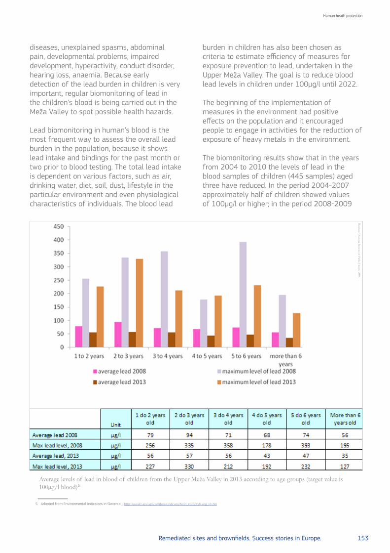
Remediated sites and brownfields. Success stories in Europe. 153
Human heath protection
5 Adapted from Environmental Indicators in Slovenia, , http://kazalci.arso.gov.si/?data=indicator&ind_id=600&lang_id=94
Average levels of lead in blood of children from the Upper Meža Valley in 2013 according to age groups (target value is 100µg/l blood)5.
diseases, unexplained spasms, abdominal pain, developmental problems, impaired development, hyperactivity, conduct disorder, hearing loss, anaemia. Because early detection of the lead burden in children is very important, regular biomonitoring of lead in the children’s blood is being carried out in the Meža Valley to spot possible health hazards.
Lead biomonitoring in human’s blood is the most frequent way to assess the overall lead burden in the population, because it shows lead intake and bindings for the past month or two prior to blood testing. The total lead intake is dependent on various factors, such as air, drinking water, diet, soil, dust, lifestyle in the particular environment and even physiological characteristics of individuals. The blood lead
burden in children has also been chosen as criteria to estimate efficiency of measures for exposure prevention to lead, undertaken in the Upper Meža Valley. The goal is to reduce blood lead levels in children under 100µg/l until 2022.
The beginning of the implementation of measures in the environment had positive effects on the population and it encouraged people to engage in activities for the reduction of exposure of heavy metals in the environment.
The biomonitoring results show that in the years from 2004 to 2010 the levels of lead in the blood samples of children (445 samples) aged three have reduced. In the period 2004-2007 approximately half of children showed values of 100µg/l or higher; in the period 2008-2009
Database/ N
ational Institute of Public Health/ 2014

154 Remediated sites and brownfields. Success stories in Europe.
Human heath protection
approximately one fifth of children and in the period 2010-2013 approximately one tenth of children showed such values. In the same period, the share of children with low levels (under 50µg/l) of lead in their blood increased; that share was more than 70% in 2010. After 2010 the blood lead levels didn’t decline anymore. From 2010 to 2013 (255 samples) the share of children with an increased level of lead in their blood was 9.1 to 14.2% and the share of children with low level of lead in their blood was 51.2 to 71.6%. In 2014 (66 samples) the share of children with high levels (100µg/l and more) of lead in their blood was higher (16.7%) than in the period from 2010 to 2013. The same applies for the average value (76.2µg/l), the geometric mean value (58.8µg/l) and the median (50µg/l). In 2008, a cross-sectional study about lead incidence was conducted in the framework of the annual programme of measures in order to detect the overall lead burden of Meža Valley children.
The study included children aged one to nine from the Upper Meža Valley and children aged three from the Lower Meža Valley. The study showed a significant higher burden in the Upper Meža Valley children. The highest levels of lead were found in the age group 2-3 years, which was followed by the age group 1-2 years. The calculation from the study showed that children in the Upper Meža Valley have five times higher risk for increased levels of lead in their blood in comparison to children from the Lower Meža Valley6.
The study was repeated in 2013. The values of lead in the blood were lower in the children from the Lower Meža Valley in comparison to children from the Upper Meža Valley. In comparison to the study performed in 2008, levels measured in 2013 show lower values. The average value, geometric mean value and the median were higher for all age groups of children (according
9 Ivartnik et al, 2010. Ivartnik M. in I. Eržen. Uporaba hmodela IEUBK za napoved vsebnosti
svinca v krvi otrok pri raziskavah in sanaciji okolja v Zgornji Mežiški dolini. Zdravstveno
Varstvo 2010; 49: 76-85.
10 Jakubowski, 2006. Jakubowski M. Development of a coherent approach to human monitoring
in Europe, D 6.1-6.3 Utility and sensitivity of biomarkers, ESBIO 2006.
to gender, age and place of living). The highest value was 393µg/l in 2008, and 330µg/l in 20135 . In addition to cross-sectional study in 2008 the “Paget’s disease and lead in the Upper Meža Valley” study has been conducted. Paget’s disease is a chronic disease of the skeleton with a localized disorder in bone remodelation. Etiology of the disease is not known, however lead is one of the possible causes for its occurrence.
The study confirms that the disease rate is significantly higher in the Upper Meža Valley than in other places of the region of Koroška and the rest of Slovenia. The results have shown that the prevalence of Paget’s disease in the Upper Meža Valley is 145.1/100,000, in the region of Ravne 3.0 /100,000, in the region of Maribor 2.5/100,000 and in the region of Ljubljana 1.5/100,0007.In the Upper Meža Valley, a study has been conducted in 2009, using the IEUBK model8. The study was used to evaluate the connection of the lead level in the blood of children aged three with the concentration of lead in the soil, house dust, air and drinking water and the location of living. The results have shown that children who live closest to the polluted area are the most exposed to lead and that each individual can influence the exposure to lead and its intake with proper hygiene, diet and hygiene of living spaces. Polluted soil and house dust are the most burdening factors9.
The occurrence of lead in a person’s body is unnecessary and unwanted. Research shows that even low levels of lead in the blood have negative impacts on children’s health and that it is not possible to determine a safe level of lead in blood. Research worldwide shows the connection between lead and pathologic symptoms for low levels such as 25µg lead/l of blood10, therefore it was suggested that the reference level of lead in
6 Hudopisk N. (2009). Prevalenčna študija obremenjenosti otrok Zgornje Mežiške doline s
svincem in program zmanjševanja škode za zdravje otrok v Zgornji Mežiški dolini zaradi
izpostavljenosti svincu, specialistično
7 Hudopisk N. (2008). Pagetova bolezen in svinec v Zgornji Mežiški dolini, diplomsko delo.
8 Cornelis et al, 2006. Cornelis C., Berghmans P., van Sprundel M., “et al”, (Oct 2006). Use of the
IEUBK Model for Determination of Exposure Routes in View of Site Remediation. Human and
Ecological Risk Assessment 2006; 12: 963–982.

Remediated sites and brownfields. Success stories in Europe. 155
Human heath protection
the blood of children and pregnant women should be reduced from 100 to 50µg lead/l of blood9. In 2012, CDC introduced the new reference level of 50µg lead/l to identify children with high blood lead levels. This level is based on the U.S. proposal for children aged 1-5. CDC is no longer using the term “level of concern” but the reference value to identify children who have been exposed to lead and who require case management11. In 2014, a comparison was made between burden of lead disease in children in smaller spatial zones.
On the territory of the municipalities of Mežica and Črna na Koroškem 24 spatial zones have been outlined. Individual zones include streets and villages that share not only geographical location, but also the similar lifestyle and potential sources of direct pollution from the near vicinity (industry, traffic). The children were located in individual zones according to their permanent address.
The comparison of the calculation of the average, geometric mean, median and the share of children with lead levels, ranged below 50, 50 to 99, 100 to 199 and above 200µg/l of blood, showed the highest burden of children’s disease by those who lived in the zones near current or past industrial plants, near older houses or buildings, where there are more macadam surfaces and where the highest levels of lead in the soil have been detected10.
The results
Conclusions
The results have shown that the highest decline of lead levels in blood was detected immediately after the beginning of the remediation measures. The measures were most intensively implemented at the beginning, due to a strong public support. Therefore, the measures had great success. Over the years, dynamic measure implementation
declined; their improvements and additional measures were not successfully continued. This stopped the decreasing trend of the lead levels in the blood. In 2014, even a slight raise in lead levels in blood was observed. For further progress it is essential to work more with small groups and with children individually (individual consultations at the children’s home environment). Also implementation of measures (remediation of soil, re-layering of macadam surfaces, management of facades, etc.) will be needed on private property. Measurements of lead in children blood and in the environment (air, soil, water, etc.) enable the evaluation and monitoring of the burden of diseases and are a basis for monitoring the occurrence and evaluation of the adequacy of implemented measures. Beside monitoring it is essential to implement programmes for the reduction of lead intake – raising awareness, information, motivation of the population to maintain high level of hygiene (personal hygiene and the hygiene of indoor and outdoor living spaces) and inclusion of healthy food (food with a lot of vitamin C and D, iron, calcium, proteins, etc.) in everyday diets.
Further readings
• Environmental Indicators in Slovenia. Share of blood samples in the three-year old children living in the Upper Meža Valley (target value is 100 µg / l blood); National Institute for Public Health, 2014:http://kazalci.arso.gov.si/?data=indicator&ind_id=600&lang_id=94
• Annual Air Quality Report 2013, Slovenian Environment Agency:http://www.arso.gov.si/zrak/kakovost%20zraka/poro%C4%8Dila%20in%20publikacije/kakovost_letna.html
• Environmental indicators in Slovenia,http://kazalci.arso.gov.si/?
11 New Blood Lead Level Information, CDC,
http://www.cdc.gov/nceh/lead/acclpp/blood_lead_levels.htm
12 Pavlič H. (2014). Primerjava obremenjenosti otrok s svincem po conah in predlogi ukrepov za
zmanjšanje izpostavljenosti, diplomska naloga

156 Remediated sites and brownfields. Success stories in Europe.
Human health protection
LOCATION Fribourg, Switzerland
POLLUTANT Lead and antimony
SOURCE Disused civilian shooting range
GENERAL CLEAN UP OBJECTIVES Protect the drinking water and the land in agricultural use
REMEDIATION ACTIONS Soil excavation, treatment and disposal of soil contaminated
SITE/END USE Water supplies and agricultural lands
SOCIAL-LEGAL ISSUES Human health concern
KEY LEARNING/EXPERIENCE TO
SHARE
The sometimes manual cleanup of smaller lead-hotspots in the forest using metal detectors and magnets proved its worth
2. Remediation of a 300-metre shooting range in the canton of Fribourg, Switzerland

Remediated sites and brownfields. Success stories in Europe. 157
Human heath protection
The study case
Approximately 8 million bullets were fired on a civilian 300 - meter shooting range in a medium-sized community in the canton of Fribourg between its opening in 1914 and its closure at the end of 2005.
The problem
Using information from the historical pollution investigation as to the amount of ammunition used, it was considered that 58 tonnes of lead had been shot there. The heavy metals lead (Pb) and antimony (Sb) that were contained in the projectiles landed mainly in the ground directly beside the slope that served as a backstop. The installation had frequently been extended over the course of decades and comprised over 60 targets with a correspondingly large number of impact points in the backstop. This area was heavily contaminated before remediation and is located
in close vicinity to a drinking water collection point that supplies the community with drinking water.
The strategy
This situation could not be tolerated. Remediation to protect the drinking water and the land in agricultural use was crucial.
Tracking down the lead with metal detectors
The canton authorities determined on the basis of a risk assessment that the remediation objective should be for the soil in the nearby water protection zone to contain no more than 200 milligrams of lead per kilo (mg Pb/kg) and in the forested extended protection zone a maximum of 1000mg Pb/kg. The contaminated material with higher concentrations was excavated and then treated and disposed of
Shooting range from the access road during remediation work. The bullets were deflected far into the forest, so that trees had to be felled (in the water protection zone).
Christoph Reusser NRC Soil SwitzerlandFederal Office for the Environment FOEN CH-3003 Bern Switzerland
Romano Dalla Piazza Chef du secteur sites pollués Service de l’environnement SEnSection déchets et sites pollués Impasse de la Colline 4 CH-1762 GivisiezSwitzerland
Janine Zürcher Collaboratrice scientifique Service de l’environnement SEnSection déchets et sites polluésImpasse de la Colline 4 CH-1762 GivisiezSwitzerland
Beat JordiSalomegasse 152503 BielSwitzerland
[email protected]@[email protected]
© Federal O
ffice for theEnvironm
ent FOE
N, 2012/Photostock
Thomas LepkeScientific officerContaminated Sites Section Federal Office for the Environment FOEN CH-3003 BernSwitzerland

158 Remediated sites and brownfields. Success stories in Europe.
Human heath protection
Individual small hotspots are identified with the metal searching device.
Former indicator and indicator trench with decontaminated earthen backstop.
in accordance with legal requirements and the latest technology. The less contaminated areas at the forest edge had to be manually cleaned sometimes – using metal detectors and magnets among other things. The final touch was given to the works carried out in 2012/13 when the previously cleared slope was re-forested.
The results
Laboratory analysis of control samples taken after remediation confirm that the remaining pollution is under the Pb concentration levels required as a remediation objective, which was a qualification for the payment of subsidies in accordance with the OCRCS. When shooting ranges are situated in groundwater protection zones, the Confederation
contributes to the costs of inspection and remediation, if no more waste from shooting enters the soil, which has happened since the end of 2012. The reason is the Art. 32e para. 3c 1 of the Swiss Environmental Protection Act1: the Confederation uses the income from the charges exclusively to pay the costs of the following measures: the investigation, monitoring and remediation of polluted sites at shooting ranges that do not serve a predominant commercial purpose if they are in groundwater protection zones. As a consequence, no further waste has been deposited after 31 December 2012. The Confederation paid 40% of the costs totalling around 1.8 million CHF.
1 https://www.admin.ch/opc/en/classified-compilation/19830267/index.html
© Service de l’environnem
ent SEn, C
anton of Fribourg, 2012/Photostock©
Service de l’environnement SE
n, Canton of Fribourg, 2012/Photostock

Remediated sites and brownfields. Success stories in Europe. 159
Networking
1. Slovakia: Information system on contaminated sites
2. Denmark: Access to test sites for investigation and remediation technology
3. Italy: Risk assessment of the large polluted area in the municipality of
Portoscuso

160 Remediated sites and brownfields. Success stories in Europe.
Networking
LOCATION Multiple location, Slovakia
POLLUTANT Unspecified
SOURCE Unspecified
GENERAL CLEAN UP OBJECTIVES
Collecting information on harmful effects upon the health of the public and the quality of environment
REMEDIATION ACTIONS Building a database of contaminated sites
SITE/END USE Information system of contaminated sites
SOCIAL-LEGAL ISSUES Land reclamation
KEY LEARNING/EXPERIENCE TO
SHARE
New opportunities for networking an exchange of information between stakeholders
1. Information system on contaminated sites in Slovakia

Remediated sites and brownfields. Success stories in Europe. 161
Networking
The study case
The Information System of Contaminated Sites (ISCS) represents a basic and official platform for records of contaminated sites in Slovakia. A register of contaminated sites, supports the content of the information system. It records the life cycle of contaminated sites (CS) and all information resulting as a consequence of processes defined by Act no. 409/2011. A register of contaminated sites consists of section A - comprising records of potentially contaminated sites, section B - comprising records of contaminated sites and section C - comprising records of remediated and reclaimed localities. The project of ISCS integration with registers or databases of the Slovak Ministry of the Environment and other government departments was launched in 2010. As a result of feasibility study 13 registers were chosen and integrated with ISCS. The network of the services for the spatial data sets and services have been created in accordance with Directive 2007/2/EC of the European Parliament and of the Council of 14 March 2007 establishing an Infrastructure for Spatial Information in the European Community (INSPIRE) - discovery, view, download and transformation services.
Wheretofindinformationoncontaminated sites
A contaminated site is defined as a site where hazardous substances caused by human activities pose a significant risk to human health or to the environment, soil and groundwater, except environmental damage. ISCS is a part of the public administration information system according to paragraph 20a, section 1 of the Act no. 569/2007 on geological work (geological law) as amended (onwards referred to as ‘Act no. 569/2007’). The basic components of ISCS are stated in a regulation of the Slovak Ministry of the Environment, no. 51/2008 as amended, which implements the geological law. They are:
a) A state program for contaminated site remediation.
b) A register of documents related to contaminated sites.
c) A register of contaminated sites, consisting of:
1. Section A - comprising records of potentially contaminated sites,
2. Section B – comprising records of contaminated sites,
3. Section C – comprising records of remediated and reclaimed localities.
Ing. Katarína Paluchová.Section of Environmental Sciences and Project ManagementIng. Erich Pacola, PhD.Datacenter-Centre of Environmental Data and Information ServicesSlovak Environment Agency Slovakia
Ground water monitoring systems close to contaminated site SN (003)/Krompachy-Halňa1
©Slovak E
nvironment A
gency/Photostock
[email protected]@sazp.sk
1 Accredited administrator of content: Operators of industrial concerns, landfills, tailing ponds.
Technical operators: Water Research Institute, Bratislava. Website http://bodove-zdroje.vuvh.sk/
IMZZ-Portal/

162 Remediated sites and brownfields. Success stories in Europe.
Networking
Since 2010, a significant amount of work has been carried out on various of the ISCS services. They are currently operational and make up an integral part of the information system. The basic applications and content of the ISCS, comprise the following services:
1. An Enviroportal, which serves as the common internet access point designed to provide environmental information and E-services. In terms of development concepts at the Ministry of Environment, for the years 2014 to 2019, it is defined as a second level portal of the Central Government Portal.
2. A Register of contaminated sites. It records the life cycle of CS and all information resulting as a consequence of processes defined by Act no. 409/2011. The register enables the search and subsequent presentation of descriptive information on CS in the form of lists, reports and registration sheets of information that can be displayed in the form of maps and spatial data positioned on these maps.
3. An atlas of remediation methods, completed in 2011 by the State Geological Institute of Dionýz Štúr. It contains a series of remediation methods for the elimination of contaminated sites and is accessible to the general public in the form of a web application. The application enables the user to search for information according to the type of remediation method and contaminating substance. It interactively connects to remediated localities contained in the Register of contaminated sites, including appropriate methods of remediation applied at the given localities.
4. Under the direction of the Ministry of the Environment, Act no. 569/2007: a register of professional competence (i.e. register of acknowledged specialists competent to undertake geological work) and a register of geological licenses (i.e. register of geologically authorised individuals, entrepreneurs and legal persons). It
contains indexes of the aforementioned who have the right to perform geological work in the territory of the Slovak Republic and a list of competent specialists complete with their contact details.
5. An integrated application interface which accesses, via the ISCS, information held in other data sources, consisting of relevant databases and registers of the Public Administration Information System, (onwards referred to as PAIS). This is an interface (web services and spatial network services) which enables exchange of records between registers of data sources and the ISCS. Mutual communication of the application interface for administration of these records happens in actual time and is independent of the active participation of users.
Register and database with ISCS
Based on the results of a feasibility study, a process was launched which output was the contractual arrangement of technical work for the connection of ISCS with data sources which are administered by the Slovak Ministry of the Environment and the Slovak Ministry of Agriculture and Rural Development. The connected systems were arranged into the following groups:
• Records of monitoring systems:
- Integrated monitoring of pollution sources - Partial monitoring system of geological
factors - Subsystem 03, anthropogenic sediment
character of old contaminated sites - Partial monitoring system - soil - Technical and safety supervision of Slovak
water construction
• Records of protected areas of the Slovak Republic:
- State list of specially protected parts of the countryside - protected areas and protected trees section
- EU member’s network of nature protection

Remediated sites and brownfields. Success stories in Europe. 163
Networking
areas - NATURA 2000 - A register of Ramsar Wetlands, UNESCO
heritage sites and Biosphere reservations.
• Records for the support of environmental legislation:
- Geofond digital archive - Information system for the management of
mining waste - Information system for the prevention of
major industrial accidents - Register of landfill sites
• Basic spatial register and large scale maps:
- Digital orthophoto maps and detailed panoramic images of streets and roads of the Slovak Republic (Google Slovakia Ltd.)
- Digital vector cadastral maps (Geodetic and Cartographic Institute, Bratislava)
Integrated monitoring of pollution sources
The aim of this system is to document and differentiate potential and actual point source pollution on the basis of monitoring groundwater which is close to potential polluters (industry, waste tips, tailings ponds, etc.). Based on data, it determines effects on ground water due to the activities of such operators. It comprises data from the monitoring of ground water which, although not regulated, is implemented for internal or other reasons by the company.
Contaminated site “NZ (037)/Tvrdošovce - landfill site NNO” in a Special Protection Area (Dolné Považie) and nearby Panské lúky, a Special Area of Conservation2
©Slovak E
nvironment A
gency/Photostock
2 Administrator of content: The Slovak Museum of Nature Protection and Speleology, Liptovský
Mikuláš. Technical operator: The Slovak Environment Agency - DATACENTRE, Banská Bystrica
Webpage of data sources: http://uzemia.enviroportal.sk/ ; http://stromy.enviroportal.sk/
This has arisen on the basis of the Water Framework Directive 2000/60/ES in order to achieve good water quality before 2015. The reason and purpose for the connection with the ISCS are the monitoring of objects, recorded by means of a database, provide supplementary assessment of the chemical status of groundwater in an area or close to an area classified as CS. Experts and the general public may obtain information concerning the exceeding of specific limits by means of chemical indicators for the last five years and the assessed development trend of these indicators.
The state list of specially protected parts of the countrysideprotected areas and protected trees
These are administrative records of protected areas and trees, and their protected zones in the Slovak Republic. Records currently consist of:
• A growing catalogue of protected areas and protected trees, which entered chronologically
• A database of protected areas and protected trees
• A collection of documents on protected areas and protected trees.

164 Remediated sites and brownfields. Success stories in Europe.
Networking
The eason and purpose in connection with the ISCS: areas classified as being CS may also be included in the category of nationally protected areas as defined by Act no. 543/2002 on nature and landscape protection. In these areas a conflict of interest between two laws occurs. Professionals and the general public alike may obtain detailed spatial, descriptive and pictorial information on protected areas or trees, as well as access to a digitalised collection of documents.
Registeroflandfillsites
This register oversees all registered landfill sites in the Slovak Republic. Intensive work on it began in 1992; in order to cover the whole area of Slovakia, the Slovakian geological office mapped appropriate sites for landfill (Scale 1:50 000). As a part of this project, a register of landfill sites in all districts was generated at 1:10 000 scale. The register was one of the most important sources of data for the systematic identification of CS in Slovakia. The reason and purpose in connection with the ISCS: an area classified as environmental-ly contaminated may also be a place where equipment is available for treatment of municipal waste, that is, a place where long term storage on the surface or in the ground takes place. Professionals and the public obtain descriptive information on municipal landfills, especially concerning the character of waste being kept.
Digital vectorised cadastral maps
Clearly defined property ownership rights of individuals and legal persons concerning real estate and the rapid gaining and clarification of information relating to ownership rights are key pillars of the rule of law. A basic record and spatial entity of any Public Administration Information System related to property and its related spatial geometrical boundary. Access to basic spatial data records (Land Register), which provides information on geometrical determination, inventories and descriptions of properties, is an unavoidable prerequisite for the process of mutual exchange of records between public institutions, individuals and organisations. Fulfillment of the above mentioned prerequisites, led to the integration of vector cadastral maps (register C land plots) and maps of unspecific
Identification of land plots affected by contaminated site “B2 (013)/Bratislava-Ružinov- Slovnaft - surrounding area of the company”. Connection to the Cadastral portal and verification of ownership rights3
boundary extent (register E land plots) in the ISCS application interface. Maps were made accessible on the basis of a contractual agreement between the Ministry of Environment and the Geodetic and Cartographic Institute, Bratislava (Contract no. 97–31–13524/2006 on the provision of bulk data by the Land Register, whereby updating of data shall occur yearly). Inventory and descriptive information on ownership rights of property is obtained according to the level of interconnection of the ISCS user interface and the Cadastral Portal which serves as the official access point to Cadastral information of the Slovak Republic.The reason and purpose for connection with the ISCS: professionals and the general public are able to identify cadastral areas and specific land plots where environmental contamination may be found or even determine ownership rights of the plot under question. This identification, however, is only of informative
©Slovak E
nvironment A
gency/Photostock
3 Administrator of content: Cadastral Offices of the Slovak Republic.Technical Operator: Geodetic
and Cartographic Institute Bratislava: http://www.katasterportal.sk/kapor/

Remediated sites and brownfields. Success stories in Europe. 165
Networking
character. The presence of a contaminated site, (pollution in bedrock, groundwater or ground) in a land plot area or across more land plots, must be verified and confirmed by a geological survey of the environment.
Experience gained from undertaken work
The integration of systems, up to the present, is among the most difficult projects undertaken within the Slovak Environment Agency. Due to the diversity of systems included in the project, it was necessary to bring together experts, despite the wide variety of addressed domains and utilised technologies. The most difficult part, however, was not the technical realisation of work. Above all, integration required complex organisational arrangement of work. Domain experts from each organisation had to be involved in the project, as well as administrators of existing systems and developers (own employee, but also from external sources). It was shown that processes which solved integration were not limited only to one section or department connected to the organisation (e.g. department of IT). On the contrary, process solving occurred across the whole organisational structure, that is, through every organisation, which in the end meant the solving of unforeseen events. In spite of this, realisation of the project contributed to the improvement of information exchange between public administration bodies, as well as towards the general public. Development of an application interface will enable easier and more effective implementation of new requirements in the future. (e.g. eGovernment activities).
Further readings
• Pacola, E., et al. Information system of environmental burdens as a support tool of processes of the Act No. 409/2011 Coll. on some measures in the field of environmental burdens, In: 26th International Conference on Informatics for Environmental Protection, August 29 - 31, Dessau, Germany, 2012 pp. 159-167
• Helma, J., Paluchová, K. Brucháneková, A., et al. Regional environmental impact assessment studies of the contaminated sites in selected regions - Slovak republic. General
evaluative report of SR. Project: Regional Environmental Impact Assessment Studies of the Contaminated Sites in Selected Regions. Slovak Environment Agency. 2010.
• A register of contaminated sites - Web form application: http://envirozataze.enviroportal.sk/
• A register of contaminated sites - Web map application: http://envirozataze.enviroportal.sk/Mapa/
• An atlas of remediation methods: http://envirozataze.enviroportal.sk/Atlas-sanacnych-metod
• A register of professional competence: http://envirozataze.enviroportal.sk/Register-odbornych-sposobilosti
• A register of geological licenses: http://envirozataze.enviroportal.sk/Register-geologickych-opravneni/Fyzicka-osoba, http://envirozataze.enviroportal.sk/Register-geologickych-opravneni/Pravnicka-osobaAn integrated application interface web services:http://envirozataze.enviroportal.sk/AtributoveUdaje.aspxSpatial network services: http://envirozataze.enviroportal.sk/PriestoroveUdaje.aspxRegister of landfill sites: http://envirozataze.enviroportal.sk/ZaznListSkladky.aspx?RegistracneCislo=4657Integrated monitoring of pollution sources:http://envirozataze.enviroportal.sk/MonitorovacieObjekty.aspx?Id_Zataz=-1&Id_Zaradenie=-1&Id_Lokalita=14062808&Id_Objekt=1240421318

166 Remediated sites and brownfields. Success stories in Europe.
Networking
LOCATION Multiple locations, Denmark
POLLUTANT PAH, BTEX, phenol, cyanide, heavy metal, chlorinated solvents
SOURCE Gasworks, tar and asphalt roofing factory, dry cleaning, waste disposal site
GENERAL CLEAN UP OBJECTIVES
Reduce groundwater and soil contamination. Provide easy and free access for national or international technology developers and researchers
REMEDIATION ACTIONS
Surface water studies, monitoring contaminants, electrokinetic bioremediation, pump and various treatments of water and air. Electrokinetic chemical remediation, microwave heating, various investigation and sampling methods
SITE/END USE Database of test sites to exchange information about soil remediation
SOCIAL-LEGAL ISSUES Land reclamation
KEY LEARNING/EXPERIENCE TO SHARE
Testing new remediation techniques, promoting networking and engagement with research institutions
2. Access to test sites for investigation and remediation technology in Denmark

Remediated sites and brownfields. Success stories in Europe. 167
Networking
The study cases
When testing a new method of either remediation or investigation it is often a problem to get site access. But the five Danish regions either own or have access to some well documented, heavily contaminated sites, which are used for the development and demonstration of new environmental technology. The five sites, shown in the table Summary of site characteristics, represent variable geology and different groundwater conditions, and their contaminants have different chemical compositions. Extensive data for the site conditions is available. Combined, the sites complement one another and provide options for testing many scenarios. The network of test sites has been established to encourage and facilitate the development, demonstration and maturation of new techniques for the investigation and remediation of soil and groundwater contamination – with a particular focus on competitive and cost and resource-efficient solutions. There may be facilities such as office space, WI-FI and meeting facilities on some of the sites as well as projects in progress with staff present. The test site facilities are made available through the Danish Soil Partnership, which serves as a single point of entry for environmental technology companies, contractors and consultants as well as research and educational institutions involved with the development of new methods and new technology. The aim has also been to establish a showcase for soil contamination solutions. The regions bring together multiple stakeholders – public administrations and private companies – to collaborate, and thus expand the opportunities for Public-Private Partnership
Location of test sites
Christian Andersenchief advisor at Danish Regions-Resources and EnvironmentDenmark
(PPP) and Public-Private Innovation (PPI). Through its collaboration with public and private partners, the Danish Soil Partnership aims to attract interested parties to testing, developing and documenting solutions.
Further readings
www.danishsoil.orghttps://stateofgreen.com/en/sectors/environment-and-resources
Summary of site characteristics Database/DSP
© D
SP/Photostock

168 Remediated sites and brownfields. Success stories in Europe.
NETWORKING
LOCATION Sardinia, Italy
POLLUTANT Heavy metals: As, Cd, Hg, Pb, Sn, Zn, Cu, V. High organic content, inorganic compounds: Pb, Cd, As, Al and F
SOURCE Big metallurgic industrial pollution and industrial and urban waste
GENERAL CLEAN UP OBJECTIVES Risk assessment of groundwater and soil contamination
REMEDIATION ACTIONS Not considered in the study
SITE/END USE Future development of a wind plant
SOCIAL-LEGAL ISSUES Land reclamation
KEY LEARNING/EXPERIENCE TO
SHARE
A new integrated risk assessment approach with stakeholder involvement. New site assessment including different management aspects: human health risks, selection of the best options for remediation, socio-economic constraints and planning issues
3. Risk assessment of the large polluted area in the municipality of Portoscuso, Italy

Remediated sites and brownfields. Success stories in Europe. 169
Networking
The study case
Introduction
The pollution of soil and groundwater caused by abandoned waste disposal sites and contaminated industrial areas is a complex environmental problem in all industrialized countries. Risk assessment is considered a very useful tool in environmental policy because it promises a rational and objective basis for priority setting and decision making. In particular for large contaminated areas or megasites, generally characterized by a wide extension, multiple and differentiated sources and different land uses, risk assessment may orient investigation and remediation to “critical areas”, avoiding the collection of a large amount of information to identify real pollution problems and remediation needs. Management of megasites should account for environmental and health risks as well as economic and social costs. Their efficient and sustainable revitalisation
The problem
The potentially contaminated area of the municipality of Portoscuso (South-West Sardinia) has been included in the National Priority Sites List “Sulcis Iglesiente Guspinese” because of the presence of a big metallurgic industrial district. The “Portovesme industrial district” is characterized by the following potentially polluting activities2:
• Production of primary aluminum and related manufactures (laminates);
• Production of non ferrous metals (sulfuric acid, copper cement, cadmium, metallic mercury, lead, sponge cadmium, copper spume, zinc);
• Power production from combustion of coal and fuel oil;
• Disposal of red muds resulting from bauxite refining processes;
Antonella VecchioSoil ProtectionDepartmentInstitute for Environmental Protection and Research (ISPRA). Italy
Maurizio GuerraSoil Protection DepartmentInstitute for Environmental Protection and Research (ISPRA). Italy
Gianfranco MulasEnvironment UnitMunicipality of PortoscusoItaly The Municipality Portoscuso potentially contaminated
area: sampling points of the investigation plan1
[email protected]@isprambiente.it
1 ISPRA and Portoscuso Municipality (2010). Characterization Plan of areas external to the
Portovesme industrial district - Results of investigations and Risk assessment - Final Report
(in Italian).
requires innovative investigation plans as well as integrated assessment approaches in order to promote sustainable redevelopment.

170 Remediated sites and brownfields. Success stories in Europe.
Networking
• Metallurgic waste disposals;• Disposal of cinders from combustion plants.
The surrounding areas are principally used for agricultural purposes (production of vegetables and vineyards), but two residential agglomerates (Portoscuso and Paringiaunu) and a naturalistic valuable area (Boi-Cerbus Lagoon) are also present.The conceptual model of soil contamination indicates a diffuse passive contamination mainly caused by emissions from the industrial district and the contaminated soil may be the primary source of groundwater contamination up gradient the Portovesme area2.
However, the geological and hydrogeological context indicates also a natural geochemical contribution to the diffuse presence of inorganic substances (metals, metalloids and other inorganics) in soil and, to a minor extent, in groundwater.
Results of site investigation
The whole municipal territory outside the industrial area (30km2) has been investigated between July 2009 and March 2010. Investigations included:
Vertical contamination pattern of Pb. The significant decreasing of concentration with depth is emphasized. As reference, the depth-non sensitive pattern is reported for As, whose origin is not related to the fall out from industrial district.
• 62 surface probes (0-1.5m below ground);• 139 intermediate probes (from ground to
capillary fringe);• 66 piezometers: 40 surface piezometers (up
to 15-25 m below ground level ) and 26 deep ones (up to 40-133m below ground).
As the Portovesme industrial district is thought to be the main source of the potential contamination of the investigated area, through transport and deposition of dusts, a “concentric” sampling was planned according to a systematic-random pattern (i.e. each sampling station was located within a cell mainly on the basis of logistical considerations).
The sampling pattern included:
• A closer or inner gridding (250 x 250m) within a 1km wide belt outside the industrial district boundary; it provided 219 sampling stations
• A wider or outer gridding (500x500 m) was planned outside the 1 km wide belt provided 81 sampling stations
• At each sampling station, 3 or more samples of unsaturated soil were taken, typically:
- Top soil sample (0-0.1m depth) - TS;- Surface soil sample (0-1m depth) - SS;- One or more deep soil samples (1-2m
depth, up to 24-25m) - DS.2 APAT (2008). Characterization Plan of areas external to the Portovesme industrial district-
Portoscuso Municipality (in Italian).

Remediated sites and brownfields. Success stories in Europe. 171
Networking
3 Chéry, L. (2006). Qualité naturelle des eaux souterraines. Méthode de caractérisation des états
de référence des aquifères français, Guide technique. BRGM édition.
4 Vecchio, A., Fratini, M., Guerra, M., Calace, N. (2010). Italian Guidelines for the evaluation of
background values in groundwater, Report of the Joint NICOLE - COMMON FORUM Workshop:
Contaminated land management: opportunities, challenges and financial consequences of
evolving legislation in Europe, pp.21-23.
The groundwater chemical investigation included, in addition to contaminants of interest, physical/chemical parameters (temperature, redox potential, electric conductivity, pH, dissolved oxygen), total suspended soils and major ions (K+, Na+, Mg2+, Ca2+, Cl-, SO4
2-, HCO3-, NO3
-)3, 4 .Results of the investigation in the areas
surrounding the industrial district confirmed a diffuse presence in soil of heavy metals (As, Cd, Hg, Pb, Sn, Zn), above the screening values (Contamination Threshold Concentrations – CTCs) all over the investigated area. Limited presence in few samples for Cu and V has been recorded. For some of the diffuse elements (Zn, Pb and
From top to bottom and from left to right: Distribution of pH (a), redox potential (b), electric conductivity (c), As (d), Cd (e) and Pb (f) in groundwater inside the Portovesme industrial district.

172 Remediated sites and brownfields. Success stories in Europe.
Networking
Investigation of the whole area
Simplified site specific risk assessment
Detailed investigation in critical areas
Identification of “critical areas” Identification of not contaminated areas
Redevelopment/Land use change
Detailed site specific risk assessment
Integrated approach for investigation and risk assessment applied at diffusely large contaminated area of Portoscuso Municipality
Cd), the contamination pattern is characterized by an impressive trend decreasing with sampling depth. This is indicative of a top soil (TS) and surface soil (SS) contamination mainly due to fallout from the industrial district, while in deep soil (DS) the presence of contaminants may be correlated to the natural background. For As the diffuse presence in soil seems to be originating from the background. For Hg, Cu and V it is not possible to define a clear origin.
The hydrogeological scenario is characterized by the presence of a not-continuous shallow aquifer hosted in Quaternary deposits (mainly sands) and of a deep one in the Cenozoic pyroclastic fractured rocks. The connection between the two aquifers is not clear, also influenced by local stratigraphy and time-dependent groundwater recharge5.
Inside the industrial district, groundwater within the shallow aquifer is characterized by a low oxidation level and reducing conditions, with an increase of pH and electric conductivity and a decrease of dissolved oxygen and redox potential down gradient. This situation is typical of shallow coastal groundwater with a low flow and limited recharge, but it can be amplified by the discharge of urban or industrial wastewaters with high organic content. Concentrations of inorganic compounds (Pb, Cd, As, Al and F) in
groundwater entering the industrial area are less than screening values, but an enrichment in these elements is registered down-gradientwith exceeding of screening values. Besides a diffuse presence in soil, Zn, Pb, Cd were found below screening values in the groundwater up-gradient the industrial district; the contaminants exceeding thoroughly the CTCs were only Mn and SO4. For such chemicals the evaluation of groundwater background concentracion confirmed that their presence is associated to natural sources6
The strategy
Firststageofsitespecificriskassessment
According to the Italian legislation on contaminated sites management (Legislative Decree 152/2006 Part IV, Title V), a site-specific human health risk assessment has to be carried out in order to assess the need for remediation also outside the industrial district. A stepwise approach has been adopted as a basis for both site investigation and risk assessment. The major problem in the application of risk assessment to a diffusely polluted large area, is to account simultaneously for the spatial distribution of soil contamination and for the land use. An innovative integrated approach has been
5 ISPRA and Portoscuso Municipality (2010). Characterization Plan of areas external to the
Portovesme industrial district - Results of investigations and Risk assessment - Final Report (in
Italian).
6 Vecchio, A., Guerra, M., Mulas G. (2012). Manganese and Sulphate background in groundwater at
Portoscuso (Sardinia): a tool for water management in a large contaminated area. in Quercia, F.F.
and Vidojevic, D. (eds) Clean Soil and Safe Water, NATO Science for Peace and Security Series C:
Environmental Security, pp.77-90. Springer.

Remediated sites and brownfields. Success stories in Europe. 173
Networking
adopted to account for land use, geological setting and spatial distribution of soil contamination. The proposed approach adopted a parameterization of source geometry and exposure scenarios more conservative than the traditional risk assessment, that is generally limited to the scale of a single area defined by property boundaries. This methodology is more similar to a “generic” and “simplified” risk assessment, even if many parameters (organic carbon content, soil/water partition coefficient, hydraulic conductivity, soil texture) have been derived from site specific measurements (go on see reference 1 in page 169). This conservative approach allows to assess a large potentially contaminated area identifying “critical sub-areas” that are suitable for a more detailed investigation and assessment according to critical exposure pathways (i.e. those posing the highest risk). After this “simplified” assessment with a very conservative approach, areas posing no significant risk to human health or the environment may be definitely declared as “not contaminated” without any other investigation or monitoring required.
In case of a diffuse presence of contaminants in soil, point data may be associated to a wider area identified with Thiessen polygons on the basis of the sampling strategy. Within each Thiessen polygon, it is reasonable to consider a uniform chemical concentration in each homogeneous soil layer (top soil, surface soil, deep soil). Given this conservative assumption on contamination spatial distribution, the differences in human exposure depend only on land use. Therefore on the basis of land use within the Thiessen polygon, different sub-areas for human exposure evaluation are defined. The conceptual model adopted on the basis of land use is indicated in the next table (see page 174). Regarding agricultural and pasture land use a specific assessment on the soil to plant uptake pathway, involving vegetables produced, vineyards and grass consumed by animals (mainly sheep) has been carried out. The quality of vegetables, food products for human consumption and grasses consumed by animals has been evaluated according to the following criteria: compliance with current national
Thiessen polygons + Land use
Sub area 2: Residential scenario
Sub area 3: Natural scenario (recreartional)
Sub area 4: Pasture scenario
Sub area 5: Natiral scenario (recreational)Sub area 6: Pasture scenario
Sub area 1: Agriculture scenario
P101Polygon
P101
Methodology for the evaluation of spatial soil contamination together with land use (human exposure) at Portoscuso site
Thiessen polygons + Emerging lithologies
P75
Sands –aeolian deposits
Aeolian sands and sandstones Eluvial-colluvial deposits
Ingimbrites
Polygon P75
Methodology for the evaluation of spatial soil contamination together geological setting (groundwater protection) at Portoscuso site.

174 Remediated sites and brownfields. Success stories in Europe.
Networking
and European legislation on food products or evaluation of human exposure to chemicals via vegetable/food ingestion7. For the assessment of potential risks to groundwater resources associated to soil contamination, the geological variability within each Thiessen polygon should be accounted in the methodology for the evaluation of spatial soil contamination. For the evaluation of the soil-to-groundwater leaching pathway an “average” geological setting is defined taking into account the properties of the different lithologies weighed on the surface of the emerging layers.
The results
The results of risk assessment identified a large portion of the studied area as not contaminated, i.e. no longer posing significant risks to human health and/or the environment. However in some residential areas, or areas where the agricultural scenario has been integrated with the residential one, the Risk Threshold Concentrations (RTCs, derived from the site-specific risk assessment, indicating non acceptable risks) of Pb, Cd, and
As were exceeded. For Pb, Cd, and As critical pathways are direct contact with TS and soil to groundwater leaching for SS and DS. For Hg critical pathways are indoor and outdoor air inhalation. No significant risk has been estimated for vegetable/food ingestion. For resident population, the highest estimated intake, via vegetable consumption, was for Pb and Cd, while intake of Zn and As was very low7.
Management of risks and further assessment
A big part of the investigated area of the municipacily of Portoscuso has been involved in a redevelopment project for a big wind plant.
The energy companies interested in redevelopment have been involved since the first stage of site characterization. To areas where the wind plant has to be realised, even if many of them were already declared “not contaminated” after the first stage of risk assessment, a second stage of site-specific risk assessment was applied taking into account specific installations
7 Beccaloni, E., Vanni, F., Beccaloni, M., Carere, M. (2013). Concentrations of arsenic, cadmium, lead
and zinc in homegrown vegetables and fruits: Estimated intake by population in an industrial-
ized area of Sardinia, Italy. Microchemical Journal, Volume 107, 190–195.
Compliance with GW target valuesSoil to groundwater leaching form surface Groundwater
protection
Quality of grass consumed by animalsFood chain
Adults and Children (exposure frequency reduced to 1,5 hr/day)
Direct contact (for TS only)Outdoor vapour and powders inhalation (for SS and DS)
Pasture activities
Adults and Children (exposure frequency reduced to 1,5 hr/day)
Direct contact (for TS only)Outdoor vapour and powders inhalation (for SS and DS)
Naturalistic (recreational)
Quality of vegetables and food products for human consumption
Vegetables/food ingestion
WorkersDirect contact (for TS only)Outdoor vapour and powders inhalation (for SS and DS)Indoor vapour inhalation (for Hg in SS and DS only)
Agricultural activities
WorkersDirect contact (for TS only)Outdoor vapour and powders inhalation (for SS and DS)Indoor vapour inhalation (for Hg in SS and DS only)
Industrial Commercial
Quality of vegetables and food products for human consumption
Vegetables/Food ingestion
Adults and ChildrenDirect contact (for TS only)Outdoor vapour and powders inhalation (for SS and DS)Indoor vapour inhalation (for Hg in SS and DS only)Residential +
Agricultural activities
Adults and ChildrenDirect contact (for TS only)Outdoor vapour and powders inhalation (for SS and DS)Indoor vapour inhalation (for Hg in SS and DS only)
Residential
ReceptorsPathwaysScenario according to land use
Conceptual model for human health risk assessment and for groundwater protection

Remediated sites and brownfields. Success stories in Europe. 175
Networking
and related activities according to the project.The new risk assessment confirmed the results of the first one and after limited interventions in some “critical areas” (sub-areas where RTCs are exceeded), the wind park, the biggest in Italy, was completed in 2012. Regarding other critical sub-areas, a detailed investigation has been planned in order to better investigate:
• Distribution of contamination, especially for areas where no soil sample is available.
• Exposure conditions (e.g. real residential use also in agricultural areas, presence or planning of buildings)
• Presence of volatilization and leaching transport pathways with leaching tests, soil gas and flux chambers sampling.
After a first assessment of real exposure conditions in critical areas, some critical exposure pathways (e.g. indoor air inhalation) have been excluded from human health risk evaluation.A second phase of detailed investigation focused on specific transport pathways is ongoing. The second stage of site-specific risk assessment will be applied on the basis of the results of detailed investigations.
Conclusions
In the management of large contaminated areas the definition of specific tools and strategies is required in order to manage uncertainties related to complex contamination patterns and to identify real pollution problems and remediation needs. In the case of the municipality of Portoscuso an integrated risk assessment approach, from the delineation of the conceptual site model in the investigation plan to the evaluation of risks according to different geological setting and land uses, oriented investigation and remediation to “critical areas”. This integrated approach avoided the collection of large amount of information and focused interventions where needed. Regarding site management, the integration of all the different management aspects (the management of human health risks, the selection of the best options for remediation, the socio-economic constraints, the planning issues), allowed a new economic development of a great part of the potentially area.
Moreover the active involvement of all the stakeholders in the decision process has proven to be an important aspect in order to successfully combine remediation plans and redevelopment issues.
Further readings
• APAT (2008). Characterization Plan of areas external to the Portovesme industrial district - Portoscuso Municipality (in Italian).
• Beccaloni, E., Vanni, F., Beccaloni, M., Carere, M. (2012). Concentrations of arsenic, cadmium, lead and zinc in homegrown vegetables and fruits: Estimated intake by population in an industrialized area of Sardinia, Italy. Microchemical Journal, Volume 107, 190–195.
• Chéry, L. (2006). Qualité naturelle des eaux souterraines. Méthode de caractérisation des états de référence des aquifères français, Guide technique. BRGM édition.
• ISPRA and Portoscuso Municipality (2010). Characterization Plan of areas external to the Portovesme industrial district - Results of investigations and Risk assessment - Final Report (in Italian).
• Italian Parliament, (2006). Legislative Decree 3 April 2006, n. 152 - Environmental Legislation, Official Gazette of the Italian Republic n.88 of 14 April 2006 - Ordinary Supplement n.96.
• RAS (2006): Remediation Plan for the rehabilitation of Sulcis Iglesiente territory - Environment Quality Status (in Italian).
• Vecchio, A., Fratini, M., Guerra, M., Calace, N. (2010). Italian Guidelines for the evaluation of background values in groundwater, Report of the Joint NICOLE - COMMON FORUM Workshop: Contaminated land management: opportunities, challenges and financial consequences of evolving legislation in Europe, pp.21-23.
• Vecchio, A., Guerra, M., Mulas G. (2012). Manganese and Sulphate background in groundwater at Portoscuso (Sardinia): a tool for water management in a large contaminated area. in Quercia, F.F. and Vidojevic, D. (eds) Clean Soil and Safe Water, NATO Science for Peace and Security Series C: Environmental Security, pp.77-90. Springer.

176 Remediated sites and brownfields. Success stories in Europe.
Research
Peatland soils: archives of atmospheric metal pollution in Spain
LOCATION Multiple locations, North West Spain
POLLUTANT Heavy metals
SOURCE Former mining and metallurgy
GENERAL CLEAN UP OBJECTIVES Investigation of metal deposition in soil
REMEDIATION ACTIONS Research
SITE/END USE Research
SOCIAL-LEGAL ISSUES Research
KEY LEARNING/EXPERIENCE TO SHARE
Article will help to promote links between soil science and other sciences/disciplines such as history, archaeology and ecology

Remediated sites and brownfields. Success stories in Europe. 177
Research
The study case
Peatland soils: what are they and how do they form?
Peatlands are wetlands; they have a water table that is at, or near, the surface for most of the year. They are particular ecosystems in that their solid component is mainly composed of organic (plant) remains (usually>90%), called peat (e.g. Pontevedra et al., 2008)1. Peat accumulates because plant biomass production exceeds decomposition under the low oxygen availability caused by waterlogging, but also because of the low nutrient content, acidic pH, and low degradability of the remains of the typical peat-forming vegetation (i.e. Sphagnum mosses). Although they are mostly distributed in high latitudes and temperate regions of the Northern Hemisphere, they can be found in tropical areas and in the Southern Hemisphere.
Globally, peatlands cover 3% of the Earth’s land surface. When actively accumulating, these soils are commonly called “mires” (e.g. Martínez Cortizas et al., 2008)2 . The dominant soil type for peatlands is the Histosol (e.g. Nóvoa Muñoz et al., 2008)3. Peatlands are an important carbon (C) sink, accounting for 300-500 Pg worldwide (Immirzi et al., 1992)4 – an amount equal to about half of the C in the atmosphere -with potential interactions with the climate system through sequestration and release of greenhouse gases. Peatland soils, in contrast to minerals soils, grow by accretion and not by the transformation of a previously formed/deposited parent material. They develop by infilling of relatively shallow water bodies (terrestrialization) or by direct accumulation of organic remains on poorly drained lands (paludification). The two modes of formation also have implications
Antonio Martínez Cortizas Noemí Silva SánchezMarta Pérez Rodríguez Luis Rodríguez Lado Earth System Science Group, Departamento de Edafoloxía e Química Agrícola, Facultade de Bioloxía, Universidade de Santiago de Compostela Spain
Olalla López-CostasEarth System Science Group, Departamento de Xeografía, Universidade de Santiago de Compostela. Archaeological Research Laboratory, Stockholm UniversitySweden
Timothy MighallDepartment of Geography and Environment, School of Geosciences, University of Aberdeen UK
Lourdes López-MerinoInstitute of Environment, Health and Societies, Brunel University UK
Malin E. KylanderDepartment of Geological Sciences, Stockholm University.Sweden
Richard BindlerDepartment of Ecology and Environmental Science Umea UniversitySweden
Harald BiesterInstitute of Geoecology, University of BraunschweiGermany
Peatland soils: a blanket bog formation in the Xistral Mountains (NW Spain).
Antonio Martínez Cortizas: [email protected]
© A
uthors/Photostock
178 Remediated sites and brownfields. Success stories in Europe.
Research
for the nature of every peatland, because the latter implies that it receives water and nutrients directly from the atmosphere (i.e. they are ombrotrophic), while the former implies possibly some contributions from the surrounding catchment (i.e. they are minerotrophic).
Peatland soils as environmental archives
At any time, peatland soils have a surface that is in direct contact and receives fluxes (of nutrients, dust, pollen, chemical substances, etc) from the atmosphere (particularly those that are ombrotrophic). Due to the accretion process, this surface will be buried after some time within the peat deposit. At depth, anoxic conditions prevail, organic matter decomposition slows down and consequently, most organic remains are preserved. Many compounds and chemical elements that were retained in the peat, because of its binding nature, are also preserved and result in the gradual build up of a chronological record. This has attracted the interest of researchers since the early 19th century. Steenstrup in 1837 in Denmark5,6 used peat stratigraphy and botanical composition of the plant remains to reconstruct past vegetation and climate changes. Since then, peatland soils have been studied for many different purposes: climate change, carbon dynamics, solar activity, greenhouse gases emissions, past human activities, and even past and recent atmospheric metal pollution7,8,9 (see also the recent contributions to PAGES News 1810). The number of peat properties, also called proxies, that researchers have analyzed to reconstruct past environmental changes are numerous; these include: plant macrofossils, charcoal, insects remains, pollen, non-pollen palynomorphs, taestate amoebae, concentrations of chemical elements, stable isotopes of C, N, S, O and Pb, and also organic compounds. To unravel the histories archived in the soil, researchers extract peat cores, which are thinly sectioned and analyzed for the properties of interest. The organic nature of the peat enables systematic radiocarbon dating (using plant macrofossils in particular) to develop accurate chronologies with new advanced statistical techniques11,12 . Radiogenic isotopes (e.g.
210Pb) can also be efficiently used, in some cases, for precise dating of the last 150-200 years13,14.
The problem
A history of atmospheric metal deposition
During the past few decades, research focusing upon the geochemical composition of peatland soils has been considerably boosted, especially by concern over increasing atmospheric pollution. The chemical elements that have attracted more interest are lead15,16 and mercury17 because of their potential toxicity in the environment and to human health. Their histories have been reconstructed using concentrations, enrichment factors and isotopic composition (a review in Kylander et al., 2006)18. The latter is well established for lead but only starting to be developed for mercury19. Depending on the length of the records, reconstructions can encompass thousands of years or just a few centuries. As such, the investigations can be grouped into long-term and short-term studies.
Long-term pollution
The first evidence for long-range pre-industrial atmospheric pollution was established by analysing lead in ice cores20 and only a few years later in peat records from the British Isles with evidence for lead pollution even extending into antiquity21. Since then, many studies on atmospheric metal pollution, using peat archives, have been published. These investigations provided the means to pinpoint when and where atmospheric metal pollution began in Europe as well as its pace through time. Results show a start that can be traced back to the Bronze Age, as early as 4400 yr BP in some areas. Recent investigations now suggest an earlier start of atmospheric metal pollution in Europe, as soon as mining and smelting were introduced some 5000 years ago. Atmospheric pollution increased almost continuously with a peak during Roman times (1st-2nd centuries AD) followed by a collapse by AD~400, with the fall of the Roman Empire. After one or two centuries, pollution resumed with varying intensities to rise exponentially especially during the last 200-300 years. The pace of the reconstructed atmospheric pollution was related to mining and metallurgy throughout the different cultural periods: the prehistoric period, the Roman period, Medieval times, and so on.

Remediated sites and brownfields. Success stories in Europe. 179
Research
Activities related to the extraction and processing of metals have been important drivers of social and economic transformations of society and key in human progress. Many historical events and processes are better understood by their relation to metallurgy, such as the establishment of new villages, the development of trade routes, and even wars and cultural collapses. For example, the presence of a peak in lead concentration in Roman times is so consistent across Europe that it has been suggested as a chronological marker22.Despite this common narrative, there are regional and even local histories showing differences in the spatial extent of the effects of human transformations of the environment linked to mining and metallurgy. In some cases the records have such high temporal resolution that specific periods can be studied with much detail. For example, a study for NW Spain23 showed four main phases of pollution related to late Iron Age and Roman mining within this region of Spain. Here, the Romans generated the highest amount of local pollution (up to 90% of the total accumulated lead was related to mining/metallurgy activities), similar to the intensity found since the start of the industrial revolution. Compared to other areas, an extended period of Roman exploitation for more than two centuries was detected, although the activities collapsed with the fall of the Roman Empire. Another remarkable aspect of this record was a see-saw pattern during the whole Roman phase, which was interpreted as reflecting specific sub-phases of mining and metallurgy due to local operations (exhaustion of previous mines and opening of new ones).
Short-term pollution
As commented above, when the superficial layers of the peat cores are thinly sectioned and accurately dated (with the aid of 210Pb dating) it is possible to get insights into the evolution of atmospheric pollution in more recent times. An example of a multicore study for NW Spain is provided in Martínez Cortizas et al., 201229 The history of atmospheric pollution from the beginning of the 19th century shows six main phases, with the onset of the most recent changes occurring in the late 19th century (AD~1875). This is indicated by a change in lead accumulation
Collecting a peat core in the Tremoal do Pedrido mire (Xistral Mountains, NW Spain). An example of a core sampled with a Waardenar corer is shown at the bottom of the picture.
and a systematic decrease in lead isotope ratios in the peatland soil. Maximum lead accumulation peaked by the AD~1970s and then abruptly decreased thereafter with the implementation of increased pollution controls until the present.
The overall chronology of the changes in lead pollution is similar to that generally found in previous studies for other areas of Europe, pointing to a common history of events. Since the start of the Industrial Revolution, the number of human activities (i.e. anthropogenic sources) releasing metals to the atmosphere largely increased and diversified. Coal burning, mining, smelting, enhanced soil erosion, increased fires, and the use of leaded gasoline are cited among the most common sources. The use of leaded gasoline was responsible for the large rise in Pb-pollution observed in the 20th century until the AD~1970s and also of the sharp decrease in Pb-accumulation and increase in isotopic ratios, starting in the AD~1980s, shown by many records obtained from environmental archives. The latter usually attributed mainly to the phasing out of leaded gasoline in North America and Europe.In contrast, and although total lead accumulation decreased, the isotopic signal recorded in the peat cores analysed in NW Spain indicates the predominance of pollution sources. This was interpreted as an increase in the relative contribution of local sources as gasoline-Pb pollution diminished. Again, despite the overall similarities in the atmospheric pollution history
© A
uthors/Photostock

180 Remediated sites and brownfields. Success stories in Europe.
Research
in Europe, local differences arise. These stories reveal that peatland soils are sensors of their local and regional environments and thus, under most circumstances, ideal to monitor past and present environmental change.
Further reading
Over long-term scales, atmospheric pollution is but one side effect of many human activities related to social and economic histories. Many resources are needed and managed to sustain societies and their economies, including mining and metallurgy. Among these, a link that peatland soil archives have shed light on is the synchronous, human-driven transformations of the landscape. One such case is the evolution of the forests, which was found to be correlated with the ups and downs of mining and metallurgy connected to cultural and social change, at least until the last few centuries 24,25,26,27 .
These investigations show that forest cover declined during phases of increased social development and recovered during phases of social/economic crisis. Another, more subtle, and intricate aspect is that of habitat change. Recent studies8 point to human activities as one of the main drivers of ecological change. For example, the same record from NW Spain containing a detailed account of Roman mining and metallurgy in this region also showed that the peatland soils of the area were deeply transformed during this time28. The Peatland seems to have been
Chronology of lead accumulation and isotopic composi-tion in a core collected in La Molina mire (Asturias, Spain) since the Late Iron age (A), and a detailed evolution of changes during the Late Iron Age and the Roman period (B). Modified from Martínez Cortizas et al. (2013)23
Lead accumulation and isotopic composition in cores collected in Chao de Lamoso (Xistral Mountains, NW Spain), showing the evolution of metal atmospheric pollution in the last few centuries. Modfied from Martínez Cortizas et al., (2012)29
Once in the laboratory the peat cores are trimmed to avoid contamination and carefully sampled to analyse peat properties. The photo shows a specific sampling to investigate into the microbial composition of the peat.
© A
uthors/Photostock

Remediated sites and brownfields. Success stories in Europe. 181
Research
part of the water-canalization-storage system used for mining operations. The hydrological modifications induced by this use triggered a change from an originally minerotrophic state to its present ombrotrophic state. This current ‘natural’ state has been key for declaring the site as protected area in Natura 2000 Network. Although the peatland soil has shown to be resilient to human intervention a few thousands of years ago (i.e. it successfully buffered the induced modifications without substantial alterations to its functioning), the changes have been significant enough to determine its present legal status of natural habitat protection.
Thus, peatland soils are environmental books that contain a narrative of prehistoric and historical environmental and cultural events. Apart from their value as natural habitats, their protection is crucial to preserve the archives of our past as well as the empty pages in which the story of the environment and futures generations will be written.
References
1 Pontevedra Pombal X, Nóvoa Muñoz JC, Martínez Cortizas A. 2008. Peat. In W. Chesworth
(ed) Encyclopedia of Soil Science, Springer.
2 Martínez Cortizas A, Pontevedra Pombal X, Nóvoa Muñoz JC. 2008. Mire. In W. Chesworth
(ed) Encyclopedia of Soil Science, Springer.
3 Nóvoa Muñoz JC, Pontevedra Pombal X, Martíenz Cortizas A. 2008. Histosol. In W.
Chesworth (ed) Encyclopedia of Soil Science, Springer.
4 Immirzi CP, Maltby E, Clymo RS. 1992. The global status of peatlands and their role in
carbon cycling. A report for Friends of the Earth by the Wetland Ecosystem Research
Group, Report 11, Department of Geography, University of Exeter, Exeter UK. Friends of
the Earth, London.
5 Jackson S, Charman D. 2010. Editorial: Peatlands - paleoenvironments and carbon
dynamics. PAGES news 18, 3-4.
6 Bindler R. 2006. Mired in the past - looking to the future: geochemistry of peat and the
analysis of past environmental changes. Global and Planetary Change 53, 209-211.
7 Chambers FM., Charman DJ. 2004. Holocene environmental change: contributions from
the peatland archive. Holocene 14, 1-6.
8 Dearing JA, Battarbee RW, Dikau R, Larocque I, Olfield F. 2006. Human-environment
interactions: learning from the past. Regional Environmental Change 6, 1-16.
9 Martini IP, Martínez Cortizas A, Chesworth W (eds). 2006. Peatlands, evolution and records
of environmental and climate changes. Developments in Earth Surface Processes 9,
Elsevier.
10 Jackson T, Charman D, Newman L, Kiefer T (eds). 2010. Peatlands: Paleoenvironments
and carbon dynamics. PAGES news 18, 52p.
11 Blaauw M. 2010. Methods and code for ‘classical’ age-modelling of radicarbon
sequences.
Quaternary Geochronology 5, 512-518
12 Blaauw M, Christen A. 2011. Flexible paleoclimate age-depth models using autoregres-
sive gamma process. Bayesian Analysis 6, 457-474.
13 Olfield F, Appleby PG, Cambray RS, Eakins JD, Barber K, Battarbee RW, Pearson GR,
Willimans JM.1979. 210Pb , 137Cs and 239Pu profiles in ombrotrophic peat. Oikos 33,
40-45.
14 Olid C, García-Orellana J, Masqué P, Martínez Cortizas A, Sánchez-Cabeza JA, Bindler
R. 2013. Improving the 210Pb-chronology of Pb deposition in peat cores from Chao de
Lamoso (NW Spain). Science of the Total Environment 443, 595-607.
15 Bindler R. 2006. Mired in the past - looking to the future: geochemistry of peat and the
analysis of past environmental changes. Global and Planetary Change 53, 209-211.
16 De Vleeschouwer F, Le Roux G, Shotyk W. 2010. Peat as an archive of atmospheric
pollution and environmental change: a case study of lead in Europe. PAGES news 18,
20-22.
17 Biester H, Bindler R, Martínez Cortizas A. 2006. Mercury in mires. In IP Martini, A
Martinez-Cortizas,W Chesworth (eds): Peatlands: Evolution and Records of Environmen-
tal and Climatic changes. Eds, Elsevier Series Development in Earth Surface Processes,
9, Elsevier, 465-479 .
18 Kylander M, Weiss DJ, Peiteado Varela E, Taboada Rodríguez T, Martínez Cortizas A. 2006.
Archiving natural and anthropogenic lead deposition in peatlands. In Martini IP, Martínez
Cortizas A, Chesworth W (eds). 2006. Peatlands, evolution and records of environmental
and climate changes. Developments in Earth Surface Processes 9, Chapter 21, 479-497.
19 Sonke JE, Blum JD. 2013. Advances in mercury stable isotopes biogeochemistry.
Chemical Geology 336, 1-4.
20 Murozomi M; Chow TJ, Patterson CC. 1969. Chemical concentrations of pollutant
lead aerosols, terrestrial dusts and sea salt in Greenland and Antarctica snow strata.
Geochimica et Cosmochimica Acta 33, 1247-1294.
21 Lee JA, Tallis JH. 1973. Regional and historical aspects of lead pollution in Britain. Nature
245, 216-218.
22 Renberg I, Bindler R, Brännvall M-L. 2001. Using the historical atmospheric lead-depo-
sition record as a chronological marker in sediment deposits in Europe. Holocene 15,
511-516.
23 Martínez Cortizas A, López-Merino L, Bindler R, Mighall T, Kylander M. 2013. Atmospher-
ic Pb pollution in N Iberia during the lat Iron Age/Roan times reconstructed using the
high-resolution record of La Molina (Asturias, Spain). Journal of Paleolimnology 50,
71-86.
24 Martínez Cortizas A, Mighall T, Pontevedra Pombal X, Nóvoa Muñoz JC, Peiteado Varela
E, Piñeiro Rebolo R. 2005. Linking changes in atmospheric dust deposition, vegetation
change and human activities in northwestern Spain during the last 5300 years. Holocene
15, 698-706.
26 Mighall T, Timberlake S, Jenkins DA, Grattan JP. 2006. Using bog archives to reconstruct
paleopollution and vegetation change during the late Holocene. In Martini IP, Martínez
Cortizas A, Chesworth W (eds). 2006. Peatlands, evolution and records of environmental
and climate changes. Developments in Earth Surface Processes 9, Chapter 17, 409-429.
27 Kaplan JO, Krumhardt KM, Zimmermann N. 2009. The pre-historic and preindustrial
deforestation of Europe. Quaternary Science Reviews 28, 3016-3034.
28 López-Merino L, Martínez Cortizas A, Reher GS, López-Sáez JA, Mighall TM, Bindler R.
2014. Reconstructing the impact of human activities in a NW Iberian Roman mining
landscape for the last 2500 years. Journal of Archaeological Science 50, 208-218.
29 Martínez Cortizas A, Peiteado Varela E, Bindler R, Biester H, Cheburkin C. 2012.
Reconstructing historical Pb and Hg pollution in NW Spain using multiple cores from the
Chao de Lamoso bog (Xistal Mountains). Geochimica et Cosmochimica Acta 82, 68-78

182 Remediated sites and brownfields. Success stories in Europe.
Educational
LOCATION Multiple locations, Slovakia
POLLUTANT Unspecified
SOURCELandfill sites, dunghills, petrol stations, industry and mineral extraction
GENERAL CLEAN UP OBJECTIVES
Collecting information and scientific evidence about new contaminated sites
REMEDIATION ACTIONS Educational
SITE/END USE Environmental education and public awareness
SOCIAL-LEGAL ISSUES Educational
KEY LEARNING/EXPERIENCE TO
SHARENew tools for citizen science programme
The Enviróza school programme. A successful example of involving the public in addressing contaminated sites in Slovakia

Remediated sites and brownfields. Success stories in Europe. 183
Educational
The study case
Enviróza (Envirosis) is a school programme and outdoor game designed to gather and spread information on contaminated sites in Slovakia. Intended for primary and secondary schools, the programme is implemented through the website www.enviroza.sk. The participants (teachers and pupils) seek out and identtify contaminated sites, publish their data online and are awarded. Through accompanying competitions, they also inform the public about this issue.
Enviróza is categorised as a citizen science programme; its practical role is to update information about selected contaminated sites registered in the Information System of Contaminated Sites (ISCS) and to identify new sites (known as “school-identified sites”) that display signs of serious contamination. The information gathered by the participants is further processed by staff of the Slovak Environment Agency (SEA) and integrated into the ISCS thus making it available to state authorities, professionals and lay public. Enviróza’s educational goal is for participants to gain information about existing contaminated sites and the state of their own environment based on first-hand observations in the field. In the process, pupils and students develop their skills at orientation with maps and navigational tools; they learn to work with formation, use information communication technology and work as a team,
as well as think critically and express their own opinions. The programme provides teachers with an experiential learning tool for environmental education and incorporating the issue of contaminated sites into lessons of many other school subjects. The materials include a teacher’s handbook and worksheets with 50 activities, but the chief teaching aid is the programme website itself. Enviróza is part of the project Education and Public Awareness to support contaminated sites remediation in the Slovak Republic, which was financed by the EU Cohesion Fund as part of the Operational Programme ‘Environment’ (2007–2013). The programme was launched at the start of the 2013/2014 school year, under the auspices of the Ministry of Environment of the Slovak Republic.
How is Enviróza played?
The programme (game) consists of three core phases and a fourth, supplementary one:
1. Seek - Select contaminated sites from a list and locate them via a map, GPS or smart phones,
2. Identify – register data on environmental burden during field site visit,
3. Score – publish data on environmental burden online and sampling sites,
4. Inform – inform people about
Jana Šimonovičová Slovak Environment Agency, Department of the Care of the Environment and Environmental Education Slovakia
Jaromír HelmaSlovak Environment Agency, Department of Analyses, Environmental Assessment,and Environmental ServicesSlovakia
© SE
A/Photostock
[email protected]@sazp.sk

184 Remediated sites and brownfields. Success stories in Europe.
Educational
contaminated sites through the accompanying Photo-burden, Infoška and Sci-Fi competitions.
What are the rules?
• Participants from a given school form a team, which is registered and led by their teacher. Each team can have an unlimited number of players. Each school can only have a single team in the game.
• A team can seek and identify any environmental burden in the list. They collect points even if the contaminated site has already been identified by another team.
• Teams can also seek out new cases of environmental contamination that are not in the list but fulfil the specified criteria.
• The publication of information by individual team members on the public area of the website must be approved by the teacher.
• If a team infringes copyright or violates the code of ethics, they will be eliminated from the game.
List of contaminated sites
Using the Information System of Contaminated Sites (ISCS), a list of 501 contaminated sites distributed throughout Slovakia has been created for the purpose of the game. Safety was the chief selection criterion, which eliminated certain groups and classes of sites completely. The final list consisted of 192 sites from Register A (potentially contaminated sites), 22 from Register B (confirmed contaminated sites) and 214 from Register C (remediated, reclaimed contaminated sites), as well as 50 categorized as both A and C, and 23 categorized as both B and C. The sites in the list are schematically divided into the following classes and types, each marked with its own icon
Classes
1. Landfill sites2. Dunghills 3. Petrol stations4. Industry and mineral extraction
Contaminated site. © SEA/Photostock
Process of evaluation of school-identified contaminated sites. A total of 25 new sites were added by schools. After they were mapped, field inspection and evaluation of the school-identified sites for the purposes of their classification in the ISCS was carried out by Ing. Jaromír Helma, PhD. (SEA) in July and August 2014.
Types
1. Conventional2. Mystery3. Unidentified4. Series5. School-identified
Every environmental burden in the list has a point value (determined according to pre-established criteria) and clues as to its location (map, coordinates) and identification (identification form). Teams can also look for “new” (school-identified) contamination sites not on the list, thus becoming co-creators of the game itself.
How to join in?
Teachers (or club leaders) can register their school in the Enviróza programme and establish a team by filling out the online registration form at www.enviroza.sk. Registration does not obligate the school to take part in any activities or pay any fees!.After successfully registering, the teacher will be sent (via post to their school’s address) the programme materials: the teacher’s handbook, worksheets for primary and secondary schools, and an informational poster.

Remediated sites and brownfields. Success stories in Europe. 185
Programme didactics
The Enviróza programme is a source of information and topics for incorporating the issue of contaminated sites into the teaching of various school subjects, including mathematics, information technology, biology, chemistry, Slovak, art and civics.Through its four phases – 1. Seek, 2. Identify, 3. Score and 4. Inform – and set of worksheets, students can develop and strengthen a range of competences, including:
• Taking an interest in the natural world and events within it
• Actively shaping and protecting the environment
• Acquiring information on the environment and its components through first-hand observations in the field
• Understanding the environmental factors that influence our lives
• Actively taking part in public affairs • Working with maps and orientation• Using information/communication technology
and media• Working with information, reading
comprehension and using acquired information
• Understanding graphs, diagrams and charts• Creativity, critical thinking and expressing their
own opinion• Written expression• Self-actualisation and self-presentation• Cooperation
The programme provides a venue for experience learning outside the classroom and the implementation of varied educational methods – problem- and project-based learning, written assignments and work with texts, hands-on learning, research methods forms – the use of information/communication technology, group learning, hikes and field trips. The teacher has free access to printed and electronic publications, including the teacher’s handbook – a companion to implementing the programme’s core phases worksheets for primary and secondary schools – featuring 50 activities for pupils, divided into five subject areas:
RNDr. Vlasta Jánová, PhD., Director General of the Directorate for Geology and Natural Resources of the Ministry of Environment of the Slovak Republic and Ing. Martin Lakanda, Director of the Section of Environmental Sciences and Project Management of SEA, in an unusual style, launch a new school programme of SEA by the name of Enviróza. The programme logo was initially cut up into little pieces then blown among fair participants which symbolises the spreading of information about environmental burdens (contaminated sites), October 2013.
Róbert Karpiel (centre) winner of EnvirOtázniky and the other awarded students from the Church Associated School in Humenné.
© SE
A/2013/Photostock
© SE
A/2013/Photostock
Educational

186 Remediated sites and brownfields. Success stories in Europe.
Educational
Contaminated sites; Classes of Contaminated sites; Water, Soil and Bedrock; Human Health
Through active participation in the Enviróza school programme, pupils help to address the issue of contaminated sites in Slovakia in the following ways:
• The information they collect by seeking out and identifying contaminated sites is further processed and utilised by SEA staff and state authorities.
• The identification (ID) forms are linked to concrete contamination sites/contaminated sites in the Information system of Contaminated Sites (ISCS,
http://envirozataze.enviroportal.sk/), and thus made available to the professional and lay public.
• They can point out new sites not yet listed in the ISCS and become their annotators, helping to identify as-yet-unrecorded cases
of contaminated sites in Slovakia.• As part of the informational competitions,
they help to spread information and raise public awareness about the issue of CS. This preventive action contributes not only to environmental conservation but possibly also to the participants’ own health.
Resultsofthefirstyear
Enviróza was launched at the start of the 2013/2014 school year, during which 71 schools and 440 participants (teachers, pupils and students) took part in the programme. Together the teams mapped 120 contaminated sites, of which 95 were from the ISCS and 25 were school-identified. The team that identified the most cases (36) was Snežienky [The Snowdrops] from the Primary School and Kindergarten in Komenského ulica 587/15, Poprad. The most school-identified sites (6) were contributed by the team Krúžok – Dobrovoľník
Participants of Enviróza team during three field trips in September/October 2014.
© SE
A/Photostock
© SE
A/Photostock
© SE
A/Photostock
© SE
A/Photostock

Remediated sites and brownfields. Success stories in Europe. 187
Educational
– “Anjel“ [The Angel Volunteer Club] from the Secondary Vocational School in Stará Ľubovňa.Enviróza’s first year included three associated informational competitions, to which participants submitted a total of 105 entries.They competed not only for individual awards and the appreciation of the expert jury and the ublic, but also for extra points for their team. Unified by the theme “Shocking Enviróza”, the first round of the Photo-burden photography competition was won in the popular vote portion (with 67 votes) by Ivana Štefkovičová from the Greenpeaces team with the photograph “Príroda sa nezaprie” [Nature can’t deny its nature], while the jury prize went to an untitled photograph by Pavol Faťun from the Tajkáči team.
The competition’s second round, centring on the theme “Inhabitants of Enviróza” was won by Petra Adamkovičová (Greenpeaces) with “Aj starý dom môže zakvitnúť” [Even an old house can bloom] (1,058 votes) and Kristína Bujňáková (Krúžok – Dobrovoľník – “Anjel”) with “Vtáky v tŕní” [The thorn birds] in the vote and jury portions, respectively. Sci-Fi, the competition for best science-fiction story on the theme “I have a dream: a world without contaminated sites”, also featured a popular vote prize and a jury prize. The former was won by Paulína Čupková (Snežienky) with “Vianočný príbeh” [A christmas story], the latter by Miriam Gajdošová (Rtím) with “Projekt TZ (tektonický zlom)” [project TZ
(Tectonic fault)]. Infoška, the competition for best informational activity, was won by the team Ochrancovia [the conservationists] with their “Motivačné video” [motivational video], aimed at “infecting” their younger schoolmates with Enviróza. All the competition entries are presented at www.enviroza.sk/informuj.
The final scores and rankings of the teams were determined by the total number of points acquired by mapping contaminated sites and through the accompanying competitions (see table above)
The teams placed first, second and third were rewarded with a class field trip to an environmental contamination site (gypsum mine in Novoveská Huta, tailing pond in Žiar nad Hronom, Old and New Fortress in Komárno). Every participant received a T-shirt with the Enviróza logo as a small gift. The 1-day field trips were made in September and October 2014.Every active team (those that submitted at least one ID form or competition entry) was thanked for their help in addressing the issue of contaminated sites in Slovakia. The rankings of the remaining teams and mapping data, as well as a final report on the programme’s first year are available at
The Enviróza programme www.enviroza.sk. has completed in its second year during the 2014/2015 school year in August 2015.
152Základná škola s MŠ, Tajovského ulica 2764/17, PopradTajkáči3 (tie)
152Stredná odborná škola, Jarmočná 108, Stará ĽubovňaKrúžok – Dobrovoľník – „Anjel“3 (tie)
329Základná škola s MŠ, Komenského ulica 587/15, PopradSnežienky2
357Stredná odborná škola techniky a služieb, Tovarnícka 1609,TopoľčanyGreenpeaces1
ScoreSchool TeamRank
Table showing rankings of the teams in the competition during the 2013/2014 school year


Europe Direct is a service to help you find answers to your questions about the European UnionFree phone number (*): 00 800 6 7 8 9 10 11(*) Certain mobile telephone operators do not allow access to 00 800 numbers or these calls may be billed.
A great deal of additional information on the European Union is available on the Internet.
It can be accessed through the Europa server http://europa.eu
How to obtain EU publications
Our publications are available from EU Bookshop (http://publications.europa.eu/howto/index_en.htm),where you can place an order with the sales agent of your choice.
The Publications Office has a worldwide network of sales agents.You can obtain their contact details by sending a fax to (352) 29 29-42758.

JRC Mission
As the Commission’s in-house science service, the Joint Research Centre’s mission is to provide EU policies with independent, evidence-based scientific and technical support throughout the whole policy cycle.
Working in close cooperation with policy Directorates-General,the JRC addresses key societal challenges while stimulating innovation through developing new methods, tools and standards, and sharing its know-how with the Member States, the scientific community and international partners.
Serving society Stimulating innovationSupporting legislation
doi:102788/406096 ISBN 978-92-79-52797-5
LB-NA-27530-EN
-N